depositional environments and sequence stratigraphic...
TRANSCRIPT
Australian Journal of Basic and Applied Sciences, 4(12): 6623-6640, 2010ISSN 1991-8178
Depositional Environments and Sequence Stratigraphic Interpretation of theCampano-Maastrichtian Nkporo Shale Group and Mamu Formation Exposures at
Leru-Okigwe Axis, Anambra Basin, Southeastern Nigeria.
S.O. Onyekuru and C.J. Iwuagwu
Federal University of Technology, P.M.B. 1526, Owerri
Abstract: A total of six (6) lithofacies were distinguished from two (2) outcrop sections of Cretaceoussuccession of Nkporo and Mamu Formations exposed in a cascading topography on both sides of theEnugu-Port Harcourt expressway in Leru, Anambra Basin. The lithofacies include: InterstratifiedCalcareous Mudstone Shale Facies (A), Horizontal and Cross Stratified Sandstone Facies (B),Heterolithic Sandstone and Muddy Shale Facies (C), Heterolithic Shale and Siltstone Facies (D), PoorlyStratified Sandstone Facies (E) and Red Sandstone Facies (F). Interpretation of depositionalenvironments using lithofacies stacking pattern, sedimentary structures and biostratigraphic analysesinferred an estuarine/lagoonal to tidal delta to shallow, open marine depositional model for the NkporoShale and an estuarine to tidal delta to shallow marine paleodepositional model for the MamuFormation in the study area. Sequence stratigraphic interpretations established depositional patterns withone complete and one incomplete 3rd order sequences, comprising of Highstand Systems Tracts (HST)and Transgressive Systems Tracts (TST). The packages (Systems Tracts) formed distinct complexesconsisting of a number of genetically linked retrogradational, progradational and aggradational deltaicsystems. Major architectural facies elements in the packages include: shoreface deposits, channel fills,and prodelta shales in sediment starved areas. Two Type-1 Sequence Boundaries (SB), a condensedsection and two chronostratigraphic significant surfaces (Maximum Flooding Surface; MFS) weredelineated in the sections. The sequence boundary identified at the 68m level in Leru 1 is a textbookexample of an onlap stratal termination pattern in outcrops. The surface provided the boundary betweenNkporo Shale and Mamu Formation in the studied sections. Alternation of Highstand Systems Tractsand Transgressive Systems Tract sands and shales, in the studied sections provides a union of reservoirand seal rocks that are essential for hydrocarbon accumulation and stratigraphic trapping.
Key words: Lithofacies, reterogradation, Progradation, aggradation, Onlap, Sequence Stratigraphy,Chronostratigraphy, Depositional Systems
INTRODUCTION
The Leru Section is a Cretaceous succession and a composite outcrop of the Nkporo and Mamu Formationsexposed in a cascading topography on both sides of the Enugu-Port Harcourt expressway where it breaches theEnugu escarpment at Leru in Abia State. The formations crop out at the foot of the cuesta: an assymetricalridge, with its western end at the left bank of River Niger at Idah, where it stretches northeastwards and, veryclose to the River Benue, turns south past Enugu to just north near Arochukwu at the right bank of the CrossRiver (Fig.1).
The studied section starts at about km 68 on the Port Harcourt bound side of the Enugu-Port Harcourtexpressway near Lekwesi Obiulo Gate and terminates at Leru/Isuochi road junction. The section is preciselydescribed by Longitudes N50541 and N50551 and Latitudes and E070241 and E070251. The total logged section is about 80m, while the lateral spread of the outcrops is about 1km.
Several workers including Tattam (1944), Grove (1951), Simpson (1954), Reyment (1965), Murat (1972),have noted that the Nkporo Shale Group consists of dark grey, very fissile shales and mudstone with occasionalthin sandy shale interbeds, fine grained sandstone and marl with coatings of sulphur and numerous white specksof Bolivina explicate. Other fossil assemblages include benthic forams such as Buliminids, Bulimina fang,Bulimina prolix, Ammobaculites Sp and Gavelinela Sp. Similarly, Tattam (1944), Simpson (1948, 1954),Reyment (1965), Murat (1972), Dessauggie (1974), described the Mamu Formation as the Lower Coal Measures,
Corresponding Author: S.O. Onyekuru, Federal University of Technology, P.m.b. 1526, OwerriE-mail [email protected]
6623
Aust. J. Basic & Appl. Sci., 4(12): 6623-6640, 2010
of Maastrichtian age. On surface sections, the Mamu Formation consists mainly of fine grained and well sortedsandstones, siltstones and shales. Cross stratification is very rare and carbonaceous material is present in varyingamounts in the sandstones and occur either as streak on bedding planes or as irregular ramifications. Coal bedsand carbonaceous shales are more concentrated in the lower sections of the formation and become rare towardsthe top, indicating progressive transition into a more open strand plain. The upper layer of the formation isbarren while the deeper part is sparse in fauna consisting of ostracods and arenaceous foraminifera, mainlyHaplophragmoides.
According to Nwajide and Reijers (1996), investigation of the Anambra Basin’s fill in terms of sequencestratigraphic analysis has only recently started. They stressed that repeated allocyclic incursions of the sea intothe Anambra Basin resulted in characteristic basin-wide genetic sequences, or parasequence sets. Only twoallocyclic events, however, have so far been recognized in the Anambra Basin in contrast to the better studiedNiger Delta with a more complete log record, where at least eleven events are reflected by a repetitive patternof transgressive-regressive lithologies (Nwajide and Reijers, 1996).
In the light of the foregoing, therefore, sequence stratigraphic techniques were adopted in the interpretationof the Nkporo Shale Group and Mamu Formation exposures in Leru-Okigwe Axis, Anambra Basin, southeasternNigeria. The study offers unifying concepts that provide the ability to predict the position of play elements, rockunits continuity and extent and the recognition of constrained key surfaces for better mapping and correlation(Van Wagoner, et al., 1988).
Geological Setting:Leru-Okigwe Axis lies in the Anambra Basin. The basin occupies the southernmost part of the Benue
Trough which is one of the series of Cretaceous rift basins in central West Africa. The tectonic evolution ofthe Anambra Basin may be traced back to the late Jurrassic when convention currents in the asthenospherecaused the break-up of the Gondwana Supercontinent. The separation of the African and south American platesleft the Benue Trough as an aulacogen, a failed arm of an RRR Triple Junction (Burke, 1972; Olade, 1975).The Benue Trough is itself a part of the very expansive west and central African rift system in which it openedas an extensive sinistral wrench complex (Emery et al., 1975; Whiteman, 1982; Genik, 1993). A reconstructionby Murat (1972) shows the southern part of the Benue Trough as longitudinally faulted, with its eastern halfsubsiding preferentially to become the Abakiliki depression. During the filling of the Abakiliki-Benue sectorof the Benue Trough in the Albian-Santonian times, the proto-Anambra Basin was a platform that became onlythinly sediment-draped (Nwajide and Reijers, 1997). Basin subsidence in the southern Benue Trough wasspasmodic. It was at a high rate in pre Albian time, low in lower Cenomanian, and very high in Turonian; thelatter was an important phase of platform subsidence (Ojoh, 1990). This is thought to be the actual time ofinitiation of the Anambra Basin; a process that gained momentum in the Coniacian and climaxed during theSantonian thermotectonic event (Nwajide, 2005).
Careful synthesis of the works of several authors (Murat, 1972; Nwachukwu, 1972; Weber and Doukoru,1975; Benkhelil, 1982; Nwajide and Reijers, 1996; Mode and Onuoha, 2001; Obi, 2000) reveals that theSantonian movement or tectonic pulses (or compressional uplift) dating back to 84 Ma, was accompanied bywidespread magmatism, folding and faulting that caused the Abakiliki area to become flexurally inverted to formthe Abakiliki Anticlinorium. These forces displaced the depocentres to the west and southeastwards, formingthe Anambra Basin and Afikpo syncline, respectively (Murat, 1972; Burke, 1972). Thereafter, the anticlinoriumserved as a sediment dispersal centre from which mineralogically mature detritus was shed into the AnambraBasin and Afikpo Syncline (Akaegbobi and Schmitt, 1998; Akaegbobi and Boboye, 1999). Other provenanceareas for texturally mature sediments of the Anambra Basin include the crystalline Basement areas of the ObanMassif, southwestern Nigerian craton and Cameroon basement granites which had undergone prolonged chemicalweathering (Hoque and Ezepue, 1977; Amajor, 1987; Nwajide and Reijers, 1996; Akaegbobi and Schmitt, 1998;Akaegbobi and Boboye, 1999).
Sediment deposition in the Anambra Basin started in the Campanian with a short marine transgressionfollowed by a regression. The Nkporo Shale and its lateral equivalents, the Enugu Shale and Owelli Sandstone(Nkporo Group), constitute the basal beds of the Campanian period. The broad shallow sea gradually becameshallower because of gradual subsidence, initiating regressive phase during the Maastrichtian that depositeddeltaic foresets and flood plain sediments of the Mamu Formation (Lower Coal Measures). The MamuFormation is overlain by the continental beds of Ajali Sandstone (False bedded Sandstone), followed by a returnto partially paralic conditions and the deposition of the Nsukka Formation.
The stratigraphic sequence presented in table 1 and graphically illustrated in Fig. 2 represents the totalityof the lithic fill of the study area and adjoining Tertiary Niger Delta.
6624

Aust. J. Basic & Appl. Sci., 4(12): 6623-6640, 2010
Table 1: Stratigraphic Sequences in Anambra Basin (after , Nwajide, 2005)
Fig. 1: Showing Study area and Cueseta Topography
Methods of Study:Although sequence stratigraphy was originally designed for seismic sections, its principles can also be
readily applied to outcrops, cores, and well logs (Van Wagoner et al, 1990). The methodology for the application of sequence stratigraphic principles to outcrops in the study area
followed the technique established by Van Wagoner et al., 1990 which is graphically presented in Fig. 3.
6625

Aust. J. Basic & Appl. Sci., 4(12): 6623-6640, 2010
Fig. 2: Rrgional Stratigraphy of the Outcropping components of the Anambra Basin (modified from Hoque,1977)
Fig. 3: An Outline of Outcrop-Based Sequence Stratigraphic Analysis (adapted from van Wagoner et al., 1990)
RESULTS AND DISCUSSIONS
Lithostratigraphic Description of Leru I and II Sections:The base of the Leru section was not precisely ascertained, but may be assumed to be marked by the
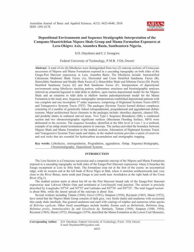
occurrence of thin drapes of older formations and/or dolerite boulders seen around Lokpaukwu (near the studylocation). The lower part of the section is about 38m thick and consists of laminated, fossiliferous, pyritic, darkgrey shales interbedded with thin beds of calcareous mudstones. The lowermost portion has profuse seepageof fluids suspected to be hydrocarbon (Fig. 4) following the course of Leru spring that emanated from thecuesta. The fossils identified in this lower section include bivalves and gastropod imprints and large assemblages
6626
Aust. J. Basic & Appl. Sci., 4(12): 6623-6640, 2010
of foraminifera and palynomorphs. Some of the identified forms also include: Haplophragmoides sp,Ammobaculites sp, Ammotium nkalagum, Ammotium nwalium, Bolivina anambra, Bolivina sp, Bulimina kugleri,Ostracoda, Amenantherites sp, Andalusiella sp, Deflandrea, etc.
Fig. 4: Seepage suspected to be Hydrocarbon in Leru I.
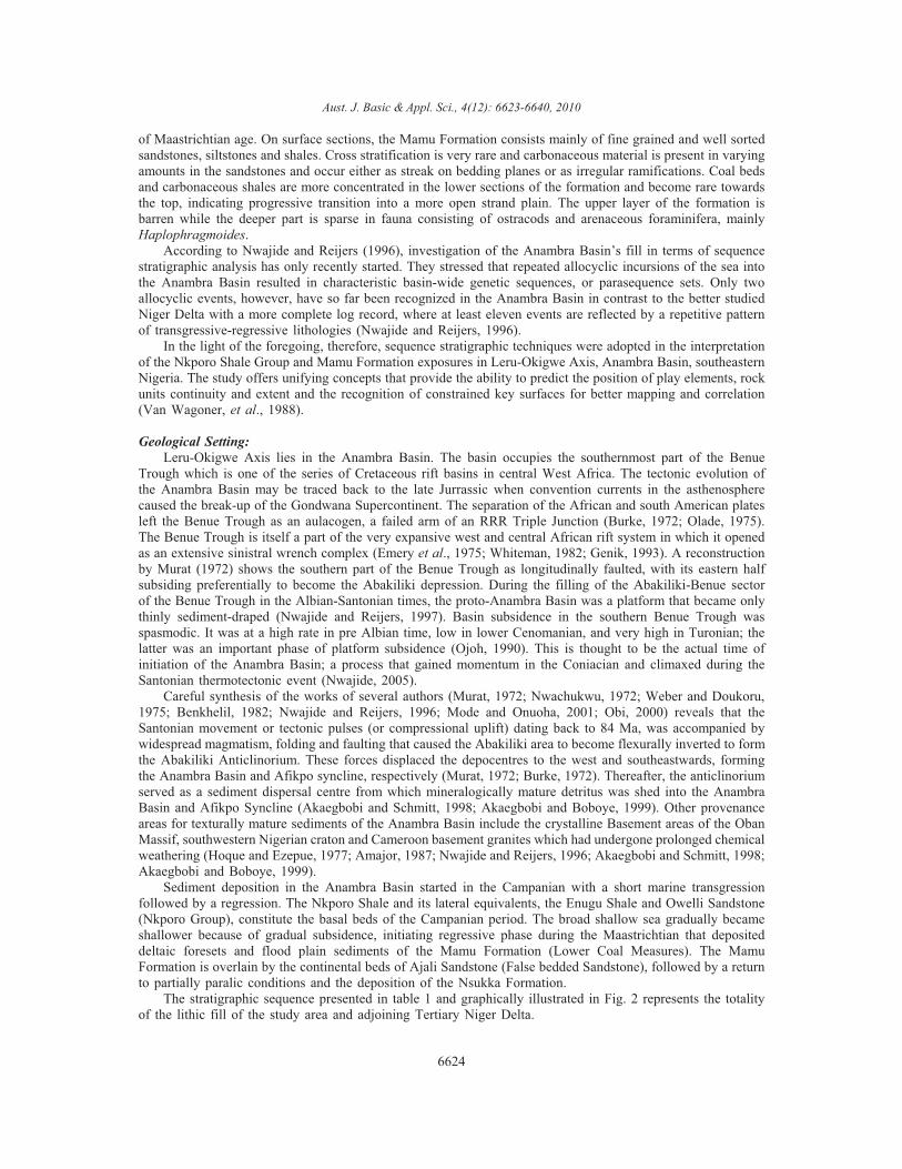
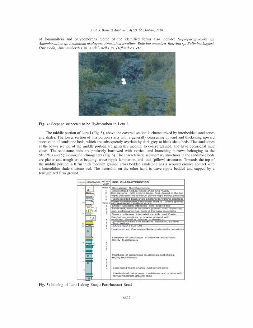
The middle portion of Leru I (Fig. 5), above the covered section is characterized by interbedded sandstonesand shales. The lower section of this portion starts with a generally coarsening upward and thickening upwardsuccession of sandstone beds, which are subsequently overlain by dark grey to black shale beds. The sandstonesat the lower section of the middle portion are generally medium to coarse grained, and have occasional mudclasts. The sandstone beds are profusely burrowed with vertical and branching burrows belonging to theSkolithos and Ophiomorpha ichnogenera (Fig. 6). The characteristic sedimentary structures in the sandstone bedsare planar and trough cross bedding, wave ripple lamination, and load (pillow) structures. Towards the top ofthe middle portion, a 0.7m thick medium grained cross bedded sandstone has a scoured erosive contact witha heterolithic shale-siltstone bed. The heterolith on the other hand is wave ripple bedded and capped by aferruginized firm ground.
Fig. 5: litholog of Leru l along Enugu-PortHarcourt Road
6627
Aust. J. Basic & Appl. Sci., 4(12): 6623-6640, 2010
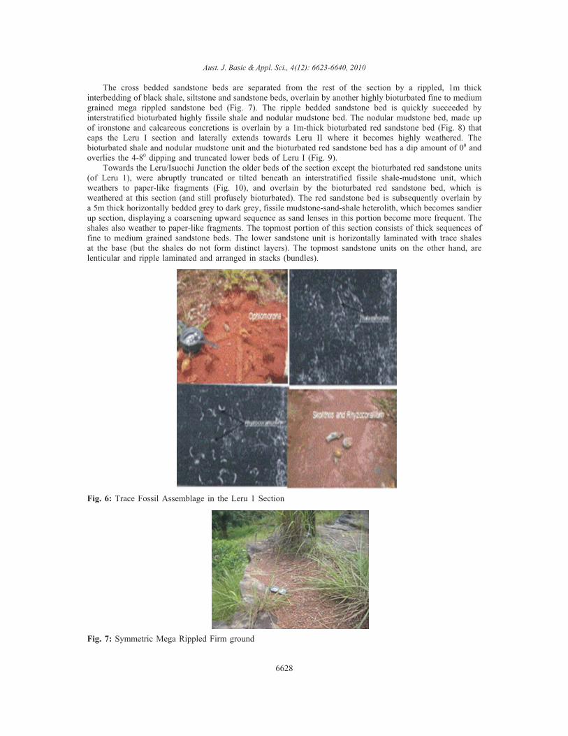
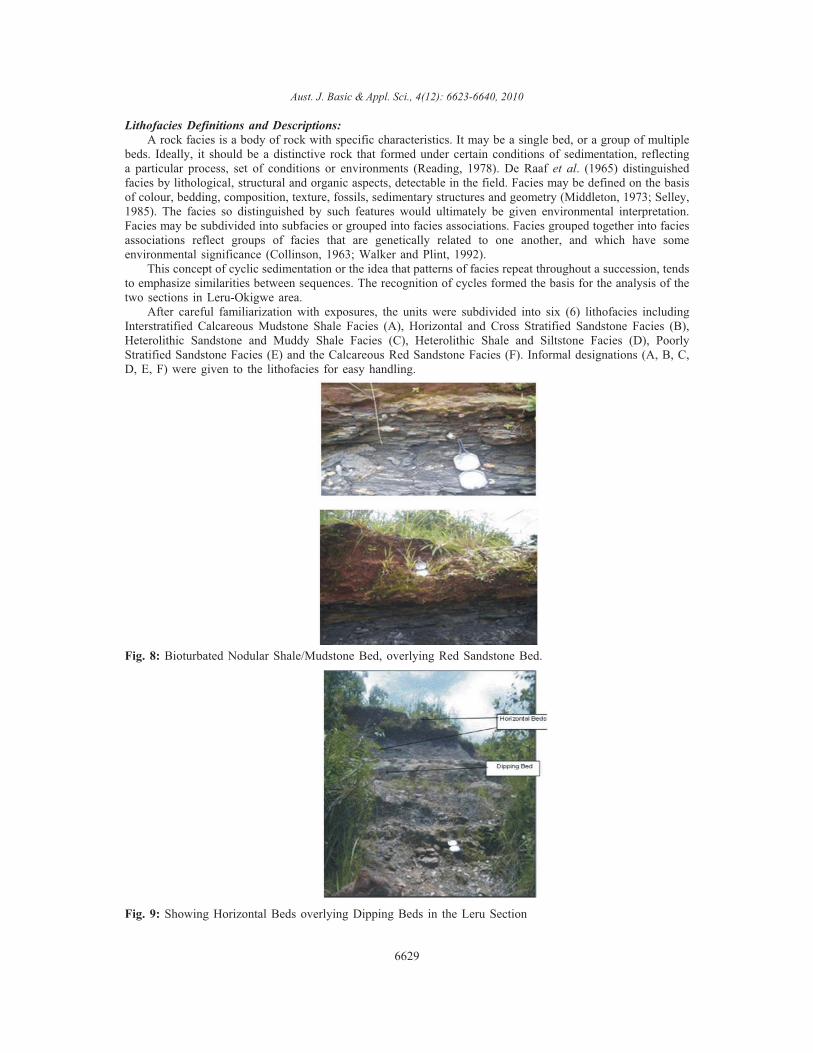
The cross bedded sandstone beds are separated from the rest of the section by a rippled, 1m thickinterbedding of black shale, siltstone and sandstone beds, overlain by another highly bioturbated fine to mediumgrained mega rippled sandstone bed (Fig. 7). The ripple bedded sandstone bed is quickly succeeded byinterstratified bioturbated highly fissile shale and nodular mudstone bed. The nodular mudstone bed, made upof ironstone and calcareous concretions is overlain by a 1m-thick bioturbated red sandstone bed (Fig. 8) thatcaps the Leru I section and laterally extends towards Leru II where it becomes highly weathered. Thebioturbated shale and nodular mudstone unit and the bioturbated red sandstone bed has a dip amount of 00 andoverlies the 4-80 dipping and truncated lower beds of Leru I (Fig. 9).
Towards the Leru/Isuochi Junction the older beds of the section except the bioturbated red sandstone units(of Leru 1), were abruptly truncated or tilted beneath an interstratified fissile shale-mudstone unit, whichweathers to paper-like fragments (Fig. 10), and overlain by the bioturbated red sandstone bed, which isweathered at this section (and still profusely bioturbated). The red sandstone bed is subsequently overlain bya 5m thick horizontally bedded grey to dark grey, fissile mudstone-sand-shale heterolith, which becomes sandierup section, displaying a coarsening upward sequence as sand lenses in this portion become more frequent. Theshales also weather to paper-like fragments. The topmost portion of this section consists of thick sequences offine to medium grained sandstone beds. The lower sandstone unit is horizontally laminated with trace shalesat the base (but the shales do not form distinct layers). The topmost sandstone units on the other hand, arelenticular and ripple laminated and arranged in stacks (bundles).
Fig. 6: Trace Fossil Assemblage in the Leru 1 Section
Fig. 7: Symmetric Mega Rippled Firm ground
6628
Aust. J. Basic & Appl. Sci., 4(12): 6623-6640, 2010
Lithofacies Definitions and Descriptions:A rock facies is a body of rock with specific characteristics. It may be a single bed, or a group of multiple
beds. Ideally, it should be a distinctive rock that formed under certain conditions of sedimentation, reflectinga particular process, set of conditions or environments (Reading, 1978). De Raaf et al. (1965) distinguishedfacies by lithological, structural and organic aspects, detectable in the field. Facies may be defined on the basisof colour, bedding, composition, texture, fossils, sedimentary structures and geometry (Middleton, 1973; Selley,1985). The facies so distinguished by such features would ultimately be given environmental interpretation.Facies may be subdivided into subfacies or grouped into facies associations. Facies grouped together into faciesassociations reflect groups of facies that are genetically related to one another, and which have someenvironmental significance (Collinson, 1963; Walker and Plint, 1992).
This concept of cyclic sedimentation or the idea that patterns of facies repeat throughout a succession, tendsto emphasize similarities between sequences. The recognition of cycles formed the basis for the analysis of thetwo sections in Leru-Okigwe area.
After careful familiarization with exposures, the units were subdivided into six (6) lithofacies includingInterstratified Calcareous Mudstone Shale Facies (A), Horizontal and Cross Stratified Sandstone Facies (B),Heterolithic Sandstone and Muddy Shale Facies (C), Heterolithic Shale and Siltstone Facies (D), PoorlyStratified Sandstone Facies (E) and the Calcareous Red Sandstone Facies (F). Informal designations (A, B, C,D, E, F) were given to the lithofacies for easy handling.
Fig. 8: Bioturbated Nodular Shale/Mudstone Bed, overlying Red Sandstone Bed.
Fig. 9: Showing Horizontal Beds overlying Dipping Beds in the Leru Section
6629
Aust. J. Basic & Appl. Sci., 4(12): 6623-6640, 2010
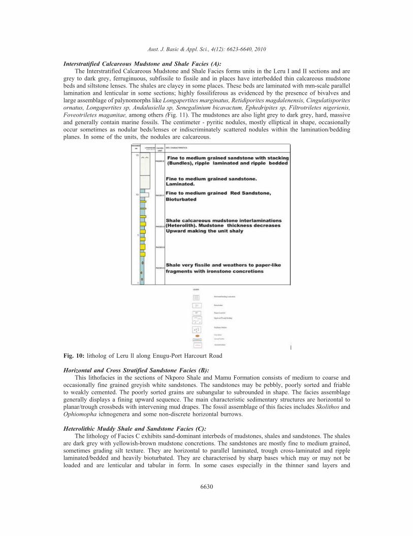
Interstratified Calcareous Mudstone and Shale Facies (A):The Interstratified Calcareous Mudstone and Shale Facies forms units in the Leru I and II sections and are
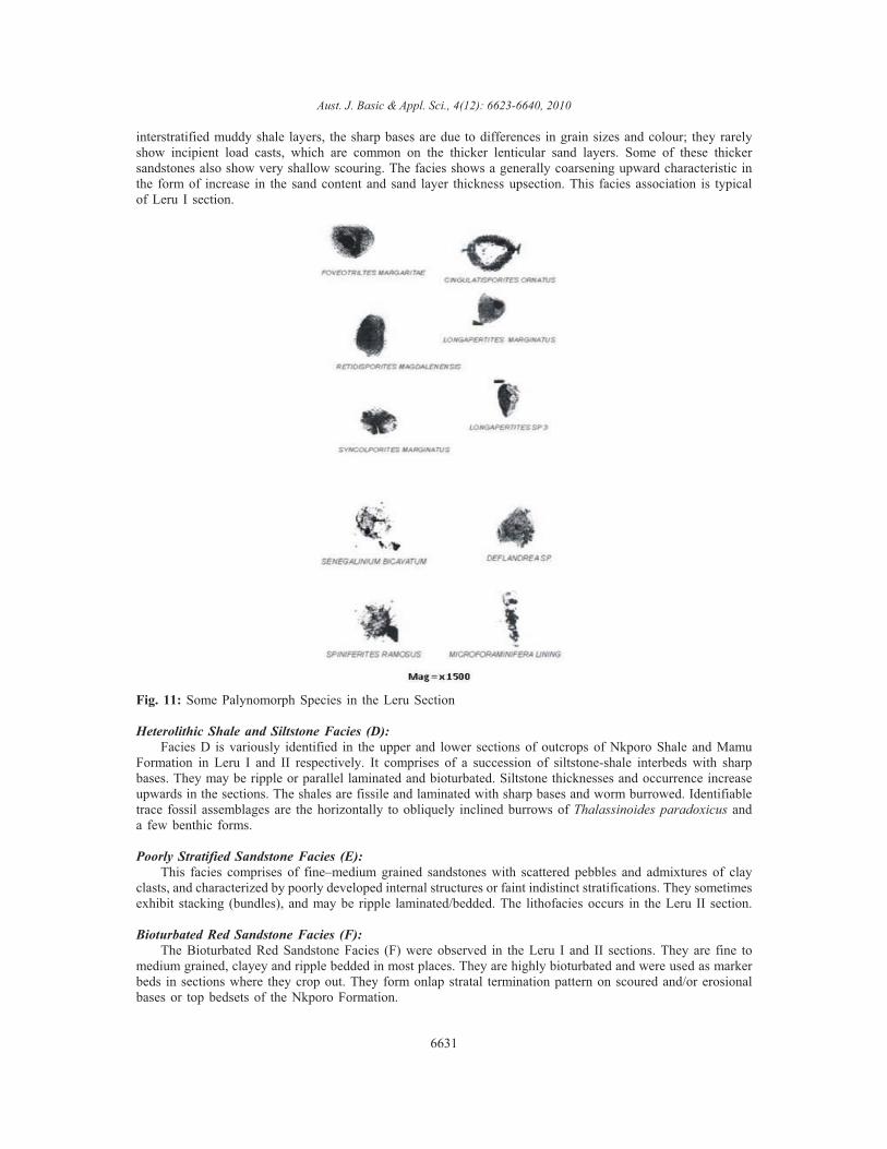
grey to dark grey, ferruginuous, subfissile to fissile and in places have interbedded thin calcareous mudstonebeds and siltstone lenses. The shales are clayey in some places. These beds are laminated with mm-scale parallellamination and lenticular in some sections; highly fossiliferous as evidenced by the presence of bivalves andlarge assemblage of palynomorphs like Longapertites marginatus, Retidiporites magdalenensis, Cingulatisporitesornatus, Longapertites sp, Andalusiella sp, Senegalinium bicavactum, Ephedripites sp, Filtrotriletes nigerienis,Foveotriletes maganitae, among others (Fig. 11). The mudstones are also light grey to dark grey, hard, massiveand generally contain marine fossils. The centimeter - pyritic nodules, mostly elliptical in shape, occasionallyoccur sometimes as nodular beds/lenses or indiscriminately scattered nodules within the lamination/beddingplanes. In some of the units, the nodules are calcareous.
Fig. 10: litholog of Leru ll along Enugu-Port Harcourt Road
Horizontal and Cross Stratified Sandstone Facies (B):This lithofacies in the sections of Nkporo Shale and Mamu Formation consists of medium to coarse and
occasionally fine grained greyish white sandstones. The sandstones may be pebbly, poorly sorted and friableto weakly cemented. The poorly sorted grains are subangular to subrounded in shape. The facies assemblagegenerally displays a fining upward sequence. The main characteristic sedimentary structures are horizontal toplanar/trough crossbeds with intervening mud drapes. The fossil assemblage of this facies includes Skolithos andOphiomopha ichnogenera and some non-discrete horizontal burrows.
Heterolithic Muddy Shale and Sandstone Facies (C):The lithology of Facies C exhibits sand-dominant interbeds of mudstones, shales and sandstones. The shales
are dark grey with yellowish-brown mudstone concretions. The sandstones are mostly fine to medium grained,sometimes grading silt texture. They are horizontal to parallel laminated, trough cross-laminated and ripplelaminated/bedded and heavily bioturbated. They are characterised by sharp bases which may or may not beloaded and are lenticular and tabular in form. In some cases especially in the thinner sand layers and
6630
Aust. J. Basic & Appl. Sci., 4(12): 6623-6640, 2010
interstratified muddy shale layers, the sharp bases are due to differences in grain sizes and colour; they rarelyshow incipient load casts, which are common on the thicker lenticular sand layers. Some of these thickersandstones also show very shallow scouring. The facies shows a generally coarsening upward characteristic inthe form of increase in the sand content and sand layer thickness upsection. This facies association is typicalof Leru I section.
Fig. 11: Some Palynomorph Species in the Leru Section
Heterolithic Shale and Siltstone Facies (D):Facies D is variously identified in the upper and lower sections of outcrops of Nkporo Shale and Mamu
Formation in Leru I and II respectively. It comprises of a succession of siltstone-shale interbeds with sharpbases. They may be ripple or parallel laminated and bioturbated. Siltstone thicknesses and occurrence increaseupwards in the sections. The shales are fissile and laminated with sharp bases and worm burrowed. Identifiabletrace fossil assemblages are the horizontally to obliquely inclined burrows of Thalassinoides paradoxicus anda few benthic forms.
Poorly Stratified Sandstone Facies (E):This facies comprises of fine–medium grained sandstones with scattered pebbles and admixtures of clay
clasts, and characterized by poorly developed internal structures or faint indistinct stratifications. They sometimesexhibit stacking (bundles), and may be ripple laminated/bedded. The lithofacies occurs in the Leru II section.
Bioturbated Red Sandstone Facies (F):The Bioturbated Red Sandstone Facies (F) were observed in the Leru I and II sections. They are fine to
medium grained, clayey and ripple bedded in most places. They are highly bioturbated and were used as markerbeds in sections where they crop out. They form onlap stratal termination pattern on scoured and/or erosionalbases or top bedsets of the Nkporo Formation.
6631
Aust. J. Basic & Appl. Sci., 4(12): 6623-6640, 2010
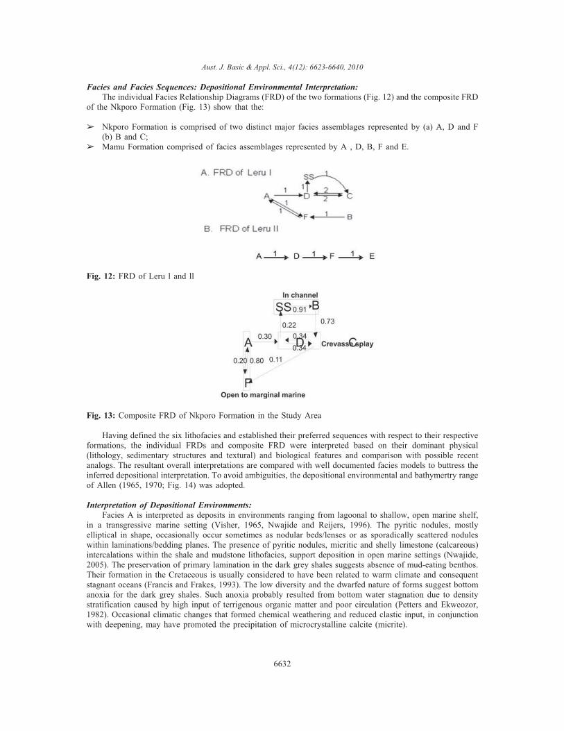
Facies and Facies Sequences: Depositional Environmental Interpretation:The individual Facies Relationship Diagrams (FRD) of the two formations (Fig. 12) and the composite FRD
of the Nkporo Formation (Fig. 13) show that the:
� Nkporo Formation is comprised of two distinct major facies assemblages represented by (a) A, D and F(b) B and C;
� Mamu Formation comprised of facies assemblages represented by A , D, B, F and E.
Fig. 12: FRD of Leru l and ll
Fig. 13: Composite FRD of Nkporo Formation in the Study Area
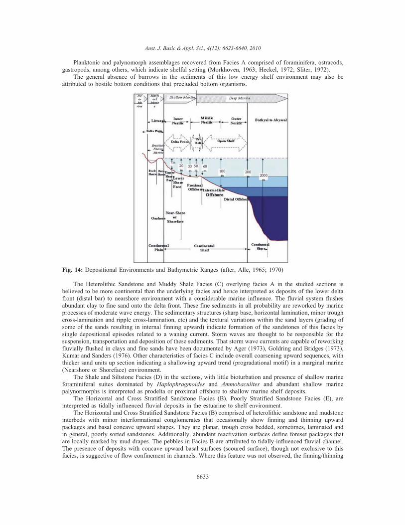
Having defined the six lithofacies and established their preferred sequences with respect to their respectiveformations, the individual FRDs and composite FRD were interpreted based on their dominant physical(lithology, sedimentary structures and textural) and biological features and comparison with possible recentanalogs. The resultant overall interpretations are compared with well documented facies models to buttress theinferred depositional interpretation. To avoid ambiguities, the depositional environmental and bathymertry rangeof Allen (1965, 1970; Fig. 14) was adopted.
Interpretation of Depositional Environments:Facies A is interpreted as deposits in environments ranging from lagoonal to shallow, open marine shelf,
in a transgressive marine setting (Visher, 1965, Nwajide and Reijers, 1996). The pyritic nodules, mostlyelliptical in shape, occasionally occur sometimes as nodular beds/lenses or as sporadically scattered noduleswithin laminations/bedding planes. The presence of pyritic nodules, micritic and shelly limestone (calcareous)intercalations within the shale and mudstone lithofacies, support deposition in open marine settings (Nwajide,2005). The preservation of primary lamination in the dark grey shales suggests absence of mud-eating benthos.Their formation in the Cretaceous is usually considered to have been related to warm climate and consequentstagnant oceans (Francis and Frakes, 1993). The low diversity and the dwarfed nature of forms suggest bottomanoxia for the dark grey shales. Such anoxia probably resulted from bottom water stagnation due to densitystratification caused by high input of terrigenous organic matter and poor circulation (Petters and Ekweozor,1982). Occasional climatic changes that formed chemical weathering and reduced clastic input, in conjunctionwith deepening, may have promoted the precipitation of microcrystalline calcite (micrite).
6632
Aust. J. Basic & Appl. Sci., 4(12): 6623-6640, 2010
Planktonic and palynomorph assemblages recovered from Facies A comprised of foraminifera, ostracods,gastropods, among others, which indicate shelfal setting (Morkhoven, 1963; Heckel, 1972; Sliter, 1972).
The general absence of burrows in the sediments of this low energy shelf environment may also beattributed to hostile bottom conditions that precluded bottom organisms.
Fig. 14: Depositional Environments and Bathymetric Ranges (after, Alle, 1965; 1970)
The Heterolithic Sandstone and Muddy Shale Facies (C) overlying facies A in the studied sections isbelieved to be more continental than the underlying facies and hence interpreted as deposits of the lower deltafront (distal bar) to nearshore environment with a considerable marine influence. The fluvial system flushesabundant clay to fine sand onto the delta front. These fine sediments in all probability are reworked by marineprocesses of moderate wave energy. The sedimentary structures (sharp base, horizontal lamination, minor troughcross-lamination and ripple cross-lamination, etc) and the textural variations within the sand layers (grading ofsome of the sands resulting in internal finning upward) indicate formation of the sandstones of this facies bysingle depositional episodes related to a waning current. Storm waves are thought to be responsible for thesuspension, transportation and deposition of these sediments. That storm wave currents are capable of reworkingfluvially flushed in clays and fine sands have been documented by Ager (1973), Goldring and Bridges (1973),Kumar and Sanders (1976). Other characteristics of facies C include overall coarsening upward sequences, withthicker sand units up section indicating a shallowing upward trend (progradational motif) in a marginal marine(Nearshore or Shoreface) environment.
The Shale and Siltstone Facies (D) in the sections, with little bioturbation and presence of shallow marineforaminiferal suites dominated by Haplophragmoides and Ammobaculites and abundant shallow marinepalynormorphs is interpreted as prodelta or proximal offshore to shallow marine shelf deposits.
The Horizontal and Cross Stratified Sandstone Facies (B), Poorly Stratified Sandstone Facies (E), areinterpreted as tidally influenced fluvial deposits in the estuarine to shelf environment.
The Horizontal and Cross Stratified Sandstone Facies (B) comprised of heterolithic sandstone and mudstoneinterbeds with minor interformational conglomerates that occasionally show finning and thinning upwardpackages and basal concave upward shapes. They are planar, trough cross bedded, sometimes, laminated andin general, poorly sorted sandstones. Additionally, abundant reactivation surfaces define foreset packages thatare locally marked by mud drapes. The pebbles in Facies B are attributed to tidally-influenced fluvial channel.The presence of deposits with concave upward basal surfaces (scoured surface), though not exclusive to thisfacies, is suggective of flow confinement in channels. Where this feature was not observed, the finning/thinning
6633
Aust. J. Basic & Appl. Sci., 4(12): 6623-6640, 2010
upward facies successions are bounded by sharp, erosional basal surfaces, and attest to deposition duringdecreasing flow energy, as typical of channel fills. Facies B is therefore attributed to tidally-influenced fluvialchannels formed in proximal estuarine areas, near the limits of the fluvial realm. It is believed that, weak tidalcurrents might reach these inner estuarine areas and rework sediments brought from the fluvial channel.
In consideration of the stratigraphic relationships, sedimentary structures, lithology, texture and micofauna,the Red Sandstone Facies (F) are interpreted as a barrier island (Shoreface to Beach) deposits, overlain andunderlain by distal offshore mud and proximal offshore mud respectively. The Poorly Stratified Sandstone Facies(E) usually associated with Facies F is characterized by poorly developed internal structures or faint indistinctstratifications. They are interpreted as distributary channels/fluvial point bars.
Sequence Stratigraphic Intrepretations of Outcrop SectionsLeru Composite Sections I and II: Nkporo and Mamu Formations (Sequences I & II):
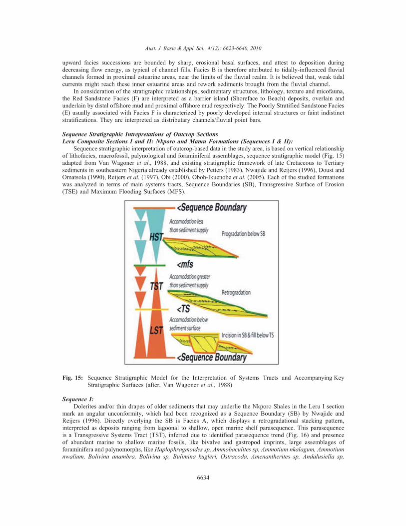
Sequence stratigraphic interpretation of outcrop-based data in the study area, is based on vertical relationshipof lithofacies, macrofossil, palynological and foraminiferal assemblages, sequence stratigraphic model (Fig. 15)adapted from Van Wagoner et al., 1988, and existing stratigraphic framework of late Cretaceous to Tertiarysediments in southeastern Nigeria already established by Petters (1983), Nwajide and Reijers (1996), Doust andOmatsola (1990), Reijers et al. (1997), Obi (2000), Oboh-Ikuenobe et al. (2005). Each of the studied formationswas analyzed in terms of main systems tracts, Sequence Boundaries (SB), Transgressive Surface of Erosion(TSE) and Maximum Flooding Surfaces (MFS).
Fig. 15: Sequence Stratigraphic Model for the Interpretation of Systems Tracts and Accompanying KeyStratigraphic Surfaces (after, Van Wagoner et al., 1988)
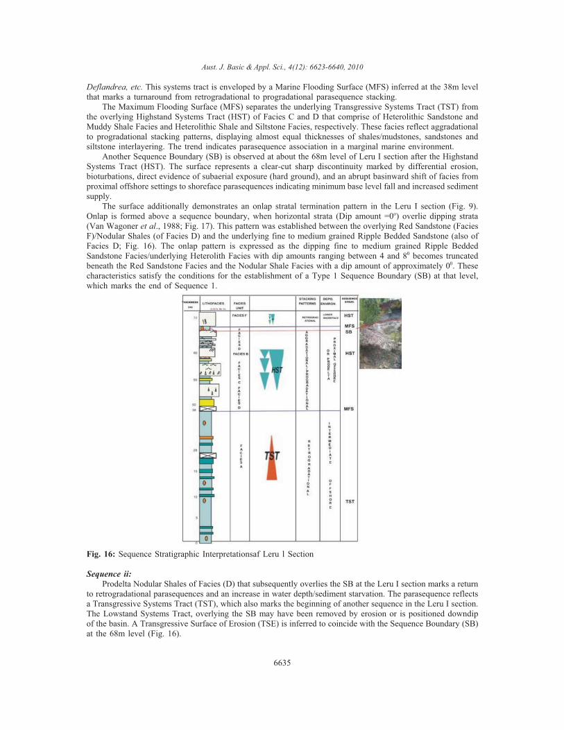
Sequence I:Dolerites and/or thin drapes of older sediments that may underlie the Nkporo Shales in the Leru I section
mark an angular unconformity, which had been recognized as a Sequence Boundary (SB) by Nwajide andReijers (1996). Directly overlying the SB is Facies A, which displays a retrogradational stacking pattern,interpreted as deposits ranging from lagoonal to shallow, open marine shelf parasequence. This parasequenceis a Transgressive Systems Tract (TST), inferred due to identified parasequence trend (Fig. 16) and presenceof abundant marine to shallow marine fossils, like bivalve and gastropod imprints, large assemblages offoraminifera and palynomorphs, like Haplophragmoides sp, Ammobaculites sp, Ammotium nkalagum, Ammotiumnwalium, Bolivina anambra, Bolivina sp, Bulimina kugleri, Ostracoda, Amenantherites sp, Andalusiella sp,
6634
Aust. J. Basic & Appl. Sci., 4(12): 6623-6640, 2010
Deflandrea, etc. This systems tract is enveloped by a Marine Flooding Surface (MFS) inferred at the 38m levelthat marks a turnaround from retrogradational to progradational parasequence stacking.
The Maximum Flooding Surface (MFS) separates the underlying Transgressive Systems Tract (TST) fromthe overlying Highstand Systems Tract (HST) of Facies C and D that comprise of Heterolithic Sandstone andMuddy Shale Facies and Heterolithic Shale and Siltstone Facies, respectively. These facies reflect aggradationalto progradational stacking patterns, displaying almost equal thicknesses of shales/mudstones, sandstones andsiltstone interlayering. The trend indicates parasequence association in a marginal marine environment.
Another Sequence Boundary (SB) is observed at about the 68m level of Leru I section after the HighstandSystems Tract (HST). The surface represents a clear-cut sharp discontinuity marked by differential erosion,bioturbations, direct evidence of subaerial exposure (hard ground), and an abrupt basinward shift of facies fromproximal offshore settings to shoreface parasequences indicating minimum base level fall and increased sedimentsupply.
The surface additionally demonstrates an onlap stratal termination pattern in the Leru I section (Fig. 9).Onlap is formed above a sequence boundary, when horizontal strata (Dip amount =0o) overlie dipping strata(Van Wagoner et al., 1988; Fig. 17). This pattern was established between the overlying Red Sandstone (FaciesF)/Nodular Shales (of Facies D) and the underlying fine to medium grained Ripple Bedded Sandstone (also ofFacies D; Fig. 16). The onlap pattern is expressed as the dipping fine to medium grained Ripple BeddedSandstone Facies/underlying Heterolith Facies with dip amounts ranging between 4 and 80 becomes truncatedbeneath the Red Sandstone Facies and the Nodular Shale Facies with a dip amount of approximately 00. Thesecharacteristics satisfy the conditions for the establishment of a Type 1 Sequence Boundary (SB) at that level,which marks the end of Sequence 1.
Fig. 16: Sequence Stratigraphic Interpretationsaf Leru l Section
Sequence ii:Prodelta Nodular Shales of Facies (D) that subsequently overlies the SB at the Leru I section marks a return
to retrogradational parasequences and an increase in water depth/sediment starvation. The parasequence reflectsa Transgressive Systems Tract (TST), which also marks the beginning of another sequence in the Leru I section.The Lowstand Systems Tract, overlying the SB may have been removed by erosion or is positioned downdipof the basin. A Transgressive Surface of Erosion (TSE) is inferred to coincide with the Sequence Boundary (SB)at the 68m level (Fig. 16).
6635
Aust. J. Basic & Appl. Sci., 4(12): 6623-6640, 2010
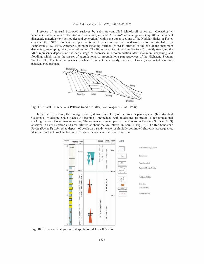
Presence of unusual burrowed surfaces by substrate-controlled ichnofossil suites e.g. Glossifungitesichnofacies associations of the skolithos, ophiomorpha, and rhizocorallium ichnogenera (Fig. 8) and abundantdiagenetic materials (pyritic nodules and concretions) within the upper sections of the Nodular Shales of Facies(D) after the TSE/SB confers the upper sections of Facies A potential condensed section as established byPemberton et al., 1992. Another Maximum Flooding Surface (MFS) is inferred at the end of the maximumdeepening, enveloping the condensed section. The Bioturbated Red Sandstone Facies (F), directly overlying theMFS represents deposits of the early stage of decrease in accommodation after maximum deepening andflooding, which marks the on set of aggradational to progradationa parasequences of the Highstand SystemsTract (HST). The trend represents beach environment on a sandy, wave- or fluvially-dominated shorelineparasequence package.
Fig. 17: Stratal Terminations Patterns (modified after, Van Wagoner et al., 1988)
In the Leru II section, the Transgressive Systems Tract (TST) of the prodelta parasequence (InterstratifiedCalcareous Mudstone Shale Facies A) becomes interbedded with mudstones to present a retrogradationalstacking pattern of open marine setting. The sequence is enveloped by the Maximum Flooding Surface (MFS)observed in Leru I section and now inferred at about the 9m interval in Leru II (Fig. 18). The Red SandstoneFacies (Facies F) inferred as deposit of beach on a sandy, wave- or fluvially-dominated shoreline parasequence,identified in the Leru I section now overlies Facies A in the Leru II section.
Fig. 18: Sequence Stratigraphic Interpretationsaf Leru ll Section
6636
Aust. J. Basic & Appl. Sci., 4(12): 6623-6640, 2010
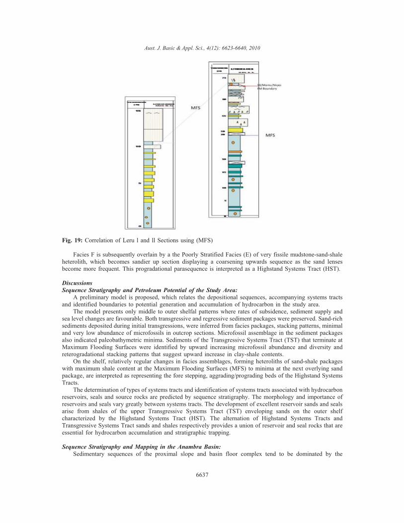
Fig. 19: Correlation of Leru l and ll Sections using (MFS)
Facies F is subsequently overlain by a the Poorly Stratified Facies (E) of very fissile mudstone-sand-shaleheterolith, which becomes sandier up section displaying a coarsening upwards sequence as the sand lensesbecome more frequent. This progradational parasequence is interpreted as a Highstand Systems Tract (HST).
DiscussionsSequence Stratigraphy and Petroleum Potential of the Study Area:
A preliminary model is proposed, which relates the depositional sequences, accompanying systems tractsand identified boundaries to potential generation and accumulation of hydrocarbon in the study area.
The model presents only middle to outer shelfal patterns where rates of subsidence, sediment supply andsea level changes are favourable. Both transgressive and regressive sediment packages were preserved. Sand-richsediments deposited during initial transgressions, were inferred from facies packages, stacking patterns, minimaland very low abundance of microfossils in outcrop sections. Microfossil assemblage in the sediment packagesalso indicated paleobathymetric minima. Sediments of the Transgressive Systems Tract (TST) that terminate atMaximum Flooding Surfaces were identified by upward increasing microfossil abundance and diversity andreterogradational stacking patterns that suggest upward increase in clay-shale contents.
On the shelf, relatively regular changes in facies assemblages, forming heteroliths of sand-shale packageswith maximum shale content at the Maximum Flooding Surfaces (MFS) to minima at the next overlying sandpackage, are interpreted as representing the fore stepping, aggrading/prograding beds of the Highstand SystemsTracts.
The determination of types of systems tracts and identification of systems tracts associated with hydrocarbonreservoirs, seals and source rocks are predicted by sequence stratigraphy. The morphology and importance ofreservoirs and seals vary greatly between systems tracts. The development of excellent reservoir sands and sealsarise from shales of the upper Transgressive Systems Tract (TST) enveloping sands on the outer shelfcharacterized by the Highstand Systems Tract (HST). The alternation of Highstand Systems Tracts andTransgressive Systems Tract sands and shales respectively provides a union of reservoir and seal rocks that areessential for hydrocarbon accumulation and stratigraphic trapping.
Sequence Stratigraphy and Mapping in the Anambra Basin:Sedimentary sequences of the proximal slope and basin floor complex tend to be dominated by the
6637
Aust. J. Basic & Appl. Sci., 4(12): 6623-6640, 2010
Lowstand Systems Tracts (LST; Vail, 1987). The Lowstand Systems Tract (LST) was not observed in theoutcrop sections studied. It is important to stress, however, that not all of the constrained surfaces or systemstracts may be present within any given sequence in an outcrop or well log. The absence of one or more surfacesor systems tracts may provide important clues to the relative position of the outcrop/well within the basin. Forexample, Lowstand Systems Tracts (LST) are commonly absent in updip areas where the transgressive Surface(TS) and Sequence Boundary (SB) are merged as one surface as is the case in the studied sections. In suchareas, significant portions of the Lowstand and Highstand Systems Tract (HST) may have been eroded awayand the SB is marked by the beginning of retrogradational stacking. In downdip areas, the TransgressiveSystems Tract (TST) and Highstand Systems Tracts (HST) may be thin and relatively mud-rich, whereas theLowstand Systems Tract (LST) may be characterized by an abrupt appearance of thick sandy facies. Many morevariations are possible and many basins are characterized by a typical pattern of sequence architecture.
It is in the light of the forgoing that the studied Leru sections are considered to be positioned in the updipareas (i.e. fringe) of the Anambra Basin. This assertion is validated by the proximity of older and tectonicallydeformed Benue Trough Sediments near the Leru section.
Correlation of Leru I and II sections (Fig. 19) using the identified constrained surface has aided thedelimitation of the probable contact between the Nkporo Formation and Mamu Formation in the studied sections.This boundary can conveniently be placed at the 68m level, where the onlap stratal pattern and the SequenceBoundary (SB) were established.
Some other contacts can also be established using sequence stratigraphic techniques. This will assist in theelimination of confusions between formation boundaries in the Anambra Basin thus helping to remap theAnambra Basin Fills.
Summary and Conclusion:The study examined paleodepositional environments and sequence stratigraphic interpretation of Campano-
Maastrichtian sediments in the Leru-Okigwe axis, Anambra Basin, southeastern Nigeria, in order to provide aframework for facies analysis, delineation of constrained surfaces and system tracts (depositional systems) thusproviding a high degree of facies predictability for better mapping and improved analysis of play elements(source, reservoir, seal and traps) in the study area.
A total of six (6) lithofacies were distinguished from the two (2) outcrop sections studied. These include:Interstratified Calcareous Mudstone Shale Facies (A), Horizontal and Cross Stratified Sandstone Facies (B),Heterolithic Sandstone and Muddy Shale Facies (C), Heterolithic Shale and Siltstone Facies (D), PoorlyStratified Sandstone Facies (E) and Calcareous Red Sandstone Facies (F)
Interpretation of the paleodepositional environments for the different depositional units in the study areawas achieved by integration of results of lithofacies analysis, sedimentary structures interpretation andbiostratigraphic analyses. Based on these analyses an estuarine/lagoonal to tidal delta to shallow, open marinedepositional model was proposed for the Nkporo Shale in the study area; an estuarine tidal delta to shallowmarine paleodepositional environmental model was proposed for the Mamu Formation, which also has beendescribed as a regressive offlap sequence of sandstone, siltstone, mudstone, shales, and sandy shales withinterbedded coal seams.
Sequence stratigraphic interpretation based on vertical facies relationships, biostratigraphic analysis in thestudy area and on existing stratigraphic framework of the late Cretaceous to Tertiary successions in southeasternNigeria established middle to outer shelfal depositional patterns with Sequence Boundaries, TransgressiveSurface of Erosion (TSE) and Maximum Flooding Surfaces enclosing Highstand and Trangressive SystemsTracts. The packages (Systems Tracts) formed distinct complexes consisting of a number of genetically linkedretrogradational, progradational and aggradational deltaic systems. Major architectural facies elements of thedelta systems in the packages include: shoreface deposits, channel fills, and prodelta shales in sediment starvedareas. One complete and one incomplete 3rd order sequences were identified in the late Cretaceous sedimentsin Leru I and II. Two Type-1 Sequence Boundaries (SB), one Transgressive Surface of Erosion and twochronostratigraphic significant surfaces (Maximum Flooding Surface, MFS) were delineated in the outcropsections. The sequence boundary identified at the 68m level is a textbook example of an onlap strataltermination pattern in outcrops. The surface was used to mark the boundary between the Nkporo Shale and theMamu Formation.
The determination of types of systems tracts associated with hydrocarbon reservoirs, seals and source rocksare predicted by sequence stratigraphy. The morphology and importance of reservoirs and seals vary greatlybetween systems tracts. The development of excellent reservoir sands and seals arise from shales of the upperTransgressive Systems Tract enveloping sands on the outer shelf characterized by the Highstand Systems Tract.
6638
Aust. J. Basic & Appl. Sci., 4(12): 6623-6640, 2010
The alternation of Highstand Systems Tracts and Transgressive Systems Tract sands and shales respectivelyprovides a union of reservoir and seal rocks that are essential for hydrocarbon accumulation and stratigraphictrapping. This union has been identified in the study area and will help to improve the hydrocarbon prospectivityof the Leru-Okigwe axis in the Anambra Basin
REFERENCES
Ager, D.V., 1973. The Nature of the Stratigraphical Record. Macmillian, London, pp: 114.Akaegbobi, I.M. and M. Schmitt, 1998. Organic Facies, Hydrocarbon Source Potential and Reconstruction
of the Depositional Paleoenvironment of the Campano–Maastrichtian Nkporo Shale in the Cretaceous AnambraBasin
Akaegbobi, I.M. and A.O. Boboye, 1999. Textural, Structural Features and Microfossil AssemblageRelationship as a delineating criteria for the stratigraphic Boundary between Mamu Formation and Nkporo Shalewithin the Anambra Basin, Nigeria. NAPE Bulletin, 14(2): 193-207.
Allen, J.R.L., 1965. Late Quarternary Niger Delta and adjacent areas-Sedimentary Environments andLithofacies. American Association of Petroleum Geologists Bulletin, .49: 547-600.
Allen, J.R.L., 1970. Studies in Fluvial Sedimentation: A comparison of Finning-Upward Cyclotherms, withspecial reference to coarse-member Composition and Interpretation. Jour. of Sedimentary Petrology, 40: 298-323.
Amajor, L.C., 1987. Paleocurrent, Petrography and Provenance Analysis of the Ajali Sandstone (UpperCretaceous). Southeastern Benue Trough, Nigeria. Sed. Geology, 54: 47-60.
Amajor, L.C., 1991. Sedimentary Facies Analysis of the Ajali Sandstones (Upper Cretaceous), SouthernBenue Trough. Nig. Jour. Min. Geol. 21(1&2.): 171-176.
Benkhelil, J., 1982. Benue Trough and Benue Chain. Geol. Mag., 119: 155-168.Burke, K., 1972. Longshore Drift, Submarine Canyons and Submarine Fans in the Development of Niger
Delta: American Assoc. Petrol. Geologists, 56: 1975-1983.Collinson, J.D., 1963. The Sedimentology of the Grindslow Shales and the Kinderscout Grit: A Deltaic
Complex in the Namurian of Northern England. J. Sed. Pet., 39: 194-221.Dessauvagie, T.F.J., 1974. A geological map of Nigeria scale 1: 1,000,000. Nig. Min, Geol and
Metallurgical Society 1.De Raaf, J.F.M., H.G. Reading and R.G. Walker, 1965. Cyclic Sedimentation in the lower Westphalian of
north Devon. Sedimentology, 4:. 21-74.Doust, H. and E. Omatsola, 1990. Niger Delta. In: Edwards, J.D., Santogrossi, P.A. (Eds.),
Divergent/Passive Margin Basins. American Association of Petroleum Geologists Memoir, 48: 201-238.Emery, K., O.E. Uchupi, J. Philips, C. Brown and J. Masle, 1975. Continental Margin off West Africa,
Angola to Sierra Leone, AAPG Bull., 59: 2209-2265.Francis, J.E. and L.A. Frakes, 1993. Creataceous Climates. In Wright, V.P., (ED.). Sedimentology review,
1: 17-30.Genik, G.J., 1993. Petroleum Geology of Cretaceous–Tertiary Basins in Niger, Chad and Central African
Republic. AAPG Bull., 77: 1405-1434.Goldring, R and P. Bridges, 1973. Sublittoral Sheet Sandstones. Jour. Sed. Pet., 43: 736-747.Grove, A.T., 1951. Land use and soil conservation. Bull Geol. surv. Nigeria, 21: 54p. Hailwood, E.A. 1989;
Magnetostratigraphy: Geol. Soc. Special Report 19, Blackwell Scientific pub., Oxford, pp: 84.Heckel, P.H., 1972. Recognition of Ancient Shallow Marine environment. In Recognition of Ancient
Sedimentary Environments. SEPM, Spec. Published., 16: 226-286.Hoque, M. and M.C. Ezepue, 1977. Petrology and Paleography of the Ajali Sandstone Journal. Sed
Petrology; 46: 579-594.Hoque, M., C.S. Nwajide, 1985. Tectono-sedimentological evolution of an elongate intracratonic basin
(aulacogen): The case of the Benue Trough of Nigeria. Journal of Mining and Geology, 21: 19-26.Kumar, N. and J.E. Sanders, 1976. Characteristics of Shoreface Storm Deposits: Modern Ancient examples.
J. Sedim. Petrl. 46: 145-165.Middleton, G.V., 1973. Johanne’s Walther’s Law of the Correlation of Facies. Geol. Soc. Amer. Bull., 84:
979-988.Mode, A.V. and K.M. Onuoha, 2001. Organic Matter Evaluation of the Nkporo Shale, Anambra Basin, from
Wireline logs. Global J. App. Sci., 7: 103-109.Morkhoven Van. F.P.C.M., 1963. Post-Palaeozoic Ostracoda: their Morphology, Taxonomy and economic
use. Elsevier Publ. Co. New York. pp: 476.
6639
Aust. J. Basic & Appl. Sci., 4(12): 6623-6640, 2010
Murat, R.C., 1972. Stratigraphy and Paleogeography of the Cretaceous and Lower Tertiary in SouthernNigeria. In Dessauvagie, T.T.J., and white man, A.J. (Eds), African Geology, University of Ibadan Press,Nigeria, pp: 251-266.
Nwachukwu, S.O., 1972. The Tectonic Evolution of the southern portion of the Benue Trough, Nigeria:Geology Magazine, 109: 411-419.
Nwajide, C.S. 2005. Anambra Basin of Nigeria: Synoptic Basin Analysis as a Basis for Evaluatin itsHydrocarbon Prospectivity, In Okogbue, C.O., (Ed.), Hydrocarbon Potentials of the Anambra Basin. PTDFChair, pp: 2-46.
Nwajide, C.S. and T.J.A. Reijers, 1996. Sequence Architecture in Outcrops. Examples from the AnambraBasin, Nigeria. NAPE Bull., 11(01): 23-32.
Nwajide, C.S. and T.J.A. Reijers, 1997. Sequence Architecture of the Campanian Nkporo and the EoceneNanka Formations of the Anambra Basin, Nigeria. NAPE Bull., 12(01): 75-87.
Obi, G.C., 2000. Depositional Model for the Campanian-Maastrichtian Anambra Basin, southern Nigeria.Unpublished Ph.D. Thesis, University of Nigeria, Nsukka, pp: 291.
Oboh-Ikuenobe, F.E., O. Yepes, O.D Leg, 1997. Palynofacies analysis of sediments from the Coˆted~Ivoire-Ghana transform margin: preliminary correlation with some regional events in the Equatorial Atlantic.Palaeogeography, Palaeoclimatology, Palaeoecology, 129: 291-314.
Oboh-Ikuenobe, F.E., G.C. Obi and C.A. Jaramillo, 2005. Lithofacies, Palynofacies and SequenceStratigraphy of Paleogene Strata in southeastern Nigeria; Journal of African Sciences, 38: 99-108.
Ojoh, K.A., 1990. Cretaceous Geodynamic Evolution of the southern part of the Benue Trough (Nigeria)in the equatorial Domain of the south Atlantic Stratigraphy Basin Analysis and Paleogeography. Bull. CentresRech. Explor-Prod, Elf-Aquaintine, 14: 419-442.
Olade, M.A., 1975. Evolution of the Nigerian Benue Trough (Aulocogen): A Tectonic Model. Geol. Mag.,12: 575-583.
Pemberton, S.G., J.A. MacEachern, R.W. Frey, 1992. Trace fossil facies models: environmental andallostratigraphic significance. In: Walker, R.G., James, N.P. (Eds.), Facies Models: Response to Sea LevelChange. Geological Association of Canada, pp: 47-72.
Petters, S.W. and J.J. Edet, 1996, Shallow shelf and anoxic facies in the Late Campanian – EarlyMaastrichtian of S. E. Nigeria: Geologie de I’Afrique et de I’Atlantque Sud Actes Colloques Angers 1994, pp:219-233.
Petters, S.W., 1983. Gulf of Guinea planktonic foraminiferal biochronology and geological history of theSouth Atlantic. Journal of Foraminiferal Research, 13: 32-59.
Petters, S.W. and C.M. Ekweozor, 1982. Petroleum Geology of the Benue Trough and southeastern ChadBasin, Nigeria. AAPG Bull., 66: 1141-1149.
Reading, H.G., 1978, Sedimentary Environments and Facies: New York, Elsevier Press, pp: 557.Reijers, T.J.A., S.W. Petters, C.S. Nwajide, 1997. The Niger Delta Basin. In: Selley, R.C. (Ed.), African
Basins. Elsevier, Amsterdam, pp: 151-172.Reyment, R.A., 1965. Aspects of the Geology of Nigeria. Ibadan University Press., pp: 145.Selley, R.C., 1985. Ancient Sedimentary Enironments. Chapman and Hall, London, pp: 317.Sliter, W.V., 1972. Cretaceous Foraminiferas-Depth Habits and their Origin. Nature, 239: 514-515.Tattam, E.M., 1944. A Review of Nigerian Stratigraphy. Geol. Sur. of Nigeria., pp: 27-47.Vail, P.R., 1987. Seismic Stratigraphy interpretation procedure, in. A. W. Belly (ed.), Atlas of Seismic
Stratigraphy, v 1. AAPG Studies in Geology, 27: 1-10Van Wagoner, J.C., H.W. Posamentier, R.M. Mitchum, P.R. Vail, J.F. Sarg, T.S. Loutit, and J. Hardenbol.,
1988. An overview of Sequence Stratigraphy and key definitions, in C. W. Wilgus et al., (Eds.), Sea levelchanges: an integrated approach: Society of Economic Paleontologists and Mineralogists Special Publication,42: 39-45.
Visher, G.S., 1965. Grain size distribution and depositional processes. Journal Sed. Petrol., 39: 1074-1106.Walker, R.G. and A.G. Plint, 1992. Wave- and storm-dominated shallow marine systems. In: Walker, R.G.,
James, N.P. (Eds.), Facies Models: Response to Sea Level Change. Geological Association of Canada, pp: 219-238.
Weber, K.J. and E. Dakoru, 1975. Petroleum geology of the Niger Delta. 9th Petroleum Congress. Tokyo.,2: 209-221.
Whiteman, A.J., 1982. Nigeria. Its Petroleum Geology, Resources and Potentil. Graham and Trotman,London, 39p Wright, J. B., 1968, South Atlantic continental drift and the Benue Trough: Tectonophysics, 6: 301-310.
6640