deer, elk and antelope -
TRANSCRIPT


4 Turn In Poachers. Enough is Enough! Make the call: 1-800-TIP-MONT (1-800-847-6668)
Ind
exSubject Index
12‑hour Closure ................................111AAirplane Spotting ............................... 12Antelope Regulations .................98‑105Antler/Horn/Skull Possession ............ 12Archery & Crossbow Equipment........ 11Archery Hunters
Bow and Arrow License .................112Hunter Orange Requirement ........... 12
Areas Closed or Limited to Hunting Methods for Big Game ...... 14
Armed Forces ...................................111Artificial Light ..................................... 12Availability of Licenses & Permits .... 114BBaiting................................................ 12Bear Country, Montana is .................. 19Block Management .......................... 118Bonus Point System ........................ 115Bow and Arrow License ................... 112Bowhunter Education ...................... 112Brucellosis ....................................... 118CCamera Devices ................................ 12Check Stations .................................. 12Chronic Wasting Disease .................. 14Commission ‑ FWP .............................. 9Conservation License ...............111, 112Contacts .......................................... 119Crossbows ......................................... 11DDeadlines......................................... 114Deer B Licenses ...................... 112, 114Deer & Elk Regulations ................31‑78Deer or Elk Permit ........................... 113Disability, Hunters with a ................. 117Disease or parasite transmission .... 118Dogs .................................................. 12Drawing Applications ....................... 114Drawing Statistics
Antelope ............................................. 98Deer .................................................... 29Elk .................................................... 30
Duplicate Bow Hunter Certificates ... 112Duplicate Certificates....................... 112Duplicate License (Replacement).... 114EElk Drawing Statistics ........................ 30Elk License .............................. 113, 115Evidence Required of Game Animal’s
Sex and Species ............................ 11FFees................................................. 116Firearms ...................................... 11, 12Furbearers, Classification .................. 13
GGame Calls ........................................ 12Game Damage Hunt Roster Rules ...111Game Retrieval.................................. 10Glandular Scents ............................... 12Guides and Outfitters......................... 13HHAEF ................................................111Horn Possession ............................... 12Hunter Education ............................. 112Hunter Education Requirements ..... 112Hunter Orange Requirement ............. 12Hunting Access Enhancement Fee ..111Hunting Bow ...................................... 11Hunting District Regulations
Antelope ..................................... 98-105Deer & Elk .................................... 31-78
Hunting Hours............................12, 123Hunting Season Dates......................... 9IIdentification Guide for Antelope,
Deer and Elk................................... 17Inspection of Wildlife Taken ............... 12Internet (Online) Licensing ...............111KKill Site Verification ............................ 13LLandowner Preference .................... 115Laws and Regulations ....................... 10Legal Descriptions
Antelope ................................... 106-110Areas Closed or Limited to
Hunting Methods ..................... 14Deer and Elk ................................ 79-93
License Availability Chart ........ 120 –121License Discount Opportunities ....... 116License Validation and Tagging ......... 10Littering .............................................. 13MMaps
Antelope ......................................93 –97Deer & Elk ...................................20 –28
Methods & Means of Hunting ............ 11Motion‑Tracking Devices ................... 12Motorized Vehicles, Use of ................ 12Muzzleloader (requirements) ............. 11NNight Vision Equipment ..................... 12Nongame Species, Classification ...... 13Nonresident, Obtaining a License ....111OOff‑Highway Vehicle (OHV) ............... 13Online Licensing ...............................111Outfitters and Guides......................... 13
PParty Applications ............................ 115Party Hunting ..................................... 13Permit To Hunt From a Vehicle
(PTHFV) ....................................... 118Permit To Modify Archery
Equipment (PTMAE) .................... 118Pets & Parasites .............................. 118Predators and Nongame Hunting ...... 13Prerequisite Licenses .......................111Private Land ...................................... 10Public Land ........................................ 10Public Roadways ............................... 12RRadio‑Collared Animals ................... 118Railroad Access ................................. 10Refund Policy .................................. 116Regulations and Laws ....................... 10Reminders for 2012 ............................. 9Replacement License(s) .................. 114Residency .........................................111Resident ...........................................111Resident With a Disability
Conservation License ................... 117Restitution.......................................... 13SSeason Dates ...................................... 9Shotgun (definition) ........................... 11Simulated Wildlife .............................. 13Skull Possession ............................... 12State Game Preserves ...................... 10State School Trust Lands .................. 10State Wildlife Management Areas ..... 10Stream Access................................... 10Sunrise‑Sunset Tables ..................... 123SuperTag Lottery ............................. 114TTapeworm ........................................ 118Traditional Handguns (requirements) 11Transport of Wildlife ........................... 13Tribal Land ......................................... 10Two‑way Communication .................. 12VVisually Challenged Individuals ....... 118WWaste of Game .................................. 12Weapons Restrictions ........................ 11Weed Control ................................... 118Weed‑Free Hay ............................... 118What’s New and Reminders ................ 9Wolf Basics ........................................ 18Wolves ............................................... 18Wolves and Big Game ....................... 18YYouth Age 11.................................... 117Youth Hunter, Opportunities .... 116, 117

Visit fwp.mt.gov 92012 Deer • Elk • Antelope
Season Dates
The following list for the 2012 hunting season are only highlights. A complete listing of FWP Commission‑adopted changes for the 2012 hunting season is available at fwp.mt.gov.1. March 15 application deadline for all
deer and elk special permits.2. Elk permits 401‑15, 411‑15, 420‑15,
500‑15, 502‑15, 580‑15, 590‑15 and 799‑15 have been bundled for hunting this year. See HDs 401, 403, 411, 412, 426, 447, 450, 500, 502, 510, 511, 520, 530, 570, 575, 580, 590, 701, 702, 704 and 705 for details.
3. The deadline to purchase all Super Tags is July 5.
4. Two‑day youth only deer hunting season October18 and 19.
5. Antelope 900‑30 Doe/Fawn licenses are no longer available.
Deer and Elk Highlights by Region: Region 1 HDs with a change are: 100,101, 103, 104, 109, 110, 120, 121, 122, 123, 124, 130, 132, and 170.Region 2 HDs with a change are: 201, 202, 203, 210, 213, 215, 240, 250, 270, 283 and 285.
FWP Commission Adopted
These regulations are adopted under the authority granted to the Fish, Wildlife & Parks Commission (FWPC) in MCA 87‑1‑301 and are valid March 1, 2012, through February 28, 2013. These regulations were adopted by the FWPC on February 16, 2012. The FWPC reserves the authority to amend the seasons, limits and regulations herein if deemed necessary for wildlife management purposes. Joe Maurier, Director.
Discrimination Prohibited – State and Federal laws, Title VI of Civil Rights Act of 1964, Section 504 of the Rehabilitation Act of 1973, Title II of the Americans with Disabilities Act of 1990, the Age Discrimination Act of 1975, and Title IX of the Education Amendments of 1972, prohibit discrimination on the basis of race, color, sex, age, religion, national origin, or disability. Anyone believing he or she has been discriminated against (as described above) in any Fish, Wildlife & Parks (FWP) program, activity, or facility may write to FWP Personnel Office, 1420 East Sixth Avenue, PO Box 200701, Helena, MT 59620‑0701 or the office of Equal Opportunity, U.S. Department of the Interior, Washington, D.C. 20240.
2012 Season Dates
These dates represent the “general” season dates. Check the individual hunting district regulations for the most accurate season dates and regulations.
Big GameAntelope 900 series.................Aug 15–Nov 11 archery ........................ Sept 1–Oct 5 general ....................... Oct 6–Nov 11Bighorn Sheep archery .................... Sept 5–Sept 14 general ................... Sept 15–Nov 25Bison ................... Nov 15–Feb 15, 2013Black bear spring ........................Apr15–Various (May 15/June 15) archery .................... Sept 1–Sept 14 fall........................... Sept 15–Nov 25Deer & Elk archery ...................... Sept 1–Oct 14 youth, two‑day hunt deer only ................Oct 18–Oct 19 general ..................... Oct 20–Nov 25 backcountry – HD’s 150, 151, 280, 316 archery ................. Sept 1–Sept 14 general ................ Sept 15–Nov 25Moose........................ Sept 15–Nov 25Mountain Goat ........... Sept 15–Nov 25Mountain Lion archery ...................... Sept 1–Oct 14 fall............................. Oct 20–Nov 25 winter.................Dec 1–Apr 14, 2013
Upland Game BirdsMountain Grouse ..Sept 1–Jan 1, 2013Partridge ................Sept 1–Jan 1, 2013Pheasant ................ Oct 6–Jan 1, 2013Sage Grouse ................. Sept 1–Nov 1Sharp‑tailed
Grouse ...............Sept 1–Jan 1, 2013Turkey spring .......................Apr 14–May 20 fall.......................Sept 1–Jan 1, 2013
2012 Application Deadlines
Big GameAntelope .................................. June 1Bighorn Sheep........................... May 1Bison ......................................... May 1Black Bear (purchase by*) spring .....................................Apr 14 fall..........................................Aug 31Deer & Elk special permits ......................Mar 15 special licenses ..................... June 1Moose........................................ May 1Mountain Goat ........................... May 1Mountain Lion (purchase by*) general license ......................Aug 31 special limited entry ..............Aug 31Super Tags Antelope, Bighorn Sheep, Bison, Deer, Elk, Moose, Mountain Goat and Mountain Lion ..................July 5
Upland Game, Migratory and Webless Migratory BirdsCrane........................................July 26Swan .........................................Sept 6Turkey spring ......................................Mar 8 fall..........................................July 26*see species‑specific regulations for license purchase restrictions.
Region 3 HDs with a change are: 302, 312, 313, 314, 317, 319, 328, 329, 332, 333, 339, 340, 341, 343, 360, 361, 362, 380 and 388.Region 4 HDs with a change are: 400, 401, 403, 405, 411, 412, 420, 422, 424, 425, 426, 447 and 450.Region 5 HDs with a change are: 500, 502, 510, 511, 520, 530, 570, 575, 580 and 590.Region 6 HDs with a change are: 620, 621, 622 and 640.Region 7 HDs with a change are: 700, 701, 702, 704 and 705.Antelope Highlights by Region:Region 3 HD with a change is 318.Region 4 HDs with a change are: 470, 471 and 473 (removed).Region 6 HD with a change is 690.
Reminders for 2012
1. License Discount Opportunities, see page 116.
2. Game Damage Hunt Roster Rules, see page 111.
3. A youth who is currently 11 but will reach 12 years of age by January 16, 2013 is eligible for some fall hunting opportunities offered to youth ages 12‑15 (see pages 116‑117).
Table of ContentsBe Legal & Safe in Montana ...................... 10-19Areas Closed or Limited to Hunting .........14-15Deer & Elk District Maps ............................ 20-28Deer & Elk Drawing Statistics ................... 29-30Deer & Elk District Regulations ................ 31-78Deer & Elk District Legal Descriptions ..... 79-92Antelope District Maps .............................. 93-97Antelope Drawing Statistics ........................... 98Antelope District Regulations ................. 99-105Antelope District Legal Descriptions ... 106-110License & Permit Information ................111-118Contacts ..........................................................119License Avalability Chart ....................... 120-121Montana Sunrise-Sunset Tables .................. 123
What’s New? Highlights

10 Turn In Poachers. Enough is Enough! Make the call: 1-800-TIP-MONT (1-800-847-6668)
B
e Le
gal -
Be
Safe
Public Land• Public lands closed to hunting include:
– National Parks and other areas administered by the National Park Service.
– National Wildlife Refuge lands except those areas designated open to public hunting.
• For hunting opportunities on federal lands such as U.S. Forest Service or U.S. Bureau of Land Management, inquire at the local federal office.
Off Road Travel and Game Retrieval• While hunting on private property, a
person may not drive off established roads or trails without landowner permission.
• Off road travel on public land, including game retrieval, is prohibited unless designated as open. Consult appropriate land agency or land map for specifics.
• All federally approved travel plans on public lands in Montana are hereby adopted by the FWP Commission.
Railroad AccessRailroads and railroad right‑of‑ways are private property and may not be hunted without permission, nor should they be used as access to other lands (private or public) without explicit permission from the railroad.
State Game PreservesState game preserves may or may not be open to limited hunting. See Areas Closed or Limited to Hunting Methods for Big Game.
State School Trust Lands• A $2 fee paid when you purchase
your conservation license provides hunters, anglers and trappers access to legally accessible State School Trust Lands.
• Overnight (2 night) camping is allowed within 200 feet of a legal access point.
• Horses may not be kept on state land overnight.
• Motorized travel is only allowed on public roads or on roads designated as open.
• Game retrieval is by foot or horse only.• No open fires are allowed except in
designated campground fire pits. • Firearms may not be discharged
within one‑quarter mile of an inhabited dwelling or outbuilding without permission of the inhabitant.
• Additional information is available from FWP or contact DNRC at 406‑444‑2074.
State Wildlife Management Areas (WMA) Wildlife Management Areas are generally open to hunting during the big game hunting season. WMAs with big game winter range are closed to
public entry, unless otherwise posted, from the day following the end of the general deer‑elk season or December 1, whichever is later, to May 15 each year, as posted. Exception: There are several exceptions to these guidelines. For WMA specific information, please call the Regional office (see page 119 for contact numbers) or visit the FWP website at: fwp.mt.gov/habitat/wildlifeManagementAreas
Stream Access Big game hunting between the ordinary high water marks of streams and rivers is illegal without landowner permission.
Tribal Land Big Game hunting by Non‑Tribal members on Indian Reservations is prohibited by the State of Montana unless it is provided for in a cooperative agreement between the Tribal Government and the State of Montana. Check with local Tribal Government before attempting to hunt on an Indian Reservation. See “Contacts Outside FWP” for contact information.
License and Permit Possession• Licenses and permits must be carried
on your person at all times while in the field hunting.
• Licenses and permits must be produced if requested by FWP Enforcement personnel.
License Validation After Harvest
License Validation and Tagging• Immediately after killing a game animal,
a hunter must cut out the proper month and day of the kill from the appropriate license and attach it to the animal in a secure and visible manner.
• To properly validate a license (sometimes referred to as a tag): – The triangles denoting the month and day the animal was killed must be completely removed. Tearing, slicing or punching the tag is not legal.
• The properly validated license must remain with the meat (including cold storage) until consumed. If quartered, the license should remain with the largest portion of the carcass.
Laws and Regulations
Hunter Land AccessHunters, it is your responsibility to know where you are, to know who owns the land, and to know what access restrictions apply.
Fishing Access SitesMany of Montana’s fishing access sites (FAS) offer hunting opportunities, however certain restrictions may apply such as no‑hunting safety zones and/or restrictions on the type of hunting weapon or firearm that may be used. Refer to the Fishing Access Site web page at fwp.mt.gov/recreation/visitFwpSite.html for site specific information opportunities and restrictions.
Montana State ParksMany of Montana’s state parks provide hunting opportunities, however certain restrictions may apply such as no‑hunting safety zones and/or restrictions on the type of hunting weapon or firearm that may be used. Contact the specific park and/or refer to the Montana State Park web page at fwp.mt.gov/parks/visit for site specific information regarding hunting opportunities and restrictions.
Private Land• Montana law requires permission for
all hunting on private land. • Even if the land is not posted, hunters
must have permission from the landowner, lessee, or their agent before hunting on private property.
• Access to public lands through private land requires permission of the private landowner, lessee, or their agent.
• See page 118 for information on FWP’s Block Management Program.
These regulations contain information to safely and legally participate in Montana’s Antelope, Deer, and Elk, hunting opportunities.
Hunters who hunt legally and responsibly keep Montana’s hunting traditions alive.
Don’t risk losing the privilege of hunting in Montana.
Be SafeBe Legal
Be Responsible!
JAN
FEB
MA
R
AP
R
MAY
JUN
JUL
AU
G
SE
P
OC
T
NO
V
DE
C
15
43
2
6 7 8 9 10 11 12 13 14 15 16 17 18 19 20 21 22 23 24 25 26
2728
2930
31IMMEDIATELY UPON KILL
1. Cut out the day and month of kill2. If more than one date is cut out, this tag is invalid3. Attach tag to animal carcass in a visible manner

Visit fwp.mt.gov 112012 Deer • Elk • Antelope
Be Legal - B
e SafeEvidence Required of Game Animal’s Sex and Species
• It is illegal to possess or transport the carcass of any big game animal unless evidence of the animal’s sex and species remains naturally attached to its carcass or a portion of the carcass.
• Evidence of an animal’s sex and species must remain naturally attached until the carcass: – Is at the final place of storage; or – Cut and wrapped in serving size; or – Is at commercial meat processing facility; or
– Is at licensed taxidermist• If the head or antlers are removed,
evidence of sex in the form of testicles, penis, scrotum, udder or vulva must remain naturally attached. For example, boned out or quartered animals need evidence of sex naturally attached to a portion of the meat.
Methods & Means of Hunting
FirearmsGeneral Season • There is no rifle or handgun caliber
limitation for the taking of big game animals.
• Muzzleloaders, shotguns, archery equipment, and crossbows are legal.
• The possession of firearms with silencers while afield is illegal.
Archery & Crossbow Equipment Archery Only Season and in areas limited to archery equipment only: • It is unlawful to use any chemical or
explosive device attached to an arrow to aid in the taking of wildlife.
• Lawful Archery Equipment: It is illegal to possess, while hunting big game during any Archery Only Season and in archery equipment only areas, archery equipment that does not meet the following criteria. ‑ Hunting Bow: A hunting bow for big
game shall be a longbow, flatbow, recurve bow, compound bow, or any combination of these designs.
‑ The bow must be a device for launching an arrow, which derives its propulsive energy solely from the bending and recovery of two limbs (includes bows with split limbs).
‑ The bow must be hand drawn by a single and direct uninterrupted pulling action of the shooter. The bowstring must be moved from brace height to the full draw position by the muscle power of the shooter’s body. The energy used to propel the arrow
shall not be derived from any other source such as hydraulic, pneumatic, mechanical, or similar devices. These limitations shall not exclude the mechanical leverage advantage provided by eccentric wheels or cams, so long as the available energy stored in the bent limbs of the bow is the sole result of a single, continuous, and direct pulling effort by the shooter.
‑ The bow must be hand‑held. One hand shall hold the bow and the other hand draw the bowstring. The bowstring must be moved and/or held at all points in the draw cycle entirely by muscle power of the shooter until release. The bowstring must be released as a direct and conscious action of the shooter, either relaxing the tension of the fingers or triggering the release action of a hand‑held release aid.
▪ Exception: Physically disabled bowhunters certified by FWP with the Permit To Modify Archery Equipment (PTMAE) are exempted from the requirement of holding or shooting the bow with their hands.
‑ A bow is considered legal if it is at least 28 inches in total length.
‑ The nominal percent of let‑off for hunting bows shall be a maximum of 80 percent. It is recognized that variations in draw length and/or draw weight can affect the percent of let‑off on compound bows. For these reasons minor variations in let‑off are acceptable.
‑ Arrow: An arrow is a projectile at least 20 inches in overall length. The length of the arrow is measured from the rearward point of the nock to the tip of the broadhead.
‑ A broadhead is mounted on the fore end.
‑ The arrow shall weigh no less than 300 grains with the broadhead attached.
‑ Arrows must have broadheads with at least two cutting edges. Expandable broadheads are legal as long as when expanded they are at least 7/8 inches at the widest point, and weigh no less than 70 grains.
• The following are not considered a hunting bow or legal archery equipment during the Archery Only Season or in an ArchEquip Only area or hunting district: ‑ Crossbow. ‑ Any device with a gun‑type stock
or incorporating any device or mechanism that holds the bowstring at partial or full draw without the shooter’s muscle power.
‑ Any bow for which a portion of the bow’s riser (handle) or any track, trough, channel, or other device that attaches directly to the bow’s riser contacts, supports, and/or guides the arrow from a point rearward of the bow’s brace height. This is not intended to restrict the use of standard overdraw systems.
‑ Electronic or battery‑powered devices attached to a hunting bow.
‑ A bow sight or arrow which uses artificial light, luminous chemicals such as tritium, or electronics.
Weapons Restriction Areas
Weapons restrictions are in effect in some hunting districts. Such restrictions are stated in the license/permit description and/or with a specific date range.
The following equipment restrictions apply to Weapons Restriction Areas:
• Muzzleloader ‑ must not be capable of being loaded
from the breech of the barrel; ‑ may not be loaded with any pre‑
prepared paper or metallic cartridges; ‑ must be charged with black powder,
pyrodex, or an equivalent; ‑ must be ignited by a percussion,
flintlock, matchlock, or wheelock mechanism;
‑ must be a minimum of .45 caliber; ‑ may have no more than two barrels;
and ‑ must only use plain lead projectiles, not
sabots or similar projectiles.• Traditional Handgun
‑ is not capable of being shoulder mounted;
‑ have a barrel length of less than 10 ½ inches;
‑ chambers only a straight wall cartridge, not originally developed for rifles.
• Shotgun ‑ A shouldered, breech‑loaded or
muzzle‑loaded firearm with a smooth bore and/or rifled barrel and/or rifled choke device designed to fire shot or slugs.
• Archery ‑ See legal archery equipment in the
“Methods and Means of Hunting” section.
• Crossbows ‑ Legal in weapons restriction areas
unless exception noted in specific hunting district regulations.

12 Turn In Poachers. Enough is Enough! Make the call: 1-800-TIP-MONT (1-800-847-6668)
B
e Le
gal -
Be
Safe
Prohibited Methods of Hunting
Airplane SpottingAircraft may not be used to locate big game animals for the purpose of: • hunting those animals during the
same hunting day after a person has been airborne
• providing information to another person for the purpose of hunting those animals within the same hunting day after being airborne.
Artificial LightIt is illegal for anyone to take or attempt to take any game animal or game bird with the aid of projected artificial light.
Baiting• It is illegal for anyone to hunt or
attempt to hunt by the aid of or with the use of any bait, salt lick, trap, snare or set gun.
• Baiting shall mean the placing, exposing, depositing, distributing, or scattering of food sources or salt so as to constitute a lure or attraction.
DogsMontana law states that a person may not use dogs to hunt or chase game animals. Dogs may be utilized to recover or locate wounded big game.
Game CallsIt is illegal to use a recorded or electrically amplified game call to hunt big game.
Motion-Tracking Devices and/or Camera DevicesIt is illegal for a person to possess or use in the field any electronic or camera device whose purpose is to scout the location of game animals or relay the information on a game animal’s location or movement during any Commission‑adopted hunting season.
Motorized VehiclesIt is illegal for anyone to:• Hunt or attempt to hunt any game
animal or game bird: from any self propelled (motorized) or drawn vehicle. Even if the vehicle is not moving, hunters must be off or out of the vehicle. Holders of Permit To Hunt From A Vehicle are the exception to this.
• Use a motorized vehicle or aircraft to concentrate, drive, rally, stir‑up, corral, or harass game animals.
• Operate, on public lands, a motorized wheeled vehicle off legal routes (including game retrieval). Contact the appropriate land management agencies for travel plan information.
Night Vision EquipmentIt is illegal to use night vision equipment or electronically enhanced light gathering optics for locating or hunting game.
Public RoadwaysIt is illegal for anyone to hunt or attempt to hunt any game animal or game bird: on, from, or across any public highway or the shoulder, berm, barrow pit or right‑of‑way of any public highway.
Two-way CommunicationTwo‑way electronic communication (radios, cell phones, text messages, etc.) may not be used to: • hunt game animals or upland game
birds, migratory birds or furbearers as defined in Montana law (“Hunt” means to “pursue, shoot, wound, kill, chase, lure, possess or capture.”), OR
• avoid game checking stations, FWP enforcement personnel, or to facilitate illegal activity.
The rule does not prohibit the possession or use of two‑way communication for safety or other legitimate purposes.
Waste of Game• Hunters, or persons in possession of a
game animal or game animal parts, are prohibited from wasting or rendering unfit for human consumption, any part of a game animal that is defined as “suitable for food.”
• For big game animals (excluding mountain lions) all of the four quarters above the hock, including loin and backstrap are considered suitable for food.
General RegulationsIt is illegal to:• “Party” hunt. Each hunter must shoot
and tag his/her own animal. • Use a license issued to another
person. • Carry or have physical control over a
valid and unused hunting license or permit issued to another person while in any location where the species to be hunted occurs. Exception: a person may carry or have control over a license or permit issued to that person’s spouse or any minor when the spouse or minor is hunting with that person.
• Alter a license or permit for any reason. • Post state or federal land other than
that done by a state or federal land agency.
• Interfere/hinder with the lawful taking of a game animal.
Antler/Horn/Skull PossessionIndividuals may possess, transport, sell, or purchase naturally shed antlers, or the antlers with a skull or portion of a skull attached from a game animal that has died from natural causes and that has not been illegally or accidentally killed. Road‑killed animals have not died from natural causes. It is illegal to possess a bighorn sheep head/horn picked up in the wild.
Check StationsAll hunters and anglers are required by law to stop as directed at all designated check stations on their way to and from hunting and fishing areas, even if they have no game or fish to be checked.
Glandular Scents• Natural or artificial glandular scents
may be used by licensed hunters to attract game animals or game birds by spraying or pouring the scent on the ground or other objects.
• Hunters may not create a scent station where the scent continues to be dispensed without the hunter’s direct action, such as an automatic device, which drips or otherwise continues to dispense scent.
• No scents other than glandular may be used for attracting animals, but other scents may be used to mask human odor.
Hunter Orange RequirementFirearm Hunters• Any person hunting or accompanying
a hunter as an outfitter or guide must wear a minimum of 400 square inches of hunter orange (fluorescent) material above the waist, visible at all times (see exception below).
Archery Hunters• A licensed bowhunter pursuing deer,
elk and/or antelope during the Archery Only Season or in an archery only hunting district is not required to meet the hunter orange requirement even if there is a concurrent firearm season in that hunting district or portion of district. However, bowhunters hunting during any portion of the general season (firearm) for deer, elk, antelope, moose, bighorn sheep, mountain goat, black bear, and/or mountain lion must always wear a minimum of 400 square inches of hunter orange (fluorescent) above the waist, visible at all times.
Hunting HoursAuthorized hunting hours for the taking of big game animals begin one‑half hour before sunrise and end one‑half hour after sunset each day of the hunting season. See the official Sunrise‑Sunset Tables listed on page 123.Incidental Harvest Resulting In An Illegally Taken Animal • If you or a member of your hunting
party shoots an animal that results in an illegally taken animal, you should notify an FWP game warden or 1‑800‑TIP‑MONT (1‑800‑847‑6668) immediately and follow their instructions.
• Do NOT transport the animal until you’ve received instructions.
Inspection of WildlifeWildlife taken must be shown to FWP Enforcement personnel for inspection when requested.

Visit fwp.mt.gov 132012 Deer • Elk • Antelope
Be Legal - B
e SafeKill Site VerificationAs a condition of hunting in Montana, if requested to do so by an FWP warden, you are required to return to the kill site.
LitteringA person convicted of littering while hunting, fishing, trapping or camping may lose his or her license and privileges to hunt, fish, trap, or camp within Montana for a period of one year.
Off-Highway Vehicle (OHV):• Examples of an OHV include but are not
limited to: motorcycles, quadricycles (also known as 4‑wheelers), dune buggies, amphibious vehicles, air cushion vehicles, and any other means of land transportation deriving motive power from any source other than muscle or wind.
• In order to operate an OHV on public lands, the OHV must have a valid/current registration and display an OHV decal.
• Nonresidents must register their OHV in their home state or purchase a temporary Off‑Highway Vehicle Use permit from Montana FWP. The permit is $5 and expires on December 31 of the year issued.
• OHV permits may be purchased from some FWP License Providers, some Vendors (such as a private OHV dealership), or download an application at fwp.mt.gov/hunting/licenses/applications. For a complete listing of where nonresident OHV permits are available, check the FWP website at fwp.mt.gov.
Outfitters and GuidesIt is illegal to hire an outfitter or guide not licensed by the Department of Labor and Industry. For information, call 406‑841‑2373.
Party Hunting• Applying as a party does not allow the transfer of licenses. Each individual in the party must harvest their own game. See page 115 for party application specifics.
Predators and Nongame Hunting• Predators and nongame species are
unprotected by federal and/or state law or regulation and can be hunted in Montana year‑round without a license by both resident and nonresident hunters. A conservation license, or a state school trust lands recreational use license is required to hunt predators and nongame species on state school trust lands. Permission must be obtained to hunt predators and nongame species on private land.
• Predators are classified as coyote, weasel, (striped) skunk, and civet cat (spotted skunk).
• Nongame species are defined as any wild animal not otherwise legally classified by statute or regulation in
Montana. Examples include badger, raccoon, red fox, hares, rabbits, ground squirrels, marmots, tree squirrels, porcupines, and prairie dogs.
• Furbearers are protected game species that may only be taken by residents with a valid trapping license during prescribed open seasons. State classified furbearers include beaver, otter, muskrat, mink, marten, fisher, wolverine, bobcat, lynx, and swift fox.
Restitution for Illegally Taken WildlifeUnder Montana law, a person convicted, or who was charged and forfeited bond or bail, of illegally killing, taking, or possessing game animals shall reimburse the state. The law sets the amount of restitution for a trophy animal under Montana law as:
Bighorn Sheep $30,000Elk $8,000Antlered Deer $8,000Moose $6,000Mountain Goat $6,000Antelope $2,000Grizzly Bear* $8,000*no authorized hunting season
• The law specifically outlines minimum standards for a trophy under this regulation, but authorizes the FWP Commission to adopt more specific criteria.
• For the purpose of assessing restitution for illegally taken trophy wildlife under Montana law, the following are considered “trophy” animals:
– Antelope: ▪ With at least one horn greater than 14 inches in length, as measured along the outside curve from base to tip.
– Elk: Must meet all three criteria:
1) At least six points on one antler2) A main beam length on each antler of at least 43 inches, and3) An inside spread of at least 36 inches.
OR ▪ Any elk with at least one six point antler and having a gross/green Boone & Crockett score of 320 points or greater.
– Mule Deer: Must meet all three criteria:
1) At least four points on one antler (excluding brow tine),2) A main beam length on each side of at least 21 inches, and 3) A greatest inside spread across the main beams of at least 20 inches.
OR ▪ Any mule deer with at least one four‑point antler and having a gross/green Boone & Crockett score of 160 points or greater.
– White‑tailed Deer: Must meet all three criteria:
1) At least four points on one antler (excluding brow tine), 2) A main beam length on each side of at least 20 inches, and 3) A greatest inside spread across the main beams of at least 16 inches.
OR ▪ Any white‑tailed deer with at least one four‑point antler and having a gross/green Boone & Crockett score of 140 points or greater.
• A “point” as defined in these regulations is at least four inches long for elk and at least one inch long for deer, measured from base to tip. Boone & Crockett measuring procedures or standards are used for criteria measurement. The official measurements for the purpose of this regulation are those that are taken at the time of confiscation or seizure of the trophy. Any Boone & Crockett measurements will be considered final when taken by an official B&C scorer, regardless of drying time. If the skullcap of antlers or horns is broken in such a manner to render an official Boone & Crockett score invalid, three official B&C scorers will estimate a score. The three scores will be averaged and the average score used to determine trophy status in accordance with Montana law.
Simulated Wildlife It is illegal to discharge a firearm or other hunting implement at a simulated wildlife decoy in violation of any state statute or FWP Commission rule regulating the hunting of the wildlife being simulated.
Transport of Wildlife• An individual other than the license
holder may transport properly tagged animals that comply with the “Evidence of Sex Requirements” and that were lawfully taken by the license holder. If you have specific questions please contact FWP Enforcement at 406‑444‑2452.
• All shippers of fish, game or nongame birds, game animals, fur‑bearing animals, the skins of fur‑bearing animals or predatory animals, or parts thereof are required to label all packages offered for shipment by parcel post or common carrier (airlines or UPS, etc.). The label must be securely attached to the address of the package and shall plainly indicate the names and addresses of the consignor and consignee and the complete contents of the package. It is a violation of the Federal Lacey Act to transport an illegally taken game animal across state boundaries.
• It is illegal to ship, possess, or take out of state illegally killed game, game‑birds, and/or furbearers. If you are transporting lawfully taken wildlife

14 Turn In Poachers. Enough is Enough! Make the call: 1-800-TIP-MONT (1-800-847-6668)
B
e Le
gal -
Be
Safe
(including parts and/or products of live or dead animals) between Montana and Canada or between the United States and any foreign country, whether for commercial or noncommercial purposes, you must complete a U.S. Fish & Wildlife Service (USFWS) Declaration form (Form 3‑177). Form 3‑177 is available at all United States customs ports and on the USFWS website at www.fws.gov. For further information contact the USFWS Wildlife Inspector at 406‑335‑4350.
• Questions concerning carcass transport may be directed to FWP Enforcement at 406‑444‑2452 or to your home state’s wildlife division.
• It is unlawful to transport into Montana the whole carcass or certain carcass parts of white‑tailed deer, mule deer, moose or elk from states or provinces with documented occurrences of CWD in wild populations or on private game farms. Those states and provinces currently include Colorado, Illinois, Kansas, Maryland, Michigan, Minnesota, Nebraska, New Mexico, New York, Oklahoma, South Dakota, Utah, West Virginia, Wisconsin, Wyoming, and the provinces of Alberta and Saskatchewan.
• Only the following carcass parts may be transported into Montana from those states: – Meat that is cut and wrapped. – Quarters or other portions of meat with no part of the spinal column or head attached.
– Meat that has been boned out. – Hides with no heads attached.
Areas Closed or Limited to Hunting Methods for Big Game
– Clean (no meat or tissue attached) skull plates with antlers attached.
– Antlers with no meat or tissue attached.
– Upper canine teeth, also known as “buglers”, “whistlers” or “ivories”.
– Finished head, partial body or whole body mounts already prepared by a taxidermist.
• Keep in mind that “Evidence of Sex Requirements” must always be met when transporting any of these parts back into Montana.
Chronic Wasting Disease • CWD has not been detected in
free‑ranging deer, elk, or moose in Montana, but has been detected in captive elk on a game farm.
• As of March, 2012 and because of concerns about the introduction of Chronic Wasting Disease (CWD), Alaska, California, Florida, Georgia, Illinois, Indiana,Kentucky, Maine, Massachusetts, New York, North Carolina, North Dakota, Oregon, Pennsylvania, South Carolina, Vermont, Virginia, West Virginia, Wyoming, and the provinces of Manitoba and Ontario have instituted regulations prohibiting the import of certain deer, elk, or moose carcass parts.
• Questions concerning carcass transport may be directed to FWP Enforcement at 406‑444‑2452 or to your home state’s wildlife division.
• It is unlawful to transport into Montana the whole carcass or certain carcass parts of white‑tailed deer, mule deer, moose or elk from states or provinces
with documented occurrences of CWD in wild populations or on private game farms. Those states and provinces currently include Colorado, Illinois, Kansas, Maryland, Michigan, Minnesota, Nebraska, New Mexico, New York, Oklahoma, South Dakota, Utah, West Virginia, Wisconsin, Wyoming, and the provinces of Alberta and Saskatchewan.
• Only the following carcass parts may be transported into Montana from those states:
– Meat that is cut and wrapped. – Quarters or other portions of meat with no part of the spinal column or head attached.
– Meat that has been boned out. – Hides with no heads attached. – Clean (no meat or tissue attached) skull plates with antlers attached.
– Antlers with no meat or tissue attached.
– Upper canine teeth, also known as “buglers”, “whistlers” or “ivories”.
– Finished head, partial body or whole body mounts already prepared by a taxidermist.
• Keep in mind that “Evidence of Sex Requirements” must always be met when transporting any of these parts back into Montana.
Furbearer Traps• It is illegal to disturb traps or trapped
animals.Traps and trapped animals are the property of the trap owner.
• Hunters should not shoot trapped animals.
Bear Creek WMA: Refer to FS maps.Brinkman Game Preserve: The S1/2 Section 7, and E1/2, NE1/4 Section 7, and S1/2 Section 8, and NW 1/4 Section 8, S1/2 Section 9, S1/2 and E1/2, NE 1/4 Section 10. All of sections 11, 14, 15, 16, 17, 18, 19, 20, 21, 22, 23, 25, 26, 27, 28, 29, 35, 36; all in T29N, R7E, M.P.M. Liberty County.Canyon Ferry Wildlife Management Area: Closed to hunting of big game except as designated under hunting regulations. Section 28 and 33, and W 1/2 of W 1/2 Section 34, T8N, R2E, Sections 4, 8, W1/2 and W1/2 of the E1/2 Section 9, NW1/4 Section 16, Sections 17, 18, 19, 20 and N1/2 Section 30, T7N, R2E, E1/2 of E1/2 Section 11, Section 12, E1/2 of NW1/4 and E1/2 Section 13 and E1/2 of E1/2 Section 24, T7N, R1E.Ear Mountain WMA: Legal description and map available from the FWP Region 4, Great Falls office 406-454-5840.East Ovando Archery-only Area: Those portions of Powell County lying within the following described boundary: Beginning at the junction of State Route 200 with the North Fork of the Blackfoot River, then southwest along said river to the Ovando-Helmville Road, then northwesterly along said Road to Ovando and State Route 200, then easterly along said Route to the North Fork of the Blackfoot River, the point of beginning.
Ennis Airport Weapons Restriction Area: Ennis Airport WRA Boundary Description: Beginning at intersection of Airport Rd and Hwy 287, east on Airport Rd, then continuing east along south boundary of section 32 to the USFS boundary, then north to north boundary of section 29, then west on north boundaries of sections 29 and 30, then south on west boundary of section 30, then west on north boundary of section 36 to Hwy 287, then south along Hwy 287 to point of beginning.Flathead Weapons Restriction Area:That portion of Flathead County lying within the following‑described boundary: Beginning at the junction of State Route 35 and State Route 206, then northerly along State Route 206 to US Highway 2, then westerly along said highway onto State Route 40 to US Highway 93, then south on said Highway to Rocky Cliff Drive, then easterly to Demersville Road, then northerly along said road to Foys Bend Lane, then easterly along said road onto Lower Valley Road to the Bonneville Power Administration powerline at Foys Bend, then northerly along said powerline across the Flathead River to the easterly shore, then up the most easterly shore of said river to State Route 35 (Old Highway 2 bridge), then easterly along said route to its junction with State Route 206, the point of the beginning.
Freezout Lake Wildlife Management Area, Teton County: As posted.Gallatin Special Management Area (Bacon Rind and Buffalo Horn Units): Bacon Rind: Those portions of Madison and Gallatin Counties lying the following boundary description: Beginning at the confluence of Buffalo Horn Creek and the Gallatin River, then up said river to Snow Flake Springs and the toe of Snow Flake Ridge, then southerly along said ridge and the Sage Creek-Monument Creek Divide, then along Sage Creek-Snowslide Creek Divide and the Sage Creek-Bacon Rind Divide in the Gallatin Madison Rivers Divide at Redstreak Peak, then southeasterly along said divide to the Yellowstone National Park boundary, then northerly along said boundary to its northwestern most intersection with the Gallatin River, then down said river to the point of beginning.Buffalo Horn: Those portions of Gallatin County lying within the following described boundary: Beginning at the intersection of Highway 191 and the north boundary of Yellowstone National Park, then in a northerly direction along said boundary to USFS trail 57 at Dailey Pass, then in a northwesterly direction along said trail to the headwaters of the South Fork of Buffalo Horn, then down said creek to

Visit fwp.mt.gov 152012 Deer • Elk • Antelope
Areas C
losed or Limited to H
unting a posted line that goes along the south side of Cow Flats to its intersection with Buffalo Horn Creek, then down said creek to the Gallatin River, then up said river to Snowflake Springs and the toe of Snowflake Ridge to its intersection with USFS Trail 151, then southeasterly along said trail to Lodgepole Creek-Monument Creek Divide, then easterly along said divide to Yellowstone National Park boundary, then north along said boundary to the point of beginning.Gates of the Mountains Game Preserve: Beginning in Section 2, T12N, R3W at the southeast corner of Upper Holter Lake, then proceeding westerly along the northern shoreline of Upper Holter Lake in the Gates of the Mountains area located in Lewis and Clark County, then northerly along Stoney Point Beacon Road, then northerly along the powerline to said beacon, then along Bulldozer Road to the point of the ridge in Section 23, T13 N, R3W, then northerly to the Missouri River, then easterly across said river and lake to the USFS boundary to the wilderness boundary, then south along wilderness boundary to the southeast corner of Section 1, T12N, R3W, then west back to Upper Holter Lake, the point of beginning. Intending hereby to include in said game preserve all the territory adjacent of the Gates of the Mountains area, shall be called and known as the Gates of the Mountains Game Preserve.Grant Kohrs Ranch near Deer Lodge: Closed to all hunting.Helena Valley Regulating Reservoir: The Bureau of Reclamation Regulating Reservoir located in Sections 4, 5, 8, 9, 16 and 17, T10N, R2W in Lewis and Clark County of the Helena Valley as posted. (This area will be open to hunting until the opening of the waterfowl season, then it will be closed to all hunting.)Kuhns Wildlife Management Area: Legal description and map available from FWP Region 1, Kalispell office 406-752-5501.Lake Bowdoin Migratory Waterfowl Refuge: Closed to hunting of big game.Lake Helena Wildlife Management Area: Closed to all big game hunting except as deisgnated under hunting regulations. Portions of the north half of Section 22 Township 11 North, Range 3 West.Lee Metcalf Refuge: Legal description, map and regulations available from the Lee Metcalf Refuge, 406-777-5552.Libby Big Game Archery Only Hunting Area: That Portion of Lincoln County lying within the following-described boundary: Beginning at the junction of U.S. Highway 2 and Port Blvd. (the old Stimpson mill site entrance) on the south edge of Libby, then heading east on Port Blvd. to the Champion Haul Road, across Libby Creek on said road to National Forest Road —4813, then southerly on Road —4813 to National Forest Road —533, the Swede Mountain Road, then southerly along said road to the Farm-To-Market Road, then northerly along the Farm-to-Market Road to U.S. Highway 2, then northerly along U.S. Highway 2 to Port Blvd., the point of beginning.Lincoln Closed Area: Closed to all big game hunting. Section 24, T14N, R9W, shall be closed to big game hunting. This comprises the area around the town of Lincoln.
McLean Game Preserve: SW1/4, S1/2NW1/4, SW1/4NE1/4 of Section 5, T28N, R3W; S1/2, S1/2NE1/4, W1/2NW1/4, SE1/4NW1/4 of Section 6, T28N, R3W; N1/2N1/2 of Section 7, T28N, R3W; NW1/4NW1/4 of Section 8, T28N, R3W; N1/2 of Section 1, T28N, R4W, Pondera County.Medicine Lake National Wildlife Refuge: Portions open to big game hunting.Milk River Wildlife Management Area: Hunting by archery, shotgun, traditional handgun or muzzleloader only as posted and as described under current regulations.Prickly Pear Valley Weapons Restriction Area: Those portions of Lewis and Clark and Jefferson Counties lying within the following-described boundary: Beginning at the north end of the split median of Interstate 15, on the north boundary of Section 31, T12N, R3W, then southerly along Interstate 15 for approximately two miles to the north boundary of Section 5, T11N, R3W, then east along the north boundary of Sections 5 and 4 to Collins Drive, then south along Collins Drive to its junction with Snowdrift Road, then easterly along Snowdrift Road until Snowdrift Road becomes Mountain Meadows Road, then easterly along Mountain Meadows Road to a junction with Countryside Road, then southeasterly along Countryside Road to Hauser Lake, then southerly along the western shore of said lake and across the entrance of the Causeway Arm, then southerly along the south shore of the Causeway Arm to the Causeway and Lake Helena Drive, then southerly along said drive to US Highway 12-287, then westerly along US Highway 12-287 to Route 518 at East Helena, then southerly along said route to the junction with Interstate 15, then across Interstate 15 to Montana City and the Jackson Creek Road, then westerly along the Jackson Creek Road to its junction with the Clark Gulch Road, then west along said route to its junction with the Holmes Gulch Road then westerly along said route to the national forest boundary, then northerly along the national forest boundary along the west edge of Sections 7 and 6, T9N, R3W, then west along the south boundary of Section 36, then north along the west boundary of Section 36, then west along the south boundary of Section 26, then north along the west boundary of Section 26 to LeGrande Cannon Boulevard, then in a westerly and northerly direction along LeGrande Cannon Boulevard to US Highway 12, then across US Highway 12 onto County Route 602 (also known as Williams Street and then the Birdseye Road), then northerly along said route to State Highway 279, then easterly along State Highway 279 to its junction with Lone Mountain Road, then northerly along said road for two miles to the junction with Woodland Hills Road, then east on said road to Green Meadow Road, then north on said road to the southwest corner of Section 36, then east along the south boundary of Section 36, then north along the east boundary of Section 36, then east along the north boundary of Section 31 to its intersection with Interstate 15, the point of beginning.Rookery Wildlife Management Area (as posted): Hunting by archery, shotgun, traditional handgun or muzzleloader only as posted and as described under current regulations.Seeley Lake Game Preserve: Closed to all hunting. That portion of Missoula County lying within the following-described boundary: Beginning at a point where US Forest Service land and private land meet next to Boy Scout Road in Section 20, T17N, R15W, then east on the boundary between
US Forest Service and private land, then north on same boundary to the section line between Sections 17 and 20, then east on said section line and east on north line of Section 21, T17N, R15W to State Route 83, then south on State Route 83 to Riverview Drive in Section 3, T16N, R15W, then west on Riverview Drive to Snowmass Drive in Section 9, T16N, R15W, then north on Snowmass Drive to section line between Sections 4 and 5, T16N, R15W, then north on said section line to Clearwater River, then north along west shore of Clearwater River to Boy Scout Road in Section 33, T17N, R15W, then west and north on said road to where USFS land and private land meet next to Boy Scout Road in Section 20, T17N, R15W, the point of beginning.Sun River Game Preserve: Beginning at a point on the crest of the Continental Divide of the Rocky Mountains, due south of the head or source of the South Fork of the Sun River, in what will be, when surveyed, Section 8, T18N of R10W, Montana meridian, then due north from the crest of the Continental Divide to the head of the south fork of the Sun River, then northerly along the east bank of the South Fork of the Sun River (the eastern boundary of the Sun River Game Preserve) to its confluence with the North Fork of the Sun River, then northerly along the east bank of the North Fork of the Sun River (the eastern boundary of the Sun River Game Preserve) to its head or source, then due north to the crest of the Continental Divide of the Rocky Mountains, then along said crest southwesterly and southerly (the western boundary of the Sun River Game Preserve) to the place of beginning. Intending hereby to include in said game preserve all that territory lying between the South Fork of the Sun River and the North Fork of the Sun River on the east and the Continental Divide of the Rocky Mountains on the west.Teton-Spring Creek Cooperative Hunting Area (TSCA), Teton County: All in T24N, R5W legally described as: Sections 2, 3, 4, 9, 10, 11, 14, 15, and W1/2 of Section 13.Townsend Weapon Restriction Area: Beginning at the intersection of US Highway 12 and Route 284 then northerly along said route to its intersection with Riley Road, then west along said road to the Canyon Ferry Wildlife Management Area boundary fence as signed, then northerly and westerly along said boundary fence to the end of said boundary fence in Section 28, T8N, R2E, near Canyon Ferry Reservoir, then westerly across said reservoir to Hahn Road, then westerly along said road to US Highway 287, then south along said highway to its intersection with the Kimber Gulch Road, then westerly along said road to its intersection with the railroad tracks, then southerly along said railroad tracks to their intersection with Springville Lane, then westerly and southerly along said lane to its intersection with the Indian Creek Road, then southerly along the west boundary of Sections 25 and 36 in T7N, R1E to the SW corner of Section 36, then easterly along the southern boundary of Section 36 and easterly along the southern boundary of Section 31 in T7N, R2E to its intersection with US Highway 287, then southeasterly along said highway to its intersection with Lower Deep Creek Road, then easterly along said road to its intersection with Jack Farm Road, then northwesterly along said road to its intersection with Cemetery Road, then east and north along said road to its intersection with US Highway 12, then east along said highway to its intersection with Route 284, the point of beginning.

16 Turn In Poachers. Enough is Enough! Make the call: 1-800-TIP-MONT (1-800-847-6668)
B
e Le
gal -
Be
Safe
Winter, spring, summer or fall, hunters and anglers can help stop aquatic hitchhikers from gaining a foothold in Montana’s lakes and rivers.
Purchase by July 5, 2012

Visit fwp.mt.gov 172012 Deer • Elk • Antelope
Identification Guides
Identification Guide for Antelope, Deer and Elk

18 Turn In Poachers. Enough is Enough! Make the call: 1-800-TIP-MONT (1-800-847-6668)
Rec
ogni
zing
a G
ray
Wol
fRecognizing A Gray Wolf
What Should I Know About Wolves in Montana? Gray Wolf Listing Status• For the latest information about wolves and their management,
go to FWP’s website at: http://fwp.mt.gov/wolf.Wolves and Big Game• Wolves eat deer, elk, and other big game. In Montana, elk
numbers in some areas have declined and so has hunter opportunity, due in part to wolf activity. Yet in other areas where wolves and elk interact, elk numbers are stable or increasing.
• When wolves are in an area, deer and elk use their habitats differently, often seeking greater cover. Hunters may need to adjust their strategies.
• FWP is increasing monitoring and research efforts to learn more about how wolves and big game interact in different places, and what that means for hunters.
Montana Wolf Basics• Pack territories can cover 200 square miles or more• Packs range from two to 14 animals, averaging about 6• Wolves often travel separately or in smaller groups• Wolves travel widely throughout their territory in the fall• Wolves travel on roads and trails regularly
Hunters Can Help FWP Monitor WolvesInformation provided by hunters will help in the management and delisting of the wolf from the Endangered Species List. Your information helps FWP know more about wolf numbers and distribution in Montana.
Here’s How To Report Wolves and Wolf Sign:• Call the nearest FWP office• Mail a pre‑printed wolf observation postcard, available from
FWP offices and license providers• Report online: http://fwp.mt.gov/wolf
To Report a Dead Wolf or Possible Illegal Activity, Contact Either:• U.S. Fish and Wildlife Service: Great Falls: 406‑761‑2286 Missoula: 406‑329‑3000 Cody, Wyoming: 307‑527‑7604• Montana Fish, Wildlife & Parks: 1‑800‑TIP‑MONT (1‑800‑847‑6668)
In a moment of decision the best thing you can do is the right thing. T. Roosevelt
• 1.5 feet tall • 4 feet long• 30‑40 pounds• Narrow snout• Pointed ears
• Color light gray to brown• Track 2.5 inches wide, 2 to 2.5 inches long• Claws evident
Coyote
Pho
to b
y A
dam
Mes
ser
• 2.5 feet tall• 5‑6 feet long• 70‑120 pounds• Broad snout• Round ears
• Color light gray to black • Long, low howl• Track 4.5 inches wide, 5 to 5.5 inches long• Claws evident
Wolf
Pho
to b
y A
dam
Mes
ser

Visit fwp.mt.gov 192012 Deer • Elk • Antelope
Montana is B
ear Country
Montana is Bear Country
Hunters must be able to tell the difference between a grizzly and a black bear because grizzly bears cannot be legally hunted in Montana.
Three simple rules will help you make the right decision:1. Learn how to identify bears.2. Be absolutely sure of your target.3. If in doubt, don’t shoot.
Dishedface
profile
Short, rounded, ears Shoulder hump
BLACK BEAR
Look for a combination of characteristics.
Their color and body size can be misleading!
No shoulder humpTall pointed
earsStraight
faceprofile
Short claws
Be Bear Aware!
Mandatory bear identification testing is required to purchase a black bear license. Check FWP’s website:
fwp.mt.gov
GRIZZLY BEAR
Long claws
Carry Bear Pepper Spray and Know How To Use It!
• Hunting puts you at risk of encountering a bear. Calling game and using scents may attract bears.
• If you hunt alone, let someone know about your plans. If you feel uneasy hunting alone, hunt with a partner.
• Pay attention to fresh bear sign. Communicate with others and let them know when bears have been seen and/or fresh sign observed.
• Some bears may move in the direction of a gunshot because they learned to associate the sound with a gut pile or carcass.
• The golden rule is “get the game animal out of the area as quickly as possible.” The longer a carcass remains lying on the ground, hung up in camp, or stored in the back of a truck, the more likely it will be discovered by a bear.
• Carcasses left for a period of time require special care. Carry a colored, lightweight tarp or space blanket. Put the guts on the tarp and drag them a few hundred feet away from the carcass. Locate an observation point 200 yards (if possible) away from the carcass with a clear line of sight.
• When returning, approach the observation point carefully. Yell or whistle repeatedly. With binoculars study the scene from the observation point and scan the area for the carcass and any movement. If a bear is at the site and refuses to leave or the meat has been covered up with debris by a bear, report the incident to FWP.
• Do not attempt to frighten away or haze a bear, especially a grizzly.
• Bears are opportunists and change their behavior to take advantage of new food sources. Always assume that grizzlies are in the area and make sure your camps, cabins, and homes are bear proof, and that bear attractants are unavailable or contained.
• Carry bear pepper spray. Keep the spray within reach and know how to use it. In sudden grizzly encounters bear pepper spray has proven effective. Bears sprayed in the face at close range often stop attacking.
• Mentally rehearse a worst‑case scenario with encountering a bear. “If the mind has never been there before, the body does not know how to respond.”
• As a last resort, if attacked, play dead. Lie face down, covering your neck and head with your hands and arms. If you have a backpack leave it on to protect your back. Stay face down, never look at the bear and remain still until the bear is gone. Many people survive bear attacks using this method.
• Report encounters with Grizzly Bears to FWP at 1‑800‑TIP‑MONT, U.S. Forest Service or one of the nearest FWP bear management specialist listed below:
– Mike Madel Choteau, MT 406‑466‑5100 – Tim Manley Kalispell, MT 406‑892‑0802 – Kevin Frey Bozeman, MT 406‑994‑3553 – James Jonkel Missoula, MT 406‑542‑5508 – In an actual emergency, contact 911. Seeing a grizzly is not necessarily a reportable encounter or an emergency. Report encounters where the bear displayed aggressive or defensive behavior toward people, livestock or pets.
General Distribution of Bears in Montana

20 Turn In Poachers. Enough is Enough! Make the call: 1-800-TIP-MONT (1-800-847-6668)
Dee
r & E
lk D
istr
ict M
aps
closed to hunting for big game Map only intended as a guide - please refer to the legal descriptions in this document for actual boundaries
Ref
eren
ce m
ap s
how
s de
er/e
lk
hunt
ing
dist
ricts
’ orie
ntat
ion
with
inth
e S
tate
of M
onta
na

2012 Deer • Elk • Antelope Visit fwp.mt.gov 21
closed to hunting for big game Map only intended as a guide - please refer to the legal descriptions in this document for actual boundaries
Deer &
Elk District M
apsR
efer
ence
map
sho
ws
deer
/elk
hu
ntin
g di
stric
ts’ o
rient
atio
n w
ithin
the
Sta
te o
f Mon
tana

22 Turn In Poachers. Enough is Enough! Make the call: 1-800-TIP-MONT (1-800-847-6668)
Dee
r & E
lk D
istr
ict M
aps
closed to hunting for big game Map only intended as a guide - please refer to the legal descriptions in this document for actual boundaries
Ref
eren
ce m
ap s
how
s de
er/e
lk
hunt
ing
dist
ricts
’ orie
ntat
ion
with
inth
e S
tate
of M
onta
na

2012 Deer • Elk • Antelope Visit fwp.mt.gov 23
closed to hunting for big game Map only intended as a guide - please refer to the legal descriptions in this document for actual boundaries
Deer &
Elk District M
apsR
efer
ence
map
sho
ws
deer
/elk
hun
ting
dist
ricts
’ or
ient
atio
n w
ithin
the
Sta
te o
f Mon
tana

24 Turn In Poachers. Enough is Enough! Make the call: 1-800-TIP-MONT (1-800-847-6668)
Dee
r & E
lk D
istr
ict M
aps
closed to hunting for big game Map only intended as a guide - please refer to the legal descriptions in this document for actual boundaries
Ref
eren
ce m
ap s
how
s de
er/e
lk
hunt
ing
dist
ricts
’ orie
ntat
ion
with
inth
e S
tate
of M
onta
na

2012 Deer • Elk • Antelope Visit fwp.mt.gov 25
closed to hunting for big game Map only intended as a guide - please refer to the legal descriptions in this document for actual boundaries
Deer &
Elk District M
apsR
efer
ence
map
sho
ws
deer
/elk
hu
ntin
g di
stric
ts’ o
rient
atio
n w
ithin
the
Sta
te o
f Mon
tana

26 Turn In Poachers. Enough is Enough! Make the call: 1-800-TIP-MONT (1-800-847-6668)
Dee
r & E
lk D
istr
ict M
aps
closed to hunting for big game Map only intended as a guide - please refer to the legal descriptions in this document for actual boundaries
Ref
eren
ce m
ap s
how
s de
er/e
lk
hunt
ing
dist
ricts
’ orie
ntat
ion
with
inth
e S
tate
of M
onta
na

2012 Deer • Elk • Antelope Visit fwp.mt.gov 27
closed to hunting for big game Map only intended as a guide - please refer to the legal descriptions in this document for actual boundaries
Deer &
Elk District M
apsR
efer
ence
map
sho
ws
deer
/elk
hu
ntin
g di
stric
ts’ o
rient
atio
n w
ithin
the
Sta
te o
f Mon
tana

28 Turn In Poachers. Enough is Enough! Make the call: 1-800-TIP-MONT (1-800-847-6668)
Dee
r & E
lk D
istr
ict M
aps
closed to hunting for big game Map only intended as a guide - please refer to the legal descriptions in this document for actual boundaries
Ref
eren
ce m
ap s
how
s de
er/e
lk
hunt
ing
dist
ricts
’ orie
ntat
ion
with
inth
e S
tate
of M
onta
na

2012 Deer • Elk • Antelope Visit fwp.mt.gov 29
2011 Draw
ing StatisticsDeer Drawing StatisticsThe statistics on this page are from the 2011 Drawings. The final license/permit quotas may differ from the quotas reflected in the 2011 printed regulations. The quotas listed in the printed regulations are the “proposed” quotas as adopted at the February FWP Commission meeting. The FWP Commission final-adopted quotas in July are based on winter and spring survey efforts and are the final quotas used to complete the actual drawing. These statistics reflect combined resident and nonresident first choice districts. These statistics do not reflect the use of bonus points, landowner preference, or the nonresident limit of up to 10% of the quota. For more detailed statistics on resident/nonresident numbers, landowner drawing statistics, 2nd and 3rd choice numbers and district specific bonus point information, visit our website at fwp.mt.gov/Hunt Planner. Key: LPT= License/PermitType.Thefirstthreedigitsmostoftenrepresentthehuntingdistrictnumber. Apps = Total number of resident and nonresident 1st choice applicants. Suc = Total number of 1st choice applicants that were successful. % Suc = Percentage of 1st choice applicants that were successful.
Deer Permits – 2011 Drawing Statistics
LPT Apps Suc % Suc130-50 219 10 4.57202-50 251 150 59.76204-40 247 247 100210-50 605 100 16.53212-40 264 264 100213-40 174 174 100214-40 77 77 100240-40 102 102 100250-50 139 85 61.15261-50 1072 25 2.33270-50 5274 45 0.85281-40 285 285 100291-50 968 100 10.33291-51 108 25 23.15292-40 674 674 100300-50 841 30 3.57302-40 120 120 100312-50 968 75 7.75318-40 208 208 100319-40 178 178 100324-50 592 25 4.22329-40 59 59 100335-40 383 383 100339-40 294 294 100343-40 490 490 100380-40 1294 1294 100390-40 109 109 100391-40 471 471 100392-40 725 725 100441-50 1017 50 4.92455-70 840 30 3.57510-40 262 262 100530-50 615 500 81.30630-20 9 9 100652-50 943 100 10.60
LPT Apps Suc % Suc
Deer B Licenses – 2011 Drawing Statistics
100-00 244 25 10.25100-01 34 5 14.71101-00 150 25 16.67102-00 195 25 12.82103-00 189 25 13.23103-01 70 5 7.14104-00 134 25 18.66104-01 28 5 17.86109-00 107 25 23.36110-00 153 25 16.34120-00 194 25 12.89121-00 545 100 18.35121-01 23 5 21.74122-00 166 25 15.06122-01 27 5 18.52123-00 63 25 39.68123-01 14 5 35.71124-00 154 100 64.94130-00 227 25 11.01132-00 79 25 31.65200-00 29 5 17.24200-01 15 5 33.33201-00 127 5 3.94201-01 9 5 55.56202-00 56 5 8.93202-01 21 5 23.81203-00 73 5 6.85204-00 119 100 84.03210-00 187 25 13.37212-00 267 50 18.73213-00 90 5 5.56214-00 41 5 12.20215-00 265 50 18.87260-20 572 300 52.45260-30 936 500 53.42261-01 103 100 97.09270-00 150 25 16.67270-01 76 25 32.89270-02 70 25 35.71281-00 186 50 26.88281-01 49 25 51.02282-00 381 25 6.56283-00 195 50 25.64283-01 46 25 54.35285-00 336 50 14.88285-01 40 25 62.50290-00 134 50 37.31291-00 279 100 35.84292-00 247 50 20.24293-00 104 50 48.08
LPT Apps Suc % Suc LPT Apps Suc % Suc300-00 106 96 90.57301-00 13 13 100309-00 11 11 100311-00 72 50 69.44311-01 204 204 100312-00 182 100 54.95313-00 18 18 100313-01 95 95 100313-02 15 15 100314-00 119 119 100315-00 183 183 100315-01 90 90 100317-00 46 46 100319-00 94 25 26.60320-00 107 50 46.73322-00 58 50 86.21324-00 33 33 100325-00 145 100 68.97325-01 38 38 100326-00 56 56 100326-01 2 2 100330-00 80 75 93.75330-01 37 37 100331-00 440 250 56.82331-01 36 25 69.44333-00 50 47 94.00333-01 65 50 76.92335-00 260 100 38.46339-00 241 200 82.99340-00 317 75 23.66341-00 28 28 100343-00 340 200 58.82380-00 724 150 20.72380-01 253 150 59.29391-00 185 50 27.03392-00 295 50 16.95393-00 201 200 99.50400-00 355 355 100400-01 109 109 100401-00 377 377 100404-00 260 260 100404-01 91 91 100405-00 181 181 100406-00 65 65 100410-00 109 5 4.59411-00 259 100 38.61411-01 212 212 100412-00 179 100 55.87413-00 156 25 16.03416-00 15 14 93.33
416-01 72 72 100417-00 75 25 33.33418-00 16 15 93.75419-00 27 5 18.52421-00 88 75 85.23422-00 15 15 100423-00 64 50 78.13424-00 2 2 100425-00 4 4 100426-00 106 5 4.72432-00 52 25 48.08441-00 112 112 100442-00 7 7 100444-00 99 98 98.99445-00 349 100 28.65445-01 167 167 100447-00 200 25 12.50448-00 13 13 100450-00 32 29 90.63471-00 43 25 58.14500-00 239 200 83.68502-00 316 300 94.94510-00 97 97 100511-00 55 49 89.09520-00 99 99 100530-00 116 100 86.21530-01 63 50 79.37560-00 67 67 100570-00 136 100 73.53575-00 485 250 51.55580-00 130 119 91.54590-00 459 350 76.25597-00 279 279 100598-00 265 265 100599-00 545 545 100600-00 303 303 100611-00 65 64 98.46620-00 438 300 68.49630-00 187 100 53.48630-01 8 8 100640-00 50 50 100641-00 8 8 100650-00 135 100 74.07651-00 137 136 99.27652-00 45 25 55.56670-00 196 191 97.45680-00 140 140 100690-00 405 403 99.51699-00 243 243 100797-00 1406 500 35.56

30 Turn In Poachers. Enough is Enough! Make the call: 1-800-TIP-MONT (1-800-847-6668)
20
11 D
raw
ing
Stat
istic
s
Elk Permits – 2011 Drawing Statistics
Elk Drawing StatisticsThe statistics on this page are from the 2011 Drawings. The final license/permit quotas may differ from the quotas reflected in the 2011 printed regulations. The quotas listed in the printed regulations are the “proposed” quotas as adopted at the February FWP Commission meeting. The FWP Commission final-adopted quotas in July are based on winter and spring survey efforts and are the final quotas used to complete the actual drawing. These statistics reflect combined resident and nonresident first choice districts. These statistics do not reflect the use of bonus points, landowner preference, or the nonresident limit of up to 10% of the quota. For more detailed statistics on resident/nonresident numbers, landowner drawing statistics, 2nd and 3rd choice numbers and district specific bonus point information, visit our website at fwp.mt.gov/Hunt Planner. Key: LPT= License/PermitType.Thefirstthreedigitsmostoftenrepresentthehuntingdistrictnumber. Apps = Total number of resident and nonresident 1st choice applicants. Suc = Total number of 1st choice applicants that were successful. % Suc = Percentage of 1st choice applicants that were successful.
Elk B Licenses – 2011 Drawing Statistics
LPT Apps Suc % Suc LPT Apps Suc % Suc250-20 290 25 8.62282-20 89 1 1.12283-20 235 5 2.13302-50 487 487 100310-20 628 5 0.80310-50 333 333 100339-20 1168 60 5.14380-20 10378 80 0.77401-15 93 93 100401-20 483 30 6.21410-15 1986 1641 82.63410-20 4162 55 1.32411-15 654 534 81.65411-20 1171 200 17.08412-20 370 60 16.22417-20 871 100 11.48420-15 325 325 100420-20 795 80 10.06426-20 164 20 12.20441-20 558 30 5.38445-20 559 50 8.94447-20 1221 75 6.14450-20 50 5 10.00455-20 871 75 8.61500-15 54 54 100500-20 155 10 6.45502-15 71 71 100502-20 72 5 6.94520-20 388 25 6.44570-20 270 35 12.96575-20 102 10 9.80580-15 71 58 81.69580-21 141 15 10.64580-22 150 25 16.67590-15 298 210 70.47590-20 817 200 24.48590-21 276 80 28.99620-15 1636 1260 77.02620-20 872 60 6.88621-20 1415 50 3.53622-00 414 100 24.15622-20 1511 60 3.97631-20 734 30 4.09631-21 270 200 74.07632-20 488 10 2.05632-21 210 100 47.62690-20 1239 30 2.42690-21 392 25 6.38798-15 446 312 69.96798-20 2203 250 11.35799-15 452 361 79.87799-20 2006 175 8.72
LPT Apps Suc % Suc LPT Apps Suc % Suc004-80 1591 1591 100.00100-80 296 25 8.45101-80 118 20 16.95101-81 45 5 11.11103-80 540 25 4.63104-80 293 25 8.53109-80 166 20 12.05110-80 116 5 4.31120-80 113 5 4.42121-80 855 100 11.70121-81 35 5 14.29122-80 311 25 8.04123-80 141 25 17.73124-80 117 25 21.37130-80 137 5 3.65132-80 49 5 10.20140-80 98 5 5.10200-80 33 5 15.15201-80 186 75 40.32201-81 15 5 33.33202-80 44 5 11.36203-80 115 5 4.35204-80 113 30 26.55210-80 715 600 83.92211-80 259 259 100.00212-80 552 400 72.46212-81 90 75 83.33213-80 445 200 44.94214-80 148 100 67.57215-80 605 400 66.12215-81 409 400 97.80216-80 124 124 100.00250-80 62 5 8.06260-80 31 5 16.13261-80 98 50 51.02270-80 104 5 4.81270-81 183 15 8.20281-80 473 75 15.86282-80 595 25 4.20
283-80 238 50 21.01283-81 45 45 100.00283-82 117 75 64.10285-80 199 25 12.56285-81 193 50 25.91291-80 419 400 95.47292-80 610 75 12.30293-80 246 25 10.16298-80 183 183 100.00300-80 533 450 84.43302-80 410 350 85.37312-80 115 100 86.96313-80 117 15 12.82313-81 57 15 26.32314-80 257 200 77.82318-80 464 100 21.55320-80 231 25 10.82321-80 176 100 56.82323-80 172 80 46.51328-80 238 150 63.03329-80 450 250 55.56331-80 693 350 50.51332-80 523 75 14.34334-80 288 125 43.40335-80 467 200 42.83339-80 533 500 93.81340-80 778 300 38.56343-80 541 300 55.45361-80 183 50 27.32370-80 535 350 65.42380-80 1778 250 14.06380-81 358 150 41.90380-82 394 125 31.73390-80 102 102 100.00391-80 462 250 54.11392-80 267 175 65.54392-81 692 250 36.13398-80 332 332 100.00
401-80 287 150 52.26410-80 1799 300 16.68410-81 217 217 100.00411-80 212 212 100.00412-80 107 107 100.00416-80 39 39 100.00417-80 126 126 100.00417-81 162 162 100.00422-80 36 36 100.00425-80 50 25 50.00425-81 32 30 93.75425-82 63 35 55.56425-83 163 35 21.47426-80 49 40 81.63441-80 252 252 100.00442-80 81 81 100.00447-80 214 200 93.46448-80 388 150 38.66450-80 27 27 100.00455-80 289 100 34.60520-80 189 75 39.68520-81 220 170 77.27540-80 68 50 73.53560-80 73 73 100.00580-80 217 217 100.00590-80 153 65 42.48590-81 53 35 66.04620-80 317 300 94.64621-80 197 100 50.76621-81 750 250 33.33622-80 1152 500 43.40631-80 422 100 23.70631-81 73 25 34.25632-80 202 30 14.85690-80 54 25 46.30690-81 508 300 59.06700-80 1112 700 62.95798-81 50 50 100.00799-80 663 200 30.17

Visit fwp.mt.gov 312012 Deer • Elk • Antelope
Deer &
Elk Regulations
Hunting District Regulations – Deer & Elk --- HD 100 North Kootenai ---General Deer License. • Sept 01 - Oct 14 — Antlered Buck Mule Deer. Archery Only Season. — Either-sex White-tailed Deer. Archery Only Season. • Oct 20 - Nov 25 — Antlered Buck Mule Deer. — Antlered Buck White-tailed Deer. — Either-sex White-tailed Deer. Only youth ages 12-15.General Elk License. • Sept 01 - Oct 14 — Brow-tined Bull or Antlerless Elk. Archery Only Season. • Oct 20 - Nov 25 — Brow-tined Bull Elk.Elk B License. Drawing only. Apply by June 1.100-80: 25 licenses. • Sept 01 - Oct 14 — Antlerless Elk. Archery Only Season. • Oct 20 - Nov 25 — Antlerless Elk. --- HD 101 Eureka ---General Deer License. • Sept 01 - Oct 14 — Antlered Buck Mule Deer. Archery Only Season. — Either-sex White-tailed Deer. Archery Only Season. • Oct 20 - Nov 25 — Antlered Buck Mule Deer. — Antlered Buck White-tailed Deer. — Either-sex White-tailed Deer. Only youth ages 12-15.General Elk License. • Sept 01 - Oct 14 — Brow-tined Bull or Antlerless Elk. Archery Only Season. • Oct 20 - Nov 25 — Brow-tined Bull Elk.Elk B License. Drawing only. Apply by June 1.101-80: 20 licenses. Only valid in Tobacco Plains portion of HD. • Sept 01 - Oct 14 — Antlerless Elk. Archery Only Season. • Oct 20 - Nov 25 — Antlerless Elk.
101-81: 5 licenses. Only valid in portion of HD outside Tobacco Plains. • Sept 01 - Oct 14 — Antlerless Elk. Archery Only Season. • Oct 20 - Nov 25 — Antlerless Elk.
101-82: 20 licenses. Only valid on private land in Tobacco Plains portion of HD 101.
• Nov 26 - Feb 15 — Antlerless Elk. --- HD 102 Tally Lake ---General Deer License. • Sept 01 - Oct 14 — Antlered Buck Mule Deer. Archery Only Season. — Either-sex White-tailed Deer. Archery Only Season. • Oct 20 - Nov 25 — Antlered Buck Mule Deer. — Antlered Buck White-tailed Deer. — Either-sex White-tailed Deer. Only youth ages 12-15.General Elk License. • Sept 01 - Oct 14 — Brow-tined Bull or Antlerless Elk. Archery Only Season. • Oct 20 - Nov 25 — Brow-tined Bull Elk. --- HD 103 East Fisher-Pleasant Valley ---NOTE: Libby Big Game Archery Only Hunting Area restricted to ArchEquip Only. See “Area Closed or Limited to Hunting Methods for Big Game.”General Deer License. • Sept 01 - Oct 14 — Antlered Buck Mule Deer. Archery Only Season. — Either-sex White-tailed Deer. Archery Only Season. • Oct 20 - Nov 25 — Antlered Buck Mule Deer. — Antlered Buck White-tailed Deer. — Either-sex White-tailed Deer. Only youth ages 12-15.
General Elk License. • Sept 01 - Oct 14 — Brow-tined Bull or Antlerless Elk. Archery Only Season. • Oct 20 - Nov 25 — Brow-tined Bull Elk.Elk B License. Drawing only. Apply by June 1.103-80: 25 licenses. • Sept 01 - Oct 14 — Antlerless Elk. Archery Only Season. • Oct 20 - Nov 25 — Antlerless Elk. --- HD 104 Cabinets ---General Deer License. • Sept 01 - Oct 14 — Antlered Buck Mule Deer. Archery Only Season. — Either-sex White-tailed Deer. Archery Only Season. • Oct 20 - Nov 25 — Antlered Buck Mule Deer. — Antlered Buck White-tailed Deer. — Either-sex White-tailed Deer. Only youth ages 12-15.General Elk License. • Sept 01 - Oct 14 — Brow-tined Bull or Antlerless Elk. Archery Only Season. • Oct 20 - Nov 25 — Brow-tined Bull Elk.Elk B License. Drawing only. Apply by June 1.104-80: 25 licenses. • Sept 01 - Oct 14 — Antlerless Elk. Archery Only Season. • Oct 20 - Nov 25 — Antlerless Elk. --- HD 109 Ten Lakes ---General Deer License. • Sept 01 - Oct 14 — Antlered Buck Mule Deer. Archery Only Season. — Either-sex White-tailed Deer. Archery Only Season. • Oct 20 - Nov 11 — Antlered Buck Mule Deer. • Oct 20 - Nov 25 — Antlered Buck White-tailed Deer. — Either-sex White-tailed Deer. Only youth ages 12-15.General Elk License. • Sept 01 - Oct 14 — Brow-tined Bull or Antlerless Elk. Archery Only Season. • Oct 20 - Nov 25 — Brow-tined Bull Elk.Elk B License. Drawing only. Apply by June 1.109-80: 20 licenses. • Sept 01 - Oct 14 — Antlerless Elk. Archery Only Season. • Oct 20 - Nov 25 — Antlerless Elk.
109-82: 20 licenses. Only valid on private land. • Nov 26 - Feb 15 — Antlerless Elk. --- HD 110 North Fork ---General Deer License. • Sept 01 - Oct 14 — Antlered Buck Mule Deer. Archery Only Season. — Either-sex White-tailed Deer. Archery Only Season. • Oct 20 - Nov 25 — Antlered Buck Mule Deer. — Antlered Buck White-tailed Deer. — Either-sex White-tailed Deer. Only youth ages 12-15.General Elk License. • Sept 01 - Oct 14 — Brow-tined Bull or Antlerless Elk. Archery Only Season. • Oct 20 - Nov 25 — Brow-tined Bull Elk.Elk B License. Drawing only. Apply by June 1.110-80: 5 licenses. • Sept 01 - Oct 14 — Antlerless Elk. Archery Only Season. • Oct 20 - Nov 25 — Antlerless Elk.

32 Turn In Poachers. Enough is Enough! Make the call: 1-800-TIP-MONT (1-800-847-6668)
D
eer &
Elk
Reg
ulat
ions
Hunters using archery equipment, see page 112 for licensing requirements. --- HD 120 Blacktail ---NOTE: Northern portion of hunting district between Smith Lake Road and US Highway 2 restricted to ArchEquip, shotgun, traditional handgun, muzzleloader or crossbow only.General Deer License. • Sept 01 - Oct 14 — Antlered Buck Mule Deer. Archery Only Season. — Either-sex White-tailed Deer. Archery Only Season. • Oct 20 - Nov 25 — Antlered Buck Mule Deer. — Antlered Buck White-tailed Deer. — Either-sex White-tailed Deer. Only youth ages 12-15.General Elk License. • Sept 01 - Oct 14 — Brow-tined Bull or Antlerless Elk. Archery Only Season. • Oct 20 - Nov 25 — Brow-tined Bull Elk.Elk B License. Drawing only. Apply by June 1.120-80: 5 licenses. • Sept 01 - Oct 14 — Antlerless Elk. Archery Only Season. • Oct 20 - Nov 25 — Antlerless Elk. --- HD 121 West Clark Fork ---General Deer License. • Sept 01 - Oct 14 — Antlered Buck Mule Deer. Archery Only Season. — Either-sex White-tailed Deer. Archery Only Season. • Oct 20 - Nov 25 — Antlered Buck Mule Deer. — Antlered Buck White-tailed Deer. — Either-sex White-tailed Deer. Only youth ages 12-15.Deer B License. Drawing only. Apply by June 1.121-00: 100 B licenses. Only Valid on Private Land. • Sept 01 - Oct 14 — Antlerless White-tailed Deer. Archery Only Season. • Oct 20 - Nov 25 — Antlerless White-tailed Deer.General Elk License. • Sept 01 - Oct 14 — Brow-tined Bull or Antlerless Elk. Archery Only Season. • Oct 20 - Nov 25 — Brow-tined Bull Elk.Elk B License. Drawing only. Apply by June 1.121-80: 100 licenses. • Sept 01 - Oct 14 — Antlerless Elk. Archery Only Season. • Oct 20 - Nov 25 — Antlerless Elk.
121-81: 5 licenses. Only valid for persons with a “Permit to Hunt from a Vehicle”. Applicant for license may list a companion but must attach a copy of companion’s conservation license listing to applicant’s application. Companion may also apply for other Elklicenses.Uptofiveantlerlesslicenseswillbeissuedtocompanions.
• Sept 01 - Oct 14 — Antlerless Elk. Archery Only Season. • Oct 20 - Nov 25 — Antlerless Elk.
121-82: 20 licenses. Only valid on private land in Heron Flats portion of HD 121 excluding Stimpson Lumber Company and Avista Land.
• Nov 26 - Feb 15 — Antlerless Elk. --- HD 122 Thompson River ---General Deer License. • Sept 01 - Oct 14 — Antlered Buck Mule Deer. Archery Only Season. — Either-sex White-tailed Deer. Archery Only Season. • Oct 20 - Nov 25 — Antlered Buck Mule Deer. — Antlered Buck White-tailed Deer. — Either-sex White-tailed Deer. Only youth ages 12-15.General Elk License. • Sept 01 - Oct 14 — Brow-tined Bull or Antlerless Elk. Archery Only Season. • Oct 20 - Nov 25 — Brow-tined Bull Elk.
Elk B License. Drawing only. Apply by June 1.122-80: 25 licenses. • Sept 01 - Oct 14 — Antlerless Elk. Archery Only Season. • Oct 20 - Nov 25 — Antlerless Elk. --- HD 123 Clark Mountain ---General Deer License. • Sept 01 - Oct 14 — Antlered Buck Mule Deer. Archery Only Season. — Either-sex White-tailed Deer. Archery Only Season. • Oct 20 - Nov 25 — Antlered Buck Mule Deer. — Antlered Buck White-tailed Deer. — Either-sex White-tailed Deer. Only youth ages 12-15.General Elk License. • Sept 01 - Oct 14 — Brow-tined Bull or Antlerless Elk. Archery Only Season. • Oct 20 - Nov 25 — Brow-tined Bull Elk.Elk B License. Drawing only. Apply by June 1.123-80: 25 licenses. • Sept 01 - Oct 14 — Antlerless Elk. Archery Only Season. • Oct 20 - Nov 25 — Antlerless Elk. --- HD 124 Arvilla ---General Deer License. • Sept 01 - Oct 14 — Antlered Buck Mule Deer. Archery Only Season. — Either-sex White-tailed Deer. Archery Only Season. • Oct 20 - Nov 25 — Antlered Buck Mule Deer. — Antlered Buck White-tailed Deer. — Either-sex White-tailed Deer. Only youth ages 12-15.Deer B License. Drawing only. Apply by June 1.124-00: 100 B licenses. Only Valid on Private Land. • Sept 01 - Oct 14 — Antlerless White-tailed Deer. Archery Only Season. • Oct 20 - Nov 25 — Antlerless White-tailed Deer.General Elk License. • Sept 01 - Oct 14 — Brow-tined Bull or Antlerless Elk. Archery Only Season. • Oct 20 - Nov 25 — Brow-tined Bull Elk.Elk B License. Drawing only. Apply by June 1.124-80: 25 licenses. • Sept 01 - Oct 14 — Antlerless Elk. Archery Only Season. • Oct 20 - Nov 25 — Antlerless Elk. --- HD 130 Swan ---General Deer License. • Sept 01 - Oct 14 — Antlered Buck Mule Deer. Archery Only Season. — Either-sex White-tailed Deer. Archery Only Season. • Oct 20 - Nov 25 — Antlered Buck Mule Deer. — Antlered Buck White-tailed Deer. — Either-sex White-tailed Deer. Only youth ages 12-15.Deer Permit. Drawing only. Apply by March 15.130-50: 10 permits. Permit must be used with a valid General Deer
License. Holders may not hunt Antlered Buck Mule Deer in any other HD. Only valid in Mission Mtns Wilderness portion of Flathead Natl Forest.
• Sept 01 - Sept 14 — Antlered Buck Mule Deer. Archery Only Season. • Sept 15 - Nov 25 — Antlered Buck Mule Deer.General Elk License. • Sept 01 - Oct 14 — Brow-tined Bull or Antlerless Elk. Archery Only Season. • Oct 20 - Nov 25 — Brow-tined Bull Elk.Elk B License. Drawing only. Apply by June 1.130-80: 5 licenses. • Sept 01 - Oct 14 — Antlerless Elk. Archery Only Season. • Oct 20 - Nov 25 — Antlerless Elk.

Visit fwp.mt.gov 332012 Deer • Elk • Antelope
Deer &
Elk Regulations
--- HD 132 North Swan ---General Deer License. • Sept 01 - Oct 14 — Antlered Buck Mule Deer. Archery Only Season. — Either-sex White-tailed Deer. Archery Only Season. • Oct 20 - Nov 25 — Antlered Buck Mule Deer. — Antlered Buck White-tailed Deer. — Either-sex White-tailed Deer. Only youth ages 12-15.Deer B License. Purchase beginning August 6.170-10: Over-the-counter B licenses. One license per hunter. Valid in HD
170 and on private land only in HD 132. Not valid on the Kuhns WMA. Legal descriptions and map available from FWP-R1 HQ 406-752-5501 in Kalispell.
• Sept 01 - Oct 14 — Antlerless White-tailed Deer. Archery Only Season. • Oct 20 - Nov 25 — Antlerless White-tailed Deer.General Elk License. • Sept 01 - Oct 14 — Brow-tined Bull or Antlerless Elk. Archery Only Season. • Oct 20 - Nov 25 — Brow-tined Bull Elk. — Brow-tined Bull or Antlerless Elk. Only valid in the East
Flathead Valley portion of HD 132 outside State School Trust Lands and Nat’l Forest boundaries. Map available from FWP-R1 HQ, 406-752-5501 in Kalispell.
Elk B License. Drawing only. Apply by June 1.132-80: 5 licenses. • Sept 01 - Oct 14 — Antlerless Elk. Archery Only Season. • Oct 20 - Nov 25 — Antlerless Elk. --- HD 140 Lower South Fork ---General Deer License. • Sept 01 - Oct 14 — Antlered Buck Mule Deer. Archery Only Season. — Either-sex White-tailed Deer. Archery Only Season. • Oct 20 - Nov 25 — Antlered Buck Mule Deer. — Antlered Buck White-tailed Deer. — Either-sex White-tailed Deer. Only youth ages 12-15.General Elk License. • Sept 01 - Oct 14 — Brow-tined Bull or Antlerless Elk. Archery Only Season. • Oct 20 - Nov 25 — Brow-tined Bull Elk.Elk B License. Drawing only. Apply by June 1.140-80: 5 licenses. • Sept 01 - Oct 14 — Antlerless Elk. Archery Only Season. • Oct 20 - Nov 25 — Antlerless Elk. --- HD 141 Lower Middle Fork ---General Deer License. • Sept 01 - Oct 14 — Antlered Buck Mule Deer. Archery Only Season. — Either-sex White-tailed Deer. Archery Only Season. • Oct 20 - Nov 25 — Antlered Buck Mule Deer. — Antlered Buck White-tailed Deer. — Either-sex White-tailed Deer. Only youth ages 12-15.General Elk License. • Sept 01 - Oct 14 — Brow-tined Bull or Antlerless Elk. Archery Only Season. • Oct 20 - Nov 25 — Brow-tined Bull Elk. --- HD 150 Upper South Fork ---NOTE: Backcountry - Remote location, access difficult.General Deer License. • Sept 01 - Sept 14 — Antlered Buck Mule Deer. Archery Only Season. — Either-sex White-tailed Deer. Archery Only Season. • Sept 15 - Nov 25 — Antlered Buck Mule Deer. — Antlered Buck White-tailed Deer. — Either-sex White-tailed Deer. Only youth ages 12-15.
General Elk License. • Sept 01 - Sept 14 — Brow-tined Bull or Antlerless Elk. Archery Only Season. • Sept 15 - Nov 25 — Brow-tined Bull Elk. --- HD 151 Upper Middle Fork ---NOTE: Backcountry - Remote location, access difficult.General Deer License. • Sept 01 - Sept 14 — Antlered Buck Mule Deer. Archery Only Season. — Either-sex White-tailed Deer. Archery Only Season. • Sept 15 - Nov 25 — Antlered Buck Mule Deer. — Antlered Buck White-tailed Deer. — Either-sex White-tailed Deer. Only youth ages 12-15.General Elk License. • Sept 01 - Sept 14 — Brow-tined Bull or Antlerless Elk. Archery Only Season. • Sept 15 - Nov 25 — Brow-tined Bull Elk. --- HD 170 Flathead River ---NOTE: Flathead Weapons Restriction Area portion of hunting district restricted to ArchEquip, shotgun, traditional handgun, muzzleloader or crossbow only.General Deer License. • Sept 01 - Oct 14 — Either-sex Mule Deer. Archery Only Season. — Either-sex White-tailed Deer. Archery Only Season. • Oct 20 - Nov 25 — Either-sex Mule Deer. — Either-sex White-tailed Deer. Kuhns WMA restricted to
antlered buck only.Deer B License. Purchase beginning August 6.170-10: Over-the-counter B licenses. One license per hunter. Valid in HD
170 and only on private land in HD 132. Not valid on the Kuhns WMA. Legal descriptions and map available from FWP-R1 HQ 406-752-5501 in Kalispell.
• Sept 01 - Oct 14 — Antlerless White-tailed Deer. Archery Only Season. • Oct 20 - Nov 25 — Antlerless White-tailed Deer.General Elk License. • Sept 01 - Oct 14 — Brow-tined Bull or Antlerless Elk. Archery Only Season. • Oct 20 - Nov 25 — Brow-tined Bull or Antlerless Elk. --- HD 200 North St. Regis ---General Deer License. • Sept 01 - Oct 14 — Antlered Buck Mule Deer. Archery Only Season. — Antlered Buck White-tailed Deer. Archery Only Season. • Oct 20 - Nov 25 — Antlered Buck Mule Deer. — Antlered Buck White-tailed Deer. — Either-sex White-tailed Deer. Only youth ages 12-15.Deer B License. Drawing only. Apply by June 1.200-00: 5 B licenses. • Sept 01 - Oct 14 — Antlerless White-tailed Deer. Archery Only Season. • Oct 20 - Nov 25 — Antlerless White-tailed Deer.
200-01: 5 B licenses. Only valid in Mullan Gulch area. • Sept 01 - Oct 14 — Antlerless White-tailed Deer. Archery Only Season. • Oct 20 - Nov 25 — Antlerless White-tailed Deer.General Elk License. • Sept 01 - Oct 14 — Brow-tined Bull Elk. Archery Only Season. • Oct 20 - Nov 25 — Brow-tined Bull Elk.Elk B License. Drawing only. Apply by June 1.200-80: 5 licenses. Only valid in Mullan Gulch area. • Sept 01 - Oct 14 — Antlerless Elk. Archery Only Season. • Oct 20 - Nov 25 — Antlerless Elk.
200-81: 10 licenses. • Sept 01 - Oct 14 — Antlerless Elk. Archery Only Season. • Oct 20 - Nov 25 — Antlerless Elk.

34 Turn In Poachers. Enough is Enough! Make the call: 1-800-TIP-MONT (1-800-847-6668)
D
eer &
Elk
Reg
ulat
ions
Hunters using archery equipment, see page 112 for licensing requirements. --- HD 201 Ninemile-North Superior ---NOTE: Nemote Creek portion boundary change, see legal description.General Deer License. • Sept 01 - Oct 14 — Antlered Buck Mule Deer. Archery Only Season. — Antlered Buck White-tailed Deer. Archery Only Season. • Oct 20 - Nov 25 — Antlered Buck Mule Deer. — Antlered Buck White-tailed Deer. — Either-sex White-tailed Deer. Only youth ages 12-15.Deer B License. Drawing only. Apply by June 1.201-00: 5 B licenses. • Sept 01 - Oct 14 — Antlerless White-tailed Deer. Archery Only Season. • Oct 20 - Nov 25 — Antlerless White-tailed Deer.
201-01: 5 B licenses. Only valid in Four Mile Area. • Sept 01 - Oct 14 — Antlerless White-tailed Deer. Archery Only Season. • Oct 20 - Nov 25 — Antlerless White-tailed Deer.
201-02: 50 B licenses. Only valid on DNRC and private lands in the Ninemile-Sixmile Area.
• Sept 01 - Jan 15 — Antlerless White-tailed Deer. ArchEquip only.General Elk License. • Sept 01 - Oct 14 — Brow-tined Bull Elk. Archery Only Season. • Oct 20 - Nov 25 — Brow-tined Bull Elk.Elk B License. Drawing only. Apply by June 1.201-80: 75 licenses. Only valid in Ninemile-Sixmile Area. Elk are found
primarily on private land where access is limited. • Sept 01 - Oct 14 — Antlerless Elk. Archery Only Season. • Oct 20 - Nov 25 — Antlerless Elk.
201-81: 20 licenses. Only valid in Nemote Creek Area. • Sept 01 - Oct 14 — Antlerless Elk. Archery Only Season. • Oct 20 - Nov 25 — Antlerless Elk.Elk B License. Purchase beginning August 6.002-80: Single Region licenses. Unlimited OTC Antlerless Elk License
(Resident/Nonresident) Only valid in HDs 260, 283, 290, 292, 298 and portion of HD 201. ArchEquip Only.
• Sept 01 - Oct 14 — Antlerless Elk. Only valid in Ninemile-Sixmile Area (201-80). Archery Only Season.
--- HD 202 South Superior ---General Deer License. • Sept 01 - Oct 14 — Antlered Buck White-tailed Deer. Archery Only Season. • Oct 20 - Nov 25 — Antlered Buck White-tailed Deer. — Either-sex White-tailed Deer. Only youth ages 12-15.Deer Permit. Drawing only. Apply by March 15.202-50: 150 permits. Permit must be used with a valid General Deer License.
Holders may not hunt Antlered Buck Mule Deer in any other HD. • Sept 01 - Oct 14 — Antlered Buck Mule Deer. Archery Only Season. • Oct 20 - Nov 25 — Antlered Buck Mule Deer.Deer B License. Drawing only. Apply by June 1.202-00: 5 B licenses. • Sept 01 - Oct 14 — Antlerless White-tailed Deer. Archery Only Season. • Oct 20 - Nov 25 — Antlerless White-tailed Deer.
202-01: 5 B licenses. Only valid between Trout and Quartz Crks. • Sept 01 - Oct 14 — Antlerless White-tailed Deer. Archery Only Season. • Oct 20 - Nov 25 — Antlerless White-tailed Deer.General Elk License. • Sept 01 - Oct 14 — Brow-tined Bull Elk. Archery Only Season. • Oct 20 - Nov 25 — Brow-tined Bull Elk.Elk B License. Drawing only. Apply by June 1. 202-80: 5 licenses. Only valid between Trout and Quartz Crks. • Sept 01 – Oct 14 — Antlerless Elk. Archery Only Season. • Oct 20 – Nov 25 — Antlerless Elk.
--- HD 203 Grave Creek Range ---General Deer License. • Sept 01 - Oct 14 — Antlered Buck Mule Deer. Archery Only Season. — Antlered Buck White-tailed Deer. Archery Only Season. • Oct 20 - Nov 25 — Antlered Buck Mule Deer. — Antlered Buck White-tailed Deer. — Either-sex White-tailed Deer. Only youth ages 12-15.Deer B License. Drawing only. Apply by June 1.203-00: 5 B licenses. • Sept 01 - Oct 14 — Antlerless White-tailed Deer. Archery Only Season. • Oct 20 - Nov 25 — Antlerless White-tailed Deer.General Elk License. • Sept 01 - Oct 14 — Brow-tined Bull Elk. Archery Only Season. • Oct 20 - Nov 25 — Brow-tined Bull Elk. --- HD 204 North Sapphire ---General Deer License. • Sept 01 - Oct 14 — Either-sex White-tailed Deer. Archery Only Season. • Oct 20 - Nov 25 — Either-sex White-tailed Deer.Deer Permit. Drawing only. Apply by March 15.204-40: Unlim permits. Permit must be used with a valid General Deer License.
Holders may not hunt Antlered Buck Mule Deer in any other HD. • Sept 01 - Oct 14 — Antlered Buck Mule Deer. Archery Only Season. • Oct 20 - Nov 11 — Antlered Buck Mule Deer.Deer B License. Drawing only. Apply by June 1.204-00: 100 B licenses. Only valid on private land. • Sept 01 - Oct 14 — Antlerless Mule Deer. Archery Only Season. • Oct 20 - Nov 25 — Antlerless Mule Deer.
260-30: 500 B licenses. Only ArchEquip, shotgun, traditional handgun, muzzleloader or crossbow may be used with this license. Valid in HDs 204, 240, 250, 260, 261 and 270. Not valid on Lee Metcalf Refuge and FWP lands except Tucker Crossing FAS.Holders may purchase up to fiveoftheseBlicenseswiththesamedateandweaponsrestrictions.
• Dec 01 - Jan 15 — Antlerless White-tailed Deer.Deer B License. Purchase beginning August 6.260-10: Over-the-counter B licenses. ArchEquip only. Only valid in HDs
204,240,250,260,261,270and283.Uptofive260-10AntlerlessWhite-tailed Deer B Licenses per hunter.
• Sept 01 - Jan 15 — Antlerless White-tailed Deer. ArchEquip only.General Elk License. • Sept 01 - Oct 14 — Brow-tined Bull or Antlerless Elk. Archery Only Season. • Oct 20 - Nov 25 — Brow-tined Bull Elk. — Brow-tined Bull or Antlerless Elk. Only youth ages 12-15 .Elk B License. Drawing only. Apply by June 1.204-80: 30 licenses. • Sept 01 - Oct 14 — Antlerless Elk. Archery Only Season. • Oct 20 - Nov 25 — Antlerless Elk. --- HD 210 John Long Range ---General Deer License. • Sept 01 - Oct 14 — Either-sex White-tailed Deer. Archery Only Season. • Oct 20 - Oct 28 — Either-sex White-tailed Deer. • Oct 20 - Nov 25 — Either-sex White-tailed Deer. Only youth ages 12-15. • Oct 29 - Nov 25 — Antlered Buck White-tailed Deer.Deer Permit. Drawing only. Apply by March 15.210-50: 50 permits. Permit must be used with a valid General Deer
License. Valid in HD 210 and HD 299 only. • Sept 01 - Oct 14 — Antlered Buck Mule Deer. Archery Only Season. • Oct 20 - Nov 25 — Antlered Buck Mule Deer.
Visit fwp.mt.gov 352012 Deer • Elk • Antelope
Deer &
Elk Regulations
Deer B License. Drawing only. Apply by June 1.210-00: 25 B licenses. • Sept 01 - Oct 14 — Antlerless Mule Deer. Archery Only Season. • Oct 20 - Nov 25 — Antlerless Mule Deer.General Elk License. • Sept 01 - Oct 14 — Brow-tined Bull or Antlerless Elk. Archery Only Season. • Oct 20 - Nov 25 — Brow-tined Bull Elk. — Brow-tined Bull or Antlerless Elk. Only youth ages 12-15 .Elk B License. Drawing only. Apply by June 1.210-80: 600 licenses. • Sept 01 - Oct 14 — Antlerless Elk. Archery Only Season. • Oct 20 - Nov 25 — Antlerless Elk. --- HD 211 Upper Rock Creek ---General Deer License. • Sept 01 - Oct 14 — Antlered Buck Mule Deer. Archery Only Season. — Either-sex White-tailed Deer. Archery Only Season. • Oct 20 - Oct 28 — Either-sex White-tailed Deer. • Oct 20 - Nov 25 — Antlered Buck Mule Deer. — Either-sex White-tailed Deer. Only youth ages 12-15. • Oct 29 - Nov 25 — Antlered Buck White-tailed Deer.General Elk License. • Sept 01 - Oct 14 — Brow-tined Bull or Antlerless Elk. Archery Only Season. • Oct 20 - Nov 25 — Brow-tined Bull Elk. — Brow-tined Bull or Antlerless Elk. Only youth ages 12-15 .Elk B License. Drawing only. Apply by June 1.211-80: 300 licenses. • Sept 01 - Oct 14 — Antlerless Elk. Archery Only Season. • Oct 20 - Nov 25 — Antlerless Elk. --- HD 212 North Flint Range ---General Deer License. • Sept 01 - Oct 14 — Antlerless Mule Deer. Only valid Prison Ranch
ArchEquip only Area.* Archery Only Season. — Either-sex White-tailed Deer. Valid entire district including
Prison Ranch ArchEquip only Area.* Archery Only Season. • Oct 20 - Oct 28 — Either-sex White-tailed Deer. • Oct 20 - Nov 25 — Either-sex White-tailed Deer. Only youth ages 12-15. • Oct 20 - Jan 01 — Antlerless Mule Deer. ArchEquip only. Only valid Prison
Ranch ArchEquip only Area.* — Either-sex White-tailed Deer. ArchEquip Only. Only valid
Prison Ranch ArchEquip only Area.* • Oct 29 - Nov 25 — Antlered Buck White-tailed Deer.Deer Permit. Drawing only. Apply by March 15.212-40: Unlim permits. Permit must be used with a valid General Deer License.
Holders may not hunt Antlerled Buck Mule Deer in any other HD. • Sept 01 - Oct 14 — Antlered Buck Mule Deer. Archery Only Season. • Oct 20 - Nov 25 — Antlered Buck Mule Deer.Deer B License. Drawing only. Apply by June 1.212-00: 50 B licenses. • Sept 01 - Oct 14 — Antlerless Mule Deer. Archery Only Season. • Oct 20 - Nov 25 — Antlerless Mule Deer.
Deer B License. Purchase beginning August 6.212-10: Over-the-counter B licenses. Only valid Prison Ranch ArchEquip
onlyArea.*Uptofive212-10BLicensesperhunter.Legaldescriptionand map available from FWP-R2 HQ 406-542-5500, in Missoula.
• Sept 01 - Oct 14 — Either-sex Mule Deer. Archery Only Season. — Either-sex White-tailed Deer. Archery Only Season. • Oct 20 - Jan 01 — Either-sex Mule Deer. ArchEquip only. — Either-sex White-tailed Deer. ArchEquip only.General Elk License. • Sept 01 - Oct 14 — Brow-tined Bull or Antlerless Elk. Archery Only Season. • Oct 20 - Nov 25 — Brow-tined Bull Elk. — Brow-tined Bull or Antlerless Elk. Only youth ages 12-15 . • Oct 20 - Jan 01 — Brow-tined Bull or Antlerless Elk. ArchEquip only. Only
valid Prison Ranch ArchEquip only Area.*Elk B License. Drawing only. Apply by June 1.212-80: 400 licenses. Valid north and east of Boulder Creek .* • Sept 01 - Oct 14 — Antlerless Elk. Archery Only Season. • Oct 20 - Nov 25 — Antlerless Elk.
212-81: 50 licenses. Valid south of Boulder Creek. • Sept 01 - Oct 14 — Antlerless Elk. Archery Only Season. • Oct 20 - Nov 25 — Antlerless Elk.*Hunters must contact Prison authorities between Aug 1 – Dec 15 of the current license year at 406‑846‑1320 x2351 for permission to access the Prison Ranch. Legal description and map available from FWP‑R2 HQ 406‑542‑5500, in Missoula. --- HD 213 South Flint Range ---NOTE: Portion of hunting district within the Warm Springs WMA restricted to ArchEquip, shotgun, traditional handgun, muzzleloader or crossbow only.General Deer License. • Sept 01 - Oct 14 — Either-sex White-tailed Deer. Archery Only Season. • Oct 20 - Oct 28 — Either-sex White-tailed Deer. • Oct 20 - Nov 25 — Either-sex White-tailed Deer. Only youth ages 12-15. • Oct 29 - Nov 25 — Antlered Buck White-tailed Deer.Deer Permit. Drawing only. Apply by March 15.213-40: Unlim permits. Permit must be used with a valid General Deer
License. Holders may not hunt Antlered Buck Mule Deer in any other HD. Valid in HDs 213 and 214.
• Sept 01 - Oct 14 — Antlered Buck Mule Deer. Archery Only Season. • Oct 20 - Nov 25 — Antlered Buck Mule Deer.Deer B License. Drawing only. Apply by June 1.213-00: 25 B licenses. • Sept 01 - Oct 14 — Antlerless Mule Deer. Valid on Private Lands Only.
Archery Only Season. • Oct 20 - Nov 25 — Antlerless Mule Deer. Valid on Private Lands Only.General Elk License. • Sept 01 - Oct 14 — Brow-tined Bull or Antlerless Elk. Archery Only Season. • Oct 20 - Nov 25 — Brow-tined Bull Elk. — Brow-tined Bull or Antlerless Elk. Only youth ages 12-15 .Elk B License. Drawing only. Apply by June 1.213-80: 200 licenses. • Sept 01 - Oct 14 — Antlerless Elk. Archery Only Season. • Oct 20 - Nov 25 — Antlerless Elk.

36 Turn In Poachers. Enough is Enough! Make the call: 1-800-TIP-MONT (1-800-847-6668)
D
eer &
Elk
Reg
ulat
ions
Hunters using archery equipment, see page 112 for licensing requirements. --- HD 214 Mill Creek-Georgetown Lake ---General Deer License. • Sept 01 - Oct 14 — Either-sex White-tailed Deer. Archery Only Season. • Oct 20 - Oct 28 — Either-sex White-tailed Deer. • Oct 20 - Nov 25 — Either-sex White-tailed Deer. Only youth ages 12-15. • Oct 29 - Nov 25 — Antlered Buck White-tailed Deer.Deer Permit. Drawing only. Apply by March 15.214-40: Unlim permits. Permit must be used with a valid General Deer
License. Holders may not hunt Antlered Buck Mule Deer in any other HD. Valid in HDs 213 and 214.
• Sept 01 - Oct 14 — Antlered Buck Mule Deer. Archery Only Season. • Oct 20 - Nov 25 — Antlered Buck Mule Deer.Deer B License. Drawing only. Apply by June 1.214-00: 5 B licenses. • Sept 01 - Oct 14 — Antlerless Mule Deer. Archery Only Season. • Oct 20 - Nov 25 — Antlerless Mule Deer.General Elk License. • Sept 01 - Oct 14 — Brow-tined Bull or Antlerless Elk. Archery Only Season. • Oct 20 - Nov 25 — Brow-tined Bull Elk. — Brow-tined Bull or Antlerless Elk. Only youth ages 12-15 .Elk B License. Drawing only. Apply by June 1.214-80: 100 licenses. • Sept 01 - Oct 14 — Antlerless Elk. Archery Only Season. • Oct 20 - Nov 25 — Antlerless Elk. --- HD 215 East Deer Lodge ---NOTE: Portion of hunting district within the Warm Springs WMA restricted to ArchEquip, shotgun, traditional handgun, muzzleloader or crossbow only.General Deer License. • Sept 01 - Oct 14 — Either-sex White-tailed Deer. Archery Only Season. • Oct 20 - Oct 28 — Either-sex White-tailed Deer. • Oct 20 - Nov 25 — Either-sex White-tailed Deer. Only youth ages 12-15. • Oct 29 - Nov 25 — Antlered Buck White-tailed Deer.Deer Permit. Drawing only. Apply by March 15.215-40: Unlim permits. Permit must be used with a General Deer License.
Hunters may not hunt Antlered Buck Mule Deer in any other HD. • Sept 01 - Oct 14 — Antlered Buck Mule Deer. Archery Only Season. • Oct 20 - Nov 25 — Antlered Buck Mule Deer. Deer B License. Drawing only. Apply by June 1.215-00: 25 B licenses. • Sept 01 - Oct 14 — Antlerless Mule Deer. Valid on Private Lands Only.
Archery Only Season. • Oct 20 - Nov 25 — Antlerless Mule Deer. Valid on Private Lands Only.General Elk License. • Sept 01 - Oct 14 — Brow-tined Bull or Antlerless Elk. Archery Only Season. • Oct 20 - Nov 25 — Brow-tined Bull Elk. — Brow-tined Bull or Antlerless Elk. Only youth ages 12-15 .Elk B License. Drawing only. Apply by June 1.215-80: 400 licenses. Only valid north of Cottonwood Crk. • Sept 01 - Oct 14 — Antlerless Elk. Archery Only Season. • Oct 20 - Nov 25 — Antlerless Elk.
215-81: 400 licenses. Only valid south of Cottonwood Crk. • Sept 01 - Oct 14 — Antlerless Elk. Archery Only Season. • Oct 20 - Nov 25 — Antlerless Elk.
--- HD 216 West Rock Creek-Quigg Peak ---General Deer License. • Sept 01 - Oct 14 — Antlered Buck Mule Deer. Archery Only Season. — Either-sex White-tailed Deer. Archery Only Season. • Oct 20 - Oct 28 — Either-sex White-tailed Deer. • Oct 20 - Nov 25 — Antlered Buck Mule Deer. — Either-sex White-tailed Deer. Only youth ages 12-15. • Oct 29 - Nov 25 — Antlered Buck White-tailed Deer.General Elk License. • Sept 01 - Oct 14 — Brow-tined Bull or Antlerless Elk. Archery Only Season. • Oct 20 - Nov 25 — Brow-tined Bull Elk. — Brow-tined Bull or Antlerless Elk. Only youth ages 12-15 .Elk B License. Drawing only. Apply by June 1.216-80: 150 licenses. • Sept 01 - Oct 14 — Antlerless Elk. Archery Only Season. • Oct 20 - Nov 25 — Antlerless Elk. --- HD 240 West Bitterroot ---General Deer License. • Sept 01 - Oct 14 — Either-sex White-tailed Deer. Archery Only Season. • Oct 20 - Nov 25 — Either-sex White-tailed Deer.Deer Permit. Drawing only. Apply by March 15.240-40: Unlim permits. Permit must be used with a valid General Deer
License. Holders may not hunt Antlered Buck Mule Deer in any other HD.
• Sept 01 - Oct 14 — Antlered Buck Mule Deer. Archery Only Season. • Oct 20 - Nov 11 — Antlered Buck Mule Deer.
240-50: 25 permits. Permit must be used with a valid General Deer License. Holders may not hunt Antlered Buck Mule Deer in any other HD.
• Oct 01 - Oct 15 — Antlered Buck Mule Deer. Valid inside wilderness boundary only.
Deer B License. Drawing only. Apply by June 1.260-30: 500 B licenses. Only ArchEquip, shotgun, traditional handgun,
muzzleloader or crossbow may be used with this license. Valid in HDs 204, 240, 250, 260, 261 and 270. Not valid on Lee Metcalf Refuge and FWP lands except Tucker Crossing FAS.Holders may purchaseuptofiveoftheseBlicenseswiththesamedateandweapons restrictions.
• Dec 01 - Jan 15 — Antlerless White-tailed Deer.Deer B License. Purchase beginning August 6.260-10: Over-the-counter B licenses. ArchEquip only. Only valid in HDs
204,240,250,260,261,270and283.Uptofive260-10AntlerlessWhite-tailed Deer B Licenses per hunter.
• Sept 01 - Jan 15 — Antlerless White-tailed Deer. ArchEquip only.General Elk License. • Sept 01 - Oct 14 — Brow-tined Bull or Antlerless Elk. Archery Only Season. • Oct 20 - Nov 25 — Brow-tined Bull Elk. — Brow-tined Bull or Antlerless Elk. Only youth ages 12-15 .Elk B License. Drawing only. Apply by June 1.240-80: 50 licenses. Valid South of Lolo Creek Drainage. Only valid on
private land. • Sept 01 - Oct 14 — Antlerless Elk. Archery Only Season. • Oct 20 - Nov 25 — Antlerless Elk.

Visit fwp.mt.gov 372012 Deer • Elk • Antelope
Deer &
Elk Regulations
--- HD 250 West Fork Bitterroot ---General Deer License. • Sept 01 - Oct 14 — Either-sex White-tailed Deer. Archery Only Season. • Oct 20 - Nov 25 — Either-sex White-tailed Deer.Deer Permit. Drawing only. Apply by March 15.250-50: 85 permits. Permit must be used with a valid General Deer
License. Holders may not hunt Antlered Buck Mule Deer in any other HD.
• Sept 01 - Oct 14 — Antlered Buck Mule Deer. Archery Only Season. • Oct 20 - Nov 11 — Antlered Buck Mule Deer.
250-51: 10 permits. Permit must be used with a valid General deer license. Holders may not hunt Antlered buck mule deer in any other HD.
• Oct 01 - Oct 15 — Antlered Buck Mule Deer. Valid inside wilderness boundary only.
Deer B License. Drawing only. Apply by June 1.260-30: 500 B licenses. Only ArchEquip, shotgun, traditional handgun,
muzzleloader or crossbow may be used with this license. Valid in HDs 204, 240, 250, 260, 261 and 270. Not valid on Lee Metcalf Refuge and FWP lands except Tucker Crossing FAS.Holders may purchaseuptofiveoftheseBlicenseswiththesamedateandweapons restrictions.
• Dec 01 - Jan 15 — Antlerless White-tailed Deer.Deer B License. Purchase beginning August 6.260-10: Over-the-counter B licenses. ArchEquip only. Only valid in HDs
204,240,250,260,261,270and283.Uptofive260-10AntlerlessWhite-tailed Deer B Licenses per hunter.
• Sept 01 - Jan 15 — Antlerless White-tailed Deer. ArchEquip only.Elk - Hunting by Drawing OnlyElk Permit. Drawing only. Apply by March 15.250-20: 25 permits. • Sept 01 - Oct 14 — Brow-tined Bull Elk. Archery Only Season. • Oct 20 - Nov 25 — Brow-tined Bull Elk.Elk B License. Drawing only. Apply by June 1.250-80: 5 licenses. Only valid in the northeast portion of the hunting
district. • Sept 01 - Oct 14 — Antlerless Elk. Archery Only Season. • Oct 20 - Nov 25 — Antlerless Elk. --- HD 260 Bitterroot-Clark Fork Archery District ---NOTE: Mostly private land - Access is difficult.General Deer License. • Sept 01 - Jan 15 — Either-sex White-tailed Deer. ArchEquip only.Deer B License. Drawing only. Apply by June 1.260-20: 300 B licenses. ArchEquip only. Not valid on Lee Metcalf Refuge. • Sept 01 - Jan 15 — Either-sex White-tailed Deer. ArchEquip Only.
260-30: 500 B licenses. Only ArchEquip, shotgun, traditional handgun, muzzleloader or crossbow may be used with this license. Valid in HDs 204, 240, 250, 260, 261 and 270. Not valid on Lee Metcalf Refuge and FWP lands except Tucker Crossing FAS. Successful applicantsmaypurchaseuptofiveoftheseBlicenseswiththesame date and weapons restrictions.
• Dec 01 - Jan 15 — Antlerless White-tailed Deer.Deer B License. Purchase beginning August 6.260-10: Over-the-counter B licenses. ArchEquip only. Only valid in HDs
204,240,250,260,261,270and283.Uptofive260-10AntlerlessWhite-tailed Deer B Licenses per hunter.
• Sept 01 - Jan 15 — Antlerless White-tailed Deer. ArchEquip only.General Elk License. • Sept 01 - Jan 15 — Brow-tined Bull or Antlerless Elk. ArchEquip only. Not
valid on Lee Metcalf Refuge.
Elk B License. Drawing only. Apply by June 1.260-80: 5 licenses. Not valid on Lee Metcalf Refuge. • Sept 01 - Oct 14 — Antlerless Elk. Archery Only Season. • Oct 20 - Jan 01 — Antlerless Elk. ArchEquip, shotgun, traditional handgun,
muzzleloader or crossbow only.Elk B License. Purchase beginning August 6.002-80: Single Region licenses. Unlimited OTC Antlerless Elk License
(Resident/Nonresident) Only valid in HDs 260, 283, 290, 292, 298 and portion of HD 201. ArchEquip Only.
• Sept 01 - Oct 14 — Antlerless Elk. Archery Only Season. --- HD 261 East Bitterroot ---General Deer License. • Sept 01 - Oct 14 — Either-sex White-tailed Deer. Archery Only Season. • Oct 20 - Nov 25 — Either-sex White-tailed Deer.Deer Permit. Drawing only. Apply by March 15.261-50: 25 permits. Permit must be used with a valid General Deer
License. Holders may not hunt Antlered Buck Mule Deer in any other HD.
• Sept 01 - Oct 14 — Antlered Buck Mule Deer. Archery Only Season. • Oct 20 - Nov 25 — Antlered Buck Mule Deer.Deer B License. Drawing only. Apply by June 1.260-30: 500 B licenses. Only ArchEquip, shotgun, traditional handgun,
muzzleloader or crossbow may be used with this license. Valid in HDs 204, 240, 250, 260, 261 and 270. Not valid on Lee Metcalf Refuge and FWP lands except Tucker Crossing FAS.Holders may purchaseuptofiveoftheseBlicenseswiththesamedateandweapons restrictions.
• Dec 01 - Jan 15 — Antlerless White-tailed Deer.261-01: 100 B licenses. Only valid outside Natl Forest boundary. • Sept 01 - Oct 14 — Antlerless Mule Deer. Archery Only Season. • Oct 20 - Nov 25 — Antlerless Mule Deer.Deer B License. Purchase beginning August 6.260-10: Over-the-counter B licenses. ArchEquip only. Only valid in HDs
204,240,250,260,261,270and283.Uptofive260-10AntlerlessWhite-tailed Deer B Licenses per hunter.
• Sept 01 - Jan 15 — Antlerless White-tailed Deer. ArchEquip only.General Elk License. • Sept 01 - Oct 14 — Brow-tined Bull or Antlerless Elk. Archery Only Season. • Oct 20 - Nov 25 — Brow-tined Bull Elk. — Brow-tined Bull or Antlerless Elk. Only youth ages 12-15 .Elk B License. Drawing only. Apply by June 1.261-80: 50 licenses. • Sept 01 - Oct 14 — Antlerless Elk. Archery Only Season. • Oct 20 - Nov 25 — Antlerless Elk.
38 Turn In Poachers. Enough is Enough! Make the call: 1-800-TIP-MONT (1-800-847-6668)
D
eer &
Elk
Reg
ulat
ions
Hunters using archery equipment, see page 112 for licensing requirements. --- HD 270 East Fork Bitterroot ---General Deer License. • Sept 01 - Oct 14 — Either-sex White-tailed Deer. Archery Only Season. • Oct 20 - Nov 25 — Either-sex White-tailed Deer.Deer Permit. Drawing only. Apply by March 15.270-50: 45 permits. Permit must be used with a valid General Deer
License. Holders may not hunt Antlered Buck Mule Deer in any other HD.
• Sept 01 - Oct 14 — Antlered Buck Mule Deer. Archery Only Season. • Oct 20 - Nov 25 — Antlered Buck Mule Deer.Deer B License. Drawing only. Apply by June 1.260-30: 500 B licenses. Only ArchEquip, shotgun, traditional handgun,
muzzleloader or crossbow may be used with this license. Valid in HDs 204, 240, 250, 260, 261 and 270. Not valid on Lee Metcalf Refuge and FWP lands except Tucker Crossing FAS.Holders may purchaseuptofiveoftheseBlicenseswiththesamedateandweapons restrictions.
• Dec 01 - Jan 15 — Antlerless White-tailed Deer.270-00: 25 B licenses. Only valid north of Rye Crk. • Sept 01 - Oct 14 — Antlerless Mule Deer. Archery Only Season. • Oct 20 - Nov 25 — Antlerless Mule Deer.
270-01: 25 B licenses. Only valid north of Rye Crk on private land. • Sept 01 - Oct 14 — Antlerless Mule Deer. Archery Only Season. • Oct 20 - Nov 25 — Antlerless Mule Deer.
270-02: 25 B licenses. Only valid in portion of district from French Basin Rd to Guide Crk.
• Sept 01 - Oct 14 — Antlerless Mule Deer. Archery Only Season. • Oct 20 - Nov 25 — Antlerless Mule Deer.Deer B License. Purchase beginning August 6.260-10: Over-the-counter B licenses. ArchEquip only. Only valid in HDs
204,240,250,260,261,270and283.Uptofive260-10AntlerlessWhite-tailed Deer B Licenses per hunter.
• Sept 01 - Jan 15 — Antlerless White-tailed Deer. ArchEquip only.General Elk License. • Oct 20 - Nov 25 — Brow-tined Bull or Antlerless Elk. Only youth ages 12-15.Elk Permit. Drawing only. Apply by March 15.270-40: Unlimited permits. 1st choice only. • Sept 01 - Oct 14 — Brow-tined Bull Elk. Archery Only Season. • Oct 20 - Nov 25 — Brow-tined Bull Elk.Elk B License. Drawing only. Apply by June 1.270-80: 15 licenses. • Sept 01 - Oct 14 — Antlerless Elk. Archery Only Season. • Oct 20 - Nov 25 — Antlerless Elk.
270-81: 15 licenses. Only valid in east fork portion of hunting district. • Sept 01 - Oct 14 — Antlerless Elk. Archery Only Season. • Nov 12 - Nov 25 — Antlerless Elk. --- HD 280 North Blackfoot ---NOTE: Backcountry - Remote location, access difficult.General Deer License. • Sept 01 - Sept 14 — Antlered Buck Mule Deer. Archery Only Season. — Antlered Buck White-tailed Deer. Archery Only Season. • Sept 15 - Nov 25 — Antlered Buck Mule Deer. — Antlered Buck White-tailed Deer. — Either-sex White-tailed Deer. Only youth ages 12-15.General Elk License. • Sept 01 - Sept 14 — Brow-tined Bull or Antlerless Elk. Archery Only Season. • Sept 15 - Sept 23 — Brow-tined Bull Elk. • Sept 15 - Nov 25 — Brow-tined Bull or Antlerless Elk. Only youth ages 12-15. • Sept 24 - Nov 25 — Brow-tined Bull or Antlerless Elk.
--- HD 281 Upper Blackfoot ---General Deer License. • Sept 01 - Oct 14 — Antlered Buck White-tailed Deer. Archery Only Season. • Oct 20 - Nov 25 — Antlered Buck White-tailed Deer. — Either-sex White-tailed Deer. Only youth ages 12-15.Deer Permit. Drawing only. Apply by March 15.281-40: Unlim permits. Permit must be used with a valid General Deer
License. Holders may not hunt Antlered Buck Mule Deer in any other HD.
• Sept 01 - Oct 14 — Antlered Buck Mule Deer. Archery Only Season. • Oct 20 - Nov 25 — Antlered Buck Mule Deer.Deer B License. Drawing only. Apply by June 1.281-00: 50 B licenses. • Sept 01 - Oct 14 — Antlerless White-tailed Deer. Archery Only Season. • Oct 20 - Nov 25 — Antlerless White-tailed Deer.General Elk License. • Sept 01 - Oct 14 — Brow-tined Bull or Antlerless Elk. Archery Only Season. • Oct 20 - Nov 25 — Brow-tined Bull Elk. — Brow-tined Bull or Antlerless Elk. Only youth ages 12-15 . --- HD 282 Blackfoot-Clearwater WMA---General Deer License. • Sept 01 - Oct 12 — Antlered Buck Mule Deer. Archery Only Season. — Antlered Buck White-tailed Deer. Archery Only Season. • Oct 13 - Oct 19 — Antlered Buck Mule Deer. VALID ONLY FOR hunters
who hold a 282-00 Deer B license. — Antlered Buck White-tailed Deer. VALID ONLY FOR
hunters who hold a 282-00 Deer B license. • Oct 20 - Nov 10 — Antlered Buck Mule Deer. VALID ONLY FOR hunters
who hold an Elk 282-80 B license or 282-20 permit. — Antlered Buck White-tailed Deer. VALID ONLY FOR
hunters who hold an Elk 282-80 B license or 282-20 permit.
Deer B License. Drawing only. Apply by June 1.282-00: 25 B licenses. • Sept 01 - Oct 12 — Antlerless White-tailed Deer. Archery Only Season. • Oct 13 - Oct 19 — Antlerless White-tailed Deer.General Elk License. • Sept 01 - Oct 12 — Brow-tined Bull or Antlerless Elk. Archery Only Season.Elk Permit. Drawing only. Apply by March 15.282-20: 1 permit. Only youth ages 12-15. • Sept 01 - Oct 12 — Brow-tined Bull or Antlerless Elk. Archery Only Season. • Oct 20 - Nov 10 — Brow-tined Bull or Antlerless Elk.Elk B License. Drawing only. Apply by June 1.282-80: 25 licenses. Antlerless Elk Only. Valid in HD 282 through Nov 10
only. Valid in HD 285 through Nov 25. • Sept 01 - Oct 12 — Antlerless Elk. Archery Only Season. • Oct 20 - Nov 10 — Antlerless Elk. --- HD 283 Lower Blackfoot ---NOTE: Rattlesnake Wilderness boundary change, see legal description.General Deer License. • Sept 01 - Oct 14 — Antlered Buck Mule Deer. Archery Only Season. — Antlered Buck White-tailed Deer. Archery Only Season. • Oct 20 - Nov 25 — Antlered Buck Mule Deer. — Antlered Buck White-tailed Deer. — Either-sex White-tailed Deer. Only youth ages 12-15.

Visit fwp.mt.gov 392012 Deer • Elk • Antelope
Deer &
Elk Regulations
Deer B License. Drawing only. Apply by June 1.283-00: 50 B licenses. • Sept 01 - Oct 14 — Antlerless White-tailed Deer. Archery Only Season. • Oct 20 - Nov 25 — Antlerless White-tailed Deer.Deer B License. Purchase beginning August 6.260-10: Over-the-counter B licenses. ArchEquip only. Only valid in HDs
204,240,250,260,261,270and283.Uptofive260-10AntlerlessWhite-tailed Deer B Licenses per hunter.
• Sept 01 - Jan 15 — Antlerless White-tailed Deer. ArchEquip only.General Elk License. • Sept 01 - Oct 14 — Brow-tined Bull or Antlerless Elk. Archery Only Season. • Oct 20 - Nov 25 — Brow-tined Bull Elk. — Brow-tined Bull or Antlerless Elk. Only youth ages 12-15 .Elk Permit. Drawing only. Apply by March 15.283-20: 5 permits. Only valid in Rattlesnake Wilderness area. Successful
applicants have the option to purchase an Elk B License. • Sept 01 - Sept 14 — Brow-tined Bull or Antlerless Elk. Archery Only Season. • Sept 15 - Nov 25 — Brow-tined Bull or Antlerless Elk.Elk B License. Drawing only. Apply by June 1.283-82: 75 licenses. Only valid in Rattlesnake Wilderness area. • Sept 01 - Sept 14 — Antlerless Elk. Archery Only Season. • Sept 15 - Nov 25 — Antlerless Elk.
283-83: 50 licenses. Only valid west of Rattlesnake Creek & Rattlesnake Wilderness/Recreation Area.
• Oct 20 - Nov 25 — Antlerless Elk. Elk are found primarily on private land where access is limited.
Elk B License. Purchase beginning August 6.002-80: Single Region licenses. Unlimited OTC Antlerless Elk License
(Resident/Nonresident) Only valid in HDs 260, 283, 290, 292, 298 and portion of HD 201. ArchEquip Only.
• Sept 01 - Oct 14 — Antlerless Elk. Archery Only Season.283-84: Unlimited OTC Antlerless Elk License (Resident/Nonresident).
Only valid on private land west of Rattlesnake Creek and Rattlesnake Wilderness/Recreation Area.
• Dec 01 - Jan 15 — Antlerless Elk. ArchEquip only. --- HD 284 Lincoln Archery District ---NOTE: Deer and Elk hunting is restricted to ArchEquip Only.General Deer License. • Sept 01 - Oct 19 — Antlered Buck White-tailed Deer. Archery Only Season. — Either-sex Mule Deer. Archery Only Season. • Oct 20 - Nov 25 — Antlered Buck Mule Deer. ArchEquip only. — Antlered Buck White-tailed Deer. ArchEquip only.General Elk License. • Sept 01 - Nov 25 — Brow-tined Bull or Antlerless Elk. ArchEquip Only. --- HD 285 Monture ---General Deer License. • Sept 01 - Oct 14 — Antlered Buck Mule Deer. Archery Only Season. — Antlered Buck White-tailed Deer. Archery Only Season. • Oct 20 - Nov 25 — Antlered Buck Mule Deer. — Antlered Buck White-tailed Deer. — Either-sex White-tailed Deer. Only youth ages 12-15.Deer B License. Drawing only. Apply by June 1.285-00: 50 B licenses. • Sept 01 - Oct 14 — Antlerless White-tailed Deer. Archery Only Season. • Oct 20 - Nov 25 — Antlerless White-tailed Deer.
General Elk License. • Sept 01 - Oct 14 — Brow-tined Bull Elk. Archery Only Season. • Oct 20 - Nov 25 — Brow-tined Bull Elk.Elk B License. Drawing only. Apply by June 1.282-80: 25 licenses. Antlerless Elk Only. Valid in HD 282 through Nov 10
only. Valid in HD 285 through Nov 25. • Sept 01 - Oct 14 — Antlerless Elk. Archery Only Season. • Oct 20 - Nov 25 — Antlerless Elk.
285-81: 25 licenses. Only valid on private land east of Hwy 83. • Sept 01 - Oct 14 — Antlerless Elk. Archery Only Season. • Oct 20 - Nov 25 — Antlerless Elk. --- HD 290 Helmville-Ovando Archery District ---NOTE: Deer hunting is restricted to ArchEquip Only in all of HD 290. The East Ovando Archery Only Area and Aunt Molly WMA are restricted to ArchEquip Only for all big game hunting; hunters may hunt Antlerless Elk with a firearm Oct 20-Nov 25 in all other portions of the hunting district. See Areas Closed or Limited to Hunting Methods for Big Game.General Deer License. • Sept 01 - Dec 15 — Antlered Buck White-tailed Deer. Archery Only Season. — Either-sex Mule Deer. Archery Only Season.Deer B License. Drawing only. Apply by June 1.290-00: 50 B licenses. ArchEquip only. • Sept 04 - Jan 01 — Antlered Buck Mule Deer. ArchEquip only. — Antlered Buck White-tailed Deer. ArchEquip only.General Elk License. • Sept 04 - Jan 01 — Brow-tined Bull or Antlerless Elk. Archery Only Season. • Oct 20 - Nov 25 — Antlerless Elk.Elk B License. Drawing only. Apply by June 1.298-80: 250 licenses. Only valid in HDs 290 and 298 • Sept 01 - Oct 14 — Antlerless Elk. Archery Only Season. • Oct 20 - Nov 25 — Antlerless Elk.Elk B License. Purchase beginning August 6.002-80: Single Region licenses. Unlimited OTC Antlerless Elk License
(Resident/Nonresident) Only valid in HDs 260, 283, 290, 292, 298 and portion of HD 201. ArchEquip Only.
• Sept 01 - Oct 14 — Antlerless Elk. Archery Only Season.290-80: Unlimited OTC Antlerless Elk License (Resident/Nonresident) • Sept 01 - Jan 01 — Antlerless Elk. ArchEquip Only. .

40 Turn In Poachers. Enough is Enough! Make the call: 1-800-TIP-MONT (1-800-847-6668)
D
eer &
Elk
Reg
ulat
ions
Hunters using archery equipment, see page 112 for licensing requirements. --- HD 291 East Garnet Range ---General Deer License. • Sept 01 - Oct 14 — Either-sex White-tailed Deer. Archery Only Season. • Oct 20 - Oct 28 — Either-sex White-tailed Deer. • Oct 20 - Nov 25 — Either-sex White-tailed Deer. Only youth ages 12-15. • Oct 29 - Nov 25 — Antlered Buck White-tailed Deer.Deer Permit. Drawing only. Apply by March 15.291-50: 100 permits. Permit must be used with a valid General Deer
License. Holders may not hunt Antlered Buck Mule Deer in any other HD.
• Sept 01 - Oct 14 — Antlered Buck Mule Deer. Archery Only Season. • Oct 20 - Nov 25 — Antlered Buck Mule Deer.
291-51: 25 permits. Only youth ages 12-15. Permit must be used with a valid General Deer License. Holders may not hunt Antlered Buck Mule Deer in any other HD.
• Sept 01 - Oct 14 — Antlered Buck Mule Deer. Only youth ages 12-15. Archery Only Season.
• Oct 20 - Nov 25 — Antlered Buck Mule Deer. Only youth ages 12-15.Deer B License. Drawing only. Apply by June 1.291-00: 100 B licenses. • Sept 01 - Oct 14 — Antlerless Mule Deer. Archery Only Season. • Oct 20 - Nov 25 — Antlerless Mule Deer.General Elk License. • Sept 01 - Oct 14 — Brow-tined Bull or Antlerless Elk. Archery Only Season. • Oct 20 - Nov 25 — Brow-tined Bull Elk. — Brow-tined Bull or Antlerless Elk. Only youth ages 12-15 .Elk B License. Drawing only. Apply by June 1.291-80: 400 licenses. • Sept 01 - Oct 14 — Antlerless Elk. Archery Only Season. • Oct 20 - Nov 25 — Antlerless Elk. --- HD 292 West Garnet Range ---General Deer License. • Sept 01 - Oct 14 — Antlered Buck White-tailed Deer. Archery Only Season. • Oct 20 - Nov 25 — Antlered Buck White-tailed Deer. — Either-sex White-tailed Deer. Only youth ages 12-15.Deer Permit. Drawing only. Apply by March 15.292-40: Unlim permits. Permit must be used with a valid General Deer
License. Only valid in HDs 292 and 298. Holders may not hunt Antlered Buck Mule Deer in any other HD.
• Sept 01 - Oct 14 — Antlered Buck Mule Deer. Archery Only Season. • Oct 20 - Nov 25 — Antlered Buck Mule Deer.Deer B License. Drawing only. Apply by June 1.292-00: 50 B licenses. • Sept 01 - Oct 14 — Antlerless White-tailed Deer. Archery Only Season. • Oct 20 - Nov 25 — Antlerless White-tailed Deer.General Elk License. • Sept 01 - Oct 14 — Brow-tined Bull or Antlerless Elk. Archery Only Season. • Oct 20 - Nov 25 — Brow-tined Bull Elk. — Brow-tined Bull or Antlerless Elk. Only youth ages 12-15.Elk B License. Drawing only. Apply by June 1.292-80: 75 licenses. • Sept 01 - Oct 14 — Antlerless Elk. Archery Only Season. • Oct 20 - Nov 25 — Antlerless Elk.Elk B License. Purchase beginning August 6.002-80: Single Region licenses. Unlimited OTC Antlerless Elk License
(Resident/Nonresident) Only valid in HDs 260, 283, 290, 292, 298 and portion of HD 201. ArchEquip Only.
• Sept 01 - Oct 14 — Antlerless Elk. Archery Only Season.
--- HD 293 South Lincoln-Nevada Creek ---General Deer License. • Sept 01 - Oct 14 — Antlered Buck Mule Deer. Archery Only Season. — Antlered Buck White-tailed Deer. Archery Only Season. • Oct 20 - Nov 25 — Antlered Buck Mule Deer. — Antlered Buck White-tailed Deer. — Either-sex White-tailed Deer. Only youth ages 12-15.Deer B License. Drawing only. Apply by June 1.293-00: 50 B licenses. • Sept 01 - Oct 14 — Antlerless White-tailed Deer. Archery Only Season. • Oct 20 - Nov 25 — Antlerless White-tailed Deer.General Elk License. • Sept 01 - Oct 14 — Brow-tined Bull or Antlerless Elk. Archery Only Season. • Oct 20 - Nov 25 — Brow-tined Bull Elk. — Brow-tined Bull or Antlerless Elk. Only youth ages 12-15 .Elk B License. Drawing only. Apply by June 1.293-80: 25 licenses. • Sept 01 - Oct 14 — Antlerless Elk. Archery Only Season. • Oct 20 - Nov 25 — Antlerless Elk. --- HD 298 Ovando-Helmville ---General Deer License. • Sept 01 - Oct 14 — Antlered Buck White-tailed Deer. Archery Only Season. • Oct 20 - Nov 25 — Antlered Buck White-tailed Deer. — Either-sex White-tailed Deer. Only youth ages 12-15.Deer Permit. Drawing only. Apply by March 15.292-40: Unlim permits. Permit must be used with a valid General Deer
License. Only valid in HDs 292 and 298. Holders may not hunt Antlered Buck Mule Deer in any other HD.
• Sept 01 - Oct 14 — Antlered Buck Mule Deer. Archery Only Season. • Oct 20 - Nov 25 — Antlered Buck Mule Deer.General Elk License. • Sept 01 - Oct 14 — Brow-tined Bull or Antlerless Elk. Archery Only Season. • Oct 20 - Nov 25 — Brow-tined Bull or Antlerless Elk.Elk B License. Drawing only. Apply by June 1.298-80: 250 licenses. Only valid in HDs 290 and 298 • Sept 01 - Oct 14 — Antlerless Elk. Archery Only Season. • Oct 20 - Nov 25 — Antlerless Elk.Elk B License. Purchase beginning August 6.002-80: Single Region licenses. Unlimited OTC Antlerless Elk License
(Resident/Nonresident) Only valid in HDs 260, 283, 290, 292, 298 and portion of HD 201. ArchEquip Only.
• Sept 01 - Oct 14 — Antlerless Elk. Archery Only Season. --- HD 300 Lima Peaks-Nicholia ---General Deer License. • Sept 01 - Oct 14 — Antlerless Mule Deer. Archery Only Season. — Either-sex White-tailed Deer. Archery Only Season. • Oct 20 - Nov 25 — Either-sex White-tailed Deer.Deer Permit. Drawing only. Apply by March 15.300-50: 30 permits. Permit must be used with a valid General Deer
License. Holders may not hunt Antlered Buck Mule Deer in any other HD.
• Sept 01 - Oct 14 — Antlered Buck Mule Deer. Archery Only Season. • Oct 20 - Nov 25 — Antlered Buck Mule Deer.Deer B License. Drawing only. Apply by June 1.300-00: 100 B licenses. • Sept 01 - Oct 14 — Antlerless Mule Deer. Archery Only Season. • Oct 20 - Nov 25 — Antlerless Mule Deer.

Visit fwp.mt.gov 412012 Deer • Elk • Antelope
Deer &
Elk Regulations
Deer B License. Purchase beginning August 6.003-10: Single Region B licenses. Resident/Nonresident. Antlerless
White-tailed Deer B License. Only valid in all Region 3 HDs except Canyon Ferry WMA and Lake Helena WMA.
• Sept 01 - Oct 14 — Antlerless White-tailed Deer. Archery Only Season. • Oct 20 - Nov 25 — Antlerless White-tailed Deer.General Elk License. • Sept 01 - Oct 14 — Brow-tined Bull or Antlerless Elk. Archery Only Season. — Either-sex Elk. Only youth ages 12-15. Archery Only
Season. • Oct 20 - Nov 25 — Brow-tined Bull Elk. — Brow-tined Bull or Antlerless Elk. Only valid on Private
and DNRC (State School Trust) lands. — Either-sex Elk. Only youth ages 12-15.Elk B License. Drawing only. Apply by June 1.300-80: 450 licenses. • Sept 01 - Oct 14 — Antlerless Elk. Archery Only Season. • Oct 20 - Nov 25 — Antlerless Elk. --- HD 301 Hyalite-Portal ---General Deer License. • Sept 01 - Oct 14 — Either-sex Mule Deer. Archery Only Season. — Either-sex White-tailed Deer. Archery Only Season. • Oct 20 - Nov 25 — Antlered Buck Mule Deer. — Either-sex White-tailed Deer.Deer B License. Drawing only. Apply by June 1.301-00: 25 B licenses. • Sept 01 - Oct 14 — Antlerless White-tailed Deer. Archery Only Season. • Oct 20 - Nov 25 — Antlerless White-tailed Deer.Deer B License. Purchase beginning August 6.003-10: Single Region B licenses. Resident/Nonresident. Antlerless
White-tailed Deer B License. Only valid in all Region 3 HDs except Canyon Ferry WMA and Lake Helena WMA.
• Sept 01 - Oct 14 — Antlerless White-tailed Deer. Archery Only Season. • Oct 20 - Nov 25 — Antlerless White-tailed Deer.General Elk License. • Sept 01 - Oct 14 — Brow-tined Bull or Antlerless Elk. Archery Only Season. • Oct 20 - Nov 04 — Brow-tined Bull or Antlerless Elk. • Oct 20 - Nov 25 — Either-sex Elk. Only youth ages 12-15. • Nov 05 - Nov 25 — Brow-tined Bull Elk. --- HD 302 Tendoys ---General Deer License. • Sept 01 - Oct 14 — Antlerless Mule Deer. Archery Only Season. — Either-sex White-tailed Deer. Archery Only Season. • Oct 20 - Nov 25 — Either-sex White-tailed Deer.Deer Permit. Drawing only. Apply by March 15.302-40: Unlim permits. Permit must be used with a valid General Deer
License. Holders may not hunt Antlered Buck Mule Deer in any other HD.
• Sept 01 - Oct 14 — Antlered Buck Mule Deer. Archery Only Season. • Oct 20 - Nov 25 — Antlered Buck Mule Deer.Deer B License. Purchase beginning August 6.003-10: Single Region B licenses. Resident/Nonresident. Antlerless
White-tailed Deer B License. Only valid in all Region 3 HDs except Canyon Ferry WMA and Lake Helena WMA.
• Sept 01 - Oct 14 — Antlerless White-tailed Deer. Archery Only Season. • Oct 20 - Nov 25 — Antlerless White-tailed Deer.
Deer B License. Drawing only. Apply by June 1.302-00: 25 B licenses. • Sept 01 - Oct 14 — Antlerless Mule Deer. Archery Only Season. • Oct 20 - Nov 25 — Antlerless Mule Deer.General Elk License. • Sept 01 - Oct 14 — Antlerless Elk. Only valid on Private or DNRC (State
School Trust) lands. Archery Only Season. • Oct 20 - Nov 25 — Antlerless Elk. Only valid on Private or DNRC (State
School Trust) lands.Elk Permit. Drawing only. Apply by March 15.302-50: Unlim permits. • Sept 01 - Oct 14 — Brow-tined Bull Elk. Archery Only Season. • Oct 20 - Nov 25 — Brow-tined Bull Elk.Elk B License. Drawing only. Apply by June 1.302-80: 350 licenses. • Sept 01 - Oct 14 — Antlerless Elk. Archery Only Season. • Oct 20 - Nov 25 — Antlerless Elk. --- HD 309 Gallatin Valley Weapons Restriction Area ---NOTE: Deer and Elk hunting is restricted to ArchEquip, shotgun, traditional handgun, muzzleloader or crossbow only, EXCEPT on some private lands which are excluded from the weapons restrictions. - Map available at FWP-R3 HQ 406-994-4042, in Bozeman.General Deer License. • Sept 01 - Nov 25 — Antlered Buck Mule Deer. — Either-sex White-tailed Deer. • Nov 26 - Jan 15 — Antlerless White-tailed Deer.Deer B License. Drawing only. Apply by June 1.309-00: 25 B licenses. • Sept 01 - Jan 15 — Antlerless Mule Deer.Deer B License. Purchase beginning August 6.003-10: Single Region B licenses. Resident/Nonresident. Antlerless
White-tailed Deer B License. Only valid in all Region 3 HDs except Canyon Ferry WMA and Lake Helena WMA.
• Sept 01 - Jan 15 — Antlerless White-tailed Deer.309-10: Over-the-counter B licenses. An individual may purchase up to
fiveoftheseBlicenses. • Sept 01 - Jan 15 — Antlerless White-tailed Deer.General Elk License. • Sept 01 - Nov 25 — Either-sex Elk. • Nov 26 - Jan 15 — Antlerless Elk.

42 Turn In Poachers. Enough is Enough! Make the call: 1-800-TIP-MONT (1-800-847-6668)
D
eer &
Elk
Reg
ulat
ions
Hunters using archery equipment, see page 112 for licensing requirements. --- HD 310 Upper Gallatin ---- Gallatin Special Management Area closed to all big game hunting except open to elk hunting by Special Permit Only, see Elk Permit 310-20.General Deer License. • Sept 01 - Oct 14 — Either-sex Mule Deer. Archery Only Season. — Either-sex White-tailed Deer. Archery Only Season. • Oct 20 - Nov 25 — Antlered Buck Mule Deer. — Either-sex White-tailed Deer.Deer B License. Purchase beginning August 6.003-10: Single Region B licenses. Resident/Nonresident. Antlerless
White-tailed Deer B License. Only valid in all Region 3 HDs except Canyon Ferry WMA and Lake Helena WMA.
• Sept 01 - Oct 14 — Antlerless White-tailed Deer. Archery Only Season. • Oct 20 - Nov 25 — Antlerless White-tailed Deer.General Elk License. • Oct 20 - Nov 25 — Brow-tined Bull Elk. Only youth ages 12-15.Elk Permit. Drawing only. Apply by March 15.310-20: 5 permits. Only valid on FWP and USFS lands in Buffalo Horn/
Lodgepole and Bacon Rind/Lodgepole Units of Gallatin Special Management Area.
• Sept 01 - Oct 14 — Brow-tined Bull Elk. Archery Only Season. • Oct 20 - Nov 25 — Brow-tined Bull Elk.
310-50: Unlim permits. Must apply for special permit to be used with valid elk license. Not valid on FWP and USFS lands in Buffalo Horn/Lodgepole and Bacon Rind/Lodgepole Units of Gallatin Special Management Area.
• Sept 01 - Oct 14 — Brow-tined Bull Elk. Archery Only Season. • Oct 20 - Nov 25 — Brow-tined Bull Elk. --- HD 311 Lower Gallatin ---General Deer License. • Sept 01 - Oct 14 — Either-sex Mule Deer. Archery Only Season. — Either-sex White-tailed Deer. Archery Only Season. • Oct 20 - Nov 25 — Antlered Buck Mule Deer. — Either-sex White-tailed Deer.Deer B License. Drawing only. Apply by June 1.311-00: 50 B licenses. • Sept 01 - Oct 14 — Antlerless White-tailed Deer. Archery Only Season. • Oct 20 - Nov 25 — Antlerless White-tailed Deer.
311-01: 300 B licenses. Only valid north of Norris to Four Corners Rd, Route 84, and the Four Corners to Bozeman Rd, US Highway 191.
• Sept 01 - Oct 14 — Antlerless Mule Deer. Archery Only Season. • Oct 20 - Nov 25 — Antlerless Mule Deer.Deer B License. Purchase beginning August 6.003-10: Single Region B licenses. Resident/Nonresident. Antlerless
White-tailed Deer B License. Only valid in all Region 3 HDs except Canyon Ferry WMA and Lake Helena WMA.
• Sept 01 - Oct 14 — Antlerless White-tailed Deer. Archery Only Season. • Oct 20 - Nov 25 — Antlerless White-tailed Deer.General Elk License. • Sept 01 - Oct 14 — Brow-tined Bull or Antlerless Elk. Archery Only Season. • Oct 20 - Nov 25 — Brow-tined Bull or Antlerless Elk. — Either-sex Elk. Only youth ages 12-15.
--- HD 312 West Bridger ---NOTE: Hunting district boundary change, see legal description.General Deer License. • Sept 01 - Oct 14 — Antlerless Mule Deer. Only valid east of Springhill Rocky
Mtn Rd. Archery Only Season. — Either-sex Mule Deer. Only valid west of Springhill
Rocky Mtn Rd. Archery Only Season. — Either-sex White-tailed Deer. Archery Only Season. • Oct 20 - Nov 25 — Antlered Buck Mule Deer. Only valid west of Springhill
Rocky Mtn Rd. — Either-sex White-tailed Deer.Deer Permit. Drawing only. Apply by March 15.312-50: 75 permits. Only valid east of Springhill Rocky Mtn Rd. Permit
must be used with a valid General Deer License. Holders may not hunt Antlered Buck Mule Deer in any other HD.
• Sept 01 - Oct 14 — Antlered Buck Mule Deer. Archery Only Season. • Oct 20 - Nov 25 — Antlered Buck Mule Deer.Deer B License. Drawing only. Apply by June 1.312-00: 100 B licenses. • Sept 01 - Oct 14 — Antlerless Mule Deer. Archery Only Season. • Oct 20 - Nov 25 — Antlerless Mule Deer.Deer B License. Purchase beginning August 6.003-10: Single Region B licenses. Resident/Nonresident. Antlerless
White-tailed Deer B License. Only valid in all Region 3 HDs except Canyon Ferry WMA and Lake Helena WMA.
• Sept 01 - Oct 14 — Antlerless White-tailed Deer. Archery Only Season. • Oct 20 - Nov 25 — Antlerless White-tailed Deer.312-10: Over-the-counterBlicenses.Accessmaybedifficult.An
individualmaypurchaseuptofiveoftheseBlicenses. • Sept 01 - Oct 14 — Antlerless White-tailed Deer. Archery Only Season. • Oct 20 - Nov 25 — Antlerless White-tailed Deer.General Elk License. • Sept 01 - Oct 14 — Brow-tined Bull or Antlerless Elk. Archery Only Season. • Oct 20 - Nov 25 — Brow-tined Bull or Antlerless Elk.Elk B License. Drawing only. Apply by June 1.312-80: 100 licenses. Only valid only on private land. • Sept 01 - Oct 14 — Antlerless Elk. Archery Only Season. • Oct 20 - Nov 25 — Antlerless Elk. --- HD 313 Gardiner ---NOTE: “No Shooting Zone” posted around the town of Gardiner. General Deer License. • Sept 01 - Oct 14 — Either-sex Mule Deer. Archery Only Season. — Either-sex White-tailed Deer. Archery Only Season. • Oct 20 - Nov 11 — Antlered Buck Mule Deer. • Oct 20 - Nov 25 — Either-sex White-tailed Deer.Deer B License. Drawing only. Apply by June 1.313-00: 150 B licenses. Only valid north of Cedar Crk - Slip and Slide Crk
Divide east of the Yellowstone River. • Sept 01 - Oct 14 — Antlerless Mule Deer. Archery Only Season. • Oct 20 - Nov 25 — Antlerless Mule Deer.
313-01: 100 B licenses. Only valid south of Cedar Crk - Slip and Slide Crk Divide east of the Yellowstone River.
• Sept 01 - Oct 14 — Antlerless Mule Deer. Archery Only Season. • Oct 20 - Nov 25 — Antlerless Mule Deer.
313-02: 75 B licenses. Only valid west of the Yellowstone River. • Sept 01 - Oct 14 — Antlerless Mule Deer. Archery Only Season. • Oct 20 - Nov 25 — Antlerless Mule Deer.

Visit fwp.mt.gov 432012 Deer • Elk • Antelope
Deer &
Elk Regulations
Deer B License. Purchase beginning August 6.003-10: Single Region B licenses. Resident/Nonresident. Antlerless
White-tailed Deer B License. Only valid in all Region 3 HDs except Canyon Ferry WMA and Lake Helena WMA.
• Sept 01 - Oct 14 — Antlerless White-tailed Deer. Archery Only Season. • Oct 20 - Nov 25 — Antlerless White-tailed Deer.General Elk License. • Sept 01 - Oct 14 — Brow-tined Bull Elk. Archery Only Season.Elk Permit. Drawing only. Apply by March 15.313-20: 30 permits. Only valid for youth ages 12 - 15. • Sept 01 - Oct 14 — Brow-tined Bull or Antlerless Elk. Archery Only Season. • Oct 20 - Nov 25 — Brow-tined Bull or Antlerless Elk.
313-40: Unlimited permits. • Oct 20 - Nov 25 — Brow-tined Bull Elk. --- HD 314 Upper Yellowstone West ---General Deer License. • Sept 01 - Oct 14 — Either-sex Mule Deer. Archery Only Season. — Either-sex White-tailed Deer. Archery Only Season. • Oct 20 - Nov 25 — Antlered Buck Mule Deer. — Either-sex White-tailed Deer.Deer B License. Drawing only. Apply by June 1.314-00: 300 B licenses. • Sept 01 - Oct 14 — Antlerless Mule Deer. Archery Only Season. • Oct 20 - Nov 25 — Antlerless Mule Deer.Deer B License. Purchase beginning August 6.003-10: Single Region B licenses. Resident/Nonresident. Antlerless
White-tailed Deer B License. Only valid in all Region 3 HDs except Canyon Ferry WMA and Lake Helena WMA.
• Sept 01 - Oct 14 — Antlerless White-tailed Deer. Archery Only Season. • Oct 20 - Nov 25 — Antlerless White-tailed Deer.
317-10: Over-the-counter B licenses. One license per hunter. Valid in HDs 317 and 314 only.
• Sept 01 - Oct 14 — Antlerless White-tailed Deer. Archery Only Season. • Oct 20 - Nov 25 — Antlerless White-tailed Deer.General Elk License. • Sept 01 - Oct 14 — Brow-tined Bull or Antlerless Elk. Archery Only Season. • Oct 20 - Nov 25 — Brow-tined Bull Elk. — Brow-tined Bull or Antlerless Elk. Youth ages 12 - 15.Elk B License. Drawing only. Apply by June 1.314-80: 200 licenses. • Sept 01 - Oct 14 — Antlerless Elk. Archery Only Season. • Oct 20 - Nov 25 — Antlerless Elk. --- HD 315 West Slope Crazy Mountains ---NOTE: Yellowstone River islands between the East Park Street Bridge at Livingston and one mile downstream of US Highway 89 Bridge restricted to ArchEquip Only.General Deer License. • Sept 01 - Oct 14 — Either-sex Mule Deer. Archery Only Season. — Either-sex White-tailed Deer. Archery Only Season. • Oct 20 - Nov 25 — Either-sex Mule Deer. — Either-sex White-tailed Deer.Deer B License. Drawing only. Apply by June 1.315-00: 250 B licenses. Only valid outside Natl Forest boundary. • Sept 01 - Oct 14 — Antlerless Mule Deer. Archery Only Season. • Oct 20 - Nov 25 — Antlerless Mule Deer.
315-01: 250 B licenses. • Sept 01 - Oct 14 — Antlerless White-tailed Deer. Archery Only Season. • Oct 20 - Nov 25 — Antlerless White-tailed Deer.
Deer B License. Purchase beginning August 6.003-10: Single Region B licenses. Resident/Nonresident. Antlerless
White-tailed Deer B License. Only valid in all Region 3 HDs except Canyon Ferry WMA and Lake Helena WMA.
• Sept 01 - Oct 14 — Antlerless White-tailed Deer. Archery Only Season. • Oct 20 - Nov 25 — Antlerless White-tailed Deer.General Elk License. • Sept 01 - Oct 14 — Brow-tined Bull or Antlerless Elk. Archery Only Season. • Oct 20 - Nov 25 — Brow-tined Bull or Antlerless Elk.Elk B License. Purchase beginning August 6.315-80: Over-the-counter licenses. Only valid in HDs 315 and 393. • Sept 01 - Oct 14 — Antlerless Elk. Archery Only Season. • Oct 20 - Nov 25 — Antlerless Elk. --- HD 316 Absaroka ---NOTE: Backcountry - Remote location, access difficult.General Deer License. • Sept 15 - Nov 25 — Antlered Buck Mule Deer. — Antlered Buck White-tailed Deer.Deer B License. Purchase beginning August 6.003-10: Single Region B licenses. Resident/Nonresident. Antlerless
White-tailed Deer B License. Only valid in all Region 3 HDs except Canyon Ferry WMA and Lake Helena WMA.
• Oct 20 - Nov 25 — Antlerless White-tailed Deer.General Elk License. • Sept 15 - Oct 19 — Either-sex Elk. • Oct 20 - Nov 25 — Antlered Bull Elk. — Either-sex Elk. Only youth ages 12-15. --- HD 317 Upper Yellowstone East ---NOTE: Yellowstone River islands between the East Park Street Bridge at Livingston and one mile downstream of US Highway 89 Bridge restricted to ArchEquip Only.General Deer License. • Sept 01 - Oct 14 — Either-sex Mule Deer. Archery Only Season. — Either-sex White-tailed Deer. Archery Only Season. • Oct 20 - Nov 25 — Antlered Buck Mule Deer. — Either-sex White-tailed Deer.Deer B License. Drawing only. Apply by June 1.317-00: 125 B licenses. • Sept 01 - Oct 14 — Antlerless Mule Deer. Archery Only Season. • Oct 20 - Nov 25 — Antlerless Mule Deer.Deer B License. Purchase beginning August 6.003-10: Single Region B licenses. Resident/Nonresident. Antlerless
White-tailed Deer B License. Only valid in all Region 3 HDs except Canyon Ferry WMA and Lake Helena WMA.
• Sept 01 - Oct 14 — Antlerless White-tailed Deer. Archery Only Season. • Oct 20 - Nov 25 — Antlerless White-tailed Deer.
317-10: Over-the-counter B licenses. One license per hunter. Only valid in HDs 317 and 314.
• Sept 01 - Oct 14 — Antlerless White-tailed Deer. Archery Only Season. • Oct 20 - Nov 25 — Antlerless White-tailed Deer.General Elk License. • Sept 01 - Oct 14 — Brow-tined Bull or Antlerless Elk. Archery Only Season. • Oct 20 - Nov 25 — Brow-tined Bull Elk. — Brow-tined Bull or Antlerless Elk. Only youth ages 12-15.Elk B License. Drawing only. Apply by June 1.317-80: 250 licenses. • Sept 01 - Oct 14 — Antlerless Elk. Archery Only Season. • Oct 20 - Nov 25 — Antlerless Elk.

44 Turn In Poachers. Enough is Enough! Make the call: 1-800-TIP-MONT (1-800-847-6668)
D
eer &
Elk
Reg
ulat
ions
Hunters using archery equipment, see page 112 for licensing requirements. --- HD 318 Butte-Basin ---General Deer License. • Sept 01 - Oct 14 — Antlerless Mule Deer. Archery Only Season. — Either-sex White-tailed Deer. Archery Only Season. • Oct 20 - Nov 25 — Either-sex White-tailed Deer.Deer Permit. Drawing only. Apply by March 15.318-40: Unlim permits. Permit must be used with a valid General Deer
License. Holders may not hunt Antlered Buck Mule Deer in any other HD.
• Sept 01 - Oct 14 — Antlered Buck Mule Deer. Archery Only Season. • Oct 20 - Nov 25 — Antlered Buck Mule Deer.Deer B License. Purchase beginning August 6.003-10: Single Region B licenses. Resident/Nonresident. Antlerless
White-tailed Deer B License. Only valid in all Region 3 HDs except Canyon Ferry WMA and Lake Helena WMA.
• Sept 01 - Oct 14 — Antlerless White-tailed Deer. Archery Only Season. • Oct 20 - Nov 25 — Antlerless White-tailed Deer.General Elk License. • Sept 01 - Oct 14 — Brow-tined Bull or Antlerless Elk. Archery Only Season. • Oct 20 - Nov 25 — Brow-tined Bull Elk. — Brow-tined Bull or Antlerless Elk. Only youth ages 12-15.Elk B License. Drawing only. Apply by June 1.318-80: 100 licenses. • Sept 01 - Oct 14 — Antlerless Elk. Archery Only Season. • Oct 20 - Nov 25 — Antlerless Elk. --- HD 319 Fleecer ---General Deer License. • Sept 01 - Oct 14 — Antlerless Mule Deer. Archery Only Season. — Either-sex White-tailed Deer. Archery Only Season. • Oct 20 - Nov 25 — Either-sex White-tailed Deer.Deer Permit. Drawing only. Apply by March 15.319-40: Unlim permits. Permit must be used with a valid General Deer
License. Holders may not hunt Antlered Buck Mule Deer in any other HD.
• Sept 01 - Oct 14 — Antlered Buck Mule Deer. Archery Only Season. • Oct 20 - Nov 25 — Antlered Buck Mule Deer.Deer B License. Drawing only. Apply by June 1.319-00: 25 B licenses. • Sept 01 - Oct 14 — Antlerless Mule Deer. Archery Only Season. • Oct 20 - Nov 25 — Antlerless Mule Deer.Deer B License. Purchase beginning August 6.003-10: Single Region B licenses. Resident/Nonresident. Antlerless
White-tailed Deer B License. Only valid in all Region 3 HDs except Canyon Ferry WMA and Lake Helena WMA.
• Sept 01 - Oct 14 — Antlerless White-tailed Deer. Archery Only Season. • Oct 20 - Nov 25 — Antlerless White-tailed Deer.General Elk License. • Sept 01 - Oct 14 — Brow-tined Bull Elk. Archery Only Season. — Brow-tined Bull or Antlerless Elk. Only youth ages 12-15.
Archery Only Season. • Oct 20 - Nov 25 — Brow-tined Bull Elk. — Brow-tined Bull or Antlerless Elk. Only youth ages 12-15.Elk B License. Drawing only. Apply by June 1.319-80: 5 licenses. • Sept 01 - Oct 14 — Antlerless Elk. Archery Only Season. • Oct 20 - Nov 25 — Antlerless Elk.
--- HD 320 South Tobacco Root Mountains ---General Deer License. • Sept 01 - Oct 14 — Either-sex Mule Deer. Archery Only Season. — Either-sex White-tailed Deer. Archery Only Season. • Oct 20 - Nov 11 — Antlered Buck Mule Deer. • Oct 20 - Nov 25 — Either-sex White-tailed Deer.Deer B License. Drawing only. Apply by June 1.320-00: 50 B licenses. • Sept 01 - Oct 14 — Antlerless Mule Deer. Archery Only Season. • Oct 20 - Nov 25 — Antlerless Mule Deer.Deer B License. Purchase beginning August 6.003-10: Single Region B licenses. Resident/Nonresident. Antlerless
White-tailed Deer B License. Only valid in all Region 3 HDs except Canyon Ferry WMA and Lake Helena WMA.
• Sept 01 - Oct 14 — Antlerless White-tailed Deer. Archery Only Season. • Oct 20 - Nov 25 — Antlerless White-tailed Deer.320-10: Over-the-counterBlicenses.Accessmaybedifficult.An
individualmaypurchaseuptofiveoftheseBlicenses. • Sept 01 - Oct 14 — Antlerless White-tailed Deer. Archery Only Season. • Oct 20 - Nov 25 — Antlerless White-tailed Deer.General Elk License. • Sept 01 - Oct 14 — Brow-tined Bull or Antlerless Elk. Archery Only Season. • Oct 20 - Nov 25 — Brow-tined Bull or Antlerless Elk.Elk B License. Drawing only. Apply by June 1.320-80: 25 licenses. Only valid in HDs 320 and 333. • Sept 01 - Oct 14 — Antlerless Elk. Archery Only Season. • Oct 20 - Nov 25 — Antlerless Elk. --- HD 321 West Big Hole ---General Deer License. • Sept 01 - Oct 14 — Either-sex Mule Deer. Archery Only Season. — Either-sex White-tailed Deer. Archery Only Season. • Oct 20 - Nov 25 — Antlered Buck Mule Deer. — Either-sex White-tailed Deer.Deer B License. Purchase beginning August 6.003-10: Single Region B licenses. Resident/Nonresident. Antlerless
White-tailed Deer B License. Only valid in all Region 3 HDs except Canyon Ferry WMA and Lake Helena WMA.
• Sept 01 - Oct 14 — Antlerless White-tailed Deer. Archery Only Season. • Oct 20 - Nov 25 — Antlerless White-tailed Deer.General Elk License. • Sept 01 - Oct 14 — Brow-tined Bull or Antlerless Elk. Archery Only Season. — Either-sex Elk. Only youth ages 12-15. Archery Only
Season. • Oct 20 - Nov 25 — Brow-tined Bull or Antlerless Elk. — Either-sex Elk. Only youth ages 12-15.Elk B License. Drawing only. Apply by June 1.321-80: 100 licenses. Valid in HD 321 and in north portion of HD329 from
Big Hole Pass along the Big Hole Divide, west of USFS Road 919 and north of Eunice Creek.
• Sept 01 - Oct 14 — Antlerless Elk. Archery Only Season. • Oct 20 - Nov 25 — Antlerless Elk. --- HD 322 Lower Ruby ---General Deer License. • Sept 01 - Oct 14 — Either-sex Mule Deer. Archery Only Season. — Either-sex White-tailed Deer. Archery Only Season. • Oct 20 - Nov 25 — Antlered Buck Mule Deer. — Either-sex White-tailed Deer.
Visit fwp.mt.gov 452012 Deer • Elk • Antelope
Deer &
Elk Regulations
Deer B License. Drawing only. Apply by June 1.322-00: 50 B licenses. • Sept 01 - Oct 14 — Antlerless Mule Deer. Archery Only Season. • Oct 20 - Nov 25 — Antlerless Mule Deer.Deer B License. Purchase beginning August 6.003-10: Single Region B licenses. Resident/Nonresident. Antlerless
White-tailed Deer B License. Only valid in all Region 3 HDs except Canyon Ferry WMA and Lake Helena WMA.
• Sept 01 - Oct 14 — Antlerless White-tailed Deer. Archery Only Season. • Oct 20 - Nov 25 — Antlerless White-tailed Deer.322-10: Over-the-counterBlicenses.Accessmaybedifficult.An
individualmaypurchaseuptofiveoftheseBlicenses. • Sept 01 - Oct 14 — Antlerless White-tailed Deer. Archery Only Season. • Oct 20 - Nov 25 — Antlerless White-tailed Deer.General Elk License. • Sept 01 - Oct 14 — Brow-tined Bull or Antlerless Elk. Archery Only Season. • Oct 20 - Nov 07 — Brow-tined Bull or Antlerless Elk. • Nov 08 - Nov 25 — Brow-tined Bull Elk. --- HD 323 Wall Creek ---General Deer License. • Sept 01 - Oct 14 — Either-sex Mule Deer. Archery Only Season. — Either-sex White-tailed Deer. Archery Only Season. • Oct 20 - Nov 25 — Antlered Buck Mule Deer. — Either-sex White-tailed Deer.Deer B License. Purchase beginning August 6.003-10: Single Region B licenses. Resident/Nonresident. Antlerless
White-tailed Deer B License. Only valid in all Region 3 HDs except Canyon Ferry WMA and Lake Helena WMA.
• Sept 01 - Oct 14 — Antlerless White-tailed Deer. Archery Only Season. • Oct 20 - Nov 25 — Antlerless White-tailed Deer.General Elk License. • Sept 01 - Oct 14 — Brow-tined Bull or Antlerless Elk. Archery Only Season. • Oct 20 - Nov 07 — Brow-tined Bull or Antlerless Elk. Not valid on Wall
Creek WMA and adjacent public lands as posted. Map of Wall Creek WMA and adjacent public lands available from FWP-R3 HQ 406-994-4042, in Bozeman.
• Nov 08 - Nov 25 — Brow-tined Bull Elk. Not valid on Wall Creek WMA and adjacent public lands as posted. Map of Wall Creek WMA and adjacent public lands available from FWP-R3 HQ 406-994-4042, in Bozeman.
Elk B License. Drawing only. Apply by June 1.323-80: 80 licenses. Only valid on Wall Crk WMA and adjacent land as
posted. • Sept 01 - Oct 14 — Antlerless Elk. Archery Only Season. • Oct 20 - Nov 25 — Antlerless Elk. --- HD 324 Snowcrest-Lower Ruby ---General Deer License. • Sept 01 - Oct 14 — Antlerless Mule Deer. Archery Only Season. — Either-sex White-tailed Deer. Archery Only Season. • Oct 20 - Nov 25 — Either-sex White-tailed Deer.Deer Permit. Drawing only. Apply by March 15.324-50: 25 permits. Permit must be used with a valid General Deer
License. Holders may not hunt Antlered Buck Mule Deer in any other HD.
• Sept 01 - Oct 14 — Antlered Buck Mule Deer. Archery Only Season. • Oct 20 - Nov 25 — Antlered Buck Mule Deer.
Deer B License. Drawing only. Apply by June 1.324-00: 50 B licenses. • Sept 01 - Oct 14 — Antlerless Mule Deer. Archery Only Season. • Oct 20 - Nov 25 — Antlerless Mule Deer.
324-01: 50 B licenses. • Sept 01 - Oct 14 — Antlerless White-tailed Deer. Archery Only Season. • Oct 20 - Nov 25 — Antlerless White-tailed Deer.Deer B License. Purchase beginning August 6.003-10: Single Region B licenses. Resident/Nonresident. Antlerless
White-tailed Deer B License. Only valid in all Region 3 HDs except Canyon Ferry WMA and Lake Helena WMA.
• Sept 01 - Oct 14 — Antlerless White-tailed Deer. Archery Only Season. • Oct 20 - Nov 25 — Antlerless White-tailed Deer.General Elk License. • Sept 01 - Oct 14 — Brow-tined Bull or Antlerless Elk. Archery Only Season. • Oct 20 - Nov 07 — Brow-tined Bull or Antlerless Elk. • Nov 08 - Nov 25 — Brow-tined Bull Elk. --- HD 325 Blacktail Ridge-Sage Creek ---NOTE: Poindexter Slough Area south of Dillon, restricted to ArchEquip, shotgun, traditional handgun, muzzleloader or crossbow only (Sections 26, 27, 34, and 35, T7S, R9W).General Deer License. • Sept 01 - Oct 14 — Either-sex Mule Deer. Archery Only Season. — Either-sex White-tailed Deer. Archery Only Season. • Oct 20 - Nov 25 — Antlered Buck Mule Deer. — Either-sex White-tailed Deer.Deer B License. Drawing only. Apply by June 1.325-00: 100 B licenses. • Sept 01 - Oct 14 — Antlerless Mule Deer. Archery Only Season. • Oct 20 - Nov 25 — Antlerless Mule Deer.
325-01: 150 B licenses. • Sept 01 - Oct 14 — Antlerless White-tailed Deer. Archery Only Season. • Oct 20 - Nov 25 — Antlerless White-tailed Deer.Deer B License. Purchase beginning August 6.003-10: Single Region B licenses. Resident/Nonresident. Antlerless
White-tailed Deer B License. Only valid in all Region 3 HDs except Canyon Ferry WMA and Lake Helena WMA.
• Sept 01 - Oct 14 — Antlerless White-tailed Deer. Archery Only Season. • Oct 20 - Nov 25 — Antlerless White-tailed Deer.General Elk License. • Sept 01 - Oct 14 — Brow-tined Bull or Antlerless Elk. Archery Only Season. • Oct 20 - Nov 07 — Brow-tined Bull or Antlerless Elk. • Nov 08 - Nov 25 — Brow-tined Bull Elk.

46 Turn In Poachers. Enough is Enough! Make the call: 1-800-TIP-MONT (1-800-847-6668)
D
eer &
Elk
Reg
ulat
ions
Hunters using archery equipment, see page 112 for licensing requirements. --- HD 326 Sweetwater ---General Deer License. • Sept 01 - Oct 14 — Antlered Buck Mule Deer. Archery Only Season. — Either-sex White-tailed Deer. Archery Only Season. • Oct 20 - Nov 25 — Antlered Buck Mule Deer. — Either-sex White-tailed Deer.Deer B License. Drawing only. Apply by June 1.326-00: 100 B licenses. • Sept 01 - Oct 14 — Antlerless Mule Deer. Archery Only Season. • Oct 20 - Nov 25 — Antlerless Mule Deer.
326-01: 100 B licenses. • Sept 01 - Oct 14 — Antlerless White-tailed Deer. Archery Only Season. • Oct 20 - Nov 25 — Antlerless White-tailed Deer.Deer B License. Purchase beginning August 6.003-10: Single Region B licenses. Resident/Nonresident. Antlerless
White-tailed Deer B License. Only valid in all Region 3 HDs except Canyon Ferry WMA and Lake Helena WMA.
• Sept 01 - Oct 14 — Antlerless White-tailed Deer. Archery Only Season. • Oct 20 - Nov 25 — Antlerless White-tailed Deer.General Elk License. • Sept 01 - Oct 14 — Brow-tined Bull or Antlerless Elk. Archery Only Season. • Oct 20 - Nov 07 — Brow-tined Bull or Antlerless Elk. • Nov 08 - Nov 25 — Brow-tined Bull Elk. --- HD 327 West Fork Madison-Centennial ---General Deer License. • Sept 01 - Oct 14 — Either-sex Mule Deer. Archery Only Season. — Either-sex White-tailed Deer. Archery Only Season. • Oct 20 - Nov 25 — Antlered Buck Mule Deer. — Either-sex White-tailed Deer.Deer B License. Purchase beginning August 6.003-10: Single Region B licenses. Resident/Nonresident. Antlerless
White-tailed Deer B License. Only valid in all Region 3 HDs except Canyon Ferry WMA and Lake Helena WMA.
• Sept 01 - Oct 14 — Antlerless White-tailed Deer. Archery Only Season. • Oct 20 - Nov 25 — Antlerless White-tailed Deer.General Elk License. • Sept 01 - Oct 14 — Brow-tined Bull or Antlerless Elk. Archery Only Season. • Oct 20 - Nov 07 — Brow-tined Bull or Antlerless Elk. • Nov 08 - Nov 25 — Brow-tined Bull Elk. --- HD 328 Medicine Lodge-Horse Prairie ---General Deer License. • Sept 01 - Oct 14 — Either-sex Mule Deer. Archery Only Season. — Either-sex White-tailed Deer. Archery Only Season. • Oct 20 - Nov 25 — Antlered Buck Mule Deer. — Either-sex White-tailed Deer.Deer B License. Purchase beginning August 6.003-10: Single Region B licenses. Resident/Nonresident. Antlerless
White-tailed Deer B License. Only valid in all Region 3 HDs except Canyon Ferry WMA and Lake Helena WMA.
• Sept 01 - Oct 14 — Antlerless White-tailed Deer. Archery Only Season. • Oct 20 - Nov 25 — Antlerless White-tailed Deer.Deer B License. Drawing only. Apply by June 1.328-00: 15 B licenses. • Sept 01 - Oct 14 — Antlerless Mule Deer. Archery Only Season. • Oct 20 - Nov 25 — Antlerless Mule Deer.
General Elk License. • Sept 01 - Oct 14 — Brow-tined Bull or Antlerless Elk. Archery Only Season. • Oct 20 - Nov 25 — Brow-tined Bull Elk. — Brow-tined Bull or Antlerless Elk. Only valid on Private
and DNRC (State School Trust) lands. — Either-sex Elk. Only youth ages 12-15.Elk B License. Drawing only. Apply by June 1.328-80: 150 licenses. • Sept 01 - Oct 14 — Antlerless Elk. Archery Only Season. • Oct 20 - Nov 25 — Antlerless Elk. --- HD 329 Horse Prairie-Bannack ---General Deer License. • Sept 01 - Oct 14 — Antlerless Mule Deer. Archery Only Season. — Either-sex White-tailed Deer. Archery Only Season. • Oct 20 - Nov 25 — Either-sex White-tailed Deer.Deer Permit. Drawing only. Apply by March 15.329-40: Unlim permits. Permit must be used with a valid General Deer
License. Holders may not hunt Antlered Buck Mule Deer in any other HD.
• Sept 01 - Oct 14 — Antlered Buck Mule Deer. Archery Only Season. • Oct 20 - Nov 25 — Antlered Buck Mule Deer.Deer B License. Purchase beginning August 6.003-10: Single Region B licenses. Resident/Nonresident. Antlerless
White-tailed Deer B License. Only valid in all Region 3 HDs except Canyon Ferry WMA and Lake Helena WMA.
• Sept 01 - Oct 14 — Antlerless White-tailed Deer. Archery Only Season. • Oct 20 - Nov 25 — Antlerless White-tailed Deer.Deer B License. Drawing only. Apply by June 1.329-00: 25 B licenses. • Sept 01 - Oct 14 — Antlerless Mule Deer. Archery Only Season. • Oct 20 - Nov 25 — Antlerless Mule Deer.General Elk License. • Sept 01 - Oct 14 — Brow-tined Bull or Antlerless Elk. Archery Only Season. — Either-sex Elk. Only youth ages 12-15. Archery Only Season. • Oct 20 - Nov 25 — Brow-tined Bull Elk. — Either-sex Elk. Only youth ages 12-15.Elk B License. Drawing only. Apply by June 1.321-80: 100 licenses. Valid in HD 321 and in north portion of HD329 from
Big Hole Pass along the Big Hole Divide, west of USFS Road 919 and north of Eunice Creek.
• Sept 01 - Oct 14 — Antlerless Elk. Archery Only Season. • Oct 20 - Nov 25 — Antlerless Elk.
329-80: 250 licenses. • Sept 01 - Oct 14 — Antlerless Elk. Archery Only Season. • Oct 20 - Nov 25 — Antlerless Elk. --- HD 330 Greenhorn Range ---General Deer License. • Sept 01 - Oct 14 — Either-sex Mule Deer. Archery Only Season. — Either-sex White-tailed Deer. Archery Only Season. • Oct 20 - Nov 25 — Antlered Buck Mule Deer. — Either-sex White-tailed Deer.Deer B License. Drawing only. Apply by June 1.330-00: 75 B licenses. • Sept 01 - Oct 14 — Antlerless Mule Deer. Archery Only Season. • Oct 20 - Nov 25 — Antlerless Mule Deer.
330-01: 100 B licenses. • Sept 01 - Oct 14 — Antlerless White-tailed Deer. Archery Only Season. • Oct 20 - Nov 25 — Antlerless White-tailed Deer.

Visit fwp.mt.gov 472012 Deer • Elk • Antelope
Deer &
Elk Regulations
Deer B License. Purchase beginning August 6.003-10: Single Region B licenses. Resident/Nonresident. Antlerless
White-tailed Deer B License. Only valid in all Region 3 HDs except Canyon Ferry WMA and Lake Helena WMA.
• Sept 01 - Oct 14 — Antlerless White-tailed Deer. Archery Only Season. • Oct 20 - Nov 25 — Antlerless White-tailed Deer.General Elk License. • Sept 01 - Oct 14 — Brow-tined Bull or Antlerless Elk. Archery Only Season. • Oct 20 - Nov 07 — Brow-tined Bull or Antlerless Elk. • Nov 08 - Nov 25 — Brow-tined Bull Elk. --- HD 331 Pioneer Mountains ---NOTE: Poindexter Slough Area south of Dillon restricted to ArchEquip, shotgun, traditional handgun, muzzleloader or crossbow only (Sections 26, 27, 34, and 35,T7S, R9W.)General Deer License. • Sept 01 - Oct 14 — Either-sex Mule Deer. Archery Only Season. — Either-sex White-tailed Deer. Archery Only Season. • Oct 20 - Nov 25 — Antlered Buck Mule Deer. — Either-sex White-tailed Deer.Deer B License. Drawing only. Apply by June 1.331-00: 250 B licenses. • Sept 01 - Oct 14 — Antlerless Mule Deer. Archery Only Season. • Oct 20 - Nov 25 — Antlerless Mule Deer.
331-01: 25 B licenses. • Sept 01 - Oct 14 — Antlerless White-tailed Deer. Archery Only Season. • Oct 20 - Nov 25 — Antlerless White-tailed Deer.Deer B License. Purchase beginning August 6.003-10: Single Region B licenses. Resident/Nonresident. Antlerless
White-tailed Deer B License. Only valid in all Region 3 HDs except Canyon Ferry WMA and Lake Helena WMA.
• Sept 01 - Oct 14 — Antlerless White-tailed Deer. Archery Only Season. • Oct 20 - Nov 25 — Antlerless White-tailed Deer.General Elk License. • Sept 01 - Oct 14 — Brow-tined Bull or Antlerless Elk. Archery Only Season. — Either-sex Elk. Only youth ages 12-15. Archery Only
Season. • Oct 20 - Nov 25 — Brow-tined Bull Elk. — Either-sex Elk. Only youth ages 12-15.Elk B License. Drawing only. Apply by June 1.331-80: 350 licenses. • Sept 01 - Oct 14 — Antlerless Elk. Archery Only Season. • Oct 20 - Nov 25 — Antlerless Elk. --- HD 332 East Big Hole ---General Deer License. • Sept 01 - Oct 14 — Either-sex Mule Deer. Archery Only Season. — Either-sex White-tailed Deer. Archery Only Season. • Oct 20 - Nov 25 — Antlered Buck Mule Deer. — Either-sex White-tailed Deer.Deer B License. Purchase beginning August 6.003-10: Single Region B licenses. Resident/Nonresident. Antlerless
White-tailed Deer B License. Only valid in all Region 3 HDs except Canyon Ferry WMA and Lake Helena WMA.
• Sept 01 - Oct 14 — Antlerless White-tailed Deer. Archery Only Season. • Oct 20 - Nov 25 — Antlerless White-tailed Deer.
General Elk License. • Sept 01 - Oct 14 — Brow-tined Bull or Antlerless Elk. Archery Only Season. — Either-sex Elk. Only youth ages 12-15. Archery Only
Season. • Oct 20 - Nov 25 — Brow-tined Bull Elk. — Either-sex Elk. Only youth ages 12-15.Elk B License. Drawing only. Apply by June 1.332-80: 75 licenses. • Sept 01 - Oct 14 — Antlerless Elk. Archery Only Season. • Oct 20 - Nov 25 — Antlerless Elk. --- HD 333 North Tobacco Root Mountains ---General Deer License. • Sept 01 - Oct 14 — Either-sex Mule Deer. Archery Only Season. — Either-sex White-tailed Deer. Archery Only Season. • Oct 20 - Nov 11 — Antlered Buck Mule Deer. • Oct 20 - Nov 25 — Either-sex White-tailed Deer.Deer B License. Drawing only. Apply by June 1.333-00: 50 B licenses. • Sept 01 - Oct 14 — Antlerless Mule Deer. Archery Only Season. • Oct 20 - Nov 25 — Antlerless Mule Deer.Deer B License. Purchase beginning August 6.003-10: Single Region B licenses. Resident/Nonresident. Antlerless
White-tailed Deer B License. Only valid in all Region 3 HDs except Canyon Ferry WMA and Lake Helena WMA.
• Sept 01 - Oct 14 — Antlerless White-tailed Deer. Archery Only Season. • Oct 20 - Nov 25 — Antlerless White-tailed Deer.333-10: Over-the-counterBlicenses.Accessmaybedifficult.An
individualmaypurchaseuptofiveoftheseBlicenses. • Sept 01 - Oct 14 — Antlerless White-tailed Deer. Archery Only Season. • Oct 20 - Nov 25 — Antlerless White-tailed Deer.General Elk License. • Sept 01 - Oct 14 — Brow-tined Bull or Antlerless Elk. Archery Only Season. • Oct 20 - Nov 25 — Brow-tined Bull or Antlerless Elk.Elk B License. Drawing only. Apply by June 1.320-80: 25 licenses. Only valid in HDs 320 and 333. • Sept 01 - Oct 14 — Antlerless Elk. Archery Only Season. • Oct 20 - Nov 25 — Antlerless Elk. --- HD 334 Mussigbrod ---General Deer License. • Sept 01 - Oct 14 — Either-sex Mule Deer. Archery Only Season. — Either-sex White-tailed Deer. Archery Only Season. • Oct 20 - Nov 25 — Antlered Buck Mule Deer. — Either-sex White-tailed Deer.General Elk License. • Sept 01 - Oct 14 — Brow-tined Bull or Antlerless Elk. Archery Only Season. — Either-sex Elk. Only youth ages 12-15. Archery Only
Season. • Oct 20 - Nov 25 — Brow-tined Bull Elk. — Either-sex Elk. Only youth ages 12-15.Elk B License. Drawing only. Apply by June 1.334-80: 125 licenses. • Sept 01 - Oct 14 — Antlerless Elk. Archery Only Season. • Oct 20 - Nov 25 — Antlerless Elk.

48 Turn In Poachers. Enough is Enough! Make the call: 1-800-TIP-MONT (1-800-847-6668)
D
eer &
Elk
Reg
ulat
ions
Hunters using archery equipment, see page 112 for licensing requirements. --- HD 335 Helena-South ---General Deer License. • Sept 01 - Oct 14 — Antlerless Mule Deer. Archery Only Season. — Either-sex White-tailed Deer. Archery Only Season. • Oct 20 - Nov 25 — Either-sex White-tailed Deer.Deer Permit. Drawing only. Apply by March 15.335-40: Unlim permits. Permit must be used with a valid General Deer
License. Holders may not hunt Antlered Buck Mule Deer in any other HD.
• Sept 01 - Oct 14 — Antlered Buck Mule Deer. Archery Only Season. • Oct 20 - Nov 25 — Antlered Buck Mule Deer.Deer B License. Drawing only. Apply by June 1.335-00: 100 B licenses. • Sept 01 - Oct 14 — Antlerless Mule Deer. Archery Only Season. • Oct 20 - Nov 25 — Antlerless Mule Deer.Deer B License. Purchase beginning August 6.003-10: Single Region B licenses. Resident/Nonresident. Antlerless
White-tailed Deer B License. Only valid in all Region 3 HDs except Canyon Ferry WMA and Lake Helena WMA.
• Sept 01 - Oct 14 — Antlerless White-tailed Deer. Archery Only Season. • Oct 20 - Nov 25 — Antlerless White-tailed Deer.General Elk License. • Sept 01 - Oct 14 — Brow-tined Bull or Antlerless Elk. Archery Only Season. • Oct 20 - Nov 25 — Brow-tined Bull Elk. — Brow-tined Bull or Antlerless Elk. Only youth ages 12-15.Elk B License. Drawing only. Apply by June 1.335-80: 200 licenses. • Sept 01 - Oct 14 — Antlerless Elk. Archery Only Season. • Oct 20 - Nov 25 — Antlerless Elk. --- HD 339 Sieben-Sleeping Giant ---General Deer License. • Sept 01 - Oct 14 — Antlerless Mule Deer. Archery Only Season. — Either-sex White-tailed Deer. Archery Only Season. • Oct 20 - Nov 25 — Either-sex White-tailed Deer.Deer Permit. Drawing only. Apply by March 15.339-40: Unlim permits. Permit must be used with a valid General Deer
License. Holders may not hunt Antlered Buck Mule Deer in any other HD.
• Sept 01 - Oct 14 — Antlered Buck Mule Deer. Archery Only Season. • Oct 20 - Nov 25 — Antlered Buck Mule Deer.Deer B License. Drawing only. Apply by June 1.339-00: 200 B licenses. • Sept 01 - Oct 14 — Antlerless Mule Deer. Archery Only Season. • Oct 20 - Nov 25 — Antlerless Mule Deer.Deer B License. Purchase beginning August 6.003-10: Single Region B licenses. Resident/Nonresident. Antlerless
White-tailed Deer B License. Only valid in all Region 3 HDs except Canyon Ferry WMA and Lake Helena WMA.
• Sept 01 - Oct 14 — Antlerless White-tailed Deer. Archery Only Season. • Oct 20 - Nov 25 — Antlerless White-tailed Deer.General Elk License. • Sept 01 - Oct 14 — Spike Bull or Antlerless Elk. Any elk having antlers
which do not branch. If branched, branch must be less than four inches long measured from the main antler beam. Archery Only Season.
• Oct 20 - Nov 25 — Spike Bull or Antlerless Elk.Elk Permit. Drawing only. Apply by March 15.339-20: 60 permits. • Sept 01 - Oct 14 — Either-sex Elk. Archery Only Season. • Oct 20 - Nov 25 — Either-sex Elk.
--- HD 340 Highlands ---General Deer License. • Sept 01 - Oct 14 — Either-sex Mule Deer. Archery Only Season. — Either-sex White-tailed Deer. Archery Only Season. • Oct 20 - Nov 25 — Antlered Buck Mule Deer. — Either-sex White-tailed Deer.Deer B License. Drawing only. Apply by June 1.340-00: 75 B licenses. • Sept 01 - Oct 14 — Antlerless Mule Deer. Archery Only Season. • Oct 20 - Nov 25 — Antlerless Mule Deer.Deer B License. Purchase beginning August 6.003-10: Single Region B licenses. Resident/Nonresident. Antlerless
White-tailed Deer B License. Only valid in all Region 3 HDs except Canyon Ferry WMA and Lake Helena WMA.
• Sept 01 - Oct 14 — Antlerless White-tailed Deer. Archery Only Season. • Oct 20 - Nov 25 — Antlerless White-tailed Deer.340-10: Over-the-counterBlicenses.Accessmaybedifficult.An
individualmaypurchaseuptofiveoftheseBlicenses. • Sept 01 - Oct 14 — Antlerless White-tailed Deer. Archery Only Season. • Oct 20 - Nov 25 — Antlerless White-tailed Deer.General Elk License. • Sept 01 - Oct 14 — Brow-tined Bull or Antlerless Elk. Archery Only Season. • Oct 20 - Nov 25 — Brow-tined Bull Elk. — Brow-tined Bull or Antlerless Elk. Only youth ages 12-15.Elk B License. Drawing only. Apply by June 1.340-80: 300 licenses. • Sept 01 - Oct 14 — Antlerless Elk. Archery Only Season. • Oct 20 - Nov 25 — Antlerless Elk. --- HD 341 High Rye ---General Deer License. • Sept 01 - Oct 14 — Either-sex Mule Deer. Archery Only Season. — Either-sex White-tailed Deer. Archery Only Season. • Oct 20 - Nov 25 — Antlered Buck Mule Deer. — Either-sex White-tailed Deer.Deer B License. Purchase beginning August 6.003-10: Single Region B licenses. Resident/Nonresident. Antlerless
White-tailed Deer B License. Only valid in all Region 3 HDs except Canyon Ferry WMA and Lake Helena WMA.
• Sept 01 - Oct 14 — Antlerless White-tailed Deer. Archery Only Season. • Oct 20 - Nov 25 — Antlerless White-tailed Deer.General Elk License. • Sept 01 - Oct 14 — Brow-tined Bull Elk. Archery Only Season. — Brow-tined Bull or Antlerless Elk. Only youth ages 12-15.
Archery Only Season. • Oct 20 - Nov 25 — Brow-tined Bull Elk. — Brow-tined Bull or Antlerless Elk. Only youth ages 12-15. --- HD 343 Helena-North ---NOTE: Hunting district boundary change, see legal description.General Deer License. • Sept 01 - Oct 14 — Antlerless Mule Deer. Archery Only Season. — Either-sex White-tailed Deer. Archery Only Season. • Oct 20 - Nov 25 — Either-sex White-tailed Deer.Deer Permit. Drawing only. Apply by March 15.343-40: Unlim permits. Permit must be used with a valid General Deer
License. Holders may not hunt Antlered Buck Mule Deer in any other HD.
• Sept 01 - Oct 14 — Antlered Buck Mule Deer. Archery Only Season. • Oct 20 - Nov 25 — Antlered Buck Mule Deer.
Visit fwp.mt.gov 492012 Deer • Elk • Antelope
Deer &
Elk Regulations
Deer B License. Drawing only. Apply by June 1.343-00: 200 B licenses. • Sept 01 - Oct 14 — Antlerless Mule Deer. Archery Only Season. • Oct 20 - Nov 25 — Antlerless Mule Deer.Deer B License. Purchase beginning August 6.003-10: Single Region B licenses. Resident/Nonresident. Antlerless
White-tailed Deer B License. Only valid in all Region 3 HDs except Canyon Ferry WMA and Lake Helena WMA.
• Sept 01 - Oct 14 — Antlerless White-tailed Deer. Archery Only Season. • Oct 20 - Nov 25 — Antlerless White-tailed Deer.General Elk License. • Sept 01 - Oct 14 — Brow-tined Bull or Antlerless Elk. Archery Only Season. • Oct 20 - Nov 25 — Brow-tined Bull Elk. — Brow-tined Bull or Antlerless Elk. Only youth ages 12-15.Elk B License. Drawing only. Apply by June 1.343-80: 300 licenses. • Sept 01 - Oct 14 — Antlerless Elk. Archery Only Season. • Oct 20 - Nov 25 — Antlerless Elk. --- HD 350 Whitetail ---General Deer License. • Sept 01 - Oct 14 — Either-sex Mule Deer. Archery Only Season. — Either-sex White-tailed Deer. Archery Only Season. • Oct 20 - Nov 25 — Antlered Buck Mule Deer. — Either-sex White-tailed Deer.Deer B License. Purchase beginning August 6.003-10: Single Region B licenses. Resident/Nonresident. Antlerless
White-tailed Deer B License. Only valid in all Region 3 HDs except Canyon Ferry WMA and Lake Helena WMA.
• Sept 01 - Oct 14 — Antlerless White-tailed Deer. Archery Only Season. • Oct 20 - Nov 25 — Antlerless White-tailed Deer.General Elk License. • Sept 01 - Oct 14 — Brow-tined Bull or Antlerless Elk. Archery Only Season. • Oct 20 - Nov 25 — Brow-tined Bull Elk. — Brow-tined Bull or Antlerless Elk. Only youth ages 12-15.Elk B License. Drawing only. Apply by June 1.370-80: 350 licenses. Only valid in HDs 350 and 370. • Sept 01 - Oct 14 — Antlerless Elk. Archery Only Season. • Oct 20 - Nov 25 — Antlerless Elk. --- HD 360 North Madison ---NOTE: Hunters may harvest ONLY ONE elk in HD 360 using either their General Elk License or their Antlerless B License. Successful elk hunters must report their harvested elk within 72 hours online at the FWP website fwp.mt.gov OR by calling 1-877-FWP-WILD (397-9453). -Ennis Airport Weapons Restriction Area, see Areas Closed or Limited to Hunting Methods.
General Deer License. • Sept 01 - Oct 14 — Either-sex Mule Deer. Archery Only Season. — Either-sex White-tailed Deer. Archery Only Season. • Oct 20 - Nov 25 — Antlered Buck Mule Deer. — Either-sex White-tailed Deer.
Deer B License. Purchase beginning August 6.003-10: Single Region B licenses. Resident/Nonresident. Antlerless
White-tailed Deer B License. Only valid in all Region 3 HDs except Canyon Ferry WMA and Lake Helena WMA.
• Sept 01 - Oct 14 — Antlerless White-tailed Deer. Archery Only Season. • Oct 20 - Nov 25 — Antlerless White-tailed Deer.360-10: Blicenses.Accessmaybedifficult.Anindividualmaypurchase
uptofiveoftheseBlicenses. • Sept 01 - Oct 14 — Antlerless White-tailed Deer. Archery Only Season. • Oct 20 - Nov 25 — Antlerless White-tailed Deer.General Elk License. • Sept 01 - Oct 14 — Brow-tined Bull or Antlerless Elk. Archery Only Season. • Oct 20 - Nov 25 — Brow-tined Bull Elk. — Either-sex Elk. Only youth ages 12-15.Elk B License. Drawing only. Apply by June 1.398-81: 50 licenses. Valid in HDs 360 and 362. • Oct 20 - Oct 26 — Antlerless Elk.
398-82: 100 licenses. Valid in HDs 360 and 362. • Oct 27 - Nov 02 — Antlerless Elk.
398-83: 100 licenses. Valid in HDs 360 and 362. • Nov 03 - Nov 09 — Antlerless Elk.
398-84: 100 licenses. Valid in HDs 360 and 362. • Nov 10 - Nov 16 — Antlerless Elk.
398-85: 100 licenses. Valid in HDs 360 and 362. • Nov 17 - Nov 25 — Antlerless Elk. --- HD 361 Hebgen-Upper Madison ---General Deer License. • Sept 01 - Oct 14 — Either-sex Mule Deer. Archery Only Season. — Either-sex White-tailed Deer. Archery Only Season. • Oct 20 - Nov 25 — Antlered Buck Mule Deer. — Either-sex White-tailed Deer.Deer B License. Purchase beginning August 6.003-10: Single Region B licenses. Resident/Nonresident. Antlerless
White-tailed Deer B License. Only valid in all Region 3 HDs except Canyon Ferry WMA and Lake Helena WMA.
• Sept 01 - Oct 14 — Antlerless White-tailed Deer. Archery Only Season. • Oct 20 - Nov 25 — Antlerless White-tailed Deer.General Elk License. • Sept 01 - Oct 14 — Brow-tined Bull or Antlerless Elk. Archery Only Season. • Oct 20 - Nov 25 — Brow-tined Bull Elk. — Either-sex Elk. Only youth ages 12-15.Elk B License. Drawing only. Apply by June 1.361-80: 50 licenses. • Sept 01 - Oct 14 — Antlerless Elk. Archery Only Season. • Oct 20 - Nov 25 — Antlerless Elk.

50 Turn In Poachers. Enough is Enough! Make the call: 1-800-TIP-MONT (1-800-847-6668)
D
eer &
Elk
Reg
ulat
ions
Hunters using archery equipment, see page 112 for licensing requirements. --- HD 362 South Madison ---NOTE: Hunters may harvest ONLY ONE elk in HD 360 using either their General Elk License or their Antlerless B License. Successful elk hunters must report their harvested elk within 72 hours online at the FWP website fwp.mt.gov OR by calling 1-877-FWP-WILD (397-9453).General Deer License. • Sept 01 - Oct 14 — Either-sex Mule Deer. Archery Only Season. — Either-sex White-tailed Deer. Archery Only Season. • Oct 20 - Nov 25 — Antlered Buck Mule Deer. — Either-sex White-tailed Deer.Deer B License. Purchase beginning August 6.003-10: Single Region B licenses. Resident/Nonresident. Antlerless
White-tailed Deer B License. Only valid in all Region 3 HDs except Canyon Ferry WMA and Lake Helena WMA.
• Sept 01 - Oct 14 — Antlerless White-tailed Deer. Archery Only Season. • Oct 20 - Nov 25 — Antlerless White-tailed Deer.General Elk License. • Sept 01 - Oct 14 — Brow-tined Bull or Antlerless Elk. Archery Only Season. • Oct 20 - Nov 25 — Brow-tined Bull Elk. — Either-sex Elk. Only youth ages 12-15.Elk B License. Drawing only. Apply by June 1.398-81: 50 licenses. Valid in HDs 360 and 362. • Oct 20 - Oct 26 — Antlerless Elk.
398-82: 100 licenses. Valid in HDs 360 and 362. • Oct 27 - Nov 02 — Antlerless Elk.
398-83: 100 licenses. Valid in HDs 360 and 362. • Nov 03 - Nov 09 — Antlerless Elk.
398-84: 100 licenses. Valid in HDs 360 and 362. • Nov 10 - Nov 16 — Antlerless Elk.
398-85: 100 licenses. Valid in HDs 360 and 362. • Nov 17 - Nov 25 — Antlerless Elk. --- HD 370 Bull Mountains ---General Deer License. • Sept 01 - Oct 14 — Either-sex Mule Deer. Archery Only Season. — Either-sex White-tailed Deer. Archery Only Season. • Oct 20 - Nov 25 — Antlered Buck Mule Deer. — Either-sex White-tailed Deer.Deer B License. Purchase beginning August 6.003-10: Single Region B licenses. Resident/Nonresident. Antlerless
White-tailed Deer B License. Only valid in all Region 3 HDs except Canyon Ferry WMA and Lake Helena WMA.
• Sept 01 - Oct 14 — Antlerless White-tailed Deer. Archery Only Season. • Oct 20 - Nov 25 — Antlerless White-tailed Deer.General Elk License. • Sept 01 - Oct 14 — Brow-tined Bull or Antlerless Elk. Archery Only Season. • Oct 20 - Nov 25 — Brow-tined Bull Elk. — Brow-tined Bull or Antlerless Elk. Only youth ages 12-15.Elk B License. Drawing only. Apply by June 1.370-80: 350 licenses. Only valid in HDs 350 and 370. • Sept 01 - Oct 14 — Antlerless Elk. Archery Only Season. • Oct 20 - Nov 25 — Antlerless Elk.
--- HD 380 Radersburg ---NOTE: Hunting district boundary change, see legal description. - Portions of Canyon Ferry WMA, Townsend Weapon Restriction Area, Muskrat Valley near Boulder, Prickly Pear Crk in the Helena Valley are restricted to ArchEquip, shotgun, traditional handgun, muzzleloader or crossbow only.General Deer License. • Sept 01 - Oct 14 — Antlerless Mule Deer. Archery Only Season. — Either-sex White-tailed Deer. Archery Only Season. • Oct 20 - Nov 25 — Antlered Buck White-tailed Deer. Only valid on Canyon
Ferry WMA. — Either-sex White-tailed Deer. Not valid on Canyon Ferry
WMA.Deer Permit. Drawing only. Apply by March 15.380-40: Unlim permits. Permit must be used with a valid General Deer
License. Holders may not hunt Antlered Buck Mule Deer in any other HD.
• Sept 01 - Oct 14 — Antlered Buck Mule Deer. Archery Only Season. • Oct 20 - Nov 25 — Antlered Buck Mule Deer.Deer B License. Drawing only. Apply by June 1.380-00: 150 B licenses. • Sept 01 - Oct 14 — Antlerless Mule Deer. Archery Only Season. • Oct 20 - Nov 25 — Antlerless Mule Deer.
380-01: 150 B licenses. Only valid on Canyon Ferry WMA - including the portion of Canyon Ferry WMA in HDs 380 and 391.
• Sept 01 - Oct 14 — Antlerless White-tailed Deer. Archery Only Season. • Oct 20 - Nov 25 — Antlerless White-tailed Deer.Deer B License. Purchase beginning August 6.003-10: Single Region B licenses. Resident/Nonresident. Antlerless
White-tailed Deer B License. Only valid in all Region 3 HDs except Canyon Ferry WMA and Lake Helena WMA.
• Sept 01 - Oct 14 — Antlerless White-tailed Deer. Archery Only Season. • Oct 20 - Nov 25 — Antlerless White-tailed Deer.General Elk License. • Sept 01 - Oct 14 — Spike Bull or Antlerless Elk. Any elk having antlers
which do not branch. If branched, branch must be less than four inches long measured from the main antler beam. Archery Only Season.
• Oct 20 - Nov 25 — Spike Bull Elk. Any elk having antlers which do not branch. If branched, branch must be less than four inches long measured from the main antler beam.
— Spike Bull or Antlerless Elk. Only youth ages 12-15.Elk Permit. Drawing only. Apply by March 15.380-20: 80 permits. • Sept 01 - Oct 14 — Either-sex Elk. Archery Only Season. • Oct 20 - Nov 25 — Either-sex Elk.Elk B License. Drawing only. Apply by June 1.380-80: 250 licenses. • Sept 01 - Oct 14 — Antlerless Elk. Archery Only Season. • Oct 20 - Nov 25 — Antlerless Elk.
380-81: 150 licenses. Only valid south portion of HD. • Sept 01 - Oct 14 — Antlerless Elk. Archery Only Season. • Oct 20 - Nov 25 — Antlerless Elk.
380-82: 125 licenses. Only valid north portion of HD. • Sept 01 - Oct 14 — Antlerless Elk. Archery Only Season. • Oct 20 - Nov 25 — Antlerless Elk.

Visit fwp.mt.gov 512012 Deer • Elk • Antelope
Deer &
Elk Regulations
--- HD 388 Tenmile - Prickly Pear Valley ---NOTE: Hunting district boundary change, see legal description. -A large portion of this district is a weapons restriction area with ArchEquip, shotgun, traditional handgun, muzzleloader or crossbow only. - A portion of this district is outside the weapons restriction area. See legal descriptions. - Helena Valley Regulating Reservoir closed to all hunting with the opening of waterfowl season.General Deer License.
Weapons Restriction Area • Aug 15 - Nov 25 — Antlered Buck White-tailed Deer. Only valid in Lake
Helena WMA. — Either-sex Mule Deer. — Either-sex White-tailed Deer. Only valid outside Lake
Helena WMA.Outside Weapons Restriction Area
• Sept 01 - Oct 14 — Either-sex Mule Deer. Archery Only Season. — Either-sex White-tailed Deer. Archery Only Season. • Oct 20 - Nov 25 — Either-sex Mule Deer. — Either-sex White-tailed Deer.Deer B License. Purchase beginning August 6.003-10: Single Region B licenses. Resident/Nonresident. Antlerless
White-tailed Deer B License. Only valid in all Region 3 HDs except Canyon Ferry WMA and Lake Helena WMA.
Weapons Restriction Area • Aug 15 - Jan 31 — Antlerless White-tailed Deer.
Outside Weapons Restriction Area • Sept 01 - Oct 14 — Antlerless White-tailed Deer. Archery Only Season. • Oct 20 - Nov 25 — Antlerless White-tailed Deer.
388-10: 1 license per hunter.Weapons Restriction Area
• Aug 15 - Nov 25 — Antlerless Mule Deer.Outside Weapons Restriction Area
• Sept 01 - Oct 14 — Antlerless Mule Deer. Archery Only Season. • Oct 20 - Nov 25 — Antlerless Mule Deer.General Elk License.
Weapons Restriction Area • Aug 15 - Nov 25 — Spike Bull or Antlerless Elk.
Outside Weapons Restriction Area • Sept 01 - Oct 14 — Spike Bull or Antlerless Elk. Archery Only Season. • Oct 20 - Nov 25 — Spike Bull or Antlerless Elk. --- HD 390 Sixteenmile Creek ---General Deer License. • Sept 01 - Oct 14 — Antlerless Mule Deer. Valid west portion of HD. Archery
Only Season. — Either-sex Mule Deer. Valid east portion of HD. Archery
Only Season. — Either-sex White-tailed Deer. Archery Only Season. • Oct 20 - Nov 25 — Antlered Buck Mule Deer. Only valid in east portion of HD. — Either-sex White-tailed Deer.Deer Permit. Drawing only. Apply by March 15.390-40: Unlim permits. Only valid west portion of HD. Permit must be
used with a valid General Deer License. Holders may not hunt Antlered Buck Mule Deer in any other HD.
• Sept 01 - Oct 14 — Antlered Buck Mule Deer. Archery Only Season. • Oct 20 - Nov 25 — Antlered Buck Mule Deer.
Deer B License. Purchase beginning August 6.003-10: Single Region B licenses. Resident/Nonresident. Antlerless
White-tailed Deer B License. Only valid in all Region 3 HDs except Canyon Ferry WMA and Lake Helena WMA.
• Sept 01 - Oct 14 — Antlerless White-tailed Deer. Archery Only Season. • Oct 20 - Nov 25 — Antlerless White-tailed Deer.General Elk License. • Sept 01 - Oct 14 — Brow-tined Bull or Antlerless Elk. Archery Only Season. • Oct 20 - Nov 25 — Brow-tined Bull or Antlerless Elk.Elk B License. Drawing only. Apply by June 1.390-80: 150 licenses. • Sept 01 - Oct 14 — Antlerless Elk. Archery Only Season. • Oct 20 - Nov 25 — Antlerless Elk. --- HD 391 Dry Creek-Duck Creek ---NOTE: Portion of Canyon Ferry WMA and Townsend Weapon Restriction Area restricted to ArchEquip, shotgun, traditional handgun, muzzleloader or crossbow only. Maps available at Helena Area Resource Office at 406-495-3260.General Deer License. • Sept 01 - Oct 14 — Antlerless Mule Deer. Archery Only Season. — Either-sex White-tailed Deer. Archery Only Season. • Oct 20 - Nov 25 — Antlered Buck White-tailed Deer. Only valid on Canyon
Ferry WMA. — Either-sex White-tailed Deer. Not valid on Canyon
Ferry WMA.Deer Permit. Drawing only. Apply by March 15.391-40: Unlim permits. Permit must be used with a valid General Deer
License. Holders may not hunt Antlered Buck Mule Deer in any other HD.
• Sept 01 - Oct 14 — Antlered Buck Mule Deer. Archery Only Season. • Oct 20 - Nov 25 — Antlered Buck Mule Deer.Deer B License. Drawing only. Apply by June 1.380-01: 150 B licenses. Only valid on Canyon Ferry WMA - including the
portion of Canyon Ferry WMA in HDs 380 and 391. • Sept 01 - Oct 14 — Antlerless White-tailed Deer. Archery Only Season. • Oct 20 - Nov 25 — Antlerless White-tailed Deer.
391-00: 50 B licenses. • Sept 01 - Oct 14 — Antlerless Mule Deer. Archery Only Season. • Oct 20 - Nov 25 — Antlerless Mule Deer.Deer B License. Purchase beginning August 6.003-10: Single Region B licenses. Resident/Nonresident. Antlerless
White-tailed Deer B License. Only valid in all Region 3 HDs except Canyon Ferry WMA and Lake Helena WMA.
• Sept 01 - Oct 14 — Antlerless White-tailed Deer. Archery Only Season. • Oct 20 - Nov 25 — Antlerless White-tailed Deer.General Elk License. • Sept 01 - Oct 14 — Brow-tined Bull or Antlerless Elk. Archery Only Season. • Oct 20 - Nov 25 — Brow-tined Bull Elk. — Brow-tined Bull or Antlerless Elk. Only youth ages 12-15.Elk B License. Drawing only. Apply by June 1.391-80: 250 licenses. • Sept 01 - Oct 14 — Antlerless Elk. Archery Only Season. • Oct 20 - Nov 25 — Antlerless Elk.

52 Turn In Poachers. Enough is Enough! Make the call: 1-800-TIP-MONT (1-800-847-6668)
D
eer &
Elk
Reg
ulat
ions
Hunters using archery equipment, see page 112 for licensing requirements. --- HD 392 Southwest Big Belts ---General Deer License. • Sept 01 - Oct 14 — Antlerless Mule Deer. Archery Only Season. — Either-sex White-tailed Deer. Archery Only Season. • Oct 20 - Nov 25 — Either-sex White-tailed Deer.Deer Permit. Drawing only. Apply by March 15.392-40: Unlim permits. Permit must be used with a valid General Deer License.
Holders may not hunt Antlered Buck Mule Deer in any other HD. • Sept 01 - Oct 14 — Antlered Buck Mule Deer. Archery Only Season. • Oct 20 - Nov 25 — Antlered Buck Mule Deer.Deer B License. Drawing only. Apply by June 1.392-00: 50 B licenses. • Sept 01 - Oct 14 — Antlerless Mule Deer. Archery Only Season. • Oct 20 - Nov 25 — Antlerless Mule Deer.Deer B License. Purchase beginning August 6.003-10: Single Region B licenses. Resident/Nonresident. Antlerless
White-tailed Deer B License. Only valid in all Region 3 HDs except Canyon Ferry WMA and Lake Helena WMA.
• Sept 01 - Oct 14 — Antlerless White-tailed Deer. Archery Only Season. • Oct 20 - Nov 25 — Antlerless White-tailed Deer.General Elk License. • Sept 01 - Oct 14 — Brow-tined Bull or Antlerless Elk. Archery Only Season. • Oct 20 - Nov 25 — Brow-tined Bull Elk. — Brow-tined Bull or Antlerless Elk. Only youth ages 12-15.Elk B License. Drawing only. Apply by June 1.392-80: 175 licenses. Only valid in south portion of HD from Duck Crk to
White’s Gulch. • Sept 01 - Oct 14 — Antlerless Elk. Archery Only Season. • Oct 20 - Nov 25 — Antlerless Elk.
392-81: 250 licenses. Only valid in portion of HD north of White’s Gulch. • Sept 01 - Oct 14 — Antlerless Elk. Archery Only Season. • Oct 20 - Nov 25 — Antlerless Elk. --- HD 393 East Bridger ---NOTE: Yellowstone River islands between the East Park Street Bridge at Livingston and one mile downstream of US Hwy 89 bridge restricted to ArchEquip only.General Deer License. • Sept 01 - Oct 14 — Either-sex Mule Deer. Archery Only Season. — Either-sex White-tailed Deer. Archery Only Season. • Oct 20 - Nov 25 — Antlered Buck Mule Deer. — Either-sex White-tailed Deer.Deer B License. Drawing only. Apply by June 1.393-00: 200 B licenses. • Sept 01 - Oct 14 — Antlerless Mule Deer. Archery Only Season. • Oct 20 - Nov 25 — Antlerless Mule Deer.Deer B License. Purchase beginning August 6.003-10: Single Region B licenses. Resident/Nonresident. Antlerless
White-tailed Deer B License. Only valid in all Region 3 HDs except Canyon Ferry WMA and Lake Helena WMA.
• Sept 01 - Oct 14 — Antlerless White-tailed Deer. Archery Only Season. • Oct 20 - Nov 25 — Antlerless White-tailed Deer.General Elk License. • Sept 01 - Oct 14 — Brow-tined Bull or Antlerless Elk. Archery Only Season. • Oct 20 - Nov 25 — Brow-tined Bull or Antlerless Elk.Elk B License. Purchase beginning August 6.315-80: Over-the-counter licenses. Only valid in HDs 315 and 393. • Sept 01 - Oct 14 — Antlerless Elk. Archery Only Season. • Oct 20 - Nov 25 — Antlerless Elk.
--- HD 400 Lower Marias River ---NOTE: Brinkman Game Preserve closed to big game hunting except as noted below.General Deer License. • Sept 01 - Oct 14 — Either-sex Mule Deer. Valid entire HD including
Brinkman Game Preserve. Archery Only Season. — Either-sex White-tailed Deer. Valid entire HD including
Brinkman Game Preserve. Archery Only Season. • Oct 20 - Nov 11 — Either-sex Mule Deer. — Either-sex White-tailed Deer.Deer B License. Drawing only. Apply by June 1.400-00: 500 B licenses. • Sept 01 - Oct 14 — Antlerless Mule Deer. Valid entire HD including
Brinkman Game Preserve. Archery Only Season. • Oct 20 - Nov 11 — Antlerless Mule Deer. Valid entire HD including
Brinkman Game Preserve.400-01: 400 B licenses. Only valid in HDs 400, 401, and 406. • Sept 01 - Oct 14 — Antlerless White-tailed Deer. Valid entire HD including
Brinkman Game Preserve. Archery Only Season. • Oct 20 - Nov 11 — Antlerless White-tailed Deer. Valid entire HD including
Brinkman Game Preserve.Deer B License. Purchase beginning August 6.004-10: Single Region B licenses. Resident/Nonresident. Antlerless White-
tailed Deer B License. Valid all Region 4 HDs except HD 455. • Sept 01 - Oct 14 — Antlerless White-tailed Deer. Valid entire HD including
Brinkman Game Preserve. Archery Only Season. • Oct 20 - Nov 11 — Antlerless White-tailed Deer. Valid entire HD including
Brinkman Game Preserve.General Elk License. • Sept 01 - Oct 14 — Either-sex Elk. Archery Only Season. • Oct 20 - Nov 25 — Either-sex Elk.Elk B License. Drawing only. Apply by June 1.004-80: 2200 licenses. Resident/Nonresident Elk B License. Only valid
on private and DNRC lands. Not valid on FWP WMAs. Valid in all Region 4 HDs except HDs 401, 410, 417 and 455.
• Sept 01 - Oct 14 — Antlerless Elk. Archery Only Season. • Oct 20 - Nov 25 — Antlerless Elk.NOTE: Elk numbers are low and will be difficult to find. --- HD 401 Sweetgrass Hills ---General Deer License. • Sept 01 - Oct 14 — Either-sex Mule Deer. Archery Only Season. — Either-sex White-tailed Deer. Archery Only Season. • Oct 20 - Nov 11 — Either-sex Mule Deer. — Either-sex White-tailed Deer.Deer B License. Drawing only. Apply by June 1.400-01: 400 B licenses. Only valid in HDs 400, 401, and 406. • Sept 01 - Oct 14 — Antlerless White-tailed Deer. Valid entire HD including
Brinkman Game Preserve. Archery Only Season. • Oct 20 - Nov 11 — Antlerless White-tailed Deer. Valid entire HD including
Brinkman Game Preserve.401-00: 400 B licenses. • Sept 01 - Oct 14 — Antlerless Mule Deer. Archery Only Season. • Oct 20 - Nov 11 — Antlerless Mule Deer.Deer B License. Purchase beginning August 6.004-10: Single Region B licenses. Resident/Nonresident. Antlerless White-
tailed Deer B License. Valid all Region 4 HDs except HD 455. • Sept 01 - Oct 14 — Antlerless White-tailed Deer. Archery Only Season. • Oct 20 - Nov 11 — Antlerless White-tailed Deer.General Elk License. • Sept 01 - Oct 14 — Antlerless Elk. Archery Only Season. • Oct 20 - Nov 25 — Antlerless Elk. Only youth ages 12-15.

Visit fwp.mt.gov 532012 Deer • Elk • Antelope
Deer &
Elk Regulations
Elk Permit. Drawing only. Apply by March 15.401-15: 350 permits. First and second choice only. Only valid in HDs 401,
403, 411, 412, 426, 447, 450, 500, 502, portion 510 west of HWY 310, 511, portion of 520 south and east of West Fork of Rock Ck, 530, 570, 575, portion of 580 south of Sweetgrass Ck, 590, portion of 701 north of Yellowstone River, south of HWY 12 and west of Sumatra-Myers Road, 702, 704 and 705. ArchEquip Only.
• Sept 01 - Oct 14 — Either-sex Elk. Archery Only Season.401-20: 30 permits. Only valid in HDs 401 and 403. • Sept 01 - Oct 14 — Either-sex Elk. Archery Only Season. • Oct 20 - Nov 25 — Either-sex Elk.Elk B License. Drawing only. Apply by June 1.401-80: 150 licenses. Only valid in HDs 401 and 403. • Sept 01 - Oct 14 — Antlerless Elk. Archery Only Season. • Oct 20 - Nov 25 — Antlerless Elk.
900-80: 1000 licenses. Only valid on private lands outside Block Mgmnt Areas in HDs 401, 403, 411, 412, 426, 447, 450, 500, 502, portion 510 west of HWY 310, 511, portion of 520 south and east of West Fork of Rock Ck, 530, 570, 575, portion of 580 south of Sweetgrass Ck, 590, portion of 701 north of Yellowstone River, south of HWY 12 and west of Sumatra-Myers Road, 702, 704 and 705.
• Sept 01 - Oct 14 — Antlerless Elk. Archery Only Season. • Oct 20 - Nov 25 — Antlerless Elk. --- HD 403 Cut Bank ---General Deer License. • Sept 01 - Oct 14 — Either-sex Mule Deer. Archery Only Season. — Either-sex White-tailed Deer. Archery Only Season. • Oct 20 - Nov 11 — Either-sex Mule Deer. — Either-sex White-tailed Deer.Deer B License. Purchase beginning August 6.004-10: Single Region B licenses. Resident/Nonresident. Antlerless White-
tailed Deer B License. Valid all Region 4 HDs except HD 455. • Sept 01 - Oct 14 — Antlerless White-tailed Deer. Archery Only Season. • Oct 20 - Nov 11 — Antlerless White-tailed Deer.General Elk License. • Sept 01 - Oct 14 — Antlerless Elk. Archery Only Season. • Oct 20 - Nov 25 — Antlerless Elk. Only youth ages 12-15.Elk Permit. Drawing only. Apply by March 15.401-15: 350 permits. First and second choice only. Only valid in HDs 401,
403, 411, 412, 426, 447, 450, 500, 502, portion 510 west of HWY 310, 511, portion of 520 south and east of West Fork of Rock Ck, 530, 570, 575, portion of 580 south of Sweetgrass Ck, 590, portion of 701 north of Yellowstone River, south of HWY 12 and west of Sumatra-Myers Road, 702, 704 and 705. ArchEquip Only.
• Sept 01 - Oct 14 — Either-sex Elk. Archery Only Season.401-20: 30 permits. Only valid in HDs 401 and 403. • Sept 01 - Oct 14 — Either-sex Elk. Archery Only Season. • Oct 20 - Nov 25 — Either-sex Elk.
Elk B License. Drawing only. Apply by June 1.004-80: 2200 licenses. Resident/Nonresident Elk B License. Only valid
on private and DNRC lands. Not valid on FWP WMAs. Valid in all Region 4 HDs except HDs 401, 410, 417 and 455.
• Sept 01 - Oct 14 — Antlerless Elk. Archery Only Season. • Oct 20 - Nov 25 — Antlerless Elk.
401-80: 150 licenses. Only valid in HDs 401 and 403. • Sept 01 - Oct 14 — Antlerless Elk. Archery Only Season. • Oct 20 - Nov 25 — Antlerless Elk.
900-80: 1000 licenses. Only valid on private lands outside Block Mgmnt Areas in HDs 401, 403, 411, 412, 426, 447, 450, 500, 502, portion 510 west of HWY 310, 511, portion of 520 south and east of West Fork of Rock Ck, 530, 570, 575, portion of 580 south of Sweetgrass Ck, 590, portion of 701 north of Yellowstone River, south of HWY 12 and west of Sumatra-Myers Road, 702, 704 and 705.
• Sept 01 - Oct 14 — Antlerless Elk. Archery Only Season. • Oct 20 - Nov 25 — Antlerless Elk.NOTE: Elk numbers are low and will be difficult to find. --- HD 404 Lower Teton River ---NOTE: The Teton-Spring Creek Cooperative Hunting Area (TSCA, formerly the Teton-Spring Creek Bird Preserve) offers a variety of weapons choices, depending upon proximity to residences. - Area Map and Rules available at FWP-R4 HQ 406-454-5840, in Great Falls.General Deer License. • Sept 01 - Oct 14 — Either-sex Mule Deer. Archery Only Season. — Either-sex White-tailed Deer. Archery Only Season. • Oct 20 - Nov 25 — Either-sex Mule Deer. — Either-sex White-tailed Deer.Deer B License. Drawing only. Apply by June 1.404-00: 900 B licenses. • Sept 01 - Oct 14 — Antlerless Mule Deer. Archery Only Season. • Oct 20 - Nov 25 — Antlerless Mule Deer.
404-01: 300 B licenses. Only valid in HDs 404 and 444. • Sept 01 - Oct 14 — Antlerless White-tailed Deer. Archery Only Season. • Oct 20 - Nov 25 — Antlerless White-tailed Deer.Deer B License. Purchase beginning August 6.004-10: Single Region B licenses. Resident/Nonresident. Antlerless White-
tailed Deer B License. Valid all Region 4 HDs except HD 455. • Sept 01 - Oct 14 — Antlerless White-tailed Deer. Archery Only Season. • Oct 20 - Nov 25 — Antlerless White-tailed Deer.General Elk License. • Sept 01 - Oct 14 — Either-sex Elk. Archery Only Season. • Oct 20 - Nov 25 — Either-sex Elk.Elk B License. Drawing only. Apply by June 1.004-80: 2200 licenses. Resident/Nonresident Elk B License. Only valid
on private and DNRC lands. Not valid on FWP WMAs. Valid in all Region 4 HDs except HDs 401, 410, 417 and 455.
• Sept 01 - Oct 14 — Antlerless Elk. Archery Only Season. • Oct 20 - Nov 25 — Antlerless Elk.NOTE: Elk numbers are low and will be difficult to find.

54 Turn In Poachers. Enough is Enough! Make the call: 1-800-TIP-MONT (1-800-847-6668)
D
eer &
Elk
Reg
ulat
ions
Hunters using archery equipment, see page 112 for licensing requirements. --- HD 405 Carter ---NOTE: Hunting district boundary change, see legal description.General Deer License. • Sept 01 - Oct 14 — Antlered Buck Mule Deer. Archery Only Season. — Either-sex White-tailed Deer. Archery Only Season. • Oct 20 - Nov 25 — Antlered Buck Mule Deer. — Either-sex White-tailed Deer.Deer B License. Drawing only. Apply by June 1.405-00: 200 B licenses. • Sept 01 - Oct 14 — Antlerless Mule Deer. Archery Only Season. • Oct 20 - Nov 25 — Antlerless Mule Deer.Deer B License. Purchase beginning August 6.004-10: Single Region B licenses. Resident/Nonresident. Antlerless White-
tailed Deer B License. Valid all Region 4 HDs except HD 455. • Sept 01 - Oct 14 — Antlerless White-tailed Deer. Archery Only Season. • Oct 20 - Nov 25 — Antlerless White-tailed Deer.General Elk License. • Sept 01 - Oct 14 — Either-sex Elk. Archery Only Season. • Oct 20 - Nov 25 — Either-sex Elk.Elk B License. Drawing only. Apply by June 1.004-80: 2200 licenses. Resident/Nonresident Elk B License. Only valid
on private and DNRC lands. Not valid on FWP WMAs. Valid in all Region 4 HDs except HDs 401, 410, 417 and 455.
• Sept 01 - Oct 14 — Antlerless Elk. Archery Only Season. • Oct 20 - Nov 25 — Antlerless Elk.NOTE: Elk numbers are low and will be difficult to find. --- HD 406 Upper Marias-Dupuyer ---NOTE: Limited access permits for deer hunting on Marias River WMA. June FWP website information and application deadline. Contact FWP-R4 HQ 406-454-5840, in Great Falls.General Deer License. • Sept 01 - Oct 14 — Either-sex Mule Deer. Archery Only Season. — Either-sex White-tailed Deer. Archery Only Season. • Oct 20 - Nov 11 — Either-sex Mule Deer. — Either-sex White-tailed Deer.Deer B License. Drawing only. Apply by June 1.400-01: 400 B licenses. Only valid in HDs 400, 401, and 406. • Sept 01 - Oct 14 — Antlerless White-tailed Deer. Valid entire HD including
Brinkman Game Preserve. Archery Only Season. • Oct 20 - Nov 11 — Antlerless White-tailed Deer. Valid entire HD including
Brinkman Game Preserve. 406-00: 400 B licenses. • Sept 01 - Oct 14 — Antlerless Mule Deer. Archery Only Season. • Oct 20 - Nov 11 — Antlerless Mule Deer.Deer B License. Purchase beginning August 6.004-10: Single Region B licenses. Resident/Nonresident. Antlerless
White-tailed Deer B License. Valid all Region 4 HDs except HD 455. • Sept 01 - Oct 14 — Antlerless White-tailed Deer. Archery Only Season. • Oct 20 - Nov 11 — Antlerless White-tailed Deer.General Elk License. • Sept 01 - Oct 14 — Either-sex Elk. Archery Only Season. • Oct 20 - Nov 25 — Either-sex Elk.
Elk B License. Drawing only. Apply by June 1.004-80: 2200 licenses. Resident/Nonresident Elk B License. Only valid
on private and DNRC lands. Not valid on FWP WMAs. Valid in all Region 4 HDs except HDs 401, 410, 417 and 455.
• Sept 01 - Oct 14 — Antlerless Elk. Archery Only Season. • Oct 20 - Nov 25 — Antlerless Elk.NOTE: Elk numbers are low and will be difficult to find. --- HD 410 Missouri River Breaks ---NOTE: CMR National Wildlife Refuge regulations may differ from these regulations. Hunters should contact the refuge at 406-538-8706. Elk hunters in HD 410 may also hunt on islands in the Missouri River adjacent to where their elk permit is valid. Island is defined as land completely surrounded by water at the time of the hunt.General Deer License. • Sept 01 - Oct 14 — Antlered Buck Mule Deer. Archery Only Season. — Either-sex White-tailed Deer. Archery Only Season. • Oct 20 - Nov 25 — Antlered Buck Mule Deer. — Either-sex White-tailed Deer.Deer B License. Drawing only. Apply by June 1.410-00: 5 B licenses. Not valid on CMR refuge. • Sept 01 - Oct 14 — Antlerless Mule Deer. Archery Only Season. • Oct 20 - Nov 25 — Antlerless Mule Deer.Deer B License. Purchase beginning August 6.004-10: Single Region B licenses. Resident/Nonresident. Antlerless
White-tailed Deer B License. Valid all Region 4 HDs except HD 455. • Sept 01 - Oct 14 — Antlerless White-tailed Deer. Archery Only Season. • Oct 20 - Nov 25 — Antlerless White-tailed Deer.Elk - Hunting by Drawing OnlyElk Permit. Drawing only. Apply by March 15.410-15: 1900 permits. Only valid in HDs 410 and 417. ArchEquip Only. • Sept 01 - Oct 14 — Either-sex Elk. Archery Only Season.
410-20: 55 permits. • Sept 01 - Oct 14 — Either-sex Elk. Archery Only Season. • Oct 20 - Nov 25 — Either-sex Elk.Elk B License. Drawing only. Apply by June 1.410-80: 300 licenses. • Sept 01 - Oct 14 — Antlerless Elk. Archery Only Season. • Oct 20 - Nov 25 — Antlerless Elk.
410-81: 300 licenses. Only valid in HDs 410 and 417. ArchEquip Only. • Sept 01 - Oct 14 — Antlerless Elk. Archery Only Season. --- HD 411 Snowy Mountains ---General Deer License. • Sept 01 - Oct 14 — Antlered Buck Mule Deer. Archery Only Season. — Either-sex White-tailed Deer. Archery Only Season. • Oct 20 - Nov 25 — Antlered Buck Mule Deer. — Either-sex White-tailed Deer.Deer B License. Drawing only. Apply by June 1.411-00: 100 B licenses. • Sept 01 - Oct 14 — Antlerless Mule Deer. Archery Only Season. • Oct 20 - Nov 25 — Antlerless Mule Deer.
411-01: 1000 B licenses. Only valid in HDs 411, 412, and 418. • Sept 01 - Oct 14 — Antlerless White-tailed Deer. Archery Only Season. • Oct 20 - Nov 25 — Antlerless White-tailed Deer.Deer B License. Purchase beginning August 6.004-10: Single Region B licenses. Resident/Nonresident. Antlerless
White-tailed Deer B License. Valid all Region 4 HDs except HD 455. • Sept 01 - Oct 14 — Antlerless White-tailed Deer. Archery Only Season. • Oct 20 - Nov 25 — Antlerless White-tailed Deer.

Visit fwp.mt.gov 552012 Deer • Elk • Antelope
Deer &
Elk Regulations
General Elk License. • Sept 01 - Oct 14 — Antlerless Elk. Archery Only Season. • Oct 20 - Nov 25 — Antlerless Elk.Elk Permit. Drawing only. Apply by March 15.411-15: 900 permits. First and second choice only. Only valid in HDs 401,
403, 411, 412, 426, 447, 450, 500, 502, portion 510 west of HWY 310, 511, portion of 520 south and east of West Fork of Rock Ck, 530, 570, 575, portion of 580 south of Sweetgrass Ck, 590, portion of 701 north of Yellowstone River, south of HWY 12 and west of Sumatra-Myers Road, 702, 704 and 705.
• Sept 01 - Oct 14 — Either-sex Elk. Archery Only Season.411-20: 200 permits. Only valid in HDs 411, 511 and 530. • Sept 01 - Oct 14 — Either-sex Elk. Archery Only Season. • Oct 20 - Nov 25 — Either-sex Elk.Elk B License. Drawing only. Apply by June 1.004-80: 2200 licenses. Resident/Nonresident Elk B License. Only valid
on private and DNRC lands. Not valid on FWP WMAs. Valid in all Region 4 HDs except HDs 401, 410, 417 and 455.
• Sept 01 - Oct 14 — Antlerless Elk. Archery Only Season. • Oct 20 - Nov 25 — Antlerless Elk.
411-80: 400 licenses. Resident/Nonresident Elk B License. Only valid in HDs 411, 511 and 530. Not valid on Natl Forest lands.
• Sept 01 - Oct 14 — Antlerless Elk. Archery Only Season. • Oct 20 - Nov 25 — Antlerless Elk.
900-80: 1000 licenses. Only valid on private lands outside Block Mgmnt Areas in HDs 401, 403, 411, 412, 426, 447, 450, 500, 502, portion 510 west of HWY 310, 511, portion of 520 south and east of West Fork of Rock Ck, 530, 570, 575, portion of 580 south of Sweetgrass Ck, 590, portion of 701 north of Yellowstone River, south of HWY 12 and west of Sumatra-Myers Road, 702, 704 and 705.
• Sept 01 - Oct 14 — Antlerless Elk. Archery Only Season. • Oct 20 - Nov 25 — Antlerless Elk. --- HD 412 Judith and Moccasin Mountains ---General Deer License. • Sept 01 - Oct 14 — Antlered Buck Mule Deer. Archery Only Season. — Either-sex White-tailed Deer. Archery Only Season. • Oct 20 - Nov 25 — Antlered Buck Mule Deer. — Either-sex White-tailed Deer.Deer B License. Drawing only. Apply by June 1.411-01: 1000 B licenses. Only valid in HDs 411, 412, and 418. • Sept 01 - Oct 14 — Antlerless White-tailed Deer. Archery Only Season. • Oct 20 - Nov 25 — Antlerless White-tailed Deer.
412-00: 100 B licenses. • Sept 01 - Oct 14 — Antlerless Mule Deer. Archery Only Season. • Oct 20 - Nov 25 — Antlerless Mule Deer.Deer B License. Purchase beginning August 6.004-10: Single Region B licenses. Resident/Nonresident. Antlerless
White-tailed Deer B License. Valid all Region 4 HDs except HD 455. • Sept 01 - Oct 14 — Antlerless White-tailed Deer. Archery Only Season. • Oct 20 - Nov 25 — Antlerless White-tailed Deer.General Elk License. • Sept 01 - Oct 14 — Antlerless Elk. Archery Only Season. • Oct 20 - Nov 25 — Antlerless Elk. Only youth ages 12-15.
Elk Permit. Drawing only. Apply by March 15.411-15: 900 permits. First and second choice only. Only valid in HDs 401,
403, 411, 412, 426, 447, 450, 500, 502, portion 510 west of HWY 310, 511, portion of 520 south and east of West Fork of Rock Ck, 530, 570, 575, portion of 580 south of Sweetgrass Ck, 590, portion of 701 north of Yellowstone River, south of HWY 12 and west of Sumatra-Myers Road, 702, 704 and 705.
• Sept 01 - Oct 14 — Either-sex Elk. Archery Only Season.412-20: 60 permits. • Sept 01 - Oct 14 — Either-sex Elk. Archery Only Season. • Oct 20 - Nov 25 — Either-sex Elk.Elk B License. Drawing only. Apply by June 1.004-80: 2200 licenses. Resident/Nonresident Elk B License. Only valid
on private and DNRC lands. Not valid on FWP WMAs. Valid in all Region 4 HDs except HDs 401, 410, 417 and 455.
• Sept 01 - Oct 14 — Antlerless Elk. Archery Only Season. • Oct 20 - Nov 25 — Antlerless Elk.
412-80: 250 licenses. • Sept 01 - Oct 14 — Antlerless Elk. Archery Only Season. • Oct 20 - Nov 25 — Antlerless Elk.
900-80: 1000 licenses. Only valid on private lands outside Block Mgmnt Areas in HDs 401, 403, 411, 412, 426, 447, 450, 500, 502, portion 510 west of HWY 310, 511, portion of 520 south and east of West Fork of Rock Ck, 530, 570, 575, portion of 580 south of Sweetgrass Ck, 590, portion of 701 north of Yellowstone River, south of HWY 12 and west of Sumatra-Myers Road, 702, 704 and 705.
• Sept 01 - Oct 14 — Antlerless Elk. Archery Only Season. • Oct 20 - Nov 25 — Antlerless Elk. --- HD 413 Northwest Little Belt Mountains ---NOTE: Missouri River between mouth of Sand Coulee Crk downstream to Great Falls City limits (this includes Park and Taylor Islands and all other unnamed islands) is restricted to ArchEquip only.General Deer License. • Sept 01 - Oct 14 — Antlered Buck Mule Deer. Archery Only Season. — Either-sex White-tailed Deer. Archery Only Season. • Oct 20 - Nov 25 — Antlered Buck Mule Deer. — Either-sex White-tailed Deer.Deer B License. Drawing only. Apply by June 1.413-00: 25 B licenses. Only valid outside Natl Forest boundary. • Sept 01 - Oct 14 — Antlerless Mule Deer. Archery Only Season. • Oct 20 - Nov 25 — Antlerless Mule Deer.
445-00: 100 B licenses. Only valid in HD 445 and outside Natl Forest boundary in HD 413.
• Sept 01 - Oct 14 — Antlerless Mule Deer. Archery Only Season. • Oct 20 - Nov 25 — Antlerless Mule Deer.
445-01: 1000 B licenses. Only valid HDs 445 and 413. • Sept 01 - Oct 14 — Antlerless White-tailed Deer. Archery Only Season. • Oct 20 - Nov 25 — Antlerless White-tailed Deer.Deer B License. Purchase beginning August 6.004-10: Single Region B licenses. Resident/Nonresident. Antlerless
White-tailed Deer B License. Valid all Region 4 HDs except HD 455. • Sept 01 - Oct 14 — Antlerless White-tailed Deer. Archery Only Season. • Oct 20 - Nov 25 — Antlerless White-tailed Deer.General Elk License. • Sept 01 - Oct 14 — Either-sex Elk. Archery Only Season. • Oct 20 - Nov 25 — Either-sex Elk.Elk B License. Drawing only. Apply by June 1.004-80: 2200 licenses. Resident/Nonresident Elk B License. Only valid
on private and DNRC lands. Not valid on FWP WMAs. Valid in all Region 4 HDs except HDs 401, 410, 417 and 455.
• Sept 01 - Oct 14 — Antlerless Elk. Archery Only Season. • Oct 20 - Nov 25 — Antlerless Elk.
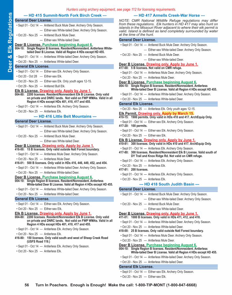
56 Turn In Poachers. Enough is Enough! Make the call: 1-800-TIP-MONT (1-800-847-6668)
D
eer &
Elk
Reg
ulat
ions
Hunters using archery equipment, see page 112 for licensing requirements. --- HD 415 Summit-North Fork Birch Creek ---General Deer License. • Sept 01 - Oct 14 — Antlered Buck Mule Deer. Archery Only Season. — Either-sex White-tailed Deer. Archery Only Season. • Oct 20 - Nov 25 — Antlered Buck Mule Deer. — Either-sex White-tailed Deer.Deer B License. Purchase beginning August 6.004-10: Single Region B licenses. Resident/Nonresident. Antlerless White-
tailed Deer B License. Valid all Region 4 HDs except HD 455. • Sept 01 - Oct 14 — Antlerless White-tailed Deer. Archery Only Season. • Oct 20 - Nov 25 — Antlerless White-tailed Deer.General Elk License. • Sept 01 - Oct 14 — Either-sex Elk. Archery Only Season. • Oct 20 - Oct 28 — Either-sex Elk. • Oct 20 - Nov 25 — Either-sex Elk. Only youth ages 12-15. • Oct 29 - Nov 25 — Antlered Bull Elk.Elk B License. Drawing only. Apply by June 1.004-80: 2200 licenses. Resident/Nonresident Elk B License. Only valid
on private and DNRC lands. Not valid on FWP WMAs. Valid in all Region 4 HDs except HDs 401, 410, 417 and 455.
• Sept 01 - Oct 14 — Antlerless Elk. Archery Only Season. • Oct 20 - Nov 25 — Antlerless Elk. --- HD 416 Little Belt Mountains ---General Deer License. • Sept 01 - Oct 14 — Antlered Buck Mule Deer. Archery Only Season. — Either-sex White-tailed Deer. Archery Only Season. • Oct 20 - Nov 25 — Antlered Buck Mule Deer. — Either-sex White-tailed Deer.Deer B License. Drawing only. Apply by June 1.416-00: 15 B licenses. Only valid outside Natl Forest boundary. • Sept 01 - Oct 14 — Antlerless Mule Deer. Archery Only Season. • Oct 20 - Nov 25 — Antlerless Mule Deer.
416-01: 500 B licenses. Only valid in HDs 416, 446, 449, 452, and 454. • Sept 01 - Oct 14 — Antlerless White-tailed Deer. Archery Only Season. • Oct 20 - Nov 25 — Antlerless White-tailed Deer.Deer B License. Purchase beginning August 6.004-10: Single Region B licenses. Resident/Nonresident. Antlerless
White-tailed Deer B License. Valid all Region 4 HDs except HD 455. • Sept 01 - Oct 14 — Antlerless White-tailed Deer. Archery Only Season. • Oct 20 - Nov 25 — Antlerless White-tailed Deer.General Elk License. • Sept 01 - Oct 14 — Either-sex Elk. Archery Only Season. • Oct 20 - Nov 25 — Either-sex Elk.Elk B License. Drawing only. Apply by June 1.004-80: 2200 licenses. Resident/Nonresident Elk B License. Only valid
on private and DNRC lands. Not valid on FWP WMAs. Valid in all Region 4 HDs except HDs 401, 410, 417 and 455.
• Sept 01 - Oct 14 — Antlerless Elk. Archery Only Season. • Oct 20 - Nov 25 — Antlerless Elk.
416-80: 150 licenses. Only valid south and west of Sheep Creek Road (USFS Road 119.)
• Sept 01 - Oct 14 — Antlerless Elk. Archery Only Season. • Oct 20 - Nov 25 — Antlerless Elk.
--- HD 417 Armells Creek-War Horse ---NOTE: CMR National Wildlife Refuge regulations may differ from these regulations. Elk hunters in HD 417 may also hunt on islands in the Missouri River adjacent to where their elk permit is valid. Island is defined as land completely surrounded by water at the time of the hunt.General Deer License. • Sept 01 - Oct 14 — Antlered Buck Mule Deer. Archery Only Season. — Either-sex White-tailed Deer. Archery Only Season. • Oct 20 - Nov 25 — Antlered Buck Mule Deer. — Either-sex White-tailed Deer.Deer B License. Drawing only. Apply by June 1.417-00: 5 B licenses. Not valid on CMR refuge. • Sept 01 - Oct 14 — Antlerless Mule Deer. Archery Only Season. • Oct 20 - Nov 25 — Antlerless Mule Deer.Deer B License. Purchase beginning August 6.004-10: Single Region B licenses. Resident/Nonresident. Antlerless
White-tailed Deer B License. Valid all Region 4 HDs except HD 455. • Sept 01 - Oct 14 — Antlerless White-tailed Deer. Archery Only Season. • Oct 20 - Nov 25 — Antlerless White-tailed Deer.General Elk License. • Oct 20 - Nov 25 — Antlerless Elk. Only youth ages 12-15.Elk Permit. Drawing only. Apply by March 15.410-15: 1900 permits. Only valid in HDs 410 and 417. ArchEquip Only. • Sept 01 - Oct 14 — Either-sex Elk. Archery Only Season.
417-20: 100 permits. • Sept 01 - Oct 14 — Either-sex Elk. Archery Only Season. • Oct 20 - Nov 25 — Either-sex Elk.Elk B License. Drawing only. Apply by June 1.410-81: 300 licenses. Only valid in HDs 410 and 417. ArchEquip Only. • Sept 01 - Oct 14 — Antlerless Elk. Archery Only Season.
417-80: 300 licenses. Resident/Nonresident Elk B License. Valid south of DY Trail and Knox Ridge Rd. Not valid on CMR refuge.
• Sept 01 - Oct 14 — Antlerless Elk. Archery Only Season. • Oct 20 - Nov 25 — Antlerless Elk.
417-81: 200 licenses. • Sept 01 - Oct 14 — Antlerless Elk. Archery Only Season. • Oct 20 - Nov 25 — Antlerless Elk. --- HD 418 South Judith Basin ---General Deer License. • Sept 01 - Oct 14 — Antlered Buck Mule Deer. Archery Only Season. — Either-sex White-tailed Deer. Archery Only Season. • Oct 20 - Nov 25 — Antlered Buck Mule Deer. — Either-sex White-tailed Deer.Deer B License. Drawing only. Apply by June 1.411-01: 1000 B licenses. Only valid in HDs 411, 412, and 418. • Sept 01 - Oct 14 — Antlerless White-tailed Deer. Archery Only Season. • Oct 20 - Nov 25 — Antlerless White-tailed Deer.
418-00: 25 B licenses. Only valid outside Natl Forest boundary. • Sept 01 - Oct 14 — Antlerless Mule Deer. Archery Only Season. • Oct 20 - Nov 25 — Antlerless Mule Deer.Deer B License. Purchase beginning August 6.004-10: Single Region B licenses. Resident/Nonresident. Antlerless
White-tailed Deer B License. Valid all Region 4 HDs except HD 455. • Sept 01 - Oct 14 — Antlerless White-tailed Deer. Archery Only Season. • Oct 20 - Nov 25 — Antlerless White-tailed Deer.General Elk License. • Sept 01 - Oct 14 — Either-sex Elk. Archery Only Season. • Oct 20 - Nov 25 — Either-sex Elk.

Visit fwp.mt.gov 572012 Deer • Elk • Antelope
Deer &
Elk Regulations
Elk B License. Drawing only. Apply by June 1.004-80: 2200 licenses. Resident/Nonresident Elk B License. Only valid
on private and DNRC lands. Not valid on FWP WMAs. Valid in all Region 4 HDs except HDs 401, 410, 417 and 455.
• Sept 01 - Oct 14 — Antlerless Elk. Archery Only Season. • Oct 20 - Nov 25 — Antlerless Elk. --- HD 419 Stanford ---General Deer License. • Sept 01 - Oct 14 — Antlered Buck Mule Deer. Archery Only Season. — Either-sex White-tailed Deer. Archery Only Season. • Oct 20 - Nov 25 — Antlered Buck Mule Deer. — Either-sex White-tailed Deer.Deer B License. Drawing only. Apply by June 1.419-00: 5 B licenses. • Sept 01 - Oct 14 — Antlerless Mule Deer. Archery Only Season. • Oct 20 - Nov 25 — Antlerless Mule Deer.Deer B License. Purchase beginning August 6.004-10: Single Region B licenses. Resident/Nonresident. Antlerless White-
tailed Deer B License. Valid all Region 4 HDs except HD 455. • Sept 01 - Oct 14 — Antlerless White-tailed Deer. Archery Only Season. • Oct 20 - Nov 25 — Antlerless White-tailed Deer.General Elk License. • Sept 01 - Oct 14 — Either-sex Elk. Archery Only Season. • Oct 20 - Nov 25 — Either-sex Elk.Elk B License. Drawing only. Apply by June 1.004-80: 2200 licenses. Resident/Nonresident Elk B License. Only valid
on private and DNRC lands. Not valid on FWP WMAs. Valid in all Region 4 HDs except HDs 401, 410, 417 and 455.
• Sept 01 - Oct 14 — Antlerless Elk. Archery Only Season. • Oct 20 - Nov 25 — Antlerless Elk.NOTE: Elk numbers are low and will be difficult to find. --HD 420 Judith River Wildlife Management Area-Sage Creek -General Deer License. • Sept 01 - Oct 14 — Antlered Buck Mule Deer. Archery Only Season. — Either-sex White-tailed Deer. Archery Only Season. • Oct 20 - Nov 25 — Antlered Buck Mule Deer. — Either-sex White-tailed Deer.Deer B License. Purchase beginning August 6.004-10: Single Region B licenses. Resident/Nonresident. Antlerless
White-tailed Deer B License. Valid all Region 4 HDs except HD 455. • Sept 01 - Oct 14 — Antlerless White-tailed Deer. Archery Only Season. • Oct 20 - Nov 25 — Antlerless White-tailed Deer.General Elk License. • Sept 01 - Oct 14 — Either-sex Elk. Archery Only Season.Elk Permit. Drawing only. Apply by March 15.420-20: 80 permits. Only valid in HDs 420 and 448. • Sept 01 - Oct 14 — Either-sex Elk. Archery Only Season. • Oct 20 - Nov 25 — Either-sex Elk.Elk B License. Drawing only. Apply by June 1.004-80: 2200 licenses. Resident/Nonresident Elk B License. Only valid
on private and DNRC lands. Not valid on FWP WMAs. Valid in all Region 4 HDs except HDs 401, 410, 417 and 455.
• Sept 01 - Oct 14 — Antlerless Elk. Archery Only Season. • Oct 20 - Nov 25 — Antlerless Elk.
448-80: 150 licenses. Only valid in HDs 420 and 448. • Sept 01 - Oct 14 — Antlerless Elk. Archery Only Season. • Oct 20 - Nov 25 — Antlerless Elk.
--- HD 421 Birdtail Hills ---General Deer License. • Sept 01 - Oct 14 — Antlered Buck Mule Deer. Archery Only Season. — Either-sex White-tailed Deer. Archery Only Season. • Oct 20 - Nov 25 — Antlered Buck Mule Deer. — Either-sex White-tailed Deer.Deer B License. Drawing only. Apply by June 1.421-00: 75 B licenses. • Sept 01 - Oct 14 — Antlerless Mule Deer. Archery Only Season. • Oct 20 - Nov 25 — Antlerless Mule Deer.Deer B License. Purchase beginning August 6.004-10: Single Region B licenses. Resident/Nonresident. Antlerless
White-tailed Deer B License. Valid all Region 4 HDs except HD 455. • Sept 01 - Oct 14 — Antlerless White-tailed Deer. Archery Only Season. • Oct 20 - Nov 25 — Antlerless White-tailed Deer.General Elk License. • Sept 01 - Oct 14 — Either-sex Elk. Archery Only Season. • Oct 20 - Nov 25 — Either-sex Elk.Elk B License. Drawing only. Apply by June 1.004-80: 2200 licenses. Resident/Nonresident Elk B License. Only valid
on private and DNRC lands. Not valid on FWP WMAs. Valid in all Region 4 HDs except HDs 401, 410, 417 and 455.
• Sept 01 - Oct 14 — Antlerless Elk. Archery Only Season. • Oct 20 - Nov 25 — Antlerless Elk. --- HD 422 North Dearborn ---NOTE: Hunting district boundary change, see legal description.General Deer License. • Sept 01 - Oct 14 — Antlered Buck Mule Deer. Archery Only Season. — Either-sex White-tailed Deer. Archery Only Season. • Oct 20 - Nov 25 — Antlered Buck Mule Deer. — Either-sex White-tailed Deer.Deer B License. Drawing only. Apply by June 1.422-00: 50 B licenses. Only valid outside Natl Forest boundary. • Sept 01 - Oct 14 — Antlerless Mule Deer. Archery Only Season. • Oct 20 - Nov 25 — Antlerless Mule Deer.Deer B License. Purchase beginning August 6.004-10: Single Region B licenses. Resident/Nonresident. Antlerless
White-tailed Deer B License. Valid all Region 4 HDs except HD 455. • Sept 01 - Oct 14 — Antlerless White-tailed Deer. Archery Only Season. • Oct 20 - Nov 25 — Antlerless White-tailed Deer.General Elk License. • Sept 01 - Oct 14 — Either-sex Elk. Archery Only Season. • Oct 20 - Nov 25 — Either-sex Elk.Elk B License. Drawing only. Apply by June 1.004-80: 2200 licenses. Resident/Nonresident Elk B License. Only valid
on private and DNRC lands. Not valid on FWP WMAs. Valid in all Region 4 HDs except HDs 401, 410, 417 and 455.
• Sept 01 - Oct 14 — Antlerless Elk. Archery Only Season. • Oct 20 - Nov 25 — Antlerless Elk.
422-80: 350 licenses. Resident/Nonresident. Valid in entire HD. • Sept 01 - Oct 14 — Antlerless Elk. Archery Only Season. • Oct 20 - Nov 25 — Antlerless Elk.

58 Turn In Poachers. Enough is Enough! Make the call: 1-800-TIP-MONT (1-800-847-6668)
D
eer &
Elk
Reg
ulat
ions
Hunters using archery equipment, see page 112 for licensing requirements. --- HD 423 South Dearborn ---General Deer License. • Sept 01 - Oct 14 — Antlered Buck Mule Deer. Archery Only Season. — Either-sex White-tailed Deer. Archery Only Season. • Oct 20 - Nov 25 — Antlered Buck Mule Deer. — Either-sex White-tailed Deer.Deer B License. Drawing only. Apply by June 1.423-00: 50 B licenses. • Sept 01 - Oct 14 — Antlerless Mule Deer. Archery Only Season. • Oct 20 - Nov 25 — Antlerless Mule Deer.Deer B License. Purchase beginning August 6.004-10: Single Region B licenses. Resident/Nonresident. Antlerless White-
tailed Deer B License. Valid all Region 4 HDs except HD 455. • Sept 01 - Oct 14 — Antlerless White-tailed Deer. Archery Only Season. • Oct 20 - Nov 25 — Antlerless White-tailed Deer.General Elk License. • Sept 01 - Oct 14 — Brow-tined Bull or Antlerless Elk. Archery Only Season. • Oct 20 - Nov 25 — Brow-tined Bull or Antlerless Elk.Elk B License. Drawing only. Apply by June 1.004-80: 2200 licenses. Resident/Nonresident Elk B License. Only valid
on private and DNRC lands. Not valid on FWP WMAs. Valid in all Region 4 HDs except HDs 401, 410, 417 and 455.
• Sept 01 - Oct 14 — Antlerless Elk. Archery Only Season. • Oct 20 - Nov 25 — Antlerless Elk. --- HD 424 Benchmark ---NOTE: Hunting district boundary change, see legal description.General Deer License. • Sept 01 - Oct 14 — Antlered Buck Mule Deer. Archery Only Season. — Either-sex White-tailed Deer. Archery Only Season. • Oct 20 - Nov 25 — Antlered Buck Mule Deer. — Either-sex White-tailed Deer.Deer B License. Drawing only. Apply by June 1.424-00: 25 B licenses. Only valid outside Natl Forest boundary. • Sept 01 - Oct 14 — Antlerless Mule Deer. Archery Only Season. • Oct 20 - Nov 25 — Antlerless Mule Deer.Deer B License. Purchase beginning August 6.004-10: Single Region B licenses. Resident/Nonresident. Antlerless White-
tailed Deer B License. Valid all Region 4 HDs except HD 455. • Sept 01 - Oct 14 — Antlerless White-tailed Deer. Archery Only Season. • Oct 20 - Nov 25 — Antlerless White-tailed Deer.General Elk License. • Sept 01 - Oct 14 — Brow-tined Bull or Antlerless Elk. Archery Only Season. • Oct 20 - Oct 23 — Antlerless Elk. • Oct 24 - Nov 25 — Brow-tined Bull or Antlerless Elk. Until closed, but no
later than Nov 25. Quota = 10 antlerless or brow-tined elk through check station. May be closed on 12 hour notice. If quota is reached, season will remain open on brow-tined bull until Nov 25.
Elk B License. Drawing only. Apply by June 1.004-80: 2200 licenses. Resident/Nonresident Elk B License. Only valid
on private and DNRC lands. Not valid on FWP WMAs. Valid in all Region 4 HDs except HDs 401, 410, 417 and 455.
• Sept 01 - Oct 14 — Antlerless Elk. Archery Only Season. • Oct 20 - Nov 25 — Antlerless Elk.
--- HD 425 Sun River WMA ---NOTE: No antlered Bull Elk hunting in HD 425, except during the Archery Only Season.General Deer License. • Sept 01 - Oct 14 — Antlered Buck Mule Deer. Archery Only Season. — Either-sex White-tailed Deer. Archery Only Season. • Oct 20 - Nov 25 — Antlered Buck Mule Deer. — Either-sex White-tailed Deer.Deer B License. Drawing only. Apply by June 1.425-00: 25 B licenses. Valid outside Sun River WMA. • Sept 01 - Oct 14 — Antlerless Mule Deer. Archery Only Season. • Oct 20 - Nov 25 — Antlerless Mule Deer.Deer B License. Purchase beginning August 6.004-10: Single Region B licenses. Resident/Nonresident. Antlerless
White-tailed Deer B License. Valid all Region 4 HDs except HD 455. • Sept 01 - Oct 14 — Antlerless White-tailed Deer. Archery Only Season. • Oct 20 - Nov 25 — Antlerless White-tailed Deer.General Elk License. • Sept 01 - Oct 14 — Brow-tined Bull or Antlerless Elk. Archery Only Season. • Oct 20 - Nov 25 — Antlerless Elk. Only valid outside the Sun River WMA.Elk B License. Drawing only. Apply by June 1.004-80: 2200 licenses. Resident/Nonresident Elk B License. Only valid
on private and DNRC lands. Not valid on FWP WMAs. Valid in all Region 4 HDs except HDs 401, 410, 417 and 455.
• Sept 01 - Oct 14 — Antlerless Elk. Archery Only Season. • Oct 20 - Nov 25 — Antlerless Elk.
425-80: 25 licenses. Valid entire HD including Sun River WMA. • Oct 15 - Oct 21 — Antlerless Elk. Successful 425-80 license applicant may
take 2nd antlerless elk with general elk license.425-81: 30 licenses. Valid entire HD including Sun River WMA. • Oct 22 - Oct 28 — Antlerless Elk. Successful 425-81 license applicant may
take 2nd antlerless elk with general elk license.425-82: 35 licenses. Valid entire HD including Sun River WMA. • Oct 29 - Nov 04 — Antlerless Elk. Successful 425-82 license applicant may
take 2nd antlerless elk with general elk license.425-83: 35 licenses. Valid entire HD including Sun River WMA. • Nov 05 - Nov 11 — Antlerless Elk. Successful 425-83 license applicant may
take 2nd antlerless elk with general elk license.425-84: 35 licenses. Valid entire HD including Sun River WMA. • Nov 12 - Nov 18 — Antlerless Elk. Successful 425-84 license applicant may
take 2nd antlerless elk with general elk license.425-85: 35 licenses. Valid entire HD including Sun River WMA. • Nov 19 - Nov 25 — Antlerless Elk. Successful 425-85 license applicant may
take 2nd antlerless elk with general elk license. --- HD 426 Winifred ---General Deer License. • Sept 01 - Oct 14 — Antlered Buck Mule Deer. Archery Only Season. — Either-sex White-tailed Deer. Archery Only Season. • Oct 20 - Nov 25 — Antlered Buck Mule Deer. — Either-sex White-tailed Deer.Deer B License. Drawing only. Apply by June 1.426-00: 5 B licenses. • Sept 01 - Oct 14 — Antlerless Mule Deer. Archery Only Season. • Oct 20 - Nov 25 — Antlerless Mule Deer.Deer B License. Purchase beginning August 6.004-10: Single Region B licenses. Resident/Nonresident. Antlerless
White-tailed Deer B License. Valid all Region 4 HDs except HD 455. • Sept 01 - Oct 14 — Antlerless White-tailed Deer. Archery Only Season. • Oct 20 - Nov 25 — Antlerless White-tailed Deer.

Visit fwp.mt.gov 592012 Deer • Elk • Antelope
Deer &
Elk Regulations
General Elk License. • Sept 01 - Oct 14 — Antlerless Elk. Archery Only Season. • Oct 20 - Nov 25 — Antlerless Elk. Only youth ages 12-15.Elk Permit. Drawing only. Apply by March 15.411-15: 900 permits. First and second choice only. Only valid in HDs 401,
403, 411, 412, 426, 447, 450, 500, 502, portion 510 west of HWY 310, 511, portion of 520 south and east of West Fork of Rock Ck, 530, 570, 575, portion of 580 south of Sweetgrass Ck, 590, portion of 701 north of Yellowstone River, south of HWY 12 and west of Sumatra-Myers Road, 702, 704 and 705.
• Sept 01 - Oct 14 — Either-sex Elk. Archery Only Season.426-20: 20 permits. • Sept 01 - Oct 14 — Either-sex Elk. Archery Only Season. • Oct 20 - Nov 25 — Either-sex Elk.Elk B License. Drawing only. Apply by June 1.004-80: 2200 licenses. Resident/Nonresident Elk B License. Only valid
on private and DNRC lands. Not valid on FWP WMAs. Valid in all Region 4 HDs except HDs 401, 410, 417 and 455.
• Sept 01 - Oct 14 — Antlerless Elk. Archery Only Season. • Oct 20 - Nov 25 — Antlerless Elk.
426-80: 40 licenses. • Sept 01 - Oct 14 — Antlerless Elk. Archery Only Season. • Oct 20 - Nov 25 — Antlerless Elk.
900-80: 1000 licenses. Only valid on private lands outside Block Mgmnt Areas in HDs 401, 403, 411, 412, 426, 447, 450, 500, 502, portion 510 west of HWY 310, 511, portion of 520 south and east of West Fork of Rock Ck, 530, 570, 575, portion of 580 south of Sweetgrass Ck, 590, portion of 701 north of Yellowstone River, south of HWY 12 and west of Sumatra-Myers Road, 702, 704 and 705.
• Sept 01 - Oct 14 — Antlerless Elk. Archery Only Season. • Oct 20 - Nov 25 — Antlerless Elk. --- HD 432 Otter Creek ---General Deer License. • Sept 01 - Oct 14 — Antlered Buck Mule Deer. Archery Only Season. — Either-sex White-tailed Deer. Archery Only Season. • Oct 20 - Nov 25 — Antlered Buck Mule Deer. — Either-sex White-tailed Deer.Deer B License. Drawing only. Apply by June 1.432-00: 25 B licenses. Only valid outside Natl Forest boundary. • Sept 01 - Oct 14 — Antlerless Mule Deer. Archery Only Season. • Oct 20 - Nov 25 — Antlerless Mule Deer.Deer B License. Purchase beginning August 6.004-10: Single Region B licenses. Resident/Nonresident. Antlerless
White-tailed Deer B License. Valid all Region 4 HDs except HD 455. • Sept 01 - Oct 14 — Antlerless White-tailed Deer. Archery Only Season. • Oct 20 - Nov 25 — Antlerless White-tailed Deer.General Elk License. • Sept 01 - Oct 14 — Either-sex Elk. Archery Only Season. • Oct 20 - Nov 25 — Either-sex Elk.Elk B License. Drawing only. Apply by June 1.004-80: 2200 licenses. Resident/Nonresident Elk B License. Only valid
on private and DNRC lands. Not valid on FWP WMAs. Valid in all Region 4 HDs except HDs 401, 410, 417 and 455.
• Sept 01 - Oct 14 — Antlerless Elk. Archery Only Season. • Oct 20 - Nov 25 — Antlerless Elk.
--- HD 441 North Fork Birch Creek-Teton ---General Deer License. • Sept 01 - Oct 14 — Antlered Buck Mule Deer. Archery Only Season. — Either-sex White-tailed Deer. Archery Only Season. • Oct 20 - Nov 04 — Antlered Buck Mule Deer. • Oct 20 - Nov 25 — Antlered Buck Mule Deer. Only valid within Natl Forest
boundary. — Either-sex White-tailed Deer.Deer Permit. Drawing only. Apply by March 15.441-50: 50 permits. Permit must be used with a valid General Deer License.
Holders may not hunt Antlered Buck Mule Deer in any other HD. • Sept 01 - Oct 14 — Antlered Buck Mule Deer. Archery Only Season. • Nov 05 - Nov 25 — Antlered Buck Mule Deer.Deer B License. Drawing only. Apply by June 1.441-00: 150 B licenses. • Sept 01 - Oct 14 — Antlerless Mule Deer. Archery Only Season. • Nov 05 - Nov 25 — Antlerless Mule Deer.Deer B License. Purchase beginning August 6.004-10: Single Region B licenses. Resident/Nonresident. Antlerless
White-tailed Deer B License. Valid all Region 4 HDs except HD 455. • Sept 01 - Oct 14 — Antlerless White-tailed Deer. Archery Only Season. • Oct 20 - Nov 25 — Antlerless White-tailed Deer.General Elk License. • Sept 01 - Oct 14 — Either-sex Elk. Archery Only Season. • Oct 20 - Nov 25 — Antlered Bull Elk. Only valid in Bob Marshall Wilderness. — Antlerless Elk. Only youth ages 12-15.Elk Permit. Drawing only. Apply by March 15.441-20: 30 permits. • Sept 01 - Oct 14 — Either-sex Elk. Archery Only Season. • Oct 20 - Nov 25 — Either-sex Elk.Elk B License. Drawing only. Apply by June 1.004-80: 2200 licenses. Resident/Nonresident Elk B License. Only valid
on private and DNRC lands. Not valid on FWP WMAs. Valid in all Region 4 HDs except HDs 401, 410, 417 and 455.
• Sept 01 - Oct 14 — Antlerless Elk. Archery Only Season. • Oct 20 - Nov 25 — Antlerless Elk.
441-80: 350 licenses. • Sept 01 - Oct 14 — Antlerless Elk. Archery Only Season. • Oct 20 - Nov 25 — Antlerless Elk. --- HD 442 Sun River ---General Deer License. • Sept 01 - Oct 14 — Antlered Buck Mule Deer. Archery Only Season. — Either-sex White-tailed Deer. Archery Only Season. • Oct 20 - Nov 25 — Antlered Buck Mule Deer. — Either-sex White-tailed Deer.Deer B License. Drawing only. Apply by June 1.442-00: 25 B licenses. Only valid outside Natl Forest boundary and
outside Ear Mtn WMA. • Sept 01 - Oct 14 — Antlerless Mule Deer. Archery Only Season. • Oct 20 - Nov 25 — Antlerless Mule Deer.Deer B License. Purchase beginning August 6.004-10: Single Region B licenses. Resident/Nonresident. Antlerless
White-tailed Deer B License. Valid all Region 4 HDs except HD 455. • Sept 01 - Oct 14 — Antlerless White-tailed Deer. Archery Only Season. • Oct 20 - Nov 25 — Antlerless White-tailed Deer.
...HD 442 continued on page 60.

60 Turn In Poachers. Enough is Enough! Make the call: 1-800-TIP-MONT (1-800-847-6668)
D
eer &
Elk
Reg
ulat
ions
Hunters using archery equipment, see page 112 for licensing requirements. ...HD 442 continued from page 59.
General Elk License. • Sept 01 - Oct 14 — Brow-tined Bull or Antlerless Elk. Archery Only Season. • Oct 20 - Oct 23 — Antlerless Elk. • Oct 24 - Nov 25 — Brow-tined Bull or Antlerless Elk. Until closed, but no
later than Nov 25. Quota = 250 antlerless or brow-tined elk through check station. May be closed on 12 hour notice. If quota is reached, season will remain open on brow-tined bull until Nov 25.
Elk B License. Drawing only. Apply by June 1.004-80: 2200 licenses. Resident/Nonresident Elk B License. Only valid
on private and DNRC lands. Not valid on FWP WMAs. Valid in all Region 4 HDs except HDs 401, 410, 417 and 455.
• Sept 01 - Oct 14 — Antlerless Elk. Archery Only Season. • Oct 20 - Nov 25 — Antlerless Elk.
442-80: 300 licenses. Resident/Nonresident Elk B License. Valid in entire HD. • Sept 01 - Oct 14 — Antlerless Elk. Archery Only Season. • Oct 20 - Nov 25 — Antlerless Elk. Until closed but no later than Nov 25
based on HD442 elk quota.450-80: 30 licenses. Only valid in HD 450 and in HD 442 north of South
and Main Forks of Deep Crk, and east of the Bob Marshall Wilderness boundary.
• Sept 01 - Oct 14 — Antlerless Elk. Archery Only Season. • Oct 20 - Nov 25 — Antlerless Elk. --- HD 444 Lower Sun River ---General Deer License. • Sept 01 - Oct 14 — Antlered Buck Mule Deer. Archery Only Season. — Either-sex White-tailed Deer. Archery Only Season. • Oct 20 - Nov 25 — Antlered Buck Mule Deer. — Either-sex White-tailed Deer.Deer B License. Drawing only. Apply by June 1.404-01: 300 B licenses. Only valid in HDs 404 and 444. • Sept 01 - Oct 14 — Antlerless White-tailed Deer. Archery Only Season. • Oct 20 - Nov 25 — Antlerless White-tailed Deer.
444-00: 150 B licenses. • Sept 01 - Oct 14 — Antlerless Mule Deer. Archery Only Season. • Oct 20 - Nov 25 — Antlerless Mule Deer.Deer B License. Purchase beginning August 6.004-10: Single Region B licenses. Resident/Nonresident. Antlerless
White-tailed Deer B License. Valid all Region 4 HDs except HD 455. • Sept 01 - Oct 14 — Antlerless White-tailed Deer. Archery Only Season. • Oct 20 - Nov 25 — Antlerless White-tailed Deer.General Elk License. • Sept 01 - Oct 14 — Either-sex Elk. Archery Only Season. • Oct 20 - Nov 25 — Either-sex Elk.Elk B License. Drawing only. Apply by June 1.004-80: 2200 licenses. Resident/Nonresident Elk B License. Only valid
on private and DNRC lands. Not valid on FWP WMAs. Valid in all Region 4 HDs except HDs 401, 410, 417 and 455.
• Sept 01 - Oct 14 — Antlerless Elk. Archery Only Season. • Oct 20 - Nov 25 — Antlerless Elk.NOTE: Elk numbers are low and will be difficult to find.
--- HD 445 Hound Creek ---General Deer License. • Sept 01 - Oct 14 — Antlered Buck Mule Deer. Archery Only Season. — Either-sex White-tailed Deer. Archery Only Season. • Oct 20 - Nov 25 — Antlered Buck Mule Deer. — Either-sex White-tailed Deer.Deer B License. Drawing only. Apply by June 1.445-00: 100 B licenses. Only valid in HD 445 and outside Natl Forest
boundary in HD 413. • Sept 01 - Oct 14 — Antlerless Mule Deer. Archery Only Season. • Oct 20 - Nov 25 — Antlerless Mule Deer.
445-01: 1000 B licenses. Only valid HDs 445 and 413. • Sept 01 - Oct 14 — Antlerless White-tailed Deer. Archery Only Season. • Oct 20 - Nov 25 — Antlerless White-tailed Deer.Deer B License. Purchase beginning August 6.004-10: Single Region B licenses. Resident/Nonresident. Antlerless
White-tailed Deer B License. Valid all Region 4 HDs except HD 455. • Sept 01 - Oct 14 — Antlerless White-tailed Deer. Archery Only Season. • Oct 20 - Nov 25 — Antlerless White-tailed Deer.General Elk License. • Sept 01 - Oct 14 — Either-sex Elk. Archery Only Season. • Oct 20 - Nov 04 — Either-sex Elk. • Nov 05 - Nov 25 — Antlerless Elk.Elk Permit. Drawing only. Apply by March 15.445-20: 50 permits. • Sept 01 - Oct 14 — Either-sex Elk. Archery Only Season. • Oct 20 - Nov 25 — Either-sex Elk.Elk B License. Drawing only. Apply by June 1.004-80: 2200 licenses. Resident/Nonresident Elk B License. Only valid
on private and DNRC lands. Not valid on FWP WMAs. Valid in all Region 4 HDs except HDs 401, 410, 417 and 455.
• Sept 01 - Oct 14 — Antlerless Elk. Archery Only Season. • Oct 20 - Nov 25 — Antlerless Elk. --- HD 446 Northeast Big Belt Mountains ---General Deer License. • Sept 01 - Oct 14 — Antlered Buck Mule Deer. Archery Only Season. — Either-sex White-tailed Deer. Archery Only Season. • Oct 20 - Nov 25 — Antlered Buck Mule Deer. — Either-sex White-tailed Deer.Deer B License. Drawing only. Apply by June 1.416-01: 500 B licenses. Only valid in HDs 416, 446, 449, 452, and 454. • Sept 01 - Oct 14 — Antlerless White-tailed Deer. Archery Only Season. • Oct 20 - Nov 25 — Antlerless White-tailed Deer.Deer B License. Purchase beginning August 6.004-10: Single Region B licenses. Resident/Nonresident. Antlerless
White-tailed Deer B License. Valid all Region 4 HDs except HD 455. • Sept 01 - Oct 14 — Antlerless White-tailed Deer. Archery Only Season. • Oct 20 - Nov 25 — Antlerless White-tailed Deer.General Elk License. • Sept 01 - Oct 14 — Brow-tined Bull or Antlerless Elk. Archery Only Season. • Oct 20 - Nov 25 — Brow-tined Bull or Antlerless Elk.Elk B License. Drawing only. Apply by June 1.004-80: 2200 licenses. Resident/Nonresident Elk B License. Only valid
on private and DNRC lands. Not valid on FWP WMAs. Valid in all Region 4 HDs except HDs 401, 410, 417 and 455.
• Sept 01 - Oct 14 — Antlerless Elk. Archery Only Season. • Oct 20 - Nov 25 — Antlerless Elk.

Visit fwp.mt.gov 652012 Deer • Elk • Antelope
Deer &
Elk Regulations
--- HD 447 Belt-Square Butte ---NOTE: Hunting district boundary change, see legal description.General Deer License. • Sept 01 - Oct 14 — Antlered Buck Mule Deer. Archery Only Season. — Either-sex White-tailed Deer. Archery Only Season. • Oct 20 - Nov 25 — Antlered Buck Mule Deer. — Either-sex White-tailed Deer.Deer B License. Drawing only. Apply by June 1.447-00: 25 B licenses. Only valid outside Natl Forest boundary. • Sept 01 - Oct 14 — Antlerless Mule Deer. Archery Only Season. • Oct 20 - Nov 25 — Antlerless Mule Deer.Deer B License. Purchase beginning August 6.004-10: Single Region B licenses. Resident/Nonresident. Antlerless
White-tailed Deer B License. Valid all Region 4 HDs except HD 455.
• Sept 01 - Oct 14 — Antlerless White-tailed Deer. Archery Only Season. • Oct 20 - Nov 25 — Antlerless White-tailed Deer.General Elk License. • Sept 01 - Oct 14 — Antlerless Elk. Archery Only Season. • Oct 20 - Nov 25 — Antlerless Elk. Only youth ages 12-15.Elk Permit. Drawing only. Apply by March 15.420-15: 680 permits. First and second choice only. Only valid in HDs 401,
403, 411, 412, 426, 447, 450, 500, 502, portion 510 west of HWY 310, 511, portion of 520 south and east of West Fork of Rock Ck, 530, 570, 575, portion of 580 south of Sweetgrass Ck, 590, portion of 701 north of Yellowstone River, south of HWY 12 and west of Sumatra-Myers Road, 702, 704 and 705. ArchEquip Only.
• Sept 01 - Oct 14 — Either-sex Elk. Archery Only Season.447-20: 75 permits. • Sept 01 - Oct 14 — Either-sex Elk. Archery Only Season. • Oct 20 - Nov 25 — Either-sex Elk.Elk B License. Drawing only. Apply by June 1.004-80: 2200 licenses. Resident/Nonresident Elk B License. Only valid
on private and DNRC lands. Not valid on FWP WMAs. Valid in all Region 4 HDs except HDs 401, 410, 417 and 455.
• Sept 01 - Oct 14 — Antlerless Elk. Archery Only Season. • Oct 20 - Nov 25 — Antlerless Elk.
447-80: 200 licenses. • Sept 01 - Oct 14 — Antlerless Elk. Archery Only Season. • Oct 20 - Nov 25 — Antlerless Elk.
900-80: 1000 licenses. Only valid on private lands outside Block Mgmnt Areas in HDs 401, 403, 411, 412, 426, 447, 450, 500, 502, portion 510 west of HWY 310, 511, portion of 520 south and east of West Fork of Rock Ck, 530, 570, 575, portion of 580 south of Sweetgrass Ck, 590, portion of 701 north of Yellowstone River, south of HWY 12 and west of Sumatra-Myers Road, 702, 704 and 705.
• Sept 01 - Oct 14 — Antlerless Elk. Archery Only Season. • Oct 20 - Nov 25 — Antlerless Elk. --- HD 448 North Judith Basin-Central Little Belts ---General Deer License. • Sept 01 - Oct 14 — Antlered Buck Mule Deer. Archery Only Season. — Either-sex White-tailed Deer. Archery Only Season. • Oct 20 - Nov 25 — Antlered Buck Mule Deer. — Either-sex White-tailed Deer.Deer B License. Drawing only. Apply by June 1.448-00: 25 B licenses. Only valid outside Natl Forest boundary. • Sept 01 - Oct 14 — Antlerless Mule Deer. Archery Only Season. • Oct 20 - Nov 25 — Antlerless Mule Deer.
Deer B License. Purchase beginning August 6.004-10: Single Region B licenses. Resident/Nonresident. Antlerless White-
tailed Deer B License. Valid all Region 4 HDs except HD 455. • Sept 01 - Oct 14 — Antlerless White-tailed Deer. Archery Only Season. • Oct 20 - Nov 25 — Antlerless White-tailed Deer.General Elk License. • Sept 01 - Oct 14 — Either-sex Elk. Archery Only Season. • Oct 20 - Nov 16 — Antlered Bull Elk. • Nov 17 - Nov 25 — Either-sex Elk.Elk Permit. Drawing only. Apply by March 15.420-20: 80 permits. Only valid in HDs 420 and 448. • Sept 01 - Oct 14 — Either-sex Elk. Archery Only Season. • Oct 20 - Nov 25 — Either-sex Elk.Elk B License. Drawing only. Apply by June 1.004-80: 2200 licenses. Resident/Nonresident Elk B License. Only valid
on private and DNRC lands. Not valid on FWP WMAs. Valid in all Region 4 HDs except HDs 401, 410, 417 and 455.
• Sept 01 - Oct 14 — Antlerless Elk. Archery Only Season. • Oct 20 - Nov 25 — Antlerless Elk.
448-80: 150 licenses. Only valid in HDs 420 and 448. • Sept 01 - Oct 14 — Antlerless Elk. Archery Only Season. • Oct 20 - Nov 25 — Antlerless Elk. --- HD 449 Castle Mountains-East ---General Deer License. • Sept 01 - Oct 14 — Antlered Buck Mule Deer. Archery Only Season. — Either-sex White-tailed Deer. Archery Only Season. • Oct 20 - Nov 25 — Antlered Buck Mule Deer. — Either-sex White-tailed Deer.Deer B License. Drawing only. Apply by June 1.416-01: 500 B licenses. Only valid in HDs 416, 446, 449, 452, and 454. • Sept 01 - Oct 14 — Antlerless White-tailed Deer. Archery Only Season. • Oct 20 - Nov 25 — Antlerless White-tailed Deer.Deer B License. Purchase beginning August 6.004-10: Single Region B licenses. Resident/Nonresident. Antlerless White-
tailed Deer B License. Valid all Region 4 HDs except HD 455. • Sept 01 - Oct 14 — Antlerless White-tailed Deer. Archery Only Season. • Oct 20 - Nov 25 — Antlerless White-tailed Deer.General Elk License. • Sept 01 - Oct 14 — Either-sex Elk. Archery Only Season. • Oct 20 - Nov 25 — Either-sex Elk.Elk B License. Drawing only. Apply by June 1.004-80: 2200 licenses. Resident/Nonresident Elk B License. Only valid
on private and DNRC lands. Not valid on FWP WMAs. Valid in all Region 4 HDs except HDs 401, 410, 417 and 455.
• Sept 01 - Oct 14 — Antlerless Elk. Archery Only Season. • Oct 20 - Nov 25 — Antlerless Elk.

66 Turn In Poachers. Enough is Enough! Make the call: 1-800-TIP-MONT (1-800-847-6668)
D
eer &
Elk
Reg
ulat
ions
Hunters using archery equipment, see page 112 for licensing requirements. --- HD 450 Chouteau ---NOTE: The Teton-Spring Creek Cooperative Hunting Area (TSCA, formerly the Teton-Spring Creek Bird Preserve) offers a variety of weapons choices, depending upon proximity to residences. -Area Map and Rules available at FWP-R4 HQ 406-454-5840, in Great Falls.General Deer License. • Sept 01 - Oct 14 — Antlered Buck Mule Deer. Archery Only Season. — Either-sex White-tailed Deer. Archery Only Season. • Oct 20 - Nov 25 — Antlered Buck Mule Deer. — Either-sex White-tailed Deer.Deer B License. Drawing only. Apply by June 1.450-00: 50 B licenses. • Sept 01 - Oct 14 — Antlerless Mule Deer. Archery Only Season. • Oct 20 - Nov 25 — Antlerless Mule Deer.Deer B License. Purchase beginning August 6.004-10: Single Region B licenses. Resident/Nonresident. Antlerless White-
tailed Deer B License. Valid all Region 4 HDs except HD 455. • Sept 01 - Oct 14 — Antlerless White-tailed Deer. Archery Only Season. • Oct 20 - Nov 25 — Antlerless White-tailed Deer.General Elk License. • Sept 01 - Oct 14 — Antlerless Elk. Archery Only Season.Elk Permit. Drawing only. Apply by March 15.401-15: 350 permits. First and second choice only. Only valid in HDs 401,
403, 411, 412, 426, 447, 450, 500, 502, portion 510 west of HWY 310, 511, portion of 520 south and east of West Fork of Rock Ck, 530, 570, 575, portion of 580 south of Sweetgrass Ck, 590, portion of 701 north of Yellowstone River, south of HWY 12 and west of Sumatra-Myers Road, 702, 704 and 705. ArchEquip Only.
• Sept 01 - Oct 14 — Either-sex Elk. Archery Only Season.450-20: 5 permits. • Sept 01 - Oct 14 — Either-sex Elk. Archery Only Season. • Oct 20 - Nov 25 — Either-sex Elk.Elk B License. Drawing only. Apply by June 1.004-80: 2200 licenses. Resident/Nonresident Elk B License. Only valid
on private and DNRC lands. Not valid on FWP WMAs. Valid in all Region 4 HDs except HDs 401, 410, 417 and 455.
• Sept 01 - Oct 14 — Antlerless Elk. Archery Only Season. • Oct 20 - Nov 25 — Antlerless Elk.
450-80: 30 licenses. Only valid in HD 450 and in HD 442 north of South and Main Forks of Deep Crk, and east of the Bob Marshall Wilderness boundary.
• Sept 01 - Oct 14 — Antlerless Elk. Archery Only Season. • Oct 20 - Nov 25 — Antlerless Elk.
900-80: 1000 licenses. Only valid on private lands outside Block Mgmnt Areas in HDs 401, 403, 411, 412, 426, 447, 450, 500, 502, portion 510 west of HWY 310, 511, portion of 520 south and east of West Fork of Rock Ck, 530, 570, 575, portion of 580 south of Sweetgrass Ck, 590, portion of 701 north of Yellowstone River, south of HWY 12 and west of Sumatra-Myers Road, 702, 704 and 705.
• Sept 01 - Oct 14 — Antlerless Elk. Archery Only Season. • Oct 20 - Nov 25 — Antlerless Elk. --- HD 452 Castle Mountains-West ---General Deer License. • Sept 01 - Oct 14 — Antlered Buck Mule Deer. Archery Only Season. — Either-sex White-tailed Deer. Archery Only Season. • Oct 20 - Nov 25 — Antlered Buck Mule Deer. — Either-sex White-tailed Deer.Deer B License. Drawing only. Apply by June 1.416-01: 500 B licenses. Only valid in HDs 416, 446, 449, 452, and 454. • Sept 01 - Oct 14 — Antlerless White-tailed Deer. Archery Only Season. • Oct 20 - Nov 25 — Antlerless White-tailed Deer.
Deer B License. Purchase beginning August 6.004-10: Single Region B licenses. Resident/Nonresident. Antlerless White-
tailed Deer B License. Valid all Region 4 HDs except HD 455. • Sept 01 - Oct 14 — Antlerless White-tailed Deer. Archery Only Season. • Oct 20 - Nov 25 — Antlerless White-tailed Deer.General Elk License. • Sept 01 - Oct 14 — Either-sex Elk. Archery Only Season. • Oct 20 - Nov 25 — Either-sex Elk.Elk B License. Drawing only. Apply by June 1.004-80: 2200 licenses. Resident/Nonresident Elk B License. Only valid
on private and DNRC lands. Not valid on FWP WMAs. Valid in all Region 4 HDs except HDs 401, 410, 417 and 455.
• Sept 01 - Oct 14 — Antlerless Elk. Archery Only Season. • Oct 20 - Nov 25 — Antlerless Elk. --- HD 454 Little Belt Mountains-Southeast ---General Deer License. • Sept 01 - Oct 14 — Antlered Buck Mule Deer. Archery Only Season. — Either-sex White-tailed Deer. Archery Only Season. • Oct 20 - Nov 25 — Antlered Buck Mule Deer. — Either-sex White-tailed Deer.Deer B License. Drawing only. Apply by June 1.416-01: 500 B licenses. Only valid in HDs 416, 446, 449, 452, and 454. • Sept 01 - Oct 14 — Antlerless White-tailed Deer. Archery Only Season. • Oct 20 - Nov 25 — Antlerless White-tailed Deer.Deer B License. Purchase beginning August 6.004-10: Single Region B licenses. Resident/Nonresident. Antlerless
White-tailed Deer B License. Valid all Region 4 HDs except HD 455.
• Sept 01 - Oct 14 — Antlerless White-tailed Deer. Archery Only Season. • Oct 20 - Nov 25 — Antlerless White-tailed Deer.General Elk License. • Sept 01 - Oct 14 — Either-sex Elk. Archery Only Season. • Oct 20 - Nov 25 — Either-sex Elk.Elk B License. Drawing only. Apply by June 1.004-80: 2200 licenses. Resident/Nonresident Elk B License. Only valid
on private and DNRC lands. Not valid on FWP WMAs. Valid in all Region 4 HDs except HDs 401, 410, 417 and 455.
• Sept 01 - Oct 14 — Antlerless Elk. Archery Only Season. • Oct 20 - Nov 25 — Antlerless Elk. --- HD 455 Beartooth WMA ---NOTE: Special permit required to hunt either-sex Mule Deer. Special permit required to hunt either-sex White-tailed Deer Oct 20-Nov 25. Resident Single Region Antlerless White-tailed Deer B license NOT valid in HD 455.General Deer License. • Sept 01 - Oct 14 — Either-sex White-tailed Deer. Archery Only Season.Deer Permit. Drawing only. Apply by March 15.455-70: 30 permits. Permit must be used with a valid General Deer
License. Holders may not hunt Antlered Buck Mule Deer in any other HD.
• Sept 01 - Oct 14 — Either-sex Mule Deer. Archery Only Season. — Either-sex White-tailed Deer. Archery Only Season. • Oct 20 - Nov 25 — Either-sex Mule Deer. — Either-sex White-tailed Deer.General Elk License. • Sept 01 - Oct 14 — Either-sex Elk. Archery Only Season.Elk Permit. Drawing only. Apply by March 15.455-20: 75 permits. • Sept 01 - Oct 14 — Either-sex Elk. Archery Only Season. • Oct 20 - Nov 25 — Either-sex Elk.

Visit fwp.mt.gov 672012 Deer • Elk • Antelope
Deer &
Elk Regulations
Elk B License. Drawing only. Apply by June 1.455-80: 100 licenses. • Sept 01 - Oct 14 — Antlerless Elk. Archery Only Season. • Oct 20 - Nov 25 — Antlerless Elk. --- HD 471 Geraldine ---General Deer License. • Sept 01 - Oct 14 — Antlered Buck Mule Deer. Archery Only Season. — Either-sex White-tailed Deer. Archery Only Season. • Oct 20 - Nov 25 — Antlered Buck Mule Deer. — Either-sex White-tailed Deer.Deer B License. Drawing only. Apply by June 1.471-00: 25 B licenses. • Sept 01 - Oct 14 — Antlerless Mule Deer. Archery Only Season. • Oct 20 - Nov 25 — Antlerless Mule Deer.Deer B License. Purchase beginning August 6.004-10: Single Region B licenses. Resident/Nonresident. Antlerless White-
tailed Deer B License. Valid all Region 4 HDs except HD 455. • Sept 01 - Oct 14 — Antlerless White-tailed Deer. Archery Only Season. • Oct 20 - Nov 25 — Antlerless White-tailed Deer.General Elk License. • Sept 01 - Oct 14 — Either-sex Elk. Archery Only Season. • Oct 20 - Nov 25 — Either-sex Elk.Elk B License. Drawing only. Apply by June 1.004-80: 2200 licenses. Resident/Nonresident Elk B License. Only valid
on private and DNRC lands. Not valid on FWP WMAs. Valid in all Region 4 HDs except HDs 401, 410, 417 and 455.
• Sept 01 - Oct 14 — Antlerless Elk. Archery Only Season. • Oct 20 - Nov 25 — Antlerless Elk.NOTE: Elk numbers are low and will be difficult to find. --- HD 500 Hailstone-Painted Robe ---NOTE: Those portions of HD 500 lying within Golden Valley County are closed to the taking of deer exhibiting 75 percent or more of white coloration.General Deer License. • Sept 01 - Oct 14 — Antlered Buck Mule Deer. Archery Only Season. — Either-sex White-tailed Deer. Archery Only Season. • Oct 20 - Nov 25 — Antlered Buck Mule Deer. — Either-sex White-tailed Deer.Deer B License. Drawing only. Apply by June 1.500-00: 200 B licenses. • Sept 01 - Oct 14 — Antlerless Mule Deer. Archery Only Season. • Oct 20 - Nov 25 — Antlerless Mule Deer.
597-00: 600 B licenses. Only valid in HDs 500, 530 and 590. • Sept 01 - Oct 14 — Antlerless White-tailed Deer. Archery Only Season. • Oct 20 - Nov 25 — Antlerless White-tailed Deer.Deer B License. Purchase beginning August 6.005-10: Single Region B licenses. Resident/NonResident. Antlerless
White-tailed Deer B License. Only valid in all Region 5 HDs. • Sept 01 - Oct 14 — Antlerless White-tailed Deer. Archery Only Season. • Oct 20 - Nov 25 — Antlerless White-tailed Deer.General Elk License. • Sept 01 - Oct 14 — Antlerless Elk. Archery Only Season. • Oct 20 - Nov 25 — Antlerless Elk.
Elk Permit. Drawing only. Apply by March 15.500-15: 180 permits. First and second choice only. Only valid in HDs 401,
403, 411, 412, 426, 447, 450, 500, 502, portion 510 west of HWY 310, 511, portion of 520 south and east of West Fork of Rock Ck, 530, 570, 575, portion of 580 south of Sweetgrass Ck, 590, portion of 701 north of Yellowstone River, south of HWY 12 and west of Sumatra-Myers Road, 702, 704 and 705. ArchEquip Only.
• Sept 01 - Oct 14 — Either-sex Elk. Archery Only Season.500-20: 10 permits. • Sept 01 - Oct 14 — Either-sex Elk. Archery Only Season. • Oct 20 - Nov 25 — Either-sex Elk.Elk B License. Drawing only. Apply by June 1.500-80: 25 licenses. Only valid in HDs 500 and 570. • Sept 01 - Oct 14 — Antlerless Elk. Archery Only Season. • Oct 20 - Nov 25 — Antlerless Elk.
900-80: 1000 licenses. Only valid on private lands outside Block Mgmnt Areas in HDs 401, 403, 411, 412, 426, 447, 450, 500, 502, portion 510 west of HWY 310, 511, portion of 520 south and east of West Fork of Rock Ck, 530, 570, 575, portion of 580 south of Sweetgrass Ck, 590, portion of 701 north of Yellowstone River, south of HWY 12 and west of Sumatra-Myers Road, 702, 704 and 705.
• Sept 01 - Oct 14 — Antlerless Elk. Archery Only Season. • Oct 20 - Nov 25 — Antlerless Elk. --- HD 502 Crow Line ---General Deer License. • Sept 01 - Oct 14 — Either-sex Mule Deer. Archery Only Season. — Either-sex White-tailed Deer. Archery Only Season. • Oct 20 - Nov 25 — Either-sex Mule Deer. — Either-sex White-tailed Deer.Deer B License. Drawing only. Apply by June 1.502-00: 300 B licenses. • Sept 01 - Oct 14 — Antlerless Mule Deer. Archery Only Season. • Oct 20 - Nov 25 — Antlerless Mule Deer.
599-00: 2000 B licenses. Only valid in HDs 502, 510, 520, 560 and 575. • Sept 01 - Oct 14 — Antlerless White-tailed Deer. Archery Only Season. • Oct 20 - Nov 25 — Antlerless White-tailed Deer.Deer B License. Purchase beginning August 6.005-10: Single Region B licenses. Resident/NonResident. Antlerless
White-tailed Deer B License. Only valid in all Region 5 HDs. • Sept 01 - Oct 14 — Antlerless White-tailed Deer. Archery Only Season. • Oct 20 - Nov 25 — Antlerless White-tailed Deer.General Elk License. • Sept 01 - Oct 14 — Antlerless Elk. Archery Only Season. • Oct 20 - Nov 25 — Antlerless Elk.Elk Permit. Drawing only. Apply by March 15.502-15: 150 permits. First and second choice only. Only valid in HDs 401,
403, 411, 412, 426, 447, 450, 500, 502, portion 510 west of HWY 310, 511, portion of 520 south and east of West Fork of Rock Ck, 530, 570, 575, portion of 580 south of Sweetgrass Ck, 590, portion of 701 north of Yellowstone River, south of HWY 12 and west of Sumatra-Myers Road, 702, 704 and 705. ArchEquip Only.
• Sept 01 - Oct 14 — Either-sex Elk. Archery Only Season.502-20: 5 permits. Also valid in portion of HD 510 West of Hwy 310. • Sept 01 - Oct 14 — Either-sex Elk. Archery Only Season. • Oct 20 - Nov 25 — Either-sex Elk.Elk B License. Drawing only. Apply by June 1.900-80: 1000 licenses. Only valid on private lands outside Block Mgmnt
Areas in HDs 401, 403, 411, 412, 426, 447, 450, 500, 502, portion 510 west of HWY 310, 511, portion of 520 south and east of West Fork of Rock Ck, 530, 570, 575, portion of 580 south of Sweetgrass Ck, 590, portion of 701 north of Yellowstone River, south of HWY 12 and west of Sumatra-Myers Road, 702, 704 and 705.
• Sept 01 - Oct 14 — Antlerless Elk. Archery Only Season. • Oct 20 - Nov 25 — Antlerless Elk.

68 Turn In Poachers. Enough is Enough! Make the call: 1-800-TIP-MONT (1-800-847-6668)
D
eer &
Elk
Reg
ulat
ions
Hunters using archery equipment, see page 112 for licensing requirements. --- HD 510 Pryor Mountains ---General Deer License. • Sept 01 - Oct 14 — Either-sex White-tailed Deer. Archery Only Season. • Oct 20 - Nov 25 — Either-sex White-tailed Deer.Deer Permit. Drawing only. Apply by March 15.510-40: Unlim permits. Permit must be used with a valid General Deer
License. Holders may not hunt Antlered Buck Mule Deer in any other HD.
• Sept 01 - Oct 14 — Antlered Buck Mule Deer. Archery Only Season. • Oct 20 - Nov 25 — Antlered Buck Mule Deer.Deer B License. Drawing only. Apply by June 1.510-00: 150 B licenses. Only valid outside Natl Forest boundary. • Sept 01 - Oct 14 — Antlerless Mule Deer. Archery Only Season. • Oct 20 - Nov 25 — Antlerless Mule Deer.
599-00: 2000 B licenses. Only valid in HDs 502, 510, 520, 560 and 575. • Sept 01 - Oct 14 — Antlerless White-tailed Deer. Archery Only Season. • Oct 20 - Nov 25 — Antlerless White-tailed Deer.Deer B License. Purchase beginning August 6.005-10: Single Region B licenses. Resident/NonResident. Antlerless
White-tailed Deer B License. Only valid in all Region 5 HDs. • Sept 01 - Oct 14 — Antlerless White-tailed Deer. Archery Only Season. • Oct 20 - Nov 25 — Antlerless White-tailed Deer.General Elk License. • Sept 01 - Oct 14 — Antlerless Elk. Only valid west of Hwy 310. Archery Only Season. • Oct 20 - Nov 25 — Antlerless Elk. Only valid west of Hwy 310.Elk Permit. Drawing only. Apply by March 15.502-15: 150 permits. First and second choice only. Only valid in HDs 401,
403, 411, 412, 426, 447, 450, 500, 502, portion 510 west of HWY 310, 511, portion of 520 south and east of West Fork of Rock Ck, 530, 570, 575, portion of 580 south of Sweetgrass Ck, 590, portion of 701 north of Yellowstone River, south of HWY 12 and west of Sumatra-Myers Road, 702, 704 and 705. ArchEquip Only.
• Sept 01 - Oct 14 — Either-sex Elk. Archery Only Season.502-20: 5 permits. Also valid in portion of HD 510 West of Hwy 310. • Sept 01 - Oct 14 — Either-sex Elk. Archery Only Season. • Oct 20 - Nov 25 — Either-sex Elk.Elk B License. Drawing only. Apply by June 1.900-80: 1000 licenses. Only valid on private lands outside Block Mgmnt
Areas in HDs 401, 403, 411, 412, 426, 447, 450, 500, 502, portion 510 west of HWY 310, 511, portion of 520 south and east of West Fork of Rock Ck, 530, 570, 575, portion of 580 south of Sweetgrass Ck, 590, portion of 701 north of Yellowstone River, south of HWY 12 and west of Sumatra-Myers Road, 702, 704 and 705.
• Sept 01 - Oct 14 — Antlerless Elk. Archery Only Season. • Oct 20 - Nov 25 — Antlerless Elk. --- HD 511 South Big Snowy Mountains ---NOTE: Those portions of HD 511 lying within Golden Valley County are closed to the taking of deer exhibiting 75 percent or more of white coloration.General Deer License. • Sept 01 - Oct 14 — Antlered Buck Mule Deer. Archery Only Season. — Either-sex White-tailed Deer. Archery Only Season. • Oct 20 - Nov 25 — Antlered Buck Mule Deer. — Either-sex White-tailed Deer.Deer B License. Drawing only. Apply by June 1.511-00: 50 B licenses. • Sept 01 - Oct 14 — Antlerless Mule Deer. Archery Only Season. • Oct 20 - Nov 25 — Antlerless Mule Deer.
598-00: 2250 B licenses. Only valid in HDs 511, 540, 570, and 580. • Sept 01 - Oct 14 — Antlerless White-tailed Deer. Archery Only Season. • Oct 20 - Nov 25 — Antlerless White-tailed Deer.
Deer B License. Purchase beginning August 6.005-10: Single Region B licenses. Resident/NonResident. Antlerless
White-tailed Deer B License. Only valid in all Region 5 HDs. • Sept 01 - Oct 14 — Antlerless White-tailed Deer. Archery Only Season. • Oct 20 - Nov 25 — Antlerless White-tailed Deer.General Elk License. • Sept 01 - Oct 14 — Antlerless Elk. Archery Only Season. • Oct 20 - Nov 25 — Antlerless Elk.Elk Permit. Drawing only. Apply by March 15.411-15: 900 permits. First and second choice only. Only valid in HDs 401,
403, 411, 412, 426, 447, 450, 500, 502, portion 510 west of HWY 310, 511, portion of 520 south and east of West Fork of Rock Ck, 530, 570, 575, portion of 580 south of Sweetgrass Ck, 590, portion of 701 north of Yellowstone River, south of HWY 12 and west of Sumatra-Myers Road, 702, 704 and 705.
• Sept 01 - Oct 14 — Either-sex Elk. Archery Only Season.411-20: 200 permits. Only valid in HDs 411, 511 and 530. • Sept 01 - Oct 14 — Either-sex Elk. Archery Only Season. • Oct 20 - Nov 25 — Either-sex Elk.Elk B License. Drawing only. Apply by June 1.411-80: 400 licenses. Resident/Nonresident Elk B License. Only valid in
HDs 411, 511 and 530. Not valid on Natl Forest lands. • Sept 01 - Oct 14 — Antlerless Elk. Archery Only Season. • Oct 20 - Nov 25 — Antlerless Elk.
900-80: 1000 licenses. Only valid on private lands outside Block Mgmnt Areas in HDs 401, 403, 411, 412, 426, 447, 450, 500, 502, portion 510 west of HWY 310, 511, portion of 520 south and east of West Fork of Rock Ck, 530, 570, 575, portion of 580 south of Sweetgrass Ck, 590, portion of 701 north of Yellowstone River, south of HWY 12 and west of Sumatra-Myers Road, 702, 704 and 705.
• Sept 01 - Oct 14 — Antlerless Elk. Archery Only Season. • Oct 20 - Nov 25 — Antlerless Elk. --- HD 520 Beartooth Face ---General Deer License. • Sept 01 - Oct 14 — Antlered Buck Mule Deer. Archery Only Season. — Either-sex White-tailed Deer. Archery Only Season. • Oct 20 - Nov 25 — Antlered Buck Mule Deer. — Either-sex White-tailed Deer.Deer B License. Drawing only. Apply by June 1.520-00: 150 B licenses. Only valid outside Natl Forest boundary. • Sept 01 - Oct 14 — Antlerless Mule Deer. Archery Only Season. • Oct 20 - Nov 25 — Antlerless Mule Deer.
599-00: 2000 B licenses. Only valid in HDs 502, 510, 520, 560 and 575. • Sept 01 - Oct 14 — Antlerless White-tailed Deer. Archery Only Season. • Oct 20 - Nov 25 — Antlerless White-tailed Deer.Deer B License. Purchase beginning August 6.005-10: Single Region B licenses. Resident/NonResident. Antlerless
White-tailed Deer B License. Only valid in all Region 5 HDs. • Sept 01 - Oct 14 — Antlerless White-tailed Deer. Archery Only Season. • Oct 20 - Nov 25 — Antlerless White-tailed Deer.General Elk License. • Sept 01 - Oct 14 — Antlerless Elk. Only valid south and east of the West
Fork of Rock Crk. Archery Only Season. — Either-sex Elk. Only valid north and west of the West
Fork of Rock Crk. Archery Only Season. • Oct 20 - Nov 25 — Antlered Bull Elk. Only valid north and west of the West
Fork of Rock Crk. — Either-sex Elk. Only youth ages 12-15.

Visit fwp.mt.gov 692012 Deer • Elk • Antelope
Deer &
Elk Regulations
Elk Permit. Drawing only. Apply by March 15.502-15: 150 permits. First and second choice only. Only valid in HDs 401,
403, 411, 412, 426, 447, 450, 500, 502, portion 510 west of HWY 310, 511, portion of 520 south and east of West Fork of Rock Ck, 530, 570, 575, portion of 580 south of Sweetgrass Ck, 590, portion of 701 north of Yellowstone River, south of HWY 12 and west of Sumatra-Myers Road, 702, 704 and 705. ArchEquip Only.
• Sept 01 - Oct 14 — Either-sex Elk. Archery Only Season.520-20: 25 permits. Only valid south and east of the West Fork of Rock Crk. • Sept 01 - Oct 14 — Either-sex Elk. Archery Only Season. • Oct 20 - Nov 25 — Either-sex Elk.Elk B License. Drawing only. Apply by June 1.520-80: 75 licenses. Only valid south and east of the West Fork of Rock Crk. • Sept 01 - Oct 14 — Antlerless Elk. Archery Only Season. • Oct 20 - Nov 25 — Antlerless Elk.
520-81: 170 licenses. Only valid north and west of the West Fork of Rock Crk. • Sept 01 - Oct 14 — Antlerless Elk. Archery Only Season. • Oct 20 - Nov 25 — Antlerless Elk. --- HD 530 Little Snowies-Flatwillow Creek ---NOTE: Those portions of HD 530 lying within Golden Valley County are closed to the taking of deer exhibiting 75 percent or more of white coloration.General Deer License. • Sept 01 - Oct 14 — Antlerless Mule Deer. Archery Only Season. — Either-sex White-tailed Deer. Archery Only Season. • Oct 20 - Nov 25 — Antlerless Mule Deer. — Either-sex White-tailed Deer.Deer Permit. Drawing only. Apply by March 15.530-50: 500 permits. Permit must be used with a valid General Deer License.
Holders may not hunt Antlered Buck Mule Deer in any other HD. • Sept 01 - Oct 14 — Antlered Buck Mule Deer. Archery Only Season. • Oct 20 - Nov 25 — Antlered Buck Mule Deer.Deer B License. Drawing only. Apply by June 1.530-00: 100 B licenses. Only valid east of Hwy 87N. • Sept 01 - Oct 14 — Antlerless Mule Deer. Archery Only Season. • Oct 20 - Nov 25 — Antlerless Mule Deer.
530-01: 50 B licenses. Only valid west of Hwy 87N outside Natl Forest boundary. • Sept 01 - Oct 14 — Antlerless Mule Deer. Archery Only Season. • Oct 20 - Nov 25 — Antlerless Mule Deer.
597-00: 600 B licenses. Only valid in HDs 500, 530 and 590. • Sept 01 - Oct 14 — Antlerless White-tailed Deer. Archery Only Season. • Oct 20 - Nov 25 — Antlerless White-tailed Deer.Deer B License. Purchase beginning August 6.005-10: Single Region B licenses. Resident/NonResident. Antlerless
White-tailed Deer B License. Only valid in all Region 5 HDs. • Sept 01 - Oct 14 — Antlerless White-tailed Deer. Archery Only Season. • Oct 20 - Nov 25 — Antlerless White-tailed Deer.
General Elk License. • Sept 01 - Oct 14 — Antlerless Elk. Archery Only Season. • Oct 20 - Nov 25 — Antlerless Elk.Elk Permit. Drawing only. Apply by March 15.411-15: 900 permits. First and second choice only. Only valid in HDs 401,
403, 411, 412, 426, 447, 450, 500, 502, portion 510 west of HWY 310, 511, portion of 520 south and east of West Fork of Rock Ck, 530, 570, 575, portion of 580 south of Sweetgrass Ck, 590, portion of 701 north of Yellowstone River, south of HWY 12 and west of Sumatra-Myers Road, 702, 704 and 705.
• Sept 01 - Oct 14 — Either-sex Elk. Archery Only Season.411-20: 200 permits. Only valid in HDs 411, 511 and 530. • Sept 01 - Oct 14 — Either-sex Elk. Archery Only Season. • Oct 20 - Nov 25 — Either-sex Elk.Elk B License. Drawing only. Apply by June 1.411-80: 400 licenses. Resident/Nonresident Elk B License. Only valid in
HDs 411, 511 and 530. Not valid on Natl Forest lands. • Sept 01 - Oct 14 — Antlerless Elk. Archery Only Season. • Oct 20 - Nov 25 — Antlerless Elk.
900-80: 1000 licenses. Only valid on private lands outside Block Mgmnt Areas in HDs 401, 403, 411, 412, 426, 447, 450, 500, 502, portion 510 west of HWY 310, 511, portion of 520 south and east of West Fork of Rock Ck, 530, 570, 575, portion of 580 south of Sweetgrass Ck, 590, portion of 701 north of Yellowstone River, south of HWY 12 and west of Sumatra-Myers Road, 702, 704 and 705.
• Sept 01 - Oct 14 — Antlerless Elk. Archery Only Season. • Oct 20 - Nov 25 — Antlerless Elk. --- HD 540 South Little Belt Mountains ---General Deer License. • Sept 01 - Oct 14 — Antlered Buck Mule Deer. Archery Only Season. — Either-sex White-tailed Deer. Archery Only Season. • Oct 20 - Nov 25 — Antlered Buck Mule Deer. — Either-sex White-tailed Deer.Deer B License. Drawing only. Apply by June 1.598-00: 2250 B licenses. Only valid in HDs 511, 540, 570, and 580. • Sept 01 - Oct 14 — Antlerless White-tailed Deer. Archery Only Season. • Oct 20 - Nov 25 — Antlerless White-tailed Deer.Deer B License. Purchase beginning August 6.005-10: Single Region B licenses. Resident/NonResident. Antlerless
White-tailed Deer B License. Only valid in all Region 5 HDs. • Sept 01 - Oct 14 — Antlerless White-tailed Deer. Archery Only Season. • Oct 20 - Nov 25 — Antlerless White-tailed Deer.General Elk License. • Sept 01 - Oct 14 — Either-sex Elk. Archery Only Season. • Oct 20 - Nov 25 — Either-sex Elk.Elk B License. Drawing only. Apply by June 1.540-80: 50 licenses. Resident/Nonresident Elk B License. Only valid
private and DNRC lands. Not valid FWP WMAs. • Sept 01 - Oct 14 — Antlerless Elk. Archery Only Season. • Oct 20 - Nov 25 — Antlerless Elk.

70 Turn In Poachers. Enough is Enough! Make the call: 1-800-TIP-MONT (1-800-847-6668)
D
eer &
Elk
Reg
ulat
ions
Hunters using archery equipment, see page 112 for licensing requirements. --- HD 560 Boulder River-Deer Creeks ---General Deer License. • Sept 01 - Oct 14 — Either-sex Mule Deer. Archery Only Season. — Either-sex White-tailed Deer. Archery Only Season. • Oct 20 - Nov 25 — Antlered Buck Mule Deer. — Either-sex White-tailed Deer.Deer B License. Drawing only. Apply by June 1.560-00: 250 B licenses. Only valid outside Natl Forest boundary. • Sept 01 - Oct 14 — Antlerless Mule Deer. Archery Only Season. • Oct 20 - Nov 25 — Antlerless Mule Deer.
599-00: 2000 B licenses. Only valid in HDs 502, 510, 520, 560 and 575. • Sept 01 - Oct 14 — Antlerless White-tailed Deer. Archery Only Season. • Oct 20 - Nov 25 — Antlerless White-tailed Deer.Deer B License. Purchase beginning August 6.005-10: Single Region B licenses. Resident/NonResident. Antlerless
White-tailed Deer B License. Only valid in all Region 5 HDs. • Sept 01 - Oct 14 — Antlerless White-tailed Deer. Archery Only Season. • Oct 20 - Nov 25 — Antlerless White-tailed Deer.General Elk License. • Sept 01 - Oct 14 — Either-sex Elk. Archery Only Season. • Oct 20 - Nov 25 — Antlered Bull Elk. Valid in the Main Boulder River
drainage south of Falls Creek. — Either-sex Elk. Only youth ages 12-15. — Either-sex Elk. Valid throughout HD except for that portion
in the Main Boulder River drainage south of Falls Creek.Elk B License. Drawing only. Apply by June 1.560-80: 75 licenses. Resident/Nonresident Elk B License. Only valid
outside Natl Forest boundary. • Sept 01 - Oct 14 — Antlerless Elk. Archery Only Season. • Oct 20 - Nov 25 — Antlerless Elk. --- HD 570 Sweet Grass ---General Deer License. • Sept 01 - Oct 14 — Antlered Buck Mule Deer. Archery Only Season. — Either-sex White-tailed Deer. Archery Only Season. • Oct 20 - Nov 25 — Antlered Buck Mule Deer. — Either-sex White-tailed Deer.Deer B License. Drawing only. Apply by June 1.570-00: 100 B licenses. • Sept 01 - Oct 14 — Antlerless Mule Deer. Archery Only Season. • Oct 20 - Nov 25 — Antlerless Mule Deer.
598-00: 2250 B licenses. Only valid in HDs 511, 540, 570, and 580. • Sept 01 - Oct 14 — Antlerless White-tailed Deer. Archery Only Season. • Oct 20 - Nov 25 — Antlerless White-tailed Deer.Deer B License. Purchase beginning August 6.005-10: Single Region B licenses. Resident/NonResident. Antlerless
White-tailed Deer B License. Only valid in all Region 5 HDs. • Sept 01 - Oct 14 — Antlerless White-tailed Deer. Archery Only Season. • Oct 20 - Nov 25 — Antlerless White-tailed Deer.General Elk License. • Sept 01 - Oct 14 — Antlerless Elk. Archery Only Season. • Oct 20 - Nov 25 — Antlerless Elk.
Elk Permit. Drawing only. Apply by March 15.500-15: 180 permits. First and second choice only. Only valid in HDs 401,
403, 411, 412, 426, 447, 450, 500, 502, portion 510 west of HWY 310, 511, portion of 520 south and east of West Fork of Rock Ck, 530, 570, 575, portion of 580 south of Sweetgrass Ck, 590, portion of 701 north of Yellowstone River, south of HWY 12 and west of Sumatra-Myers Road, 702, 704 and 705. ArchEquip Only.
• Sept 01 - Oct 14 — Either-sex Elk. Archery Only Season.570-20: 50 permits. • Sept 01 - Oct 14 — Either-sex Elk. Archery Only Season. • Oct 20 - Nov 25 — Either-sex Elk.Elk B License. Drawing only. Apply by June 1.500-80: 25 licenses. Only valid in HDs 500 and 570. • Sept 01 - Oct 14 — Antlerless Elk. Archery Only Season. • Oct 20 - Nov 25 — Antlerless Elk.
900-80: 1000 licenses. Only valid on private lands outside Block Mgmnt Areas in HDs 401, 403, 411, 412, 426, 447, 450, 500, 502, portion 510 west of HWY 310, 511, portion of 520 south and east of West Fork of Rock Ck, 530, 570, 575, portion of 580 south of Sweetgrass Ck, 590, portion of 701 north of Yellowstone River, south of HWY 12 and west of Sumatra-Myers Road, 702, 704 and 705.
• Sept 01 - Oct 14 — Antlerless Elk. Archery Only Season. • Oct 20 - Nov 25 — Antlerless Elk. --- HD 575 Absarokee ---General Deer License. • Sept 01 - Oct 14 — Antlered Buck Mule Deer. Archery Only Season. — Either-sex White-tailed Deer. Archery Only Season. • Oct 20 - Nov 25 — Antlered Buck Mule Deer. — Either-sex White-tailed Deer.Deer B License. Drawing only. Apply by June 1.575-00: 250 B licenses. • Sept 01 - Oct 14 — Antlerless Mule Deer. Archery Only Season. • Oct 20 - Nov 25 — Antlerless Mule Deer.
599-00: 2000 B licenses. Only valid in HDs 502, 510, 520, 560 and 575. • Sept 01 - Oct 14 — Antlerless White-tailed Deer. Archery Only Season. • Oct 20 - Nov 25 — Antlerless White-tailed Deer.Deer B License. Purchase beginning August 6.005-10: Single Region B licenses. Resident/NonResident. Antlerless
White-tailed Deer B License. Only valid in all Region 5 HDs. • Sept 01 - Oct 14 — Antlerless White-tailed Deer. Archery Only Season. • Oct 20 - Nov 25 — Antlerless White-tailed Deer.General Elk License. • Sept 01 - Oct 14 — Antlerless Elk. Archery Only Season. • Oct 20 - Nov 25 — Antlerless Elk.Elk Permit. Drawing only. Apply by March 15.502-15: 150 permits. First and second choice only. Only valid in HDs 401,
403, 411, 412, 426, 447, 450, 500, 502, portion 510 west of HWY 310, 511, portion of 520 south and east of West Fork of Rock Ck, 530, 570, 575, portion of 580 south of Sweetgrass Ck, 590, portion of 701 north of Yellowstone River, south of HWY 12 and west of Sumatra-Myers Road, 702, 704 and 705. ArchEquip Only.
• Sept 01 - Oct 14 — Either-sex Elk. Archery Only Season.575-20: 10 permits. • Sept 01 - Oct 14 — Either-sex Elk. Archery Only Season. • Oct 20 - Nov 25 — Either-sex Elk.Elk B License. Drawing only. Apply by June 1.900-80: 1000 licenses. Only valid on private lands outside Block Mgmnt
Areas in HDs 401, 403, 411, 412, 426, 447, 450, 500, 502, portion 510 west of HWY 310, 511, portion of 520 south and east of West Fork of Rock Ck, 530, 570, 575, portion of 580 south of Sweetgrass Ck, 590, portion of 701 north of Yellowstone River, south of HWY 12 and west of Sumatra-Myers Road, 702, 704 and 705.
• Sept 01 - Oct 14 — Antlerless Elk. Archery Only Season. • Oct 20 - Nov 25 — Antlerless Elk.

Visit fwp.mt.gov 712012 Deer • Elk • Antelope
Deer &
Elk Regulations
--- HD 580 East Slope Crazy Mountains ---General Deer License. • Sept 01 - Oct 14 — Either-sex Mule Deer. Archery Only Season. — Either-sex White-tailed Deer. Archery Only Season. • Oct 20 - Nov 25 — Either-sex Mule Deer. — Either-sex White-tailed Deer.Deer B License. Drawing only. Apply by June 1.580-00: 250 B licenses. Only valid outside Natl Forest boundary. • Sept 01 - Oct 14 — Antlerless Mule Deer. Archery Only Season. • Oct 20 - Nov 25 — Antlerless Mule Deer.
598-00: 2250 B licenses. Only valid in HDs 511, 540, 570, and 580. • Sept 01 - Oct 14 — Antlerless White-tailed Deer. Archery Only Season. • Oct 20 - Nov 25 — Antlerless White-tailed Deer.Deer B License. Purchase beginning August 6.005-10: Single Region B licenses. Resident/NonResident. Antlerless
White-tailed Deer B License. Only valid in all Region 5 HDs. • Sept 01 - Oct 14 — Antlerless White-tailed Deer. Archery Only Season. • Oct 20 - Nov 25 — Antlerless White-tailed Deer.General Elk License. • Sept 01 - Oct 14 — Antlerless Elk. Valid south of Sweet Grass Crk. Archery
Only Season. — Either-sex Elk. Valid north of Sweet Grass Crk. Archery
Only Season. • Oct 20 - Nov 25 — Antlerless Elk. Valid south of Sweet Grass Crk. — Either-sex Elk. Valid north of Sweet Grass Crk.Elk Permit. Drawing only. Apply by March 15.580-15: 130 permits. First and second choice only. Only valid in HDs 401,
403, 411, 412, 426, 447, 450, 500, 502, portion 510 west of HWY 310, 511, portion of 520 south and east of West Fork of Rock Ck, 530, 570, 575, portion of 580 south of Sweetgrass Ck, 590, portion of 701 north of Yellowstone River, south of HWY 12 and west of Sumatra-Myers Road, 702, 704 and 705. ArchEquip Only.
• Sept 01 - Oct 14 — Either-sex Elk. Archery Only Season.580-21: 15 permits. Only valid in portion between Sweet Grass Crk and
Big Timber Crk. • Sept 01 - Oct 14 — Either-sex Elk. Archery Only Season. • Oct 20 - Nov 25 — Either-sex Elk.
580-22: 25 permits. Only valid in portion between Big Timber Crk and West Fork Duck Crk.
• Sept 01 - Oct 14 — Either-sex Elk. Archery Only Season. • Oct 20 - Nov 25 — Either-sex Elk.Elk B License. Drawing only. Apply by June 1.580-80: 300 licenses. Resident/Nonresident Elk B License. Only valid
outside Natl Forest Boundary. • Sept 01 - Oct 14 — Antlerless Elk. Archery Only Season. • Oct 20 - Nov 25 — Antlerless Elk.
900-80: 1000 licenses. Only valid on private lands outside Block Mgmnt Areas in HDs 401, 403, 411, 412, 426, 447, 450, 500, 502, portion 510 west of HWY 310, 511, portion of 520 south and east of West Fork of Rock Ck, 530, 570, 575, portion of 580 south of Sweetgrass Ck, 590, portion of 701 north of Yellowstone River, south of HWY 12 and west of Sumatra-Myers Road, 702, 704 and 705.
• Sept 01 - Oct 14 — Antlerless Elk. Archery Only Season. • Oct 20 - Nov 25 — Antlerless Elk. --- HD 590 Bull Mountains-Pine Ridge ---General Deer License. • Sept 01 - Oct 14 — Either-sex Mule Deer. Archery Only Season. — Either-sex White-tailed Deer. Archery Only Season. • Oct 20 - Nov 25 — Either-sex Mule Deer. — Either-sex White-tailed Deer.
Deer B License. Drawing only. Apply by June 1.590-00: 350 B licenses. • Sept 01 - Oct 14 — Antlerless Mule Deer. Archery Only Season. • Oct 20 - Nov 25 — Antlerless Mule Deer.
597-00: 600 B licenses. Only valid in HDs 500, 530 and 590. • Sept 01 - Oct 14 — Antlerless White-tailed Deer. Archery Only Season. • Oct 20 - Nov 25 — Antlerless White-tailed Deer.Deer B License. Purchase beginning August 6.005-10: Single Region B licenses. Resident/NonResident. Antlerless
White-tailed Deer B License. Only valid in all Region 5 HDs. • Sept 01 - Oct 14 — Antlerless White-tailed Deer. Archery Only Season. • Oct 20 - Nov 25 — Antlerless White-tailed Deer.General Elk License. • Sept 01 - Oct 14 — Antlerless Elk. Archery Only Season. • Oct 20 - Nov 25 — Antlerless Elk.Elk Permit. Drawing only. Apply by March 15.590-15: 450 permits. First and second choice only. Only valid in HDs 401,
403, 411, 412, 426, 447, 450, 500, 502, portion 510 west of HWY 310, 511, portion of 520 south and east of West Fork of Rock Ck, 530, 570, 575, portion of 580 south of Sweetgrass Ck, 590, portion of 701 north of Yellowstone River, south of HWY 12 and west of Sumatra-Myers Road, 702, 704 and 705. ArchEquip Only.
• Sept 01 - Oct 14 — Either-sex Elk. Archery Only Season.590-20: 200 permits. Valid in HD 590 north of Yellowstone River and
portion of HD 701 north of the Yellowstone River, south of Highway 12 and west of Sumatra-Myers Rd.
• Sept 01 - Oct 14 — Either-sex Elk. Archery Only Season. • Oct 20 - Nov 25 — Either-sex Elk.
590-21: 80 permits. Only valid south of Yellowstone River. • Sept 01 - Oct 14 — Either-sex Elk. Archery Only Season. • Oct 20 - Nov 25 — Either-sex Elk.Elk B License. Drawing only. Apply by June 1.590-80: 65 licenses. Resident/Nonresident Elk B License. Only valid in
HD 590 north of Yellowstone River and portion of HD 701 north of the Yellowstone River, south of Hwy 12 and west of Sumatra-Myers Rd.
• Sept 01 - Oct 14 — Antlerless Elk. Archery Only Season. • Oct 20 - Nov 25 — Antlerless Elk.
590-81: 35 licenses. Resident/Nonresident Elk B License. Only valid in HD 590 south of Yellowstone River.
• Sept 01 - Oct 14 — Antlerless Elk. Archery Only Season. • Oct 20 - Nov 25 — Antlerless Elk.
900-80: 1000 licenses. Only valid on private lands outside Block Mgmnt Areas in HDs 401, 403, 411, 412, 426, 447, 450, 500, 502, portion 510 west of HWY 310, 511, portion of 520 south and east of West Fork of Rock Ck, 530, 570, 575, portion of 580 south of Sweetgrass Ck, 590, portion of 701 north of Yellowstone River, south of HWY 12 and west of Sumatra-Myers Road, 702, 704 and 705.
• Sept 01 - Oct 14 — Antlerless Elk. Archery Only Season. • Oct 20 - Nov 25 — Antlerless Elk.NOTE: Public access to elk in HD 590 is limited and difficult.

72 Turn In Poachers. Enough is Enough! Make the call: 1-800-TIP-MONT (1-800-847-6668)
D
eer &
Elk
Reg
ulat
ions
Hunters using archery equipment, see page 112 for licensing requirements. --- HD 600 North Hill-Blaine ---General Deer License. • Sept 01 - Oct 14 — Either-sex Mule Deer. Archery Only Season. — Either-sex White-tailed Deer. Archery Only Season. • Oct 20 - Nov 25 — Either-sex Mule Deer. — Either-sex White-tailed Deer.Deer B License. Drawing only. Apply by June 1.600-00: 400 B licenses. • Sept 01 - Oct 14 — Antlerless Mule Deer. Archery Only Season. • Oct 20 - Nov 25 — Antlerless Mule Deer.
699-00: 1000 B licenses. Antlerless White-tailed Deer B License. Valid in all of Region 6 HDs.
• Sept 01 - Oct 14 — Antlerless White-tailed Deer. Archery Only Season. • Oct 20 - Nov 25 — Antlerless White-tailed Deer.Deer B License. Purchase beginning August 6.006-10: Single Region B licenses. Resident /Nonresident. Antlerless
White-tailed Deer B License. Valid in all Region 6 HDs. • Sept 01 - Oct 14 — Antlerless White-tailed Deer. Archery Only Season. • Oct 20 - Nov 25 — Antlerless White-tailed Deer.General Elk License. • Sept 01 - Oct 14 — Either-sex Elk. Archery Only Season. • Oct 20 - Nov 25 — Either-sex Elk.Elk numbers are low and will be difficult to find. --- HD 611 North Phillips ---NOTE: Cree Crossing and Milk River WMAs restricted to ArchEquip, shotgun, traditional handgun, muzzleloader or crossbow only.General Deer License. • Sept 01 - Oct 14 — Either-sex Mule Deer. Archery Only Season. — Either-sex White-tailed Deer. Archery Only Season. • Oct 20 - Nov 25 — Either-sex Mule Deer. — Either-sex White-tailed Deer.Deer B License. Drawing only. Apply by June 1.611-00: 100 B licenses. • Sept 01 - Oct 14 — Antlerless Mule Deer. Archery Only Season. • Oct 20 - Nov 25 — Antlerless Mule Deer.
699-00: 1000 B licenses. Antlerless White-tailed Deer B License. Valid in all of Region 6 HDs.
• Sept 01 - Oct 14 — Antlerless White-tailed Deer. Archery Only Season. • Oct 20 - Nov 25 — Antlerless White-tailed Deer.Deer B License. Purchase beginning August 6.006-10: Single Region B licenses. Resident /Nonresident. Antlerless
White-tailed Deer B License. Valid in all Region 6 HDs. • Sept 01 - Oct 14 — Antlerless White-tailed Deer. Archery Only Season. • Oct 20 - Nov 25 — Antlerless White-tailed Deer.General Elk License. • Sept 01 - Oct 14 — Either-sex Elk. Archery Only Season. • Oct 20 - Nov 25 — Either-sex Elk.NOTE: Elk numbers are low and will be difficult to find. --- HD 620 South Phillips ---General Deer License. • Sept 01 - Oct 14 — Either-sex Mule Deer. Archery Only Season. — Either-sex White-tailed Deer. Archery Only Season. • Oct 20 - Nov 25 — Either-sex Mule Deer. — Either-sex White-tailed Deer.
Deer B License. Drawing only. Apply by June 1.620-00: 300 B licenses. Valid in HDs 620, 621 and 622. • Sept 01 - Oct 14 — Antlerless Mule Deer. Archery Only Season. • Oct 20 - Nov 25 — Antlerless Mule Deer.
699-00: 1000 B licenses. Antlerless White-tailed Deer B License. Valid in all of Region 6 HDs.
• Sept 01 - Oct 14 — Antlerless White-tailed Deer. Archery Only Season. • Oct 20 - Nov 25 — Antlerless White-tailed Deer.Deer B License. Purchase beginning August 6.006-10: Single Region B licenses. Resident /Nonresident. Antlerless
White-tailed Deer B License. Valid in all Region 6 HDs. • Sept 01 - Oct 14 — Antlerless White-tailed Deer. Archery Only Season. • Oct 20 - Nov 25 — Antlerless White-tailed Deer.Elk - Hunting by Drawing OnlyElk Permit. Drawing only. Apply by March 15.620-15: 1400 permits. Only valid in HDs 620, 621, and 622. ArchEquip Only. • Sept 01 - Oct 14 — Either-sex Elk. Archery Only Season.
620-20: 60 permits. Only valid in HDs 620, 621 and 622. Not valid on CMR refuge. • Oct 20 - Nov 25 — Either-sex Elk.Elk B License. Drawing only. Apply by June 1.620-80: 300 licenses. Only valid in HDs 620, 621, and 622. ArchEquip Only. • Sept 01 - Oct 14 — Antlerless Elk. Archery Only Season.
621-80: 100 licenses. Only youth ages 12-15. Only valid in HD 620, 621 and 622. • Oct 17 - Nov 25 — Antlerless Elk.
621-81: 250 licenses. Only valid in HD 620 and HD 621. • Oct 20 - Nov 25 — Antlerless Elk.
622-80: 500 licenses. Only valid in HDs 620 and 622. • Oct 20 - Nov 25 — Antlerless Elk. --- HD 621 Upper Missouri Breaks-West ---NOTE: CMR National Wildlife Refuge regulations may differ from these regulations. Hunters should contact the refuge at 406-538-8706.General Deer License. • Sept 01 - Oct 14 — Either-sex Mule Deer. Archery Only Season. — Either-sex White-tailed Deer. Archery Only Season. • Oct 20 - Nov 25 — Either-sex Mule Deer. — Either-sex White-tailed Deer.Deer B License. Drawing only. Apply by June 1.620-00: 300 B licenses. Valid in HDs 620, 621 and 622. • Sept 01 - Oct 14 — Antlerless Mule Deer. Archery Only Season. • Oct 20 - Nov 25 — Antlerless Mule Deer.
699-00: 1000 B licenses. Antlerless White-tailed Deer B License. Valid in all of Region 6 HDs.
• Sept 01 - Oct 14 — Antlerless White-tailed Deer. Archery Only Season. • Oct 20 - Nov 25 — Antlerless White-tailed Deer.Deer B License. Purchase beginning August 6.006-10: Single Region B licenses. Resident /Nonresident. Antlerless
White-tailed Deer B License. Valid in all Region 6 HDs. • Sept 01 - Oct 14 — Antlerless White-tailed Deer. Archery Only Season. • Oct 20 - Nov 25 — Antlerless White-tailed Deer.Elk - Hunting by Drawing OnlyElk Permit. Drawing only. Apply by March 15.620-15: 1400 permits. Only valid in HDs 620, 621, and 622. ArchEquip Only. • Sept 01 - Oct 14 — Either-sex Elk. Archery Only Season.
620-20: 60 permits. Only valid in HDs 620, 621 and 622. Not valid on CMR refuge. • Oct 20 - Nov 25 — Either-sex Elk.
621-20: 50 permits. • Oct 20 - Nov 25 — Either-sex Elk.

Visit fwp.mt.gov 732012 Deer • Elk • Antelope
Deer &
Elk Regulations
Elk B License. Drawing only. Apply by June 1.620-80: 300 licenses. Only valid in HDs 620, 621, and 622. ArchEquip Only. • Sept 01 - Oct 14 — Antlerless Elk. Archery Only Season.
621-80: 100 licenses. Only youth ages 12-15. Only valid in HD 620, 621 and 622.
• Oct 17 - Nov 25 — Antlerless Elk.621-81: 250 licenses. Only valid in HD 620 and HD 621. • Oct 20 - Nov 25 — Antlerless Elk.*Elk hunters in HDs 621 and 622 may also hunt on islands in the Missouri River adjacent to where their elk permit is valid. Island is defined as land completely surrounded by water at the time of the hunt. --- HD 622 Middle Missouri Breaks ---NOTE: CMR National Wildlife Refuge regulations may differ from these regulations. Hunters should contact the refuge at 406-538-8706.General Deer License. • Sept 01 - Oct 14 — Either-sex Mule Deer. Archery Only Season. — Either-sex White-tailed Deer. Archery Only Season. • Oct 20 - Nov 25 — Either-sex Mule Deer. — Either-sex White-tailed Deer.Deer B License. Drawing only. Apply by June 1.620-00: 300 B licenses. Valid in HDs 620, 621 and 622. • Sept 01 - Oct 14 — Antlerless Mule Deer. Archery Only Season. • Oct 20 - Nov 25 — Antlerless Mule Deer.
699-00: 1000 B licenses. Antlerless White-tailed Deer B License. Valid in all of Region 6 HDs.
• Sept 01 - Oct 14 — Antlerless White-tailed Deer. Archery Only Season. • Oct 20 - Nov 25 — Antlerless White-tailed Deer.Deer B License. Purchase beginning August 6.006-10: Single Region B licenses. Resident /Nonresident. Antlerless
White-tailed Deer B License. Valid in all Region 6 HDs. • Sept 01 - Oct 14 — Antlerless White-tailed Deer. Archery Only Season. • Oct 20 - Nov 25 — Antlerless White-tailed Deer.Elk - Hunting by Drawing OnlyElk Permit. Drawing only. Apply by March 15.620-15: 1400 permits. Only valid in HDs 620, 621, and 622. ArchEquip Only. • Sept 01 - Oct 14 — Either-sex Elk. Archery Only Season.
620-20: 60 permits. Only valid in HDs 620, 621 and 622. Not valid on CMR refuge.
• Oct 20 - Nov 25 — Either-sex Elk.622-20: 60 permits. • Oct 20 - Nov 25 — Either-sex Elk.Elk B License. Drawing only. Apply by June 1.620-80: 300 licenses. Only valid in HDs 620, 621, and 622. ArchEquip Only. • Sept 01 - Oct 14 — Antlerless Elk. Archery Only Season.
621-80: 100 licenses. Only youth ages 12-15. Only valid in HD 620, 621 and 622.
• Oct 17 - Nov 25 — Antlerless Elk.622-80: 500 licenses. Only valid in HDs 620 and 622. • Oct 20 - Nov 25 — Antlerless Elk.*Elk hunters in HDs 621 and 622 may also hunt on islands in the Missouri River adjacent to where their elk permit is valid. Island is defined as land completely surrounded by water at the time of the hunt.
--- HD 630 South Valley ---NOTE: A portion of the CMR Refuge at the Fort Peck Dam Site is open to ArchEquip only as posted, EXCEPT in closed areas which are also posted and include: Fort Peck Townsite, Kiwanis Park (except 630-20), Wildlife Exhibition Closure.General Deer License. • Sept 01 - Oct 14 — Either-sex Mule Deer. Archery Only Season. — Either-sex White-tailed Deer. Archery Only Season. • Oct 20 - Nov 25 — Either-sex Mule Deer. — Either-sex White-tailed Deer. • Dec 01 - Jan 01 — Antlerless Mule Deer. ArchEquip only at the Fort Peck
Dam Site. See HD 630 subheading above. — Antlerless White-tailed Deer. ArchEquip only at the Fort
Peck Dam Site. See HD 630 subheading above.Deer Permit. Drawing only. Apply by March 15.630-20: 10 permits. Only Resident hunters with a Disability Conservation
License. Rules and information regarding hunt available from Corp of Engineers at Ft Peck 406-526-3411.
• Sept 01 - Oct 14 — Either-sex White-tailed Deer. Archery Only Season. • Oct 31 - Nov 25 — Either-sex White-tailed Deer.Deer B License. Drawing only. Apply by June 1.630-00: 100 B licenses. Valid in HDs 630, 631 and 632. • Sept 01 - Oct 14 — Antlerless Mule Deer. Archery Only Season. • Oct 20 - Nov 25 — Antlerless Mule Deer.
630-01: 75 B licenses. ArchEquip only. Valid in portion of HD near Fort Peck townsite and dam. See HD 630 subheading above.
• Sept 01 - Jan 01 — Antlerless Mule Deer. ArchEquip only. — Antlerless White-tailed Deer. ArchEquip only.
699-00: 1000 B licenses. Antlerless White-tailed Deer B License. Valid in all of Region 6 HDs.
• Sept 01 - Oct 14 — Antlerless White-tailed Deer. Archery Only Season. • Oct 20 - Nov 25 — Antlerless White-tailed Deer.Deer B License. Purchase beginning August 6.006-10: Single Region B licenses. Resident /Nonresident. Antlerless
White-tailed Deer B License. Valid in all Region 6 HDs. • Sept 01 - Oct 14 — Antlerless White-tailed Deer. Archery Only Season. • Oct 20 - Nov 25 — Antlerless White-tailed Deer.Elk - Hunting by Drawing OnlyElk Permit. Drawing only. Apply by March 15.631-20: 30 permits. Only valid in HDs 630 and 631. • Oct 20 - Nov 25 — Either-sex Elk.
631-21: 200 permits. ArchEquip only. Only valid in HDs 630 and 631. • Sept 01 - Oct 14 — Either-sex Elk. Archery Only Season.
632-20: 10 permits. Only valid in HDs 630 and 632. • Oct 20 - Nov 25 — Either-sex Elk.
632-21: 100 permits. ArchEquip only. Only valid in HDs 630 and 632. • Sept 01 - Oct 14 — Either-sex Elk. Archery Only Season.Elk B License. Drawing only. Apply by June 1.631-80: 100 licenses. Only valid in HDs 630 and 631. • Oct 20 - Nov 25 — Antlerless Elk.
631-81: 25 licenses. Only youth ages 12-15. Only valid in HDs 630, 631 and 632.
• Oct 17 - Nov 25 — Antlerless Elk.632-80: 30 licenses. Only valid in HDs 630 and 632. • Oct 20 - Nov 25 — Antlerless Elk.

74 Turn In Poachers. Enough is Enough! Make the call: 1-800-TIP-MONT (1-800-847-6668)
D
eer &
Elk
Reg
ulat
ions
Hunters using archery equipment, see page 112 for licensing requirements. --- HD 631 Lower Missouri Breaks-West ---General Deer License. • Sept 01 - Oct 14 — Either-sex Mule Deer. Archery Only Season. — Either-sex White-tailed Deer. Archery Only Season. • Oct 20 - Nov 25 — Either-sex Mule Deer. — Either-sex White-tailed Deer.Deer B License. Drawing only. Apply by June 1.630-00: 100 B licenses. Valid in HDs 630, 631 and 632. • Sept 01 - Oct 14 — Antlerless Mule Deer. Archery Only Season. • Oct 20 - Nov 25 — Antlerless Mule Deer.
699-00: 1000 B licenses. Antlerless White-tailed Deer B License. Valid in all of Region 6 HDs.
• Sept 01 - Oct 14 — Antlerless White-tailed Deer. Archery Only Season. • Oct 20 - Nov 25 — Antlerless White-tailed Deer.Deer B License. Purchase beginning August 6.006-10: Single Region B licenses. Resident /Nonresident. Antlerless
White-tailed Deer B License. Valid in all Region 6 HDs. • Sept 01 - Oct 14 — Antlerless White-tailed Deer. Archery Only Season. • Oct 20 - Nov 25 — Antlerless White-tailed Deer.Elk - Hunting by Drawing OnlyElk Permit. Drawing only. Apply by March 15.631-20: 30 permits. Only valid in HDs 630 and 631. • Oct 20 - Nov 25 — Either-sex Elk.
631-21: 200 permits. ArchEquip only. Only valid in HDs 630 and 631. • Sept 01 - Oct 14 — Either-sex Elk. Archery Only Season.Elk B License. Drawing only. Apply by June 1.631-80: 100 licenses. Only valid in HDs 630 and 631. • Oct 20 - Nov 25 — Antlerless Elk.
631-81: 25 licenses. Only youth ages 12-15. Only valid in HDs 630, 631 and 632. • Oct 17 - Nov 25 — Antlerless Elk. --- HD 632 Lower Missouri Breaks-East ---General Deer License. • Sept 01 - Oct 14 — Either-sex Mule Deer. Archery Only Season. — Either-sex White-tailed Deer. Archery Only Season. • Oct 20 - Nov 25 — Either-sex Mule Deer. — Either-sex White-tailed Deer.Deer B License. Drawing only. Apply by June 1.630-00: 100 B licenses. Valid in HDs 630, 631 and 632. • Sept 01 - Oct 14 — Antlerless Mule Deer. Archery Only Season. • Oct 20 - Nov 25 — Antlerless Mule Deer.
699-00: 1000 B licenses. Antlerless White-tailed Deer B License. Valid in all of Region 6 HDs.
• Sept 01 - Oct 14 — Antlerless White-tailed Deer. Archery Only Season. • Oct 20 - Nov 25 — Antlerless White-tailed Deer.Deer B License. Purchase beginning August 6.006-10: Single Region B licenses. Resident /Nonresident. Antlerless
White-tailed Deer B License. Valid in all Region 6 HDs. • Sept 01 - Oct 14 — Antlerless White-tailed Deer. Archery Only Season. • Oct 20 - Nov 25 — Antlerless White-tailed Deer.Elk - Hunting by Drawing OnlyElk Permit. Drawing only. Apply by March 15.632-20: 10 permits. Only valid in HDs 630 and 632. • Oct 20 - Nov 25 — Either-sex Elk.
632-21: 100 permits. ArchEquip only. Only valid in HDs 630 and 632. • Sept 01 - Oct 14 — Either-sex Elk. Archery Only Season.Elk B License. Drawing only. Apply by June 1.631-81: 25 licenses. Only youth ages 12-15. Only valid in HDs 630, 631 and 632. • Oct 17 - Nov 25 — Antlerless Elk.
632-80: 30 licenses. Only valid in HDs 630 and 632. • Oct 20 - Nov 25 — Antlerless Elk.
--- HD 640 Daniels-Sheridan ---General Deer License. • Sept 01 - Oct 14 — Either-sex Mule Deer. Archery Only Season. — Either-sex White-tailed Deer. Archery Only Season. • Oct 20 - Nov 25 — Either-sex Mule Deer. — Either-sex White-tailed Deer.Deer B License. Drawing only. Apply by June 1.640-00: 400 B licenses. • Sept 01 - Oct 14 — Antlerless Mule Deer. Archery Only Season. • Oct 20 - Nov 25 — Antlerless Mule Deer.
699-00: 1000 B licenses. Antlerless White-tailed Deer B License. Valid in all of Region 6 HDs.
• Sept 01 - Oct 14 — Antlerless White-tailed Deer. Archery Only Season. • Oct 20 - Nov 25 — Antlerless White-tailed Deer.Deer B License. Purchase beginning August 6.006-10: Single Region B licenses. Resident /Nonresident. Antlerless
White-tailed Deer B License. Valid in all Region 6 HDs. • Sept 01 - Oct 14 — Antlerless White-tailed Deer. Archery Only Season. • Oct 20 - Nov 25 — Antlerless White-tailed Deer.General Elk License. • Sept 01 - Oct 14 — Either-sex Elk. Archery Only Season. • Oct 20 - Nov 25 — Either-sex Elk.NOTE: Elk numbers are low and will be difficult to find. --- HD 641 Sheridan-Roosevelt ---General Deer License. • Sept 01 - Oct 14 — Either-sex Mule Deer. Archery Only Season. — Either-sex White-tailed Deer. Archery Only Season. • Oct 20 - Nov 25 — Either-sex Mule Deer. — Either-sex White-tailed Deer.Deer B License. Drawing only. Apply by June 1.641-00: 50 B licenses. • Sept 01 - Oct 14 — Antlerless Mule Deer. Archery Only Season. • Oct 20 - Nov 25 — Antlerless Mule Deer.
699-00: 1000 B licenses. Antlerless White-tailed Deer B License. Valid in all of Region 6 HDs.
• Sept 01 - Oct 14 — Antlerless White-tailed Deer. Archery Only Season. • Oct 20 - Nov 25 — Antlerless White-tailed Deer.Deer B License. Purchase beginning August 6.006-10: Single Region B licenses. Resident /Nonresident. Antlerless
White-tailed Deer B License. Valid in all Region 6 HDs. • Sept 01 - Oct 14 — Antlerless White-tailed Deer. Archery Only Season. • Oct 20 - Nov 25 — Antlerless White-tailed Deer.General Elk License. • Sept 01 - Oct 14 — Either-sex Elk. Archery Only Season. • Oct 20 - Nov 25 — Either-sex Elk.NOTE: Elk numbers are low and will be difficult to find. Medicine Lake NWR closed to elk hunting. --- HD 650 McCone ---NOTE: That portion on the CMR Refuge at the Fort Peck dam site lying between the powerhouse and the spillway shall be open to ArchEquip, shotgun, traditional handgun, muzzleloader or crossbow only, during the general season.General Deer License. • Sept 01 - Oct 14 — Either-sex Mule Deer. Archery Only Season. — Either-sex White-tailed Deer. Archery Only Season. • Oct 20 - Nov 25 — Either-sex Mule Deer. — Either-sex White-tailed Deer.

Visit fwp.mt.gov 75
Deer &
Elk Regulations
Deer B License. Drawing only. Apply by June 1.650-00: 100 B licenses. • Sept 01 - Oct 14 — Antlerless Mule Deer. Archery Only Season. • Oct 20 - Nov 25 — Antlerless Mule Deer.
699-00: 1000 B licenses. Antlerless White-tailed Deer B License. Valid in all of Region 6 HDs.
• Sept 01 - Oct 14 — Antlerless White-tailed Deer. Archery Only Season. • Oct 20 - Nov 25 — Antlerless White-tailed Deer.Deer B License. Purchase beginning August 6.006-10: Single Region B licenses. Resident /Nonresident. Antlerless
White-tailed Deer B License. Valid in all Region 6 HDs. • Sept 01 - Oct 14 — Antlerless White-tailed Deer. Archery Only Season. • Oct 20 - Nov 25 — Antlerless White-tailed Deer.General Elk License.* • Sept 01 - Oct 14 — Either-sex Elk. Archery Only Season. • Oct 20 - Nov 25 — Either-sex Elk. --- HD 651 Redwater ---General Deer License. • Sept 01 - Oct 14 — Either-sex Mule Deer. Archery Only Season. — Either-sex White-tailed Deer. Archery Only Season. • Oct 20 - Nov 25 — Either-sex Mule Deer. — Either-sex White-tailed Deer.Deer B License. Drawing only. Apply by June 1.651-00: 200 B licenses. • Sept 01 - Oct 14 — Antlerless Mule Deer. Archery Only Season. • Oct 20 - Nov 25 — Antlerless Mule Deer.
699-00: 1000 B licenses. Antlerless White-tailed Deer B License. Valid in all of Region 6 HDs.
• Sept 01 - Oct 14 — Antlerless White-tailed Deer. Archery Only Season. • Oct 20 - Nov 25 — Antlerless White-tailed Deer.Deer B License. Purchase beginning August 6.006-10: Single Region B licenses. Resident /Nonresident. Antlerless
White-tailed Deer B License. Valid in all Region 6 HDs. • Sept 01 - Oct 14 — Antlerless White-tailed Deer. Archery Only Season. • Oct 20 - Nov 25 — Antlerless White-tailed Deer.General Elk License.* • Sept 01 - Oct 14 — Either-sex Elk. Archery Only Season. • Oct 20 - Nov 25 — Either-sex Elk. --- HD 652 McCone-Garfield ---General Deer License. • Sept 01 - Oct 14 — Either-sex White-tailed Deer. Archery Only Season. • Oct 20 - Nov 25 — Either-sex White-tailed Deer.Deer Permit. Drawing only. Apply by March 15.652-50: 50 permits. Permit must be used with a valid General Deer License.
Holders may not hunt Antlered Buck Mule Deer in any other HD. • Sept 01 - Oct 14 — Antlered Buck Mule Deer. Archery Only Season. • Oct 20 - Nov 25 — Antlered Buck Mule Deer.Deer B License. Drawing only. Apply by June 1.652-00: 25 B licenses. • Sept 01 - Oct 14 — Antlerless Mule Deer. Archery Only Season. • Oct 20 - Nov 25 — Antlerless Mule Deer.
699-00: 1000 B licenses. Antlerless White-tailed Deer B License. Valid in all of Region 6 HDs.
• Sept 01 - Oct 14 — Antlerless White-tailed Deer. Archery Only Season. • Oct 20 - Nov 25 — Antlerless White-tailed Deer.Deer B License. Purchase beginning August 6.006-10: Single Region B licenses. Resident /Nonresident. Antlerless
White-tailed Deer B License. Valid in all Region 6 HDs. • Sept 01 - Oct 14 — Antlerless White-tailed Deer. Archery Only Season. • Oct 20 - Nov 25 — Antlerless White-tailed Deer.
General Elk License.* • Sept 01 - Oct 14 — Either-sex Elk. Archery Only Season. • Oct 20 - Nov 25 — Either-sex Elk. --- HD 670 North Valley-Phillips-Daniels ---General Deer License. • Sept 01 - Oct 14 — Either-sex Mule Deer. Archery Only Season. — Either-sex White-tailed Deer. Archery Only Season. • Oct 20 - Nov 25 — Either-sex Mule Deer. — Either-sex White-tailed Deer.Deer B License. Drawing only. Apply by June 1.670-00: 200 B licenses. • Sept 01 - Oct 14 — Antlerless Mule Deer. Archery Only Season. • Oct 20 - Nov 25 — Antlerless Mule Deer.
699-00: 1000 B licenses. Antlerless White-tailed Deer B License. Valid in all of Region 6 HDs.
• Sept 01 - Oct 14 — Antlerless White-tailed Deer. Archery Only Season. • Oct 20 - Nov 25 — Antlerless White-tailed Deer.Deer B License. Purchase beginning August 6.006-10: Single Region B licenses. Resident /Nonresident. Antlerless
White-tailed Deer B License. Valid in all Region 6 HDs. • Sept 01 - Oct 14 — Antlerless White-tailed Deer. Archery Only Season. • Oct 20 - Nov 25 — Antlerless White-tailed Deer.General Elk License.* • Sept 01 - Oct 14 — Either-sex Elk. Archery Only Season. • Oct 20 - Nov 25 — Either-sex Elk. --- HD 680 Chouteau-Blaine ---General Deer License. • Sept 01 - Oct 14 — Either-sex Mule Deer. Archery Only Season. — Either-sex White-tailed Deer. Archery Only Season. • Oct 20 - Nov 25 — Either-sex Mule Deer. — Either-sex White-tailed Deer.Deer B License. Drawing only. Apply by June 1.680-00: 500 B licenses. • Sept 01 - Oct 14 — Antlerless Mule Deer. Archery Only Season. • Oct 20 - Nov 25 — Antlerless Mule Deer.
699-00: 1000 B licenses. Antlerless White-tailed Deer B License. Valid in all of Region 6 HDs.
• Sept 01 - Oct 14 — Antlerless White-tailed Deer. Archery Only Season. • Oct 20 - Nov 25 — Antlerless White-tailed Deer.Deer B License. Purchase beginning August 6.006-10: Single Region B licenses. Resident /Nonresident. Antlerless
White-tailed Deer B License. Valid in all Region 6 HDs. • Sept 01 - Oct 14 — Antlerless White-tailed Deer. Archery Only Season. • Oct 20 - Nov 25 — Antlerless White-tailed Deer.Elk - Hunting by Drawing OnlyElk Permit. Drawing only. Apply by March 15.690-20: 30 permits. Only valid in HDs 680 and 690. • Oct 20 - Nov 25 — Either-sex Elk.
690-21: 25 permits. ArchEquip only. Only valid in HDs 680 and 690. • Sept 01 - Oct 14 — Either-sex Elk. Archery Only Season.Elk B License. Drawing only. Apply by June 1.690-80: 25 licenses. Only youth ages 12-15. Only valid in HDs 680 and 690. • Oct 20 - Nov 25 — Antlerless Elk.
690-81: 300 licenses. Only valid in HDs 680 and 690. • Oct 20 - Nov 25 — Antlerless Elk.
* NOTE: Elk numbers are low and elk will be difficult to find.

76 Turn In Poachers. Enough is Enough! Make the call: 1-800-TIP-MONT (1-800-847-6668)
D
eer &
Elk
Reg
ulat
ions
Hunters using archery equipment, see page 112 for licensing requirements. --- HD 690 Hill-Blaine-Chouteau ---NOTE: Elk primarily found on private land. Public access may be difficult and limited.General Deer License. • Sept 01 - Oct 14 — Either-sex Mule Deer. Archery Only Season. — Either-sex White-tailed Deer. Archery Only Season. • Oct 20 - Nov 25 — Either-sex Mule Deer. — Either-sex White-tailed Deer.Deer B License. Drawing only. Apply by June 1.690-00: 550 B licenses. • Sept 01 - Oct 14 — Antlerless Mule Deer. Archery Only Season. • Oct 20 - Nov 25 — Antlerless Mule Deer.
699-00: 1000 B licenses. Antlerless White-tailed Deer B License. Valid in all of Region 6 HDs.
• Sept 01 - Oct 14 — Antlerless White-tailed Deer. Archery Only Season. • Oct 20 - Nov 25 — Antlerless White-tailed Deer.Deer B License. Purchase beginning August 6.006-10: Single Region B licenses. Resident /Nonresident. Antlerless
White-tailed Deer B License. Valid in all Region 6 HDs. • Sept 01 - Oct 14 — Antlerless White-tailed Deer. Archery Only Season. • Oct 20 - Nov 25 — Antlerless White-tailed Deer.Elk - Hunting by Drawing OnlyElk Permit. Drawing only. Apply by March 15.690-20: 30 permits. Only valid in HDs 680 and 690. • Oct 20 - Nov 25 — Either-sex Elk.
690-21: 25 permits. ArchEquip only. Only valid in HDs 680 and 690. • Sept 01 - Oct 14 — Either-sex Elk. Archery Only Season.Elk B License. Drawing only. Apply by June 1.690-80: 25 licenses. Only youth ages 12-15. Only valid in HDs 680 and 690. • Oct 20 - Nov 25 — Antlerless Elk.
690-81: 300 licenses. Only valid in HDs 680 and 690. • Oct 20 - Nov 25 — Antlerless Elk. --- HD 700 Missouri Breaks-Prairie ---NOTE: CMR National Wildlife Refuge regulations may differ from these regulations. Hunters should contact the refuge at 406-538-8706.General Deer License. • Sept 01 - Oct 14 — Either-sex Mule Deer. Archery Only Season. — Either-sex White-tailed Deer. Archery Only Season. • Oct 20 - Nov 25 — Either-sex Mule Deer. — Either-sex White-tailed Deer.Deer B License. Drawing only. Apply by June 1.797-00: 500 B licenses. Nonresidents only. Valid in all Region 7 HDs. Not
valid on CMR refuge. • Sept 01 - Oct 14 — Antlerless Mule Deer. Archery Only Season. • Oct 20 - Nov 25 — Antlerless Mule Deer.
Deer B License. Purchase beginning August 6.007-10: Single Region B licenses. Resident/Nonresident. Antlerless
White-tailed Deer B License. Valid in all Region 7 HDs. • Sept 01 - Oct 14 — Antlerless White-tailed Deer. Archery Only Season. • Oct 20 - Nov 25 — Antlerless White-tailed Deer.
007-11: 2000 B licenses. Residents only. 2nd Antlerless White-tailed Deer B License. Valid in all Region 7 HDs.
• Sept 01 - Oct 14 — Antlerless White-tailed Deer. Archery Only Season. • Oct 20 - Nov 25 — Antlerless White-tailed Deer.
007-13: 2500 B licenses. Residents only. Antlerless Mule Deer B License. Valid in all Region 7 HDs. Not valid on CMR.
• Sept 01 - Oct 14 — Antlerless Mule Deer. Archery Only Season. • Oct 20 - Nov 25 — Antlerless Mule Deer.
007-14: 100 B licenses. Residents only. 2nd Antlerless Mule Deer B License. Valid in all Region 7 HDs. Not valid on CMR refuge.
• Sept 01 - Oct 14 — Antlerless Mule Deer. Archery Only Season. • Oct 20 - Nov 25 — Antlerless Mule Deer.Elk - Hunting by Drawing OnlyElk Permit. Drawing only. Apply by March 15.798-15: 705 permits. ArchEquip Only. • Sept 01 - Oct 14 — Either-sex Elk. Archery Only Season.
798-20: 250 permits. • Sept 01 - Oct 14 — Either-sex Elk. Archery Only Season. • Oct 20 - Nov 25 — Either-sex Elk.Elk B License. Drawing only. Apply by June 1.700-80: 700 licenses. • Sept 01 - Oct 14 — Antlerless Elk. Archery Only Season. • Oct 20 - Nov 25 — Antlerless Elk.
798-81: 300 licenses. ArchEquip Only. • Sept 01 - Oct 14 — Antlerless Elk. Archery Only Season.NOTE: Public access to elk in HD 700 is limited and difficult. --- HD 701 Sagebrush Prairie ---General Deer License. • Sept 01 - Oct 14 — Either-sex Mule Deer. Archery Only Season. — Either-sex White-tailed Deer. Archery Only Season. • Oct 20 - Nov 25 — Either-sex Mule Deer. — Either-sex White-tailed Deer.Deer B License. Drawing only. Apply by June 1.797-00: 500 B licenses. Nonresidents only. Valid in all Region 7 HDs. Not
valid on CMR refuge. • Sept 01 - Oct 14 — Antlerless Mule Deer. Archery Only Season. • Oct 20 - Nov 25 — Antlerless Mule Deer.Deer B License. Purchase beginning August 6.007-10: Single Region B licenses. Resident/Nonresident. Antlerless
White-tailed Deer B License. Valid in all Region 7 HDs. • Sept 01 - Oct 14 — Antlerless White-tailed Deer. Archery Only Season. • Oct 20 - Nov 25 — Antlerless White-tailed Deer.
007-11: 2000 B licenses. Residents only. 2nd Antlerless White-tailed Deer B License. Valid in all Region 7 HDs.
• Sept 01 - Oct 14 — Antlerless White-tailed Deer. Archery Only Season. • Oct 20 - Nov 25 — Antlerless White-tailed Deer.
007-13: 2500 B licenses. Residents only. Antlerless Mule Deer B License. Valid in all Region 7 HDs. Not valid on CMR.
• Sept 01 - Oct 14 — Antlerless Mule Deer. Archery Only Season. • Oct 20 - Nov 25 — Antlerless Mule Deer.
007-14: 100 B licenses. Residents only. 2nd Antlerless Mule Deer B License. Valid in all Region 7 HDs. Not valid on CMR refuge.
• Sept 01 - Oct 14 — Antlerless Mule Deer. Archery Only Season. • Oct 20 - Nov 25 — Antlerless Mule Deer.

Visit fwp.mt.gov 772012 Deer • Elk • Antelope
Deer &
Elk Regulations
General Elk License. • Sept 01 - Oct 14 — Antlerless Elk. Valid in portion of HD 701 north of
Yellowstone River, south of Hwy 12 and west of Sumatra-Myers Rd. Archery Only Season.
— Either-sex Elk. Not valid in portion of HD 701 north of Yellowstone River, south of Hwy 12 and west of Sumatra-Myers Rd. Archery Only Season.
• Oct 20 - Nov 25 — Antlerless Elk. Valid in portion of HD 701 north of Yellowstone River, south of Hwy 12 and west of Sumatra-Myers Rd.
— Either-sex Elk. Not valid in portion of HD 701 north of Yellowstone River, south of Hwy 12 and west of Sumatra-Myers Rd.
Elk Permit. Drawing only. Apply by March 15.590-15: 450 permits. First and second choice only. Only valid in HDs 401,
403, 411, 412, 426, 447, 450, 500, 502, portion 510 west of HWY 310, 511, portion of 520 south and east of West Fork of Rock Ck, 530, 570, 575, portion of 580 south of Sweetgrass Ck, 590, portion of 701 north of Yellowstone River, south of HWY 12 and west of Sumatra-Myers Road, 702, 704 and 705. ArchEquip Only.
• Sept 01 - Oct 14 — Either-sex Elk. Archery Only Season.590-20: 200 permits. Valid in HD 590 north of Yellowstone River and
portion of HD 701 north of the Yellowstone River, south of Highway 12 and west of Sumatra-Myers Rd.
• Sept 01 - Oct 14 — Either-sex Elk. Archery Only Season. • Oct 20 - Nov 25 — Either-sex Elk.Elk B License. Drawing only. Apply by June 1.900-80: 1000 licenses. Only valid on private lands outside Block Mgmnt
Areas in HDs 401, 403, 411, 412, 426, 447, 450, 500, 502, portion 510 west of HWY 310, 511, portion of 520 south and east of West Fork of Rock Ck, 530, 570, 575, portion of 580 south of Sweetgrass Ck, 590, portion of 701 north of Yellowstone River, south of HWY 12 and west of Sumatra-Myers Road, 702, 704 and 705.
• Sept 01 - Oct 14 — Antlerless Elk. Archery Only Season. • Oct 20 - Nov 25 — Antlerless Elk. --- HD 702 Yellowstone Pine Hills ---NOTE: Elk primarily found on private land. Public access may be difficult and limited.General Deer License. • Sept 01 - Oct 14 — Either-sex Mule Deer. Archery Only Season. — Either-sex White-tailed Deer. Archery Only Season. • Oct 20 - Nov 25 — Either-sex Mule Deer. — Either-sex White-tailed Deer.Deer B License. Drawing only. Apply by June 1.797-00: 500 B licenses. Nonresidents only. Valid in all Region 7 HDs. Not
valid on CMR refuge. • Sept 01 - Oct 14 — Antlerless Mule Deer. Archery Only Season. • Oct 20 - Nov 25 — Antlerless Mule Deer.Deer B License. Purchase beginning August 6.007-10: Single Region B licenses. Resident/Nonresident. Antlerless
White-tailed Deer B License. Valid in all Region 7 HDs. • Sept 01 - Oct 14 — Antlerless White-tailed Deer. Archery Only Season. • Oct 20 - Nov 25 — Antlerless White-tailed Deer.
007-11: 2000 B licenses. Residents only. 2nd Antlerless White-tailed Deer B License. Valid in all Region 7 HDs.
• Sept 01 - Oct 14 — Antlerless White-tailed Deer. Archery Only Season. • Oct 20 - Nov 25 — Antlerless White-tailed Deer.
007-13: 2500 B licenses. Residents only. Antlerless Mule Deer B License. Valid in all Region 7 HDs. Not valid on CMR.
• Sept 01 - Oct 14 — Antlerless Mule Deer. Archery Only Season. • Oct 20 - Nov 25 — Antlerless Mule Deer.
007-14: 100 B licenses. Residents only. 2nd Antlerless Mule Deer B License. Valid in all Region 7 HDs. Not valid on CMR refuge.
• Sept 01 - Oct 14 — Antlerless Mule Deer. Archery Only Season. • Oct 20 - Nov 25 — Antlerless Mule Deer.
General Elk License. • Sept 01 - Oct 14 — Antlerless Elk. Archery Only Season. • Oct 20 - Nov 25 — Antlerless Elk. Only valid outside Natl Forest Administrative
boundary. Boundary maps available at: Forest Service Office in Ashland; FWP-R7 HQ 406-234-0900 in Miles City; License Providers in area; and on FWP website.
Elk Permit. Drawing only. Apply by March 15.799-15: 860 permits. First and second choice only. Only valid in HDs 401,
403, 411, 412, 426, 447, 450, 500, 502, portion 510 west of HWY 310, 511, portion of 520 south and east of West Fork of Rock Ck, 530, 570, 575, portion of 580 south of Sweetgrass Ck, 590, portion of 701 north of Yellowstone River, south of HWY 12 and west of Sumatra-Myers Road, 702, 704 and 705. ArchEquip Only.
• Sept 01 - Oct 14 — Either-sex Elk. Archery Only Season.799-20: 175 permits. Only valid in HDs 702, 704 and 705. • Sept 01 - Oct 14 — Either-sex Elk. Archery Only Season. • Oct 20 - Nov 25 — Either-sex Elk.Elk B License. Drawing only. Apply by June 1.799-80: 200 licenses. Only valid in HDs 702, 704 and 705. • Sept 01 - Oct 14 — Antlerless Elk. Archery Only Season. • Oct 20 - Nov 25 — Antlerless Elk.
900-80: 1000 licenses. Only valid on private lands outside Block Mgmnt Areas in HDs 401, 403, 411, 412, 426, 447, 450, 500, 502, portion 510 west of HWY 310, 511, portion of 520 south and east of West Fork of Rock Ck, 530, 570, 575, portion of 580 south of Sweetgrass Ck, 590, portion of 701 north of Yellowstone River, south of HWY 12 and west of Sumatra-Myers Road, 702, 704 and 705.
• Sept 01 - Oct 14 — Antlerless Elk. Archery Only Season. • Oct 20 - Nov 25 — Antlerless Elk. --- HD 703 Grassland-Agriculture ---NOTE: Elk primarily found on private land. Elk numbers may be low. Public access may be difficult and limited.General Deer License. • Sept 01 - Oct 14 — Either-sex Mule Deer. Archery Only Season. — Either-sex White-tailed Deer. Archery Only Season. • Oct 20 - Nov 25 — Either-sex Mule Deer. — Either-sex White-tailed Deer.Deer B License. Drawing only. Apply by June 1.797-00: 500 B licenses. Nonresidents only. Valid in all Region 7 HDs. Not
valid on CMR refuge. • Sept 01 - Oct 14 — Antlerless Mule Deer. Archery Only Season. • Oct 20 - Nov 25 — Antlerless Mule Deer.Deer B License. Purchase beginning August 6.007-10: Single Region B licenses. Resident/Nonresident. Antlerless
White-tailed Deer B License. Valid in all Region 7 HDs. • Sept 01 - Oct 14 — Antlerless White-tailed Deer. Archery Only Season. • Oct 20 - Nov 25 — Antlerless White-tailed Deer.
007-11: 2000 B licenses. Residents only. 2nd Antlerless White-tailed Deer B License. Valid in all Region 7 HDs.
• Sept 01 - Oct 14 — Antlerless White-tailed Deer. Archery Only Season. • Oct 20 - Nov 25 — Antlerless White-tailed Deer.
007-13: 2500 B licenses. Residents only. Antlerless Mule Deer B License. Valid in all Region 7 HDs. Not valid on CMR.
• Sept 01 - Oct 14 — Antlerless Mule Deer. Archery Only Season. • Oct 20 - Nov 25 — Antlerless Mule Deer.
007-14: 100 B licenses. Residents only. 2nd Antlerless Mule Deer B License. Valid in all Region 7 HDs. Not valid on CMR refuge.
• Sept 01 - Oct 14 — Antlerless Mule Deer. Archery Only Season. • Oct 20 - Nov 25 — Antlerless Mule Deer.General Elk License. • Sept 01 - Oct 14 — Either-sex Elk. Archery Only Season. • Oct 20 - Nov 25 — Either-sex Elk.

78 Turn In Poachers. Enough is Enough! Make the call: 1-800-TIP-MONT (1-800-847-6668)
D
eer &
Elk
Reg
ulat
ions
Hunters using archery equipment, see page 112 for licensing requirements. --- HD 704 Powder Pine Hills ---NOTE: Elk primarily found on private land. Public access may be difficult and limited.General Deer License. • Sept 01 - Oct 14 — Either-sex Mule Deer. Archery Only Season. — Either-sex White-tailed Deer. Archery Only Season. • Oct 20 - Nov 25 — Either-sex Mule Deer. — Either-sex White-tailed Deer.Deer B License. Drawing only. Apply by June 1.797-00: 500 B licenses. Nonresidents only. Valid in all Region 7 HDs. Not
valid on CMR refuge. • Sept 01 - Oct 14 — Antlerless Mule Deer. Archery Only Season. • Oct 20 - Nov 25 — Antlerless Mule Deer.Deer B License. Purchase beginning August 6.007-10: Single Region B licenses. Resident/Nonresident. Antlerless
White-tailed Deer B License. Valid in all Region 7 HDs. • Sept 01 - Oct 14 — Antlerless White-tailed Deer. Archery Only Season. • Oct 20 - Nov 25 — Antlerless White-tailed Deer.
007-11: 2000 B licenses. Residents only. 2nd Antlerless White-tailed Deer B License. Valid in all Region 7 HDs.
• Sept 01 - Oct 14 — Antlerless White-tailed Deer. Archery Only Season. • Oct 20 - Nov 25 — Antlerless White-tailed Deer.
007-13: 2500 B licenses. Residents only. Antlerless Mule Deer B License. Valid in all Region 7 HDs. Not valid on CMR.
• Sept 01 - Oct 14 — Antlerless Mule Deer. Archery Only Season. • Oct 20 - Nov 25 — Antlerless Mule Deer.
007-14: 100 B licenses. Residents only. 2nd Antlerless Mule Deer B License. Valid in all Region 7 HDs. Not valid on CMR refuge.
• Sept 01 - Oct 14 — Antlerless Mule Deer. Archery Only Season. • Oct 20 - Nov 25 — Antlerless Mule Deer.General Elk License. • Sept 01 - Oct 14 — Antlerless Elk. Archery Only Season. • Oct 20 - Nov 25 — Antlerless Elk. Only valid outside Natl Forest
Administrative boundary. Boundary maps available at: Forest Service Office in Ashland; FWP-R7 HQ 406-234-0900 in Miles City; License Providers in area; and on FWP website.
Elk Permit. Drawing only. Apply by March 15.799-15: 860 permits. First and second choice only. Only valid in HDs 401,
403, 411, 412, 426, 447, 450, 500, 502, portion 510 west of HWY 310, 511, portion of 520 south and east of West Fork of Rock Ck, 530, 570, 575, portion of 580 south of Sweetgrass Ck, 590, portion of 701 north of Yellowstone River, south of HWY 12 and west of Sumatra-Myers Road, 702, 704 and 705. ArchEquip Only.
• Sept 01 - Oct 14 — Either-sex Elk. Archery Only Season.799-20: 175 permits. Only valid in HDs 702, 704 and 705. • Sept 01 - Oct 14 — Either-sex Elk. Archery Only Season. • Oct 20 - Nov 25 — Either-sex Elk.Elk B License. Drawing only. Apply by June 1.799-80: 200 licenses. Only valid in HDs 702, 704 and 705. • Sept 01 - Oct 14 — Antlerless Elk. Archery Only Season. • Oct 20 - Nov 25 — Antlerless Elk.
900-80: 1000 licenses. Only valid on private lands outside Block Mgmnt Areas in HDs 401, 403, 411, 412, 426, 447, 450, 500, 502, portion 510 west of HWY 310, 511, portion of 520 south and east of West Fork of Rock Ck, 530, 570, 575, portion of 580 south of Sweetgrass Ck, 590, portion of 701 north of Yellowstone River, south of HWY 12 and west of Sumatra-Myers Road, 702, 704 and 705.
• Sept 01 - Oct 14 — Antlerless Elk. Archery Only Season. • Oct 20 - Nov 25 — Antlerless Elk.
--- HD 705 Prairie/Pines-Juniper Breaks ---NOTE: Elk primarily found on private land. Public access may be difficult and limited.General Deer License. • Sept 01 - Oct 14 — Either-sex Mule Deer. Archery Only Season. — Either-sex White-tailed Deer. Archery Only Season. • Oct 20 - Nov 25 — Either-sex Mule Deer. — Either-sex White-tailed Deer.Deer B License. Drawing only. Apply by June 1.797-00: 500 B licenses. Nonresidents only. Valid in all Region 7 HDs. Not
valid on CMR refuge. • Sept 01 - Oct 14 — Antlerless Mule Deer. Archery Only Season. • Oct 20 - Nov 25 — Antlerless Mule Deer.Deer B License. Purchase beginning August 6.007-10: Single Region B licenses. Resident/Nonresident. Antlerless
White-tailed Deer B License. Valid in all Region 7 HDs. • Sept 01 - Oct 14 — Antlerless White-tailed Deer. Archery Only Season. • Oct 20 - Nov 25 — Antlerless White-tailed Deer.
007-11: 2000 B licenses. Residents only. 2nd Antlerless White-tailed Deer B License. Valid in all Region 7 HDs.
• Sept 01 - Oct 14 — Antlerless White-tailed Deer. Archery Only Season. • Oct 20 - Nov 25 — Antlerless White-tailed Deer.
007-13: 2500 B licenses. Residents only. Antlerless Mule Deer B License. Valid in all Region 7 HDs. Not valid on CMR.
• Sept 01 - Oct 14 — Antlerless Mule Deer. Archery Only Season. • Oct 20 - Nov 25 — Antlerless Mule Deer.
007-14: 100 B licenses. Residents only. 2nd Antlerless Mule Deer B License. Valid in all Region 7 HDs. Not valid on CMR refuge.
• Sept 01 - Oct 14 — Antlerless Mule Deer. Archery Only Season. • Oct 20 - Nov 25 — Antlerless Mule Deer.General Elk License. • Sept 01 - Oct 14 — Antlerless Elk. Archery Only Season. • Oct 20 - Nov 25 — Antlerless Elk. Only valid outside Natl Forest
Administrative boundary. Boundary maps available at: Forest Office - Ashland; FWP - Miles City; Broadus and license providers in area and on FWP website.
Elk Permit. Drawing only. Apply by March 15.799-15: 860 permits. First and second choice only. Only valid in HDs 401,
403, 411, 412, 426, 447, 450, 500, 502, portion 510 west of HWY 310, 511, portion of 520 south and east of West Fork of Rock Ck, 530, 570, 575, portion of 580 south of Sweetgrass Ck, 590, portion of 701 north of Yellowstone River, south of HWY 12 and west of Sumatra-Myers Road, 702, 704 and 705. ArchEquip Only.
• Sept 01 - Oct 14 — Either-sex Elk. Archery Only Season.799-20: 175 permits. Only valid in HDs 702, 704 and 705. • Sept 01 - Oct 14 — Either-sex Elk. Archery Only Season. • Oct 20 - Nov 25 — Either-sex Elk.Elk B License. Drawing only. Apply by June 1.799-80: 200 licenses. Only valid in HDs 702, 704 and 705. • Sept 01 - Oct 14 — Antlerless Elk. Archery Only Season. • Oct 20 - Nov 25 — Antlerless Elk.
900-80: 1000 licenses. Only valid on private lands outside Block Mgmnt Areas in HDs 401, 403, 411, 412, 426, 447, 450, 500, 502, portion 510 west of HWY 310, 511, portion of 520 south and east of West Fork of Rock Ck, 530, 570, 575, portion of 580 south of Sweetgrass Ck, 590, portion of 701 north of Yellowstone River, south of HWY 12 and west of Sumatra-Myers Road, 702, 704 and 705.
• Sept 01 - Oct 14 — Antlerless Elk. Archery Only Season. • Oct 20 - Nov 25 — Antlerless Elk.

2012 Deer • Elk • Antelope Visit fwp.mt.gov 79
Deer &
Elk Legal Descriptions
Deer and Elk Hunting Districts – Legal Descriptions100 North Kootenai: That portion of Lincoln County lying within the following-described boundary: Beginning where the Kootenai River meets the Idaho border, then northerly along said border to the Canadian border, then easterly along said border to the east shore of Lake Koocanusa (Kootenai River), then southerly along said shore to Libby Dam and the east shore of the Kootenai River, then southerly and westerly along said shore of the Kootenai River to the Idaho border, the point of beginning.101 Eureka: Those portions of Lincoln and Flathead Counties lying within the following-described boundary: Beginning near Koocanusa Marina where USFS Road 835 (Cripple Horse Creek Road) meets the east shore of Lake Koocanusa, then northerly along said shore to the Canadian border, then easterly along said border to US Highway 93, then southerly along said highway to the Kootenai-Flathead Forest boundary at Spring Creek Campground, then southwesterly along said boundary to USFS Road 3500 near Bowen Lake, then westerly along said road to USFS Road 36, then south along said road to USFS Road 835, then westerly along said road to the east shore of Lake Koocanusa, the point of beginning.102 Tally Lake: Those portions of Lincoln and Flathead counties lying within the following-described boundary: Beginning on the Flathead National Forest Boundary at Spring Creek Campground on US Highway 93, then in a southerly and westerly direction along said boundary to the divide between Sunday and Martin Creeks, Tepee Mtn, Sanders Mtn, and Grubb Mtn to USFS Road 6799 (Elbow Creek Road), then southerly along said road to County Road 543 (Little Bitterroot Lake/Pleasant Valley Road), then southerly along said road to US Highway 2, then easterly along said route to junction with West Spring Creek Road, then north on said road to Farm-to-Market Road, then north on said road to junction of US Highway 93, then along US Highway 93 to the Flathead National Forest boundary at the Spring Creek Campground, the point of beginning.103 East Fisher-Pleasant Valley: Those portions of Lincoln and Flathead Counties lying within the following-described boundary: Beginning where State Route 37 crosses the south shore of the Kootenai River at Libby, then southerly along said route to US Highway 2 in Libby, then southerly and easterly along said highway to Marion and USFS Road 543 (Little Bitterroot Lake Road), then northwesterly along said road to Elbow Creek and USFS Road 6799, then northerly up said road to the Kootenai-Flathead National Forests boundary, then northerly along said boundary through Grubb Mtn, Sanders Mtn, Teepee Mtn, Sheppard Mtn, Brush Creek Divide and Elk Mountain to USFS Road 3500 near Bowen Lake, then westerly along said road to USFS Road 36 (Wolf Creek Road) near Twin Meadows, then southwesterly along said road to USFS Road 835 (Cripple Horse Creek Road), then westerly along said road to the mouth of Cripple Horse Creek and the east shoreline of Lake Koocanusa, then southerly along said shoreline to Libby Dam and the east shoreline of the Kootenai River, then south and west along said shoreline to State Route 37 Bridge at Libby, the point of beginning.NOTE: Libby Big Game Archery Only Hunting Area restricted to ArchEquip Only. See “Area Closed or Limited to Hunting Methods for Big Game” for legal description.
104 Cabinets: That portion of Lincoln County lying within the following-described boundary: Beginning where the Kootenai River meets the Montana-Idaho border, then south along said border to the Lincoln-Sanders County Line, then easterly along said county through Silver Butte Pass and Willow Creek Pass and continuing easterly, then northerly along said county line (Hydrologic Divide) through Davis Peak, then northerly along said Hydrologic Divide, T26N, R27W, S30, to USFS Road 6769, T26N, R28W, S12, then northeasterly along said road to USFS Road 9991, then northerly along said road to US Highway 2, then westerly and northerly along said highway to State Route 37 in Libby, then north on said route to the south shore of the Kootenai River in Libby, then westerly along said shoreline to the Montana-Idaho Border, the point of beginning.109 Ten Lakes: That portion of Lincoln County lying within the following-described boundary: Beginning at the junction of the USFS Road 900 (Stillwater River Road) and US Highway 93, then northerly along said highway to the Canadian border, then easterly along said border to the Lincoln-Flathead County Line, then southerly along said line to Russky Creek Road 379, then southerly along said road to the USFS Road 900 (Stillwater River Road), then southwesterly along said road to US Highway 93, the point of beginning.110 North Fork: Those portions of Flathead and Lincoln Counties lying within the following-described boundary: Beginning at the mouth of the North Fork of the Flathead River, then northerly up the river to the Canadian border, then westerly along said border to the divide between Weasel Creek and the North Fork of the Flathead River, then southerly along said divide to the Russky Creek Road, then westerly along said road to Stillwater Road 900, then southerly along said road to US Highway 93 at Stryker then southerly along said highway to junction of East 2nd Street, then easterly and northerly to East Edgewood Drive, then easterly along said drive to Tamarack Lane, then easterly along said lane to 12th Ave NW, then southerly along said avenue to US Highway 2, then easterly along said highway to the Flathead River, then northerly along said river to the mouth of the North Fork of the Flathead River, the point of beginning.120 Blacktail: Those portions of Flathead and Lincoln Counties lying within the following-described boundary: Beginning where the Thompson River County Road meets US Highway 2, then southerly along the Thompson River County Road to Shroder Creek Road and USFS Trail 137, then easterly along said road and trail to USFS Trail 132, then southeasterly to USFS Trail 290, then along said trail to the Flathead Indian Reservation Boundary, then easterly along said boundary to Flathead Lake, then northerly and easterly along the shore of said lake to Somers Fishing Access site and US Highway 93, then northerly along said highway to Rocky Cliff Road, then westerly along said road to Foys Canyon Road, then southerly, westerly and northerly along said road to Whalebone Drive then westerly to Dern Road to US Highway 2, then westerly along said highway to the Thompson River County Road, the point of beginning.121 West Clark Fork: That portion of Sanders County lying within the following-described boundary: Beginning where the Sanders-Lincoln County line intersects the Idaho border, then south and southeasterly along said border to the Kootenai-
Lolo National Forest boundary in Section 34, T22N, R32W, then easterly along said boundary through Emma Peak, Helwick Peak and Mosquito Peak to USFS Trail 635, then easterly along said trail to the Mosquito Creek Road, then easterly along said road to State Route 200, then southeasterly along said route through Thompson Falls to the Thompson Falls River Bridge, then northeasterly up the Thompson River to USFS Trail 433, then northerly up said trail to Marmot Peak, then westerly along said trail to Mt. Headley and USFS Trail 528, then northerly up said trail to the Vermillion River Divide, then northerly along said divide to the Sanders-Lincoln County Line in Section 19, T25N, R28W, then westerly along said county line to the Idaho border, the point of beginning.122 Thompson River: Those portions of Flathead, Sanders and Lincoln Counties lying within the following-described boundary: Beginning where the Thompson River County Road meets US Highway 2, then southerly along said highway to the Shroder Creek Road and USFS Trail 137, then easterly along said road and trail to USFS Trail 132, then southeasterly to USFS Trail 290, then along said trail to the Flathead Indian Reservation Boundary, then southerly along said boundary to the Sanders County line, then westerly along said line to the Clark Fork-Ninemile Divide, then westerly along said divide to the USFS Trail 242, then northerly along said trail to the Clark Fork River, then easterly and northerly along the eastern shore of the Clark Fork River to the confluence of the Flathead River, then westerly along the northern shore of the Clark Fork River to the Thompson River, then northeasterly up said river to USFS Trail 433, then northerly up said trail to Marmot Peak, then westerly along said trail to Mt. Headley and USFS Trail 528, then northerly up said trail to the Vermilion River Divide, then northerly along said divide to the Lincoln-Sanders County Line in Section 19, T25N, R28W, then northeasterly along said county line (Hydrological Divide) through Davis Peak, then northerly along said Hydrologic Divide T26N, R27W, S30 to USFS Road 6769, T26N, R28W, S12, then northeasterly along said road to USFS Road 9991, then northerly along said road to US Highway 2, then easterly along said highway to the Thompson River County Road, the point of beginning.123 Clark Mountain: That portion of Sanders County lying within the following-described boundary: Beginning where State Route 200 meets the Mosquito Creek Road, then westerly along said road at USFS Trail 635, then westerly along said trail to Mosquito Peak, then westerly from said peak through the Helwick, Emma, Beaver Peak divide to the Montana-Idaho border in Section 34, T22N, R23W, then southerly along said border to the Sanders-Mineral County line, then easterly along said line to Greenwood Hill and the junction of USFS Trail 398, then northerly on said trail to Penrose Peak, then northerly from said peak along the Penrose-Cherry Peak divide to the junction of USFS Trail 1130, then northerly along said trail to Eddy Mountain, then northerly from said mountain along the Outlaw Lake Trail to Outlaw Creek, then northerly down said creek to the Clark Fork River, then westerly along the northern shore of said river to the Thompson River, then up said river to the Thompson River Bridge and State Route 200, then westerly along said route through Thompson Falls to the Mosquito Creek Road, the point of beginning.

80 Turn In Poachers. Enough is Enough! Make the call: 1-800-TIP-MONT (1-800-847-6668)
Dee
r & E
lk L
egal
Des
crip
tions 124 Arvilla: That portion of Sanders County lying
within the following-described boundary: Beginning at the confluence of the Flathead River and the Clark Fork River, then southwesterly up said river to USFS Trail 1714, then northerly along said trail to USFS Road 7592, then north and westerly along said road to USFS Trail 404, then westerly along said trail through Combpest Peak to the Sanders-Mineral County line, then westerly along said line to Greenwood Hill and the junction of USFS Trail 398, then northerly on said trail to Penrose Peak, then northerly from said peak along the Penrose-Cherry Peak divide to the junction of USFS Trail 1130, then northerly along said trail to Eddy Mountain, then northerly from said mountain along the Outlaw Lake Trail to Outlaw Creek, then northerly down said creek to the Clark Fork River, the easterly along the northern shore of the Clark Fork River to the confluence of the Flathead River and the Clark Fork River, the point of beginning.130 Swan: Those portions of Lake and Missoula Counties lying within the following-described boundary: Beginning at Swan Lake and the confluence of Groom Creek, then northeasterly along said creek to USFS Trail 61, then northerly along said trail to the Swan Divide, then southerly along said divide to Wolverine Peak and the Clearwater River/Swan River Divide, then southwesterly along said divide (Flathead NF/Lolo NF boundary) to the Flathead Indian Reservation Boundary, then westerly and northerly along said boundary to the head of Lime Creek in Section 31, T25N R18W, then northeasterly down Lime Creek to the Swan River, then northerly along said river to Swan Lake, then southerly and northerly along shore of said lake to Groom Creek, the point of beginning.132 North Swan: Those portions of Flathead and Lake Counties lying within the following-described boundary: Beginning at the mouth of the South Fork Flathead River, then southeasterly along said river to Frank Creek, then westerly along said creek to USFS Trail 51, then westerly along said trail to the Swan Divide, then southerly along said divide to USFS Trail 61, then southerly along said trail to Groom Creek, then southwesterly along said creek to Swan Lake, then southerly and northerly along the shore of said lake to the Swan River, then southerly along said river to Lime Creek, then southwesterly along said creek to the Flathead Indian Reservation Boundary in Section 31, T25N R18W, then westerly along said boundary to Flathead Lake, then northerly along the shore of said lake to the north bank of the Swan River, then easterly along said river bank to State Route 35, then northerly on said route to State Route 206, then northerly on said route to US Highway 2, then westerly on said highway to the Flathead River, then easterly along said river to the South Fork Flathead River, the point of beginning.140 Lower South Fork: That portion of Flathead County lying within the following-described boundary: Beginning at Inspiration Point on the Swan Divide and the Middle Fork Creek/Inspiration Creek Divide, then northeasterly along said creek divide to USFS Trail 218, then easterly along said trail to USFS Trail 226 (Picture Peak Trail), then easterly along said trail to USFS Trail 107 near Picture Peak, then northerly along said trail to the south side of Sarah Peak, then easterly along the main creek to the South Fork Flathead River and the mouth of Mid Creek/USFS Trail 103, then northeasterly along said trail to USFS Trail 89 at Mid Mtn., then easterly and northerly along said trail to USFS Trail 83 (near Silvertip Cabin), then northwesterly along said trial to USFS Trail 43,
then northwesterly along said trail to USFS Trail 327 east of Whitcomb Peak, then northwesterly along said trail to USFS 81 and the South Fork Flathead River/Middle Fork Flathead River Divide, then northwesterly along said divide (Twin Mtn., Prospector Mtn., Great Northern Mtn.) to USFS Trail 331, then northwesterly along said trail to US Highway 2, then westerly on said highway to Ousel Creek, then northerly along said creek to the Middle Fork Flathead River, then westerly along said river to the Flathead River at the confluence of the North Fork Flathead River, then southerly along said river to the South Fork Flathead River, then southeasterly along said river to Frank Creek, then westerly along said creek to USFS Trail 51, then westerly along said trail to the Swan Divide, then southerly along said divide to Inspiration Point, the point of beginning.141 Lower Middle Fork: That portion of Flathead County lying within the following-described boundary: Beginning at the Glacier National Park Boundary and the Continental Divide (near Marias Pass), then southerly along said divide to USFS Trail 179 (east of Big Lodge Mtn.), then southerly and southwesterly along said trail to USFS Trail 154, then southwesterly along said trail to USFS Trail 155, then westerly along said trail to USFS Trail 81, then southerly along said trail to the South Fork Flathead River/Middle Fork Flathead River Divide (near Whitcomb Peak), then northwesterly along said divide (Twin Mtn, Prospector Mtn, Great Northern Mtn) to USFS Trail 331, then northwesterly along said trail to US Highway 2, then westerly on said highway to Ousel Creek, then northerly along said creek to the Middle Fork Flathead River and the Glacier National Park Boundary, then southeasterly and northeasterly along said boundary to the Continental Divide, the point of beginning.NOTE: The BNSF right-of-way from Marias Pass to the Java Creek Bridge is closed to hunting.150 Upper South Fork: Those portions of Flathead, Missoula and Powell Counties lying within the following-described boundary: Beginning at Inspiration Point on the Swan Divide and the Middle Fork Creek/Inspiration Creek Divide, then northeasterly along said creek divide to USFS Trail 218, then easterly along said trail to USFS Trail 226 (Picture Peak Trail), then easterly along said trail to USFS Trail 107 near Picture Peak, then northerly along said trail to the south side of Sarah Peak, then easterly along the main creek to the South Fork Flathead River and the mouth of Mid Creek/USFS Trail 103, then northeasterly along said trail to USFS Trail 89 at Mid Mtn, then northeasterly along said trail to the Silvertip Creek/Mid Creek Divide, then southerly along said divide to Silvertip Mountain and the Spotted Bear River/White River Divide, then southeasterly along said divide to the Continental Divide in the SW of Section 15, T23N, R13W, then southerly along said divide to the Lolo NF/Flathead NF Boundary at Triple Divide Peak, then westerly along said boundary to the Swan Divide at Wolverine Peak, then northerly along said divide to Inspiration Point, the point of beginning.151 Upper Middle Fork: That portion of Flathead County lying within the following-described boundary: Beginning on the Continental Divide at the junction of USFS Trail 179 east of Big Lodge Mtn, then southerly along said divide to the Spotted Bear River/White River Divide southwest of Section 15, T23N, R12W, then northwesterly along said divide to Silvertip Mtn and the Silvertip Creek/Mid Creek Divide, then northerly along said divide to USFS Trail 89, then easterly and northerly along
said trail to USFS Trail 83, then northwesterly along said trail to USFS Trail 43, then northwesterly along said trail to USFS Trail 327 east of Whitcomb Peak, then westerly along said trail to USFS Trail 81, then northerly along said trail to USFS Trail 155, then easterly along said trail to USFS Trail 154, then northeasterly along said trail to USFS Trail 179, then easterly and northerly along said trail to the Continental Divide, the point of beginning.170 Flathead River: That portion of Flathead County lying within the following-described boundary: Beginning where State Route 35 bridge crosses the Swan River, then northerly along said route to State Route 206, then northerly along said route to US Highway 2, then westerly along said highway to 12th Avenue West, Columbia Falls, then northerly to Tamarack Lane, then westerly to East Edgewood Drive and continue westerly to East 2nd Street, Whitefish, then south and westerly to US Highway 93, then west and northerly along said highway to Farm-to-Market Road, then southerly along said road to West Spring Creek Road across US Highway 2 on to Dern Road then east on Whalebone Drive to Foys Lake Road, then southerly onto Foys Canyon Road to Rocky Cliff Road, then easterly to US Highway 93, then southerly along said highway to the Somers Fishing Access Site and the north shore of Flathead Lake, then easterly along said shore to the Swan River, then easterly along the north shore of said river to State Route 35 Bridge, the point of beginning.200 North St. Regis: Those portions of Mineral and Sanders Counties lying within the following-described boundary: Beginning at St. Regis, then in a northwesterly direction along Interstate 90 to the Montana-Idaho border, then northerly along said border to the Mineral-Sanders County Line, then in an easterly and southerly direction along said county line (C-C Divide) to USFS Trail 404 near Combpest Peak, then easterly on said trail to the Miller Creek Loop USFS Road 7592, then easterly along said road to its junction with USFS Trail 415, then easterly on said trail to its junction with USFS Trail 1714, then southerly on said trail to the Clark Fork River, then upstream to Interstate 90 bridge at St. Regis, the point of beginning.201 Ninemile-North Superior: Those portions of Mineral, Missoula and Sanders Counties lying within the following-described boundary: Beginning at the Flathead Indian Reservation Boundary near Evaro, then south along US Highway 93 to its junction with Interstate 90, then northwesterly along said route to the first bridge over Clark Fork River west of Frenchtown (second bridge east of Alberton), then northwest along Clark Fork River to St. Regis, then easterly along said river downstream to Cascade Campground, then south along USFS Trail 242 to Ninemile-Seigel Creek Divide (Sanders-Mineral County Line), then easterly along said divide crossing Seigel Pass to the Flathead Indian Reservation Boundary, then south easterly along said reservation boundary and divide to Evaro, the point of beginning.NOTE: Nemote Creek portion of Mineral County lying within the following-described boundary: Be-ginning at the Cyr Bridge over the Clark Fork River, then northwesterly along the Clark Fork River to the confluence of Deep Creek, then along said creek to Forest Road 285 (Deep Creek Road), then easterly along said road to the BPA power line, then easterly along said power line to the boundary line between Section 13, T15N, R24W and Section 18, T15N, R23W, then south along said boundary to the Clark Fork River, then northwesterly along said river to the Cyr Bridge, the point of beginning.

2012 Deer • Elk • Antelope Visit fwp.mt.gov 81
Deer &
Elk Legal Descriptions
202 South Superior: Those portions of Missoula and Mineral Counties lying within the following-described boundary: Beginning at Superior, then south east along the west and south side of the Clark Fork River to Fish Creek, then east along said creek to USFS Road 344, then east along said road to USFS Road 343, then south along said road to the Lolo Creek-Fish Creek Divide, then south along USFS Road 343 to US Highway 12, then west along said highway to the Montana-Idaho border (Lolo Pass), then northwest along said border to Lookout Pass, then east on Interstate 90 to St. Regis and the Clark Fork River, then southeast along the Clark Fork River to Superior, the point of beginning.203 Grave Creek Range: Those portions of Missoula and Mineral Counties lying within the following-described boundary: Beginning at Lolo, then westerly along US Highway 12 to USFS Road 343 (Fish Creek Road), then north along said road to USFS Road 344 then west along said road to Fish Creek, then west along said creek to the Clark Fork River, then east along the west and south side of said river to the second bridge on Interstate 90 east of Alberton (first bridge west of Frenchtown), then easterly along the west and south side of said river to the old Harpers Bridge and County Road 30 (Big Flat Road), then southerly along said road to its junction with the Blue Mountain Road, then south along said road to its junction with US Highway 93, then south along said highway to Lolo, the point of beginning.204 North Sapphire: Those portions of Granite, Missoula and Ravalli Counties lying within the following-described boundary: Beginning at Missoula, then east along Interstate 90 to the Rock Creek Interchange, then south along the Rock Creek Road to the Eagle Creek cable crossing, then west along USFS Trail 215 to the Bitterroot Divide, then northerly along said divide to USFS Trail 146 (the Cut-Off Gulch Trail), then southwest down said trail to the Burnt Fork Road, then northwest along said road to the Eastside Highway 269, then north along said highway to the Eightmile Creek Road, then north along said road and the Montana Power Co. Power Line to the south end of Trails End Road, then northerly along said road to the Miller Creek Road, then northerly along said road to US Highway 93, then north along said highway through Missoula to Interstate 90, the point of beginning.210 John Long Range: Those portions of Missoula and Granite Counties lying within the following-described boundary: Beginning at Drummond, then southerly along State Route 1 to the junction with State Route 38 near Porter’s Corner, then westerly along said route to the main Rock Creek Road, then north along said road to State Route 348, then northerly along said route to the Slide Rock-Upper Willow Creek Road, then northerly and westerly along said road to the Main Rock Creek Road, then northerly along said road to Interstate 90, then easterly along said interstate to Drummond, the point of beginning.211 Upper Rock Creek: That portion of Granite County lying within the following-described boundary: Beginning at Skalkaho Pass, then east along State Route 38 to its junction with the East Fork of Rock Creek Road, then south and southeast along the East Fork Road to its junction with the East Fork of Rock Creek Trail above East Fork Reservoir, then southerly along the East Fork Trail to its junction with the Page Creek Trail, then easterly up said trail to its junction with the Continental Divide near Mt.Tiny, then along the
Continental Divide in a southwesterly direction to the Bitterroot River-Rock Creek Divide, then along said divide in a northerly direction to State Route 38, the point of beginning.212 North Flint Range: Those portions of Granite and Powell Counties lying within the following-described boundary: Beginning at Drummond, then in a southeasterly direction along Interstate 90 to the Race Track Creek Bridge, then up Race Track Creek in a westerly direction to Race Track Lake and the trail to Red Lion Road, then southwesterly down said road to its junction with State Route 1 at Georgetown Lake, then in a northerly direction along said route to Drummond, the point of beginning.NOTE: A portion of the State Prison Ranch property west of Deer Lodge, as posted, shall be closed to all hunting. Grant Kohrs Ranch near Deer Lodge closed to all hunting.213 South Flint Range: Those portions of Granite, Powell and Deer Lodge Counties lying within the following-described boundary: Beginning at the junction of the Red Lion Road and State Route 1 at Georgetown Lake, then in a northeasterly direction along Red Lion Road and Trail to Race Track Lake, then in an easterly direction along Race Track Creek to the bridge on Interstate 90, then along said interstate in a southerly direction to its junction with State Route 1, then along said route in a westerly direction to its junction with Red Lion Road the point of beginning.214 Mill Creek-Georgetown Lake: Those portions of Deer Lodge and Granite Counties lying within the following-described boundary: Beginning at the junction of State Route 1 and State Route 274 (Mill Creek Road), then in a southwesterly direction along said route to the Continental Divide, then in a westerly direction along said divide to the Page Creek Trail, then northwesterly down said trail to its junction with the East Fork of Rock Creek Trail, then northerly along said trail to the road above East Fork Reservoir, then northwest and north along the East Fork Road to its junction with State Route 38, then northeast along said route to its junction with State Route 1 at Porter’s Corner, then east along State Route 1 to its junction with State Route 274, the point of beginning.215 East Deer Lodge: Those portions of Deer Lodge, Silver Bow and Powell Counties lying within the following-described boundary: Beginning at Garrison Junction, then in an easterly direction along US Highway 12 to the Continental Divide at MacDonald Pass, then in a southerly direction along said divide to Interstate 15, then in a southerly direction along said interstate to its junction with Interstate 90 at Butte, then west and north along said interstate to Garrison Junction, the point of beginning.216 West Rock Creek-Quigg Peak: Those portions of Granite and Missoula Counties lying within the following-described boundary: Beginning at Skalkaho Pass, then northerly along the Bitterroot-Rock Creek Divide to USFS Trail 215, then easterly along said trail to the Rock Creek Road at Eagle Creek-Cable Crossing, then north along said road to the Slide Rock-Upper Willow Creek Road at Brewster Creek, then southeasterly along said road to its junction with the Rock Creek-Philipsburg Road, then westerly along said road to the main Rock Creek Road, then south along said road to its junction with State Route 38, then westerly along said route to Skalkaho Pass, the point of beginning.
240 West Bitterroot: Those portions of Missoula and Ravalli Counties lying within the follow-described boundary: Beginning at Lolo, then south on US Highway 93 to its junction with County Road 62 near the river bridge north of Hamilton, then along said road to its junction with County Road 68, then along said road to its junction with the Roaring Lion Road, then along said road to its junction with US Highway 93, then south along said highway to Tin Cup Creek, then west along said creek to the Montana-Idaho border, then northward along said border to US Highway 12 at Lolo Pass, then easterly along said highway to Lolo, the point of beginning.250 West Fork Bitterroot: That portion of Ravalli County lying within the following-described boundary: Beginning at the junction of Tin Cup Creek and US Highway 93 near Darby, then in a southerly direction along said highway to the Montana-Idaho Border, then in a southwesterly and northerly direction along said border to Tin Cup Creek headwaters, then in an easterly direction down Tin Cup Creek to its junction with US Highway 93, the point of beginning.260 Bitterroot-Clark Fork Archery District: Those portions of Missoula and Ravalli Counties lying within the following-described boundary: Beginning at Lolo, then north on US Highway 93 to the Blue Mountain Road, then west and northerly along said road to Big Flat Road (Missoula County Route 30), then northerly along said road to Harper’s Bridge, then westerly down the west shoreline of said river to the first Interstate 90 bridge west of the Ninemile Interchange, then easterly along Interstate 90 to its intersection with US Highway 93 at Missoula, then southerly along said route to the Miller Creek Road, then south on said road to the Trails End Road, then south on said road to its end, then south along the eastside Montana Power Company B Power Line to the Eightmile Creek road, then south along said road to its junction with the eastside Highway (State Routes 203, 268, and 269), then south on said highway to its junction with US Highway 93 at Hamilton, then south on said highway to its junction with State Route 38, then south along said route to its junction with State Route 501, then south along said route to its junction with County Road 87, then south along said road to its junction with US Highway 93 at Como, then north along said highway to its junction with the Roaring Lion Road, then west along said road to its junction with County Road 68, then north along said road to its junction with County Road 62, then north along said road to its junction with US Highway 93 at Riverside Bridge, then north along said highway to Lolo, the point of beginning.261 East Bitterroot: That portion of Ravalli County lying within the following-described boundary: Beginning at Skalkaho Pass, then west along State Route 38 to US Highway 93, then north along said highway to State Route 269 (Eastside Highway) at Hamilton, then east and north along said highway to Stevensville, then easterly along the Burnt Fork Road to Cut-off Gulch, then northeast along Cut-off Gulch Trail 146 to the Rock Creek Divide, then southerly along said divide to Skalkaho Pass, the point of beginning.

82 Turn In Poachers. Enough is Enough! Make the call: 1-800-TIP-MONT (1-800-847-6668)
Dee
r & E
lk L
egal
Des
crip
tions 270 East Fork Bitterroot: That portion of Ravalli
County lying within the following-described boundary: Beginning at Darby, then north along US Highway 93 to its junction with County Road 87, then north along said road to its junction with State Route 501, then north along said road to its junction with State Route 38 (the Skalkaho Road), then in an easterly direction along Skalkaho Road to the Bitterroot-Rock Creek Divide, then in a southerly direction along said divide to the Continental Divide, then in a southwesterly direction along said divide to the Montana-Idaho border, then westerly along said border to US Highway 93, then north along said route to Darby, the point of beginning.280 North Blackfoot: Those portions of Powell and Lewis and Clark Counties lying within the following-described boundary: Beginning on Monture Creek Trail 27 at its junction with Falls Creek Trail 16, then north along Monture Creek Trail 27 to Center Creek Trail 463, then west along said trail to Center Creek Trail 246, then west along said trail to Youngs Pass and the Flathead-Blackfoot Divide, then northeast along said Divide to Triple Divide Mountain and the Continental Divide, then southeasterly along said Divide to Falls Creek (of the Landers Fork of the Blackfoot River), then southwest along said creek to the Landers Fork, then up said river to Heart Lake Trail 478, then southerly along said trail to its intersection with Trail 481 at Heart Lake, then westerly along Trail 481 to Red Mountain-Ringeye Creek Trail 423, then southwesterly along said trail to Red Mountain, then southwesterly along the Scapegoat Wilderness Boundary (divide between Copper and Beaver Creeks on the south and East Fork of North Fork Blackfoot River on the north) to Arrastra Mountain then northwest along Scapegoat Wilderness Boundary to Windy Pass Trail 484, then southwesterly along said trail to the Bear Creek-North Fork Blackfoot Trail 17, then northwesterly along said trail to its intersection with North Fork Blackfoot Trail 32, then southwesterly along said trail to North Fork Blackfoot Trailhead and Lake Creek Trail 61, then northwest along said trail to its junction with Trail 16 near Lake Otatsy, then northwesterly along said trail through Camp Pass to Monture Creek Trail 27, the point of beginning.281 Upper Blackfoot: Those portions of Powell and Lewis and Clark Counties lying within the following-described boundary: Beginning at Rogers Pass on State Route 200, then southwest on said route to the Landers Fork River Bridge, then northeasterly up Landers Fork to its intersection with the Great Falls to Ovando powerline, then westerly along said powerline to its intersection with the Beaver Creek Road, then southerly along said road to State Route 200, then west along said route to Monture Creek Road 89, then north on said road to the Monture Creek Campground, then north on Monture Creek Trail 27 to Falls Creek Trail 16, then easterly along said trail through Camp Pass to Lake Creek Trail 61 near Lake Otatsy, then southeasterly along said trail to the North Fork Blackfoot Trailhead, then north on North Fork Blackfoot Trail 32 to Bear Creek-Northfork Blackfoot Trail 17, then southeasterly along said trail to its intersection with Windy Pass Trail 484, then northeasterly, along said trail to Windy Pass, then southeasterly along the Scapegoat Wilderness Boundary to Arrastra Mountain, then northeasterly along Scapegoat Wilderness Boundary to Red Mountain, then northeasterly on Red Mountain-Ringeye Creek Trail 423 to its junction with Webb Lake Trail 481, then east along said trail to its junction with Heart Lake-Bighorn Creek Trail 478 near Heart Lake, then north along said trail to Landers Fork River, then southeasterly along said
river to Falls Creek (of the Landers Fork River), then northeasterly along said creek to the Continental Divide, the southeast along said divide to Rogers Pass, the point of beginning.282 Blackfoot-Clearwater Wildlife Management Area: Those portions of Missoula and Powell Counties lying within the following described boundary: Beginning at the junction of State Routes 200 and 83 (Seeley Lake Road), then seven miles north on State Route 83 to Woodworth Road (Tote Road), then east on the Woodworth Road to its junction with the Cottonwood Lakes Road at Cozy Corners, then one mile east on the Woodworth Road to Cottonwood Creek, then north along Cottonwood Creek to the Seeley-Monture Road (USFS Road 477), then four miles southeast on the Seeley-Monture Road to the posted eastern boundary of the Blackfoot-Clearwater Wildlife Management Area Section 28 NE 1/4, T16N, R13W, then south 1.5 miles along this posted boundary, then west 0.5 miles along posted boundary, then south 0.5 miles along posted boundary, then west 0.4 miles along posted boundary to the Woodworth Road, then south on the Woodworth Road to State Route 200, then six miles west on said route to its junction with State Route 83, the point of beginning.283 Lower Blackfoot: That portion of Missoula County lying within the following described boundary: Beginning at Missoula, then northwest along Interstate 90 to US Highway 93, then north on said highway to the Flathead Indian Reservation boundary near Evaro, then northeast along said boundary to the Gold Creek-Boles Creek divide Section 11 NE 1/4, T15N, R17W, then southeast along said divide to Gold Creek Peak, then northeast along the Boles Creek-Belmont Creek divide to Game Ridge, then southeast along said ridge (Clearwater-Blackfoot Divide) to Blanchard Pt., then northeast and southeast along Blanchard-Woodchuck Divide to State Route 200, Section 8 NW 1/4, T14N, R14W, then west along said route to its junction with Interstate 90 near Milltown, then west along said interstate to Missoula, the point of beginning.284 Lincoln Archery District: That portion of Lewis and Clark County lying within the following-described boundary: Beginning at State Route 200 at its intersection with the section line between Sections 28 and 29, T14N, R9W, then easterly up State Route 200 to its intersection with the Beaver Creek Road, then northerly along said road to its intersection with the Great Falls to Ovando powerline, then easterly along said powerline to its intersection with the Landers Fork of the Blackfoot River, then southwesterly down the Landers Fork to its confluence with the Blackfoot River, then westerly down said river to the section line between Sections 20 and 21, T14N, R8W, then southerly along said line to the southeast corner of Section 20, then westerly along the southern boundary of Sections 20 and 19 to its intersection with the Stemple Pass-Poorman Creek Road, then south along said road to the northeast corner of Section 1, T13N, R9W, at the junction with the Herrin Lakes Road, then northwesterly along said Herrin Lakes Road to its intersection with the Dalton Mtn Road, then northwesterly along said road to its junction with the Sauerkraut Road; then westerly along said road to the section line between Sections 28 and 29, T14N, R9W, then north along said section line to its intersection with State Route 200, the point of beginning.NOTE: Within the above-described boundary Section 24, T14N, R9W, is closed to big game hunting.
285 Monture: Those portions of Missoula and Powell Counties lying within the following-described boundary: Beginning at the junction of State Route 83 and State Route 200, then southwest along State Route 200 to the Woodchuck-Blanchard Divide, Section 8 SW 1/4, T14N, R14W, then northwest along said divide to Blanchard Pt. and Game Ridge, then northwest along said ridge to the Boles Creek-Belmont Creek Divide, then southwest along said divide to Gold Creek Peak, then northwest along the Boles Creek-Gold Creek Divide to the Flathead Indian Reservation boundary, Section 11 NE 1/4, T15N, R17W, then north along said boundary to the Swan-Clearwater Divide, then northeast along said divide, crossing State Route 83, to Wolverine Peak, then southeast along the Flathead-Blackfoot River Divide to USFS Trail 246 (Youngs Pass), then east along said trail to Center Creek Trail 463, then east along said trail to Monture Creek Trail 27, then south along said trail to the Monture Creek Campground, then south along Monture Creek Road 89 to State Route 200, then approximately 6 miles west along said route to its junction with the Woodworth Road, then 4.5 miles north on said road to the southern edge of T16N (where the boundary of the Blackfoot– Clearwater WMA crosses Woodworth Road), then east 0.4 miles along said posted boundary, then north 0.5 miles along said posted boundary, then east 0.5 miles along said posted boundary, then north 1.5 miles along said posted boundary to the Seeley-Monture road (USFS Road 477), then four miles northwest on said road to Cottonwood Creek, then south along said creek to Woodworth Road (near the Missoula-Powell County line), then west on said road to its junction with State Route 83, then south on said route to its junction with State Route 200, the point of beginning.NOTE: Seeley Lake Game Preserve is closed to all hunting.290 Helmville-Ovando Archery District: Those portions of Powell County lying within the following-described boundary: Beginning at the junction of State Route 200 and the Helmville-Ovando County Road, then south along said road to its junction with Route 271 at Helmville, then east along said route to its junction with State Route 141, then north along said route to its junction with State Route 200, then west along said route to the point of beginning.291 East Garnet Range: That portion of Powell County lying within the following-described boundary: Beginning at the junction of State Route 271 (Drummond-Helmville Road) and Interstate 90, then easterly along said interstate to its junction with US Highway 12 at Garrison, then easterly along said route to its junction with State Route 141 at Avon, then north along said route to its junction with Cottonwood Meadows Road (1/4 mile northwest of Nevada Lake), then northwest on said road to its junction with Braziel Creek Road (BLM Road 2864), then south on said road to the northern boundary of BLM Section 22, T12N, R10W, then west along said section line to the southeast corner of Section 16, T12N, R10W, then north along the eastern boundary of said section to its northeast corner, then west along the northern boundaries of Sections 16, 17, and 18 to the northwest corner of Section 18, T12N, R10W, then south along said section boundary to the northeast corner of Section 24, T12N, R11W, then west along said section’s northern boundary to its northwest corner, then south along said section’s boundary to its southwest corner, then west along the northern boundary of Section 26, T12N, R11W, to its junction with Cottonwood Creek, then north along said creek to its junction with Route 271, then south along said route to its junction with Interstate 90, the point of beginning.

2012 Deer • Elk • Antelope Visit fwp.mt.gov 83
Deer &
Elk Legal Descriptions
292 West Garnet Range: Those portions of Missoula, Granite, and Powell Counties lying within the following described boundary: Beginning at the junction of Interstate 90 and its junction with Rattler Gulch (4 miles northwest of Drummond), then north up said Gulch (the stream bottom) to the Powell/Granite County line (Section 21 NE, T12N, R13W), then northwest on said County Line to BLM Road 2819, then north on said BLM Road to BLM Road 2819, then north on said BLM Road to BLM Road 2814, then north on said BLM Road to the drainage divide in Section 4 NW (T13N, R13W), then east on said divide to the top of Chamberlain Mountain, then northeast on said divide to the top of Granite Mountain, then north on said divide 1.5 miles to the head of Lobe Creek, then north down said Creek bottom to its confluence with the Blackfoot River to Scotty Brown Bridge and the County Road, then north on said Road to its junction with State Route 200, then west along said Route to its junction with Interstate 90 near Milltown, then east along said Interstate to Rattler Gulch, the point of beginning. 293 South Lincoln-Nevada Creek: Those portions of Powell and Lewis and Clark Counties lying within the following described boundaries: Beginning at Rogers Pass, then south along the Continental Divide to MacDonald Pass, then west along U.S. Highway 12 to Avon, then northwest along State Route 141, then north along said road to its junction with State Route 200, then east along said highway to its intersection with the section line between Sections 28 and 29, T14N, R9W, then south along said section line to its junction with the Sauerkraut Road, then easterly along said road to its junction with the Dalton Mountain Road, then southeasterly along said road to its junction with the Herrin Lakes Road, then southeasterly along said Herrin Lakes Road to its intersection Stemple Pass-Poorman Creek Road, then northerly along said road to its intersection with the southern boundary of Section 19 (T14N, R8W), then east along the southern boundary of Sections 19 and 20 to the southeast corner of Section 20, then north along the boundary of Sections 20 and 21 to the Blackfoot River, then easterly up the Blackfoot River to its confluence with the Landers Fork, then northeasterly up said river to the bridge at State Route 200, then northeasterly to Rogers Pass, the point of beginning.298 Ovando-Helmville: Those portions of Graniteand Powell Counties lying within the followingdescribed boundary: Beginning at the junction ofRoute 271 (Drummond-Helmville Road) and Route10 (about two miles southeast of Drummond),then northwest on said Route 10 (the frontageroad along Interstate 90) to its junction with RattlerGulch, then north up said gulch (the stream bottom) to the Powell/Granite County Line, Section 21 NE, T12N, R13W, then northwest on said County line to BLM Road 2819, then north on said BLM Road to BLM Road 2814, then north on aid BLM Road to the drainage divide in Section 4 NW, T13N, R13W, then east on said divide to the top of Chamberlain Mountain, then northeast on said divide to the top of Granite Mountain, then north on said divide 1.5 miles to the head of Lobe Creek, then north down said creek bottom to its confluence with the Blackfoot River to Scotty Brown Bridge and the County Road, then north on said road to its junction with State Route 200, then east on said route to its junction with the Helmville-Ovando County Road, then south along said road to its junction with Route 271 at Helmville, then east along said route to its junction with State Route 141, then north along said route to
its junction with State Route 200, then east along said route to its junction with the Ogden Mountain Road (USFS Road 1163), then south along said road to its junction with Route 141, then southeast along said route to its junction with Cottonwood Meadows Road (1/4 mile northwest of Nevada Lake), then northwest on said road to its junction with Braziel Creek Road (BLM Road 2864), then south on said road to the northern boundary of BLM Section 22, T12N, R10W, then west along said section line to the southeast corner of Section 16, T12N, R10W, then north along the eastern boundary of said section to its northeast corner, then west along the northern boundaries of Sections 16, 17, and 18 to the northwest corner of Section 18, T12N, R10W, then south along said section boundary to the northeast corner of Section 24, T12N, R11W, then west along said section’s northern boundary to its northwest corner, then south along said section’s boundary to its southwest corner, then west along the northern boundary to Section 26, T12N, R11W, to its junction with Cottonwood Creek, then north along said creek to its junction with Route 271, then south along said route to its junction with Route 10, the point of beginning.300 Lima Peaks-Nicholia: That portion of Beaverhead County lying within the following-described boundary: Beginning at the junction of Interstate 15 and the Big Sheep Creek Road south of Dell, then southwesterly along said road to Meadow Creek, then westerly along said creek to the Montana-Idaho border, then southeasterly along said border to Italian Peak, then northeasterly along said border to Interstate 15 at Monida, then northerly along said interstate to the junction with the Big Sheep Road south of Dell, the point of beginning.301 Hyalite-Portal: Beginning at Bear Canyon Interchange/Interstate 90, easterly along Interstate 90 to Meadow Creek Road, then southerly up said road to the Goose Creek Road, then southerly up said road to the Gallatin-Yellowstone Divide near the Old Cooper Reservoir, then south along said divide to Eaglehead Mountain, then in a northerly and westerly direction along the Portal-Porcupine Creeks and the Porcupine-Levinski Creeks divide to the Gallatin River near the mouth of the West Fork, then northerly down the Gallatin River to Gallatin Gateway, then east on Gallatin Gateway Road to US Highway 191, then south on US Highway 191 to Cottonwood Road, then southeast to intersection of Cottonwood and Enders Roads, continuing southeast from that intersection along Cottonwood Rd, north to South 19th, then east on South 19th to Nash Rd, then east on Nash Rd to Sourdough Canyon Rd, then south on Sourdough Canyon Rd. to the national forest boundary, then east along said boundary to boundary of State Land Sections 4, 3, 34, 35 and 1 to Bear Canyon Rd, then northerly on Bear Canyon Road, to point of beginning.302 Tendoys: That portion of Beaverhead County lying within the following-described boundary: Beginning at the junction of Route 324 and Interstate 15, then westerly along said route to the Medicine Lodge-Big Sheep Road, then southerly along said road to Hildreth Creek, then westerly along said creek to the Montana-Idaho border, then southerly along said border to the headwaters of Meadow Creek, then easterly along said creek to the Medicine Lodge-Big Sheep Road, then northeasterly along said road to Interstate 15 at Dell, then northerly along said interstate to its junction with Route 324, the point of beginning.
309 Gallatin Valley Weapons Restriction Area: Beginning at the intersection of Cottonwood Road and Enders Road, continuing southeast from that intersection along Cottonwood Road, north to South 19th, then east on South 19th to Nash Road, then east on Nash Road to Sourdough Canyon Road, then south on Sourdough Canyon Road, to the national forest boundary, then east along said boundary to boundary of State Lands Sections 4, 3, 34, 35 and 1 to Bear Canyon Road, then northerly on Bear Canyon Road to the Bear Canyon Interchange with Interstate 90, then northerly to Rocky Creek, northwesterly along Rocky Creek to L Street, then north on L Street to Story Mill Road, then north on Story Mill Road to Deer Creek Drive, northeast on Deer Creek Drive to Lookfar Way, north on Lookfar Way to Rolling Hills Drive, north on Rolling Hills Drive to Sypes Canyon Road, northwesterly on Sypes Canyon Road to Summer Cuttoff Road, then Saddle Mountain Road, then east on Saddle Mountain Road to Bostwick Road, then north along Bostwick Road to Baseline East Road, then west on Baseline East Road to Walker Road, then north on Walker Road to Penwell Bridge Road, then west on Penwell Bridge Road to Wes Davis Road, then north and west on Wes Davis Road to Hamilton Road, then west and north on Hamilton Road to Cactus Road, then west on Cactus Road to Highway 290, then south on Highway 290 to Weaver Road, then west on Weaver Road to Highway 10, then northwesterly on Highway 10 to Heeb Road, then south on Heeb Road to Amsterdam Road, east on Amsterdan Road, to Linney Road, south on Linney Road to Cameron Bridge Road, then east on Cameron Bridge Road to River Road, then south on River Road to Highway 84, then east on Highway 84 to Shedds Bridge, then south up western most channel of the Gallatin River to Gallatin Gateway Bridge, then east on Gallatin Gateway Road to US Highway 191, then south on US Highway 191 to Cottonwood Road, to point of beginning.NOTE: Sourdough Exclusion Zone from SWRA within HD 309: Beginning at the intersection of Nash and Sourdough Canyon Road, then south on Sourdough Canyon Road to the USFS boundary, then east, north and east along said boundary in Section 8, then along said boundary in Section 8 to the intersection with State Lands in Section 9, then north along the section line of Sections 4 and 5, then west along section line of Sections 5 and 32 to the intersection with Sourdough Road, then south on Sourdough Road, then west on Nash Road, the point of beginning.310 Upper Gallatin: Those portions of Gallatin and Madison Counties lying within the following-described boundary: Beginning at the intersection of Buck Creek and the Gallatin River, then up Buck Creek to the Madison-Gallatin Rivers divide, then south and east along said divide to the Yellowstone National Park Boundary, then northerly along said boundary to its intersection with the Gallatin-Yellowstone Rivers divide, then in a northerly direction along said divide to Eaglehead Mountain, then in a westerly and northerly direction along the Portal Creek-Porcupine Creek divide and along the Porcupine Creek-Levenski Creek divide to the Gallatin River near the mouth of West Fork of the Gallatin River, then southerly up the Gallatin River to Buck Creek, the point of beginning.NOTE: Please reference AREA CLOSED OR LIM-ITED TO HUNTING METHODS for portion descrip-tions for the Buffalo Horn/Lodgepole Unit and the Bacon Rind/Lodgepole Unit.
84 Turn In Poachers. Enough is Enough! Make the call: 1-800-TIP-MONT (1-800-847-6668)
Dee
r & E
lk L
egal
Des
crip
tions 311 Lower Gallatin: Those portions of Madison,
Gallatin, Jefferson and Broadwater Counties lying within the following-described boundary: Beginning at the intersection of US Highway 287 and Route 84 at Norris, then northerly along said highway to Interstate 90 near Three Forks, then southeasterly along said interstate to Heeb Road, then south on Heeb Road to Amsterdam Road, then east on Amsterdam Road to Linney Road, then south on Linney Road to Cameron Bridge Road, east on Cameron Bridge Road to River Road, south on River Road to Highway 84, east on Highway 84 to Shedds Bridge, south along the Gallatin River, along its western most channels to its intersection with Dudley Creek-West Fork Gallatin divide near Big Sky junction (US Highway 191 and Route 64), then northwesterly up said divide to Wilson Peak, then northwesterly along Hellroaring Creek-West Fork Gallatin-Spanish Creek divide, then along the Madison-Gallatin Rivers divide and the Madison River-Cherry Creek divide to Red Knob Mountain, then westerly down Trail Creek to the intersection with the Montana Power Canyon Road in Beartrap Canyon, then southerly along said road to its intersection with the North Shore County Road (at Ennis Lake), then west along said county road to its intersection with US Highway 287 at McAllister, then northerly along said highway to its intersection with Route 84 at Norris, the point of beginning.312 West Bridger: Those portions of Gallatin County lying within the following described boundary: Beginning at the junction of Sixteen Mile Creek and the Missouri River, then southerly up the east bank of said river to the Jefferson River, then southerly up the east bank of said river to its intersection with Interstate 90 near Three Forks, then southeasterly along said interstate to its junction with Heeb Road, east on Heeb Road to Highway 10, southeasterly along Highway 10 to Weaver Road, then east on Weaver Road to Highway 290, then north on Highway 290 to Cactus Road, then east on Cactus Road to Hamilton Road, then east and south on Hamilton Road to Wes Davis Road, then east and south on Wes Davis Road to Penwell Bridge Road, then east on Penwell Bridge Road to Walker Road, then south on Walker Road to East Baseline Road, east on Baseline East Road to Bostwick Road, south on Bostwick Road, to Saddle Mountain Road, west on Saddle Mountain Road to Summer Cuttoff Road, south on Summer Cuttoff Road to Sypes Canyon Road, southeasterly on Sypes Canyon Road to Rolling Hills Road, south on Rolling Hills Road to Lookfar Way, south on Lookfar Way to Deer Creek Drive, south on Deer Creek Drive to Story Mill Road, south on Story Mill Road to Route 86, then easterly and northerly along said route to its junction with the Flathead Pass Road, then westerly along said road to Flathead Pass and the Bridger Range Divide, then northerly and westerly along said divide to Blacktail Mountain, then westerly down Olie Canyon to the Rocky Mountain Road, then northerly along said road to Blacktail Divide Road, then one mile westerly along said road to Brammer Creek Road, then northerly along said road to the Dry Creek Road, then northerly along said road to Maudlow, then easterly along the Maudlow-Ringling Road to the bridge over Sixteen Mile Creek, then westerly down said creek to the Missouri River, the point of beginning.
313 Gardiner: That portion of Park County lying within the following-described boundary: Beginning at the intersection of the Yellowstone River and the north boundary of Yellowstone National Park near Gardiner, then northwesterly along said boundary to Shooting Star Mountain, then northeasterly along the Tom Miner-Cinnabar Basin divide to Black Mountain, then northeasterly to the West Fork of Sphinx Creek, then northeasterly down Sphinx Creek to its junction with the Yellowstone River, then north along said river to its junction with Sixmile Creek, then up said creek to the intersection with State Highway 540 (East River Road), then northeasterly on said highway to the intersection of Sixmile Creek Road, then southerly on said road to the intersection with the westerly branch of Sixmile Creek in the NE1/4 Section 29, T6S, R8E, then southerly up said creek to the North Fork of Sixmile Creek, then easterly up the North Fork of Sixmile Creek to Monitor Peak, then southeasterly along the Mill-Hellroaring-Bear Creek divide to Ash Mountain, then southerly along the divide between Crevice and Cottonwood Creek and Hellroaring Creek to the Yellowstone National Park boundary, then westerly along said boundary to its intersection with the Yellowstone River, the point of beginning.314 Upper Yellowstone West: Those portions of Gallatin and Park Counties lying within the following-described boundary: Beginning at the junction of the Yellowstone River and Interstate 90, then westerly along said interstate to the Meadow Creek Road, then southeasterly up said road to the Goose Creek Road, then southerly on said road to its intersection with Gallatin-Yellowstone River divide, then southerly down said divide to Shooting Star Mountain, then northeasterly along the Tom Miner-Cinnabar Basin divide to Black Mountain, then northeasterly to the West Fork of Sphinx Creek, then northeasterly down said creek to its junction with the Yellowstone River, then northerly down said river to its junction with Interstate 90, the point of beginning.315 West Slope Crazy Mountains: Those portions of Meagher, Park and Sweet Grass Counties lying within the following-described boundary: Beginning at US Highway 89 and the Yellowstone River east of Livingston, then northerly along said highway to Sixteen Mile Creek, then easterly up said creek to the Crazy Mountain Divide, then southerly along said divide to the West Fork of Duck Creek near Fairview Peak, then easterly down the West Fork of Duck Creek to Duck Creek, then southerly down said creek to the Yellowstone River, then westerly up said river to US Highway 89, the point of beginning.316 Absaroka: Those portions of Carbon, Sweet Grass and Park Counties lying within the following-described boundary: Beginning at the junction of the Montana-Wyoming border and the Custer-Gallatin National Forest boundary southeast of Albino Lake, then northerly and westerly along said boundary to Granite Mountain, then north one-half mile to the Stillwater County Line, then west along said county line to the Custer-Gallatin National Forest Boundary near Timberline Mountain, then northerly along said boundary to the Slough Creek-Boulder River Divide near Columbine Pass, then southwesterly along the Boulder River-Slough Creek Divide and northwesterly along the Boulder River-Buffalo Fork Divide and the Hellroaring Creek-Boulder River Divide to the Hellroaring-Mill Creeks Divide near Crow Mountain, then southwesterly along the Mill-Hellroaring Creeks Divide to the Bear-Hellroaring Creeks Divide to Ash Mountain, then southerly along the Crevice-Hellroaring Creeks Divide to the
Crevice-Cottonwood Creeks Divide, then southerly along the Crevice-Cottonwood Creeks Divide to the Yellowstone National Park Boundary, then easterly and southerly along said boundary to the Montana-Wyoming border, then easterly along said border to the Custer-Gallatin National Forest boundary southeast of Albino Lake, the point of beginning.317 Upper Yellowstone East: That portion of Park County lying within the following-described boundary: Beginning at the junction of the Yellowstone River and Interstate 90, then south along said river to the mouth of Sixmile Creek, then southerly up said creek to its intersection with State Highway 540 (East River Road), the northeasterly on said highway to its intersection with Sixmile Creek Road, then southerly on said road to its intersection with Sixmile Creek in the NE 1/4 Section 29, T6S, R8E, then up said creek to the North Fork of Sixmile Creek, then southerly up said fork to the Sixmile-Cedar-Mill Creeks Divide near Monitor Peak, then easterly and northerly along the Mill-Hellroaring Creeks and Mill Creek-Boulder River Divides to Mount Cowen, then northerly along the Yellowstone River-West Boulder River Divide to Elephant Head Mountain, then northerly down Mission Creek to the Yellowstone River, then westerly up said river to Interstate 90, the point of beginning.318 Butte-Basin: Those portions of Jefferson County lying within the following -described boundary: Beginning at the junction of the Jefferson County line and Interstate 15 at Elk Park Pass, then northeasterly along said interstate to the Boulder-Prickly Pear Divide north of Boulder, then westerly along said divide to the Boulder River-Ten Mile Creek Divide, then westerly along said divide to the Jefferson County Line, then southwesterly along said county line to Interstate 15, the point of beginning.319 Fleecer: Those portions of Silver Bow and Deer Lodge Counties lying within the following-described boundary: Beginning at the junction of Interstate 15 and Route 43, then westerly along said route to a point directly opposite the confluence of Pintlar Creek with the Big Hole River (Deer Lodge-Beaverhead County line), northwesterly along the Deer Lodge-Beaverhead County line to the Continental Divide at West Pintlar Peak then northeasterly along the Continental Divide to Route 274, then southerly along said route to American Creek, then southeasterly up said creek to the Continental Divide, then easterly along said divide to Fleecer Ridge at Burnt Mountain, then southerly along Fleecer Ridge to USFS Road 96 (Divide Creek Road) then easterly along said road to Interstate 15, then southerly along said interstate to its junction with Route 43, the point of beginning.320 South Tobacco Root Mountains: Those portions of Madison and Silverbow Counties lying within the following-described boundary: Beginning at the junction of Montana Highway 287 and South Meadow Creek near McAllister, then southerly on said highway to Ennis, then westerly along same highway to Twin Bridges, then northerly along Route 41 and Route 55 to the intersection of the Waterloo-Parsons Road, then southeasterly along said road to the Mill Canyon Road, then easterly on said road and Mill Canyon Trail (USFS Trail 89) to the South Boulder-Jefferson River Divide, then southerly and easterly along said divide and the South Boulder-Ruby Divide and the Madison-Ruby Divide to Ramshorn Mountain, then easterly down South Meadow Creek to the junction of Montana Highway 287, the point of beginning.

2012 Deer • Elk • Antelope Visit fwp.mt.gov 85
Deer &
Elk Legal Descriptions
321 West Big Hole: That portion of Beaverhead County lying within the following-described boundary: Beginning at Wisdom and Route 278, then southerly along said route to the Jackson-Skinner Meadows Road, then southerly along said road to the Big Hole-Bloody Dick Divide, then westerly along said divide to the Montana-Idaho border and Continental Divide, then northerly along said divide to Route 43, then easterly along said route to Route 278 at Wisdom, the point of beginning.322 Lower Ruby: Those portions of Beaverhead and Madison Counties lying within the following-described boundary: Beginning at the junction of Route 41 and the Sweetwater Road, then easterly along said road to the Ruby River Road, then northerly down said road to Montana Highway 287 at Alder, then northwesterly along said highway to Route 41 at Twin Bridges, then southerly along said route to the junction of the Sweetwater Road, the point of beginning.323 Wall Creek: That portion of Madison County lying within the following-described boundary: Beginning at the junction of the Madison River and the West Fork of the Madison River, then southwesterly up the West Fork of the Madison River to Elk River, then northwesterly up said river to the Gravelly Range Road, then northerly along said road to the Johnny Ridge-Talc Mine Road, then easterly along said road to the east bank of the Madison River, then southerly up the east bank of said river to the West Fork of the Madison River, the point of beginning.NOTE: Portion of Wall Creek Winter Range – Beginning at the junction of Ruby Creek and the Madison River, then southerly along east bank of said river to its intersection with Wall Creek, then westerly along Wall Creek to a posted boundary in the southwest 1/4 of Section 23, T10S, R1W, then northerly for approximately 4.5 miles along posted boundary on USFS lands (through Sections 23,14,11, 2, T10S, R1W and Sections 34 and 35 T9S, R1W) to Hyde Creek, then along Hyde Creek to the Wall Creek Wildlife Management Area boundary, then northerly and westerly along the wildlife management area boundary to Ruby Creek, then easterly along Ruby Creek to the Madison River, the point of beginning.324 Snowcrest-Lower Ruby: Those portions of Beaverhead and Madison Counties lying within the following-described boundary: Beginning at the junction of the Rock-Robb-Ledford Creek Road and Ruby River Road, then southerly along Ruby River Road to Warm Springs Road, then easterly along said road to Gravelly Range Road, then southerly along said road to Ruby River-Long Creek Road, then southerly along Long Creek Road to Clover-Blacktail Road, then northerly along said road to Rock-Robb-Ledford Creek Road, then easterly-northeasterly along said road to the junction of the Ruby River Road, the point of beginning.325 Blacktail Ridge-Sage Creek: Those portions of Beaverhead and Madison Counties lying within the following-described boundary: Beginning at Lima and Interstate 15, then northerly along said interstate to the junction of Blacktail Road, then southeasterly along said road and Clover Creek Road to the north side Centennial Road, then southerly and westerly along said road to Lima and Interstate 15, the point of beginning.
326 Sweetwater: Those portions of Beaverhead and Madison Counties lying within the following-described boundary: Beginning at the junction of Route 41 and Sweetwater Road, then easterly along said road to Ruby River Road, then southeasterly along said road to the Rock-Robb-Ledford Creek Road, then southwesterly-westerly along said road to the Blacktail Road, then northwesterly along said road to its junction with Route 41, then northeasterly along said route to its junction with the Sweetwater Road, the point of beginning.327 West Fork Madison-Centennial: Those portions of Beaverhead and Madison Counties lying within the following-described boundary: Beginning at Lima and the north side Centennial Road, then easterly along said road to the Ruby River-Long Creek Road, then northerly along said road to the Gravelly Range Road, then northerly along said road to Elk River, then southeasterly down said river to the West Fork of the Madison River, then northeasterly down said river to the Madison River, then southerly up said river to Route 87, then southerly along said route to the Montana-Idaho border at Reynolds Pass, then westerly along said border to Interstate 15, then northerly along said Interstate to Lima, the point of beginning.328 Medicine Lodge-Horse Prairie: That portion of Beaverhead County lying within the following-described boundary: Beginning at the Montana-Idaho Border at Lemhi Pass, then easterly along the Lemhi Pass Road to Route 324, then easterly along said route to Medicine Lodge-Big Sheep Road, then southerly along said road to Hildreth Creek, and then westerly along said Creek to the Montana-Idaho border, then northwesterly along said border to Lemhi Pass, the point of beginning.329 Horse Prairie-Bannack: That portion of Beaverhead County lying within the following-described boundary: Beginning at the junction of Route 324 and Interstate 15, then westerly along Route 324 to Lemhi Pass Road, then westerly along said road to the Montana-Idaho border at Lemhi Pass, then northerly along said border to the Bloody Dick-Big Hole Divide, then easterly along said divide to the Skinner Meadows-Jackson Road, then northerly along said road to Route 278 near Jackson, then easterly along said route to Interstate 15, then southerly along said interstate to Route 324, the point of beginning.330 Greenhorn Range: Those portions of Beaverhead and Madison counties lying within the following-described boundary: Beginning at the junction of Montana Highway 287 and Ruby River Road at Alder, then southwesterly along said road to the Warm Springs-Gravelly Range-Johnny Ridge-Sierra Talc Mine Road, then easterly along said road to the east bank of the Madison River, then northerly along the east bank of said river to Montana Highway 287 at Ennis, then westerly along said highway to the junction of Ruby River Road at Alder, the point of beginning.331 Pioneer Mountains: Those portions of Beaverhead, Silver Bow and Madison Counties lying within the following-described boundary: Beginning at the junction of Grasshopper-Wise River Road and Route 278, then northerly along Grasshopper -Wise River Road to Route 43 at Wise River, then easterly along said route to Interstate 15 at Divide, then southerly along said interstate to Route 278, then westerly along said route to Grasshopper-Wise River Road, the point of beginning.
332 East Big Hole: Those portions of Beaverhead, Silver Bow and Deer Lodge Counties lying within the following-described boundary: Beginning at Wise River, then southerly on the Wise River-Grasshopper County Road to Route 278, then westerly on said route to Route 43 at Wisdom, then northerly and easterly along said route to Wise River, the point of beginning.333 North Tobacco Root Mountains: Those portions of Madison, Gallatin and Jefferson Counties lying within the following-described boundary: Beginning at the junction of Interstate 90 and Route 55 at Whitehall, then southerly along said route to its intersection with the Waterloo Parson’s Bridge Road (also known as Guy George Bridge), then southeasterly along said road to the Mill Canyon Road, then easterly on said road and USFS Trail 89 (Mill Canyon Trail) to the South Boulder-Jefferson River Divide, then southerly and easterly along said divide and South Boulder-Ruby River Divide and Madison-Ruby River Divide to Ramshorn Mountain, then easterly down South Meadow Creek to its junction with US Highway 287, then northerly along said highway to its junction with Interstate 90 (near Three Forks), then westerly along said interstate to its junction with Route 55 at Whitehall, the point of beginning.334 Mussigbrod: That portion of Beaverhead County lying within the following described boundary: Beginning at Wisdom and Route 43, then westerly along Route 43 to the Continental Divide, then northerly and northeasterly along said divide to the Beaverhead-Deer Lodge County line at West Pintler Peak, then southeasterly along said line to a point on Route 43 directly opposite the confluence of Pintler Creek with the Big Hole River, then southerly along Route 43 to Route 278 at Wisdom, the point of beginning.335 Helena-South: Those portions of Lewis and Clark and Jefferson Counties lying within the following-described boundary: Beginning at the junction of Interstate 15 and the Montana City exit, then south along said interstate to the Prickly Pear Creek-Boulder River Divide, then westerly along said divide to its junction with the Continental Divide, then northerly along said Divide to US Highway 12, then east along said highway to its junction with LeGrande Boulevard, then along said boulevard in a southerly direction to Section 26, then south along the west boundary of said section to the north boundary of Section 35, then east along said section to the west boundary of Section 36, then south along the west boundary of said section, then east along the south boundary of Section 36 along the national forest boundary, then south along the west boundary of Section 6 and 7 T9N R3W, then easterly along the Holmes-Clark Gulch Road to the junction with Jackson Creek Road, then easterly along said road to Montana City and Interstate 15, the point of beginning.

86 Turn In Poachers. Enough is Enough! Make the call: 1-800-TIP-MONT (1-800-847-6668)
Dee
r & E
lk L
egal
Des
crip
tions 339 Sieben-Sleeping Giant: That portion of
Lewis and Clark county lying within the following-described boundary: Beginning at the bridge over Rock Creek on Interstate 15, (approximately three miles northeast of Wolf Creek), then southeasterly along Rock Creek approximately one mile to its confluence with the Missouri River, then southerly up the west bank of the Missouri River to Hauser Dam, then southerly along Hauser Dam Road to its junction with Country Side Road, then westerly along said road to its junction with Mountain Meadows Road, then westerly along said road to where it becomes Snowdrift Road, then west along said road to its junction with Collins Drive, then north along Collins Drive to the north boundary of Section 4, T11N, R3W, then west along the north boundary of Section 4 and Section 5 to Interstate 15, then northerly along said Interstate approximately two miles to the north boundary of Section 31, T12N, R3W, at the north of the spilt median of Interstate 15, then followiing the north boundary of Section 31 westerly to the northeast corner of Section 36, T12N, R4W, then southerly along the east boundary of Section 36, then west along the south boundary of Section 36 to Green Meadow Drive, then south along Green Meadow Drive to its junction with Woodland Hills Road, then west on Woodland Hills Road to its junction with Lone Mountain Road, then south along Lone Mountain Road to Highway 279 (Lincoln Road West), then westerly and northerly along said route to Flesher Pass, then northwesterly along the Continental Divide to the North Fork Lyons Creek, then southeasterly down said creek to Interstate 15, then north along said interstate to Rock Creek Bridge, the point of beginning.340 Highlands: Those portions of Beaverhead, Madison, Jefferson and Silver Bow Counties lying within the following-described boundary: Beginning at Dillon, then northerly along Route 41 to its junction with Route 55, then northwesterly along said route to its junction with Interstate 90 at Whitehall, then westerly along said interstate to its junction with Interstate 15 west of Butte, then southerly along said interstate to Dillon, the point of beginning.341 High Rye: Those portions of Silver Bow and Deer Lodge Counties lying within the following-described boundary: Beginning at the junction of Interstate 90 and Interstate 15 near Rocker, then southerly along said Interstate to its junction with USFS Road 96 (Divide Creek Road), then westerly along said road to Fleecer Ridge, then northerly along said ridge to the Continental Divide at Burnt Mountain, then westerly along said divide to the head of American Creek, then northwesterly down said creek to Route 274, then northerly along said route to Route 1, then easterly along said route to Interstate 90, then easterly along said interstate to Interstate 15, the point of beginning.343 Helena-North: That portion of Lewis and Clark County lying within the following-described boundary: Beginning at Flesher Pass, then southerly along State Route 279 to its intersection with County Route 602 (the Birdseye Road, also known as Williams Street), then southerly along said route to the north boundary of Section 15, T10N, R4W, and the intersection with the property owned and administered by the Department of Defense and known as Fort Harrison in Section 15, T10N, R4W, then along the boundary of all property owned and administered by the Department of Defense known as Fort Harrison in Sections 15, 16, 17, 18, 19, 20, 21, and 22, T10N, R4W, to the intersection with County Route 602 (the Birdseye Road, also known as Williams Street) in Section 22, T10N, R4W, then southerly along said route to its intersection with
US Highway 12, then westerly along said route to MacDonald Pass and the Continental Divide, then along said divide in a northerly direction to Flesher Pass, the point of beginning.350 Whitetail: Those portions of Silverbow and Jefferson Counties lying within the following-described boundary: Beginning at Butte, then northeasterly along Interstate 15 to its junction with Route 69 at Boulder, then southerly along said route to its junction with the Boulder-Whitetail Road, then southerly along the said road to its junction with Interstate 90 at Whitehall, then westerly along said interstate to its junction with Interstate 15 at Butte, the point of beginning.360 North Madison: That portion of Madison and Gallatin Counties lying within the following-described boundary: Beginning at the intersection of Indian Creek and the Madison River, then following the east bank of said river to the bridge at Ennis on US Highway 287, then northerly along said highway to its intersection with the North Shore County Road (at Ennis Lake) at McAllister, then easterly along said county road to the mouth of Beartrap Canyon and the Montana Power Canyon Road, then northerly along said road to Trail Creek, then up Trail Creek in an easterly direction to Red Knob Mountain and the Madison-Cherry Creek Divide, then southerly along said divide and the Madison-Gallatin Rivers Divide to the Spanish Creek-West Fork Gallatin-Hellroaring Creek Divide, then easterly along said divide to Wilson Peak, then southeasterly down the Dudley Creek-West Fork Gallatin divide to the Gallatin River, then southerly up said river to the intersection with Buck Creek, then up said creek in a westerly direction to the Madison-Gallatin Rivers Divide, then southerly along said divide to Shedhorn ridge (mountain), then northwesterly down the toe of Shedhorn Ridge to Indian Creek, then westerly down said creek to its intersection with the Madison River, the point of beginning.361 Hebgen-Upper Madison: Those portions of Madison and Gallatin Counties lying within the following-described boundary: Beginning where the western boundary of Yellowstone National Park intersects the Montana-Idaho border, then northerly along the Yellowstone National Park Boundary to its intersection with US Highway 191, then southerly along said highway to its junction with US Highway 287 at the Duck Creek Y, then westerly along said highway to Grayling Creek, then down said creek to Hebgen Lake, then westerly along the north shore of Hebgen Lake to Hebgen Lake Dam, then westerly along the north shore of the Madison River and Earthquake Lake to Route 87, then southerly along said route to the Montana-Idaho border then southeasterly along said border to the intersection of the Yellowstone National Park Boundary, the point of beginning.362 South Madison: Those portions of Madison and Gallatin Counties lying within the following-described boundary: Beginning at the mouth of Indian Creek and the east bank of the Madison River, then southerly along the east and north bank of said river and Earthquake Lake to Hebgen Lake Dam, then easterly along the north shore of Hebgen Lake to Grayling Creek, then up said creek to US Highway 287, then easterly along said highway to its junction with US Highway 191 at the Duck Creek Y, then northerly along US Highway 191 to its intersection with the Yellowstone National Park boundary, then northerly along said boundary to its intersection with the Madison-Gallatin River divide, then westerly and northerly along said divide
through Sentinel and Imp Peaks to the Shedhorn Ridge (mountain), then northwesterly down the toe of said ridge to Indian Creek, then westerly down said creek to the point where the mouth of Indian Creek and the east bank of the Madison River meet, the point of beginning.370 Bull Mountains: That portion of Jefferson County lying within the following-described boundary: Beginning on Interstate 90 at Whitehall, then easterly along said interstate to the Route 69 bridge, then northerly along said Route 69 to the Whitetail-Boulder Road, then southerly along said road to Interstate 90 at Whitehall, the point of beginning.380 Radersburg: Those portions of Jefferson, Broadwater, and Lewis and Clark Counties lying within the following-described boundary: beginning at Boulder, then southerly along Route 69 to Interstate 90, then easterly along said route to the Jefferson River Bridge west of Three Forks, then northeasterly down the east bank of the Jefferson River to the Missouri River, then northerly down the east bank of said river and the east shore of Canyon Ferry Reservoir to Canyon Ferry Dam and Route 284, then southerly along said route to US Highway 12-287, then westerly along said highway to Route 518 at East Helena, then southerly along said route to the junction with Interstate 15, then southerly along said interstate to Boulder the point of beginning. 388 Tenmile – Prickly Pear Valley: Those portions of Lewis and Clark and Jefferson Counties lying within the following-described boundary (does not include any national forest lands): Beginning at the north end of the split median of Interstate 15, on the north boundary of Section 31 (T12N, R3W), then southerly along Interstate 15 for approximately two miles to the north boundary of Section 5, T11N, R3W, then east along the north boundary of Sections 5 and 4 to Collins Drive, then south along Collins Drive to its junction with Snowdrift Road, then easterly along Snowdrift Road until Snowdrift Road becomes Mountain Meadows Road, then easterly along Mountain Meadows Road to a junction with Countryside Road, then southeasterly along Countryside Road to Hauser Lake, then southerly along the western shore of said lake and across the entrance of the Causeway Arm and continuing in a southerly direction along the west shore of said lake to Canyon Ferry Dam and Route 284, then westerly and southerly along said route to the junction with US Highway 12-287, then westerly along US Highway 12-287 to Route 518 at East Helena, then southerly along said route to the junction with Interstate 15, then across Interstate 15 to Montana City and the Jackson Creek Road, then westerly along the Jackson Creek Road its junction with the Clark Gulch Road, then west along said route to its junction with the Holmes Gulch Road, then westerly along said route to the national forest boundary, then northerly along the national forest boundary along the west edge of Sections 7 and 6, T9N, R3W, then west along the south boundary of Section 36, then north along the west boundary of Section 36, then west along the south boundary of Section 26, then north along the west boundary of Section 26 to LeGrande Cannon Boulevard, then in a westerly and northerly direction along LeGrande Cannon Boulevard to US Highway 12, then across US Highway 12 onto County Route 602 (also known as Williams Street and then the Birdseye Road), then northerly along said route to the intersection with the property owned and administered by the Department of Defense and known as Fort Harrison in Section 22, T10N, R4W, then along the boundary

2012 Deer • Elk • Antelope Visit fwp.mt.gov 87
Deer &
Elk Legal Descriptions
of all property owned and administered by the Department of Defense known as Fort Harrison in Sections 22, 21, 20, 19, 18, 17, 16, and 15, T10N, R4W, to the intersection with County Route 602 (also known as the Birdseye Road) at the north boundary of Section 15, T10N, R4W, then northwesterly along said route to State Highway 279, then easterly along State Highway 279 to its junction with Lone Mountain Road, then northerly along said road for two miles to the junction with Woodland Hills Road, then east on said road to Green Meadow Road, then north on said road to the southwest corner of Section 36, then east along the south boundary of Section 36, then north along the east boundary of Section 36, then east along the north boundary of Section 31 to its intersection with Interstate 15, the point of beginning.NOTE: Area outside the Weapons Restriction Area of HD 388: Those portions of Lewis and Clark and Jefferson Counties lying within the following-described boundary: Beginning at the junction of the Causeway Arm with Hauser Lake and continuing in a southerly direction along the west shore of said lake to Canyon Ferry Dam and Route 284, then westerly and southerly along said route to US Highway 12-287, then westerly along US Highway 12-287 and the junction with Lake Helena Drive, then northerly along Lake Helena Drive to the Causeway, then in a northerly and easterly direction along the south shore of the Causeway Arm to Hauser Lake, the point of beginning.390 Sixteenmile Creek: Those portions of Broadwater, Gallatin and Meagher Counties lying in the following-described boundary: Beginning at the mouth of Sixteenmile Creek and the east bank of the Missouri River, then northerly along the east bank of said river to the mouth of Greyson Creek, then easterly up said creek to its junction with the Ridge Road, then south and east along the Ridge Road to the junction of the Dry Creek Road cutoff, then southerly to the Dry Creek Road, then easterly along the Dry Creek Road to the Meagher-Broadwater County line, then southerly along said line to the Meagher-Gallatin County line, then east along said line to Sixteenmile Creek, then northeasterly along said creek to Ringling, then southerly and westerly along the Ringling-Maudlow Road to its junction with Dry Creek Road and Sixteenmile Creek at Maudlow, then westerly along said creek to the east bank of the Missouri River, the point of beginning.391 Dry Creek-Duck Creek: Those portions of Broadwater and Meagher Counties lying within the following-described boundary: Beginning at the intersection of the Missouri River and US Highway 12 and Route 287 north of Townsend, then northerly along the east bank of said river and the east shoreline of Canyon Ferry Reservoir to Duck Creek, then easterly along said creek to Route 284, then southerly along said route to the Duck Creek Road, then easterly along said road to the Broadwater-Meagher County line, then southeasterly along said line to US Highway 12, then northeasterly along said highway to Highway 89, then southerly along said highway to Sixteen-Mile Creek (near Ringling), then southwesterly along said creek to the Gallatin-Meagher County line, then northerly along said line to the Broadwater County line, then northerly along said line to the Dry Creek Road, then westerly along said road to its junction with the Ridge Road, then northerly and westerly along said road to Greyson Creek, then westerly along said creek to the east bank of the Missouri River, then northwesterly and easterly along the east bank of said river to its junction with US Highway 12-287, the point of beginning.
392 Southwest Big Belts: Those portions of Broadwater and Lewis and Clark Counties lying within the following described boundary: Beginning at the mouth of Meriwether Canyon on the Missouri River, then northeasterly up the Meriwether Canyon-Mann Gulch Divide to the Meriwether Canyon-Willow Creek Divide, then northeasterly along said divide to Willow Mountain, then southeasterly along the Slip Gulch-Meriwether Canyon-Big Log Gulch Divide to Bear Prairie, then northeasterly along the Candle Gulch-Hunters Gulch Divide to Candle Mountain, then easterly along the Willow Creek-Hunters Gulch-Moors Creek Divide to Moors Mountain, then northeasterly along the Willow Creek-Elkhorn Creek-Porcupine Creek Divide to the posted Beartooth Wildlife Management Area boundary, then east and north along said boundary to the east boundary fence of the Beartooth Wildlife Management Area to the Beaver Creek-Middle Creek Divide near Hump Cabin, then easterly along said divide to the Lewis and Clark-Meagher County Line, then southerly and easterly along said county line to the Meagher-Broadwater County line, then southerly along said line to the Duck Creek Road, then westerly along said road to Route 284, then northerly along said route to Duck Creek, then westerly along said creek to the east shore of Canyon Ferry Reservoir, then northerly along said shore and the east bank of the Missouri River to the mouth of Meriwether Canyon, the point of beginning.393 East Bridger: Those portions of Park, Gallatin and Meagher Counties lying within the following-described boundary: Beginning at the junction of Interstate 90 and the Yellowstone River at Livingston, then easterly down said river to its junction with US Highway 89, then northerly along said highway to Ringling, then southerly and westerly along the Ringling-Maudlow Road to its junction with the Dry Creek Road at Maudlow, then southerly along said road to the Brammer Creek Road, then southerly along said road to the Blacktail Divide Road, then easterly along said road to Rocky Mountain Road, then southerly along said road to Olie Canyon, then easterly up said canyon to Blacktail Mountain, then easterly and southerly along the Bridger Range divide to Flathead Pass, then easterly along the Flathead Pass Road to its junction with Route 86, then southerly and westerly along said route to Story Mill Road, then southeasterly on Story Mill Road to L Street, then south on L Street to its intersection with Rocky Creek, then southeasterly along Rocky Creek, then southerly to Bear Canyon-Interstate 90 Interchange, then easterly along Interstate 90 to the Yellowstone River at Livingston, the point of beginning.400 Lower Marias River: Those portions of Toole, Pondera, Liberty and Chouteau Counties lying within the following-described boundary: Beginning at Shelby, then east along US Highway 2 to the Hill-Liberty county line, then south along said line to the Marias River, then east and south down said river to the Missouri River, then southwesterly up said river to Route 80 at Fort Benton, then northwesterly along said route to Route 223, then northwesterly along said route to its intersection with Route 564, then north and west along said route to Interstate 15 at Brady, then northerly along said interstate to US Highway 2 at Shelby, the point of beginning.NOTE: Brinkman Game Preserve closed to all big game hunting except as designated under hunting regulations.
401 Sweetgrass Hills: Those portions of Toole and Liberty Counties lying within the following-described boundary: Beginning at the Port of Sweetgrass and its junction with Interstate 15 on the Canadian border, then east on said border to the Liberty-Hill County line, then south on said line to US Highway 2, then west along said highway to Shelby and Interstate 15, then north along said interstate to Sweetgrass, the point of beginning.403 Cut Bank: Those portions of Glacier and Toole Counties lying within the following-described boundary: Beginning on the Canadian Border at Sweetgrass, then south on Interstate 15 to Shelby, then west on US Highway 2 to Cut Bank, then north along the eastern boundary of the Blackfeet Indian Reservation to the Canadian border, then east along said border to Sweetgrass, the point of beginning.404 Lower Teton River: Those portions of Teton, Pondera, Chouteau, and Cascade Counties lying within the following-described boundary: Beginning at the intersection of US Highway 89 and Route 219 at Pendroy, then northeasterly along said route to its intersection with Interstate 15 at Conrad, then southeasterly along said interstate to Route 365 at Brady, then easterly along said route to the junction of Route 564, then north and east along said route to the junction of Highway 223, then southerly along said route to US Highway 87 at Fort Benton, then southwesterly along said highway to Interstate 15 at Great Falls, then southwesterly along said interstate to the interchange at the town of Cascade, then north along the county road to Simms, then northerly along County Road 431 to junction of US Highway 89, then westerly through Fairfield and Choteau to Route 219 at Pendroy, the point of beginning.405 Carter: Those portions of Cascade and Chouteau Counties lying within the following described boundary: Beginning at Fort Benton, then northwesterly along Route 223 to Highway 87, then southwesterly along said highway to Great Falls, then southeasterly along Highway 87 and 89 to Belt Creek, then northerly down said creek to Route 228 near Highwood, then northeasterly along said route to Highway 80 near Ft. Benton then northwesterly along said route to Route 223 at Fort Benton, the point of beginning.406 Upper Marias-Dupuyer: Those portions of Glacier, Toole, Pondera, and Teton Counties lying within the following-described boundary: Beginning at Conrad on Interstate 15 north to Shelby, then west on US Highway 2 to the Blackfeet Indian Reservation boundary near Cut Bank, then south and west along said boundary to US Highway 89, then south on said highway to the junction of Route 219, then easterly through Pendroy to Conrad on said route the point of beginning.410 Missouri River Breaks: Those portions of Fergus and Petroleum Counties lying within the following-described boundary: Beginning at Winnett, then west on State Highway 200 to its junction with US Highway 87 and State Highway 19, approximately 1 mile north of Grass Range, then northerly on State Highway 19 to its junction with US Highway 191, then northerly on said highway to the Missouri River, then easterly down said river to the mouth of the Musselshell River, then southerly up said river to State Highway 200, then west on said highway to Winnett, the point of beginning.

88 Turn In Poachers. Enough is Enough! Make the call: 1-800-TIP-MONT (1-800-847-6668)
Dee
r & E
lk L
egal
Des
crip
tions 411 Snowy Mountains: Those portions of Golden
Valley, Fergus and Judith Basin Counties lying within the following-described boundary: Beginning at Lewistown, then east on State Highway 200 to Winnett, then southwesterly on the Winnett to Roundup Road (FAS244) to its junction with US Highway 87, then north on said highway approximately four miles to Flat Willow Creek, then westerly up said creek to the South Fork of Flat Willow Creek, then westerly up said creek to the Red Hill road, then south along said road to the Snowy Mountain Divide, then westerly along said divide to the head of Meadow Creek, then westerly down said creek to US Highway 191, then northerly along said highway to US Highway 87, then westerly along said highway to the Judith River, then northerly down said river to the Hanover Road, then easterly along said road to US Highway 191, then southerly on said highway to Lewistown, the point of beginning.412 Judith and Moccasin Mountains: That portion of Fergus County lying within the following-described boundary: Beginning at Lewistown, then easterly along US Highway 87 (State Route 200), to its junction with State Highway 19 at Grass Range, then north along said highway to its junction with US Highway 191 at Bohemian Corner, then westerly along US Highway 191 to Hilger, then north on the Winifred Road (FAS236) approximately three miles to the junction of the Salt Creek Road, then northwesterly along said road to the Plum Creek Road, then southwesterly along said road to State Route 81, then westerly along said route to the Judith River, then southerly along said river to the Hanover Road (FAS 426), then easterly along said road to US Highway 191, then southerly along said highway to US Highway 87 at Lewistown, the point of beginning.413 Northwest Little Belt Mountains: Those portions of Cascade and Meagher Counties lying within the following-described boundary: Beginning at Ulm, then following Interstate 15 northeasterly to US Highways 87 and 89 at Great Falls, then southeast along said highways to Armington Junction US Highway 89 and 87 separate), then south on US Highway 89 to its junction with Harley Creek (two miles north of Neihart), then westerly along Harley Creek to its junction with USFS Road 839, then south on said road to its junction with USFS Road 586, then westerly along said road past Onion Park, Williams Park and Eagle Park to where said road intersects with USFS Road 6424 (South Fork Tenderfoot Creek Road), then westerly on said road and down the South Fork Tenderfoot Creek to forks of Tenderfoot Creek, then westerly down the main Tenderfoot Creek to its confluence with the Smith River, then north and down said river to Ulm, the point of beginning.415 Summit-North Fork Birch Creek: Those portions of Pondera and Glacier Counties lying within the following-described boundary: Beginning at Summit on Marias Pass, then northeast along the Glacier Park Boundary to the Blackfeet Indian Reservation boundary, then southeasterly along said boundary to USFS Trail 121 (North Fork of Birch Creek Trail), then westerly along said trail to Badger Pass, then northwesterly along the Continental Divide to Summit, the point of beginning.416 Little Belt Mountains: Southwest: Those portions of Cascade and Meagher Counties lying within the following-described boundary: Beginning at White Sulphur Springs, then northwest along Route 360 (Fort Logan-Millegan Road) to junction of said route with the Smith River, then north
and downstream said river to its confluence with Tenderfoot Creek, then easterly up said creek to fork with South Fork Tenderfoot Creek, then easterly on South Fork Tenderfoot Creek, and then continuing on USFS Road 6424 (South Fork Tenderfoot) to intersection of said road with the main county road (Road 586 on Forest Service travel plan map), then easterly on said road past Eagle Park, Williams Park, and Onion Park to its junction with USFS Road 839, then north on said road to its junction with Harley Creek, then easterly along Harley Creek to its junction with US Highway 89 (two miles north of Neihart), then south on said highway to White Sulphur Springs, the point of beginning.417 Armells Creek-War Horse: Those portions of Fergus County lying within the following-described boundary: Beginning at Hilger, then easterly and northerly on US Highway 191 to the Missouri River, then westerly up said river to the Stafford Ferry Road, then south on said road to the Knox Ridge Road, then westerly on said road to Route 236 at Winifred, then south on said route to US Highway 191 at Hilger, the point of beginning.418 South Judith Basin: Those portions of Judith Basin and Fergus Counties lying within the following-described boundary: Beginning at the junction of US Highway 87 and State Highway 239 near Windham, then south and east along said route to Utica, then southwesterly following the Judith River Road-South Fork Judith River Road (USFS Road 487) to the mouth of Dry Pole Canyon, then up the main fork of the stream course in Dry Pole Canyon to the Mount High Lookout location, then easterly along the USFS Road 382 (Mount High Lookout-Jellison Guard Station Road) to the permanent boundary marker (Wheatland-Judith Basin County line) on said road, then east on said line to its confluence with US Highway 191 (one mile north of Judith Gap), then north on said highway to its junction with US Highway 87 (Eddie’s corner), then west on said highway to its junction with State Highway 239 near Windham, the point of beginning.419 Stanford: Those portions of Judith Basin and Fergus Counties lying within the following-described boundary: Beginning at Geyser, then north on the Geyser-Geraldine Road to Arrow Creek, then down said creek to Route 230, then south along said route to Route 81, then easterly along said route through Denton to the Judith River, then southwesterly up said river to US Highway 87 (near Hobson), then northwesterly along said highway to Geyser, the point of beginning.420 Judith River Wildlife Management Area-Sage Creek: That portion of Judith Basin County lying within the following-described boundary: Beginning at the junction of the Judith River Road and the bridge over the Middle Fork of the Judith River, then westerly along said fork to its confluence with Yogo Creek, then northwesterly along said creek to Bear Gulch Road, then up said road and trail to Bear Park, then northerly and easterly along the Bear Park Road to the Sage Creek Road, then easterly along said road to its junction with the Windham-Utica Road, then easterly along said road to Utica, then along the Judith River Road to the junction of said road and the Middle Fork of the Judith River, the point of beginning.421 Birdtail Hills: Those portions of Cascade and Lewis and Clark Counties lying within the following-described boundary: Beginning at Cascade, then west along the Missouri River to Rock Creek, then northwesterly up said creek to Interstate 15 then
southerly along said interstate to the junction with US Highway 287, then northerly along said highway to State Route 200 at Bowman’s Corner, then northeast along said route to Simms, then south along the Simms-Cascade county road to Cascade, the point of beginning.422 North Dearborn: That portion of Lewis and Clark county lying within the following-described boundary: Beginning at the Continental Divide at Rogers Pass, then northwesterly along said divide to the head of the South Fork of the Sun River, then northerly down said river to USFS trail 248, then easterly along said trail to USFS trail 212, then southeasterly along said trail to USFS trail 232 (Crown Creek trail), then easterly along said trail to USFS Trail 270 (Crown Mountain trail), then northerly along said trail to Ford Creek, then down Ford Creek to the USFS boundary, then northerly along said boundary to the Benchmark road, then northerly and easterly along said road to Augusta and FAS 434, then southerly along said road to the Dearborn River approximately two miles southeast of Bean Lake, then southeasterly along said river to State Route 200 approximately seven miles southwest of Bowmans Corner, then southwesterly along said route to the Continental Divide at Rogers Pass, the point of beginning.423 South Dearborn: That portion of Lewis and Clark County lying within the following-described boundary: Beginning at the intersection of US Highway 287 and State Route 200 at Bowman’s Corner, then southerly along US Highway 287 to Interstate 15, then south on said interstate to the bridge over Lyons Creek, then up said creek and the North Fork of Lyons Creek to the Continental Divide, then northwest along said divide to State Route 200 at Roger’s Pass then northeasterly along said route to its intersection with US Highway 287, the point of beginning.424 Benchmark: That portion of Lewis and Clark county lying within the following-described boundary: Beginning at the junction of Cutrock Creek and the crest of Lime Ridge, then southerly and westerly along the divide between Beaver Creek and Willow Creek to Fairview Mountain, then northerly and westerly along said divide to Renshaw Mountain, then northerly along the divide between the Lange Creek drainage and the Bighead-Benchmark Creek drainages to the divide between Bighead Creek and Windfall Creek, then westerly along said divide immediately south and west of Windfall Creek to the South Fork of the Sun River, then south along the east bank of the South Fork of the Sun River (the eastern border of the Sun River Game Preserve) to USFS trail 248, then easterly along said trail to USFS trail 212, then southerly along said trail to USFS 232 (Crown Creek trail), then easterly along said trail to USFS Trail 270 (Crown Mountain trail), then northerly along said trail to Ford Creek, then down Ford Creek to the USFS boundary, then northerly along said boundary to the Benchmark road, then northerly along said road to the junction with the Beaver/Willow road, then westerly along Beaver/Willow road approximately 1/3 of a mile to the USFS boundary, then northerly along said boundary to the crest of Lime Ridge, then northerly along said crest to Cutrock Creek, the point of beginning.425 Sun River Wildlife Management Area: That portion of Lewis and Clark County lying within the following-described boundary: Beginning at Augusta, then north and east along US Highway 287 to the Sun River, then westerly along said river to the USFS boundary, then south along said

2012 Deer • Elk • Antelope Visit fwp.mt.gov 89
Deer &
Elk Legal Descriptions
boundary to crest of Sawtooth Mountain, then along the crest of Sawtooth Mountain to Cutrock Creek, then westerly up said creek to the crest of Lime Ridge, then south along the crest of Lime Ridge to the USFS boundary, then south along said boundary to the Willow Creek Road, then easterly along said road to Augusta, the point of beginning.426 Winifred: Those portions of Fergus and Judith Basin Counties lying within the following-described boundary: Beginning at Suffolk, then north following the Winifred Road (FAS 236) to Winifred, then northeasterly on the DY Trail to the Stafford Ferry Road, then northerly on said road to the Missouri River, then up said river in a westerly direction to the mouth of Arrow Creek, then up said creek to State Route 80, then south on said route to State Route 81, then easterly along said route near Denton to the Plum Creek County Road, then northerly and easterly along said road to the Salt Creek Road, then southeasterly along the Salt Creek Road to its junction with the Winifred Road (FAS 236) approximately three miles north of Hilger, then north on the Winifred Road to Suffolk, the point of beginning.432 Otter Creek: Those portions of Cascade and Judith Basin counties lying within the following-described boundary: Beginning at the junction of US Highways 89 and 87 at Armington Junction, then southerly along US Highway 89 to its junction with USFS Road 487 at King’s Hill Pass, then east on USFS Road 487 to its junction with USFS Road 251, then northeasterly along USFS Road 251/Judith Basin County Road 101 (Dry Wolf Creek Road) past Slide Rock Point and Yogo Peak and down Dry Wolf Creek to its junction with US Highway 87 near Stanford, then northwesterly along said highway to Armington Junction, the point of beginning.441 North Fork Birch Creek-Teton: Those portions of Pondera and Teton Counties lying within the following-described boundary: Beginning at the Blackfeet Indian Reservation boundary on US Highway 89, then southerly on said highway to the junction of County Road 144 near Choteau, then westerly on said road to West Fork Teton and USFS Trail 114, then westerly along said trail to Teton Pass on the Continental Divide, then northerly along said divide to Badger Pass and USFS Trail 121, then easterly along said trail to Swift Dam, then north and east along the Blackfeet Indian Reservation boundary to US Highway 89, the point of beginning.442 Sun River: Those portions of Lewis and Clark and Teton Counties lying within the following-described boundary: Beginning at the intersection of the Sun River and the Forest Service boundary below Diversion Dam, then southerly along said boundary to the crest of Sawtooth Mountain, then southerly along said crest to Cutrock Creek, then westerly up said creek to the crest of Lime Ridge and the divide between Beaver Creek and Willow Creek, then southerly and westerly along said divide to Fairview Mountain, then northerly and westerly along the divide to Renshaw Mountain, then northerly along the divide between Lange Creek Drainage and the Bighead-Benchmark Creek drainages to the divide between Bighead Creek and Windfall Creek, then westerly along said divide immediately south and west of Windfall Creek to the South Fork of the Sun River, then north along the east bank of the South Fork of the Sun River (the eastern border of the Sun River Game Preserve) to its confluence with the North Fork of the Sun River, then north along the east bank of the North Fork of the Sun River (the eastern border of the Sun River
Game Preserve) to Sun River Pass, then easterly and northerly along the Continental Divide to Teton Pass, then easterly down USFS Trail 114 (West Fork of the Teton Trail) to the Teton River Road, then southeasterly along said road to Ear Mountain Road turnoff, then southerly along said road to Bellview Road, then easterly along said road to Deep Creek Road, then southerly along said road to Deep Creek, then westerly along Battle Creek Road to the first road turning in a southerly and easterly direction to the bridge on the Pishkun Supply Canal (two miles west of the Pishkun Reservoir, then in a westerly direction along the Pishkun Supply Canal Road to the bridge over the Sun River below Diversion Dam, then along the Sun River to USFS boundary, the point of beginning.444 Lower Sun River: Those portions of Cascade, Lewis and Clark and Teton Counties lying within the following-described boundary: Beginning at Simms, then north along County Road 431 to US Highway 89, then westerly along said highway to Choteau and US Highway 287, then southerly along said highway to Augusta and FAS 434, then southerly along said road to the intersection with the Dearborn River approximately two miles southeast of Bean Lake, then southerly along said river to State Route 200 approximately seven miles southwest of Bowman’s Corner, then northeasterly and east along said route to Simms, the point of beginning.445 Hound Creek: Those portions of Cascade, Lewis and Clark, and Meagher Counties lying within the following-described boundary: Beginning at Ulm, then southeasterly down the south bank of the Missouri River to the mouth of the Smith River, then southerly up the west bank of said river to the mouth of Two Creek, then westerly up said creek to the Hound Creek-Smith River divide, then westerly for approximately 13 miles along said divide to the head of Beaver Creek at the Beaver Creek-Elk Creek divide (Meagher and Lewis and Clark County line), then westerly along said divide to the posted Beartooth WMA boundary fence then Hump Cabin, then north and west along said fence to Holter Lake, then down said lake and the east bank of the Missouri River to the Missouri River Bridge in Cascade, then west and north through Cascade to the Interstate 15 interchange, then northeasterly along said interstate to Ulm, the point of beginning.446 Northeast Big Belt Mountains: Those portions of Broadwater, Cascade and Meagher Counties lying within the following-described boundary: Beginning at White Sulphur Springs, then northwest on Fort Logan-Milligan Road (Route/County Road 360) to the junction of said road with the Smith River, then north and downstream along the west bank of said river to its confluence with Two Creek, then westerly up said creek across the main county road to Hound Creek-Smith River divide, then westerly along said divide to the Meagher and Lewis and Clark County line (east end of Elk Ridge), then south along said line and subsequently continuing south along the Broadwater-Meagher County line (Big Belt Mountains hydrological divide) to where said line intersects with US Highway 12, then easterly on said highway to junction with US Highway 89, then north on said highway to White Sulphur Springs, the point of beginning.
447 Belt-Square Butte: Those portions of Cascade, Chouteau and Judith Basin Counties lying within the following-described boundary: Beginning at Highway 87 at Geyser, then northwesterly along said highway to Belt Creek, then northerly down said creek to Route 228 near Highwood, then northeasterly along said route to Highway 80 near Ft. Benton, then southerly along said highway to Arrow Creek, then southwesterly up said creek to the Geyser– Geraldine Route 551, then south along said route to Geyser, the point of beginning.448 North Judith Basin-Central Little Belts: Those portions of Cascade, Judith Basin and Meagher Counties lying within the following-described boundary: Beginning at the junction of U.S. Highway 89 and USFS Road 487 at King¿s Hill Pass, then south on U.S. Highway 89 highway to USFS Road 837 (Deadman Creek Road), then east on said road to Spur Park, then southeast on USFS Road 487 (Memorial Way-South Fork Judith River Road) to its junction with USFS Road 274 (Spring Creek Road) near the mouth of Corral Creek, then south on said road to its junction with USFS Road 189 near Clyde and Willow parks, then easterly on said road (toward the Mount High area) to the junction with USFS Trail 603, then easterly along said trail to the Mount High Lookout location, then north down the main fork of the stream course in Dry Pole Canyon to its mouth and the South Fork Judith River Road (USFS Road 487), then northeasterly along said road to where it crosses the Middle Fork Judith River, then up said fork to the confluence with Yogo Creek, then northwest up said creek to the mouth of Bear Gulch, then northwesterly on the Bear Gulch Road and Trail to Bear Park, then northeasterly along the Bear Park Road and Sage Creek Road to its junction with State Highway 239, then north on said route to its junction with U.S. Highway 87 near Windham, then northwesterly on said highway to its junction with USFS Road 251/Judith Basin County Road 101 (Dry Wolf Creek Road) one mile west of Stanford, then southwesterly on said road up Dry Wolf Creek, up Lyon Gulch, past Yogo Peak and Slide Rock Point to its junction with USFS Road 487, then west on USFS Road 487 to U.S. Highway 89 at Kings Hill Pass, the point of beginning.449 Castle Mountains-East: That portion of Meagher County lying within the following-described boundary: Beginning at the intersection of US Highway 12 and Route 294 north of Martinsdale, then southwesterly along said route to its junction with the Four Mile-Castle Town Road, near Lennep, then northwesterly along said road to its junction with US Highway 12, then easterly along said highway to its intersection with Route 294, the point of beginning.450 Chouteau: That portion of Teton County lying within the following-described boundary: Beginning at Choteau then westerly along US Highway 89 to its junction with the Teton River Road, then westerly along said road to its junction with the Bellview School Road, then southerly along said road to Deep Creek Road, then southerly along said road to Deep Creek and Old Battle Creek Road, then southwesterly along said road to Battle Creek, then southeasterly to the bridge across the Pishkun Canal, two miles west of Pishkun Reservoir, then westerly along the Canal Road to the bridge over the Sun River, then down said river to the bridge on US Highway 287, then northerly on said highway, to Choteau, the point of beginning.

90 Turn In Poachers. Enough is Enough! Make the call: 1-800-TIP-MONT (1-800-847-6668)
Dee
r & E
lk L
egal
Des
crip
tions 452 Castle Mountains-West: That portion of
Meagher County lying within the following-described boundary: Beginning at the intersection of US Highways 89 and 12 northeast of White Sulphur Springs, then easterly on US Highway 12 to its intersection with the Four Mile-Castle Town Road, then southeasterly on said road to its junction with Route 294 near Lennep, then southwesterly along said route to its intersection with US Highway 89 north of Ringling, then northerly along said highway through White Sulphur Springs to its intersection with US Highway 12, the point of beginning.454 Little Belt Mountains-Southeast: Those portions of Meagher and Judith Basin Counties lying within the following-described boundary: Beginning at the junction of US Highways 89 and 12 east of White Sulphur Springs, then east along US Highway 12 to the Spring Creek-Whitetail Cabin Road, then northerly along said road to the junction with the South Fork of the Judith River-Hoover Springs-Deadman Creek Road, then northwesterly along said road to US Highway 89, then southerly on said highway to US Highways 89 and 12 junction, the point of beginning.455 Beartooth Wildlife Management Area: Those portions of Cascade and Lewis and Clark Counties lying within the following-described boundary: Beginning at the mouth of Meriwether Canyon on the east side of the Missouri river, then northeasterly up the Meriwether Canyon-Mann Gulch divide to the Meriwether Canyon-Willow Creek divide, then northeasterly along said divide to Willow Mountain, then southeasterly along Slip Gulch-Meriwether Canyon-Big Log Gulch divide to Bear Prairie, then northeasterly along Candle Gulch-Hunters Gulch divide to Candle Mountain, then easterly along Willow Creek-Hunters Gulch-Moors Creek divide to Moors Mountain, then northeasterly along the Willow Creek-Elkhorn Creek-Porcupine Creek divide to the posted Beartooth Wildlife Management Area boundary, then east along said boundary to the east boundary fence of the Beartooth Wildlife Management Area near Hump Cabin, then north and west along said boundary fence to Holter Lake, then southerly up said lake and the east shore of the Missouri River to the mouth of Meriwether Canyon, the point of beginning.471 Geraldine: Those portions of Chouteau and Fergus Counties lying within the following-described boundary: Beginning at the Missouri River at Fort Benton, then northerly and easterly down the Missouri River to the mouth of Arrow Creek, then southerly and westerly up said creek to State Route 80, then northwesterly along said route through Geraldine to the Missouri River at Fort Benton, the point of beginning.500 Hailstone-Painted Robe: Those portions of Golden Valley, Stillwater, Sweet Grass, Wheatland and Yellowstone Counties lying within the following-described boundary: Beginning at Columbus, then north along Route 306 to Rapelje, then west approximately 18 miles on the Gibson Road to its junction with South Shawmut Road, also signed as 12E116S, then north along South Shawmut Road to Shawmut, then east along US Highway 12 to Lavina, then south along State Route 3 to Interstate 90 at Billings, then west along said interstate to Columbus, the point of beginning.
502 Crow Line: Those portions of Carbon and Yellowstone Counties lying within the following-described boundary: Beginning at Billings, then southeasterly along the Old Hardin Road (old Highway 87) to the Crow Reservation Boundary, then southwesterly along said boundary to Bowler-Sage Creek Road, then westerly and southerly along said road to Bowler-Bridger Road, then northwesterly along said road to its junction with US Highway 310, then northwesterly along said highway to its junction with State Route 72 south of Bridger, then southerly along said route to Belfry, then westerly along Route 308 to Red Lodge, then northerly and easterly along US Highway 212 to Laurel, then easterly along Interstate 90 to Billings, the point of beginning.510 Pryor Mountains: That portion of Carbon County lying within the following-described boundary: Beginning at Belfry, then south along State Route 72 to its junction with the Clarks Fork Yellowstone River, then south along the east bank of said river to the Wyoming border, then east along said border to Bighorn Lake (Yellowtail Reservoir), then northeast along the west shore of Bighorn Lake to the Carbon County-Bighorn County line, then west along said line to the Bowler-Sage Creek Road, then west and south along said road to the Bowler-Bridger Road, then west and north along said road to US Highway 310, then northwest along said highway to State Route 72 south of Bridger, then south along said route to Belfry, the point of beginning.511 South Big Snowy Mountains: Those portions of Wheatland, Fergus, and Golden Valley Counties lying within the following-described boundary: Beginning at Harlowton, then northerly along US Highway 191 to its junction with Meadow Creek near Garneil, then northeasterly along Meadow Creek to the Snowy Mountain Divide, then easterly along said divide to its intersection with the Red Hill Road, then southerly along said road to Rothiemay Road, then southerly along said road to Ryegate and US Highway 12, then westerly along said highway to Harlowton, the point of beginning.520 Beartooth Face: Those portions of Carbon, Stillwater and Sweet Grass Counties lying within the following described boundary: Beginning at Belfry, then west along Route 308 to Red Lodge, then northwest along State Route 78 to its intersection with Route 419, then southwest along said route to its intersection with Route 425, one mile southwest of Fishtail, then south along Route 425 to the Fiddler Creek (Bedford School) Road then west and north along said road to its intersection with Route 419 at Dean, then west along said route to the Main Stem Stillwater River, then northeast down said river to the Spring Creek Road bridge, then north and west along the Spring Creek Road 1.1 mile to the Stockade Road, the northwesterly along said road to the Main Bridger Creek Road, then southwest up said road to the Gallatin National Forest boundary, then south along said boundary approximately one-half mile to the boundary between the Gallatin and Custer National Forests, then south along said boundary to the Park County line approximately one mile southeast of Timberline Mountain, then east along the Park County line to a point one-half mile north of Granite Peak, then south to Granite Peak on the Custer-Gallatin National Forest boundary, then southerly and easterly along said boundary to the Montana-Wyoming border, then east along said border to the east bank of the Clark’s Fork Yellowstone River, then north along the east bank of the Clark’s Fork to State Route 72, then north along said route to Belfry, the point of beginning.
530 Little Snowies-Flatwillow Creek: Those portions of Fergus, Golden Valley, Musselshell and Petroleum Counties lying within the following-described boundary: Beginning at Ryegate, then north along the Rothiemay Road to Red Hill Road, then north along said road to South Fork Flatwillow Creek, then easterly along said creek to Flatwillow Creek, then easterly along said creek to US Highway 87, then southerly along said highway to Route 244, then northerly along said route to Winnett, then east along State Route 200 to the Musselshell River, then south along the east bank of said river to US Highway 12, then west along said highway to Ryegate, the point of beginning.540 South Little Belt Mountains: Those portions of Meagher and Wheatland Counties lying within the following-described boundary: Beginning at Harlowton, then westerly along US Highway 12 to Spring Creek-Whitetail Cabin Road (USFS Road 274), then northerly along said road to its intersection with the Willow Park Road (USFS Road 189), then easterly along said road to its intersection with USFS Trail 603, then easterly along said trail to the Mt. High Lookout Tower, then easterly along USFS Road 382 to a permanent boundary marker (Wheatland/Judith Basin county line) then northeasterly along the Wheatland County line to US Highway 191, then southerly along said highway to Harlowton, the point of beginning.560 Boulder River-Deer Creeks: Those portions of Park and Sweet Grass Counties lying within the following-described boundary: Beginning at Big Timber, then east along Interstate 90 to the Bridger Creek Road, then south along said road past West Bridger, East Bridger and Blind Bridger Creeks, continuing up Main Bridger Creek Road to the Gallatin National Forest boundary, then south along said boundary approximately one-half mile to the boundary between the Gallatin and Custer National Forests, then west and south along said boundary to the Slough Creek-East Fork Boulder Divide near Columbine Pass, then southwest along said divide and northwest along the Boulder River-Buffalo Fork Divide through Boulder Pass, then northwest along the Boulder-Hellroaring Creek Divide past Crow Mountain, then north and west along the Boulder-Mill Creek Divide to Mt. Cowan, then north along the Yellowstone River-West Boulder River Divide to Elephant Head Mountain, then north down Mission Creek to the Yellowstone River, then east down the north bank of said river to US Highway 191, then south along said highway to Interstate 90 at Big Timber, the point of beginning.570 Sweet Grass: Those portions of Golden Valley, Stillwater, Sweet Grass and Wheatland Counties, lying within the following-described boundary: Beginning at Harlowton, then east along US Highway 12 to Shawmut, then south along the South Shawmut Road, also signed as 12E116S, to the Gibson Road, then east along said road (approximately 18 miles) to Rapelje, then south along Route 306 to Columbus, then west along Interstate 90 to Big Timber, then north along US Highway 191 to Harlowton, the point of beginning.575 Absarokee: Those portions of Carbon, Stillwater, Sweet Grass and Yellowstone Counties lying within the following-described boundary: Beginning at Laurel, then south along US Highway 212 to Red Lodge, then northwest along State Route 78 to its intersection with Route 419, then southwest along said route to its intersection with Route 425, one mile southest of Fishtail, the south along said route to the Fiddler Creek (Bedford School) Road. then west and north along said road

2012 Deer • Elk • Antelope Visit fwp.mt.gov 91
Deer &
Elk Legal Descriptions
to its intersection with Route 419 at Dean, then west along said route to the Main Stem Stillwater River, then northeast down the Stillwater River to the Spring Creek Road bridge, then north and west along the Spring Creek Road 1.1 mile to the Stockade Road, the northwesterly along said road to the Main Bridger Creek Road, then north along said road to Interstate 90, then east along said interstate to Laurel, the point of beginning.580 East Slope Crazy Mountains: Those portions of Meagher, Park, Sweet Grass and Wheatland Counties lying within the following-described boundary: Beginning at the junction of Sixteenmile Creek and US Highway 89 at Ringling, then north along said highway to Route 294, then east along said route to US Highway 12, then east along said highway to Harlowtown, then south along US Highway 191 to the north bank of the Yellowstone River, then west up the north bank of said river to Duck Creek, then north up said creek to the West Fork of Duck Creek, then northwest up said creek to Crazy Mountain Divide near Fairview Peak, then north and west along said divide to the head of Sixteenmile Creek, then west along said creek to US Highway 89, the point of beginning.590 Bull Mountains-Pine Ridge: Those portions of Big Horn, Golden Valley, Musselshell and Yellowstone Counties lying within the following-described boundary: Beginning at Billings then north along State Route 3 to US Highway 12 just north of Lavina, then east along said highway to Melstone, then south along the Melstone-Custer Road to Interstate 94 near Custer, then east along said interstate to State Route 47, then south along said route to Interstate 90 at Hardin, then east along said interstate to the Crow Indian Reservation Boundary, then west along the said boundary to the Old Hardin Road (Old Highway 87) at the northwest corner of the reservation, then northwest along the said road to Billings, the point of beginning.600 North Hill-Blaine (NEW NOTE): Those portions of Hill and Blaine Counties lying within the following-described boundary: Beginning at a point where the Hill-Liberty County Line meets the Canadian border, then southerly along Hill-Liberty County Line to US Highway 2, three miles west of Inverness, then east along US Highway 2 to State Route 241 (Harlem-Turner Road) at Harlem, then northeasterly along said route to the Canadian border at the Port of Turner, then west along the Canadian border to the Hill-Liberty County Line, the point of beginning.NOTE: The Rookery Recreation Area, as posted, may be open to the hunting of deer with archery, shotgun, traditional handgun and muzzleloader only as designated in the big game hunting regulation.611 North Phillips: Those portions of Blaine and Phillips Counties lying within the following-described boundary: Beginning at a point where the Harlem-Turner Road (Route 241) joins the Canadian line, then south along said road to US Highway 2 at Harlem, then east and south along said highway to the Milk River Bridge at the Fort Belknap Indian Agency, then east down the Milk River to the Milk River Bridge on US Highway 2 west of Dodson, then east along said highway to the town of Dodson, then south of said town on Route 204 to the South Dodson-Wagner Road (Route 363), then in an easterly direction along said road to US Highway 191 south of Malta, then in a northerly direction along said highway to its intersection with US Highway 2 at Malta, then east along said highway to the junction
of Route 243 at Saco, then north along said road to the Milk River Bridge, then up the Milk River to Whitewater Creek, then up said creek and the west fork of Whitewater Creek to Route 242, then north along said road to the Canadian line, then west along said line to the Harlem-Turner Road (Route 241), the point of beginning.NOTE: A portion of the Milk River Wildlife Management Area, as posted, may be open to the hunting of all big game with archery, shotgun, traditional handgun and muzzleloader only as designated in the big game hunting regulations.620 South Phillips: Those portions of Phillips and Valley Counties lying within the following-described boundary: Beginning at a point west of Dodson where US Highway 2 crosses the east boundary of the Fort Belknap Indian Reservation, then continuing southerly and westerly along said boundary to US Highway 191, then southwest along said highway to the Dry Fork Road, then easterly along said road to the Second Creek School, then north and easterly to First Creek Hall, then southeasterly to the Sun Prairie Road, then northerly along said road to Content Road, then northeasterly along said road to the Content-Larb Creek Road, then southeasterly along said road to Larb Creek Road, then northerly along said road to US Highway 2 at Saco, then westerly along said highway to US Highway 191 at Malta, then south along said highway to the Wagner-South Dodson Road (Route 363), then westerly along said road to Route 204, then north along said route to US Highway 2 at Dodson, then west along said highway to the east boundary of the Fort Belknap Indian Reservation, the point of beginning.621 Upper Missouri Breaks-West: That portion of Blaine and Phillips Counties lying within the following described boundary: Beginning at the confluence of the Missouri River and Cow Creek, then north along said creek to Suction Creek, then northeast along said creek to Little Suction Creek, then southeast along said creek to the Fort Belknap Indian Reservation boundary, then south and east along said boundary to US Highway 191, then southwest along said highway to the junction with the Dry Fork Road, then east along said road to Second Creek School, then south on County Road to the CMR National Wildlife Refuge (CMR) Road 212, then easterly along CMR Road 201, then south on CMR Road 219 to the Missouri River/Fort Peck Reservoir, then westerly along said reservoir and river back to the mouth of Cow Creek, the point of beginning.NOTE: The Slippery Ann Elk Viewing Area is closed to all hunting: portions of Section 36, T22N, R24E and Sections 31 and 32, T22N, R25E, as posted.622 Middle Missouri Breaks: Those portions of Valley and Phillips Counties lying within the following-described boundary: Beginning at the mouth of Timber Creek on Fort Peck Reservoir, then north up Timber Creek to the Bill Anderson Ranch, then north along the Saco-Bill Anderson Road to the Larb Creek-Content Road, then northwesterly along said road to Content Road, then southerly along said road to Sun Prairie Road, then southerly along said road to First Creek Hall Road, then northwesterly along said road to First Creek Hall, then westerly along said road to the Midale Road, then southerly along said road to the Charles M. Russell National Wildlife Refuge (CMR) Boundary Road 212, then easterly along said road
to CMR Road 201, then southeasterly along said road to CMR Road 219, then southwesterly along said road to Fort Peck Reservoir, then easterly along said reservoir to the mouth of Timber Creek, the point of beginning.630 South Valley: Those portions of Phillips and Valley Counties lying within the following-described boundary: Beginning at a point where the Larb Creek Road joins US Highway 2 at Saco, then south along said highway to Triple Crossing Road, then easterly along said road to Ridge Road, then southerly on said road to Stonehouse Road, then southeasterly along said road to Willow Creek Road, then northeast along said road to State Route 24, then southeasterly along said route to the Missouri River at Fort Peck Dam, then northeasterly down said river to the Milk River, then north along said river to Porcupine Creek, then north up said creek to US Highway 2, then northwesterly along said highway to the Larb Creek Road at Saco, the point of beginning.631 Lower Missouri Breaks-West: That portion of Valley County lying within the following-described boundary: Beginning at the junction of Triple Crossing and Saco-Bill Anderson Road, then easterly along Triple Crossing Road to the Ridge Road, then southerly on said road to the Stonehouse Road, then southeasterly on said road to Willow Creek Road, then southwesterly along said road to Murray Ranch Road (Wittmayer), then southerly along said road to the Charles M. Russell National Wildlife Refuge (CMR) boundary and CMR Road 513, then southeasterly along said road to the Fort Peck Reservoir, then westerly along north shore of said reservoir to Timber Creek, then north along said creek to the Saco-Bill Anderson Road, then north along said road to the Triple Crossing Road, the point of beginning.632 Lower Missouri Breaks-East: That portion of Valley County lying within the following described boundary: Beginning at Fort Peck Dam and State Route 24, then northwesterly along said route to Willow Creek Road, then westerly along said road to Murray Ranch Road (Wittmayer), then southerly along said road to the Charles M. Russell National Wildlife Refuge (CMR) boundary and CMR Road 513, then southeasterly along said road to the Fort Peck Reservoir, then easterly along north shore of said reservoir to the Fort Peck Dam and State Route 24, the point of beginning.NOTE: That portion of the Charles M. Russell National Wildlife Refuge (CMR) in Valley County lying east of the road leading to the Duck Creek Recreational Area shall be closed to all big game hunting.NOTE: That portion of the CMR known as the Pines Recreation Area will be closed to all big game hunting, as posted.640 Daniels-Sheridan: Those portions of Daniels and Sheridan Counties lying within the following-described boundary: Beginning at a point where State Route 13 crosses the Canadian border, then southerly along said route to the Fort Peck Indian Reservation boundary, then easterly along said boundary to Big Muddy Creek, then southerly along said creek to the town of Reserve and Route 258, then easterly along said route to the North Dakota border, then north along said border to the Canadian border, then westerly along said border to State Route 13, the point of beginning.

92 Turn In Poachers. Enough is Enough! Make the call: 1-800-TIP-MONT (1-800-847-6668)
Dee
r & E
lk L
egal
Des
crip
tions 641 Sheridan-Roosevelt: Those portions of
Sheridan and Roosevelt Counties lying within the following-described boundary: Beginning at the town of Reserve on Big Muddy Creek, then southerly along said creek to U.S. Highway 2 five miles west of Culbertson, then easterly along said highway to the North Dakota border, then northerly along said border to Route 258, then westerly along said border to Reserve, the point of beginning.650 McCone: That portion of McCone County lying within the following-described boundary: Beginning at Circle, then northerly along State Route 13 to the south boundary of the Fort Peck Indian Reservation, then westerly along said boundary to the mouth of the Milk River, then westerly along the Missouri River to the Fort Peck Dam, then easterly along the north shore of Fort Peck Reservoir to the Fort Peck Dam Spillway, then southerly along State Route 24 to State Route 200, then easterly along said route to Circle, the point of beginning.NOTE: That portion on the CMR Refuge at the Fort Peck dam lying between the powerhouse and the spillway shall be open to archery, shotgun, traditional handgun or muzzleloader only during the general deer season.651 Redwater: Those portions of Dawson, McCone, Richland and Roosevelt Counties lying within the following-described boundary: Beginning at the junction of State Route 200 and State Route 13 near Circle, then north along State Route 13 to the Missouri River Bridge near Wolf Point, then east down the Missouri River to Big Muddy Creek, then north along said creek to US Highway 2, then east along said highway to the Montana-North Dakota border, then south along said border to State Route 200 at Fairview, then southwest and westerly along said route to State Route 13 near Circle, the point of beginning.652McCone-Garfield: Those portions of McCone and Garfield Counties lying within the following-described boundary: Beginning at Fort Peck Dam Spillway, then southerly along the east shore of Fort Peck Reservoir to Big Dry Creek, then southerly along said creek to Little Dry Creek, then southerly along said creek to State Route 200, then easterly along said route to State Route 24, then northerly along said route to the Fort Peck Dam Spillway, the point of beginning.670 North Valley-Phillips-Daniels: Those portions of Phillips, Valley, and Daniels counties lying within the following-described boundary: Beginning at a point where Route 242 crosses the Canadian border, then easterly along said border to State Route 13, then southerly along said route to the Fort Peck Indian Reservation boundary, then westerly along said boundary to the West Fork of Porcupine Creek, then southerly along said creek to Porcupine Creek, then southerly along said creek to US Highway 2 near Nashua, then westerly along said highway to its junction with Route 243 at Saco, then north along said route to the Milk River Bridge, then westerly up the Milk River to Whitewater Creek, then northwesterly along Whitewater Creek and West Fork of Whitewater Creek to Route 242, then north along said route to the Canadian border, the point of beginning.
680 Chouteau-Blaine: Those portions of Chouteau and Blaine Counties lying within the following-described boundary: Beginning at US Highway 87 and the Marias River at Loma, then east along said river to the Missouri River, then east along said river to Cow Creek, then north and west along said creek to the Lloyd Road, then south along said road to the Cow Island Trail, then northwest along said trail to Route 236, then north on said route to US Highway 87 at Big Sandy, then southwest along said highway to the Marias River at Loma, the point of beginning.NOTE: Submarginal lands adjacent to the Ft. Belknap Indian Reservation shall be closed to all hunting. For more information contact Ft Belknap Community Council, box 249, Harlem, MT 59526.690 Hill-Blaine-Chouteau: Those portions of Hill, Blaine and Chouteau Counties lying within the following-described boundaries (excluding the Rocky Boys Indian Reservation and portions of the Fort Belknap Indian Reservation lying within the exterior boundaries of HD 690): Beginning at a point where the Hill-Liberty County Line meets US Highway 2, three miles west of Inverness, then south along said county line to the Marias River, then southerly along said river to US Highway 87 near Loma, then northeast on said highway to the junction with Route 236 at Big Sandy, then southeast along said route to the Cow Island Trail, then southeast along said trail to Lloyd Road, then north on said road to Cow Creek, then southeast along said creek to Suction Creek, then northeast along said creek to Little Suction Creek, then east along said creek to the Fort Belknap Indian Reservation boundary, then north along said boundary to the Milk River, then east along said river to US Highway 2 at Fort Belknap Indian Agency, then north and west along said highway to the Hill-Liberty County Line three miles west of Inverness, the point of beginning.700 Missouri Breaks-Prairie: Those portions of Garfield and McCone Counties lying within the following-described boundary: Beginning at the Musselshell River Bridge near Mosby on State Route 200, then north down the Musselshell River to the Missouri River, then east and north down the Missouri River to the Fort Peck Powerhouse, then south along the east shore of the Fort Peck Reservoir to Big Dry Creek, then south up Big Dry Creek to Little Dry Creek, then up Little Dry Creek to State Route 200, then west along said route to the Musselshell River Bridge, the point of beginning.701 Sagebrush Prairie: Those portions of Prairie, Custer, Rosebud, Treasure, Yellowstone, Musselshell, Garfield, and McCone Counties lying within the following-described boundary: Beginning at the junction of US Interstate 94 and Route 253 at Terry, then west along said interstate to its junction with the Custer-Melstone Road at Custer, then north along said road to its junction with US Highway 12 at Melstone, then east on said highway to the Musselshell River, then north down said river to its intersection with State Route 200 near Mosby, then east on said route to Brockway, then southeast on Route 253 to Terry, the point of beginning.
702 Yellowstone Pine Hills: Those portions of Treasure, Big Horn, Rosebud and Custer Counties lying within the following-described boundary: Beginning at the Bighorn River Bridge on Interstate 90 near Hardin, then northwest along said interstate to State Route 47, then north along said route to its intersection with Interstate 94, then northeast along said interstate to its intersection with State Route 59 near Miles City, then south along said route to Route 332, then south along said route to the Northern Cheyenne Reservation boundary, then west along said boundary to the Crow Reservation boundary, then north and west along said boundary to the Bighorn River, then south down said river to its intersection with Interstate 90, the point of beginning.703 Grassland-Agriculture: Those portions of Prairie, McCone, Dawson, Richland, Wibaux, Fallon and Custer Counties lying within the following-described boundary: Beginning at the intersection of Route 253 and Interstate 94 at Terry, then north along Route 253 to its intersection with State Route 200 at Brockway, then northeasterly along said route through Sidney to the Montana-North Dakota border, then south along said border to its intersection with US Highway 12 east of Baker, then west along said highway to its intersection with O’Fallon Creek, then northwest down said creek to its intersection with Interstate 94, then west along said interstate to its intersection with Route 253 at Terry, the point of beginning.704 Powder Pine Hills: Those portions of Big Horn, Custer, Fallon, Powder River, Prairie and Rosebud counties lying within the following-described boundary: Beginning at the junction of the Montana-Wyoming border and the east boundary of the Crow Reservation, then north along said boundary to the Northern Cheyenne Reservation boundary, then east along said boundary to the Tongue River, then north down said river to the northeast corner of the Northern Cheyenne Reservation boundary, then west along said boundary to Route 332, then north on said route to State Route 59, then north on said route to its junction with Interstate 94, then north along said interstate to O’Fallon Creek, then southeast up said creek to US Highway 12, then west along said highway to its junction with Powder River Road at Locate, then south on said road to Broadus, then south along the Broadus-Moorhead Road to the Montana-Wyoming border, then west along the said border to its intersection with the Crow Reservation boundary, the point of beginning.705 Prairie/Pines-Juniper Breaks: Those portions of Carter, Custer, Powder River and Fallon Counties lying within the following described boundary: Beginning at the intersection of the Montana-Wyoming border and the Broadus-Moorhead Road, then north on said road to the Broadus-Powderville Road at Broadus, then north on said road on the west side of the Powder River to Powderville, continuing to its intersection with US Highway 12 at Locate, then east along said highway to the Montana-North Dakota border, then south along said border to its intersection with the Montana-South Dakota-Wyoming junction, then west along the Montana-Wyoming border to its intersection with the Broadus-Moorhead Road, the point of beginning.

Visit fwp.mt.gov 932012 Deer • Elk • Antelope
closed to hunting for big game Map only intended as a guide - please refer to the legal descriptions in this document for actual boundaries
Antelope D
istrict Maps
Ref
eren
ce m
ap s
how
s an
telo
pe
hunt
ing
dist
ricts
’ orie
ntat
ion
with
inth
e S
tate
of M
onta
na

94 Turn In Poachers. Enough is Enough! Make the call: 1-800-TIP-MONT (1-800-847-6668)
closed to hunting for big game Map only intended as a guide - please refer to the legal descriptions in this document for actual boundaries
Ant
elop
e D
istr
ict M
aps
Ref
eren
ce m
ap s
how
s an
telo
pe
hunt
ing
dist
ricts
’ orie
ntat
ion
with
inth
e S
tate
of M
onta
na

Visit fwp.mt.gov 952012 Deer • Elk • Antelope
closed to hunting for big game Map only intended as a guide - please refer to the legal descriptions in this document for actual boundaries
Antelope D
istrict Maps
Ref
eren
ce m
ap s
how
s an
telo
pe
hunt
ing
dist
ricts
’ orie
ntat
ion
with
inth
e S
tate
of M
onta
na

96 Turn In Poachers. Enough is Enough! Make the call: 1-800-TIP-MONT (1-800-847-6668)
closed to hunting for big game Map only intended as a guide - please refer to the legal descriptions in this document for actual boundaries
Ant
elop
e D
istr
ict M
aps
Ref
eren
ce m
ap s
how
s an
telo
pe
hunt
ing
dist
ricts
’ orie
ntat
ion
with
inth
e S
tate
of M
onta
na

Visit fwp.mt.gov 972012 Deer • Elk • Antelope
closed to hunting for big game Map only intended as a guide - please refer to the legal descriptions in this document for actual boundaries
Antelope D
istrict Maps
Ref
eren
ce m
ap s
how
s an
telo
pe
hunt
ing
dist
ricts
’ orie
ntat
ion
with
inth
e S
tate
of M
onta
na

Hunters using archery equipment, see page 112 for licensing requirements.
98 Turn In Poachers. Enough is Enough! Make the call: 1-800-TIP-MONT (1-800-847-6668)
A
ntel
ope
Reg
ulat
ions
Antelope – 2011 Drawing Statistics
LPT = License/Permit Type. The first three digits most often represent the hunting district number.Apps = Total number of resident and nonresident 1st choice applicants.Suc = Total number of 1st choice applicants that were successful.% Suc = Percentage of 1st choice applicants that were successful.
Antelope RegulationsThe regulations, licensing information and general information found in this regulation booklet are also applicable to this antelope section.
Antelope License (either sex)• License holders may legally take
antelope subject to all specifications on the license. The total number of antelope licenses an individual may hold is three, only one of which may be an either‑sex license.
• Both resident and nonresident hunters are eligible to apply for antelope licenses awarded through the drawings.
• By state law, nonresidents are limited to, but not guaranteed, 10 percent of the license and/or permit quota.
• Drawings are based upon the final quotas adopted by the FWP Commission which may differ from the quotas listed in the hunting district regulations.
• Archers must hold a valid antelope license and a Bow and Arrow (archery) license to hunt during the Archery Only Season.
Antelope B License (doe/fawn)• The cost of the first nonresident antelope
B license whether issued through FWP drawings, over‑the‑counter, or through surplus is $200. Additional nonresident antelope B license cost is $50.
900-00 Multi-Region Antelope Archery Only/ArchEquip Only License – Drawing Only• Given late summer timing of annual
field survey efforts, antelope drawing results may not be available until approximately August 1. Please note this late timeline relative to the August 15 opening date as/if you apply and plan your antelope archery hunt.
• A limited number of licenses are available.
• License is valid for either‑sex antelope.• Hunting is restricted to ArchEquip Only.• Archers using this license must also
possess a valid Bow and Arrow (archery) License.
• Archers using this license during the antelope “gun” season must wear hunter orange.
• Applications must be postmarked by the U.S. Postal Service no later than June 1. Or, apply online at fwp.mt.gov no later than 11:45 p.m. MST June 1.
• Hunters who apply for this 900‑00 multi‑region antelope license may list 900‑00 as their first, second or third choice.
• These licenses are valid in any hunting district beginning with the number 3, 4, 5, 6 and/or 7.
LPT Apps Suc % SucANTELOPE LICENSES
LPT Apps Suc % Suc
LPT Apps Suc % SucLPT Apps Suc % Suc
The statistics on this page are from the 2011 Drawings. The final license/permit quotas may differ from the quotas reflected in the 2011 printed regulations. The quotas listed in the printed regulations are the “proposed” quotas as adopted at the February FWP Commission meeting. The FWP Commission final-adopted quotas in July are based on winter and spring survey efforts and are the final quotas used to complete the actual drawing. These statistics reflect combined resident and nonresident first choice districts. These statistics do not reflect the use of bonus points, landowner preference, or the nonresident limit of up to 10% of the quota. For more detailed statistics on resident/nonresident numbers, landowner drawing statistics, 2nd and 3rd choice numbers and district specific bonus point information, visit our website at fwp.mt.gov/Hunt Planner.
ANTELOPE B LICENSESLPT Apps Suc % Suc
LPT Apps Suc % Suc215-00 366 25 6.83291-00 88 3 3.41300-00 645 250 38.76301-00 39 20 51.28310-00 651 200 30.72311-00 572 200 34.97318-00 1266 449 35.47319-00 166 50 30.12320-00 187 25 13.37321-00 727 224 30.81330-00 1134 500 44.09338-00 640 400 62.50339-00 159 100 62.89340-00 271 100 36.90341-00 585 275 47.01350-00 153 40 26.14360-00 931 500 53.71370-00 189 50 26.46371-00 398 75 18.84380-00 251 50 19.92
381-00 118 25 21.19388-00 95 50 52.63390-00 406 75 18.47401-00 1460 500 34.25404-00 1767 500 28.30413-00 402 100 24.88420-00 205 50 24.39430-00 395 150 37.97440-00 464 75 16.16441-00 48 20 41.67444-00 540 150 27.78450-00 482 150 31.12455-00 72 5 6.94470-00 427 150 35.13471-00 221 75 33.94473-00 422 150 35.55480-00 699 200 28.61481-00 448 100 22.32490-00 595 350 58.82491-00 279 125 44.80
500-00 362 355 98.07501-00 463 400 86.39510-00 457 452 98.91511-00 643 300 46.66512-00 121 121 100.00513-00 588 400 68.03514-00 386 150 38.86530-00 753 400 53.12540-00 204 100 49.02550-00 307 200 65.15560-00 1328 800 60.24570-00 1290 1000 77.52590-00 487 487 100.00600-00 1604 300 18.70620-00 1939 600 30.94630-00 330 10 3.03650-00 928 200 21.55670-00 450 25 5.56690-00 1717 700 40.77700-00 10776 6500 60.32900-00 4706 4501 95.64
215-10 92 25 27.17291-10 22 5 22.73300-10 154 100 64.94310-10 294 250 85.03311-10 297 200 67.34318-10 536 500 93.28319-10 57 25 43.86320-10 68 25 36.76321-10 177 75 42.37330-10 432 350 81.02350-10 35 10 28.57370-10 98 98 100371-10 180 150 83.33380-10 112 100 89.29388-10 42 42 100390-10 177 100 56.50401-10 608 400 65.79
404-10 567 300 52.91413-10 100 100 100420-10 42 25 59.52430-10 84 84 100440-10 175 100 57.14444-10 197 100 50.76450-10 205 205 100470-10 104 50 48.08471-10 59 25 42.37480-10 96 25 26.04481-10 85 25 29.41490-10 207 207 100491-10 97 97 100500-10 122 122 100501-10 113 25 22.12510-10 152 152 100511-10 138 100 72.46
512-10 25 25 100513-10 102 5 4.90514-10 65 65 100530-10 124 5 4.03540-10 42 25 59.52550-10 49 25 51.02560-10 302 200 66.23570-10 315 100 31.75590-10 168 168 100600-10 422 50 11.85620-10 637 100 15.70630-10 48 5 10.42650-10 207 25 12.08670-10 60 10 16.67690-10 579 250 43.18700-10 3082 250 8.11

2012 Deer • Elk • Antelope Visit fwp.mt.gov 99
Antelope R
egulations --- HD 215 East Deer Lodge ---Antelope License. Drawing only. Apply by June 1.215-00: 25 licenses.
• Sept 01 – Oct 05 — Either-sex Antelope. Archery Only Season. • Oct 06 – Nov 11 — Either-sex Antelope.
Antelope B License. Drawing only. Apply by June 1.215-10: 5 licenses.
• Sept 01 – Oct 05 — Doe/Fawn Antelope. Archery Only Season. • Oct 06 – Nov 11 — Doe/Fawn Antelope.
--- HD 291 East Garnet Range ---Antelope License. Drawing only. Apply by June 1.291-00: 5 licenses.
• Sept 01 – Oct 05 — Either-sex Antelope. Archery Only Season. • Oct 06 – Nov 11 — Either-sex Antelope.
Antelope B License. Drawing only. Apply by June 1.291-10: 5 licenses.
• Sept 01 – Oct 05 — Doe/Fawn Antelope. Archery Only Season. • Oct 06 – Nov 11 — Doe/Fawn Antelope.
--- HD 300 Medicine Lodge-Upper Horse Prairie ---Antelope License. Drawing only. Apply by June 1.300-00: 250 licenses.
• Sept 01 – Oct 05 — Either-sex Antelope. Archery Only Season. • Oct 06 – Nov 11 — Either-sex Antelope.
900-00: 5600 licenses. ArchEquip Only License. • Aug 15 – Nov 11 — Either-sex Antelope. ArchEquip Only.
Antelope B License. Drawing only. Apply by June 1.300-10: 100 licenses.
• Sept 01 – Oct 05 — Doe/Fawn Antelope. Archery Only Season. • Oct 06 – Nov 11 — Doe/Fawn Antelope.
--- HD 301 Lima Peaks ---Antelope License. Drawing only. Apply by June 1.301-00: 20 licenses.
• Sept 01 – Oct 05 — Either-sex Antelope. Archery Only Season. • Oct 06 – Nov 11 — Either-sex Antelope.
900-00: 5600 licenses. ArchEquip Only License. • Aug 15 – Nov 11 — Either-sex Antelope. ArchEquip Only.
--- HD 310 Pioneers ---Antelope License. Drawing only. Apply by June 1.310-00: 200 licenses.
• Sept 01 – Oct 05 — Either-sex Antelope. Archery Only Season. • Oct 06 – Nov 11 — Either-sex Antelope.
900-00: 5600 licenses. ArchEquip Only License. • Aug 15 – Nov 11 — Either-sex Antelope. ArchEquip Only.
Antelope B License. Drawing only. Apply by June 1.310-10: 250 licenses.
• Sept 01 – Oct 05 — Doe/Fawn Antelope. Archery Only Season. • Oct 06 – Nov 11 — Doe/Fawn Antelope.
--- HD 311 Lower Gallatin-Madison-Horseshoe Hills ---Antelope License. Drawing only. Apply by June 1.311-00: 200 licenses.
• Sept 01 – Oct 05 — Either-sex Antelope. Archery Only Season. • Oct 06 – Nov 11 — Either-sex Antelope.
900-00: 5600 licenses. ArchEquip Only License. • Aug 15 – Nov 11 — Either-sex Antelope. ArchEquip Only.
Antelope B License. Drawing only. Apply by June 1.311-10: 100 licenses.
• Sept 01 – Oct 05 — Doe/Fawn Antelope. Archery Only Season. • Oct 06 – Nov 11 — Doe/Fawn Antelope.
--- HD 318 Big Hole ---Antelope License. Drawing only. Apply by June 1.318-00: 450 licenses.
• Sept 01 – Oct 05 — Either-sex Antelope. Archery Only Season. • Oct 06 – Nov 11 — Either-sex Antelope.
900-00: 5600 licenses. ArchEquip Only License. • Aug 15 – Nov 11 — Either-sex Antelope. ArchEquip Only.
Antelope B License. Drawing only. Apply by June 1.318-10: 500 licenses.
• Sept 01 – Oct 05 — Doe/Fawn Antelope. Archery Only Season. • Oct 06 – Nov 11 — Doe/Fawn Antelope.
--- HD 319 Fleecer-High Rye ---Antelope License. Drawing only. Apply by June 1.319-00: 50 licenses.
• Sept 01 – Oct 05 — Either-sex Antelope. Archery Only Season. • Oct 06 – Nov 11 — Either-sex Antelope.
900-00: 5600 licenses. ArchEquip Only License. • Aug 15 – Nov 11 — Either-sex Antelope. ArchEquip Only.
Antelope B License. Drawing only. Apply by June 1.319-10: 25 licenses.
• Sept 01 – Oct 05 — Doe/Fawn Antelope. Archery Only Season. • Oct 06 – Nov 11 — Doe/Fawn Antelope.
--- HD 320 Tobacco Roots ---Antelope License. Drawing only. Apply by June 1.320-00: 25 licenses.
• Sept 01 – Oct 05 — Either-sex Antelope. Archery Only Season. • Oct 06 – Nov 11 — Either-sex Antelope.
900-00: 5600 licenses. ArchEquip Only License. • Aug 15 – Nov 11 — Either-sex Antelope. ArchEquip Only.
Antelope B License. Drawing only. Apply by June 1.320-10: 25 licenses.
• Sept 01 – Oct 05 — Doe/Fawn Antelope. Archery Only Season. • Oct 06 – Nov 11 — Doe/Fawn Antelope.
--- HD 321 Ruby-Blacktail ---Antelope License. Drawing only. Apply by June 1.321-00: 225 licenses.
• Sept 01 – Oct 05 — Either-sex Antelope. Archery Only Season. • Oct 06 – Nov 11 — Either-sex Antelope.
900-00: 5600 licenses. ArchEquip Only License. • Aug 15 – Nov 11 — Either-sex Antelope. ArchEquip Only.
Antelope B License. Drawing only. Apply by June 1.321-10: 75 licenses.
• Sept 01 – Oct 05 — Doe/Fawn Antelope. Archery Only Season. • Oct 06 – Nov 11 — Doe/Fawn Antelope.

100 Turn In Poachers. Enough is Enough! Make the call: 1-800-TIP-MONT (1-800-847-6668)
Ant
elop
e H
D R
egul
atio
nsHunters using archery equipment, see page 112 for licensing requirements.
--- HD 330 Centennial Sage ---Antelope License. Drawing only. Apply by June 1.330-00: 500 licenses.
• Sept 01 – Oct 05 — Either-sex Antelope. Archery Only Season. • Oct 06 – Nov 11 — Either-sex Antelope.
900-00: 5600 licenses. ArchEquip Only License. • Aug 15 – Nov 11 — Either-sex Antelope. ArchEquip Only.
Antelope B License. Drawing only. Apply by June 1.330-10: 350 licenses.
• Sept 01 – Oct 05 — Doe/Fawn Antelope. Archery Only Season. • Oct 06 – Nov 11 — Doe/Fawn Antelope.
--- HD 338 Shield River North ---Antelope License. Drawing only. Apply by June 1.338-00: 400 licenses. Successful antelope either-sex 338-00
applicants may be offered the opportunity to purchase a single Doe/Fawn 338-30 license valid in HD338 during the same time periods.
• Sept 01 – Oct 05 — Either-sex Antelope. Archery Only Season. • Oct 06 – Nov 11 — Either-sex Antelope.
900-00: 5600 licenses. ArchEquip Only License. • Aug 15 – Nov 11 — Either-sex Antelope. ArchEquip Only.
--- HD 339 Shields River South ---Antelope License. Drawing only. Apply by June 1.339-00: 100 licenses.
• Sept 01 – Oct 05 — Either-sex Antelope. Archery Only Season. • Oct 06 – Nov 11 — Either-sex Antelope.
900-00: 5600 licenses. ArchEquip Only License. • Aug 15 – Nov 11 — Either-sex Antelope. ArchEquip Only.
--- HD 340 West Boulder ---Antelope License. Drawing only. Apply by June 1.340-00: 100 licenses.
• Sept 01 – Oct 05 — Either-sex Antelope. Archery Only Season. • Oct 06 – Nov 11 — Either-sex Antelope.
900-00: 5600 licenses. ArchEquip Only License. • Aug 15 – Nov 11 — Either-sex Antelope. ArchEquip Only.
--- HD 341 Highlands ---Antelope License. Drawing only. Apply by June 1.341-00: 275 licenses. 150 of the successful antelope either-sex
341-00 applicants may be offered the opportunity to purchase an additional Doe/Fawn 341-30 license valid in HD341 during the same time periods.
• Sept 01 – Oct 05 — Either-sex Antelope. Archery Only Season. • Oct 06 – Nov 11 — Either-sex Antelope.
900-00: 5600 licenses. ArchEquip Only License. • Aug 15 – Nov 11 — Either-sex Antelope. ArchEquip Only.
--- HD 350 Whitetail ---Antelope License. Drawing only. Apply by June 1.350-00: 40 licenses.
• Sept 01 – Oct 05 — Either-sex Antelope. Archery Only Season. • Oct 06 – Nov 11 — Either-sex Antelope.
900-00: 5600 licenses. ArchEquip Only License. • Aug 15 – Nov 11 — Either-sex Antelope. ArchEquip Only.
Antelope B License. Drawing only. Apply by June 1.350-10: 10 licenses.
• Sept 01 – Oct 05 — Doe/Fawn Antelope. Archery Only Season. • Oct 06 – Nov 11 — Doe/Fawn Antelope.
--- HD 360 Madison ---Antelope License. Drawing only. Apply by June 1.360-00: 500 licenses. 200 of the successful antelope either-sex
360-00 applicants may be offered the opportunity to purchase an additional Doe/Fawn 360-30 license valid in HD360 during the same time periods.
• Sept 01 – Oct 05 — Either-sex Antelope. Archery Only Season. • Oct 06 – Nov 11 — Either-sex Antelope.
900-00: 5600 licenses. ArchEquip Only License. • Aug 15 – Nov 11 — Either-sex Antelope. ArchEquip Only.
--- HD 370 Boulder Valley ---Antelope License. Drawing only. Apply by June 1.370-00: 50 licenses.
• Sept 01 – Oct 05 — Either-sex Antelope. Archery Only Season. • Oct 06 – Nov 11 — Either-sex Antelope.
900-00: 5600 licenses. ArchEquip Only License. • Aug 15 – Nov 11 — Either-sex Antelope. ArchEquip Only.
Antelope B License. Drawing only. Apply by June 1.370-10: 100 licenses.
• Sept 01 – Oct 05 — Doe/Fawn Antelope. Archery Only Season. • Oct 06 – Nov 11 — Doe/Fawn Antelope.
--- HD 371 Radersburg ---Antelope License. Drawing only. Apply by June 1.371-00: 75 licenses.
• Sept 01 – Oct 05 — Either-sex Antelope. Archery Only Season. • Oct 06 – Nov 11 — Either-sex Antelope.
900-00: 5600 licenses. ArchEquip Only License. • Aug 15 – Nov 11 — Either-sex Antelope. ArchEquip Only.
Antelope B License. Drawing only. Apply by June 1.371-10: 150 licenses.
• Sept 01 – Oct 05 — Doe/Fawn Antelope. Archery Only Season. • Oct 06 – Nov 11 — Doe/Fawn Antelope.

Visit fwp.mt.gov 1012012 Deer • Elk • Antelope
Antelope H
D R
egulations --- HD 380 Winston Flats ---Antelope License. Drawing only. Apply by June 1.380-00: 50 licenses. Successful antelope either-sex 380-00
applicants may be offered the opportunity to purchase an additional Doe/Fawn 380-30 license valid in HD380 during the same time periods. Not valid in HD 380 portion of the Townsend Weapon Restriction Areas, except with the use of ArchEquip.
• Sept 01 – Oct 05 — Either-sex Antelope. Archery Only Season. • Oct 06 – Nov 11 — Either-sex Antelope.
900-00: 5600 licenses. ArchEquip Only License. • Aug 15 – Nov 11 — Either-sex Antelope. ArchEquip Only.
Antelope B License. Drawing only. Apply by June 1.380-10: 100 licenses. Not valid in HD 380 portion of the Townsend
and Prickly Pear Weapon Restriction Areas, except with the use of ArchEquip.
• Sept 01 – Oct 05 — Doe/Fawn Antelope. Archery Only Season. • Oct 06 – Nov 11 — Doe/Fawn Antelope.
--- HD 381 Hilger Valley-Silver City ---Antelope License. Drawing only. Apply by June 1.381-00: 25 licenses.
• Sept 01 – Oct 05 — Either-sex Antelope. Archery Only Season. • Oct 06 – Nov 11 — Either-sex Antelope.
900-00: 5600 licenses. ArchEquip Only License. • Aug 15 – Nov 11 — Either-sex Antelope. ArchEquip Only.
--- HD 388 Tenmile-Prickly Pear Valley ---NOTE: A large portion of this district is a weapons restriction area using archery, muzzleloader, shotgun, traditional handgun, or crossbow. – A portion of this district is outside the weapons restriction area. Please see legal descriptions. – Helena Valley Regulating Reservoir closed to all hunting with the opening of waterfowl season.Antelope License. Drawing only. Apply by June 1.388-00: 50 licenses. Successful antelope either-sex 388-00
applicants may be offered the opportunity to purchase a Doe/Fawn 388-30 license valid in HD388 during the same time periods. Valid both inside and outside Weapons Restriction Area.
• Sept 01 – Oct 05 — Either-sex Antelope. Archery Only Season. • Oct 06 – Nov 11 — Either-sex Antelope.
900-00: 5600 licenses. ArchEquip Only License. • Aug 15 – Nov 11 — Either-sex Antelope. ArchEquip Only.
Antelope B License. Drawing only. Apply by June 1.388-10: 100 licenses.
• Sept 01 – Oct 05 — Doe/Fawn Antelope. Archery Only Season. • Oct 06 – Nov 11 — Doe/Fawn Antelope.
--- HD 390 South Belts ---Antelope License. Drawing only. Apply by June 1.390-00: 75 licenses. Successful antelope either-sex 390-00
applicants may be offered the opportunity to purchase an additional Doe/Fawn 390-30 license valid in HD390 during the same time periods.
• Sept 01 – Oct 05 — Either-sex Antelope. Archery Only Season. • Oct 06 – Nov 11 — Either-sex Antelope.
900-00: 5600 licenses. ArchEquip Only License. • Aug 15 – Nov 11 — Either-sex Antelope. ArchEquip Only.
Antelope B License. Drawing only. Apply by June 1.390-10: 100 licenses.
• Sept 01 – Oct 05 — Doe/Fawn Antelope. Archery Only Season. • Oct 06 – Nov 11 — Doe/Fawn Antelope.
--- HD 401 Sweetgrass Hills ---Antelope License. Drawing only. Apply by June 1.401-00: 500 licenses.
• Sept 01 – Oct 05 — Either-sex Antelope. Archery Only Season. • Oct 06 – Nov 11 — Either-sex Antelope.
900-00: 5600 licenses. ArchEquip Only License. • Aug 15 – Nov 11 — Either-sex Antelope. ArchEquip Only.
Antelope B License. Drawing only. Apply by June 1.401-10: 400 licenses.
• Sept 01 – Oct 05 — Doe/Fawn Antelope. Archery Only Season. • Oct 06 – Nov 11 — Doe/Fawn Antelope.
--- HD 404 Teton-Marias ---Antelope License. Drawing only. Apply by June 1.404-00: 500 licenses.
• Sept 01 – Oct 05 — Either-sex Antelope. Archery Only Season. • Oct 06 – Nov 11 — Either-sex Antelope.
900-00: 5600 licenses. ArchEquip Only License. • Aug 15 – Nov 11 — Either-sex Antelope. ArchEquip Only.
Antelope B License. Drawing only. Apply by June 1.404-10: 300 licenses.
• Sept 01 – Oct 05 — Doe/Fawn Antelope. Archery Only Season. • Oct 06 – Nov 11 — Doe/Fawn Antelope.
--- HD 413 Sand Coulee ---Antelope License. Drawing only. Apply by June 1.413-00: 100 licenses.
• Sept 01 – Oct 05 — Either-sex Antelope. Archery Only Season. • Oct 06 – Nov 11 — Either-sex Antelope.
900-00: 5600 licenses. ArchEquip Only License. • Aug 15 – Nov 11 — Either-sex Antelope. ArchEquip Only.
Antelope B License. Drawing only. Apply by June 1.413-10: 200 licenses.
• Sept 01 – Oct 05 — Doe/Fawn Antelope. Archery Only Season. • Oct 06 – Nov 11 — Doe/Fawn Antelope.
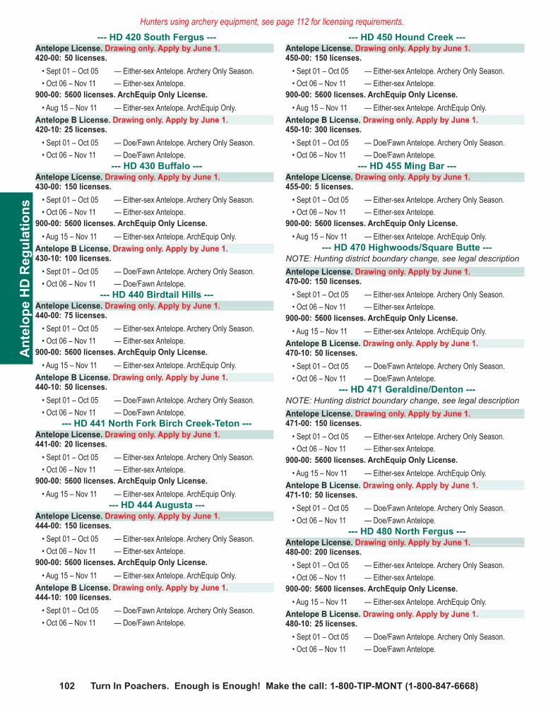
102 Turn In Poachers. Enough is Enough! Make the call: 1-800-TIP-MONT (1-800-847-6668)
Ant
elop
e H
D R
egul
atio
nsHunters using archery equipment, see page 112 for licensing requirements.
--- HD 420 South Fergus ---Antelope License. Drawing only. Apply by June 1.420-00: 50 licenses.
• Sept 01 – Oct 05 — Either-sex Antelope. Archery Only Season. • Oct 06 – Nov 11 — Either-sex Antelope.
900-00: 5600 licenses. ArchEquip Only License. • Aug 15 – Nov 11 — Either-sex Antelope. ArchEquip Only.
Antelope B License. Drawing only. Apply by June 1.420-10: 25 licenses.
• Sept 01 – Oct 05 — Doe/Fawn Antelope. Archery Only Season. • Oct 06 – Nov 11 — Doe/Fawn Antelope.
--- HD 430 Buffalo ---Antelope License. Drawing only. Apply by June 1.430-00: 150 licenses.
• Sept 01 – Oct 05 — Either-sex Antelope. Archery Only Season. • Oct 06 – Nov 11 — Either-sex Antelope.
900-00: 5600 licenses. ArchEquip Only License. • Aug 15 – Nov 11 — Either-sex Antelope. ArchEquip Only.
Antelope B License. Drawing only. Apply by June 1.430-10: 100 licenses.
• Sept 01 – Oct 05 — Doe/Fawn Antelope. Archery Only Season. • Oct 06 – Nov 11 — Doe/Fawn Antelope.
--- HD 440 Birdtail Hills ---Antelope License. Drawing only. Apply by June 1.440-00: 75 licenses.
• Sept 01 – Oct 05 — Either-sex Antelope. Archery Only Season. • Oct 06 – Nov 11 — Either-sex Antelope.
900-00: 5600 licenses. ArchEquip Only License. • Aug 15 – Nov 11 — Either-sex Antelope. ArchEquip Only.
Antelope B License. Drawing only. Apply by June 1.440-10: 50 licenses.
• Sept 01 – Oct 05 — Doe/Fawn Antelope. Archery Only Season. • Oct 06 – Nov 11 — Doe/Fawn Antelope.
--- HD 441 North Fork Birch Creek-Teton ---Antelope License. Drawing only. Apply by June 1.441-00: 20 licenses.
• Sept 01 – Oct 05 — Either-sex Antelope. Archery Only Season. • Oct 06 – Nov 11 — Either-sex Antelope.
900-00: 5600 licenses. ArchEquip Only License. • Aug 15 – Nov 11 — Either-sex Antelope. ArchEquip Only.
--- HD 444 Augusta ---Antelope License. Drawing only. Apply by June 1.444-00: 150 licenses.
• Sept 01 – Oct 05 — Either-sex Antelope. Archery Only Season. • Oct 06 – Nov 11 — Either-sex Antelope.
900-00: 5600 licenses. ArchEquip Only License. • Aug 15 – Nov 11 — Either-sex Antelope. ArchEquip Only.
Antelope B License. Drawing only. Apply by June 1.444-10: 100 licenses.
• Sept 01 – Oct 05 — Doe/Fawn Antelope. Archery Only Season. • Oct 06 – Nov 11 — Doe/Fawn Antelope.
--- HD 450 Hound Creek ---Antelope License. Drawing only. Apply by June 1.450-00: 150 licenses.
• Sept 01 – Oct 05 — Either-sex Antelope. Archery Only Season. • Oct 06 – Nov 11 — Either-sex Antelope.
900-00: 5600 licenses. ArchEquip Only License. • Aug 15 – Nov 11 — Either-sex Antelope. ArchEquip Only.
Antelope B License. Drawing only. Apply by June 1.450-10: 300 licenses.
• Sept 01 – Oct 05 — Doe/Fawn Antelope. Archery Only Season. • Oct 06 – Nov 11 — Doe/Fawn Antelope.
--- HD 455 Ming Bar ---Antelope License. Drawing only. Apply by June 1.455-00: 5 licenses.
• Sept 01 – Oct 05 — Either-sex Antelope. Archery Only Season. • Oct 06 – Nov 11 — Either-sex Antelope.
900-00: 5600 licenses. ArchEquip Only License. • Aug 15 – Nov 11 — Either-sex Antelope. ArchEquip Only.
--- HD 470 Highwoods/Square Butte ---NOTE: Hunting district boundary change, see legal descriptionAntelope License. Drawing only. Apply by June 1.470-00: 150 licenses.
• Sept 01 – Oct 05 — Either-sex Antelope. Archery Only Season. • Oct 06 – Nov 11 — Either-sex Antelope.
900-00: 5600 licenses. ArchEquip Only License. • Aug 15 – Nov 11 — Either-sex Antelope. ArchEquip Only.
Antelope B License. Drawing only. Apply by June 1.470-10: 50 licenses.
• Sept 01 – Oct 05 — Doe/Fawn Antelope. Archery Only Season. • Oct 06 – Nov 11 — Doe/Fawn Antelope.
--- HD 471 Geraldine/Denton ---NOTE: Hunting district boundary change, see legal descriptionAntelope License. Drawing only. Apply by June 1.471-00: 150 licenses.
• Sept 01 – Oct 05 — Either-sex Antelope. Archery Only Season. • Oct 06 – Nov 11 — Either-sex Antelope.
900-00: 5600 licenses. ArchEquip Only License. • Aug 15 – Nov 11 — Either-sex Antelope. ArchEquip Only.
Antelope B License. Drawing only. Apply by June 1.471-10: 50 licenses.
• Sept 01 – Oct 05 — Doe/Fawn Antelope. Archery Only Season. • Oct 06 – Nov 11 — Doe/Fawn Antelope.
--- HD 480 North Fergus ---Antelope License. Drawing only. Apply by June 1.480-00: 200 licenses.
• Sept 01 – Oct 05 — Either-sex Antelope. Archery Only Season. • Oct 06 – Nov 11 — Either-sex Antelope.
900-00: 5600 licenses. ArchEquip Only License. • Aug 15 – Nov 11 — Either-sex Antelope. ArchEquip Only.
Antelope B License. Drawing only. Apply by June 1.480-10: 25 licenses.
• Sept 01 – Oct 05 — Doe/Fawn Antelope. Archery Only Season. • Oct 06 – Nov 11 — Doe/Fawn Antelope.

Visit fwp.mt.gov 1032012 Deer • Elk • Antelope
Antelope H
D R
egulations --- HD 481 Petroleum ---Antelope License. Drawing only. Apply by June 1.481-00: 100 licenses.
• Sept 01 – Oct 05 — Either-sex Antelope. Archery Only Season. • Oct 06 – Nov 11 — Either-sex Antelope.
900-00: 5600 licenses. ArchEquip Only License. • Aug 15 – Nov 11 — Either-sex Antelope. ArchEquip Only.
Antelope B License. Drawing only. Apply by June 1.481-10: 25 licenses.
• Sept 01 – Oct 05 — Doe/Fawn Antelope. Archery Only Season. • Oct 06 – Nov 11 — Doe/Fawn Antelope.
--- HD 490 West Meagher ---Antelope License. Drawing only. Apply by June 1.490-00: 350 licenses.
• Sept 01 – Oct 05 — Either-sex Antelope. Archery Only Season. • Oct 06 – Nov 11 — Either-sex Antelope.
900-00: 5600 licenses. ArchEquip Only License. • Aug 15 – Nov 11 — Either-sex Antelope. ArchEquip Only.
Antelope B License. Drawing only. Apply by June 1.490-10: 700 licenses.
• Sept 01 – Oct 05 — Doe/Fawn Antelope. Archery Only Season. • Oct 06 – Nov 11 — Doe/Fawn Antelope.
--- HD 491 East Meagher ---Antelope License. Drawing only. Apply by June 1.491-00: 125 licenses.
• Sept 01 – Oct 05 — Either-sex Antelope. Archery Only Season. • Oct 06 – Nov 11 — Either-sex Antelope.
900-00: 5600 licenses. ArchEquip Only License. • Aug 15 – Nov 11 — Either-sex Antelope. ArchEquip Only.
Antelope B License. Drawing only. Apply by June 1.491-10: 150 licenses.
• Sept 01 – Oct 05 — Doe/Fawn Antelope. Archery Only Season. • Oct 06 – Nov 11 — Doe/Fawn Antelope.
--- HD 500 West Wheatland ---Antelope License. Drawing only. Apply by June 1.500-00: 500 licenses.
• Sept 01 – Oct 05 — Either-sex Antelope. Archery Only Season. • Oct 06 – Nov 11 — Either-sex Antelope.
900-00: 5600 licenses. ArchEquip Only License. • Aug 15 – Nov 11 — Either-sex Antelope. ArchEquip Only.
Antelope B License. Drawing only. Apply by June 1.500-10: 200 licenses.
• Sept 01 – Oct 05 — Doe/Fawn Antelope. Archery Only Season. • Oct 06 – Nov 11 — Doe/Fawn Antelope.
--- HD 501 East Wheatland ---Antelope License. Drawing only. Apply by June 1.501-00: 400 licenses.
• Sept 01 – Oct 05 — Either-sex Antelope. Archery Only Season. • Oct 06 – Nov 11 — Either-sex Antelope.
900-00: 5600 licenses. ArchEquip Only License. • Aug 15 – Nov 11 — Either-sex Antelope. ArchEquip Only.
Antelope B License. Drawing only. Apply by June 1.501-10: 25 licenses.
• Sept 01 – Oct 05 — Doe/Fawn Antelope. Archery Only Season. • Oct 06 – Nov 11 — Doe/Fawn Antelope.
--- HD 510 Big Timber ---Antelope License. Drawing only. Apply by June 1.510-00: 600 licenses.
• Sept 01 – Oct 05 — Either-sex Antelope. Archery Only Season. • Oct 06 – Nov 11 — Either-sex Antelope.
900-00: 5600 licenses. ArchEquip Only License. • Aug 15 – Nov 11 — Either-sex Antelope. ArchEquip Only.
Antelope B License. Drawing only. Apply by June 1.510-10: 600 licenses.
• Sept 01 – Oct 05 — Doe/Fawn Antelope. Archery Only Season. • Oct 06 – Nov 11 — Doe/Fawn Antelope.
--- HD 511 Hardin ---Antelope License. Drawing only. Apply by June 1.511-00: 300 licenses.
• Sept 01 – Oct 05 — Either-sex Antelope. Archery Only Season. • Oct 06 – Nov 11 — Either-sex Antelope.
900-00: 5600 licenses. ArchEquip Only License. • Aug 15 – Nov 11 — Either-sex Antelope. ArchEquip Only.
Antelope B License. Drawing only. Apply by June 1.511-10: 100 licenses.
• Sept 01 – Oct 05 — Doe/Fawn Antelope. Archery Only Season. • Oct 06 – Nov 11 — Doe/Fawn Antelope.
--- HD 512 Stillwater ---Antelope License. Drawing only. Apply by June 1.512-00: 125 licenses.
• Sept 01 – Oct 05 — Either-sex Antelope. Archery Only Season. • Oct 06 – Nov 11 — Either-sex Antelope.
900-00: 5600 licenses. ArchEquip Only License. • Aug 15 – Nov 11 — Either-sex Antelope. ArchEquip Only.
Antelope B License. Drawing only. Apply by June 1.512-10: 25 licenses.
• Sept 01 – Oct 05 — Doe/Fawn Antelope. Archery Only Season. • Oct 06 – Nov 11 — Doe/Fawn Antelope.
--- HD 513 Willow Creek ---Antelope License. Drawing only. Apply by June 1.513-00: 400 licenses.
• Sept 01 – Oct 05 — Either-sex Antelope. Archery Only Season. • Oct 06 – Nov 11 — Either-sex Antelope.
900-00: 5600 licenses. ArchEquip Only License. • Aug 15 – Nov 11 — Either-sex Antelope. ArchEquip Only.
Antelope B License. Drawing only. Apply by June 1.513-10: 5 licenses.
• Sept 01 – Oct 05 — Doe/Fawn Antelope. Archery Only Season. • Oct 06 – Nov 11 — Doe/Fawn Antelope.
--- HD 514 Rock Creek ---Antelope License. Drawing only. Apply by June 1.514-00: 150 licenses.
• Sept 01 – Oct 05 — Either-sex Antelope. Archery Only Season. • Oct 06 – Nov 11 — Either-sex Antelope.
900-00: 5600 licenses. ArchEquip Only License. • Aug 15 – Nov 11 — Either-sex Antelope. ArchEquip Only.
Antelope B License. Drawing only. Apply by June 1.514-10: 75 licenses.
• Sept 01 – Oct 05 — Doe/Fawn Antelope. Archery Only Season. • Oct 06 – Nov 11 — Doe/Fawn Antelope.

104 Turn In Poachers. Enough is Enough! Make the call: 1-800-TIP-MONT (1-800-847-6668)
Ant
elop
e H
D R
egul
atio
nsHunters using archery equipment, see page 112 for licensing requirements. Hunters using archery equipment, see page 112 for licensing requirements.
--- HD 530 Flatwillow-Willow Creek ---Antelope License. Drawing only. Apply by June 1.530-00: 400 licenses.
• Sept 01 – Oct 05 — Either-sex Antelope. Archery Only Season. • Oct 06 – Nov 11 — Either-sex Antelope.
900-00: 5600 licenses. ArchEquip Only License. • Aug 15 – Nov 11 — Either-sex Antelope. ArchEquip Only.
Antelope B License. Drawing only. Apply by June 1.530-10: 5 licenses.
• Sept 01 – Oct 05 — Doe/Fawn Antelope. Archery Only Season. • Oct 06 – Nov 11 — Doe/Fawn Antelope.
--- HD 540 Bull Mountains ---Antelope License. Drawing only. Apply by June 1.540-00: 100 licenses.
• Sept 01 – Oct 05 — Either-sex Antelope. Archery Only Season. • Oct 06 – Nov 11 — Either-sex Antelope.
900-00: 5600 licenses. ArchEquip Only License. • Aug 15 – Nov 11 — Either-sex Antelope. ArchEquip Only.
Antelope B License. Drawing only. Apply by June 1.540-10: 25 licenses.
• Sept 01 – Oct 05 — Doe/Fawn Antelope. Archery Only Season. • Oct 06 – Nov 11 — Doe/Fawn Antelope.
--- HD 550 Billings ---Antelope License. Drawing only. Apply by June 1.550-00: 200 licenses.
• Sept 01 – Oct 05 — Either-sex Antelope. Archery Only Season. • Oct 06 – Nov 11 — Either-sex Antelope.
900-00: 5600 licenses. ArchEquip Only License. • Aug 15 – Nov 11 — Either-sex Antelope. ArchEquip Only.
Antelope B License. Drawing only. Apply by June 1.550-10: 25 licenses.
• Sept 01 – Oct 05 — Doe/Fawn Antelope. Archery Only Season. • Oct 06 – Nov 11 — Doe/Fawn Antelope.
--- HD 560 Molt-Broadview ---Antelope License. Drawing only. Apply by June 1.560-00: 800 licenses.
• Sept 01 – Oct 05 — Either-sex Antelope. Archery Only Season. • Oct 06 – Nov 11 — Either-sex Antelope.
900-00: 5600 licenses. ArchEquip Only License. • Aug 15 – Nov 11 — Either-sex Antelope. ArchEquip Only.
Antelope B License. Drawing only. Apply by June 1.560-10: 200 licenses.
• Sept 01 – Oct 05 — Doe/Fawn Antelope. Archery Only Season. • Oct 06 – Nov 11 — Doe/Fawn Antelope.
--- HD 570 Fish Creek-Big Coulee ---Antelope License. Drawing only. Apply by June 1.570-00: 1000 licenses.
• Sept 01 – Oct 05 — Either-sex Antelope. Archery Only Season. • Oct 06 – Nov 11 — Either-sex Antelope.
900-00: 5600 licenses. ArchEquip Only License. • Aug 15 – Nov 11 — Either-sex Antelope. ArchEquip Only.
Antelope B License. Drawing only. Apply by June 1.570-10: 100 licenses.
• Sept 01 – Oct 05 — Doe/Fawn Antelope. Archery Only Season. • Oct 06 – Nov 11 — Doe/Fawn Antelope.
--- HD 590 Twodot ---Antelope License. Drawing only. Apply by June 1.590-00: 700 licenses.
• Sept 01 – Oct 05 — Either-sex Antelope. Archery Only Season. • Oct 06 – Nov 11 — Either-sex Antelope.
900-00: 5600 licenses. ArchEquip Only License. • Aug 15 – Nov 11 — Either-sex Antelope. ArchEquip Only.
Antelope B License. Drawing only. Apply by June 1.590-10: 500 licenses.
• Sept 01 – Oct 05 — Doe/Fawn Antelope. Archery Only Season. • Oct 06 – Nov 11 — Doe/Fawn Antelope.
--- HD 600 North Hill-Blaine-Phillips ---Antelope License. Drawing only. Apply by June 1.600-00: 300 licenses.
• Sept 01 – Oct 05 — Either-sex Antelope. Archery Only Season. • Oct 06 – Nov 11 — Either-sex Antelope.
900-00: 5600 licenses. ArchEquip Only License. • Aug 15 – Nov 11 — Either-sex Antelope. ArchEquip Only.
Antelope B License. Drawing only. Apply by June 1.600-10: 50 licenses.
• Sept 01 – Oct 05 — Doe/Fawn Antelope. Archery Only Season. • Oct 06 – Nov 11 — Doe/Fawn Antelope.
--- HD 620 South Phillips ---Antelope License. Drawing only. Apply by June 1.620-00: 600 licenses.
• Sept 01 – Oct 05 — Either-sex Antelope. Archery Only Season. • Oct 06 – Nov 11 — Either-sex Antelope.
900-00: 5600 licenses. ArchEquip Only License. • Aug 15 – Nov 11 — Either-sex Antelope. ArchEquip Only.
Antelope B License. Drawing only. Apply by June 1.620-10: 100 licenses.
• Sept 01 – Oct 05 — Doe/Fawn Antelope. Archery Only Season. • Oct 06 – Nov 11 — Doe/Fawn Antelope.
--- HD 630 South Valley ---Antelope License. Drawing only. Apply by June 1.630-00: 10 licenses.
• Sept 01 – Oct 05 — Either-sex Antelope. Archery Only Season. • Oct 06 – Nov 11 — Either-sex Antelope.
900-00: 5600 licenses. ArchEquip Only License. • Aug 15 – Nov 11 — Either-sex Antelope. ArchEquip Only.
Antelope B License. Drawing only. Apply by June 1.630-10: 5 licenses.
• Sept 01 – Oct 05 — Doe/Fawn Antelope. Archery Only Season. • Oct 06 – Nov 11 — Doe/Fawn Antelope.
--- HD 650 McCone-Redwater ---Antelope License. Drawing only. Apply by June 1.650-00: 200 licenses.
• Sept 01 – Oct 05 — Either-sex Antelope. Archery Only Season. • Oct 06 – Nov 11 — Either-sex Antelope.
900-00: 5600 licenses. ArchEquip Only License. • Aug 15 – Nov 11 — Either-sex Antelope. ArchEquip Only.
Antelope B License. Drawing only. Apply by June 1.650-10: 25 licenses.
• Sept 01 – Oct 05 — Doe/Fawn Antelope. Archery Only Season. • Oct 06 – Nov 11 — Doe/Fawn Antelope.

Visit fwp.mt.gov 1052012 Deer • Elk • Antelope
Antelope H
D R
egulations --- HD 670 Northeast Montana ---Antelope License. Drawing only. Apply by June 1.670-00: 25 licenses.
• Sept 01 – Oct 05 — Either-sex Antelope. Archery Only Season. • Oct 06 – Nov 11 — Either-sex Antelope.
900-00: 5600 licenses. ArchEquip Only License. • Aug 15 – Nov 11 — Either-sex Antelope. ArchEquip Only.
Antelope B License. Drawing only. Apply by June 1.670-10: 10 licenses.
• Sept 01 – Oct 05 — Doe/Fawn Antelope. Archery Only Season. • Oct 06 – Nov 11 — Doe/Fawn Antelope.
--- HD 690 South Hill, Blaine, Phillips, and North Chouteau ---NOTE: Hunting district boundary change, see legal descriptionAntelope License. Drawing only. Apply by June 1.690-00: 700 licenses.
• Sept 01 – Oct 05 — Either-sex Antelope. Archery Only Season. • Oct 06 – Nov 11 — Either-sex Antelope.
900-00: 5600 licenses. ArchEquip Only License. • Aug 15 – Nov 11 — Either-sex Antelope. ArchEquip Only.
Antelope B License. Drawing only. Apply by June 1.690-10: 250 licenses.
• Sept 01 – Oct 05 — Doe/Fawn Antelope. Archery Only Season. • Oct 06 – Nov 11 — Doe/Fawn Antelope.
--- HD 700 Missouri Breaks-Prairie ---Antelope License. Drawing only. Apply by June 1.700-00: 6500 licenses. Valid in all Region 7 HDs.
• Sept 01 – Oct 05 — Either-sex Antelope. Archery Only Season. • Oct 06 – Nov 11 — Either-sex Antelope.
900-00: 5600 licenses. ArchEquip Only License. • Aug 15 – Nov 11 — Either-sex Antelope. ArchEquip Only.
Antelope B License. Drawing only. Apply by June 1.700-10: 250 licenses. Doe/Fawn License. Valid in all Region 7 HDs.
• Sept 01 – Oct 05 — Doe/Fawn Antelope. Archery Only Season. • Oct 06 – Nov 11 — Doe/Fawn Antelope.
--- HD 701 Sagebrush Prairie ---Antelope License. Drawing only. Apply by June 1.700-00: 6500 licenses. Valid in all Region 7 HDs.
• Sept 01 – Oct 05 — Either-sex Antelope. Archery Only Season. • Oct 06 – Nov 11 — Either-sex Antelope.
900-00: 5600 licenses. ArchEquip Only License. • Aug 15 – Nov 11 — Either-sex Antelope. ArchEquip Only.
Antelope B License. Drawing only. Apply by June 1.700-10: 250 licenses. Doe/Fawn License. Valid in all Region 7 HDs.
• Sept 01 – Oct 05 — Doe/Fawn Antelope. Archery Only Season. • Oct 06 – Nov 11 — Doe/Fawn Antelope.
--- HD 702 Yellowstone Pine Hills ---Antelope License. Drawing only. Apply by June 1.700-00: 6500 licenses. Valid in all Region 7 HDs.
• Sept 01 – Oct 05 — Either-sex Antelope. Archery Only Season. • Oct 06 – Nov 11 — Either-sex Antelope.
900-00: 5600 licenses. ArchEquip Only License. • Aug 15 – Nov 11 — Either-sex Antelope. ArchEquip Only.
Antelope B License. Drawing only. Apply by June 1.700-10: 250 licenses. Doe/Fawn License. Valid in all Region 7 HDs.
• Sept 01 – Oct 05 — Doe/Fawn Antelope. Archery Only Season. • Oct 06 – Nov 11 — Doe/Fawn Antelope.
--- HD 703 Grassland-Agriculture ---Antelope License. Drawing only. Apply by June 1.700-00: 6500 licenses. Valid in all Region 7 HDs.
• Sept 01 – Oct 05 — Either-sex Antelope. Archery Only Season. • Oct 06 – Nov 11 — Either-sex Antelope.
900-00: 5600 licenses. ArchEquip Only License. • Aug 15 – Nov 11 — Either-sex Antelope. ArchEquip Only.
Antelope B License. Drawing only. Apply by June 1.700-10: 250 licenses. Doe/Fawn License. Valid in all Region 7 HDs.
• Sept 01 – Oct 05 — Doe/Fawn Antelope. Archery Only Season. • Oct 06 – Nov 11 — Doe/Fawn Antelope.
--- HD 704 Powder Pine Hills ---Antelope License. Drawing only. Apply by June 1.700-00: 6500 licenses. Valid in all Region 7 HDs.
• Sept 01 – Oct 05 — Either-sex Antelope. Archery Only Season. • Oct 06 – Nov 11 — Either-sex Antelope.
900-00: 5600 licenses. ArchEquip Only License. • Aug 15 – Nov 11 — Either-sex Antelope. ArchEquip Only.
Antelope B License. Drawing only. Apply by June 1.700-10: 250 licenses. Doe/Fawn License. Valid in all Region 7 HDs.
• Sept 01 – Oct 05 — Doe/Fawn Antelope. Archery Only Season. • Oct 06 – Nov 11 — Doe/Fawn Antelope.
--- HD 705 Prairie/Pines-Juniper Breaks ---Antelope License. Drawing only. Apply by June 1.700-00: 6500 licenses. Valid in all Region 7 HDs.
• Sept 01 – Oct 05 — Either-sex Antelope. Archery Only Season. • Oct 06 – Nov 11 — Either-sex Antelope.
900-00: 5600 licenses. ArchEquip Only License. • Aug 15 – Nov 11 — Either-sex Antelope. ArchEquip Only.
Antelope B License. Drawing only. Apply by June 1.700-10: 250 licenses. Doe/Fawn License. Valid in all Region 7 HDs.
• Sept 01 – Oct 05 — Doe/Fawn Antelope. Archery Only Season. • Oct 06 – Nov 11 — Doe/Fawn Antelope.
106 Turn In Poachers. Enough is Enough! Make the call: 1-800-TIP-MONT (1-800-847-6668)
Ant
elop
e L
egal
Des
crip
tions
Antelope Hunting Districts – Legal Descriptions
215 East Deer Lodge: Those portions of Deer Lodge, Silver Bow and Powell Counties lying within the following described boundary: Beginning at Garrison Junction, then in an easterly direction along US Highway 12 to the Continental Divide at MacDonald Pass, then in a southerly direction along said divide to Interstate 15, then in a southerly direction along said interstate to its junction with Interstate 90 at Butte, then west and north along said interstate to Garrison Junction, the point of beginning.291 East Garnet Range: That portion of Powell County lying within the following-described boundary: Beginning at the junction of State Route 271 (Drummond-Helmville Road) and Interstate 90, then easterly along said interstate to its junction with US Highway 12 at Garrison, then easterly along said route to its junction with State Route 141 at Avon, then north along said route to its junction with Cottonwood Meadows Road (1/4 mile northwest of Nevada Lake), then northwest on said road to its junction with Braziel Creek Road (BLM Road 2864), then south on said road to the northern boundary of BLM Section 22, T12N, R10W, then west along said section line to the southeast corner of Section 16, T12N, R10W, then north along the eastern boundary of said section to its northeast corner, then west along the northern boundaries of Sections 16, 17, and 18 to the northwest corner of Section 18, T12N, R10W, then south along said section boundary to the northeast corner of Section 24, T12N, R11W, then west along said section’s northern boundary to its northwest corner, then south along said section’s boundary to its southwest corner, then west along the northern boundary of Section 26, T12N, R11W, to its junction with Cottonwood Creek, then north along said creek to its junction with Route 271, then south along said route to its junction with Interstate 90, the point of beginning.300 Medicine Lodge-Upper Horse Prairie: That portion of Beaverhead County lying within the following-described boundary: Beginning at Clark Canyon Dam, then westerly along Route 324 to USFS Road 3909 (Trail Creek-Lemhi Pass Road), then westerly along said road to the Montana-Idaho border, then southerly and easterly along said border to the Pine Creek-W.F. Little Sheep Creek Divide northeast of Bannock Pass (Medicine Lodge Pass), then northerly down said divide to the head end of Four Eyes Canyon, then northwesterly down said canyon to its junction with the Big Sheep Creek County Road, then easterly and northerly along said road to Interstate 15 at Dell, then northwesterly along said highway to Clark Canyon Dam, the point of beginning.301 Lima Peaks: That portion of Beaverhead County lying within the following-described boundary: Beginning at Dell, then southeasterly along Interstate 15 to the Montana-Idaho border near Monida, then southerly and westerly along said state line to the Pine Creek-W.F. Little Sheep Creek Divide northeast of Bannock Pass (Medicine Lodge Pass), then northerly down said divide to the head end of Four Eyes Canyon, then northwesterly down said canyon to its junction with Big Sheep Creek County Road, then easterly and northerly along said road to Interstate 15 at Dell, the point of beginning.
310 Pioneers: Those portions of Beaverhead, Silver Bow and Madison Counties lying within the following-described boundary: Beginning at the junction of Grasshopper-Wise River Road with Route 278, then northerly along said road to Route 43 at Wise River, then easterly along said route to Interstate 15 at Divide, then southerly along said interstate to the point directly opposite the confluence of Grasshopper Creek with the Beaverhead River, then westerly along Grasshopper Creek to the Bannack-Grant Road, then northerly along said road to Route 278, then westerly along said route to the junction of the Grasshopper-Wise River Road, the point of beginning.311 Lower Gallatin-Madison-Horseshoe Hills: Those portions of Madison, Park, Gallatin, Jefferson, and Broadwater Counties lying within the following-described boundary: Beginning at the mouth of Sixteenmile Creek, then easterly up said creek to the Middle Fork of Sixteenmile Creek, then easterly up said Middle Fork to the South Fork of Sixteenmile Creek, then southerly up said South Fork to the Bridger Mountain Divide near Flathead Pass, then southerly along said divide to Ross Peak, then easterly and southerly along the Yellowstone-Gallatin Divide including Bangtail Ridge, Bozeman Pass and Hyalite Peak to Eaglehead Mountain, then in a westerly direction along the Portal-Porcupine and Levinski-Porcupine Creeks Divide to the West Gallatin River near the mouth of West Fork, then south up the Gallatin River to Buck Creek, then up said creek to the Madison-Gallatin Divide, then northerly along said divide and the Madison-Cherry Creek Divide to the head of Trail Creek near Red Knob Mountain, then down Trail Creek to the Madison River, then northerly down the west shore of said river to Route 84, then westerly along said route to US Highway 287, then southerly along said highway to North Meadow Creek, then westerly up said creek to Mount Bradley and the Madison-Ruby Divide, then northerly along said divide and the Jefferson-Ruby Divide to Noble Peak and the head of the South Boulder River, then northerly and easterly down said river to Route 359, then northerly along said route to Interstate 90, then easterly along said interstate to the Jefferson River near Three Forks Junction, then northerly and easterly down the south shore of said river to the Missouri River, then northerly down the east shore of said river to Sixteenmile Creek, the point of beginning.318 Big Hole: Those portions of Beaverhead and Deer Lodge Counties lying within the following-described boundary: Beginning at Wise River and the Pioneer Mountains Scenic Byway, then southerly along said byway to Route 278, then southeasterly along said route to the Bannock-Grant Road, then south along said road to Grasshopper Creek, then easterly along said creek to its intersection with Interstate 15, then southerly along said interstate to Route 324 at Clark Canyon Dam, then westerly along said route to the Trail Creek-Lemhi Pass Road, then westerly along said road to the Montana-Idaho border and Continental Divide at Lemhi Pass, then northerly along said divide to its junction with Route 43 at Chief Joseph Pass, then northerly and northeasterly along said divide to its junction with Route 274, then southerly along said route to its junction with Route 43, then easterly along said route to Wise River, the point of beginning.
319 Fleecer-High Rye: Those portions of Silver Bow and Deer Lodge Counties lying within the following-described boundary: Beginning at the junction of Interstate 90 and Interstate 15 west of Butte, then southerly along Interstate 15 to Route 43, then westerly along said route to Route 274, then northerly along said route to Route 1, then easterly along said route to Interstate 90, then easterly along said interstate to Interstate 15, the point of beginning.320 Tobacco Roots: Those portions of Madison, Jefferson, and Silver Bow Counties lying within the following-described boundary: Beginning at Virginia City, then westerly and northerly along Montana Highway 287 to Route 41, then northerly to Route 55 and Interstate 90, then easterly along said interstate to the South Boulder River, then southerly up said river to Noble Peak and the Jefferson-Ruby Divide, then southerly along said divide and the Madison-Ruby Divide to Montana Highway 287, then westerly along said route to Virginia City, the point of beginning.321 Ruby-Blacktail: Those portions of Beaverhead and Madison Counties lying within the following-described boundary: Beginning at Dillon and Route 41, then northeasterly along said route to Route 287, then southeasterly along said route to Virginia City and Alder Gulch, then southerly up said gulch to Baldy Mountain and the Ruby-Madison Divide, then southeasterly along said divide to Gravelly Range Road, then southerly along said road and the Eureka Basin-Ruby Road to the Ruby-Centennial Divide, then westerly along said divide and continuing northwesterly along the Centennial-Blacktail and Sage Creek-Blacktail Divides to the head of Clark Canyon, then westerly down said canyon to Interstate 15, then northerly along said interstate to Route 41 at Dillon, the point of beginning.330 Centennial Sage: Those portions of Beaverhead and Madison Counties lying within the following-described boundary: Beginning at the Montana-Idaho border on Interstate 15, then easterly and northerly along said border (Continental Divide) to the Madison River-Red Rock Creek Divide, then westerly along said divide through Lone Tree Pass and westerly over Deer Mountain to Elk Lake at the Limestone Creek confluence, then northerly along the east shores of Elk, Hidden, Cliff and Wade Lakes and connecting trails and roads to Lake Creek, then north along Lake Creek to the West Fork of the Madison River, then westerly up said river to the Centennial-Ruby Divide, then westerly along said divide and Centennial-Blacktail Divide and continuing northwesterly along said divide and Sage Creek-Blacktail Divide to Clark Canyon, then westerly down Clark Canyon to Interstate 15, then southerly along said interstate to the Montana-Idaho border, the point of beginning.NOTE: The Red Rock Lakes National Wildlife Refuge is not closed to antelope hunting by the Montana Fish, Wildlife & Parks Commission however, portions of the refuge may be closed to trespass by the U.S. Fish and Wildlife Service. Hunters are asked to check with the Refuge Manager before hunting on the refuge.338 Shield River North: Those portions of Gallatin, Meagher and Park Counties lying within the following-described boundary: Beginning at the confluence of Sixteenmile and Middle Fork of Sixteenmile Creeks, then easterly up said Middle Fork to the South Fork of Sixteenmile

Visit fwp.mt.gov 1072012 Deer • Elk • Antelope
Antelope Legal D
escriptionsCreek, then southerly up said South Fork to the Bridger Mountain Divide near Flathead Pass, then southerly along said divide to Ross Peak, then easterly and southerly along the Yellowstone-Gallatin Divide, including Bangtail Ridge to Bozeman Pass and Interstate 90, then easterly along said interstate to the bridge over the Yellowstone River at Livingston, then northeasterly down the Yellowstone to the bridge on US Highway 89, then northerly along said highway to its intersection with Cottonwood Creek near Clyde Park, then easterly and northerly up said creek to Crazy Mountain Divide near Conical Peak, then northerly along said divide to Sixteenmile Creek, then southwesterly down said creek to the Middle Fork of Sixteenmile Creek, the point of beginning.339 Shields River South: Those portions of Park and Sweet Grass Counties lying within the following-described boundary: Beginning at the bridge on the Yellowstone River on US Highway 89 just north of the intersection of said highway with Interstate 90, east of Livingston, then northerly along US Highway 89 to its intersection with Cottonwood Creek near Clyde Park, then easterly and northerly up said creek to the Crazy Mountain Divide near Conical Peak, then southerly along said divide to Fairview Peak, then southerly to the head of the West Fork of Duck Creek, then southeasterly down said creek to the Yellowstone River, then westerly up said river to the bridge on US Highway 89, the point of beginning.340 West Boulder: Those portions of Park and Sweet Grass Counties lying within the following-described boundary: Beginning at the mouth of the Boulder River at Big Timber, then southerly along said river to the Gallatin National Forest boundary south of McLeod Basin, then westerly, northerly, westerly and southerly along said boundary to Suce Creek, then westerly along said creek to the Yellowstone River, then northerly and easterly along said river to the mouth of the Boulder River, the point of beginning.341 Highlands: Those portions of Beaverhead, Madison, Jefferson and Silverbow Counties lying within the following-described boundary: Beginning at Dillon, then northerly along Route 41 to its junction with Route 55, then northwesterly along said route to its junction with Interstate 90 at Whitehall, then westerly along said interstate to its junction with Interstate 15, west of Butte, then southerly along said interstate to Dillon, the point of beginning.350 Whitetail: Those portions of Silverbow and Jefferson Counties lying within the following-described boundary: Beginning at Butte, then northeasterly along Interstate 15 to its junction with Route 69 at Boulder, then southerly along said route to its junction with the Boulder-Whitetail Road, then southerly along said road to the Boulder-Whitetail Divide, then southerly along said divide to Interstate 90, then westerly along said interstate to Butte, the point of beginning.360 Madison: Those portions of Madison and Beaverhead Counties lying within the following-described boundary: Beginning at Norris, then easterly along Route 84 to the Madison River, then up the west shore of the Madison River to Trail Creek, then up said creek to the Madison-Cherry Creek Divide, then southerly along said divide to the Madison-Gallatin Divide near Red Knob Mountain, then southerly along said divide to the Beaverhead-Gallatin National Forest boundary, then southerly along said boundary to Rock Creek,
then southeasterly down said creek to Earthquake Lake, then easterly along the north shore of said lake to the Madison-Gallatin County line, then south along the said line to the Montana-Idaho border on the Continental Divide, then westerly and southerly along said divide to the Madison River-Red Rock Creek Divide, then westerly along said divide through Lone Tree Pass and westerly over Deer Mountain to Elk Lake at the Limestone Creek confluence, then northerly along the east shores of Elk, Hidden, Cliff and Wade Lakes and connecting trails and roads to Lake Creek, then north along said creek to the West Fork of the Madison River, then southerly and westerly along the West Fork to Gravelly Range Road, then northerly along said road and the Madison-Ruby Divide to Baldy Mountain and the head of Alder Gulch, then northerly down said gulch to Virginia City, then easterly along Route 287 to the Madison-Ruby Divide, then northerly along said divide to Mount Bradley and the head of North Meadow Creek, then easterly down said creek to US Highway 287, then northerly along said highway to Norris, the point of beginning.370 Boulder Valley: That portion of Jefferson County lying within the following-described boundary: Beginning at Boulder, then southerly along Route 69 to the Boulder-Whitetail Road, then southerly along said road to the Boulder-Whitetail Divide, then southerly along said divide to Interstate 90, then easterly along said interstate to the intersection with the Boulder River, then northerly up said river to the intersection with Route 69, then northerly along said route to Boulder, the point of beginning.371 Radersburg: Those portions of Broadwater and Jefferson Counties lying within the following-described boundary: Beginning at the Jefferson River Bridge on Interstate 90 west of Three Forks, then northerly down the Jefferson River to the Missouri River, then northerly down said river to the Missouri River Bridge north of Townsend, then westerly on the Indian Creek Road to Hassel, then westerly on USFS Road 4031 to USFS Road 405, then southerly on said road to the South Fork of Crow Creek, then westerly up said creek to the Boulder-Missouri Divide, then westerly along said divide to Interstate 15, then southerly along said interstate to Boulder, then southerly along Route 69 to the intersection with the Boulder River, then southerly down said river to Interstate 90, then easterly along said Interstate to the Jefferson River Bridge on Interstate 90 west of Three Forks, the point of beginning.380 Winston Flats: Those portions of Broadwater, Lewis and Clark, and Jefferson Counties lying within the following-described boundary: Beginning at the Missouri River bridge north of Townsend, then westerly on Indian Creek Road to Hassel, then westerly on USFS Road 4031 to USFS Road 424, then southerly to South Crow Creek, then westerly up said creek to the Boulder-Missouri Divide near Crow Peak, then westerly along said divide to Interstate 15, then northerly along said interstate to Route 518 at Montana City, then easterly and northerly along said route to US Highway 12-287 at East Helena, then easterly along said highway to Route 284, then northerly and easterly along said route to Canyon Ferry Dam, then southerly along the east shore of Canyon Ferry Reservoir and the Missouri River to the Missouri River bridge at Townsend, the point of beginning.
381 Hilger Valley-Silver City: That portion of Lewis and Clark County lying within the following-described boundary: Beginning at the junction of County Route 602 (also known as Williams Street on the west edge of Helena) and US Highway 12 and continuing west along US Highway 12 to MacDonald Pass, then northerly along the Continental Divide beyond Flesher Pass, approximately four miles to the head of the North Fork of Lyons Creek, then southeasterly down Lyons Creek to Little Prickly Pear Creek, then northeasterly along said creek to the Missouri River, then up the west shore of said river to Hauser Dam, then southerly along Hauser Dam Road to its junction with Countryside Road, then westerly along said road to its junction with Mountain Meadows Road, then westerly along said road to where it becomes Snowdrift Road, then west along said road to its junction with Collins Drive, then north along Collins Drive to the north boundary of Section 4, T11N, R3W, then west along the north boundary of Sections 4 and 5 to Interstate 15, then northerly along said interstate approximately two miles to the north boundary of Section 31, T12N, R3W, at the north end of the split median of Interstate 15, then following the north boundary of Section 31, westerly to the northeast corner of Section 36, T12N, R4W, then southerly along the east boundary of Section 36, then west along the south boundary of Section 36 to Green Meadow Drive, then south along Green Meadow Drive to its junction with Woodland Hills Road, then west on Woodland Hills Road to its junction with Lone Mountain Road, then south along Lone Mountain Road to Highway 279 (Lincoln Road West), then westerly on Highway 279 to County Road 602 (Birdseye Road), then southerly along County Road 602 to US Highway 12, the point of beginning.388 Tenmile-Prickly Pear Valley: Those portions of Lewis and Clark and Jefferson Counties lying within the following-described boundary: Beginning at the north end of the split median of Interstate 15, on the north boundary of Section 31, T12N, R3W, then southerly along Interstate 15 for approximately two miles to the north boundary of Section 5, T11N, R3W, then east along the north boundary of Sections 5 and 4 to Collins Drive, then south along Collins Drive to its junction with Snowdrift Road, then easterly along Snowdrift Road until Snowdrift Road becomes Mountain Meadows Road, then easterly along Mountain Meadows Road to a junction with Countryside Road, then southeasterly along Countryside Road to Hauser Lake, then southerly along the western shore of said lake and across the entrance of the Causeway Arm and continuing in a southerly direction along the west shore of said lake to Canyon Ferry Dam and Route 284, then westerly and southerly along said route to the junction with US Highway 12-287, then westerly along US Highway 12-287 to Route 518 at East Helena, then southerly along said route to the junction with Interstate 15, then across Interstate 15 to Montana City and the Jackson Creek Road, then west along the Jackson Creek Road to its junction with the Clark Gulch Road, then west along said route to its junction with the Holmes Gulch Road, then west along said route to the national forest boundary, then northerly along the the national forest boundary along the west edge of Sections 7 and 6, T9N, R3W, then west along the south boundary of Section 36, then north along the west boundary of Section 36, then west along the south boundary of Section 26, then north along the west boundary
108 Turn In Poachers. Enough is Enough! Make the call: 1-800-TIP-MONT (1-800-847-6668)
Ant
elop
e L
egal
Des
crip
tions
of Section 26 to LeGrande Cannon Boulevard, then in a westerly and northerly direction along LeGrande Cannon Boulevard to US Highway 12, then across US Highway 12 onto County Route 602 (also known as Williams Street and then the Birdseye Road), then northerly along said route to State Highway 279, then easterly along State Highway 279 to its junction with Lone Mountain Road, then northerly along said road for two miles to the junction with Woodland Hills Road, then east on said road to Green Meadow Road, then north on said road to the southwest corner of Section 36, then east along the south boundary of Section 36, then northerly along the east boundary of Section 36, then easterly along the south boundary of Section 30 to its intersection with Interstate 15, the point of beginning.NOTE: Area outside the Weapons Restriction Area of HD 388: Those portions of Lewis and Clark and Jefferson Counties lying within the following-described boundary: Beginning at the junction of the Causeway Arm with Hauser Lake and continu-ing in a southerly direction along the west shore of said lake to Canyon Ferry Dam and Route 284, then westerly and southerly along said route to US Highway 12-287, then westerly along US Highway 12-287 and the junction with Lake Helena Drive, then northerly along Lake Helena Drive to the Causeway, then in a northerly and easterly direc-tion along the south shore of the Causeway Arm to Hauser Lake, the point of beginning.390 South Belts: Those portions of Broadwater, Lewis and Clark and Gallatin Counties lying within the following-described boundary: Beginning at the mouth of Cave Gulch at Cave Bay, then northerly up Cave Gulch to Hedges Mountain, then northeasterly along the Trout Creek-Magpie Creek Divide to the Lewis and Clark-Broadwater County line, then northerly and easterly along said line to the Meagher-Broadwater Line, then southeasterly along said line to Sixteenmile Creek, then westerly down said creek to the Missouri River, then northerly down said river and the east shore of Canyon Ferry Reservoir to the mouth of Cave Gulch at Cave Bay, the point of beginning.401 Sweetgrass Hills: Those portions of Liberty, Toole and Glacier Counties lying within the following-described boundary: Beginning at the junction of US Highway 2 and the Hill-Liberty County line east of Chester, then northerly along said line to the Canadian border, then westerly along said border to the Blackfeet Indian Reservation boundary, then south along said boundary to US Highway 2 near Cut Bank, then east along said highway through Shelby to the Hill-Liberty Line, the point of beginning.404 Teton-Marias: Those portions of Glacier, Toole, Pondera, Teton, Cascade, Liberty, Chouteau and Hill Counties lying within the following-described boundary: Beginning at Choteau, then northerly along US Highway 89 to the Blackfeet Indian Reservation boundary (Birch Creek), then east and north along said boundary to Cut Bank, then easterly along US Highway 2 through Shelby to the Hill-Liberty County line, then southerly along said line to the Marias River, then east and south down the Marias River to the Missouri River, then southwesterly up said river to Great Falls, then westerly along US Highway 89 through Fairfield to Choteau, the point of beginning.NOTE: Brinkman Game Preserve closed to all big game hunting.
413 Sand Coulee: That portion of Cascade County lying within the following-described boundary: Beginning at Great Falls, then southeast along US Highway 87 to Armington Junction, then south along US Highway 89 to King’s Hill then westward along the Cascade-Meagher County line to the Smith River, then north down said river to the Missouri River, then eastward down said river to Great Falls, the point of beginning.420 South Fergus: Those portions of Fergus, Petroleum, Musselshell, and Golden Valley counties lying within the following-described boundary: Beginning at Lewistown, then easterly along State Route 200 to Winnett, then southwesterly along Route 244 to US Highway 87, then northerly along said highway to Flatwillow Creek, then westerly along said creek to the South Fork of Flatwillow Creek, then westerly along said creek to the Red Hill Road, then southerly along said road to the Snowy Mountains Divide, then westerly along said divide to the head of Meadow Creek, then westerly down said creek to its junction with US Highway 191 near Garneil, then north and east along said highway to Lewistown, the point of beginning.430 Buffalo: Those portions of Judith Basin, Fergus and Cascade Counties lying within the following-described boundary: Beginning at Stanford, then southeast along US Highway 87 to US Highway 191, then south along said highway to the Judith-Musselshell River Divide, then west along said divide and the Judith-Smith River Divide to Kings Hill, then northwest along US Highway 89 to Armington Junction, then east along US Highway 87 to Stanford, the point of beginning.440 Birdtail Hills: Those portions of Lewis and Clark and Cascade Counties lying within the following-described boundary: Beginning at the Continental Divide at the summit of Rogers Pass on State Route 200, then south along said divide to the North Fork of Lyons Creek, then easterly down said creek to Little Prickly Pear Creek, then down said creek to the Missouri River, then northerly down said river to Great Falls, then northwesterly along Interstate 15 to its junction with US Highway 89, then west along said highway to its junction with State Route 200, then south and west along said route to Rogers Pass and the Continental Divide, the point of beginning.441 North Fork Birch Creek-Teton: Those portions of Pondera and Teton Counties lying within the following-described boundary: Beginning at the Blackfeet Indian Reservation boundary on US Highway 89, then southerly on said highway to the junction of County Road 144 near Choteau, then westerly on said road to West Fork Teton and USFS Trail 114, then westerly along said trail to Teton Pass on the Continental Divide, then northerly along said divide to Badger Pass and USFS Trail 121, then easterly along said trail to Swift Dam, then north and east along the Blackfeet Indian Reservation boundary to US Highway 89, the point of beginning.444 Augusta: Those portions of Lewis and Clark, Teton and Cascade Counties lying within the following-described boundary: Beginning at the Continental Divide on State Route 200 at the summit of Rogers Pass, then northerly along said divide to the Lewis and Clark National Forest boundary approximately one quarter mile north of Cadotte Pass, then northerly along said boundary to the Teton Canyon Road, then easterly along said road to US Highway 89, then southeasterly
along said highway to its junction with State Route 200, then south and west along said route to the summit of Rogers Pass and the Continental Divide, the point of beginning.450 Hound Creek: Those portions of Cascade and Meagher Counties lying within the following-described boundary: Beginning at the mouth of the Smith River, then south up said river to Rock Creek, then up said creek to the Meagher-Lewis and Clark County line, then northward along said line to the Cascade-Lewis and Clark County line, then west and north along said line to the Missouri River, then northeasterly down said river to the mouth of the Smith River, the point of beginning.455 Ming Bar: That portion of Lewis and Clark County lying within the following-described boundary: Beginning at the junction of the Cascade County-Lewis and Clark County line and the Missouri River, then southerly along the said river to Holter Lake, then southerly along the east shoreline of Holter Lake to the mouth of Willow (Elkhorn) Creek, then north and east up Willow Creek to the Cascade-Lewis and Clark County line, then north and west along said line to its junction with the Missouri River, the point of beginning.470 Highwoods/Square Butte: Those portions of Cascade, Chouteau, Judith Basin and Fergus Counties lying within the following-described boundary: Beginning at the Missouri River at Great Falls, downstream along said river to its junction with Hwy 80 at Ft. Benton, then southerly along said highway to its junction with US Highway 87 at Stanford, then westerly along said highway to its junction with the Missouri River at Great Falls, the point of beginning.471 Geraldine/Denton: Those portions of Chouteau, Fergus and Judith Basin Counties lying within the following described boundary: Beginning at Missouri River at Ft. Benton, downstream along said river to its junction with the mouth of the Judith River, then southerly up said river to its junction with US Highway 87 at Hobson, then northwesterly along said highway to the junction of Hwy 80 at Stanford, then northerly along said highway to the Missouri River at Ft. Benton, the point of beginning.480 North Fergus: That portion of Fergus County lying within the following-described boundary: Beginning at Lewistown, then westerly on US Highway 87 to the Judith River, then northerly down said river to the Missouri River, then easterly down said river to the Robinson Bridge at US Highway 191, then southerly along said highway to State Route 19 at Bohemian Junction, then southerly along said route to State Route 200 near Grass Range, then westerly along said route to Lewistown, the point of beginning.481 Petroleum: Those portions of Fergus, Judith Basin and Petroleum Counties lying within the following-described boundary: Beginning at Mosby, then westerly along State Route 200 to State Route 19 near Grass Range, then northerly along said route to US Highway 191 at Bohemian Junction, then northerly along said highway to the Robinson Bridge, then easterly down the Missouri River to the Musselshell River, then southerly up said river to Mosby, the point of beginning.490 West Meagher: That portion of Meagher County lying within the following-described boundary: Beginning at King’s Hill, then south along US Highway 89 through White Sulphur

Visit fwp.mt.gov 1092012 Deer • Elk • Antelope
Antelope Legal D
escriptionsSprings to Sixteenmile Creek near Ringling, then westerly down said creek to the Broadwater-Meagher County line, then northwest along said line to Rock Creek, then easterly down said creek to the Smith River, then northerly down said river to the Cascade-Meagher County line, then eastward along said line to King’s Hill, the point of beginning.491 East Meagher: That portion of Meagher County lying within the following-described boundary: Beginning at King’s Hill, then southeast along the Meagher-Judith Basin County line to USFS Road 274, then southward along said road to US Highway 12, then easterly along said highway to its junction with State Highway 294, then south and west along said highway, to the point where said highway crosses Cottonwood Creek, then up said creek to the Shields River Divide, then west along said fork and the main Sixteenmile Creek to US Highway 89, then north along said highway (through White Sulphur Springs) to King’s Hill, the point of beginning.500 West Wheatland: Those portions of Meagher and Wheatland Counties lying within the following-described boundary: Beginning at Harlowton, then westerly along US Highway 12 to USFS Road 274 (Spring Creek Road-Whitetail Cabin Road), then northerly along said road to its intersection with USFS Road 189 (Willow Park Road), then easterly along said road to its intersection with USFS Trail 603, then easterly along said trail to the Mt. High Lookout Tower, then easterly along USFS Road 382 to a permanent boundary marker (Wheatland-Judith Basin County line), then northeasterly along the Wheatland County line to US Highway 191, then southerly along said highway to Harlowton, the point of beginning.501 East Wheatland: Those portions of Fergus, Golden Valley, and Wheatland Counties lying within the following-described boundary: Beginning at Harlowton, then northerly along US Highway 191 to its junction with Meadow Creek near Garneil, then northeasterly along said creek to the Snowy Mountain Divide, then easterly along said divide to its intersection with the Red Hill Road, then southerly along said road to the Rothiemay Road, then southerly along said road to Ryegate and US Highway 12, then westerly along said highway to Harlowton, the point of beginning.510 Big Timber: Those portions of Sweet Grass and Park Counties lying within the following-described boundary: Beginning at the Yellowstone Bridge at Big Timber, then westerly along the north bank of the Yellowstone River to Duck Creek, then northerly along said creek to the West Fork of Duck Creek, then northerly along said fork to Crazy Mountain Divide, then northerly along said divide to Sweet Grass Creek, then easterly and southerly along said creek to the Yellowstone River, then westerly along the north bank of the Yellowstone River to Big Timber, the point of beginning.511 Hardin: Those portions of Big Horn and Yellowstone Counties lying within the following-described boundary: Beginning at the Yellowstone River Bridge at Custer, then westerly up the north bank of the Yellowstone River to US Highway 87 at Billings, then east on said highway to Old US Highway 87 (Old Hardin Road), then southeast along said road to the Crow Indian Reservation boundary, then east along said boundary to Interstate 90 near Hardin, then west along said interstate to State Route 47, then north along
said route to Interstate 94, then west along said interstate to Custer, then north on the Custer-Melstone Road to the Yellowstone River Bridge, the point of beginning.512 Stillwater: Those portions of Carbon, Stillwater and Sweet Grass Counties lying within the following-described boundary: Beginning at the Yellowstone River Bridge at Columbus, then southwesterly along State Route 78 to Absarokee, then westerly along Route 420 to the first bridge crossing the Stillwater River, then north and easterly along said river (1/4 mile) to the mouth of Trout Creek, then up said drainage in a northwesterly direction to the headwaters of said drainage at the Gallatin-Custer National Forest boundary, then westerly and southerly along said boundary to the headwaters of the Dry Fork of the East Boulder River, then northwesterly along said fork to its junction with the East Boulder River, then northerly and westerly along said river to its junction with the Main Boulder River, then northerly and easterly along said river to its junction with the Yellowstone River, then easterly and southerly along the north bank of said river to the Yellowstone River Bridge at Columbus, the point of beginning.513 Willow Creek: Those portions of Fergus, Golden Valley, Musselshell and Petroleum Counties lying within the following-described boundary: Beginning at Roundup, then westerly along US Highway 12 to Ryegate, then north along the Rothiemay Road to the Red Hill Road, then north along said road to the South Fork-Flatwillow Creek, then easterly along said creeks to Flatwillow Creek, then easterly along said creek to US Highway 87, then southerly along said highway to Roundup, the point of beginning.514 Rock Creek: Those portions of Carbon, Stillwater and Yellowstone Counties lying within the following-described boundary: Beginning at the Yellowstone River Bridge at Columbus, then east down the north bank of said river to US Highway 87 at Billings, then east on said highway to Old US Highway 87 (Old Hardin Road), then south along said road to the Crow Indian Reservation boundary, then southwest along said boundary to Pryor-Warren Road, then south along said road to US Highway 310 at Warren, then south on said highway to the Montana-Wyoming border, then west along said border to US Highway 212, then north on said highway to Red Lodge, then west and north along State Route 78 to the Yellowstone River Bridge, the point of beginning.530 Flatwillow-Willow Creek: Those portions of Musselshell and Petroleum Counties lying within the following-described boundary: Beginning at Roundup, then northerly along US Highway 87 to Route 244, then northeasterly along said route to State Route 200 at Winnett, then easterly along said route to the Musselshell River Bridge at Mosby, then southerly up said river to US Highway 12, then westerly on said highway to the Custer-Melstone road, then southerly along said road to the Musselshell River, then westerly up said river to US Highway 87, then northeast along said highway to Roundup, the point of beginning.540 Bull Mountains: Those portions of Musselshell and Yellowstone Counties lying within the following-described boundary: Beginning at Billings, then northerly along US Highway 87 to the Musselshell River, then easterly down said river to the Melstone-Custer road near Melstone, then in a southerly direction along said road to the
Yellowstone River, then westerly along the north bank of said river to Billings, the point of beginning.550 Billings: Those portions of Golden Valley, Musselshell and Yellowstone Counties lying within the following-described boundary: Beginning at Billings, then northwesterly along State Route 3 (Billings-Lavina Road) to US Highway 12, then easterly on said highway to US Highway 87, then southerly along said highway to Billings, the point of beginning.560 Molt-Broadview: Those portions of Golden Valley, Stillwater and Yellowstone Counties lying within the following-described boundary: Beginning at Billings, then westerly along the north bank of the Yellowstone River to the Yellowstone River Bridge at Columbus, then westerly to the Columbus-Rapelje-Ryegate Road, then northerly along said road to US Highway 12 at Ryegate, then easterly along said highway to State Route 3 (Billings-Lavina Road), then southeasterly along said route to Billings, the point of beginning.570 Fish Creek-Big Coulee: Those portions of Golden Valley, Sweet Grass, Stillwater and Wheatland Counties lying within the following described boundary: Beginning at Harlowton then southeast on US Highway 12 to Ryegate, then south along the Rapelje-Ryegate road to Rapelje, continuing south along US Highway 308 to the Yellowstone River Bridge at Columbus, then westerly along the north bank of the Yellowstone River to Sweet Grass Creek, then northwest up said creek to US Highway 191, then north on said highway to Harlowton, the point of beginning.590 Twodot: Those portions of Wheatland, Sweet Grass, Meagher and Park Counties lying within the following-described boundary: Beginning at Harlowton, then southerly along US Highway 191 to Sweet Grass Creek, then westerly along said creek to Crazy Mountain Divide, then northerly along said divide to Cottonwood Creek, then northerly along said creek to Route 294, then north and east along Route 294 to US Highway 12, then east along said highway to Harlowton, the point of beginning.600 North Hill-Blaine-Phillips: Those portions of Hill, Blaine and Phillips Counties lying within the following described boundary: Beginning at the point where the Hill-Liberty Count line meets the Alberta, Canada border. Then southerly along the Hill-Liberty county line to US Highway 2 east of Joplin. Then easterly along said highway to the Milk River bridge at the Fort Belknap Indian Agency, then east down the Milk River to the Milk River bridge on US Highway 2 west of Dodson, then east along said highway to Dodson, then south on Highway 204 to the South Dodson-Wagner Road (Route 363) , then in an easterly direction along said road to US Highway 291 south of Malta, then in a northerly direction along said highway to its intersection with US Highway 2 at Malta, then east along said highway to the junction of Route 243 at Saco, then north along said route to the Milk River bridge, then westerly up the Milk River to Whitewater Creek, then northwesterly up said Creek and the West Fork of Whitewater Creek to Route 242, then along said route to the Saskatchewan, Canada border, then west along said border to the Hill-Liberty County line, the point of beginning.

110 Turn In Poachers. Enough is Enough! Make the call: 1-800-TIP-MONT (1-800-847-6668)
Ant
elop
e L
egal
Des
crip
tions
620 South Phillips: Those portions of Phillips and Valley Counties lying within the following-described boundary: Beginning at a point west of Dodson where US Highway 2 crosses the east boundary of the Fort Belknap Indian Reservation, then southerly, westerly, and northerly along said boundary to Little Suction Creek on the western boundary of the Fort Belknap Indian Reservation, then northwesterly along said creek to Suction Creek, then southwesterly along said creek to Cow Creek, then south along said creek to the Missouri River, then easterly downstream on said river and Fort Peck Reservoir to Timber Creek, then northerly along said creek to the Saco Road at Bill Anderson Ranch, then north along said road to US Highway 2 at Saco, then westerly along said highway to US Highway 191 at Malta, then southwest along said highway to the Wagner-South Dodson Road (Route 363), then westerly along said road to Route 204, then north on said route to US Highway 2 at Dodson, then west along said highway to the east boundary of the Fort Belknap Indian Reservation, the point of beginning.NOTE: The following-described area is closed to all hunting: Slippery Ann Station, Section 36, T22N, R24E and Section 31, T22N, R25E, as posted.NOTE: Lake Bowdoin Migratory Waterfowl Refuge is closed to antelope hunting.630 South Valley: Those portions of Phillips and Valley Counties lying within the following-described boundary: Beginning at a point where the Saco-Bill Anderson Road joins US Highway 2 at Saco, then south along said road to Timber Creek at Bill Anderson Ranch, then south along said creek to Ft. Peck Reservoir and the Missouri River, then down the north shore of said reservoir and river to the Milk River, then north along said river to Porcupine Creek, then north up said creek to US Highway 2, then west along said highway to Saco, the point of beginning.NOTE: That portion of the Charles M. Russell National Wildlife Refuge in Valley County lying east of the road leading to the Duck Creek Recreational Area shall be closed to all big game hunting as posted.NOTE: That portion of the Charles M. Russell National Wildlife Refuge known as the Pines Recreation Area will be closed to all big game hunting, as posted.650 McCone-Redwater: Those portions of McCone, Garfield, Dawson, Richland and Roosevelt Counties lying within the following-described boundary: Beginning at the Fort Peck Powerhouse on the Missouri River, then easterly downstream along said river to the mouth of Big Muddy Creek, then north along said creek to US Highway 2 five miles west of Culbertson, then east along said highway to the North Dakota border, then south along said border to State Route 200 at Fairview, then southwest and westerly along said route to Little Dry Creek, west of Brockway, then north down said creek to Fort Peck Reservoir, then northerly along east shore of said reservoir to the Fort Peck Reservoir to the Fort Peck Powerhouse, the point of beginning.NOTE: That portion of the C.M. Russell NWR in McCone County lying between the Fort Peck Powerhouse and the spillway shall be closed to all big game hunting as posted.
670 Northeast Montana: Those portion of Philips, Valley, Daniels, Sheridan, and Roosevelt Counties lying within the following-described boundaries: Beginning at a point where State Route 242 meets the Canadian border, then south along said route to the West Fork of Whitewater Creek, then southeasterly along said creek and Whitewater Creek to the Milk River, then easterly down said river to State Route 243, then south on said route to US Highway 2 at Saco, then east on said highway to Porcupine Creek near Nashua, then northerly along said creek and the West Fork of Porcupine Creek to the northwest corner of the Fort Peck Indian Reservation, then east along the northern boundary of said reservation to Big Muddy Creek, then southerly downstream on said creek to US Highway 2 west of Culbertson, then east on said highway to the North Dakota border, then north on said border to the Canadian border, then west along said border to State Route 242, the point of beginning.690 South Hill, Blaine, Phillips, and North Chouteau: Those portions of Hill, Blaine, Chouteau, and Phillips Counties lying within the following-described boundary: Beginning at a point where US Highway 2 meets the Hill-Liberty County line east of Joplin, then south along said line to the Marias River, then southerly downstream on said river to the Missouri River near Loma, then easterly downstream along said river to Cow Creek, then northernly along said creek to the Fort Belknap Reservation line, then north along said line to the Milk River, then southeasterly along said river to the Milk River Bridge on Highway 2, then westerly along said highway to the Hill-Liberty County line east of Joplin, the point of the beginning.700 Missouri Breaks-Prairie: Those portions of Garfield and McCone Counties lying within the following-described boundary: Beginning at the Musselshell River Bridge near Mosby on State Route 200, then north down the Musselshell River to the Missouri River, then east and north down the said river to the Fort Peck Powerhouse, then south along the east shore of the Fort Peck Reservoir to Big Dry Creek, then south up said creek to Little Dry Creek, then up said creek to State Route 200, then west along said route to the Musselshell River Bridge, the point of beginning.701 Sagebrush Prairie: Those portions of Prairie, Custer, Rosebud, Treasure, Yellowstone, Musselshell, Garfield and McCone counties lying within the following-described boundary: Beginning at the junction of Interstate 94 and Route 253 at Terry, then west along said interstate to its junction with the Custer-Melstone Road at Custer, then north along said road to its junction with US Highway 12 at Melstone, then east on said highway to the Musselshell River, then north down said river to its intersection with State Route 200 near Mosby, then east on said route to Brockway, then southeast on Route 253 to Terry, the point of beginning.
702 Yellowstone Pine Hills: Those portions of Treasure, Big Horn, Rosebud and Custer Counties lying within the following-described boundary: Beginning at the Bighorn River Bridge on Interstate 90 near Hardin, then northwest along said interstate to State Route 47, then north along said route to its intersection with Interstate 94, then northeast along said interstate to its intersection with State Route 59 near Miles City, then south along said route to Route 332, then south along said road to the Northern Cheyenne Reservation boundary, then west along said boundary to the Crow Reservation boundary, then north and west along said boundary to the Bighorn River, then north down said river to its intersection with Interstate 90, the point of beginning.703 Grassland-Agriculture: Those portions of Prairie, McCone, Dawson, Richland, Wibaux, Fallon and Custer Counties lying within the following described boundary: Beginning at the intersection of Route 253 and Interstate 94 at Terry, then north along said route to its intersection with State Route 200 at Brockway, then northeasterly along said route through Sidney to the Montana-North Dakota border, then south along said border to its intersection with US Highway 12 east of Baker, then west along said highway to its intersection with O’Fallon Creek, then northwest down said creek to its intersection with Interstate 94, then west along said interstate to its intersection with Route 253 at Terry, the point of beginning.704 Powder Pine Hills: Those portions of Big Horn, Custer, Fallon, Powder River, Prairie and Rosebud Counties lying within the following-described boundary: Beginning at the junction of the Montana-Wyoming border and the east boundary of the Crow Reservation, then north along said boundary to the Northern Cheyenne Reservation boundary, then east along said boundary to the Tongue River, then north down said river to the northeast corner of the Northern Cheyenne Reservation boundary, then west along said boundary to Route 332, then north on said route to State Route 59, then north on said route to its junction with Interstate 94, then north along said interstate to O’Fallon Creek, then southeast up said creek to US Highway 12, then west along said highway to its junction with the Powder River Road at Locate, then south on said road to Broadus, then south along the Broadus-Moorhead Road to the Montana-Wyoming border, then west along said border to its intersection with the Crow Reservation boundary, the point of beginning.705 Prairie/Pines-Juniper Breaks: Those portions of Carter, Custer, Powder River and Fallon Counties lying within the following described boundary: Beginning at the intersection of the Montana-Wyoming border and the Broadus-Moorhead Road, then north on said road to the Broadus-Powderville Road at Broadus, then north on said road on the west side of the Powder River to Powderville, and continuing to its intersection with US Highway 12 at Locate, then east along US Highway 12 to the Montana-North Dakota border, then south along said border to its intersection with the Montana-South Dakota-Wyoming borders junction, then west along the Montana-Wyoming border to its intersection with the Broadus-Moorhead Road, the point of beginning.

Visit fwp.mt.gov 1112012 Deer • Elk • Antelope
Licenses & Perm
its Obtain A License Or Permit• Only one license or permit of any type
may be purchased each year, unless otherwise specified and allowed in the regulations, such as a hunter may purchase more than one deer B license.
• Many licenses or permits may be purchased from license providers or online licensing. Some licenses and permits are available only through a drawing.
• Refer to the Licenses Available Chart for a complete list of resident and nonresident licenses and application or purchase deadlines.
Online Licensing• You may apply for permits and/or
licenses and purchase many general hunting licenses from FWP Online Licensing between approximately 5:15 a.m. and 11:45 p.m., MST, 7 days a week within applicable sales dates.
• Go to https://app.mt.gov/Als/Index and follow the instructions.
• Online purchases must be made by using a MasterCard or Visa credit card.
• Montana residents must have purchased a conservation license through the automated licensing system (ALS) in a previous license year and have an ALS number to buy licenses online. See Residency.
• Don’t wait until the last minute to buy your hunting license online as carcass tags are mailed to you within 10 days of your purchase.
• All online license purchases and applications are final and cannot be changed or withdrawn.
Interstate Wildlife Violator Compact (IWVC) Montana is a member of the IWVC. Under the compact, member states recognize suspensions of hunting, fishing or trapping privileges. It is illegal for a violator whose privilege to hunt, fish or trap is suspended to obtain or attempt to obtain a license, tag or permit in a member state. For more information, call 406‑444‑2452.
Residency• It is illegal to swear to or to affirm a
false statement in order to obtain an original or duplicate resident hunting and/or fishing license OR to assist an unqualified applicant in obtaining a resident license.
Resident• To be a legal Montana resident and
eligible to purchase any Montana resident fishing, hunting, and trapping licenses, as per MCA 87‑2‑102, you must: – have been physically living in Montana
for at least 180 consecutive days immediately prior to purchasing a resident license;
– register your vehicle(s) in Montana; – be registered to vote in Montana if you’re registered to vote at all;
– not possess current (or have applied for any) resident hunting, fishing, or trapping privileges in another state or country;
– file Montana state income tax returns as a resident, if you are required to file.
– Once you have established your residency, you must continue to meet all these requirements and physically reside in Montana as your principal or primary place of abode for not less than 120 days per year (days need not be consecutive).
– A person is NOT considered a resident for the purposes of this section if the person: ▪ claims residence in any other state or country for any purpose; or
▪ is an absentee property owner paying property tax on property in Montana.
• To purchase an annual resident conservation license you will be required to show a valid Montana Driver’s License (MDL), a valid Montana Identification Card (MIC) or a valid Tribal Identification Card.
• If your MDL or MIC has been issued for less than six months, you may be required to show additional proof of residency. An out‑of‑state driver’s license is NOT an acceptable form of ID for resident license purchases. Contact your local FWP office for specifics.
Nonresident • Montana’s nonresident guests are
eligible to purchase or apply for most Montana fishing, hunting, and trapping licenses. By state law, nonresidents are limited to, but not guaranteed, 10 percent of the license and/or permit quota for a district. The Licenses Available Chart provides details.
• Nonresident unmarried minors, at least 12 (by Jan 16, 2013) but not older than 17 years of age, can hunt in Montana as a resident if the minor’s parents, legal guardian, or parent with joint custody, sole custody, or visitation rights is a legal resident of Montana. See “Youth Hunter” chart for details on youth 11 years of age.
Armed Forces • A member of the regular armed
forces of the United States, a member’s dependent who resides in the member’s Montana household, or a member of the armed forces of a foreign government attached to the regular armed forces of the United States is considered a
resident for Montana hunting, fishing and trapping licenses if:
– the member was a resident of Montana under the provisions listed under residency at the time the member entered the armed forces and continues to meet these residency criteria; or,
– the member is currently stationed in and assigned to active duty in Montana, has resided in Montana for a least 30 days, and presents official assignment orders and a certificate verifying successful completion of an approved hunter safety course from any state or province.
Prerequisites
Conservation License• Each new license year, a new
Conservation License is required to purchase any fishing, trapping or hunting license(s), or to apply for licenses/permits. Most licenses can be purchased from any FWP License Provider beginning late February.
• In compliance with the Federal Welfare Reform Laws, Montana law requires each resident and nonresident hunter, including youth, to provide the last four digits of his/her Social Security number when purchasing a Conservation License or obtaining a Conservation License through a drawing.
Hunting Access Enhancement Fee (HAEF)This is an annual fee and will be charged at the time the hunter purchases his/her first hunting license (including upland and migratory bird).
Game Damage Hunt Roster Rules• The game damage hunt roster is a
randomized list of hunters’ names. If FWP identifies a need to implement a game damage hunt, the game damage hunt roster will be used to select hunters. Selected hunters will be contacted by FWP.
• Sign up for the game damage hunt roster is from June 15 – July 15, 2012, and only on the FWP website.
12-hour Closure
• In Administrative Region 4, elk HD 424 and HD 442 may be subject to 12‑hour closure for the antlerless portion of the general brow‑tined bull or antlerless elk season,
• If the antlerless quota is reached, the general season will revert to only the brow‑tined bull regulation until the end of the general season.
• Contact Region 4 Headquarters for updates.
112 Turn In Poachers. Enough is Enough! Make the call: 1-800-TIP-MONT (1-800-847-6668)
L
icen
ses
& P
erm
its
Hunter Education
Hunter Education RequirementsIf you were born after January 1, 1985, you are required to show proof of completing a Montana hunter safety and education course or an approved hunter safety course from any other state or province prior to applying for or purchasing a hunting license, whether the hunting license is for the rifle or archery season.
Bowhunter Education Requirements To purchase a Montana bow and arrow license, a hunter must:• provide a certificate of completing
the National Bowhunter Education Foundation course, or
• provide any prior year’s bowhunting/archery stamp, tag, permit, or license from any state or province. If you can no longer produce this license, for a $5 fee you may sign an affidavit stating that you previously held such a license. The affidavit is available at all FWP License Providers. The affidavit entitles you to purchase a current year’s Montana bow and arrow license.
Duplicate Certificates Bowhunter or Hunter Education certificates of completion for the Montana hunter education and/or bowhunter education courses may be obtained from FWP’s website at fwp.mt.gov.
License and Permit Types
Bow and Arrow LicenseA bow and arrow license, plus the proper hunting license is required during: (1) the deer, elk and/or antelope Archery Only Season; or (2) to archery hunt in an Arch‑Equip only area or hunting district.
Conservation LicensePrerequisite for all resident and nonresident licenses. Includes the state lands recreation license (for hunting, fishing and trapping purposes).
Deer LicenseGeneral Deer License• The general deer license is Montana’s
license valid for one deer. Hunters may hold only one general deer license. It can be used for deer as indicated under the “General Deer License” heading on the deer and elk hunting district pages of these regulations.
• Residents may purchase only one deer and/or one elk general license each year. Licenses may be purchased from license providers or online licensing beginning mid January. Each license year, a new Conservation License is required in order to purchase any fishing, trapping or hunting license(s), or to apply for any license or permit.
• Resident hunters may purchase a general Deer license over the counter at FWP offices and other license vendors. Residents may also buy a sportsman’s license, which includes a general deer license. Some disabled, youth, and senior hunters may qualify for discounted licenses.
• Nonresidents cannot buy their general deer license over the counter. They must obtain what’s known as a “deer combination” license, which includes a general deer license as well as several other licenses. Montana makes 4,600 General Drawing and 2,000 land owner sponsored licenses available each year. Demand is greater than supply, so to get a deer combination license, you need to apply in a random lottery drawing by March 15 for either a:
– Big game (deer and elk) combination license, which is also good for fishing and upland bird hunting, or a
– Deer combination license, which is also good for fishing and upland bird hunting.
– You can apply for only one of these licenses each year.
Deer B License• Valid for one deer during a specific
time period, or for a certain species and sex, and in a particular hunting district or group of districts. May be offered through a drawing or over‑the‑counter.
• A deer B license is usually a license for antlerless mule deer or white‑tailed deer, depending on the license type and hunting district.
• The deer B license allows you to kill a deer in addition to the deer you could harvest with your general deer license.
• There is no particular order in which the general deer and deer B licenses must be purchased or used.
• Most deer B licenses are available through the June 1 drawing but some are available for purchase at License Providers, including FWP Online Licensing.
• A hunter may possess a total of seven deer B licenses in any combination.
• A hunter may purchase only one single‑region deer B license for white‑tailed deer per year.
• The single‑region deer B license for white‑tailed deer is in addition to other deer B licenses a person may obtain through a drawing or purchase at License Providers. You must designate the region in which you will use the single‑region deer B license for white‑tailed deer at the time of purchase.Check the hunting district in which you will hunt for specific regulations and valid dates for the single‑region license.
Single-Region Deer B Licenses for Mule Deer• Check the hunting district in which
you will hunt for specific regulations and valid dates for the single‑region license.
• The following resident only Single‑Region Mule Deer B License opportunities are offered for the 2012 hunting season.
Single-Region Resident OnlyMule Deer B Licenses
R 7
007-13. All Region 7 HDs. Not valid on CMR refuge. 007-14. 2nd MD B License. All Region 7 HDs. Not valid on CMR refuge.
Single-Region Deer B Licenses for White-tailed Deer• A hunter may purchase only one
single‑region deer B license for white‑tailed deer per year.
• The single‑region deer B license for white‑tailed deer is in addition to other deer B licenses a person may obtain through a drawing or purchase at License Providers. You must designate the region in which you will use the single‑region deer B license for white‑tailed deer at the time of purchase.
• Licenses are available beginning August 6 from License Providers, including FWP Online Licensing.
• Check the hunting district in which you will hunt for specific regulations and valid dates for the single‑region license.
• The following Single‑Region White‑tailed Deer B License opportunities for residents and/or nonresidents are offered for the 2012 hunting season.
Single-Region Resident/NonresidentWhite-tailed Deer B Licenses
R3003-10. All Region 3 HDs, except Canyon Ferry WMA and Lake Helena WMA
R4 004-10. All Region 4 HDs, except HD 455.
R5 005-10. All Region 5 HDs.R6 006-10. All Region 6 HDs.R7 007-10. All Region 7 HDs.
Single-Region Resident Only White-tailed Deer B Licenses
R 7 007-11. 2nd WT B License. All Region 7 HDs.

Visit fwp.mt.gov 1132012 Deer • Elk • Antelope
Licenses & Perm
its Deer Permit• Permits are valid for hunting the
specified sex‑age class during the time period(s) listed.
• Hunters who receive a deer permit must use it with a current general deer license. A deer permit does not allow you to take a second deer.
• Hunters who receive a deer permit valid for taking an antlered buck mule deer (with their general deer license) are restricted to taking an antlered buck mule deer only in the district or portion of district specified on the permit. They may not hunt antlered buck mule deer anywhere else in Montana even if the General Season or Archery Only Season is open to mule deer buck hunting with a general deer license. This applies to all deer permit areas, whether limited or unlimited, for antlered buck mule deer.
• Deer permits are available through the March 15 drawing to Residents and Nonresidents. Be sure to check individual hunting district regulations for specific deer permit details. By state law, nonresidents are limited to, but not guaranteed, 10 percent of the license/permit quota.
• Residents must hold a general deer license before using a deer permit.
• Nonresidents must hold a Big Game Elk/Deer or Deer Combination License before applying for a deer permit.
• The following White‑tailed and Mule Deer Permit opportunities are offered for the 2012 hunting season.
Permits Resident/Nonresident
White-tailed Deer
R4 455‑70
Mule Deer
R1 130‑50
R2
202‑50, 204‑40, 210‑50, 212‑40, 213‑40, 214‑40, 215‑40, 240‑40, 240‑50, 250‑50, 250‑51, 261‑50, 270‑50, 281‑40, 291‑50, 291‑51 (youth only), 292‑40
R3300‑50, 302‑40, 312‑50, 318‑40, 319‑40, 324‑50, 329‑40, 335‑40, 339‑40, 343‑40,380‑40, 390‑40, 391‑40,392‑40
R4 441‑50, 455‑70R5 510‑40, 530‑50R6 652‑50
Elk LicenseGeneral Elk License• A general elk license is the basic
license for hunting elk. Montana’s general elk‑hunting license is valid for one elk. Hunters may hold only one general elk license. It can be used only according to the specific regulations of the hunting district in which you hunt.
• Resident hunters may purchase this license over the counter at FWP offices and other license vendors for $20 plus the required conservation license ($8) and hunter access enhancement fee ($2). Residents may also buy a sportsman’s license (prices vary), which includes a general elk license. Some disabled, youth, and senior hunters may qualify for discounted licenses.
• Nonresidents cannot buy their general elk license over the counter. They must obtain what’s known as an “elk combination” license, which includes a general elk license as well as several other licenses. Montana makes 17,000 of these General Drawing licenses available each year. Demand is greater than supply, so to get a combination license, you need to apply in a random lottery drawing by March 15 for either a:
– Big game (deer and elk) combination license, which is also good for fishing and upland bird hunting, or a
– Elk combination license, which is also good for fishing and upland bird hunting.
– You can apply for only one of these licenses each year.
Elk B License• The elk B license is valid for taking
an antlerless elk during a specific time period and in a particular hunting district or group of districts.
• The elk B licenses are designed to control elk numbers and many are only valid on private land.
• A limited elk B license is obtained only through the drawing and has an application deadline date of June 1.
• Unlimited elk B licenses have no limit on the number of licenses sold and are available from License Providers, including FWP Online Licensing. See individual hunting districts for details.
• The only prerequisite for the elk B license is a conservation license.
• Each hunter may possess only one elk B license per license year in addition to a general elk license.
• Elk B license hunting opportunities may be restricted to portions of individual hunting districts. See individual hunting districts for specific details.
• The following limited and unlimited Elk B License opportunities are offered for the 2012 hunting season.
Limited Elk B Licenses
R1
100‑80, 101‑80, 101‑81, 101‑82, 103‑80, 104‑80, 109‑80, 109‑82, 110‑80, 120‑80, 121‑80, 121‑81, 121‑82, 122‑80, 123‑80, 124‑80, 130‑80, 132‑80, 140‑80
R2
200‑80, 200‑81, 201‑80, 201‑81, 204‑80, 210‑80, 211‑80, 212‑80, 212‑81, 213‑80, 214‑80, 215‑80, 215‑81, 216‑80, 240‑80, 250‑80, 260‑80, 261‑80, 270‑80, 270‑81, 282‑80, 283‑82, 283‑83, 283‑84, 285‑80, 285‑81, 291‑80, 292‑80, 293‑80, 298‑80
R3
300‑80, 302‑80, 312‑80, 314‑80, 317‑80, 318‑80, 319‑80, 320‑80, 321‑80, 323‑80, 328‑80, 329‑80, 331‑80, 332‑80, 334‑80, 335‑80, 340‑80, 343‑80, 361‑80, 370‑80, 380‑80, 380‑81, 380‑82, 390‑80, 391‑80, 392‑80, 392‑81, 398‑81, 398‑82, 398‑83, 398‑84, 398‑85
R4
004‑80, 401‑80, 410‑80, 410‑81, 411‑80, 412‑80, 416‑80, 417‑80, 417‑81, 422‑80, 425‑80, 425‑81, 425‑82, 425‑83, 425‑84, 425‑85, 426‑80, 441‑80, 442‑80, 447‑80, 448‑80, 450‑80, 455‑80
R5 500‑80, 520‑80, 520‑81, 540‑80, 560‑80, 580‑80, 590‑80, 590‑81
R6620‑80, 621‑80, 621‑81, 622‑80, 631‑80, 631‑81, 632‑80, 690‑80, 690‑81
R7 700‑80, 798‑81, 799‑80
Unlimited Elk B Licenses
R2
002-80 Archery Only is valid in hunting districts 201 (portion), 260, 283, 290, 292 and 298.283-84 valid in HD 283. 290-80 is valid in HD 290
R3 315-80 valid in hunting districts 315, 393
Elk Permit• Elk permits, allotted by drawings, allow
you to hunt in a restricted area or time period or to harvest a bull where bull harvest restrictions exist for hunters who have only a general elk license.
• Permits are not a second license for killing an additional elk. Rather, you must use them with your general elk license.
• Elk permits are available through the March 15 drawing to Residents and Nonresidents. Be sure to check individual hunting district regulations for specific deer permit details. By state law, nonresidents are limited to, but not guaranteed, 10 percent of the license/permit quota.
• Learn about the hunting district you wish to hunt before applying for a permit. For instance, don’t put in for a backcountry area if you aren’t willing

114 Turn In Poachers. Enough is Enough! Make the call: 1-800-TIP-MONT (1-800-847-6668)
L
icen
ses
& P
erm
its
and prepared to backpack in. And don’t apply in hunting districts that are mostly private land if you aren’t certain you can get permission.
• Residents must hold a general elk license before applying for an elk permit.
• Nonresidents must hold a Big Game Elk/Deer or Big Game Elk Combination License before applying for an elk permit.
• In all or a portion of each of the following hunting districts a hunter is required to have successfully drawn a special permit before hunting a bull elk or brow‑tined bull elk in all or a portion of the fall hunting seasons. See individual hunting districts for specific regulations.
• The following limited and unlimited Bull Elk Permit opportunities are offered for the 2012 hunting season.
Limited Bull Elk Permits
R2 250‑20, 282‑20 (youth only), 283‑20
R3 310‑20, 310‑50, 313‑20 (youth only), 339‑20, 380‑20
R4
401‑15, 401‑20, 410‑15, 410‑20, 411‑15, 411‑20, 412‑20, 417‑20, 420‑15, 420‑20, 426‑20, 441‑20, 445‑20, 447‑20, 450‑20, 455‑20
R5
411‑15, 500‑15, 500‑20, 502‑15, 502‑20, 520‑20, 570‑20, 575‑20, 580‑15, 580‑21, 580‑22, 590‑15, 590‑20, 590‑21
R6620‑15, 620‑20, 621‑20, 622‑20, 631‑20, 631‑21, 632‑20, 632‑21, 690‑20, 690‑21
R7 590‑15, 590‑20, 798‑15, 798‑20, 799‑15, 799‑20
Unlimited Bull Elk Permits
R2 270‑40R3 302‑50, 310‑50, 313‑40
Over-the-Counter (OTC) B License• Certain deer and elk B licenses
with unlimited quotas are available for purchase over‑the‑counter from License Providers beginning August 6.
• The following over‑the‑counter Deer B License and Elk B License opportunities are offered for the 2012 hunting season. See individual hunting district regulations for specifics.
OTC Deer B LicensesR1 170‑10R2 212‑10, 260‑10
R3003‑10, 309‑10, 312‑10, 317‑10, 320‑10, 322‑10, 333‑10, 340‑10, 360‑10, 388‑10
R4 004‑10R5 005‑10R6 006‑10R7 007‑10, 007‑11, 007‑13, 007‑14
OTC Elk B Licenses
R2 002‑80 (archery only), 283‑84, 290‑80
R3 315‑80
ReplacementsReplacements of lost, stolen or destroyed licenses or permits may be purchased at FWP offices and FWP License Providers. A second duplicate license for the same species within a two‑year period may only be purchased at an FWP office. A person may not replace a license requiring a carcass tag a third time for the same species within a two‑year period. A fee of $5 per license will be charged for each duplicate license.
It is unlawful to:• Swear or affirm to a false statement in
order to obtain a duplicate.• Possess an original as well as a
duplicate license(s). If the original is found, it must be returned to FWP at any regional office.
• Allow a license of any type to be used by another person.
SuperTag Lottery
Open to residents and nonresidents.
SpeciesDeadline to
Purchase SuperTag Chances ($5 each)
Antelope
July 5
Bighorn SheepBisonDeerElkMooseMountain GoatMountain Lion
• Resident and nonresident hunters can buy an unlimited number of $5 chances to win a Montana hunting license for antelope, bighorn sheep, bison, deer, elk, moose, mountain goat and mountain lion.
• An individual may be successful in winning one or a combination of these SuperTags per year.
• Each SuperTag license allows one to hunt in any Montana hunting district valid for that species.
• Moose, bighorn sheep and mountain goat 7‑year waiting period does not apply to SuperTags.
• Chances are sold electronically at all FWP License Providers or via the online licenses at fwp.mt.gov.
• Proceeds from the sale of SuperTag chances will enhance public hunting access and boost FWP enforcement efforts.
• For more information visit FWP’s website at fwp.mt.gov.
Availability of Licenses & Permits
Purchase your fishing license, hunting licenses(s) and apply for drawings online
https://app.mt.gov/Als/Index
Deadlines and Cost • A complete list of licenses, cost and
deadlines for drawing applications is available on pages 120‑121 in the Licenses & Permits Availability Chart.
• Applications, as well as some general licenses, and many licenses and permits awarded through a drawing, have a purchase or application deadline.
• Applications are available at FWP License Providers or may be downloaded from the FWP website. Nonresidents may call 406‑444‑2950 to request an application through the mail.
• You may have your application entered directly into the system at an FWP office or you may mail in your application. If the application is mailed, it must be postmarked no later than the deadline date. The postmark must be an official U.S. Postal Service mark. A postage meter postmark will not be accepted.
• FWP encourages hunters to apply online for permits/licenses awarded through a drawing as safeguards will not accept incomplete applications. Also, your information is retained for future purchases or license applications.
Drawing Applications• Drawing applications are available
from FWP’s website at fwp.mt.gov and from License Providers.
• Applications for deer and elk permits must be postmarked by the U.S. Postal Service on or before March 15. Applications for deer B, elk B, antelope and/or antelope B licenses must be postmarked by the U.S. Postal Service on or before June 1. Hunters may apply online no later than March 15 for deer and elk permits or June 1 for deer B, elk B, antelope and antelope B licenses.
• Both resident and nonresident hunters are eligible to apply for most of the licenses awarded through the drawings. By state law, nonresidents are limited to, but not guaranteed, 10 percent of the license and/or permit quota.
• Drawings are based upon the final quotas adopted by the FWP Commission which may differ from the quotas listed in the printed hunting district regulations.
• For specific license/permit opportunities please refer to the hunting district regulations where you will find a complete list of all available hunting opportunities for each hunting district.

Visit fwp.mt.gov 1152012 Deer • Elk • Antelope
Licenses & Perm
its Party Applications• Applicants may apply as a “party.”
If you apply as a party, each party member must list the identical license/permit choices in the identical order on his/her application. If one or more party member does not pay the bonus point fee, but the other members pay the fee, those who have not paid the fee will be taken out of the party. It is unlawful to loan or transfer a license to another or to use a license issued to another.
• Either everyone in the party is successful in obtaining a license or everyone is unsuccessful. A party of individuals is assigned one random number in the computer. If that number is drawn, each member of the party receives a permit/license.
• The success rate for applying as a party versus as an individual is about the same. However, if a resident applies with a nonresident in a party, the whole party is considered “nonresident” because of the 10 percent quota limit on nonresident licenses and/or permits.
• The maximum number of applicants in a party is 5 members.
Licenses and Permits Through A Drawing• You may apply for a permit and/
or license that allows you to hunt in an otherwise restricted area or time period. You may also decide to participate in the bonus point system.
• Residents must hold a general deer license before using a deer permit.
• Residents must hold a general elk license before applying for an elk permit.
• Nonresidents must hold a Big Game Elk/Deer or Deer Combination License before applying for a deer permit.
• Nonresidents must hold a Big Game Elk/Deer or Big Game Elk Combination License before applying for an elk permit.
• Nonresident holders of a Landowner‑Sponsored Deer Combination License are reminded that the license (including deer B licenses) entitles them to hunt deer only on the deeded lands of the sponsoring landowner. This license may not be used on leased or public land. However, the license is valid statewide for fishing and hunting upland game birds.
• Nonresident holders of a Landowner‑Sponsored Deer Combination License may apply for a deer permit or deer B license only in the hunting district where they are authorized to hunt deer.
Bonus & Preference Point SystemBonus Points can increase your chances to draw a buck mule deer or bull elk permit. • Bonus points essentially offer you
additional drawing chances.• For instance, a person with 2 bonus
points will have two chances to have his/her application drawn.
• In addition, beginning this year, existing bonus points will be mathematically “squared” prior to the drawing.
• That means if you already have 3 “base” bonus points those will be “squared” and you’ll then have 9 bonus points going into the 2012 drawing.
• If you’re unsuccessful, you’ll be awarded an additional base bonus point for next year’s drawing.
• If you wish to participate in the Bonus Point program for Deer/Elk permits, make sure to check “YES” on the Bonus Point questions and include the $2 Bonus Point fee for residents or the $20 Bonus Point fee for nonresidents.
• All “base” bonus points accumulate over time until you obtain a permit or you fail to participate in the bonus point system.
• An applicant may skip 2 consecutive years of participating without forfeiting accumulated points, but if an applicant misses the third year, all accumlated points for that species are lost.
• All nonresidents who are unsuccessful in the nonresident combination license drawing are mailed a form that must be returned if they wish to accumulate bonus points for deer and elk permits. If you should have, but did not receive this form and wish to participate in the bonus point system, please contact FWP at 406‑444‑2950.
Preference Points increase the likelihood of obtaining a combination license and only apply towards combination license packages.• Preference points essentially move
you ahead in line.• For instance, a person with three
preference points is in front of the person with two, and so on.
• Beginning this year, 75 percent of all combination licenses awarded via the drawing will be issued to hunters with preference points.
• All preference points accumulate over time until you obtain a combination license.
• If you wish to participate in the Preference Point program for your combination license, make sure to check “YES” on the Preference Point question and include the $50 Preference Point fee.
• Preference points are lost if they are not used for 2 consecutive years.
Landowner Preference• Montana landowners (resident and
nonresident) may qualify for preference in the license/permit drawings for deer, elk, and antelope.
• In order to claim landowner preference for deer B, deer permit, and/or antelope drawings, a landowner must own or be contracting to purchase at least 160 contiguous acres of land within the hunting district applied for. If the license/permit is only valid for a portion of the hunting district, the landowner must own land within that portion and the land must be used primarily for agricultural purposes.
• In order to claim landowner preference for the elk B license and/or elk permit drawings, a landowner must own or be contracting to purchase at least 640 contiguous acres of land within a district regularly used by elk for one or more seasonal activities. If the license/permit is only valid for a portion of the hunting district, a landowner must own land within that portion to claim preference.
• A landowner may designate his/her preference to a member of his/her immediate family (blood or marriage related) or a ranch manager (paid employee who has state, federal, or FICA taxes withheld from pay). Only one person may use designated preference in a partnership or corporation.
• Nonresidents owning land in Montana should contact FWP Headquarters in Helena at 406‑444‑2950 for details on how to apply for landowner preference. See the Licenses Available Chart for prerequisite license requirements and deadlines to apply.
Drawing Results
License Drawing Results
Refunds Mailed
Nonresident Combination Mid‑April End of
April
Deer & Elk Permits Mid‑April End of
AprilSuperTags for: Antelope, Bighorn Sheep, Bison, Deer, Elk, Moose, Mountain Goat, Mountain Lion
After July 16 NA
Antelope, Deer, Elk Licenses Mid‑July End of
AugustCheck for drawing results at fwp.mt.gov

116 Turn In Poachers. Enough is Enough! Make the call: 1-800-TIP-MONT (1-800-847-6668)
L
icen
ses
& P
erm
its
• Nonresidents who hold a current upland game bird license, big game combination, elk combination or deer combination license may purchase a nonresident turkey license for $55.
• Nonresident Youth Big Game Combination Licenses will be sold for $474.50 beginning March 1 to nonresident youth who have an adult immediate family member sponsor (applicant’s natural or adoptive parent, grandparent, brother or sister who is 18 years of age or older) who possesses a current resident deer or elk license or a nonresident big game, elk combination or nonresident deer combination license. The youth must be accompanied by the sponsor while hunting. Applications are available from FWP’s website at fwp.mt.gov and will be processed at the FWP headquarters in Helena. For further details and an application, contact Licensing at 406‑444‑2950.
• Nonresident children of residents may be entitled to reduced rate licenses for up to six years from the date they received their diploma or GED. To qualify the child must have: 1) been born and raised in Montana; 2)attended and completed high school or attained a GED in Montana; and 3) the parent(s) still reside in Montana. Licenses will be issued at FWP offices with verification of Birth Certificate, Montana high school diploma or GED, and proof that natural or adoptive parent is still a current Montana resident. Any nonresident youth hunting with this license must be accompanied by a licensed resident family member while hunting in the field.
• Nonresident students enrolled as a full‑time student (12 or more credits) in a postsecondary educational institution in Montana or Nonresident full time students in another state who graduated from MT High School and their parent is a MT resident are now eligible for discounted hunting licenses. The new nonresident college student big game combination license will cost $70.00 and includes Conservation, fishing, upland bird, deer and elk. – Application for the nonresident college student big game combination license may be made after the second Monday in September at any FWP Regional office or Department Headquarters in Helena. To qualify, the applicant shall present a valid student identification card and copy of paid tuition as current full‑time enrollment at a post secondary education institution in Montana. Payment of the $10 Hunting Access Enhancement Fee is also required.
Fees and Refunds• In addition to the cost of each permit
or license, there is a $5 nonrefundable drawing fee for each license or permit you apply for. The $5 fee covers the cost of printing and processing the application.
• In some situations, FWP may refund resident or nonresident – in full or in part – fees for licenses and/or drawings.
• The appropriate documentation (death certificate, medical statement, etc.) must accompany the unused license(s) and a signed request form certifying the license(s) has not been used. Nonresident license holders should call 406‑444‑2950 for information.
• Situations include:
Reason Deadline RefundDeath of licensee 12/31/12 100%Death of family member 12/31/12 90%Medical emergency 12/31/12 90%
Call Licensing at 406-444-2950• If you do not receive your license
or refund within 2‑3 weeks of time from refund dates. Note: the license fee is refunded if an applicant is unsuccessful in the drawings, unless there is a valid obligation owed to the State of Montana or if the refund is less than $5.
• For information on drawings for big game hunting.
• For surplus license (any left over licenses or permits from the drawings) information and applications (available by the end of August).
License Discount Opportunities • Montana resident members of the
Montana National Guard, Federal Reserve or Active Duty, who participated after September 11, 2001 in a contingency operation outside the state for two months and have been released from active duty or discharged, are entitled to a free conservation license OR a sportsman without bear license for a fee of $2. These licenses will be issued only at FWP offices. DD 214 and supporting documentation is required. – To take advantage of this opportunity you must obtain the license in the year you returned from military service, or in the following year.
• A veteran with certain combat connected injuries may be entitled to half‑priced licenses for deer and antelope. Up to 50 licenses will be issued annually. Contact FWP License Bureau Chief for details at 406‑444‑2663.
Youth Elk Hunts• Youth 12 (by Jan 16, 2013) ‑15 years
of age may hunt elk as listed in the specific hunting district regulations without applying for an elk permit through the drawing in the following hunting districts. Be sure to check specific hunting district regulations as youth hunting opportunities in some of the districts listed below may not include either‑sex or antlered bull elk.
Resident and NonresidentYouth Opportunities
R 2204, 210, 211, 212, 213, 214, 215, 216, 240, 261, 270, 280, 281, 283, 291, 292, 293
R 3300, 301, 310, 311, 314, 316, 317, 318, 319, 321, 328, 329, 331, 332, 334, 335, 340, 341, 343, 350, 360, 361, 362, 370, 380, 391, 392
R 4 401, 403, 412, 415, 417, 426, 441, 447
R 5 520, 560
Youth Elk Permits and Elk B Licenses • Elk permits and elk B licenses only for
youth 12 (by Jan 16, 2013) ‑15 years of age to hunt elk as listed in the specific hunting district regulations are offered in hunting districts listed below.
• To qualify, the applicant must: – be 12 (by Jan 16, 2013) ‑15 years of age at time of application.
– show proof of successfully completing hunter education.
– be accompanied, while hunting, by an adult and/or guardian who is at least 18 years of age.
• Youth that are 15 years of age at the start of the general season, October 20, are eligible to hunt in the youth areas even if they turn 16 years of age during the season.
Youth Resident/Nonresident Permits
R2 282‑20R3 313‑20
B Licenses
R6 621‑80, 631‑81, 690‑80

Visit fwp.mt.gov 1172012 Deer • Elk • Antelope
Licenses & Perm
its Youth Hunter
Age Available To Opportunities and Requirements
11 Resident & Nonresident
A youth 11 years of age who will reach 12 years of age by January 16, 2013 and can show proof of having completed an approved hunter education course at the time of purchase/application, may: • After August 15, 2012, hunt any game species for which their license is valid during an open season.• Purchase a hunting license, except spring turkey and spring black bear. • Apply for any drawing, except spring turkey.
11‑13 Resident & Nonresident
In order to carry or use a firearm in public, a youth under 14 years of age must be accompanied by a person having charge or custody of the child, or be under the supervision of a qualified firearms safety instructor or an adult 18 years of age or older who has been authorized by the youth’s parent or guardian, as per Montana law.
12‑15 Resident & Nonresident
Youth Statewide Two-Day Deer Hunt – • The FWP Commission is allowing two additional days to provide a hunting opportunity to encourage
youth participation in deer hunting.• Legally licensed hunters 12 through 15 years of age may hunt deer during the Statewide Two‑day Youth
Only Deer Season – October 18‑19. – During these two days, youth hunters with a general or deer B license may take those deer species and sex otherwise available on their general or deer B license the first day of the general firearm season in the specific hunting district the youth is hunting.
• A nonhunting adult at least 18 years of age must accompany the youth hunter in the field.• Shooting hours, hunter safety requirements and all other regulations that apply to the regular deer firearm
season shall apply to this youth two‑day deer season.
12‑17 Resident Only A youth who has successfully completed a hunter safety and education course, and is purchasing his/her first Montana hunting license, is entitled to receive a Resident Youth Combination Sports License free‑of‑charge.
14 Resident Only A youth 14 years of age who purchases a discounted general deer or elk license, may use the license throughout the season, even if he/she turns 15 before or during the season.
12‑17 Nonresident Only
Nonresident Youth Big Game Combination Licenses will be sold for $474.50 beginning March 1 to nonresident youth who have an adult immediate family member sponsor (applicant’s natural or adoptive parent, grandparent, brother or sister who is 18 years of age or older) who possesses a current resident deer or elk license or a nonresident big game, elk combination or nonresident deer combination license. The youth must be accompanied by the sponsor while hunting. Applications are available from FWP’s website and will be processed at the FWP headquarters in Helena. For further details and an application, contact Licensing at 406‑444‑2950.
Hunters with a Disability• Certification for “special considerations”
are lifetime certifications and do not need to be renewed annually.
• For applications, detailed eligibility requirements, and information on licenses and permits for hunters with disabilities contact any FWP office or on the FWP website. See addresses and phone numbers on page 119.
Resident With a Disability Conservation License• Residents certified as permanently
and substantially disabled, as defined by FWP rules, may purchase a conservation license for $8 which includes fishing, upland game bird (excluding turkey), state waterfowl license, and state lands recreational use license for hunting, fishing and trapping purposes.
• The license holder may also purchase a general deer and general elk license at a discounted price. Applications for a Resident With a Disability Conservation License are available at all FWP offices and on the FWP website.
• The certification is valid for the life of the holder or until changed by the Montana Legislature.

118 Turn In Poachers. Enough is Enough! Make the call: 1-800-TIP-MONT (1-800-847-6668)
L
icen
ses
& P
erm
its
Common Sense Precautions When Field-Dressing Big Game• To minimize risk of disease or
parasite transmission to humans, follow these proper ways to handle wild meat:
– Wear rubber (latex) gloves when field dressing game.
– Minimize contact with animal fluids, brain and spinal tissues.
– Wash hands and instruments thoroughly after field dressing or processing.
• Cook all meat until well done before consuming.
• To minimize risk of disease or parasite transmission to your domestic dog, prevent consumption of big game viscera.
Harvest SurveyMontana FWP conducts an annual telephone survey to gather hunting and harvest information from Montana hunters. Telephone interviewers call mid‑week evenings and weekends to speak to hunters one‑on‑one to get the most accurate information possible. Wildlife managers use the results to evaluate hunting seasons and set quotas, season dates and other regulations.
Marked or Radio-Collared AnimalsIt is legal to shoot big game animals that have radio collars, neck bands, ear tags and/or other markers, but markers and radio collars must be returned to FWP. Please report the killing of a marked animal to the local FWP Office.
Tapeworm: Protect your PetsDomestic dogs can pick up a parasite (Echinococcus granulosus) by eating carcasses or organs from infected deer, elk or moose. The domestic dog can then pass it to humans in its feces. If your dog does have access to carcasses, talk to your veterinarian about an appropriate deworming strategy.
Weed Control and Weed-Free HayMontana requires use of certified weed‑free hay, grain, straw, mulch, cubes, and pelletized feed on federal lands.
Permit To Hunt From a Vehicle (PTHFV) • Residents and nonresidents certified
as permanently and substantially non‑ambulatory, as defined by FWP rules, may apply for a PTHFV. – Specific PTHFV field regulations apply. A copy of these regulations will be provided at the time of certification. Noncompliance may result in loss of this privilege.
Permit To Modify Archery Equipment (PTMAE)• Residents and nonresidents certified
as permanently and substantially disabled, as defined by FWP rules, may apply for a PTMAE. The PTMAE allows a person with a disability to use archery tackle that supports the bow, and draws, holds, and releases the string to accommodate the individual disability.
• Arrows are not exempt, and must meet requirements for the Archery Only Season.
• This permit does not entitle the holder to use a crossbow during the Archery Only Season.
• The permit only allows modification of legal archery tackle and must be used with a valid bow and arrow license and appropriate hunting license.
Certain Combat Disabled Veterans• A veteran with certain combat–
connected injuries may be entitled to half‑priced licenses for deer and antelope. Up to 50 licenses will be issued annually. Contact FWP License Bureau for details at 406‑444‑2663.
Free license for terminally ill youth• Montana law allows terminally ill
resident or nonresident youth under 17 years of age to receive a free one‑time deer and elk license.
• The youth must be accompanied by a licensed outfitter or an adult who has a license to hunt in Montana.
• Minimum age and hunter education requirements may be waived for this license. For information call the License Section at 406‑444‑2950.
B Licenses and/or Permits for Hunters with a Disability• Applicants must apply on FWP‑
provided forms available at FWP offices or FWP website. For more information contact FWP at 406‑444‑2950.
• Deer: – Deer permit 630‑20 (HD 630).
▪ Applicants must be a Resident with a Disability Conservation License and apply on or before March 15
• Elk: – Elk B license 121‑81 (HD 121).
▪ Applicants must have a Permit to Hunt From a Vehicle, valid conservation and elk licenses and apply on or before June 1.
• Antelope: – Individuals who are permanently, physically disabled and nonambulatory as defined in ARM 12.3.106, may apply for an antelope license. A total of 25 antelope licenses are issued through the June 1 drawing. These licenses are offered in those antelope hunting districts which have a total quota of 50 or more antelope licenses. Applicants must apply on FWP‑provided forms available at all FWP offices. Applications must be postmarked on or before June 1.
Visually Challenged IndividualsA copy of the big game regulations is available in an alternative format upon request. Call 406‑444‑2535 for details.
General Information
Block ManagementThe Block Management Program is a public hunting access program in which FWP enters into contractual agreements with private landowners (and sometimes public land management agencies) about how free public hunting access will be permitted and managed on enrolled lands. Through the contractual agreement, private landowners agree to allow public hunting on enrolled lands under specified conditions, and FWP agrees to assist the landowner by enforcing the ranch rules adopted through the Block Management contract. Each FWP region annually publishes a regional Hunting Access Guide by August 15th that lists the Block Management Areas (BMAs) enrolled for that year and explains how to gain access to them. For general information about the program, contact FWP at (406) 444‑2602.
Brucellosis Test Kits• FWP’s cooperative effort among hunters,
landowners and outfitters to track brucellosis in elk in some southwestern Montana hunting districts will continue.
• Blood sampling kits and instructions are available at local trailheads, U.S. Forest Service offices, sporting goods stores, the Cameron hunter check station, and FWP Region 3 Headquarters at 1400 S. 19th Avenue in Bozeman.
MonTech at the University of Montana Rural Institute 700 SW Higgins Ave – Ste 250Missoula MT 59803. 877-243-5511. http://montech.ruralinstitute.umt.edu/
If you or someone you know has a disability and/or is aging, and is in need of assistive technology (AT) or adaptive equipment to help you participate in outdoor recreation, please contact :

Visit fwp.mt.gov 1192012 Deer • Elk • Antelope
Contact List
Contacts
REGION 1490 N Meridian RdKalispell, MT59901406‑752‑5501REGION 23201 Spurgin RdMissoula, MT59804406‑542‑5500REGION 31400 South 19th.AveBozeman, MT59718‑5496406‑994‑4042
Montana Fish, Wildlife & Parks Regional Headquarters
Montana Fish, Wildlife & Parks State Headquarters 1420 East 6th Avenue, PO Box 200701, Helena, MT 59620‑0701 406‑444‑2535Harvest Reporting .1-877-FWP-WILD or 1-877-397-9453Quota Status ......................1-800-385-7826Hunter Education ....................406‑444‑9948Wildlife ...................................406‑444‑2612Enforcement ..........................406‑444‑2452Parks Division .........................406‑444‑3750Drawings.................................406‑444‑2950Licenses ..................................406‑444‑2535
Telephone Device for the Deaf 406‑444‑1200
Contacts Outside Fish, Wildlife & Parks
Tribal Lands Blackfeet Reservation ..406‑338‑7276 Crow Reservation ......406‑638‑2601 Flathead Reservation ...406‑675‑2700 Fort Belknap .................406‑353‑2205 Fort Peck Reservation ..406‑768‑5305 Northern Cheyenne Reservation .............406‑477‑8844 Rocky Boy Reservation 406‑395‑4207
Montana State Agencies Agriculture.....................406‑444‑3144 Guides & Outfitters .......406‑841‑2373 Livestock ......................406‑444‑2977 State Lands ..................406‑444‑2074 Tourism .........................406‑841‑2870
Federal Agencies US Department of Interior ...................202‑208‑3100 US Fish & Wildlife Service....................406‑449‑5225 US Forest Service ........406‑449‑5201 Bureau of Land Management .........406‑896‑5000 National Weather Service (Missoula) ............406‑329‑4840
HELENA Area Res Office (HARO)930 Custer Ave WHelena, MT59620406‑495‑3260BUTTE Area Res Office (BARO)1820 Meadowlark LnButte, MT59701406‑494‑1953REGION 44600 Giant Springs RdGreat Falls, MT59405406‑454‑5840
LEWISTOWN Area Res Office (LARO)
215 W Aztec DrPO Box 938Lewistown, MT59457406‑538‑4658REGION 52300 Lake Elmo DrBillings, MT59105406‑247‑2940REGION 654078 US Hwy 2 WGlasgow, MT59230406‑228‑3700HAVRE Area Res Office (HvARO)2165 Hwy 2 EastHavre, MT59501406‑265‑6177REGION 7352 I‑94 Business LoopPO Box 1630Miles City, MT59301406‑234‑0900
120 Turn In Poachers. Enough is Enough! Make the call: 1-800-TIP-MONT (1-800-847-6668)
L
icen
ses
& P
erm
its2012 LICENSE TYPE Resident
COSTNonResident
COST DEADLINE NOTES
Conservation $8.00 $10.00Required prerequisite license. Residents 12 -14 and 62 & older includes free season fishing, upland game bird (excluding turkey) and state migratory license.
Antelope (900 Archery) Drawing $19.00 $205.00 June 1*
Antelope Disabled Drawing $19.00 $205.00 June 1*Special disabled antelope drawing application required. For information call (406) 444-2950. Must have a current conservation license to apply.
Antelope Drawing $19.00 $205.00 June 1* Must have a current conservation license to apply.Big Game Combination - General Drawing $944.00 March 15* Includes conservation, deer, elk, state lands, upland bird
(excluding turkey), season fishing & HAEF.
Big Game Combo Youth (12 to 17) $474.50Sales begin March 1. Includes conservation, deer, elk, state lands, upland bird (excluding turkey) & season fishing. For information call (406) 444-2950.
Bighorn Sheep Drawing $80.00 $755.00 May 1*Residents will have to pay an additional $50 if successful. See Moose/Sheep/Goat regulations for details. Must have a current conservation license to apply.
Bison Drawing $125 $750 May 1*There is a $5.00 drawing fee required with the application. The license cost is paid if successful. Must have a current conservation license to apply.
Black Bear $19.00 $350.00 Spring - April 14 Fall - August 31
Can purchase after deadline dates but then there is a 5-day wait period to use license.
Bow and Arrow $10.00 $10.00
College Student Combination $70.00 Certification at FWP office required. For information call (406) 444-2950. Available after September 10.
Combat Disabled Veteran - Antelope $7.00 $100.00 50 licenses - handled thru Helena Licensing only - For
information call (406) 444-2950.Combat Disabled Veteran - Deer, General $8.00 $125.00 50 licenses - handled thru Helena Licensing only - For
information call (406) 444-2950.
Combat Disabled Veteran - Deer B $5.00 $37.50 50 licenses - handled thru Helena Licensing only - For information call (406) 444-2950.
Coming Home to Hunt - Deer Combination $561.00 March 15* Includes conservation, deer, state lands, upland bird (excluding turkey),
season fishing & HAEF. For information call (406) 444-2950.Coming Home to Hunt - Big Game Combination $944.00 March 15* Includes conservation, deer, elk, state lands, upland bird (excluding
turkey), season fishing & HAEF. For information call (406) 444-2950.Deer – General, Disabled $6.50Deer – General $16.00Deer – General, Senior $10.00Deer – General, Youth (12 - 14) $6.50Deer B – Over-the-Counter and Single Region Antlerless $10.00 $75.00 Over-the-counter - valid in specific district(s). Purchase
beginning August 6.Deer B Drawing $15.00 $80.00 June 1*Deer Combination - General Drawing $561.00 March 15* Includes conservation, deer, state lands, upland bird (excluding
turkey), season fishing & HAEFDeer Combination - Landowner Sponsored Drawing $561.00 March 15* Includes conservation, deer, state lands, upland bird (excluding
turkey), season fishing & HAEFDeer Permit Drawing $5.00 $5.00 March 15* Drawing fee only - must be used with general deer license.
Disabled Conservation License $8.00 Includes free upland bird (excluding turkey), season fishing & state waterfowl.
Elk – General, Disabled $8.00Elk – General $20.00Elk–General,Senior-(62•) $12.00Elk – General, Youth (12 - 14) $8.00Elk B License - Drawing $25.00 $278.00 June 1* Antlerless only.
Elk B License Over-The-Counter $20.00 $273.00 Antlerless only - over-the-counter - valid in specific district(s). Purchase beginning August 6.
Key: * = Must be postmarked on or before deadline date. ** = Must be received by 5 pm. MST on deadline date.

Visit fwp.mt.gov 1212012 Deer • Elk • Antelope
Licenses & Perm
its
Elk Combination - General Drawing $794.00 March 15* Includes conservation, elk, state lands, upland bird (excluding
turkey), season fishing & HAEF.
Elk Permit Drawing $9.00 $9.00 March 15* Must have current year general elk license to apply - must be used with general elk license.
Hound Training License $5.00Hunting Access Enhancement Fee (HAEF) $2.00 $10.00 Annual fee charged when hunter purchases first hunting license
each year.
Migratory (12 - 15) FREE $35.00 Need only a conservation license. Federal Stamp is not required. Nonresident includes an Upland Bird License.
Migratory (16 - 61) $6.50 $50.00 Federal Stamp also required.
Migratory (62 and older) FREE $50.00 Need only a conservation license. Federal Stamp is also required.
Moose Drawing $80.00 $755.00 May 1* Residents will have to pay additional $50 if successful. See Moose/Sheep/Goat regulations for details.
Montana Born Relative Bird License $30.00 For former resident with current resident relative, other
qualifications apply. For information call (406) 444-2950.Montana Born Relative Deer License $60.00 For former resident with current resident relative, other
qualifications apply. For information call (406) 444-2950Montana Born Relative Elk License $80.00 For former resident with current resident relative, other
qualifications apply. For information call (406) 444-2950
Mountain Goat Drawing $80.00 $755.00 May 1* Residents will have to pay additional $50 if successful. See Moose/Sheep/Goat regulations for details.
Mountain Lion - General License $19.00 $320 August 31 Can purchase after deadline date but then there is a 5-day wait period to use license.
Mountain Lion Special License - Limited Entry Drawing $19.00 $320 August 31** Drawing fee is only $5.00. The license cost must be paid if
successful.Mountain Lion Trophy $50.00 $50.00 Must be purchased after mountain lion kill.Off Highway Temporary Use Decal $5.00Sandhill Crane Drawing $5.00 $5.00 July 26** Drawing fee only.
Sportsman - Military Recognition $2.00Must go through certification process at FWP offices - includes conservation, season fishing, State lands, upland bird (excluding turkey), deer & elk. $2.00 fee is for HAEF.
Sportsman with Bear $85.00 Includes conservation, deer, elk, bear, state lands, upland bird (excluding turkey) & season fishing.
Sportsman without Bear $70.00 Includes conservation, deer, elk, state lands, upland bird (excluding turkey) & season fishing.
Sportsman without Bear - (Youth - 12 - 17) $25.00 Includes conservation, deer, elk, state lands, upland bird
(excluding turkey) season fishing.
Sportsman without Bear - Free Youth (12 - 17) FREE
For first-time ever hunting after completion of Hunter Education course. Includes conservation, deer, elk, state lands, upland bird (excluding turkey) & season fishing.
State Lands (12-17) $5.00 Required for recreational use on state school trust lands.The State Lands Recreation License is included in the Montana Conservation License specifically for the purpose of hunting, fishing, and/or trapping (HFT). All other recreational use on state school trust lands requires the State Lands Recreation License.
(18-59) $10.00(60•) $5.00 (Family) $20.00Swan Drawing $5.00 $5.00 Sept 6** Drawing fee only.
Turkey General License $6.50 $115.00 If nonresident has purchased Upland Bird then turkey tags are $55 each.
Turkey Permit Drawing $5.00 $5.00 Spring - March 8* Fall - July 26**
Drawing fee only - if successful need to purchase turkey license and upland game bird license.
Upland Bird $7.50 $110.00Upland Bird - (Youth 15 - 17) $3.00Upland Bird - 3 Day Preserve $20.00 Valid only on state-licensed shooting preservesUpland Bird & Migratory (12 - 15) $35.00 Federal Waterfowl stamp not required.
Wolf $19.00 $350.00 August 31 Can purchase after the season opens but then there is a 5-day wait period to use the license.
Key: * = Must be postmarked on or before deadline date. ** = Must be received by 5 pm. MST on deadline date.
2012 LICENSE TYPE Resident COST
NonResident COST DEADLINE NOTES

2012 Deer • Elk • Antelope Visit fwp.mt.gov 123
Sunrise – Sunset Tables
ZONE 4: INCLUDES: Carter, Custer, Daniels, Dawson, Fallon, Garfield, McCone, Powder River, Prairie, Richland, Roosevelt, Rosebud, Sheridan, Treasure, Valley and Wibaux Counties
2012-2013 Sunrise-Sunset Tables For Determining Hunting HoursThese tables, including adjustments for daylight savings time, are the official sunrise‑sunset tables adopted by the Montana Fish, Wildlife & Parks Commission for hunting in Montana. Authorized hunting hours for the taking of antelope, deer and/or elk begin one‑half hour before sunrise and end one‑half hour after sunset each day of the hunting season. (Do not utilize from other sources).
ZONE 1: INCLUDES: Flathead, Granite, Lake, Lincoln, Mineral, Missoula, Ravalli and Sanders Counties
Aug Sept Oct Nov Dec Jan Feb Rise Set Rise Set Rise Set Rise Set Rise Set Rise Set Rise Set Day A.M. P.M. A.M. P.M. A.M. P.M. A.M. P.M. A.M. P.M. A.M. P.M. A.M. P.M.01 5:58 8:50 6:38 7:56 7:17 6:56 8:01 6:01 7:44 4:30 8:04 4:39 7:42 5:2102 5:59 8:48 6:39 7:54 7:19 6:54 8:03 5:59 7:45 4:30 8:04 4:40 7:41 5:2203 6:00 8:47 6:40 7:52 7:20 6:52 8:04 5:58 7:46 4:29 8:04 4:41 7:40 5:2404 6:01 8:45 6:42 7:50 7:21 6:50 7:06 4:56 7:47 4:29 8:04 4:43 7:38 5:2605 6:03 8:44 6:43 7:48 7:23 6:48 7:07 4:55 7:48 4:29 8:03 4:44 7:37 5:2706 6:04 8:42 6:44 7:46 7:24 6:46 7:09 4:53 7:49 4:29 8:03 4:45 7:36 5:2907 6:05 8:41 6:46 7:44 7:25 6:44 7:10 4:52 7:50 4:28 8:03 4:46 7:34 5:3008 6:06 8:39 6:47 7:42 7:27 6:43 7:12 4:51 7:51 4:28 8:03 4:47 7:33 5:3209 6:08 8:38 6:48 7:40 7:28 6:41 7:13 4:49 7:52 4:28 8:02 4:48 7:31 5:3310 6:09 8:36 6:50 7:38 7:30 6:39 7:15 4:48 7:53 4:28 8:02 4:50 7:30 5:3511 6:10 8:34 6:51 7:36 7:31 6:37 7:16 4:47 7:54 4:28 8:01 4:51 7:28 5:3612 6:12 8:33 6:52 7:34 7:32 6:35 7:18 4:46 7:55 4:28 8:01 4:52 7:27 5:3813 6:13 8:31 6:53 7:32 7:34 6:33 7:19 4:45 7:56 4:29 8:00 4:53 7:25 5:4014 6:14 8:29 6:55 7:30 7:35 6:31 7:21 4:43 7:57 4:29 8:00 4:55 7:23 5:4115 6:16 8:28 6:56 7:28 7:37 6:29 7:22 4:42 7:57 4:29 7:59 4:56 7:22 5:4316 6:17 8:26 6:57 7:26 7:38 6:27 7:24 4:41 7:58 4:29 7:58 4:57 7:20 5:4417 6:18 8:24 6:59 7:24 7:40 6:26 7:25 4:40 7:59 4:29 7:58 4:59 7:18 5:4618 6:19 8:22 7:00 7:22 7:41 6:24 7:26 4:39 7:59 4:30 7:57 5:00 7:17 5:4719 6:21 8:21 7:01 7:20 7:42 6:22 7:28 4:38 8:00 4:30 7:56 5:02 7:15 5:4920 6:22 8:19 7:03 7:18 7:44 6:20 7:29 4:37 8:01 4:31 7:55 5:03 7:13 5:5021 6:23 8:17 7:04 7:16 7:45 6:19 7:31 4:37 8:01 4:31 7:54 5:04 7:12 5:5222 6:25 8:15 7:05 7:14 7:47 6:17 7:32 4:36 8:02 4:32 7:53 5:06 7:10 5:5323 6:26 8:13 7:07 7:12 7:48 6:15 7:33 4:35 8:02 4:32 7:53 5:07 7:08 5:5524 6:27 8:12 7:08 7:10 7:50 6:13 7:35 4:34 8:02 4:33 7:52 5:09 7:06 5:5625 6:29 8:10 7:09 7:08 7:51 6:12 7:36 4:33 8:03 4:34 7:51 5:10 7:04 5:5826 6:30 8:08 7:11 7:06 7:53 6:10 7:37 4:33 8:03 4:34 7:49 5:12 7:03 5:5927 6:31 8:06 7:12 7:04 7:54 6:08 7:39 4:32 8:03 4:35 7:48 5:13 7:01 6:0128 6:33 8:04 7:13 7:02 7:56 6:07 7:40 4:32 8:03 4:36 7:47 5:15 6:59 6:0229 6:34 8:02 7:15 7:00 7:57 6:05 7:41 4:31 8:04 4:37 7:46 5:1630 6:35 8:00 7:16 6:58 7:58 6:04 7:42 4:31 8:04 4:38 7:45 5:1831 6:36 7:58 8:00 6:02 8:04 4:39 7:44 5:19
ZONE 3: INCLUDES: Big Horn, Blaine, Carbon, Fergus, Golden Valley, Judith Basin, Musselshell, Petroleum, Phillips, Stillwater, Sweet Grass, Wheatland and Yellowstone Counties
ZONE 2: INCLUDES: Beaverhead, Broadwater, Cascade, Choteau, Deer Lodge, Gallatin, Glacier, Hill, Jefferson, Lewis & Clark, Liberty, Madison, Meagher, Park, Pondera, Powell, Silver Bow, Teton and Toole Counties. Aug Sept Oct Nov Dec Jan Feb Rise Set Rise Set Rise Set Rise Set Rise Set Rise Set Rise SetDay A.M. P.M. A.M. P.M. A.M. P.M. A.M. P.M. A.M. P.M. A.M. P.M. A.M. P.M.01 6:09 8:59 6:49 8:06 7:28 7:07 8:11 6:12 7:52 4:42 8:12 4:52 7:52 5:3302 6:11 8:57 6:50 8:04 7:29 7:05 8:12 6:11 7:53 4:42 8:12 4:53 7:50 5:3403 6:12 8:56 6:51 8:02 7:30 7:03 8:14 6:09 7:55 4:42 8:12 4:54 7:49 5:3604 6:13 8:54 6:53 8:00 7:31 7:01 7:15 5:08 7:56 4:41 8:12 4:55 7:48 5:3705 6:14 8:53 6:54 7:58 7:33 6:59 7:17 5:06 7:57 4:41 8:12 4:56 7:46 5:3906 6:16 8:51 6:55 7:56 7:34 6:57 7:18 5:05 7:58 4:41 8:12 4:57 7:45 5:4007 6:17 8:50 6:56 7:54 7:36 6:55 7:20 5:04 7:59 4:41 8:11 4:58 7:43 5:4208 6:18 8:48 6:58 7:52 7:37 6:53 7:21 5:02 8:00 4:41 8:11 4:59 7:42 5:4309 6:19 8:47 6:59 7:50 7:38 6:51 7:22 5:01 8:01 4:41 8:11 5:00 7:41 5:4510 6:21 8:45 7:00 7:49 7:40 6:50 7:24 5:00 8:02 4:41 8:10 5:02 7:39 5:4611 6:22 8:44 7:02 7:47 7:41 6:48 7:25 4:59 8:03 4:41 8:10 5:03 7:38 5:4812 6:23 8:42 7:03 7:45 7:42 6:46 7:27 4:57 8:04 4:41 8:10 5:04 7:36 5:4913 6:24 8:40 7:04 7:43 7:44 6:44 7:28 4:56 8:04 4:41 8:09 5:05 7:34 5:5114 6:26 8:39 7:05 7:41 7:45 6:42 7:30 4:55 8:05 4:41 8:08 5:07 7:33 5:5215 6:27 8:37 7:07 7:39 7:47 6:40 7:31 4:54 8:06 4:41 8:08 5:08 7:31 5:5416 6:28 8:35 7:08 7:37 7:48 6:38 7:33 4:53 8:07 4:41 8:07 5:09 7:30 5:5517 6:30 8:34 7:09 7:35 7:49 6:37 7:34 4:52 8:07 4:42 8:06 5:11 7:28 5:5718 6:31 8:32 7:11 7:33 7:51 6:35 7:35 4:51 8:08 4:42 8:06 5:12 7:26 5:5819 6:32 8:30 7:12 7:31 7:52 6:33 7:37 4:50 8:09 4:43 8:05 5:13 7:25 6:0020 6:33 8:28 7:13 7:29 7:54 6:31 7:38 4:49 8:09 4:43 8:04 5:15 7:23 6:0121 6:35 8:27 7:14 7:27 7:55 6:30 7:40 4:48 8:10 4:44 8:03 5:16 7:21 6:0322 6:36 8:25 7:16 7:25 7:56 6:28 7:41 4:48 8:10 4:44 8:02 5:18 7:19 6:0423 6:37 8:23 7:17 7:23 7:58 6:26 7:42 4:47 8:11 4:45 8:01 5:19 7:18 6:0624 6:39 8:21 7:18 7:21 7:59 6:25 7:44 4:46 8:11 4:45 8:00 5:21 7:16 6:0725 6:40 8:19 7:20 7:19 8:01 6:23 7:45 4:45 8:11 4:46 7:59 5:22 7:14 6:0926 6:41 8:17 7:21 7:17 8:02 6:21 7:46 4:45 8:12 4:47 7:58 5:24 7:12 6:1027 6:42 8:16 7:22 7:15 8:04 6:20 7:47 4:44 8:12 4:47 7:57 5:25 7:11 6:1228 6:44 8:14 7:24 7:13 8:05 6:18 7:49 4:44 8:12 4:48 7:56 5:27 7:09 6:1329 6:45 8:12 7:25 7:11 8:06 6:17 7:50 4:43 8:12 4:49 7:55 5:2830 6:46 8:10 7:26 7:09 8:08 6:15 7:51 4:43 8:12 4:50 7:54 5:3031 6:48 8:08 8:09 6:13 8:12 4:51 7:53 5:31
Aug Sept Oct Nov Dec Jan Feb Rise Set Rise Set Rise Set Rise Set Rise Set Rise Set Rise SetDay A.M. P.M. A.M. P.M. A.M. P.M. A.M. P.M. A.M. P.M. A.M. P.M. A.M. P.M.01 6:17 9:07 6:56 8:14 7:36 7:15 8:19 6:19 8:01 4:49 8:21 4:59 8:00 5:4002 6:18 9:06 6:58 8:12 7:37 7:13 8:21 6:18 8:02 4:49 8:21 5:00 7:59 5:4103 6:19 9:04 6:59 8:10 7:38 7:11 8:22 6:16 8:03 4:48 8:21 5:01 7:57 5:4304 6:20 9:03 7:00 8:08 7:40 7:09 7:24 5:15 8:05 4:48 8:21 5:02 7:56 5:4405 6:22 9:01 7:02 8:06 7:41 7:07 7:25 5:13 8:06 4:48 8:21 5:03 7:55 5:4606 6:23 9:00 7:03 8:04 7:42 7:05 7:27 5:12 8:07 4:48 8:21 5:04 7:53 5:4707 6:24 8:58 7:04 8:03 7:44 7:03 7:28 5:11 8:08 4:48 8:20 5:05 7:52 5:4908 6:25 8:57 7:05 8:01 7:45 7:01 7:30 5:09 8:09 4:47 8:20 5:06 7:51 5:5109 6:27 8:55 7:07 7:59 7:46 6:59 7:31 5:08 8:10 4:47 8:20 5:07 7:49 5:5210 6:28 8:54 7:08 7:57 7:48 6:57 7:33 5:07 8:11 4:47 8:19 5:08 7:48 5:5411 6:29 8:52 7:09 7:55 7:49 6:55 7:34 5:06 8:12 4:47 8:19 5:10 7:46 5:5512 6:30 8:50 7:11 7:53 7:51 6:53 7:35 5:05 8:13 4:47 8:18 5:11 7:44 5:5713 6:32 8:49 7:12 7:51 7:52 6:52 7:37 5:03 8:13 4:48 8:18 5:12 7:43 5:5814 6:33 8:47 7:13 7:49 7:53 6:50 7:38 5:02 8:14 4:48 8:17 5:14 7:41 6:0015 6:34 8:45 7:14 7:47 7:55 6:48 7:40 5:01 8:15 4:48 8:17 5:15 7:40 6:0116 6:36 8:44 7:16 7:45 7:56 6:46 7:41 5:00 8:16 4:48 8:16 5:16 7:38 6:0317 6:37 8:42 7:17 7:43 7:58 6:44 7:43 4:59 8:16 4:49 8:15 5:18 7:36 6:0418 6:38 8:40 7:18 7:41 7:59 6:42 7:44 4:58 8:17 4:49 8:14 5:19 7:35 6:0619 6:40 8:39 7:20 7:39 8:00 6:41 7:46 4:57 8:18 4:49 8:14 5:20 7:33 6:0720 6:41 8:37 7:21 7:37 8:02 6:39 7:47 4:56 8:18 4:50 8:13 5:22 7:31 6:0921 6:42 8:35 7:22 7:35 8:03 6:37 7:48 4:55 8:19 4:50 8:12 5:23 7:30 6:1022 6:43 8:33 7:24 7:32 8:05 6:35 7:50 4:55 8:19 4:51 8:11 5:25 7:28 6:1223 6:45 8:31 7:25 7:30 8:06 6:34 7:51 4:54 8:20 4:51 8:10 5:26 7:26 6:1324 6:46 8:29 7:26 7:28 8:08 6:32 7:52 4:53 8:20 4:52 8:09 5:28 7:24 6:1525 6:47 8:28 7:28 7:26 8:09 6:30 7:54 4:52 8:20 4:53 8:08 5:29 7:22 6:1626 6:49 8:26 7:29 7:24 8:10 6:29 7:55 4:52 8:21 4:53 8:07 5:31 7:21 6:1827 6:50 8:24 7:30 7:22 8:12 6:27 7:56 4:51 8:21 4:54 8:06 5:32 7:19 6:1928 6:51 8:22 7:32 7:20 8:13 6:25 7:58 4:51 8:21 4:55 8:05 5:34 7:17 6:2129 6:52 8:20 7:33 7:18 8:15 6:24 7:59 4:50 8:21 4:56 8:04 5:3530 6:54 8:18 7:34 7:16 8:16 6:22 8:00 4:50 8:21 4:57 8:03 5:3731 6:55 8:16 8:18 6:21 8:21 4:58 8:01 5:38
Aug Sept Oct Nov Dec Jan Feb Rise Set Rise Set Rise Set Rise Set Rise Set Rise Set Rise SetDay A.M. P.M. A.M. P.M. A.M. P.M. A.M. P.M. A.M. P.M. A.M. P.M. A.M. P.M.01 5:45 8:33 6:24 7:41 7:03 6:42 7:46 5:48 7:27 4:18 7:47 4:28 7:26 5:0802 5:46 8:32 6:26 7:39 7:04 6:40 7:47 5:46 7:28 4:18 7:47 4:29 7:25 5:1003 5:48 8:30 6:27 7:37 7:05 6:38 7:49 5:45 7:29 4:17 7:47 4:30 7:24 5:1104 5:49 8:29 6:28 7:35 7:07 6:36 6:50 4:43 7:30 4:17 7:47 4:31 7:22 5:1305 5:50 8:28 6:29 7:33 7:08 6:34 6:51 4:42 7:31 4:17 7:47 4:32 7:21 5:1406 5:51 8:26 6:31 7:31 7:09 6:33 6:53 4:41 7:32 4:17 7:46 4:33 7:20 5:1607 5:53 8:25 6:32 7:30 7:11 6:31 6:54 4:39 7:33 4:17 7:46 4:34 7:18 5:1708 5:54 8:23 6:33 7:28 7:12 6:29 6:56 4:38 7:34 4:16 7:46 4:35 7:17 5:1909 5:55 8:22 6:34 7:26 7:13 6:27 6:57 4:37 7:35 4:16 7:45 4:36 7:15 5:2010 5:56 8:20 6:36 7:24 7:15 6:25 6:59 4:36 7:36 4:16 7:45 4:37 7:14 5:2211 5:58 8:18 6:37 7:22 7:16 6:23 7:00 4:34 7:37 4:16 7:45 4:39 7:12 5:2312 5:59 8:17 6:38 7:20 7:17 6:21 7:02 4:33 7:38 4:17 7:44 4:40 7:11 5:2513 6:00 8:15 6:39 7:18 7:19 6:19 7:03 4:32 7:39 4:17 7:44 4:41 7:09 5:2614 6:01 8:13 6:41 7:16 7:20 6:18 7:04 4:31 7:40 4:17 7:43 4:43 7:08 5:2815 6:03 8:12 6:42 7:14 7:21 6:16 7:06 4:30 7:41 4:17 7:42 4:44 7:06 5:2916 6:04 8:10 6:43 7:12 7:23 6:14 7:07 4:29 7:41 4:17 7:42 4:45 7:05 5:3117 6:05 8:08 6:45 7:10 7:24 6:12 7:09 4:28 7:42 4:18 7:41 4:47 7:03 5:3218 6:06 8:07 6:46 7:08 7:26 6:10 7:10 4:27 7:43 4:18 7:40 4:48 7:01 5:3419 6:08 8:05 6:47 7:06 7:27 6:09 7:11 4:26 7:43 4:18 7:40 4:49 7:00 5:3520 6:09 8:03 6:48 7:04 7:28 6:07 7:13 4:25 7:44 4:19 7:39 4:51 6:58 5:3721 6:10 8:01 6:50 7:02 7:30 6:05 7:14 4:24 7:44 4:19 7:38 4:52 6:56 5:3822 6:12 8:00 6:51 7:00 7:31 6:04 7:15 4:23 7:45 4:20 7:37 4:54 6:55 5:4023 6:13 7:58 6:52 6:58 7:33 6:02 7:17 4:23 7:45 4:21 7:36 4:55 6:53 5:4124 6:14 7:56 6:54 6:56 7:34 6:00 7:18 4:22 7:45 4:21 7:35 4:56 6:51 5:4325 6:15 7:54 6:55 6:54 7:36 5:59 7:19 4:21 7:46 4:22 7:34 4:58 6:49 5:4426 6:17 7:52 6:56 6:52 7:37 5:57 7:21 4:21 7:46 4:23 7:33 4:59 6:47 5:4627 6:18 7:51 6:57 6:50 7:38 5:55 7:22 4:20 7:46 4:23 7:32 5:01 6:46 5:4728 6:19 7:49 6:59 6:48 7:40 5:54 7:23 4:20 7:47 4:24 7:31 5:02 6:44 5:4829 6:20 7:47 7:00 6:46 7:41 5:52 7:24 4:19 7:47 4:25 7:30 5:0430 6:22 7:45 7:01 6:44 7:43 5:51 7:26 4:19 7:47 4:26 7:29 5:0531 6:23 7:43 7:44 5:49 7:47 4:27 7:28 5:07