december 2011 mississippi river - gao.gov · re. mississippi river actions are needed to help...
TRANSCRIPT

MISSISSIPPI RIVER
Actions Are Needed to Help Resolve Environmental and Flooding Concerns about the Use of River Training Structures
Report to Congressional Requesters
December 2011
GAO-12-41
United States Government Accountability Office
GAO

United States Government Accountability Office
Highlights of GAO-12-41, a report to congressional requesters
December 2011
MISSISSIPPI RIVER Actions Are Needed to Help Resolve Environmental and Flooding Concerns about the Use of River Training Structures
Why GAO Did This Study
For more than 130 years the U.S. Army Corps of Engineers (Corps) has used dikes to “train” the Mississippi River channel and maintain adequate depth for navigation. The Corps relies heavily on these structures—including some with more recent designs—in the Middle Mississippi, between the confluences of the Missouri and Ohio Rivers. Over the past few decades, some researchers have raised concerns about the structures’ cumulative impacts on the environment and the height of floodwaters. For the Corps’ river training structures in the Middle Mississippi, GAO was asked to examine (1) key requirements and directives that govern their use, (2) how the Corps has addressed key environmental requirements, (3) the extent to which their hydrologic and environmental impacts are monitored, and (4) concerns that researchers have raised about hydrologic and environmental impacts and how the Corps has responded. GAO reviewed relevant laws, regulations, agency documents, and key studies, and interviewed Corps officials and other researchers and experts.
What GAO Recommends
GAO recommends that the Department of Defense direct the Corps to prepare an environmental assessment for river training structures in the Middle Mississippi, obtain required water quality permits for new structures, and conduct physical and/or numerical modeling to assess the cumulative impact of structures on flood heights. The department generally agreed with these recommendations.
What GAO Found
The Corps’ authority to use river training structures in the Mississippi River comes from several Rivers and Harbors Acts, which collectively require the Corps to maintain a 9-foot navigation channel in the river, and several Water Resources Development Acts, which also authorize projects in the Corps’ civil works program. In using these structures, the Corps must comply with federal environmental laws such as the National Environmental Policy Act (NEPA), the Clean Water Act (CWA), and the Fish and Wildlife Coordination Act, as well as applicable state requirements. The Corps also has its own guidance that district offices are to use when planning, designing, and building river training structures.
In using river training structures in the Middle Mississippi, the Corps has addressed some environmental requirements but not all. For example, the Corps has undertaken consultation with other agencies in accordance with the Fish and Wildlife Coordination Act. However, the Corps has not complied with certain requirements of NEPA or CWA. For example, in constructing new river training structures the Corps has continued to rely on an environmental impact statement prepared in 1976. Even though significant changes have occurred in the river and in the Corps’ design of its structures, it has not prepared the additional analyses required by NEPA to assess whether further environmental impact analysis is warranted. Similarly, the Corps has not obtained the appropriate CWA permits or state water quality certifications for river training structures as required.
The Corps routinely assesses some of the hydrologic impacts of its Middle Mississippi training structures but not the environmental impacts. For example, the Corps has performed physical and numerical modeling to assess the hydraulic impacts of proposed structures prior to construction, and it has routinely monitored the hydrologic impacts after construction through data collection and observation of the river’s surface elevation (known as river stage). The Corps has also analyzed the relationship between river stage and the volume and speed of river flow (known as discharge), looking for rising or falling trends that might indicate whether the structures are having a cumulative effect during floods. The Corps, however, does not routinely monitor the environmental impacts of its structures after construction, although it has conducted studies to monitor impacts on certain endangered species, such as the pallid sturgeon, and on fish and wildlife habitats.
Researchers have highlighted two key areas of concern with river training structures—degradation of river habitat and increased flooding. Although the Corps has attempted to address the habitat concerns, the agency and some researchers disagree over flooding concerns. In response to the habitat concerns, the Corps has modified some river training structures to increase flows between them, and has begun installing newer types of structures in select locations to promote aquatic habitat. Regarding flooding, the Corps disagrees with the concern that its structures have led to an increase in river stage during high flow events, and has undertaken various studies that support its position. Nevertheless, significant professional disagreement remains over this issue, which many experts believe could be resolved through additional physical and/or numerical modeling.
View GAO-12-41. For more information, contact Anu K. Mittal at (202) 512-3841 or [email protected].

Page i GAO-12-41 Mississippi River
Letter 1
Background 4River Training Structures Must Adhere to Key Federal and State
Requirements and Corps Guidance 11The Corps Has Addressed Some but Not All of the Environmental
Requirements for River Training Structures 20The Corps Has Routinely Monitored the Hydrologic Impacts of
River Training Structures after Construction, but Has Not Routinely Monitored Their Environmental Impacts 27
The Corps Has Modified Structures over Environmental Concerns but Disagrees That They Exacerbate Floods 37
Conclusions 47Recommendations for Executive Action 48Agency Comments and Our Evaluation 49
Appendix I Objectives, Scope, and Methodology 52
Appendix II Comments from the Department of Defense 56
Appendix III GAO Contact and Staff Acknowledgments 59
Figures
Figure 1: Management Area of the Six Districts within the Corps’ Mississippi Valley Division 5
Figure 2: Wing Dikes in the Middle Mississippi 6Figure 3: Simplified Illustration of a River Cross-Section before and
after Installing a Wing Dike 7Figure 4: Illustration of Submerged Bendway Weirs on the Outside
of a River Bend 8Figure 5: Chevrons in the St. Louis Harbor 9Figure 6: Photograph of a Small-Scale Physical Model 29Figure 7: 1993 Rating Curve for the St. Louis Gauge 33Figure 8: Specific Gauge Analysis for the St. Louis Gauge 34Figure 9: Aerial and Close-up Views of Notched Wing Dikes in the
Mississippi River 39Figure 10: Close-up View of a Chevron in the St. Louis Harbor 40
Contents
Page ii GAO-12-41 Mississippi River
Abbreviations Corps U.S. Army Corps of Engineers EA environmental assessment EIS environmental impact statement FONSI finding of no significant impact FWS U.S. Fish and Wildlife Service NEPA National Environmental Policy Act NESP Navigation and Ecosystem Sustainability Program SEIS supplemental environmental impact statement USGS U.S. Geological Survey WRDA Water Resources Development Act
This is a work of the U.S. government and is not subject to copyright protection in the United States. The published product may be reproduced and distributed in its entirety without further permission from GAO. However, because this work may contain copyrighted images or other material, permission from the copyright holder may be necessary if you wish to reproduce this material separately.

Page 1 GAO-12-41 Mississippi River
United States Government Accountability Office Washington, DC 20548
December 9, 2011
The Honorable Timothy Bishop Ranking Member Subcommittee on Water Resources and the Environment Committee on Transportation and Infrastructure House of Representatives The Honorable Jerry Costello Ranking Member Subcommittee on Aviation Committee on Transportation and Infrastructure House of Representatives
The Mississippi River has long been a prime contributor to the nation’s physical and economic growth. As it flows from northern Minnesota south to the Gulf of Mexico, the river carries a significant volume of commerce, supplies water to the cities and industries along its course, and sustains vital ecosystems in the water and on shore. However, throughout its history—and most recently in 2011—the river has also been a source of major floods that have caused widespread damage to communities in its floodplain.1
1A floodplain is a lowland area adjacent to inland and coastal waters that is subject to a 1 percent or greater chance of flooding in any given year.
Through legislation, Congress has directed the U.S. Army Corps of Engineers (Corps) to support Mississippi River navigation, provide flood protection, and restore the river’s environment. To fulfill its navigation mission, the Corps employs a variety of structures designed primarily to “train” the Mississippi River—diverting its flow of water and sediment to scour the river bottom in order to maintain an adequate navigation channel. The Corps relies heavily on these river training structures in the Middle Mississippi, which is a 195-mile stretch that extends from where the Missouri River joins the Mississippi River above St. Louis, Missouri, to where the Ohio River enters the Mississippi River at Cairo, Illinois. The Middle Mississippi is an integral part of a river system that handles nearly 500-million tons of waterborne commerce annually.

Page 2 GAO-12-41 Mississippi River
The primary purpose of the Corps’ river training structures is to maintain the channel’s depth when water flow is low, but some researchers contend that the structures have unintended consequences during higher-flow events, in particular those resulting in floods. Studies published in the 1970s discussed the idea that the accumulation of hundreds of river training structures in the Middle Mississippi might unintentionally cause large volumes of water to “back up” in the river, thus increasing the height of flood waters. A recent series of floods in the St. Louis region in 2008 rekindled this issue. In support of their claims, some researchers have analyzed trends over time between the height of the water’s surface (the river’s “stage,” commonly measured in feet) and the volume and speed of its flow (the river’s “discharge,” commonly measured in cubic feet per second). In addition to these concerns about the structures’ hydrologic effects,2
In this context, you asked us to report on the Corps’ use of river training structures in the Middle Mississippi. Our objectives were to examine (1) key requirements and directives that govern the Corps’ use of river training structures, (2) how the Corps has addressed key federal and state environmental requirements in the use of river training structures, (3) the extent to which the Corps has monitored the hydrologic and environmental impacts of river training structures, and (4) concerns that researchers have raised about the hydrologic and environmental impacts of the Corps’ river training structures and how the Corps has responded to these concerns.
critics of the structures claim that the Corps’ assertions of environmental benefits produced by certain structures are unproven and not worth the risk of higher flood stages. In contrast, the Corps and other researchers contend that the structures produce the desired navigational and environmental benefits without increasing flood risk or severity.
To address the first objective, we reviewed relevant provisions in key federal and state laws, regulations, and guidance that govern the Corps’ use of river training structures. We determined these laws, regulations, and guidance to be key because they authorize construction of river training structures and relate to flooding and environmental impacts. We conducted interviews with Corps officials—specifically, agency engineers and attorneys, as well as biologists and other scientists. Our work
2For the purposes of this report, hydrologic effects include impacts associated with the movement and distribution of water, including flooding.
Page 3 GAO-12-41 Mississippi River
focused on the Corps’ St. Louis District and its management of the Middle Mississippi. We also interviewed officials from the Corps’ national headquarters, its Mississippi Valley Division, and the division’s other five districts. To address the second and third objectives, we reviewed the Corps’ various assessments of its river training structures and compared them to the requirements we identified. We examined project documentation to determine how the Corps addressed these requirements. We also obtained in writing the Corps’ legal views on how it has complied with National Environmental Policy Act (NEPA)3
We conducted this performance audit from September 2010 through December 2011 in accordance with generally accepted government auditing standards. Those standards require that we plan and perform the
requirements with respect to its river training structures constructed under the project to operate and maintain the navigation channel. In addition, we interviewed officials with the U.S. Fish and Wildlife Service (FWS), state resource agencies, and several nongovernmental organizations to obtain their views. To address the fourth objective, we conducted a detailed literature review of scientific periodicals and government-sponsored research on the effects of river training structures. We used this review—along with interviews with officials from the Corps, FWS, the U.S. Geological Survey (USGS), and state resource agencies, as well as other researchers not affiliated with these parties—to compile the key concerns that have been raised about the structures’ hydrologic and environmental impacts. We then solicited the Corps’ response to the concerns identified by non-Corps parties. We also conducted structured interviews with a group of 16 experts in the fields of river engineering and water resources to obtain their comments on these concerns and to identify ways in which they might be resolved. We identified these experts through recommendations made during our interview process and by soliciting recommendations from relevant organizations, such as the National Research Council’s Water Sciences and Technology Board and the American Society of Civil Engineers. A more detailed description of our scope and methodology is presented in appendix I.
3Pub. L. No. 91-190, 83 Stat. 852 (1970), codified as amended at 42 U.S.C. §§ 4321-4347 (2011). Under NEPA, federal agencies must assess the effects of major federal actions—those they propose to carry out or to permit—that significantly affect the environment. NEPA has two principal purposes: (1) to ensure that an agency carefully considers detailed information concerning significant environmental impacts and (2) to ensure that this information will be made available to the public.
Page 4 GAO-12-41 Mississippi River
audit to obtain sufficient, appropriate evidence to provide a reasonable basis for our findings and conclusions based on our audit objectives. We believe that the evidence obtained provides a reasonable basis for our findings and conclusions based on our audit objectives.
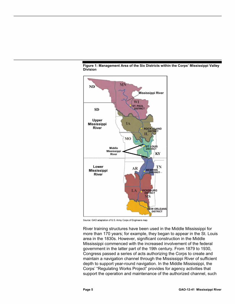
The Corps first became responsible for supporting Mississippi River navigation under an act passed by Congress in 1824. Within the Corps, responsibility for managing the river rests with its Mississippi Valley Division, headquartered in Vicksburg, Mississippi. The division’s St. Louis District manages about 300 miles of the river, including the Middle Mississippi. For planning purposes, the river as a whole is divided into two parts: (1) the Upper Mississippi, which extends from northern Minnesota to the Ohio River confluence and includes the Middle Mississippi; and (2) the Lower Mississippi, which begins at the Ohio River confluence and empties into the Gulf of Mexico. Figure 1 shows the boundaries of the six Corps districts in the Mississippi Valley Division, as well as the Upper, Middle, and Lower Mississippi.
Background
Page 5 GAO-12-41 Mississippi River
Figure 1: Management Area of the Six Districts within the Corps’ Mississippi Valley Division
River training structures have been used in the Middle Mississippi for more than 170 years; for example, they began to appear in the St. Louis area in the 1830s. However, significant construction in the Middle Mississippi commenced with the increased involvement of the federal government in the latter part of the 19th century. From 1879 to 1930, Congress passed a series of acts authorizing the Corps to create and maintain a navigation channel through the Mississippi River of sufficient depth to support year-round navigation. In the Middle Mississippi, the Corps’ “Regulating Works Project” provides for agency activities that support the operation and maintenance of the authorized channel, such

Page 6 GAO-12-41 Mississippi River
as dredging sediment from the bottom of the channel and constructing river training structures to better shape it for navigation.
The Corps typically builds river training structures by piling large stones on the river bottom in various configurations. The most common type of structure is a wing dike (also known as a wing dam or spur dike), which extends from one riverbank at an angle roughly perpendicular to river flow. See figure 2 for a photograph of wing dikes in the Middle Mississippi.
Figure 2: Wing Dikes in the Middle Mississippi
Note: Arrows indicate locations of wing dikes in the photograph.
According to the Corps, wing dikes have been used on the Middle Mississippi in various forms since at least 1838. They are designed to maintain a navigable channel by concentrating river flow in the channel. This focuses the water’s energy and suspended sediment, scouring the river bottom and thereby deepening the channel. These structures are able to maintain the navigation channel because the Mississippi River is an alluvial valley, which means that the river bottom is made of soil and sand rather than rock and stone. Consequently, the riverbed is constantly shifting in response to the force of water and suspended sediment. River

Page 7 GAO-12-41 Mississippi River
training structures harness these forces and redirect them into the navigation channel. This allows barges to travel the river throughout the year, even when the river is low, while reducing the amount of dredging that is required to maintain the channel’s authorized depth. Figure 3 illustrates the scouring effect a wing dike has on the river bed, resulting in a deeper navigation channel.
Figure 3: Simplified Illustration of a River Cross-Section before and after Installing a Wing Dike
In the last 20 years the Corps has begun to use new types of structures, known as bendway weirs and chevrons, to further train the Middle Mississippi. Since 1990, the Corps has used bendway weirs, which are specialized dikes placed on the outside of a river bend. These structures are angled upstream and are positioned entirely under water so that navigation traffic may pass over them. They are designed to redirect flows to the inside of the bend, thus widening the navigation channel and preventing it from migrating toward the outside of the bend. See figure 4 for an illustration of bendway weirs.

Page 8 GAO-12-41 Mississippi River
Figure 4: Illustration of Submerged Bendway Weirs on the Outside of a River Bend
Note: Arrows indicate locations of bendway weirs in the illustration.
After 2000, the Corps introduced chevrons—arch-shaped dikes placed with their curved arches pointed upstream. They are designed to split the river’s downstream flow, thereby scouring the main navigation channel while creating a secondary channel near the bank. According to Corps documents and other studies, chevrons have the added benefit of promoting different kinds of aquatic habitat around the structures and in the secondary channels. See figure 5 for a photograph of three chevrons in the St. Louis harbor.

Page 9 GAO-12-41 Mississippi River
Figure 5: Chevrons in the St. Louis Harbor
Note: Arrows indicate locations of chevrons in the photograph.
Like chevrons, wing dikes can be built as a series of similar structures, known as a dike field, and are typically erected no higher than half bankfull—the stage when water is halfway up the river’s banks. This is approximately 15 feet on the St. Louis gauge, with flood stage at St. Louis beginning at 30 feet. Bendway weirs are placed lower in the channel, and according to the Corps, are always submerged.
According to Corps documents, there are currently more than 1,375 wing dikes, bendway weirs, chevrons, and similar structures4
4This total includes other types of river training structures. For example, the St. Louis District uses regularly interspersed mounds of stone—known as multiple roundpoint structures—to create permeable dikes for navigation and environmental purposes.
in the Middle

Page 10 GAO-12-41 Mississippi River
Mississippi’s 195 river miles. Of this total, about 175 are bendway weirs. The type and pace of construction of river training structures has varied over time. For example, the St. Louis District built almost 450 such structures in the late 19th century, and another 250 in the 1930s; it constructed 150 bendway weirs from 1990 to 2000. The current pace of construction of these structures has slowed relative to the past, but the St. Louis District continues to repair and modify existing structures and has built some new ones. For example, from 2003 to 2010 the district constructed 23 chevrons in the Middle Mississippi, including 3 in the St. Louis harbor.
While not the subject of this review, it is important to note that the Corps uses other structures to fulfill its navigation and flood protection missions along the length of the Mississippi River. These additional structures include:
• Levees and floodwalls. Levees are earthen barriers built parallel to the river for flood protection, and floodwalls are artificial barriers that give additional protection to populated areas. Both types of structures narrow the river’s floodplain.
• Dams and locks. Dams are structures built across the entire width of the river to create pools that increase the depth of the river for navigation. They are used above the Middle Mississippi, where discharges are typically smaller relative to the rest of the river. Locks are gated chambers that allow navigation traffic to pass through the wall of a dam.
• Revetments. Revetments are concrete matting or graded stone placed on riverbanks to stabilize them and prevent erosion. Revetments keep the river in a fixed position—without them, the river’s natural tendency to meander could endanger lands and structures, including levees, in the floodplain.
Assessments of the impacts of river training structures rely upon both hydrologic and hydraulic research. Hydrology is the study of the movement, distribution, and quality of water, and includes the study of flooding. Hydrologic factors explain how (and how much) water enters a river system. Such factors include upstream rainstorms, snow melt, and runoff. In contrast, hydraulic factors are the physical forces that govern how water and sediment are conveyed once they enter a river system. Thus, the primary effect of river training structures is hydraulic, because they deflect water (and sediment) into the navigation channel. However,

Page 11 GAO-12-41 Mississippi River
the structures’ hydraulic and hydrologic effects can be linked. Specifically, if structures’ hydraulic effects increase river stage, the structures could contribute to an overall hydrologic effect.
The Corps and USGS have collected various types of historical hydrologic data on the Mississippi River through different approaches. For example, river stages have been measured daily at St. Louis since 1861. Because these measurements consist of river stage measured on a stream gauge, they are more straightforward than discharge measurements, which require accurate readings of flow velocity, river width, and river depth—the latter two measurements, when multiplied, form the river’s cross-sectional area, which determines the volume of flow it can convey. The Corps took most discharge measurements at St. Louis until 1933, using a variety of devices to record the speed of the river’s flow. These devices included surface floats, double floats, rod floats, and ultimately current meters.5
USGS assumed discharge measurement duties at St. Louis in 1933, and began operating the St. Louis stream gauge station to record continuous stage and discharge measurements. From 1933 to the early 2000s, USGS used Price current meters suspended from bridges—an improvement over earlier devices and methods—to measure discharge, before adopting even more precise instrumentation and methodology that is used today.
Key federal laws provide the Corps with the authority to construct and use river training structures in the Middle Mississippi for navigation and environmental purposes. In addition, in constructing these structures the Corps must comply with the environmental requirements of other key federal laws such as NEPA and the Clean Water Act, as well as applicable state requirements. Further, over a long history of using these training structures, the Corps has gained significant institutional knowledge that it has incorporated into guidance that its districts consult when planning, constructing, and maintaining these structures.
5Surface floats are objects that are placed in the water and then timed to determine how long it takes them to float a known distance. When properly corrected for wind speed, they give an indication of flow velocity. Double floats are surface floats attached by twine to a subsurface float for improved accuracy. Rod floats are wooden poles with a length sufficient to span the depth of a stream. Current meters come in various configurations; the most common type uses a set of rotating cups, which the river’s current turns to indicate the flow’s velocity.
River Training Structures Must Adhere to Key Federal and State Requirements and Corps Guidance

Page 12 GAO-12-41 Mississippi River
The following key federal laws provide the Corps the authority to use river training structures in the Middle Mississippi.6
Rivers and Harbors Acts.
7
Water Resources Development Acts.
The Rivers and Harbors Acts are a series of laws dating back to the 1800s that authorize the Corps to build and maintain public works projects and undertake other projects in the nation’s rivers and harbors. Among other things, these acts have required the Corps to maintain a navigation channel in the Mississippi River since 1878. The Rivers and Harbors Acts of 1927 and 1930 are of particular importance because they require the Corps to establish the current 9-foot navigation channel. Specifically, the 1927 act required the Corps to establish this depth for the navigation channel from the northern boundary of St. Louis to the mouth of the Ohio River near Cairo, Illinois, and to establish another 9-foot navigation channel from Cairo to the Head of Passes in Louisiana. The 1930 act establishes a similar channel from Minneapolis, Minnesota, to the mouth of the Illinois River. The Corps meets these requirements through the use of river training structures, in conjunction with locks, dams, revetments, and periodic dredging of the river bed.
8
6In addition to the laws described in this section, other laws govern certain aspects of the Corps’ use of river training structures in the Middle Mississippi, such as the National Historic Preservation Act. We selected the laws presented in this report because, based on interviews and analysis of documents, they were the requirements most relevant to potential hydrologic and environmental impacts of river training structures.
The Water Resources Development Acts (WRDA) govern various aspects of conservation and development of water resources and, as the Rivers and Harbors Acts did previously, authorize the construction of water resources projects, including improvements to rivers and harbors of the United States. Several WRDA provisions are particularly relevant to the use of river training structures in the Middle Mississippi. For example, beginning in 1986, WRDA authorizes the Corps’ Environmental Management Program, a joint federal-state partnership to restore and enhance the ecology of the Upper Mississippi. The 1990 WRDA requires the Corps to consider environmental protection as one of the primary goals for
7Pub. L. No. 69-560, 44 Stat. 1010; Pub. L. No. 71-520, 46 Stat. 918. 8WRDAs have been enacted periodically since 1986 to authorize and modify Corps civil works studies, projects, and programs. See, for example, Pub. L. No. 99-662, 100 Stat. 4082 (1986); Pub. L. No. 101–640, 104 Stat. 4604 (1990); Pub. L. No. 110-114, 121 Stat. 1041 (2007).
Key Federal Laws Provide the Corps with Authority to Use River Training Structures

Page 13 GAO-12-41 Mississippi River
planning, design, construction, operations, and maintenance of its water resources projects. WRDA 2007 authorizes the Corps to develop ecosystem restoration projects within the Upper Mississippi-Illinois River waterway. These projects are administered under the Corps’ Navigation and Ecosystem Sustainability Program (NESP), a program designed to promote navigation efficiency and ecological restoration.
In using river training structures in the Middle Mississippi, the Corps must comply with the applicable environmental requirements of key federal laws, as well as state and other requirements. These key laws and requirements include the following:
National Environmental Policy Act.9 NEPA requires an agency to prepare a detailed statement on the environmental impacts of any “major federal action” significantly affecting the environment. Regulations promulgated by the Council on Environmental Quality implementing NEPA generally require an agency to prepare either an environmental assessment (EA)10 or an environmental impact statement (EIS).11
9Pub. L. No. 91-190, 83 Stat. 852 (1970), codified as amended at 42 U.S.C. §§ 4321-4347 (2011).
Agencies may prepare an EA to determine whether there is a significant potential impact on the environment, which would necessitate the preparation of an EIS. However, if the agency, in its EA, determines there are no significant impacts from the proposed action, then an agency should prepare a finding of no significant impact (FONSI). NEPA regulations state that federal agencies shall, to the maximum extent
10An EA is a concise public document that provides sufficient evidence and analysis for determining whether to prepare an environmental impact statement or a finding of no significant impact, and is to include brief discussions of the need for the proposal, alternatives, the environmental impacts of the proposed action and alternatives, and a listing of agencies and persons consulted. 40 C.F.R. § 1508.9 (2011). 11An EIS is a more detailed statement than an EA, and NEPA implementing regulations specify requirements and procedures—such as providing the public with an opportunity to comment on the draft document—applicable to the EIS process that are not mandated for EAs. An EIS must, among other things, (1) describe the environment that will be affected, (2) identify alternatives to the proposed action and identify the agency’s preferred alternative, (3) present the environmental impacts of the proposed action and alternatives, and (4) identify any adverse environmental impacts that cannot be avoided should the proposed action be implemented. 42 U.S.C. § 4332(c) (2011), 40 C.F.R. §§ 1501.4, 1508.11 (2011).
River Training Structures Must Comply with Applicable Federal and State Environmental Requirements

Page 14 GAO-12-41 Mississippi River
possible, encourage and facilitate public involvement in decisions that affect the quality of the human environment. Under these regulations, agencies must provide a public comment period for a draft EIS; while there is no corresponding requirement for an EA, agencies may provide a public comment period. We reported in March 2010 that the Corps does not have clear guidance concerning whether it will provide a public comment period for draft EAs, and recommended the agency develop such guidance.12
Once an agency has prepared an EIS for a project, supplemental NEPA documentation is sometimes required. The Council on Environmental Quality’s regulations require supplemental documentation when an agency “makes substantial changes in the proposed action” or “[t]here are significant new circumstances or information” relevant to environmental concerns and bearing on the proposed action or its impacts.
According to Corps officials, the agency is presently developing such clarifying guidance. St. Louis District officials said that their practice is to provide a public comment period on any EA prior to finalizing a finding of no significant impact.
13 A council document issued in 1981 suggests that if the EIS concerns an ongoing program and is more than 5 years old, it should be carefully reexamined to determine if a supplement should be prepared.14
12GAO, Delaware River Deepening Project: Comprehensive Reanalysis Corrected Errors, but Several Issues Still Need to Be Addressed,
An agency must take a “hard look” at the new information and project changes to determine if a supplemental EIS (SEIS) is needed; an EA may be used to do so. Similarly, the Corps’ own NEPA implementing regulations require the district commander to “review existing NEPA document(s) to determine if there are new circumstances or significant impacts which warrant the
GAO-10-420 (Washington, D.C.: Mar. 31, 2010). 1340 C.F.R. § 1502.9(c) (2011). Courts have explained that substantial changes to a project warrant supplemental NEPA documentation. A change is substantial if it presents a “seriously different picture of the environmental impact.” See, for example, Ark. Wildlife Fed’n v. U.S. Army Corps of Eng’rs, 431 F. 3d 1096 (8th Cir. 2005); Envtl. Def. Fund v. Marsh, 651 F. 2d 983 (5th Cir. 1981). Similarly, courts have stated that when new information presents a “seriously different picture of the environmental landscape” another in-depth look at the environment is necessary. In re Katrina Canal Breaches Consol. Litig., 647 F. Supp. 2d 644, 723 (E.D. La. 2009). See also Blue Mountains Biodiversity Project v. U.S. Forest Serv., 229 F. Supp. 2d 1140 (D. Or. 2002). 14Council on Environmental Quality, Forty Most Asked Questions Concerning CEQ's National Environmental Policy Act Regulations, 46 Fed. Reg. 18,026 (Mar. 23, 1981).

Page 15 GAO-12-41 Mississippi River
preparation of a…supplement to the EIS.”15 Then, after review of the new information and project changes, the Corps will determine whether to prepare an additional EA or SEIS.16 An EA is recommended if there are, among other things, “changes in environmental impacts [that] were not considered” in the original NEPA documentation.17 An EA or SEIS may also be used to ensure site-specific impacts and alternatives are evaluated when an initial EIS is broad or programmatic in nature. Additional, site-specific analysis is required when the original EIS did not provide the required analysis and left gaps that could include significant impacts.18
Clean Water Act.
Thus, when unaddressed impacts are brought to light by new information or major changes in the operation or maintenance of Corps projects, the Corps is required to prepare supplemental NEPA documentation.
19 The Corps is also subject to many requirements of the Clean Water Act, which includes the goal of eliminating the addition of pollutants to waters of the United States. The Clean Water Act requires, among other things, that projects involving placement of dredged or fill material in federally regulated waters must obtain a permit, known as a Department of the Army Section 404 permit or simply a “dredge or fill” permit. With respect to the Corps’ own activities triggering a dredge or fill permit, the agency’s practice is generally to document that the activities are covered by a nationwide permit,20
1533 C.F.R. § 230, App. A (3a) (2011) (emphasis added). Additionally, the Corps’ regulations provide that supplemental documentation will be prepared according to CEQ regulations. 33 C.F.R. § 230.13(b) (2011).
or if not, to issue a permit-equivalent. In doing so, the Corps project team prepares a document evaluating the
16According to the Corps’ regulations, a SEIS is prepared for “major changes in the operation and/or maintenance of completed projects,” among other things. 33 C.F.R. § 230.6 (2011). 1733 C.F.R. § 230.7(d) (2011). 18See, for example, Recent Past Pres. Network v. Latschar, 701 F. Supp. 2d 49 (D.D.C. 2010), State of Mississippi v. Marsh, 710 F. Supp. 1488, 1505-06 (S.D. Miss. 1989); Natural Res. Def. Council, Inc. v. U.S. Nuclear Regulatory Comm’n, 606 F.2d 1261, 1271 (D.C. Cir. 1979). 19Federal Water Pollution Control Act, Pub. L. No. 92–500, 86 Stat. 884 (1972), codified as amended at 33 U.S.C. §§ 1251-1387, and generally referred to as the Clean Water Act. 20The Corps’ regulatory branch generally administers the permitting process, and has issued nationwide permits to provide a streamlined process for certain types of activities that it has found have only minimal impacts on the aquatic environment.

Page 16 GAO-12-41 Mississippi River
project’s compliance with EPA-promulgated guidelines21
Fish and Wildlife Coordination Act.
for the placement of fill material in federally regulated waters, including a determination of cumulative effects on the aquatic ecosystem, as well as to provide information demonstrating compliance with state water quality standards. The Corps regulatory section generally makes this document, known as a Section 404(b)(1) evaluation or statement of findings, available for public review as part of the public notice of the permit application.
22 The Fish and Wildlife Coordination Act authorizes the Secretary of the Interior to, among other things, provide assistance to, and cooperate with, federal, state, and public or private agencies and organizations in the development, protection, rearing, and stocking of all species of wildlife and their habitat; in minimizing damages from overabundant species; and in providing public shooting and fishing areas. Amendments to this law enacted in 1946 require consultation with FWS and the fish and wildlife agencies of states where the “waters of any stream or other body of water are proposed or authorized, permitted or licensed to be impounded, diverted, the channel deepened. . . or otherwise controlled or modified” by any federal agency.23
Endangered Species Act.
Consultation is to be undertaken for the purpose of preventing loss of and damage to wildlife resources, among other reasons.
24
21The guidelines were developed by EPA in consultation with the Corps. 45 Fed. Reg. 85,344 (Dec. 24, 1980).
The Endangered Species Act requires that federal agencies ensure that any action they authorize, fund, or carry out is not likely to jeopardize the continued existence of a species protected under the act. To fulfill this responsibility, the agencies must, under some circumstances, formally consult with FWS when their actions may affect listed species or habitat identified as critical to the species’ survival. Formal consultations generally result in the issuance of biological
22Acts of March 10, 1934, ch. 55, 48 Stat. 401, codified as amended at 16 U.S.C. §§ 661-666c (2011). 23The consultation requirement applies to projects or units of projects whensoever authorized, except that it does not apply to any project or unit authorized before March 10, 1934, if the construction of the particular project or unit has been substantially completed, defined as when 60 percent or more of the estimated construction cost has been obligated for expenditure. 24Pub. L. 93–205, 87 Stat. 884 (1973), codified at 16 U.S.C. §§ 1531-1544 (2011).

Page 17 GAO-12-41 Mississippi River
opinions by FWS. The biological opinion contains a detailed discussion of the effects of the action on listed species or critical habitat and FWS’s opinion on whether the agency action is likely to jeopardize the continued existence of the species. In cases where a project as proposed is likely to either jeopardize the species or cause the destruction or adverse modification of its critical habitat, the opinion will provide “reasonable and prudent” alternatives to avoid jeopardy or adverse modification that FWS believes the agency could take in implementing the action. Additionally, biological opinions often contain provisions directing an agency to monitor and report on the effects of its action on listed species.25
Executive Order 11988.
26
25These monitoring reports may contain information relevant to reinitiation of formal consultation, among other things. Reinitiation of formal consultation is required in four instances where discretionary federal involvement or control over the action has been retained or is authorized by law: (1) if the amount or extent of taking specified in the biological opinion is exceeded, (2) if new information reveals effects of the action that may affect listed species or critical habitat in a manner or to an extent not previously considered, (3) if the identified action is subsequently modified in a manner that causes an effect to the listed species or critical habitat that was not considered in the biological opinion, or (4) if a new species is listed or critical habitat designated that may be affected by the identified action. 50 C.F.R. § 402.16 (2011).
Executive Order 11988, Floodplain Management, was signed by the President in 1977. The executive order requires, among other things, that agencies determine whether a proposed action will occur in a floodplain, and if so, consider alternatives to avoid adverse effects and incompatible development in the floodplains and take actions to minimize potential harm to the floodplain. Under the executive order, the floodplain is, in relevant part, defined as including the lowland and relatively flat areas adjoining inland waters, but does not include the river channel. The executive order also requires each agency to issue or amend existing regulations and procedures within 1 year to comply with the order; the regulations and procedures are to require the construction of federal structures and facilities to be in accordance with the standards and criteria and to be consistent with the intent of those promulgated under the National Flood Insurance Program, the primary federal government initiative supporting flood insurance for communities meeting minimum conditions. The National Flood Insurance Program requires that participating communities ensure that construction, fill, and certain other
2642 Fed. Reg. 26,951 (May 24, 1977).
Page 18 GAO-12-41 Mississippi River
activities in the floodway do not cause an increase in flood levels,27 but the executive order, however, was focused on the land portion of floodplains rather than the river channel and does not import the prohibition on floodway encroachment to federal agencies. The Corps regulation implementing the executive order specifies Corps policy and procedures for projects, including operation and maintenance activities, in the floodplain.28 The Corps regulation defines regulatory floodway as “the area regulated by Federal, State or local requirements; the channel of a river or other watercourse and the adjacent land areas that must be reserved in an open manner, i.e., unconfined or unobstructed either horizontally or vertically to provide for the discharge of the base flood29
State requirements. In addition to complying with federal requirements, the Corps’ use of river training structures must also comply with applicable state requirements. Specifically, federal agencies conducting projects requiring federal permits or licenses generally must obtain certification from the relevant state that the project will not cause or contribute to violations of the state’s water quality standards. In the Middle Mississippi, if a federal project in Missouri or Illinois complies with the conditions of certain nationwide permits, as well as conditions of the relevant state’s blanket water quality certification, then additional certification is generally not needed. Moreover, although states may set
so the cumulative increase in water surface elevation from encroachment does not exceed one foot as set by the National Flood Insurance Program.”
2744 C.F.R. § 60.3(d)(3) (2011) (“[In the regulatory floodway, communities must] prohibit encroachments, including fill, new construction, substantial improvements, and other development within the adopted regulatory floodway unless it has been demonstrated through hydrologic and hydraulic analyses performed in accordance with standard engineering practice that the proposed encroachment would not result in any increase in flood levels within the community during the occurrence of the base flood discharge.”) 28U.S. Army Corps of Engineers, Implementation of Executive Order 11988 on Flood Plain Management, ER 1165-2-26 (1984). 29The base flood is the flood that has a 1 percent chance of occurrence in any given year (also known as the 100-year flood).

Page 19 GAO-12-41 Mississippi River
floodway standards, this generally does not impose a requirement on the Corps’ use of river training structures.30
The Corps has internal guidance, informed by institutional knowledge, that further governs its use of river training structures in the Middle Mississippi. The primary guidance for the design of river training structures is the Corps’ engineering manual.31
Corps guidance also includes its policy for internal reviews of all Civil Works projects.
The manual’s section on training structures covers topics such as determining their length and height and the size of the stones used in constructing them. It also addresses flood control, cautioning structure designers to ensure that the amount of channel contraction does not unduly increase flood heights; discusses the performance and evaluation of training structures; and lists studies and factors that should be considered in the planning and design of training structures, including the modeling of such structures to help predict their impacts. In several places, the manual cites institutional knowledge as a factor that should be considered in designing and constructing training structures. For example, the manual states that, through experience and judgment, an engineer can evaluate various sections of the river that maintain adequate depths naturally and use that information to determine how to apply it to other sections.
32
30Generally, the federal government is not itself subject to regulation by state and local government. However, Congress may enact laws waiving supremacy and subjecting federal agencies to state and local regulation such as permit requirements. See, for example, Clean Water Act (33 U.S.C. § 1323(a)), Resource Conservation and Recovery Act (42 U.S.C. § 6961(a)).
The policy establishes various levels of review, including district-level quality control review, agency technical review, and independent external peer review. The policy applies to all Civil Works projects “from initial planning though design, construction, and operation, maintenance, repair, replacement, and rehabilitation.” In addition, Mississippi Valley Division regulations establish, among other things, required approvals and reviews for river training structures and other
31U.S. Army Corps of Engineers, Layout and Design of Shallow-Draft Waterways, EM 1110-2-1611 (Washington, D.C.: Dec. 31, 1980). 32U.S. Army Corps of Engineers, Civil Works Review Policy, Circular 1165-2-209 (Washington, D.C.: Jan. 31, 2010).
The Corps Has Internal Guidance That Applies to the Use of River Training Structures

Page 20 GAO-12-41 Mississippi River
channel improvements in the Mississippi River and key tributaries.33
In addition, the St. Louis District provided us with a written description of the process they use to assess the need for new training structures and then build and monitor them. This process is not currently documented in the Corps’ official guidance. According to the description provided by the district, the process includes several steps, such as (1) assessing river conditions and identifying sections of the river that have resulted in navigation problems, (2) designing structures using physical models of the river, (3) coordinating with key stakeholders, and (4) monitoring structures before and after construction. The description states that this process is consistent with the process that has been used throughout the Mississippi Valley Division for the past 50 years.
For example, the regulations require each district’s “general plan” to provide a general outline of proposed channel improvements, such as proposed location and type of training structures. These plans are to be approved by a Division team, which serves as the agency’s technical review under the Corps’ review policy.
The Corps has conferred with stakeholders on environmental impacts and has assessed these impacts to some extent, but has not prepared additional analyses—such as an EA—to assess site-specific impacts and alternatives, new information, and project changes to determine if a SEIS is required. The Corps also has not obtained Clean Water Act permits or state water quality certifications for river training structures as required.
In accordance with the Fish and Wildlife Coordination Act and the Endangered Species Act, the Corps has engaged in consultation with FWS about the environmental impacts of river training structures. Specifically, the Corps’ St. Louis, Rock Island, and St. Paul Districts consulted with FWS in the 1990s on the operations and maintenance of
33U.S. Army Corps of Engineers, Mississippi Valley Division, Channel Improvement Engineering and Design Activities, Regulation No. 1110-2-8 (Vicksburg, Miss.: Oct. 27, 2005).
The Corps Has Addressed Some but Not All of the Environmental Requirements for River Training Structures
The Corps Has Conferred with Stakeholders Prior to Constructing River Training Structures

Page 21 GAO-12-41 Mississippi River
the 9-foot navigation channel. In its 2000 biological opinion, FWS determined that the operations and maintenance project jeopardizes the pallid sturgeon—a large native fish that FWS placed on the endangered species list in 1990—and results in harm to the interior least tern—a small bird that was placed on the endangered species list in 1985—in the Middle Mississippi.34
In addition to requirements for consultation and other actions to prevent harm to endangered species, the St. Louis District is required to submit annual reports to FWS on its implementation of the biological opinion’s reasonable and prudent alternatives. According to FWS, the St. Louis District is several years behind in providing these annual reports. In addition, the consultation culminating in the 2000 biological opinion did not include individual, site-specific effects or new construction impacts. According to the opinion and a Corps document, site-specific effects and new construction impacts for river training structures are to be handled under separate consultations, referred to as tier II biological assessments. The Corps provided us with examples of such assessments issued in 2010 and 2011.
To prevent jeopardy for the pallid sturgeon, FWS’s biological opinion instructs the Corps to (1) conduct a habitat study in the Middle Mississippi, (2) facilitate development of a conservation and restoration plan, (3) implement a long-term program of aquatic habitat restoration, and (4) begin short-term implementation of aquatic habitat restoration measures. To minimize harm to the least tern, the opinion instructs the Corps to (1) modify training structure maintenance projects to maintain flow between sandbars and the shore and to reduce conversion of sandbar habitat to trees; (2) evaluate, and implement where appropriate, techniques that use dredge material to restore or enhance sandbar habitat and aquatic habitat; and (3) reduce the accretion of new and existing sandbars to the bank and reduce tree colonization on those sandbars.
According to officials at FWS and the state resource agencies in Illinois and Missouri, the St. Louis District confers with them prior to constructing river training structures. According to officials at the FWS field office that works with the St. Louis District, the district coordinates with them through activities conducted under the Fish and Wildlife Coordination Act, as well
34U.S. Fish and Wildlife Service, Biological Opinion for the Operation and Maintenance of the 9-Foot Navigation Channel on the Upper Mississippi River System (May 2000).

Page 22 GAO-12-41 Mississippi River
as through the implementation process for the 2000 biological opinion. This interaction occurs through the district’s River Resources Action Team, which coordinates and prioritizes projects in the Middle Mississippi, including those related to the biological opinion, and conducts an annual inspection tour of the river. Additionally, the Corps has consulted with the states prior to constructing river training structures. According to officials at the Illinois and Missouri Departments of Natural Resources and the Missouri Department of Conservation, the St. Louis District solicits their comments on proposed projects and involves them in river planning studies. As part of the St. Louis District’s planning process, it invites these stakeholders to its Applied River Engineering Center35
for physical modeling demonstrations, where district engineers describe proposed structures and solicit comments from stakeholders. Officials from both states told us they believe that the level of coordination is sufficient.
The St. Louis District has not performed the additional analyses of environmental impacts for river training structures that it has constructed in the last three decades as NEPA requires, but instead has continued to rely primarily on an EIS prepared more than 35 years ago. Specifically, in 1976, the St. Louis District issued the Final Environmental Statement: Mississippi River between the Ohio and Missouri Rivers (Regulating Works).36
35The Applied River Engineering Center was established by the St. Louis District in 1995 to conduct applied river engineering in an office laboratory environment. With a staff of about 10, the center conducts work on behalf of customers such as landowners, private facility owners, and local municipalities, as well as agency partners such as FWS, the Missouri Department of Conservation, and the Illinois Department of Natural Resources. It has also partnered with other districts within the Corps including the Memphis, Rock Island, Vicksburg, New Orleans, Galveston, and Kansas City Districts.
The 1976 EIS focuses on the operation and maintenance of the Middle Mississippi navigation channel, including dikes, revetments, and any necessary dredging. It broadly discusses each component of its recommended plan, and discusses at a high level the implementation of dikes in general. It does not describe the environmental effects of river training structures or specify any design criteria or location for any structures. The EIS states that dikes could lead to degradation of the riverbed and aquatic organisms and acknowledges that some impacts of
36U.S. Army Corps of Engineers, St. Louis District, Final Environmental Statement: Mississippi River between the Ohio and Missouri Rivers (Regulating Works) (St. Louis, Mo.: April 1976).
The Corps Has Not Prepared the Additional Environmental Analyses Required by NEPA

Page 23 GAO-12-41 Mississippi River
the 9-foot channel project were “not… adequately assessed” or “not yet fully understood.”37 It also recognizes that the river is an ever-changing environment and states that a reassessment of project impacts would likely be necessary within 5 years.38
In the 35 years since the Corps issued its EIS, the St. Louis District has constructed new river training structures in the Middle Mississippi and intends to continue building such structures in the future as needed. For these new river training structures, the St. Louis District has continued to rely primarily upon the 1976 EIS as adequate for NEPA compliance. However, since 1976, the picture of potential impacts of these structures on the river environment has changed in some important respects. First, several river species have been listed as endangered (e.g., the least tern and the pallid sturgeon) and significantly more data has been developed on their populations as well as impacts of training structures on habitat for these and other species. For example, according to FWS’s 2000 biological opinion, river training structures affect natural river processes, harming the least tern and pallid sturgeon. The 1976 EIS does not reflect today’s scientific understanding of the effect of river training structures on these species. The 1976 EIS also does not reflect the relative significance of various types of river habitat for other native species, given the losses in habitat diversity documented in FWS’s 2000 biological opinion and a
The EIS briefly considers broad alternatives to the Regulating Works Project, namely no action; use of locks and dams; a change in project authorization to incorporate fish and wildlife enhancement; and the existing operation and maintenance activities, which formed the adopted plan. The EIS concludes that the actions proposed by the Regulating Works project do not significantly impact the river’s endangered species, among other things.
37“The effects of riverbed degradation on aquatic organisms in the Middle Mississippi River are not yet fully understood.” 1976 EIS at 215a. “The cumulative effect of channelization efforts in the Middle Mississippi River to date has not been adequately assessed. Perhaps the most serious adverse impact resulting from the 9-foot channel project on the Middle Mississippi River is reduction in size and diversity of the aquatic habitat.” Id. at 216. 38Corps officials stated that such provisions commonly appeared in EISs in the 1970s, but that they did not establish any requirements for further review.

Page 24 GAO-12-41 Mississippi River
2004 Corps document.39
The lack of additional NEPA analysis by the St. Louis District is also inconsistent with Corps regulations and the practices of other districts. Corps regulations require the St. Louis District commander to “review existing NEPA document(s) to determine if there are new circumstances or significant impacts which warrant the preparation of a…supplement to the EIS.” However, we found that for river training structures this has generally not happened. The Corps’ position is that the agency has taken the requisite “hard look” at whether there are new or significant changes that would require additional NEPA documentation, and so far as the Corps has been able to determine to date, changes have not risen to a level of significance that would justify or require the preparation of a SEIS. The Corps produced one documented internal review, from 1994, of whether additional NEPA documents were needed for the Regulating Works Project.
Second, the St. Louis District has expanded the types of river training structures it uses in the Middle Mississippi. For example, the district began using bendway weirs in 1990 and chevrons after 2000, whereas the 1976 EIS focuses primarily on the use of wing dikes. Corps documents suggest that each of these types of river training structures may have different environmental impacts, but St. Louis District officials told us that while configurations of river training structures have evolved over time, the purpose and function of these structures themselves has changed very little. Finally, the 1976 EIS does not provide any information on site-specific structures or locations and discusses the environmental effects only at a high level. Without site- or location-specific information, the Corps has not documented to the public its consideration of such impacts and potential mitigation. Because the St. Louis District has not prepared any additional NEPA documents since 1976, such as an EA or SEIS, we believe that the Corps has not fully implemented the requirements of NEPA for river training structures in the Middle Mississippi. The absence of additional NEPA analyses, we believe, limits opportunities for the Corps to evaluate new environmental circumstances and information that have arisen since 1976.
40
39U.S. Fish and Wildlife Service, Biological Opinion for the Operation and Maintenance of the 9-Foot Navigation Channel on the Upper Mississippi River System (May 2000); U.S. Army Corps of Engineers, Final Integrated Feasibility Report and Programmatic Environmental Impact Statement for the UMR-IWW System Navigation Feasibility Study (Sept. 24, 2004).
The review, however, did not describe what changes the
40The review did not determine whether a supplement to the EIS was “warranted,” as called for by Corps regulations, but rather whether one was legally required.
Page 25 GAO-12-41 Mississippi River
Corps believed had taken place, or why it considered those changes to be environmentally insignificant.41 According to Corps officials, the St. Louis District has had discussions and briefings on this issue, and NEPA considerations have been discussed with the district commander at the budget, design, and construction phases for specific river training structures. However, the district did not provide documentation to us that demonstrated these discussions. Similarly, we found that the St. Louis District’s approach for preparing additional analyses is inconsistent with other Corps districts. For example, the Rock Island District, which is the district immediately to the north of the St. Louis District, has prepared eight EAs since 1992 for river training structure construction or modifications under its channel operation and maintenance authority. One of these EAs noted that the Rock Island District’s EIS42
In a written response to our inquiries about this issue, the Corps’ Chief Counsel stated that the agency strongly believes, “based on all information available to [the Corps] at this time,” that it is in full compliance with NEPA with regard to river training structures. The written response further stated, however, that “in the spirit of” NEPA regulations the Corps will voluntarily perform an additional EA for river training structures that “will determine whether there are undisclosed and currently unknown significant effects on the human environment that might require additional analysis and documentation.” Further, the written response stated that the Corps will make an objective and formal determination of whether to prepare a SEIS after the EA is completed but did not state whether it would make a draft of the EA available for public comment. The written response also noted that the Corps cannot commit
for operation and maintenance of the 9-foot channel, prepared in 1974, does not address site-specific new construction of river training structures. As a result, the Rock Island District prepared additional NEPA documentation to address potential impacts of its construction. In addition, the Rock Island District provided the public an opportunity to comment on this EA before deciding whether or not to prepare an EIS.
41We note that the subject review was an internal document, whereas more typically, agencies use EAs, revised records of decision, or formal re-evaluation documents to announce such decisions. 42U.S. Army Corps of Engineers, Rock Island District, Operations and Maintenance, Upper Mississippi River, 9-Foot Navigation Channel, Final Environmental Impact Statement: Pools 11-22 (1974).

Page 26 GAO-12-41 Mississippi River
to a specific time frame for completion of the EA, since no funds have been budgeted for it in fiscal year 2012.
As previously discussed, the Corps is obligated to obtain Clean Water Act permit-equivalents for placement of fill in federally regulated waters and obtain associated water quality certifications from relevant states, unless a nationwide permit applies. However, the St. Louis District has not obtained these permits for river training structures constructed under the Corps’ operation and maintenance authority. Instead, according to district officials, the agency builds new river training structures under its authority to maintain the river channel, and therefore they are considered to fall under a nationwide permit for maintenance issued by the Corps’ regulatory branch. In addition, St. Louis District officials told us they do not need the permit-equivalent because they are operating under the nationwide permit.
However, the Corps has not demonstrated that the construction of new river training structures, which typically involves the placement of thousands of tons of rock into the river, meets the requisite conditions for the nationwide permit for maintenance. This nationwide permit authorizes “the repair, rehabilitation or replacement of any previously authorized, currently serviceable, structure, or fill,” and “minor deviations in the structure’s configuration or filled area, including those due to changes in materials, construction techniques, or current construction codes or safety standards that are necessary to make the repair, rehabilitation or replacement.” The permit further notes that “the placement of riprap must be the minimum necessary to protect the structure or to ensure the safety of the structure.”43
43Riprap is defined as loose stone used as a cover for the purpose of stabilization.
St. Louis District officials did not provide us any evidence that would explain how new river training structures are consistent with the nationwide permit’s scope. Moreover, the Corps’ regulations applicable to all nationwide permits provide that no activity is authorized under any nationwide permit that is likely to jeopardize the continued existence of a threatened or endangered species or that will destroy or adversely modify the critical habitat of such species. As previously discussed, FWS determined in its 2000 biological opinion that the Corps’ channel maintenance activities jeopardize the pallid sturgeon, among other species. The St. Louis District could not explain to us how a
The Corps Has Not Obtained Clean Water Act Permits

Page 27 GAO-12-41 Mississippi River
nationwide permit would be applicable to project operations under these circumstances.44
Furthermore, officials at another Mississippi River Corps district that we contacted told us that the nationwide permit for maintenance is not applicable for new construction of river training structures and as a result they do not use such a permit in their district. In light of these discrepancies, we believe that the St. Louis District has not obtained the permits required by the Clean Water Act, including obtaining the required state water quality certification for its river training structures.
For river training structures in the Middle Mississippi, the Corps has conducted preconstruction physical and numerical modeling to assess the potential hydraulic impacts of the structures and has routinely monitored the hydrologic impacts after construction through data collection and observation, among other activities. In contrast, the Corps has not routinely monitored postconstruction environmental impacts of its river training structures. The Corps has, however, conducted or contracted for a number of studies on specific environmental effects of its river training structures.
Prior to construction, the Corps has conducted physical and numerical modeling to assess the potential hydraulic impacts of proposed new river training structures and proposed modifications to existing structures. For example, at its Applied River Engineering Center, the Corps has
44St. Louis District officials also provided us with a Section 404(b)(1) evaluation prepared in 1981 for the construction of dikes in the Middle Mississippi, but did not provide any associated permit-equivalent or explain its relevance. According to Mississippi Valley Division regulations, for compliance with the Clean Water Act, each district is to review its proposed channel improvement projects annually to determine if the planned work meets the requirements of the EPA guidelines, or if updates to the original Section 404 evaluation are required. The regulation indicates that development of supplemental information or reevaluation and public notice under the Section 404(b)(1) process may be necessary. See U.S. Army Corps of Engineers, Channel Improvement Engineering and Design Activities.
The Corps Has Routinely Monitored the Hydrologic Impacts of River Training Structures after Construction, but Has Not Routinely Monitored Their Environmental Impacts
The Corps Has Conducted Preconstruction Modeling to Assess Hydraulic Impacts

Page 28 GAO-12-41 Mississippi River
assessed hydraulic impacts of river training structures by building small-scale physical models to help determine the impact that these structures might have on a given river section, such as changes in flow and sedimentation patterns.45 Corps officials told us that the Corps builds models for specific reaches of the river, to evaluate the effectiveness of the various river training structures prior to constructing them. The Corps uses field data, such as discharge, velocity, and sediment volume, to calibrate its models. The models are then run through a series of tests to obtain results. Corps engineers evaluate the results and refine the models, with input and review from biologists, fisheries specialists, other water resource scientists, the river industry, land owners, and other stakeholders. The results are recorded in reports that are publicly available on a Corps website.46 As of September 2011, the Corps’ website included 25 physical model reports that have been issued since 1994. The Corps has also used physical models to solve problems such as repetitive dredging and other navigation-related issues. For example, in a report issued in 2004, the Corps built a physical model to evaluate and propose design modifications to existing training structures, and possibly introduce new training structures, for the purpose of improving navigation conditions and reducing the need for dredging in the St. Louis harbor.47
45According to Corps documents, small-scale synthetic bed models, called micro-models or hydraulic sediment response models, have been used since 1994 and replace large-scale coal bed models. With these small-scale models, engineers are able to replicate the mechanics of an actual river or stream on an area the size of a normal table top.
Figure 6 is a photograph of a small-scale physical model similar to the one used in the St. Louis harbor report.
46For copies of modeling studies, see the Corps’ Applied River Engineering Center’s website at http://www.mvs.usace.army.mil/arec/reports_hsrmodels.html (accessed Sept. 15, 2011). 47U.S. Army Corps of Engineers, Sedimentation and Navigation Study of the Middle Mississippi River in the St. Louis Harbor River Miles 192.0 to 172.0: Hydraulic Micro Model Investigation, Technical Report M31 (St. Louis, Mo.: 2004).

Page 29 GAO-12-41 Mississippi River
Figure 6: Photograph of a Small-Scale Physical Model
Note: The model employed a horizontal scale of 1 inch equals 1,000 feet and a vertical scale of 1 inch equals 100 feet.
The Corps has also at times used numerical models to assess the potential hydraulic impacts of training structures prior to their construction. Numerical models are computer programs that simulate the behavior of a river section. Like physical models, numerical models use field data from the actual section, such as river stage, discharge, and cross-sectional width. The Corps runs these data through a complex set of equations to produce quantitative estimates of how the river will respond to changes, such as the addition or modification of training structures. According to an

Page 30 GAO-12-41 Mississippi River
official with the Corps’ Engineer Research and Development Center,48
In contrast, the Corps has not assessed the potential hydrologic impacts of proposed new river training structures or proposed modifications to existing structures prior to their construction because it believes the structures have no impact on flooding, according to agency officials. According to Corps officials, both physical and numerical models are limited in their ability to assess hydrologic impacts of river training structures. For example, according to these officials, small-scale physical models cannot be used to predict changes in river stage. They said this is because of the large differences in scale between the model and the actual size of the river section being modeled. Because of these large differences, it is not possible to measure very small changes in river stage detected in the model and translate them into predicted changes in actual river stage. In addition, there are other factors that may impact river stage, such as bank vegetation, that are not feasible to reproduce in a small-scale model, according to a St. Louis District official responsible for modeling. As with physical models, a district official told us that while numerical models could theoretically be used to predict impacts of
numerical models can run analyses in one, two, or three dimensions. The two- and three-dimensional models can perform more complex analyses, but on a shorter stretch of river than a one-dimensional model. According to this official, the Corps commonly uses one-dimensional models to analyze changes in the floodplain for a large river section. Two-dimensional models can analyze lateral and longitudinal velocities for a smaller river section, and three-dimensional models can analyze vertical velocities for an even smaller river section. Models can be used in tandem—for example, results from three-dimensional modeling can be used to improve a two-dimensional model. Numerical models are able to show the effects that training structures have on the river as its flow goes around the structures, including flow separation and sediment capture, the official told us. In certain circumstances, the Corps has run numerical models in conjunction with physical models to help it to obtain a clearer picture of the expected results.
48The Engineer Research and Development Center is a diverse engineering and scientific research organization that conducts research and development in support of the Corps’ military and civil works missions, as well as for other federal agencies, state and municipal authorities, and U.S industry. Headquartered in Vicksburg, Mississippi, the Center operates seven laboratories in various locations in the United States, has a staff of about 2,500 federal employees, and an annual research program exceeding $1 billion.

Page 31 GAO-12-41 Mississippi River
training structures on river stage prior to construction, the Corps is not aware of a model study that has proven this capability.49
According to the St. Louis District, along with physical and numerical modeling, the Corps also monitors the section of the river where it plans to build or modify training structures by collecting data, including hydrographic surveys of the river bottom, velocities of the river current, stages, and discharges. In addition, the Corps conducts several reviews before constructing or modifying training structures. Specifically, according to the St. Louis District, engineers throughout the division review the proposals, as do federal and state partner agencies, such as FWS, the Illinois Department of Natural Resources, and the Missouri Department of Conservation, as well as the navigation industry. In addition, Corps officials told us that all training structure proposals undergo, at the general plan stage, a formal review by a committee consisting of representatives from all six districts in the Mississippi Valley Division. This is conducted per division regulations establishing reviews and approvals, including those under the Corps Civil Works Review Policy.
Further, the official said that because the Corps believes training structures have no impact on river stage, the St. Louis District does not believe it is necessary to perform numerical modeling for assessing river stage impacts.
According to the St. Louis District, once training structures are built, it routinely monitors their hydrologic impacts through several methods. First, it collects data to measure the structures’ effects and to compare with preconstruction data. For example, St. Louis District engineers conduct hydrographic surveys of the river bottom to confirm that the structures have improved the channel’s ability to convey water and sediment. Also, according to Corps officials and documents, the Corps collects and monitors discharge and other relevant data with instruments that, for example, measure the velocity of water at various depths or the height of water over a given structure. Engineers also monitor stream gauges—37 operating on the Middle Mississippi—both upstream and
49According to the Corps, because of the interest in potential river stage impacts due to river training structures, the agency has contracted with a university to perform research using a numerical model to evaluate any changes in river stage due to three chevrons constructed in the St. Louis harbor. This study is also addressed later in this report.
The Corps Routinely Monitors Postconstruction Hydrologic Impacts

Page 32 GAO-12-41 Mississippi River
downstream of training structures to determine whether river stage changed after construction of particular training structures.
As part of its monitoring of stream gauges, the Corps conducts “specific gauge analysis,” which it defines as a graph of river stage for a specific discharge at a particular gauging location plotted against time. St. Louis District officials told us the Corps does this to track changes in river stage over time and, in particular, to determine if stage is trending upward or downward for a given discharge. This analysis can help determine any cumulative impact of river training structures on river stage. Conducting a specific gauge analysis requires two steps. The first step is to develop a “rating curve,” which is a graph of a series of points that plots river stage (measured in feet) against discharge (measured in cubic feet per second) over time (usually 1 year). Once the points are plotted, a line is fitted through them to create a rating curve for that year. Figure 7 is an example of a rating curve for the St. Louis gauge in 1993, a year that saw heavy flooding on the Middle Mississippi. The same technique is used to develop rating curves for each year of interest.

Page 33 GAO-12-41 Mississippi River
Figure 7: 1993 Rating Curve for the St. Louis Gauge
Note: This graphic is presented solely as an example of the Corps’ hydrologic monitoring. We did not attempt to independently reproduce the information depicted.
The second step is to use the rating curves developed in step one to plot the river stage for specific discharges for each year. This is done in a specific gauge analysis graph. Figure 8 shows such a graph for the St. Louis gauge for a period starting in the early 1930s and ending in the late 2000s.
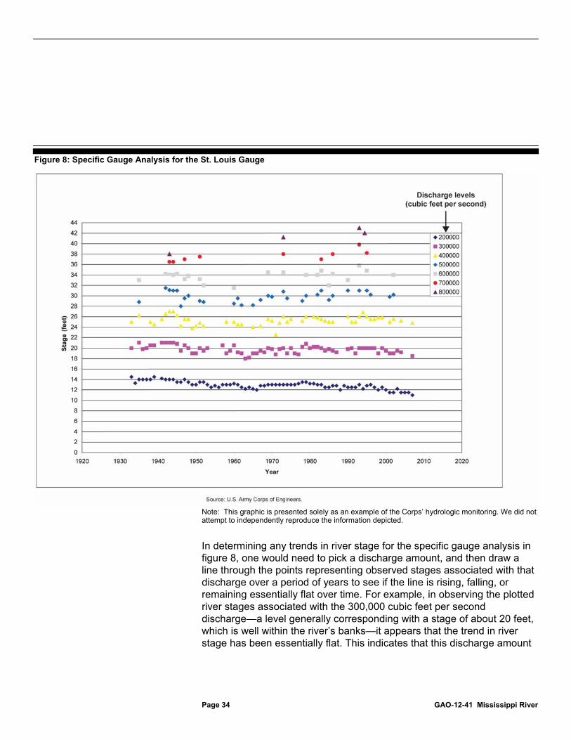
Page 34 GAO-12-41 Mississippi River
Figure 8: Specific Gauge Analysis for the St. Louis Gauge
Note: This graphic is presented solely as an example of the Corps’ hydrologic monitoring. We did not attempt to independently reproduce the information depicted.
In determining any trends in river stage for the specific gauge analysis in figure 8, one would need to pick a discharge amount, and then draw a line through the points representing observed stages associated with that discharge over a period of years to see if the line is rising, falling, or remaining essentially flat over time. For example, in observing the plotted river stages associated with the 300,000 cubic feet per second discharge—a level generally corresponding with a stage of about 20 feet, which is well within the river’s banks—it appears that the trend in river stage has been essentially flat. This indicates that this discharge amount

Page 35 GAO-12-41 Mississippi River
resulted in about the same river stage height in the 2000s as it did in the 1930s.
The second way the Corps monitors the hydrologic impacts of river training structures is by physically observing them, according to officials we spoke with. For example, they observe them to determine whether there are any readily identifiable visual effects on flow. In addition, a St. Louis District official said that a team of Corps officials—which includes engineers, biologists, and other scientists—along with other key stakeholders, conduct an annual multiday inspection tour that enables participants to observe training structures up close and discuss the potential need for new structures. Participating stakeholders include FWS, the Illinois Department of Natural Resources, the Missouri Department of Conservation, nongovernmental organizations such as the Nature Conservancy and the Prairie River Audubon, and university faculty.
Third, for decades the Corps has conducted its own studies of the impacts of structures on the shape of the channel and flooding after construction. For example, the Corps issued a paper in 1964 that presented, among other things, the variations in rating curves with respect to time and stage and causes for some of the changes in the stage-discharge relationship.50
The Corps conducted similar studies in the 1970s, 1980s, and 1990s. Another study the Corps completed in 2009 examined the limits of using specific gauge analysis to analyze the effects of river training structures on flood heights. A more recent Corps study in 2011 looked at the effects of bendway weir construction on the shape of the channel. Specifically, this study examined 22 bendway weir fields, all but 1 located in the Middle Mississippi, over 5 periods (1976, 1982, 1986, 2005, and 2007) to compare certain parameters before and after installation.
50U.S. Army Corps of Engineers, Waterways Experiment Station, Study of Effect of Regulation Works on Stream Flow (Vicksburg, Miss.: February 1964).

Page 36 GAO-12-41 Mississippi River
According to Corps officials, the St. Louis District does not routinely monitor the environmental impacts of the different kinds of river training structures after they have been constructed. The monitoring that it does conduct is focused more on bendway weirs and chevrons than on the more prevalent wing dikes. Corps officials told us this is because routine monitoring of environmental effects is costly—as much as $320,000 for 4 years of pre- and post-construction monitoring of a single dike field, and potentially more if contractors are used. Moreover, they told us that routine monitoring is unnecessary for wing dikes because the St. Louis District has more than 100 years of experience with these kinds of river training structures.
In contrast, FWS and Missouri Department of Conservation officials told us that additional monitoring is needed for some of these river training structures—in particular chevrons and bendway weirs—because not enough is known about how species respond to these structures. According to officials at the FWS field office that works with the St. Louis District, in recent years they have opposed the construction of new bendway weirs in the Middle Mississippi due to a lack of information regarding the biological and physical impacts of the structures. These FWS officials, however, acknowledged that the Corps has shown a willingness to conduct more monitoring of the physical and biological impacts of river training structures in the future.
According to Corps officials, the Corps has undertaken some assessments to monitor impacts on species identified in the 2000 biological opinion. For example, the Corps has identified 17 projects designed to implement the reasonable and prudent alternatives in the biological opinion for the pallid sturgeon and least tern. These projects include efforts to quantify young pallid sturgeon groups in the Middle Mississippi and to monitor the least tern population. The Corps has also conducted follow-up biological assessments for several new river training structures to address the proposed structures’ site-specific impacts on these species. FWS noted in its concurrence letter on one of these follow-up assessments that it is unclear whether the benefits of proposed river training structure construction in one river reach (and the consequent reduction in maintenance dredging) “can fully compensate for the project impacts,” but concluded that the construction met the standards set by the reasonable and prudent alternatives. FWS officials told us that these kinds of efforts are challenging because of data limitations, but they believe that more work needs to be done, particularly related to the longer-term habitat restoration measures. The Corps is in the process of developing its pallid sturgeon conservation and restoration plan. As part of this effort, the Corps is
The Corps Does Not Routinely Monitor Environmental Impacts after Construction but Has Conducted Various Studies

Page 37 GAO-12-41 Mississippi River
participating in a soon to be published study with the Missouri Department of Conservation and a university in the region that analyzed habitat selection patterns of adult pallid sturgeon and determined that these fish tend to congregate near the tips of wing dikes.51
While the Corps has not performed routine environmental monitoring for its river training structures, it has conducted or contracted for a number of studies that examine the impacts of the structures on some types of fish and wildlife habitats. Officials at the St. Louis District estimate that, between the Corps, its contractors, and other academics, more than 50 studies have been published on various environmental effects of training structures in the Mississippi and other rivers dating back to at least 1982. Several of these studies indicate that the structures may negatively affect the environment by converting river habitat into terrestrial habitat and by making the habitat that remains in the river more homogenous. However, studies also show that modifications can be made to the structures to reduce these negative impacts, as discussed in further detail later in this report.
Two primary concerns have been raised by various researchers with regard to the impacts of river training structures in the Middle Mississippi. One set of concerns relates to the degradation of river habitat, and the Corps has modified some structures in response to these concerns. The second set of concerns is that the structures are associated with increased flooding. The Corps disagrees with this correlation and has taken a number of steps to demonstrate why it believes that this relationship does not exist. However, despite the Corps’ efforts, professional disagreement remains over the cumulative impact of river training structures during periods of high flow. Experts in the fields of river engineering and water resources told us that physical and numerical modeling could help resolve this issue.
51James Garvey, et al., Habitat Selection and Movement of Naturally Occurring Pallid Sturgeon in the Mississippi River (forthcoming).
The Corps Has Modified Structures over Environmental Concerns but Disagrees That They Exacerbate Floods
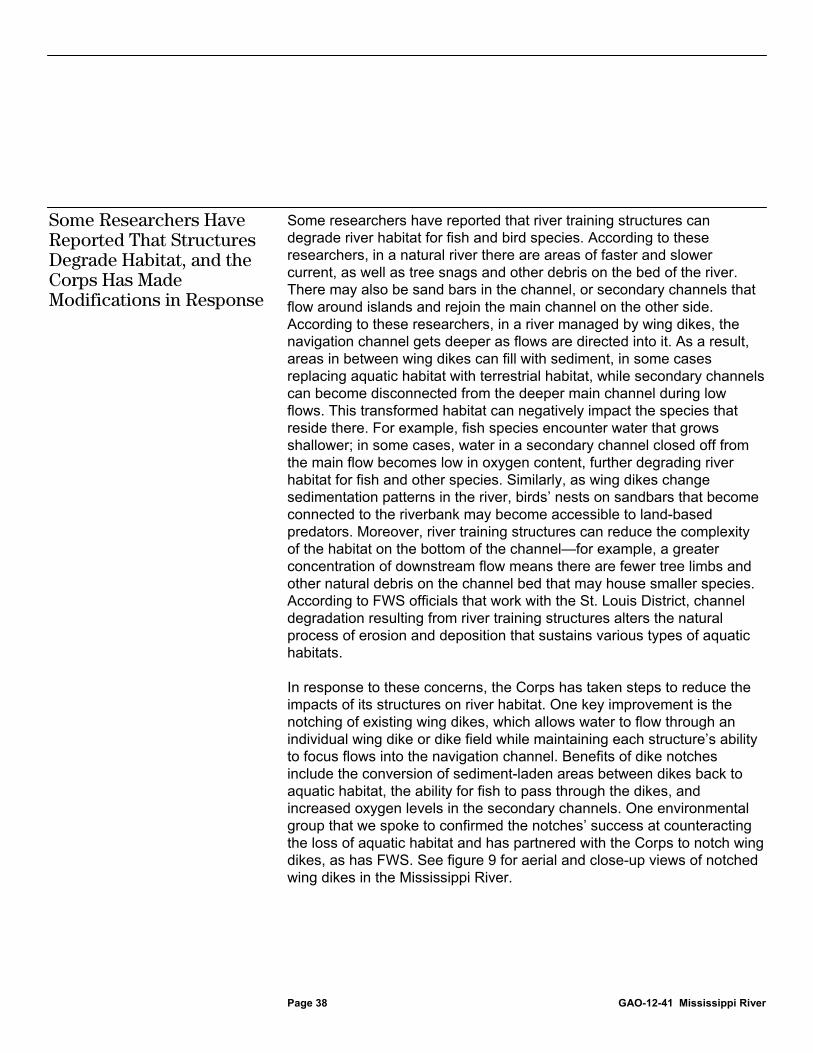
Page 38 GAO-12-41 Mississippi River
Some researchers have reported that river training structures can degrade river habitat for fish and bird species. According to these researchers, in a natural river there are areas of faster and slower current, as well as tree snags and other debris on the bed of the river. There may also be sand bars in the channel, or secondary channels that flow around islands and rejoin the main channel on the other side. According to these researchers, in a river managed by wing dikes, the navigation channel gets deeper as flows are directed into it. As a result, areas in between wing dikes can fill with sediment, in some cases replacing aquatic habitat with terrestrial habitat, while secondary channels can become disconnected from the deeper main channel during low flows. This transformed habitat can negatively impact the species that reside there. For example, fish species encounter water that grows shallower; in some cases, water in a secondary channel closed off from the main flow becomes low in oxygen content, further degrading river habitat for fish and other species. Similarly, as wing dikes change sedimentation patterns in the river, birds’ nests on sandbars that become connected to the riverbank may become accessible to land-based predators. Moreover, river training structures can reduce the complexity of the habitat on the bottom of the channel—for example, a greater concentration of downstream flow means there are fewer tree limbs and other natural debris on the channel bed that may house smaller species. According to FWS officials that work with the St. Louis District, channel degradation resulting from river training structures alters the natural process of erosion and deposition that sustains various types of aquatic habitats.
In response to these concerns, the Corps has taken steps to reduce the impacts of its structures on river habitat. One key improvement is the notching of existing wing dikes, which allows water to flow through an individual wing dike or dike field while maintaining each structure’s ability to focus flows into the navigation channel. Benefits of dike notches include the conversion of sediment-laden areas between dikes back to aquatic habitat, the ability for fish to pass through the dikes, and increased oxygen levels in the secondary channels. One environmental group that we spoke to confirmed the notches’ success at counteracting the loss of aquatic habitat and has partnered with the Corps to notch wing dikes, as has FWS. See figure 9 for aerial and close-up views of notched wing dikes in the Mississippi River.
Some Researchers Have Reported That Structures Degrade Habitat, and the Corps Has Made Modifications in Response

Page 39 GAO-12-41 Mississippi River
Figure 9: Aerial and Close-up Views of Notched Wing Dikes in the Mississippi River
Note: Arrows indicate locations of notched wing dikes in the left photograph.
In addition, Corps biologists and engineers told us that after many decades of using wing dikes on the Middle Mississippi, the agency designed its chevrons specifically to reduce environmental impacts. According to these officials, chevrons also create more diverse habitat than wing dikes. As the river plunges over and flows around the arch-shaped structures, it creates pools behind the arch and in the scour holes on either end, each of which provides deep water habitat for fish. When the river is below the chevron’s top crest, the plunge pools become areas of calm water sheltered from upstream flows where fish can congregate to feed. Corps officials told us that, over the past 10 years, they have increasingly used these structures for environmental enhancement in the Middle Mississippi with the encouragement of FWS. FWS officials confirmed that they generally prefer chevrons to the St. Louis District’s other river training structures because of their relative habitat benefits. Figure 10 shows a closer view of one of the three chevrons in the St. Louis harbor.

Page 40 GAO-12-41 Mississippi River
Figure 10: Close-up View of a Chevron in the St. Louis Harbor
Corps officials also noted two additional environmental benefits that partially offset the disruption to the natural river caused by their river training structures. First, Corps officials in multiple districts told us that the introduction of stone into a river largely devoid of it provides habitat for the macroinvertebrates52
that serve as the basis for the river’s food chain. Second, Corps officials told us that the structures are less injurious to the environment than the dredging that would otherwise be necessary to maintain the required 9-foot channel. Specifically, dredging requires repeated disturbance of the channel bottom, and the species residing there, and further disturbance in the area of the river where the dredged material is deposited. Aggregate data from several Mississippi River districts show that the Corps has steadily decreased dredging over the past 50 years as its construction of river training structures has increased.
52Macroinvertebrates are animals without backbones that are large enough to be seen with the naked eye. In the Middle Mississippi, these species include aquatic earthworms, flies, beetles, crayfishes, and freshwater mussels, among others.

Page 41 GAO-12-41 Mississippi River
Some researchers in the Middle Mississippi region have issued reports—based on statistical analysis of historical river stage and discharge data—that link the proliferation of river training structures in the region with higher river levels during periods of high river flow. These researchers who are critical of the structures’ effects report that by creating impediments in the river to concentrate low flows, the structures raise the river’s height during higher-flow events, especially floods. For example, one professor at Southern Illinois University Carbondale—who has partnered with numerous co-authors to publish a series of journal articles on the subject53
According to this researcher, the effect of the structures is reversed at higher flows because adding dikes to a river channel (1) constricts the river, reducing its ability to convey floodwaters and (2) makes the channel rougher and more resistant to flow. His research shows these effects are compounded when there are multiple dikes that are each hundreds of feet long, as is common on the Middle Mississippi. According to this researcher, these effects have been recognized in other countries as well. He cites the example of the Netherlands, which has begun lowering dozens of wing dikes along a branch of the Rhine River and plans to lower hundreds more as part of a nationwide effort to reduce flood risk in that river’s floodplain.
—told us that there is a general consensus that flood stage magnitudes have risen over time on the Middle Mississippi. Drawing on historical river stage and discharge records for St. Louis and elsewhere on the Middle Mississippi, he has reported that cumulative hydrologic impacts resulting from the proliferation of river training structures have caused this change. Through specific gauge analysis, this researcher found that when flows are below the top level of wing dikes and concentrated in the channel, river stage decreases because those flows erode the channel bottom. When flows are above the top level of the structures but still well within the river’s banks, he found no net effect on river stage; but when river flows approach the top of the banks and overflow into the floodplain, he found a clear increase in stage.
53For example, Nicholas Pinter, Russell Thomas, and Joseph H. Wlosinski, “Assessing Flood Hazard on Dynamic Rivers,” Eos, Transactions, American Geophysical Union, vol. 82, no. 31 (Washington, D.C.: July 31, 2001); Jonathan W.F. Remo and Nicholas Pinter, “Retro-modeling the Middle Mississippi River,” Journal of Hydrology, vol. 337 (2007); Nicholas Pinter, Abebe A. Jemberie, Jonathan W. F. Remo, Reuben A. Heine, and Brian S. Ickes, “Cumulative Impacts of River Engineering, Mississippi and Lower Missouri Rivers,” River Research and Applications, vol. 26 (2010).
Some Researchers Have Reported That Structures Increase Flood Stages, but the Corps Disagrees

Page 42 GAO-12-41 Mississippi River
A professor at Washington University in St. Louis, who has studied the region since the mid-1990s, has also reported that river training structures can worsen flooding. His research has focused on historical river stage data for the Middle Mississippi. In a 2001 paper, he compared this historical record for the prior 140 years to the Corps’ river management practices over that period.54
Other researchers have also published papers documenting increased river stages due in part to river training structures. Two widely discussed studies published in 1975 were among the first to advance this theory.
He found that flood stages for similar discharges have increased steadily in the Middle Mississippi since continuous stage-discharge records have been kept and concluded that wing dikes have contributed to this increase in river stage. According to his research, this has resulted in major floods recurring with greater frequency and severity than in earlier eras. Further, he told us that among several factors that could have increased river stage—ranging from river training structures to levees and climate change—the Corps’ wing dikes are responsible for the largest share of this increase.
55 We reported on these studies in August 1995 as part of a review of the performance of Mississippi River levees in the 1993 Midwest flood.56
54Robert E. Criss and Everett L. Shock, “Flood Enhancement through Flood Control,” Geology, vol. 29, no. 10 (October 2001).
At that time, we reported that researchers had used trend analysis to assert a relationship between long-term increases in flood levels and the Corps’ use of levees and river training structures. However, we found that the value of these studies was limited by a lack of accurate information about historic discharge rates and by conflicting results. In the additional studies that have appeared in scientific journals over the ensuing years stating that large discharges on the Middle Mississippi are now associated with
55C.B. Belt, Jr., “The 1973 Flood and Man’s Constriction of the Mississippi River,” Science, vol. 189, no. 4204 (Aug. 29, 1975); Michael A. Stevens, Daryl B. Simons, and Stanley A. Schumm, “Man-Induced Changes of Middle Mississippi River,” Journal of the Waterways, Harbors, and Coastal Engineering Division: Proceedings of the American Society of Civil Engineers, vol. 101, no. WW-2 (May 1975). 56Intense rainfall that deluged the upper Mississippi River basin in the spring and summer of 1993 caused the largest flood ever measured at St. Louis. This unprecedented event in nine Midwestern states generated the highest flood crests ever recorded at 95 measuring stations on the region’s rivers, required the evacuations of tens of thousands of people, and created large-scale disruptions in transportation, business, and public services. See GAO, Midwest Flood: Information on the Performance, Effects, and Control of Levees, GAO/RCED-95-125 (Washington, D.C.: Aug. 7, 1995).

Page 43 GAO-12-41 Mississippi River
higher river stages than in prior eras, the authors generally conclude that multiple river training structures have a cumulative impact on flood heights that is greater than any one structure’s effect.
The Corps, however, disagrees with the conclusions of these researchers, and agency officials told us that the structures are so deeply submerged during flood events that they are essentially invisible to the river’s flow. They said that they base this understanding of the structures’ cumulative effects on their professional expertise, their more than 100 years of experience managing the river, and on past studies conducted by Corps engineers and independent researchers. Based on this body of knowledge they agree that wing dikes reduce river stages at low flows as those flows are deflected into the channel; they also agree that levees are responsible for some increase in flood stages because they are designed to hold floodwaters back from portions of the floodplain, which can force these waters higher. However, they disagree that the structures have a cumulative impact on the river’s stage during high-flow events. According to Corps officials, as the Middle Mississippi approaches flood stage and eventually overflows its banks, any constriction of the river channel is dwarfed by the much wider and deeper dimensions of the flow. Corps officials told us that the greatest effect from river training structures occurs just as they are overtopped, not when they are submerged by 30 feet or more (as is the case during some St. Louis floods). According to these officials, the specific gauge analysis results reported by researchers to support their conclusions are both counterintuitive and contrary to established models of hydraulic behavior. Corps officials also told us that although specific gauge analysis is a powerful tool to assess trends in the river stage-discharge relationship over time, it alone cannot isolate the effects of river training structures from other changes in the river and floodplain. A second limitation of specific gauge analysis is that it cannot account for natural variables like water temperature, sediment load, and bank vegetation—all of which can affect river stage. Additionally, they stated that there are not enough measured discharges for large floods to support a definitive trend analysis. They further stated that comparisons with rivers in other countries must take into account important differences, such as wing dikes that may be taller than those in the Middle Mississippi. We spoke with a researcher from the Netherlands who confirmed that wing dikes on a branch of the Rhine are being lowered to reduce flood

Page 44 GAO-12-41 Mississippi River
heights, as previously discussed, but also confirmed that these dikes sit relatively higher in the river than those in the Middle Mississippi.57
Moreover, according to Corps officials, inaccuracies in historical flood data have led to the false conclusion that river stages have grown over time for similar discharges—a position that we also reported in August 1995.
58 River discharge on the Middle Mississippi has been continuously measured by the USGS since 1933; before then, the Corps was responsible for such measurements, using devices and measurement techniques that were generally less accurate than those later used by USGS. For example, the Corps took its discharge measurements at St. Louis from boats, often with floating gauges, whereas USGS measurements were made from bridges with meters that were used consistently for the rest of the century. In 1935, 1949, and 1952, the Corps tested its earlier methodology against the USGS methodology and concluded that early Corps discharge measurements were systematically overstated, especially during floods. Consequently, the Corps now assesses pre-1933 data separately from post-1933 data in its own specific gauge analysis. In addition, the Corps reduced some of its historical discharge measurements to account for its earlier overstatements. Both of these approaches tend to flatten the rising trend that has been alleged by other researchers for river stage increases over time. Researchers who have used historical discharge data to link river training structures to increasing stages for similar discharges told us that the Corps’ revised approaches were inappropriate and served to mask a dangerous flooding trend. In response, the Corps cited a recent USGS study it commissioned that characterized the accuracy of pre-1933 discharge measurements as “questionable” and recommended further examination of the historic record.59
In addition to its own research, the St. Louis District recently commissioned four external reviews of the relationship between river
57According to this researcher, the navigation channel in this branch of the Rhine has steadily deepened over the years while the crests of its wing dikes have maintained their original heights. 58GAO/RCED-95-125, 43. 59U.S. Geological Survey, Examination of Direct Discharge Measurement Data and Historic Daily Data for Selected Gages on the Middle Mississippi River, 1861-2008, Scientific Investigations Report 2009-5232 (Reston, Va.: 2009).

Page 45 GAO-12-41 Mississippi River
training structures and river stage, three of which have been completed and generally support the Corps’ position.60
The completed studies were prepared by a USGS hydrologist, a pair of engineers with several decades of experience on the Mississippi River, and a statistics professor from Missouri University of Science and Technology. However, researchers who have raised concerns about the structures told us that, in their opinion, contractors reporting directly to the Corps—no matter how well-respected—are not sufficiently independent to resolve this issue. These researchers believe that a study conducted by an independent body like the National Research Council would have greater credibility.
The Corps has engaged critics of its river training structures in several ways in an attempt to resolve these disagreements. For example, it has invited them to attend the St. Louis District’s annual inspection tour. In addition, it has invited critics to visit district modeling facilities and meet in person to discuss their research and relevant data. Some meetings did take place between the Corps’ critics and officials from the St. Louis District, Mississippi Valley Division, and Corps headquarters. However, neither the Corps nor its critics reported that these meetings were successful in resolving their disagreements. Corps officials told us that their efforts to provide data to the critics of their river training structures were not reciprocated. The critics who attended these meetings told us that they believe the Corps listens only to its own staff in its thinking on this issue, rarely publishing its analyses in peer-reviewed journals where its assumptions and methodologies could be vetted by the scientific community. One river expert who is familiar with this dispute told us that while he is skeptical of work that has been done linking river training structures to increased flood stages, the Corps has not done a thorough job of publishing the research it has completed on the subject at both the district and national levels. St. Louis District staff agreed that they could do a better job sharing their analyses with the public. They told us that many studies are available on the district’s website but that they generally have neither the time nor the resources to prepare articles for journal publication.
60The district expects the fourth study—numerical modeling of chevron effects by a university hydraulics laboratory—to be completed by March 2012.
The Corps Has Engaged Critics in Several Ways, but Significant Professional Disagreement Remains

Page 46 GAO-12-41 Mississippi River
We contacted 16 experts in river engineering and water resources to see if there was a possible resolution to the disagreement that exists between the Corps and its critics.61
Thirteen of the 16 experts told us that the question of river training structures’ cumulative effects on flood stages could be appropriately addressed by physical or numerical modeling or a combination of the two. As one expert told us, experimental modeling is much more likely to be successful than studies trying to unravel stage-discharge relationships over many decades, since so many physical changes have occurred in the river during that time. This expert recommended a numerical model of a large river section with input from a physical model. Similarly, another expert—who is familiar with the capabilities of hydraulics laboratories—agreed that a combination of physical and numerical modeling should be capable of isolating river training structures’ effects on river stage. St. Louis District officials told us that they have a numerical modeling team, but, as noted previously, the district’s physical models are primarily small-scale models that are not capable of predicting structures’ effect on river stage. We also spoke with staff from the Corps’ Engineer Research and Development Center, which conducts numerical and large-scale physical modeling for Corps districts nationwide, to determine if they thought modeling was a feasible option. The staff, including two modelers with more than 35 years of experience each, told us that cumulative effects on river stage are an important issue that, with sufficient time and resources, could be assessed using a large-scale model. One modeler emphasized
These experts generally agreed with the Corps’ understanding of the impact of river training structures on flood stages, but they were less certain about the nature of the cumulative impact from many such structures aggregated over many river miles. Specifically, there was general agreement among the 16 experts that the influence of river training structures on river stage is diminished during periods of high flow. However, many of these experts told us that the magnitude of this effect would depend on specific characteristics of the structures and the river (similar to the Corps engineering manual’s guidance regarding the influence of channel contraction on flood heights noted earlier in this report). For example, one expert identified the height of a structure relative to the overall river depth as the most important factor, and a second stated that the overall number of structures and their spacing are key considerations.
61See appendix I for the names of these experts and how they were selected.
Experts Told Us That Modeling Could Help Determine Structures’ Effect on Flood Stages

Page 47 GAO-12-41 Mississippi River
the importance of modeling the effects of an entire dike field, rather than using the results from a single structure to predict cumulative effects.
Corps officials acknowledged that their structures’ cumulative impact on river stage in the Middle Mississippi has not been modeled. While they told us that numerical and physical modeling could potentially be used to gain additional information on structures’ effect on river stage, they maintain that based on the results of studies conducted by the agency and others, they are confident of their understanding of river training structures and do not think that additional modeling would resolve the issue. Thus, in the absence of specific funding, they are reluctant to incur the costs of additional modeling. According to the Corps and other experts we spoke with, such costs could range from hundreds of thousands to several million dollars, in part because of the large cost of collecting river data to calibrate a model—especially if modelers tried to simulate hundreds of river miles. However, based on our discussions with experts, we believe a simplified model that focuses on some of the key attributes of the Middle Mississippi could be useful in resolving disputes over the river stage effects of a large dike field. The St. Louis District is currently funding two more limited studies, both at university laboratories—(1) a numerical model focused on the three chevrons in the St. Louis harbor and (2) a physical model with up to four structures built by a district engineer doing graduate research. According to the Corps, both models are assessing the effect of multiple river training structures on river stage. Studies such as these that test the Corps’ conclusions regarding the effects of its structures are worthwhile because, as 1 of the 16 experts told us, “a good flood defense scheme is one that people believe in; otherwise, anxiety and fear can measurably diminish a community’s quality of life.”
Congress requires the Corps to maintain a shipping channel in the Mississippi River that is navigable year-round from northern Minnesota to the Gulf of Mexico. By maintaining the channel, the Corps has enabled millions of tons worth of commerce to safely pass through the Mississippi. Over many decades of meeting this substantial challenge, the Corps has found that, in comparison to dredging, river training structures are often a more efficient, effective, and environmentally friendly way of maintaining the required depth. However, river training structures also have environmental impacts that the St. Louis District has not fully addressed. Specifically, in constructing new river training structures in the Middle Mississippi, the St. Louis District has not complied with certain federal and state environmental requirements, in particular with regard to NEPA
Conclusions
Page 48 GAO-12-41 Mississippi River
and CWA. The district continues to rely primarily on an EIS published 35 years ago and has not prepared any post-EIS analyses as NEPA requires, even though significant changes have occurred in the river and in the design of its structures. Although the Corps has stated that it will prepare such an analysis in response to our findings, it is unclear when this will occur, what the scope of it will be, and whether it will be available for public comment. The St. Louis District also did not follow the Corps’ NEPA regulations calling for its review of new information that could warrant the preparation of a supplement to its existing EIS. In addition, the district has inappropriately relied upon a nationwide permit for maintenance to comply with the requirements of Section 404 of CWA for the construction of new river training structures. This new construction does not match the scope of the maintenance permit, and is inconsistent with Corps regulations and other districts’ practice.
In addition to its navigation and environmental missions, the Corps also has a mandate to provide flood protection to communities along the Mississippi River. For those who live near the river, it is important to have confidence that the Corps’ construction of river training structures for navigational and environmental benefits is not inadvertently increasing their flood risk. Based on its extensive experience with these structures and studies it has conducted as well as those conducted by others, the Corps remains confident in its conclusion that its river training structures do not exacerbate floods. However, there remains significant professional disagreement between the Corps and the critics of its structures. According to experts, one solution for resolving this disagreement is to conduct physical or numerical modeling to assess the cumulative effects of river training structures during periods of high flow.
We are recommending that the Secretary of Defense direct the Chief of Engineers and Commanding General of the U.S. Army Corps of Engineers to take the following five actions:
• To help ensure compliance with NEPA,
• prepare an EA to determine, in accordance with Council on Environmental Quality and Corps regulations, whether there are significant new circumstances or information relevant to the Middle Mississippi navigation project’s environmental concerns that have emerged since publication of the 1976 EIS, and if so, prepare a SEIS in accordance with NEPA, or if not, prepare a finding of no significant impact in accordance with NEPA;
Recommendations for Executive Action

Page 49 GAO-12-41 Mississippi River
• develop and present in the EA an approach to ensure that site-specific impacts are assessed, as appropriate, for new river training structures in the Middle Mississippi; and
• review and revise as needed St. Louis District procedures to ensure that determinations of whether existing NEPA documents need to be supplemented are performed in accordance with Corps regulations implementing NEPA and documented.
• To help ensure compliance with CWA, obtain CWA Section 404 permit-equivalents and state water quality certifications as required for new river training structures in the Middle Mississippi.
• To help resolve concerns over river training structures’ cumulative effect on river stages during periods of high flow, conduct physical or numerical modeling, or some combination thereof, to provide further insight into the relative magnitude of this effect for flood conditions on the Middle Mississippi. The Corps should determine and conduct the appropriate level of review for such modeling under its Civil Works Review Policy, including consideration of independent external peer review.
We provided a draft of this report to the Department of Defense for review and comment. The department generally concurred with the recommendations in our report. Specifically, the department agreed that the Corps should prepare an EA to determine whether there are significant new circumstances or information relevant to the Middle Mississippi navigation project’s environmental concerns that have emerged since publication of the St. Louis District’s 1976 EIS, and that the Corps should prepare a subsequent SEIS if the EA identifies undisclosed and currently unknown significant effects on the human environment that may require additional analysis and documentation. The department also agreed that the Corps should develop and present in the EA an approach to ensure that site-specific impacts are assessed, as appropriate, for new river training structures in the Middle Mississippi, and that the Corps should review and revise St. Louis District procedures to ensure that determinations of whether existing NEPA documents need to be supplemented are performed in accordance with Corps regulations implementing NEPA and documented. While we are encouraged by the department’s response, we note that under NEPA, the Corps must consider relevant external studies in addition to its own.
Agency Comments and Our Evaluation

Page 50 GAO-12-41 Mississippi River
With respect to our recommendation that the Corps obtain required CWA Section 404 permit-equivalents and state water quality certifications for new river training structures in the Middle Mississippi, the department agreed that the Corps should perform all CWA assessments and obtain any certifications required by law and regulation. However, the department did not agree with our report finding that the Corps relied on a nationwide permit for maintenance as the mechanism for ensuring CWA compliance for river training structure construction in the Middle Mississippi. Instead, the department stated that the Corps has relied on its 1976 EIS and a CWA Section 404(b)(1) evaluation. The department’s statement is inconsistent with the information provided to us by Corps officials during the course of our review. According to some Corps officials, the agency relies on the nationwide permit to ensure compliance with CWA requirements for construction of river training structures in the Middle Mississippi. Although the Corps also provided us its 404(b)(1) evaluation from 1981, it did not provide any documentation of a permit-equivalent, public notice, or state permits, all of which would need to accompany the 1981 evaluation in order to fully meet CWA requirements. Given the conflicting information provided to us by the department and the Corps, we believe that the Corps should consider including a description of how it is complying with CWA requirements when it prepares its forthcoming EA.
Finally, the department partially concurred with our recommendation that the Corps conduct physical or numerical modeling, or some combination thereof, to provide further insight into the cumulative effect of river training structures during flood conditions on the Middle Mississippi, stating that the implementation of this modeling would be subject to funding and the results of the Corps’ ongoing monitoring and analysis. The department also stated that the Corps will consider independent external peer review of the results of its ongoing studies. While we agree that this may be helpful, it does not directly address our recommendation that the Corps consider independent external peer review of any new physical and/or numerical modeling that it undertakes.

Page 51 GAO-12-41 Mississippi River
We are sending copies of this report to the Secretary of Defense, the Chief of Engineers and Commanding General of the U.S. Army Corps of Engineers, appropriate congressional committees, and other interested parties. In addition, the report is available at no charge on the GAO website at http://www.gao.gov.
If you or your staff have any questions about this report, please contact me at (202) 512-3841 or [email protected]. Contact points for our Offices of Congressional Relations and Public Affairs may be found on the last page of this report. GAO staff who made key contributions to this report are listed in appendix III.
Anu K. Mittal Director, Natural Resources and Environment

Appendix I: Objectives, Scope, and Methodology
Page 52 GAO-12-41 Mississippi River
In the context of the Middle Mississippi, our objectives were to examine (1) key requirements and directives that govern the U.S. Army Corps of Engineers’ (Corps) use of river training structures, (2) how the Corps has addressed key federal and state environmental requirements in the use of river training structures, (3) the extent to which the Corps has monitored the hydrologic and environmental impacts of river training structures, and (4) concerns that researchers have raised about the hydrologic and environmental impacts of the Corps’ river training structures and how the Corps has responded to these concerns. Our work focused on the Corps’ St. Louis District and its management of the Middle Mississippi.
To address the first objective, we reviewed relevant provisions in key federal and state laws, regulations, and guidance that govern the Corps’ use of river training structures. We determined these laws, regulations, and guidance to be key because they authorize construction of river training structures and they relate to flooding and environmental impacts. We traveled to St. Louis to meet with officials from the Corps’ Mississippi Valley Division and St. Louis District, specifically agency engineers, attorneys, biologists, and other scientists. We conducted separate interviews with engineering and environmental staff from each of the five remaining districts in the Mississippi Valley Division—Memphis, New Orleans, Rock Island, St. Paul, and Vicksburg—to learn about their requirements for river training structures. We interviewed state officials involved in reviewing activities on the Mississippi River, including officials with the Illinois and Missouri Departments of Natural Resources and the Missouri Department of Conservation, to identify any requirements they have related to the Corps’ river training structures. We also reached out to local officials in the city of St. Louis and three St. Louis-area counties—St. Clair County, Illinois; St. Charles County, Missouri; and St. Louis County, Missouri—but all four told us they were not aware of any actions by their jurisdictions to regulate Corps activities related to river training structures on the Mississippi River.
To address the second objective, we reviewed Corps documentation for compliance with the National Environmental Policy Act (NEPA), the Clean Water Act, the Fish and Wildlife Coordination Act, and the Endangered Species Act. With respect to NEPA, we reviewed relevant environmental assessments, environmental impact statements, and a biological opinion issued by the U.S. Fish and Wildlife Service (FWS) in 2000. We interviewed officials with the Corps’ Office of General Counsel and obtained in writing the Corps’ legal views on how it has complied with NEPA requirements with respect to its river training structures built under the navigation authority. We interviewed officials with the FWS Illinois
Appendix I: Objectives, Scope, and Methodology

Appendix I: Objectives, Scope, and Methodology
Page 53 GAO-12-41 Mississippi River
Sub-Office to discuss Corps actions related to the Endangered Species Act. We also reviewed Corps documentation relative to state requirements and interviewed relevant Corps, state, and local officials discussed previously. We interviewed officials with several nongovernmental organizations to obtain their views, including American Rivers, the American Society of Civil Engineers, the Association of State Floodplain Managers, the Lower Mississippi River Conservation Committee, the National Wildlife Federation, and the St. Louis Confluence Riverkeeper.
To address the third objective, we reviewed the Corps’ various assessments of its river training structures. We examined documentation from selected projects to become familiar with how the Corps assesses its structures’ impacts. We interviewed Corps officials on the extent to which the Corps conducts pre- and post-construction hydraulic, hydrologic, and environmental assessments of river training structures. We reviewed reports on Corps modeling efforts. During our trip to St. Louis, we visited the St. Louis District’s Applied River Engineering Center to discuss and observe modeling efforts and we participated in a district-led river tour of the Middle Mississippi near St. Louis that included observing river training structures. In our interviews with other districts within the division, we discussed the extent to which they conduct hydraulic, hydrologic, and environmental assessments of river training structures. We also interviewed the previously mentioned nongovernmental organizations for their views.
To address the fourth objective, we conducted a detailed literature review of scientific periodicals and government-sponsored research on the effects of river training structures. Specifically, we used an iterative process to identify relevant research. We identified search terms that we refined as we reviewed the literature for terminology related to this topic. In addition, we reviewed the bibliographies of literature we had found to identify further studies for review. The documentary sources cited in our report were reviewed for methodological strength and reliability and we ultimately determined them to be sufficiently reliable for our purposes. We believe we have included the key studies and have qualified our findings, where appropriate. However, we may not have identified all of the studies with findings relevant to our objectives. We used this review—along with interviews of officials from the Corps (as described previously), FWS, U.S. Geological Survey, and state resource agencies, as well as other researchers not affiliated with these parties—to compile the key concerns that have been raised about the structures’ hydrologic and environmental impacts and how the Corps has addressed those concerns. We

Appendix I: Objectives, Scope, and Methodology
Page 54 GAO-12-41 Mississippi River
interviewed the authors of two of the four recent studies commissioned by the Corps to evaluate the research that links river training structures to increased stage. (We did not interview the authors of the remaining two studies because one was a summary review of other authors’ statistical analysis and the other was a modeling exercise still underway at the time this report was issued.) We spoke with officials with the Corps’ Engineer Research and Development Center to discuss physical and numerical modeling. We met with officials with the National Research Council’s Water Sciences and Technology Board to discuss the Board’s role with respect to resolving professional disagreements over complex scientific issues. We also interviewed the previously mentioned nongovernmental organizations for their views.
In addressing the fourth objective, we conducted structured interviews with 16 experts in the fields of river engineering and water resources on, among other things, river training structures’ potential effects on river stage; whether such effects can be isolated from other structures, such as levees, or other hydrologic factors, such as climate change; and, if so, how this might be done. We used the “snowball sampling” technique to identify these knowledgeable experts. Specifically, we identified these experts through recommendations made during our interview process and by soliciting recommendations from the following organizations: the National Research Council’s Water Sciences and Technology Board; the American Society of Civil Engineers, including its American Academy of Water Resource Engineers; the American Geophysical Union; the Colorado State University Water Institute; and the World Association of Waterborne Transport Infrastructure. We sought a balance of experts between those currently engaged in applied engineering and those currently in academic positions, and also sought those who were, to the extent possible, independent from both the Corps and the critics of its river training structures. Prior to interviewing the 16 experts, we pretested the structured interview with three subject matter experts and, based on those results, made adjustments to the structured interview as necessary. The names of the 16 experts we interviewed are listed alphabetically in table 1.

Appendix I: Objectives, Scope, and Methodology
Page 55 GAO-12-41 Mississippi River
Table 1: List of Interviewed Experts
List of experts 1 Nani G. Bhowmik, Ph.D., P.E., Life Member and Fellow, ASCE, F. IWRA, M. AGU,
D. WRE, Principal Scientist Emeritus, Illinois State Water Survey, Prairie Research Institute, University of Illinois
2 Jeff Bradley, Ph.D., P.E., D.WRE, President, WEST Consultants 3 Mike Buechter, P.E., Principal Engineer, Metropolitan St. Louis Sewer District 4 John Cassidy, Ph.D., P.E., Dist.M.ASCE, NAE, Hon.D.WRE, Independent
Consultant Specializing in Hydraulic and Hydrologic Engineering (also former Chief Hydraulic Engineer at Bechtel Corporation)
5 Tim Dean, P.E., LEED® AP, Civil Engineer, Intuition & Logic, Inc. 6 David Galat, Ph.D., Adjunct Associate Professor, Department of Fisheries and
Wildlife Sciences, University of Missouri 7 Marcelo Garcia, Ph.D., Professor, Department of Civil and Environmental
Engineering, and Director, Ven Te Chow Hydrosystems Laboratory, University of Illinois
8 Robert R. Holmes, Jr., Ph.D., P.E., D.WRE, Hydrologist, U.S. Geological Survey 9 Susan McCrary, P.E., Senior Civil Engineer 10 Gary Parker, Ph.D., Professor, Department of Civil and Environmental Engineering
and Department of Geology, University of Illinois 11 Timothy J. Randle, M.S., P.E., D.WRE., Manager, Sedimentation and River
Hydraulics Group, U.S. Bureau of Reclamation 12 Bruce Rhoads, Ph.D., Professor and Head of the Geography Department and
Affiliate Professor in the Department of Geology and the Department of Civil and Environmental Engineering, University of Illinois
13 Doug Shields, Jr., Ph.D., P.E., Research Hydraulic Engineer, USDA-Agricultural Research Service
14 Colin Thorne, Ph.D., Chair, Physical Geography Department, Nottingham University (England)
15 Chris Thornton, Ph.D., P.E., Director, Engineering Research Center, Colorado State University
16 Chester Watson, Ph.D., P.E., Biedenharn Group, LLC (Emeritus Professor of Civil Engineering, Colorado State University)
Source: GAO.
We conducted this performance audit from September 2010 through December 2011 in accordance with generally accepted government auditing standards. Those standards require that we plan and perform the audit to obtain sufficient, appropriate evidence to provide a reasonable basis for our findings and conclusions based on our audit objectives. We believe that the evidence obtained provides a reasonable basis for our findings and conclusions based on our audit objectives.
Appendix II: Comments from the Department of Defense
Page 56 GAO-12-41 Mississippi River
Appendix II: Comments from the Department of Defense

Appendix II: Comments from the Department of Defense
Page 57 GAO-12-41 Mississippi River
Note: All recommendations can now be found on pages 48 and 49.

Appendix II: Comments from the Department of Defense
Page 58 GAO-12-41 Mississippi River

Appendix III: GAO Contact and Staff Acknowledgments
Page 59 GAO-12-41 Mississippi River
Anu K. Mittal, (202) 512-3841 or [email protected]
In addition to the individual listed above, Vondalee R. Hunt (Assistant Director), Elizabeth Beardsley, David Brown, George Depaoli, Mark Keenan, Perry Lusk, and Rebecca Shea made significant contributions to this report. Michael Armes, James Ashley, Cheron Green, Richard Johnson, Justin Mausel, Sarah M. McGrath, Nathan Morris, Madhav Panwar, Holly Sasso, Aaron Shiffrin, Ben Shouse, and Vasiliki Theodoropoulos also made key contributions.
Appendix III: GAO Contact and Staff Acknowledgments
GAO Contact
Staff Acknowledgments
(361232)

The Government Accountability Office, the audit, evaluation, and investigative arm of Congress, exists to support Congress in meeting its constitutional responsibilities and to help improve the performance and accountability of the federal government for the American people. GAO examines the use of public funds; evaluates federal programs and policies; and provides analyses, recommendations, and other assistance to help Congress make informed oversight, policy, and funding decisions. GAO’s commitment to good government is reflected in its core values of accountability, integrity, and reliability.
The fastest and easiest way to obtain copies of GAO documents at no cost is through GAO’s website (www.gao.gov). Each weekday afternoon, GAO posts on its website newly released reports, testimony, and correspondence. To have GAO e-mail you a list of newly posted products, go to www.gao.gov and select “E-mail Updates.”
The price of each GAO publication reflects GAO’s actual cost of production and distribution and depends on the number of pages in the publication and whether the publication is printed in color or black and white. Pricing and ordering information is posted on GAO’s website, http://www.gao.gov/ordering.htm.
Place orders by calling (202) 512-6000, toll free (866) 801-7077, or TDD (202) 512-2537.
Orders may be paid for using American Express, Discover Card, MasterCard, Visa, check, or money order. Call for additional information.
Connect with GAO on Facebook, Flickr, Twitter, and YouTube. Subscribe to our RSS Feeds or E-mail Updates. Listen to our Podcasts . Visit GAO on the web at www.gao.gov.
Contact:
Website: www.gao.gov/fraudnet/fraudnet.htm E-mail: [email protected] Automated answering system: (800) 424-5454 or (202) 512-7470
Ralph Dawn, Managing Director, [email protected], (202) 512-4400 U.S. Government Accountability Office, 441 G Street NW, Room 7125 Washington, DC 20548
Chuck Young, Managing Director, [email protected], (202) 512-4800 U.S. Government Accountability Office, 441 G Street NW, Room 7149 Washington, DC 20548
GAO’s Mission
Obtaining Copies of GAO Reports and Testimony
Order by Phone
Connect with GAO
To Report Fraud, Waste, and Abuse in Federal Programs
Congressional Relations
Public Affairs