david f. cash
TRANSCRIPT

David F. Cash
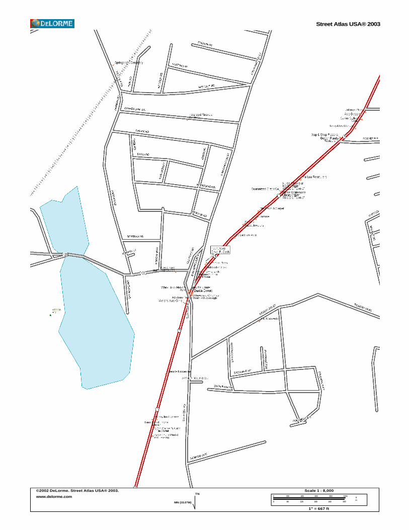
File No.: 199701040 City and State: North Attleboro, MA General Impacts: 0.57 acre Functions and Values Lost: (From EA/SOF) Groundwater Discharge Floodflow Alteration Toxicant Retention Wildlife Habitat (Diversity/Abundance) Year(s) Mitigation Constructed: October 1999 Size and Type of Mitigation as Proposed: 0.43 acre creation 1.58 acres preservation Proposed Functions and Values of Mitigation: Floodflow Alteration Groundwater Nutrient Removal Sediment/Toxicant Retention Wildlife Habitat Mitigation Special Condition(s): 2a. Permittee shall implement the grading and planting plan set forth on the plan entitled “Proposed Wetland Replication Plan in North Attleborough, Massachusetts” dated “March 12, 1998” in 1 sheet. This work shall be completed no later than the substantial completion of the development work at the site. Remarks: None Directions: Take I-95 south to the exit for Route 1 in Attleboro. Go north. When the road forks and Route 1 bears right, follow Route 1 but the site is just after a small strip mall on the left. Park there or at the Domino’s Pizza which is immediately adjacent to one of the creation sites.
Street Atlas USA® 2003
©2002 DeLorme. Street Atlas USA® 2003.
www.delorme.comTN
MN (15.5°W)
0 200 400 600 800 1000
0 60 120 180 240 300
ftm
Scale 1 : 8,000
1" = 667 ft

Copyright (C) 1997, Maptech, Inc.
David F. Cash

Page 1 of 2
MITIGATION SITE FIELD DATA FORM Site Name: David Cash File No. : 199701040 City/Town: North Attleboro State: MA Waterbody: Monitor(s): McKee, Wright Date: 6-20-02 Was site constructed? yes Is site wetland? yes Size of proposed wetland: 0.43 acre Actual size of wetland: app. 0.43 acre Landscape position: 2 depressions surrounded by steep to moderate inclines Lat/Long Points: Site A N41.96885 W071.33749 Site C N41.96867 W071.33690 Saved GPS Waypoint name: DCASH (site C) CASHA (Site A) GPS Tracking Log Name: TBD Perimeter: TBD Surrounding land use: Residential, industrial park Is wetland function compromised by surrounding land use? Both sites may experience runoff from lawns or parking lots and are easily accessible by people, which may impact wildlife. Plant Health: Good Invasive Species: Site A: none Site C: Lythrum salicaria (trace) Wildlife Use: Site A: bullfrog, green frog, Site C: bullfrog, green frog, red-winged blackbird, report of snapping turtle
Plants: Site A: Acer rubrum Alisma triviale Bidens sp. Carex lurida Carex sp. Carex sp. (ovales) Eleocharis sp. Galium sp. Impatiens capensis Juncus effusus Lemna sp. Lythrum salicaria Phalaris arundinacea Poaceae spp. Polygonum arifolium Salix sp. Salix discolor Sambucus canadensis Typha latifolia Site C: Acer rubrum Alisma sp. Betula populifolia Bidens sp. Carex sp. (ovales) Carex lurida Impatiens capensis Iris sp. Juncus effusus Lemna sp.

Page 2 of 2
Lythrum salicaria Poaceae sp. Rubus sp. Sambucus canadensis
Typha latifolia Ulmus americana Vitis sp.
Soils Data: Site A DEPTH HORIZON MATRIX REDOX COMMENTS 0 - 1” A 5Y 2.5/2 none loamy medium sand 1+ B 10YR 3/2 2.5YR 4/8 at 3.5”, loamy, gravelly, medium dark grey brown 25%, large sand, friable, sulfidic odor Sketch approximate mitigation site, noting areas and types of wetlands, waters, other features, landscape position, landmarks, etc., and data and photo point(s): Drawings are with field notes. Overall Description of site: The site consists of two ponded areas that are separated by wooded upland. On the west side of Site A there is a forested wetland. Residential areas are to the north and commercial areas are to the south and east. Site C has residential to the north and west and swamp to the east and south. Site C was too wet to get a decent soil sample; it is basically a pond surrounded by steep banks. Comments, problems, recommendations: Water depths were not taken though it appears from the mitigation file that this might be a concern. Both sites had what seemed to be deep water. Site A is the site farthest away from Route 1. Site C is the site nearest Route 1.


yes no yes
10 feet
30% but only about 100 feet wide
N41.96885
n/a
0
X it is likely that both recharge and discharge occur
X none known
X
X
X
5/14/03 RL PM
X
X
yes
~0.43 ac
residential, industrial park
PEM, POW
David Cash 199701040
W71.33749
X
X too small and too shallow
X X minimal
X
X
X
X X adjacent to forested wetland system but limited by size and proximity to development
X

199701040 David Cash
N. Attleboro, MA 6/20/02
Area A from south side
Area A erosion on northeast edge. Note steepness of slope.

Area A vegetation plot from west end looking east
Area C facing southwest with Route 1 in the background.
Domino’s Pizza is off the photo to the left.

North Attleboro, Massachusetts, United States 29 Mar 1995
Image courtesy of the U.S. Geological Survey © 2003 Microsoft Corporation. All rights reserved.