data collection survey on water resources … · data collection survey on water resources...
TRANSCRIPT
DATA COLLECTION SURVEYON
WATER RESOURCES MANAGEMENTIN
HAOR AREA OF BANGLADESH
THE PEOPLE’ S REPUBLIC OF BANGLADESH
FINAL REPORT
December 2013
JAPAN INTERNATIONAL COOPERATION AGENCY
NIPPON KOEI CO., LTD.
JR() 4R
14-006
DATA COLLECTION SURVEYON
WATER RESOURCES MANAGEMENTIN
HAOR AREA OF BANGLADESH
THE PEOPLE’ S REPUBLIC OF BANGLADESH
FINAL REPORT
December 2013
JAPAN INTERNATIONAL COOPERATION AGENCY
NIPPON KOEI CO., LTD.
JR 4R
14-006

Exchange Rate: USD 1.0 = BDT 77.8 = JPY 99.7
(As of September 2013)
Sherpur
Tangail
mymensingh
Jamalpur
Faridpur
Netrakona
Rajbari
Gopalganj
MadaripurShariatpur
Moulavi Bazar
Sunamganj
Habiganj
Sylhet
Kishoreganj
Panchagarh
Thakurgaon Nilphamari
Dinajpur Rangpur
Lalmanirhat
GaibandhaJoypurhat
Naogaon Bogra
Nawabganj
Rajshahi
NatoreSirajganj
Pabna
KushtiaMeherpur
Chuadanga Jenaidah
Magura
ManikganjBrahmanbaria
Narsingdi
Gazipur
Narayanganj
Munshiganj Comilla
Chandpur
Narail
Jessore
Satkhira
Bagerhat
Pirojpur
Barguna
Patuakhali
Jhalakati
Barisal
Bhola
Lakshmipur
Noakhali
Feni
Khagrachhari
Chittagong
Rangamati
Bandarban
Cox’s Bazar
Kurigram
Khulna
Padma R.
Meg
hna
R.
Jam
una R.
Surma R.
Old Brahmaputra R.
Kushiara R.
Ganges R.
Gorai R.
Kal
ni R.
Baula
i R
.
Dhaka
92o E
91o E90o E89o E
21o N
22o N
23o N
24o N
25o N
26o N
N
Location Map
Bengal Bay
River
National Boundary
District Boundary
Highway (Dhaka)
Capital (Dhaka)
District Capital
Study Area
Haor Areas (August 2010)
Legend
Distric
Study
Haor A (Aug
0 20 40 60 80 100 kmScale
KEY MAP
Bangladesh
India
Afganistan
Pakistan
China
Nepal Bhutan
Thailand
Myanmar
Sri Lanka
Data Collection Survey on Water Resources Management in Final Report Haor Area of Bangladesh Summary
Nippon Koei Co., Ltd. 1 December 2013
CHAPTER 1 INTRODUCTION
1.1 Objectives of the Study
The objectives of the Study are:
1) To collect and review (i) contents of water resources management plans, such as “Master
Plan of Haor Areas (the M/P, 2012)”, for the haor areas in the upper Meghna area and
(ii) existing relevant data and information,
2) To conduct additional study on matters having hardly been addressed so far in the said
plans, and
3) To propose possible JICA cooperation projects for flood measures and river
management plan in haor areas.
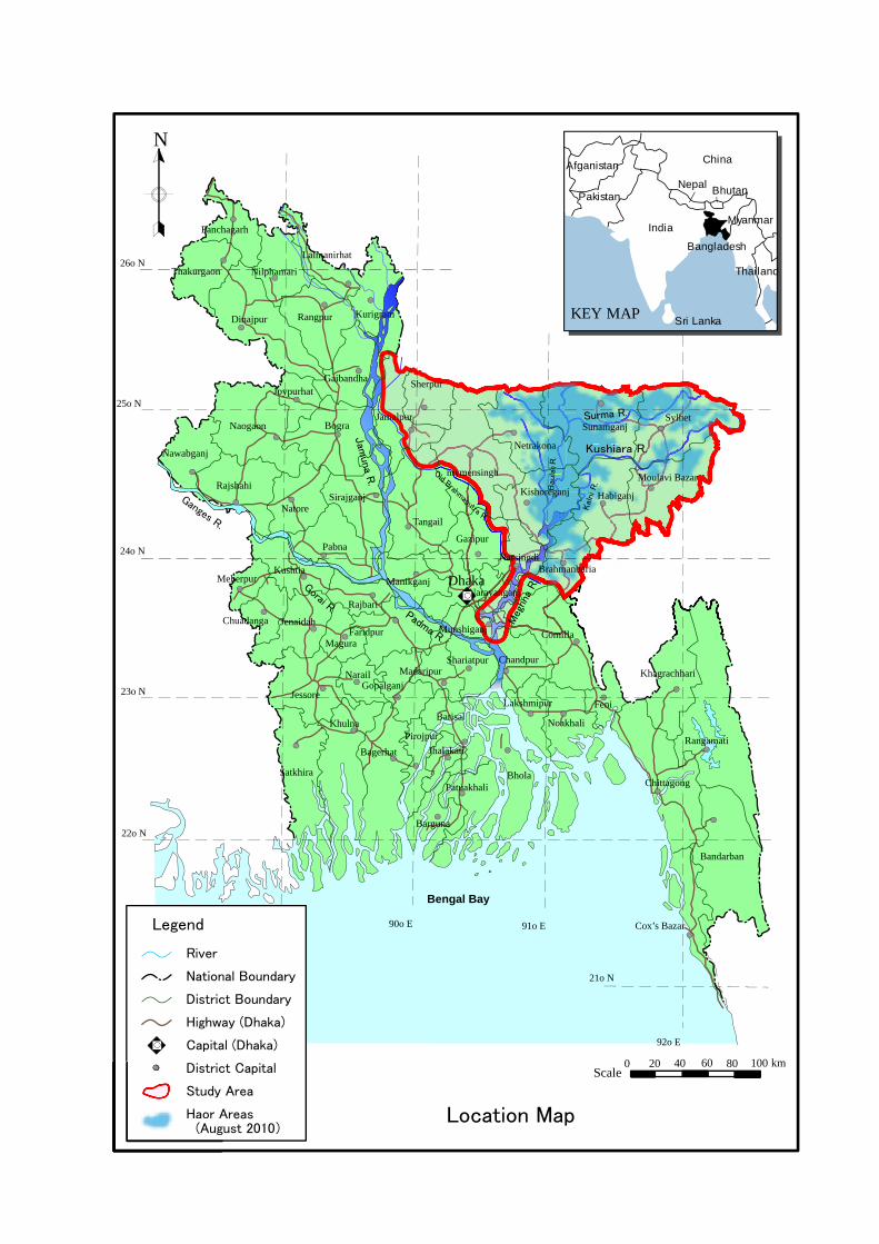
1.2 Study Area
The study area covers the river basins dealt with by the M/P (including their upstream and
downstream areas required for the Study (limited to the Bangladeshi territory)).
1.3 Final Report
This Final Report is submitted as the product stating the results and findings in the First to
Fourth Works in Bangladesh, which were conducted from November 2012 to November
2013.
CHAPTER 2 CURRENT CONDITIONS OF STUDY AREA
2.1 Physical Setting
2.1.1 Physiography and Topography
The physiography of the study area is classified based on the combination of the geological
material in which particular kinds of soil have formed and the landscape on which they occur.
Seven districts comprising the haor area are placed on the following eleven (11)
physiographic units, based on agro-ecological regions of Bangladesh prepared by Food and
Agriculture Organization (FAO)1, as shown in Figure 2.1.1 (Page 2-3, Chapter 2). The units
are Northern and Eastern Piedmont Plains, Northern and Eastern Hills, Sylhet Basin, Eastern
Surma-Kushiyara Floodplain, Old Brahmaputra Floodplain, Young Brahmaputra and Jamuna
Floodplain, Active Brahmaputra-Jamuna Floodplain, Old Meghna Estuarine Floodplain,
Madhupur Tract, Middle Meghna River Floodplain and Akhaura Terrace.
The study area forms such a low-lying basin compared with other regions of the country.
Land below EL. 5m PWD extends virtually as far as the Meghlaya Foothills. Outside of this
area, floodplain lands situated 200km from the sea are found at EL. 8 m to 20 m PWD.
Approximately 25 % of the study area lies below EL. 5m and 50 % lies below EL. 8m.
1 Classification of agro-ecological zone in Bangladesh prepared by FAO http://www.fao.org/fileadmin/templates/faobd/img/Agroecological_Zones.jpg

Data Collection Survey on Water Resources Management in Final Report Haor Area of Bangladesh Summary
Nippon Koei Co., Ltd. 2 December 2013
2.1.2 Climate
The Northeast Region of Bangladesh is located entirely to the north of the Tropic of Cancer,
and hence its climate is characterized by the sub-tropical monsoon. The sub-tropical
monsoon results in intense regional and orographic rains caused by the interface of the mist
air masses incoming from the Indian Ocean through the Bay of Bengal with a predominant
northeastern direction and the steep and high hills located at the foothills in the states of
Assam, Meghalaya and Tripura in India. The hills in these states of India experience very
severe precipitation. Some of the more intense precipitations in the world fall in the hilly
areas, where the average annual rainfall is around 12,000 mm.
The hydro-meteorological seasons of the Northeast Region are generally classified into:
- Pre-monsoon season extending from April to May,
- Monsoon season from June through September,
- Post-monsoon season from October to November, and
- Dry season from December through March.
2.1.3 River System
Figure 2.1.3 (Page 2-6, Chapter 2) shows the river system for the upper Meghna River
including the portion of the watershed inside India. The Barak River drains the Assam
region and distributes the flow through a bifurcation near the border between Bangladesh and
India. Data from 1980 to 2008 indicates that an average of around 40% flows into the
Surma River channel and 60% inflows to the Kushiyara River during most part of the year.
During the dry season, the Kushiyara River carries around 88% of the Barak inflow due to
the physiography at the bifurcation. Because of the sediment deposition at the Surma River
portion of the bifurcation, the tendency is that flow proportion increases with time into the
Kushiara River while the Surma River is silted over.
2.1.4 Geology and Soil
The Indian sub-continent has been formed by a collision between the northward moving
Indian Plate and the static Eurasian Plate since the Cretaceous period. Part of the northeast
Indian Plate has fractured and sank below the sea-level during the Oligocene period. Since
then the Bengal basin has started to form subsiding tectonic basin slowly, filling up with
deltaic sediment.
The soils of the area are grey silty clay and clay on the higher parts that dry out seasonally
and grey clays in the wet basin. Peat occupies some wet basin centers. The soils have a
moderate content of organic matter and soil reaction is mainly acidic.
About 74% of the top soil texture of the haor region is clay to silty clay, 21% is silt and the
rest are clayey silt, sandy silt and sand.
2.2 Natural Resources
(1) Water Resources
It is reported in the M/P that the analysis of BWDB data (1960-2009) has shown the volume
of water contribution into Bangladesh through the Meghna river system is 162,619 million
m3. Water contribution from the transboundary rivers of the Barak, Meghalaya and Tripura
Data Collection Survey on Water Resources Management in Final Report Haor Area of Bangladesh Summary
Nippon Koei Co., Ltd. 3 December 2013
systems are 42,670 million m3, 30,376 million m3 and 15,716 million m3, respectively.
(2) Vegetation
In the haor basin, there are hill forests, social forests, fresh water swamps, reed swamp
forests, bamboo and homestead vegetation, etc. In the M/P, ecologists have grouped the
typical haor vegetation areas into nine classes, which are 1) Submerged plants, 2) Free
floating plants, 3) Rooted floating plants, 4) Sedges and meadows, 5) Floodplain grassland,
6) Reed swamp, 7) Fresh water swamp forest, 8) Crop field vegetation and 9) Homestead
vegetation.
(3) Biodiversity and Wetland
There are a large number of wetlands of significant national and regional importance and
many sites have significant local value. The sites support biodiversity at all scales
especially communities (species and within the species) and are home to several
internationally threatened species. The biodiversity of haor wetlands is very rich. The
most significant wetlands are Hakaluki Haor, Tanguar Haor, Hail Haor, Matian Haor, Pasuar
Beel Haor, Dekar Haor, Baro Haor, Gurmar Haor, Sonamorol Haor, Baram Haor, Kalni Haor,
Kawadighi Haor and Pagner Haor.
In 1999, the Government of Bangladesh (GoB) declared two haors as ‘Ecologically Critical
Areas’ (ECA) in the haor area based on “Bangladesh Environment Conservation Act (1995,
amended in 2000 and 2002)”, which are Hakaluki Haor (Maulvibazar/Sylhet Districts) and
Tanguar Hoar (Sunamganj District). Tanguar Haor has been declared as a Ramsar site.
(4) Mineral Resources
The haor basin is a large, gentle depression, created by subsidence and tectonic adjustment.
The geological setting and formations of the northeastern part of Bangladesh favors the
deposit of various types of mineral and energy resources. The mineral resources discovered
are natural gas, crude oil, limestone, white clay, glass sand, peat, coal, gravel and
construction sand (see Table 2.2.4 (Page 2-14, Chapter 2)). About 90% of the total gas
production of the country is obtained from the haor districts.
2.3 Socio-economy
(1) Population Distribution
The total population of the seven haor districts (Kishoreganj, Netrokona, Sunamganj, Sylhet,
Moulvibazar, Habiganj and Brahmanbaria districts) in the Northeast Region is 17.88 million
as of 2011 Census compared to 14.94 million in 2001 Census (BBS, 2012). There are about
3.44 million households in the haor districts, which translates into an average household size
of 5.2 persons per household. The sex ratio in the haor districts on average is 97.78:100,
which indicates that there are 97.8 males per 100 females. The national sex ratio is 100:100.
The overall population density in the haor districts is 894 per sq km, which is lower than the
average population density in Bangladesh, which is 976 per km2. The rate of urbanization
in these districts is 14.8%, though the national average of urbanization is 23.3%.
(2) Land use
The haor districts cover a gross area of about 2 million ha, of which about 55 % is cropped
Data Collection Survey on Water Resources Management in Final Report Haor Area of Bangladesh Summary
Nippon Koei Co., Ltd. 4 December 2013
land, and the rest is occupied by the rivers, channels (khals), water bodies, forests,
homesteads, ponds, hills and infrastructure.
The number of farm households in the haor districts is 1.68 million and non-farm households
1.37 million. Of the total farm households, about 80 % are small (owning less than 1 ha of
cultivated land), 17 % are medium (owning 1 to 3 ha of cultivated land) and 3 % are large
(more than 3 ha of cultivated land). The large farms usually operate their lands using
tenants or hired labor.
(3) Agriculture
Net cultivated area covers about 12,000 km2 in the haor districts. The highlands (F0) and
medium highlands (F1) where flood depth reaches 0 to 0.9 m occupy about two-fifths of the
net cultivated area. The medium lowlands (F2) and lowlands (F3) where the seasonal
flooding depth is 0.9 m to more than 1.8 m occupy about three-fifths of the net cultivated
area. In the haor area, about one-fifth of the net cultivable area is in F0 and F1. The F3
comprise about four-fifths.
The Census of Agriculture in 2010 Yearbook of Agricultural Statistics indicates that 15,400
km2 is cropped under different rice cultures. Local and high-yield-variety (HYV) boro are
almost the only crops grown in the lowlands. Cropping intensity (ratio of total cropped area
to net cultivated one) is 133%.
Since most of the haor areas flood to a depth of more than 0.9 m in the monsoon season,
about four-fifths of the net cultivated area is used for single cropping. In this cropping
pattern, HYV boro is the major crop followed by local aman.
Early flash floods and poor drainage of floodwater significantly reduces boro rice crop yields
in some years.
(4) Fisheries
Wetlands are used for breeding as well as feeding grounds of most for the freshwater fish
species. The estimated fish habitat area in the haor region is about 9,670 km2. The fish
production is about 4,300 tons of fish, out of which 73.7% comes from capture fishery and
the rest is contributed by culture fishery. Of the capture fish production, floodplain
contributes the bulk portion which is about 77.9% followed by beels (15.6%), river streams
(3.5%), channels/khals (1.8%) and ditches/borrow pits (1.2%). Culture fish ponds in the
area produce about 1,136 tons which is 26.3% of the total production. The fish production
of 4,300 tons is derived from 2,540 tons (59%) mainly coming from the flood plains during
the monsoon season and 1,780 tons (41%) from rivers, beels, fish ponds, etc., during the
remaining season.
Nearly 20% of the total inland fish production of Bangladesh comes from the haor basin and
this sector plays a vital role in the national economy in general and the local economy in
particular for the poor.
(5) Livestock
The livestock resources of the haor region are mainly cattle, buffaloes, goats, sheep, chickens
and ducks. There are around 32.68 million heads of livestock (cattle, goats, sheep, ducks
and poultry) in the haor farms. They constitute approximately 22% of the total cattle
Data Collection Survey on Water Resources Management in Final Report Haor Area of Bangladesh Summary
Nippon Koei Co., Ltd. 5 December 2013
population in the country.
(6) Industry
Industrialization has not taken place to a great extent in the Northeast Region and
consequently the number of industries and people engaged is comparatively low (1.33% of
the total population only). Most of the tea estates are in the Sylhet Region.
(7) Electricity
Energy is one of the factors that support and accelerate growth of the country. Unfortunately,
the state of energy in the haor area is in poor condition. The Rural Electrification Board
(REB) is entrusted with the distribution of electricity in the rural areas of Bangladesh. The
total number of villages receiving electricity by 2010 was 6,740 out of 15,374, accounting
for 44% as compared to 72% nationwide.
(8) Water Supply
Most of the households in the haor area are using tube-well water (groundwater) for drinking
purpose. About 50% of the households are dependent on surrounding river/pond water for
domestic use. As a result, in spite of having good and safe water access, the haor people are
affected by many water-borne diseases.
(9) Sanitation
Bangladesh is on its way to achieving the MDGs targets. However, burdened with poverty
and stressed with infrastructure inadequacy, the overall health status in the haor region
continues to lag behind the national benchmark with the prevalence of both communicable
and non-communicable diseases. The sanitation facilities of the haor area are poor
compared to other parts of the country. Use of sanitary latrine is only 44% in the haor area.
(10) Education
The average literacy rate of the haor districts is 38%, while the national level is at 54.8 %.
Among the haor districts, Moulivibazaar has the highest literate population (42%), followed
by Sylhet (41%), Brahmanbaria (40%), Habiganj (37%), Kishoreganj (37%), Netrokona
(34%), and Sunamganj (33%).
(11) Health
The overall health status in the haor region continues to lag behind the national benchmark
with the prevalence of both communicable and non-communicable diseases. The malaria
endemic districts of Habiganj, Maulvibazaar, Netrokona, Sunamgonj and Sylhet had 5,345
numbers of case loads in 2009 (DGHS 2010).
The average infant mortality rate (IMR) and under-5 child mortality rate (U5MR) in the haor
area, except for Brahmanbaria District, is 57 (per 1,000 infants) and 76 (per 1,000 children)
which are much higher than the national IMR of 49 and U5MR of 64. The average of
under-5 child malnutrition for haor districts is approximately 46%, which is again higher
than the national rate of 43% (BDHS 2007).
(12) Road Transport
Haor areas remain under water for 4 - 6 months during the pre-monsoon and monsoon
seasons. The roads are submerged during these seasons making it impossible to travel from
Data Collection Survey on Water Resources Management in Final Report Haor Area of Bangladesh Summary
Nippon Koei Co., Ltd. 6 December 2013
one place to another without using boats. The transportation networks of waterways and
roadways have developed over the years in keeping with the unique characteristics of haors.
Eleven upazilas out of the total 69 upazilas in the haor districts are not connected with the
Road and Highways Department (RHD) network.
(13) Inland Navigation
Inland waterways have been used as a major way of transporting cargo and passengers in the
haor area. There are 25 inland water transport (IWT) routes covering a length of 1828.8 km
of inland waterways, which remain navigable during the monsoon season (May-September).
However, during the lean period (October-April) inland vessels cannot navigate in about
1,000 km of the waterways.
2.4 Flood Damage and Flood Mark
The damage caused by the flash flood in the haor area can be considered as direct damage. It
damaged the boro rice production, submergible embankment and house inundation. However,
the most serious damage is in the boro rice production. Other damage data could not be
collected.
Flood damage on the boro rice production from 2009 to 2010 was collected by district basis
from the Bangladesh Bureau of Statistics (BBS). The district basis flood damage data before
2009 - 2010 was not available from the BBS office and other agencies.
No information on flood marks has been collected from existing documents related to flood
events in the haor area.
CHAPTER 3 REVIEW OF STUDY APPROACH TAKEN IN FORMULATION OF THE M/P
3.1 Organization of Working Group
The Working Group (WG) was organized in the initial stage of the first work in Bangladesh
for efficient and smooth practice of the M/P review. The WG is composed of members
from BWDB, which is expected to be the project executing agency, Center for
Environmental and Geographic Information Services (CEGIS), which actually joined in the
formulation of the M/P as a consultant, and the Study Team.
During the first work in Bangladesh, three WG meetings were held at the BWDB central
office, Dhaka, on 10 and 23 December 2012 and 14 January 2013. The JICA Study Team
explained the purpose, members, activities and final outputs of the WG, among others, by
using the operational guideline at the first WG meeting on 10 December 2012 in order to
share the same understanding and information among the WG members.
3.2 Findings on Study Approach Taken in Formulation of the M/P
(1) General Study Approach for Water Resources Sector in Haor Area
In the haor area, one of the major problems related to water resources management is
flooding due to flash floods having occurred during the pre-monsoon season, which starts at
the end of April or beginning of May. In the M/P, integrated solutions have been derived
from engineering solutions based on the flooding characteristics in the haor area and from
Data Collection Survey on Water Resources Management in Final Report Haor Area of Bangladesh Summary
Nippon Koei Co., Ltd. 7 December 2013
the perception of the local people upholding ecological sustenance in the area.
The primary approach to the solutions is stated below.
1) Preparation of flood depth maps using the established relation with critical periods
2) Proposal of new engineering but eco-friendly hydraulic structures and existing practices
through managing or restraining the flood levels at a reasonable extent.
3) Review of the design parameters of existing submergible embankments and suggestions
or recommendations for better O&M and strengthening of existing structures.
4) Identification of infrastructure requirements, following participatory process.
5) Addressing of drainage management including dredging and restoration of khals and
beels to maintain/improve the connectivity between haors and the rivers.
(2) Study Approach of Individual Projects Identified for Water Resources Sector in Haor
Area
The study approach taken to formulate the WR01, WR02, WR03 and WR05 projects, which
have been identified in the M/P for water management in the haor area was confirmed, as
explained below, in the WG meetings and through repeated discussions between the Study
Team and CEGIS.
Stage-1: Identification of the problems, issues and possible remedial measures through
public consultation meetings (PCMs) at upazila level (69 Upazilas) , and review of the Flood
Action Plan 6 (FAP6) report and other relevant documents
Stage-2: Compilation of the PCM results into 15 issues which were found very important for
the haor area,
Stage-3: Clustering into 17 development areas (DAs) to address the 15 issues,
Stage-4: Classification of the Development Area of water resources-related issues into 6
categories, which are:
Flash flood Drainage congestion River bank erosion Poor navigability Wave erosion Sedimentation
Stage-5: Conversion of the 6 categories above into the following schemes/projects for
implementation to solve the issues:
1) Rehabilitation projects: WR01 2) New development projects:WR02 3) River dredging projects:WR03 4) Protection of the settlements:WR05 5) Study projects
After Stage-5, the study approach as stated below was pursed for the respective projects.
1) WR01: Pre-monsoon Flood Protection and Drainage Improvement in Haor Areas
Stage-1: Preparation of a list of all existing water-related scheme/projects in the haor area, a
total of 118 projects/schemes which are flood control, flood control/drainage and flood
control/drainage/irrigation projects
Data Collection Survey on Water Resources Management in Final Report Haor Area of Bangladesh Summary
Nippon Koei Co., Ltd. 8 December 2013
Stage-2: Collection of available information on the 66 screened projects, excluding the 52
projects/schemes included in DPP/2011 for rehabilitation
Stage-3: Selection of 25 projects for rehabilitation in due consideration of (i) demand of the
local people and (ii) opinions of the BWDB field offices, based on the Water Management
Improvement Project (WMIP) outputs
Stage-4: Validation of the selected 25 projects, as referred to in Table 3.2.2 (Page 3-5,
Chapter 3), at the Dhaka office and senior ex-officials of BWDB as well as other water
experts.
2) WR02: Flood Management of Haor Areas
Stage-1: Formulation of 39 projects/schemes in consideration of information about the
demands of local people collected from the PCMs and also earlier proposed projects in the
haor areas,
Stage-2: Identification of 31 projects/schemes out of the 39 projects/schemes based on expert
knowledge, opinions and experiences under the M/P of the haor area,
Stage-3: Validation of the identified 31 projects/schemes (see Table 3.2.3 (Page 3-7, Chapter
3)) at the Dhaka office of BWDB as well as renowned water experts.
3) WR03: River Dredging and Development of Settlement
Stage-1: Selection of the Surma-Baulai-Gorauttara river system with its tributaries for
dredging plan under the M/P.
Stage-2: Review of the North East Water Management Plan and other relevant documents to
identify the potential rivers for dredging in the haor area.
Stage-3: Identification of a total of 125 km long river stretches from the Surma, the Rakti,
the Bauli and the Katakhal in the Surma-Baulai-Gorauttara river system for dredging
Stage-4: Verification of the selected river stretches through field investigation, public
consultation meetings and knowledge sharing with the local BIWTA and BWDB officials.
Stage-5: Finalization of the selected river stretches by consulting with BIWTA and BWDB
officials, senior ex-officials and water experts at the Dhaka offices.
4) WR05: Village Protection against Wave Action of Haor Area
Stage-1: Identification of deeply flooded and erosion prone settlement areas by using high
resolution Cartosat satellite images of the haor area and through field visit.
Stage-2: Collection of information about the wave action, intensity, duration, magnitude,
erosion prone areas, and investigation of existing housing practices, protection measures, etc
through field survey.
Stage-3: PCMs in the haor areas to seek solutions from the stakeholders in different locations
and to preliminarily identify locations for green belt development/new settlement platforms
and existing wave protection measures such as revetment works, wave protection walls, etc.
Stage-4: Consultation with the BWDB field offices to reflect their
knowledge/experiences/ideas/opinions for selection of vulnerable locations and appropriate
protection measures.

Data Collection Survey on Water Resources Management in Final Report Haor Area of Bangladesh Summary
Nippon Koei Co., Ltd. 9 December 2013
Stage-5: Validation of locations and respective measures at the Dhaka office of BWDB as
well as water experts.
(3) Review of Data and Analysis Results Used for the M/P Formulation
In selecting the clusters of subprojects for the respective projects identified in the M/P for the
water resources sector of the vast haor area, relevant data and information were used,
particularly to fully examine the importance and urgency of subproject implementation at
selected sites.
After the selection, the M/P formulation process worked out the design of subprojects at a
master plan level. The design work was carried out referring to the following:
1) Available design of major project structures adopted in existing similar water-related
projects, and
2) Past experiences and lessons learned by senior ex-officials of BWDB and renowned
water experts.
Therefore, it is pointed out that no latest data/information of river cross-sections and
foundation soil at planned structure sites was incorporated into the subproject design and no
verification of subproject design through flood inundation and riverbed movement analyses
was conducted.
In due consideration of the data and information used, it is essential for the Study to examine
and/or confirm the soundness and necessity of project through basic study, in particular from
a technical point of view, based not only on latest river, topography and foundation soil data
to be obtained through river/topographic survey and geotechnical investigation, but also on
hydraulic analysis of flood inundation and riverbed movement, all of which have been
carried out in the Study, in order to successfully achieve the objectives of the Study.
CHAPTER 4 FIELD SURVEY AND INVESTIGATION
4.1 River Profile and Cross Section Survey
The river cross sections are required to deal with the following issues in the Study:
1) Flood run-off and inundation analyses,
2) Sediment balance study and riverbed movement analysis, and
3) Structural measures, such as embankment, river bank protection, and dredging.
River Morphology Circle, which belongs to BWDB, carries out the river cross section survey
of thirty (30) rivers in Bangladesh. The river cross section survey results are checked by
River Morphology Section under Flood Forecasting and Processing Circle (FFPC), which
belongs to BWDB. Finally, the river cross section data are stored in the database of FFPC.
The river cross section data in the Study area surveyed by BWDB are not applied to
hydraulic analysis due to low reliability of the pillar information of each cross section.
IWM has carried out river cross section survey and the preparation of simulation model in a
part of haor area. The river cross section survey results partly cover the study area.
Data Collection Survey on Water Resources Management in Final Report Haor Area of Bangladesh Summary
Nippon Koei Co., Ltd. 10 December 2013
The river cross section survey is executed by a local contractor. Al-Mayeda Survey
Consultants was selected through the tender process, according to JICA’s guidelines.
The number of river cross sections to be surveyed is 168 cross sections.
4.2 Topographic Survey and Geotechnical Investigation
4.2.1 Topographic Survey
Normally, a topographic survey is carried out after the selection of project sites. However,
the field works of the topographic survey have to be finished before the rainy season because
the project areas are to be located in the hoar area. Therefore, the topographic survey needs
to be started before the selection of priority project sites.
The target haor projects of the topographic survey were decided to be carried out at
Sunamganj, Habiganj, Netrakona, Kishoreganj, and Brhamanbaria districts. The high
frequency of flash flood and only boro crop production area are widely distributed in these
districts. When flash flood damage occurs in the only boro crop production area, there is a
serious impact to the farmers in this area as compared with other districts, i.e. Shylet and
Moulvibazar districts, due to no crop production.
On the other hand, Water Management Improvement Project (WMIP) financed by World
Bank, is carrying out rehabilitation works in the surrounding of the haor area. Four (4)
projects in the Haor M/P are carried out in WMIP. Therefore, there are 12 target haor projects
for topographic survey.
The problems related to water resources and management in the new haor projects proposed
in Haor M/P were considered during the public consultation meetings (PCMs) in 66 upazilas.
The new haor projects were selected through discussions with the field offices and central
office in BWDB. Twenty six new haor projects were selected.
The topographic survey was carried out under a subcontract with a selected local contractor.
Al-mayeda Survey Consultants was selected through the tender process following JICA’s
guidelines.
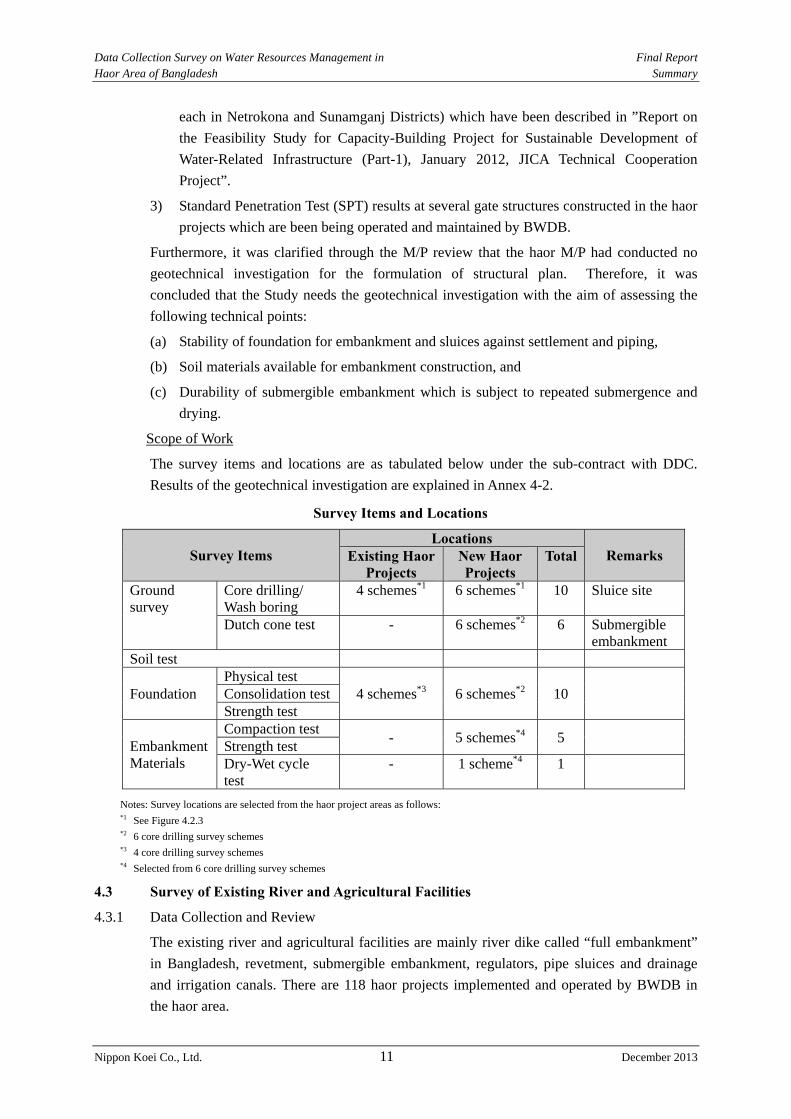
4.2.2 Geotechnical Investigation
Geotechnical investigation was conducted for the ten (10) haor projects, composed of four
(4) rehabilitation projects and six (6) new projects which were identified in the M/P and their
locations are shown in Figure 4.2.3 (Page 4-10, Chapter4).
Major work items of this geotechnical investigation are: 1) Core Drilling/Wash Boring, 2)
Dutch Cone Test, 3) Laboratory Test for Undisturbed Samples, 4) Laboratory Test for
Embankment Materials, 5) Dry-Wet Cycle Test and 6) Riverbed Material Survey
Necessity of the Work
The existing source materials/data on (i) foundation soil of structures like embankment and
sluices and (ii) embankment construction materials which are available in the Study are as
enumerated below.
1) ”Geological Map of Bangladesh, 1:1,000,000”, Geological Survey of Bangladesh, 2001
2) Soil laboratory test results (physical, consolidation and strength tests) at two (2)
locations in the haor area near the northern international border with India (one location
Data Collection Survey on Water Resources Management in Final Report Haor Area of Bangladesh Summary
Nippon Koei Co., Ltd. 11 December 2013
each in Netrokona and Sunamganj Districts) which have been described in ”Report on
the Feasibility Study for Capacity-Building Project for Sustainable Development of
Water-Related Infrastructure (Part-1), January 2012, JICA Technical Cooperation
Project”.
3) Standard Penetration Test (SPT) results at several gate structures constructed in the haor
projects which are been being operated and maintained by BWDB.
Furthermore, it was clarified through the M/P review that the haor M/P had conducted no
geotechnical investigation for the formulation of structural plan. Therefore, it was
concluded that the Study needs the geotechnical investigation with the aim of assessing the
following technical points:
(a) Stability of foundation for embankment and sluices against settlement and piping,
(b) Soil materials available for embankment construction, and
(c) Durability of submergible embankment which is subject to repeated submergence and
drying.
Scope of Work
The survey items and locations are as tabulated below under the sub-contract with DDC.
Results of the geotechnical investigation are explained in Annex 4-2.
Survey Items and Locations
Survey Items Locations
Remarks Existing HaorProjects
New Haor Projects
Total
Ground survey
Core drilling/ Wash boring
4 schemes*1 6 schemes*1 10 Sluice site
Dutch cone test - 6 schemes*2 6 Submergible embankment
Soil test
Foundation Physical test
4 schemes*3 6 schemes*2 10
Consolidation testStrength test
Embankment Materials
Compaction test - 5 schemes*4 5
Strength test Dry-Wet cycle test
- 1 scheme*4 1
Notes: Survey locations are selected from the haor project areas as follows: *1 See Figure 4.2.3 *2 6 core drilling survey schemes *3 4 core drilling survey schemes *4 Selected from 6 core drilling survey schemes
4.3 Survey of Existing River and Agricultural Facilities
4.3.1 Data Collection and Review
The existing river and agricultural facilities are mainly river dike called “full embankment”
in Bangladesh, revetment, submergible embankment, regulators, pipe sluices and drainage
and irrigation canals. There are 118 haor projects implemented and operated by BWDB in
the haor area.
Data Collection Survey on Water Resources Management in Final Report Haor Area of Bangladesh Summary
Nippon Koei Co., Ltd. 12 December 2013
Detailed information of structures
The information related to the facilities of haor projects were collected in Dhaka and from the
site offices. However, the information on the facilities in the 37 haor projects that are funded
by GOB, were collected.
During the site reconnaissance, the Study Team tried to collect as-built drawings of the
existing haor projects. However, such drawings were not obtained because the staff in the
BWDB site offices had no knowledge of their locations.
In addition, the facilities and work volume of the proposed rehabilitation works were
mentioned in M/P. But the locations and areas for rehabilitation were not mentioned. The
information on the type of facilities, dimensions, and damaged areas should be collected.
Therefore, a river facility survey is needed to check the present conditions.
The flood control projects and drainage projects were also executed in the haor area. In these
projects, full embankment, regulator, barrage, pump station were constructed.
Flood damage of river structures in 2007
The flood damage of the facilities in the haor projects and other projects was surveyed. The
data on the flood damage on the structures were only from the 2007 flood damage data
surveyed by BWDB. No data on flood damage is available except year 2007.
Responsibility of operation and maintenance
A sluice committee is established to discuss between an executive engineer of a BWDB site
office and stakeholders, such as an upazila chairman and ward members. The sluice
committee has a key of regulator. The operation of regulator is instructed by the BWDB staff.
The sluice committee operates their regulator under the instruction of BWDB.
On the other hand, the regulators along the rivers which are not included in the haor projects
have no committee. Therefore, the BWDB site office requests the operation of such
regulators to respective ward members. In this case, the BWDB site office directly requests
the ward members to operate the gates.
Information on the proposed rehabilitation projects of existing haor projects in the M/P is
only limited to the quantities of the rehabilitation works. It is not mentioned in the M/P the
damage location and situation of each structure. Therefore, information on the existing
structures in the proposed rehabilitation project is collected from BWDB site offices.
4.3.2 Targets of Field Survey
The targets of the field survey are 1) the existing haor projects, and 2) the river facilities
because existing facilities related to water management are located in the existing haor areas
and along/across the rivers.
4.3.3 Survey Items
The field survey shall include the following items:
1) Collection and review of design drawings and design conditions/criteria,
2) Past flood overtopping and damage of submergible embankment, types and problems
of drainage facilities,
3) Major causes of facility damage and malfunction,
Data Collection Survey on Water Resources Management in Final Report Haor Area of Bangladesh Summary
Nippon Koei Co., Ltd. 13 December 2013
4) State of operation and maintenance
5) Function of haor areas (method for securing irrigation water, supply of nutritive salt
due to farm land sedimentation, freshwater fishing in farm land, etc.)
4.3.4 Survey Results
(1) Regulator
Many regulators are non-operational due to maintenance problems. The responsibility of
maintenance of regulators rests upon the BWDB field office, however they do not have
enough budget for regular maintenance.
There are 60 regulators in the survey area, in which 31 regulators are completely not
operational and 6 regulators are partially damaged. The regulator cannot be operated due to
conflicts between farmer and fishery committees.
On the other hand, the responsibility of the operation of the regulator lies with the sluice
committee, which is organized by the stakeholders. The sluice committee coordinates with
BWDB for the operation of regulator based on the instruction from BWDB. The sluice
committee functions well.
(2) Embankment
Full embankment and submergible embankment were conducted for 258 km and 175km,
respectively. These structures are mainly damaged for about a few meters to 10 m. Damage
of several hundred meters is a few.
Damage to the embankment is classified into two cases. One is erosion due to flood
overtopping and/or river flow velocity and direction, and the other is artificial cutting.
According to interviews with the village people and the BWDB site office staff, the reasons
for artificial cutting are to create the entrances for boat, to create drainage outlets and inlets
of irrigation water and for inland fishery purpose.
(3) Canal
The canals in the haor areas, which have a total 241 km, are connected to the rivers. Many
canals suffer sedimentation problems, thus resulting in lack of irrigation water and drainage
problems.
(4) Flood Mark
The Study Team collected flood information from the village people and the BWDB officer
in the existing haor project area. The highest flood water depth from the paddy field was
confirmed by the village people for the 29 haor projects during the river facility survey. The
minimum water depth is 1.5 m and the maximum is 4.0m as referred to in Table 4.3.7 (Page
4-38, Chapter 4). The water depth varies from each location of the haor projects.
CHAPTER 5 HYDROLOGICAL AND HYDRAULIC STUDY
5.1 Data Collection and Review
Measurements exist for 46 stations in the Northeast Region. While updating the previous
Data Collection Survey on Water Resources Management in Final Report Haor Area of Bangladesh Summary
Nippon Koei Co., Ltd. 14 December 2013
models the data was updated up to November 2006. These data are still available from
BWDB and updated data up to March 2012 could be readily accessed, but not properly
shelved.
There are 27 flow/discharge measurement stations located in the Northeast Region. BWDB
maintains these measurement stations. Data till 2011 are available from BWDB.
There are as many as 45 rainfall measurement stations in the Northeast Region, which are
being maintained by BWDB. The rainfall data are updated up to March 2012.
There are only 3 evaporation measurement stations in the Northeast Region, which are also
being maintained by BWDB. The evaporation data are updated up to March 2012 and
available for the Study.
There are 4 temperature measurement stations in the Northeastern Haor Region of
Bangladesh, which are being maintained by Bangladesh Meteorological Department (BMD).
The data series available from BWDB and BMD are quite long and may be considered
sufficient. However, the number of stations of evaporation measurement appear less but the
variation of evaporation rate in the area is negligible.
Rainfall data seems to be inadequate for hydrologic modeling. Rainfall is measured only
thrice a day and the spacing does not cover major geographic or climatic region throughout
the watershed.
For watersheds without rainfall and/or rating curves at the watershed outlet, flood
hydrographs were estimated by transposing the results from nearby watersheds considering
the precipitation, watershed vegetation cover, soil, physical characteristics, and area size.
5.2 Hydrologic Model
IWM preserves the “General Model” and the six “Regional Models” developed under
Surface Water Simulation Modeling Programme Phase-II (SWSMP II, 1992 to 1996). The
Northeastern Regional Model (NERM) covered the same study area of the Study. Attempts
were thus made to have an overview of the NERM available with IWM.
The WL-discharge rating curves and the discharge hydrographs at the sub-watersheds outlets
are not reliable because these outlets have been frequently under the effect of the backwater
formed at the confluence of the major tributaries and also large portion of the flows
spillovers or inflows exchanging volumes of water with the flood plain before reaching the
WL station. In addition, wherever the rating curves were not available the calibration of the
model was tried utilizing the variation on the ground water table as reference. Considering
the lag time between surface flow and ground water table variation, the hydrologic
calibration at most of the time is unreliable.
5.3 Flood Runoff Analysis
5.3.1 General
(1) Pre-monsoon Season
The pre-monsoon season usually extends from April to May in Bangladesh. The most
important impact caused by rainfall during this season is the occurrence of the flash floods,
which frequently overtop river banks and natural levees. Flash floods cause devastating

Data Collection Survey on Water Resources Management in Final Report Haor Area of Bangladesh Summary
Nippon Koei Co., Ltd. 15 December 2013
damage to the agricultural product, mainly boro rice in the harvest season.
(2) Monsoon Season
The monsoon season starts just after the end of the pre-monsoon season and continues to
September through October. During this period, most of agricultural activities cease
because a large part of the haor area is inundated: for example, the water depths in several
regions reach up to 5 m.
During this season, the precipitation is not as intense as that of the pre-monsoon season, but
the rainfall continues over the larger watershed with a longer duration. The runoff due to
this rainfall drains over the haor area.
5.3.2 Dynamic Hydraulic Modeling
(1) NERM
IWM developed a dynamic hydraulic model utilizing the MIKE11 software. The model
comprises a hydrological (rainfall-runoff) model and a hydro-dynamic (river/channel/flood
plain) model. The model utilizes hydrographs from the transboundary tributaries,
intermediate gauging stations and a downstream boundary condition site (the Bhairab Bazar
WL station) as input data.
It is difficult to estimate a probable flood water level by the conventional method in the haor
area, which is a process of rainfall–runoff analysis, runoff-flood inundation level relation,
and frequency analysis of rainfall and flood water level. This is because the flood inundation
in the haor area is developed by the combination of the runoff from the upstream Indian
border side area and the direct runoff in the haor area. In the Study, probable flood water
levels are estimated by the use of a set of flood water levels simulated by the NERM
calibrated with input of recorded water levels.
(2) Verification of NERM
The design water level of the submergible embankment and full embankment for the
rehabilitation project and new project are determined from the analysis result of NERM.
Therefore, the verification of NERM is carried out to check the relation of the highest
pre-monsoon and monsoon water levels between the simulated output and observed data.
Following table shows the comparison between the simulated water level and the expected
observed water level from the regression equation under the pre-monsoon 10-year flood
condition.
Comparison between Simulated Water Level and Expected Observed Water Level under Pre-monsoon 10-year Flood Condition
Location Simulation (EL.m) Observed (EL.m) Difference A B |A-B| A/B
Bhairab Bazar 2.86 2.45 0.41m 1.17 Itna 4.52 3.86 0.66m 1.17 Sunamganj 6.95 7.30 0.35m 0.95 Sylhet 9.92 10.20 0.28m 0.97
Note: Observed water level is estimated from the regression equation. Source: JICA Study Team
The simulated water level at Sunamganj and Sylhet is 3 % to 5 % lower than the observed
one. On the other hand, the difference between the simulated and observed water levels at
Data Collection Survey on Water Resources Management in Final Report Haor Area of Bangladesh Summary
Nippon Koei Co., Ltd. 16 December 2013
Bhairab Bazar is 17%. The reason for this is that Bhairab Bazar is vulnerable to the impact of
Padma River and old Brahmaputra River, and the hydraulic phenomenon surrounding
Bhairab Bazar is complicated. However, the simulated water level is higher than the
observed one. It means that the design water level is set within the safety side.
The difference of simulated and observed water levels at Itna is also 17%, where the former
is higher than the latter. Itna is a hydraulically affected by Bhairab Bazar, and hydraulic
phenomenon in the flood plain is complicated.
For the planar verification, the relation between observed and simulated water level at
Ajimiriganj which is located at Kalni-Kushiyara River, is studied. The difference between the
observed and simulated high water levels is only 9%.
Therefore, NERM adapts well with the design high water level in the haor area.
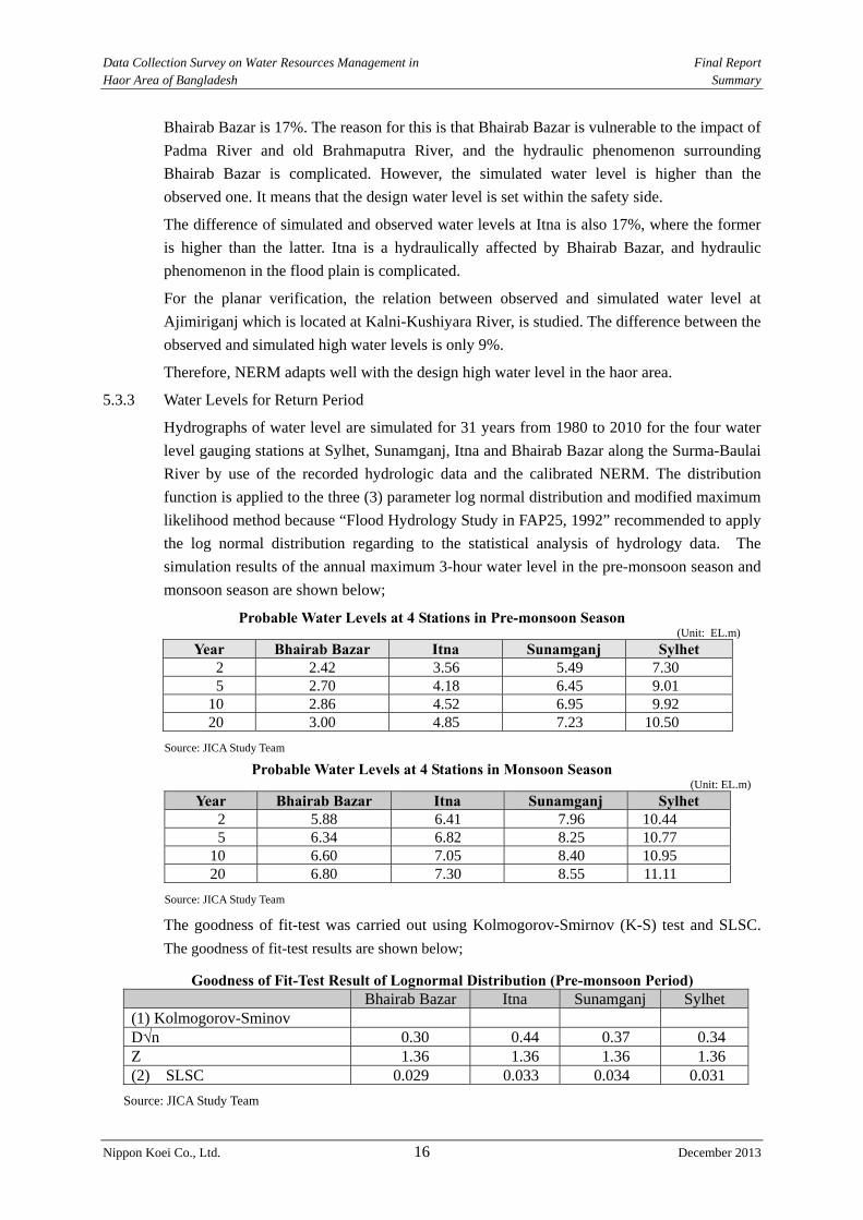
5.3.3 Water Levels for Return Period
Hydrographs of water level are simulated for 31 years from 1980 to 2010 for the four water
level gauging stations at Sylhet, Sunamganj, Itna and Bhairab Bazar along the Surma-Baulai
River by use of the recorded hydrologic data and the calibrated NERM. The distribution
function is applied to the three (3) parameter log normal distribution and modified maximum
likelihood method because “Flood Hydrology Study in FAP25, 1992” recommended to apply
the log normal distribution regarding to the statistical analysis of hydrology data. The
simulation results of the annual maximum 3-hour water level in the pre-monsoon season and
monsoon season are shown below;
Probable Water Levels at 4 Stations in Pre-monsoon Season (Unit: EL.m)
Year Bhairab Bazar Itna Sunamganj Sylhet 2 2.42 3.56 5.49 7.30 5 2.70 4.18 6.45 9.01
10 2.86 4.52 6.95 9.92 20 3.00 4.85 7.23 10.50
Source: JICA Study Team
Probable Water Levels at 4 Stations in Monsoon Season (Unit: EL.m)
Year Bhairab Bazar Itna Sunamganj Sylhet 2 5.88 6.41 7.96 10.44 5 6.34 6.82 8.25 10.77
10 6.60 7.05 8.40 10.95 20 6.80 7.30 8.55 11.11
Source: JICA Study Team
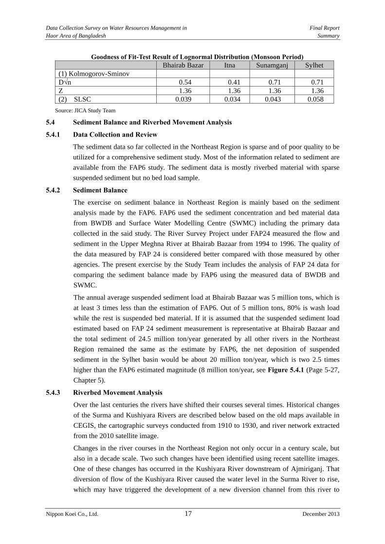
The goodness of fit-test was carried out using Kolmogorov-Smirnov (K-S) test and SLSC.
The goodness of fit-test results are shown below;
Goodness of Fit-Test Result of Lognormal Distribution (Pre-monsoon Period) Bhairab Bazar Itna Sunamganj Sylhet
(1) Kolmogorov-Sminov D√n 0.30 0.44 0.37 0.34 Z 1.36 1.36 1.36 1.36 (2) SLSC 0.029 0.033 0.034 0.031
Source: JICA Study Team
Data Collection Survey on Water Resources Management in Final Report Haor Area of Bangladesh Summary
Nippon Koei Co., Ltd. 17 December 2013
Goodness of Fit-Test Result of Lognormal Distribution (Monsoon Period) Bhairab Bazar Itna Sunamganj Sylhet
(1) Kolmogorov-Sminov D√n 0.54 0.41 0.71 0.71 Z 1.36 1.36 1.36 1.36 (2) SLSC 0.039 0.034 0.043 0.058
Source: JICA Study Team
5.4 Sediment Balance and Riverbed Movement Analysis
5.4.1 Data Collection and Review
The sediment data so far collected in the Northeast Region is sparse and of poor quality to be
utilized for a comprehensive sediment study. Most of the information related to sediment are
available from the FAP6 study. The sediment data is mostly riverbed material with sparse
suspended sediment but no bed load sample.
5.4.2 Sediment Balance
The exercise on sediment balance in Northeast Region is mainly based on the sediment
analysis made by the FAP6. FAP6 used the sediment concentration and bed material data
from BWDB and Surface Water Modelling Centre (SWMC) including the primary data
collected in the said study. The River Survey Project under FAP24 measured the flow and
sediment in the Upper Meghna River at Bhairab Bazaar from 1994 to 1996. The quality of
the data measured by FAP 24 is considered better compared with those measured by other
agencies. The present exercise by the Study Team includes the analysis of FAP 24 data for
comparing the sediment balance made by FAP6 using the measured data of BWDB and
SWMC.
The annual average suspended sediment load at Bhairab Bazaar was 5 million tons, which is
at least 3 times less than the estimation of FAP6. Out of 5 million tons, 80% is wash load
while the rest is suspended bed material. If it is assumed that the suspended sediment load
estimated based on FAP 24 sediment measurement is representative at Bhairab Bazaar and
the total sediment of 24.5 million ton/year generated by all other rivers in the Northeast
Region remained the same as the estimate by FAP6, the net deposition of suspended
sediment in the Sylhet basin would be about 20 million ton/year, which is two 2.5 times
higher than the FAP6 estimated magnitude (8 million ton/year, see Figure 5.4.1 (Page 5-27,
Chapter 5).
5.4.3 Riverbed Movement Analysis
Over the last centuries the rivers have shifted their courses several times. Historical changes
of the Surma and Kushiyara Rivers are described below based on the old maps available in
CEGIS, the cartographic surveys conducted from 1910 to 1930, and river network extracted
from the 2010 satellite image.
Changes in the river courses in the Northeast Region not only occur in a century scale, but
also in a decade scale. Two such changes have been identified using recent satellite images.
One of these changes has occurred in the Kushiyara River downstream of Ajmiriganj. That
diversion of flow of the Kushiyara River caused the water level in the Surma River to rise,
which may have triggered the development of a new diversion channel from this river to
Data Collection Survey on Water Resources Management in Final Report Haor Area of Bangladesh Summary
Nippon Koei Co., Ltd. 18 December 2013
further west to the Ghorautra River. The process of development of these two channels was
almost simultaneous. The development of these two channels appears to have been the result
of the two individual but related events of local morphology.
CHAPTER 6 REVIEW OF FLOOD MEASURES AND RIVER MANAGEMENT
6.1 Flood Protection Level and Design Rainfall in Flood Measures
6.1.1 Flood Protection Level
The standard design manual was prepared by BWDB in 1995. The flood protection level is
explained in this manual.
Full Embankment
The following flood frequencies may be adopted:
1 in 20 year flood where agricultural damage is predominant
1 in 100 year flood where loss of human lives, properties and installations are
predominant. In general, embankment along Jamuna, Padma and Meghna rivers shall
be designed under this return period.
Having selected the flood frequency the design flood levels need to be assessed separately in
two cases, as follows, depending upon whether embankments are to be provided on one bank
or on both banks.
Submergible Embankment
According to the standard design manual, the design flood water level is to be decided based
on a ten (10) year pre-monsoon flood before 31 May. However, the Design Circle-I adopts
that before 15 May.
Technical Review of Flood Protection Level of Submergible Embankment
Main damage caused by the flash floods in haor area falls towards boro rice production.
Therefore, major factor to decide the flood protection level is an impact to boro rice production.
On the other hand, drought level of irrigation water supply is generally applied 5-year drought
level (Confirmed with an irrigation engineer in Bangladesh). If drought occurs, boro rice
production and farmers’ income also decrease. Flood and drought together can cause serious
damage on crop production.
Therefore, the flood protection level of submergible embankment shall be the same level or
higher level compared with the drought level of water use.
The water rising ratio between 5-year to 10-year and 10-year and 15-year is about 36%. The
water rising ratio around a 10-year return period comes to slow down.
The purpose of the submergible embankment is for flood protection during pre-monsoon season,
which is a very short period. The flood protection level is less than the full embankment.
It is judged to be appropriate design flood protection level of the submergible embankment
considering the 10-year probable water level of pre-monsoon flood.
Data Collection Survey on Water Resources Management in Final Report Haor Area of Bangladesh Summary
Nippon Koei Co., Ltd. 19 December 2013
6.1.2 Design Rainfall
The availability of data and information about rainfall distribution in sub-watersheds and
flow at their respective outlets is rather poor in the Northeast Region. No rainfall record is
available inside and upstream of the border areas with India, where a large amount of rainfall
occurs.
The hydrologic model study of the NERM clearly demonstrates that the estimated river flow
based on rainfall data is not reliable with the currently available data set. Therefore, the
rainfall data can not be applied to define the design rainfall in flood measures planning to
provide probable water levels for structural design.
The procedures recommended are as follows:
1) For the design of submersible embankment (crest elevation), water level statistical
analysis should be used, and;
2) For determination of rainwater volume inside the areas protected by submersible
embankment, statistical analysis of local rainfalls in Bangladesh should be applied.
6.2 Flood Management in Bangladesh
The danger level at some water level gauging stations along rivers was decided and flood
management has been carried out based on the danger level in Bangladesh. Danger level is
defined as a level above where flood may likely cause damages to crops and homesteads. If
there is no embankment along a river, the danger level set is close to the annual average
flood water level. If there is a continuous embankment along a river, the danger level is set at
slightly lower level of the design flood water level for the embankment. The danger levels
are set at 7 locations.
6.3 Strategy of Flood Measures and River Management Plan in M/P
The strategies of flood measures and river management in the M/P were explained in Section
9.3 of Annex-1 Water Resources. The proposed strategies are 1) flood management, 2)
drainage improvement, 3) riverbank erosion protection, and 4) operation and maintenance
(O&M) for the existing scheme. Each strategy is explained below.
1) Flood Management
The flood management mainly has two objectives:
i) Protection from sudden intrusion of flood water is required for saving the
agricultural production (especially boro rice production), and
ii) Allowance of flood water during the monsoon is crucial for maintaining the aquatic
ecosystem.
The proposed structures are as follows: 1) intake structure to enter the land side area, 2)
construction of submergible embankment, 3) construction of full embankment, 4)
construction of bypass channel, 5) mechanized construction, and 6) preparation of flash flood
forecasting model.
2) Drainage Improvement
Post-monsoon drainage is essential for Rabi (including boro) cultivation. Timely and quick
recession of flood water allows cultivars to go for crop culture in the haor areas. Therefore,
Data Collection Survey on Water Resources Management in Final Report Haor Area of Bangladesh Summary
Nippon Koei Co., Ltd. 20 December 2013
the following measures are proposed:
i) Dredging of mainstream rivers, and
ii) Drainage improvement of distributaries to reestablish the drainage connectivity of
the haor areas.
3) Riverbank Erosion Protection
The government has recognized river bank erosion as disaster. River bank erosion is
observed on all the rivers in Bangladesh including those in the haor areas.
4) Operation and Maintenance (O&M) of Existing Scheme
Problems for O&M of existing scheme are i) budget shortage, ii) inadequate equipment
support, iii) inadequate manpower, iv) poor quality of O&M works, v) inadequate
monitoring, and vi) non-availability of O&M manual.
6.4 Applicability of River Planning Method in Japan
1) To set control points
It will be appropriate to set the control points of the river management plan based on the
danger level setting points.
2) Importance of river and setting of flood protection level
The planning scale applied the design standard in Bangladesh.
3) Selection and application of recorded rainfall(s) and planned rainfall(s)
The data and information about rainfall distribution in sub-watersheds and flow at their
respective outlets are rather poor in the Northeast Region. Therefore, the rainfall data can not
be applied to define the planned rainfall patterns in the river management planning. to
provide probable water levels for structural design. It is not possible to apply recorded
rainfall and planned rainfall.
4) Flood Discharge and Design Flood Discharge
There is poor data availability of the observed discharge. Therefore, it is difficult to evaluate
the flood discharge from the observed discharge. Also the authorized rating curves are not
available, and hence the indicator of the river management planning applies the simulated
water level.
5) Planning of Facility Installation
The layout plan used in Japan is not applicable in the deep haor area because of the following
reasons:
The river course of the Surma-Baurai River in the deep haor area is not stable, and
A large lake appears during the monsoon season.
The full embankment can be constructed along the upper and the lower reach of the deep
haor. In this case, the planning of layout plan in Japan is applicable. The existing full
embankment shall be considered when the layout plan of full embankment alignment is
studied.
Data Collection Survey on Water Resources Management in Final Report Haor Area of Bangladesh Summary
Nippon Koei Co., Ltd. 21 December 2013
CHAPTER 7 STRUCTURAL MEASURES FOR FLOOD MEASURES AND RIVER MANAGEMENT PLAN IN HAOR AREA
7.1 Basic Conditions for Flood Measures and River Management Plan
(1) Target River
The Surma-Baulai River is a target river and it flows through Sylhet City, Sunamganj and
Itna town areas.
(2) Control Points of Flood Control Measure
The control points of flood control measure are determined from the danger level points. It is
considered that some of these control points will become candidate control points for flood
control measure because they are applicable to hydraulic and hydrological analysis.
The control points were set at 1) Sylhet, 2) Sunamganj, 3) Itna and 4) Bhairab Bazar in the
pre-monsoon season. And the control points were set at 1) Sylhet, 2) Sunamganj, and 3)
Bhairab Bazar in the monsoon season because Itna area has a completely different condition
of the pre-monsoon season and monsoon season.
(3) Importance of River and Planning Scale
The planning scale is decided according to the standard design guideline of Bangladesh.
The planning scale is set at:
Submergible Embankment: 10-year probable flood during pre-monsoon season
Full Embankment: 20-year probable flood
(4) Setting of Planned High Water Level at Control Points for Flood Control
The planned high water levels are estimated from the run-off analysis and inundation
analysis as shown in following table.
Planned High Water Level at Control Points Control Points Pre-monsoon (EL.m) Monsoon (EL.m) Bairab Bazaar EL. 2.86m EL.6.80m Itna EL. 4.52m - Sunamganj EL. 6.95m EL.8.55m Slyhet EL. 9.92m EL.11.11m
Source: JICA Study Team
7.2 Structural Measures for Flood Measures and River Management Plan
7.2.1 Pre-monsoon Flood Protection and Drainage Improvement Project
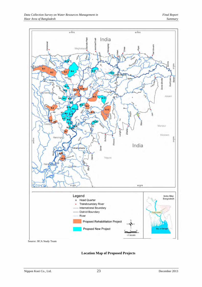
(1) Proposed Facilities
Twenty four (24) rehabilitation projects are selected. On the other hand, twenty six (26) new
projects proposed in the M/P are also considered.
(2) Selection of Facilities
1) Proposed Rehabilitation Project
Twenty three (23) existing haor projects are selected. Of these selected projects, 12 are
proposed projects in M/P and the rest are not selected by BWDB.
Data Collection Survey on Water Resources Management in Final Report Haor Area of Bangladesh Summary
Nippon Koei Co., Ltd. 22 December 2013
Twelve (12) projects are proposed because these projects are authorized by the GOB. Three
(3) project are proposed because of their high priority and efficiency projects.
Therefore, fifteen (15) rehabilitation projects are proposed in this study.
2) Proposed New Project
Twenty four (24) new projects are proposed because these projects are also authorized by the
GOB. In this Study, twenty two (22) projects are proposed considering the hydraulic
condition after the construction of the new project.
The proposed projects are listed below;
Proposed Project
(1) Rehabilitation Project
(2) New Project
Source: JICA Study Team
No. Name of Project Annualized Cost (mil. BDT) B'/C Rank RemarkBenfit B' C
N-1 Boro Haor Project (Nikli) 479 236.9 2.022 1N-2 Naogaon Haor Project 667 380.3 1.754 2N-3 Jaliar Haor Project 114 95.4 1.198 3N-4 Dharmapasha Rui Beel Project 1,286 1,119.5 1.148 5N-5 Chandpur Haor Project 70 58 1.191 4N-6 Suniar Haor Project 118 149 0.796 6N-7 Badla Haor Project 85 135 0.629 7N-8 Nunnir Haor Project 207 350 0.592 9N-9 Dakhshiner Haor Project 180 289 0.623 8
N-10 Chatal Haor Project 43 111 0.387 10N-11 Ganesh Haor Project 117 312 0.375 11N-12 Dhakua Haor Project 228 620 0.367 12N-13 Mokhar Haor Project 451 1,444 0.313 13N-14 Noapara Haor Project 141 566 0.250 14N-15 Dulapur Haor Project 29 198 0.145 16N-16 Bara Haor (Kamlakanda) 164 1,002 0.164 15N-17 Bansharir Haor Project 27 238 0.115 18N-18 Korati Haor Project 123 962 0.128 17N-19 Sarishapur Haor Project 10 101 0.103 19N-20 Shelnir Haor Project 10 324 0.032 21N-21 Kuniarbandh Haor Project 7 217 0.033 20N-22 Ayner Gupi Haor 3 329 0.009 22
No. Name of Project Annualized Cost (mil. BDT) B'/C Rank RemarkBenfit B C
R-1 Dampara Water Management Scheme 1,166.5 32.0 36.496 9 Proposed Project in M/PR-2 Kangsa River Scheme 1,148.6 4.6 248.163 3 Proposed Project in M/PR-3 Singer Beel Scheme 359.6 7.9 45.793 7 Proposed Project in M/PR-4 Baraikhali Khal Scheme 767.8 6.2 123.842 5 Proposed Project in M/PR-5 Alalia-Bahadia Scheme 134.6 17.0 7.912 12 Proposed Project in M/PR-6 Modkhola Bhairagirchar sub-project
Scheme166.5 16.3 10.231 11 Proposed Project in M/P
R-7 Ganakkhalli Sub-scheme 154.1 0.3 494.123 2 Proposed Project in M/PR-8 Kairdhala Ratna Scheme 757.9 1.1 677.758 1 Proposed Project in M/PR-9 Bahira River Scheme 273.3 113.6 2.405 15 Proposed Project in M/P
R-10 Aralia Khal Scheme 99.8 5.5 18.295 10 Proposed Project in M/PR-11 Chandal Beel Scheme 104.2 25.8 4.032 14 Proposed Project in M/PR-12 Satdona Beel Scheme 187.6 34.7 5.413 13 Proposed Project in M/PR-13 Gangajuri FCD sub-project 1,368.4 36.2 37.840 8 High ranking and high efficiency projectR-14 Kaliajuri polder #02 scheme 410.6 5.0 81.515 6 High ranking and high efficiency projectR-15 Kaliakjuri polder #04 scheme 399.3 2.7 148.241 4 High ranking and high efficiency project
Data Collection Survey on Water Resources Management in Final Report Haor Area of Bangladesh Summary
Nippon Koei Co., Ltd. 23 December 2013
Source: JICA Study Team
Location Map of Proposed Projects
Data Collection Survey on Water Resources Management in Final Report Haor Area of Bangladesh Summary
Nippon Koei Co., Ltd. 24 December 2013
7.2.2 River Dredging Project
The inundated water in the paddy field is drained in the direction of the river through the
channels/canals and regulators from the post-monsoon to the dry season due to boro rice
planting. It is important that the inundated water dries quickly.
An adequate flow capacity is required to prevent flood damage at the small- or medium-
scale flooding in the flood plain area.
In addition, the minimum water depth for navigation purpose shall be kept because the
Suruma-Baulai River is important one for water transport.
Five (5) stretches of dredging works were proposed in the M/P as shown in Figure 5.4.4
(Page 5-33, Chapter 5).
1) Downstream stretch from Dharmapasha in the Surma-Baulai River
2) Katkhal Channel
3) Stretch between Chatak and Sunamganj in the Surma-Baulai River
4) Stretch between Kanalghat and Border
5) Jadukata River
Three (3) stretches are selected for the following reasons;
The expectation of the dredging effect in Kanalgaht to the border in the Surma-Baulai
Rivers is increase in run-off volume. However, the efficiency is very small.
Frequent maintenance dredging will be required in the Jadukata River. It will be difficult
to prepare the budget for maintenance dredging.
The following stretches are thus considered for carrying out the dredging works.
1) Downstream stretch from Dharmapasha
2) Katkhal Channel
3) Stretch between Chatak and Sunamganj
Possibility of JICA Cooperation Project
The necessity of the dredging works is confirmed for the three stretches. However, it is
difficult to propose a JICA cooperation project for the following reasons:
The budget for maintenance dredging has to be prepared by the GOB. The budget
preparation will be difficult considering the present maintenance situation. Therefore, it
is difficult to propose these dredging works for possible projects for JICA's cooperation.
CHAPTER 8 PLAN AND DESIGN OF STRUCTURES FOR FLOOD MEASURES
8.1 Assessment of Present Situation and Appropriateness regarding Existing Structural Measures
8.1.1 Structural Measures in Pre-monsoon Season
(1) Present Situation regarding Existing Structures
The structural measures of flood control were not applied in the deep haor area during the

Data Collection Survey on Water Resources Management in Final Report Haor Area of Bangladesh Summary
Nippon Koei Co., Ltd. 25 December 2013
monsoon season. The submergible embankment was constructed to protect against
pre-monsoon floods, Channel/canal and regulators were also constructed for drainage
improvement.
At present, the submergible embankment doesn’t function well due to partial damage by
flood overtopping and artificial cutting.
Fertile soil is transported from the upstream during the monsoon season where it is deposited
in the deep haor area. Therefore, the channel/canal is also silted up by the fertile soil. In
addition, the erosion of channel/canal slope has occurred and eroded material is deposited in
the channel/canal. Finally, the flow capacity for drainage and the storage volume for water
supply in the channel/canal are decreased.
The regulator was constructed near the confluence of the channel/canal and river. At present,
about 50% of regulators have malfunctioned. Problems in drainage, water storage and
prevention of river water during flash flood have been encountered.
The gate regulator is manually opened to control river water levels and landside water levels
before the start of the monsoon season. At present, the causeways are constructed in Kaliajuri
polder-4 to check ease of O&M.
(2) Evaluation of Existing Facilities
The evaluation of existing facilities is carried out from a planning, design, construction and
operation and maintenance points of view.
1) Planning
The submergible embankment was arranged against a 10-year probable pre-monsoon flood.
The channel/canal and regulator were arranged to drain the landside water of the submergible
embankment and to store water in the channel/canal. The planning concept is acceptable for
the deep haor area. However, the specification of each haor project in the deep haor area
shall be decided with considering the Surma-Baulai River Management Plan.
2) Design
A standard design guideline is available. The flood protection level of the submergible
embankment, grain size distribution, and stability analysis method of the embankment are
included in the standard design guideline. The design guideline has been prepared for review
by the BWDB’s senior engineers and experts. Therefore, the design method of the river
facilities is satisfactory.
The grain size distribution is decided during the design stage. The required materials for
construction are not available at many sites. Material on-site is used for the embankment. It
is necessary to carry out adequate material survey before designing the submergible
embankment.
3) Construction
Repair works for the embankment were carried out without compaction. Therefore, the
deterioration of local durability of the loose compacted embankment material under the
submerged condition is faster than that of the good compacted one. The design drawings
indicate grain size distribution of the embankment material. However, the materials from the

Data Collection Survey on Water Resources Management in Final Report Haor Area of Bangladesh Summary
Nippon Koei Co., Ltd. 26 December 2013
design drawings were not followed at the site due to the difficulty in collecting the blend
material. The structures did not follow the instructions indicated on the geotechnical design,
such as the grain size distribution, water contents, compaction criteria, etc. Therefore, the
durability of the structures may be weaker than the initial design strength
4) Operation and Maintenance
Regarding the O&M, lack of O&M budget is a serious problem in BWDB field offices.
LGED has applied a way where the constructed facilities are transferred to the stakeholders.
The stakeholders then carry out O&M. BWDB shall consider how to carry out O&M. In the
facility survey, the staffs of BWDB site offices explained the difficulty of O&M activities
because the O&M budget is only 10%-20% of the initial budget requested from the central
office in BWDB. With that, many facilities are not maintained and do not function.
If O&M system is not improved, similar problems on O&M may be occurred in the O&M
for rehabilitation and new projects after a few years to about 10 years.
8.1.2 Structural Measure in Monsoon Season
(1) Present Situation regarding to Existing Structure
The existing haor projects are constructed not only in the deep haor area but also in the flood
plain area. Structural measures are composed of full embankment, submergible embankment,
channel/canal and regulators.
The problems of the full embankment are 1) erosion of embankment, 2) lack of extra
embankment during the construction stage, and 3) artificial cut.
The channel/canal and regulators have the same conditions as in the deep haor area.
(2) Evaluation of Existing Facilities
1) Planning
In the flood plain, the construction of full embankment is planned to cultivate two cropping.
On the other hand, the area sandwiched between the Surma-Baulai River and the
Kalni-Kushiyara River has drainage problems. To solve the problems, the pumping stations
and regulators were constructed. The construction of the required facilities for flood control
measures is an appropriate input. However, the concrete river management plan is not
proposed in the M/P. It is necessary to prepare this plan in the Surma-Baulai River.
The river facilities shall be planned based on the river management plan.
2) Design
The full embankment is designed based on the design flood water level of the 20-year
probable flood. The calculation of the water level is carried out based on NERM. It is a
normal approach to estimate the flood water level in Bangladesh. However, the embankment
material survey is not sufficient for design works.
3) Construction
The full embankment is constructed to protect the haor area located in the flood plain area.
However, it is required to control the embankment material, water content, and compaction.
Data Collection Survey on Water Resources Management in Final Report Haor Area of Bangladesh Summary
Nippon Koei Co., Ltd. 27 December 2013
4) Operation and Maintenance
It is necessary to improve the O&M as in the case during the pre-monsoon season. If the
O&M works of the BWDB field office are not improved, the river facility conditions will
worsen.
8.1.3 Issues on Design and Construction of Existing Submergible Embankment in Terms of
Durability
The geotechnical investigation, interview survey with BWDB and site reconnaissance in the
Study pointed out three issues regarding the durability of existing submergible embankment,
namely: 1) low quality of embankment materials, 2) inferiority of embankment works and 3)
lack of surface protection.
(1) Low Quality of Embankment Materials
Very fine silt and clay (under 0.075 mm) soil materials on normal embankment may bring
cracks causing erosion and deterioration through the dry and wet process. Shortage of fine
soil materials (under 0.075 mm in grain size) may bring comparatively high permeability
with seepage. Embankment materials composed of 15 % – 50 % silt and clay (under
0.075mm) are usually used to achieve the required durability and impermeability in Japan.
According to the grain size investigations for embankment materials from 15 locations in
five candidate haor projects, soil materials from each site include more than 90 % of silt and
clay. These soil materials can induce cracks and erosion easily and result in low compaction
workability.
(2) Inferiority of Embankment Works
The technical requirements for compaction works of submergible embankment are usually
specified in the bid drawing notes, with a required 7.0 kg rammer compaction. However, no
specification regarding the degree of compaction is stipulated in the drawings. There is an
opinion in the Design Circle that a 90 % degree of compaction should be required. This idea
is considered to be appropriate, as a 90 % degree of compaction is usually applied for river
dykes as the average limit degree of compaction, in Japan. However, more than a 90 %
degree of compaction may not be achieved without heavy equipment. As the adjustment of
moisture content is not also stipulated in any specification and drawing, it is one of the
important issues for embankment works.
(3) Lack of Surface Protection
Although the Design Circle of BWDB understands that the slope protection and crest
pavement of embankment increase its durability, crest pavement is not applied for any
submergible embankment due to budget constraints at present.
It is expected that durability would be increasing by applying pavement of crest and gentler
slope than 1:2 with turfing for submergible embankment. However, deterioration seems to be
significantly seen on existing submergible embankment with steep slope without protection
on the crest.
(4) BWDB Design Manual regarding Embankment
BWDB has issued “Standard Design Manual Volume-I: Standard Design Criteria”, and
describes design criteria of embankment in “Section “7. Design Criteria for Embankment”.
Data Collection Survey on Water Resources Management in Final Report Haor Area of Bangladesh Summary
Nippon Koei Co., Ltd. 28 December 2013
However, issues such as standard grain size distribution of embankment materials, degree of
compaction and adjustment of moisture content are not mentioned in the manual. Regarding
compaction, though contract drawings instruct to use a 7.0 kg rammer as notes, they do not
mention degree of compaction.
Though the grain size distribution of embankment material is also mentioned in the contract
drawings as follows, the instruction above allows fine materials which include “0 %” of
coarse material like sand and gravel. Practically, the ground adjacent to a submergible
embankment site does not include sand and gravel. It means that most of the embankment
materials may consist of silt and clay. In effect, the repeated submergence in the area is
feared to cause the deterioration of embankment due to cracking and erosion.
8.2 Proposal of Basin Standard Design of Structures for Flood Measures
8.2.1 Design Review of Existing Structural Measures
(1) Present Situation of Gate Equipment
A standard gate size (1.5 m wide x 1.8 m high) is usually used when installing regulators.
Therefore, the flow capacity of the regulator is determined from the number of its gates
(number of vents). It was confirmed through the site reconnaissance in the Study that half of
the gates on the existing regulators at present do not function well. Factors which caused the
malfunction of these gates include robbery, loss of gate parts, corrosion and deterioration of
gate equipment.
Maintenance work, even greasing and tightening of the bolts, has not been carried out.
Nearby residents say that BWDB should be responsible for the gate even for its simple
maintenance work such as greasing and bolt tightening. Any sense of ownership was not
found among the residents.
(2) Present Situation of Concrete Structures
Though many sound concrete structures were confirmed during the site reconnaissance,
some of these structures have serious problems like cracks and deterioration.
According to the contract drawings, the required quality of concrete is described at a
specified strength of 20 N/mm2. However, quality confirmation of the concrete through
compaction test might not have been undertaken because the concrete was mixed at the site
by local people. Standardization of mix proportion and quality control system need to be
prepared.
Though the contract drawings of regulators usually instruct the clear cover of reinforcement
bars, concrete exfoliation and exposure of corroded reinforcement bars were observed on
some of the regulators, which are caused by too small clear cover and lack of mortar.
Concrete edges under the hoists chip on the deck slabs of the some of the regulators.
Shearing force might not be considered for the design of contact portion of deck slabs and
plates of hoists.
8.2.2 Consideration for Structure Design
(1) Consideration for Design of Submergible Embankment
- The crest elevation of submergible embankment shall be a 10-year probable water level
Data Collection Survey on Water Resources Management in Final Report Haor Area of Bangladesh Summary
Nippon Koei Co., Ltd. 29 December 2013
during the pre-monsoon season with a + 0.3 m freeboard in accordance with the
stipulation stated in the Standard Design Manual of BWDB.
- The manual stipulates that the crest width of the submergible embankment shall be 4.3 m.
However, the crest width of submergible embankment is designed to be 3.6 m for cost
reduction purposes in many cases. The crest width of 4.3 m is considered to be
appropriate in terms of slope shoulder protection against traffic vehicles during
inspection and maintenance.
- The geotechnical investigation done by the Study shows that the thickness of soft ground
(N-value < 4 in clay foundation) is usually less than 5 m in the haor area. Settlement
calculations based on consolidation tests have a result that residual settlements are less
than 10 cm. The contract drawings of submergible embankment usually instruct an extra
embankment of 15 cm, which seems to be enough in the light of the result of the
settlement analysis.
- Dutch Cone Test (DCT) carried out in the Study shows that cone resistance is generally
greater than 0.8 MPa, which is equivalent to 26.7 kN/m2 in clay soil, except for areas
with very soft ground sites. According to the result of circulate slip analysis including
ground foundation. Embankment with a slope gradient of 1:2.0 satisfies the required
safety factor (FS > 1.2) in the case of cohesion greater than 23 kN/m2 (cone resistance >
0.7 MPa). In the case of very soft ground (cone resistance < 0.4 MPa), countermeasures
like revision of embankment alignment are needed, if the height of embankment is
greater than 2.0 m. Boring survey is recommended in the implementation stage at
maximum intervals of 500 m and at specific sites to be investigated from a topographic
view point.
- Embankment material must be borrowed from adjacent areas even if the grain size
distribution is not suitable for the embankment because of the cost and technical aspects.
However, a 95 % degree of compaction is expected as the target degree to keep required
local durability and reduce the frequency of maintenance.
(2) Consideration for Design of Regulator
Present standard regulators are usually sluice way type structures with lift gates. Basic design
condition such as design flow capacity and elevation of operation deck should follow the
design manual of BWDB. Considering the present problem regarding regulators, basic issues
regarding design and concrete quality should be improved rather than revision of structure
type and material.
Proposal for Improvement of Quality Control of Regulator Item Proposal
Enhancement of Design and Quality Control
- Standardization of maximum coarse aggregate, classification of aggregate, standard gradation of coarse and fine aggregate
- Standardization of mix proportion (aggregate, cement and water) - Stipulation of slump value - Establishment of quality control method during construction stage (quality
control by aggregate physical test and slump test) - Revision of clear cover according to the size of aggregate - Execution of structural calculation using hoist load - Proposal for maintenance method and budget in the design stage (reflecting
to DPP)
Data Collection Survey on Water Resources Management in Final Report Haor Area of Bangladesh Summary
Nippon Koei Co., Ltd. 30 December 2013
CHAPTER 9 NON STRUCTURAL MEASURES IN HAOR AREA
9.1 Assessment of Present Situation and Appropriateness regarding Existing Non-Structural Measures
Non-structural measures refer to any measure that does not involve physical construction
(like retarding basins, embankments, dredging, diversions, etc.) but instead uses knowledge,
practices, and/or agreements to reduce the potential negative impacts of a flood. A
non-structural approach can be a cost-effective alternative to traditional engineering and an
ecological solution. Though the main tools of flood damage reduction revolve around
structural measures, non structural flood measures are also considered as means of damage
reduction.
Not all non-structural measures are effective in all types of flood damage and it is always
better to adopt multiple non-structural measures along with some structural measures for
better flood risk management. Since the crop damage is the main issue of concern in the haor
area, rather than threat to human life, more focus is given on asset loss reduction by
government and non-government organizations.
Different types of non-structural measures practiced in the haor area are analyzed covering
present situation, on-going and planned activities, assessment of appropriateness and
potential for further interventions. These includes, (1) Regulation of development in river
areas, (2) Flood forecasting and warning system, (3) Warning dissemination, (4) Simplified
warning system, (5) Local disaster management planning (namely, (a) evacuation planning,
(b) hazard mapping, (c) flood shelter, (d) disaster prevention edification, (e) seed bank and
food bank, and (f) crop insurance), (6) Livelihood diversification (namely, (a) paddy variety
diversification, (b) crop diversification, (c) job diversification, and (d) improved market
access), (7) Flood proofing of living environment (namely, (a) raising of houses and related
facilities, and (b) construction of new platform or raising entire village), and (8) Participatory
water resources management.
Based on the analysis, it can be inferred that the most appropriate non-structural measures
suitable for the haor area are (1) Local disaster management planning, (2) Livelihood
diversification, (3) Flood proofing of living environment, and (4) Participatory water
resources management. Well planned interventions in these 4 types of measures can bring
about considerable benefits in terms of flood damage reduction in the haor area.
9.2 Non-structural Measures Effective for Haor Area
The 4 most appropriate non-structural measures were examined by sub sector considering
on-going and planned projects, and implications and intervention possibilities. Based on the
analysis 6 conceivable projects were identified. Although each of these projects can
significantly contribute towards flood related damage reduction, not all projects are suitable
for JICA cooperation. It may be mentioned that even a project is not suitable for JICA
cooperation, GOB should implement these from other financial sources.
Suitability analysis of these 6 conceivable projects were conducted and 4 projects are found
to be suitable for JICA cooperation. These are,
Data Collection Survey on Water Resources Management in Final Report Haor Area of Bangladesh Summary
Nippon Koei Co., Ltd. 31 December 2013
NSM-1: Planning and implementation of user friendly flood shelter cum market
NSM-2: Pilot study on seed bank and food bank
NSM-3: Flash flood resilient agricultural diversification with improved market
access
NSM-4: Extension of Beel Nursery
Brief outlines of the 4 potential projects are provided covering project location, objectives,
major components, benefited areas/beneficiaries, expected execution agency and urgency of
JICA cooperation. Two projects are found to have higher implementation urgency and those
are NSMs 3 and 4.
CHAPTER 10 CONCLUSIONS AND RECOMMENDATIONS
The Bangladesh Haor and Wetland Development Board (BHWDB) formulated “Master Plan of Haor
Areas (the M/P)” in April 2012 as a comprehensive development plan of the haor areas for the next 20
years. The M/P is to be positioned as an overarching plan and a base of formulation/implementation
for future JICA cooperation in the haor areas. The M/P has worked out priority projects through (i)
problem/issue analysis and (ii) reflecting the peoples’ needs clarified through a participatory approach.
However, it was pointed out that project impacts on the upstream and/or downstream areas after
project implementation are not necessarily verified in the M/P yet.
In such a situation, the Study conducted (i) review of the M/P and (ii) basic study to supplement the
M/P, and has proposed the following structural and non-structural measures as possible JICA
cooperation projects for flood measures and river management plan in the haor areas:
(1) Structural measures
- Pre-monsoon Flood Protection and Drainage Improvement Project in Haor Areas
(rehabilitation and new development of haor projects, hereinafter referred to as “the Haor
Project”)
(2) Non-structural measures
- Flash Flood Resilient Agricultural Diversification with Improved Market Access
- Extension of Beel Nursery
Furthermore, the Study has worked out the project design of the structural measures, giving priority to
the technical aspect. In these situations, the following are recommended for the succeeding project
stage:
(1) The Haor Project, composed of 37 subprojects (15 for rehabilitation and 22 for new
development), has been designed based principally on study and examination of the
technical aspect. Therefore, it is essential in the succeeding stage for project
Data Collection Survey on Water Resources Management in Final Report Haor Area of Bangladesh Summary
Nippon Koei Co., Ltd. 32 December 2013
implementation to review and design the project including economic evaluation and
environmental/social assessment.
(2) River water level and discharge measurements have been conducted in the haor areas. Ocular
observation of water level (usually from 6:00 a.m. to 6:00 p.m.) has been the major work of
the measurements in accordance with the need for current river management in the country
using flood water levels. In the haor areas it is important to incorporate quantitative
management of river water into the future water resources management. Therefore, it is
recommended to measure water levels by automatic water level gauges including the time
from 6:00 p.m. to 6:00 a.m. and provide proper water level-discharge rating curves.
(3) Currently, the design water levels of flood control facilities such as submergible embankment
and regulators of the haor project have been determined basically through frequency analysis of
water level data obtained from NERM. However, considering future land use change and river
channel movement in the haor area, it is also recommended to incorporate into the design of
flood control facilities the different approach wherein a design flood discharge at a facility site is
set up first and the design water level is determined based on the design flood discharge.
(4) In the Study, the flood flow analysis in the haor areas, which have a vast area of 8,500km2 in
total, was carried out, partially modifying the flood runoff model of IWM. In the project
implementation stage, it is recommended to confirm the flood flow conditions through
detailed hydraulic analysis for specific project areas.
(5) Through the Dutch corn test, soft layers were found to exist at very few sites in the haor
areas. The soft layer requires countermeasures such as counterweight embankment for
embankment construction of more than 2.0 m to 2.5 m in height. Therefore, it is
recommended to confirm the existence of soft layer through core boring investigations at
around 500 m intervals in the planned alignments of submergible embankment in the project
implementation stage so as to correctly reflect the soft layer properties in the detailed
structural design.
(6) As mentioned above, the haor areas have been subjected to serious Boro rice damage due to
frequent flash floods during the pre-monsoon season. The Haor Project can mitigate the
flood damage and contribute towards raising the level of economic and social activities and
realizing poverty reduction and livelihood improvement in the haor areas. In due
consideration of the disastrous situation in the haor areas having been repeatedly devastated
by the flash floods, earlier realization of the Haor Project is strongly needed. It is
recommended for the GOB to timely take necessary actions for further steps such as
securing finance, technical assistance and so forth to realize the Haor Project.

Data Collection Survey on Water Resources Management in Final Report Haor Area of Bangladesh
Nippon Koei Co., Ltd. i December 2013
Abbreviation(1/2) Abbreviation Description ADB Asian Development Bank ADPC Asian Disaster Preparedness Center ASTM American Society for Testing and Materials BBS Bangladesh Bureau of Statistic BDHS Bangladesh Demographic and Health Survey BDT Bangladesh Taka BHWDB Bangladesh Haor & Wetland Development Board BIWTA Bangladesh Inland Water Transport Authority BMD Bangladesh Meteorological Department BRRI Bangladesh Rice Research Institute BUG Beel User Group BWDB Bangladesh Water Development Board CALIP Climate Adaptation and Livelihood Protection CCTV Closed Circuit Television CDM Comprehensive Disaster Management CDMP II Comprehensive Disaster Management Programme II CEGIS Center for Environmental and Geographic Information Services CFB Community Food Bank CNRS Center for Natural resource Study CRA Community Risk Assessment DA Development Area DAE Department of Agricultural Extension DCRMA Disaster and Climate Risk Management in Agriculture DCT Dutch Corn Test DEM Digital Elevation Model DG Director General DGHS Directorate General of Health Services DPP Development Project Proposal EIA Environmental Impact Assessment FAO Food and Agriculture Organization FAP Flood Action Plan FCD Flood Control and Drainage FFPC Flood Forecasting and Processing Center FFWC Flood Forecasting and Warning Center FTRA Fast Tracked Risk Assessment GDP Gross Domestic Production GOB Government of Bangladesh HEC-RAS Hydrologic Engineering Centers River Analysis System HILIP Haor Infrastructure and Livelihood Improvement Project HYV High Yield Variety IDM Introduction to Disaster Management IFAD International Fund for Agricultural Development IRRI International Rice Research Institution IVR Mobile Phone Instant Voice Response IWM Institute of Water Modelling JAXA Japan Aerospace Exploration Agency JICA Japan International Cooperation Agency LGED Local Government Engineering Department M/P Master Plan MDGs Millennium Development Goals NERM North East Region Model

Data Collection Survey on Water Resources Management in Final Report Haor Area of Bangladesh
Nippon Koei Co., Ltd. ii December 2013
Abbreviation(2/2) Abbreviation Description NGO Non-Governmental Organization NWMP National Water Management Plan O&M Operation and Maintenance PCM PWD
Public Consultation Meeting Public Works Datum
POPI People's Oriented Program Implementation RHD Bangladesh Roads and Highways Department RRAP Risk Reduction Action Plan SCBRMP Sunamganj Community Based Resource Management Project SLSC Standard Least Square Criterion SSWRDP Small Scale Water Resources Development Project SWMC Surface Water Modeling Center SWSMP II Surface Water Simulation Modeling Programme Phase-II) UNESCO United Nations Educational, Scientific and Cultural Organization USBR United States Bureau of Reclamation WG Working Group WMA Water Management Association WMCA Water Management Cooperative Association WMIP Water Management Improvement Project
i
The People’s Republic of Bangladesh
DATA COLLECTION SURVEY ON WATER RESOURCES MANAGEMENT
IN HAOR AREA OF BANGLADESH
FINAL REPORT
Table of Contents
Location Map of the Study Area Summary Abbreviation Page
Chapter 1 INTRODUCTION ..................................................................................... 1-1
1.1 Background of the Study .................................................................................... 1-1
1.2 Objectives of the Study ...................................................................................... 1-2
1.3 Study Area .......................................................................................................... 1-2
1.4 Schedule of the Study ......................................................................................... 1-3
1.5 Final Report ........................................................................................................ 1-4
Chapter 2 CURRENT CONDITIONS OF STUDY AREA ...................................... 2-1
2.1 Physical Setting .................................................................................................. 2-1
2.1.1 Physiography and Topography ............................................................. 2-1
2.1.2 Climate ................................................................................................. 2-4
2.1.3 River System ........................................................................................ 2-5
2.1.4 Geology and Soil .................................................................................. 2-9
2.2 Natural Resources ............................................................................................. 2-12
2.3 Socio-economy ................................................................................................. 2-14
2.4 Flood Damage and Flood Mark ........................................................................ 2-23
Chapter 3 REVIEW OF STUDY APPROACH TAKEN IN FORMULATION
OF THE M/P .............................................................................................. 3-1 3.1 Organization of Working Group ......................................................................... 3-1
3.2 Findings on Study Approach Taken in Formulation of the M/P ......................... 3-1
ii
Page
Chapter 4 FIELD SURVEY AND INVESTIGATION ............................................. 4-1 4.1 River Profile and Cross Section Survey ............................................................. 4-1
4.1.1 Data Collection and Review ................................................................. 4-1
4.1.2 River Profile and Cross Section Survey ............................................... 4-3
4.2 Topographic Survey and Geotechnical Investigation ......................................... 4-4
4.2.1 Topographic Survey .............................................................................. 4-4
4.2.2 Geotechnical Investigation ................................................................... 4-9
4.3 Survey of Existing River and Agricultural Facilities ....................................... 4-13
4.3.1 Data Collection and Review ............................................................... 4-13
4.3.2 Targets of Field Survey ....................................................................... 4-25
4.3.3 Survey Items ....................................................................................... 4-25
4.3.4 Survey Results .................................................................................... 4-30
Chapter 5 HYDROLOGICAL AND HYDRAULIC STUDY .................................. 5-1 5.1 Data Collection and Review ............................................................................... 5-1
5.2 Hydrologic Model .............................................................................................. 5-8
5.3 Flood Runoff Analysis ...................................................................................... 5-11
5.3.1 General ............................................................................................... 5-11
5.3.2 Dynamic Hydraulic Modeling ............................................................ 5-11
5.3.3 Water Levels for Return Periods ........................................................ 5-20
5.4 Sediment Balance and Riverbed Movement Analysis ...................................... 5-25
5.4.1 Data Collection and Review ............................................................... 5-25
5.4.2 Sediment Balance ............................................................................... 5-26
5.4.3 Riverbed Movement Analysis ............................................................ 5-28
5.4.4 Dredging in the Surma-Baulai River System ..................................... 5-31
Chapter 6 REVIEW OF FLOOD MEASURES AND RIVER MANAGEMENT . 6-1 6.1 Flood Protection Level and Design Rainfall in Flood Measures ....................... 6-1
6.1.1 Flood Protection Level ......................................................................... 6-1
6.1.2 Design Rainfall ..................................................................................... 6-4
6.2 Flood Management in Bangladesh ..................................................................... 6-4
6.3 Strategy of Flood Measures and River Management Plan in M/P ..................... 6-5
6.4 Applicability of River Planning Method in Japan .............................................. 6-7
iii
Page
Chapter 7 STRUCTURAL MEASURES FOR FLOOD MEASURES AND RIVER MANAGEMENT PLAN IN HAOR AREA ............................... 7-1
7.1 Basic Conditions for Flood Measures and River Management Plan .................. 7-1
7.2 Structural Measures for Flood Measures and River Management Plan ............. 7-6
7.2.1 General ................................................................................................. 7-6
7.2.2 Pre-monsoon Flood Protection and Drainage Improvement Project .... 7-7
7.2.3 River Dredging Project ....................................................................... 7-22
Chapter 8 PLAN AND DESIGN OF STRUCTURES FOR FLOOD MEASURES ............................................................................................... 8-1
8.1 Assessment of Present Situation and Appropriateness of Existing Structural Measures ............................................................................................................. 8-1
8.1.1 Structural Measures during Pre-monsoon Season ................................ 8-1
8.1.2 Structural Measures during the Monsoon Season ................................ 8-5
8.1.3 Issues on Design, Construction and Maintenance of Existing Submergible Embankment in terms of Durability ................................ 8-7
8.2 Proposal of Basin Standard Design of Structural for Flood Measures ............. 8-11
8.2.1 Design Review of Existing Structural Measures ................................ 8-11
8.2.2 Consideration for Structure Design .................................................... 8-13
Chapter 9 NON-STRUCTURAL FLOOD MEASURES IN HAOR AREA........... 9-1 9.1 Assessment of Present Situation and Appropriateness regarding Existing
Non-Structural Measures .................................................................................... 9-1
9.1.1 Relevance of Flood Damage Pattern with Non-Structural Measures ... 9-1
9.1.2 Appropriateness regarding Existing Non-Structural Measures ............ 9-3
9.2 Non-structural Measures Effective for Haor Area .............................................. 9-9
9.2.1 Conceivable Projects ............................................................................ 9-9
9.2.2 Potential Projects for JICA cooperation ............................................. 9-14
Chapter 10 CONCLUSIONS AND RECOMMENDATIONS ................................. 10-1
iv
List of Tables
Page
Table 2.1.1 Distribution of Transboundary and International River Catchments ........ 2-8
Table 2.1.2 Transboundary Rivers contributing in different Catchment System ........... 2-8
Table 2.1.3 Distribution of Average Seasonal Inflow of Kushiyara and Surma Rivers ........................................................................................................... 2-8
Table 2.1.4 Distribution of Average Seasonal Inflow among the Rivers of the Meghalaya System ....................................................................................... 2-9
Table 2.1.5 Distribution of Average Seasonal Inflow among the Rivers of the Tripura System ............................................................................................ 2-9
Table 2.1.6 Average Seasonal Inflow through Different Catchments (Volume) ............ 2-9
Table 2.1.7 Average Seasonal Inflow through Different Catchments (Per cent) ........... 2-9
Table 2.2.1 Water Balance in the Haor Area (1960-2009) ........................................... 2-12
Table 2.2.2 Natural Forest Area .................................................................................... 2-13
Table 2.2.3 Extent of Flora and Fauna ......................................................................... 2-13
Table 2.2.4 Mineral Resources of Haor Area ............................................................... 2-14
Table 2.3.1 District-wise Population, Density and Gender Ratio, 2010 ...................... 2-15
Table 2.3.2 Urbanization Rate by District (2011) ........................................................ 2-15
Table 2.3.3 Cropped Area in 7 Districts ....................................................................... 2-17
Table 2.3.4 Crop Yields ................................................................................................ 2-18
Table 2.3.5 Loss of HYV Boro Rice Production .......................................................... 2-19
Table 2.3.6 Crop Production Benefit ............................................................................ 2-20
Table 2.3.7 District-wise Educational Institute ............................................................ 2-22
Table 2.4.1 Recent Flood Damage in Bangladesh ........................................................ 2-23
Table 2.4.2 Inundation Area in Bangladesh ................................................................. 2-24
Table 2.4.3 Flash Flood Damage on Boro Rice ........................................................... 2-25
Table 3.2.1 List of Study Projects .................................................................................. 3-4
Table 3.2.2 List of Haor Projects Proposed for Rehabilitation in WR01 of Haor Master Plan .................................................................................................. 3-5
Table 3.2.3 List of New Haor Projects Proposed in WR02 of Haor Master Plan .......... 3-7
Table 3.2.4 Proposed Dredging Plan in Haor Master Plan ........................................... 3-12
Table 3.2.5 Locations of Village Protection Work Identified in Haor M/P .................. 3-14
Table 4.1.1 River Cross Section Data in Study Area (BWDB) ...................................... 4-1
Table 4.1.2 Applied River Cross Section Data for the Calibration of NERM in 2007 ............................................................................................................. 4-3
Table 4.1.3 Number of River Cross Sections Surveyed by IWM in 2011-12 ................ 4-3
Table 4.1.4 Number of River Cross Section to Each River ............................................ 4-3
Table 4.2.1 Number of Haor Projects ............................................................................. 4-4
Table 4.2.2 Target Haor Projects for Topographic Survey ............................................. 4-6
Table 4.2.3 List of New Haor Projects ........................................................................... 4-7
v
Page
Table 4.2.4 Survey Items and Locations ...................................................................... 4-12
Table 4.2.5 Planned and Completed Main Survey Items and Quantities ..................... 4-12
Table 4.3.1 Rehabilitation Works of Existing Haor Projects ........................................ 4-14
Table 4.3.2 Part of the Rehabilitation Project by BWDB (37 Projects) ....................... 4-15
Table 4.3.3 Flood Damage of River Structure in 2007 (BWDB) ................................. 4-22
Table 4.3.4 Number of Haor Projects for Facility Survey ............................................ 4-25
Table 4.3.5 Inventory Survey Results .......................................................................... 4-27
Table 4.3.6 Target Rivers for River Facility Survey .................................................... 4-33
Table 4.3.7 Maximum Water Depth at 29 Haor Projects .............................................. 4-37
Table 5.1.1 List of Water Level Data Available from BWDB ........................................ 5-3
Table 5.1.2 List of Flow/Discharge Data Available from BWDB .................................. 5-4
Table 5.1.3 List of Rainfall Data Available from BWDB .............................................. 5-4
Table 5.1.4 List of Evaporation Data Available from BWDB ........................................ 5-5
Table 5.1.5 List of Temperature Data Available from BMD .......................................... 5-5
Table 5.3.1 Comparison between Simulated Water Level and Expected Observed Water Level under Pre-monsoon 10-year Flood Condition ....................... 5-18
Table 5.3.2 Simulation Results of Annual Maximum 3-hour Water Level at Four Stations during the Pre-monsoon Season .................................................. 5-20
Table 5.3.3 Simulation Results of Annual Maximum 3-hour Water Level at Four Stations during the Monsoon Season ........................................................ 5-21
Table 5.3.4 Probable Water Level at Four Stations in Pre-monsoon Season ............... 5-23
Table 5.3.5 Probable Water Level at Four Stations in Monsoon Season...................... 5-23
Table 5.3.6 Goodness of Fit-Test Results of Log-Normal Distribution (Pre-monsoon Period) ................................................................................ 5-25
Table 5.3.7 Goodness of Fit-Test Results of Log-Normal Distribution (Monsoon Period) ....................................................................................................... 5-25
Table 5.4.1 Summary of Sediment Analysis Report of SWSMP for the Northeast Region ........................................................................................................ 5-25
Table 5.4.2 Median grain size (D50) of the Collected Samples ................................... 5-26
Table 5.4.3 Locations of Suspended Sediment Sampling by FAP-6 ............................ 5-26
Table 5.4.4 Proposed Dredging Plan in Master Plan of Haor Area .............................. 5-31
Table 6.1.1 Water Level Rising Regarding Return Period ............................................. 6-3
Table 6.2.1 Danger Level ............................................................................................... 6-5
Table 6.4.1 Applicability of Japanese River Management Method ............................... 6-7
Table 7.1.1 Control Points of Flood Control Measure ................................................... 7-2
Table 7.1.2 Importance of River and Planning Scale ..................................................... 7-2
Table 7.1.3 Planned High Water Level at Control Points ............................................... 7-3
Table 7.1.4 Average River Width ................................................................................... 7-5
vi
Page
Table 7.2.1 Principal Rehabilitation Features and New Constructed Haor Projects ...... 7-7
Table 7.2.2 Damaged Ratio of Paddy ........................................................................... 7-14
Table 7.2.3 Project Prioritization for Each Group ........................................................ 7-16
Table 7.2.4 Proposed Projects ...................................................................................... 7-20
Table 7.2.5 Dredging Locations and Dredging Volumes ............................................. 7-22
Table 8.1.1 Planned Causeway in Haor Projects ............................................................ 8-3
Table 8.1.2 Results of Grain Size Investigation and Compaction Test for Embankment Materials ................................................................................ 8-7
Table 8.2.1 Basic Feature of Regulator for New Projects ............................................ 8-18
Table 8.2.2 Proposal for Improvement of Quality Control and Maintenance of Regulator ................................................................................................... 8-19
Table 9.2.1 Rationale for Intervention Possibility on Local Disaster Management Planning ..................................................................................................... 9-10
Table 9.2.2 Rationale for Intervention Possibility on Livelihood Diversification ....... 9-12
Table 9.2.3 Rationale for Intervention Possibility on Flood Proofing of Living Environment .............................................................................................. 9-13
Table 9.2.4 Rationale for Intervention Possibility on Participatory Water Resources Management ............................................................................. 9-13
Table 9.2.5 Suitability Analysis of Conceivable NSM Projects for potential JICA Cooperation ............................................................................................... 9-14
Table 10.2.1 Grouping of Sub-projects in the Haor Project ........................................... 10-4
Table 10.2.2 Analysis on Economic Efficiency/Priority for the Haor Projects .............. 10-5
Table 10.2.3 Phasing of the Haor Project ....................................................................... 10-5
Table 10.2.4 Assumed Implementation Schedule .......................................................... 10-7
Table 10.2.5 Project Cost ............................................................................................... 10-8
List of Figures
Page
Figure 1.3.1 Division of Haor Areas ................................................................................ 1-3
Figure 1.4.1 Schedule of the Study .................................................................................. 1-4
Figure 2.1.1 Physiography Map ....................................................................................... 2-3
Figure 2.1.2 Digital Elevation Model .............................................................................. 2-4
Figure 2.1.3 Transboundary River System in Upper Meghna River Basin ..................... 2-6
Figure 2.1.4 Isohyet Graph in Upper Meghna River Basin ............................................. 2-7
Figure 2.1.5 Geological Map in Project Area ................................................................ 2-11
Figure 2.3.1 Upazilla-wise Population of 2011 and Haors of Northeast Region ........... 2-16
Figure 3.2.1 Extent of Flood by Depth .......................................................................... 3-16
Figure 3.2.2 Hazard Map, Fish Flood ............................................................................ 3-17
vii
Page
Figure 3.2.3 Cropping Pattern ........................................................................................ 3-18
Figure 3.2.4 Land Zone .................................................................................................. 3-19
Figure 4.1.1 Target Rivers in the Study Area to Undertake River Cross Section Survey by BWDB ........................................................................................ 4-2
Figure 4.1.2 Survey Location of River Cross Sections .................................................... 4-4
Figure 4.2.1 Location Map of Haor Projects ................................................................... 4-5
Figure 4.2.2 Location Map of New Projects for Topographic Survey ............................. 4-8
Figure 4.2.3 Location Map of Geotechnical Investigation ............................................ 4-10
Figure 4.3.1 Location Map of 37 Rehabilitation Project planned by BWDB ................ 4-18
Figure 4.3.2 Location Map of the Manu Barrage and Pumping Station ........................ 4-20
Figure 4.3.3 Location Map of Haor Projects for Field Survey ...................................... 4-26
Figure 4.3.4 Location Map of Field Survey ................................................................... 4-29
Figure 5.1.1 Location Map of Hydro Meteorological Stations ........................................ 5-7
Figure 5.2.1 Hydrologic Model (NAM – IWM) Calibration Results (1/2-2/2) ............... 5-9
Figure 5.3.1 Water Surface Elevation and Flow Calibration Results (1/2-2/2) ............. 5-13
Figure 5.3.2 Measured and Simulated Water Levels at Bhairab Bazar Gauging Station ........................................................................................................ 5-15
Figure 5.3.3 Measured and Simulated Water Levels at Itna Gauging Station ............... 5-16
Figure 5.3.4 Measured and Simulated Water Levels at Sunamganj Gauging Station ... 5-16
Figure 5.3.5 Measured and Simulated Water Levels at Sylhet Gauging Station ........... 5-17
Figure 5.3.6 Verification Points of NERM .................................................................... 5-17
Figure 5.3.7 Relation between Observed Water Level and Simulated Water Level at Five Locations ....................................................................................... 5-19
Figure 5.3.8 Illustration for Cumulative Distribution of Sample X and Cumulative Distribution of Probability Distribution Function of Sample X ................ 5-22
Figure 5.3.9 Frequency Analysis Result of Pre-monsoon Seasons at the Four Stations ...................................................................................................... 5-24
Figure 5.3.10 Frequency Analysis Result of Monsoon Seasons at the Four Stations ...... 5-24
Figure 5.4.1 Sediment Budget for the Northeast Region ............................................... 5-27
Figure 5.4.2 Suspended Sediment Concentration in the Upper Meghna River at Bhairab Bazar Measure in River Survey Project (FAP 24) during 1994-1995 .................................................................................................. 5-28
Figure 5.4.3 Major Rivers Moving towards the Deepest Part of the Basin ................... 5-29
Figure 5.4.4 Proposed River Dredging in the Haor Area Master Plan .......................... 5-33
Figure 5.4.5 Proposed River Dredging in FAP6 ............................................................ 5-34
Figure 5.4.6 Proposed River Dredging for Navigation Route ....................................... 5-35
Figure 5.4.7 Long Profile of Surma River 2008 from Chatak to Sunamganj Showing Formation of Level and Locations of Dredging for Maintaining Navigability ........................................................................... 5-36
viii
Page
Figure 5.4.8 Long Profile of Surma-Baulai-Upper Meghna Rivers 2008 from Jamalganj to Bhairab Bazar Showing Formation of Level and Locations of Dredging for Maintaining Navigability ................................ 5-36
Figure 6.1.1 Relationship between Return Periods and Pre-monsoon Flood Water Levels .......................................................................................................... 6-3
Figure 6.2.1 Location Map of Danger Level Setting Points ............................................ 6-5
Figure 6.4.1 Flow Chart of Flood Control Plan in Japan ................................................. 6-9
Figure 7.1.1 Profile of the Surma-Baulai River ............................................................... 7-4
Figure 7.1.2 Flow Capacity of the Surma-Baulai River .................................................. 7-4
Figure 7.1.3 River Width of Surma-Baulai River ............................................................ 7-5
Figure 7.2.1 Surma-Baulai River moving towards the Slyhet Basin ............................... 7-6
Figure 7.2.2 Location Map of Proposed Haor Rehabilitation Projects .......................... 7-12
Figure 7.2.3 Location Map of Proposed New Haor Projects ......................................... 7-13
Figure 7.2.4 Water Inflow and Drainage of Tanguar Haor ............................................ 7-18
Figure 7.2.5 Location Map of Proposed Projects .......................................................... 7-21
Figure 7.2.6 Location Map of Barak River, Surma-Baulai River and Kalni-Kushiyara River ............................................................................... 7-23
Figure 8.1.1 Decrease of Strength of Compacted Specimens by Dry-Wet Cycle Test for Three Degrees of Compaction ........................................................ 8-9
Figure 8.2.1 Relationship between Settlement and Soft Ground Depth, Height of Embankment based on Consolidation Tests .............................................. 8-14
Figure 8.2.2 Relationship between Cohesion of Foundation Ground and Safety Factor of Circular Slip Analysis (Height of Embankment: 4.0 m) ............ 8-14
Figure 8.2.3 Relationship between Cohesion of Embankment Materials and Safety Factor of Circulate Slip (Height of Embankment: 4.0m, Slope Gradient: 1:2) ............................................................................................. 8-15
Figure 8.2.4 Unconfined Compression Test Using Embankment Material (Relationship between Unconfined Strength and Void Ratio) ................... 8-16
Figure 8.2.5 Typical Longitudinal Profile of Regulator ................................................. 8-17
Figure 8.2.6 Typical Plan of Regulator .......................................................................... 8-18
Figure 10.2.1 Proposed Phasing of Haor Project ............................................................. 10-6
Figure 10.2.2 Location Map of Project ............................................................................ 10-9
ix
List of Photograph
Page
Photo 5.4.1 Changes of Kushiyara River Courses (Downstream of Ajmirganj) ........... 5-30
Photo 5.4.2 Changes of Surma River Courses (East of Karimganj) .............................. 5-30
Photo 9.1.1 Construction of New Platform in Nikkli Upazilla, Kishoreganj (1/2-2/2) .. 9-8
List of Annex
Annex 3.1 Operational Guideline of Working Group
Annex 3.2 Minutes of Meetings
Annex 4.1 River Cross Section Data from BWDB
Annex 4.2 Analysis of Geotechnical Investigation and Laboratory Test Result
Annex 4.3 Facility Survey
Annex 4.4 Location Map of Photographs
Annex 5.1 Division of Inland and Transboundary Catchments of NERM
Annex 7.1 Impact of New Haor Project
Annex 7.2 Project Map
Annex 7.3 Damaged Ratio
Annex 9.1 Assessment of Present Situation and Appropriateness regarding Existing Non-structural Flood Measures
Data Collection Survey on Water Resources Management in Haor Area of Bangladesh Final Report
Nippon Koei Co., Ltd. 1-1 December 2013
CHAPTER 1 INTRODUCTION
1.1 Background of the Study
Bangladesh is situated in the Bengal Delta area flowed into by three transboundary rivers,
namely, the Ganges (Padma), Brahmaputra (Jamuna) and Meghna, which drain a total
catchment area reaches of 1.72 million km2.
Around 90% of the Bangladeshi territory is occupied by flat lowlands of less than 10m in
elevation, and rivers in these lowlands are characterized by very easy riverbed gradients.
Therefore, serious inundation occurs to more than 20% of the territory annually because
floodwater overflows the river channels during rainy season, which generally receives more
than 80% of annual rainfall.
After the formulation of the National Water Policy in 1999 and the National Water
Management Plan (an implementation plan of the policy) in 2004, Bangladesh set forth a
definite direction of flood measures that provide a living environment adaptable to floods by
allowing floodwater to overflow rather than confining into the river channels. In
Bangladesh, the stable growth of economy will not be achieved without flood damage
mitigation, while in reality the soil has remained rich and fertile owing to the annual
occurrence of flooding. Therefore, realization of living together with floods in harmony
with sustainable water resources development and management is one of the most important
focused areas of the country.
Out of the three transboundary rivers, the Japan International Cooperation Agency (JICA)
has decided to place much importance on cooperation to the Meghna River, which need
flood measures and integrated water resources management, according to the findings stated
in “the Preparatory Survey on Disaster Prevention Sector in Bangladesh (Program
Formulation)” conducted in 2009 and 2010 by JICA.
In the upper Meghna area, situated in the Northeast Region of Bangladesh, there are swampy
lowland areas called “haors” extended widely. The whole haors (about 8,500 km2) are
submerged during rainy season because of flood inundation, and it is said that the inundation
of haor has contributed toward flood control for the Dhaka area with a population of 16
million.
The upper Meghna area has been supporting the Bangladeshi economy as a food basket
during the dry season and a rich fishing ground in the rainy season. However, the whole
upper Meghna area has suffered from serious flood damage due to (i) flash floods brought
about by river water coming from the hilly areas in the Indian territory during pre-monsoon
season, which are counted among the heaviest rainfall zones in the world, and (ii) long-term
flood inundation during rainy season. Although flood control facilities such as submergible
embankments and sluices have been constructed in the haor areas since the early times, flood
damage has repeatedly been occurring in reality. Hence, effective flood measures are still
needed.
The Bangladesh Haor and Wetland Development Board (BHWDB) was established as a
coordination body for the haor areas and formulated “Master Plan of Haor Areas (hereinafter
Data Collection Survey on Water Resources Management in Haor Area of Bangladesh Final Report
Nippon Koei Co., Ltd. 1-2 December 2013
referred to as “the M/P”)” in April 2012 as a comprehensive development plan covering 17
development sectors of the haor areas for the next 20 years. The M/P has concluded that it
is essential to implement flash flood measures, village protection measures against wave
erosion, drainage improvement, irrigation facility maintenance/improvement and promotion
of agricultural/fishery sectors as priority projects for appropriate water resources
management in the haor areas.
The M/P has worked out priority projects through (i) problem/issue analysis including some
hydraulic analysis, and (ii) reflecting peoples’ needs clarified through a participatory
approach, and this is to be positioned as an overarching plan for future cooperation of JICA
in the haor areas. However, it might be pointed out that project impacts in the upstream
and/or downstream areas after project implementation have not been necessarily verified in
the M/P yet. In such situations, the “Data Collection Survey on Water Resources
Management in Haor Area of Bangladesh (hereinafter referred to as “the Study”)” has
conducted the following:
(1) Review of the M/P contents, which will be the base of formulation/implementation of
future JICA projects in the haor area,
(2) Collection of additional data and information related to the formulation process of the
M/P, and
(3) Basic study to supplement the M/P.
1.2 Objectives of the Study
The objectives of the Study are:
1) To collect and review (i) the contents of water resources management plans, such as
“Master Plan of Haor Areas (the M/P, 2012)”, for the haor areas in the upper Meghna
area and (ii) existing relevant data and information,
2) To conduct additional study on matters that have been hardly addressed so far in the
said plans, and
3) To propose possible JICA cooperation projects for flood measures and river
management plan in the haor areas.
1.3 Study Area
The study area covers the river basins dealt with in the M/P (including their upstream and
downstream areas required for the Study (limited to the Bangladeshi territory).
In the study area, special wetlands, namely, “haors” are situated. The haor areas having
unique hydro-ecological characteristics are large bowl shaped floodplain depressions in the
Northeast Region of Bangladesh covering about 1.99 million ha and accommodating about
19.37 million people. There are about 373 haors/wetlands located in the districts of
Sunamganj, Habiganj, Sylhet, Maulvibazar, Netrakona, Kishoreganj and Brahmanbaria.
As presented in Figure1.3.1, the haors are largely classified into three areas based on their
geo-morphological characteristics: (i) haors within Sylhet basin, (ii) haors in simple

Data Collection Survey on Water Resources Management in
Haor Area of Bangladesh Final Report
Nippon Koei Co., Ltd. 1-3 December 2013
floodplain and (iii) trapped haors, which are delineated in the figure with red, purple and dark blue lines, respectively. In the center part of the Sylhet basin, a low land bottom area of which the elevation is less than 2m to 3 m is widely extended.
Source: “Master Plan of Haor Area, Water Resources, Ministry of Water Resources, 2012”
Figure 1.3.1 Division of Haor Areas
1.4 Schedule of the Study
The study period is 14 months from November 2012 to December 2013 and the schedule of the Study is presented in Figure 1.4.1.
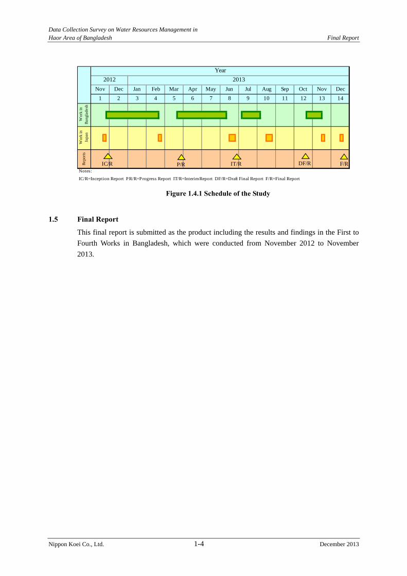
Data Collection Survey on Water Resources Management in Haor Area of Bangladesh Final Report
Nippon Koei Co., Ltd. 1-4 December 2013
Notes:
12
Nov Dec Jan Feb
Year
2012 2013
OctAug Sep NovMar Apr May Jun
Wor
k in
Ban
glad
esh
Wor
k in
Japa
n
1 2
DecJul
3 4 5 6
Rep
orts
13 148 9
IC/R=Inception Report PR/R=Progress Report IT/R=Interim Report DF/R=Draft Final Report F/R=Final Report
7 10 11
IC/R IT/R DF/R F/RP/R
Figure 1.4.1 Schedule of the Study
1.5 Final Report
This final report is submitted as the product including the results and findings in the First to
Fourth Works in Bangladesh, which were conducted from November 2012 to November
2013.
Data Collection Survey on Water Resources Management in Haor Area of Bangladesh Final Report
Nippon Koei Co., Ltd. 2-1 December 2013
CHAPTER 2 CURRENT CONDITIONS OF STUDY AREA
2.1 Physical Setting
2.1.1 Physiography and Topography
(1) Physiography
The physiography of the Study area is classified based on the combination of geological
material in which particular kinds of soil have formed and the landscape on which they occur.
Seven districts comprising the haor area are placed on the following 11 physiographic units,
based on agro-ecological regions of Bangladesh prepared by the Food and Agriculture
Organization (FAO)1, as shown in Figure 2.1.1. The units are as follows: a) Northern and
Eastern Piedmont Plains, b) Northern and Eastern Hills, c) Sylhet Basin, d) Eastern
Surma-Kushiyara Floodplain, e) Old Brahmaputra Floodplain, f) Young Brahmaputra and
Jamuna Floodplain, g) Active Brahmaputra-Jamuna Floodplain, h) Old Meghna Estuarine
Floodplain, i) Madhupur Tract, j) Middle Meghna River Floodplain and k) Akhaura Terrace.
Among these units, six major units are described briefly in the following paragraphs:
1) Northern and Eastern Piedmont Plain
The Northern and Eastern Piedmont Plains are placed at the Northern and Eastern hills with a
gentle outward slope from the foot of the hills. Alluvial fans at the north border of the area
are its main features. Someswari, Jadukata, Jalukhali and Piyain along with some other
trans-boundary rivers have mainly developed alluvial fans in this area. Piedmont floodplains
are formed at the eastern border of the Study area by some steep streams like Khowai, Manu,
Sutang, Dhalai, and Juri Rivers that flow from Tripura Hills in India to meet the Kushiyara
River.
2) Northern and Eastern Hills
The Northern and Eastern Hills covers the series of northward plunging anticlines in the
eastern part of the Study area with scattered patches along the northern border of the
Jamalpur, Sherpur and Sylhet districts. The hills are formed with consolidated and
unconsolidated sandstones, siltstones and shale of various Tertiary ages. The rocks have been
uplifted, folded, faulted and dissected to form hill ranges or areas of complex hill and valley
relief. Slopes are mainly very steep but the relief varies from very steeply dissected to gently
rolling.
3) Sylet Basin
Sylhet basin comprises extensive low-lying, bowl-shaped depression and is deeply flooded
during the monsoon season. The main feature of this area is the big bowl shaped depression,
which is subsiding with a considerably high rate. Presently, subsidence is the dominating
geo-morphological process as this area is isolated from its sediment sources after avulsion of
the Brahmaputra River since 200 years ago. Flood basins within this large subsiding basin
form the deeply inundated haor such as Tangua, Shanir, Matian, Karcher, and Kalner haors.
1 Classification of agro-ecological zone in Bangladesh prepared by FAO http://www.fao.org/fileadmin/templates/faobd/img/Agroecological_Zones.jpg
Data Collection Survey on Water Resources Management in Haor Area of Bangladesh Final Report
Nippon Koei Co., Ltd. 2-2 December 2013
The haors are divided by natural dikes of channels and are very poorly drained. The bottom
elevation of these haors is less than EL. 2 m, PWD2. Flooded water in this area after the
monsoon season does not drain immediately as perennial water bodies occupy the lowest
point of the haors and adjacent river dikes prevents rapid drainage. A large area in the basin
stay wet for most or all of the dry season.
4) Eastern Surma-Kushiyara Floodplain
The Eastern Surma-Kushiyara Floodplain comprises parts of Sunamganj, Habiganj, Sylhet
and Moulavibazar. The landforms are mainly very broad, smooth ridges and extensive basins.
There is a broad belt of irregular relief, with narrow and linear ridges and inter-ridge
depressions along the lower Kushiyara River. This area is flooded with shallow depth and is
subject to early floods and rapid rise in water levels due to heavy rainfall locally and in
adjoining hills. Gungiajuri, Hail, Kawadighi, Hakaluki, Dubriary, Dhamrir, Patharchuli and
Zilkar are the major haors in this floodplain.
5) Old Brahmaputra Floodplain
The Old Brahmaputra Floodplain prevails in the western part of the region and was
abandoned after the avulsion of the Brahmaputra River to the west of Madhupur Tract from
its east about 200 years ago. There are silt loams and silty clay loams on the ridges and
extensive areas of clays in the basins. Some basins near the northern and eastern boundaries
of the subunit are occupied by clay sediments derived from the adjoining piedmont plain and
the Sylhet basins. High water levels in the adjoining rivers and floodplains unable to drain
off, and hence causes seasonal flooding accumulated by rainfall. Flooding becomes deeper
toward the east and south.
6) Old Meghna Estuarine Floodplain
The Old Meghna Estuarine Floodplain occurs in the southern part of the Study area including
some parts of Kishoreganhj, Habiganj and Narayanganj districts. This unit is almost level
with uniform soil predominating by silty soil. It is moderately deep in the north and west, but
shallow in the southeast.
(2) Ground Elevation
Figure 2.1.2 shows a map of digital elevation model (DEM). This map illustrates that the
Study area forms such a low-lying basin compared with other regions of the country. Land
below EL. 5m PWD extends virtually as far as the Meghlaya Foothills. Out-side of this area,
floodplain lands situated 200 km from the sea are found at EL. 8 m to 20 m PWD.
Approximately 25 % of the Study area lies below EL. 5m PWD and 50 % lies below EL. 8 m
PWD.
2 Public Works Datum
Data C
ollection Survey on Water R
esources Managem
ent in H
aor Area of B
angladesh
Final R
eport
Nippon K
oei C
o., Ltd.
2-3
De
cem
ber 2013
Source: Master Plan of Haor Area, April 2012
Note: Nine units are shown in this figure because small units in this area are not indicated.
Figure 2.1.1 Physiography Map
Data Collection Survey on Water Resources Management in Haor Area of Bangladesh Final Report
Nippon Koei Co., Ltd. 2-4 December 2013
Source: CEGIS
Figure 2.1.2 Digital Elevation Model
2.1.2 Climate
(1) Climate in Bangladesh
Bangladesh has a subtropical monsoon climate characterized by wide seasonal variations in
rainfall, moderately warm temperatures, and high humidity. Regional climatic differences in
this flat country are minor. Three seasons are generally recognized as follows: a hot and
humid summer season from March to June; a cool and rainy monsoon season from June to
October; and a cool and dry winter from October to March. In general, maximum summer
temperatures range between 32 °C and 38 °C. April is the warmest month in most parts of the
country. January is the coldest month, when the average minimum temperature for most of
the country is 10 °C. Winds come mostly from the north and northwest during winter.
About 80 % of Bangladesh's rain falls during the monsoon season. During the hot months of
April and May, hot air rises over the Indian subcontinent, creating low-pressure areas into
which rush cooler, moisture-bearing winds from the Indian Ocean. This is the southwest
monsoon, commencing in June and usually lasting through September.
(2) Climate in the Northeast Region
The Northeast Region is located entirely to the north of the Tropic of Cancer, hence its
climate is characterized by sub-tropical monsoon. The sub-tropical monsoon climate tends to
have more sharply defined seasons than the tropical one. The monsoon results in intense
regional and orographic rains caused by the interface of mist air masses coming from the
Indian Ocean through the Bay of Bengal with a predominant northeastern direction and the
steep and high hills located at the foothills in the states of Assam, Meghalaia and Tripura in
Meghalaya Foothill
Tripra hills
Data Collection Survey on Water Resources Management in Haor Area of Bangladesh Final Report
Nippon Koei Co., Ltd. 2-5 December 2013
India. The hills in Indian states experience very severe precipitation, causing very high
flows in the major rivers draining through the Northeast Region of Bangladesh such as the
Surma, Kushiyara, Manu, Khowai and Someswari. Some of the more intense precipitations
in the world fall in this region where the average annual rainfall is around 12,000 mm.
As a result of the said unique climatic and physiographic settings of the upper Meghna area,
the meteorology, hydrology, fluvial regimes and geomorphology are quite and distinct from
other regions of Bangladesh.
The hydro-meteorological seasons of the Northeast Region are generally classified into:
- Pre-monsoon season extending from April to May;
- Monsoon season from June through September;
- Post-monsoon season from October to November; and
- Dry season from December through March.
1) Monsoon Season
The southwest monsoon brings moist winds into the Northeast Region from the Bay of
Bengal along a circular route over the Chitagon Region so that the winds actually approach
the region from the southeast. Rainfall in the season is abundant and it is often referred to as
“monsoon”, meaning rainy season.
2) Pre- and Post-monsoon Seasons
The pre-monsoon season occurs from April to May and is characterized by an increase in
precipitation with rainfall ranging from nearly 490 mm in the southwest to around 1,290 mm
in the northeast. The intensification of rainfall during the pre-monsoon season increases the
incidence of flash floods in the region, which can potentially damage the crops when the
river flows overtop and inundate agriculture land during the harvest season, causing serious
damage to farmers as well as the country.
The post-monsoon season happens during October and November. The rainfall is sporadic
and ranges from near 170 mm in the southwest to about 320 mm in the northeast.
2.1.3 River System
The majority of the rainfall volume that flows through the Bangladeshi Northeast Region
comes from India where the largest flow volumes, floods, and sediment yield occur.
Figure 2.1.3 shows the river system for the upper Meghna River including the portion of the
watershed inside India. Figure 2.1.4 presents the average rainfall distribution throughout the
Upper Meghna River Watershed.
Data Collection Survey on Water Resources Management in Haor Area of Bangladesh Final Report
Nippon Koei Co., Ltd. 2-6 December 2013
Source: Master Plan of Haor Area, April 2012
Figure 2.1.3 Transboundary River System in Upper Meghna River Basin
Meghalaya
Barak
Tripura
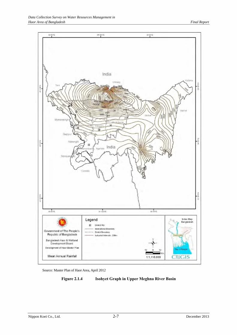
Data Collection Survey on Water Resources Management in Haor Area of Bangladesh Final Report
Nippon Koei Co., Ltd. 2-7 December 2013
Source: Master Plan of Haor Area, April 2012
Figure 2.1.4 Isohyet Graph in Upper Meghna River Basin
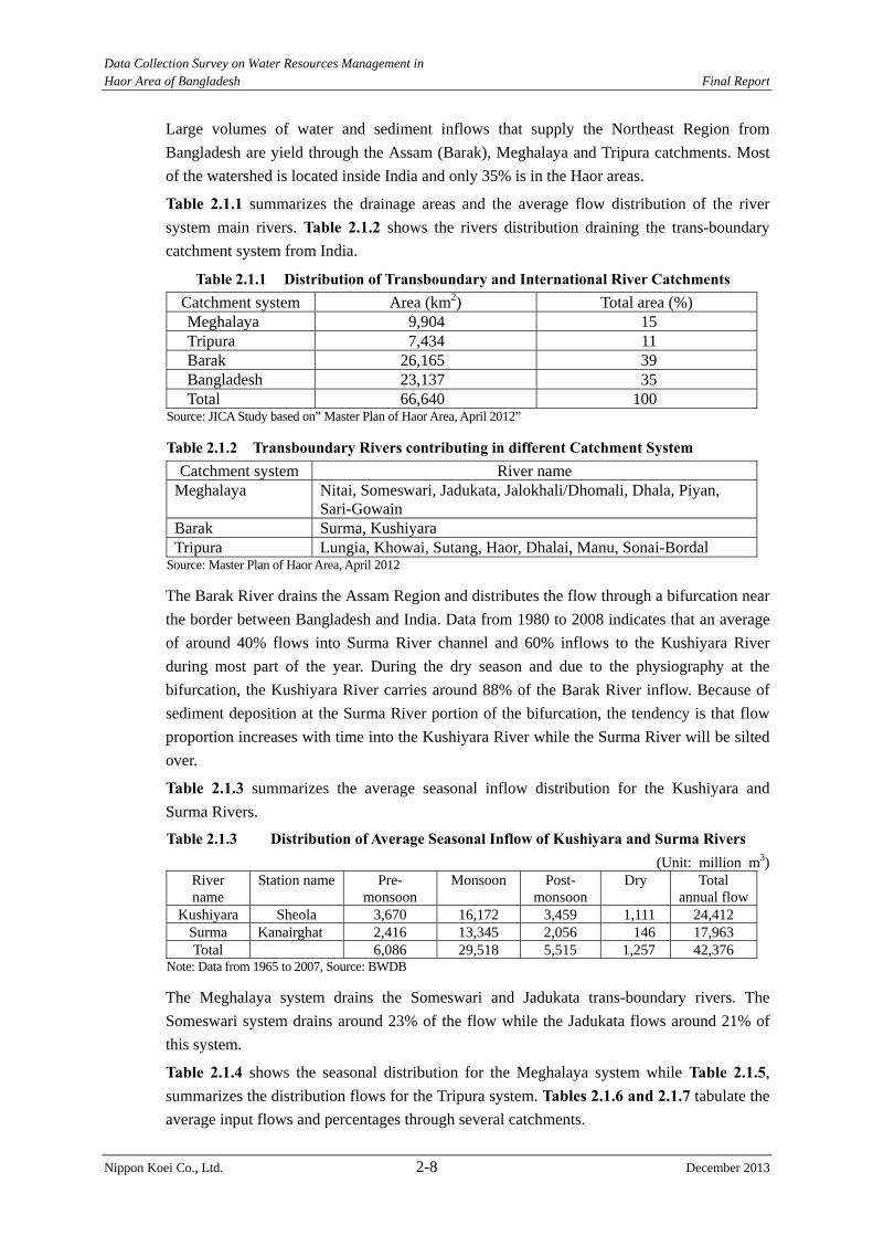
Data Collection Survey on Water Resources Management in Haor Area of Bangladesh Final Report
Nippon Koei Co., Ltd. 2-8 December 2013
Large volumes of water and sediment inflows that supply the Northeast Region from
Bangladesh are yield through the Assam (Barak), Meghalaya and Tripura catchments. Most
of the watershed is located inside India and only 35% is in the Haor areas.
Table 2.1.1 summarizes the drainage areas and the average flow distribution of the river
system main rivers. Table 2.1.2 shows the rivers distribution draining the trans-boundary
catchment system from India.
Table 2.1.1 Distribution of Transboundary and International River Catchments Catchment system Area (km2) Total area (%) Meghalaya 9,904 15 Tripura 7,434 11 Barak 26,165 39 Bangladesh 23,137 35 Total 66,640 100
Source: JICA Study based on” Master Plan of Haor Area, April 2012”
Table 2.1.2 Transboundary Rivers contributing in different Catchment System Catchment system River name
Meghalaya Nitai, Someswari, Jadukata, Jalokhali/Dhomali, Dhala, Piyan, Sari-Gowain
Barak Surma, Kushiyara Tripura Lungia, Khowai, Sutang, Haor, Dhalai, Manu, Sonai-Bordal
Source: Master Plan of Haor Area, April 2012
The Barak River drains the Assam Region and distributes the flow through a bifurcation near
the border between Bangladesh and India. Data from 1980 to 2008 indicates that an average
of around 40% flows into Surma River channel and 60% inflows to the Kushiyara River
during most part of the year. During the dry season and due to the physiography at the
bifurcation, the Kushiyara River carries around 88% of the Barak River inflow. Because of
sediment deposition at the Surma River portion of the bifurcation, the tendency is that flow
proportion increases with time into the Kushiyara River while the Surma River will be silted
over.
Table 2.1.3 summarizes the average seasonal inflow distribution for the Kushiyara and
Surma Rivers.
Table 2.1.3 Distribution of Average Seasonal Inflow of Kushiyara and Surma Rivers (Unit: million m3)
River name
Station name Pre- monsoon
Monsoon Post- monsoon
Dry Total annual flow
Kushiyara Sheola 3,670 16,172 3,459 1,111 24,412 Surma Kanairghat 2,416 13,345 2,056 146 17,963 Total 6,086 29,518 5,515 1,257 42,376
Note: Data from 1965 to 2007, Source: BWDB
The Meghalaya system drains the Someswari and Jadukata trans-boundary rivers. The
Someswari system drains around 23% of the flow while the Jadukata flows around 21% of
this system.
Table 2.1.4 shows the seasonal distribution for the Meghalaya system while Table 2.1.5,
summarizes the distribution flows for the Tripura system. Tables 2.1.6 and 2.1.7 tabulate the
average input flows and percentages through several catchments.
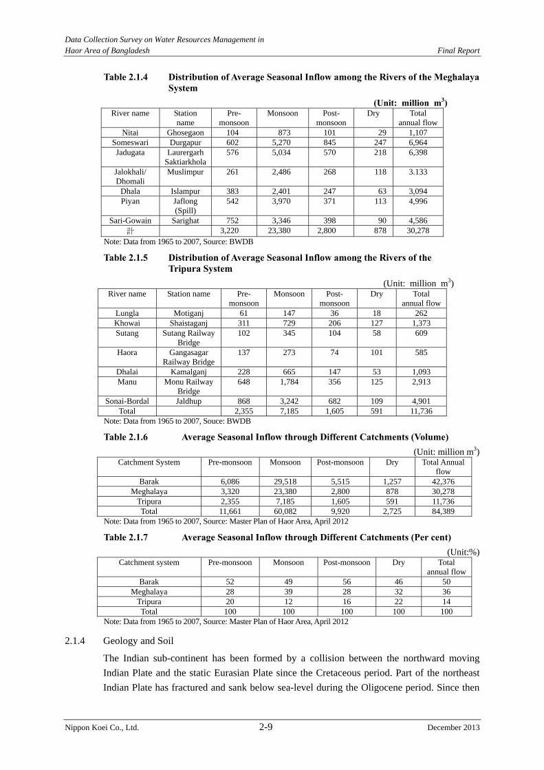
Data Collection Survey on Water Resources Management in Haor Area of Bangladesh Final Report
Nippon Koei Co., Ltd. 2-9 December 2013
Table 2.1.4 Distribution of Average Seasonal Inflow among the Rivers of the Meghalaya System
(Unit: million m3) River name Station
name Pre-
monsoonMonsoon Post-
monsoonDry Total
annual flow Nitai Ghosegaon 104 873 101 29 1,107
Someswari Durgapur 602 5,270 845 247 6,964 Jadugata Laurergarh
Saktiarkhola 576 5,034 570 218 6,398
Jalokhali/ Dhomali
Muslimpur 261 2,486 268 118 3.133
Dhala Islampur 383 2,401 247 63 3,094 Piyan Jaflong
(Spill) 542 3,970 371 113 4,996
Sari-Gowain Sarighat 752 3,346 398 90 4,586 計 3,220 23,380 2,800 878 30,278
Note: Data from 1965 to 2007, Source: BWDB
Table 2.1.5 Distribution of Average Seasonal Inflow among the Rivers of the Tripura System
(Unit: million m3) River name Station name Pre-
monsoonMonsoon Post-
monsoonDry Total
annual flow Lungla Motiganj 61 147 36 18 262 Khowai Shaistaganj 311 729 206 127 1,373 Sutang Sutang Railway
Bridge 102 345 104 58 609
Haora Gangasagar Railway Bridge
137 273 74 101 585
Dhalai Kamalganj 228 665 147 53 1,093 Manu Monu Railway
Bridge 648 1,784 356 125 2,913
Sonai-Bordal Jaldhup 868 3,242 682 109 4,901 Total 2,355 7,185 1,605 591 11,736
Note: Data from 1965 to 2007, Souce: BWDB
Table 2.1.6 Average Seasonal Inflow through Different Catchments (Volume) (Unit: million m3)
Catchment System Pre-monsoon Monsoon Post-monsoon Dry Total Annual flow
Barak 6,086 29,518 5,515 1,257 42,376 Meghalaya 3,320 23,380 2,800 878 30,278
Tripura 2,355 7,185 1,605 591 11,736 Total 11,661 60,082 9,920 2,725 84,389
Note: Data from 1965 to 2007, Source: Master Plan of Haor Area, April 2012
Table 2.1.7 Average Seasonal Inflow through Different Catchments (Per cent) (Unit:%)
Catchment system Pre-monsoon Monsoon Post-monsoon Dry Total annual flow
Barak 52 49 56 46 50 Meghalaya 28 39 28 32 36
Tripura 20 12 16 22 14 Total 100 100 100 100 100
Note: Data from 1965 to 2007, Source: Master Plan of Haor Area, April 2012
2.1.4 Geology and Soil
The Indian sub-continent has been formed by a collision between the northward moving
Indian Plate and the static Eurasian Plate since the Cretaceous period. Part of the northeast
Indian Plate has fractured and sank below sea-level during the Oligocene period. Since then
Data Collection Survey on Water Resources Management in Haor Area of Bangladesh Final Report
Nippon Koei Co., Ltd. 2-10 December 2013
the Bengal basin has started to form subsiding tectonic basin slowly, filling up with deltaic
sediment.
Figure 2.1.5 shows the geological map in the study area. The geology of the study area is
generally divided as follows;
1) Alluvial Fans (described in the M/P report by BHWDB) are normally found, as young
gravelly (light purple area), in the limited transition zones between mountainous areas
and floodplains along the northern national border with India.
2) The central study area (yellowish green area) is underlain by alluvial deposits,
composed of mainly soft cohesive soil such as clay and silt. Especially, marsh clay and
peat are distributed in the vicinity of the Dhanu and the Baulai Rivers, situated east of
Netrokona and Kishoreganj Districts. Therefore, very soft peat is considered to exist in
the central area.
3) Surrounding the central area, Netrokona, Kishoreganj and south of Sylhet area are
underlain by alluvial silt and clay (light brown area).
4) Moreover, the western border area is generally underlain by alluvial silt (grave blue
area).
5) Recent river deposits are distributed along big rivers which flow into the study area.
River deposits are mainly composed of sand and gravel with silt and clay. Cobble stone,
gravel and sand are quarried in the river bed at some places.
The central study area, called as the Sylhet Basin (pale purple color in Figure 2.1.2), has
experienced some of the greatest subsidence. This basin has subsided 30-40 feet (10-12 m)3
in the last several hundred years.
Referring to other areas’ data4, on condition that the Sylhet basin is subsiding at a rate of 2-4
mm/yr and the soil compaction rate is 1-2 mm/yr, the actual subsidence rate of the Sylhet
basin might be 3-6 mm/yr.
The soils of the area are grey silty clay and clay on the higher parts that dry out seasonally
and grey clays in the wet basin. Peat occupies some wet basin centers. The soils have a
moderate content of organic matter and soil reaction is mainly acidic.
About 74% of the top soil texture of the haor region is clay to silty clay, 21% is silt, while the
rest are clayey silt, sandy silt and sand.
3 Source:Master Plan of Haor Area, Volume II Main Report and Annex 1 Water Resources 4 A subsidence rate of 21 mm/year in the Surma basin was reported in the Master Plan Organization(PMO) (1985) and FEC (1989).
Data C
ollection Survey on Water R
esources Managem
ent in H
aor Area of B
angladesh
Final R
eport
Nippon K
oei Co., L
td. 2-11
D
ecember 2013
Source: Adapted from Geological Map provided by CEGIS
Figure 2.1.5 Geological Map in Project Area
Data Collection Survey on Water Resources Management in Haor Area of Bangladesh Final Report
Nippon Koei Co., Ltd. 2-12 December 2013
2.2 Natural Resources
(1) Water Resources
The study area lies in the Meghna River basin, which is one of the largest GBM basins.
About 66,640 km2 of the Meghna River basin is drained ultimately into the Bay of Bengal
through the Kalni-Kushiyara and Surma-Baulai river systems. Of this area, 35 % or 23,137
km2 lies in Bangladesh. The total inflow in the haor area comes from India through
Meghalaya, Barak and Tripura catchments. In addition, Old Brahmaputra carries water from
the Indian part. The combined flow of Meghalaya, Barak and Tripura systems and Old
Brahmaputra finally drain out through the Meghna River at Bhairab Bazar. Bhairab Bazar
also internally drains flow generated by local rainfall in the Bangladesh territory.
It is reported in the M/P, that the analysis of BWDB data (1960-2009) showed a volume of
water contribution into Bangladesh through the river system is 162,619 million m3. Water
contribution from transboundary rivers of Barak, Meghalaya and Tripura systems is 42,670
million m3, 30,376 million m3 and 15,716 million m3, respectively. The contribution of
water from transboundary river systems from India and Bangladesh in the region are
described below.
- The catchment area of the Barak River system is 26,165 km2, which contributes 26% of
the total inflow in the region.
- The catchment area of the Meghalaya river system is 9,904 km2, which contributes
19 % of the total inflow in the region.
- The catchment area of the Tripura river system is 7,434 km2, which contributes 10 % of
the total inflow in the region,
- The water contribution inside Bangladesh is 23,137 km2, which is 43% of the total
inflow in the region. And
- The water contribution from the Old Brahmaputra in the region is 2%.
The water balance for the study area is presented in Table 2.2.1. The proportion of annual
average flow between the India and Bangladesh territories is 57 : 43.
Table 2.2.1 Water Balance in the Haor Area (1960-2009) River system Total flow (million m3)
(A) Barak 42,670 (B) Meghalaya 30,376 (C) Tripura 15,719 (D) Brahmaputra 3,532 (E) Total inflow from India (A+B+C+D) 92,297 (F) Local contribution from Bangladesh 69,422
Total Inflow (E+F) 162,619 Source: Compiled by JICA Study Team based on Haor MP, 2012
(2) Vegetation
In the haor basin there are hill forests, social forests, fresh water swamps, reed swamp forests,
bamboos and homestead vegetation, etc. Table 2.2.2 shows the natural forest coverage in
the study area.
In the M/P, ecologists have grouped the typical haor vegetation areas into nine classes, which
are 1) submerged plants, 2) free floating plants, 3) rooted floating plants, 4) sedges and

Data Collection Survey on Water Resources Management in Haor Area of Bangladesh Final Report
Nippon Koei Co., Ltd. 2-13 December 2013
meadows, 5) floodplain grassland, 6) reed swamp, 7) fresh water swamp forest, 8) crop field
vegetation and 9) homestead vegetation.
Table 2.2.2 Natural Forest Area District Natural forest area (ha)
Sunamganj 7,293Habiganj 13,153Netrokona 739Sylhet 262,832Maulvibazar 25,142
Total 296,005Source: Haor MP, 2012
(3) Biodiversity and Wetland
There is a large number of wetlands of significant national and regional importance, and
many of these sites have significant local value. The sites support biodiversity at all scales
especially communities (species and within the species) and are home to several
internationally threatened species. The biodiversity of haor wetlands is very rich. The
most significant wetlands are Hakaluki Haor, Tanguar Haor, Hail Haor, Matian Haor, Pasuar
Beel Haor, Dekar Haor, Baro Haor, Gurmar Haor, Sonamorol Haor, Baram Haor, Kalni Haor,
Kawadighi Haor and Pagner Haor. These wetlands have rich wildlife communities
including birds, reptiles, mammals and amphibians. Most of the important haor areas are
also enriched by wetland plants through lowland plantation.
In 1999, the Government of Bangladesh (GoB) declared two haors as ‘ecologically critical
areas’ (ECA) in the haor area based on “Bangladesh Environment Conservation Act (1995,
amended in 2000 and 2002)”, which are Hakaluki Haor (Maulvibazar/Sylhet Districts) and
Tanguar Hoar (Sunamganj District) . Tanguar Haor has been declared as a Ramsar site.
In addition, the Bangladesh National Herbarium (BNH) carried out a survey in 2001. Extent
of flora and fauna is as shown in Table 2.2.3.
Table 2.2.3 Extent of Flora and Fauna Flora and fauna Number of spices
Amphibians 9Birds 257Mammals 29Reptiles 40Fish 141Free floating plants 11Anchored plants 38Suspended plants 5Rooted plants 2Emergent species 116Climbers 5Swamp plants 8
Source: Compiled by the JICA Study Team based on Haor MP, 2012
The haor ecosystem is the major habitat of birds and fishes in Bangladesh. Tanguar Haor is
characterized having an approximately 141 fish species including some introduced exotic
species which represents more than half of the country’s fresh water fish species (266 spp.).
Data Collection Survey on Water Resources Management in Haor Area of Bangladesh Final Report
Nippon Koei Co., Ltd. 2-14 December 2013
There are 208 bird species avifauna in the haor area.
(4) Mineral Resources
The haor basin is a large, gentle depression, bounded by the Old Brahmaputra floodplain in
the west, the foothills of the Meghalaya Plateau in the north, the Sylhet High Plain in the east
and the Old Meghna floodplain in the south. This depression is created by subsidence and
tectonic adjustment.
The geological setting and formations of the Northeast Region of Bangladesh favors the
deposit of various types of mineral and energy resources. The mineral resources discovered
are natural gas, crude oil, limestone, white clay, glass sand, peat, coal, gravel and
construction sand (see Table 2.2.4). About 90% of the total gas production of the country is
obtained from the haor districts.
Table 2.2.4 Mineral Resources of Haor Area Type Brief description of mineral resources
Coal The coal consists of 18.96-39.32% carbon, 15-46.16% ash, 0. 62-1.44% moisture and 32.64-48.22% gaseous materials.
Crude Oil Small commercial oil discovered at Haripur, Sylhet, was in operation for about 7 years only.
Glass Sand Glass sand is found in Habiganj, Shajibazar and Noapara. Gravel Gravel is composed of rock types like quartzite, granite, amphibolite,
basalt, sandstone, and conglomerate Lime Stone Limestone is mainly found in the subsurface at Boglibazar, Lalghat,
Takerghat and Bhangerghat of Tahirpur Upazila, Sunamganj District. Natural Gas Among the 23 natural gas fields, 10 fields are located in the haor region. Peat Peat is available around Maulvibazar District; Chatal beel of
Maulvibazar District; Pagla, Derai and Shalla of Sunamganj District; Charkai of Sylhet District; Katanga of Brahmanbaria District and Mukndapur of Habiganj District.
White Clay White clay deposit is found nearly in the surface to subsurface at Bijoypur and Gopalpur of Durgapur Upazila in Netrakona District.
Source: Compiled by JICA Study Team based on Haor MP, 2012
2.3 Socio-economy
(1) Population Distribution
The total population of the seven haor districts in the Northeast Region is 17.88 million as of
2011 Census compared to 14.94 million in 2001 Census (BBS, 2012). The average yearly
growth rate for the past 10 years is 1.97%, which is higher than the national rate of 1.47%.
There are about 3.44 million households in the haor districts, which translates into an
average household size of 5.2 persons per household. The highest number of population
lives in Sylhet (3.43 million) and the lowest in Maulvibazaar (1.92 million). Similarly,
Sylhet has the largest household size of 5.76, while Kishoreganj has the smallest size of 4.64.
The average gender ratio in the haor districts is 97.78:100, which indicates that there are 97.8
males per 100 females. The national gender ratio is 100:100. Brahmanbaria District has
the highest population density (1,510 per km2), while only 659 people live per km2 in
Sunamganj District. The overall population density in the haor districts is 894 per km2,
which is lower than the average population density in Bangladesh, which is 976 per km2. The
district-wise population, its density and gender ratio are given in Table 2.3.1. The rate of
Data Collection Survey on Water Resources Management in Haor Area of Bangladesh Final Report
Nippon Koei Co., Ltd. 2-15 December 2013
urbanization is highest in Sylhet District at 21.94%, followed by Kishoreganj, where the rate
is 16.79%. The lowest urbanization is in Sunamganj, which is only 10.38% as compiled in
Table 2.3.2. The national average of urbanization is 23.3%.
Table 2.3.1 District-wise Population, Density and Gender Ratio, 2010 District Population
(mil.) Household(thousand
HH)
Person per Household
(People)
Gender Ratio (M:F)
Population density
(person/ km2 )Sunamganj 2.47 440.3 5.6 100.35 659Habiganj 2.07 393.3 5.3 96.88 792Netrakona 2.23 479.1 4.6 99.37 798Kishoreganj 2.91 627.3 4.6 96.80 1,083Sylhet 3.43 596.1 5.7 101.16 995Maulvibazar 1.92 361.2 5.3 96.96 686Brahmanbaria 2.84 538.9 5.3 92.74 1,510Haor Total Area
17.88 3,436.2 5.2 97.78 894
Source: Compiled by JICA Study Team based on 2011 Census (BBS, 2012)
Table 2.3.2 Urbanization Rate by District (2011)
District Population (103)
Population in urban areas* (103)
Urbanization Rate (%)
Sunamganj 2,468 256 10.4Habiganj 2,089 245 11.7Netrokona 2,230 247 11.1Kishoreganj 2,912 489 16.8Sylhet 3,434 753 21.9Maulvibazar 1,919 208 10.8Brahnmanbaria 2,840 448 15.8 Haor Total Area 17,892 2,646 14.8
Note: * Population in “2 Urban” and “3 Other Urban” under BBS’s census Source:Bangladesh Population and Housing Census (BBS,2011)
The upazila-wise 2011 population for the 7 haor districts is shown in Figure 2.3.1. This is
superimposed by the 373 haors as defined by the MP.
(2) Land Use
Land: The haor area extends over Kishoreganj, Netrakona, Sunamganj, Sylhet, Moulvibazar,
Habiganj and Brahmanbaria districts in the Northeast Region of Bangladesh. These seven
districts cover a gross area of about 2 million ha, of which about 55 % is cropped land, and
the rest is occupied by rivers, channels (khals), water bodies, forests, homesteads, ponds,
hills and infrastructure.
The haor area covers about 0.86 million ha. About 9.5 % of the haor area is under permanent
water bodies, of which 37,000 ha are beels5 and 45,000 ha are channels6. Multi-use lands
including grazing lands, waste lands, village grounds and riverbanks cover about 40,000 ha.
People in the locality use the beels and multi-use lands as “common property resources”.
The beels are for fisheries and source of irrigation water in the dry season. Grazing lands are
5 Beels: Static water bodies or shallow lakes found at the centre or in the lowest part of every haor in the dry season 6 Channel: Stream channels known as khals, connecting the beels to nearby rivers: most of the haors are interconnected with channels through which floodwater spills into the haor area from the rivers during the flood season and drains out at the end of the monsoon season
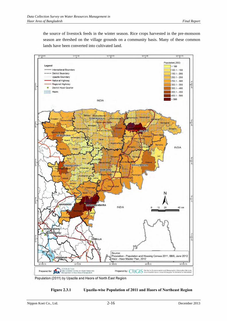
Data Collection Survey on Water Resources Management in Haor Area of Bangladesh Final Report
Nippon Koei Co., Ltd. 2-16 December 2013
the source of livestock feeds in the winter season. Rice crops harvested in the pre-monsoon
season are threshed on the village grounds on a community basis. Many of these common
lands have been converted into cultivated land.
Figure 2.3.1 Upazila-wise Population of 2011 and Haors of Northeast Region
Data Collection Survey on Water Resources Management in Haor Area of Bangladesh Final Report
Nippon Koei Co., Ltd. 2-17 December 2013
Table 2.3.3 Cropped Area in 7 Districts Crop Season
Name of Crop
Area (% of net cultivated area)
Kharif 1 (Pre-monsoon)
Local aus 1.30 HYV aus 8.17 Jute 0.93
Kharif 2 (Monsoon)
Local aman* 22.17 HYV aman 33.51
Rabi/Boro (Dry)
Local boor 5.90 HYV boro 57.61 Wheat 0.98 Pulse 0.31 Oilseeds 0.84 Potato 0.93 Sweet potato 0.31 Sugarcane 0.17
Total cropped area (km2) 15,400 Net cultivated area (km2) 12,000
Cropping Intensity (%) 133 Note: *Local aman includes deepwater aman broadcast. Source: Agriculture Census 2010 Yearbook of Agricultural Statistics.
Land Ownership: The number of farm households in the 7 districts is 1.68 million and
non-farm households is 1.37 million. Of the total farm households, about 80 % are
considered small (owning less than 1 ha of cultivated land), 17 % are medium (owning 1 to 3
ha of cultivated land) and 3 % are large (more than 3 ha of cultivated land). The large
farms are usually operated using tenants or hired labor.
Land Tenure: Owner operation is common. About 71 % of the total farm households operate
their own land. Owner-cum tenant operated and tenant operated households account for 20 %
and 9 % of the total farm households, respectively. The large landowners generally share
out their lands to tenants for operation. The share cropping system is being practiced where
one-half of the produce is retained by the landowners without providing inputs. The
landowners generally provide 50 % of the inputs costs.
(3) Agriculture
Cultivated Area: Net cultivated area covers about 12,000 km2 in the above-mentioned 7
districts. The highlands (F0) and medium highlands (F1) where flood depth reaches 0 to 0.9
m occupy about two-fifths of the net cultivated area. The lands are therefore subject to
moderate cropping constraints during the monsoon season. The medium lowlands (F2) and
lowlands (F3) where the seasonal flooding depth is 0.9 m to more than 1.8 m occupy about
three-fifths of the net cultivated area. In the haor area about one-fifth of the net cultivable
area is in F0 and F1. The F3 comprise about four-fifths.
Cropped Area: Rice is the major and most important crop. This crop accounts for 99 % of the
total food grain cropped area in the 7 districts. It is grown in three cropping seasons,
mainly solely or in rotation with dry land crops. The Census of Agriculture in the 2010
Yearbook of Agricultural Statistics indicates that 15,400 km2 is cropped under different rice
cultures (refer to Table 2.3.3). Local and high-yield variety (HYV) boro are almost the only
crops grown in the lowlands. Cropping intensity (ratio of total cropped area to net cultivated
one) is 133%.
Cropping Patterns: It uses
rice-based cropping patterns.
Almost all segments of the
cultivated land are cropped with at
least one rice crop a year. Since
most of the haor areas flood to a
depth of more than 0.9 m in the
monsoon season, about four-fifths
of the net cultivated area is used
for single cropping. In this
cropping pattern, HYV boro is the
major crop followed by local
aman.
Crop Yields: The annual average
rice yield is 2.93 ton/ha in the 7
districts, more than the national
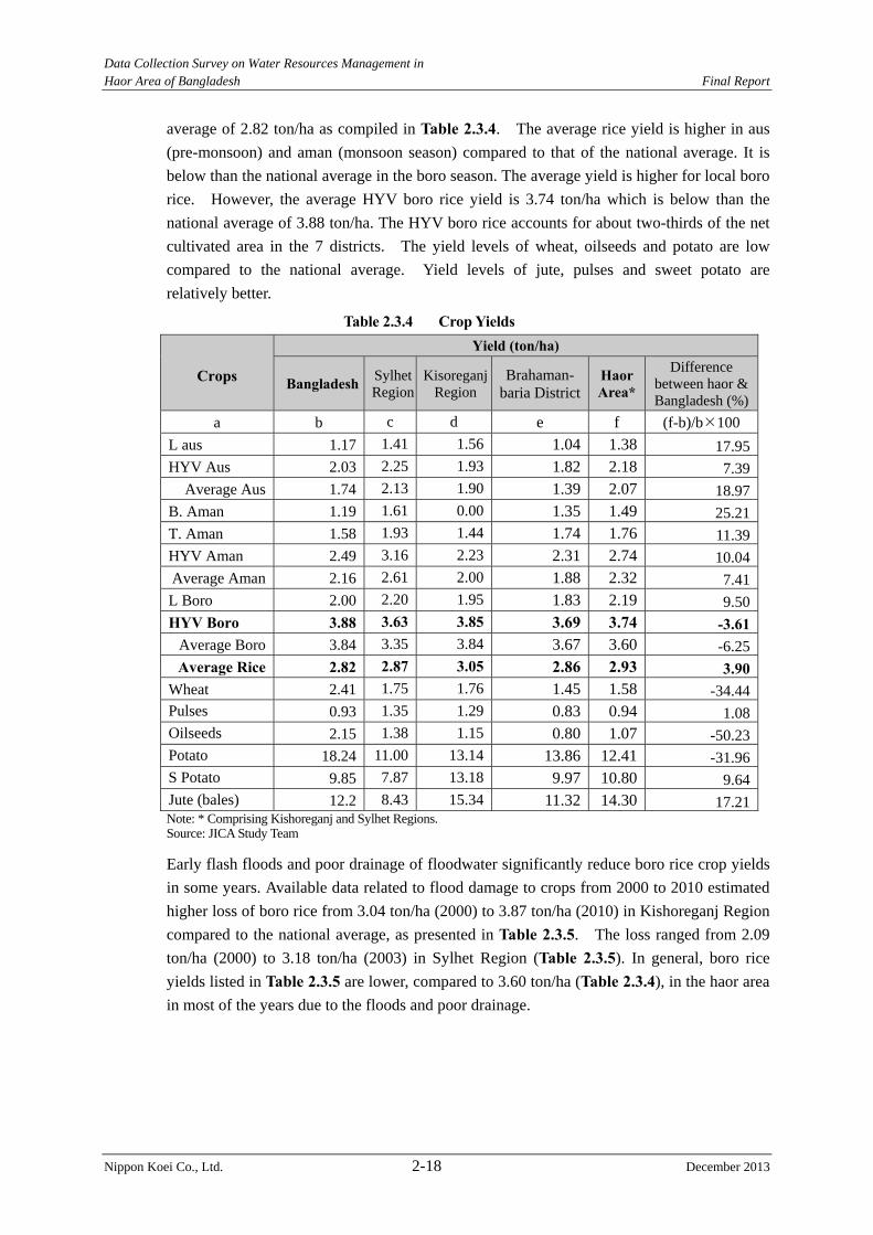
Data Collection Survey on Water Resources Management in Haor Area of Bangladesh Final Report
Nippon Koei Co., Ltd. 2-18 December 2013
average of 2.82 ton/ha as compiled in Table 2.3.4. The average rice yield is higher in aus
(pre-monsoon) and aman (monsoon season) compared to that of the national average. It is
below than the national average in the boro season. The average yield is higher for local boro
rice. However, the average HYV boro rice yield is 3.74 ton/ha which is below than the
national average of 3.88 ton/ha. The HYV boro rice accounts for about two-thirds of the net
cultivated area in the 7 districts. The yield levels of wheat, oilseeds and potato are low
compared to the national average. Yield levels of jute, pulses and sweet potato are
relatively better.
Table 2.3.4 Crop Yields
Crops
Yield (ton/ha)
Bangladesh Sylhet Region
Kisoreganj Region
Brahaman- baria District
Haor Area*
Difference between haor & Bangladesh (%)
a b c d e f (f-b)/b100
L aus 1.17 1.41 1.56 1.04 1.38 17.95HYV Aus 2.03 2.25 1.93 1.82 2.18 7.39
Average Aus 1.74 2.13 1.90 1.39 2.07 18.97B. Aman 1.19 1.61 0.00 1.35 1.49 25.21T. Aman 1.58 1.93 1.44 1.74 1.76 11.39HYV Aman 2.49 3.16 2.23 2.31 2.74 10.04Average Aman 2.16 2.61 2.00 1.88 2.32 7.41L Boro 2.00 2.20 1.95 1.83 2.19 9.50HYV Boro 3.88 3.63 3.85 3.69 3.74 -3.61
Average Boro 3.84 3.35 3.84 3.67 3.60 -6.25Average Rice 2.82 2.87 3.05 2.86 2.93 3.90
Wheat 2.41 1.75 1.76 1.45 1.58 -34.44Pulses 0.93 1.35 1.29 0.83 0.94 1.08Oilseeds 2.15 1.38 1.15 0.80 1.07 -50.23Potato 18.24 11.00 13.14 13.86 12.41 -31.96S Potato 9.85 7.87 13.18 9.97 10.80 9.64Jute (bales) 12.2 8.43 15.34 11.32 14.30 17.21Note: * Comprising Kishoreganj and Sylhet Regions. Source: JICA Study Team
Early flash floods and poor drainage of floodwater significantly reduce boro rice crop yields
in some years. Available data related to flood damage to crops from 2000 to 2010 estimated
higher loss of boro rice from 3.04 ton/ha (2000) to 3.87 ton/ha (2010) in Kishoreganj Region
compared to the national average, as presented in Table 2.3.5. The loss ranged from 2.09
ton/ha (2000) to 3.18 ton/ha (2003) in Sylhet Region (Table 2.3.5). In general, boro rice
yields listed in Table 2.3.5 are lower, compared to 3.60 ton/ha (Table 2.3.4), in the haor area
in most of the years due to the floods and poor drainage.
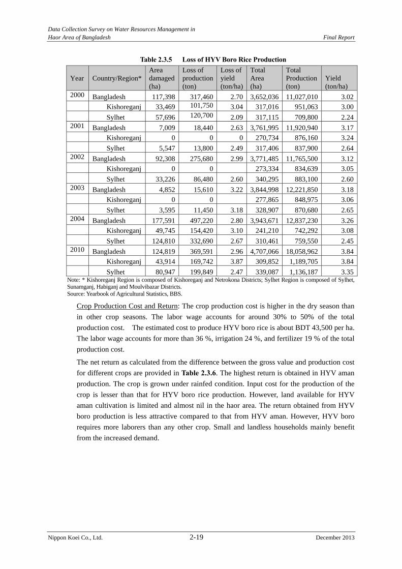
Data Collection Survey on Water Resources Management in Haor Area of Bangladesh Final Report
Nippon Koei Co., Ltd. 2-19 December 2013
Table 2.3.5 Loss of HYV Boro Rice Production
Year Country/Region* Area damaged(ha)
Loss of production(ton)
Loss ofyield (ton/ha)
Total Area (ha)
Total Production (ton)
Yield (ton/ha)
2000 Bangladesh 117,398 317,460 2.70 3,652,036 11,027,010 3.02 Kishoreganj 33,469 101,750 3.04 317,016 951,063 3.00 Sylhet 57,696 120,700 2.09 317,115 709,800 2.242001 Bangladesh 7,009 18,440 2.63 3,761,995 11,920,940 3.17 Kishoreganj 0 0 0 270,734 876,160 3.24 Sylhet 5,547 13,800 2.49 317,406 837,900 2.642002 Bangladesh 92,308 275,680 2.99 3,771,485 11,765,500 3.12 Kishoreganj 0 0 273,334 834,639 3.05 Sylhet 33,226 86,480 2.60 340,295 883,100 2.602003 Bangladesh 4,852 15,610 3.22 3,844,998 12,221,850 3.18 Kishoreganj 0 0 277,865 848,975 3.06 Sylhet 3,595 11,450 3.18 328,907 870,680 2.652004 Bangladesh 177,591 497,220 2.80 3,943,671 12,837,230 3.26 Kishoreganj 49,745 154,420 3.10 241,210 742,292 3.08 Sylhet 124,810 332,690 2.67 310,461 759,550 2.452010 Bangladesh 124,819 369,591 2.96 4,707,066 18,058,962 3.84 Kishoreganj 43,914 169,742 3.87 309,852 1,189,705 3.84 Sylhet 80,947 199,849 2.47 339,087 1,136,187 3.35
Note: * Kishoreganj Region is composed of Kishoreganj and Netrokona Districts; Sylhet Region is composed of Sylhet, Sunamganj, Habiganj and Moulvibazar Districts. Source: Yearbook of Agricultural Statistics, BBS.
Crop Production Cost and Return: The crop production cost is higher in the dry season than
in other crop seasons. The labor wage accounts for around 30% to 50% of the total
production cost. The estimated cost to produce HYV boro rice is about BDT 43,500 per ha.
The labor wage accounts for more than 36 %, irrigation 24 %, and fertilizer 19 % of the total
production cost.
The net return as calculated from the difference between the gross value and production cost
for different crops are provided in Table 2.3.6. The highest return is obtained in HYV aman
production. The crop is grown under rainfed condition. Input cost for the production of the
crop is lesser than that for HYV boro rice production. However, land available for HYV
aman cultivation is limited and almost nil in the haor area. The return obtained from HYV
boro production is less attractive compared to that from HYV aman. However, HYV boro
requires more laborers than any other crop. Small and landless households mainly benefit
from the increased demand.
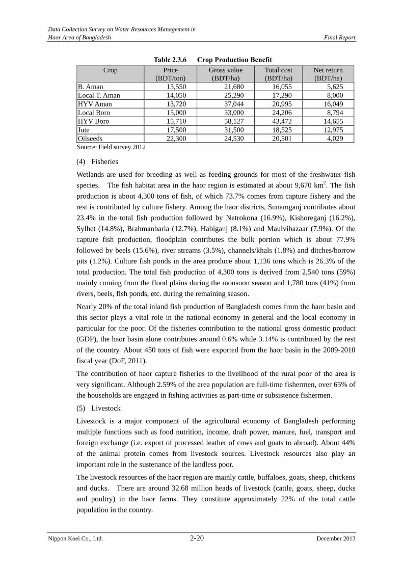
Data Collection Survey on Water Resources Management in Haor Area of Bangladesh Final Report
Nippon Koei Co., Ltd. 2-20 December 2013
Table 2.3.6 Crop Production Benefit
Crop Price (BDT/ton)
Gross value (BDT/ha)
Total cost (BDT/ha)
Net return (BDT/ha)
B. Aman 13,550 21,680 16,055 5,625 Local T. Aman 14,050 25,290 17,290 8,000 HYV Aman 13,720 37,044 20,995 16,049 Local Boro 15,000 33,000 24,206 8,794 HYV Boro 15,710 58,127 43,472 14,655 Jute 17,500 31,500 18,525 12,975 Oilseeds 22,300 24,530 20,501 4,029 Source: Field survey 2012
(4) Fisheries
Wetlands are used for breeding as well as feeding grounds for most of the freshwater fish
species. The fish habitat area in the haor region is estimated at about 9,670 km2. The fish
production is about 4,300 tons of fish, of which 73.7% comes from capture fishery and the
rest is contributed by culture fishery. Among the haor districts, Sunamganj contributes about
23.4% in the total fish production followed by Netrokona (16.9%), Kishoreganj (16.2%),
Sylhet (14.8%), Brahmanbaria (12.7%), Habiganj (8.1%) and Maulvibazaar (7.9%). Of the
capture fish production, floodplain contributes the bulk portion which is about 77.9%
followed by beels (15.6%), river streams (3.5%), channels/khals (1.8%) and ditches/borrow
pits (1.2%). Culture fish ponds in the area produce about 1,136 tons which is 26.3% of the
total production. The total fish production of 4,300 tons is derived from 2,540 tons (59%)
mainly coming from the flood plains during the monsoon season and 1,780 tons (41%) from
rivers, beels, fish ponds, etc. during the remaining season.
Nearly 20% of the total inland fish production of Bangladesh comes from the haor basin and
this sector plays a vital role in the national economy in general and the local economy in
particular for the poor. Of the fisheries contribution to the national gross domestic product
(GDP), the haor basin alone contributes around 0.6% while 3.14% is contributed by the rest
of the country. About 450 tons of fish were exported from the haor basin in the 2009-2010
fiscal year (DoF, 2011).
The contribution of haor capture fisheries to the livelihood of the rural poor of the area is
very significant. Although 2.59% of the area population are full-time fishermen, over 65% of
the households are engaged in fishing activities as part-time or subsistence fishermen.
(5) Livestock
Livestock is a major component of the agricultural economy of Bangladesh performing
multiple functions such as food nutrition, income, draft power, manure, fuel, transport and
foreign exchange (i.e. export of processed leather of cows and goats to abroad). About 44%
of the animal protein comes from livestock sources. Livestock resources also play an
important role in the sustenance of the landless poor.
The livestock resources of the haor region are mainly cattle, buffaloes, goats, sheep, chickens
and ducks. There are around 32.68 million heads of livestock (cattle, goats, sheep, ducks
and poultry) in the haor farms. They constitute approximately 22% of the total cattle
population in the country.
Data Collection Survey on Water Resources Management in Haor Area of Bangladesh Final Report
Nippon Koei Co., Ltd. 2-21 December 2013
(6) Industry
Industrialization has not taken place to a great extent in the Northeast Region and
consequently the number of industries and people engaged is comparatively low (1.33% of
the total population only). However, most of the tea estates are in the Sylhet Region.
Furthermore, the industrial product of the Sylhet Region includes fertilizer, cement and
liquefied petroleum (propane) gas.
The industrial economy of the haor area is based on cottage and tea processing industries.
(7) Electricity
Energy is one of the factors that support and accelerate growth of the country. The
electricity supply in the haor area in general is far from sufficient compared with its demand.
The Rural Electrification Board (REB) is entrusted with the distribution of electricity in the
rural areas of Bangladesh. The total number of villages receiving electricity by 2010 was
6,740 out of 15,374, accounting for 44% as compared to 72% nationwide. As compared to
the nationwide average consumption of about 200 kWh per capita, the haor area showed only
47 kWh in 2010. Sunamganj District had the lowest consumption of electricity with only 17
kWh per capita followed by Kishoreganj and Netrakona.
(8) Water Supply
Most of the households in the haor area are using tube-well water (groundwater) for drinking
purpose. About 50% of the households are dependent on surrounding river/pond water for
domestic use. As a result, in spite of having good and safe water access, the haor people are
affected by many water-borne diseases.
(9) Sanitation
Bangladesh is on its way to achieve the MDGs targets, attesting to marked progress
compared to other developing countries. However, burdened with poverty and stressed
with infrastructure inadequacy, the overall health status in the haor region continues to lag
behind the national benchmark with the prevalence of both communicable and
non-communicable diseases. The sanitation facilities of the haor area are poor compared to
other parts of the country. Use of sanitary latrine is only 44% in the haor area (Haor MP,
2012). Flooding, high water table, excessive rainfall and loose soil formation are the causes
of overflow and collapse of pit latrines.
(10) Education
The average literacy rate of the haor districts is 38%, while the national level is at 54.8%.
Among the haor districts, Moulivibazaar has the highest literate population (42%), followed
by Sylhet (41%), Brahmanbaria (40%), Habiganj (37%), Kishoreganj (37%), Netrokona
(34%), and Sunamganj (33%). The distribution of educational institutes is shown in Table 2.3.7

Data Collection Survey on Water Resources Management in Haor Area of Bangladesh Final Report
Nippon Koei Co., Ltd. 2-22 December 2013
Table 2.3.7 District-wise Educational Institutes
District Primaryschool High school College Vocational
school Sunamganj 1,447 149 27 2 Habiganj 1,053 108 22 2 Netrokona 1,166 186 30 6 Kishoreganj 1,305 202 30 9 Sylhet 1,350 256 60 3 Maulvibazar 1,027 141 27 - Brahmanbaria 1,033 182 36 7 Haor Area Total 8,381 1,224 232 29
Source: MoE, 2010 and BBS, 2010
(11) Health
The overall health status in the haor region continues to lag behind the national benchmark
with the prevalence of both communicable and non-communicable diseases. The malaria
endemic districts of Habiganj, Maulvibazaar, Netrokona, Sunamgonj and Sylhet had 5,345
numbers of case loads in 2009 (DGHS 2010).
The average infant mortality rate (IMR) and under-5 child mortality rate (U5MR) in the haor
area, except for Brahmanbaria District, is 57 (per 1,000 infants) and 76 (per 1,000 children)
which are higher than the national IMR of 49 and U5MR of 64. The high infant and child
mortality is also due to malnutrition. The average of under-5 child malnutrition for haor
districts is approximately 46%, which is again higher than the national rate of 43% (BDHS
2007).
(12) Road Transport
Haor areas remain flooded under water for 4-6 months during the pre-monsoon and monsoon
seasons. The roads are submerged during these seasons making it impossible to travel from
one place to another without using boats. The transportation networks of waterways and
roadways have developed over the years in keeping with the unique characteristics of the
haors.
The Bangladesh Roads and Highways Department (RHD) is responsible for constructing
roads at the national, regional and district levels. The rural roads consisting of Upazila7,
union8 and village roads are constructed by the Local Government Engineering Department
(LGED). Eleven upazilas out of the total 69 upazilas in the haor districts are not connected
with the RHD network.
(13) Inland Navigation
Inland waterways have been used as a major way of transporting cargo and passengers in the
haor area. There are 25 inland water transport (IWT) routes covering a length of 1828.8 km
of inland waterways, which remain navigable during the monsoon season (May-September).
However, during the lean period (October-April) inland vessels cannot navigate in about
1,000 km of the waterways.
7 Districts of Bangladesh are divided into sub-districts called “Upazila” 8 Upazilas of Bangladesh are administratively divided into sub-upazilas, called "Union", which is the smallest rural administrative and local government unit in Bangladesh and usually composed of nine villages (Ward).
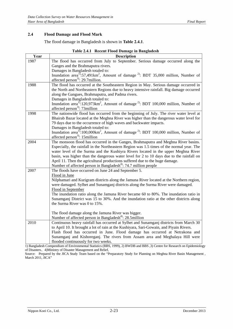
Data Collection Survey on Water Resources Management in Haor Area of Bangladesh Final Report
Nippon Koei Co., Ltd. 2-23 December 2013
2.4 Flood Damage and Flood Mark
The flood damage in Bangladesh is shown in Table 2.4.1.
Table 2.4.1 Recent Flood Damage in Bangladesh Year Description
1987 The flood has occurred from July to September. Serious damage occurred along the Ganges and the Brahmaputra rivers. Damages in Bangladesh totaled to: Inundation area1):57,491km2, Amount of damage 2): BDT 35,000 million, Number of affected person3): 29.7million.
1988 The flood has occurred at the Southeastern Region in May. Serious damage occurred in the North and Northeastern Regions due to heavy intensive rainfall. Big damage occurred along the Gangues, Brahmaputra, and Padma rivers. Damages in Bangladesh totaled to: Inundation area1):120,973km2, Amount of damage 2): BDT 100,000 million, Number of affected person3): 73million
1998 The nationwide flood has occurred from the beginning of July. The river water level at Bhairab Bazar located at the Meghna River was higher than the dangerous water level for 79 days due to the occurrence of high waves and backwater impacts. Damages in Bangladesh totaled to: Inundation area1):100,000km2, Amount of damage 2): BDT 100,000 million, Number of affected person3): 15million
2004 The monsoon flood has occurred in the Ganges, Brahmaputra and Meghna River basins. Especially, the rainfall in the Northeastern Region was 1.5 times of the normal year. The water level of the Surma and the Kushiyra Rivers located in the upper Meghna River basin, was higher than the dangerous water level for 2 to 10 days due to the rainfall on April 11. Then the agricultural productions suffered due to the huge damage. Number of affected person in Bangladesh4): 74.7 million people
2007 The floods have occurred on June 24 and September 5. Flood in June Nilphamari and Kurigram districts along the Jamuna River located at the Northern region, were damaged. Sylhet and Sunamganj districts along the Surma River were damaged. Flood in September The inundation ratio along the Jamuna River became 60 to 80%. The inundation ratio in Sunamganj District was 15 to 30%. And the inundation ratio at the other districts along the Surma River was 0 to 15%. The flood damage along the Jamuna River was bigger. Number of affected person in Bangladesh4): 28.5million
2010 Continuous heavy rainfall has occurred at Sylhet and Sunamganj districts from March 30 to April 10. It brought a lot of rain at the Kushiyara, Sari-Gowain, and Piyain Rivers. Flash flood has occurred in June. Flood damage has occurred at Netrakona and Sunamganj and Kishoreganj. The rivers from Assam area and Meghalaya Hill were flooded continuously for two weeks.
1) Bangladesh Compendium of Environmental Statistics (BBS, 1999), 2) BWDB and BBS ,3) Centre for Research on Epidemiology of Disasters、4)Ministry of Disaster Management and Relief, Source: Prepared by the JICA Study Team based on the “Preparatory Study for Planning on Meghna River Basin Management , March 2011, JICA”
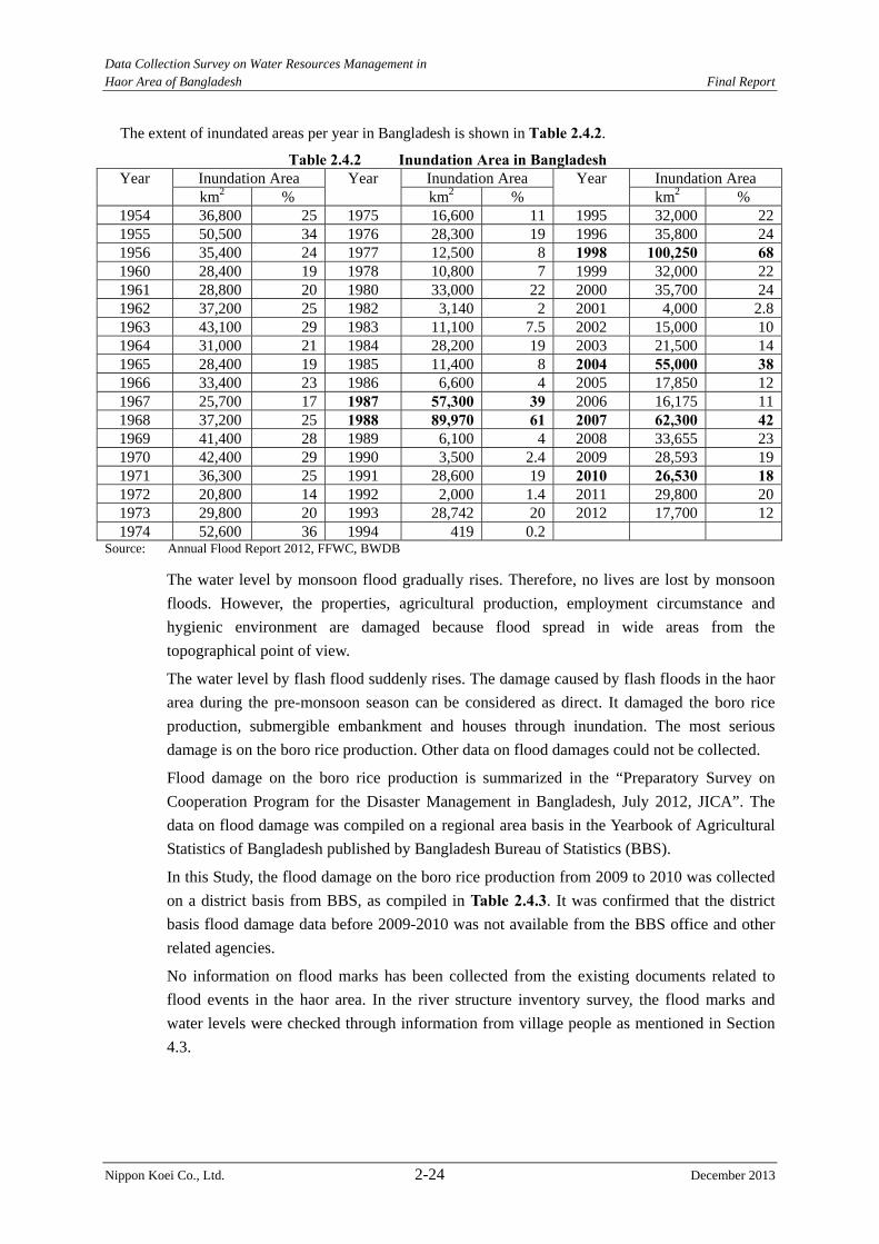
Data Collection Survey on Water Resources Management in Haor Area of Bangladesh Final Report
Nippon Koei Co., Ltd. 2-24 December 2013
The extent of inundated areas per year in Bangladesh is shown in Table 2.4.2.
Table 2.4.2 Inundation Area in Bangladesh Year Inundation Area Year Inundation Area Year Inundation Area
km2 % km2 % km2 % 1954 36,800 25 1975 16,600 11 1995 32,000 221955 50,500 34 1976 28,300 19 1996 35,800 241956 35,400 24 1977 12,500 8 1998 100,250 681960 28,400 19 1978 10,800 7 1999 32,000 221961 28,800 20 1980 33,000 22 2000 35,700 241962 37,200 25 1982 3,140 2 2001 4,000 2.81963 43,100 29 1983 11,100 7.5 2002 15,000 101964 31,000 21 1984 28,200 19 2003 21,500 141965 28,400 19 1985 11,400 8 2004 55,000 381966 33,400 23 1986 6,600 4 2005 17,850 121967 25,700 17 1987 57,300 39 2006 16,175 111968 37,200 25 1988 89,970 61 2007 62,300 421969 41,400 28 1989 6,100 4 2008 33,655 231970 42,400 29 1990 3,500 2.4 2009 28,593 191971 36,300 25 1991 28,600 19 2010 26,530 181972 20,800 14 1992 2,000 1.4 2011 29,800 201973 29,800 20 1993 28,742 20 2012 17,700 121974 52,600 36 1994 419 0.2
Source: Annual Flood Report 2012, FFWC, BWDB
The water level by monsoon flood gradually rises. Therefore, no lives are lost by monsoon
floods. However, the properties, agricultural production, employment circumstance and
hygienic environment are damaged because flood spread in wide areas from the
topographical point of view.
The water level by flash flood suddenly rises. The damage caused by flash floods in the haor
area during the pre-monsoon season can be considered as direct. It damaged the boro rice
production, submergible embankment and houses through inundation. The most serious
damage is on the boro rice production. Other data on flood damages could not be collected.
Flood damage on the boro rice production is summarized in the “Preparatory Survey on
Cooperation Program for the Disaster Management in Bangladesh, July 2012, JICA”. The
data on flood damage was compiled on a regional area basis in the Yearbook of Agricultural
Statistics of Bangladesh published by Bangladesh Bureau of Statistics (BBS).
In this Study, the flood damage on the boro rice production from 2009 to 2010 was collected
on a district basis from BBS, as compiled in Table 2.4.3. It was confirmed that the district
basis flood damage data before 2009-2010 was not available from the BBS office and other
related agencies.
No information on flood marks has been collected from the existing documents related to
flood events in the haor area. In the river structure inventory survey, the flood marks and
water levels were checked through information from village people as mentioned in Section
4.3.
Data Collection Survey on Water Resources Management in Haor Area of Bangladesh Final Report
Nippon Koei Co., Ltd. 2-25 December 2013
Table 2.4.3 Flash Flood Damage on Boro Rice
(1) Local Boro Rice District Area
(Fully Damaged) (ha)
Area (Partially Damaged) (ha)
Percentage of Full Damage in Partial Damage (%)
Area (Full Damage in Partial Damage) (ha)
Damaged Total Area (ha)
Expected yield (Million ton)/(ha)
Total Production Loss (Million Ton)
Shylet 5,213 6,699 47.94 3,212 8,424 1.69 14,259Moulvibazar 0 0 0.00 0 0 0.00 0Sunamganj 16,132 14,076 41.94 5,903 22,035 1.75 38,658Habiganj 0 194 55.00 107 107 1.47 157Sub-total 21,345 20,969 43.98 30,566 30,566 1.74 53,074Kishorganj 97 43 36.33 113 113 1.92 216Netrokona 316 0 0.00 317 317 1.93 609Sub-total 412 43 36.33 428 428 1.93 825Total 21,757 21,012 43.96 30,995 30,995 1.74 53,899
(2) High Yield Variety Boro Rice District Area
(Fully Damaged) (ha)
Area (Partially Damaged) (ha)
Percentage of Full Damage in Partial Damage (%)
Area (Full Damage in Partial Damage) (ha)
Damaged Total Area (ha)
Expected yield (Million ton)/(ha)
Total Production Loss (Million Ton)
Shylet 8,649 5,087 54.83 2,789 11,438 2.63 30,130Moulvibazar 0 0 0.00 0 0 0.00 0Sunamganj 33,603 10,128 47.64 4,825 38,428 2.99 114,986Habiganj 223 486 60.00 291 514 3.23 1,662Sub-total 42,474 15,700 50.35 7,905 50,379 2.91 146,775Kishorganj 12,093 17,008 33.82 5,917 17,846 3.91 69,744Netrokona 15,996 5,101 51.91 2,648 18,644 3.66 68,255Sub-total 28,098 22,109 38.00 8,401 36,490 3.78 137,999Total 70,564 37,809 43.12 16,306 86,870 3.28 284,774
(3) Hybrid Boro Rice District Area
(Fully Damaged) (ha)
Area (Partially Damaged) (ha)
Percentage of Full Damage in Partial Damage (%)
Area (Full Damage in Partial Damage) (ha)
Damaged Total Area (ha)
Expected yield (Million ton)/(ha)
Total Production Loss (Million Ton)
Shylet 0 0 0.00 0 0 0.00 0Moulvibazar 0 0 0.00 0 0 0.00 0Sunamganj 0 0 0.00 0 0 0.00 0Habiganj 0 0 0.00 0 0 0.00 0Sub-total 0 0 0.00 0 0 0.00 0Kishorganj 3,613 4,427 37.05 1,640 5,253 4.40 23,127Netrokona 1,672 69 40.00 28 1,700 4.58 7,791Sub-total 5,285 4,496 37.09 1,668 6,953 4.45 30,918Total 5,285 4,496 37.09 1,668 6,953 4.45 30,918
Data Collection Survey on Water Resources Management in Haor Area of Bangladesh Final Report
Nippon Koei Co., Ltd. 2-26 December 2013
(4) Total District Area
(Fully Damaged) (ha)
Area (Partially Damaged) (ha)
Percentage of Full Damage in Partial Damage (%)
Area (Full Damage in Partial Damage) (ha)
Damaged Total Area (ha)
Expected yield (Million ton)/(ha)
Total Production Loss (Million Ton)
Shylet 13,861 11,785 50.92 6,001 19,862 2.23 44,389Moulvibazar 0 0 0.00 0 0 0.00 0Sunamganj 49,735 24,204 44.32 10,728 60,463 2.54 153,641Habiganj 223 680 58.57 398 621 2.93 1,819Sub-total 63,819 36,669 46.71 17,127 80,946 2.47 199,849Kishorganj 15,803 21,479 34.49 7,409 23,212 4.01 93,087Netrokona 17,984 5,169 51.75 2,675 20,659 3.71 76,655Sub-total 33,786 65,859 37.84 10,084 43,871 3.87 169,742Total 97,605 63,317 42.98 27,211 124,817 2.96 369,591Note: sub-total means total value of each region, 2009/2010 data Source:BBS (Translation from Bengal language)
Data Collection Survey on Water Resources Management in Haor Area of Bangladesh Final Report
Nippon Koei Co., Ltd. 3-1 December 2013
CHAPTER 3 REVIEW OF STUDY APPROACH TAKEN IN FORMULATION OF THE M/P
3.1 Organization of Working Group
The Working Group (WG) was organized in the initial stage of the first work in Bangladesh
for efficient and smooth practice of the M/P review. The WG is composed of members
from BWDB, which is expected to be the project executing agency, CEGIS, which actually
joined in the formulation of the M/P as a consultant, and the Study Team. The operational
guideline for the WG was prepared, as referred to in Annex 3.1.
During the first work in Bangladesh, three WG meetings were held in the BWDB central
office, Dhaka, on 10 and 23 December 2012 and 14 January 2013, respectively.
The Study Team explained the purpose, members, activities and final outputs of the WG,
among others, by using the said operational guideline at the first WG meeting to share the
same understanding and information about the WG among the members.
3. 2 Findings on Study Approach Taken in Formulation of the M/P
(1) General Study Approach for Water Resources Sector in Haor Area
In the haor area, one of the major problems related to water resources management is
flooding due to flash floods during the pre-monsoon season, which starts either at the end of
April or beginning of May. The traditional measure for protection is construction of
submergible low height embankment which protects crops from the immediate surge of flash
floods. In the M/P, integrated solutions have been derived from engineering solutions based
on the flooding characteristics in the haor area and from the perception of the local people
upholding ecological sustenance in the area.
The primary approach to the solutions is as stated below.
1) Flood depth maps were prepared through the following procedures:
(a) Identification of critical time periods of highest water levels derived from
hydrological analysis,
(b) Collection of flood depths in the floodplains of haor areas at the critical periods
through previous study and field verification, and
(c) Preparation of flood depth maps using the established relation with critical periods
for agriculture practices.
2) Based on the flood depth maps, new engineering but eco-friendly hydraulic structures
were proposed or existing practices were proposed to be continued through managing or
restraining the flood levels at a reasonable extent.
3) The design parameters of existing submergible embankments were reviewed. Then,
suggestions or recommendations were made for better O&M and strengthening of
existing structures.
4) Infrastructure requirements were identified, following the participatory process.
Initially, the infrastructure requirements and location plan were framed out, identifying
problems through physical investigation and consultation with stakeholders.
Data Collection Survey on Water Resources Management in Haor Area of Bangladesh Final Report
Nippon Koei Co., Ltd. 3-2 December 2013
5) Drainage management including dredging and restoration of khals and beels was
addressed to maintain/improve the connectivity between haors and rivers. The
infrastructure requirements were assessed from technical, social and environmental
standpoints, which were identified and verified though stakeholder consultation
meetings.
Regarding the 3) above, the M/P discusses that the strategy for plan formulation should place
importance to (i) resectioning of existing submergible embankments and also (ii) the (a) to
(d) below for strengthening of the O/M of existing structures:
(a) To ensure adequate budget by line agencies,
(b) To ensure adequate logistic support (transportation, computers, etc.) for such field
activities as monitoring and supervision,
(c) To ensure adequate manpower by filling vacant posts in BWDB and recruiting new
professionals, and
(d) To arrange training of stakeholders, including promotion of people’s participation.
This discussion in the M/P is fairly assessed to address a crucial point, in consideration of the
following:
(i) In reality, not a few existing submergible embankments have aggravated a steep slope
problem resulting from lack of appropriate repair/maintenance after slope
failure/erosion due to flowing water attack and flood overtopping, although the
BWDB’s design manual stipulates that the design slope of submergible embankment be
1:3.0.
(ii) The (a) to (d) above keenly point out the vital issues the current O/M practices have
been facing.
(2) Study Approach of Individual Project Identified for Water Resources Sector in
Haor Area
The study approach taken to formulate the WR01, WR02, WR03 and WR05 projects which
have been identified in the M/P for water management in the haor area was confirmed, as
explained below, in the WG meetings and through repeated discussions between the Study
Team and CEGIS.
Stage-1: During preparation of the M/P, public consultation meetings (PCMs) were
organized at upazila level (69 upazilas) to identify the problems, issues and possible remedial
measures. The public consultation meetings were held in the presence of various
stakeholders from each upazila. Almost 29 issues were discussed there, out of which 20
issues had been predetermined and 9 were incorporated through consultation meetings. In
addition, the FAP (Flood Action Plan)-6 report and other relevant documents were reviewed
to identify potential projects for the haor area. The 29 issues of the PCMs are as tabulated
below:
Water resources Graveyards and cremation grounds Water sharing Food godowns and cold storage Agriculture Mini hydropower
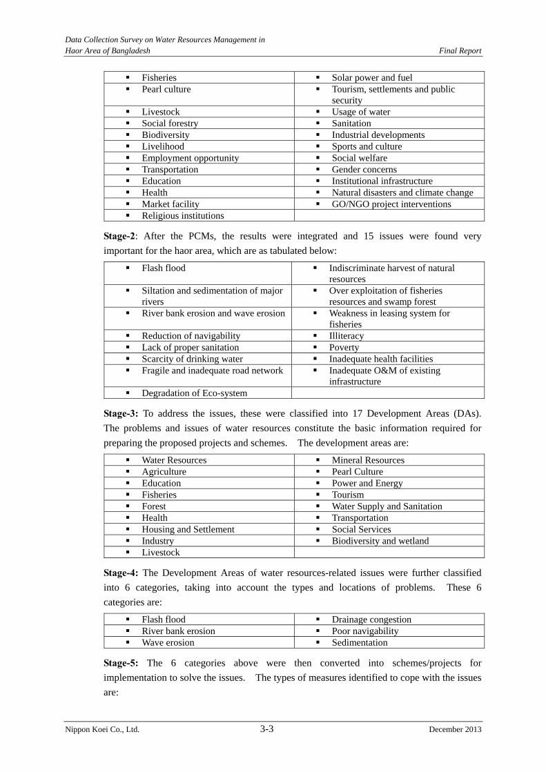
Data Collection Survey on Water Resources Management in Haor Area of Bangladesh Final Report
Nippon Koei Co., Ltd. 3-3 December 2013
Fisheries Solar power and fuel Pearl culture Tourism, settlements and public
security Livestock Usage of water Social forestry Sanitation Biodiversity Industrial developments Livelihood Sports and culture Employment opportunity Social welfare Transportation Gender concerns Education Institutional infrastructure Health Natural disasters and climate change Market facility GO/NGO project interventions Religious institutions
Stage-2: After the PCMs, the results were integrated and 15 issues were found very
important for the haor area, which are as tabulated below:
Flash flood Indiscriminate harvest of natural resources
Siltation and sedimentation of major rivers
Over exploitation of fisheries resources and swamp forest
River bank erosion and wave erosion Weakness in leasing system for fisheries
Reduction of navigability Illiteracy Lack of proper sanitation Poverty Scarcity of drinking water Inadequate health facilities Fragile and inadequate road network Inadequate O&M of existing
infrastructure Degradation of Eco-system
Stage-3: To address the issues, these were classified into 17 Development Areas (DAs).
The problems and issues of water resources constitute the basic information required for
preparing the proposed projects and schemes. The development areas are:
Water Resources Mineral Resources Agriculture Pearl Culture Education Power and Energy Fisheries Tourism Forest Water Supply and Sanitation Health Transportation Housing and Settlement Social Services Industry Biodiversity and wetland Livestock
Stage-4: The Development Areas of water resources-related issues were further classified
into 6 categories, taking into account the types and locations of problems. These 6
categories are:
Flash flood Drainage congestion River bank erosion Poor navigability Wave erosion Sedimentation
Stage-5: The 6 categories above were then converted into schemes/projects for
implementation to solve the issues. The types of measures identified to cope with the issues
are:
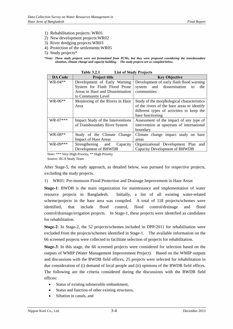
Data Collection Survey on Water Resources Management in Haor Area of Bangladesh Final Report
Nippon Koei Co., Ltd. 3-4 December 2013
1) Rehabilitation projects: WR01 2) New development projects:WR02 3) River dredging projects:WR03 4) Protection of the settlements:WR05 5) Study projects* *Note: These study projects were not formulated from PCMs, but they were proposed considering the transboundary
situation, climate change and capacity building. The study projects are as compiled below.
Table 3.2.1 List of Study Projects DA Code Project title Key Objective
WR-04** Development of Early Warning System for Flash Flood Prone Areas in Haor and Dissemination to Community Level
Development of early flash flood warning system and dissemination to the communities
WR-06** Monitoring of the Rivers in Haor Area
Study of the morphological characteristics of the rivers of the haor areas to identify different types of activities to keep the haor functioning
WR-07*** Impact Study of the Interventions of Transboundary River System
Assessment of the impact of any type of intervention at upstream of international boundary
WR-08** Study of the Climate Change Impact of Haor Areas
Climate change impact study on haor areas
WR-09*** Strengthening and Capacity Development of BHWDB
Organizational Development Plan and Capacity Development of BHWDB
Note: *** Very High Priority, ** High Priority Source: JICA Study Team
After Stage-5, the study approach, as detailed below, was pursued for respective projects,
excluding the study projects.
1) WR01: Pre-monsoon Flood Protection and Drainage Improvement in Haor Areas
Stage-1: BWDB is the main organization for maintenance and implementation of water
resource projects in Bangladesh. Initially, a list of all existing water-related
scheme/projects in the haor area was compiled. A total of 118 projects/schemes were
identified, that include flood control, flood control/drainage and flood
control/drainage/irrigation projects. In Stage-1, these projects were identified as candidates
for rehabilitation.
Stage-2: In Stage-2, the 52 projects/schemes included in DPP/2011 for rehabilitation were
excluded from the projects/schemes identified in Stage-1. The available information on the
66 screened projects were collected to facilitate selection of projects for rehabilitation.
Stage-3: In this stage, the 66 screened projects were considered for selection based on the
outputs of WMIP (Water Management Improvement Project). Based on the WMIP outputs
and discussions with the BWDB field offices, 25 projects were selected for rehabilitation in
due consideration of (i) demand of local people and (ii) opinions of the BWDB field offices.
The following are the criteria considered during the discussions with the BWDB field
offices:
Status of existing submersible embankment,
Status and function of other existing structures,
Siltation in canals, and
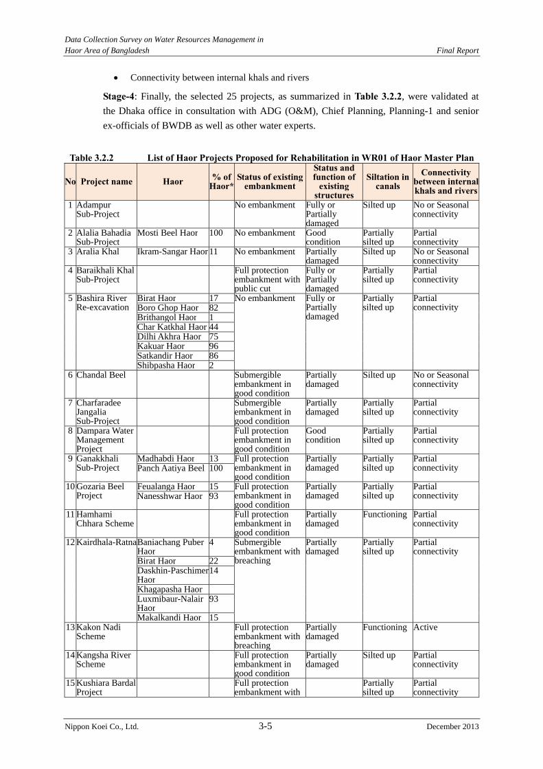
Data Collection Survey on Water Resources Management in Haor Area of Bangladesh Final Report
Nippon Koei Co., Ltd. 3-5 December 2013
Connectivity between internal khals and rivers
Stage-4: Finally, the selected 25 projects, as summarized in Table 3.2.2, were validated at
the Dhaka office in consultation with ADG (O&M), Chief Planning, Planning-1 and senior
ex-officials of BWDB as well as other water experts.
Table 3.2.2 List of Haor Projects Proposed for Rehabilitation in WR01 of Haor Master Plan
No Project name Haor % of Haor*
Status of existing embankment
Status and function of
existing structures
Siltation in canals
Connectivity between internal khals and rivers
1 Adampur Sub-Project
No embankment Fully or Partially damaged
Silted up No or Seasonal connectivity
2 Alalia Bahadia Sub-Project
Mosti Beel Haor 100 No embankment Good condition
Partially silted up
Partial connectivity
3 Aralia Khal Ikram-Sangar Haor 11 No embankment Partially damaged
Silted up No or Seasonal connectivity
4 Baraikhali Khal Sub-Project
Full protection embankment with public cut
Fully or Partially damaged
Partially silted up
Partial connectivity
5 Bashira River Re-excavation
Birat Haor 17 No embankment Fully or Partially damaged
Partially silted up
Partial connectivity Boro Ghop Haor 82
Brithangol Haor 1 Char Katkhal Haor 44 Dilhi Akhra Haor 75 Kakuar Haor 96 Satkandir Haor 86 Shibpasha Haor 2
6 Chandal Beel Submergible embankment in good condition
Partially damaged
Silted up No or Seasonal connectivity
7 Charfaradee Jangalia Sub-Project
Submergible embankment in good condition
Partially damaged
Partially silted up
Partial connectivity
8 Dampara Water Management Project
Full protection embankment in good condition
Good condition
Partially silted up
Partial connectivity
9 Ganakkhali Sub-Project
Madhabdi Haor 13 Full protection embankment in good condition
Partially damaged
Partially silted up
Partial connectivity Panch Aatiya Beel 100
10 Gozaria Beel Project
Feualanga Haor 15 Full protection embankment in good condition
Partially damaged
Partially silted up
Partial connectivity Nanesshwar Haor 93
11 Hamhami Chhara Scheme
Full protection embankment in good condition
Partially damaged
Functioning Partial connectivity
12 Kairdhala-Ratna Baniachang Puber Haor
4 Submergible embankment with breaching
Partially damaged
Partially silted up
Partial connectivity
Birat Haor 22 Daskhin-Paschimer Haor
14
Khagapasha Haor Luxmibaur-Nalair Haor
93
Makalkandi Haor 15 13 Kakon Nadi
Scheme Full protection
embankment with breaching
Partially damaged
Functioning Active
14 Kangsha River Scheme
Full protection embankment in good condition
Partially damaged
Silted up Partial connectivity
15 Kushiara Bardal Project
Full protection embankment with
Partially silted up
Partial connectivity
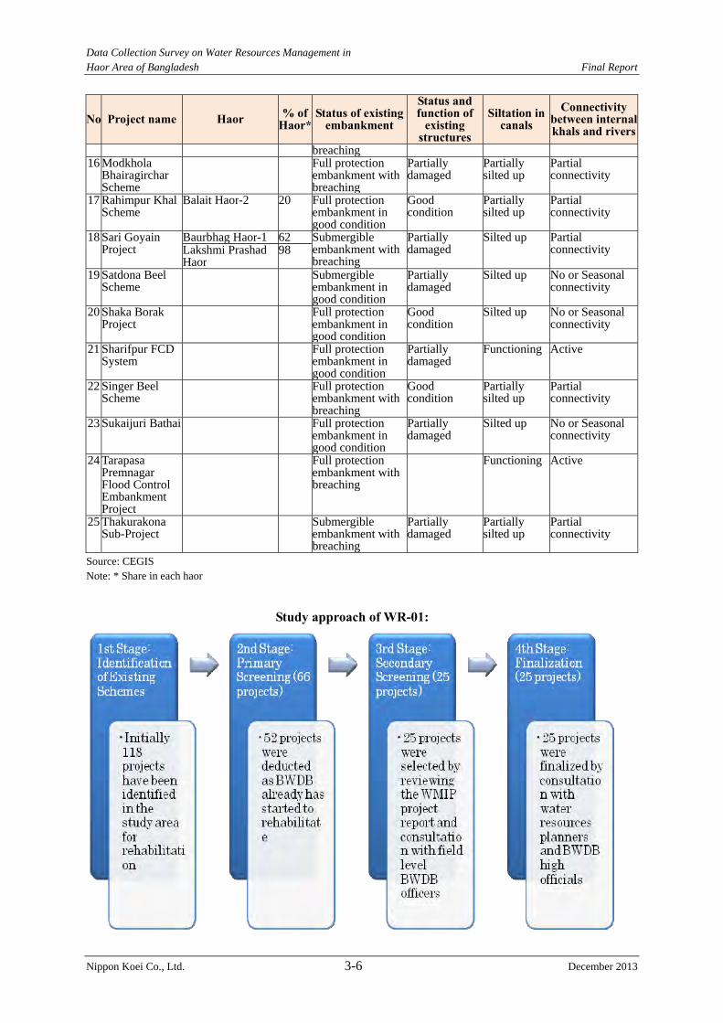
Data Collection Survey on Water Resources Management in Haor Area of Bangladesh Final Report
Nippon Koei Co., Ltd. 3-6 December 2013
No Project name Haor % of Haor*
Status of existing embankment
Status and function of
existing structures
Siltation in canals
Connectivity between internal khals and rivers
breaching16 Modkhola
Bhairagirchar Scheme
Full protection embankment with breaching
Partially damaged
Partially silted up
Partial connectivity
17 Rahimpur Khal Scheme
Balait Haor-2 20 Full protection embankment in good condition
Good condition
Partially silted up
Partial connectivity
18 Sari Goyain Project
Baurbhag Haor-1 62 Submergible embankment with breaching
Partially damaged
Silted up Partial connectivity Lakshmi Prashad
Haor 98
19 Satdona Beel Scheme
Submergible embankment in good condition
Partially damaged
Silted up No or Seasonal connectivity
20 Shaka Borak Project
Full protection embankment in good condition
Good condition
Silted up No or Seasonal connectivity
21 Sharifpur FCD System
Full protection embankment in good condition
Partially damaged
Functioning Active
22 Singer Beel Scheme
Full protection embankment with breaching
Good condition
Partially silted up
Partial connectivity
23 Sukaijuri Bathai Full protection embankment in good condition
Partially damaged
Silted up No or Seasonal connectivity
24 Tarapasa Premnagar Flood Control Embankment Project
Full protection embankment with breaching
Functioning Active
25 Thakurakona Sub-Project
Submergible embankment with breaching
Partially damaged
Partially silted up
Partial connectivity
Source: CEGIS Note: * Share in each haor
Study approach of WR-01:

Data Collection Survey on Water Resources Management in Haor Area of Bangladesh Final Report
Nippon Koei Co., Ltd. 3-7 December 2013
2) WR02: Flood Management of Haor Areas
Stage-1: In consideration of information about the demands of local people collected from
the PCMs and also earlier proposed projects in the haor areas, 39 projects/schemes were
newly formulated. The boundary and location of each project/scheme were determined
based on Digital Elevation Model (DEM), haor locations and hazard maps.
Stage-2: Out of the 39 projects/schemes, 31 were identified as feasible ones based on expert
knowledge, opinions and experiences under the Master Plan of the haor area.
Stage-3: Finally, the identified 31 projects/schemes were validated at the Dhaka office in
consultation with ADG (O&M), Chief Planning, Planning-1 and senior ex-officials of
BWDB as well as renowned water experts. The identified 31 projects/schemes are as
compiled in Table 3.2.3.
Table 3.2.3 List of New Haor Projects Proposed in WR02 of Haor Master Plan
No Scheme name Haor % of Haor* Problems
1 Ayner Gupi Haor
Ayner Gupi Haor 100 Flash flood Siltation and sedimentation of major rivers River bank erosion and wave erosion Fragile and inadequate road network Degradation of Eco-system Indiscriminate harvest of natural resources Over exploitation of fisheries resources and
swamp forest Weakness in leasing system for fisheries Illiteracy Poverty Inadequate O&M of existing infrastructure
2 Badla Project Kataiya Band Haor 42 Flash flood Siltation and sedimentation of major rivers River bank erosion and wave erosion Reduction of navigability Fragile and inadequate road network Degradation of Eco-system Indiscriminate harvest of natural resources Over exploitation of fisheries resources and
swamp forest Weakness in leasing system for fisheries Poverty Inadequate O&M of existing infrastructure
3 Banaiya Haor Banaiya Haor 100 River bank erosion and wave erosion Scarcity of drinking water Degradation of Eco-system Indiscriminate harvest of natural resources Over exploitation of fisheries resources and
swamp forest Weakness in leasing system for fisheries Inadequate O&M of existing infrastructure
4 Bansharir Haor Bansharir Haor 100 Flash flood Siltation and sedimentation of major rivers Reduction of navigability Poverty Inadequate O&M of existing infrastructure
5 Bara Haor Boro Haor(Netrokona) 62 Flash flood Reduction of navigability Lack of proper sanitation Poverty
Digli Beel 100Sonadubi Haor 56
6 Boro Haor(Austagram)
Boro Haor(Austagram) 100 Flash flood Siltation and sedimentation of major rivers River bank erosion and wave erosion Degradation of Eco-system
Chaudanta Band Haor 100Goradigha Haor 100Mithamain Dhakhin Haor 100
Data Collection Survey on Water Resources Management in Haor Area of Bangladesh Final Report
Nippon Koei Co., Ltd. 3-8 December 2013
No Scheme name Haor % of Haor* Problems
Pathar Char Bandh Haor 100 Indiscriminate harvest of natural resources Over exploitation of fisheries resources and
swamp forest Weakness in leasing system for fisheries Inadequate health facilities Poverty Inadequate O&M of existing infrastructure
7 Boro Haor(Nikli)
Bariar Haor 100 Flash flood Siltation and sedimentation of major rivers River bank erosion and wave erosion Inadequate health facilities Poverty Inadequate O&M of existing infrastructure
Boro Haor(Kishoreganj) 100Kaliain Beel Haor (Borar Haor)
100
Kaliar Beel 100Paschimband Haor 100
8 Chandpur Haor Chandpur Haor 100 Flash flood Siltation and sedimentation of major rivers River bank erosion and wave erosion Poverty Inadequate O&M of existing infrastructure
9 Charigram Project
Khunkhuni Haor 46 Flash flood Siltation and sedimentation of major rivers River bank erosion and wave erosion Lack of proper sanitation Fragile and inadequate road network Degradation of Eco-system Indiscriminate harvest of natural resources Over exploitation of fisheries resources and
swamp forest Weakness in leasing system for fisheries Inadequate health facilities Illiteracy Poverty
10 Chatal Haor Chatal Haor 100 Flash flood Siltation and sedimentation of major rivers River bank erosion and wave erosion Reduction of navigability Fragile and inadequate road network Degradation of Eco-system Indiscriminate harvest of natural resources Over exploitation of fisheries resources and
swamp forest Weakness in leasing system for fisheries Poverty Inadequate O&M of existing infrastructure
11 Dakhshiner Haor
Dakhshiner Haor 100 Flash flood Siltation and sedimentation of major rivers River bank erosion and wave erosion Lack of proper sanitation Fragile and inadequate road network Degradation of Eco-system Indiscriminate harvest of natural resources Over exploitation of fisheries resources and
swamp forest Weakness in leasing system for fisheries Poverty Inadequate O&M of existing infrastructure
12 Dhakua Haor Dhakua Haor 100 Flash flood Siltation and sedimentation of major rivers River bank erosion and wave erosion Reduction of navigability Lack of proper sanitation Degradation of Eco-system Indiscriminate harvest of natural resources Over exploitation of fisheries resources and
swamp forest Weakness in leasing system for fisheries Inadequate health facilities
Data Collection Survey on Water Resources Management in Haor Area of Bangladesh Final Report
Nippon Koei Co., Ltd. 3-9 December 2013
No Scheme name Haor % of Haor* Problems
Illiteracy Poverty Inadequate O&M of existing infrastructure
13 Dharmapasha Rui Beel
Atla Beel Haor 100 Flash flood Siltation and sedimentation of major rivers River bank erosion and wave erosion Degradation of Eco-system Indiscriminate harvest of natural resources Over exploitation of fisheries resources and
swamp forest Weakness in leasing system for fisheries Poverty Inadequate O&M of existing infrastructure
Chichrar Haor 97Choto Hijla- Baro Hijlar Beel Haor
98
Goradoba Haor 11Holdir Haor 94Jaldhara/ Keuti Haor 100Kahilani-Sreekuli Haor 99Kainjar Haor 5Kalianibeel Haor 96Kalnikuri Beel 100Kumuria Beel Haor 100Medar Beel-2 Haor 99Morichapuri Haor 97Naya Beel Haor 98Ruiyer Beel Haor 100Shaldighar Haor 99Soilchapra Haor 100Togar Haor 100
14 Dubriary Haor Dubriary Haor 100 Flash flood Siltation and sedimentation of major rivers River bank erosion and wave erosion Lack of proper sanitation Scarcity of drinking water Degradation of Eco-system Indiscriminate harvest of natural resources Over exploitation of fisheries resources and
swamp forest Weakness in leasing system for fisheries Inadequate health facilities Inadequate O&M of existing infrastructure
15 Dulalpur Haor Dulalpur Haor-1 100 Flash flood Siltation and sedimentation of major rivers River bank erosion and wave erosion Degradation of Eco-system Indiscriminate harvest of natural resources Over exploitation of fisheries resources and
swamp forest Weakness in leasing system for fisheries Poverty Inadequate O&M of existing infrastructure
16 Ganesh Haor Ganesh Haor 100 Flash flood Reduction of navigability Poverty Inadequate O&M of existing infrastructure
17 Golaimara Haor Golaimara Haor 100 Flash flood Siltation and sedimentation of major rivers River bank erosion and wave erosion Illiteracy Poverty
18 Jaliar Haor Jaliar Haor 100 Siltation and sedimentation of major rivers Scarcity of drinking water Poverty
19 Joyariya Haor Joyariya Haor 100 Flash flood Siltation and sedimentation of major rivers River bank erosion and wave erosion Illiteracy Poverty Inadequate O&M of existing infrastructure
20 Korati Beel Bhusha Kanda Beel Haor 100 Flash flood
Data Collection Survey on Water Resources Management in Haor Area of Bangladesh Final Report
Nippon Koei Co., Ltd. 3-10 December 2013
No Scheme name Haor % of Haor* Problems
Haor Korati Beel Haor 100 Siltation and sedimentation of major rivers River bank erosion and wave erosion Fragile and inadequate road network Poverty
21 Kuniarbandh Haor
Dulalpur haor 100 Flash flood Siltation and sedimentation of major rivers River bank erosion and wave erosion Degradation of Eco-system Indiscriminate harvest of natural resources Over exploitation of fisheries resources and
swamp forest Weakness in leasing system for fisheries Illiteracy Poverty Inadequate O&M of existing infrastructure
Kuniarbandh Haor 100
22 Mokhar Haor Mokhar Haor 100 Flash flood Siltation and sedimentation of major rivers River bank erosion and wave erosion Inadequate health facilities Poverty Inadequate O&M of existing infrastructure
23 Muktarpur Haor
Muktarpur Haor 100 Flash flood Siltation and sedimentation of major rivers River bank erosion and wave erosion Scarcity of drinking water Degradation of Eco-system Indiscriminate harvest of natural resources Over exploitation of fisheries resources and
swamp forest Weakness in leasing system for fisheries Inadequate O&M of existing infrastructure
24 Muria Haor Muria Haor 100 Siltation and sedimentation of major rivers River bank erosion and wave erosion Reduction of navigability Lack of proper sanitation Degradation of Eco-system Indiscriminate harvest of natural resources Over exploitation of fisheries resources and
swamp forest Weakness in leasing system for fisheries Inadequate O&M of existing infrastructure
25 Naogaon Haor Gopdighi Haor 100 Flash flood Siltation and sedimentation of major rivers River bank erosion and wave erosion Lack of proper sanitation Degradation of Eco-system Indiscriminate harvest of natural resources Over exploitation of fisheries resources and
swamp forest Weakness in leasing system for fisheries Inadequate health facilities Illiteracy Poverty Inadequate O&M of existing infrastructure
Madhainagar haor 100Mithamain Uttar Haor 100Naogaon Haor 100
26 Noapara Haor Bhatibaratia Haor 100 Flash flood Siltation and sedimentation of major rivers River bank erosion and wave erosion Fragile and inadequate road network Poverty Inadequate O&M of existing infrastructure
Noapara Haor 100
27 Nunnir Haor Bullar Haor 100 Flash flood Siltation and sedimentation of major rivers River bank erosion and wave erosion Degradation of Eco-system Indiscriminate harvest of natural resources Over exploitation of fisheries resources and
Guja Haor 100Gurai Haor 100Jaraitala Haor 100Nunnir Haor 100
Data Collection Survey on Water Resources Management in Haor Area of Bangladesh Final Report
Nippon Koei Co., Ltd. 3-11 December 2013
No Scheme name Haor % of Haor* Problems
swamp forest Weakness in leasing system for fisheries Poverty Inadequate O&M of existing infrastructure
28 Rautir Haor Rautir Haor 100 Flash flood Reduction of navigability Degradation of Eco-system Indiscriminate harvest of natural resources Over exploitation of fisheries resources and
swamp forest Weakness in leasing system for fisheries Inadequate O&M of existing infrastructure
io Sarishapur Haor
Goyila Halda haor 100 Flash flood Siltation and sedimentation of major rivers River bank erosion and wave erosion Degradation of Eco-system Indiscriminate harvest of natural resources Over exploitation of fisheries resources and
swamp forest Weakness in leasing system for fisheries Illiteracy Poverty Inadequate O&M of existing infrastructure
Lahundi Haor 100Sarishapur Haor 100
30 Shelnir Haor Shelnir Haor 100 Siltation and sedimentation of major rivers Lack of proper sanitation Degradation of Eco-system Indiscriminate harvest of natural resources Over exploitation of fisheries resources and
swamp forest Weakness in leasing system for fisheries Poverty
31 Sunair Haor Sunair Haor 100 Flash flood Siltation and sedimentation of major rivers Reduction of navigability Illiteracy Poverty Inadequate O&M of existing infrastructure
Note: * Share of each haor
Study approach of WR-02:
3) WR03: River Dredging and Development of Settlement
Stage-1: The haor area has two major river systems; namely, the Surma-Baulai-Gorautra and
the Kalni Kushiyara river systems. These two river systems with their tributaries have been
carrying sediment load into the haor area from India. In 2011, river dredging was initiated
in the Kalni-Kushiyara river system by BWDB under their development project. Therefore,
only the Surma-Baulai-Gorauttara river system with its tributaries was considered in the
dredging plan of the M/P.
Stage-2: The Northeast Regional Water Management Plan and other relevant documents
were reviewed to identify the potential rivers for dredging in the haor area. In the NE Water
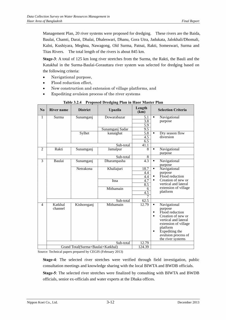
Data Collection Survey on Water Resources Management in Haor Area of Bangladesh Final Report
Nippon Koei Co., Ltd. 3-12 December 2013
Management Plan, 20 river systems were proposed for dredging. These rivers are the Baida,
Baulai, Chamti, Darai, Dhalai, Dhaleswari, Dhanu, Gora Utra, Jadukata, Jalokhali/Dhomali,
Kalni, Kushiyara, Meghna, Nawagong, Old Surma, Patnai, Rakti, Someswari, Surma and
Titas Rivers. The total length of the rivers is about 845 km.
Stage-3: A total of 125 km long river stretches from the Surma, the Rakti, the Bauli and the
Katakhal in the Surma-Baulai-Gorauttara river system was selected for dredging based on
the following criteria:
Navigational purpose, Flood reduction effect, New construction and extension of village platforms, and Expediting avulsion process of the river systems
Table 3.2.4 Proposed Dredging Plan in Haor Master Plan
No River name District Upazila Length (km) Selection Criteria
1 Surma Sunamganj Dowarabazar 5.1 Navigational purpose 3.8
5.9Sunamganj Sadar 9.5
Sylhet kanaighat 5.8 Dry season flow diversion 4.5
6.5Sub-total 41.1
2 Rakti Sunamganj Jamalpur 8 Navigational purpose
Sub-total 8 3 Baulai Sunamganj Dharampasha 4.3 Navigational
purpose Netrakona Khaliajuri 18.7 Navigational
purpose Flood reduction Creation of new or
vertical and lateral extension of village platform
4.44.4
Itna 4.78.5
Mithamain 64.5
7Sub-total 62.5
4 Katkhal channel
Kishoreganj Mithamain 12.79 Navigational purpose
Flood reduction Creation of new or
vertical and lateral extension of village platform
Expediting the avulsion process of the river systems
Sub-total 12.79 Grand Total(Surma+Baulai+Katkhal) 124.39
Source: Technical papers prepared by CEGIS (February 2013)
Stage-4: The selected river stretches were verified through field investigation, public
consultation meetings and knowledge sharing with the local BIWTA and BWDB officials.
Stage-5: The selected river stretches were finalized by consulting with BIWTA and BWDB
officials, senior ex-officials and water experts at the Dhaka offices.
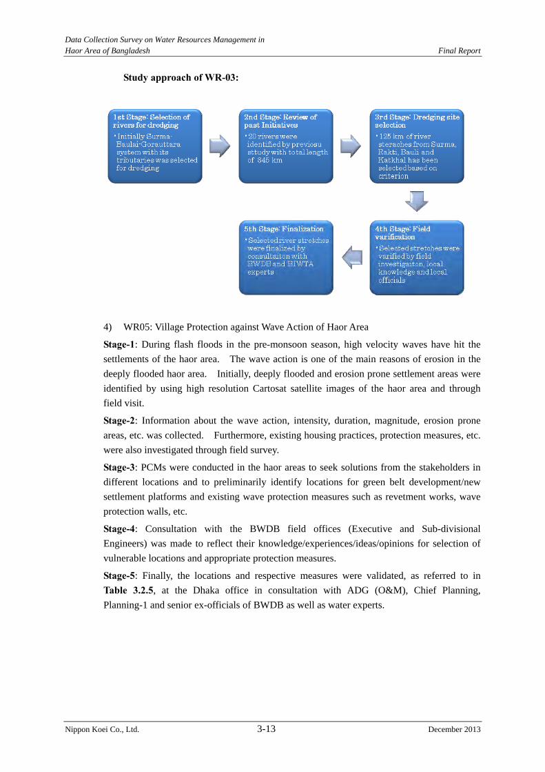
Data Collection Survey on Water Resources Management in Haor Area of Bangladesh Final Report
Nippon Koei Co., Ltd. 3-13 December 2013
Study approach of WR-03:
4) WR05: Village Protection against Wave Action of Haor Area
Stage-1: During flash floods in the pre-monsoon season, high velocity waves have hit the
settlements of the haor area. The wave action is one of the main reasons of erosion in the
deeply flooded haor area. Initially, deeply flooded and erosion prone settlement areas were
identified by using high resolution Cartosat satellite images of the haor area and through
field visit.
Stage-2: Information about the wave action, intensity, duration, magnitude, erosion prone
areas, etc. was collected. Furthermore, existing housing practices, protection measures, etc.
were also investigated through field survey.
Stage-3: PCMs were conducted in the haor areas to seek solutions from the stakeholders in
different locations and to preliminarily identify locations for green belt development/new
settlement platforms and existing wave protection measures such as revetment works, wave
protection walls, etc.
Stage-4: Consultation with the BWDB field offices (Executive and Sub-divisional
Engineers) was made to reflect their knowledge/experiences/ideas/opinions for selection of
vulnerable locations and appropriate protection measures.
Stage-5: Finally, the locations and respective measures were validated, as referred to in
Table 3.2.5, at the Dhaka office in consultation with ADG (O&M), Chief Planning,
Planning-1 and senior ex-officials of BWDB as well as water experts.
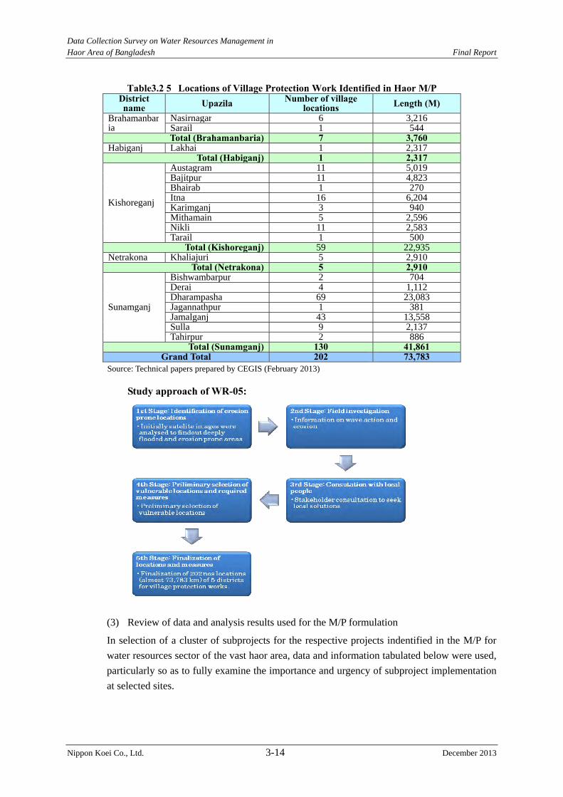
Data Collection Survey on Water Resources Management in Haor Area of Bangladesh Final Report
Nippon Koei Co., Ltd. 3-14 December 2013
Table3.2 5 Locations of Village Protection Work Identified in Haor M/P District name Upazila Number of village
locations Length (M) Brahamanbaria
Nasirnagar 6 3,216 Sarail 1 544 Total (Brahamanbaria) 7 3,760
Habiganj Lakhai 1 2,317 Total (Habiganj) 1 2,317
Kishoreganj
Austagram 11 5,019 Bajitpur 11 4,823 Bhairab 1 270 Itna 16 6,204 Karimganj 3 940 Mithamain 5 2,596 Nikli 11 2,583 Tarail 1 500
Total (Kishoreganj) 59 22,935 Netrakona Khaliajuri 5 2,910
Total (Netrakona) 5 2,910
Sunamganj
Bishwambarpur 2 704 Derai 4 1,112 Dharampasha 69 23,083 Jagannathpur 1 381 Jamalganj 43 13,558 Sulla 9 2,137 Tahirpur 2 886
Total (Sunamganj) 130 41,861 Grand Total 202 73,783
Source: Technical papers prepared by CEGIS (February 2013)
Study approach of WR-05:
(3) Review of data and analysis results used for the M/P formulation
In selection of a cluster of subprojects for the respective projects indentified in the M/P for
water resources sector of the vast haor area, data and information tabulated below were used,
particularly so as to fully examine the importance and urgency of subproject implementation
at selected sites.

Data Collection Survey on Water Resources Management in Haor Area of Bangladesh Final Report
Nippon Koei Co., Ltd. 3-15 December 2013
Identified Projects Data/information used in selection of subprojects
WR01
Information about 66 screened projects (location, type: FC/FCD/FCDI, project area, benefited area: irrigation/drainage/flood control, project components: length of embankment/crest level of embankment/earth work/ location and dimension of regulator/pipe sluice/culvert/sluice/clouser/ navigation lock/inlet/cross dam/pump number/tube-well number/low lift pump number/location of public cut/length and type of protection work, etc.)
WMIP outputs Drainage condition of existing khals and reason of congestion, Water logging area identification in pre-monsoon and
post-monsoon , Functionality of existing structures, Functionality of water management groups, Requirement of re-section of embankment, location of public cut
and reasons, River ban erosion, etc.
Outcomes of PCMs
WR02 Outcomes of PCMs DEM for delineation of project area boundaries
WR03 North East Water Management Plan (FAP6) Satellite image (Landsat, IRS, Google images)
WR05 Satellite image (IRS, Cartoset) Wave action (intensity, duration, magnitude, erosion-prone areas) Outcomes of PCMs
Source: Technical papers prepared by CEGIS (April 2013)
Besides, land use data and past serious flood records, which have been analyzed and
compiled as referred to in the Figures 3.2.1 to 3.2.4, were used in the subproject selection:
1) Figure 3.2.1 Extent of Flood by Depth (Oct. 1998 Flood)
2) Figure 3.2.2 Hazard Map, Flash Flood
3) Figure 3.2.3 Cropping Pattern
4) Figure 3.2.4 Land Zone
After the selection, the M/P formulation process worked out design of subprojects at a master
plan level. The design work was carried out referring to:
1) Available design of major project structures adopted in existing similar water-related
projects, and
2) Past experiences and lessons learned by senior ex-officials of BWDB and renowned
water experts.
Therefore, it is pointed out that no latest data/information about relevant river cross-sections
and foundation soil of planned structure sites was incorporated into the subproject design and
no verification of subproject design through flood inundation and riverbed movement
analyses was conducted.
In due consideration of the above, it is essential for the Study to examine and/or confirm the
soundness and necessity of project through basic study, in particular from a technical point of
view, based not only on latest river, topography and foundation soil data to be obtained
through the river/topographic survey and geotechnical investigation, but also on hydraulic
analysis of flood inundation and riverbed movement, all of which are currently in progress in
the Study, in order to successfully achieve the objectives of the Study.
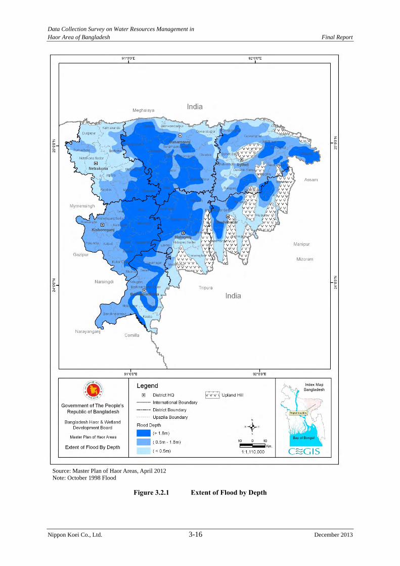
Data Collection Survey on Water Resources Management in Haor Area of Bangladesh Final Report
Nippon Koei Co., Ltd. 3-16 December 2013
Source: Master Plan of Haor Areas, April 2012 Note: October 1998 Flood
Figure 3.2.1 Extent of Flood by Depth
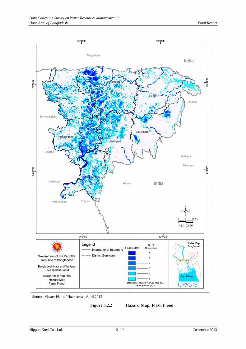
Data Collection Survey on Water Resources Management in Haor Area of Bangladesh Final Report
Nippon Koei Co., Ltd. 3-17 December 2013
Source: Master Plan of Haor Areas, April 2012
Figure 3.2.2 Hazard Map, Flash Flood
(Months of March, Apr l& May 15) From 2005 to 2010
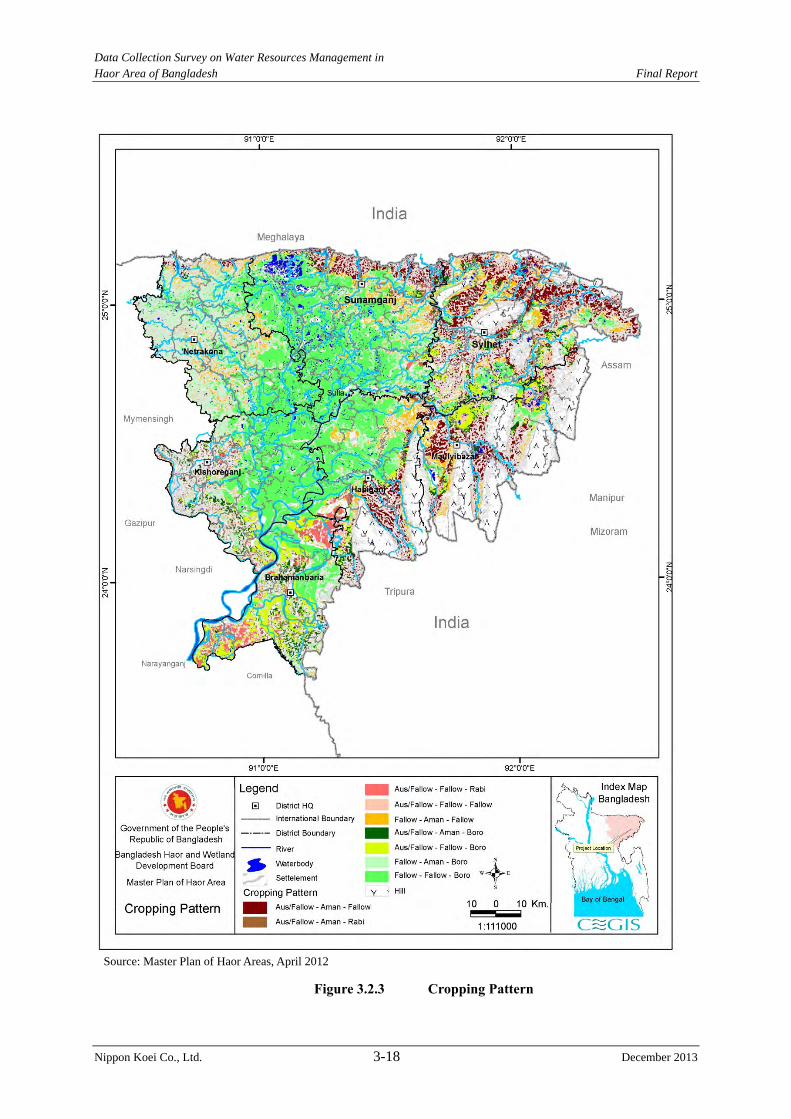
Data Collection Survey on Water Resources Management in Haor Area of Bangladesh Final Report
Nippon Koei Co., Ltd. 3-18 December 2013
Source: Master Plan of Haor Areas, April 2012
Figure 3.2.3 Cropping Pattern

Data Collection Survey on Water Resources Management in Haor Area of Bangladesh Final Report
Nippon Koei Co., Ltd. 3-19 December 2013
Source: Master Plan of Haor Areas, April 2012
Figure 3.2.4 Land Zone
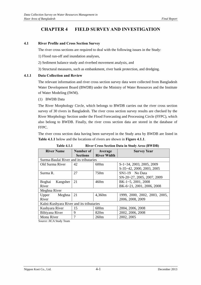
Data Collection Survey on Water Resources Management in Haor Area of Bangladesh Final Report
Nippon Koei Co., Ltd. 4-1 December 2013
CHAPTER 4 FIELD SURVEY AND INVESTIGATION
4.1 River Profile and Cross Section Survey
The river cross sections are required to deal with the following issues in the Study:
1) Flood run-off and inundation analyses,
2) Sediment balance study and riverbed movement analysis, and
3) Structural measures, such as embankment, river bank protection, and dredging.
4.1.1 Data Collection and Review
The relevant information and river cross section survey data were collected from Bangladesh
Water Development Board (BWDB) under the Ministry of Water Resources and the Institute
of Water Modeling (IWM).
(1) BWDB Data
The River Morphology Circle, which belongs to BWDB carries out the river cross section
survey of 30 rivers in Bangladesh. The river cross section survey results are checked by the
River Morphology Section under the Flood Forecasting and Processing Circle (FFPC), which
also belong to BWDB. Finally, the river cross section data are stored in the database of
FFPC.
The river cross section data having been surveyed in the Study area by BWDB are listed in
Table 4.1.1 below and the locations of rivers are shown in Figure 4.1.1.
Table 4.1.1 River Cross Section Data in Study Area (BWDB) River Name Number of
Sections Average
River WidthSurvey Year
Surma-Baulai River and its tributaries Old Surma River 42 600m S-1~34, 2003, 2005, 2009
S-35~42, 2000, 2003, 2005 Surma R. 27 750m SN1-19 No Data
SN-20~27, 2005, 2007, 2009 Boghai Kangsher River
21 460m BK-1~5, 2001, 2008 BK-6~21, 2001, 2006, 2008
Meghna River Upper Meghna River
21 4,360m 1999, 2000, 2002, 2003, 2005, 2006, 2008, 2009
Kalni-Kushyara River and its tributaries Kushyara River 15 600m 2004, 2006, 2008 Bibiyana River 9 820m 2002, 2006, 2008 Monu River 7 260m 2002, 2005
Source: JICA Study Team
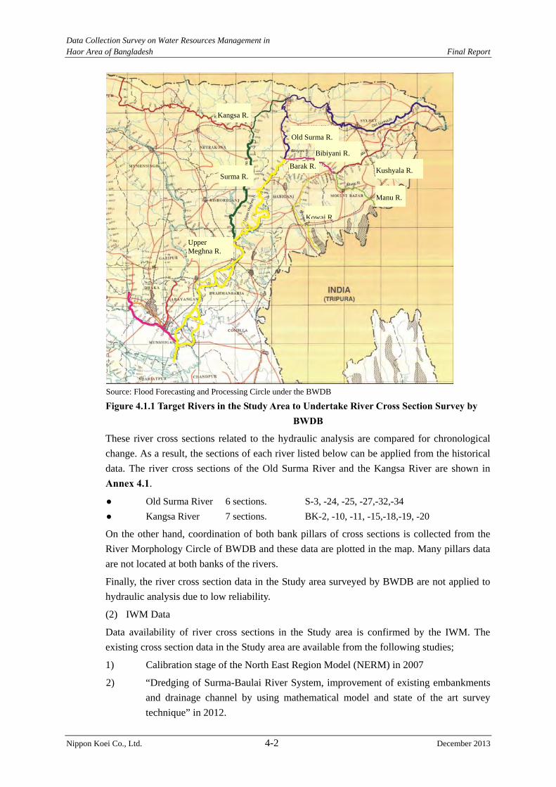
Data Collection Survey on Water Resources Management in Haor Area of Bangladesh Final Report
Nippon Koei Co., Ltd. 4-2 December 2013
Source: Flood Forecasting and Processing Circle under the BWDB
Figure 4.1.1 Target Rivers in the Study Area to Undertake River Cross Section Survey by BWDB
These river cross sections related to the hydraulic analysis are compared for chronological
change. As a result, the sections of each river listed below can be applied from the historical
data. The river cross sections of the Old Surma River and the Kangsa River are shown in
Annex 4.1.
● Old Surma River 6 sections. S-3, -24, -25, -27,-32,-34
● Kangsa River 7 sections. BK-2, -10, -11, -15,-18,-19, -20
On the other hand, coordination of both bank pillars of cross sections is collected from the
River Morphology Circle of BWDB and these data are plotted in the map. Many pillars data
are not located at both banks of the rivers.
Finally, the river cross section data in the Study area surveyed by BWDB are not applied to
hydraulic analysis due to low reliability.
(2) IWM Data
Data availability of river cross sections in the Study area is confirmed by the IWM. The
existing cross section data in the Study area are available from the following studies;
1) Calibration stage of the North East Region Model (NERM) in 2007
2) “Dredging of Surma-Baulai River System, improvement of existing embankments
and drainage channel by using mathematical model and state of the art survey
technique” in 2012.
Kangsa R.
Surma R.
Old Surma R.
Upper Meghna R.
Kushyala R.
Manu R.
Bibiyani R.
Kowai R
Barak R.

Data Collection Survey on Water Resources Management in Haor Area of Bangladesh Final Report
Nippon Koei Co., Ltd. 4-3 December 2013
The river cross section data that were applied for the calibration of NERM in 2007 are
summarized in Table 4.1.2 as follows:
Table 4.1.2 Applied River Cross Section Data for the Calibration of NERM in 2007 River Name Survey Year River Name Survey Year
Surma River 1991,
1999-2000
Dhanu River 1991-92
Baulai River 2005 Jadukata River 2005
Tributaries of the Surma -
Baulai River
2005 Upper Meghna River 2005
Kangsha River Unknown Kalkhal Channel Unknown Source: IWM
Moreover, IWM has carried out the river cross section survey and preparation of the
simulation model in a part of the haor area. The river cross section survey results partly cover
the Study area. The numbers of river cross sections that overlapped with the Study area are
summarized in Table 4.1.3.
Table 4.1.3 Number of River Cross Sections Surveyed by IWM in 2011-12 River Name Number of Sections
Surma River 17
Baulai River 40
Old Surma River 31
Jadugata River 11 Source: IWM
The area covered by the river cross section survey and the locations of the survey lines are
confirmed. It is judged that the survey data are suitable from the above items.
4.1.2 River Profile and Cross Section Survey
The river cross section survey was executed by a local contractor. Al-Mayeda Survey
Consultants was selected through the tender process according to the JICA’s guidelines.
The number of river cross sections to be survey is summarized in Table 4.1.4. And location
map of rivers to carry out survey work is shown in Figure 4.1.2.
Table 4.1.4 Number of River Cross Section to Each River River Name Number of
Sections River Name Number of Sections
Surma-Baulai River 58 Kalkhal Channel 5 Piyain River 10 Upper Meghna River Other Tributaries of Surma-Baulai River
40 -Upstream of Bhairab* 51)
Kangsha-Dhanu River 50 Total 168 Note:* Bhairab Bazar is located at lower boundary of NERM. Therefore, the upper Meghna River is divided to upper and lower reaches at Bhairab Bazar.
Source: JICA Study Team
Data Collection Survey on Water Resources Management in Haor Area of Bangladesh Final Report
Nippon Koei Co., Ltd. 4-4 December 2013
Note: Black line is the almost same location of previous survey. Blue line indicates new survey location Source: JICA Study Team
Figure4.1.2 Survey Location of River Cross Sections
The result of the river cross section survey is shown in Drawings.
4.2 Topographic Survey and Geotechnical Investigation
4.2.1 Topographic Survey
Normally a topographic survey is carried out after the selection of project sites. However, the
fieldworks of the topographic survey have to be finished before the rainy season because the
project areas are located within the hoar area. Therefore, the topographic survey needs to be
started before the selection of priority project sites.
There are 118 haor projects in the Study area, out of which 52 haor projects were decided to
carry out rehabilitation works with GOB funding. The remaining haor projects are 66. In the
M/P, 25 haor projects are proposed to carry out rehabilitation works. Table 4.2.1 shows the
number of haor projects by category and Figure 4.2.1 shows the location of each haor
project.
Table4.2.1 Number of Haor Projects Category of Haor Projects Number
Existing Haor Projects by BWDB 118 Rehabilitation Projects by BWDB 52 Rehabilitation Projects proposed in the M/P 25 Remaining Projects (Not Considered for Rehabilitation) 41 Source: Haor Master Plan
In the M/P, the elevation and dimensions of the existing submergible embankment, regulators,
canals, etc. were not investigated. BWDB in Dhaka have no detailed information on the
structural drawings and data of damaged structures.
Data Collection Survey on Water Resources Management in Haor Area of Bangladesh Final Report
Nippon Koei Co., Ltd. 4-5 December 2013
Source: Haor Master Plan,2012
Figure4.2.1 Location Map of Haor Projects
Data Collection Survey on Water Resources Management in Haor Area of Bangladesh Final Report
Nippon Koei Co., Ltd. 4-6 December 2013
(1) Target Haor Projects of the Topographic Survey
The land use data and past serious flood records were used in the selection of sub-projects.
According to Figures 3.2.1 to 3.2.4, high frequency of flash flood and only boro crop
production areas are widely distributed in Sunamganj, Habiganj, Netrakona, Kishoreganj,
and Brhamanbaria districts. When flash flood damage occurs only in the boro crop
production areas, it is a serious impact to the farmers in this area as compared with other
districts, such as Sylhet and Moulvibazar districts, since there is no crop production.
Therefore, the above five districts are given priority and the topographic survey for 16
projects proposed in the M/P were carried out.
On the other hand, the World Bank-financed Water Management Improvement Project
(WMIP) is carrying out rehabilitation works in the surrounding area of the haor area. Four
projects in the M/P are carried out in WMIP.
Therefore, there are 12 target haor projects for topographic survey as listed in Table 4.2.2
and the locations of these target haor projects are shown in Figure 4.2.1.
Table 4.2.2 Target Haor Projects for Topographic Survey Name of Haor Project Selection Remarks
1. Dampara Water Management Scheme O
2. Kangsa River Scheme O
3. Takurakona Scheme X Under rehabilitation
by WMIP
4. Singer Beel Scheme O
5. Gazaria Beel Scheme X Under rehabilitation
by WMIP
6. Baraikhali Khal Scheme O
7. Charfaradee-Jangalia Scheme X Under rehabilitation
by WMIP
8. Alalia-Bahadia Scheme O
9. Modkhola Bhairagirchar sub-project Scheme O
10. Adampur Scheme X Under rehabilitation
by WMIP
11. Ganakkhalli Sub-scheme O
12. Kairdhala Ratna Scheme O
13. Bahira River Scheme O
14. Aralia Khal Scheme O
15. Chandal Beel Scheme O
16. Satdona Beel Scheme O Note: O: Execution of survey works, X: Not execution of survey works Source: JICA Study Team
Data Collection Survey on Water Resources Management in Haor Area of Bangladesh Final Report
Nippon Koei Co., Ltd. 4-7 December 2013
(3) New Haor Projects
The problems related to water resources and management in the new haor projects proposed
in the M/P were discussed and considered during the public consultation meetings (PCMs) in
66 upazilas. The new haor projects were selected through discussions with the field offices
and central office of BWDB. Then, 26 new haor projects were selected as listed in Table 4.2.3.
Table 4.2.3 List of New Haor Projects No. Project Name No. Project Name 1 Badla Haor Project (Kishoreganj) 14 Naogaon Haor Project (Kishorganj) 2 Dharmapasha Rui Beel Project
(Sunamganj & Netrokona) 15 Noapara Haor Project (Kishorganj)
3 Charigram Haor Project (Kishorganj)
16 Nunnir Haor Project (Kishorgang)
4 Bara Haor (Kamlakanda) (Netrokona)
17 Sarishapur Haor Project (Kishorganj)
5 Ayner Gupi Haor (Kishorganj) 18 Bansharir Haor Project (Netrokona) 6 Bara Haor Sub Project
(Austagram) (Kishorganj) 19 Chatal Haor Project (Kishorganj)
7 Boro Haor Project (Nikli) (Kishorganj)
20 Dakhshiner Haor Project (Kishorganj)
8 Chandpur Haor Project (Kishorganj)
21 Dhakua Haor Project (Sunamganj)
9 Dulapur Haor Project (Kishorganj)
22 Ganesh Haor Project (Netrokona)
10 Golaimara Haor Project (Kishorganj)
23 Jaliar Haor Project (Sunamganj)
11 Joyariya Haor Project (Kishorganj)
24 Mokhar Haor Project (Habiganj)
12 Korati Haor Project (Kishorganj) 25 Shelnir Haor Project (Habiganj & Bramanbaria)
13 Kuniarbandh Haor Project (Kishorganj)
26 Suniar Haor Project (Kishorganj & Netrokona)
Note: Closed in parenthesis is the district name Source: JICA Study Team
The topographic survey of the new haor projects was carried out. The topographic survey
includes spot elevation survey along the envisaged alignment of submergible embankment.
The location map of the new haor projects is shown in Figure 4.2.2.
(4) Topographic Survey
The topographic survey was carried out based on the subcontract with a selected local
contractor. Al-mayeda Survey Consultants was selected through the tender process according
to JICA’s guidelines.
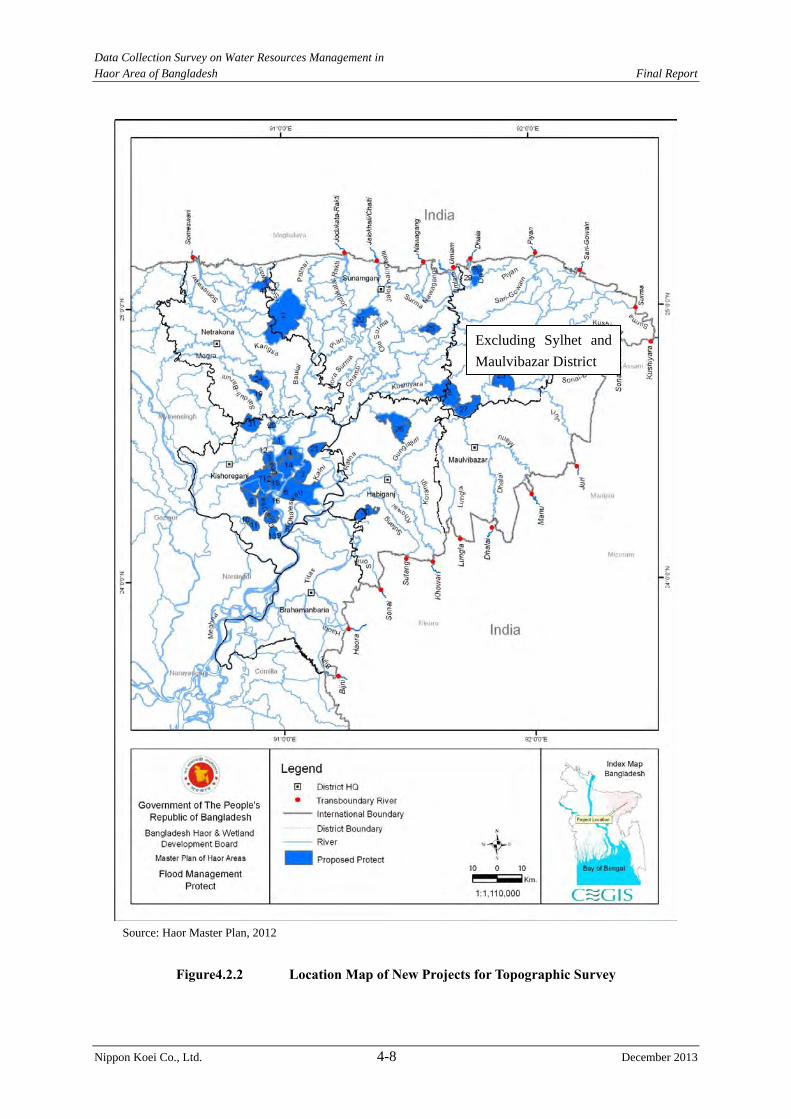
Data Collection Survey on Water Resources Management in Haor Area of Bangladesh Final Report
Nippon Koei Co., Ltd. 4-8 December 2013
Source: Haor Master Plan, 2012
Figure4.2.2 Location Map of New Projects for Topographic Survey
Excluding Sylhet and
Maulvibazar District
Data Collection Survey on Water Resources Management in Haor Area of Bangladesh Final Report
Nippon Koei Co., Ltd. 4-9 December 2013
4.2.2 Geotechnical Investigation
Geotechnical investigation was conducted under the sub-contract of ten haor projects,
consisting of four rehabilitation projects and six new projects presented in Figure 4.2.3.
The locations of the geotechnical investigation were selected considering the following
ideas:
1) The locations were selected in the target haor project area excluding 52 rehabilitation
projects to be implemented by BWDB.
2) The locations were selected in the priority new and rehabilitation project area extracted
in the M/P.
3) The locations were selected with geotechnical representativeness of all target project
areas.
The major work items of the geotechnical investigation are the follwings:
1) Core Drilling: 300 m (30 m/ hole, 1 hole/ project)
2) Dutch Cone Test: 360 m (20 m/ hole, 3 holes/ new project)
3) Laboratory Test for Undisturbed Samples (core drilling sites)
4) Laboratory Test for Embankment Materials (3 samples/ new projects)
5) Dry-Wet Cycle Test (1 new project)
6) Riverbed Material Survey (10 locations)
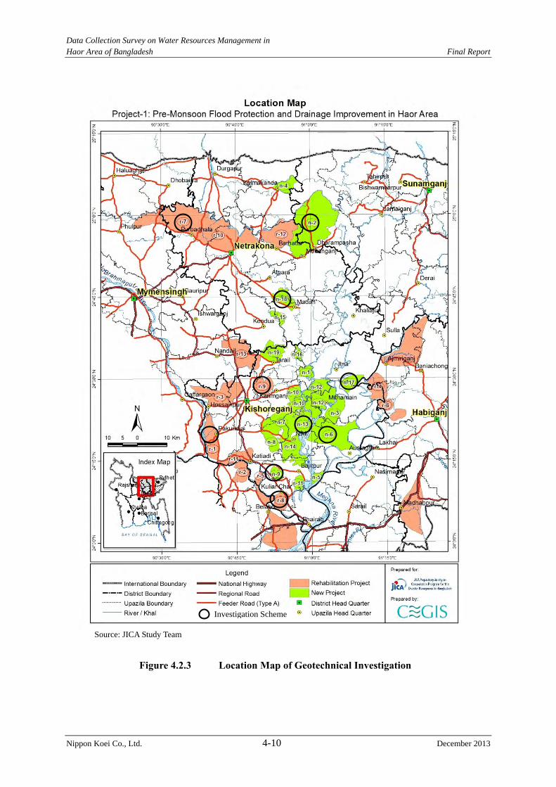
Data Collection Survey on Water Resources Management in Haor Area of Bangladesh Final Report
Nippon Koei Co., Ltd. 4-10 December 2013
Figure 4.2.3 Location Map of Geotechnical Investigation
Source: JICA Study Team
Investigation Scheme
Data Collection Survey on Water Resources Management in Haor Area of Bangladesh Final Report
Nippon Koei Co., Ltd. 4-11 December 2013
(1) Data Collection and Review
During the first work in Bangladesh, the following data and information related to soil and
geology in the Study area were collected:
1) ”Geological Map of Bangladesh, 1:1,000,000”, Geological Survey of Bangladesh, 2001
2) Soil laboratory test results (physical, consolidation and strength tests) at two locations in
the haor area near the northern international border with India (each at one location in
Netrokona and Sunamganj Districts) which has been described in “the Report on the
Feasibility Study for Capacity-Building Project for Sustainable Development of
Water-Related Infrastructure (Part-1), January 2012, JICA Technical Cooperation
Project”.
3) Standard Penetration Test (SPT) results at several gate structures constructed in the haor
projects which are being operated and maintained by BWDB.
The findings from the review of data and information collected, are as follows:
1) The geological map of Bangladesh indicates the existence of soft silt and clay including
peat in the Study area. According to 2) above, some parts of soil samples include about
2% to7% organic materials.
2) Besides, according to 2) above, the laboratory data for foundation shows the following
soil parameters:
Netrakona: Grain size; silt100% wn*=19.57% qu*=1.57(kg/cm2),
Sunamganj: Grain size; silt70%, clay30% wn*=34.57% qu*=0.65 (kg/cm2),
(*: wn=Moisture content, qu=Unconfined compression strength)
3) Some drilling data from BWDB suggest that soft cohesive soils are distributed
universally over the floodplains in the haor area.
(2) Necessity of the Work
The existing source materials/data on (i) foundation soil of structures such as embankment
and sluices, and (ii) embankment construction materials which are available in the Study are
as enumerated in (1) above.
It was clarified through the M/P review that the M/P had no conducted any geotechnical
investigation for the formulation of the structural plan, and the structural measures, such as
embankment and sluices proposed in the M/P were drawn out, referring to the existing haor
projects, without any data from the survey of the foundation soil and embankment materials
in the project sites.
In view of the above, it was concluded that the Study needs geotechnical investigation,
excluding the areas of the 52 haor projects which have been incorporated in the BWDB
Rehabilitation Project, with the aim of assessing the following technical points:
(a) Stability of foundation for embankment and sluices against settlement and piping,
(b) Soil materials available for embankment construction, and
(c) Durability of submergible embankment which is subject to repeated submergence and
drying.
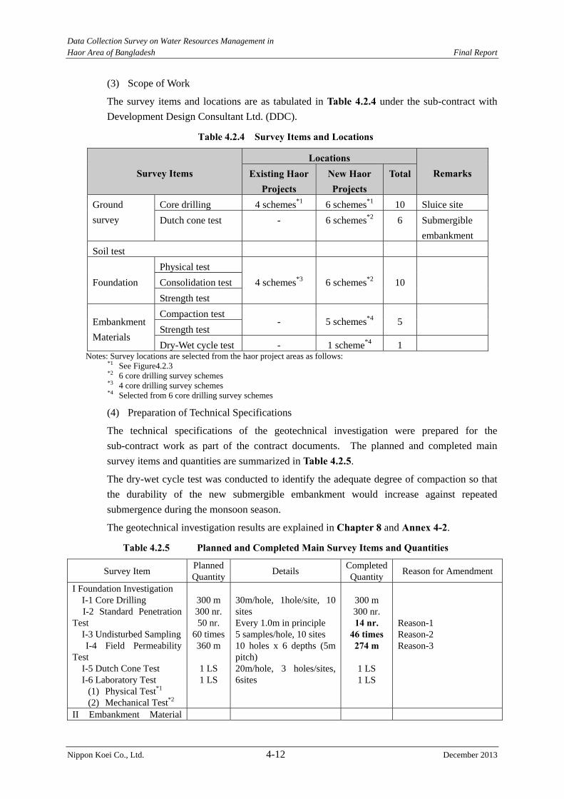
Data Collection Survey on Water Resources Management in Haor Area of Bangladesh Final Report
Nippon Koei Co., Ltd. 4-12 December 2013
(3) Scope of Work
The survey items and locations are as tabulated in Table 4.2.4 under the sub-contract with
Development Design Consultant Ltd. (DDC).
Table 4.2.4 Survey Items and Locations
Survey Items Locations
Remarks Existing HaorProjects
New Haor Projects
Total
Ground
survey
Core drilling 4 schemes*1 6 schemes*1 10 Sluice site
Dutch cone test - 6 schemes*2 6 Submergible
embankment
Soil test
Foundation
Physical test
4 schemes*3 6 schemes*2 10
Consolidation test
Strength test
Embankment
Materials
Compaction test - 5 schemes*4 5
Strength test
Dry-Wet cycle test - 1 scheme*4 1 Notes: Survey locations are selected from the haor project areas as follows:
*1 See Figure4.2.3 *2 6 core drilling survey schemes *3 4 core drilling survey schemes *4 Selected from 6 core drilling survey schemes
(4) Preparation of Technical Specifications
The technical specifications of the geotechnical investigation were prepared for the
sub-contract work as part of the contract documents. The planned and completed main
survey items and quantities are summarized in Table 4.2.5.
The dry-wet cycle test was conducted to identify the adequate degree of compaction so that
the durability of the new submergible embankment would increase against repeated
submergence during the monsoon season.
The geotechnical investigation results are explained in Chapter 8 and Annex 4-2.
Table 4.2.5 Planned and Completed Main Survey Items and Quantities
Survey Item Planned Quantity
Details CompletedQuantity
Reason for Amendment
I Foundation Investigation I-1 Core Drilling I-2 Standard Penetration Test I-3 Undisturbed Sampling I-4 Field Permeability Test I-5 Dutch Cone Test I-6 Laboratory Test
(1) Physical Test*1 (2) Mechanical Test*2
300 m 300 nr. 50 nr.
60 times 360 m
1 LS 1 LS
30m/hole, 1hole/site, 10 sites Every 1.0m in principle 5 samples/hole, 10 sites 10 holes x 6 depths (5m pitch) 20m/hole, 3 holes/sites, 6sites
300 m 300 nr. 14 nr.
46 times 274 m
1 LS 1 LS
Reason-1 Reason-2 Reason-3
II Embankment Material
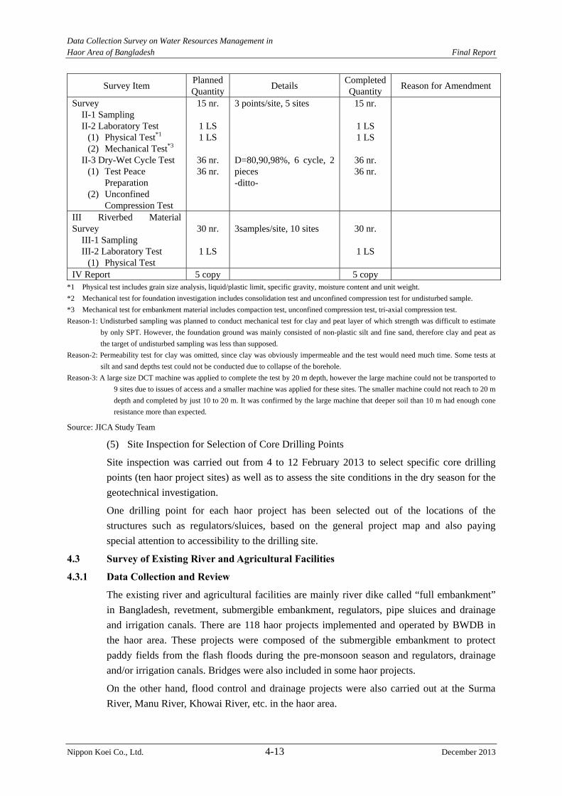
Data Collection Survey on Water Resources Management in Haor Area of Bangladesh Final Report
Nippon Koei Co., Ltd. 4-13 December 2013
Survey Item Planned Quantity
Details CompletedQuantity
Reason for Amendment
Survey II-1 Sampling II-2 Laboratory Test
(1) Physical Test*1 (2) Mechanical Test*3
II-3 Dry-Wet Cycle Test (1) Test Peace
Preparation (2) Unconfined
Compression Test
15 nr.
1 LS 1 LS
36 nr. 36 nr.
3 points/site, 5 sites D=80,90,98%, 6 cycle, 2 pieces -ditto-
15 nr.
1 LS 1 LS
36 nr. 36 nr.
III Riverbed Material Survey III-1 Sampling III-2 Laboratory Test
(1) Physical Test
30 nr.
1 LS
3samples/site, 10 sites
30 nr.
1 LS
IV Report 5 copy 5 copy *1 Physical test includes grain size analysis, liquid/plastic limit, specific gravity, moisture content and unit weight.
*2 Mechanical test for foundation investigation includes consolidation test and unconfined compression test for undisturbed sample.
*3 Mechanical test for embankment material includes compaction test, unconfined compression test, tri-axial compression test.
Reason-1: Undisturbed sampling was planned to conduct mechanical test for clay and peat layer of which strength was difficult to estimate
by only SPT. However, the foundation ground was mainly consisted of non-plastic silt and fine sand, therefore clay and peat as
the target of undisturbed sampling was less than supposed.
Reason-2: Permeability test for clay was omitted, since clay was obviously impermeable and the test would need much time. Some tests at
silt and sand depths test could not be conducted due to collapse of the borehole.
Reason-3: A large size DCT machine was applied to complete the test by 20 m depth, however the large machine could not be transported to
9 sites due to issues of access and a smaller machine was applied for these sites. The smaller machine could not reach to 20 m
depth and completed by just 10 to 20 m. It was confirmed by the large machine that deeper soil than 10 m had enough cone
resistance more than expected.
Source: JICA Study Team
(5) Site Inspection for Selection of Core Drilling Points
Site inspection was carried out from 4 to 12 February 2013 to select specific core drilling
points (ten haor project sites) as well as to assess the site conditions in the dry season for the
geotechnical investigation.
One drilling point for each haor project has been selected out of the locations of the
structures such as regulators/sluices, based on the general project map and also paying
special attention to accessibility to the drilling site.
4.3 Survey of Existing River and Agricultural Facilities
4.3.1 Data Collection and Review
The existing river and agricultural facilities are mainly river dike called “full embankment”
in Bangladesh, revetment, submergible embankment, regulators, pipe sluices and drainage
and irrigation canals. There are 118 haor projects implemented and operated by BWDB in
the haor area. These projects were composed of the submergible embankment to protect
paddy fields from the flash floods during the pre-monsoon season and regulators, drainage
and/or irrigation canals. Bridges were also included in some haor projects.
On the other hand, flood control and drainage projects were also carried out at the Surma
River, Manu River, Khowai River, etc. in the haor area.
Data Collection Survey on Water Resources Management in Haor Area of Bangladesh Final Report
Nippon Koei Co., Ltd. 4-14 December 2013
(1) Results of the Data Collection in Dhaka and BWDB Site Offices
Data collection works related to haor projects and flood control projects and drainage
projects in the haor area, were carried out by BWDB and concerned agencies.
1) Detailed Information of Structures
In the M/P, the rehabilitation works of the existing haor projects are classified in Table 4.3.1.
Table 4.3.1 Rehabilitation Works of Existing Haor Projects Haor Project Number of
Project Remarks
1.Rehabilitation Works planned by BWDB
52
Feasibility Study (F/S) was finished (2007)
37 Table 4.3.2 shows information on rehabilitation works. Some project offices requested the Design Circle to carry out the detailed design (D/D)
F/S is ongoing 15 Data cannot be collected. 2.Proposed by the M/P 25 To check the dimensions of structures,
BWDB site offices were requested to collect as built drawings. However, these drawings were not collected because nobody knows where the drawings have been stored.
3.Remaining Project 41 No information from BWDB Note: Number of haor projects includes seven districts. Source: Haor Master Plan, DPP, JICA Study Team
Information related to the facilities of the haor projects were collected in Dhaka and from the
site offices. However, the information on the facilities in the 37 haor projects, which are
funded by the GOB, were collected. Table 4.3.2 shows information on the existing 37 haor
projects.
During the site reconnaissance, the JICA Study Team tried to collect as-built drawings of the
existing haor projects. However, such drawings were not obtained because the staffs from the
BWDB site offices have no knowledge of their location.
In addition, the facilities and work volume of the proposed rehabilitation works were
mentioned in the M/P. But the locations and areas for rehabilitation were not mentioned.
Information on the type of facilities, dimensions, and damaged areas should be collected.
Therefore, a river facility survey is needed to check the present conditions.
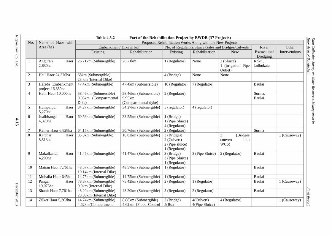
Data C
ollection Survey on Water R
esources Managem
ent in H
aor Area of B
angladesh
Final R
eport
Nippon K
oei Co., L
td. 4-15
D
ecember 2013
Table 4.3.2 Part of the Rehabilitation Project by BWDB (37 Projects) No. Name of Haor with
Area (ha) Proposed Rehabilitation Works Along with the New Projects
Embankment/ Dike in km No. of Regulators/Sluice Gates and Bridges/Culverts River Excavation/
Dredging
Other Interventions Existing Rehabilitation Existing Rehabilitation New
1 Angurali Haor 2,630ha
26.71km (Submergible) 26.71km 1 (Regulator) None 2 (Sluice) 1 (irrigation Pipe Outlet)
Rokti, Jadhukata
2 Hail Haor 24,370ha 68km (Submergible) 23 km (Internal Dike)
4 (Bridge) None None
3 Haizda Embankment project 16,880ha
47.4km (Submergible) 47.4km (Submersible) 10 (Regulator) 7 (Regulator) Baulai
4 Halir Haor 10,000ha 58.46km (Submersible) 9.95km (Compartmental Dike)
58.46km (Submersible)9.95km (Compartmental dyke)
2 (Regulator) Surma, Baulai
5 Humpaipur Haor 5,270ha
34.27km (Submergible) 34.27km (Submergible) 5 (regulator) 4 (regulator)
6 Joalbhanga Haor 4,370ha
60.59km (Submergible) 33.55km (Submergible) 1 (Bridge) 1 (Pipe Sluice) 4 (Regulator)
7 Kalner Haor 6,828ha 64.15km (Submergible) 30.76km (Submergible) 2 (Regulator) Surma 8 Karchar Haor
5,513ha 35.8km (Submergible) 16.82km (Submergible) 3 (Bridges)
2 (Culvert) 2 (Pipe sluice) 1 (Regulator)
3 (Bridges convert into WCS)
1 (Causeway)
9 Makalkandi Haor 4,200ha
41.47km (Submergible) 41.47km (Submergible) 3 (Bridge) 3 (Pipe Sluice) 1 (Regulator)
3 (Pipe Sluice) 2 (Regulator) Baulai
10 Matian Haor 7,761ha 48.57km (Submergible) 10.14km (Internal Dike)
48.57km (Submergible) 1 (Regulator) Baulai
11 Mohalia Haor 645ha 14.75km (Submergible) 14.75km (Submergible) 1 (Regulator) Baulai 12 Panger Haor
19,075ha 78.87km (Submergible) 9.9km (Internal Dike)
75.42km (Submergible) 2 (Regulator) 1 (Regulator) Baulai 1 (Causeway)
13 Shanir Haor 7,761ha 48.20km (Submergible) 23.88km (Internal Dike)
48.20km (Submergible) 5 (Regulator) 2 (Regulator) Baulai
14 Zilker Haor 5,263ha 14.74km (Submergible) 4.62km(Compartment
8.88km (Submergible) 4.62km (Flood Control
2 (Bridge) 5(Box
4(Culvert) 4(Pipe Sluice)
4 (Regulator) 1 (Causeway)
Data C
ollection Survey on Water R
esources Managem
ent in H
aor Area of B
angladesh
Final R
eport
Nippon K
oei Co., L
td. 4-16
D
ecember 2013
No. Name of Haor with Area (ha)
Proposed Rehabilitation Works Along with the New Projects Embankment/ Dike in km No. of Regulators/Sluice Gates and Bridges/Culverts River
Excavation/ Dredging
Other Interventions Existing Rehabilitation Existing Rehabilitation New
Dike) 5.3km (Flood Control Embankment)
Embankment) Culvert) 6(Pipe Sluice) 3(Regulator)
15 Dewghat Haor 1,220ha
4.46km (Submergible) 4.43km (Submergible) 3(Pipe Sluice) 3(Regulator)
3(Regulator) 1 (Causeway)
16 Shafique Haor 2,380ha
15.92km(Submergible) 2.64km(Internal Dike)
15.92km(Submergible)2.64km(Internal Dike)
4(Bridge) 2(Pipe Sluice) 1(Regulator)
1(Regulator) 4(Regulator)
17 Patharchauly 5,466ha 33.63km(Submergible) 33.63km(Submergible) 2(Pipe Sluice) 2(Regulator)
1(Pipe Sluice)1(Regulator)
4(Regulator)
18 Kalikota Haor 17,610ha
84.48km(Submergible) 34.34km(Compartmental Dike)
71.22km(Submergible) 5(Bridge) 2(Pipe Sluice) 2(Regulator)
17(Box Culvert) 2(Bridge) 2(Regulator)
3 (Causeway)
19 Udgal beel Haor 5,900ha
33.55km(Submergible) 21.58km(Compartmental Dike) 4.67km(Flood Control Embankment)
33.55km(Submergible)4.67km(Flood Control Embankment)
8(Bridge) 1(Regulator)
1(Regulator) 1(Causeway)
20 Balali-Padamsree 2,398ha
13.14km(Submergible) 13.14km(Submergible) 1(Bridge) 1(Culvert) 2(Regulator)
2(Regulator)
21 Sonamoral 3,275ha 45.58km(Submergible) 3.8km(Compartmental Dike)
45.58km(Submergible) 4(Regulator) 3(Regulator)
22 Dhankunia Haor 1,692ha
18.44km(Submergible) 18.44km(Submergible) 1(Regulator) 2(Regulator) Baulai
23 Gurmar Haor 5,360ha
51.59km(Submergible) 51.59km(Submergible) 14(Irrigation Pipe) 5(Regulator)
5(Regulator)
24 Kawadhighi Haor 22,672 ha
57.9km (Flood Control Embankment)
28km (Flood Control Embankment)
1(Bridge) 2(Regulator)
1(Regulator) 1(Barrage)
25 Joydhona Haor 355ha
11.3km (Submergible) 11.3km (Submergible) 2(Regulator)
Data C
ollection Survey on Water R
esources Managem
ent in H
aor Area of B
angladesh
Final R
eport
Nippon K
oei Co., L
td. 4-17
D
ecember 2013
No. Name of Haor with Area (ha)
Proposed Rehabilitation Works Along with the New Projects Embankment/ Dike in km No. of Regulators/Sluice Gates and Bridges/Culverts River
Excavation/ Dredging
Other Interventions Existing Rehabilitation Existing Rehabilitation New
26 Nawatana 3,020ha 7.7km(Submergible) 7.7km(Submergible) 2(Pipe Outlet) 1(Regulator)
1(Regulator) 2(Cross Dam)
27 Bhanda Beel Haor 4,000ha
31.45km(Submergible) 9.10km(Compartmental Dike)
31.45km(Submergible) 6(Pipe Sluice) 1(Regulator)
5(Pipe Sluice)1(Regulator)
2(Pipe Sluice) 1(Regulator)
28 Baram Haor 5,500ha 33.12km(Submergible) 33.12km(Submergible) 3(Pipe Sluice) 3(Regulator)
3(Pipe Sluice)2(Regulator)
Mara Chamti Nadi, Chamti Nadi
29 Shangair Haor 5,000ha
28.95km(Submergible) 7.39km(Internal Dike)
28.95km(Submergible)7.39km(Internal Dike)
3(Regulator) 1(Regulator)
30 Chandra Sonar Thal 5,714ha
62.74km(Submergible) 48.17km(Submergible) 5(Pipe Sluice) 3(Regulator)
5(Pipe Sluice)3(Regulator)
31 Tanguar Haor 5,000ha
40.91km(Submergible) 36.51km(Submergible) 4(Pipe Sluice) 2(Regulator)
3(Pipe Sluice)2(Regulator)
1(Regulator) 2(Cross Dam)
32 Kushiara Bradhal Haor 7,500ha
41.26km(Submergible) 41.26km(Submergible) 7(Regulator)
33 Chaptir Haor 4,553ha 40.64km(Submergible) 37.62km(Submergible) 1(Bridge) 8(Pipe Sluice) 3(Regulator)
4(Pipe Sluice)3(Regulator)
1(Causeway)
34 Naluar Haor 12,140ha
79.78km(Submergible) 8.6km(Internal Dike)
67.55km(Submergible)
6(Bridge) 6(Regulator)
4(Regulator) 2(Loop cut)
35 Khai Haor 4,800ha 28.16km(Submergible) 17.00km(Submergible) 6(Bridge) 4(Pipe Sluice) 2(Regulator)
4(Pipe Sluice)2(Regulator)
36 Jamkhola Haor 2,000ha
22.47km(Submergible) 22.47km(Submergible) 4(Regulator) 1(Causeway)
37 Updakhali Haor 7,220ha
33.23km(Submergible) 33.23km(Submergible) 11(Bridge) 5(Regulator)
4(Regulator)
Note: Existing means Existing Structure, Rehabilitation means Rehabilitation structures, New means new construction in the rehabilitation project Source: DPP for Pre-Monsoon Flood Protection and Drainage Improvement in Haor Areas, Original May, 2010, Recast May, 2011, BWDB
Data C
ollection Survey on Water R
esources Managem
ent in H
aor Area of B
angladesh
Final R
eport
Nippon K
oei Co., L
td. 4-18
D
ecember 2013
Source: JICA Study Team
Figure 4.3.1 Location Map of 37 Rehabilitation Project planned by BWDB
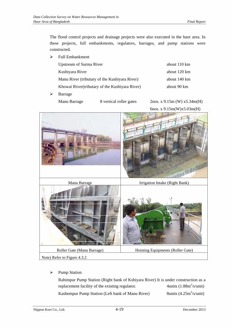
Data Collection Survey on Water Resources Management in Haor Area of Bangladesh Final Report
Nippon Koei Co., Ltd. 4-19 December 2013
The flood control projects and drainage projects were also executed in the haor area. In
these projects, full embankments, regulators, barrages, and pump stations were
constructed.
Full Embankment
Upstream of Surma River about 110 km
Kushiyara River about 120 km
Manu River (tributary of the Kushiyara River) about 140 km
Khowai River(tributary of the Kushiyara River) about 90 km
Barrage
Manu Barrage 8 vertical roller gates 2nos. x 9.15m (W) x5.34m(H)
6nos. x 9.15m(W)x5.03m(H)
Manu Barrage Irrigation Intake (Right Bank)
Roller Gate (Manu Barrage) Hoisting Equipments (Roller Gate)
Note) Refer to Figure 4.3.2
Pump Station
Rahimpur Pump Station (Right bank of Kshiyara River) It is under construction as a
replacement facility of the existing regulator. 4units (1.88m3/s/unit)
Kashempur Pump Station (Left bank of Manu River) 8units (4.25m3/s/unit)

Data Collection Survey on Water Resources Management in Haor Area of Bangladesh Final Report
Nippon Koei Co., Ltd. 4-20 December 2013
Pumping Stataion Panel
Note) Refer to Figure 4.3.2
The location map of the Manu Barrage and Pumping Station is shown in Figure 4.3.2.
Source: JICA Study Team
Figure 4.3.2 Location Map of the Manu Barrage and Pumping Station
2) Flood Damage
The flood damage on the river facilities was surveyed. The data on flood damage on the
structures were taken only from the flood damage survey by BWDB in 2007. Two floods
occurred in 2007, one in June and the other in September.
Data Collection Survey on Water Resources Management in Haor Area of Bangladesh Final Report
Nippon Koei Co., Ltd. 4-21 December 2013
Flood in June
Nilphamari and Kurigram districts, which are located along the Jamuna River in the
northern region, were damaged. Also, Sylhet and Sunamganj districts along the Surma
River were damaged.
Flood in September
The inundation ratio along the Jamuna River changed from 60% to 80%. The inundation
ratio in Sunamganj District was 15% to 30%, while the inundation ratio in other districts
along the Surma River was 0% to 15%.
Table 4.3.3 shows the flood damage on river structures in 2007.
3) Operation and Maintenance
The facilities constructed under the BWDB projects in the haor area, are BWDB assets,
and the operation of regulators is carried out by the sluice committee. In 1999, the
Ministry of Water Resources published the “Guideline for Participatory Water
Management”; however, new organizations following such guideline were not established
yet.
The sluice committee was established to discuss between the executive engineer of the
BWDB site office and stakeholders, such as the upazila chairman and ward members. The
sluice committee has the key to the regulator. The operation of the regulator is instructed
by BWDB staffs. The sluice committee operates the regulator under the instruction of
BWDB.
On the other hand, the regulators along the river which are not included in the haor
projects have no established committee. Therefore, the BWDB site office requests the
operation of such regulators to respective ward members. In this case, the BWDB site
office directly requests the ward members to operate the gates.
Water users groups for irrigation were established under the Manu River Project because
water supply from the Manu River is controlled by the Manu Barrage.
Data C
ollection Survey on Water R
esources Managem
ent in H
aor Area of B
angladesh
Final R
eport
Nippon K
oei Co., L
td. 4-22
D
ecember 2013
Table 4.3.3 Flood Damage of River Structure in 2007 (BWDB) (Unit: 100,000)
District Project Name Embankment (km)
Irrigation Canal/ Drainage Channel (km)
Water Control Structure (Nos.)
Bank Protection (km)
Groyne(Nos.)
Spur/ Hard Protect
Others Damage (BDT)
Full Part BDT Full Part BDT Full Part BDT Full Part Part Part BDT QTY BDT B. Baria Kondagokama FCD 0.040 1.000 15.0 0.09 5.0 20.0 B. Baria Protection of the
Meghna River Bank 0.09 0.08 50.0 50.0
B. Baria Joydarkandi Village Protection
0.20 10.0 10.0
B.Baria Howra River Project 0.634 6.000 25.0 25.0 B.Baria Protection of the Buri
River Project 0.120 10.0 10.0
Habiganj Kusheria Left bank 0.333 0.460 10.0 10.0 Habiganj Madofpur FCD 1.850 1.641 85.0 85.0 Habiganj Goinggazun FCD 0.740 1.590 23.4 23.4 Habiganj Khowai River Left and
Right Bank Protection 2.000 16.300 175.0 0.317 100.0 275.0
Habiganj Debnath school and bazar project
0.060 5.0 5.0
Habiganj Makalkandi Haor 1.250 20.0 20.0 Habiganj Markuli Bazar
Protected Project 0.100 3.5 3.5
Moulavibazar Manu River Project 0.300 0.840 20.0 1.000 7.0 1 26.0 53.0 Moulavibazar Manu River FCD
Project, ph-1 0.180 1.380 40.0 40.0
Moulavibazar Dhalai River Project 1.770 1.400 50.0 50.0 Moulavibazar Tarapasha-Prammagar
FCD Project 0.250 0.515 17.0 17.0
Moulavibazar Manu River FCD Project, ph-2
0.650 1.400 30.0 0.250 40.0 70.0
Moulavibazar Manu Soyjun Protective Work
0.150 2.0 2.0
Moulavibazar Manu Left Flood Embankment
0.040 0.035 14.0 14.0
Moulavibazar Dewrachar FCD Project
0.140 2.0 2.0
Moulavibazar Hamhamichara FCD 0.300 3.0 3.0 Moulavibazar Baria Haor Sub-project 2 7.0 7.0 Moulavibazar Hail Haor Project 1.500 15.0 15.0 Moulavibazar Manu River Project 1 40.0 40.0

Data C
ollection Survey on Water R
esources Managem
ent in H
aor Area of B
angladesh
Final R
eport
Nippon K
oei Co., L
td. 4-23
D
ecember 2013
District Project Name Embankment (km)
Irrigation Canal/ Drainage Channel (km)
Water Control Structure (Nos.)
Bank Protection (km)
Groyne(Nos.)
Spur/ Hard Protect
Others Damage (BDT)
Full Part BDT Full Part BDT Full Part BDT Full Part Part Part BDT QTY BDT (Mechanical)
Sylhet Kushiara Dike 20.700 63.0 63.0 Sylhet Surma River System 0.015 1.780 20.0 20.0 Sylhet Kushiyara River Right
Bank Embankment Project
1.900 12.0 2 20.0 32.0
Sylhet Dhaleshwan Cross Dam
0.965 12.0 0.200 4.0 16.0
Syhlet Sari-Goyain Project 2.500 0.780 37.0 37.0 Syhlet Khoshara Bardal
Project 1.500 8.0 8.0
Syhlet Surma Right Bank 2.291 12.0 12.0 Syhlet Goinaghal Project 2.500 25.0 25.0 Syhlet Jneelkar haor project 0.620 20.0 20.0 Syhlet Pathor Chowfee Haor
Project 0.820 20.0 20.0
Syhlet Embankment from Balagonj to Kalanichar
19.000 12.0 12.0
Syhlet Safiq Haor Project 0.950 8.0 8.0 Syhlet Barr Haor Project 1.000 5.0 5.0 Sunamganj Karchar Haor,
Kalpanar, Angraly, Sanir, Mathian, Mohallia, Zoal
25.861 134.050 732.5 28 12.5 0.470 54.0 799.0
Keshoreganj Charparadi-Janggalia
Project 0.100 1.0 1.0
Netrokona Someswari River
Hazard Management Project
0.200 5.0 5.0
Netrokona Updakhali Sub-project 0.500 8.0 5 4.0 12.0 Netrokona Kongsho River
Sub-projects 3.000 9.0 2 1.5 10.5
Netrokona Dampara Water Management Project
6.000 10.0 2 1.5 11.5
Netrokona Thakurakona Sub-project
5.000 8.0 5 1.5 9.5
Netrokona Singer Beel Sub-project
0.390 6.0 3 6.0 4 2 4.5 16.5
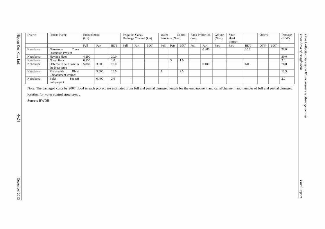
Data C
ollection Survey on Water R
esources Managem
ent in H
aor Area of B
angladesh
Final R
eport
Nippon K
oei Co., L
td. 4-24
D
ecember 2013
District Project Name Embankment (km)
Irrigation Canal/ Drainage Channel (km)
Water Control Structure (Nos.)
Bank Protection (km)
Groyne(Nos.)
Spur/ Hard Protect
Others Damage (BDT)
Full Part BDT Full Part BDT Full Part BDT Full Part Part Part BDT QTY BDT Netrokona Netrokona Town
Protection Project 0.300 20.0 20.0
Netrokona Hayjada Haor 4.290 20.0 20.0 Netrokona Notan Haor 0.150 1.0 3 1.0 2.0 Netrokona Deferent Khal Close in
the Haor Area 5.880 3.000 70.0 0.100 6.0 76.0
Netrokona Mahananda River Embankment Project
5.000 10.0 2 2.5 12.5
Netrokona Balai Padasri Sub-project
0.400 2.0 2.0
Note: The damaged costs by 2007 flood in each project are estimated from full and partial damaged length for the embankment and canal/channel , and number of full and partial damaged
location for water control structures. .
Source: BWDB
Data Collection Survey on Water Resources Management in Haor Area of Bangladesh Final Report
Nippon Koei Co., Ltd. 4-25 December 2013
4.3.2 Targets of Field Survey
The targets of the field survey are 1) the existing haor projects, and 2) the river facilities
because existing facilities related to water management are located in the existing haor
areas and along/across the rivers.
(1) Existing Haor Projects
The target areas of the haor projects for this survey are also decided based on the same
reasons for the topographic survey. The targets of this survey include the existing haor
projects in the five districts except the haor projects to be rehabilitated by BWDB. Figure 4.3.3 and Table 4.3.4 show the target haor projects of the facility survey.
Table 4.3.4 Number of Haor Projects for Facility Survey District Number 1 Sunamganj 1
2 Habiganj 7
3 Netrakona 8
4 Kishoreganj 10
5 Brahamanbaria 4
Total 30 Source: JICA Study Team
(2) River Facilities
Many full and submergible embankments in Sunamganj, Netrakona, Kishoreganj,
Brahamanbaria districts were constructed under the haor project. These structures have
been surveyed in the haor project. Therefore, the river facility survey is carried out for
Sylhet, Maulvibazar and Habiganj districts.
(3) Schedule of Field Survey
The field survey is divided to two steps. The first step consists of the existing haor
projects, and the second step consists of the river facilities. The first step was conducted
from early February to early March and second step was planned from the middle of
March to early April. However, the second step was shifted to the beginning of May
because many hartar occurred in March and April.
4.3.3 Survey Items
The field survey shall include the following items:
1) Collection and review of design drawings and design conditions/criteria,
2) Past flood overtopping and damage of submergible embankment, and types and
problems of drainage facilities,
3) Major causes of facility damage and malfunction,
4) State of O&M,
5) Function of haor areas (method for securing irrigation water, supply of nutritive
salt due to farm land sedimentation, freshwater fishing in farm land, etc.)
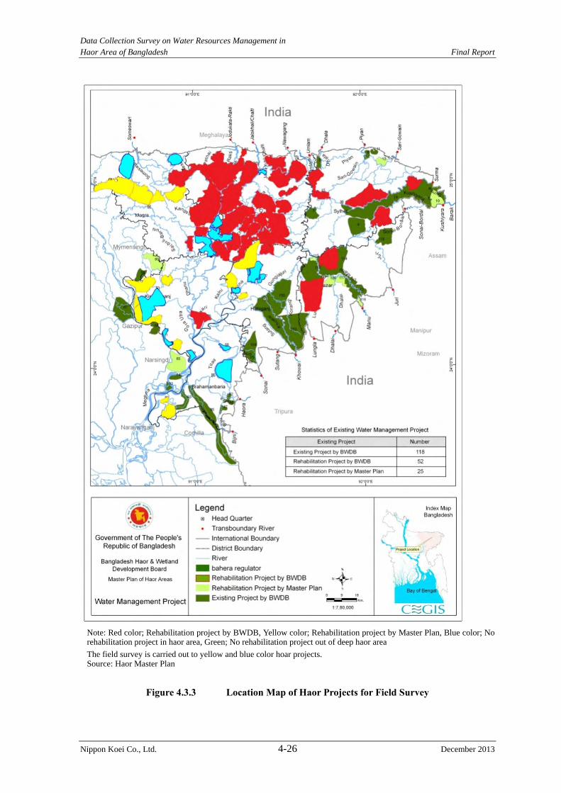
Data Collection Survey on Water Resources Management in Haor Area of Bangladesh Final Report
Nippon Koei Co., Ltd. 4-26 December 2013
Note: Red color; Rehabilitation project by BWDB, Yellow color; Rehabilitation project by Master Plan, Blue color; No rehabilitation project in haor area, Green; No rehabilitation project out of deep haor area
The field survey is carried out to yellow and blue color hoar projects. Source: Haor Master Plan
Figure 4.3.3 Location Map of Haor Projects for Field Survey
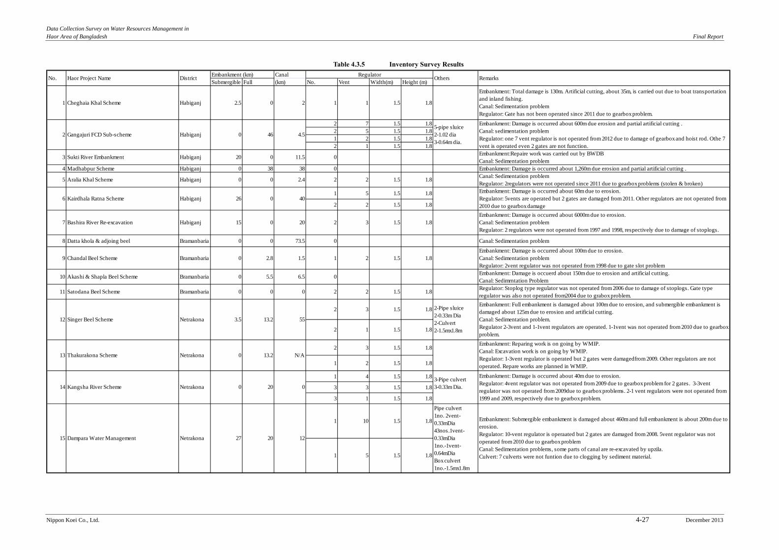
Data Collection Survey on Water Resources Management in Haor Area of Bangladesh Final Report
Nippon Koei Co., Ltd. 4-27 December 2013
Table 4.3.5 Inventory Survey Results
Embankment (km) Canal RegulatorSubmergible Full (km) No. Vent Width(m) Height (m)
1 Cheghaia Khal Scheme Habiganj 2.5 0 2 1 1 1.5 1.8
Embankment: Total damage is 130m. Artificial cutting, about 35m, is carried out due to boat transportationand inland fishing.Canal: Sedimentation problemRegulator: Gate has not been operated since 2011 due to gearbox problem.
2 7 1.5 1.82 5 1.5 1.81 2 1.5 1.82 1 1.5 1.8
3 Sukti River Embankment Habiganj 20 0 11.5 0Embankment:Repaire work was carried out by BWDBCanal: Sedimentation problem
4 Madhabpur Scheme Habiganj 0 38 38 0 Embankment: Damage is occurred about 1,260m due erosion and partial artificial cutting .
5 Aralia Khal Scheme Habiganj 0 0 2.4 2 2 1.5 1.8Canal: Sedimentation problemRegulator: 2regulators were not operated since 2011 due to gearbox problems (stolen & broken)
1 5 1.5 1.8
2 2 1.5 1.8
7 Bashira River Re-excavation Habiganj 15 0 20 2 3 1.5 1.8Embankment: Damage is occurred about 6000m due to erosion.Canal: Sedimentation problemRegulator: 2 regulators were not operated from 1997 and 1998, respectively due to damage of stoplogs.
8 Datta khola & adjoing beel Bramanbaria 0 0 73.5 0 Canal: Sedimentation problem
9 Chandal Beel Scheme Bramanbaria 0 2.8 1.5 1 2 1.5 1.8Embankment: Damage is occurred about 100m due to erosion.Canal: Sedimentation problemRegulator: 2vent regulator was not operated from 1998 due to gate slot problem
10 Akashi & Shapla Beel Scheme Bramanbaria 0 5.5 6.5 0Embankment: Damage is occuerd about 150m due to erosion and artificial cutting.Canal: Sedimrntation Problem
11 Satodana Beel Scheme Bramanbaria 0 0 0 2 2 1.5 1.8Regulator: Stoplog type regulator was not operated from 2006 due to damage of stoplogs. Gate typeregulator was also not operated from2004 due to grabox problem.
2 3 1.5 1.8
2 1 1.5 1.8
2 3 1.5 1.8
1 2 1.5 1.8
1 4 1.5 1.8
3 3 1.5 1.8
3 1 1.5 1.8
1 10 1.5 1.8
1 5 1.5 1.8
0HabiganjGangajuri FCD Sub-scheme
0 40
Netrakona 3.5 13.2 55
2-Pipe sluice2-0.33m Dia2-Culvert2-1.5mx1.8m
Embankment: Full embankment is damaged about 100m due to erosion, and submergible embankment isdamaged about 125m due to erosion and artificial cutting.Canal: Sedimentation problem.Regulator 2-3vent and 1-1vent regulators are operated. 1-1vent was not operated from 2010 due to gearboxproblem.
2
Embankment: Damage is occurred about 600m due erosion and partial artificial cutting .Canal: sedimentation problemRegulator: one 7 vent regulator is not operated from 2012 due to damage of gearbox and hoist rod. Othe 7vent is operated even 2 gates are not function.
6 Kairdhala Ratna Scheme Habiganj 26Embankment: Damage is occurred about 60m due to erosion.Regulator: 5vents are operated but 2 gates are damaged from 2011. Other regulators are not operated from2010 due to gearbox damage
5-pipe sluice2-1.02 dia3-0.64m dia.
4.546
13 Thakurakona Scheme Netrakona 0 13.2 N/A
Embankment: Reparing work is on going by WMIP.Canal: Excavation work is on going by WMIP.Regulator: 1-3vent regulator is operated but 2 gates were damagedfrom 2009. Other regulators are notoperated. Repare works are planned in WMIP.
Pipe culvert1no. 2vent-0.33mDia43nos.1vent-0.33mDia1no.-1vent-0.64mDiaBox culvert1no.-1.5mx1.8m
Embankment: Submergible embankment is damaged about 460m and full embankment is about 200m due toerosion.Regulator: 10-vent regulator is operaated but 2 gates are damaged from 2008. 5vent regulator was notoperated from 2010 due to gearbox problemCanal: Sedimentation problems, some parts of canal are re-excavated by upzila.Culvert: 7 culverts were not funtion due to clogging by sediment material.
020
20 12
0Netrakona3-Pipe culvert3-0.33m Dia.
Embankment: Damage is occurred about 40m due to erosion.Regulator: 4vent regulator was not operated from 2009 due to gearbox problem for 2 gates. 3-3ventregulator was not operated from 2009due to gearbox problems. 2-1 vent regulators were not operated from1999 and 2009, respectively due to gearbox problem.
15 Dampara Water Management Netrakona 27
DistrictNo. Haor Project Name
Kangsha River Scheme14
12 Singer Beel Scheme
Others Remarks
Data Collection Survey on Water Resources Management in Haor Area of Bangladesh Final Report
Nippon Koei Co., Ltd. 4-28 December 2013
Source: JICA Study Team
Embankment (km) Canal RegulatorSubmergible Full (km) No. Vent Width(m) Height (m)
16 Someswari River sub-scheme Netrakona 0 6 0 0Box culvert2nos. 1mx0.5m
Embankment: Damage is ocured about 1,970m due to erosion.
2 4 1.5 1.81 3 1.5 1.82 2 1.5 1.85 1 1.5 1.8
1 4 1.5 1.8
1 3 1.5 1.8
3 1 1.5 1.8
19 Mohadao Nadii Embankment Netrakona 3 7.5 0 03nos. Box Culvert1.32m x 0.67m
Embankment: Full embankment is damaged about 420m due to erosion, artifical cutting and lower than thedesign crest elevation, and submergible embankment is damaged about 120m due to erosion and artificialcutting.
20 Sunamganj Town Protection Sunamganj 0 1.6 0 0 Embankment: Damage is about 300m due to erosion.
1 6 1.5 1.8
1 1 1.5 1.8
1 2 1.5 1.81 1 1.5 1.8
23 Boraikhali Khal sub-project Kishoreganj 0 5.3 24.5 1 6 1.5 1.82nos. Pipe Sluice2-0.9m Dia.
Embankment: Damage is about 10m due to erosion.Canal: Sedimentation problem.All pipe sluices are not function due to siltation.
24 Char Ferradee-Jangalia sub-project Kishoreganj 0 11.6 0 1 5 1.5 1.81no. Pipe Sluice0.9m Dia.
Embankmnt: Rehabilitaion works are carried out by WMIP.Regulator is operated.Pipe sluice is not funtion due to siltation.
25 Singua River Re-excavation sub-project Kishoreganj 0 0 55 0 Canal: Riverbed aggradation in Singua River is occurred due to sedimentation.
26 Adampur sub-project Kishoreganj 0 0 9.4 1 2 1.5 1.8Regulator is good condition.Canal: Sedimentation problem
27 Alalia Bahadia sub-project Kishoreganj 0 0 8 1 2 1.5 1.8Regulator is good condition.Canal: Sedimentation problem
28 Motkhola-Bairagir Char sub-project Kishoreganj 0 10.8 0 1 2 1.5 1.8Embankment: Damage is about 50m due to erosion.Regulator is good condition.
29 Bhairab Bazar Erosion Protection sub-project Kishoreganj 0 0 0 0Bank Protection3km
Bank erosion: Damage is about 3000m due to erosion. Some protection works was carried out nearabatment by railway authority.
1 2 1.5 1.81 1 1.5 1.8
Khaliajuri FCD Polder #217
4nos. Pipe inlet4-0.75m Dia2nos. Box culvert0.75mx0.75m
Embankment: Damage is occurred about 810m due to erosion and artificial cutting.Regulator: 2-4vent regulators are under construction. 3vent regulator is not operated from 2009 due togearbox problem. 2-2vent tregulators are operated even both gates are damaged. 3-1 vent regulators arenotoperated due to gearbox problem.
0047Netrakona
0052.1Netrakona
Kaliajuri FCD Polder #418
5nos. Pipe inlet5nos. 0.50m DiaBox culvert1no. 0.5mx1.0m4nos. 0.66mx0.66mPipeculvert1no. 0.3m Dia2 Causeway
Embankment: Damage id occurred about 630m due to erosion and artificial cuttingRegulator: 4vent and 3 vent regulatores are under constructios. 1 vent regulators are damaged due to gearbox problem.
21 Sukhaijuri Bathai sub-project Kishoreganj 0 20.9 0
22 Gazaria Beel sub-project Kishoreganj 0 0 0
30 Ganakkali sub-project Kishoreganj 0 0 0
No. Haor Project Name District Others Remarks
2vent regulator is not operated because the gate, hoisting rod, gear box was stolen just after construction.1vent regulator is not operated due to gearbox problem.
3nos. Pipe sluice3-0.9m Dia
Embankment: Full embankment is damaged about 70m.Regulator: 6vent regulator is not operated from 1993 due to conflict between fishers committee and farmerscommittee. 1vent regulator is not operated due to gearbox problem.
3nos. Pipe sluice3-0.9m Dia
Regulator: 1 vent regulator is not operated due to gearbox problem.All pipe sluice are not function due to siltation and lost of gate
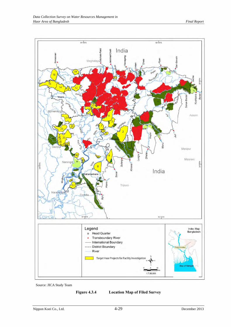
Data Collection Survey on Water Resources Management in Haor Area of Bangladesh Final Report
Nippon Koei Co., Ltd. 4-29 December 2013
Source: JICA Study Team
Figure 4.3.4 Location Map of Filed Survey
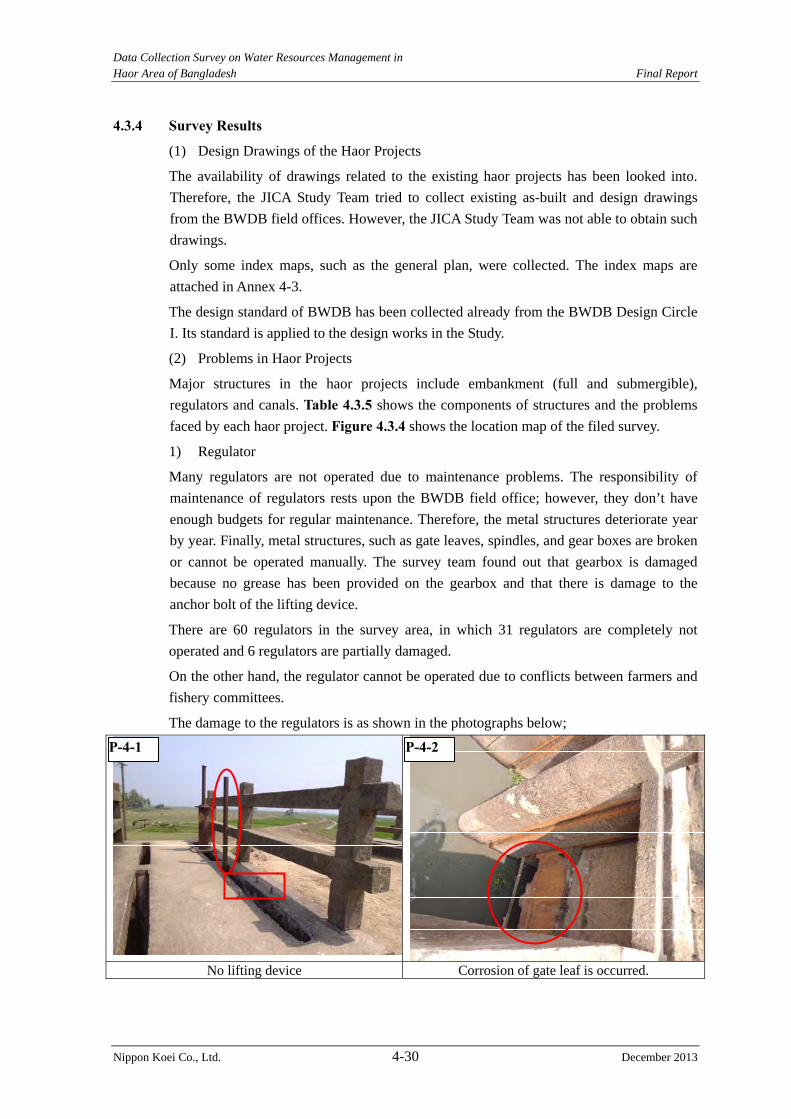
Data Collection Survey on Water Resources Management in Haor Area of Bangladesh Final Report
Nippon Koei Co., Ltd. 4-30 December 2013
4.3.4 Survey Results
(1) Design Drawings of the Haor Projects
The availability of drawings related to the existing haor projects has been looked into.
Therefore, the JICA Study Team tried to collect existing as-built and design drawings
from the BWDB field offices. However, the JICA Study Team was not able to obtain such
drawings.
Only some index maps, such as the general plan, were collected. The index maps are
attached in Annex 4-3.
The design standard of BWDB has been collected already from the BWDB Design Circle
I. Its standard is applied to the design works in the Study.
(2) Problems in Haor Projects
Major structures in the haor projects include embankment (full and submergible),
regulators and canals. Table 4.3.5 shows the components of structures and the problems
faced by each haor project. Figure 4.3.4 shows the location map of the filed survey.
1) Regulator
Many regulators are not operated due to maintenance problems. The responsibility of
maintenance of regulators rests upon the BWDB field office; however, they don’t have
enough budgets for regular maintenance. Therefore, the metal structures deteriorate year
by year. Finally, metal structures, such as gate leaves, spindles, and gear boxes are broken
or cannot be operated manually. The survey team found out that gearbox is damaged
because no grease has been provided on the gearbox and that there is damage to the
anchor bolt of the lifting device.
There are 60 regulators in the survey area, in which 31 regulators are completely not
operated and 6 regulators are partially damaged.
On the other hand, the regulator cannot be operated due to conflicts between farmers and
fishery committees.
The damage to the regulators is as shown in the photographs below;
No lifting device Corrosion of gate leaf is occurred.
P-4-1 P-4-2
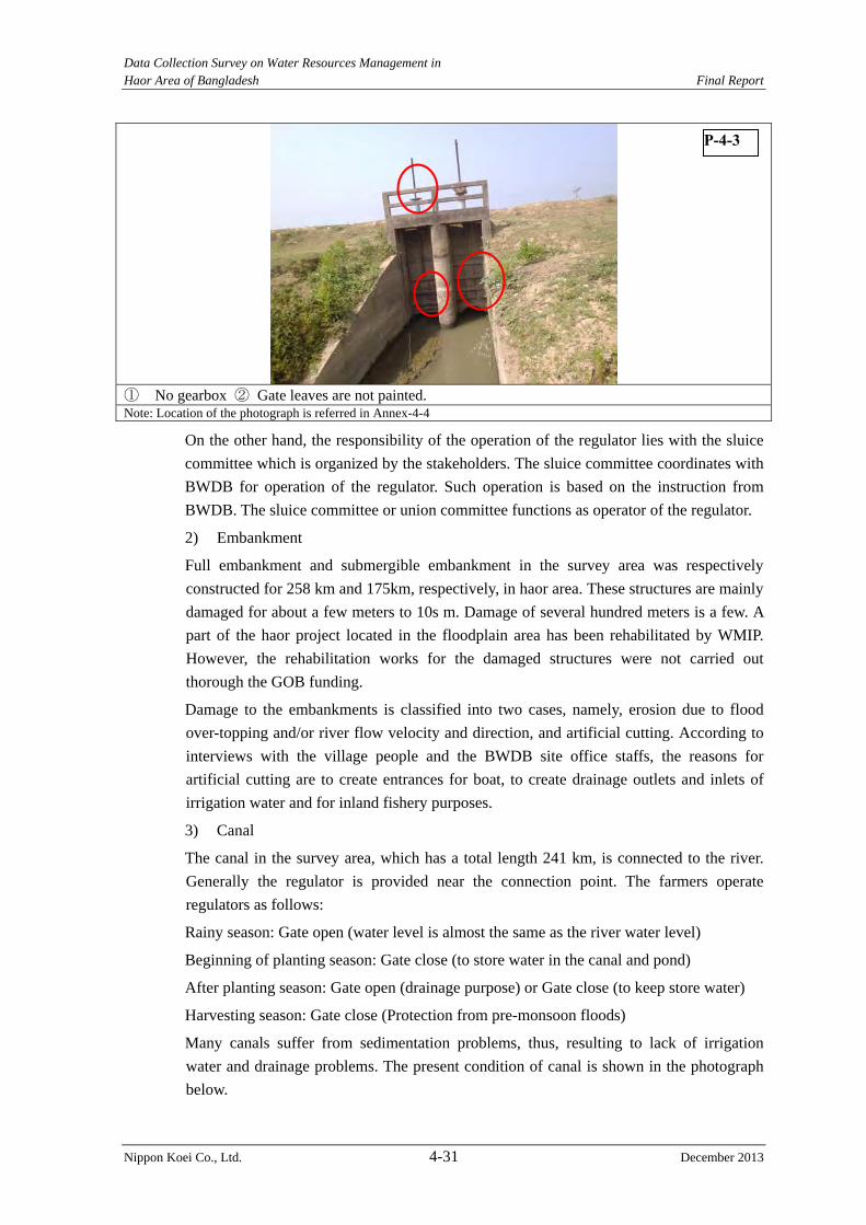
Data Collection Survey on Water Resources Management in Haor Area of Bangladesh Final Report
Nippon Koei Co., Ltd. 4-31 December 2013
① No gearbox ② Gate leaves are not painted. Note: Location of the photograph is referred in Annex-4-4
On the other hand, the responsibility of the operation of the regulator lies with the sluice
committee which is organized by the stakeholders. The sluice committee coordinates with
BWDB for operation of the regulator. Such operation is based on the instruction from
BWDB. The sluice committee or union committee functions as operator of the regulator.
2) Embankment
Full embankment and submergible embankment in the survey area was respectively
constructed for 258 km and 175km, respectively, in haor area. These structures are mainly
damaged for about a few meters to 10s m. Damage of several hundred meters is a few. A
part of the haor project located in the floodplain area has been rehabilitated by WMIP.
However, the rehabilitation works for the damaged structures were not carried out
thorough the GOB funding.
Damage to the embankments is classified into two cases, namely, erosion due to flood
over-topping and/or river flow velocity and direction, and artificial cutting. According to
interviews with the village people and the BWDB site office staffs, the reasons for
artificial cutting are to create entrances for boat, to create drainage outlets and inlets of
irrigation water and for inland fishery purposes.
3) Canal
The canal in the survey area, which has a total length 241 km, is connected to the river.
Generally the regulator is provided near the connection point. The farmers operate
regulators as follows:
Rainy season: Gate open (water level is almost the same as the river water level)
Beginning of planting season: Gate close (to store water in the canal and pond)
After planting season: Gate open (drainage purpose) or Gate close (to keep store water)
Harvesting season: Gate close (Protection from pre-monsoon floods)
Many canals suffer from sedimentation problems, thus, resulting to lack of irrigation
water and drainage problems. The present condition of canal is shown in the photograph
below.
P-4-3

Data Collection Survey on Water Resources Management in Haor Area of Bangladesh Final Report
Nippon Koei Co., Ltd. 4-32 December 2013
Re-excavation of canal (WMIP) due to sedimentation problem
Present situation of drainage canal According to interviews with village people, canal bed aggradation was already occurred. Re-excavation of canal is required.
Note: Location of the photograph is referred in Annex-4-4
4) Problems
(a) Operation and Maintenance (O&M)
As explained above, the most important problem is the lack of O&M budget. The BWDB
site offices requested to the BWDB head office for their O&M budget as estimated based
on the repair works cost of the damaged structures. According to the interview with the
BWDB site office, the actual budget is given about 20% to 30% only of the required cost.
It is impossible to carry out all repair works and maintenance works with such budget.
Therefore, they consider the priority of the repair works and only high priority structures
undergo repair works, thus low priority structures are not rehabilitated.
On the other hand, LGED hands over the facilities constructed in the project to the
stakeholders, such as the village people. The stakeholders then established a committee to
carry out O&M. But BWDB does not have experience to establish the same type of O&M
organization of LGED.
The JICA Study Team carried out hearing to the BWDB site offices regarding to the
problem of the lack of the O&M budget and the participatory O&M approach. As a result
of the interview, the BWDB site offices want to hand over to the water management
group (WMG) established based on “Guideline for Participatory Water Management”.
They think that the WMG will be established under the new project, but it is difficult to
establish the WMG in the existing project. The following issues shall be settled:
1) Establishment of new O&M organization (WMG) by stakeholder, and
2) Preparation of a system, such as to function facilities in the long term.
(b) Rehabilitation of Embankment
As a result of the interview with the village people, the embankment materials for
rehabilitation works are collected near the river and canal. The embankment materials are
to be compacted by use of a rammer, however, the compaction works have not been
carried out.
P-4-4 P-4-5
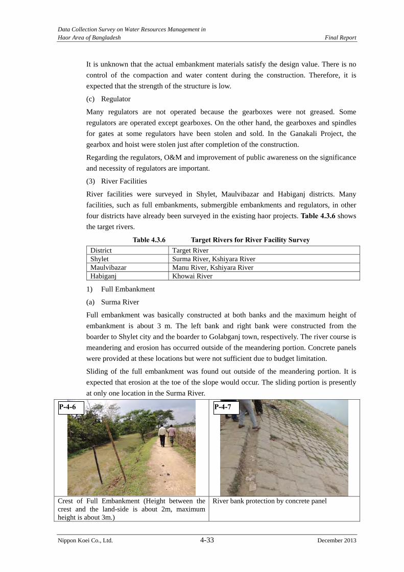
Data Collection Survey on Water Resources Management in Haor Area of Bangladesh Final Report
Nippon Koei Co., Ltd. 4-33 December 2013
It is unknown that the actual embankment materials satisfy the design value. There is no
control of the compaction and water content during the construction. Therefore, it is
expected that the strength of the structure is low.
(c) Regulator
Many regulators are not operated because the gearboxes were not greased. Some
regulators are operated except gearboxes. On the other hand, the gearboxes and spindles
for gates at some regulators have been stolen and sold. In the Ganakali Project, the
gearbox and hoist were stolen just after completion of the construction.
Regarding the regulators, O&M and improvement of public awareness on the significance
and necessity of regulators are important.
(3) River Facilities
River facilities were surveyed in Shylet, Maulvibazar and Habiganj districts. Many
facilities, such as full embankments, submergible embankments and regulators, in other
four districts have already been surveyed in the existing haor projects. Table 4.3.6 shows
the target rivers.
Table 4.3.6 Target Rivers for River Facility Survey District Target River Shylet Surma River, Kshiyara River Maulvibazar Manu River, Kshiyara River Habiganj Khowai River
1) Full Embankment
(a) Surma River
Full embankment was basically constructed at both banks and the maximum height of
embankment is about 3 m. The left bank and right bank were constructed from the
boarder to Shylet city and the boarder to Golabganj town, respectively. The river course is
meandering and erosion has occurred outside of the meandering portion. Concrete panels
were provided at these locations but were not sufficient due to budget limitation.
Sliding of the full embankment was found out outside of the meandering portion. It is
expected that erosion at the toe of the slope would occur. The sliding portion is presently
at only one location in the Surma River.
Crest of Full Embankment (Height between the crest and the land-side is about 2m, maximum height is about 3m.)
River bank protection by concrete panel
P-4-6 P-4-7
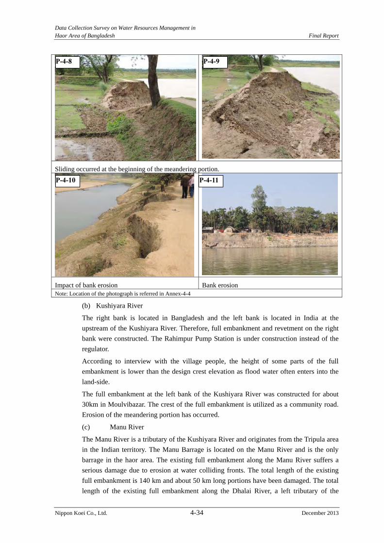
Data Collection Survey on Water Resources Management in Haor Area of Bangladesh Final Report
Nippon Koei Co., Ltd. 4-34 December 2013
Sliding occurred at the beginning of the meandering portion.
Impact of bank erosion Bank erosion Note: Location of the photograph is referred in Annex-4-4
(b) Kushiyara River
The right bank is located in Bangladesh and the left bank is located in India at the
upstream of the Kushiyara River. Therefore, full embankment and revetment on the right
bank were constructed. The Rahimpur Pump Station is under construction instead of the
regulator.
According to interview with the village people, the height of some parts of the full
embankment is lower than the design crest elevation as flood water often enters into the
land-side.
The full embankment at the left bank of the Kushiyara River was constructed for about
30km in Moulvibazar. The crest of the full embankment is utilized as a community road.
Erosion of the meandering portion has occurred.
(c) Manu River
The Manu River is a tributary of the Kushiyara River and originates from the Tripula area
in the Indian territory. The Manu Barrage is located on the Manu River and is the only
barrage in the haor area. The existing full embankment along the Manu River suffers a
serious damage due to erosion at water colliding fronts. The total length of the existing
full embankment is 140 km and about 50 km long portions have been damaged. The total
length of the existing full embankment along the Dhalai River, a left tributary of the
P-4-8 P-4-9
P-4-10 P-4-11

Data Collection Survey on Water Resources Management in Haor Area of Bangladesh Final Report
Nippon Koei Co., Ltd. 4-35 December 2013
Manu River, is 130 km, of which about 60 km long embankments are damaged.
(d) Khowai River.
The Khowai River is also a tributary of the Kushiyara River and originates from the
Tripula area in the Indian territory.
A total of 84 km long embankments had been constructed in the Khowai River Project,
Phase 1, out of which 34km long embankments were rehabilitated in Khowai River
Project, Phase2. Since the rehabilitation, 10 years have passed and some locations are
partially eroded. However, the damage of embankment in the Khowai River is less
serious compared with that of other rivers owing to the execution of rehabilitation.
Full embankment in the Kushiyara RiverThe crest of the full embankment is utilized as a community road.
Full embankment of the Kushiyra River (hundreds meter upstream from the left side photo.) The crest elevation is lower than the design crest elevation. Thus, flood water often enters the mosque area. The overflow water depth is about 10 cm to 20cm.
Manu River (near the boundary) The river bank protection was constructed in this area in 2006/07. However, the eroded area was partially provided with concrete block type revetment due to budget shortage; therefore, the meandering portion was eroded.
Erosion at the meandering portion of the Dhalai River
P-4-12 P-4-13
P-4-14 P-4-15
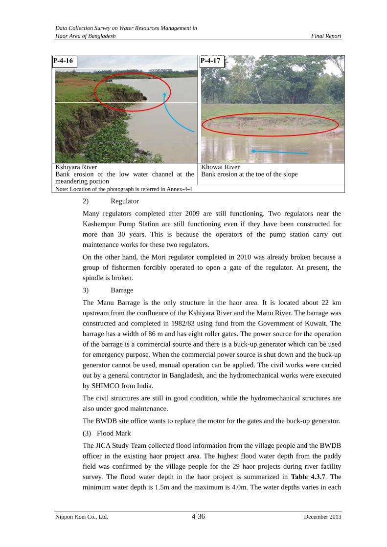
Data Collection Survey on Water Resources Management in Haor Area of Bangladesh Final Report
Nippon Koei Co., Ltd. 4-36 December 2013
Kshiyara River Bank erosion of the low water channel at the meandering portion
Khowai RiverBank erosion at the toe of the slope
Note: Location of the photograph is referred in Annex-4-4
2) Regulator
Many regulators completed after 2009 are still functioning. Two regulators near the
Kashempur Pump Station are still functioning even if they have been constructed for
more than 30 years. This is because the operators of the pump station carry out
maintenance works for these two regulators.
On the other hand, the Mori regulator completed in 2010 was already broken because a
group of fishermen forcibly operated to open a gate of the regulator. At present, the
spindle is broken.
3) Barrage
The Manu Barrage is the only structure in the haor area. It is located about 22 km
upstream from the confluence of the Kshiyara River and the Manu River. The barrage was
constructed and completed in 1982/83 using fund from the Government of Kuwait. The
barrage has a width of 86 m and has eight roller gates. The power source for the operation
of the barrage is a commercial source and there is a buck-up generator which can be used
for emergency purpose. When the commercial power source is shut down and the buck-up
generator cannot be used, manual operation can be applied. The civil works were carried
out by a general contractor in Bangladesh, and the hydromechanical works were executed
by SHIMCO from India.
The civil structures are still in good condition, while the hydromechanical structures are
also under good maintenance.
The BWDB site office wants to replace the motor for the gates and the buck-up generator.
(3) Flood Mark
The JICA Study Team collected flood information from the village people and the BWDB
officer in the existing haor project area. The highest flood water depth from the paddy
field was confirmed by the village people for the 29 haor projects during river facility
survey. The flood water depth in the haor project is summarized in Table 4.3.7. The
minimum water depth is 1.5m and the maximum is 4.0m. The water depths varies in each
P-4-16 P-4-17
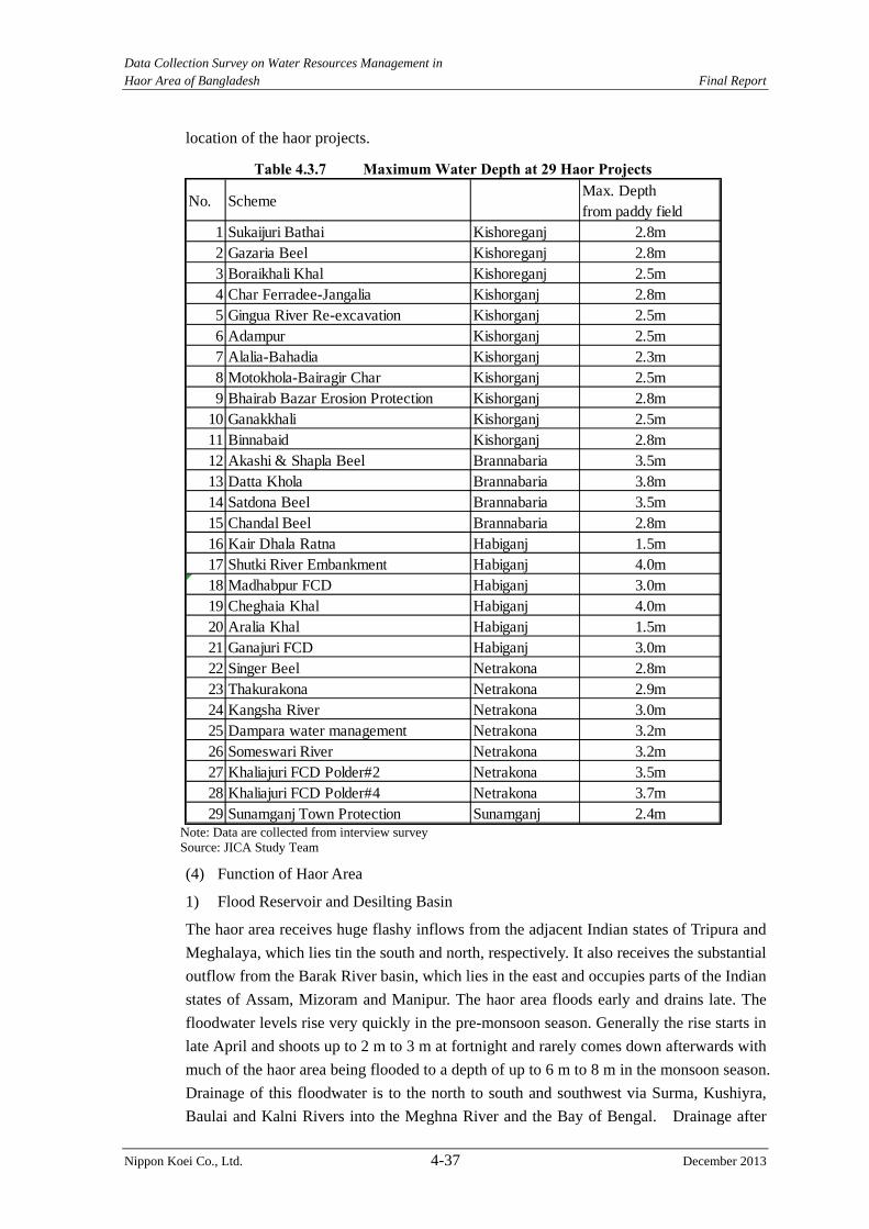
Data Collection Survey on Water Resources Management in Haor Area of Bangladesh Final Report
Nippon Koei Co., Ltd. 4-37 December 2013
location of the haor projects.
Table 4.3.7 Maximum Water Depth at 29 Haor Projects
Note: Data are collected from interview survey Source: JICA Study Team
(4) Function of Haor Area
1) Flood Reservoir and Desilting Basin
The haor area receives huge flashy inflows from the adjacent Indian states of Tripura and
Meghalaya, which lies tin the south and north, respectively. It also receives the substantial
outflow from the Barak River basin, which lies in the east and occupies parts of the Indian
states of Assam, Mizoram and Manipur. The haor area floods early and drains late. The
floodwater levels rise very quickly in the pre-monsoon season. Generally the rise starts in
late April and shoots up to 2 m to 3 m at fortnight and rarely comes down afterwards with
much of the haor area being flooded to a depth of up to 6 m to 8 m in the monsoon season.
Drainage of this floodwater is to the north to south and southwest via Surma, Kushiyra,
Baulai and Kalni Rivers into the Meghna River and the Bay of Bengal. Drainage after
No. SchemeMax. Depthfrom paddy field
1 Sukaijuri Bathai Kishoreganj 2.8m2 Gazaria Beel Kishoreganj 2.8m3 Boraikhali Khal Kishoreganj 2.5m4 Char Ferradee-Jangalia Kishorganj 2.8m5 Gingua River Re-excavation Kishorganj 2.5m6 Adampur Kishorganj 2.5m7 Alalia-Bahadia Kishorganj 2.3m8 Motokhola-Bairagir Char Kishorganj 2.5m9 Bhairab Bazar Erosion Protection Kishorganj 2.8m
10 Ganakkhali Kishorganj 2.5m11 Binnabaid Kishorganj 2.8m12 Akashi & Shapla Beel Brannabaria 3.5m13 Datta Khola Brannabaria 3.8m14 Satdona Beel Brannabaria 3.5m15 Chandal Beel Brannabaria 2.8m16 Kair Dhala Ratna Habiganj 1.5m17 Shutki River Embankment Habiganj 4.0m18 Madhabpur FCD Habiganj 3.0m19 Cheghaia Khal Habiganj 4.0m20 Aralia Khal Habiganj 1.5m21 Ganajuri FCD Habiganj 3.0m22 Singer Beel Netrakona 2.8m23 Thakurakona Netrakona 2.9m24 Kangsha River Netrakona 3.0m25 Dampara water management Netrakona 3.2m26 Someswari River Netrakona 3.2m27 Khaliajuri FCD Polder#2 Netrakona 3.5m28 Khaliajuri FCD Polder#4 Netrakona 3.7m29 Sunamganj Town Protection Sunamganj 2.4m
Data Collection Survey on Water Resources Management in Haor Area of Bangladesh Final Report
Nippon Koei Co., Ltd. 4-38 December 2013
the wet season ends and typically takes up to three months.
2) Method for Securing Irrigation Water
There are substantial volumes of (post monsoon) residual surface water available for
irrigation. Surface water in rivers and haors is extensively used for rice production in the
dry season. About two-thirds of the total rice growing area is irrigated by surface water
compared to the national average of 20%. According to the survey conducted by the
Ministry of Agriculture 52% of 1.35 million irrigation water users or farmers in the haor
area irrigate surface water compared to 18% throughout the country (Minor Irrigation
Survey Report 2011-12, Bangladesh Agriculture Development Corporation, according to
the survey by the Ministry of Agriculture). Furthermore, diesel operated equipments, such
as (deep tube wells (DTWs), shallow tube wells (STWs) and low-lift pumps (LLPs))
cover about 78% of the total irrigated area (groundwater and surface water combined)
compared to the national average of 69%. Surface water irrigation by diesel operated
LLPs accounts for about 87% of the total irrigated area. About 98% of the surface water
users irrigate their land by diesel operated LLPs. Water users who irrigate their land by
electricity operated LLPs account for 2% of the total water users. Water charge in the
diesel operated LLP irrigated area is two to three times higher than in electricity operated
LLP irrigated area. Surface water for irrigation is mostly obtained from the beels as well
as from the channels and rivers using LLPs. The regulators on the channels are closed
before land drainage is complete so that sufficient water is regained in the beels for
irrigation. The water management plan that will ensure irrigation water supply and
contribute to food production in the haor area should include as follows:
Increasing of the effectiveness of the existing irrigation infrastructure through
improvements of operation and maintenance systems.
Provision of irrigation infrastructure in the areas of existing and potential high
agricultural productivity.
Improvement of water distribution by development of irrigation infrastructure. Such
as construction of lined canal and buried pipe system, and supply of flexible pipe.
Dredging of rivers and re-excavation of channels and beels to conserve adequate
water for irrigation in dry season.
Provision of cross dams on rivers, channels and hilly streams for water conservation
for irrigation.
Excavation of hilly streams in order to improve flow.
Electricity supply for irrigation to reduce crop production.
Support farmers for solar powered irrigation pumping.
3) Soil Nutrient Supply
Soils in the haor area are relatively uniform, developed in non-calcareous alluvium and
productive. Grey, heavy, silty clay loams predominate on the ridges; while clay in the
haor centers. Small areas of loamy soils occur alongside rivers, together with mixed sandy
and silty alluvium. Peats occupy some wet haor centers. The cultivated layer is lighter
Data Collection Survey on Water Resources Management in Haor Area of Bangladesh Final Report
Nippon Koei Co., Ltd. 4-39 December 2013
in texture except in haor centers. Most soils have dark grey to black topsoil and between
slightly to strongly acid and moderately alkaline in reaction. Fertility level is medium to
high with low P and high in Zn and S content while that of other essential nutrients is
themedium. The levels of N and P2O5 are medium. Organic matter content ranges
between 0.5% to 2.0% in ridge soils and 2.0% to 4.0% in haor centers. Permeability is
generally slow, except in some loamy ridge soils. Moisture-holding capacity is moderate
to low. The soils are better suited for rice cultivation with irrigation in the dry season.
Silty clay and loamy soils on intermediate positions are suitable for both irrigated boro
rice and non-rice crops. Deep floods in haor area damage crops or restrict land use for
crop production. However, the floods may actually benefit deepwater aman rice grown
after the harvest of boro rice in the pre-monsoon season. The deepwater rice provides
shelter for fish and their food in the form of periphyton on submerged stems and leaves,
refuge for wildlife, and base of food chain through decomposition of plant material.
The soil nutrients in the haor area are affected by many factors. These include flooding,
elevation of the soils relative to the local flood levels, sediments content of the flood
water, types of crop grown, and nature and rate of fertilizers application on the land. The
floodwater running off upstream carries silt and clay. The fertility associated with
flooding comes from various sources including nitrogen-fixing organism living in
floodwater, decomposition of organic matter, release of nitrogen from soil micro organic
matter by microbial activity after soil is submerged and phosphorous and some minor
elements released by changes in soil chemistry which occur between dry and submerged
conditions. Flood protection and drainage which reduce the depth and duration of
flooding may reduce the fertility. This needs to be compensated by increased fertilizer
use.
In the hill lands upstream there have been extensive and indiscriminate cleaning of the
forest over large tracts of areas, followed by use of the land for cropping. The numerous
rivers rising in these hills carry huge volume of sediments of which some are flashed out.
The reminder is deposited mainly on the river beds, cultivated lands and depressions.
These sediments are characterized by coarser fraction in the upstream and final materials
in the downstream. There are significant changes in soil productivity with the increase in
severity and frequency of flooding, burial of land by raw sandy sediments and depletion
of soil fertility level. The increasing degradation of vegetation and soils in the Indian
states of Assam Hills and in some Bangladesh’s hills areas too will increase runoff into
the rivers. This seems likely to increase the amounts of sediments including more sands
carried by floodwater in the haor area (Agricultural Development Possibilities in
Bangladesh by Hugh Brammer, 1997, University Press Limited, Bangladesh).
4) Freshwater Fishing in Farm Land
Freshwater fisheries are comprised of floodplain (77%), beels (9%), channels (11%) and
ponds and ditches (3%). The floodplain covers about 324,000 ha, beels 37,000 ha,
channel 45,000 ha and ponds 4,300 ha. Floodplain landscapes are not absolutely flat.
They comprise higher parts (river banks, ridges) and lower parts (old river-channels,
basins). Virtually every floodplain includes both ridge and basin land which are
Data Collection Survey on Water Resources Management in Haor Area of Bangladesh Final Report
Nippon Koei Co., Ltd. 4-40 December 2013
seasonally flooded. The ridge soils are better suited for non-rice corps and heavier soils
on the lower part are for boro rice in the winter season. In floodplain areas subsistence
fishing occurs mainly during the flooding period and large-scale beel fishing occurs in the
winter season on an annual basis.
There are two types of fishermen - traditional and non-traditional, who catch for
generating an income. Traditional fishermen live on fishing and have been engaged in
the profession since generations. There are an estimated 12,000 to 18,000 traditional
fisherman households settled mostly in the haor area. The jalmohals (water bodies which
are registered for revenue collection as a fishery) are generally leased out to them through
cooperatives. The non-traditional fishermen are mainly an emerging group from landless
and poor farmers. They fish in open water especially during monsoon season and sell the
catch. Such non-traditional fishermen are increasing in number and nearly 30-40 percent
of the total households in haor area are reportedly engaged in catching fish. According to
the Bangladesh Bureau of Statistics (2011) the number of subsistence fisheries
households in the haor area is 1.6 million (2010 Yearbook of Agricultural Statistics).
Annually, each household catches 115 kg of fish in floodplain. Accordingly the total
annual catch from the floodplain is about 184,000 tons. The semi-closed seasonal water
bodies on cultivated floodplain covers about 2,900 ha where the fish production is about
6,350 tons annually.
Data Collection Survey on Water Resources Management in Haor Area of Bangladesh Final Report
Nippon Koei Co., Ltd. 5-1 December 2013
CHAPTER 5 HYDROLOGICAL AND HYDRAULIC STUDY
5.1 Data Collection and Review
Most of the data were obtained from BWDB, IWM and CEGIS. Some of the information
obtained can only be used in conjunction with these institutions.
(1) Existing Data Availability
1) Water Level
Water level data is very important information for the Study because it is the reference in the
definition of the water surface elevation to define the height of submerged embankment
planned in the M/P for the protection of agricultural land during the pre-monsoon season.
Measurements exist for 46 stations in the Northeast Region. The IWM study used data series
from 1986 (mostly from April) to 1993 (mostly up to March). While updating the previous
models the data was updated up to November 2006. These data are still available from
BWDB and updated data up to March 2012 could be readily accessed; while data prior to
1986 are also available with BWDB. However, they might not be necessary as 25 years data,
1986-2011, is quite a long series for any hydrological analysis, and the river channel
dynamic or morphological changes have occurred after 1986. Hence, the existing NERM has
been updated through calibration using hydrological data from 1986. The list of the water
level measurement stations is provided in Table 5.1.1.
The frequency of water elevation measurement is not continuous as it can be seen in the
NERM. The water elevation measurements at most of the gauges have been conducted
manually every 3 hours for a total of 5 measurements a day from 6:00 a.m. to 6:00 p.m.
using a staff gauge. There are no automatic gauging stations present in the Northeast Region.
2) Flow
There are 27 flow/discharge measurement stations located in the Northeast Region. BWDB
maintains these measurement stations. Data until 2001 are available from BWDB.
Flow/discharge measurements have been carried out with a bucket-type current meter. The
list of flow/discharge measurements is provided in Table 5.1.2. Flow measurements are
less frequent than water elevation records due to budget constraint and other difficulties and
issues. There have been 16 to 18 measurements conducted annually at Sylhet, Sunamganj
and Bhairab Bazar along the Surma-Baulai Rivers.
3) Rainfall
There are 45 rainfall measurement stations in the Northeast Region, which are being
maintained by BWDB. Rainfall is measured on a daily basis (24 hour rainfall from 7:00
a.m.) with a manual rain gauge and its data are updated up to March 2012. The measured
daily rainfall data are sent and stored in BWDB/Dhaka through the following process:
i) The measured daily rainfall is entered into a prescribed monthly rainfall statement form, and
the monthly rainfall statement is sent by a field engineer of “Hydrology Sub-division
(BWDB)” to the Executive Engineer of “Surface Water Processing Branch (BWDB/Dhaka)”
after the statement is checked and signed by the field engineer.
Data Collection Survey on Water Resources Management in Haor Area of Bangladesh Final Report
Nippon Koei Co., Ltd. 5-2 December 2013
ii) After the monthly rainfall statement is checked and compiled by the Executive Engineer of
“Surface Water Processing Branch”, the compiled data are stored into a computer in
BWDB/Dhaka under the supervision of the Director of “Processing and Flood
Forecasting Circle (BWDB/Dhaka)”. And
iii) The measured daily rainfall is also sent directly from a rain gauge station to “Flood
Forecasting and Warning Centre (BWDB)” during the months of April to October by
mobile phone.
Data from 1986 to 2006 have been used by IWM. The list of rainfall stations is provided in
Table 5.1.3.
4) Evaporation
There are only 3 evaporation measurement stations in the Northeast Region as listed in Table 5.1.4. BWDB maintains these stations. Evaporation is measured on a daily basis (24 hour
evaporation from 7:00 a.m.) with an evaporation pan and its data are updated up to March
2012. Data from 1986 to 2006 have been used by IWM in connection with regional
hydrologic modeling. The frequency for evaporation measurements is once a day.
5) Temperature
There are 4 temperature measurement stations in the Northeast Region. The Bangladesh
Meteorological Department (BMD) maintains these stations. Air temperature is measured
twice a day (7:00 a.m. and 6:00 p.m.) with a maximum-minimum thermometer, and its data
are available from January 1948 to March 2012. Data from the remaining period of 2012 is
also available. These data have been used in the M/P. The list of temperature stations is
provided in Table 5.1.5. Temperature measurements are generally continuous or at several
times a day, depending on locations and objectives of the record.
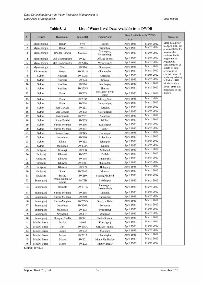
Data Collection Survey on Water Resources Management in Haor Area of Bangladesh Final Report
Nippon Koei Co., Ltd. 5-3 December2013
Table 5.1.1 List of Water Level Data Available from DWDB
Sl District RiverName StationID StationName Data Available with BWDB
Remarks From To
1 Mymensingh Banar SW8 Basuri April 1986 March 2012 More data prior to April 1986 are also available for most of the stations, but it might not be required in consideration of length of data series and in consideration of updating existing NAM and HD Model as data from 1986 has been used in the models
2 Mymensingh Banar SW9.5 Trimohini April 1986 March 2012
3 Mymensingh Bhogai-Kangsa SW35.5 Sarchapur_
Mymensingh April 1986 March 2012
4 Mymensingh Old Brahmaputra SW227 Offtake of Suti April 1986 March 2012
5 Mymensingh Old Brahmaputra SW228.5 Mymensingh April 1986 March 2012
6 Mymensingh Nitai SW314 Ghosegaon April 1986 March 2012
7 Kishoreganj Mogra SW311.4 Chamraghat April 1986 March 2012
8 Sylhet Kushiara SW172.5 Amalshid April 1986 March 2012
9 Sylhet Kushiara SW173 Sheola April 1986 March 2012
10 Sylhet Kushiara SW174 Fenchuganj April 1986 March 2012
11 Sylhet Kushiara SW175.5 Sherpur April 1986 March 2012
12 Sylhet Piyan SW233 Protappur_Piyan
gang April 1986 March 2012
13 Sylhet Piyan SW233A Jaflong_Spill April 1986 March 2012
14 Sylhet Piyan SW234 Companiganj April 1986 March 2012
15 Sylhet Sari-Gowain SW251 Sarighat April 1986 March 2012
16 Sylhet Sari-Gowain SW252 Gowainghat April 1986 March 2012
17 Sylhet Sari-Gowain SW252.1 Salutikar April 1986 March 2012
18 Sylhet Sonai-Bardal SW265 Jaldhup April 1986 March 2012
19 Sylhet Surma-Meghna SW266 Kanairghat April 1986 March 2012
20 Sylhet Surma-Meghna SW267 Sylhet April 1986 March 2012
21 Sylhet Surma-Noya SW345 Durlavpur April 1986 March 2012
22 Sylhet Lubachara SW326 Lubachara April 1986 March 2012
23 Sylhet Dhala SW332 Islampur April 1986 March 2012
24 Sylhet Jhalukhali SW333A Dulura April 1986 March 2012
25 Habiganj Korangi SW138 Sofiabad April 1986 March 2012
26 Habiganj Khowai SW157 Ballah April 1986 March 2012
27 Habiganj Khowai SW158 Chunarghat April 1986 March 2012
28 Habiganj Khowai SW158.1 Shaistaganj April 1986 March 2012
29 Habiganj Khowai SW159 Habiganj April 1986 March 2012
30 Habiganj Sonai SW264A Montala April 1986 March 2012
31 Habiganj Sutang SW280 Sutang Rly.Brid April 1986 March 2012
32 Sunamganj Dhanu-Baulai-Gh
orautra SW72B Sukdebpur April 1986 March 2012
33 Sunamganj Jadukata SW131.5 Laurergarh
Saktiarkhola April 1986 March 2012
34 Sunamganj Surma-Meghna SW268 Chhatak April 1986 March 2012
35 Sunamganj Surma-Meghna SW269 Sunamganj April 1986 March 2012
36 Sunamganj Surma-Meghna SW269.5 Dirai_on Kalni April 1986 March 2012
37 Sunamganj Lubachara SW326A Borogram April 1986 March 2012
38 Sunamganj Jhalukhali SW333 Muslimpur April 1986 March 2012
39 Sunamganj Noyagang SW337 Urargaon April 1986 March 2012
40 Sunamganj Omayan Chella SW341 Chella Sonapur April 1986 March 2012
41 Moulvi Bazar Dhalai SW67 Kamalganj April 1986 March 2012
42 Moulvi Bazar Juri SW135A JuriCont_Silghat April 1986 March 2012
43 Moulvi Bazar Lungla SW192 Motiganj April 1986 March 2012
44 Moulvi Bazar Monu SW201A Chatalaghat April 1986 March 2012
45 Moulvi Bazar Monu SW201 Monu Rly.Bridge April 1986 March 2012
46 Moulvi Bazar Monu SW202 Moulvi Bazar April 1986 March 2012 Source: BWDB
Data Collection Survey on Water Resources Management in Haor Area of Bangladesh Final Report
Nippon Koei Co., Ltd. 5-4 December2013
Table 5.1.2 List of Flow/Discharge Data Available from BWDB
Sl District River Name Station ID Station Name Data Available with BWDB
Remarks From To
1 Sunamganj Omayun Chella SW341 Chella Sonapur April 1986 March 2012 More data prior to April 1986 are also available for most of the stations, but it might not be required in consideration of length of data series and in consideration of updating existing NAM and HD Model as data from 1986 has been used in the models
2 Sunamganj Noyagang SW337 Urargaon April 1986 March 2012
3 Sunamganj Jhalukhali SW333 Muslimpur April 1986 March 2012
4 Sunamganj Surma-Meghna SW269 Sunamganj April 1986 March 2012
5 Sunamganj Jadukata SW131.5Laurergarh
Saktiarkhola April 1986 March 2012
6 Netrokona Someswari SW262 Bijoypur April 1986 March 2012 7 Netrokona Bhogai-Kangsa SW36 Jaria-Jhanjail April 1986 March 2012 8 Moulvi Bazar Monu SW201 Monu Rly.Bridge April 1986 March 2012
9 Moulvi Bazar Lungla SW192 Motiganj April 1986 March 2012
10 Moulvi Bazar Juri SW135A JuriCont_Silghat April 1986 March 2012
11 Moulvi Bazar Dhalai SW67 Kamalganj April 1986 March 2012 12 Mymensingh Nitai SW314 Ghosegaon April 1986 March 2012 13 Mymensingh Old Brahmaputra SW228.5 Mymensingh April 1986 March 2012 14 Kishoreganj Surma-Meghna SW273 Bhairab Bazar April 1986 March 2012 15 Kishoreganj Old Brahmaputra SW230.1 Bhairab Bazar R April 1986 March 2012 16 Sylhet Jhalukhali SW333A Dulura April 1986 March 2012 17 Sylhet Dhala SW332 Islampur April 1986 March 2012 18 Sylhet Lubachara SW326 Lubachara April 1986 March 2012 19 Sylhet Surma-Meghna SW267 Sylhet April 1986 March 2012 20 Sylhet Surma-Meghna SW266 Kanairghat April 1986 March 2012 21 Sylhet Sonai-Bardal SW265 Jaldhup April 1986 March 2012 22 Sylhet Sari-Gowain SW251 Sarighat April 1986 March 2012 23 Sylhet Piyan SW233A Jaflong_Spill April 1986 March 2012
24 Sylhet Piyan SW233 Protappur_ Piyan gang
April 1986 March 2012
25 Sylhet Kushiara SW175.5 Sherpur April 1986 March 2012 26 Sylhet Kushiara SW173 Sheola April 1986 March 2012 27 Sylhet Kushiara SW172.5 Amalshid April 1986 March 2012
Source: BWDB
Table 5.1.3 List of Rainfall Data Available from BWDB Sl District Station ID Station Name
Data Available with BWDB Remarks
From To
1 Sylhet CL102 Companyganj
Bholaganj April 1986 March 2012
More data prior to April 1986 are also available for most of the stations. But it might not be required in consideration of length of data series and in consideration of updating existing NAM and HD Model as data from 1986 has been used in the models
2 Sylhet CL116 Lallakhal April 1986 March 2012 3 Sylhet CL125 Sheola April 1986 March 2012 4 Sylhet CL128 Sylhet April 1986 March 2012 5 Sylhet CL129 Tajpur April 1986 March 2012 6 Sylhet CL130 Zakiganj April 1986 March 2012 7 Sylhet CL228 Kanairghat April 1986 March 2012 8 Sunamganj CL107 Chhatak April 1986 March 2012 9 Sunamganj CL109 Gobindaganj April 1986 March 2012
10 Sunamganj CL127 Sunamganj April 1986 March 2012 11 Sunamganj CL44 Moheshkhola April 1986 March 2012 12 Sunamganj CL49 Laurergarh April 1986 March 2012 13 Moulvi Bazar CL104 Chandbagh April 1986 March 2012 14 Moulvi Bazar CL108 Dakhinbagh April 1986 March 2012 15 Moulvi Bazar CL114 Kamalganj April 1986 March 2012 16 Moulvi Bazar CL117 Langla April 1986 March 2012 17 Moulvi Bazar CL118 Latu April 1986 March 2012 18 Moulvi Bazar CL119 Monumukh April 1986 March 2012 19 Moulvi Bazar CL122 Moulvi Bazar April 1986 March 2012
Data Collection Survey on Water Resources Management in Haor Area of Bangladesh Final Report
Nippon Koei Co., Ltd. 5-5 December2013
Sl District Station ID Station Name Data Available with BWDB
Remarks From To
20 Moulvi Bazar CL126 Srimangal April 1986 March 2012 21 Moulvi Bazar CL229 Monu Rly. Br. April 1986 March 2012 22 Habiganj CL105 Chandpur Bagan April 1986 March 2012 23 Habiganj CL110 Habiganj April 1986 March 2012 24 Habiganj CL111 Itakhola(Baikuntha) April 1986 March 2012 25 Habiganj CL120 Markuli April 1986 March 2012 26 Mymensingh CL27 Phulbaria April 1986 March 2012 27 Mymensingh CL45 Ghosegaon April 1986 March 2012 28 Mymensingh CL46 Rasulpur April 1986 March 2012 29 Mymensingh CL5 Bhaluka April 1986 March 2012 30 Mymensingh CL64 Gafargaon April 1986 March 2012 31 Mymensingh CL65 Gauripur April 1986 March 2012 32 Mymensingh CL72 Muktagacha April 1986 March 2012 33 Mymensingh CL73 Mymensingh April 1986 March 2012 34 Mymensingh CL75 Nandail April 1986 March 2012 35 Mymensingh CL77 Phulpur April 1986 March 2012 36 Kishoreganj CL101 Bhairab Bazar April 1986 March 2012 37 Kishoreganj CL112 Itna April 1986 March 2012 38 Kishoreganj CL113 Khaliajuri April 1986 March 2012 39 Kishoreganj CL61 Bajitpur April 1986 March 2012 40 Kishoreganj CL71 Kishoreganj April 1986 March 2012 41 Netrokona CL115 Kendua April 1986 March 2012 42 Netrokona CL121 Mohanganj April 1986 March 2012 43 Netrokona CL123 Netrokona April 1986 March 2012 44 Netrokona CL63 Durgapur April 1986 March 2012 45 Netrokona CL68 Jaria-jhanjail April 1986 March 2012
Source: BWDB
Table 5.1.4 List of Evaporation Data Available from BWDB Sl District Station ID Station Name Data Available with BWDB Remarks
From To
1 Mymensingh E024 Mymensingh April 1986 March 2012
More data prior to April 1986 are also available for most of the stations, but it might not be required in consideration of length of data series and in consideration of updating existing NAM and HD Model as data from 1986 has been used in the models
2 Sreemangal E036 Sreemangal April 1986
March 2012
3 Sunamganj E037 Sunamganj April 1986 March 2012
Source: BWDB
Table 5.1.5 List of Temperature Data Available from BMD
Sl District Station ID Station Name Data Available
From To 1 Comilla 11313 Comilla April 1986 March 2012 2 Mymensingh 10609 Mymensingh April 1986 March 2012 3 Moulvi Bazar 10724 Sreemangal April 1986 March 2012 4 Sylhet 10705 Sylhet April 1986 March 2012
Source: BMD
Data Collection Survey on Water Resources Management in Haor Area of Bangladesh Final Report
Nippon Koei Co., Ltd. 5-6 December2013
(2) Data Consistency and Resolution
The data series available from BWDB and BMD are quite long and are considered sufficient.
However, the number of stations of evaporation measurement appears less, but the variation
of evaporation rate in the haor area is negligible.
Rainfall data seem to be inadequate for hydrologic modeling. Rainfall is measured only
thrice a day and the spacing does not cover major geographic or climatic region throughout
the watershed.
For watersheds without rainfall and/or rating curves at their outlets, flood hydrographs were
estimated by transposing the results from nearby watersheds considering the precipitation,
watershed vegetation cover, soil, physical characteristics, and area sizes. Rainfall data are
recoded and collected daily at several locations in the watershed. However, the data are
sparse and manually registered thrice a day. To account for the flow at the trans- boundary
locations, water level (WL) stations are operated at these locations and rating curves are
developed.
No automatic rain gauging stations have been operated. In a region with intense precipitation,
the rainfall needs to be registered with more details in order to have a precipitation run-off
model within an acceptable degree of certainty. The precipitation at the foothill in India,
which is one of the highest areas in the world, results in high flood run off during the
monsoon season.
Figure 5.1.1 locates the hydro meteorological stations in the Northeast Region.

Data Collection Survey on Water Resources Management in
Haor Area of Bangladesh Final Report
Nippon Koei Co., Ltd. 5-7 December2013
Source: Master Plan of Haor Area, April, 2012
Figure 5.1.1 Location Map of Hydro Meteorological Stations
Data Collection Survey on Water Resources Management in Haor Area of Bangladesh Final Report
Nippon Koei Co., Ltd. 5-8 December2013
5.2 Hydrologic Model
IWM preserves “General Model” and the six “Regional Models” developed under Surface
Water Simulation Modeling Programme Phase-II (SWSMP II, 1992 - 1996).
The North East Regional Model (NERM), which is one of the “Regional Models”, covered
the same study area. Attempts were thus made to have an overview of the NERM available in
IWM. The development of NERM was initiated in early 1991. The model comprised a
hydrological (rainfall-runoff) model and a hydro-dynamic (river, channel, and flood plain)
model. The hydrological model was originally calibrated from April 1986 to December 1992.
The model was subsequently validated for the period from April 1992 to March 2003. This
model provided runoff discharges as the input data to the hydrodynamic model.
The hydrologic analysis was centered on two topics: hydrologic modeling to provide input
flow data to the hydrodynamics model, and statistical analysis to extrapolate precipitations,
water surface elevation, and flows at several locations throughout the Northeast Region.
(1) Model Description and Analysis
The mathematical model with MIKE 11 was utilized to route the rainfall-runoff from several
watersheds within the North and Southeast regions by CEGIS and IWM. CEGIS calibrated
the model for watersheds situated within the Bangladesh-India border, while IWM
extrapolated the model over the Indian border in order to incorporate the whole watershed.
The models settled the output to a 3 hour time step which is the input time interval for the
NERM. Annex 5-1 shows the division of the inland and transboundary catchments in the
NERM.
(2) Models Reliability
The WL-discharge rating curves and the discharge hydrographs at the sub-watershed outlets
are not reliable. These outlets have been frequently under the effect of backwater formed at
the confluence of major tributaries and also large portion of flow spillovers or inflows
exchanging volumes of water with flood plain before reaching the WL stations. In addition,
wherever the rating curves were not available, the calibration of the model was tried utilizing
the variation of ground water table as reference. Considering the lag time between the
surface runoff flow and the ground water table variation, the hydrologic calibration at most
of the time is unreliable.
The watershed physiographic characteristics and data quality jeopardizes the hydrologic
model calibration, while the estimated hydrographs are indeed questionable. To improve the
water yield from the upstream sub-watershed data, additional studies are thus necessary.
The verification of the IWM and CEGIS model calibration shows that the data available are
poor in quality, thus resulting in unsatisfactory prediction of input flows for the
hydrodynamic model. Figure 5.2.1, exemplifying some of the calibration results in the IWM
Validation Report, clearly shows that the model calibration needs improvement.
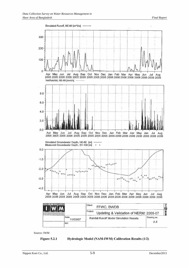
Data Collection Survey on Water Resources Management in Haor Area of Bangladesh Final Report
Nippon Koei Co., Ltd. 5-9 December2013
Source: IWM
Figure 5.2.1 Hydrologic Model (NAM-IWM) Calibration Results (1/2)
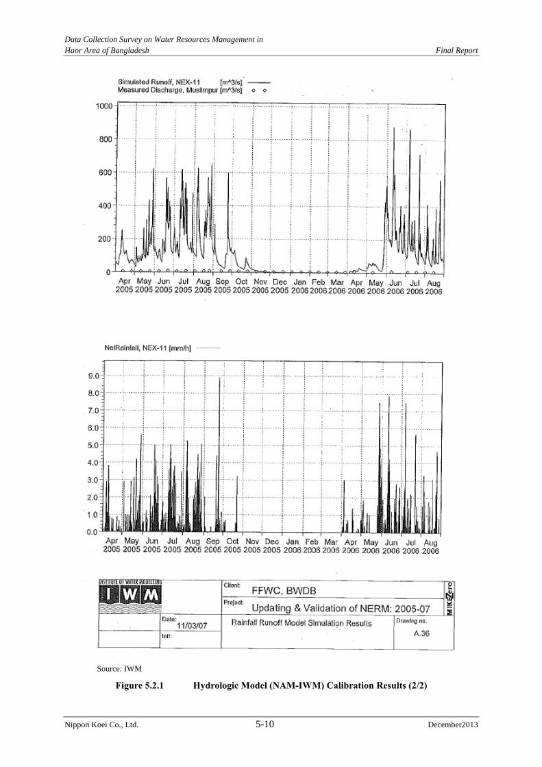
Data Collection Survey on Water Resources Management in Haor Area of Bangladesh Final Report
Nippon Koei Co., Ltd. 5-10 December2013
Source: IWM
Figure 5.2.1 Hydrologic Model (NAM-IWM) Calibration Results (2/2)
Data Collection Survey on Water Resources Management in Haor Area of Bangladesh Final Report
Nippon Koei Co., Ltd. 5-11 December2013
Certainly, the data sampling locations and quality for precipitation over the watershed and/or
flows at the watershed outlets must be greatly improved. These goals can only be achieved
with a long term strategy plan and a continuous commitment from the GOB and agencies in
charge of collecting hydro-meteorological information.
5.3 Flood Runoff Analysis
5.3.1 General
(1) Pre-monsoon Season
The pre-monsoon season usually extends from April to May in Bangladesh. This season is
characterized by powerful short-duration thunderstorms with heavy rainfall which yield
intense runoff from the hills across the border in India. This intense flood runoff and the
runoff due to the direct precipitation in the haor area combine, and accumulate as inundation
occurs over the haor area.
The most important impact caused by rainfall during this season is the occurrence of flash
floods that frequently overtop river banks and natural levees. Flash floods cause devastating
damage to the agricultural product, mainly boro rice in the harvest season.
(2) Monsoon Season
The monsoon season starts just after the end of the pre-monsoon season and continues to
September through October. During this period, most agricultural activities cease because a
large part of the haor area is inundated; for example the water depths in several regions reach
up to 5 m. The economic activities in this area is mostly reduced, and the local population
relay on fishing as a source of livelihood.
During the monsoon season, the precipitation is not as intense as that of the pre-monsoon
season, but the rainfall continues over the larger watershed with a longer duration. The runoff
due to this rainfall drains over the haor area. A large volume of flood also originates from the
area across the Indian border where one of the largest average annual precipitations in the
world occurs.
The hydrographs throughout the steeper valleys in the Indian side of the border attenuate
when they reach the flat topography in the Northeast Region. The reduced slope of the terrain
just downstream of the border frequently causes floods which spread over the flood plains
and lakes reducing the peak discharge, resulting in attenuation of hydrographs.
Over the haor area, the floodplain topography is very shallow with reduced landscape slope.
This physiography is the product of the sediment deposition due to erosion of overland soil
in the Indian hills of the watershed, geological subsidence in the Sylhet basin, and
morphological alterations caused by the channel migration of the Brahmaputra River. As a
consequence, flow conditions of most of the haor area behave like a reservoir during the
monsoon season, controlled by the back-water of the downstream, the Padma River.
5.3.2 Dynamic Hydraulic Modeling
(1) NERM
IWM developed a dynamic hydraulic model utilizing the MIKE11 software. This model
Data Collection Survey on Water Resources Management in Haor Area of Bangladesh Final Report
Nippon Koei Co., Ltd. 5-12 December2013
utilizes to make a network of the rivers, virtual channels and overflow points. The overflow
to and return flow from inundation area and flow in the inundation area can be represented
the overflow points, and the virtual channel, respectively. The model utilizes hydrographs
from the transboundary tributaries, intermediate gauging stations and downstream boundary
site conditions (the Bhairab Bazar WL Station) as input data.
The dynamic hydraulic model was calibrated based mainly on hydraulic roughness and
overbank spill coefficients from April 1991 to March 1993, and was validated from April
1993 to July 2003. The NERM was used in the FAP6 study, and feedback from the FAP6
model was incorporated into the model. The NERM was also used for water resources
management planning in the National Water Management Plan (NWMP). The NERM was
revalidated using the hydrological data from April 2005 to July 2006 and recent topographic
information under the BWDB project “Real Time Data Collection for Flood Forecasting and
Warning Centre (July 2005 to December 2006) and Update & Validation of General/National
& 6 Regional Models for 2003-06 Hydrological Year”.
Even though the input information from the hydrological model and flow series from
tributaries are not reliable, the results of NERM are rather good. The possible reason is that
the model filters the uncertainties by adjusting flows and water surface elevations throughout
the intermediate WL stations localized in the main river system.
As a result of the NERM calibration verification, the model seems to be reliable, but the
reason why it simulates well the measured data must be carefully verified. Figure 5.3.1 shows the good calibration results for water surface elevation and flows. Furthermore, the
verification on goodness of fit of NERM is discussed in “Sub-section 5.3.2 (2)”.
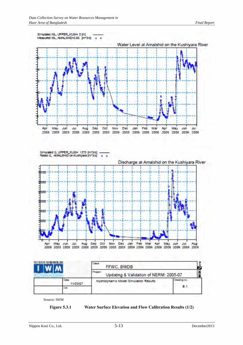
Data Collection Survey on Water Resources Management in Haor Area of Bangladesh Final Report
Nippon Koei Co., Ltd. 5-13 December2013
Source: IWM
Figure 5.3.1 Water Surface Elevation and Flow Calibration Results (1/2)
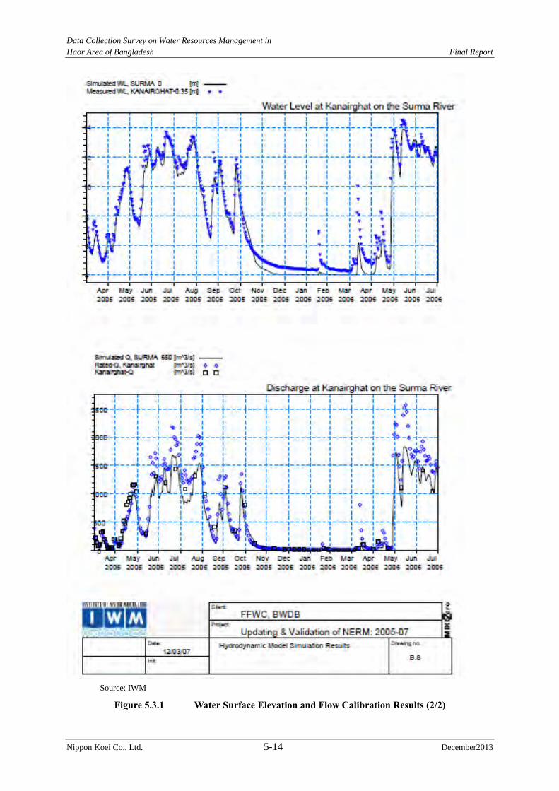
Data Collection Survey on Water Resources Management in Haor Area of Bangladesh Final Report
Nippon Koei Co., Ltd. 5-14 December2013
Source: IWM
Figure 5.3.1 Water Surface Elevation and Flow Calibration Results (2/2)
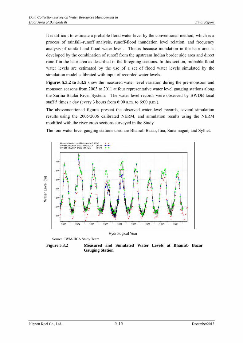
Data Collection Survey on Water Resources Management in
Haor Area of Bangladesh Final Report
Nippon Koei Co., Ltd. 5-15 December2013
It is difficult to estimate a probable flood water level by the conventional method, which is a process of rainfall–runoff analysis, runoff-flood inundation level relation, and frequency analysis of rainfall and flood water level. This is because inundation in the haor area is developed by the combination of runoff from the upstream Indian border side area and direct runoff in the haor area as described in the foregoing sections. In this section, probable flood water levels are estimated by the use of a set of flood water levels simulated by the simulation model calibrated with input of recorded water levels.
Figures 5.3.2 to 5.3.5 show the measured water level variation during the pre-monsoon and monsoon seasons from 2003 to 2011 at four representative water level gauging stations along the Surma-Baulai River System. The water level records were observed by BWDB local staff 5 times a day (every 3 hours from 6:00 a.m. to 6:00 p.m.).
The abovementioned figures present the observed water level records, several simulation results using the 2005/2006 calibrated NERM, and simulation results using the NERM modified with the river cross sections surveyed in the Study.
The four water level gauging stations used are Bhairab Bazar, Itna, Sunamaganj and Sylhet.
Source: IWM/JICA Study Team
Figure 5.3.2 Measured and Simulated Water Levels at Bhairab Bazar
Gauging Station
Wate
r Leve
l (m
)
Hydrological Year
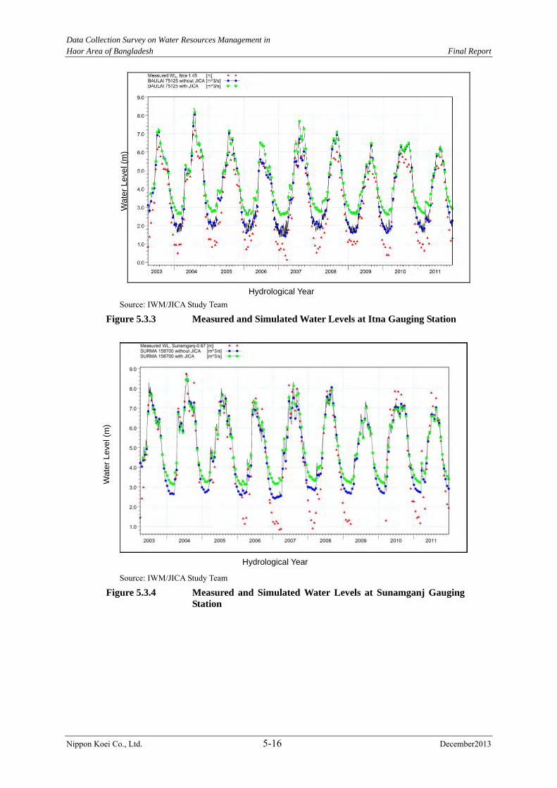
Data Collection Survey on Water Resources Management in
Haor Area of Bangladesh Final Report
Nippon Koei Co., Ltd. 5-16 December2013
Source: IWM/JICA Study Team
Figure 5.3.3 Measured and Simulated Water Levels at Itna Gauging Station
Source: IWM/JICA Study Team
Figure 5.3.4 Measured and Simulated Water Levels at Sunamganj Gauging
Station
Wate
r Leve
l (m
)
Hydrological Year
Wa
ter
Leve
l (m
)
Hydrological Year

Data Collection Survey on Water Resources Management in
Haor Area of Bangladesh Final Report
Nippon Koei Co., Ltd. 5-17 December2013
Source: IWM/JICA Study Team
Figure 5.3.5 Measured and Simulated Water Levels at Sylhet Gauging
Station
(2) Verification of NERM
The design water level of the submergible embankment and full embankment for the rehabilitation project and new project are determined from the analysis results of NERM. Therefore, the verification of NERM is carried out to check the relation of the highest pre-monsoon and monsoon water levels between the simulated output and observed data. Figure 5.3.6 shows the verification points in the haor area.
Source: JICA Study Team
Figure 5.3.6 Verification Points of NERM
Wa
ter
Leve
l (m
)
Hydrological Year
Sylhet
Sunamganj
Ajimiriganj
Itna
Bhairab Bazar
Data Collection Survey on Water Resources Management in Haor Area of Bangladesh Final Report
Nippon Koei Co., Ltd. 5-18 December2013
Figure 5.3.7 shows the relation between the observed data and simulated data at five
locations, namely, Bhairab Bazar, Itna, Ajimirganj, Sunamganj, and Sylhet. Table 5.3.1
shows the comparison between the simulated water level and the expected observed water
level from the regression equation under the pre-monsoon 10-year flood condition.
Table 5.3.1 Comparison between Simulated Water Level and Expected Observed Water Level under Pre-monsoon 10-year Flood Condition
Location Simulation (EL.m) Observed (EL.m) Difference A B |A-B| A/B
Bhairab Bazar 2.86 2.45 0.41m 1.17 Itna 4.52 3.86 0.66m 1.17 Sunamganj 6.95 7.30 0.35m 0.95 Sylhet 9.92 10.20 0.28m 0.97
Note: Observed water level is estimated from the regression equation shown in Figure 5.3.7. Source: JICA Study Team
The simulated water level at Sunamganj and Sylhet is 3% to 5 % lower than the observed
one. On the other hand, the difference between the simulated and observed water level at
Bhairab Bazar is 17%. The reason for this is that Bhairab Bazar is vulnerable to the impact of
the Padma River and old Brahmaputra River, and the hydraulic phenomenon surrounding
Bhairab Bazar is complicated. However, the simulated water level is higher than the
observed one. It means that the design water level is set with the safety side.
The difference of simulated and observed water level at Itna is also 17%, with the former
higher than the latter value. Itna is hydraulically affected by Bhairab Bazar, and hydraulic
phenomenon in the flood plain is complicated.
For the planar verification, the relation between observed and simulated water level at
Ajimiriganj which is located at the Kalni-Kushiyara River, is studied. The difference between
the observed and simulated high water level is only 9%.
Therefore, NERM adapts well with the design high water level in the haor area.
Data Collection Survey on Water Resources Management in Haor Area of Bangladesh Final Report
Nippon Koei Co., Ltd. 5-19 December2013
Bhairab Bazar Itna
Sunamganj Sylhet
Ajmiriganj Note: ○Highest water level during pre-monsoon, △Highest water level during monsoon Source: JICA Study Team
Figure 5.3.7 Relation between Observed Water Level and Simulated Water Level at Five Locations
y = 0.9161xR² = 0.6956
2
3
4
5
6
7
8
2 3 4 5 6 7 8
Observed Water Level (EL.m)
Simulated
Water Le
vel (EL.m
)
y = 0.9728xR² = 0.967
3
4
5
6
7
8
9
10
11
12
13
3 4 5 6 7 8 9 10 11 12 13
Observed Water Level (EL.m)
Simulated Water Level (EL.m
)y = 0.9526xR² = 0.8812
2
3
4
5
6
7
8
9
10
11
12
2 3 4 5 6 7 8 9 10 11 12
Observed Water Level (EL.m)
Simulated Water Level (EL.m
)
y = 1.1713xR² = 0.9503
0
1
2
3
4
5
6
7
8
9
10
0 1 2 3 4 5 6 7 8 9 10
Observed Water Level (EL.m)
Simulated Water Level (EL.m
)
y = 1.1672xR² = 0.8501
0
1
2
3
4
5
6
7
8
9
10
0 1 2 3 4 5 6 7 8 9 10
Observed Water Level (EL.m)
Simulated Water Level (EL.m
)

Data Collection Survey on Water Resources Management in
Haor Area of Bangladesh Final Report
Nippon Koei Co., Ltd. 5-20 December2013
5.3.3 Water Levels for Return Periods
Water level hydrographs are simulated for 31 years from 1980 to 2010 for the Sylhet, Sunamganj, Itna and Bhairab Bazar water level gauging stations along the Surma-Baulai River by use of the recorded hydrologic data and the calibrated NERM. The simulation results of the annual maximum 3-hour water level in the pre-monsoon season and monsoon season are shown in Tables 5.3.2 and 5.3.3, respectively.
(1) Plotting Position
The plotting position of the frequent analysis applied in Bangladesh is the Chegadayev plotting position as it has been used in FAP-25. Therefore, the Chegadayev plotting position is applied in this Study. The formulation of the Chegadayev plotting position is as follows:
Pi=(i-0.3)/(N+0.4) P: Exceedance probability of ith sample N: Total number of data
(2) Distribution Function
The distribution function is applied to the three parameter log normal distribution and modified maximum likelihood method as the “Flood Hydrology Study in FAP25, 1992” recommended to apply the log normal distribution regarding to the statistical analysis of hydrology data. The distribution is as follows:
where, Y=ln(X-X0) µY=mean of Y σY=standard deviation of Y X0=location parameter, conditioned by (X0<X)
Table 5.3.2 Simulation Results of Annual Maximum 3-hour Water Level at Four Stations during the
Pre-monsoon Season
Year Annual Maximum of Daily Simulated Pre-monsoon Water Level (m)
Bhairab Bazar Itna Sunamganj Sylhet 1980 2.78 4.15 6.16 8.60 1981 2.15 3.04 4.67 5.69 1982 2.26 3.92 5.66 7.31 1983 2.81 4.70 6.76 9.88 1984 2.89 3.67 5.79 7.45 1985 2.42 3.40 5.59 7.86 1986 2.25 3.32 5.02 6.74 1987 1.92 3.22 5.01 6.40 1988 2.30 3.54 5.65 7.80 1989 2.33 3.86 6.27 9.01 1990 2.52 4.24 6.33 9.34 1991 3.27 4.79 7.52 10.57 1992 1.81 2.39 3.78 4.24 1993 2.66 4.29 6.55 9.81 1994 2.38 3.70 5.65 8.01 1995 2.51 2.71 4.51 4.98 1996 2.71 3.80 6.17 9.02 1997 1.91 2.06 2.52 2.88
Data Collection Survey on Water Resources Management in Haor Area of Bangladesh Final Report
Nippon Koei Co., Ltd. 5-21 December2013
Year Annual Maximum of Daily Simulated Pre-monsoon Water Level (m) Bhairab Bazar Itna Sunamganj Sylhet
1998 2.19 2.88 4.30 5.27 1999 2.44 3.35 5.45 6.29 2000 2.69 4.60 6.75 9.76 2001 2.19 3.33 5.68 8.05 2002 2.56 4.37 5.93 7.10 2003 2.47 3.11 4.75 6.24 2004 2.86 4.76 7.39 10.51 2005 2.23 3.22 4.96 5.93 2006 2.24 2.80 4.30 4.89 2007 2.41 3.45 5.52 7.42 2008 2.40 2.71 3.87 4.25 2009 2.04 2.84 4.66 5.73 2010 2.86 4.61 7.37 10.04
Source: IWM/JICA Study Team
Table 5.3.3 Simulation Results of Annual Maximum 3-hour Water Level at Four Stations during the Monsoon Season
Year Annual Maximum of Daily Simulated Monsoon Water Level (m) Bhairab Bazar Itna Sunamganj Sylhet
1980 5.79 6.14 7.42 9.71 1981 5.85 6.43 7.98 10.31 1982 5.82 6.49 7.77 10.11 1983 6.18 6.74 8.21 10.70 1984 6.28 6.76 8.12 10.28 1985 5.77 6.38 7.99 10.60 1986 5.06 5.69 7.23 9.29 1987 6.29 6.85 8.27 10.49 1988 7.05 7.49 8.53 10.94 1989 5.80 6.45 7.78 10.42 1990 5.43 6.00 8.01 10.59 1991 5.80 6.27 8.12 10.67 1992 4.94 5.80 7.75 10.10 1993 6.32 6.86 8.00 10.70 1994 5.05 5.60 7.25 10.01 1995 6.08 6.62 7.90 10.49 1996 5.88 6.24 7.69 9.96 1997 5.71 6.26 7.91 10.41 1998 6.72 6.96 8.08 10.51 1999 5.82 6.37 7.91 10.51 2000 5.91 6.34 7.59 10.03 2001 5.52 5.95 7.46 10.34 2002 6.10 6.59 8.01 10.32 2003 6.08 6.59 8.48 10.65 2004 7.18 7.63 8.74 11.50 2005 5.57 6.34 8.10 10.40 2006 4.87 5.78 7.88 10.83 2007 6.57 7.08 8.51 10.97 2008 5.90 6.47 8.10 10.70 2009 5.41 6.19 8.01 10.44 2010 6.12 6.47 7.91 10.63
Source: IWM/JICA Study Team
Data Collection Survey on Water Resources Management in
Haor Area of Bangladesh Final Report
Nippon Koei Co., Ltd. 5-22 December2013
(3) Goodness of Fit-test
The goodness of fit-test is carried out by using the Kolmogorov-Smirnov (K-S) test. The K-S test is a nonparametric test for the equality of continuous, one-dimensional probability distribution that can be used to compare a sample with a reference probability distribution. The null distribution of this statistic is calculated under the null hypothesis that the sample is drawn from the reference distribution. In addition, the goodness of fit-test is carried out to apply Standard Least Squares Criterion (SLSC) which is proposed in the Technical Criteria for River Works prepared by the Ministry of Land, Infrastructure, Transport and Tourism of Japan.
Kolmogorov-SmirnovTest
Null hypothesis: “Sample X occurs from the three parameter log-normal distribution.”
Cumulative probability distribution of sample X S(X): Empirical Distribution Function
Sn(X)=1/n x ΣXi(x)
Where, Xi(x) =1 (xi≤x), =0 (xi>x)
Source: JICA Study Team
Figure 5.3.8 Illustration for Cumulative Distribution of Sample X and Cumulative
Distribution of Probability Distribution Function of Sample X
Standard Least Squares Criterion (SLSC)
The SLSC value (Sc) is calculated from the following formula:
0
0.2
0.4
0.6
0.8
1
累積確率
1/n
F(X)=∫f(y) dX
Sn(X)
D
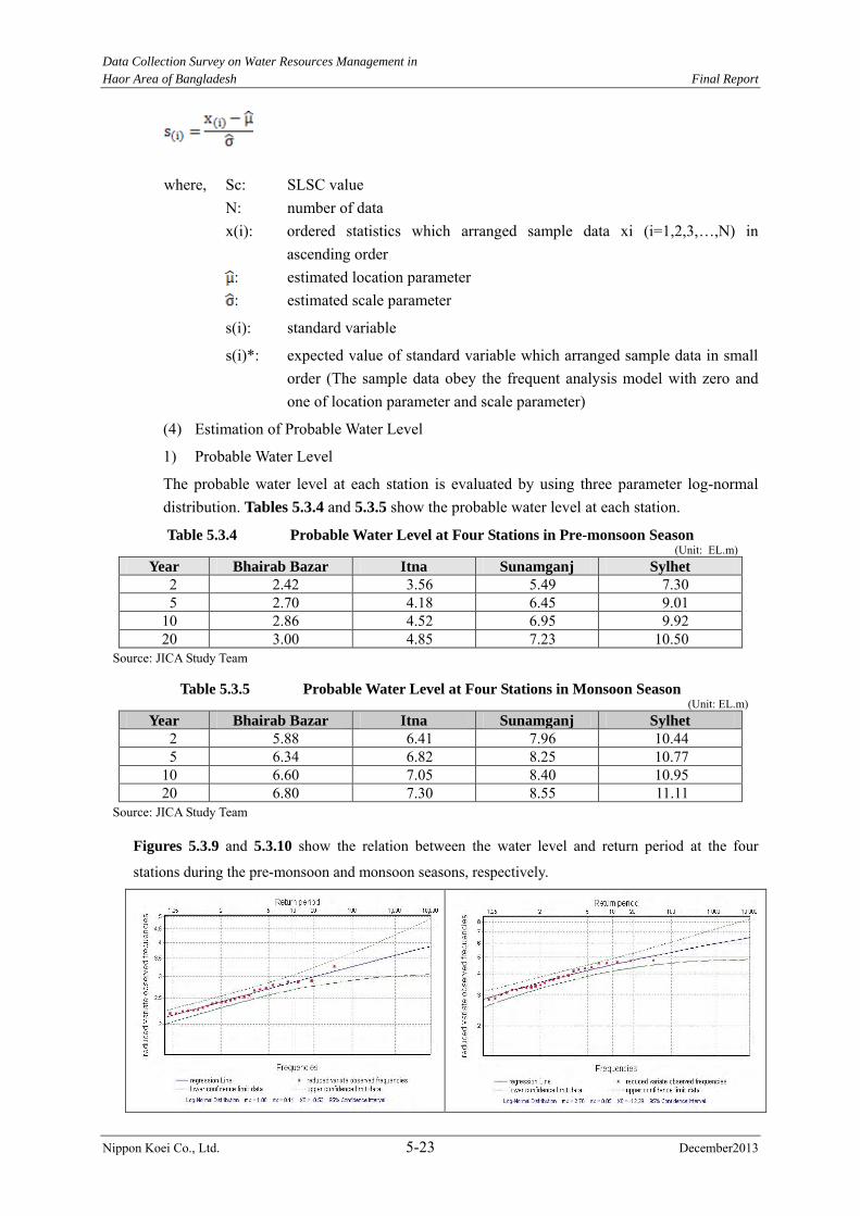
Data Collection Survey on Water Resources Management in
Haor Area of Bangladesh Final Report
Nippon Koei Co., Ltd. 5-23 December2013
where, Sc: SLSC value N: number of data
x(i): ordered statistics which arranged sample data xi (i=1,2,3,…,N) in ascending order
: estimated location parameter
: estimated scale parameter
s(i): standard variable
s(i)*: expected value of standard variable which arranged sample data in small order (The sample data obey the frequent analysis model with zero and one of location parameter and scale parameter)
(4) Estimation of Probable Water Level
1) Probable Water Level
The probable water level at each station is evaluated by using three parameter log-normal distribution. Tables 5.3.4 and 5.3.5 show the probable water level at each station.
Table 5.3.4 Probable Water Level at Four Stations in Pre-monsoon Season (Unit: EL.m)
Year Bhairab Bazar Itna Sunamganj Sylhet
2 2.42 3.56 5.49 7.30 5 2.70 4.18 6.45 9.01
10 2.86 4.52 6.95 9.92 20 3.00 4.85 7.23 10.50
Source: JICA Study Team
Table 5.3.5 Probable Water Level at Four Stations in Monsoon Season (Unit: EL.m)
Year Bhairab Bazar Itna Sunamganj Sylhet
2 5.88 6.41 7.96 10.44 5 6.34 6.82 8.25 10.77
10 6.60 7.05 8.40 10.95 20 6.80 7.30 8.55 11.11
Source: JICA Study Team
Figures 5.3.9 and 5.3.10 show the relation between the water level and return period at the four
stations during the pre-monsoon and monsoon seasons, respectively.
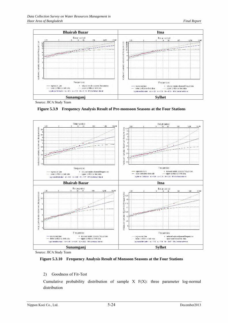
Data Collection Survey on Water Resources Management in
Haor Area of Bangladesh Final Report
Nippon Koei Co., Ltd. 5-24 December2013
Bhairab Bazar Itna
Sunamganj Sylhet
Source: JICA Study Team
Figure 5.3.9 Frequency Analysis Result of Pre-monsoon Seasons at the Four Stations
Bhairab Bazar Itna
Sunamganj Sylhet
Source: JICA Study Team
Figure 5.3.10 Frequency Analysis Result of Monsoon Seasons at the Four Stations
2) Goodness of Fit-Test
Cumulative probability distribution of sample X F(X): three parameter log-normal distribution
Data Collection Survey on Water Resources Management in Haor Area of Bangladesh Final Report
Nippon Koei Co., Ltd. 5-25 December2013
D=Max(|Sn(X)-F(X)|)
Significant probability of D: Pr(D√n>z)=2Σ(-1)j-1exp(-2j2z2) (approximate formula, where n>20)
Significant level =5%; z=1.36
Judgment of the null hypothesis
If the value of D√n is greater than1.36, the null hypothesis is rejected. (The assumed distribution
cannot be applied to the sample data.)
If the value of D√n is smaller than1.36, the null hypothesis is accepted. (The assumed distribution
can be applied to the sample data.)
The goodness of fit-test results of log-normal distribution in the pre-monsoon and monsoon
periods are shown in Tables 5.3.6 and 5.3.7, respectively.
Table 5.3.6 Goodness of Fit-Test Results of Log-Normal Distribution (Pre-monsoon Period) Bhairab Bazar Itna Sunamganj Sylhet
(1) Kolmogorov-Sminov D√n 0.30 0.44 0.37 0.34 Z 1.36 1.36 1.36 1.36 (2) SLSC 0.029 0.033 0.034 0.031
Source: JICA Study Team
Table 5.3.7 Goodness of Fit-Test Results of Log-Normal Distribution (Monsoon Period) Bhairab Bazar Itna Sunamganj Sylhet
(1) Kolmogorov-Sminov D√n 0.54 0.41 0.71 0.71 Z 1.36 1.36 1.36 1.36 (2) SLSC 0.039 0.034 0.043 0.058
Source: JICA Study Team
5.4 Sediment Balance and Riverbed Movement Analysis
5.4.1 Data Collection and Review
(1) Existing Data Availability
In connection with the Study, the availability of sedimentation data of BWDB and IWM has
been investigated. The current status is given in Table 5.4.1. Additional information about
the sediment characteristics are provided in Tables 5.4.2 and 5.4.3.
Table 5.4.1 Summary of Sediment Analysis Report of SWSMP for the Northeast Region
River Name Locations D50 (mm) of Bed materials Upper Meghna Bahirab Bazar 0.20 – 0.12 Surma Kanair Ghat 0.26 – 0.02 Kushiyara Sheola 0.226 – 0.037 Jadukata Lourergar 0.151-0.10 Someswari Durgapur 0.114 – 0.011 Khowai Shaistaganj 0.245-0.012
Source: CEGIS
Data Collection Survey on Water Resources Management in Haor Area of Bangladesh Final Report
Nippon Koei Co., Ltd. 5-26 December2013
Table 5.4.2 Median Grain Size (D50) of Collected Samples Sl. Station Location River D50 (mm) Date of Sampling1 Badhyanathpur Centre Karangi 0.032 12/06/2010 2 Badhyanathpur Right Bank Karangi 0.047 12/06/2010 3 Shankarpur Left Bank Lunglabijna 0.051 12/06/2010 4 Shankarpur Centre Lunglabijna 0.039 12/06/2010 5 Shankarpur Right Bank Lunglabijna 0.044 12/06/2010 6 Balikhal Left Bank Karangi-Lunglabijna Confluence 0.028 13/06/2010 7 Balikhal Centre Karangi-Lunglabijna Confluence 0.022 13/06/2010 8 Balikhal Right Bank Karangi-Lunglabijna Confluence 0.036 13/06/2010 Source: CEGIS
Table 5.4.3 Locations of Suspended Sediment Sampling by FAP-6 Location River District Upazila Markuli Kushiyara Hobiganj SullaBalaganj Sherpur do Sylhet Beani Bazar Sheola do do Ajmiriganj Kalni Hobiganj Ajmiriganj Shantipur do Kishorganj Mithamine Kadam Chal do do do Shaistaganj do Moulvi Baza Chunarughat Monu Railway Bridge Monu do Kamalganj Sylhet Surma Sylhet Sylhet Sadar
Source: CEGIS
The sediment data so far collected in the Northeast Region is sparse and of poor quality to be
utilized for a comprehensive sediment study. Most of the information related to sediments is
available from the FAP-6 study. Additional sediment samples were collected for specific
morphological studies or sediment modeling done by CEGIS and IWM but have limited
scope and spatial distribution. The sediment data is mostly riverbed material, with sparse
suspended sediment but no bed load samples.
(2) Rating Curve Analysis
The available sediment load rating curves were sampled only for the suspended portion of
the total load. The plot of the data indicates a disperse cloud of suspended load with most of
the sizes smaller than sand.
The diffuse suspended sediment measurements are common in the geomorphological study.
These are the results of sampling techniques, uncertainty inherent to the computation,
variability of characteristics of the sub-watersheds, which includes but are not limited to soil,
topography, vegetation cover, and variability in the precipitation intensity.
5.4.2 Sediment Balance
The Northeast Region is tectonically the most active in Bangladesh. The Sylhet basin
tectonic subsidence plays an important role on the geo-morphological process of this region.
It is a tub-shaped north-south aligned basin with a length of 100 km (see Figure 1.3.1).
Every monsoon season, the Sylhet basin is flooded with inundation depths of 1-2m. The
annual extent of inundation is more than 8,000 km2. All the rivers in the basin become
hydro-morphologically inert during the monsoon season compared to its activities during the
pre- and post-monsoon periods.
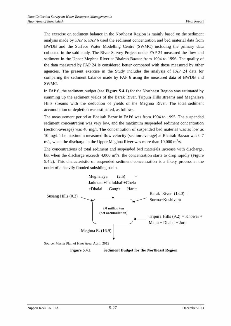
Data Collection Survey on Water Resources Management in Haor Area of Bangladesh Final Report
Nippon Koei Co., Ltd. 5-27 December2013
The exercise on sediment balance in the Northeast Region is mainly based on the sediment
analysis made by FAP 6. FAP 6 used the sediment concentration and bed material data from
BWDB and the Surface Water Modelling Centre (SWMC) including the primary data
collected in the said study. The River Survey Project under FAP 24 measured the flow and
sediment in the Upper Meghna River at Bhairab Bazaar from 1994 to 1996. The quality of
the data measured by FAP 24 is considered better compared with those measured by other
agencies. The present exercise in the Study includes the analysis of FAP 24 data for
comparing the sediment balance made by FAP 6 using the measured data of BWDB and
SWMC.
In FAP 6, the sediment budget (see Figure 5.4.1) for the Northeast Region was estimated by
summing up the sediment yields of the Barak River, Tripura Hills streams and Meghalaya
Hills streams with the deduction of yields of the Meghna River. The total sediment
accumulation or depletion was estimated, as follows.
The measurement period at Bhairab Bazar in FAP6 was from 1994 to 1995. The suspended
sediment concentration was very low, and the maximum suspended sediment concentration
(section-average) was 40 mg/l. The concentration of suspended bed material was as low as
10 mg/l. The maximum measured flow velocity (section-average) at Bhairab Bazaar was 0.7
m/s, when the discharge in the Upper Meghna River was more than 10,000 m3/s.
The concentrations of total sediment and suspended bed materials increase with discharge,
but when the discharge exceeds 4,000 m3/s, the concentration starts to drop rapidly (Figure
5.4.2). This characteristic of suspended sediment concentration is a likely process at the
outlet of a heavily flooded subsiding basin.
Source: Master Plan of Haor Area, April, 2012
Figure 5.4.1 Sediment Budget for the Northeast Region
Meghna R. (16.9)
Barak River (13.0) =
Surma+Kushiyara
8.0 million ton (net accumulation)
Meghalaya (2.5) =
Jadukata+Jhalukhali+Chela
+Dhalai Gang+ Hari+
Susang Hills (0.2)
Tripura Hills (9.2) = Khowai +
Manu + Dhalai + Juri
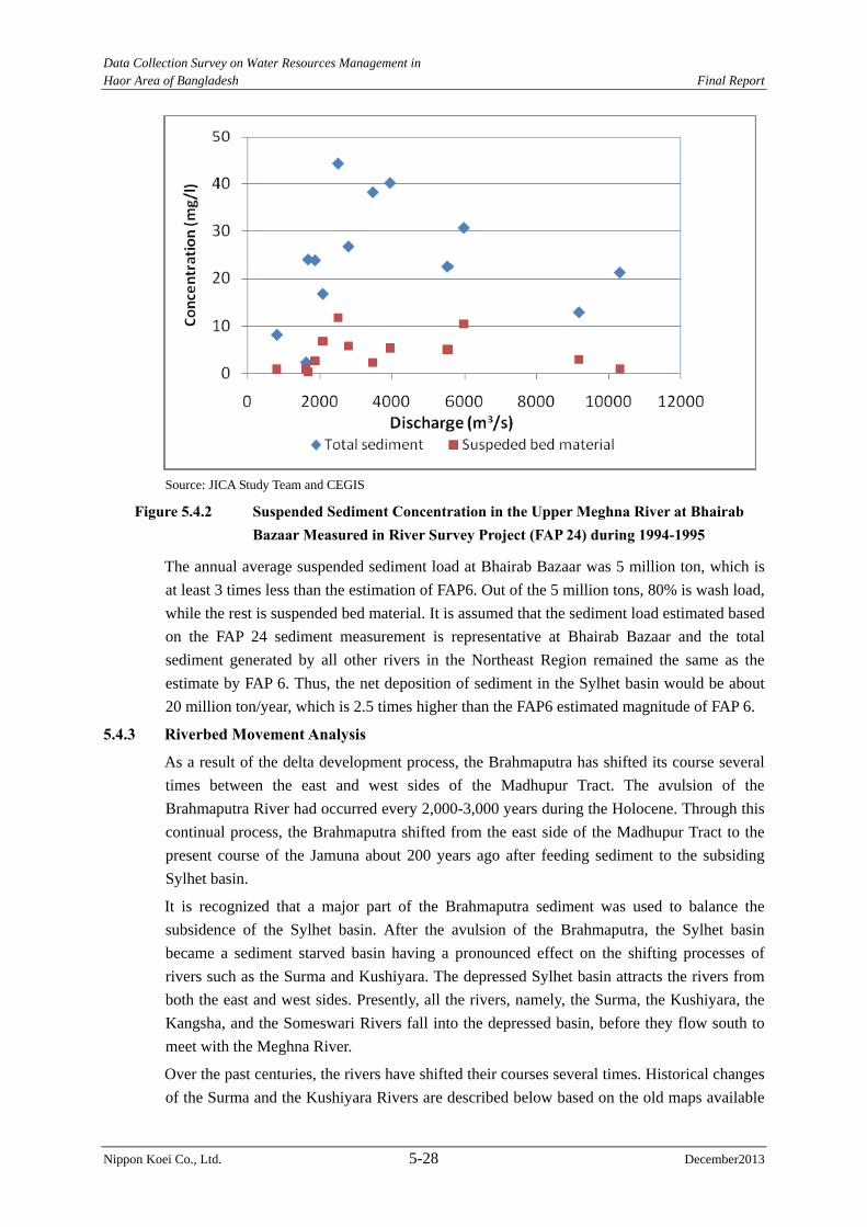
Data Collection Survey on Water Resources Management in Haor Area of Bangladesh Final Report
Nippon Koei Co., Ltd. 5-28 December2013
Source: JICA Study Team and CEGIS
Figure 5.4.2 Suspended Sediment Concentration in the Upper Meghna River at Bhairab Bazaar Measured in River Survey Project (FAP 24) during 1994-1995
The annual average suspended sediment load at Bhairab Bazaar was 5 million ton, which is
at least 3 times less than the estimation of FAP6. Out of the 5 million tons, 80% is wash load,
while the rest is suspended bed material. It is assumed that the sediment load estimated based
on the FAP 24 sediment measurement is representative at Bhairab Bazaar and the total
sediment generated by all other rivers in the Northeast Region remained the same as the
estimate by FAP 6. Thus, the net deposition of sediment in the Sylhet basin would be about
20 million ton/year, which is 2.5 times higher than the FAP6 estimated magnitude of FAP 6.
5.4.3 Riverbed Movement Analysis
As a result of the delta development process, the Brahmaputra has shifted its course several
times between the east and west sides of the Madhupur Tract. The avulsion of the
Brahmaputra River had occurred every 2,000-3,000 years during the Holocene. Through this
continual process, the Brahmaputra shifted from the east side of the Madhupur Tract to the
present course of the Jamuna about 200 years ago after feeding sediment to the subsiding
Sylhet basin.
It is recognized that a major part of the Brahmaputra sediment was used to balance the
subsidence of the Sylhet basin. After the avulsion of the Brahmaputra, the Sylhet basin
became a sediment starved basin having a pronounced effect on the shifting processes of
rivers such as the Surma and Kushiyara. The depressed Sylhet basin attracts the rivers from
both the east and west sides. Presently, all the rivers, namely, the Surma, the Kushiyara, the
Kangsha, and the Someswari Rivers fall into the depressed basin, before they flow south to
meet with the Meghna River.
Over the past centuries, the rivers have shifted their courses several times. Historical changes
of the Surma and the Kushiyara Rivers are described below based on the old maps available
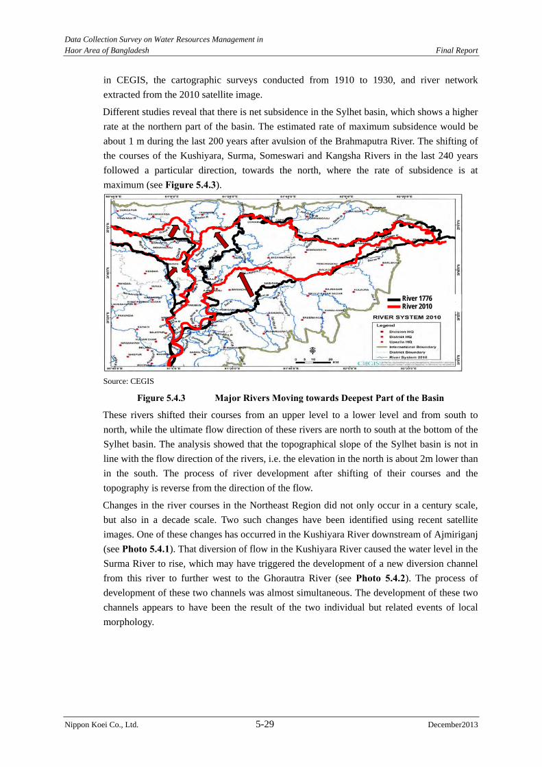
Data Collection Survey on Water Resources Management in Haor Area of Bangladesh Final Report
Nippon Koei Co., Ltd. 5-29 December2013
in CEGIS, the cartographic surveys conducted from 1910 to 1930, and river network
extracted from the 2010 satellite image.
Different studies reveal that there is net subsidence in the Sylhet basin, which shows a higher
rate at the northern part of the basin. The estimated rate of maximum subsidence would be
about 1 m during the last 200 years after avulsion of the Brahmaputra River. The shifting of
the courses of the Kushiyara, Surma, Someswari and Kangsha Rivers in the last 240 years
followed a particular direction, towards the north, where the rate of subsidence is at
maximum (see Figure 5.4.3).
Source: CEGIS
Figure 5.4.3 Major Rivers Moving towards Deepest Part of the Basin
These rivers shifted their courses from an upper level to a lower level and from south to
north, while the ultimate flow direction of these rivers are north to south at the bottom of the
Sylhet basin. The analysis showed that the topographical slope of the Sylhet basin is not in
line with the flow direction of the rivers, i.e. the elevation in the north is about 2m lower than
in the south. The process of river development after shifting of their courses and the
topography is reverse from the direction of the flow.
Changes in the river courses in the Northeast Region did not only occur in a century scale,
but also in a decade scale. Two such changes have been identified using recent satellite
images. One of these changes has occurred in the Kushiyara River downstream of Ajmiriganj
(see Photo 5.4.1). That diversion of flow in the Kushiyara River caused the water level in the
Surma River to rise, which may have triggered the development of a new diversion channel
from this river to further west to the Ghorautra River (see Photo 5.4.2). The process of
development of these two channels was almost simultaneous. The development of these two
channels appears to have been the result of the two individual but related events of local
morphology.
River 2010 River 1776
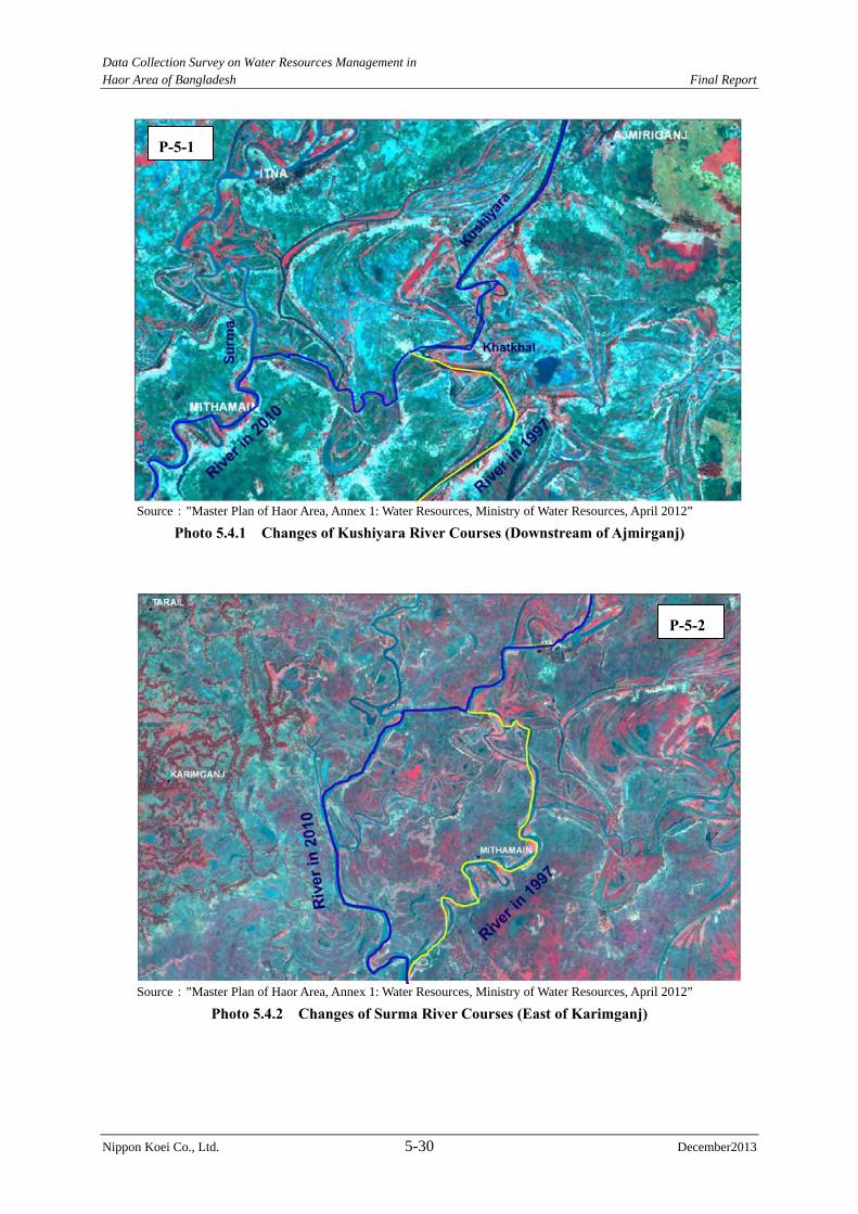
Data Collection Survey on Water Resources Management in Haor Area of Bangladesh Final Report
Nippon Koei Co., Ltd. 5-30 December2013
Source:”Master Plan of Haor Area, Annex 1: Water Resources, Ministry of Water Resources, April 2012”
Photo 5.4.1 Changes of Kushiyara River Courses (Downstream of Ajmirganj)
Source:”Master Plan of Haor Area, Annex 1: Water Resources, Ministry of Water Resources, April 2012”
Photo 5.4.2 Changes of Surma River Courses (East of Karimganj)
P-5-1
P-5-2
Data Collection Survey on Water Resources Management in Haor Area of Bangladesh Final Report
Nippon Koei Co., Ltd. 5-31 December2013
5.4.4 Dredging in the Surma-Baulai River System
The FAP6 and other relevant documents were reviewed to identify the potential rivers in the
haor area for dredging. In FAP6, 20 river systems were proposed for dredging.
A total of 125 km of river that stretches from the Surma, Rakti, Bauli and Katakhal Rivers
has been selected for dredging based on the following criteria, and as compiled in Table 5.4.4:
- Navigational purpose,
- Flood reduction,
- Creation of new or vertical/lateral extension of village platform, and
- Expediting the avulsion process of the river systems.
Table 5.4.4 Proposed Dredging Plan in Master Plan of Haor Area Sl no River
Name District Upazila Length
(km) Selection Criteria
1 Surma Sunamganj Dowarabazar 5.1 Navigational purpose 3.85.9
Sunamganj Sadar 9.5Sylhet Kanaighat 5.8 Dry season flow diversion
4.56.5
41.1 2 Rakti Sunamganj Jamalganj 8 Navigational purpose
8 3 Baulai Sunamganj Dharampasha 4.3 Navigational purpose
Netrakona Khaliajuri 18.7 Navigational purpose Flood reduction Creation of new or vertical and lateral extension of village platform
4.44.4
Itna 4.78.5
Mithamain 64.5
7 62.5
4 Katkhal channel
Kishoreganj Mithamain 12.79 Navigational purpose Flood reduction Creation of new or vertical and lateral extension of village platform Expediting the avulsion process of the river systems
12.79 Grand Total (Surma+Baulai+Katkhal) 124.39
Source: CEGIS
Several dredging layouts have been planned in Bangladesh at several times. The location of
the dredging is presented in the following figures:
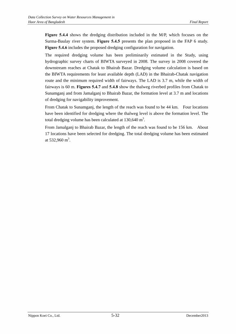
Data Collection Survey on Water Resources Management in Haor Area of Bangladesh Final Report
Nippon Koei Co., Ltd. 5-32 December2013
Figure 5.4.4 shows the dredging distribution included in the M/P, which focuses on the
Surma-Baulay river system. Figure 5.4.5 presents the plan proposed in the FAP 6 study.
Figure 5.4.6 includes the proposed dredging configuration for navigation.
The required dredging volume has been preliminarily estimated in the Study, using
hydrographic survey charts of BIWTA surveyed in 2008. The survey in 2008 covered the
downstream reaches at Chatak to Bhairab Bazar. Dredging volume calculation is based on
the BIWTA requirements for least available depth (LAD) in the Bhairab-Chatak navigation
route and the minimum required width of fairways. The LAD is 3.7 m, while the width of
fairways is 60 m. Figures 5.4.7 and 5.4.8 show the thalweg riverbed profiles from Chatak to
Sunamganj and from Jamalganj to Bhairab Bazar, the formation level at 3.7 m and locations
of dredging for navigability improvement.
From Chatak to Sunamganj, the length of the reach was found to be 44 km. Four locations
have been identified for dredging where the thalweg level is above the formation level. The
total dredging volume has been calculated at 130,640 m3.
From Jamalganj to Bhairab Bazar, the length of the reach was found to be 156 km. About
17 locations have been selected for dredging. The total dredging volume has been estimated
at 532,960 m3.
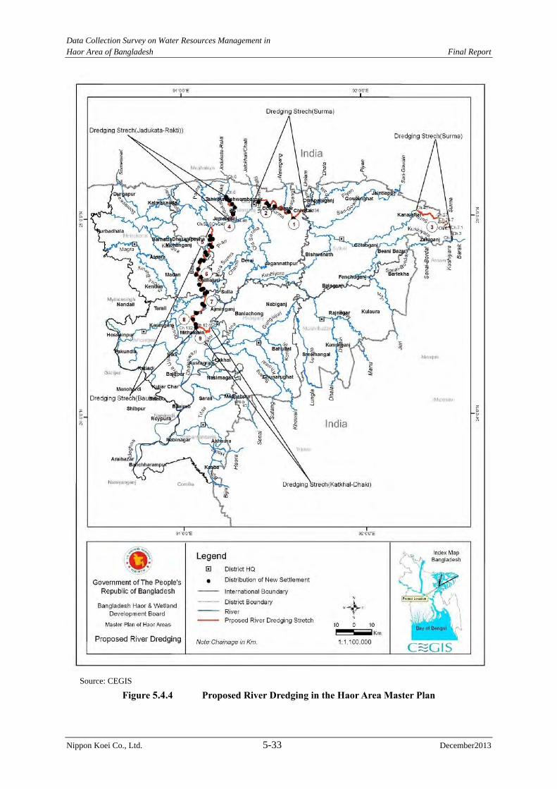
Data Collection Survey on Water Resources Management in Haor Area of Bangladesh Final Report
Nippon Koei Co., Ltd. 5-33 December2013
Source: CEGIS
Figure 5.4.4 Proposed River Dredging in the Haor Area Master Plan
Data Collection Survey on Water Resources Management in Haor Area of Bangladesh Final Report
Nippon Koei Co., Ltd. 5-34 December2013
Source: FAP 6
Figure 5.4.5 Proposed River Dredging in FAP6
Data Collection Survey on Water Resources Management in Haor Area of Bangladesh Final Report
Nippon Koei Co., Ltd. 5-35 December2013
Source: Master Plan of Haor Area, April 2012
Figure 5.4.6 Proposed River Dredging for Navigation Route
Data Collection Survey on Water Resources Management in
Haor Area of Bangladesh Final Report
Nippon Koei Co., Ltd. 5-36 December2013
Source: JICA Study Team and CEGIS Figure 5.4.7 Long Profile of Surma River 2008 from Chatak to Sunamganj Showing
Formation of Level and Locations of Dredging for Maintaining Navigability
Source: JICA Study Team and CEGIS Figure 5.4.8 Long Profile of Surma-Baulai-Upper Meghna Rivers 2008 from Jamalganj to
Bhairab Bazar Showing Formation of Level and Locations of Dredging for
Maintaining Navigability
Lowest level
Lowest level
Data Collection Survey on Water Resources Management in Haor Area of Bangladesh Final Report
Nippon Koei Co., Ltd. 6-1 December 2013
CHAPTER 6 REVIEW OF FLOOD MEASURES AND RIVER MANAGEMENT
6.1 Flood Protection Level and Design Rainfall in Flood Measures
6.1.1 Flood Protection Level
The standard design manual was prepared by BWDB in 1995. The flood protection level is
explained in this manual.
(Excerpts from BWDB Design Standard Manual)
7.0 DESIGN CRITERIA OF EMBANKMENT
7.5 Design Crest Level
7.5.2 Selection of Design Flood Frequency
The frequency of occurrence of floods that needs to be selected for the design of a particular
embankment depends on the acceptable extent of damage by inundation in the locality.
Considering likely agricultural damage, damage to important installations and loss of human
lives, the following flood frequencies may be adopted:
1 in 20 years flood where agricultural damage is predominant
1 in 100 years flood where loss of human lives, properties and installations are
predominant. In general, embankment along the Jamuna, Padma and Meghna rivers
shall be designed with this return period.
7.5.3 Design Flood Levels
Having selected the flood frequency the design flood levels need to be assessed separately in
two cases, as follows, depending upon whether embankments are to be provided on one bank
or on both banks.
i) Embankment on one bank
Where an embankment needs to be constructed on one bank only, the design flood levels
may be computed by frequency analysis of available annual maximum river level data for
full flood protection embankments, and by frequency analysis of maximum river level data
before some specified time during the year, e.g. 31 May, for submersible embankment.
ii) Embankments on both banks
Where embankments are to be constructed on both banks, the computation of design flood
levels by frequency analysis of historical river level data at a particular location is not a
logical approach as the recorded river levels are measured with overbank flow conditions.
Accordingly, the design flood levels need to be computed from the design flood discharge
under confined conditions. A model study may required to be taken up to determine the
confinement effect.
7.12 Submersible Embankments
7.12.1 General
The Haor submersible embankments are designed to restrict flood waters from entering the
sub-project until 31 May. The delay in flooding would enable farmers to harvest boro rice

Data Collection Survey on Water Resources Management in Haor Area of Bangladesh Final Report
Nippon Koei Co., Ltd. 6-2 December 2013
without the risk of crop damage.
7.12.2 Crest Level
Submersible embankments in haor areas are designed for a 1 in 10 year pre-monsoon flood expected to occur before 31 May. In addition, a nominal height of freeboard of about 0.30m
is provided. The freeboard is provided to account for possible increases in the pre-monsoon
flood levels due to embankment confinement effect. To ensure access at any time, the
operating decks of the regulators are designed above the 1 in 20 year annual flood. The
embankment crest should be gradually raised to the regulator deck level over a 50 m length
on each side of the structure. This will prevent washout of the embankments adjacent to the
structures.
(1) Actual Application of Standard Design Manual
The JICA Study Team visited and discussed the Design Circle-I under BWDB as stated
below.
According to the standard design manual, the design flood water level will be decided based
on a ten year pre-monsoon flood before 31 May. However, the Design Circle-I adopts that
before 15 May for the following reasons:
Farmers recently cultivated high yield variety (HYV) boro rice, and the harvesting
season is until 15 May. To avoid flash flood damage to boro rice, the calculation period
of flood water level is considered until 15 May.
The agricultural and fishery sides have agreed to bring flood water into paddy fields
after 15 May.
Even if the calculation period is set up to 31 May, fishermen will still break the
submergible embankment after 15 May.
Farmers also expect to bring water to paddy field as soon as possible after harvesting
because farmers want to use rivers/channels in transporting boro rice by boat.
The design flood water level is decided based on a simulated water level by IWM.
(2) Technical Review of Flood Protection Level for Submergible Embankment
Main damage caused by flash floods in the haor area falls towards boro rice production.
Therefore, major factor in deciding the flood protection level can affect boro rice production.
On the other hand, drought level of irrigation water supply is generally applied 5-year drought
level. If drought occurs, boro rice production and farmer’s income also decrease. Flood and
drought together can cause serious damage on crop production. Therefore, the flood protection
level of submergible embankment shall be the same level or higher compared with the drought
level of water use.
On the other hand, several probable water levels at some water level gauging stations in the
Surma-Baulai and Kalni-Kushiyara Rivers were evaluated in the “Mathematical Modeling
along with Hydrological Studies and Terrestrial Survey under the Haor Rehabilitation
Scheme, March 2007, IWM”. The relation between water levels and return periods before the
implementation of rehabilitation work is shown in Figure 6.1.1. Table 6.1.1 shows water
level difference between15-year and 10-year return periods, and 10-year and 5-year return
Data Collection Survey on Water Resources Management in Haor Area of Bangladesh Final Report
Nippon Koei Co., Ltd. 6-3 December 2013
perioda in the Surma-Baulai and Kalni-Kushiyara Rivers.
0
2
4
6
8
10
12
14
16
18
20
0 5 10 15 20 25 30
Amalshid
Kanairghat
Syleht
Sunamuganj
Khaliajuri
Bhairabbazar
Return Period (Year)
Pre‐m
onsoon Flood Water Level (EL.m
)
Upstream
Downstream
Haor Area
Impact from Tital Water4
5
6
7
8
9
10
0 10 20 30 40 50
Shepur
Ajmiriganj
Return Period (Year)
Pre‐m
onsoon Flood Water Level (EL.m)
Surma-Baulai River Kalni-Keshiyara River Data Source: Mathematical Modelling along with Hydrlogical Studies and Terrestrial Survey under the Haor Rehabilitation Scheme, March 2007, IWM
Figure 6.1.1 Relationship between Return Periods and Pre-monsoon Flood Water Levels
Table 6.1.1 Water Level Rising Regarding Return Period Difference Amalshid Kanairghat Syhlet Sunamganj Khaliajuri Bhairab Bazar1)10-yr and 5yr 1.25m 1.09m 0.67m 0.50m 0.40m 0.14m 2)15-yr and 10-yr 0.44m 0.38m 0.24m 0.18m 0.15m 0.05m 2)/1) 0.35 0.35 0.36 0.36 0.38 0.36 Note: 15-year probable water level is expected from interpolation method. Data Source: Mathematical Modelling along with Hydrological Studies and Terrestrial Survey under the Haor Rehabilitation Scheme, March 2007, IWM
The slopes of the curves in Figure 6.1.1 change from steep to gentle the 10-year return
period. The water rising ratio between 15-year to 10-year and 10-year and 5-year is about
36%. The water rising ratio around 10-year return period slows down.
In addition, the submergible embankment functions as flood protection during the pre-monsoon
season, which is a very short period. The flood protection level is less than the full embankment.
It is judged to be appropriate design flood protection level of the submergible embankment
considering the 10-year probable water level of pre-monsoon flood.
(3) Flood Protection Level for Full Embankment
The flood protection level of full embankment in Bangladesh basically follows the BWDB’s
standard design manual. However, special cases such as land acquisition limitations and
small rivers have used smaller protection level in due consideration of actual field conditions.
Such decisions for the special cases, which are also based on political judgment of the GOB,
are considered reasonable. In this Study, a 20-year flood protection level is employed for the
design of full embankment according to the design standard manual.
(4) Estimation Method of Design Water Level
The design water level is estimated through frequent analysis by using the water level data.
There are two kinds of water level considered if the run-off model and/or the inundation
model is available for the target area. One is the observed water level and the other is a
simulated water level. The JICA Study Team confirmed with the Design Circle, which
applies the following approach at the present:
Data Collection Survey on Water Resources Management in Haor Area of Bangladesh Final Report
Nippon Koei Co., Ltd. 6-4 December 2013
Case 1: Run-off model and/or Inundation model is available
The design water level is decided from the simulated water level.
Case 2: No model
The observed water level data is applied to estimate the design water level.
There is a NERM for the project area. Therefore, the simulated water level is applied in
estimating the design water level.
6.1.2 Design Rainfall
The availability of data and information about rainfall distribution in sub-watersheds and
flow at their respective outlets is rather poor in the Northeast Region. No rainfall record is
available inside and upstream of the border areas with India, where a large amount of rainfall
occurs. In addition, due to the topographic conditions at the watershed outlets, the rating
curves and hydrographs have not been satisfactorily recorded yet.
The hydrologic model study of the NERM clearly demonstrates that the estimate of river
flow based on rainfall data is not reliable with the currently available data set.
Therefore, the rainfall data cannot be applied to define the design rainfall in flood measures
planning to provide probable water levels for structural design.
The alternative to design rainfall is to use records of river discharge or water surface, such as
annual peak discharges and flood water levels at representative locations in watersheds and
extrapolate the values using well-known statistical methods. Though the topography of the
haor areas has a gentle 2 m to 3 m undulation, the height of submergible embankment is
relatively low at almost 1 m to 2 m. It should be adequate to use statistical water levels from
the measured values of design water level of submergible embankment in hydraulically
sensitive area.
The rainfall frequency analysis method, however, can be safely used to compute the probable
rainfalls falling directly over the areas to be protected by submergible embankments. The
estimation of rainwater volume inside these areas is important to work out drainage plan of
agriculture land, etc.
In due consideration of the above, the procedures recommended are as follows:
1) For the design of submersible embankment (crest elevation), water level statistical
analysis and model analysis should be used; and
2) For the determination of rainwater volume inside the areas protected by submersible
embankment, statistical analysis of local rainfalls in Bangladesh should be applied.
6.2 Flood Management in Bangladesh
The danger level at some water level gauging stations along rivers was decided and flood
management has been carried out based on the danger level in Bangladesh. Danger level is
defined as a level above where flood may likely cause damages to crops and homesteads. If
there is no embankment along the river, the danger level is set close to the annual average
flood water level. If there is a continuous embankment along the river, the danger level is set
slightly lower of the design flood water level for the embankment. Table 6.2.1 shows the
danger levels and their setting locations, while Figure 6.2.1 shows the location map of
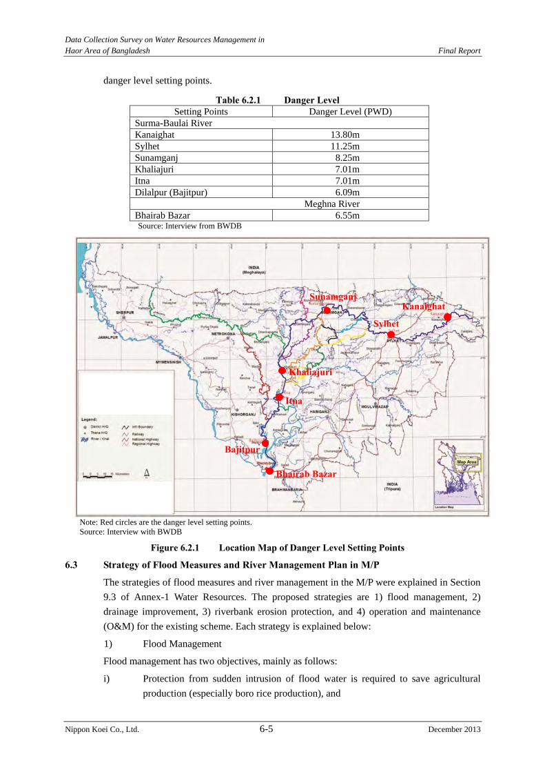
Data Collection Survey on Water Resources Management in Haor Area of Bangladesh Final Report
Nippon Koei Co., Ltd. 6-5 December 2013
danger level setting points.
Table 6.2.1 Danger Level Setting Points Danger Level (PWD)
Surma-Baulai River Kanaighat 13.80m Sylhet 11.25m Sunamganj 8.25m Khaliajuri 7.01m Itna 7.01m Dilalpur (Bajitpur) 6.09m
Meghna River Bhairab Bazar 6.55m Source: Interview from BWDB
Note: Red circles are the danger level setting points. Source: Interview with BWDB
Figure 6.2.1 Location Map of Danger Level Setting Points
6.3 Strategy of Flood Measures and River Management Plan in M/P
The strategies of flood measures and river management in the M/P were explained in Section
9.3 of Annex-1 Water Resources. The proposed strategies are 1) flood management, 2)
drainage improvement, 3) riverbank erosion protection, and 4) operation and maintenance
(O&M) for the existing scheme. Each strategy is explained below:
1) Flood Management
Flood management has two objectives, mainly as follows:
i) Protection from sudden intrusion of flood water is required to save agricultural
production (especially boro rice production), and
Kanaighat
Sylhet
Sunamganj
Khaliajuri
Itna
Bajitpur
Bhairab Bazar
Data Collection Survey on Water Resources Management in Haor Area of Bangladesh Final Report
Nippon Koei Co., Ltd. 6-6 December 2013
ii) Allowance of flood water during the monsoon is crucial to maintain the aquatic
ecosystem.
To achieve the flood management strategy, the following issues are proposed:
i) Construction of intake structure to divert water to protected land after the
harvesting of boro crops (15 May),
ii) Construction of new and rehabilitation of existing submergible embankments
against a 10-year pre-monsoon probable flood,
iii) Construction of new and rehabilitation of existing full embankments near the
boundary of the inundation and deep haor area against a 20-year annual probable
flood,
iv) Construction of bypass channel,
v) Mechanized construction, and
vi) Establishment of flood forecasting model of flash flood (non-structural measure).
2) Drainage Improvement
Post-monsoon drainage is essential for rabi (including boro) cultivation. Timely and quick
recession of flood water allows cultivars to go for crop culture in the haor areas. Therefore,
the following measures are proposed:
i) Dredging of mainstream rivers, and
ii) Drainage improvement of distributaries to reestablish the drainage connectivity of
the haor areas.
3) Riverbank Erosion Protection
The Government has recognized river bank erosion as a disaster. River bank erosion is
observed on all the rivers in Bangladesh including those in the haor areas.
River bank erosion is considered as one of the major reasons of pauperization. To elevate
poverty and protect life and property of the people, river banks should be protected against
erosion according to the government policy and directives, which is to attach priority to
protect towns, Government installations, structures of high economic value and national
heritage.
4) Operation and Maintenance (O&M) of Existing Scheme
Problems for O&M of existing scheme are i) budget shortage, ii) inadequate equipment
supports, iii) inadequate manpower, iv) poor quality of O&M works, v) inadequate
monitoring, and vi) non-availability of O&M manual. Therefore, the M/P has proposed
following measures;
i) The line agency has to ensure adequate fund,
ii) Adequate equipment supports have to be ensured, and
iii) Adequate manpower for proper O & M activities has to be ensured.
The protection level and projects for flood measures were proposed in the M/P, but the
control points, defined as important location to plan river management, and indicators such
as the discharge, water level, etc. for river management plan are not cleared. These shall be
Data Collection Survey on Water Resources Management in Haor Area of Bangladesh Final Report
Nippon Koei Co., Ltd. 6-7 December 2013
decided to manage flood control.
6.4 Applicability of River Planning Method in Japan
The river planning method used in Japan was studied to examine its applicability to the river
planning in Bangladesh. Figure 6.4.1 shows the flow chart of ordinary flood control plan.
The applicability of the Japanese method of river management plan for haor area was studied
based on Figure 6.4.1. The study results are shown in Table 6.4.1.
Table 6.4.1 Applicability of Japanese River Management Method Items Applicability
1) To grasp the present situation of the target river
The river management is carried out based on the danger level of control points. Data collection of water level is executed at these control points of danger level. These control points are set at upper, middle, and lower reaches of the Surma-Baulai River. Japanese selection criteria of control points are as follows; Existing hydraulic and hydrological data are sufficiently stored, It is a base point for hydraulic and hydrological analysis, and It is closely related to overall plan. Therefore, it is possible that the control points of river management plan in Surma-Baulai River are selected from the existing danger level of control points.
2) Importance of river and setting of flood protection level
In determining the planning scale of the Japanese technical criteria, the importance of the subject river should be emphasized, and the actual damage caused by past floods, economic effects, and other factors should all be taken into consideration. On the other hand, the planning scale of full embankment is determined from the design standard in Bangladesh. The planning scale is applied considering 20- or 100-year return periods. In this Study, the planning scale is applied based on the design standard of Bangladesh.
3) Selection and application of recorded rainfall(s) and planned rainfall(s)
Section 6.1.2 mentions; “The available data and information on rainfall distribution in sub-watersheds and flow at their respective outlets are rather poor in the Northeast Region. The hydrologic model study of NERM clearly demonstrates that the estimated river flow based on rainfall data is not reliable with the currently available set of data. Therefore, the rainfall data cannot be applied to define the design rainfall in the flood measures planning to provide probable water levels for structural design.” Therefore, it is not possible to apply recorded rainfall(s) and planned rainfall(s).
4) Hydrograph(s) Hydrograph is not applicable because 3) is not applied. 5) Flood Discharge In the project area, the measurement of the water level is carried out
five times per day from 1980. Recently, discharge measurement is also carried out about twenty times per year. However, there are no old data of the discharge measurement. It is difficult to grasp past discharge because there are no records on the past observed discharge. The flood management plan based on the discharge was not prepared. Therefore, flood discharge will be based on the water level at each control point. There are two kinds of water level, i.e., observed and simulated water level. According to the Design Circle, the simulated water level is applied to estimate the design water level, if the run-off model and/or the inundation model are available. NERM exists for the project area. Therefore, the simulated water
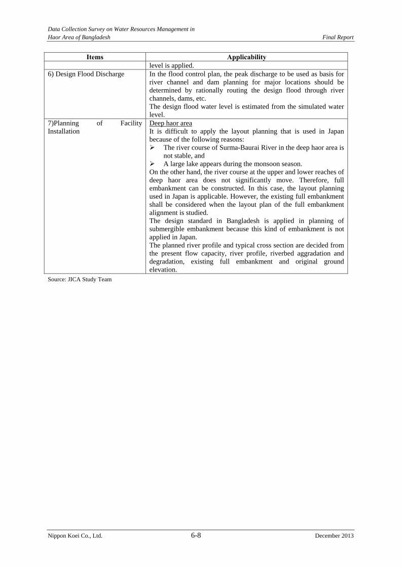
Data Collection Survey on Water Resources Management in Haor Area of Bangladesh Final Report
Nippon Koei Co., Ltd. 6-8 December 2013
Items Applicability level is applied.
6) Design Flood Discharge In the flood control plan, the peak discharge to be used as basis for river channel and dam planning for major locations should be determined by rationally routing the design flood through river channels, dams, etc. The design flood water level is estimated from the simulated water level.
7)Planning of Facility Installation
Deep haor area It is difficult to apply the layout planning that is used in Japan because of the following reasons: The river course of Surma-Baurai River in the deep haor area is
not stable, and A large lake appears during the monsoon season. On the other hand, the river course at the upper and lower reaches of deep haor area does not significantly move. Therefore, full embankment can be constructed. In this case, the layout planning used in Japan is applicable. However, the existing full embankment shall be considered when the layout plan of the full embankment alignment is studied. The design standard in Bangladesh is applied in planning of submergible embankment because this kind of embankment is not applied in Japan. The planned river profile and typical cross section are decided from the present flow capacity, river profile, riverbed aggradation and degradation, existing full embankment and original ground elevation.
Source: JICA Study Team
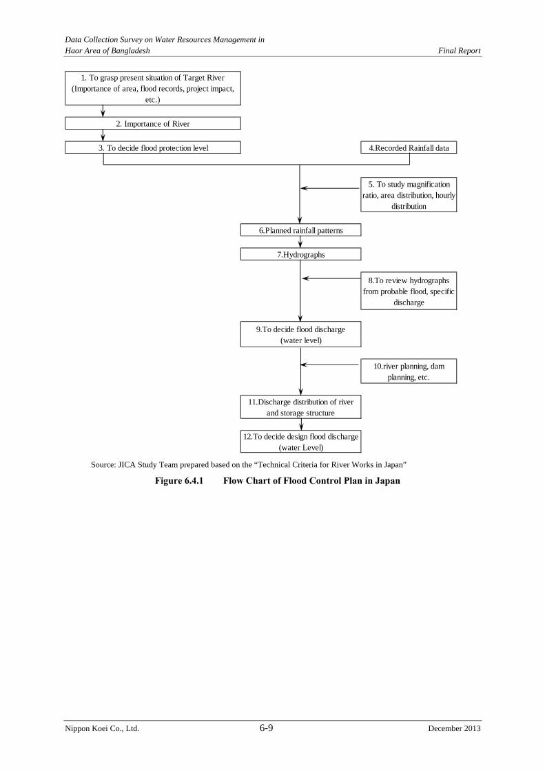
Data Collection Survey on Water Resources Management in Haor Area of Bangladesh Final Report
Nippon Koei Co., Ltd. 6-9 December 2013
Source: JICA Study Team prepared based on the “Technical Criteria for River Works in Japan”
Figure 6.4.1 Flow Chart of Flood Control Plan in Japan
1. To grasp present situation of Target River(Importance of area, flood records, project impact,
etc.)
2. Importance of River
3. To decide flood protection level 4.Recorded Rainfall data
5. To study magnificationratio, area distribution, hourly
distribution
6.Planned rainfall patterns
7.Hydrographs
8.To review hydrographsfrom probable flood, specific
discharge
9.To decide flood discharge(water level)
10.river planning, damplanning, etc.
11.Discharge distribution of riverand storage structure
12.To decide design flood discharge(water Level)
Data Collection Survey on Water Resources Management in Haor Area of Bangladesh Final Report
Nippon Koei Co., Ltd. 7-1 December 2013
CHAPTER 7 STRUCTURAL MEASURES FOR FLOOD MEASURES AND RIVER MANAGEMENT PLAN IN HAOR AREA
7.1 Basic Conditions for Flood Measures and River Management Plan
In the M/P, flood control measures are proposed, particularly the construction of a full
embankment and submergible embankment in the deep haor area. The proposed measures for
the deep haor area corresponded with the people’s concept of “living with flood”.
Flood control planning methods in Japan can be partly applied to the flood control plan in the
Surma-Baulai River. Therefore, method for flood control and river management plans shall
be studied considering the present situation and design guidelines applied in Bangladesh and
Japan.
(1) Target River
Major rivers in the study area are the Surma-Baulai River and the Kalni-Kshiyara River.
Both rivers branch off from the Barak River at the border between India and Bangladesh.
The Surma-Baulai River flows through Slyhet City, Sunamganj and Itna town areas. The
Kalni-Kshiyara River flows through Fenchuganj, Ajimirigang and Austagram town areas.
Both rivers join near Bajitpur.
The dredging works in the Kalni-Kushiyara River are being studied. Therefore, the
Surma-Baulai River is selected as the target river for planning of the dredging works.
(2) Control Points of Flood Control Measure
The control points of flood control measure have not been established yet, but the control
points of danger level are determined. It is considered that some of the control point of
danger level will become candidate control points for flood control measure because they are
applicable for hydraulic and hydrological analysis.
The control points of flood control measure are considered in each of the pre-monsoon and
monsoon seasons because the circumstances in the haor area drastically change between
these seasons.
Pre-monsoon season
The control points for danger level in the upper reach from Sunamganj Town were set at: 1)
Kanaighat, 2) Slyhet, and 3) Sunamganj. The crucial areas of flood control are Sylhet City
and Sunamganj Town due to prefectural capital status and the concentration of assets in this
area. On the other hand, Kanaighat is located near the international border. This is important
in confirming the water level at the most upstream point. The water level at Kanaighat is
used mainly for: 1) flood warning in and around Kanaighat and 2) examination of water level
at Sylhet City. Therefore, Kanaighat is not applied as a control point of flood control but
shall still be a control point for danger level. Sylhet and Sunamganji are used as control
points of flood control considering the protection of assets and sufficient data for hydraulic
and hydrological analysis.
In addition, Bairab Bazar is also a control point of flood control in consideration of its
downstream impact. And Itna Town is also determined to be a control point because many
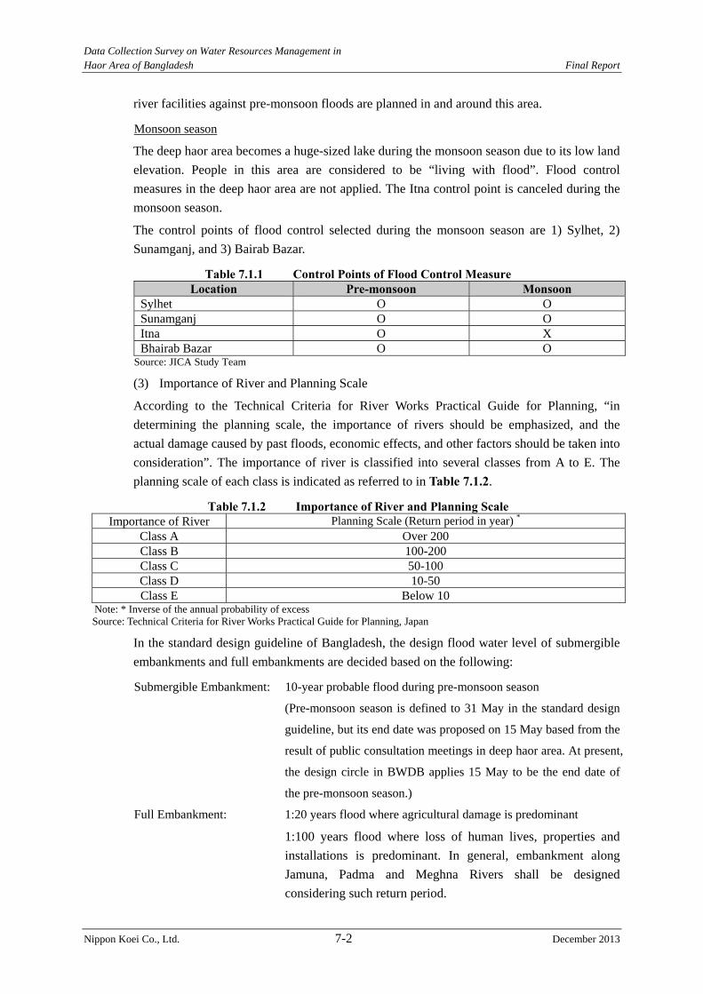
Data Collection Survey on Water Resources Management in Haor Area of Bangladesh Final Report
Nippon Koei Co., Ltd. 7-2 December 2013
river facilities against pre-monsoon floods are planned in and around this area.
Monsoon season
The deep haor area becomes a huge-sized lake during the monsoon season due to its low land
elevation. People in this area are considered to be “living with flood”. Flood control
measures in the deep haor area are not applied. The Itna control point is canceled during the
monsoon season.
The control points of flood control selected during the monsoon season are 1) Sylhet, 2)
Sunamganj, and 3) Bairab Bazar.
Table 7.1.1 Control Points of Flood Control Measure Location Pre-monsoon Monsoon
Sylhet O O Sunamganj O O Itna O X Bhairab Bazar O O
Source: JICA Study Team
(3) Importance of River and Planning Scale
According to the Technical Criteria for River Works Practical Guide for Planning, “in
determining the planning scale, the importance of rivers should be emphasized, and the
actual damage caused by past floods, economic effects, and other factors should be taken into
consideration”. The importance of river is classified into several classes from A to E. The
planning scale of each class is indicated as referred to in Table 7.1.2.
Table 7.1.2 Importance of River and Planning Scale Importance of River Planning Scale (Return period in year) *
Class A Over 200 Class B 100-200 Class C 50-100 Class D 10-50 Class E Below 10
Note: * Inverse of the annual probability of excess Source: Technical Criteria for River Works Practical Guide for Planning, Japan
In the standard design guideline of Bangladesh, the design flood water level of submergible
embankments and full embankments are decided based on the following:
Submergible Embankment: 10-year probable flood during pre-monsoon season
(Pre-monsoon season is defined to 31 May in the standard design
guideline, but its end date was proposed on 15 May based from the
result of public consultation meetings in deep haor area. At present,
the design circle in BWDB applies 15 May to be the end date of
the pre-monsoon season.)
Full Embankment: 1:20 years flood where agricultural damage is predominant
1:100 years flood where loss of human lives, properties and
installations is predominant. In general, embankment along
Jamuna, Padma and Meghna Rivers shall be designed
considering such return period.
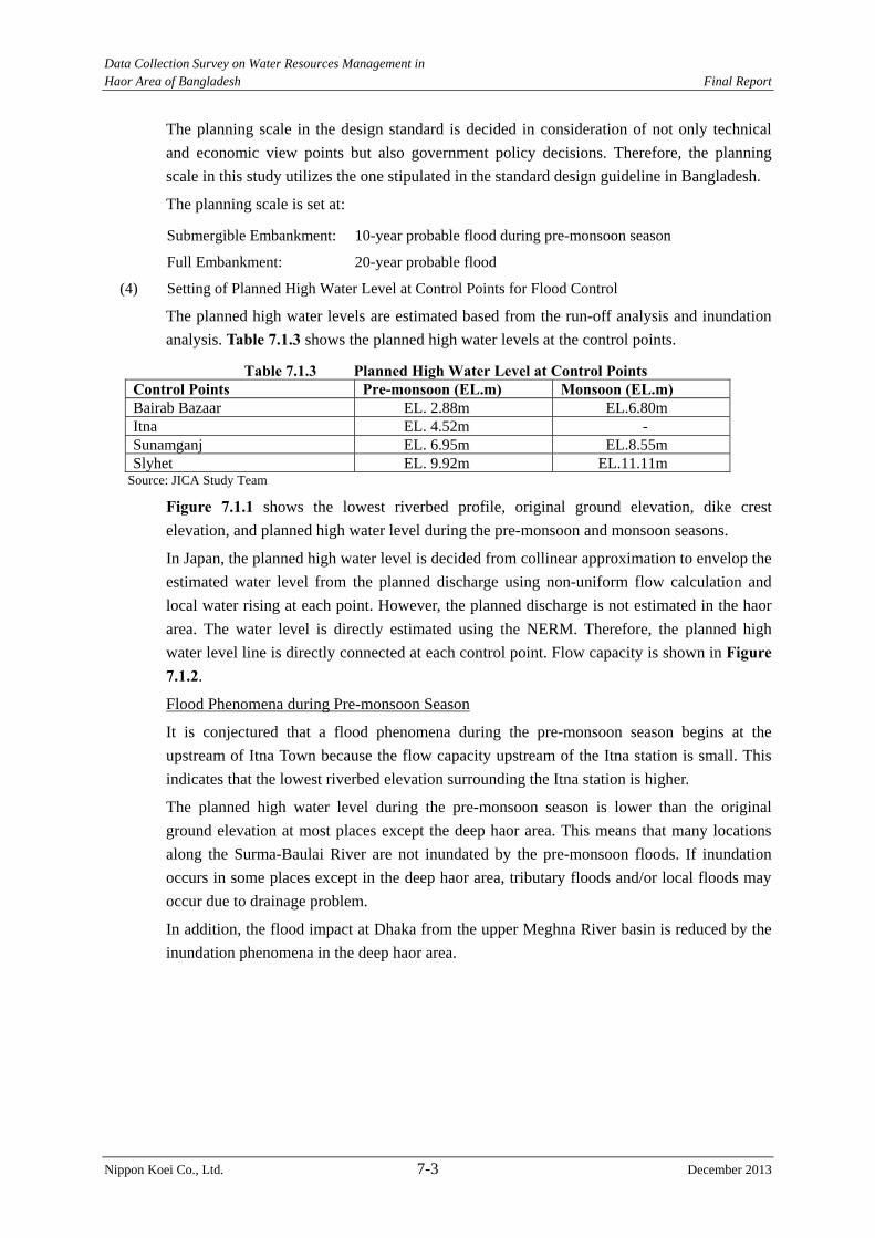
Data Collection Survey on Water Resources Management in Haor Area of Bangladesh Final Report
Nippon Koei Co., Ltd. 7-3 December 2013
The planning scale in the design standard is decided in consideration of not only technical
and economic view points but also government policy decisions. Therefore, the planning
scale in this study utilizes the one stipulated in the standard design guideline in Bangladesh.
The planning scale is set at:
Submergible Embankment: 10-year probable flood during pre-monsoon season
Full Embankment: 20-year probable flood
(4) Setting of Planned High Water Level at Control Points for Flood Control
The planned high water levels are estimated based from the run-off analysis and inundation
analysis. Table 7.1.3 shows the planned high water levels at the control points.
Table 7.1.3 Planned High Water Level at Control Points Control Points Pre-monsoon (EL.m) Monsoon (EL.m) Bairab Bazaar EL. 2.88m EL.6.80m Itna EL. 4.52m - Sunamganj EL. 6.95m EL.8.55m Slyhet EL. 9.92m EL.11.11m
Source: JICA Study Team
Figure 7.1.1 shows the lowest riverbed profile, original ground elevation, dike crest
elevation, and planned high water level during the pre-monsoon and monsoon seasons.
In Japan, the planned high water level is decided from collinear approximation to envelop the
estimated water level from the planned discharge using non-uniform flow calculation and
local water rising at each point. However, the planned discharge is not estimated in the haor
area. The water level is directly estimated using the NERM. Therefore, the planned high
water level line is directly connected at each control point. Flow capacity is shown in Figure 7.1.2.
Flood Phenomena during Pre-monsoon Season
It is conjectured that a flood phenomena during the pre-monsoon season begins at the
upstream of Itna Town because the flow capacity upstream of the Itna station is small. This
indicates that the lowest riverbed elevation surrounding the Itna station is higher.
The planned high water level during the pre-monsoon season is lower than the original
ground elevation at most places except the deep haor area. This means that many locations
along the Surma-Baulai River are not inundated by the pre-monsoon floods. If inundation
occurs in some places except in the deep haor area, tributary floods and/or local floods may
occur due to drainage problem.
In addition, the flood impact at Dhaka from the upper Meghna River basin is reduced by the
inundation phenomena in the deep haor area.
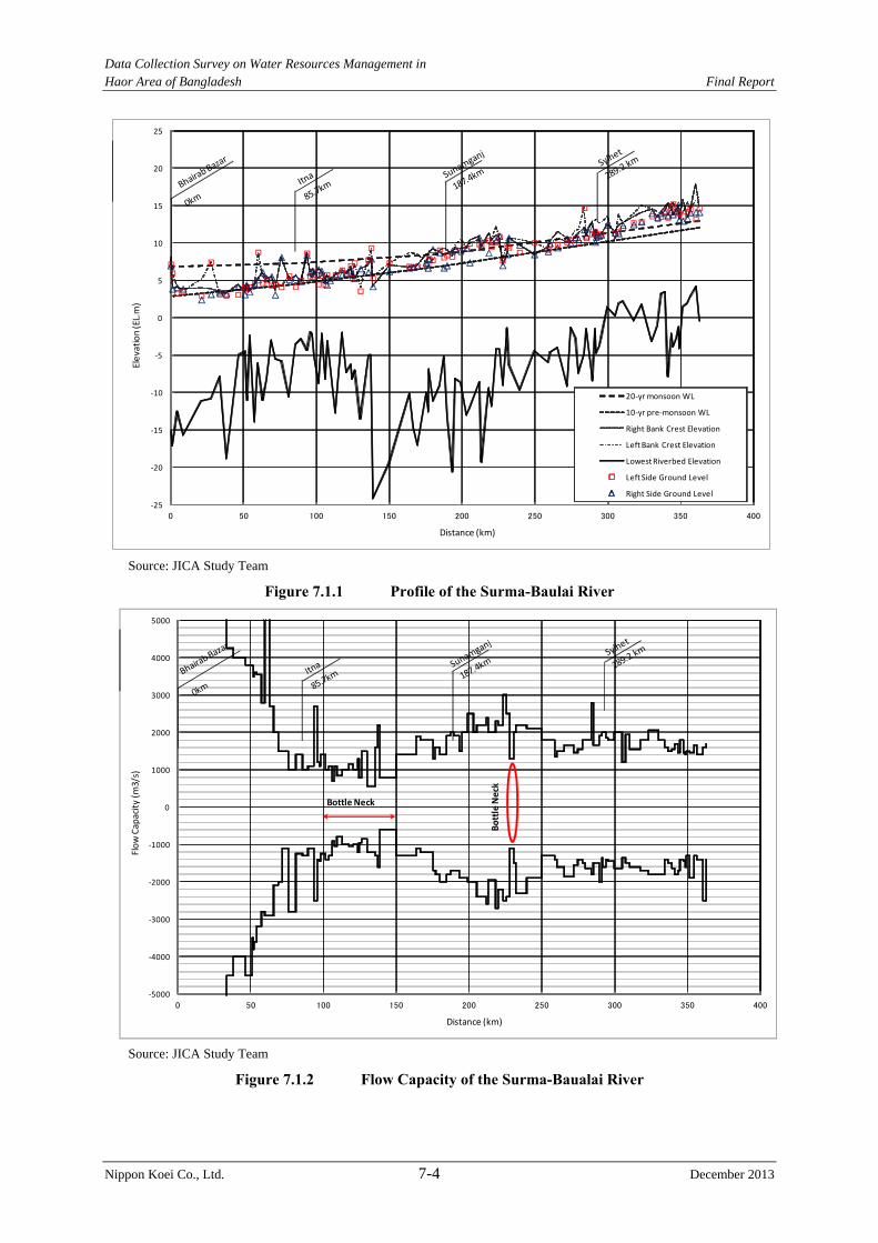
Data Collection Survey on Water Resources Management in Haor Area of Bangladesh Final Report
Nippon Koei Co., Ltd. 7-4 December 2013
Source: JICA Study Team
Figure 7.1.1 Profile of the Surma-Baulai River
Source: JICA Study Team
Figure 7.1.2 Flow Capacity of the Surma-Baualai River
‐5000
‐4000
‐3000
‐2000
‐1000
0
1000
2000
3000
4000
5000
0 50 100 150 200 250 300 350 400
Flow Capacity (m
3/s)
Distance (km)
Bottle Neck
Bottle Neck
‐25
‐20
‐15
‐10
‐5
0
5
10
15
20
25
0 50 100 150 200 250 300 350 400
20‐yr monsoon WL
10‐yr pre‐monsoon WL
Right Bank Crest Elevation
Left Bank Crest Elevation
Lowest Riverbed Elevation
Left Side Ground Level
Right Side Ground Level
Elevation(EL.m)
Distance (km)
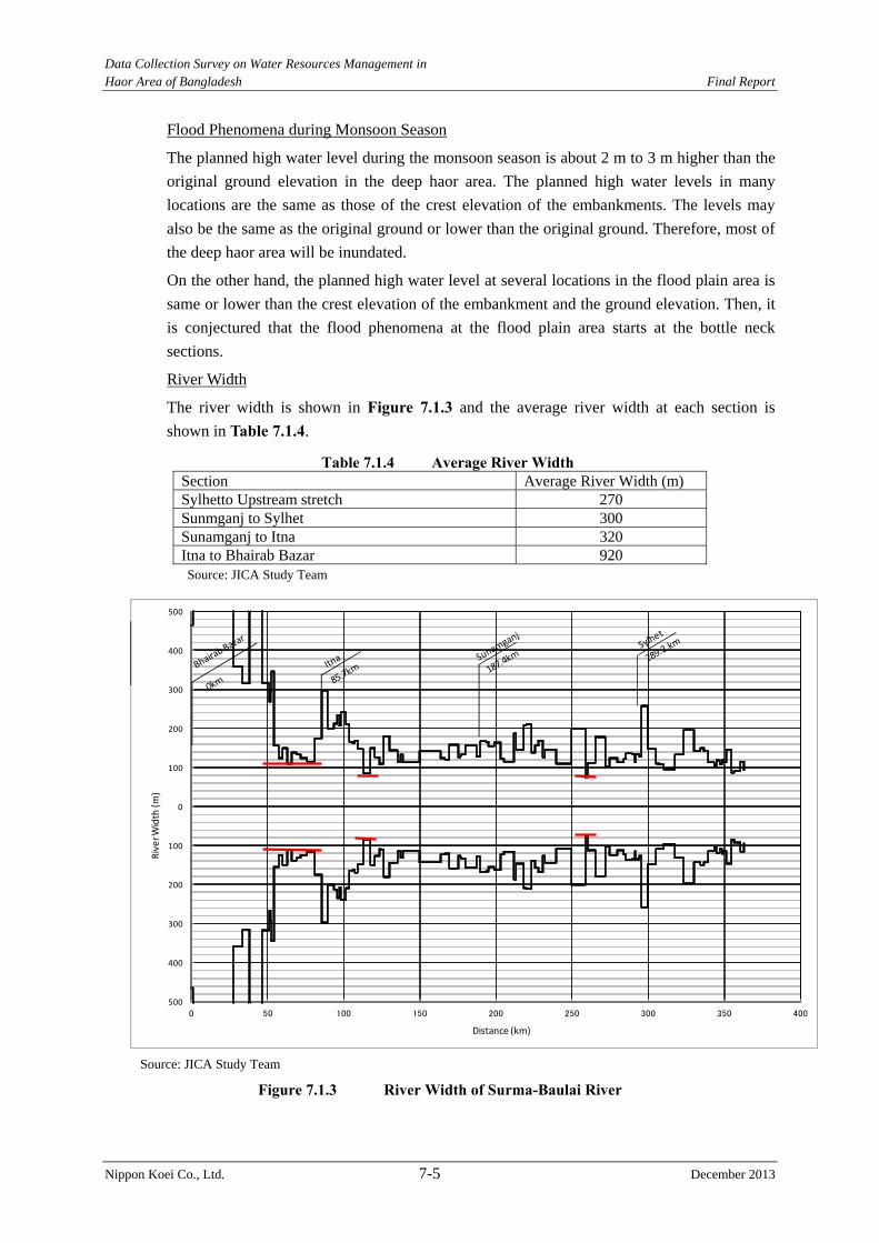
Data Collection Survey on Water Resources Management in Haor Area of Bangladesh Final Report
Nippon Koei Co., Ltd. 7-5 December 2013
Flood Phenomena during Monsoon Season
The planned high water level during the monsoon season is about 2 m to 3 m higher than the
original ground elevation in the deep haor area. The planned high water levels in many
locations are the same as those of the crest elevation of the embankments. The levels may
also be the same as the original ground or lower than the original ground. Therefore, most of
the deep haor area will be inundated.
On the other hand, the planned high water level at several locations in the flood plain area is
same or lower than the crest elevation of the embankment and the ground elevation. Then, it
is conjectured that the flood phenomena at the flood plain area starts at the bottle neck
sections.
River Width
The river width is shown in Figure 7.1.3 and the average river width at each section is
shown in Table 7.1.4.
Table 7.1.4 Average River Width Section Average River Width (m) Sylhetto Upstream stretch 270 Sunmganj to Sylhet 300 Sunamganj to Itna 320 Itna to Bhairab Bazar 920 Source: JICA Study Team
Source: JICA Study Team
Figure 7.1.3 River Width of Surma-Baulai River
‐500
‐400
‐300
‐200
‐100
0
100
200
300
400
500
0 50 100 150 200 250 300 350 400
RiverW
idth (m)
Distance (km)
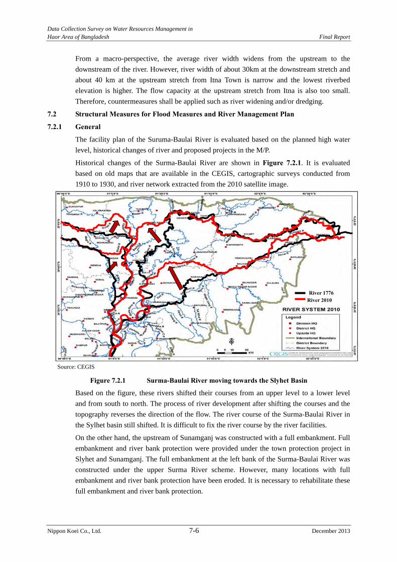
Data Collection Survey on Water Resources Management in Haor Area of Bangladesh Final Report
Nippon Koei Co., Ltd. 7-6 December 2013
From a macro-perspective, the average river width widens from the upstream to the
downstream of the river. However, river width of about 30km at the downstream stretch and
about 40 km at the upstream stretch from Itna Town is narrow and the lowest riverbed
elevation is higher. The flow capacity at the upstream stretch from Itna is also too small.
Therefore, countermeasures shall be applied such as river widening and/or dredging.
7.2 Structural Measures for Flood Measures and River Management Plan
7.2.1 General
The facility plan of the Suruma-Baulai River is evaluated based on the planned high water
level, historical changes of river and proposed projects in the M/P.
Historical changes of the Surma-Baulai River are shown in Figure 7.2.1. It is evaluated
based on old maps that are available in the CEGIS, cartographic surveys conducted from
1910 to 1930, and river network extracted from the 2010 satellite image.
Source: CEGIS
Figure 7.2.1 Surma-Baulai River moving towards the Slyhet Basin
Based on the figure, these rivers shifted their courses from an upper level to a lower level
and from south to north. The process of river development after shifting the courses and the
topography reverses the direction of the flow. The river course of the Surma-Baulai River in
the Sylhet basin still shifted. It is difficult to fix the river course by the river facilities.
On the other hand, the upstream of Sunamganj was constructed with a full embankment. Full
embankment and river bank protection were provided under the town protection project in
Slyhet and Sunamganj. The full embankment at the left bank of the Surma-Baulai River was
constructed under the upper Surma River scheme. However, many locations with full
embankment and river bank protection have been eroded. It is necessary to rehabilitate these
full embankment and river bank protection.
River 1776River 2010
Data Collection Survey on Water Resources Management in Haor Area of Bangladesh Final Report
Nippon Koei Co., Ltd. 7-7 December 2013
7.2.2 Pre-monsoon Flood Protection and Drainage Improvement Project
(1) Proposed Facilities
The facility survey was carried out for the 30 existing haor projects in five districts, namely:
Sunamganj, Netrakona, Habiganj, Kishorganj, and Brahamanbaria. Many locations in these
districts are irrigated for one crop of boro rice. Four existing haor projects are rehabilitated in
the Water Management Improvement Project (WMIP). Two projects, Sunamganj Town
Protection Project and Bairab Erosion Protection Sub-project, were rejected due to the small
amount for the rehabilitation works of river bank protections. Twenty four rehabilitation
projects were selected. On the other hand, 26 new projects proposed in the M/P were also
considered.
Full embankment has been constructed along the left bank between Sylhet City and the
upstream border of the Suruma-Baulai River. The full embankment was damaged at many
locations due to the lack of O&M budget. Rehabilitation works of the full embankment are
important. However, the flow capacity of the upstream stretch of Sylhet City has become
smaller compared to the originally designed capacity because the flow area has been reduced
by riverbed aggradation due to sedimentation. If the rehabilitation works of the full
embankment are decided, the dredging works shall be carried out at the same time. In this
case, although maintenance dredging is important, it is difficult because of the lack of
maintenance budget. Therefore, the rehabilitation works of the full embankment in the upper
Surma River scheme are not proposed.
Table 7.2.1 shows the principal rehabilitation features and new constructed haor projects,
while Figures 7.2.2 and 7.2.3 show the location map of the projects.
Table 7.2.1 Principal Rehabilitation Features and New Constructed Haor Projects No. Sub-project
Name Location Principal Features of Major Structures i) Rehabilitation of existing haor projects 1. Dampara
Water Management Scheme
Upazila : Purbodhola District: Netrakona
Resectioning of embankment = 200 m (full), 460 m (submergible)Replacement of gearbox = 4 nos. Replacement of rubber seal = 3 nos. Re-excavation of canal = 12 km (Kalihor Khal) Pipe cleaning = 3 locations Sluice gate (0.6 m x 0.6 m) = 23nos. Maintenance equipments = 1no.
2. Kangsa River Scheme
Upazila : Sadar, Purbodhola District: Netrakona
Resectioning of embankment = 40 m (full)Fully replacement of gate with related mechanical equipments = 1 no.Replacement of gearbox = 10 nos. Replacement of rubber seal = 1 no. Maintenance equipments = 1 no.
3. Singer Beel Scheme
Upazila : Barhatta District: Netrakona
Resectioning of embankment = 100 m (full),125 m (submergible)Replacement of gearbox = 2 nos. Re-excavation of canal = 2 km (1km+1km) Installation of sluice gate (1.5 m x 1.8 m) = 1 no. Pipe cleaning = 2 locations
4. Baraikhali Khal Scheme
Upzila: Nandail, Hosenpur Kishoreganj Sadar District: Mymensingh, Nandail, Kishoreganj.
Resectioning of embankment = 10 m(full)Re-excavation of canal = 24.5 km Installation of flap gate (0.5 m x 0.5 m) = 2 nos. Pipe cleaning = 2 locations Maintenance equipments = 1 no.
Data Collection Survey on Water Resources Management in Haor Area of Bangladesh Final Report
Nippon Koei Co., Ltd. 7-8 December 2013
No. Sub-project Name Location Principal Features of Major Structures
5. Alalia-Bahadia Scheme
Upzila: Katiadi, Pakundia District: Kishoreganj
Re-excavation of canal = 8 km (5 km + 3 km)
6. Modkhola Bhairagirchar Sub-project Scheme
Upzila: Pakundia, Katiadi District: Kishoreganj
Resectioning of embankment = 50 m (full)
7. Ganakkhalli Sub-scheme
Upzila: Kuliarchar District: Kishoreganj
Fully replacement of gate (1.5 m x 1.8m) with mechanical equipments = 3 nos. Maintenance equipments = 1 no.
8. Kairdhala Ratna Scheme
Upzila: Ajmiriganj, Baniachong District: Habiganj
Resectioning of embankment = 60 m (submergible) Replacement of gearbox = 5 nos. Replacement of rubber seal = 1 no. Maintenance equipments = 1 no.
9. Bahira River Scheme
Upzila: Ajmiriganj, Baniachong District: Habiganj
Resectioning of embankment = 6,000m (submergible) Installation of gate (1.5 m x 1.8 m) with mechanical equipments = 4nos. Re-excavation of canal = 20 km Maintenance equipments = 1 no.
10. Aralia Khal Scheme
Upzila: Baniachong District: Habiganj
Reinstallation of gearbox = 4 nos.Re-excavation of canal = 2.4 km Maintenance equipments = 1 no.
11. Chandal Beel Scheme
Upzila: Bancharampur District: Brahmanbaria
Resectioning of embankment = 100 m (full)Fully replacement of gate with mechanical equipments = 2nos. Re-excavation of canal = 1.5 km Maintenance equipments = 1 no.
12. Satdona Beel Scheme
Upzila: Bancharampur District: Brahmanbaria
Installation of stoplogs = 2 setsFully replacement of gate with mechanical equipments = 2 nos. Maintenance equipments = 1 no.
13 Datta Khola and Adjoing Beel Scheme
Upazila: Sadar, Mojlishpur District: Brahmanbaria
Re-excavation of canal = 73.5 km (total canal length)
14 Cheghaia Khal Scheme
Upazila: Baniachong District: Habiganj
Embankment = 130 mReplacement of gearbox = 1 no. Re-excavation of canal = 4.5 km
15 Gangajuri FCD Sub-project
Upazila; Bahubol, Baniachong & Sadar District Habiganj
Embankment =600m (full)Replacement of gearbox = 19 nos. Replacement of hoist rod = 1 no. Re-excavation of canal = 4.5 km
16 Sukti River Embankment Project
Upazila; Ajmirigang, Baniachong District Habiganj
Repair works of submergible embankment are carried out by BWDB.Re-excavation of canal = 11.5 km
17 Madhapur Scheme
Upazila; Madhapur District Habiganj
Embankment = 1,260 m (full)Re-excavation of canal = 38 km
18 Akashi and Shapla Beel Scheme
Upazila; Nasirnagar, Sarail District: Brahmanbaria
Embankment = 150m (full)Re-excavation of canal = 6.5 km
Data Collection Survey on Water Resources Management in Haor Area of Bangladesh Final Report
Nippon Koei Co., Ltd. 7-9 December 2013
No. Sub-project Name Location Principal Features of Major Structures
19 Mohadao Nodi Embankment Scheme
Upazila; Kamlakanda District Netrakona
Embankment = 420 m (full) = 120 m (submergible)
20 Kaliajuri polder #02 Scheme
Upazila; Kaliajuri District Netrakona
Embankment = 810 m (submergible) Replacement of gearbox =19 nos.
21 Kaliakjuri Polder #04 Scheme
Upazila; Kaliajuri District Netrakona
Embankment = 630 m (submergible) Fully replacement of gate with mechanical equipments = 2 nos. Replacement of gearbox = 1 no.
22 Sukaijuri Bathai Sub-project
Upazila; Nandail, Tarail, Kendua District Mymensingh, Kishoreganj, Netrakona
Embankment = 70 m (full)Replacement of gearbox = 1 no. (This project was proposed in the M/P. However, it is mainly located in the Mymensingh District and was rejected from this study because Mymensingh District was excluded from the target area.)
23 Singua River Scheme
Upazila; Pakundia, Kishoreganj Sadar, Nikli District Kishoreganj,
Re-excavation of canal = 55 km
24 Someswari River Embankment Project
Upazila; Durgapur District Netrakona
Embankment = 1,970 m (full)Replacement of gearbox = 1no.
25 Surma River Scheme
Upazila: Beani Bazar , Dakshin Surma, Golapganj Sylhet Sadar Zakiganj District Sylhet
Full embankment = 60 km (It is assumed that 50% of embankment is damaged.) Dredging works shall be carried out together with rehabilitation works because the flow capacity becomes smaller due to riverbed aggradation. Maintenance dredging shall be carried out but the maintenance budget is limited. At present, the maintenance budget is not sufficient. The scheme was rejected from this Study because Sylhet District was excluded from the target area.
ii) Development of new haor projects 26 Badla Haor
Project Upazila: Itna, Karimganj, Tarail Dstrict: Kishoreganj
Embankment = 10.8 km Re-excavation of canal = 2 km 2-vent regulator = 2 nos.
27. Dharmapasha Rui Beel Project
Upazila: Dharmapasha, Kalmakanda, Barhatta, Mohanganj District: Sunamganj & Netrakona
Embankment = 57.1kmRe-excavation of canal = 5 km 9-vent regulator = 3 nos. 8-vent regulator = 2 nos. 6-vent regulator = 1 no. 3-vent regulator = 1 no.
28. Charigram Haor Project
Upazila: Mithamain, Austagram, Itna, Nikli District: Kishoreganj
Embankment = 25.7 kmRe-excavation of canal = 3 km 4-vent regulator = 1no. 1-vent regulator = 1no.
29. Bara Haor (Kamlakanda)
Upazila: Kamlakanda, Dharmapasha District: Netrakona
Embankment = 27.0 kmRe-excavation of canal = 40 km 5-vent regulator = 1 no. 1-vent regulator = 1 no.
30. Ayner Gupi Haor
Upazila: Austagram,
Embankment = 13.7 km3-vent regulator = 1no.
Data Collection Survey on Water Resources Management in Haor Area of Bangladesh Final Report
Nippon Koei Co., Ltd. 7-10 December 2013
No. Sub-project Name Location Principal Features of Major Structures
Bajitpur District: Kishoreganj
31. Bara Haor Sub Project (Austagram)
Upazila: Austagram, Mithamain, Nikli, Itna, Karimganj District: Kishoreganj
Embankment = 60.3 kmRe-excavation of canal = 40 km 11-vent regulator = 2 nos. 4-vent regulator = 1no. 3-vent regulator = 1no.
32. Boro Haor Project (Nikli)
Upazila: Karimganj, Katiadi, Kishoreganj Sadar, Nikli District: Kishoreganj
Embankment = 9.6 kmRe-excavation of canal = 10 km 9-vent regulator = 2 nos. 3-vent regulator = 1 no.
33. Chandpur Haor Project
Upazila: Katiadi, Nikli District: Kishoreganj
Embankment =2.1 kmRe-excavation of canal = 5 km 4-vent regulator = 1no. 1-vent regulator = 1no.
34. Dulapur Haor Project
Upazila: Bajitpur District: Kishoreganj
Embankment = 8.3 kmRe-excavation of canal = 3 km 2-vent regulator = 1no.
35. Golaimara Haor Project
Upazila: Bajitpur District: Kishoreganj
This project was rejected because the ground elevation is higher than 10-year probable pre-monsoon flood water level based on the spot elevation survey and hydraulic analysis results.
36. Joyariya Haor Project
Upazila: Bajitpur, Kuriar Char District: Kishoreganj
This project was rejected because the ground elevation is higher than 10-year probable pre-monsoon flood water level based on the spot elevation survey and hydraulic analysis results.
37. Korati Haor Project
Upazila: Kalimganj, Nikli District: Kishoreganj
Embankment = 40.4 kmRe-excavation of canal = 4 km 4-vent regulator = 1 no. 1-vent regulator = 1 no.
38. Kuniarbandh Haor Project
Upazila: Bajitpur, Kuliar Char District: Kishoreganj
Embankment = 8.3 km1-vent regulator = 1 no.
39. Naogaon Haor Project
Upazila: Itna, Karimganj, Mithamain, Nikli District: Kishoreganj
Embankment = 34.1 kmRe-excavation of canal = 20 km 9-vent regulator = 2 nos. 8-vent regulator = 1 no. 4-vent regulator = 1 no.
40. Noapara Haor Project
Upazila: Austagram, Karimganj, Nikli District: Kishoreganj
Embankment = 28.3 k mRe-excavation of canal = 7 km 3-vent regulator = 1no. 2-vent regulator = 1no. 1-vent regulator = 1no.
41. Nunnir Haor Project
Upazila: Bajitpur, Kariadi, Nikli District: Kishoreganj
Embankment = 25.5 kmRe-excavation of canal = 20 km 5-vent regulator = 1 no. 2-vent regulator = 2 nos.
42. Sarishapur Haor Project
Upazila: Bajitpur District: Kishoreganj
Embankment= 7.1 kmRe-excavation of canal = 5 km 1-vent regulator = 1 no.
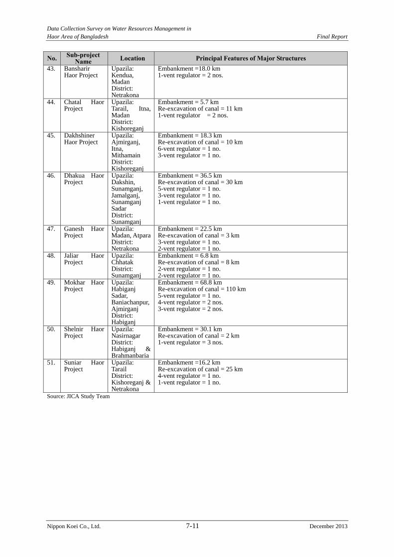
Data Collection Survey on Water Resources Management in Haor Area of Bangladesh Final Report
Nippon Koei Co., Ltd. 7-11 December 2013
No. Sub-project Name Location Principal Features of Major Structures
43. Bansharir Haor Project
Upazila: Kendua, Madan District: Netrakona
Embankment =18.0 km1-vent regulator = 2 nos.
44. Chatal Haor Project
Upazila: Tarail, Itna, Madan District: Kishoreganj
Embankment = 5.7 kmRe-excavation of canal = 11 km 1-vent regulator = 2 nos.
45. Dakhshiner Haor Project
Upazila: Ajmirganj, Itna, Mithamain District: Kishoreganj
Embankment = 18.3 kmRe-excavation of canal = 10 km 6-vent regulator = 1 no. 3-vent regulator = 1 no.
46. Dhakua Haor Project
Upazila: Dakshin, Sunamganj, Jamalganj, Sunamganj Sadar District: Sunamganj
Embankment = 36.5 kmRe-excavation of canal = 30 km 5-vent regulator = 1 no. 3-vent regulator = 1 no. 1-vent regulator = 1 no.
47. Ganesh Haor Project
Upazila: Madan, Atpara District: Netrakona
Embankment = 22.5 kmRe-excavation of canal = 3 km 3-vent regulator = 1 no. 2-vent regulator = 1 no.
48. Jaliar Haor Project
Upazila: Chhatak District: Sunamganj
Embankment = 6.8 kmRe-excavation of canal = 8 km 2-vent regulator = 1 no. 2-vent regulator = 1 no.
49. Mokhar Haor Project
Upazila: Habiganj Sadar, Baniachanpur, Ajmirganj District: Habiganj
Embankment = 68.8 kmRe-excavation of canal = 110 km 5-vent regulator = 1 no. 4-vent regulator = 2 nos. 3-vent regulator = 2 nos.
50. Shelnir Haor Project
Upazila: Nasirnagar District: Habiganj & Brahmanbaria
Embankment = 30.1 kmRe-excavation of canal = 2 km 1-vent regulator = 3 nos.
51. Suniar Haor Project
Upazila: Tarail District: Kishoreganj & Netrakona
Embankment =16.2 kmRe-excavation of canal = 25 km 4-vent regulator = 1 no. 1-vent regulator = 1 no.
Source: JICA Study Team
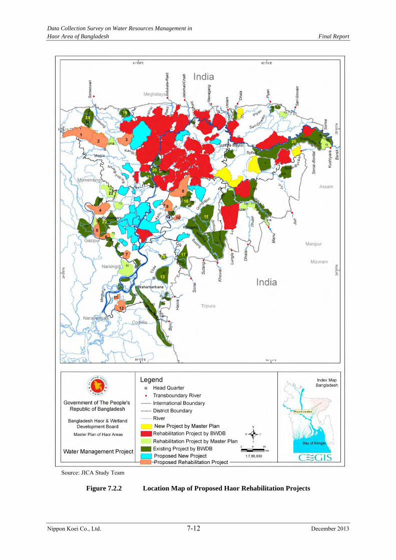
Data Collection Survey on Water Resources Management in
Haor Area of Bangladesh Final Report
Nippon Koei Co., Ltd. 7-12 December 2013
Source: JICA Study Team
Figure 7.2.2 Location Map of Proposed Haor Rehabilitation Projects
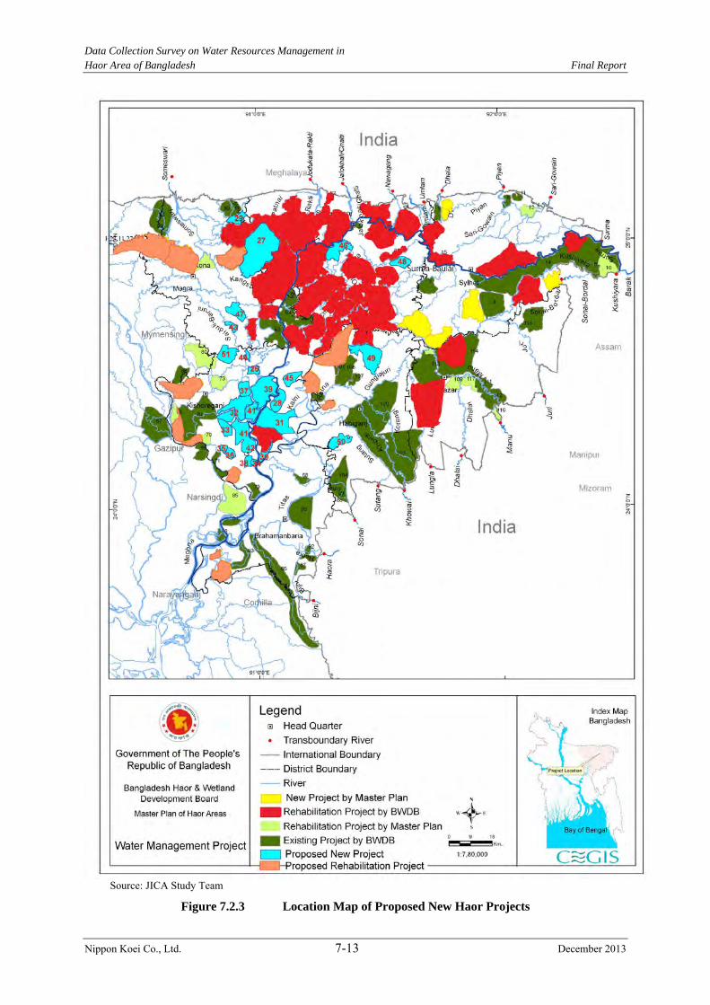
Data Collection Survey on Water Resources Management in
Haor Area of Bangladesh Final Report
Nippon Koei Co., Ltd. 7-13 December 2013
Source: JICA Study Team
Figure 7.2.3 Location Map of Proposed New Haor Projects
Data Collection Survey on Water Resources Management in Haor Area of Bangladesh Final Report
Nippon Koei Co., Ltd. 7-14 December 2013
(2) Selection of Facilities
Fifty one projects have been proposed and divided into the rehabilitation and new projects.
The proposed projects were selected from each group. Two rehabilitation projects and two
new projects were rejected due to the reasons below,
The Sukajuri Bathai Sub-project was rejected because the main target area in this project is
located in the Mymensingh District. In this case, the Mymensingh Office in BWDB would
have handled this project if the district is located in the project area. The Upper Surma River
Scheme was also rejected because the dredging work shall be carried out at the same time of
the rehabilitation work. In this case, maintenance dredging is important but difficult to carry
out due to the budget limitation.
It is confirmed that the ground elevation along the alignment of the proposed submergible
embankment in the Golaimara Haor Project and the Joyariya Haor Project is higher than the
design high water level of the submergible embankment as was determined in the spot
elevation survey. Therefore, these projects do not require the construction of the submergible
embankment.
The number of target projects became 47 projects. The prioritization of each group is
determined from the economic viewpoint of the projects.
The following assumptions are applied to evaluate the ranking of each project:
The crop yield (ton/ha) of the boro rice in the project area is assumed to be the
same.
The economic value of the boro rice in the project area is assumed to be the same.
The beneficiary area is only cultivated for the boro rice.
There is no example of the estimation method for the rice damaged cost using the
relation between the flood depth and the period of inundation in Bangladesh. The
damage ratio for each excess probability estimated in “Kalni-Kushyara River
Improvement Project” is adopted because this project is located in the target area.
Table 7.2.2 shows damaged ratio of paddy.
Table7.2.2 Damage Ratio of Paddy Excess Probability Damaged Ratio (%)
2-year 6.4 5-year 26.4 10-year 36.1 20-year 55.5*
Note: * Damage ratio is determined by extrapolation, Detailed explanation of damage ration refers to Annex 7.3 Source:Kalni-Kushyara River Improvement Project
The damage cost is estimated from the following formula:
(Damage cost (BDT)) = (Unit price of boro rice (BDT/ton)) x (Crop yield (ton/ha)) x (Flooded
area (ha)) x (Damage ratio (%))
The estimation of project ranking is a relative evaluation. Therefore, the following formula
can be applied to evaluate the project ranking:
(Annualized damage of boro rice) =(Flooded area (ha)) x (Damage ratio (%))
Data Collection Survey on Water Resources Management in Haor Area of Bangladesh Final Report
Nippon Koei Co., Ltd. 7-15 December 2013
The project ranking from an economic viewpoint is evaluated using the following formula:
(Economic efficiency) =(Annualized damage of boro rice) / (Direct construction cost)
The crest of the existing submergible embankment is damaged due to erosion. The
overtopping through the submergible embankment has occurred. Even the water level is now
lower than the 10-year probable pre-monsoon flood water level. Many locations of the
existing submergible embankment are damaged because of the BWDB field office’s budget
limitation. Therefore, it is assumed that the flood damage has occurred over a 2-year probable
flood.
The remaining existing haor projects that are not selected as rehabilitation projects in the M/P
and by BWDB are also evaluated for economic efficiency. If the high priority projects are
included in the remaining projects, they are also selected for rehabilitation.
Table 7.2.3 shows the prioritization result for each group.
1) Proposed Rehabilitation Works of Existing Haor Projects
Twenty three existing haor projects are selected. The proposed projects in M/P are 12
projects and the remaining projects that are not selected by BWDB are 11 projects.
Twelve projects are proposed because these projects are authorized by GOB. Also, three
projects that are the Gangajuri FCD Project, Kaliajuri Polder #02 Scheme, and Kaliajuri
Polder #04, are proposed from the remaining projects because they are high priority projects.
Therefore, a total of fifteen rehabilitation projects are proposed in this Study.
2) Proposed New Projects
Twenty four new haor projects are proposed because these projects are also authorized by
GOB. In this Study, the prioritization of the new projects is evaluated.

Data Collection Survey on Water Resources Management in Haor Area of Bangladesh Final Report
Nippon Koei Co., Ltd. 7-16 December 2013
Table 7.2.3 Project Prioritization for Each Group
(1) Rehabilitation Projects
(2) New Projects
Source: JICA Study Team
No. Name of Project Annualized Cost (mil. BDT) B'/C Rank RemarkBenfit B C
26 Badla Haor Project 85 135.1 0.6 927 Dharmapasha Rui Beel Project 1,286 1,119.5 1.1 528 Charigram Haor Project 239 329.5 0.7 829 Bara Haor (Kamlakanda) 164 1,001.6 0.2 1730 Ayner Gupi Haor 3 328.6 0.0 2431 Bara Haor Sub Project (Austagram) 755 1,025.7 0.7 732 Boro Haor Project (Nikli) 479 236.9 2.0 133 Chandpur Haor Project 70 58.5 1.2 434 Dulapur Haor Project 29 197.9 0.1 1835 Korati Haor Project 123 962.4 0.1 1936 Kuniarbandh Haor Project 7 217.0 0.0 2237 Naogaon Haor Project 667 380.3 1.8 238 Noapara Haor Project 141 565.7 0.3 1639 Nunnir Haor Project 207 349.8 0.6 1140 Sarishapur Haor Project 10 101.1 0.1 2141 Bansharir Haor Project 27 237.7 0.1 2042 Chatal Haor Project 43 111.1 0.4 1243 Dakhshiner Haor Project 180 288.6 0.6 1044 Dhakua Haor Project 228 620.3 0.4 1445 Ganesh Haor Project 117 312.0 0.4 1346 Jaliar Haor Project 114 95.4 1.2 347 Mokhar Haor Project 451 1,444.2 0.3 1548 Shelnir Haor Project 10 323.9 0.0 2349 Suniar Haor Project 118 148.6 0.8 6
No. Name of Project Annualized Cost (mil. BDT) B'/C RankBenfit B C
1 Dampara Water Management Scheme 1,167 32.0 36.5 9 Proposed Project in M/P2 Kangsa River Scheme 1,149 4.6 248.2 3 Proposed Project in M/P3 Singer Beel Scheme 360 7.9 45.8 7 Proposed Project in M/P4 Baraikhali Khal Scheme 768 6.2 123.8 5 Proposed Project in M/P5 Alalia-Bahadia Scheme 135 17.0 7.9 15 Proposed Project in M/P6 Modkhola Bhairagirchar sub-project
Scheme167 16.3 10.2 13 Proposed Project in M/P
7 Ganakkhalli Sub-scheme 154 0.3 494.1 2 Proposed Project in M/P8 Kairdhala Ratna Scheme 758 1.1 677.8 1 Proposed Project in M/P9 Bahira River Scheme 273 113.6 2.4 23 Proposed Project in M/P
10 Aralia Khal Scheme 100 5.5 18.3 11 Proposed Project in M/P11 Chandal Beel Scheme 104 25.8 4.0 22 Proposed Project in M/P12 Satdona Beel Scheme 188 34.7 5.4 21 Proposed Project in M/P13 Datta Khola and Adjoing Beel Scheme 1,044 154.4 6.8 1714 Cheghaia Khal scheme 82 14.9 5.5 2015 Gangajuri FCD sub-project 1,368 36.2 37.8 8 High ranking and high efficiency project16 Sukti River Embankment Project 513 24.2 21.2 1017 Madhapur scheme 737 131.5 5.6 1918 Akashi and Shapla Beel scheme 154 19.8 7.8 1619 Mohadao Nodi Embankment scheme 158 17.7 8.9 1420 Kaliajuri polder #02 scheme 411 5.0 81.5 6 High ranking and high efficiency project21 Kaliakjuri polder #04 scheme 399 2.7 148.2 4 High ranking and high efficiency project22 Sukaijuri Bathai sub-project Out of the project area
23 Singua River scheme(Drainage andIrrigation)
674 115.5 5.8 18
24 Someswari River Embankment Project 851 81.0 10.5 1225 Upper Surma River Scheme The dredging work shall be carried out at the same time of
rehabilitation work. The maintenance dredging will be difficult due tobudget limitation.
Remark
Data Collection Survey on Water Resources Management in Haor Area of Bangladesh Final Report
Nippon Koei Co., Ltd. 7-17 December 2013
(3) Impact by New Haor Projects
1) Impact Study to Tanguar Haor after construction of new projects
Tanguar Haor that is registered in Ramsar Convention, is located at northern area of
Sunamganj near the border of Indian territory. The western hill forms the watershed and
the submergible embankment is constructed at southern area. The present condition of flow
in and out the Tanguar Haor is explained below (reference Figure 7.2.4);
(i) Flow in the Tanguar Haor
The water enters to the Tanguar Haor from the rivers through the northern hilly area at Indian
border, the eastern adjoining river and the back water from the Baulai River.
Inflow from the rivers through the hilly area at Uttar Bangshikunda Union and Uttar
Sreepur Union,
Inflow from Patnai Paikartala River that adjoin the east side of the Tanguar Haor,
through the eroded and/or breaching portion of the submergible embankment and the
road, and
Back water from Baulai River through Patnai Paikartala River during pre-monsoon and
monsoon period.
(ii) Outflow from the Tanguar Haor
The store water in the Tanguar Haor drains to Patnai Paikartala River thorough some small
tributaries located in Uttar Sreepur Union during pre-monsoon and post-monsoon seasons.
The Pre-monsoon Flood Protection and Drainage Improvement Project is planned to consider
no negative impact from hydraulic point of view near the confluence of Patnai Paikartala
River and Baulai River. Therefore, it can be considered that the negative impact in the
Tanguar Haor from the hydraulic viewpoint isn’t occurred after completion of the Project.
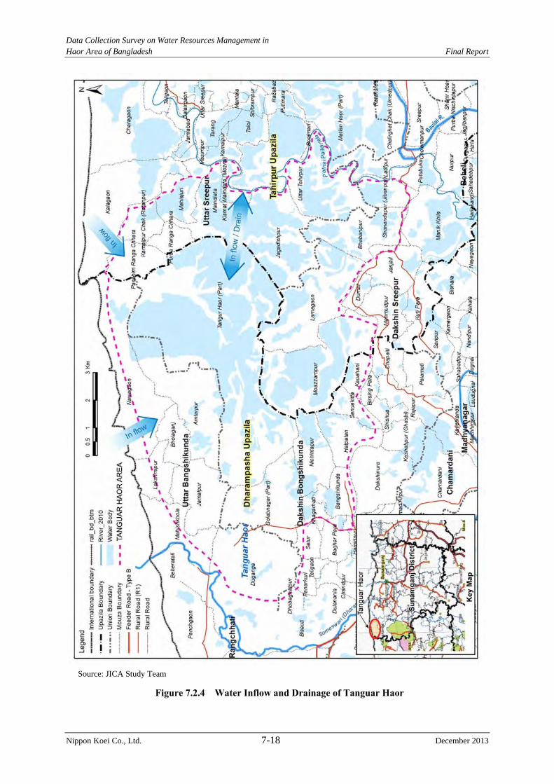
Data Collection Survey on Water Resources Management in Haor Area of Bangladesh Final Report
Nippon Koei Co., Ltd. 7-18 December 2013
Source: JICA Study Team
Figure 7.2.4 Water Inflow and Drainage of Tanguar Haor
Data Collection Survey on Water Resources Management in Haor Area of Bangladesh Final Report
Nippon Koei Co., Ltd. 7-19 December 2013
2) Impact to Dhaka
In the beginning of this Study, the dredging work was also considered as one component of
the JICA cooperation project. The necessity of the dredging work was confirmed but it was
identified as an inappropriate component of the JICA coopetation project. Therefore, the
dredging work was rejected.
In this case, the outflow from the haor area has the same condition and its impact to Dhaka is
controlled by the water level condition of the Padoma River. Therefore, there is no negative
impact that will be caused by the Project.
3) Impact of the New projects on the Surroundings of Itna Town
New projects are planned at the downstream of Itna Town, but the area is inundated and is a
flood plain area. If the submergible embankments of the new projects are constructed, the
flood water flows in the river portion and the water level becomes higher than the present
situation. The freeboard of existing haor projects located at the upstream area will be reduced.
The negative impact on the upstream area was confirmed using HEC-RAS (refer to Annex 7-1). As a result of the hydraulic confirmation, the Charigram Haor Project causes water to
rise in the upstream area (existing haor project near Itna Town: 10cm rise in water level).
Therefore, countermeasures are required, if GOB wants to realize the Charigram Haor
Project. The following measures will be considered:
a) Dredging works
b) Elevating the existing submergible embankment, and
c) Combination of a) and b)
It is expected that both flow direction between Surma-Baulai River and Kalni-Kushiyara
River occurr during pre-monsoon and monsoon season. The Bara Haor Sub-project will
hamper the water flow of both rivers. Therefore, countermeasures are required.
Two projects are rejected from the new haor projects. If GOB will carry out these projects,
the countermeasure against the hydraulic impact shall be executed and the countermeasure
will be decided through detailed model simulation and/or test.
(4) Proposed Project
As a result of the above study, 37 projects are proposed. These consist of 15 rehabilitation
projects and 22 new projects. Table 7.2.4 shows project list while Figure 7.2.5 shows the
location map of the proposed projects.
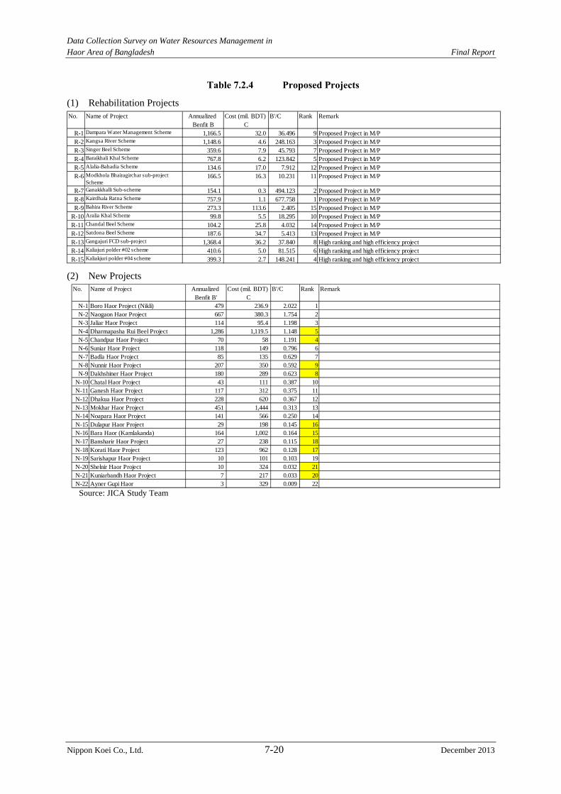
Data Collection Survey on Water Resources Management in Haor Area of Bangladesh Final Report
Nippon Koei Co., Ltd. 7-20 December 2013
Table 7.2.4 Proposed Projects
(1) Rehabilitation Projects
(2) New Projects
Source: JICA Study Team
No. Name of Project Annualized Cost (mil. BDT) B'/C Rank RemarkBenfit B' C
N-1 Boro Haor Project (Nikli) 479 236.9 2.022 1N-2 Naogaon Haor Project 667 380.3 1.754 2N-3 Jaliar Haor Project 114 95.4 1.198 3N-4 Dharmapasha Rui Beel Project 1,286 1,119.5 1.148 5N-5 Chandpur Haor Project 70 58 1.191 4N-6 Suniar Haor Project 118 149 0.796 6N-7 Badla Haor Project 85 135 0.629 7N-8 Nunnir Haor Project 207 350 0.592 9N-9 Dakhshiner Haor Project 180 289 0.623 8
N-10 Chatal Haor Project 43 111 0.387 10N-11 Ganesh Haor Project 117 312 0.375 11N-12 Dhakua Haor Project 228 620 0.367 12N-13 Mokhar Haor Project 451 1,444 0.313 13N-14 Noapara Haor Project 141 566 0.250 14N-15 Dulapur Haor Project 29 198 0.145 16N-16 Bara Haor (Kamlakanda) 164 1,002 0.164 15N-17 Bansharir Haor Project 27 238 0.115 18N-18 Korati Haor Project 123 962 0.128 17N-19 Sarishapur Haor Project 10 101 0.103 19N-20 Shelnir Haor Project 10 324 0.032 21N-21 Kuniarbandh Haor Project 7 217 0.033 20N-22 Ayner Gupi Haor 3 329 0.009 22
No. Name of Project Annualized Cost (mil. BDT) B'/C Rank RemarkBenfit B C
R-1 Dampara Water Management Scheme 1,166.5 32.0 36.496 9 Proposed Project in M/PR-2 Kangsa River Scheme 1,148.6 4.6 248.163 3 Proposed Project in M/PR-3 Singer Beel Scheme 359.6 7.9 45.793 7 Proposed Project in M/PR-4 Baraikhali Khal Scheme 767.8 6.2 123.842 5 Proposed Project in M/PR-5 Alalia-Bahadia Scheme 134.6 17.0 7.912 12 Proposed Project in M/PR-6 Modkhola Bhairagirchar sub-project
Scheme166.5 16.3 10.231 11 Proposed Project in M/P
R-7 Ganakkhalli Sub-scheme 154.1 0.3 494.123 2 Proposed Project in M/PR-8 Kairdhala Ratna Scheme 757.9 1.1 677.758 1 Proposed Project in M/PR-9 Bahira River Scheme 273.3 113.6 2.405 15 Proposed Project in M/P
R-10 Aralia Khal Scheme 99.8 5.5 18.295 10 Proposed Project in M/PR-11 Chandal Beel Scheme 104.2 25.8 4.032 14 Proposed Project in M/PR-12 Satdona Beel Scheme 187.6 34.7 5.413 13 Proposed Project in M/PR-13 Gangajuri FCD sub-project 1,368.4 36.2 37.840 8 High ranking and high efficiency projectR-14 Kaliajuri polder #02 scheme 410.6 5.0 81.515 6 High ranking and high efficiency projectR-15 Kaliakjuri polder #04 scheme 399.3 2.7 148.241 4 High ranking and high efficiency project
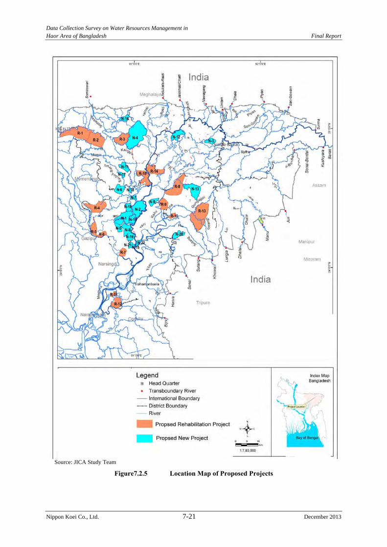
Data Collection Survey on Water Resources Management in Haor Area of Bangladesh Final Report
Nippon Koei Co., Ltd. 7-21 December 2013
Source: JICA Study Team
Figure7.2.5 Location Map of Proposed Projects
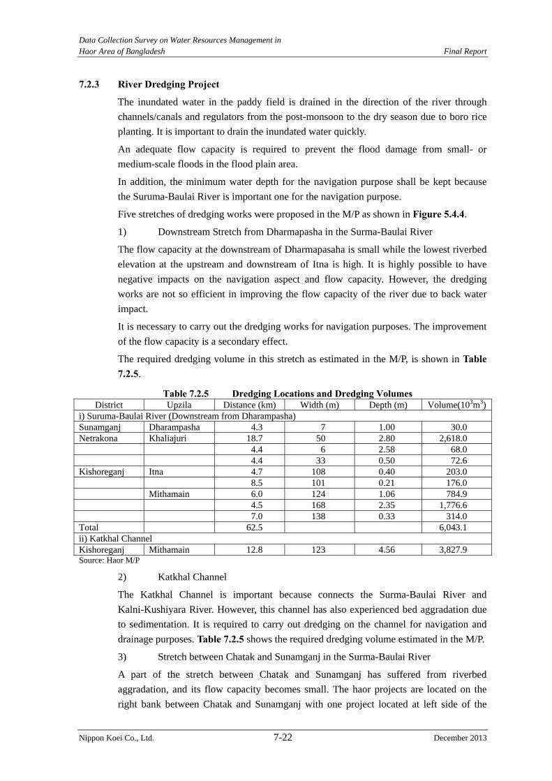
Data Collection Survey on Water Resources Management in Haor Area of Bangladesh Final Report
Nippon Koei Co., Ltd. 7-22 December 2013
7.2.3 River Dredging Project
The inundated water in the paddy field is drained in the direction of the river through
channels/canals and regulators from the post-monsoon to the dry season due to boro rice
planting. It is important to drain the inundated water quickly.
An adequate flow capacity is required to prevent the flood damage from small- or
medium-scale floods in the flood plain area.
In addition, the minimum water depth for the navigation purpose shall be kept because
the Suruma-Baulai River is important one for the navigation purpose.
Five stretches of dredging works were proposed in the M/P as shown in Figure 5.4.4.
1) Downstream Stretch from Dharmapasha in the Surma-Baulai River
The flow capacity at the downstream of Dharmapasaha is small while the lowest riverbed
elevation at the upstream and downstream of Itna is high. It is highly possible to have
negative impacts on the navigation aspect and flow capacity. However, the dredging
works are not so efficient in improving the flow capacity of the river due to back water
impact.
It is necessary to carry out the dredging works for navigation purposes. The improvement
of the flow capacity is a secondary effect.
The required dredging volume in this stretch as estimated in the M/P, is shown in Table 7.2.5.
Table 7.2.5 Dredging Locations and Dredging Volumes District Upzila Distance (km) Width (m) Depth (m) Volume(103m3)
i) Suruma-Baulai River (Downstream from Dharampasha) Sunamganj Dharampasha 4.3 7 1.00 30.0 Netrakona Khaliajuri 18.7 50 2.80 2,618.0 4.4 6 2.58 68.0 4.4 33 0.50 72.6 Kishoreganj Itna 4.7 108 0.40 203.0 8.5 101 0.21 176.0 Mithamain 6.0 124 1.06 784.9 4.5 168 2.35 1,776.6 7.0 138 0.33 314.0 Total 62.5 6,043.1 ii) Katkhal Channel Kishoreganj Mithamain 12.8 123 4.56 3,827.9 Source: Haor M/P
2) Katkhal Channel
The Katkhal Channel is important because connects the Surma-Baulai River and
Kalni-Kushiyara River. However, this channel has also experienced bed aggradation due
to sedimentation. It is required to carry out dredging on the channel for navigation and
drainage purposes. Table 7.2.5 shows the required dredging volume estimated in the M/P.
3) Stretch between Chatak and Sunamganj in the Surma-Baulai River
A part of the stretch between Chatak and Sunamganj has suffered from riverbed
aggradation, and its flow capacity becomes small. The haor projects are located on the
right bank between Chatak and Sunamganj with one project located at left side of the
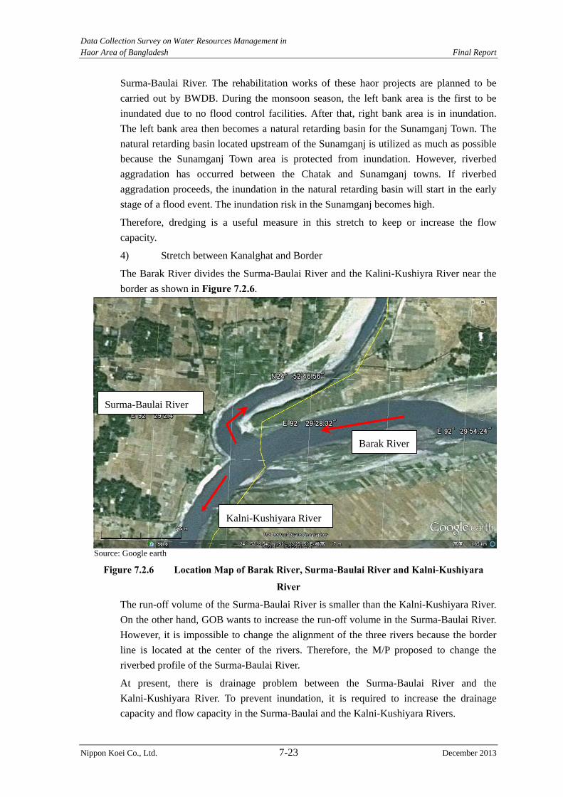
Data Collection Survey on Water Resources Management in Haor Area of Bangladesh Final Report
Nippon Koei Co., Ltd. 7-23 December 2013
Surma-Baulai River. The rehabilitation works of these haor projects are planned to be
carried out by BWDB. During the monsoon season, the left bank area is the first to be
inundated due to no flood control facilities. After that, right bank area is in inundation.
The left bank area then becomes a natural retarding basin for the Sunamganj Town. The
natural retarding basin located upstream of the Sunamganj is utilized as much as possible
because the Sunamganj Town area is protected from inundation. However, riverbed
aggradation has occurred between the Chatak and Sunamganj towns. If riverbed
aggradation proceeds, the inundation in the natural retarding basin will start in the early
stage of a flood event. The inundation risk in the Sunamganj becomes high.
Therefore, dredging is a useful measure in this stretch to keep or increase the flow
capacity.
4) Stretch between Kanalghat and Border
The Barak River divides the Surma-Baulai River and the Kalini-Kushiyra River near the
border as shown in Figure 7.2.6.
Source: Google earth
Figure 7.2.6 Location Map of Barak River, Surma-Baulai River and Kalni-Kushiyara
River
The run-off volume of the Surma-Baulai River is smaller than the Kalni-Kushiyara River.
On the other hand, GOB wants to increase the run-off volume in the Surma-Baulai River.
However, it is impossible to change the alignment of the three rivers because the border
line is located at the center of the rivers. Therefore, the M/P proposed to change the
riverbed profile of the Surma-Baulai River.
At present, there is drainage problem between the Surma-Baulai River and the
Kalni-Kushiyara River. To prevent inundation, it is required to increase the drainage
capacity and flow capacity in the Surma-Baulai and the Kalni-Kushiyara Rivers.
Barak River
Surma-Baulai River
Kalni-Kushiyara River

Data Collection Survey on Water Resources Management in Haor Area of Bangladesh Final Report
Nippon Koei Co., Ltd. 7-24 December 2013
Dredging is very useful to increase the flow capacity but it is not effective to increase
run-off volume in the Surma-Baulai River.
5) Jadukata River
The Jadukata River has a large catchment area in the Indian territory. Large volumes of
sediments are transported through this river. Because of sediment transportation, there is
no water at the confluence of the Jadukata River and the Surma-Baulai River during the
dry season. The water flow of the Jadukata River at the upstream has changed to the west
direction and has entered the Surma-Baulai River. It is required to carry out dredging
works for the maintenance of the river functions.
Based on the explanation of the necessity for dredging in the above five river stretches,
the first three river stretches were finally selected due to the following reasons:
The expectations of the dredging effect in Kanalgaht to the border in the
Surma-Baulai River increase the run-off volume. However, the efficiency is very
small.
Frequent maintenance dredging will be required in the Jadukata River. It will be
difficult to prepare the budget for maintenance dredging.
The following stretches are considered to carry out the dredging works.
1) Downstream stretch from Dharmapasha
2) Katkhal Channel
3) Stretch between Chatak and Sunamganj
Possibility of JICA Cooperation Project
The necessity of the dredging works is confirmed for the three river stretches. However, it
is difficult to propose a JICA Cooperation Project due to the following reason.
The budget for maintenance dredging has to be prepared by GOB. The budget
preparation will be difficult considering the present maintenance situation. However,
it is difficult to propose these dredging works for possible projects for JICA's
cooperation due to the lack of the budget for maintenance dredging.
Data Collection Survey on Water Resources Management in Haor Area of Bangladesh Final Report
Nippon Koei Co., Ltd. 8-1 December 2013
CHAPTER 8 PLAN AND DESIGN OF STRUCTURES FOR FLOOD MEASURES
8.1 Assessment of Present Situation and Appropriateness of Existing Structural Measures
8.1.1 Structural Measures during Pre-monsoon Season
(1) Present Situation of Existing Structures
The structural measures of flood control were not applied in the deep haor area during the
monsoon season. The submergible embankment was constructed to protect against
pre-monsoon floods. Channel/canal and regulators were also constructed for drainage
improvement. The structural measures are being carried out in the deep haor area.
Submergible Embankment
At present, the submergible embankment does not function well due to partial damage by
flood overtopping and artificial cutting.
Bashila River Sub-project(Total length of submergible embankment=15km The crest elevation becomes lower than the design crest elevation due to the overtopping.)
Singer Beel Project (Farmers demolished some parts of the submergible embankment to install a connection pipe between the river side and land side. However, they did not fill the embankment material up to the crest elevation of the submergible embankment.)
Chegaia Khal Scheme (The submergible embankment is cut for boat transportation by the people. This photograph shows the rehabilitation works at the artificial cutting location.)
Singer Beel Scheme (The farmers cut the submergible embankment to collect irrigation water.)
Note: Photograph location is shown in Annex-4-4.
P-8-1 P-8-2
P-8-3 P-8-4
Data Collection Survey on Water Resources Management in Haor Area of Bangladesh Final Report
Nippon Koei Co., Ltd. 8-2 December 2013
Channel/Canal
Fertile soil is transported from the upstream during the monsoon season where it is deposited
in the deep haor area. Erosion of channel/canal slope has occurred in which the eroded
material is deposited in the channel/canal. Thus, the channel/canal is silted up by the fertile
soil and eroded material. The flow capacity for drainage and the storage volume for water
supply in the channel/canal are decreased.
Boraikali khal Sub-project (Sedimentation in the channel occurs every year. The drainage capacity and storage volume are decreased.)
Dampara Water Management Project (Sedimentation at the entrance of the Kalihor Khal occurrs every year. The drainage capacity and storage volume are decreased.)
Note: Photograph location is shown in Annex-4-4.
Regulator
The regulator was constructed near the confluence of the channel/canal and river. At present,
about 50% of regulators have malfunctioned. Problems in drainage, water storage, and
prevention of river water during flash flood have been encountered.
Dampara Water Management Project(This regulator has five gates. The gear boxes were damaged and removed. However, they have not been repaired yet. The gates are not operated.)
Khaliajuri-04 Project (The hoist deck, gear box, spindle, and guide wall concretes are damaged. The gate is not able to operate.)
Note: Photograph location is shown in Annex-4-4.
The flood control facilities in Bangladesh have an appropriate concept from the viewpoints
of planning and design. However, following problems are found out:
Operation and maintenance problem after completion of the structure,
P-8-5 P-8-6
P-8-7 P-8-8
Data Collection Survey on Water Resources Management in Haor Area of Bangladesh Final Report
Nippon Koei Co., Ltd. 8-3 December 2013
Low public morale, such as theft of gear box and artificial cutting of the
submergible embankment,
Lack of discussion among the stakeholders.
Causeway
The gate of regulator is manually opened to control river water levels and landside water
levels before the start of the monsoon season. At present, the causeways are constructed in
Kaliajuri Polder-4 to check ease of O&M.
Note: Photograph location is shown in Annex-4-4.
In addition, the causeway construction in the existing haor project is planned by BWDB as
shown in Table 8.1.1.
Table 8.1.1 Planned Causeway in Haor Projects No. Name of Haor Project Quantity (no.) Total Cost (Lakh Tk) 1 Karchar Haor 6 325.74 2 Angurali Haor 2 108.58 3 Shanir Haor 1 54.29 4 Pagner Haor 5 271.45 5 Kalikota Haor 4 217.16 6 Udgal Beel 1 54.29 7 Naluar Haor 1 54.29 8 Chapitar Haor 1 54.29 9 Jamkhola Haor 1 54.29 10 Pathaechauli Haor 5 271.45 11 Shafique Haor 1 54.29 12 Nawtana Haor 2 108.58 13 Balali-Padmasri sub-project 1 54.29 14 Dewghar Haor 1 54.29 15 Humaipur Haor 2 108.58 16 Makalkandi Haor 1 54.29
Total 35 1,900.00 Note: Unit price is BDT 54.29 lakh per one unit. Source: BWDB
Local flood is drained through a causeway during the post-monsoon season. After the
completion of the drainage in the landside area, the open space in the causeway will be
closed with embankment material. Its embankment then becomes a part of the submergible
embankment. In the beginning of the monsoon season, the embankment was taken out by the
people. Then, the water levels in the river side and land side are kept at the same elevation
and the overtopping from the crest of the submergible embankment is avoided.
P-8-9 P-8-10
Data Collection Survey on Water Resources Management in Haor Area of Bangladesh Final Report
Nippon Koei Co., Ltd. 8-4 December 2013
If the final operation of the causeway shows good results, the causeway can be planned for
flood control measures. However, the causeway is not proposed in this Study because
BWDB has not obtain the result of effectiveness of the causeway at this stage.
(2) Evaluation of Existing Facilities
The evaluation of existing facilities is carried out from planning, design, construction and
operation and maintenance points of view.
1) Planning
The submergible embankment was arranged against a 10-year probable pre-monsoon flood.
The channel/canal and regulator were arranged to drain the landside water of the submergible
embankment and to store water in the channel/canal. The planning concept is acceptable for
the deep haor area.
However, there is no flood control plan from the upstream to the downstream of the river. It
is necessary to prepare a plan in the Surma-Baulai River. The specification of each haor
project in the deep haor area shall be decided considering the Surma-Baulalai River
Management Plan.
2) Design
A standard design guideline is available. The flood protection level of the submergible
embankment, grain size distribution, and stability analysis method of the embankment are
included in the standard design guideline. The design guideline has been prepared to study
by the BWDB’s senior engineers and the experts. However, it shall be improved regarding to
the degree of compaction. The grain size of embankment material and the rammer to be used
for the compaction are explained in the drawing, but the degree of compaction is not
mentioned in the guideline and drawing.
The grain size distribution is decided during the design stage. The required materials for
construction are not available at many sites. Material on-site is used for the embankment. It
is necessary to carry out adequate material survey before design of the submergible
embankment. The design circle in BWDB carries out the design works of the rehabilitation
project, but the available embankment material at the site was not surveyed.
Therefore, the design modification will be carried out during the construction stage.
It is recommended material survey is carried out and the slope of embankment and the
practicable grain size distribution shall be decided based on the material survey result.
3) Construction
Repair works for the embankment as shown in photograph of embankment in the Chegaia
Khal Scheme, are carried out by BWDB. However, the labor collects the embankment
material near the site and it is only put on the existing embankment. And there is no
compaction of the embankment material. The deterioration of strength of the loose
compacted embankment material under the submerged condition is faster than that of the
good compacted material (refer to Section 8.1.3).
The design drawings indicate grain size distribution of the embankment material. However,
the material from the design drawings were not followed at the site (it is difficult to collect
Data Collection Survey on Water Resources Management in Haor Area of Bangladesh Final Report
Nippon Koei Co., Ltd. 8-5 December 2013
the blend material.). The structures are not followed instruction of design stage, such as the
grain size distribution, the water contents, and the compaction criteria, etc. Therefore, the
strength of the structures may be weaker than the design stage.
Many haor projects have a problem of access to the project sites by the construction
equipment because the construction budget is limited and the road network in the deep haor
area is not developed.
It is recommended to carry out the control of water contents and the compaction, to execute
mechanized construction. And the character of the embankment material collected through
the mechanized construction has to be backed to the design modification. Then, it is possible
to apply the embankment shape using the locally available material.
4) Operation and Maintenance
Regarding to O&M, lack of O&M budget is a serious problem in BWDB field offices. The
LGED has applied a way where the constructed facilities are transferred to the stakeholders.
The stakeholders then carry out O&M. The BWDB head office shall consider how to carry
out O&M. In the facility survey, the staffs of BWDB site offices explained the difficulty of
O&M activities because the O&M budget is only 10% to 20% of the initial budget requested
to BWDB head office. Then, many facilities are not maintained and do not function.
At present, the O&M of the river facilities is not suitable. It is necessary to study how to
improve these O&M activities.
For example, the approach in terms of the material and type of structure is studied, to
minimize the life cycle cost. The O&M budget collection system is also studied which
includes the collection of O&M budget cost from the beneficiaries.
It is understood that the O&M method was studied in preparing the “Preparatory Survey on
Upper Meghna River Basin Watershed Management Improvement Project”.
If the O&M system is not improved, the same problems regarding O&M may occur for the
rehabilitation projects and new projects after several years.
8.1.2 Structural Measures during the Monsoon Season
(1) Present Situation of Existing Structures
The existing haor projects are constructed not only in the deep haor area but also the flood
plain area. Structural measures are composed of full embankment, submergible embankment,
channel/canal, and regulators.
Full Embankment
The problems of the full embankment are: 1) erosion of embankment, 2) lack of extra
embankment during the construction stage, and 3) artificial cut.
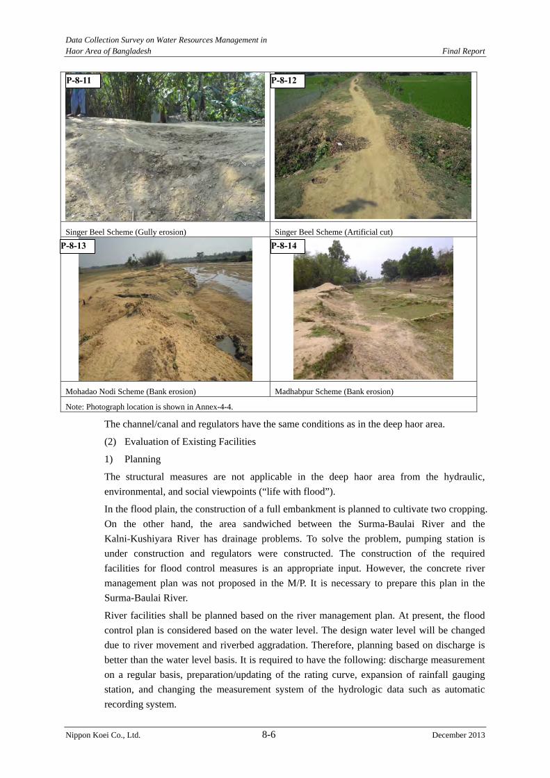
Data Collection Survey on Water Resources Management in Haor Area of Bangladesh Final Report
Nippon Koei Co., Ltd. 8-6 December 2013
Singer Beel Scheme (Gully erosion) Singer Beel Scheme (Artificial cut)
Mohadao Nodi Scheme (Bank erosion) Madhabpur Scheme (Bank erosion)
Note: Photograph location is shown in Annex-4-4.
The channel/canal and regulators have the same conditions as in the deep haor area.
(2) Evaluation of Existing Facilities
1) Planning
The structural measures are not applicable in the deep haor area from the hydraulic,
environmental, and social viewpoints (“life with flood”).
In the flood plain, the construction of a full embankment is planned to cultivate two cropping.
On the other hand, the area sandwiched between the Surma-Baulai River and the
Kalni-Kushiyara River has drainage problems. To solve the problem, pumping station is
under construction and regulators were constructed. The construction of the required
facilities for flood control measures is an appropriate input. However, the concrete river
management plan was not proposed in the M/P. It is necessary to prepare this plan in the
Surma-Baulai River.
River facilities shall be planned based on the river management plan. At present, the flood
control plan is considered based on the water level. The design water level will be changed
due to river movement and riverbed aggradation. Therefore, planning based on discharge is
better than the water level basis. It is required to have the following: discharge measurement
on a regular basis, preparation/updating of the rating curve, expansion of rainfall gauging
station, and changing the measurement system of the hydrologic data such as automatic
recording system.
P-8-11 P-8-12
P-8-13 P-8-14
Data Collection Survey on Water Resources Management in Haor Area of Bangladesh Final Report
Nippon Koei Co., Ltd. 8-7 December 2013
2) Design
The full embankment is designed based on the design flood water level of the 20-year
probable flood. The calculation of the water level is carried out based on NERM. It is a
normal approach to estimate the flood water level in Bangladesh.
However, the embankment material survey is not sufficient for design works.
3) Construction
The full embankment is constructed to protect the haor area located in the flood plain area.
However, it is required to control the embankment material, water content, and compaction.
4) Operation and Maintenance
It is necessary to improve the O&M as in the case during the pre-monsoon season. If the
O&M works of the BWDB field office are not improved, the river facility conditions will
worsen.
8.1.3 Issues on Design, Construction and Maintenance of Existing Submergible Embankment in terms of Durability
The geotechnical investigation, interview survey with BWDB and site reconnaissance in the
Study can point out three issues regarding the durability of existing submergible
embankment, namely 1) low quality of embankment materials, 2) inferiority of embankment
works and 3) lack of surface protection. “Durability” is defined as the resistance against local
crack, deformation and erosion. It does not means resistance against shear deformation of
embankment material.
(1) Low Quality of Embankment Materials
Too much fine silt and clay (under 0.075mm) soil materials of normal embankment may
bring cracks causing erosion and deterioration easily through the dry and wet process.
Shortage of fine soil materials (under 0.075mm in grain size) may bring comparatively high
permeability with seepage. Embankment materials composed of 15 – 50 % silt and clay
(under 0.075mm) are usually used to achieve the required durability and impermeability in
Japan.
Soil materials for dykes in the haor areas are normally borrowed from adjacent ground of the
embankment sites. According to the grain size investigations for embankment materials from
15 locations in five candidate haor projects, soil materials from each site are composed of
more than 90 % silt and clay. These soil materials can induce cracks and erosion easily and
low workability for compaction.
Table8.1.2 Results of Grain Size Investigation and Compaction Test for Embankment Materials
Site Name Grain Size
(<0.075mm) (% )
Maximum Dry
Density (kN/m3)
Optimum Moisture
Content (%)
Natural Moisture
Content (%)
Dharmapasha Rui Beel 95 -98 15.9 – 17.1 16.9 – 19.0 13.4 – 30.9
Boro (Austagram) 95 -97 16.7 – 17.0 16.1 – 19.0 19.8 – 34.1
Joyariya 88 -92 15.9 – 17.9 14.2 – 19.2 16.6 – 21.6
Dhakshiner 98 -99 16.9 -17.8 16.0 – 18.0 18.7 – 29.7
Ganesh 96 -99 16.2 – 17.2 18.4 – 20.0 24.4 – 25.9 Source: JICA Study Team
Data Collection Survey on Water Resources Management in Haor Area of Bangladesh Final Report
Nippon Koei Co., Ltd. 8-8 December 2013
(2) Inferiority of Embankment Works
The technical requirements for compaction works of submergible embankment are usually
specified in the notes of bid drawings as 7.0 kg rammer compaction. However, no
specification regarding the degree of compaction is stipulated in the drawings. Besides,
according to the Design Circle of BWDB, many submergible embankments have been
constructed by manual labor without complying with the technical specifications regarding
compaction works. There is an opinion in the Design Circle that a 90 % degree of
compaction should be required.
This idea is considered to be appropriate, as 90 % degrees are usually applied for river dykes
as average limit degree of compaction, respectively, in Japan.
The natural moisture content is normally larger than the optimum moisture content in the
haor area as indicated in Table 8.1.2. As the adjustment of moisture content is not also
stipulated in any specification and drawing, it is one of the important issues for embankment
works during the implementation stage.
In this study, the Dry-Wet cycle test was conducted to understand the relationship between
the local durability of submergible embankment, which is influenced by the repeating
submergence during the monsoon, and the degree of compaction. In this test: 1) specimens
were compacted in PVC pipes (5cm diameter) by 80%, 90% and 98% degrees of compaction
and covered by porous stone and filter paper on their upper and bottom face, 2) specimens
were cured in the PVC pipes under the condition of dry-wet process for 10 days cycle (3
days submergence and 7 days drying), and 3) unconfined compression tests were carried out
for 1, 2, 4, 8 and 16 cycles respectively to evaluate the reduction of local durability through
the dry-wet process using unconfined compression strength as “indicators”, which is inferred
to depend on the degree of compaction. The methodology of the dry-wet cycle test can be
referred to in Annex 4.2.
Figure 8.1.1 shows the result of the unconfined compression tests up to 16 cycles.
- In case of 80% degree of compaction, initial compression strength was found to be 70.3
kPa, however the compression strength rapidly decreases to 14.3 kPa after 2 cycles, the
specimen cannot form the shape of itself at 4 cycles.
- In case of 90 % degree of compaction, the initial compression strength is 86.5 kPa, and the
compression strength decreases to 36.8 kPa after 16 cycles (42 % of initial strength).
- In case of 98 % degree of compaction, initial compression strength is 97.4 kPa, and the
compression strength decreases to 56.6 kPa after 16 cycles (58 % of initial strength).
The reduction of unconfined compression strength is considered to be caused by the
deterioration on the upper and bottom of specimens where the dry-wet process has stronger
influence. This means that local durability against the dry-wet process is inferred to be higher
when higher degree of compaction is applied for submergible embankment, since the depth
acted upon by infiltration and drying can be narrowed by applying a higher degree of
compaction. Deterioration of submergible embankment which needs maintenance and repair
works should be avoided as much as possible to reduce the maintenance cost. In this regards,
a higher degree of compaction, such as 95% to 98%, is desirable.
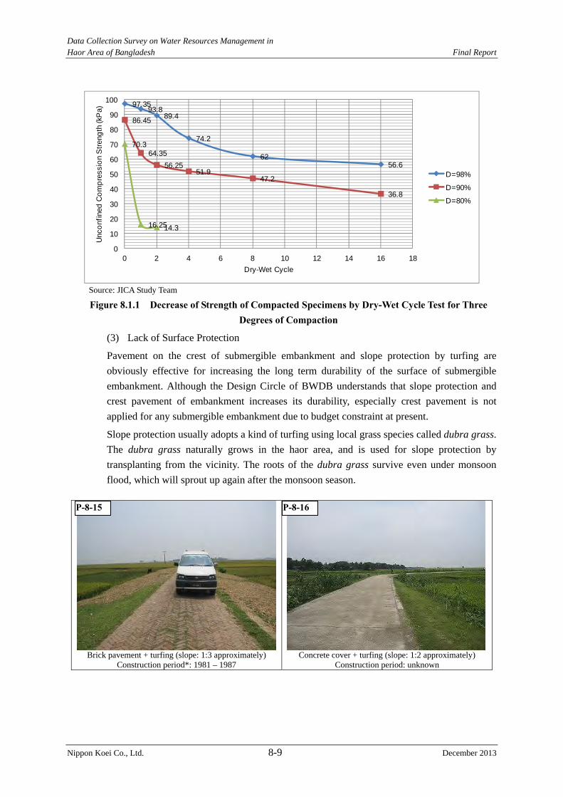
Data Collection Survey on Water Resources Management in Haor Area of Bangladesh Final Report
Nippon Koei Co., Ltd. 8-9 December 2013
97.3593.8
89.4
74.2
6256.6
86.45
64.3556.25
51.947.2
36.8
70.3
16.2514.3
0
10
20
30
40
50
60
70
80
90
100
0 2 4 6 8 10 12 14 16 18
Unc
onfin
ed C
ompr
essi
on S
treng
th (k
Pa)
Dry-Wet Cycle
D=98%
D=90%
D=80%
Source: JICA Study Team
Figure 8.1.1 Decrease of Strength of Compacted Specimens by Dry-Wet Cycle Test for Three Degrees of Compaction
(3) Lack of Surface Protection
Pavement on the crest of submergible embankment and slope protection by turfing are
obviously effective for increasing the long term durability of the surface of submergible
embankment. Although the Design Circle of BWDB understands that slope protection and
crest pavement of embankment increases its durability, especially crest pavement is not
applied for any submergible embankment due to budget constraint at present.
Slope protection usually adopts a kind of turfing using local grass species called dubra grass.
The dubra grass naturally grows in the haor area, and is used for slope protection by
transplanting from the vicinity. The roots of the dubra grass survive even under monsoon
flood, which will sprout up again after the monsoon season.
Brick pavement + turfing (slope: 1:3 approximately) Construction period*: 1981 – 1987
Concrete cover + turfing (slope: 1:2 approximately) Construction period: unknown
P-8-16P-8-15

Data Collection Survey on Water Resources Management in Haor Area of Bangladesh Final Report
Nippon Koei Co., Ltd. 8-10 December 2013
Turfing on slope without pavement (slope: 1:1.5 approximately)
Construction period: 1997 - 2006
Brick pavement + turfing (slope: 1:3 approximately) Construction period*: 1981 – 1987
Note: Photograph location is shown in Annex-4-4.Photos: JICA Study Team
Surface Protection on Submergible Embankment and Road *As the construction periods indicate those of the corresponding haor project, accurate completion years of the road and embankment in the above photos are unknown.
(4) BWDB Design Manual regarding Embankment
BWDB has issueds “Standard Design Manual Volume-I: Standard Design Criteria”. This
issue describes the design criteria of embankment in “Section 7. Design Criteria for
Embankment”. However, issues such as standard grain size distribution of embankment
materials, degree of compaction and adjustment of moisture content are not mentioned in the
manual. As for compaction, although contract drawings instruct the use of a 7.0 kg rammer
as notes, the degree of compaction is not mentioned.
The gradation of embankment materials is also mentioned in contract drawings as follows.
Clay > 30%
Silt 0 – 40 %
Sand 0 – 30%
The instruction above allows fine materials which include “0 %” of coarse material like sand
and gravel. Practically, the ground adjacent to a submergible embankment site does not
include sand and gravel. It means that most of the embankment materials may consist of silt
and clay In effect, the repeated submergence in the area is feared to cause the deterioration of
embankment due to cracking and erosion.
(5) Issues on Maintenance of Existing Submergible Embankment in Terms of Durability
Maintenance of existing submergible embankment is not carried out sufficiently due to the
lack of budget. Lack of maintenance may bring small collapse and crack on the slope,
baldness of turfing and wheel truck without any repair, which may result in the infiltration of
the monsoon flood water into the depth of the submergible embankment as well as further
deterioration.
Wheel trucks can be prevented by restricting traffic on the submergible embankment after
the appearance of the crest of embankment in the beginning of the post-monsoon, or
P-8-17 P-8-18
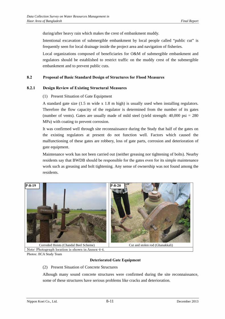
Data Collection Survey on Water Resources Management in Haor Area of Bangladesh Final Report
Nippon Koei Co., Ltd. 8-11 December 2013
during/after heavy rain which makes the crest of embankment muddy.
Intentional excavation of submergible embankment by local people called “public cut” is
frequently seen for local drainage inside the project area and navigation of fisheries.
Local organizations composed of beneficiaries for O&M of submergible embankment and
regulators should be established to restrict traffic on the muddy crest of the submergible
embankment and to prevent public cuts.
8.2 Proposal of Basic Standard Design of Structures for Flood Measures
8.2.1 Design Review of Existing Structural Measures
(1) Present Situation of Gate Equipment
A standard gate size (1.5 m wide x 1.8 m high) is usually used when installing regulators.
Therefore the flow capacity of the regulator is determined from the number of its gates
(number of vents). Gates are usually made of mild steel (yield strength: 40,000 psi = 280
MPa) with coating to prevent corrosion.
It was confirmed well through site reconnaissance during the Study that half of the gates on
the existing regulators at present do not function well. Factors which caused the
malfunctioning of these gates are robbery, loss of gate parts, corrosion and deterioration of
gate equipment.
Maintenance work has not been carried out (neither greasing nor tightening of bolts). Nearby
residents say that BWDB should be responsible for the gates even for its simple maintenance
work such as greasing and bolt tightening. Any sense of ownership was not found among the
residents.
Corroded Hoists (Chandal Beel Scheme) Cut and stolen rod (Ghanakkali) Note: Photograph location is shown in Annex-4-4.Photos: JICA Study Team
Deteriorated Gate Equipment
(2) Present Situation of Concrete Structures
Alhough many sound concrete structures were confirmed during the site reconnaissance,
some of these structures have serious problems like cracks and deterioration.
P-8-19 P-8-20
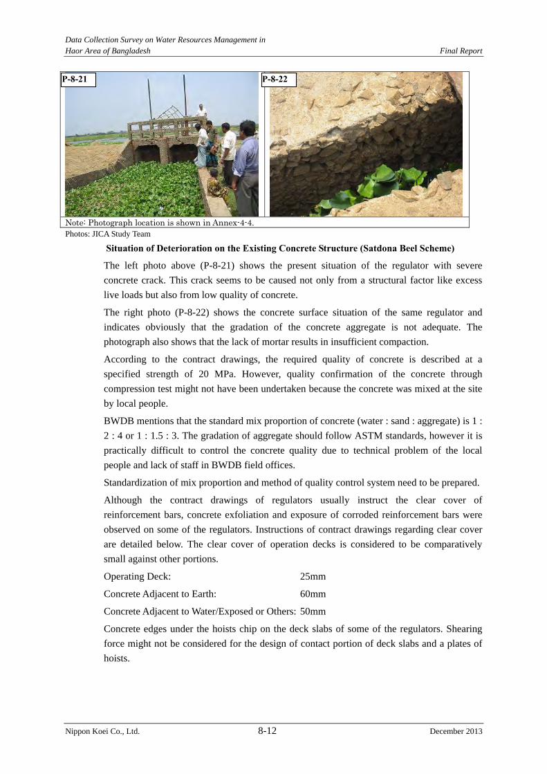
Data Collection Survey on Water Resources Management in Haor Area of Bangladesh Final Report
Nippon Koei Co., Ltd. 8-12 December 2013
Note: Photograph location is shown in Annex-4-4.Photos: JICA Study Team
Situation of Deterioration on the Existing Concrete Structure (Satdona Beel Scheme)
The left photo above (P-8-21) shows the present situation of the regulator with severe
concrete crack. This crack seems to be caused not only from a structural factor like excess
live loads but also from low quality of concrete.
The right photo (P-8-22) shows the concrete surface situation of the same regulator and
indicates obviously that the gradation of the concrete aggregate is not adequate. The
photograph also shows that the lack of mortar results in insufficient compaction.
According to the contract drawings, the required quality of concrete is described at a
specified strength of 20 MPa. However, quality confirmation of the concrete through
compression test might not have been undertaken because the concrete was mixed at the site
by local people.
BWDB mentions that the standard mix proportion of concrete (water : sand : aggregate) is 1 :
2 : 4 or 1 : 1.5 : 3. The gradation of aggregate should follow ASTM standards, however it is
practically difficult to control the concrete quality due to technical problem of the local
people and lack of staff in BWDB field offices.
Standardization of mix proportion and method of quality control system need to be prepared.
Although the contract drawings of regulators usually instruct the clear cover of
reinforcement bars, concrete exfoliation and exposure of corroded reinforcement bars were
observed on some of the regulators. Instructions of contract drawings regarding clear cover
are detailed below. The clear cover of operation decks is considered to be comparatively
small against other portions.
Operating Deck: 25mm
Concrete Adjacent to Earth: 60mm
Concrete Adjacent to Water/Exposed or Others: 50mm
Concrete edges under the hoists chip on the deck slabs of some of the regulators. Shearing
force might not be considered for the design of contact portion of deck slabs and a plates of
hoists.
P-8-21 P-8-22
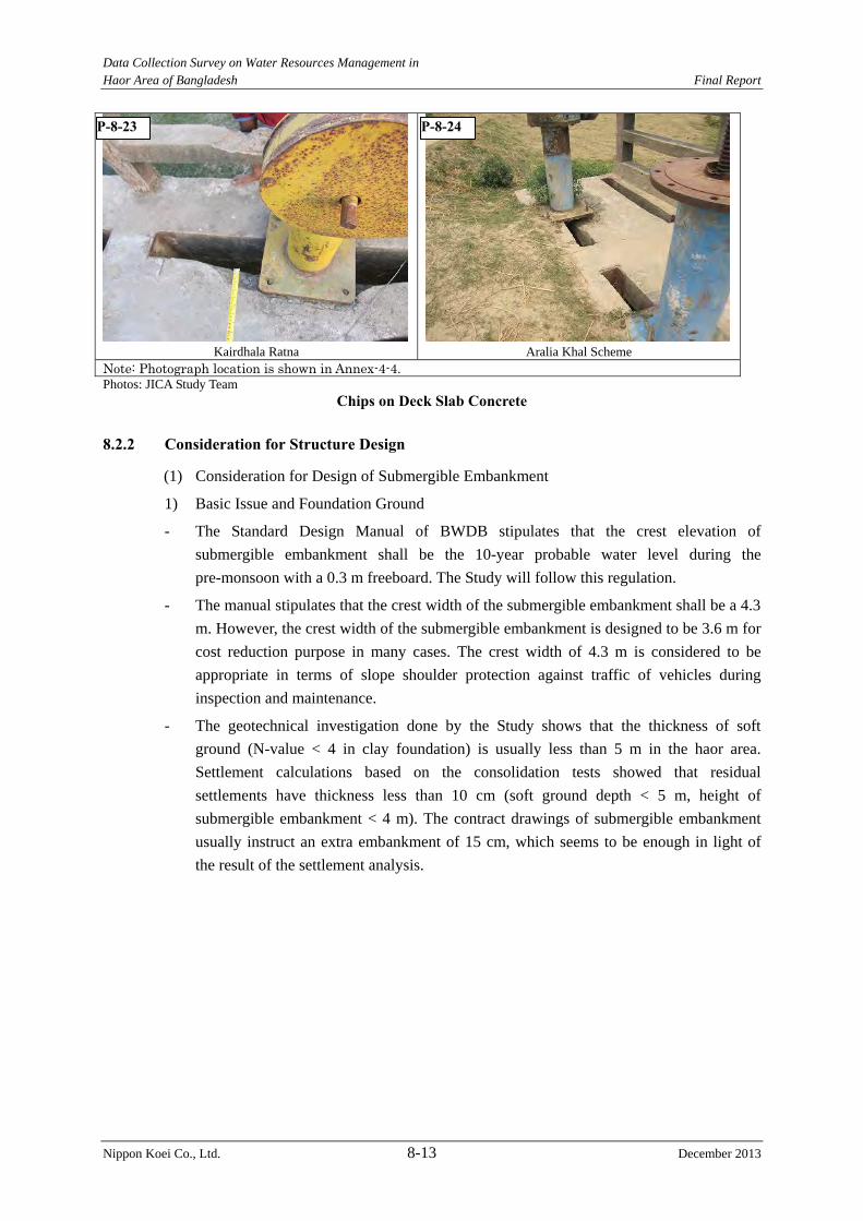
Data Collection Survey on Water Resources Management in Haor Area of Bangladesh Final Report
Nippon Koei Co., Ltd. 8-13 December 2013
Kairdhala Ratna Aralia Khal Scheme Note: Photograph location is shown in Annex-4-4.Photos: JICA Study Team
Chips on Deck Slab Concrete
8.2.2 Consideration for Structure Design
(1) Consideration for Design of Submergible Embankment
1) Basic Issue and Foundation Ground
- The Standard Design Manual of BWDB stipulates that the crest elevation of
submergible embankment shall be the 10-year probable water level during the
pre-monsoon with a 0.3 m freeboard. The Study will follow this regulation.
- The manual stipulates that the crest width of the submergible embankment shall be a 4.3
m. However, the crest width of the submergible embankment is designed to be 3.6 m for
cost reduction purpose in many cases. The crest width of 4.3 m is considered to be
appropriate in terms of slope shoulder protection against traffic of vehicles during
inspection and maintenance.
- The geotechnical investigation done by the Study shows that the thickness of soft
ground (N-value < 4 in clay foundation) is usually less than 5 m in the haor area.
Settlement calculations based on the consolidation tests showed that residual
settlements have thickness less than 10 cm (soft ground depth < 5 m, height of
submergible embankment < 4 m). The contract drawings of submergible embankment
usually instruct an extra embankment of 15 cm, which seems to be enough in light of
the result of the settlement analysis.
P-8-23 P-8-24
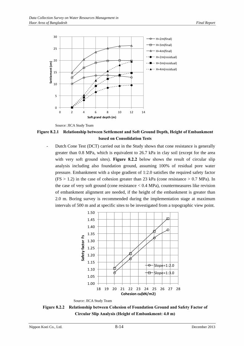
Data Collection Survey on Water Resources Management in Haor Area of Bangladesh Final Report
Nippon Koei Co., Ltd. 8-14 December 2013
0
5
10
15
20
25
30
0 2 4 6 8 10 12 14
Settlement (cm)
Soft grand depth (m)
H=2m(final)
H=3m(final)
H=4m(final)
H=2m(residual)
H=3m(residual)
H=4m(residual)
Source: JICA Study Team
Figure 8.2.1 Relationship between Settlement and Soft Ground Depth, Height of Embankment based on Consolidation Tests
- Dutch Cone Test (DCT) carried out in the Study shows that cone resistance is generally
greater than 0.8 MPa, which is equivalent to 26.7 kPa in clay soil (except for the area
with very soft ground sites). Figure 8.2.2 below shows the result of circular slip
analysis including also foundation ground, assuming 100% of residual pore water
pressure. Embankment with a slope gradient of 1:2.0 satisfies the required safety factor
(FS > 1.2) in the case of cohesion greater than 23 kPa (cone resistance > 0.7 MPa). In
the case of very soft ground (cone resistance < 0.4 MPa), countermeasures like revision
of embankment alignment are needed, if the height of the embankment is greater than
2.0 m. Boring survey is recommended during the implementation stage at maximum
intervals of 500 m and at specific sites to be investigated from a topographic view point.
1.00
1.05
1.10
1.15
1.20
1.25
1.30
1.35
1.40
1.45
1.50
18 19 20 21 22 23 24 25 26 27 28
Safety factor Fs
Cohesion cu(kN/m2)
Slope=1:2.0
Slope=1:3.0
Source: JICA Study Team
Figure 8.2.2 Relationship between Cohesion of Foundation Ground and Safety Factor of Circular Slip Analysis (Height of Embankment: 4.0 m)
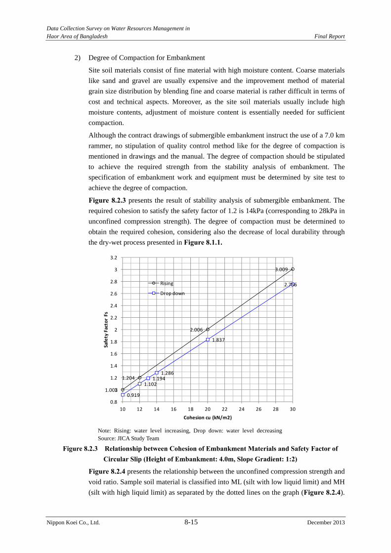
Data Collection Survey on Water Resources Management in Haor Area of Bangladesh Final Report
Nippon Koei Co., Ltd. 8-15 December 2013
2) Degree of Compaction for Embankment
Site soil materials consist of fine material with high moisture content. Coarse materials
like sand and gravel are usually expensive and the improvement method of material
grain size distribution by blending fine and coarse material is rather difficult in terms of
cost and technical aspects. Moreover, as the site soil materials usually include high
moisture contents, adjustment of moisture content is essentially needed for sufficient
compaction.
Although the contract drawings of submergible embankment instruct the use of a 7.0 km
rammer, no stipulation of quality control method like for the degree of compaction is
mentioned in drawings and the manual. The degree of compaction should be stipulated
to achieve the required strength from the stability analysis of embankment. The
specification of embankment work and equipment must be determined by site test to
achieve the degree of compaction.
Figure 8.2.3 presents the result of stability analysis of submergible embankment. The
required cohesion to satisfy the safety factor of 1.2 is 14kPa (corresponding to 28kPa in
unconfined compression strength). The degree of compaction must be determined to
obtain the required cohesion, considering also the decrease of local durability through
the dry-wet process presented in Figure 8.1.1.
1.003
1.204
2.006
3.009
0.919
1.1021.194
1.286
1.837
2.756
0.8
1
1.2
1.4
1.6
1.8
2
2.2
2.4
2.6
2.8
3
3.2
10 12 14 16 18 20 22 24 26 28 30
Safety Factor Fs
Cohesion cu (kN/m2)
Rising
Drop down
Note: Rising: water level increasing, Drop down: water level decreasing Source: JICA Study Team
Figure 8.2.3 Relationship between Cohesion of Embankment Materials and Safety Factor of Circular Slip (Height of Embankment: 4.0m, Slope Gradient: 1:2)
Figure 8.2.4 presents the relationship between the unconfined compression strength and
void ratio. Sample soil material is classified into ML (silt with low liquid limit) and MH
(silt with high liquid limit) as separated by the dotted lines on the graph (Figure 8.2.4).
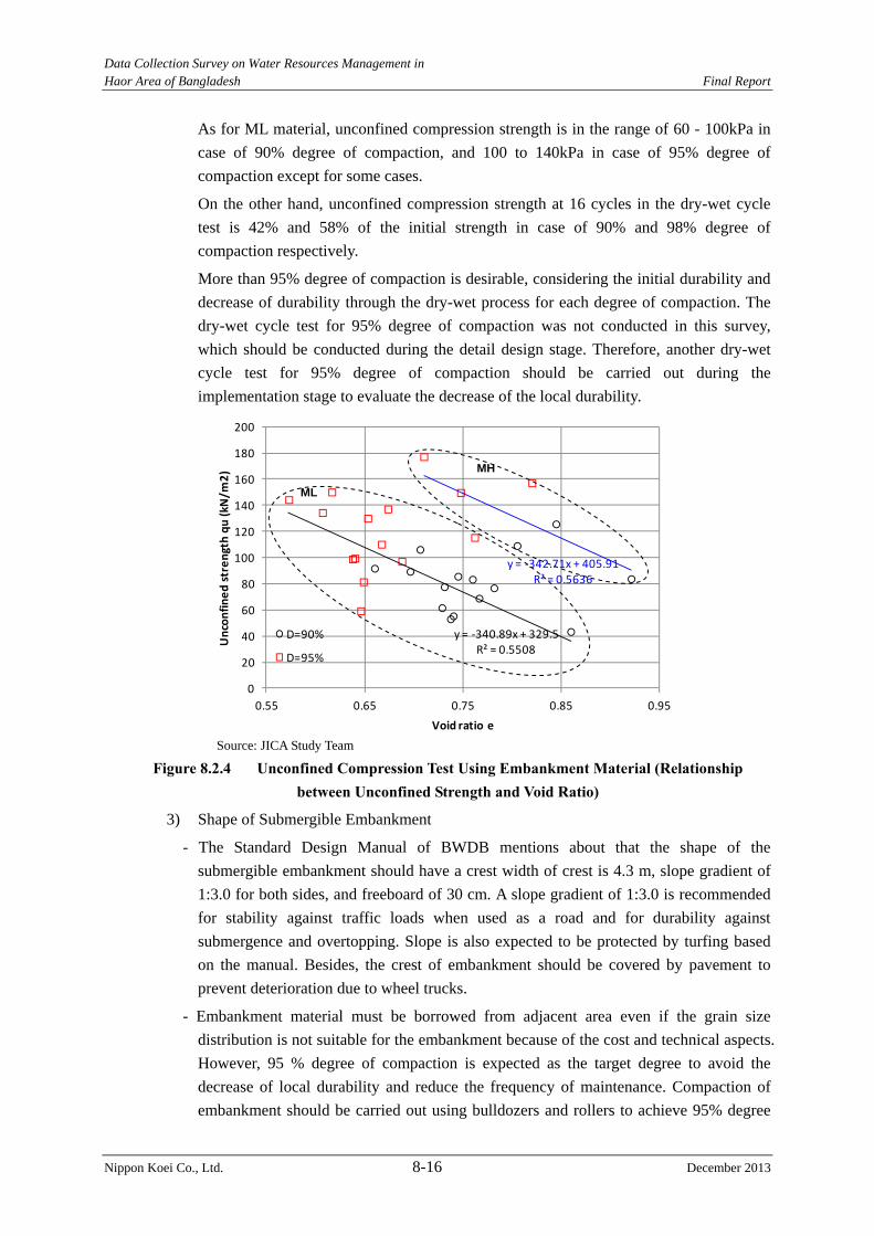
Data Collection Survey on Water Resources Management in Haor Area of Bangladesh Final Report
Nippon Koei Co., Ltd. 8-16 December 2013
As for ML material, unconfined compression strength is in the range of 60 - 100kPa in
case of 90% degree of compaction, and 100 to 140kPa in case of 95% degree of
compaction except for some cases.
On the other hand, unconfined compression strength at 16 cycles in the dry-wet cycle
test is 42% and 58% of the initial strength in case of 90% and 98% degree of
compaction respectively.
More than 95% degree of compaction is desirable, considering the initial durability and
decrease of durability through the dry-wet process for each degree of compaction. The
dry-wet cycle test for 95% degree of compaction was not conducted in this survey,
which should be conducted during the detail design stage. Therefore, another dry-wet
cycle test for 95% degree of compaction should be carried out during the
implementation stage to evaluate the decrease of the local durability.
Source: JICA Study Team
Figure 8.2.4 Unconfined Compression Test Using Embankment Material (Relationship between Unconfined Strength and Void Ratio)
3) Shape of Submergible Embankment
- The Standard Design Manual of BWDB mentions about that the shape of the
submergible embankment should have a crest width of crest is 4.3 m, slope gradient of
1:3.0 for both sides, and freeboard of 30 cm. A slope gradient of 1:3.0 is recommended
for stability against traffic loads when used as a road and for durability against
submergence and overtopping. Slope is also expected to be protected by turfing based
on the manual. Besides, the crest of embankment should be covered by pavement to
prevent deterioration due to wheel trucks.
- Embankment material must be borrowed from adjacent area even if the grain size
distribution is not suitable for the embankment because of the cost and technical aspects.
However, 95 % degree of compaction is expected as the target degree to avoid the
decrease of local durability and reduce the frequency of maintenance. Compaction of
embankment should be carried out using bulldozers and rollers to achieve 95% degree
y = ‐340.89x + 329.5R² = 0.5508
y = ‐342.71x + 405.91R² = 0.5636
0
20
40
60
80
100
120
140
160
180
200
0.55 0.65 0.75 0.85 0.95
Unconfined strength qu (kN
/m2)
Void ratio e
D=90%
D=95%
MH
ML
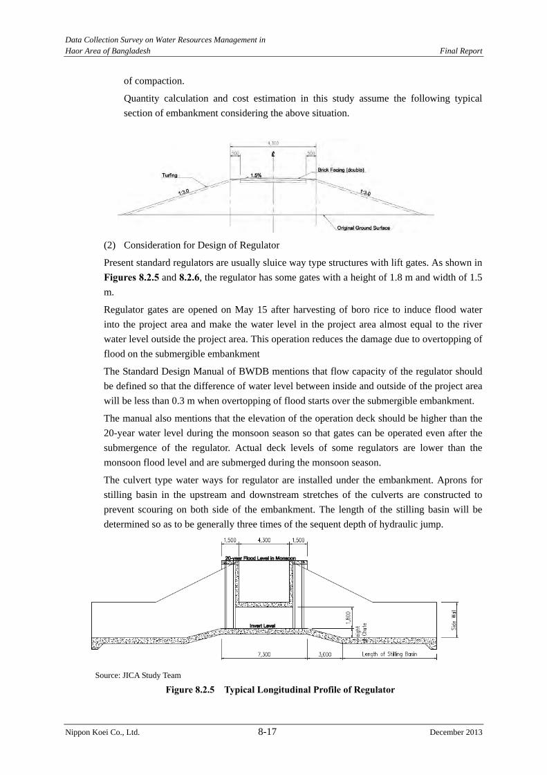
Data Collection Survey on Water Resources Management in Haor Area of Bangladesh Final Report
Nippon Koei Co., Ltd. 8-17 December 2013
of compaction.
Quantity calculation and cost estimation in this study assume the following typical
section of embankment considering the above situation.
(2) Consideration for Design of Regulator
Present standard regulators are usually sluice way type structures with lift gates. As shown in
Figures 8.2.5 and 8.2.6, the regulator has some gates with a height of 1.8 m and width of 1.5
m.
Regulator gates are opened on May 15 after harvesting of boro rice to induce flood water
into the project area and make the water level in the project area almost equal to the river
water level outside the project area. This operation reduces the damage due to overtopping of
flood on the submergible embankment
The Standard Design Manual of BWDB mentions that flow capacity of the regulator should
be defined so that the difference of water level between inside and outside of the project area
will be less than 0.3 m when overtopping of flood starts over the submergible embankment.
The manual also mentions that the elevation of the operation deck should be higher than the
20-year water level during the monsoon season so that gates can be operated even after the
submergence of the regulator. Actual deck levels of some regulators are lower than the
monsoon flood level and are submerged during the monsoon season.
The culvert type water ways for regulator are installed under the embankment. Aprons for
stilling basin in the upstream and downstream stretches of the culverts are constructed to
prevent scouring on both side of the embankment. The length of the stilling basin will be
determined so as to be generally three times of the sequent depth of hydraulic jump.
Source: JICA Study Team
Figure 8.2.5 Typical Longitudinal Profile of Regulator
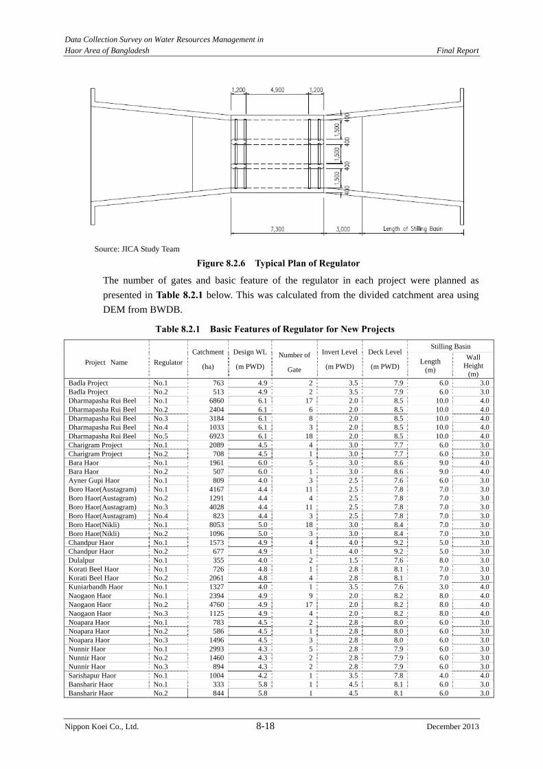
Data Collection Survey on Water Resources Management in Haor Area of Bangladesh Final Report
Nippon Koei Co., Ltd. 8-18 December 2013
Source: JICA Study Team
Figure 8.2.6 Typical Plan of Regulator
The number of gates and basic feature of the regulator in each project were planned as
presented in Table 8.2.1 below. This was calculated from the divided catchment area using
DEM from BWDB.
Table 8.2.1 Basic Features of Regulator for New Projects
Project Name Regulator
Catchment
(ha)
Design WL
(m PWD)
Number of
Gate
Invert Level
(m PWD)
Deck Level
(m PWD)
Stilling Basin
Length (m)
Wall Height
(m) Badla Project No.1 763 4.9 2 3.5 7.9 6.0 3.0Badla Project No.2 513 4.9 2 3.5 7.9 6.0 3.0Dharmapasha Rui Beel No.1 6860 6.1 17 2.0 8.5 10.0 4.0Dharmapasha Rui Beel No.2 2404 6.1 6 2.0 8.5 10.0 4.0Dharmapasha Rui Beel No.3 3184 6.1 8 2.0 8.5 10.0 4.0Dharmapasha Rui Beel No.4 1033 6.1 3 2.0 8.5 10.0 4.0Dharmapasha Rui Beel No.5 6923 6.1 18 2.0 8.5 10.0 4.0Charigram Project No.1 2089 4.5 4 3.0 7.7 6.0 3.0Charigram Project No.2 708 4.5 1 3.0 7.7 6.0 3.0Bara Haor No.1 1961 6.0 5 3.0 8.6 9.0 4.0Bara Haor No.2 507 6.0 1 3.0 8.6 9.0 4.0Ayner Gupi Haor No.1 809 4.0 3 2.5 7.6 6.0 3.0Boro Haor(Austagram) No.1 4167 4.4 11 2.5 7.8 7.0 3.0Boro Haor(Austagram) No.2 1291 4.4 4 2.5 7.8 7.0 3.0Boro Haor(Austagram) No.3 4028 4.4 11 2.5 7.8 7.0 3.0Boro Haor(Austagram) No.4 823 4.4 3 2.5 7.8 7.0 3.0Boro Haor(Nikli) No.1 8053 5.0 18 3.0 8.4 7.0 3.0Boro Haor(Nikli) No.2 1096 5.0 3 3.0 8.4 7.0 3.0Chandpur Haor No.1 1573 4.9 4 4.0 9.2 5.0 3.0Chandpur Haor No.2 677 4.9 1 4.0 9.2 5.0 3.0Dulalpur No.1 355 4.0 2 1.5 7.6 8.0 3.0Korati Beel Haor No.1 726 4.8 1 2.8 8.1 7.0 3.0Korati Beel Haor No.2 2061 4.8 4 2.8 8.1 7.0 3.0Kuniarbandh Haor No.1 1327 4.0 1 3.5 7.6 3.0 4.0Naogaon Haor No.1 2394 4.9 9 2.0 8.2 8.0 4.0Naogaon Haor No.2 4760 4.9 17 2.0 8.2 8.0 4.0Naogaon Haor No.3 1125 4.9 4 2.0 8.2 8.0 4.0Noapara Haor No.1 783 4.5 2 2.8 8.0 6.0 3.0Noapara Haor No.2 586 4.5 1 2.8 8.0 6.0 3.0Noapara Haor No.3 1496 4.5 3 2.8 8.0 6.0 3.0Nunnir Haor No.1 2993 4.3 5 2.8 7.9 6.0 3.0Nunnir Haor No.2 1460 4.3 2 2.8 7.9 6.0 3.0Nunnir Haor No.3 894 4.3 2 2.8 7.9 6.0 3.0Sarishapur Haor No.1 1004 4.2 1 3.5 7.8 4.0 4.0Bansharir Haor No.1 333 5.8 1 4.5 8.1 6.0 3.0Bansharir Haor No.2 844 5.8 1 4.5 8.1 6.0 3.0
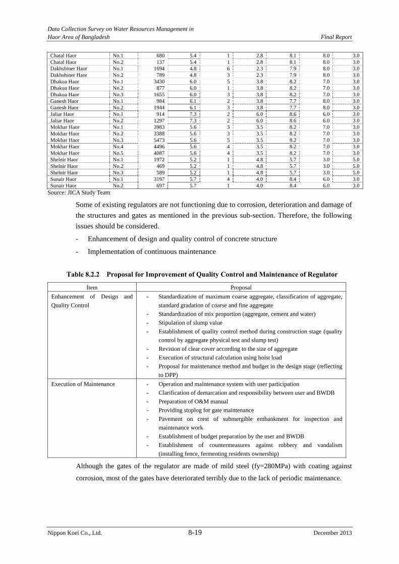
Data Collection Survey on Water Resources Management in Haor Area of Bangladesh Final Report
Nippon Koei Co., Ltd. 8-19 December 2013
Chatal Haor No.1 680 5.4 1 2.8 8.1 8.0 3.0Chatal Haor No.2 137 5.4 1 2.8 8.1 8.0 3.0Dakhshiner Haor No.1 1694 4.8 6 2.3 7.9 8.0 3.0Dakhshiner Haor No.2 789 4.8 3 2.3 7.9 8.0 3.0Dhakua Haor No.1 3430 6.0 5 3.8 8.2 7.0 3.0Dhakua Haor No.2 877 6.0 1 3.8 8.2 7.0 3.0Dhakua Haor No.3 1655 6.0 3 3.8 8.2 7.0 3.0Ganesh Haor No.1 984 6.1 2 3.8 7.7 8.0 3.0Ganesh Haor No.2 1944 6.1 3 3.8 7.7 8.0 3.0Jaliar Haor No.1 914 7.3 2 6.0 8.6 6.0 3.0Jaliar Haor No.2 1297 7.3 2 6.0 8.6 6.0 3.0Mokhar Haor No.1 3983 5.6 3 3.5 8.2 7.0 3.0Mokhar Haor No.2 3388 5.6 3 3.5 8.2 7.0 3.0Mokhar Haor No.3 5473 5.6 5 3.5 8.2 7.0 3.0Mokhar Haor No.4 4496 5.6 4 3.5 8.2 7.0 3.0Mokhar Haor No.5 4087 5.6 4 3.5 8.2 7.0 3.0Shelnir Haor No.1 1972 5.2 1 4.8 5.7 3.0 5.0Shelnir Haor No.2 469 5.2 1 4.8 5.7 3.0 5.0Shelnir Haor No.3 589 5.2 1 4.8 5.7 3.0 5.0Sunair Haor No.1 3197 5.7 4 4.0 8.4 6.0 3.0Sunair Haor No.2 697 5.7 1 4.0 8.4 6.0 3.0
Source: JICA Study Team
Some of existing regulators are not functioning due to corrosion, deterioration and damage of
the structures and gates as mentioned in the previous sub-section. Therefore, the following
issues should be considered.
- Enhancement of design and quality control of concrete structure
- Implementation of continuous maintenance
Table 8.2.2 Proposal for Improvement of Quality Control and Maintenance of Regulator
Item Proposal
Enhancement of Design and
Quality Control
- Standardization of maximum coarse aggregate, classification of aggregate,
standard gradation of coarse and fine aggregate
- Standardization of mix proportion (aggregate, cement and water)
- Stipulation of slump value
- Establishment of quality control method during construction stage (quality
control by aggregate physical test and slump test)
- Revision of clear cover according to the size of aggregate
- Execution of structural calculation using hoist load
- Proposal for maintenance method and budget in the design stage (reflecting
to DPP)
Execution of Maintenance - Operation and maintenance system with user participation
- Clarification of demarcation and responsibility between user and BWDB
- Preparation of O&M manual
- Providing stoplog for gate maintenance
- Pavement on crest of submergible embankment for inspection and
maintenance work
- Establishment of budget preparation by the user and BWDB
- Establishment of countermeasures against robbery and vandalism
(installing fence, fermenting residents ownership)
Although the gates of the regulator are made of mild steel (fy=280MPa) with coating against
corrosion, most of the gates have deteriorated terribly due to the lack of periodic maintenance.
Data Collection Survey on Water Resources Management in Haor Area of Bangladesh Final Report
Nippon Koei Co., Ltd. 8-20 December 2013
Periodic maintenance is expected, however the use of stainless steel can be also considered to
save on the frequency of maintenance. In Bangladesh, stainless steel is used in the coastal area,
where steel can be corroded easily, for mainly the gate slot which is difficult to replace.
Although stainless steel is not manufactured in Bangladesh, simple processing is possible. It is
not practical to use stainless steel for the whole gate structure (the required stainless steel is
approximately one ton), however it is worth considering to use it for one gate slot.
Supposing the price of stainless steel in Bangladesh is the same as in Japan (because it must be
imported), the price must be around 610 JPY/kg = 740 BDT/kg. The weight of the steel gate slot
for both left and right sides is supposed to total to around 200 kg, with an estimated price of BDT
148,000.
On the other hand, the general price of a gate with slot and hoist etc is BDT 98,400 including
manufacturing and installation according to the schedule of rate from BWDB. This means that
the price of a gate slot made of stainless steel is more expensive than that of a whole gate
structure made of mild steel.
Considering the above, corrosion should not be prevented by using stainless steel, but periodic
maintenance in the haor area, where is far from the coastal area.
Data Collection Survey on Water Resources Management in Haor Area of Bangladesh Final Report
Nippon Koei Co., Ltd. 9-1 December 2013
CHAPTER 9 NON-STRUCTURAL FLOOD MEASURES IN HAOR AREA
9.1 Assessment of Present Situation and Appropriateness regarding Existing Non-Structural Measures
The extensive annual flooding of the haor area makes livelihoods extremely vulnerable and
limits the potential for economic growth. Although the lifestyle of the haor people is well
adapted to flood phenomena, damage due to drainage related inundation, pre-monsoon flash
floods, severe monsoon floods, river bank erosion, failure of river structures, etc. still occurs.
Due to monsoon inundation, in most haor areas, only one crop is possible. Unfortunately,
pre-monsoon flash floods occurring before the harvesting damage the crops once in 3 or 4
years. Thus, among many natural hazards, pre-monsoon floods are particularly challenging
for the communities of the haor area. Though the main tools of the damage reduction
revolves around structural measures like embankment, river dredging, etc., non structural
flood measures are also considered as means of damage reduction. This section has assessed
the present non structural measures practiced in the haor area and to evaluate their
appropriateness.
9.1.1 Relevance of Flood Damage Pattern with Non-Structural Measures
Analysis of area specific flood damage pattern is relevant as not all types of non structural
measures are effective for all types of flood damage. For example, where the flash flood can
cause life threatening situation, early warning and evacuation is most important. On the other
hand, where major threat due to the flash flood is crop damage, crop diversification and
alternate livelihood can be an effective measure.
Threat to human life is not a common damage in the haor area, because there is no habitat in
the low lying areas and most habitats are raised above normal monsoon flood levels. On the
other hand, among the various types of flood damage experienced in the haor areas, crop
damage is the main issue of concern. Thus, more focus is given on asset loss reduction by
government and non-government organizations.
The following flood damage patterns in the haor area are considered.
(1) Flash Flood Onslaught
1) Damage for Rice Cultivation
Flash floods generally occur in two seasons: pre-monsoon and monsoon. Flash flood in the
pre-monsoon season (April to mid-May) is a major concern due to its effect to crop
production/harvest but that in the monsoon season (mid-May to October) is not considerably
important since no crops are planted.
The occurrence of flash floods in the pre-monsoon season damages boro rice (single crop)
and other cereals in the area. This is considered one of the major disasters in the area, which
affects the primary production sector (e.g., agriculture and fisheries) and thus, threatens the
lives and livelihood of the people (mostly farmers).
If flash floods continue to damage the production of boro rice, people will remain in a
stressful condition until the next year's harvest. Also, many farmers will be forced to sell
Data Collection Survey on Water Resources Management in Haor Area of Bangladesh Final Report
Nippon Koei Co., Ltd. 9-2 December 2013
their livestock because of fodder shortage.
2) River Bank Erosion
Many excavated rivers are located in the haor area, and river bank protection is not provided
at most of haor area. Thus, these areas suffer river bank erosion. Riverbank erosion is
significant in such middle scale rivers as the Manu, Dharai, and Khoai Rivers, as well as in
major rivers such as the Surma and the Kushiyara Rivers. These resulted to washout of
houses, cultivated lands, and other properties owned by the people residing along the rivers.
(2) Flood Damage during the monsoon season
Fertile soil is provided from the upstream area during the monsoon season. Therefore, the
people consider the blessing. On the other hand, the people suffer the following damages.
1) Erosion due to Wave Action Induced on Haor Water Surface
The villages in the haors are formed on earthen mounds or man-made platforms to keep their
houses and cultivated land above the water level during the monsoon season, which lasts for
about five months (mid-May to October) in a year.
The mounds and platforms have been threatened by repeated erosion due to wave action
induced on the haor water surface by winds. Although bamboo and tarja (local grass)
fencing are used by the people for mound/platform protection from wave action, the
protection works often proved ineffective. Therefore, the mounds/platforms remain exposed
to erosion for about 5 months (the monsoon season), resulting sometimes in washout
destroying houses, cultivated land, etc.
2) Sedimentation in Rivers, Haors, and Other Water Bodies
Sedimentation is a concern in the area because it plays a governing role in the morphology of
rivers, i.e., the change in the river channels and flood plains. Furthermore, sedimentation in
river channels has induced incomplete drainage, frequent overtopping of floods from rivers,
and aggravation of riverbank erosion in the upstream reaches. Besides, sedimentation in
some haor areas has resulted in negative impacts on fisheries and decrease in the
flood-retarding capacity in the areas.
3) Drainage Congestion in Rivers and Channels
Drainage is mainly very important during the month of December since it is the planting time
for boro rice. The usual time for planting boro is every mid-December. However, due to
congestion or delayed drainage in rivers and channels, plantation of boro rice is always
delayed. As a result, its harvesting is also delayed, which increases the risk of pre-monsoon
flash flood.
Non-structural measures refer to any measure that does not involve physical construction
(like retarding basins, embankment, dredging, diversions, etc.) but instead uses knowledge,
practices and/or agreements to reduce the potential impacts of a flood. Non-structural
approaches can be a cost-effective alternative to traditional engineering and ecological
solutions. Typical measures include the installation of early warning systems, soil and land
use management, insurance, awareness building and public information actions, all of which
can help mitigate flood related damage. Nonetheless, not all non-structural measures are
effective in all situations and it is always better to adopt multiple non-structural measures
Data Collection Survey on Water Resources Management in Haor Area of Bangladesh Final Report
Nippon Koei Co., Ltd. 9-3 December 2013
along with some structural measures for better flood risk management.
9.1.2 Appropriateness regarding Existing Non-Structural Measures
Different types of non-structural measures are practiced in the haor areas. In this section,
each measure is analyzed briefly covering present situation, on-going and planned activities,
and potential for further interventions.
(1) Regulation of Development in River Areas
Present situation: Development of river areas in the haors is not regulated. There are two
main reasons for not having any development control in the river areas. First, people usually
construct their establishments in relatively flood free areas, so these are less susceptible to
flood loss; and second, local administrations have no legal framework and resources to
ensure any development control.
On-going and planned activities: Currently there is no activity in this regard.
Assessment: It is not an effective flood damage reduction measure because development
control may not bring any new benefit. Formulating a relevant legal framework will be time
consuming and enforcement will be difficult.
Potential for further interventions: It may be proposed that local authorities can be given
legal authority for development control in consultation with all concerned stakeholders
including BWDB. However, considering the effectiveness and necessity, this has a low
priority.
(2) Flood Forecasting and Warning System
Present situation: Flood Forecasting and Warning Center (FFWC) of BWDB prepares a
3-day flood forecasting for specific points using a mathematical model based on data from
water level and rainfall stations. The warning is provided by the FFWC to all relevant
government and non government organizations, and also posted on the FFWC’s website.
On-going and planned activities: Many agencies are now carrying out various activities.
These includes, (a) the ADB pilot study on satellite based weather/ flood forecast to be
implemented by JAXA, (b) calibration of the JICA funded Maulvibazar doppler radar station,
(c) project to increase the lead time from current 3 days to 5 days by CDMP II, (d)
development of local FF model for the northeast area under CDMP II to make flash flood
warning (A new northeast FF model has just been developed under CDMP II, and an
experimental flash flood warning was issued this year), and (e) installation of water gauge
stations under CDMP II.
Assessment: At present, there is no regular flash flood warning. The issued monsoon flood
warning is not user friendly as the warning states only the anticipated river water level at
some few locations, which is difficult for the residents to correlate to their localities. So,
currently it is not a very effective measure for the haor areas.
Once the on-going projects complete, it is expected that effectiveness of this measure will
increase.
Potential for further interventions: Before any further interventions, impacts of on-going
activities should be observed.
Data Collection Survey on Water Resources Management in Haor Area of Bangladesh Final Report
Nippon Koei Co., Ltd. 9-4 December 2013
(3) Warning Dissemination
Present situation: Under the present institutional mandate, FFWC is responsible to provide
the flood warning only to district level authorities. Warning dissemination to the people is
responsibility of local government. Also, there is no monitoring as to whether recipients can
understand or use the flood warnings provided.
On-going and planned activities: Current activities include, (a) trial basis mobile phone
Instant Voice Response (IVR) method under the CDMP II project, and (b) trial basis national
inundation map and future plan to produce local level inundation maps.
Assessment: Dissemination of flood forecasts in the haor area is weak because no single
organization has overall responsibility of disseminating flood forecasts to potential users.
Thus, at present, it is not a very effective measure. Effectiveness should be assessed after
completion of ongoing activities.
Potential for further interventions: Legal arrangements can be proposed to give one
organization (like Union Council) overall responsibility for flood warning dissemination.
However, before any further interventions, impact of on-going activities should be observed.
(4) Simplified Warning System
Simplified flood warning denotes the system that does not use computational mathematical
simulation model. There can be various types of simplified warning system: (a) By using
historical data employing statistical calculation, (b) Co-relating upstream water gauge levels
and downstream floods, and (c) Simple visual inspection of upstream river through CCTV,
etc.
Present situation: Some NGOs (as explained below) tried to apply such systems in the haor
area, but without much success.
Example of Type (a): In 2009, one NGO, CNRS developed a simplified warning system
based on rainfall-runoff relationship. The target areas were the haors in Tahirpur Upazila.
However, it was not successful because of lack of regular and timely availability of rainfall
information in the Meghalaya catchment.
Example of Type (b): Another NGO, Oxfam had some activities on early warning based on
upstream water level information. But the flood damage reduction was not achieved well.
Though they could issue an early warning but the lead time was short. That could not reduce
the damage as enough labor force was not available for harvesting because of a short notice.
It is generally considered that a 7 day lead time is required for effective crop damage
reduction (ADB, 2006).
On-going and planned activities: Currently there is no activity in this regard.
Assessment: Though the simplified warning system has a lot of potential as it can be rolled
out rather quickly and with a fraction of cost compared to the conventional warning system,
the simplified warning system in the haor area is currently not an effective measure because
all previous activities failed due to lack of proper planning, proper institutional arrangements
and local people’s participation.
Potential for further interventions: There are lots of potential to introduce these systems. If
the lessons learned from the previous failures can be addressed with proper institutional
Data Collection Survey on Water Resources Management in Haor Area of Bangladesh Final Report
Nippon Koei Co., Ltd. 9-5 December 2013
arrangements, the simplified warning system can be a low cost and rapidly deployable
option.
(5) Local Disaster Management Planning
This includes, (a) Evacuation Planning, (b) Hazard Mapping, (c) Flood Shelter, (d) Disaster
Prevention Edification, (e) Seed and Food Bank, and (f) Crop Insurance.
Present situation: Response aspects of flood warning including evacuation planning are much
neglected, but this can be attributed to lack of proper warning and its dissemination.
However, many NGOs (like POPI, Concern, Oxfam, CNRS, etc,) are working on awareness
building, local hazard mapping, seed banking and construction of multi use flood shelter.
Many of their activities are funded by CDMP II. However, currently crop insurance is not
available.
On-going and planned activities: Current activities include (a) simplified Community Risk
Assessment (CRA) tool under CDMP II, (b) awareness building through communication
materials, forming volunteer corps, inclusion of disaster management in school curricula,
higher education on disaster management, training of government officials, distribution of
life jackets, solar lanterns and radio sets, etc. under CDMP II, (c) planned ADB Pilot Project
on Weather Index-Based Crop Insurance (Japan Fund), (d) “Multi-Hazard Risk and
Vulnerability Assessments, Modeling and Mapping” by Asian Disaster Preparedness Center
(ADPC) and (e) planned local level inundation maps after availability of new DEM data
from on-going JICA mapping project.
Assessment: Effectiveness of this aspect is mixed. (a) For the evacuation planning/ flood
disaster response system, it is much neglected and no organization is responsible for ensuring
flood response. One of the reasons for such weak situation could be linked to the fact that the
life loss is not a concern in the haor area. (b) At present there is no effective hazard map for
the haor area. The local communities have no clear understanding about an existing flash
flood management program. (c) There are few flood shelters in the haor areas. Since the
human loss is not a serious issue in the haor area, government and NGOs pay less importance
on the flood shelter. It was learned from the community that they do not prefer to evacuate
until it is impossible to live in their houses. The common reasons for not going to the flood
shelters are, the risk of looting valuable assets and resources from their houses, the shelters
are not suitable for women as in many cases separate female toilet facilities are not available,
and the shelters lack facilities for cattle head evacuation. (d) Though CDMP II is carrying out
a disaster prevention edification and awareness building program, little success can be
expected until there are good response planning, hazard mapping and flood shelters. (e) Seed
bank is a new idea and needs more campaigns for wider farmers’ participation.
Potential for further interventions: Before any further interventions, impact of on-going
activities should be observed.
(6) Livelihood Diversification
Heavy dependence on single crop of boro rice makes the haor people vulnerable to flood
damage. The objective of livelihood diversification is flood damage reduction through (a)
paddy variety diversification, (b) crop diversification, (c) job diversification, and (d)
Data Collection Survey on Water Resources Management in Haor Area of Bangladesh Final Report
Nippon Koei Co., Ltd. 9-6 December 2013
improved market access.
Present situation: These are the most widely practiced means for flood damage reduction and
also these are the most successful interventions till date. Bangladesh Rice Research Institute
(BRRI) developed many paddy varieties which are either early plantation type or early
harvesting type or short maturation type. In addition, vegetables, potatoes and oil seeds are
now possible to grow in the haor area. One special potato variety has an only 40 days
maturation time, so that people can cultivate boro rice after potato harvesting.
On-going and planned activities: There are many on-going and planned projects related to
livelihood diversification. Among those, examples of activities considered as successful are
briefly explained below.
(a) Job diversification by beel nursery is promoted by two IFAD (an UN agency) financed
LGED projects. First, Sunamganj Community Based Resource Management Project
(SCBRMP) implemented beel nursery in one haor district (Sunamganj) and based on the
very positive results it is replicated in Haor Infrastructure and Livelihood Improvement
Project (HILIP). Beel is generally defined as the deepest part of the haor area, where
water remains even in the dry season. In this scheme, government owned beels are made
available to fishery groups, called “Beel User Group (BUG)” through lease agreement.
The group then maintain sustainable fishing after getting proper training from the Project.
This activity ensured higher production of fish and improved the livelihoods of the local
fishermen community. It is estimated that around 20,000 members of the BUGs will
benefit from beel nursery of which at least 20% will be women. The HILIP project thus
opens up new income source of the people to compensate agricultural flood damage.
(b) Improved market access is promoted by Livelihood Protection Component of HILIP. The
agricultural production system is closely linked with storage and marketing facilities.
The broad objective of this component is to enhance production, diversification and
marketing of crop and livestock produce. This component will develop the capacity of
smallholder producers and establish and support market-based institutions. A total of
94,000 persons are expected to directly benefit from this component in the 26 project
Upazilas.
Inspired by HILIP success, IFAD is now planning a new project called CALIP to replicate
the HILIP model in wider areas. Livelihood will be certainly improved in the flood prone
haor area with the success of these activities.
Assessment: Currently, these measures are the most effective in flood damage reduction. (a)
As for the paddy variety diversification, many paddy varieties had been developed to cope
with the flash flood. Because of such success, rice production in the haor area is actually
increased compared to that obtained few decades ago. (b) Previously, the extents of flash
flood damage was extreme as the entire haor area was dependent on single boro rice. With
the introduction and promotion of vegetables, potatoes and oil seeds, now the cropping
intensity is more than 1 for the haor area. (c) As explained above, through well planned
IFAD projects, job diversification by beel nursery has been helping marginal poor to reduce
their flash flood related damage. (d) Improved market access is an integrated approach under
the IFAD projects and its success will be replicated in wider areas under a new IFAD project.
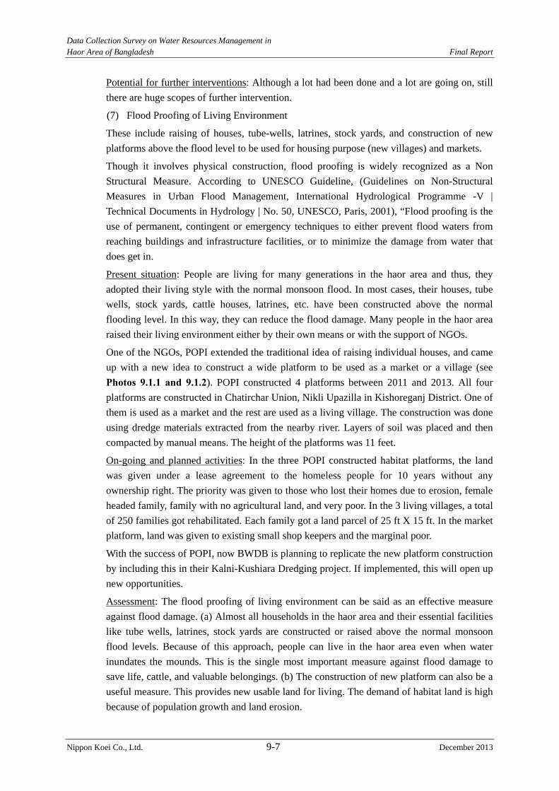
Data Collection Survey on Water Resources Management in Haor Area of Bangladesh Final Report
Nippon Koei Co., Ltd. 9-7 December 2013
Potential for further interventions: Although a lot had been done and a lot are going on, still
there are huge scopes of further intervention.
(7) Flood Proofing of Living Environment
These include raising of houses, tube-wells, latrines, stock yards, and construction of new
platforms above the flood level to be used for housing purpose (new villages) and markets.
Though it involves physical construction, flood proofing is widely recognized as a Non
Structural Measure. According to UNESCO Guideline, (Guidelines on Non-Structural
Measures in Urban Flood Management, International Hydrological Programme -V |
Technical Documents in Hydrology | No. 50, UNESCO, Paris, 2001), “Flood proofing is the
use of permanent, contingent or emergency techniques to either prevent flood waters from
reaching buildings and infrastructure facilities, or to minimize the damage from water that
does get in.
Present situation: People are living for many generations in the haor area and thus, they
adopted their living style with the normal monsoon flood. In most cases, their houses, tube
wells, stock yards, cattle houses, latrines, etc. have been constructed above the normal
flooding level. In this way, they can reduce the flood damage. Many people in the haor area
raised their living environment either by their own means or with the support of NGOs.
One of the NGOs, POPI extended the traditional idea of raising individual houses, and came
up with a new idea to construct a wide platform to be used as a market or a village (see Photos 9.1.1 and 9.1.2). POPI constructed 4 platforms between 2011 and 2013. All four
platforms are constructed in Chatirchar Union, Nikli Upazilla in Kishoreganj District. One of
them is used as a market and the rest are used as a living village. The construction was done
using dredge materials extracted from the nearby river. Layers of soil was placed and then
compacted by manual means. The height of the platforms was 11 feet.
On-going and planned activities: In the three POPI constructed habitat platforms, the land
was given under a lease agreement to the homeless people for 10 years without any
ownership right. The priority was given to those who lost their homes due to erosion, female
headed family, family with no agricultural land, and very poor. In the 3 living villages, a total
of 250 families got rehabilitated. Each family got a land parcel of 25 ft X 15 ft. In the market
platform, land was given to existing small shop keepers and the marginal poor.
With the success of POPI, now BWDB is planning to replicate the new platform construction
by including this in their Kalni-Kushiara Dredging project. If implemented, this will open up
new opportunities.
Assessment: The flood proofing of living environment can be said as an effective measure
against flood damage. (a) Almost all households in the haor area and their essential facilities
like tube wells, latrines, stock yards are constructed or raised above the normal monsoon
flood levels. Because of this approach, people can live in the haor area even when water
inundates the mounds. This is the single most important measure against flood damage to
save life, cattle, and valuable belongings. (b) The construction of new platform can also be a
useful measure. This provides new usable land for living. The demand of habitat land is high
because of population growth and land erosion.
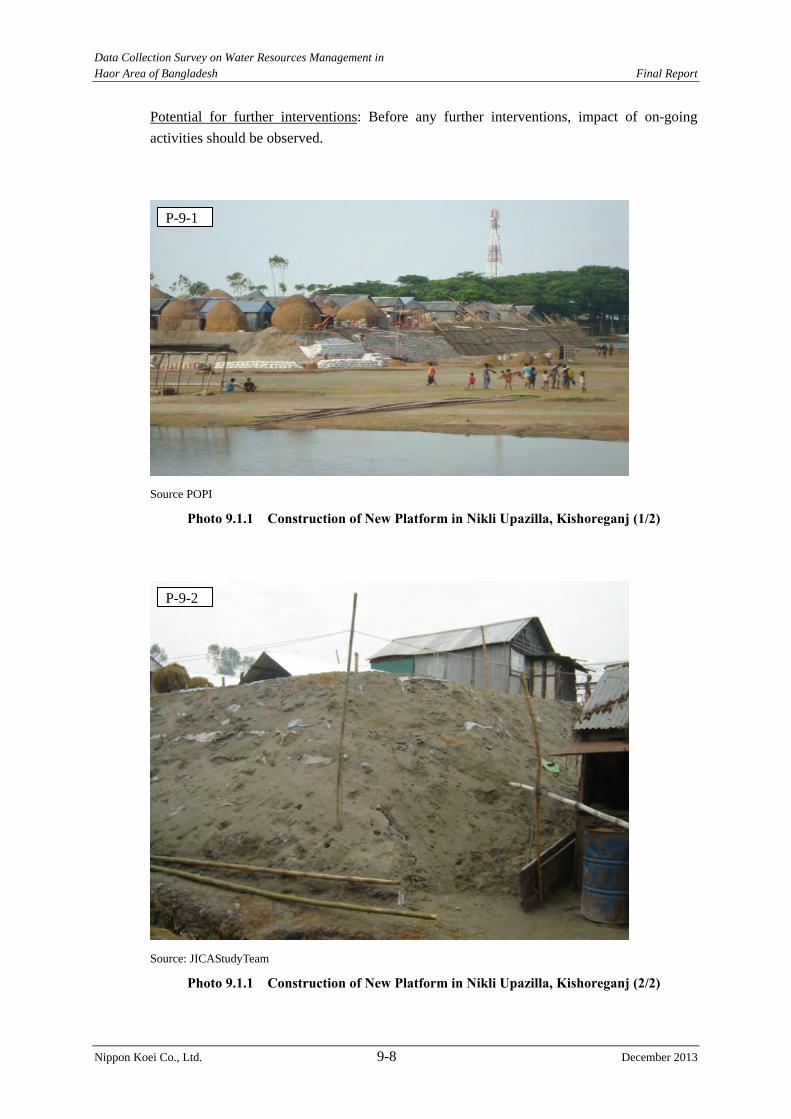
Data Collection Survey on Water Resources Management in Haor Area of Bangladesh Final Report
Nippon Koei Co., Ltd. 9-8 December 2013
Potential for further interventions: Before any further interventions, impact of on-going
activities should be observed.
Source POPI
Photo 9.1.1 Construction of New Platform in Nikli Upazilla, Kishoreganj (1/2)
Source: JICAStudyTeam
Photo 9.1.1 Construction of New Platform in Nikli Upazilla, Kishoreganj (2/2)
P-9-1
P-9-2
Data Collection Survey on Water Resources Management in Haor Area of Bangladesh Final Report
Nippon Koei Co., Ltd. 9-9 December 2013
(8) Participatory Water Resources Management
This is not an independent non structural measure; rather it is an alternate approach to ensure
proper O&M of the structural flood measures to ensure flood damage reduction. Under this
approach, stakeholders/ beneficiaries are involved in O&M procedure.
Present situation: (a) The Small Scale Water Resources Development (SSWRD) Projects of
LGED organizes Water Management Cooperative Association (WMCA) for the participatory
operation and management of the facilities. Initially it was funded by ADB and later JICA
started funding. (b) Concern, an international NGO, used the participatory approach to carry
out village protection works from wave action in 21 mounds (mounds are effectively like
islands during the wet season). Concern organized a cooperative society in the target village
and the society created a maintenance fund upfront. The beneficiaries also contributed all
labor required for the construction. After the completion, the ownership was transferred to
the village cooperative society and they took over responsibilities for all kinds of
maintenance.
On-going and planned activities: (a) The SSWRD Projects of LGED will continue following
the participatory approach and it is expected that more than 1,000 WMCAs will be formed
before 2017, and (b) BWDB now is doing a pilot under the WB funded WMIP project to
form Water Management Association (WMA) in order to hand over the O&M activities. If
successful, this will lead to major improvement in BWDB’s O&M.
Assessment: (a) As mentioned above, LGED’s SSWRD is considered generally as a
successful model according to LGED’s internal monitoring. Some problems were identified
and future projects are expected to address those. (b) According to Concern, in the past 5
years, there were 2 cases of collapse out of their 21 sub projects; however, the villagers
successfully reconstructed those without any assistance from Concern. Thus, the
participatory model is considered successful.
Potential for further interventions: Before any further interventions, impact of on-going
activities should be observed.
9.2 Non-structural Measures Effective for Haor Area
Based on the above discussion in Section 9.1, it can be inferred that the non-structural
measures effective for the haor area are (1) Local disaster management planning, (2)
Livelihood diversification, (3) Flood proofing of living environment, and (4) Participatory
water resources management. In this Section, conceivable future projects under these 4
measures are examined and potential projects for JICA cooperation are identified.
9.2.1 Conceivable Projects
(1) Local Disaster Management Planning
As mentioned in the previous section, many organizations are now working in various
sub-sectors under this measure. An overview of the on-going and planned projects is given
below. Details can be found in Annex 9-1.
Data Collection Survey on Water Resources Management in Haor Area of Bangladesh Final Report
Nippon Koei Co., Ltd. 9-10 December 2013
Table 9.2.1 Rationale for Intervention Possibility on Local Disaster Management Planning Sub sector On-going and planned projects Implication and
interventions possibility Response System/ Evacuation Planning
a. Establishment of National Disaster Management Training and Research Centre (CDMP II)
b. Establishment of National Disaster Management Volunteer Corps (CDMP II)
c. Utilization of Fast Tracked Risk Assessment (FTRA) at the local administration level to produce the Risk Reduction Action Plans (RRAPs) (CDMP II).
In 2012, 242 unions have gone through the FTRA/review of RRAP process. The CDMP II target is to cover 1,780 unions. Evaluation of current approach is required before conceiving new interventions.
Hazard Mapping a. Local community led hazard mapping on a country wide basis (funded by CDMP II, implemented with NGOs)
b. “Multi-Hazard Risk and Vulnerability Assessments, Modeling and Mapping in Bangladesh” (funded by Norway, implemented by Asian Disaster Preparedness Center (ADPC), expected to complete by May 2014)
Evaluation of current approach is required before conceiving new interventions.
Flood Shelter No concrete planning exists A flood shelter is not an essential requirement thanks to local flood characteristics. Even the existing facilities are not very popular. A user friendly flood shelter is required. If combined with other use like storage and market, it can enhance economic activities.
Data Collection Survey on Water Resources Management in Haor Area of Bangladesh Final Report
Nippon Koei Co., Ltd. 9-11 December 2013
Sub sector On-going and planned projects Implication and interventions possibility
Edification and awareness building
a. Providing life jackets, solar lanterns and radio sets (CDMP II)
b. Disaster management education is provided during the preparation of local Community Risk Assessment (CRA) (CDMP II)
c. Introduction of disaster management in school text books (CDMP II)
d. Bangladesh and English versions of the Introduction to Disaster Management (IDM) and Comprehensive Disaster Management (CDM) modules are now accessible at http://elearning.cdmp.org.bd. (CDMP II)
e. 1 million posters, 50 thousand leaflets and other communication materials are published and distributed to schools countrywide (CDMP II)
f. Training Ansar and VDP (two local level Community Police force ) as flood management volunteers (CDMP II)
Evaluation of current approach is required before conceiving new interventions.
Seed Bank and Food Bank
Some NGOs are trying the approach as a trial basis.
A systematic and well planned pilot study is required.
Flood Damage/ Crop Insurance
a. “Pilot Project on Weather Index-Based Crop Insurance TA - 46284” will be implemented by Asian Development Bank (ADB) under a grant of $2 million from Japan
Evaluation of the pilot study is required before conceiving new interventions.
Source: JICA Study Team
Thus, the conceivable projects in this measure are as follows,
Planning and implementation of user friendly flood shelter cum market, and
Pilot study on seed bank and food bank
(2) Livelihood Diversification
As mentioned in the previous section, this measure can be considered to be the most
effective for flood damage reduction in the haor area. Many organizations are now working
in various sub-sectors under this measure. An overview of the on-going and planned projects
is given below. Details can be found in Annex 9-1.
Data Collection Survey on Water Resources Management in Haor Area of Bangladesh Final Report
Nippon Koei Co., Ltd. 9-12 December 2013
Table 9.2.2 Rationale for Intervention Possibility on Livelihood Diversification Sub sector On-going and planned projects Implication and
interventions possibility Paddy variety diversification
Bangladesh Rice Research Institute (BRRI) developed many hybrid varieties. For example, short maturation type BR-28 (140 days), high yield type BR-29 (7.5 t/ha), early harvesting type BR-45 (early April), etc.
BR-45 suffers from shattering (falling off the grains during harvesting) and BR-29 cannot withstand in very cold temperature. Further research is required.
Crop diversification Department of Agricultural Extension (DAE) and some NGOs are promoting vegetables, potatoes, oil seeds, grass and bamboo cultivation before Boro rice. DCRMA (Disaster and Climate Risk Management in Agriculture) is a component of CDMP-II, being implemented since 2011 by DAE. DCRMA has project activities on crop diversification, integrated farming, adaptive farming, farmers’ capacity building, etc. in 4 Haor districts (Habiganj, Netrokona, Sunamganj and Moulovibazar).
There are scopes of projects similar to DCRMA.
Job diversification a. To improve the livelihood of haor communities and to reduce the flood damage impact, beel nursery activities were undertaken by LGED with funding from UN agency International Fund for Agricultural Development (IFAD). There are 2 successful projects, namely Sunamganj Community Based Resource Management Project (SCBRMP) and Haor Infrastructure and Livelihood Improvement Project (HILIP).
b. The HILIP proposed to provide training and capital support for income generating activities mainly for women on cottage industries based on agro-products.
c. Livelihood Protection Component of HILIP will develop the capacity of smallholder producers to participate in selected market-based value chains and establish and support market-based institutions.
The target beneficiaries of “beel nursery” are 90,000 farmers under SCBRMP and 688,000 households under HILIP. Because of the success of these projects, now IFAD is forming a new project called Climate Resiliendce and Livelihood Improvement Project (CALIP) to expand the coverage. A total of 94,000 persons are expected to directly benefit from Livelihood Protection Component in the 26 project Upazilas. Though a lot is going on, still there is room for further extension.
Source: JICA Study Team
Thus, the conceivable projects in this measure are as follows:
Research on developing paddy variety to sustain flash flood related damage,
Flash flood resilient agricultural diversification with improved market access, and
Extension of Beel Nursery.
Data Collection Survey on Water Resources Management in Haor Area of Bangladesh Final Report
Nippon Koei Co., Ltd. 9-13 December 2013
(3) Flood Proofing of Living Environment
As mentioned in the previous section, this is an effective measure against flood damage. An
overview of the on-going and planned projects is given below. Details can be found in
Annex 9-1.
Table 9.2.3 Rationale for Intervention Possibility on Flood Proofing of Living Environment Sub sector On-going and planned projects Implication and
interventions possibility Raising of habitat area
Most households raise their habitats above the normal flood level for generations. Most people do this by their own or sometimes borrowing money.
This is a traditional activity and suitable for NGOs to support.
Raising of villages and new platform construction
a. Some NGOs are carrying out this activity but not in a coordinated way.
b. Kalni-Kushiara Dredging Project (GOB) includes this activity using the dredge materials.
New villages and markets were reclaimed and landless families were settled. Good use of dredge material. New land can be created if combined with wave protection works.
Source: JICA Study Team
Thus, the conceivable projects in this measure are as follows:
Raising of villages and new platform construction in conjunction with dredging and
village wave protection works.
(4) Participatory Water Resources Management
As mentioned in the previous section, this is not an independent non-structural measure;
rather it is an alternate approach to ensure proper O&M of the structural flood measures to
ensure flood damage reduction. Trials and pilot scale studies have been completed, on-going
or planned on 3 models. An overview is given below. Details can be found in Annex 9-1.
Table 9.2.4 Rationale for Intervention Possibility on Participatory Water Resources Management
Sub sector On-going and planned projects Implication and interventions possibility
WMIP model (participatory O&M, but no asset transfer)
Water Management Improvement Project (WMIP) is an on-going project of BWDB funded by the World Bank and the Netherlands government expected to be completed by 2015. It will define the role of communities in water resources management projects.
Vital for BWDB’s future management strategy. Evaluation of the current approach is required before conceiving new interventions.
LGED model (asset transfer, but follow up support)
Small Scale Water Resources Development Projects of LGED (funded by ADB and JICA) organized Water Management Cooperative Association (WMCA) for the operation and management of the small scale facilities. The implementation started from mid 2000 and is currently expected to be continued till 2017.
This LGED model is generally considered to be successful. However, current implementation is trying to address encountered problems. Evaluation of the current approach is required before conceiving new interventions.
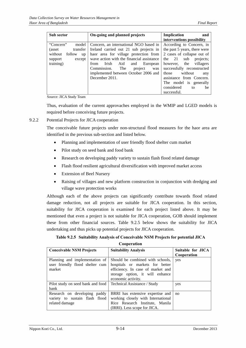
Data Collection Survey on Water Resources Management in Haor Area of Bangladesh Final Report
Nippon Koei Co., Ltd. 9-14 December 2013
Sub sector On-going and planned projects Implication and interventions possibility
“Concern” model (asset transfer without follow up support except training)
Concern, an international NGO based in Ireland carried out 21 sub projects in haor area for village protection from wave action with the financial assistance from Irish Aid and European Commission. The project was implemented between October 2006 and December 2011.
According to Concern, in the past 5 years, there were 2 cases of collapse out of the 21 sub projects; however, the villagers successfully reconstructed those without any assistance from Concern. The model is generally considered to be successful.
Source: JICA Study Team
Thus, evaluation of the current approvaches employed in the WMIP and LGED models is
required before conceiving future projects.
9.2.2 Potential Projects for JICA cooperation
The conceivable future projects under non-structural flood measures for the haor area are
identified in the previous sub-section and listed below.
Planning and implementation of user friendly flood shelter cum market
Pilot study on seed bank and food bank
Research on developing paddy variety to sustain flash flood related damage
Flash flood resilient agricultural diversification with improved market access
Extension of Beel Nursery
Raising of villages and new platform construction in conjunction with dredging and
village wave protection works
Although each of the above projects can significantly contribute towards flood related
damage reduction, not all projects are suitable for JICA cooperation. In this section,
suitability for JICA cooperation is examined for each project listed above. It may be
mentioned that even a project is not suitable for JICA cooperation, GOB should implement
these from other financial sources. Table 9.2.5 below shows the suitability for JICA
undertaking and thus picks up potential projects for JICA cooperation.
Table 9.2.5 Suitability Analysis of Conceivable NSM Projects for potential JICA Cooperation
Conceivable NSM Projects Suitability Analysis Suitable for JICA Cooperation
Planning and implementation of user friendly flood shelter cum market
Should be combined with schools, hospitals or markets for better efficiency. In case of market and storage option, it will enhance economic activity.
yes
Pilot study on seed bank and food bank
Technical Assistance / Study yes
Research on developing paddy variety to sustain flash flood related damage
BRRI has extensive expertise and working closely with International Rice Research Institute, Manila (IRRI). Less scope for JICA.
no
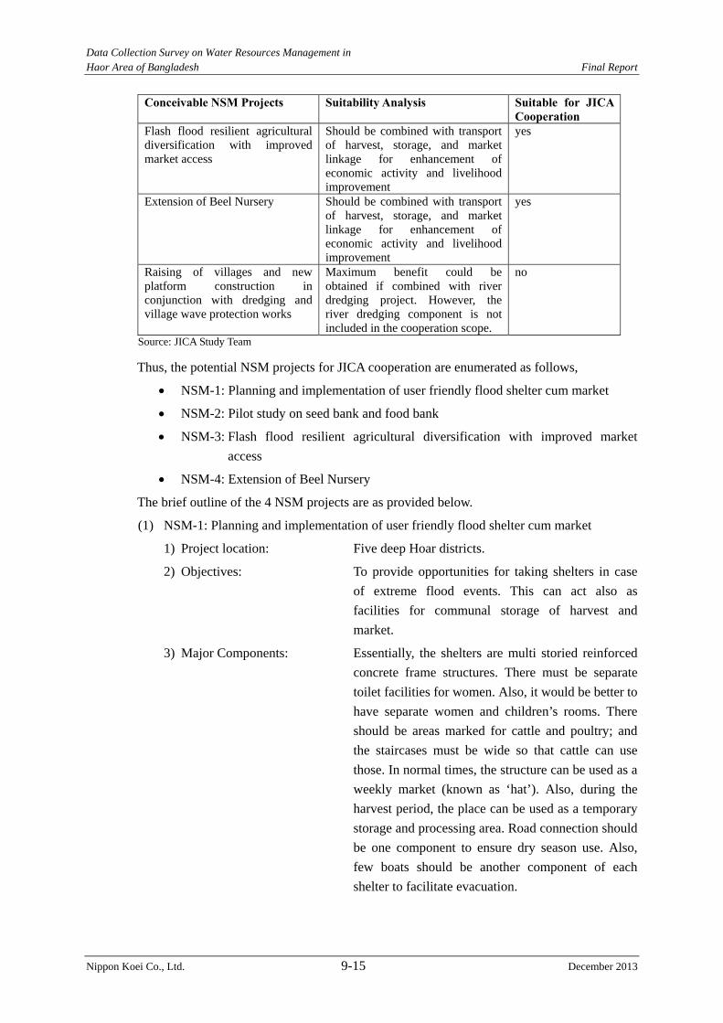
Data Collection Survey on Water Resources Management in Haor Area of Bangladesh Final Report
Nippon Koei Co., Ltd. 9-15 December 2013
Conceivable NSM Projects Suitability Analysis Suitable for JICA Cooperation
Flash flood resilient agricultural diversification with improved market access
Should be combined with transport of harvest, storage, and market linkage for enhancement of economic activity and livelihood improvement
yes
Extension of Beel Nursery Should be combined with transport of harvest, storage, and market linkage for enhancement of economic activity and livelihood improvement
yes
Raising of villages and new platform construction in conjunction with dredging and village wave protection works
Maximum benefit could be obtained if combined with river dredging project. However, the river dredging component is not included in the cooperation scope.
no
Source: JICA Study Team
Thus, the potential NSM projects for JICA cooperation are enumerated as follows,
NSM-1: Planning and implementation of user friendly flood shelter cum market
NSM-2: Pilot study on seed bank and food bank
NSM-3: Flash flood resilient agricultural diversification with improved market
access
NSM-4: Extension of Beel Nursery
The brief outline of the 4 NSM projects are as provided below.
(1) NSM-1: Planning and implementation of user friendly flood shelter cum market
1) Project location: Five deep Hoar districts.
2) Objectives: To provide opportunities for taking shelters in case
of extreme flood events. This can act also as
facilities for communal storage of harvest and
market.
3) Major Components: Essentially, the shelters are multi storied reinforced
concrete frame structures. There must be separate
toilet facilities for women. Also, it would be better to
have separate women and children’s rooms. There
should be areas marked for cattle and poultry; and
the staircases must be wide so that cattle can use
those. In normal times, the structure can be used as a
weekly market (known as ‘hat’). Also, during the
harvest period, the place can be used as a temporary
storage and processing area. Road connection should
be one component to ensure dry season use. Also,
few boats should be another component of each
shelter to facilitate evacuation.
Data Collection Survey on Water Resources Management in Haor Area of Bangladesh Final Report
Nippon Koei Co., Ltd. 9-16 December 2013
4) Benefited areas/beneficiaries: All five deep haor districts will be benefitted.
5) Expected execution agency: Implementation is to be done by LGED.
Management and maintenance is to be done by local
beneficiary groups.
6) Urgency of JICA Cooperation: Medium.
(2) NSM-2: Pilot study on seed bank and food bank
1) Project location: A few upazillas.
2) Objectives: To plan a scheme of seed bank and food bank
tailored to local conditions, implement a pilot study,
and evaluate possibility of replication.
3) Major Components: In the first step, based on international and national
experiences, prepare a plan appropriate for haor
conditions. In the second step, a two season pilot
study is to be carried out. In the last step, evaluation
is to be done and modification is to be proposed for
successful full scale implementation.
“Community Food Bank (CFB)” is an idea where
buffer stock of food grains is built up at a
community level to provide food against seasonal
deficits in the lean months (mid-September to
mid-November) or during disaster periods. The CFB
will keep deposit of food from the beneficiaries and
return back it during the crisis period. The depositors
may withdraw their food in terms of cash and have
the provision in getting interest. Branches can be set
up in villages and a central storage is required which
may be set up at the upazila level.
After a major flood, usually there is a scarcity of
seed. To overcome this problem, there should be
some facilities to maintain seed security stock.
4) Benefited areas/beneficiaries: This is a pilot study.
5) Expected execution agency: Department of Agricultural Extension (DAE) in
cooperation with local NGOs.
6) Urgency of JICA Cooperation: Medium.
(3) NSM-3: Flash flood resilient agricultural diversification with improved market access
1) Project location: Five deep hoar districts.
2) Objectives: To promote paddy and crop diversification in a way
to reduce flash flood related agricultural damages,
and to facilitate with storage, transport and forward
market linkage.

Data Collection Survey on Water Resources Management in Haor Area of Bangladesh Final Report
Nippon Koei Co., Ltd. 9-17 December 2013
3) Major Components: It can be modeled based on CDMP II supported
“Disaster and Climate Risk Management in
Agriculture” (DCRMA) and Livelihood Protection
Component of HILIP.
This will have several components. The first
component will have activities on crop
diversification, integrated farming, adaptive farming,
and farmers’ capacity building.
Agricultural production system is closely linked
with storage and marketing facilities. The
inaccessibility of these facilities makes it difficult
for farmers to get reasonable prices for their produce.
Most of the farmers sell their products in village
markets immediately after harvesting when prices
are typically low. The producers are then frequently
obliged to replace this food grain at higher prices to
meet daily consumption requirements during the
off-season.
Thus, the second component of the project includes
establishment of regulated markets, construction of
warehouses, provision for grading of crop quality,
standardization of produce, standardization of
weight and measures, daily broadcasting of market
prices, and improvement of transport facilities. This
component will develop the capacity of smallholder
producers to participate in selected market-based
value chains and establish and support market-based
institutions.
4) Benefited areas/beneficiaries: All five deep haor districts will be benefitted.
5) Expected execution agency: Implementation is to be done by LGED in
cooperation with DAE. Management and
maintenance is to be done by local beneficiary
groups.
6) Urgency of JICA Cooperation: Urgent.
(4) NSM-4: Extension of Beel Nursery
1) Project location: Five deep Hoar districts.
2) Objectives: To improve livelihood of haor fishermen
communities by increasing haor fish production in
beel areas.
3) Major Components: It can be modeled based on Community Resources
Management Component of HILIP.
Data Collection Survey on Water Resources Management in Haor Area of Bangladesh Final Report
Nippon Koei Co., Ltd. 9-18 December 2013
“Beel” is generally defined as the deepest part of a
haor, where water remains in the dry season. In this
scheme, government owned beels are made available
to fishery groups through lease agreement. The
groups then maintain sustainable fishing after
getting proper training from the Project.
4) Benefited areas/beneficiaries: All five deep haor districts will be benefitted.
5) Expected execution agency: Implementation is to be done by LGED in
cooperation with Department of Fisheries.
Management and maintenance is to be done by local
beneficiary groups.
6) Urgency of JICA Cooperation: Urgent.
Data Collection Survey on Water Resources Management in Haor Area of Bangladesh Final Report
Nippon Koei Co., Ltd. 10-1 December 2013
CHAPTER 10 CONCLUSIONS AND RECOMMENDATIONS
The haor areas (covering about 8,500 km2), which extend in the upper Meghna area and are located in
the Northeast Region of Bangladesh, have been supporting the regional economy as a food basket
during the dry season and a rich fishery during the rainy season. However, the haor areas have
suffered from serious flood damage due to (i) flash floods brought about by river waters coming from
the hilly areas in the Indian territory during pre-monsoon seasons (which are counted as one of the
heaviest rainfall zones in the world), and (ii) long-term flood inundation during the monsoon season.
Particularly in a pre-monsoon season, the haor areas sustain serious boro rice damage due to flash
floods which occur every two to three years.
The Bangladesh Haor and Wetland Development Board (BHWDB) formulated “Master Plan of Haor
Areas (the M/P)” in April 2012 as a comprehensive development plan of the haor areas for the next 20
years. The M/P is to be positioned as an overarching plan and a base of formulation/implementation
for future JICA cooperation in the haor areas. The M/P has worked out priority projects through: (i)
problem/issue analysis and (ii) reflecting the peoples’ needs clarified through a participatory approach.
However, it was pointed out that project impacts on the upstream and/or downstream areas after
project implementation are not necessarily verified in the M/P yet.
In such a situation, the Study conducted (i) review of the M/P and (ii) basic study to supplement the
M/P. The JICA Study Team has proposed the following structural and non-structural measures as
possible JICA cooperation projects for flood measures and river management plan in the haor areas:
(1) Structural measures
- Pre-monsoon Flood Protection and Drainage Improvement Project in Haor Areas
(rehabilitation and new development of haor projects), hereinafter referred to as “the
Haor Project”
(2) Non-structural measures
- Flash Flood Resilient Agricultural Diversification with Improved Market Access
- Extension of Beel Nursery
As to the O/M of the Haor Project and the non-structural measures of the above, project design is to be
entrusted to the ongoing JICA study entitled “Preparatory Survey on Upper Meghna River Basin
Watershed Management Improvement Project in the People’s Republic of Bangladesh”. The Study
has worked out the project design of the structural measures, giving priority to the technical aspect.
In these situations, the following are recommended for the succeeding project stage:
(1) The Haor Project, composed of 37 subprojects (15 for rehabilitation and 22 for new
development), has been designed based principally on the study and examination of the
technical aspect. Therefore, it is essential in the succeeding stage for project
Data Collection Survey on Water Resources Management in Haor Area of Bangladesh Final Report
Nippon Koei Co., Ltd. 10-2 December 2013
implementation to review and design the project including economic evaluation and
environmental/social assessments.
(2) River water level and discharge measurements have been conducted in the haor areas.
Ocular observation of water level (usually from 6:00 a.m. to 6:00 p.m.) has been the major
work on measurements in accordance with the need for current river management in the
country using flood water levels. In the haor areas it is important to incorporate
quantitative management of river water into the future water resources management.
Therefore, it is recommended to measure water levels by automatic water level gauges
including the time from 6:00 p.m. to 6:00 a.m. and provide proper water level-discharge
rating curves.
(3) Currently, the design water levels of flood control facilities such as submergible
embankment and regulators for the haor projects have been determined basically through
frequency analysis of water level data obtained from NERM. However, considering future
land use change and river channel movement in the haor area, it is also recommended to
incorporate into the design of flood control facilities the different approach wherein a design
flood discharge at a facility site is set up first and the design water level is determined based
on the design flood discharge.
(4) In the Study, the flood flow analysis in the haor areas, which have a vast area of 8,500 km2
in total, was carried out, partially modifying the flood runoff model of IWM. During the
project implementation stage, it is recommended to confirm the flood flow conditions
through detailed hydraulic analysis for specific project areas.
(5) Through the Dutch corn test, soft layers were found to exist at very few sites in the haor
areas. The soft layer requires countermeasures such as counterweight embankment for
embankment construction of more than 2.0m to 2.5m in height. Therefore, it is
recommended to confirm the existence of soft layer (particularly, peat layer) through core
boring investigations at around 500 m intervals in the planned alignments of submergible
embankment during the project implementation stage so as to correctly reflect the soft layer
properties in the detailed structural design.
(6) As mentioned above, the haor areas have been subjected to serious boro rice damage due to
frequent flash floods during pre-monsoon season. The Haor Project can mitigate the flood
damage and contribute towards raising the level of economic and social activities and
realizing poverty reduction and livelihood improvement in the haor areas. In due
consideration of the disastrous situation in the haor areas, having been repeatedly devastated
by flash floods, earlier realization of the Haor Project is strongly needed. It is recommended
that the Government of Bangladesh take necessary actions timely for further steps such as
securing finance, technical assistance, etc. to realize the Haor Project.