current river conservation area...2017 current river conservation area management plan page 7 which...
TRANSCRIPT
Current River Conservation Area
·Ten-Year Area Management Plan FY 2017-2026
Forestry Division Chief
2017 Current River Conservation Area Management Plan •:• Page 2
Current River Conservation Area Management Plan Approval Page
PLANNING TEAM
Steve Orchard, Resource Forester
Alex Wolf, Forest Ecologist
Mark McLain, Wildlife Management Biologist
Paul Cieslewicz, Fisheries Management Biologist
Bruce Henry, Natural History Biologist
Eric Long, Conservation Agent
Kaleb Neece, Conservation Agent
Pat Holloway, Education Consultant
Jeremy Pulley, Private Land Conservationist
David Hasenbeck, Elk Program Manager
SOUTHEAST REGION
RCT Chair
FORESTRY DIVISION
Forest Management Chief
Signature Date
';)/;o/;z ~ I
Date
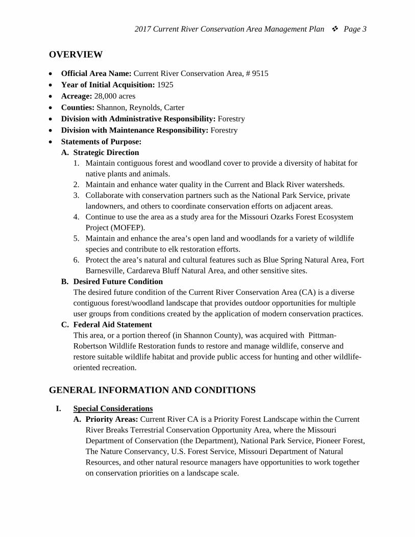
2017 Current River Conservation Area Management Plan Page 3
OVERVIEW
• Official Area Name: Current River Conservation Area, # 9515 • Year of Initial Acquisition: 1925 • Acreage: 28,000 acres • Counties: Shannon, Reynolds, Carter • Division with Administrative Responsibility: Forestry • Division with Maintenance Responsibility: Forestry • Statements of Purpose:
A. Strategic Direction 1. Maintain contiguous forest and woodland cover to provide a diversity of habitat for
native plants and animals. 2. Maintain and enhance water quality in the Current and Black River watersheds. 3. Collaborate with conservation partners such as the National Park Service, private
landowners, and others to coordinate conservation efforts on adjacent areas. 4. Continue to use the area as a study area for the Missouri Ozarks Forest Ecosystem
Project (MOFEP). 5. Maintain and enhance the area’s open land and woodlands for a variety of wildlife
species and contribute to elk restoration efforts. 6. Protect the area’s natural and cultural features such as Blue Spring Natural Area, Fort
Barnesville, Cardareva Bluff Natural Area, and other sensitive sites. B. Desired Future Condition
The desired future condition of the Current River Conservation Area (CA) is a diverse contiguous forest/woodland landscape that provides outdoor opportunities for multiple user groups from conditions created by the application of modern conservation practices.
C. Federal Aid Statement This area, or a portion thereof (in Shannon County), was acquired with Pittman-Robertson Wildlife Restoration funds to restore and manage wildlife, conserve and restore suitable wildlife habitat and provide public access for hunting and other wildlife-oriented recreation.
GENERAL INFORMATION AND CONDITIONS
I. Special Considerations A. Priority Areas: Current River CA is a Priority Forest Landscape within the Current
River Breaks Terrestrial Conservation Opportunity Area, where the Missouri Department of Conservation (the Department), National Park Service, Pioneer Forest, The Nature Conservancy, U.S. Forest Service, Missouri Department of Natural Resources, and other natural resource managers have opportunities to work together on conservation priorities on a landscape scale.
2017 Current River Conservation Area Management Plan Page 4
B. Natural Areas: Blue Spring Natural Area contains the sixth largest spring in Missouri with a discharge of 90 million gallons per day. It is also the deepest known spring in Missouri, with a primary conduit at least 300 feet deep. The spring supports cold water aquatic species including plants, fish and invertebrates, including some that are species of conservation concern (Missouri Department of Conservation, 1999). Cardareva Bluff Natural Area contains a wide range of community types from dry dolomite cliffs to mesic bottomland forest. These communities support a wide range of native plants and animals, including species of conservation concern, such as the cerulean warbler that utilizes the mature forests along the Current River and at the base of the bluffs.
C. Other: Current River CA is within an Audubon Important Bird Area. The Current River/Jacks Fork River Watershed Important Bird Area was recognized for its extensive contiguous forest cover and its ability to provide nesting habitat for forest-interior songbirds.
II. Important Natural Features and Resources
A. Species of Conservation Concern: Species of conservation concern are known from this area. Area managers should consult the Natural Heritage Database annually and review all management activities with the natural history biologist.
B. Caves: Yes, records kept with Department natural history biologist. Managers should follow the Cave Management policy found in the Department Resource Policy Manual. All caves on this and other conservation areas are closed or restricted to public access. The fungus that causes White-nose Syndrome in bats has been documented in Missouri, resulting in the Department’s White-nose Syndrome Action Plan that limits public access to protect bats.
C. Springs: Blue Spring is located on the west side of the area. Blue Spring is among Shannon County’s most popular destinations for area visitors, and is Missouri’s sixth largest spring, with an average daily flow of 90 million gallons.
D. Other: Current River flows along the area’s south-west boundary. It is an important recreational resource for the Department and National Park Service area users. The use of proper best management practices and being considerate of aesthetics along the river corridor is important to retain the area’s pristine natural character. Consult the Department/National Park Service Memorandum of Understanding, when appropriate, for management guidance and or restrictions near the river. The area has a rich diversity of habitat types. • The dominant landtype associations of the area are the Current and Black River
Oak-Pine Woodland/Forest Hills. These forested landtypes consist of mostly even-age mixed scarlet, black, and white oak, as well as the native range of shortleaf pine. Other habitat types within the area are Ozark stream corridors,
2017 Current River Conservation Area Management Plan Page 5
open and semi-open dolomite glades of exposed bedrock, mesic and xeric bottomland forest, and dry forested sinkholes. (Nigh & Schroeder, 2002)
III. Existing Infrastructure
• Ellington Department Office • Missouri Ozark Forest Ecosystem Project housing • Two residences that are occupied by area staff (Civilian Conservation Corps [CCC]
era) • One barn (CCC era) • One garage (CCC era) • One historic cabin (CCC era) • Hiking trail (1.5 miles) • One fire tower • Two fishing jetties/platforms • Deer Run Archery Range (unstaffed) • Deer Run Shooting Range (Americans with Disabilities Act [ADA] accessible,
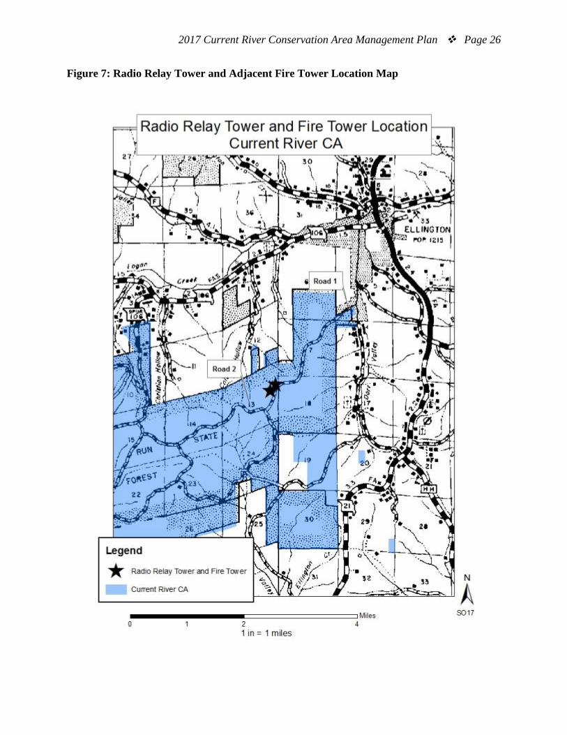
unstaffed) • Two parking lots (ADA accessible) • Eight picnic tables • One privy/restroom (ADA accessible) • One staffed office (ADA accessible) • One radio relay and accompanying tower in cooperation with the Missouri Highway
Patrol (see Figure 7) • Buford Pond (3-acre stocked fishing pond) • 32 wildlife watering holes (15 acres total) • One overlook platform at Blue Spring • Approximately 50 pipe gates/cable road closure structures
IV. Area Restrictions or Limitations
A. Deed Restrictions or Ownership Considerations: The Department has a Memorandum of Understanding with the National Park Service on portions of the west side of the area in regard to resource management. The Memorandum of Understanding should be consulted before conducting management activities in these areas.
B. Federal Interest: Uses of land acquired with federal funds may not interfere with the purpose for which it was acquired. Federal funds may also be used in the management of this land. Fish and wildlife agencies may not allow recreational activities and related facilities that would interfere with the purpose for which the
2017 Current River Conservation Area Management Plan Page 6
State is managing the land. Other uses may be acceptable and must be assessed in each specific situation.
C. Easements: • Ozark National Scenic Riverways scenic easement runs along the Current River
corridor. • Black River Electric Cooperative has an easement for an underground
transmission line of 0.75 acres (Section 25, T29N, R2W). • Ozark Border Electric Cooperative overhead transmission line runs down Paint
Rock Creek, going in and out of state-owned property, to the Log Yard Access on the Ozark National Scenic Riverways.
• There are 1.26 acres located in the southeast corner deeded for school purposes (SE ¼ SE ¼ of Section 33, T29N, R1W). The school structure is no longer in existence, which would lead to the premise that the 1.26 acres would revert back to the state.
• The U. S. Geological Survey has an easement to install water flow measuring equipment in Blue Spring.
• The following county roads cross a portion of Current River CA: Shannon County Roads 539, HH-555, and the Paint Rock Road. Reynolds County Roads 620 and 626 cross portions of the area. State Highway HH crosses segments of the forest also.
• M. A. O’Brien has the full right and privilege of executing leases for oil, gas, coal, and all other minerals, totaling 1,740 acres (Section 25, 26, 27, 34, and 35, T29N, R1W).
• Black River Electric Cooperative supplies electricity to Deer Run Tower and the Radio Relay Tower.
D. Cultural Resources Findings: Yes, records kept with the Department environmental compliance specialist. Mangers should follow Best Management Practices for Cultural Resources found in the Department Resource Policy Manual.
E. Endangered Species: Endangered species are known from this area. Area managers should consult the Natural Heritage Database annually and review all management activities with the natural history biologist.
F. Boundary Issues: Establishing accurate and identifiable boundary markers is a priority for this property.
MANAGEMENT CONSIDERATIONS
V. Terrestrial Resource Management Considerations
The majority of land at the Current River CA is typical of the Ozarks. The area contains black and scarlet oak-dominated forests that evolved after decades of woods burning
2017 Current River Conservation Area Management Plan Page 7
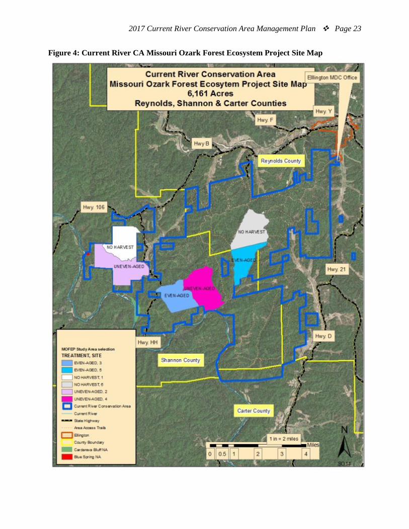
which was done in an attempt to maintain forage for open-range livestock production. Subsequent timber liquidation style cutting, around 1900, removed pine seed trees and merchantable hardwood, and created an even-aged forest structure. With the absence of the fire, oaks (which sprout vigorously) dominated the forest, and matured with a high stocking density. Today, most of the forests are in an even-aged condition. The area is managed with an emphasis on forest ecosystem health, tree species diversity, and to maintain or enhance wildlife habitat. The Current River CA is the home to a portion of the Missouri Ozark Forest Ecosystem Project (MOFEP). This project is a 100-year project assigned to monitor the long-term effects of different forest management regimes covering 9,000 acres of Ozark forest and its associated plant and animal life. There are six MOFEP compartments in the Current River CA, each is approximately 1000 acres in size. The MOFEP Compartments will receive the following treatments as prescribed each 15-year inventory cycle: Two even-aged, two uneven-aged, and two control units that will be left unmanaged. The next MOFEP inventory will be conducted in 2024 and is noted on this plan. The subsequent 2025 timber sale marking and 2026 MOFEP harvest entry will be part of the 2025-2035 Current River CA Area Planning cycle.
Challenges and Opportunities:
1) Manage forests for a variety of habitat types, diversity of plant and animal species, and healthy forests.
2) Restore and maintain the natural ecosystem integrity of woodland and glade communities.
3) Collaborate with conservation partners to develop and maintain natural habitat that demonstrates sound natural resource management to the public.
4) Maintain open lands for elk habitat, as well as a suite of other animal species. 5) Control invasive species. 6) Some persistent forestry challenges are: lack of tree species diversity in a
predominantly red oak forest, oak decline, poor public perceptions of timber harvesting, and difficulty with marketing suppressed small diameter trees of low vigor.
Management Objective 1: Maintain a healthy and diverse forest using a 20-year re-inventory cycle and subsequent management when necessary.
Strategy 1: Inventory compartments according to the management schedule. (Forestry) Strategy 2: Implement forest and woodland management resulting from the forest inventory management prescriptions. Enhance tree species diversity when possible. (Forestry)
2017 Current River Conservation Area Management Plan Page 8
Strategy 3: Continue to challenge the local forest industry to improve by using the latest Department sale administration resources and providing staff opportunities to assist with, and/or attend Professional Timber Harvester Training, when available. (Forestry)
Management Objective 2: Implement woodland and glade community management to restore and maintain the natural ecosystem integrity on the site of application following the Draft Current River Conservation Area Woodland Management Plan (Missouri Department of Conservation, 2016).
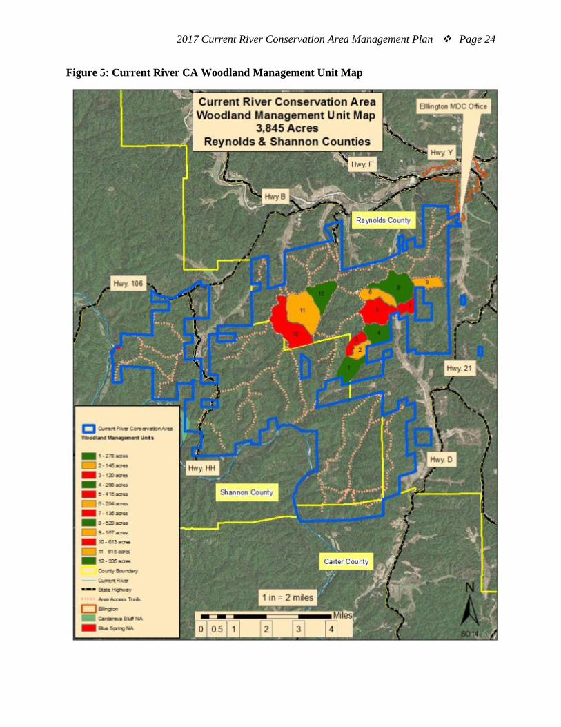
Strategy 1: Restore and maintain glade and woodland communities throughout the area to provide high quality habitat. (Forestry, Wildlife) Strategy 2: Continue to follow the work schedule set forth in the 2016 Current River Conservation Area Woodland Management Plan; 3,743 acres (See Figure 9, Woodland Management Tables). Plan specifies to monitor, and re-evaluate habitat outcomes as necessary. (Forestry, Wildlife)
Management Objective 3: Collaborate with conservation partners on developing and maintaining natural habitat that demonstrates sound natural resource management to the public.
Strategy 1: Monitor and collaborate with the National Park Service on the Booming Shoal prescribed burn to ensure that integrity remains on adjacent Department managed forests and MOFEP study sites. (Resource Science, Forestry)
Management Objective 4: Manage open lands for elk habitat and a suite of other animal species, based on habitat needs identified by the area wildlife management biologist, resource forester, and elk program manager.
Strategy 1: Maintain the area’s open lands in their present condition with a combination of mowing, chemical application, disking, and no-till drilling to establish and maintain legumes, as well as cool- and warm-season grasses. Consult the area’s Elk Restoration Plan as needed. (Forestry, Wildlife)
Management Objective 5: Control invasive species.
Strategy 1: Control invasive species to preserve the native integrity of the forest ecosystem. (Forestry, Wildlife)

2017 Current River Conservation Area Management Plan Page 9
VI. Aquatic Resource Management Considerations
Challenges and Opportunities: 1) Continue to maintain the area’s key wildlife watering holes and Buford Pond. 2) Protect and enhance riparian corridors along Current River, Blue Spring, and
other tributaries of the Current and Black River Watersheds that occur on the area.
Management Objective 1: Continue to maintain the area’s key wildlife watering holes and Buford Pond.
Strategy 1: Maintain fish and associated habitat at Buford Pond by conducting periodic fish population surveys, applying herbicide to control aquatic vegetation, and conducting annual channel catfish stockings. (Fisheries, Wildlife) Strategy 2: Retain viability of fishless ponds and critical wildlife watering holes by removing brush from dams and enhancing amphibian habitat as needed. (Forestry, Fisheries, Wildlife)
Management Objective 2: Protect and enhance riparian corridors along Current River, Blue Spring, and other tributaries of the Current and Black River Watersheds that occur on the area.
Strategy 1: Use best management practices as defined in the Missouri Watershed Protection Practice – 2014 Management Guidelines for Maintaining Forested Watersheds to Protect Streams (Missouri Department of Conservation, 2014) to prevent soil erosion during timber harvests and temporary sale access road construction. (Forestry, Fisheries, Design and Development)
VII. Public Use Management Considerations
Challenges and Opportunities: 1) Provide for hunting and nature viewing opportunities. 2) Provide educational and interpretive opportunities. 3) Build and maintain relationships with the local community. 4) Upgrade Blue Spring Foot Access Trail. The existing trail is frequently inundated
and eroded with floodwater.
Management Objective 1: Provide optimum wildlife viewing opportunities. Strategy 1: Use forest management treatments to enhance wildlife habitat for both game, and non-game animal species. Incorporate aesthetically pleasing viewsheds when opportunities arise, near existing open lands, and maintain open woodlands for viewing wildlife. (Forestry, Wildlife, Protection)
2017 Current River Conservation Area Management Plan Page 10
Management Objective 2: Provide educational and interpretive opportunities. Strategy 1: Explore the possibility of a self-guided elk tour driving route on the area. Develop signage along the route that explains habitat management and associated wildlife for each respective habitat type. (Forestry, Wildlife, Outreach and Education) Strategy 2: Continue to maintain Buford Pond and surrounding area for educational opportunities such as youth fishing clinics. (Forestry, Fisheries) Strategy 3: Engage the public and forest industry on the benefits of forest management by communicating the distinct difference between managed harvests (where the best trees are retained to provide a prescribed habitat condition) as opposed to merchantability harvests (where the biggest and best trees are removed with no regard to the outcome of residual habitat conditions). (Forestry)
Management Objective 3: Build and maintain relationships with the local community. Strategy 1: Communicate the uniqueness of the area to local teachers, students, scout groups, and youth groups. Facilitate the area as a possible destination for ecology classes, school programs, university student field trips, and other workshops. (Forestry, Outreach and Education)
Management Objective 4: Maintain and upgrade the Blue Spring Foot Access Trail. Strategy 1: Continue to explore the feasibility to upgrade the trail so that it is user-friendly and accessible to users with physical disabilities. The trail will soon require re-grading to level and the removal of tree roots. In addition, the installation of soil retaining devices is needed to fill holes that are currently a falling hazard along the river bank. (Forestry, Wildlife) Strategy 2: Pursue the need for an improved foot access trail to Blue Spring with the National Park Service. Consider using the existing service road as a new trail route. This route would require little to no tree/shrub removal, and would reduce trail maintenance and erosion. The new route would place the new trail on ground above the floodplain, yet would still have much the same view, sounds, and character of the existing trail. (Forestry, Wildlife)
VIII. Administrative Considerations
Challenges and Opportunities: 1) Maintain area infrastructure at current levels. 2) Acquisition of land. 3) Maintain boundary lines and area signage. 4) Maintain good relationships with neighbors.
2017 Current River Conservation Area Management Plan Page 11
Management Objective 1: Maintain area infrastructure at current levels. Strategy 1: Maintain area infrastructure in accordance with the Department guidelines and at the currently identified maintenance level. (Forestry, Resource Science, Design and Development)
Management Objective 2: Maintain boundary lines.
Strategy 1: Maintain the area’s 87 miles of painted boundary lines. Each year a different portion of boundary lines will be maintained with blue paint on a four-year rotation. (Forestry) Strategy 2: Reinstall area signage and regulations postings, as needed. (Forestry) Strategy 3: Work to resolve any boundary line disputes, if or when they appear. (Forestry)
Lands Proposed for Acquisition: When available, adjacent land may be considered for acquisition from willing sellers. Tracts that improve area access, provide public use opportunities, contain unique natural communities and/or species of conservation concern, or meet other Department priorities, as identified in the annual Department land acquisition priorities, may be considered.
2017 Current River Conservation Area Management Plan Page 12
MANAGEMENT TIMETABLE
Strategies are considered ongoing unless listed in the following table:
Management Table listed by Fiscal Year (FY), and by Current River (CR) Forest Compartment
FY17 FY18 FY19 FY20 FY21 FY22 FY23 FY24 FY25 FY26
Terrestrial Resources Management Objective 1: Forest Inventory Schedule Strategy 1 CR #3
(1,253 acres)
CR #15 (1,685 acres)
CR #4, #6 (2,125 acres)
CR #22 (1,588 acres)
CR #20 (1,251 acres)
CR #16 (1,075 acres)
CR #13 (1,412 acres)
CR #2 MOFEP2; CR #8 MOFEP3; CR #9 MOFEP4; CR #17 MOFEP5
(4,024 acres)
CR #14 (887
acres)
CR #7, #23 (1,737 acres)
Administrative Considerations Objective 3: Boundary Line Maintenance Strategy 1 22.25
miles 8 miles 36 miles 20.75
miles 22.25 miles
8 miles 36 miles
20.75 miles 22.25 miles
8 miles
2017 Current River Conservation Area Management Plan Page 13
APPENDICES
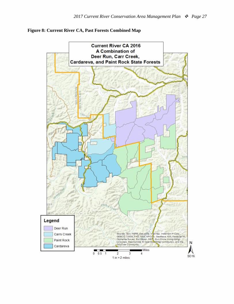
Area Background: Current River Conservation Area (CA) was created by combining Deer Run, Carr’s Creek, Cardareva and Paint Rock State Forests (Figure 8.). The entire area encompasses approximately 28,000 acres. The Current River CA is the home of the Missouri Ozark Forest Ecosystem Project. Missouri Ozark Forest Ecosystem Project is a 100-year project assigned to monitor the long-term effects of different forest management regimes, covering 9,000 acres of Ozark forest and its associated plant and animal life. Deer Run Unit The Deer Run Unit began as a game refuge and state park in 1925 with 6,625 acres. In 1926 the state’s first fire tower was erected to help protect Missouri’s forest land from fire. Many of the area’s roads, ponds, and food plots are the result of the Civilian Conservation Corps whose Camp was located here in 1935. This area helped to re-establish Missouri’s deer population. Deer Run contributed 323 white-tailed deer used to restock other areas of the state at a time when Missouri’s deer herd was badly depleted. The quality of the area’s forest and its abundance of wildlife are the products of sound forest management. Deer Run has been protected from fire and grazing damage longer than any other forested tract in southern Missouri. Some 66 wildlife food plots are seeded, fertilized, and mowed as needed. Water holes have been built in about 40 locations. Buford Pond provides 3 acres of fishing water. Picnic tables are kept at the lake for public use. A nature trail also connects Buford Pond with the Deer Run fire tower. The Deer Run Unit has both archery and firearms shooting range. The unmanned shooting range is ADA-accessible and provides shooters with a 25-, 50- and 100-yard shooting station, in addition to a shotgun range. The archery range is comprised of a “static” range with targets set at 20, 30, 40, and 50 yard distances. Carr Creek Unit The Carr Creek Unit is located in Shannon County in the Current River hills just north of the river. The forest is located halfway between Eminence and Ellington, off Highway 106 and HH. The area was expanded during the early 1990s with the acquisition of former Kerr-McGee Chemical Corporation property. Blue Spring Natural Area is part of this unit. This is the sixth largest spring in Missouri with an average daily flow of 90 million gallons. It is also the deepest spring in Missouri. Native cane, blue mist flower and cardinal flower grow along its banks. Resurrection ferns and mistletoe are found in the trees. This is near the northern limit of the range of these two southern species.
2017 Current River Conservation Area Management Plan Page 14
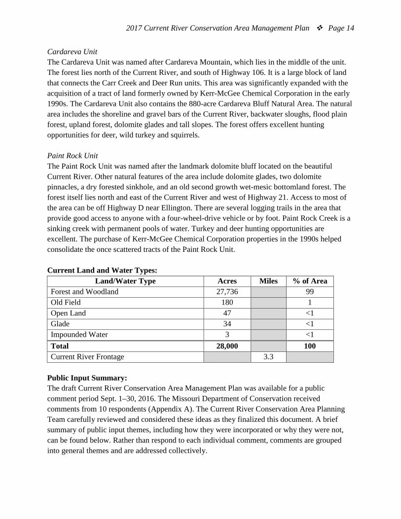
Cardareva Unit The Cardareva Unit was named after Cardareva Mountain, which lies in the middle of the unit. The forest lies north of the Current River, and south of Highway 106. It is a large block of land that connects the Carr Creek and Deer Run units. This area was significantly expanded with the acquisition of a tract of land formerly owned by Kerr-McGee Chemical Corporation in the early 1990s. The Cardareva Unit also contains the 880-acre Cardareva Bluff Natural Area. The natural area includes the shoreline and gravel bars of the Current River, backwater sloughs, flood plain forest, upland forest, dolomite glades and tall slopes. The forest offers excellent hunting opportunities for deer, wild turkey and squirrels. Paint Rock Unit The Paint Rock Unit was named after the landmark dolomite bluff located on the beautiful Current River. Other natural features of the area include dolomite glades, two dolomite pinnacles, a dry forested sinkhole, and an old second growth wet-mesic bottomland forest. The forest itself lies north and east of the Current River and west of Highway 21. Access to most of the area can be off Highway D near Ellington. There are several logging trails in the area that provide good access to anyone with a four-wheel-drive vehicle or by foot. Paint Rock Creek is a sinking creek with permanent pools of water. Turkey and deer hunting opportunities are excellent. The purchase of Kerr-McGee Chemical Corporation properties in the 1990s helped consolidate the once scattered tracts of the Paint Rock Unit. Current Land and Water Types:
Land/Water Type Acres Miles % of Area Forest and Woodland 27,736 99 Old Field 180 1 Open Land 47 <1 Glade 34 <1 Impounded Water 3 <1 Total 28,000 100 Current River Frontage 3.3
Public Input Summary: The draft Current River Conservation Area Management Plan was available for a public comment period Sept. 1–30, 2016. The Missouri Department of Conservation received comments from 10 respondents (Appendix A). The Current River Conservation Area Planning Team carefully reviewed and considered these ideas as they finalized this document. A brief summary of public input themes, including how they were incorporated or why they were not, can be found below. Rather than respond to each individual comment, comments are grouped into general themes and are addressed collectively.
2017 Current River Conservation Area Management Plan Page 15
Department responses to themes and issues identified through the Current River Conservation Area Management Plan public comment period. Terrestrial Resource Management Supports elk reintroduction to Current River CA. Elk reintroduction has been carried out on Peck Ranch CA approximately 4 miles southwest of Current River CA. Ten to 25 percent of the current elk population resides on Current River CA at any given time of the year. The number of elk residing on Current River CA has slowly risen over the last few years, and this trend will likely continue. Active management is occurring on 3,743 acres of woodlands and 150 acres of open land management to retain elk on the area. Traditional forest thinning occurs on the area on a scheduled basis also. Elk habitat management is addressed on Page 8 (Terrestrial Management Objective 4). Suggests increasing use of prescribed fire to improve wildlife habitat south of Paint Rock Road. There are 3,743 acres of woodlands that are actively managed at Current River CA. The Current River CA Woodland Complex starts within a few feet of the north side of Paint Rock Road and runs north through the center of the area. The Current River CA Woodland Plan has area staff preparing for four prescribed burns annually with burn preparation and line renewal on approximately 1,247 acres each year. From a logistics standpoint, the existing woodland is set up well, using area trails for fire lines, but the area south of Paint Rock Road is not well suited for efficient use of staff time or for what would be considered landscape type burns with its highly dissected land type. Area managers are aware of some small dolomite glade outcrops and will be open for their management, should staff time and other priorities make this a doable option. Concern that invasive species (shield leaf, autumn olive) are not being controlled. Suggests addressing feral hogs in this plan. Invasive exotic eradication is being actively pursued based on area manager’s priorities and input from the natural history biologist. Sericea lespedeza, autumn olive, and bush honeysuckle eradications have been part of the annual budget, work plan, and accomplishments for many years now. In the summer of 2016, feral hog activity was discovered at Current River CA. Area staff follow the direction set forth by the Southeast Region’s hog eradication coordinator to guide feral hog control. Controlling invasive species is mentioned on Page 9 (Terrestrial Management Objective 5). Opposes conducting timber sales during wet conditions. Department staff closely monitors timber harvesting contracts and activities to prevent resource damage during wet conditions. Timber sale best management practices, sale administration, and

2017 Current River Conservation Area Management Plan Page 16
subsequent audits on closed timber sales prohibit harvesting during wet periods, when there is potential for long-term disturbance lasting more than one to three years. Suggests opening fields to improve wildlife habitat in lower Carr Creek area and Banker Hollow. There are currently 150 acres of active open land management across Current River CA. In 2012, elk restoration planning efforts identified feasible areas for open land management across Current River CA. Additional clearing would likely be on less than desirable soils with limited capabilities for open land management due to soil fertility limitations and erosion potential on slopes. In addition, the Department is cooperatively working with landowners to provide elk friendly open land habitats in the Lower Carr Creek Region. Aquatic Resource Management Opposes motorized boat access/use on the Current River. The National Park Service (Ozark National Scenic Riverways) is responsible for management of the Current River. The Department manages a portion of the land in the Current River Watershed, but does not regulate motorized boat usage on the Current River. Appreciates Current River. Concerned that floating groups have degraded the river. The National Park Service (Ozark National Scenic Riverways) is responsible for management of the Current River. One interesting note is that the portion of Current River adjacent to Current River CA likely has lower float usage than most other areas of the river due to its remoteness and limited access opportunities. Public Use Management Suggests expanding hiking trails. Current River CA has an abundance of primary and secondary area management roads (86 miles) for area users to enjoy which generally range from primary, secondary (gated) and retired timber harvest trails. The public is encouraged to hike trails and enjoy the area’s serenity. There are abundant hiking opportunities across the area, especially when considering additional long-term maintenance needs required when adding additional trail infrastructure. Suggests adding equestrian trails. Current River CA roads and trails are open for equestrian use (organized groups with 10 or more people need a special permit). Many of the 86 miles of Current River CA roads tie into existing Ozark National Scenic Riverways Roads that also provide equestrian use opportunities. Additional equestrian use trails and maintenance accompanying responsibilities are not feasible given equestrian opportunities that exist at Current River CA and surrounding areas currently.
2017 Current River Conservation Area Management Plan Page 17
Suggests building a small museum to provide information about the area’s rich history. The Department has an existing museum of this type at Twin Pines Conservation Education Center in Winona. In addition, there is a Reynolds County Museum in Ellington that has an outstanding collection of local history and artifacts. Adding an additional museum would likely be cost prohibitive and detract from other museums that have staff on hand to manage this type of facility. Administrative Considerations Requests more details about plans to collaborate with adjacent private landowners. Private land assistance is offered to all landowners across the state as well as within the elk zone. The public is invited to contact their local Conservation Department office for more information on private land programs. Concerned about negative long-term effects from an oil, coal, and mineral lease. The M.A. O’Brien easements noted on Page 6 of the plan were established at a time that was likely before Department ownership, and lie in the general area of Paint Rock Creek. Although concerning to managers, no large-scale exploitation has occurred resulting from the easements to date. The easements are legally bound, and were part of the conditions of purchase; it is very unlikely any exploitation of resources will occur at this time. Suggests adding an easement map. Adding an easement map to the plan is possible, but not a priority; especially when considering the resources involved in researching the records of three counties since the area’s purchase in 1925. Management of powerline right of ways and other structures is addressed as part of the area forest compartment inventory process. Suggests adding a road map and including information about who is allowed to use each road and if there are plans to close these roads. The area map listed under Figure 1 includes primary numbered area roads, many of which are all-weather roads, which remain open year around. Some of the secondary roads are numbered for reference, but are used less and gated intermittently, depending on weather and management activity. Other trails across the area are opened temporarily for management access, and when management projects are completed these trails incorporate modern best management practices to maintain natural resource integrity. Due to the intermittent nature of road and trail use for management activity, the current area map and Atlas is adequate to display area trails. Suggests adding more details to this area plan (cost of implementing plan, natural disaster plans, post-timber harvest protocols, timber management guidelines, area regulations,
2017 Current River Conservation Area Management Plan Page 18
facility maintenance and inspections, improved maps, staffing needs, contingency plans, planning team members, etc.). Missouri Department of Conservation area management plans are strategic-level plans that guide management at a broad level. These plans document strategies for natural resource management and public use on conservation areas. Conservation area plans also help communicate an area’s purpose and management direction to staff and interested citizens. References: Missouri Department of Conservation. (1999). Current River Conservation Area plan. Jefferson City, MO: Missouri Department of Conservation. Missouri Department of Conservation. (2009). Watershed and stream management guidelines for lands and waters managed by Missouri Department of Conservation. Jefferson City, MO: Missouri Department of Conservation. Missouri Department of Conservation. (2010). Elk restoration in Missouri. Jefferson City, MO: Missouri. Missouri Department of Conservation. (2014). Missouri watershed protection practice recommended practices for Missouri forests: 2014 management guidelines for maintaining forested watersheds to protect streams. Jefferson City, MO: Conservation Commission of the State of Missouri. Missouri Department of Conservation. (2016). Draft Current River Conservation Area
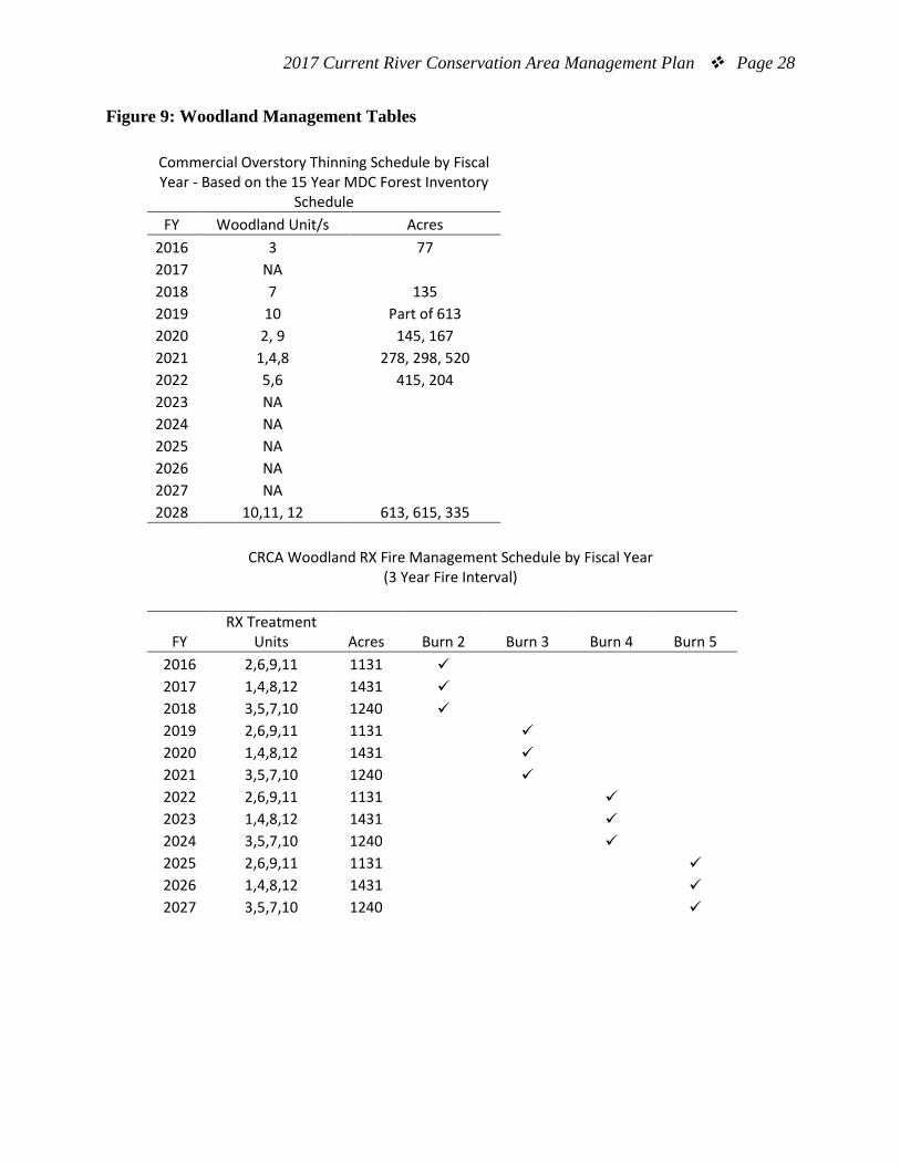
Woodland Management Plan. Nigh, T.A. & Schroeder, W.A. (2002). Atlas of Missouri ecoregions. Missouri Department of Conservation. Maps: Figure 1: Area Map Figure 2: Aerial Map Figure 3: Compartment Map Figure 4: Missouri Ozark Forest Ecosystem Project Site Map Figure 5: Woodland Management Unit Figure 6: Land Cover Map Figure 7: Radio Relay Tower and Fire Tower Location Map Figure 8: Current River CA, Past Forests Combined Map Figure 9: Woodland Management Tables

2017 Current River Conservation Area Management Plan Page 19
Additional Appendices: Appendix A. Current River Conservation Area Management Plan Public Comments
2017 Current River Conservation Area Management Plan Page 20
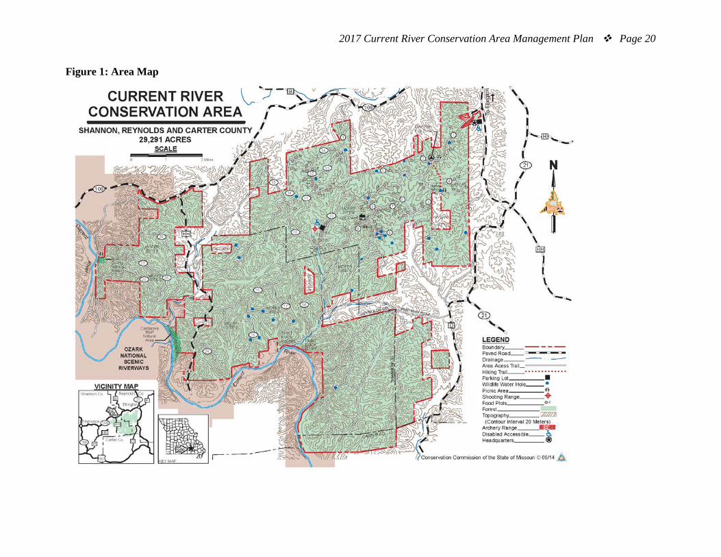
Figure 1: Area Map
2017 Current River Conservation Area Management Plan Page 21
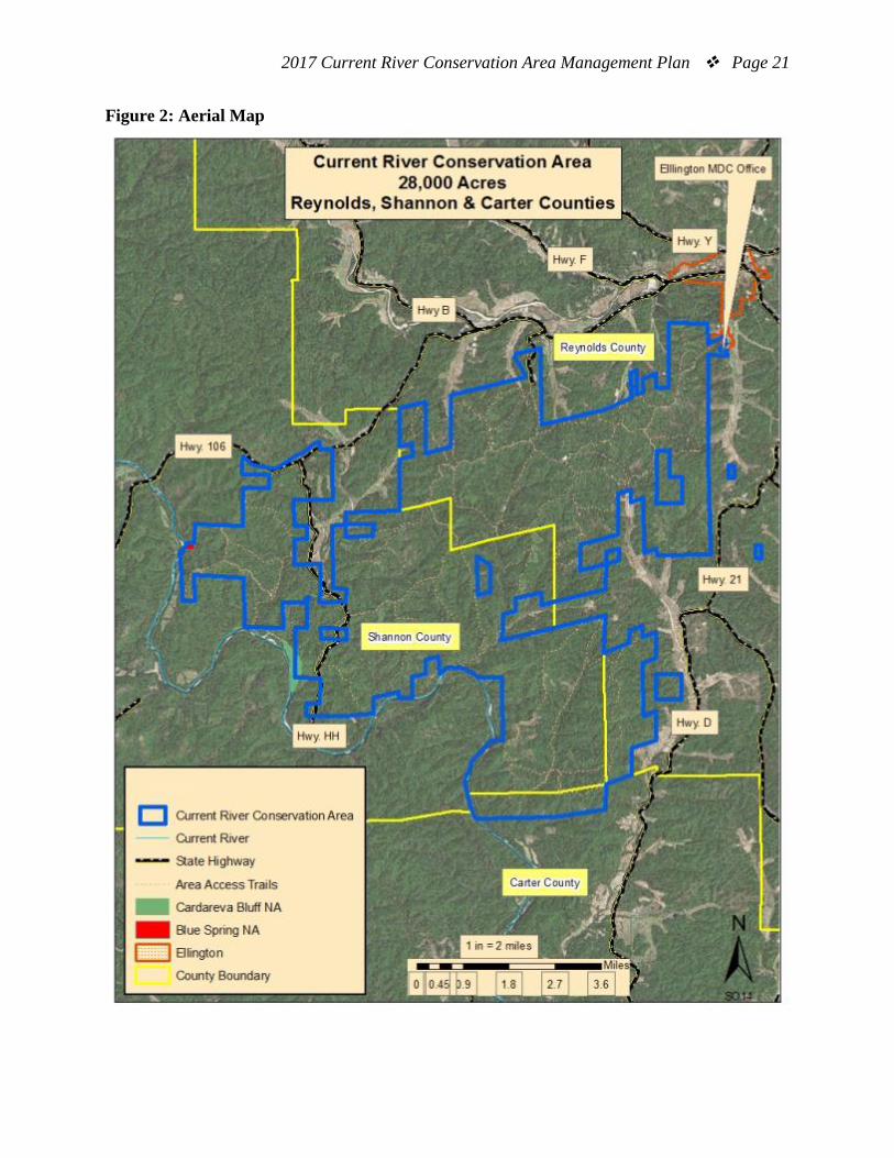
Figure 2: Aerial Map
2017 Current River Conservation Area Management Plan Page 22
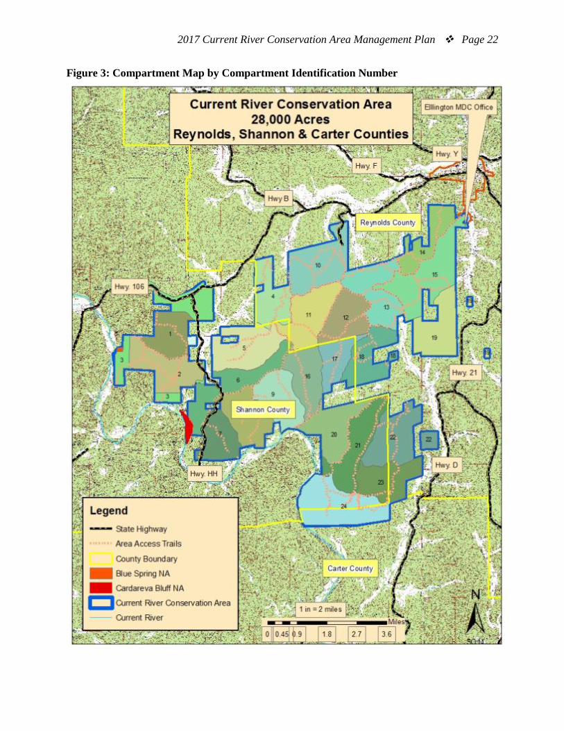
Figure 3: Compartment Map by Compartment Identification Number
2017 Current River Conservation Area Management Plan Page 23
Figure 4: Current River CA Missouri Ozark Forest Ecosystem Project Site Map
2017 Current River Conservation Area Management Plan Page 24
Figure 5: Current River CA Woodland Management Unit Map
2017 Current River Conservation Area Management Plan Page 25
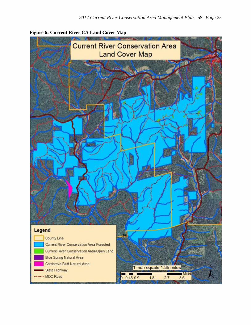
Figure 6: Current River CA Land Cover Map
2017 Current River Conservation Area Management Plan Page 26
Figure 7: Radio Relay Tower and Adjacent Fire Tower Location Map
2017 Current River Conservation Area Management Plan Page 27
Figure 8: Current River CA, Past Forests Combined Map
2017 Current River Conservation Area Management Plan Page 28
Figure 9: Woodland Management Tables
Commercial Overstory Thinning Schedule by Fiscal Year - Based on the 15 Year MDC Forest Inventory
Schedule FY Woodland Unit/s Acres
2016 3 77 2017 NA
2018 7 135 2019 10 Part of 613 2020 2, 9 145, 167 2021 1,4,8 278, 298, 520 2022 5,6 415, 204 2023 NA
2024 NA 2025 NA 2026 NA 2027 NA 2028 10,11, 12 613, 615, 335
CRCA Woodland RX Fire Management Schedule by Fiscal Year (3 Year Fire Interval)
FY RX Treatment
Units Acres Burn 2 Burn 3 Burn 4 Burn 5 2016 2,6,9,11 1131
2017 1,4,8,12 1431 2018 3,5,7,10 1240 2019 2,6,9,11 1131
2020 1,4,8,12 1431
2021 3,5,7,10 1240
2022 2,6,9,11 1131
2023 1,4,8,12 1431
2024 3,5,7,10 1240
2025 2,6,9,11 1131
2026 1,4,8,12 1431
2027 3,5,7,10 1240
2017 Current River Conservation Area Management Plan Page 29
Appendix A. Current River Conservation Area Management Plan Public Comments Comments received during public comment period (Sept. 1-30, 2016): As long as the current plans did not make way for additional put-in spots to, or leading to the Current River that motorized boats could access, I think this would be excellent. Over the last 20 years, I've seen the land around the river, and the river itself increasingly suffer sue to the introduction of motor boats and the day-goers that use them. They have made paddling certain parts of the river quite a challange and the people who use those motorized craft seem to have little concern for the preservation of the area. Need a longer hiking trail. Consider adding more hiking trails and adding equestrian trails - avoiding the most sensitive areas while allowing limited access to natural water features. It can be done. I think the plan to reintroduce an elk herd is great. But, I'm wondering about he section stating M.A. Obrien having rights and privileges to execute leases for oil, gas, coal and minerals. Is there any worry this will cause negative long-term effects on the area? All I ask it that you don't mess it up! I've been floating the upper sections of Current River since the early 80's and I believe it is just fine the way it is. My wife and I moved to the Salem area because of our love of the Current River after I retired in 1996 and we'd like for the river to stay just like we found it. I believe that, if it ain't broke, don't fix it! If something happens to change the river for the worse, we'll have no reason to stay in the area. So please don't mess anything up. And thanks for keeping it as lovely as it was when first we floated it back in 1983. Keep up the great work that you've been doing. I'm a 62 year old outdoorsman and adventurer who has floated and camped on just about every river /stream south of I-70. (Much thanks to Oz Hawksley's book). I've been an outdoorsman since before high school. Very much a fan of MDC and most of your efforts over the years. I have cooperated with many projects over the years such as Missouri Stream Team, concerned citizen for Pettis and Benton Counties, etc. Also a member of the Cave Research Foundation for several years, mapping and doing biological inventory in Powder Mill Cave, mostly Hell Hole section. I have not floated the Current in several years because of lack of control of invasive species to preserve the native integrity of the ecosystem. The species to which I refer is the drunken tubers and general density of people. Buildings have maximum occupancy regulations, so should the Current, Jacks Fork, Gasconade; all of our popular float streams. Can't imagine how this would be done, obviously the local outfitters and general economy of the areas will not agree to this type of regulation. I can imagine how out of staters who used vacation time, money, etc. , to float the Current because of its reputation as an Ozark stream, feel after battling tubers and the mass of humanity while there. Not exactly the wilderness experience they were hoping for, and were led to believe existed.

2017 Current River Conservation Area Management Plan Page 30
I miss floating the Current, camping on the gravel bars, catching Smallmouth bass. Throw a lure in the stream now, more likely to snag a tuber or beer can. Aesthetics along the river corridor? In my opinion, not for many years For many years, my husband and I enjoyed canoeing the Current from Baptist to Two Rivers. We are in favor of any management plan and regulations that preserve the pristine nature of this valuable watershed. We think banning motorized boats would be ideal on this stretch, but if this is not possible, then only very small horsepower above Two Rivers. There are so few rivers left in the world where one can experience Nature without the noise and pollution of motors!!!! Limiting access to the river by roads through the forest is also important. In all, this area should be kept as pristine as possible. There are just not many areas left like this, and there are untold numbers of developed areas. Let's do the right thing! I have a second residence near Fredericktown, Mo. My wife and I float the Current River frequently over the past 20 years. We belive that the Current River and Jacks Fork water system are the best keep secrets in the mid-west. It is our hope that those two rivers from there orgin to the junction of Two Rivers and the Current River would always be motor-boat / or John-boat free! Power boats should be limited to the Current River BELOW the confluence of the Jack Forks and Current River. The Strategic Direction mentions collaboration with adjacent private landowners, but there is no mention of how that will be accomplished in the plan. I would like to see more prescribed fire to open up the forest and improve wildlife habitat, south of Paint Rock Road. DNAP has a old replica of an older paddleboat that was used on Current River. I would like to see a small museum built to house the boat and provide information on the river and surrounding area. Our river is such an asset and our local Stream Team is helping to draw attention to the fact that people use it as a dumping ground. Perhaps a place that highlights the proud rich history in our area would give pause to those who unthinkingly destroy it. Comments for MDC area plan – Current River Conservation Area The following are my comments and suggestions based upon the request for public input for the future updating of the Current River Conservation area plan for the period 2017-2026. What are the manpower needs to accomplish the major provisions of this plan? How much is it going to cost and how much staff and specialized equipment might be needed to accomplish the identified objectives and goals? Should not a plan also address some major problem that might occur? Such as that regarding timber removal after a bad wildfire or wind throw? What about addressing after harvesting? There should be something such as monitoring and meditations for soil erosion, skid trails rehab, monitoring and replanting in case of poor natural regeneration in an area? The plan addresses noxious weed control, however, problems have been seen and I have notified your office of problems several years ago through the website. So is action really going to be performed for this issue? Regarding Shield Leaf in several of the wildlife drinking ponds and a population of
2017 Current River Conservation Area Management Plan Page 31
Autumn Oliver off MDC 15 near HH. Plants are expanding with no controls taken or actions put into place. If you are not dealing with it based on an identified issue in the old plan, why is the new plan going to be any different? The maps within the plan need to show zones of exclusions from harvest and other restrictive activities. However, there is no reason to show what feature(s) has required the exclusion, but the area or zone should be shown on these planning maps in some color so restrictions are followed for all those coming after those who are already aware of the current restriction. The basic standards and guidelines for operations need to be presented in your planning document. Plans determine many standard and guidelines and there are many instances of standards and guides, which affect provisions of your plan. For they effect each other. For instance, a guideline has been established on how steep a slope for which a harvest can occur. This will have a cause to affect an area to be treated. Probably limit the amount of acreage in a proposed sale area to be harvested? Another guideline or standard, which I would like to see followed better is for a requirement for soil moisture content to limit damage from using heavy harvest equipment on the soil. So far timber sales (both on private and on MDC lands) that I have seen in this area have taken place no matter how wet the soil and damage doesn’t appear to matter. It is a BMP and a standard and guide for the managers, but not being followed by harvesters or enforced properly with an MDC harvest inspector around sales here. Damage to private land is the business of the private owner, but I figure as a tax payer in Missouri, that I own MDC lands in part. Heavy equipment usage with harvests on wet soils need to stop. What about basic rules and regulations of the area? Shouldn’t some of them be addressed within the plan also? Sure the Conservation Guides addresses wildlife and hunting rules, but what about rural camping? Allowed? Where? What about ATV use. Allowed? Where? What about off road vehicles? Open campfires, cutting downed wood, target practicing, etc. Allowed? Where? You get the idea. Some basic rules, regulations and restrictions should be addressed within an area planning document also and available for public comment. Either pro or con. Justifications for the regulations? Your plan identifies easements within the plan, but there are many permanent uses that do not have easements. Black River Electric Company has electrical lines through MDC lands in the Current River Conservation Area that are not identified within this document. Shouldn’t they be identified? Their location might have an impact on work in the area. What about other roads found in the area? I know of roads that belong to MDC and used by MDC and harvesters, but they are not identified on the road overlay map. Shouldn’t they be identified better? They don’t need a number, but are still used by the public and occasionally by MDC personnel and even timber harvesters. The plan needs to address non-system roads and how do you plan on closing them? Or do you? Even if not identified as a numbered MDC road, can I still use them with a truck or ATV? How would I know that or not? A plan also needs to address the maintenance of facilities. I see nothing of any requirement being addressed with the maintenance or repair of any of facilities found in the area. Not only should there be an inventory (which appears provided), there should be identified maintenance needs, and perhaps most facilities need to have identified maintenance needs and even deferred maintenance in out-year planning. Part of this is also safety for the housing, offices, and public use facilities. How often

2017 Current River Conservation Area Management Plan Page 32
are they inspected? How often are the steps and the rest of the lookout tower inspected? Is the dam inspected at Buford Pond? Or does it even have a dam? Are MDC road gates and barriers checked annually for reflective markers to keep the public from running into them after dark? Documentation? I’d rather my tax dollars are used to support your agency and not pay structures need to be programmed in every year and identified in this plan. A plan also needs to address a future condition or goal that is trying to be achieved by an action within the plan. While there is a plan to do something, the plan needs to address the whys something is being done. i.e. burning an area to promote warm season grass growth as an enhancement to wildlife, or timber removal to change dominate species to Short-leaf Pine, or a controlled burn to remove and recycle timber slash, etc. You have broad objectives, but nothing much of detail. The maps are not detailed enough for the proper planning. Yet, they are the most important tool in planning. Shouldn’t they be made correctly? Some are just bad photocopies or imports into the plan from other sources. Maps and the details provided are most important, but as presented in this plan, they appear to just be provided as an afterthought. Perhaps the Conservation Department needs to hire a GIS Specialist and have them produce much better maps for each area’s plans? I see that there are several errors on the maps that you all are using for the base. Not all that important to the plan, but shouldn’t there be a way for local MDC offices or the public to input for corrections to these public maps? Planning for area management also requires plans for funding. Funds are needed for everything. Timber layout, marking and cruising, field inspections, harvest inspection, road and skid trail layout, inspections, and perhaps restoration. Fire suppression takes workers away from all duties, shouldn’t funding be addressed here? What about costs of boundary marking? The cost of a vehicle, people, and paint. Lots of MDC roads. Their maintenance isn’t free or cheap. What about the cost to monitor, address, and apply herbicide to noxious weeds to keep them from spreading. That’s not free or cheap either. How about building maintenance and repairs? Buildings here in Missouri need constant repairs. Does your office, equipment bays, shop, storage areas, or housing need any improvements? Shouldn’t that also be addressed in the plan for funding? What about vandalism? I know that all resource agencies have some. It might be hard to plan, but maybe a statement of annual cost estimates should be provided in the plan. Planning for each area’s funding requirement also allows managers to seek out and/or approve dollars that allow the requirements and details of the plan to be acted upon. This plan does not detail any costs at all. And what about manpower needs? Funding, as a part of this plan, will also determine staffing needs, equipment requirements/needs and priorities. I understand that the Ellington office also has oversight on a couple of other MDC areas, beside the Current River CA, so funding also needs to be addressed within those other area plans. Too much work, too little staff, poor tools and equipment, and to little funds. Where are the real costs of doing business and keeping things going? A timber sale also has a fiscal benefit to the harvester, their employees and the community as a whole. This should be addressed in the plan. While the local office might not have a lot of control on the receipts, this should still be identified. i.e. the receipts from each sale provides to: the state of Missouri, MDC, counties as “in-lieu of taxes,” etc. This plan also needs to show where the incoming and outgoing dollars goes. As an example;
2017 Current River Conservation Area Management Plan Page 33
how can local MDC managers ask for more dollars in support of their program where it’s costs say $10.00 to plan, layout, mark, advertise, hold a pre-work meeting, approve road and skid trails, and conduct a harvest inspection, when the timber receipts from the sale returns only a $1.00 back to MDC (and then half of that is skimmed off the top by MDC managers in Jefferson City for other priority projects before the remains are returned to the local office”? A planning document needs to contain all estimates of costs. For it also becomes a cost analysis. One doesn’t paint a house if they can’t figure out the costs to do that. How much does a sale cost? How do I, as a taxpayer, know that I am not subsidizing a timber harvest? Even if each sale is offered as a lost, have the goals of the timber management in that area been achieved? Plans for harvest are addressed with timeframes (years) of when the area or compartment will be entered for treatment(s). But you fail to state or list or show any modifiers. Old time foresters and silvaculturalists were trained that they could re-enter an area to conduct a harvest again after so many years. This was quantified by visits to an area after harvest and using various variables, such as the site index for growth potential. However, currently with major climatic variations, there may be very limited growth for an area to be re-harvested to maintain sustainable yield and growth. How “locked in” is the plan to year(s) for harvesting/treatment/etc? It may not be possible to keep a harvest rotational cycle of say 20 years now and still expect to maintain a sustained yield of timber. Some variation and/or deviation needs to be addressed in a planning document. It doesn’t appear that your plan provides changes of the year of harvest or exception for poor growth performance of the timber. Why not? For the purpose of a plan is also to figure out contingencies. Who composed the plan. Was it MDC employees or was this document produced by an external contractor? Was it produced locally or did it come off of someone’s desk in Jefferson City? How does one know? Those who produced it – were whom? What is their background or job title? Were any specialists asked to review or provide consultation on the plan? Identify. All kinds of mistakes are present on the inventory of non-MDC roads found to cut and/or transverse across the Current River Conservation Area. Reference map: The Conservation land of the Lower Ozarks, c.2010. Several county roads need to be added to your inventory and HH-555 – a Shannon County Road, it appears to me that this road is all in the NPS area? You also failed to address anything regarding the extensive network of MDC designated numbered roads in the area. Don’t these have to be maintained? How often and at what costs? Does your office ever replace signs, gates, barriers, or reflectors? When needed or schedule? Inventory of each MDC designated road (with length and number) needs to be documented. Do trees have to be cut out of the road occasionally? Do any culverts have to be cleaned out? It all takes time, staff and needs to be a part of the planning process. Also MDC has to be able to make sure that enough use is present to continue to maintain them and then fund the necessary ongoing maintenance. A plan. There are many documents (10 count) referenced in the plan, but the plan provides too much generalization with no detail and just notes of those other documents. Too many references are given to many different documents that are listed as an accessory to this planning document. Documents that the reader doesn’t have access to. A good plan needs to be all-encompassing in detail and while one can certainly reference other documents, the plan
2017 Current River Conservation Area Management Plan Page 34
should provide a short paragraph or summary of the work referenced; i.e. the “Elk Restoration plan allows for the ongoing maintenance of old fields and even possible conversions of small overgrown woodlands areas to warm season or cool season grasses or a combination of both. This will be achieved through timber and brush removal, disking, and controlled burns, or a combination of all methods. The goal being to provide enhanced habitat and food stock for the species.” What about fire suppression and fire support in/of the area? This needs to also be addressed in a planning document. It happens and when it does it can really take a toll on staff, funding, and project work. Yet, the plan doesn’t address anything at all. What about costs? How about a plan for controlled burns? Are you ever going to do any in this area? Where, when, why, and at what costs for personnel and equipment? Should timber be damaged enough in a wildfire, what about salvage sales? I see nothing in the plan regarding regeneration or field recon. Isn’t that one of the main goals of a timber harvest? To open up a closed canopy and provide for natural reseeding and enhanced growth. Shouldn’t one of the goals include field visits to a harvested area? And what about general field reconnaissance into an area before cutting? Do specialists walk the area to be treated and check adjacent boundaries looking for karst features, or cultural resources, or wildlife habitat? Does the area only get a visit by layout people and markers who might see something and might say something? Shouldn’t the plan address requirements to field survey an area before treatment and afterwards conduct and document area monitoring? There is an identified need to address what the procedure is when your layout people, timber markers, or other specialists conducting field work or receiving information from a timber harvest operator or their employees who discovers a significant item of either a natural or cultural feature when it has been discovered. Regarding wildlife needs and problems. Poor address in the plan. There are several fields by me that are really overgrown. MDC use to maintain, but not in many years now. Why not? Open fields are good for wildlife – including Elk. Put in a good perimeter line around them and burn them open on a scheduled basis. These are in lower Carr Creek and Banker Hollow. Perhaps other locations also have a need? Not identified in plan, nor action needs in the plan. And nothing addressed with the hog problem. Probably coming into this area, if not already here. Staff and all the associated costs for control needs to be addressed in the plan just in case. For it will take employees away from other duties. Of course MDC hasn’t dealt with noxious invasive plants in this area, so I have to wonder how well MDC will deal with an invasive mammal species. In Summary, I have to say that this plan is grossly inadequate and leaves me wondering why your office has even wasted the time to provide such a document? It appears to be little more than a recap of an older plan, which I have from the early 1990’s. Nothing has really changed in the modern plan, except the dates and timelines. Most items for action in the early plan still not addressed acted upon after 30 years. Why not? Why should I have any faith in proposed actions in this new plan? I also hoped that after 30 years, the planning process of MDC would have improved greatly. At least in production of this type of document. This plan, to me, isn’t a plan at all, but simply a guiding document of what needs to be done in the future. Just a quick summary being forced upon staff to produce. I found very little depth or scope of the work needed to be performed and accomplished. I found
2017 Current River Conservation Area Management Plan Page 35
no plan regarding costs, funds, or staff needed to accomplished those goals and objectives. Since it appears that it has been at least 10 years since the last plan was produced, I would have thought in that decade of lapse, your office could have produced a better document? For it is just a poor effort for a driving document for a 10 year time spam. Rather disappointing in its detail. This document is worthy of the production from a first-year college forestry student, but not much better. Yet, I am aware the Missouri Department of Conservation is composed of many, very well-educated professional foresters and other specialists. What happened? It is my understanding that, unlike federal agencies, MDC has neither requirements, nor obligations to even make planning documents available to the general public unless requested? Further, that the state has no requirement to address any of my comments or remarks. But, I do thank you for letting the neighbors know of this plan’s production and to ask for input. I hope that my comments are considered constructive and maybe in the next ten years, the future MDC staff or a private contractor can spend a little bit more time to produce an improved product? At least you did meet one of the management objectives of this new plan by trying to maintain a good working relationship with neighbors. Respectfully submitted,