cruise plan - rv g.o. sars, june-july 2004 mar-eco cruise ... · platform instruments, sesors, and...
TRANSCRIPT
1
Cruise Plan - RV G.O. Sars, June-July 2004
MAR-ECO CRUISE TO THE MID-ATLANTIC RIDGE
ICELAND-AZORES
Version 5
O.A. Bergstad, Olav Rune Godø 24 May 2004.
2
Table of Contents LEG 1. RV G.O. Sars, survey of the Mid-Atlantic Ridge from Iceland to the Azores...................................................................................................................................3
1 Time frame, leadership, aims ....................................................................................................3 2 Sampling equipment..................................................................................................................3 3 Work content .............................................................................................................................5
3.1 Continuous acoustic mapping ............................................................................................5 3.2 Station sampling.................................................................................................................5
Table 2. List of proposed stations. Leg1 ..........................................................................................7 3 Participation ..............................................................................................................................9 4 Time budget.............................................................................................................................10
LEG 2. RV G. O. Sars, operating in target areas in collaboration with Norwegian longliner MS Loran ....................................................................................11
1 Aims, strategy and scientific crew ..........................................................................................11 1.1 Time frame, leadership, aims ...........................................................................................11 1.2 Sampling equipment.........................................................................................................12 1.3 Work content ....................................................................................................................13 1.4 Participation .....................................................................................................................14
2 Schedule ..................................................................................................................................15 3 Study design in target areas.....................................................................................................15
3.1 Southern box ....................................................................................................................15 3.2 Middle box .......................................................................................................................17
4 Time budget.............................................................................................................................20
Please see WWW.MAR-ECO.NO for overall MAR-ECO Science Plan, component project descriptions, and earlier draft plans for the RV G.O. Sars cruise 2004.

3
LEG 1. RV G.O. Sars, survey of the Mid-Atlantic Ridge from Iceland to the Azores 1 Time frame, leadership, aims Time: 5 June-3 July 2004. Schedule RV G.O. Sars:
Departure Bergen: 5 June a.m. (Mobilisation on 4 June). Arrival Horta: 3 July a.m.
PI: Olav Rune Godø, Institute of Marine Research, Norway Tasks and priorities:
• To produce an overall quantitative assessment of the plankton and nekton associated with the Mid-Atlantic Ridge.
• To collect biological samples in support of the Mar-Eco component projects Z1, Z4, PN1, PN2 and PN3.
• Add effort at opportunity for cetacean and bird studies (PN3). • Launch moorings and rigs for long-term physical and acoustic data logging. (3 moorings,
1 long-term lander (DOBO). 2 Sampling equipment Sampling equipment for continuous observations (during steaming)
• Echosounders with vessel-mounted transducer transmitting at 5 frequencies on same acoustic axis
• Surface plankton recorder and chlorophyll recorder
Sampling equipment for point sampling (data collection at selected stations) • Mid-water trawls and nets of different sizes and designs (large pelagic trawl,
macrozooplankton trawl, Multinet) • ROV, landers, and lowered camera systems (exceptional situations). • Echosounders of various designs/characteristics (hull- and keel-mounted, and towed
vehicle transducers). • CTD and UVP • See G.O. Sars website for permanent instrumentation and facilities.
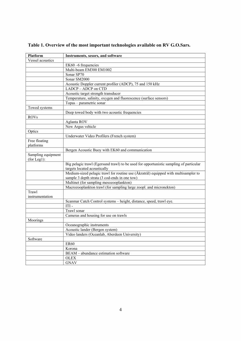
A list of technologies available on GO Sars is given in Table 1.
4
Table 1. Overview of the most important technologies available on RV G.O.Sars. Platform Instruments, sesors, and software Vessel acoustics EK60 –6 frequencies Multi-beam EM300 EM1002 Sonar SP70 Sonar SM2000 Acoustic Doppler current profiler (ADCP), 75 and 150 kHz LADCP – ADCP on CTD Acoustic target strength transducer Temperature, salinity, oxygen and fluorescence (surface sensors) Topas – parametric sonar Towed systems Deep towed body with two acoustic frequencies ROVs Aglanta ROV New Argus vehicle Optics Underwater Video Profilers (French system) Free floating platforms
Bergen Acoustic Buoy with EK60 and communication Sampling equipment (for Leg1):
Big pelagic trawl (Egersund trawl) to be used for opportunistic sampling of particular targets located acoustically
Medium-sized pelagic trawl for routine use (Åkratrål) equipped with multisampler to sample 3 depth strata (3 cod-ends in one tow)
Multinet (for sampling mesozooplankton) Macrozooplankton trawl (for sampling large zoopl. and micronekton) Trawl instrumentation
Scanmar Catch Control systems – height, distance, speed, trawl eye. ITI - Trawl sonar Cameras and housing for use on trawls Moorings Oceanographic instruments Acoustic lander (Bergen system) Video landers (Oceanlab, Aberdeen University) Software ER60 Korona BEAM – abundance estimation software OLEX GNAV
5
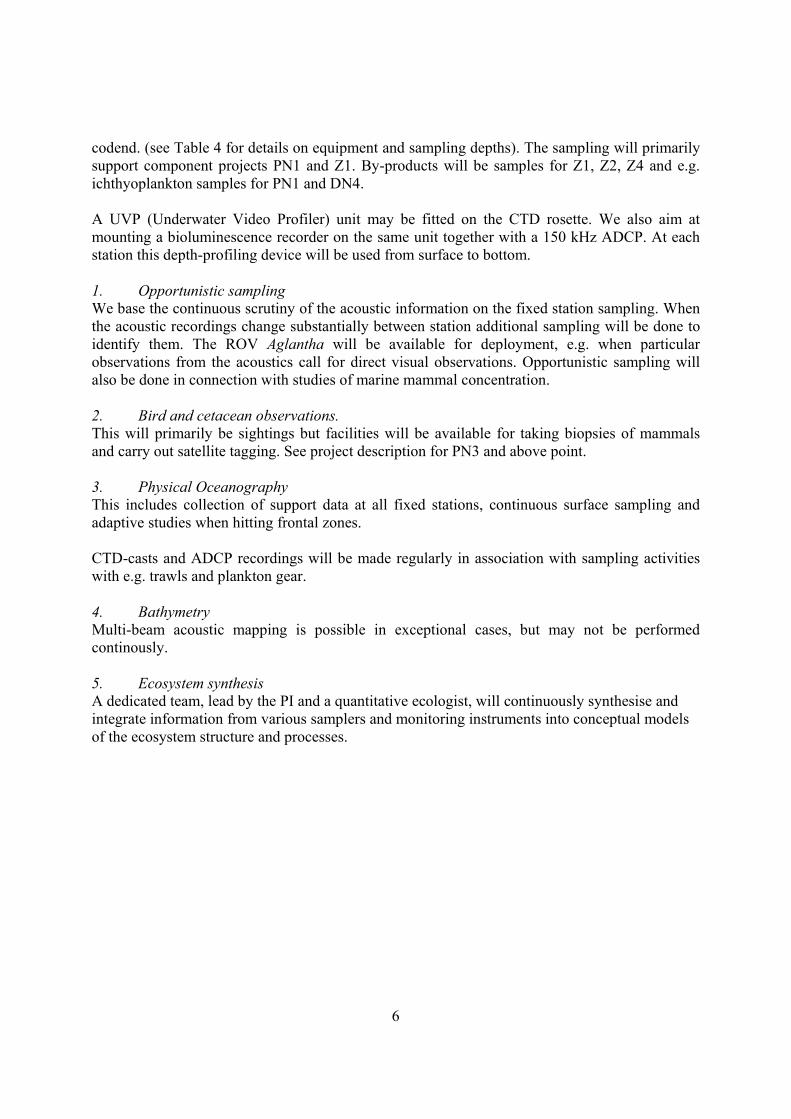
3 Work content The fixed stations, and sites for deployment of moorings and lander, are shown on Figure 1 and 2. Exact positions for each station are given in Table 2 The planned work consists of:
1. Continuous acoustic mapping. o Pelagic nekton o Zooplankton
2. Station sampling with: o trawls o plankton nets o acoustics/optics
3. Opportunistic sampling (by large midwater trawl and e.g. ROV) 4. Bird and cetacean studies.
o Sighting, and if possible tagging. o Passive acoustics
5. Physical oceanography o CTD, ADCP
6. Bathymetry mapping. 7. Deployment of long-term moorings and DOBO lander. 8. Conceptual ecosystem modelling.
3.1 Continuous acoustic mapping General strategy: Combination of hydroacoustic mapping, depth-stratified sampling at fixed stations, and opportunistic sampling for identification of acoustic recordings in order to gain an overall grand assessment and description of the distribution and abundance of major macro-and megafauna species and communities associated with the MAR in the depth interval 0-3000m. The G.O.Sars will follow a pre-set cruise track and sample with the available trawls, nets and acoustic devices on fixed pre-determined stations. Hydroacoustic data from five frequencies (18, 38, 120, 200 and 400 kHz) will be logged continuously. The information from sampling on the fixed stations, and multi-frequency analysis of the acoustic data will be used to distribute the biomass on species or group of species. Sampling resolution of the acoustic data will vary to some extent with frequency, but all data will be scrutinised and stored in cells of 1 n.mile horizontal distance and 10 m depth layers. 3.2 Station sampling General strategy: To collect as much data as possible in support of the MAR-ECO component project PN1, Z1, Z4 and DN1. We have designed two types of stations (long and short). On these stations we will perform a depth stratified sampling with trawls and plankton nets using opening and closing devices in the
6
codend. (see Table 4 for details on equipment and sampling depths). The sampling will primarily support component projects PN1 and Z1. By-products will be samples for Z1, Z2, Z4 and e.g. ichthyoplankton samples for PN1 and DN4. A UVP (Underwater Video Profiler) unit may be fitted on the CTD rosette. We also aim at mounting a bioluminescence recorder on the same unit together with a 150 kHz ADCP. At each station this depth-profiling device will be used from surface to bottom. 1. Opportunistic sampling We base the continuous scrutiny of the acoustic information on the fixed station sampling. When the acoustic recordings change substantially between station additional sampling will be done to identify them. The ROV Aglantha will be available for deployment, e.g. when particular observations from the acoustics call for direct visual observations. Opportunistic sampling will also be done in connection with studies of marine mammal concentration. 2. Bird and cetacean observations. This will primarily be sightings but facilities will be available for taking biopsies of mammals and carry out satellite tagging. See project description for PN3 and above point. 3. Physical Oceanography This includes collection of support data at all fixed stations, continuous surface sampling and adaptive studies when hitting frontal zones. CTD-casts and ADCP recordings will be made regularly in association with sampling activities with e.g. trawls and plankton gear. 4. Bathymetry Multi-beam acoustic mapping is possible in exceptional cases, but may not be performed continously. 5. Ecosystem synthesis A dedicated team, lead by the PI and a quantitative ecologist, will continuously synthesise and integrate information from various samplers and monitoring instruments into conceptual models of the ecosystem structure and processes.
7
Table 2. List of proposed stations. Leg1 Station
No. Latitude [dd,mm]
Longitude [dd,mm]
Type of station
Waypoint no.
Time on station (h)
60°23’9646 N 005°18’8679 E Bergen 0 0 1 59°46’2690 N 025°57’4219 W Long 1 20 2 60°22’0463 N 028°27’4805 W Long 4 20 3 57°11’9867 N 030°31’6406 W Short 5 16 4 56°20’6736 N 034°09’3994 W Short 6 16 5 55°41’1700 N 036°31’1131 W Long 7 20 6 53°10’4912 N 034°29’3850 W Long 8 20 7 53°09’3992 N 036°42’5391 W Long 9 20 8 51°28’3260 N 033°24’7852 W Long 10 20 9 52°22’5533 N 032°03’0469 W Long 11 20 10 53°08’3223 N 030°56’2501 W Long 12 20 11 50°43’3531 N 027°31’4648 W Short 13 16 12 49°27’6378 N 028°35’6249 W Short 14 16 13 48°09’3147 N 029°37’5877 W Short 15 16 46°09’2680 N 027°32’3438 W Waypoint 16 0
14 42°49’4875 N 027°44’9780 W Long 17 20 15 42°49’0137 N 029°16’0545 W Long 18 20 16 42°48’3701 N 030°14’0621 W Long 19 20 17 41°29’6113 N 029°56’8140 W Short 20 16 18 41°29’6871 N 028°21’5627 W Short 21 16 38°37’7071 N 028°37’3828 W Horta 22 0 338
Figure 1. Overall plan, MAR-ECO cruise RV G.O. Sars Leg 1. Bergen-Horta. 30 days survey on the MAR. Cruise lines: 3116 nm; Cruising speed 12 knots, 18 stations (Table 2). White square is area where northernmost long-term mooring will be deployed (see other maps for other mooring sites).
8
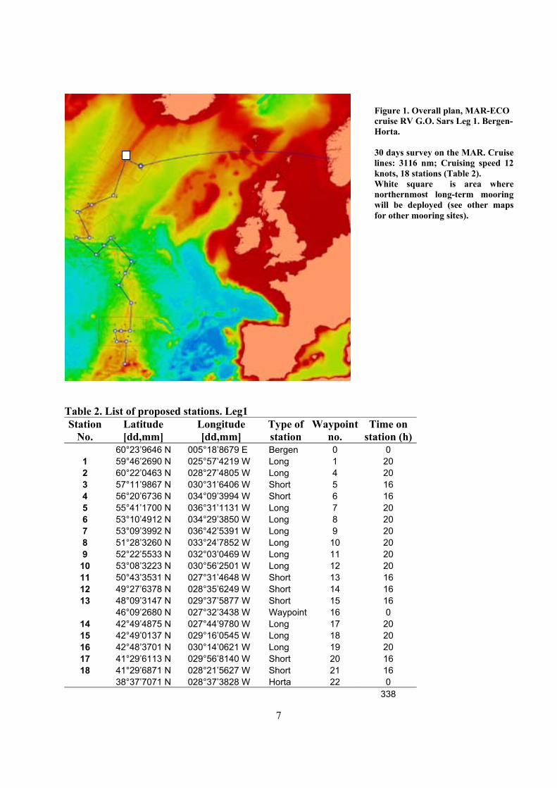
Fig. 2a) Stations and cruise track in Middle Box. White circle and square are approximate areas for deployments of DOBO lander, and the Middle Box acoustic mooring, respectively.
Fig 2b) Stations and cruise track in Southern Box. White square is deployment site for Southern Box acoustic mooring.
9
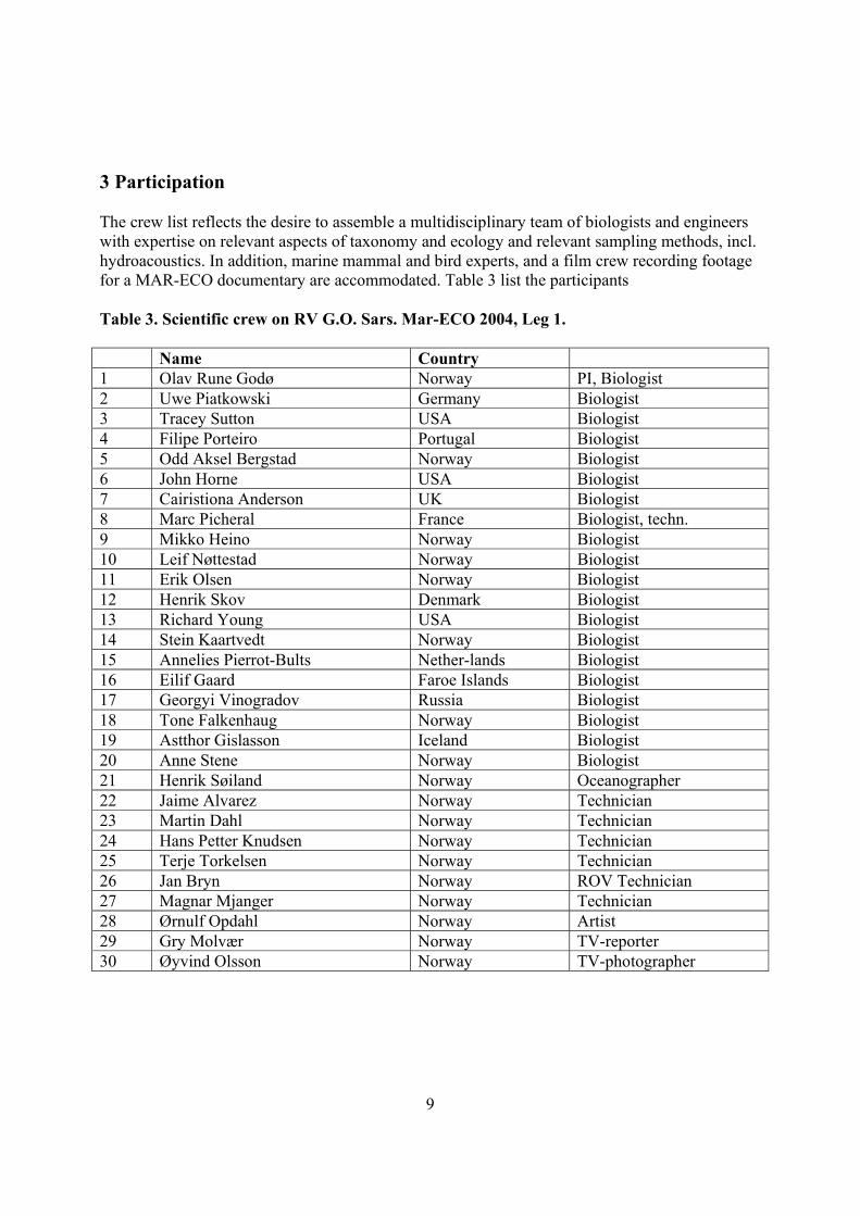
3 Participation The crew list reflects the desire to assemble a multidisciplinary team of biologists and engineers with expertise on relevant aspects of taxonomy and ecology and relevant sampling methods, incl. hydroacoustics. In addition, marine mammal and bird experts, and a film crew recording footage for a MAR-ECO documentary are accommodated. Table 3 list the participants Table 3. Scientific crew on RV G.O. Sars. Mar-ECO 2004, Leg 1. Name Country 1 Olav Rune Godø Norway PI, Biologist 2 Uwe Piatkowski Germany Biologist 3 Tracey Sutton USA Biologist 4 Filipe Porteiro Portugal Biologist 5 Odd Aksel Bergstad Norway Biologist 6 John Horne USA Biologist 7 Cairistiona Anderson UK Biologist 8 Marc Picheral France Biologist, techn. 9 Mikko Heino Norway Biologist 10 Leif Nøttestad Norway Biologist 11 Erik Olsen Norway Biologist 12 Henrik Skov Denmark Biologist 13 Richard Young USA Biologist 14 Stein Kaartvedt Norway Biologist 15 Annelies Pierrot-Bults Nether-lands Biologist 16 Eilif Gaard Faroe Islands Biologist 17 Georgyi Vinogradov Russia Biologist 18 Tone Falkenhaug Norway Biologist 19 Astthor Gislasson Iceland Biologist 20 Anne Stene Norway Biologist 21 Henrik Søiland Norway Oceanographer 22 Jaime Alvarez Norway Technician 23 Martin Dahl Norway Technician 24 Hans Petter Knudsen Norway Technician 25 Terje Torkelsen Norway Technician 26 Jan Bryn Norway ROV Technician 27 Magnar Mjanger Norway Technician 28 Ørnulf Opdahl Norway Artist 29 Gry Molvær Norway TV-reporter 30 Øyvind Olsson Norway TV-photographer
10
4 Time budget Table 4a. Total time budget RV G.O. Sars, Leg 1
Leg 1 total time budget, Bergen-Horta
Time per
station (h)
Distance (nm)
Speed (nm/hr) Number
Total time (Hrs)
Total time
(Days) Cruising before Station1 928 15 61 Station short 16 7 112 Stations long 20 11 220 Cruising 2188 12 182 Opportunistic sampling 3 26 78 ROV 24 Sum 677 28 Table 4b. Time budget for “long” stations
12 “Long” stations a´ 20 hours Depth
(m)
Total time (min)
Total time (hrs)
o CTD/UVP/Biolum/ADCP 3000 180 o Multinet 0-2500 2500 155 o Multinet 0-1000 1000 80 o Macrozooplankton trawl 2500 224 o Macrozooplankton trawl 1000 107 o Pelagic fish trawl 3000 340 Sum 1087 18 Table 4b. Time budget for “short” stations
16 “Short” stations a´ 16 hours: Depth
(m) Total time
(min) Total time
(hrs) o CTD/UVP/Biolum/ADCP 3000 180 o Macrozooplankton trawl 2500 224 o Macrozooplankton trawl 1000 107 o Pelagic fish trawl 3000 340 Sum 852 14
11
LEG 2. RV G. O. Sars, operating in target areas in collaboration with Norwegian longliner MS Loran 1 Aims, strategy and scientific crew 1.1 Time frame, leadership, aims Time: 4 July-5 August 2004. Schedule RV G.O.Sars:
Departure Horta: 4 July Arrival Bergen: 4 August Unloading Bergen: 5 August Call at Aberdeen 3 August
Schedule MS Loran: Departure Horta: 4 July
Total time of operation together with RV G.O.Sars 14 fishing days (22 days total). PI on RV G.O.Sars: Odd Aksel Bergstad, Institute of Marine Research, Norway PI on MS Loran: Jan Erik Dyb, Moere Research, Norway Tasks and priorities:
• To provide data and samples to a range of MAR-ECO component projects, but primarily those focusing on benthopelagic and benthic fauna (Demersal nekton projects DN1, DN2, DN3, DN4), and secondarily the zooplankton components Z1, and Z2.
• To retrieve long-term moorings in southern and middle MAR-ECO sub-areas.
12
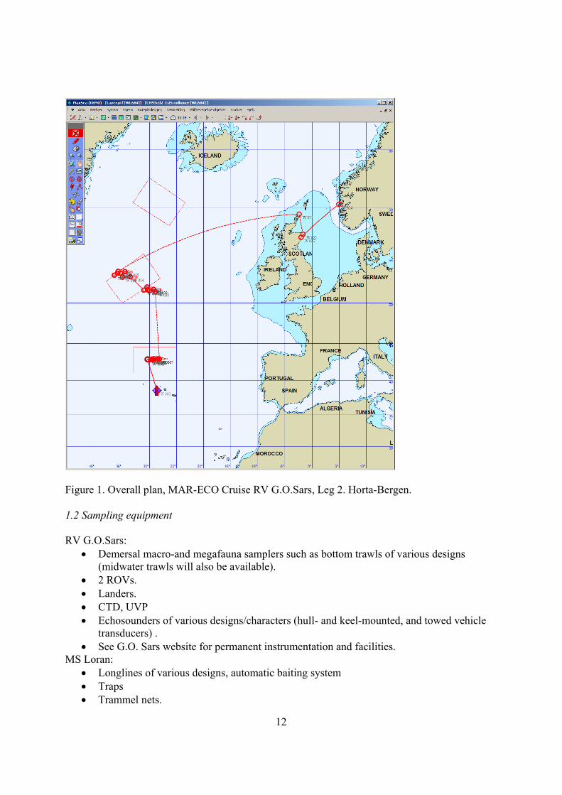
Figure 1. Overall plan, MAR-ECO Cruise RV G.O.Sars, Leg 2. Horta-Bergen. 1.2 Sampling equipment RV G.O.Sars:
• Demersal macro-and megafauna samplers such as bottom trawls of various designs (midwater trawls will also be available).
• 2 ROVs. • Landers. • CTD, UVP • Echosounders of various designs/characters (hull- and keel-mounted, and towed vehicle
transducers) . • See G.O. Sars website for permanent instrumentation and facilities.
MS Loran: • Longlines of various designs, automatic baiting system • Traps • Trammel nets.
13
1.3 Work content
1. Demersal nekton mapping and sampling 2. Epibenthos sampling 3. Zooplankton mapping and process studies. 4. Physical oceanography 5. Bathymetry 6. Retrieval of lander and moorings put deployed on Leg 1 (all except northernmost
mooring.
1. Demersal nekton mapping and sampling. General strategy: combination of hydroacoustic mapping, depth-stratified sampling using active and passive gears, and ROV observations, along cross-ridge transects in each MAR-ECO box. On Leg 1 of the cruise, semi-quantitative hydroacoustic mapping of demersal (benthopelagic) scatterers will be conducted along pre-determined cross-ridge corridors, spanning the depth range from the ridge crest to 3500 m on either side. Zig-zag cruise tracks will be surveyed using keel- and hull-mounted transducers (transmitting frequency 38 KHz). Data will be logged continuously. A sampling interval of 0.1 n.m. will be used routinely. Onboard regular scrutinizing of the echosounder recordings will be carried out. On Leg 2 depth-stratified sampling by the G.O. Sars will include bottom and semi-pelagic trawling using the standard Norwegian sampling trawl (Campeln 1800) with associated monitoring instruments, and still cameras. In each sub-area (MAR-ECO box) it is an aim to sample down the slope on either side of the ridge to 3500 m. In the same areas as G.O. Sars is operating active gears and conducting hydroacoustic mapping, MS Loran will operate longlines and traps, in pre-determined depth-zones. The deep-sea ROV will provide direct observations and counts of demersal fish and cephalopods, and also epibenthos at selected locations, again depth-stratified. The ROV will also provide video footage and still photos.
2. Epibenthos sampling Epibenthos sampling will include collection of still photographs, and sampling of benthic animals caught by demersal samplers such as bottom trawls. There will not be sufficient time to conduct dedicated sampling by benthic gears.
3. Zooplankton mapping and process studies. These are ROV and UVP based studies of behavioural and physiological processes of zooplankton, primarily gelatinous forms. By-products will be additional distributional information for Z1, and e.g. ichthyoplankton samples for PN1 and DN4.
4. Oceanography This includes collection of support data in the focus areas, and selected special investigations in frontal zones. CTD-casts and ADCP recordings will be made regularly in association with sampling activities with e.g. trawls and plankton gear. Transect sampling to locate fronts may be accommodated.
5. Bathymetry Multi-beam acoustic mapping of focus areas for demersal sampling may be made to assist the sampling activity, and to describe habitats for later analyses.

14
1.4 Participation A multidisciplinary team of biologists and engineers with relevant expertise on taxonomy and ecology and experience with sampling methods will work on the RV G.O.Sars. Four scientist will work on MS Loran. (Table 1). The longliner crew will board in Horta on 3 July. At the end of the charter period, two crew members will continue with the longliner and disembark in the UK or Iceland. The other two may be transferred to RV G.O.Sars at sea and disembark in Bergen. Table 1. Scientific crew on RV G.O.Sars and MS Loran. MAR-ECO 2004, Leg 2. RV G.O.Sars crew Name Country Comments 1 Odd Aksel Bergstad Norway Biologist PI 2 Ingvar Huse Norway Biologist, gear tech. 3 Åge Høines Norway Biologist 4 Ingvar Byrkjedal Norway Biologist 5 Franz Uiblein Austria Biologist 6 John Galbraith USA Biologist 7 Gui Menezes Portugal Biologist 8 Ricardo S Santos Portugal Biologist 9 Alexei Orlov Russia Biologist 10 Andrey Dolgov Russia Biologist 11 Anders Thorsen Norway Biologist 12 Inge Fossen Norway Biologist Part of time on MS Loran 13 Michael Vecchione USA Biologist 14 Andrey Gebruk Russia Biologist 15 Tom Sørnes Norway Biologist 16 Aino Hosia Norway Biologist 17 Marsh Youngbluth USA Biologist 18 Nicola King UK Biologist 19 Monty Priede UK Biologist 20 Øyvind Knutsen Norway Oceanographer 21 Atle Totland Norway Technician 22 T. De Lange Wenneck Norway Data manager 23 Asgeir Steinsland Norway ROV technician 24 Reidar Johannesen Norway ROV technician 25 Einar Osland Norway Technician 26 Sven Klimpel Germany Biologist 27 Jan Bryn Norway ROV technician 28 Lars Stemman France Biologist 29 Charles Cotton USA Biologist Part of time on MS Loran 30 David Shale UK Photographer MS Loran crew Jan Erik Dyb Norway Fish biology PI Entire period Ann Helen Hellevik Norway Biologist, catch proc. Entire period Inge Fossen Norway Biology Part of period Charles Cotton USA Biology Part of period
15
2 Schedule 3 July: All Leg 2 participants and longliner crew arrive in Horta and embark.
Colloqium with Leg 1 crew. Final planning meeting with crew on longliner MS Loran.
Social gathering in the evening. 4 July : Open ship event in Horta. Departure at 15:00 Hrs.
Tasks during voyage towards Southern Box: Final decisions on target locations and sampling strategy. Final allocation of responsibilities. Interdisciplinary colloquia.
5-13 July. Investigations in Southern Box. (approx. 8 days).
Tasks: see below. 13-14 July. Transfer to Middle Box.
Tasks: Preliminary analyses and recording of data from Southern Box. Evaluation of strategies and final decisions on strategy for Middle Box.
14-30 July. Investigations in Middle Box
Tasks: see below. 30 July. Departure Middle Box
Tasks during cruising to Aberdeen: data recording and sorting of samples. Packing of samples for museums.
3 August. Morning call at Aberdeen. 6 Hrs.
Tasks: Unloading of UK equipment and crew. PO event. 4 August (afternoon-evening) Arrival Bergen
Tasks: Unloading and demobilization.
5 August. Docked in Bergen Tasks: demobilization. 3 Study design in target areas 3.1 Southern box RV G.O. Sars The research vessel has about 8 days available for work in this box. In addition to the tasks described below, a long-term lander deployed on Leg 1 shall be recovered.
16
It is assumed that a cross-ridge corridor spanning the distance beween the 3500m contours on both sides has been mapped on Leg 1. The location of the corridor has been pre-determined on the basis of available bathymetric charts, and it has been decided to work at about 420 50’ N. Hydroacoustic data will be available from a track in this corridor, and also data from pelagic trawling and zooplankton samplers (see Leg 1 plan). In the corridor, 7 stations have been planned. A station is defined as a 2.5x2.5 n.m. rectangle within which many activities will be conducted. Proposed station locations and depths are given in Table 2, and shown on maps in Fig. 2. At each station the following tasks should be accomplished in sequence:
1) Pre-deployment bathymetry mapping (if required). (Max 2 hrs) 2) Lander deployment. (1 Hour) 3) CTD (bottom-surface) and UVP (0-1000m). (3 Hours) 4) ROV for DN1 and PN1. (8 Hrs) 5) ROV for Z2 and Z1. (3 Hrs) 6) Demersal trawling (at least one tow). (4 Hours) 7) Lander recovery (2 Hours)
This series of task will probably take around 25 hours, depending on depth and conditions. Tasks 4) and 5) will as much as possible be combined in order to save time. Figure 2 shows a bathymetric map and the proposed station locations in the Southern Box. MS Loran The longliner has 5 days of operation in the Southern Box. The vessel will conduct depth-stratified sampling using primarily vertical longlines and traps. The areas of operation will be some distance away from the stations operated by the research vessel in order to avoid interference. It is suggested that most of the fishing should be carried out along a cross-ridge transect at about N410 50’- 420. Along this transect, the vessel will fish in the depth intervals: <1500m, 1500-2500 m, >2500. The two deeper intervals will be fished both east and west of the ridge crest. In each interval a fixed minimum number of hooks will be used, but the vessel will determine what particular areas are most suitable for the operation. Principles for using traps and possibly trammel nets have not been settled.
17
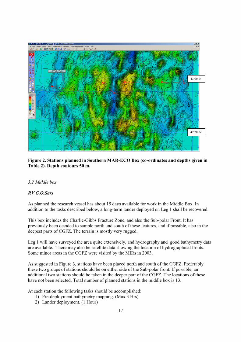
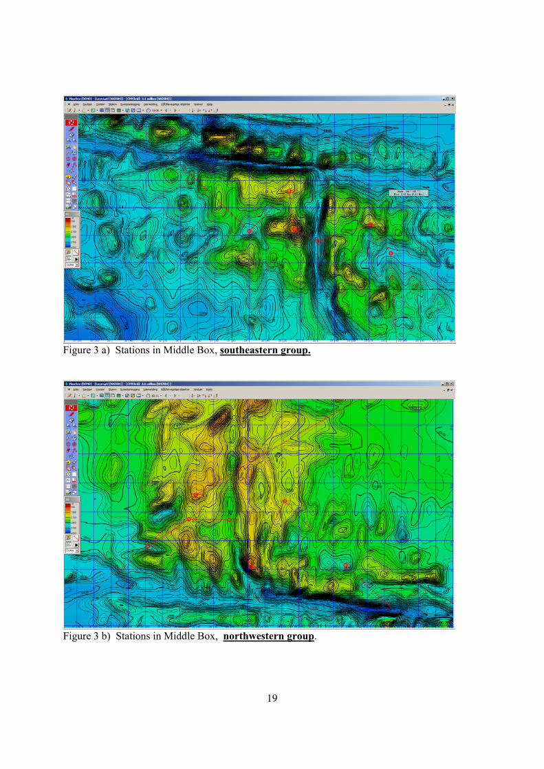
Figure 2. Stations planned in Southern MAR-ECO Box (co-ordinates and depths given in Table 2). Depth contours 50 m. 3.2 Middle box RV G.O.Sars As planned the research vessel has about 15 days available for work in the Middle Box. In addition to the tasks described below, a long-term lander deployed on Leg 1 shall be recovered. This box includes the Charlie-Gibbs Fracture Zone, and also the Sub-polar Front. It has previously been decided to sample north and south of these features, and if possible, also in the deepest parts of CGFZ. The terrain is mostly very rugged. Leg 1 will have surveyed the area quite extensively, and hydrography and good bathymetry data are available. There may also be satellite data showing the location of hydrographical fronts. Some minor areas in the CGFZ were visited by the MIRs in 2003. As suggested in Figure 3, stations have been placed north and south of the CGFZ. Preferably these two groups of stations should be on either side of the Sub-polar front. If possible, an additional two stations should be taken in the deeper part of the CGFZ. The locations of these have not been selected. Total number of planned stations in the middle box is 13. At each station the following tasks should be accomplished:
1) Pre-deployment bathymetry mapping. (Max 3 Hrs) 2) Lander deployment. (1 Hour)
43 00 N
42 20 N
18
3) CTD and UVP. (3 hours) 4) ROV for DN1 and PN1. (8 Hours) 5) ROV for Z2 and Z1. (3 Hours) 6) Trawling (at least one tow). (3 Hours) 7) Lander recovery (2 Hours)
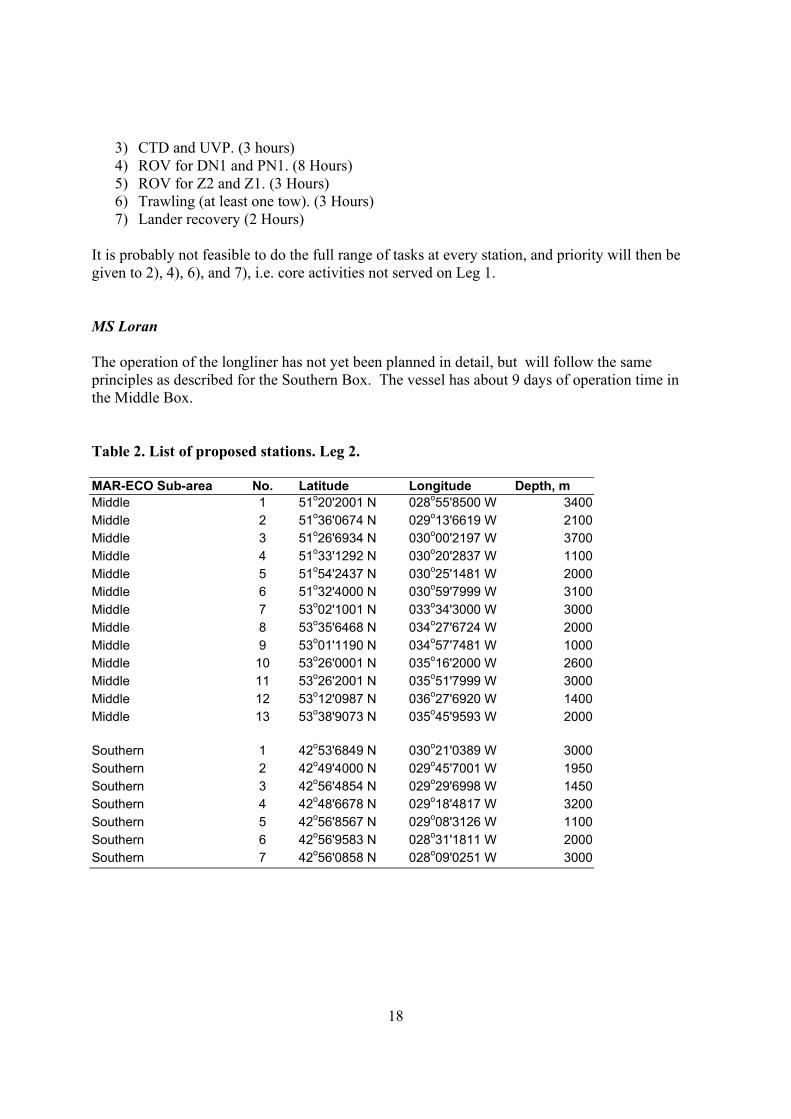
It is probably not feasible to do the full range of tasks at every station, and priority will then be given to 2), 4), 6), and 7), i.e. core activities not served on Leg 1. MS Loran The operation of the longliner has not yet been planned in detail, but will follow the same principles as described for the Southern Box. The vessel has about 9 days of operation time in the Middle Box. Table 2. List of proposed stations. Leg 2. MAR-ECO Sub-area No. Latitude Longitude Depth, m Middle 1 51o20'2001 N 028o55'8500 W 3400 Middle 2 51o36'0674 N 029o13'6619 W 2100 Middle 3 51o26'6934 N 030o00'2197 W 3700 Middle 4 51o33'1292 N 030o20'2837 W 1100 Middle 5 51o54'2437 N 030o25'1481 W 2000 Middle 6 51o32'4000 N 030o59'7999 W 3100 Middle 7 53o02'1001 N 033o34'3000 W 3000 Middle 8 53o35'6468 N 034o27'6724 W 2000 Middle 9 53o01'1190 N 034o57'7481 W 1000 Middle 10 53o26'0001 N 035o16'2000 W 2600 Middle 11 53o26'2001 N 035o51'7999 W 3000 Middle 12 53o12'0987 N 036o27'6920 W 1400 Middle 13 53o38'9073 N 035o45'9593 W 2000
Southern 1 42o53'6849 N 030o21'0389 W 3000 Southern 2 42o49'4000 N 029o45'7001 W 1950 Southern 3 42o56'4854 N 029o29'6998 W 1450 Southern 4 42o48'6678 N 029o18'4817 W 3200 Southern 5 42o56'8567 N 029o08'3126 W 1100 Southern 6 42o56'9583 N 028o31'1811 W 2000 Southern 7 42o56'0858 N 028o09'0251 W 3000
19
Figure 3 a) Stations in Middle Box, southeastern group.
Figure 3 b) Stations in Middle Box, northwestern group.
20
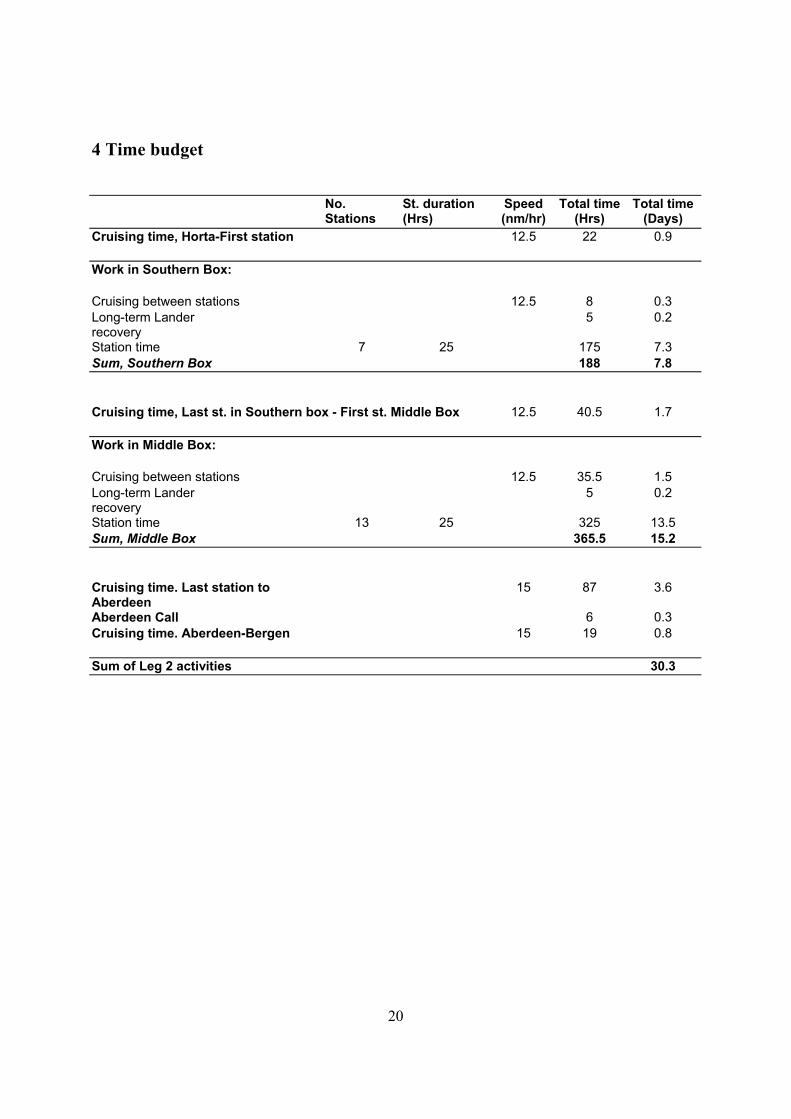
4 Time budget
No. Stations
St. duration (Hrs)
Speed (nm/hr)
Total time (Hrs)
Total time (Days)
Cruising time, Horta-First station 12.5 22 0.9
Work in Southern Box:
Cruising between stations 12.5 8 0.3 Long-term Lander recovery
5 0.2
Station time 7 25 175 7.3 Sum, Southern Box 188 7.8
Cruising time, Last st. in Southern box - First st. Middle Box 12.5 40.5 1.7
Work in Middle Box:
Cruising between stations 12.5 35.5 1.5 Long-term Lander recovery
5 0.2
Station time 13 25 325 13.5 Sum, Middle Box 365.5 15.2
Cruising time. Last station to Aberdeen
15 87 3.6
Aberdeen Call 6 0.3 Cruising time. Aberdeen-Bergen 15 19 0.8
Sum of Leg 2 activities 30.3