croydon avenue and garnet street reserve and … and streetscape project study ... croydon avenue...
TRANSCRIPT
Croydon Avenue and Garnet Street
Reserve and Streetscape Project
Study Report
Client // City of Charles Sturt
Office // SA
Reference // S107110
Date // 30/06/2017
© GTA Consultants (GTA Consultants (SA) Pty Ltd) 2017
The information contained in this document is confidential and
intended solely for the use of the client for the purpose for which it has
been prepared and no representation is made or is to be implied as
being made to any third party. Use or copying of this document in
whole or in part without the written permission of GTA Consultants
constitutes an infringement of copyright. The intellectual property
contained in this document remains the property of GTA Consultants. Bla
nk R
ep
ort
(160805 v
1.8
)
Melbourne | Sydney | Brisbane
Canberra | Adelaide | Perth
Gold Coast | Townsville
Croydon Avenue and Garnet Street
Reserve and Streetscape Project
Study Report
Issue: B 30/06/2017
Client: City of Charles Sturt
Reference: S107110
GTA Consultants Office: SA
Quality Record
Issue Date Description Prepared By Checked By Approved By Signed
A 29/06/2017 Final Lydia Kairl Paul Froggatt Paul Froggatt PFR
B 30/06/2017 Final – Revised Lydia Kairl Paul Froggatt Paul Froggatt

S107110 // 30/06/2017
Study Report // Issue: B
Croydon Avenue and Garnet Street, Reserve and Streetscape Project
Table of Contents
1. Introduction 1
1.1 Project Background 1
1.2 Study Context 1
1.3 Structure of this Report 1
2. Study Area Context 2
2.1 Study Area 2
2.2 Transport Networks 3
3. Issues and Opportunities 4
3.1 Background 4
3.2 Issues 4
3.3 Opportunities 5
4. Community and Stakeholder Engagement 7
4.1 Community Engagement 7
4.2 Stakeholder Meetings 9
5. Final Concept Plan 10
5.1 Garnet Street and Croydon Avenue Streetscape 10
5.2 Croydon Avenue Reserve 11
6. Summary and Conclusion 12
Appendices
A: Discovery & Investigations Report
B: Consultation and Engagement Report
C: Concept Plan
Figures
Figure 2.1: Local Study Area 2
Figure 3.1: Issues and Opportunities Plan 6
Figure 4.1: Community Satisfaction Response for the Reserve Draft Concept Plan 8
Figure 4.2: Community Satisfaction Response for the Streetscape Draft Concept Plan 9
S107110 // 30/06/2017
Study Report // Issue: B
Croydon Avenue and Garnet Street, Reserve and Streetscape Project 1
1. Introduction
1.1 Project Background
The study has developed a masterplan for Croydon Avenue, Garnet Street and Croydon Avenue
Reserve in West Croydon, between Port Road and Torrens Road in consultation with local
residents, schools and business owners.
The project was identified within Council in order to improve the local area for the benefit of the
community with regard to:
Road safety;
Parking provision;
Street amenity and ‘placemaking’;
Facilities and connections for walking and cycling;
Access to public transport, active transport corridors, retail precincts and community
facilities; and
Personal safety (CPTED), especially for vulnerable road users (disabled, children and
elderly) and including application of the principles of ‘Human Centred Design.’
1.2 Study Context
Garnet Street and Croydon Avenue are both local streets, with through connections for traffic
severed by the railway line and Croydon Reserve.
Opportunities for new approaches to local street design and management were first investigated
for the City of Charles Sturt through the North West Corridor Study. This study developed a series of
potential cross sections for various types of local streets according to their hierarchical function
and traffic volumes. The cross sections included options for reduced width roadways, indented
parking, improved pedestrian facilities and crossing safety, cyclist access and streetscape
amenity. The outcomes from the North West Corridor Study will provide a key starting point for this
study.
The Welland Transport and Parking Plan similarly investigated opportunities for improving local
street amenity and improved pedestrian and cyclist access as a means of managing local traffic
impact rather than traditional traffic calming measures. The new and upgraded footpaths, build-
outs and revised intersection priorities implemented by the City of Charles Sturt around Welland
Plaza were an outcome of the Welland study.
The Croydon Avenue and Garnet Street – Reserve and Streetscape project now presents a
further opportunity for the City of Charles Sturt, in conjunction with its local communities, to
reimagine other local streets to create an environment that encourages social interaction and
community integration through safe and welcoming streets, comfortable and clear pedestrian
routes, safe local cycling access and accessible but not intrusive vehicle movement and parking
provision.
1.3 Structure of this Report
The report includes brief details of the study processes, including a summary of the existing streets
and transport networks in the study area and the community and stakeholder engagement that
has taken place. Full details of these are contained in the Discovery and Investigations Report
and Community Engagement Report attached as appendices to this report.
1
S107110 // 30/06/2017
Study Report // Issue: B
Croydon Avenue and Garnet Street, Reserve and Streetscape Project 2
2. Study Area Context
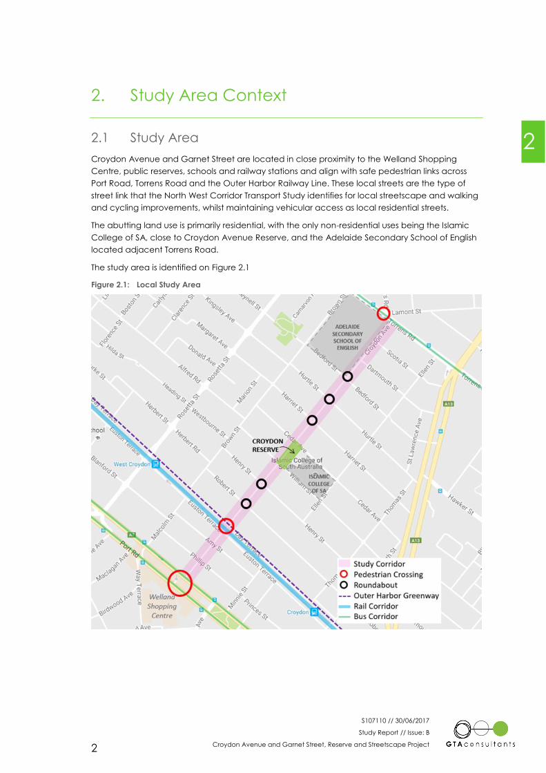
2.1 Study Area
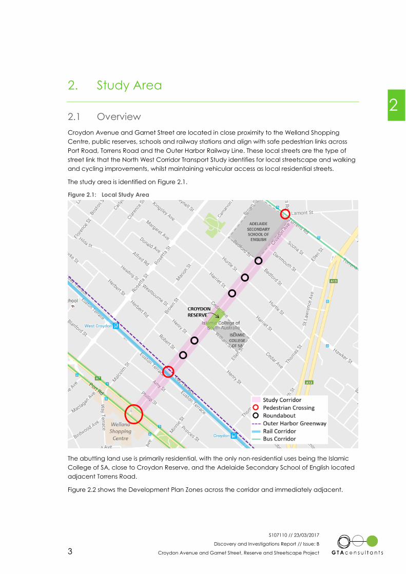
Croydon Avenue and Garnet Street are located in close proximity to the Welland Shopping
Centre, public reserves, schools and railway stations and align with safe pedestrian links across
Port Road, Torrens Road and the Outer Harbor Railway Line. These local streets are the type of
street link that the North West Corridor Transport Study identifies for local streetscape and walking
and cycling improvements, whilst maintaining vehicular access as local residential streets.
The abutting land use is primarily residential, with the only non-residential uses being the Islamic
College of SA, close to Croydon Avenue Reserve, and the Adelaide Secondary School of English
located adjacent Torrens Road.
The study area is identified on Figure 2.1
Figure 2.1: Local Study Area
2

S107110 // 30/06/2017
Study Report // Issue: B
Croydon Avenue and Garnet Street, Reserve and Streetscape Project 3
2.2 Transport Networks
Garnet Street and Croydon Avenue both function as local streets and are located in close
proximity to the Welland Plaza Shopping Centre, public reserves, schools and railway stations.
Through connections for traffic are severed by the railway line and Croydon Reserve, although
pedestrian and bicycle access is available through the reserve and across the railway line.
Traffic volumes on Garnet Street, Croydon Avenue and the surrounding streets are low at well
under 500 vehicles per day. Vehicle speeds are also generally well within the speed limit, which
has recently been changed to a precinct wide 40 km/h limit.
Several bus routes use Torrens Road and Port Road and Croydon and West Croydon Railway
Stations are also within walking access of the study area.
Pedestrian demand (both existing and latent) is relatively high for a residential street, due to the
direct links along the corridor to Welland Plaza Shopping Centre, Croydon Avenue Reserve,
public transport and two schools.
There is generally sealed footpath provision along both sides of the streets, although some
maintenance issues have been identified. Kerb ramps however vary significantly from recent
replacements to old or missing ramps that are away from the main desire lines.
Day Terrace forms part of the Outer Harbor Greenway, with additional bicycle pavement
markings and signage and the study corridor provides a connection to this route.
There were only two recorded crashes within the immediate study area and both were Property
Damage Only (PDO) crashes where the vehicles hit a fixed object at night. This indicates that
there is not a significant road safety issue in the study area.
Consistency of footpaths and kerb ramps, parking around the Islamic College, improved crossing
access to the reserve and the railway line and the constraint on the corner of Hurtle Street and
Croydon Avenue were the main traffic and transport issues identified by the community. Traffic
speed was only really an issue along Day Terrace and Euston Terrace.
Full details and an assessment of the transport networks is included in the Discovery and
Investigations Report attached as Appendix A.

S107110 // 30/06/2017
Study Report // Issue: B
Croydon Avenue and Garnet Street, Reserve and Streetscape Project 4
3. Issues and Opportunities
3.1 Background
A summary issues and opportunities plan was prepared based on the background investigations
described in section 2 and the community and stakeholder consultation feedback, described
further in section 4. As the project was intended to be driven by outcomes identified by the
community, the community engagement feedback formed the basis of the issues and
opportunities plan to inform the development of potential options. This was supplemented by the
evidence derived from the analysis of the existing transport conditions and operations in the study
area and overview of the streetscape and amenity provision.
3.2 Issues
Through the community engagement and background investigations, a number of issues were
identified within the study area. The issues along the study corridor were broken down into a
number of categories as follows:
1. Movement
Balanced movement of people as pedestrians, cyclists and motorists
Appropriate vehicle speeds and volumes
Maintaining access to properties and residential streets
Access to the reserve, schools, public transport and other key locations as a
pedestrian, cyclist and motorist
Parking availability and length of stay
Parking behaviour and volume adjacent schools
Ensuring safety of pedestrians, cyclists and motorists
2. Maintenance
Maintenance of landscaping, trees and vegetation for aesthetics and safety
Footpath surface maintenance and quality
Repair damage and remove graffiti
3. Streetscape and Reserve Facilities
Inadequate footpath widths and surface treatments and kerb ramps to suit all users
and allow for appropriate movement uses.
Limited reserve facilities to create a local community area within Croydon/West
Croydon
The limited reserve and park facilities do not generate enough use to deter
antisocial behaviour
Lack of lighting infrastructure
4. Anti-social behaviour
Security of people and infrastructure, with poor street lighting creating an
environment for antisocial behaviour
Behaviour of dogs and dog owners, particularly regarding waste
Noise
3
S107110 // 30/06/2017
Study Report // Issue: B
Croydon Avenue and Garnet Street, Reserve and Streetscape Project 5
3.3 Opportunities
Arising from the issues and in consideration of the facilities and locations available, a number of
opportunities to improve the local amenity and streetscape were identified. Some of these
opportunities are relatively low cost and potentially deliverable within a short time frame, whilst
others will require longer term planning and funding strategies.
As with the issues identification, the opportunities were grouped in to 4 categories.
1. Movement
Alterations to the intersection of Hurtle Street and Croydon Avenue to remove
constraint on the eastern side adjacent the building to provide adequate space
for vehicles, pedestrians and cyclists.
Maintain appropriate vehicle speeds and volumes and identify measures to
reduce speeds where required, notably on Day Terrace and Euston Terrace.
Maintain access to properties and residential streets.
Improve access to Croydon Avenue Reserve, schools, public transport and other
key locations as a pedestrian, cyclist and motorist.
Improve pedestrian and cyclist access through Croydon Avenue Reserve, without
impacting on local amenity for residents and users of the reserve.
Ensure suitable parking availability for the nature of parking demand in the area,
particularly for residential uses.
Parking behaviour and traffic volume adjacent schools
Improve safety for pedestrians and cyclists
Upgrade train line crossing facilities (warning lights or gates for pedestrians)
Improve crossing facilities on Day Terrace and Euston Terrace to access rail
crossing, facilitating reduced vehicle speeds in the vicinity
Improve crossing facilities to access Croydon Avenue Reserve
Upgrade crossing of Port Road to formally accommodate cyclists and improve
localised surface treatments.
2. Maintenance
Revised maintenance strategy for landscaping, trees and vegetation for aesthetics
and safety
Footpath surface maintenance and quality
Repair damage and remove graffiti
3. Streetscape and Reserve Facilities
Upgrade footpaths to suit all users and allow for appropriate movement uses,
including footpath widths and surface treatments as appropriate
Upgrade kerb ramps to current standards to provide a consistent treatment within
the study area
Opportunities to improve Croydon Avenue Reserve facilities to create a local
community area within Croydon/West Croydon
Playground improvements, including potential nature play
BBQ facilities
Additional shade and seating provision
Additional trees and greening, particularly on the edges of the reserve
Improved stormwater management, opportunities for Water Sensitive Urban
Design
Dog facilities
Litter and waste facilities
Improved fencing for child safety
S107110 // 30/06/2017
Study Report // Issue: B
Croydon Avenue and Garnet Street, Reserve and Streetscape Project 6
Public Art
Vandal proof facilities and equipment
Improvement of lighting infrastructure
Improve street lighting
Lighting provision within Croydon Avenue Reserve
Reinstate or upgrade heritage items and locations
Building facades
Advertising walls
4. Anti-social behaviour
Improve the perception of security for people and infrastructure, creating an
environment that deters antisocial behaviour
Improve lighting in reserve and local streets
Improved amenity to attract more people to Croydon Avenue Reserve and
using the streets to create natural surveillance
Vandal proof equipment
Behaviour of dogs and dog owners, particularly regarding waste
Provide dog waste bags and bin station
Signage regarding control of dogs
Management of noise with increased use of the reserve
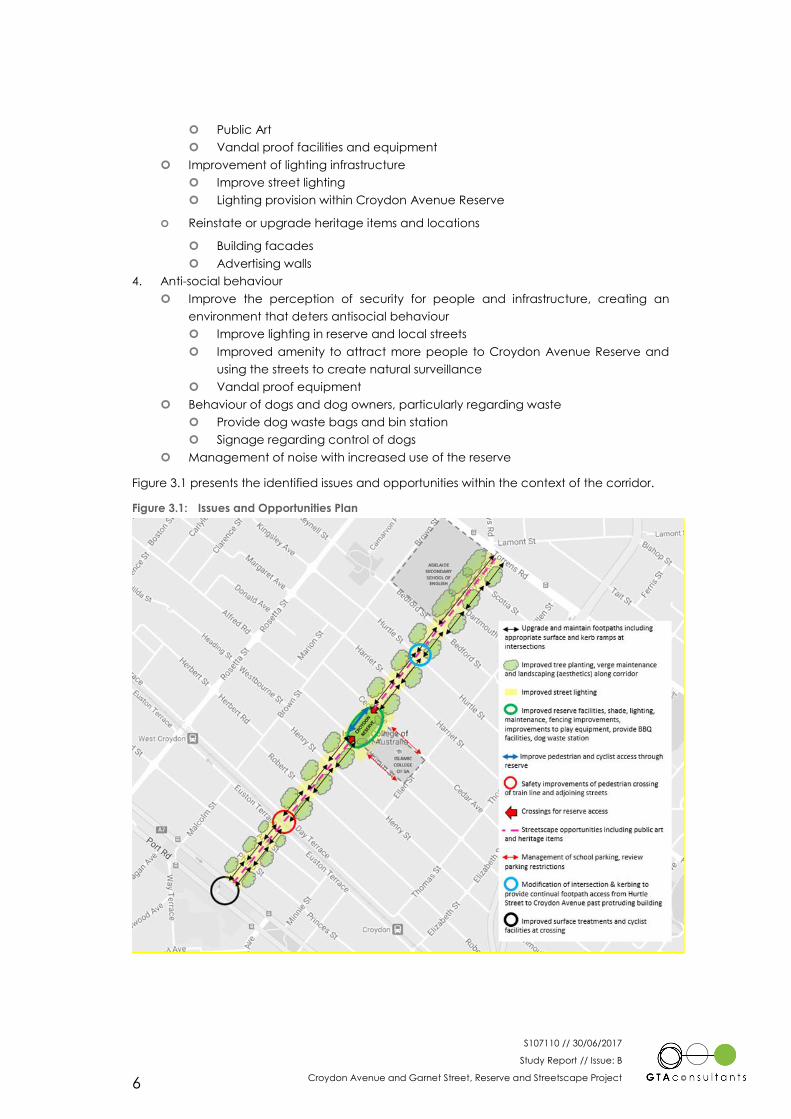
Figure 3.1 presents the identified issues and opportunities within the context of the corridor.
Figure 3.1: Issues and Opportunities Plan
S107110 // 30/06/2017
Study Report // Issue: B
Croydon Avenue and Garnet Street, Reserve and Streetscape Project 7
4. Community and Stakeholder Engagement
4.1 Community Engagement
The community engagement that took place during the development of the Concept Plan for
the study area, included an initial community workshop and on-line survey and a follow up
workshop and survey to present options or “Ideas for Improvements”. A summary of the feedback
is provided below and the initial Consultation and Engagement Report is included as Appendix B.
4.1.1 Initial Engagement
The initial community workshop was set up to enable the community to provide input and
commentary on the current issues, concerns and opportunities within the study area. This took
place in November 2016 as part of the early stages of the project.
The initial project was entitled the “Croydon Link Masterplan.” This created some concern and
confusion amongst the community that a new road link was proposed through Croydon Avenue
Reserve as a major link road between Torrens Road and Port Road. As a result, the project was
rebranded to “Croydon Avenue and Garnet Street – Streetscape and Reserve Project” to place
the emphasis on the intended streetscape and local amenity upgrades that are envisaged.
The community feedback identified a number of issues within the proposed study area of
Croydon Avenue and Garnet Street covering walking and cycling provision, facilities and access
to the reserve, impact of high travel demand generators within the area and anti-social
behaviour.
Opportunities for improvement to the local area and in particular Croydon Avenue Reserve were
identified including footpath and kerb ramp upgrades, pedestrian improvements to access the
reserve and across the railway line, improved and additional facilities in the reserve to encourage
more community use, enhanced maintenance, improved lighting and more secure fencing,
primarily from a road safety perspective.
The community further identified that the study area scope was too localised and that a wider
area should have been considered. Recommendations from this study may be appropriate for
application on a wider area basis.
4.1.2 Draft Concept Plan Engagement
Following the initial community engagement, an “Ideas for Improvements” plan was prepared
showing potential improvements that were considered feasible for the study area and in some
locations alternative options that could be considered.
The Ideas for Improvements Plan and options was presented at a community workshop in April
2017. There was generally a high level of support for the Ideas for Improvements Plan from the
community, with the following options indicated as preferred or requiring minor change:
Realignment of the proposed cycle path from the eastern entrance in to Croydon
Avenue Reserve driveway to allow a single parking space to be retained
Build-outs rather than dedicated crossings across William Street and Cedar Avenue to
provide access to the reserve
The use of raised intersection or crossings may be more appropriate at Day Terrace and
Euston Terrace to assist with vehicle speed management
Roundabout reconfiguration at Hurtle Street intersection to reduce the central island
diameter and enable improved footpath and kerb ramp provision
4
S107110 // 30/06/2017
Study Report // Issue: B
Croydon Avenue and Garnet Street, Reserve and Streetscape Project 8
Upgrade of railway level crossings to facilitate universal access including for the
disabled (wheelchairs and gophers and bikes, including with trailers)
Playground upgrades to include shade and ‘nature play’ equipment.
Following the feedback at the second community workshop, a draft Concept Plan was issued for
community consultation in June 2017. This included the updates and preferred options from the
previous consultation on Ideas for Improvements and sought to secure community endorsement
of a Final Concept Plan.
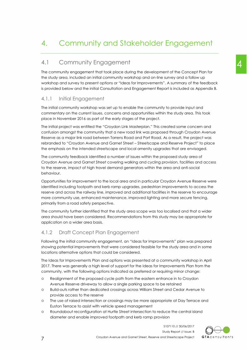
The feedback on the draft Concept Plan was generally positive, with high levels of satisfaction
with the draft plan for both the Reserve and the Streetscape elements. Figure 4.1 presents the
feedback on the Reserve.
Figure 4.1: Community Satisfaction Response for the Reserve Draft Concept Plan
The responses indicate a high level of satisfaction with the draft Concept Plan for the Reserve.
Figure 4.2 presents the feedback on the Streetscape.
S107110 // 30/06/2017
Study Report // Issue: B
Croydon Avenue and Garnet Street, Reserve and Streetscape Project 9
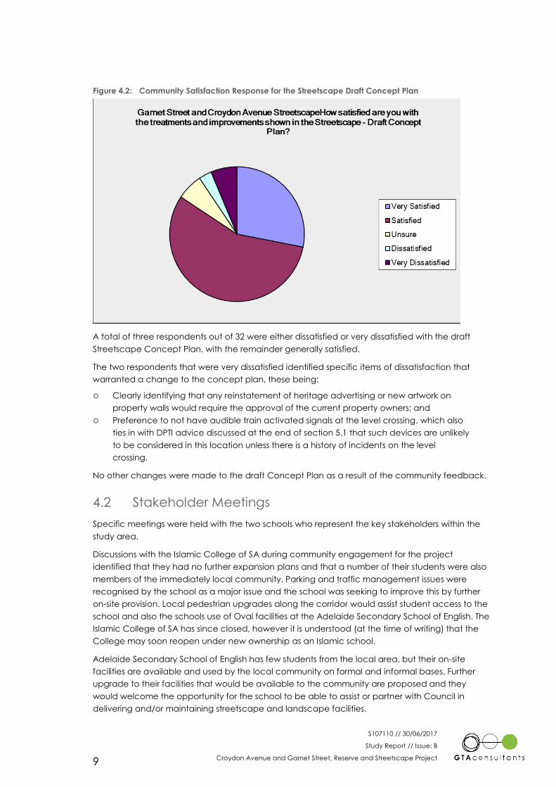
Figure 4.2: Community Satisfaction Response for the Streetscape Draft Concept Plan
A total of three respondents out of 32 were either dissatisfied or very dissatisfied with the draft
Streetscape Concept Plan, with the remainder generally satisfied.
The two respondents that were very dissatisfied identified specific items of dissatisfaction that
warranted a change to the concept plan, these being:
Clearly identifying that any reinstatement of heritage advertising or new artwork on
property walls would require the approval of the current property owners; and
Preference to not have audible train activated signals at the level crossing, which also
ties in with DPTI advice discussed at the end of section 5.1 that such devices are unlikely
to be considered in this location unless there is a history of incidents on the level
crossing.
No other changes were made to the draft Concept Plan as a result of the community feedback.
4.2 Stakeholder Meetings
Specific meetings were held with the two schools who represent the key stakeholders within the
study area.
Discussions with the Islamic College of SA during community engagement for the project
identified that they had no further expansion plans and that a number of their students were also
members of the immediately local community. Parking and traffic management issues were
recognised by the school as a major issue and the school was seeking to improve this by further
on-site provision. Local pedestrian upgrades along the corridor would assist student access to the
school and also the schools use of Oval facilities at the Adelaide Secondary School of English. The
Islamic College of SA has since closed, however it is understood (at the time of writing) that the
College may soon reopen under new ownership as an Islamic school.
Adelaide Secondary School of English has few students from the local area, but their on-site
facilities are available and used by the local community on formal and informal bases. Further
upgrade to their facilities that would be available to the community are proposed and they
would welcome the opportunity for the school to be able to assist or partner with Council in
delivering and/or maintaining streetscape and landscape facilities.
S107110 // 30/06/2017
Study Report // Issue: B
Croydon Avenue and Garnet Street, Reserve and Streetscape Project 10
5. Final Concept Plan
The final Concept Plan can be considered as two components. The first considers the wider
streetscape along Garnet Street and Croydon Avenue, whilst the second considers Croydon
Avenue Reserve. Details of the final plan for each of the components are set out below, including
the comments identified from the final consultation.
5.1 Garnet Street and Croydon Avenue Streetscape
The following opportunities have been identified and are recommended as part of the final
concept plan for the street sections of Croydon Avenue and Garnet Street.
Pedestrian & Cycling Improvements to the Port Road pedestrian crossing including
formally incorporating cyclists within the crossing, widening the median footpath to a
shared path, improved and extended paving on the Port Road footpaths to
accommodate cyclists and relevant surface marking.
Art installations to support streetscape activation by painting items such as fences, road
surfaces and Stobie poles.
Pedestrian & Cycling Improvements to the Euston Terrace and Day Terrace Crossings
including extended paving, road surface marking, Wombat crossings, level crossing
upgrade and new fencing.
Heritage art installations by reinstating historical advertising on the property walls or by
painting blank walls, subject to approval from the current property owners.
Wayfinding signage at various points along Croydon Avenue and Garnet Street
denoting walking/cycling times and distances to neighbourhood amenities within and
outside the immediate corridor.
Intersection improvements to include new build outs and pedestrian crossing points
located closer to desire lines where feasible and upgrades to pram ramps to provide a
consistent design to current standards.
Hurtle Street roundabout amendments to provide a smaller central island, enabling the
adjoining footpaths and crossings to be modified to provide safe, connecting and DDA
compliant facilities.
Additional planting and maintenance of existing verges, including additional street
trees, to add interest and amenity to the streetscape.
Use of different plant species to reflect different precincts along Croydon Avenue and
Garnet Street, including the potential for Educational Heritage Amenity and
opportunities to partner with the local community and Adelaide Secondary School for
English for verge upgrade and maintenance.
In relation to the level crossing between Day Terrace and Euston Terrace, exploratory discussions
have been held with DPTI to confirm their views on level crossing provision, maintenance and
design. There is no current programme for the widespread review of pedestrian level crossings
and in the short term each will be considered on its merits. As Council develops further detail on
the area around the level crossing, discussions with DPTI should be held to consider the
integration of potential upgrades to the rail crossing as part of the adjoining street corridor.
The use of automated level crossing gates with audible warnings is only likely to be considered
appropriate at crossing locations where there is a history of reported incidents within the rail
corridor or very poor sight distances. There is not understood to be a history of incidents at this
crossing, although this will need to be confirmed with DPTI, and the sight distances are very good
due to the straight track alignment.
5
S107110 // 30/06/2017
Study Report // Issue: B
Croydon Avenue and Garnet Street, Reserve and Streetscape Project 11
The development of revised pedestrian mazes that accommodate the DDA requirements for
gophers and wheelchairs, and would also better accommodate large pushchairs and cyclists, is
also in progress through the Australian Standards. In advance of this, a site specific design may
need to be developed for DPTI approval.
5.2 Croydon Avenue Reserve
The following opportunities have been identified and are recommended as part of the final
concept plan for Croydon Avenue Reserve, covering both facilities within the reserve and the
immediate access to the reserve.
Pedestrian build outs, incorporating low planted landscape areas, across Cedar
Avenue and William Street to reduce pedestrian crossing widths and improve access to
the reserve.
Enhance the existing public art through the use of raised plinths.
Creation of appropriate scale entry features and signage at each of the access points
in to the reserve.
Addition of new and inclusive play equipment with rubber soft fall.
Addition of nature play opportunities.
Continuation of existing fence, and renewal of existing fence where required, with gate
and child proof latch.
Wheelchair accessible barbecue and drinking fountain.
New shade structure and bike parking rack.
Fruit trees in planters and herbs and companion planting in the ground.
Re-mark existing hard surfaced courts in bright colours.
Creation of a new section of shared path from the Cedar Avenue frontage to connect
to the existing driveway within the reserve to enable a through route for cyclists.
Renew and widen existing footpath to 1.5m and create a new boundary path to
improve access within the reserve.
Introduce an entry plaza raised plateau in conjunction with the driveway access in to
the reserve.
S107110 // 30/06/2017
Study Report // Issue: B
Croydon Avenue and Garnet Street, Reserve and Streetscape Project 12
6. Summary and Conclusion
This report has considered the progress and outcomes of the Croydon Avenue and Garnet Street
– Reserve and Streetscape Project. Opportunities for new approaches to local street design and
management were first investigated for the City of Charles Sturt through the North West Corridor
Study and the Garnet Street and Croydon Avenue Streetscape is a further opportunity for the City
of Charles Sturt, in conjunction with its local communities, to reimagine other local streets.
The existing conditions in the study area can be summarised as follows:
Garnet Street and Croydon Avenue are both local streets, serving primarily residential
areas and located in close proximity to a wide range of local facilities and transport
networks.
Through connections for traffic are severed by the railway line and Croydon Reserve. As
a result traffic volumes on both streets and the surrounding streets are low, at well under
500 vehicles per day, vehicle speeds are generally well within the recently introduced
40 km/h precinct speed limit and there is no significant crash history.
Pedestrian and bicycle access is available throughout the corridor, including across
Croydon Avenue Reserve and the railway line, enabling direct walking and cycling
routes. Pedestrian demand (both existing and latent) is therefore relatively high for a
residential street.
There is generally sealed footpath provision along both sides of the streets, although
some maintenance issues have been identified. Kerb ramps vary from recent
replacements to old or missing ramps that are away from the main desire lines.
The initial community and stakeholder engagement identified the following:
Initial concern and confusion amongst the community that a new road link was
proposed through Croydon Avenue Reserve as a major link road between Torrens Road
and Port Road. As a result, the project was rebranded to the Croydon Avenue and
Garnet Street – Streetscape and Reserve Project to place the emphasis on the
intended streetscape and local amenity upgrades.
The study area scope was too localised and that a wider area should have been
considered.
A number of issues in the local area, mostly related to the limited facilities within
Croydon Avenue Reserve. Improved seating, shelter, shade, access and play facilities
were key opportunities identified for the reserve. Revitalising local heritage locations
was also suggested.
In transport terms, consistency of footpaths and kerb ramps, parking around the Islamic
College, improved crossing access to the reserve and the railway line and the footpath
constraint on the corner of Hurtle Street and Croydon Avenue were the main issues.
Traffic speed was only really an issue along Day Terrace and Euston Terrace.
Discussions with the Islamic College of SA identified that a number of their students are
also members of the immediately local community, the parking and traffic
management issues are recognised by the school as a major issue and the school is
seeking to improve this by further on-site provision and that local pedestrian upgrades
along the corridor would assist student access to the school.
Adelaide Secondary School of English has few students from the local area, but their
on-site facilities are available and used by the local community on formal and informal
bases. The school would welcome the opportunity to assist or partner with Council in
delivering and/or maintaining streetscape and landscape facilities.
6
S107110 // 30/06/2017
Study Report // Issue: B
Croydon Avenue and Garnet Street, Reserve and Streetscape Project 13
Through a series of community engagement consultations and reviewing the background data,
a Concept Plan has been developed for Council to take forward for further design development,
consultation and implementation.
The key components of the final concept plan for the street sections of Croydon Avenue and
Garnet Street can be summarised as follows:
Pedestrian & Cycling facility improvements at the Port Road pedestrian crossings and
around Euston Terrace, Day Terrace and the level crossing.
Art installations to enhance the streetscape by painting items such as fences, walls,
road surfaces and Stobie poles and reinstating heritage advertising on property walls,
subject to approval from the current property owners.
Wayfinding signage to neighbourhood amenities within and outside the immediate
corridor.
Intersection improvements to include new build outs and pedestrian crossing points and
upgrades to kerb ramps to a consistent design and current standards.
Hurtle Street roundabout amendments to provide a smaller central island, enabling the
adjoining footpaths to be improved.
Additional planting and maintenance of verges using a variety of different plant
species and street trees and partnering with the community and Adelaide Secondary
School for English for verge upgrade and maintenance.
The key components of the final concept plan for Croydon Avenue Reserve, covering both
facilities within the reserve and the immediate access to the reserve can be summarised as
follows:
Pedestrian build outs, incorporating low planted landscape areas, across Cedar
Avenue and William Street to improve pedestrian access to the reserve.
Enhance the existing public art and hard court installations.
Enhancement of the entry features and signage at each of the access points in to the
reserve.
Addition of inclusive and nature play equipment.
Improved fencing around the reserve including gates with child proof latch.
New facilities with the reserve including barbecue, drinking fountain, shade structure
and bike parking rack.
New planting within the reserve, including species that may facilitate a community
garden.
Improve the pedestrian and cyclist footpath and shared path provision through and
within the reserve.
In response to the community comments on the scope of the study area, a number of the
above components recommended as outcomes from this study would be appropriate for
application on a wider area basis, including other local streets and nearby reserves.
S107110 // 30/06/2017
Study Report // Issue: B
Croydon Avenue and Garnet Street, Reserve and Streetscape Project 14
Appendix A
Discovery & Investigations Report
Ap
pe
nd
ix A

Croydon Avenue and Garnet Street
Reserve and Streetscape Project
Discovery and Investigations Report
Client // City of Charles Sturt
Office // SA
Reference // S107110
Date // 23/03/2017

© GTA Consultants (GTA Consultants (SA) Pty Ltd) 2017
The information contained in this document is confidential and
intended solely for the use of the client for the purpose for which it has
been prepared and no representation is made or is to be implied as
being made to any third party. Use or copying of this document in
whole or in part without the written permission of GTA Consultants
constitutes an infringement of copyright. The intellectual property
contained in this document remains the property of GTA Consultants. Bla
nk R
ep
ort
(160805 v
1.8
)
Melbourne | Sydney | Brisbane
Canberra | Adelaide | Perth
Gold Coast | Townsville
Croydon Avenue and Garnet Street
Reserve and Streetscape Project
Discovery and Investigations Report
Issue: B 23/03/2017
Client: City of Charles Sturt
Reference: S107110
GTA Consultants Office: SA
Quality Record
Issue Date Description Prepared By Checked By Approved By Signed
A 21/02/2017 Final Lydia Kairl Paul Froggatt Paul Froggatt PFR
B 23/03/2017 Final – amended Lydia Kairl Paul Froggatt Paul Froggatt

S107110 // 23/03/2017
Discovery and Investigations Report // Issue: B
Croydon Avenue and Garnet Street, Reserve and Streetscape Project
Table of Contents
1. Introduction 1
1.1 Background & Proposal 1
2. Study Area 3
2.1 Overview 3
3. Transport Networks 5
3.1 Network 5
3.2 Traffic Data 5
3.3 Public Transport Network 6
3.4 Pedestrian Access 7
3.5 Road Safety 8
4. Issues and Opportunities 10
4.1 Issues 10
4.2 Opportunities 10
5. Summary 13
Figures
Figure 1.1: Local Study Area 2
Figure 2.1: Local Study Area 3
Figure 2.2: Land Uses 4
Figure 3.1: Study Area Road Network 5
Figure 3.2: Traffic Data 6
Figure 3.3: Public Transport Data 7
Figure 3.4: Pedestrian Access through Study Area 8
Figure 3.5: Crash Data 2010-2015 9
Figure 4.1: Issues and Opportunities Plan 12

S107110 // 23/03/2017
Discovery and Investigations Report // Issue: B
Croydon Avenue and Garnet Street, Reserve and Streetscape Project 1
1. Introduction
1.1 Background & Proposal
1.1.1 The Project
The project is intended to develop a masterplan for Croydon Avenue, Garnet Street and
Croydon Avenue Reserve in West Croydon, between Port Road and Torrens Road in consultation
with local residents, schools and business owners.
The project has been identified within Council in order to improve the local area for the benefit of
the community with regard to:
1. Road safety;
2. Parking provision;
3. Street amenity and ‘placemaking’;
4. Facilities and connections for walking and cycling;
5. Access to public transport, active transport corridors, retail precincts and community
facilities;
6. Personal safety (CPTED), especially for vulnerable road users (disabled, children and
elderly) and including application of the principles of ‘Human Centred Design.’
1.1.2 Background
Garnet Street and Croydon Avenue are both local streets, with through connections for traffic
severed by the railway line and Croydon Reserve.
Opportunities for new approaches to local street design and management were first investigated
for the City of Charles Sturt through the North West Corridor Study which was prepared by GTA.
This study developed a series of potential cross sections for various types of local streets
according to their hierarchical function and traffic volumes. The cross sections included options
for reduced width roadways, indented parking, improved pedestrian facilities and crossing
safety, cyclist access and streetscape amenity. The outcomes from the North West Corridor Study
will provide a key starting point for this study.
GTA and Jensen Planning + Design also prepared the nearby Welland Transport and Parking Plan
for the City of Charles Sturt. This study similarly investigated opportunities for improving local street
amenity and improved pedestrian and cyclist access as a means of managing local traffic
impact rather than traditional traffic calming measures. The new and upgraded footpaths, build-
outs and revised intersection priorities implemented by the City of Charles Sturt around Welland
Plaza were an outcome of the Welland study.
The Croydon Avenue and Garnet Street – Reserve and Streetscape project now presents a
further opportunity for the City of Charles Sturt, in conjunction with its local communities, to
reimagine other local streets to create an environment that encourages social interaction and
community integration through safe and welcoming streets, comfortable and clear pedestrian
routes, safe local cycling access and accessible but not intrusive vehicle movement and parking
provision.
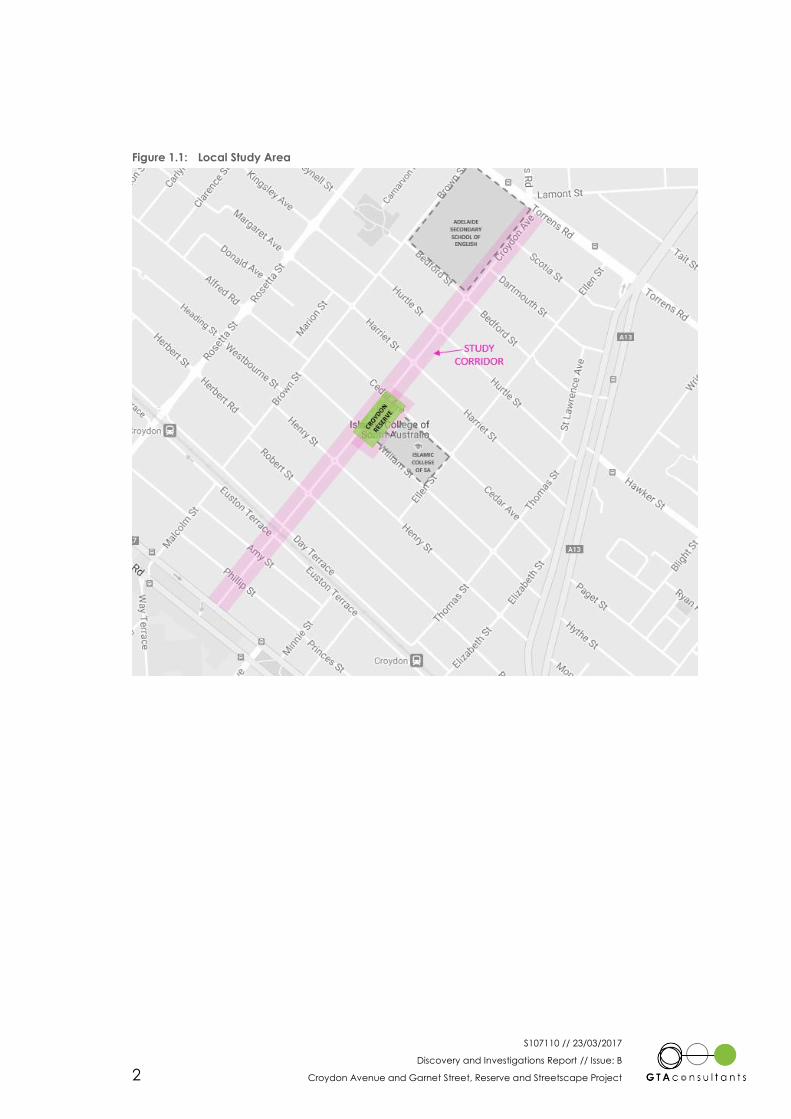
The study corridor for the streetscape project is identified on Figure 1.1.
1
S107110 // 23/03/2017
Discovery and Investigations Report // Issue: B
Croydon Avenue and Garnet Street, Reserve and Streetscape Project 2
Figure 1.1: Local Study Area
S107110 // 23/03/2017
Discovery and Investigations Report // Issue: B
Croydon Avenue and Garnet Street, Reserve and Streetscape Project 3
2. Study Area
2.1 Overview
Croydon Avenue and Garnet Street are located in close proximity to the Welland Shopping
Centre, public reserves, schools and railway stations and align with safe pedestrian links across
Port Road, Torrens Road and the Outer Harbor Railway Line. These local streets are the type of
street link that the North West Corridor Transport Study identifies for local streetscape and walking
and cycling improvements, whilst maintaining vehicular access as local residential streets.
The study area is identified on Figure 2.1.
Figure 2.1: Local Study Area
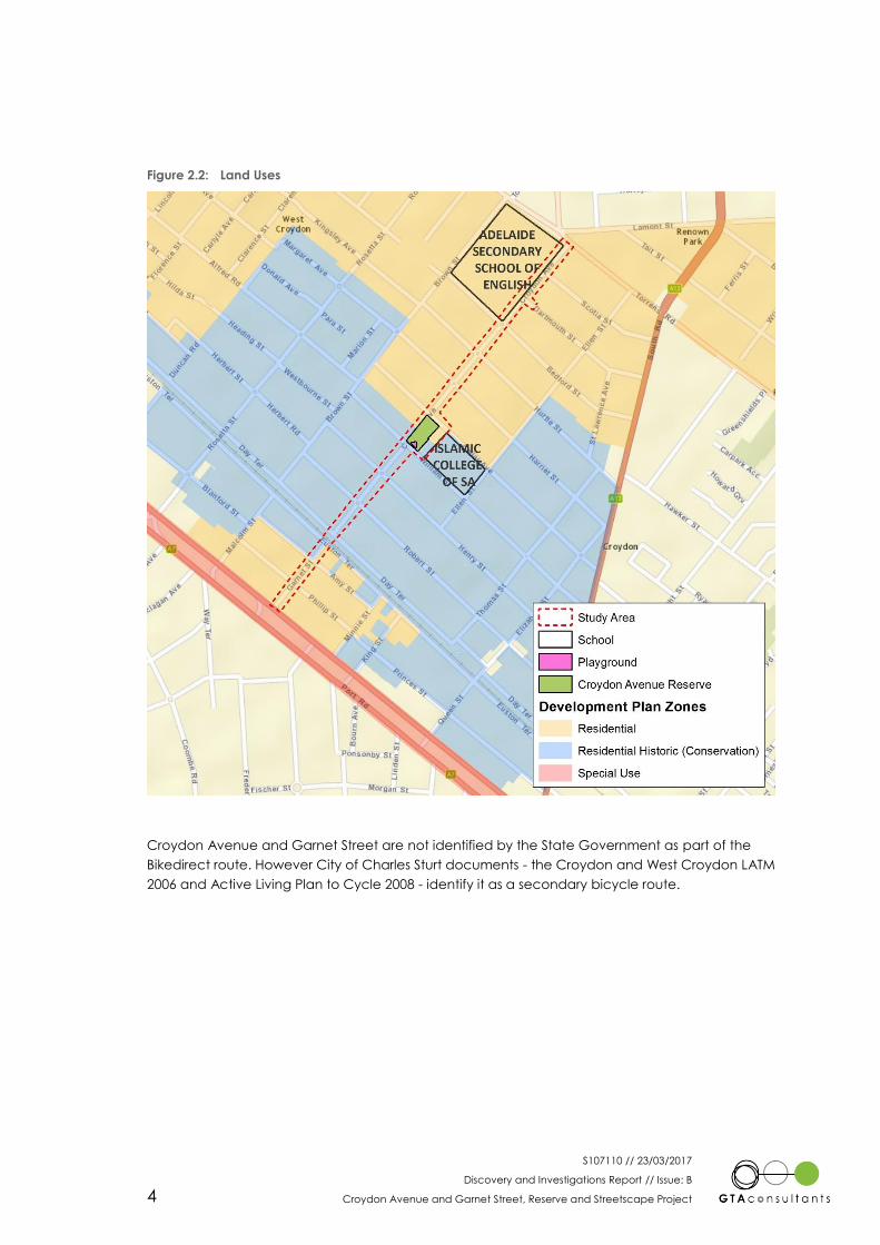
The abutting land use is primarily residential, with the only non-residential uses being the Islamic
College of SA, close to Croydon Reserve, and the Adelaide Secondary School of English located
adjacent Torrens Road.
Figure 2.2 shows the Development Plan Zones across the corridor and immediately adjacent.
2
S107110 // 23/03/2017
Discovery and Investigations Report // Issue: B
Croydon Avenue and Garnet Street, Reserve and Streetscape Project 4
Figure 2.2: Land Uses
Croydon Avenue and Garnet Street are not identified by the State Government as part of the
Bikedirect route. However City of Charles Sturt documents - the Croydon and West Croydon LATM
2006 and Active Living Plan to Cycle 2008 - identify it as a secondary bicycle route.
S107110 // 23/03/2017
Discovery and Investigations Report // Issue: B
Croydon Avenue and Garnet Street, Reserve and Streetscape Project 5
3. Transport Networks
3.1 Network
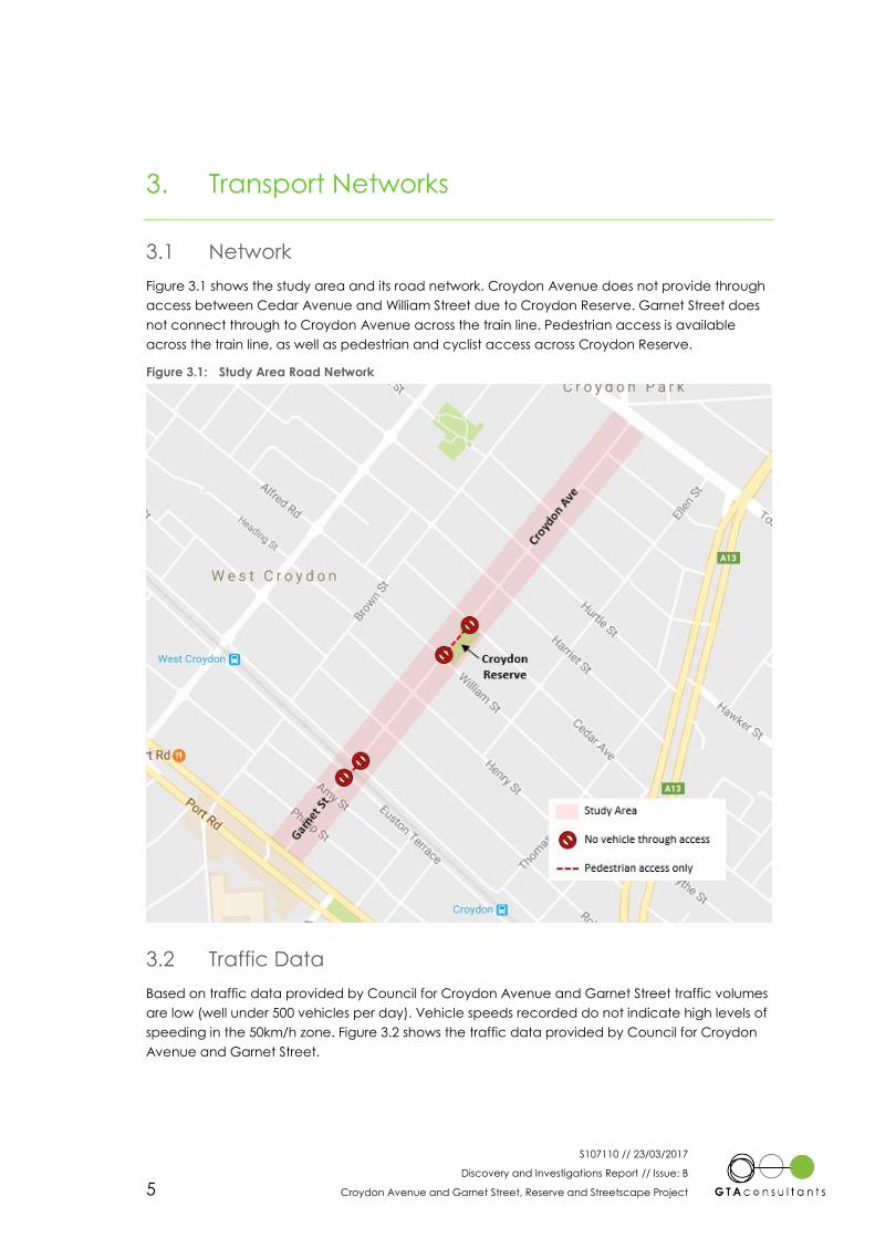
Figure 3.1 shows the study area and its road network. Croydon Avenue does not provide through
access between Cedar Avenue and William Street due to Croydon Reserve. Garnet Street does
not connect through to Croydon Avenue across the train line. Pedestrian access is available
across the train line, as well as pedestrian and cyclist access across Croydon Reserve.
Figure 3.1: Study Area Road Network
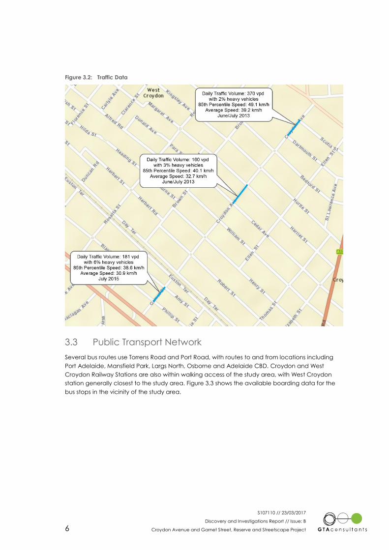
3.2 Traffic Data
Based on traffic data provided by Council for Croydon Avenue and Garnet Street traffic volumes
are low (well under 500 vehicles per day). Vehicle speeds recorded do not indicate high levels of
speeding in the 50km/h zone. Figure 3.2 shows the traffic data provided by Council for Croydon
Avenue and Garnet Street.
S107110 // 23/03/2017
Discovery and Investigations Report // Issue: B
Croydon Avenue and Garnet Street, Reserve and Streetscape Project 6
Figure 3.2: Traffic Data
3.3 Public Transport Network
Several bus routes use Torrens Road and Port Road, with routes to and from locations including
Port Adelaide, Mansfield Park, Largs North, Osborne and Adelaide CBD. Croydon and West
Croydon Railway Stations are also within walking access of the study area, with West Croydon
station generally closest to the study area. Figure 3.3 shows the available boarding data for the
bus stops in the vicinity of the study area.
S107110 // 23/03/2017
Discovery and Investigations Report // Issue: B
Croydon Avenue and Garnet Street, Reserve and Streetscape Project 7
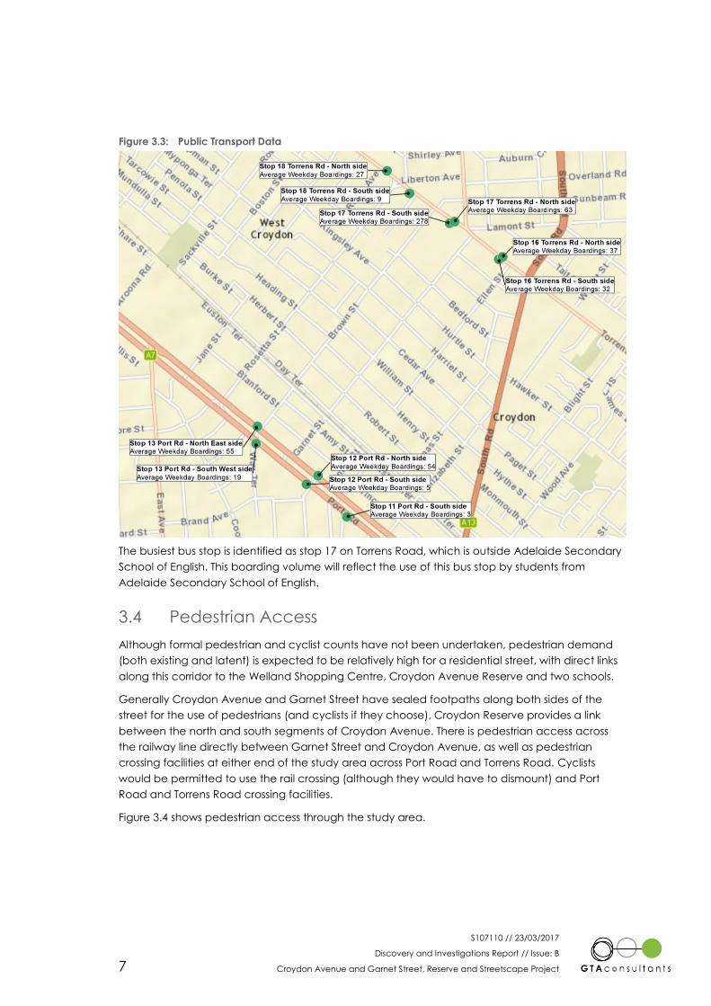
Figure 3.3: Public Transport Data
The busiest bus stop is identified as stop 17 on Torrens Road, which is outside Adelaide Secondary
School of English. This boarding volume will reflect the use of this bus stop by students from
Adelaide Secondary School of English.
3.4 Pedestrian Access
Although formal pedestrian and cyclist counts have not been undertaken, pedestrian demand
(both existing and latent) is expected to be relatively high for a residential street, with direct links
along this corridor to the Welland Shopping Centre, Croydon Avenue Reserve and two schools.
Generally Croydon Avenue and Garnet Street have sealed footpaths along both sides of the
street for the use of pedestrians (and cyclists if they choose). Croydon Reserve provides a link
between the north and south segments of Croydon Avenue. There is pedestrian access across
the railway line directly between Garnet Street and Croydon Avenue, as well as pedestrian
crossing facilities at either end of the study area across Port Road and Torrens Road. Cyclists
would be permitted to use the rail crossing (although they would have to dismount) and Port
Road and Torrens Road crossing facilities.
Figure 3.4 shows pedestrian access through the study area.

S107110 // 23/03/2017
Discovery and Investigations Report // Issue: B
Croydon Avenue and Garnet Street, Reserve and Streetscape Project 8
Figure 3.4: Pedestrian Access through Study Area
3.5 Road Safety
Figure 3.5 shows the recorded crashes in the study area and immediately adjacent the study
area between 2011 and 2015 (inclusive).
S107110 // 23/03/2017
Discovery and Investigations Report // Issue: B
Croydon Avenue and Garnet Street, Reserve and Streetscape Project 9
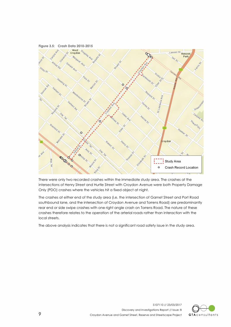
Figure 3.5: Crash Data 2010-2015
There were only two recorded crashes within the immediate study area. The crashes at the
intersections of Henry Street and Hurtle Street with Croydon Avenue were both Property Damage
Only (PDO) crashes where the vehicles hit a fixed object at night.
The crashes at either end of the study area (i.e. the intersection of Garnet Street and Port Road
southbound lane, and the intersection of Croydon Avenue and Torrens Road) are predominantly
rear end or side swipe crashes with one right angle crash on Torrens Road. The nature of these
crashes therefore relates to the operation of the arterial roads rather than interaction with the
local streets.
The above analysis indicates that there is not a significant road safety issue in the study area.
S107110 // 23/03/2017
Discovery and Investigations Report // Issue: B
Croydon Avenue and Garnet Street, Reserve and Streetscape Project 10
4. Issues and Opportunities
4.1 Issues
Through the community engagement as well as our investigations, a number of issues have been
identified within the study area. The issues along the study corridor have been broken down into
a number of categories as follows;
1. Movement
Balanced movement of people as pedestrians, cyclists and motorists
Appropriate vehicle speeds and volumes
Maintaining access to properties and residential streets
Access to the reserve, schools, public transport and other key locations as a
pedestrian, cyclist and motorist
Parking availability and length of stay
Parking behaviour and volume adjacent schools
Ensuring safety of pedestrians, cyclists and motorists
2. Maintenance
Maintenance of landscaping, trees and vegetation for aesthetics and safety
Footpath surface maintenance and quality
Repair damage and remove graffiti
3. Streetscape and Reserve Facilities
In adequate footpath widths and surface treatments and kerb ramps to suit all users
and allow for appropriate movement uses.
Limited reserve facilities to create a local community area within Croydon/West
Croydon
The limited reserve and park facilities do not generate enough use to deter
antisocial behaviour
Lack of lighting infrastructure
4. Anti-social behaviour
Security of people and infrastructure, with poor street lighting creating an
environment for antisocial behaviour
Behaviour of dogs and dog owners, particularly regarding waste
Noise
4.2 Opportunities
Arising from the issues and in consideration of the facilities and locations that are available, there
are a number of opportunities to improve the local amenity and streetscape. Some of these
opportunities are relatively low cost and potentially deliverable within a short time frame, whilst
others will require longer term planning and funding strategies.
As with the issues identification, the opportunities have been grouped in to 4 categories.
S107110 // 23/03/2017
Discovery and Investigations Report // Issue: B
Croydon Avenue and Garnet Street, Reserve and Streetscape Project 11
1. Movement
Alterations to the intersection of Hurtle Street and Croydon Avenue to remove
constraint on the eastern side adjacent the building to provide adequate space
for vehicles, pedestrians and cyclists.
Maintain appropriate vehicle speeds and volumes and identify measures to
reduce speeds where required, notably on Day Terrace and Euston Terrace.
Maintain access to properties and residential streets.
Improve access to Croydon Avenue Reserve, schools, public transport and other
key locations as a pedestrian, cyclist and motorist.
Improve pedestrian and cyclist access through Croydon Avenue Reserve, without
impacting on local amenity for residents and users of the reserve.
Ensure suitable parking availability for the nature of parking demand in the area,
particularly for residential uses.
Parking behaviour and traffic volume adjacent schools
Improve safety for pedestrians and cyclists
Upgrade train line crossing facilities (warning lights or gates for pedestrians)
Improve crossing facilities on Day Terrace and Euston Terrace to access rail
crossing, facilitating reduced vehicle speeds in the vicinity
Improve crossing facilities to access Croydon Avenue Reserve
Upgrade crossing of Port Road to formally accommodate cyclists and improve
localised surface treatments.
2. Maintenance
Revised maintenance strategy for landscaping, trees and vegetation for aesthetics
and safety
Footpath surface maintenance and quality
Repair damage and remove graffiti
3. Streetscape and Reserve Facilities
Upgrade footpaths to suit all users and allow for appropriate movement uses,
including footpath widths and surface treatments as appropriate
Upgrade kerb ramps to current standards to provide a consistent treatment within
the study area
Opportunities to improve Croydon Avenue Reserve facilities to create a local
community area within Croydon/West Croydon
Playground improvements, including potential nature play
BBQ facilities
Additional shade and seating provision
Additional trees and greening, particularly on the edges of the reserve
Improved stormwater management, opportunities for Water Sensitive Urban
Design
Dog facilities
Litter and waste facilities
Improved fencing for child safety
Public Art
Vandal proof facilities and equipment
Improvement of lighting infrastructure
Improve street lighting
S107110 // 23/03/2017
Discovery and Investigations Report // Issue: B
Croydon Avenue and Garnet Street, Reserve and Streetscape Project 12
Lighting provision within Croydon Avenue Reserve
Reinstate or upgrade heritage items and locations
Building facades
Advertising walls
4. Anti-social behaviour
Improve the perception of security for people and infrastructure, creating an
environment that deters antisocial behaviour
Improve lighting in reserve and local streets
Improved amenity to attract more people to Croydon Avenue Reserve and
using the streets to create natural surveillance
Vandal proof equipment
Behaviour of dogs and dog owners, particularly regarding waste
Provide dog waste bags and bin station
Signage regarding control of dogs
Management of noise with increased use of the reserve
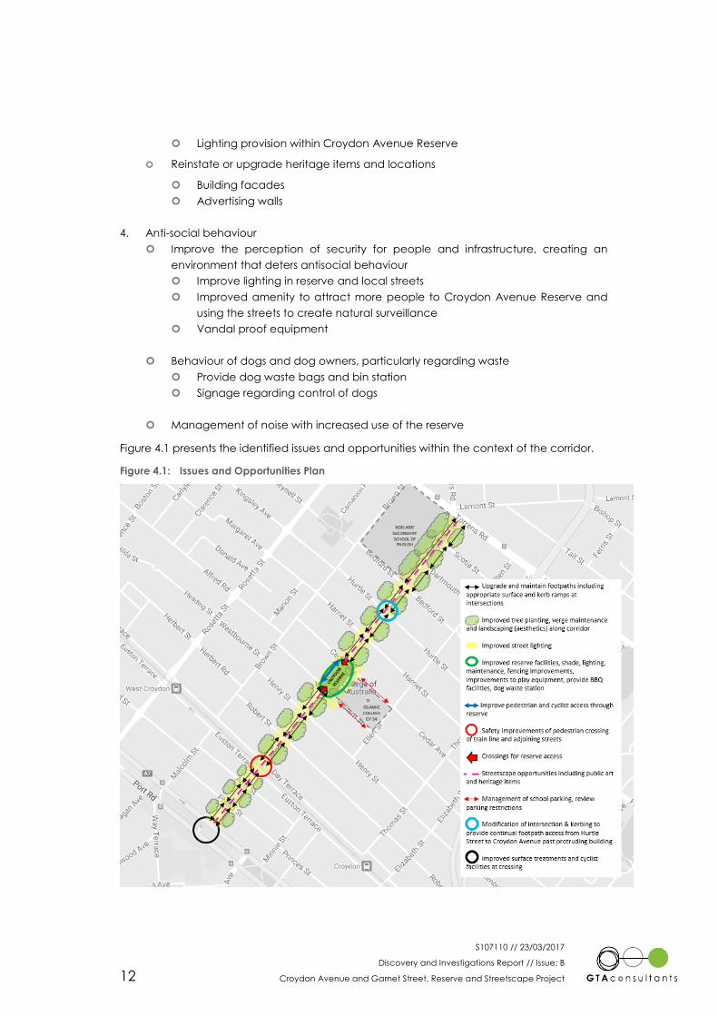
Figure 4.1 presents the identified issues and opportunities within the context of the corridor.
Figure 4.1: Issues and Opportunities Plan

S107110 // 23/03/2017
Discovery and Investigations Report // Issue: B
Croydon Avenue and Garnet Street, Reserve and Streetscape Project 13
5. Summary
This report has considered the background to the Croydon Avenue and Garnet Street – Reserve
and Streetscape Project, providing details of the existing transport networks, their use and format.
Opportunities for new approaches to local street design and management were first investigated
for the City of Charles Sturt through the North West Corridor Study and the Garnet Street and
Croydon Avenue Streetscape project now presents a further opportunity for the City of Charles
Sturt, in conjunction with its local communities, to reimagine other local streets.
The existing conditions in the study area can be summarised as follows:
Garnet Street and Croydon Avenue are both local streets, located in close proximity to
the Welland Plaza Shopping Centre, public reserves, schools and railway stations.
Through connections for traffic are severed by the railway line and Croydon Reserve,
although pedestrian and bicycle access is available through the reserve and across the
railway line.
The abutting land use is primarily residential, with the only non-residential uses being the
two schools.
Traffic volumes on both streets and the surrounding streets are low at well under 500
vehicles per day and vehicle speeds are generally well within the current speed limit.
Several bus routes use Torrens Road and Port Road and Croydon and West Croydon
Railway Stations are also within walking access of the study area.
Pedestrian demand (both existing and latent) is relatively high for a residential street,
due to the direct links along the corridor to Welland Plaza Shopping Centre, Croydon
Avenue Reserve, public transport and two schools.
There is generally sealed footpath provision along both sides of the streets, although
some maintenance issues have been identified. Kerb ramps are varied from recent
replacements to old or missing ramps that are away from the main desire lines.
There were only two recorded crashes within the immediate study area and both were
Property Damage Only (PDO) crashes where the vehicles hit a fixed object at night,
indicating that there is not a significant road safety issue in the study area.
Community and stakeholder engagement has identified a number of issues in the local
area, mostly related to the limited facilities within Croydon Avenue Reserve. Improved
seating, shelter, shade, access and play facilities were key opportunities identified for
the reserve. Revitalising local heritage locations was also suggested.
In transport terms, consistency of footpaths and kerb ramps, parking around the Islamic
College, improved crossing access to the reserve and the railway line and the
constraint on the corner of Hurtle Street and Croydon Avenue were the main issues.
Traffic speed was only really an issue along Day Terrace and Euston Terrace.

Melbourne
A Level 25, 55 Collins Street
PO Box 24055
MELBOURNE VIC 3000
P +613 9851 9600
Brisbane
A Level 4, 283 Elizabeth Street
BRISBANE QLD 4000
GPO Box 115
BRISBANE QLD 4001
P +617 3113 5000
Adelaide
A Suite 4, Level 1, 136 The Parade
PO Box 3421
NORWOOD SA 5067
P +618 8334 3600
Townsville
A Level 1, 25 Sturt Street
PO Box 1064
TOWNSVILLE QLD 4810
P +617 4722 2765
Sydney
A Level 6, 15 Help Street
CHATSWOOD NSW 2067
PO Box 5254
WEST CHATSWOOD NSW 1515
P +612 8448 1800
Canberra
A Tower A, Level 5,
7 London Circuit
Canberra ACT 2600
P +612 6243 4826
Gold Coast
A Level 9, Corporate Centre 2
Box 37, 1 Corporate Court
BUNDALL QLD 4217
P +617 5510 4800
F +617 5510 4814
Perth
A Level 2, 5 Mill Street
PERTH WA 6000
PO Box 7025, Cloisters Square
PERTH WA 6850
P +618 6169 1000
www.gta.com.au www.gta.com.au
S107110 // 30/06/2017
Study Report // Issue: B
Croydon Avenue and Garnet Street, Reserve and Streetscape Project 1
Appendix B
Consultation and Engagement Report Ap
pe
nd
ix B
Croydon Avenue and Garnet Street
Reserve and Streetscape Project
Consultation and Engagement Report
Client // City of Charles Sturt
Office // SA
Reference // S107110
Date // 23/03/2017
© GTA Consultants (GTA Consultants (SA) Pty Ltd) 2017
The information contained in this document is confidential and
intended solely for the use of the client for the purpose for which it has
been prepared and no representation is made or is to be implied as
being made to any third party. Use or copying of this document in
whole or in part without the written permission of GTA Consultants
constitutes an infringement of copyright. The intellectual property
contained in this document remains the property of GTA Consultants. Bla
nk R
ep
ort
(160805 v
1.8
)
Melbourne | Sydney | Brisbane
Canberra | Adelaide | Perth
Gold Coast | Townsville
Croydon Avenue and Garnet Street
Reserve and Streetscape Project
Consultation and Engagement Report
Issue: B 23/03/2017
Client: City of Charles Sturt
Reference: S107110
GTA Consultants Office: SA
Quality Record
Issue Date Description Prepared By Checked By Approved By Signed
A 10/03/2017 Final Paul Froggatt Paul Froggatt Paul Froggatt PFR
B 23/03/2017 Final – amended Paul Froggatt Paul Froggatt Paul Froggatt
S107110 // 23/03/2017
Consultation and Engagement Report // Issue: B
Croydon Avenue and Garnet Street, Reserve and Streetscape Project
Table of Contents
1. Introduction 1
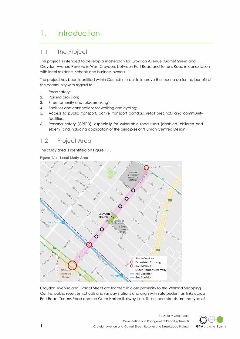
1.1 The Project 1
1.2 Project Area 1
1.3 Future Consultation 2
2. Community Engagement 3
2.1 Place Check Event 3
2.2 Community Survey 3
3. Targeted Meetings 5
3.1 Islamic College of SA 5
3.2 Adelaide Secondary School of English 6
4. Engagement Feedback 7
4.1 Community Responses 7
4.2 Issues and Opportunities 10
5. Summary 12
Appendices
A: Issues and Opportunities Plan
B: Initial Consultation Brochure
Figures
Figure 1.1: Local Study Area 1
Figure 4.1: Respondents Relationship to Study Area 8
Figure 4.2: Residents use of Croydon Avenue, Garnet Street, Croydon Avenue Reserve 9
Figure 4.3: Improvements of most interest to residents 9
S107110 // 23/03/2017
Consultation and Engagement Report // Issue: B
Croydon Avenue and Garnet Street, Reserve and Streetscape Project 1
1. Introduction
1.1 The Project
The project is intended to develop a masterplan for Croydon Avenue, Garnet Street and
Croydon Avenue Reserve in West Croydon, between Port Road and Torrens Road in consultation
with local residents, schools and business owners.
The project has been identified within Council in order to improve the local area for the benefit of
the community with regard to:
1. Road safety;
2. Parking provision;
3. Street amenity and ‘placemaking’;
4. Facilities and connections for walking and cycling;
5. Access to public transport, active transport corridors, retail precincts and community
facilities;
6. Personal safety (CPTED), especially for vulnerable road users (disabled, children and
elderly) and including application of the principles of ‘Human Centred Design.’
1.2 Project Area
The study area is identified on Figure 1.1.
Figure 1.1: Local Study Area
Croydon Avenue and Garnet Street are located in close proximity to the Welland Shopping
Centre, public reserves, schools and railway stations and align with safe pedestrian links across
Port Road, Torrens Road and the Outer Harbor Railway Line. These local streets are the type of
S107110 // 23/03/2017
Consultation and Engagement Report // Issue: B
Croydon Avenue and Garnet Street, Reserve and Streetscape Project 2
street link that the North West Corridor Transport Study identifies for local streetscape and walking
and cycling improvements, whilst maintaining vehicular access as local residential streets.
The existing average daily traffic volume along the various sections of Croydon Avenue and
Garnet Street varies from 150-400 vehicles per day. Although formal pedestrian and cyclist counts
have not been undertaken, pedestrian demand (both existing and latent) is expected to be
relatively high for a residential street, with direct links along this corridor to the Welland Shopping
Centre, Croydon Avenue Reserve and two schools, Islamic College of SA and Adelaide
Secondary School of English, both of which are not zoned to the local area and attract students
from all parts of Metropolitan Adelaide, many via public transport.
The abutting land use is primarily residential, with the only non-residential uses being the Islamic
College of SA, close to Croydon Reserve, and the Adelaide Secondary School of English located
adjacent Torrens Road.
Croydon Avenue and Garnet Street are not identified by the State Government as part of the
Bikedirect route. However, City of Charles Sturt documents, notably the Croydon and West
Croydon LATM 2006 and Active Living Plan to Cycle 2008 identify it as a secondary bicycle route.
1.3 Future Consultation
During the subsequent stages of the project, further consultation events will be held with the
community. Additional feedback on these events will be documented in updated versions of this
report.
S107110 // 23/03/2017
Consultation and Engagement Report // Issue: B
Croydon Avenue and Garnet Street, Reserve and Streetscape Project 3
2. Community Engagement
2.1 Place Check Event
A community workshop was held on Saturday 19 November 2016 at Croydon Avenue Reserve to
discuss issues and initial ideas. The event was intended as a “Place Check” event.
“Place Check” is a method of analysing a street or public place and uses a series of questions
and scores to determine:
What works well?
What doesn’t work? and
What should change in a Street?
The Place Check process is designed so that local residents can take part. The Place Check
workshop was proposed to comprise group walks of residents, Council Staff and the consultant
team along the study area, identifying key locations and holding structured conversation in the
locations to record issues and concerns and ideas.
At the workshop, questions were raised by the community about the nature and intent of the
project. The branding of the project as the ‘Croydon Link Masterplan’ created confusion with
many residents who were concerned the proposal intended the development of a vehicle link
through Croydon Avenue Reserve, creating through traffic routes.
Notwithstanding the concerns raised, small group discussions were held within Croydon Avenue
Reserve which identified a number of issues and concerns within the local area as well as
potential suggestions for enhancements.
Following the workshop a brochure was sent to the community that clarified the intent of the
project and rebranded the project replacing the word “Link” with “Streetscape” and removing
the use of Masterplan. The brochure confirmed that the project is not intended to facilitate
construction of additional roads to allow through traffic along the corridor.
2.2 Community Survey
A total of 1,800 consultation packages were also sent to the local community seeking feedback
on the existing issues and ideas for future improvements or enhancements. A total of 115 people
completed the survey and provided a wide range of comments and ideas, which confirm many
of the suggestions made at the community workshop.
The survey consisted of multiple choice questions and long answer questions, as well as
requesting basic information about the respondent such as their name, address, contact details,
and whether they were a business owner, home owner or tenant in the area.
The key questions as part of the survey were as follows;
How do you use Croydon Link (i.e. Croydon Avenue, Garnet Street, Croydon Avenue
Reserve)? (please tick all that apply to you)
I walk along the footpaths and/or cross the road
In a car to access my street/house
I travel in a car to Croydon Reserve
In a car to drop children off at school (Adelaide Secondary School of
English/Islamic College of SA)
I don’t use or rarely use the Croydon LinK
I ride my bicycle through it
I walk or ride my bicycle to Croydon Reserve
2

S107110 // 23/03/2017
Consultation and Engagement Report // Issue: B
Croydon Avenue and Garnet Street, Reserve and Streetscape Project 4
Talk and/or play with family and neighbours
Other (please specify)
What types of improvements are of most interest to you for the Croydon Link? (please
tick all applicable)
Pedestrian and Cyclist safety
Enhance Street Amenity (i.e. trees, landscaping etc. to make the street look nicer)
Enhance Croydon Reserve (i.e. trees, landscaping, play areas, facilities)
On-street Car Parking
Seating
Public Art
Stormwater Improvements
Street Lighting
Safe and Convenient Access to Properties and Side Streets
Play Equipment
Wayfinding (directional signage)
Other (please specify)
What are your key concerns or issues with the Croydon Link streetscape or traffic
conditions?
Do you have any other comments or ideas to improve the Croydon Link?

S107110 // 23/03/2017
Consultation and Engagement Report // Issue: B
Croydon Avenue and Garnet Street, Reserve and Streetscape Project 5
3. Targeted Meetings
3.1 Islamic College of SA
The Islamic College of South Australia (ICOSA) is located on a site bounded by Cedar Avenue,
Ellen Street and William Street with the primary entrance on Cedar Avenue. Although there is a
formal pick-up and drop-off area within the school site accessed from William Street, significant
pick-up and drop-off takes place on Cedar Avenue.
A meeting was held with the school principal, Lynda MacLeod and acting Business Manager
Qasir Khan to discuss the operation of the school and its interaction with the Croydon Avenue
corridor and Croydon Avenue Reserve. A new principal is expected to be appointed early in
2017.
The school currently has close to 500 students, and this number is likely to reduce rather than
increase in future years as similar facilities are proposed elsewhere in Greater Adelaide. The
school therefore has no plans for expansion.
In terms of the school use of the Croydon Avenue corridor and issues arising from this, the
following points were advised:
ICOSA has an informal agreement with Adelaide Secondary School of English to use
their reserve for a limited number of sports events each year, to which students walk.
This informal agreement is intended to be placed on a more formal basis in 2017.
ICOSA organises some student group excursions by train, with students walking to
Croydon station.
Approximately 50 students are estimated to walk locally to the school, with a very small
number (maximum 1-2 students) riding bikes. Up to 120 students make use of school
buses.
There are some concerns over traffic speed on the adjoining streets and the congestion
issues on William Street and Cedar Avenue. Traffic on Cedar Street was noted to have
increased since the South Road Torrens to Torrens project had started on site.
The proposed 40 km/h precinct speed limit is due to be implemented imminently.
Some of the school zone signs and markings were noted to be faded, damaged or
missing.
In relation to Croydon Avenue Reserve and adjoining plots, the following points were noted:
The school had previously been advised by Council that small group use of the reserve
would be appropriate but this advice was subsequently overturned.
Students and families that do use the reserve after school have received unwelcoming
approaches from local residents even though many are likely to be using the reserve as
local residents.
The school no longer owns the vacant plot adjacent to the reserve on Cedar Avenue
or the plot adjacent to the school on William Street, which now has a commercial land
use. Both are owned by the Islamic Council of Australia, based in Sydney, and are
expected to be sold at some point in the future as they will not be required by the
school.
The proposed roadway connection through the school site to facilitate increased
internal drop-off and pick-up could include proposals for greening of the northern
boundary of the school site. The proposed roadway is with Council as a development
application but is subject to a local objection.

S107110 // 23/03/2017
Consultation and Engagement Report // Issue: B
Croydon Avenue and Garnet Street, Reserve and Streetscape Project 6
Although Cedar Avenue is over 9 metres wide, the school cars parked on both sides create a
very congested environment. Issues associated with poor parking and blocking of driveways
have been a frequent complaint of local residents.
3.2 Adelaide Secondary School of English
The Adelaide Secondary School of English is located on a site bounded by Torrens Road,
Croydon Avenue, Bedford Street and Brown Street with the primary pedestrian entrance on
Torrens Road and parking accessed via Croydon Avenue. The site is shared with the separate
School of Languages.
A meeting was held with the school principal, Julie Presser to discuss the operation of the school
and its interaction with the Croydon Avenue corridor. Julie has been at the school for a number
of years but left at the end of 2016 with a new principal expected to be appointed early in 2017.
Anti Macri will be remaining at the school as Deputy Principal for future correspondence.
The school caters specifically for new arrivals to Australia, primarily providing English language
education to enable students to subsequently integrate in to the mainstream high school system.
The school typically has around 500 students at any given time with many of the students of
refugee origin. Up to 100 students transition to mainstream schools each term, with most students
spending around 18 months at the school.
Students travel from all over the Adelaide Metropolitan area, with the school providing 4
articulated buses each morning and afternoon. Three of the buses are to and from the CBD,
enabling students to connect with ongoing transport options throughout Adelaide with the fourth
bus route to the northern suburbs. There is also a small number of students who access the school
locally on foot or scheduled public transport services (bus and train via West Croydon station).
There has been some use of bicycles but this has reduced following a number of theft incidents.
In terms of the school use of the Croydon Avenue corridor and issues arising from this, the
following points were advised and agreed with Anti Macri:
Pick-up and drop-off can take place within the school site, with the preference of the
school being access from Croydon Avenue and exit on to Torrens Road (left turn only
and no entry permitted.
Some pick-up and drop-off takes place on Croydon Avenue.
The school grounds are open to the public and now includes formal use by a local dog
club. The increased community use has reduced vandalism but lead to concerns with
dog excrement and drug paraphernalia. A code of conduct is now in place with the
dog group.
The school has funding to introduce gym equipment near the Brown Street/Bedford
Street corner of the site in the next few months.
The use of the school Oval by ICOSA is intended to be formalised in 2017.
Excursions by students take place using local bus, train or charter bus, with charter
buses picking up and dropping off on Croydon Avenue.
Most staff parking is accommodated on site, although high numbers of staff on
Tuesdays results in some on street parking on Croydon Avenue where the shade of the
trees provides an attraction for parking.
Some staff make use of local train and bus services, walking along local streets from
West Croydon station.
Delivery and loading generally takes place on Croydon Avenue, although where the
loading/ delivery relates to the gym, it generally occurs on Brown Street.
Opportunities for greening along the local streets and particularly Croydon Avenue
frontage would be welcomed and could include partnerships with the school as part of
some of their projects with students.
S107110 // 23/03/2017
Consultation and Engagement Report // Issue: B
Croydon Avenue and Garnet Street, Reserve and Streetscape Project 7
4. Engagement Feedback
4.1 Community Responses
4.1.1 Place Check Event
One of the key issues raised in the community workshop was regarding vehicle through route
access. This was clarified with attendees (and then to the community via a flyer distribution).
Some of the issues raised in the discussions at the community workshop are summarised as
follows;
Kerb ramps – different format and orientation at every location
Poor footpath surfaces and limited widths for pushchairs and gophers
More shade needed, specifically in reserve
Clean up of graffiti
Grass maintenance in reserve currently 1 per year – needs to be more frequent
Limited street lighting
Better verge maintenance on local streets
Paving lifting around tree roots
Park & Ride issues for Croydon station - Impact of parking on residents from higher
demand as Croydon is last 2 section station
New years’ eve fireworks (illegal group) – Sprinkler to deter gathering
Maintenance of soft fall areas
Stormwater ponds at end of access driveway in reserve – blockage may have been
resolved after most recent storm
Noise impact from basketball on adjoining residents
Lack of sight distance to/for cyclists using reserve path adjacent to fences/property
access
Concern over college expansion
Parent drop-offs at school a problem
On street parking
Opportunities and ideas were raised, with many responding to the above issues and concerns, as
follows;
Opportunity for teenage facilities adjacent High School
Dog facilities (dog bags) - replenishment/maintenance considerations, previous budget
constraints
Zebra crossings – particularly for access to reserve and across railway
Renewal of painted heritage advertising sign on building on corner of Robert St/
Croydon Ave
Stobie pole art as installed on other nearby streets
Keep it green looking – hard wearing grasses – slow growing for maintenance
Palette of landscape materials
Controlled gates for pedestrian level crossing when train is due
Underground power lines
Nature play equipment – wider age friendly
Barbeque
Drinking fountain
Toilet – Yes and no suggestions, positive and negative impacts identified
More seating in reserve, make it useable, nice, shaded
S107110 // 23/03/2017
Consultation and Engagement Report // Issue: B
Croydon Avenue and Garnet Street, Reserve and Streetscape Project 8
View that school/ Australia Muslim Council may be amenable to sell land next to
reserve as can’t acquire adjoining property
Greening of fence edges to reserve – more green generally in the area
Community herb garden / fruit trees
History - old photos
Improved fencing, including security for children in reserve
Footpaths – wider, better
Bins and recycling bins
Nature reserve
Water
Medium density
Volunteer implementation (e.g. of public art, working bee at reserve)
Nature play theme to reserve
Expand Croydon Reserve park
Broader masterplan of West Croydon/Croydon needed
Story of the (former) shop buildings in study area
Heritage trail
Fruit and vegetable shop
4.1.2 Community Survey
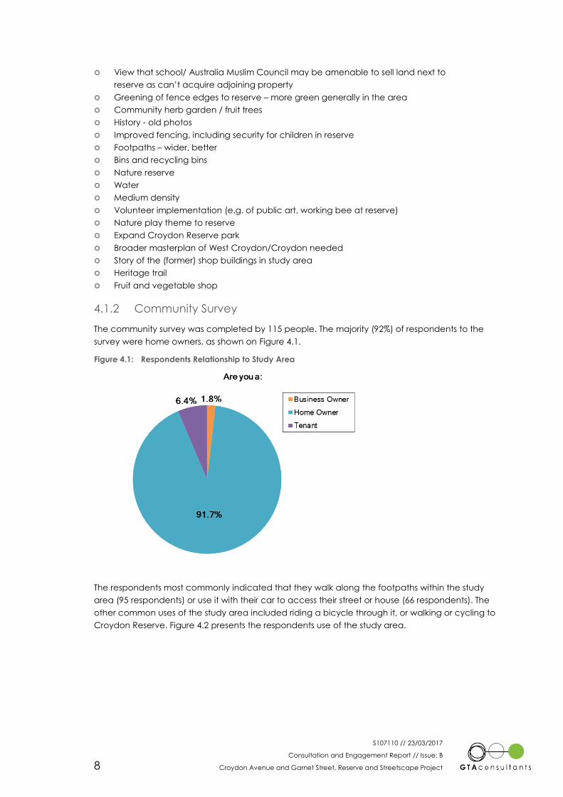
The community survey was completed by 115 people. The majority (92%) of respondents to the
survey were home owners, as shown on Figure 4.1.
Figure 4.1: Respondents Relationship to Study Area
The respondents most commonly indicated that they walk along the footpaths within the study
area (95 respondents) or use it with their car to access their street or house (66 respondents). The
other common uses of the study area included riding a bicycle through it, or walking or cycling to
Croydon Reserve. Figure 4.2 presents the respondents use of the study area.
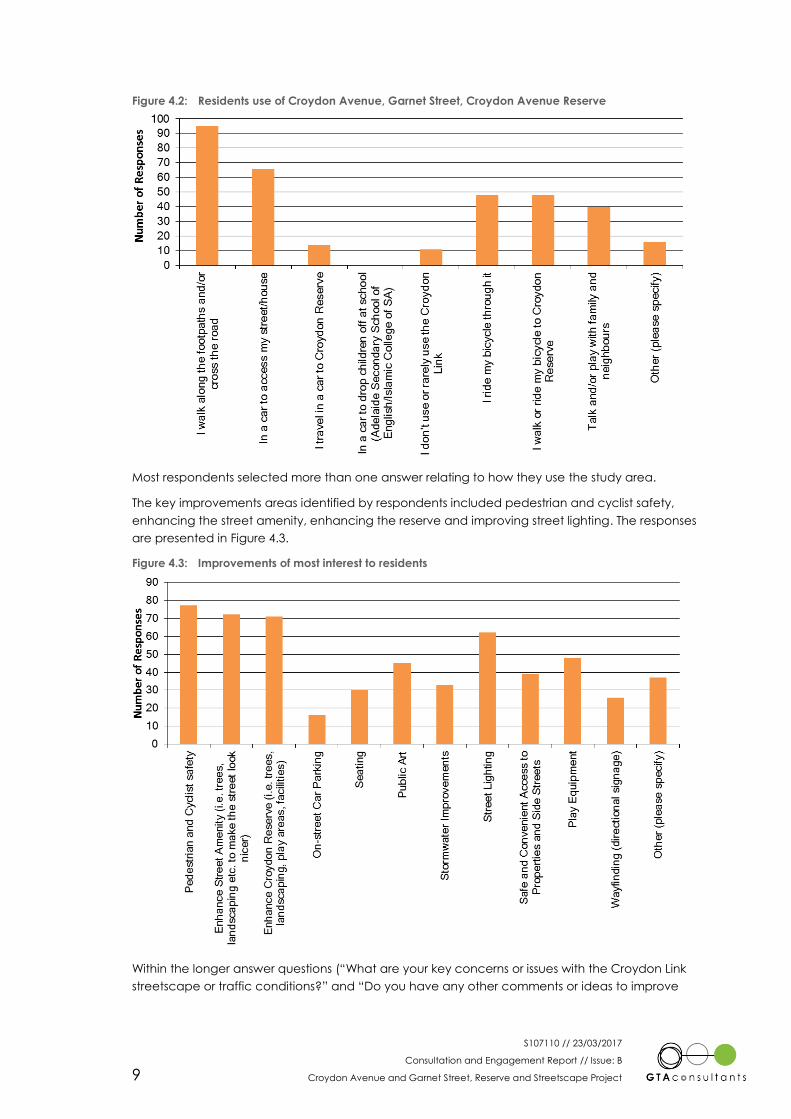
S107110 // 23/03/2017
Consultation and Engagement Report // Issue: B
Croydon Avenue and Garnet Street, Reserve and Streetscape Project 9
Figure 4.2: Residents use of Croydon Avenue, Garnet Street, Croydon Avenue Reserve
Most respondents selected more than one answer relating to how they use the study area.
The key improvements areas identified by respondents included pedestrian and cyclist safety,
enhancing the street amenity, enhancing the reserve and improving street lighting. The responses
are presented in Figure 4.3.
Figure 4.3: Improvements of most interest to residents
Within the longer answer questions (“What are your key concerns or issues with the Croydon Link
streetscape or traffic conditions?” and “Do you have any other comments or ideas to improve

S107110 // 23/03/2017
Consultation and Engagement Report // Issue: B
Croydon Avenue and Garnet Street, Reserve and Streetscape Project 10
the Croydon Link?”) there were 10 respondents who noted they objected to the project in
general in their responses to these questions.
The concerns or issues raised with the streetscape or traffic conditions included concerns at the
level of through traffic and general traffic volumes (21 responses), as well as speed concerns
(including suggestions to lower the speed limit) (12 responses). Maintenance concerns were
raised by 18 respondents, with footpath quality and grass maintenance being the most common
concerns.
Some concern over behaviours of users were raised as follows;
Dog poo clean-up and intimidating dogs off leashes – 4
School parking/drop off/pick up – 3
Illegal parking or parking close to intersections – 3
Vandalism – 1
Children cyclists on footpaths and/or cyclists not being considerate – 2
Long term parking – 1
Drug dealing – 2
Several people raised a concern over the safety of the rail crossing. 4 respondents indicated that
they did not want to lose on street parking as part of the plan.
Respondents also raised a number of ideas to improve Croydon Link, as follows;
Nature play park – 1
Community garden – 1
Bigger/improved playground equipment – 4
Fence playground – 1
Shade awning over playground – 2
Upgrade/improve safety at rail crossing – 5
Improve street lighting – 8
Trees for aesthetics and shade, greenery/landscaping – 18
Street art/visual improvements – 8
Seating areas – 2
Toilets – 4
Wheelchair ramps/kerb ramps appropriately located – 2
BBQ – 1
More bins – 2
Directional signage – 1
Drinking fountain – 1
Fitness equipment – 1
Improve drainage – 1
Dog poo bag station – 3
Widen streets or remove some parking as narrow streets – 3
4.2 Issues and Opportunities
4.2.1 Summary
The community consultation identified issues and opportunities along the study corridor which
can broadly be broken down into the following categories;
1. Movement
Balanced movement of people as pedestrians, cyclists and motorists;
Appropriate vehicle speeds and volumes;
Maintaining access to properties and residential streets;
S107110 // 23/03/2017
Consultation and Engagement Report // Issue: B
Croydon Avenue and Garnet Street, Reserve and Streetscape Project 11
Access to the reserve, schools, public transport and other key locations as a
pedestrian, cyclist and motorist;
Parking availability and length of stay;
Ensuring safe movement of pedestrians, cyclists and motorists;
2. Maintenance
Maintenance of landscaping, trees and vegetation for aesthetics and safety;
Footpath surface maintenance;
Repair damage and remove graffiti;
3. Facilities
Adequate footpaths and kerb ramps to suit all users and allow for appropriate
movement uses;
Opportunities to improve the reserve facilities to create a local community area
within Croydon/West Croydon;
Opportunities to improve the reserve and park facilities to deter antisocial
behaviour;
More secure fencing to minimise road safety risks of children leaving the reserve
unaccompanied;
Improvement of lighting infrastructure;
4. Anti-social behaviour
Security of people and infrastructure, with poor street lighting creating an
environment for antisocial behaviour;
Behaviour of dogs and dog owners, particularly regarding waste;
Noise
An Issues and Opportunities Plan has been developed based solely on the community feedback.
The plan is included in Appendix A

S107110 // 23/03/2017
Consultation and Engagement Report // Issue: B
Croydon Avenue and Garnet Street, Reserve and Streetscape Project 12
5. Summary
This report provides a summary of the community engagement that has taken place as part of
the early stages of the Croydon Avenue and Garnet Street - Reserve and Streetscape Project,
and the feedback that has been received to date.
The initial project entitled the Croydon Link Masterplan created some concern and confusion
amongst the community that a new road link was proposed through Croydon Avenue Reserve as
a major link road between Torrens Road and Port Road. As a result, the project has been
rebranded to place the emphasis on the intended streetscape and local amenity upgrades that
are envisaged.
The community feedback identified a number of issues within the proposed study area of
Croydon Avenue and Garnet Street covering walking and cycling provision, facilities and access
to the reserve, impact of high travel demand generators within the area and anti-social
behaviour.
The community further identified that the study area scope was too localised and that a wider
area should have been considered. Recommendations from this study may be appropriate for
application on a wider area basis.
Opportunities for improvement to the local area and in particular Croydon Avenue Reserve were
identified including footpath and kerb ramp upgrades, pedestrian improvements to access the
reserve and across the railway line, improved and additional facilities in the reserve to encourage
more community use, enhanced maintenance, improved lighting and more secure fencing,
primarily from a road safety perspective.
Discussions with the Islamic College of SA identified that they have no further expansion plans
and that a number of their students are also members of the immediately local community.
Parking and traffic management issues are recognised by the school as a major issue and the
school is seeking to improve this by further on-site provision. Local pedestrian upgrades along the
corridor would assist student access to the school and also the schools use of Oval facilities at the
Adelaide Secondary School of English.
Adelaide Secondary School of English has few students from the local area, but their on-site
facilities are available and used by the local community on formal and informal bases. Further
upgrade to their facilities that would be available to the community are proposed and they
would welcome the opportunity for the school to be able to assist or partner with Council in
delivering and/or maintaining streetscape and landscape facilities.
A summary issues and opportunities plan has been prepared from the consultation feedback. This
will form the basis of the ideas for the development of potential options, supplemented by issues
and opportunities derived from analysis of the existing transport conditions and operations in the
study area and overview of the streetscape and amenity provision.
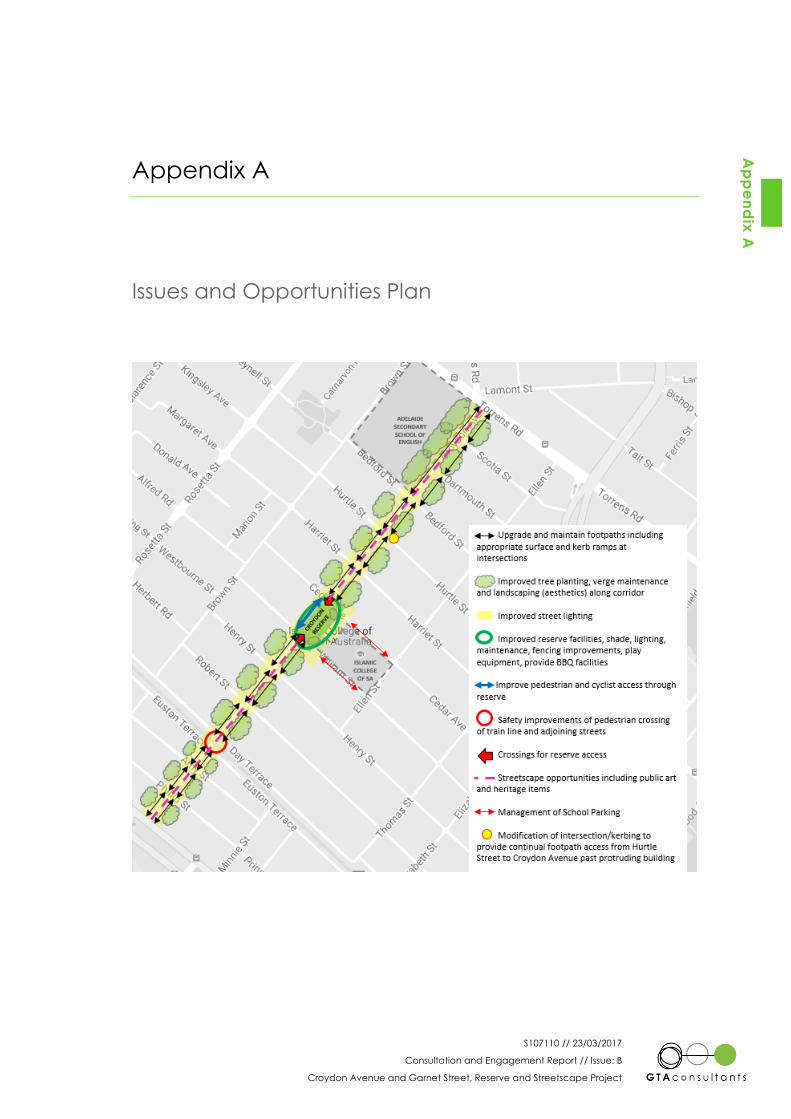
S107110 // 23/03/2017
Consultation and Engagement Report // Issue: B
Croydon Avenue and Garnet Street, Reserve and Streetscape Project
Appendix A
Issues and Opportunities Plan
Ap
pe
nd
ix A
S107110 // 23/03/2017
Consultation and Engagement Report // Issue: B
Croydon Avenue and Garnet Street, Reserve and Streetscape Project
Appendix B
Initial Consultation Brochure
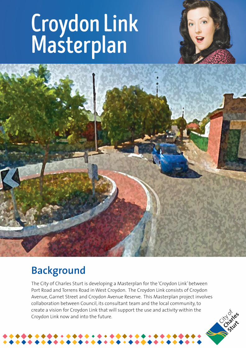
Croydon Link Masterplan
BackgroundThe City of Charles Sturt is developing a Masterplan for the ‘Croydon Link’ between Port Road and Torrens Road in West Croydon. The Croydon Link consists of Croydon Avenue, Garnet Street and Croydon Avenue Reserve. This Masterplan project involves collaboration between Council, its consultant team and the local community, to create a vision for Croydon Link that will support the use and activity within the Croydon Link now and into the future.
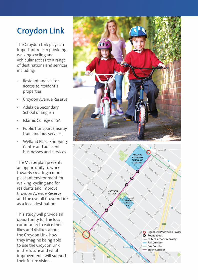
The Croydon Link plays an important role in providing walking, cycling and vehicular access to a range of destinations and services including:
• Resident and visitor access to residential properties
• Croydon Avenue Reserve
• Adelaide Secondary School of English
• Islamic College of SA
• Public transport (nearby train and bus services)
• Welland Plaza Shopping Centre and adjacent businesses and services.
The Masterplan presents an opportunity to work towards creating a more pleasant environment for walking, cycling and for residents and improve Croydon Avenue Reserve and the overall Croydon Link as a local destination.
This study will provide an opportunity for the local community to voice their likes and dislikes about the Croydon Link, how they imagine being able to use the Croydon Link in the future and what improvements will support their future vision.
Croydon Link
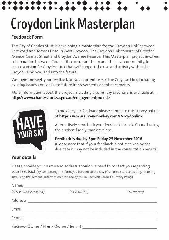
Your details
Please provide your name and address should we need to contact you regarding your feedback (By completing this form, you consent to the City of Charles Sturt collecting, retaining and using the personal information provided by you in line with Council’s Privacy Policy)
Name: __________________________________________________________________(Mr/Mrs/Miss/Ms/Dr) (FirstName) (Surname)
Address: ________________________________________________________________
Email: __________________________________________________________________
Phone:__________________________________________________________________
Business Owner / Home Owner / Tenant _____________________________________
Have your say
To provide your feedback please complete this survey online at https://www.surveymonkey.com/r/croydonlink
Alternatively send back your feedback form to Council using the enclosed reply-paid envelope.
Feedback is due by 5pm Friday 25 November 2016 (Please note that if your feedback is not received by the due date it may not be included in the consultation results).
Feedback Form
The City of Charles Sturt is developing a Masterplan for the ‘Croydon Link’ between Port Road and Torrens Road in West Croydon. The Croydon Link consists of Croydon Avenue, Garnet Street and Croydon Avenue Reserve. This Masterplan project involves collaboration between Council, its consultant team and the local community, to create a vision for Croydon Link that will support the use and activity within the Croydon Link now and into the future.
We therefore seek your feedback on your current use of the Croydon Link, including existing issues and ideas for future improvements or enhancements.
More information about the project, including a summary brochure, is available at: - http://www.charlessturt.sa.gov.au/engagementprojects
Croydon Link Masterplan
Council’s emailed newsletter
Would you like to receive Council’s Diamond Bytes emailed newsletter to be kept up to date with activities and projects within the City? Yes No (Please provide your email address above)
1. In which street do you live or own a property?__________________________________________________________________________________________________________________________________________
2. How do you use Croydon Link (i.e. Croydon Avenue, Garnet Street, Croydon Avenue Reserve)? (please tick all that apply to you)
I walk along the footpaths and/or cross the road
I ride my bicycle through it
In a car to access my street/house
I walk or ride my bicycle to Croydon Reserve
I travel in a car to Croydon Reserve
Talk and/or play with family and neighbours
In a car to drop children off at school (Adelaide Secondary School of English/Islamic College of SA)
I don’t use or rarely use the Croydon Link
Other (please specify below)
3. What types of improvements are of most interest to you for the Croydon Link? (please tick all applicable)
Pedestrian and Cyclist safety
Street Lighting
Enhance Street Amenity (i.e. trees, landscaping etc. to make the street look nicer)
Enhance Croydon Reserve (i.e. trees, landscaping, play areas, facilities)
On-street Car Parking
Safe and Convenient Access to Properties and Side Streets
Seating
Play Equipment
Public Art
Wayfinding (directional signage)
Stormwater Improvements
Other (please specify below)
__________________________________________________________________________________________________________________________________________
4. What are your key concerns or issues with the Croydon Link streetscape or traffic conditions?
______________________________________________________________________________________________________________________________________________________________________________________________________________________________________________________________________________________________________________________________________________________________________________________________________________________________
5. Do you have any other comments or ideas to improve the Croydon Link?
______________________________________________________________________________________________________________________________________________________________________________________________________________________________________________________________________________________________________________________________________________________________________________________________________________________________
Wethankyouforyourtimeandvaluablecomments

72 Woodville Road, Woodvillewww.charlessturt.sa.gov.au
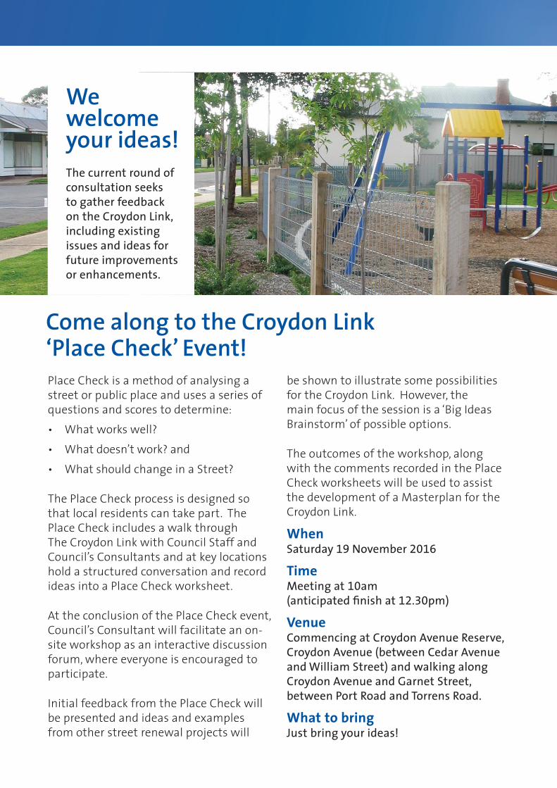
Come along to the Croydon Link ‘Place Check’ Event!
We welcome your ideas!The current round of consultation seeks to gather feedback on the Croydon Link, including existing issues and ideas for future improvements or enhancements.
Place Check is a method of analysing a street or public place and uses a series of questions and scores to determine:
• What works well?
• What doesn’t work? and
• What should change in a Street?
The Place Check process is designed so that local residents can take part. The Place Check includes a walk through The Croydon Link with Council Staff and Council’s Consultants and at key locations hold a structured conversation and record ideas into a Place Check worksheet.
At the conclusion of the Place Check event, Council’s Consultant will facilitate an on-site workshop as an interactive discussion forum, where everyone is encouraged to participate.
Initial feedback from the Place Check will be presented and ideas and examples from other street renewal projects will
be shown to illustrate some possibilities for the Croydon Link. However, the main focus of the session is a ‘Big Ideas Brainstorm’ of possible options.
The outcomes of the workshop, along with the comments recorded in the Place Check worksheets will be used to assist the development of a Masterplan for the Croydon Link.
When Saturday 19 November 2016
Time Meeting at 10am (anticipated finish at 12.30pm)
Venue Commencing at Croydon Avenue Reserve, Croydon Avenue (between Cedar Avenue and William Street) and walking along Croydon Avenue and Garnet Street, between Port Road and Torrens Road.
What to bring Just bring your ideas!
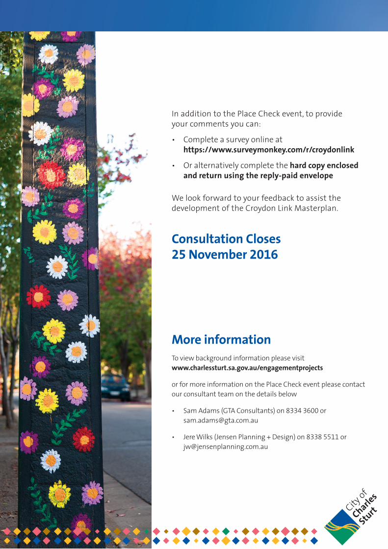
In addition to the Place Check event, to provide your comments you can:
• Complete a survey online at https://www.surveymonkey.com/r/croydonlink
• Or alternatively complete the hard copy enclosed and return using the reply-paid envelope
We look forward to your feedback to assist the development of the Croydon Link Masterplan.
Consultation Closes 25 November 2016
More informationTo view background information please visit www.charlessturt.sa.gov.au/engagementprojects
or for more information on the Place Check event please contact our consultant team on the details below
• Sam Adams (GTA Consultants) on 8334 3600 or [email protected]
• Jere Wilks (Jensen Planning + Design) on 8338 5511 or [email protected]

S107110 // 30/06/2017
Study Report // Issue: B
Croydon Avenue and Garnet Street, Reserve and Streetscape Project 1
Appendix C
Concept Plan
Ap
pe
nd
ix C
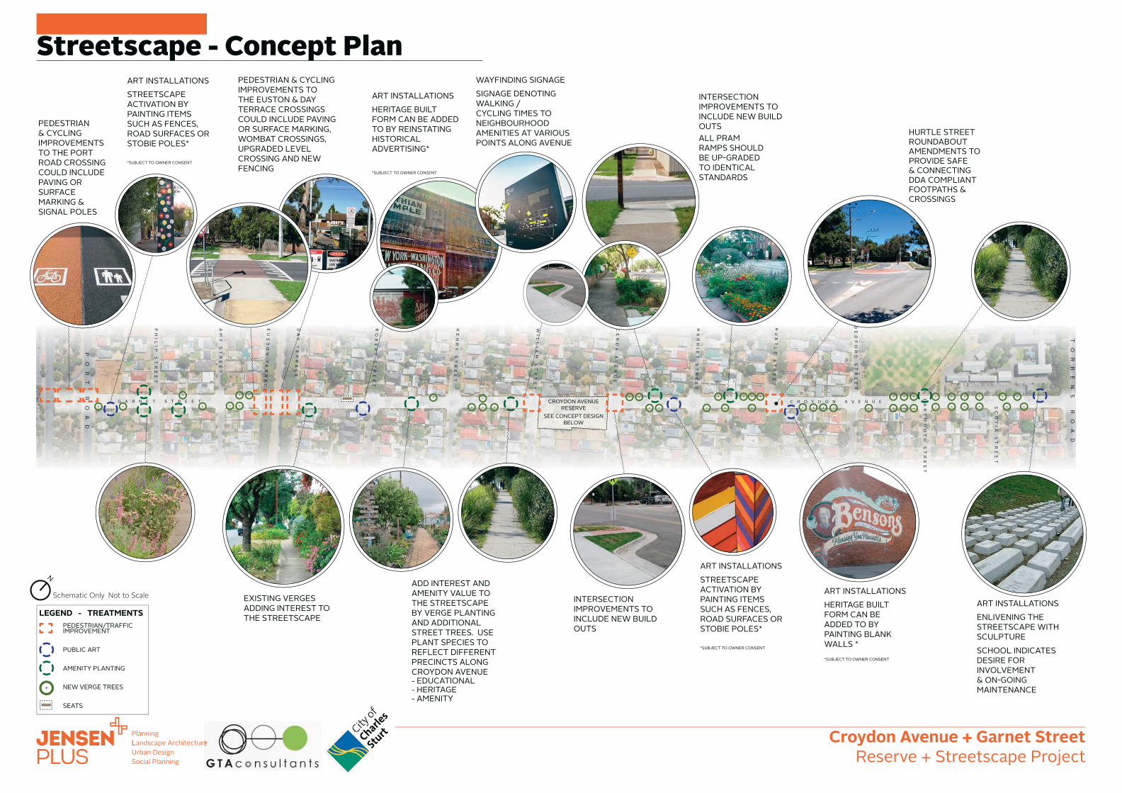
C R O Y D O N A V E N U E
BE
DF
OR
D
ST
RE
ET
DA
RT
MO
UT
H
ST
RE
ET
SC
OT
IA
S
TR
EE
T
HU
RT
LE
S
TR
EE
T
HA
RR
IE
T
ST
RE
ET
CE
RD
A
AV
EN
UE
WI
LL
IA
M
ST
RE
ET
HE
NR
Y
ST
RE
ET
RO
BE
RT
S
TR
EE
T
DA
Y
TE
RR
AC
E
EU
ST
ON
TE
RR
AC
E
AM
Y
ST
RE
ET
PH
IL
IP
S
TR
EE
T
CROYDON AVENUE RESERVE
SEE CONCEPT DESIGN BELOW
G A R N E T S T R E E T
TO
RR
EN
S
RO
AD
PO
RT
R
OA
D
Schematic Only Not to Scale
PEDESTRIAN/TRAFFIC IMPROVEMENT
PUBLIC ART
AMENITY PLANTING
NEW VERGE TREES
SEATS
LEGEND - TREATMENTS
Streetscape - Concept Plan
ART INSTALLATIONSENLIVENING THE STREETSCAPE WITH SCULPTURE SCHOOL INDICATES DESIRE FOR INVOLVEMENT & ON-GOING MAINTENANCE
INTERSECTION IMPROVEMENTS TO INCLUDE NEW BUILD OUTS
HURTLE STREET ROUNDABOUT AMENDMENTS TO PROVIDE SAFE & CONNECTING DDA COMPLIANT FOOTPATHS & CROSSINGS
PEDESTRIAN & CYCLING IMPROVEMENTS TO THE EUSTON & DAY TERRACE CROSSINGS COULD INCLUDE PAVING OR SURFACE MARKING, WOMBAT CROSSINGS, UPGRADED LEVEL CROSSING AND NEW FENCING
PEDESTRIAN & CYCLING IMPROVEMENTS TO THE PORT ROAD CROSSING COULD INCLUDE PAVING OR SURFACE MARKING & SIGNAL POLES
INTERSECTION IMPROVEMENTS TO INCLUDE NEW BUILD OUTSALL PRAM RAMPS SHOULD BE UP-GRADED TO IDENTICAL STANDARDS
ADD INTEREST AND AMENITY VALUE TO THE STREETSCAPE BY VERGE PLANTING AND ADDITIONAL STREET TREES. USE PLANT SPECIES TO REFLECT DIFFERENT PRECINCTS ALONG CROYDON AVENUE- EDUCATIONAL- HERITAGE- AMENITY
ART INSTALLATIONSHERITAGE BUILT FORM CAN BE ADDED TO BY PAINTING BLANK WALLS **SUBJECT TO OWNER CONSENT
ART INSTALLATIONSHERITAGE BUILT FORM CAN BE ADDED TO BY REINSTATING HISTORICAL ADVERTISING*
*SUBJECT TO OWNER CONSENT
WAYFINDING SIGNAGESIGNAGE DENOTING WALKING / CYCLING TIMES TO NEIGHBOURHOOD AMENITIES AT VARIOUS POINTS ALONG AVENUE
EXISTING VERGES ADDING INTEREST TO THE STREETSCAPE
ART INSTALLATIONSSTREETSCAPE ACTIVATION BY PAINTING ITEMS SUCH AS FENCES, ROAD SURFACES OR STOBIE POLES*
*SUBJECT TO OWNER CONSENT
ART INSTALLATIONSSTREETSCAPE ACTIVATION BY PAINTING ITEMS SUCH AS FENCES, ROAD SURFACES OR STOBIE POLES*
*SUBJECT TO OWNER CONSENT
N
Croydon Avenue + Garnet StreetReserve + Streetscape Project
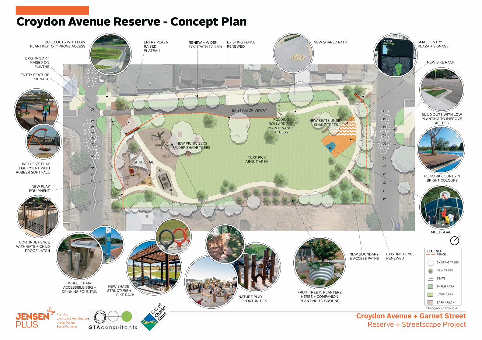
WI
LL
IA
M
ST
RE
ET
CE
DA
R
AV
EN
UE
1:100@A0 / 1:200 @ A1
FRUIT TREE IN PLANTERSHERBS + COMPANION
PLANTING TO GROUND
BUILD OUTS WITH LOW PLANTING TO IMPROVE
ACCESS
NATURE PLAY OPPORTUNITIES
NEW SHADE STRUCTURE +
BIKE RACK
NEW BIKE RACK
WHEELCHAIR ACCESSIBLE BBQ +
DRINKING FOUNTAIN
INCLUSIVE PLAY EQUIPMENT WITH
RUBBER SOFT FALL
NEW PLAY EQUIPMENT
EXISTING ART RAISED ON
PLINTHS
ENTRY PLAZA RAISED PLATEAU
RENEW + WIDEN FOOTPATH TO 1.5M
NEW SHARED PATH
CONTINUE FENCE WITH GATE + CHILD
PROOF LATCH
EXISTING FENCE RENEWED
ENTRY FEATURE + SIGNAGE
SHADE SAIL
NEW PICNIC SETS UNDER SHADE TREES
NEW SEATS UNDER SHADE TREES
FOLDING BOLLARD FOR MAINTENANCE
ACCESS
RE-MARK COURTS IN BRIGHT COLOURS
EXISTING FENCE RENEWED
MULTIGOAL
NEW BOUNDARY & ACCESS PATHS
SMALL ENTRY PLAZA + SIGNAGE
TURF KICK ABOUT AREA
EXISTING DRIVEWAY
FENCE
EXISTING TREES
NEW TREES
SEATS
SHRUB AREA
LAWN AREA
BARK MULCH
LEGEND
BUILD OUTS WITH LOW PLANTING TO IMPROVE ACCESS
Croydon Avenue Reserve - Concept Plan
N
Croydon Avenue + Garnet StreetReserve + Streetscape Project

Melbourne
A Level 25, 55 Collins Street
PO Box 24055
MELBOURNE VIC 3000
P +613 9851 9600
Brisbane
A Ground Floor, 283 Elizabeth Street
BRISBANE QLD 4000
GPO Box 115
BRISBANE QLD 4001
P +617 3113 5000
Adelaide
A Suite 4, Level 1, 136 The Parade
PO Box 3421
NORWOOD SA 5067
P +618 8334 3600
Townsville
A Level 1, 25 Sturt Street
PO Box 1064
TOWNSVILLE QLD 4810
P +617 4722 2765
Sydney
A Level 6, 15 Help Street
CHATSWOOD NSW 2067
PO Box 5254
WEST CHATSWOOD NSW 1515
P +612 8448 1800
Canberra
A Tower A, Level 5,
7 London Circuit
Canberra ACT 2600
P +612 6243 4826
Gold Coast
A Level 9, Corporate Centre 2
Box 37, 1 Corporate Court
BUNDALL QLD 4217
P +617 5510 4800
F +617 5510 4814
Perth
A Level 2, 5 Mill Street
PERTH WA 6000
PO Box 7025, Cloisters Square
PERTH WA 6850
P +618 6169 1000
www.gta.com.au www.gta.com.au