crowd-gps-sec: leveraging crowdsourcing to detect … · with air safety. we propose crowd-gps-sec...
TRANSCRIPT

Crowd-GPS-Sec: Leveraging Crowdsourcing toDetect and Localize GPS Spoofing Attacks
Kai Jansen∗, Matthias Schafer†, Daniel Moser‡, Vincent Lenders§, Christina Popper¶ and Jens Schmitt†
∗Ruhr-University Bochum, Germany, [email protected]†University of Kaiserslautern, Germany, {schaefer, jschmitt}@cs.uni-kl.de
‡ETH Zurich, Switzerland, [email protected]§armasuisse, Switzerland, [email protected]
¶New York University Abu Dhabi, United Arab Emirates, [email protected]
Abstract—The aviation industry’s increasing reliance on GPSto facilitate navigation and air traffic monitoring opens newattack vectors with the purpose of hijacking UAVs or interferingwith air safety. We propose Crowd-GPS-Sec to detect andlocalize GPS spoofing attacks on moving airborne targets suchas UAVs or commercial airliners. Unlike previous attempts tosecure GPS, Crowd-GPS-Sec neither requires any updates ofthe GPS infrastructure nor of the airborne GPS receivers,which are both unlikely to happen in the near future. Incontrast, Crowd-GPS-Sec leverages crowdsourcing to monitorthe air traffic from GPS-derived position advertisements thataircraft periodically broadcast for air traffic control purposes.Spoofing attacks are detected and localized by an independentinfrastructure on the ground which continuously analyzes thecontents and the times of arrival of these advertisements. Weevaluate our system with real-world data from a crowdsourcedair traffic monitoring sensor network and by simulations. Weshow that Crowd-GPS-Sec is able to globally detect GPS spoofingattacks in less than two seconds and to localize the attacker up toan accuracy of 150 meters after 15 minutes of monitoring time.
I. INTRODUCTION
Today, more than a billion devices rely on the GlobalPositioning System (GPS) for various applications that re-quire accurate positioning or precise time synchronization.With its ubiquitous coverage, GPS has become the de factostandard means of navigation and tracking services in outdoorenvironments, where it achieves an accuracy of up to threemeters [1]. For navigation purposes, satellite systems suchas GPS are mission-critical for Unmanned Aerial Vehicles(UAVs), ranging from consumer-class mini or micro dronesto tactical and strategic UAVs.
Although GPS is commonly used in aviation, the systemis not secure, i. e., civilian (public) GPS signals sent bythe satellites are neither authenticated nor encrypted. As aconsequence, aircraft and UAVs are vulnerable to GPS signalspoofing attacks, where a malicious transmitter emits signalssimilar to those from the satellites but at a higher power and,potentially, at slightly different time delays. The aircraft’s GPSreceiver will lock on to the spoofed signal as it arrives with ahigher signal strength than the authentic signals.
By selectively varying the time offsets of the spoofedsatellite signals, attackers are able to mimic arbitrary positions.These kinds of spoofing attacks are well-known [2]–[7] and
have been shown to be feasible in the real-world [5], [8]. Infact, GPS spoofing has allegedly been used to hijack a CIAstealth drone (RQ-170) in Iran in 2011 [9] or luring shipsoff their course [4], [10]. Moreover, GPS spoofing has beenused as a defense against GPS-controlled UAVs flying in thevicinity of the Kremlin in Russia [11].
Over the years, the price to perform GPS spoofing attackshas dramatically dropped. Mobile commercial off-the-shelfGPS spoofing devices are available for less than $1,000 [4]and publicly available software tools [12] allow the generationof arbitrary GPS signals. The price fall and low-expertiserequirements raise the risk for applications relying on GPSfor safety- or security-critical decisions and processes.
The democratization of GPS spoofing technologies has trig-gered the development of various countermeasures, which canbe coarsely categorized into three classes: (i) cryptographictechniques, (ii) detection at signal level, and (iii) directionof arrival sensing. Cryptographic techniques [13]–[16] aim atauthenticating signals from satellites with additional signalsthat are unpredictable to users that do not own a secretkey. However, these techniques are not resistant to replayattacks and would require a costly upgrade of the GPS infras-tructure. Spoofing detection at signal level are based eitheron anomaly checks in the physical signal waveform [17]–[19] or on measuring the angle of arrival from which thesignal is originating [20], [21]. While these techniques donot require a change in the structure of GPS signals, theyimpose modifications on existing receivers and increase thecomplexity and computational requirements of those devices.We conclude that existing countermeasures are unlikely tobe implemented in the near future since they all require far-reaching modifications of either the GPS infrastructure or thereceiving devices.
Driven by the increasing threat and the lack of realisticshort-term solutions, we propose Crowd-GPS-Sec, a systemthat detects and localizes GPS spoofing attacks on aerialvehicles without the need to update the structure of theGPS satellites’ signals nor the logic of the airborne GPS re-ceivers. Crowd-GPS-Sec leverages crowdsourcing to monitorthe position advertisements derived from GPS that aircraft andUAVs periodically broadcast for air traffic surveillance. Using

those advertisements, we devise a GPS spoofing detection andlocalization solution that analyzes the contents and the time ofarrival of these surveillance messages as received by differentsensors on the ground.
We have evaluated Crowd-GPS-Sec with simulations andreal-world data from the OpenSky Network [22], a crowd-sourcing initiative which maintains a network of more than700 air traffic communication sensors around the world. Ourimplementation of Crowd-GPS-Sec is able to globally detectGPS spoofing attacks in less than two seconds and to localizethe attacker up to an accuracy of 150 meters after 15 minutesof monitoring time.
While the problem addressed in this work is related tospoofing detection and localization in classical direction find-ing [20], [21] and multilateration systems [23], there is onefundamental difference and unique advantage. Instead of try-ing to detect and localize the GPS spoofer through directmeasurements of its own signals, we rely on indirect mea-surements from the position advertisements that the aircraftare broadcasting. This approach enables us to detect andlocalize the spoofer even when there is no direct line-of-sight connection from a sensor to the spoofer. Maintaininga line-of-sight connection to the aircraft is much simplerand thus more effective since the aircraft are in the sky anduse high transmission power levels which render the signalsreceivable from the ground up to several hundred kilometersaway. Another major advantage is that Crowd-GPS-Sec relieson data from air traffic monitoring sensors that are alreadywidely deployed around the world. Thus, the solution doesnot require a dedicated GPS signal acquisition infrastructurefor spoofing detection and localization. To the best of ourknowledge, this paper is the first to propose a GPS spoofingcountermeasure which takes advantage of considering indirectGPS-inferred data rather than raw GPS signals.
In summary, this paper makes the following contributions:• We propose Crowd-GPS-Sec and elaborate on the idea to
provide security via an existing infrastructure of crowd-sourcing sensors.
• We present algorithms for the detection of GPS spoofingattacks on airborne targets by using aircraft reports andmultilateration.
• We provide a novel technique for the localization of GPSspoofers based on position differences between pairs ofspoofed aircraft.
• We report on experiments with aircraft transponders andassess the performance of Crowd-GPS-Sec analyzingreal-world air traffic control data.
II. THE GLOBAL POSITIONING SYSTEM
The GPS infrastructure is a satellite-based navigation net-work of over 30 satellites located in the medium Earth orbit,more than 20,000 km above the Earth’s surface. GPS-capablereceivers can determine their position and time by measuringthe time of arrival (ToA) from at least four satellites. Basedon the ToA and the transmission time embedded in thesignals, receivers can calculate distances to each satellite.
RADAR ADS-B/Flarm
GPS
Satellite-to-Aircraft
Aircraft-to-Ground
Fig. 1. Schematic overview of currently deployed technologies used tomonitor air traffic including GPS, RADAR, and ADS-B/Flarm.
Multilateration of those distances yields the position and thelocal time of the receiver.
The ToA measurements are affected by a range of errorsresulting in a typical localization uncertainty of σ = 4 m(mean error of about 7 m) [24]–[27]. While civilian (public)GPS signals can be decoded by everyone, including airplanes,drones, and other UAVs, military GPS signals are protectedby (at least) secret spreading codes restricting their usersto a selected group with additional knowledge. We focuson civilian GPS with non-authenticated signals, which is thestandard in commercial and general aviation.
A. GPS Usage in Aviation
While in the past, radar and inertial systems used to be thetwo main localization technologies in aviation, GPS is todayoften the preferred solution due to its superior accuracy. Mod-ern airliners, smaller aircraft, gliders, helicopters, or UAVsare almost all equipped with GPS receivers. GPS is typicallyused by pilots or UAVs for self-localization but the technologyis also used for remote air-traffic surveillance and collision-avoidance applications. In the latter cases, aerial vehicles arerequired to periodically broadcast position and velocity adver-tisements to inform neighboring aircraft and ground controllersabout their presence. Larger aerial vehicles generally transmitthose messages over the Automatic Dependent Surveillance –Broadcast (ADS-B) system while smaller and slower vehiclesrely on the Flarm [28] system. Irrespective of the used system,these advertisements contain a position that is directly derivedfrom airborne GPS receivers as depicted in Figure 1.
In this work, we propose to leverage the position advertise-ment messages of ADS-B and Flarm in order to detect and lo-calize GPS spoofers. While ADS-B and Flarm rely on differentradio frequencies and message formats, the underlying conceptis the same. On regular random intervals (around twice persecond), aircraft broadcast their current position together withtheir unique addresses. Neighboring aerial vehicles and groundstations receive these messages to generate a recognized airpicture. The advertisement messages can be received over longdistances. In ADS-B, messages can be received up to distances

of 700 km when there is a direct line-of-sight connectionbetween the transmitter and the receiver. In Flarm, the rangeis smaller but reception ranges of up to 100 km are possible.
B. GPS Spoofing Attacks
GPS spoofing attacks exploit the lack of encryption andauthentication of civilian GPS signals by imitating the legit-imate signals with the purpose of modifying the localizationor time result of a victim [3], [7], [25]. Technically, spoofingattacks are based on fake GPS signals manipulating the ToAsof signals that otherwise use the same payload as real signals.
In the past, incidents were reported [4], [9]–[11] wherespoofers successfully interfered with the integrity of GPS-dependent systems, thus rendering the spoofing threat farfrom being only of theoretical nature. As a result, currentlymarketed drones, aircraft, helicopters, or any kind of vehiclesthat rely on GPS are prone to spoofing attacks and lackeffective countermeasures.
Based on common assumptions on attacker capabilities andrecent incidents, we assess the resulting threat model in thissection. First, we clarify our considered adversary model. Sec-ond, we reason about key assumptions that Crowd-GPS-Secis based on to detect and localize spoofing attacks.
1) Threat Model: The attacker’s motivation to interferewith the air safety by injecting false positioning informationinto UAVs or aircraft can be manifold. An attacker mayconsider hijacking the targeted victim for an own benefit ofacquiring goods or circumventing flying bans. Even moresevere, an attacker may participate in terrorist attacks bymanipulating the air-traffic control or the collision-avoidancesystems, e. g., by spoofing fake position information to foolthe safety logic of these systems.
In our adversary model, the attacker is able to transmitspecially crafted signals identical to those broadcasted byGPS satellites but can achieve a higher power at the targetlocation. The attacker aims at spoofing a moving aircraft ora UAV from a position on the ground. In order to conduct astealthy and unnoticed attack, the spoofer may use a directionalantenna1 directed towards the victim in the sky. However, dueto the target’s movement, the attacker needs to transmit signalsfrom a considerable distance, hundreds of meters to kilometersaway. We note that typical operating altitudes of UAVs rangefrom 60 m to 20,000 m and their mission radii vary from 5 kmto 200 km and beyond [30]. Hence, if the route taken by thevictim is not predictable, the attacker will be forced to useantennas with wide-beam propagation patterns. This forces theattacker to transmit signals of such a strength and propagationthat the spoofing signals most likely will not only be receivedat a particular primary target location but also over a widerarea, affecting other aircraft and UAVs in the neighborhood.Since the spoofer is targeting moving vehicles, we furtherassume that the spoofer is emulating a moving track such asa straight line or a curve with some potential acceleration.
1We focus on the common assumption that the attacker uses a single antennafor transmitting the spoofing signals, but the proposed technique could alsobe extended to multi-antenna attackers representing an emerging threat [29].
(a) PowerFLARM Core (b) PowerFLARM Portable
Fig. 2. Two newest-generation Flarm transponder models. Both transpondershave an integrated GPS receiver but do not provide any protection to GPSspoofing and advertise false positions when spoofed.
2) Validation of Assumptions: Crowd-GPS-Sec relies ontwo key assumptions which we validate in this section. Thefirst assumption is that whenever a GPS receiver locks onto the spoofed signals, the position advertisements of theaircraft and UAVs will contain the spoofed GPS positions.While commercial GPS receivers are known to be vulnera-ble to spoofing attacks [2]–[5], [8], [10], [31]–[33], aviationtransponders could have additional plausibility checks to pre-vent that spoofed GPS positions propagate to the broadcastedposition advertisements. The second assumption is that thespoofed signals will not only affect the target victim of thespoofer but also neighboring aircraft and UAVs. We validatethese two assumptions with controlled lab experiments andsimulations with real-world air traffic data from the OpenSkyNetwork.
GPS Spoofing Experiments. We perform GPS spoofingexperiments with two Flarm transponders that are widelydeployed. As we could not get formal approval from ournational office of communications to perform GPS spoofingexperiments in the wild with real aircraft, we rely on anisolated experimental setup inside a shielded lab environment.The goal of these experiments is to demonstrate that existingtransponders do not perform any checks on the derived GPSposition and that spoofers can precisely control the positionand speed of victim receivers.
Our experimental setup consists of two new-generationFlarm transponder models from Flarm Technology: a Pow-erFLARM Core and a PowerFLARM Portable both with anintegrated GPS receiver from u-blox, see Figure 2. More than30,000 manned aircraft, helicopters, and UAVs over the worldare equipped today with these transponders [28]. As GPSspoofer, we rely on a USRP B200 from Ettus Research andthe software-defined GPS signal simulator gps-sdr-sim [12].To monitor the reported Flarm position advertisements bythe transponders, we use a Raspberry Pi with an RTL-SDRsoftware-defined radio dongle and the flare open-source Flarmdecoder [34]. All devices are equipped with omnidirectionalantennas.
0.00
0.25
0.50
0.75
1.00
0 50 100 150Deviation in meters
CD
F
Speed in km/h06301003001000
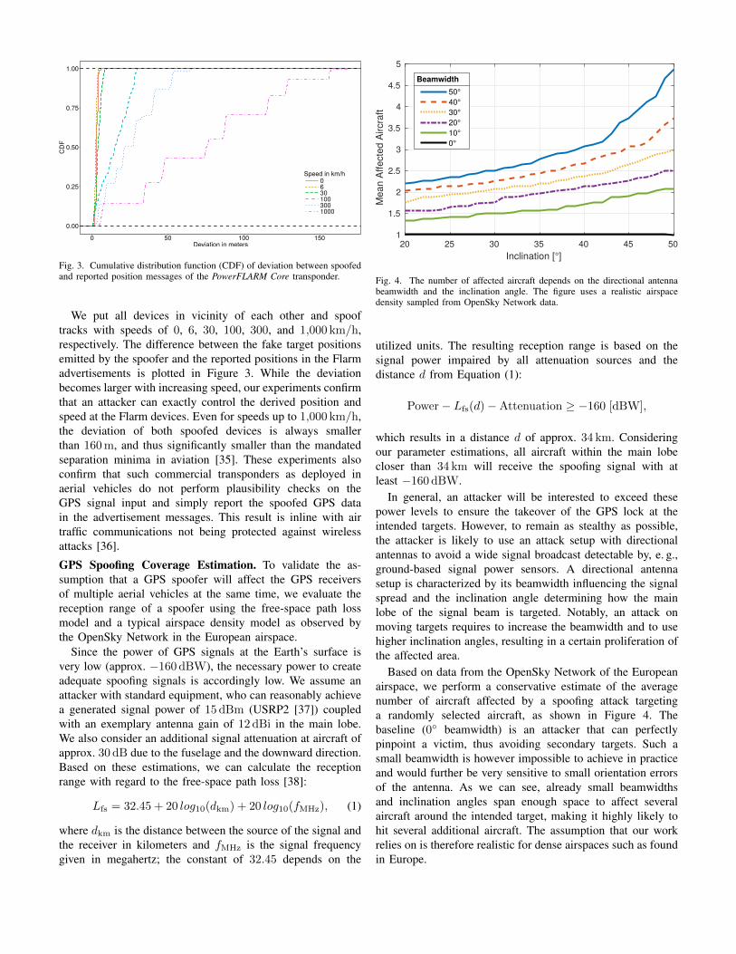
Fig. 3. Cumulative distribution function (CDF) of deviation between spoofedand reported position messages of the PowerFLARM Core transponder.
We put all devices in vicinity of each other and spooftracks with speeds of 0, 6, 30, 100, 300, and 1,000 km/h,respectively. The difference between the fake target positionsemitted by the spoofer and the reported positions in the Flarmadvertisements is plotted in Figure 3. While the deviationbecomes larger with increasing speed, our experiments confirmthat an attacker can exactly control the derived position andspeed at the Flarm devices. Even for speeds up to 1,000 km/h,the deviation of both spoofed devices is always smallerthan 160 m, and thus significantly smaller than the mandatedseparation minima in aviation [35]. These experiments alsoconfirm that such commercial transponders as deployed inaerial vehicles do not perform plausibility checks on theGPS signal input and simply report the spoofed GPS datain the advertisement messages. This result is inline with airtraffic communications not being protected against wirelessattacks [36].
GPS Spoofing Coverage Estimation. To validate the as-sumption that a GPS spoofer will affect the GPS receiversof multiple aerial vehicles at the same time, we evaluate thereception range of a spoofer using the free-space path lossmodel and a typical airspace density model as observed bythe OpenSky Network in the European airspace.
Since the power of GPS signals at the Earth’s surface isvery low (approx. −160 dBW), the necessary power to createadequate spoofing signals is accordingly low. We assume anattacker with standard equipment, who can reasonably achievea generated signal power of 15 dBm (USRP2 [37]) coupledwith an exemplary antenna gain of 12 dBi in the main lobe.We also consider an additional signal attenuation at aircraft ofapprox. 30 dB due to the fuselage and the downward direction.Based on these estimations, we can calculate the receptionrange with regard to the free-space path loss [38]:
Lfs = 32.45 + 20 log10(dkm) + 20 log10(fMHz), (1)
where dkm is the distance between the source of the signal andthe receiver in kilometers and fMHz is the signal frequencygiven in megahertz; the constant of 32.45 depends on the
20 25 30 35 40 45 50Inclination [°]
1
1.5
2
2.5
3
3.5
4
4.5
5
Mea
n Af
fect
ed A
ircra
ft
50°40°30°20°10°0°
Beamwidth
Fig. 4. The number of affected aircraft depends on the directional antennabeamwidth and the inclination angle. The figure uses a realistic airspacedensity sampled from OpenSky Network data.
utilized units. The resulting reception range is based on thesignal power impaired by all attenuation sources and thedistance d from Equation (1):
Power− Lfs(d)−Attenuation ≥ −160 [dBW],
which results in a distance d of approx. 34 km. Consideringour parameter estimations, all aircraft within the main lobecloser than 34 km will receive the spoofing signal with atleast −160 dBW.
In general, an attacker will be interested to exceed thesepower levels to ensure the takeover of the GPS lock at theintended targets. However, to remain as stealthy as possible,the attacker is likely to use an attack setup with directionalantennas to avoid a wide signal broadcast detectable by, e. g.,ground-based signal power sensors. A directional antennasetup is characterized by its beamwidth influencing the signalspread and the inclination angle determining how the mainlobe of the signal beam is targeted. Notably, an attack onmoving targets requires to increase the beamwidth and to usehigher inclination angles, resulting in a certain proliferation ofthe affected area.
Based on data from the OpenSky Network of the Europeanairspace, we perform a conservative estimate of the averagenumber of aircraft affected by a spoofing attack targetinga randomly selected aircraft, as shown in Figure 4. Thebaseline (0◦ beamwidth) is an attacker that can perfectlypinpoint a victim, thus avoiding secondary targets. Such asmall beamwidth is however impossible to achieve in practiceand would further be very sensitive to small orientation errorsof the antenna. As we can see, already small beamwidthsand inclination angles span enough space to affect severalaircraft around the intended target, making it highly likely tohit several additional aircraft. The assumption that our workrelies on is therefore realistic for dense airspaces such as foundin Europe.
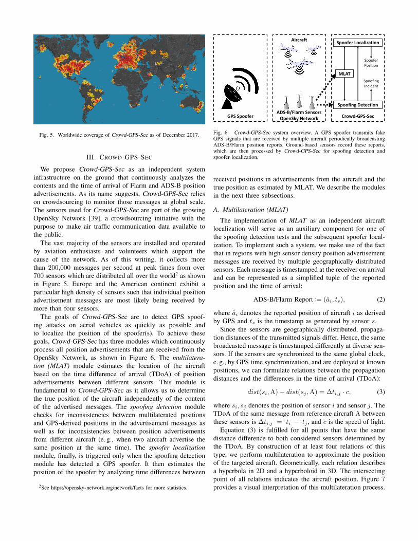
Fig. 5. Worldwide coverage of Crowd-GPS-Sec as of December 2017.
III. CROWD-GPS-SEC
We propose Crowd-GPS-Sec as an independent systeminfrastructure on the ground that continuously analyzes thecontents and the time of arrival of Flarm and ADS-B positionadvertisements. As its name suggests, Crowd-GPS-Sec relieson crowdsourcing to monitor those messages at global scale.The sensors used for Crowd-GPS-Sec are part of the growingOpenSky Network [39], a crowdsourcing initiative with thepurpose to make air traffic communication data available tothe public.
The vast majority of the sensors are installed and operatedby aviation enthusiasts and volunteers which support thecause of the network. As of this writing, it collects morethan 200,000 messages per second at peak times from over700 sensors which are distributed all over the world2 as shownin Figure 5. Europe and the American continent exhibit aparticular high density of sensors such that individual positionadvertisement messages are most likely being received bymore than four sensors.
The goals of Crowd-GPS-Sec are to detect GPS spoof-ing attacks on aerial vehicles as quickly as possible andto localize the position of the spoofer(s). To achieve thesegoals, Crowd-GPS-Sec has three modules which continuouslyprocess all position advertisements that are received from theOpenSky Network, as shown in Figure 6. The multilatera-tion (MLAT) module estimates the location of the aircraftbased on the time difference of arrival (TDoA) of positionadvertisements between different sensors. This module isfundamental to Crowd-GPS-Sec as it allows us to determinethe true position of the aircraft independently of the contentof the advertised messages. The spoofing detection modulechecks for inconsistencies between multilaterated positionsand GPS-derived positions in the advertisement messages aswell as for inconsistencies between position advertisementsfrom different aircraft (e. g., when two aircraft advertise thesame position at the same time). The spoofer localizationmodule, finally, is triggered only when the spoofing detectionmodule has detected a GPS spoofer. It then estimates theposition of the spoofer by analyzing time differences between
2See https://opensky-network.org/network/facts for more statistics.
GPS SpooferADS-B/Flarm Sensors
OpenSky Network Crowd-GPS-Sec
Aircraft
Spoofing Detection
Spoofer Localization
MLAT
SpooferPosition
SpoofingIncident
Fig. 6. Crowd-GPS-Sec system overview. A GPS spoofer transmits fakeGPS signals that are received by multiple aircraft periodically broadcastingADS-B/Flarm position reports. Ground-based sensors record these reports,which are then processed by Crowd-GPS-Sec for spoofing detection andspoofer localization.
received positions in advertisements from the aircraft and thetrue position as estimated by MLAT. We describe the modulesin the next three subsections.
A. Multilateration (MLAT)
The implementation of MLAT as an independent aircraftlocalization will serve as an auxiliary component for one ofthe spoofing detection tests and the subsequent spoofer local-ization. To implement such a system, we make use of the factthat in regions with high sensor density position advertisementmessages are received by multiple geographically distributedsensors. Each message is timestamped at the receiver on arrivaland can be represented as a simplified tuple of the reportedposition and the time of arrival:
ADS-B/Flarm Report := (ai, ts), (2)
where ai denotes the reported position of aircraft i as derivedby GPS and ts is the timestamp as generated by sensor s.
Since the sensors are geographically distributed, propaga-tion distances of the transmitted signals differ. Hence, the samebroadcasted message is timestamped differently at diverse sen-sors. If the sensors are synchronized to the same global clock,e. g., by GPS time synchronization, and are deployed at knownpositions, we can formulate relations between the propagationdistances and the differences in the time of arrival (TDoA):
dist(si,A)− dist(sj ,A) = ∆ti,j · c, (3)
where si, sj denotes the position of sensor i and sensor j. TheTDoA of the same message from reference aircraft A betweenthese sensors is ∆ti,j = ti − tj , and c is the speed of light.
Equation (3) is fulfilled for all points that have the samedistance difference to both considered sensors determined bythe TDoA. By construction of at least four relations of thistype, we perform multilateration to approximate the positionof the targeted aircraft. Geometrically, each relation describesa hyperbola in 2D and a hyperboloid in 3D. The intersectingpoint of all relations indicates the aircraft position. Figure 7provides a visual interpretation of this multilateration process.

𝑑𝑖𝑠𝑡 𝑠2, A
𝑑𝑖𝑠𝑡 𝑠1, A
𝑑𝑖𝑠𝑡 𝑠𝑖 , A − 𝑑𝑖𝑠𝑡 𝑠𝑗 , A = ∆𝑡𝑖,𝑗 ∗ 𝑐
𝑑𝑖𝑠𝑡 𝑠3, A
Sensor 1
Sensor 2
Sensor 3
Fig. 7. Implementation of an independent aircraft localization schemebased on multilateration considering the TDoA of broadcasted ADS-B/Flarmmessages.
B. GPS Spoofing Detection
Spoofing detection is the first step in a mitigation strategyto counter GPS spoofing attacks. The idea of Crowd-GPS-Secto detect GPS spoofing attacks is based on the broadcastedADS-B/Flarm reports containing potentially spoofed position-ing information. We propose a verification process consistingof two complementary checks.
1) Time Alignment of Transmissions: Since ADS-B/Flarmmessages are broadcasted at variable transmission times, weneed to time-align those reports in order to make themcomparable. This is achieved by incorporating the results fromthe MLAT computation. To align the position reports to areference global time, two steps are performed subsequently.
The first step yields the transmission time tTX at which theGPS-derived position was reported:
tTX = ts −dist(s, a)
c, (4)
with ts being the time at which sensor s has timestampedthe message, dist(s, a) representing the Euclidean distancebetween the considered sensor and aircraft, and c being thespeed of light.
The second step is an interpolation to approximate theaircraft position aREF at a global reference time tREF. Weneed to consider the following three cases:
aREF =
aTX·(tTX+1−tREF)+aTX+1·(tREF−tTX)
tTX+1−tTXtTX < tREF
aTX tTX = tREFaTX·(tREF−tTX−1)+aTX−1·(tTX−tREF)
tTX−tTX−1tTX > tREF
with aTX = a denoting the aircraft position at transmissiontime, TX−1, TX, and TX+1 being the previous, current, andnext transmission event, respectively. After this interpolation,all reported positions are time-aligned and can be comparedwith respect to the same time basis. In the remainder of thispaper, we assume time-aligned positions.
2) Test 1 (Cross-Checks with MLAT): We propose theimplementation of two complementary tests. The first testperforms a cross-check between the reported positions and theestimated real positions from the previously described MLATapproach. We check for each incoming position report whether
dist(ai, ai)?< T1 (5)
holds, where ai is the real position of aircraft i determinedby MLAT, ai is the position reported by aircraft i usingADS-B/Flarm, dist() is the Euclidean distance function, andT1 denotes a predefined threshold which tolerates measure-ment errors in ai and ai. Choosing the right threshold T1depends on the accuracy of the underlying secondary local-ization method (here MLAT). Smaller T1 lead to higher falsepositive rates, while larger T1 create more room for undetectedmanipulations.Complexity. Let n be the number of aircraft. Equation (5)needs to be checked once for each aircraft, i. e., n times,resulting in a complexity of O(n). For each sampling time,we require the positioning information from ADS-B/Flarm andMLAT. The comparisons of both positioning sources can beparallelized, since the checks for each aircraft are independentof all other aircraft. As a result, the first test of GPS spoofingdetection scales linearly with the number of simultaneouslytracked aircraft.
3) Test 2 (Multiple Aircraft Comparison): The second testmakes use of the information provided by other aircraft.In particular, we perform a comparison between reportedpositions of multiple aircraft. When multiple aircraft receivethe signals from the same spoofer device, they will appearat the same location [7] since the time differences betweenindividual satellites are emulated on the radio of the spooferprior transmission. Due to mandatory separation minima [35],i. e., minimum required distances between en-route aircraft,similar positions are critical and are caused either by aserious incident, e. g., near-collision, or a GPS spoofing attack.Eventually, the multiple aircraft comparison test is defined as:
dist(ai, aj) = di,j?> T2, (6)
where i and j denote two different aircraft, ai and aj are theGPS-derived positions of aircraft i and aircraft j, dist() is theEuclidean distance function, and T2 is a threshold toleratingthe GPS positioning noise. Choosing an appropriate T2 de-pends on the mandated separation minima in the consideredairspace and the accuracy of the GPS information provided viaposition reports. However, as accuracy is one of the designgoals of ADS-B and Flarm and the separation minima areusually in the order of kilometers, a threshold as small as afew hundreds of meters is appropriate.Complexity. Let n be the number of aircraft. Since Equa-tion (6) considers pairs of aircraft, a naive implementationwould require
(n2
)= n2−n
2 comparisons resulting in a com-plexity of O(n2). However, since Test 2 considers spatialdata only, the complexity can be reduced by implementingnearest neighbor searches based on k-d trees and cover trees.
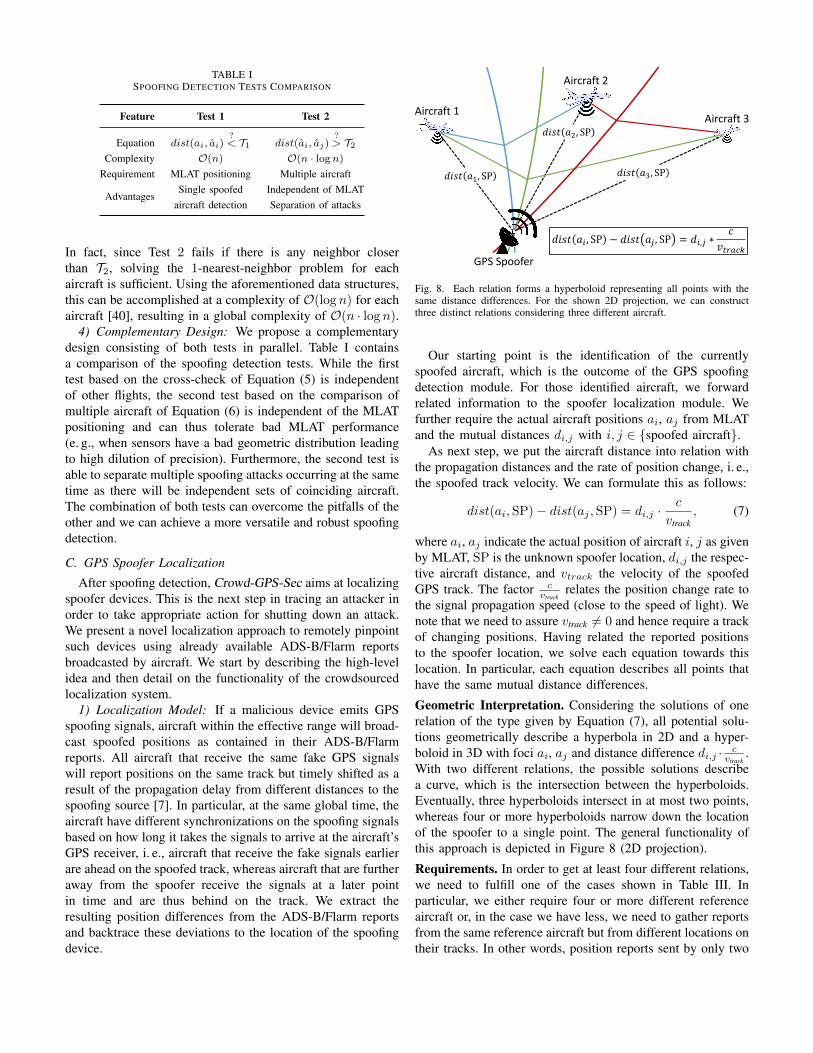
TABLE ISPOOFING DETECTION TESTS COMPARISON
Feature Test 1 Test 2
Equation dist(ai, ai)?< T1 dist(ai, aj)
?> T2
Complexity O(n) O(n · logn)
Requirement MLAT positioning Multiple aircraft
AdvantagesSingle spoofed Independent of MLAT
aircraft detection Separation of attacks
In fact, since Test 2 fails if there is any neighbor closerthan T2, solving the 1-nearest-neighbor problem for eachaircraft is sufficient. Using the aforementioned data structures,this can be accomplished at a complexity of O(log n) for eachaircraft [40], resulting in a global complexity of O(n · log n).
4) Complementary Design: We propose a complementarydesign consisting of both tests in parallel. Table I containsa comparison of the spoofing detection tests. While the firsttest based on the cross-check of Equation (5) is independentof other flights, the second test based on the comparison ofmultiple aircraft of Equation (6) is independent of the MLATpositioning and can thus tolerate bad MLAT performance(e. g., when sensors have a bad geometric distribution leadingto high dilution of precision). Furthermore, the second test isable to separate multiple spoofing attacks occurring at the sametime as there will be independent sets of coinciding aircraft.The combination of both tests can overcome the pitfalls of theother and we can achieve a more versatile and robust spoofingdetection.
C. GPS Spoofer Localization
After spoofing detection, Crowd-GPS-Sec aims at localizingspoofer devices. This is the next step in tracing an attacker inorder to take appropriate action for shutting down an attack.We present a novel localization approach to remotely pinpointsuch devices using already available ADS-B/Flarm reportsbroadcasted by aircraft. We start by describing the high-levelidea and then detail on the functionality of the crowdsourcedlocalization system.
1) Localization Model: If a malicious device emits GPSspoofing signals, aircraft within the effective range will broad-cast spoofed positions as contained in their ADS-B/Flarmreports. All aircraft that receive the same fake GPS signalswill report positions on the same track but timely shifted as aresult of the propagation delay from different distances to thespoofing source [7]. In particular, at the same global time, theaircraft have different synchronizations on the spoofing signalsbased on how long it takes the signals to arrive at the aircraft’sGPS receiver, i. e., aircraft that receive the fake signals earlierare ahead on the spoofed track, whereas aircraft that are furtheraway from the spoofer receive the signals at a later pointin time and are thus behind on the track. We extract theresulting position differences from the ADS-B/Flarm reportsand backtrace these deviations to the location of the spoofingdevice.
𝑑𝑖𝑠𝑡 𝑎2, SP
𝑑𝑖𝑠𝑡 𝑎𝑖 , SP − 𝑑𝑖𝑠𝑡 𝑎𝑗 , SP = 𝑑𝑖,𝑗 ∗𝑐
𝑣𝑡𝑟𝑎𝑐𝑘
𝑑𝑖𝑠𝑡 𝑎1, SP𝑑𝑖𝑠𝑡 𝑎3, SP
GPS Spoofer
Aircraft 1
Aircraft 2
Aircraft 3
Fig. 8. Each relation forms a hyperboloid representing all points with thesame distance differences. For the shown 2D projection, we can constructthree distinct relations considering three different aircraft.
Our starting point is the identification of the currentlyspoofed aircraft, which is the outcome of the GPS spoofingdetection module. For those identified aircraft, we forwardrelated information to the spoofer localization module. Wefurther require the actual aircraft positions ai, aj from MLATand the mutual distances di,j with i, j ∈ {spoofed aircraft}.
As next step, we put the aircraft distance into relation withthe propagation distances and the rate of position change, i. e.,the spoofed track velocity. We can formulate this as follows:
dist(ai,SP)− dist(aj ,SP) = di,j ·c
vtrack, (7)
where ai, aj indicate the actual position of aircraft i, j as givenby MLAT, SP is the unknown spoofer location, di,j the respec-tive aircraft distance, and vtrack the velocity of the spoofedGPS track. The factor c
vtrackrelates the position change rate to
the signal propagation speed (close to the speed of light). Wenote that we need to assure vtrack 6= 0 and hence require a trackof changing positions. Having related the reported positionsto the spoofer location, we solve each equation towards thislocation. In particular, each equation describes all points thathave the same mutual distance differences.
Geometric Interpretation. Considering the solutions of onerelation of the type given by Equation (7), all potential solu-tions geometrically describe a hyperbola in 2D and a hyper-boloid in 3D with foci ai, aj and distance difference di,j · c
vtrack.
With two different relations, the possible solutions describea curve, which is the intersection between the hyperboloids.Eventually, three hyperboloids intersect in at most two points,whereas four or more hyperboloids narrow down the locationof the spoofer to a single point. The general functionality ofthis approach is depicted in Figure 8 (2D projection).
Requirements. In order to get at least four different relations,we need to fulfill one of the cases shown in Table III. Inparticular, we either require four or more different referenceaircraft or, in the case we have less, we need to gather reportsfrom the same reference aircraft but from different locations ontheir tracks. In other words, position reports sent by only two
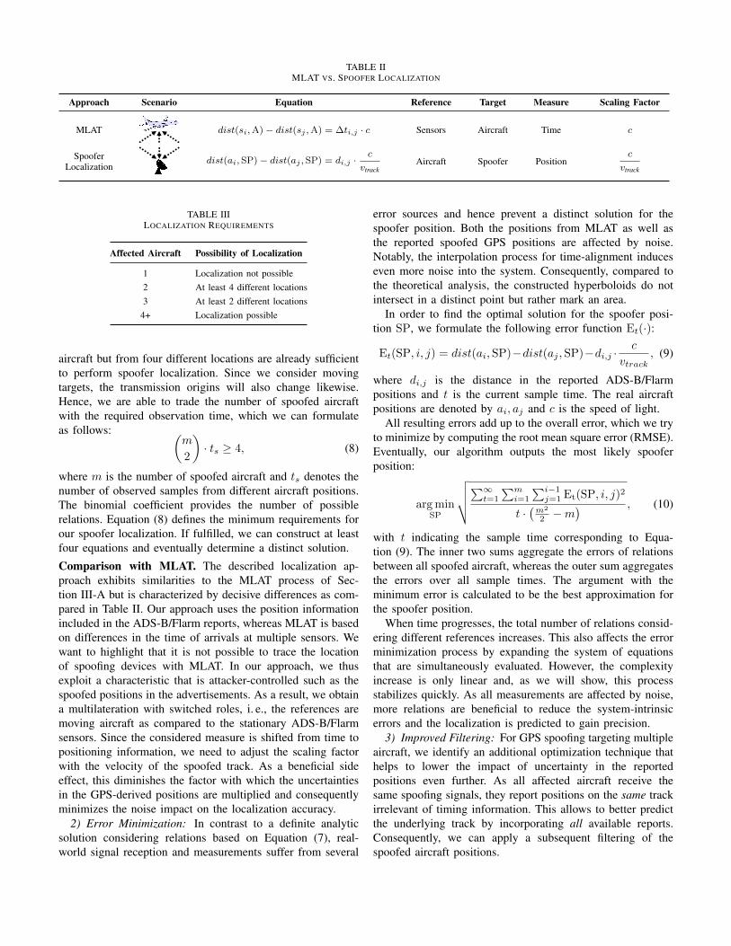
TABLE IIMLAT VS. SPOOFER LOCALIZATION
Approach Scenario Equation Reference Target Measure Scaling Factor
MLAT dist(si,A)− dist(sj ,A) = ∆ti,j · c Sensors Aircraft Time c
SpooferLocalization
dist(ai, SP)− dist(aj , SP) = di,j ·c
vtrackAircraft Spoofer Position
c
vtrack
TABLE IIILOCALIZATION REQUIREMENTS
Affected Aircraft Possibility of Localization
1 Localization not possible2 At least 4 different locations3 At least 2 different locations
4+ Localization possible
aircraft but from four different locations are already sufficientto perform spoofer localization. Since we consider movingtargets, the transmission origins will also change likewise.Hence, we are able to trade the number of spoofed aircraftwith the required observation time, which we can formulateas follows: (
m
2
)· ts ≥ 4, (8)
where m is the number of spoofed aircraft and ts denotes thenumber of observed samples from different aircraft positions.The binomial coefficient provides the number of possiblerelations. Equation (8) defines the minimum requirements forour spoofer localization. If fulfilled, we can construct at leastfour equations and eventually determine a distinct solution.
Comparison with MLAT. The described localization ap-proach exhibits similarities to the MLAT process of Sec-tion III-A but is characterized by decisive differences as com-pared in Table II. Our approach uses the position informationincluded in the ADS-B/Flarm reports, whereas MLAT is basedon differences in the time of arrivals at multiple sensors. Wewant to highlight that it is not possible to trace the locationof spoofing devices with MLAT. In our approach, we thusexploit a characteristic that is attacker-controlled such as thespoofed positions in the advertisements. As a result, we obtaina multilateration with switched roles, i. e., the references aremoving aircraft as compared to the stationary ADS-B/Flarmsensors. Since the considered measure is shifted from time topositioning information, we need to adjust the scaling factorwith the velocity of the spoofed track. As a beneficial sideeffect, this diminishes the factor with which the uncertaintiesin the GPS-derived positions are multiplied and consequentlyminimizes the noise impact on the localization accuracy.
2) Error Minimization: In contrast to a definite analyticsolution considering relations based on Equation (7), real-world signal reception and measurements suffer from several
error sources and hence prevent a distinct solution for thespoofer position. Both the positions from MLAT as well asthe reported spoofed GPS positions are affected by noise.Notably, the interpolation process for time-alignment induceseven more noise into the system. Consequently, compared tothe theoretical analysis, the constructed hyperboloids do notintersect in a distinct point but rather mark an area.
In order to find the optimal solution for the spoofer posi-tion SP, we formulate the following error function Et(·):
Et(SP, i, j) = dist(ai,SP)−dist(aj ,SP)−di,j ·c
vtrack, (9)
where di,j is the distance in the reported ADS-B/Flarmpositions and t is the current sample time. The real aircraftpositions are denoted by ai, aj and c is the speed of light.
All resulting errors add up to the overall error, which we tryto minimize by computing the root mean square error (RMSE).Eventually, our algorithm outputs the most likely spooferposition:
arg minSP
√√√√∑∞t=1
∑mi=1
∑i−1j=1 Et(SP, i, j)2
t ·(m2
2 −m) , (10)
with t indicating the sample time corresponding to Equa-tion (9). The inner two sums aggregate the errors of relationsbetween all spoofed aircraft, whereas the outer sum aggregatesthe errors over all sample times. The argument with theminimum error is calculated to be the best approximation forthe spoofer position.
When time progresses, the total number of relations consid-ering different references increases. This also affects the errorminimization process by expanding the system of equationsthat are simultaneously evaluated. However, the complexityincrease is only linear and, as we will show, this processstabilizes quickly. As all measurements are affected by noise,more relations are beneficial to reduce the system-intrinsicerrors and the localization is predicted to gain precision.
3) Improved Filtering: For GPS spoofing targeting multipleaircraft, we identify an additional optimization technique thathelps to lower the impact of uncertainty in the reportedpositions even further. As all affected aircraft receive thesame spoofing signals, they report positions on the same trackirrelevant of timing information. This allows to better predictthe underlying track by incorporating all available reports.Consequently, we can apply a subsequent filtering of thespoofed aircraft positions.

0.0
0.2
0.4
0.6
0.0 2.5 5.0 7.5 10.0 12.5Attacker Radius [km]
Det
ectio
n R
ate
Test Method1 only1 and 22 only
Fig. 9. Detection rates and coverage of Test 1 and Test 2 in the consideredOpenSky Network data set depending on the attacker’s range.
In particular, we apply a projection of the reported positionson the combined estimated track. Notably, with this projectionwe cannot correct timing inaccuracies, but we can betterestimate the most likely position at the current measurementtime. The (orthogonal) projection provides the least error withrespect to the estimated track and can be described as:
ai − ai′ ⊥ track, (11)
where ai is the noisy GPS position and ai′ is the projected
point with ai − ai′ being orthogonal on the estimated track.Moreover, we do not necessarily require a continuous straightline but the track can also contain separated segments, whichare then evaluated separately to apply the projection.
IV. EVALUATION
To evaluate the applicability of Crowd-GPS-Sec to real-world air traffic, we assess its performance in terms ofspoofing detection and accuracy of the spoofer localization. Inparticular, we have implemented Crowd-GPS-Sec and appliedit to real-world data from the OpenSky Network. Moreover,we have built a simulation framework to generate results withrespect to spoofing scenarios.
A. Spoofing Detection Performance
We compare our two spoofing detection tests with regard totheir coverage, detection delay, and detection rate. The testsare applied to air traffic data of Central Europe as receivedby the OpenSky Network over a period of 1 h. The data setcontains 141,693 unique positions of 142 aircraft.
Coverage. We define the coverage of a test as the percentageof aircraft positions that is protected by a test. Protectionmeans that a test indicates a spoofing attack if the aircraftis indeed spoofed. For simplicity, we assume that the attackeris using an omnidirectional antenna and is positioned rightunderneath the target using exactly the required transmissionpower to have the target aircraft lock on the spoofer. Thisresults in an attack range in the form of a sphere with a radiusof the altitude of the aircraft. Note that this setup models anunrealistically optimal attacker since in reality, the attackermay not be able to stay exactly underneath the target aircraftas the aircraft is moving and it may use higher transmissionpowers than the minimal required power.
0.00
0.25
0.50
0.75
1.00
0.0 2.5 5.0 7.5 10.0 12.5
Altitude [km]
Cu
m.
Pro
ba
bili
ty
Data SetAllTest 1Test 2
Fig. 10. Comparison of the detection rates of Test 1 and Test 2 in the OpenSkyNetwork data set depending on the target’s altitude.
Since both tests rely on different features, the sets ofpositions covered by one test is different from the one coveredby the other test, but there are overlaps. We therefore analyzehow many aircraft in our data set are covered by whichtest. Figure 9 shows the fractions of aircraft in the data setcovered by Test 1, Test 2, or both depending on the target’saltitude. The results show that Test 1 clearly outperformsTest 2. Overall, 61.2 % of the aircraft are covered only byTest 1 while 2.9 % are covered only by Test 2. In addition,8.9 % are covered by both tests. This result is not surprisingsince the receiver density of the OpenSky Network is high(which benefits Test 1), while the aircraft density (which Test 2relies on) is limited due to separation minima. In total, we cansummarize that if the spoofer’s target is at an altitude above11 km and the spoofer is directly underneath the target, thedetection rate is about 75 % using both tests. If the spoofer useshigher transmission powers or if it is not directly underneaththe target, the detection rate increases quickly towards 100 %(not shown in the Figure).
As mentioned above, Test 1 directly depends on multilatera-tion coverage and should therefore work better at high altitudeswhere aircraft are tracked by more sensors. In contrast, Test 2benefits from dense airspaces since close aircraft “protect”one another. To further investigate this effect, we consideredthe cumulative distribution of the altitudes of all aircraft andcompared it to those of the aircraft protected by either of thetests. The results are shown in Figure 10. As expected, Test 2has a distribution similar to all altitudes. The steep inclines inits distribution confirm that it is most effective at the commonaltitudes above 10 km (en route flights) and at around 1 km(approach areas). Most aircraft detected by Test 1, on the otherhand, were higher than 10 km which also complies with theabove hypothesis.
Detection Delay. We define the detection delay as the delaybetween the point in time when the attack takes effect, i. e.,when the aircraft’s GPS sensor locks on to the spoofed signaluntil the detection test will detect the attack. As for Test 1,this corresponds to the delay between receiving the ADS-Bposition and the MLAT position update. To evaluate this, weused the open-source MLAT implementation [41] with theOpenSky Network’s real-time data stream and measured thetime between the reception of an ADS-B position and the
0.00
0.25
0.50
0.75
1.00
0 10 20 30 40Time [s]
Cum
ulat
ive P
roba
bilit
y
Test MethodTest 1Test 2
Fig. 11. Comparison of the detection times of Test 1 and Test 2 in theOpenSky Network data set.
TABLE IVSIMULATION FRAMEWORK PARAMETERS
Parameter Parameter Range Default
Sensor Density 10 . . . 100[
1(100 km)2
]OpenSky
Airspace Density 10 . . . 100[
1(100 km)2
]OpenSky
Flightpath random OpenSkyFlight Altitude 0 . . . 10,000 [m] OpenSkyAirspeed 0 . . . 1,000 [km/h] OpenSky
Spoofer Position random randomSpoofing Range 10 . . . 200 [km] 100 km
Spoofed Track Velocity 0 . . . 10,000 [km/h] 1,000 km/h
GPS Noise (std) 0.01 . . . 4 [m] 4 m
MLAT Noise (std) 1 . . . 100 [m] 10 m
emission of the respective position by the MLAT implementa-tion. As for Test 2, the delay can be reduced to the inter-arrivaltimes between spoofed position reports. Figure 11 shows thedistributions for the delays of the two tests. The delay ofTest 1 is a result of the delay of the relatively long MLATcalculations. Test 2, on the other hand, can detect an attack assoon as a false position report is received from two differentaircraft. Note that the position broadcast interval of ADS-Bis random within an interval of 0.4 s to 0.6 s, explaining theaverage detection delay close to 0.5 s.Conclusion. The results of our evaluation show that withrealistic air traffic and implementation characteristics, the twotests can reach a detection rate of up to 75 % when the attackeris directly underneath the target. While Test 1 performs muchbetter in terms of coverage and detection rate, the detectiondelay is much smaller for Test 2. These results encourage acomplementary implementation as proposed in Section III-B4.
B. Spoofer Localization Performance
To evaluate Crowd-GPS-Sec in terms of GPS spoofer lo-calization accuracy, we have built a simulation framework inMATLAB, which allows us to analyze spoofing scenarios in acontrolled environment without having to spoof real aircraft.In particular, we assess the impact of noise in the GPS-derivedposition reports, MLAT positioning noise, and spoofed trackvelocity.
0 5 10 15Elapsed Time after Spoofing Attack [min]
10 1
10 2
10 3
10 4
10 5
10 6
Dis
tanc
e to
Spo
ofer
[m]
4 2 1 0.5 0.1 0.01
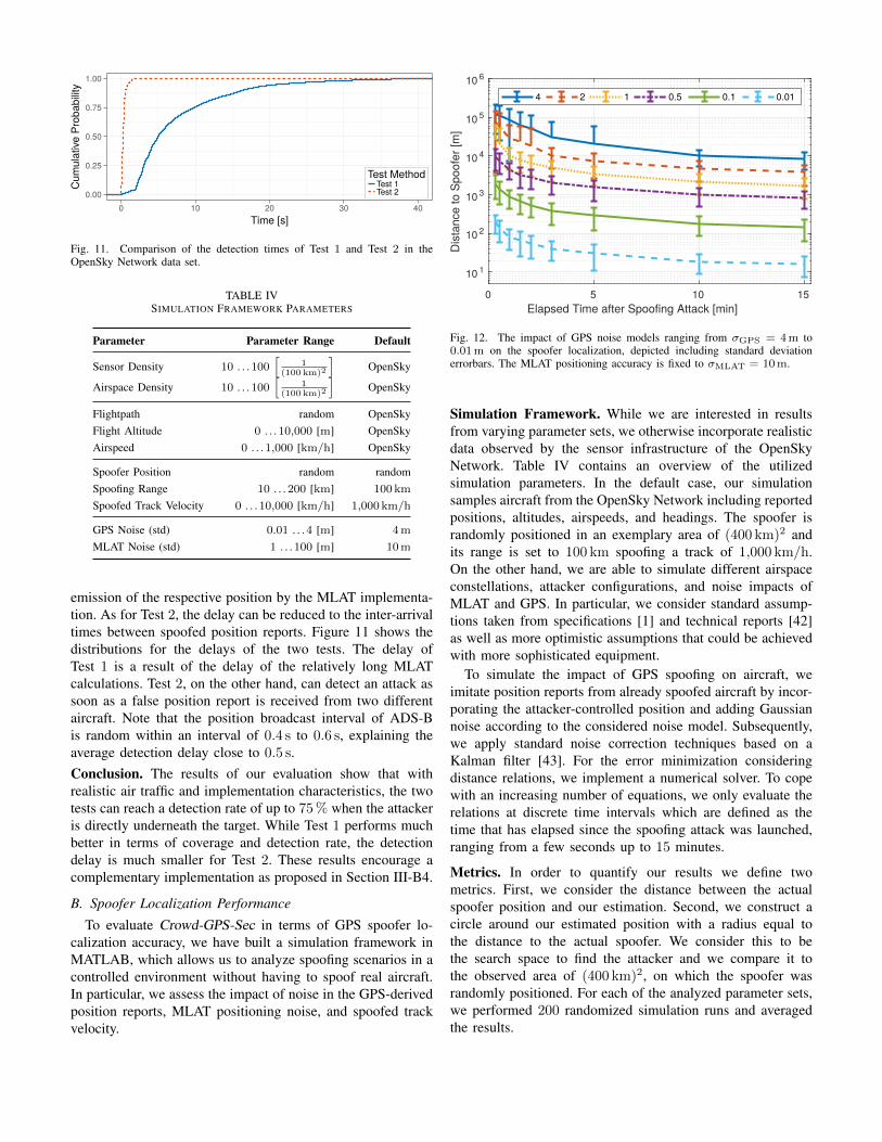
Fig. 12. The impact of GPS noise models ranging from σGPS = 4 m to0.01 m on the spoofer localization, depicted including standard deviationerrorbars. The MLAT positioning accuracy is fixed to σMLAT = 10 m.
Simulation Framework. While we are interested in resultsfrom varying parameter sets, we otherwise incorporate realisticdata observed by the sensor infrastructure of the OpenSkyNetwork. Table IV contains an overview of the utilizedsimulation parameters. In the default case, our simulationsamples aircraft from the OpenSky Network including reportedpositions, altitudes, airspeeds, and headings. The spoofer israndomly positioned in an exemplary area of (400 km)2 andits range is set to 100 km spoofing a track of 1,000 km/h.On the other hand, we are able to simulate different airspaceconstellations, attacker configurations, and noise impacts ofMLAT and GPS. In particular, we consider standard assump-tions taken from specifications [1] and technical reports [42]as well as more optimistic assumptions that could be achievedwith more sophisticated equipment.
To simulate the impact of GPS spoofing on aircraft, weimitate position reports from already spoofed aircraft by incor-porating the attacker-controlled position and adding Gaussiannoise according to the considered noise model. Subsequently,we apply standard noise correction techniques based on aKalman filter [43]. For the error minimization consideringdistance relations, we implement a numerical solver. To copewith an increasing number of equations, we only evaluate therelations at discrete time intervals which are defined as thetime that has elapsed since the spoofing attack was launched,ranging from a few seconds up to 15 minutes.
Metrics. In order to quantify our results we define twometrics. First, we consider the distance between the actualspoofer position and our estimation. Second, we construct acircle around our estimated position with a radius equal tothe distance to the actual spoofer. We consider this to bethe search space to find the attacker and we compare it tothe observed area of (400 km)2, on which the spoofer wasrandomly positioned. For each of the analyzed parameter sets,we performed 200 randomized simulation runs and averagedthe results.

0 5 10 15Elapsed Time after Spoofing Attack [min]
10 3
10 4
10 5
10 6D
ista
nce
to S
poof
er [m
]100 50 10 5 1
Fig. 13. The considered MLAT positioning noise models in the rangeof σMLAT = 100 m to 1 m do not show any significant impact on the local-ization accuracy. The results are based on a high GPS noise of σGPS = 4 m.
1) Impact of GPS Accuracy: Figure 12 depicts the impactof high GPS noise (σ = 4 m) to low GPS noise (σ = 0.01 m)applied to the latitude and longitude direction. We do notrequire altitude information for spoofer localization and cantherefore neglect altitude inaccuracies. We conclude that theextent of noise in the reported GPS positions is a dominatingfactor that can make the difference between a few kilome-ters and merely tens of meters in spoofer localization. Inparticular, we achieve an average localization accuracy of ap-prox. 8.2 km for σGPS = 4 m, approx. 1.7 km for σGPS = 1 m,and approx. 149 m for σGPS = 0.1 m, each after 15 min-utes. Considering the search space reduction, we need toscan approx. 0.13 % for σGPS = 4 m, approx. 5.8× 10⁻⁵
for σGPS = 1 m, and approx. 4.4× 10⁻⁷ for σGPS = 0.1 m,again after 15 minutes. Furthermore, we can observe thatthe localization accuracy increases rapidly within the firstfew minutes, whereas after 5 min the accuracy only improvesslowly. From 5 min to 15 min, the distance roughly halves.As a result, we can already give a good spoofer positionestimation in a timely manner after the spoofing attack islaunched and narrow it down to a more exact position after afew minutes.
2) Impact of MLAT Accuracy: Another uncertainty of ourlocalization approach is the accuracy of the MLAT posi-tioning that we require to determine the actual (unspoofed)aircraft positions. We choose to vary the MLAT accuracybetween high noise (σMLAT = 100 m) and lower noise lev-els (σMLAT = 1 m), each representing the standard deviationin latitude, longitude, and altitude. Figure 13 contains theimpact on the localization of different MLAT noise levels.In contrast to the strong dependence on the GPS noise inthe spoofed measurements, the MLAT noise has little impacton the accuracy of the spoofer localization. As a result, ourlocalization approach does not rely on highly accurate MLATmeasurements of the actual aircraft position and can stillperform decently on relatively noisy data.
0 5 10 15Elapsed Time after Spoofing Attack [min]
10 3
10 4
10 5
10 6
Dis
tanc
e to
Spo
ofer
[m]
6 30 100 300 1000
Fig. 14. The velocity of the spoofed track is analyzed for speeds be-tween vtrack = 6 km/h to 1,000 km/h. The results consider a GPSnoise level of σGPS = 1 m and an MLAT positioning accuracy errorof σMLAT = 10 m.
3) Impact of Spoofed Track Velocity: As the spoofed trackvelocity vtrack is part of the scaling factor in the distancerelations, we identify it to be another important parameter.The results for varying spoofed track velocities are depicted inFigure 14. For a spoofed track velocity of vtrack = 300 km/h,the accuracy decreases by nearly one fourth. The accuracydecreases further for a track velocity of vtrack = 100 km/h.Eventually, for track speeds lower than vtrack = 30 km/h,the spoofer localization fails to narrow down a useful searchradius. However, considering less GPS noise, we expect tosee better results even for lower track velocities. The strongdependence on the track velocity is due to the scaling factor,which relates the observed distances to the spoofed trackvelocity and the speed of light. Hence, low velocities resultin smaller distance differences among the spoofed aircraft andare relatively more affected by system-intrinsic noise.
V. DISCUSSION
Combined Error Effects. The spoofer localization accuracyof Crowd-GPS-Sec depends on the GPS error, the MLATerror, and the spoofed track velocity. These three parametersare all components of the relations defined in Equation (7)and thus impact the accuracy. While the MLAT noise is lessdecisive, the GPS noise and the spoofed track velocity aresignificantly affecting the achievable accuracy. This is due tothe small differences in spoofed aircraft positions with respectto the speed of light divided by the spoofed track velocity.In general, we expose the following relationship between thelocalization error E, the GPS noise σGPS, and the spoofedtrack velocity vtrack:
E ∝√
2 · σGPS
vtrack, (12)
with σGPS being scaled with√
2 due to the Euclidean distancebased on two normally distributed points in space. Hence, we

can expect to see similar results for low track velocities withlow GPS noise and high track velocities with high GPS noise.
Localizing Spoofers of Stationary Targets. The attackermodel considered in this paper assumes that the spoofer’starget is a moving object. If instead the target is stationary,the attacker could also spoof constant positions. While thedetection would still work, the localization would fail since thedifferences in propagation delays between spoofer and aircraftwould not be reflected in the reported position differences(compare di,j in Equation (9)). One way to cope with such at-tackers is to additionally propagate GPS time synchronizationinformation to the ground infrastructure. As time is evolving,the spoofer would have to imitate a progressing GPS time toremain undetected by the target. Having information aboutthe time synchronization of affected aircraft would allowperforming a localization by analogy. More specifically, if tdenotes the real GPS time and ti the reported time of aircraft i,the relation from Equation (7) can be rewritten to:
dist(ai,SP)− dist(aj ,SP) = (ti − tj) ·c
δ, (13)
where δ denotes a factor representing the spoofed GPS clock’sspeed. Equation (13) is independent from the spoofed positionand therefore allows localizing spoofers, even if the target isstationary.
Applicability to Other Networks. The underlying idea ofCrowd-GPS-Sec does not only apply to aircraft but can alsobe relevant to GPS spoofing attacks on cars, trucks, ships,or other vehicles on ground. Similar to the broadcastingof avionic position reports via ADS-B or Flarm, vehicularsystems could also report state information to, e. g., roadsideunits. The combined reports can then be used to run ourspoofing detection and localization scheme. Even though thespeeds of vehicles are comparably low, the density of affectedtargets is much higher and the GPS filtering is expected tobe more conditioned. Eventually, we envision the merging ofinformation provided by different networks. In particular, eachspoofed system, such as aircraft, vehicles, vessel, etc., cancollaborate by sharing their information in a crowdsourcingmanner.
VI. RELATED WORK
As GPS is known to be vulnerable to spoofing attacks [2],[5], [8], [31], several works demonstrated their feasibility [3],[4], [10], [32], [33]. Attacks can target different domainssuch as vehicle navigation systems [4], [10], [32] or criti-cal infrastructures [6]. The requirements for successful GPSspoofing attacks are analyzed in [7]. Attacks that also changethe data content of the signals are discussed in [44]. It isworth noting that GPS spoofing has also been proposed asa countermeasure, e. g., to defend against hostile UAVs [8],[11], [32] by means of hijacking or misguidance.
General techniques for detecting and localizing wirelessspoofing attacks (not specific to GPS satellite signals) areproposed by Chen et al. [45]. The authors use received signalstrength (RSS) readings from different locations and compare
them against RSS maps built during an offline calibrationphase to locate the spoofer. They evaluated their scheme in802.11 and 802.15.4 networks. Later, Yang et al. [46] extendedthe scheme to deal with attackers which vary their transmissionpower. Rather than using direct RSS values, they consider RSSdifferences at multiple locations.
A rich body of countermeasures specific to GPS exists in theliterature which can be categorized into prevention and detec-tion measures. In order to prevent spoofing of GPS signals,several works propose the use of cryptographic techniquesto authenticate satellite signals [13]–[16]. This is similar tohow military GPS signals are protected. However, crypto-graphic techniques require profound modifications of the GPSinfrastructure as well as a key distribution system which ischallenging to implement for applications with disconnectedreceivers. Further, the use of encryption alone does not protectagainst signal replaying attacks [33].
The detection of GPS spoofing attacks has also receivedconsiderable attention in the literature. Overviews can befound in [18] and [31]. Akos [19] suggests to monitor theincoming signal power and the state of the automatic gaincontrol. Another technique called SPREE relies on auxiliarypeak tracking [17] to detect suspicious peaks from signals withweaker acquisition correlation peaks. Psiaki et al. [47] proposea detection scheme which uses an additional reference receiverto correlate the received signal with authentic signals assumingthe inclusion of the encrypted military signal. A spoofed signaldoes not correlate with the reference node’s received signaland the attack can be detected.
A different class of detection approaches deploys multipleantennas. Tippenhauer et al. [7], [48] use multiple co-locatedGPS receivers whose calculated positions and times are com-pared; coinciding locations indicate an attack. A dual antennareceiver setup to determine the angle of arrival of incomingsignals is proposed by Montgomery et al. [20] and extendedby Psiaki et al. [49] to include differential carrier phase mea-surements. Magiera and Katulski [21] suggest even the use ofarrays of antennas showing that antenna diversity is effectiveat detecting single antenna spoofers without knowledge of thetarget’s position. Although these detection approaches do notrequire changes to the GPS infrastructure, they assume moresophisticated GPS receivers which would significantly increasethe complexity, size, costs, and power requirements. This,however, is contradictory to the objectives of GPS. It is alsoworth noting that, in principle, almost any passive localizationtechnique (such as multilateration) could be used to locate GPSspoofers. However, in contrast to our approach, these methodsassume a direct line-of-sight between the localization systemand the attacker. As a consequence, this requires a dedicatedinfrastructure which covers all potential attacker positions.
The authors of [23], [50]–[52] have proposed techniques todetect spoofing attacks in ADS-B. However, the threat modelin these works is different as they consider spoofed ADS-Bsignals and not spoofed GPS signals. These techniques aretherefore not capable of localizing GPS spoofers such as inCrowd-GPS-Sec.

VII. CONCLUSION
This work presented Crowd-GPS-Sec, an independent sys-tem to detect and localize GPS spoofing attacks targetedat aircraft and UAVs. Crowd-GPS-Sec is lightweight andleverages existing wireless air traffic broadcast infrastructures,the ADS-B and Flarm systems, to identify spoofing attacksfrom a remote location—possibly far from where the attackis happening. We have shown that our approach is effectiveat localizing spoofing devices by using differences in reportedpositions by multiple aircraft. Using simulations based on real-world input from the OpenSky Network, we have demon-strated that Crowd-GPS-Sec achieves attack detection delaysbelow two seconds and an attacker localization accuracy ofaround 150 meters after 15 minutes of monitoring time.
ACKNOWLEDGMENT
The authors would like to thank Markus Fuchs and GiorgioTresoldi for their help with the experiments and the evalua-tions. This work was supported in parts by the DFG ResearchTraining Group UbiCrypt GRK 1817/1 and the BMBF SysKitproject 16KIS0664.
REFERENCES
[1] Global Positioning System Standard Positioning Service PerformanceStandard, 4th ed., U.S. Department of Defense, Sep. 2008.
[2] Anon., “Vulnerability Assessment of the Transportation InfrastructureRelying on the Global Positioning System,” John A. Volpe NationalTransportation Systems Center, Tech. Rep. Final Report, Aug. 2001.
[3] T. E. Humphreys, B. M. Ledvina, M. L. Psiaki, B. W. O’Hanlon, andP. M. Kintner Jr., “Assessing the Spoofing Threat: Development of aPortable GPS Civilian Spoofer,” in International Technical Meeting ofthe Satellite Division of The Institute of Navigation, ser. ION GNSS ’08,Savannah, GA, USA, Sep. 2008, pp. 2314–2325.
[4] M. L. Psiaki and T. E. Humphreys, “Attackers can spoof navigationsignals without our knowledge. Here’s how to fight back GPS lies,”IEEE Spectrum, vol. 53, no. 8, pp. 26–53, Aug. 2016.
[5] T. E. Humphreys, “Statement on the Vulnerability of Civil UnmannedAerial Vehicles and Other Systems to Civil GPS Spoofing,” The Uni-versity of Texas at Austin, Tech. Rep., Jul. 2012, submitted to theSubcommittee on Oversight, Investigations, and Management of theHouse Committee on Homeland Security.
[6] D.-Y. Yu, A. Ranganathan, T. Locher, S. Capkun, and D. Basin, “ShortPaper: Detection of GPS Spoofing Attacks in Power Grids,” in ACMConference on Security and Privacy in Wireless and Mobile Networks,ser. WiSec ’14. Oxford, United Kingdom: ACM, Jul. 2014, pp. 99–104.
[7] N. O. Tippenhauer, C. Popper, K. B. Rasmussen, and S. Capkun,“On the Requirements for Successful GPS Spoofing Attacks,” in ACMConference on Computer and Communications Security, ser. CCS ’11.Chicago, IL, USA: ACM, Oct. 2011, pp. 75–86.
[8] T. E. Humphreys, “Statement on the Security Threat Posed by Un-manned Aerial Systems and Posssible Countermeasures,” The Universityof Texas at Austin, Tech. Rep., Mar. 2015, submitted to the Subcommit-tee on Oversight and Management Efficiency of the House Committeeon Homeland Security.
[9] M.-A. Russon. (2015, May) Wondering how to hack amilitary drone? It’s all on Google. International Business Times.[Online]. Available: http://www.ibtimes.co.uk/wondering-how-hack-military-drone-its-all-google-1500326
[10] J. A. Bhatti and T. E. Humphreys, “Hostile Control of Ships via FalseGPS Signals: Demonstration and Detection,” The University of Texas atAustin, Tech. Rep., 2014.
[11] C. Sebastian. (2016, Dec.) Getting lost near the Kremlin? Russia couldbe ’GPS spoofing’. [Online]. Available: http://money.cnn.com/2016/12/02/technology/kremlin-gps-signals
[12] OSQZSS. (2017) Software-Defined GPS Signal Simulator. [Online].Available: https://github.com/osqzss/gps-sdr-sim
[13] L. Scott, “Anti-Spoofing & Authenticated Signal Architectures for CivilNavigation Systems,” in International Technical Meeting of the SatelliteDivision of The Institute of Navigation, ser. ION GPS/GNSS ’03,Portland, OR, USA, Sep. 2003, pp. 1543–1552.
[14] M. G. Kuhn, “An Asymmetric Security Mechanism for NavigationSignals,” in International Conference on Information Hiding, ser. IH ’04.Toronto, Ontario, Canada: Springer, May 2004, pp. 239–252.
[15] G. W. Hein, F. Kneissl, J.-A. Avila Rodrıguez, and S. Wallner, “Authen-ticating GNSS: Proofs against Spoofs,” Inside GNSS, vol. 2, no. 5/6, pp.58–63/71–78, 2007.
[16] K. Wesson, M. Rothlisberger, and T. E. Humphreys, “Practical Cryp-tographic Civil GPS Signal Authentication,” in International TechnicalMeeting of The Satellite Division of the Institute of Navigation, ser. IONGNSS ’11, Portland, OR, USA, Sep. 2011, pp. 3335–3345.
[17] A. Ranganathan, H. Olafsdottir, and S. Capkun, “SPREE: A SpoofingResistant GPS Receiver,” in ACM Conference on Mobile Computing andNetworking, ser. MobiCom ’16. New York, USA: ACM, Oct. 2016,pp. 348–360.
[18] M. L. Psiaki and T. E. Humphreys, “GNSS Spoofing and Detection,”Proceedings of the IEEE, vol. 104, no. 6, pp. 1258–1270, Apr. 2016.
[19] D. M. Akos, “Who’s Afraid of the Spoofer? GPS/GNSS SpoofingDetection via Automatic Gain Control (AGC),” NAVIGATION, Journalof the Institute of Navigation, vol. 59, no. 4, pp. 281–290, Dec. 2012.
[20] P. Y. Montgomery, T. E. Humphreys, and B. M. Ledvina, “Receiver-Autonomous Spoofing Detection: Experimental Results of a Multi-Antenna Receiver Defense Against a Portable Civil GPS Spoofer,” inInternational Technical Meeting of The Institute of Navigation, ser.ION ’09, Anaheim, CA, USA, Jan. 2009, pp. 124–130.
[21] J. Magiera and R. J. Katulski, “Detection and Mitigation of GPSSpoofing Based on Antenna Array Processing,” Journal of AppliedResearch and Technology, vol. 13, no. 1, pp. 45–57, Feb. 2015.
[22] OpenSky Network. (2017) OpenSky Network. [Online]. Available:https://opensky-network.org
[23] D. Moser, P. Leu, V. Lenders, A. Ranganathan, F. Ricciato, andS. Capkun, “Investigation of Multi-device Location Spoofing Attacks onAir Traffic Control and Possible Countermeasures,” in ACM Conferenceon Mobile Computing and Networking, ser. MobiCom ’16. New York,USA: ACM, Oct. 2016, pp. 375–386.
[24] B. Hofmann-Wellenhof, H. Lichtenegger, and J. Collins, Global Posi-tioning System: Theory and Practice, 5th ed. Springer, 2001.
[25] P. F. Swaszek and R. J. Hartnett, “Spoof Detection Using Multiple COTSReceivers in Safety Critical Applications,” in International TechnicalMeeting of The Satellite Division of the Institute of Navigation, ser.ION GNSS+ ’13, Nashville, TN, USA, Sep. 2013, pp. 2921–2930.
[26] ——, “A Multiple COTS Receiver GNSS Spoof Detector – Extensions,”in International Technical Meeting of The Institute of Navigation, ser.ION ’14, San Diego, CA, USA, Jan. 2014, pp. 316–326.
[27] P. F. Swaszek, R. J. Hartnett, M. V. Kempe, and G. W. Johnson, “Anal-ysis of a Simple, Multi-Receiver GPS Spoof Detector,” in InternationalTechnical Meeting of The Institute of Navigation, ser. ION ’13, SanDiego, CA, USA, Jan. 2013, pp. 884–892.
[28] Flarm. (2017) Flarm. [Online]. Available: https://flarm.com[29] K. Jansen and C. Popper, “Opinion: Advancing Attacker Models of
Satellite-based Localization Systems—The Case of Multi-device Attack-ers,” in ACM Conference on Security and Privacy in Wireless and MobileNetworks, ser. WiSec ’17. Boston, MA, USA: ACM, Jul. 2017, pp.156–159.
[30] The Executive Director of the Joint Air Power Competence Center(JAPCC), “JAPCC Strategic Concept of Employment for Unmanned Air-craft Systems in NATO,” Joint Air Power Competence Center (JAPCC),Tech. Rep. UAS CONEMP Report, Jan. 2010.
[31] A. Jafarnia-Jahromi, A. Broumandan, J. Nielsen, and G. Lachapelle,“GPS Vulnerability to Spoofing Threats and a Review of AntispoofingTechniques,” International Journal of Navigation and Observation, vol.2012, May 2012.
[32] A. J. Kerns, D. P. Shepard, J. A. Bhatti, and T. E. Humphreys,“Unmanned Aircraft Capture and Control via GPS Spoofing,” Journalof Field Robotics, vol. 31, no. 4, pp. 617–636, Jul. 2014.
[33] P. Papadimitratos and A. Jovanovic, “GNSS-based Positioning: Attacksand Countermeasures,” in IEEE Military Communications Conference,ser. MILCOM ’08. San Diego, CA, USA: IEEE, Nov. 2008, pp. 1–7.
[34] creaktive. (2017) nRF905 demodulator/FLARM decoder. [Online].Available: https://github.com/creaktive/flare
[35] Air Traffic Control - Order JO 7110.65W, U.S. Department of Trans-portation, Dec. 2015.

[36] M. Strohmeier, M. Schafer, R. Pinheiro, V. Lenders, and I. Martinovic,“On Perception and Reality in Wireless Air Traffic CommunicationSecurity,” IEEE Transactions on Intelligent Transportation Systems,vol. 18, no. 6, pp. 1338–1357, Jun. 2017.
[37] Ettus Research. (2017) Universal Software Radio Peripheral (USRP).[Online]. Available: https://www.ettus.com
[38] D. L. Adamy, EW 101: A First Course in Electronic Warfare, 1st ed.Artech House, 2001.
[39] M. Schafer, M. Strohmeier, V. Lenders, I. Martinovic, and M. Wil-helm, “Bringing up OpenSky: A Large-scale ADS-B Sensor Networkfor Research,” in ACM/IEEE International Conference on InformationProcessing in Sensor Networks, ser. IPSN ’14. Berlin, Germany: IEEE,Apr. 2014, pp. 83–94.
[40] A. Beygelzimer, S. Kakade, and J. Langford, “Cover Trees for NearestNeighbor,” in ACM International Conference on Machine Learning, ser.ICML ’06. Orlando, FL, USA: ACM, Jun. 2006, pp. 97–104.
[41] O. Jowett. (2016) Mode S Multilateration Server. [Online]. Available:https://github.com/mutability/mlat-server
[42] W. H. L. Neven, T. J. Quilter, R. Weedon, and R. A. Hogendoorn, “WideArea Multilateration,” Eurocontrol, Tech. Rep. NLR-CR-2004-472, Aug.2005.
[43] R. E. Kalman, “A New Approach to Linear Filtering and PredictionProblems,” Transactions of the ASME–Journal of Basic Engineering,vol. 82, no. Series D, pp. 35–45, 1960.
[44] T. Nighswander, B. Ledvina, J. Diamond, R. Brumley, and D. Brumley,“GPS Software Attacks,” in ACM Conference on Computer and Com-munications Security, ser. CCS ’12. Raleigh, NC, USA: ACM, Oct.2012, pp. 450–461.
[45] Y. Chen, W. Trappe, and R. P. Martin, “Detecting and LocalizingWireless Spoofing Attacks,” in IEEE Conference on Sensor, Mesh and
Ad Hoc Communications and Networks, ser. SECON ’07. San Diego,CA, USA: IEEE, Jun. 2007, pp. 193–202.
[46] J. Yang, Y. Chen, W. Trappe, and J. Cheng, “Detection and Localizationof Multiple Spoofing Attackers in Wireless Networks,” IEEE Transac-tions on Parallel and Distributed Systems, vol. 24, no. 1, pp. 44–58,Jan. 2013.
[47] M. L. Psiaki, B. W. O’Hanlon, J. A. Bhatti, D. P. Shepard, and T. E.Humphreys, “GPS Spoofing Detection via Dual-Receiver Correlationof Military Signals,” IEEE Transactions on Aerospace and ElectronicSystems, vol. 49, no. 4, pp. 2250–2267, Oct. 2013.
[48] K. Jansen, N. O. Tippenhauer, and C. Popper, “Multi-Receiver GPSSpoofing Detection: Error Models and Realization,” in Annual ComputerSecurity Applications Conference, ser. ACSAC ’16. Los Angeles, CA,USA: ACM, Dec. 2016, pp. 237–250.
[49] M. L. Psiaki, B. W. O’Hanlon, S. P. Powell, J. A. Bhatti, K. D. Wesson,T. E. Humphreys, and A. Schofield, “GNSS Spoofing Detection usingTwo-Antenna Differential Carrier Phase,” in International TechnicalMeeting of The Satellite Division of the Institute of Navigation, ser.ION GNSS+ ’14, Tampa, FL, USA, Sep. 2014, pp. 2776–2800.
[50] M. Schafer, V. Lenders, and J. Schmitt, “Secure Track Verification,” inIEEE Symposium on Security and Privacy, ser. SP ’15. San Jose, CA,USA: IEEE, May 2015, pp. 199–213.
[51] M. Strohmeier, M. Smitt, M. Schafer, V. Lenders, and I. Martinovic,“Crowdsourcing Security for Wireless Air Traffic Communications,” inInternational Conference on Cyber Conflict. Tallinn, Estonia: IEEE,Jun. 2017.
[52] M. Strohmeier, V. Lenders, and I. Martinovic, “Lightweight LocationVerification in Air Traffic Surveillance Networks,” in ACM Cyber-Physical System Security Workshop. Singapore: ACM, Apr. 2015.