cranbourne north development plan - city of casey · the cranbourne north development plan provided...
TRANSCRIPT

Cranbourne North Development Plan
DRAFT

Document Control Council policy documents change from time to time and it is recommended that you consult the electronic reference copy at www.casey.vic.gov.au/policiesstrategies to ensure that you have the current version. Alternatively you may contact Customer Service on 9705 5200. Responsible Department – Strategic Development Draft as at 15 April 2014 Electronic reference library version – DRAFT Preamble In accordance with a resolution of Council on 21 June 2005 to include definitions of Council, Councillors and Council officers in all Council policy documents, the following definitions are provided: Council – means Casey City Council, being a body corporate constituted as a municipal Council under the Local Government Act 1989 Councillors – means the individuals holding the office of a member of Casey City Council Council officers – means the Chief Executive Officer and staff of Council appointed by the Chief Executive Officer. Administrative updates It is recognised that, from time to time, circumstances may change leading to the need for minor administrative changes to this document. Where an update does not materially alter this document, such a change may be made administratively. Examples include a change to the name of a Council department, a change to the name of a Federal or State Government department, and a minor update to legislation which does not have a material impact. However, any change or update which materially alters this document must be by resolution of Council.

1. Introduction 4
1.1. Role of the Development Plan 4 1.2. Land to which the Development Plan Applies 4
2. Site Features 6 2.1.1. Environs 6 2.1.2. Site Features 6 2.1.3. Easements 6 2.1.4. Natural Environment 7 2.1.5. Buffers 7
3. Vision and Urban Structure 8 3.1. Vision 8 3.2. Urban Structure 8 3.3. Land Use Budget 8
4. Elements 12 4.1. Image and Character 12 4.1.1. Objectives 12 4.1.2. Planning and Design Guidelines 12 4.2. Housing 13 4.2.1. Objectives 13 4.2.2. Planning and Design Guidelines 13 4.1. Community Facilities 14 4.1.1. Objectives 14 4.1.2. Planning and Design Guidelines 14 4.1. Open Space and Natural System 16 4.1.1. Objectives 16 4.1.2. Planning and Design Guidelines 16 4.1.3. How to make a Public Open Space Contribution in this Development Plan Area 17 4.2. Integrated Water Management 18 4.2.1. Objectives 18 4.2.2. Planning and Design Guidelines 18 4.3. Transport and Movement 19 4.3.1. Objectives 19 4.3.2. Planning and Design Guidelines 19 4.4. Utilities and Development Staging 24 4.4.1. Objectives 24 4.4.2. Planning and Design Guidelines 24

Cranbourne North Development Plan (Draft) 4
1. Introduction
1.1. Role of the Development Plan
This Development Plan has been prepared and approved by the Casey City Council under Clause 43.04 of the Casey Planning Scheme. This Clause relates to the Development Plan Overlay. All planning proposals within the Cranbourne North Development Plan area must be generally in accordance with the requirements of this document. This Development Plan describes how the land is expected to be developed and how and where infrastructure and services are planned to support development.
1.2. Land to which the Development Plan Applies
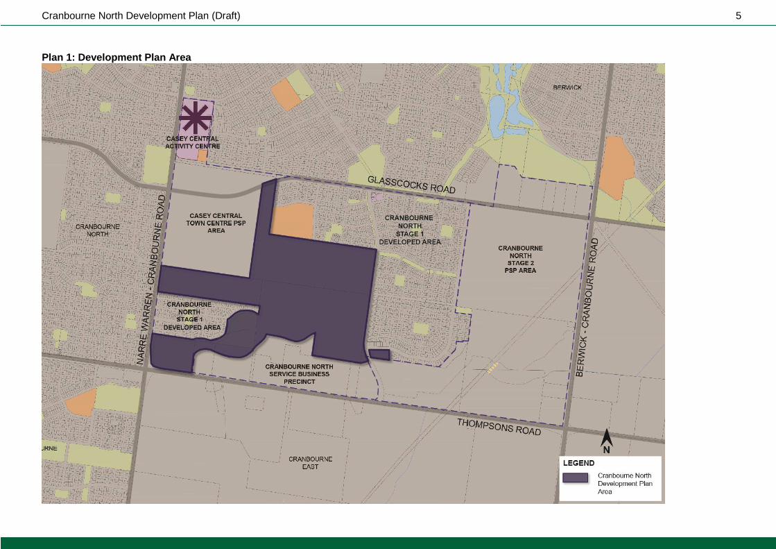
The land to which this Development Plan applies is illustrated in Plan 1 and shown on the Casey Planning Scheme Maps as Schedule 14 to the Development Plan Overlay (DPO14). This Development Plan applies to approximately 104 hectares of land. This Development Plan area is part of the broader Cranbourne North area which is bounded by Glasscocks Road to the north, Narre Warren-Cranbourne Road to the west, Thompsons Road to the south and Berwick-Cranbourne Road to the east. Planning for the wider Cranbourne North area commenced in 2004 and has generally been progressed in 4 stages as follows: Stage 1: The original Cranbourne North Stage 1 Development Plan area. This is land that was made available for urban development through Amendment C77 to the Casey Planning Scheme. Stage 1 excluded the Casey Central Town Centre in the west and generally followed the interim Urban Growth Boundary in the east. The interim UGB was the UGB that was in place prior to November 2005. The Cranbourne North Development Plan provided a detailed strategic framework for the Stage 1 area and broader strategic direction for the balance of the Cranbourne North area. Stage 2: Cranbourne North Stage 2 Precinct Structure Plan (PSP) area. The PSP was prepared by the former Growth Areas Authority (now Metropolitan Planning Authority) and incorporated into the Casey Planning Scheme in June 2011 to guide urban development on land that was brought into the UGB after November 2005. Stage 3: Cranbourne North Service Business Precinct Development Plan area. Planning Scheme Amendment C163, approved in October 2013, applies a Commercial 2 Zone to this area. The Cranbourne North Service Business Precinct Development Plan has been prepared and is proposed to be approved under Clause 19 of the Development Plan Overlay. Stage 4: Casey Central Town Centre PSP area. The Metropolitan Planning Authority and Casey City Council are working together to prepare a PSP for this remaining area of land. The Cranbourne North Development Plan was originally adopted in August 2007. Amendment C172 to the Casey Planning Scheme gazetted in September 2013 made amendments to DPO14 to simplify and update the planning provisions and remove the application of the DPO14 to land in Stage 1 where development was largely complete. In addition the open space contribution specified in Clause 52.01 was reduced to 3.08%. Consequently a revised Development Plan has been prepared to guide development within this revised framework.
Cranbourne North Development Plan (Draft) 5
Plan 1: Development Plan Area
Cranbourne North Development Plan (Draft) 6
2. Site Features
2.1.1. Environs
Four nearby residential estates have been developed since 2007. The estates are within the area now known as the Cranbourne North Stage 1 developed area identified in Plan 1. Additional development will occur within:
Casey Central Town Centre PSP area in the form of a Major Activities Area with a combination of commercial, residential and community uses.
Cranbourne North Stage 2 PSP area in the form of residential housing supported by a range of community and recreational facilities along with two local town centres.
Cranbourne North Service Business Precinct with employment and business uses.
2.1.2. Site Features
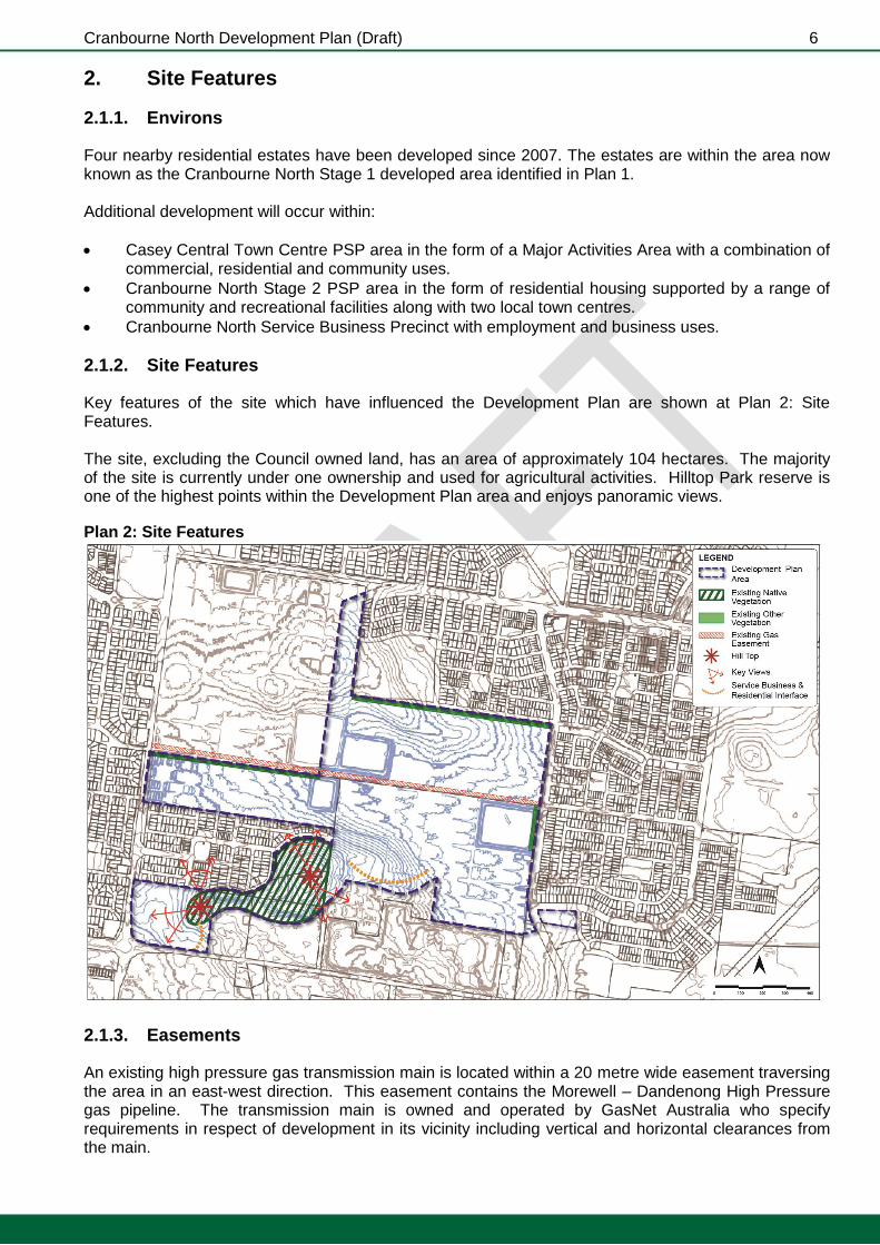
Key features of the site which have influenced the Development Plan are shown at Plan 2: Site Features. The site, excluding the Council owned land, has an area of approximately 104 hectares. The majority of the site is currently under one ownership and used for agricultural activities. Hilltop Park reserve is one of the highest points within the Development Plan area and enjoys panoramic views.
Plan 2: Site Features
2.1.3. Easements
An existing high pressure gas transmission main is located within a 20 metre wide easement traversing the area in an east-west direction. This easement contains the Morewell – Dandenong High Pressure gas pipeline. The transmission main is owned and operated by GasNet Australia who specify requirements in respect of development in its vicinity including vertical and horizontal clearances from the main.

Cranbourne North Development Plan (Draft) 7
2.1.4. Natural Environment
The area has mostly been cleared for agricultural activities. Existing vegetation includes, but it not limited to:
Vegetation with moderate landscape value along the northern boundary of Properties A and E.
Remnant native vegetation is exists within the Hilltop Park conservation reserve.
2.1.5. Buffers
Uses with reverse amenity potential are found along both sides of Thompsons Road. Plan 3 provides a preliminary assessment on those uses and the indicative buffer requirements. Plan 3: Buffers

Cranbourne North Development Plan (Draft) 8
3. Vision and Urban Structure
3.1. Vision
The Development Plan aims to build a community upon the principles of sustainability, economic vibrancy and social cohesion and the strengths and assets of the existing and planned Cranbourne North community. Innovative and site responsive approaches to development will help achieve this vision. This Development Plan will:
Integrate and connect with the wider Cranbourne North community and maximise the use of nearby existing and planned services and amenities.
Be compact and walkable with strong connections to nearby amenities, schools, community facilities, parklands and employment opportunities through an integrated pedestrian, cycling and trail network.
Provide a central community hub incorporating active open space, a primary school and kindergarten facilities.
Deliver an east west and north south “community spine” which provide high quality pedestrian and cycle links between public facilities including town centres, multi-purpose community centres, schools and active sports reserves.
3.2. Urban Structure
The vision will be realised through the future urban structure illustrated in Plan 4. The plan illustrates and outlines the key land use, development and subdivision requirements of the Development Plan.
3.3. Land Use Budget
The Land Use Budget is depicted in Plan 5, and outlined in Table 1 Summary Land Use Budget, with a more detailed property specific Land Use Budget in Table 2. This Development Plan covers a total area of 104.4 hectares. The Net Developable Area (“NDA”) is approximately 73 hectares representing 70.4% of the PSP Area.
Cranbourne North Development Plan (Draft) 9
Plan 4: Future Urban Structure

Cranbourne North Development Plan (Draft) 10
Plan 5: Land Use Budget Table 1: Summary Land Use Budget

Cranbourne North Development Plan (Draft) 11
Table 2: Property Specific Land Use Budget
Cranbourne North Development Plan (Draft) 12
4. Elements
This chapter sets out objectives and planning and design guidelines for the following elements: 4.1 Image and Character 4.2 Housing 4.3 Community Facilities 4.4 Open Space and Natural Systems 4.5 Integrated Water Management 4.6 Transport and Movement 4.7 Utilities and Development Staging Each element includes:
Objectives: an objective describes the desired outcome to be achieved in the completed development. Objectives must be met.
Plans: the plans are a spatial expression of the objectives.
Planning and Design Guidelines: including figures and tables that:
Must be met, or
Should be met. Where a planning and design guideline is listed as “must be met” no alternative shall be considered. Where a planning and design guideline is listed as “should be met” an application for an alternative design solution or outcome envisaged by the planning and design guideline, which meets the objectives, may be considered to the satisfaction of the Responsible Authority.
4.1. Image and Character
4.1.1. Objectives
The objectives for image and character are:
To establish a built environment that is functional, safe, sustainable, aesthetically pleasing and that promotes a strong sense of place for future residents.
To capitalise on view corridors to and from Hilltop Park as one of the more significant landscape features and ensure development does not detract from the visual amenity of the area.
To develop a distinctive neighbourhood and landscape character with a strong emphasis on elements which contribute to community identity and sense of place.
To create “community spines” that provide high quality pedestrian and cycle links that connect between public facilities, multipurpose community centres, schools and active sports reserves.
4.1.2. Planning and Design Guidelines
Landscape masterplans should be designed to:
Establish an informal indigenous and native base of trees to complement Hilltop Park in public and private spaces where possible.
Establish landmark trees in important locations such as roundabouts, junctions, vistas, axis, and open spaces to maximise canopy, height, a sense of structure and to inspire people.
Provide consistent street tree themes across existing and proposed development in accordance with Casey tree strategies.
The subdivision layout plan for Property A must provide the east west principal community spine that builds upon the Alisma Boulevard cross section and includes:
A linear open space link with a minimum width of 30 metres.

Cranbourne North Development Plan (Draft) 13
A shared path lined with large informally planted canopy trees.
Public art and interpretative displays along the trail that tell the history of the place.
Consistency in quality of the public open space treatment.
Pockets of higher density housing that benefit from the outlook over the space and access to other community facilities.
The subdivision layout plan for Property A and F must provide the north south community spine that builds upon the William Thwaites Boulevard cross section and includes:
Continuation of a shared path within the road reservation on the western side of William Thwaites Boulevard.
A wider road reservation is required to include an at least 2.5 metres wide linear strip to the west of the shared path to provide for an additional row of canopy tree planting.
The subdivision layout and lots with abuttal to the community spines must be designed with building envelopes and restrictions in accordance with Section 4.2.2 (building envelope restriction).
The subdivision layout plan for Property E must provide a shared pedestrian and cycling link that also serves as a visual axis between Hilltop Park and the future Casey Central Town Centre Activities Area. This link should be designed to achieve a shared path, a strong landscape theme and address the principles of “Crime Prevention Through Environmental Design” (“CPTED”).
The subdivision layout plan for Property F must provide a shared pedestrian and cycling link that also serves as a visual axis between the two active open space reserves P2 and P6. This link should be designed to achieve a shared path, a strong landscape theme and address the principles of CPTED.
The subdivision layout plan for Property F and H-1 must provide for the delivery of the balance of Hilltop Park as a conservation reserve.
Streets must be designed to relate to and provide visual connection with the Hilltop Park.
4.2. Housing
4.2.1. Objectives
The objectives for housing are:
To provide a diversity of lot sizes and housing types to satisfy the needs and aspirations of the new community over time.
To provide medium and higher residential housing densities close to the Activities Areas, open space, community hub, and proposed public transport routes.
To provide residential neighbourhoods that promote liveability through high urban design standards, creating attractive streetscapes and a distinctive neighbourhood character.
To provide lot sizes and housing types which are responsive to the character of the natural environment in the area and respond to principles of environmental sustainability.
To provide appropriate treatments to address potential reverse amenity issues generated from non-residential uses within the Cranbourne North Service Business Precinct as shown on Plan 4.
4.2.2. Planning and Design Guidelines
Density Requirements
A minimum density of 15 dwellings per net developable hectare must be achieved.
Medium and high density housing should be provided around the Activities Areas, open space and other areas with higher amenity.
Developments should be designed to minimise the bushfire risks associated with Hilltop Park reserve. A wider road reserve or greater building setback on larger lots is encouraged.
Building Envelope Restriction
Building envelopes must be applied to all lots of between 300 and 500 square metres, that require:
Except in special circumstances, a front setback of at least 4 metres (with allowable encroachments of up to 1.5 metres) with all garages set back at least 5.5 metres.
Garage openings to occupy no more than 40% of the width of the lot frontage unless in the case of dwellings of two or more storeys on lots with a frontage width of less than 12

Cranbourne North Development Plan (Draft) 14
metres whereby the garage opening must not exceed 25% of the area of the front façade of the dwelling. The area of the front façade of the dwelling is measured from a two dimensional elevation plan and excludes any area of the roof of the dwelling.
The subdivision layout and lots with abuttal to the community spines must be designed with building envelopes and restrictions applied as necessary, to ensure that dwellings are:
Rear loaded or provided with loop road frontage to minimise the numbers of vehicular crossings over these dedicated community spines and ensure dwellings are oriented and integrated within open space land.
Oriented to the community spines, have a minimum front setback of 5 meters and no fencing forward of the building line.
No dwelling may be constructed on any lot unless the building incorporates plumbing for recycled water supply for toilet flushing and garden watering use if it is to become available.
The creation of restrictions to prohibit the construction of more than one dwelling on any lot. This restriction will not apply to lots nominated on the endorsed subdivision layout plan as a potential multi-dwelling lot.
General Requirements
Any planning permit applications for sensitive uses and development within and around the areas identified in Plan 3 should be referred to the EPA for comment.
Any proposal for development at the interface of the Cranbourne North Service Business Precinct as shown in Plan 4 must be designed to respond to nearby non-residential uses such that the potential impact upon residential amenity is minimised.
Any planning permit applications for use and development within the “measurement length” of the gas transmission pipeline easement identified in Plan 2: Site Feature should be referred to Energy Safe Victoria and the gas pipeline operator. The “measurement length” is the distance up to 270 metres from the pipeline.
4.3. Community Facilities
4.3.1. Objectives
The objectives for community facilities are:
To provide a central community hub as one of the focal points for community activity and interaction.
To support the early and timely provision of community facilities.
To ensure safe and convenient access to community facilities by walking, cycling, public transport and car.
To generally co-locate community facilities with active and passive open space. To plan and design for community facilities which represent quality architecture and offer flexible designs to accommodate a range of uses and meet the changing needs of the community.
4.3.2. Planning and Design Guidelines
Community facilities should be integrated with other council facilities and/or open space, and be co-located with proposed children’s playgrounds, recreation infrastructure and kindergartens.
Education and community services (public and private) and other activities (such as childcare centres) should be:
Within and or adjoining community hubs,
Within or on the edge of Activities Areas, or
On either connector streets or arterial roads where access can be provided safely.
Cranbourne North Development Plan (Draft) 15
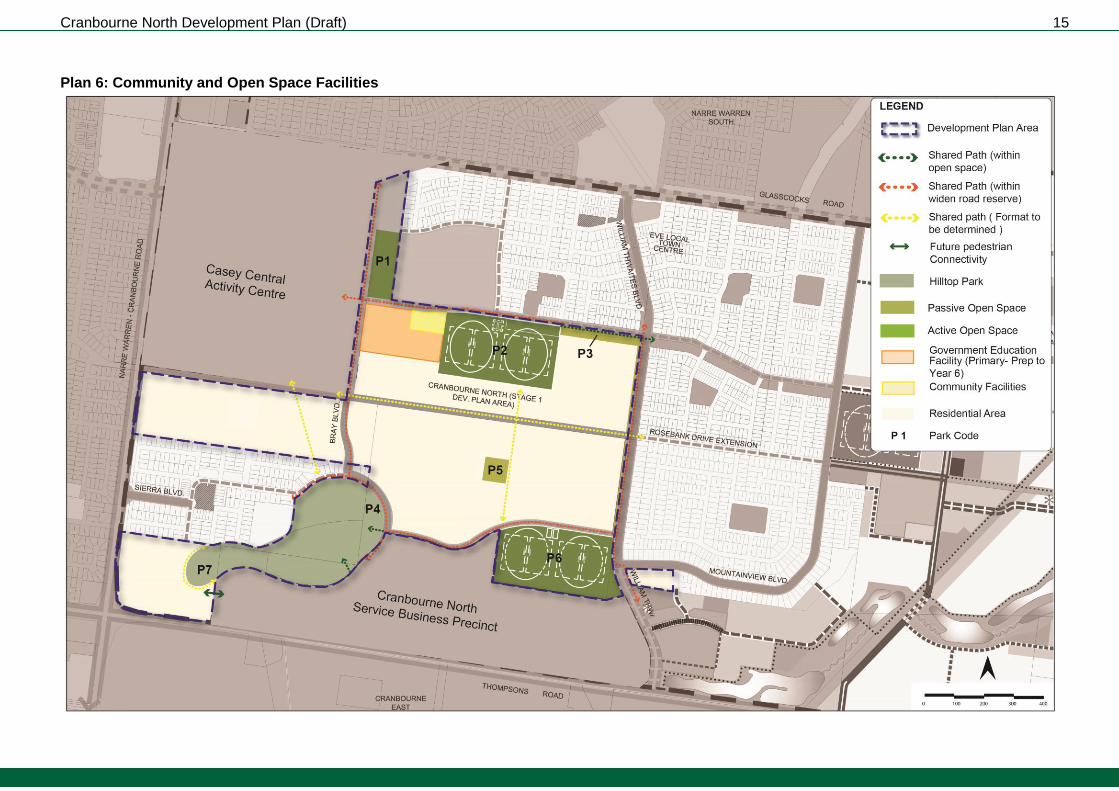
Plan 6: Community and Open Space Facilities

Cranbourne North Development Plan (Draft) 16
4.4. Open Space and Natural Systems
4.4.1. Objectives
The objectives for open space and natural systems are:
To provide a variety of open spaces to meet the active and passive recreation needs of the community.
To integrate and restore as appropriate environmental, heritage and drainage values and features.
To ensure safe and convenient access to community and recreational facilities by walking and cycling.
To establish a network of appropriately sized, connected and distributed open spaces to meet local and district open space needs and generally within 400m or around a 5 minute walk of most residents.
To provide for a sustainable future maintenance regime.
To support the early development of open space.
To facilitate local and regional trail linkages with adjoining precincts and open space features.
To encourage joint uses, where appropriate, between schools, community facilities and open spaces.
To incorporate Water Sensitive Urban Design into the street space where possible.
4.4.2. Planning and Design Guidelines
General
Open spaces should be designed and constructed to a fit for purpose standard with an appropriate mix of facilities and infrastructure.
Design of open spaces should be contemporary in nature, innovative and draw upon the context, history and the future use of the space.
Passive parks should cater for a broad range of users by providing a mix of spaces and planting to support both structured and informal recreational activities.
Parks should contain both cleared open areas for unstructured activities, as well as areas for shade and shelter.
Any pedestrian and cycle link through a drainage reserve, adjoining the road network or the existing gas transmission pipeline easement (subject to approval of the GasNet Australia) should include provision of park seating at appropriate intervals.
Interface with Road Network
Open spaces should have a road frontage to all edges except where these are otherwise addressed by active frontage from careful design of residential, commercial or community facility development.
Streetscape planting and paths should complement and integrate with the adjoining parkland design.
Interface with Adjoining Development
All development abutting open space should be well articulated and facilitate passive surveillance with windows, balconies, and pedestrian access points to promote and maximise use of the parkland.
Development should avoid the rear of properties or blank walls abutting open space.
Where fencing is required it should be low scale and permeable to facilitate public safety and surveillance.
Landscaping of adjoining development should complement the park landscape design.

Cranbourne North Development Plan (Draft) 17
Water Sensitive Urban Design (“WSUD”)
The design and layout of open spaces should maximise water use efficiency, stormwater quality and long term viability of vegetation through the use of WSUD initiatives.
Where possible WSUD principles should be used to capture stormwater runoff to support planting and landscaping.
Warm season grasses should be used within passive reserves and sports fields to minimise potable water use.
Transfer of Land Requirements
All parks must be finished to the following level of development to the satisfaction of the Responsible Authority prior to the transfer of land:
Removal of all existing disused structures, foundations, pipelines or stockpiles.
Cleared of rubbish and environmental weeds, levelled, topsoiled and grassed with warm climate grass (unless a conservation reserve).
Provision of water tapping, potable and recycled water connection points. Sewer and gas connection points must also be provided to land identified as an active reserve.
Drought resistant plantings.
Vehicles exclusion devices (fence or other suitable method) and maintenance access points.
Construction of 2.5 metre concrete shared paths within reserves connecting and linking into any other surrounding paths or points of interest.
Installation of park furniture including BBQs, shelters, tables, playgrounds and rubbish bins. Table 3: Open Space Values This table describes the core components of the open space network delivered via the DCP (in the case of active open space) and via the schedule to clause 52.01 of the Casey Planning Scheme (for passive open space). The recommended park types and amenities should be used as a guide, in consultation with council, when developing park concepts. Final park type and design is subject to the approval of the Responsible Authority.
PA
RK
CO
DE
PA
RK
FU
NC
TIO
N
UN
EN
CU
MB
E
RE
D A
RE
A
(HA
)
SITE FEATURES / DESCRIPTION
P1 Active* 2 Located adjacent the existing secondary college, along the central community hub.
P2 Active** 8.41 Located adjacent to the proposed primary school and community centre.
P3 Passive 0.71 Located along Alisma Boulevard. Approximately 30 metres wide.
P4 Passive
(Encumbered) 1.24
Forms part of the Hilltop Park conservation reserve.
P5 Passive 1 Central located to serve neighbourhood. At least 1 hectare in size.
P6 Active** 8.4 Located along William Thwaites Boulevard.
P7 Passive
(Encumbered) 1.18
Forms part of the Hilltop Park conservation reserve.
P8 Active 0.24 Addition to the active open space reserve P6.
* includes 6 Tennis courts & Carpark & pavilion ** includes 2 Football/Cricket ovals, Cricket Nets, 2 Netball courts, Pavilion & carpark.
4.4.3. How to make a Public Open Space Contribution in this Development Plan Area
Clause 52.01 of the Casey Planning Scheme specifies a public open space contribution which must be made upon the subdivision of the land. Because this Development Plan seeks a particular distribution of public open space, all landowners must provide the public open space shown in Plan 5 of the Development Plan as part of their public open space contribution and make a payment or receive a

Cranbourne North Development Plan (Draft) 18
payment as necessary to ensure that each landowners’ open space contribution is the same or equal. This process is referred to as equalisation. Table 2 of this Development Plan is the Property Specific Land Budget and identifies the amount of open space to be provided as land and the payment in respect of equivalent land area that must be paid by or paid to the land owner. All land within the Development Plan area must make an open space contribution equal to 3.08% of Net Developable Area (NDA). Where land is required for unencumbered open space purposes as shown in Plan 5 of the Development Plan and specified in Table 2 of the Development Plan area and that area of land is less or equal to 3.08% of NDA that land is to be transferred to Council at no cost. Where no land or less than 3.08% of NDA is shown in Plan 5 and Table 2 for unencumbered open space purposes, a cash contribution is to be made to Council to bring each property’s total open space contribution up to an amount equal to 3.08% of NDA. Where the land required for unencumbered open space purposes as shown in Plan 5 and Table 2 of the Development Plan is more than 3.08% of NDA, Council will pay an amount equivalent to the additional land being provided by that property required in order to provide 3.08% of NDA as a public open space contribution but Council will not pay an amount for land which is in excess of the land required to be set aside as specified in Table 2 for Public Open Space. The value of the land for equalisation purposes is to be assessed on an area proportion of the site value, in accordance with Section 18 of the Subdivision Act 1988, of the whole of the land.
4.5. Integrated Water Management
4.5.1. Objectives
The objectives for integrated water management are:
To plan for the future drainage needs of the new urban environment.
To mitigate flooding of urban areas.
To manage the flows of storm water runoff into the Westernport and Port Phillip catchments.
To reduce and filter sediment and nitrogen levels.
To enhance the biodiversity and habitat values of the Development Plan area.
To enhance the landscape character and plant health within the Development Plan area.
To incorporate Water Sensitive Urban Design into the street and public space design elements.
To conserve potable water and use alternative water sources for fit-for purpose uses where possible.
4.5.2. Planning and Design Guidelines
Every development must be provided with reticulated sewer services and potable water supply. Existing sewer infrastructure may need upgrading depending on extent of development.
Advice must be sought from the Responsible Authority and Melbourne Water regarding design, construction and maintenance regime of any future drainage system. This advice should inform and be reflected in the surface water management plan and detailed stormwater management plan to be submitted to and approved by the Responsible Authority and Melbourne Water as part of the planning permit application assessment process.
Applications for subdivision must be accompanied by a hydrogeological assessment of groundwater conditions on the site and the potential impacts on the proposed development including any measures required to mitigate the impacts of groundwater conditions on the development and the impact of development on groundwater.
Cranbourne North Development Plan (Draft) 19
4.6. Transport and Movement
4.6.1. Objectives
The objectives for transport and movement are:
To establish an integrated and sustainable transport network that reduces dependency on the use of private vehicles, maximises access to public transport and encourages walking and cycling within and between neighbourhoods.
To establish a bus network that connects the residential area to the Activities Areas, community facilities, schools, nearby railway stations and other key destinations.
To establish a connector street network that provides for the safe and efficient operation of bus and cycle movements and the existing and future arterial road networks.
To support the early provision of local bus services and walking and cycling links through the sequential staging of the development of the area.
To establish an approximate 800 metre spaced grid of arterial roads and connector streets.
To provide for the landscaping of roads, transport and movement corridors to help create safe and attractive urban environments.
To create highly connective and accessible street network, with dead ends and cul de sacs avoided.
To minimise the vehicular crossovers on the Community Spines.
4.6.2. Planning and Design Guidelines
Connector Street Construction
Connector streets (including any culverts) must be constructed by development proponents as part of the subdivision works (prior to the issue of a statement of compliance for the relevant stage).
Where two connector streets intersect, a roundabout treatment should be applied.
Construction of Intersections with Arterial Roads
All intersections with existing or proposed arterial roads must be designed, constructed and controlled to the satisfaction of the Responsible Roads Authority and the responsible authority, with the main design objective being to allow for a minimum 10-year design life having regard to the anticipated traffic growth on the affected roads from both the ultimate development of the Development Plan area and the external traffic.
Staging of subdivisions is to provide for the timely connection of road links between properties and the arterial road network and bus, cycle and walking routes to the satisfaction of the responsible authority and Responsible Roads Authority.
Land must be provided for right of way flaring at all arterial road connections to existing and proposed arterial roads for the ultimate design of the intersection in accordance with Responsible Roads Authority standards, with no cost burden to Responsible Roads Authority.
Prior to the preparation of planning permit applications which require access to an arterial road as shown on Plan 4 and 7, permit applicants should consult with Responsible Roads Authority to determine the appropriate extent of Right of Way flaring required for the intersection.
Arterial Road Connections – General Requirements
Residential lots fronting the arterial road network should be accessed via internal loop roads rather than by a service road.
Access to streets connecting to an arterial road should be considered within the context of the requirements of traffic management, safety, urban design and its urban environment.
Intersection design should provide for the safe and efficient operation of the arterial road and the side road to the satisfaction of Responsible Roads Authority, with consideration to vehicle speeds, vehicle queues and conflicting movements on approach to and departure from the intersection.
Cranbourne North Development Plan (Draft) 20
Access points (temporary and permanent) to the existing or proposed arterial road network beyond those shown on Plan 7, will be considered on a case by case basis in accordance with Responsible Roads Authority access management policies.
Shared Pathways
Shared paths, including along arterial road frontages, must be constructed by development proponents as part of subdivision works (prior to the issue of a statement of compliance for the relevant stage).
Footpaths and shared paths must be provided with increased width in areas expecting high foot traffic such as near the primary school, community centre and public transport interchanges and bus stops.
Pram crossings must be provided at all relevant street intersections and along key desire lines, particularly in the vicinity of bus stops.
Bicycle lane connections must be designed to allow for the smooth transition between shared paths and segregated cycle paths.
Pedestrian and cycle paths must be designed and located to maximize passive surveillance and provided in wide road verges with safe crossing points at key locations.
The local street network must be designed to provide permeable and safe routes for walking and cycling to the Activities Areas, community facilities, parks and open space, trail networks, public transport.
All shared paths must be provided as identified on Plan 6, be concrete and have a minimum width of 2.5 metres.
A 3-metres wide shared path must be provided along either side of arterial roads.
Bus Network
Where a requirement for a bus route or bus stop has been nominated by the Director of Public Transport, bus stops must:
Be constructed by development proponents as part of the subdivision works (prior to the issue of a statement of compliance for the relevant stage) in accordance with the requirements of the Public Transport Guidelines for Land Use and Development to the satisfaction of the Director of Public Transport.
Be provided with Disability Discrimination Act compliant direct and safe pedestrian access connected to an existing pedestrian/shared path.
Be designed as an integral part of activity centres and activity generating land uses, such as schools, community facilities, sports fields and employment areas.
Road and Street Cross Sections
Lots must be designed to address the road network.
In accordance with the Casey Arterial Road Tree Strategy (or as amended), a 12m wide tree reserve must be provided to any arterial road where an internal loop road (or service road) is not provided
Road and street cross sections should be generally consistent with the cross sections as outlined in Table 4.
The proposed east-west connector road along the northern boundary of the Cranbourne North Service Business Precinct (CNSBP) should accommodate a shared path within the road reservation in the event that delivery of the road precedes development of the linear open space within the CNSBP.
Where possible common trenching should be used to accommodate underground utilities and services.
Where additional land is required for utilities and services in connector streets, additional trenching may be provided within the 2.3m parking lane.

Cranbourne North Development Plan (Draft) 21
Table 4: Road type and cross sections
Road / street type Road reservation Ultimate function and cross section
Arterial Road – 6 Lanes
41m reservation Six trafficable lanes (minimum 3.5m width each lane)
Bus capable
No direct property access to Thompsons Road should be allowed
Allowance of canopy tree planting
A 3m wide shared path / two-way bike path on either side of road
Arterial Road – 4 Lane
34m reservation
Four trafficable lanes (minimum 3.5m width each lane)
Bus capable
Direct property access should be minimised along the same side of the segregated cycle paths or community spines identified in Plan 6
Allowance of canopy tree planting
A 3m wide shared path / two-way bike path on either side of road
Boulevard Connector Street
31m reservation Two trafficable lanes (minimum 3.5m width each lane)
Two parking lanes
Bus capable
Direct property access should be minimised along the same side of the segregated cycle paths or community spines identified in Plan 6
Allowance of canopy tree planting
A 3m wide shared path / two-way bike path on either side of road
Connector Street Level 1
25m reservation 22m reservation may be considered where it connects to the existing development.
Two trafficable lanes (minimum 3.5m width each lane)
Two parking lanes
Bus capable
Direct property access should be minimised along the same side of the segregated cycle paths or community spines identified in Plan 6
Allowance of canopy tree planting
A 3m wide shared path
Local Access Street Level 2
23m reservation Two trafficable lanes (minimum 3m width each lane)
Two parking lanes
Allowance of canopy tree planting
A 3m wide shared path
Cranbourne North Development Plan (Draft) 22
Plan 7: Transport Network

Cranbourne North Development Plan (Draft) 23
Plan 8: Public Transport

Cranbourne North Development Plan (Draft) 24
4.7. Utilities and Development Staging
4.7.1. Objectives
The utilities and development staging objectives are:
To ensure development occurs in an orderly and sustainable manner and makes best use of existing infrastructure.
To provide all developed lots, to the satisfaction of the relevant authority, with:
a potable water service,
electricity,
a reticulated sewerage service,
drainage,
third pipe,
gas, and
telecommunications.
To protect the gas transmission pipeline easement, to the satisfaction of the relevant authority.
4.7.2. Planning and Design Guidelines
Electricity
All new electricity supply infrastructure (excluding infrastructure to support cables with a voltage greater than 66kv) must be provided underground (excluding substations),
New substations must be identified at the subdivision design response stage to ensure effective integration with the surrounding neighbourhood and to minimise amenity impacts, and
The design of subdivision electricity infrastructure must consider the practically of removing existing above ground electricity lines in the local and arterial road network both within and abutting the subdivision and re-routing lines underground through the subdivision.
Development Staging
Generally, staging will be determined by the development program of developers within the precinct and the availability of infrastructure services. Within this context, the following planning and design guidelines must be met:
Development staging must not create circumstances in which residents will be unreasonably isolated from commercial and community facilities or public transport,
Development staging must, to the extent practical, be integrated with adjoining developments, including the timely provision of connecting roads and walkway / cycling paths, and
Access to each new lot must be provided via a sealed road.
Gas Transmission Pipeline Easement
Early engagement with the gas pipeline operator will be required during the preparation of the planning permit application. It will be necessary to demonstrate outcomes or other physical measures to be implemented to protect the pipeline. The gas pipeline operator may request that a Safety Management Study (SMS) is carried out in response to the possible change in land use and development outcomes.
All applications for development of land including subdivision must be accompanied by a Construction Management Plan (CMP). The CMP must adequately address development in proximity to the gas pipeline and ensure that appropriate safety measures will be implemented during construction that will maintain operating safety to the pipeline. This CMP must be prepared and approved by the easement owners and operators and Council and forms part of the permit (if issued).

Cranbourne North Development Plan (Draft) 25
Document Authorisation
Revision Date Details Authorisation
Position Signature
A 18/09/2007 Adopted as the approved Development
Plan under Clause 43.04 to the Casey Planning Scheme
Manager Strategic
Development
B 25/8/2009 Adopted as the approved Development
Plan under Clause 43.04 to the Casey Planning Scheme
Manager Statutory Planning
C DATE Amendments to this Development Plan to update the planning
provisions applicable to a reduced area
Manager Strategic
Development