council assessment panel meeting agenda · council assessment panel meeting agenda . tuesday 01 may...
TRANSCRIPT

Council Assessment Panel Meeting Agenda
Tuesday 01 May 2018 at 6pm
Council Chambers, 401 Greenhill Road, Tusmore
Members: Bill Chandler (Presiding Member) Ross Bateup, Graeme Brown, Kate Shierlaw and Di Wilkins
1 APOLOGIES
Nil
2 KAURNA ACKNOWLEDGEMENT
The Presiding Member will take the opportunity to acknowledge the Kaurna people.
3 CONFIRMATION OF MINUTES
Recommendation: That the minutes of the meeting held on Tuesday 03 April 2018 be taken as read and confirmed.
4 APPLICATIONS WITHDRAWN FROM THE AGENDA
Nil
5 DEVELOPMENT APPLICATIONS FOR CONSIDERATION – PERSONS WISH TO BE HEARD
(A) NON-COMPLYING DEVELOPMENT APPLICATIONS (HEARING)
Nil
(B) CATEGORY 3 DEVELOPMENT APPLICATIONS (HEARING)
Nil
(C) CATEGORY 2 DEVELOPMENT APPLICATIONS (HEARING)
Recommendation: As the opportunity to make a verbal presentation for Category 2 applications is at the Panel’s discretion, that the Panel provide an opportunity to be heard.
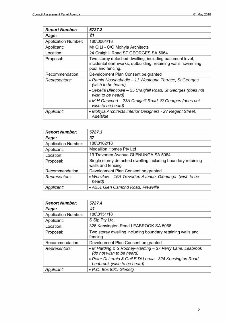
Report Number: 5727.1
Page:
Application Number: 180\0025\18 Applicant: Precision Homes Location: 25 High Street BURNSIDE SA 5066 Proposal: Demolition of existing dwelling and construction of single storey
detached dwelling, shed, swimming pool, deck, incidental earthworks, retaining walls and fencing
Recommendation: Development Plan Consent be granted Representors: Helen Miles – 6 Allen Street, Burnside (wish to be heard)
H & P Marcelin – 6a Allen Street, Burnside (wish to be heard)
Applicant: 45 Hackney Road, Hackney
7
1
Council Assessment Panel Agenda 01 May 2018
Report Number: 5727.2
Page:
Application Number: 180\0084\18 Applicant: Mr Q Li - C/O Mohyla Architects Location: 24 Craighill Road ST GEORGES SA 5064 Proposal: Two storey detached dwelling, including basement level,
incidental earthworks, outbuilding, retaining walls, swimming pool and fencing.
Recommendation: Development Plan Consent be granted Representors: Ramin Noushabadic – 11 Wootoona Terrace, St Georges
(wish to be heard)
Sybella Blencowe – 25 Craighill Road, St Georges (does notwish to be heard)
M.H Garwood – 23A Craighill Road, St Georges (does notwish to be heard)
Applicant: Mohyla Architects Interior Designers - 27 Regent Street,Adelaide
Report Number: 5727.3
Page:
Application Number: 180\0162\18 Applicant: Medallion Homes Pty Ltd Location: 19 Trevorten Avenue GLENUNGA SA 5064 Proposal: Single storey detached dwelling including boundary retaining
walls and fencing Recommendation: Development Plan Consent be granted Representors: Wenzlow – 16A Trevorten Avenue, Glenunga (wish to be
heard)
Applicant: A251 Glen Osmond Road, Frewville
Report Number: 5727.4
Page:
Application Number: 180\0151\18 Applicant: S Slp Pty Ltd. Location: 326 Kensington Road LEABROOK SA 5068 Proposal: Two storey dwelling including boundary retaining walls and
fencing Recommendation: Development Plan Consent be granted Representors: M Harding & S Rooney-Harding – 37 Perry Lane, Leabrook
(do not wish to be heard)
Peter Di Lernia & Gail E Di Lernia– 324 Kensington Road,Leabrook (wish to be heard)
Applicant: P.O. Box 891, Glenelg
21
37
51
2
Council Assessment Panel Agenda 01 May 2018
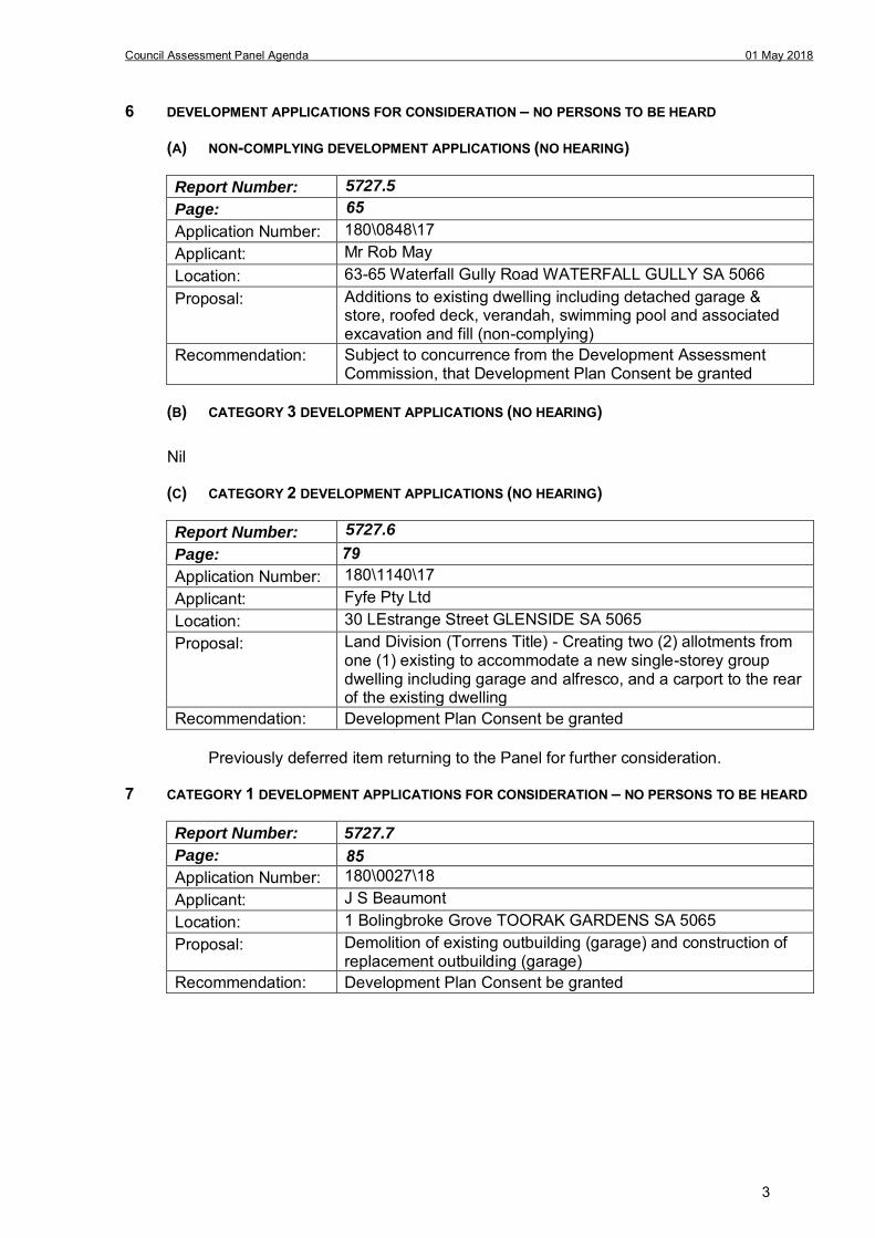
6 DEVELOPMENT APPLICATIONS FOR CONSIDERATION – NO PERSONS TO BE HEARD
(A) NON-COMPLYING DEVELOPMENT APPLICATIONS (NO HEARING)
Report Number:
65 Page:
Application Number: 180\0848\17 Applicant: Mr Rob May Location: 63-65 Waterfall Gully Road WATERFALL GULLY SA 5066Proposal: Additions to existing dwelling including detached garage &
store, roofed deck, verandah, swimming pool and associated excavation and fill (non-complying)
Recommendation: Subject to concurrence from the Development Assessment Commission, that Development Plan Consent be granted
(B) CATEGORY 3 DEVELOPMENT APPLICATIONS (NO HEARING)
Nil
(C) CATEGORY 2 DEVELOPMENT APPLICATIONS (NO HEARING)
Report Number: 5727.6
Page:
Application Number: 180\1140\17 Applicant: Fyfe Pty Ltd Location: 30 LEstrange Street GLENSIDE SA 5065 Proposal: Land Division (Torrens Title) - Creating two (2) allotments from
one (1) existing to accommodate a new single-storey group dwelling including garage and alfresco, and a carport to the rear of the existing dwelling
Recommendation: Development Plan Consent be granted
Previously deferred item returning to the Panel for further consideration.
7 CATEGORY 1 DEVELOPMENT APPLICATIONS FOR CONSIDERATION – NO PERSONS TO BE HEARD
Report Number: 5727.7
Page:
Application Number: 180\0027\18 Applicant: J S Beaumont Location: 1 Bolingbroke Grove TOORAK GARDENS SA 5065 Proposal: Demolition of existing outbuilding (garage) and construction of
replacement outbuilding (garage) Recommendation: Development Plan Consent be granted
79
85
5727.5
3
Council Assessment Panel Agenda 01 May 2018
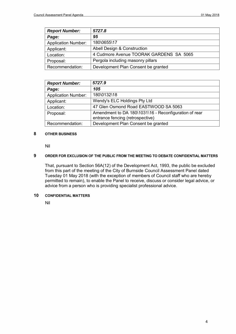
Report Number: 5727.8
Page:
Application Number: 180\0655\17 Applicant: Abell Design & Construction Location: 4 Cudmore Avenue TOORAK GARDENS SA 5065 Proposal: Pergola including masonry pillars Recommendation: Development Plan Consent be granted
Report Number:
Page:
Application Number: 180\0132\18 Applicant: Wendy's ELC Holdings Pty Ltd Location: 47 Glen Osmond Road EASTWOOD SA 5063 Proposal: Amendment to DA 180\1031\16 - Reconfiguration of rear
entrance fencing (retrospective) Recommendation: Development Plan Consent be granted
8 OTHER BUSINESS
Nil
9 ORDER FOR EXCLUSION OF THE PUBLIC FROM THE MEETING TO DEBATE CONFIDENTIAL MATTERS
That, pursuant to Section 56A(12) of the Development Act, 1993, the public be excluded from this part of the meeting of the City of Burnside Council Assessment Panel dated Tuesday 01 May 2018 (with the exception of members of Council staff who are hereby permitted to remain), to enable the Panel to receive, discuss or consider legal advice, or advice from a person who is providing specialist professional advice.
10 CONFIDENTIAL MATTERS
Nil
5727.9105
95
4
Council Assessment Panel Agenda
NOTES FOR THE READER
Purpose
The purpose of each report prepared for the Council Assessment Panel is to assist the applicant, those assessing the application and members of the public alike, to understand all of the relevant factors and considerations involved in the assessment of each particular development application.
Development Plan Assessment
Development in South Australia is regulated under the Development Act, 1993 and the Development Regulations, 2008.
This legislation requires Council, which is a relevant planning authority under this legislation, to assess most applications for development against the provisions of Council’s “Development Plan”.
The Development Plan is a policy document. The policy is formulated by the Council. It uses some “planning language” but is intended to form a useful and practical guide for the public and those responsible for the assessment of development. It is a practical policy document which the planning authority must apply to development assessment in a practical way.
When assessing development, the relevant provisions within the Development Plan are identified. The planning authority will then usually be required to consider whether those provisions speak for or against a proposed development. Quite often the assessment task will require the planning authority to weigh the “pros and cons” of a proposed development by reference to the relevant policies within the Development Plan.
The process involved in the assessment of each development application is contained within the above legislation. Depending on a variety of factors, including the nature of the development and the Zone within which it is proposed, applications may be classified as “complying”, “non-complying” or “merit” development. The classification of the application will determine the procedure to be followed under the legislation. Classification will also determine the public notification protocol, that is, whether the planning authority is able to provide public notification and if so, the extent of the public notification.
Representations
Representors will usually be provided with an opportunity to address the planning authority at its relevant meeting if they wish to be heard. In this case the relevant planning authority will hear and consider the representations prior to making its decision. It is the role of the planning authority to act as a mediator or arbitrator between representor(s) and applicant.
The reports prepared by the Council’s staff will not separately address the content of each representation, but rather will deal with relevant town planning issues raised in any representation, together with all other relevant considerations involved in the assessment of a proposed development.
5

this page is left intentionally blank
6
Council Assessment Panel Agenda 01 May 2018 Report Number: PR 5727.1
DEVELOPMENT APPLICATION
Application Number: 180\0025\18
Applicant: Precision Homes
Location: 25 High Street, Burnside
Proposal: Demolition of existing dwelling and construction of single storey detached dwelling, shed, swimming pool, deck, incidental earthworks, retaining walls and fencing
Zone/Policy Area: Residential Zone
Residential Policy Area 16 – Burnside (North)
Development Plan consolidated 19 December 2017
Kind of Assessment: Merit
Public Notification: Category 2
Two (2) representations received
Appeal Opportunity Applicant only, no third party appeal rights
Referrals – Non Statutory: Traffic Management Engineer
Tree Management Officer
Delegations Policy: Unresolved representations
Recommendation: Development Plan Consent be granted
Recommending Officer: Theresa James
REPORT CONTENTS
Assessment report: - Appendix 1 – Aerial Locality Map - Appendix 2 – Detailed Planning Assessment - Appendix 3 – Development Data Table
Please note that due to Federal Copyright Law restrictions, attachments associated with the proposed development are not made available to the public.
Documentation provided as attachments to the report to members of the Council Assessment Panel to facilitate decision making: Plans and supporting documents Internal agency referral reports Representations received Applicant’s response to representations Photographs
7
Council Assessment Panel Agenda 01 May 2018 Report Number: PR 5727.1
1. DESCRIPTION OF PROPOSAL
The applicant seeks Development Plan Consent for the demolition of an existing single storey detached dwelling, swimming pool, outbuilding and non-regulated vegetation on the subject land. It seeks to replace the existing dwelling with a new single storey detached dwelling, located wholly within Residential Policy Area 16 – Burnside (North). The proposed dwelling footprint will share a similar footprint as the existing dwelling, and also include a split floor level due to a sharp decent in the land towards the mid-north/west of the allotment. The proposed dwelling includes the following features: Central portico; Double garage; Formal lounge; Large master bedroom with ensuite and WIR; 2 additional bedrooms; Play room; Study; Open kitchen/dining; Stepped living area and alfresco; Swimming pool; Decking; Retaining walls; and Fencing.
2. BACKGROUND
Development Application 180\0025\18 was lodged on 18 January 2018 by Precision Homes, on behalf of the registered owner of the land. The proposal was determined to be a merit form of development pursuant to Section 35(5) of the Development Act 1993. For the purposes of public notification, the application was determined to be Category 2, pursuant to the Burnside (City) Development Plan, Residential Policy Area 16 – Burnside (North), Principle of Development Control 10 (a) and (c). The application was made available for public consultation from 27 February 2018 – 13 March 2018, during which time two (2) representations were received. The representation raised concerns regarding the modification to the rear fencing and retaining walls. The applicant provided a response to the representations, stating that the existing retaining walls appear to be located on the adjoining land and not constructed on the common boundary. They were built to accommodate excavation on the adjoining allotments, which entail a much lower ground level than the subject land. Due to the location of the existing retaining walls, the proposed new retaining walls are located on the boundary and will abut the existing retaining walls. The application was internally referred to Council’s Technical Officer and Arborist with respect to on-site stormwater management, impacts to Council’s infrastructure, and the suitability of proposed access arrangements. Initially the applicant wished for a Council street tree to be removed, however this was not supported by Council’s arborist. Amended drawings were submitted which satisfied the set-back requirements to the adjacent street tree. The application is now presented to the Council Assessment Panel (the Panel) for consideration as a Category 2 application with two (2) unresolved representations, with a staff recommendation that consent be granted subject conditions.
8
Council Assessment Panel Agenda 01 May 2018 Report Number: PR 5727.1
3. SUBJECT LAND AND LOCALITY ATTRIBUTES
3.1. Subject Land
The subject land is a large allotment located on the north side of High Street. The land has a single frontage width measuring 50.12m, and an overall area measuring 1653m². The existing dwelling is a stone fronted dwelling built in the 1950s, and includes a simple carport positioned to the eastern side of the land. The ground level around the dwelling varies, and includes a sharp descend at the centre of the site, where it meets a levelled tennis court positioned on the western side of the allotment. The site is accessed via a small crossover to its eastern end of the frontage, as well as a small pedestrian gate. Dense hedging borders the front boundary, limiting views into the land from High Street.
3.2. Locality
The immediate locality comprises the streetscape of High Street, where it meets Lockwood Road to the east and Glynburn Road to the west. Burnside Primary School comprises a large portion of the northern side of High Street and is within a Community Zone. High Street abuts the Local Business Zone, where it meets Glynburn Road to the west. The locality is characterised by its narrow carriageway, creating an intimate setting. Large, mature street trees further add to this charm. Large grassed verges, particularly to the eastern end of High Street, contribute to the character of the locality. Some Local heritage places are also identified within this area.
4. KIND OF ASSESSMENT
Kind: Merit Reason: Development Act 1993, Section 35(5) Applicant Appeal Opportunity: Yes
5. PUBLIC NOTIFICATION
Category: Category 2 Reason: Residential Policy Area 16 Principle of Development Control 8(a)
& (c) Cut / Fill: Although a degree of fill is to be introduced to the site,
particularly beneath the north western portion of the dwelling footprint, the resultant floor level is similar to the existing dwelling floor level. The extent of the building footprint is comparable to the existing dwelling, and as such the level of earthworks and the external impacts as a result of the incidental fill (beneath the dwelling footprint) are considered minor.
Representations Received: Helen Miles – 6 Allen Street Burnside (wish to be heard) H & P Marcelin – 6a Allen Street Burnside (wish to be heard)
Third Party Appeal Opportunity: No
Representations received are provided as an attachment to the Panel.
Applicant’s response(s) to representations are provided as an attachment to the Panel.
9
Council Assessment Panel Agenda 01 May 2018 Report Number: PR 5727.1
6. AGENCY REFERRALS
Internal agency referrals are provided as an attachment to the Panel.
7. EXECUTIVE SUMMARY
7.1. Land Use
In relation to the current proposal, the following comments are made: The development involves the construction of a single storey dwelling on a site where
an existing single storey dwelling exists; The nature of the proposed built form (detached dwelling) is consistent with the low to
medium density residential character envisaged for the policy area; The proposed development is not identified as a non-complying kind of development in
the Burnside (City) Development Plan; and If it can be demonstrated that the proposed development has minimal or no
unreasonable external impacts, then consent could reasonably be expected. The proposed development is therefore not considered to be seriously at variance to the Burnside (City) Development Plan.
7.2. Character and Amenity
The proposed development involves the construction of a new, single storey detached dwelling on a residential allotment within Burnside. The design of the dwelling exhibits traditional elements such as a central portico, elaborate coining and stone features to its façade. However, it also includes contemporary elements, such as its low 22.5º roof pitch and low eave overhang, resulting in a hybrid style. The main dwelling façade is set-back 5m from the boundary of the road, with a recessed garage set-back an additional 900mm. Whilst the Development Plan contemplates a 6m set-back to a road boundary, the policy area recognises buildings sited close to road boundaries near the intersection of High Street and Lockwood Road. The existing dwelling on the site illustrates a short set-back of only 4.3m to the High Street boundary. In addition, the large open space to the west of the dwelling, comprising garden and tennis court, reduces the presence of the built-form spanning across the frontage of the land. The proposed dwelling has been designed to avoid any boundary walls, ensuring external impacts from the dwelling walls are reduced. Despite the Development Plan contemplating garages built on side boundaries, the proposed garage wall is set-back 1.25m from the eastern side boundary, with the remainder of the dwelling set-back 2.4m from the respective boundary. Minimal earthworks are proposed adjacent to the eastern side boundary, with existing levels largely unchanged. New fencing will ensure existing overlooking at ground level will be improved. The proposed dwelling maintains the village character of the early settlement of Burnside by maintaining a close building alignment to High Street, and also includes traditional building elements to the dwelling façade. It is set-back well from adjoining residential allotments to ensure the resultant building envelope does not cause significant loss of amenity, in terms of visual impact to adjoining residents.
7.3. Site Functionality
The proposed building footprint fits well within the site boundaries, as delineated on the site plan. The policy area contemplates buildings sited close to road boundaries, and the
10
Council Assessment Panel Agenda 01 May 2018 Report Number: PR 5727.1
general provisions expect garages to be built on side boundaries, however the proposal does not seek to do this. The proposed building footprint and layout is considered to adhere to the quantitative guidelines for residential development. Council’s arborist requires a 1.5m set-back to the adjacent street tree, which has been demonstrated on amended site plans.
7.4. Public Notification
The application was determined to be a Category 2 development pursuant to Residential Policy Area 16 Principle of Development Control (a) and (c) as the dwelling is greater than 6.5m in height and the proposed finished floor level is greater than 0.6m above the ground level. During the notification period Council received two (2) written submissions from the owner/occupier of adjoining land to the north of the subject land. Their concerns are summarised as follows:
Do not wish for shared rear boundary fencing to be replaced; Any earthworks required on the subject land should be carried out without any
need to remove existing retaining wall and fence; We would not object to the erection of additional buffer fencing over the length of
our back fence; All retaining walls to be built totally on land at 25 High Street and not on dividing
fence line; and Reduction of fencing to 1.8m rather than 2.1m.
The Applicant responded to the representations, and included a site plan illustrating the benched levels adjacent the boundaries of the land. They also employed their surveyor to inspect the Representor’s land to ascertain the ground levels of those sites and the location of the existing retaining wall. The adjoining allotments to the north appear to have been excavated and levelled, with the top of retaining wall heights following the grade of the land on the subject land. These existing retaining walls appear to be located on the adjoining land. The applicant responded by stating they wish to predominantly maintain the levels at the boundary of the site, with as little alteration to ground level as possible. The proposed fence height is solely intended to provide privacy to the adjoining properties. Due to the existing uneven ground level in the rear yard of the subject land, the proposed development seeks to raise these levels so that it is more easily accessible from the lower living area. The applicant stated they seek to minimise works at the northern boundary and as such a small garden bed lays between the proposed deck and swimming pool and the rear fence to allow for vegetation plantings. Notwithstanding the small garden bed separating the raised yard level and the rear fence, some retaining is required on the rear boundary, to a maximum height of 608mm where it adjoins the representor’s land. The new fencing atop the retaining walls is considered necessary, to ensure reasonable privacy from the subject land.
7.5. Agency Referrals
The application was referred to Council’s Technical Officer and Arborist. Standard comments were received from the Technical Officer. Council’s Arborist requires a 1.5m set-back to the adjacent street tree, which has been addressed through the amended drawings.
11
Council Assessment Panel Agenda 01 May 2018 Report Number: PR 5727.1
7.6. Conclusion
Having regard to all of the relevant Objectives and Principles of Development Control of the Burnside (City) Development Plan, the proposed development is not considered seriously at variance with, and is generally in accordance with, the policies of the Development Plan.
8. RECOMMENDATIONS
It is recommended that the Council Assessment Panel resolve that:
1. The proposed development is not seriously at variance with the policies in the Development Plan; and
2. is granted Development Plan Consent subject to the following conditions:
Conditions
1 The development granted Development Plan Consent shall be undertaken in accordance with the stamped approved plans, drawings, specifications and other documents submitted to the Council that are relevant to the consent to the reasonable satisfaction of the Council, except where varied by conditions below. Reason: To ensure the development is undertaken in accordance with the plans and details submitted.
2 The approved works may not commence until such time as the applicant has secured written authorisation for the construction of the new driveway crossover from the Council pursuant to Section 221 of the Local Government Act 1999.
Reason: To ensure the applicant has secured all relevant consents/authorisations required prior to the commencement of development.
3 The landscaping adjacent to the north boundary, between the deck and the rear fence as shown on the 'Boundary and Shed Elevations' drawing no. SK04A, shall include advanced growth, evergreen trees of greater than 2.5 metres in height at the time of planting and with a mature height of at least 3.5 metres and shall be planted on the subject land within three months of the substantial completion of the development and in any event prior to the occupation or use of the development. Such plants shall be maintained in good health and condition to the reasonable satisfaction of the Council. Any dead or diseased plants or trees shall be replaced immediately to the reasonable satisfaction of the Council. Reason:
To provide amenity for the occupants of buildings and those of adjacent buildings through the provision of landscaping as part of the development.
RECOMMENDING OFFICER
Theresa James Development Officer – Planning
APPENDIX 1
12
Council Assessment Panel Agenda 01 May 2018 Report Number: PR 5727.1
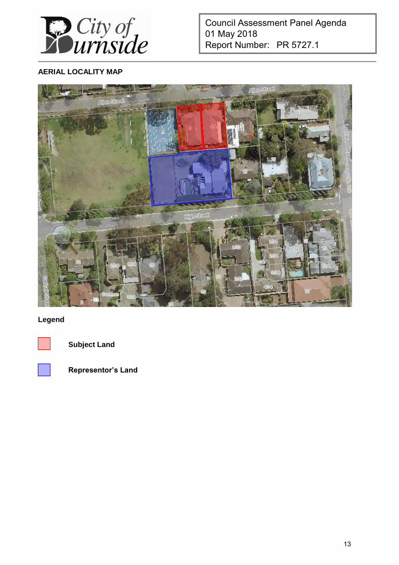
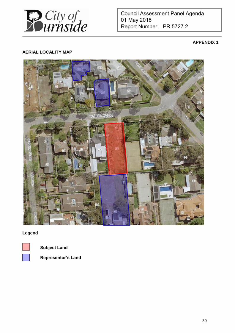
AERIAL LOCALITY MAP
Legend
Subject Land
Representor’s Land
13
Council Assessment Panel Agenda 01 May 2018 Report Number: PR 5727.1
APPENDIX 2
DETAILED PLANNING ASSESSMENT
Summary of Policy Area Objectives and Principles
Primary Residential Policy Area 16 Objectives:
Objective 1: Maintenance and enhancement of the low-to-medium density residential character that is derived particularly from: (a) low-to-medium density, primarily detached, and interwar or post-war, dwellings in a variety of styles,
interspersed with dwellings of other types or earlier origin; (b) split-level or two-storeyed detached dwellings, predominant in the south east of the Policy Area (generally
south of Greenhill Road and east of Wyatt Road), taking advantage of views from elevated sites; and (c) north of Greenhill Road, a greater mix of dwelling types, styles and densities.
Acknowledged, significant variations from the desired character, or the prevailing character or environmental conditions, forming, nevertheless, part of the character that is to be maintained and enhanced, are found: (a) on the sites of churches on Glynburn Road and Lockwood Road, and of the Fernilee Lodge function centre
on Greenhill Road; (b) south of Greenhill Road and east of Wyatt Road, where indigenous eucalypts, local reserves and minor
watercourses, and the generally open, well-vegetated appearance of front gardens, are important elements of the desired character;
(c) near the intersection of Lockwood Road and High Street, where nineteenth century buildings sited on or close to road boundaries contribute to the “village” character of the early settlement of Burnside;
(d) on land with frontage to Greenhill Road and to Glynburn Road; and (e) adjacent to the Community Zone and the Local Business Zone. Subject: DP Ref
Assessment:
Desired Land Use
O 1 Satisfied.
The development facilitates the intended use of the land for residential purposes.
Local Compatibility
PDC 1 The housing stock within the locality is varied. The policy area notes that ‘north of Greenhill Road, a greater mix of dwelling types, styles and densities’ form part of the residential character. In any event, the single storey building height, articulated façade, and separation to all boundaries on the land, ensures the proposed development contributes to the streetscape quality.
Site Areas and Frontages PDC 2–5
Satisfied.
14
Council Assessment Panel Agenda 01 May 2018 Report Number: PR 5727.1
Summary of Residential Zone Objectives and Principles
Primary Residential Zone Objectives:
Objective 1: A zone primarily for residential use with a range of dwelling types in appropriate policy areas to accommodate varied socio-economic needs.
Objective 2: Protection and enhancement of the amenity of residential areas, with particular reference to the objectives for the relevant policy area.
Objective 3: Residential densities varied having regard to topography, the objectives for the relevant policy area, and proximity to centres and major transport routes.
Objective 5: Enhancement of the attractive qualities of streetscapes and particularly areas of cohesive character or visual sensitivity, through good design.
Subject:
DP Ref Assessment:
Zoning and Land Use O 1–8 PDC 1
Satisfied.
Building Appearance PDC 2–4 The building is single storey, with a maximum building height well below
Development Plan guidelines. It is sited similarly to the existing building on the land, and is set-back appropriately from adjoining residential land.
The design of the building is best described as a hybrid contemporary style, which includes traditional details such a coining, decorative mouldings and stonework to its façade. Due to the topography of the land the eastern side of the dwelling entails a ground level below the adjacent road level. The rear portion of the dwelling has a similar floor level as the existing dwelling, which includes a stepped design to the western side.
Design for Topography PDC 5–6 The proposed ground floor of the dwelling is benched with a lower level
of 99.31 on the western side and 99.85 on the eastern side. The resultant finished floor levels are 99.51 and 100.05 respectively. In comparison to the finished floor level displayed by the existing dwelling, the eastern side of the proposed dwelling has a floor level that is 8cm higher than the existing dwelling, but 46cm lower on the western side. Given the proposed dwelling footprint is similar to the existing dwelling, impacts from the proposed finished floor level will be similar to existing circumstances.
This application however, seeks to bench the rear and side yards of the land, to create a more pedestrian friendly ground level than current conditions. Due to a sharp descend at the edge of the building line, which falls as it nears the rear boundary and towards the west, this portion of land will be raised. The application details indicate that up to 608m high new retaining will be introduced at the existing level along the rear boundary, with fencing atop. Higher retaining wall will be required where the land abuts the schools tennis courts to the west.
15

Council Assessment Panel Agenda 01 May 2018 Report Number: PR 5727.1
The applicant seeks to minimise earthworks abutting the fence line where it adjoins residential land, and as such a small landscaping bed separates the raised yard level and the rear fence, with landscaping between. The proposed landscaping will aid in softening the appearance of the new fencing and provide additional privacy from the raised yard levels.
16
Council Assessment Panel Agenda 01 May 2018 Report Number: PR 5727.1
Summary of Council Wide Objectives and Principles
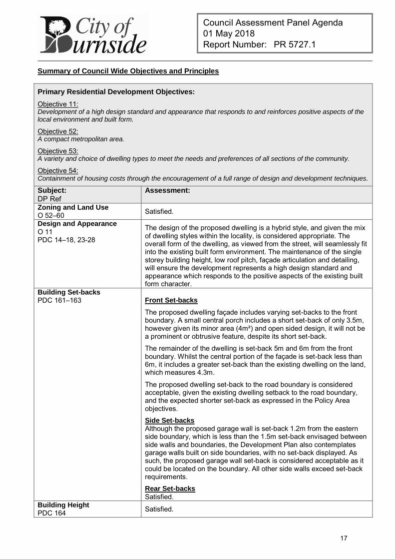
Primary Residential Development Objectives:
Objective 11: Development of a high design standard and appearance that responds to and reinforces positive aspects of the local environment and built form.
Objective 52: A compact metropolitan area.
Objective 53: A variety and choice of dwelling types to meet the needs and preferences of all sections of the community.
Objective 54: Containment of housing costs through the encouragement of a full range of design and development techniques.
Subject:
DP Ref Assessment:
Zoning and Land Use O 52–60 Satisfied.
Design and Appearance
O 11 PDC 14–18, 23-28
The design of the proposed dwelling is a hybrid style, and given the mix of dwelling styles within the locality, is considered appropriate. The overall form of the dwelling, as viewed from the street, will seamlessly fit into the existing built form environment. The maintenance of the single storey building height, low roof pitch, façade articulation and detailing, will ensure the development represents a high design standard and appearance which responds to the positive aspects of the existing built form character.
Building Set-backs PDC 161–163 Front Set-backs
The proposed dwelling façade includes varying set-backs to the front boundary. A small central porch includes a short set-back of only 3.5m, however given its minor area (4m²) and open sided design, it will not be a prominent or obtrusive feature, despite its short set-back.
The remainder of the dwelling is set-back 5m and 6m from the front boundary. Whilst the central portion of the façade is set-back less than 6m, it includes a greater set-back than the existing dwelling on the land, which measures 4.3m.
The proposed dwelling set-back to the road boundary is considered acceptable, given the existing dwelling setback to the road boundary, and the expected shorter set-back as expressed in the Policy Area objectives.
Side Set-backs Although the proposed garage wall is set-back 1.2m from the eastern side boundary, which is less than the 1.5m set-back envisaged between side walls and boundaries, the Development Plan also contemplates garage walls built on side boundaries, with no set-back displayed. As such, the proposed garage wall set-back is considered acceptable as it could be located on the boundary. All other side walls exceed set-back requirements.
Rear Set-backs Satisfied.
Building Height PDC 164 Satisfied.
17
Council Assessment Panel Agenda 01 May 2018 Report Number: PR 5727.1
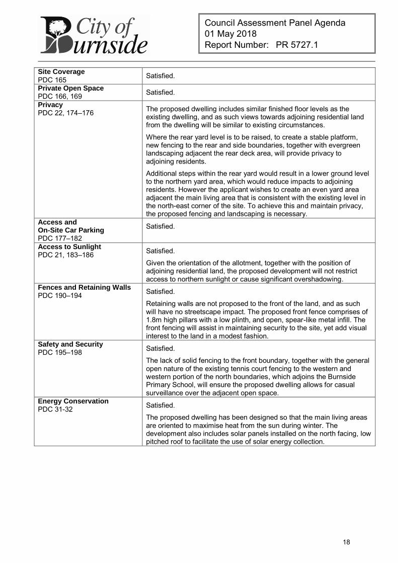
Site Coverage PDC 165 Satisfied.
Private Open Space PDC 166, 169 Satisfied.
Privacy PDC 22, 174–176 The proposed dwelling includes similar finished floor levels as the
existing dwelling, and as such views towards adjoining residential land from the dwelling will be similar to existing circumstances.
Where the rear yard level is to be raised, to create a stable platform, new fencing to the rear and side boundaries, together with evergreen landscaping adjacent the rear deck area, will provide privacy to adjoining residents.
Additional steps within the rear yard would result in a lower ground level to the northern yard area, which would reduce impacts to adjoining residents. However the applicant wishes to create an even yard area adjacent the main living area that is consistent with the existing level in the north-east corner of the site. To achieve this and maintain privacy, the proposed fencing and landscaping is necessary.
Access and On-Site Car Parking PDC 177–182
Satisfied.
Access to Sunlight PDC 21, 183–186 Satisfied.
Given the orientation of the allotment, together with the position of adjoining residential land, the proposed development will not restrict access to northern sunlight or cause significant overshadowing.
Fences and Retaining Walls PDC 190–194 Satisfied.
Retaining walls are not proposed to the front of the land, and as such will have no streetscape impact. The proposed front fence comprises of 1.8m high pillars with a low plinth, and open, spear-like metal infill. The front fencing will assist in maintaining security to the site, yet add visual interest to the land in a modest fashion.
Safety and Security PDC 195–198 Satisfied.
The lack of solid fencing to the front boundary, together with the general open nature of the existing tennis court fencing to the western and western portion of the north boundaries, which adjoins the Burnside Primary School, will ensure the proposed dwelling allows for casual surveillance over the adjacent open space.
Energy Conservation PDC 31-32 Satisfied.
The proposed dwelling has been designed so that the main living areas are oriented to maximise heat from the sun during winter. The development also includes solar panels installed on the north facing, low pitched roof to facilitate the use of solar energy collection.
18
Council Assessment Panel Agenda 01 May 2018 Report Number: PR 5727.1
APPENDIX 3
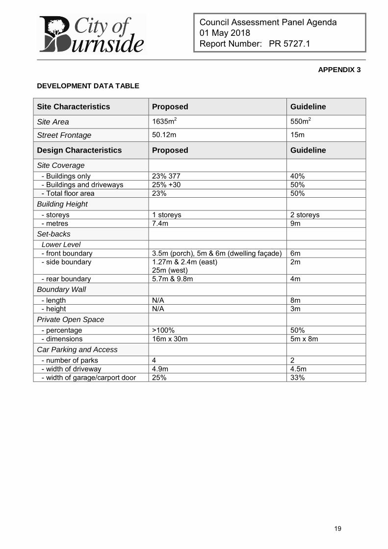
DEVELOPMENT DATA TABLE
Site Characteristics Proposed Guideline
Site Area 1635m2 550m2
Street Frontage 50.12m 15m
Design Characteristics Proposed Guideline
Site Coverage - Buildings only 23% 377 40% - Buildings and driveways 25% +30 50% - Total floor area 23% 50%
Building Height - storeys 1 storeys 2 storeys - metres 7.4m 9m
Set-backs Lower Level - front boundary 3.5m (porch), 5m & 6m (dwelling façade) 6m - side boundary 1.27m & 2.4m (east)
25m (west) 2m
- rear boundary 5.7m & 9.8m 4m Boundary Wall
- length N/A 8m - height N/A 3m
Private Open Space - percentage >100% 50% - dimensions 16m x 30m 5m x 8m
Car Parking and Access - number of parks 4 2 - width of driveway 4.9m 4.5m - width of garage/carport door 25% 33%
19

this page is left intentionally blank
20
Council Assessment Panel Agenda 01 May 2018 Report Number: PR 5727.2
DEVELOPMENT APPLICATION
Application Number: 180\0084\18
Applicant: Mr Q Li
C/O Mohyla Architects
Location: 24 Craighill Road, St Georges
Proposal: Two storey detached dwelling, including basement level, incidental earthworks, outbuilding, retaining walls, swimming pool and fencing.
Zone/Policy Area: Residential Zone
Residential Policy Area 25 – St Georges
Development Plan consolidated 19 December 2017
Kind of Assessment: Merit
Public Notification: Category 2
Three (3) representations received
Appeal Opportunity Applicant only, no third party appeal rights
Referrals – Statutory: Nil
Referrals – Non Statutory: Technical Officer - Traffic/Engineering
Delegations Policy: Unresolved representations
Recommendation: Development Plan Consent be granted
Recommending Officer: Jake Vaccarella
REPORT CONTENTS
Assessment report: - Appendix 1 – Aerial Locality Map - Appendix 2 – Detailed Planning Assessment - Appendix 3 – Development Data Table
Please note that due to Federal Copyright Law restrictions, attachments associated with the proposed development are not made available to the public.
Documentation provided as attachments to the report to members of the Council Assessment Panel to facilitate decision making: Plans and supporting documents Internal agency referral reports Representations received Applicant’s response to representations Photographs
21
Council Assessment Panel Agenda 01 May 2018 Report Number: PR 5727.2
1. DESCRIPTION OF PROPOSAL
The applicant seeks Development Plan Consent for the construction of new two-storey detached dwelling comprising incidental earthworks, basement level, swimming pool, fencing and outbuilding (pool house) including additional (6th) bedroom. The dwelling comprises the following features: Basement level:
Home theatre room; Wine cellar; Store; Lift; and Bar
Ground level:
Porch with central entrance; Double garage; Guest bedroom comprising ensuite and walk in robe Study; Lounge room; Laundry; Dining; Louvered verandah Lift; and Open plan kitchen, meals and living areas.
First floor:
Four (4) bedrooms, each comprising ensuite and walk in robe; Balcony (facing street); Lift; and Retreat.
2. BACKGROUND
Development Application 180\0084\18 was lodged on 08 February 2018 by Joshua Carrabs of Mohyla Architects on behalf of the registered owner of the land. The proposal was determined to be a merit form of development pursuant to Section 35(5) of the Development Act 1993. For the purposes of public notification, the application was determined to be a Category 2 development in accordance with the Burnside (City) Development Plan, Residential Policy Area 25, Principle of Development Control 7 (a). The application was made available for public inspection between 27 February and 14 March 2018, during which time Council received written submissions from three (3) external parties, of whom one (1) expressed a desire to appear in person before the Council Assessment Panel (the Panel) in support of their submission. The representations raised concerns with regard to bulk and scale, overlooking, garage dominance and compatibility with locality.
22
Council Assessment Panel Agenda 01 May 2018 Report Number: PR 5727.2
A copy of the submissions was forwarded to the application for consideration and response. The applicant engaged private planning consultants ‘Masterplan’ to provide a formal response to the representations as when as provide revised plans which depict the following changes:
Garage door reduced in width; Driveway tapered to 4.0 metres; Planting of ornamental pear trees along the rear boundary; Fixed obscure glazing to 2.1 above finished floor level on the upper level retreat; and Fixed aluminium louvres (angled up) fitted to side and rear elevations on upper level.
As part of the internal assessment process, the proposal was also referred to Council’s Technical Officer - Engineering for review. No concerns were raised with respect to the proposal and subsequent authorisation was granted for the relocation of the crossover pursuant to Section 221 of the Local Government Act 1999.
Pursuant to Council’s Delegation Policy, the application is presented to the Panel for consideration as a Category 2 development with unresolved representations.
3. SUBJECT LAND AND LOCALITY ATTRIBUTES
3.1. Subject Land
The subject land is a vacant allotment on the southern side of Craighill Road in Beaumont measuring approximately 961 square metres with a frontage to the public road of 18.29 metres. The land has been vacant since mid-2016 and naturally slopes upwards from the front (north-western corner) of the site to the rear (south-eastern corner) of the site.
3.2. Locality
The locality comprises both sides of Craighill Road between Purnana Avenue to the east and Crossing Street to the west all of which are contained within Residential Policy Area 25 – St Georges. Properties to the rear of the subject land with frontage to Wootoona Terrace are located within Historic Conservation Area 3 – St Georges. The locality is characterised by low density single-storeyed and double-storeyed detached dwellings occupying relatively spacious allotments. The pattern of division is relatively consistent, with predominantly regular shaped allotments occupying detached dwellings. However, there is evidence of higher density development along Craighill Road with some residential flats at the Portrush Road intersection and group dwellings on the northern side adjacent the subject site. The residential amenity of the locality is enhanced by the well-established, open, front gardens, spacious, grassed verges, native street trees and moderate street setbacks. The built form of the locality is characterised by a variety of architectural styles with a large concentration of post war period dwellings, with evidence of both earlier bungalows and later, modern style builds.
4. KIND OF ASSESSMENT
Kind: Merit Reason: Development Act 1993, Section 35(5) Applicant Appeal Opportunity: Yes
23
Council Assessment Panel Agenda 01 May 2018 Report Number: PR 5727.2
5. PUBLIC NOTIFICATION
Category: Category 2 Reason: Residential Policy Area 25 Principle of Development Control 7
(a) Cut / Fill: Incidental earthworks to accommodate the basement level are
minor in nature and will be imperceptible from surrounding land, so as to not impart any visual impacts upon occupiers of land in locality. Accordingly, the earthworks have been deemed to satisfy Schedule 9, Part 1, Clause 2(g) of the Development Regulations 2008.
Representations Received: Ramin Noushabadic – 11 Wootoona Terrace, St Georges (wish to be heard)
Sybella Blencowe – 25 Craighill Road, St Georges (does not wish to be heard)
M.H Garwood – 23A Craighill Road, St Georges (does not wish to be heard)
Third Party Appeal Opportunity: No
Representations received are provided as an attachment to the Panel.
Applicant’s response(s) to representations are provided as an attachment to the Panel.
6. AGENCY REFERRALS
Internal agency referrals are provided as an attachment to the Panel.
7. EXECUTIVE SUMMARY
7.1. Land Use
The subject land is a vacant allotment on the southern side of Craighill Road which was previously used for residential purposes, prior to the existing dwelling being demolished in mid-2016. The proposed dwelling will maintain the previous and desired residential use of the land and as such is consistent with the Development Plan from a land use perspective.
7.2. Character and Amenity
Residential Policy Area 25 of the Development Plan seeks to maintain and enhance a low scale, low density residential character derived from single storey or split level detached dwellings in a variety of post-war styles, with open front gardens and in certain areas, tall trees including indigenous eucalyptus. The proposed development is generally compatible with these characteristics and is anticipated to enhance the streetscape character by introducing a new building of a suitably high design standard. The proposed dwelling offers a modern, contemporary architecturally designed two-storey building which is comparable in bulk and scale to the neighbouring two-storey buildings at both 22 and 27 Craighill Road. The dwelling has been sympathetically designed with emphasis on creating a visually interesting primary façade highlighted by its appropriate mix of high-quality materials and finishes including face brick, timber panel lift door, large floor to ceiling windows, aluminium louvres and large feature entrance with window highlights, all of which create an appropriate level of articulation.
24
Council Assessment Panel Agenda 01 May 2018 Report Number: PR 5727.2
In terms of its visual impact from adjoining properties either side of the subject land, the proposed building includes vertical wall heights that are compatible with existing housing stock and a modest upper level that assists in presenting a sympathetic external built from appearance to neighbouring properties on either side of the subject land. The garage door has been reduced in width and now complies with frontage width guidelines and is not considered a visually dominant element within the overall façade. In terms of its siting, the proposed building will sit proud of the western neighbour, but will remain consistent with the Development Plan guideline of 6 metres. While a greater front set-back may be more compatible with the siting of the western neighbour the locality is characterised by a range in front set-back distances and the proposed development is not considered inappropriate within this context. The proposed building also maintains the established pattern of spacing between buildings observed throughout the locality and achieves appropriate spatial separation between adjacent built form, satisfying the quantitative guidelines of the Development Plan concerning set-backs from side and rear boundaries. In terms of overlooking opportunities, the proposed building incorporates upper level side and rear windows which are fitted with fixed and obscure glazing to a height of 2.1m above the floor level of the first floor. Additionally, the remaining windows observed across the side and rear of the first floor of the building which are unobscured, are to be fitted with fixed external aluminium louvres (angled upwards) to ensure that the proposal will not result in direct views into habitable rooms or areas of private open space. The front balcony and ‘wrap around’ corner windows of the master bedroom provide direct views of the street which enable casual surveillance of the public realm and result in only oblique views of neighbouring front yards. The overall siting and design of the building is considered to be appropriate within the context of the locality in terms of scale, height, form, style, materials and finishes, and is considered to be an appropriate planning outcome for the subject land and locality.
7.3. Site Functionality
The development is largely consistent with the relevant quantitative guidelines of the Development Plan and is not considered to be an overdevelopment of the site. Despite exceeding the total floor area guideline the dwelling achieves appropriate boundary set-backs and is compatible with the dominant character of the street. The land also retains a private open rear yard that complies with the desired floor area ratio and conforms to the various qualitative standards. For vehicular purposes, the subject land is serviced via a new crossover located in the north-western corner of the site, with the existing crossover to be removed and reinstated to kerb. The development provides generous space for on-site car parking to meet the needs of future occupants and visitors and to avoid on-street parking that would restrict the free flow of traffic (including pedestrian traffic) along Craighill Road or cause significant nuisance to nearby residents or other users of land. Council’s Engineering Services department have reviewed the proposal and are satisfied with the design and the proposed crossover works have been approved through a separate authorisation granted in accordance with Section 221 of the Local Government Act 1999.
25
Council Assessment Panel Agenda 01 May 2018 Report Number: PR 5727.2
7.4. Public Notification
The proposal was determined to be a Category 2 development pursuant to Residential Policy Area 25 Principle of Development Control 7, which states:
“The following kinds of development are assigned to Category 1: Dwelling, except where
(a) the dwelling or outbuilding is two or more storeys in height (where “two storeys” is defined as a total of one habitable floor level directly above another, not including an understorey garage), or more than 6.5 metres building height above natural ground level;
The proposal was made available for public inspection between 27 February and 14 March 2018, during which time Council received three (3) valid representations from occupiers of adjoining properties, one of whom expressed a desire to formally present their submission before the Panel. The primary issues of concern were summarised earlier in the background section of the report. Council considers that the planning matters raised through the public notification process have been sufficiently addressed through the overall design of the building and the amendments introduced following the notification period insofar as they are to be determined under the Development Act 1993.
7.5. Conclusion
Having regard to all of the relevant Objectives and Principles of Development Control of the Burnside (City) Development Plan, the proposed development is not considered seriously at variance with, and is generally in accordance with, the policies of the Development Plan.
8. RECOMMENDATIONS
It is recommended that the Council Assessment Panel resolve that:
1. The proposed development is not seriously at variance with the policies in the Development Plan; and
2. Development Application 180\0084\18, is granted Development Plan Consent subject to the following conditions:
Conditions
1 The development granted Development Plan Consent shall be undertaken in accordance with the stamped approved plans, drawings, specifications and other documents submitted to the Council that are relevant to the consent to the reasonable satisfaction of the Council, except where varied by conditions below. Reason: To ensure the development is undertaken in accordance with the plans and details submitted.
26
Council Assessment Panel Agenda 01 May 2018 Report Number: PR 5727.2
2 The fixed and obscured glazing fitted to side and rear upper level windows as depicted on the stamped and approved plans granted Development Plan Consent shall be installed prior to the occupation or use of the building herein granted Development Plan Consent and thereafter shall be maintained to the reasonable satisfaction of Council at all times. Reason: To ensure the new development does not unreasonably diminish the privacy of residents in adjoining properties.
3 The fixed aluminium louvres as depicted on both side and rear elevations of the stamped and approved plans granted Development Plan Consent shall be installed prior to the occupation or use of the building herein granted Development Plan Consent and thereafter shall be maintained to the reasonable satisfaction of Council at all times. Reason:
To ensure the new development does not unreasonably diminish the privacy of residents in adjoining properties.
4 A detailed landscaping plan specifying all areas of the subject land to be landscaped, including a list of the species to be planted, the height of the species and the maturity at the time of planting and mature height of plants shall be submitted to the Council prior to the granting of Development Approval. The establishment of all landscaping shall be undertaken within three (3) months of the substantial completion of development and in any event prior to the occupation or use of the development. Such landscaping shall be maintained in good health and condition to the satisfaction of the Council at all times and any dead or diseased plants or trees shall be immediately replaced to the reasonable satisfaction of the Council. Reason:
To provide amenity for the occupants of buildings and those of adjacent buildings through the provision of landscaping as part of the development.
5 All mechanical machinery associated with the heating, cleaning and filtration of the swimming pool shall not emit any noise which exceeds 45dB(A) when measured from the boundary of the subject land at the closest point to the mechanical machinery. Reason: To ensure minimal amenity loss of adjacent properties.
Advisory Notes
1 Building Consent Development Approval will not be granted until a Building Rules Consent has been obtained. A separate application must be submitted for such consent. No building work or change of classification is permitted until the Development Approval has been obtained.
2 Expiration Time of Approval
Pursuant to the provisions of Regulation 48 under the Development Act 1993, this Consent/Approval will lapse at the expiration of 12 months from the operative date of the Consent/Approval unless the relevant development has been lawfully commenced by substantial work on the site of the development within 12 months, in which case the Approval will lapse within 3 years from the operative date of the Approval subject to the
27
Council Assessment Panel Agenda 01 May 2018 Report Number: PR 5727.2
proviso that if the development has been substantially or fully completed within those 3 years, the Approval will not lapse.
3 Boundaries
It is recommended that as the Applicant is undertaking work on or near the boundary, the Applicant should ensure that the boundaries are clearly defined by a Licensed Surveyor, prior to the commencement of any building work.
4 Driveway Conditions:
Unless approved otherwise, construction of the driveway crossover shall be in accordance with Council’s Standard Specification and General Conditions and completed to the reasonable satisfaction of Council.
The existing second driveway/gutter crossing must be removed and reinstated to kerb upon completion of the proposed gutter crossing.
A driveway width of 4.5 metres is permitted across the verge and a crossover width of 5.5 metres (maximum) is permitted at the kerb and gutter.
If you elect to carry out the works yourself (or via a contractor) evidence of Public Liability Insurance must be provided to Council before any works can commence on the public verge/road.
Footpath Maintenance
Existing footpath levels, grades etc. shall not be altered as a result of the new works associated with the development.
Stormwater Detention
Due to the increase of the impermeable area, detention shall be provided to limit post development flows. Calculations shall be provided to verify the ability of the proposed detention quantity to meet the Council’s default detention and discharge requirements below:
The volume of any detention device shall be equal to the volume of water generated on the site with an impervious (Cp = 0.9) site coverage of 75% and pervious (Cp = 0.1) area of 25%, during a 1 in 20 year flood event for a 10 minute duration.
The maximum rate of discharge from the site shall be equal to the volume of water generated on the site with an impervious (Cp = 0.9) site coverage of 40% and pervious (Cp = 0.1) area of 60%, during a 1 in 5 year flood event for a 10 minute duration.
For stormwater management purposes, it is desirable that: An additional detention storage of 1,000Ltrs be provided in addition to
the standard 1,000Ltrs retention tank provided; and The development utilises permeable paving for the proposed external
paving work within the development site.
Stormwater Discharge
The stormwater pipe across the road verge should terminate at an approved galvanised steel kerb adaptor.
If the cover to the stormwater pipe across the Council verge is less than 65mm, steel pipe housing is to be used as per Council’s standards.
The developer is responsible for locating all existing services and to consult with the necessary service providers if there is a conflict when placing stormwater infrastructure.
28
Council Assessment Panel Agenda 01 May 2018 Report Number: PR 5727.2
Construction of the stormwater infrastructure is in accordance with Council’s Standard Specification and General Conditions and to the overall satisfaction of Council.
Trenching and connections are to be undertaken as per Australian Plumbing Standards.
Excess stormwater runoff from the roof catchment shall be discharged to the street water table through a sealed system to the satisfaction of the Council.
5 Noise
The emission of noise from the premises is subject to control under the Environment Protection Act and Regulations, 1993 and the applicant (or person with the benefit of this consent) should comply with those requirements.
6 Fences Act 1975
The Applicant is reminded of the requirements of the Fences Act 1975. Should the proposed works require the removal, alteration or repair of an existing boundary fence, a 'Notice of Intention' must be served to adjoining owners. Please contact the Legal Services Commission for further advice on 1300 366 424 or visit www.lsc.sa.gov.au
RECOMMENDING OFFICER
Jake Vaccarella Development Officer – Planning
29
Council Assessment Panel Agenda 01 May 2018 Report Number: PR 5727.2
APPENDIX 1
AERIAL LOCALITY MAP
Legend
Subject Land
Representor’s Land
30
Council Assessment Panel Agenda 01 May 2018 Report Number: PR 5727.2
APPENDIX 2
DETAILED PLANNING ASSESSMENT
Summary of Policy Area Objectives and Principles
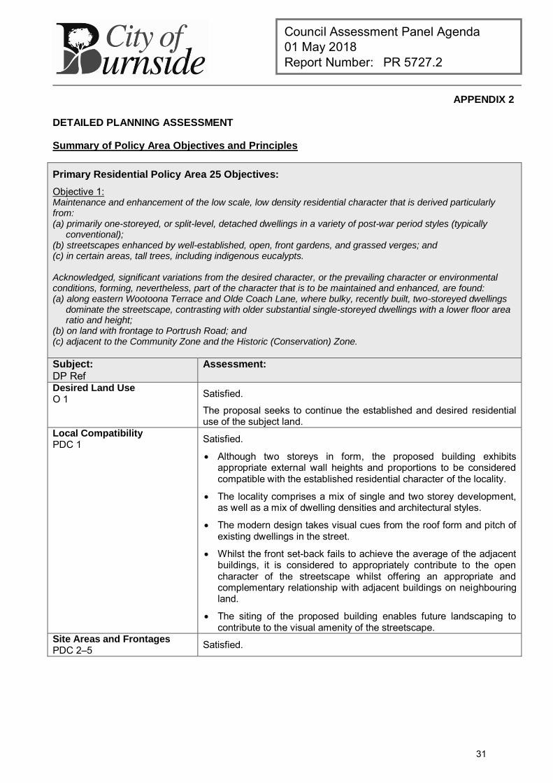
Primary Residential Policy Area 25 Objectives:
Objective 1: Maintenance and enhancement of the low scale, low density residential character that is derived particularly from: (a) primarily one-storeyed, or split-level, detached dwellings in a variety of post-war period styles (typically
conventional); (b) streetscapes enhanced by well-established, open, front gardens, and grassed verges; and (c) in certain areas, tall trees, including indigenous eucalypts. Acknowledged, significant variations from the desired character, or the prevailing character or environmental conditions, forming, nevertheless, part of the character that is to be maintained and enhanced, are found: (a) along eastern Wootoona Terrace and Olde Coach Lane, where bulky, recently built, two-storeyed dwellings
dominate the streetscape, contrasting with older substantial single-storeyed dwellings with a lower floor area ratio and height;
(b) on land with frontage to Portrush Road; and (c) adjacent to the Community Zone and the Historic (Conservation) Zone. Subject:
DP Ref Assessment:
Desired Land Use O 1 Satisfied.
The proposal seeks to continue the established and desired residential use of the subject land.
Local Compatibility PDC 1 Satisfied.
Although two storeys in form, the proposed building exhibits appropriate external wall heights and proportions to be considered compatible with the established residential character of the locality.
The locality comprises a mix of single and two storey development, as well as a mix of dwelling densities and architectural styles.
The modern design takes visual cues from the roof form and pitch of existing dwellings in the street.
Whilst the front set-back fails to achieve the average of the adjacent buildings, it is considered to appropriately contribute to the open character of the streetscape whilst offering an appropriate and complementary relationship with adjacent buildings on neighbouring land.
The siting of the proposed building enables future landscaping to contribute to the visual amenity of the streetscape.
Site Areas and Frontages PDC 2–5
Satisfied.
31
Council Assessment Panel Agenda 01 May 2018 Report Number: PR 5727.2
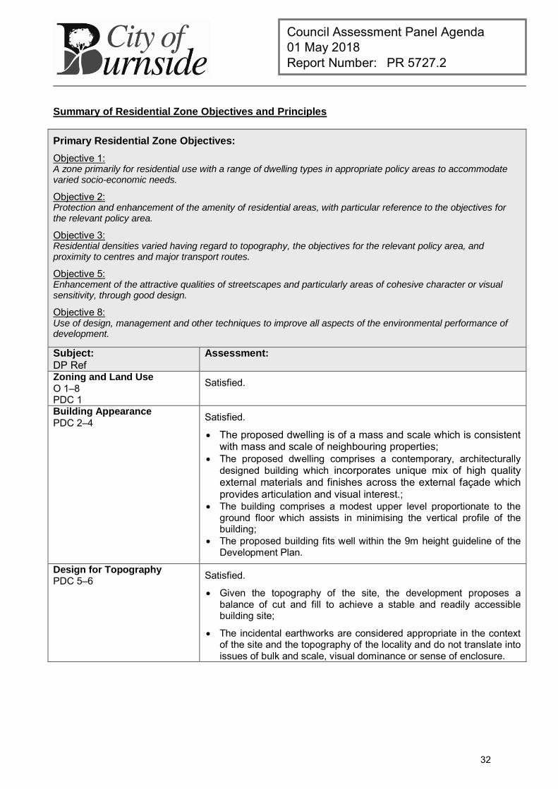
Summary of Residential Zone Objectives and Principles
Primary Residential Zone Objectives:
Objective 1: A zone primarily for residential use with a range of dwelling types in appropriate policy areas to accommodate varied socio-economic needs.
Objective 2: Protection and enhancement of the amenity of residential areas, with particular reference to the objectives for the relevant policy area.
Objective 3: Residential densities varied having regard to topography, the objectives for the relevant policy area, and proximity to centres and major transport routes.
Objective 5: Enhancement of the attractive qualities of streetscapes and particularly areas of cohesive character or visual sensitivity, through good design.
Objective 8: Use of design, management and other techniques to improve all aspects of the environmental performance of development.
Subject:
DP Ref Assessment:
Zoning and Land Use O 1–8 PDC 1
Satisfied.
Building Appearance PDC 2–4 Satisfied.
The proposed dwelling is of a mass and scale which is consistent with mass and scale of neighbouring properties;
The proposed dwelling comprises a contemporary, architecturally designed building which incorporates unique mix of high quality external materials and finishes across the external façade which provides articulation and visual interest.;
The building comprises a modest upper level proportionate to the ground floor which assists in minimising the vertical profile of the building;
The proposed building fits well within the 9m height guideline of the Development Plan.
Design for Topography PDC 5–6 Satisfied.
Given the topography of the site, the development proposes a balance of cut and fill to achieve a stable and readily accessible building site;
The incidental earthworks are considered appropriate in the context of the site and the topography of the locality and do not translate into issues of bulk and scale, visual dominance or sense of enclosure.
32
Council Assessment Panel Agenda 01 May 2018 Report Number: PR 5727.2
Summary of Council Wide Objectives and Principles
Primary Residential Development Objectives:
Objective 11: Development of a high design standard and appearance that responds to and reinforces positive aspects of the local environment and built form.
Objective 52: A compact metropolitan area.
Objective 53: A variety and choice of dwelling types to meet the needs and preferences of all sections of the community.
Objective 54: Containment of housing costs through the encouragement of a full range of design and development techniques.
Objective 55: Safe, pleasant, accessible and convenient residential areas.
Objective 56: Residential development which moderates adverse climatic conditions, takes advantage of solar energy, does not unreasonably overshadow adjacent development, and protects the natural environment.
Objective 58: The revitalisation of residential areas to support the viability of community services and infrastructure.
Objective 60: Increased affordable housing opportunities through land division and the conversion of buildings to a residential use.
Subject:
DP Ref Assessment:
Zoning and Land Use O 52–60 Satisfied.
Design and Appearance
O 11 PDC 14–18, 23-28
Satisfied.
The proposed development is considered to be of a high design standard and appearance that responds to positive aspects of the locality.
Building Set-backs PDC 161–163 Front Set-backs
Variance.
The proposed building satisfies the 6m front setback guideline however fails to align with the average of the setbacks of adjacent dwellings;
The proposed shortfall is not fatal in this instance given the context of the locality which observes a relatively varied front setback pattern with deep building setbacks apparent on the southern side of Craighill Road to the west of the subject land and reduced setbacks observed on the northern side.
The proposed building maintains adequate space within the front yard for the future provision of landscaping to assist in breaking up the visual mass of the building.
Side Set-backs
Satisfied.
Rear Set-backs
Satisfied.
33
Council Assessment Panel Agenda 01 May 2018 Report Number: PR 5727.2
Building Height PDC 164 Satisfied.
Site Coverage PDC 165 Variance.
The proposal generally accords with the DP guideline for site coverage however results in a total floor area exceeding the 50% DP guideline by 16%;
The excess in total floor area in this instance does not translate into problems of bulk, scale or land use intensity and the design appears to compensate through the use of appropriate design techniques which create articulation and visual interest across the external façade.
Private Open Space PDC 166, 169 Satisfied.
Privacy PDC 22, 174–176 Satisfied.
The proposal involves a two storey building with floor levels that could overlook adjacent properties.
The proposal addresses this issue with the incorporation of fixed obscured glazing to a height of 2.1m to some of the upper level side and rear windows of the building;
The remaining upper level side and rear windows will incorporate external fixed aluminium louvres (angled up) to mitigate overlooking;
The front balcony and “wrap around” corner windows to the master bedroom are orientated towards the public road and are not anticipated to overlook the windows or private open space areas of adjacent dwellings.
Access and On-Site Car Parking PDC 177–182
Satisfied.
The dwelling satisfies off-street parking requirements prescribed by Table Bur/5.
The proposed crossover location and driveway configuration which is sited over the Council verge has been approved by Council’s Technical Officer – Engineering in accordance with Section 221 of the Local Government Act 1999.
Access to Sunlight PDC 21, 183–186 Satisfied.
The dwelling is two storeys in height and therefore could reasonably be expected to impose a degree of shadow over adjoining properties at certain times of the day.
The north-south orientation of the site, coupled with the siting of the building in relation to adjacent allotments means that the amount of sunlight afforded to each adjoining property will remain consistent with DP guidelines.
Domestic Outbuildings PDC 187–189 Satisfied.
The proposed pool habitable outbuilding is compatible in form, proportion and external appearance with the proposed dwelling;
The proposed outbuilding is of an appropriate size proportionate to the footprint of the dwelling and enables adequate provision for private open space;
The siting of the outbuilding is adjacent the existing tennis court on the adjacent allotment at 28 Craighill Road and as such is not likely
34
Council Assessment Panel Agenda 01 May 2018 Report Number: PR 5727.2
to impact the cause significant nuisance to occupiers of adjoining land or result in issues of bulk, scale or overshadowing.
Fences and Retaining Walls PDC 190–194 Satisfied.
The proposal includes details of boundary fencing and retaining walls along the eastern boundary.
The proposed retaining walls are appropriate in scale and not out of character with the locality, in which stepped allotments are a typical response to the slope of the road.
The proposed side and rear boundary fencing (1.8 metre high Colorbond) is regarded as standard within the Residential Zone and suitable in providing reasonable privacy without appearing visually dominant of large in scale.
Safety and Security PDC 195–198 Satisfied.
Water Conservation PDC 200–201 Satisfied.
Energy Conservation PDC 31-32 Satisfied.
35
Council Assessment Panel Agenda dd mmm yyyy Report Number: PR XXXX.X
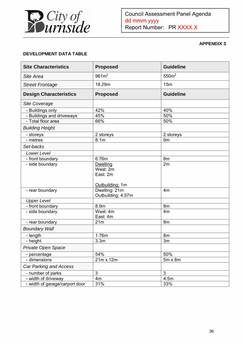
APPENDIX 3
DEVELOPMENT DATA TABLE
Site Characteristics Proposed Guideline
Site Area 961m2 550m2
Street Frontage 18.29m 15m
Design Characteristics Proposed Guideline
Site Coverage - Buildings only 42% 40% - Buildings and driveways 45% 50% - Total floor area 66% 50%
Building Height - storeys 2 storeys 2 storeys - metres 8.1m 9m
Set-backs Lower Level - front boundary 6.76m 8m - side boundary Dwelling
West: 2m East: 2m Outbuilding: 1m
2m
- rear boundary Dwelling: 21m Outbuilding: 4.57m
4m
Upper Level - front boundary 8.9m 8m - side boundary West: 4m
East: 4m 4m
- rear boundary 21m 8m Boundary Wall
- length 1.76m 8m - height 3.3m 3m
Private Open Space - percentage 54% 50% - dimensions 21m x 12m 5m x 8m
Car Parking and Access - number of parks 3 3 - width of driveway 4m 4.5m - width of garage/carport door 31% 33%
36
Council Assessment Panel Agenda 01 May 2018 Report Number: PR 5727.3
DEVELOPMENT APPLICATION
Application Number: 180\0162\18
Applicant: Medallion Homes Pty Ltd
Location: 19 Trevorten Avenue, Glenunga
Proposal: Single storey detached dwelling including boundary retaining walls and fencing
Zone/Policy Area: Residential Zone
Residential Policy Area 26 – Glenunga (South)
Development Plan consolidated 19 December 2017
Kind of Assessment: Merit
Public Notification: Category 2
One (1) representation received
Appeal Opportunity Applicant only, no third party appeal rights
Referrals – Statutory: N/A
Referrals – Non Statutory: Technical Officer – Engineering
Delegations Policy: Unresolved representations
Recommendation: Development Plan Consent be granted
Recommending Officer: Jake Vaccarella
REPORT CONTENTS
Assessment report: - Appendix 1 – Aerial Locality Map - Appendix 2 – Detailed Planning Assessment - Appendix 3 – Development Data Table
Please note that due to Federal Copyright Law restrictions, attachments associated with the proposed development are not made available to the public.
Documentation provided as attachments to the report to members of the Council Assessment Panel to facilitate decision making: Plans and supporting documents Internal agency referral reports Representations received Applicant’s response to representations Photographs
37
Council Assessment Panel Agenda 01 May 2018 Report Number: PR 5727.3
1. DESCRIPTION OF PROPOSAL
The applicant seeks Development Plan Consent for the construction of a single storey detached dwelling on a single existing residential allotment within Residential Policy Area 24 – Glenunga (South). The proposed dwelling features double garage, three (3) bedrooms (one with walk in robe and ensuite), bathroom, home theatre, study, laundry, open plan kitchen, family and meals areas and alfresco to rear. The application also comprises boundary concrete sleeper retaining walls and 1.8 metre high Colorbond fencing.
2. BACKGROUND
Development Application 180\0162\18 was lodged on 26 February 2018 by Medallion Homes who is also the registered owner of the land. The proposal was determined a merit form of development pursuant to Section 35(5) of the Development Act 1993. For the purposes of public notification, the application was determined to be a Category 2 development in accordance with the Burnside (City) Development Plan, Residential Policy Area 26, Principle of Development Control 7 (b). The application was made available for public consultation between 09 March and 23 March 2018, during which time Council received one (1) written submission who expressed a desire to formally present there submission bore the Panel. The representation raised concerns in relation to streetscape presentation and compatibility of building with the established character of the locality. A copy of the submissions was forwarded to the application for consideration and response. The applicant engaged private planning consultants ‘Future Urban Group’ to provide a formal response to the representations. There were no changes made to the proposal following the public consultation process. As part of the assessment process the application was also referred to Council’s Engineering Services department and Open Space department to assess the suitability of access arrangements, as well as general impacts on Council infrastructure. Pursuant to Council’s Delegation Policy, the application is now presented to the Development Assessment Panel for consideration as a Category 2 development with one (1) unresolved representation; with a staff recommendation for approval, subject to conditions.
3. SUBJECT LAND AND LOCALITY ATTRIBUTES
3.1. Subject Land
The subject land is a regular shaped allotment that has recently benefitted from a Torrens Titled land division approval (DA: 180\1003\17) which was approved in late 2017 creating three (3) allotments from two (2). The allotments have not yet been created however for the purposes of identifying the subject land the approved allotment has a frontage of 16.09m to Trevorten Avenue with an approximate site area of 567 square metres. The land is now vacant after the existing buildings, ancillary structures and vegetation were recently demolished.
38
Council Assessment Panel Agenda 01 May 2018 Report Number: PR 5727.3
3.2. Locality
The locality comprises both sides of Trevorten Avenue and encompasses part of Historic Conservation Area 8 – Glenunga Park with the zone boundary located in proximity to the subject land. Dwellings on each side of Bethune Avenue also form part of the locality on account of their proximity to the site. The pattern of subdivision is generally consistent with predominantly spacious, rectangular allotments of approximately 700 – 1200 square metres occupying both sides of Trevorten Avenue. The locality is characterised by predominantly detached dwellings built in the inter-war and post-war period in both single and double storey, with evidence of more recent, contemporary built form also observed on either side of Trevorten Avenue. The residential amenity of the locality is enhanced by the well-established, open, front gardens, spacious, grassed verges, native mature street trees and generous street setbacks.
4. KIND OF ASSESSMENT
Kind: Merit Reason: Development Act 1993, Section 35(5) Applicant Appeal Opportunity: Yes
5. PUBLIC NOTIFICATION
Category: Category 2 Reason: Residential Policy Area 26 Principle of Development Control 7
(b) Representations Received: Wenzlow – 16A Trevorten Avenue, Glenunga (wish to be
heard) Third Party Appeal Opportunity: No
Representations received are provided as an attachment to the Panel.
Applicant’s response(s) to representations are provided as an attachment to the Panel.
6. AGENCY REFERRALS
Internal agency referrals are provided as an attachment to the Panel.
7. EXECUTIVE SUMMARY
7.1. Land Use
The subject land is a vacant allotment on the northern side of Trevorten Avenue which was previously used for residential purposes, prior to the existing dwelling and ancillary structures being demolished in late 2017. The proposed dwelling will maintain the previous and desired residential use of the land and as such is consistent with the Development Plan from a land use perspective. The proposed development is therefore not considered to be seriously at variance to the Burnside (City) Development Plan.
39
Council Assessment Panel Agenda 01 May 2018 Report Number: PR 5727.3
7.2. Character and Amenity
RPA 26 seeks to enhance the low scale, low density residential character derived primarily from single storey detached dwellings in a variety of inter-war and post-war styles, with open front gardens and in certain areas grassed road verges and mature street trees. The proposed development is generally compatible with these characteristics and is anticipated to enhance the streetscape character by introducing a new building of a suitably high design standard.
The locality in question comprises a variety of single storey and two storey detached dwellings in a variety of architectural styles of the inter-war and post-war era including a large concentration of bungalow style dwellings, some of which are listed as Contributory Items as per Figure Bur HCPA/8 of the Development Plan. More recent development exhibiting contemporary architectural styles is observed throughout the locality in proximity to the site at 12, 15 and 16A Trevorten Avenue.
The proposed dwellings offers a modern, contemporary architecturally designed single storey building which is comparable in bulk and scale to the adjacent existing built form and the recently approved single storey dwelling to the west of the site. As such, the dwelling is generally regarded as being compatible with the existing streetscape character and that described in the policy area objective in terms of its architectural form, style, bulk, scale, setback from the street and open front garden.
The dwelling has been sympathetically designed with emphasis on creating a visually interesting primary façade highlighted by its appropriate mix of high-quality materials and finishes including rendered external walls, feature stone blade wall, timber panel lift door, large floor to ceiling windows, and large feature entrance with window highlights, all of which create an appropriate level of articulation.
In terms of its visual impact on adjoining properties to the east and to the west of the subject land, the proposed building comprises vertical wall heights that are typical of a single storey building and compatible with the existing housing stock of the locality. The proposed building achieves adequate spatial separation from adjoining properties with stepped external walls which assist in providing articulation and visual interest across the side elevations. As such the proposal is not likely to prejudice the occupiers of adjoining land in terms of its bulk, scale and overshadowing.
7.3. Site Functionality
The development is largely consistent with the relevant quantitative guidelines of the Development Plan and is not considered to be an overdevelopment of the site. Despite exceeding the site coverage guideline and departing from the setback guidelines concerning side boundaries, the proposed development is considered to fit neatly within this context and will have a minimal impact to the adjoining properties in terms of bulk, scale and overshadowing. For vehicular purposes, the subject land is serviced via an existing crossover located in the south-eastern corner of the site, which is to be slightly modified to suit the siting of the proposed building. The development provides generous space for on-site car parking to meet the needs of future occupants and visitors and to avoid on-street parking that would restrict the free flow of traffic (including pedestrian traffic) along Trevorten Avenue and Bethune Avenue or cause significant nuisance to nearby residents or other users of land.
40
Council Assessment Panel Agenda 01 May 2018 Report Number: PR 5727.3
7.4. Public Notification
The application was determined to be a Category 2 development pursuant to Residential Policy Area 26 Principle of Development Control 7 which states:
“The following kinds of development are assigned to Category 1: Dwelling, except where
(b) the development has a solid wall located on a side or rear boundary, but excluding a fence or wall of less than two metres building height above natural ground level.
The proposal was made available for public inspection between 09 March and 23 March 2017, during which time Council received one (1) written submission from the neighbouring property to the south at 16A Trevorten Avenue, Glenunga. The primary concerns raised through this process relate to the streetscape appearance of the proposed building and its lack of compatibility with the established residential character of the locality. The applicant engaged a private planning consultant to provide a response which in summary provided justification for the proposed development on its appropriate regard for the relevant objectives and policies of the Development Plan. Council considers that the planning matters raised through the public notification process have been sufficiently addressed through the overall design of the building and the amendments introduced following the notification period insofar as they are to be determined under the Development Act 1993.
7.5. Agency Referrals
The proposal was referred to Council’s Engineering Services and Open Spaces departments for consideration. No issues of concern were raised through this process and engineering and open spaces comments have been incorporated as advisory notes to this recommendation.
7.6. Conclusion
Having regard to all of the relevant Objectives and Principles of Development Control of the Burnside (City) Development Plan, the proposed development is not considered seriously at variance with, and is generally in accordance with, the policies of the Development Plan.
8. RECOMMENDATIONS
It is recommended that the Council Assessment Panel resolve that:
1. The proposed development is not seriously at variance with the policies in the Development Plan; and
2. Development Application 180\0162\18, by Medallion Homes Pty Ltd is granted Development Plan Consent subject to the following conditions:
41
Council Assessment Panel Agenda 01 May 2018 Report Number: PR 5727.3
Conditions
1 The development granted Development Plan Consent shall be undertaken in accordance with the stamped approved plans, drawings, specifications and other documents submitted to the Council that are relevant to the consent to the reasonable satisfaction of the Council, except where varied by conditions below. Reason:
To ensure the development is undertaken in accordance with the plans and details submitted.
Advisory Notes
1 Building Consent
Development Approval will not be granted until a Building Rules Consent has been obtained. A separate application must be submitted for such consent. No building work or change of classification is permitted until the Development Approval has been obtained.
2 Expiration Time of Approval
Pursuant to the provisions of Regulation 48 under the Development Act 1993, this Consent/Approval will lapse at the expiration of 12 months from the operative date of the Consent/Approval unless the relevant development has been lawfully commenced by substantial work on the site of the development within 12 months, in which case the Approval will lapse within 3 years from the operative date of the Approval subject to the proviso that if the development has been substantially or fully completed within those 3 years, the Approval will not lapse.
3 Boundaries
It is recommended that as the Applicant is undertaking work on or near the boundary, the Applicant should ensure that the boundaries are clearly defined by a Licensed Surveyor, prior to the commencement of any building work.
4 Fences Act 1975
The Applicant is reminded of the requirements of the Fences Act 1975. Should the proposed works require the removal, alteration or repair of an existing boundary fence, a 'Notice of Intention' must be served to adjoining owners. Please contact the Legal Services Commission for further advice on 1300 366 424 or visit www.lsc.sa.gov.au Engineering Advisory Notes
5 Driveway Conditions:
Unless approved otherwise, construction of the driveway crossover shall be in accordance with Council’s Standard Specification and General Conditions and completed to the reasonable satisfaction of Council.
A driveway width of 4.5 metres is permitted across the verge and a crossover width of 5.5 metres (maximum) is permitted at the kerb and gutter.
If you elect to carry out the works yourself (or via a contractor) evidence of Public Liability Insurance must be provided to Council before any works can commence on the public verge/road.
42
Council Assessment Panel Agenda 01 May 2018 Report Number: PR 5727.3
Engineering Conditions to be included in the DPC: Footpath Maintenance
Existing footpath levels, grades etc. shall not be altered as a result of the new works associated with the development.
Stormwater Detention
Due to the increase of the impermeable area, detention shall be provided to limit post development flows. Calculations shall be provided to verify the ability of the proposed detention quantity to meet the Council’s default detention and discharge requirements below:
The volume of any detention device shall be equal to the volume of water generated on the site with an impervious (Cp = 0.9) site coverage of 75% and pervious (Cp = 0.1) area of 25%, during a 1 in 20 year flood event for a 10 minute duration.
The maximum rate of discharge from the site shall be equal to the volume of water generated on the site with an impervious (Cp = 0.9) site coverage of 40% and pervious (Cp = 0.1) area of 60%, during a 1 in 5 year flood event for a 10 minute duration.
For stormwater management purposes, it is desirable that: An additional detention storage of 1,000Ltrs be provided in addition to
the standard 1,000Ltrs retention tank provided; and The development utilises permeable paving for the proposed external
paving work within the development site.
Stormwater Discharge
The stormwater pipe across the road verge should terminate at an approved galvanised steel kerb adaptor.
If the cover to the stormwater pipe across the Council verge is less than 65mm, steel pipe housing is to be used as per Council’s standards.
The developer is responsible for locating all existing services and to consult with the necessary service providers if there is a conflict when placing stormwater infrastructure.
Construction of the stormwater infrastructure is in accordance with Council’s Standard Specification and General Conditions and to the overall satisfaction of Council.
Trenching and connections are to be undertaken as per Australian Plumbing Standards.
Excess stormwater runoff from the roof catchment shall be discharged to the street water table through a sealed system to the satisfaction of the Council.
RECOMMENDING OFFICER
Jake Vaccarella Development Officer – Planning
43
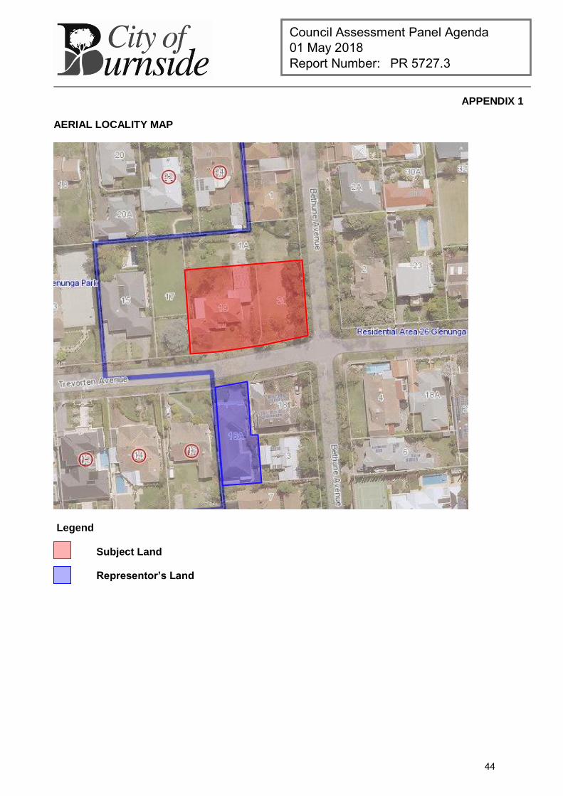
Council Assessment Panel Agenda 01 May 2018 Report Number: PR 5727.3
APPENDIX 1
AERIAL LOCALITY MAP
Legend
Subject Land Representor’s Land
44
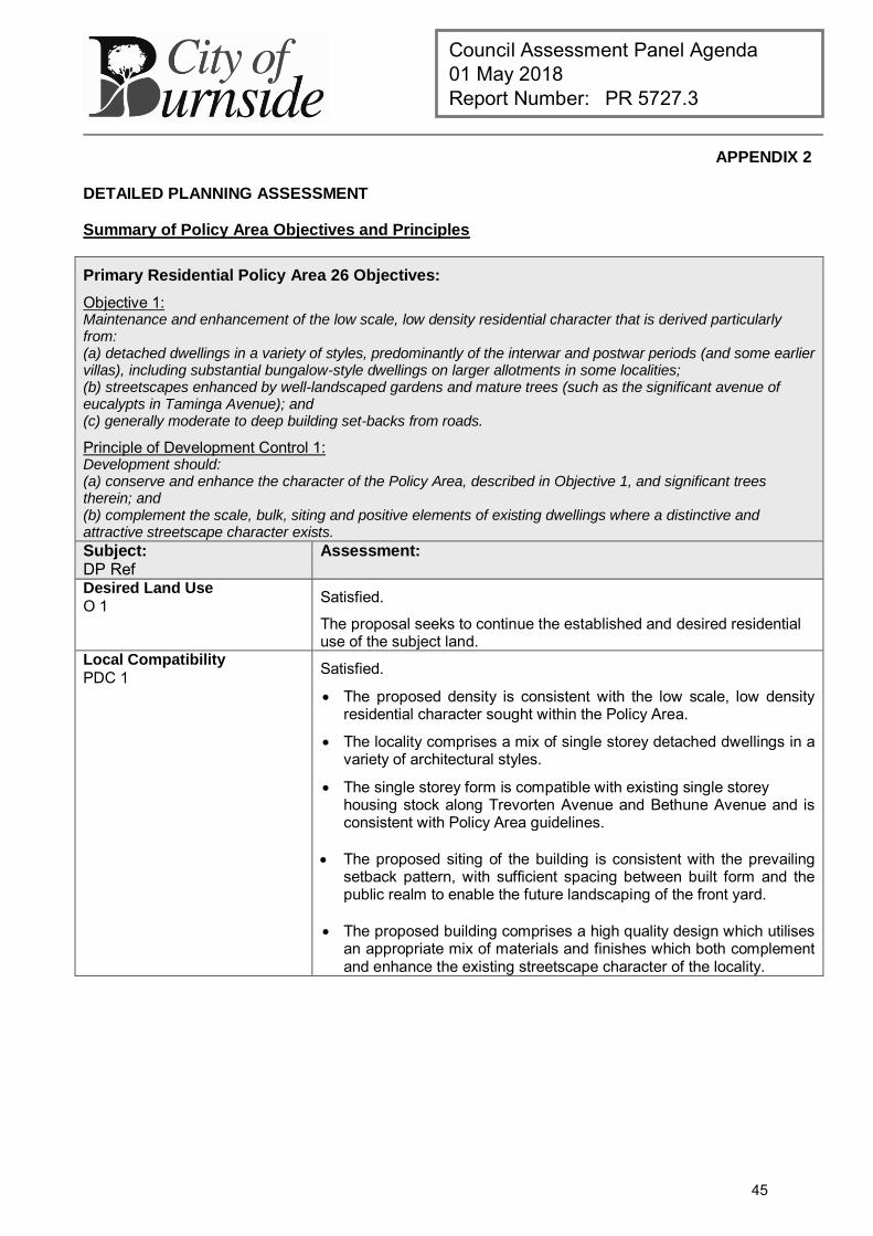
Council Assessment Panel Agenda 01 May 2018 Report Number: PR 5727.3
APPENDIX 2
DETAILED PLANNING ASSESSMENT
Summary of Policy Area Objectives and Principles
Primary Residential Policy Area 26 Objectives:
Objective 1: Maintenance and enhancement of the low scale, low density residential character that is derived particularly from: (a) detached dwellings in a variety of styles, predominantly of the interwar and postwar periods (and some earlier villas), including substantial bungalow-style dwellings on larger allotments in some localities; (b) streetscapes enhanced by well-landscaped gardens and mature trees (such as the significant avenue of eucalypts in Taminga Avenue); and (c) generally moderate to deep building set-backs from roads.
Principle of Development Control 1: Development should: (a) conserve and enhance the character of the Policy Area, described in Objective 1, and significant trees therein; and (b) complement the scale, bulk, siting and positive elements of existing dwellings where a distinctive and attractive streetscape character exists.
Subject: DP Ref
Assessment:
Desired Land Use
O 1 Satisfied.
The proposal seeks to continue the established and desired residential use of the subject land.
Local Compatibility
PDC 1 Satisfied.
The proposed density is consistent with the low scale, low density residential character sought within the Policy Area.
The locality comprises a mix of single storey detached dwellings in a variety of architectural styles.
The single storey form is compatible with existing single storey housing stock along Trevorten Avenue and Bethune Avenue and is consistent with Policy Area guidelines.
The proposed siting of the building is consistent with the prevailing setback pattern, with sufficient spacing between built form and the public realm to enable the future landscaping of the front yard.
The proposed building comprises a high quality design which utilises an appropriate mix of materials and finishes which both complement and enhance the existing streetscape character of the locality.
45
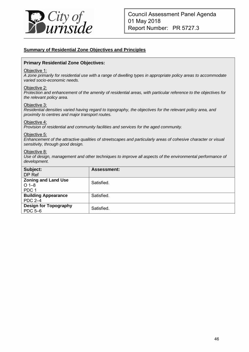
Council Assessment Panel Agenda 01 May 2018 Report Number: PR 5727.3
Summary of Residential Zone Objectives and Principles
Primary Residential Zone Objectives:
Objective 1: A zone primarily for residential use with a range of dwelling types in appropriate policy areas to accommodate varied socio-economic needs.
Objective 2: Protection and enhancement of the amenity of residential areas, with particular reference to the objectives for the relevant policy area.
Objective 3: Residential densities varied having regard to topography, the objectives for the relevant policy area, and proximity to centres and major transport routes.
Objective 4: Provision of residential and community facilities and services for the aged community.
Objective 5: Enhancement of the attractive qualities of streetscapes and particularly areas of cohesive character or visual sensitivity, through good design.
Objective 8: Use of design, management and other techniques to improve all aspects of the environmental performance of development.
Subject:
DP Ref Assessment:
Zoning and Land Use O 1–8 PDC 1
Satisfied.
Building Appearance PDC 2–4
Satisfied.
Design for Topography
PDC 5–6 Satisfied.
46
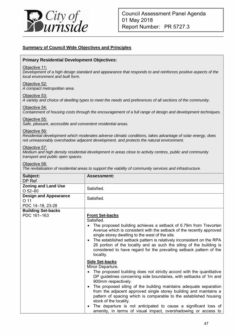
Council Assessment Panel Agenda 01 May 2018 Report Number: PR 5727.3
Summary of Council Wide Objectives and Principles
Primary Residential Development Objectives:
Objective 11: Development of a high design standard and appearance that responds to and reinforces positive aspects of the local environment and built form.
Objective 52: A compact metropolitan area.
Objective 53: A variety and choice of dwelling types to meet the needs and preferences of all sections of the community.
Objective 54: Containment of housing costs through the encouragement of a full range of design and development techniques.
Objective 55: Safe, pleasant, accessible and convenient residential areas.
Objective 56: Residential development which moderates adverse climatic conditions, takes advantage of solar energy, does not unreasonably overshadow adjacent development, and protects the natural environment.
Objective 57: Medium and high density residential development in areas close to activity centres, public and community transport and public open spaces.
Objective 58: The revitalisation of residential areas to support the viability of community services and infrastructure.
Subject: DP Ref
Assessment:
Zoning and Land Use
O 52–60 Satisfied.
Design and Appearance O 11 PDC 14–18, 23-28
Satisfied.
Building Set-backs PDC 161–163 Front Set-backs
Satisfied. The proposed building achieves a setback of 6.79m from Trevorten
Avenue which is consistent with the setback of the recently approved single storey dwelling to the west of the site.
The established setback pattern is relatively inconsistent on the RPA 26 portion of the locality and as such the siting of the building is considered to have regard for the prevailing setback pattern of the locality.
Side Set-backs Minor Departure. The proposed building does not strictly accord with the quantitative
DP guidelines concerning side boundaries, with setbacks of 1m and 900mm respectively.
The proposed siting of the building maintains adequate separation from the adjacent approved single storey building and maintains a pattern of spacing which is comparable to the established housing stock of the locality.
The departure is not anticipated to cause a significant loss of amenity, in terms of visual impact, overshadowing or access to
47
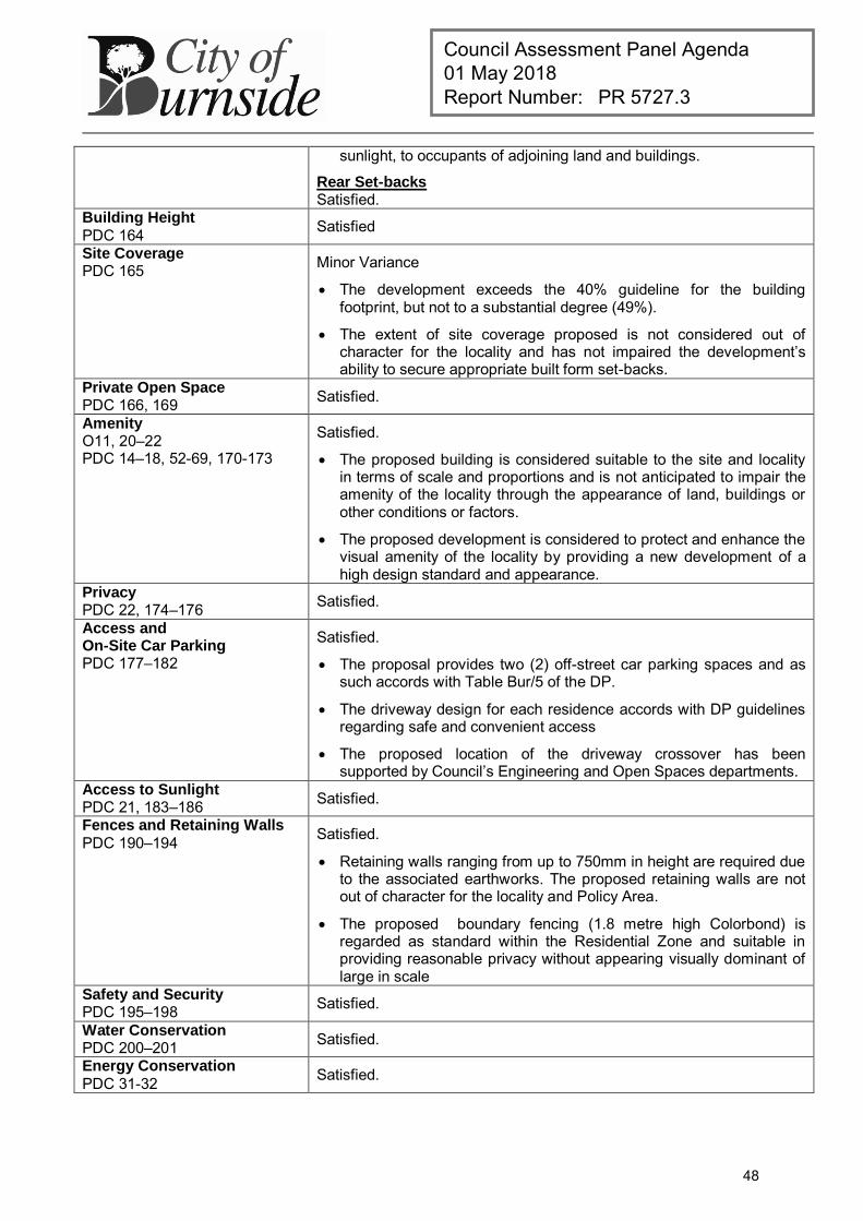
Council Assessment Panel Agenda 01 May 2018 Report Number: PR 5727.3
sunlight, to occupants of adjoining land and buildings.
Rear Set-backs Satisfied.
Building Height PDC 164 Satisfied
Site Coverage PDC 165 Minor Variance
The development exceeds the 40% guideline for the building footprint, but not to a substantial degree (49%).
The extent of site coverage proposed is not considered out of character for the locality and has not impaired the development’s ability to secure appropriate built form set-backs.
Private Open Space PDC 166, 169 Satisfied.
Amenity O11, 20–22 PDC 14–18, 52-69, 170-173
Satisfied.
The proposed building is considered suitable to the site and locality in terms of scale and proportions and is not anticipated to impair the amenity of the locality through the appearance of land, buildings or other conditions or factors.
The proposed development is considered to protect and enhance the visual amenity of the locality by providing a new development of a high design standard and appearance.
Privacy PDC 22, 174–176 Satisfied.
Access and On-Site Car Parking PDC 177–182
Satisfied.
The proposal provides two (2) off-street car parking spaces and as such accords with Table Bur/5 of the DP.
The driveway design for each residence accords with DP guidelines regarding safe and convenient access
The proposed location of the driveway crossover has been supported by Council’s Engineering and Open Spaces departments.
Access to Sunlight PDC 21, 183–186 Satisfied.
Fences and Retaining Walls PDC 190–194 Satisfied.
Retaining walls ranging from up to 750mm in height are required due to the associated earthworks. The proposed retaining walls are not out of character for the locality and Policy Area.
The proposed boundary fencing (1.8 metre high Colorbond) is regarded as standard within the Residential Zone and suitable in providing reasonable privacy without appearing visually dominant of large in scale
Safety and Security PDC 195–198 Satisfied.
Water Conservation PDC 200–201 Satisfied.
Energy Conservation PDC 31-32 Satisfied.
48
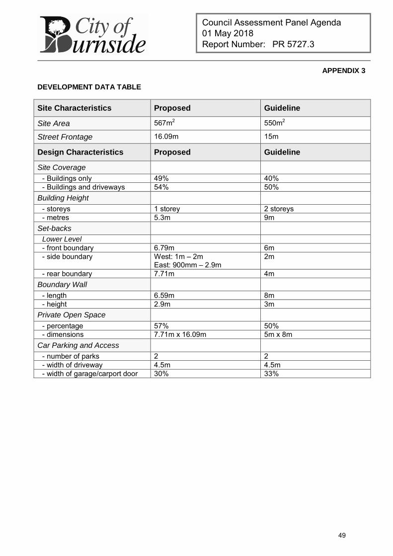
Council Assessment Panel Agenda 01 May 2018 Report Number: PR 5727.3
APPENDIX 3
DEVELOPMENT DATA TABLE
Site Characteristics Proposed Guideline
Site Area 567m2 550m2
Street Frontage 16.09m 15m
Design Characteristics Proposed Guideline
Site Coverage - Buildings only 49% 40% - Buildings and driveways 54% 50%
Building Height - storeys 1 storey 2 storeys - metres 5.3m 9m
Set-backs Lower Level - front boundary 6.79m 6m - side boundary West: 1m – 2m
East: 900mm – 2.9m 2m
- rear boundary 7.71m 4m Boundary Wall
- length 6.59m 8m - height 2.9m 3m
Private Open Space - percentage 57% 50% - dimensions 7.71m x 16.09m 5m x 8m
Car Parking and Access - number of parks 2 2 - width of driveway 4.5m 4.5m - width of garage/carport door 30% 33%
49

this page is left intentionally blank
50
Council Assessment Panel Agenda 01 May 2018 Report Number: PR 5727.4
DEVELOPMENT APPLICATION
Application Number: 180\0151\18
Applicant: S Slp Pty Ltd.
Location: 326 Kensington Road, Leabrook
Proposal: Two storey dwelling including boundary retaining walls and fencing
Zone/Policy Area: Residential Zone
Residential Policy Area 10 - Leabrook (North)
Development Plan consolidated 19 December 2017
Kind of Assessment: Merit
Public Notification: Category 2
Two (2) representations received
Appeal Opportunity Applicant only, no third party appeal rights
Referrals – Statutory: N/A
Referrals – Non Statutory: Technical Officer – Engineering
Delegations Policy: Unresolved representations
Recommendation: Development Plan Consent be granted
Recommending Officer: Jake Vaccarella
REPORT CONTENTS
Assessment report: - Appendix 1 – Aerial Locality Map - Appendix 2 – Detailed Planning Assessment - Appendix 3 – Development Data Table
Please note that due to Federal Copyright Law restrictions, attachments associated with the proposed development are not made available to the public.
Documentation provided as attachments to the report to members of the Council Assessment Panel to facilitate decision making: Plans and supporting documents Internal agency referral reports Representations received Applicant’s response to representations Photographs
51
Council Assessment Panel Agenda 01 May 2018 Report Number: PR 5727.4
1. DESCRIPTION OF PROPOSAL
The applicant seeks Development Plan Consent for the construction of a new two-storey dwelling inclusive of boundary retaining walls and 1.8 metre high Colorbond fencing on a single residential allotment which currently accommodates an existing single storey detached dwelling with frontage to Kensington Road. Whilst the land has not yet formally been divided, it has been confirmed that it is the intention of the applicant to subdivide the land following the outcome of the subject land use application. The dwelling comprises porch, double garage, lounge room, laundry, rumpus room, study, activities area, two (2) bathrooms, four (4) bedrooms (one with WIR and ensuite), alfresco and open plan kitchen, meals and living areas. Vehicular access to the site is gained via Perry Lane to which the building is orientated towards.
2. BACKGROUND
Development Application 180\0151\18 was lodged on 22 February 2018 by Superior Land Projects on behalf of the registered owner of the land. The proposal was determined to be a merit form of development pursuant to Section 35(5) of the Development Act 1993. For the purposes of public notification, the application was determined to be a Category 2 development in accordance with the Burnside (City) Development Plan, Residential Policy Area 10, Principle of Development Control 8 (a) and (d). The application was made available for public inspection between 07 March and 22 March 2018, during which time Council received written submissions from two (2) external parties, of whom one (1) expressed a desire to appear in person before the Council Assessment Panel (the Panel) in support of their submission. The representations raised concerns with regard to external materials and finishes, traffic, bulk and scale, overshadowing and compatibility with the local area. As part of the assessment process the application was also referred to Council’s Technical Officer – Engineering to assess the suitability of access arrangements, as well as general impacts on Council infrastructure.
Pursuant to Council’s Delegation Policy, the application is presented to the Panel for consideration as a Category 2 development with unresolved representations.
3. SUBJECT LAND AND LOCALITY ATTRIBUTES
3.1. Subject Land
The subject land is a rectangular shaped allotment on the southern side of Kensington Road in Leabrook, measuring approximately 929 square metres with a frontage to Perry Lane of 15.24 metres. The land current accommodates a single storey detached dwelling with frontage to Kensington Road. The proposal utilises the rear yard of this allotment with the dwelling to have exclusive frontage to Perry Lane; a subsequent land division application will formalise this arrangement in the event this proposal is granted approval.
52
Council Assessment Panel Agenda 01 May 2018 Report Number: PR 5727.4
3.2. Locality
Description The locality takes in the area bounded by Kensington Road in the north, Godfrey Terrace in the south, Doerwyn Avenue to the west and the Resthaven site to the east. The locality is comprised of primarily single storey detached dwellings with the exception of the adjacent recently constructed two-storey detached dwelling of similar form and proportions and the multi-storey aged care facility (Resthaven) located to the east of the subject land. Perry Lane whilst a public road has a diminished presence within the locality, with its character being derived from its narrow road width (approximately 6 metres) and sense-of-enclosure created by the existing rear boundary fencing, walls and garages located along the Perry Lane road boundary. The amenity within Perry Lane is considered to be limited and inconsistent with the pleasant residential amenity afforded to residents and road users within the remainder of the locality.
4. KIND OF ASSESSMENT
Kind: Merit Reason: Development Act 1993, Section 35(5) Applicant Appeal Opportunity: Yes
5. PUBLIC NOTIFICATION
Category: Category 2 Reason: Residential Policy Area 10 Principle of Development Control 8
(a) and (d) Representations Received: M Harding & S Rooney-Harding – 37 Perry Lane (do not wish
to be heard) Peter Di Lernia & Gail E Di Lernia– 324 Kensington Road
(wish to be heard) Third Party Appeal Opportunity: No
Representations received are provided as an attachment to the Panel.
Applicant’s response(s) to representations are provided as an attachment to the Panel.
6. AGENCY REFERRALS
Internal agency referrals are provided as an attachment to the Panel.
7. EXECUTIVE SUMMARY
7.1. Land Use
The subject land is an existing residential allotment which will surrender its rear yard for the purposes of the proposed built form application. The proposed dwelling will maintain the previous and desired residential use of the land and as such is consistent with the Development Plan from a land use perspective.
The proposed development is therefore not considered to be seriously at variance to the Burnside (City) Development Plan.
53
Council Assessment Panel Agenda 01 May 2018 Report Number: PR 5727.4
7.2. Character and Amenity
Residential Policy Area 10 seeks to maintain and enhance a low scale, low density residential character derived from detached dwellings of low density, in a variety of styles (including modern styles).
In terms of density, Residential Policy Area 10 envisages dwellings being developed on allotments of 500m² and 12m frontage widths. The proposed indicative allotment falls marginally but not unreasonably short of these figures, while the dwelling design is considered acceptable in achieving the qualitative intent of the Development Plan. It is also worth noting that the adjacent allotment to the east of the subject land at 37 Perry Lane was recently subdivided to create an allotment of similar site area and frontage to Perry Lane.
The proposed development is generally compatible with these characteristics, whereby the centralised siting of the building and spatial separation from boundaries both maintains and enhances the low scale character of the streetscape while introducing a new building of a suitably high design standard that is compatible with existing housing stock. Whilst the proposal is located within a streetscape which is afforded limited residential amenity as mentioned earlier, it offers a modern, contemporary two-storey building which is comparable in bulk and scale to the neighbouring, recently constructed two-storey buildings at both 37 Perry Lane. Perry Lane is characterised by garages, outbuildings and fencing on the road boundary. It is therefore reasonable to assume that development with a 0.0 metre set-back is appropriate within Perry Lane; as such the proposed set-back of the lower level at 4.18m is generous by comparison and is unlikely to disrupt the established pattern of development in the lane. The building is also set-back further from the lane than the recently constructed two-storey building adjacent the subject land. In terms of its visual impact from adjoining properties either side of the subject land, the proposed building includes vertical wall heights that are compatible with existing housing stock and a modest upper level that assists in presenting a sympathetic external built from appearance to neighbouring properties on either side of the subject land. In terms of its siting, the proposed building maintains the established pattern of spacing between buildings observed throughout the locality and achieves appropriate spatial separation between adjacent built form, satisfying the quantitative guidelines of the Development Plan concerning set-backs from side and rear boundaries. In terms of overlooking opportunities, the proposed building incorporates upper level front, side and rear windows which are fitted with fixed and obscured privacy screening to a height of 1.6m above the finished floor level, satisfying the relevant DP guidelines with respect to privacy. The overall siting and design of the building is considered to be appropriate within the context of the locality in terms of scale, height, form, style, materials and finishes, and is considered to be an appropriate planning outcome for the subject land and locality.
54
Council Assessment Panel Agenda 01 May 2018 Report Number: PR 5727.4
7.3. Site Functionality
The development is largely consistent with the relevant quantitative guidelines of the Development Plan and is not considered to be an overdevelopment of the site. Despite exceeding the site coverage and total floor area guidelines of the Development Plan, the proposal provides adequate boundary set-backs so as to not cause any significant loss of amenity for adjoining properties in terms of visual impact and overshadowing, or detract from the established patterns of space in the streetscape. The total floor area figure is not considered to amount to an overdevelopment of the land, noting that the impacts of the upper level are appropriately managed.
The applicant has provided a stormwater plan as part of their application, which indicates stormwater from the site will be collected and released to Perry Lane in accordance with Council requirements.
For vehicular purposes, access to the subject land is enabled via Perry Lane. Perry Lane retains sufficient area to allow for adequate vehicle manoeuvrability for both ingress and egress movements. The development provides generous space for on-site car parking to meet the needs of future occupants and visitors without creating additional on-street parking along the lane. Council’s Technical Officer – Engineering has reviewed the proposal and raises no objection to the development from traffic and engineering point of view.
7.4. Public Notification
The proposal was determined to be a Category 2 development pursuant to Residential Policy Area 10 Principle of Development Control 8, which states:
“The following kinds of development are assigned to Category 1: Dwelling, except where
(a) the dwelling or outbuilding is two or more storeys in height (where “two storeys” is defined as a total of one habitable floor level directly above another, not including an understorey garage), or more than 6.5 metres building height above natural ground level;
(d) the development will result in more than one dwelling within the area of the site of the development at the time the development is proposed;
The proposal was made available for public inspection between 07 March and 22 March 2018, during which time Council received two (2) valid representations from occupiers of adjoining properties, one of whom expressed a desire to formally present their submission before the Panel. The primary issues of concern were summarised earlier in the background section of the report. Council considers that the planning matters raised through the public notification process have been sufficiently addressed through the overall design of the building and the amendments introduced following the notification period insofar as they are to be determined under the Development Act 1993.
7.5. Agency Referrals
As mentioned as part of Council’s internal assessment process, the proposal was referred to the Technical Officer Engineering to assess the impact of development on local infrastructure. No concerns have been identified through this process.
55
Council Assessment Panel Agenda 01 May 2018 Report Number: PR 5727.4
7.6. Conclusion
Having regard to all of the relevant Objectives and Principles of Development Control of the Burnside (City) Development Plan, the proposed development is not considered seriously at variance with, and is generally in accordance with, the policies of the Development Plan.
8. RECOMMENDATIONS
It is recommended that the Council Assessment Panel resolve that:
1. The proposed development is not seriously at variance with the policies in the Development Plan; and
2. Development Application 180\0151\18 is granted Development Plan Consent subject to the following conditions:
Conditions
1 The development granted Development Plan Consent shall be undertaken in accordance with the stamped approved plans, drawings, specifications and other documents submitted to the Council that are relevant to the consent to the reasonable satisfaction of the Council, except where varied by conditions below. Reason:
To ensure the development is undertaken in accordance with the plans and details submitted.
2 All front, side and rear upper level windows as depicted on the stamped and approved plans granted Development Plan Consent shall be fitted with fixed and obscured glazing to a minimum height of 1.6m above the finished floor level. The fixed and obscured glazing shall be installed prior to the occupation or use of the building herein granted Development Plan Consent and thereafter shall be maintained to the reasonable satisfaction of Council at all times. Reason:
To ensure the new development does not unreasonably diminish the privacy of residents in adjoining properties.
Advisory Notes
1 Building Consent Development Approval will not be granted until a Building Rules Consent has been obtained. A separate application must be submitted for such consent. No building work or change of classification is permitted until the Deveopment Approval has been obtained.
2 Expiration Time of Approval
Pursuant to the provisions of Regulation 48 under the Development Act 1993, this Consent/Approval will lapse at the expiration of 12 months from the operative date of the Consent/Approval unless the relevant development has been lawfully commenced by substantial work on the site of the development within 12 months, in which case the Approval will lapse within 3 years from the operative date of the Approval subject to the proviso that if the development has been substantially or fully completed within those 3 years, the Approval will not lapse.
56
Council Assessment Panel Agenda 01 May 2018 Report Number: PR 5727.4
3 Boundaries
It is recommended that as the Applicant is undertaking work on or near the boundary, the Applicant should ensure that the boundaries are clearly defined by a Licensed Surveyor, prior to the commencement of any building work.
4 Footpath Maintenance
Existing footpath levels, grades etc. shall not be altered as a result of the new works associated with the development.
Stormwater Detention
Due to the increase of the impermeable area, detention shall be provided to limit post development flows. Calculations shall be provided to verify the ability of the proposed detention quantity to meet the Council’s default detention and discharge requirements below:
The volume of any detention device shall be equal to the volume of water generated on the site with an impervious (Cp = 0.9) site coverage of 75% and pervious (Cp = 0.1) area of 25%, during a 1 in 20 year flood event for a 10 minute duration.
The maximum rate of discharge from the site shall be equal to the volume of water generated on the site with an impervious (Cp = 0.9) site coverage of 40% and pervious (Cp = 0.1) area of 60%, during a 1 in 5 year flood event for a 10 minute duration.
For stormwater management purposes, it is desirable that: An additional detention storage of 1,000Ltrs be provided in addition to
the standard 1,000Ltrs retention tank provided; and The development utilises permeable paving for the proposed external
paving work within the development site.
Stormwater Discharge
The stormwater pipe across the road verge should terminate at an approved galvanised steel kerb adaptor.
If the cover to the stormwater pipe across the Council verge is less than 65mm, steel pipe housing is to be used as per Council’s standards.
The developer is responsible for locating all existing services and to consult with the necessary service providers if there is a conflict when placing stormwater infrastructure.
Construction of the stormwater infrastructure is in accordance with Council’s Standard Specification and General Conditions and to the overall satisfaction of Council.
Trenching and connections are to be undertaken as per Australian Plumbing Standards.
Excess stormwater runoff from the roof catchment shall be discharged to the street water table through a sealed system to the satisfaction of the Council.
5 Noise
The emission of noise from the premises is subject to control under the Environment Protection Act and Regulations, 1993 and the applicant (or person with the benefit of this consent) should comply with those requirements.
57
Council Assessment Panel Agenda 01 May 2018 Report Number: PR 5727.4
6 Fences Act 1975
The Applicant is reminded of the requirements of the Fences Act 1975. Should the proposed works require the removal, alteration or repair of an existing boundary fence, a 'Notice of Intention' must be served to adjoining owners. Please contact the Legal Services Commission for further advice on 1300 366 424 or visit www.lsc.sa.gov.au
RECOMMENDING OFFICER
Jake Vaccarella Development Officer – Planning
58
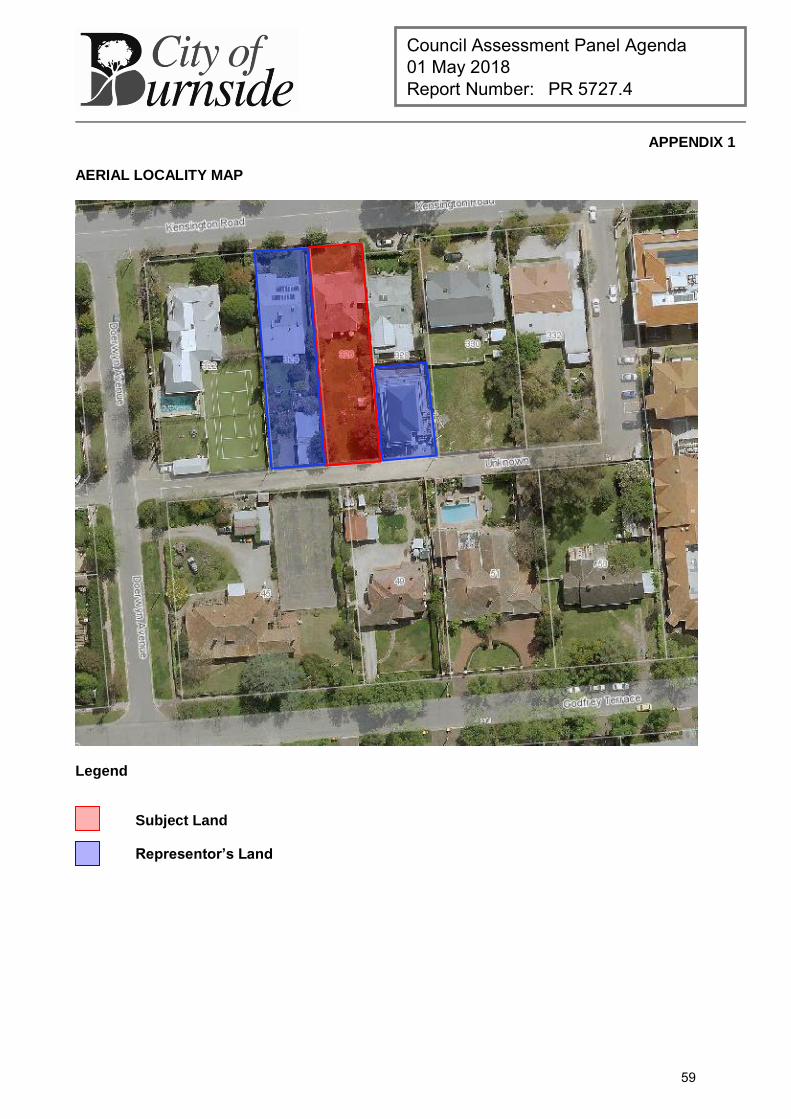
Council Assessment Panel Agenda 01 May 2018 Report Number: PR 5727.4
APPENDIX 1
AERIAL LOCALITY MAP
Legend
Subject Land
Representor’s Land
59
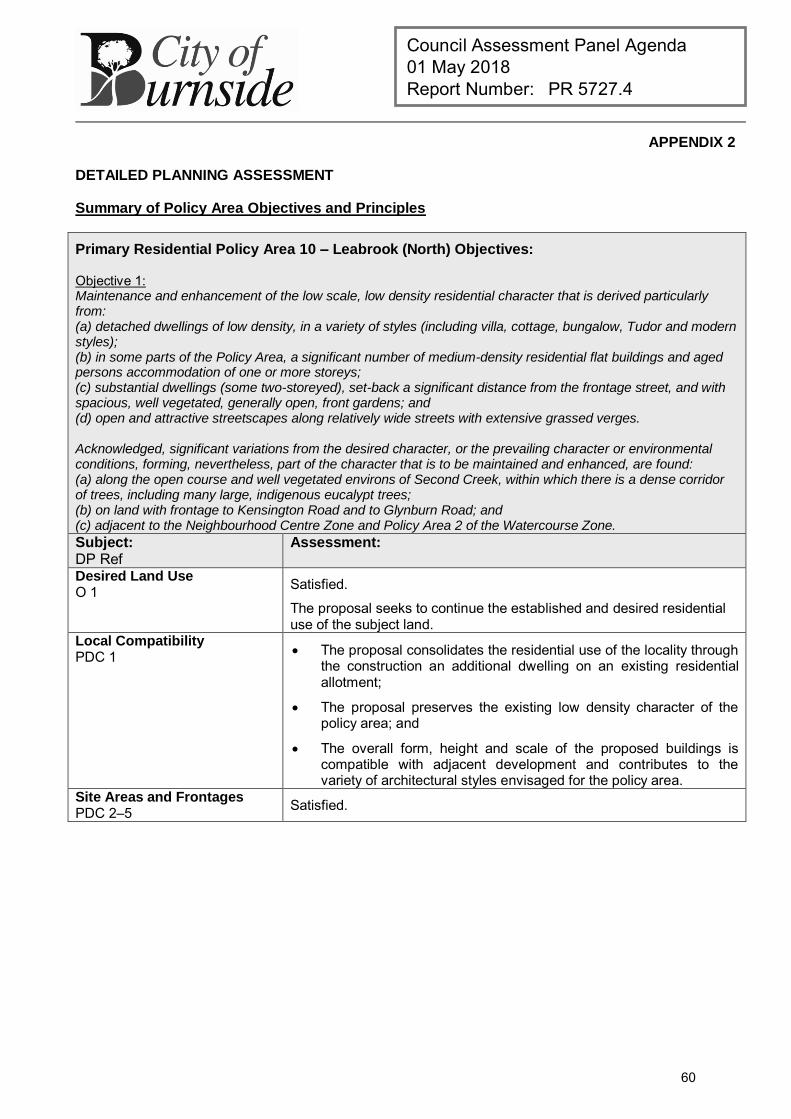
Council Assessment Panel Agenda 01 May 2018 Report Number: PR 5727.4
APPENDIX 2
DETAILED PLANNING ASSESSMENT
Summary of Policy Area Objectives and Principles
Primary Residential Policy Area 10 – Leabrook (North) Objectives: Objective 1: Maintenance and enhancement of the low scale, low density residential character that is derived particularly from: (a) detached dwellings of low density, in a variety of styles (including villa, cottage, bungalow, Tudor and modern styles); (b) in some parts of the Policy Area, a significant number of medium-density residential flat buildings and aged persons accommodation of one or more storeys; (c) substantial dwellings (some two-storeyed), set-back a significant distance from the frontage street, and with spacious, well vegetated, generally open, front gardens; and (d) open and attractive streetscapes along relatively wide streets with extensive grassed verges. Acknowledged, significant variations from the desired character, or the prevailing character or environmental conditions, forming, nevertheless, part of the character that is to be maintained and enhanced, are found: (a) along the open course and well vegetated environs of Second Creek, within which there is a dense corridor of trees, including many large, indigenous eucalypt trees; (b) on land with frontage to Kensington Road and to Glynburn Road; and (c) adjacent to the Neighbourhood Centre Zone and Policy Area 2 of the Watercourse Zone. Subject: DP Ref
Assessment:
Desired Land Use O 1 Satisfied.
The proposal seeks to continue the established and desired residential use of the subject land.
Local Compatibility PDC 1 The proposal consolidates the residential use of the locality through
the construction an additional dwelling on an existing residential allotment;
The proposal preserves the existing low density character of the policy area; and
The overall form, height and scale of the proposed buildings is compatible with adjacent development and contributes to the variety of architectural styles envisaged for the policy area.
Site Areas and Frontages PDC 2–5
Satisfied.
60
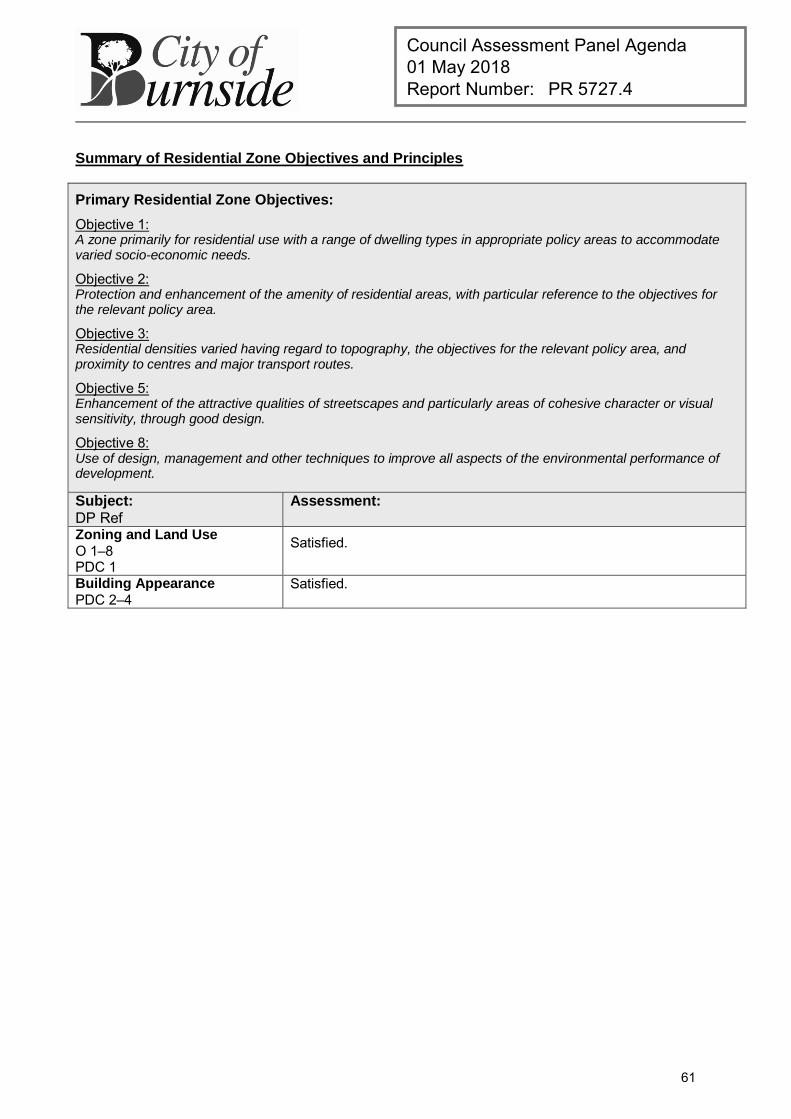
Council Assessment Panel Agenda 01 May 2018 Report Number: PR 5727.4
Summary of Residential Zone Objectives and Principles
Primary Residential Zone Objectives:
Objective 1: A zone primarily for residential use with a range of dwelling types in appropriate policy areas to accommodate varied socio-economic needs.
Objective 2: Protection and enhancement of the amenity of residential areas, with particular reference to the objectives for the relevant policy area.
Objective 3: Residential densities varied having regard to topography, the objectives for the relevant policy area, and proximity to centres and major transport routes.
Objective 5: Enhancement of the attractive qualities of streetscapes and particularly areas of cohesive character or visual sensitivity, through good design.
Objective 8: Use of design, management and other techniques to improve all aspects of the environmental performance of development.
Subject:
DP Ref Assessment:
Zoning and Land Use O 1–8 PDC 1
Satisfied.
Building Appearance PDC 2–4
Satisfied.
61
Council Assessment Panel Agenda 01 May 2018 Report Number: PR 5727.4
Summary of Council Wide Objectives and Principles
Primary Residential Development Objectives:
Objective 11: Development of a high design standard and appearance that responds to and reinforces positive aspects of the local environment and built form.
Objective 52: A compact metropolitan area.
Objective 53: A variety and choice of dwelling types to meet the needs and preferences of all sections of the community.
Objective 54: Containment of housing costs through the encouragement of a full range of design and development techniques.
Objective 55: Safe, pleasant, accessible and convenient residential areas.
Objective 56: Residential development which moderates adverse climatic conditions, takes advantage of solar energy, does not unreasonably overshadow adjacent development, and protects the natural environment.
Objective 57: Medium and high density residential development in areas close to activity centres, public and community transport and public open spaces.
Objective 58: The revitalisation of residential areas to support the viability of community services and infrastructure.
Subject:
DP Ref Assessment:
Zoning and Land Use O 52–60 Satisfied.
Design and Appearance
O 11 PDC 14–18, 23-28
Satisfied.
Building Set-backs PDC 161–163 Front Set-backs
Variance. The front set-back is proposed at 4.18 metres for both the ground
floor level and the first floor. Given Perry Lane is comprised of outbuildings and garages sited
on boundary, the proposed set-back is generous by comparison and is unlikely to disrupt the established pattern of development in the lane.
The building is also set-back further from the lane than the recently constructed two-storey building adjacent the subject land.
Side Set-backs Satisfied.
Rear Set-backs Satisfied.
Building Height PDC 164 Satisfied.
Site Coverage PDC 165 Variance.
62
Council Assessment Panel Agenda 01 May 2018 Report Number: PR 5727.4
The proposal generally accords with the the Council Wide ground floor site coverage guidelines prescribed of the DP, however the combined floor area of both levels exceeds the 50% guideline of PDC 164(b).
The extent of the departure is within tolerable limits based on the proposal’s design and siting that reduces bulk, provides sufficient POS and space for landscaping.
Private Open Space PDC 166, 169 Satisfied.
Amenity O11, 20–22 PDC 14–18, 52-69, 170-173
Satisfied.
Privacy PDC 22, 174–176 Satisfied.
The proposal involves a two storey building with floor levels that could overlook adjacent properties.
The proposal addresses this issue with the use of high sill windows on both sides of the dwelling and fixed obscure glazing fitted to any portion below 1.6m above first floor level on side, rear and front windows.
Access and On-Site Car Parking PDC 177–182
Satisfied.
The dwelling satisfies off-street parking requirements prescribed by Table Bur/5.
The proposed access arrangements have been supported by Council’s Technical Officer – Engineering & Traffic.
Access to Sunlight PDC 21, 183–186 Satisfied.
The dwelling is two storeys in height and therefore could reasonably be expected to impose a degree of shadow over adjoining properties at certain times of the day.
The north-south orientation of the site, coupled with the siting of the laneway between neighbouring allotments to the south means that the amount of sunlight afforded to each adjoining property will remain consistent with DP guidelines.
Fences and Retaining Walls PDC 190–194 Satisfied.
The proposal includes details of boundary fencing and retaining walls.
The proposed retaining walls (max 600mm height) are appropriate in scale and not out of character with the locality.
The proposed side and rear boundary fencing (1.8 metre high Colorbond) is regarded as standard within the Residential Zone and suitable in providing reasonable privacy without appearing visually dominant of large in scale.
Safety and Security PDC 195–198 Satisfied.
Water Conservation PDC 200–201 Satisfied.
Energy Conservation PDC 31-32 Satisfied.
63
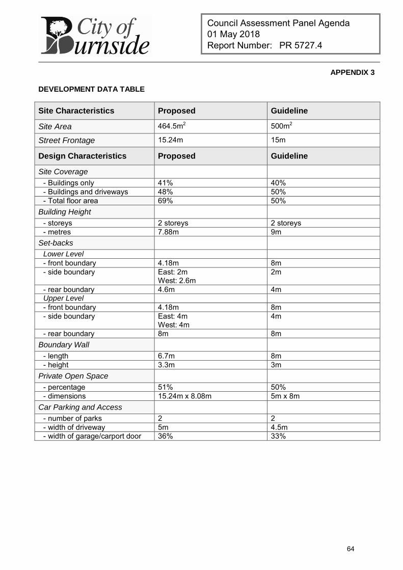
Council Assessment Panel Agenda 01 May 2018 Report Number: PR 5727.4
APPENDIX 3
DEVELOPMENT DATA TABLE
Site Characteristics Proposed Guideline
Site Area 464.5m2 500m2
Street Frontage 15.24m 15m
Design Characteristics Proposed Guideline
Site Coverage - Buildings only 41% 40% - Buildings and driveways 48% 50% - Total floor area 69% 50%
Building Height - storeys 2 storeys 2 storeys - metres 7.88m 9m
Set-backs Lower Level - front boundary 4.18m 8m - side boundary East: 2m
West: 2.6m 2m
- rear boundary 4.6m 4m Upper Level - front boundary 4.18m 8m - side boundary East: 4m
West: 4m 4m
- rear boundary 8m 8m Boundary Wall
- length 6.7m 8m - height 3.3m 3m
Private Open Space - percentage 51% 50% - dimensions 15.24m x 8.08m 5m x 8m
Car Parking and Access - number of parks 2 2 - width of driveway 5m 4.5m - width of garage/carport door 36% 33%
64

Council Assessment Panel Agenda 01 May 2018 Report Number: PR 5727.5
DEVELOPMENT APPLICATION
Application Number: 180\0848\17
Applicant: Mr Rob May
Location: 63-65 Waterfall Gully Road, WATERFALL GULLY
Proposal: Additions to existing dwelling including detached garage & store, roofed deck, verandah, swimming pool and associated excavation and fill (non-complying)
Zone/Policy Area: Hills Face Zone
Development Plan consolidated 30 May 2017
Kind of Assessment: Non-complying
Public Notification: Category 3
One (1) representation received (support)
Appeal Opportunity Third party only, no Applicant appeal rights
Referrals – Statutory: Country Fire Service (CFS)
Referrals – Non Statutory: N/A
Delegations Policy: Non-complying development
Recommendation: Subject to concurrence from the Development Assessment Commission, that Development Plan Consent be granted
Recommending Officer: Jake Vaccarella
REPORT CONTENTS
Assessment report: - Appendix 1 – Aerial Locality Map - Appendix 2 – Detailed Planning Assessment - Appendix 3 – Development Data Table
Please note that due to Federal Copyright Law restrictions, attachments associated with the proposed development are not made available to the public.
Documentation provided as attachments to the report to members of the Council Assessment Panel to facilitate decision making: Plans and supporting documents External agency referral reports Representations received Photographs 13 September 2017 delegated report to proceed
65
Council Assessment Panel Agenda 01 May 2018 Report Number: PR 5727.5
1. DESCRIPTION OF PROPOSAL
The applicant seeks Development Plan Consent for single storey additions to an existing dwelling comprising:
New bedroom featuring walk in robe and ensuite and cabana (pool room), connected to the existing house by a glass walkway;
Detached garage/store and shed In-ground swimming pool; Deck and verandah to the front of the house accessible from internal living areas; and Associated earthworks and stone retaining walls
2. BACKGROUND
Development Application 180\0848\17 was lodged on 16 August 2017 by Rebecca Thomas on behalf of the registered owner of the property. The proposal was determined to be a non-complying form of development pursuant to Hills Face Zone, Principle of Development Control 27 of the Burnside (City) Development Plan, which states:
The following kinds of development are non-complying in the Hills Face Zone:
Detached Dwelling or additions to, or conversion of, an existing detached dwelling where: (b) the scale and design is such that:
(i) the vertical distance between any point at the top of any external wall and the finished ground level immediately below that point on the wall exceeds three metres, other than gable ends of the dwelling where the distance exceeds five metres.
(c) the depth of excavation and/or height of filling of land exceeds 1.5 metres.
The proposal involves the construction of dwelling additions where the scale and design is such that the vertical distance between the point at the top of the external walls and the finished ground level immediately below that point exceeds 3 metres. Additionally, the incidental earthworks, comprising both excavation and filling of land exceeds 1.5 metres.
The Planning Team Leader determined to proceed to an assessment of the application on 13 September 2017 under delegated authority. The application was processed as a Category 3 development pursuant to Section 38 (2)(c) of the Development Act 1993. The application was made available for public consultation from 06 March until the 22 March 2018, during which time Council received one written submission in support of the proposal. Pursuant to Schedule 8 of the Development Regulations 2008, the application was referred to the Country Fire Service (CFS) as the subject land is located within a High Bushfire Risk area. The proposal in now presented to the Council Assessment Panel (the Panel) for consideration as a non-complying development with a staff recommendation that Development Plan Consent be granted, subject to the concurrence of the State Commission Assessment Panel (SCAP).
66
Council Assessment Panel Agenda 01 May 2018 Report Number: PR 5727.5
3. SUBJECT LAND AND LOCALITY ATTRIBUTES
3.1. Subject Land
The subject land is an irregular shaped allotment measuring 7,521 square metres with angled frontage to the southern side of Waterfall Gully road of 129.8 metres. The site topography rises steeply from Waterfall Gully Road up to the rear property boundary which abuts a fire track controlled by Council. The land is located within the suburb of Waterfall Gully and is wholly contained within the Hills Face Zone of the Burnside (City) Development Plan. The subject land is currently occupied by a single storey detached dwelling, various outbuildings, landscaping and retaining walls and a steep concrete driveway that provides access to the building. The property is well vegetated with many mature trees and shrubs. Visibility of the house from Waterfall Gully Road and adjoining neighbouring properties is restricted due to the vegetation, particularly tree canopies, and also the topography of the hill side.
3.2. Locality
The locality, which is also located within the Hills Face Zone, is characterised by the shared relationship between the natural landscape character and detached dwellings of varying styles and scales. The natural topographical features and dense vegetation often screen views of existing dwellings from local roads. Cleland Conservation Park is situated to the east and west of the site, with the Chambers Gully access point located immediately east of the property.
4. KIND OF ASSESSMENT
Kind: Non-complying Reason: Development Act 1993, Section 35(3) Applicant Appeal Opportunity: No
5. PUBLIC NOTIFICATION
Category: Category 3 Reason: Hills Face Zone Principle of Development Control 27 Representations Received: 8 Burnalta Crescent, Burnside - support (do not wish to be
heard) Third Party Appeal Opportunity: Yes
Representations received are provided as an attachment to the Panel.
Applicant’s response(s) to representations are provided as an attachment to the Panel.
6. AGENCY REFERRALS
External agency referrals are provided as an attachment to the Panel.
7. EXECUTIVE SUMMARY
7.1. Land Use
In relation to the current proposal, the following comments are made:
67
Council Assessment Panel Agenda 01 May 2018 Report Number: PR 5727.5
The proposed addition relates to an existing single storey detached dwelling and is
of a modest scale by comparison; The proposed development is consistent with the established residential use of the
land and are considered to enhance the functionality of the site; The proposed works are of a high-quality design standard which are consistent in
bulk, scale, form and proportion with the existing dwelling; The additions have been designed to integrate seamlessly with the existing
dwelling and are comprised of contemporary materials in dark tones that are consistent with the dwelling itself and will fit appropriately within this hillside context;
The proposed works are well setback from Waterfall Gully Road and as such do not appear to form a notable visual element within the local streetscape and would not be a visually prominent feature when viewed from the road or adjacent properties; and as a consequence; and
The proposed appears unlikely to create adverse impacts for the owners or occupiers of adjoining property.
7.2. Character and Amenity
The locality, comprising land within the Hills Face Zone, is characterised by the shared relationship between the natural landscape character and detached dwellings of varying styles and scale. The locality enjoys a high degree of amenity, enhanced by the open and natural landscape of the hills.
The proposed development is considered to be modest in nature despite the non-complying classification, and is not anticipated to have any adverse impact on the natural character of the zone. The proposed additions reflect the siting and footprint of the existing building, extending in a linear form to the side and behind the existing dwelling and maintain the generous setback from Waterfall Gully Road. The proposed development comprises of a high quality, contemporary design which features a variety of external materials and finishes including dark metal cladding, stonework, feature “rust” look metal panels and large glass windows across the primary façade which provide a high level of visual interest and articulation.
The proposed additions are considered to appropriately respond to the locality and topography of the subject land and are consistent with the existing built form character. The proposed works are considered to enhance the functionality of the existing residence and reflect a high-quality, contemporary built form outcome.
The proposed outbuildings comprising carport, storage shed and store have been neatly sited into the side of the hill behind the existing dwelling, within an area which has previously been used for vehicle parking storage and outbuildings.
The proposed works are appropriately screened from the public realm and adjacent properties by existing mature trees and shrubs, all of which are to be retained and enhanced through new, complimentary landscaping. As such, the proposed additions are considered to have an acceptable level of impact to the occupiers of adjoining land and have been designed and sited so as to blend in with the natural topography of the site.
68
Council Assessment Panel Agenda 01 May 2018 Report Number: PR 5727.5
7.3. Site Functionality
The applicant along with Council staff met with CFS bushfire safety officer on site to work through some of the initial issues raised in the statutory referral from a bushfire safety point of view. As a result, modification, including expansion and resurfacing of the existing driveway was required to create an adequate hardstand area at the bend of the existing driveway for firefighting vehicles in proximity to the dwelling. As this area is conveniently located adjacent the proposed swimming pool, this can act as a water source in the event of a fire. The proposed development involves a degree of incidental earthworks, primarily comprising of cutting into the hillside (approximately 546m3) and a small amount of fill in others (approximately 121m3). The degree of earthworks when considered in the context of the spacious allotment is not considered excessive and enables improved structural stability and functionality of the site whilst preserving the natural character and topography of the area. Due to the deep setback of the existing dwelling from Waterfall Gully Road, the location of the earthworks will not impart any visual impacts on the locality or result in any unreasonable visual impacts to adjoining occupiers of land.
7.4. Public Notification
The proposed development is neither a fence nor an outbuilding therefore the Development Plan, through Principle of Development Control 28 does not assign a development category for the proposal. The proposed development also fails to meet the criteria for Category 1 and Category 2 development as set out in Schedule 9 of the Development Regulations 2008. As such, the application was determined to be a category 3 development pursuant to Section 38 (2)(c) of the Development Act 1993. The proposal was made available for public inspection between 06 March and 22 March 2018, during which time Council received one (1) representation in support of the proposal.
7.5. Agency Referrals
The subject land is located within an area of the City of Burnside designated as a High Bushfire Risk Area. Accordingly, the proposal required consideration by the CFS pursuant to Schedule 8 of the Development Regulations 2008
Consultation with the CFS has been undertaken and the CFS Development Assessment Service has confirmed they have no objection to the development, provided appropriate planning conditions are included in the approval (see Conditions 3 - 6).
7.6. Conclusion
Having regard to all of the relevant Objectives and Principles of Development Control of the Burnside (City) Development Plan, the proposed development is not considered seriously at variance with, and is generally in accordance with, the policies of the Development Plan.
69
Council Assessment Panel Agenda 01 May 2018 Report Number: PR 5727.5
8. RECOMMENDATIONS
It is recommended that the Council Assessment Panel resolve that:
1. The proposed development is not seriously at variance with the policies in the Development Plan; and
2. Subject to concurrence from the State Commission Assessment Panel, that Development Application 180\0848\17 is granted Development Plan Consent subject to the following conditions:
Conditions
1 The development granted Development Plan Consent shall be undertaken in accordance with the stamped approved plans, drawings, specifications and other documents submitted to the Council that are relevant to the consent to the reasonable satisfaction of the Council, except where varied by conditions below. Reason:
To ensure the development is undertaken in accordance with the plans and details submitted.
2 All mechanical machinery associated with the heating, cleaning and filtration of the swimming pool shall not emit any noise which exceeds 45dB(A) when measured from the boundary of the subject land at the closest point to the mechanical machinery. Reason:
To ensure minimal amenity loss of adjacent properties.
3 Access to Dwelling
Access to the building site shall be of all-weather construction, with a minimum formed road surface width of 3 metres and must allow forward entry and exit for large fire-fighting vehicles.
The all-weather road shall allow fire-fighting vehicles to safely enter and exit the allotment in a forward direction by incorporating either -
o A loop road around the building, OR o A turning area with a minimum radius of 12.5 metres, OR o A ‘T’ or ‘Y’ shaped turning area with a minimum formed length of 11 metres
and minimum internal radii of 9.5 metres. Private access shall have minimum internal radii of 9.5 metres on all bends. Vegetation overhanging the access road shall be pruned to achieve a minimum
vehicular clearance of not less than 4 metres in width and a vertical height clearance of 4 metres.
The gradient of the access road shall not exceed 16 degrees (29%), in steep terrain the construction of the public road or driveway shall be a sealed surface.
The all-weather road is to be constructed such that it is protected from water erosion of the traffic surface. The road surface shall be profiled to manage storm water run-off to appropriate drains, at one or both sides of the traffic surface.
The accumulated volumes of water shall be directed via: o open drains, or o culverts and pipes under the traffic surface, and / or away from same,
without causing further soil erosion, silting of adjacent areas or water courses or instability of any embankment or cutting.
Solid crossings over waterways shall be provided to withstand the weight of large bushfire appliances (GVM 21 tonnes).
70
Council Assessment Panel Agenda 01 May 2018 Report Number: PR 5727.5
4 Vegetation
A vegetation management zone (VMZ) shall be established and maintained within 20 metres of the dwelling (or to the property boundaries - whichever comes first) as follows:
The number of trees and understorey plants existing and to be established within the VMZ shall be reduced and maintained such that when considered overall a maximum coverage of 30% is attained, and so that the leaf area of shrubs is not continuous. Careful selection of the vegetation will permit the ‘clumping’ of shrubs where desirable, for diversity, and privacy and yet achieve the ‘overall maximum coverage of 30%’.
Reduction of vegetation shall be in accordance with SA Native Vegetation Act 1991 and SA Native Vegetation Regulations 2017.
Trees and shrubs shall not be planted closer to the building(s) than the distance equivalent to their mature height.
Trees and shrubs must not overhang the roofline of the building, touch walls, windows or other elements of the building.
Shrubs must not be planted under trees and must be separated by at least 1.5 times their mature height.
Grasses within the zone shall be reduced to a maximum height of 10cm during the Fire Danger Season.
No understorey vegetation shall be established within 1 metre of the dwelling (understorey is defined as plants and bushes up to 2 metres in height).
Flammable objects such as plants, mulches and fences must not be located adjacent to vulnerable parts of the building such as windows, decks and eaves
The VMZ shall be maintained to be free of accumulated dead vegetation.
5 Water Supply
A minimum supply of 22,000 litres of water shall be available at all times for bushfire fighting purposes.
The bushfire fighting water supply shall be clearly identified and fitted with an outlet of at least
50mm diameter terminating with a compliant SA CFS fire service adapter, which shall be accessible to bushfire fighting vehicles at all times.
The water storage facility (and any support structure) shall be constructed of non-combustible material.
The dedicated fire-fighting water supply shall be pressurised by a pump that has: o A minimum inlet diameter of 38mm, AND o Is powered by a petrol or diesel engine with a power rating of at least
3.7kW (5hp), OR o A pumping system that operates independently of mains electricity and is
capable of pressurising the water for fire-fighting purposes. The dedicated fire-fighting water supply pump shall be located at or adjacent to the
dwelling to ensure occupants safety when operating the pump during a bushfire. An ‘Operations Instruction Procedure’ shall be located with the pump control panel.
The fire-fighting pump and any flexible connections to the water supply shall be protected by a non-combustible cover that allows adequate air ventilation for efficient pump operation.
All bushfire fighting water pipes and connections between the water storage facility and a pump shall be no smaller in diameter than the diameter of the pump inlet.
71
Council Assessment Panel Agenda 01 May 2018 Report Number: PR 5727.5
All non-metal water supply pipes for bushfire fighting purposes (other than flexible connections and hoses for fire-fighting) shall be buried below ground to a minimum depth of 300mm with no non-metal parts above ground level.
A fire-fighting hose (or hoses) shall be located so that all parts of the building are within reach of the nozzle end of the hose and if more than one hose is required they should be positioned to provide maximum coverage of the building and surrounds (i.e. at opposite ends of the dwelling).
All fire-fighting hoses shall be capable of withstanding the pressures of the supplied water.
All fire-fighting hoses shall be of reinforced construction manufactured in accordance with AS 2620 or AS 1221.
All fire-fighting hoses shall have a minimum nominal internal diameter of 18mm and a maximum length of 36 metres.
All fire-fighting hoses shall have an adjustable metal nozzle, or an adjustable PVC nozzle manufactured in accordance with AS 1221.
All fire-fighting hoses shall be readily available at all times.
6 Access (to dedicated water supply)
Water supply outlet shall be easily accessible and clearly identifiable from the access way. Stand-alone tanks shall be identified with the signage ‘WATER FOR FIRE FIGHTING’ and the tank capacity written in 100mm lettering on the side of each tank and repeated so that the sign is visible from all approaches to the tank. The sign shall be in fade-resistant letting in a colour contrasting with that of the background (i.e. blue sign with white lettering.)
Access to the dedicated water supply shall be of all-weather construction, with a minimum formed road surface width of 3 metres.
Provision shall be made adjacent to the water supply for a flat hardstand area (capable of supporting fire-fighting vehicles with a gross vehicle mass (GVM) of 21 tonnes) that is a distance equal to or less than 6 metres from the water supply outlet.
SA CFS appliance inlet is rear mounted; therefore the outlet/water storage shall be positioned so that the SA CFS appliance can easily connect to it rear facing.
The water supply outlet may be remotely located from the tank to provide adequate access.
All non-metal water supply pipes for bushfire fighting purposes (other than flexible connections and hoses for fire-fighting) shall be buried below ground to a minimum depth of 300mm with no non-metal parts above ground level.
All water supply pipes for drafting purposes shall be capable of withstanding the required pressure for drafting.
Advisory Notes
1 Building Consent Development Approval will not be granted until a Building Rules Consent has been obtained. A separate application must be submitted for such consent. No building work or change of classification is permitted until the Development Approval has been obtained.
2 Expiration Time of Approval
Pursuant to the provisions of Regulation 48 under the Development Act 1993, this Consent/Approval will lapse at the expiration of 12 months from the operative date of the Consent/Approval unless the relevant development has been lawfully commenced by substantial work on the site of the development within 12 months, in which case the
72
Council Assessment Panel Agenda 01 May 2018 Report Number: PR 5727.5
Approval will lapse within 3 years from the operative date of the Approval subject to the proviso that if the development has been substantially or fully completed within those 3 years, the Approval will not lapse.
3 Boundaries It is recommended that as the Applicant is undertaking work on or near the boundary, the Applicant should ensure that the boundaries are clearly defined by a Licensed Surveyor, prior to the commencement of any building work.
4 Noise The emission of noise from the premises is subject to control under the Environment Protection Act and Regulations, 1993 and the applicant (or person with the benefit of this consent) should comply with those requirements.
5 Fences Act 1975
The Applicant is reminded of the requirements of the Fences Act 1975. Should the proposed works require the removal, alteration or repair of an existing boundary fence, a 'Notice of Intention' must be served to adjoining owners. Please contact the Legal Services Commission for further advice on 1300 366 424 or visit www.lsc.sa.gov.au
RECOMMENDING OFFICER
Jake Vaccarella Development Officer – Planning
73
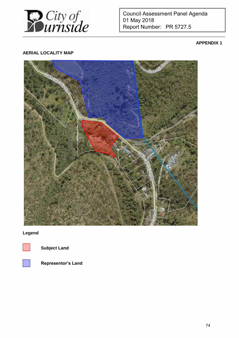
Council Assessment Panel Agenda 01 May 2018 Report Number: PR 5727.5
APPENDIX 1
AERIAL LOCALITY MAP
Legend
Subject Land
Representor’s Land
74
Council Assessment Panel Agenda 01 May 2018 Report Number: PR 5727.5
APPENDIX 2
DETAILED PLANNING ASSESSMENT
Summary of Hills Face Zone Objectives and Principles
Hills Face Zone Objectives:
Objective 1: A zone in which the natural character is preserved and enhanced or in which a natural character is re-established in order to:
(a) Provide a natural backdrop to the Adelaide Plains and a contrast to the urban area; (b) Preserve and develop native vegetation and fauna habitats close to metropolitan Adelaide; (c) Provide for passive recreation in an area of natural character close to the metropolitan area; (d) Provide a part of the buffer between metropolitan districts and prevent the urban area extending into the
western slopes of the ranges; and (e) Ensure that the community is not required to bear the cost of providing services to land within the zone.
Objective 2: A zone accommodating low-intensity agricultural activities and public/private open space and one where structures are located and designed in such a way as to:
(a) Preserve and enhance the natural character or assist in the re-establishment of a natural character in the zone;
(b) Limit the visual intrusion of development in the zone, particularly when viewed from roads within the zone or from the Adelaide Plains;
(c) Not create, either in themselves, or in association with other developments, a potential demand for the provision of services at a cost to the community; and
(d) Prevent the loss of life and property resulting from bushfires. Hills Face Zone, Principle of Development Control 1: Development should not be undertaken unless:
(a) It is associated with a low-intensity, agricultural activity, a public open space area or a private use of an open character, or is a detached single-storey dwelling, including outbuildings and structures normally associated with such dwellings, on a single allotment; and
Together with associated native landscaping, it preserves and enhances the natural character of the zone or assists in the re-establishment of a natural character. Subject: DP Ref
Assessment:
Desired Land Use O 1 Satisfied.
Design for Topography PDC 2 Satisfied.
The development requires a degree of earthworks to achieve the proposed vehicle access arrangements and dwelling floor levels.
Given the steep topography of the site, a degree of excavation and/or fill is to be expected in order to facilitate a residential land use.
The development sits into the hillside so as to preserve the natural form of the land and reduce the visual prominence of the building.
75
Council Assessment Panel Agenda 01 May 2018 Report Number: PR 5727.5
Summary of Council Wide Objectives and Principles
Primary Residential Development Objectives:
Objective 11: Development of a high design standard and appearance that responds to and reinforces positive aspects of the local environment and built form.
Objective 52: A compact metropolitan area.
Objective 53: A variety and choice of dwelling types to meet the needs and preferences of all sections of the community.
Objective 54: Containment of housing costs through the encouragement of a full range of design and development techniques.
Objective 55: Safe, pleasant, accessible and convenient residential areas.
Objective 56: Residential development which moderates adverse climatic conditions, takes advantage of solar energy, does not unreasonably overshadow adjacent development, and protects the natural environment.
Objective 57: Medium and high density residential development in areas close to activity centres, public and community transport and public open spaces.
Objective 58: The revitalisation of residential areas to support the viability of community services and infrastructure.
Objective 59: Affordable housing, student housing and housing for aged persons provided in appropriate locations.
Objective 60: Increased affordable housing opportunities through land division and the conversion of buildings to a residential use.
Subject: DP Ref
Assessment:
Zoning and Land Use O 52–60 Satisfied
Design and Appearance O 11 PDC 14–18, 23-28
Satisfied
Building Set-backs PDC 161–163
Minor departure. All relevant boundary setbacks meet the DP guidelines with the
exception of the side (western) setback which departs from CW PDC 161 by 500mm. The siting is acceptable in this instance given the section of the side boundary in question is not adjacent the adjacent dwelling on the neighbours property, thus enabling adequate separation. The siting of the addition will not detract from the character of the Hills Face Zone nor will it unreasonably impact neighbouring properties in terms of its bulk, scale and overshadowing effect.
Building Height PDC 164 Satisfied.
Site Coverage PDC 165 Satisfied.
Private Open Space Satisfied.
76
Council Assessment Panel Agenda 01 May 2018 Report Number: PR 5727.5
PDC 166, 169 Amenity O11, 20–22 PDC 14–18, 52-69, 170-173
Satisfied.
Privacy PDC 22, 174–176 Satisfied.
Access and On-Site Car Parking PDC 177–182
Satisfied.
Access to Sunlight PDC 21, 183–186 Satisfied.
Fences and Retaining Walls PDC 190–194 Satisfied.
The proposed retaining is associated with the rebuilding of the existing retaining walls along the driveway where a more structurally sound ‘gabion’ wall is to be adopted.
The new fill surrounding the swimming pool area will result in a maximum retaining wall height of 3.2m. Whilst this is of considerable height it is considered reasonable in the context of the existing site conditions and proposed works, enabling safer and convenient fire truck access and enhancing the stability of the existing retaining walls.
Hazards O 39-42 PDC 126–138
Satisfied
77

this page is left intentionally blank
78
Council Assessment Panel Agenda 01 May 2018 Report Number: PR 5727.6
DEVELOPMENT APPLICATION
Application Number: 180\1140\17
Applicant: Fyfe Pty Ltd
Location: 30 LEstrange Street, Glenside
Proposal: Land Division (Torrens Title) - Creating two (2) allotments from one (1) existing to accommodate a new single-storey group dwelling including garage and alfresco, and a carport to the rear of the existing dwelling
Zone/Policy Area: Residential Zone
Residential Policy Area20 – Glenside (Village)
Development Plan consolidated 30 May 2017
Kind of Assessment: Merit
Public Notification: Category 2
Three (3) representations received
Appeal Opportunity Applicant only, no third party appeal rights
Referrals – Statutory: SCAP
SA Water
Referrals – Non Statutory: Technical Officer
Tree Management Officer
Delegations Policy: Deferred Item
Recommendation: Development Plan Consent be granted
Recommending Officer: Renae Grida
REPORT CONTENTS
Assessment report Additional plans and documentation
Please note that due to Federal Copyright Law restrictions, attachments associated with the proposed development are not made available to the public.
Documentation provided as attachments to the report to members of the Council Assessment Panel to facilitate decision making: 03 April 2018 Council Assessment Panel minutes, report and attachments Supplementary information Photographs
79
Council Assessment Panel Agenda 01 May 2018 Report Number: PR 5727.6
1. DESCRIPTION OF PROPOSAL
The applicant seeks Development Plan Consent, and Land Division Consent for the division of the subject land into two allotments to accommodate the construction of a new single-storey group dwelling. The Torrens Title land division is proposed in a battle-axe format, whereby proposed Lot 10 is to retain the existing dwelling fronting L’Estrange Street, with the head of the allotment, proposed Lot 11 at the rear to accommodate the new dwelling. The new dwelling will comprise a double garage, 4 bedrooms, 3 bathrooms, 2 living areas, kitchen, porch and verandah, and accessed via a proposed unrestricted right of way. Alterations to the existing dwelling involve the removal of the carport located on the northern side of the dwelling and the construction of a new double carport located at the rear, accessed via a proposed unrestricted right of way. The rest of the existing dwelling is maintained as per existing. The existing crossover is proposed to be widened to accommodate shared access. There are no identified regulated or significant trees on either the subject land or adjoining land.
2. BACKGROUND
Development Application 180\1140\17 was presented to the Council Assessment Panel (the Panel) on 03 April 2018 with a staff recommendation to grant Development Plan Consent. The Panel resolved to defer the matter to allow the Applicant an opportunity to consider the following:
1. Landscaping 2. On-site manoeuvring 3. Amenity and character in relation to the entrance and forecourt area to the rear dwelling.
The applicant has since responded to the reasons for deferral and the application returns to the Panel for further consideration.
3. DISCUSSION
The applicant’s response to the Panel’s concerns has been addressed by way of additional plans and details. A landscaping plan has been prepared and provided, which seeks to retain existing trees, and compensate for the loss of existing vegetation with new plantings, in order to accommodate the proposed development. Additionally, the landscaping plan seeks to achieve increased amenity outcomes by providing for an increase of visual relief when viewing the subject site adjacent the boundaries of the site. A plan demonstrating turning paths, together with a report from CIRQA Traffic Consultants has been provided in order to address the concerns raised by Panel regarding traffic movement within the common driveway space. It has been determined by the submitted plan and supporting report that the proposed development achieves the requirements of the relevant Australian Standards regarding garage door widths as well as turning paths for ingress and egress. This supplementary information confirms that the development achieves safe and convenient, access and car parking and manoeuvrability.
80
Council Assessment Panel Agenda 01 May 2018 Report Number: PR 5727.6
Furthermore, the proposed common driveway width exceeds the relevant Australian Standard for two-way movements, and achieves the minimum guidelines of the Burnside (City) Development Plan for driveway servicing more than one dwelling. On-site car parking is achieved in accordance with Table Bur/5.
It is considered that the proposed landscaping scheme provides for increased amenity and character both internal to the site, and when viewed from adjoining properties and the public realm. The proposed landscaping scheme does not compromise access and manoeuvrability, and it is noted that no changes have been made with respect to the proposed building footprints to what has been previously considered by the Panel.
Council staff maintains support for the proposal, subject to conditions.
4. RECOMMENDATIONS
It is recommended that the Council Assessment Panel resolve that:
1. The proposed development is not seriously at variance with the policies in the Development Plan; and
2. Development Application 180\1140\17, by Fyfe Pty Ltd, is granted Development Plan Consent subject to the following conditions:
Conditions
1 The development granted Development Plan Consent shall be undertaken in accordance with the stamped approved plans, drawings, specifications and other documents submitted to the Council that are relevant to the consent to the reasonable satisfaction of the Council, except where varied by conditions below. Reason:
To ensure the development is undertaken in accordance with the plans and details submitted.
2 The establishment of all landscaping shall be undertaken within two (2) months of the substantial completion of development and in any event prior to the occupation or use of the development. Such landscaping shall be maintained in good health and condition to the satisfaction of the Council at all times and any dead or diseased plants or trees shall be immediately replaced to the reasonable satisfaction of the Council. Reason:
To provide amenity for the occupants of buildings and those of adjacent buildings through the provision of landscaping as part of the development.
3 The driveway depicted on the stamped and approved plans granted Development Plan Consent shall be tapered to a maximum width of 6m at the property boundary. Reason: To ensure minimal impacts to Council verge.
81
Council Assessment Panel Agenda 01 May 2018 Report Number: PR 5727.6
Land Division Consent
1 Pursuant to Section 33 of the Development act 1993, it is necessary for the developer to satisfy the following requirements of the SA Water Corporation:
The financial requirements of SA Water shall be met for the provision of water supply and sewerage services.
The alteration of internal drains to the satisfaction of SA Water is required. Subject to our new process, on receipt of the developer details and site
specifications an investigation will be carried out to determine if the connections to your development will be standard of non standard fees.
On approval of the application, all internal water piping that crosses the allotment boundaries must be severed or redirected at the developers/owners cost to ensure that the pipework relating to each allotment is contained within its boundaries.
Reason:
To satisfy the requirements of the SA Water Corporation.
2 Payment of $6830 shall be made into the Planning and Development Fund (1 allotment(s) @ $6830/allotment). Payment may be made by credit card via the internet at www.edala.sa.gov.au or by phone (7109 7018), by cheque payable to the Development Assessment Commission marked "Not Negotiable" and sent to GPO Box 1815, Adelaide 5001 or in person, at Ground Floor, 101 Grenfell Street, Adelaide. Reason:
To satisfy the requirements of the Development Assessment Commission.
3 A final plan complying with the requirements for plans as set out in the Manual of Survey Practice Volume 1 (Plan Presentation and Guidelines) issued by the Registrar General to be lodged with the Development Assessment Commission for Land Division Certificate purposes. Reason: To satisfy the requirements of the Development Assessment Commission.
4 Eaves or walls within 900mm from a boundary shall comply with Part 3.7.1.5, and walls separating Class 1 buildings shall comply with Part 3.7.1.8 of the National Construction Code Building Code of Australia 2016 Vol 2. Any eaves/walls required to comply with these provisions are to be inspected and confirmed in writing by a suitably qualified builder or Private Certifier that the walls satisfy this provision of the Building Code of Australia, prior to Council issuing Section 51 Clearance. Reason:
To ensure the proposal satisfies the requirements of the Building Code of Australia.
5 All buildings, structures, concrete slabs, deleterious materials and alike shall be removed from the area of land comprising 'Lot 11' prior to issuing of section 51 clearance.
82
Council Assessment Panel Agenda 01 May 2018 Report Number: PR 5727.6
Where building work is required to be undertaken to ensure compliance with the above, a separate application under the Development Act 1993 shall be lodged for assessment and approved by Council prior to the works being undertaken. Reason:
To ensure the land is in a fit purpose for subdivision.
Advisory Notes
1 Engineering Requirements:
Driveway Conditions:
Unless approved otherwise, construction of the driveway crossover shall be in accordance with Council’s Standard Specification and General Conditions and completed to the reasonable satisfaction of Council.
A shared driveway width of 6 metres is permitted across the verge and a crossover width of 7 metres (maximum) is permitted at the kerb and gutter.
A minimum distance of 1.0 metre shall be maintained from the closest point of the driveway to the stobie pole.
If you elect to carry out the works yourself (or via a contractor) evidence of Public Liability Insurance must be provided to Council before any works can commence on the public verge/road.
Footpath Maintenance:
Existing footpath levels, grades etc. shall not be altered as a result of the new works associated with the development.
Stormwater Detention:
Due to the significant increase of the impermeable area, detention shall be provided to limit post development flows. Calculations shall be provided to verify the ability of the proposed detention quantity to meet the Council’s default detention and discharge requirements below:
The volume of any detention device shall be equal to the volume of water generated on the site with an impervious (Cp = 0.9) site coverage of 75% and pervious (Cp = 0.1) area of 25%, during a 1 in 20 year flood event for a 10 minute duration.
The maximum rate of discharge from the site shall be equal to the volume of water generated on the site with an impervious (Cp = 0.9) site coverage of 40% and pervious (Cp = 0.1) area of 60%, during a 1 in 5 year flood event for a 10 minute duration.
For stormwater management purposes, it is desirable that: An additional detention storage of 1,000Ltrs be provided in addition to
the standard 1,000Ltrs retention tank provided; and The development utilises permeable paving for the proposed external
paving work within the development site.
83
Council Assessment Panel Agenda 01 May 2018 Report Number: PR 5727.6
Stormwater Discharge:
The stormwater pipe across the road verge should terminate at an approved galvanised steel kerb adaptor.
If the cover to the stormwater pipe across the Council verge is less than 65mm,
steel pipe housing is to be used as per Council’s standards. The developer is responsible for locating all existing services and to consult
with the necessary service providers if there is a conflict when placing stormwater infrastructure.
Construction of the stormwater infrastructure is in accordance with Council’s Standard Specification and General Conditions and to the overall satisfaction of Council.
Trenching and connections are to be undertaken as per Australian Plumbing Standards.
Excess stormwater runoff from the roof catchment shall be discharged to the street water table through a sealed system to the satisfaction of the Council.
Street Trees:
The proposed widening of the crossover requires a Setback of 2.2m from the adjacent Jacaranda street tree.
Street trees to be protected during development with bunting set 1.5m from trunk for duration of works.
Crossover to be constructed using Permeable materials. No storing of materials on road verge during construction. No pruning of street trees. No vehicles on road verge at any time during development. The applicant will be liable for any damage caused to public trees during the
development process, including damage by privately engaged contractors.
RECOMMENDING OFFICER
Renae Grida Development Officer – Planning
84
Council Assessment Panel Agenda 01 May 2018 Report Number: PR 5727.7
DEVELOPMENT APPLICATION
Application Number: 180\0027\18
Applicant: J S Beaumont
Location: 1 Bolingbroke Grove, Toorak Gardens
Proposal: Demolition of existing outbuilding (garage) and construction of replacement outbuilding (garage)
Zone/Policy Area: Historic Conservation Zone
Historic Conservation Zone Policy Area 7 (HCPA 7)
Development Plan consolidated 30 May 2017
Kind of Assessment: Merit
Public Notification: Category 1
Appeal Opportunity Applicant only, no third party appeals
Referrals – Statutory: N/A
Referrals – Non Statutory: Local Heritage Consultant
Delegations Policy: Application not supported by Local Heritage Consultant
Recommendation: Development Plan Consent be granted
Recommending Officer: Nishanth Dasan
REPORT CONTENTS
Assessment report: - Appendix 1 – Aerial Locality Map - Appendix 2 – Detailed Planning Assessment
Please note that due to Federal Copyright Law restrictions, attachments associated with the proposed development are not made available to the public.
Documentation provided as attachments to the report to members of the Council Assessment Panel to facilitate decision making: Plans and supporting documents Internal agency referral reports Photographs
85
Council Assessment Panel Agenda 01 May 2018 Report Number: PR 5727.7
1. DESCRIPTION OF PROPOSAL
The applicant seeks Development Plan Consent for the demolition of an existing outbuilding (garage) and construction of a replacement outbuilding (garage) facing a secondary road frontage in the rear northeast corner of an existing residential property at 1 Bolingbroke Grove, Toorak Gardens. The proposed outbuilding replaces an existing structure of similar siting, form, scale and appearance and will measure 7.9 metres in length, 3.5 metres in width and will have a gabled roof at a 25 degree pitch for a total height of 3.5 metres. Whereas the existing structure is set back from the secondary road boundary (Raymond Walk) at an approximate distance of 1-2 metres, the replacement outbuilding will have a setback of 0.6 metres.
2. BACKGROUND
Development Application 180\0027\18 was lodged on the 16 January 2018 by the registered owner of the subject land. The proposed development was processed as a merit Category 1 assessment, pursuant to the Historic Conservation Zone, Principle of Development Control 26 of the Burnside (City) Development Plan. As part of the internal assessment process, the proposal was referred to Council`s Local Heritage Consultant for review due to the location of the subject land within the Historic Conservation Zone. During this referral period it was determined the proposed development does not meet the heritage requirements in regards to the detailing proposed for the outbuilding and the proposed setback. The applicant has since amended the proposed plans in regards to the heritage detailing but has chosen not alter the proposed setback. For this reason the proposed development is not supported by Council`s Local Heritage Consultant due to the setback from the secondary road frontage not meeting the heritage character of the zone. The proposal is now present to the Council Assessment Panel (the Panel) for consideration as a merit development with a staff recommendation of Development Plan Consent to be granted.
3. SUBJECT LAND AND LOCALITY ATTRIBUTES
3.1. Subject Land
The subject land is an irregularly shaped allotment on the northern side of Bolingbroke Grove which measures approximately 1275 square metres in area. The site has a frontage of 49.8 metres to Bolingbroke grove and a secondary frontage of 58.7 metre to Raymond Walk. The subject site is located within the suburb of Toorak Garden which is partly contained within the Historic Conservation Zone of the Burnside (City) Development Plan. The proposed dwelling has also been determined to be a Contributory item within the zone. The subject site is occupied by a single storey dwelling identified as a Contributory item and a free standing outbuilding and pergola in the rear northeast corner facing Raymond Walk. The existing outbuilding utilises single width crossover for vehicular access to the secondary frontage.
86
Council Assessment Panel Agenda 01 May 2018 Report Number: PR 5727.7
3.2. Locality
The site is located wholly within the Historic Conservation Zone Policy Area 7 – Toorak Gardens (Fergusson Square). The locality has been constructed in a grid pattern with Fergusson Square being the centre point. The streets surrounding Fergusson Square are narrow but lined with mature street trees and generously grassed verges. Majority of dwellings within this zone have been built during the 1920s with many properties being located on larger allotments. The dwellings within the zone are predominately interwar Bungalows or Tudors of both single and double storey design. These dwellings generally have uniform setbacks and consistent height, scale, and appearance. A number of ancillary outbuildings with varying road setbacks can be observed.
4. KIND OF ASSESSMENT
Kind: Merit Reason: Development Act 1993, Section 35(5) Applicant Appeal Opportunity: No
5. PUBLIC NOTIFICATION
Category: Category 1 Reason: Historic Conservation Zone, Principle of Development Control 26
6. AGENCY REFERRALS
Internal agency referrals are provided as an attachment to the Panel.
7. EXECUTIVE SUMMARY
7.1. Land Use
In relation to the current proposal, the following comments are made: The proposal involves the construction of a new garage on an existing residential
property in the Historic Conservation Zone; The Historic Conservation Zone is primarily a residential area and the proposed
development is consistent with this land use; The proposed garage will be ancillary to an existing Contributory item dwelling and
used for residential purposes by the occupants of the land; Similar outbuildings are widely observed throughout the zone and are regarded as
both reasonable and expected development; The development involves the construction of an outbuilding that is ancillary to an
existing dwelling; and The proposed development is not identified as a non-complying kind of development
in the Burnside (City) Development Plan. The proposed development is therefore not considered to be seriously at variance to the Burnside (City) Development Plan.
7.2. Character and Amenity/Agency Referrals
The proposed development involves the construction of an outbuilding (garage) on a large irregularly shaped allotment within Toorak Gardens. The proposed design demonstrates
87
Council Assessment Panel Agenda 01 May 2018 Report Number: PR 5727.7
heritage detailing inclusive of a pitched roof, panel lift door and external colours recommended by Council’s Local Heritage Consultant. The proposed development is set-back from the secondary road frontage at a distance of 0.6 metres, however the Development Plan envisages that a single width garage on a corner site facing a secondary frontage should be set back at a distance of not less than 1 metre from the road boundary. The proposed setback has also been of concern with Council`s Local Heritage Consultant who has not supported the proposed development. Despite these issues, from a planning perspective, the proposed outbuilding is considered to have sufficient merit to warrant approval as it will be replacing an existing outbuilding which has become derelict in a similar location. Although the proposed garage is at a distance of 0.4 metres closer than the existing garage it is screened by mature street trees and is also not highly visible from the streetscape. The proposed outbuilding will also be facing Raymond Walk which currently has another site (20 Fergusson Square) with an existing structure located at a distance of 0.4 metres from the boundary of the secondary frontage and a double garage within 0.4 metres of the same boundary. The section along Raymond Walk which the proposed outbuilding will be located adjacent also currently has 5 properties abutting the road, with only one dwelling and an existing set of units utilising it as a primary frontage and the other three properties utilising it as a secondary frontage. Therefore the loss of streetscape amenity is limited, and the discrepancy of 0.4 metres will not significantly impact the existing streetscape amenity or significantly impose on the street. Due to the location of the proposed outbuilding and it’s sitting in proximity to the boundaries its impacts of overshadowing are limited and will not affect the neighbouring properties.
7.3. Site Functionality
The proposed outbuilding will be located in a similar location as the existing outbuilding. As a result, the existing crossover will be utilised, and for that reason, the proposed functionality of the existing site will not be altered.
7.4. Public Notification
The proposed development was deemed to be a Category 1 form of development in accordance with the Principle of Development Control 26 of the Historic Conservation Zone, and therefore no notification was necessary for the proposed application.
7.5. Conclusion
Having regard to all of the relevant Objectives and Principles of Development Control of the Burnside (City) Development Plan, the proposed development is not considered seriously at variance and is generally in accordance with, the policies of the Development Plan.
8. RECOMMENDATIONS
It is recommended that the Council Assessment Panel resolve that:
1. The proposed development is not seriously at variance with the policies in the Development Plan; and
88
Council Assessment Panel Agenda 01 May 2018 Report Number: PR 5727.7
2. Development Application 180\0027\18, by J S Beaumont is granted Development Plan Consent subject to the following conditions:
Conditions
1 The development granted Development Plan Consent shall be undertaken in accordance with the stamped approved plans, drawings, specifications and other documents submitted to the Council that are relevant to the consent to the reasonable satisfaction of the Council. Reason:
To ensure the development is undertaken in accordance with the plans and details submitted.
RECOMMENDING OFFICER
Nishanth Dasan Development Officer – Planning
89
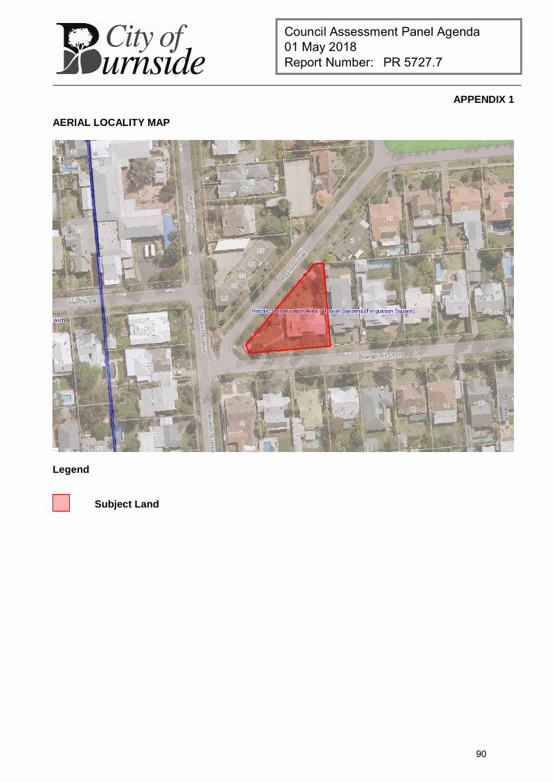
Council Assessment Panel Agenda 01 May 2018 Report Number: PR 5727.7
APPENDIX 1
AERIAL LOCALITY MAP
Legend
Subject Land
90
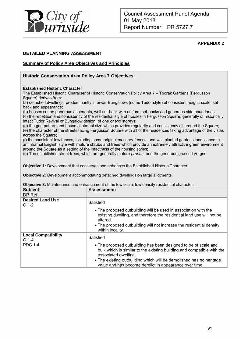
Council Assessment Panel Agenda 01 May 2018 Report Number: PR 5727.7
APPENDIX 2
DETAILED PLANNING ASSESSMENT
Summary of Policy Area Objectives and Principles
Historic Conservation Area Policy Area 7 Objectives:
Established Historic Character The Established Historic Character of Historic Conservation Policy Area 7 – Toorak Gardens (Fergusson Square) derives from: (a) detached dwellings, predominantly interwar Bungalows (some Tudor style) of consistent height, scale, set-back and appearance; (b) houses set on generous allotments, well set-back with uniform set-backs and generous side boundaries; (c) the repetition and consistency of the residential style of houses in Fergusson Square, generally of historically intact Tudor Revival or Bungalow design, of one or two storeys; (d) the grid pattern and house allotment size which provides regularity and consistency all around the Square; (e) the character of the streets facing Fergusson Square with all of the residences taking advantage of the vistas across the Square; (f) the consistent low fences, including some original masonry fences, and well planted gardens landscaped in an informal English style with mature shrubs and trees which provide an extremely attractive green environment around the Square as a setting of the intactness of the housing styles; (g) The established street trees, which are generally mature prunus, and the generous grassed verges.
Objective 1: Development that conserves and enhances the Established Historic Character. Objective 2: Development accommodating detached dwellings on large allotments. Objective 3: Maintenance and enhancement of the low scale, low density residential character. Subject:
DP Ref Assessment:
Desired Land Use
O 1-2 Satisfied
The proposed outbuilding will be used in association with the existing dwelling, and therefore the residential land use will not be altered.
The proposed outbuilding will not increase the residential density within locality.
Local Compatibility O 1-4 PDC 1-4
Satisfied
The proposed outbuilding has been designed to be of scale and bulk which is similar to the existing building and compatible with the associated dwelling.
The existing outbuilding which will be demolished has no heritage value and has become derelict in appearance over time.
91
Council Assessment Panel Agenda 01 May 2018 Report Number: PR 5727.7
Summary of Residential Zone Objectives and Principles
Primary Historic Conservation Zone Objectives: Objective 1: The conservation and enhancement of the historic character of the relevant Policy Area. Objective 2: The retention and conservation of land, buildings, outbuildings, structures, and landscape elements that contribute positively to the established historic character of a Policy Area. Objective 3: Development accommodating those housing types which are compatible with the historic character of the zone. Objective 4: Development which conserves and enhances the historic character of the relevant Policy Areas of the zone, in terms of: (a) overall and detailed design of buildings; (b) dwelling type and overall form; (c) allotment dimensions and proportions; (d) placement of buildings on the allotment and alignment to the street; (e) layout of the site and the type and height of fencing; (f) streetscapes, verge treatment and street planting; and (g) curtilages and garden areas. Objective 5: A zone where the majority of the existing housing stock is maintained through the retention of items which contribute positively to the character of the Policy Areas, and the number of dwellings is increased primarily through: (a) the replacement of dwellings that are not identified as contributory items, and (b) the appropriate development of vacant sites. Subject:
DP Ref Assessment:
Desired Land Use/Character O 1–4 Satisfied
The proposed outbuilding will be utilised for residential purposes and uses heritage detailing to sufficiently address the established historical character of the area.
The proposed outbuilding is an acceptable impact on the historic character of the locality as it is located to the rear of the contributory item. The proposed outbuilding has also been designed in a positive scale, form, and proportions.
Conservation Guidelines PDC 4
Partially satisfied The proposed garage will replace a derelict existing freestanding
garage to the rear of the existing dwelling satisfying the conservation guidelines.
The Council’s Consulting Heritage Architect has not supported the proposed garage setback of 0.6 metres, however, its dominance to the street is mitigated by the heritage detailing provided and the mature street trees lining Raymond Walk. The structure is also replacing a dilapidated shed in a very similar location.
92
Council Assessment Panel Agenda 01 May 2018 Report Number: PR 5727.7
Summary of Council Wide Objectives and Principles
Primary Residential Development Objectives:
Objective 11: Development of a high design standard and appearance that responds to and reinforces positive aspects of the local environment and built form.
Objective 55: Safe, pleasant, accessible and convenient residential areas.
Subject:
DP Ref Assessment:
Building Set-backs PDC 160 Side Set-backs
Departure. The proposed development will be 0.4 metres closer to the
secondary frontage than anticipated by the Burnside (City) development plan. However, the small departure will not significantly impact the streetscape as there is an existing outbuilding located at a distance of 1 metre from the boundary and the decrease of 0.4 metres from the boundary will not be highly noticeable. The proposed outbuilding has also been designed using heritage detail to be in line with the other dwellings within the area. This detailing reduces its dominance to the streetscape.
Another dwellings located along Raymond Walk currently have outbuildings located on the boundary.
Access and On-Site Car Parking PDC 177–182
Satisfied.
The site will allow for two off-street car parking space in accordance with the Burnside (City) Development Plan.
The outbuilding has been designed to be a single width garage to reduce its dominance to the streetscape while the site also has an existing gate next to the outbuilding which allows for a second car to be parked.
Domestic Outbuildings PDC 187–189 Satisfied
The proposed garage has been designed to be a free-standing structure to the rear of the dwelling reducing its visual dominance in relation to the existing dwelling.
The proposed garage has utilised heritage detailing and is of a scale and proportion which do not detract from the existing dwelling.
93

this page is left intentionally blank
94
Council Assessment Panel Agenda 01 May 2018 Report Number: PR 5727.8
DEVELOPMENT APPLICATION
Application Number: 180\0655\17
Applicant: Abell Design & Construction
Location: 4 Cudmore Avenue, Toorak Gardens
Proposal: Pergola including masonry pillars
Zone/Policy Area: Historic Conservation Zone
Historic Conservation Policy Area 6 - Toorak Gardens (North)
Development Plan consolidated 30 May 2017
Kind of Assessment: Merit
Public Notification: Category 1
Appeal Opportunity None
Referrals – Non Statutory: Local Heritage Consultant
Delegations Policy: Local Heritage Consultant recommends refusal
Recommendation: Development Plan Consent be granted
Recommending Officer: Renae Grida
REPORT CONTENTS
Assessment report: - Appendix 1 – Aerial Locality Map - Appendix 2 – Detailed Planning Assessment
Please note that due to Federal Copyright Law restrictions, attachments associated with the proposed development are not made available to the public.
Documentation provided as attachments to the report to members of the Council Assessment Panel to facilitate decision making: Plans and supporting documents Internal agency referral reports Photographs
95
Council Assessment Panel Agenda 01 May 2018 Report Number: PR 5727.8
1. DESCRIPTION OF PROPOSAL
The applicant seeks Development Plan Consent for the construction of an open pergola situated forward of the original building line, including masonry pillars to match existing.
2. BACKGROUND
Development Application 180\0655\17 was lodged on 04 August 2017 by Abell Design & Construction on behalf of the registered owners of the land. The application was determined to be a merit form of development pursuant to Section 35(5) of the Development Act 1993. For the purposes of public notification, the proposal does not comprise a dwelling, fence or outbuilding as identified by the Historic Conservation Zone, Principle of Development Control 27, and as such is deemed a Category 1 form of development, pursuant to Schedule 9, Part 1, 2(d) and (g) of the Development Regulations 2008. The site has benefitted from a number of previous development authorisations of which are notable on site at present: DA 180\0194\13 Addition to existing carport and front fence (masonry) DA 180\0732\94 Upper level addition to detached dwelling and carport on side
boundary DA 180\0520\90 Swimming pool DA 180\0818\89 Garage on side boundary DA 180\0019\85 Tool shed on side and rear boundaries
The application underwent an internal referral process to Council’s Local Heritage Consultant, where the outcome is such that Council’s Local Heritage Consultant does not support the proposal. The application is now presented to the Council Assessment Panel (the Panel) as a Category 1 form of development with a staff recommendation that Development Plan Consent be granted.
3. SUBJECT LAND AND LOCALITY ATTRIBUTES
3.1. Subject Land
The subject land is located on the eastern side of Cudmore Avenue in the suburb of Toorak Gardens. The subject dwelling is identified by the Burnside (City) Development Plan as a contributory item, and the subject land is located wholly within the Historic Conservation Zone, and more specifically, Historic Conservation Policy Area 6 – Toorak Gardens (North). The land currently contains a substantial two-storey bungalow style detached dwelling, including ancillary structures such as carports, masonry front fencing, swimming pool and outbuilding(s).
3.2. Locality
The locality in the case of the subject land encompasses a number of varying zones and policy areas as identified by the Burnside (City) Development Plan (refer Figure 1 below).
96
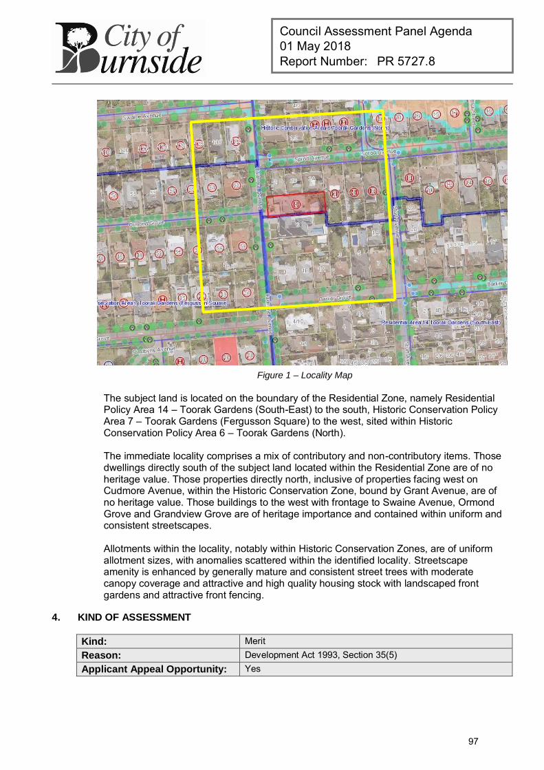
Council Assessment Panel Agenda 01 May 2018 Report Number: PR 5727.8
Figure 1 – Locality Map
The subject land is located on the boundary of the Residential Zone, namely Residential Policy Area 14 – Toorak Gardens (South-East) to the south, Historic Conservation Policy Area 7 – Toorak Gardens (Fergusson Square) to the west, sited within Historic Conservation Policy Area 6 – Toorak Gardens (North). The immediate locality comprises a mix of contributory and non-contributory items. Those dwellings directly south of the subject land located within the Residential Zone are of no heritage value. Those properties directly north, inclusive of properties facing west on Cudmore Avenue, within the Historic Conservation Zone, bound by Grant Avenue, are of no heritage value. Those buildings to the west with frontage to Swaine Avenue, Ormond Grove and Grandview Grove are of heritage importance and contained within uniform and consistent streetscapes. Allotments within the locality, notably within Historic Conservation Zones, are of uniform allotment sizes, with anomalies scattered within the identified locality. Streetscape amenity is enhanced by generally mature and consistent street trees with moderate canopy coverage and attractive and high quality housing stock with landscaped front gardens and attractive front fencing.
4. KIND OF ASSESSMENT
Kind: Merit Reason: Development Act 1993, Section 35(5) Applicant Appeal Opportunity: Yes
97
Council Assessment Panel Agenda 01 May 2018 Report Number: PR 5727.8
5. PUBLIC NOTIFICATION
Category: Category 1 Reason: Development Regulations 2008, Schedule 9, Part 1, 2(d) –
pergola Development Regulations 2008, Schedule 9, Part 1, 2(g) – masonry pillars
Third Party Appeal Opportunity: No
6. AGENCY REFERRALS
Internal agency referrals are provided as an attachment to the Panel.
7. EXECUTIVE SUMMARY
7.1. Land Use
In relation to the current proposal, the following comments are made: The subject land is currently and lawfully used for residential purposes. The proposed development is ancillary to the existing use of the land. The proposed development is not considered significantly adverse to the heritage
values of the contributory item. If the proposal can be seen to be sufficiently in accordance with the Development
Plan, it may not be considered seriously at variance in this respect. The proposed development is therefore not considered to be seriously at variance to the Burnside (City) Development Plan.
7.2. Character and Amenity
The policy area and the Historic Conservation Zone in general seek to conserve and enhance the established historic character and fabric of the area. The subject land whilst located in Historic Conservation Policy Area 6, is nestled in a location that borders both Historic Conservation Policy Area 7 and Residential Policy Area 14, where the immediate streetscape exhibits a less uniform and consistent pattern of contributory dwelling examples, as well as later infill development, and a number of secondary street frontages where there is less contribution to the streetscape.
In the case of the proposed pergola, it is to be sited forward of the dwelling, noting that it is not proposed to protrude any closer to the property frontage than that of an existing and lawful carport sited forward of the dwelling. Concerns were raised by Council’s Local Heritage Consultant with respect to setbacks, the visibility of the proposed structure and bulkiness resulting from the associated proposed masonry pillars. The pillars are to match the existing pillars seen beneath the existing verandah, of which have been replicated with the existing front fence, from materials sourced to match the original dwelling. It is noted that the pillars will not be largely visible from the public realm due to the presence of the existing fence that spans the width of the allotment. The pergola itself, is an open sided and open roofed structure, conditioned that it is not to be enclosed. With respect to setbacks, the policy area seeks a minimum setback of 8m from the front property boundary. The proposed pergola is to be setback 9.4m from the front property boundary, aligning with the existing carport, sited forward of the existing building line, of which was subject to a previous development authorisation.
98
Council Assessment Panel Agenda 01 May 2018 Report Number: PR 5727.8
The Historic Conservation Zone seeks no alteration or addition to a building that contributes significantly to the historic character of the zone in a manner or to an extent which will diminish significantly the amount of that contribution. The siting, low degree of visibility and openness of the proposed structure is not considered to unreasonably detract from the contributory values of the dwelling. It is further considered that given the location of the subject dwelling amongst non-heritage adjacencies, and the presence of the existing masonry front fence, streetscape character is not unduly diminished as a result of the proposed development.
7.3. Agency Referrals
As the proposed development affects land within the Historic Conservation Zone and an identified contributory item, referral to Council’s Local Heritage Consultant was undertaken. Advice received with respect to the proposal is as such: “The proposed pergola would sit forward of the existing dwelling and despite its openness will largely produce a space that will be visually incorporated into the mass of the building. It is not supported in its current location as it is sited forward of the dwelling.”
Alternative design considerations were suggested to Council’s Local Heritage Consultant via Council staff, such as removing the pillars as proposed and using timber posts to reduce visual massing of the structure. Further concerns were put forward by the Heritage Consultant, advising that the proposed structure does not accord with requirements for setbacks, does not reflect the streetscape character including open front gardens, and additional reservations regarding the ability of the proposed structure to be enclosed using temporary patio blinds. It has been confirmed by Council’s Local Heritage Consultant that the proposal is in keeping with the style and design of the original residence. As such, the issue from a heritage perspective is solely the siting of the structure forward of the dwelling, the potential for installation of blinds and an unclear use of the structure. It is noted that the pergola will be open (no enclosed sides or roof).
7.4. Conclusion
Having regard to all of the relevant Objectives and Principles of Development Control of the Burnside (City) Development Plan, the proposed development is not considered seriously at variance with, and is generally in accordance with, the policies of the Development Plan.
8. RECOMMENDATIONS
It is recommended that the Council Assessment Panel resolve that:
1. The proposed development is not seriously at variance with the policies in the Development Plan; and
2. Development Application 180\0655\17, by Abell Design & Construction is granted Development Plan Consent subject to the following conditions:
Conditions
1 The development granted Development Plan Consent shall be undertaken in accordance with the stamped approved plans, drawings, specifications and other documents submitted to the Council that are relevant to the consent to the reasonable satisfaction of the Council, except where varied by conditions below.
99
Council Assessment Panel Agenda 01 May 2018 Report Number: PR 5727.8
Reason:
To ensure the development is undertaken in accordance with the plans and details submitted.
2 The pergola as depicted on the stamped plans granted Development Plan Consent shall remain an open structure at all times with no walls or doors attached to any elevation of the structure. Reason:
To ensure the proposal is developed in accordance with the approved plans.
RECOMMENDING OFFICER
Renae Grida Development Officer – Planning
100
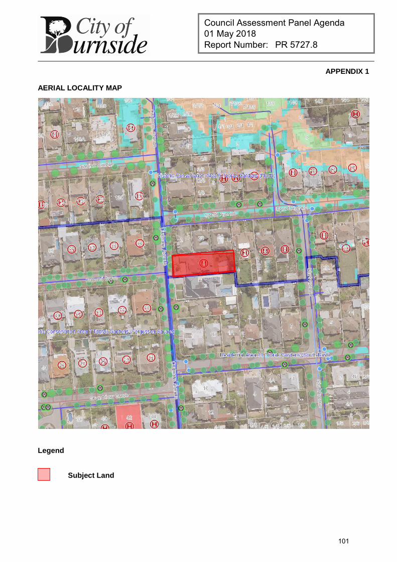
Council Assessment Panel Agenda 01 May 2018 Report Number: PR 5727.8
APPENDIX 1
AERIAL LOCALITY MAP
Legend
Subject Land
101
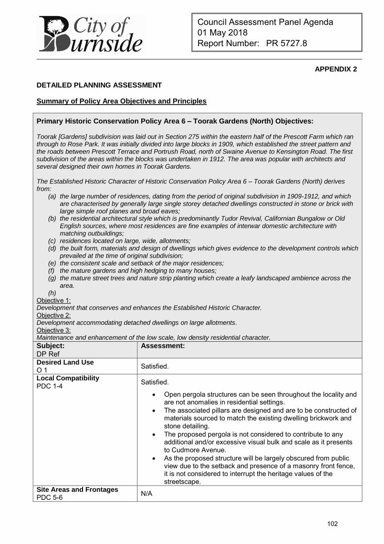
Council Assessment Panel Agenda 01 May 2018 Report Number: PR 5727.8
APPENDIX 2
DETAILED PLANNING ASSESSMENT
Summary of Policy Area Objectives and Principles
Primary Historic Conservation Policy Area 6 – Toorak Gardens (North) Objectives: Toorak [Gardens] subdivision was laid out in Section 275 within the eastern half of the Prescott Farm which ran through to Rose Park. It was initially divided into large blocks in 1909, which established the street pattern and the roads between Prescott Terrace and Portrush Road, north of Swaine Avenue to Kensington Road. The first subdivision of the areas within the blocks was undertaken in 1912. The area was popular with architects and several designed their own homes in Toorak Gardens. The Established Historic Character of Historic Conservation Policy Area 6 – Toorak Gardens (North) derives from:
(a) the large number of residences, dating from the period of original subdivision in 1909-1912, and which are characterised by generally large single storey detached dwellings constructed in stone or brick with large simple roof planes and broad eaves;
(b) the residential architectural style which is predominantly Tudor Revival, Californian Bungalow or Old English sources, where most residences are fine examples of interwar domestic architecture with matching outbuildings;
(c) residences located on large, wide, allotments; (d) the built form, materials and design of dwellings which gives evidence to the development controls which
prevailed at the time of original subdivision; (e) the consistent scale and setback of the major residences; (f) the mature gardens and high hedging to many houses; (g) the mature street trees and nature strip planting which create a leafy landscaped ambience across the
area. (h)
Objective 1: Development that conserves and enhances the Established Historic Character. Objective 2: Development accommodating detached dwellings on large allotments. Objective 3: Maintenance and enhancement of the low scale, low density residential character.
Subject:
DP Ref Assessment:
Desired Land Use O 1 Satisfied.
Local Compatibility
PDC 1-4 Satisfied.
Open pergola structures can be seen throughout the locality and are not anomalies in residential settings.
The associated pillars are designed and are to be constructed of materials sourced to match the existing dwelling brickwork and stone detailing.
The proposed pergola is not considered to contribute to any additional and/or excessive visual bulk and scale as it presents to Cudmore Avenue.
As the proposed structure will be largely obscured from public view due to the setback and presence of a masonry front fence, it is not considered to interrupt the heritage values of the streetscape.
Site Areas and Frontages PDC 5-6
N/A
102
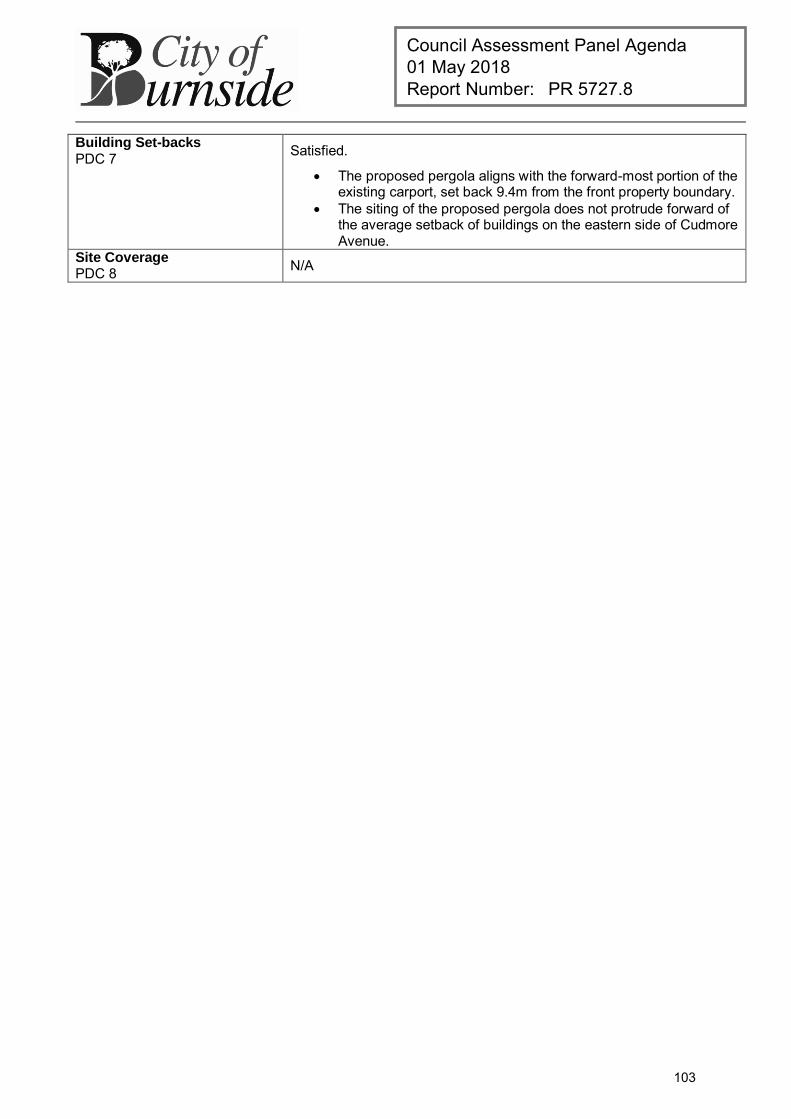
Council Assessment Panel Agenda 01 May 2018 Report Number: PR 5727.8
Building Set-backs
PDC 7 Satisfied.
The proposed pergola aligns with the forward-most portion of the existing carport, set back 9.4m from the front property boundary.
The siting of the proposed pergola does not protrude forward of the average setback of buildings on the eastern side of Cudmore Avenue.
Site Coverage PDC 8 N/A
103
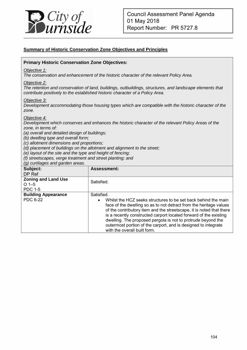
Council Assessment Panel Agenda 01 May 2018 Report Number: PR 5727.8
Summary of Historic Conservation Zone Objectives and Principles
Primary Historic Conservation Zone Objectives:
Objective 1: The conservation and enhancement of the historic character of the relevant Policy Area.
Objective 2: The retention and conservation of land, buildings, outbuildings, structures, and landscape elements that contribute positively to the established historic character of a Policy Area.
Objective 3: Development accommodating those housing types which are compatible with the historic character of the zone.
Objective 4: Development which conserves and enhances the historic character of the relevant Policy Areas of the zone, in terms of: (a) overall and detailed design of buildings; (b) dwelling type and overall form; (c) allotment dimensions and proportions; (d) placement of buildings on the allotment and alignment to the street; (e) layout of the site and the type and height of fencing; (f) streetscapes, verge treatment and street planting; and (g) curtilages and garden areas.
Subject:
DP Ref Assessment:
Zoning and Land Use O 1–5 PDC 1-5
Satisfied.
Building Appearance PDC 6-22
Satisfied. Whilst the HCZ seeks structures to be set back behind the main
face of the dwelling so as to not detract from the heritage values of the contributory item and the streetscape, it is noted that there is a recently constructed carport located forward of the existing dwelling. The proposed pergola is not to protrude beyond the outermost portion of the carport, and is designed to integrate with the overall built form.
104
Council Assessment Panel Agenda 01 May 2018 Report Number: PR 5727.9
DEVELOPMENT APPLICATION
Application Number: 180\0132\18
Applicant: Wendy's ELC Holdings Pty Ltd
Location: 47 Glen Osmond Road, Eastwood
Proposal: Amendment to DA 180\1031\16 - Reconfiguration of rear entrance fencing (retrospective)
Zone/Policy Area: Business (Glen Osmond Road) Zone
Historic Conservation Zone
Development Plan consolidated 19 December 2017
Kind of Assessment: Merit
Public Notification: Category 1
Appeal Opportunity Applicant only, no third party appeal rights
Referrals – Statutory: N/A
Referrals – Non Statutory: Local Heritage Consultant
Delegations Policy: Manager’s discretionary determination
Recommendation: Development Plan Consent be granted
Recommending Officer: James Moss
REPORT CONTENTS
Assessment report: - Appendix 1 – Aerial Locality Map
Please note that due to Federal Copyright Law restrictions, attachments associated with the proposed development are not made available to the public.
Documentation provided as attachments to the report to members of the Council Assessment Panel to facilitate decision making: Plans and supporting documents Internal agency referral reports Photographs February 2017 DAP minutes, report and attachments
105
Council Assessment Panel Agenda 01 May 2018 Report Number: PR 5727.9
1. DESCRIPTION OF PROPOSAL
The applicant seeks retrospective Development Plan Consent for design changes relating to the siting and construction of two rendered walls adjacent the rear car park approved under a previous development application (DA 180\1031\16). The proposed changes can be summarised as follows:
The existing access ramp on the western side of the car park entrance has been retained and adjacent landscape area reduced in width accordingly;
The eastern wall closest to Main Street is no longer angled, but instead runs parallel with the road boundary, albeit with step providing a staggered set back of .04 metres and 1.5 metres;
The western wall set further inside the subject land is no longer angled, but runs parallel to the road boundary and has been reduced in height from 2 metres to 1.5 metres;
Both walls will be of blueboard construction rather than masonry constructed.
All remaining aspects of the approved development remain as approved under DA 180\1031\16.
2. BACKGROUND
The development in question was originally granted Development Plan Consent on 07 February 2017 by the then Development Assessment Panel (DAP), subject to three conditions. Following commencement of construction on site Council’s attention was drawn by adjacent residents to apparent inconsistencies in the design of the rear car park, specifically the siting and materials involved in the construction of the two rendered walls adjacent the Main Street frontage. Council’s compliance officers inspected the site and determined works undertaken were in fact inconsistent with the approval issued by the DAP. A caution letter was issued requesting that the works on site be rectified to align with the approval or retrospective approval be sought. The owner of the land has sought the latter of the two options and is now seeking retrospective approval for the development as constructed. The amendment application, DA 180\0132\18, was received by Council on 19 February 2018 and determined to be a Category 1 form of development pursuant to Schedule 9, Part 1, 2 (g) of the Development Regulations 2008, to be assessed on merit against the relevant provisions of the Burnside (City) Development Plan. The application was referred to Council’s Local Heritage Consultant, given the dual zoning of the land which places the approved rear car park within the Historic Conservation Zone. An assessment has now been completed and the application is presented to the Council Assessment Panel (CAP) in accordance with the discretionary powers afforded to the Manager City Development and Safety, with a staff recommendation of approval.
3. SUBJECT LAND AND LOCALITY ATTRIBUTES
3.1. Subject Land
The subject land is an irregular shaped allotment with two street frontages, the primary frontage being to the north-eastern side of Glen Osmond Road of some 36.58 metres and
106
Council Assessment Panel Agenda 01 May 2018 Report Number: PR 5727.9
the secondary frontage facing Main Street to the rear of some 39.58 metres. The land has an approximate site area of 2503 square metres, which is split over two zones with the majority of the site being located within the Business (Glen Osmond Road) Zone and a smaller rear portion being located within the Historic Conservation Zone (Policy Area 2 – Eastwood). The site contains a large single storey building identified as a Local Heritage Place under Table Bur/2 in the Development Plan. The extent of the listing refers to ‘Nursing Home – Anaster – former Residence’ and the description reads ‘external form and fabric of the 1877 bluestone building. Key features include projecting gable ended wings and bay windows, Bluestone walls, rendered dressings and prominent chimneys. The building has undergone extensive additions in the past, and has formerly been used as an aged care facility.
3.2. Locality
The locality comprises those properties on either side of Glen Osmond Road extending approximately 200 metres in each direction, based on a visual connection to the subject site. The locality extends to the north and east to properties fronting Main Street, given the site has a secondary road frontage to Main Street. The locality spans across two metropolitan Council jurisdictions and differing zones. The City of Burnside Business (Glen Osmond Road) Zone comprises those properties fronting Glen Osmond Road on the north-eastern side of the road and a small number of properties fronting Main Street, with the remaining properties fronting Main Street being located within the Historic Conservation Zone (Policy Area 2 – Eastwood). The opposite side of Glen Osmond Road sits within the City of Unley, and is zoned Office 1. The locality consists primarily of a broad collection of commercial businesses and on-site car parking facilities. Medium density low scale dwellings of historic significance are to be found along Main Street to the rear of the site.
4. KIND OF ASSESSMENT
Kind: Merit Reason: Development Act 1993, Section 35(5) Applicant Appeal Opportunity: Yes
5. PUBLIC NOTIFICATION
Category: Category 1 Reason: Development Regulations 2008, Schedule 9, Part 1, 2 (g)
6. AGENCY REFERRALS
Internal agency referrals are provided as an attachment to the Panel.
7. EXECUTIVE SUMMARY
7.1. Proposed Amendments
The proposed amendments are limited to the redesign of two rendered walls adjacent the Main Street road boundary, which screen the rear staff car park from the street.
107

Council Assessment Panel Agenda 01 May 2018 Report Number: PR 5727.9
All other aspects of the development granted approval under DA 180\1031\16 remain unaltered as approved. For the purpose of clarity each change is addressed individually below:
The existing access ramp on the western side of the car park entrance has been retained and adjacent landscape area reduced in width accordingly.
This change is viewed positively as the retention of the access ramp improves accessibility to the existing building and aligns more closely with those provisions of the Development Plan that seek to provide facilities designed for broad accessibility, including for aged and disabled members of the community.
The eastern wall closest to Main Street is no longer angled, but instead runs parallel with the road boundary, albeit with step providing a staggered set back of 0.4 metres and 1.5 metres.
Having reviewed existing fencing arrangements along both sides of Main Street, the squaring off of the eastern wall appears to be more consistent with the established character of the locality than the siting of the wall at an angle. The inclusion of a step in the design provides articulation and visual interest to break up the total length of the wall adjacent the boundary. Council’s Local Heritage Consultant has reviewed the proposal and has confirmed there is no conflict with the heritage-based principles of the Development Plan.
The western wall set further inside the subject land is no longer angled, but runs parallel to the road boundary and has been reduced in height from 2 metres to 1.5 metres;
As with the siting of the eastern wall, the squaring off of the western wall appears more consistent with the general siting and appearance of fencing structures observable within the locality. The modest reduction in height from 2 metres to 1.5 metres provides greater visual permeability into the site, while retaining adequate visual screening of the car park from Main Street. The reduction in height is also more closely aligned with the scale of existing fencing structures observes along Main Street. Council’s Local Heritage Consultant has reviewed the proposal and has confirmed there is no conflict with the heritage-based principles of the Development Plan.
Both walls will be of blueboard construction rather than masonry constructed.
There are no visual implications from this aspect of the amended proposal as the approved walls were to be rendered and the proposed walls are also to be rendered. From a visual perspective the end result is the same. In terms of the quality of finish that has been provided this appears to have been executed to a high standard. Council’s Local Heritage Consultant has reviewed the proposal and has confirmed there is no conflict with the heritage-based principles of the Development Plan. While it could be argued that the change in construction materials from masonry to blueboard offers less in terms of acoustic buffering to adjacent residences on Main Street the nature and scale of activities on this portion of the site are not considered inappropriate or excessive.
108
Council Assessment Panel Agenda 01 May 2018 Report Number: PR 5727.9
Key factors supporting this conclusion include the historic use of this portion of the land as a car park with far less screening, the imposition of a condition on the previous authorisation restricting use of the car park to staff members only and the character of the locality which includes the presence of similar (or arguably more invasive) parking arrangements long established along the southern side of Main Street. In relation to landscaping, the amended proposal does not seek to alter the landscaping included in the original approval and reinforced by supplementary condition to that approval. The retention of the existing access ramp will moderately narrow a portion of the area adjacent the western wall previously identified for landscaping, however the benefits of improving disabled access outweigh the loss of available space in this instance. The applicant has confirmed the Boston Ivy will be retained in the amended scheme.
7.2. Conclusion
Having regard to all of the relevant Objectives and Principles of Development Control of the Burnside (City) Development Plan, the proposed development is not considered seriously at variance with, and is generally in accordance with, the policies of the Development Plan.
8. RECOMMENDATIONS
It is recommended that the Council Assessment Panel resolve that:
1. The proposed development is not seriously at variance with the policies in the Development Plan; and
2. Development Application 180\0132\18, by Wendy's ELC Holdings Pty Ltd, is granted Development Plan Consent subject to the following conditions:
Conditions
1 The development granted Development Plan Consent shall be undertaken in accordance with the stamped approved plans, drawings, specifications and other documents submitted to the Council that are relevant to the consent to the reasonable satisfaction of the Council. Reason:
To ensure the development is undertaken in accordance with the plans and details submitted.
Advisory Notes
1 Previous Consent
The applicant should be aware that the conditions of approval and advices issued with the previous consent (180\1031\16) where relevant remain valid and should be complied with.
RECOMMENDING OFFICER
James Moss Acting Team Leader – Planning
109
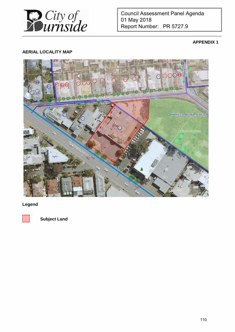
Council Assessment Panel Agenda 01 May 2018 Report Number: PR 5727.9
APPENDIX 1
AERIAL LOCALITY MAP
Legend
Subject Land
110