coral baseline survey of maalea harbor - hawaii...
TRANSCRIPT
CORAL BASELINE SURVEY OF MA’ALAEA HARBOR FOR LIGHT-DRAFT VESSELS, ISLAND OF MAUI
Paul L. Jokiel and Eric K. Brown, Hawai’i Institute of Marine Biology - March 13, 1998
Page 1 of 21 pages
Introduction:
Ma’alaea small boat harbor on the south central coast of Maui is a multi-use facility for recreational and commercial boaters (Figure 1). Originally constructed in 1952 with a single breakwater facing the south and a 12 foot deep entrance channel, it was further enclosed by the east breakwater in 1958 (AECOS, 1994). It is one of only 2 berthing areas for light-draft vessels on Maui. The harbor entrance opens to the south and is subjected to strong southerly swells that enter the bay. Modification of the harbor is proposed to reduce swell activity responsible for boat damage.
Prior to construction, this area consisted of reef flats divided by a shallow channel leading to the approximate area of the present day Ma’alaea General Store (Figure 2). Data from cores taken in 1980 during the preparation of the General Design Memorandum and Final Environmental Impact Statement provide information relevant to the geological history of the reef flat (USACE, 1980). A crust of limestone breccia approximately 1’ in thickness, overlies unconsolidated clastic marine sediments of coral sands, gravels and rubble (USACE, 1980). The 2 cores taken within the harbor showed a 10’-12’ layer of reef material overlying a reddish-brown clay. The south breakwater and east mole were constructed on top of these reef platforms. The central channel, which in the late 1800’s was less than 6’ deep, was dredged along with portions of the harbor interior to its present depth of 8’-12’.
In 1968 the United States Congress approved funding for renovations to the existing harbor. Subsequently, a General Design Memorandum and Final Environmental Impact Statement (EIS) was prepared in 1980 for the U.S. Army Corps of Engineers (USACE, 1980). The project, however, did not receive funding until 1989 (Forestell and Brown, 1991). A supplemental EIS was prepared in 1994 which included additional data on algae and endangered humpback whales. This document also included the renovation plans from the 1980 EIS for enhancing existing harbor facilities, increasing the number of berths and construction of an additional breakwater fronting the harbor to reduce swell within the harbor.
This proposed modification and expansion of the harbor raised concerns about the negative impact on coral reefs in and around the harbor as well as the impact on recreational surfing sites and nearby coastline developments. Biological impacts include siltation on nearby reefs from dredging operations and physical destruction of the reef habitat during construction of the breakwater and channel entrance. All parties involved were interested in evaluating possible mitigation measures. In order to assess habitat loss and potential damage to the adjacent coral reef ecosystem it was necessary to determine the extent and structure of the coral habitat through a series of underwater surveys. This information in turn will be used to recommend type and extent of mitigation activity.
Scope of the Present Report:
The scope of work for the report was to:
CORAL BASELINE SURVEY OF MA’ALAEA HARBOR FOR LIGHT-DRAFT VESSELS, ISLAND OF MAUI
Paul L. Jokiel and Eric K. Brown, Hawai’i Institute of Marine Biology - March 13, 1998
Page 2 of 21 pages
1. Define and map the extent of various benthic habitats in and around Ma’alaea harbor. These data quantify the amount of coral that would be affected by the proposed harbor expansion.
2. Conduct detailed quantitative transects. Data taken include substrate types, coral cover, coral diversity, fish density and fish diversity. Fish community structure was also characterized in relation to coral coverage and fish trophic groups to examine the effect of harbor modification and expansion on fish populations.
3. Based on these data and prior experience with coral transplantation at other sites, develop recommendations for mitigation measures before, during and after harbor expansion. These recommendations include the identification of potential transplant sites, the quantity of coralspecies appropriate for transplantation and suggestions for various transplant techniques that might be used in this effort.
4. Include observations on threatened and endangered species habitat within the Ma’alaea area. One request was to identify the location and extent of the area known as "Turtle reefs" in relation to the harbor.
Methods:
Study Site
Ma’alaea Bay is located on the south central coast of Maui (Figure 1). The harbor area is protected by the south breakwater (Figure 3) and the eastern mole, creating a shallow basin approximately 8 - 12’ (2.4 - 3.7m) in depth (Figure 4). The harbor bottom consists primarily of soft sediments with remnants of the former reef flat still present within the central and eastern portion of the basin. Live coral reefs have developed along the east and west slopes of the dredged channel and turning basin.
The area outside of the harbor fronting the south breakwater is the pre-existing limestone platform with a thin veneer of sand that is transient over the substrate. This area is characterized by very low coral cover. Near the dredged channel entrance, coral coverage approaches 50-75% (USFWS, 1994). East of the harbor there is a band of high coral cover along the reef face from 3’ to 20’ (1m-6m) in depth. A more complete qualitative description of the overall marine environment inside and outside of the harbor is given in the USFWS report (1994), the EIS for the Maui Ocean Center (AECOS, 1994), and by William A. Brewer and Associates (1987).
Mapping of the coral community
Habitat types and coral coverage within the study area were mapped. A series of surveys were conducted on December 15, 1997, January 13, 15, and 16, 1998 using a 4 person team consisting of an observer with a lookbox, data recorder, navigator and vessel operator. The 17.4’ (5.3m) vessel traversed transects that followed latitude coordinates established by a Differential

CORAL BASELINE SURVEY OF MA’ALAEA HARBOR FOR LIGHT-DRAFT VESSELS, ISLAND OF MAUI
Paul L. Jokiel and Eric K. Brown, Hawai’i Institute of Marine Biology - March 13, 1998
Page 3 of 21 pages
Global Positioning System (DGPS) receiver. Approximately every .01 of a degree in Longitude the following parameters were measured; % sand, % coral rubble, % hard substrate, % coral, and % algae. In addition, the locations of major habitat boundaries were outlined as the vessel moved across the area. At each Latitude/Longitude location, supplemental data was collected on depth (from the depth sounder located on the boat), noteworthy plant and animal species and bottom topography. These data were used to produce a series of contour maps that delineate boundaries for the various types of substrates and identify major concentrations of coral coverage.
Quantitative assessment of coral coverage and fish density
The second phase involved a detailed assessment of coral coverage and fish density patterns using SCUBA along selected transects in and around the harbor. Two 25 meter lines were laid out in a parallel arrangement, separated by a 5 meter interval which created a sample area of 125m2(1,345.5ft2). A rope was used to tether the two divers in order to maintain the 5 meter width for the transect area. Each transect was marked with flagging tape at both ends so that DGPS coordinates could be obtained. After the lines were positioned, the researchers returned to the start of the transect and allowed 5 minutes for the fish to habituate. The first diver proceeded down the transect corridor and recorded the number of every species of fish seen within the transect boundaries. The second diver followed behind and used a 1m2 quadrat to measure coral coverage at the 5, 10, 15 and 20 meter mark.
Coral diversity and percent coverage were measured using the point-intercept quadrat method described by Reed (1980). This method has been used quite extensively in the literature to assess benthic community composition and detect gross changes in the reef flat community structure (Dahl, 1981; Coyer and Whitman, 1990). The quadrat was 1m2 in area and consisted of 1"(2.54cm) PVC tubing fitted with nylon line spaced 10 centimeters apart to form a grid with 81 intersections. The quadrat was placed on the substrate at 5 meter intervals and different species of coral/substrate types found underneath each intersection were recorded on underwater slates. Coral species were identified using Reef and Shore Fauna of Hawai’i, Section 1: Protozoa Through Ctenophora by Maragos (1977).
Fish population density and species richness were censused using a modified Brock transect method (Brock, 1954). It is generally recognized that conducting visual transects using SCUBA is one of the most effective ways to assess fish populations over nearshore, rocky intertidal or shallow reef habitats (Dewees, 1981; Bortone and Kimmel, 1991). Visual census techniques are advantageous because they do not disturb the habitat and are minimally disruptive to the organisms. The most severe limitation of visual estimates is underestimation of actual abundance and diversity. This is due in part to the cryptic habit of certain reef fish and the structural complexity of the reef ecosystem (Bortone and Kimmel, 1991). Data were tabulated on an underwater slate using scientific names. All fish identifications were standardized using the Guide to Hawai’ian Reef Fishes by Randall (1985) and Shore Fishes of Hawai’i by Randall (1996). Three to four transects were surveyed during each morning and afternoon dive. After each dive, the data were transcribed from the underwater slates into a notebook for later computer entry.
CORAL BASELINE SURVEY OF MA’ALAEA HARBOR FOR LIGHT-DRAFT VESSELS, ISLAND OF MAUI
Paul L. Jokiel and Eric K. Brown, Hawai’i Institute of Marine Biology - March 13, 1998
Page 4 of 21 pages
A total of 50 transects in and around the harbor were sampled across 11 days between December 1997 to January 1998 (Figure 3). Actual sampling dates with the raw data are noted in Appendix A(Coral) and B(Fish). This data was then integrated into the contour maps by recording Longitude and Latitude data for the beginning and end of each transect and incorporating the mean percent coral cover for that transect. Surveys were conducted concurrently with the mapping effort.
Fish diversity (H’) was calculated for each transect using the Shannon and Weaver diversity index formula
where pi is the proportion of the ith species in the population (Pielou, 1966). General comparisons of fish communities could then be made across different regions within the harbor and outside in close proximity. The relationship between coral coverage and the overlying fish community was also examined using regression techniques. A distinction was made between transects inside of the harbor and outside to explore any possible differences associated with altered habitats. Finally fish community structure was analyzed using trophic categories outlined by DeMartini, et. al. (1994) and supplemented by Randall (1996) (Table 1). Each transect was broken down into the trophic guilds by grouping the various fish species into their appropriate feeding categories.
Table 1: Trophic categories of Hawaiian reef fishes
Database Code Trophic Guild
C Coralivore
D Detritivore
H Herbivore
MI Mobile Invertebrates
P Piscivore
SI Sessile Invertebrates
Z Planktivore
CORAL BASELINE SURVEY OF MA’ALAEA HARBOR FOR LIGHT-DRAFT VESSELS, ISLAND OF MAUI
Paul L. Jokiel and Eric K. Brown, Hawai’i Institute of Marine Biology - March 13, 1998
Page 5 of 21 pages
The charts and contour maps of the study area, habitat boundaries, coral coverage were produced using DeltaGraph 4.0 for the PC. Statistical analyses were carried out on the transect data using Minitab and Statistica for the PC.
Potential sites for transplantation, coral species suitable for transplantation and transplant techniques.
Reconnaissance surveys were conducted on January 15th and 29th, 1998 to examine potential sites for transplantation of corals. Using the 17.4’ vessel, a 4 person team consisting of an observer with a lookbox, data recorder, navigator and vessel operator traversed the coastline in an easterly (1/15/98) and westerly (1/29/98) direction. Sites between a depth of 5’ to 40’ (1.5m-12m) were explored. Extremely calm conditions (Beaufort Sea State 0-1) coupled with high water transparency (Visibility >45’/15m) occurred during these surveys. The fortuitous conditions enabled us to conduct an extensive survey of the reef areas within 3.1 miles (5km) of the harbor.
Results
Mapping of the coral community
The greatest concentration of coral inside the harbor occurs along the dredged channel entrance near the southern tip of the east mole (Figure 5). The area of high coral cover extends into a reef face heading northward with a steep slope that separates the sand channel from the old reef flat on the inside section of the east mole. Coral coverage near the entrance is approximately 30-40%. The coral community is dominated by Montipora verrucosa, Porites compressa, Porites lobata and Montipora patula. Some uncommon species of coral were observed such as Psammocora stellata and Pavona pollicata. Another area of high coral coverage existed along the eastern edge of the triangular reef remnant in the center of the harbor. The dominant species at this reef site were M. verrucosa, P. compressa, and P. lobata. Montipora verrucosa and Pocillopora damicornis also occurred along the inside slopes of the south breakwater and northern face of the wharf.
Outside of the harbor the highest coral cover occurred on either side of the channel entrance and extends eastward along a zone from 3’ to 20’ (1m-6m) in depth (Figure 5). The area with the highest coral cover on the western side of the channel occurs as a narrow band along a north-south axis and gradually dissipates with increasing depth to 23’ (7m). On the eastern side of the channel, coral coverage was even higher and formed a rather extensive community over the reef flat. Clearly, this is the richest area of coral within the area surveyed. The dominant species included; Montipora verrucosa, Porites lobata, Montipora patula, Pocillopora meandrina and Montipora flabellata. The dominant coral species on the reef flat immediately adjacent to the east mole is M. flabellata.
CORAL BASELINE SURVEY OF MA’ALAEA HARBOR FOR LIGHT-DRAFT VESSELS, ISLAND OF MAUI
Paul L. Jokiel and Eric K. Brown, Hawai’i Institute of Marine Biology - March 13, 1998
Page 6 of 21 pages
Quantitative assessment of coral coverage and fish density
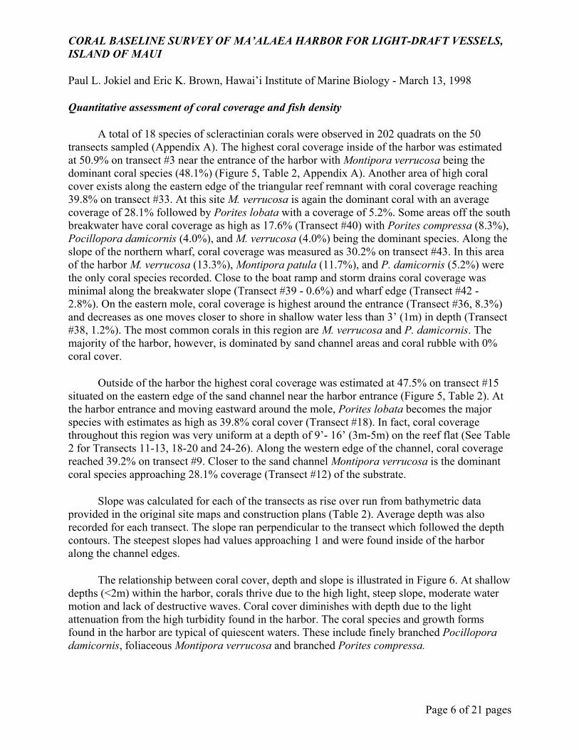
A total of 18 species of scleractinian corals were observed in 202 quadrats on the 50 transects sampled (Appendix A). The highest coral coverage inside of the harbor was estimated at 50.9% on transect #3 near the entrance of the harbor with Montipora verrucosa being the dominant coral species (48.1%) (Figure 5, Table 2, Appendix A). Another area of high coral cover exists along the eastern edge of the triangular reef remnant with coral coverage reaching 39.8% on transect #33. At this site M. verrucosa is again the dominant coral with an average coverage of 28.1% followed by Porites lobata with a coverage of 5.2%. Some areas off the south breakwater have coral coverage as high as 17.6% (Transect #40) with Porites compressa (8.3%), Pocillopora damicornis (4.0%), and M. verrucosa (4.0%) being the dominant species. Along the slope of the northern wharf, coral coverage was measured as 30.2% on transect #43. In this area of the harbor M. verrucosa (13.3%), Montipora patula (11.7%), and P. damicornis (5.2%) were the only coral species recorded. Close to the boat ramp and storm drains coral coverage was minimal along the breakwater slope (Transect #39 - 0.6%) and wharf edge (Transect #42 - 2.8%). On the eastern mole, coral coverage is highest around the entrance (Transect #36, 8.3%) and decreases as one moves closer to shore in shallow water less than 3’ (1m) in depth (Transect #38, 1.2%). The most common corals in this region are M. verrucosa and P. damicornis. The majority of the harbor, however, is dominated by sand channel areas and coral rubble with 0% coral cover.
Outside of the harbor the highest coral coverage was estimated at 47.5% on transect #15 situated on the eastern edge of the sand channel near the harbor entrance (Figure 5, Table 2). At the harbor entrance and moving eastward around the mole, Porites lobata becomes the major species with estimates as high as 39.8% coral cover (Transect #18). In fact, coral coverage throughout this region was very uniform at a depth of 9’- 16’ (3m-5m) on the reef flat (See Table 2 for Transects 11-13, 18-20 and 24-26). Along the western edge of the channel, coral coverage reached 39.2% on transect #9. Closer to the sand channel Montipora verrucosa is the dominant coral species approaching 28.1% coverage (Transect #12) of the substrate.
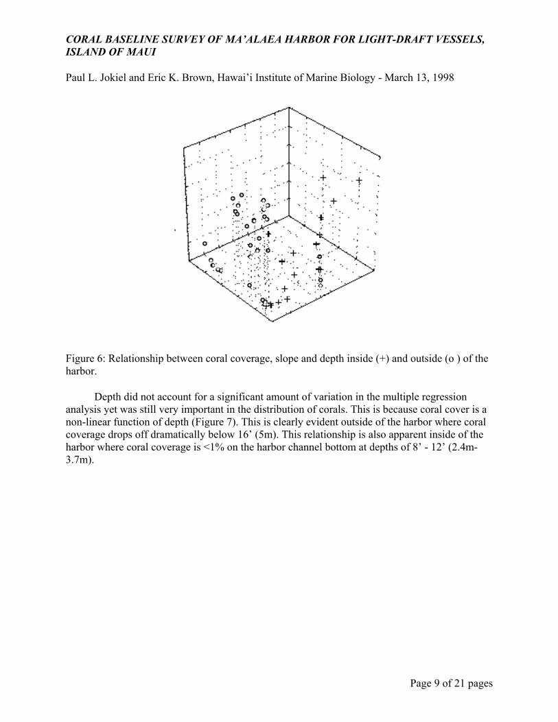
Slope was calculated for each of the transects as rise over run from bathymetric data provided in the original site maps and construction plans (Table 2). Average depth was also recorded for each transect. The slope ran perpendicular to the transect which followed the depth contours. The steepest slopes had values approaching 1 and were found inside of the harbor along the channel edges.
The relationship between coral cover, depth and slope is illustrated in Figure 6. At shallow depths (<2m) within the harbor, corals thrive due to the high light, steep slope, moderate water motion and lack of destructive waves. Coral cover diminishes with depth due to the light attenuation from the high turbidity found in the harbor. The coral species and growth forms found in the harbor are typical of quiescent waters. These include finely branched Pocillopora damicornis, foliaceous Montipora verrucosa and branched Porites compressa.
CORAL BASELINE SURVEY OF MA’ALAEA HARBOR FOR LIGHT-DRAFT VESSELS, ISLAND OF MAUI
Paul L. Jokiel and Eric K. Brown, Hawai’i Institute of Marine Biology - March 13, 1998
Page 7 of 21 pages
Outside of the harbor, areas of high coral cover are not found shallower than 3’ (1m) due to extreme wave impact, sand scouring and movement of sand and rubble across the reef flat. High coral coverage is found between 6.5’ and 16.4’ (2-5m). This zone is characterized by high light penetration and hard substrate. Seasonal wave action is high but not sufficient to dislodge the corals. Coral species and growth forms found in this area are typical of high wave energy environments. They include encrusting Montipora spp., lobate and encrusting Porites spp., and thickly branched Pocillopora spp.. Below 5 meters the substrate consists of unstable sand and rubble which is not suitable for coral colonization.
The above observations are supported by our statistical analysis. Multiple regression analysis indicated that a steep slope coincided with areas of high coral coverage but only inside (R²= .5758, F(2,15)=10.182, p<.0016) of the harbor compared with outside (R²= .0305, F(2,29)=.4563, p<.6381) of the harbor (Table 3). Slope appears to be a determining factor in the distribution of coral within an altered habitat such as a harbor. This study indicates that only areas of high vertical relief in low water motion habitats can support good coral coverage. Perhaps this is due to the fact that suspended sediments would otherwise bury the existing reef structure unless a slope is present to facilitate removal. The only steep slope outside of the harbor is along the breakwater face which does not support good coral reef cover in comparison to the adjacent habitat (e.g. Transect #16 - 7.1% vs. Transect #17 - 42.6%). At this location, however, wave energy is extremely high compared to the protected water within the harbor.
Typically, the steep reef slope fronting healthy reefs have the highest number of coral species, cover and diversity (Rodgers, 1977; Dollar, 1982; Sheppard, 1982; Jokiel and Tyler, 1992). Human altered habitats such as dredged surfaces, however, have been rarely quantified with respect to slope and coral cover. Harbor studies more often focus on water quality and degradation of the reef habitat (Dodge and Vaisnys, 1977; Maragos, 1993; AECOS, 1994).
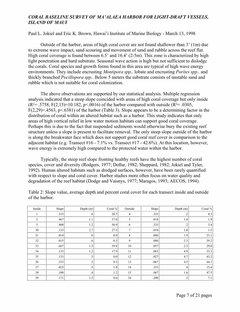
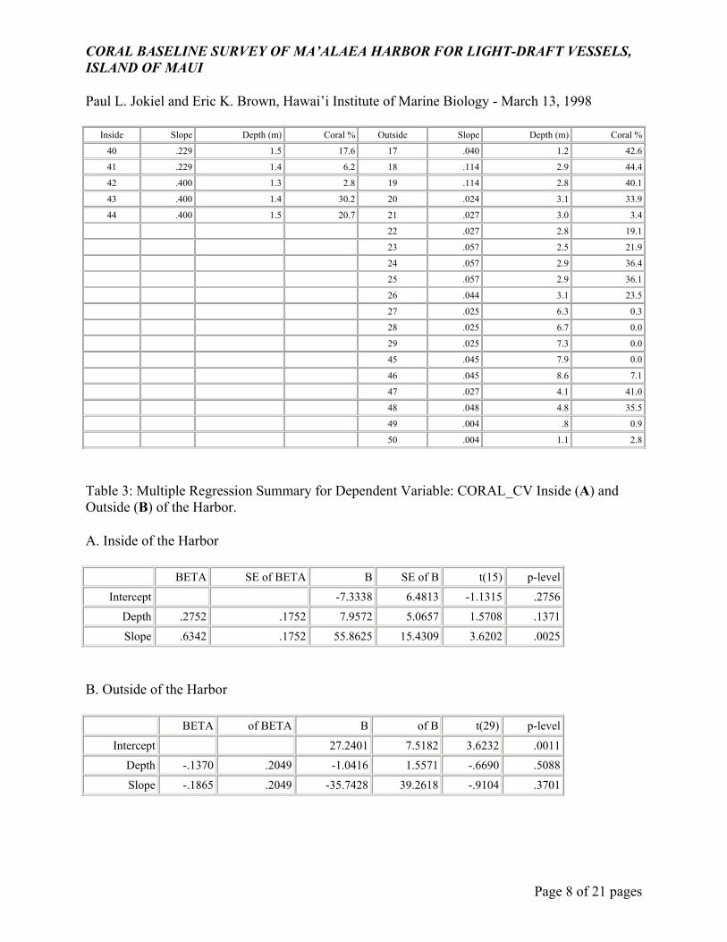
Table 2: Slope value, average depth and percent coral cover for each transect inside and outside of the harbor.
Inside Slope Depth (m) Coral % Outside Slope Depth (m) Coral %
1 .333 .8 20.7 4 .333 .2 0.3
2 .467 1.1 37.0 5 .018 1.0 1.8
3 .400 1.2 50.9 6 .333 .2 3.4
30 .133 2.7 27.5 7 .018 1.0 1.5
31 .014 .8 0.0 8 .086 1.9 23.1
32 .015 .6 0.3 9 .086 2.3 39.2
33 .667 1.5 39.8 10 .057 2.3 29.0
34 .133 1.2 17.9 11 .063 4.9 33.3
35 .133 .5 0.0 12 .027 4.7 43.2
36 .333 .5 8.3 13 .067 4.5 44.1
37 .025 .5 1.8 14 .333 .4 15.4
38 .100 .4 1.2 15 .067 1.6 47.5
39 .171 1.5 0.6 16 .200 .3 7.1
CORAL BASELINE SURVEY OF MA’ALAEA HARBOR FOR LIGHT-DRAFT VESSELS, ISLAND OF MAUI
Paul L. Jokiel and Eric K. Brown, Hawai’i Institute of Marine Biology - March 13, 1998
Page 8 of 21 pages
Inside Slope Depth (m) Coral % Outside Slope Depth (m) Coral %
40 .229 1.5 17.6 17 .040 1.2 42.6
41 .229 1.4 6.2 18 .114 2.9 44.4
42 .400 1.3 2.8 19 .114 2.8 40.1
43 .400 1.4 30.2 20 .024 3.1 33.9
44 .400 1.5 20.7 21 .027 3.0 3.4
22 .027 2.8 19.1
23 .057 2.5 21.9
24 .057 2.9 36.4
25 .057 2.9 36.1
26 .044 3.1 23.5
27 .025 6.3 0.3
28 .025 6.7 0.0
29 .025 7.3 0.0
45 .045 7.9 0.0
46 .045 8.6 7.1
47 .027 4.1 41.0
48 .048 4.8 35.5
49 .004 .8 0.9
50 .004 1.1 2.8
Table 3: Multiple Regression Summary for Dependent Variable: CORAL_CV Inside (A) and Outside (B) of the Harbor.
A. Inside of the Harbor
BETA SE of BETA B SE of B t(15) p-level
Intercept -7.3338 6.4813 -1.1315 .2756
Depth .2752 .1752 7.9572 5.0657 1.5708 .1371
Slope .6342 .1752 55.8625 15.4309 3.6202 .0025
B. Outside of the Harbor
BETA of BETA B of B t(29) p-level
Intercept 27.2401 7.5182 3.6232 .0011
Depth -.1370 .2049 -1.0416 1.5571 -.6690 .5088
Slope -.1865 .2049 -35.7428 39.2618 -.9104 .3701
CORAL BASELINE SURVEY OF MA’ALAEA HARBOR FOR LIGHT-DRAFT VESSELS, ISLAND OF MAUI
Paul L. Jokiel and Eric K. Brown, Hawai’i Institute of Marine Biology - March 13, 1998
Page 9 of 21 pages
Figure 6: Relationship between coral coverage, slope and depth inside (+) and outside (o ) of the harbor.
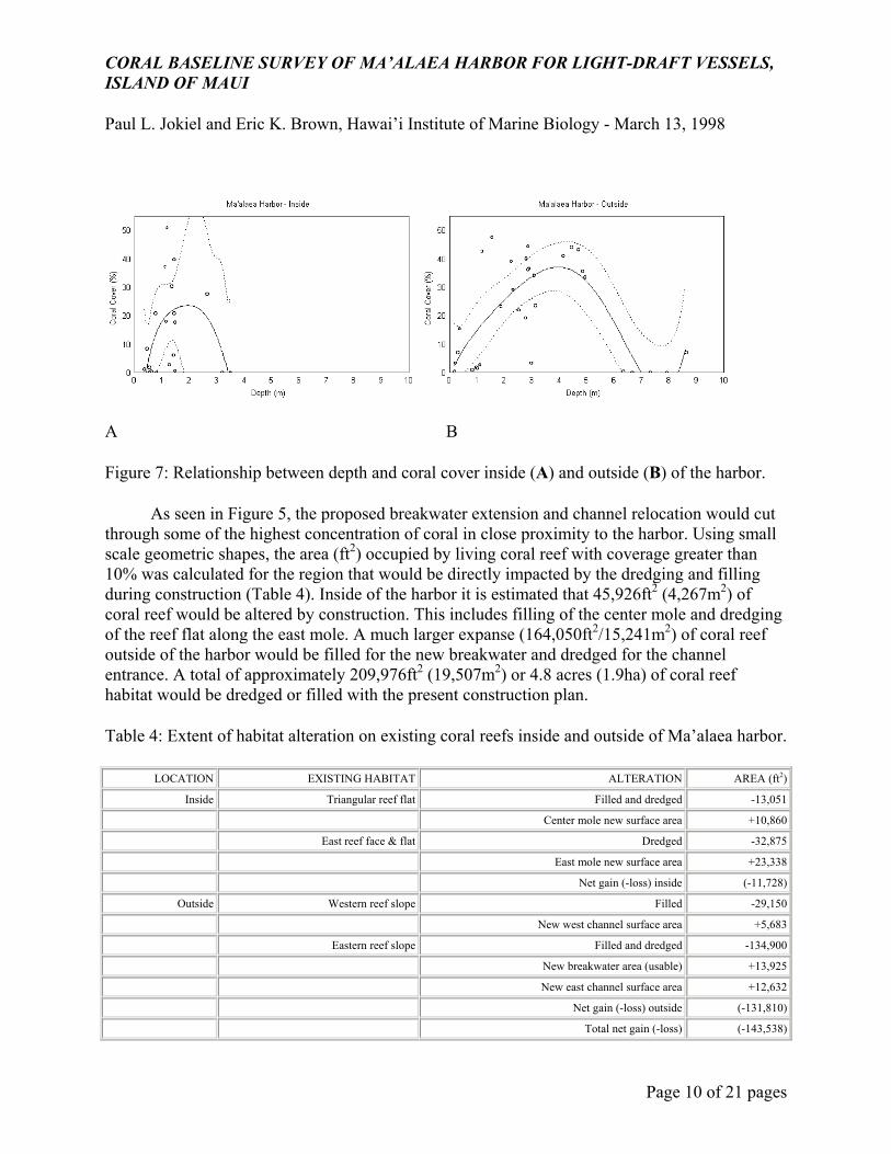
Depth did not account for a significant amount of variation in the multiple regression analysis yet was still very important in the distribution of corals. This is because coral cover is a non-linear function of depth (Figure 7). This is clearly evident outside of the harbor where coral coverage drops off dramatically below 16’ (5m). This relationship is also apparent inside of the harbor where coral coverage is <1% on the harbor channel bottom at depths of 8’ - 12’ (2.4m-3.7m).
CORAL BASELINE SURVEY OF MA’ALAEA HARBOR FOR LIGHT-DRAFT VESSELS, ISLAND OF MAUI
Paul L. Jokiel and Eric K. Brown, Hawai’i Institute of Marine Biology - March 13, 1998
Page 10 of 21 pages
A B
Figure 7: Relationship between depth and coral cover inside (A) and outside (B) of the harbor.
As seen in Figure 5, the proposed breakwater extension and channel relocation would cut through some of the highest concentration of coral in close proximity to the harbor. Using small scale geometric shapes, the area (ft2) occupied by living coral reef with coverage greater than 10% was calculated for the region that would be directly impacted by the dredging and filling during construction (Table 4). Inside of the harbor it is estimated that 45,926ft2 (4,267m2) of coral reef would be altered by construction. This includes filling of the center mole and dredging of the reef flat along the east mole. A much larger expanse (164,050ft2/15,241m2) of coral reef outside of the harbor would be filled for the new breakwater and dredged for the channel entrance. A total of approximately 209,976ft2 (19,507m2) or 4.8 acres (1.9ha) of coral reef habitat would be dredged or filled with the present construction plan.
Table 4: Extent of habitat alteration on existing coral reefs inside and outside of Ma’alaea harbor.
LOCATION EXISTING HABITAT ALTERATION AREA (ft2)
Inside Triangular reef flat Filled and dredged -13,051
Center mole new surface area +10,860
East reef face & flat Dredged -32,875
East mole new surface area +23,338
Net gain (-loss) inside (-11,728)
Outside Western reef slope Filled -29,150
New west channel surface area +5,683
Eastern reef slope Filled and dredged -134,900
New breakwater area (usable) +13,925
New east channel surface area +12,632
Net gain (-loss) outside (-131,810)
Total net gain (-loss) (-143,538)
CORAL BASELINE SURVEY OF MA’ALAEA HARBOR FOR LIGHT-DRAFT VESSELS, ISLAND OF MAUI
Paul L. Jokiel and Eric K. Brown, Hawai’i Institute of Marine Biology - March 13, 1998
Page 11 of 21 pages
Habitat loss would be partially offset by the creation of about 84,591ft2 (7,859m2) or 1.9 acres (.8ha) of new or altered habitat due to the addition of the new breakwater, dredged channel slope and interior harbor slope. Data from the present study indicate, however, that only the protected areas inside the breakwater would support coral cover greater than 5% on the breakwater itself. Therefore, the new substrate that would actually be suitable coral habitat is approximately 66,438ft2 (6,172m2) or 1.5 acres (.6ha). This breaks down to approximately 34,198ft2 (3,177m2) inside of the harbor along the center mole and east mole slope face. About 32,240ft2 (2,995m2) would be available for coral colonization outside of the existing harbor along the inside edge of the new breakwater and slope face of the channel entrance. Ultimately, this construction would directly result in a net loss of approximately 143,538ft2 (13,335m2) or 3.3 acres (1.3ha) of coral habitat. Information on habitat loss for the alternative plans (USACE, 1994) is contained in Appendix C. We do not anticipate adverse sediment damage to adjacent reefs so long as best management practices are employed. Any sediments that are carried out of the harbor would be kept in suspension by wave action and transported offshore.
On the 50 transects conducted in and around the harbor a total of 101 species of fish were observed (Appendix B). Even though fish species richness was greater outside of the harbor (79 species versus 62) than inside, this is confounded by the fact that nearly twice as many transects were surveyed outside. Both areas may have more equitable species richness with similar effort.
The highest fish densities recorded were inside of the harbor with 344 fish/125m2 recorded at transect #37. The dominant species were Yellowfin Goatfish (Mulloides vanicolensis) and Hawai’ian Flagtails (Kuhlia sandvicensis). These 2 species comprised as much as 63.4% of the total fish numbers observed around the harbor entrance and along the east mole. The harbor serves as a refuge for many juvenile species of wrasses, Stethojulis balteata & Thalassoma duperrey, surgeonfish Acanthurus triostegus & Acanthurus blochii, parrotfish Scarus psittacus, and butterflyfish, Chaetodon sp. Several species of fish not recorded on transect but noted as abundant in some areas of the harbor included mullet, Mugil cephalus, and anchovy, Encrasicholina purpurea.
Outside of the harbor fish densities were highest (176/125m2) on transect #12. The fish populations in this region were quite uniform and dominated by parrotfish Scarus psittacus, tobies Canthigaster jactator, surgeonfish Acanthurus triostegus, wrasses Stethojulis balteata & Thalassoma duperrey, and damselfish Abudefduf abdominalis & Stegastes fasciolatus (Appendix B). the highest densities of any particular species of fish occurred around the harbor entrance or along the sand channel. In deeper water over the sandy flats, fish density dropped off dramatically at transects #27, 28, and 29 (5/125m2, 2/125m2, 50/125m2).
Fish diversity patterns in and around the harbor were analyzed using the Shannon-Weaver diversity index for each transect (Table 5). There was no significant difference between fish diversity inside of the harbor and outside using a one-way ANOVA (df=49,F=.1221,p=.7283). This is primarily due to the extreme variability of the fish populations encountered across a wide variety of habitats in both areas. Therefore, the relative proportion of each species to the overall sample was quite similar.
CORAL BASELINE SURVEY OF MA’ALAEA HARBOR FOR LIGHT-DRAFT VESSELS, ISLAND OF MAUI
Paul L. Jokiel and Eric K. Brown, Hawai’i Institute of Marine Biology - March 13, 1998
Page 12 of 21 pages
Table 5: Shannon-Weaver diversity indexes (H’) for transects inside and outside of the harbor.
Inside Transect H’ Outside Transects H’ 1 0.8718 4 0.8669 2 0.9842 5 0.9705 3 1.0242 6 0.7398 30 1.0914 7 0.7815 31 0.3768 8 1.0260 32 0.8334 9 0.6990 33 1.3019 10 0.6898 34 0.9245 11 1.0357 35 0.3010 12 0.9277 36 0.9017 13 0.9009 37 0.9301 14 1.2208 38 0.7002 15 1.1993 39 0.3010 16 0.9736 40 0.8174 17 0.6986 41 0.5511 18 0.9796 42 0.7253 19 0.9263 43 0.9136 20 0.9115 44 0.8474 21 0.6004 22 0.9018 23 1.1005 24 0.7692 25 0.8255 26 0.9824 27 0.6990 28 0.3010 29 0.0000 45 0.9803 46 0.5308 47 0.8475 48 1.0836 49 0.4342 50 0.8474
CORAL BASELINE SURVEY OF MA’ALAEA HARBOR FOR LIGHT-DRAFT VESSELS, ISLAND OF MAUI
Paul L. Jokiel and Eric K. Brown, Hawai’i Institute of Marine Biology - March 13, 1998
Page 13 of 21 pages
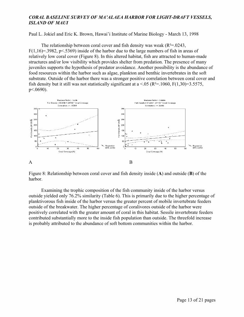
The relationship between coral cover and fish density was weak (R²=.0243, F(1,16)=.3982, p<.5369) inside of the harbor due to the large numbers of fish in areas of relatively low coral cover (Figure 8). In this altered habitat, fish are attracted to human-made structures and/or low visibility which provides shelter from predation. The presence of many juveniles supports the hypothesis of predator avoidance. Another possibility is the abundance of food resources within the harbor such as algae, plankton and benthic invertebrates in the soft substrate. Outside of the harbor there was a stronger positive correlation between coral cover and fish density but it still was not statistically significant at a <.05 (R²=.1060, F(1,30)=3.5575, p<.0690).
A B
Figure 8: Relationship between coral cover and fish density inside (A) and outside (B) of the harbor.
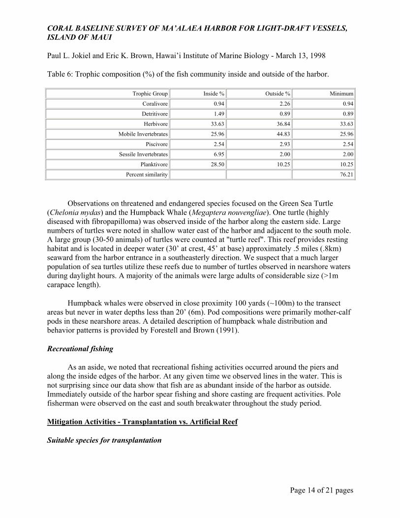
Examining the trophic composition of the fish community inside of the harbor versus outside yielded only 76.2% similarity (Table 6). This is primarily due to the higher percentage of planktivorous fish inside of the harbor versus the greater percent of mobile invertebrate feeders outside of the breakwater. The higher percentage of coralivores outside of the harbor were positively correlated with the greater amount of coral in this habitat. Sessile invertebrate feeders contributed substantially more to the inside fish population than outside. The threefold increase is probably attributed to the abundance of soft bottom communities within the harbor.
CORAL BASELINE SURVEY OF MA’ALAEA HARBOR FOR LIGHT-DRAFT VESSELS, ISLAND OF MAUI
Paul L. Jokiel and Eric K. Brown, Hawai’i Institute of Marine Biology - March 13, 1998
Page 14 of 21 pages
Table 6: Trophic composition (%) of the fish community inside and outside of the harbor.
Trophic Group Inside % Outside % Minimum
Coralivore 0.94 2.26 0.94
Detritivore 1.49 0.89 0.89
Herbivore 33.63 36.84 33.63
Mobile Invertebrates 25.96 44.83 25.96
Piscivore 2.54 2.93 2.54
Sessile Invertebrates 6.95 2.00 2.00
Planktivore 28.50 10.25 10.25
Percent similarity 76.21
Observations on threatened and endangered species focused on the Green Sea Turtle (Chelonia mydas) and the Humpback Whale (Megaptera nouvengliae). One turtle (highly diseased with fibropapilloma) was observed inside of the harbor along the eastern side. Large numbers of turtles were noted in shallow water east of the harbor and adjacent to the south mole. A large group (30-50 animals) of turtles were counted at "turtle reef". This reef provides resting habitat and is located in deeper water (30’ at crest, 45’ at base) approximately .5 miles (.8km) seaward from the harbor entrance in a southeasterly direction. We suspect that a much larger population of sea turtles utilize these reefs due to number of turtles observed in nearshore waters during daylight hours. A majority of the animals were large adults of considerable size (>1m carapace length).
Humpback whales were observed in close proximity 100 yards (~100m) to the transect areas but never in water depths less than 20’ (6m). Pod compositions were primarily mother-calf pods in these nearshore areas. A detailed description of humpback whale distribution and behavior patterns is provided by Forestell and Brown (1991).
Recreational fishing
As an aside, we noted that recreational fishing activities occurred around the piers and along the inside edges of the harbor. At any given time we observed lines in the water. This is not surprising since our data show that fish are as abundant inside of the harbor as outside. Immediately outside of the harbor spear fishing and shore casting are frequent activities. Pole fisherman were observed on the east and south breakwater throughout the study period.
Mitigation Activities - Transplantation vs. Artificial Reef
Suitable species for transplantation
CORAL BASELINE SURVEY OF MA’ALAEA HARBOR FOR LIGHT-DRAFT VESSELS, ISLAND OF MAUI
Paul L. Jokiel and Eric K. Brown, Hawai’i Institute of Marine Biology - March 13, 1998
Page 15 of 21 pages
Ma’alaea harbor contains appropriate species in sufficient quantity for transplantation to other sites. These are common species found throughout Hawai’ian waters and include Montipora verrucosa, Pocillopora meandrina, Porites compressa and P. lobata. Outside of the harbor the coral community structure is fairly typical of other coastline areas subjected to strong seasonal wave action.
There are several problems, however, with growth forms and colony size. The first issue is that coral colonies inside of the harbor are adapted to low water motion environments and as a consequence have growth forms that are more delicate and foliaceous. Many of these colonies would not survive the relocation to higher water motion regimes outside of the harbor especially during strong, seasonal southerly swells. Attachment of the colonies to the substrate would also be required.
The second point is that coral colonies on the outside of the harbor are either too large (e.g. large Porites sp.) or encrusting (e.g. Montipora sp.) to be easily transplanted. The future location of the breakwater and channel entrance will cut through vast areas of reef flat that cannot be readily fragmented into smaller movable pieces. From past experience only coral colonies of a certain size and shape can be easily moved for transplantation. There are not enough of these colony types at Ma’alaea to make this a feasible option when one considers the net area of coral habitat that will be lost.
Receiving sites for transplantation
East of the harbor, coral cover was extensive (30-60%) but tapers off at the end of the shoreline development near the park at Kanaio. Potential sites for transplantation would have to be in deeper (>20’/6m) sections of this reef area because shallow areas free of coral have sand channels that facilitate sediment removal from the existing reef. These channels are a necessary part of the reef framework and unsuitable for coral colonization. At these deeper sites, coral colonies would have to be attached to the hard substrate to prevent movement and subsequent death during high water motion events. Unfortunately, the available hard substrate has very little relief with a shallow slope gradient and is surrounded by sand so it is continually subjected to burial from the shifting sediment.
Moving eastward and further offshore the hard substrate gives way to a sandy bottom interspersed with patches of coral rubble (Maciolek, 1971). Most of this sandy substrate from Palalau (north central Ma’alaea bay) has less than 5% coral cover indicating that suitable substrate for coral recruitment and survival does not exist. In addition, the turbidity in this area is impacted by silty water discharge from Kealia Pond and large southerly swells that resuspend bottom sediments (Maciolek, 1971).
To the west of the harbor, the hard substrate of the reef flat increases in topographic relief with an increase in depth. Coral cover increases dramatically moving southwest towards McGregor point and the Scenic lookout. Several possible sites were surveyed but suitable substrate was scare. At some sites such as Wash Rock, a popular fishing and dive site, coral
CORAL BASELINE SURVEY OF MA’ALAEA HARBOR FOR LIGHT-DRAFT VESSELS, ISLAND OF MAUI
Paul L. Jokiel and Eric K. Brown, Hawai’i Institute of Marine Biology - March 13, 1998
Page 16 of 21 pages
cover approached 80%. This exceeded our criteria because supplementing an area already rich in coral and apparently in equilibrium, would not benefit the ecosystem. Other sites had a hard substrate that were depauperate of coral (<10%) indicating high water motion from seasonal south swells. Therefore, any transplantation efforts would have to be cemented to the substrate increasing labor and costs. Past experience with transplantation at Kawaihae harbor, Hawai’i, identifies similar factors (e.g. existing coral cover, water motion and sedimentation) influencing reefs that are important considerations in selecting a site (Jokiel, et.al., 1997).
Economic feasibility of transplantation
The economic aspect of transplantation is not a viable option. Any transplantation efforts at Ma’alaea would have to be conducted by commercial divers adhering to OSHA guidelines. The expense of commercial dive operations is very high compared with research projects or volunteer programs. Additional equipment, logistical support and personnel would have to be employed making commercial diving cost prohibitive. In this scenario, it is believed that artificial reef structures would be a better option by producing new habitat.
Alternatives
At present there are no areas within close proximity of Ma’alaea harbor that are under consideration for transplantation or artificial reef placement. The closest area currently designated as an artificial reef site is Keawakapu which is approximately 7miles (11.3km) from Ma’alaea harbor. Artificial reef structures already present at this site include concrete slabs, concrete filled tires and a sunken ship. Transporting extensive areas of living reef this distance, however, would be a costly undertaking. The most cost effective alternative is placement of new artificial reef structures of suitable size and material. The nearest approved site at Keawakapu is too deep (>50’) for lush development of shallow coral reefs to replace the existing harbor community. Possibly a new artificial reef site east of "Turtle Reefs" could be created in depths of 40’-50’. Using concrete or boulders to create a mound on the sand of sufficient height (15’-20’) would produce a reef similar to the "Turtle Reefs". These reefs exhibit high coral coverage (80%) and resting habitat for sea turtles. Corals, fish and sea turtles would recruit naturally to the new structures if placed in comparable depths.
Executive Summary
A detailed quantitative survey of corals and fishes leads to the following conclusions:
1. The greatest concentration of coral inside the harbor is located near the dredged channel entrance along the east mole and along the eastern face of the triangular reef remnant located in the harbor. Prior to the construction of Ma’alaea Harbor, these areas were shallow (1-3 ft) reef flats with undoubtedly little if any living coral. Areas of high slope (>.4 Rise/Run) within the harbor show coral coverage as high as 50.9%. This coral community is dominated by the common species Montipora verrucosa and Porites compressa which thrive in low water motion environments.
CORAL BASELINE SURVEY OF MA’ALAEA HARBOR FOR LIGHT-DRAFT VESSELS, ISLAND OF MAUI
Paul L. Jokiel and Eric K. Brown, Hawai’i Institute of Marine Biology - March 13, 1998
Page 17 of 21 pages
2. Outside of the harbor, coral coverage is extensive (30-40%) on both sides of the ship channel and extending eastward along the reef face at depths between 3’ to 20’ (1-6m). At these sites, slope of the reef face was low (.03-.06). This high correlation between good coral coverage and depth is attributed to suitable light conditions and moderate water motion with minimal destructive impact from waves. Little coral can be found at depths shallower than 1 m due to extreme wave action and exposure at minus tides. Substratum below 6 m consists of shifting sand/gravel that is unsuitable for coral colonization. The dominant species in the coral community outside of the harbor is Porites lobata.
3. The areal extent of coral reef that would be dredged or filled is approximately 209,976ft2 (19,507m2) or 4.8 acres (1.9 ha), using the present construction plan sponsored by the State of Hawai’i and the Federal Government. This would be partially offset by the creation of about 66,438ft2 (6,172m2) or 1.5 acres (.6ha) of new, altered habitat due to the addition of the breakwater, dredged channel slope and interior harbor slope. Overall, there will be a net loss of approximately 143,538ft2 (13,335m2) or 3.3 acres (1.3ha) of coral habitat as a result of the proposed harbor construction. These values are merely estimates because we are uncertain at this time whether the construction will result in more extensive or less extensive coral cover on the new breakwater and slope faces.
4. There were no significant differences between the fish species diversity inside of the harbor and outside. Even though fish density patterns were much more variable inside of the harbor, the proportion of each fish species within the sampled population was relatively uniform between the 2 areas.
5. The positive correlation between coral coverage and the abundance of fish is stronger outside of the harbor. The relationship weakens inside the harbor due to the large numbers of schooling juvenile fish even within areas of low coral cover. In fact, the highest fish densities recorded in this survey (344/125m2) were located inside of the harbor along the eastern mole in water depths less than 3’ (1m). The harbor serves as a valuable nursery ground for juvenile fish such as mullet, Mugil cephalus, Hawai’ian flagtail, Kuhlia sandwichensis, anchovy, Encrasicholina purpurea, butterflyfish, Chaetodon sp., and wrasses, Stethojulis balteata & Thalassoma duperrey. Coral and fish species seldom seen in Hawai’i (e.g. the coral Psammocora stellata and the stripey, Microcanthus strigatus) were also observed in the harbor.
6. Even though fish species diversity was relatively uniform in and around the harbor, the trophic composition of the community was not. The similarity index indicated that the correspondence between the two areas was only 76.2%. This is due primarily to the large proportion of planktivores within the harbor and the high numbers of mobile invertebrate feeders outside. The proportion of coralivores outside of the harbor was twice as high as inside which correlated well with the higher overall coral cover. In turn there was a threefold percentage increase of sessile invertebrate feeders inside of the harbor which can be explained by the abundance of soft bottom communities.
CORAL BASELINE SURVEY OF MA’ALAEA HARBOR FOR LIGHT-DRAFT VESSELS, ISLAND OF MAUI
Paul L. Jokiel and Eric K. Brown, Hawai’i Institute of Marine Biology - March 13, 1998
Page 18 of 21 pages
7. We conclude that the proposed expansion of the harbor will not impact green sea turtle (Chelonia mydas) populations. During the entire survey we observed only one turtle (highly diseased with fibropapilloma) inside the harbor (near the eastern mole). Large numbers of healthy turtles were noted in shallow water east of the harbor and off the south mole. A large group (30-50) of turtles were observed on "turtle reef". This reef serves as a resting habitat and is located in deeper water (30’ at crest, 45’ at base) approximately 0.5 miles (0.8km) seaward from the harbor entrance. This area will be outside of any conceivable impact due to harbor construction.
8. Humpback whales were also observed near the harbor entrance during the study period but never entered water depths shallower than 20’. The deepest penetration of the proposed breakwater is approximately 16’ so we conclude that impacts would be minimal once construction is completed. See Forestell and Brown (1991) for further details on construction impacts to humpback whales.
Recommendations
• Transplantation of corals to new locations is not an option at Ma’alaea due to lack of suitable colony sizes, growth forms and transplant sites along the coast. Either sites have extensive coral cover (>70%) in which case transplanted corals would not supplement the existing habitat over a 10 year period, or regions were relatively barren indicating harsh environmental conditions that would not support transplanted colonies of coral.
• Mitigation of habitat loss by construction of artificial reefs is the most attractive and cost effective option. In order to compensate for loss of critical reef habitat and associated fauna we estimate that an artificial reef equivalent to 143,500ft2 (13,335m2) or 3.3 acres (1.3ha) would be required. This takes into account new habitat that would be created from the construction of moles and dredging of channels through consolidated reef material. The artificial reef could be of the concrete type currently utilized by the State of Hawai’i Division of Aquatic Resources (DAR) or the sinking of derelict ship hulls in designated artificial reef zones. Overall habitat loss will be partially offset by these structures which are suitable for coral settlement. We advocate the creation of habitat at a new site near "Turtle Reefs" in similar water depths.
• During construction, efforts should be made to reduce sediment loads when dredging or filling portions of the harbor. Suspended sediments can be detrimental to coral recruitment and survival in low water motion environments with little vertical relief as is the case in protected harbor habitats. In the high water motion environment outside of the harbor, sediments are transported away to deeper depths.
• Establish a monitoring program to document indirect sediment impacts on coral coverage inside and outside of the harbor that result from construction activities. This program could
CORAL BASELINE SURVEY OF MA’ALAEA HARBOR FOR LIGHT-DRAFT VESSELS, ISLAND OF MAUI
Paul L. Jokiel and Eric K. Brown, Hawai’i Institute of Marine Biology - March 13, 1998
Page 19 of 21 pages
help develop construction protocols for future harbor projects to mitigate reef impact from suspended sediments and the resulting loss in water clarity.
CORAL BASELINE SURVEY OF MA’ALAEA HARBOR FOR LIGHT-DRAFT VESSELS, ISLAND OF MAUI
Paul L. Jokiel and Eric K. Brown, Hawai’i Institute of Marine Biology - March 13, 1998
Page 20 of 21 pages
References
AECOS, Inc., 1994. Ma’alaea triangle and Maui Ocean Center. Draft environmental assessment for a sea water system and drainage improvements. Prep. for Maui Ocean Center and Ma’alaea Triangle Partnership. AECOS No. 780: 86p.
Bortone, S.A. and J.J. Kimmel, 1991. Environmental assessment and monitoring of artificial habitats. In: Artificial Habitats For Marine and Freshwater Fisheries. Ed. W. Seaman, Jr. and L.M. Sprague. Academic Press, Inc. 177-236.
Brock, V.E., 1954. A preliminary report on a method for estimating reef fish populations. Journ. Wild. Management. 18 (3): 297-308.
Coyer, J. and J. Witman, 1990. The Underwater Catalog. A Guide to Methods in Underwater Research. Shoals Marine Laboratory.
DeMartini, E.E., F.A. Parrish and J.D. Parrish, 1994. Temporal comparisons of reef fish populations at Midway Atoll, Northwestern Hawai’ian Islands. Southwest Fisheries Science Center. Administrative Report H-94-05. 56p.
Dahl, A. L., 1981. Monitoring Coral Reefs for Urban Impact, Bulletin of Marine Science, 31(3):544-551.
Dewees, C.M., (Ed) 1981. Guidelines for Marine Ecological Surveys: Nekton. Sea Grant California, Marine Advisory Publication.
Dodge, R.E. and J.R. Vaisnys, 1977. Coral Populations and Growth Patterns: Responses to Sedimentation and Turbidity Associated with Dredging. Journ. of Mar. Res. 35(4):715-730.
Dollar, S.J., 1982. Wave Stress and Coral Community Structure in Hawai’i. Coral Reefs 1:71-81.
Forestell, P.H. and E.K. Brown, 1991. Description of Humpback Whale Use of Ma’alaea Bay, Maui, Hawai’i. Prep. for U. S. Army Corps of Engineers, Honolulu Engineer District, Environmental Resources Branch. 44p.
Jokiel, P.L. and W.A. Tyler III, 1992. Distribution of Stony Corals in Johnston Atoll Lagoon. Proceedings of the Seventh International Coral Reef Symposium, Guam 2:683-692.
Jokiel, P.L., E.F. Cox, F.T. Te and D. Irons, 1997. Mitigation of Reef Damage at Kawaihae Harbor Through Transplantation of Reef Corals. Interim Report prep. for U.S. Fish and Wildlife Service, Pacific Islands Ecoregion. 35p.
Maciolek, J., 1971. Aquatic Ecosystems of Kealia Floodplain and Ma’alaea Bay, Maui. Hawai’i Institute of Marine Biology. Technical Report No. 27.
Maragos, J.E., 1977. Order Scleractinia, stony corals. In:Reef and Shore Fauna of Hawai’i, Section 1: Protozoa Through Ctenophora. B.P. Bishop Museum Spec. Pub. 64 (1):158-241.
Pielou, E.C., 1966. The Measurement of Diversity in Different Types of Biological Collections. Journ. Theoret. Biology, 13:131-144.
CORAL BASELINE SURVEY OF MA’ALAEA HARBOR FOR LIGHT-DRAFT VESSELS, ISLAND OF MAUI
Paul L. Jokiel and Eric K. Brown, Hawai’i Institute of Marine Biology - March 13, 1998
Page 21 of 21 pages
Randall, J.R., 1985. Guide to Hawai’ian Reef Fishes. Harrowood Books, Newton Square, PA.
Randall, J.R., 1996. Shore Fishes of Hawai’i. Natural World Press, Vida, OR.
Reed, A.S., 1980. Sampling and Transecting Techniques on Tropical Reef Substrates. pp. 71-89. In: Environmental survey techniques for coastal water assessment. Conference Proceedings. University of Hawai’i Sea Grant College program. Cooperative Report UNIHI-SEAGRANT-CR-80-01.
Sheppard, C.R.C., 1982. Coral Populations on Reef Slopes and Their Major Controls. Mar. Ecol. Prog. Series 7:83-115.
USACE. 1980. Ma’alaea Harbor for light-draft vessels, Maui, Hawai’i, general design memorandum and final environmental impact statement. U.S. Army Corps of Engineers, Honolulu District.
USFWS. 1994. Final Fish and Wildlife Coordination Act Report, Ma’alaea Harbor for Light-draft Vessels, Ma’alaea, Maui, Hawai’i. Prep. for U.S. Army Corps of Engineers, Pacific Ocean Division. U.S. Dept. of the Interior, Fish and Wildlife Service, Pacific Islands Office, Honolulu, Hawai’i. 44p.
William A. Brewer and Assoc. 1987. Baseline marine environmental surveys, Ma’alaea Harbor, Maui, Hawai’i. Prep. for Ma’alaea Triangle Partnership. 28p.
Information presented here is contained in the document: Coral Baseline Survey of Ma’alaea Harbor for Light-Draft Vessels, Island of Maui. By Paul L. Jokiel Ph.D. and Eric K. Brown M.S., Hawai’i Institute of Marine Biology, P.O. Box 1346, Kaneohe, HI 96744-1346, Draft final report for DACW83-96-P-0216 submitted March 13, 1998 to the U.S. Army Engineer District, Honolulu, Environmental Resources Branch, Attn: Bill Lennan, Fort Shafter, Hawai’i 96858-5440