copyright 2015 nathan pavlovic
TRANSCRIPT

COPYRIGHT 2015 NATHAN PAVLOVIC

BURNING QUESTIONS: A GEOSPATIAL ANALYSIS OF FIRE REGIME CHANGE IN
CÔTE D’IVOIRE, 1984-2014
BY
NATHAN R. PAVLOVIC
THESIS
Submitted in partial fulfillment of the requirements
for the degree of Master of Science in Geography
in the Graduate College of the
University of Illinois at Urbana-Champaign, 2015
Urbana, Illinois
Master’s Committee:
Assistant Professor Jonathan A. Greenberg, Co-Chair
Professor Thomas J. Bassett, Co-Chair
Associate Professor Trevor Birkenholtz

ii
ABSTRACT
Africa has been called the “burn center” of the planet because it is the continent where the
greatest proportion of global fire occurs. This widespread yet poorly understood phenomenon holds the
key to processes such as land cover change, vegetation change, and the emission of greenhouse gasses.
To understand this role, better information about the distribution and drivers of fire is needed. Research
in West Africa points to seasonal changes in vegetation burning over the past 30 years. In Côte d’Ivoire,
fieldwork at the terroir scale in one savanna region indicates an increase in the proportion of early dry
season fires related to the expansion of livestock raising. Since early dry season fires are generally less
intense than late dry season fires, a shift toward early season burning will influence vegetation cover
and greenhouse gas emissions. But are these shifts apparent at broader scales? How does cattle herding
interact with other variables affecting fire?
This research investigates the factors affecting fire seasonality at the country level in Côte
d’Ivoire. I reconstruct a representative history of fire activity for Côte d’Ivoire using more than 5000
Landsat TM/ETM+ images over the period 1984 to 2014. Active fires are detected in each image using
two indices based on the radiance of fire in the shortwave infrared portion of the electromagnetic
spectrum. The work assesses the fire regime as represented by active fire in 896 locations covering Côte
d’Ivoire. It also investigates the relationship of fire patterns with climate and land use/land cover
variables using random forest regression. The independent variables show a strong relationship with fire
regularity and a weaker, though important, relationship with timing and density of fires.
The results reveal spatial and temporal patterns in fire seasonality over the past 30 years in Côte
d’Ivoire. While I conclude that the timing of fire across Côte d’Ivoire has not shown a substantial linear
trend over time, the seasonality, density, and regularity of fire has fluctuated over time and space.
These variations are related to temperature, rainfall, and pastoralism, among other variables. Improving

iii
the understanding of fire regimes in Côte d’Ivoire can shed new light on ongoing debates regarding the
impacts of increasing agricultural activity in West Africa on fire, vegetation, and climate change.
iv
ACKNOWLEDGEMENTS
I would like to acknowledge all those who helped bring this thesis work to completion. Special
thanks are due to my advisors, Dr. Jonathan Greenberg and Dr. Thomas Bassett, who provided much of
the inspiration and guidance that were needed to make my thesis a reality. Their patience and
willingness to work between the worlds of political ecology, remote sensing, and fire kept this project
moving forward. I would also like to thank Dr. Trevor Birkenholtz for his contributions as the third
member of my thesis committee. Finally, Stephanie Mundis, Jiangdong Liu, and Alejandra Restrepo were
very helpful in preparing and validating a portion of the data that went into my research.

v
Table of Contents Chapter 1. Introduction ............................................................................................................................ 1
Chapter 2. Literature Review .................................................................................................................... 3
Chapter 3. Methods ................................................................................................................................ 33
Chapter 4. Results ................................................................................................................................... 51
Chapter 5. Discussion .............................................................................................................................. 64
References .............................................................................................................................................. 73

1
Chapter 1. Introduction
Fire is a significant component of the savanna systems of West Africa, with over 50% of the total
land area set alight each year in some regions (Laris, 2005). The patterns of burning in this region are
believed to be highly influenced by humans (Bassett, Koli Bi, and Ouattara, 2003; Laris, 2013). People
use fire as a tool for the management of agricultural lands, for hunting, and for the creation of fire
breaks (Bowman et al., 2011). However, when the characteristics of fire change, burning can also act as
a driver of ecological change. The seasonal timing of annual fires plays a significant role in determining
the balance between fire’s role in sustainable management and land cover change. Early dry season fires
generally result in lower intensity burns, lower emission of greenhouse gases, and a greater cover of
woody vegetation (Bond and van Wilgen, 1996; Koné, Bassett, and Nkem, 2011). Local-scale studies of
savanna systems in Côte d’Ivoire show that fire seasonality has shifted over the past 30 years, signaling
potentially important changes in land use and land cover (Koné et al., 2011).
The seasonality of fire represents one important aspect of the pattern of fire’s occurrence
across a landscape, or the fire regime (Gill, 1975). Previous studies have examined aspects of the fire
regimes of West Africa at the global (Giglio, Csiszar, and Justice, 2006), continental (Archibald, Scholes,
Roy, Roberts, and Boschetti, 2010; Cooke, Koffi, and Grégoire, 1996), and local scales (Bassett et al.,
2003; Laris, 2011). These studies, however, do not capture the full variability of fire regimes and, in
some cases, lack the ability to explain the patterns observed. Understanding the potential role of fire in
land cover change and climate change requires better characterization of these aspects of fire across
broad spatial and temporal scales. Such information could guide policy and management toward
improved social and ecological outcomes.
The factors that determine the fire regimes in Africa are currently debated, with primary
candidates related to either climate or human activity. As interest in the impacts of land use on the

2
climate system increase, understanding these drivers is becoming more important. Greater information
is needed to inform attempts to mitigate climate change through land management. At the same time,
agricultural activity is known to be intensifying in West Africa (Andela and van der Werf, 2014), a trend
that may also be driving changes in fire activity. These new developments underline the importance of
better knowledge about the variables controlling fire in West Africa.
Using a historical archive of remote sensing imagery covering the period of 1984-2014 across
Côte d’Ivoire, the research presented here investigates patterns of active fire in Côte d’Ivoire over time
and space. I ask: What patterns in fire activity over time and space are visible in Côte d’Ivoire? How do
climate and human activity relate to these patterns? To answer these questions, I use active fire
detection to examine three aspects of fire activity in Côte d’Ivoire: the density of fires, the timing of
peak fire, and the regularity with which fire burns over time.

3
Chapter 2. Literature Review
2.1 Fire, Ecology & Society
Fire is an ephemeral phenomenon, a meeting of fuel, oxygen, and spark. Thus, fire is best
understood as a reaction, a process of change, rather than an entity in and of itself. Defining the role of
fire in a landscape is complicated by its transitory nature. Burns in one year may differ vastly from those
in the past year, decade, or even century. Nevertheless, patterns emerge. The characteristics of fire in a
particular landscape are known as the fire regime (Gill, 1975). The fire regime describes the intensity,
severity, frequency, seasonality, fuel consumption, and fire spread (Bond and Keeley, 2005). These
terms are defined in table 1.
Fire has been a component of terrestrial systems since the emergence of vegetation on land
during the Silurian period about 420 Ma (Bowman et al., 2009; Scott, 2000, 2010). Large deposits of
charcoal during the Permian suggest that fire was an especially prominent feature of the Earth system
when atmospheric oxygen exceeded 30% approximately 250-300 Ma (Scott and Glasspool, 2006). More
recently, fire is believed to have played a role in the expansion of tropical savannas about 7 to 8 Ma
(Jacobs, Kingston, and Jacobs, 1999). While this shift was probably primed by declining atmospheric
CO2, fire played the dominant role in this expansion (Beerling and Osborne, 2006). Globally, the
remarkable stability and extent of savannas was reinforced by feedback mechanisms among fire, climate
and vegetation (Beerling and Osborne, 2006).
Fires are presently an important component of many ecosystems on every populated continent.
Available estimates suggest that approximately 200-600 million hectares burn each year around the
world (Hoelzemann, 2004; Mouillot and Field, 2005). Where they are common, fires are necessary for
the sustainability of ecosystems. Fire exclusion and suppression cause substantial changes in vegetation
structure in such systems (Bond and van Wilgen, 1996). Fires are especially important in savanna

4
ecosystems, where fire is thought to be a key factor in maintaining the balance between grasses and
tree cover (Bond and van Wilgen, 1996; Bond, Woodward, and Midgley, 2005). Newer models of grass-
tree interaction further suggest that the regular presence of fire disturbance is necessary to explain the
global distribution of savannas (Lehmann, Archibald, Hoffmann, and Bond, 2011).
A limitation of many studies examining the global distribution of fire is the lack of attention paid
to human activity. This is surprising given that the most recent increase in global fire occurrence
coincided with human migrations to Europe, Asia, Australia, and the Americas (Bowman et al., 2009).
Today, human activities dominate many landscape characteristics, fire among them. The impact of
humans is therefore of critical importance to understanding the nature of fire in the Earth system.
Fire has played an important role in the lives of people for millennia. While intense debate exists
over the possible evolutionary origins of humans in a landscape dominated by fire (Domínguez-Rodrigo,
2014), we know that humans have made regular domestic use of fire for at least 50,000 to 100,000 years
(Bar-Yosef, 2002), and possibly as much as 1.9 million years (Wrangham, Jones, Laden, Pilbeam, and
Conklin-Brittain, 1999). Human management of landscape fire is diverse, widespread, and long-practiced
as well (Bowman et al., 2009; Eriksen, 2007). Indeed, the concordance between the spread of humans
and the prevalence of fire historically (Bowman et al., 2009; Thevenon, Bard, Williamson, and Beaufort,
2004) suggests that humans have used and promoted fire-affected landscapes for tens of thousands of
years, if not longer. Archibald, Staver, & Levin (2012) argue that humans could have affected fire
regimes in Africa as much as 1.5 Ma through the modification of fires initially ignited by lightning. That
impact would have increased as humans gained the ability to ignite fires independently of lightning and
manipulate the landscape at large scales over 300,000 years ago.
Today, it is estimated that humans are responsible for about 90% of all fire ignitions (Levine,
Cofer, Cahoon, and Winstead, 1995), with the remainder largely attributable to lightning strikes. In areas

5
where fire suppression has been the dominant fire management paradigm, such as the United States,
human ignitions account for the largest proportion of fire ignitions but are largely accidental (Pyne,
1984). In other areas, however, fire is a tool utilized by people to achieve land management goals
efficiently. In Africa, fire is used for rangeland management, preparation of crop fields, hunting, security
from theft, and protection against more intense fires (Eriksen, 2007; Fairhead and Leach, 1995; Kull and
Laris, 2009; Laris and Wardell, 2006; Laris, 2002, 2013; Mbow, Nielsen, and Rasmussen, 2000).
In fact, humans have made use of landscape fire on every vegetated continent in some way.
Humans are able to influence the fire regime by altering environmental conditions and through direct
ignition of fires. Variables open to human influence include fuel characteristics including load, moisture,
and continuity and wind speed through landscape modification (Bowman et al., 2011) as well as timing
of ignition. Despite its widespread occurrence, the use of fire in landscape management remains
controversial in many places, not least because fire can easily escape human control, transforming from
tool to disaster. There has been a strong tendency in European and academic traditions and policy to
emphasize the negative impacts of fire (Bassett et al., 2003; Caillault, Ballouche, and Delahaye, 2014;
Kull, 2004) despite indications that fire can not only be a sustainable but necessary component in some
systems (Bowman et al., 2009, 2011; Pyne, 2009).
In recent decades, a new concern has arisen regarding the impact of human use of fire: the
potential contribution to anthropogenic climate change (Meinrat O. Andreae, 1991). The combustion of
biomass releases various climate-relevant gasses, and fire can contribute to deforestation and net
carbon release, as has been documented in the Amazon (Cochrane et al., 1999) and South East Asia
(Miettinen, Shi, and Liew, 2011). The advent of concerns that biomass burning could contribute to
climate change motivated forceful recommendations to limit biomass burning (Andrasko, Ahuja,
Winnett, and Tirpak, 1991). Recently, the potential use of fire in carbon sequestration has also garnered
significant attention (Bradstock et al., 2012; Neely, Bunning, and Wilkes, 2009; Wiedinmyer and
6
Hurteau, 2010; Woodfine, 2009). The following section reviews potential connections between fire and
the climate system.
2.2 Biomass Burning and Climate Change
As a major driver of carbon fluxes, as a source of various trace gases and aerosols, and as a
determinant of vegetation characteristics and a driver of land cover change, biomass burning has the
potential to significantly influence the climate system. Understanding the effects of biomass burning is
important for accurate modeling of global climate change, forecasting of fire hazards, and policy
planning for climate change mitigation and disaster prevention. The nature of fire’s influence is difficult
to assess, however, due to the complex and event specific nature of fire. Here, I review the current
understanding of biomass burning’s roles and impacts within the climate system. I give particular
attention to the available sources of information from which fire’s impacts are determined and to the
existing difficulties in attempts to characterize those impacts.
2.2.1 Role of burning in chemical processes and climate forcings
The IPCC defines biomass burning as “the burning of living and dead vegetation” (Allwood,
Bosetti, Dubash, Gómez-Echeverri, and Stech, 2014). Biomass burning refers to the burning of
vegetation in savannas and forests, as well as the burning of domestic fuels, agricultural wastes, and
charcoal (Meinrat O. Andreae, 1991; Delmas, Loudjani, Podaire, and Menaut, 1991; Liousse et al., 2004).
Biomass burning is a feature of most landscapes globally, though the distribution is uneven.
A change in the physical or chemical characteristics of the earth system that results in a shift in
the climate equilibrium is known as a climate forcing. Climate change can occur via either direct or
indirect effects of a particular climate forcing (Hartmann, 1994). Direct effects refer to the direct
interaction of a particle or surface with radiation, resulting in a change in Earth’s radiative balance.
Indirect effects occur when a species influences other climate processes which themselves influence
climate. CO2, trace gasses, water vapor, and particulates released from fire influence the climate system.

7
These emissions have both direct and indirect impacts on climate (Meinrat O. Andreae and Merlet,
2001; Crutzen and Andreae, 1990; Crutzen, Heidt, and Krasnec, 1979). In addition, biomass burning
indirectly effects the climate system through changes in vegetation, with short- and long-term changes
in albedo (Beringer et al., 2003), carbon stored in biomass (Balshi et al., 2009), and cloud formation (M O
Andreae et al., 2004).
Worldwide biomass burning has been estimated to contribute as much as 40% of the bulk
emissions of carbon dioxide globally (Meinrat O. Andreae, 1991), an amount that is within an order of
magnitude of emissions from fossil fuel burning. However, the role of these emissions in climate change
is complicated by the fact that much of the CO2 released by fire is balanced by vegetation regrowth over
time (Bowman et al., 2009). In general, biomass burning is considered to be in an equilibrium state with
the climate except where fire results in land cover change, especially in the case of fire’s use for
deforestation. However, because interannual variability of burned area is high, fire is believed to be the
greatest driver of variability in the rate of CO2 increase in the atmosphere (van der Werf et al., 2006).
Fire is thus an important component of the global carbon cycle but not necessarily a contributor to
climate change as a result of CO2 emissions.
Aside from carbon dioxide, biomass burning is a significant source of dozens of trace gases
including methane, CO, NOx, ammonia, VOC, carbonyl sulfide, and sulfur dioxide (Meinrat O. Andreae
and Merlet, 2001). These emissions can exert climate forcings in various ways. For instance, methane
released from fires acts directly as a greenhouse gas. However, aerosols from fire are expected to result
in negative forcing on the climate system (Sena, Artaxo, and Correia, 2013). Modification of surface
albedo due to fire can act as a climate forcing as well. Although the evolution of black materials from fire
is expected to reduce surface albedo for several weeks after a fire (IPCC, 2007), the long term effects of
fire on albedo are positive, resulting in negative climate forcings at a regional level (Sena et al., 2013).
8
In summary, fire’s effects on the climate system are diverse in nature and magnitude. The
complexity of biomass burning’s interactions with the climate system makes this a particularly difficult
challenge for scientists who seek to understand the role of fire in climate change or to model future
climate behavior. The following section gives an overview of the approaches currently taken by
scientists to better understand the roll of biomass burning in global climate.
2.2.2 Biomass burning and greenhouse gas emissions
Emissions from biomass burning can be estimated by modeling and predicting emissions from
fire, or through direct observation of gasses near a fire combined with inverse modelling of sources.
These are known as the “bottom-up” and “top-down” approaches, respectively (Arellano, 2004). The
most common approach to estimating the climate impacts of fire relies on the calculation of emissions
from fire using information about fuels and fire characteristics from available datasets. Emissions from
fire may be calculated from the following equation (Seiler and Crutzen, 1980):
𝐸(𝑋) = ∑ 𝐵𝐴𝑖 ∙ 𝐵𝐷𝑖 ∙ 𝐵𝐸𝑖 ∙ 𝐸𝐹𝑖(𝑋)
𝑁
𝑖=1
where N gives the number of vegetation classes assessed and additional parameters are given as:
Burned area (BA) – The land area affected by fire. This measurement is generally derived from
satellite data, or in the case of historical reconstructions, projections based on qualitative
assessments (Mieville et al., 2010).
Biomass density (BD) – The amount of biomass contained within a given area of land. This is
usually parameterized for each vegetation class assessed.
Burning efficiency (BE) – The percentage of biomass within a given unit of area that generally
burns. Again, this is often parameterized on a per-vegetation class basis.

9
Emission factor (EF) – The amount of gas X that is released by the burning of a set amount of
biomass within a given vegetation class.
This equation is prescribed by the Intergovernmental Panel on Climate Change (IPCC, 2006) for National
Greenhouse Gas Inventory calculations, marking it as a key tool in understaning biomass burning’s
influence on the climate system.
Emissions from biomass burning across various time periods have been calculated recently (Jain,
Tao, Yang, and Gillespie, 2006; Jain, 2007; Mieville et al., 2010; Mouillot and Field, 2005; van der Werf et
al., 2010). Estimating emissions is a critical step in understanding the implications of biomass burning for
climate change. This task is complicated by the need to determine whether the gross emissions and land
cover change from fire signify 1) a climate forcing or 2) a flux or aspect of change that is ultimately
canceled by other processes (i.e. vegetation regrowth either in the same area or in other areas that
compensate for emissions and land cover change). In addition, a number of additional uncertainties
exist.
2.2.3 Uncovering uncertainty
An accurate understanding of biomass burning’s effect on the climate system relies on well-
constrained measurements of the parameters used in calculating emissions from fire. However, large
uncertainties in these estimates are evident in the literature. Here, I review several examples of that
uncertainty.
Estimating burned area represents one challenge in understanding the role of biomass burning
in climate change. Mouillot and Field (2005) used ASTR satellite imagery, government records, and
qualitative information such as burn scars in tree rings to reconstruct a history of global fire for the 20th
century. They found that, excluding agricultural fires, 608 Mha per year burned at the end of the last
century. Because the influence of fire on carbon budgets is determined by trends in fire rather than the

10
bulk amount of fire, they further examined trends in fire over the century. While fire decreased by
approximately 80% in boreal and temperate forests in the Northern Hemisphere, a sharp increase in fire
in tropical forests was also observed over the study period, signaling the increasing use of fire for
deforestation and agricultural production.
These trends generally agree with previous regional studies of fire activity, but the analysis
remains a “best guess” due to various sources of uncertainty within the reconstruction. Sources of bias,
error, or uncertainty cited by the authors include: 1) the limited availability of historical records in some
countries which necessitated the interpolation of available data over data gaps, 2) significant differences
between reports from adjacent countries suggesting substantial biases and difference in data collection
methods, 3) a decline in data quality for older fire records, 4) variability in the level of detail of fire
records, 5) exclusion of agricultural fires from the analysis, and 6) the assumption of fire regime
homogeneity within sub-continent regions (Mouillot and Field, 2005).
These uncertainties result in large discrepancies in the estimated burned areas. The analysis
from Mouillot and Field underestimates burned area by up to 60% compared to the findings of Barbosa,
Stroppiana, Grégoire, and Cardoso Pereira (1999). In addition, remote sensing data can present biases in
burned area estimates. When fires occur at a spatial scale below that of available satellite imagery, fires
can remain undetected. This problem has been noted particularly in the African context, where 25-90%
of fires in some areas may be excluded from detection (Laris, 2005; Roy and Boschetti, 2009).
Similarly, estimates of emissions from fire are difficult to constrain. One of the difficulties in
estimating fire emissions lies in the fact that the ratio of smoldering to burning cannot be easily
determined based on available observations or models. Emissions factors are quite different for
smoldering and burning and the two are not well correlated. Adding to the difficulty, the ratio is
controlled by a variety of local factors including temperature, humidity, soil moisture, and fuel density

11
(Bond and van Wilgen, 1996). These can, in turn, be related to season and time of day to some extent,
but including these factors in models is difficult in part because the relationship is regionally specific
(Keywood et al., 2013). Thus, the emission factors and burning efficiency tend to be event specific in
ways that are difficult to model.
In addition, uncertainty in emissions estimates themselves remain substantial. Studies have
found a two-fold difference between CO emissions estimated by L3JRC, MODIS fire counts, and the
Global Burned Area 2000, indicating a high degree of uncertainty currently present within these datasets
(Arellano, 2004; Langmann, Duncan, Textor, Trentmann, and van der Werf, 2009; Monks et al., 2009). A
3.4 fold discrepancy between aerosol emissions estimates from two different estimation approaches has
also been reported (Kaiser et al., 2012). These results reveal the uncertainty in current attempts to
estimate emissions from fire
The final goal of estimating emissions from fire is the quantification of climate forcings due to
biomass burning. Bowman et al. (2009) provide a preliminary estimate of climate forcings because of
biomass burning, but rely on substantial assumptions about the system. They suggest that only fire
which contributes to deforestation influences the climate system, and that that effect is due only to CO2
released.
In contrast, Sena et al. (2013) studied the direct radiative effects of biomass burning over the
Amazon due to aerosols and albedo changes. They found that the radiative effect of albedo was almost
an order of magnitude greater than that of the effect of aerosols. A value of -7.3 ± 0.9 W/m2 for mean
annual albedo-change radiative forcing due to fire was reported, versus a value of -0.9 ± 0.3 W/m2 for
aerosol effects. The findings suggest that the gaseous emissions may not be the most important
component of fire associated with climate change, a finding that conflicts with the approach taken by
Bowman et al. (2009).
12
Current knowledge about emissions and climate forcings from biomass burning is sufficient to
begin to assess global trends. However, the current level of uncertainty regarding the effects of fire on
the climate system suggests that it may not yet be possible to state the climate effects of most fire
regimes with certainty.
2.2.4 Future directions
Proponents of the use of fire for climate change mitigation suggest that, if low-intensity
prescribed fires can reduce the net emission of carbon over time, this could create a net sink for
greenhouse gases. The possibilities for this use, however, are expected to be dependent on the
characteristics of the specific ecosystem to which it is applied, and preliminary study has not provided
evidence that this approach might be effective (Bradstock et al., 2012; Wiedinmyer and Hurteau, 2010).
This fact has not stopped climate scientists and policy makers from prescribing specific fire management
actions to address climate change, however. The following section addresses these recommendations
within the context of current climate science and historical attitudes toward fire.
2.3 Burn Center Narrative
2.3.1 Introduction
Africa is a red continent – a continent on fire. This is the image presented in popular media and
scientific literature when addressing the topic of biomass burning. A particularly common theme in the
remote sensing and atmospheric science literature holds that Africa is the site of more fires and a
greater amount of greenhouse gas emissions from biomass burning than any other continent on the
planet. A frequent corollary is that fire in Africa should be limited due to concerns over the effect of fire
on vegetation, air quality, and climate change. The literature that perpetuates this “burn center
narrative” (Koné, 2012) represents fire in Africa as homogenous and uniformly negative savanna
management technique. However, researchers in political ecology and other fields have argued that
these depictions rest on largely unquestioned assumptions about burning and its environmental effects.
13
Specifically, political ecologists claim that previous research has exaggerated the intensity of fires and
the homogeneity of landscapes affected by fire (Koné, 2012). In addition, such representations of fire
ignore the social and ecological contexts in which fires are set and burn. Understanding the form and
content of the burn center narrative, as well as the factors that perpetuate it, can provide insight into
climate change and environmental governance. Deconstructing this narrative can point toward a more
complete picture of the nuanced role of fire in African landscapes.
This section seeks to describe the constituent assertions and assumptions of the burn center
narrative and to explore alternative perspectives. Building on the work of Koné (2012), I argue that the
narrative is constituted by four distinct but interrelated characteristics. The narrative 1) identifies Africa
as the primary locus of fire and emissions from biomass burning globally, 2) assumes African savanna
fire is intense and homogeneous across broad scales, 3) links African fire with the emission of
climatically relevant emissions of greenhouse gasses and particulates, and 4) prescribes a reduction in
fire frequency and intensity. Drawing from the field of political ecology as well as recent findings in
remote sensing and atmospheric science, I explore the nature of the burn center narrative and its
implications for savanna management in Africa. Emerging evidence suggests that the narrative is flawed
because of inaccurate modeling assumptions and a simplistic representation of African savannas. Some
researchers have identified the need to reduce biomass burning within African savannas, a conclusion
that others contend is premature. This is particularly true because such recommendations rarely
account for the complex relationship between fire and the socio-ecological system in which it occurs. In
this section, I argue that fire is one component of the complex socionatural savanna systems of Africa.
2.3.2 Anatomy of the Burn Center Narrative: Linking African fire with global emissions
Extensive research has been conducted on the impact of biomass burning on carbon fluxes,
atmospheric chemistry, and radiative forcing (Crutzen & Andreae, 1990). This literature finds that

14
biomass burning impacts atmospheric chemistry in a number of significant ways as the result of
emissions from these fires. For instance, CO2 from anthropogenic biomass burning may contribute as
much as 60% of the warming effect caused by CO2 released from fossil fuel use (Crutzen and Andreae,
1990). Climate science studies have also sought to enumerate the specific contribution of different
types of biomass fires across the globe to emissions budgets and climate change (van der Werf et al.,
2010; van der Werf, Randerson, Collatz, and Giglio, 2003). This work seeks to attribute emissions to
particular fire activities and locations and to quantify the net radiative forcing associated with the
emissions. This line of study also investigates methods for mitigation of climate change through human
modification of fire regimes. Together, these studies portray fire in Africa as a threat to the planet’s
climate system, constituting the burn center narrative. Here, I discuss four common elements of the
burn center narrative.
2.3.3 Africa as the Burn Center
Africa is consistently identified as the continent that is home to the greatest proportion of all
terrestrial fires, with savanna fires making up the majority of all fires on the continent (Barbosa et al.,
1999; Crutzen and Andreae, 1990; Delmas et al., 1991; Levine, Bobbe, Ray, Witt, and Singh, 1999; Levine
et al., 1995; Mouillot and Field, 2005; Roberts, Wooster, and Lagoudakis, 2009). In particular, the
expanding use of remote sensing to detect terrestrial fire has provided convincing evidence that the
majority of fire occurs in Africa. This fact is the basis of the depiction of Africa as the “burn center” of
the world in more popular mediums of information dissemination (Julia Cole and NASA, 2001; Stanford
University, 2004). The portrayal of Africa as the center of global fire activity marks the first element of
the burn center narrative. However, the specific nature and effects of this fire is of critical concern to
climate change research as well. As I show next, three additional lines of argumentation regarding the
nature of fire in Africa contribute to the burn center narrative.

15
2.3.4 African savanna fire as intense and homogeneous
The nature of fire depends directly on the fuel, climatic, and terrain conditions in which it occurs
(Bond and van Wilgen, 1996). To understand the characteristics and history of fire in terms of location,
timing, efficiency, emissions factors, and fuel load, one needs to draw on evidence from remote sensing
imagery, atmospheric chemistry, and field investigations. Koné (2012) provides a detailed summary of
the representation of the characteristics of African fire. He finds that the descriptions of fire in savanna
systems within the remote sensing and climate science literature portray this fire as intense and
homogeneous. This portrayal results from several factors.
First, Koné notes that the dominant works on global emissions (see review paper by Koppmann,
von Czapiewski, and Reid, 2005) rely on a single study of emission efficiency for West African savannas.
This study, known as FOS/DECAFE, was performed at a southern, relatively humid savanna study site in
Côte d’Ivoire under conditions which, Koné argues, do not reflect the diverse range of fires that occur
across the region (Bonsang and Boissard, 1995; Lacaux, Brustet, and Delmas, 1995). The timing of the
experiment (between 11-12AM in mid-January), the extent of the fires (100x100m and 10x10km), and
the nature of the fire itself (“intensive” or “vigorous” and only occurring in one particular research site)
presents a biased image of West African fire. Although other estimates of burning efficiency from
Central and Southern Africa exist (Delmas et al., 1999), the application of the parameter estimates
obtained from elsewhere on the continent to West African fires is not appropriate or practiced. Current
estimates of the impact of fire, then, rely on a single experiment that does not reflect the diversity of
the West African savanna systems and is derived from only two particularly intense fires.
Another potential underlying factor in the characterization of African fire as intense and
homogeneous lies in the detection of fire itself. Laris (2005) demonstrated that the 1 km resolution
MODIS fire product commonly used to characterize global fire failed to detect 80% of burned areas in his

16
study system. Because MODIS imagery has a relatively large lower bound for the detection of active fire
(100m2), the type of fire detected is significantly skewed toward large, intense fires (Giglio, Descloitres,
Justice, and Kaufman, 2003). This bias is particularly strong in grasslands, where even large active fires
are missed by MODIS (Schroeder et al., 2008).
In summary, the burn center narrative presents a view of West African fires that is biased by the
nature of the remote sensing and emissions data used. The resulting depiction of fire focuses on fires
that are large and intense, obscuring the highly variable nature of fire in savanna mosaics. Although
authors do acknowledge these limitations, the conclusions they reach are predicated on such an
understanding of fire nonetheless.
2.3.5 Linking biomass burning and global greenhouse gas emissions
A key link in the burn center narrative is the connection drawn between biomass burning and
emissions of greenhouse gases. Indeed, the impact of fire on atmospheric chemistry is one of the key
research interests driving research on African fire. Therefore, the link between burning and greenhouse
gas emissions is critical to understanding the chain of logic of the burn center narrative, which links
African fire with climate change.
It is well known that biomass burning can make a significant contribution to global atmospheric
chemistry (Crutzen, Heidt, & Krasnec, 1979). Possible effects result from the release of climatically
relevant gases and particulates. Each species released has a unique influence on global radiative forcing,
and disentangling these effects is a significant challenge. Recently, van der Werf et al. (2010) utilized
MODIS fire data to assess the contribution of different fire types and regions to global emissions from
fire. They report that, globally, 72% of burned area, 52% of carbon emissions, 44% of CO emissions, and
36% of CH4 emissions from fire can be attributed to Africa. In particular, van der Werf and colleagues
report that savanna fires represented the single largest contribution to global carbon budgets from
17
biomass burning. Thus, literature contributing to the burn center narrative ties African fire to impacts on
global atmospheric chemistry.
The relationship between fire and emissions is often described as complex and challenging to
characterize. The IPCC Guidelines for National Greenhouse Gas Inventories Programme (IPCC, 2006) are
indicative. The authors note that the calculation of "CO2 and non-CO2 emissions from fire on all
managed land" is a top priority within the Agriculture, Forestry and Other Land Use sector. The
Guidelines include a chapter dedicated to the estimation of biomass burning on carbon stocks and
carbon emissions. IPCC GHG inventory methods do not require the quantification of CO2 emissions from
grassland fires in recognition of the fact that savanna fires rarely have a net impact on carbon budgets.
However, non-CO2 GHGs must be still be reported (Verchot et al., 2006). These methods include the
requirement that emissions be assessed on an annual basis to account for yearly fluctuations, the
recognition of the limitation of satellite-derived burn products, and the acknowledgement that burn
parameters cannot be scaled accurately. In short, the relationship between fire and atmospheric
chemistry is recognized as complex, variable, and difficult to measure.
However, some literature treating biomass burning at the global scale takes a much stronger
stance on the role of fire in climate change. Levine et al. (1999) argue that anthropogenic fire can have a
“negative impact on … our planet’s climate and on human health.” Indeed, biomass burning is
considered a “driver for global change” (Levine et al., 1995). In this context, fire is simply identified as a
source of greenhouse gasses without interrogating the nature of these emissions or the net budget for
species such as carbon.
The influence of biomass burning on climate change remains in dispute, largely due to the
uncertainties in estimates of the impacts of trace gasses and particulates on global radiative forcing. The
magnitude and sign of these emissions remains uncertain (Ciais et al., 2011), as does the impact on the

18
global climate. However, it is undeniable that African fire releases a great deal of gaseous and
particulate emissions each year. The burn center narrative is constituted by literature that focuses on
the substantial quantities of these emissions, which are often portrayed as troubling.
2.3.6 Recommendations to limit fire
The fourth key aspect of the burn center narrative is the common recommendation that fire be
controlled to reduce its contribution to climate change. Recommendations that fire should be
suppressed or limited to seasons in which fire is less intense are particularly common. Anti-burning
recommendations appear in the work of the IPCC and supporting academic literature.
Andrasko et al. (1991) were the first to review policy options that could reduce climate change
from biomass burning. That work recommends an increase in “grassland management to reduce fire
frequency and area.” Fire control recommendations for grassland management persists within the IPCC.
A more recent IPCC report suggests mitigation action to reduce “the frequency or extent of fires through
more effective fire suppression; reducing the fuel load by vegetation management; and burning at a
time of year when less CH4 and N20 are emitted” (IPCC, 2007). In this discursive framework, climate
change and ecosystem degradation are represented as the inevitable outcome of biomass burning. By
extension, this framing of the “fire problem” suggests that fire should be suppressed to reduce its
negative effects.
Similar recommendations appear in other reports related to climate change. In a report
prepared for UNEP by Levine et al. (1999) that synthesizes global wildland fires, the authors “highlight
global fire issues and identify opportunities to coordinate international wildland fire prevention,
suppression and rehabilitation programs.” An FAO report on dryland pastoralism and climate change
(Neely et al., 2009) argues that

19
"Where possible, alternatives to grassland burning should be found. Measures to control
burning to reduce both the intensity and frequency of fires should be put in place to limit
negative consequences of carbon and other gaseous emissions, and to reduce degradation of
soil and vegetation and associated loss of productivity and ecosystem functions.“
Similarly, a 2009 report by the NGO TerrAfrica recommends “more effective fire suppression” in African
savannas to reduce frequency and extent of fires (Woodfine, 2009). Although some of these sources
explicitly state that savanna fires do not make a net contribution to GHG emissions, they nonetheless
fall into the final conceit of the burn center narrative: that fire must be limited in order to reduce
negative impacts of fire on climate change and the environment. These recommendations are made in
spite of, and often juxtaposed to, the acknowledgement that the contribution of biomass burning to
climate change is highly uncertain.
The following section explores emerging counternarratives that challenge the presumptions of
the burn center narrative, particularly the prescription that a reduction in fire frequency and extent is
called for by existing evidence. Beyond challenging the scientific evidence used to reach this conclusion,
critiques leveled against the burn center narrative call for an understanding of the narrative as a
historically and politically situated orthodoxy. Revealing the constructed nature of the burn center
narrative points to possibilities for alternative approaches to fire management in West Africa.
2.3.7 Counternarratives to Africa as the Burn Center
Recent findings, particularly from within the political ecology climate modeling literature, call
into question the logic of the burn center narrative. This effort has been led by Koné (2012), who
identified and problematizes the burn center narrative based on the modeling parameters used for
global estimates and the characterization of African fire generically. Building on these critiques, I draw
out several additional challenges to components of the burn center narrative that can be found in the

20
literature. A growing collection of studies suggest that the conclusions of the burn center narrative may
be unhelpful as scientists and policy makers seek to understanding the connections between fire,
climate, vegetation, and human management in African savannas.
In his work that is critical of the burn center narrative, Koné (2012) suggests that this body of
work constitutes the African “burn center narrative,” a narrative that presents a flawed representation
of fire in Africa:
…the “burn center” narrative is problematic for several reasons.… First, the “burn center”
narrative simplifies the African savanna as an undifferentiated “biomass.” … Second, the
narrative’s emphasis on highly destructive fires ignores the changes that have occurred in
burning regimes of the Sudanian savanna.… Third, despite the statements regarding large
amounts of greenhouse gas emissions in the burn center narrative, there is a scarcity of data on
the quantity and type of greenhouse gasses emitted from the savannas of West Africa.
Thus, Koné questions the modeling assumptions of fire emissions estimates in the case of West Africa.
His central argument asserts that the diversity and temporal variability of fire types that occur in African
savannas are not well represented by the parameters used in climate models that estimate emissions
from fire.
Certain critiques to this effect have been long established within the literature. J. M. Robinson,
(1989) provides an excellent overview of the sources of error in global emissions estimates. Her work
points to the “exploding uncertainty” in attempts to extrapolate emissions parameters. These issues
remain unresolved, particularly the uncertainty surrounding burning efficiency parameters in West
Africa. Only a single additional experiment in West African savannas has investigated burning efficiency
since Robinson’s article was published. As a result, the values and parameters used in estimates of

21
biomass burning’s contribution to atmospheric chemistry remain a source of substantial model
uncertainty.
The literature commonly reports large inconsistencies in burned area estimates both between
and within studies (Giglio et al., 2010; Menaut, Abbadie, Lavenu, Loudjani, and Podaire, 1991). Mouillot
& Field (2005) report that their estimate of burned area in Africa diverges from other studies by as much
as 60%. Giglio and colleagues (2010) find "substantial differences in many regions" between their
assessment of fire and other fire products. Elsewhere, we learn that “the true scale of burning across
Africa is greater than we can easily measure using 1 km resolution satellite sensors” (Lehsten et al.,
2009). Because the area burned is an important input into estimation and attribution of emissions from
biomass burning, this lack of certainty raises basic questions about the conclusions of the burn center
narrative.
Burn parameters such as efficiency and emission factors are also highly variable. For example,
the literature reports median biomass combustion ranges that vary by a factor of more than three
(Roberts et al., 2009). Delmas et al. (1991) note that the level of uncertainty around burning efficiency is
"highly speculative" in this system, and so adopts an estimate of 25% based primarily on precedent. This
practice of modeling based on rough estimations of key parameters continues today (van der Werf et
al., 2010). In the case of particulate emissions, Reid, Koppmann, Eck, and Eleuterio (2005) find that
modeling is uncertain because of the high standard deviation between experiments within a single
study, large discrepancies between studies themselves, and sampling methods and biases that do not
reflect the nature of most fires. While this wide variability may represent true variation between sites
and environmental conditions, it also raises the point that the selection of parameters in estimating the
extent and impact of fire greatly influences the outcome of modelling efforts. The literature constituting
the burn center narrative has not adequately addressed these concerns.

22
Beyond known variability in burn parameters, unmeasured biases in the experimental
approaches of climate scientists introduce additional uncertainties in attempts to quantify the impacts
of biomass burning. For example, the diurnal dynamics of fire are rarely considered within modeling
activities, with the result that important trends may be left out (Roberts et al., 2009). In addition, while
global modelers acknowledge that emissions factors differ between broad ecosystem types (Liousse et
al., 2004), the models produced do not distinguish between the many types of fire that may occur within
a given landscape (Bond & van Wilgen, 1996). Studies tend to rely on single parameters for all African
savannas (Liousse et al., 2004). In contrast to this practice, (Koné, 2012) found significant variability in
burning efficiency between different vegetation types of the Sudanian savanna zone in Côte d’Ivoire. He
also found significant seasonal variation within vegetation types during different periods in the dry
season. As a result of the use of their variation, the uncertainty estimates for biomass burning emissions
probably underestimate the degree of error.
Studies seeking to understand global atmospheric dynamics and the role played by fire in these
dynamics are surely justified even in the face of uncertainty. However, these observations call into
question the key assertions of the burn center narrative. First, the uncertainty in burned area estimates
reduces the certainty about greenhouse gas emissions due to African fires. The uncertainty in burn
parameters also problematizes quantitative estimates between biomass burning and atmospheric
effects. In addition, the broad variability in burn parameters between and within ecotypes indicate that
the representation of fire in Africa as homogeneous and intense is inappropriate. Finally, the policy
relevance of these studies is limited due to the high degree of uncertainty in current estimates of the
effects of fire on climate. In light of persistent uncertainty and acknowledged bias, it is difficult to
imagine that a justification for the outright suppression of fire in African savannas can be found within
the burn center narrative.

23
Despite a dearth of evidence linking biomass burning with climate change, the burn center
narrative has been used as a basis for recommendations that fire should be limited within African
savannas. Previous work has shown that exogenous conceptions of nature and natural resources have
influenced African societies and landscapes since colonial times (Crush, 1995; Leach and Mearns, 1996).
Such work documents the ways in which the application of inappropriate environmental orthodoxies
have resulted in negative outcomes for all involved (Forsyth, 2001). I argue that the burn center
narrative presents a contextually constructed, orthodox perspective on African fire. This perspective has
its origins in European attitudes toward fire that were entrenched during the colonial experience. A
recognition of the constructed nature of this narrative presents the opportunity for deeper and more
socially relevant engagement with the complex interactions of fire in African landscapes. The burn
center narrative can be productively understood as a powerful epistemology with the ability to change
the characteristics of lives and livelihoods within Côte d’Ivoire and throughout Africa (Castree, 2014).
This section seeks to suggest that the burn center narrative has been constructed in ways that “embody
beliefs not only about how the world is, but also how it ought to be” (Jasanoff, 2007).
The long history of anti-fire policies established by European colonizers points to the potentially
constructed nature of the burn center narrative. Europeans historically portrayed fire use as an
irresponsibility practice of local populations (Kull, 2004), and fire exclusion policies are common in
African states today. Against this backdrop, it is not surprising that an anti-fire narrative has arisen
within the climate change literature, as it has in other literatures where European perspectives
dominate. Historically, anti-fire policy was utilized as a tool in the struggle over natural resources
between local populations and colonial governments (Kull and Laris, 2009; Kull, 2004). The extent to
which anti-fire orthodoxy may continue to play such a roe has not been explored in the climate change
context.
24
I suggest that anti-fire policy recommendations within the climate change literature can be
traced to the historical and political context in which the IPCC and climate scientists perform their
research. The possible underpinnings of the burn center narrative include: 1) a long history of anti-fire
ideals, or “received wisdoms,” emanating primarily from European centers (Kull, 2004; Leach and
Mearns, 1996), 2) policies and practices for fire repression that have been implemented around the
world (Laris and Wardell, 2006), 3) the “linear model of expertise” which is dominant within science
generally and climate science in particular (Beck, 2010), and 4) the coproduction of cultural,
institutional, and political contexts of climate researchers themselves.
Thus, the burn center narrative can be understood productively as the outcome of the
experiences, biases, and material interests of Europeans. This understanding suggests future avenues
through which scientific and political representations of fire in Africa can be made more socially and
environmentally relevant.
2.3.8 Savanna fire as an element of socionatural systems
In his work on the burn center narrative, Koné (2012) argues that the narrative misses not only
important variability in fire, but also key processes that influence fire over time and space. The models
produced by climate science and the experimental parameters used in their production do not account
for social processes in particular. Indeed, the burn parameters used for West African fire are derived
from experiments performed within a nature preserve “nearly deprived of human influence” (Vuattoux
et al., 2006). This, despite the fact that the vast majority of fires in West Africa are set by people to
achieve specific aims within highly managed landscapes (Levine et al., 1995). Furthermore,
recommendations made in the literature often do not acknowledge the ways in which local interests
may shape fire regimes. Instead, broad assumptions are used to make recommendations for the
reduction of fire irrespective of local circumstances. This section asses the current literature examining
25
the social aspects of African fire. Having applied the constructivist “hatchet” to the burn center narrative
in the previous section, I now suggest that fire may more productively be viewed as a single component
of a larger socionatural system rather than as an isolated phenomenon. Actionable conclusions may yet
be drawn from global studies of fire.
Evidence suggests that fire acts as an integral component in many socionatural savanna systems
of Africa. Fire has been a component of savanna systems in Africa for far longer than humans have been
present, and savanna species are adapted to the reality of fire. Many fire-prone systems rely on fire for
their propagation (Bond & van Wilgen, 1996). Today, however, humans are believed to play a significant
role in the fire regimes in African ecosystems where humans are present (Archibald, Nickless, Govender,
Scholes, & Lehsten, 2010), limiting the influence of other variables such as climate. Laris (2011) points to
an emerging understanding of common burning regimes in West African savannas based upon fire use
patterns for management of rangeland and fallow fields. In this system, two peaks in fire frequency
occur corresponding to the use of fire at distinct times in rangeland and fallows. Similarly, spatial
patterns of heterogeneity in savanna ecosystems indicate the role of humans in selecting where burning
occurs, and where it does not (Eriksen, 2007). Human livelihood interests influence the spatial and
temporal patterns of fire in landscapes that depend upon fire. In this view, human and ecological
processes become intimately intertwined.
The simplistic anti-fire received wisdom fueled by the African burn center narrative is likely to be
inappropriate for socionatural systems. In similar regions where fire suppression “experiments” have
been more successfully implemented, the result has been an increase in particularly intense fires
resulting in damage to ecosystems and human interests (Bond & van Wilgen, 1996). Furthermore,
efforts to impose environmental orthodoxies formulated in distant regions have a long track record of
failure (Fairhead & Leach, 1995). Explicit treatment of socioecological variations in fire across space and
time is needed to strengthen existing treatments of West African savanna fires in the climate change

26
and land use literature. The constructivist critique suggests that perhaps the most urgently needed
improvement to the understanding of fire in African savannas is local input. Local people have already
applied a nuanced fire management system to savannas. A socionatural perspective could lead to a
more appropriate set of recommendations and policies for West Africa. For example, what are the
implications of the burn center narrative for people living in the fire-prone landscapes of West Africa?
The following section interrogates the impact of the burn center narrative on policy and livelihoods in
Côte d’Ivoire.
2.3.9 Implications of the burn center narrative for policy and livelihoods
The “institutionalization” of environmental orthodoxies addressing degradation has important
material impacts, including the direction of research and aid money (Batterbury, Forsyth, and Thomson,
1997) and the setting of restrictive environmental policy (Fairhead & Leach, 1995; Kull, 2004).
Recommendations based on climate change research have resulted in the implementation of anti-fire
policies in grasslands in Australia, with implications for livelihoods there (Russell-Smith et al., 2013). The
following discussions reveal the actual and potential influences of the burn center narrative on policy
and livelihoods in Africa generally and Côte d’Ivoire specifically.
Côte d’Ivoire provides an example of the articulation of the burn center narrative with African
policy. The formation in 1984 of the Comité National de Défense des Forêts et de Lutte contre les Feux
de Brousse (National Committee for Defense of Forests and the Fight against Bush Fires) strengthened
the position of anti-fire received wisdom in the environmental policy of Côte d’Ivoire. The entrenchment
of this perspective continues today through official representations of fire as a primarily negative force
in the landscape. The launch of the Campagne nationale de Lutte contre les feux de brousse 2012-2013
(the 2012-2013 National Campaign to Fight against Bushfires) provides a prime example of the ongoing
production of anti-fire perspectives propelled by global environmental narratives. The theme of this

27
initiative is “Unite for Côte d’Ivoire without bushfire,” highlighting the current approach to anti-fire
sentiment in the country. At the launch of this initiative, the Minister of Water and Forests called for
the end of bushfires because they are destructive and, tellingly, contribute to climate change, making
explicit reference to the United Nations as the source of this information (Darret, 2012). Global
narratives linking fire and climate change are used as justification for the anti-fire policy.
This argument does not intend to lay blame for the anti-fire perspective within Côte d’Ivoire
solely at the feet of the burn center narrative and the associated concerns regarding climate change.
Ivoirian actors have differentiated interests in fire management, particularly with respect to the
protection of capital assets and territorial control. Indeed, Laris (2011) observed that it is common for
rural villagers in Mali, who themselves live within burned landscapes, to complain of “too much fire.”
Residents of fire-prone landscapes do not have unified understandings of fire or fire regime preferences
(Eriksen, 2007). However, insofar as the burn center narrative provides legitimacy for particular
perspectives within local contestations of natural resource control, it is relevant to consider the validity
of this narrative and its potential impact on policy outcomes.
The example of Côte d’Ivoire illustrates the power embodied in representations of the burn
center narrative. This narrative privileges particular viewpoints by granting authority to national decision
makers to enact particular policies by reference to global expertise. But who wins and who loses
because of this policy? An examination of the importance of fire in livelihoods can indicate how people
in Côte d’Ivoire use fire.
In the absence of fire, savannas themselves might cease to exist (Bond & van Wilgen, 1996). The
welfare of people living in savanna systems is closely tied to the presence and nature of fire as well.
Lavorel, Flannigan, Lambin, and Scholes (2006) provide an extensive list of the ecosystem services upon
which fire may have a strong impact, including “carbon sequestration, maintenance of soil fertility,

28
atmospheric quality, and climate regulation… direct products people can obtain from harvesting… the
quantity and quality of water available… [and] biodiversity and the services it provides to humans.” Fire
is also used for agricultural purposes. Lavorel, Flannigan, Lambin, and Scholes (2006) suggest that shifts
in fire regimes may have important feedbacks on the adaptability of people living in fire-prone systems.
They argue that a clear understanding of the motives and practices of fire ignition is needed before
policies prescriptions are made to ensure that the interests of local people are represented.
Interestingly, the primary purpose of burning in some landscapes may be fire prevention (Laris,
2013). By this logic, the setting of early, controlled fires ensures that more intense fires do not damage
local assets later in the dry season. Areas where fire suppression has been aggressively implemented,
the result had often been increasingly large and intense fires (Bond & van Wilgen, 1996). Ironically, anti-
fire policies may therefore fail to prevent fires while simultaneously making people more vulnerable to
fire damage to assets and a loss of the other goods provided by fire.
Political ecological research suggests that the burn center narrative and the policies it inspires
will produce both winners and losers (Robbins, 2012). More detailed study of the ways in which fire acts
as a component of socionatural savanna systems in Africa is needed to determine the impact of the burn
center narrative on livelihoods in West Africa. The number of identified uses of fire, however, suggests
that the burn center narrative could increase the vulnerability of people living in fire-prone landscapes
through the promotion of anti-fire policies. Conversely, there may be some opportunities for indigenous
communities to benefit from changes in fire practices if they are able to tap into global carbon offset
markets (Russell-Smith et al., 2013).
2.3.10 The future of African fire in a warming world
This review is not intended to portray an understanding of African fire as entirely beyond the
purview of those who seek to understanding the roll of land use on climate change. Rather, I suggest

29
that past efforts have suffered from large uncertainties because they do not reflect an appropriate
understanding of fire in the savannas of West Africa. An improved understanding that better accounts
for the human and event-specific dimension of fire will be important for investigation fire’s impact on
the Earth system.
Opportunities to reduce the uncertainty currently found in global emissions models exist. Koné’s
work makes a significant step in this direction. However, constructivist critique of the burn center
narrative suggests that what is needed most for determining the future of fire in the African savanna is
the empowerment of the people who live there to determine the fire regime utilized in these systems.
The view that savanna systems are complex socionatural systems, in which nuanced fire management
already occurs, reinforces the need for local input. The following section assesses previous work to study
fire regimes and the roles of people in them.
2.4 Analysis of Fire Regimes
The season in which a fire occurs influences a number of important variables, including the
efficiency of the burn, the ratio of flaming to smoldering (Korontzi, 2005), and the long-term impacts of
fire on vegetation. The differences in impact of fire depending on the season is known to and used by
people in West Africa, where distinct signals for early season fires related to pastoralism and late season
fires related to crop field preparation can be distinguished (Laris, 2011). Understanding the season in
which fires occur is relevant for a number of areas of study related to land management and climate
change.
The simplest approach to measuring the season in which fire occurs is to divide the burn season
year into segments related to the ecological patterns or effects of fires in those segments (Carmona-
Moreno et al., 2005). In Côte d’Ivoire, the fire season has been divided into early (Nov-Dec), mid (Jan-
Feb), and late (March-Apr) dry seasons (Koné, 2012). Koné showed that, in the Sudanian savanna zone,
30
the season of burning has significant impact on emissions of greenhouse gasses. By enumerating the
number or extent of burns in each season, a general summary of fire seasonality may be obtained.
In addition, it is often desirable to create statistics that summarize the characteristics of a
particular burn regime. The time of peak burn, the beginning and end of the burn season, and the
duration of the burn season are often computed. Several methods for a measure of central tendency of
fire have been implemented. Giglio, Csiszar, and Justice (2006) define the peak burn month as the
month with the greatest number of fires recorded. Dwyer, Pinnock, Gregoire, and Pereira (2000) define
the burn peak as the time point at which 50% of all fires in a burn season have been observed. Zhang,
Kondragunta, and Roy (2014) implement a 60-day moving window measure of fire activity and define
the point of peak burning as the center of the moving window with the greatest biomass consumption.
Finally, Le Page and colleagues (2010) use TIMESAT software to fit a smoothed curve to their burn data
and define the peak as the midpoint between the two points of the curve at which 80% of maximum
amplitude is reached. No direct comparison of these approaches has been undertaken.
The beginning and end of the burn season has also been measured in several ways. Le Page and
colleagues (2010) define these points as the points at which the TIMESAT fitted function reaches 10% of
amplitude. Zhang, Kondragunta, and Roy (2014) fit a sigmoid curve to the cumulative fuel consumption
data and define the beginning and end of the burn season as the points where 10% and 90% of fuel has
been confirmed. Giglio, Csiszar, and Justice (2006) define the length of the burn season as the number of
months in which at least 10% of annual fires are observed.
The regularity with which fire returns to an area, or the fire regularity, is also of interest to
studies of fire regimes (Laris, Caillault, Dadashi, and Jo, 2015). Measurements of this property across
landscapes are limited in the literature, although it has been assessed using the 12-month
autocorrelation of burned area times in one study (Giglio et al., 2006).
31
A major debate in the literature regarding fire regimes in Africa addresses the extent to which
they are under human or climatic control (Andela and van der Werf, 2014; Archibald, Nickless,
Govender, Scholes, and Lehsten, 2010; Archibald, Roy, van Wilgen, and Scholes, 2009; Grégoire and
Simonetti, 2010; Laris et al., 2015). The tension lies between broad patterns in fire prevalence that
appear to reflect climatic gradients and the knowledge that people use fire deliberately and variably to
achieve certain ends. To disentangle these effects, researchers have utilized field studies, historical
records, and remotely sensed data to examine the influence of human and climate variables on fire’s
characteristics.
An analysis of fire regimes in southern Africa using field and remote sensing data showed that
the relationship between fire and climate is significant in protected areas where human impact is limited
(Archibald, Nickless, et al., 2010). However, outside of protected areas, this relationship was
substantially diminished, an effect the authors attribute to the role played by humans in fire
management. Similarly, Andela et. al (2014) use MODIS burned area data in a linear regression model to
show that fire has diminished across Africa in association with of intensifying crop cultivation. Similar
findings are also reported at smaller scales (Devineau, Fournier, and Nignan, 2010). Despite these
findings, climate remains one of the best model predictors of fire activity (Archibald et al., 2009).
Interpretation of these results is complicated by the fact that the studies examine fire regimes
using different metrics (i.e. burned area vs. active fire) and examine the impacts on varying measures of
seasonality. Discrepancies between studies may be due to these factors. Thus, an examination of the
relationship of human and climatic variables to several aspects of the fire regime can help to clarify
these effects. In addition, this approach can lend insight into the specific mechanisms by which humans
influence fire regimes. The following chapter presents the methods I use to investigate these
relationships.

32
2.5 Tables
Table 1. Defining a fire regime.
Fire characteristic Definition
Intensity The amount of energy released by a given unit of fire.
Severity The level of impact of the fire on the ecosystem (i.e. rate of tree death or percent aboveground biomass consumed).
Frequency The frequency, usually in years, with which fire affects a given area of land, or the time required to burn a specified area.
Seasonality The annual cycle of fire prevalence on a landscape. The seasonality of fire can be described by the time of peak fire activity, the length of the fire season, or the start and end time of fire activity within the year.
Fuel consumption and fire spread
The amount and type of fuel consumed over a given area. Based upon its vertical location, fire spread can be divided into crown fires, surface fires, and ground fires.

33
Chapter 3. Methods
3.1 Overview
To address the impact of humans and climate on the fire regime of Côte d’Ivoire, I quantified fire
regimes using historical remote sensing data and combined these with available gridded data on climate
and anthropogenic factors in a randomForest modelling framework.
3.2 Study Area
Côte d’Ivoire occupies 515 km of coastline on the Gulf of Guinea in West Africa. With an area of
approximately 320,000 km2, the climate of Côte d’Ivoire is dominated by a north-south rainfall gradient
controlled by the displacement of the Intertropical Convergence Zone (ITCZ) (Delmas et al., 1999; Koffi,
Grgoire, and Mah, 1995). Along the southern coast, the climate is tropical, while the far north of the
country is Sudanian. Climate reanalysis data shows that annual rainfall for individual years at locations
across Côte d’Ivoire has ranged from under 250 to over 2000mm between 1984-2014 (Fig. 1) and mean
temperature has ranged from 23°C to 28°C (Fig. 2). The long-term mean rainfall varies in the northern
savannas from approximately 1000mm to over 1400mm (Bassett and Turner, 2006). Inter-annual
variation in these climate patterns has been attributed to the El Niño Southern Oscillation and Atlantic
sea-surface temperatures in the Sahel of West Africa (Dai, Trenberth, and Qian, 2004; Dai, 2011),
although inter-decadal patterns are known to be affected by an array of factors (Rodríguez-Fonseca et
al., 2011).
Vegetation cover in Côte d’Ivoire generally mirrors the climatic gradient, with evergreen and
tropical forests covering much of the southern half of the country and savannas dominating the north.
The northern savannas are differentiated into the Guinean and Sudanian savannas (Vuattoux et al.,
2006), and some identify a third sub-Sudanian savanna in the far north of the country (Koné, 2012).

34
Although the proportion of trees to grasses and the dominant tree species defines the difference
between these zones, satellite descriptions of woody vegetation cover show heterogeneous patterns of
tree and shrub prevalence within and among these ecotypes (Fig. 3).
3.3 Definitions
I defined the following terms used to describe fire activity. The fire year is the 180th day of the
calendar year through the 179th day of the following year. This definition was selected because the
number of fires in Côte d’Ivoire is generally minimal during the period June to approximately October,
and the fire peak tends to occur between December and January. Defining the fire year in this way
ensured that the fires occurring within one seasonal cycle from minimal fire to maximum fire and back
to minimal fire are assessed as a unit. The fire density is the mean number of fires occurring per
observation (Giglio et al., 2006; Grégoire and Simonetti, 2010). I defined the fire peak as the day of the
fire year on which 50% of all fires detected in that year have occurred. Finally, across broader time
scales, I identified fire regularity as the tendency of fire to occur every year and at the same time each
year at a given location.
3.4 Geospatial datasets
In this study, I used a historical archive of multispectral remote sensing imagery to detect the
presence of actively burning fire across Côte d’Ivoire, which were then summarized into fire density, fire
peak, and fire regularity. Fire statistics were computed for each cell in a 20x20km grid created to cover
the area of Côte d’Ivoire. This grid cell size was selected to balance the ability to resolve spatial
heterogeneity with the presence of a reasonable number of active fire counts per observation. As
predictor variables for random forest regression models, I used existing datasets representing climate,
land use, population density, and livestock density (Table 2). All datasets were resampled using bilinear
interpolation to fit the data to the same 20x20km grid used to aggregate active fire counts. Data for fire
characteristics and environmental variables were merged based on grid cell, as well as date for the fire
35
count and fire peak analyses. Correlation coefficients were calculated between each of the predictor
variables (Table 3).
3.4.1 Remote sensing imagery
For this study, I used satellite imagery from the Landsat 4 Thematic Mapper (TM), Landsat 5 TM,
and Landsat 7 Enhanced Thematic Mapper Plus (ETM+) sensors. These instruments represent three
iterations of the Landsat continuity mission, providing consistent spectral information from 1982 to
present at 30m ground sample distance (GSD). Each instrument has a repeat cycle of 16 days, with an 8-
day interval between Landsat 5 and 7 during their concurrent operations. The instruments collect blue,
green, red, near-infrared, and two shortwave infrared bands. In addition, the sensors detect thermal
infrared radiation at either 120-meter spatial resolution in TM imagery or 60m resolution in ETM+
imagery. Each image covers an area of the Earth’s surface roughly 180x170 km.
For this study, twenty-one regions, each corresponding to a Landsat Worldwide Reference
System (WRS) Path/Row coverage, were selected to cover the land area of Côte d’Ivoire (Fig. 4). All
Landsat TM/ETM+ images available for the 21 study regions from the U.S. Geological Survey (USGS) and
the European Space Agency (ESA) were obtained for the period 1984-2014 (Fig. 5). In all, 5157 images
were obtained. Generally, fewer images were available during the middle of the calendar year, a
characteristic of Landsat acquisitions over Africa that has been noted previously (Roy, Ju, Mbow, Frost,
and Loveland, 2010). The number of available images per WRS Path/Row ranged from 176 to 275.
I obtained 4468 images from the USGS Earth Resources Observation and Science (EROS) Center.
I acquired the images in the Landsat Surface Reflectance Climate Data Record (CDR) surface reflectance
processing level. CDR images are derived from Landsat scenes that have undergone radiometric and
geometric correction at the 1G, 1Gt, or 1T level. Images are then atmospherically corrected and
converted to surface reflectance values using the Landsat Ecosystem Disturbance Adaptive Processing

36
System (LEDAPS) (Masek et al., 2006). LEDAPS makes use of Second Simulation of a Satellite Signal in the
Solar Spectrum (6S) radiative transfer model to adjust pixel values to correct for the effects of water
vapor, ozone, geopotential height, aerosol optical thickness, and elevation. In addition, the CDR surface
reflectance product includes cloud, cloud shadow, water, and snow identifications determined by the
CFmask algorithm (Zhu and Woodcock, 2012).
The availability of Landsat imagery covering Africa in the USGS archive was relatively limited,
with a majority of path/rows showing a complete absence between 1989 and 1998 (Roy et al., 2010). To
fill these gaps where possible, six hundred eighty-nine radiance images were obtained in terrain-
corrected L1G or L1T format from the ESA Earth Online portal. These images were processed using the
same procedures applied to USGS Landsat CDR images. First, images were atmospherically corrected
and converted to surface reflectance using the LEDAPS processing algorithm, version 1.3.1, and ancillary
data available as of 9/15/2014. Cloud, cloud shadow, water, and snow pixels were identified using the
CFmask algorithm (Zhu and Woodcock, 2012). Finally, images visually identified as being affected by
substantial data loss due to bit-flip errors were removed from the dataset. The distribution of all
Landsat images used in time is shown in figure 5.
To facilitate further processing, I used nearest-neighbor interpolation to align and crop all
images from the ESA and USGS using a single reference image for each of the 21 study regions.
3.4.2 Active fire detection and fire summaries
I adapted an active fire detection algorithm described in Schroeder et al. (2008). This approach
uses emissions caused by small fires in the shortwave infrared (as opposed to thermal IR), and has been
found to be useful in detecting fires burning at between 700°C to over 1200°C (Rothery et al., 1988).
This approach has been used in a variety of active fire applications, including validation of the widely-
used MOD14 MODIS fire product (Schroeder et al., 2008).

37
The algorithm use two thresholds based on differences and ratios between Landsat’s shortwave
infrared (band 7) and near infrared (band 4):
𝑅74 =𝜌7
𝜌4> 2.5
𝐷74 = 𝜌7 − 𝜌4 > 0.3
where R74 is a the ratio of the reflectance of Landsat band 7 to band 4 and D74 is the difference between
Landsat band 7 and band 4. Any pixel in which the given threshold is exceeded was identified as a fire
pixel. Unlike Shroeder et al. (2008), I did not include an additional contextual detection step.
All raster calculations were performed using the rasterEngine function from the spatial.tools
package in R (Greenberg, 2014).
Fire detection pixels from each analyzed image were converted to polygons and merged to a
SpatiaLite database. Over 2.7 million raw fire detection polygons were obtained. All polygons covering
less than four Landsat pixels (2700 m2) were removed from the dataset to eliminate spurious detections
due to cloud and water masking errors or data corruption. Additionally, all polygons from images that
indicated substantial fire detections over large water bodies due to cloud masking errors were
eliminated from the dataset. Since active fires from a single ignition source can diverge spatially, I
merged any fire polygons found within 500m of each other into a single fire event.
To validate the detection algorithm, I randomly selected an N=400 member subsample of the
resulting fire polygons for visual validation. Each detected fire was displayed in spatial and temporal
context using Landsat bands 5, 4 and 3 RGB false color images. The detected fires were determined to
be true active fires or in error based on the spatial patterns of fire, the presence of smoke, apparent
burned areas in subsequent images, and presence of an elevated band 5 reflectance. The rate of
commission error was calculated for the fire detections.

38
3.5 Fire statistics
3.5.1 Fire counts
I calculated the number of fire polygons per time interval for each 20km by 20km cell. I
corrected the counts for grid cells in which part of the cell was missing data due to cloud cover, cloud
shadows, water, or other missing data errors following Giglio et al. (2006) and Venkataraman et al.
(2006):
𝐶𝑎,𝑖,𝑗 =𝐶𝑟𝑎𝑤,𝑖,𝑗 ∗ 𝑁𝑃𝑎𝑙𝑙
𝑁𝑃𝑐𝑙𝑒𝑎𝑟,𝑖,𝑗
where Ca,i,j is the adjusted fire count in cell i at time j, Craw,i,j is the original fire count , NPall is the total
number of pixels in each 20km x 20km grid square (444,444 pixels), and NPclear,i,j is the number of clear,
unmasked pixels. Fire counts obtained from an image in which less than 5% of a grid cell was visible
were removed for that grid cell.
3.5.2 Fire peak day
I calculated the annual fire peak day for each 20km x 20km grid cell from the fire count data,
defined as the day of the fire year on which 50% of all fires observed for a grid cell in a year have
occurred. Each year was divided into 16-day bins, and the mean number of fires detected for each 20km
grid cell, year, and bin was calculated. This corrected for situations in which more than one sensor had
data available during a 16-day window, most commonly during the period during which both Landsat 5
TM and Landsat 7 ETM+ were both collecting data. For grid cells with missing data for a given 16-day
bin, I performed a linear interpolation of the fire count data from the bracketing time periods. If a grid
cell had a continuous period of missing data lasting 64 days or more for a single year, the grid cell’s data
for that year was removed from the analysis.

39
3.5.3 Fire regularity
Periodic components of the data were assessed with a Lomb-Scargle periodogram for each grid
cell across all uninterpolated fire counts (Scargle, 1982; Thieler, Backes, Fried, and Rhode, 2013). This
technique has been used elsewhere to examine the periodicity of fire (Giglio, Randerson, and Van Der
Werf, 2013). Importantly, the Lomb-Scargle approach is robust to irregularly sampled data, including
periodically sampled data, allowing me to make use of all available fire count data, including from those
years for which missing data prevents the calculation of an accurate fire peak. I utilized the RobPer
package in R (Thieler, Rathjens, & Fried, 2015) to conduct the analysis for all grid cells with 10 or more
time periods in which fire was observed.
To investigate the spatial distribution of the strength of annual periodicity, I extracted the
strength of the periodicity at 12 months for each grid cell. This value represents the R2 value of a least-
squares regression of the data to sine and cosine functions with frequency equivalent to annual
periodicity (Thieler et al., 2013).
3.6 Predictor Variables
3.6.1 Temperature and Precipitation
Air temperature at 2 meters and precipitation grids were obtained from the Modern-Era
Retrospective Analysis for Research and Applications (MERRA) reanalysis product (Rienecker et al.,
2011). The data are generated using Version 5.2.0 of the Goddard Earth Observing System Model,
Version 5 (GEOS-5) Data Assimilation System and are provided at 1/2 x 2/3 degree resolution. This
reanalysis was selected due to enhancements in precipitation modeling over other reanalyses such ERA-
Interim and the Climate Forecasting System Reanalysis (CFSR). The temperature at the time of the
Landsat acquisition was extracted, approximately 10am local time.

40
For each location and time, I calculated the monthly total precipitation, as well as the mean annual
precipitation for over the past two calendar years. I refer to the later value as the two-year antecedent
precipitation. For temperature data, I calculated the mean temperature for each year. Only data for days
on which Landsat overpass occurred were included in the temperature means. Finally, I calculated the
annual mean temperature and precipitation for each grid cell over all years. These values were used is
the randomForest models as described below depending on the time-scale of each model.
3.6.2 Palmer Drought Severity Index
Monthly Palmer Drought Severity Index data were obtained from the National Center for
Atmospheric Research (NCAR) Climate Analysis Section for global land areas for the period 1984-2012 on
a 2.5° grid (Dai et al., 2004; Dai, 2011). The Palmer Drought Severity Index (PDSI) represents the
deviation from climatic norms in moisture supply by month (Alley, 1984) and is derived from
precipitation, temperature, streamflow, soil moisture, and soil water-holding capacity datasets.
3.6.3 Crop, pasture, and tree cover
Africa subsets of the Global Agricultural Lands in 2000 croplands (Ramankutty, Evan, Monfreda,
and Foley, 2010a) and pastures (Ramankutty, Evan, Monfreda, and Foley, 2010b) datasets from the
Center for International Earth Science Information Network (CIESIN) were obtained at 5 arc-minute
resolution via the NASA Socioeconomic Data and Applications Center (Ramankutty, Evan, Monfreda, and
Foley, 2008). These datasets are derived using multiple linear regression to predict percent cropland and
pasture from satellite land cover classifications (BU-MODIS and GLC 2000). An agricultural inventory
dataset is used to estimate model parameters, and predictions are adjusted to match FAOSTAT
administrative unit level statistics for croplands and pastures. From the percent cropland and pasture
data, I calculated the proportion of agricultural land in pasture as the percent of agricultural land divided
by the sum of pasture and cropland percent covers.
41
Percent woody cover was estimated using the MODIS Vegetation Continuous Fields (MOD44B)
collection 5 woody vegetation layer at 250 m resolution for the year 2000 from the Global Land Cover
Facility (DiMiceli et al., 2011). The data relies on a MODIS woody vegetation cover classification machine
learning algorithm trained using manually classified Landsat images verified with Ikonos, Quickbird, and
other high-resolution imagery (Carroll et al., 2011).
3.6.4 Population Density
The Rural Population Density 2000 dataset was obtained from FAO at 5 arc-minute resolution
(Salvatore, Pozzi, Ataman, Huddleston, and Bloise, 2005). The dataset was created using recorded
populations for administrative units distributed over a grid based upon transportation networks, urban
centers, elevation, and land cover.
3.6.5 Cattle Density
To estimate the effect of grazing on fire regimes, I obtained the Gridded Livestock of the World
v. 1 dataset (T. P. Robinson et al., 2014). This dataset is prepared using bootstrapped regression on
environmental variables including vegetation, climate, topography, and demography. The results of the
regression are adjusted to match FAO livestock density records where available. For Côte d’Ivoire, the
dataset reflects cattle density data recorded by the Ministère de l’Agriculture et des Ressources
Animales, Direction de la Programmation, Côte d’Ivoire: Recensement National de l’Agriculture in 2001.
3.7 Analysis
I expected the fire regime is to have non-linear relationships with some predictor variables
(Archibald et al., 2009) as well as interactions between predictors. Therefore, I selected randomForest
(Breiman, 2001) as my regression model that explored the relationships between fire regime and natural
and anthropogenic predictors, while accounting for the complexities of the dataset.
42
I ran three random forests regression models on the active fire data to assess the relationship
between human and environmental factors and the fire activity statistics. The models were run using
the randomForest package in R (Liaw and Wiener, 2002). Within each random forest model, 500
regression trees were run for each forest. The importance (Breiman, 2001) and partial effect (Friedman,
2001) of each predictor variable on the fire response variable was calculated and assessed. For each
model, the importance was calculated as the average percent increase in the mean square error of each
tree when the variable is randomly permuted. The results of each model were assessed based on total
variance explained, the variable importance and the patterns in the partial effect plots.
To identify the primary determinants of fire density within the year and across space and time, I
first ran a model relating 155,882 16-day binned fire counts to available predictor variables. Predictor
variables included monthly rainfall, daily temperature, monthly PDSI, 2-year antecedent precipitation,
population density, percent woody vegetation, percent cropland, percent pasture, cattle density, year,
and day of year of observation. This model was run on the fire count data up to 2012 only due to missing
PDSI data after 2012.
Next, I constructed a random forest regression model examining the relationship between fire
peak and available data. I used 3981 fire peaks calculated each year for each grid cell where sufficient
observations were available. This model, which also covered data through but not after 2012, included
2-year antecedent precipitation, annual mean Palmer Drought Severity Index, annual mean
temperature, population density, cattle density, percent pasture, percent cropland, percent woody
vegetation, proportion of agricultural land as pasture, and year.
Third, a model related the strength of the annual periodicity for the 504 grid cells with sufficient
fire data to predictor variables using data over the period 1984 to 2014. Predictor variables used in this

43
model included mean annual rainfall, mean annual temperature, population density, percent woody
vegetation, percent cropland, percent pasture, and cattle density.
The results of each model were assessed based on the variable importance and partial effect
plots obtained. The relative importance of each predictor in each model was considered. In addition, the
trends apparent between each predictor variable and the fire activity response was assessed using the
partial effect plots. Together, these indicated the roll played by important predictor variables in the
various aspects of fire activity in Côte d’Ivoire.

44
3.8 Figures and Tables
Figure 1. Boxplot of rainfall across Côte d’Ivoire 1983-2014. Each data point represents one 20km by 20km grid location within Côte d’Ivoire. Data is derived from Modern-Era Retrospective Analysis for Research and Applications (MERRA) reanalysis calculated using rain gauge and remote sensing data.

45
Figure 2. Boxplot of temperature across Côte d’Ivoire 1983-2014. Each data point represents one 20km by 20km grid location within Côte d’Ivoire. Data is derived from the Modern-Era Retrospective Analysis for Research and Applications (MERRA) reanalysis product.
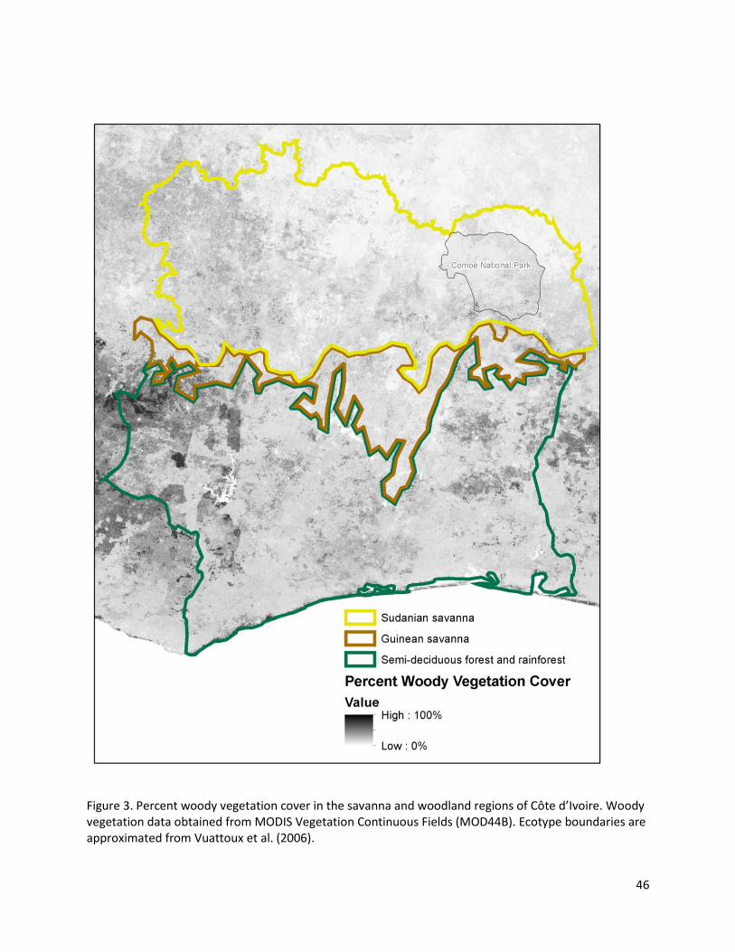
46
Figure 3. Percent woody vegetation cover in the savanna and woodland regions of Côte d’Ivoire. Woody vegetation data obtained from MODIS Vegetation Continuous Fields (MOD44B). Ecotype boundaries are approximated from Vuattoux et al. (2006).
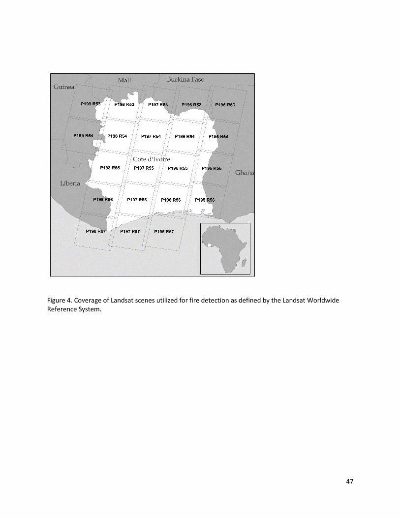
47
Figure 4. Coverage of Landsat scenes utilized for fire detection as defined by the Landsat Worldwide Reference System.

48
Figure 5. Temporal distribution of Landsat images for Côte d’Ivoire used in this analysis. Points shown in red represent images effected by >90% cloud cover.

49
Table 2. Predictor datasets.
Variable Source Spatial Resolution
Temporal Resolution
Citation
Air temperature at 2 meters (°C)
Modern-Era Retrospective Analysis for Research and Applications (MERRA) reanalysis product, tavg1_2d_slv_Nx dataset
1/2° x 2/3° Daily Rienecker et al., 2011
Total precipitation (mm)
Modern-Era Retrospective Analysis for Research and Applications (MERRA) reanalysis product, tavgM_2d_mld_Nx dataset
1/2° x 2/3° Monthly Rienecker et al., 2011
Palmer Drought Severity Index (PDSI)
National Center for Atmospheric Research (NCAR) Climate Analysis Section
2.5° Monthly Dai et al., 2004; Dai, 2011
Pasture cover (%)
Global Agricultural Lands in 2000
5 arc-minute resolution
Year 2000 data only
Ramankutty, Evan, Monfreda, & Foley, 2010b
Cropland cover (%)
Global Agricultural Lands in 2000
5 arc-minute resolution
Year 2000 data only
Ramankutty, Evan, Monfreda, & Foley, 2010a
Population density (persons per km2)
FAO Rural Population Density 2000
5 arc-minute resolution
Year 2000 data only
Salvatore, Pozzi, Ataman, Huddleston, & Bloise, 2005
Cattle density (head per km2)
Gridded Livestock of the World v. 1
3 arc-minute resolution
Year 2005 data only
Robinson et al., 2014
Woody vegetation cover (%)
MODIS Vegetation Continuous Fields (MOD44B)
250 m resolution
Year 2000 data only
DiMiceli et al., 2011

50
Table 3. Correlation between the independent variables used in this analysis. Variables with multiple values in time are averaged over the study period for all grid cells. PDSI is not shown due to the index’s representation of climate anomalies. Correlations greater than 0.5 are noted in bold.
Percent Woody Vegetation
0.12 Population
Density
-0.19 -0.10 Percent
Crop
-0.41 -0.42 0.32 Percent Pasture
-0.32 -0.06 -0.10 0.33 Cattle
Density
-0.45 -0.42 0.05 0.84 0.48 Pasture:
Crop
0.05 0.12 -0.17 -0.39 -0.14 -0.46
Precipitation
-0.55 -0.23 -0.03 0.44 0.51 0.51 0.34
Temperature
51
Chapter 4. Results
4.1. Active fire validation
I detected 51,364 individual active fires across Côte d’Ivoire in all years of the study. The error of
commission rate for the active fire detections was 6.25% (Table 4). Interpolation and bias removal
resulted in 100,550 binned fire counts, including zero counts, out of 604,643 possible data bins.
4.2. Fire density results
Across Côte d’Ivoire, fire density shows an increase in the number of fires per observation from
south to north (Fig. 6). A substantial degree of heterogeneity along this gradient and within each
ecotype is apparent, however. Areas of highest fire activity are interspersed among areas of lower
occurrence in the north. An area of especially high fire density is concentrated in the northeastern
portion of the country, which includes the large Comoé National Park (Fig. 3). There is also an area of
notably high fire activity in the southwest coastal area of Côte d’Ivoire. A lower than average amount of
fire is seen in the area surrounding the large city of Korhogo in the center north of the country.
The distribution of fire density within the year provides an indication of the seasonality of fire. A
summary of gridded fire counts across the fire year exhibits a strong peak in activity between January
and February in both Guinean and Sudanian savannas (Fig. 7). In contrast, little seasonality in fire density
can be observed in the southern forests (Fig. 7).
The amount of variability explained by the fire density vs. human and climate factor model was
20.5%. The top five variables, ranked by importance, were all climate or climate-proxy variables:
temperature, day of year, 1-month precipitation, year, and PDSI (Fig. 8). Cattle density is the sixth most
important variable. The partial dependence model for temperature showed that fire density generally
declined with increasing temperatures (Fig. 9). Fire density peaked during the middle of the fire season.
Minor peaks in fire activity are also seen in May and early November. Trends in fire density over the

52
years included in the study also show variation, though a clear direction in fire activity is not
apparent. 2-year antecedent precipitation showed high fire density at high and low values relative to
intermediate rainfall values. A similar pattern appears for PDSI values. In contrast, 1-month antecedent
precipitation primarily shows a negative correlation with fire density.
The model shows that increasing cattle density is associated with higher fire densities, a trend
that is apparent with increasing pasture cover as well. Intermediate values of population density and
percent cropland are associated with the lowest levels of burning.
4.3. Fire peak results
A total of 5482 peaks were calculated across all grid cells in all years, representing
approximately 6 years of fire observation per grid cell per year. The number of observations per grid cell
ranged from one to 14. The distribution of fire peaks over time is shown in figure 10. Two hundred
fifteen grid squares, primarily located in the southern half of the country, had no fire peaks recorded in
any year. The timing of peak fire varied between years across the fire peak dataset (Fig. 10), although
the data do not indicate a linear trend in the timing of peak burn over the years of this study. However,
patterns in interannual variability of the fire peak appear.
The average fire peak within the northern savanna lies mostly between late December and early
February, with spatial patterns in timing of peak burn apparent (Fig. 11). Notably, a band of late fire
seasonality cuts from north to south through the central northern area around Korhogo. Where fire
occurs in the south, the fire peak tends to occur relatively later in the fire year compared to fires in the
north.
The peak fire day of year model had the lowest predictive power of the three models, with
15.2% of the variance explained in the model (Fig. 8). However, a number of variables show important
trends. Climate plays the largest role, with peak burn occurring later in the year with increasing

53
temperature, precipitation, and high levels of drought (Fig. 12). Woody vegetation is associated with
later fire activity, while areas with high cattle density and percent pasture cover show earlier fires. The
model shows more complex patterns associated with population and percent cropland.
4.4. Fire regularity
Overall, annual periodicity dominates the fire periodogram for the country as a whole, with
characteristic harmonic peaks at higher frequencies (Archibald et al., 2009) (Fig. 13). Plotting the
strength of the annual signal of fire at available locations within Côte d’Ivoire reveals that the greatest
regularity of fire is concentrated in the north and west of the country (Fig. 14). In contrast, areas in the
southeastern portion of the savanna zones showed relatively low fire regularity. Few southern areas
had a sufficient number of fire observations to calculate a meaningful level of annual regularity.
The fire regularity randomForest model showed highest explanatory power of the three models,
with 52.1% of the variance explained. Mean temperature was the best predictor of fire regularity, with
increasing regularity in locations with higher temperatures (Fig. 15). Mean precipitation had the
opposite effect, with increasing rainfall leading to greater irregularity in the fire regime. Several
indicators of land use showed clear relationships with fire regularity as well. Increasing population is
associated with lower fire regularity, while higher fire regularity is found where there is a greater density
of cattle and a higher proportion of pasture cover.
A comparison of the patterns of fire density, peak, and regularity exposes the interrelationship,
or lack thereof, of these fire characteristics. In the east, areas of high fire density show relatively low
regularity. Yet areas of high density in the northwest show high regularity as well. Similarly, a strong
contrast between December and January fire peaks is apparent in the central north, but both areas
show high regularity of fire. Finally, fire peak and density appear to be nearly independent in the
savanna region.

54
4.5. Figures and Tables
Figure 6. Spatial distribution of mean fire density per observation calculated by averaging available
data over all years in each grid cell.

55
Figure 7. Mean density of fire across each ecotype in Côte d’Ivoire as defined by Vuattoux et al. (2006).Data for all years and all locations are averaged over 16-day intervals. Each interval is represented as a horizontal bar spanning the interval represented.

56
Figure 8. Variable importance ranked from greatest to least importance for a) fire density, b) fire peak day of year, and c) fire regularity. The percent increase in mean square error (%IncMSE) represents an increase in mean square error for the model prediction resulting from random permutation of the given variable.

57
Figure 9. Partial dependence of fire density on independent variables as estimated by a random forest model. Plots show, in order of decreasing importance, the marginal effect on the predicted day of year attributed to a) temperature, b) day of year, c) 1-month antecedent precipitation, d) year, e) PDSI, f) cattle density, g) 2-year antecedent precipitation, h) population density, i) % woody vegetation cover, j) proportion of agricultural land in pasture, k) % pasture, and l) % cropland.
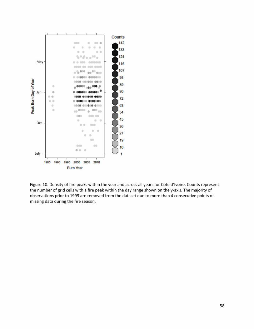
58
Figure 10. Density of fire peaks within the year and across all years for Côte d’Ivoire. Counts represent the number of grid cells with a fire peak within the day range shown on the y-axis. The majority of observations prior to 1999 are removed from the dataset due to more than 4 consecutive points of missing data during the fire season.
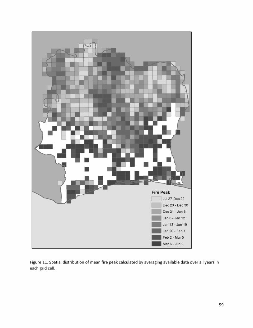
59
Figure 11. Spatial distribution of mean fire peak calculated by averaging available data over all years in
each grid cell.

60
Figure 12. Partial dependence of fire peak day of year on independent variables as estimated by a random forest model. Plots show, in order of decreasing importance, the marginal effect on the predicted day of year attributed to a) temperature, b) PDSI, c) precipitation, d) % woody vegetation, e) % cropland, f) cattle density, g) year, h) population density, i) % pasture cover, and j) proportion of agricultural land in pasture.
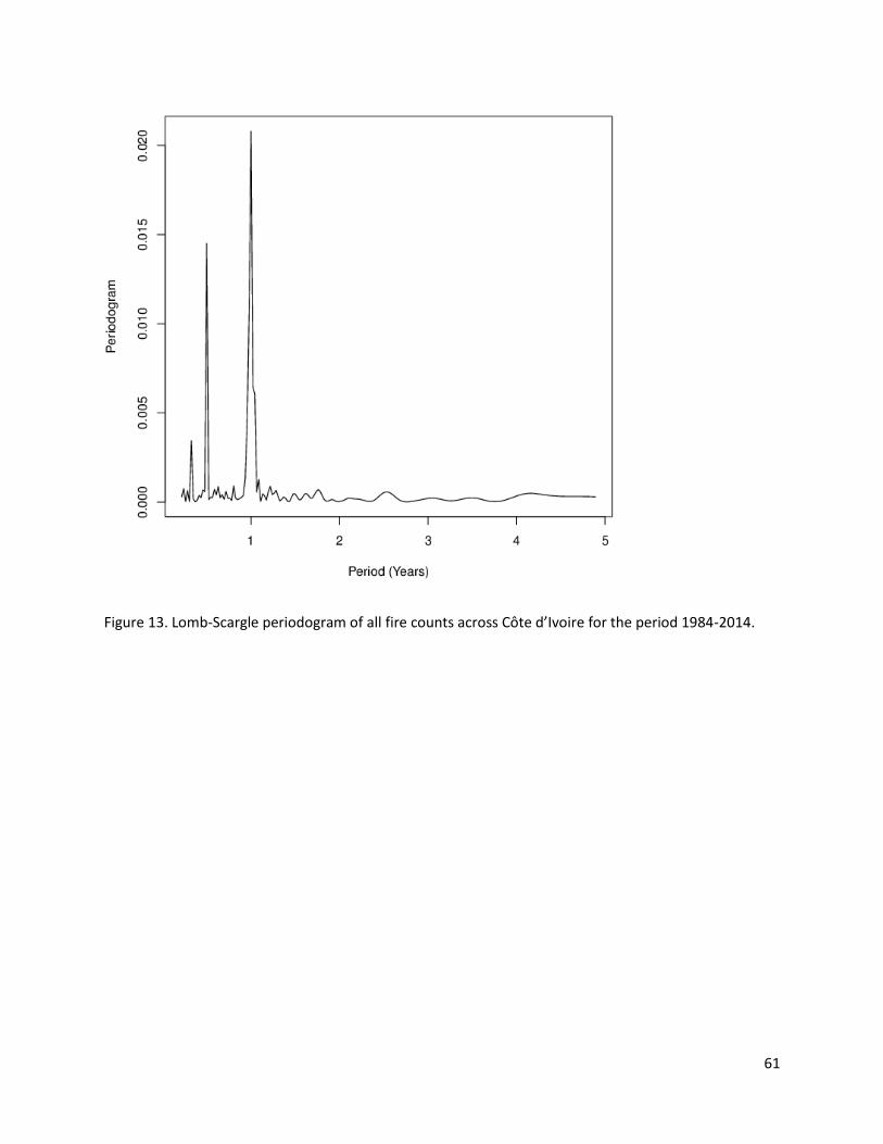
61
Figure 13. Lomb-Scargle periodogram of all fire counts across Côte d’Ivoire for the period 1984-2014.

62
Figure 14. Spatial distribution of annual periodicity strength.

63
Figure 15. Partial dependence of fire regularity on independent variables as estimated by a random forest model. Plots show, in order of decreasing importance, the marginal effect on the predicted day of year attributed to a) temperature, b) precipitation, c) population density, d) cattle density, e) proportion of agricultural land in pasture, f) % pasture, g) % woody vegetation cover, and h) % cropland.
Table 4. Types of error in active fire detections and error rate.
Error Type Error Number
Error Rate
Building or settlement 2 0.5%
Cloud 18 4.5%
Oversaturation 2 0.5%
Fully Saturated 2 0.5%
Impulse Noise (Bit-flip) 1 0.25%
Total Errors 25 6.25%
No Error 400 93.75%
64
Chapter 5. Discussion
5.1. Fire seasonality over time and space
The dominant feature of the fire regime of Côte d’Ivoire lies at the transition between the
southern forest and northern savanna systems. The transition, rather than representing a smooth
gradient from little fire to high fire density, appears as a rather sharp transition that is manifest as both
an increase in fire density and a shift in seasonality. Once the transition is crossed, however, spatial
heterogeneity in multiple directions is observed. This heterogeneity suggests that the fire regime is
controlled by factors other than the dominant north-south climate gradient.
The spatial pattern of fire regularity I report matches the patterns found in an analysis of 12-
month autocorrelation of MODIS active fire detections (Giglio et al., 2006). A pattern of high regularity
in the north, as well as a pocket of high regularity in the Guinean savanna near the center of the
country, was observed. In contrast, an area of low regularity is seen in the east. The same study
reported broad patterns of peak fire activity that resemble my findings. Fire peaks later in the fire year
to the south and fire density generally increases to the north. This pattern can probably be explained by
the practice of shifting cultivation of crops in the southern forests, which requires fire set at the end of
the dry season (de Rouw, 1994). My analysis reveals new, finer-scale patterns in the northern Sudanian
savanna for fire regularity and seasonality.
The increasing fire density with 2-year precipitation and PDSI is best explained by increasing fuel
production associated with wet years before a burn season. Particularly dry conditions can also
contribute to higher fire density.
Interannual variability is clearly apparent in the fire seasonality and fire density data. Variability
in the fire season has been reported previously in Africa (Cooke et al., 1996). However, I do not identify
65
a linear trend in countrywide timing of fire peak. This finding does not support the hypothesized change
in fire seasonality due to increasing pastoralism across Côte d’Ivoire over the past 30 years. However,
the relationships revealed here between cattle density, pasture, and fire activity suggest that such a
trend is likely to occur if pastoralist activity continued to increase across broad scales. Below, I explore
the effects of agriculture, focusing primarily on cattle grazing and the fire regime.
5.2. Fire Seasonality and Climate
That the characteristics of fire in Côte d’Ivoire are most strongly related to climate is not
surprising. However, the relationships between fire and climate revealed in this study show trends that
are unexpected within current paradigms in the fire literature. Increasing temperature, a phenomenon
usually associated with fire risk, is shown here to be associated with declining fire density. This unusual
relationship is probably related to the association of higher temperatures with higher rainfall in the
climate datasets. High temperatures are also related to later fires and greater regularity of fire. A steep
increase in fire regularity at approximately 25°C matches the north-south temperature gradient in Côte
d’Ivoire. However, the north-south gradient runs counter to the observed shift to a later fire peak,
suggesting that the heterogeneity in the fire regime within the savanna ecosystem also plays a role in
these patterns.
While the relationship between temperature and fire regimes appears to be complex, the role
of precipitation follows the trends of fire from south to north more directly. Fires become later, less
regular, and less dense from south to north, and precipitation declines along the same direction. The
direction of relationships between fire and precipitation match this gradient.
The power of PDSI in the modeling of fire regimes has been noted previously (Keeley, 2004).
This metric measures drought through a measure of climate anomaly based on temperature,
precipitation, and several other factors. My results show that, in years with particularly low mean PDSI

66
indicating persistent drought, fire density increases and the fire peak shifts later in the year. I
hypothesize that this trend can be explained by two factors. First, drought during the growing season
results in a paucity of fuel available to burn, reducing the number of potential fires in the early dry
season. However, as woody vegetation desiccates during extreme dry years, the number of fires
increases and the density of fire eventually overtakes that of years that are less dry.
5.3. Fire Seasonality and Land Use/Land Cover
This study was motivated by interest in the effects of increasing pastoralism on the timing of
fire. In this study, I confirm the importance of cattle grazing on fire regimes and reveal the aspects of fire
most affected by grazing. Cattle density appears as the most important non-climate variable in
predicting fire density, the second most important in fire periodicity, and also shows importance in the
fire seasonality model. High cattle densities are associated with greater fire density and fire regularity in
my study, which I argue is a product of the human management of rangelands for cattle production
(Bassett et al., 2003). The relationship between cattle density and the time of fire peak is more complex,
though the timing of fire peak cuts notably lower at high densities. This dip can be attributed to herders
setting early fires to encourage the “green pick” (Bassett et al., 2003; Kull and Laris, 2009). Similar trends
are revealed between percent pasture cover and the fire regime, lending additional strength to these
conclusions.
Crop cultivation represents a second significant human activity with the potential to influence
fire regimes. In contrast to previous findings showing declining burned area as a result of cropland
expansion (Andela and van der Werf, 2014), my results suggest that crop cultivation is not important in
relation to fire density, and that fire density increases somewhat in areas where the percentage of
croplands is high. This could be because cropland is most prominent in the central north of Côte d’Ivoire
and usually occurs in areas where other land cover types are present, as indicated by the maximum
67
percent cover of about 70%. The fire signal could be associated with those other land cover types. The
trend, however, is likely also related to the common practice of using fire for crop land preparation
(Laris, 2002). The MODIS burned area product used elsewhere may fail to detect the effect of small fires
in croplands.
The relationship of fire with population in Côte d’Ivoire is complex. Fire density and fire
seasonality reach a minimum at intermediate population density values, while fire regularity declines
directly with increasing population. Several factors could explain the relationship between fire density
and population. First, protected areas where people are excluded from the landscape may experience
higher rates of burning (Archibald, Scholes, et al., 2010; Grégoire and Simonetti, 2010), although this is
not always the case (Palumbo, Grégoire, Simonetti, and Punga, 2011). Second, high fire densities may
occur in locations with low population density because many extensive agricultural systems, herding and
shifting agriculture in particular, make use of fire (Bassett et al., 2003). As population density increases,
the danger presented by fire to property increases as well, resulting in fewer, earlier fires to act as fire
breaks against later fires (Laris, 2002). In southern Africa, the opposite trend has been described, with
increasing early season fires in high population density settlements (Archibald, Scholes, et al., 2010).
Woody vegetation shows a particularly strong positive correlation with fire peak day of year. I
suggest that this may be a signal produced by differing land management strategies in grasslands and
forests. In forests, shifting cultivation is common and relies on late burning at intervals as long as 15
years. In contrast, grasslands are burned more frequently and earlier in the dry season to promote grass
regrowth. My observations of the effect of woody vegetation cover on fire density and seasonality
match these practices.

68
5.4. Fire Regularity
Fire regularity has been hypothesized to represent a signal of the “humanization” of fire regimes
(Laris et al., 2015; Laris, 2011, 2013). My results complicate this idea. In my model of fire regularity,
temperature and precipitation show the greatest importance, outweighing the influence of human
population and land use, though only slightly so. In addition, increasing population density is associated
with lower fire regularity. Furthermore, the map of fire regularity shows only a slight decline in fire
regularity within Comoé National Park compared to surrounding areas, despite a relative lack of human
management. These results suggest that climatic factors may still play a primary role in determining
where fire is most regular.
The human role in fire regimes is clear in my seasonality model. Fire regularity decreases with
increasing population, but increases sharply where cattle are present and where the proportion of
pasture substantially outweighs the proportion of cropland. However, the extent to which humans
modify these regimes through their activities or to which their activities are modified by climate is
unclear. Given the importance of climate in my model, I suggest that it is not appropriate to consider fire
regularity a unique hallmark of human activity.
5.5. Limitations and Uncertainties
The percentage of variability explained in the models presented here is in line with previous
attempts to model fire activity (Archibald, Nickless, et al., 2010; Keeley, 2004). In particular, the model
of fire regularity shows strong explanation of the variance in the data. However, a large degree of
uncertainty remains, particularly in the fire density and fire peak models. The relatively lower
percentage of variability explained by the yearly model suggests that there may be other variables of
importance to interannual variability in fire seasonality that have not been captured here. However,
limitations of the datasets used may also affect the explanatory power of the models.

69
The input data used presents one area source of uncertainty. For instance, the authors note that
the FAOSTAT pasture data used to produce pasture percent cover data is ambiguous, especially in the
differentiation between forest, shrub and grassland where grazing occurs. In addition, they find that the
greatest uncertainty in crop and pasture cover occurs in the Sahelo-Sudan region of West Africa
(Ramankutty et al., 2008).
While cattle density data is an important predictor in my analysis, its ability to adequately
describe the distribution of cattle in Côte d’Ivoire is limited by several factors. Changes in cattle density
and distribution over years and between years commonly occurs in Côte d’Ivoire, particularly in relation
to the practice of seasonal transhumance common among herders in the country (Bassett and Turner,
2006). Changing land use and land tenure, farmer-herder conflict, and the distribution of tse-tse flies
also affect cattle densities, but these factors are not explicitly considered in the cattle distribution data
used.
Finally, the land use/land cover indicators I use represent a static snapshot of the distribution of
these elements, while the climate variables were allowed to vary over time in the fire density and fire
seasonality models. This reduces the comparability of the climate and land use data. Regardless, I make
use of the best available data for these indicators, following the approach of similar studies (Andela and
van der Werf, 2014; Archibald et al., 2009; Archibald, Scholes, et al., 2010).
The active fire dataset I have created possess limitations itself. The properties of remotely
sensed data can influence detected fire regimes (Freeborn, Cochrane, and Wooster, 2014), and active
fire detections in particular are sensitive to bias caused by the timing of satellite overpass (Giglio, 2007).
In this study, the time of satellite overpass limits fire detections to fires that burn at approximately 10
AM. Fires in northern hemisphere Africa are characterized by diurnal patterns specific to ecosystem
type. Fire detections derived from geostationary satellite images show fire counts peaking at or after

70
12PM, although open and sparse grasslands show peaks in mid-morning and late afternoon instead
(Roberts et al., 2009). My data may therefore overestimate fire in open grasslands compared to other
land cover types. Additionally, various fire management objectives, such as fire break creation or crop
field cleaning, may require that fire be set at different times of day, adding additional complexity to
diurnal patterns of fire because of human management. These dynamics are not captured by my
analysis.
The choice of grid cell size may have contributed to the low predictive power of the model as
well. While a grid cell size of 20km allows for fine scale resolution of the data, only a few fires were
captured in each observation. This may have increased the noise to signal ratio of the data because of
the degree of chance involved with such low counts. While this study context was different from that
reported here, Archibald et al. (2009) found that a 100km grid cell was optimal for a study of burned
areas detected with MODIS. Nevertheless, the grid cell size I use provides an acceptable balance
between spatial resolution and resolution of fire activity.
Finally, the use of random forest models in this study presents both valuable insight and
challenges. Random forests, by their nature, incorporate variable interactions through the relative
location of the branches of the regression tree. This characteristic gives random forests strong predictive
power, but it also produces results that are more difficult to interpret. The partial plots presented here
are designed to show the influence of one variable on the regression outcome, at the cost of ignoring
variable interactions. Furthermore, while the variable importance as measured by percentage increase
in mean square error provides some indication of the value of each input variable, this does not provide
the clarity by tests of significance in linear models. It is therefore difficult to know just how much a given
relationship “matters.”
71
5.6. Fire Seasonality, Change, and the Burn Center Narrative
The results of this analysis reveal important patterns and relationships in the fire regimes of
Côte d’Ivoire. Specifically, my results illustrate that the effects of climate and land use on fire are
intertwined in complex ways. Disentangling these effects is a significant challenge when there may be
reinforcing relationships between climate, fire, and land use. The findings presented here show that
livestock density and land use predict the regularity of fire with similar accuracy as climate variables.
These patterns are important for land managers and for our understanding of the role of West Afircan
fire in global change.
Humans demonstrate a unique capacity to alter the environment. The vast majority of fire
ignitions in Africa can be traced to human sources. However, decisions about the timing of those
ignitions are often made with explicit reference to climate and the growing season (Laris et al., 2015).
Furthermore, the possibility of regular fire in West Africa is constrained to the north and south by
rainfall. It is perhaps more productive, then, to see fire as a component of a human-natural coupled
system in which both humans and climate play a role in an integrated manner. Thus, fire regimes may
depend as much on the motivations of pastoralists moving to better pastures as on anomalies in rainfall
or temperature. As I conceive it, this relationship articulates in such a way that a change in one will alter
the effects of the other in respect to fire seasonality. When this view is taken, the question becomes not
only how does land use influence fire, but through which mechanism and to what degree do fire,
climate, and land use influence each other.
The results presented here point to one avenue through which these mechanisms may be
investigated. By dissecting different aspects of the fire regime and their correlation to human activities,
we may gain insight into the linkages among these elements and climate. I show that human activity
across Côte d’Ivoire is strongly linked to fire regimes in ways that are specific to each aspect of the fire

72
regime. This finding is not entirely new. Differing management has been shown to influence the spatial
distribution and seasonal timing of fire, but not the total area burned, in a South African National Park,
for instance (van Wilgen, Govender, Biggs, Ntsala, and Funda, 2004).
The burn center narrative as well as humanized perspectives of fire suggest that humans wield
powerful control over fire regimes across Africa. My results suggest that human activities do influence
the characteristics of fire and point to the ways in which these activities exert an effect. In particular, I
show that cattle grazing is associated with more, earlier, and more regular fires. Increasing cattle
densities could drive substantial changes in the fire regimes in some areas of Côte d’Ivoire. My results
show an inhibitory effect of woody vegetation on fire density, and a growing interest in tree crops in
Côte d’Ivoire could help push some areas from savanna to forest.
The effect of these agricultural trends could result in earlier or less intense fires in some areas of
Côte d’Ivoire, but their effects would be antagonistic. At the same time, pastoralists must compete with
expanding crop production as well (Andela and van der Werf, 2014). As these competing forces play out,
a detailed understanding of their effects on fire is critical for land management and predictions about
impacts on climate change. As interest in carbon sequestration in savannas grows (Bradstock et al.,
2012; Neely et al., 2009; Wiedinmyer and Hurteau, 2010; Woodfine, 2009), the results of our study point
to the potential impact of various management strategies on fire regimes and livelihoods. My results,
however, also caution against broad assumptions about such effects due to spatial heterogeneity in fire
regime characteristics and the interrelationship between humans, climate, and fire.

73
References
Alley, W. M. (1984). The Palmer Drought Severity Index: Limitations and Assumptions. Journal of Climate and Applied Meteorology, 23, 1100–1109.
Allwood, J. M., Bosetti, V., Dubash, N. K., Gómez-Echeverri, L., & Stech, C. von. (2014). Glossary. In O. Edenhofer, R. Pichs-Madruga, Y. Sokona, E. Farahani, S. Kadner, K. Seyboth, … J. C. Mi (Eds.), Change 2014: Mitigation of Climate Change. Contribution of Working Group III to the Fifth Assessment Report of the Intergovernmental Panel on Climate Change. Cambridge, United Kingdom and New York, NY, USA: Cambridge University Press.
Andela, N., & van der Werf, G. R. (2014). Recent trends in African fires driven by cropland expansion and El Niño to La Niña transition. Nature Climate Change, 4(9), 791–795. http://doi.org/10.1038/nclimate2313
Andrasko, K. J., Ahuja, D. R., Winnett, S. M., & Tirpak, D. A. (1991). Policy Options for Managing Biomass Burning to Mitigate Global Climate Change. In J. S. Levine (Ed.), Global Biomass Burning: Atmospheric, Climatic, and Biospheric Implications (pp. 445–456). Cambridge, Massachusetts: MIT Press.
Andreae, M. O. (1991). Biomass burning: Its history, use and distribution and its impact on environmental quality and global climate. In J. S. Levine (Ed.), Global Biomass Burning: Atmospheric, Climatic, and Biospheric Implications (pp. 1–21). Cambridge, Massachusetts: MIT Press.
Andreae, M. O., & Merlet, P. (2001). Emission of trace gases and aerosols from biomass burning. Global Biogeochemical Cycles, 15(4), 955–966.
Andreae, M. O., Rosenfeld, D., Artaxo, P., Costa, a a, Frank, G. P., Longo, K. M., & Silva-Dias, M. a F. (2004). Smoking rain clouds over the Amazon. Science (New York, N.Y.), 303(5662), 1337–1342. http://doi.org/10.1126/science.1092779
Archibald, S. A., Nickless, A., Govender, N., Scholes, R. J., & Lehsten, V. (2010). Climate and the inter-annual variability of fire in southern Africa: a meta-analysis using long-term field data and satellite-derived burnt area data. Global Ecology and Biogeography, 19(6), 794–809. http://doi.org/10.1111/j.1466-8238.2010.00568.x
Archibald, S. A., Roy, D. P., van Wilgen, B. W., & Scholes, R. J. (2009). What limits fire? An examination of drivers of burnt area in Southern Africa. Global Change Biology, 15(3), 613–630. http://doi.org/10.1111/j.1365-2486.2008.01754.x
Archibald, S. A., Scholes, R. J., Roy, D. P., Roberts, G., & Boschetti, L. (2010). Southern African fire regimes as revealed by remote sensing. International Journal of Wildland Fire, 19(7), 861–878. http://doi.org/10.1071/WF10008
74
Archibald, S. A., Staver, A. C., & Levin, S. A. (2012). Evolution of human-driven fire regimes in Africa. Proceedings of the National Academy of Sciences of the United States of America, 109(3), 847–52. http://doi.org/10.1073/pnas.1118648109
Arellano, A. F. (2004). Top-down estimates of global CO sources using MOPITT measurements. Geophysical Research Letters, 31(1), L01104. http://doi.org/10.1029/2003GL018609
Balshi, M. S., McGuire, a. D., Duffy, P., Flannigan, M., Walsh, J., & Melillo, J. (2009). Assessing the response of area burned to changing climate in western boreal North America using a Multivariate Adaptive Regression Splines (MARS) approach. Global Change Biology, 15(3), 578–600. http://doi.org/10.1111/j.1365-2486.2008.01679.x
Barbosa, P. M., Stroppiana, D., Grégoire, J.-M., & Cardoso Pereira, J. M. (1999). An assessment of vegetation fire in Africa (1981-1991): Burned areas, burned biomass, and atmospheric emissions. Global Biogeochemical Cycles, 13(4), 933–950. http://doi.org/10.1029/1999GB900042
Bar-Yosef, O. (2002). The Upper Paleolithic Revolution. Annual Review of Anthropology, 31(1), 363–393. http://doi.org/10.1146/annurev.anthro.31.040402.085416
Bassett, T. J., Koli Bi, Z., & Ouattara, T. (2003). Fire in the Savanna: Environmental Change & Land Reform in Northern Côte d’Ivoire. In T. J. Bassett & D. Crummey (Eds.), African Savannas: Global Narratives & Local Knowledge of Environmental Change (pp. 53–71). Oxford, UK and Portsmouth, NH: James Currey and Heinemann.
Bassett, T. J., & Turner, M. D. (2006). Sudden Shift or Migratory Drift? FulBe Herd Movements to the Sudano-Guinean Region of West Africa. Human Ecology, 35(1), 33–49. http://doi.org/10.1007/s10745-006-9067-4
Batterbury, S., Forsyth, T., & Thomson, K. (1997). Environmental transformations in developing countries: hybrid research and democratic policy. Geographical Journal, 163(2), 126–132.
Beck, S. (2010). Moving beyond the linear model of expertise? IPCC and the test of adaptation. Regional Environmental Change, 11(2), 297–306. http://doi.org/10.1007/s10113-010-0136-2
Beerling, D. J., & Osborne, C. P. (2006). The origin of the savanna biome. Global Change Biology, 12, 2023–2031. http://doi.org/10.1111/j.1365-2486.2006.01239.x
Beringer, J., Hutley, L. B. W., Tapper, N. J., Coutts, A., Kerley, A., & O’Grady, A. P. (2003). Fire impacts on surface heat, moisture and carbon fluxes from a tropical savanna in northern Australia. International Journal of Wildland Fire, 12(4), 333. http://doi.org/10.1071/WF03023
Bond, W. J., & Keeley, J. E. (2005). Fire as a global “herbivore”: The ecology and evolution of flammable ecosystems. Trends in Ecology and Evolution, 20(7), 387–394. http://doi.org/10.1016/j.tree.2005.04.025
Bond, W. J., & van Wilgen, B. W. (1996). Fire and Plants. London: Chapman & Hall.
75
Bond, W. J., Woodward, F. I., & Midgley, G. F. (2005). The global distribution of ecosystems in a world without fire. New Phytologist, 165(2), 525–37. http://doi.org/10.1111/j.1469-8137.2004.01252.x
Bonsang, B., & Boissard, C. (1995). Methane, carbon monoxide and light non-methane hydrocarbon emissions from African savanna burnings during the FOS/DECAFE experiment. Journal of Atmospheric Chemistry, 149–162. Retrieved from http://link.springer.com/article/10.1007/BF00708186
Bowman, D. M. J. S., Balch, J. K., Artaxo, P., Bond, W. J., Carlson, J. M., Cochrane, M. A., … Pyne, S. J. (2009). Fire in the Earth system. Science, 324, 481–484. http://doi.org/10.1126/science.1163886
Bowman, D. M. J. S., Balch, J. K., Artaxo, P., Bond, W. J., Cochrane, M. A., D’Antonio, C. M., … Whittaker, R. (2011). The human dimension of fire regimes on Earth. Journal of Biogeography, 38(12), 2223–2236. http://doi.org/10.1111/j.1365-2699.2011.02595.x
Bradstock, R. A., Boer, M. M., Cary, G. J., Price, O. F., Williams, R. J., Barrett, D., … Russell-smith, J. (2012). Modelling the potential for prescribed burning to mitigate carbon emissions from wildfires in fire-prone forests of Australia. International Journal of Wildland Fire, 21, 629–639.
Breiman, L. (2001). Random Forests. Machine Learning, 45, 5–32.
Caillault, S., Ballouche, A., & Delahaye, D. (2014). Where are the “bad fires” in West African savannas? Rethinking burning management through a space-time analysis in Burkina Faso. Geographical Journal. http://doi.org/10.1111/geoj.12074
Carmona-Moreno, C., Belward, A., Malingreau, J.-P., Hartley, A., Garcia-Alegre, M., Antonovskiy, M., … Pivovarov, V. (2005). Characterizing interannual variations in global fire calendar using data from Earth observing satellites. Global Change Biology, 11, 1537–1555. http://doi.org/10.1111/j.1365-2486.2005.01003.x
Carroll, M., Townshend, J., Hansen, M., DiMiceli, C., Sohlberg, R., & Wurster, K. (2011). MODIS Vegetative Cover Conversion and Vegetation Continuous Fields. In B. Ramachandran, C. O. Justice, M. J. Abrams, M. Friedl, X. Zhang, & A. Strahler (Eds.), Land Remote Sensing and Global Environmental Change (Vol. 11, pp. 725–745). New York: Springer. http://doi.org/10.1007/978-1-4419-6749-7
Castree, N. (2014). Making Sense of Nature. New York, N.Y.: Routledge.
Ciais, P., Bombelli, A., Williams, M. L., Piao, S. L., Chave, J., Ryan, C. M., … Valentini, R. (2011). The carbon balance of Africa: synthesis of recent research studies. Philosophical Transactions. Series A, Mathematical, Physical, and Engineering Sciences, 369, 2038–2057. http://doi.org/10.1098/rsta.2010.0328
Cochrane, M. A., Alencar, A., Schulze, M. D., Souza, C. M., Nepstad, D. C., Lefebvre, P., & Davidson, E. A. (1999). Positive Feedbacks in the Fire Dynamic of Closed Canopy Tropical Forests. Science, 284(5421), 1832–1835. http://doi.org/10.1126/science.284.5421.1832
76
Cooke, W. F., Koffi, B., & Grégoire, J.-M. (1996). Seasonality of vegetation fires in Africa from remote sensing data and application to a global chemistry model. Journal of Geophysical Research. http://doi.org/10.1029/96JD01835
Crush, J. (1995). Power of Development. New York: Routledge.
Crutzen, P. J., & Andreae, M. O. (1990). Biomass Burning in the Tropics: Impact on Atmospheric Chemistry and Biogeochemical Cycles Estimates of Worldwide Biomass Burning. Science, 250(4988), 1669–1678.
Crutzen, P. J., Heidt, L., & Krasnec, J. (1979). Biomass burning as a source of atmospheric gases CO, H2, N2O, NO, CH3Cl and COS. Nature, 282, 253–256.
Dai, A. (2011). Characteristics and trends in various forms of the Palmer Drought Severity Index during 1900-2008. Journal of Geophysical Research: Atmospheres, 116(12). http://doi.org/10.1029/2010JD015541
Dai, A., Trenberth, K. E., & Qian, T. (2004). A Global Dataset of Palmer Drought Severity Index for 1870 – 2002 : Relationship with Soil Moisture and Effects of Surface Warming. Journal of Hydrometeorology, 5, 1117–1130.
Darret, M. B. (2012). Declaration du gouvernement, lue par monsieur le ministre des eaux et forets a l’occasion du lancement de la campagne nationale de lutte contre les feux de brousse 2012-2013. Retrieved from http://www.eauxetforets.gouv.ci/index.php/component/content/article/1-derniers-articles-ajoutes/155-campagne-nationale-de-lutte-contre-les-feux-de-brousse-2012-2013
De Rouw, a. (1994). Effect of fire on soil, rice, weeds and forest regrowth in a rain-forest zone (Cote-d’Ivoire). Catena, 22(2), 133–152. http://doi.org/10.1016/0341-8162(94)90022-1
Delmas, R. A., Druilhet, A., Cros, B., Durand, P., Delon, C., Lacaux, J. P., … Ceccato, P. (1999). Experiment for Regional Sources and Sinks of Oxidants ( EXPRESSO ): An overview s. Journal of Geophysical Research, 104, 30609–30624.
Delmas, R. A., Loudjani, P., Podaire, A., & Menaut, J.-C. (1991). Biomass Burning in Africa: An Assessment of Annually Burned Biomass. In J. S. Levine (Ed.), Global Biomass Burning: Atmospheric, Climatic, and Biospheric Implications (pp. 126–132). Cambridge, Massachusetts: MIT Press.
Devineau, J.-L., Fournier, A., & Nignan, S. (2010). Savanna fire regimes assessment with MODIS fire data: Their relationship to land cover and plant species distribution in western Burkina Faso (West Africa). Journal of Arid Environments, 74(9), 1092–1101. http://doi.org/10.1016/j.jaridenv.2010.03.009
DiMiceli, C., Carroll, M., Sohlberg, R., Huang, C., Hansen, M., & Townshend, J. (2011). Annual Global Automated MODIS Vegetation Continuous Fields (MOD44B) at 250 m Spatial Resolution for Data Years Beginning Day 65, 2000 - 2010, Collection 5 Percent Tree Cover. College Park; MD; USA: University of Maryland.

77
Domínguez-Rodrigo, M. (2014). Is the “Savanna Hypothesis” a Dead Concept for Explaining the Emergence of the Earliest Hominins? Current Anthropology, 55(1), 59–81. http://doi.org/10.1086/674530
Dwyer, E., Pinnock, S., Gregoire, J. M., & Pereira, J. M. C. (2000). Global spatial and temporal distribution of vegetation fire as determined from satellite observations. International Journal of Remote Sensing, 21(6-7), 1289–1302. http://doi.org/10.1080/014311600210182
Eriksen, C. (2007). Why do they burn the “bush”? Fire, rural livelihoods, and conservation in Zambia. The Geographical Journal, 173(3), 242–256.
Fairhead, J., & Leach, M. (1995). Reading forest history backwards: The interaction of policy and local land use in Guinea’s forest-savanna mosaic, 1893-1993. Environment and History, 1, 55–91.
Forsyth, T. (2001). Critical realism and political ecology. In J. Lopez & G. Potter (Eds.), After postmodernism: an introduction to critical realism (pp. 146–154). London, UK: Athlone Press.
Freeborn, P. H., Cochrane, M. a., & Wooster, M. J. (2014). A decade long, multi-scale map comparison of fire regime parameters derived from three publically available satellite-based fire products: A case study in the Central African Republic. Remote Sensing, 6(5), 4061–4089. http://doi.org/10.3390/rs6054061
Friedman, J. H. (2001). Greedy Function Approximation: A Gradient Boosting Machine. The Annals of Statistics, 29(5), 1189–1232.
Giglio, L. (2007). Characterization of the tropical diurnal fire cycle using VIRS and MODIS observations. Remote Sensing of Environment, 108(4), 407–421. http://doi.org/10.1016/j.rse.2006.11.018
Giglio, L., Csiszar, I. A., & Justice, C. O. (2006). Global distribution and seasonality of active fires as observed with the Terra and Aqua Moderate Resolution Imaging Spectroradiometer (MODIS) sensors. Journal of Geophysical Research: Biogeosciences, 111(2), 1–12. http://doi.org/10.1029/2005JG000142
Giglio, L., Descloitres, J., Justice, C. O., & Kaufman, Y. J. (2003). An Enhanced Contextual Fire Detection Algorithm for MODIS. Remote Sensing of Environment, 87(2-3), 273–282. http://doi.org/10.1016/S0034-4257(03)00184-6
Giglio, L., Randerson, J. T., & Van Der Werf, G. R. (2013). Analysis of daily, monthly, and annual burned area using the fourth-generation global fire emissions database (GFED4). Journal of Geophysical Research: Biogeosciences, 118(November 2012), 317–328. http://doi.org/10.1002/jgrg.20042
Giglio, L., Randerson, J. T., van der Werf, G. R., Kasibhatla, P. S., Collatz, G. J., Morton, D., & Defries, R. S. (2010). Assessing variability and long-term trends in burned area by merging multiple satellite fire products. Biogeosciences, 7(3), 1171–1186. http://doi.org/10.5194/bg-7-1171-2010
Gill, A. M. (1975). Fire and the Australian flora: A review. Australian Forestry, 38(April 2015), 4–25. http://doi.org/10.1080/00049158.1975.10675618
78
Greenberg, J. A. (2014). spatial.tools: R functions for working with spatial data. R package version 1.4.8. http://cran.r-project.org/package=spatial.tools.
Grégoire, J.-M., & Simonetti, D. (2010). Interannual changes of fire activity in the protected areas of the SUN network and other parks and reserves of the West and Central Africa region derived from MODIS observations. Remote Sensing, 2(2), 446–463. http://doi.org/10.3390/rs2020446
Hartmann, D. L. (1994). Global Physical Climatology. San Diego: Academic Press.
Hoelzemann, J. J. (2004). Global Wildland Fire Emission Model (GWEM): Evaluating the use of global area burnt satellite data. Journal of Geophysical Research, 109(D14), 1–18. http://doi.org/10.1029/2003JD003666
IPCC. (2006). 2006 IPCC Guidelines for National Greenhouse Gas Inventories. Main, 2, 12. http://doi.org/http://www.ipcc-nggip.iges.or.jp/public/2006gl/pdf/2_Volume2/V2_3_Ch3_Mobile_Combustion.pdf
IPCC. (2007). Climate change 2007: Mitigation. Contribution of Working Group III to the Fourth Assessment Report of the Intergovernmental Panel on Climate Change. (B. Metz, O. R. Davidson, P. R. Bosch, R. Dave, & L. A. Meyer, Eds.). Cambridge, United Kingdom and New York, NY, USA: Cambridge University Press.
Jacobs, B. F., Kingston, J. D., & Jacobs, L. L. (1999). The Origin of Grass-Dominated Ecosystems. Annals of the Missouri Botanical Garden, 86(2), 590–643.
Jain, A. K. (2007). Global estimation of CO emissions using three sets of satellite data for burned area. Atmospheric Environment, 41(33), 6931–6940. http://doi.org/10.1016/j.atmosenv.2006.10.021
Jain, A. K., Tao, Z., Yang, X., & Gillespie, C. (2006). Estimates of global biomass burning emissions for reactive greenhouse gases (CO, NMHCs, and NO x ) and CO 2. Journal of Geophysical Research, 111(D6), D06304. http://doi.org/10.1029/2005JD006237
Jasanoff, S. (2007). Designs on Nature: Science and Democracy in Europe and the United States. Princeton, N.J.: Princeton University Press.
Julia Cole, & NASA. (2001). Biomass Burning. Retrieved December 9, 2013, from http://earthobservatory.nasa.gov/Features/BiomassBurning/printall.php
Kaiser, J. W., Heil, A., Andreae, M. O., Benedetti, a., Chubarova, N., Jones, L., … van der Werf, G. R. (2012). Biomass burning emissions estimated with a global fire assimilation system based on observed fire radiative power. Biogeosciences, 9(1), 527–554. http://doi.org/10.5194/bg-9-527-2012
Keeley, J. E. (2004). Impact of antecedent climate on fire regimes in coastal California. International Journal of Wildland Fire, 13(2), 173–182. http://doi.org/10.1071/WF03037

79
Keywood, M., Kanakidou, M., Stohl, A., Dentener, F., Grassi, G., Meyer, C. P., … Burrows, J. (2013). Fire in the Air: Biomass Burning Impacts in a Changing Climate. Critical Reviews in Environmental Science and Technology, 43(1), 40–83. http://doi.org/10.1080/10643389.2011.604248
Koffi, B., Grgoire, J., & Mah, G. (1995). Remote sensing of bush fire dynamics in Central Africa from 1984 to 1988 : analysis in relation to regional vegetation and pluviometric patterns, 39, 179–200.
Koné, M. (2012). Up In Smoke: Biomass Burning and Atmospheric Emissions in the Sudanian Savanna of Cote D’Ivoire (Unpublished doctoral dissertation). Urbana-Champaign, IL: University of Illinois.
Koné, M., Bassett, T. J., & Nkem, J. (2011). Changing fire regimes in the Cote d’Ivoire savanna: implications for greenhouse emissions and carbon sequestration. In C. J. Geldenhuys, C. Ham, & H. Ham (Eds.), Sustainable Forest Management in Africa: Some Solutions to Natural Forest Management Problems in Africa (pp. 441–453). Stellenbosch, South Africa: Stellenbosch University.
Koppmann, R., von Czapiewski, K., & Reid, J. S. (2005). A review of biomass burning emissions, part I: gaseous emissions of carbon monoxide, methane, volatile organic compounds, and nitrogen containing compounds. Atmospheric Chemistry and Physics Discussions, 5(5), 10455–10516. http://doi.org/10.5194/acpd-5-10455-2005
Korontzi, S. (2005). Seasonal patterns in biomass burning emissions from southern African vegetation fires for the year 2000. Global Change Biology, 11(10), 1680–1700. http://doi.org/10.1111/j.1365-2486.2005.001024.x
Kull, C. A. (2004). Isle of Fire: The Political Ecology of Landscape Burning in Madagascar. Chicago: University of Chicago Press.
Kull, C. A., & Laris, P. S. (2009). Fire ecology and fire politics in Mali and Madagascar. In M. A. Cochrane (Ed.), Tropical Fire Ecology: Climate Change, Land Use and Ecosystem Dynamics (pp. 171–226). Berlin: Springer.
Lacaux, J. P., Brustet, J., & Delmas, R. A. (1995). Biomass burning in the tropical savannas of Ivory Coast: An overview of the field experiment Fire of Savannas (FOS/DECAFE 91). Journal of Atmospheric Chemistry, 22, 195–216.
Langmann, B., Duncan, B., Textor, C., Trentmann, J., & van der Werf, G. R. (2009). Vegetation fire emissions and their impact on air pollution and climate. Atmospheric Environment, 43(1), 107–116. http://doi.org/10.1016/j.atmosenv.2008.09.047
Laris, P. S. (2002). Burning the seasonal mosaic: preventative burning strategies in the wooded savanna of southern Mali. Human Ecology, 30(2), 155–186.
Laris, P. S. (2005). Spatiotemporal problems with detecting and mapping mosaic fire regimes with coarse-resolution satellite data in savanna environments. Remote Sensing of Environment, 99(4), 412–424. http://doi.org/10.1016/j.rse.2005.09.012

80
Laris, P. S. (2011). Humanizing Savanna Biogeography: Linking Human Practices with Ecological Patterns in a Frequently Burned Savanna of Southern Mali. Annals of the Association of American Geographers, 101(5), 1067–1088. http://doi.org/10.1080/00045608.2011.560063
Laris, P. S. (2013). Integrating Land Change Science and Savanna Fire Models in West Africa. Land, 2(4), 609–636. http://doi.org/10.3390/land2040609
Laris, P. S., Caillault, S., Dadashi, S., & Jo, A. (2015). The Human Ecology and Geography of Burning in an Unstable Savanna Environment. Journal of Ethnobiology, 35(1), 111–139.
Laris, P. S., & Wardell, D. A. (2006). Good, bad or “necessary evil”? Reinterpreting the colonial burning experiments in the savanna landscapes of West Africa. The Geographical Journal, 172(4), 271–290. http://doi.org/10.1111/j.1475-4959.2006.00215.x
Lavorel, S., Flannigan, M. D., Lambin, E. F., & Scholes, M. C. (2006). Vulnerability of land systems to fire: Interactions among humans, climate, the atmosphere, and ecosystems. Mitigation and Adaptation Strategies for Global Change, 12(1), 33–53. http://doi.org/10.1007/s11027-006-9046-5
Le Page, Y., Oom, D., Silva, J. M. N., Jönsson, P., & Pereira, J. M. C. (2010). Seasonality of vegetation fires as modified by human action: observing the deviation from eco-climatic fire regimes. Global Ecology and Biogeography, 575–588. http://doi.org/10.1111/j.1466-8238.2010.00525.x
Leach, M., & Mearns, R. (1996). Environmental Change and Policy: Challenging Received Wisdom in Africa. In M. Leach & R. Mearns (Eds.), The Lie of the Land: Challenging received wisdom on the African Environment (pp. 1–33). London: The International African Institute.
Lehmann, C. E. R., Archibald, S. A., Hoffmann, W. a, & Bond, W. J. (2011). Deciphering the distribution of the savanna biome. The New Phytologist, 191(1), 197–209. http://doi.org/10.1111/j.1469-8137.2011.03689.x
Lehsten, V., Tansey, K., Balzter, H., Thonicke, K., Spessa, A., Weber, U., … Arneth, A. (2009). Estimating carbon emissions from African wildfires. Biogeosciences, 6(3), 349–360. http://doi.org/10.5194/bg-6-349-2009
Levine, J. S., Bobbe, T., Ray, N., Witt, R. G., & Singh, A. (1999). Wildland Fires and the Environment: a Global Synthesis. UNEP/DEIAEW/TR.99-1.
Levine, J. S., Cofer, W. R., Cahoon, D. R., & Winstead, E. L. (1995). Biomass Burning: A Driver for Global Change. Environ. Sci. Technol., 29(3), 120A–125A. http://doi.org/10.1021/es00003a746
Liaw, A., & Wiener, M. (2002). Classication and Regression by randomForest. R News, 2/3(December), 18–22.
Liousse, C., Andreae, M. O., Artaxo, P., Barbosa, P. M., Cachier, H., Gregoire, J. M., … Schultz, M. G. (2004). Deriving global quantitative estimates for spatial and temporal distributions of biomass burning emissions. In C. Granier, P. Artaxo, & C. E. Reeves (Eds.), Emissions of Atmospheric Trace Compounds (pp. 71–113). Dordrecht, The Netherlands: Kluwer Academic Publishers.

81
Masek, J. G., Vermote, E. F., Saleous, N. E., Wolfe, R. E., Hall, F. G., Huemmrich, K. F., … Lim, T. (2006). A Landsat Surface Reflectance Dataset. IEEE Geoscience and Remote Sensing Letters, 3(1), 68–72. http://doi.org/10.1109/LGRS.2005.857030
Mbow, C., Nielsen, T., & Rasmussen, K. (2000). Savanna fires in east-central Senegal: Distribution patterns, resource management and perceptions. Human Ecology, 28(4), 561–583.
Menaut, J.-C., Abbadie, L., Lavenu, F., Loudjani, P., & Podaire, A. (1991). Biomass Burning in West African Savannas. In J. S. Levine (Ed.), Global Biomass Burning: Atmospheric, Climatic, and Biospheric Implications (pp. 133–142). Cambridge, Massachusetts: MIT Press.
Miettinen, J., Shi, C., & Liew, S. C. (2011). Deforestation rates in insular Southeast Asia between 2000 and 2010. Global Change Biology, 17(7), 2261–2270. http://doi.org/10.1111/j.1365-2486.2011.02398.x
Mieville, A., Granier, C., Liousse, C., Guillaume, B., Mouillot, F., Lamarque, J.-F., … Pétron, G. (2010). Emissions of gases and particles from biomass burning during the 20th century using satellite data and an historical reconstruction. Atmospheric Environment, 44(11), 1469–1477. http://doi.org/10.1016/j.atmosenv.2010.01.011
Monks, P. S., Granier, C., Fuzzi, S., Stohl, A., Williams, M. L., Akimoto, H., … von Glasow, R. (2009). Atmospheric composition change – global and regional air quality. Atmospheric Environment, 43(33), 5268–5350. http://doi.org/10.1016/j.atmosenv.2009.08.021
Mouillot, F., & Field, C. B. (2005). Fire history and the global carbon budget: a 1ox 1o fire history reconstruction for the 20th century. Global Change Biology, 11(3), 398–420. http://doi.org/10.1111/j.1365-2486.2005.00920.x
Neely, C., Bunning, S., & Wilkes, A. (2009). Review of evidence on drylands pastoral systems and climate change: Implications and opportunities for mitigation and adaptation. Rome: FAO.
Palumbo, I., Grégoire, J.-M., Simonetti, D., & Punga, M. (2011). Spatio-temporal distribution of fire activity in protected areas of Sub-Saharan Africa derived from MODIS data. Procedia Environmental Sciences, 7, 26–31. http://doi.org/10.1016/j.proenv.2011.07.006
Pyne, S. J. (1984). Introduction to Wildland Fire: Fire Management in the United States. New York: John Wiley & Sons.
Pyne, S. J. (2009). The human geography of fire: a research agenda. Progress in Human Geography, 33(4), 443–446. http://doi.org/10.1177/0309132508101598
Ramankutty, N., Evan, A. T., Monfreda, C., & Foley, J. A. (2008). Farming the planet: 1. Geographic distribution of global agricultural lands in the year 2000. Global Biogeochemical Cycles, 22(1), 1–19. http://doi.org/10.1029/2007GB002952
Ramankutty, N., Evan, A. T., Monfreda, C., & Foley, J. A. (2010a). Global Agricultural Lands: Croplands, 2000. Retrieved March 22, 2015, from http://sedac.ciesin.columbia.edu/es/aglands.html
82
Ramankutty, N., Evan, A. T., Monfreda, C., & Foley, J. A. (2010b). Global Agricultural Lands: Pastures, 2000. Retrieved March 22, 2015, from http://sedac.ciesin.columbia.edu/es/aglands.html
Reid, J. S., Koppmann, R., Eck, T. F., & Eleuterio, D. P. (2005). A review of biomass burning emissions part II: intensive physical properties of biomass burning particles. Atmospheric Chemistry and Physics, 5(3), 799–825. http://doi.org/10.5194/acp-5-799-2005
Rienecker, M. M., Suarez, M. J., Gelaro, R., Todling, R., Bacmeister, J., Liu, E., … Woollen, J. (2011). MERRA: NASA’s modern-era retrospective analysis for research and applications. Journal of Climate, 24, 3624–3648. http://doi.org/10.1175/JCLI-D-11-00015.1
Robbins, P. (2012). Political Ecology: A Critical Introduction. In Political Ecology: A Critical Introduction (pp. 25–48). Malden, MA: John Wiley & Sons.
Roberts, G., Wooster, M. J., & Lagoudakis, E. (2009). Annual and diurnal african biomass burning temporal dynamics. Biogeosciences, 6(5), 849–866. http://doi.org/10.5194/bg-6-849-2009
Robinson, J. M. (1989). On uncertainty in the computation of global emissions from biomass burning. Climatic Change, 14(3), 243–261. http://doi.org/10.1007/BF00134965
Robinson, T. P., William Wint, G. R., Conchedda, G., Van Boeckel, T. P., Ercoli, V., Palamara, E., … Gilbert, M. (2014). Mapping the global distribution of livestock. PLoS ONE, 9(5). http://doi.org/10.1371/journal.pone.0096084
Rodríguez-Fonseca, B., Janicot, S., Mohino, E., Losada, T., Bader, J., Caminade, C., … Voldoire, A. (2011). Interannual and decadal SST-forced responses of the West African monsoon. Atmospheric Science Letters, 12, 67–74. http://doi.org/10.1002/asl.308
Roy, D. P., & Boschetti, L. (2009). Southern Africa Validation of the MODIS, L3JRC, and GlobCarbon Burned-Area Products. IEEE Transactions on Geoscience and Remote Sensing, 47(4), 1032–1044. http://doi.org/10.1109/TGRS.2008.2009000
Roy, D. P., Ju, J., Mbow, C., Frost, P., & Loveland, T. (2010). Accessing free Landsat data via the Internet: Africa’s challenge. Remote Sensing Letters, 1(2), 111–117. http://doi.org/10.1080/01431160903486693
Russell-Smith, J., Monagle, C., Jacobsohn, M., Beatty, R. L., Bilbao, B., Millán, A., … Sánchez-Rose, I. (2013). Can savanna burning projects deliver measurable greenhouse emissions reductions and sustainable livelihood opportunities in fire-prone settings? Climatic Change. http://doi.org/10.1007/s10584-013-0910-5
Salvatore, M., Pozzi, F., Ataman, E., Huddleston, B., & Bloise, M. (2005). Mapping global urban and rural population distributions. Rome.
Scargle, J. D. (1982). Studies in astronomical time series analysis. II - Statistical aspects of spectral analysis of unevenly spaced data. The Astrophysical Journal, 263, 835–853. http://doi.org/10.1086/160554
83
Schroeder, W., Prins, E., Giglio, L., Csiszar, I. A., Schmidt, C. C., Morisette, J., & Morton, D. (2008). Validation of GOES and MODIS active fire detection products using ASTER and ETM+ data. Remote Sensing of Environment, 112(5), 2711–2726. http://doi.org/10.1016/j.rse.2008.01.005
Scott, A. C. (2000). The Pre-Quaternary history of fire. Palaeogeography, Palaeoclimatology, Palaeoecology, 164(1), 281–329.
Scott, A. C. (2010). Charcoal recognition, taphonomy and uses in palaeoenvironmental analysis. Palaeogeography, Palaeoclimatology, Palaeoecology, 291(1), 11–39.
Scott, A. C., & Glasspool, I. J. (2006). The diversification of Paleozoic fire systems and fluctuations in atmospheric oxygen concentration. Proceedings of the National Academy of Sciences of the United States of America, 103(29), 10861–10865. http://doi.org/10.1073/pnas.0604090103
Seiler, W., & Crutzen, P. J. (1980). Estimates of gross and net fluxes of carbon between the biosphere and the atmosphere from biomass burning. Climatic Change, 2(3), 207–247. http://doi.org/10.1007/BF00137988
Sena, E. T., Artaxo, P., & Correia, a. L. (2013). Spatial variability of the direct radiative forcing of biomass burning aerosols and the effects of land use change in Amazonia. Atmospheric Chemistry and Physics, 13(3), 1261–1275. http://doi.org/10.5194/acp-13-1261-2013
Stanford University. (2004, August 24). Forest Burning Is A Net Contributor To Global Warming, Scientist Says. Retrieved from http://www.sciencedaily.com/releases/2004/08/040824013946.htm
Thevenon, F., Bard, E., Williamson, D., & Beaufort, L. (2004). A biomass burning record from the West Equatorial Pacific over the last 360 ky: Methodological, climatic and anthropic implications. Palaeogeography, Palaeoclimatology, Palaeoecology, 213(1-2), 83–99. http://doi.org/10.1016/j.palaeo.2004.07.003
Thieler, A. M., Backes, M., Fried, R., & Rhode, W. (2013). Perriodicity Detection in Irregularly Sampled Light Curves by Robust Regression and Outlier Detection. Statistical Analysis and Data Mining: The ASA Data Science Journal, 6(1), 73–89. http://doi.org/10.1002/sam
Thieler, A. M., Rathjens, J., Fried, R., & with contributions from Brenton R. Clarke, Uwe Ligges, Matias Salibian-Barrera, G. W. and V. Y. (2015). RobPer: Robust Periodogram and Periodicity Detection Methods. R package version 1.2.1. http://CRAN.R-project.org/package=RobPer.
Van der Werf, G. R., Randerson, J. T., Collatz, G. J., & Giglio, L. (2003). Carbon emissions from fires in tropical and subtropical ecosystems. Global Change Biology, 9(4), 547–562. http://doi.org/10.1046/j.1365-2486.2003.00604.x
Van der Werf, G. R., Randerson, J. T., Giglio, L., Collatz, G. J., Kasibhatla, P. S., & Arellano, A. F. (2006). Interannual variability of global biomass burning emissions from 1997 to 2004. Atmospheric Chemistry and Physics Discussions, 6(2), 3175–3226. http://doi.org/10.5194/acpd-6-3175-2006

84
Van der Werf, G. R., Randerson, J. T., Giglio, L., Collatz, G. J., Mu, M., Kasibhatla, P. S., … van Leeuwen, T. T. (2010). Global fire emissions and the contribution of deforestation, savanna, forest, agricultural, and peat fires (1997–2009). Atmospheric Chemistry and Physics, 10(23), 11707–11735. http://doi.org/10.5194/acp-10-11707-2010
Van Wilgen, B. W., Govender, N., Biggs, H. C., Ntsala, D., & Funda, X. N. (2004). Response of Savanna Fire Regimes to Changing Fire-Management Policies in a Large African National Park. Conservation Biology, 18(6), 1533–1540. http://doi.org/10.1111/j.1523-1739.2004.00362.x
Venkataraman, C., Habib, G., Kadamba, D., Shrivastava, M., Leon, J. F., Crouzille, B., … Streets, D. G. (2006). Emissions from open biomass burning in India: Integrating the inventory approach with high-resolution Moderate Resolution Imaging Spectroradiometer (MODIS) active-fire and land cover data. Global Biogeochemical Cycles, 20(2), 1–12. http://doi.org/10.1029/2005GB002547
Verchot, L., Krug, T., Lasco, R. D., Ogle, S. M., Raison, J., Li, Y., … Smith, P. (2006). Grassland. In H. S. Eggleston, L. Buendia, K. Miwa, T. Ngara, & K. Tanabe (Eds.), 2006 IPCC Guidelines for National Greenhouse Gas Inventories Volume 4: Agriculture, Forestry and Other Land Use (pp. 1–49). Japan: IGES.
Vuattoux, R., Konaté, S., Abbadie, L., Barot, S., Gignoux, J., & Lahoreau, G. (2006). History of the Lamto Ecology Station and Ecological Studies at Lamto. In L. Abbadie, J. Gignoux, X. Roux, & M. Lepage (Eds.), Lamto: Structure, Functioning, and Dynamics of a Savanna Ecosystem (pp. 1–12). New York: Springer-Verlag.
Wiedinmyer, C., & Hurteau, M. D. (2010). Prescribed fire as a means of reducing forest carbon emissions in the western United States. Environmental Science & Technology, 44(6), 1926–32. http://doi.org/10.1021/es902455e
Woodfine, A. (2009). Using sustainable land management practices to adapt to and mitigate climate change in Sub-Saharan Africa. Retrieved September 17, 2013, from http://knowledgebase.terrafrica.org/fileadmin/user_upload/terrafrica/docs/SLM_SUB-SAHARAN_AFRICA.pdf
Wrangham, R. W., Jones, J. H., Laden, G., Pilbeam, D., & Conklin-Brittain, N. (1999). The Raw and the Stolen: Cooking and the Ecology of Human Origins. Current Anthropology, 40(5), 567–577. http://doi.org/10.1086/300083
Zhang, X., Kondragunta, S., & Roy, D. P. (2014). Interannual variation in biomass burning and fire seasonality derived from Geostationary satellite data across the contiguous United States from 1995 to 2011. Journal of Geophysical Research: Biogeosciences, 1147–1162. http://doi.org/10.1002/2013JG002518.Received
Zhu, Z., & Woodcock, C. E. (2012). Object-based cloud and cloud shadow detection in Landsat imagery. Remote Sensing of Environment, 118, 83–94. http://doi.org/10.1016/j.rse.2011.10.028