contamina on remedia on kdhe orphan sites 2014 … on remedia on kdhe orphan sites 2014 basin report...
TRANSCRIPT
Contamina on Remedia on
KDHE Orphan Sites
2014 Basin Report

CONTAMINATION REMEDIATION – KDHE ORPHAN SITES
ACCOMPLISHMENTS AND SITE UPDATES JANUARY 1, 2014 THROUGH DECEMBER 31, 2014
TABLE OF CONTENTS
List of Acronyms .......................................................................................................................................... 5 Sites by River Basin Map ............................................................................................................................. 9 Introduction ................................................................................................................................................. 13 OSP Information ......................................................................................................................................... 13
Activities in the OSP ...................................................................................................................... 13 OSP Potentially Responsible Party Search .................................................................................... 14 OSP Emergency Response Activities ............................................................................................ 14 OSP Investigation Activities .......................................................................................................... 14 OSP Remediation Activities .......................................................................................................... 15 OSP Monitoring and Closure Activities ........................................................................................ 16 OSP Accomplishments for 2014 .................................................................................................... 16 Planned OSP Accomplishments for 2015 ...................................................................................... 18
SFP Information .......................................................................................................................................... 18 SFP Accomplishments for 2014 .................................................................................................... 18 Planned SFP Accomplishments for 2015....................................................................................... 19
OSP Accomplishments ............................................................................................................................... 21 Site Updates By River Basin ....................................................................................................................... 29 Cimarron River Drainage Basin .................................................................................................................. 31
2nd and General Welch, Liberal ...................................................................................................... 31 8th & Country Estates, Liberal (Former National Beef) ................................................................. 32
Kansas-Republican River Drainage Basin .................................................................................................. 33 2nd & Leonard, Onaga .................................................................................................................... 33 Armourdale Refinery ..................................................................................................................... 33 Axtell PWS Well #2....................................................................................................................... 34 Clifton Carbon Tetrachloride ......................................................................................................... 34 Coral Refinery ................................................................................................................................ 35 Konza Valley RWD #1 .................................................................................................................. 36 Lanham Grain Bins ........................................................................................................................ 37 Latimer Groundwater Contamination ............................................................................................ 38 Mercier Carbon Tetrachloride ........................................................................................................ 39 St. George VOC Site ...................................................................................................................... 40
Lower Arkansas River Drainage Basin ....................................................................................................... 43 Arkansas City Refinery Site ........................................................................................................... 43 Belle Plaine Groundwater Contamination ..................................................................................... 43 Clearwater PCE .............................................................................................................................. 44 Elm & SW 3rd, Newton .................................................................................................................. 45 FMGP—Wellington ....................................................................................................................... 46 Former Cusco Oil and Refining ..................................................................................................... 47 Former Wichita Independent Oil Storage ...................................................................................... 47 Hudson Carbon Tetrachloride ........................................................................................................ 48 Hutchinson Air Base Industrial Tract (HABIT) ............................................................................ 49 Kiowa PWS Well #2 ...................................................................................................................... 51
Lyons Chloride Site ....................................................................................................................... 52 Lyons VOC Site ............................................................................................................................. 53 Mayberry Middle School, Wichita ................................................................................................ 54 McPherson PWS #7 ....................................................................................................................... 55 Oak Knoll Site ............................................................................................................................... 56 Park City DRO ............................................................................................................................... 57 Pollard Carbon Tet ......................................................................................................................... 58 Pratt Ag Aviation, Inc .................................................................................................................... 58 Pratt Army Airfield/Pratt PWS Well #2 ........................................................................................ 59 Pratt Oil Reclamation ..................................................................................................................... 61 Richardson Property Site ............................................................................................................... 62 Warren Petroleum Plant ................................................................................................................. 62 Yoder, Village of (Yoder VOCs) ................................................................................................... 63
Marais des Cygnes River Drainage Basin ................................................................................................... 65 Ottawa FMGP ................................................................................................................................ 65 Paola Refining Co.—Former ......................................................................................................... 65
Missouri River Drainage Basin ................................................................................................................... 67 Uncle Sam Oil Refinery (Former)—Atchison ............................................................................... 67
Neosho River Drainage Basin ..................................................................................................................... 69 4th & Commercial, Emporia ........................................................................................................... 69 4th Ave & Merchant St. .................................................................................................................. 70 Bruce Mining and Smelting Company........................................................................................... 71 Canada Carbon Tetrachloride ........................................................................................................ 72 Cherokee Mining and Smelting ..................................................................................................... 72 Concreto Smelter ........................................................................................................................... 73 MARCO (Mid-America Refining Co.) .......................................................................................... 74 McGraw Trucking .......................................................................................................................... 75 Pittsburg Short Method Smelter ..................................................................................................... 76 St. Louis Smelter Company ........................................................................................................... 76 Webster/Miller Refinery ................................................................................................................ 77 Wilsey Groundwater Contamination ............................................................................................. 78
Smoky Hill-Saline River Drainage Basin ................................................................................................... 79 Bird-Feldt Farms ............................................................................................................................ 79 Country View Mobile Park BTA ................................................................................................... 79 Fossil & Wichita Ave..................................................................................................................... 81 Hope PWS Well #10 ...................................................................................................................... 82 Kanopolis Abandoned Salt Pile ..................................................................................................... 83 Kanopolis PCE ............................................................................................................................... 84 Paris Corp. (Fmr) ........................................................................................................................... 85 Park PWS #1 .................................................................................................................................. 86 West South Street ........................................................................................................................... 87
Solomon River Drainage Basin .................................................................................................................. 89 Englehardt Grain Company ........................................................................................................... 89 Former Krueger Refining Co. ........................................................................................................ 90 Lebanon Nitrate Site ...................................................................................................................... 90 Royal Acid ..................................................................................................................................... 91 Stockton PWS #10 ......................................................................................................................... 92
Upper Arkansas River Drainage Basin ....................................................................................................... 95 Alamota Elevator ........................................................................................................................... 95 Bazine Groundwater Contamination .............................................................................................. 95 Dodge City Cooperative Exchange ................................................................................................ 96
Garden City VOCs ......................................................................................................................... 97 Great Bend Former Refinery Site (Falcon Refinery) ..................................................................... 98 Holcomb Garden City Company Site ............................................................................................ 98 Ingalls PWS ................................................................................................................................... 99 Kent Loesch Property .................................................................................................................. 100 Mid-Kansas Aerial, Inc. ............................................................................................................... 101 Ness City PWS ............................................................................................................................. 103 Ness Crude Oil #2 ........................................................................................................................ 104 Stafford County Oil Reclaiming Company (Former) .................................................................. 105
Upper Republican River Drainage Basin .................................................................................................. 107 Ace Services, Inc. ........................................................................................................................ 107 Norton Carbon Tetrachloride ....................................................................................................... 108 Selden Carbon Tetrachloride ....................................................................................................... 109
Verdigris River Drainage Basin ................................................................................................................ 111 Coffeyville Ind Park-Dixon Industries ......................................................................................... 111 Coffeyville Industrial Park-Middle Hangar ................................................................................. 112 Coffeyville Industrial Park-North Hangar ................................................................................... 112 Coffeyville Industrial Park-South Hangar ................................................................................... 113 Crescent Oil Company, Independence ......................................................................................... 114 Former Kanotex Refinery ............................................................................................................ 114 Former Uncle Sam Oil Refinery .................................................................................................. 115 South 5th Street ............................................................................................................................. 116 Superior Refinery ......................................................................................................................... 116
Walnut River Drainage Basin ................................................................................................................... 117 El Dorado Salvation Army BTA .................................................................................................. 117 Former Empire Fuel and Gas Company ...................................................................................... 118 Former Railroad Men’s Refinery ................................................................................................. 118 Former Reliance Refining Company ........................................................................................... 119 Lakeside Refining Company ........................................................................................................ 119 Walnut River Refining Company ................................................................................................ 119
Listing of Orphan Sites and Superfund Program Sites ............................................................................. 121

5
LIST OF ACRONYMS AAF Army Airfield
ALC Aquatic Life Criteria
AST Aboveground Storage Tank
BER Bureau of Environmental Remediation
BTA Brownfields Targeted Assessment
BTEX Benzene, Toluene, Ethylbenzene, Xylene
CA Contamination Assessment
CAAF Coffeyville Army Airfield
CAP Corrective Action Plan
CAS Corrective Action Study
CI Comprehensive Investigation
1,1-DCE 1,1-dichloroethylene
1,2-DCA 1,2-dichloroethane
EUC Environmental Use Control
EDB Ethylene Dibromide
EPA U.S. Environmental Protection Agency
ESA Environmental Site Assessment
FFRA Focused Former Refinery Assessment
FFSA Focused Former Smelter Assessment
FMGP Former Manufactured Gas Plant
FUDS Formerly Utilized Defense Sites
GAC Granulated Activated Carbon
GWTS Groundwater Treatment Plant and System
HABIT Hutchinson Air Base Industrial Tract
IM Interim Measure
KDHE Kansas Department of Health and Environment
KDOT Kansas Department of Transportation
LTM Long-Term Monitoring
MCL Maximum Contaminant Level
MTBE Methyl Tert-Butyl Ether
6
O&M Operations and Maintenance
ONLM Old North Lyons Mine
OSP Orphan Sites Program
PA Preliminary Assessment
PAHs Polynuclear Aromatic Hydrocarbons
PCE Tetrachloroethylene
PRP Potentially Responsible Party
PSE Preliminary Site Evaluation
PWS Public Water Supply
RECs Recognized Environmental Conditions
RSE Removal Site Evaluation
RSK Risk-based Standards for Kansas
RWD Rural Water District
SFP Superfund Program
SI Site Investigation
SMCL Secondary Maximum Contaminant Level
SRE Site Reconnaissance and Evaluation
SSE Supplemental Site Evaluation
SSI Supplemental Site Inspection
TCA Trichloroethane
TCE Trichloroethylene
TEC Threshold Effect Concentration
TPH Total Petroleum Hydrocarbons
TPH-DRO Total Petroleum Hydrocarbons-Diesel Range Organics
TPH-GRO Total Petroleum Hydrocarbons-Gasoline Range Organics
UFA Unified Focused Assessment
USACE United States Army Corp of Engineers
USDA United States Department of Agriculture
USDA/CCC United States Department of Agriculture/Commodity Credit Corporation
UST Underground Storage Tank
VCPRP Voluntary Cleanup and Property Redevelopment Program

7
VOC Volatile Organic Compound

9
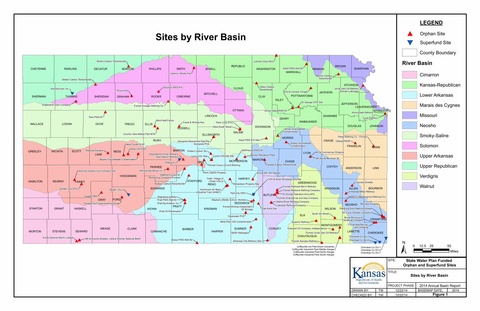
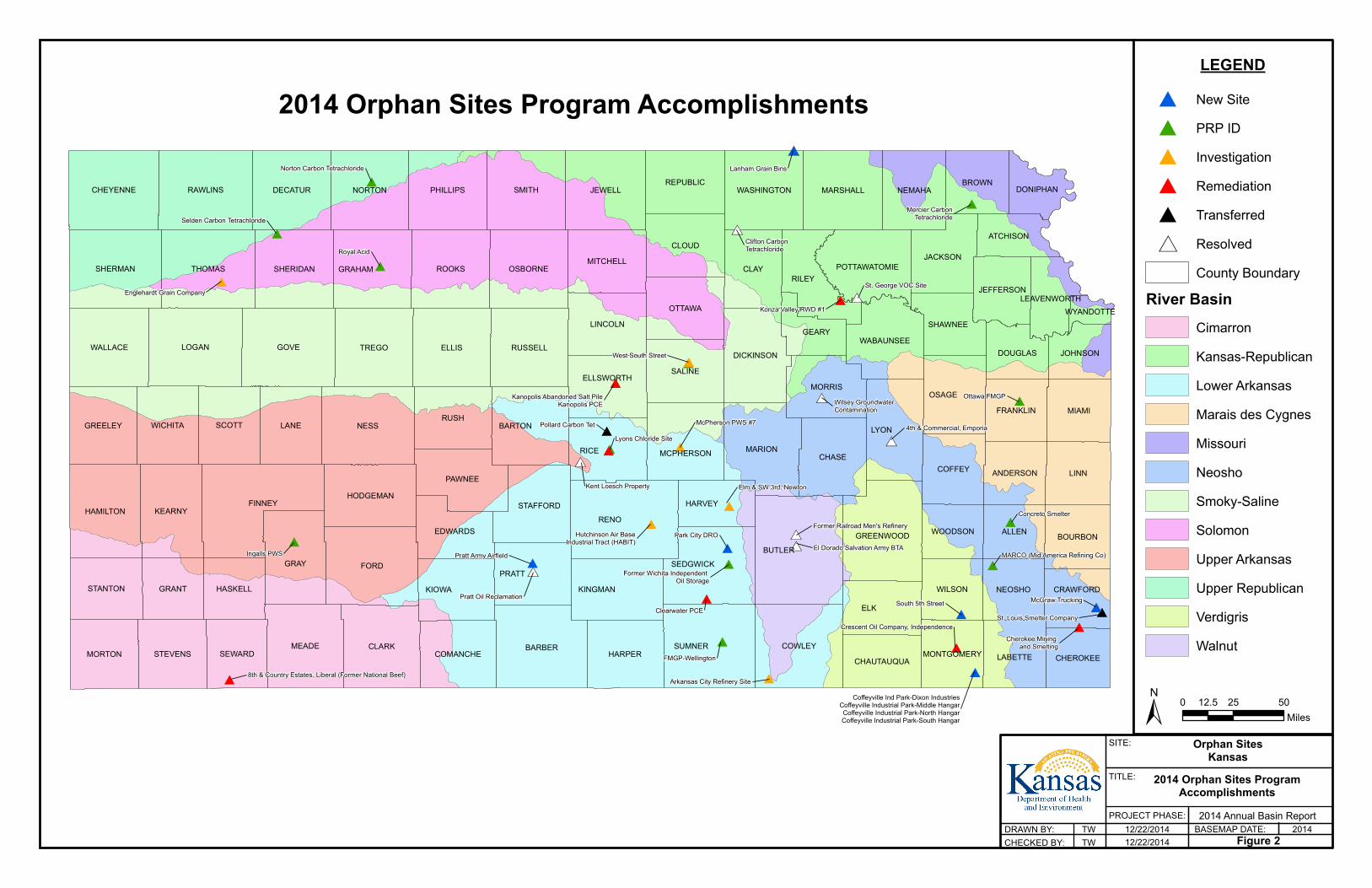
Sites by River Basin Map
Sites by River Basin Map: The Sites by River Basin Map provides an overview of the State of Kansas, the twelve river basins, and the location of the Orphan Site and Superfund Program sites.

#
#
#
#
#
#
#
#
#
#
#
##
#
#
#
#
#
#
#
#
#
#
#
#
# #
#
#
#
#
##
#
#
#
#
#
#
#
#
#
#
##
#
#
#
##
#
#
#
##
#
#
#
## #
#
#
#
#
#
#
#
#
##
#
#
#
#
#
#
#
#
#
#
#
#
#
#
#
#
#
#
#
#
#
#
#
#
#
#*
#*
#*#*
#*#*#*#*
#*
2nd & General Welch, Liberal 8th & Country Estates, Liberal (Former National Beef) Kiowa PWS Well #2 Arkansas City Refinery Site
Pratt Oil Reclamation
Pratt Ag Aviation, Inc.Pratt PWS Well #2Pratt Army Airfield
Hudson Carbon Tetrachloride
Stafford County Oil Reclaiming Company (Former)
Pollard Carbon Tet
Former Cusco Oil and Refining
Kent Loesch Property
Lyons VOC Site Lyons Chloride Site
McPherson PWS #7Warren Petroleum Plant
Elm & SW 3rd, Newton
Richardson Property SiteYoder, Village of
(Yoder VOCs)
Hutchinson Air BaseIndustrial Tract (HABIT) Park City DRO
Mayberry Middle School, Wichita
Oak Knoll Site
Clearwater PCE
Former Wichita Independent Oil Storage
Belle Plain GW Contamination
FMGP-Wellington
Lakeside Refining CompanyWalnut River Refining Company
Former Empire Fuel and Gas CompanyEl Dorado Salvation Army BTAFormer Reliance Refining CompanyFormer Railroad Men's Refinery
Superior Refinery
South 5th Street
Crescent Oil Company, Independence
Former Kanotex Refinery
Former Uncle Sam Oil Refinery
Concreto Smelter
Webster/Miller RefineryMARCO (Mid America Refining Co)
Pittsburg Short Method SmelterMcGraw Trucking
St. Louis Smelter CompanyBruce Mining and
Smelting CompanyCherokee Mining
and Smelting
Coffeyville Ind Park-Dixon IndustriesCoffeyville Industrial Park-Middle HangarCoffeyville Industrial Park-North HangarCoffeyville Industrial Park-South Hangar
Canada Carbon Tetrachloride
Wilsey GroundwaterContamination
4th Ave & Merchant St
4th & Commercial, Emporia
Ottawa FMGPPaola Refining Co. - Former
Coral RefineryArmourdale Refinery
Latimer Groundwater Contamination
Hope PWS #10 Site
Konza Valley RWD #1
St. George VOC Site
2nd & Leonard, OnagaClifton CarbonTetrachloride Uncle Sam Oil Refinery
(Former) - Atchison
Mercier CarbonTetrachloride
Axtell PWS Well #2
Lanham Grain Bins
Paris Corp (Fmr)West South Street
Kanopolis Abandoned Salt PileKanopolis PCE
Lebanon Nitrate Site
Stockton PWS #10
Former Krueger Refining Co.
Fossil & Wichita Ave.Bird-Feldt Farms
Country View Mobile Park BTA
Royal Acid
Norton Carbon Tetrachloride
Park PWS #1
Selden Carbon Tetrachloride
Ace Services, Inc.
Englehardt Grain Company
Bazine Groundwater Contamination
Alamota Elevator Ness City PWSNess Crude Oil #2
Great Bend Former Refinery Site (Falcon Refinery)
Mid-Kansas Aerial, Inc.
Dodge City Cooperative Exchange
Ingalls PWS
Garden City VOCs
Holcomb Garden City Company Site
Wright, City of
Plating Inc
57th & North Broadway, Wichita
Cherokee Co OU-1Cherokee Co OU-5Cherokee Co OU-7
Cherokee Co OU-3Cherokee Co OU-4
RENO
NESS
FORD
GOVE
BUTLER
FINNEY
ELK
ELLIS
LYON
LOGAN
GRAY
RICE
SMITH
CLARK
LANE
BARBERMEADE
CLAY
SUMNER
LINN
THOMAS
TREGO
ROOKS
RUSH
COWLEY
RAWLINS JEWELL
MARION CHASE
PRATT
RILEY
BARTON
SHERMAN
KIOWA
NORTON
SCOTT
PHILLIPS
CLOUD
GRAHAM
KEARNY
MIAMI
SALINE
OSAGE
RUSSELLWALLACE
DECATUR
HAMILTON
CHEYENNE
HARPER
OSBORNE
SEDGWICKKINGMAN
OTTAWA
SHERIDAN
PAWNEE
MORRIS
NEMAHAMARSHALL
WICHITA
LINCOLN
GREENWOOD
GREELEY
GRANT
COFFEY
MORTON
ALLEN
DICKINSON
BROWN
STEVENS
REPUBLIC
MITCHELL
HODGEMAN
JACKSON
WILSON
SEWARD LABETTE
STANTON
MCPHERSON
WASHINGTON
COMANCHE
HARVEY
NEOSHO
WABAUNSEE
HASKELL
BOURBONEDWARDS
GEARY
ELLSWORTH
FRANKLIN
SHAWNEE
POTTAWATOMIE
ANDERSON
CHEROKEE
JOHNSON
CRAWFORD
DOUGLAS
JEFFERSON
WOODSON
CHAUTAUQUA
ATCHISON
MONTGOMERY
DONIPHAN
STAFFORD
LEAVENWORTHWYANDOTTE
SITE:
TITLE:
PROJECT PHASE:BASEMAP DATE:DRAWN BY:
CHECKED BY:
Sites by River Basin
State Water Plan Funded Orphan and Superfund Sites
12/22/1412/22/14 Figure 1
20142014 Annual Basin Report
TWTW
± 0 25 5012.5Miles
Sites by River BasinLEGEND
# Orphan Site
River BasinCounty Boundary
CimarronKansas-RepublicanLower ArkansasMarais des CygnesMissouriNeoshoSmoky-SalineSolomonUpper ArkansasUpper RepublicanVerdigrisWalnut
#*Superfund Site
13
CONTAMINATION REMEDIATION – KDHE ORPHAN SITES INTRODUCTION State Water Plan (SWP) funding is utilized by KDHE for addressing contaminated orphan sites in Kansas. Two programs address the sites funded by SWP: Orphan Sites Program (OSP) and Superfund Program (SFP). The following summarizes each Program, the respective accomplishments for 2014 and planned activities for 2015.
OSP INFORMATION
The OSP uses SWP funding for the evaluation, monitoring, and remediation of contaminated sites in the State of Kansas, where the responsible party is unknown or is unable or unwilling to undertake the necessary action. The program also provides funding to supply alternate water sources as an emergency response action to residences with contaminated drinking water sources. The OSP was developed with the specific objective of providing a mechanism to address sites which for one reason or another fall outside the parameters of other programs. These sites, referred to as orphan sites, generally do not have federal, state, or other funding sources available for complete investigation and cleanup activities. The program is designed as a mechanism to balance the need to hold parties accountable for the cost of investigation and remediation of contamination they have caused, while avoiding pointless delays and further environmental damage when no responsible party can be found, or when such parties are recalcitrant and uncooperative. Upon the addition of a contaminated site to the program, OSP staff review available information about the site and evaluate the problem to determine the existence of contamination, the presence of affected or potentially affected health and environmental receptors, the source of the pollution, and the priority of the contaminated site based on the site’s score on the Contaminated Sites Ranking System. If no previous investigation has been conducted, investigation may be necessary to obtain enough information to rank the site. Depending on the level of threat the site poses to the public, the contaminated site may be placed in a long-term monitoring (LTM) program, or proceed through one or more investigative phases which may result in a remedial action. OSP funds may be used to determine sources of contamination, identify responsible parties, take legal or administrative actions tied to sites where OSP funds have been expended, seek cost recovery from responsible parties for funds expended by the program on a site, and for the administration of the program. At the end of 2014 there are 86 sites in the OSP. Consultants and project managers have worked together to investigate seven OSP sites in 2014. In addition, project managers have been monitoring contamination at 48 OSP sites. ACTIVITIES IN THE OSP Due to the large number of sites in OSP, funding provided by the SWP was prioritized so those sites which pose the most serious threat to the public and/or the environment are remediated. The prioritization includes orphan sites under state control in the SFP (see SFP section below). Many
14
sites are monitored to ensure that contamination does not migrate to receptors such as public and private water supply wells. Providing an alternative water supply is a common function of the OSP where needed to protect public health. A site in the program may progress through one or more phases prior to reclassification or transfer out of the program. A table indicating the status of each site is included at the end of the report. OSP staff conduct many tasks internally to most efficiently utilize the limited funding, thereby saving resources for remedial activities. Sites will continue to be managed efficiently and evaluated based on priority to make sure potential and actual impacts to human health and the environment are adequately addressed. In order to conserve resources for the OSP’s primary mission of protecting the citizens and environment of Kansas, this annual report is being delivered electronically. It may be downloaded from the Bureau of Environmental Remediation (BER) website at http://www.kdheks.gov/ars/swp/index.html. OSP POTENTIALLY RESPONSIBLE PARTY SEARCH KDHE will determine whether a viable potentially responsible party (PRP), able to pay for the costs of investigation and cleanup, exists for each site. Should a PRP be identified, the site will be referred to another appropriate KDHE program. OSP EMERGENCY RESPONSE ACTIVITIES As an interim corrective action, a site may qualify for an emergency response if the sole source of drinking water is contaminated at levels exceeding the federally mandated Safe Drinking Water Standards, there are no alternate sources of water, and the responsible party is unknown, unwilling, or unable to respond. The OSP emergency response program may fund a remedial action to provide safe drinking water, and may perform a PRP search for eventual cost recovery. Emergency responses may include providing bottled drinking water, connecting a household to a public water supply (PWS), installing a household filtration or treatment system, or installing a treatment system at a public water supply. OSP INVESTIGATION ACTIVITIES
Preliminary Site Evaluation/Contamination Assessment If investigation is recommended, the site undergoes two separate investigation phases. The Preliminary Site Evaluation (PSE), generally conducted by environmental contractors, entails a complete historical records search and limited environmental sampling to determine the presence or absence of contamination. This sampling may include the collection and analysis of samples from existing water wells and, if necessary, an intensive phase involving surface and subsurface water and soil sample collection through direct push sampling techniques. If the site is determined to be contaminated and no responsible party is identified through the PSE, the site may progress to the Contamination Assessment (CA) phase. The CA is designed to delineate the lateral and vertical extent of contamination, and may include more intensive subsurface soil and groundwater sample collection through direct push sampling techniques and/or the installation of
15
monitoring wells. The contractor is required to submit a Work Plan to be reviewed for completeness, adequacy, and technical competency in accordance with state regulatory policies and guidelines. The investigations are intended to:
• characterize the type and extent of the contamination, • identify and characterize contamination source area(s), • identify the responsible party or parties, and • identify any human and environmental targets impacted by the contamination.
OSP REMEDIATION ACTIVITIES Corrective Action Study Following a comprehensive investigation, if the responsible party remains unknown or is unwilling or unable to address the contamination, the OSP may fund remediation. The Corrective Action Study (CAS) recommends a corrective action based on feasibility, effectiveness, and cost. Additional investigation may be required before a corrective action can be recommended. Some remedial actions evaluated include soil removal or in-place contaminant stabilization, groundwater treatment by air stripping or filtering, and monitored natural attenuation in which the contaminants are monitored while natural physical and biological processes reduce the contaminants to acceptable levels. Corrective Action Plan Once a corrective action is chosen, the environmental contractor submits a Corrective Action Plan (CAP). The CAP very specifically describes the remedial procedure, costs, and an implementation schedule. Corrective Action Once a cleanup plan has been prepared and approved, the on-site work can begin. The effectiveness of the corrective action is verified by post-cleanup sampling of the contaminated site and LTM. Typically, large remediation projects may take two to three years to complete after a thorough investigation and evaluation of alternatives; some projects, particularly groundwater cleanups, will require even more time to reach cleanup objectives. A large majority of the initial time on a cleanup project is spent evaluating various cleanup alternatives in terms of effectiveness, cost, and cleanup plan development. Once a cleanup plan has been prepared and approved, the on-site work can begin.
16
OSP MONITORING AND CLOSURE ACTIVITIES Long-Term Monitoring Sites in which contamination has been documented and cleanup is currently not appropriate, based on available funding and/or priority, may be recommended for LTM. LTM provides periodic surveillance and re-evaluation of the sites. Sites in LTM are generally sampled on an annual or bi-annual basis. Sites can be removed from LTM in one of the following ways:
• The site is reclassified as resolved because monitoring demonstrates cleanup goals have been achieved and maintained for four consecutive, equally time-sequenced sampling episodes conducted under KDHE oversight over a period of no less than two years, or as otherwise approved by KDHE; or
• The site is transferred to another KDHE program such as the Dry Cleaning Facility Release Trust Fund, the State Cooperative Program, the Voluntary Cleanup and Property Redevelopment Program (VCPRP), or an applicable program in the KDHE/BER Storage Tank Section.
Transfer of Sites A site may be transferred to another KDHE/BER program if a PRP is identified, the use of an Environmental Use Control (EUC) will prevent exposure to remaining contamination, or a more appropriate funding mechanism is available for the site (i.e. the Dry Cleaning Facility Trust Fund or Storage Tank Trust Fund, etc.). Resolution of Sites Sites are reclassified as resolved once cleanup goals have been met or once contamination at the site has fallen to levels within criteria established in KDHE’s Reclassification Plan. OSP ACCOMPLISHMENTS FOR 2014 Program efforts are focused on characterizing contamination problems, identifying PRPs, evaluating the risk to human health and the environment associated with the contamination, and remediation through cleanup or EUCs. The majority of the program’s sites are being addressed in response to groundwater impacts which have affected or threaten public and/or private drinking water wells. There are 86 sites currently in the program. Sites within the program continue to make progress beyond investigative stages and toward remediation. Eleven of the program’s sites are in some phase of remediation or are waiting on funding for these activities. Sites are prioritized with a scoring system based on health risk to identify sites requiring immediate attention. Further, the scoring system provides a tool to ensure funds are available for continuing investigations and cleanup evaluations, while allowing funding for more cost-intensive cleanup activities.
17
Additional investigation activities were conducted at several sites this year. The purpose of the site investigations was to:
• identify potential source areas, • provide additional data to help delineate a plume, • establish additional groundwater data to better characterize the hydrogeology of the
aquifer, and/or • define the vertical and horizontal extent of contamination to establish a waste volume for
proposal of a cap design. Sites Added to OSP Ten new sites (Coffeyville Ind Park-Dixon Industries, Coffeyville Industrial Park-Middle Hangar, Coffeyville Industrial Park-North Hangar, Coffeyville Industrial Park-South Hangar, Lanham Grain Bins, McGraw Trucking, Park City DRO, Pratt Army Airfield, and South 5th Street) were added to the program in 2014. Potentially Responsible Party Search Extensive research to identify PRPs was conducted on 14 sites in 2014 (Concreto Smelter, El Dorado Salvation Army BTA, FMGP-Wellington, Former Wichita Independent Oil Storage, Ingalls PWS, Kanopolis Abandoned Salt Pile, Lyons Chloride Site, MARCO, Mercier Carbon Tetrachloride, Norton Carbon Tetrachloride, Ottawa FMGP, Royal Acid, Selden Carbon Tetrachloride, and West South Street). Emergency Response Activities Funds were used to install and operate and/or maintain treatment systems at two sites in 2014 (Hutchinson Air Base Industrial Tract (HABIT) and Konza Valley RWD #1). Investigation Activities Seven sites have undergone investigative activities in 2014 (Arkansas City Refinery Site, Elm & SW 3rd-Newton, Englehardt Grain Company, Hutchinson Air Base Industrial Tract (HABIT), Konza Valley RWD #1, McPherson PWS #7, and West South Street). Remediation Activities There are eight sites subject to some form of remediation (8th and Country Estates (Former National Beef), Clearwater PCE, Crescent Oil Company-Independence, Kanopolis PCE, Konza Valley RWD #1, Lyons Chloride Site, McGraw Trucking, and Pratt Oil Reclamation). Monitoring and Closure Activities There are 48 sites currently in LTM. Transfer of Sites One site was transferred from the program in 2014. Investigative activities at the Pollard Carbon Tet site determined a source area of contamination and a PRP search identified a responsible party. The site was transferred to the State Cooperative Program.
18
Resolution of Sites Nine sites were resolved in 2014 (4th & Commercial-Emporia, Clifton Carbon Tetrachloride, El Dorado Salvation Army BTA, Former Railroad Men’s Refinery, Kent Loesch Property, Lanham Grain Bins, Pratt Oil Reclamation, St. George VOC Site, and Wilsey Groundwater Contamination). PLANNED OSP ACCOMPLISHMENTS FOR 2015 The following proposed activities are being considered by KDHE subject to prioritization based on the SWP funding provided for FY14 and FY15. A remediation project proposed at the Cherokee Mining and Smelting site may be awarded to consultants if funding becomes available. Sites will be prioritized and addressed based on their priority ranking. The OSP will continue to deal with property access, PRP searches, public relations, and other activities associated with OSP site management. Sites that may be investigated or remediated in 2015 include 2nd and Leonard, Onaga; Arkansas City Refinery Site; Bruce Mining and Smelting Company; Country View Mobile Park BTA; Elm and Southwest 3rd, Newton; Hutchinson Air Base Industrial Tract (HABIT); McPherson PWS #7; Mercier Carbon Tetrachloride; Ness Crude Oil #2; Pratt Army Airfield; Pratt PWS Well #2; Stockton PWS #10; and the FMGP—Wellington sites. SFP INFORMATION
The SFP provides state oversight of EPA Superfund Sites, which are typically orphaned sites with no responsible parties or portions of the site are orphan and require the use of federal Superfund money to accomplish the clean up. The federal Superfund law requires states to provide a 10 percent cost match for remedial activities and to take over long term operation and maintenance of those remedial systems after they have been determined to be Operational and Functional (e.g soil repositories) or after the Long Term Remedial Action is complete (e.g. groundwater treatment systems), depending on the type of remedial system. KDHE and EPA sign a Superfund State Contract (SSC) for each site requiring remedial action. The SSC details the state match and state-lead operations and maintenance (O&M) requirements. Sites follow the same general assessment and remediation process as noted above for the OSP. SFP ACCOMPLISHMENTS FOR 2014 SFP activities utilizing State Water Plan funding in 2014 included conducting long-term O&M on a groundwater treatment system at the Ace Services Superfund Site in Colby, Kansas. Per the SSC, KDHE took over the long-term operation of the treatment plan on April 16, 2014. Funding is used for operations, maintenance and purchase of replacement resin for removal of chromium from the groundwater as it is pumped for use in the City of Colby Public Water Supply System.
19
PLANNED SFP ACCOMPLISHMENTS FOR 2015 The following proposed activities are being considered by KDHE subject to prioritization based on the SWP funding provided for FY14 and FY15. The SFP will utilize SWP funding to provide continued long-term O&M for the groundwater treatment system at the Ace Services Superfund Site in Colby Sites within the SFP potentially subject to payment of outstanding or future state match funding in 2015 include: City of Wright (groundwater monitoring), Cherokee County OU-1 (drinking water system), Cherokee County OU-3/4 (Phase I Baxter Springs/Treece remediation), Cherokee County OU-5 (Galena remediation), and Cherokee County OU07 (Galena residential yard remediation). Potential upcoming remediation projects that may be subject to a 10 percent state match are: Wichita- 57th & North Broadway (Groundwater remediation), Great Bend – Plating Inc. (Groundwater remediation).

21
OSP ACCOMPLISHMENTS
This section of the report highlights some of the program accomplishments for the year 2014.

#
#
#
#
#
#
#
#
#
#
#
#
#
#
#
#
#
#
#
#
#
#
##
#
#
#
#
#
#
#
#
#*
#*
#*#*
#*
#*
#*
#*
#*
#
#
#
##
#
8th & Country Estates, Liberal (Former National Beef)Arkansas City Refinery Site
Pratt Oil Reclamation
Pratt Army Airfield
Pollard Carbon Tet
Kent Loesch Property
Lyons Chloride Site
McPherson PWS #7
Elm & SW 3rd, Newton
Hutchinson Air BaseIndustrial Tract (HABIT)
Park City DRO
Clearwater PCE
Former Wichita Independent Oil Storage
FMGP-Wellington
El Dorado Salvation Army BTA
Former Railroad Men's Refinery
South 5th Street
Crescent Oil Company, Independence
Concreto Smelter
MARCO (Mid America Refining Co)
McGraw Trucking
St. Louis Smelter Company
Cherokee Mining and Smelting
Coffeyville Ind Park-Dixon IndustriesCoffeyville Industrial Park-Middle HangarCoffeyville Industrial Park-North HangarCoffeyville Industrial Park-South Hangar
Wilsey GroundwaterContamination
4th & Commercial, Emporia
Ottawa FMGP
Konza Valley RWD #1
St. George VOC Site
Clifton CarbonTetrachloride
Mercier CarbonTetrachloride
Lanham Grain Bins
West South Street
Kanopolis Abandoned Salt PileKanopolis PCE
Royal Acid
Norton Carbon Tetrachloride
Selden Carbon Tetrachloride
Englehardt Grain Company
Ingalls PWS
RENO
NESS
FORD
GOVE
BUTLER
FINNEY
ELK
ELLIS
LYON
LOGAN
GRAY
RICE
SMITH
CLARK
LANE
BARBERMEADE
CLAY
SUMNER
LINN
THOMAS
TREGO
ROOKS
RUSH
COWLEY
RAWLINS JEWELL
MARIONCHASE
PRATT
RILEY
BARTON
SHERMAN
KIOWA
NORTON
SCOTT
PHILLIPS
CLOUD
GRAHAM
KEARNY
MIAMI
SALINE
OSAGE
RUSSELLWALLACE
DECATUR
HAMILTON
CHEYENNE
HARPER
OSBORNE
SEDGWICK
KINGMAN
OTTAWA
SHERIDAN
PAWNEE
MORRIS
NEMAHAMARSHALL
WICHITA
LINCOLN
GREENWOOD
GREELEY
GRANT
COFFEY
MORTON
ALLEN
DICKINSON
BROWN
STEVENS
REPUBLIC
MITCHELL
STAFFORDHODGEMAN
JACKSON
WILSON
SEWARD LABETTE
STANTON
MCPHERSON
WASHINGTON
COMANCHE
HARVEY
NEOSHO
WABAUNSEE
HASKELL
BOURBONEDWARDS
GEARY
ELLSWORTH
FRANKLIN
SHAWNEE
POTTAWATOMIE
ANDERSON
CHEROKEE
JOHNSON
CRAWFORD
DOUGLAS
JEFFERSON
WOODSON
CHAUTAUQUA
ATCHISON
MONTGOMERY
DONIPHAN
LEAVENWORTHWYANDOTTE
SITE:
TITLE:
PROJECT PHASE:BASEMAP DATE:DRAWN BY:
CHECKED BY:
2014 Orphan Sites ProgramAccomplishments
Orphan SitesKansas
12/22/201412/22/2014 Figure 2
20142014 Annual Basin Report
TWTW
± 0 25 5012.5Miles
2014 Orphan Sites Program AccomplishmentsLEGEND
River Basin
# New Site# PRP ID# Investigation# Remediation
TransferredResolvedCounty Boundary
CimarronKansas-RepublicanLower ArkansasMarais des CygnesMissouriNeoshoSmoky-SalineSolomonUpper ArkansasUpper RepublicanVerdigrisWalnut
#*
#
Kansas Department of Health and Environment Bureau of Environmental Remediation, Assessment and Restoration Section
Orphan Sites Program
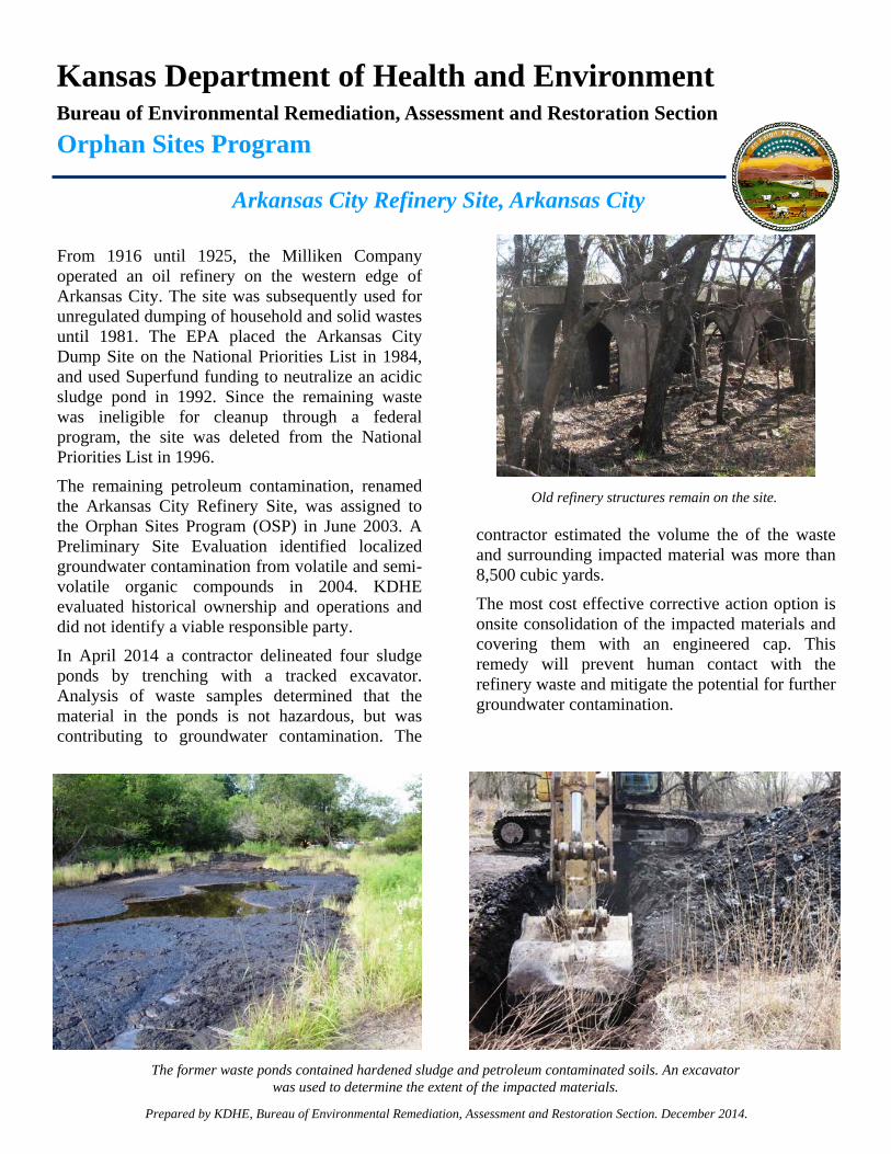
Arkansas City Refinery Site, Arkansas City
From 1916 until 1925, the Milliken Company operated an oil refinery on the western edge of Arkansas City. The site was subsequently used for unregulated dumping of household and solid wastes until 1981. The EPA placed the Arkansas City Dump Site on the National Priorities List in 1984, and used Superfund funding to neutralize an acidic sludge pond in 1992. Since the remaining waste was ineligible for cleanup through a federal program, the site was deleted from the National Priorities List in 1996.
The remaining petroleum contamination, renamed the Arkansas City Refinery Site, was assigned to the Orphan Sites Program (OSP) in June 2003. A Preliminary Site Evaluation identified localized groundwater contamination from volatile and semi-volatile organic compounds in 2004. KDHE evaluated historical ownership and operations and did not identify a viable responsible party.
In April 2014 a contractor delineated four sludge ponds by trenching with a tracked excavator. Analysis of waste samples determined that the material in the ponds is not hazardous, but was contributing to groundwater contamination. The
contractor estimated the volume the of the waste and surrounding impacted material was more than 8,500 cubic yards.
The most cost effective corrective action option is onsite consolidation of the impacted materials and covering them with an engineered cap. This remedy will prevent human contact with the refinery waste and mitigate the potential for further groundwater contamination.
Prepared by KDHE, Bureau of Environmental Remediation, Assessment and Restoration Section. December 2014.
The former waste ponds contained hardened sludge and petroleum contaminated soils. An excavator was used to determine the extent of the impacted materials.
Old refinery structures remain on the site.
Kansas Department of Health and Environment Bureau of Environmental Remediation, Assessment and Restoration Section
Orphan Sites Program
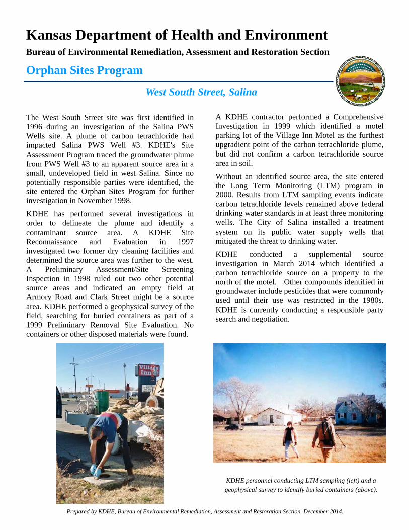
West South Street, Salina
The West South Street site was first identified in 1996 during an investigation of the Salina PWS Wells site. A plume of carbon tetrachloride had impacted Salina PWS Well #3. KDHE's Site Assessment Program traced the groundwater plume from PWS Well #3 to an apparent source area in a small, undeveloped field in west Salina. Since no potentially responsible parties were identified, the site entered the Orphan Sites Program for further investigation in November 1998.
KDHE has performed several investigations in order to delineate the plume and identify a contaminant source area. A KDHE Site Reconnaissance and Evaluation in 1997 investigated two former dry cleaning facilities and determined the source area was further to the west. A Preliminary Assessment/Site Screening Inspection in 1998 ruled out two other potential source areas and indicated an empty field at Armory Road and Clark Street might be a source area. KDHE performed a geophysical survey of the field, searching for buried containers as part of a 1999 Preliminary Removal Site Evaluation. No containers or other disposed materials were found.
A KDHE contractor performed a Comprehensive Investigation in 1999 which identified a motel parking lot of the Village Inn Motel as the furthest upgradient point of the carbon tetrachloride plume, but did not confirm a carbon tetrachloride source area in soil.
Without an identified source area, the site entered the Long Term Monitoring (LTM) program in 2000. Results from LTM sampling events indicate carbon tetrachloride levels remained above federal drinking water standards in at least three monitoring wells. The City of Salina installed a treatment system on its public water supply wells that mitigated the threat to drinking water.
KDHE conducted a supplemental source investigation in March 2014 which identified a carbon tetrachloride source on a property to the north of the motel. Other compounds identified in groundwater include pesticides that were commonly used until their use was restricted in the 1980s. KDHE is currently conducting a responsible party search and negotiation.
Prepared by KDHE, Bureau of Environmental Remediation, Assessment and Restoration Section. December 2014.
KDHE personnel conducting LTM sampling (left) and a geophysical survey to identify buried containers (above).
Kansas Department of Health and Environment Bureau of Environmental Remediation, Assessment and Restoration Section
Orphan Sites Program
2014 Ongoing Investigations
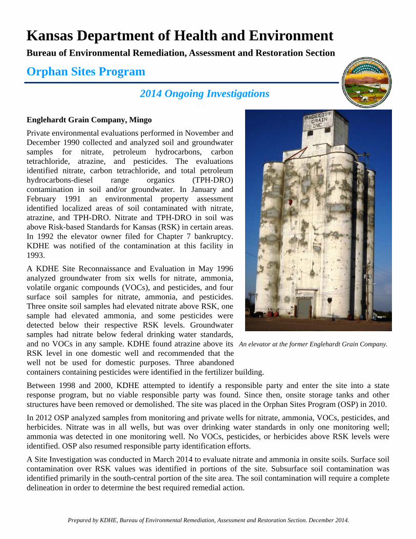
Englehardt Grain Company, Mingo
Private environmental evaluations performed in November and December 1990 collected and analyzed soil and groundwater samples for nitrate, petroleum hydrocarbons, carbon tetrachloride, atrazine, and pesticides. The evaluations identified nitrate, carbon tetrachloride, and total petroleum hydrocarbons-diesel range organics (TPH-DRO) contamination in soil and/or groundwater. In January and February 1991 an environmental property assessment identified localized areas of soil contaminated with nitrate, atrazine, and TPH-DRO. Nitrate and TPH-DRO in soil was above Risk-based Standards for Kansas (RSK) in certain areas. In 1992 the elevator owner filed for Chapter 7 bankruptcy. KDHE was notified of the contamination at this facility in 1993.
A KDHE Site Reconnaissance and Evaluation in May 1996 analyzed groundwater from six wells for nitrate, ammonia, volatile organic compounds (VOCs), and pesticides, and four surface soil samples for nitrate, ammonia, and pesticides. Three onsite soil samples had elevated nitrate above RSK, one sample had elevated ammonia, and some pesticides were detected below their respective RSK levels. Groundwater samples had nitrate below federal drinking water standards, and no VOCs in any sample. KDHE found atrazine above its RSK level in one domestic well and recommended that the well not be used for domestic purposes. Three abandoned containers containing pesticides were identified in the fertilizer building.
Between 1998 and 2000, KDHE attempted to identify a responsible party and enter the site into a state response program, but no viable responsible party was found. Since then, onsite storage tanks and other structures have been removed or demolished. The site was placed in the Orphan Sites Program (OSP) in 2010.
In 2012 OSP analyzed samples from monitoring and private wells for nitrate, ammonia, VOCs, pesticides, and herbicides. Nitrate was in all wells, but was over drinking water standards in only one monitoring well; ammonia was detected in one monitoring well. No VOCs, pesticides, or herbicides above RSK levels were identified. OSP also resumed responsible party identification efforts.
A Site Investigation was conducted in March 2014 to evaluate nitrate and ammonia in onsite soils. Surface soil contamination over RSK values was identified in portions of the site. Subsurface soil contamination was identified primarily in the south-central portion of the site area. The soil contamination will require a complete delineation in order to determine the best required remedial action.
Prepared by KDHE, Bureau of Environmental Remediation, Assessment and Restoration Section. December 2014.
An elevator at the former Englehardt Grain Company.
Kansas Department of Health and Environment Bureau of Environmental Remediation, Assessment and Restoration Section
Orphan Sites Program
2014 Ongoing Investigations
McPherson PWS #7, McPherson
The McPherson PWS #7 site was discovered in 1997 during an investigation of an aerial pesticide application facility at the McPherson City/County Airport. Tetrachloroethylene (PCE), 1,1-dichloroethene, and 1,1,1-trichloroethane were discovered in a monitoring well north of the facility and west of the Public Water Supply (PWS) #7 well. The chlorinated compounds were attributed to the aerial pesticide application facility.
KDHE performed a Preliminary Assessment/Screening Site Investigation in 2000-2001. Data suggested a volatile organic compound (VOC) source area in an open area on airport property south of PWS #7. Two types of geophysical surveys, a magnetometer survey and a terrain conductivity survey, yielded no evidence of buried containers or wastes. Since the source area could not be attributed to any apparent discharge facility, the site entered the Orphan Sites Program (OSP) in 2001.
In September 2001 a Comprehensive Investigation sampled area wells and advanced direct-push probes for soil and groundwater samples. While VOCs were detected in one groundwater probe and one monitoring well below Risk-based Standards for Kansas (RSK) levels, the investigation did not discover any specific source facility or apparent discharge area. The site entered the Long Term Monitoring (LTM) program in 2002.
Since 2002 the OSP annually monitors two monitoring wells and PWS #7 for VOCs. Analytical results for one monitoring well show increasing PCE concentrations from 2002 to 2007, but a decline since 2008. PCE had been non-detect in PWS #7 until 2010 when concentrations appeared below RSK levels.
In February 2014 the two older and dry monitoring wells were plugged by KDHE. In March and April a two-Phase Groundwater Investigation included collecting groundwater samples (Phase I) and installing three new monitoring wells near PWS #7 (Phase II). Phase I collected ten groundwater samples and detected PCE southwest of PWS #7. Phase II activities were completed in April and included the installation of three monitoring wells. PCE was detected above RSK in one monitoring well. Additional investigations are needed south, southwest, and southeast of these VOC detections.
A Phase III Groundwater Investigation took place in October 2014 to search for source areas and to delineate the PCE plume. The OSP is currently waiting for the draft report. The site will remain in the LTM program until reclassification criteria are met.
Prepared by KDHE, Bureau of Environmental Remediation, Assessment and Restoration Section. December 2014.
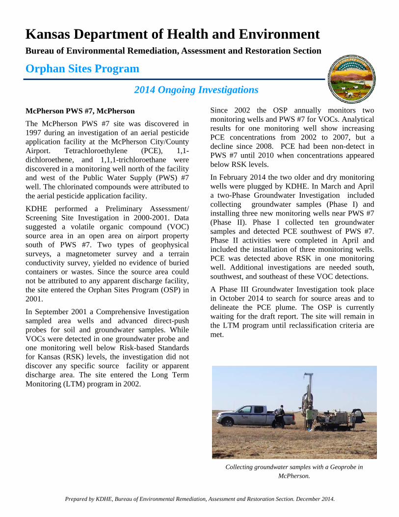
Collecting groundwater samples with a Geoprobe in McPherson.
29
SITE UPDATES BY RIVER BASIN
This section of the report provides a summary of the work performed in 2014 at the OSP sites.

Cimarron Basin Update
31
CIMARRON RIVER DRAINAGE BASIN
Site Name: 2nd & General Welch, Liberal Location: Liberal, Seward County KDHE District: Southwest, Dodge City Contamination: Tetrachloroethylene Status: Monitoring Site Summary: The 2nd & General Welch, Liberal site is located near the intersection of 2nd Street and General Welch Boulevard in Liberal, Seward County, Kansas, within the historical limits of the Liberal Army Airfield. The site was referred to KDHE’s Remedial Section in 1999 when tetrachloroethylene (PCE) appeared in monitoring wells associated with a nearby Underground Storage Tank (UST) site. Some of these monitoring wells consistently contained PCE until groundwater levels dropped below the total depth of the wells in 2001, and they were abandoned and plugged. In October 1999 the Site Assessment Unit investigated. Groundwater samples from five of the UST monitoring wells contained PCE at concentrations below KDHE Risk-based Standards for Kansas (RSK) levels. Soil samples indicated PCE detections at Building 639, a former engine-cleaning facility on the north side of the Liberal Combat Air Museum. The OSP and the KDHE Formerly Utilized Defense Sites (FUDS) Program jointly evaluated the site in 2004. The evaluation did not find PCE in the PWS wells or a nearby runway well. Lab results of soil samples suggested PCE contamination below RSK levels was limited to the area of former Building 639. In October 2005 samples from two City of Liberal PWS wells showed no PCE impact to these wells, which extend more than 400 feet below ground surface. On June 22, 2006, KDHE executed an EUC Agreement restricting groundwater use and certain activities at the property. The EUC agreement required installing deeper monitoring wells and LTM sampling. Two monitoring wells were installed in February 2008; LTM activities include annual sampling of two monitoring wells and one PWS well. December 2014 Update: Analytical results from the April 2014 LTM sampling event indicated PCE was detected in both monitoring wells; one well’s detection was above RSK while the other well’s detection was below RSK. No volatile organic compounds (VOCs) were detected in the PWS well. Additional monitoring wells should be installed further downgradient. Due to a lack of adequate staff and funding, the site will be placed on biennial sampling and will remain in the LTM program until reclassification criteria are met.
Cimarron Basin Update
32
Site Name: 8th & Country Estates, Liberal (Former National Beef) Location: Liberal, Seward County KDHE District: Southwest, Dodge City Contamination: Volatile organic compounds Status: Remediation and Monitoring Site Summary: The 8th & Country Estates, Liberal site entered the OSP in 1994. The National Beef Packing Company identified VOC contamination in Well #3 above federal safe drinking water standards. Well #3 is classified as a PWS well. National Beef’s Well #2 also had trace concentrations of these VOCs. Investigations conducted by the EPA, private entities, and the OSP have been unable to identify a contamination source. KDHE and National Beef executed a contract in February 1998. The OSP designed and constructed a remedial air-stripper system to remove VOCs from water pumped from Well #3, and National Beef agreed to operate and maintain the air-stripper after installation. This approach allows National Beef to continue using Well #3 and helps restore the Ogallala aquifer by containing and removing the contaminant from the aquifer. Groundwater modeling indicates that using Well #3 helps contain and reduce the amount of VOCs in groundwater over time. The air-stripper system began operating in July 1999. December 2014 Update: LTM sampling occurred in April, 2014. At the time of the sampling, the air stripper on supply well #3 was not operating due to mechanical issues. Supply well #3 was operating without treatment and was sampled as part of the LTM sampling. Results of the untreated water from supply well #3 was non-detect for all VOCs. Results from other supply and monitoring wells were consistent with previous sampling results.
Kansas-Republican Basin Update
33
KANSAS-REPUBLICAN RIVER DRAINAGE BASIN
Site Name: 2nd & Leonard, Onaga Location: Onaga, Pottawatomie County Contamination: Tetrachloroethylene, trichloroethylene KDHE District: Northeast, Lawrence Status: Monitoring and Assessment Site Summary: The 2nd & Leonard, Onaga site was established in June 2000 when trichloroethylene (TCE) was identified in a groundwater sample collected from a monitoring well at the Lawrence Potter UST Site. Assessments were completed in December 2000 and July 2002. Analytical results from groundwater samples revealed PCE and TCE. No responsible party could be identified. The alley behind 2nd & Leonard Street was identified as the likely source area. The site was transferred to the OSP and placed into the LTM program in September 2002. The first LTM sampling event in January 2004 confirmed the presence of PCE and TCE. KDHE closed the Lawrence Potter UST site and plugged its monitoring wells in January 2005; in August OSP installed six new monitoring wells. Annual LTM sampling events since 2005 have detected PCE and TCE above RSK levels in two monitoring wells. December 2014 Update: The LTM sampling event occurred in November 2014 and OSP was waiting for analytical results at the time of the this report. The source area appears to be along the alley. Focused soil and groundwater sampling to determine the size of the source area and potential remedial options is planned for 2015, subject to funding availability and priority. Due to a lack of adequate staff and funding, the site will be placed on biennial sampling and will remain in the LTM program until reclassification criteria are met. Site Name: Armourdale Refinery Location: Kansas City, Wyandotte County Potential Contamination: Refinery waste including polynuclear aromatic hydrocarbons KDHE District: Northeast, Lawrence Status: Assessment Site Summary: KDHE identified refineries statewide in 2005 through historical reviews and reconnaissance. Historical records indicate these facilities generally operated between 1900 and 1940. KDHE delegated OSP funds to assess site conditions and associated human health and environmental risks, and evaluate PRPs if contamination were found. The Armourdale Refinery site is now occupied by the unused coal-fired power plant owned by the City of Kansas City, Kansas, for use by the Board of Public Utilities. A Phase I Focused Former Refinery Assessment (FFRA) in March 2007 concluded that historic and current uses of
Kansas-Republican Basin Update
34
the subject property and several surrounding properties may pose environmental impacts. A Phase II FFRA has not yet been conducted. December 2014 Update: Due to its low priority ranking and limited resources, funds, and staff, the OSP did not work at the Armourdale Refinery site in 2014. Site Name: Axtell PWS Well #2 Location: Axtell, Marshall County Contamination: Nitrate KDHE District: Northeast, Lawrence Status: Monitoring and Assessment Site Summary: The Axtell PWS Well #2 site was discovered during statewide sampling of public water supplies when 1,2,-dichloroethane (1,2-DCA) was identified in PWS Well #2. KDHE identified nitrate and 1,2-DCA in local groundwater, but identified no sources. The 1,2-DCA concentrations were attributed to well-head contamination during maintenance on the well or the well house and the well was taken out of service. The site entered the OSP and the LTM program in 1995. Sampling indicates no more contamination by VOCs, but nitrate continues to be above the Maximum Contaminant Level (MCL) in one private lawn and garden well and the former PWS Well #2. KDHE collected subsurface and surface soil and groundwater samples in 2002 and 2003 to investigate the localized nitrate problem. The problem may be due to a former poultry operation on the property. Nitrate levels continue to be elevated. December 2014 Update: The Axtell PWS Well #2 site is sampled biennially to monitor nitrate contamination in one lawn and garden well and the former PWS well. The site was last sampled in May 2013. Nitrate was detected above its MCL value in both wells. Nitrate levels have fluctuated since 1988, particularly in the private lawn and garden well. Nitrate levels in PWS Well #2 are more stable and, while above the MCL, are steadily decreasing. The source area of the nitrate contamination needs to be identified. The site will remain in the LTM program until reclassification criteria are met. Site Name: Clifton Carbon Tetrachloride Location: Clifton, Washington County Contamination: Carbon tetrachloride, nitrate KDHE District: North Central, Salina Status: Resolved Site Summary: The Clifton Carbon Tetrachloride site was referred by KDHE's Storage Tank Section after sampling at the Caldwell's 66 UST site indicated that a monitoring well contained carbon tetrachloride. The UST site is adjacent to a grain elevator. A November 2005 Site Reconnaissance and Evaluation (SRE) sampled six existing monitoring wells and two private

Kansas-Republican Basin Update
35
wells. Two monitoring wells were contaminated with carbon tetrachloride, while elevated nitrates were detected throughout the site area. The nitrates are highly sporadic and do not appear to be attributable to point source releases. In December 2005 the site entered the LTM program. Carbon tetrachloride concentrations, which had persisted in one monitoring well, have dropped to below RSK since 2010. December 2014 Update: Analytical results from the March 2014 LTM sampling event indicated carbon tetrachloride detections in one monitoring well below the RSK level. This was the fifth consecutive event where carbon tetrachloride concentrations were below RSK in the monitoring wells. Per BER Policy #BER-RS-024 Reclassification Plan, the site was reclassified as resolved on April 29, 2014. Site Name: Coral Refinery Location: Kansas City, Wyandotte County Contamination: Total petroleum hydrocarbons, volatile organic compounds, metals KDHE District: Northeast, Lawrence Status: Monitoring and EUC Site Summary: The Coral Refinery site is located north of the Kansas River and just east of the 7th Street Trafficway in Kansas City. From 1970 to 1978, the facility was a waste oil refinery using an acid-clay process. The refinery generated a thick, strong-smelling, acid-hydrocarbon sludge that was disposed of in two on-site sludge pits. In June 1982 the sludge pits were filled with agricultural lime and partially neutralized; however, unneutralized pockets of sludge remained. In 1983 a Site Inspection found sludge seeping from the west side of the site. Another KDHE inspection in 1985 found waste oil accumulating in a nearby gutter and draining into a storm sewer. In 1986 a KDHE Preliminary Assessment found seepage at the surface and along the western flanks of the pit dike. A Site Investigation (SI) installed four monitoring wells, collected soil and sludge samples, and completed a geophysical survey. The SI identified extensive un-mixed, un-stabilized material in the former pits. In 1993 the site entered the OSP. Samples collected from existing wells indicated only trace levels of contamination. The Coral Refinery site entered the State Cooperative Program in the mid-2000s. A 2007 Site Inspection identified unstabilized sludge, impacted with lead, seeping to the surface. A Unified Focused Assessment (UFA) in May 2011 further characterized the waste on site. The State Cooperative Program continued to work with the property owners to address the residual contamination. The OSP began monitoring the groundwater on a semi-annual basis in 2013. December 2014 Update: Since spring of 2013, the semi-annual sampling events have not detected any contaminants of concern above the respective RSK. The State Cooperative Program worked with the property owner to place a cap on the former sludge pit area. An EUC for the former sludge pit area was finalized in September 2014. A fourth LTM sampling event was conducted in November 2014. If the analytical results return with non-detections or detection

Kansas-Republican Basin Update
36
below RSK, OSP will have completed monitoring and would reclassify the site as resolved with restrictions, per the terms of the EUC agreement. Site Name: Konza Valley RWD #1 Location: Manhattan, Riley County Contamination: Tetrachloroethylene KDHE District: North Central, Salina Status: Remediation, Monitoring, and Assessment Site Summary: The Konza Valley RWD #1 site was referred to the OSP in August 2007 by KDHE’s Bureau of Water after PCE was detected above RSK in the PWS #3 well. The initial investigation in August 2007 consisted of confirmation sampling of PWS #3 and sampling six nearby private domestic wells. Three private wells and PWS#3 had PCE concentrations above RSK. In October 2007 three whole house carbon treatment systems were installed at the three impacted residences. KDHE also conducted a groundwater investigation consisting of direct-push sampling onsite. PCE was found over RSK at depths from 24-30 feet below ground surface. In February 2008 three monitoring wells were installed southwest of PWS #3, and PCE was detected above and below RSK. In March 2008 a granular activated carbon (GAC) system was installed on PWS #3, consisting of two 1500-pound vessels designed to treat 65 gallons of water per minute. The GAC system was operational by April 2008. The carbon vessels were placed in an enclosed mobile trailer. Pre-treatment and post-treatment sampling confirmed the treatment systems removed PCE from PWS#3 and the private wells. KDHE continued to maintain the trailer-mounted carbon treatment system and whole-house carbon water treatment systems on three nearby private water supply wells. In April 2009 the site was placed into the LTM Program. In December 2012 the City of Manhattan extended its PWS pipeline to replace water supplied by PWS #3. In May 2013 PWS #3 was taken out of service and abandoned. In October 2013 the GAC system was decommissioned from PWS #3 and removed from the site. December 2014 Update: In January 2014 the GAC was replaced on one private well. In May 2014 a GAC system was installed on an additional private well. A site investigation to identify potential source areas for the PCE groundwater contamination was conducted in October 2014. OSP is currently reviewing the report. The site will remain in the LTM program until reclassification criteria are met.
Kansas-Republican Basin Update
37
Site Name: Lanham Grain Bins Location: Lanham, Washington County Contamination: Carbon tetrachloride KDHE District: North Central, Salina Status: Monitoring and Assessment Site Summary: The Washington County RWD #1 is currently served by four PWS wells, all of which are within 0.5 to 1.5 miles southwest of Lanham. Carbon tetrachloride was first detected in the PWS #4 well in July and October 1991 below RSK. PWS #4 was later abandoned and plugged due to production issues. Starting in 1996, PWS compliance samples were collected from the Lanham Pump House #1. Carbon tetrachloride was detected six times between 2005 and 2011, all below RSK. In March and April 2013, KDHE’s Site Assessment Unit conducted a Preliminary Assessment (PA) which included collecting groundwater samples from the four PWS wells, eleven domestic wells, and from one direct-push sample location. Carbon tetrachloride was detected in one domestic well below RSK, located north of the site in Nebraska; and in one PWS below RSK. Soil samples were collected around a grain storage facility. All soil samples were non-detect for carbon tetrachloride. During the investigation, one-gallon cans of “80/20” grain fumigant were found onsite. The “80/20” fumigant contained 80.9 percent carbon tetrachloride, 16.5 percent carbon disulfide, 2 percent sulfur dioxide, and 0.6 percent pentane. A box of six “80/20” cans (with the bottoms rusted out) plus two additional cans were found in the storage shed and two cans in the weigh station. All cans were found empty. In January and February 2014, the Site Assessment Unit conducted a Site Inspection which included groundwater collection using direct-push and drilling techniques from eleven sample locations and from three domestic wells. Carbon tetrachloride was again detected in the same domestic well below RSK. Two sample locations had carbon tetrachloride detections below RSK. In May 2014 the Nebraska Department of Environmental Quality was notified of the carbon tetrachloride detection in the domestic well. Also in May, the site was referred to the OSP. The site was reclassified as resolved on November 14, 2014 due to a lack of any carbon tetrachloride detections over RSK. The PWS wells will continue to be monitored for VOC compliance through KDHE’s Bureau of Water. A PRP search did not identify any viable responsible parties.
Kansas-Republican Basin Update
38
Site Name: Latimer Groundwater Contamination Location: Latimer, Morris County Contamination: Carbon tetrachloride, ethylene dibromide, trichloroethylene,
perchlorate KDHE District: North Central, Salina Status: Monitoring and Assessment Site Summary: Groundwater impacts were first discovered in the City of Latimer during a 1989 buried tank leak assessment at the Latimer Agri-Services facility. TCE and carbon tetrachloride concentrations exceeded RSK in a private well. Between 1994 and 1996, the Tri-County Public Airport site was discovered in connection with the United States Army Corps of Engineers (USACE) investigation of the former Herington Army Airfield base, located approximately three miles upgradient and southeast of the city of Latimer. During the investigation, the USACE identified TCE contamination in the groundwater. The property was used by the Department of Defense from 1942 to 1945 as a staging facility for aircraft and crews preparing for overseas deployment. Following facility closure in 1945, the Department of Defense transferred the property to the City of Herington in 1948 for use as a public airport and for industrial development. The Beech Aircraft Company (now Raytheon Aircraft Corporation) operated at the airport for a decade during the 1950s to 1960s and used TCE for degreasing activities. A black powder manufacturer and other light industries also operated at the property. KDHE’s 1996 Preliminary Assessment/Screening Site Investigation at the Tri-County Public Airport site detected TCE in monitoring and supply wells. A TCE groundwater plume extends northwest from the former air base to private wells in the city of Latimer. In response, KDHE initiated a Preliminary Removal Evaluation at the Latimer Groundwater Contamination site while the EPA conducted an Expanded Site Investigation of the Tri-County Public Airport site. KDHE executed a Consent Agreement with Raytheon Aircraft Company, identified as a PRP, to address remaining TCE impacts under the KDHE State Cooperative Program. KDHE has since updated the Consent Order to assign Hawker-Beechcraft Corporation as the PRP. The OSP provided bottled water and carbon water treatment systems to Latimer residents with contaminated water supplies. KDHE also initiated a Comprehensive Investigation (CI) in 1998 to further investigate carbon tetrachloride and ethylene dibromide (EDB) impacts. The CI identified the former Latimer Agri-Services facility as a source for an EDB/carbon tetrachloride groundwater plume extending approximately 0.5 miles northwest. The CI also reported elevated nitrate levels, probably from non-point sources. The Latimer Groundwater Contamination site entered the LTM program in October 1998. Early monitoring data reported TCE, carbon tetrachloride, and EDB above respective RSKs and indicated relatively stable groundwater plumes. Private well sample data proved the effectiveness of the in-house treatment systems. LTM analytical data collected in 2002 and 2003 found perchlorate impacts to groundwater. EPA’s 1998 findings prompted additional perchlorate sampling that eventually delineated a
Kansas-Republican Basin Update
39
perchlorate groundwater plume extending to Latimer and surrounding areas. The Hodgdon Powder facility, also located at the Tri-County Public Airport, is a source of perchlorate releases to soil, sediment, surface water, and groundwater. KDHE executed a Consent Agreement with Hodgdon Powder Company in 2002 to address remaining perchlorate impacts under the KDHE State Cooperative Program. Due to the extent of groundwater impacts within the Latimer area EPA, KDHE, and Hodgdon Powder dedicated funds to construct a water supply line from the City of Herington to the City of Latimer. Water line construction and connection to all residences in Latimer was completed in early 2007. EPA gave Raytheon permission to remove the carbon filtration systems. December 2014 Update: In March 2014 OSP sampled seventeen monitoring wells, two livestock wells, and one lawn and garden well for VOCs. Carbon tetrachloride was detected in five well samples, above RSK in two. EDB was detected below RSK in one of the livestock wells. OSP proposes conducting a Source Investigation in 2015, pending sufficient funding. The site will remain in the LTM program until reclassification criteria are met. Site Name: Mercier Carbon Tetrachloride Location: Mercier, Brown County Contamination: Carbon tetrachloride, nitrate KDHE District: Northeast, Lawrence Status: Monitoring, Assessment, and PRP Identification Site Summary: The Mercier Carbon Tetrachloride site was discovered in 1998 when investigative screening of a former United States Department of Agriculture/Commodity Credit Corporation (USDA/CCC) grain bin storage facility discovered carbon tetrachloride above RSK levels in a livestock well. KDHE’s Site Assessment Program investigated in June and August 1998, confirming groundwater impacts by carbon tetrachloride, chloroform, and nitrates. Contaminant source areas were not identified. The site was referred to the OSP in September 1999. Further investigation in July 2000 sampled nearby private wells and installed and sampled six monitoring wells. The results indicated elevated concentrations of carbon tetrachloride in two wells and elevated nitrate concentrations throughout the study area. The investigation did not identify any source areas. Annual LTM since 2001 sampled private and monitoring wells for VOCs and nitrate. By landowner request, four monitoring wells without a history of carbon tetrachloride detections were abandoned and plugged in May 2002. Carbon tetrachloride is consistently above RSK in one monitoring well. Nitrate levels remain elevated above the MCL in nearly all wells sampled, suggesting non-point source nitrate contamination. Although a PWS is available in and near Mercier, one residence had chosen not to connect to it. It was reported that water from the unconnected residence’s well is treated prior to use. All other residences were reportedly connected to the PWS.
Kansas-Republican Basin Update
40
December 2014 Update: A PRP search in March 2014 confirmed the historical presence of USDA/CCC grain storage, as well as another historic grain storage facility. Only one monitoring well was sampled during the November 2014 LTM sampling event. OSP was waiting for analytical results at the time of this report. OSP plans a 2015 Site Investigation, subject to available funding and priority, to delineate the carbon tetrachloride plume and to determine its downgradient and sidegradient extents, as well as focus on source investigations within the historic location of the former USDA/CCC grain bin site. Due to a lack of adequate staff and funding, the site will be placed on biennial sampling and will remain in the LTM program until reclassification criteria are met. Site Name: St. George VOC Site Location: St. George, Pottawatomie County Contamination: 1,2-dichloroethane KDHE District: Northeast, Lawrence Status: Resolved Site Summary: The St. George VOC Site was identified in July 1998 during a statewide sampling of private water wells located near former USDA/CCC grain storage facilities. The study detected 1,2-DCA below RSK in the Taylor Store (a former general store) well; and TCE below RSK in a private lawn and garden well. A confirmatory sampling of the wells in September 1998 indicated that 1,2-DCA was below RSK in the Taylor well and TCE below RSK in the private well. Both the Taylor Store and the private well residence obtain their drinking water from the Pottawatomie County RWD #1. A search of the Resource Conservation and Recovery Act records did not identify any users of 1,2-DCA or TCE in the vicinity of the documented groundwater contamination. KDHE’s Site Assessment Unit conducted a SRE in October 1999, which verified TCE detections in the private well below RSK, and identified several trace detections of petroleum hydrocarbons at the former gas station located south of the former Taylor Store. The former gas station was a KDHE Storage Tank Program site (Former Meinhardt Station) closed after gasoline tanks were removed and no further action was needed. The SRE did not detect 1,2-DCA or TCE in nine groundwater samples collected using direct-push technology, or identify a source area for the TCE contamination found in the private well. The investigation identified 1,2-DCA above RSK in a sample taken from a pressure tank at the Taylor well. The Taylor well was not in service at the time because the basement was flooded, and the sample was taken without purging the well. This contamination may have been related to the former gas station; or, since 1,2-DCA was not detected in any other groundwater samples, may be limited to the Taylor well or the pressure tank. KDHE conducted a Supplemental Sampling Assessment in August 2007 to evaluate the localized contamination. Groundwater samples were collected from five direct-push sample locations, the Black Jack Spring, and the private well; the Taylor well was abandoned and unavailable for sampling. The investigation identified no 1,2-DCA, trace detections of petroleum hydrocarbons
Kansas-Republican Basin Update
41
immediately adjacent to the former gas station UST site, and TCE detections below RSK in the private well, but in no other groundwater sample. Because TCE had been detected at low levels every time the private well has been sampled and no detections of TCE were present in upgradient groundwater samples, the site was referred to OSP for LTM in 2013. Concentrations of TCE observed in the private lawn and garden well were consistently below RSK from 1998 to 2007. The occurrence of elevated 1,2-DCA is suspect due to the sampling and collection method from the holding tank, and nearby groundwater samples adjacent to the well location could not duplicate the elevated concentrations. Since this sampling event, the Taylor Store well has been abandoned. The TCE concentrations are below RSK and the well is not used for domestic purposes. December 2014 Update: OSP conducted a site reconnaissance trip in March 2014. The Taylor Store well was completely inaccessible for sampling. The site was reclassified as resolved March 17, 2014.

Lower Arkansas Basin Update
43
LOWER ARKANSAS RIVER DRAINAGE BASIN
Site Name: Arkansas City Refinery Site Location: Arkansas City, Cowley County Contamination: Total petroleum hydrocarbons KDHE District: South Central, Wichita Status: Assessment Site Summary: From 1916 until 1925, the Milliken Company operated an oil refinery on the western edge of Arkansas City. Fire destroyed most of the refinery operations in 1925 and the site was abandoned in 1931. The site was subsequently used for unregulated dumping of household and solid wastes until 1981. The EPA placed Arkansas City Dump Site on the National Priorities List in 1984. Two distinct areas of waste were identified by the EPA. An acidic sludge pond, identified as the Northern Waste Area, was neutralized in place in 1992. It was determined that the remaining petroleum waste materials in the southern waste area were not eligible for treatment under the Comprehensive Environmental Response Compensation Liability Act. The site was deleted from the National Priorities List in 1996. The remaining petroleum contamination, a daughter site named the Arkansas City Refinery Site, was assigned to the OSP in June 2003. A PSE identified localized groundwater contamination in 2004. KDHE evaluated historical ownership and operations and did not identify a viable responsible party. December 2014 Update: In April 2014 an OSP contractor delineated the remaining sludge ponds to the south by trenching using a tracked excavator. Based on these measurements, the contractor estimated the remaining waste volume at 1,908 cubic yards, with the surrounding impacted material at 6,826 cubic yards. The contractor also evaluated various corrective action options. The most cost effective option recommended is consolidation of the waste materials and capping onsite. Site Name: Belle Plaine Groundwater Contamination Location: Belle Plaine, Sumner County Contamination: Nitrate, pesticides KDHE District: South Central, Wichita Status: Monitoring and Assessment Site Summary: The Belle Plaine Groundwater Contamination site was discovered in 1997 when a KDHE investigation of a former grain storage facility identified excessive nitrate concentrations in a nearby lawn and garden well. The site entered the OSP for further evaluation. Subsequent OSP investigations conducted in 1999 and 2002 verified nitrate point source impacts to soil and groundwater, including impacts to several domestic lawn and garden wells. Investigation findings indicated the abandoned Agri-Data facility, located on railroad right-of-way property, as a source area. The site remains in the OSP because no there is no viable PRP.
Lower Arkansas Basin Update
44
The site was placed in the LTM program in 2003. Annual sampling events since then indicate relatively steady to decreasing nitrate concentrations. December 2014 Update: OSP is working with the South Central District Office to complete the 2014 LTM sampling event at the time of this report. Due to a lack of adequate staff and funding, the site will be placed on biennial sampling and will remain in the LTM program until reclassification criteria are met. Site Name: Clearwater PCE Location: Clearwater, Sedgwick County Contamination: Tetrachloroethylene KDHE District: South Central, Wichita Status: Remediation and Monitoring Site Summary: The Clearwater PCE site was identified in 1985 through routine PWS well sampling for VOCs. In response to PCE levels above the drinking water standards, the City of Clearwater disconnected PWS Well #2 from the public water system. Two other PWS wells nearby have no reported impacts. PWS Well #2 was occasionally used for the public swimming pool and for park irrigation. Area investigations conducted by the OSP between 1990 and 1998 confirmed the presence of a PCE source in northeastern Clearwater and delineated a groundwater plume approximately ½ mile in length. Several irrigation and lawn and garden wells have also been impacted. Based on groundwater data, the source area is located between the public swimming pool and the intersection of Heller Avenue and Elaine Avenue; however there have been no potential source facilities identified. The PCE contamination appears to be from indiscriminate waste dumping in the area. KDHE initiated a CAS in 1999 that recommended ex-situ groundwater treatment at the apparent source and natural attenuation in downgradient areas. Additional investigations were conducted in 1999 and 2000 suggested there is an ongoing contaminant source in areas adjacent to the Clearwater Historical Museum and the pool. A historical review of the area identified no source facilities. The impacted wells do not supply drinking water, but PCE in the groundwater is widespread and extends beneath several residential areas, including the Clearwater High School and the Clearwater Middle School. The site entered the LTM program in June 2003. In June 2007 a shallow tray air stripping treatment system, piping, and a new concrete block well house were installed on PWS #2 to remove PCE from the groundwater. The system operates seven days per week and treats approximately 21,000 gallons of water per day; regular sampling shows its effectiveness. Monitoring since 2005 has included sampling PWS #2 pre-treatment and post-treatment, private lawn and garden wells, and eight monitoring wells. The private lawn and garden wells that are sampled vary from year to year as some property owners may be unavailable and unable to grant access during the sampling event.
Lower Arkansas Basin Update
45
December 2014 Update: OSP is working with the South Central District Office to complete the 2014 LTM sampling event at the time of this report. The site will remain in the LTM program until reclassification criteria are met. Site Name: Elm & SW 3rd, Newton Location: Newton, Harvey County Contamination: Tetrachloroethylene, trichloroethylene KDHE District: South Central, Wichita Status: Monitoring and Assessment Site Summary: The Elm & SW 3rd, Newton site was discovered in 1988 when PCE and TCE were detected in two monitoring wells associated with the primarily diesel-related Burlington Northern Santa Fe Railmill site. From 1991 through 1996, Burlington Northern Santa Fe files indicate no PCE or TCE present in samples collected the two monitoring wells. In April 1997 PCE again appeared in one monitoring well, and in the second monitoring well in October. KDHE’s Site Assessment Program conducted a SRE investigation in 1998 and unsuccessfully attempted to identify potential source areas. PCE was identified in one monitoring well. The site entered the OSP in 2000. Site access negotiations delayed a PSE until May 2004. The PSE did not identify any sources for PCE, and the site entered the LTM program in May 2005. Since 2005 OSP has annually sampled the four monitoring wells for PCE and TCE. Three monitoring wells are repeatedly non-detect. One monitoring well has a history of PCE and TCE above RSK levels since 1997. Between 2010 and 2011, PCE and TCE concentrations in one monitoring well greatly increased, indicating a spill or an active source of contamination nearby. December 2014 Update: In March and April 2014, a Source Investigation was conducted upgradient and in the area surrounding the impacted monitoring well. Twenty-five groundwater samples and twenty-two soil samples were collected using direct-push techniques. PCE and TCE were only detected in soil and groundwater samples collected in the immediate area of the impacted monitoring well. The lack of any detectable VOCs in soil and groundwater the northern or eastern portions of the site indicated that the adjacent scrap metal business to the north is likely not a source. Also, since there were no detections of VOCs in shallow soil samples, it does not appear that the PCE impacts are a result of a surface spill in the vicinity of the impacted monitoring well. It is recommended for the downgradient groundwater plume to be delineated, a water well survey to be completed, and the installation of additional monitoring wells in the to-be-determined downgradient portions of the plume. Also, the OSP is working with the South Central District Office to complete the 2014 LTM sampling event at the time of this report. Due to a lack of adequate staff and funding, the site will be placed on biennial sampling and will remain in the LTM program until reclassification criteria are met.
Lower Arkansas Basin Update
46
Site Name: FMGP—Wellington Location: Wellington, Sumner County Contamination: Volatile organic compounds, polynuclear aromatic hydrocarbons,
arsenic KDHE District: South Central, Wichita Status: Monitoring, Assessment, and PRP Identification Site Summary: In 1993 Western Resources investigated a number of Former Manufactured Gas Plant (FMGP) sites across Kansas to determine if they were a PRP for these historical facilities. The investigation determined that the Wellington FMGP was not a facility in which Western Resources had a historic involvement. The site was referred to KDHE's Site Assessment Unit. A Preliminary Assessment/Screening Site Inspection completed in 1998 found VOCs, polynuclear aromatic hydrocarbons (PAHs), and metal contaminants in onsite soil and groundwater, as well as a substance thought to be coal tar (a by-product of the production of coal gas). Since no PRP was identified, the site entered the OSP. OSP concluded a CI in February 2000, installing and sampling several nested (shallow and deep) monitoring wells. Results indicated that the FMGP had caused benzene, toluene, ethylbenzene and xylene (BTEX); total petroleum hydrocarbon-diesel range organics (TPH-DRO); PAHs; and certain metals contamination, concentrated near the former gas holder. The CI also found free-phase hydrocarbons, consistent with coal tar, in three deep wells near the gas holder. A CAS and preliminary CAP in April 2002 found detectable levels of benzene and naphthalene in indoor air results at the former FMGP building. The OSP contractor modified the ventilation system to introduce more fresh air into the building. The CAS recommended a soil ventilation system to reduce indoor air exposure but pilot testing indicated this system would be ineffective. KDHE considered removing the existing gas holder and contaminated soil, but further investigation in November 2003 suggested the gas holder was not the only source of contamination. In February 2009 KDHE found coal tar in three deep monitoring wells and volatile petroleum hydrocarbons and PAH contamination far above RSK levels in deep and shallow wells nearest the FMGP gas holder. These and other site wells also had elevated arsenic. A phased Source Investigation examined the horizontal and vertical extent of soil and groundwater contamination and located buried FMGP structures contributing to site contamination. The August 2010 Phase I collected soil cores for subsurface profiling, soil samples, and perimeter groundwater samples. Soil cores located buried process wastes from FMGP operations north of the FMGP building, between the building and gas holder, and inside the gas holder along with historically disposed of municipal waste. The primary contaminants were PAHs, benzene, naphthalene and arsenic; the waste tested as non-hazardous. A Phase II Source Investigation in March and April 2011 consisted of subsurface trenching, monitoring well installation, and well sampling. Trenching confirmed buried wastes north of the FMGP building, located two sides of the FMGP gas holder and confirmed the buried wastes
Lower Arkansas Basin Update
47
inside. The investigation installed additional nested monitoring wells further upgradient and along the perimeter of the property downgradient of known contamination. Organic contaminants remained in the central portion of the site while there were elevated concentrations of arsenic within, downgradient, and upgradient of the area of impact. December 2014 Update: A PRP search did not identify any viable potentially responsible parties. The OSP is working with the South Central District Office to complete the 2014 LTM sampling event at the time of this report. Due to a lack of adequate staff and funding, the site will be placed on biennial sampling and will remain in the LTM program until reclassification criteria are met. Site Name: Former Cusco Oil and Refining Location: Chase, Rice County Contamination: Naphthalene, heavy metals KDHE District: North Central, Salina Status: Assessment Site Summary: The Former Cusco Oil and Refining site was identified when KDHE identified and ranked former oil refinery facilities in Kansas. The refinery operated from 1916 to 1926. In May 2011 KDHE’s then Sector Assessment Program conducted a UFA, collecting and analyzing groundwater and soil samples for radiation, VOCs, TPH-DRO, chloride, and metals. Analytical results for the soil samples resulted in detections below RSK values. Groundwater sample analysis results had detections of naphthalene, arsenic, and manganese above their respective RSK values. The Former Cusco Oil and Refining site entered the OSP in 2011 after a PRP search found no viable responsible parties. December 2014 Update: The next proposed events will include investigations to determine the extent of VOC and metal contamination. Due to its priority ranking and limited resources, funds, and staff, the OSP did not work on the site in 2014. Site Name: Former Wichita Independent Oil Storage Location: Wichita, Sedgwick County Contamination: Total petroleum hydrocarbons KDHE District: South Central, Wichita Status: Assessment and PRP Identification Site Summary: The Wichita Independent Oil Company had a storage facility located at 1041 North Water Street in Wichita from 1914 to 1917. The site had been identified by KDHE in 2010 through the research and identification of former petroleum refineries and storage facilities in Kansas.
Lower Arkansas Basin Update
48
An UFA was performed by KDHE’s then Sector Assessment Program in November 2010. Groundwater samples were analyzed for VOCs, chloride, metals, and TPH-DRO and TPH-GRO. PCE was detected in one groundwater sample above its RSK value, but was attributed to the North Industrial Corridor groundwater contamination. TPH-DRO and TPH-GRO were detected in one sample collected closest to the site, with both concentrations being above their RSK values. Manganese was detected above its RSK residential value. Soil samples were also collected and analyzed for gross alpha, gross beta, VOCs, TPH-DRO, TPH-GRO, chloride, and metals. Radiation was found to be at natural background concentrations. No VOCs were detected aside from methylene chloride, which was found to be a laboratory contaminant. TPH-DRO and TPH-GRO were also non-detect. All metal concentrations were below their respective RSK values. The former oil storage was identified as a Historical Recognized Environmental Condition. The source for the elevated levels of manganese was unknown; it could be naturally occurring, or from an offsite source such as the metal fabrication company to the northwest of the site. The TPH-DRO and TPH-GRO may be attributed to the former oil storage. Further assessment was recommended to verify if TPH originates from the former refinery storage or another source area. A Site Evaluation was proposed in January 2013, but was put on hold due to funding issues. In June 2013, the site was transferred to the OSP. December 2014 Update: A PRP search was completed in October 2014. No viable potentially responsible parties were identified. Site Name: Hudson Carbon Tetrachloride Location: Hudson, Stafford County Contaminations: Carbon tetrachloride, trichloroethylene, chloroform KDHE District: Southwest, Dodge City Status: Monitoring and Assessment Site Summary: As a result of sampling at the Stafford County Flour Mill Trust Fund site, carbon tetrachloride, TCE, and chloroform were detected in a restaurant well. The well supplies drinking water to the restaurant and had no type of water treatment system. The samples collected in March 2005 indicated carbon tetrachloride over its RSK value. The Hudson Carbon Tetrachloride site was referred to the OSP in April 2005. In response, the OSP provided a six-month supply of bottled water to a private residence and a three-month supply of bottled water to the restaurant. Further review of the data indicated that the private residence was not contaminated and the supply of bottled water was discontinued. In May 2005 the OSP installed a carbon treatment system at the restaurant. A PSE was conducted in June 2005. Carbon tetrachloride impacting the restaurant well was not identified in any soil or groundwater samples collected at the site and no source areas were identified. In January and February 2006, a Supplemental Sampling Event was conducted and indicated a
Lower Arkansas Basin Update
49
likely source area in the vicinity of an old shed, brush, and small drainage ditch; however the source area could not be confirmed since the contaminants of concern were below analytical detection limits in all shallow groundwater samples. In April 2008 the OSP completed a SI. Results of the SI identified a likely source area consisting of a drainage ditch and old shed immediately upgradient of the impacted well. In August and September 2008, the OSP installed seven monitoring wells and the site entered the LTM program. From February 2006 until 2011, the OSP conducted quarterly monitoring of the treated restaurant water supply and determined the treatment system is adequately addressing contamination in the impacted well. Starting in 2012 the OSP began sampling the treatment system annually instead of quarterly. Influent and effluent water samples are collected from the restaurant well, coinciding with the annual sampling of the monitoring wells. December 2014 Update: The OSP is working with the Southwest District Office to complete the 2014 LTM sampling event at the time of this report. The site will remain in the LTM program until reclassification criteria are met. Site Name: Hutchinson Air Base Industrial Tract (HABIT) Location: Yoder, Reno County Contamination: Carbon tetrachloride, trichloroethylene KDHE District: South Central, Wichita Status: Monitoring and Assessment Site Summary: The HABIT site entered the OSP in 1994 after an EPA investigation discovered carbon tetrachloride and TCE migrating from the former air naval base. No responsible parties were identified at the time. In 1988 the EPA connected affected homes and the City of Yoder to the newly created Reno County RWD #101. In 1996 the OSP installed several monitoring wells to evaluate plume migration toward RWD #101. The monitoring discovered impacted wells at homes not connected to the rural water district. As an interim measure, OSP installed carbon filter units at homes where contaminants were above the federal MCL. OSP evaluated RWD #101 and the adjacent RWD #3 to determine a long-term solution for the area residents. OSP repaired RWD #3’s two supply wells, pressurizing and automating the system and installing service lines to homes. A contingency interconnection between RWD #3 and RWD #101 was installed in case RWD #101 should become impacted by contaminants at levels exceeding the federal MCLs. RWD #3 and RWD #101 signed an agreement for a sale of water and temporary transfer of water rights as part of the plan; it will not be used unless contamination is discovered in RWD #101's well. The Department of Defense added the HABIT site to their list of FUDS requiring investigation. The OSP and the FUDS Program completed a joint investigation in 2004 in order to identify
Lower Arkansas Basin Update
50
source areas. No definitive source was encountered, but investigation data defined a narrow plume originating at the site. Since OSP monitoring activities indicated the contamination had migrated closer to the RWD #101 well, a CAS in 2004 evaluated several different options, including using recovery wells to intercept the contaminant plume and installing a remedial system at the RWD #101 well. In December 2004 the OSP connected a previously unidentified private residence to RWD #3. A direct-probe investigation in the spring of 2005 detected very high levels of carbon tetrachloride and TCE in groundwater near a seed storage operation. OSP reviewed and approved a CAS Work Plan to address remedial actions at the seed storage operation, but this plan was put on hold. Further investigation in 2007 attempted to differentiate groundwater plumes on the former base in order to locate possible sources attributable to historical use. The investigation identified another TCE plume in the eastern portion of the HABIT property. In January 2009 the OSP installed whole-house treatment systems in two homes whose shared water supply well had been contaminated with TCE above the MCL. In June 2009 a soil-gas source investigation was initiated. Data from this investigation was supplemented by soil and groundwater samples collected in October 2009 and sewer sediment samples collected in December 2009. In May 2010 a comingled TCE and carbon tetrachloride plume was traced to an area where historical aerial photographs indicate dumping by the Navy. Geophysical surveys conducted in November 2010 discovered three anomalies near the area of highest shallow groundwater contamination. In January 2011, due to budgetary constraints within OSP, another KDHE program conducted exploratory trenching in the anomalous area. Engraved Navy tableware, Navy watch mugs, and bottles and trash cans dating to World War II, as well as drums containing kitchen refuse and TCE, were uncovered. KDHE presented the findings to the USACE. In December 2011 OSP installed whole-house treatment systems in three homes where private water supplies were contaminated by the encroaching contaminant plume. In spring 2012 OSP added eight private wells to its monitoring network in response to the continued migration of contaminant plume. Acting upon KDHE findings, USACE excavated the burial trench in March 2013 as the first phase of a removal/in situ remedial plan. OSP added fourteen nested monitoring wells to its spring 2013 network to provide a data baseline to enable evaluation of groundwater quality changes resulting from the USACE’s remedial efforts. December 2014 Update: OSP installed a whole-house treatment system when spring 2014 LTM results indicated the household’s water supply well, at the leading edge of the contaminant plume, had become contaminated by TCE above its MCL. In fall 2014 OSP’s long-term monitoring program for the site was modified in response to program cutbacks to include only private wells within or directly threatened by the plume, sentry wells by the RWD #101 well, and
Lower Arkansas Basin Update
51
the three public supply wells. USACE installed monitoring wells and initiated in situ treatment of contaminated groundwater directly downgradient of the former burial trench. The treatment will be repeated and groundwater results analyzed in spring 2015 to determine the treatment’s effectiveness. Site Name: Kiowa PWS Well #2 Location: Kiowa, Barber County Contamination: Carbon tetrachloride KDHE District: Southwest, Dodge City Status: Monitoring and Assessment Site Summary: The Kiowa PWS Well #2 site was discovered in August 1986 during a statewide screening of PWS wells. PWS Well #2 had carbon tetrachloride exceeding RSK levels, and the City of Kiowa discontinued using the well in October 1986. A Preliminary Assessment in 1989 confirmed excessive carbon tetrachloride in PWS Well #2 and 1,2-DCA above the drinking water standard in a private well. At that time the City of Kiowa was using a new well field near the City of Sharon to obtain its drinking water. The issue of water quality for the former Kiowa PWS wells resurfaced in September 1999 when the City of Kiowa requested KDHE to sample several former wells to evaluate their suitability as a PWS. Groundwater samples collected from the former PWS wells contained high concentrations of carbon tetrachloride and nitrate in PWS Wells #2 and #11, and inorganic compounds above drinking water standards in several other PWS wells. Based on the results, the Kiowa PWS Well #2 site entered the OSP in September 1999. A 2001 investigation found elevated petroleum constituents, carbon tetrachloride, and nitrate in various wells. The OSP installed monitoring wells in spring 2002. A possible nitrate point source was identified, but not for carbon tetrachloride. The site entered the LTM program in 2002. A Supplemental Investigation in December 2005 and groundwater sampling in January 2006 tried to fully define the upgradient extent of the carbon tetrachloride groundwater plume. Carbon tetrachloride was farther upgradient than previously known and the source may be a former grain bin. In May 2007 KDHE transferred the nitrate portion of the site to the State Cooperative Program. LTM analytical results indicate carbon tetrachloride concentrations have generally remained steady or decreased in all monitoring wells except two. In PWS Well #2, carbon tetrachloride was last over RSK in 1999, and has been non-detect since 2009. Carbon tetrachloride concentrations in the private well have been decreasing since 2002, but remain slightly over RSK. December 2014 Update: A KDHE Brownfields site, Kiowa Hospital BTA located downgradient of the Kiowa PWS Well #2 site, identified carbon tetrachloride in the groundwater during Phase II assessment work in 2012. The issue was referred to KDHE’s Site Assessment Program to investigate, even though the carbon tetrachloride contamination is related to the
Lower Arkansas Basin Update
52
Kiowa PWS Well #2 site. Currently, the Site Assessment Program is conducting city-wide monitoring well sampling of nitrates and VOCs in an attempt to identify source areas. This work was conducted in November 2014. KDHE is waiting on the analytical results. Site Name: Lyons Chloride Site Location: Lyons, Rice County Contaminant: Chloride KDHE District: North Central, Salina Status: Remediation, Monitoring, and PRP Identification Site Summary: The Lyons Chloride Site is a chloride-impacted groundwater plume resulting from historical mining operations in the northeastern area of Lyons. The mine, referred to as the Old Lyons Mine Shaft site, was addressed and resolved in 1993 and 1994. The mine plugging project was undertaken as groundwater quality downgradient of the mine property indicated extremely elevated levels of chloride. The mine wastes on the surface with some impacted soil were disposed back down the old mine and the mine shaft was plugged. The area of the old mine is considered as the source for the chloride contamination in groundwater extending from the old mine property, south through Lyons, and ultimately co-mingling with chloride groundwater contamination associated with the American Salt site located south of Lyons. Remediation of the contaminated soil as the source associated with the Lyons Chloride Site was addressed under the Old Lyons Mine Shaft site; the Lyons Chloride site deals exclusively with the groundwater contamination resulting from the historical mining operations. Results from groundwater monitoring upgradient of the American Salt site indicate that sometime between 1986 and 1993, the Old North Lyons Mine (ONLM) plume migrated to the American Salt site (over 1.5 miles). KDHE initiated two rounds of investigations which confirmed the plume migration and location. The site was referred to KDHE’s OSP. Additional investigations were conducted to delineate and monitor the OLNM plume through 1997. Overall results revealed concern that the ONLM plume could impact three Lyons PWS wells that are used for the city’s supply in addition to supplying a local rural water district. KDHE-BER entered into an agreement with North American Salt whereby the OSP would install groundwater recovery wells to contain the chloride plume from migrating to a position that could impact Lyons PWS wells, the salt company would take the pumped water for reuse or disposal, and provide for continued operation and maintenance of the recovery wells. The project was unique in that it involved the State, industry, and a municipality. Recovery wells were installed and became operational in June 1998. Intensive monitoring of the project verified that containment had been achieved and Lyons PWS wells would be protected from the OLNM plume as long as the recovery wells could be operated. The recovery wells continue to operate; an overall assessment of the project progress and comprehensive monitoring event occurred in June 2001. Aquifer testing completed in February 2003 confirmed that a low flow pumping containment system in the northern portion of the chloride plume would provide an efficient means for long
Lower Arkansas Basin Update
53
term containment of the plume. The OSP commissioned its contractors to begin preparing engineering designs for a Northern Containment System in early 2004, in addition to completing a round of comprehensive monitoring of the chloride plume. An agreement between KDHE, the City of Lyons, and North American Salt Company identified the contributions and responsibilities of each party with regard to operation, maintenance, and long-term funding of the conveyance pipeline and recovery well systems. The final system design was attached to this agreement in May 2005. The system was installed and began operation by November 2005. Continued monitoring of the North and South Containment Systems indicate the chloride plume is being contained. December 2014 Update: In June 2014 a PRP was identified with connections to operations of the historic salt mine. Until the PRP can be brought in to an appropriate BER program, the OSP will continue annual monitoring of the well network to ensure the containment systems are effectively remediating the groundwater. Site Name: Lyons VOC Site Location: Lyons, Rice County Contaminant: Carbon tetrachloride KDHE District: North Central, Salina Status: Monitoring and Assessment Site Summary: In 1997 VOCs were detected in groundwater during the sampling of former grain bin sites in the City of Lyons. A monitoring well associated with the Lyons Chloride site had detections of PCE and TCE above RSK. KDHE initiated additional sampling in Lyons to find a widely distributed plume(s) of low-level VOC contamination in groundwater including the contaminants PCE, TCE, 1,2-DCA, BTEX, MTBE (Methyl Tert-Butyl Ether), carbon tetrachloride and chloroform. The wide variety of VOCs present indicated possible multiple sources. A SRE was performed in late 1998 and determined the PCE contamination was attributable to former drycleaner operations and was referred to the Drycleaners Trust Fund program. Since source areas for other VOCs were not identified, the site was placed into the OSP. A Phase I VOC investigation was conducted in April 1999. Results indicated petroleum VOCs present in groundwater attributable to leaking underground storage tanks, which were referred to the Storage Tank Section. Carbon tetrachloride was determined present but a specific source was not identified. The investigation revealed that releases of VOCs had occurred in the northern part of Lyons and had migrated over 1.5 miles south; these were detected at low levels in recovery well effluent as part of the Lyons Chloride site remediation project. The plumes had migrated close to the Lyons PWS wells where KDHE had already installed two recovery wells to contain the chloride groundwater plume emanating from the Old North Lyons Mine. A Phase II VOC investigation was conducted in June 2001, specifically attempting to locate the source for the carbon tetrachloride but none were identified.
Lower Arkansas Basin Update
54
Monitoring of the Lyons Chloride site Northern Containment System (NCS) would include analyzing both chloride and VOC concentrations in monitoring and recovery wells. Through these comprehensive monitoring events, it has been determined that the Lyons Chloride site recovery wells were containing the VOC plumes and preventing further migration to the PWS wells. The OSP continues to monitor the VOC plumes (mainly carbon tetrachloride and chloroform) in conjunction with continued remediation efforts associated with the Lyons Chloride Site. December 2014 Update: An LTM sampling event in March 2014 detected carbon tetrachloride and chloroform below RSK in five of thirteen sampled wells. It was recommended that a comprehensive history of the VOC analytical data be completed to determine if carbon tetrachloride is a continuing issue or whether the site should be considered resolved. Due to a lack of adequate staff and funding, the site will be placed on biennial sampling and will remain in the LTM program until reclassification criteria are met. Site Name: Mayberry Middle School, Wichita Location: Wichita, Sedgwick County Contamination: Tetrachloroethylene, naphthalene KDHE District: South Central, Wichita Status: Monitoring and Assessment Site Summary: The Mayberry Middle School, Wichita site was referred to KDHE’s Site Assessment Program by KDHE’s Storage Tank Section to investigate PCE detected in monitoring wells at Mayberry Middle School. A KDHE field team collected groundwater samples from locations between several historical and active dry cleaning and laundry facilities in 2005. The data suggested that none of the identified potential source facilities was a contributor to the site. KDHE returned to the Mayberry Middle School site in 2005 to evaluate groundwater at the school and to determine a migration pathway for the PCE. The investigation found no VOCs in any of the direct-push samples. Two UST monitoring wells had low concentrations of PCE. The absence of PCE in groundwater immediately upgradient of the impacted monitoring wells suggests that the contamination is isolated to the vicinity. No source for the contamination was identified. Concentrations of PCE decreased to below RSK levels between 2000 and 2005 and no human or environmental targets had been identified. In December 2005 the site entered the OSP LTM program. Since March 2006 the OSP annually analyzes groundwater samples for VOCs. Petroleum contamination is being addressed by KDHE’s Storage Tank Section. PCE concentrations had decreased to below RSK levels and the site was being considered for reclassification to resolved status.
Lower Arkansas Basin Update
55
In September 2008 three monitoring wells were plugged in order to resurface the school’s parking lot. The UST Program replaced and renamed two monitoring wells and installed three new monitoring wells. Only one well showed PCE above RSK levels. Since the 2008 installation, this well has had PCE detections consistently above RSK. OSP could not gain access from USD #259 to conduct LTM in 2012. An access agreement has been signed that allows KDHE access for LTM events through December 31, 2017. December 2014 Update: In July 2014 the South Central District Office aided the OSP with the LTM sampling event. PCE was detected above RSK in the one impacted monitoring well, and was not detected in the remaining monitoring wells. A Supplemental Site Investigation has been proposed in order to delineate the PCE plume around the impacted monitoring well. This site will remain in the LTM program until reclassification criteria are met. Site Name: McPherson PWS #7 Location: McPherson, McPherson County Contamination: Volatile organic compounds KDHE District: North Central, Salina Status: Monitoring and Assessment Site Summary: The McPherson PWS #7 site was discovered in 1997 during a SRE investigation of an aerial pesticide application facility at the McPherson City/County Airport. PCE, 1,1-dichloroethene, and 1,1,1-trichloroethane were discovered in a monitoring well north of the facility and west of the PWS #7 well. The chlorinated compounds were attributed to the aerial pesticide application facility. KDHE performed a Preliminary Assessment/Screening Site Investigation in 2000-2001. Data suggested a source in an open area on airport property south of PWS #7. Two types of geophysical surveys, a magnetometer survey and a terrain conductivity survey, yielded no evidence of buried containers or wastes. Since the source area could not be attributed to any apparent discharge facility, the site entered the OSP in 2001. In September 2001 a CI sampled area wells and advanced direct-push probes for soil and groundwater samples. Similar VOCs were detected in one groundwater probe and one monitoring well below RSK levels. Apparent historical source areas could not be attributed to any specific facility or apparent discharge area. The site entered the LTM program in 2002. Since 2002 the OSP annually monitors two monitoring wells and PWS #7 for VOCs. Analytical results for one monitoring well show an increase in PCE concentrations from 2002 to 2007, but a decline since 2008. Groundwater in the other monitoring well showed no detections of VOCs from 2002 to 2004, but has been dry since 2005. PCE had been non-detect in PWS #7 until 2010 when concentrations appeared below RSK levels. December 2014 Update: In February 2014, the two older and dry monitoring wells were plugged by KDHE. In March and April 2014, a two-Phase Groundwater Investigation was
Lower Arkansas Basin Update
56
conducted which included the collection of groundwater samples (Phase I) and the installation of three new monitoring wells near PWS #7 (Phase II). Phase I took place in March, where ten groundwater samples were collected. PCE was detected southwest of PWS #7. Phase II activities were completed in April and included the installation of three monitoring wells. PCE was detected above RSK in one monitoring well. It was recommended to conduct additional investigation south, southwest, and southeast of the above-found VOC detections. A Phase III Groundwater Investigation took place in October 2014 to continue to identify any source areas and to delineate the PCE plume. The OSP is waiting for the draft report at the time of this report. The site will remain in the LTM program until reclassification criteria are met. Site Name: Oak Knoll Site Location: Wichita, Sedgwick County Contamination: Volatile organic compounds, metals KDHE District: South Central, Wichita Status: Monitoring and EUC Site Summary: In January 1990 an Environmental Site Assessment (ESA) identified VOCs and metals contamination in temporary wells installed along the western boundary of the Oak Knoll Addition. Installing and sampling permanent wells in September 1990 confirmed the contamination. A Phase II ESA, conducted on the adjacent property to the west in 1994, confirmed VOC contamination near a disposal lagoon formerly used by an automotive and radiator repair business. In 1997 KDHE’s SRE investigation sampled existing wells at both properties for VOC analysis, low levels of several VOCs in some site wells and significant contamination in the lagoon area. By then the facility was occupied by a concrete pumping service and the lagoon was no longer present. The site entered the OSP to determine potential source areas. A CI in 2000 installed eight additional monitoring wells and sampled existing wells. Soil and groundwater sample results indicated that four VOCs, lead, and cadmium were the main contaminants at the former lagoon; the former automotive repair business was identified as the PRP. KDHE attempted to contact the former auto repair business and determined it was not a PRP, so added the site to the LTM program in 2003. Over time, monitoring wells have been plugged or destroyed, or not sampled due to temporary conditions. However, concentrations of VOCs and metals in wells sampled have been below RSK since 2006. A 2011 PRP search identified no viable PRPs and the LTM sampling indicated that VOCs remained below RSK. The samples were not analyzed for metals. In June 2012 OSP conducted a Limited Site Investigation along with LTM sample collection in order to assess remnant impacts on groundwater. The investigation collected several soil samples
Lower Arkansas Basin Update
57
and one groundwater sample near the former lagoon. Soil VOCs were below RSK, but four VOCs were in groundwater above RSK. December 2014 Update: The OSP is working with the South Central District Office to complete the 2014 LTM sampling event at the time of this report. Due to a lack of adequate staff and funding, the site will be placed on biennial sampling and will remain in the LTM program until reclassification criteria are met. KDHE may pursue an EUC in order to resolve the site. Site Name: Park City DRO Location: Park City, Sedgwick County Contamination: Total petroleum hydrocarbons KDHE District: South Central, Wichita Status: Assessment Site Summary: The Park City DRO Site is located along West 61st Street between North Seneca Street and North Broadway Street in the City of Park City. A Limited Site Investigation was conducted by a private consultant on behalf of a property development company in March 2009. Investigation activities included soil and groundwater sample collection for analysis of VOCs and TPH-DRO. TPH-DRO was detected in groundwater samples at and above RSK. 1,2-DCA and MTBE were detected below their respective RSK values. Due to the elevated TPH-DRO detections in groundwater, the consultant recommended the property be submitted to KDHE. In October 2011 the site entered the VCPRP as the Park City Properties site. VCPRP personnel conducted site reconnaissance and observed various dumped items and potential offsite sources of contamination. In July 2013 the TPH-DRO portion of the site was referred to KDHE’s Site Assessment Program to evaluate offsite contamination sources. In December 2013 a Site Evaluation collected eight groundwater samples with direct-push techniques and two groundwater samples from domestic wells located on West 61st Street. Groundwater samples identified VOCs and TPH-DRO below RSK. MTBE was detected below RSK in one of the domestic wells. December 2014 Update: The 2013 Site Evaluation recommended that property development company address the TPH-DRO contamination present on their property through the VCPRP, and that the OSP investigate the MTBE contamination, especially in potentially impacted domestic wells. The Park City DRO site was created in April 2014 to address and investigate the offsite TPH-DRO and MTBE contamination.
Lower Arkansas Basin Update
58
Site Name: Pollard Carbon Tet Location: Pollard, Rice County Contamination: Carbon tetrachloride KDHE District: North Central, Salina Status: Transferred Site Summary: The Pollard Carbon Tet site was identified in March 2013 during a site visit of an unlicensed salvage yard. Carbon tetrachloride was detected over RSK in one domestic well sampled during the site visit. OSP conducted a water well survey of domestic wells in the area. Of the three wells impacted, none are used for drinking or bathing; no emergency response was needed. A source investigation in May 2013 identified a source of the carbon tetrachloride immediately south of the elevator in the northern part of the site. Once a PRP was identified the site was transferred to the State Cooperative Program in October 2013. December 2014 Update: An Environmental Agreement was successfully reached between the PRP and KDHE in February 2014. Site Name: Pratt Ag Aviation, Inc. Location: Pratt, Pratt County Contamination: Volatile organic compounds, pesticides KDHE District: Southwest, Dodge City Status: Monitoring and Assessment Site Summary: Located at the Pratt Airport/Industrial Park, Pratt Ag Aviation, Inc. was an aerial applicator of agricultural chemicals. Pratt Ag Aviation, Inc., ceased operations temporarily in late 1998, when the facility owner died. KDHE conducted a Buried Tank Leak Assessment and in 1999 removed a UST tank and product lines used for aviation fuel. The removal included excavating petroleum contaminated soils. The Pratt Ag Aviation, Inc., Petroleum Storage Tank Release Trust Fund site entered KDHE’s Storage Tank Section program in May 1999. Operations at Pratt Ag Aviation, Inc., resumed in May 1999 under a new owner, and continued until approximately August 2001. In January 2002 aerial spraying services resumed under the business name Pratt Ag Aviation. In April and May 2001, KDHE sampled soil and groundwater and installed four monitoring wells related to the UST tank site. The sampling identified carbon tetrachloride, chloroform and TCE in the monitoring wells and carbon tetrachloride in PWS #2. This contamination was assigned to the Pratt PWS Well #2 site. A soil sample collected in July 2001 at the Pratt Ag Aviation UST site contained several pesticides. Groundwater samples confirmed pesticide and petroleum contamination. This contamination was assigned to the newly created Pratt Ag Aviation, Inc., site which was referred to KDHE’s State Cooperative Program in April 2002.
Lower Arkansas Basin Update
59
KDHE excavated fuel-impacted soil at the Pratt Ag Aviation UST site in 2002, and installed monitoring wells in 2002 and 2003 to better delineate the dissolved petroleum phase plume. In 2004 the Storage Tanks Section program installed remedial wells and determined that vapor extraction and air sparging are only marginally effective at remediating contaminated soil below 50 feet. Groundwater sample results showed that contamination had migrated northwest and northeast. The Storage Tank Section program abandoned and plugged some monitoring wells and the unsuccessful remedial wells and began semi-annual monitoring in 2006. Several attempts were made between 2005 and 2007 to have the Pratt Ag Aviation, Inc., owner enter the KDHE State Cooperative Program and conduct investigation and remediation of the pesticide contamination. A 2007 Ability to Pay Analysis indicated she had insufficient financial resources. No other PRPs were identified. The site was transferred to OSP for additional investigation. KDHE sampled monitoring wells and PWS #1 for pesticides and VOCs in March and April 2012 during a PSE that also provided supplemental data for the Pratt PWS Well #2 site. Seven wells (located near the remaining Pratt Ag Aviation facility building where former pesticide storage, mixing and distribution equipment had been located) had alachlor, atrazine, and/or cyanazine above RSK. Atrazine was in Pratt PWS Well #1 below RSK. Petroleum hydrocarbons in a few monitoring wells and free phase aviation fuel in one well confirmed historical data from the active Pratt Ag Aviation Storage Tank Release Trust Fund site. December 2014 Update: Due to limited resources, funds, and staff, OSP did not work at the Pratt Ag Aviation, Inc., site in 2014. In order to monitor the pesticide and VOC groundwater contamination, the site was placed into the LTM program in 2014 with biennial sampling to begin in 2015. The site will remain in the LTM program until reclassification criteria are met. Site Name: Pratt Army Airfield/Pratt PWS Well #2 Location: Pratt, Pratt County Contamination: Volatile organic compounds KDHE District: Southwest, Dodge City Status: Monitoring and Assessment Site Summary: The United States Army constructed and operated the Pratt Army Airfield (AAF) from 1942 to 1945. Flight school training occurred at the base, and later B-29 bombers were sent to Pratt AAF for modification before action during World War II. Military operations may have resulted in releases to the environment. Two PWS wells served the airfield: PWS #1 in the central portion and PWS #2 in the northern portion. After closure, the airfield land west of Highway 281 was quit-claimed to the City of Pratt in 1948, and the area east of the highway reverted to private ownership. Many of the former airfield buildings have been moved or destroyed and much of the airport has been leased to private companies for various commercial and industrial purposes. A feedlot is operated on the western portion of the site. The runways are still used for small aircraft. The City of Pratt deeded the entire former airfield west of Highway 281 to the Pratt Airport Authority in May 1991.
Lower Arkansas Basin Update
60
An Archives Search Report in September 1994 identified materials disposal, chemical warfare training materials, and small arms munitions as potential contaminants and recommended that a different investigation be conducted to investigate other contaminants such as solvents. A Phase II investigation conducted in 1994 installed and sampled six monitoring wells but no VOCs were detected. In April and May 2001 four monitoring wells were installed for a KDHE Petroleum Storage Tank Release Trust Fund Investigation at the Pratt Ag Aviation, Inc. site. The sampling identified carbon tetrachloride, chloroform, and TCE in the monitoring wells and carbon tetrachloride in PWS #2. This contamination was assigned to the Pratt PWS Well #2 site. In July and August 2001 KDHE conducted an investigation to determine the source of carbon tetrachloride in the PWS well. Based on regional groundwater flow direction and results from the trust fund investigation, Hangar T-304 (North Hangar) was identified as a source of contamination. KDHE installed additional monitoring wells and collected soil samples. The investigation confirmed the presence of VOCs in soil and groundwater near the North Hangar and near Hangar T-307. KDHE also concluded that additional sources may be contributing to groundwater contamination. The site was referred to KDHE’s Assessment and Restoration Section for further response by the USACE under the Federal Facilities Program. Between August and October 2002, a supplemental investigation identified eleven downgradient domestic water wells for sampling. Carbon tetrachloride was detected in seven wells, and two wells had concentrations above RSK. Low levels of TCE were detected in two of the wells. In spring 2003 the USACE installed granulated activated carbon filters at the wells containing carbon tetrachloride above RSK. KDHE’s Site Assessment Unit extensively sampled groundwater during an Expanded Site Inspection in 2010. Groundwater results suggested at least four potential source areas for low levels of carbon tetrachloride, including three hangars, but did not find the source of high concentrations of carbon tetrachloride in the private wells to the east. The Pratt PWS Well #2 site entered the OSP in September 2011. A Phase I Source Investigation in November included private well sampling east of Highway 281 and direct-push soil and groundwater sampling near two former Army mess halls and garbage storage areas. The investigation did not identify a source area for the contamination and well sample results confirmed carbon tetrachloride above RSK at the two private wells. The USACE continued to monitor and maintain the two treatment units. Additionally, at KDHE's request, EPA Region 7 drafted a PRP search in 2011. KDHE sampled monitoring wells and PWS #1 for pesticides and VOCs in March and April 2012 during a PSE performed for the Pratt Ag Aviation, Inc., site that also provided supplemental data for this site. Groundwater samples collected found pesticides and hydrocarbons associated with aviation fuel in some monitoring wells but no carbon tetrachloride or TCE.
Lower Arkansas Basin Update
61
KDHE’s own PRP search was concluded in June 2013. In July the USACE turned ownership and maintenance of the carbon treatment systems over to the private well owners and withdrew from site activities. In lieu of the USACE’s withdrawal, the Pratt Army Airfield portion of the site was transferred to the OSP. OSP has continued with semi-annual monitoring of the two contaminated private wells to ensure the carbon treatment systems are effectively remediating the well water to allow for domestic use. OSP will continue to investigate the source(s) of the contamination, monitor the private carbon treatment systems semi-annually, and continue to evaluate PRPs. December 2014 Update: Due to limited resources, funds, and staff, OSP was not able to complete any assessment activities at the site(s) in 2014. Both private domestic wells were sampled in April and October 2014. The carbon treatment systems are successfully removing VOCs from the groundwater prior to its use; however, the nitrate concentrations in one well fluctuate above and below the MCL. The site will remain in the LTM program until reclassification criteria are met. Site Name: Pratt Oil Reclamation Location: Pratt, Pratt County Contamination: Hydrocarbon sludge, total petroleum hydrocarbons-diesel range
organics KDHE District: Southwest, Dodge City Status: Resolved Site Summary: The Pratt Oil Reclamation site entered the OSP in 2006. There was an Aboveground Storage Tank (AST) onsite that reportedly contained approximately 30,700 gallons of tank bottom sludge left behind by a former oil reclaiming business in the mid-1980s. A previous site visit July 2006 saw evidence of releases from the tank valve and along the tank base. A PSE planned for 2007 was delayed due to limited funding. Due to its low priority ranking and limited resources/funds, the OSP did not work at the Pratt Oil Reclamation site in subsequent years. A PRP search in January 2011 did not identify any viable parties. Vandals opened the valve on the tank and spilled a large amount of tank bottom sludge in June 2012 and the property owner notified KDHE. In February 2013, in conjunction with KDHE, the property owner developed and implemented a beneficial use plan to apply the spilled material to the owner’s lease roads. KDHE then proceeded to conduct a CA and Tank Removal in April 2013. OSP’s contractor removed the tank contents through a combination of recovery and solidification with cement kiln dust and disposal. The CA discovered TPH-DRO impacted soil directly under the tank. Groundwater and soil surrounding the tank were not impacted. The OSP removed the impacted soil, backfilled, and regraded the clean soil in November 2013. December 2014 Update: The final report for the CA and Tank Removal activities was approved and the site was reclassified as resolved on January 10, 2014.
Lower Arkansas Basin Update
62
Site Name: Richardson Property Site Location: Hutchinson, Reno County Contamination: Total petroleum hydrocarbons KDHE District: South Central, Wichita Status: Assessment Site Summary: The Richardson Property site was discovered in May 2001 when the KDHE South Central District Office was notified of onsite oil sludge, kerosene, and refuse. A district office representative informed the Reno County Health Department of the refuse and referred the remainder of the site to KDHE for further action. An assessment performed by KDHE’s Site Assessment Program in 2001 found petroleum in soil, groundwater, and lagoon samples. Numerous corroded drums were tested and the contents were determined to be non-hazardous. The assessment did not identify a viable PRP, so the site entered the OSP in December 2001. A phased CAS cleared the site of trash and drums with the help of a KDHE Bureau of Waste Management grant in June 2003. Further cleanup activities in May 2004 emptied, crushed, and disposed of bulk storage tanks at the Reno County Landfill. Approximately 800 cubic yards of sludge were stabilized with cement kiln dust onsite and approximately cubic 1000 yards of stabilized sludge and contaminated soil was disposed of at the Reno County Landfill. The excavated area was then backfilled and reseeded to native grass. Groundwater contamination remains above MCL, but below non-residential RSK levels. Either an EUC needs to be placed on the property or groundwater reassessed to determine the current level of impacts. December 2014 Update: Due to its low priority ranking and limited resources, funds, and staff, OSP did not work at the site in 2014. Site Name: Warren Petroleum Plant Location: Galva, McPherson County Contamination: Total petroleum hydrocarbons, metals KDHE District: North Central, Salina Status: Assessment Site Summary: Several refineries across the state were identified in the fall of 2005 through historical reviews and reconnaissance activities. The former Warren Petroleum Plant, identified through historical records, operated from 1935 to 1942 in an area one mile northeast of Galva. The plant produced propane, butane, and gasoline that were shipped by truck and rail. In May 2006 a Phase I FFRA was completed. The Phase I FFRA identified potential environmental impacts from former petroleum plant operations and multiple ASTs present on site since the 1930s.

Lower Arkansas Basin Update
63
In April 2010 a Phase II FFRA investigation was conducted. Analytical results indicated arsenic, cadmium, mercury, nickel, naphthalene, gasoline, and TPH-DRO were present in soil and/or groundwater at concentrations exceeding RSK. Free product was identified in two pipes protruding from the ground. An additional investigation was proposed to further delineate the extent and magnitude of contamination. December 2014 Update: Due to its priority ranking and limited resources, funds, and staff, the OSP did not work at the Warren Petroleum Plant site in 2014. Site Name: Yoder, Village of (Yoder VOCs) Location: Yoder, Reno County Contamination: Carbon tetrachloride KDHE District: South Central, Wichita Status: Monitoring and Assessment Site Summary: The Village of Yoder site is located in the same vicinity as the HABIT site. In 1988 the EPA connected impacted homes in the City of Yoder to the newly created Reno County RWD #101 in response to the discovery of VOCs in private water supply wells. Because a responsible party was not identified during the EPA investigations, the site was referred to the OSP in 1994. In 1996 KDHE installed 13 monitoring wells upgradient of the RWD #101 and RWD #3 wells to create an early warning system for the two water districts. Due to the proximity of the two sites, the Village of Yoder site entered the LTM program with the HABIT site in 1999, with private water supply and monitoring wells sampled semiannually. A CAS in 2004 evaluated the safety of the RWD #101 water supply, located in the path of the contaminant plume migrating from the HABIT site. The CAS proposed several remedial options, including installing recovery wells to intercept the contaminant plume and installing a remedial system at the RWD #101 well. Budgetary constraints prevented any remedial action at that time. In January 2009 the OSP installed whole-house treatment systems in two homes whose shared water supply well had been contaminated with TCE above RSK. In June 2009 a soil-gas source investigation was initiated. Data from this investigation was supplemented by soil and groundwater samples collected in October 2009 and sewer sediment samples collected in December 2009. OSP installed three more whole-house treatment systems in late 2011 due to PCE above RSK in private wells, and added eight private wells to its spring 2012 monitoring network in response to the continued migration of the contaminant plume. December 2014 Update: OSP installed another whole-house treatment system in the summer of 2104 and continues to sample PWS, private drinking supply, and sentry wells semiannually to monitor contaminant movement through the aquifer. Investigation of this site is being managed concurrently with the HABIT site.

Marais Des Cygnes Basin Update
65
MARAIS DES CYGNES RIVER DRAINAGE BASIN
Site Name: Ottawa FMGP Location: Ottawa, Franklin County Contamination: Polynuclear aromatic hydrocarbons, volatile organic compounds,
metals KDHE District: Northeast, Lawrence Status: PRP Identification/Negotiation Site Summary: The Ottawa FMGP was discovered in a KDHE statewide evaluation of historical manufactured gas plants in the state. The site entered the OSP for further investigation. A PSE conducted in June 2005 collected soil and groundwater samples and analyzed them for cyanide, metals, VOCs, and PAHs. PAHs were above RSK in two soil samples. VOCs and PAHs were above RSK in four groundwater samples. Soil samples collected in January 2006 as part of the CA indicated metals and PAH concentrations above RSK levels. Groundwater samples contained metals, VOCs, and PAHs below RSK levels. It could not be determined if PAH and metals concentrations were due to FMGP operations or materials placed at the site when it was reportedly used as a dump. A May 2008 review of historical records indicated VOC contamination was from bulk gasoline storage tanks adjacent to the site, not FMGP operations. The VOC contamination was subsequently transferred to the Storage Tank Section. A 2010 CI indicated metals, PAHs, and VOCs exceed RSK in soil and/or groundwater. Coal tar identified onsite did not exceed the MCL for toxicity characteristics. The majority of contamination appears limited to the subject property. December 2014 Update: A PRP search in May 2014 identified a PRP. KDHE is currently negotiating with the PRP to enter the site into the State Cooperative Program. Site Name: Paola Refining Co.—Former Location: Paola, Miami County Contamination: Total petroleum hydrocarbons, VOCs KDHE District: Northeast, Lawrence Status: Assessment Site Summary: During a November 2002 VCPRP investigation, KDHE identified TPH-GRO and TPH-DRO at the Miami County Coop. A property history determined that a petroleum refinery had once been located on the Coop property. The site entered the OSP in April 2003. Investigation found soil and groundwater contaminated by benzene, TPH-GRO, and TPH-DRO but could not define groundwater plumes or determine groundwater flow due to the inadequate
Marais Des Cygnes Basin Update
66
volume of water recovered. It appeared the water encountered was not representative of actual groundwater, but rather seasonal, perched water on the shale bedrock. A 2004 evaluation of the aquifer concluded it could not be considered potable based on quality and quantity. In June 2005 a review of historical information revealed more about former refinery operations. KDHE determined that contamination on the northern portion of the Coop property likely resulted from former Coop operations rather than the former refinery and transferred several impacted sample locations to the Storage Tank Section. In November 2005 soil samples collected in an area of former refinery storage tanks indicated TPH-GRO, TPH-DRO, motor oil, 1,2,4-trimethylbenzene, and 1,3,5-trimethylbenzene above RSK. Soil samples collected further downgradient of the former refinery were non-detect or below RSK. December 2014 Update: Due to its priority ranking and limited resources, funds, and staff, the OSP did not work the site in 2014.
Missouri Basin Update
67
ORPHAN SITES PROGRAM MISSOURI RIVER DRAINAGE BASIN
Site Name: Uncle Sam Oil Refinery (Former)—Atchison Location: Atchison, Atchison County Potential Contamination: Refinery waste including polynuclear aromatic hydrocarbons KDHE District: Northeast, Lawrence Status: Assessment Site Summary: KDHE identified refineries statewide in 2005 through historical reviews and reconnaissance. Historical records indicate these facilities generally operated between 1900 and 1940. The site was placed with the OSP in 2006. A Phase I FFRA was completed in May 2006 and additional assessment activities were recommended. December 2014 Update: Due to its priority ranking and limited resources, funds, and staff, the OSP did not work the site in 2014.

Neosho Basin Update
69
NEOSHO RIVER DRAINAGE BASIN
Site Name: 4th & Commercial, Emporia Location: Emporia, Lyon County Contamination: Volatile organic compounds KDHE District: Southeast, Chanute Status: Resolved Site Summary: The 4th & Commercial site was reported to KDHE in April 2000 when workers installing pier borings for expansion of the Lyon County Courthouse discovered an odorous oily/tarry material. KDHE sampled groundwater and soil cuttings from the borings. Lab analysis of the groundwater indicated detections of petroleum-related VOCs above RSK; and the soil cuttings indicated petroleum-related VOCs, TPH-GRO, TPH-DRO were detected below RSK. A search for RCRA facilities in the area did not indicated an apparent source. A FMGP was identified within two blocks of the site. BER's Site Assessment Program completed a SRE in May-July 2000. During the SRE, analytical results from groundwater samples indicated the presence of petroleum hydrocarbon compounds, chlorinated solvents, and PAHs. Results indicated that contamination released from the FMGP would be migrating south and wouldn’t impact the site. A search indicated that two USTs were removed from the immediate vicinity of the site and two other USTs had been removed within ½ block of the site. The BTLA for each of the tank removals indicated that contamination was not observed. Due to multiple source areas existing at the site, the site was referred to the OSP in October 2000. A CI was conducted at the site in April-June 2001. Site activities included a water well survey, soil sampling, and the installation of eleven new monitoring wells. Groundwater and soil samples near the area of the Spic ‘N Span Cleaners indicated the presence of chlorinated solvents and TPH-GRO at elevated concentrations. This was transferred to the Dry Cleaning Facility Release Trust Fund as the Spic ‘N Span Cleaners-W 4th site. The CI determined that any contamination related to the courthouse appeared to be limited to the courthouse property. It was probable that some of the impacted soil at the courthouse was removed during construction. The new building acted as a cap over the area, preventing the infiltration of surface water to any remaining impacted soil. The site was placed into the LTM Program in 2001. In April 2005 workers encountered odors during excavation activities within the courthouse. Analytical results from the soil cores indicated high levels of petroleum-related VOCs. An investigation in July 2005 at the site of a former service station at 401 Commercial identified TPH-GRO in soil below RSK. All groundwater samples collected at the former service station were non-detect for VOCs. This indicated that the former service station was not likely the source for the courthouse contamination. In March-April 2006 a Supplemental Site Evaluation (SSE) was conducted to determine the extent of contamination in the vicinity of the courthouse. SSE field activities included soil and
Neosho Basin Update
70
groundwater sampling, the installation of one groundwater monitoring well, and the plugging of four monitoring wells. Analytical results of the soil and groundwater samples indicated no contaminants exceeded RSK. It appeared the extent of contamination was limited to subsurface soils directly beneath the courthouse building. In September 2010 KDHE conducted a Vapor Intrusion Assessment. Air samples were collected within the basement of the former courthouse and the new courthouse addition. The results of the assessment indicate the indoor air quality was acceptable with no vapor intrusion from the subsurface entering the courthouse and indoor air concentrations below KDHE indoor air RSK levels. Annual LTM sampling of the site since 2001 has resulted in no VOCs being detected above RSK in any of the monitoring wells. December 2014 Update: In January 2014 KDHE met with and encouraged the Lyon County Board of Commissioners to place an EUC on the courthouse property to prevent/reduce future exposure to contamination. The Board never applied for the EUC Program. The OSP resolved the site on October 3, 2014, and contacted the Board about its continued recommendation for an EUC to be placed on the property. Site Name: 4th Ave & Merchant St. Location: Emporia, Lyon County Contamination: Carbon tetrachloride KDHE District: Southeast, Chanute Status: Monitoring and Assessment Site Summary: The 4th Ave & Merchant St. site was referred to the KDHE Remedial Section by KDHE's Storage Tank Section after finding carbon tetrachloride above RSK levels in two monitoring wells at the Lyon-Coffey Electrical Coop UST Site in January 2004. An SRE in February 2005 identified a source area at the northeast corner of the property at 104 West 4th Avenue but did not find a responsible party. Groundwater data indicates that the lateral extent of carbon tetrachloride contamination appears to be limited to within 120 feet of the apparent source area. In March 2005 the site entered the LTM program. LTM sampling activities since 2005 have detected carbon tetrachloride in two monitoring wells above RSK levels. The remaining monitoring wells have had no detections of carbon tetrachloride. December 2014 Update: A LTM sampling event is planned for December 2014. Due to a lack of adequate staff and funding, the site will be placed on biennial sampling. The site will remain in the LTM program until reclassification criteria are met.
Neosho Basin Update
71
Site Name: Bruce Mining and Smelting Company Location: Cherokee, Crawford County Contamination: Heavy metals KDHE District: Southeast, Chanute Status: Assessment
Site Summary: The Bruce Mining and Smelting Company site was identified in 2003 through historical reviews and reconnaissance activities. KDHE conducted these efforts to identify several former smelter facility locations documented to exist throughout southeast Kansas. The site was placed in the OSP in May 2003. Phase I and Phase II Focused Former Smelter Assessment (FFSA) activities in 2004 confirmed smelting operations and smelter wastes on site. Two intermittent tributaries of Wolf Creek were cutting into slag piles. Surface soil, subsurface soil, smelter waste, and sediment samples have arsenic, cadmium, lead, and zinc concentrations well above background concentrations. Cadmium, lead, and zinc concentrations in one groundwater sample exceeded RSK. Cadmium and zinc concentrations in a surface water sample were above the EPA’s Aquatic Life Criteria (ALC) values. KDHE was unable to identify a PRP in 2006. In April 2008 a SI evaluated the horizontal and vertical extent of smelter wastes onsite, collecting surface soil, subsurface soil (trench), sediment, and surface water samples. No groundwater was found. Soil and sediment samples contained arsenic, lead, cadmium, and zinc concentrations above RSK for soils and Threshold Effect Concentration (TEC) values for sediments. Upstream surface water samples had zinc concentrations above the EPA’s ALC values; while downstream surface water samples had concentrations of cadmium and zinc above ALC values. An estimated volume of 25,000 cubic yards of impacted soils and smelter waste is onsite. In January and February 2013 KDHE collected surface soil samples for metal analysis from seven residential yards surrounding the site to determine if the properties had been impacted by historic smelting operations. Laboratory analysis indicated surface soils at six of the residential properties were below RSK. One residential property had elevated detections of chromium; however, the concentrations were comparable to background levels in the associated soil series and no other metals related to historic smelting activities were detected. No further action was recommended for the residential properties. December 2014 Update: The OSP is working with KDHE’s Surface Mining Section to complete a wetland delineation for the site. OSP met with Surface Mining personnel at the site in July 2014 for site reconnaissance. OSP noted additional areas at the site that may require additional smelter waste investigation or delineation before remedial activities can occur.
Neosho Basin Update
72
Site Name: Canada Carbon Tetrachloride Location: Canada, Marion County Contamination: Carbon tetrachloride, nitrate KDHE District: North Central, Salina Status: Monitoring and Assessment Site Summary: The Canada Carbon Tetrachloride site was discovered in 1997 during domestic well sampling conducted to inventory former USDA/CCC grain bin sites in Kansas. KDHE investigated in 1998, confirming carbon tetrachloride and nitrate in groundwater above RSK. Elevated nitrate levels appeared to be associated with non-point sources and possibly a Coop facility located onsite; carbon tetrachloride appeared to originate from the former USDA/CCC facility. The USDA extended rural water connections to Canada residents in April 1999. Additional investigation conducted by the USDA in 1999 suggested a private grain storage facility as the carbon tetrachloride source, rather than the former USDA/CCC facility. The site entered the OSP for further evaluation. An investigation in 2002 indicated both the former USDA/CCC facility and the private facility as likely carbon tetrachloride source areas. The investigation, however, described exposure risks as limited since excessive carbon tetrachloride levels were localized and domestic wells are no longer used to supply drinking water. Due to limited exposure risks and inconclusive nitrate and carbon tetrachloride source area data, the site was placed in the LTM program in 2002. Monitoring data collected since indicates that carbon tetrachloride and nitrate concentrations persist above RSK. Additional source investigations for both the nitrate and carbon tetrachloride contamination need to occur. December 2014 Update: Analytical results from the March 2014 LTM sampling event indicated carbon tetrachloride was detected over RSK in two wells and under RSK in seven wells. Nitrate was detected over the MCL in nine wells and below in two wells. The site will remain in the LTM sampling program until reclassification criteria are met. Site Name: Cherokee Mining and Smelting Location: Cherokee, Crawford County Contamination: Heavy metals KDHE District: Southeast, Chanute Status: Remediation Site Summary: The Cherokee Mining and Smelting site was identified during research of former smelter sites in Kansas completed in April 2006. The site operated as a smelter from 1894 to 1905 and has been used primarily as agricultural land since. KDHE’s Site Assessment Unit conducted an SRE in May 2006 which identified smelter waste and slag. Surface soil samples contained arsenic, lead, cadmium, and zinc above the RSK soil values. There are no viable PRPs. The site entered the OSP in July 2008.
Neosho Basin Update
73
In April 2009 a SI evaluated the horizontal and vertical extent of smelter wastes by collecting surface soil, subsurface soil (trench), sediment, and surface water samples. Soil and sediment samples contained arsenic, lead, cadmium, and zinc concentrations above RSK for soils and TEC values for sediments. A surface water sample contained cadmium and lead above the EPA’s ALC values. A calculated volume of 13,850 cubic yards of impacted soils and smelter waste is present onsite. In April 2010 the OSP collected additional sediment samples along the intermittent creek and two background sediment samples. Most sediment samples contained arsenic, cadmium, lead, and zinc above their respective TEC values. Zinc was highest in the background sediment sample located farthest upstream. In October 2010 KDHE conducted a Supplemental Site Inspection (SSI) to collect and analyze surface soil samples for total metals from three nearby residential properties, the Southeast High School USD #247, and background locations. The SSI focused on determining if historic smelting operations had impacted surface soils on properties bordering the site. Initial results indicated elevated total chromium at two residential properties and the high school. Additional work in July 2011 resampled the elevated residential properties and the school and collected background surface soil samples. Data collected during the SSI suggest that no surface soils at properties adjacent to the site had been impacted by the historic smelting operations. The data indicate that arsenic and total chromium on adjacent properties is native and naturally elevated rather than the result of smelter operations. Aquifer testing in August 2011 showed the upper unconfined aquifer onsite to be non-potable, thus requiring no future need for groundwater monitoring. A Wetland Delineation in September 2012 identified two areas of fringe wetlands. The report was submitted to the USACE for a preliminary jurisdictional determination of the wetlands. The site is ready for remediation pending available funding. December 2014 Update: Due to limited resources, funds, and staff, the OSP did not work at the site in 2014. Site Name: Concreto Smelter Location: Gas, Allen County Contamination: Heavy metals KDHE District: Southeast, Chanute Status: PRP Identification/Negotiation Site Summary: The Concreto Smelter site entered the OSP in 2006. The site was identified during research of former smelter sites in Kansas completed in April 2006. The site was originally developed as a Portland cement factory in the early 1900s, and was used as a smelter by the Iola Zinc Company from 1915 to 1916. It was largely dismantled in 1917.
Neosho Basin Update
74
A 2006 SRE identified visual slag smelter waste and identified lead, cadmium, and arsenic concentrations above RSK values in surface soil. EPA Region 7 conducted a PRP search in August 2010. Since that time, KDHE has been reviewing the EPA PRP search report as well as conducting additional independent PRP search. December 2014 Update: A PRP search in January 2014 identified a PRP. KDHE is currently negotiating with the PRP to enter the site into the State Cooperative Program. Site Name: MARCO (Mid-America Refining Co.) Location: Chanute, Neosho County Contaminations: Petroleum, petroleum wastes, volatile organic compounds KDHE District: Southeast, Chanute Status: PRP Identification/Negotiation Site Summary: The MARCO site was a former oil refinery located on the north edge of Chanute, Kansas. The site has historically been a source of surface water, groundwater, and soil contamination by gasoline, crude oil and oil products, and other VOCs. The site included an adjacent property containing a tank bottoms sludge disposal pit accessible to the public. When the site was discovered, it was unsecured and children were able to enter and play on the property. One child reportedly slipped into the bottom sludge pit, which was approximately eight feet deep. For a period of several years, firms contracted by the property owner salvaged metal from the site. Salvage operations stopped in the early 1990s when KDHE Southeast District Office personnel discovered improper disposal of petroleum wastes into a Class II disposal well, numerous spills of tank and piping contents, and burning tank contents. In 1998 the EPA used funding available through the Oil Spill Prevention and Control Act to address source areas for contamination that had migrated off the MARCO property. The EPA completed the cleanup of the site; removing tanks, product, piping, and several thousand tons of contaminated soil. In 1998 the OSP discovered two areas east and southeast of the MARCO property that were significantly contaminated. The CI defined areas of surface and subsurface soil and groundwater contaminated with VOCs and semi-volatile organic compounds above recommended cleanup levels. The OSP placed the site in the LTM program in 2000 and began a CAS in 2004. Two groundwater probe events in 2005 investigated free product thickness offsite and levels of petroleum constituents remaining onsite. An SI in 2005 collected data from areas that had not been previously characterized. Most contamination is limited to the southern half of the site and areas directly east. This information was used to evaluate corrective action alternatives proposed in the 2004 CAS. A Work Plan for a Focused CAS was prepared in May 2006. Additional investigations to be performed included limited hydraulic aquifer testing, hydraulic slug testing and groundwater
Neosho Basin Update
75
sampling to assess in-situ bioremediation. The groundwater sampling for the focused CAS was performed along with the LTM event in December 2006. The analytical results from the groundwater samples collected indicate a continued presence of petroleum constituents in groundwater. Additional limited hydraulic aquifer testing has not been conducted. The work plan for the CAS was placed on hold due to financial restraints. In 2012 KDHE had contacted the current property owner to encourage them to conduct remedial action at the site. This lead to a PRP search being conducted in 2013 for past operators/owners of the site property. December 2014 Update: Analytical results from the February 2014 LTM sampling event detected the continued presence of petroleum contaminants (including TPH-GRO) above RSK in the southeast and eastern portion of the site. KDHE is currently negotiating with the PRP to enter the site into the State Cooperative Program. Until the PRP can be brought in, the OSP will continue monitoring the site. Due to a lack of adequate staff and funding, the site will be placed on biennial sampling and will remain in the LTM program until reclassification criteria are met. Site Name: McGraw Trucking Location: Frontenac, Crawford County Contamination: Heavy metals KDHE District: Southeast, Chanute Status: Remediation and Monitoring Site Summary: The McGraw Trucking site is located at 832 West McKay Street in Frontenac. Between 2004 and 2008, McGraw Trucking constructed a building on the property for the trucking business and constructed a parking lot pad from concrete rubble, bottom ash from Trigen's Kansas City power plant, and surplus black granular roofing feedstock from McCabe Industrial Minerals. Low pH runoff water and oxidized iron precipitates were observed at the site. KDHE first attempted to work with McGraw Trucking to stop the leachate from leaving the site; however; McGraw Trucking went bankrupt in 2009. In July 2009 the EPA brought in limestone and agricultural lime to neutralize acidic runoff, but this was not a permanent solution. KDHE executed a Consent Order with Trigen, McCabe, and Mr. & Mrs. McGraw in April 2010 for an interim measure (IM) and removal site evaluation (RSE) scope of work. An IM work plan has been approved and onsite construction activities for the interim measure were completed in July 2010. The IM consists of a containment berm that surrounds the parking lot pad that is lined with limestone gravel. This IM is intended to prevent low pH runoff from leaving the former McGraw property and neutralize the pH of impacted surface water runoff. A RSE work plan was implemented in summer 2010 to characterize the nature of the material used to construct the parking lot pad and a report of investigation results was approved in December 2010. An evaluation of corrective action alternatives with a recommended remedy was presented to KDHE in the RSE report. An Agency Decision Statement that described KDHE's selected remedy for the site was finalized in May 2011. KDHE negotiated a consent agreement to address contamination in 2012. Removal
Neosho Basin Update
76
action activities in summer and fall 2012 removed a large majority of the parking lot to a landfill and the rest neutralized and stabilized. Approximately 15,000 tons of fill material potentially comingled with bottom ash was excavated and disposed of. An application for EUCs was submitted and approved in August 2012. The Removal Action reports were submitted and subsequently approved in September 2013. The consent order was terminated on December 12, 2013. December 2014 Update: The site was transferred to the OSP to address future maintenance monitoring. Due to limited resources, funds, and staff, OSP did not work at the site in 2014. Site Name: Pittsburg Short Method Smelter Location: Pittsburg, Crawford County Contamination: Heavy metals KDHE District: Southeast, Chanute Status: Assessment Site Summary: The Pittsburg Short Method Smelter site was identified in 2003 through historical reviews and reconnaissance activities. The Pittsburg Short Method Smelter apparently operated as a silver and gold smelter rather than a lead and zinc smelter. A Phase I FFSA completed in May 2004 confirmed smelting operations and smelter wastes onsite. After resolving access issues, KDHE performed a Phase II FFSA in 2005. Sample results confirmed arsenic, lead, and mercury in soil and shallow subsurface soil. There was no groundwater onsite. No PRP could be identified. December 2014 Update: Due to its priority ranking and limited resources, funds, and staff, the OSP did not work at the site in 2014. Site Name: St. Louis Smelter Company Location: Pittsburg, Crawford County Contamination: Heavy metals KDHE District: Southeast, Chanute Status: EPA Transfer Site Summary: Phase I and Phase II FFSA activities for the St. Louis Smelter Company in 2004 confirmed smelting operations and smelter wastes. There were lead, arsenic, and cadmium concentrations in surface soils above RSK and lead and cadmium above RSK in subsurface soils. Funding limitations delayed follow-up assessment and the site was ranked for future work. In May 2010 a SI estimated smelter waste volumes and analyzed surface soils at 31 nearby residences, surface water and sediment from nearby ponds, a drainage way to an intermittent stream, and the stream. There are approximately 34,400 cubic yards of smelter waste and impacted soils onsite. Sediments and surface water in the drainage way and the intermittent stream are impacted by former smelter operations. Six of the residential properties surrounding
Neosho Basin Update
77
the site had elevated detections of arsenic, but this was attributed to naturally elevated background arsenic concentrations. Aquifer testing in August 2011 showed the upper unconfined aquifer onsite is non-potable, and does not require future groundwater monitoring. December 2014 Update: Due to its priority ranking and limited resources, funds, and staff, the OSP did not work at the site in 2014. Also, due to the much larger scale of work/funding that will be required for the site, KDHE will be requesting a transfer of the site to the EPA in order for it to be properly addressed. Site Name: Webster/Miller Refinery Location: Humboldt, Allen County Contamination: Refinery waste including polynuclear aromatic hydrocarbons KDHE District: Southeast, Chanute Status: EUC Site Summary: The former refinery was built by the Webster Oil company and operated from 1904 to the late 1920s. The refinery was also named the Humboldt Refinery and the Miller Refinery. A Preliminary Assessment was completed by KDHE in April 1990. Soil/sludge samples were collected in an area that contained two sludge pits. Analytical results showed the soil was impacted by PAHs and petroleum hydrocarbons. The site entered the OSP in 1997. A CI discovered VOCs, PAHs, pesticides, nitrate, and metals in soil and groundwater. Although the site posed minimal threat to human health, the exposed sludge pits posed an environmental problem for waterfowl. A CAS in September 1999 considered excavating the waste sludge with offsite disposal or onsite stabilization. In 2002 KDHE removed sludge material from two sludge pits and a “chemist pit” area, as well as a sludge breakout area discovered during the project. The cleanup excavated over 3,100 cubic yards of waste material, mixed it with cement kiln dust from a nearby cement plant to neutralize the low pH and make it less mobile, then encapsulated it at a waste treatment cell on the western portion of the property. Vegetation was established on a clay and soil cap. The original access agreement signed by the property owner in 2002 prior to the Corrective Action activities noted that a deed restriction would be placed on the property in the area of the soil cap. However, the deed restriction was never completed. Since 2005, KDHE has tried to have the property owner enter the soil cap into the EUC Program, but to no avail. An EUC needs to be filed before the site can be reclassified as resolved. December 2014 Update: Since the 2002 removal and stabilization of waste material at the site, the property owner has not yet cooperated with KDHE and signed an EUC agreement. The site will remain in the OSP with unchanged status until the EUC process has been completed.
Neosho Basin Update
78
Site Name: Wilsey Groundwater Contamination Location: Wilsey, Morris County Contaminations: Nitrate KDHE District: North Central, Salina Status: Resolved Site Summary: In 1991 groundwater sampling in the City of Wilsey by the North Central District Office found elevated nitrate concentrations in several private wells. In 1997 OSP began to identify nitrate source areas. A Phase I CI in November 1997 included soil and private well sampling. Some soil samples indicated elevated nitrate concentrations near a vacated grain and farm chemical storage facility. Samples collected from many of the private wells indicated nitrate concentrations above RSK. Neither VOCs nor pesticides were detected in the private wells. A Phase II CI in April 1999 installed and sampled several monitoring wells. Analytical results for groundwater samples appeared to indicate that the nitrate contamination was the result of both non-point source pollution as well as the nitrate-contaminated soil. The site was placed in the LTM program in April 1999. The site was temporarily transferred to KDHE’s VCPRP in November 2001. KDHE sent letters to current and past landowners inviting them to participate in the VCPRP, but none were able to pay for a cleanup. The site was transferred back to the OSP and the LTM program. The City of Wilsey was put on a public water supply in 2005, and all residences were connected by spring 2006. A site visit in July 2005 identified a source area near three corroded liquid fertilizer ASTs, impacted vegetation, and an area of nitrate-impacted soil. KDHE’s 2005-2006 investigation confirmed and delineated an estimated 2,333 cubic yards of contaminated soil and recommended excavation and land application as a cleanup strategy. Corrective action in March 2007 included excavating approximately 1,615 cubic yards of contaminated soil, testing soil samples by field screening and lab confirmation, land application, and backfilling. LTM sampling events since the soil remediation in 2007 have consistently shown nitrate concentrations above the MCL in one upgradient monitoring well, and nitrate concentrations in a downgradient monitoring well have fallen below RSK from 2010 to 2014. December 2014 Update: Analytical results from the March 2014 LTM sampling event detected nitrate above the MCL in one upgradient monitoring well, and below the MCL in four monitoring wells. The nitrate detection in the upgradient well is unrelated to the site. The nitrate at the MCL level in the onsite monitoring well in 2013 was considered as an outlier. This was the fourth consecutive event where nitrate concentrations were below RSK in the monitoring wells. Per BER Policy #BER-RS-024 Reclassification Plan, the site was reclassified as resolved on May 15, 2014.
Smoky Hill-Saline Basin Update
79
SMOKY HILL-SALINE RIVER DRAINAGE BASIN
Site Name: Bird-Feldt Farms Location: Hays, Ellis County Contamination: Carbon tetrachloride KDHE District: Northwest, Hays Status: Monitoring and Assessment Site Summary: Carbon tetrachloride contamination was discovered in the Bird-Feldt farms area during a City of Hays groundwater investigation to determine new PWS well locations. Subsequent response by KDHE’s Site Assessment Unit identified a former seed cleaning facility as a potential carbon tetrachloride source. In 1994 KDHE completed a Preliminary Assessment, which identified three potential source areas: the former seed-cleaning facility at the Bird Farm, the Feldt Farm, and a nearby railroad area where grain fumigation may have occurred. KDHE installed a whole house GAC filtration system for the Feldt residence in 1997. An effective water treatment system (reverse/osmosis) was already in place at the Bird residence. The site was transferred to the OSP. In 1998 three groundwater monitoring wells were installed and a CI identified a former dump, also considered a potential source area, in the northwest portion of the Bird property. Although carbon tetrachloride impacts were detected near the former seed-cleaning area, a definitive point source was not identified. Nine additional monitoring wells were then installed. A CAS was conducted to evaluate remedial options; however, LTM was determined to be an effective means of addressing the contamination. Five additional monitoring wells were installed. LTM data indicate that treatment systems have been effective and that carbon tetrachloride levels have decreased. December 2014 Update: The Northwest District Office assisted the OSP with the October 2014 LTM sampling event. Carbon tetrachloride above RSK in one monitoring well. Due to carbon tetrachloride’s slow natural attenuation, it is recommended to continue to identify the source area of contamination. The site will remain in the LTM program until reclassification criteria are met. Site Name: Country View Mobile Park BTA Location: Hays, Ellis County Contamination: Volatile organic compounds KDHE District: Northwest, Hays Status: Assessment Site Summary: In October 2010 KDHE’s Brownfields Program conducted a Phase I Brownfields Targeted Assessment (BTA). Recognized environmental conditions (RECs) were initially identified as hazardous substances and petroleum products associated with a former
Smoky Hill-Saline Basin Update
80
septic lagoon and discarded metal piping from an oil field service company that left the property in 2008 and 2009. A Phase II BTA in February 2011 identified manganese (dissolved) in groundwater above RSK. It appeared that manganese potentially originated from an upgradient source. Elevated manganese detections near the former septic lagoon could have been attributed to substances disposed in the lagoon or reducing conditions created by the lagoon. The manganese and PCE detections were referred to KDHE’s Site Assessment Program for further assessment and source identification. It was recommended that the owner file an EUC to restrict groundwater use. KDHE’s Site Assessment Program conducted a Site Evaluation in August 2011 to identify possible upgradient sources of manganese and PCE. Groundwater samples collected using direct-push techniques and from existing wells did not identify a concentrated manganese plume. The elevated levels appeared to be naturally occurring in area sediments, and no further assessment was recommended for manganese. PCE was detected below RSK in a private company’s domestic well, leading to additional investigation to determine the upgradient source of PCE. The Site Assessment Program conducted a Preliminary Assessment in November 2012 to collect groundwater using direct-push techniques and from monitoring wells. Personnel with KDHE’s Northwest District Office collected groundwater samples from the Country View North PWS well and the Country View West PWS well in January 2013. PCE was detected below RSK in groundwater samples collected along Highway 40, downgradient of the APAC asphalt facility. There were no detections of PCE in any direct-push groundwater samples collected upgradient or sidegradient of APAC. However, the Preliminary Assessment did not identify a source for the PCE. The site was transferred to OSP in April 2013. OSP reviewed agency files for APAC and identified a history of PCE detections in monitoring wells since 2009. These monitoring wells were installed in response to a 1992 fuel tank leak at what was then the Allied, Inc.-Asphalt Division property. APAC purchased Allied, Inc. in 1999. A Limited Risk Based Corrective Action Assessment in April 2009 identified PCE in two monitoring wells. The monitoring wells were subsequently plugged. APAC has filed a hazardous waste generator form with KDHE’s Bureau of Waste Management which lists PCE as a waste produced onsite. All historic detections of PCE associated with the site have been below RSK, samples collected upgradient and sidegradient of the APAC property have been non-detect and samples collected downgradient have had low levels of PCE. OSP plans a source investigation of the APAC property to identify PCE source areas, subject to funding limitations and site priorities. December 2014 Update: Due to its priority ranking and limited resources, funds, and staff, the OSP did not work at the site in 2014.
Smoky Hill-Saline Basin Update
81
Site Name: Fossil & Wichita Ave. Location: Russell, Russell County Contamination: Volatile organic compounds KDHE District: Northwest, Hays Status: Monitoring and Assessment Site Summary: The Fossil & Wichita Ave. site was identified in July 1999 after PCE was detected in a monitoring well at the former Kerr McGee UST site. KDHE’s Site Assessment Program conducted a SRE in January 2001. The investigation detected PCE above RSK in one temporary well but did not determine a source. A used car lot operated at the facility in 2002, but closed in January 2003. In June 2003 KDHE performed a Preliminary Assessment/Screening Site Inspection which confirmed PCE above RSK in one temporary well. Since the source of contamination could not be traced to a responsible party, the site was transferred to OSP’s LTM program in August 2003. In July 2005 KDHE’s UST Program plugged all monitoring wells. In November 2005 OSP installed four new monitoring wells and sampled these as the first LTM sampling event. PCE was detected above RSK in one monitoring well. Two monitoring wells had detections of petroleum based hydrocarbons that were initially attributed to the former Kerr McGee UST site. Annual LTM events from 2006 to 2009 indicated PCE below RSK in one monitoring well. Petroleum constituents in two monitoring wells were attributed to the former Kerr McGee UST site. In April 2010 OSP conducted annual LTM sampling and also sampled three monitoring wells from the Sellens Auto Repair UST site. PCE was below RSK in one of the UST monitoring wells. Petroleum constituents were detected. After reviewing the petroleum constituent data and UST Program files, KDHE determined that the petroleum constituents did not come from a known UST site. Groundwater samples collected in the vicinity in April 2010 supported this conclusion. Historical research identified several potential petroleum sources but no single source was identified. A SSI in April 2011 did not identify a source area for petroleum contamination east of the site. December 2014 Update: The Northwest District Office assisted the OSP with the October 2014 LTM sampling event. PCE was identified above RSK in one monitoring well. The OSP should investigate for a PCE source upgradient and west-southwest of the impacted monitoring well, determine if the groundwater plume has migrated, and determine the extent of the plume. Due to a lack of adequate staff and funding, the site will be placed on biennial sampling and will remain in the LTM program until reclassification criteria are met.
Smoky Hill-Saline Basin Update
82
Site Name: Hope PWS #10 Site Location: Hope, Dickinson County Contamination: Carbon tetrachloride KDHE District: North Central, Salina Status: Monitoring Site Summary: Carbon tetrachloride was detected above RSK in a groundwater sample collected from the Hope Well #10 in 1986. KDHE completed a Preliminary Assessment in 1987. The site entered the OSP LTM program in 1995. In 1996 OSP conducted a CI and installed monitoring wells. KDHE has collected groundwater samples annually from 1996 to 2004 and from 2010 to present, and biannually from 2006 to 2010 from monitoring wells, two private wells, and the former PWS Well #10. Groundwater results indicated carbon tetrachloride concentrations consistently exceeded RSK in two monitoring wells and one private well. Over time, carbon tetrachloride concentrations decreased significantly in the two impacted monitoring wells, but concentrations in the private well remained above RSK. In January, June, and August 2009, KDHE collected nitrate and chloride samples. Nitrate samples, historical documentation, and previous analytical results identified the North Central Kansas Coop as the PRP for nitrate contamination. In January 2010 the Coop entered the VCPRP to address the nitrate contamination. The Kansas Geological Survey analyzed the chloride samples and attributed the high chloride levels to naturally occurring formation brines. In February and March 2010 KDHE investigated the former USDA/CCC property to determine if carbon tetrachloride contamination was present at previously unsampled locations. Analytical results confirmed the former USDA/CCC grain bins are probably not a significant source of carbon tetrachloride contamination. In April 2010 the deep monitoring wells were plugged and abandoned. Additionally, one lawn and garden well, the previously impacted private well, and PWS #10 were removed from the LTM sampling plan due to lack of significant detections of carbon tetrachloride, inoperability of the well pump, and the upgradient position of PWS #10 to the carbon tetrachloride plume. December 2014 Update: Analytical results from the February 2014 LTM sampling event indicated carbon tetrachloride below RSK in two monitoring wells. In cooperation with the VCPRP program, VCPRP personnel collected carbon tetrachloride samples from monitoring wells associated with the North Central Kansas Cooperative site. Carbon tetrachloride was detected below RSK in two of the monitoring wells. Due to a lack of adequate staff and funding, the site will be placed on biennial sampling and will remain in the LTM program until reclassification criteria are met.
Smoky Hill-Saline Basin Update
83
Site Name: Kanopolis Abandoned Salt Pile Location: Kanopolis, Ellsworth County Contaminations: Chloride KDHE District: North Central, Salina Status: Monitoring and PRP Identification/Negotiation Site Summary: Kanopolis has historic activity of salt mining. Several salt mines have operated; only one remains in operation today. In the past salt companies disposed of their wastes on the surface and contaminated soil, surface water, and groundwater. The first documented complaint of contamination was in 1945 when a property owner adjacent to the Morton Salt Company Mine complained that seepage from the mine's impoundment pond was impacting his private well. The Kansas State Board of Health investigated. Another similar complaint was also investigated in 1947. Elevated levels of chloride above the Secondary Maximum Contaminant Level (SMCL) were detected. In 1972 the Morton Salt Company Shaft #1 collapsed. Material around the shaft slumped into the shaft and continued to enlarge a pit at the surface. The site entered the OSP in 1997, when KDHE’s North Central Regional Office received a complaint that salt was leaching out of the abandoned salt pile and contaminating nearby fields. The ground surrounding the pile was devoid of vegetation. A Limited Phase I CI/CAS 1997 investigated impacts from salt mining activities to soil and groundwater. Two suspected sources of chloride included the abandoned salt pile and Shaft #1. KDHE installed nine monitoring wells and surveyed the pile, estimated to contain 6,694 cubic yards of material. In 1998 a Phase II CI installed thirteen monitoring wells. Analytical results indicated that domestic wells downgradient of the former Morton Salt Company Mine were potentially impacted with chlorides. Salt leaching from the pile, Shaft #1, and possibly a nearby former waste salt pile appeared to be the primary sources of chloride contamination in the alluvial aquifer. Former surface impoundments associated with the mines may also have contributed chloride contamination. In 1998 a CAS and Reclamation Field Test evaluated remedial options for the pile and determined whether the salt could be removed and used by the Kansas Department of Transportation (KDOT). The volume of salt below the cap was estimated at 2,227 cubic yards. Corrective Action in 1999 excavated and stockpiled the non-engineered cap, then separated, graded, and screened 3,205 tons of salt to uniform size, adding an anti-caking agent. Workers placed the stockpiles in the footprint of the former pile and covered the material with plastic sheeting, 1,500 tons of unsalvageable salt, and a clay cap. They compacted and regarded the surface, leaving an earthen berm in place around the mound. Acme Brick did the final grading and seeding of the site as part of their landfill closure plan through KDHE’s Bureau of Waste Management. In 2000 Shaft #2 collapsed and vented, the blowout of air strong enough to throw bricks and dust several hundred feet in the air for 10-20 minutes. KDHE studied mine conditions to determine
Smoky Hill-Saline Basin Update
84
whether installing a venthole would prevent additional air pressure from building up within the mine. The site entered the LTM Program from 2001 until 2008. In 2007 the State Cooperative Program site contacted Morton Salt Company as a PRP. Negotiations with Morton Salt Company failed to produce a Consent Agreement, and the site was transferred back to the OSP in 2011. In 2012 KDHE installed two new sentry wells between the site and PWS #1 and conducted a well sampling and survey to determine the extent of contamination prior to returning the site to LTM. Groundwater samples from 21 private lawn and garden wells, 11 monitoring wells, and the 2 new sentry wells indicated that chloride contamination extends along the eastern side of Kanopolis from the site to at least the southeastern corner of the city. The new sentry wells indicated that the chloride plume was not influenced by the pumping of PWS #1. Chloride plume delineation activities from April through September 2013 collected twenty-one groundwater samples from direct-push locations, and seven surface water samples from streams receiving surface water runoff from the site and the Smoky Hill River. The data would delineate the southern and eastern extents of the chloride plume in the groundwater. Based on groundwater analytical data, the chloride plume appears to begin near the former abandoned salt pile, continues southwest where it has impacted at least three known private wells located in the southeastern portion of the city, and then appears to follow an unnamed stream’s influence southeast to the Smoky Hill River. No chloride concentrations in surface water samples exceeded the surface water quality standard. December 2014 Update: In June 2014 the OSP finalized a comprehensive report documenting the history of the site and an additional PRP search was completed. PRPs were identified with connections to operations of the historic salt mines. Until the PRPs can be brought in to an appropriate BER program, the site will be placed on biennial sampling and will remain in the LTM program until reclassification criteria are met. The OSP is working with the North Central District Office to complete the 2014 LTM sampling event at the time of this report. Site Name: Kanopolis PCE Location: Kanopolis, Ellsworth County Contaminations: Tetrachloroethylene KDHE District: North Central, Salina Status: Remediation and Monitoring Site Summary: In 2009 KDHE’s Site Assessment Unit investigated the Kanopolis PCE site in response to PCE detections in PWS #1. The investigation identified the source of the PCE as a former City of Kanopolis power plant on the property. The OSP and the City of Kanopolis cooperated to install a treatment system on PWS #1 to provide a safe drinking water supply. Due to lack of available funding from the City of Kanopolis, the OSP provided a used, two-tray aeration treatment system for the well, currently operated by the City of Kanopolis.
Smoky Hill-Saline Basin Update
85
December 2014 Update: The City of Kanopolis continues to use PWS #1. In November 2014 KDHE collected pre- and post-treatment water samples from PWS #1. The treatment system continues to provide a safe water supply. Site Name: Paris Corp (Fmr) Location: Salina, Saline County Contamination: 1,1-Dichloroethene, 1,1,2-trichloroethane, trichloroethylene KDHE District: North Central, Salina Status: Monitoring Site Summary: Various bread, flour, and grain-type businesses operated at the property from 1944 to 1975. KDHE’s Bureau of Waste Management files indicate that the former Paris Corporation operated from 1978 to 1985 and generated waste solvents, solvent mix (xylene and TCE), paint sludge, and air filters from paint booths. Facility operations included assembly and manufacturing of electronic consumer products. In 2001 KDHE’s Site Assessment Program conducted an Expanded Site Inspection at the Salina PWS Well #11 site. Groundwater samples collected immediately downgradient of the former Paris Corp facility had detections of VOCs including 1,1-dichloroethylene (1,1-DCE) and 1,1,1-trichloroethane (1,1,1-TCA). Concentrations of 1,1-DCE exceeded RSK. From 2002 to 2004 KDHE identified past property owners and operators; and also attempted to identify any potentially responsible parties, but none were identified. In January 2009 a SI concluded that 1,1-DCE and 1,1,2-TCA were detected in groundwater samples above RSK east of the former Paris Corp facility. An exact source area was not identified, but the deep soil and shallow groundwater analytical results indicated a likely source area originating from the southwest corner of Bishop and 10th Streets. The groundwater plume had migrated eastward. In June 2009 KDHE installed and sampled three monitoring wells at the site as part of the first LTM sampling event. Analytical results indicated 1,1-DCE concentrations exceeded RSK in two monitoring wells. Since April 2010 a monitoring well from the Salina Fire Station UST site has been included in the annual LTM sampling events. Annual LTM sampling events have found concentrations of 1,1-DCE over residential RSK in two monitoring wells. 1,1,2-TCA was last detected in one monitoring well over residential RSK in 2011, and has since fallen below RSK. December 2014 Update: Analytical results from the March 2014 LTM sampling event detected 1,1-DCE above RSK in two monitoring wells. Due to a lack of adequate staff and funding, the site will be placed on biennial sampling and will remain in the LTM program until reclassification criteria are met.
Smoky Hill-Saline Basin Update
86
Name: Park PWS #1 Location: Park, Gove County Contamination: Carbon tetrachloride KDHE District: Northwest, Hays Status: Monitoring Site Summary: Since 1991 carbon tetrachloride and BTEX have been detected at trace levels in the City of Park’s PWS system. In 1996 KDHE installed monitoring wells near potential carbon tetrachloride sources and detected carbon tetrachloride above RSK levels in one monitoring well near a grain elevator. The UST Program installed GAC filters on the PWS to remove BTEX compounds; the filters have also effectively removed carbon tetrachloride. In 1999 an impacted monitoring well displayed a significant increase in carbon tetrachloride concentrations. A KDHE Preliminary Investigation confirmed petroleum and carbon tetrachloride releases, warranting an additional site assessment. In 2001 KDHE confirmed elevated carbon tetrachloride concentrations in groundwater at the former Collingwood Grain Elevator and identified the elevator as the likely source of carbon tetrachloride. The site entered KDHE’s State Cooperative Program. Negotiations with the responsible party continued through 2006. In September 2006 the State Cooperative Program installed and sampled two new monitoring wells. Analytical results identified VOCs in groundwater but not carbon tetrachloride. Since a carbon tetrachloride contamination source could not be confirmed, the Park PWS #1 site reentered the OSP. The site entered the LTM program in 2007 and is sampled semiannually. Sampling results indicated all VOCs below RSK, but nitrate was above MCL. In May 2009 KDHE found carbon tetrachloride in two monitoring wells below RSK and nitrate concentrations above MCL in seven monitoring wells and one domestic well. In March and April 2010, KDHE conducted a Nitrate Source Investigation in Park, identifying two separate elevator facilities as nitrate source areas. KDHE is currently working with the two elevator facilities to address the nitrate contamination through the State Cooperative Program. In May 2012 KDHE’s UST Program planned a final groundwater sampling event before closing out the UST site and removing the GAC filters from the PWS system. Carbon tetrachloride had not been detected in the PWS Well #1 since September 2007. A comprehensive groundwater sampling event was coordinated between KDHE’s UST, OSP, and State Cooperative Programs, which sampled for VOCs, nitrate, and ammonia from nineteen monitoring wells, PWS Well #1, and three upgradient private wells. Carbon tetrachloride was not detected in any groundwater samples. In October 2012 a new monitoring well was installed nested to an older, dry monitoring well with historically high detections of carbon tetrachloride. December 2014 Update: Analytical results from the February 2014 LTM sampling event indicated that carbon tetrachloride was not detected in any wells. The second semiannual LTM sampling event was conducted by the Northwest District Office in November 2014. If the
Smoky Hill-Saline Basin Update
87
analytical results return with non-detections or detection below RSK, OSP will have completed monitoring at the site and would reclassify the site as resolved. Site Name: West South Street Location: Salina, Saline County Contamination: Carbon tetrachloride KDHE District: North Central, Salina Status: PRP Identification/Negotiation Site Summary: The West South Street site was first identified in 1996 during an investigation of the Salina PWS Wells site. A plume of carbon tetrachloride had impacted Salina PWS Well #3. KDHE's Site Assessment Program traced the groundwater plume from PWS Well #3 to an apparent source area in a small, undeveloped property in west Salina. Since no PRPs were identified, the site entered the OSP for further investigation in November 1998. In February 1999 the OSP collected direct-push groundwater, soil, and soil gas samples and installed and sampled eleven monitoring wells during a CI. Groundwater data indicated an apparent source area in the parking lot of a motel, but it could not be confirmed by the soil data. The motel had no history of using carbon tetrachloride in their operations. The site entered the LTM program in 2000. Results from LTM sampling events indicate carbon tetrachloride levels above RSK in at least three monitoring wells. Concentrations of carbon tetrachloride in Salina PWS Well #3 are generally near or below the MCL. The primarily impacted monitoring well was plugged and replaced after it was discovered destroyed in 2010. December 2014 Update: The OSP conducted a Supplemental Source Investigation in March 2014. Results indicated a carbon tetrachloride source on a property located north of the motel. Pesticides were also detected over RSK in the groundwater in the same area. A PRP search identified a PRP in June 2014. KDHE is currently negotiating with the PRP to enter the site into the VCPRP.

Solomon Basin Update
89
SOLOMON RIVER DRAINAGE BASIN
Site Name: Englehardt Grain Company Location: Mingo, Thomas County Contaminations: Nitrate KDHE District: Northwest, Hays Status: Assessment Site Summary: Private environmental evaluations performed in November and December 1990 collected and analyzed soil and groundwater samples for nitrate, petroleum hydrocarbons, carbon tetrachloride, atrazine, and pesticides, and identified nitrate, carbon tetrachloride, and TPH-DRO contamination in soil and/or groundwater. In January and February 1991 an environmental property assessment identified localized areas of soil contaminated with nitrate, atrazine, and TPH-DRO. Nitrate and TPH-DRO in soil was above RSK in certain areas. In 1992 the elevator owner filed for Chapter 7 bankruptcy. KDHE was notified of the contamination at this facility in 1993. A KDHE SRE in May 1996 analyzed groundwater from six wells for nitrate, ammonia, VOCs, and pesticides and four surface soil samples for nitrate, ammonia, and pesticides. Three onsite soil samples had elevated nitrate above RSK, one sample had elevated ammonia, and some pesticides were detected below their respective RSK levels. Groundwater samples had nitrate below the MCL, and no VOCs in any sample. KDHE found atrazine above its RSK level in the Englehardt's domestic well and recommended that the well not be used for domestic purposes. Three abandoned pesticide containers were identified in the fertilizer building. Between 1998 and 2000, KDHE attempted to identify a responsible party and enter the site into a state response program, but no viable responsible party was found. Since then, onsite storage tanks and other structures have been removed or demolished. The site was placed in the OSP in 2010. In 2012 OSP analyzed samples from monitoring and private wells for nitrate, ammonia, VOCs, pesticides, and herbicides. Nitrate was in all wells, but was over MCL in only one monitoring well; ammonia was detected in one monitoring well. No VOCs, pesticides, or herbicides above RSK levels were identified. OSP also resumed responsible party identification efforts. December 2014 Update: A SI in March 2014 evaluated nitrate and ammonia in onsite soils. Surface soil contamination over RSK values was identified in portions of the site. Subsurface soil contamination was identified primarily in the south-central portion of the site area. The soil contamination will require a complete delineation in order to determine the best required remedial action.
Solomon Basin Update
90
Site Name: Former Krueger Refining Co. Location: Natoma, Rooks County Contamination: Total petroleum hydrocarbons, chloride, heavy metals KDHE District: Northwest, Hays Status: Assessment Site Summary: KDHE identified the Former Krueger Refining Co. site as part of an effort to identify and rank former oil refinery facilities in Kansas. The refinery operated from 1934 to 1939. In January 2011 KDHE’s then Sector Assessment Program conducted a UFA that collected and analyzed soil samples for radiation, VOCs, TPH-DRO, chloride, and metals. Analytical results detected TPH-DRO, chloride, and metals above RSK values. The Former Krueger Refining Co. site entered the OSP in 2011 after a PRP search found no viable responsible parties. Plans include investigations to determine the extent of the TPH-DRO, chloride, and metal contamination. December 2014 Update: Due to its priority ranking and limited resources, funds, and staff, the OSP did not work this site in 2014. Site Name: Lebanon Nitrate Site Location: Lebanon, Smith County Contaminant: Nitrate KDHE District: Northwest, Hays Status: Assessment Site Summary: The Lebanon Nitrate site entered the OSP when groundwater samples collected in May 1998 indicated high nitrate levels in the City of Lebanon landfill monitoring well and at the Independent Oil Company. In April 2005 an initial investigation identified numerous potential sources for nitrate contamination; however, none of these sources appeared to be the cause of the problem at the Independent Oil Company. KDHE sampled wells in July 2005 to confirm levels and determine if they were due to a regional source. Groundwater samples collected at the city landfill and Independent Oil Company were non-detect for nitrate. A groundwater sample collected at the Lebanon/Peterson Oil Company indicated a nitrate concentration above the MCL. In March 2006 KDHE sampled the Lebanon/Peterson Oil Company monitoring wells and confirmed elevated nitrate levels. December 2014 Update: Due to its priority ranking and limited resources, funds, and staff, the OSP did not work at the site in 2014.
Solomon Basin Update
91
Site Name: Royal Acid Location: Hill City, Graham County Contaminant: Chloride KDHE District: Northwest, Hays Status: Monitoring and PRP Identification Site Summary: The Royal Acid Site was discovered in April 1986 when a complaint was filed with KDHE’s Northwest District Office regarding chloride contamination in a private domestic well. KDHE sampled the domestic well and discovered chloride concentrations above the SMCL. The chloride concentration continued to increase in the domestic well until it peaked in January 1988. The elevated chloride concentrations were suspected to be from Royal Acid, Inc., a former industrial operation that used acids for petroleum production, located directly west of the impacted domestic well. Dumping and spillage of acid and acid rinse water into an earthen pit on the Royal Acid property were investigated as a possible source of pollution. There were complaints from the Hill City Chief of Police as early as March 1982 of acid spills at the facility. In April 1987, during the process of removing a fiberglass acid tank from the Royal Acid property, L-K Acid/Wireline of Hays spilled approximately 50 gallons of acid into the earthen pit and was subsequently fined by KDHE. The neutralized acid waste sludge had a very high calcium chloride concentration, which produced high concentrations in the groundwater. KDHE conducted periodic sampling of the area from 1987 to 1989, which indicated increasing concentrations of chloride in the wells east of the Royal Acid property. The Kansas Geological Survey completed a report in January 1989, concluding the chemistry of the groundwater was such that the infiltration of hydrochloric acid from the surface was the cause of the high chloride concentrations. The earthen pit was determined to be the source area of contamination. The NWDO completed a three-year investigation and report in February 1989 which also concluded that the chloride contamination was from hydrochloric acid spillage. Royal Acid operated at the site from 1982-1986. During that time, four domestic wells in the area had been contaminated with chloride over the SMCL. From 1988 to 1992 KDHE sampled several domestic wells in the area to monitor the chloride plume. Sampling results indicated chloride levels in the original source area were decreasing, but other domestic wells located hydraulically downgradient of the source area were increasing. Based on these findings, the site was added to the OSP LTM Program in September 1995. Since 1995 around 26 private wells have been sampled on an annual basis to monitor chloride concentrations in the groundwater. From 1995 to 1998 it appeared that chloride concentrations across the site began to return to normal background concentrations. Then in 1998 chloride greatly increased in five wells located north of US Highway 24. The source of the contamination appeared to be emanating from the property with the first contaminated well. In 1999 the chloride source appeared to have stopped and the small chloride plume appeared to be moving downgradient. Then again in 2000 chloride concentrations became elevated once more, again
Solomon Basin Update
92
appearing to be coming from the same property. Since 2000 chloride concentrations remained consistently and persistently over the SMCL, with the edges of the chloride plume fluctuating. Due to these observations, it appears the original source of chloride contamination from the Royal Acid activities has long since naturally attenuated; and a different chloride source is affecting the groundwater. Because chloride groundwater concentrations across the site have been observed below the SMCL, it cannot be concluded that the area is naturally elevated in chloride. December 2014 Update: Analytical results from the August 2014 LTM sampling event detected chloride concentrations above the SMCL in 12 of 26 wells. Total dissolved solids were also analyzed and were elevated above the SMCL in all 26 wells. The OSP is trying to determine the newer source of chloride contamination. A PRP search completed in July 2014 determined that if the source area is still the former Royal Acid facility, then there may be responsible parties. The site will remain in the LTM program until reclassification criteria are met. Site Name: Stockton PWS #10 Location: Stockton, Rooks County Contamination: Chloride KDHE District: Northwest, Hays Status: Monitoring and Assessment Site Summary: In September 2011 KDHE’s Northwest District Office reported chloride and sodium contamination in the Stockton PWS well #10. The well had not been used for more than ten years due to the elevated concentrations. The City of Stockton requested assistance from KDHE to determine the contamination source, hoping to restore the well. The site was assigned to the OSP. In January 2012 KDHE toured the Stockton PWS #10 well house and surrounding area, including the KDOT Stockton Subarea facilities and the City of Stockton water treatment plant. Personnel took note of road salt storage facilities (shed and dome) and salt brine mixing equipment and salt crystals, brine precipitation, and distressed vegetation on the ground at the KDOT facility. In May 2012 OSP conducted a PSE which included collecting surface and subsurface soil samples and groundwater samples from direct-push sample locations and PWS wells #9 and #10. In places where the soil showed visible traces of salt spills and runoff, chloride contamination exceeded the soil-to-groundwater pathway concentration. Chloride concentrations in groundwater were above the SMCL near the KDOT facility. Elevated chloride concentrations in PWS #10 and samples collected upslope and upgradient of the KDOT facility and water treatment plant suggest a separate source of contamination. Subsequent research identified a water softening business and oil production activities in and around Stockton. In April 2013 the Northwest District Office sampled monitoring wells from an UST site upgradient from PWS #10. Only the deepest monitoring well had chloride
Solomon Basin Update
93
concentrations above the SMCL. Shallower groundwater adjacent to the water softening business was not impacted; the business does not appear to be a source. A SSE in May 2013 installed four monitoring wells, one upgradient of PWS #10. All four monitoring wells had detections of chloride above the SMCL. Six surface water samples were collected from a nearby creek and in areas receiving surface water runoff from a road salt storage facility. One surface water sample had chloride concentrations above the surface water quality standard value. The sampling event confirmed that contaminated soil and surface water runoff from the salt storage facility is impacting soil and vegetation on site and threatens the surface water quality of the nearby stream and the South Fork of the Solomon River. OSP conducted a SI in September and October 2013 in order to determine the source area(s) of the chloride groundwater contamination found in the deeper portion of the alluvial aquifer. Groundwater samples were collected with direct-push techniques from locations across Stockton; PWS wells #5, #9, and #10; and monitoring wells. The SI concluded that chloride was elevated above the SMCL across Stockton as a result of historical oil field drilling activities. The soil and groundwater in the area immediately between PWS #10 and the KDOT facility was additionally contaminated by chloride as a result of surface runoff from KDOT’s road salt storage and handling practices. Due to PWS #10’s construction, the well is more susceptible to groundwater contamination from both the shallow and deep portions of the alluvial aquifer. Elevated detections of chloride were found in the an UST monitoring well located upgradient of the KDOT facility. December 2014 Update: It is recommended for the OSP to conduct an additional focused investigation in the area north of KDOT. Until an investigation can be completed, the site was added to the LTM Program in October 2014 to track chloride concentrations in the area near PWS #10. The KDOT portion of the site was referred to the State Cooperative Program. Negotiations are currently underway with KDOT under the site name KDOT Stockton Facility. The Northwest District Office assisted the OSP with the first LTM sampling event in October 2014. Chloride was detected over the SMCL in two PWS wells located near PWS #10 and in the nearby monitoring wells. Most sampled wells saw a large increase of chloride concentrations compared to samples collected in 2013. The site will remain in the LTM program until reclassification criteria are met.

Upper Arkansas Basin Update
95
UPPER ARKANSAS RIVER DRAINAGE BASIN
Site Name: Alamota Elevator Location: Alamota, Lane County Contamination: Nitrate, 1,2-dichloroethane KDHE District: Southwest, Dodge City Status: Assessment Site Summary: The Alamota Elevator began as the Farmer’s Coop Elevator. In 1966 Garvey, Inc., purchased the elevator and operated it until 1994. Garden City Coop, Inc., purchased the elevator from Garvey in early 1994 and has been the owner/operator ever since. Garvey, Inc., had a history of purchasing and using carbon tetrachloride at its other grain elevators and carbon tetrachloride has been detected in groundwater at other former Garvey grain elevators. A 2008 SRE at the Alamota Elevator did not find carbon tetrachloride in groundwater from area domestic wells or collected by direct push techniques. One sample had 1,2-DCA above RSK. Trace levels of fluorotrichloromethane, chloromethane, ethylbenzene, toluene, and xylene were detected below their respective RSKs. Nitrate was detected in all groundwater samples and ranged from below MCL to above MCL in the samples collected downgradient and upgradient of the elevator. Chloromethane in groundwater samples may be attributed to the degradation of carbon tetrachloride. All other VOC detections may come from a former fueling station upgradient of the elevator, which has been referred to KDHE’s Storage Tank Section. Nitrate above the MCL in groundwater may come from the elevator; however, there is not enough evidence for an enforcement program to negotiate a cleanup agreement. December 2014 Update: Due to its priority ranking and limited resources, funds, and staff, the OSP did not work at the site in 2014. Site Name: Bazine Groundwater Contamination Location: Bazine, Ness County Contamination: Nitrate KDHE District: Northwest, Hays Status: Monitoring Site Summary: The Bazine Groundwater Contamination site entered the OSP in early 1997 after the City of Bazine reported carbon tetrachloride and nitrate contamination in PWS wells above drinking water standards. A 1997 Phase I CI did not identify a carbon tetrachloride source and the investigation concluded there may be residual impact from a contaminant plume no longer present. Elevated nitrate levels were detected near an area Coop and adjacent railroad tracks.
Upper Arkansas Basin Update
96
A 1998 Phase II CI assessed potential nitrate source areas, specifically the nearby Coop, and found elevated nitrate and ammonia in the soil along the railroad tracks, near the sanitary sewer line, and southwest of the Coop grain elevators. Elevated ammonia levels suggested a release of urea or other ammonia-containing fertilizer. None of the subsurface soil samples tested positive for fecal coliform bacteria. Groundwater south of the Coop along the sanitary sewer line and in four monitoring wells contained elevated phosphorous and boron. The contamination appeared to come from the old cast iron sewer line underneath the railroad south of the Coop. The sewer line passed a smoke test; however, precipitation around a leak can invalidate test results. Historical nitrate results for the PWS wells indicate that nitrate concentrations have gradually increased since 1994, suggesting either non-point source contamination or a continuous point source with low to moderate concentrations. The City of Bazine and the OSP applied for and received a Community Development Block Grant for the City to locate and install a new PWS well in an area without nitrate impact. The site entered the OSP’s LTM program in 1999. The nitrate levels in the monitoring wells continued to decline. During the 2005 LTM sampling event, the groundwater sample from a monitoring well located along the sewer line was the only sample with nitrate detections above MCL. In 2006 KDHE collected soil samples when the City of Bazine replaced a sewer line running under the railroad tracks, finding no ammonia and only low levels of nitrate. KDHE has since discounted the sewer line as a source. Later in 2006 the City of Bazine and KDHE collected water samples for nitrate analysis. One monitoring well, apparently placed in a concentration of nitrate in the soil, contained increasing levels of nitrate that exceeded MCL. This monitoring well is nearby and upgradient of PWS Well #1. All other wells sampled contained nitrate concentrations below the drinking water standard. Nitrate is present in all monitoring wells and some private wells every year. December 2014 Update: The Northwest District Office assisted the OSP with the October 2014 LTM sampling event which indicated nitrate above the MCL in one monitoring well. Nitrate was detected below the MCL in the remaining wells, including all three PWS wells. The site will remain in the LTM program until reclassification criteria are met. Site Name: Dodge City Cooperative Exchange Location: Dodge City, Ford County Contamination: Nitrate KDHE District: Southwest, Dodge City Status: Assessment Site Summary: In 1905 the Farmers Elevator and Supply Company built a grain elevator on the site property. The Dodge City Cooperative Exchange took over the grain elevator facility in 1914.
Upper Arkansas Basin Update
97
In January 1990 seven USTs were removed from the service station located northwest of Trail Street and Santa Fe Avenue. A remedial system to address soil contamination was designed for the facility. The site entered KDHE’s Storage Tank Section as the Dodge City Cooperative site; and the site was closed out in April 2008. Southwest District Office sampled three UST monitoring wells where nitrate had been elevated above its MCL. The Dodge City Cooperative Exchange site was referred to KDHE’s Site Assessment Unit in July 2008. An SRE from August 2008 to January 2009 collected groundwater samples from five existing monitoring wells and one direct-push sample location. All groundwater samples contained nitrate above RSK. The highest detection of nitrate was in a monitoring well located at the Coastal Mart #2536 UST site, north and sidegradient of the site. The limited data generated from the SRE did not confirm a release from the Dodge City Cooperative Exchange facility. It is unclear if the nitrate levels represent discrete releases or a regional problem. The site entered the OSP in 2013. A SI has been recommended to confirm whether nitrate concentrations in the groundwater are naturally elevated due to sporadic non-point sources, or if the Dodge City Cooperative Exchange facility and its historical use as a grain elevator has contributed to the nitrate contamination as a point source. December 2014 Update: Due to its priority ranking and limited resources, funds, and staff, the OSP did not work at the site in 2014. Site Name: Garden City VOCs Location: Garden City, Finney County Contamination: Volatile organic compounds KDHE District: Southwest, Dodge City Status: Monitoring and Assessment Site Summary: The Garden City VOCs site was referred to the OSP in May 2002 by the UST Program after finding PCE, TCE, acetone, and methyl ethyl ketone at a UST site. A PSE completed in July 2003 collected soil and groundwater samples to identify potential source areas. Adjacent properties have contained businesses that may have used PCE, including a former laundry facility and a machine shop. A January 2006 investigation collected soil samples from near sewer lines and potential source areas and installed seven permanent monitoring wells. Soils did not contain detectable amounts of the contaminants of concern but groundwater contained PCE above the RSK level. In February 2006 the site entered the LTM program. In February 2009 a limit site investigation collected soil and groundwater samples from monitoring wells and direct-push sampling to determine the source area. The investigation included onsite laboratory sample analysis using a mobile gas chromatograph, and found PCE in shallow soil samples near a building which may have been a former dry cleaner. In December
Upper Arkansas Basin Update
98
2009 KDHE sent an information request letter to the company that was involved with the former dry cleaner, but no response was ever received. Since 2009 many of the monitoring wells at the site have been dry. December 2014 Update: Only one monitoring well had water present during the April 2014 LTM sampling event. PCE was elevated above RSK in the monitoring well. It has been recommended to plug the dry monitoring wells, and drill deeper wells. Due to a lack of adequate staff and funding, the site will be placed on biennial sampling and will remain in the LTM program until reclassification criteria are met. Site Name: Great Bend Former Refinery Site (Falcon Refinery) Location: Great Bend, Barton County Contamination: Total petroleum hydrocarbons KDHE District: Northwest, Hays Status: Monitoring Site Summary: The Great Bend Former Refinery (Falcon Refinery) site was identified in 1991 when the site was being assessed as a former UST location. KDHE’s Site Assessment Unit performed several investigations between 1992 and 1994 to assess petroleum impacts and discovered that the site had once been the location of a refinery from 1932 to 1942. Likely contaminant sources include former containment lagoon and refinery plant areas. Storm sewer excavations in 1996 encountered low levels of petroleum near a former refinery processing area. Soils contaminated above RSK were excavated and treated offsite. Monitoring wells were installed onsite in January 1997. A CAS also conducted in 1997 recommended LTM and the site was given LTM status in 1998. Recent LTM analytical results indicate TPH-DRO concentrations are below RSK levels and are declining. TPH-GRO, VOCs, and metals concentrations remain below RSK levels. December 2014 Update: The Northwest District Office assisted OSP with the October 2014 LTM sampling event. At the time of this report, OSP was reviewing the analytical data. Due to a lack of adequate staff and funding, the site will be placed on biennial sampling and will remain in the LTM program until reclassification criteria are met. Site Name: Holcomb Garden City Company Site Location: Holcomb, Finney County Contamination: Carbon tetrachloride KDHE District: Southwest, Dodge City Status: Monitoring Site Summary: Carbon tetrachloride was discovered at the site in April 1998 by KDHE Southwest District Office as part of a program to sample private wells adjacent to former USDA/CCC grain storage facilities. In April and May 1998, the Garden City Company onsite
Upper Arkansas Basin Update
99
well and three other nearby wells were sampled for VOCs. The Garden City Company well is used for non-drinking purposes. Carbon tetrachloride was detected over RSK in April and in May 1998. Two domestic wells had no detections of VOCs. Carbon tetrachloride was detected below RSK in the Garden City Coop-Lowe Facility well, located approximately 400 feet northeast of the site. The Garden City Coop-Lowe facility well is also used for non-drinking purposes. The Garden City Coop-Lowe facility provides bottled water for its employees. It was recommended that KDHE’s Site Assessment Unit investigate possible sources for carbon tetrachloride contamination. The former USDA/CCC grain bit site was identified as the most likely source area. A SRE in June and July 1998 included subsurface soil sample collection. No significant detections of carbon tetrachloride were detected in the soil samples, but the onsite well continued to indicate carbon tetrachloride levels above RSK . The Garden City Company declined an offer from the USDA to supply a clean source of drinking water to their facility. Since no source area was identified during the SRE, the site was transferred to the OSP. A CI was completed in February 2002. Groundwater samples were collected from the Garden City Company well, the Garden City Coop-Lowe facility well, and two domestic wells. Carbon tetrachloride was not detected in the groundwater samples. The site was placed into the LTM program in 2002. LTM sampling since 2003 for the Garden City Coop-Lowe facility well resulted in non-detections of carbon tetrachloride until the 2009 LTM sampling event. From 2009 to 2014, carbon tetrachloride has increased but has remained below RSK. The Garden City Company well has historically fluctuated between non-detection to above RSK. December 2014 Update: Analytical results from the April 2014 LTM sampling event indicated carbon tetrachloride below RSK in both Garden City Coop and Garden City Company wells. Carbon tetrachloride has been below RSK for four consecutive sampling events and the site may qualify for reclassification to resolved status. However, carbon tetrachloride concentrations, while below RSK, have been slowly increasing in the Garden City Coop well since 2009. No other wells, aside from the Garden City Company and Garden City Coop wells, have been sampled since 2001. Downgradient wells at similar screened intervals should be sampled to determine if the carbon tetrachloride plume is impacting downgradient wells before the site is considered for resolution. Due to a lack of adequate staff and funding, the site will be placed on biennial sampling and will remain in the LTM program until reclassification criteria are met. Site Name: Ingalls PWS Location: Ingalls, Gray County Contamination: Carbon tetrachloride KDHE District: Southwest, Dodge City Status: Monitoring, Assessment, and PRP Identification Site Summary: The Ingalls PWS site was assigned to OSP after the City of Ingalls PWS #3 had low levels of carbon tetrachloride and atrazine in December 2003.
Upper Arkansas Basin Update
100
A PSE in February 2004 found impacted groundwater in the eastern and southeastern portions of the investigation area. Nitrate concentrations exceeded the MCL in five wells. Carbon tetrachloride and atrazine concentrations were below RSK. A phased CA in July 2004 installed five monitoring wells around the Dodge City Cooperative Exchange, collected groundwater samples from 17 previously existing PWS and private wells, and collected soil samples from locations at the Dodge City Cooperative Exchange. Analytical results identified carbon tetrachloride in two wells and atrazine in three wells below RSK, but did not identify source areas for these contaminants. The investigation also identified elevated nitrate concentrations above RSK in soil and above MCL in groundwater. Elevated nitrate in the soil was traced to a release of liquid nitrogen fertilizer from the Dodge City Cooperative Exchange in the 1980s. The Dodge City Coop Site entered KDHE’s State Cooperative Program to address the nitrate contamination. The VOC portion of the site entered the LTM program in 2006 to monitor atrazine and carbon tetrachloride in groundwater below RSK. Annual LTM sampling events have included sampling PWS #2, PWS #3, PWS #4, PWS#3/PWS #4 blend sample, and two private wells. December 2014 Update: Analytical results from the April 2014 LTM sampling event indicated carbon tetrachloride below RSK in PWS #3, the PWS #3/PWS #4 blend, and in one private well. The OSP plans to install monitoring wells to help identify a source area. A PRP search was completed in March 2014. If an area of former grains bins is determined to be a source area, a PRP has been potentially identified. The site will remain in the LTM program until reclassification criteria are met. Site Name: Kent Loesch Property Location: Raymond, Rice County Contamination: Nitrate KDHE District: North Central, Salina Status: Resolved Site Summary: In February 2004 a commercial fertilizer application truck parked on the Loesch property leaked an undetermined quantity of 28% nitrogen fertilizer. The leak was reported to KDHE in June 2004 when nearby trees started to die. The site was accepted into KDHE's VCPRP in July 2005. A voluntary cleanup investigation was completed in February 2006. Soil delineation was achieved and a cleanup proposal was approved for excavation with land application. In April 2008 after its attempts to recoup investigative costs through the KARB program failed, the commercial fertilizer company terminated its Voluntary Agreement with KDHE. An Administrative Order was issued in January 2009; but in February KDHE was advised that the responsible party was insolvent, and the company did not respond to additional KDHE correspondence. The site was transferred to the OSP in April 2009.
Upper Arkansas Basin Update
101
In June 2009 OSP conducted remediation through excavating 987 yards of soil up to depths of 15 feet in the spill area and its associated runoff. The excavated soil was land spread on nearby fields. The excavation was limited by sidewall collapse and the presence of a cedar windbreak; subsequently, nitrate concentrations above the soil RSK value remained. In October 2010 additional soil sampling was conducted in order to reduce the areal extent to be covered by an EUC. Two subsurface soil locations contained nitrate above its RSK. December 2014 Update: OSP conducted a SSE in February 2014. Soil and groundwater samples were collected. All soil locations contained nitrate at concentrations below RSK. All upgradient and sidegradient groundwater locations contained nitrate concentrations above the MCL. The remaining groundwater contamination appears to be coming from upgradient sources including a private septic lateral drain field and cattle holding pens. Because of this, the site was reclassified as resolved on May 1, 2014. Site Name: Mid-Kansas Aerial, Inc. Location: Larned, Pawnee County Contaminant: Pesticides, nitrate KDHE District: Southwest, Dodge City Status: Monitoring and Assessment Site Summary: The Mid-Kansas Aerial, Inc. site was identified through the investigation of an AST located at the Larned-Pawnee County Airport. The contamination was addressed by KDHE’s Storage Tank Section under the Mid Kansas Aerial AST site and the contaminated soil was excavated. Two other areas of concern were identified during the cleanup: 1) a liquid nitrogen fertilizer spill; and 2) an area impacted by pesticide runoff from the curbed concrete loading pad. The liquid nitrogen fertilizer spill occurred sometime in 2001 when a vandal opened a valve on a nurse tank, releasing several hundred gallons of fertilizer and contaminating and staining the soil. The pesticide runoff came from the curbed concrete pad where airplanes had been loaded with pesticides. KDHE’s Southwest District Office collected a soil sample from each area in 2002. The sample near the nurse tank contained elevated nitrate and ammonia. The soil sample from the concrete pad runoff area contained no reportable concentrations of pesticides. The water well (north well) adjacent to the areas of concern was also sampled, but contained no reportable concentrations of pesticides and nominal concentrations of nitrate and ammonia. A draft Consent Order was prepared by KDHE’s State Cooperative Program and sent to the owner of Mid-Kansas Aerial, Inc. to address the stained soil as part of a removal action. The owner was unresponsive. In April 2003 the site was referred to KDHE’s Site Assessment Program. A PRE was conducted in June 2003 and soil samples were collected from the liquid nitrogen fertilizer spill area and the concrete pad runoff area. The two water supply wells (north and south) were sampled for
Upper Arkansas Basin Update
102
ammonia, nitrate, and pesticides. The liquid nitrogen fertilizer spill area contained high concentrations of ammonia. The concrete pad runoff contained trace amounts of pesticides below RSK, except for toxaphene which was detected over RSK. Groundwater samples collected contained no detectable concentrations of pesticides or ammonia, and nominal concentrations of nitrate. Based on the sampling results, the site was referred to the OSP in October 2004. A PSE of the nitrogen spill area in December 2004 found nitrate and ammonia over RSK in the soil up to a depth of 12 feet. Ammonia and nitrate were identified in groundwater samples, but concentrations were below the MCL. Activities in the loading pad runoff area identified dieldrin, DDE, DDT, and toxaphene in the soils below RSK. A CA was conducted in May 2006 and activities consisted of collecting direct-push samples from the concrete pad runoff area, excavating the nitrate spill area, and collecting a groundwater sample from the north well. Approximately 3,170 cubic yards of contaminated soil was removed from the nitrogen spill area to depths of 15 feet and land-applied on approved areas at the airport. Nitrate-contaminated soils remained to a depth of at least 13 feet along the southern extent where excavation was restricted by the 10,000-gallon AST containing aviation fuel and part of the western extent where the excavation was restricted by a groundwater well. Soil samples were collected from locations in the concrete pad runoff area down to two feet. The pesticides dieldrin, DDT, endrin, heptachlor epoxide, and toxaphene were detected in soil samples above RSK. Numerous other pesticides were detected below RSK. It was recommended to further delineate the pesticide soil contamination in order to excavate the impacted material. Also, due to the nitrate/ammonia impacted soil left in place onsite, it was also recommended to sample the two water supply wells and place an EUC on the area. Since 2006 the north and south well have been sampled in 2007, 2010-2012, and 2014. Nitrate concentrations in the north well have been below the MCL. Nitrate in the south well ranged from below to at the MCL. Ammonia had been non-detect and has not been sampled since 2007. The north well was only sampled for pesticides in 2012, with all contaminants being non-detect. The south well has not been sampled for pesticides since 2004. December 2014 Update: Analytical results from the April 2014 LTM sampling event detected nitrate below the MCL in both the north and south well. Recommendations are to either reassess nitrate, ammonia, and pesticides in the soils to determine if concentrations are still over RSK, or to place an EUC on the property to cover both the nitrate spill area and the pesticide runoff area. Due to a lack of adequate staff and funding, the site will be placed on biennial sampling and will remain in the LTM program until reclassification criteria are met.
Upper Arkansas Basin Update
103
Site Name: Ness City PWS Location: Ness City, Ness County Contamination: Volatile organic compounds and nitrate KDHE District: Northwest, Hays Status: Monitoring Site Summary: The Ness City PWS Site was identified in 1986 during statewide sampling of PWS systems when 1,2-DCA was detected in PWS wells #3, #9, and #14. Subsequent sampling confirmed the 1,2-DCA contamination and also found carbon tetrachloride impacting PWS #19 at concentrations below RSK. KDHE required the City to sample and analyze PWS wells #3, #9, #14, and #19 for 1,2-DCA and carbon tetrachloride semi-annually. PWS #9 was abandoned in 1990 due to a well-screen failure; and PWS #14 was declared inoperable due to low yield. By the end of 1991, concentrations of carbon tetrachloride within the PWS #19 had declined to below the detection limit. In 1996 KDHE’s Storage Tank Section conducted an investigation at the Home Oil #2, Ness City LUST site. As part of the investigation, three private wells and PWS #19 were sampled for VOCs. Carbon tetrachloride was detected below RSK in all three private wells. PWS #19 remained non-detect for carbon tetrachloride. A CI was conducted in 1997. Carbon tetrachloride was detected below RSK in seven private lawn and garden wells. EDB was detected above RSK in one private lawn and garden well and below RSK in three lawn and garden wells. Carbon tetrachloride and EDB were not detected in PWS #19. The site was placed in the OSP LTM program in 1998. By 2005 many of the private lawn and garden wells that had been historically sampled and had contained elevated concentrations of EDB were disconnected and no longer accessible for sampling. Site reconnaissance and interviews with facility owners and operators were conducted in January 2006. Historic use of carbon tetrachloride as a grain fumigant was reported at grain storage facilities in the northern portion of the site. Past use of grain fumigants and former storage of nitrogen fertilizers were reported at a farmer’s cooperative facility northeast of the site. Split groundwater samples were collected in February and April 2006 during post-remediation monitoring activities at two former LUST sites (Home Oil #2 and Paul’s 66 Service). In addition to gasoline constituents, low levels of carbon tetrachloride and EDB were detected at the former Home Oil #2 facility. Historical groundwater monitoring of the site has indicated that VOC contamination is declining. The nitrate groundwater contamination needs to be determined if the elevated levels are the result of non-point or point sources. December 2014 Update: The Northwest District Office assisted OSP with the October 2014 LTM sampling event. At the time of this report, OSP was reviewing the analytical data. The site will remain in the LTM program until reclassification criteria are met.
Upper Arkansas Basin Update
104
Site Name: Ness Crude Oil #2 Location: Ness City, Ness County Contamination: Total petroleum hydrocarbons, 1,2,4-trimethylbenzene KDHE District: Northwest, Hays Status: Assessment Site Summary: The Ness Crude Oil #2 site was identified following a complaint filed with the Kansas Corporation Commission in 1997. Ness Crude Oil, Inc. had two inactive and abandoned crude oil reclamation facilities located in Ness City, but filed for bankruptcy in 1993. Both sites had ASTs that were in poor condition and leaking. Sludge had escaped and spread out on the ground surface and neither site had adequate containment structures. In July 1997 KDHE forwarded the information it had gathered to the EPA. In December 1997 the EPA investigated both facilities and determined they posed a threat to navigable waters of the United States. Further, EPA stated removal actions at both sites were warranted. During a file review in 2004, KDHE determined it had no information regarding the disposition of the Ness Crude Oil #2 site. The EPA was contacted and responded it had conducted removal/clean-up actions only at the Ness Crude Oil #1 site in July 1998, and not at the Ness Crude Oil #2 site, because “… there was not a direct path to a waterway.” KDHE personnel looked at the property in November 2004. Since the site visit in 1997, the abandoned ASTs had been cleaned and moved to the northwest corner of the property. A new crude oil storage facility had been installed in the northeast portion of the property, consisting of four ASTs enclosed by a containment structure. Surface soils at the original Ness Crude Oil #2 facility appeared to have been cleaned up and vegetation was growing with no sign of stress. There were no visible areas of staining or oil spillage. However, no records were available to document past clean-up actions. KDHE investigated in 2005 to determine if petroleum products were present at the original locations of the petroleum ASTs. Results indicate sludge wastes and soils impacted by petroleum contamination above RSK extended approximately 6,500 square feet and eight feet deep. A CAS in April 2006 indicated that sludge wastes and soil contamination were limited to the original Ness Crude Oil #2 operations area. Sludge wastes and impacted soils contained TPH-GRO, TPH-DRO and 1,2,4-trimethylbenzene above RSK. The contamination is estimated to be 5,400 square feet and up to ten feet deep. Groundwater was not encountered in probe holes, trenches, or test pits during either the PSE or the CAS investigations. Groundwater from a livestock well located one-eighth mile east of the site was non-detect for all analytes. Corrective action options include the use of waste material for road construction, onsite stabilization/treatment, and landfill disposal. The recommended corrective action entails the excavation of approximately 2000 cubic yards of sludge and impacted soil.
Upper Arkansas Basin Update
105
December 2014 Update: Due to its priority ranking and limited resources, funds, and staff, the OSP did not work on this site in 2014. Site Name: Stafford County Oil Reclaiming Company (Former) Location: Stafford County Contamination: Total petroleum hydrocarbons, volatile organic compounds,
chloride KDHE District: Southwest, Dodge City Status: Monitoring Site Summary: The oil reclaiming facility now identified as the Stafford County Oil Reclaiming Company site started operating during or before 1975 and was closed and abandoned in 1995. Sludge was disposed in three pits, while brine was injected into a salt-water disposal well. The site came to KDHE in 2002 in response to U.S. Fish and Wildlife Service concerns that the sludge pits were a danger to migratory birds. The site is located about 10 miles west of the Quivira National Wildlife Refuge, a designated Wetland of International Importance. A Removal Site Evaluation in June 2002 found that tanks onsite contained around 41,118 gallons of oil reclaiming waste. The disposal sludge pits contained an estimated 1,780 cubic yards of material. The groundwater at the site was contaminated with petroleum and chlorinated hydrocarbons. The site was transferred to OSP in October 2003. A PSE in February 2004 identified VOC, TPH-DRO, and TPH-GRO concentrations in soil above RSK and barium, cadmium, and lead in groundwater above RSK. Because groundwater was not readily accessible due to subsurface conditions, the groundwater plume was not defined. A CA from February to October 2005 detected TPH-GRO, TPH-DRO, and VOCs above RSK in soils from the AST area. Soil samples collected from the former salt-water disposal area exhibited high chloride concentrations that decreased with depth. Testing indicated that the sludge could be treated using solidification/stabilization treatment. The investigation identified two additional sludge pits near the site, installed four monitoring wells at the AST area and installed and sampled four monitoring wells at the three sludge pits. Groundwater contained VOCs, arsenic, lead, TPH-GRO, and TPH-DRO at concentrations above RSK and chloride at concentrations above the SMCL. Circle T Oil purchased the former oil reclaiming facility and applied an EUC to the deed in March 2007. Corrective action to remediate the five sludge pits was conducted from March through April 2008. Sludge from the two smaller pits was excavated and transported to the three main sludge pits, where the combined total of 3,952 tons of sludge was stabilized with cement kiln dust, mixed with soil, and compacted. The landowner applied for an EUC for the stabilized sludge area and the EUC was approved and recorded to the deed in April 2008.
Upper Arkansas Basin Update
106
Since 2008 the OSP has been conducting annual LTM events at the site. Groundwater samples were collected from the eight monitoring wells and from the North and South wells and analyzed for VOCs, TPH-DRO, TPH-GRO, and chloride. In 2012 the North and South wells were removed from the sampling plan on account of contaminants of concern being below RSK or non-detect for four consecutive sampling events. In 2013 the scale of TPH-DRO and TPH-GRO sampling was scaled back to only include one impacted well for TPH-GRO and one impacted well for TPH-DRO, since these wells were the only monitoring wells with persistent detections of these contaminants. Only one well continues to have detections of benzene and vinyl chloride over RSK. Chloride concentrations over the SMCL have continued to be observed in five monitoring wells. December 2014 Update: The Southwest District Office will be assisting OSP with the 2014 LTM sampling event in December 2014. Due to a lack of adequate staff and funding, the site will be placed on biennial sampling and will remain in the LTM program until reclassification criteria are met.
Upper Republican Basin Update
107
UPPER REPUBLICAN RIVER DRAINAGE BASIN
Site Name: Ace Services, Inc. Location: Colby, Thomas County Contamination: Chromium KDHE District: Northwest, Hays Status: Remediation and Monitoring Site Summary: A chromium plating facility operated onsite from 1954 to 1990. KDHE first identified the site for investigation by the Superfund program in 1980 after the nearby City of Colby PWS Well #8 became contaminated with chromium and was taken offline. KDHE performed a Preliminary Assessment and Scanning Site Investigation in 1989 and a Listing Site Investigation in 1991. KDHE removed the plating solutions and vats in 1992. EPA removed residual contamination from the building interior, excavated a concrete trough and underlying soils, removed additional building support columns, demolished the facility wastewater treatment building, excavated underlying soils, and excavated and stabilized/treated lagoon soil in 1994. EPA initiated a remedial investigation and feasibility study in 1996. Additional hazardous material was removed from the buildings from 1999 to 2000. Remedial design efforts for remediation of groundwater were initiated in June 1999 and were completed January 2002. All plating facility buildings were removed. Construction of the Groundwater Treatment Plant and System (GWTS) onsite was completed in 2003. The GWTS included 13 extraction wells and an ionic exchange treatment system capable of treating 1000 gallons per minute. The system began processing extracted contaminated groundwater in August 2003. In early 2011 an impermeable geotextile cap was constructed over the eastern portion of the site to prevent rainwater from infiltrating and transferring chromium contamination into groundwater. December 2014 Update: EPA's schedule for the 10-year Federal-funded Long Term Response Action ended on April 16, 2014, and KDHE became as the lead agency for the Kansas-funded O&M phase. The City of Colby was retained to operate the GWTS. KDHE reduced the total extraction flow rate in April to more efficiently use the resin. The plume downgradient of PWS #8 was determined by an EPA Groundwater Fate and Transport Model to be remediated below the MCL for chromium. After analysis of the next groundwater sampling event results, the total extraction rate may be reduced again. In 2015 an additional extraction well, installed by the EPA, may be connected to the GWTS. The GWTS will need to be operated approximately another 10 years to complete the groundwater remediation.
Upper Republican Basin Update
108
Site Name: Norton Carbon Tetrachloride Location: Norton, Norton County Contamination: Carbon tetrachloride KDHE District: Northwest, Hays Status: Monitoring and PRP Identification/Negotiation Site Summary: The Norton Carbon Tetrachloride site, also known as the Gil’s Barber Shop site, was referred to the OSP in 2003 by KDHE’s Storage Tank Section when carbon tetrachloride had been consistently encountered in a private well over RSK. A PSE conducted in 2004 included groundwater sampling of 12 monitoring wells and soil and groundwater sampling in direct-push locations near potential carbon tetrachloride sources. The highest carbon tetrachloride concentrations were detected immediately downgradient from the former Garvey Grain Elevator. In February 2005 the site was transferred to KDHE’s State Cooperative Program for enforcement; and in September of 2005 KDHE drafted a consent order. In 2006 KDHE conducted an information request concerning carbon tetrachloride use at PRP properties. After internal discussions concerning PRPs, the site was transferred back to the OSP for additional investigative work in 2007. In May 2010 a SI looked into multiple source areas; and the former Garvey Grain Elevator liquid fumigant storage area was identified as the sole source of carbon tetrachloride contamination. The carbon tetrachloride plume was delineated and found to extend approximately 2,500 feet downgradient from the source area. In May 2012 the site was placed into the LTM program and installed seven monitoring wells. Five monitoring wells from the closed Norton Hardware & Appliance site from the Storage Tank Section were transferred to the Norton Carbon Tetrachloride site. PRP research and negotiation began in December 2012. The downgradient extent of the plume needs to be delineated. Once the additional PRP work is complete, the site may again be transferred to the State Cooperative Program for enforcement. Until that time, the OSP will continue monitoring the site on an annual basis. December 2014 Update: The Northwest District Office assisted the OSP with the October 2014 LTM sampling event. Carbon tetrachloride was detected above RSK in ten of the thirteen sampled wells. The highest detection was observed from the monitoring well located in the source area. Overall, most monitoring wells showed an increase of concentrations. The most downgradient monitoring well had a concentration over RSK, implying the need to continue to delineate the plume. The site will remain in the LTM program until reclassification criteria are met.
Upper Republican Basin Update
109
Site Name: Selden Carbon Tetrachloride Location: Selden, Sheridan County Contamination: Carbon tetrachloride KDHE District: Northwest, Hays Status: PRP Identification/Negotiation Site Summary: The Selden Carbon Tetrachloride site entered the OSP in October 2000 after KDHE’s Storage Tank Section detected carbon tetrachloride in several monitoring wells at the Home Oil Bulk Plant site. Carbon tetrachloride has historically been detected in several monitoring wells at the Home Oil Bulk Plant site at concentrations ranging from non-detect to above RSK. A Phase I CI in January 2001 sampled existing wells and collected soil samples near several source areas. The Phase II CI installed monitoring wells in August and November 2001. The investigations evaluated soil and groundwater conditions; soil samples collected near potential source areas did not contain VOCs, but the groundwater had carbon tetrachloride over RSK. The analytical data identified three separate grain storage facilities as potential source areas for carbon tetrachloride. Garvey Elevator, Inc., was identified as a PRP. The site entered KDHE’s State Cooperative Program. In 2007 after an administrative appeal, the Secretary of KDHE signed a final order requiring Garvey Elevator, Inc., to investigate and clean up the Selden Carbon Tetrachloride site. Garvey Elevator, Inc., appealed the order to state district court, but then filed for Chapter 7 bankruptcy in March 2008. KDHE filed a claim in October 2008. In July 2009 the site was transferred from the State Cooperative Program back to OSP for LTM. OSP monitoring wells have been sampled quarterly by KDHE’s Storage Tank Section as part of the air-sparge remedial sampling at the Home Oil Bulk Plant Site. Carbon tetrachloride concentrations continue to exceed RSK value in three monitoring wells. In May 2013 OSP sampled 13 monitoring wells and PWS #2 for VOCs. One monitoring well was plugged with corn and another monitoring well had a broken casing. Carbon tetrachloride was detected above RSK in five of the monitoring wells, but was not detected in PWS #2. The most downgradient monitoring well continues to have elevated carbon tetrachloride. A PRP has been encouraged to address the site. December 2014 Update: Due to its priority ranking and limited resources, funds, and staff, the OSP did not work at the site in 2014.

Verdigris Basin Update
111
VERDIGRIS RIVER DRAINAGE BASIN
Site Name: Coffeyville Ind Park-Dixon Industries Location: Coffeyville, Montgomery County Contamination: Volatile organic compounds KDHE District: Southeast, Chanute Status: Assessment Site Summary: The United States Army constructed the Coffeyville Army Airfield (CAAF) in 1942, which was used a training facility for air cadets until its deactivation in 1946. The Coffeyville Industrial Park now occupies this former air field. In 2007 a wooden cabinet manufacturer purchasing an manufacturing facility in the industrial park conducted a Phase I ESA that concluded that chemical spills and releases at adjacent sites and the site itself could have impacted the soil and groundwater. A Phase II ESA conducted in Sept 2007 found PCE contamination above RSK in two of six temporary monitoring wells. Additionally, metallic dust samples in the metal prep and general welding areas were found to be environmental impairments that should be addressed. Geophysical subsurface investigations revealed anomalies. A Phase III ESA was conducted in 2007. The inside of the building was decontaminated and confirmation samples indicated metals were below detection limits. The previously identified geophysical anomalies were discovered to be abandoned oil wells. The Kansas Corporation Commission was contacted to address plugging the wells. In September 2008 KDHE’s Site Assessment Program conducted a SRE after an investigation for the adjacent Fiberglass Corp of America site revealed VOC contamination near the former Dixon building. Groundwater samples identified PCE concentrations below and above RSK. The highest detection of PCE was found near the former CAAF sewer line. Other VOCs detected below RSK included benzene, toluene, TCE, and cis 1,2-DCE. The Dixon facility did not appear to be a significant source area for PCE contamination, as the higher PCE concentrations appeared to be migrating onsite from known source areas upgradient. Additional work for the site was not recommended, as the upgradient source areas would be further investigated as part of the Coffeyville Industrial Park-South Hangar site. December 2014 Update: The site was transferred to the OSP in January 2014. Due to its priority ranking and limited resources, funds, and staff, the OSP did not work at the site in 2014.
Verdigris Basin Update
112
Site Name: Coffeyville Industrial Park-Middle Hangar Location: Coffeyville, Montgomery County Contamination: Volatile organic compounds KDHE District: Southeast, Chanute Status: Assessment Site Summary: The United States Army constructed the CAAF in 1942, which was used a training facility for air cadets until its deactivation in 1946. The Coffeyville Industrial Park now occupies this former air field. KDHE’s Site Assessment Program conducted an SRE in August 2008 after an investigation for the adjacent Fiberglass Corp of America site in 2007 revealed VOC contamination near the hangar. Groundwater samples were taken from around the hangar. Multiple VOCs were found in the groundwater, but concentrations of PCE, TCE, cis 1,2-DCE, and vinyl chloride were above RSK. A PRP search was completed from the Coffeyville Industrial Park in September 2011. December 2014 Update: The site was transferred to the OSP in January 2014. Due to its priority ranking and limited resources, funds, and staff, the OSP did not work at the site in 2014. Site Name: Coffeyville Industrial Park-North Hangar Location: Coffeyville, Montgomery County Contamination: Volatile organic compounds KDHE District: Southeast, Chanute Status: Assessment Site Summary: The United States Army constructed the CAAF in 1942, which was used a training facility for air cadets until its deactivation in 1946. The Coffeyville Industrial Park now occupies this former air field. KDHE’s Site Assessment Program conducted an SRE in August 2008 after an investigation for the adjacent Fiberglass Corp of America site in 2007 revealed VOC contamination near the hangar. Groundwater samples were taken from around the hangar. Multiple VOCs were found in the groundwater, but concentrations of PCE, TCE, cis 1,2-DCE, and MTBE were above RSK and were attributed to the site. A PRP search was completed from the Coffeyville Industrial Park in September 2011. December 2014 Update: The site was transferred to the OSP in January 2014. Due to its priority ranking and limited resources, funds, and staff, the OSP did not work at the site in 2014.
Verdigris Basin Update
113
Site Name: Coffeyville Industrial Park-South Hangar Location: Coffeyville, Montgomery County Contamination: Volatile organic compounds KDHE District: Southeast, Chanute Status: Assessment Site Summary: The United States Army constructed the CAAF in 1942, which was used a training facility for air cadets until its deactivation in 1946. The Coffeyville Industrial Park now occupies this former air field. KDHE’s Site Assessment Program conducted an SRE in August 2008 after an investigation for the adjacent Fiberglass Corp of America site in 2007 revealed VOC contamination near the hangar. Groundwater samples were taken from around the hangar. Multiple VOCs were found in the groundwater, but concentrations of PCE were above RSK. A Supplemental Sampling Assessment (SSA) was conducted in July 2009 to further characterize the chlorinated solvent plume between the South Hangar site and the Dixon Industries site. PCE and TCE were detected in the groundwater above RSK. The highest concentration of PCE was in the center of the field between the two sites, adjacent to a sewer pipe manhole. The Site Assessment Program conducted a PA in March of 2010 to further delineate a PCE source area. Soil and groundwater samples were collected from locations surrounding a sewer pipe manhole in the center of the field. All of the groundwater concentrations exceeded the RSK. TCE concentrations exceeded RSK in two of the groundwater samples. Cis 1,2-DCE was detected below RSK in two groundwater samples. A PRP search was completed from the Coffeyville Industrial Park in September 2011. December 2014 Update: A Site Inspection in March 2014 collected groundwater and soil samples from around the South Hangar and the grassy field to the west. PCE was detected above RSK in all but four groundwater samples. The highest detection was on the eastern edge of the concrete pad within the grassy field west of the hangar. PCE was detected in soil samples south of a sewer manhole in the field west of the hangar, off the southwest corner of the hangar, off the northwest corner of the hangar, and near the sewer line under the road west of the hangar. An upgradient source to the east appears likely as well. The site was transferred to the OSP in June 2014. Due to its priority ranking and limited resources, funds, and staff, the OSP did not work at the site in 2014.
Verdigris Basin Update
114
Site Name: Crescent Oil Company, Independence Location: Independence, Montgomery County Contamination: Volatile organic compounds KDHE District: Southeast, Chanute Status: Remediation and Monitoring Site Summary: The Crescent Oil Refining Company was a bulk storage facility with ASTs for kerosene, diesel, oils, and solvents. A diesel fuel spill from an AST was reported to KDHE in 2001. The site entered KDHE’s Storage Tank Section, and ten monitoring wells were installed. A 2005 pre-closure monitoring event found TCE in a monitoring well. The monitoring wells were subsequently plugged and abandoned or covered with crushed limestone. The site entered KDHE’s Site Assessment Program in 2007. An SRE in 2008 detected TCE and carbon tetrachloride above their respective RSK values in some of the monitoring wells. The SRE did not positively identify a source area, and recommended a Preliminary Assessment. Crescent Oil Refining Company filed for bankruptcy in 2009. In response, KDHE collected samples to determine whether to file a claim under the bankruptcy and found VOCs above and below RSK levels in the groundwater. In March 2011 a Preliminary Assessment was conducted. The assessment detected TCE, 1,2-DCE, and vinyl chloride above RSK and other VOCs associated with a known fuel spill, and found source areas for TCE, PCE, and carbon tetrachloride. A PRP search did not identify any viable potential responsible parties. The site was then transferred to the OSP in December 2011. The OSP conducted a removal action in early January 2013, excavating 300 cubic yards of TCE contaminated soil. The site to the original grade with clean soil and gravel. December 2014 Update: A monitoring well network needs to be established to track the remaining impacted groundwater from the site as well as to assess any potential vapor intrusion issues. Due to its priority ranking and limited resources, funds, and staff, the OSP did not work at the site in 2014. Site Name: Former Kanotex Refinery Location: Caney, Montgomery County Contamination: Heavy metals, total petroleum hydrocarbons KDHE District: Southeast, Chanute Status: Assessment Site Summary: KDHE identified several refineries in 2005 through historical reviews and reconnaissance activities. The Former Kanotex Refinery was built in 1907 and operated from 1909 to about 1919. There have been several subsequent corporate and private property owners.
Verdigris Basin Update
115
In 2006 a Phase 1 FFRA confirmed the historical refinery’s presence and recommended sampling. A 2009 Phase II FFRA identified impacts from former refinery operations, including metals and TPH-GRO in soils and sediments exceeding RSK. In May 2010 KDHE began a SSA at the site. The SSA is a phased investigation to determine the magnitude, extent, and volume of metals contamination in soil, TPH-GRO contamination in soil, and metals contamination in sediment. The first phase, determining the extent of metals contamination in soil, is still in progress. December 2014 Update: Due to its priority ranking and limited resources, funds, and staff, the OSP did not work at the site in 2014. Site Name: Former Uncle Sam Oil Refinery Location: Cherryvale, Montgomery County Contamination: Heavy metals, total petroleum hydrocarbons, polynuclear aromatic
hydrocarbons KDHE District: Southeast, Chanute Status: Assessment Site Summary: KDHE identified several refineries in 2005 through historical reviews and reconnaissance activities. Current site use includes a pasture and two livestock ponds. A Phase I FFRA in April 2006 concluded that former use of the property was as a petroleum refining facility. A site visit in October 2006 found remnant structures and waste materials potentially associated with the former refinery, such as sludge-like material below dry sediment in an apparent former sludge pit. In September 2008 a Phase II FFRA collected samples of soil, sediment, surface water, and waste and found heavy metal and TPH contamination in areas associated with former refinery operations, including the sludge pit, AST, facility structures and railroad spurs. Dissolved concentrations of PAHs were above RSK in groundwater. Additional investigation is needed to determine the extent of contamination at the site. December 2014 Update: Due to its priority ranking and limited resources, funds, and staff, the OSP did not work at the site in 2014.
Verdigris Basin Update
116
Site Name: South 5th Street Location: Neodesha, Wilson County Contamination: Trichloroethylene KDHE District: Southeast, Chanute Status: Monitoring and Assessment Site Summary: The South 5th Street site was referred to KDHE’s Remedial Section from KDHE’s Storage Tank Section after a sampling event at the Neodesha Fire Dept UST site at 113 South 5th Street identified cis 1,2-DCE and TCE in October 2000 in two monitoring wells. KDHE’s Site Assessment Program conducted a SRE in January 2007. TCE was detected in all six monitoring wells and in two boreholes over RSK. The maximum concentration of TCE was located in front of 413 Main Street. PCE was also detected, but was below RSK. In April 2008 the Site Assessment Program conducted a PA. TCE was detected in five of the monitoring wells. TCE was only detected in one borehole, located on the southeastern corner of 4th Street and Indiana Street. Cis 1,2-DCE and PCE were also detected, but were below RSK. A Site Inspection from September 2012 through February 2013 detected TCE in groundwater above RSK. The highest concentration was found in a sample collected from a borehole at 410 Main Street. During subsequent site visits, KDHE collected subsurface soil samples from locations near current or former businesses likely to have used TCE. None of the soil samples had detections of TCE above reporting limits. The source of TCE was not discovered and it was recommended for the site to be transferred to the OSP in 2013. December 2014 Update: Due to its priority ranking and limited resources, funds, and staff, the OSP did not work at the site in 2014. Additional assessment will be needed. Until investigations can be completed, the site was added to the LTM Program with monitoring to begin in 2015. Due to a lack of adequate staff and funding, the site will be placed on biennial sampling and will remain in the LTM program until reclassification criteria are met. Site Name: Superior Refinery Location: Longton, Elk County Contamination: Potential refinery waste KDHE District: Southeast, Chanute Status: Assessment Site Summary: KDHE identified several refineries in 2005 through historical reviews and reconnaissance activities. A Phase I FFRA in April 2006 confirmed the historical refinery’s presence. Phase II activities were scheduled to begin July 2006 but funding limitations prevented their completion. December 2014 Update: Due to its priority ranking and limited resources, funds, and staff, the OSP did not work at the site in 2014.
Walnut Basin Update
117
WALNUT RIVER DRAINAGE BASIN
Site Name: El Dorado Salvation Army BTA Location: El Dorado, Butler County Contamination: Tetrachloroethylene KDHE District: South Central, Wichita Status: PRP Identification and Resolved Site Summary: In May 2008 the KDHE Brownfields Program approved a BTA application for the Salvation Army property in El Dorado. A Phase I in July 2008 found RECs including a historic filling station at the site and multiple facilities nearby. A Phase II BTA in November 2008 and a Phase III BTA in February 2009 identified low levels of PCE and petroleum-related VOCs below RSK. In July 2009 the site was transferred to KDHE’s Site Assessment Program. In August 2009 a Site Evaluation identified PCE above RSK in one sample located north of the site and below RSK in the other samples surrounding the site. In September and December 2010 a Preliminary Assessment identified PCE above RSK directly east of the site and south and further east of the site. A coin-operated laundry facility located directly south of the Salvation Army property may have been the PCE source area. In November and December 2012 a Site Inspection detected PCE above RSK, with the highest detection in groundwater located directly east of the Super Sudz Laundromat. The investigation detected PCE above the RSK soil-to-groundwater value in subsurface soil samples collected from the alley west of the Super Sudz Laundromat and in the alley north of 1st Street. The Site Inspection concluded that there had been two releases of PCE near the site. The first release was in the alley west of the Super Sudz Laundromat, attributable to historical dry cleaning operations on the property. A responsible party was recommended to join KDHE’s Dry Cleaner Facility Release Trust Fund. The second release occurred north of 1st Street in the alley near the former Bill’s Engine Service. A PRP search conducted in 2013 did not identify any successors for Bill’s Engine Service. OSP recommended transferring the Super Sudz Laundromat to the Dry Cleaner Facility Release Trust Fund, the creation of the former Bill's Engine Service as a separate site under the direction of OSP, and the resolution of the El Dorado Salvation Army BTA site since it was not a source of contamination. December 2014 Update: The site was reclassified as resolved on November 20, 2014.
Walnut Basin Update
118
Site Name: Former Empire Fuel and Gas Company Location: El Dorado, Butler County Contamination: Potential refinery waste KDHE District: South Central, Wichita Status: Assessment Site Summary: KDHE identified several refineries in 2005 through historical reviews and reconnaissance activities. In 2010 through historical research, KDHE positively identified the location of the former Empire Fuel and Gas Company facility. December 2014 Update: Due to its priority ranking and limited resources, funds, and staff, the OSP did not work at the site in 2014. Site Name: Former Railroad Men’s Refinery Location: El Dorado, Butler County Potential Contamination: Total petroleum hydrocarbons-diesel range organics KDHE District: South Central, Wichita Status: Resolved Site Summary: KDHE identified several refineries in 2005 through historical reviews and reconnaissance activities. The Railroad Men’s Refining Company was organized in 1917 and began operations in 1918. Ownership and operation of the refinery was transferred to the Tri-State Oil and Refining Corporation in July 1919. The refinery was closed by 1923. A Phase I FFRA 2007 did not identify any distressed areas, refinery waste, or structures associated with refinery operations. A Phase II FFRA 2009 could not identify any apparent impact attributable to the former refinery in soil, surface water, or sediment in the West Branch of the Walnut River. TPH-DRO exceeded RSK in one groundwater sample and was below RSK in a private domestic well. A Supplemental Sampling Event in 2010 collected 10 groundwater samples and resampled the domestic well; DRO was not detected in any sample. These results were confirmed with LTM sampling in 2011, 2012, and 2013. December 2014 Update: The OSP sampled the domestic well in November 2013 for VOCs and TPH-DRO. Analytical results indicate no detectable VOC or TPH-DRO contamination. This was the fourth consecutive event where VOC and TPH-DRO concentrations were below RSK in the domestic well. Per BER Policy #BER-RS-024 Reclassification Plan, the site was reclassified as resolved on December 16, 2013.
Walnut Basin Update
119
Site Name: Former Reliance Refining Company Location: El Dorado, Butler County Potential Contamination: Heavy metals, total petroleum hydrocarbons, polynuclear aromatic
hydrocarbons KDHE District: South Central, Wichita Status: Assessment Site Summary: KDHE identified several refineries in 2005 through historical reviews and reconnaissance activities. The Reliance Refining Company was built on the Piper farm northeast of El Dorado and was in operation from 1917 until about 1935. The site currently consists of approximately 23 residential parcels. A Phase I FFRA was completed in June 2007. A Phase II FFRA in July 2009 detected TPH-GRO, TPH-DRO, PAHs, and metals in groundwater above RSK. Groundwater samples collected in November 2010 indicate that groundwater contamination may be migrating from an upgradient source. December 2014 Update: Due to its priority ranking and limited resources, funds, and staff, the OSP did not work at the site in 2014. Site Name: Lakeside Refining Company Location: Augusta, Butler County Potential Contamination: Potential refinery waste KDHE District: South Central, Wichita Status: Assessment Site Summary: KDHE identified several refineries in 2005 through historical reviews and reconnaissance activities. A Phase I FFRA Report in May 2006 confirmed the historical presence of the Lakeside Refining Company oil refinery. December 2014 Update: Due to its priority ranking and limited resources, funds, and staff, the OSP did not work at the site in 2014. Site Name: Walnut River Refining Company Location: Augusta, Butler County Potential Contamination: Potential refinery waste KDHE District: South Central, Wichita Status: Assessment Site Summary: KDHE identified several refineries in 2005 through historical reviews and reconnaissance activities. A Phase I FFRA in May 2006 confirmed the historical presence of the Walnut River Refining Company.

Walnut Basin Update
120
December 2014 Update: Due to its priority ranking and limited resources, funds, and staff, the OSP did not work at the site in 2014.

121
LISTING OF ORPHAN SITES AND SUPERFUND PROGRAM SITES
Sites Table: The Site Table lists the 2014 sites in alphabetical order and provides the project status, the name of the project manager, the name of the river basin in which the site is located,
and the page number of the site activities update.

123
Orphan Sites and Superfund Programs
Sites Listed Alphabetically
Site Name, City Site Status Project
Manager River Basin Page
2nd & General Welch, Liberal Monitoring Wells, T. Cimarron 31
2nd & Leonard, Onaga Monitoring and
Assessment Wells, T. Kansas-Republican 33
4th & Commercial, Emporia Resolved Wells, T. Neosho 69
4th Ave & Merchant St., Emporia Monitoring and
Assessment Wells, T. Neosho 70
8th & Country Estates, Liberal (Former Nat'l Beef), Liberal
Remediation and Monitoring
Doubek, D. Cimarron 32
Ace Services, Inc., Colby Remediation and
Monitoring Haring, B. Upper Republican 107
Alamota Elevator, Alamota Assessment Wells, T. Upper Arkansas 95 Arkansas City Refinery Site, Arkansas City
Assessment Wells, T. Lower Arkansas 43
Armourdale Refinery, Kansas City Assessment Wells, T. Kansas-Republican 33
Axtell PWS Well #2, Axtell Monitoring and
Assessment Wells, T. Kansas-Republican 34
Bazine Groundwater Contamination, Bazine
Monitoring Wells, T. Upper Arkansas 95
Belle Plaine Groundwater Contamination, Belle Plaine
Monitoring and Assessment
Wells, T. Lower Arkansas 43
Bird-Feldt Farms, Hays Monitoring and
Assessment Wells, T. Smoky Hills-Saline 79
Bruce Mining and Smelting Company, Cherokee
Assessment Wells, T. Neosho 71
Canada Carbon Tetrachloride, Canada Monitoring and
Assessment Wells, T. Neosho 72
Cherokee Mining and Smelting, Cherokee Remediation Wells, T. Neosho 72
Clearwater PCE, Clearwater Remediation and
Monitoring Wells, T. Lower Arkansas 44
Clifton Carbon Tetrachloride, Clifton Resolved Wells, T. Kansas-Republican 34 Coffeyville Ind Park-Dixon Industries, Coffeyville
Assessment Wells, T. Verdigris 111
Coffeyville Industrial Park-Middle Hangar, Coffeyville
Assessment Wells, T. Verdigris 112
Coffeyville Industrial Park-North Hangar, Coffeyville
Assessment Wells, T. Verdigris 112
Coffeyville Industrial Park-South Hangar, Coffeyville
Assessment Wells, T. Verdigris 113
Concreto Smelter, Gas PRP
Identification/ Negotiation
Wells, T. Neosho 73
Coral Refinery, Kansas City Monitoring and Wells, T. Kansas-Republican 35
124
Orphan Sites and Superfund Programs
Sites Listed Alphabetically
Site Name, City Site Status Project
Manager River Basin Page
EUC
Country View Mobile Park BTA, Hays Assessment Wells, T. Smoky Hills-Saline 79
Crescent Oil Company, Independence Remediation and
Monitoring Wells, T. Verdigris 114
Dodge City Cooperative Exchange, Dodge City
Assessment Wells, T. Upper Arkansas 96
El Dorado Salvation Army BTA, El Dorado
PRP Identification/
Resolved Wells, T. Walnut 117
Elm & SW 3rd, Newton Monitoring and
Assessment Wells, T. Lower Arkansas 45
Englehardt Grain Company, Mingo Assessment Wells, T. Solomon 89
FMGP – Wellington, Wellington
Monitoring/ Assessment/
PRP Identification
Doubek, D. Lower Arkansas 46
Former Cusco Oil and Refining, Chase Assessment Wells, T. Lower Arkansas 47 Former Empire Fuel and Gas Company, El Dorado
Assessment Wells, T. Walnut 118
Former Kanotex Refinery, Caney Assessment Wells, T. Verdigris 114
Former Krueger Refining Co., Natoma Assessment Wells, T. Solomon 90 Former Railroad Men’s Refinery, El Dorado
Resolved Haring, B. Walnut 118
Former Reliance Refining Company, El Dorado
Assessment Wells, T. Walnut 119
Former Uncle Sam Oil Refinery, Cherryvale
Assessment Wells, T. Verdigris 115
Former Wichita Independent Oil Storage, Wichita
Assessment and PRP
Identification Wells, T. Lower Arkansas 47
Fossil & Wichita Ave., Russell Monitoring and
Assessment Wells, T. Smoky Hills-Saline 81
Garden City VOCs, Garden City Monitoring and
Assessment Wells, T. Upper Arkansas 97
Great Bend Former Refinery Site (Falcon Refinery), Great Bend
Monitoring Wells, T. Upper Arkansas 98
Holcomb Garden City Company Site, Holcomb
Monitoring Wells, T. Upper Arkansas 98
Hope PWS #10 Site, Hope Monitoring Wells, T. Smoky Hills-Saline 82
Hudson Carbon Tetrachloride, Hudson Monitoring and
Assessment Wells, T. Lower Arkansas 48
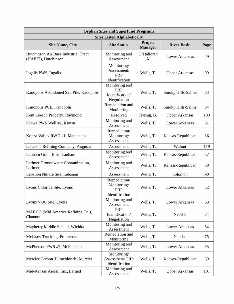
125
Orphan Sites and Superfund Programs
Sites Listed Alphabetically
Site Name, City Site Status Project
Manager River Basin Page
Hutchinson Air Base Industrial Tract (HABIT), Hutchinson
Monitoring and Assessment
O’Halloran, M.
Lower Arkansas 49
Ingalls PWS, Ingalls
Monitoring/ Assessment/
PRP Identification
Wells, T. Upper Arkansas 99
Kanopolis Abandoned Salt Pile, Kanopolis
Monitoring and PRP
Identification/ Negotiation
Wells, T. Smoky Hills-Saline 83
Kanopolis PCE, Kanopolis Remediation and
Monitoring Wells, T. Smoky Hills-Saline 84
Kent Loesch Property, Raymond Resolved Haring, B. Upper Arkansas 100
Kiowa PWS Well #2, Kiowa Monitoring and
Assessment Wells, T. Lower Arkansas 51
Konza Valley RWD #1, Manhattan Remediation/ Monitoring/ Assessment
Wells, T. Kansas-Republican 36
Lakeside Refining Company, Augusta Assessment Wells, T. Walnut 119
Lanham Grain Bins, Lanham Monitoring and
Assessment Wells, T. Kansas-Republican 37
Latimer Groundwater Contamination, Latimer
Monitoring and Assessment
Wells, T. Kansas-Republican 38
Lebanon Nitrate Site, Lebanon Assessment Wells, T. Solomon 90
Lyons Chloride Site, Lyons
Remediation/ Monitoring/
PRP Identification
Wells, T. Lower Arkansas 52
Lyons VOC Site, Lyons Monitoring and
Assessment Wells, T. Lower Arkansas 53
MARCO (Mid America Refining Co.), Chanute
PRP Identification/ Negotiation
Wells, T. Neosho 74
Mayberry Middle School, Wichita Monitoring and
Assessment Wells, T. Lower Arkansas 54
McGraw Trucking, Frontenac Remediation and
Monitoring Wells, T. Neosho 75
McPherson PWS #7, McPherson Monitoring and
Assessment Wells, T. Lower Arkansas 55
Mercier Carbon Tetrachloride, Mercier Monitoring/
Assessment/ PRP Identification
Wells, T. Kansas-Republican 39
Mid-Kansas Aerial, Inc., Larned Monitoring and
Assessment Wells, T. Upper Arkansas 101
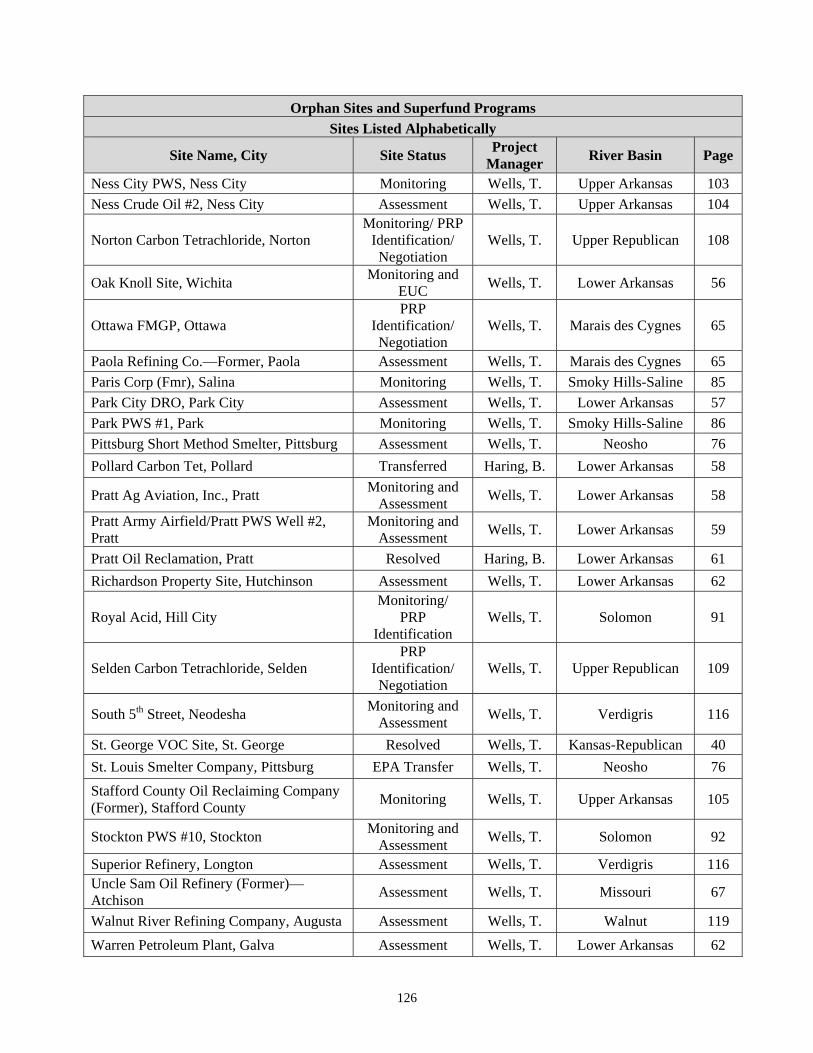
126
Orphan Sites and Superfund Programs
Sites Listed Alphabetically
Site Name, City Site Status Project
Manager River Basin Page
Ness City PWS, Ness City Monitoring Wells, T. Upper Arkansas 103
Ness Crude Oil #2, Ness City Assessment Wells, T. Upper Arkansas 104
Norton Carbon Tetrachloride, Norton Monitoring/ PRP
Identification/ Negotiation
Wells, T. Upper Republican 108
Oak Knoll Site, Wichita Monitoring and
EUC Wells, T. Lower Arkansas 56
Ottawa FMGP, Ottawa PRP
Identification/ Negotiation
Wells, T. Marais des Cygnes 65
Paola Refining Co.—Former, Paola Assessment Wells, T. Marais des Cygnes 65
Paris Corp (Fmr), Salina Monitoring Wells, T. Smoky Hills-Saline 85
Park City DRO, Park City Assessment Wells, T. Lower Arkansas 57
Park PWS #1, Park Monitoring Wells, T. Smoky Hills-Saline 86
Pittsburg Short Method Smelter, Pittsburg Assessment Wells, T. Neosho 76
Pollard Carbon Tet, Pollard Transferred Haring, B. Lower Arkansas 58
Pratt Ag Aviation, Inc., Pratt Monitoring and
Assessment Wells, T. Lower Arkansas 58
Pratt Army Airfield/Pratt PWS Well #2, Pratt
Monitoring and Assessment
Wells, T. Lower Arkansas 59
Pratt Oil Reclamation, Pratt Resolved Haring, B. Lower Arkansas 61
Richardson Property Site, Hutchinson Assessment Wells, T. Lower Arkansas 62
Royal Acid, Hill City Monitoring/
PRP Identification
Wells, T. Solomon 91
Selden Carbon Tetrachloride, Selden PRP
Identification/ Negotiation
Wells, T. Upper Republican 109
South 5th Street, Neodesha Monitoring and
Assessment Wells, T. Verdigris 116
St. George VOC Site, St. George Resolved Wells, T. Kansas-Republican 40
St. Louis Smelter Company, Pittsburg EPA Transfer Wells, T. Neosho 76
Stafford County Oil Reclaiming Company (Former), Stafford County
Monitoring Wells, T. Upper Arkansas 105
Stockton PWS #10, Stockton Monitoring and
Assessment Wells, T. Solomon 92
Superior Refinery, Longton Assessment Wells, T. Verdigris 116 Uncle Sam Oil Refinery (Former)—Atchison
Assessment Wells, T. Missouri 67
Walnut River Refining Company, Augusta Assessment Wells, T. Walnut 119
Warren Petroleum Plant, Galva Assessment Wells, T. Lower Arkansas 62
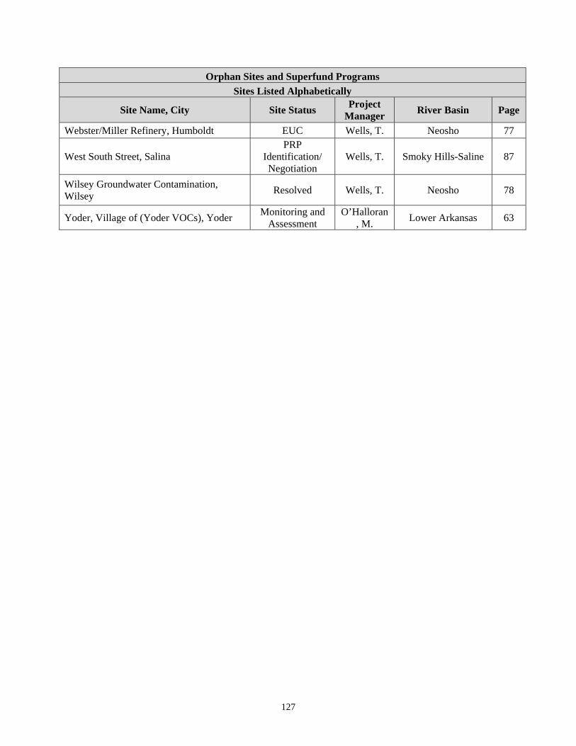
127
Orphan Sites and Superfund Programs
Sites Listed Alphabetically
Site Name, City Site Status Project
Manager River Basin Page
Webster/Miller Refinery, Humboldt EUC Wells, T. Neosho 77
West South Street, Salina PRP
Identification/ Negotiation
Wells, T. Smoky Hills-Saline 87
Wilsey Groundwater Contamination, Wilsey
Resolved Wells, T. Neosho 78
Yoder, Village of (Yoder VOCs), Yoder Monitoring and
Assessment O’Halloran
, M. Lower Arkansas 63