consultation bedout basin - quadrantenergy.com.au · consultation coordinator...
TRANSCRIPT
Keraudren 3D MSS Information
Earliest commencement date
Q1 2019 (pending approvals, vessel availability and weather limitations).
Estimated duration Approximately 120 days.
Water depth The water depths of the survey area are in the range of ~50 m to ~135 m.
Description of natural environment
North-West Marine Bioregion in the NWS Province (DEWHA, 2008a).
Response tier required for worst case spill scenario
In the event of a hydrocarbon spill caused by a vessel collision, considered highly unlikely, a Level 2 response would be implemented as per activity-specific OPEP arrangements described in the EP.
Survey vessels
Nearest proximity to key regional features
Two survey vessels, with one to two
support vessels.
Regional feature Distance to survey
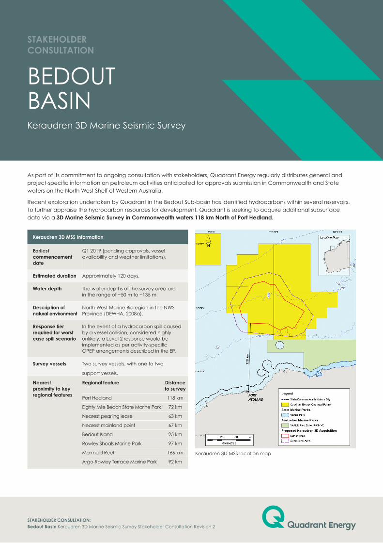
Port Hedland 118 km
Eighty Mile Beach State Marine Park 72 km
Nearest pearling lease 63 km
Nearest mainland point 67 km
Bedout Island 25 km
Rowley Shoals Marine Park 97 km
Mermaid Reef 166 km
Argo-Rowley Terrace Marine Park 92 km
As part of its commitment to ongoing consultation with stakeholders, Quadrant Energy regularly distributes general and project-specific information on petroleum activities anticipated for approvals submission in Commonwealth and State waters on the North West Shelf of Western Australia.
Recent exploration undertaken by Quadrant in the Bedout Sub-basin has identified hydrocarbons within several reservoirs. To further appraise the hydrocarbon resources for development, Quadrant is seeking to acquire additional subsurface data via a 3D Marine Seismic Survey in Commonwealth waters 118 km North of Port Hedland.
BEDOuT BASINKeraudren 3D Marine Seismic Survey
StaKEHolDER CoNSultatIoN
StaKEHolDER CoNSultatIoN: Bedout Basin Keraudren 3D Marine Seismic Survey Stakeholder Consultation Revision 2
Keraudren 3D MSS location map
PRoPoSED aCtIVItIESQuadrant proposes to undertake the Keraudren 3D Marine Seismic Survey 118 km North of Port Hedland. The survey covers a total area of 5,539 km2. An additional buffer around the survey area of 5,151 km2 is allowed for vessel manoeuvring which provides for a total operational area of 10,690 km2.
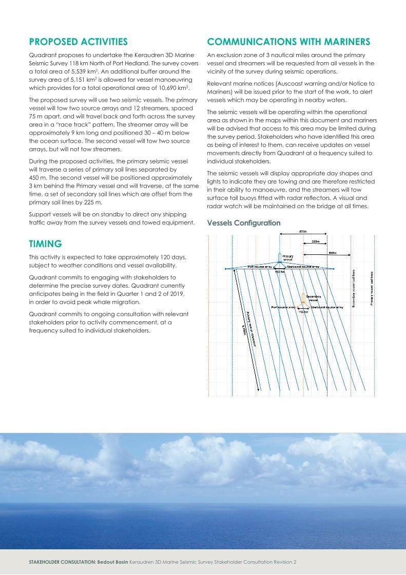
The proposed survey will use two seismic vessels. The primary vessel will tow two source arrays and 12 streamers, spaced 75 m apart, and will travel back and forth across the survey area in a “race track” pattern. The streamer array will be approximately 9 km long and positioned 30 – 40 m below the ocean surface. The second vessel will tow two source arrays, but will not tow streamers.
During the proposed activities, the primary seismic vessel will traverse a series of primary sail lines separated by 450 m. The second vessel will be positioned approximately 3 km behind the Primary vessel and will traverse, at the same time, a set of secondary sail lines which are offset from the primary sail lines by 225 m.
Support vessels will be on standby to direct any shipping traffic away from the survey vessels and towed equipment.
tIMINg This activity is expected to take approximately 120 days, subject to weather conditions and vessel availability.
Quadrant commits to engaging with stakeholders to determine the precise survey dates. Quadrant currently anticipates being in the field in Quarter 1 and 2 of 2019, in order to avoid peak whale migration.
Quadrant commits to ongoing consultation with relevant stakeholders prior to activity commencement, at a frequency suited to individual stakeholders.
CoMMuNICatIoNS WItH MaRINERSAn exclusion zone of 3 nautical miles around the primary vessel and streamers will be requested from all vessels in the vicinity of the survey during seismic operations.
Relevant marine notices (Auscoast warning and/or Notice to Mariners) will be issued prior to the start of the work, to alert vessels which may be operating in nearby waters.
The seismic vessels will be operating within the operational area as shown in the maps within this document and mariners will be advised that access to this area may be limited during the survey period. Stakeholders who have identified this area as being of interest to them, can receive updates on vessel movements directly from Quadrant at a frequency suited to individual stakeholders.
The seismic vessels will display appropriate day shapes and lights to indicate they are towing and are therefore restricted in their ability to manoeuvre, and the streamers will tow surface tail buoys fitted with radar reflectors. A visual and radar watch will be maintained on the bridge at all times.
Vessels Configuration
StaKEHolDER CoNSultatIoN: Bedout Basin Keraudren 3D Marine Seismic Survey Stakeholder Consultation Revision 2
Consultation Coordinator [email protected] Phone: 08 6218 4972
Level 7 100 St Georges TerracePerth Western Australia 6000PO Box 5624 St Georges Tce Perth WA 6831
t +61 8 6218 7100F +61 8 6218 7200
Quadrant Energy
quadrantenergy.com.au
Environmental Management
Potential risks and/or impacts Management Measure
acoustic noise
• Implementation of EPBC Policy Statement 2.1.
• Noise modelling.
• Temporal management for key receptors.
Marine fauna interactions
• Maintaining dedicated marine mammalobservers (MMOs) throughout the survey.
• Quadrant Procedures for interacting withprotected marine fauna.
• All marine fauna sightings are recordedand reported to the Department of theEnvironment and Energy.
Interaction with marine users
• Relevant marine notices will be issued.
• 3 nm radius exclusion zone will be in placearound the primary survey vessel whilestreamers are deployed.
• The seismic vessels will display appropriateday shapes and lights to indicate the vesselsare towing and are therefore restricted intheir ability to manoeuvre.
• The streamers will tow surface tail buoysfitted with radar reflectors.
• A visual and radar watch will be maintainedon the vessel bridges at all times.
• Support vessel(s) will be on standby to directany shipping traffic away from the surveyvessel and its towed equipment.
Hydrocarbon release
• Appropriate spill response plans, equipmentand materials will be in place and maintained.
• Appropriate refuelling procedures andequipment will be used to prevent spills tothe marine environment.
Effluent discharge and waste management
• Routine discharges from vessels will meetlegal requirements.
• Other wastes will be transported back toshore for appropriate recycling/disposal.
Management of invasive marine species
• Vessels will be assessed and managed asper Quadrant Procedures.
• Compliance with Australian quarantinerequirements and guidelines.
• Quadrant contracted vessels comply withAustralian ballast water requirements.
Keraudren 3D Marine Seismic Survey Coordinates
Survey area (including ramp up zone) operational area
latitude longitude latitude longitude
18° 35' 7.045" S 118° 50' 34.761" E 18° 26' 51.223" S 118° 55' 27.640" E
18° 38' 6.855" S 118° 56' 9.496" E 18° 29' 48.055" S 119° 5' 52.555" E
18° 38' 4.104" S 119° 1' 0.136" E 18° 47' 44.565" S 119° 17' 3.117" E
18° 52' 45.201" S 119° 10' 8.735" E 18° 52' 54.304" S 119° 26' 44.328" E
18° 59' 31.541" S 119° 22' 50.866" E 19° 7' 55.430" S 119° 37' 29.648" E
19° 3' 18.212" S 119° 28' 47.131" E 19° 23' 1.390" S 119° 28' 34.972" E
19° 18' 23.816" S 119° 19' 51.803" E 19° 27' 25.821" S 119° 18' 59.124" E
19° 19' 33.734" S 119° 17' 19.420" E 19° 25' 8.230" S 118° 57' 9.686" E
19° 17' 36.167" S 119° 13' 38.329" E 19° 22' 40.546" S 118° 29' 50.156" E
19° 21' 7.299" S 119° 5' 57.165" E 19° 17' 28.382" S 118° 25' 25.594" E
19° 15' 8.911" S 118° 54' 45.534" E 18° 55' 18.240" S 118° 18' 58.894" E
19° 14' 25.122" S 118° 34' 45.283" E 18° 33' 1.122" S 118° 32' 14.283" E
19° 14' 17.563" S 118° 34' 32.079" E
19° 10' 1.713" S 118° 31' 51.289" E
19° 9' 13.067" S 118° 30' 20.816" E
18° 59' 58.962" S 118° 27' 39.357" E
18° 37' 41.293" S 118° 40' 53.876" E
StaKEHolDER ENgagEMENtQuadrant encourages open, two way communication with stakeholders throughout the planning and implementation of the Keraudren 3D MSS. Reviewing this consultation package is the first stage of stakeholder engagement.
If you wish to discuss this consultation material further please respond to Quadrant via the contact details below. Consultation for this activity will be ongoing, until the activity is completed.
Additional consultation material may also be distributed throughout the activity, for example when there is a change in operations or an update in scheduling.
Quadrant will provide all stakeholder feedback to the Commonwealth regulators within the Keraudren Seismic Survey Environment Plan.
StaKEHolDER CoNSultatIoN: Bedout Basin Keraudren 3D Marine Seismic Survey Stakeholder Consultation Revision 2