conservation effects assessment project ceap highlights€¦ · conservation effects assessment...
TRANSCRIPT

United States Department of Agriculture Natural Resources Conservation Service
Helping People Help the Land
Conservation Effects Assessment Project
CEAP Highlights December 2007
Wildlife Literature Review Addresses Conservation Practice Benefits
Below are key findings from Fish and Wildlife Response to Farm Bill Conser-vation Practices (Technical Review 07-1) a CEAP literature synthesis pub-lished in September 2007 by The Wild-life Society in partnership with NRCS and the Farm Service Agency
Summary Findings bull Considering wildlife in the planning of practices is key to achieving wildlife benefits bull Wildlife response to grass establish-ment is significant but variable by spe-cies cover management and other fac-tors bull Linear practices promote high use by wildlife but with limited reproduc-tive success With proper planning and management they can result in substan-tial landscape biodiversity benefits
New Release
This new publication and its com-panion volume -- Fish and Wildlife Benefits of Farm Bill Conservation Programs (TWS Technical Review 05-2) -- are available on the CEAP website
bull Wetland establishment practices substantially benefit wildlife bull Stream restoration and other prac-tices affecting streams benefit aquatic biota but landscape factors must be con-sidered bull Overall effects of individual prac-tices on fish and wildlife depend on many factors
Key Findings by Chapter
Effects of Cropland Conservation Prac-tices on Fish and Wildlife Habitat bull Historically agricultural intensifica-tion has negatively impacted grassland wetland and forestland wildlife Soil and water conservation practices provide some habitat on cropland landscapes bull Little has been published document-ing specific effects of most soil and wa-ter conservation practices on terrestrial wildlife habitat However conservation practices that reduce soil erosion and sediment delivery or that otherwise im-prove the quality of runoff water play significant roles in improving aquatic habitat quality bull Conservation tillage benefits some species (beneficial insects invertebrate food sources for birds and mammals) bull No-till provides greater wildlife benefit (nesting and winter food and cover) than more intensive tillage sys-tems bull Grassed waterways are used for bird nesting (and re-nesting following distur-bance of other habitats) but nest success is low due to predation and mowing bull Grass-backed terraces provide some nesting cover and add to biodiversity in cropland systems bull Filter strips and field borders in-crease wildlife use of crop fields bull Woody hedgerows provide nesting and winter cover for birds but may have negative effects on grassland obligate species due to habitat fragmentation bull Landscape effects (species-specific spatial and temporal) confound gener-
alizations on the value of individual practices
Grassland Establishment for Wildlife Conservation bull Change from cropland to grassland use has had a positive influence on grassland wildlife Grassland bird bene-fits have been documented effects on other wildlife are largely unknown bull Wildlife response to grassland es-tablishment is a multi-scale phenomenon dependent upon vegetation structure and composition within the planting prac-tice-level factors such as size and shape of the field and its landscape context as well as temporal factors such as season and succession bull Grassland succession makes man-agement an important determinant of wildlife habitat conditions bull Benefits of any management sce-nario to a particular species will depend in part on the management of surround-ing sites Additional species may bene-fit but others may be excluded Thus the benefits of grassland establishment and management are location- and spe-cies-specific
Agricultural Buffers and Wildlife Con-servation A Summary About Linear Practices bull Linear practices such as filter strips grassed waterways buffers contour strips riparian buffers windbreaks and shelterbelts originally were designed to reduce soil erosion and improved water quality bull Most often grasses or mixtures of grasses and forbs are used in linear practices although establishment of trees and shrubs is encouraged in some practices bull Acreage enrolled in linear practices has increased in recent years Most wildlife studies focus heavily on benefits to birds and do not address broader eco-logical communities bull The small area and high edge-area
ratios limit the usefulness of these prac-tices for wildlife bull Buffer width vegetation composi-tion and structure and landscape context all affect wildlife communities bene-fited bull Positive effects are associated with longer and wider buffers with buffers associated with or connecting other habitat practices such as blocks of cover or food plots and with practices that are grouped on the landscape bull With careful planning and manage-ment applying linear practices widely within an agricultural landscape could be expected to have positive wildlife benefits compared with continued inten-sive row cropping
Benefits of Farm Bill Grassland Conser-vation Practices to Wildlife bull Rangeland conservation practices (prescribed grazing prescribed burning range planting and restoration of declin-ing habitats) can provide wildlife bene-fits bull Prescribed grazing produces both positive and negative responses by wild-life bull Prescribed burning also has both positive and negative effects but bene-fits generally outweigh detriments bull Range planting and restoration of declining habitats benefit wildlife but determining appropriate comparisons can be problematic Undisturbed grass-land ecosystems have greater heteroge-neity and diversity making comparisons between managed and ldquonativerdquo ecosys-tem conditions complex bull Additional practices including fenc-ing brush management tree planting and shelterbelts and pest management can all be used to improve wildlife habi-tat although each can also cause prob-lems for wildlife in certain situations bull Bird responses to practices have received the greatest attention Even for birds considerable information is lack-ing eg effects of practices on many species effects of surrounding landscape factors on wildlife responses and re-sponses in reproductive rates or survival rates to various practices bull Grassland ecosystems and wildlife are considered among the most at risk and rangeland practices can be used to maintain enhance and restore needed plant communities and habitat condi-tions
Fish and Wildlife Benefits Associated with Wetland Establishment Practices bull Efforts to restore or create wetlands have increased in recent decades bull Most published studies describe bird response to wetland restoration with most reporting bird communities in restored wetlands to be similar to those of natural reference wetlands bull Studies indicate that invertebrates and amphibians generally respond quickly to and colonize newly estab-lished wetland habitats bull Key factors correlated with wildlife species richness include wetland size availability of nearby wetland habitats diversity of water depths and vegetation wetland age and active maintenance and management bull Knowledge gaps include the need for studies on biota other than birds and long-term monitoring of wetland condi-tion and wildlife response over time
Effects of Conservation Practices on Aquatic Habitats and Fauna bull Landscape management affects the condition of aquatic communities at the watershed scale bull Land clearing leveling draining tilling fertilizing and harvesting to-gether create prolonged perturbations manifested in the ecological and physi-cal conditions of streams and rivers bull Physical damage due to channeliza-tion erosion sedimentation and altered hydrology coupled with inputs of excess nutrients pesticide contamination and riparian clearing cumulatively diminish the quality of aquatic habitats bull Primary conservation goals in agri-cultural watersheds have been to (a) con-trol non-point source pollutants such as nutrients sediments and pesticides (b) maintain adequate water supplies for crop and animal production and (c) maintain streamriver channel stability bull Little monitoring of aquatic biota response to stream restoration and other conservation practices has been done bull Steam bank vegetation establish-ment improves aquatic habitat bull Clearing and snagging to remove wood from streams has a negative im-pact on stream habitat quality and diver-sity bull Dams and stream diversions reduce habitat quality and quantity for stream biota bull Fish passage stream habitat restora-
tion and livestock exclusion practices have been shown to improve aquatic habitat quality bull Grassed waterways riparian forest buffers and other buffer practices de-signed to improve water quality benefit aquatic habitat condition bull The complexities of effects of vari-ous conservation practices and systems on fish and macroinvertebrates coupled with landscape management diversity leave many questions unanswered
Wetlands National Assessment
Monitoring Wetland Conservation-Benefits Across the ChoptankLandscape
Scientists from the CEAP national as-sessment of wetlands (NRCS) and theChoptank Benchmark Watershed (Agricultural Research Service) are part-nering to assess the effects of conserva-tion practices on ecosystem services (eg pollutant reduction) provided bywetlands in the watershed of the Chop-tank River a major tributary of the Chesapeake Bay Findings will be used to assess and improve the effectiveness of conservation practices and Farm Bill programs affecting wetlands and associ-ated lands on the Maryland and Dela-ware Coastal Plain The project is animportant step towards producing a na-tional landscape analysis tool as part of the National Wetlands MonitoringFramework being developed through CEAP supported research
The project brings together an interdisci-plinary group of experts and resources from the NRCS the Agricultural Re-search Service the US Geological Sur-vey and the University of Maryland to assess the ability of wetlands along a land usehydrology alteration gradient to improve water quality Project scientists will combine information gained from individual wetlands with landscape scale measurements from satellite images and other geospatial datasets The ability to quantify ecosystem services ldquoon the groundrdquo and then link this information to remotely sensed data represents a pow-erful tool for future wetland applications such as monitoring
Nine wetlandstream study sites have been established in the headwaters of the Choptank River Watershed divided
2
equally between prior converted wet-lands on croplands lands where conser-vation practices to restore wetland hy-drology have been implemented and native wetlands Approximately 50 shal-low groundwater wells have been dis-tributed across the study sites to best monitor groundwater depth and water quality These wells and nearby surface waters will be monitored monthly and during rain events for parameters that best indicate 1) the hydrologic connec-tivity of wetland sites to ground and surface waters 2) the potential of these sites to reduce and transform water-borne agrochemicals (eg nitrogen and phosphorus) before their entry into ground and surface waters and 3) the amount of denitrification occurring at these sites The water quality and quan-tity data are complimented by additional
field-collected data on soils vegetation and biota
The synergistic potential of the ground data and multiple types of remotely sensed images ndash LIDAR (light detection and ranging) synthetic aperture radar and multispectral imagery -- is being assessed and initial results are ex-tremely promising Radar data has been used to create multi-temporal maps of wetland hydroperiod ndash the most impor-tant abiotic factor controlling wetland function and extent Fine scale (1 m horizontal and 15 cm vertical resolution) digital elevation maps (DEMs) previ-ously unavailable at this scale have been created using airborne LIDAR im-agery A combination of the hydrope-riod maps DEMs and ancillary data is being used to help determine the origin of waters flowing into different types of
wetlands and the likelihood that agro-chemicals are being removed from these waters before they enter adjacent streams The ground data will be used to calibrate and validate these estimates of wetland water quality services and to extend the predictive function of the geospatial data to other important ser-vices (eg habitat)
The impact of this project is greatly en-hanced by extending the analysis to ad-jacent streams and measuring the effect of wetland biogeochemical processes on stream health Examination of the wet-landstream connection is especially timely given increasing attention on the health of the Chesapeake Bay which carries high nutrient and sediment loads originating from agriculture
[Contributed by Dr Megan Lang USDA-ARS Hydrology and Remote Sensing Laboratory Beltsville Maryland]
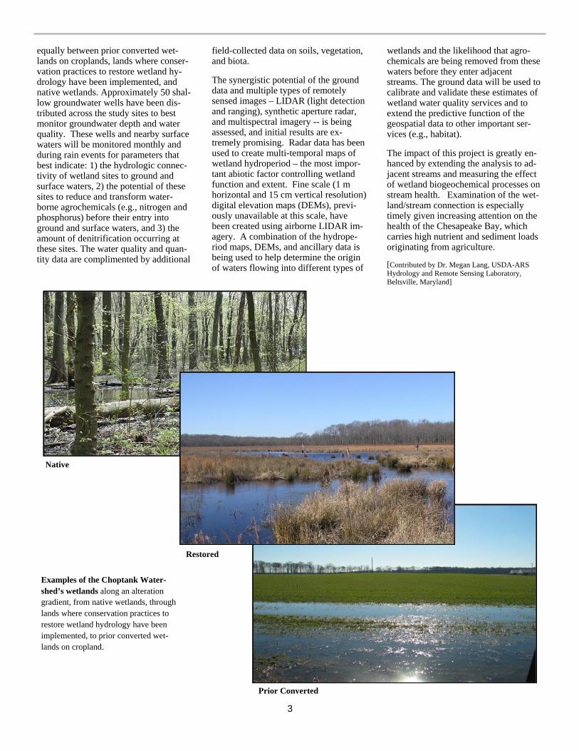
Native
Restored
Examples of the Choptank Water-shedrsquos wetlands along an alteration gradient from native wetlands through lands where conservation practices to restore wetland hydrology have been implemented to prior converted wet-lands on cropland
Prior Converted
3
Cropland National Assessment
CEAP Cropland Component Goes Regional
The CEAP Cropland National Assess-ment has re-designed its plans for pub-lishing summaries of the effects of con-servation practices currently present on the landscape Instead of a single report covering the entire country a series of reports will be prepared for each water resource region with significant cropland acreage The first report will be for the Upper Mississippi River Basin with a draft report for interagency peer review scheduled for completion in August 2008 The report will be based on the full set of NRI-CEAP cropland sample points and will include both onsite ef-fects of practices (field level) and off-site water quality effects Regional re-source concerns will be emphasized
Regional reports for each of the four other basins making up the Mississippi drainage will followmdashOhio-Tennessee Basin Missouri River Basin Lower
Mississippi River Basin and the Arkan-sas-White-Red water resource region These reports are expected to be com-pleted by early 2009 Regional reports for remaining water resource regionsmdash Pacific Northwest Texas-Gulf South Atlantic-Gulf Mid-Atlantic and the Great Lakesmdashare expected to be com-pleted by the end of 2009
After the regional reports are completed a national assessment of the field-level effects of conservation practices includ-ing a national assessment of conserva-tion treatment needs will be prepared
RUSLE2 Incorporated in Cropland National Assessment Model
Researchers at the Texas Agricultural Experiment Station working with the NRCS CEAP cropland team have incor-porated RUSLE2 (Revised Universal Soil Loss Equation 2) model routines into APEX (Agricultural Policy Environmental eXtender) the field-level model being used to assess the effects of conservation practices for the national assessment RUSLE2 is a stand-alone model currently being used in NRCS
field offices for evaluating relative effec-tiveness of soil erosion control practices to aid in preparation of conservation plans The field office also uses RUSLE2 to report expected reductions in soil erosion associated with conserva-tion plans This model upgrade enables the CEAP estimates of soil erosion ef-fects and benefits to correspond more closely to agency practice standards
The addition of RUSLE2 also allows for the use of the Soil Tillage Intensity Rat-ing (STIR) component and the Soil Con-ditioning Index (SCI) in CEAP analysis This enables the CEAP team to examine relationships between conservation ef-fects and tillage intensity cropping sys-tems and soil types Specifically it is now possible to examine the conse-quences of periodic shifts in tillage in-tensity or ldquorotational tillagerdquo We can now estimate how much is lost in terms of previous conservation gains when a producer temporarily shifts to the use of conventional tillage and we can also determine how much conservation is gained by seasonal adoption of conser-vation tillage
4
Watershed Assessment Studies
CSREES Watershed Projects to Report Preliminary Results
An all day session on CEAP Competi-tive Grant Watershed projects will be held February 6 2008 at the CSREES National Water Conference in Sparks Nevada Project directors will summa-rize overall current project findings re-garding the effects of conservation prac-tices on water resources Some will fo-cus on modeling approaches and ad-vances decision support data manage-ment challenges and monitoring strate-gies to evaluate management practice effectiveness Several presentations will focus on the effectiveness of outreach efforts and factors affecting adoption of conservation practices To wrap up the day the framework and approach to the CEAP Synthesis Project will be dis-cussed along with future opportunities for CEAP More information on the CSREES National Water Conference is available at httpwwwsoilncsuedu swetcwaterconf2008home08htm
Object Modeling System Framework Scheduled for January2008 Delivery
Agriculture Research Service (ARS) scientists in Fort Collins Colorado ex-pect to deliver version 21 of the proto-type OMS (Object Modeling System) framework to NRCS in January 2008 OMS is designed to address processes and issues associated with regional dif-ferences in climate soils farming prac-tices etc Its modular structure allows component process models (eg water balance nutrient cycling soil erosion and plant growth and development) to be used interchangeably so that the model can be customized for any specific re-gion of the United States
OMS is the modeling platform for ARS Cropland CEAP Objective 5 Develop and verify regional watershed models that quantify environmental outcomes of conservation practices When fully op-erational OMS will enhance modeling capabilities for future assessments of conservation programs save time and money spent on model development and facilitate the development of models customized for specific NRCS uses
Grants Awarded for CEAP Synthesis Project
In November USDArsquos Cooperative State Research Education and Extension Ser-vice (CSREES) announced competitive grants to conduct a synthesis of findings from the CSREES CEAP Competitive Grant Watersheds and related findings from other CEAP watershed studies
The awards jointly funded by the CSREES National Integrated Water Quality Program and NRCS were made to North Carolina State University which will lead the synthe-sis effort and to the University of Idaho
In presenting the grants Acting Agriculture Secretary Chuck Conner noted that These two studies culminate the first phase of USDAs work to understand the effects of conservation practices benefiting a water-shed This science and outreach will provide additional practical knowledge for planning and carrying out conservation programs across the nation
For more information see the press release httpwwwcsreesusdagovnewsroomnews2007news11261_ceaphtml
Grazing Lands National Assessment
Rangeland Modeling Update
Plant Growth Component A team of scientists from NRCS the Agricultural Research Service and the National Aeronautics and Space Administration (NASA) has begun modifying and adapting existing hillslope-scale range-land models for use in estimating the impactbenefit of conservation practices for plant community associations The models are RHEM (Rangeland Hydrol-ogy and Erosion Model) and ALA-MANAC (Agricultural Land Manage-ment Alternatives with Numerical As-sessment Criteria)
ALAMANAC will be used to estimate plant community response to climate management and deployment of conservation practices The model is being adapted to simulate inter- and in-tra-species competition on rangelands This model will focus on developing a functional plant group approach where classes such as short grass mixed grass tall grass annual grass shrubs trees and forbs can be simulated on a single ecological site If possible cryptogamic crusts will also be addressed if enough information is available in the literature to document the growth resistance and
resilience to disturbance of this func-tional plant group
The ALAMANAC modeling team will also develop the technology to simulate the temporal and spatial impact of the following conservation practices Pre-scribed grazing prescribed fire brush management range seeding reduction in the impact of invasive spe-cies riparian management and the asso-ciated affiliated practices such as fenc-ing water development and placement of supplements as defined in the NRCS field office technical guides
The primary function of ALAMANAC is to provide the required biophysical output (ie canopy cover plant height standing biomass root distribution and mass ground cover percentages of functional plant groups etc) to estimate soil and water quality and wildlife habi-tat with other component models being developed as part of CEAP
Soil Carbon Component The CASA (Carnegie-Ames-Stanford Approach) model developed by NASA is being evaluated for use in estimating changes in soil carbon as a function of the inter-action of climate management and de-ployment of conservation practices
5
CEAP Building the Science Base for Conservation
Science based conservation is the key to managing agricultural landscapes for environ-mental quality The Conservation Effects Assessment Project (CEAP) is a multi-agency effort to scientifically quantify the environmental benefits of conservation practices used by private landowners participating in US Department of Agriculture (USDA) and other conservation programs Project findings will guide USDA conser-vation policy and program development and help farmers and ranchers to make in-formed conservation choices
The three principal components of CEAP mdash the national assessment the watershed assessment studies and the bibliographies and literature reviews mdash contribute to the evolving process of building the science base for conservation That process includes research monitoring and data collection modeling and assessment
NRCS CEAP Contacts
bull Executive Leader mdash Wayne Maresch waynemareschwdcusdagov bull CEAP Project Coordinator mdash Lisa Duriancik lisaduriancikwdcusdagov bull Cropland National Assessment mdash Robert Kellogg robertkelloggwdcusdagov bull Grazing Lands National Assessment mdash Leonard Jolley leonardjolleywdcusdagov bull Wetlands National Assessment mdash Diane Eckles dianeeckleswdcusdagov bull Wildlife National Assessment mdash Charles Rewa charlesrewawdcusdagov
CEAP Highlights is issued quarterly by the Resources Inventory and Assessment Division
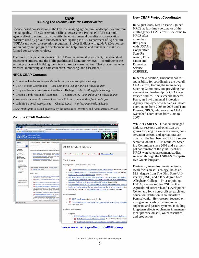
Visit the CEAP Website
New CEAP Project Coordinator In August 2007 Lisa Duriancik joined NRCS as full-time coordinator of the multi-agency CEAP effort She came to NRCS after more than five years with USDArsquos Cooperative State Re-search Edu-cation and Extension Service (CSREES)
In her new position Duriancik has re-sponsibility for coordinating the overall CEAP effort leading the interagency Steering Committee and providing man-agement and leadership for CEAP wa-tershed studies She succeeds Roberta Parry an Environmental Protection Agency employee who served as CEAP coordinator from 2005 to 2006 and Tom Drewes NRCS who served as CEAP watershed coordinator from 2004 to 2007
While at CSREES Duriancik managed national research and extension pro-grams focusing on water resources con-servation effects and agricultural air quality She has been a CSREES repre-sentative on the CEAP Technical Steer-ing Committee since 2003 and a princi-pal coordinator of the joint CSREES NRCS watershed assessment studies selected through the CSREES Competi-tive Grants Program
Duriancik an environmental scientist (with focus on soil ecology) holds an MS degree from The Ohio State Uni-versity (OSU) and a BS degree from Allegheny College Prior to joining USDA she worked for OSUrsquos Ohio Agricultural Research and Development Center and for a non-profit research and education institution in southeastern Pennsylvania Her research focused on nitrogen and carbon cycling in corn soybean and pasture systems including long-term effects of changes in manage-ment practice on soil water resources and production
wwwnrcsusdagovtechnicalNRIceap
An Equal Opportunity Provider and Employer
6
ratios limit the usefulness of these prac-tices for wildlife bull Buffer width vegetation composi-tion and structure and landscape context all affect wildlife communities bene-fited bull Positive effects are associated with longer and wider buffers with buffers associated with or connecting other habitat practices such as blocks of cover or food plots and with practices that are grouped on the landscape bull With careful planning and manage-ment applying linear practices widely within an agricultural landscape could be expected to have positive wildlife benefits compared with continued inten-sive row cropping
Benefits of Farm Bill Grassland Conser-vation Practices to Wildlife bull Rangeland conservation practices (prescribed grazing prescribed burning range planting and restoration of declin-ing habitats) can provide wildlife bene-fits bull Prescribed grazing produces both positive and negative responses by wild-life bull Prescribed burning also has both positive and negative effects but bene-fits generally outweigh detriments bull Range planting and restoration of declining habitats benefit wildlife but determining appropriate comparisons can be problematic Undisturbed grass-land ecosystems have greater heteroge-neity and diversity making comparisons between managed and ldquonativerdquo ecosys-tem conditions complex bull Additional practices including fenc-ing brush management tree planting and shelterbelts and pest management can all be used to improve wildlife habi-tat although each can also cause prob-lems for wildlife in certain situations bull Bird responses to practices have received the greatest attention Even for birds considerable information is lack-ing eg effects of practices on many species effects of surrounding landscape factors on wildlife responses and re-sponses in reproductive rates or survival rates to various practices bull Grassland ecosystems and wildlife are considered among the most at risk and rangeland practices can be used to maintain enhance and restore needed plant communities and habitat condi-tions
Fish and Wildlife Benefits Associated with Wetland Establishment Practices bull Efforts to restore or create wetlands have increased in recent decades bull Most published studies describe bird response to wetland restoration with most reporting bird communities in restored wetlands to be similar to those of natural reference wetlands bull Studies indicate that invertebrates and amphibians generally respond quickly to and colonize newly estab-lished wetland habitats bull Key factors correlated with wildlife species richness include wetland size availability of nearby wetland habitats diversity of water depths and vegetation wetland age and active maintenance and management bull Knowledge gaps include the need for studies on biota other than birds and long-term monitoring of wetland condi-tion and wildlife response over time
Effects of Conservation Practices on Aquatic Habitats and Fauna bull Landscape management affects the condition of aquatic communities at the watershed scale bull Land clearing leveling draining tilling fertilizing and harvesting to-gether create prolonged perturbations manifested in the ecological and physi-cal conditions of streams and rivers bull Physical damage due to channeliza-tion erosion sedimentation and altered hydrology coupled with inputs of excess nutrients pesticide contamination and riparian clearing cumulatively diminish the quality of aquatic habitats bull Primary conservation goals in agri-cultural watersheds have been to (a) con-trol non-point source pollutants such as nutrients sediments and pesticides (b) maintain adequate water supplies for crop and animal production and (c) maintain streamriver channel stability bull Little monitoring of aquatic biota response to stream restoration and other conservation practices has been done bull Steam bank vegetation establish-ment improves aquatic habitat bull Clearing and snagging to remove wood from streams has a negative im-pact on stream habitat quality and diver-sity bull Dams and stream diversions reduce habitat quality and quantity for stream biota bull Fish passage stream habitat restora-
tion and livestock exclusion practices have been shown to improve aquatic habitat quality bull Grassed waterways riparian forest buffers and other buffer practices de-signed to improve water quality benefit aquatic habitat condition bull The complexities of effects of vari-ous conservation practices and systems on fish and macroinvertebrates coupled with landscape management diversity leave many questions unanswered
Wetlands National Assessment
Monitoring Wetland Conservation-Benefits Across the ChoptankLandscape
Scientists from the CEAP national as-sessment of wetlands (NRCS) and theChoptank Benchmark Watershed (Agricultural Research Service) are part-nering to assess the effects of conserva-tion practices on ecosystem services (eg pollutant reduction) provided bywetlands in the watershed of the Chop-tank River a major tributary of the Chesapeake Bay Findings will be used to assess and improve the effectiveness of conservation practices and Farm Bill programs affecting wetlands and associ-ated lands on the Maryland and Dela-ware Coastal Plain The project is animportant step towards producing a na-tional landscape analysis tool as part of the National Wetlands MonitoringFramework being developed through CEAP supported research
The project brings together an interdisci-plinary group of experts and resources from the NRCS the Agricultural Re-search Service the US Geological Sur-vey and the University of Maryland to assess the ability of wetlands along a land usehydrology alteration gradient to improve water quality Project scientists will combine information gained from individual wetlands with landscape scale measurements from satellite images and other geospatial datasets The ability to quantify ecosystem services ldquoon the groundrdquo and then link this information to remotely sensed data represents a pow-erful tool for future wetland applications such as monitoring
Nine wetlandstream study sites have been established in the headwaters of the Choptank River Watershed divided
2
equally between prior converted wet-lands on croplands lands where conser-vation practices to restore wetland hy-drology have been implemented and native wetlands Approximately 50 shal-low groundwater wells have been dis-tributed across the study sites to best monitor groundwater depth and water quality These wells and nearby surface waters will be monitored monthly and during rain events for parameters that best indicate 1) the hydrologic connec-tivity of wetland sites to ground and surface waters 2) the potential of these sites to reduce and transform water-borne agrochemicals (eg nitrogen and phosphorus) before their entry into ground and surface waters and 3) the amount of denitrification occurring at these sites The water quality and quan-tity data are complimented by additional
field-collected data on soils vegetation and biota
The synergistic potential of the ground data and multiple types of remotely sensed images ndash LIDAR (light detection and ranging) synthetic aperture radar and multispectral imagery -- is being assessed and initial results are ex-tremely promising Radar data has been used to create multi-temporal maps of wetland hydroperiod ndash the most impor-tant abiotic factor controlling wetland function and extent Fine scale (1 m horizontal and 15 cm vertical resolution) digital elevation maps (DEMs) previ-ously unavailable at this scale have been created using airborne LIDAR im-agery A combination of the hydrope-riod maps DEMs and ancillary data is being used to help determine the origin of waters flowing into different types of
wetlands and the likelihood that agro-chemicals are being removed from these waters before they enter adjacent streams The ground data will be used to calibrate and validate these estimates of wetland water quality services and to extend the predictive function of the geospatial data to other important ser-vices (eg habitat)
The impact of this project is greatly en-hanced by extending the analysis to ad-jacent streams and measuring the effect of wetland biogeochemical processes on stream health Examination of the wet-landstream connection is especially timely given increasing attention on the health of the Chesapeake Bay which carries high nutrient and sediment loads originating from agriculture
[Contributed by Dr Megan Lang USDA-ARS Hydrology and Remote Sensing Laboratory Beltsville Maryland]
Native
Restored
Examples of the Choptank Water-shedrsquos wetlands along an alteration gradient from native wetlands through lands where conservation practices to restore wetland hydrology have been implemented to prior converted wet-lands on cropland
Prior Converted
3
Cropland National Assessment
CEAP Cropland Component Goes Regional
The CEAP Cropland National Assess-ment has re-designed its plans for pub-lishing summaries of the effects of con-servation practices currently present on the landscape Instead of a single report covering the entire country a series of reports will be prepared for each water resource region with significant cropland acreage The first report will be for the Upper Mississippi River Basin with a draft report for interagency peer review scheduled for completion in August 2008 The report will be based on the full set of NRI-CEAP cropland sample points and will include both onsite ef-fects of practices (field level) and off-site water quality effects Regional re-source concerns will be emphasized
Regional reports for each of the four other basins making up the Mississippi drainage will followmdashOhio-Tennessee Basin Missouri River Basin Lower
Mississippi River Basin and the Arkan-sas-White-Red water resource region These reports are expected to be com-pleted by early 2009 Regional reports for remaining water resource regionsmdash Pacific Northwest Texas-Gulf South Atlantic-Gulf Mid-Atlantic and the Great Lakesmdashare expected to be com-pleted by the end of 2009
After the regional reports are completed a national assessment of the field-level effects of conservation practices includ-ing a national assessment of conserva-tion treatment needs will be prepared
RUSLE2 Incorporated in Cropland National Assessment Model
Researchers at the Texas Agricultural Experiment Station working with the NRCS CEAP cropland team have incor-porated RUSLE2 (Revised Universal Soil Loss Equation 2) model routines into APEX (Agricultural Policy Environmental eXtender) the field-level model being used to assess the effects of conservation practices for the national assessment RUSLE2 is a stand-alone model currently being used in NRCS
field offices for evaluating relative effec-tiveness of soil erosion control practices to aid in preparation of conservation plans The field office also uses RUSLE2 to report expected reductions in soil erosion associated with conserva-tion plans This model upgrade enables the CEAP estimates of soil erosion ef-fects and benefits to correspond more closely to agency practice standards
The addition of RUSLE2 also allows for the use of the Soil Tillage Intensity Rat-ing (STIR) component and the Soil Con-ditioning Index (SCI) in CEAP analysis This enables the CEAP team to examine relationships between conservation ef-fects and tillage intensity cropping sys-tems and soil types Specifically it is now possible to examine the conse-quences of periodic shifts in tillage in-tensity or ldquorotational tillagerdquo We can now estimate how much is lost in terms of previous conservation gains when a producer temporarily shifts to the use of conventional tillage and we can also determine how much conservation is gained by seasonal adoption of conser-vation tillage
4
Watershed Assessment Studies
CSREES Watershed Projects to Report Preliminary Results
An all day session on CEAP Competi-tive Grant Watershed projects will be held February 6 2008 at the CSREES National Water Conference in Sparks Nevada Project directors will summa-rize overall current project findings re-garding the effects of conservation prac-tices on water resources Some will fo-cus on modeling approaches and ad-vances decision support data manage-ment challenges and monitoring strate-gies to evaluate management practice effectiveness Several presentations will focus on the effectiveness of outreach efforts and factors affecting adoption of conservation practices To wrap up the day the framework and approach to the CEAP Synthesis Project will be dis-cussed along with future opportunities for CEAP More information on the CSREES National Water Conference is available at httpwwwsoilncsuedu swetcwaterconf2008home08htm
Object Modeling System Framework Scheduled for January2008 Delivery
Agriculture Research Service (ARS) scientists in Fort Collins Colorado ex-pect to deliver version 21 of the proto-type OMS (Object Modeling System) framework to NRCS in January 2008 OMS is designed to address processes and issues associated with regional dif-ferences in climate soils farming prac-tices etc Its modular structure allows component process models (eg water balance nutrient cycling soil erosion and plant growth and development) to be used interchangeably so that the model can be customized for any specific re-gion of the United States
OMS is the modeling platform for ARS Cropland CEAP Objective 5 Develop and verify regional watershed models that quantify environmental outcomes of conservation practices When fully op-erational OMS will enhance modeling capabilities for future assessments of conservation programs save time and money spent on model development and facilitate the development of models customized for specific NRCS uses
Grants Awarded for CEAP Synthesis Project
In November USDArsquos Cooperative State Research Education and Extension Ser-vice (CSREES) announced competitive grants to conduct a synthesis of findings from the CSREES CEAP Competitive Grant Watersheds and related findings from other CEAP watershed studies
The awards jointly funded by the CSREES National Integrated Water Quality Program and NRCS were made to North Carolina State University which will lead the synthe-sis effort and to the University of Idaho
In presenting the grants Acting Agriculture Secretary Chuck Conner noted that These two studies culminate the first phase of USDAs work to understand the effects of conservation practices benefiting a water-shed This science and outreach will provide additional practical knowledge for planning and carrying out conservation programs across the nation
For more information see the press release httpwwwcsreesusdagovnewsroomnews2007news11261_ceaphtml
Grazing Lands National Assessment
Rangeland Modeling Update
Plant Growth Component A team of scientists from NRCS the Agricultural Research Service and the National Aeronautics and Space Administration (NASA) has begun modifying and adapting existing hillslope-scale range-land models for use in estimating the impactbenefit of conservation practices for plant community associations The models are RHEM (Rangeland Hydrol-ogy and Erosion Model) and ALA-MANAC (Agricultural Land Manage-ment Alternatives with Numerical As-sessment Criteria)
ALAMANAC will be used to estimate plant community response to climate management and deployment of conservation practices The model is being adapted to simulate inter- and in-tra-species competition on rangelands This model will focus on developing a functional plant group approach where classes such as short grass mixed grass tall grass annual grass shrubs trees and forbs can be simulated on a single ecological site If possible cryptogamic crusts will also be addressed if enough information is available in the literature to document the growth resistance and
resilience to disturbance of this func-tional plant group
The ALAMANAC modeling team will also develop the technology to simulate the temporal and spatial impact of the following conservation practices Pre-scribed grazing prescribed fire brush management range seeding reduction in the impact of invasive spe-cies riparian management and the asso-ciated affiliated practices such as fenc-ing water development and placement of supplements as defined in the NRCS field office technical guides
The primary function of ALAMANAC is to provide the required biophysical output (ie canopy cover plant height standing biomass root distribution and mass ground cover percentages of functional plant groups etc) to estimate soil and water quality and wildlife habi-tat with other component models being developed as part of CEAP
Soil Carbon Component The CASA (Carnegie-Ames-Stanford Approach) model developed by NASA is being evaluated for use in estimating changes in soil carbon as a function of the inter-action of climate management and de-ployment of conservation practices
5
CEAP Building the Science Base for Conservation
Science based conservation is the key to managing agricultural landscapes for environ-mental quality The Conservation Effects Assessment Project (CEAP) is a multi-agency effort to scientifically quantify the environmental benefits of conservation practices used by private landowners participating in US Department of Agriculture (USDA) and other conservation programs Project findings will guide USDA conser-vation policy and program development and help farmers and ranchers to make in-formed conservation choices
The three principal components of CEAP mdash the national assessment the watershed assessment studies and the bibliographies and literature reviews mdash contribute to the evolving process of building the science base for conservation That process includes research monitoring and data collection modeling and assessment
NRCS CEAP Contacts
bull Executive Leader mdash Wayne Maresch waynemareschwdcusdagov bull CEAP Project Coordinator mdash Lisa Duriancik lisaduriancikwdcusdagov bull Cropland National Assessment mdash Robert Kellogg robertkelloggwdcusdagov bull Grazing Lands National Assessment mdash Leonard Jolley leonardjolleywdcusdagov bull Wetlands National Assessment mdash Diane Eckles dianeeckleswdcusdagov bull Wildlife National Assessment mdash Charles Rewa charlesrewawdcusdagov
CEAP Highlights is issued quarterly by the Resources Inventory and Assessment Division
Visit the CEAP Website
New CEAP Project Coordinator In August 2007 Lisa Duriancik joined NRCS as full-time coordinator of the multi-agency CEAP effort She came to NRCS after more than five years with USDArsquos Cooperative State Re-search Edu-cation and Extension Service (CSREES)
In her new position Duriancik has re-sponsibility for coordinating the overall CEAP effort leading the interagency Steering Committee and providing man-agement and leadership for CEAP wa-tershed studies She succeeds Roberta Parry an Environmental Protection Agency employee who served as CEAP coordinator from 2005 to 2006 and Tom Drewes NRCS who served as CEAP watershed coordinator from 2004 to 2007
While at CSREES Duriancik managed national research and extension pro-grams focusing on water resources con-servation effects and agricultural air quality She has been a CSREES repre-sentative on the CEAP Technical Steer-ing Committee since 2003 and a princi-pal coordinator of the joint CSREES NRCS watershed assessment studies selected through the CSREES Competi-tive Grants Program
Duriancik an environmental scientist (with focus on soil ecology) holds an MS degree from The Ohio State Uni-versity (OSU) and a BS degree from Allegheny College Prior to joining USDA she worked for OSUrsquos Ohio Agricultural Research and Development Center and for a non-profit research and education institution in southeastern Pennsylvania Her research focused on nitrogen and carbon cycling in corn soybean and pasture systems including long-term effects of changes in manage-ment practice on soil water resources and production
wwwnrcsusdagovtechnicalNRIceap
An Equal Opportunity Provider and Employer
6