conservation area audit -...
TRANSCRIPT

CO
NS
ER
VAT
ION
AR
EA
AU
DIT
ADELPHI 31
Document Tite: Adelphi Conservation Area Audit Document Status: Adopted Supplementary Planning Guidance Date: 21 March 2003 Document ID No: 2932 This report is based on a draft prepared by Conservation Architecture & Planning. It is accurate at the time of publication, March 2003. Department of Planning and Transportation, Development Planning Services, City Hall, 64 Victoria Street, London SW1E 6QP www.westminster.gov.uk

PREFACE Since the designation of the first conservation areas in 1967 the City Council has undertaken a comprehensive programme of conservation area designation, extensions and policy development. There are now 53 conservation areas in Westminster, covering 76% of the City. These conservation areas are the subject of detailed policies in the Unitary Development Plan and in Supplementary Planning Guidance. In addition to the basic activity of designation and the formulation of general policy, the City Council is required to undertake conservation area appraisals and to devise local policies in order to protect the unique character of each area. Although this process was first undertaken with the various designation reports, more recent national guidance (as found in Planning Policy Guidance Note 15 and the English Heritage Conservation Area Practice and Conservation Area Appraisal documents) requires detailed appraisals of each conservation area in the form of formally approved and published documents. This enhanced process involves the review of original designation procedures and boundaries; analysis of historical development; identification of all listed buildings and those unlisted buildings making a positive contribution to an area; and the identification and description of key townscape features, including street patterns, trees, open spaces and building types. Given the number and complexity of Westminster’s conservation areas the appraisal process has been broken down into three stages, the first of which is complete. This first stage involved the publication of General Information Leaflets or mini-guides for each conservation area covering in brief a series of key categories including Designation, Historical Background, Listed Buildings and Key Features. The second stage involved the production of Conservation Area Directories for each Conservation Area. A Directory has now been adopted for 51 of the City’s conservation areas and includes copies of designation reports, a detailed evaluation of the historical development of the area and analysis of listed buildings and key townscape features. The City is now working on a programme to prepare Conservation Area Audits for each of its conservation areas. This will form the third and final stage of the appraisal process. As each audit is adopted as Supplementary Planning Guidance it will incorporate the Directory for that conservation area.

CONTENTS 1 INTRODUCTION 2 HISTORIC DEVELOPMENT 3 CHARACTER OF THE CONSERVATION AREA HIERARCHY OF PLAN FORM ARCHITECTURAL AND HISTORIC CHARACTERISTICS OF BUILDINGS
overview unlisted buildings of merit landmark buildings roof extensions
VIEWS, VISTAS AND PANORAMAS CHARACTERISTIC LOCAL TOWNSCAPE DETAILS
railings, boundary walls & enclosure historic shopfronts statues and monuments street furniture historic floorscapes trees
CHARACTERISTIC LAND USES NEGATIVE FEATURES 4 DIRECTORY DESIGNATION AND EXTENSION LISTED BUILDINGS OTHER DESIGNATIONS
Adjacent conservation areas Topography
Areas of archaeological priority Article 4 directions Regulation 7 direction
PUBLICATIONS
Design Briefs and Guidelines Further reading.
AUDIT DESIGNATION REPORT AND STATEMENT OF DECISION
INTRODUCTION 1.1 The City Council has a statutory duty to review the character and boundaries of its conservation areas. The Audit is the third, and final stage of the appraisal process. The overall appraisal strategy is based upon the English Heritage publication Conservation Area Practice. 1.2 The first stage (Mini-guide) and second stage (Directory) documents have already been adopted. The Mini-guide provides a brief description of the area and its characteristics. The Directory provided a detailed source of factual information. This has now been incorporated as part of the Audit providing an Appendix of factual information. 1.3 The Audit describes both the historical development, and character and appearance of the conservation area. It is designed to identify and explain important local features such as unlisted buildings of merit, unbroken rooflines and local views. In addition the audit also seeks to apply relevant Unitary Development Plan policies to the local context in order to preserve and/or enhance the character and appearance of the area. 1.4 The Conservation Area Audit for the Strand was adopted as Supplementary Planning Guidance by the Cabinet Member for City Development on 21 March 2003. The Adelphi Conservation Area was designated on 26 March 1981. The designation reports can be found in the Directory, Section 1, at the back of this document.

2 HISTORIC DEVELOPMENT 2.1 Following the abandonment of the Roman City in the fourth century AD, a trading and manufacturing port became established, which was called Lundenwic. The Saxon town of Lundenwic thrived in the seventh, eighth and ninth centuries; its site has been identified by major archaeological discoveries of items from this period in Aldwych, Covent Garden and the Strand. Described by Bede as 'a mart of many nations coming by land and sea', Lundenwic was evidently an active trading settlement. Excavations have also revealed evidence of houses, agriculture and industries such as metal working, antler working and cloth production. This period of settlement was ended in the mid to late ninth century by a series of Viking raids on the area. 2.2 The northern boundary of the Conservation Area is the ancient route of the Strand. Its southern edge follows the course of Savoy Place, which marks the original riverbank. Before the Thames was embanked the Strand was the street nearest the river, a busy thoroughfare connecting Temple Bar and Charing Cross. It was lined on the south side with houses that turned their backs on the street in order to face the Thames over long gardens that led down to the river bank. Thus the street frontage comprised gatehouses and walls set back from the road, with stables and domestic ranges. The grand scale of the buildings was described as ‘suburbio frequente continuante’ – its suburban character presumably different from those of either the City to the east or the Court to the west. The land was owned by noblemen and ecclesiastics: Norwich Inn, originally the house of the Bishop of Lincoln and later known as York House, is mentioned in 1237, when the Bishop was ordered to repair the quay. Its gatehouse stood on the present entrance from the Strand to Villiers Street. It is also known that Richard Le Poer, Otho Papal Legate, lodged at 'the Bishop of Durham’s house near London' in 1238. In the same period, the north side of the Strand was rapidly developing as a commercial centre with small premises housing businesses connected with Covent Garden Market. 2.3 In 1330-1336 a tax was levied to complete improvement work to the road surface of the Strand up to Temple Bar. Consequently land values in the area increased. The continuous development and importance of the Strand meant that by the mid fifteenth century the south side of the road had changed in character and scale to being predominantly commercial with an almost continuous line of shops, tenements and inns. 2.4 Recorded in 1536 is an exchange of property between the King and Cuthbert Tunstall, Bishop of Durham. The transactions described a building called Durham Rents comprising twenty-two messuages (dwellings) and gardens. It is clear from Ralph Aggas’ map of the 1560s in Figure 1, that there were houses of considerable importance and grandeur within this tightly-bound area. Particularly prominent is the Great Hall of Durham House abutting the Thames. Although the buildings have gone, one feature on Aggas' map remains and now forms the eastern boundary of the Conservation Area. Ivy Bridge Lane, so called because from the 1220s onwards it provided a crossing over what was then virtually swamp from the river to Covent Garden, is one of the oldest routes to the Thames in London. 2.5 From the mid-sixteenth century onwards a pattern began to evolve of small houses on streets and lanes leading off the Strand. The mansions of the medieval period were becoming obsolete and the sale of parcels of land to less wealthy landlords
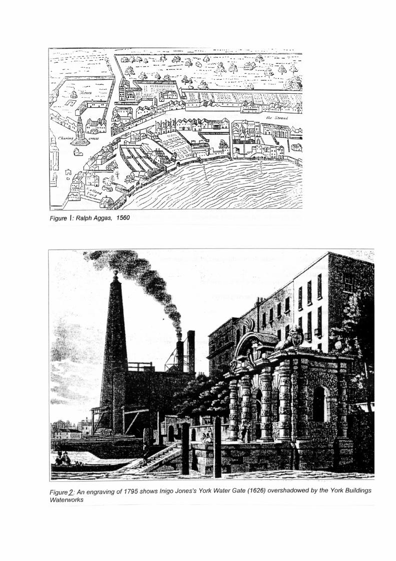

resulted in numerous subdivisions and land splits, which began to give the area a definite character and relationship with the river, access to which was via lanes and gateways from the various private residences. The western side of Durham House, known as the Inn of the Bishop of Norfolk, was obtained by Heath, Archbishop of York in the 1550s and subsequently became known as York House. 2.6 York House had a series of owners who allowed it to fall into disrepair. When the house was obtained by the King's favourite, George Villiers, First Duke of Buckingham, an extensive programme of repair was drawn up but never carried out; the Duke was reported to be invariably out of funds. Inigo Jones' Water Gate is the only physical evidence that still exists of the rebuilding plans – but this could only have required 200 tons of the 2,000 tons of Portland Stone that James I is know to have given Buckingham. The planned great house never materialised, as the Duke's murder in 1628 put an abrupt end to any further building. The famous York Water Gate of 1629 (by Inigo Jones) is the only part of the area which stands at the lower level, at the end of Buckingham Street, included because it formed the river access for Buckingham House (see Figure 2). It now sits within Victoria Embankment Gardens, the rest of which are in the Savoy Conservation Area 2.7 `The second Duke of Buckingham (also George Villiers), 'whose taste and extravagances led him to pecuniary difficulties’, also had little money to spare on the repair of his inherited and now ruinous house. In 1649 he fled to Antwerp with various ‘picktures and other rich goods’, and the house was granted to Thomas, Lord Fairfax in recognition of services to Parliament. The next few years saw the nineteen houses known as York Rents being granted to various purchasers. Bored by exile, Buckingham returned to England in 1657 and after courting and marrying Lord Fairfax’s daughter, avoided arrest and was allowed to live in honourable confinement at York House. All his estates were returned to him on the return of Charles II, but by now York House was in a terrible state of disrepair. Buckingham was eventually obliged to sell his land to Dr Nicholas Barbon. As part of the bargain he managed to secure the use of his name in the subsequent development; Villiers Street and Buckingham Street form part of the street layout that resulted from this transaction. 2.8 The many changes in ownership of land and buildings and the increasing commercial viability of the Strand meant that the York House and Durham House sites were ripe for redevelopment. York House was demolished in 1674 and the site was laid out in the street plan that survives today. At the same time the riverside was undergoing change. York Water Gate was overshadowed in 1675 by the construction of the York Buildings Waterworks. The wooden pyramidal tower of this development would have been a familiar landmark from the river side, and with the wharves and warehouses of the now run-down Durham Yard area must have given this stretch of the Thames a functional and industrial character that contrasted awkwardly with the splendour of Inigo Jones’ triumphal arch. 2.9 Morden and Lea’s map of London, published in 1682 (see Figure 3), illustrates the result of these divisions with a considerably different scale of development. Streets have been punched through from the Strand to the riverside and the area has been divided by a warren of lanes and alleyways. The boundaries of Ivy Bridge Lane and the Strand are firmly in place and the line of the River Thames would not change until the building of the Embankment in the 1860s. To the South, Hungerford Market provides another trading post fed by the river and the Strand. George Street effectively separates two blocks


which developed and flourish at different times. The terraced housing of York Buildings, erected just nine years after the Great Fire of London, exhibited all the characteristics derived from a dramatic change in the building regulations and led the Rev R Kirk to remark that ‘ all London is built uniformly, the streets broader, the houses all of one form and height’. This contrasted significantly with adjacent development of the area known as Durham Yard: traders on the wharves and river front had built commercial premises, warehouses and artisans' dwellings. The area had become run down and the quality of building poor. The riverbank here was 'so untidy and malodorous that the neighbours repeatedly complained'. Little had changed by 1738 as seen in Rocque’s map, see Figure 4. 2.10 It was the vision of Robert Adam to transform this run-down area by building 'twenty-four first-rate houses treated as a single architectural composition and raised on a terrace whose vaulted interior was intended to be let as warehouses'. Together with his brothers James and William, he paid the Duke of St Albans £1,200 for a 99-year lease on the site of Durham House, with a view to redevelopment on a grand scale. 2.11 By 1772 the substructure of tunnels was complete and many of the houses built. A single long terrace with a symmetrical 'palace front' was to be flanked by pedimented end blocks; a consistent style of decoration featuring bands of anthemion ensured the unity of the composition. Confident of getting an agreement from the government to lease space in the arches underneath, and with the well publicised support of their friend the actor David Garrick, who bought one of the first houses, the Adams invested heavily in the development. Always adept at publicity, they even named the site 'Adelphi' (Greek for 'brothers'). However, the Government pulled out of the deal and the brothers were nearly ruined. The houses were not selling and it was decided that a lottery was the only solution to fund the completion of the terrace. 4,370 tickets were sold, at £50 a time, the prizes being houses. The Adams were also forced to sell their large collection of art and antiquities. 2.12 The scheme included Adelphi Terrace (see Figure 5), Robert Street to the west and Adam Street to the east, John Street to the north parallel to the terrace, Durham House Street and the north-east corner of York Buildings. Adam revolutionised the use of ornament with ornate pilasters, entablatures, stringcourses, individual designs to metal balconies, railings, lamp standards and flanking doorways with enriched door cases. The terrace formed the most extensive individual group of houses in London at the time. Adam had managed to transform a steeply sloping derelict site, subject to inundations from the river at high tide, into one of the most desirable residential quarters in London, where a number of celebrities made their home over several decades. 2.13 The Adelphi remains unimitated and unrivalled and was complemented in c.1772 by a new 'proper' building for the Royal Society of Arts to use as accommodation and offices. The building with its attached order of columns above the ground floor stage of the front was designed and executed for the RSA by Robert Adam himself and formed an integral part of the development and popularity that the terrace enjoyed. 2.14 Although it failed commercially, as a feat of architecture the Adelphi was a success. The new style adopted by Adam was presented to London where everybody could see, admire and criticise it, particularly the commanding Thameside centrepiece of the scheme. The terrace brought a new idiom of architectural interpretation combined with infrastructure to the riverside and prompted William Chambers to better Adam on a
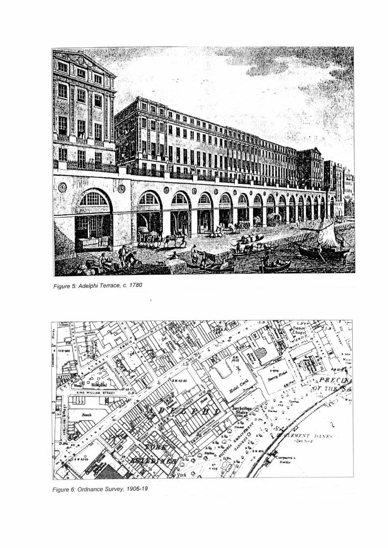
newly cleared site with similar properties where Somerset House eventually rose to challenge the Adelphi. But it was Robert Adam whose composition made the most significant impact on London at that time, a change that is apparent after 1775 when it was rare to find any London houses, especially in the West End, that did not copy elements of Adam's style. 2.15 The Victorian era was characterised throughout British cities by the expansion of large-scale public and institutional projects and developments as a direct result of the arrival of the railway network. It is such an atmosphere that the Adelphi area was enclosed by developments of a fundamentally different scale and character. Hungerford Market was cleared and replaced by Charing Cross Railway terminus, which also included the western side of Villiers Street. On the other side of Ivy Bridge Lane the Cecil Hotel was built in 1886; with 800 rooms it was the largest in Europe at this time. It’s relationship with the Adelphi Terrace can be seen in the Ordnance Survey map 1906-19 in Figure 6. 2.16 The relationship with the river Thames was dramatically changed by the creation of Victoria Embankment Gardens in 1867. Designed by Joseph Bazelgette and executed by the Metropolitan Board of Works as a civil engineering project, it aimed to improve drainage and sewerage as well as transport links both above and below ground. It was successful on these counts but rendered the York Water Gate and other features of the old waterfront geographically meaningless. 2.17 The Adelphi leases expired in 1867 and the landlords attempted to attract new tenants by remodelling the exterior in a style wryly described by Summerson as 'calculated to bring to the purlieus of the Strand some of the stucco amenity of the Cromwell Road'. A false pediment was added to the centre of the terrace and the whole facade was covered with Portland cement. At its demolition in 1937 it was unrecognizable as an Adam building. In the 19th century the present house of 14 Buckingham Gate was let as chambers and with its riverside views it was favoured by artists such as Prince Hoare, William Etty and Clarkson Stanfield. 2.18 In the 1930s, the demolition of both the Adelphi Terrace and the Cecil Hotel left large gaps which were filled by grand corporate buildings on a scale not exhibited before on this frontage. The new Adelphi, by the architects Collcutt and Hamps (1936-38) retained the concept of the terrace overlooking the broad sweep of the river, with a fragment of Adam's work surviving at its eastern end 2.19 Little has changed to the overall fabric since the second part of the 20th. There has been a limited number of infill development which are generally sympathetic to the character of the area

3 CHARACTER OF THE CONSERVATION AREA GENERAL 3.1 The Adelphi takes its name from the 18th century development of residential terraces by the Adam brothers and is located immediately to the south of the Strand. The southern boundary of the conservation area is the former shoreline of the Thames. The oldest surviving building, the Water Gate (1626), is a remnant of an earlier phase of development, being the formal river entrance to York House. Having been continuously occupied for more than a thousand years the area is rich in archaeology. 3.2 The conservation area is characterised by the surviving grid pattern of its formal layout within which two distinct areas are evident today. The earlier developed on the site of York House in the 1670s (Buckingham Street/York Buildings/Villiers Street) and the second phase to the east, developed by the Adam brothers in the 1770s. In contrast, though following the street pattern of the Adam’s scheme, is the 1930s Art Deco Adelphi, a prominent feature on the riverside. 3.3 It is necessary to look at specific components of the built fabric of the conservation area in order to gain a full understanding of the character and appearance of the area. This will range from an analysis of views of metropolitan or local importance to the identification of local townscape qualities such as notable shopfronts. Individually and collectively these factors will define the unique character of an area and should be considered fully in the determination of any application. 3.4 The Unitary Development Plan provides the policy basis for the determination of applications and the relevant policy or polices are referred to where appropriate. HIERARCHY OF STREETS AND SPACES 3.5 The hierarchy of the street pattern and its interrelationship with the open space network will define the overall framework of an area. Within this the importance of the grain of development in terms of plot patterns and building lines will establish the pattern of the built form. All of these factors will affect the character of an area dictating the scale of development and the level of enclosure. 3.6 For the purposes of the conservation area audits the council has defined 3 categories of routes or spaces according to a combined analysis of their scale, level of enclosure and the function they perform within the area (see Figure 7). These are: Primary routes and spaces Secondary routes and spaces Intimate routes or spaces 3.7 The street pattern is virtually unchanged from the late 18th century to the present day. Villiers Street is the main north south route within the conservation area providing an important link between Embankment London Underground Station and Charring Cross. This is considered to be a primary route due to the high level of pedestrian flow. The Charring Cross Station buildings to the west are of a considerably larger scale to the

19th century terraced eastern frontage which retains an important traditional scale and grain to Villiers Street. 3.8 The streets forming the western part of the conservation area are modest forming secondary routes and follow the river bank topography, rising steeply towards the Strand. John Adam Street rises towards the Adelphi as the vaults constructed as part of the Adam’s brother estate raised the street level to the east up to the level of the Strand, with the resultant drop beyond Adelphi Terrace. The more imitate routes consist of the steps leading from Adelphi Terraces to Savoy Place, and Watergate Walk and the steps leading up to Buckingham Street. Despite there being no open space within the conservation area all north south routes lead to Victoria Embankment Gardens in the Savoy Conservation which forms the southern edge to Watergate Walk 3.9 Building lines in the area have been firmly established creating a hard and consistent edge to the street space. The old houses are so densely packed as to be virtually "back to back," with only the slimmest of lightwells at the rear. Many plots within the terraces remain a traditional width with a significant amount of 18th century properties intact. Most infill or later development has generally respected this following the terraced pattern of development. In direct contrast is the large footprint of the Adelphi and to a lesser extent the little Adelphi though both follow the Adam’s street pattern. Dominant patterns should be respected and where historic patterns remain these should be protected and reflected in any proposed schemes. Policies DES1 A 2, 4, 5, 6, 7 and DES 12 should be consulted.

Figure:7

ARCHITECTURAL AND HISTORIC CHARACTERISTICS OF BUILDINGS Overview 3.10 This small area has a wide range of buildings. There are two dominant building
types within the area; terraced properties with examples from the 17th, 18th and 19th centuries, and the set piece and distinct Adelphi block. Of note also are the Royal Society of Arts building purpose built for them by Robert Adam 1772-74 and Inigo Jones’s 17th Century York Watergate. Numerous infill schemes have been implemented, and though generally of a greater scale they tend to follow the form and proportions of the residential terraces such as1 to 5 Adam Street and the Little Adelphi. The general age of developments can be seen in Figure 8.
Figure 8: Building Ages 3.11 The predominant height within the conservation area is 4 storeys, or five including a mansard roof. Whilst some properties such as the Little Adelphi and Nos. 1 to5 Adam Street reach 6 storeys, or above in the case of the Adelphi, these should bee seen as exceptions, out of scale with the reaming 17th and 18th century terraced properties. Terraces 3.12 There are 17th and 18th century terraced properties in Buckingham Street. Those surviving from c 1675-67, part of Barbon’s York House Estate Development, are of brown brick with red brick dressings or now faced in stucco following later alterations. Many retain fine doorcases and fanlights and their significance is highlighted by the listing of the majority of the properties on the street Grade II*. No. 22, listed Grade II,

c1860 by R P Pullman in a high Victorian Italinate design and provides a good corner feature. 3.13 The remaining Adams terraced properties provide a glimpse of the once widespread form and style considered to be the epitome of London elegance and urbanity. The centrepiece overlooking the river has been lost though the vaults beneath remain and run under the Royal Society for Arts building. Nos. 6-10 (con) & 18 Adam Street, Nos. 2-6 (even) John Adam Street and Nos. 1,2 & 3 Robert Street are left. Of brown brick with stucco dressings many retain cast iron balconnets with anthemion (honeysuckle) design and lightwell railings, some of cast and some of wrought iron. Of note is No 7 John Adam Street, the former centre piece of that terrace with pediment and stucco pilasters to 1st and 2nd floors enriched with honeysuckle designs, it is the focal point in views east along John Adam Street. All are listed Grade II*. 3.14 Various buildings have been added within the existing street plan including the Little Adelphi, a neo-Georgian office block of limited quality and other infill development of predominantly office uses. Recent schemes such as Nos 1 –22 John Adam Street, are generally sympathetic respecting the scale and complementing the traditional materials, of the terraced forms. No. 15 & 16 Buckingham Street and 9-12 York Buildings is a polite stone faced infill (with brick elevation to part of York Buildings) facing Victoria Embankment Gardens. Continuing the building line and with vertical emphasis to the facades the upper floor and plant enclosure are unfortunate features. 3.15 On the Strand various buildings of the 1960s dwarf the Adelphi conservation area and are of varying quality. Though outside the conservation area they impact on its character and appearance. Some have impacted on the traditional street pattern such as at the northern end of Buckingham Street. 3.16 The properties in Villiers Street are predominantly of the 19th century and whilst of a variety of detailed designs form a cohesive group, each with its own typical period detailing including decorative window surrounds or cornices. No 33-37 with a well detailed sandstone façade has a more commercial character with a high proportion of fenestration and strong horizontal emphasis between floors. 3.17 Brick is the principal material of the earlier remaining properties and defines the overall character of the area. Some infill from the 60’s and 70’s has been faced in stone and this detracts from the level of uniformity achieved through the use of brick. Some properties, as those on the western side of Buckingham Street, are finished with Stucco though this traditional material for terraced development conforms to the overall character. The terraced properties have painted timber joinery and slate roofs. It is unfortunate where brick work has been painted and this is particularly evident in Villiers Street. The Adelphi 3.18 The Adelphi (1936-38) by Collcutt and Hamps reflects the scale of the development to the east. Whilst following the street pattern it is a dramatic departure from the prevailing architectural style and scale of the earlier development. The facade fronting the river is well articulated with strong corner towers formed by the projecting wings. Faced in limestone it has bronze metalwork detailing. The facade to John Adam street is finished in brick with strong stone detailing to the ground floor including decorative banding and projections at the top and bold door surrounds. The building has

numerous decorative panels, roundels and carved figures forming an integral part of the fabric. Any proposal should take into account the character of its context. Policies, DES1 A 3 and 4 and DES4 should be consulted on the Principles of Development and DES5 A and B should be consulted on alterations and extensions. Relevant Supplementary Planning Guidance documents are noted throughout the document. DES4B should be referred to for scholarly replicas within terraces of unified townscape and/or DES4A in terms of respecting adjoining buildings in areas of varied townscape. Unlisted buildings of merit 3.19 The vast majority of the buildings are in keeping with the character of the conservation area, most contributing in a positive manner. Those properties or developments which are considered to harm the character of the conservation area are identified in the section ‘Negative Features’ below. There are numerous buildings or groups of buildings that are not listed but are considered to be of special merit. These are buildings which may be considered for listing at a future date and are of local significance. They are defined in the Audits as unlisted buildings of merit, see Figure 9. 3.20 This may be due to their townscape or group value, their contribution to the overall character of the area, their inherent architectural qualities or historic association. By definition these properties are of particular value to the character and appearance of the conservation area and their demolition or unsympathetic alteration will be resisted. Adam Street Nos. 1-5(consec.) John Adam Street The Adelphi No 23-25 (including No 7 & 6 Buckingham Street) No. 31 Villiers Street No 13-17 (odd) No 19-23 (odd) No 25 No 27 No 29 No 31 No. 33-37 (odd) Nos. 39-47(odd) York Buildings No. 4 No. 8 No. 17-16 No. 13-15 Railings at end of street forming boundary with Victoria Embankment Gardens.

Policy DES9 2 states that the City Council will seek the retention of buildings which in the opinion of the City Council make a significant contribution to the character or appearance of a conservation area and this would include unlisted buildings of merit. Landmark buildings 3.21 Within the conservation area there are buildings which are considered to be of landmark quality. This can be as a result of numerous factors including their sitting and detailed design. They contribute significantly to the character and townscape of the area being focal points or key elements in views, see Figure 9. 3.22 Whilst numerous buildings are important in local views, as identified below, only one is considered to be a landmark. The Adelphi is a dominant feature within the conservation area and in views of the northern bank of the River Thames. The importance of this building in views is described in more detail in the section on Metropolitan and Local Views below.

Figure:9
Roof extensions 3.23 Roof profiles are an important element which can influence the character and appearance of the conservation area. As a result roof extensions are not always acceptable as they can have a negative impact on this. Policy DES6C highlights instances where roof extensions would not be acceptable. This includes terraces where the existing roofline is largely unimpaired by any extensions or alterations; buildings that are significantly higher than their neighbours; buildings or terraces which are complete compositions or which have existing roof extensions; where there is an unbroken line of butterfly roofs; and where a roofline is visible in long views of public spaces. 3.24 Most buildings in the area have some form of roof extension, form a terraced group, have been built as a set piece architectural composition or are highly visible in views into the area from the south. Roof extensions in most locations would therefore either compound existing harm or spoil original rooflines and compositions. Figure 10 shows where roof extensions are considered to be unacceptable in townscape terms. 3.25 The policy acknowledges that there are some instances where additional storeys may be acceptable, notably when the extension would not harm the proportions or the architectural integrity of the building or terrace. Policy DES6 states that a roof extension should always compliment the appearance of the existing building and should not adversely affect the character and appearance of the conservation area. Policy DES6A highlights instances where roof extensions would not be acceptable. Advice is given in the publication ‘Roofs. A Guide to Alterations and Extensions on Domestic Buildings (1995).

Figure:10

METROPOLITAN AND LOCAL VIEWS 3.26 The Unitary Development Plan defines two categories of views in Policy DES15 which contribute to Westminster’s townscape and historic character. The following section of the audit identifies local views in the conservation area and provides a preliminary list of views which are considered to be of Metropolitan importance. A separate Borough wide document will be produced identifying views of Metropolitan Importance which will undergo full consultation before being adopted as Supplementary Planning Guidance. 3.27 Full consideration must be given to the impact of any development proposals on important metropolitan and local views both within the conservation area and into and out of it. These are shown on the plan in Figure 8. LOCAL VIEWS 3.28 There are local views of landmark buildings from within the conservation area and panoramas of the river corridor. These include:
• View towards No 7 Adam Street along John Adam Street with the Royal Society of Art facade on the north side.
• View of river corridor from Adelphi Terrace. • View north along Adam Street of the listed No 409/410 Strand, built as
restaurant to the Adelphi Theatre by Spencer Chadwick (1886-87). • View north along George Court of the listed former east wing of Charring Cross
Hospital (1831-34) by Decimus Burton. • View down York Buildings to the York Water Gate in Victoria Embankment
Gardens. • View down Buckingham Street to Victoria Embankment Gardens and river
beyond • View down Villiers Street to Hungerford Footbridge Pylons beyond the
Embankment Tube Station. • View south from Strand of No 8 John Adam Street
3.29 There are no preliminary Metropolitan views proposed from this conservation area though the river frontage is within Metropolitan views from other conservation areas. There are no strategic views affected by development in this conservation area. In the Unitary Development Plan DES15 seeks to protect metropolitan and local views.

CHARACTERISTIC LOCAL TOWNSCAPE DETAILS 3.30 Local townscape details contribute to the sense of local distinctiveness and may be unique to a particular conservation area. They can range from specific building detailing, characteristic building elements, boundary treatments to the landscape qualities of the streetscape. Individually and collectively they contribute to the overall quality of Westminster as well as enhancing individual areas of character within the City. Railings, boundary walls & enclosure 3.31 Railings and boundary walls can contribute significantly to the character of a conservation area. The City Council considers that they should be protected and properly maintained. They add interest and richness and provide a sense of enclosure marking the boundaries between public and private spaces. 3.32 The enclosure of shallow front lightwells is a characteristic feature of the conservation area. This is particularly important in the streets of 17th and 18th century terraces many of which retain their original railings, listed as part of the property. In Buckingham Street Many retaining their original cast iron railings to shallow light wells with urn finials and some as at No. 19 with lamp standards. Nos. 6 & 7 York Buildings have good wrought iron railings. Numerous of the Adams terraces retain cast iron railings with urn finials and those to Robert Street have wrought iron railings, again all listed with the houses. 3.33 The mid 18th century railings, gate, retaining wall and steps at the southern end of Buckingham Street are Listed Grade II. Of cast iron and Portland stone the railings have urn finials. There are also good wrought iron railings closing off the southern end of York Street from the later part of the 19th century. 3.34 The other main boundary feature is the substantial limestone wall to the Adelphi terrace designed as part of the building and incorporating the steps down to the lower level, and the limestone walls to the open areas of basement around the perimeter of the building. The relevant City Council policy in respect of these is DES7 G and further guidance can be found in the design guide Railings in Westminster A guide to their design, repair and maintenance. Shopfronts 3.35 Shopfronts, including non-original ones of an appropriate design, can be of great importance in contributing to the character and appearance of both individual buildings and the conservation area and can be of historic and architectural interest in their own right. 3.36 Most of properties along Villiers Street have shopfronts at ground floor. Some of these are of an appropriate design reflecting the character of the property, using traditional proportions and materials and have externally illuminated signage. Those to Nos. 33-37 are a good example in timber. The replacement of inappropriate

shopfronts with ones of a more appropriate design would significantly improve the character and appearance of this street. (see section on negative features below) The relevant City Council policies concerning historic shopfronts and the design of new ones are DES5 C. Reference should be made to the design guide 'Shopfronts, Blinds and Signs: A Guide to their Design' (1990) and ‘Advertisement Design Guidelines (1992). Statues and Monuments 3.37 The York Water Gate 1629 by Inigo Jones is a fine feature, situated within Victoria Embankment Gardens. Street Furniture 3.38 Westminster has an outstanding heritage of interesting and historic street furniture, much of it listed. The appropriate maintenance and protection of this is important as is the need to prevent modern street clutter from detracting from its setting. 3.39 Whilst there are no items of listed street furniture in the conservation area the Grey Wornum lamp standards respect the character of the area and the streets remain relatively free of clutter such as signage. Policy DES7 C & F intends to protect these historic and characteristic features of the street scene. Historic floorscapes 3.40 Historic floorscapes are important elements in the townscape of an area and often an integral part of landscaping schemes in an urban environment. This can include major city squares or a mews development. Paving, if well-designed and maintained and in suitable quality materials, will contribute to the townscape qualities of an area, often by providing a backdrop to the surrounding built fabric. 3.41 The Adelphi conservation area is essentially of hard, urban character with a floorscape in mostly modern materials with granite curbs. The listed stairs down to York Gate are of Portland stone and the integral stairs from the Adelphi Terrace are finished in Portland stone. Trees 3.42 Trees provide significant amenity value in an urban environment in both visual and environmental terms. They are important elements in the character and appearance of a conservation area contributing to the townscape in many ways. This can range from a single specimen providing a focal point, a group of mature trees forming part of an historic planting scheme or street trees forming an integral part of an estate layout. 3.43 There are no trees in the conservation area however views along streets to the mature planting in Embankment Gardens are an important characteristic from within

the conservation area. The green foil of the canopies is also important in the foreground of views into the area from the Hungerford and Waterloo Bridges and the South bank. UDP policy ENV 14 seeks to protect trees which make a significant contribution to the character and appearance of a conservation area. Advice on trees and their protection is given in the City Council design guide, Trees and Other Planting on Development Sites.

CHARACTERISTIC LAND USES 3.44 The contribution of land uses to the character and appearance of a conservation area is of importance. This will not only have a direct influence on the building typology or make-up of an area but also on the nature and use of the public spaces and streets. Particular uses may be of historic or national importance and will have dictated the evolution of an area. 3.45 Although originally developed as a high class residential location, the area is now dominated by institutional and office uses with some retail, restaurant and public house use in Villiers Street. The Royal Society of Arts is at No 8 John Adam Street in premises purposely designed for them. See Figure 11 below.
Figure 11 Characteristic land uses The City Council will consider the contribution of existing and proposed uses to the character or appearance of the conservation area. DES9 D is the relevant UDP policy.

NEGATIVE FEATURES 3.46 Negative features detract from the special character of an area and present the opportunity for change which will enhance the character and appearance of an area. It may be that simple maintenance works could remedy the situation or in some cases there may be the opportunity to redevelop a particular site. 3.47 There are several buildings located in the Adelphi Conservation Area which are considered to be detrimental to the overall character and appearance of the conservation area by virtue of either their bulk or elevational detailing. There are also numbers shopfronts of a poor design. These are identified in Figure 8 and include: Nos. 13-15 John Adam Street & No 21 York Buildings. Nos. 13-21 Villiers Street (odd) have poor 20th century shop fronts. The upper storeys of many of the properties in Villiers Street have been painted. Any proposal will be judged against policies DES1 and DES9.

DIRECTORY

DESIGNATION AND EXTENSIONS This appendix contains the texts of reports, minutes and correspondence relating to the designation and extension of the Adelphi Conservation Area. The contents are as follows: Report by City Planning Officer, 6 November 1980 26 Report by City Planning Officer, 26 March 1981 27

City of Westminster Town Planning Committee, 6 November 1980 Proposed Adelphi Conservation Area: Report by City Planning Officer 1. Over the last few years, informal consideration has been given to the possible designation of the Adelphi area as a conservation area. Several representations have been made suggesting that the City Council should undertake such designation, including one from the Assistant Secretary of the Royal Society of Arts. Recently, the Town Planning (Applications) Sub-Committee in considering an application for redevelopment of Watergate House, (at lower end of York Buildings) recognised that the omission of the Adelphi area from conservation area status was an anomaly. 2. The area of the present study includes the following streets: Adam Street, Buckingham Street, John Adam Street, Robert Street, Villiers Street and York Buildings, the area constituting the former York House and Durham House Estates. It is acknowledged that the Victoria Embankment Gardens and the area between Adam Street and Lancaster Place (which includes Shell Mex House, the Savoy Hotel and Savoy Chapel) merits a similar study, not least in recognition of the distinctive important contribution made by the buildings of the area in relation to the curve of the River. It is considered however that for consistency and the need to avoid compromising the essential townscape quality of the area, the present study should be restricted to that area of distinctively seventeen- and eighteenth-century origin and scale centred on John Adam Street. 3. The study area has diverse character in both urban design and land use terms. Retail and restaurant activity is confined to Villiers Street whilst the other streets contain mostly small-scale professional offices and some residential development, with the key exception of the New Adelphi, a vast office building dating from 1936-1938, to the designs of Collcutt and Hamp, erected on the site of the Adams, brother Royal Terrace (Adelphi Terrace), and Little Adelphi, a regrettable, neo-Georgian office building designed by the same architects, and dating from 1951-1952, on a site on the north west side of John Adam Street, and running back to Durham House Street. 4. The original development of the York House Estate took place after the demolition of the main house in 1676. Of this original development, a significant number of houses remain, especially in Buckingham Street, although several have been altered substantially. No. 8-14 (consec.) on the south west side of the street and nos. 17-21 (consec.) on the north east side are all included on the statutory list as grade I or II* buildings and have, in addition to special architectural or historic interest, conspicuous townscape value. No. 22 on the corner of John Adam Street and Buckingham Street (Canoa House) is of Italian origin (ca. 1860) but has great architectural and townscape distinction nonetheless and reflects in its Italianate Medieval design that fact that it was for many years the office of the distinguished Victorian architect, William Burges. At the lower end of the street, adjacent to Watergate Walk, is the York Water Gate of 1626, the original River entrance to York House, although the line of the river is now set back substantially following the formation of the Victoria Embankment and Gardens between 1864-1870 by Sir Joseph Bazalgette. 5. York Buildings is a street of similar form and scale to Buckingham Street although containing a smaller number of historic buildings. Nos. 6 and 7, on the south-west side are included on the statutory list, whilst Watergate House (by Thompson and Walford, 1907), has substantial townscape significance. The Sub-Committee have recently expressed their conviction as to the merits of its preservation. 6. In John Adam Street, only Nos. 27 and 29, on the south east side near the junction with Villiers Street, survive from the early eighteenth century.

7. The south west side of Villiers Street was totally redeveloped at the time of the building of the Charing Cross Station and Hotel between 1862 and 1865. The opposite side comprises a group of buildings (Nos. 13-47 odd) mostly mid Victorian origin, but with the exception of modern shop front and fascias at street level, the group has substantial townscape value and makes a significant contribution to the character and appearance of the area. 8. One of the most important features of the area however is the surviving part of the Adam Brothers' Adelphi development. 9. A few years after the acquisition of the site of Durham House in 1768 the vast development was commenced to the designs of Robert Adam. The scheme provided for the formation of four grand terraces of houses, including premises for the Royal Society of Arts on the north-west side of John Adam Street above several levels of accommodation, mostly cellarage, including several underground streets running between Durham House Street and Savoy Place. Of these fine terraces, only parts survive, namely Nos. 1, 2 and 3 Robert Street (grade II* listed), Nos. 2 to 8 (even) John Adam Street (grade II* listed), the Royal Society of Arts, and 6 to 10 9 consec.) Adam Street (also grade II* listed). The major element of the original distinguished composition, Royal Terrace (Adelphi House) was extensively altered in 1872 and subsequently demolished, in 1936, for the New Adelphi development. Although all the original terrace above street level was lost, must of interest survives at lower levels. What survives of the original Adelphi development, however, is perhaps one of the finest examples of late eighteenth-century urban development in London, as well as constituting a most valuable element in townscape terms. 10. Notwithstanding the more recent and over-scaled developments in the vicinity, it is considered that the group of streets described above have a distinction and quality that merit conservation area designation, not least in providing for the Council additional powers to control development that may be detrimental to the character and appearance of the area. 11. Recommendations 1. That the area outlined on Map NOI.C.D.C.O.0027, (to be displayed at Committee) be approved as suitable for designation as the Adelphi Conservation Area, subject to consultations. 2. That the GLC be formally consulted as well as the appropriate national and local amenity groups. Ian Lacey City Planning Officer

City of Westminster Town Planning Committee, 26 March 1981 Proposed Adelphi Conservation Area: Report by City Planning Officer Introduction 1. On 6 November 1980 the Town Planning Committee, subject to consultations, the designation of an Adelphi Conservation Area. In addition to approving the City Planning officer's recommendation to designate the Adelphi area, members also expressed the wish to consider further whether the Shell Mex House, the Savoy Hotel and the Charing Cross Hotel should be included within the proposed Conservation Area. The following bodies and Societies were consulted: The Greater London Council, the Victorian Society, the Georgian Group, The Westminster Society and the Civic Trust. Results of Consultations 2. The Acting Director of Architecture of the Greater London Council, in supporting the designation, has indicated that in his view the Shell Mex House and the Savoy Hotel are prominent riverside buildings which also preserve some of the adjacent riverside layout of narrow alleys, flights of steps and inner courtyards approached from the Strand. For these reasons he considers they merit inclusion in the area of designation. He notes that on the other hand he does not consider the Charing Cross Hotel as contributing to the river scene, nor as an integral part of the same riverside layout. In his opinion the replacement of the original mansard roof in this century has detracted considerably both from its intrinsic architectural interest and removed any contribution it might have made to the skyline of this part of London, and that therefore it should be omitted from the area of designation. 3. The Victorian Society 'warmly supports' the proposed designation and expresses the hope 'that it will lead to the careful fostering of the buildings, street pattern and other characteristics which make this such an interesting part of London.' Referring to the possibility of the area of designation including the Charing Cross Hotel, and Shell Max House, the Victorian Society notes that this 'would seem sensible', suggesting that as small conservations areas tend to be easily damaged by unsympathetic development on their boundaries, a wider area of designation should increase the level of protection afforded to the setting of the central area. The Society concludes by expressing a welcome to a tightening of aesthetic control in this sensitive area south of the Strand. 4. The Georgian Group's comments will be reported to Committee verbally. 5. The Westminster Society have welcomed the proposed designation and have expressed support for the inclusion of Shell Mex House, the Savoy Hotel and the Charing Cross Hotel. The Society notes that it is particularly concerned to safeguard the views from the River, its bridge and the Embankment, and therefore suggests that the eastern boundary of the area proposed for designation should be extended to Savoy Street, thus enabling stricter planning controls to be applied to any proposed new developments which mar the river views. 6. The Civic Trust has not submitted any representations. 7. The Chairman of the Council of the Royal Society of Arts which occupies premises at Nos. 2 to 8 John Adam Street has welcomed the proposed designation. Consideration 8. As noted in paragraph 2 of the report considered by Committee on 6 November, it is recognised that the Victoria Embankment Gardens and the area between Adam Street and
Savoy Street, which includes Shell Max House, the Savoy Hotel and the Savoy Chapel, makes an important contribution to the character and appearance of this part of the city, especially in relation to the curve of the river. It was noted, however, that this area has a different architectural and townscape character to that of the Adelphi area, centred on John Adam Street, which has specifically seventeenth- and eighteenth-century origins and scale. 9. It is therefore considered that the representations made by the Greater London Council, the Victorian Society and the Westminster Society would be met by the inclusion of the area between Adam Street and Savoy Street, including the Victoria Embankment Gardens, into a further and separate, Savoy Conservation Area. 10. The inclusion of the Charing Cross Hotel within the Adelphi Conservation Area is not considered to be appropriate as its architectural and townscape character is not considered to be consistent with the character and appearance of either the Adelphi or Savoy areas. 11. Recommendation 1. That officers be instructed to proceed with the designation of the area shown on Map NO. CD.CO.0027 (to be displayed at Committee) and on the attached plan (Plan A), as the Adelphi Conservation Area under the provision of Section 227 of the Town and Country Planning Act 1971. 2. That the area outlined on Map CD.CO.0028 (to be displayed at Committee) and on the attached plan (Plan B) be approved as suitable for designation as the Savoy Conservation Area, subject to consultations. Ian Lacey City Planning Officer

LISTED BUILDINGS
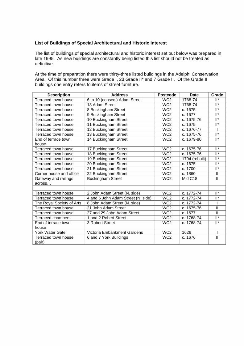
List of Buildings of Special Architectural and Historic Interest The list of buildings of special architectural and historic interest set out below was prepared in late 1995. As new buildings are constantly being listed this list should not be treated as definitive. At the time of preparation there were thirty-three listed buildings in the Adelphi Conservation Area. Of this number three were Grade I, 23 Grade II* and 7 Grade II. Of the Grade II buildings one entry refers to items of street furniture.
Description Address Postcode Date Grade Terraced town house 6 to 10 (consec.) Adam Street WC2 1768-74 II* Terraced town house 18 Adam Street WC2 1768-74 II* Terraced town house 8 Buckingham Street WC2 c. 1675 II* Terraced town house 9 Buckingham Street WC2 c. 1677 II* Terraced town house 10 Buckingham Street WC2 c. 1675-76 II* Terraced town house 11 Buckingham Street WC2 c. 1675 II* Terraced town house 12 Buckingham Street WC2 c. 1676-77 I Terraced town house 13 Buckingham Street WC2 c. 1675-76 II* End of terrace town house
14 Buckingham Street WC2 c. 1679-80 II*
Terraced town house 17 Buckingham Street WC2 c. 1675-76 II* Terraced town house 18 Buckingham Street WC2 c. 1675-76 II* Terraced town house 19 Buckingham Street WC2 1794 (rebuilt) II* Terraced town house 20 Buckingham Street WC2 c. 1675 II* Terraced town house 21 Buckingham Street WC2 c. 1700 II* Corner house and office 22 Buckingham Street WC2 c. 1860 II Gateway and railings across…
Buckingham Street WC2 Mid C18 II
Terraced town house 2 John Adam Street (N. side) WC2 c. 1772-74 II* Terraced town house 4 and 6 John Adam Street (N. side) WC2 c. 1772-74 II* The Royal Society of Arts 8 John Adam Street (N. side) WC2 c. 1772-74 I Terraced town house 21 John Adam Street WC2 c. 1675-76 II Terraced town house 27 and 29 John Adam Street WC2 c. 1677 II Terraced chambers 1 and 2 Robert Street WC2 c. 1768-74 II* End of terrace town house
3 Robert Street WC2 c. 1768-74 II*
York Water Gate Victoria Embankment Gardens WC2 1626 I Terraced town house (pair)
6 and 7 York Buildings WC2 c. 1676 II

OTHER DESIGNATIONS
Adjacent conservation areas Topography
Areas of archaeological priority Article 4 directions
Regulation 7 direction

Figure 1 : Topography
Topography The Adelphi lies on the lower banks of the River Thames. The former shoreline (represented by the fine line of dots and dashes) ran along what is now the southern edge of the Conservation Area. The western streets of the area clearly demonstrate the original topography of the riverbank as they rise steeply towards the Strand. The eastern streets, being built on a terrace formed vast vaults, defy the original topography. However, the streets and passageways in the vaults under the terrace follow the natural topography.

Plot Patterns The original late seventeenth-century plot pattern in the western half of the Conservation Area survives substantially intact. To the east, and commensurate with the enhanced status of the Adam development, the surviving plot patterns are generally wider and of a grander order than those to the west. The original pattern to the centre of the Adam development was extinguished by the construction of the New Adelphi office block.
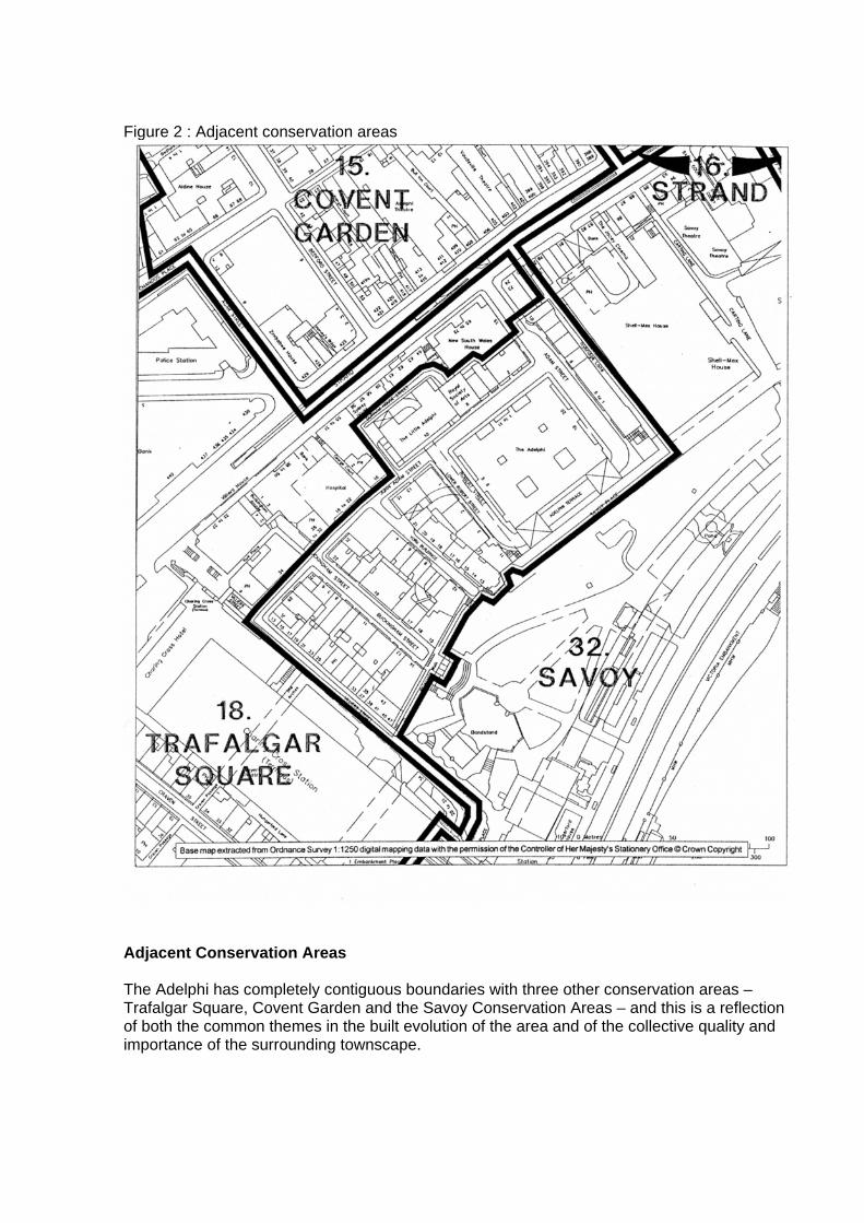
Figure 2 : Adjacent conservation areas
Adjacent Conservation Areas The Adelphi has completely contiguous boundaries with three other conservation areas – Trafalgar Square, Covent Garden and the Savoy Conservation Areas – and this is a reflection of both the common themes in the built evolution of the area and of the collective quality and importance of the surrounding townscape.

Parks and Gardens of Special Historic Interest The National Heritage Act 1983 enabled the Historic Buildings and Monuments Commission for England to compile a 'register of gardens and other land which appears to it to be of special historic significance'. This has become known as the Register of Parks and Gardens of Special Historic Interest in England. Its purpose is to identify and safeguard parks and gardens which by reason of their historic layout, features and architectural ornaments make them of special historic interest. The sites in the Register are categorised in the same way as listed buildings – that is, as Grade I, Grade II* and Grade II. Each site entry contains a concise description of the site, together with a short bibliography. As the Register was enabled by statute, owners do not have a power of veto over a site's inclusion. The effect of a proposed development on a registered garden or its setting is a material consideration in the determination of a planning application. Victoria Embankment Gardens, listed at Grade II*, is included in this Directory because, although most of the Gardens is in the Savoy Conservation Area, the York Water Gate straddles both Conservation Areas. The full text of the Register entry is given below. For more information please refer to the City Council's Historic Parks and Gardens in Westminster Supplementary Planning Guidance note (see page 20). Adelphi Entry in the Register of Parks and Gardens Victoria Embankment Gardens TQ3079 G1012 Grade II* Late C19 public gardens, 4pha. The site of Victoria Embankment Gardens was created in 1864-70, following the embankment of the Thames by Sir Joseph Bazalgette. The gardens occupy a series of four sites curving round a loop of the Thames, a quarter circle round from TQ311809 to TQ303799 (round from north to west). All four sections are bounded on the river side by the Victoria Embankment. (1) The northernmost section is bounded to north by Temple Place. Railings and dense shrubbery enclose a roughly rectangular area, with lawns and bedding on each side of an asphalt path. Mature planes. Central rosebed has replaced 1895 bandstand. Monuments to J S Mill, W E Forster, I K Brunel. (2) The main section is bounded by Savoy Place to the north-west, by Watergate Walk to west, by Villiers Street and Embankment Place to the south-west, and by Charing Cross Underground Station to south. Railed, with shrubbery and mature trees – plane, thorn, catalpa, metesequoia round curving asphalt paths, with lawn and outstanding displays of bedding. The main open area, with lawn and symmetrical bedding scheme, is to south-west, with open air theatre beyond, and the York Water Gate 1626, on north-west boundary. On south-east side of lawn, outstanding mixed border with exotic foliage, backed by privet hedge, with lime trees above. Narrower north-east section has bedding displays, alternating with lawn, shrubbery, small paved water gardens. Numerous memorials and pieces of sculpture – Robert Burns, Robert Raikes, Sir Arthur Sullivan. Monument to Lord Cheylesmore (d.1925) by Lutyens, with small water garden, and aligned on Cleopatra's Needle (erected 1878) on the Embankment to south-east. Reginald Bomfield, 1917-20. (3)(4) The south-western sections are separated from the first two by Hungerford Bridge, and were not opened until 1875. (3) These are called Whitehall Gardens, and are bounded to north by the railway, to west by Whitehall Court, to south by Horseguards Avenue. Railed, with shrubbery and mature planes, round peripheral path and central lawns. Bedding displays and monuments – William Tyndale, Sir James Outram, Sir Bartie Frere. (4) The southernmost section lies south of Horseguards Avenue, and is bounded to the west by the Ministry of

Defence, by Richmond Terrace to the south. Queen Mary's Steps, a remnant of the Tudor palace, discovered 1939, in the north-west corner of this area. Monuments to General Gordon, Air Chief Marshal Trenchard, Lord Portal. Victoria Embankment Gardens are open to the public every day of the year. Cecil E London Parks and Gardens (1907), pp. 132-133. Pevsner N, rev. Cherry B, London (1985), pp. 388, 660. Sexby, J J The Municipal Parks of London (1898), pp.262-289

Area of Special Archaeological Priority The whole of the Adelphi Conservation Area falls within the Lundenwic and Thorney Island Area of Special Archaeological Priority, which covers a large part of the southern area of Westminster stretching from the Old Bailey to Smith Square. Lundenwic was a middle Saxon trading settlement (seventh-ninth centuries) located on the banks of the Thames in the vicinity of the Strand. At this time London appears to have comprised two distinct elements: the old walled town located within the limits of the Roman City, and Lundenwic, which consisted of a much larger mercantile centre. Recent excavations in Lundenwic have revealed evidence of houses, agriculture, industry and water-borne trade. Lundenwic appears to have been abandoned for a short while during the period of Viking raids in the latter part of the ninth century, when the population retreated behind the walls of the old city. Figure 3 : Archaeological sites: prehistoric, Roman and Saxon

Figure 4: Archaeological findspots; Medieval and Post Medieval

ARTICLE 4 DIRECTIONS
There are no Article 4 directions affecting this conservation area
REGULATION 7 DIRECTION
This direction covers the whole of the conservation area and is designed to control the size, location and colour of estate agent’s boards. Uncontrolled proliferation of these
boards is considered to be severely detrimental to the appearance and amenity of the area. In summary normal deemed consent rights relating to the display of boards have been removed and replaced by a strict code of control. Express consent is required for
all boards. Reference should be made to the Council’s Boardwatch guide.

PUBLICATIONS
Design Briefs and Guidelines Further reading and sources of information.

Title Date The Unitary Development Plan (UDP) The City of Westminster Unitary Development Plan 1997 The City of Westminster Proposals Map 1997 The Unitary Development Plan is the City Council's statutory planning document. It provides a detailed framework for new development, development control, conservation and land use policies and proposals. The Proposals Map is an integral part of the statutory UDP. It shows the strategic and secondary road network, conservation areas and other policies with geographical boundaries.
General Planning Planning in Westminster – the Work of the Development Division 1995 (Includes contact numbers for the Development Division Service Committee and two planning advice leaflets: 'Planning Applications Advice' and 'The Planning Application Process'.)
The Street Furniture Manual 1993 A Prospect of Westminster 1989 (An illustrated tour of Westminster's urban villages and key buildings.)
Design Guides and Planning Briefs Specific to Adelphi Adelphi Conservation Area No. 31 – General Information Leaflet
General Policies Planning Applications Advice 1996 (Outlines advice available at the pre-application stage and the Council's approach to negotiation once an application is made.)
Guide to the Planning Enforcement System in the City of Westminster
1993
Map of Designated Conservation Areas in Westminster 1997 Conservation Area: A Guide for Property Owners 1992 Development and Demolition in Conservation Areas 1996 The Listing of Buildings of Special Architectural or Historic Interest 1996 Repairs and Alterations to Listed Buildings 1996 The Protection of Historic Buildings: A Guide to Structural Alterations
1992
A Guide to Building Conservation Grants in Westminster 1994 Historic Parks and Gardens in Westminster
1997
Design Guides Westminster's Architectural Heritage at Risk 1991 (Guidance about architectural theft for owners or historic buildings.) Advertisement Design Guidelines 1992 Blinds: Guidelines for their selection and fitting Boardwatch 1996 (An information pack of estate agents' boards and the laws about their display.)
Conservatories: A Guide to Design and Planning Procedures 1994 Front Garden Parking: A Guide to Legislation and Design 1992 Lighting Up the City 1994 (Council policy and practical advice on the floodlighting of buildings

and monuments.) Mews: A Guide to Alterations 1992 Mobility Guide 1989 Plant and Air Conditioning Equipment: Guidance Notes 1993 Public Art in Westminster 1994 Railings in Westminster 1997 Refuse Storage Requirements 1996 Roofs: A Guide to Alterations and Extensions on Domestic Buildings 1995 Shopfronts: Security Shutters 1995 Shopfronts: Blinds and Signs 1993 A Guide to the Siting of Satellite Dishes and other Telecom Equipment
1995
A Guide to the Siting of Security Cameras and other Security Equipment
1995
Stucco: A Guide to its Care and Maintenance 1994 The Placing of Tables and Chairs on the Highway 1994 Trees and Other Planning on Development Sites
1996
The History of the Adelphi Aldous, T., A Prospect of Westminster (1989) see esp. Ch. 2: 'The Heart of London' E Beresford, The Annals of the Strand: Topographical and Historical (Chapman and Hall, London, 1912) Hermione Hobhouse, Lost London: A Century of Demolition and Decay (Macmillian, London, 1906) N Pevsner (rev. Bridget Cherry), Buildings of England: London 1: The Cities of London and Westminster (Buildings of England Series, Penguin, 1985) Steen Eiler Rasmussen, London, The Unique City (Jonathan Cape, London, rev. ed. 1947) John Summerson, Georgian London (Pimlico, London, 1988) Henry B. Wheatley, The Adelphi and its Site (London, 1885) Survey of London: Vol. XVII: The Parish of St Martin's in the Field: Part II: The Strand (RCHME and LCC, London, 1937) Historic Map Books The A to Z of Elizabethan London, London Topographical Society Publication No. 122 (Invicta Press, 1979) H. Margary, The A to Z of Georgian London (Invicta Press, 1981) H Margary, The A to Z of Regency London (Invicta Press, 1985)

AUDIT ADOPTION REPORT AND STATEMENT OF DECISION

City of Westminster
Item No. CMfCD\5\2003
Decision-maker Date Title of Report
CABINET MEMBER FOR CITY DEVELOPMENT
7 March 2003
Adoption of the Adelphi and Savoy Conservation Area Audits as Supplementary Planning Guidance Report of CLASSIFICATION FOR GENERAL
RELEASE Director of Planning and Transportation
Wards Involved St James’s Policy Context The Civic Review Initiative has a target to adopt 12
Conservation Area Audits as supplementary planning guidance by 2002/03 in order to implement the programme to prepare audits for the City’s 53 conservation areas. The review of conservation area boundaries forms part of this process
Financial Summary There are no financial implications arising from this report at this stage.
Summary 1.1 National guidance and advice places the responsibility on the City Council to
produce detailed appraisals of each of its 53 conservation areas and to consider the designation of further ones. The Council wishes to adopt the Adelphi and Savoy Conservation Area Audits following full consultation and a public meeting. This report takes on board comments received in writing and at the public meeting following a comprehensive programme of consultation on the draft Audit.
RECOMMENDATIONS 2.1 That the Cabinet Member for City Development resolves to adopt the Adelphi
and Savoy Conservation Area Audits (attached in Appendix 4) as Supplementary Planning Guidance.
3 Background Information 3.1 On 22 October 1998, Sub-Committee agreed a priority list of conservation
areas to be audited as part of the City Council’s comprehensive review of its then 51 conservation areas (there are now 53). This review is a statutory duty.
3.2 Given the complexity and scale of the City’s conservation areas this process
has been broken into three stages involving the production of mini-guides (General Information Leaflets), directories and audits. The audits represent the third and final stage of the preparation of appraisals of all of the Borough’s 53

conservation areas. Boundary reviews have been undertaken by consultants in conjunction with the preparation of Conservation Area Audits.
4 Detail 4.1 The Adelphi and Savoy Audits were adopted for consultation on 13 December
2002. Extensive public consultation, including a public meeting, has resulted in the policies contained within the Audits receiving widespread public support. The audits have been revised to take on board many of the amendments suggested during the consultation process. Comments made during the public meeting are summarised in the minutes of the meeting.
Original written consultation 4.2 28 letters of consultation were issued on 25 October 2002 to local amenity
groups, national bodies, local businesses and ward Councillors inviting them to comment in writing on the draft audits and to attend a public meeting. See list in Appendix 1. A notice was put in the local press and 8 site notices put up within the areas advertising the public meeting.
4.3 7 written responses were received and these are listed in the background paper
section. The points that were raised are dealt with in this report. It should be noted that English Heritage and the Westminster Society are very supportive and welcome the adoption of such documents as Supplementary Planning Guidance so that they can assist in the preservation and enhancement of the areas. The Theatres Trust and Railtrack replied stating they had no comments.
Public meeting 4.4 On Thursday 23 January 2003 there was a public meeting at the RSA, John
Adam Street, to discuss the Adelphi and Savoy Conservation Area Audits. 4.5 The meeting was chaired by Councillor Angela Hooper, Cabinet Member for
City Development, and attended by a representative of the Duchy of Lancaster (See Appendix 2). The audit was presented to the meeting, including numerous amendments and additions.
4.6 Issues of concern, many highlighted in the written responses received, were
then discussed. The main points of discussion and matters from the written responses are dealt with below. The majority of points of concern raised have been addressed as can be seen in Appendix 3. All additions to the text are shown in bold, and any text to be deleted is struck through, in the Audits included in Appendix 4.
Roof extensions and possibility for enhancement
DUCHY OF LANCASTER 4.7 The Duchy of Lancaster considered roof extensions in certain locations would
lead to the enhancement of the conservation area. This matter was discussed in full at the meeting. 4.8 Mr Whalley gave an example of works underway to install a shallow copper roof to the vestry to the Queen’s Chapel to improve views from surrounding buildings

(replaced white asphalt flat roof). He considers similar benefits could be achieved elsewhere, for example to the rear of No. 110-111 the Strand where the low level roofscape of extensions provide a poor setting to this Chapel. (N.B. these properties are outside the Savoy Conservation Area). 4.9 Mr Whalley also believes that there is potential for improvement at high level.
He considers that filling in the gap in the eastern elevation of the Institute of Electrical Engineers building would tidy up that elevation and not prove to be detrimental. It is his view works facilitating the removal of unsightly plant at roof level to Savoy Hill House in conjunction with some sort of roof extension may also be acceptable.
Council Response 4.10 This work was undertaken by consultants on behalf of the Council and is the
result of survey work using policy DES 6 which explicitly identifies where roof extensions would be considered unacceptable in Westminster.
4.11 The following paragraph will be added to follow 3.35 in the Savoy Audit. “This
section relates to the main skyline of the properties and therefore generally considers the complete roof form to the main part of the building. Some instances of infill or small scale extensions may be acceptable and each one will be judged on its merits.”
4.12 The Council would also consider the benefits of the removal of unsightly high
level features such as plant, as part of a roof extension proposal, which has a reduced impact and complies will policy DES 6.
4.13 The survey identifies where roof extensions would not be acceptable as they
would have a harmful impact on the townscape, including in long views or those from other properties, or would be harmful to the character or appearance of a particular property. In undertaking the survey it may not be possible to assess some instances where an extension would not be visible and thus may not impact on the townscape character of the area.
4.14 In some cases where it is shown the roof extension would not be visible – from
public and private views – then it may be approved even if the audit identifies it as a property where a roof extension would be unacceptable.
Redevelopment as enhancement
INSTITUTE OF ELECTRICAL ENGINEERS
4.15 The Institute believe that the redevelopment of the site of The Institute of Electrical Engineers Building and Savoy Hill House would result in the enhancement of the area as the current property provides an unsightly gap in views of the built frontage to the river edge.
COUNCIL RESPONSE
4.16 These documents aim to describe the character of the area providing a detailed analysis of what is there and where elements such as rooflines should be preserved.

4.17 In view of the number of conservation areas in Westminster and the heavy
workload associated with this programme the Council is not preparing enhancement objectives. These would however deal with matters such as returning original features to building etc. rather than suggest where whole scale redevelopment proposals may be acceptable. The latter would form the basis of a planning brief.
4.18 This building has been identified as an unlisted building of merit in the
document in recognition of the contribution it makes to the character and appearance of the area and its historic association. The Council do not agree that at present it is detrimental to the character and appearance of the area and that its redevelopment is necessary to enhance the area. This does not necessarily prohibit the redevelopment of the site, any proposals for the site will be judged on their merits following the test set out in PPG 15. It should be noted that the identification of this property as an unlisted building of merit does not place any controls over internal works.
5 Proposed Extensions to the Conservation Area 5.1 No boundary alteration were suggested by the consultants. The Duchy of
Lancaster have suggested that the properties fronting the Strand to the north of The Queen’s Chapel be considered for inclusion in the Savoy Conservation Area as opposed to the Strand Conservation Area. The Council will look at this following the preparation of Audits for the other conservation areas in the area. The properties already benefit from being within a designated Conservation Area. There have been no boundary alterations proposed for the Adelphi Conservation Area.
6 Financial Implications 6.1 There are no financial implications arising from this report at this stage.
Expenditure costs will be met from existing revenue budgets. 7 Legal Implications 7.1 Under Section 69 (1)(a) of the Planning (Listed Buildings and Conservation
Areas Act) 1990 every local authority “shall from time to time determine which parts of their area are areas of special architectural or historic interest the character and appearance of which it is desirable to preserve or enhance”. Planning Policy Guidance Note 15 ‘Planning and the Historic Environment’ interprets this responsibility by advising local authorities to periodically review existing conservation areas and their boundaries.
8 Consultation
8.1 A comprehensive programme of consultation was undertaken, see section 4,
involving English Heritage, national amenity societies, local resident groups, ward Councillors and anyone who has expressed an interest.
9 Human Rights Act 1998

9.1 The Human Rights Act came into force in England on 2 October 2000. It gives
teeth to the European Convention on Human Rights (ECHR), which was ratified by the UK in 1951 and has been in force since 1953. The Act confers the direct protection of English law in relation to Convention rights. For the purposes of the role of a local planning authority the relevant provisions are: Article 2 - right to life, Article 6 – right to a fair hearing, Article 8 - right to respect for private and family life, Article 14 – prohibition of discrimination and Article 1 of the First Protocol - protection of property.
Conclusion 10.1 The Adelphi and Savoy Conservation Area Audits have been through a
comprehensive programme of public consultation. The adoption of such documents as Supplementary Guidance is a statutory duty and the Adelphi and Savoy Conservation Area Audits will help guide development sympathetically in the future. The Audits, with amendments proposed in this report, have gained considerable public support. These document specifically relate Council UDP policies to the local area as encouraged by best practice. Failure to do so would weaken the Councils' position in implementing its Borough wide polices when determining applications.
IF YOU HAVE ANY QUERIES ABOUT THIS REPORT OR WISH TO INSPECT ANY OF THE BACKGROUND PAPERS, PLEASE CONTACT GARETH JONES.ON 020 7641 8019; EMAIL ADDRESS [email protected] ; FAX NUMBER 020 7641 2338 BACKGROUND PAPERS 1. Report to Planning and Development Committee, 13 July 2000. 2 The Adelphi and Savoy Conservation Area mini-guides 4 Minutes of public meeting 5 Letters from:
The Theatres Trust 20.12.02 The Duchy of Lancaster 20.12.02 Institute of Electrical Engineers 2.01.03 The Westminster Society 9.01.03 English Heritage 22.01.03 The Strand, Aldwych and Trafalgar Square Association 23.01.03 Railtrack 24.01.03

APPENDIX 1 LIST OF CONSULTEES English Heritage Georgian Group Victorian Society SPAB Twentieth Century Society Garden History Society Westminster Property Owners Association The Royal Household Councillor Louise Hyams Councillor Tim Mitchell Councillor Alexander Nicoll The Westminster Society The Theatres Trust The Society of London Theatres The Strand, Aldwych and Trafalgar Square Association The Institute of Electrical Engineers Royal Society of Arts Department of Works and Pensions The Rotch Property Group The Savoy Hotel Duchy of Lancaster Railtrack London Underground London Borough of Lambeth London Borough of Southwark Head of Parks and Leisure - WCC Senior Aboricultural Officer - WCC APPENDIX 2 ATTENDEES OF PUBLIC MEETING R H Whalley Duchy of Lancaster Councillor Angela Hooper Cabinet Member for City Development Rosemarie MacQueen Westminster City Council Gareth Jones Westminster City Council

APPENDIX 3 COMMENTS RECEIVED
Consultation Responses Council responseConsultee Comment Agree/
do not agree
Justification
Westminster Society Mr Peter Handley Honorary Secretary 09.01.03
Both drafts represent the outcome of a great deal of effort and the City Council is to be congratulated on its very thorough approach to the task Surprised that the Adelphi is not listed Notes importance of uniform design of shopfronts at Cecil Court
Noted Noted
Agree
Welcome support This building has been identified as an unlisted building of merit and will consider putting it forward to the DCMS for statutory listing. Council have stated this in the Audit and welcome support
The Theatres Trust 30.10.02
Do not wish to make any comment
Noted
English Heritage 22.03.03
This high quality document considers very fully the historic development and current situation of these very important conservation areas. Savoy Audit needs to address the matter of river operations in relation to historic piers/ historic access points and the problems rising from permanently moored vessels and ‘up and over’ access brows.
Noted Noted
Council welcome support Will make reference to the aesthetic issues and possible harm to historic integrity of Embankment wall arising from this matter.
The Institute of Electrical Engineers 02.01.03
Consider the report should look into more proactive ways of enhancement and improvement, specifically through the redevelopment of the Institute of Electrical Engineers block. .
Do not agree
See paras. 4.15-4.17 in main report

Duchy of Lancaster 20.12.02 & at Public Meeting
Would like paras 3.34-3.35 amended to allow for roof extensions where these would result in improvements, specifically to Savoy Hill House and the Institute of Electrical Engineers and to some of the buildings surrounding The Queen’s Chapel. Correction of identification of extent of listing of Waterloo Bridge. Considers properties north of Queens Chapel should be in Savoy rather than Strand Conservation Area. Considers Compound in Victoria Embankment Gardens to be a negative feature
Do not agree
Noted
Noted
Agree
See paras 4.10-4.13. in main report Will change See para. 5.1 in main report Will add to diagram and clarify list in Audit to include post-war building adjoining Embankment Station to the west.
The Strand, Aldwych and Trafalgar Square Association 23.01.03
No comment on the draft audits. Consider efforts should be redirected to produce SPG on improving quality of public realm
Noted
Not a matter for this report most areas identified outside these conservation areas– separate response drafted
Railtrack 24.01.03
No comments at this stage Noted Consultation letter made it clear that following this exercise these documents would be adopted – any boundary alterations would be consulted on further
London Borough of Lambeth
Note high standard of the audits which are well presented and fascinating to read
Noted Welcome support


Conservation Area Audit
Department of Planning and City Development Westminster City Council
64 Victoria Street London SW1E 6QP
The City Council also makes available many documents in Braille, on tape and in large print. If you require any of the information contained in these documents in one of these alternative formats please contact: (020) 7641 8088.