comparative petroleum geology of southeast turkey and northeast syria
TRANSCRIPT

Journal of Petroleum Geology, 1,4, pp. 3-27, 1979 3
COMPARATIVE PETROLEUM GEOLOGY OF SOUTHEAST TURKEY AND NORTHEAST SYRIA
M. A. Ala" and B. J. MOSS'"
In terms of their regional tectonic setting, SE Turkey and NE Syria belong to the Persian Gulf basin, and the essential structural features of SW Iran and N Iraq are readily discernible here. Large, elongated folds of Alpine (Mio-Pliocene) age dominate the structure of the region, and the intensity of deformation increases towards the north, in the direction of the Taurus orogenic zone.
Five major depositional cycles have been recognized in the sedimentary record of SE Turkey and NE Syria. and the stratigraphy of the area has been outlined. The depositional cycles a re late Precani b ria n, Cam b ro-De von ian, Pe rmo- Ca rbo n if e rous to Upper Ju ras F ic, Lower-Cretaceous to Lower Eocene and Middle Eocene to Recent in age. Important regional unconformities are present at the base of the Permo-Carboniferous to Upper Jurassic and Lower Cretaceous to Lower Eocene cy les . The effects of the latter unconfornzity are particularly marked north o,f the Dkarbakir-Mardin swell in southeast Turkey, and it has adversely affected the petroleum potential of this region.
Several giant oilfields have been discovered in NE Syria, while in SE Turke-v the accumulations are small by Middle East standards and are often only marginally commercial. The difference in size of accumulations is due to more favourable source, reservoir and caprock relationshbs in the former area. Many of the structures in NE Syria can be regarded as multi-objective with Tertiary, Upper Cretaceous, Lower Jurassic and Triassic prospects, Mihereas in SE Turkey the effects of the late Jurassic-early Cretaceous uplift and erosion seem to have restricted the potentialpay zones largely to the Upper Cretaceous- Palaeocene section.
Geochemical evidence suggests separate sources for the Tertiary, Cretaceous and Lower Mesozoic crudes of NE Syria, and in SE Turkey much of the currently produced oil is believed to have been generated by late Maestrichtian- Palaeocene basinal shales. However, in both areas there is some evidence that at least part ofthe oils now trapped in Upper Cretaceous-Tertiary reservoirs in certain fields may be of deeper origin.
Introduction SE Turkey and NE Syria occupy the NW
corner of the great Persian Gulf basin. The region discussed in this article is bounded to the E by the Taurus orogenic zone and to the S by the Deir-ez-Zor uplift and the Palmyra
Mountains. To the E the geological features of SE Turkey and NE Syria extend into Iraq and beyond, while to the W these characteristic features seem to terminate at the N-NE trending Amanos Mountains of S Turkey.
* Department of Petroleirm Geologv. Iniperial ** BP Coal Ltd.. Britannic House. Moor Lane. College of Science arid Technolog\,. London London EC2. S W7 2BP

4 M . A. Ala and B. J . Moss
The regional aspects of the structure and stratigraphy of the area have been summarised by Ilhan (1967). and Beydoun and Dunnington ( 1975). More specifically. SE Turkey has been the subject of numerous studies, which include the contributions of Tasman (1949). Ketin (1959 and 1966). Tolun f 1960 and 1962). Ten Dam and Tolun ( 1961 ). Temple and Perry (19621, Rigo de Righi and Cortesini (1964). AltinliI 1966), Ilhan( 1971 and 1974)andKamen- Kaye (1971 1. Syria also has been studied by many workers since the 1880s. but those whose contributions are particularly relevant to this article include Daniel (19631, Weber (1963 and 1964). Ponikarov er al. (1966). Wolfart (1967) and Metwalli et a1 (1974).
In this article. the tectonic development of SE Turkey and NE Syria is briefly reviewed and the tectonic elements of the area are described. The stratigraphy of the region is outlined. and the petroleum geology of its component segments is discussed and compared in some detail. Finally, by invoking local tectono-sedimentary conditions. the authors attempt to explain the absence of hydrocarbons in certain seemingly favourable structures in NE Syria, and the wide variation in crude oil gravities in southeast Turkey.
TECTONIC DEVELOPMENT Throughout the Palaeozoic and Lower
Mesozoic, SE Turkey and NE Syria formed part of the vast unstable shelf element of the Persian Gulf geosyncline. During this period, the development of the unstable shelf was dominated by the subsidence of the gently N- sloping underlying basement, and only mild epeirogenic movements, mainly along d e e p seated N-S trends. interrupted these relatively quiescent tectono-sedimentary conditions.
Significant epeirogenic movements began in the late Triassic-early Jurassic (early Kimmerian? movements), and continued intermittently until the end of the Lower Cretaceous. Consequently. numerous gaps are present in the Triassic to Lower Cretaceous stratigraphic record. Further movements took place during the Upper Cretaceous, as the result of which the region between the present day Palmyra Mountains and the Taurus orogenic zone became tectonically differen- tiated from central and southern Syria. Subsequently, SE Turkey and NE Syria became more mobile and were ultimately subjected to compressional folding. the intensity of which increases progressively to the N in the Mio- Pliocene phase of Alpine diastrophism. Orogenic movements began in mid-Upper Cretaceous times and culminated during the late Campanian-early Maestrichtian (late
Upper Cretaceous) with the formation of a cordillera-type mountain range (the "Taurus cordillera" of Rig0 de Righi and Cortesini, 1964, p. 192) that occupied the present-day site of the Taurus chain. A narrow foredeep, the Kastel trough, developed in front of the rising cordillera. and received flysch-type clastics derived from the highlands immediately to the north. By late Maestrichtian times. the orogenic slope bordering the northern flank of the foredeep had become sufficiently steep to cause gravitational instability and sliding, resulting in the emplacement of a large quantity of highly disturbed older Cretaceous and Jurassic rocks in the Kastel trough. Known as the Kevan Nappe and Besni Olistotrome (Rigo d e Righi and Cortesini, 1964 p. 19281, the tectono-sedimentary features of these alloch- thonous units are discussed below. Ophiolite material occurs in the slides. and indicates either submarine eugeosynclinal volcanic eruptions (Kuendig, 1959; Aubouin, 1965) or obduction of former oceanic floor (Dewey et al.. 1973: Dewey, 1976; Coleman, 1977).
There was a renewal of orogenic activity in the Taurus zone during the Palaeo-Eocene, and the ensuing uplift caused a regional regression in the Kastel trough. The main phase of the Alpine orogeny took place in the late Miocene-early Pliocene. as the result of which compressional folds developed as far S as the Palmyra Mountains of central Syria. All the hydrocarbon accumulations so far dis- covered in SE Turkey and NE Syria are held in anticlinal traps formed during this last phase of the Alpine movements.
TECTONIC ELEMENTS From N to S the following elements may be
recognised in the structural framework of SE Turkey and NE Syria (Fig. 1 ):
Taurus Orogenic Zone The Taurus orogenic zone forms the N
boundary of the area discussed in this paper. It is a highly complex and as yet poorly-known tectonic element, and bears the imprints of several major crustal upheavals which include severe tectonism. igneous activity and metamorphism. The Taurus thrust marks the S edge of the zone, while its N limit is ill-defined owing to lack of detailed data. To the W and E. the Taurus orogenic zone and thrust extend beyond the limits of the area discussed in this article.
Extensive regional metamorphism has affected the Palaeozoic rocks of the orogenic zone. Originally, this metamorphic event was attributed to the Hercynian (Permo-Car- boniferous) orogeny. but the subsequent

Southeast Turkey aizd Northeast SLIvia 5
Fig. 1 Tectonic sketch map of SE Turkey and NE Syria.
discovery of the altered nature of some of the Mesozoic and Lower Tertiary sediments suggests that it may be at least partly, an Alpine phenomenon (Rigo de Righi and Cortesini, 1964. p. 1927).
The most important period of folding and thrusting spanned the Upper Cretaceous-early Pliocene interval, during which the prominent, approximately E-W trending Taurus structural grain became established. This prolonged phase of crustal deformation was followed in the Pleistocene by widespread volcanic activity.
Foothills Zone Located immediately S of the Taurus thrust,
the foothills zone is a highly-disturbed and relatively narrow belt that has been affected by at least two major phases of folding. uplift and gravity tectonics. The earlier phase took place in the late Cretaceous, and was related to the formation of the Taurus cordillera discussed above. The second episode occurred in the late Miocene-early Pliocene, and led to the development of the foothills zone in its present form. Tight, asymmetrical folds, which with few exceptions parallel the Taurus orogenic front, characterise the foothills zone. Both normal and reverse faults are common, and roughly parallel the fold axes. In places the reverse faults form imbricated structures (Rigo de Righi and Cortesini, 1964, p. 1911) and
generally affect the steeper S flank of the folds (Ilhan, 1967, p. 664).
The N margin of the foothills zone is sharply defined by the Taurus thrust, but to the S its border is gradational and it merges with the relatively less disturbed folded zone (see below). Palaeozoic successions bear no evidence of metamorphism in the foothills, and only one phase of volcanism (Plio- Pleistocene) has been reported.
Folded Zone This zone covers large areas of SE Turkey
and extends into N and NE Syria, where the Palmyra Mountains mark its S limit. Broad, faulted uplifts and large anticlinal features dominate the structure of the folded zone. The dominant trend varies from W-NW to W-SW and the intensity of deformation decreases progressively towards the S. A few of the structures show evidence of growth since the Upper Cretaceous (Ilhan, 1967, p. 665), and probably owe their inception to the epeirogenic movements that represented in the folded zone the repercussions of the orogenic activity affecting the Taurus thrust belt at that time.
Individual structures are characterised by a prominent surface expression. and a closure of several hundred metres. Towards the N, the folds become increasingly asymmetrical. Their S flanks are steeper than the N limbs, and in some cases cut by high-angle (50-60°) reverse

h M. A . Ala and B. J. Moss
faults (Rigo de Righi and Cortesini, 1964. p. 1928). Further. drilling has revealed consider- able structural disharmony with depth. All the commercially viable petroleum accumulations discovered to date in districts V and VI of SE Turkey and those in NE Syria are held in anticlinal traps located in the folded zone.
Perhaps the most prominent feature in the folded zone is the WNW-ESE Diyarbakir- Mardin swell, which has been active intermittently since at least the late Palaeozoic. It is about 70 km long, and has had profound effects on the thickness and facies distribution of the Phanerozoic stratigraphic record of SE Turkey. I t is bounded by major faults in the N and S. and some authors regard i t as a Precambrian basement high that has remained active through much of the Phanerozoic (Temple and Perry. 1962. Figs. 3-5 and 11, Rigo de Righi and Cortesini. 1964. p. 1928).
Another important high is the Jrablus swell, which is located SW of the Diyarbakir-Mardin uplift and follows roughly the same trend. Until late Middle Jurassic times, it appears to have been part of the Diyarbakir-Mardin uplift tWeber. 1963. Fig. 5. p. 677) from which it became tectonically differentiated at some time in the Upper Cretaceous. Its main period of activity was in the Palaeo-Eocene. during which time it formed a distinctly positive area and received no Palaeogene cover (Figs. 8 and 9. Tectonic inversion in the Oligocene led to the disappearance of the swell. and thereafter it became the site of shallow marine carbonate deposition (Ponikarov et aL. 1966. Fig. 30. p. 100). It is now partially covered by Pliocene basalt flows.
An E-W trending negative feature, the Sinjar trough. existed E of the Jrablus high throughout the Upper Cretaceous (Figs. hand 7 ) . To the E. the trough extends into N Iraq and contains over 2,000 m of Upper Cretaceous sediments. I t was still in evidence during the Palaeogene. but its rate of subsidence was markedly lower [Figs. 8 and 9) . Subsidence was resumed briefly in the Miocene (Ponikarov et al.. 1966. Figs. 31 and 32, p. 102-103). and the trough was subjected to tectonic inversion in late Miocene- early Pliocene times. forming the E extension of Jebel Abd el-Aziz (Ponikarov et a/.. 1966. Fig. 311.
The remaining important structural feature of the folded zone is Jebel An-Nusseiriyeh. located in NW Syria. Essentially, Jebel An- Nusseiriyeh represents a N extension of the Lebanon Range, and has been a positive feature since the end of the Jurassic. Like the present day Lebanon Range i t was a Jurassic depocentre. but as the result of continuous uplift in the Cretaceous and Tertiary i t received
little or no cover during this time interval (Figs. 6-9: Ponikarov t.'r 01.. 1966. Figs. 20-24, p. 88-1051.
Deir ez-Zor Uplift The Deir ez-Zor uplift was a prominent E-W
high which, from the Jurassic until the end of the Lower Eocene, straddled the Syrian-Iraqi border and greatly controlled sedimentary thickness and facies variations. It probably formed an island throughout this time interval, as marine sediments of this age d o not appear to have been deposited on it Figs. 6-8: Ponikarov et al.. 1966, Figs. 20-25, p. 88-94). However, its areal extent, geographic position and orientation changed in time and space. The uplift is on strike with the Palmyra chain, and. as mentioned above, it probably marks the boundary between the folded belt and the stable shelf of Syria in the E areas of the country.
Tectonic inversion and subsidence occurred at the beginning of the Middle Eocene, and by the end of the Eocene period more than 400 m of marly to chalky limestones were deposited over the Deir ez-Zor (Fig. 8). The area remained stable during the Oligocene but subsidence was actively resumed in the Miocene, and led to the accumulation of a substantial thickness of sediments of this age. Evaporitic facies form a large proportion of the Miocene successions of the Deir ez-Zor area. but it was uplifted in the late Miocene- early Pliocene and has remained a positive feature ever since (Ponikarov et a / . . 1966, Figs. 30-34, p. 100-105).
Palmyra Mountains As mentioned above, the Palmyra Mountains
form an important dividing line between the mobile N Syria-SE Turkey tectonic province in the N, and the stable shelf element that comprises central and S Syria in the S. The mountain range is a NE-SW trending feature that rises to a maximum height of 1.400 m above sea-level. There is a gradual decrease in elevation towards the NE, and the chain plunges beneath flat-lying Miocene beds in the vicinity of the Euphrates valley. However, as discussed above, the Deir ez-Zor uplift may represent the NE extension of the Palmyra Mountains (Ponikarov et al.. 1966, p. 80).
Closely spaced folds, characterised by steep and much-faulted flanks, comprise the Palmyra chain. To the NE. the fold axes fan ou t and form a diverging system of en e'chelon struc- tures: towards the SW they converge and eventually merge with the N-S trending Anti- Lebanon Range. Individual anticlines exhibit a variety of structural styles which include linearly elongated symmetrical and asym-

Southeast Tut-ke.y and Northeast Svria 7
metrical folds as well as dome-shaped features. Also present are uplifted blocks which are between 25 and 50 km long and vary in width from 12 to 25 km (Daniel. 1963. p. 172). During the Cretaceous and Palaeogene. the Palmyra area formed a NE-SW trending complex of depressions in which a substantial thickness of sediments was deposited. Local thickness variations in the Maestrichtian successions suggest that syn-sedimentary movements were in active progress at that time, and indeed axes of Maestrichtian uplifts coincide with those of the present day anticlines. Further movements took place in the Oligocene, but the main phase of uplift was in the Mio-Pliocene. Ensuing erosion removed much of the Palaeogene cover, and there are extensive exposures of Upper Cretaceous rocks (Ponikarov etal. , 1966, Figs. 22-34, p. 90-105).
Opinion regarding the origin and the mode of formation of the Palmyra Mountains is divided. The presence of a strongly-folded and faulted linear belt between less severely disturbed areas to the NW and SE has puzzled geologists for decades, and no generally accepted explanation of the structural complexities has yet emerged. Henson (1951, p. 122) attributed the Palmyra structures to “horst and graben tectonics” (i.e. deep-seated vertical movements), while Daniel (1963, p. 172) invoked the almost isoclinal character of the folds to argue for a shallow origin due to ”gliding over deeper layers”. Although Daniel did not indicate the nature or the stratigraphic position of the “deeper layers”, the most likely level at which de‘collernent is possible is an evaporitic sequence of late Triassic to Middle Jurassic age (see below).
OUTLINE OF STRATIGRAPHY The stratigraphic record of SE Turkey and
NE Syria is summarized in Figs. 2 and 3. Five major cycles may be recognised in the sedimentary column of the area (see also Daniel, 1963, p. 163, and Rigo de Righi and Cortesini, 1964):
(a) Late Precambrian; (b) Cambro-Devonian; (c) Permo-Carboniferous to Upper Jurassic; (d) Lower Cretaceous to Lower Eocene; (e ) Middle Eocene to Recent. The Cambro-Devonian and Middle Eocene
to Recent cycles began with regional marine transgression: major unconformities mark the base of the Permo-Carboniferous to Upper Jurassic and Lower Cretaceous to Lower Eocene cycles.
(a) Late Precambrian Precambrian rocks are not exposed or
encountered in the subsurface in NE Syria.
One isolated outcrop of unmetamorphosed volcanic and sedimentary rocks is known in SE Turkey, W of the town of Derik, and a few wells in this area have encountered similar rocks in the subsurface. The late Precambrian section around Derik is about 2,300 m in total thickness, and consists of some 2,000 m of felsite porphyry and clastics (Derik Formation), conformably overlain by polygenetic sand- stones and red beds (Sadan Formation) not more than 300 m thick (Rigo de Righi and Cortesini, 1964, p. 1913).
These late-Precambrian sediments are thought to overlie a metamorphic basement complex similar to that which is exposed N of the Taurus thrust and in W Syria (Bassiit Mountains area).
(b) Cambro-Devonian This cycle began with a regional transgres-
sion at the end of the Precambrian when a shallow sea covered the above-described volcanic and sedimentary complex. The transgression was preceded by earth move- ments which are attributed by Ponikarov eta/. (1966, p. 85) to the Baikalian folding. In NE Syria, “a zone of sublatitudinal uplifts bounded by deep faults” and devoid of Devonian sediments has been reported by these authors: this zone included the present-day Kamishly- Karatchok trend, and was probably a large Baikalian block which became reactivated towards the end of the Lower Palaeozoic (Caledonian? movements) and acted as a source of the detritus deposited during the Devonian and possibly through the Permo- Carboniferous. However, information on the Cambro-Devonian successions of NE Syria is sparse, as rocks of this age are not exposed at the surface and none of the deep wells drilled in the area has reached the base of the section.
In SE Turkey, Cambro-Devonian sections are exposed in a number of localities, although the post-Ordovician strata are thin or missing due to Carboniferous and late Jurassic-early Cretaceous uplift and erosion. Nevertheless, more than 500 m of Cambrian carbonates and clastics are exposed in the Amanos Mountains of southern Turkey (Tolun and Pamir, 1975, p. 54), and this sequence thickens to 1.950 m west of Mardin (Sosink Formation, Rigo de Righi and Cortesini, 1964, p. 1913).
On regional grounds, the concealed Cambrian section in NE Syria is expected to be between 800 m and 1,000 m thick.
Marine Ordovician rocks conformably succeed the Cambrian successions. Although no exposures are found in NE Syria, their presence at depth has been confirmed in wells (e.g. Kamishly No. 1: see Fig. 4). The type section of the Ordovician in SE Turkey

H M . A. Ala and B. J. Moss
(Bedinan Formation) is exposed SW of Mardin. and rocks of this age have been encountered in some of the wells drilled to the NE and SE of Mardin (Fig. 5). The section is a sand-shale sequence. and ranges from over 1,OOO m (NE Syria) to 700 m (type locality. SE Turkey) in total thickness (Ripo de Righi and Cortesini. 1964, p. 1913).
Silurian rocks d o not crop ou t in NE Syria. and the subsurface record is fragmentary as a result of truncation during the late Jurassic- early Cretaceous. Where encountered (Kamishly No. 1. Fig. 4). the sequence is a marine shale development up to 500 m thick and succeeds the Ordovician conformably. This unit is referred to as the Abba Group by Daniel 11963, p. 164). and the Khabour Beds by Weber (1963. p. 672). In SE Turkey, late Jurassic-early Cretaceous erosion has removed all trace of the Silurian in the Mardin area of the Diyarbakir-Mardin swell, but elsewhere the Bedinan Formation is gradationally overlain by an argillaceous section with subordinate silty-sandy bands and locally developed black bituminous shale intervals. Although deposited during the Upper Ordovician to Devonian. the unit (Handof Formation) is largely of Silurian age. and reaches a thickness of 900 ni in Handof No. 1. from which well the formation was defined (Rigo de Righi and Cortesini. 1964. p. 1913, and Fig 4. p. 1918-19).
Rocks definitely assignable to the Devonian have not been reported from NE Syria. There are problematical occurrences of Upper Palaeozoic rocks (Carboniferous'? see below) in Jebel Abd el-Aziz, and Silurian rocks were determined in deep wells. unconformably overlain by Carboniferous in El-Bouab 1, and (perhaps) directly by Triassic in Kamishly 1 (Weber. 1964. p. 252 etc.) (Fig. 4).
However. i t should be pointed out that Kamishly No. 1 and El Bouab No. 1 were located on "Baikalian highs" which formed positive land areas during the Devonian (see above). and the presence of sediments of this age should not be ruled o u t in the intervening lows. It is therefore possible that the Kaisti Beds-a limestone. siltstone and sandstone sequence up to 70 m thick-which in N Iraq have been placed in the Devonian by Van Bellen a al. t1959), may extend across the border into extreme NE Syria.
The Devonian is poorly represented by sediments also in SE Turkey. I t is absent over much of the Diyarbakir-Mardin swell (Schmidt. 1964. Plate 31, but in some other areas the uppermost parts of the Handof Formation contain Upper Devonian fossils (Temple and Perry. 1962, p. 15991.
( c ) Permo-Carboniferous to Upper Jurassic Carboniferous rocks have not been reported
in SE Turkey. and their presence in NE Syria is speculative. In the latter area, Lower Carboniferous (Tournaisian) rocks are found at outcrop in Jebel Abd el-Aziz. but these may represent large exotic blocks in a Cretaceous slump sheet (Ponikarov ei al.. 1966, p. 12). In the subsurface, some deep wells (e.g. El Barde No. 1. El Bouab No. 1, Toueman No. 1, Fig. 4) have encountered between 600 to 800 m of sandy shales and limestones which have been thought by some authors to be of Permo- Carboniferous age while others have attributed the section solely to the Permian (Daniel, 1963, p. 164). Weber (1964. p. 252), in discussion of the stratigraphy of El Bouab No. 1. identified Triassic. unconformably overlying Namurian and possibly Westphalian clastics, with a lower section dated as Visean and Tournaisian, transgressive over Silurian clastics. Temple and Perry ( 1962. p. 1599) consider it likely that Lower Carboniferous sedimentation did take place over much of SE Turkey but was interrupted by a phase of uplift and erosion, associated with the Hercynian orogeny, that led to a regional regression and general emergence by the late Carboniferous.
Large areas of central SE Turkey remained emergent during the Permian and consequently sediments of this age are restricted mainly to the E parts of the region where they overlap Cambro-Ordovician to Devonian strata without marked angular discordance. The Permian stratigraphic record is represented by a marginal marine clastic sequence of vari- coloured shales, siltstones with coal seams and massive. cross-bedded quartzitic sandstones ( Hazro-Formation), followed by predominantly reefoid carbonates of the Inbirik Formation. At their type locality -the Hazro uplift, located about 60 km NEof Diyarbakir-the thicknessof the clastic unit is 150 m. while that of the carbonate section is about 250 m (Rigo de Righi and Cortesini, 1964, p. 1918-1920). However. to the E of the towns of Diyarbakir and Mardin. the Permian section thickens. reaching a maximum of more than 1.200 m between Lake Van and the Iraqi border (Temple and Perry, 1962, Fig. 3. p. 1600).
In NE Syria, Permian rocks have been encountered only in the subsurface. El Barde No. 1 and El Bouab No. 1 (Fig. 4) both penetrated a Permian section that resembled the Hazro and Inbirik formations o f SE Turkey. Further to the N, this sequence is replaced by a carbonate succession similar to the Inbirik Formation and referred to by some authors as the "Doubayat Group" (Daniel, 1963, p. 164; Wetzel. 1974, Fig. 4).

Southeast Tiirkej' arid Northeast Sijria 9
The carbonate-clastic sedimentary regime of the Permian was replaced during the Lower Triassic by a period of carbonate-evaporite deposition that persisted throughout NE Syria and southern SE Turkey until the Upper Jurassic. In the latter area, the SW flank of the Diyarbakir-Mardin swell underwent subsidence along major WNW-ESE trending faults, and was encroached by sediments onlapping from the south (Temple and Perry, 1962, Fig. 4, p. 1602). This phase of subsidence lasted until Upper Jurassic times, when uplift led to a marine regression.
Notwithstanding these palaeogeographic changes, the Diyarbakir-Mardin swell had a profound influence on Triassic sedimentation in SE Turkey. On the S flank of this uplift, Permian rocks are unconformably overlain by a Triassic sequence, which in places begins with a 5-20 m thick basal sandstone followed by up to 650 m of marine carbonates, evaporites and subordinate pyritic shales (Aril Forma- tion). Triassic rocks are missing from the crest of the Diyarbakir-Mardin swell, but, to the N and NE of the culmination, sediments of this age are present and consist of red shales and sandy limestones (Beduh Formation) that rest unconformably on older rocks (Fig. 5). Near Hazro, this unit is some 170 m thick (Rigo de Righi and Cortesini, 1964, p. 1601). but this increases NE to about 200 m.
There are no Triassic outcrops in NE Syria, but the presence of rocks of this age in the subsurface has been confirmed by deep wells (e.g. El Bouab No. 1 and El Barde No. 1). The succession comprises a series of grey to brown dolomites, often brecciated, and dark grey pyritized shales with gysiferous, anhydritic and rock salt horizons in the upper part. This sequence, known as the Kurra Chine Beds, is partly equivalent to the Aril and Beduh Formations of SE Turkey, but is found at much greater depths-at 2,457 m in El Barde No. 1. The Triassic measured 386 m and 503 m in El Bouab No. 1 and El Barde No. 1 respectively, but in Kamishly No. 1 the section was thinner and included a thin basal transgressive sand- stone unit which rested unconformably on Permian or older strata.
Jurassic deposits are poorly developed in SE Turkey. The Upper Jurassic is missing. and both Lower and Middle Jurassic sections have been partly eroded along the S flank and crest of the Diyarbakir-Mardin swell and completely removed from its N flank as a result of late Jurassic-early Cretaceous uplift and erosion. Middle and Lower Jurassic deposits are best developed near the Syrian frontier SE of Mardin, where up to 350 m of marginal marine shaly evaporites and dolomites have been encountered in the subsurface. This sequence
continues downwards without recognized break into the Triassic and constitutes the upper part of the Aril Formation. West of Mardin the Jurassic is missing or truncated as far as Gaziantep, where it reappears once more in similar shaly, evaporitic and dolomite facies (Temple and Perry. 1962, p. 1601-1602). West of Gaziantep, the Lower and Middle Jurassic section thickens to over 300 m.
The Jurassic successions of NE Syria also show the effects of post-depositional erosion and are truncated by the unconformity noted above. N o Upper Jurassic has been reported and the combined thickness of the Lower and' Middle Jurassic reaches a known maximum thickness of about 660 m (Souedie No. 3, Fig. 4). The Lower Jurassic sequence is made up of limestones, dolomites and dark shales with frequent evaporitic interbeds and may represent an uninterrupted extension of the marginal marine carbonate-evaporite regime established in the Lower Triassic. Deep boreholes located to the S of the Turkish frontier have penetrated a sequence locally exceeding 300 m in thickness and made up of four lithologic units (called, in ascending order. the Butmah, Adaiyah. Mus and Alan forma- tions), which can be correlated throughout the area and with the Iraqi Liassic successions to the E (Metwalli et al.. 1974, Fig. 8, p. 1788). Wells drilled near and on the Turkish-Syrian border, however, have logged a reduced and incomplete section, and in one borehole. Kamishly No. 1, Jurassic rocks are absent and Lower Cretaceous beds uncomformably overlie Triassic sediments (Fig. 41, due to post- depositional erosion following the re- emergence of the Diyarbakir-Mardin swell during the late Jurassic, and the SE migration of the S flank of the swell into NE Syria.
Middle Jurassic sediments have been en- countered in most deep wells in NE Syria. Where present, they are lithologically similar to the Lower Jurassic successions on which they rest conformably. The sequence is named after and correlated with the Sargelu Formation of N Iraq (Metwalli et al., re6 c i f . ) .
(c) Lower Cretaceous to Middle Eocene The Cretaceous was a period of tectonic
instability in both SE Turkey and NE Syria. I n the former area, sedimentation during the early Cretaceous was restricted by the phase of uplift that had commenced during the late Jurassic, and the oldest Cretaceous rocks were deposited following a marine transgression in the Neocomian. The Diyarbakir-Mardin swell remained emergent during the early Lower Cretaceous, and was not overlapped until the Aptian (Temple and Perry, 1962, p. 1602). Lower Cretaceous rocks are most thickly

i n hi? A. Ala m d B. J. hfoss
developed near Gaziantep. where there is a reported section of 800 m of dolomites, anhydrites. and vari-coloured shales, laid down under restricted marine conditions (Temple and Per?, 19h2. p. lh01-1603). This sequence grades laterally to the S and SE into a series of mark. shales and marly limestones deposited under the more open m2rine conditions which prevailed in N Syria at that time. By the end of the Aptian. a shallow marine carbonate shelf environnient had become established through- o u t SE Turkey.
This transgression also affected NE Syria. and b j the beginning of the Aptian. marine sedimentation was re-established almost everywhere. Only one area. the Deir ez-Zor high [Ponikarov et a/.. 1966. Fig. 22. p. 91). remained above sea-level a t that time. Early Cretaceous deposits in NE Syria are exposed m l y in Jebel Abd el-.4ziz and consist of 124 m of \.aricoloured clastics and carbonates of Neocwniian age (Ponikarov et al.. 1966. p. 22). The base of the section is not exposed. and the term Cherrift. Formation has been applied to rht. unit (Daniel. 1963. p. 165; Weber. 1963. Fig. 3. p. 6731. It thins in the subsurface [(wards the Syrian-Turkish frontier, and is not always present in wells drilled in NE Syria.
The establishment of shallow marine condi- tions in SE Turkey at the end of the Aptian resulted in the deposition of a thick sequence of limestones known as the Mardin Formation. Now largely altered to crystalline dolomite, [he Mardin ranges in age from Albian to Turonian and in thickness from 350 to 750 m tRigo de Righi and Cortesini, 1964, p. 1917- 19201. Because of its importance as the reservoir rock of a number of the SE Turkey oilfields. the Mardin Formation has been the wbject of several studies. the most recent of uhich include the contributions of Demirmen I 1971 \ and Cordey I 1971). In NE Syria, the A pt i a n -A I b i an in t erv a I is rep re sent ed by alternations of argillaceous limestone, dolomite m c i shale I Qanichuqa Formation; Weber. 1963. Fig. 3. p. 673; Metwalli et al.. 1974, p. 1788- 17891. These facies are partly equivalent to the lZIardin Formation of SE Turkey, and the Sarmord Formation of N Iraq. As shown in Fig. 4. the thickness of the Lower Cretaceous rocks is fairly constant (between 130 and 150 nil in extreme YE Syria but a change of facies from carbonates to clastics takes place between El Bouab N o . 1 and Sollak No. 1 which are separated by a distance of 50 km. No Lower Cretaceous rocks were encountered in Touenian No. 1. which penetrated an attenuated Jurassic section below Cenomanian sediments. On the other hand, in the Jebisse oilfield. situated about 40 km west of Sollak 30. I . the thickness of the Lower Cretaceous
section (Qamchuqa Formation) is reported to be 292 m (Metwalli el a/. . 1974, p. 1789).
During the early Upper Cretaceous. intensification of tectonic activity in the present-day Taurus foothills zone, lying immediately to N of the SE Turkey shelf, began to influence sedimentation. By the end of the Turonian. the N part of the SE Turkish platform had already been affected by subsidence related to major downwarping in the foothills zone (see also Ten Dam, 1955) and the shelf carbonates (Mardin Formation) were first tilted, and then, during the Coniacian and Santonian, covered unconformably by up to 100 m of deeper marine dark blue or black marly and cherty limestones (Karabogaz Formation). A phase of flysch deposition (Kastel Formation) followed, and the Karabogaz carbonates are succeeded by between 350 and 600 m of calcareous shales and greywacke-type sandstone units (Rigo d e Righi and Cortesini, 1964, p. 1916-1921). T h e Karabogaz and Kastel facies were not deposited in the S areas of SE Turkey, and here the Mardin Formation is unconformably overlain by red beds and reefal carbonates (see below).
Elsewhere in SE Turkey, old fracture zones were reactivated, and the platform floor was divided into a complex pattern of differentially subsiding blocks causing abrupt variations in Upper Cretaceous sedimentary thicknesses and lithofacies. Subsidence was slow, however, allowing reefal complexes (Raman Limestone, etc.) to form on submerged topographic highs during the Campanian to early Maestrichtian. Locally. these reefal developments interdigitate with thin marly limestones (e.g. Kahta Group, Fig. 5) laid down in adjacent lows. The reefal limestones exhibit marked lateral thickness variations, but are best developed near the Turkey-Syria frontier where the sequence is 380 m thick. The Raman Limestone forms the reservoir in the Raman field, the first commercially-viable oil accumulation dis- covered (1940) in SE Turkey (Tasman and Egeran, 1951). Elevation of the Taurus cordillera began in late Upper Cretaceous times. Gravity tectonics began to affect the N part of SE Turkey, causing a fundamental change in sedimentation patterns. Large-scale slides (known collectively as the Kevan Nappe) moved down the S flank of the cordillera and into the offshore, as a result of which a thick (up to 1,800 m) allochthonous mass of boulders, embedded in a finer grained clastic matrix, accumulated on top of the Kastel and Karabogaz formations. T h e term Besni Olistostrome is applied to the submarine part of the Kevan Nappe (Rigo de Righi and Cortesini, 1964, p. 1921 and 1928-1933). It has

Southeast Turkey and Northeast Svria I1
an overall WNW-ESE trend, and extends S to within 30 km of Diyarbakir before it wedges out in the subsurface.
The immediate effect of gravity sliding was to displace the geosynclinal axis to the S at the expense of the SE Turkey carbonate shelf. Rapid infilling followed, and by late Maestrichtian times shallow marine to continental conditions became prevalent over the foothills zone immediately S of the Taurus cordillera. A regressive conglomeratic red bed sequence (Antak Formation, Rig0 de Righi and Cortesini, 1964, p. 1921) of substantial but variable thickness was deposited unconform- ably on the Besni Olistostrome and Kevan Nappe between the late Maestrichtian and Lower Eocene. The Antak facies are characterised by a general decrease in thickness and grain size towards the S. They finally pinch out in the Raman area where their lateral equivalent (Kiradag Formation) is a 50 m thick tongue of varicoloured shales and silts overlying the late Maestrichtian Raman Formation with an apparently conformable contact (Fig. 5 ) . Elsewhere in SE Turkey, open marine conditions prevailed, and the late Maestrichtian- Palaeocene interval is repre- sented by up to 850 m of dark grey glauconitic shale known as the Germav Formation (Tolun, 1962, p. 44). Local reefal developments, referred to as the Garzan and Sinan formations, are present in the Germav shales and form the reservoir in some of the southeast Turkey oilfields (Sanlav et al., 1963; Rig0 de Righi and Cortesini, 1964, p. 1921). The Garzan is the more frequently productive of the two, and reaches a thickness of up to 190 m in the Garzan-Germik area (Sanlav et a/., 1963,
Palaeo-Eocene earth movements in the Taurus orogenic zone caused a marine regression and deposition during the Lower Eocene of continental red beds. Known as the Gercus Formation, this unit comprises up to 330 m (Tolun, 1962, p. 50) of red silts and covers both the Sinan and Germav formations wjthout marked unconformity. Local reefal carbonates (Becirman Formation) up to 100 m thick (Tolun, 1962, p. 49) occur within or are overlain by the Gercus Formation.
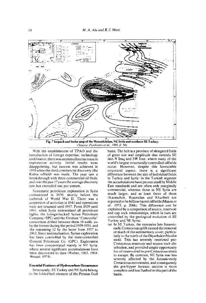
The early Upper Cretaceous tectonic activity in the Taurus orogenic zone was reflected by epeirogenic movements in NE Syria. Ancient Baikalian or Lower Palaeozoic blocks (see above) were reactivated and an E-W trending system of basin-and-swell structures became prominent in extreme NE Syria (see also Ponikarov etal., 1966, Fig. 23, p. 92). The most actively subsiding low was the Sinjar trough, which during the Coniacian, Santonian, Campanian and early Maestrichtian received a
p. 757).
fill of basinal bituminous mark, argillaceous and detrital limestones (Soukhne and Shiranish Formations, Daniel, 1963, p. 166; Weber, 1963, p. 673). These sediments reach a maximum thickness of more than 2,000 m in the Sinjar trough (Figs. 6 and 7). Oil was discovered in a detrital limestone facies of the Shiranish Formation in 1972 (Aliane, Souedie and Roumelan fields), and the unit is now an important exploration target (Mahfoud, 1978,
Elsewhere in NE Syria, the Cenomanian- Maestrichtian sedimentary record is repre- sented by carbonates and local developments of pyritised shales and limestone-sandstone- shale facies. The carbonate section begins with the Cenomanian Judea Formation which consists of about 100 m of limestone, dolomite and some anhydrite and rests conformably on the Aptian-Albian Qamchuqa Formation (Weber, 1963, p. 675). Sediments of Turonian age are poorly developed or missing in NE Syria (Ponikarov et al., 1966, p. 28). Where present they consist of thin limestones and dolomites and are included in the upper part of the Judea Formation. Coniacian-Maestrichtian carbonates, the Soukhne Formation and the “Massive Limestone”, overlie the Judea unconformably but without angular dis- cordance. The Soukhne Formation is generally less than 150 m thick (126 m in the Jebisse oilfield, Metwalli etal., 1974, p. 1787, where it consists of alternations of marly to cherty limestone and glauconitic sandstone). In the main oilfields area, the Soukhne and Shiranish formations are replaced by the “Massive Limestone” which is the major pay zone in NE Syria. It consists of up to 300 m of grey massive limestone, dolomitic limestone and dolomite and may be compared in broad terms with the Mardin Formation of SE Turkey (Weber, 1963, p. 675), but is wholly younger than that formation. The pyritised shale facies (Coniacian-Santonian) are best exhibited in the El Bouab and Jebel Tchembe area, where they are about 50 m thick and have been referred to as the Derro Shale by Weber (ref: cit . ) .
Further movements in the Maestrichtian led to regional uplift which resulted in a shallowing of the seas and the slow emergence of a number of swells (e.g. Kamishly). Conse- quently, the Maestrichtian shows local variations in thickness and the succession thins markedly or is missing across some structural crests (Figs. 4 and7). To the S. in the direction of the Sinjar trough, the Maestrichtian section expands, and reaches its maximum recorded thickness in this depression immediately to the west of Jebel Abd el-Aziz (1,061 m in Abba No.
p. 55).

12 M . A . Ala and B. J . Moss
Fig. 6 lsopach and fades map of the Coniscian, Santonian and Campanian, NE Syria and southern SE Turkey. (Sources. Temple and Perty. IY62. p . 1606; Ponikarov el al.. 1966. p. 9.71.
1. Ponikarov et al., 1966, p. 34) where sediments of this age constitute the upper part of the Shiranish Formation.
The Palaeocene-Lower Eocene sedimentary patterns of NE Syria were controlled by relatively gentle differential movements along fault lines inherited from the Mesozoic, and depositional trends follow closely those of the Upper Cretaceous. However, the Deir ez-Zor high remained above sea level and the J rabhs swzll. already in evidence by the late Maestrichtian. grew in size and extended as far E as Jebel Abd el-Aziz (Fig. 8). N of these uplifted areas the platform slowly subsided from the Palaeocene onwards. and the shallow marine carbonate regime that had existed during the late Cretaceous was replaced by open marine clay and limestone sedimentation which persisted well into the Eocene.
In the early Palaeocene. Germav shale deposition extended from SE Turkey into extreme NE Syria. During the Palaeocene some 350 m of these shales with minor intercalations of limestone accumulated, oserlying the Shiranish Formation with a slight unconformity (Weber. 1963, p. 672-673). To the SE. the Germav Formation becomes increasingly calcareous and passes laterally into and is transgressed by a series of marly, silty and sandy and locally reefoid Palaeocene- Lower Eocene limestones (Sinjar Formation). The transition zone occurs in the vicinity of
Souedie where the Sinjar is about 260 m thick. Further S, the clastic content decreases and the unit becomes a marl and cherty limestone sequence (Aaliji Formation) which in the Sinjar trough reaches a thickness of about 400 m (Fig. 8).
Towards the end of the Lower Eocene, red beds comprising the Gercus Formation of SE Turkey spread into the NE tip of NE Syria. where they interfinger with the upper part of the Sinjar Formation. T h e maximum thickness of the red beds does not exceed 100 m in Syrian territory.
(d 1 Middle Eocene to Recent The sea returned to SE Turkey in the
Middle Eocene, re-establishing a shallow marine carbonate sedimentary regime through- out the area. During this period, a transgressive series comprising some 270 to 350 m (locally up to 600 m) of chalky, partly dolomitic limestones with occasional chert and anhydrite bands (Midyat Formation) was deposited on the Gercus and Antak red beds (Tolun, 1962, p. 51; Rigo de Righi and Cortesini, 1964, p. 1922). This was followed in late Eocene- Oligocene times by local developments of some 400 m of evaporites (Germik Formation) in the central and E parts of Petroleum Dis- trict V (Sanlav et al.. 1963, p. 757). Elsewhere, however, marine conditions prevailed, and chalky mark (Gaziantep Formation) were

Southeast Turkey and Northeast Sjiria 13
deposited conformably on the Midyat carbonates (Rigo de Righi and Cortesini, reb cit.).
Important palaeogeographic changes oc- curred in SE Turkey at the end of the Oligocene, as the result of which Miocene sediments display wide lithological variations. There were some movements in the Taurus orogenic zone, and the present day foothills structures began to rise. A relatively narrow foredeep developed immediately to the south of the orogenic zone and received flysch type sediments (Lice Formation) throughout the Miocene and Pliocene. Uplift in the foothills zone led to the partial removal of the Eocene Midyat Formation from crests of some major anticlinal axes, on which a reefoidal carbonate facies (Silvan Formation) up to about 50 m thick was deposited during the Miocene. In southern parts of SE Turkey, a largely continental environment became dominant and a series of shales, anhydrites and limestones (Selmo Formation) accumulated. These facies were deposited contemporaneously with the Silvan carbonates during the Miocene, but due to a marine regression at the end of the Miocene the area of their accumulation extended N, and in the Pliocene they overlie the Silvan Formation (Temple and Perry, 1962, p. 1610; Rig0 de Righi and Cortesini, 1964, p. 1922). The thickness of the Selmo Formation in the Garzan-Germik area is about 390 m (Sanlav et al., 1963, p. 757).
NE Syria continued to subside throughout the Middle and Upper Eocene and received a cover of more than 600 m (Fig. 9) of marly limestones and mark (Jaddala Formation). Towards the Turkish frontier, the unit becomes dolomitic and anhydritic and may be correlated with the Midyat Formation of SE Turkey (Weber, 1963,~.676).Attheendof theEocene, the NE-most comer of Syria underwent uplift and emergence. The Oligocene is missing here (Souedie No. 1, etc.) but further to the S and W, rocks of this age are represented by more than 300 m of marly limestones and locally dolomitic limestones, known as the Chilou Formation (El Barde No. 1; see also Metwalli et al., 1974, p. 1783-1785).
The Miocene is well represented by sediments in NE Syria. Sediments of this age closely resemble those deposited in NE Iraq and SW Iran, and indeed during the Miocene, NE Syria became part of the great Zagros saline basin. In the NE-most corner of the country, where the Oligocene is absent, Miocene rocks unconformably overlie the Eocene Jaddala-Midyat facies (Souedie No. 1, etc.), but elsewhere the Chilou Formation is succeeded conformably by the Dhiban Formation, the basal parts of which may be of
Oligocene age, according to some reports. The Dhiban is an evaporitic unit, containing varying amounts of marly limestones, which reaches a maximum thickness of 250 m (Weber, 1963, p. 672). It is followed conformably by Middle Miocene successions, which consist of up to 250 m of porous recrystallised limestones, dolomitic limestones and some anhydrite (Jeribe Formation) overlain by a predominantly evaporitic section (Lower Fars Formation) between 400 and 650 m thick. Upper Miocene sediments are developed in continental facies, consisting of up to 250 m of red sandstones and finer clastics with nodular anhydrite at the base (Upper Fars Formation).
Late Miocene to Pliocene folding move- ments led to a further uplift of NE Syria and the continued dominance of continental condi- tions. The Pliocene is thus represented by coarse continental sediments (Bakhtiari Formation) which attain a maximum thickness of about 1,600 m (Weber, 1963, p. 672) in NE Syria. These beds rest unconformably on the Upper Fars and, due to extensive volcanic activity during the late Pliocene, include basaltic lava sheets in the uppermost parts of the succession. Quaternary and Recent deposits are only thinly developed in NE Syria. They comprise not more than 30 m of alluvium, sand and gravel deposited in topographic lows and river beds.
PETROLEUM GEOLOGY
Introduction Although some attention has been focused
on exploring other onshore and, more recently. offshore sedimentary basins in Turkey, the major proportion of exploration effort is still concentrated in the SE part of that country in petroleum districts V and VI. During the early years of petroleum exploration in SE Turkey, all drilling was carried out by the state-owned Petroleum Exploration and Exploitation Administration, which later became a department of the Mining Research and Exploitation Institute (MTA) of Turkey when the latter was formed in 1935. The first wildcat was completed in 1934, but it was not until six years later that a commercial oil-pool (Raman field) was discovered, and a further 10 years elapsed before the second commercial accumulation (Garzan) was found. In 1954 the government revised its petroleum laws, making it possible for foreign oil companies to operate on Turkish soil, and reorganised its own involvement by setting up a new state- controlled petroleum exploration and exploita- tion company. TPAO.
14 M. A. Ala and B. J. Moss
ISciou~ce: Ponikorov el al., 1966, p. 94).
With the establishment of TPAO and the introduction of foreign expertise, technology and finance. there was an immediate increase in exploration activity. Initial results were disappointing. but success was achieved in 19.58 when the third commercial discovery (the Kahta oilfield) was made. The year saw a breakthrough with three commercial oil finds. and over the past 17 years the average discovery rate has exceeded one per annum.
Systematic petroleum exploration in Syria commenced in 1939. shortly before the outbreak of World War 11. There was a suspension of activities in 1941 and operations were not resumed until 1947. From 1939 until 1965. when Syria nationalised all petroleum rights, the foreign-backed Syrian Petroleum Company (SPC) and the German "Concordia'. consortium drilled between them 18 wells, six by the former during the period 1939-1951, and the remaining 12 by the latter from 1957 to 1963. Since nationalisation, Syrian exploration has been controlled by the state-controlled General Petroleum Co. (GPC). Exploration has been concentrated mainly in NE Syria, where several significant accumulations have been discovered to date iWeber. 1963, 1964: Wetzel. 1974).
Essential Features of Hydrocarbon Occurrence Structurally, SE Turkey and NE Syria belong
to the folded-belt element of the Persian Gulf
basin. The belt is a province of elongated folds of great size and amplitude that extends SE into N Iraq and SW Iran, where many of the world's largest structurally-controlled oilfields occur. However, despite this favourable structural aspect, there is a significant difference between the size of individual fields in Turkey and Syria: in the Turkish segment the accumulations have proven small by Middle East standards and are often only marginally commercial, whereas those in NE Syria are much larger, and at least three of them (Karatchok, Roumelan and Khurbet) are reported to be billion-barrel oilfields (Mason et al., 1973, p. 2066). This difference can be explained by a comparison of source, reservoir and cap rock relationships, which in turn are controlled by the geological evolution of SE Turkey and NE Syria: (a) In SE Turkey, the extensive late Jurassic-
early Cretaceous uplift caused the removal of much of the sedimentary cover, particu- larly to the north of the Diyarbakir-Mardin swell. This has severely restricted pre- Cretaceous reservoir and source rock dis- tribution, and provided ample opportunity for oil reservoired in pre-Cretaceous strata to escape. By contrast, NE Syria was less severely affected by the Jurassic-early Cretaceous movements, and consequently the pre-Upper Jurassic section is more complete and less flushed in this part of the basin.

SoutheaJt Turkeji arid Northeast Si . i . i c i 1
Fig. 8 Isopach and facies map of the Palaeocene and Lower Eocene, NE Syria and southern SE Turkey. (Source: Dunnington, 1958, p . 1212; Temple and Perry, 1962, p. 1608: Weber. 1963. p . 679; Pottikarov et al.. 1966, p. 96).
(b) Due to more favourable source, reservoir and cap rock relationships, the Syrian fields may be regarded as multi-objective prospects, with potential pay zones in the Miocene (Metwalli et al., 1972 and 1974; Philip et al., 1972), Upper Cretaceous, Lower Jurassic and Triassic (Mason eta/. , 1973, p. 2066). In SE Turkey, on the other hand, commercially-viable accumulations appear to be limited to Upper Cretaceous and Palaeocene rocks.
(c) The all-important Miocene evaporitic facies of Iraq, Iran and NE Syria have a very limited distribution in SE Turkey. This lack of adequate cover has led to the exposure of pre-Miocene rocks, enabling meteoric waters to invade Tertiary and Mesozoic potential reservoirs. In addition to the Miocene cover rocks, the pre- Cretaceous Mesozoic reservoirs of NE Syria are adequately sealed by Triassic and Jurassic evaporites which are missing in SE Turkey. The stratigraphic distribu- tion of potential source, reservoir and cap rocks in SE Turkey and NE Syria is discussed in further detail below.
Figs. 10 and 11 show the distribution of oilfields in SE Turkey and the available data on individual accumulations are summarised in Tables I and I1
SE TURKEY The broad aspects of the petroleum geology
of Turkey have been discussed by Erentoz and Ternek (1959), Goniilden (1970) and Rigassi (1971), amongst others. More specifically, the surface and subsurface stratigraphic distribu- tion of hydrocarbons in SE Turkey have been documented in some detail by Mason (1930). Eyoub (1931), Tasman (1950) and Lebkiichner et al. (1972). While commercial production is restricted to Upper Cretaceous and Palaeocene reefoidal carbonates (see below), oil indications have been encountered in sediments ranging in age from the Devonian to Eocene (Tasman and Egeran, 1951, p. 192; see also Fig. 5). Surface hydrocarbon indications are common in breached structures in the foothills and folded belt zones. Their mode of occurrence and chemical characteristics have been studied in detail by Lebkiichner e t al. (1972). and according to these authors asphaltic substances form the great majority of the surface indications. The material occurs in three different ways (Lebkiichner et al.. 1972, p. 1939-1941): (1) as thin fissure fillings, (2, as veins of dense asphalt up to 3.5 km long and 80 m wide. and (3) as primary deposits of pyrobituminous shale.
SOURCE ROCKS ( a ) Palaeozoic
Marine shales are present in the late

I6 M. A. Ala and B. J. Moss
Cambrian-early Devonian Sosink. Bedinan. and Handof formations. Possible evidence to suggest that Palaeozoic sediments were capable of sourcing hydrocarbons may be found in the breached core of the Hazro Anticline (Fig. 1 J where oil-impregnated Permian sandstones ( Hazro Formation I are exposed at the surface (Rigt) de Righi and Cortesini. 1964. p. 1920). However. the present-day distribution of Palaeozoic sediments and their post-depositional grolugical histoq make it unlikely that com- niercially viable accumulations sourced by rocks of this age could have survived in SE Turkey. Much of the region was affected by late Jurassic-earl) Cretaceous uplift, when Mesozoic. Palaeozoic and even Precambrian rocks became exposed over -large areas. Sorthern SE Turkey was the most severely affected region. and here the prospects are particularly poor. S of the Diyarbakir-Mardin swell. in areas where adequate Mesozoic- Tertiary cover is present. the prospects for the preservation of hydrocarbons generated by possible Palaeozoic source rocks improve.
Ih) Mesozoic Rocks with potential source characteristics
;ire nor immediately apparent in the Mesozoic successions of SE Turkey. Indeed. due to the ahove-mentioned effects of late Jurassic-early Cretaceous uplift. potential Mesozoic rocks
seem to be restricted to the Upper Cretaceous section, and the environmental conditions prevailing during this interval limited the accumulation of potential source sediments still further. Upper Cretaceous sedimentation was. for the most part. dominated by a carbonate shelf environment and consequently there was little opportunity for the accumula- tion of deeper more basinal sediments. It was n o t until the Maestrichtian with the increase in the rate of subsidence and the consequent influx of fine-grained clastics that significant volumes of potential source rock material began to be deposited regionally in SE Turkey. These bituminous, dark, marine shales interfinger with and overlie a complex of oil- bearing Upper Cretaceous carbonate reser- voirs (Garzan Formation, etc.) in the Garzan, Germik. Kurtalan, Magrip, Silivanka and Ranian West oilfields. located some 100 km E of Diyarbakir. Due to this close stratigraphic association between the Garzan and Germav facies and the presence of fresh water (i.e. evidence of flushing) in the underlying Mardin Formation in the Garzan-Germik area (Sanlav ei ( I / . , 1963, p. 763), the Germav Shale appears to be the most logical source of the Garzan Formation oil in these fields. On the other hand. the Raman field, located in the same general area, produces heavy oil ( 18S0 API) from the Campanian-early Maestrichtian
Fig. 9 Isopach and facies map of Middle and Upper Eocene, NE Syria and southern SE Turkey. (Source\: Duriningron. 1V.W p. 1213. Weher. 196.7: p. 96).

Southeast Turkev and Northeast Syria 17
Fig. 10 Distribution of oilfields in District V, SE Turkey.
R a m m Limestone, which is separated from the Germav Shale by about 100 m of marly limestone comprising the Kiradag Formation. Since downward migration of hydrocarbons from the Germav Shale through the intervening Kiradag Formation into the Raman reservoir is not a satisfactory explanation of the origin of the oil. derivation from a lateral or underlying source should be considered. In this connec- tion, evidence from a deep test (Raman No. 14, Fig. 5) on the Raman structure may be relevant. This well reached the top of the Triassic Beduh Formation and penetrated several hundred metres of Lower Cretaceous to Triassic carbonates and subordinate shales containing an abundance of asphalt, bitumen and some light oil (Tasman and Egeran, 1951, p. 193). It may therefore be suggested that the heavy oil currently produced from the Raman Formation represents the residue of an accumulation, originally stored in a pre-Raman reservoir, that was partly flushed during the late Jurassic-early Cretaceous uplift. Late Tertiary faulting could have. provided the necessary channels through which the remnant accumulation migrated into the Raman reservoir, where it was prevented from further upward movement by the Germav Shale.
Along the W-SW-E-NE Beykan-Kurkan-
Kayakoy- Katin producing trend, located 10- 15 km N and NW of Diyarbakir, oil is reservoired in the Albian-Turonian Mardin Formation. In these oilfields the Campanian- early Maestrichtian Kastel flysch facies intervenes between the Mardin carbonates and the late Maestrichtian-Palaeocene Germav Shale (Cordey, 1971, Fig. 4, p. 320), and evidence of direct migration from the latter into the former is not readily available. The source of hydrocarbons in these fields is even more speculative since in this region the Mardin Formation is underlain directly by
Fig. 11 Distribution of oilfields in District VI, SE Turkey.

18 M. A. Ala and B. J. Moss
Siluro-Devonian rocks (Cordey, 1971. Fig. 14, p. 332-333). Although locally-developed black bituminous shales are known in the Siluro- Devonian successions (Handof Formation) in the Hazro area, there is no information regarding their presence in the Beykan. Kurkan, Kayakoy and Katin oilfields area. Furthermore, even if present, the authors doubt that any hydrocarbons generated by these shales could have survived the vigorous late Jurassic-early Cretaceous erosion in this region. The absence of a pre-Mardin Mesozoic section points to hydrocarbon migration from a lateral or overlying source. Since no sediments with potential source-bed characteristics are known to have been deposited contemporane- ously with the Mardin Formation, this process of elimination leaves the overlying Germav Shale as the most viable alternative. Although the Germav and Mardin Formations are not in direct contact in the Beykan-Kurkan-Kayakoy- Katin area, the intervening Kastel facies thins towards the SW and finally pinches o u t in the Adiyaman region, where the Germav Shale unconformably overlies the Mardin carbonates (Rigo de Righi and Cortesini, 1964. Fig. 8, p. 1930-1931). It is therefore possible that the oil now trapped in the above fields entered the Mardin Formation, beyond the limits of the Beykan-Kurkan-Kayakoy-Katin axis, and reached its present position by long-distance lateral migration along the regional unconfor- mity at the top of the Mardin unit. Evidence for this proposed migration route is provided by the concentration of oil in the uppermost beds of the Mardin Formation. These beds are situated immediately below the unconformity, and their petrophysical characteristics have been enhanced by leaching and dolomitisation as the result of subaerial exposure.
The oils produced from the above fields vary in gravity from 29.5' API (Katin) to 38.2' API (Kayakoy), indicating that they have not suffered oxidiation or flushing. This in turn makes it unlikely that they were derived from pre-Mardin source rocks. Nevertheless, while the Germav Shale appears to have sourced most of the oil currently produced in SE Turkey. the possibility of the presence or former presence of pre-Mardin source rocks should not be discounted, as indicated by evidence from deep tests (see also Bakuk No. 1, Fig. 5 ; Dunnington, 1967, p. 129).
(c) Tertiary The upper part of the Germav Shale is of
Palaeocene age and constitutes the only obvious Tertiary potential source rock in SE Turkey. It is the most likely source of the' hydrocarbons reservoired in the laterally
equivalent Sinan reef complex at the Selmo field, and the indications encountered in the overlying Becirman limestone in some wells (Fig. 5).
RESERVOIR ROCKS
(a ) Palaeozoic Potential Palaeozoic reservoir rocks are
predominantly clastic. Porous sandstone horizons are developed throughout the Cambro-Devonian Sosink, Bedinan, and, less frequently, Handof formations. In the Upper Palaeozoic section, the Permian Hazro Formation contains sandstone beds which are oil-impregnated at outcrop in the breached core of the Hazro anticline, and these may also be considered as potential reservoirs. Carbon- ate reservoirs may be developed in the Permian shelf and reefal limestones that comprise the Inbirik Formation, particularly where it interdigitates with the Hazro clastics.
Any speculation regarding the distribution of potential Palaeozoic reservoirs must, however, be tempered by a consideration of the effects of late Jurassic early Cretaceous uplift and erosion. North of the Diyarbakir- Mardin swell, potential Palaeozoic reservoir rocks have been either removed, or truncated and flushed. Therefore, the possibility of finding commercial accumulations in Palaeo- zoic rocks over large areas of SE Turkey seems remote, and consequently only 10% of the wells have tested the pre-Permian section (Rigassi, 1971, p. 461). There are, nonetheless, some restricted areas, particularly near the Syrian frontier, where potential Palaeozoic reservoirs may have escaped the full effects of uplift, flushing and erosion. In this connection it should be pointed out that several surface and subsurface oil shows are known in pre- Permian sediments, and gas shows have been encountered in wells drilled into the section near the Syrian frontier, indicating that Palaeozoic rocks may hold some prospects in this area (Rigassi, 1971, p. 459).
(b) Mesozoic Cretaceous carbonates, ranging in age from
Albian-Turonian to late Maestrichtian, contain most of the oil in the SE Turkey fields. The primary petrophysical characteristics of these reservoirs are not favourable and production is obtained only when porosity and permeability have been enhanced by secondary processes such as leaching and dolomitisation, or fracturing. In ascending order, the Mesozoic pay-zones are as follow:

Southeast Turkey and Northeast Syria 19
Cumulative / t o Ju1.v 1st. 1978)
3.900.000
46,780.981
TABLE I-OILFIELD DATA, SE TURKEY
Gravity P A P I )
11.5
34.2
KURKAN (Shell)
Daily Average Field
(Operator)
1963 Mardin 3,673
KAHTA (ERSAN-Turkish I subsidiaryof AMOSEAS) I 1958 I Mardin I 250
37,107.726
1,677,977
1 EEYKAN (Shell) I 1964 I Mardin I 3.544
31.4
31.0 YATIR (Shell) I 1973 I 1 1965 I Mardin I 4,294
SAHABAN-K URKAN I SOUTH (Shell)
2.181
K A Y A K O Y WEST(Shel1)
K A Y A K O Y (Shell)
I BARBES (Shell) I 1971 1 Mardin I 3,101
1964 Mardin 3.814
1960 Mardin 1,805
17.078.848
11.513.825
45.292.994 I 33.2 I
34.0
38.2
7,979,183
14.142.293 I 34.7 I
29.6
SILIVANKA (TPAO) 1962 Garzan 19.5
~~
CELIKLI (TPAO)
DEVECATAGI (TPAO)
OYUKTAS (TPAO)
PIYANKO (Shell)
MALTEPE (Shell)
KATIN (Shell)
KURTALAN (TPAOI
1963 Mardin
1973
1971
1968 Mardin
1970 Mardin
1971 Mardin
1961 Garzan
Shut-in
553.000 (to July 1st. 1977)
34.0
33.5
543.000 (to July 1st. 1977)
1,143,785 (to July 1st. 1977)
30.1
35.5
1 33.0
2.790.286 (to July 1st. 1977)
3.018.359 (to Ju ly 1st. 1977)
Sources: Glance. 1971.p.452; OilandGasJournal, December26th. 1 9 7 7 ; ~ . 142; OilandGasJournal. December251h. 1 9 7 8 ; ~ . 142.
32.7
29.5
Mardin Formation The Mardin Formation has been found
commercially productive in the Beykan- Kurkan-Kayakoy area of District V and at Kahta and Adiyaman in District VI. The Beykan-Kurkan-Kayakoy oil-pools are located N and NW of Diyarbakir and are associated with a W-SW-E-SE trend where the Mardin has been deformed into a series of anticlines. In all of these fields, the Mardin shelf carbonates have been extensively dolomitised immediately beneath a latecretaceous regional uncon- formity at the top of the formation. The oil is reservoired in the uppermost beds, which
consist of moderately porous sucrosic dolomites. Secondary porosity is believed to be due to late Cretaceous uplift as the result of which the top of the Mardin Formation became subaerially exposed, fractured, leached and dolomitised (Demirmen 1971; Cordey, 1971).
Raman Limestone The only significant hydrocarbon accumula-
tion found so far in this unit is at Raman where the limestone is developed in a reefal facies of Campanian-early Maestrichtian age. Reser- voir porosity has been enhanced by leaching (Tasman and Egeran, 1951, p. 194) prior to

20
1956
I956
M. A. Ala and B. J. MOSS
.'Massire Limestone'' 32.550 64,005.538 2 1 .o "Massive Limtwone" 22 0
I KARATCHOK (GPCI
l y 5 ~
I HAMZAiGPCl
Shiranish I?) "Massive Limestone.. 1 122.731 I 352.515.410 I 24.0 Butmah 36.0 Kurrachine 35.0
1 SOUEDIE tCPCi
JEBISSE I G PC I
KHLIRBE7 I G P C I
TABLE 11-OILFIELD DATA. N E SYRIA
Production lBbll
Dailv A wra,ge Disco very Producing
Formution
Shiranish I,!) 1962 1 "Massive Limestone'' I U.UO8 I 24.515.140 I 23.0
Kurrachine 48.0
5.549.2UR
,'Massive Lirnsstone"
Kurrachine I ? )
Shiranish PI "Massive Limestone'' I .Y8 I .372
Sources.Glance. 1971. p 152: Mason e t a / . . 197.7. p. 2Mh. Beydoun mdDunnington. 19'75. p. 40: Oiland GasJournaL December 25th. 1 W X . p . 142: Mahfoud. 19'78. p. 55
burial beneath a thick impervious cover of Germav Shale.
Garzan Formation The late Maestrichtian Garzan reefal
limestones form the reservoirs in the Garzan- Germik, West Raman, Magrip and Silivanka oilfields in District V. The reservoir rocks are composed of moderately porous, fractured bioclastic to reefal limestones. In most cases, the accumulations are undersaturated, and the oil produced is heavy, with API gravities ranging from 13.4' (Raman West) to 25' (Garzan). The pay horizons are sealed by and grade downflank into the Germav Shale.
(c ) Tertiary Oil is produced from the Palaeocene Sinan
Formation at Selmo, but this field is the only example of a Tertiary accumulation in Dis- tricts V and VI of SE Turkey. Apart from the Sinan reefal carbonates, Tertiary prospects are limited, due to the exposure of the potential reservoir rocks.
NE SYRIA
Surface hydrocarbon occurrences in Syria are commonly associated with Tertiary rock outcrops and include live oil and gas shows as well as asphaltic impregnations. In NE Syria the best indications are found in the E end of Jebel Abd el-Aziz, in Jebels Tchembe and Jeribe, and around Jebisse (Ghorab. 1960; Metwalli et al.. 1974).
SOURCE ROCKS
(a) Palaeozoic Marine shales are expected to be present in
the Palaeozoic rocks of NE Syria. Dark grey shales occur at various stratigraphic levels in adjacent areas, and are thought to extend beneath the thick Mesozoic and Tertiary cover in NE Syria. Of particular interest in this connection is a development of graptolitic Silurian shale, similar to shales which are thought to be a possible source of several major gas discoveries in SW Iran. South of the Diyarbakir-Mardin swell, the effects of the late Jurassic-early Cretaceous uplift have been less severe, and in this area there may be opportunities for the preservation of hydro- carbons generated in Palaeozoic source-rocks. (b) Mesozoic
Mesozoic successions are predominantly calcareous and contain significant develop- ments of evaporitic facies. Nevertheless, the broad basin-and-swell framework that was evident through much of the Mesozoic era provided opportunities for the deposition of closely associated potential source and reservoir rocks. Potential source rock develop- ments may be expected at the following stratigraphic levels:
Triassic Although available subsurface information
indicates that the lithology of the Triassic successions in NE Syria is dominated by dolomite and anhydrite (Kurra Chine Beds), a facies change occurs across the border with

Southeast Turkey and Northeast Syria 21
Iraq, where the upper part of the section is replaced by the Baluti Shale (Metwalli et al., 1974. p. 1788). Further, according to Dunning- ton (1958, p. 1199), occasional evaporite layers have been encountered in wells drilled in N Iraq, indicating intermittent barred basin conditions. Surface and subsurface indigenous oil indications are known in the Triassic sediments of N Iraq, and notwithstanding Dunnington’s reservations ( re t cit .) regarding the source rock potential of the succession, it is possible that the hydrocarbons reservoired in the Kurra Chine Beds in the Souedie, Roumelan, Khurbet and Jebisse oilfields (see below) have been derived from a lateral source.
Lower Jurassic Rocks of this age comprise the Butmah,
Adaiyah, Mus and Alan formations of NE Syria and N Iraq. Lithologically, they consist of varying proportions of anhydrite, limestone, dolomite and black shale. Deposition took place under semi-barred basin conditions, and although the total organic content of the sediments is not reported to be very high, they are thought to have generated some petroleum (Dunnington, 1958, p. 1200).
Sargelu Formation As its type section in N Iraq, this Middle
Jurassic formation consists of thin bedded, black, bituminous limestones and fissile shales. Towards the W, the Sargelu Formation be- comes increasingly dolomitic and anhydritic, but contains, nevertheless, some shaly develop ments which could be considered as potential source rocks in NE Syria. The source rock potential of this interval is rated highly by Dunnington (1958, p. 1201).
Shiranish Formation The Campanian-Maestrichtian Shiranish
Formation reaches its thickest development in the Sinjar trough, where it includes bituminous layers of possible source rock potential. In the Jebisse area it is up to 1,135 m thick and is reported to be bituminous throughout (Metwalli et al., 1974, p. 1787). Due to its large thickness and lateral gradation into the producing “Massive Limestone”, the Shiranish Formation could be an important potential source rock in NE Syria.
(c) Tertiary Bituminous deposits are present in the Lower
Tertiary successions of NE Syria. These potential source rocks occur at two stratigraphic intervals:
Germav Formation This Palaeocene unit is considered an
important potential source rock in SE Turkey
and extends into the NE-most corner of Syria. Here it is represented by thick marine shales and resembles closely its counterpart in the Garzan-Germik producing area.
faddala Formation The Middle and Upper Eocene marls and
marly limestones that comprise this formation are thick, widely distributed in NE Syria, and include bituminous layers towards the base (see also Metwalli et al., 1974, p. 1786). In central NE Syria the formation has been buried to the required depth for hydrocarbon generation.
RESERVOIR ROCKS
( a ) Palaeozoic The reservoir characteristics of Palaeozoic
sediments in NE Syria are poorly known. Palaeozoic rocks have been reached in only a few wells, Kamishly No. 1, which was abandoned in Ordovician beds, having the deepest stratigraphical penetration that has been recorded in publication. On the basis of subsurface and outcrop data from SE Turkey and N Iraq, however, it may be speculated that potential Palaeozoic sandstone reservoirs are present in NE Syria. Sandstone developments may be expected in the Middle and Upper Cambrian (Telbesmi Beds), Ordovician and Silurian (Khabour Beds), Devonian? (Kaisti Beds), and Permo-Carboniferous, while p6tential carbonate reservoirs may exist in the Middle and Upper Cambrian and Permo- Carboniferous. However, the possibility of the presence of commercially-viable hydrocarbon akumulations in Lower Palaeozoic rocks is remote.
(b) Mesozoic Mesozoic reservoirs contain the bulk of the
hydrocarbon reserves discovered in NE Syria. Petroleum is reservoired in the Upper Triassic at Jebisse, Souedie, Roumelan, Khurbet and Karatchok; in the Lower Jurassic at Khurbet and Karatchok, and in the Upper Cretaceous at Jebisse, Karatchok, Roumelan, Khurbet and Souedie.
UPPER TRIASSIC The Kurra Chine Formation forms the Upper
Triassic reservoirs, which range in depth from 3,000 to 3,200 m (Mason et al., 1973, p. 2066). Light oil, gas and condensate are reservoired in fractured, friable and sucrosic Kurra Chine dolomites, and the pay zones are sealed by thick anhydrite beds comprising the upper part of the Kurra Chine Formation.
Lower sulphur content and high API gravity distinguish the Triassic hydrocarbons from

22 M. A. Ala and B. J . Moss
those found in the Upper Cretaceous “Massive Limestone”, which is the main pay zone in the NE Syria oilfields. While the former generally have a high gas-oil ratio (Mason et al., ref. cit., Metwalli e t a / . , 1974, p. 1790) and a gravity of 35’ API in the Souedie oilfield (Glance, 1971, p. 452), the latter are characterised by low API gravities (see below) and sulphur contents of up to or above 4.85% by weight (Jenkins, 1977, p. 165). Further differences came to light as the result of geochemical studies by Metwalli et al. (1972). who concluded that the Triassic and Upper Cretaceous crudes were derived from separate sources.
The discovery of Triassic oil greatly enhances the petroleum potential of NE Syria, as deep drilling has indicated that sediments of this age have a wide distribution here.
JURASSIC Lower Jurassic carbonates (Butmah Forma-
tion) are oil-bearing at Karatchok and Khurbet, and hydrocarbon shows have been en- countered in the Middle Jurassic (Sargelu Fcrmation).
Butmah Formation Butmah dolomites form the Lower Jurassic
reservoirs in the Karatchok and Khurbet oilfields. In addition to these, pools of unknown commercial significance have been reported in the Butmah and the overlying Alan-Mus- Adaiyah complex at Roumelan and Souedie respectively (Dunnington, 1967, Plate 1, Fig. D). Elsewhere, El Barde No. 1 encountered oil shows in the Butmah at 2,302 m and 2.378 m, and in El Bouab No. 1 similar indications were reported from the same beds at 2,439 m.
CRETACEOUS The Upper Cretaceous “Massive Limestone”
constitutes the main pay-horizon in NE Syria. It is a massively-bedded, neritic limestone- dolomite sequence which includes reefal developments according to some authors (Nikolaevskii, 1972, quoted by Metwalli et al., 1974, p. 1787). In the Jebisse area, the “Massive Limestone” is not developed in its typical facies, and is replaced by bituminous shales, sandstones and thinly-bedded argillaceous carbonates that are referred to the Soukhne and Ghouna formations (Metwalli et al.. ref. c i t ) . The reported flow rates of between 1,875 and 2,830 bblid (Mason et a/., 1973, p. 2066) suggest favourable porosity, permeability and fracturing. These may have been enhanced by leaching and dolomitisation as the result of exposure at the end of the Maestrichtian.
The oils produced from the “Massive Limestone“ are heavy, ranging from 19.5O API
at Aliane to 24’ API at Souedie (Oil and Gas Journal, 25th December 1978, p. 142). Geochemical evidence put forward by Metwalli et al. (1972) suggests that the “Massive Limestone” oil has been derived from a laterally equivalent (Shiranish?) or underlying (Lower Cretaceous‘? or Jurassic? but not Triassic) source. In the Iraqi and Iranian segments of the folded zone, where substantial production is obtained from carbonates of equivalent age, there is preponderant evidence in support of the generation of the hydrocarbons in the Lower Cretaceous-Jurassic section (Dunning- ton, 1958 and 1967; Thode and Monster, 1970; Young et a/., 1977). This consideration tends to favour a similar origin for the petroleum found in the “Massive Limestone” reservoirs of NE Syria.
In several seemingly favourable structures such as Kamishly, El Barde and El Bouab, the “Massive Limestone“ is unproductive. The anomalous lack of oil in these large structural traps, fairly close to other structures which are productive, merits consideration.
Towards the close of the Campanian, certain parts of NE Syria were uplifted and formed a series of low-relief islands. These locally emergent highs were centred on the Karatchok, Souedie, Roumelan, Kamishly, El Barde and El Bouab structures of NE Syria. Over these highs the “Massive Limestone” became subaerially exposed, and was subjected to leaching and dolomitisation. This was followed by subsidence and the deposition of 100 to 300 m of Maestrichtian Shiranish mark and marly limestones over the leached carbonates. The emergent areas around Kamishly did not subside during the Maestrichtian, and here the “Massive Limestone” remained exposed until the Palaeocene when the Sinjar shelf carbonates were laid down. El Barde and El Bouab experienced some subsidence during the Maestrichtian, and received a thin and patchy cover of Shiranish marly limestones. These areas were eventually covered by the Sinjar shelf carbonates in the Palaeocene.
It is considered likely that hydrocarbons migrating into the “Massive Limestone” reservoirs were generated in the central areas of NE Syria (Sinjar trough area?) and reached the above-mentioned structures at the end of the Cretaceous. The fate of the hydrocarbons filling these incipient culminations was then decided by the effectiveness of the seal above the “Massive Limestone” reservoir. Owing to lack of adequate cover at Kamishly, the migration of hydrocarbons was not checked and consequently no accumulation was formed. At El Barde, El Bouab, Karatchok, Souedie and Roumelan, on the other hand, the reservoir had acquired a cover of marly
Southeast Turkey and Northeast Syria 23
limestones (Shiranish Formation) which tended to arrest further hydrocarbon movement. However, the presence of copious hydrocarbon shows in the Shiranish marly limestones indicate that this unit was not an effective cap rock (see also Mahfoud, 1978, p. 55). The lighter hydrocarbon fractions could thus have been lost, and this is offered as the explanation of the presence of heavy oils in the “Massive Limestone” of NE Syria fields. The rate of dissipation was probably greater at El Bouab and El Barde, as the Shiranish cover is thinner over these structures. Finally, Palaeocene sedimentary patterns played a decisive role in the preservation of the oil left in these structures.
During the Palaeocene, deposition of the Germav Shale extended S into NE-most Syria, and capped the “Massive Limestone” cover of the structures presently producing from this formation. These fine-grained deposits effec- tively sealed the reservoirs and arrested the dissipation of hydrocarbons. El Barde and El Bouab lay too far to the SW to be covered by Germav shale, and in these areas the Shiranish is succeeded by the Sinjar carbonates which were equally ineffective as a seal. The hydrocar- bons continued to escape unchecked, and the process of dissipation was probably completed before the marly limestones of the Jaddala and Chilou formations covered the structures in Middle Eocene-Oligocene times. In El Barde No. 1, the “Massive Limestone” contained weakly saline water and was heavily impreg- nated with asphalt, while El Bouab Nos. 1 and 2 encountered fresh water with hydrogen sulphide in the same formation (Weber, 1964).
(c) Tertiary The discovery of oil in Jebisse, in 1968,
confirmed the accumulation of hydrocarbons in commercially-significant quantities in Tertiary rocks. This had long been suspected, as, prior to this discovery, encouraging oil shows had been encountered in the Tertiary section below the Middle Miocene Lower Fars evaporites in NE Syria in several wells (Ghorab, 1960; Weber, 1964), and “giant” petroleum deposits in rocks of similar age have been known in the Iraqi and Iranian parts of the Zagros basin since the early years of the present century.
Production is obtained from the Lower to Middle Miocene Jeribe Formation, the petrography and reservoir characteristics of which have been discussed by Philip et al. (1972). It is an extensively recrystallised and dolomitised limestone with high secondary porosity and permeability. The pay zone has an average thickness of 55 m at Jebisse, and its top lies at depths varying from about 550 to
800 m below the surface. A large gas cap is present and the oil is oversaturated and has a reported API gravity of 20.5’ (Oil and Gas Journal, 25th December 1978, p. 142), which compares with that of the crudes reservoired in the Upper Cretaceous “Massive Limestone” further north. However, Metwalli et al. (1972) found the sulphur, asphaltene and trace- element contents of the Jeribe crude to be higher than those of the “Massive Limestone” oils, and on this basis attributed the former to a Tertiary source. Since the overlying Lower Fars evaporites are judged incapable of generating hydrocarbons, and no laterally- equivalent potential source rock is known, the Jeribe oil must have migrated from below. Such an origin seems to be supported by the presence of minor quantities of oil and abundant bitumen in the underlying Dhiban evaporites and Chilou carbonates (Metwalli et al., 1974, p. 1785). Live oil was recorded in the upper part of the formations and viscous or dead oil in the lower part of each unit. Metwalli et af. (ref. cit . ) have noted the presence of hydrocarbons also in fractures in the anhydrite beds of the Dhiban. This is particularly significant, as it shows that despite a thickness of up to 168 m and a lithology dominated by anhydrite and halite, the Dhiban Formation has failed to prevent the entry of hydrocarbons into the Jeribe reservoir from below.
Substantial quantities of bitumen and live oil shows have been reported also in the Upper Cretaceous Shiranish, Ghouna and Soukhne formations at Jebisse (Metwalli et al., 1974, p. 1787). There can be little doubt that fault and fracture communication exists between these formations and the Jeribe reservoir, making it possible for any oil accumulation in the former to have moved into the latter after the Mio-Pliocene folding. Such an origin would be consistent with that envisaged by Dunning- ton (1958 and 1967) and confirmed by Thode and Monster (1970) and Young et al. (1977) for the Zagros Tertiary oil accumulations of Iraq and Iran. Thus, while the authors of this article agree with Metwalli et at. (1972) that the bulk of the Jeribe oil was probably supplied by an indigenous Tertiary source-rock (the Eocene Jaddala Formation?), a contribution from the underlying Upper Cretaceous section cannot be ruled out as a possibility.
CONCLUSIONS Important similarities and marked dif-
ferences between the geological histories of and petroleum occurrences in SE Turkey and in NE Syria have been noted.
The structural features of SE Turkey and NE Syria form the NW continuation of those

24 M. A . Ala and B. J. Moss
associated with the Zagros folded zone of Iraq and Iran. A pronounced tectonic grain varying in trend from ENE to ESE is evident in Turkey and Syria, and the degree of structural complexity increases progressively towards the Taurus orogenic zone. Elongated folds of oiten great size and amplitude dominate the structural features. They were formed during the Mio-Pliocene Alpine movements that affected the NE margin of the Persian Gulf basin stretching from the Straits of Hormuz in the SE to the Amanos Mountains of Turkey in the NW. Nevertheless, certain features cannot be explained by Mio-Pliocene movements alone, and there is little doubt that the Alpine structural alignments have been superimposed. particularly in SE Turkey, on pre-existing trends.
The depositional history of the area has been divided into five major cycles, namely. late Precambrian, Cambro-Devonian, Permo- Carboniferous to Upper Jurassic, Lower Cretaceous to Lower Eocene and Middle Eocene to Recent. Regional uplift and extensive erosion preceded the PermoCar- boniferous to Upper Jurassic and Lower Cretaceous to Eocene sedimentary cycles. SE Turkey appears to have experienced more uplift and greater erosion, particularly north of the Diyarbakir-Mardin swell, which adversely affected its petroleum potential.
In terms of individual field size and magnitude of reserves, NE Syria differs considerably from SE Turkey. Estimates of the recoverable reserves of Syria are variable. According to the Oil and Gas Journal (25th December 1978, p. 102), Syria’s proven reserves as of 1st January 1978 were 2,080 MM/bbl of oil and 1.5 Tcf of gas, while Mason et al. (1973. p. 2066). quoting Bybochkin and Kats (1970). credited the Karatchok, Roumelan and Khurbet fields with 2,575 MM/bbl, 1,500 MM/bbl and “several billion barrels” of recoverable oil respectively. The recoverable reserves of the Souedie field, currently the largest producer in NE Syria, have not been disclosed. Although the authors of this article have been unable to find independent con- firmation or clarification of the figures quoted by Mason et al.. they regard the figure of 2,080 MM/bbl as a gross underestimate
The recoverable reserves of Turkey, as of 1st January 1978, were estimated at 360 MM/bbl of oil and 0.5 Tcf of gas (Oil and Gas Journal, re& cit.). During the first six months of 1978, the average daily production of Syria from five fields (Jebisse, Karatchok, Roumelan, Souedie and Aliane) was 171,227 bbl of oil (122,731 bbl from Souedie alone), while the Turkish output in the same period averaged
57,329 bbl/d from 21 fields (Oil and Gas Journal, 25th December 1978, p. 142).
These differences in productivities and in volumes of reserves are caused by several factors. the most important of which are the regional development and distribution of potential source, reservoir and cap rocks, these factors being controlled ultimately by the geological evolution of the two areas. Because of favourable source, reservoir and cap rock relationships, some Syrian fields have multi-reservoir accumulations with potential pay zones in the Miocene, Upper Cretaceous, Lower Jurassic, Triassic and possibly Upper Palaeozoic. In SE Turkey, on the other hand, late Jurassic-early Cretaceous uplift and erosion appears to have limited the occurrence of commercial hydrocarbon deposits largely to the Upper Cretaceous and Palaeocene rocks. Tertiary prospects are severely restricted in SE Turkey. The Miocene Lower Fars evaporites that cap the Tertiary accumulations of Iran, Iraq and NE Syria have. a very limited distribution in SE Turkey, and here the exposure of pre-Miocene rocks has enabled meteoric water to invade many of the Tertiary and Mesozoic potential reservoirs.
There is a wide variation in the gravity of Turkish oils-from 11.5’ API at Kahta to 39.9’ API at Osmancik North-while the crudes produced from the Upper Cretaceous and Tertiary reservoirs of Syria are consistently heavy and characterised by 19.5’ API to 24O API gravities at Aliane and Souedie respectively (Oil and Gas Journal, 25th December 1978, p. 142). Light oil and con- densate of 35’ API to 48’ API have been tested in Lower Jurassic and Triassic succes- sions in some of the Syrian fields (Dunnington, 1967, Plate 1, Fig. D; Glance, 1971, p. 452; Beydoun and Dunnington, 1975, p. 43). Flushing is the main cause of the low API gravities of some of the Turkish crudes, as is indicated by the presence of fresh water in many of the reservoirs. Dead oil and weakly saline water are present also in some of the unproductive Upper Cretaceous reservoirs of NE Syria, but in general the pre-Miocene section has been subjected to less flushing in this area. Loss of light fractions, due to imperfect sealing, is probably the main reason for the heavy gravities of the hydrocarbons in the Upper Cretaceous pay zones of NE Syria.
On the basis of geochemical studies, Metwalli et al. (1972) proposed separate sources for the oils in the Tertiary, Upper Cretaceous and Lower Mesozoic reservoirs of NE Syria. Although the authors of this article agree with Metwalli et al. that the Miocene Jeribe accumulation at Jebisse is largely of Tertiary origin, fault and fracture communications do

Southeast Turkej, arid Northeast SI-/ ici 25
exist between Tertiary and older rocks, and the presence of live and dead oil-shows in the intervening section suggests a mixing of Mesozoic and younger crudes.
Most of the oil currently produced from Upper Cretaceous pay zones in SE Turkey is believed to have been generated by the Maestrichtian Germav shale, as in a number of fields the Albian-Turonian Mardin reservoir is underlain by Siluro-Devonian successions of doubtful source rock potential. However, in the Raman field, which produces from the Campanian-early Maestrichtian Raman Forma- tion, a deep well recorded some light oil and abundant asphalt and bitumen in the underlying Mardin, Lower Cretaceous and Jurassic formations. Since the oil presently produced from the Raman Formation is heavy 18.5’ API) and associated with fresh water (Temple and Perry, 1962. p. 1611), it may be the residue of an earlier accumulation, origin- ally stored in an underlying pre-Raman reser- voir, that was partly flushed during the late Jurassic-early Cretaceous uplift. Late-Tertiary faulting and fracturing could have provided the necessary channels through which the remnant accumulation migrated into the over- lying Raman reservoir. where it was prevented from further upward movement by the Germav shale. There is thus a possibility that at least part of the oil now trapped in Upper Cretaceous reservoirs in some of the SE Turkey fields is of deeper origin.
Finally, it should be clear from the above summary that the favourable conditions which have conspired to create “giant” oilfields in NE Syria do not prevail in SE Turkey, where the prospects of finding petroleum accumulations of comparable size are remote.
Acknowledgment The authors are indebted to John
Christensen, via Filippo Marchetti 35, Rome, Italy for providing Figs. 4 and 5 and sanctioning their use in this article.
REFERENCES
ALTINLI, E., 1966. Geology of eastern and southeastern Anatolia: Madan Tetkik Arama Enst. Bull., 66, p. 35-76.
AUBOUIN, J . , 1965. Geosynclines: Elsevier, Amsterdam, 335p.
BEYDOUN, Z. R. and DUNNINGTON, H. V.. 1975. The petroleum geology of the Middle East: Scientific Press Ltd., Beaconsfield, Bucks., England, 99p.
COLEMAN, R. G.. 1977. Ophiolites: Springer- Verlag, Berlin, 229p.
CORDEY, W. G., 1979. Stratigraphy and sedimentatjon of the Cretaceous Mardin Formation in Southeastern Turkey: in Geology and History of Turkey, A. S. Campbell ed., Petroleum Exploration Society of Libya, pp. 317-348.
DANIEL, E. J., 1963. Syrie interieur. i n
Lexique Stratigraphique International, VIII, Fasc. 10 cl. Syrie, Liban, Jordan, L. Dubertret ed., Paris, pp. 157-291.
DEMIRMEN, F., 1971. Aspects of the regional stratigraphy of the Mardin Formation in southeastern Turkey: in Geology and History of Turkey, A. S. Campbell ed., Petroleum Exploration Society of Libya,
DEWEY, J. F., 1976. Ophiolite obduction: Tectonophysics. 31, pp. 93-120.
DEWEY, J. F., W. C. PITMAN, W. B. F. RYAN, and J. BONNIN, 1973. Plate tectonics and the evolution of the Alpine system: Geol. SOC. America Bull., 84, pp. 3137-3180.
DUNNINGTON. H. V., 1958. Generation, migration, accumulation and dissipation of oil in Northern Iraq: in Habitat of Oil, L. G. Weeks, ed., AM. Assoc. Petrol. Geol.,
DUNNINGTON, H. V., 1967. Stratigraphical distribution of oil fields in the Iraq-Iran- Arabia basin: Inst. Petrol. Journ.. 53, 520,
ERENTOZ, C., and 2. TERNEK. 1959. Oil possibilities in the sedimentary basins of Turkey: Madan Tetkik Aramu Enst. Bull..
EYOUB, D., 1931. Petroleum possibilities of Turkey: Bull. Amer. Assoc. Petrol. Geol..
GHORAB, M. A.. 1960. Geologic observations on the surface and subsurface petroleum indications in the United Arab Republic (The Syrian Region): 2nd Arab Petroleum Cong., Beirut, 1, paper 4, 25 pp.
GLANCE, A. J., 1971. The oil-producing countries of the world: in Our Industry Petroleum, M. H. Lowson ed., The British Petroleum Co. Ltd., pp. 396-465.
GONULDEN, P., 1970. An outline of the oil basins of Turkey: Oil and Gus Journ., 68,33
HENSON, F. R. S., 1951. Observations on the geology and petroleum occurrences of the Middle East: Proc. 3rd World Petrol. Cong.. Sec. 1, pp. 118-140.
ILHAN, E., 1967. Toros-Zagros folding and its relation to Middle East oilfields: Bull. Amer. Assoc. Petrol. Geol., 51,5,pp. 651-667.
ILHAN, E., 1971. The structural features of Turkey: in Geology and History of Turkey, A. S. Campbell ed., Petroleum Exploration Society of Libya, pp. 159-170.
pp. 313-316.
pp. 1194-1252.
pp. 129-161.
53, pp. 21-38.
15,6, pp. 629-669).
(17th August 19701, pp. 100-105.

26 M . A . Ala and B. J . Moss
ILHAN, E., 1974. Eastern Turkey: in Mesozoic- Cenozoic Orogenic Belts. A. M. Spencer ed.. Special Publications No. 4. Geol. Soc. London. pp. 187-198.
JENKINS, G., 1977. Oil Economists' Hand- book: Applied Science Publishers, London, 173p.
KAMEN-KAYE, M., 1971. A review of depositional history and geological structure in Turkey: in Geology and History of Turkey, A. S. Campbell ed., Petroleum Exploration Society of Libya, pp. 111-138.
KETIN, I., 1959. The orogenic evolution of Turkey: Madan Tetkik Arama Enst. Bull.,
KETIN. 1.. 1966. Tectonic units of Anatolia (Asia Minor): Madan Tetkik Arama Enst. Bull.. 66, pp. 23-34.
KUENDIG, E., 1959. Eu-geosynclines as potential oil habitats: Proc. 5th World Petroleum Cong., Sec. 1, p .46!-479.
LEBKUCHNER, R. F., F. 8RHUN and M. WOLF, 1972. Asphaltic substances in Southeastern Turkey; Bull. Amer. Assoc. Petrol. Geol. 56, 10, pp. 1939-1964.
MAHFOUD, M., 1978. Shiranish Formation oilfields of North of Syria; geological structure, lithofacies and reservoir properties and oil and gas possibilities: Syrian Geological Magazine. 1, 1, pp. 55-65 (in Arabic).
MASON, J . F . , Q. M. MOORE, and R. C. HASSON, 1973. Petroleum developments in Middle East Countries in 1972: Bull. Amer Assoc. Petrol. Geol. 59, 10, pp. 2057-2085.
MASON. S. L., 1930. Geology of prospective oil territory in Republic of Turkey: Bull. Amer. Assoc. Petrol. GeoI., 14, 6, pp. 687- 704.
METWALLI, M. H., G. PHILIP, and M. M. MOUSSLY, 1972. Oil geology, geochemical characteristics, and the problem of the source- reservoir relations of the Jebissa crude oils, S.A.R.: 8th Arab Petroleum Cong.. Algiers. Paper No. 66 (B-3), 20pp.
METWALLI, M. H., G. PHILIP, and M. M. MOUSSLY, 1974. Petroleum bearing forma- tions in Northeastern Syria and Northern Iraq: Bull. Amer. Assoc. Petrol. Geol. 58,9,
PHILIP, G.. M. H. METWALLI and M. M. MOUSSLY, 1972. Petrographic characteris- tics of the oil-bearing Jeribe Formation, Jebissa oilfield, S.A.R.: 8th Arab Petroleum Cong., Algiers, Paper No. 67 (B-3), 20pp.
PONIKAROV. V. P.. V. G. KAZMIN, I. A. MIKHAILOV, A. V. RAZVALIAYEV, V. A. KRASHENINNIKOV. V. V.
YEW and V. A. FARADZEV, 1966. The geological map of Syria: scale 1:1,oOO,ooO,
53, pp. 82-88.
pp. 1781-1796.
KOZLOV, E. D. SOULIDI-KONDRATI-
explanatory notes, Syrian Arab Republic, Ministry of Industry, Department of Geological and Mineral Research, 11 lpp.
RIGASSI, D., 1971. Petroleum Geology of Turkey: in Geology and History of Turkey, A. S. Campbell ed., Petroleum Exploration Society of Libya, pp. 453-482.
R I G 0 DE RIGHI, M., and A. CORTESINI, 1964. Gravity tectonics in foothills structure belt of Southeast Turkey: Bull. Amer. Assoc. Petrol. Geol. 48, 12, pp. 1911-1937.
SANLAV, F.. M. TOLGAY. and M. GENCA, 1963. Geology, geophysics and production history of the Garzan-Germik field, southeast Turkey: Proc. 6th World Petrol. Cong., Sec. 1, pp. 749-771.
SCHMIDT, G. C., 1964. A review of Permian and Mesozoic formations exposed near the Turkey-Iraq border at Harbol: Madan Tetkik Arama Enst. Bull.. No. 62, pp. 103- 119.
TASMAN, C. E., 1949. Stratigraphy of South eastern Turkey: Bull. Amer. Assoc. Petrol. Geol. 33, 1, pp. 22-31.
TASMAN, C., 1950. Stratigraphic distribution of evidences of bituminous substances in Turkey: Bull. Amer. Assoc. Petrol. Geo., 34,
TASMAN, C. and N. EGERAN, 1951. On the oil possibilities of Turkey with special reference to the Raman field: Proc. 3rd World Petrol. Cong., Sec. I , pp. 187-198.
TEMPLE, P. G., and L. J. PERRY, 1962. Geology and oil occurrence, Southeast Turkey: Bull. Amer. Assoc. Petrol. Geol.,
TEN DAM, A., 1955. Stratigraphy and sedimentation of the Lower Tertiary and Mesozoic in the foredeep basin of Southeast Turkey: Bull. Geol. SOC. Turkey, 4, I ,
TEN DAM, A., and N. TOLUN, 1961. Struttura geologica della Turchia: Bull. SOC. Geol. Ital., 80, 3, pp. 45-80.
THODE, H. G., and J. MONSTER, 1970. Sulfur isotope abundances and genetic relations of oil accumulation in Middle East basin: Bull. Amer. Assoc. Petrol. Geol., 54,
TOLUN, N., 1960. Stratigraphy and tectonics of southeast Anatolie: Bull. Faculte' Sci.. Univ. Instanbul, ser. B, 25,3-4, pp. 203-264.
TOLUN, N., 1962. Explanatory text of the Geological Map of Turkey, Diyarbakir sheet: Madan Tetkik Arama Enst., Ankara,
T0LUN.N.. andH.N.PAMIR, 1975. Expiana- tory text of the Geological Map of Turkey, Hatay sheet: Madan Tetkik Arama Enst., Ankara, pp. 45-99.
8, pp. 1718-1728.
46, pp. 1596-1612.
pp. 28-38.
4, pp. 627-637.
pp. 33-69.

Southeast Turkey and Northeast Syria 27
VAN BELLEN, R. C., H. V. DUNNINGTON, R. WETZEL and D. M. MORTON. Iraq: in Lexique Stratigraphique International, VIII, Fasc. lOa,L. Dubertret ed.,Paris, pp. 1-333.
WEBER, H., 1963. Ergebnisse erdolgeologischer Aufschlussarbeiten der DEA in Nordost- Syrien. Teil 1: Schichtfolge, Fazies und Tektonik in der Haute Djksireh: Erdol und Kohle, Erdgas, Petrochemie, 16, 6, pp. 669- 682.
WEBER, H., 1963. Ergebnisse erdolgeologischer Aufschlussarbeiten der DEA in Nordost- Syrien. Teil 11: Geophysikalische Unter- suchungen und Tiefbohrungen in der Haute Djksireh: Erdol und Kohle, Erdgas, Petrochemie, 17,4, pp. 249-261.
WETZEL, R., 1974. Prospection pktroliere en Syrie et au Liban. pp. 51-69 in Notes et Memoires No. 11, Total Campagnie Franqaise des Pktroles, Paris. p. 336.
WOLFART, R., 1967. Syrien und Lebanon Beitrage zur regionalen Geologie der Erde, Band 6. Pubd. Gebriider Bomtraeger, Berlin, pp. i-xiii, 1-326, etc.
YOUNG, A., P. H. MONAGHAN and R. T. SCHWEISBERGER, 1977. Calculation of ages of hydrocarbons in oils: physical chemistry applied to petroleum geo- chemistry: Bull. Amer. Assoc. Petrol. Geol., 61,4, pp. 513-600.