community planning and urban design in contested places ...usir.salford.ac.uk/38803/1/community...
TRANSCRIPT

Community planning and urban design in contested places. Some insights from
BelfastEsposito De Vita, G, Trillo, Claudia and Martinez Perez, A
http://dx.doi.org/10.1080/13574809.2016.1167586
Title Community planning and urban design in contested places. Some insights from Belfast
Authors Esposito De Vita, G, Trillo, Claudia and Martinez Perez, A
Type Article
URL This version is available at: http://usir.salford.ac.uk/38803/
Published Date 2016
USIR is a digital collection of the research output of the University of Salford. Where copyright permits, full text material held in the repository is made freely available online and can be read, downloaded and copied for noncommercial private study or research purposes. Please check the manuscript for any further copyright restrictions.
For more information, including our policy and submission procedure, pleasecontact the Repository Team at: [email protected].
Full Terms & Conditions of access and use can be found athttp://www.tandfonline.com/action/journalInformation?journalCode=cjud20
Download by: [University of Salford] Date: 26 April 2016, At: 02:51
Journal of Urban Design
ISSN: 1357-4809 (Print) 1469-9664 (Online) Journal homepage: http://www.tandfonline.com/loi/cjud20
Community planning and urban design incontested places. Some insights from Belfast
Gabriella Esposito De Vita, Claudia Trillo & Alona Martinez- Perez
To cite this article: Gabriella Esposito De Vita, Claudia Trillo & Alona Martinez- Perez (2016)Community planning and urban design in contested places. Some insights from Belfast,Journal of Urban Design, 21:3, 320-334, DOI: 10.1080/13574809.2016.1167586
To link to this article: http://dx.doi.org/10.1080/13574809.2016.1167586
© 2016 The Author(s). Published by Taylor &Francis
Published online: 19 Apr 2016.
Submit your article to this journal
Article views: 64
View related articles
View Crossmark data

Journal of urban Design, 2016Vol. 21, no. 3, 320–334http://dx.doi.org/10.1080/13574809.2016.1167586
Community planning and urban design in contested places. Some insights from Belfast
Gabriella Esposito De Vitaa , Claudia Trillob and Alona Martinez- Perezc
aCnr—iriss, naples, italy; bschool of the built environment, university of salford, Manchester, uK; cschool of architecture, Design and environment, university of Plymouth, Plymouth, uK
Reason for this research
Several contemporary cities are plagued by issues of social conflict due to the presence of different groups divided by cultural, religious or ethnic issues. Community planning and participatory processes are the most appropriate approaches when deep engagement from citizens is required to carry out regeneration, particularly in contested and multicultural places (Sanoff 2000). In this field, a broad range of methods and techniques have been developed; however, these methods and techniques still pay little attention to segregation as a specific issue, particularly when the community planning process rests on tools drawn from the urban design field. Although identifying barriers and their impact on the urban
ABSTRACTAlthough social conflict due to the presence of different groups divided by cultural, religious or ethnic issues plagues many contemporary cities, community and participatory planning methods still pay little attention to segregation in contested spaces as a specific matter of concern. This paper aims to contribute to filling this gap through the development of a novel tool to be implemented during community planning processes in contested cities, particularly in (visual) mapping processes. The pilot area for developing the lexicon has been selected within the city of Belfast, which has been struggling for years with problems related to inter-religious sectarian conflicts. The material effects on the urban structure of the long process of defensive planning during the so-called Troubles and within the post-conflicts peace programmes have been investigated by analysing urban artefacts including edges, borders, barriers, doors, visual control points. The paper suggests that a simple, recognizable lexicon may contribute to honing community planning methods in contested places by integrating the traditional methodology of visual mapping with a tailored taxonomy of elements of urban conflict, which may be used at many stages of the planning process, including developing a visual map, design and planning, and developing and implementing an action plan.
© 2016 The author(s). Published by informa uK limited, trading as Taylor & francis groupThis is an open access article distributed under the terms of the Creative Commons attribution-nonCommercial-noDerivatives license (http://creativecommons.org/licenses/by-nc-nd/4.0/), which permits non-commercial re-use, distribution, and reproduction in any medium, provided the original work is properly cited, and is not altered, transformed, or built upon in any way.
CONTACT Claudia Trillo [email protected]
OPEN ACCESS
Dow
nloa
ded
by [
Uni
vers
ity o
f Sa
lfor
d] a
t 02:
51 2
6 A
pril
2016
JournAl of urBAn DESIGn 321
form and social division is useful in community planning processes that take place within a contested and divided area (Bollens 2011), Kallus and Kolodney (2010) highlight that the problem of how to approach urban design in contested cities specifically is still underestimated.
This paper aims to contribute to filling this gap through the development of a novel tool to be implemented during community planning processes in contested cities, particularly in (visual) mapping processes (Waters 2000, 76–77). Drawing from community planning techniques aimed at collecting and sharing local communities’ needs (Pretty et al. 1995), a tailored approach to be applied in contested areas will be developed. The research hypoth-esis states that in contested places, the traditional methodology of visual mapping may benefit from the exploitation of a specific taxonomy of urban elements able to capture existing and hidden conflicts; the same taxonomy can be beneficial to support community planning processes intended to produce rehabilitation projects. Experienced facilitators could also apply this tool to develop incremental projects by visualizing the gradual removal of physical barriers between communities, thus allowing communities to accept a sequence of slow and minor changes, leading to the expected result in a longer perspective. To explore this hypothesis, the above-mentioned tool has been developed and tested by simulating its implementation in a purposefully selected area. To corroborate the findings, the research-ers gathered experts’ comments on both steps of this process.
The remainder of the paper is divided into six parts, comprising: (1) the relationship between planning theory and conflict resolution in multicultural environments; (2) the rela-tionship between urban design and social conflicts in contested neighbourhoods; (3) the empirical analysis that first led to the construction of the tool, followed by pre-testing of its applicability in the context of the city of Belfast; (4) the findings from the empirical analysis; and (5) general conclusions that are further applicable to other cities challenged by internal conflicts.
Multicultural places, public participation and community planning
Social studies explore the effects of multiculturalism on the space-function balance of the city, i.e. the creation of scenarios characterized by advanced stages of multiculturalism (ray 2003; Hutchison and Krase 2007). recurring themes include urban security and safety (Body-Gendrot and Martiniello 2000), urban identity, and the search for new dimensions of citi-zenship (Castles 2000; Allam, Martiniello, and Tosolini 2004). Similarly, the local dimension, neighbourhood scale and participatory democracy have been emphasized. The idea of identity has been rediscovered (Sandercock 2003), while globalization tends to be disasso-ciated from specific spaces and places (Amendola 2001), making identities based on places increasingly important. The place becomes a constitutive moment of both individual and collective identity (Augé 1992), thus strengthening the need for a unique identity which may trigger tensions and conflicts. risks and insecurity may appear exaggerated to urban dwellers and there is evidence that this can affect the physical city. Gated communities, video surveillance and the abandonment of public spaces are some of the emerging phe-nomena that have been observed in large parts of many cities (Madanipour 2004, 2010).
The interpretations of specific expressions of urban conflict are difficult to generalize as the system of relationships between fluxes, places, spaces and urban functions are all com-plex and dynamic (Jewson and Mac Gregor 1997). The awareness of the inherently plural
Dow
nloa
ded
by [
Uni
vers
ity o
f Sa
lfor
d] a
t 02:
51 2
6 A
pril
2016
322 G.E. DE VITA ET Al.
character of the city elicits investigations into the convergence and concentration of cultural, religious and ethnic groups in the city. A complex system of relationships between human behaviours and the ways of experiencing places and spaces suggests that urban planning and architecture may play a role in managing conflicts. The answers should come from the city, its neighbourhoods, its public places, its architecture and its ability to encourage and give shape to an integrated and inclusive community (Madanipour 2011).
Planning theory suggests that the involvement of the community through participatory processes may play a significant role, particularly in shaping public spaces in contested neighbourhoods (Gaffikin, McEldowney, and Sterrett 2010). Community engagement and participation are key elements of sustainable planning (rydin and Pennington 2000; Creighton 2005). Although a rich literature on how to implement community planning and public participation exists, specific spatial tools for contested places are less evident. In particular, a simplified and shared representation of the main physical elements of the con-tested places ‒ to support discussion with local stakeholders during participation processes ‒ needs to be developed (Carmona, De Magalhães, and Edwards 2002). Before proceeding with an in-depth analysis of this gap, the paper discusses the nexus between the built envi-ronment and human behaviour, framing it in the current multicultural context.
Segregating vs. connecting people and spaces: the role of urban design
In a globalized society it is important to address social complexity in design processes (Melotti 2004). In this multicultural scenario, Sassen (1996) identified a range of possible factors that generate conflict. Within the diverse components of settlements, projects and policies it is possible to find some urban public spaces and certain aspects of the infrastruc-tural tissue that either favour or impede encounters with diversity. Among the various com-ponents of the settlements, this paper focuses on the configuration of the public city and in particular, of public spaces and the connective pathways that join them to the wider urban context (Martiniello and Piquard 2002). When this process is associated with choices of spatial self-segregation in specialized areas based on social class, religion and ethnicity, the com-munication gap and the absence of dialogue increase. for example, gated communities have been developed to separate the different social milieux more or less rigidly by means of walls and fences.
The exacerbation of the conflict leads us to consider not only the social implications of the problem but also the role of space and place in increasing or mitigating conflicts. According to Beguinot (2004), urban planning and architecture, supported by environmental psychology, should be able to contribute to facing intercultural conflicts by providing places and spaces for encounter and dialogue, thus contributing to the removal of barriers between communities. Beginning in the 1920s and 1930s, the Chicago School, also known as the Ecological School, approached urban sociology and criminology from the perspective that human behaviour is influenced by social structures and the physical environment, ideas that were reinforced in the 1980s by the theory of ‘broken windows’ policing (Wilson and Kelling 1982). Starting from this, a long tradition of studies on the importance of a supportive urban environment in encouraging a socially correct behaviour gathered consensus. In a phenom-enologically oriented perspective, in this paper it is assumed that urban design can act as a factor of social (dis-)integration. As highlighted by Madanipour (2006, 187), “In the context of spatial fragmentation and dispersal of cities, any place or activity that can physically attract
Dow
nloa
ded
by [
Uni
vers
ity o
f Sa
lfor
d] a
t 02:
51 2
6 A
pril
2016

JournAl of urBAn DESIGn 323
a diverse range of people and can house them in the same place can have a positive effect on social integration”.
other theorists, such as Jan Gehl, proved that the physical planning of our cities and neighbourhoods directly influences life between buildings and interpersonal relations. To facilitate the construction of a shared future, the urban form should play a role in terms of organizing outdoor activities and establishing “contact points with the outside world because life between buildings has been phased out” (Gehl 2001, 49). The privatization and the ‘secu-ritization’ of public places with elements such as walls, CCTV and gates does not contribute to lessening the problems associated with the term introduced by Gordon Cullen as ‘desert planning’, later emphasized by Gehl as the functionalist paradigm. These observations lead to the following conclusions: (1) in contested urban areas, specific defensive features at the micro scale often reflect a situation of insecurity and/or social conflict, thus suggesting that when a conflict exists at the macro scale, it could be worthwhile to carry out an in-depth spatial investigation at neighbourhood level to identify possible urban artefacts for security, control and protection; (2) given that the quality of the urban environment might contribute to improved relationships among people at the neighbourhood level, the development of a specific urban design tool aimed at honing consolidated community planning methods and tailored for managing the process of removal of the above-mentioned artefacts would also be useful. This is the goal of the next section.
Setting the context for the empirical research: the case of Belfast
The main goal of this empirical research was to introduce a tool aimed at honing consolidated community planning methods, techniques and mapping processes. In particular, the tool is intended to support the visual representation of urban artefacts that cause barriers and segregation, tailoring the mapping process to contested places. By making available a rep-resentation of all the physical artefacts producing separation that is simultaneously spatial and abstract and detached from emotional legacy, it is possible to tackle these artefacts from a site-design oriented perspective. This may allow facilitators to discuss new visions and scenarios for the removal of those artefacts by resting on a comprehensive site-design toolkit, thus including, between the two alternatives of barrier existence vs. barrier removal, a broad range of many possible options. To develop this tool, the researchers drew inspiration from the notational system applied by lynch (1960). This approach has been very efficient in translating the complex spatial qualities of neighbourhoods into a community-friendly lexicon. Because the aim was to develop a taxonomy specifically applicable to contested places for mapping and visioning processes through a design-oriented community planning approach, the notational system applied in Imaging the City was considered to still be sup-portive (nasar 1998; Carmona et al. 2003).
The lynch-inspired taxonomy was adapted to disclose explicit and implicit conflicts in the transformation of public places by matching the original elements of the lexicon with related elements depicting conflict. Paths were matched with cul-de-sacs and gates: while paths connect, cul-de-sacs and gates spatially translate the concept of interrupted continuity and accessibility. Edges were matched with wall-barriers and fence-barriers: while edges can be place of mutual exchange, wall-barriers and fences are meant to divide communities. Districts were matched with segregated neighbourhoods and derelict lands as expressions of gated communities and abandoned areas due to conflict. Nodes become controlled-access
Dow
nloa
ded
by [
Uni
vers
ity o
f Sa
lfor
d] a
t 02:
51 2
6 A
pril
2016

324 G.E. DE VITA ET Al.
points as expressions of social control points. Landmarks were translated through blind views and open views. The researchers drafted a preliminary version of the lexicon and discussed it with a panel of experts from different countries and fields of research. These respondents commented on the potential of the tool to support the visual mapping process in critical contexts.
To test the lexicon, Belfast was selected as the study area for the following reasons: (1) the city has been struggling with social conflict for decades; (2) the spatial effects of this conflict are tangible and still present; (3) several urban artefacts (such as wall murals) explic-itly represent spatial segregation; and (4) a process of community engagement to overcome the existing spatial segregation is currently emerging in different areas and neighbourhoods that have been impacted by the conflict (see figure 1).
The connection between economic interests, cultural vocations, religious confessions and social conditions that characterized conflicts between the two groups of loyalist or nationalist communities in northern Ireland have been extensively investigated and have given rise to heated interdisciplinary debates during the both period of violence and the peace process. Copious literature is available on the complex issue of the Irish question (Jarman 2005; Boal and royle 2006; Horgan 2006; Shirlow and Murtagh 2006; Murtagh and Ellis 2010; Murtagh 2011).
As a result of sectarian conflicts (or ‘the troubles’ as they are locally known), streets, squares, parks and public offices became no-mans-lands due to tension, fighting and bombing (Mesev, Shirlow, and Downs 2009). The socio-political processes that occurred have been analyzed in terms of urban transformation processes, explicitly or implicitly oriented towards segregation (Wiener 1980; Somma 1991; Boal 1996, 2008). The individual and institutional responses to this
Figure 1. Map showing the complex pattern determined by the religious distribution in belfast. source: http://cain.ulst.ac.uk
Dow
nloa
ded
by [
Uni
vers
ity o
f Sa
lfor
d] a
t 02:
51 2
6 A
pril
2016
JournAl of urBAn DESIGn 325
extreme situation have been oriented towards accentuating physical and behavioural distances between conflicting communities, leaving visible traces in spite of the intense urban develop-ment initiated after the peace agreement. The most evident urban artefacts embedding the past and current conflict in Belfast are gated communities with an internal distribution consisting of numerous cul-de-sacs as well as by the so-called peace lines, i.e. different types of barriers ranging from brick walls to fences and gates, dividing Protestant and Catholic communities (nagle 2009; Goldie and ruddy 2010). A pattern of defensive planning far from being obsolete is “being rep-licated in a post-conflict context” (Cunningham 2014, 460), reinforcing the ‘cordon sanitaire’ around the north and west of the city. There are more than 60 barriers and walls dominating the landscape of working-class communities in Belfast.
Ironically, a significant number of these have been constructed or strengthened after the ces-sations in violence and introduction of power sharing arrangements in government. This reality of fortified segregation sits uneasily with the popular narrative of the peace process in northern Ireland and its successes (Byrne and Gormley-Heenan 2014, 447).
According to Cunningham (2014), the planning system in Belfast successfully achieved the key military objective of spatially isolating major areas of the north and west of the city.
Moving forward and following the research developed by a group of scholars based at the Queen’s university of Belfast on the role of urban design in contested public spaces in Belfast (Morrissey and Gaffikin 2006; Gaffikin, McEldowney, and Sterrett 2010, 2011), this study focuses on the spatial patterns that reflect the conflict across the urban grid. As an example, the researchers considered the study of Charmes (2010) on how cul-de-sacs affect social connectivity. Despite the extensive literature examining the socio-economic roots of the Belfast conflict, few papers investigate the process that led to the construction of physical barriers. no systematic analysis of the complex system of peace lines, their relationship with the past and present urban grid and their interaction with the social network of neighbour-hoods exists (Belfast City Council 2008; ravenscroft 2009). Surprisingly, this gap is present in both urban policy and planning documents: the current Metropolitan Area Plan even lacks a clear representation of the peace line system across the city. An exhaustive, in-depth study of this matter would require an effort that is beyond the limited resources of this research team. As a starting point, however, this research rested on the work done by non-profit organizations (i.e. the Belfast Interface Project BIP), which provided a database and mapping of the existing peace lines and the related interface areas, created with the aim of documenting them and encouraging creative approaches in transforming and reusing the Belfast interface areas. The researchers integrated this type of secondary data with on-site visual analysis to select the areas for the fieldwork and to investigate their key features. following a preliminary analysis, the groups of physical urban artefacts determining sepa-ration were determined as: (1) fenced neighbourhoods with a controlled access; (2) internal distribution mainly provided by cul-de-sacs; (3) abandoned housing in borderline areas; (4) highways and infrastructural barriers; (5) buffer areas created by detaching neighbourhoods through the insertion of productive or commercial enclosures; and (6) fortified police stations and video surveillance of strategic crossroads.
While these typologies have been associated with the need to protect each of the two communities during the conflict, it is clear that they are not disappearing but staying on in the post-conflict phase, with the central area classified as a neutral zone. Although the city of Belfast seeks to brand itself as a post-conflict European city (Gould and Skinner 2007), many urban defensive elements were identified that combine to clearly define a suburban
Dow
nloa
ded
by [
Uni
vers
ity o
f Sa
lfor
d] a
t 02:
51 2
6 A
pril
2016
326 G.E. DE VITA ET Al.
typology where walls, CCTV, gates and motorways, together with cul-de-sacs and abandoned empty spaces, control permeability.
While planning and policy documents officially discuss the shared future, the urban form still reflects a situation in which communities are in conflict, reproducing typical functionalist planning results. Together with large areas of commercial and office space and other ruptures of continuity of the previous built continuum, the construction of the motorway exacerbated spatial separation by determining the fragmentation of ‘politically oriented’ neighbourhoods. over a period of 30 to 40 years, the breakdown of the urban fabric of the city has created a suburban cul-de-sac type of living in the interface areas between divided communities (figures 5 and 6). Many multidisciplinary studies have favoured overcoming the physical and mental barriers that have divided Catholic and Protestant communities for years (Byrne and Gormley-Heenan 2014), although feelings of fear and mistrust persist in communities living in the neighbourhoods affected by conflicts. less than a decade ago, over 75% of the population believed that the walls were strongly needed (Jarman 2005), while a sudden removal of physical barriers is still perceived as a threat (Byrne and Gormley-Heenan 2014). However, the ‘Together Building a united Community’ strategy includes the commitment to tackling interface issues through a 10-year programme aimed to remove all interface barriers by 2023 (ofMDfM - office of the first Minister and Deputy first Minister 2013, 63).
Developing a tailored lexicon for conflicting places
As anticipated in the previous sections, the empirical research sought to test the potential of the lexicon properly customized for conflicting neighbourhoods. To reach this goal, four areas within the city of Belfast were chosen and investigated through an in-depth field analysis to identify the elements depicting the conflict (Yin 2013). The selection followed a preliminary analysis that included: (1) the analysis of the current Belfast masterplan (Department of Environment (DoE) 2004) by focusing on peace lines and interfaces; (2) the evaluation of relevant current Belfast social indicators (www.ninis.nisra.gov.uk) by highlight-ing the areas where specific social groups are concentrated; and (3) the analysis of data provided by two websites specializing in representations of interfaces (www.belfastinterfa-ceproject.org and www.conflictresearch.org.uk).
This preliminary analysis showed the areas in which the social conflict is particularly entrenched, leading the research team to choose the following neighbourhoods: Shankill, new lodge, the Alexandra Park area and the Westlink edge. The first three areas can be labelled as interfaces between Catholic and Protestant neighbourhoods. The fourth area was considered as a ‘hidden’ interface because, by visualizing the Catholic and Protestant neighbourhoods, the Westlink motorway appears as a borderline that divides communities.
fieldwork included a thorough visual survey of each area conducted by walking and driving in and outside the four areas at different parts of the day and on different days of the week and year, and by observing people and recording notes. A photo survey was included in the fieldwork (Gaber and Gaber 2007), aimed at recording the relevant urban artefacts reflecting the social conflict and/or the sense of belonging, such as borders, edges and murals.
This survey allowed the researchers to list a set of recurrent artefacts directly related to the specific condition of the contested areas, as illustrated in Table 1. In building the Table,
Dow
nloa
ded
by [
Uni
vers
ity o
f Sa
lfor
d] a
t 02:
51 2
6 A
pril
2016
JournAl of urBAn DESIGn 327
the researchers drew inspiration from lynch’s elements (paths, edges, districts, nodes and landmarks) and redefined them as controlled access points, wall-barriers, fence-barriers, derelict lands, cul-de-sacs, gates, blind views and open views, as anticipated in the previous sections.
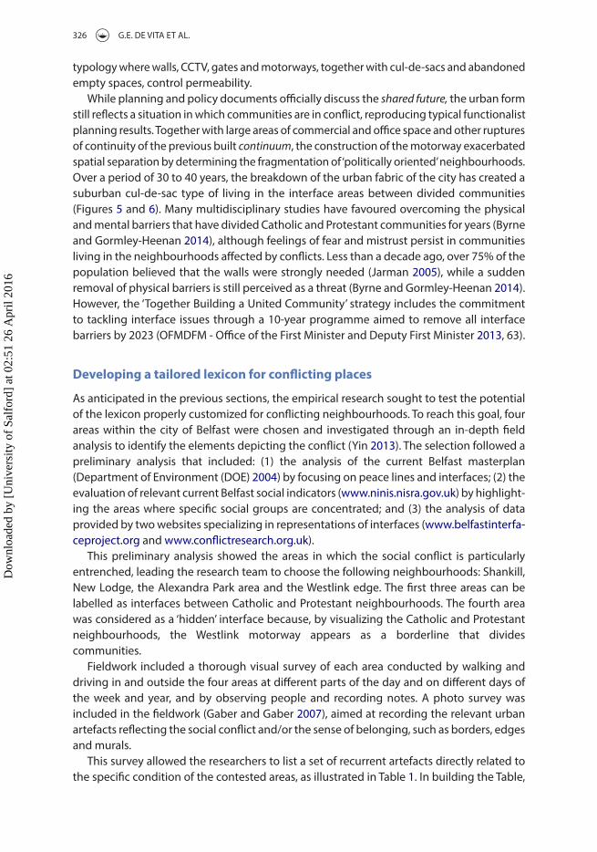
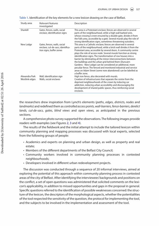
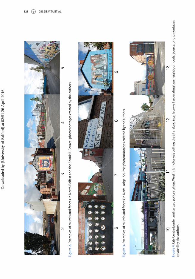
A comprehensive photo survey supported the observations. The following images provide readers with examples (see figures 2, 3 and 4).
The results of the fieldwork and the initial attempt to include the tailored lexicon within community planning and mapping processes was discussed with local experts, selected from the following groups of people:
• Academics and experts on planning and urban design, as well as property and real estate;
• Members of the different departments of the Belfast City Council;• Community workers involved in community planning processes in contested
neighbourhoods;• Developers involved in different urban redevelopment projects.
The discussion was conducted through a sequence of 20 informal interviews, aimed at exploring the potential of this approach within community planning process in contested areas of the city of Belfast. After identifying the interviewees’ backgrounds and positions on the conflict, a set of open questions was administered that solicited comments on the lexi-con’s applicability, in addition to missed opportunities and gaps in the proposal in general. Specific questions referred to the identification of possible weaknesses concerned: the struc-ture of the lexicon, the descriptors of the morphological aspects, whether the potentialities of the tool respected the sensitivity of the question, the protocol for implementing the tool, and the subjects to be involved in the implementation and assessment of the tool.
Table 1. identification of the key elements for a new lexicon drawing on the case of belfast.
Study area relevant features investigated
Description
shankill gates, fences, walls, social enclave, identification signs
This area is a Protestant enclave; fences are observed in several parts of the neighbourhood, while a high wall barbed wire, whose crossing is even ensured by a double gate, divides it from the falls area, accessible by a gate. several murals play the role of strong identification signs, sometimes threatening outsiders.
new lodge gates, fences, walls, social enclave, cul-de-sacs, identifica-tion signs, buffer zones
This area is a Catholic enclave; fences are observed in several parts of the neighbourhood, while a brick wall divides it from the Protestant area, accessible by several doors. a community centre plays the role of access node. several murals function as strong identification signs. The transformation of row houses into a barrier by eliminating all the minor interconnections between the buildings and the urban grid behind them (Duncairn gardens - new lodge) can be considered an additional, more peculiar fence. The fenced and monitored industrial and service areas on adam street (some now abandoned) can be labelled as a buffer zone.
alexandra Park Wall, identification sign High iron fence, also decorated with murals. Westlink edges Walls, social enclaves Creation of infrastructures that separate the centre from the
deprived neighbourhoods of the crown by inducing car addiction, reducing urban accessibility and discouraging the development of shared public spaces, thus reinforcing social enclaves.
Dow
nloa
ded
by [
Uni
vers
ity o
f Sa
lfor
d] a
t 02:
51 2
6 A
pril
2016
328 G.E. DE VITA ET Al.
Figu
re 2
. exa
mpl
es o
f mur
als a
nd fe
nces
in n
orth
bel
fast
and
the
shan
kill.
sou
rce:
pho
tom
onta
ges c
reat
ed b
y th
e au
thor
s.
Figu
re 3
. exa
mpl
es o
f mur
als a
nd fe
nces
in n
ew l
odge
. sou
rce:
pho
tom
onta
ges c
reat
ed b
y th
e au
thor
s.
Figu
re 4
. City
Cen
tre
bord
er: m
ilita
rized
pol
ice
stat
ion,
Wes
t lin
k m
otor
way
cutt
ing
the
city
fabr
ic, i
nter
face
wal
l sep
arat
ing
two
neig
hbou
rhoo
ds. s
ourc
e: p
hoto
mon
tage
s cr
eate
d by
the
auth
ors.
Dow
nloa
ded
by [
Uni
vers
ity o
f Sa
lfor
d] a
t 02:
51 2
6 A
pril
2016
JournAl of urBAn DESIGn 329
A first finding was that each category of interviewees perceived potential and gaps of the tool according to its own perspective on the implementation process. Community work-ers from both sides and community planning experts showed an enthusiastic reaction to the proposal and its potential implementation within a visual mapping process. They sug-gested developing a pilot project without any other testing phase for collecting reactions on the ground. Members of government bodies declared cautious interest in the results and suggested testing the method on a selected area before beginning a pilot project within a real community both for gathering further insights on the area and for providing future facilitators with a simulation. from the academic side, the majority of the interviewed schol-ars advised clarifying the role played by experts in applying the methodology within com-munity planning processes. The academics were in favour of an appropriately managed use of the tool, i.e. they felt that the tool should be implemented by experienced facilitators. one local scholar recommended that, although the lexicon remains clear and consistent with the topics, it must be integrated with the necessary economic and human resources to guarantee actual implementation. Almost all the interviewees agreed that the tool was a useful means to hone consolidated community planning processes, such as a visual map-ping, particularly if delivered by facilitators.
The general feedback from the first round of talks with the panel of experts was:(a) The survey and the application of the descriptors to the four areas is clear and con-
sistent with the literature and the context;(b) The critical node of the protocol for a sensitive application of the lexicon aids the
facilitator in guiding without forcing the process of implementation; and(c) A testing phase for the tool in a specific area is needed to build up the action protocol
and understand how to improve the tool.The researchers agreed on the critical role played by the facilitator in addressing the
correct implementation of the tailored lexicon, particularly in controversial places. furthermore, following the general recommendations that emerged from the interviews (point c), they opted to conduct a pilot study using the instrument within a purposefully selected area challenged by severe conflict: the Cupar Way interface area (nIo 1969). The selection of the pilot area was driven by several observations, first among them the strong image of the barrier perceived while walking or driving along the street. The official definition of the divide is:
a multi-level fence runs from lanark Way to the rear of properties at Cupar Street and cuts off access between Cupar Street and Cupar Way. It then runs parallel with Cupar Way to the junction with north Howard Street. The barrier cuts access with Conway Street. (Community relations Council 2010, 14).
The high wall dividing the Shankill and falls road neighbourhoods is highlighted by the symbol of a defensive wall, which also clearly creates a negative visual effect on the houses. Because of the presence of the wall, the border areas are affected by a process of decline, physically evidenced by the vacant derelict lands on both sides, and by the ruptures in the former urban grid mirrored by the enormous number of cul-de-sacs.
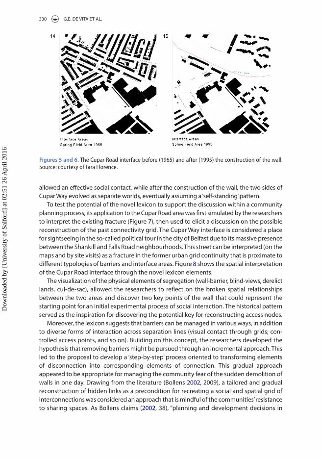
The maps (figures 5 and 6) dated 1965 and 1995, i.e. before and after the construction of the peace line in 1969 (Community relations Council 2010), make it possible to visualize the rupture in the physical form of the city, particularly in terms of ‘connectivity’. The 1965 map shows an emerging dense urban pattern comprising an interconnected urban grid on the two sides of Cupar Way. Before the construction of the wall, strong continuity in the road network
Dow
nloa
ded
by [
Uni
vers
ity o
f Sa
lfor
d] a
t 02:
51 2
6 A
pril
2016
330 G.E. DE VITA ET Al.
allowed an effective social contact, while after the construction of the wall, the two sides of Cupar Way evolved as separate worlds, eventually assuming a ‘self-standing’ pattern.
To test the potential of the novel lexicon to support the discussion within a community planning process, its application to the Cupar road area was first simulated by the researchers to interpret the existing fracture (figure 7), then used to elicit a discussion on the possible reconstruction of the past connectivity grid. The Cupar Way interface is considered a place for sightseeing in the so-called political tour in the city of Belfast due to its massive presence between the Shankill and falls road neighbourhoods. This street can be interpreted (on the maps and by site visits) as a fracture in the former urban grid continuity that is proximate to different typologies of barriers and interface areas. figure 8 shows the spatial interpretation of the Cupar road interface through the novel lexicon elements.
The visualization of the physical elements of segregation (wall-barrier, blind-views, derelict lands, cul-de-sac), allowed the researchers to reflect on the broken spatial relationships between the two areas and discover two key points of the wall that could represent the starting point for an initial experimental process of social interaction. The historical pattern served as the inspiration for discovering the potential key for reconstructing access nodes.
Moreover, the lexicon suggests that barriers can be managed in various ways, in addition to diverse forms of interaction across separation lines (visual contact through grids; con-trolled access points, and so on). Building on this concept, the researchers developed the hypothesis that removing barriers might be pursued through an incremental approach. This led to the proposal to develop a ‘step-by-step’ process oriented to transforming elements of disconnection into corresponding elements of connection. This gradual approach appeared to be appropriate for managing the community fear of the sudden demolition of walls in one day. Drawing from the literature (Bollens 2002, 2009), a tailored and gradual reconstruction of hidden links as a precondition for recreating a social and spatial grid of interconnections was considered an approach that is mindful of the communities’ resistance to sharing spaces. As Bollens claims (2002, 38), “planning and development decisions in
Figures 5 and 6. The Cupar road interface before (1965) and after (1995) the construction of the wall. source: courtesy of Tara florence.
Dow
nloa
ded
by [
Uni
vers
ity o
f Sa
lfor
d] a
t 02:
51 2
6 A
pril
2016

JournAl of urBAn DESIGn 331
today’s multicultural cities can establish bridges and links between racial/ethnic neighbour-hoods or they can build boundaries and figurative walls”. urban artefacts and social bound-aries “can create urban landscapes that can facilitate, but also impede, ethnic group relations in cities”, suggesting that the urban environment can either encourage or discourage the shared use of spaces (Bollens 2009, 101). Thus, it is expected that ‒ possibly ‒ a gradual reconstruction of physical missing links may support the gradual reconstruction of social relations (Gaffikin and Morrissey 2011).
Due to the sensitivity of the context, the researchers decided to return to the panel of experts and discuss this finding with them. The idea of incrementally dismantling the existing walls was discussed with local community workers and scholars through informal interviews and was considered valuable. The discussion with community workers and academics was fruitful in confirming the tool’s potential in terms of additional support for facilitating a dialogue between different conflicting groups and in shaping possible shared transforma-tions of the interface areas. This preliminary investigation suggested that this tool may be valuable for honing community planning methods in contested places. It is therefore sug-gested that facilitators could benefit from implementing it to improve upon traditional methodologies of visual mapping.
furthermore, the improvements suggested by the experts to expand the potential results of the implementation of the lexicon within a community planning process can be summa-rized in the following points: (1) although the lexicon remains clear and consistent with the topics, it must be integrated with the necessary economic and human resources to guarantee actual implementation; (2) it would be useful to conduct an action driven research in a real community planning process in order to provide the end-users with a practical example of how the tool can be applied in real life.
Figure 7. The Cupar road interface analyzed by implementing the suggested new tool.
Figure 8. The Cupar road proposal.
Dow
nloa
ded
by [
Uni
vers
ity o
f Sa
lfor
d] a
t 02:
51 2
6 A
pril
2016
332 G.E. DE VITA ET Al.
Conclusions
urban planning and urban design can play an important role in establishing bridges and links between conflicting neighbourhoods (Bollens 2002). This paper discussed the potential of including a site-specific, spatially oriented component in consolidated community plan-ning methods in areas challenged by social conflict, suggesting that a specific urban design-led tool might be useful contested areas. The fieldwork in Belfast confirmed the importance of urban design tools in reconnecting divided societies (Madanipour 2004; Kallus and Kolodney 2010). Gaffikin, McEldowney, and Sterrett (2010, 511) investigate the limits and potential of urban design in managing division, focusing on the case of Belfast. on the one hand, referring to Belfast, they state that “the removal of defensive walls and barriers has to be a longer-term objective, to be addressed by reducing the appearance of ‘permanence’ in the structures and the introduction of controlled through access points between commu-nities”. on the other hand, they recognize the central need for the “prioritis[ation] of potentially integrative over potentially segregating projects”. The implementation of the government’s 2023 removal strategy (ofMDfM - office of the first Minister and Deputy first Minister 2013) needs to address residents’ primary concerns around security. “It would be a gradual and incremental process, rather than a significant media spectacle similar to the dismantling of the Berlin wall” (Byrne and Gormley-Heenan 2014, 453). In order to engage the post-ceasefire generation, flexible tools are needed, tailored to capture the role of these divisive infrastruc-tures on the everyday life of the people living near peace-walls.
This research suggests that a simple, recognizable lexicon may contribute to honing community planning methods in contested places by integrating the traditional method-ology of visual mapping (Wates 2014) with a tailored taxonomy of elements of urban conflict. The suggested pattern may be used at many stages of the planning process, including developing a visual map, design and planning, and developing and implementing an action plan. Moreover, simulating the tool implementation in the Cupar road area allowed research-ers to suggest that an incremental approach to the long-term process of barriers removal could start with the gradual retrieval of the original edges, accesses and landmarks.
further research should apply the tool in different contexts, discussing the barriers and opportunities inherent in the complete process with end users. Developing a better under-standing of the tool’s potential may be achieved through its concrete application in a real community planning process through active research methodology.
Disclosure statement
no potential conflict of interest was reported by the authors.
ORCID
Gabriella Esposito De Vita http://orcid.org/0000-0002-7496-1838Claudia Trillo http://orcid.org/0000-0002-5961-0706
References
Allam, K. f., M. Martiniello, and A. Tosolini. 2004. La città Multiculturale. Identità, Diversità, Pluralità [Multicultural City. Identity, Civersity, Plurality]. Bologna: EMI.
Amendola, G. 2001. La città postmoderna [The Postmodern City]. Bari: laterza.
Dow
nloa
ded
by [
Uni
vers
ity o
f Sa
lfor
d] a
t 02:
51 2
6 A
pril
2016

JournAl of urBAn DESIGn 333
Augé, M. 1992. Non-Lieux. Paris: Editions Seuil.Beguinot, C., ed. 2004. Città di genti e culture, da “Megaride ‘94” alla città interetnica Europea [City of
People and Cultures, from “Megaride 94” to the European Inter-Ethnic City]. napoli: Giannini Editore.Belfast City Council. 2008. Peace and Reconciliation Action Plan (revised), Belfast. Accessed March 2010.
http://www.belfastcity.gov.uk. Belfast Mapping. Accessed March 2010. http://cain.ulst.ac.ukBelfast Metropolitan Area Map. Accessed March 2010. http://www.planningni.gov.ukBoal, f. 1996. “Integration and Division: Sharing and Segregating in Belfast.” Planning Practice and
Research 11 (2): 151–158.Boal, f. 2008. “Territoriality on the Shankill-falls Divide.” Irish Geography 41 (3): 349–366.Boal, f., and S. royle, eds. 2006. Enduring City, Belfast in the Twentieth Century. london: Blackstaff.Body-Gendrot, S., and M. Martiniello, eds. 2000. Minorities in European Cities. the Dynamics of Social
Integration and Social Exclusion at the Neighbourhood Level. Basingstoke and new York: MacMillan St. Martin’s Press.
Bollens, S. 2002. “urban Planning and Intergroup Conflict: Confronting a fractured Public Interest.” Journal of the American Planning Association 68 (1): 22–42.
Bollens, S. 2009. “Intervening in Politically Turbulent Cities: Spaces.” Journal of Urban Technology 16 (2–3): 79–107.
Bollens, S. 2011. City and Soul in Divided Societies. london and new York: routledge.Byrne, J., and C. Gormley-Heenan. 2014. “Beyond the Walls: Dismantling Belfast’s Conflict Architecture.”
City 18 (4–5): 447–454.Carmona, M., C. De Magalhães, and M. Edwards. 2002. “Stakeholder Views on Value and urban Design.”
Journal of Urban Design 7 (2): 145–169.Carmona, M., T. Heath, T. oc, and S. Tiesdell. 2003. Public Places - Urban Spaces. the Dimensions of Urban
Design. oxford: Elsevier.Castles, S. 2000. Ethnicity and Globalization: From Migrant Worker to Transnational Citizen. london: Sage.Charmes, E. 2010. “Cul-De-Sacs.” Superblocks and Environmental Areas as Supports of Residential
Territorialisation, Journal of Urban Design 15 (3): 357–374.Community Planning Methods. Accessed March 2012. http://www.communityplanning.netCommunity relations Council. 2010. Towards Sustainable Security. Interface Barriers and the Legacy of
Segregation in Belfast. Belfast: CrC.Creighton, J. l. 2005. The Public Participation Handbook: Making Better Decisions through Citizen
Involvement. San francisco,CA: Jossey-Bass.Cunningham, T. 2014. “Changing Direction: Defensive Planning in a Post-Conflict City.” City 18 (4–5):
455–462.Department of Environment (DoE). 2004. Belfast Metropolitan Area Plan (BMAP). Accessed March
2010. www.planningni.gov.uk.Gaber, J., and S. l. Gaber. 2007. Qualitative Analysis for Planning and Policy: Beyond the Numbers. Chicago,
Il: American Planning Association.Gaffikin, f., and M. Morrissey. 2011. Planning in Divided Cities. london: Wiley-Blackwell.Gaffikin, f., M. McEldowney, and K. Sterret. 2010. “Creating Shared Public Space in Contested City: The
role of urban Design.” Journal of Urban Design 15 (4): 493–513.Gehl, J. 2001. Life between Buildings: Using Public Space. 5th ed. Copenhagen: Arkitektens forlag.Goldie, r., and B. ruddy. 2010. Crossing the Line. Key Features of Effective Practice in the Development of
Shared Space in Areas close to an Interface. Belfast: roz Goldie Partnership, Belfast Interface Project.Gould, M., and H. Skinner. 2007. “Branding on Ambiguity? Place Branding without a national Identity:
Marketing northern Ireland as a post-conflict society in the uSA.” Place Branding and Public Diplomacy 3 (1): 100-113.
Horgan, G. 2006. “Devolution, Direct rule and neo-liberal reconstruction in northern Ireland.” Critical Social Policy 26 (3): 656–668.
Hutchison, r., and J. Krase, eds. 2007. Ethnic Landscapes in an Urban World, Research in Urban Sociology. 8 vol. Amsterdam: Elsevier JAI.
Institute for Conflicting research, Interface and Security Barrier Mapping Project. Accessed March 2010. http://www.conflictresearch.org.uk
Dow
nloa
ded
by [
Uni
vers
ity o
f Sa
lfor
d] a
t 02:
51 2
6 A
pril
2016
334 G.E. DE VITA ET Al.
Jarman, n. 2005. No Longer a Problem? Sectarian Violence in Northern Ireland. Belfast: Institute for Conflict research.
Jewson, n., and S. Mac Gregor, eds. 1997. Transforming Cities: Contested Governance and New Spatial Divisions. london: routledge.
Kallus, r., and Z. Kolodney. 2010. “Politics of urban Space in an Ethno-nationally Contested City: negotiating (Co)Existence in Wadi nisnas.” Journal of Urban Design 15 (3): 403–422.
lynch, K. 1960. The Image of the City. Boston, MA: MIT Press.Madanipour, A. 2004. “Marginal Public Spaces in European Cities.” Journal of Urban Design 9 (3): 267–286.Madanipour, A. 2006. “roles and Challenges of urban Design.” Journal of Urban Design 11 (2): 173–193.Madanipour, A., ed. 2010. Whose Public Space? International Case Studies in Urban Design and
Development. london: routledge.Madanipour, A. 2011. “Social Exclusion and Space.” In The City Reader, edited by r. T. leGates, and f.
Stout, 186–194. london: routledge.Martiniello, M., and B. Piquard, eds. 2002. Diversity in the City. Bilbao: university of Deusto Humanitatianet.Melotti, u. 2004. Migrazioni Internazionali. Globalizzazione E Culture Politiche [International Migrations.
Globalization and Political Culture]. Milano: Bruno Mondadori.Mesev, V., P. Shirlow, and J. Downs. 2009. “The Geography of Conflict and Death in Belfast.” Annals of
the Association of American Geographers 99 (5): 893–903.Morrissey, M., and f. Gaffikin. 2006. “Planning for Peace in Contested Space.” International Journal of
Urban and Regional Research 30: 873–893.Murtagh, B. 2011. “Desegregation and Place restructuring in the new Belfast.” Urban Studies 48 (6):
1119–1135.Murtagh, B., and G. Ellis. 2010. “The Skills Agenda and the Competencies for Managing Spatial Diversity.”
Town Planning Review 81 (5): 563–583.nagle, J. 2009. “Sites of Social Centrality and Segregation: lefebvre in Belfast, a ‘Divided City’.” Antipode
41 (2): 326–347.nasar, J. l. 1998. The Evaluative Image of the City. Thousand oaks: Sage.northern Ireland neighbourhood Information. Accessed March 2010. http://www.ninis.nisra.gov.ukofMDfM - office of the first Minister and Deputy first Minister 2013. “Together Building a united
Community”. Accessed february 2016. http://www.ofmdfmni.gov.uk/together-building-a-united-community
Pretty, J. n., I. Guijt, J. Thompson, and I. Scoones. 1995. Participatory Learning Action. a Trainer’s Guide. london: IIED.
ravenscroft, E. 2009. “The Meaning of the Peacelines of Belfast.” Peace Review 21 (2): 213–221.ray, B. 2003. The Role of Cities in Immigrant Integration, Migration Information Source. Washington:
Migration Policy Institute. http://www.migrationinformation.orgrydin, I., and M. Pennington. 2000. “Public Participation and local Environmental Planning: The
Collective Action Problem and the Potential of Social Capital.” Local Environment 5 (2): 153–169.Sandercock, l. 2003. Cosmopolis II. Mongrel Cities of the 21st Century. london: Continuum Books.Sanoff, H. 2000. Community Participation Methods in Design and Planning. new York, nY: John Wiley & Sons.Sassen, S. (1996). Migranten, Siedler, Flüchtlinge. Von der Massenauswanderung zur Festung Europa [Migrants,
Settlers, refugees: from Mass Emigration to fortress Europe]. frankfurt am Main: fischer Verlag.Shirlow, P., and B. Murtagh. 2006. Belfast—Segregation, Violence and the City, Contemporary Irish Studies
Series. london: Pluto.Somma, P. 1991. Spazio e razzismo, Studi urbani e regionali [Space and racism. urban and regional
Studies] Milano: franco Angeli.Waters, n. 2000. The Community Planning Handbook. london: Earthscan.Wates, n. 2014. The Community Planning Handbook: How People Can Shape their Cities, Towns and Villages
in any Part of the World. london: routledge.Wiener, r. 1980. The Rape and Plunder of the Shankill. Belfast: farset.Wilson, J. Q., & G. l. Kelling. 1982. Broken Windows: the Police and neighborhood Safety. The Atlantic
Monthly.Belfast Interface Project. Accessed March 2010. http://www.belfastinterfaceproject.orgYin, r. K. 2013. Case Study Research, Design and Methods. 5th ed. london: Sage Publications.
Dow
nloa
ded
by [
Uni
vers
ity o
f Sa
lfor
d] a
t 02:
51 2
6 A
pril
2016