committee report - meetings, agendas, and minutesdemocracy.brent.gov.uk/documents/s47379/warranty...
TRANSCRIPT
Document Imaged DocRepFRef: 16/4010 Page 1 of 41
COMMITTEE REPORTPlanning Committee on 14 December, 2016Item NoCase Number 16/4010
SITE INFORMATIONRECEIVED: 13 September, 2016
WARD: Dudden Hill
PLANNING AREA: Brent Connects Willesden
LOCATION: Warranty House, Dudden Hill Lane, London, NW10 1DD
PROPOSAL: Proposed demolition of all existing buildings and construction of part five / part six / partseven / part eight / part nine storey buildings comprising 136 residential units (Use ClassC3, comprising of 42 x 1 bed, 56 x 2 bed and 38 x 3 bed flats) and community/retailfloorspace (Use Classes D1/A1/A3); related lower ground car park comprising 44 carparking spaces; cycle parking, vehicular access; footways; landscaping; plant andassociated works.
APPLICANT: Harley Property Investments and DPMM Enterprises Ltd
CONTACT: DP9 Ltd
PLAN NO'S: (See Condition 2)
LINK TODOCUMENTSASSOCIATED TOTHISAPPLICATION
When viewing this on an Electronic Device
Please click on the link below to view ALL document associated to case<https://pa.brent.gov.uk/online-applications/applicationDetails.do?activeTab=documents&keyVal=DCAPR_130188>
When viewing this as an Hard Copy
Please use the following steps
1. Please go to pa.brent.gov.uk2. Select Planning and conduct a search tying "16/4010" (i.e. Case Reference) into
the search Box3. Click on "View Documents" tab
__________________________________________________________
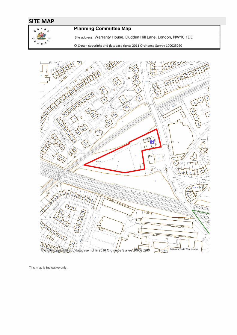
SITE MAPPlanning Committee Map
Site address: Warranty House, Dudden Hill Lane, London, NW10 1DD
© Crown copyright and database rights 2011 Ordnance Survey 100025260
This map is indicative only.
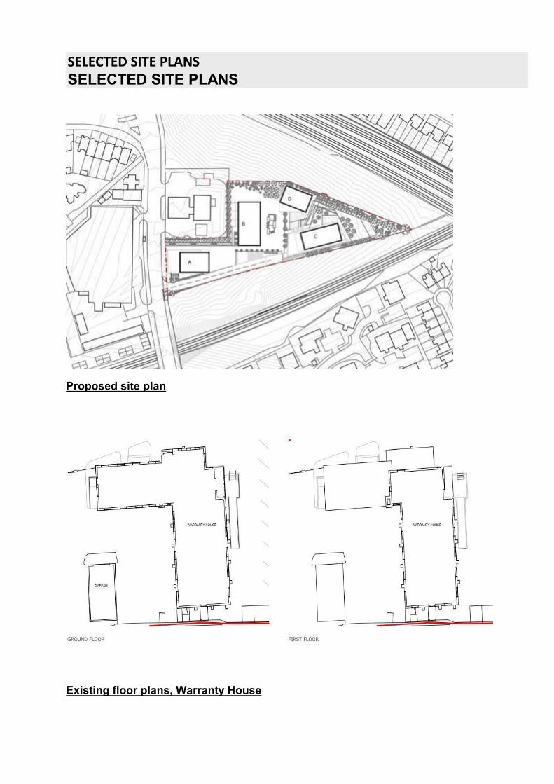
SELECTED SITE PLANSSELECTED SITE PLANS
Proposed site plan
Existing floor plans, Warranty House
Document Imaged DocRepFRef: 16/4010 Page 2 of 41
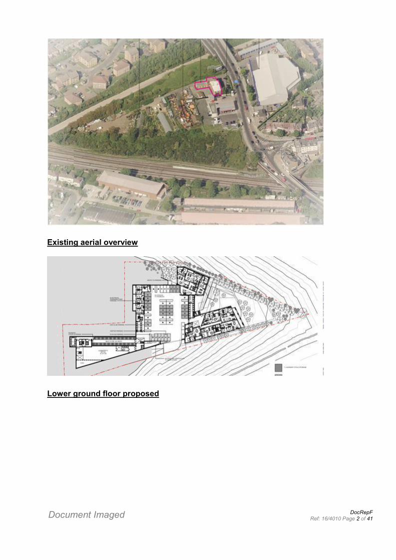
Existing aerial overview
Lower ground floor proposed
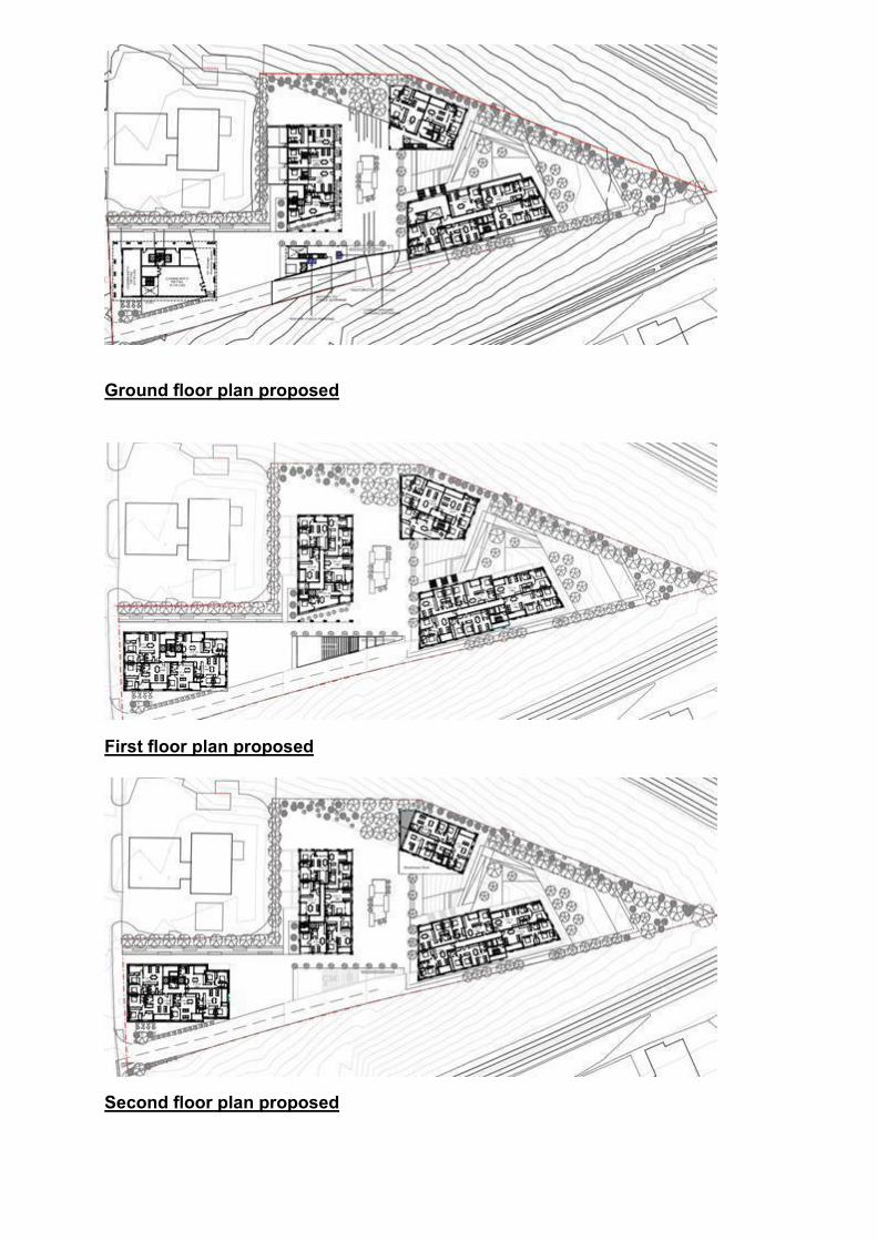
Ground floor plan proposed
First floor plan proposed
Second floor plan proposed
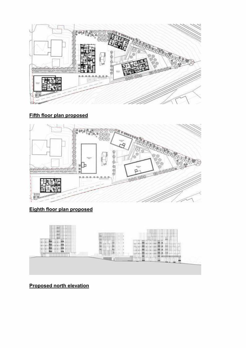
Fifth floor plan proposed
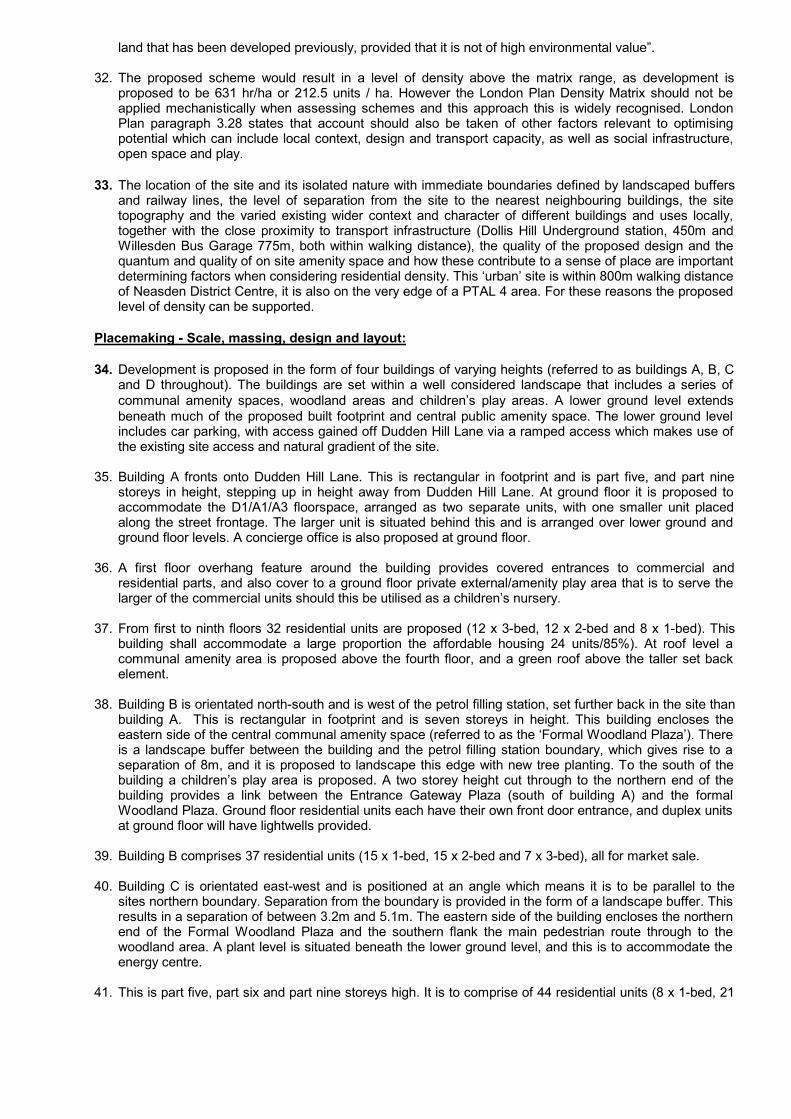
Eighth floor plan proposed
Proposed north elevation
Document Imaged DocRepFRef: 16/4010 Page 3 of 41
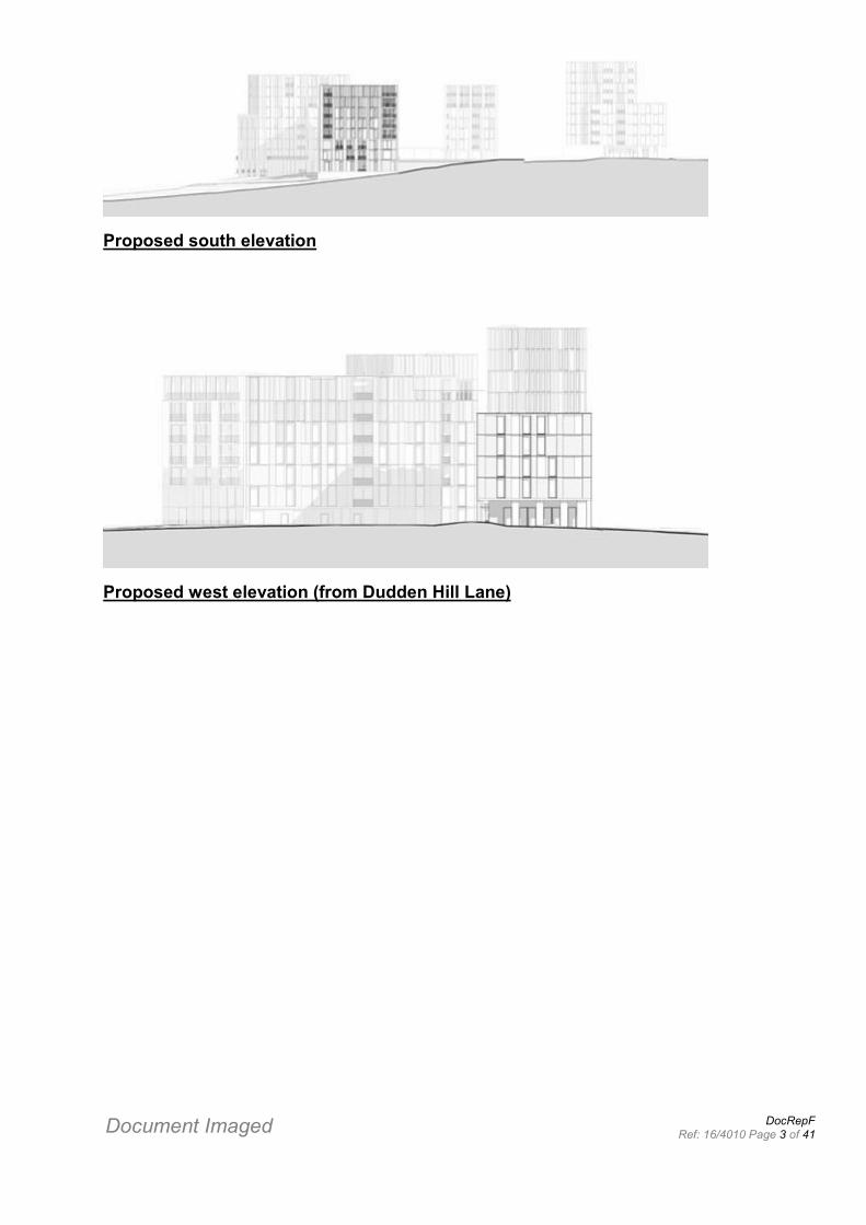
Proposed south elevation
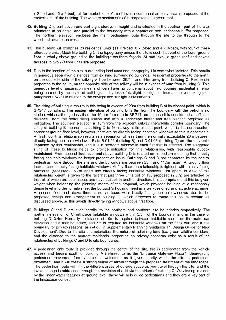
Proposed west elevation (from Dudden Hill Lane)
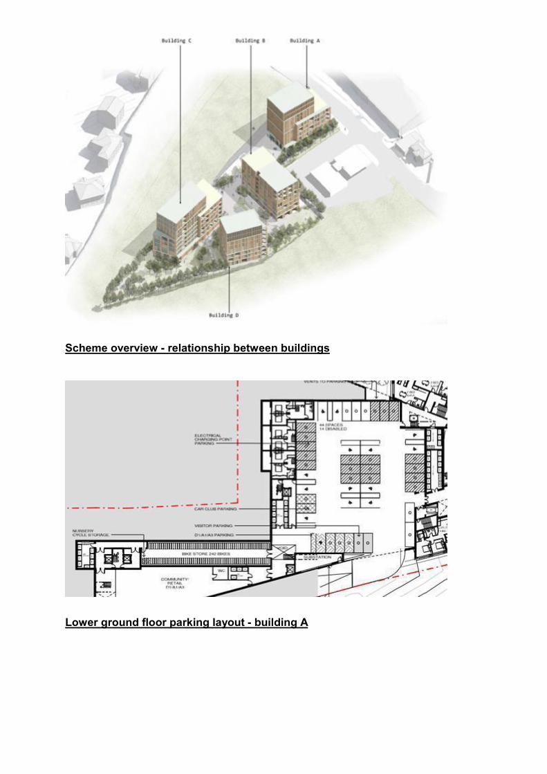
Scheme overview - relationship between buildings
Lower ground floor parking layout - building A
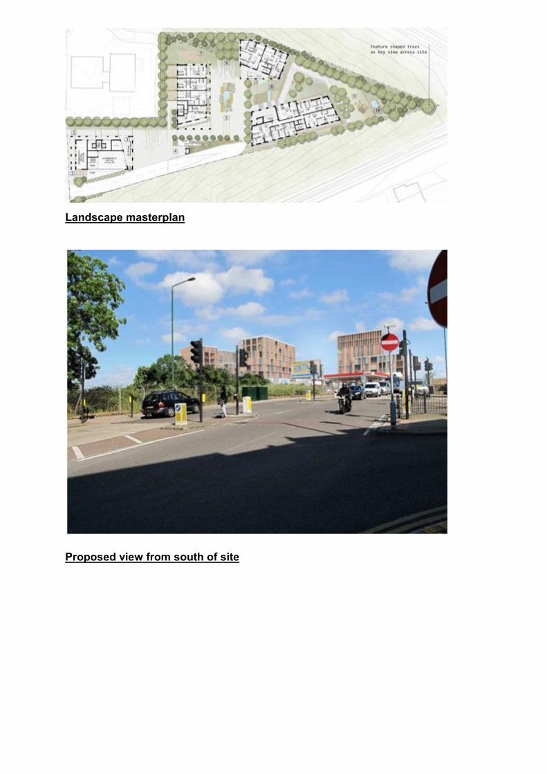
Landscape masterplan
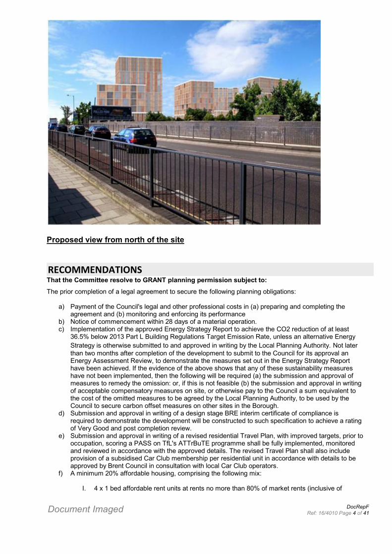
Proposed view from south of site
Document Imaged DocRepFRef: 16/4010 Page 4 of 41
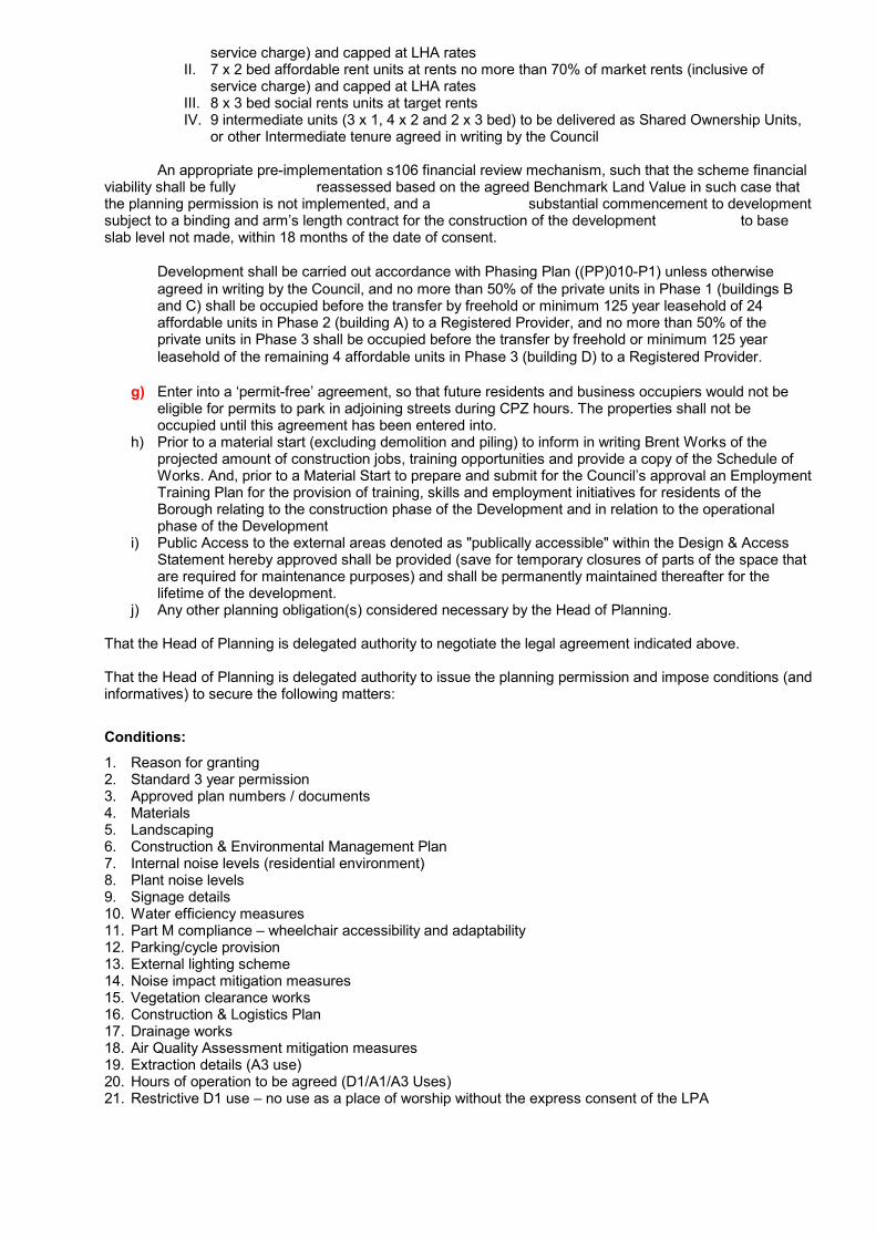
Proposed view from north of the site
RECOMMENDATIONSThat the Committee resolve to GRANT planning permission subject to:
The prior completion of a legal agreement to secure the following planning obligations:
a) Payment of the Council's legal and other professional costs in (a) preparing and completing theagreement and (b) monitoring and enforcing its performance
b) Notice of commencement within 28 days of a material operation.c) Implementation of the approved Energy Strategy Report to achieve the CO2 reduction of at least
36.5% below 2013 Part L Building Regulations Target Emission Rate, unless an alternative EnergyStrategy is otherwise submitted to and approved in writing by the Local Planning Authority. Not laterthan two months after completion of the development to submit to the Council for its approval anEnergy Assessment Review, to demonstrate the measures set out in the Energy Strategy Reporthave been achieved. If the evidence of the above shows that any of these sustainability measureshave not been implemented, then the following will be required (a) the submission and approval ofmeasures to remedy the omission: or, if this is not feasible (b) the submission and approval in writingof acceptable compensatory measures on site, or otherwise pay to the Council a sum equivalent tothe cost of the omitted measures to be agreed by the Local Planning Authority, to be used by theCouncil to secure carbon offset measures on other sites in the Borough.
d) Submission and approval in writing of a design stage BRE interim certificate of compliance isrequired to demonstrate the development will be constructed to such specification to achieve a ratingof Very Good and post completion review.
e) Submission and approval in writing of a revised residential Travel Plan, with improved targets, prior tooccupation, scoring a PASS on TfL's ATTrBuTE programme shall be fully implemented, monitoredand reviewed in accordance with the approved details. The revised Travel Plan shall also includeprovision of a subsidised Car Club membership per residential unit in accordance with details to beapproved by Brent Council in consultation with local Car Club operators.
f) A minimum 20% affordable housing, comprising the following mix:
I. 4 x 1 bed affordable rent units at rents no more than 80% of market rents (inclusive of
service charge) and capped at LHA ratesII. 7 x 2 bed affordable rent units at rents no more than 70% of market rents (inclusive of
service charge) and capped at LHA ratesIII. 8 x 3 bed social rents units at target rentsIV. 9 intermediate units (3 x 1, 4 x 2 and 2 x 3 bed) to be delivered as Shared Ownership Units,
or other Intermediate tenure agreed in writing by the Council
An appropriate pre-implementation s106 financial review mechanism, such that the scheme financialviability shall be fully reassessed based on the agreed Benchmark Land Value in such case thatthe planning permission is not implemented, and a substantial commencement to developmentsubject to a binding and arm’s length contract for the construction of the development to baseslab level not made, within 18 months of the date of consent.
Development shall be carried out accordance with Phasing Plan ((PP)010-P1) unless otherwiseagreed in writing by the Council, and no more than 50% of the private units in Phase 1 (buildings Band C) shall be occupied before the transfer by freehold or minimum 125 year leasehold of 24affordable units in Phase 2 (building A) to a Registered Provider, and no more than 50% of theprivate units in Phase 3 shall be occupied before the transfer by freehold or minimum 125 yearleasehold of the remaining 4 affordable units in Phase 3 (building D) to a Registered Provider.
g) Enter into a ‘permit-free’ agreement, so that future residents and business occupiers would not beeligible for permits to park in adjoining streets during CPZ hours. The properties shall not beoccupied until this agreement has been entered into.
h) Prior to a material start (excluding demolition and piling) to inform in writing Brent Works of theprojected amount of construction jobs, training opportunities and provide a copy of the Schedule ofWorks. And, prior to a Material Start to prepare and submit for the Council’s approval an EmploymentTraining Plan for the provision of training, skills and employment initiatives for residents of theBorough relating to the construction phase of the Development and in relation to the operationalphase of the Development
i) Public Access to the external areas denoted as "publically accessible" within the Design & AccessStatement hereby approved shall be provided (save for temporary closures of parts of the space thatare required for maintenance purposes) and shall be permanently maintained thereafter for thelifetime of the development.
j) Any other planning obligation(s) considered necessary by the Head of Planning.
That the Head of Planning is delegated authority to negotiate the legal agreement indicated above.
That the Head of Planning is delegated authority to issue the planning permission and impose conditions (andinformatives) to secure the following matters:
Conditions:1. Reason for granting2. Standard 3 year permission3. Approved plan numbers / documents4. Materials5. Landscaping6. Construction & Environmental Management Plan7. Internal noise levels (residential environment)8. Plant noise levels9. Signage details10. Water efficiency measures11. Part M compliance – wheelchair accessibility and adaptability12. Parking/cycle provision13. External lighting scheme14. Noise impact mitigation measures15. Vegetation clearance works16. Construction & Logistics Plan17. Drainage works18. Air Quality Assessment mitigation measures19. Extraction details (A3 use)20. Hours of operation to be agreed (D1/A1/A3 Uses)21. Restrictive D1 use – no use as a place of worship without the express consent of the LPA

22. Delivery & Servicing Management Plan23. Sound insulation details24. Phase 2 site investigation (contamination)25. Verification report of Phase 2 remedial works (contamination)26. Considerate Contractors Scheme27. Accessible cycle parking details28. Layout of service/drop-off area29. Prior to occupation of the larger of the commercial units marketing of this for use as childrens nursery
and/or other D1 uses (save for place of worship)
That the Head of Planning is delegated authority to make changes to the wording of the committee’s decision(such as to delete, vary or add conditions, informatives, planning obligations or reasons for the decision) priorto the decision being actioned, provided that the Head of Planning is satisfied that any such changes couldnot reasonably be regarded as deviating from the overall principle of the decision reached by the committeenor that such change(s) could reasonably have led to a different decision having been reached by thecommittee.
That, if by 14 February 2017 the legal agreement has not been completed, the Head of Planning is delegatedauthority to refuse planning permission.
That the Committee confirms that adequate provision has been made, by the imposition of conditions, for thepreservation or planting of trees as required by Section 197 of the Town and Country Planning Act 1990.
A) PROPOSALThe proposed development seeks full permission for the demolition of all existing buildings on site and itsredevelopment comprising of:
Ground floor commercial floorspace for A1/A3/D1 uses, within Block A (586sqm)Four buildings, of between five and nine storeys, accommodating 136 residential units (including 20%affordable housing)Associated car parking, with 44 on-site spaces, car club and 240 cycle parking spaces.Associated amenity space, landscape works and tree planting
The following housing mix is proposed:
42 x 1 bedroom flat (30.9%)56 x 2 bedroom flat (41.2%)38 x 3 bedroom flat (27.9%)
Building A B C D Total1 bed 8 15 8 11 42 (31%)2 bed 12 15 21 8 56 (41%)3 bed 12 7 15 4 38 (28%)Total 32 37 44 23 136
B) EXISTINGThe application site is located on the western side of Dudden Hill Lane, approximately 5 minutes walk fromDollis Hill Jubilee Line Underground Station. The site is 0.68 hectares and comprises Warranty House, a twostorey brick building currently in use by the NHS. To the rear of Warranty House the site is used for coachparking and also as a garden centre and nursery.
C) AMENDMENTS SINCE SUBMISSIONSince the application was submitted no significant revisions have been made to the proposal.
It is worth noting that the following amendments have been made since the submission of earlier applications
Document Imaged DocRepFRef: 16/4010 Page 5 of 41
16/0775 (now withdrawn) and 16/0776;-
Reduction in the proposed number of new buildings from five to four, and a re-arrangement of themassing of buildings resulting in buildings of smaller footprint, some of greater height, buildings moreslender in their form and with increased separation between buildings on site.Increased level of separation of building B from petrol filling stationRemoval of a terrace of townhouses from the southern part of the site.Proposal to have segregated pedestrian and vehicle access, and to utilise the existing site access forvehicle entry/exit.
D) SUMMARY OF KEY ISSUESThe key issues for consideration are as follows:
a) Principle of development, loss of and re-provision of D1 use.b) The opportunity for new housing and to make a contribution to the borough’s housing delivery targets
on this sustainable, brownfield site.c) The level of affordable housing being proposed.d) Scale, massing, design and impact on the existing townscape.e) The ecological context and the impact of the scheme in biodiversity and ecology terms.f) The transport impacts of the proposed development, level of proposed parking and consideration of
proposed mitigation measures.g) The quality of the proposed residential accommodation.
E) MONITORINGThe table(s) below indicate the existing and proposed uses at the site and their respective floorspace and abreakdown of any dwellings proposed at the site.
Floorspace Breakdown
Primary Use Existing Retained Lost New Net Gain(sqm)
Non-residential institutions 496 496 20Restaurants and cafes 0 0 0Shops 0 0 70
Monitoring Residential Breakdown
Description 1Bed 2Bed 3Bed 4Bed 5Bed 6Bed 7Bed 8Bed Unk TotalEXISTING ( Flats û Market )EXISTING ( Flats û Social Rented )EXISTING ( Flats û Intermediate )PROPOSED ( Flats û Market ) 35 45 28 108PROPOSED ( Flats û Social Rented ) 4 7 8 19PROPOSED ( Flats û Intermediate ) 3 4 2 9
RELEVANT SITE HISTORY16/3843 – Current application being consideredErection of two single storey portacabins for ancillary office use to existing D1 premises, for a temporaryperiod between 3 to 5 years.
16/0775 - WithdrawnProposed demolition of all existing buildings and construction part three / part five / part six and part sevenstorey buildings comprising 134 residential units (44 x 1 bed, 44 x 2 bed and 41 x 3 bed flats, and 5 x 3 bedtownhouses) and 540sqm community/retail floorspace (Use Classes D1/A1/A3), with associated basementcar park comprising 88 car parking spaces, 228 cycle parking spaces, new vehicular access, footways,landscaping, amenity space, plant and ancillary works.

16/0776 – Application not being progressed in view of this current applicationProposed demolition of all existing buildings and construction of part three / part five / part six and part sevenstorey buildings comprising 133 residential units (44 x 1 bed, 45 x 2 bed and 39 x 3 bed flats, and 5 x 3 bedtownhouses) and 516sqm community/retail floorspace (Use Classes D1/A1/A3), with associated lowerground car park comprising 44 car parking spaces, 226 cycle parking spaces, new vehicular access,footways, landscaping, amenity space, plant and ancillary works.
Although broadly similar to one another in terms of built form the main differences between applications16/0775 and 16/0776 relate to the number of residential units, the proposed level of affordable housing ineach, and parking provision.
97/0161 – GrantedChange of use from office to clinic.
CONSULTATIONSConsultation letters were sent on 29 September 2016, to a total of 548 addresses on the following roads:-
-Aberdeen Road -Broadfields Way -Burnley Road -Dudden Hill Lane -Cornmow Drive -Southview Avenue -Selbie Avenue -Severn Way -Westview Close -Woodmans Grove -Westview Close -Mulgrave Road -Colin Road
Site notice(s) were displayed on 14/10/2016Press notice advertised on 06/10/2016
No neighbour representations were received to this consultation. One query was received from a resident ofCornmow Drive who had received the notification letter and was having difficulty locating/accessing theplanning application documents on the Council website. Guidance was given as to how to access theinformation and no further comments have since been received.
CONSULTEESWard Councillors for Dollis Hill and Willesden Green:No response received to date.
Transportation:No objection raised, detailed discussion is set out in the remarks section. In the event of approval it isrecommended that (a) a permit-free agreement is secured so that future residents are not eligible to park inadjoining streets during CPZ hours; (b) revised details of the servicing area and nursery drop off/pick up area,which can be secured by condition; (c) revised Travel Plan to be submitted, and secured through a s106agreement; (d) Construction Method Statement to be secured by condition and (e) implementation of theDelivery & Servicing Management plan.
Local Lead Flood Authority:No objection raised, and conditions are recommended in relation to the approval of further details of theproposed SuDS strategy.
Environmental Health:No objection raised, conditions are recommended in relation to noise attenuation, air quality andcontaminated land.
Principal Tree Officer:No objection raised.
Landscape Design:No objection raised, further details of hard landscaping requested by condition.
Transport for London:No objection raised, conditions have been recommended.
Thames Water (Development Control):No objection raised, conditions have been recommended.
Network Rail:Comments received that relate to matters which fall outside of planning control. No conditions recommended.Informatives have been added to advise the applicant of the requirement to agree an Asset ProtectionAgreement with Network Rail prior to works commencing.
NHS Property Services Ltd:No response received to date.
Met Police, Secure by Design:Prior to submission of the application a meeting was held with the Secure by Design officer. A number ofobservations and recommendations were made, which are summarised below along with the applicantsresponse:
Concern with the location of the commercial units and how these interact with the residentialelements.Residential entrances should be legible.The double height undercroft pedestrian route is not clearly defined as it will serve both uses, andwho will manage the seating provisions along the Entrance Gateway Plaza.
Response: The two residential entrances to building A are defined along the southern façade. There are nocommercial entrances along this façade. The entrances are accessed via a safe, well used and lit pedestrianpath. The undercroft is sufficiently high (4.1m) and wide (2m) and will be well lit.
The access control strategy throughout the site should be identified.
Response: Exact details cannot be detailed at this time, specialist input is required. The following principleswill however be followed; (i) development covered by fob controlled access, monitored and maintained by onsite security (ii) fob controlled access to gated car parks, all buildings, stairs, lifts, refuse stores and cyclestores, and (iii) no public access to buildings or basement.
A proportion of bicycle storage should be within close proximity to the core it serves, andbasement cycle parking should be split into smaller stores and not accessed externally.
Response: Entrances to the cycle parking will be fob controlled.
Residential and commercial uses must not be linked which is the case with the basement.
Response: The commercial staff parking occupies a small element, and access will be fob controlled. Novisitor parking is provided at the lower ground floor level.
Maximise glazing opportunities to stair cores at roof level, and providing access to terraces.
Response: The design does incorporate glazing to achieve passive surveillance of these spaces.
Ground floor plan suggests a large number of bathrooms/bedrooms face onto the communalareas which doesn’t aid surveillance.
Response: Within building B there will be 11 rooms facing the central communal area, 6 of these are fullyglazed living rooms. When balanced against the number of bedrooms/bathrooms this is considered to beappropriate. Further surveillance is achieved at first and second floors.
Member pre-submission engagement:
Document Imaged DocRepFRef: 16/4010 Page 6 of 41
The proposed development was presented as a pre-application development presentation item to PlanningCommittee on 10 August 2016. Clarification was sought in relation to car parking, nursery drop-off, servicing,details of proposed nursery, explanation for the loss of the NHS clinic, disabled/wheelchair access, design,location and provision of affordable housing, views of the proposal and its townscape impact, all of which areaddressed in the following remarks section.
Community involvement:
A Statement of Community Involvement (SoCI) supports the application, and sets out in detail the process ofcommunity consultation that has been undertaken.
In accordance with the NPPF, the developer consulted Ward Councillors for Dudden Hill and the localcommunity as part of the community consultation process that preceded the submission of earlierapplications 16/0775 and 16/0776. A public exhibition was held (December 2015) and this attractedapproximately 30 attendees, a newsletter was distributed to 2670 addresses in the surrounding area andbriefing sessions were undertaken with ward councillors and local stakeholders.
Prior to the submission of this revised application further community consultation was undertaken, andfeedback was invited. A public exhibition was held in September 2016, and this attracted approximately 20attendees. Ahead of this exhibition a newsletter was distributed to 2,670 addresses and briefing sessionswere offered to Dudden Hill ward councillors. A dedicated residents enquiry email address has been set upalso. The applicants have also engaged with Council officers in developing their proposals, and as mentionedwith Members.
POLICY CONSIDERATIONSNational Planning Policy Framework 2012The National Planning Policy Framework (NPPF) was published on 27 March 2012 and replaces PlanningPolicy Guidance and Planning Policy Statements with immediate effect. It includes a presumption in favour ofsustainable development in both plan making and decision making. It is considered that the saved policiesreferred to in the adopted UDP and Core Strategy are in conformity with the NPPF and are still relevant. TheNPPF states that good quality design and a good standard of amenity for existing and future occupants ofland and buildings are required. Accordingly, the policies contained within the adopted SPG’s, LondonBorough of Brent Unitary Development Plan 2004 and Core Strategy 2010 carry considerable weight in thedetermination of planning applications and appeals.
London Plan consolidated with alterations since 2011 (March 2016)
Mayor’s Housing SPG
Development Management Policies, London Borough of Brent (2016) – adopted 21 November 2016(N.B this has superseded the Brent Unitary Development Plan 2004)
London Borough of Brent LDF Core Strategy 2010
Supplementary Planning Guidance 17 'Design Guide for New Development' (2002)
Supplementary Planning Document – s106 Planning Obligations
DETAILED CONSIDERATIONSContext and existing use:
1. The site is in an elevated position along the west side of Dudden Hill Lane. Indented to the south andeast of the site is an Esso petrol filling station and directly opposite on the east side of Dudden Hill Laneis a large self storage warehouse building.
2. The site is triangular in shape and bound to the north and south by railway lines in cuttings which meet tothe west and to the east by Dudden Hill Lane. The open areas of vegetation along the railway lines whichborder the site to the north, west and south form part of a locally designated wildlife corridor and Sites ofBorough (Grade I) Nature Conservation Importance (SINC). There is a significant fall in levels of 10m

across the site from east (Dudden Hill Lane) to west (where the north and south railway lines overlap.
3. On the opposite side of the railway lines to the south is the College of North West London campus. Thishas a number of buildings of varying scales. To the north on the opposite side of the railway is aresidential development accessed from Southview Avenue off Dudden Hill Lane, which comprises aseries of blocks of flats of 3 and 4 storeys height. These railway lines and green corridors create bufferdistances of between 30m and 60m to the nearest residential properties.
4. All existing buildings on site are to be demolished and all existing uses are to cease under the proposals.
5. Existing Warranty House is a two storey brick building fronting Dudden Hill Lane. This is not consideredto be of significant architectural merit and as such the buildings demolition does not present any issues.It is currently used as the NHS Brent Child and Family Clinic (Use Class D1), and is run by the Centraland North West London NHS Foundation Trust. To the rear of Warranty House is a part of the sitereferred to as ‘middle yard’, this is used for coach parking and has its own secure gated access. To thewest of ‘middle yard’ and at the rear of the site is Dudden Hill Nursery and Garden Centre. A number ofancillary structures support this use, including polytunnels, sheds and stacked portacabins which areused as offices.
6. This site is not within a Conservation Area, nor is it a Listed Building.
General principle of redevelopment of site for residential use and loss of and re-provision of D1 use:
7. Paragraph 17 of the NPPF sets out ‘core planning principles’, including that planning should "encouragethe effective use of land by reusing land that has been developed previously, provided that it is not of highenvironmental value”. These principles also include to “proactively drive and support sustainableeconomic development to deliver homes …” The NPPF goes on to state that development proposals thataccord with the development plan should be approved without delay.
8. The development site is located on previously developed brownfield site, and is in a sustainable location.Therefore the redevelopment of the site for residential purposes is supported in principle and yourofficers give significant weight to the planning merit of providing new homes (including provision ofaffordable homes), and to making efficient use of the land by providing these homes at a reasonably highdensity.
9. The principle of the proposed development complies with Council objectives and national policy asoutlined in the Brent Core Strategy and the NPPF respectively. The development site is not covered by arestrictive land use designation within the adopted development plan and therefore there is apresumption in favour of residential development.
10. To enable this site to come forward for redevelopment the existing building (Warranty House), currentlyused for class D1, purposes requires demolition. Existing social infrastructure such as this is affordedprotection through London Plan policy 3.1, Brent's Core Strategy policy CP23 and DevelopmentManagement Policy DMP 1.
11. London Plan policy 3.1 says that boroughs should seek to protect facilities that meet the needs ofparticular groups and communities, and protection of existing social infrastructure is afforded throughpolicy 3.16. Local Brent policy CP23 (Core Strategy 2010) also affords protection to existing facilities, orwhere necessary their loss permits their loss to be mitigated.
12. Adopted Development Management policy DMP1 says that development will be acceptable provided itresults in no loss of community facilities or other land/buildings for which there is an identified need.Paragraph 11.4 of the Development Management Policies DPD provides guidance on how London Planand Core Strategy policies will be applied. It states that if it is to be demonstrated that social infrastructureis no longer needed then this is to be demonstrated through, amongst other things, consultation withservice providers and the local community, and redevelopment is part of an agreed programme of socialinfrastructure reprovision.
13. Warranty House is currently used by the NHS as a child and family clinic. In accordance with the policycontext referred, to the applicant offered to re-provide the existing facility on site as part of any proposeddevelopment. The applicant approached the existing provider of the NHS clinic to confirm whether itwould wish to remain on site after its lease expires on 25 March 2018, and in the event that this siteshould be redeveloped. Contact was made with Central and North West London NHS Foundation Group
(CNWL), Brent Clinical Commissioning Group and the Director of Public Health at the Council.Correspondence with the CNWL established that the NHS is intending to consolidate its existing estateby 2016 / early 2017 and that while supportive in principle of the idea to redevelop the site to incorporateits clinical services the time needed to redevelop the site would not fit into the NHS’s timescales to delivera Brent / Harrow hub. In light of the service provider confirming its intention to replace the existing facilityas part of the consolidation of its wider estate any re-provision of the facility was removed from theproposed scheme.
14. It should be noted that the NHS were formally consulted as part of this application, and to date norepresentations have been received.
15. An alternative form of social infrastructure is however proposed, subject to there being demand from anursery operator. This provision means that, subject to demand from a nursery operator, or othercommunity use, D1 floorspace would be retained on the site. The applicant’s review of the ‘Brent earlyyear’s strategy – taking stock’ (2006) has identified some under provision in the area for day nurseriesthat cater to the under 3’s age range. The applicant has advised there have also been some positiveindications from day nursery operators who have confirmed an interest at this stage.
16. In total 586sqm of floorspace is proposed that could potentially be used as class D1 floorpsace, which isgreater than existing on site. This floorspace is located within proposed building A at lower ground andground floor.
17. A flexible permission is sought that would allow uses within classes A1/A3/D1 to operate in the event thatthere is a lack of demand from D1 operators and in order to accommodate any future change in need ordemand for use of the premises. In relation to the children’s nursery, it was suggested by the applicantthat a planning condition is attached that requires marketing of the premises initially as a D1 communityuse particularly targeting nursery operators, and for this to be undertaken prior to occupation, in order tofully test demand for this use prior to an A1 or A3 use coming forward. This is welcomed and isconsidered necessary and reasonable.
18. The remaining parts of the site, currently in use for coach parking and as a garden centre and nurseryare not afforded any policy protection. Their proposed loss as part of a residential led mixed usedevelopment is acceptable in principle, subject to compliance with other aspects of the DevelopmentPlan and other material planning considerations.
Affordable housing:
19. London Plan Policy 3.12 requires boroughs seek the maximum reasonable amount of affordable housingwhen negotiating on private and mixed use developments, having regard to a number of factors,including development viability.
20. Policy CP2 of Brent's Core Strategy sets a strategic target that 50% of new homes to be delivered in theborough are affordable.
21. Development Management Policy DMP 15 reinforces the 50% target set by policy CP2 and the need toseek the maximum reasonable amount of affordable housing. It goes on to say that where a reduction toaffordable housing obligations is sought on economic viability grounds on major phased developments,and where the proportion of affordable housing agreed is significantly below 50% appropriate provisionsto re-appraise scheme viability will be sought and secured by s106 agreement.
22. An independent review of the applicant DS2 Financial Viability Assessment (FVA) submission wasundertaken by BNP Paribas on behalf of the Council to advise the maximum level of affordable housingthe scheme could viably deliver. This assessment was carried out on the basis of the proposed 136 unitresidential scheme, comprising a mix of 1, 2 and 3 bedroom units.
23. A total of 28 residential units are proposed for affordable housing, representing 20% affordable housingon a per unit basis. This does not meet the borough strategic target that 50% of new homes should beaffordable, and the applicant contends that it is not financially viable to provide a higher level of affordablehousing. This position has been rigorously tested by BNP Paribas, as set out below.
24. BNP Paribas reviewed the FVA submittals associated with the applicant’s previous proposals for the siteunder planning applications 16/0775 and 16/0776 and therefore are familiar with the scheme. BNPParibas have reached agreement on a number of assumptions adopted by DS2 in their assessment,
Document Imaged DocRepFRef: 16/4010 Page 7 of 41
including those relating to private housing revenue, car parking revenue, affordable housing values,ground rent income, commercial revenue and finance costs. BNP Paribas however take a different viewon some of the financial assumptions underpinning the FVA, including construction costs and developer'sassumed profit margin.
25. The Benchmark Land Value based upon a Current Use Value valuation report provided by ColliersInternational (December 2015) was agreed in so far as this relates to Warranty House. With respect tothe remainder of the site (i.e. coach yard and nursery/garden centre) Colliers adopted a rate per acreapproach. BNP Paribas did not consider this to be the appropriate approach for the site benchmark asthe site had a variety of uses. It was considered that a more appropriate approach to assessing the valueof the remainder of the site is via a rent and yield method. This culminated in a different site benchmarkvalue to that which DS2 originally relied upon. However, for the purposes of the most recent FVA DS2adopted the site benchmark value that BNP Paribas considered to be appropriate (£3.48m).
26. Based on the benchmark land value (£3.48m), and with different assumptions applied on constructioncosts and profit levels, the development as proposed produces a residual land value of £380,000. Whencompared to the site benchmark value of £3.48m this produces a deficit of £3.1m. The proposeddevelopment does not therefore deliver a surplus over and above the site benchmark value.
27. BNP Paribas note that, given the applicant is willing to develop the scheme even at its current unviablestatus this would imply that the applicant expects revenue growth over the course of the development.Having run a sensitivity analysis in order to determine what level of sales value growth would benecessary for the development to generate a surplus, it is concluded that a sales growth of 11.5% wouldgenerate a surplus over the site benchmark value.
28. In view of the above, the proposed 28 affordable units (20%) can be viewed as the maximum reasonableamount of affordable housing the scheme can currently deliver. It is recommended by BNP Paribas that areview mechanism is secured by s106 agreement, and this is considered to be reasonable given the nonpolicy complaint level of affordable housing proposed, and the phased implementation. The applicantsagree to a pre-implementation review such that should the scheme not be implemented and substantialcommencement not made within 18 months of any decision, then the financial viability will bere-assessed at that time to determine whether more than 20% affordable housing can be delivered.Officers consider that such an approach is proportionate in this case only, and that this will be reflected inthe s106 agreement.
29. The following represents the agreed affordable housing position:-
Affordable Rent – Building A1 bed x 42 bed x73 bed x8
Intermediate – Building D1 bed x32 bed x43 bed x2
Social rented/affordable (4 x 1bed, 7 x 2bed, 8 x 3bed) = 19Intermediate (3 x 1bed, 4 x 2bed, 2 x 3bed) = 9Market (35 x 1bed, 45 x 2bed, 28 x 3bed) = 108
Total (42 x 1bed, 56 x 2bed, 38 x 3bed) = 136
Density:
30. The proposal makes highly efficient use of this land to provide a significant contribution to Brent's annualhousing target of 1,525 homes.
31. London Plan policy 3.4 seeks to optimise housing potential taking into account local context, character,design principles and public transport capacity. In accordance with the London Plan density matrix (table3.2) the application site, which is considered to be in an ‘Urban’ setting, with a PTAL of 2 to 3 would beappropriate for accommodating 200 – 450 hr/ha, or 45 to 170 u/ha. Paragraph 17 of the NPPF sets out‘core planning principles’, including that planning should "encourage the effective use of land by reusing
land that has been developed previously, provided that it is not of high environmental value”.
32. The proposed scheme would result in a level of density above the matrix range, as development isproposed to be 631 hr/ha or 212.5 units / ha. However the London Plan Density Matrix should not beapplied mechanistically when assessing schemes and this approach this is widely recognised. LondonPlan paragraph 3.28 states that account should also be taken of other factors relevant to optimisingpotential which can include local context, design and transport capacity, as well as social infrastructure,open space and play.
33. The location of the site and its isolated nature with immediate boundaries defined by landscaped buffersand railway lines, the level of separation from the site to the nearest neighbouring buildings, the sitetopography and the varied existing wider context and character of different buildings and uses locally,together with the close proximity to transport infrastructure (Dollis Hill Underground station, 450m andWillesden Bus Garage 775m, both within walking distance), the quality of the proposed design and thequantum and quality of on site amenity space and how these contribute to a sense of place are importantdetermining factors when considering residential density. This ‘urban’ site is within 800m walking distanceof Neasden District Centre, it is also on the very edge of a PTAL 4 area. For these reasons the proposedlevel of density can be supported.
Placemaking - Scale, massing, design and layout:
34. Development is proposed in the form of four buildings of varying heights (referred to as buildings A, B, Cand D throughout). The buildings are set within a well considered landscape that includes a series ofcommunal amenity spaces, woodland areas and children’s play areas. A lower ground level extendsbeneath much of the proposed built footprint and central public amenity space. The lower ground levelincludes car parking, with access gained off Dudden Hill Lane via a ramped access which makes use ofthe existing site access and natural gradient of the site.
35. Building A fronts onto Dudden Hill Lane. This is rectangular in footprint and is part five, and part ninestoreys in height, stepping up in height away from Dudden Hill Lane. At ground floor it is proposed toaccommodate the D1/A1/A3 floorspace, arranged as two separate units, with one smaller unit placedalong the street frontage. The larger unit is situated behind this and is arranged over lower ground andground floor levels. A concierge office is also proposed at ground floor.
36. A first floor overhang feature around the building provides covered entrances to commercial andresidential parts, and also cover to a ground floor private external/amenity play area that is to serve thelarger of the commercial units should this be utilised as a children’s nursery.
37. From first to ninth floors 32 residential units are proposed (12 x 3-bed, 12 x 2-bed and 8 x 1-bed). Thisbuilding shall accommodate a large proportion the affordable housing 24 units/85%). At roof level acommunal amenity area is proposed above the fourth floor, and a green roof above the taller set backelement.
38. Building B is orientated north-south and is west of the petrol filling station, set further back in the site thanbuilding A. This is rectangular in footprint and is seven storeys in height. This building encloses theeastern side of the central communal amenity space (referred to as the ‘Formal Woodland Plaza’). Thereis a landscape buffer between the building and the petrol filling station boundary, which gives rise to aseparation of 8m, and it is proposed to landscape this edge with new tree planting. To the south of thebuilding a children’s play area is proposed. A two storey height cut through to the northern end of thebuilding provides a link between the Entrance Gateway Plaza (south of building A) and the formalWoodland Plaza. Ground floor residential units each have their own front door entrance, and duplex unitsat ground floor will have lightwells provided.
39. Building B comprises 37 residential units (15 x 1-bed, 15 x 2-bed and 7 x 3-bed), all for market sale.
40. Building C is orientated east-west and is positioned at an angle which means it is to be parallel to thesites northern boundary. Separation from the boundary is provided in the form of a landscape buffer. Thisresults in a separation of between 3.2m and 5.1m. The eastern side of the building encloses the northernend of the Formal Woodland Plaza and the southern flank the main pedestrian route through to thewoodland area. A plant level is situated beneath the lower ground level, and this is to accommodate theenergy centre.
41. This is part five, part six and part nine storeys high. It is to comprise of 44 residential units (8 x 1-bed, 21
x 2-bed and 15 x 3-bed), all for market sale. At roof level a communal amenity area is proposed at theeastern end of the building. The western section of roof is proposed as a green roof.
42. Building D is part seven and part eight storeys in height and is situated in the southern part of the site,orientated at an angle, and parallel to the boundary with a separation and landscape buffer proposed.The northern elevation encloses the main pedestrian route through the site to the through to thewoodland area to the west.
43. This building will comprise 23 residential units (11 x 1-bed, 8 x 2-bed and 4 x 3-bed), with four of theseaffordable units. Much like building C, the topography across the site is such that part of the lower groundfloor is wholly above ground to the building's southern façade. At roof level, a green roof and privateterraces to two 7th floor units are proposed.
44. Due to the location of the site, surrounding land uses and topography it is somewhat isolated. This resultsin generous separation distances from existing surrounding buildings. Residential properties to the north,on the opposite side of the railway will be between 38.7m and 44m away from building C. Residentialproperties to the south, on the opposite side of the railway will be in excess of 60m from building C. Thisgenerous level of separation means officers have no concerns about neighbouring residential amenitybeing harmed by the scale of buildings, or by loss of daylight, sunlight or increased overlooking (seeparagraph's 67-71 in relation to the daylight and sunlight assessment).
45. The siting of building A results in this being in excess of 20m from building B at its closest point, which isSPG17 compliant. The eastern elevation of building B is 8m from the boundary with the petrol fillingstation, which although less than the 10m referred to in SPG17, on balance it is considered a sufficientdistance from the petrol filling station use with a landscape buffer and tree planting proposed asmitigation. The southern elevation is 15m from the adjacent railway line/wildlife corridor boundary. Thesiting of building B means that building D is 16m away at its closest point, which is the north-easterncorner at ground floor level, however there are no directly facing habitable windows so this is acceptable.At first floor this relationship results in a separation of less than the normally acceptable 20m betweendirectly facing habitable windows. Flats B.01.06 (building B) and D.01.08 (building D) are the only unitsimpacted by this relationship, and it is a bedroom window in each flat that is affected. The staggeredsiting of these buildings helps to provide mitigation for this relationship, with reasonable outlookmaintained. From second floor level and above building D is rotated on its podium meaning that directlyfacing habitable windows no longer present an issue. Buildings C and D are separated by the centralpedestrian route through the site and the buildings are between 23m and 11.5m apart. At ground floorthere are no directly facing habitable windows. At first floor the relationship is tightest, with directly facingbalconies (recessed) 15.7m apart and directly facing habitable windows 13m apart. In view of thisrelationship weight is given to the fact that just three units out of 136 proposed (2.2%) are affected bythis, all of which are dual aspect and have outlook in another direction. It is appropriate that this be givenweight when balancing the planning merits of the proposal, which provides housing at a reasonablydense level in order to help meet the borough’s housing need in a well-designed and attractive scheme.At second floor and above there is not an issue with directly facing habitable windows, due to theproposed design and arrangement of building D, which proposes to rotate this on its podium asdiscussed above, as this avoids directly facing windows above first floor.
46. Buildings C and D are sited parallel to the northern and southern site boundaries respectively. Thenorthern elevation of C will place habitable windows within 3.3m of the boundary, and in the case ofbuilding D, 3.4m. Normally a distance of 10m is required between habitable rooms on the main rearelevation and a rear boundary, and 5m is required for habitable windows on the flank wall and a siteboundary for privacy reasons, as set out in Supplementary Planning Guidance 17 ‘Design Guide for NewDevelopment’. Due to the site characteristics, the nature of adjoining land (i.e. green wildlife corridors)and the distance to the nearest residential properties no privacy concerns exist as a result of therelationship of buildings C and D to site boundaries.
47. A pedestrian only route is provided through the centre of the site, this is segregated from the vehicleaccess and begins south of building A (referred to as the ‘Entrance Gateway Plaza’). Segregatingpedestrian movement from vehicles is welcomed as it gives priority within the site to pedestrianmovement, and it will create a strong sense of arrival through the proposed treatment of the landscape.The pedestrian route will link the different areas of outside space as you travel through the site, and thelevels change is addressed through the provision of a lift via the atrium of building C. Wayfinding is aidedby the linear water features at ground level, these will help guide pedestrians and they are a key part ofthe landscape concept.
Document Imaged DocRepFRef: 16/4010 Page 8 of 41
Townscape impact;-
48. An assessment of the proposed developments impact on the existing townscape has been undertaken.Various view points have been used for this, as set out in the Assessment. This demonstrates that thesite topography has the effect of reducing the buildings visibility from various viewpoints. Also, that thesite is within an unusual and varied surrounding built context, with no distinctive pattern in terms of theheight, scale and mass of buildings in the locality. The spacing between individual buildings on site andthe variation in heights ensure an appropriate scale, bulk and mass on this relatively unconstrained site.
49. No heritage assets will be affected by the proposed development.
50. In townscape terms it is considered this would make a positive contribution to this section of Dudden HillLane.
Appearance and Materials;-
51. The architectural approach is to keep the elevations simple; this is reflected by the palette of materials.Brick is proposed as the predominant material, with a darker brown brick to give consistency between allfour buildings. Secondary materials are proposed through the use of concrete features. Recessed glazingis proposed to inset windows, canopies to signify core access points and simple metal railings.
52. Articulation and expression is provided in the form of horizontal and vertical elements to buildings, thesehelp to visually break down the massing and bulk. Verticality to the upper floor elements is to be achievedusing brick fin features, which contrasts well with the horizontal rhythms on the lower floors, expressedthrough the brickwork and coloured concrete panels. The ground floor of each building is expressed as aplinth, this breaks up the massing into separate elements, and creates an active frontage at ground floor.The inclusion of recessed and projecting balconies, floor to ceiling glazing, brick detailing and the depthof window reveals will also help to give interest and depth to the facades.
53. In summary the overall design is considered to be of high quality, and further details of all externalmaterials will be required as a condition of any approval.
Quality of residential accommodation:
Internal floorspace and accessibility:-
54. London Plan policy 3.5, the Mayor's Housing SPG and the nationally prescribed, Technical HousingStandards (2015) set guidance on design standards for new residential development, including minimumspace standard requirements for new housing. It has been confirmed and demonstrated that theminimum internal floor space standards are met or exceeded in 100% of residential units. Also thatminimum floor-to-ceiling height standards would be met or exceeded in accordance with the Mayor’sHousing SPG. All units are designed to Lifetime Homes, Part M compliant and 10% of the dwellings willbe Wheelchair Accessible, and that these accessible units (total 14) will be split across unit types andtenures, which is supported and welcomed. The wheelchair adaptable homes (90%) have been designedto comply with the Building Regulations Part M4(3), which is in line with National Housing Standards.
Light, outlook and privacy:-
55. Separation distances between individual buildings within the site does display some variation, which inplaces propose a separation distance of less than 20m. In terms of the impact on residential amenity therelationships have been tested, and this is discussed in detail above (see paragraph’s 45-46 ).
56. The orientation, siting of buildings and internal layouts mean that there is just a single unit which is northfacing, this is a one bedroom single aspect unit. When viewed in its wider context this is consideredacceptable on a development proposing this level of density.
57. Daylight and sunlight conditions for prospective occupiers have been modelled, expressed as AverageDaylight Factor (ADF). Across the whole scheme just two windows fall below the BRE guidelines forinternal daylight, resulting a level of compliance in excess of 99%. In context, given the number ofwindows across the development this is a very low proportion, and must be balanced against otherplanning merits associated with the development.
58. Within the development site all external ground areas and communal spaces will perform well in terms ofovershadowing and comply with BRE guidelines, except for one small area of private amenity space. Thisis one isolated instance.
External amenity space and play space:-
59. The scheme is supported by a detailed and well considered landscape strategy and the high quality oflandscaping that is proposed is an important part of creating a valued place that is attractive for residents.Your officers consider the high quality of this aspect of the proposal to be a planning merit.
60. A hierarchy of external spaces are proposed incorporating a series of landscaped communal amenityspaces, woodland areas and children’s play areas. These will be at different levels taking advantage ofthe sloping topography of the site from east to west. These spaces are designed to start off as formalspaces around the site entrance that become more informal as you travel through the site. Inclusivedesign is achieved across these levels with the inclusion of an atrium lift, in building C.
61. An entrance gateway space is proposed to the south of building A. This will be publicly accessible andcreates a pedestrian only arrival point and marks the route through the site. This will be planted, and willhave a linear water feature running through it, and this water feature forms part of the wayfinding strategyto guide pedestrians through the site. This also creates a welcoming entrance to building A for residents.
62. To the west of building A a publicly accessible square is proposed. A formal woodland themed area issituated to the west of building B, this also will be publicly accessible and also function as communalspace for prospective residents. A mid-level semi-formal woodland seating area is proposed within thecentre of the site, between buildings B and C. The water feature wayfinding theme continues hereconnecting this space to the entrance gateway space and terracing is proposed to take advantage of thetopography. Seating will be provided to encourage people to use and enjoy this space and good levels ofnatural surveillance will be achieved as it is flanked by buildings B and C either side. As you movethrough this central space you will then reach the informal nature themed woodland area at the westernend of this triangular shaped site (west of building C).
63. Private amenity spaces are provided at ground floor for three bedroom duplex units, and privatebalconies or roof terrace to serve all other units. Communal roof gardens will supplement the communalground level spaces. All private balconies meet, or exceed the 5sqm minimum standard set out in theMayor's Housing SPG. Overall the outdoor space amounts to approximately 4,760 sqm of externalamenity space (including dedicated child play space). This is broken down into 1,214sqm of privateamenity space, 3,264sqm of ground floor communal amenity space, and 282sqm of communal rooftopamenity space. This exceeds the external space standards set out in Development Management policyDMP 19.
64. On balance the different types of external amenity space and the quantum of private amenity space willcreate a high quality development for future residents, with buildings located within an attractive anduseable landscape setting.
Play space:
65. The proposal also incorporates children's play space, which is required by London Plan policy 3.6. Theamount of play space required is determined by expected child yield population. The application issupported by a child yield calculation, which has been carried out in line with the Mayor's SPGmethodology. This gives rise to a requirement of 390sqm, with an additional 195sqm required for theunder 5's age range. It is proposed to provide this play space on site, split between two dedicated areas.An area for younger children is sited to the south of building B, this is to include inclusive play equipmentand play mounds, and this will be 212sqm. In addition play space for the older children is to be providedat the western end of the site (178sqm) and this is supplemented by an incidental play area incorporatedinto the central communal space. This area, which is 152sqm, is aimed at the 12+ age range that are tocontain playable aspects such as sculptural features, seating elements, changes to levels all of which willprovide opportunities for informal play. Nearby playgrounds and parks can be used for children in theolder age ranges too, and it is noted that Gladstone Park is within walking distance.
66. The amount, and range of play space satisfies London Plan policy, and further details of the playequipment will be secured through planning condition.
Impact on neighbour amenity:
Daylight, sunlight and overshadowing assessment:
67. A full assessment has been carried out, in accordance with BRE's "Site Layout Planning for Daylight andSunlight 2011. This has assessed the likely impact of the proposal on neighbouring amenity in terms ofdaylight and sunlight conditions, as well as shadowing.
68. The results show that in daylight terms all of the neighbouring 94 rooms/windows assessed will fully andcomfortably comply with BRE guidance for daylight in No Sky Line terms, as well as Average DaylightFactor.
69. In sunlight terms all 42 rooms assessed will comply with the BRE guidance for sunlight in AnnualProbable Sunlight Hours (APSH). Many of the rooms are served by more than one window and there is asingle individual window within 1-6 Sycamore Court (to the north) which will experience a loss of just over22%, but importantly it will still remain BRE compliant.
70. The shadow analysis indicates that all neighbouring public and private amenity space outside of thedevelopment site will continue to remain fully BRE compliant in shadowing terms.
71. On balance, the assessment results demonstrate that daylight and sunlight conditions for neighbouringaccommodation will not be unduly impacted upon or harmed by the siting and scale of the proposedbuildings. The proposal is BRE compliant in daylight, sunlight and overshadowing terms and would havean acceptable impact on surrounding residential amenity in this regard.
Transport considerations: Access, parking and servicing:
72. Dudden Hill Lane is a London Distributor Road. On-street parking is prohibited at all times due the doubleyellow lines along the site frontage as well as the site’s close proximity to the signal controlled junction ofDudden Hill Lane/Burnley Road. Although this length of Dudden Hill Lane is not covered by any CPZ, allsurrounding residential streets are with various CPZ restricting parking Mon-Fri 8am – 6.30pm. The oneexception is nearby Broadfields Way to the north, which is not included in the Controlled Parking Zone‘NS’.
73. The site has poor to moderate access to public transport services (PTAL 2-3), with Dollis Hill station(Jubilee tube) and two bus routes (226, 302) within 640 metres of the eastern end of the site. Thesouthern end of the site has a PTAL of 3, and the site is on the edge of what might be considered to be aPTAL 4 location.
74. Access arrangements have been revised since the submission of earlier applications (16/0775 and16/0776). Vehicle access will now utilise the existing site access located close to the northern boundary,this is completely separate from pedestrian access. The existing crossover is wide enough to allow a twoway flow. The vehicle access point is 30m away from the petrol filling station exit, and allows for a safe,segregated pedestrian only access south of building A, which is welcomed.
75. Car parking allowances for the existing and proposed uses of the site are set out in the recently adoptedDevelopment Management Policy DMP 12 (appendix 1). For residential parking the full allowance isapplied due to the low-moderate PTAL level (1 and 2 bedrooms = 1 space, 3 bedrooms = 1.5 spaces).Therefore a maximum of 155 spaces are permitted for this site. The DMP car parking and servicingallowances for A1/A3 uses would allow as maximum provision 1 space for the smaller unit and 5 – 10spaces for the larger unit. The car parking allowance for nursery use (40 children and 10 staff) wouldallow as a maximum 5 spaces.
76. The application proposes a total of 44 spaces within the lower ground car park, of which 36 spaces willbe for residents use (ratio of 0.3 spaces per unit), four staff only spaces for the intended nursery, twovisitor spaces and two car club spaces. 14 (+10%) of spaces will be for disabled parking, in accordancewith adopted standards.
77. The DMP parking allowance for the commercial elements is greater than under the now superseded UDPstandards; however, this is a maximum provision and as such the proposed level of parking complieswith standards. The Council’s Transportation officer supports this provision, in view of the fact extensivewaiting restrictions along Dudden Hill Lane and a CPZ in the wider area address concerns regardingoverspill on-street parking from these uses.

Document Imaged DocRepFRef: 16/4010 Page 9 of 41
78. The number of proposed residential spaces falls below the maximum standard and thereforeconsideration needs to be given to the impact of any overspill parking on traffic flow and highway safety.To this end, parking demand amongst flats is generally assumed to average 75% of the maximumallowance (50% in the case of affordable housing) and a total of 112 cars are estimated to be owned byfuture occupiers of these flats, leaving 76 vehicles needing to park in the area.
79. As parking cannot be safely accommodated on Dudden Hill Lane, with it being a London Distributor Roadwith extensive double yellow lines along it, appropriate mitigation is required to prevent excessiveoverspill parking occurring on nearby roads.
80. To this end, the surrounding streets (save for Broadfields Way) are within a Controlled Parking Zone, soa more flexible parking standard can be applied as long as this is supported by a ‘permit-free’ agreement,so that future residents would not be allowed to park in adjoining streets during CPZ hours. This can beenforced by Brent Council. A higher PTAL value (4 or above) is usually sought to support low- or no-carhousing and ensure residents will still have options for travel by other modes. This site does not have aPTAL 4 rating, but it is within walking distance of Dollis Hill Underground station and is also onlyfractionally beyond the 640m walking distance threshold for seven further bus services at Willesden busgarage. Given these characteristics and the presence of a CPZ it is considered that any concernsregarding overspill parking can be appropriately managed. Two car club bays are also proposed on site,these are welcomed in terms of helping support the lower level of parking provision. For these reasonsany approval would be subject to the right of future residents for on-street parking permits beingwithdrawn.
81. It is proposed that 20% of the car parking spaces will have active electric vehicle charging facilities, with afurther 20% of spaces having passive electric charging facilities, this meets policy requirements.
82. The area to the rear of building A will be used for servicing of the D1/A1/A3 use and nursery drop off/pickup. The area is 16m wide and approximately 18m deep and the applicant proposes for this area to beused as a turning circle allowing vehicles entering one way and exiting another, therefore allowingparents to use this zone as a drop off and collection point and preventing unsafe and obstructive parkingon the highway. The area is also reserved for the servicing and deliveries for the residential units and thecommercial units and a delivery management plan states that deliveries and servicing will be avoidedduring nursery drop off and pick up times. Further details of appropriate layout and markings in thisturning area will however need to be secured by condition.
83. The Transport Assessment (TA) does state that the nursery can expect 13-25 vehicular arrivals duringmorning and evening peaks. The drop off and pick zone incorporated is considered sufficient toaccommodate these vehicles and the flexible starting and finishing times that area proposed for thenursery will also help to spread demand over a longer period and should form a key element of anyTravel Plan secured.
84. A total of 260 cycle spaces on the lower ground, with 18 cycle parking spaces available on ground levelfor visitor parking are proposed. The cycle spaces also include provisions for the nursery and café staff touse. The TA states that stepped access to the lower ground cycle facility will be provided with channelsset within the steps to assist pushing of cycles and lift services will also be provided for the cyclists, andshower facilities for the D1/A1/A3 uses to encourage cycling.
Refuse and emergency access:
85. The area to the rear of the nursery and café (building A) will be used for servicing and refuse collection asthe space is large enough to accommodate vehicles turning around and leaving in forward gear. A refusecollection point is proposed whereby bins for collection will be moved to the designated collection point oncollection day. This will be managed by the on site concierge.
Delivery and servicing management:
86. The TA anticipates 12-14 deliveries per day for the site as a whole. It is submitted that deliveries will besubject to time restrictions so that these do not conflict with peak nursery drop off and pick up times. It isalso expected that a nursery staff member will marshal the nursery drop-off and pick ups, which iswelcomed. Delivery and servicing will be managed by the concierge and suppliers will required to prebook delivery slots which are also welcomed. The deliveries will be programmed to avoid refusecollection and the marshal/concierge will be actively discouraging any illegal parking/waiting activity.
87. The Council's Transportation officer has recommended that the implementation of the Delivery andServicing Management Plan be secured by condition.
Transport Assessment:
88. Baseline traffic flows were carried out over a week long period and accident statistics along Dudden HillLane were looked at over a five year period. There were no recurring patterns that would be likely to beworsened by the proposed development.
89. Comparable residential sites and nursery uses were used to predict vehicle generation. The predictedflows amount to less than 2% of the existing traffic flow along Dudden Hill Lane and are not thereforeconsidered to be significant enough to warrant further junction capacity assessment.
Travel Plan:
90. The Council's Transportation officer has assessed the draft residential travel plan, and advises that this isnot of sufficient quality to pass TfL’s ATTrBuTE programme. This is due to the low targets set to reducecar travel, and it would be expected that improved targets be set. A revised Travel Plan, with improvedtargets, will be secured through the s106 agreement.
91. In summary, there would be no objection on transport grounds. The low level of on site parking issupported due to site accessibility to Dollis Hill Underground Station, Willesden Bus Garage and theability to control overspill parking by the surrounding CPZ. A more detailed plan is required to show whatthe servicing area to the rear of building A will look like and how it will be laid out.
92. Subject to a S106/conditions to secure: (i) a ‘permit-free’ agreement withdrawing the right of futureresidents to on-street parking permits in the area; (ii) provision of a subsidised Car Club membership perresidential unit in accordance with details to be approved by Brent Council in consultation with local CarClub operators; (iii) submission, approval of and implementation of a revised Travel Plan; (iii) furtherdetails of a Construction Method Statement, implementation of the Delivery and Servicing Managementplan there would be no objections on transportation grounds to this proposal.
TfL position:-
93. The quantum of on-site parking is supported, being in line with London Plan standards and the widerLondon objective to deliver sustainable developments. The provision of on site car club is also welcomed.The provision of 20% active and 20% passive EVCP’s is welcomed and should be secured by condition.The quantum of cycle parking is welcomed. A permit free restriction is also supported, and a Travel Planshould be secured by s106 agreement.
94. In view of the above no objection has been raised, subject to alterations to the disabled parking spacesand securing of further details through conditions.
Ecology and biodiversity:
95. The NPPF states that “the planning system should contribute to and enhance the natural and localenvironment protecting and enhancing valued landscapes” and that it should minimise impacts onbiodiversity. London Plan policy 7.19 states that wherever possible, proposals should make a positivecontribution to the protection, creation and management of biodiversity, and gives sites of borough andlocal importance for nature conservation the level of protection commensurate with their importance.Brent Core Strategy policy CP18 is also relevant.
96. Adopted Development Management policy DMP1 says that for development to be acceptable it must“maintain or enhance sites of ecological importance” and DMP8 says that where open space is proposedit should “enhance biodiversity and integrate into the existing green infrastructure network” and that greenchains and wildlife corridors will be protected from development which would compromise its biodiversityfunction.
97. The ecological context is formed by the adjacent railway embankment to the north and south of the site.The area to the north is locally designated as a Site of Importance for Nature Conservation (SINC),known as the Dudding Hill loop SINC, and to the south the Metropolitan line SINC. These are designatedfor their importance locally as wildlife corridors. Due to these designations an Ecological Constraints andOpportunities Assessment supports the application.
98. The current ecological value on the site is relatively low, it is comprised mainly of buildings and areas ofhardstanding, and is absent of trees on site. There are existing hedgerows on site, these have beenidentified as having potential to support nesting birds and foraging bats.
99. An Ecological Constraints and Opportunities Assessment (ECOA) has been provided, one of therecommendations of this was to carry out bat surveys to establish whether or not bat roosts are presentin two buildings on site. In accordance with the ECOA recommendations bat roost surveys wereundertaken for existing buildings on site identified as having potential to support roosting bats. Thesewere undertaken in July and August, which is considered the optimum survey period. During the surveysthere was no recorded evidence of bats emerging or re-entering the potential roost spots, and noevidence of foraging or commuting bats. In the absence of any recorded bat activity no specific batmitigation measures have been recommended by the survey report, nor are they considered necessary.
100. The lack of bat activity may be a result of the relatively high levels of lighting on site, particularly atnight due in part to the proximity to the petrol filling station.
101. It is considered the proposed landscaping measures, which will include new native tree/shrubplanting, will increase foraging habitat, and the installation of bird and bat boxes will improve nestingopportunities. The implementation of a Construction and Environmental Management Plan (CEMP) shalldemonstrate what measures will be implemented to minimise lighting impact on the neighbouring SINCareas.
102. An extended Phase 1 habitat survey was undertaken (April 2015) and all habitats mapped andassessed for their potential to support protected species. European protected species are protected byReg 40 of the Conservation of Habitats and Species Regulations (2015) (as amended), protection is alsoafforded to European protected species under the Wildlife and Countryside Act 1981 (as amended).
103. A desktop investigation was undertaken to establish if any legally protected species had previouslybeen recorded within close proximity of the site. In August 2016 all habitats on site were surveyed fortheir potential to support protected species.
104. The habitat survey noted the adjacent Dudding Hill and Metropolitan line SINC areas. The latestreview of these did not show any habitats of principal importance to be present though they are known tosupport House Sparrows and hedgehogs.
105. With any construction work there will be a level of impact, and there is the potential for increasedpollution during this period. However, there is recognition that the adjacent SINC areas will alreadyreceive light and noise pollution due to their locality, and the implementation of a CEMP to reducepotential pollution, the implementation of a sensitive lighting scheme, provision of a nature area at thewestern end of the site (where the neighbouring SINC areas meet) and the new habitats that are to becreated on site will, on balance, provide sufficient mitigation against any harm that may arise.
106. It is important to recognise that the proposed scheme does not propose any alterations into,encroachment of, or clearance of the adjacent SINC areas, which fall on land outside of the applicationboundaries, and on land outside of the applicant’s control.
107. The proposed scheme has been designed to be sensitive to the local ecology and respect theadjacent SINC areas, and to not adversely effect nature conservation. The proposed landscape strategyhas been designed to positively respond to the local context by:
Setting back building lines from site boundariesProposing new landscaping corridors adjoining site boundaries, including a large number of newtrees along site edgesProposing a sensitive lighting strategy, further details of which shall be secured by conditionProposing a high quality landscape scheme as a setting to the proposed buildings which provideshabitat for biodiversity. Water swales have been proposed, and the heavily wooded area to thesouth-west of the site will function as a continuation of the adjacent SINC areas.The green edges proposed will integrate into the existing green infrastructureProvision of green roofs on site
108. On balance it is considered the impacts on ecology and biodiversity ecological impacts would notcause material harm, and would be acceptable subject to conditions.
Document Imaged DocRepFRef: 16/4010 Page 10 of 41
Trees:
109. A Tree Survey, Tree Protection Plan and Arboricultural Impact Assessment all support theapplication. These consider the impacts on trees on and adjacent to the site during the construction stageand the life of the development. It is proposed to remove a single tree in close proximity to the vehicleaccess, which the Councils Tree Officer is agreeable to given its low quality, and subject to replacementplanting. A significant number of new trees are proposed as part of the landscaping strategy which iswelcomed. These will provide a buffer in selected areas, will act as green corridors around the site thatcan act as a continuation of the adjacent SINC areas.
110. Subject to further details of new planting (including new trees) to be agreed as part of a landscapingcondition, and implementation of the tree protection plan measures set out there would be no objection.
Environmental considerations:
Air Quality:
111. The site is within a designated Air Quality Management Area (AQIA), therefore a report has beensubmitted considering the potential air quality impacts associated with the proposed construction andfuture operation of the site.
112. The report shows that construction works will give rise to a medium risk to air quality through dustimpacts. It recommends measures to mitigate dust emissions during construction phase and securingthese by condition. It is found that additional traffic from the development will have a negligible impact.Emissions from the proposed CHP and boiler plant have been assessed, and in terms of nearbyproperties any impact is found to be negligible.
113. Air quality conditions for prospective occupiers has been assessed, and pollutant concentrations arepredicted to be below the air quality objectives at the worst-case locations assessed, as such air qualityconditions for residents will be acceptable. The Council’s Environmental Health officer concurs with themethodology and findings of the assessment and recommends that conditions are secured in relation tomeasures to control noise, dust and other environmental impacts during construction (i.e. a ConstructionMethod Statement), and also that prior to occupation the applicant shall provide a report to verify that allproposed mitigation measures in the approved Air Quality Impact Assessment have been implemented infull.
Noise conditions:
114. London Plan policy 7.15 requires development proposals to be designed to minimise the impacts ofnoise.
115. A Noise and Vibration Assessment (NVA) has been undertaken and supports the application. Thisquantifies the existing noise climate in the local area, in order to determine building envelopeperformance requirements (in view of the proposed uses) and plant noise emission levels.
116. The NVA has been assessed by the Councils Environmental Health officer, who considers themethodology to be accurate, the ventilation strategy is considered to be reasonable (subject to chosenplant/machinery), and the information in relation to vibration levels is acceptable.
117. Conditions are recommended in relation to plant noise, façade attenuation and noise transmissionbetween commercial units and residential uses.
Flood risk and drainage:
118. London plan policy 5.12 requires developments to comply with flood risk assessment andmanagement requirements set out in the NPPF.
119. The site is situated within Flood Zone 1 and therefore has the lowest level of flood risk, and is belowthe 1 hectare threshold for undertaking a full Flood Risk Assessment (FRA). However a Flood RiskStatement does support the application. This confirms the site is at low risk of tidal or fluvial flooding, andthat flood risk from all other sources is deemed to be low.
120. London plan policy 5.13 requires development to utilise sustainable urban drainage systems (SUDS),aim to achieve greenfield run-off rates and to ensure surface water run-off is managed as close to sourceas possible. A Drainage Strategy submitted with this application outlines the proposed strategy fordealing with surface water and foul water drainage. The strategy seeks to incorporate SUDS by collectingrun off for reuse on site, to utilise swales and permeable paving (subject to ground conditions) and theprovision of attenuation tanks on site. Further details of this strategy have been requested by condition bythe Council's Infrastructure, Flood and Drainage engineer.
Contamination:
121. The requirement to deal with contaminated land is set out in London Plan policy 5.21, Brent UDPpolicy BE12 and reinforced by the NPPF.
122. A Phase 1 land contamination assessment supports the application. The assessment concludes thatthe potential risk to future site users from contaminants in the made ground is low to medium if thedevelopment exposes the shallow soils. However, the risk increases with the need to remove material inorder to accommodate the lower ground floor level parking.
123. The Council's Environmental Health officer has recommended that conditions be secured requiringfurther site investigation works post demolition to determine the nature and extent of any soilcontamination present, and proposed remediation measures if necessary and secondly a verificationreport to demonstrate any remedial works have been carried out fully in accordance with the agreedstrategy.
Other:
Phasing:
124. It is proposed to implement the development in phases for practical construction reasons. Phase 1 willinclude buildings B and C, Phase 2 building A and Phase 3 building D. This is set out through phasingplan (PP)010 –P1, and is secured by condition unless an alternative Phasing Plan is submitted to andapproved in writing by the Local Planning Authority.
Conclusion:
125. Officers consider that the scheme meets planning policy objectives and is in general conformity withlocal, regional and national policy. The proposal makes efficient use of previously developed land in asustainable location and would make a positive contribution to the locality. This efficient use of the landwill result in a substantial number of new homes, helping to meet housing targets, and secures themaximum reasonable proportion of affordable housing. It is considered that the form of development willhave an acceptable impact on and relationship with the existing surrounding development, is sensitive toits ecological context, and will not materially harm the adjacent SINC areas, nor will it unduly harmsurrounding amenity. A well considered landscape strategy is proposed, which combined with theproposed standard of design and layout of buildings will ensure a high standard of development and agood quality residential environment for future occupiers. Officers recommend the application forapproval subject to the conditions and s106 obligations set out in this report.
SUSTAINABILITY ASSESSMENTENERGY
London Plan policy 5.2 seeks to minimise carbon emissions through the ‘Be lean, Be Clean and Be Green’energy hierarchy. All major development submitted before the 30 September 2016 is required to reducecarbon emissions by at least 35% over the 2013 Building Regulations Target Emission Rates. London Planpolicy 5.3 requires development to achieve the highest standards of sustainable design.
Brent Core Strategy policy CP19 requires all development to contribute towards achieving sustainabledevelopment.
The application is supported by an Energy Strategy Report and Sustainability Statement (including BREEAMPre-Assessment) which outlines the strategy to reduce the buildings energy consumption and measures thatare to be implemented to achieve the target 35% reduction in CO2 emissions beyond the requirements ofPart L of the 2013 Building Regulations.

This strategy proposes Be Lean measures through the building fabric, the use of a Combined Heat andPower (CHP) system in order to supply energy efficiently (Be Clean), and photovoltaic panels (Be Green) inorder to achieve the required carbon emission reductions target.
The strategy, which follows the GLA’s Energy Hierarchy will achieve a 36.5% improvement in CO2 emissionsover Part L 2013 through ‘Be Lean, Be Clean, Be Green’ measures, and will satisfy the relevant London Planand local Brent policies.
Before deciding upon the aforementioned strategy a number of renewable technologies were investigated fortheir feasibility on site, including wind energy, ground source heat pumps, and biomass. For various practicalreasons these were not deemed feasible for this development.
This level of carbon reduction is in conformity with policy 5.2 of the London Plan. The energy strategyproposed is also in conformity with the GLA’s Energy Hierarchy. Compliance with this target and the widersustainability measures should be secured by s106 agreement.
The BREEAM pre-assessment relates to the community/retail element. At this stage it is envisaged that aproposed score of 68.15% could be achieved, which corresponds to a BREEAM rating of Very Good. A ratingof Excellent is normally sought, however it is recognised that the commercial elements within thisdevelopment are relatively small, and that Excellent may not be feasible. It is therefore consideredreasonable to support the envisaged Very Good rating. BREEAM post completion certification will be securedby s106 legal agreement.
S106 DETAILSA legal agreement under S106 of the Town and Country Planning Act 1990 (as amended) is required tosecure a number of planning obligations that are most appropriate to secure as obligations rather than asplanning conditions. See ‘Recommendation’ section for further details.
CIL DETAILSThis application is liable to pay £3,710,100.51* under the Community Infrastructure Levy (CIL).
We calculated this figure from the following information:
Total amount of eligible** floorspace which on completion is to be demolished (E): 616 sq. m.Total amount of floorspace on completion (G): 14025 sq. m.
Use Floorspaceoncompletion(Gr)
Eligible*retainedfloorspace(Kr)
Net areachargeableat rate R(A)
Rate R:Brentmultiplierused
Rate R:Mayoralmultiplierused
Brentsub-total
Mayoralsub-total
Dwellinghouses
13386 12798.0658823529
£200.00 £35.15 £3,108,101.71 £546,248.88
Shops 639 610.934117647059
£40.00 £35.15 £29,673.94 £26,075.98
BCIS figure for year in which the charging schedule took effect (Ic) 224 224BCIS figure for year in which the planning permission was granted (Ip) 272
Total chargeable amount £3,137,775.65 £572,324.86
*All figures are calculated using the formula under Regulation 40(6) and all figures are subject to index linkingas per Regulation 40(5). The index linking will be reviewed when a Demand Notice is issued.
**Eligible means the building contains a part that has been in lawful use for a continuous period of at leastsix months within the period of three years ending on the day planning permission first permits thechargeable development.
Please Note : CIL liability is calculated at the time at which planning permission first permitsdevelopment. As such, the CIL liability specified within this report is based on current levels ofindexation and is provided for indicative purposes only. It also does not take account of

Document Imaged DocRepFRef: 16/4010 Page 11 of 41
development that may benefit from relief, such as Affordable Housing.
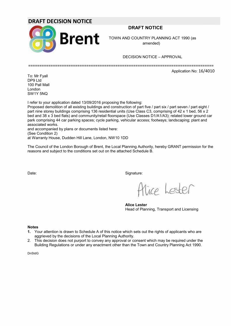
DRAFT DECISION NOTICEDRAFT NOTICE
TOWN AND COUNTRY PLANNING ACT 1990 (asamended)
DECISION NOTICE – APPROVAL
===================================================================================Application No: 16/4010
To: Mr FyallDP9 Ltd100 Pall MallLondonSW1Y 5NQ
I refer to your application dated 13/09/2016 proposing the following:Proposed demolition of all existing buildings and construction of part five / part six / part seven / part eight /part nine storey buildings comprising 136 residential units (Use Class C3, comprising of 42 x 1 bed, 56 x 2bed and 38 x 3 bed flats) and community/retail floorspace (Use Classes D1/A1/A3); related lower ground carpark comprising 44 car parking spaces; cycle parking, vehicular access; footways; landscaping; plant andassociated works.and accompanied by plans or documents listed here:(See Condition 2)at Warranty House, Dudden Hill Lane, London, NW10 1DD
The Council of the London Borough of Brent, the Local Planning Authority, hereby GRANT permission for thereasons and subject to the conditions set out on the attached Schedule B.
Date: Signature:
Alice LesterHead of Planning, Transport and Licensing
Notes1. Your attention is drawn to Schedule A of this notice which sets out the rights of applicants who are
aggrieved by the decisions of the Local Planning Authority.2. This decision does not purport to convey any approval or consent which may be required under the
Building Regulations or under any enactment other than the Town and Country Planning Act 1990.
DnStdG
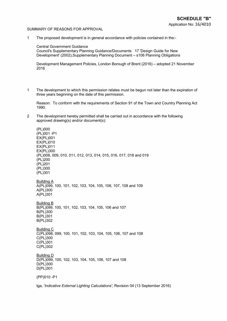
SCHEDULE "B"Application No: 16/4010
SUMMARY OF REASONS FOR APPROVAL
1 The proposed development is in general accordance with policies contained in the:-
Central Government GuidanceCouncil's Supplementary Planning Guidance/Documents 17 'Design Guide for NewDevelopment' (2002),Supplementary Planning Document – s106 Planning Obligations
Development Management Policies, London Borough of Brent (2016) – adopted 21 November2016
1 The development to which this permission relates must be begun not later than the expiration ofthree years beginning on the date of this permission.
Reason: To conform with the requirements of Section 91 of the Town and Country Planning Act1990.
2 The development hereby permitted shall be carried out in accordance with the followingapproved drawing(s) and/or document(s):
(PL)000(PL)001 -P1EX(PL)001EX(PL)010EX(PL)011EX(PL)300(PL)008, 009, 010, 011, 012, 013, 014, 015, 016, 017, 018 and 019(PL)200(PL)201(PL)300(PL)301
Building AA(PL)099, 100, 101, 102, 103, 104, 105, 106, 107, 108 and 109A(PL)300A(PL)301
Building BB(PL)099, 100, 101, 102, 103, 104, 105, 106 and 107B(PL)300B(PL)301B(PL)302
Building CC(PL)098, 099, 100, 101, 102, 103, 104, 105, 106, 107 and 108C(PL)300C(PL)301C(PL)302
Building DD(PL)099, 100, 102, 103, 104, 105, 106, 107 and 108D(PL)300D(PL)301
(PP)010 -P1
tga, 'Indicative External Lighting Calculations', Revision 04 (13 September 2016)
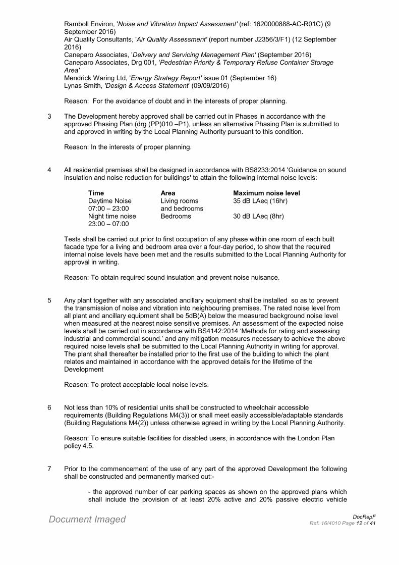
Document Imaged DocRepFRef: 16/4010 Page 12 of 41
Ramboll Environ, 'Noise and Vibration Impact Assessment' (ref: 1620000888-AC-R01C) (9September 2016)Air Quality Consultants, 'Air Quality Assessment' (report number J2356/3/F1) (12 September2016)Caneparo Associates, 'Delivery and Servicing Management Plan' (September 2016)Caneparo Associates, Drg 001, 'Pedestrian Priority & Temporary Refuse Container StorageArea'Mendrick Waring Ltd, 'Energy Strategy Report' issue 01 (September 16)Lynas Smith, 'Design & Access Statement' (09/09/2016)
Reason: For the avoidance of doubt and in the interests of proper planning.
3 The Development hereby approved shall be carried out in Phases in accordance with theapproved Phasing Plan (drg (PP)010 –P1), unless an alternative Phasing Plan is submitted toand approved in writing by the Local Planning Authority pursuant to this condition.
Reason: In the interests of proper planning.
4 All residential premises shall be designed in accordance with BS8233:2014 'Guidance on soundinsulation and noise reduction for buildings' to attain the following internal noise levels:
Time Area Maximum noise levelDaytime Noise Living rooms 35 dB LAeq (16hr)07:00 – 23:00 and bedroomsNight time noise Bedrooms 30 dB LAeq (8hr)23:00 – 07:00
Tests shall be carried out prior to first occupation of any phase within one room of each builtfacade type for a living and bedroom area over a four-day period, to show that the requiredinternal noise levels have been met and the results submitted to the Local Planning Authority forapproval in writing.
Reason: To obtain required sound insulation and prevent noise nuisance.
5 Any plant together with any associated ancillary equipment shall be installed so as to preventthe transmission of noise and vibration into neighbouring premises. The rated noise level fromall plant and ancillary equipment shall be 5dB(A) below the measured background noise levelwhen measured at the nearest noise sensitive premises. An assessment of the expected noiselevels shall be carried out in accordance with BS4142:2014 ‘Methods for rating and assessingindustrial and commercial sound.’ and any mitigation measures necessary to achieve the aboverequired noise levels shall be submitted to the Local Planning Authority in writing for approval.The plant shall thereafter be installed prior to the first use of the building to which the plantrelates and maintained in accordance with the approved details for the lifetime of theDevelopment
Reason: To protect acceptable local noise levels.
6 Not less than 10% of residential units shall be constructed to wheelchair accessiblerequirements (Building Regulations M4(3)) or shall meet easily accessible/adaptable standards(Building Regulations M4(2)) unless otherwise agreed in writing by the Local Planning Authority.
Reason: To ensure suitable facilities for disabled users, in accordance with the London Planpolicy 4.5.
7 Prior to the commencement of the use of any part of the approved Development the followingshall be constructed and permanently marked out:-
- the approved number of car parking spaces as shown on the approved plans whichshall include the provision of at least 20% active and 20% passive electric vehicle
charging points and at least 14 spaces designed and laid out for disabled parking- cycle parking numbers as approved
Thereafter the approved parking shall be retained and used solely for the specified purposes inconnection with the Development hereby approved for the lifetime of the Development and shallnot be obstructed or used for any other purpose/s unless otherwise agreed in writing by theLocal Planning Authority.
Reason: To ensure adequate parking and cycle parking provision in accordance with adoptedstandards.
8 External lighting shall be carried out in accordance with the tga report, Revision 04 titled‘Indicative External Lighting Calculations’ The approved details relating to a Phase shall be fullyimplemented prior to occupation of the building(s) within that Phase and retained as such for thelifetime of the development.
Reason: In the interests of safety, amenity and convenience.
9 Vegetation clearance of shrubs/trees shall be undertaken outside of the nesting bird season(generally extends between March and September inclusive). If this is not possible then anyvegetation that is to be removed or disturbed shall be checked by an experienced ecologist fornesting birds immediately prior to works commencing. If birds are found to be nesting any workswhich may affect them is required to be delayed until the young have fledged and the nest hasbeen abandoned naturally.
Reason: To ensure compliance with the Wildlife and Countryside Act 1981 (as amended).
10 Elements of the building(s) permitted for "D1 Use" as shown on approved drawings (PL) 009,(PL)010, A(PL)099 and A(PL)100 shall under no circumstances be used as a Place of Worshipwithin Class D1 (Non-residential Institutions) as defined in the Town and Country Planning (UseClasses) Order 1987 (as amended) without express planning consent from the Local PlanningAuthority first being obtained.
Reason: in order to ensure that the use of the premises has an acceptable impact ontransportation grounds and on residential amenity
11 Use of the site shall be carried out fully in accordance with the Delivery and ServicingManagement Plan, as set out in the Transport Statement (dated September 2016) unlessotherwise agreed in writing by the Local Planning Authority.
Reason: To minimise the impacts of the development on the highway.
12 The developer or constructor shall sign up to the Considerate Constructors Scheme prior tocommencement of works on site and the developer or constructor shall thereafter adhere to therequirements of the Scheme for the period of construction for that part of the development.
Reason: In the interest of the amenities of the adjoining and nearby owners and occupiers.
13 Before any above ground construction work (excluding demolition) is commenced on anyPhase, details of materials for all external work for that Phase shall be submitted to andapproved in writing by the Local Planning Authority. The development shall be carried out inaccordance with the approved details and retained as such thereafter.
Reason: To ensure a satisfactory development which does not prejudice the amenity of thelocality.
14 Before any above ground construction work (excluding demolition) is commenced on any Phase
a detailed scheme for the hard and soft landscape works of any undeveloped land within thatPhase shall be submitted to and approved in writing by the Local Planning Authority. Theapproved landscaping works for a Phase shall be fully completed prior to occupation of thebuilding(s) within that Phase, or within 12 (twelve) weeks of the commencement of the nextplanting season. Such a scheme shall include, but is not limited to:-
(a) the means of protection (in accordance with BS5837:2012) of all existing trees and shrubson site or in close proximity to the site boundaries and not directly affected by the buildingworks and which are to be retained, including detailed proposed protection measures during anydemolition or construction works to include locations of all protective fencing, ground protection,site facilities and storage areas. Where, for construction purposes, it is necessary to positiontree protection fencing within the RPA of retained trees, suitable ground protection will beinstalled to prevent undue soil/root compaction from pedestrian and/or vehicular traffic. Suchworks are to be carried out fully in accordance with Indigo report (ref: 15166/A3_AIA_RevA)unless otherwise approved in writing.
(b) Details of proposed walls, fencing and other means of enclosure indicating materials andheights, including secure fencing around the boundary of the site and the neighbouringdesignated SINC areas;
(c) Details for all new tree planting across the site, with all new trees planted at a minimum girthof 12-14cm,
(d) Details of adequate physical separation, such as protective walls and fencing betweenlandscaped and paved areas;
(e) Details of existing contours and any proposed alteration to ground levels such as earthmounding;
(f) Details of any balustrade/balcony treatment
(g) Details of areas of hard landscape works and proposed materials, including details of arobust and durable choice of material for the refuse turning area ;
(h) Details of the proposed arrangements for the maintenance of the landscape works.
(I) Details for the provision for outside seating / benches and children’s play equipment
(j) Details for the provision of on site bird and bat boxes
Furthermore, all trees within the Indigo report (dated 12 September 2016) that are identified forretention as part of this development that fall into irreversible decline and/or die as a result ofnon-adherence to the approved documents within a period not to exceed five years fromcompletion of works shall be replaced with a tree of size and species to be agreed with theLocal Authority.
Any planting that is part of the approved scheme that within a period of five years after plantingis removed, dies or becomes seriously damaged or diseased, shall be replaced in the nextplanting season and all planting shall be replaced with others of a similar size andspecies and in the same positions, unless the Local Planning Authority first gives writtenconsent to any variation.
Reason: To ensure a satisfactory appearance and setting for the proposed development, toensure that the proposed development enhances the visual amenity of the locality in theinterests of the amenities of the occupants of the developmentand, ensure that it enhances thevisual amenity of the area and to protect trees in the immediate environment and to retain amature tree cover aroundthe site.and to provide tree planting in pursuance of section 197 of theTown and Country Planning Act 1990.
15 Prior to the commencement of the Development, including any preparatory works or demolitionworks, a detailed Construction and Environmental Management Plan shall be submitted to andagreed by the Local Planning Authority outlining measures that will be taken to control dust,noise and other environmental impacts of the development. The Development shall be carried
Document Imaged DocRepFRef: 16/4010 Page 13 of 41
out fully in accordance with the approved details thereafter unless otherwise agreed in writing bythe Local Planning Authority.
Reason: Owing to the fact the site is within an Air Quality Management Area and to safeguardthe amenity of the neighbours by minimising impacts of the development that would otherwisegive rise to nuisance.
16 Details of all external signage, naming and numbering on any building within a Phase shall besubmitted to and approved in writing by the Local Planning Authority prior to first occupation ofthe relevant building and implemented in accordance with the approved details and retained assuch for thelifetime of the Development.
Reason: In order to ensure a legible development.
17 Prior to first occupation of any building within a Phase hereby approved, confirmation from theBuilding Control body shall be submitted to the Local Planning Authority to demonstrate that therelevant building has been designed so that mains water consumption does not exceed a targetof 105 litres or less per person per day, using a fittings-based approach to determine the waterconsumption of the development in accordance with requirement G2 of Schedule 1 to theBuilding Regulations 2010.
Reason: In order to ensure a sustainable development.
18 Prior to first occupation of any building(s) within a Phase a report which provides evidence thatthe mitigation measures described in the approved Noise Impact Assessment (Ramboll EnvironProject Number 1620000888, Report Reference 1620000888-AC-ROIC, dated 9 September2016) relating to that Phase have been fully implemented shall be submitted to and approved inwriting by the Local Planning Authority. The mitigation measures shall be retained for thelifetime of the Development.
Reason: To ensure the safe development and secure occupancy of the site for future residentialuse.
19 Prior to the commencement of the development, including any enabling works or demolitionworks (save for site investigations and surveys), a Construction Management and Logistics Planshall be submitted to and agreed by the Local Planning Authority. The development shall becarried out fully in accordance with the approved details thereafter.The approved Plan shallinclude any required temporary traffic management or temporary highway closures required forloading/unloading of materials/equipment.
Reason: To comply with London plan policy 6.14. This condition is required to bepre-commencement to ensure the Plan is in place before harmful works commence.
20 Prior to the commencement of relevant drainage works for any Phase full details of a drainagestrategy detailing any on and/or off site drainage works which shall include but is not limited to ascheme of drainage measures for all areas of hard surface within the relevant Phase, showingthose areas to be treated by means of hard landscape works to utilise a sustainable urbandrainage system (SUDS) to reduce run-off rates, shall be submitted to and approved in writingby the Local Planning Authority. The approved scheme for any relevant Phase shall beimplemented in full prior to first occupation of that Phase and shall be retained for the lifetime ofthe Development.
Reason: To ensure the development meets the requirements of London Plan Policy 5.13Sustainable Drainage.
21 Prior to first occupation of any building(s) within a Phase a report which demonstrates that themitigation measures set out in the approved Air Quality Impact Assessment (Air Quality
Consultants Report Number J2356/1/F2 dated 15/02/16) relating to that Phase have been fullyimplemented shall be submitted to and approved in writing by the Local Planning Authority. Themitigation measures shall be retained for the lifetime of the Development.
Reason: To ensure the safe development and secure occupancy of the site for residential use.
22 Any extract ventilation fan, together with any associated ducting shall be installed so asto prevent the transmission of noise and vibration into any neighbouring premises. Thenoise level from any extraction plant together with any associated ducting, shall be 10dB(A) or greater below the measured background noise level at the nearest noisesensitive premises. The method of assessment should be carried out in accordancewith BS4142:2014 ‘Methods for rating and assessing industrial and commercial sound.’An assessment of the expected noise levels and any mitigation measures necessary toachieve the required noise levels shall be submitted to the Local Planning Authority inwriting for approval. The extraction system shall thereafter be installed prior to the firstoperation of the A3 use to which the extraction system relates and maintained inaccordance with the approved details for the lifetime of the Development
Reason: To safeguard the amenity of the neighbours from the transmission of noisefrom any future A3 use on site.
23 Details of hours of operation for any Use Class D1/A1/A3 Use hereby approved shall besubmitted to and agreed in writing by the Local Planning Authority prior to commencement ofthe relevant use and the relevant Use shall be carried out in accordance with the approvedhours of operation for that Use unless otherwise agreed in writing.
Reason: To safeguard the amenity of residential occupiers.
24 A scheme of sound insulation measures between the proposed commercial and residentialuses of Building A, shall be submitted to and approved in writing by the Local PlanningAuthority, and the approved scheme shall be installed before commencement of the useshereby permitted within Building A and permenantly retained thereafter. This shall demonstratethat the insulation of separating floors between commercial and residential uses meet thestandards of the Building Regulaitons Approved Document E ‘Resistance to the passage ofsound’.
Reason: To safeguard the amenity of residential occupiers.
25 Following the demolition of the buildings and prior to the commencement of building works onany Phase, a site investigation shall be carried out by competent persons to determine thenature and extent of any soil contamination present within that Phase. The investigation shall becarried out in accordance with the principles of BS 10175:2011. A report shall be submitted toand approved in writing by the Local Planning Authority prior to the commencement ofconstruction works on any Phase, that includes the results of any research and analysisundertaken as well as an assessment of the risks posed by any identified contamination. It shallinclude an appraisal of remediation options should any contamination be found that presents anunacceptable risk to any identified receptors.
Reason:- To ensure the safe development and secure occupancy of the site.’
26 Any soil contamination remediation measures required by the Local Planning Authority shall becarried out in full in accordance with the approved remediation works on any Phase. Prior to theoccupation of each phase a verification report shall be submitted to and approved in writing bythe Local Planning Authority, demonstrating that remediation has been carried out for thatPhase in accordance with the approved remediation scheme and the land within that Phase issuitable for end use (unless the Planning Authority has previously confirmed that no remediationmeasures are required).
Reason: To ensure the safe development and secure occupancy of the site.’
27 Prior to first occupation of any building(s) within a Phase the applicant shall submit for theapproval in writing of the Local Planning Authority further details of accessible cycle parking forthat Phase. The approved details relating to a Phase shall be fully implemented prior tooccupation of the building(s) within that Phase and retained as such thereafter
Reason: To comply with London Plan policy 6.13
28Prior to first occupation of any of the buildings further details of the layout of the service/dropoff zone shall be submitted to and approved in writing to the Local Planning Authority todemonstrate how this area will be marked appropriately for users. The approved details shall beimplemented in full prior to first occupation and retained as such thereafter
Reason; In the interests of pedestrian and highway safety.
29 Prior to first occupation of the largest commercial unit identified within the approved drawingsA(PL)099, A(PL)100 and Design and Access Statement for use as a children’s nursery atground and lower ground levels within Building A, the permitted retail uses (Classes A1/A3)must not be implemented until the unit has been actively marketed for D1 nursery use and/orother D1 uses (excluding as a place of worship) by all reasonable means for a minimum periodof six months, and a Marketing Report which 1) provides details of the marketing undertakenand 2) demonstrates that there is no suitable D1 operator interest, shall be submitted to andapproved in writing by the Local Planning Authority (unless otherwise agreed). Details of theproposed first use of the unit shall be submitted to and approved in writing by the Local PlanningAuthority, prior to first occupation.
Reason: To ensure D1 community uses are adequately re-provided to meet the DevelopmentPlan requirements and to fully test demand for the proposed D1 use prior to implementation of aClass A1 or A3 use.
INFORMATIVES
1 As the site is adjacent to Network Rail’s operational railway infrastructure, Network Railstrongly recommends the developer contacts [email protected] priorto any works commencing on site. Network Rail strongly recommends the developer agreesan Asset Protection Agreement with them to enable approval of detailed works. Moreinformation can also be obtained from the website at www.networkrail.co.uk/aspx/1538.aspx.
2 The site is adjacent to London Underground land. The applicant is advised to contact LondonUnderground Infrastructure Protection in regard to the site’s close proximity to LU lines inorder to enter into any necessary agreements and or licenses before carrying out of works onsite.
3 (a) Piling has the potential to impact on local underground water utility infrastructure. Theapplicant is advised to contact Thames Water Developer Services on 0800 009 3921 todiscuss the details of any piling works in advance of such works.
(b) Thames Water advise that they will aim to provide customers with a minimum pressure of10m head (approx 1 bar) and a flow rate of 9 litres/minute at the point where it leaves ThamesWaters pipes. The developer should take account of this minimum pressure in the design ofthe proposed development.
(c) Pursuant to Condition 19, Thames Water advise that the Strategy submitted should includethe current and proposed point(s) of connection to the public sewer system as well as peak
Document Imaged DocRepFRef: 16/4010 Page 14 of 41
discharge rates for both the pre- and post- development scenarios. Pump rates will need to beconfirmed. They would expect peak surface water discharge rates to remain consistent or bereduced from current levels.
4 The applicant is advised that prior to commencement of any works on site, a condition surveyof the existing road network, together with a regime for monitoring the condition of the roadnetwork during construction and subsequent repair works, shall be agreed by the LocalHighway Authority. The applicant is advised to notify the Council’s Highways Service of theintention to commence works prior to commencement. They shall contact Mark O'Brien(Public Realm Monitoring Manager) at Mark.O'[email protected], and include photographsshowing the condition of highway along the site boundaries.
5 The applicant must ensure, before work commences, that the treatment/finishing of flankwalls can be implemented as this may involve the use of adjoining land and should alsoensure that all development, including foundations and roof/guttering treatment is carried outentirely within the application property.
6 The applicant is required to enter into a "Building Over sewer" Agreement with Thames WaterUtilities Ltd before commencing construction of any part of the building over a public sewer.
7 Prior consent may be required under the Town and Country Planning (Control ofAdvertisements) Regulations 1990 for the erection or alteration of any(a) illuminated fascia signs(b) projecting box signs(c) advertising signs(d) hoardings
8 Given the age of the building(s) to be demolished it is possible that asbestos may be present.Applicants are reminded of hazards caused by asbestos materials especially duringdemolition and removal works and attention is drawn to the Asbestos Licensing Regulations1983. Licensed Contractors only are permitted to remove asbestos which must be transferredto a licensed site. For further advice the Council's Environmental Health Officer should becontacted.
9 The provisions of The Party Wall etc. Act 1996 may be applicable and relates to work on anexisting wall shared with another property; building on the boundary with a neighbouringproperty; or excavating near a neighbouring building. An explanatory booklet setting out yourobligations can be obtained from the Communities and Local Government websitewww.communities.gov.uk
10 The applicant is advised that this development is liable to pay the Community InfrastructureLevy; a Liability Notice will be sent to all known contacts including the applicant and the agent.Before you commence any works please read the Liability Notice and comply with its contentsas otherwise you may be subjected to penalty charges. Further information including eligibilityfor relief and links to the relevant forms and to the Government’s CIL guidance, can be foundon the Brent website at www.brent.gov.uk/CIL.

Any person wishing to inspect the above papers should contact Gary Murphy, Planning and Regeneration,Brent Civic Centre, Engineers Way, Wembley, HA9 0FJ, Tel. No. 020 8937 5227