columbia river vancouver to bonneville - quick links · columbia river vancouver to bonneville ....
TRANSCRIPT

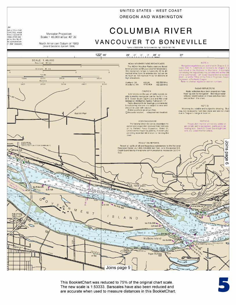
BookletChart™ Columbia River – Vancouver to Bonneville NOAA Chart 18531
A reduced-scale NOAA nautical chart for small boaters When possible, use the full-size NOAA chart for navigation.
Included Area

2
Published by the National Oceanic and Atmospheric Administration
National Ocean Service Office of Coast Survey
www.NauticalCharts.NOAA.gov 888-990-NOAA
What are Nautical Charts?
Nautical charts are a fundamental tool of marine navigation. They show water depths, obstructions, buoys, other aids to navigation, and much more. The information is shown in a way that promotes safe and efficient navigation. Chart carriage is mandatory on the commercial ships that carry America’s commerce. They are also used on every Navy and Coast Guard ship, fishing and passenger vessels, and are widely carried by recreational boaters.
What is a BookletChart?
This BookletChart is made to help recreational boaters locate themselves on the water. It has been reduced in scale for convenience, but otherwise contains all the information of the full-scale nautical chart. The bar scales have also been reduced, and are accurate when used to measure distances in this BookletChart. See the Note at the bottom of page 5 for the reduction in scale applied to this chart.
Whenever possible, use the official, full scale NOAA nautical chart for navigation. Nautical chart sales agents are listed on the Internet at http://www.NauticalCharts.NOAA.gov.
This BookletChart does NOT fulfill chart carriage requirements for regulated commercial vessels under Titles 33 and 44 of the Code of Federal Regulations.
Notice to Mariners Correction Status
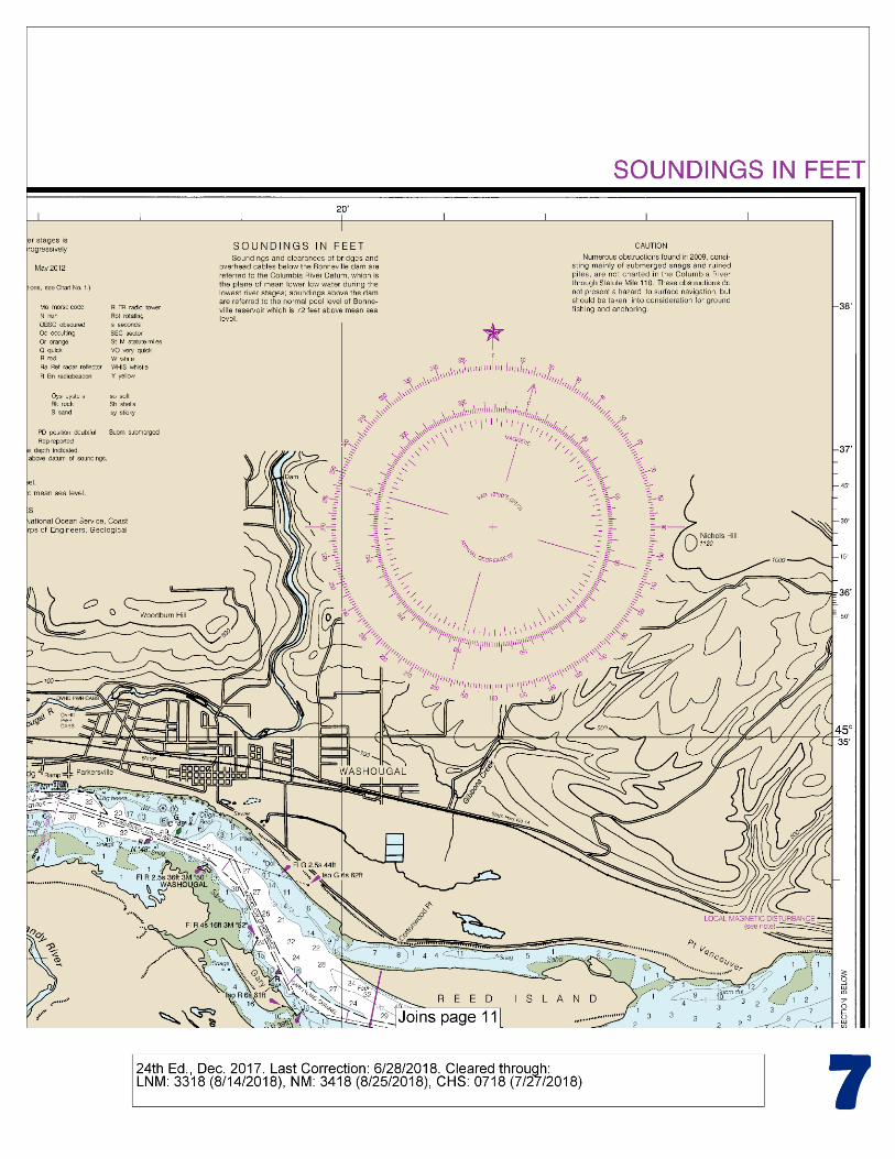
This BookletChart has been updated for chart corrections published in the U.S. Coast Guard Local Notice to Mariners, the National Geospatial Intelligence Agency Weekly Notice to Mariners, and, where applicable, the Canadian Coast Guard Notice to Mariners. Additional chart corrections have been made by NOAA in advance of their publication in a Notice to Mariners. The last Notices to Mariners applied to this chart are listed in the Note at the bottom of page 7. Coast Pilot excerpts are not being corrected.
For latest Coast Pilot excerpt visit the Office of Coast Survey website at http://www.nauticalcharts.noaa.gov/nsd/searchbychart.php?chart=18531.
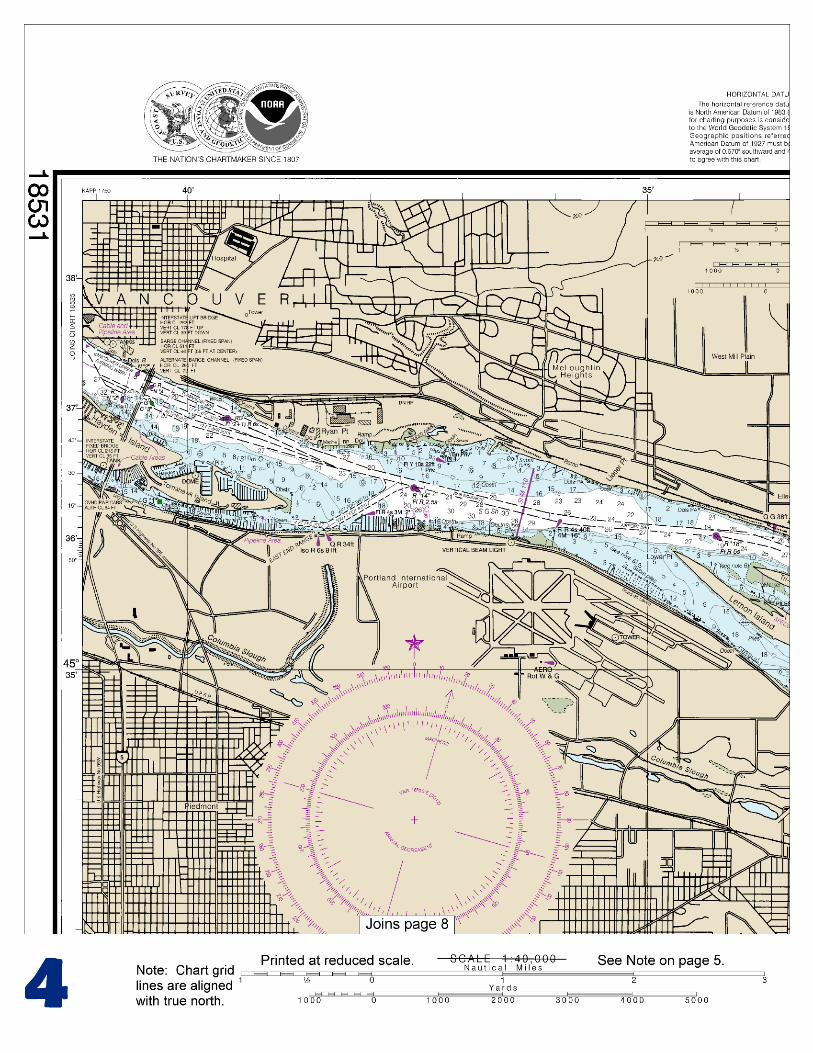
(Selected Excerpts from Coast Pilot) From Vancouver to Bonneville, Mile 126 (145), Columbia River passes through the Columbia River Gorge. Ryan Point, 1.4 miles ESE of the Interstate 5 highway bridge, is the site of a public launching ramp. There are many full service marinas, yacht clubs, and moored houseboats along the Oregon shore from Interstate 5 highway bridge to the W end of Government Island. Anchorage.–A special anchorage is
between Tri-Club Island 18531Tri-Club Island (Sand Island) and Lemon Island, the W end of Government Island. (See 110.1 and 110.128,
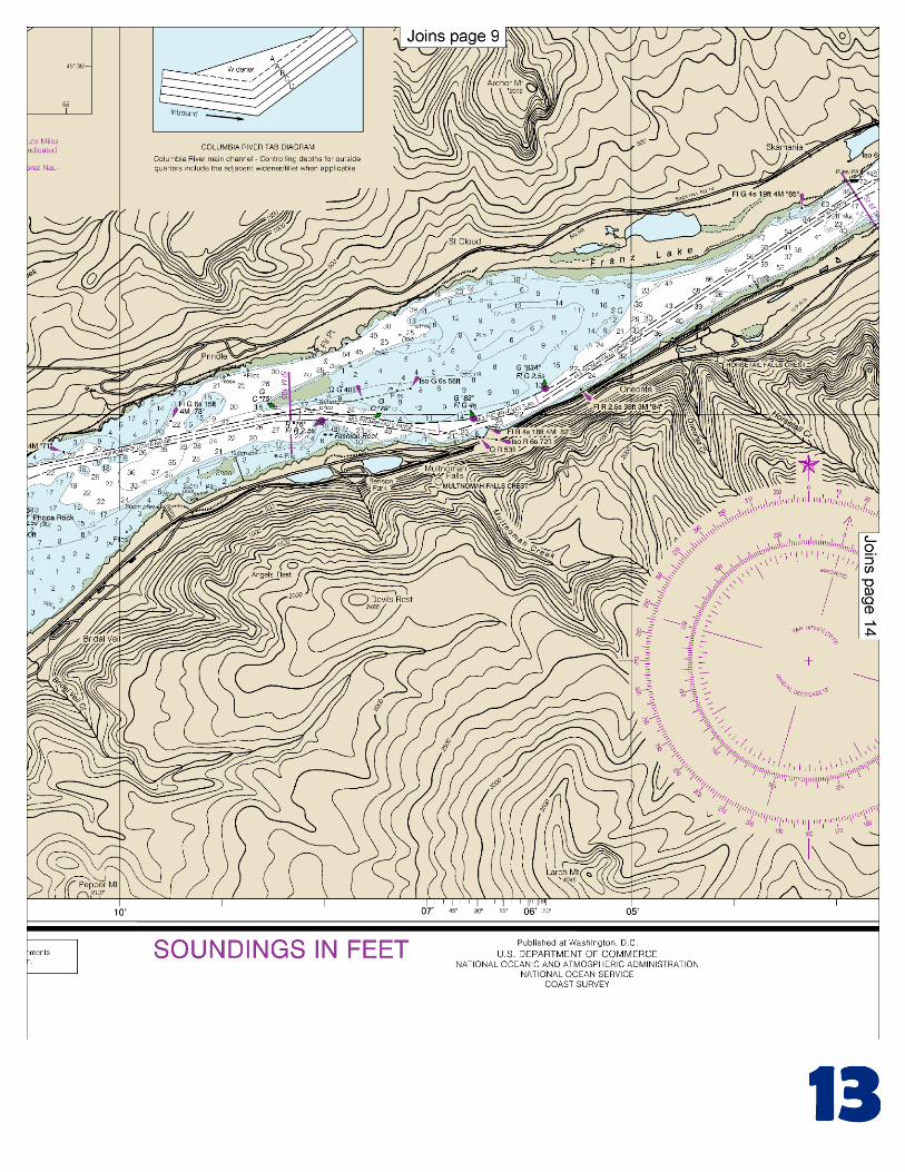
chapter 2, for limits and regulations.) The entrance to Sandy River on the Oregon side opposite Camas, bares at low water. At higher flood stages, passage up Sandy River as far as Troutdale is possible. Dangers.–In this section of the river, the principal hazards to navigation are the strong currents, rocks and rocky banks, winds, and an accumulation of ice. Currents.–In general, currents run fair with the main channels with considerable intensity, increasing in regions upstream toward Bonneville. Exceptions are the turn in the channel at Washougal Light 50, where a NW set prevails; SW of Cape Horn, where a W set is experienced; and the region between Fashion Reef and Multnomah Falls, where a S set is experienced. Near Warrendale, Mile 123 (141.5), the river becomes very constricted within less than a mile and continues so almost to the approach to the locks of Bonneville Dam, at the lower end of Bradford Island. Beacon Rock, 840 feet high and 300 yards inshore, is on the Washington side opposite Warrendale. A State park of the same name surrounds the rock. The park maintains a mooring float just inside the entrance to the channel W of Pierce Island; moorage is restricted to pleasure boats and to periods not to exceed 5 nights. Water, electricity, and pump-out facility are available at the park. Bonneville, on the Oregon side at Mile 126 (145), is the headquarters of the U.S. Army Corps of Engineers in charge of the Bonneville Lock and Dam. Bonneville Lock and Dam, 126.3 (145.3) miles above the mouth of the Columbia River, is in four parts. Powerhouse No. 2 is between the Washington shore and Cascade Island; the spillway is between Cascade Island and Bradford Island; Powerhouse No. 1 and the old lock are between Bradford Island and Robins Island; and the new lock is between Robins Island and the Oregon shore. The new navigation lock has a vertical lift of about 59 feet, a width of 86 feet and a length of 675 feet. The old lock has been placed in mothball status. Restricted areas are above and below the spillway and powerhouse. (See 207.718, chapter 2, for information concerning use, administration, and navigation of Bonneville Lock and Dam.) The strong current toward the powerhouse makes it difficult to approach Bonneville Lock from upstream, particularly if the lock is approached at an angle and if a turn is to be executed in time to avoid an accident. Therefore, all craft approaching the lock from the E and pushing one or more barges should steer as close to the Oregon mainland shore as safety will permit, should be in line with the lock upon reaching the E end of the guide wall, and should continue at a steady but reduced speed if the lock is prepared for entrance and the signal for entrance has been given. From Bonneville to The Dalles, the channel is through the pool created by Bonneville Dam, which extends 40 (46) miles to The Dalles Dam. Depths and overhead clearances are at normal pool level. Although there is deep water in much of the pool, the controlling depth to The Dalles Dam navigation lock is about 20 feet. The channels are marked by aids to navigation. Currents.–From the lock at Bonneville through Cascade Rapids, constant piloting is necessary because of the strong currents. From Cascade Rapids E, a set of 1° to 3° may be experienced depending on the angle that the course makes with the general direction of the river, the strength of the current, and the direction and strength of the wind. U.S. Coast Guard Rescue Coordination Center
24 hour Regional Contact for Emergencies
RCC Seattle Commander 13th CG District (206) 220-7001
Seattle, WA

G
NOAA’s navigation managers serve as ambassadors to the maritime community. They help identify navigational challenges facing professional and recreational mariners, and provide NOAA resources and information for safe navigation. For additional information, please visit nauticalcharts.noaa.gov/service/navmanagers
To make suggestions or ask questions online, go to nauticalcharts.noaa.gov/inquiry. To report a chart discrepancy, please use ocsdata.ncd.noaa.gov/idrs/discrepancy.aspx.
Lateral System As Seen Entering From Seaward on navigable waters except Western Rivers
PORT SIDE
ODD NUMBERED AIDS
GREEN LIGHT ONLY
FLASHING (2)
PREFERRED CHANNEL
NO NUMBERS – MAY BE LETTERED
PREFERRED CHANNEL TO
STARBOARD
TOPMOST BAND GREEN
PREFERRED CHANNEL
NO NUMBERS – MAY BE LETTERED
PREFERRED CHANNEL
TO PORT
TOPMOST BAND RED
STARBOARD SIDE
EVEN NUMBERED AIDS
RED LIGHT ONLY
FLASHING (2)
FLASHING FLASHING
OCCULTING GREEN LIGHT ONLY RED LIGHT ONLY OCCULTING QUICK FLASHING QUICK FLASHING
ISO COMPOSITE GROUP FLASHING (2+1) COMPOSITE GROUP FLASHING (2+1) ISO
"1"
Fl G 6s
G "9"
Fl G 4s
GR "A"
Fl (2+1) G 6s
RG "B"
Fl (2+1) R 6s
"2"
Fl R 6s
8
R "8"
Fl R 4s
LIGHT
G
C "1"
LIGHTED BUOY
G
"5"
GR
"U"
GR
C "S"
RG
N "C"
RG
"G"
LIGHT
6
R
N "6"
LIGHTED BUOY
R
"2
"
CAN DAYBEACON
CAN NUN NUN
DAYBEACON
For more information on aids to navigation, including those on Western Rivers, please consult the latest USCG Light List for your area.
These volumes are available online at http://www.navcen.uscg.gov
Navigation Managers Area of Responsibility
Northeast
Lt. Meghan McGovern
Northwest and
Pacific Islands
Crescent Moegling
Great Lakes Region
Tom Loeper
Chesapeake and
Delaware Bay
Steve Soherr
California
Jeff Ferguson
[email protected] Mid-Atlantic
Lt. Ryan Wartick
Alaska
Lt. Timothy M. Smith
Western Gulf Coast
Alan Bunn
Central Gulf Coast
Tim Osborn
[email protected] South Florida
Puerto Rico
U.S. Virgin Islands
Michael Henderson
Southeast
Kyle Ward
2
2 C U 5
1


VHF Marine Radio channels for use on the waterways:Channel 6 – Inter-ship safety communications.Channel 9 – Communications between boats and ship-to-coast.Channel 13 – Navigation purposes at bridges, locks, and harbors.Channel 16 – Emergency, distress and safety calls to Coast Guard and others, and to initiate calls to other
vessels. Contact the other vessel, agree to another channel, and then switch.Channel 22A – Calls between the Coast Guard and the public. Severe weather warnings, hazards to navigation and safety warnings are broadcast here.Channels 68, 69, 71, 72 and 78A – Recreational boat channels.
Getting and Giving Help — Signal other boaters using visual distress signals (flares, orange flag, lights, arm signals); whistles; horns; and on your VHF radio. You are required by law to help boaters in trouble. Respond to distress signals, but do not endanger yourself.
EMERGENCY INFORMATION
Distress Call Procedures
• Make sure radio is on.• Select Channel 16.• Press/Hold the transmit button.• Clearly say: “MAYDAY, MAYDAY, MAYDAY.”• Also give: Vessel Name and/or Description;Position and/or Location; Nature of Emergency; Number of People on Board.• Release transmit button.• Wait for 10 seconds — If no responseRepeat MAYDAY call.
HAVE ALL PERSONS PUT ON LIFE JACKETS!
This Booklet chart has been designed for duplex printing (printed on front and back of one sheet). If a duplex option is not available on your printer, you may print each sheet and arrange them back-to-back to allow for the proper layout when viewing.
QR
Quick ReferencesNautical chart related products and information - http://www.nauticalcharts.noaa.gov
Interactive chart catalog - http://www.charts.noaa.gov/InteractiveCatalog/nrnc.shtmlReport a chart discrepancy - http://ocsdata.ncd.noaa.gov/idrs/discrepancy.aspx
Chart and chart related inquiries and comments - http://ocsdata.ncd.noaa.gov/idrs/inquiry.aspx?frompage=ContactUs
Chart updates (LNM and NM corrections) - http://www.nauticalcharts.noaa.gov/mcd/updates/LNM_NM.html
Coast Pilot online - http://www.nauticalcharts.noaa.gov/nsd/cpdownload.htm
Tides and Currents - http://tidesandcurrents.noaa.gov
Marine Forecasts - http://www.nws.noaa.gov/om/marine/home.htm
National Data Buoy Center - http://www.ndbc.noaa.gov/
NowCoast web portal for coastal conditions - http://www.nowcoast.noaa.gov/
National Weather Service - http://www.weather.gov/
National Hurrican Center - http://www.nhc.noaa.gov/
Pacific Tsunami Warning Center - http://ptwc.weather.gov/
Contact Us - http://www.nauticalcharts.noaa.gov/staff/contact.htm
NOAA’s Office of Coast Survey The Nation’s Chartmaker
For the latest news from Coast Survey, follow @NOAAcharts
NOAA Weather Radio All Hazards (NWR) is a nationwide network of radio stations broadcasting continuous weather information directly from the nearest National Weather Service office. NWR broadcasts official Weather Service warnings, watches, forecasts and other hazard information 24 hours a day, 7 days a week. http://www.nws.noaa.gov/nwr/