civil aviation publication cap 04 designated airspace ... 04 designated... · civil aviation...
TRANSCRIPT
CIVIL AVIATION PUBLICATION
CAP 04
DESIGNATED AIRSPACE OPERATIONS
INDEX - GENERAL
INDEX - DETAIL

CIVIL AVIATION PUBLICATION
This Page Intentionally Left Blank
CIVIL AVIATION PUBLICATION
CAP 04 Rev 01 i 01 February 2014
CAP 04
DESIGNATED AIRSPACE OPERATIONS
INDEX – GENERAL
LIST OF ABBREVIATIONS GLOSSARY CHAPTER 1 - INTRODUCTION CHAPTER 2 - RNAV/RNP 10 CHAPTER 3 - RNAV 5 (B-RNAV) CHAPTER 4 - RNP 4 CHAPTER 5 - RNAV 1 (P-RNAV & RNAV 2) CHAPTER 6 - RNP APCH CHAPTER 7 - RNP AR APCH CHAPTER 8 - MNPS CHAPTER 9 - RVSM

CIVIL AVIATION PUBLICATION
CAP 04 Rev 01 ii 01 February 2014
This Page Intentionally Left Blank
CIVIL AVIATION PUBLICATION
CAP 04 Rev 01 iii 01 February 2014
INDEX – DETAIL Section Title Page No.
INDEX – GENERAL .................................................................................................................................................. i
INDEX – DETAIL ................................................................................................................................................... iii
LIST OF ABBREVIATIONS .................................................................................................................................... viii
GLOSSARY OF TERMS ........................................................................................................................................... x
CHAPTER 1 INTRODUCTION ................................................................................................................. 1-1
1.1 GENERAL ................................................................................................................................. 1-1
1.1.1 Purpose................................................................................................................................... 1-1
1.1.2 Approval Criteria .................................................................................................................... 1-1
1.1.3 References .............................................................................................................................. 1-2
1.2 AREA NAVIGATION (RNAV) .................................................................................................... 1-2
1.2.1 General ................................................................................................................................... 1-2
1.2.2 Performance Based Navigation (PBN)................................................................................... 1-2
1.3 NAVIGATION SPECIFICATIONS ............................................................................................... 1-3
1.3.1 General ................................................................................................................................... 1-3
1.3.2 Oceanic, Remote Continental, En-Route and Terminal Operations .................................... 1-3
1.3.3 Approach Operations ............................................................................................................. 1-3
1.3.4 Minimum Navigation Performance Specifications (MNPS) ................................................. 1-3
1.3.5 Understanding RNAV Designations ....................................................................................... 1-4
1.3.6 Navigation Performance Errors ............................................................................................. 1-4
1.3.7 Performance Monitoring and Alerting .................................................................................. 1-5
1.3.8 Accuracy and Track Guidance ................................................................................................ 1-6
1.3.9 Aircraft Equipment - General ................................................................................................ 1-6
1.3.10 Navigation Database .............................................................................................................. 1-7
1.4 GLOBAL NAVIGATION SATELLITE SYSTEM (GNSS) ................................................................ 1-7
1.4.1 General ................................................................................................................................... 1-7
1.4.2 Receiver Autonomous Integrity Monitoring (RAIM) ............................................................ 1-8
1.5 RNAV ROUTE STRUCTURES ................................................................................................... 1-8
1.5.1 General ................................................................................................................................... 1-8
1.5.2 Oceanic and Remote Continental Routes ............................................................................. 1-8
1.5.3 Continental Routes ................................................................................................................ 1-9
1.5.4 Terminal Arrival and Departure Routes ................................................................................ 1-9
1.5.5 Approach .............................................................................................................................. 1-10
CIVIL AVIATION PUBLICATION
CAP 04 Rev 01 iv 01 February 2014
1.6 CONTINUING SURVEILLANCE .............................................................................................. 1-11
1.6.1 Operator Responsibility ....................................................................................................... 1-11
1.6.2 Reporting Action .................................................................................................................. 1-11
CHAPTER 2 RNAV/RNP 10 AIRSPACE ............................................................................................... 2-1
2.1 GENERAL ................................................................................................................................. 2-1
2.2 AIRCRAFT EQUIPMENT REQUIREMENTS .............................................................................. 2-1
2.3 OPERATIONAL PROCEDURES ................................................................................................. 2-1
2.3.1 Before Flight Phase ................................................................................................................ 2-1
2.3.2 En-Route Phase ...................................................................................................................... 2-2
2.3.3 Contingency Procedures ........................................................................................................ 2-2
2.4 TRAINING REQUIREMENTS .................................................................................................... 2-3
2.4.1 Basic RNAV Concept Training ................................................................................................ 2-3
2.4.2 Additional RNAV/RNP 10 Training ......................................................................................... 2-4
2.5 APPLICATION FOR RNAV/RNP 10 .......................................................................................... 2-4
2.5.1 Process ................................................................................................................................... 2-4
2.5.2 Airworthiness Issues .............................................................................................................. 2-4
2.5.3 Equipment .............................................................................................................................. 2-5
2.5.4 Operational Requirements .................................................................................................... 2-5
2.5.5 Approval ................................................................................................................................. 2-6
CHAPTER 3 RNAV 5 (B-RNAV) AIRSPACE .......................................................................................... 3-1
3.1 GENERAL ................................................................................................................................. 3-1
3.2 AIRCRAFT EQUIPMENT REQUIREMENTS .............................................................................. 3-1
3.3 OPERATIONAL PROCEDURES ................................................................................................. 3-2
3.3.1 Before Flight Phase ................................................................................................................ 3-2
3.3.2 En-Route Phase ...................................................................................................................... 3-2
3.3.3 Contingency Procedures ........................................................................................................ 3-2
3.4 TRAINING REQUIREMENTS .................................................................................................... 3-3
3.5 APPLICATION FOR RNAV 5/B-RNAV ...................................................................................... 3-3
3.5.1 Process ................................................................................................................................... 3-3
3.5.2 Airworthiness Issues .............................................................................................................. 3-3
3.5.3 Equipment .............................................................................................................................. 3-4
3.5.4 Operational Requirements .................................................................................................... 3-4
3.5.5 Approval ................................................................................................................................. 3-5
CIVIL AVIATION PUBLICATION
CAP 04 Rev 01 v 01 February 2014
CHAPTER 4 RNP 4 AIRSPACE ............................................................................................................ 4-1
4.1 GENERAL ................................................................................................................................. 4-1
4.2 AIRCRAFT EQUIPMENT REQUIREMENTS .............................................................................. 4-1
4.2.1 Navigation Equipment ........................................................................................................... 4-1
4.2.2 Additional Communications Equipment ............................................................................... 4-2
4.3 OPERATIONAL PROCEDURES ................................................................................................. 4-2
4.3.1 Before Flight Phase ................................................................................................................ 4-2
4.3.2 En-Route Phase ...................................................................................................................... 4-3
4.3.3 Contingency Procedures ........................................................................................................ 4-3
4.4 TRAINING REQUIREMENTS .................................................................................................... 4-4
4.5 APPLICATION FOR RNP 4 ....................................................................................................... 4-5
4.5.1 Process ................................................................................................................................... 4-5
4.5.2 Airworthiness Issues .............................................................................................................. 4-5
4.5.3 Equipment .............................................................................................................................. 4-6
4.5.4 Operational Requirements .................................................................................................... 4-6
4.5.5 Approval ................................................................................................................................. 4-6
CHAPTER 5 RNAV 1 (P-RNAV) & RNAV 2 AIRSPACE ......................................................................... 5-1
5.1 GENERAL ................................................................................................................................. 5-1
5.2 AIRCRAFT EQUIPMENT REQUIREMENTS .............................................................................. 5-1
5.3 OPERATIONAL PROCEDURES ................................................................................................. 5-1
5.3.1 General ................................................................................................................................... 5-1
5.3.2 Before Flight Phase ................................................................................................................ 5-2
5.3.3 Flying the Procedure .............................................................................................................. 5-2
5.3.4 Contingency Procedures ........................................................................................................ 5-4
5.4 RNAV 1 (P-RNAV) AND RNAV 2 TRAINING ............................................................................ 5-4
5.4.1 General ................................................................................................................................... 5-4
5.4.2 Overlay Approach Training .................................................................................................... 5-5
5.5 APPLICATION FOR RNAV 1 (P-RNAV) & RNAV 2 ................................................................... 5-6
5.5.1 Process ................................................................................................................................... 5-6
5.5.2 Airworthiness Issues .............................................................................................................. 5-6
5.5.3 Equipment .............................................................................................................................. 5-7
5.5.4 Operational Requirements .................................................................................................... 5-7
5.5.5 Approval ................................................................................................................................. 5-7
CIVIL AVIATION PUBLICATION
CAP 04 Rev 01 vi 01 February 2014
CHAPTER 6 RNP APCH OPERATIONS ................................................................................................ 6-1
6.1 GENERAL ................................................................................................................................. 6-1
6.2 DOCUMENTATION ................................................................................................................. 6-1
6.3 RNP APCH TRAINING .............................................................................................................. 6-2
6.4 APPLICATION FOR RNP APCH ................................................................................................ 6-4
6.4.1 Process ................................................................................................................................... 6-4
6.4.2 Airworthiness Issues .............................................................................................................. 6-4
6.4.3 Equipment .............................................................................................................................. 6-5
6.4.4 Operational Requirements .................................................................................................... 6-5
6.4.5 Approval ................................................................................................................................. 6-5
CHAPTER 7 RNP AR APCH OPERATIONS .......................................................................................... 7-1
7.1 GENERAL ................................................................................................................................. 7-1
CHAPTER 8 MINIMUM NAVIGATION PERFORMANCE SPECIFICATION (MNPS) AIRSPACE ................ 8-1
8.1 INTRODUCTION ...................................................................................................................... 8-1
8.1.2 References .............................................................................................................................. 8-1
8.1.3 NAT MNPS Defined Area ....................................................................................................... 8-1
8.2 MNPS AIRSPACE ACCURACY REQUIREMENTS ...................................................................... 8-2
8.2.1 Navigation .............................................................................................................................. 8-2
8.2.2 Altimetry ................................................................................................................................. 8-3
8.2.3 Communications .................................................................................................................... 8-3
8.3 OPERATIONAL PROCEDURES ................................................................................................. 8-3
8.3.1 Before Flight Phase ................................................................................................................ 8-3
8.3.2 En-route Procedures .............................................................................................................. 8-4
8.3.3 Post Flight Procedures ........................................................................................................... 8-4
8.4 TRAINING REQUIREMENTS .................................................................................................... 8-4
8.5 APPLICATION FOR MNPS ....................................................................................................... 8-5
8.5.1 Process ................................................................................................................................... 8-5
8.5.2 Airworthiness Issues .............................................................................................................. 8-5
8.5.4 Approval ................................................................................................................................. 8-5
CHAPTER 9 RVSM ............................................................................................................................ 9-1
9. INTRODUCTION ...................................................................................................................... 9-1
9.1 GENERAL ................................................................................................................................. 9-1
9.1.1 Purpose................................................................................................................................... 9-1
CIVIL AVIATION PUBLICATION
CAP 04 Rev 01 vii 01 February 2014
9.1.2 General ................................................................................................................................... 9-1
9.1.3 References .............................................................................................................................. 9-1
9.2 AIRCRAFT EQUIPMENT FOR RVSM OPERATIONS ................................................................. 9-2
9.3 OPERATIONAL PROCEDURES ................................................................................................. 9-2
9.3.1 Flight Planning ........................................................................................................................ 9-2
9.3.2 Pre-flight Procedures ............................................................................................................. 9-3
9.3.3 Procedures Prior to RVSM Airspace Entry ............................................................................ 9-3
9.3.4 In-flight Procedures ............................................................................................................... 9-3
9.3.5 Contingency procedures after entering RVSM airspace ...................................................... 9-5
9.4 TRAINING REQUIREMENTS .................................................................................................... 9-6
9.5 APPLICATION PROCESS .......................................................................................................... 9-6
9.5.1 General ................................................................................................................................... 9-6
9.5.2 Process ................................................................................................................................... 9-7
9.5.3 Airworthiness Issues .............................................................................................................. 9-7
9.5.4 Over flight Assessment .......................................................................................................... 9-7
9.5.5 Periodic Monitoring ............................................................................................................... 9-9
9.5.6 Approval ................................................................................................................................. 9-9
9.6 OVERSIGHT ............................................................................................................................. 9-9
9.6.1 CAA Action .............................................................................................................................. 9-9
9.6.2 Operator Responsibility ....................................................................................................... 9-10
CIVIL AVIATION PUBLICATION
CAP 04 Rev 01 viii 01 February 2014
LIST OF ABBREVIATIONS ABAS Aircraft-Based Augmentation System ACAS Aircraft Collision Avoidance System ADS Automatic Dependent Surveillance ADS-C Automatic Dependent Surveillance – Contract AFM Aircraft Flight Manual ANP Actual Navigation Performance AOC Air Operator Certificate (for Commercial Air Transport operators) ATC Air Traffic Control ATM Air Traffic Management B-RNAV Basic Area Navigation (European standard) B-RNP 1 Basic Required Navigation Performance 1 nm (US standard) CDI Course Deviation Indicator CDU Control Display Unit CPDLC Controller-Pilot Data Link Communications CSA Channel of Standard Accuracy DME Distance Measuring Equipment EASA European Aviation Safety Agency ECAC European Civil Aviation Conference (E)HIS (Electronic) Horizontal Situation Indicator EUR European Region (ICAO) FAA Federal Aviation Administration FAF Final Approach Fix FDE Fault Detection and Exclusion (GNSS) FL Flight Level FMS Flight Management System FRT Fixed Radius Transition FT Feet FTE Flight Technical Error GBAS Ground-Based Augmentation System GNSS Global Navigation Satellite System GPS Global Positioning System GRAS Ground-based Regional Augmentation System IAF Initial Approach Fix ICAO International Civil Aviation Organisation IF Intermediate Fix INS Inertial Navigation System IRS Inertial Reference System JAA Joint Aviation Authorities LNAV Lateral Navigation mode (FMS) LoA Letter of Acceptance LOFT Line-Oriented Flight Training LORAN Long Range Navigation (Low frequency radio navigation network) LRNS Long Range Navigation System M metres MAPt Missed Approach Point MEL Minimum Equipment List MHz Megahertz
CIVIL AVIATION PUBLICATION
CAP 04 Rev 01 ix 01 February 2014
MID Middle East Region (ICAO) MNPS Minimum Navigation Performance Specification NDB Non-Directional Beacon NM Nautical miles NOTAM Notice(s) to Airmen NSE Navigation System Error PAC Pacific Region (ICAO) PANS-OPS Procedures for Air Navigation Services – Aircraft Operations (ICAO publication) PBN Performance Based Navigation PDE Path Definition Error PEE Positioning Estimation Error PF Pilot Flying PM Pilot Monitoring P-RAIM Predictive Receiver Autonomous Integrity Monitoring P-RNAV Precision Area Navigation (European Standard) PSE Path Steering Error R/T Radio Telephony RAIM Receiver Autonomous Integrity Monitoring RF Radius to Fix (Path Terminator) RNAV Area Navigation RNP Required Navigation Performance SBAS Satellite-based Augmentation System SID (Standard Instrument Departure) SLOP Strategic Lateral Offset Procedure SPS Standard Positioning Service (GPS) SSR Secondary Surveillance Radar (ATC Transponder) STAR Standard Arrival STD Synthetic Training Device TMA Terminal Area TSE Total System Error UTC Universal Coordinated Time VOR Very High Frequency Omni-directional Range WGS-84 World Geodetic System – 1984
CIVIL AVIATION PUBLICATION
CAP 04 Rev 01 x 01 February 2014
GLOSSARY OF TERMS The following is an explanation of some of the terms used in RNAV procedures. Other definitions may be found in the ICAO Doc. 9613, Performance Based Navigation Manual, available from the CAA. Aircraft-Based Augmentation System (ABAS). An augmentation system that augments and/or integrates the information obtained from GNSS elements with all the other information available on board the aircraft. Approach procedure with vertical guidance (APV). An instrument procedure, which utilises lateral and vertical guidance, but does not meet the requirements established for precision approach and landing operations. Area navigation (RNAV). A method of navigation which permits aircraft operation on any desired flight path within the coverage of station-referenced navigation aids or within the limits of the capability of self-contained aids, or a combination of these. Note: Area navigation includes performance based navigation as well as other RNAV operations that do
not meet the definition of performance based navigation. B-RNAV. A European RNAV navigation specification with a required track keeping accuracy of ±5 NM for at least 95% of the flight time. B-RNAV or Basic RNAV capability can be achieved using inputs from VOR/DME, DME/DME or GNSS and/or INS. Letter of Acceptance. An EASA Type 2 LoA is issued by EASA whereas the FAA issues a Type 2 LoA in accordance with AC 20153. Transport Canada (TCCA) issues an Acknowledgement Letter of an Aeronautical Data Process using the same basis. Both the FAA LoA and the TCCA Acknowledgement Letter are seen to be equivalent to the EASA LoA. EUROCAE/RTCA document ED76/ DO200A Standards for Processing Aeronautical Data contains guidance relating to the processes that the supplier may follow. Localizer Performance with Vertical Guidance (LPV). A US term for an augmented GNSS approach utilising geometric vertical navigation with the following FAA definition. A type of approach with vertical guidance (APV) based on WAAS, published on RNAV (GPS) approach charts. This procedure takes advantage of the more precise lateral guidance available from WAAS enabled GNSS receivers. The approach minimum is published as a decision altitude (DA). Minimum Navigation Performance Specification (MNPS). MNPS vertical dimension airspace is that portion of the North Atlantic airspace between FL290 and FL410 inclusive. The lateral dimensions include the following Control Areas (CTAs): REYKJAVIK, SHANWICK, GANDER and SANTA MARIA OCEANIC plus the portion of NEW YORK OCEANIC which is North of 27N but excluding the area which is west of 60°W & south of 38°30'N Navigation Specification. A navigation specification is a set of aircraft and flight crew requirements needed to support Performance Based Navigation operations within a defined airspace. Overlays. The use of RNAV systems to fly instrument flight procedures that are themselves based on conventional ground navigational aids and can be flown without the use of an RNAV system.
CIVIL AVIATION PUBLICATION
CAP 04 Rev 01 xi 01 February 2014
Performance Based Navigation. Performance Based Navigation specifies system performance requirements for aircraft operating along an ATS route, on an instrument approach procedure or in an airspace block. Performance requirements are defined in terms of the accuracy, integrity, continuity, availability and functionality needed for the proposed operation in the context of a particular airspace concept. P-RNAV. A European RNAV navigation specification with a required track-keeping accuracy of ±1 NM for at least 95% of the flight time, together with advanced functionality and a high integrity navigation database. P-RNAV capability can be achieved using inputs from DME/DME or GNSS and/or INS. Now referred to as RNAV 1. Receiver Autonomous Integrity Monitoring (RAIM) A technique whereby a GNSS receiver/processor determines the integrity of the GNSS navigation signals using only GPS signals or GPS signals augmented with altitude. This determination is achieved by a consistency check among redundant pseudorange measurements. At least one satellite in addition to those required for navigation should be in view for the receiver to perform the RAIM function. RNAV 1 SID/STAR (FAA Operations). Procedures requiring system performance currently met by GPS or DME/DME/IRU RNAV systems satisfying the criteria discussed in FAA AC 90-100A. RNAV 1 procedures may require the aircraft’s track-keeping accuracy remain bounded by ±1 NM for 95% of the total flight time. RNAV 2 SID/STAR (FAA Operations). RNAV terminal procedures requiring system performance currently met by GPS or DME/DME/IRU RNAV systems satisfying the criteria discussed in FAA AC 90-100A. RNAV 2 terminal procedures require the aircraft’s track-keeping accuracy remain bounded by ±2 NM for 95% of the total flight time. RNAV (GNSS). Approach operations. Basic approach operations in designated European airspace. Initially designed as 2-D RNAV (GNSS) with no vertical guidance, i.e. non-precision. EASA AMC development is expected to expand the utilisation of the Aircraft VNAV function for vertical guidance. Baro-VNAV approach procedures are to be classified by ICAO as APV. Referred to as RNP APCH in the draft ICAO PBN Manual as the application requires on-board performance monitoring and alerting. For charting purposes will remain as RNAV (GNSS). RNAV Operations. Aircraft operations using an area navigation system for RNAV applications. RNAV operations include the use of area navigation for operations which are not developed in accordance with the PBN Manual. RNAV System. A navigation system which permits aircraft operation on any desired flight path within the coverage of station-referenced navigation aids or within the limits of the capability of self-contained aids, or a combination of these. An RNAV system may be included as part of a Flight Management System (FMS). RNP AR APCH. RNP Approval Required Approaches represent the ICAO equivalent to FAA RNP Special Aircraft and Aircrew Approval Required (SAAAR) operations. RNP System. An area navigation system which supports on-board performance monitoring and alerting. RNP Operations. Aircraft operations using an RNP System for RNP applications.
CIVIL AVIATION PUBLICATION
CAP 04 Rev 01 xii 01 February 2014
Satellite Based Augmentation System (SBAS). A wide area coverage augmentation system for satellite navigation systems (GPS, GLONASS, Galileo). An SBAS requires a network of ground stations across the area of augmentation and one or more geostationary satellites able to broadcast signals over this area. The ground stations continually monitor the signals from the satellite navigation system of interest, and from an analysis of the signals integrity information and accuracy corrections can be provided for the whole of the augmentation area. The correction signals are sent from a ground master station to the geostationary satellite and re-broadcast. Few aeronautical standard receivers are currently configured to receive SBAS signals. The United States SBAS is known by the acronym WAAS whilst the Europeans have EGNOS, with the Japanese developing MSAS (Multi-functional Satellite Augmentation System). Vertical Navigation (VNAV). A method of navigation which permits aircraft operation on a vertical flight profile using altimetry sources, external flight path references, or a combination of these. Wide-Area Augmentation System (WAAS). This is the term for the US satellite based augmentation system (SBAS) which augments the GPS Standard Positioning Service (SPS). It provides enhanced integrity, accuracy, availability and continuity to the SPS over the contiguous United States.
CIVIL AVIATION PUBLICATION
CAP 04 Rev 01 01 February 2014 1-1
CHAPTER 1
INTRODUCTION
1.1 GENERAL
1.1.1 Purpose
The purpose of this CAP is to provide all San Marino operators with an overview on required aircraft equipment, generic training, procedures and operational approval requirements for operations in the following designated airspace.
(a) RNAV/RNP (b) B-RNAV (c) P-RNAV (RNAV 1 & RNAV 2) (d) RNP APCH (e) RNP AR APCH (f) MNPS (g) RVSM It is essential that all operators understand that operations in designated airspace may not be carried out unless a specific approval for that designation of airspace has been issued by the San Marino CAA for the individual aircraft. Airworthiness and operational criteria must be satisfied before such approval can be issued and the fact that the associated navigational equipment is fitted and certified is not sufficient.
1.1.2 Approval Criteria
An applicant from a General Aviation operator to operate in designated airspace must provide evidence of navigation/altimetry capability (as appropriate) and declare in a Declaration of Compliance (refer Form SM 04) that the aircraft has suitably approved equipment (is eligible), the navigation database is valid, the pilot is suitably qualified and current with respect to the equipment and adequate procedures and checklists are in place.
An applicant from a Commercial Air Transport operator to operate in designated airspace on a PBN route/procedure must provide documentary evidence on the aircraft equipment and capability, the navigation database, pilot training and qualifications and adequacy of procedures. (Refer Form SM 04A)
Note: Only one application is required for multiple approvals and can be submitted online. (e.g.
RNAV 5 (B-RNAV) + RVSM could be submitted on one application form)
CIVIL AVIATION PUBLICATION
CAP 04 Rev 01 01 February 2014 1-2
1.1.3 References
The information in this CAP is not intended to be the sole reference material to be reviewed prior to making an application. The following appropriate references below should also be consulted. (a) ICAO Doc. 9613, Performance Based Navigation Manual (http://www.icao.int/pbn)
(b) ICAO DOC 8168 Procedures for Air Navigation Services Aircraft Operations (Volume II)
Construction of Visual and Instrument Flight Procedures. (c) JAA TGL 10 (P-RNAV) Note: Please also refer to the Chapters on MNPS/RVSM for additional references.
1.2 AREA NAVIGATION (RNAV)
1.2.1 General
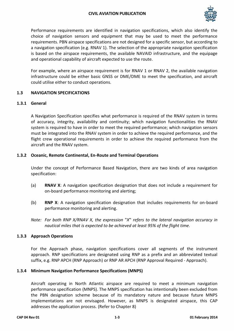
Area Navigation (RNAV) is a method of navigation which permits aircraft operation on any desired flight path within the coverage of station-referenced navigation aids or within the limits of the capability of self-contained aids, or a combination of these.
Conventional Navigation RNAV Navigation
RNAV systems have evolved in a manner similar to conventional ground-based routes and procedures. Airspace and obstacle clearance criteria were developed based on the performance of available equipment; and specifications for requirements were based on available capabilities. To avoid such prescriptive specifications of requirements, an alternative method for defining equipage requirements by specifying the performance requirements has been developed by ICAO. This method is called Performance Based Navigation (PBN).
1.2.2 Performance Based Navigation (PBN)
Performance-Based navigation (PBN) defines performance requirements for aircraft navigating on an ATS route, terminal procedure or in a designated airspace. It is ICAO’s effort and objective to redefine the regional differences of various Area Navigation (RNAV) and Required Navigation Performance (RNP) specifications into a globally harmonized set of PBN applications. The PBN concept specifies that RNAV system performance requirements be defined in terms of the accuracy, integrity, availability, continuity and functionality which are needed for the proposed operations in the context of a particular airspace concept.
CIVIL AVIATION PUBLICATION
CAP 04 Rev 01 01 February 2014 1-3
Performance requirements are identified in navigation specifications, which also identify the choice of navigation sensors and equipment that may be used to meet the performance requirements. PBN airspace specifications are not designed for a specific sensor, but according to a navigation specification (e.g. RNAV 1). The selection of the appropriate navigation specification is based on the airspace requirements, the available NAVAID infrastructure, and the equipage and operational capability of aircraft expected to use the route. For example, where an airspace requirement is for RNAV 1 or RNAV 2, the available navigation infrastructure could be either basic GNSS or DME/DME to meet the specification, and aircraft could utilise either to conduct operations.
1.3 NAVIGATION SPECIFICATIONS
1.3.1 General
A Navigation Specification specifies what performance is required of the RNAV system in terms of accuracy, integrity, availability and continuity; which navigation functionalities the RNAV system is required to have in order to meet the required performance; which navigation sensors must be integrated into the RNAV system in order to achieve the required performance, and the flight crew operational requirements in order to achieve the required performance from the aircraft and the RNAV system.
1.3.2 Oceanic, Remote Continental, En-Route and Terminal Operations
Under the concept of Performance Based Navigation, there are two kinds of area navigation specification:
(a) RNAV X: A navigation specification designation that does not include a requirement for
on-board performance monitoring and alerting;
(b) RNP X: A navigation specification designation that includes requirements for on-board performance monitoring and alerting.
Note: For both RNP X/RNAV X, the expression ‟X‟ refers to the lateral navigation accuracy in
nautical miles that is expected to be achieved at least 95% of the flight time.
1.3.3 Approach Operations
For the Approach phase, navigation specifications cover all segments of the instrument approach. RNP specifications are designated using RNP as a prefix and an abbreviated textual suffix, e.g. RNP APCH (RNP Approach) or RNP AR APCH (RNP Approval Required - Approach).
1.3.4 Minimum Navigation Performance Specifications (MNPS)
Aircraft operating in North Atlantic airspace are required to meet a minimum navigation performance specification (MNPS). The MNPS specification has intentionally been excluded from the PBN designation scheme because of its mandatory nature and because future MNPS implementations are not envisaged. However, as MNPS is designated airspace, this CAP addresses the application process. (Refer to Chapter 8)
CIVIL AVIATION PUBLICATION
CAP 04 Rev 01 01 February 2014 1-4
1.3.5 Understanding RNAV Designations
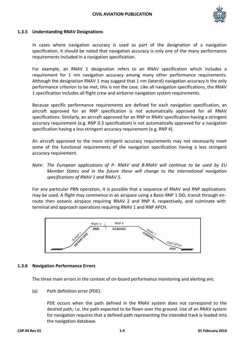
In cases where navigation accuracy is used as part of the designation of a navigation specification, it should be noted that navigation accuracy is only one of the many performance requirements included in a navigation specification. For example, an RNAV 1 designation refers to an RNAV specification which includes a requirement for 1 nm navigation accuracy among many other performance requirements. Although the designation RNAV 1 may suggest that 1 nm (lateral) navigation accuracy is the only performance criterion to be met, this is not the case. Like all navigation specifications, the RNAV 1 specification includes all flight crew and airborne navigation system requirements.
Because specific performance requirements are defined for each navigation specification, an aircraft approved for an RNP specification is not automatically approved for all RNAV specifications. Similarly, an aircraft approved for an RNP or RNAV specification having a stringent accuracy requirement (e.g. RNP 0.3 specification) is not automatically approved for a navigation specification having a less stringent accuracy requirement (e.g. RNP 4). An aircraft approved to the more stringent accuracy requirements may not necessarily meet some of the functional requirements of the navigation specification having a less stringent accuracy requirement.
Note: The European applications of P- RNAV and B-RNAV will continue to be used by EU
Member States and in the future these will change to the international navigation specifications of RNAV 1 and RNAV 5.
For any particular PBN operation, it is possible that a sequence of RNAV and RNP applications may be used. A flight may commence in an airspace using a Basic-RNP 1 SID, transit through en-route then oceanic airspace requiring RNAV 2 and RNP 4, respectively, and culminate with terminal and approach operations requiring RNAV 1 and RNP APCH.
1.3.6 Navigation Performance Errors
The three main errors in the context of on-board performance monitoring and alerting are;
(a) Path definition error (PDE).
PDE occurs when the path defined in the RNAV system does not correspond to the desired path; i.e. the path expected to be flown over the ground. Use of an RNAV system for navigation requires that a defined path representing the intended track is loaded into the navigation database.
CIVIL AVIATION PUBLICATION
CAP 04 Rev 01 01 February 2014 1-5
A consistent, repeatable path cannot be defined for a turn that allows for a fly-by turn at a waypoint, requires a fly-over of a waypoint, or occurs when the aircraft reaches a target altitude. In these cases, the navigation database contains a point-to-point desired flight path, but cannot account for the RNAV system defining a fly-by or fly-over path and performing a manoeuvre. In practice, PDE is negligible.
(b) Flight technical error (FTE).
FTE relates to the flight crew or autopilot’s ability to follow the defined path or track, including any display system error. FTE can be monitored by the autopilot or flight crew procedures and the extent to which these procedures need to be supported by other means depends, for example, on the phase of flight and the type of operations. Such monitoring support could be provided by a map display.
(c) Navigation system error (NSE).
NSE refers to the difference between the aircraft’s estimated and actual position.
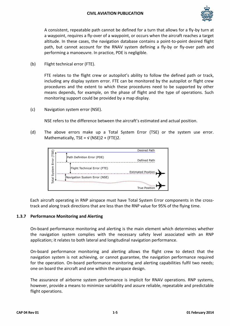
(d) The above errors make up a Total System Error (TSE) or the system use error.
Mathematically, TSE = √ (NSE)2 + (FTE)2.
Each aircraft operating in RNP airspace must have Total System Error components in the cross- track and along track directions that are less than the RNP value for 95% of the flying time.
1.3.7 Performance Monitoring and Alerting
On-board performance monitoring and alerting is the main element which determines whether the navigation system complies with the necessary safety level associated with an RNP application; it relates to both lateral and longitudinal navigation performance.
On-board performance monitoring and alerting allows the flight crew to detect that the navigation system is not achieving, or cannot guarantee, the navigation performance required for the operation. On-board performance monitoring and alerting capabilities fulfil two needs; one on board the aircraft and one within the airspace design. The assurance of airborne system performance is implicit for RNAV operations. RNP systems, however, provide a means to minimize variability and assure reliable, repeatable and predictable flight operations.
CIVIL AVIATION PUBLICATION
CAP 04 Rev 01 01 February 2014 1-6
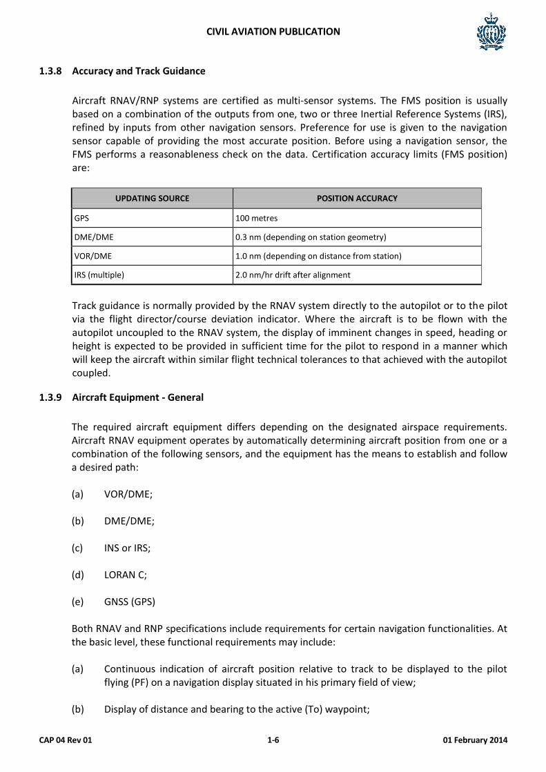
1.3.8 Accuracy and Track Guidance
Aircraft RNAV/RNP systems are certified as multi-sensor systems. The FMS position is usually based on a combination of the outputs from one, two or three Inertial Reference Systems (IRS), refined by inputs from other navigation sensors. Preference for use is given to the navigation sensor capable of providing the most accurate position. Before using a navigation sensor, the FMS performs a reasonableness check on the data. Certification accuracy limits (FMS position) are:
UPDATING SOURCE POSITION ACCURACY
GPS 100 metres
DME/DME 0.3 nm (depending on station geometry)
VOR/DME 1.0 nm (depending on distance from station)
IRS (multiple) 2.0 nm/hr drift after alignment
Track guidance is normally provided by the RNAV system directly to the autopilot or to the pilot via the flight director/course deviation indicator. Where the aircraft is to be flown with the autopilot uncoupled to the RNAV system, the display of imminent changes in speed, heading or height is expected to be provided in sufficient time for the pilot to respond in a manner which will keep the aircraft within similar flight technical tolerances to that achieved with the autopilot coupled.
1.3.9 Aircraft Equipment - General
The required aircraft equipment differs depending on the designated airspace requirements. Aircraft RNAV equipment operates by automatically determining aircraft position from one or a combination of the following sensors, and the equipment has the means to establish and follow a desired path:
(a) VOR/DME; (b) DME/DME; (c) INS or IRS; (d) LORAN C; (e) GNSS (GPS)
Both RNAV and RNP specifications include requirements for certain navigation functionalities. At the basic level, these functional requirements may include:
(a) Continuous indication of aircraft position relative to track to be displayed to the pilot
flying (PF) on a navigation display situated in his primary field of view;
(b) Display of distance and bearing to the active (To) waypoint;
CIVIL AVIATION PUBLICATION
CAP 04 Rev 01 01 February 2014 1-7
(c) Display of ground speed or time to the active (To) waypoint; (d) Navigation data storage function;
(e) Appropriate failure indication of the RNAV system, including the sensors. More
sophisticated navigation specifications include the requirement for navigation databases and the capability to execute database procedures.
1.3.10 Navigation Database
The RNAV system is expected to access a navigation database, if available. The navigation database contains pre-stored information on NAVAID locations, waypoints, ATS routes and terminal procedures and related information. The RNAV system will use such information and may also conduct cross-checks between sensor information and the database. Any navigation database which supports an airborne navigation application as a primary means of navigation must be provided by a database supplier who holds a Type 2 Letter of Acceptance (LoA) or equivalent. If the supplier does not hold a Type 2 LoA or equivalent, the navigation database must meet equivalent standards of integrity as approved by the San Marino CAA. Procedures must be in place that ensures the timely distribution and insertion of current and unaltered electronic navigation data to all aircraft that require it, so that only current and up to date data is used. Operators should assure that appropriate digital communications software updates are incorporated when necessary and that both air and ground systems are able to identify and properly respond to the installed level of digital communication capability. There must be a documented mechanism for software update procedures. Note: Navigation databases are expected to be current for the duration of the flight. If the
AIRAC cycle is due to change during flight, the electronic data must be verified against paper products that are current for the required time frame.
1.4 GLOBAL NAVIGATION SATELLITE SYSTEM (GNSS)
1.4.1 General
Global Navigation Satellite Systems (GNSS) is the standard generic term for satellite navigation systems that provide autonomous geo-spatial positioning with global coverage. This system translates into extreme accuracy and reliability. GNSS allows small electronic receivers to determine their location (longitude, latitude and altitude) to within a few metres using time signals transmitted along a line-of-sight by radio from satellites. Receivers calculate the precise time as well as position.
The United States NAVSTAR Global Positioning System (GPS), Russian GLONASS and the European Union’s Galileo positioning system are GNSS. GNSS navigation services (i.e. position and time data) may be obtained using various combinations of the following elements installed on the ground, on satellites and/or on board aircraft:
CIVIL AVIATION PUBLICATION
CAP 04 Rev 01 01 February 2014 1-8
The position information provided by GNSS is expressed in terms of the World Geodetic System – 1984 (WGS-84), which utilises a standard geodetic reference datum. The time data provided by the GNSS to the user is expressed in a time scale that takes Universal Time Co-ordinated (UTC) as its reference.
1.4.2 Receiver Autonomous Integrity Monitoring (RAIM)
Receiver Autonomous Integrity Monitoring (RAIM) is a technique whereby the on-board GNSS receiver / processor determines the integrity of the GNSS navigation signals using only GNSS or GNSS signals augmented with barometric altitude. This determination is achieved by a consistency check among redundant measurements (pseudo-ranges). At least one satellite in addition to those required for navigation must be in view for the receiver to perform RAIM. Four satellites are required for navigation.
It is a requirement of RNP APCH and RNP AR APCH final approach operations, and for information regarding likely performance for other GNSS-based RNAV operations that, prior to dispatch, a prediction of the number of satellites available within the constellation must be carried out. This is to ensure availability of navigational and integrity monitoring capability during the planned approach period. Predicted periods when fewer than five satellites will be visible are termed “RAIM Holes”. A web site called www.augur.ecacnav.com is available for this pre-flight planning function. Whilst it has primarily European region coverage, other destinations may be added on request.
Note: RAIM predictions are included in briefing material as GNSS NOTAMs.
1.5 RNAV ROUTE STRUCTURES
1.5.1 General
Traditional airways and other routes were defined by tracks between geographic positions defined by radio navigation beacons. In RNAV operations, the aircraft flies between geodetic waypoints or fixes that may, or may not, be co-located with radio navigation beacons but which are not defined by them.
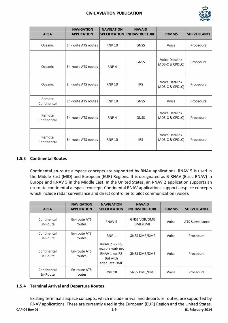
1.5.2 Oceanic and Remote Continental Routes
Oceanic and remote continental airspace concepts are served by two navigation applications, RNAV 10 and RNP 4. Both these navigation applications rely primarily on GNSS to support the navigation element of the airspace concept. In the case of the RNAV 10 application, no form of ATS surveillance service is required. In the case of the RNP 4 application, ADS contract (ADS-C) is used.
CIVIL AVIATION PUBLICATION
CAP 04 Rev 01 01 February 2014 1-9
AREA
NAVIGATION APPLICATION
NAVIGATION SPECIFICATION
NAVAID INFRASTRUCTURE
COMMS
SURVEILLANCE
Oceanic En-route ATS routes RNP 10 GNSS Voice Procedural
Oceanic
En-route ATS routes
RNP 4 GNSS
Voice Datalink (ADS-C & CPDLC)
Procedural
Oceanic En-route ATS routes RNP 10 IRS Voice Datalink
(ADS-C & CPDLC) Procedural
Remote Continental
En-route ATS routes RNP 10 GNSS Voice Procedural
Remote Continental
En-route ATS routes RNP 4 GNSS Voice Datalink
(ADS-C & CPDLC)
Procedural
Remote Continental
En-route ATS routes RNP 10 IRS Voice Datalink
(ADS-C & CPDLC)
Procedural
1.5.3 Continental Routes
Continental en-route airspace concepts are supported by RNAV applications. RNAV 5 is used in the Middle East (MID) and European (EUR) Regions. It is designated as B-RNAV (Basic RNAV) in Europe and RNAV 5 in the Middle East. In the United States, an RNAV 2 application supports an en-route continental airspace concept. Continental RNAV applications support airspace concepts which include radar surveillance and direct controller to pilot communication (voice).
AREA NAVIGATION APPLICATION
NAVIGATION SPECIFICATION
NAVAID INFRASTRUCTURE
COMMS
SURVEILLANCE
Continental En-Route
En-route ATS routes
RNAV 5 GNSS VOR/DME
DME/DME Voice ATS Surveillance
Continental En-Route
En-route ATS routes
RNP 1 GNSS DME/DME Voice Procedural
Continental En-Route
En-route ATS routes
RNAV 2 no IRS RNAV 1 with IRS RNAV 1 no IRS
But with adequate DME
GNSS DME/DME Voice Procedural
Continental En-Route
En-route ATS routes
RNP 10 GNSS DME/DME Voice Procedural
1.5.4 Terminal Arrival and Departure Routes
Existing terminal airspace concepts, which include arrival and departure routes, are supported by RNAV applications. These are currently used in the European (EUR) Region and the United States.

CIVIL AVIATION PUBLICATION
CAP 04 Rev 01 01 February 2014 1-10
The European terminal airspace RNAV application is known as Precision RNAV (P-RNAV). Although the P-RNAV specification shares a common navigation accuracy with RNAV 1, this regional navigation specification does not satisfy the full requirements of the ICAO RNAV 1 specification. The United States terminal airspace application formerly known as US RNAV Type B has been aligned with the PBN concept and is now called RNAV 1. Basic-RNP 1 has been developed primarily for application in non-radar, low-density terminal airspace.
AREA NAVIGATION APPLICATION
NAVIGATION SPECIFICATION
NAVAID INFRASTRUCTURE
COMMS
SURVEILLANCE
Terminal SIDs, STARs Transitions
RNAV 2 without IRS RNAV 1 with IRS
RNAV 1 without IRS but with adequate
DME
GNSS DME/DME Voice ATS Surveillance
Terminal SIDs, STARs Transitions
Basic - RNP 1 GNSS Voice Procedural
Terminal SIDs, STARs Transitions
Basic - RNP 1 RNAV 1 with
GPS only GNSS DME/DME Voice ATS Surveillance
1.5.5 Approach
Approach concepts cover all segments of an instrument approach, i.e. initial, intermediate, final and missed approach. They call for RNP specifications requiring a navigation accuracy of 0.3 nm to 0.1 nm or lower. Typically, there are three sorts of RNP applications:
(a) New procedures to runways never served by an instrument procedure; (b) Procedures either replacing or serving as backup to existing instrument procedures based
on different technologies; (c) Procedures developed to enhance aerodrome access in demanding environments.
The relevant RNP specifications are RNP APCH and RNP AR APCH.
AREA NAVIGATION APPLICATION
NAVIGATION SPECIFICATION
NAVAID INFRASTRUCTURE
COMMS
SURVEILLANCE
Approach Approach RNP APCH GNSS Voice ATS Surveillance
Approach Approach RNP APCH GNSS Voice Procedural
Approach Approach RNP AR APCH GNSS Voice Procedural
Approach Approach RNP AR APCH GNSS Voice ATS Surveillance
CIVIL AVIATION PUBLICATION
CAP 04 Rev 01 01 February 2014 1-11
1.6 CONTINUING SURVEILLANCE 1.6.1 Operator Responsibility
As part of their Safety Management System, all operators should conduct their own continuing surveillance on the following areas,
(a) Checking the Occurrence Reports for abnormalities. (b) Checking Voyage Reports for RNP anomalies. (c) Continuation training evaluation.
(d) Cross-checking to ensure that operations are in accordance with the appropriate ICAO
Regional Supplementary Procedures and/or Aeronautical Information Publication for that airspace.
1.6.2 Reporting Action
Unsafe conditions or performance related to RNP or RVSM operations such as a navigation error or altimetry events, which potentially could affect continued safe operations, must be reported to the ATS of the FIR controlling State within 24 hours. It is incumbent upon each operator to take immediate action to rectify the conditions that cause an operational error. In addition to reporting events to the ATS above, the operator should also report the event to the CAA within 72 hours, by submission of a CAA Occurrence Report with initial analysis of causal factors and measures taken to prevent further events.
The operator shall advise the CAA of any rectification work or modifications, which may affect PBN or RVSM capability.

CIVIL AVIATION PUBLICATION
CAP 04 Rev 01 01 February 2014 1-12
This Page Intentionally Left Blank
CIVIL AVIATION PUBLICATION
CAP 04 Rev 01 01 February 2014 2-1
CHAPTER 2
RNAV/RNP 10 AIRSPACE
2.1 GENERAL
RNAV/RNP 10 is an oceanic or remote area specification requiring the aircraft to maintain a track- keeping accuracy of +/- 10 nm without regular updates from ground-based navigation aids. RNP 10 approval can be based on IRS performance alone (with a time limit of up to 6.2 hours), and there is no requirement for an RNP alerting function in the FMS.
The existing RNP 10 designation is, therefore, inconsistent with PBN RNP and RNAV specifications. Since RNP 10 does not include requirements for on-board performance monitoring and alerting, technically, RNP 10 is an RNAV navigation specification. However, renaming current RNP 10 routes, operational approvals, etc. to an RNAV 10 designation would be an extensive and expensive task, which is not cost-effective. Consequently, any existing or new operational approvals will continue to be designated RNP 10, and any charting annotations will be depicted as RNP 10. The use of RNP 10 or RNAV 10 or RNAV/RNP 10 is acceptable.
RNP 10 airspace supports 50 nm lateral and longitudinal distance-based separation minima, and examples of RNP 10 airspace exist over the NAT (MNPS) Indian Ocean and in the AFI, SAM and PAC regions.
2.2 AIRCRAFT EQUIPMENT REQUIREMENTS
RNP 10 requires that aircraft operating in oceanic and remote areas are equipped with at least two independent and serviceable LRNSs comprising an INS, an IRS FMS or a GNSS, with integrity such that the navigation system does not provide an unacceptable probability of misleading information.
2.3 OPERATIONAL PROCEDURES
2.3.1 Before Flight Phase
In the before flight phase, the flight crew should:
(a) Identify which portions of the flight are to be conducted in RNP 10 airspace and verify the
entry and exit points;
(b) Ensure that the letter “R” is annotated in item 10 of the ATC Flight Plan. Additional information should be displayed in the Remarks section indicating the accuracy capability, such as RNP 4 versus RNP 10;
(c) For IRS-only operations, ensure that the RNP 10 time limit has been accounted for
(normally 6.2 hours);
(d) Check the Technical Log to ensure that there is no defect in navigational equipment that would preclude RNP 10 operations;
CIVIL AVIATION PUBLICATION
CAP 04 Rev 01 01 February 2014 2-2
Note: The MEL would normally identify those alleviations that are not suitable for RNAV/RNP 10 operations.
(e) Check and brief the contingency procedures for the area in which RNP 10 operations are
to be conducted.
2.3.2 En-Route Phase
During en-route operations, and before entering RNAV/RNP 10 airspace, flight crew should:
(a) Verify that the aircraft technical status allows RNAV/RNP 10 operations; (b) Find an alternative non-RNAV/RNP 10 route or divert if the equipment requirements
cannot be met; (c) After entering RNAV/RNP 10 airspace, flight crew should:
(1) cross-check to identify navigation errors in sufficient time to prevent the aircraft from an inadvertent deviation from ATC cleared routes;
(2) advise ATC of any deterioration or failure of the navigation equipment below the
navigation performance requirements, or of any deviations required for a contingency procedure.
(d) For aircraft with automatic offset programming capability only, determine if the use of
the Strategic Lateral Offset Procedure may be employed at the discretion of the flight crew. This procedure may be used for both wake vortex encounters and to mitigate the heightened risk of collision when non-normal events such as operational altitude deviation errors and turbulence-induced altitude deviations occur.
2.3.3 Contingency Procedures
In oceanic and remote areas, continuous direct controller-pilot communication may not always be possible, so a range of contingencies have been considered which allow independent action by flight crews. These procedures provide for the more frequent cases such as:
(a) Inability to maintain assigned flight level due to meteorological conditions, aircraft
performance or pressurization failure; (b) En-route diversion across the prevailing traffic flow; (c) Loss of, or significant reduction in, the required navigation capability when operating in
airspace where the navigation performance accuracy is a prerequisite to the safe conduct of flight operations.
In general, they permit crews, in exceptional circumstances, to deviate from assigned clearances by selecting flight levels and/or tracks where other aircraft are least likely to be encountered.
CIVIL AVIATION PUBLICATION
CAP 04 Rev 01 01 February 2014 2-3
During such deviations, crews are required to make maximum use of the aircraft lighting and to transmit relevant information on all appropriate frequencies, including the distress and emergency frequency.
Once contact with ATC has been re-established, the crew will be assisted and issued with new clearances as required. Offset track procedures are permitted if an encounter with turbulence is considered to be due to a wake vortex encounter.
Note: Details of specific contingency procedures for each area or route can be found in the
Route Guide (e.g. Jeppesen Manual).
2.4 TRAINING REQUIREMENTS
2.4.1 Basic RNAV Concept Training
Basic RNAV Concept Training must be conducted prior to RNP 10 airspace training. Basic RNAV Concept Training will include the following topics:
(a) Theory of RNAV including differences between RNAV and RNP operations; (b) The meaning of RNP / ANP; (c) Limitations of RNAV; (d) GPS concepts and limitations (if applicable); (e) Charting, database and avionics issues including:
(1) Waypoint naming and depiction concepts; (2) Fly-by and Fly-over waypoints.
(f) Use of RNAV equipment including, where appropriate:
(1) Verification and sensor management; (2) Tactically modifying the flight plan; (3) Addressing discontinuities; (4) Entering associated data such as:
(i) Wind; (ii) Altitude/Speed constraints; (iii) Vertical profile/Vertical speed.
(g) R/T phraseology for RNAV;
CIVIL AVIATION PUBLICATION
CAP 04 Rev 01 01 February 2014 2-4
(h) The implications for RNAV operations of systems malfunctions which are not RNAV- related (e.g. hydraulic failure or engine failure).
2.4.2 Additional RNP 10 Training
Additional training for RNP 10 operations must include the following topics:
(a) Basic RNAV Concept training; (b) Airspace where RNP 10 compliance is required; (c) Flight planning requirements; (d) Pre-flight procedures; (e) En-route procedures; (f) Contingency procedures.
There are no requirements for STD training or checking in relation to RNP 10 but these operations should be introduced into training scenarios (where suitable). Recency for RNP 10 operations is satisfied by normal licensing recency requirements.
2.5 APPLICATION FOR RNP 10
2.5.1 Process
All operators must submit evidence of navigation performance capability with their application. The application (refer Form SM 04 or Form SM 04A) must address all of the sections on equipment, operational requirements, including documentation and training. General Aviation operators shall sign the “Declaration of Compliance” indicating all equipment, operational requirements, documentation and training meet the requirements for RNP 10 approval. Commercial Air Transport operators shall submit documentary evidence of the required information in the application form.
2.5.2 Airworthiness Issues
The components of a RNP 10 capable aircraft are usually installed at manufacture of a new generation aircraft and the manufacturer includes statements as to navigation performance capability in the Aircraft Flight Manual, an AFM Supplement or STC. Where an aircraft has been modified for RNP capability, the Commercial Air Transport operator must provide the CAA with all the aircraft navigation details for each aircraft registration and include the applicable software versions. Unless the approved MEL already addresses the required navigation equipment, an amendment to the MEL should be submitted to the CAA for approval.
CIVIL AVIATION PUBLICATION
CAP 04 Rev 01 01 February 2014 2-5
It is up to the operator to determine that the maintenance organisation used is capable of providing maintenance support of navigation equipment and software. That support must be provided by trained maintenance personnel capable of implementing digital communications related maintenance programmes. The support includes, but is not limited to; (a) addressing installation,
(b) modification,
(c) correction of reported system discrepancies,
(d) use of test equipment,
(e) procedures,
(f) MEL relief, and
(g) return to service authorisations.
2.5.3 Equipment
As RNP 10 is an oceanic or remote area specification, acceptable aircraft navigation equipment must be; (a) Two fully serviceable Long Range Navigation Systems (LRNs), which consist of either;
(1) Two Inertial Navigation Systems, or (2) Two Flight Management Systems (FMS) with two Inertial Reference Systems (IRS),
or (3) Two approved Global Positioning Systems (GPS), or (4) One INS and one FMS/IRS, or (5) One INS and one approved GPS, or (6) One FMS/IRS and one approved GPS.
(b) Capable of providing a continuous indication to the flight crew of the aircraft position
relative to track, and
(c) Should be coupled to the automatic pilot.
2.5.4 Operational Requirements
To be eligible for a RNP 10 approval from the CAA, the following operational issues need to be addressed and documented by the operator.
CIVIL AVIATION PUBLICATION
CAP 04 Rev 01 01 February 2014 2-6
Commercial Air Transport operators must submit the supporting documentation whilst General Aviation operators need not submit this supporting documentation but must have them available upon request:
(a) Operating procedures (SOPs including Contingency Procedures); (b) FCOM & Quick Reference Handbook changes (if applicable); (c) Training programmes;
(d) Provision of flight planning information for designated area (e.g. NOTAMs, AIP etc.); and (e) Data base and software integrity.
2.5.5 Approval
The RNAV/RNP 10 approval will be issued on a Designated Airspace Approval Certificate for General Aviation operators, a copy of which must be carried in the aircraft for all flights expected to be conducted in that airspace. The RNAV/RNP 10 approval will be granted by inclusion in the Operations Specifications of the AOC holder.
CIVIL AVIATION PUBLICATION
CAP 04 Rev 01 01 February 2014 3-1
CHAPTER 3
RNAV 5 (B-RNAV) AIRSPACE
3.1 GENERAL
B-RNAV is an en-route navigation specification that is mandated above FL 95 throughout Europe and the Middle East (where it may be called RNAV 5). For operations in RNAV 5/B-RNAV airspace, aircraft require a track-keeping accuracy of +/-5 nm for 95% of the flight time. RNAV 5/B-RNAV does not require a navigation database, it only requires the flight management system to store four waypoints, and it does not require waypoint fly-by functionality. RNAV 5/B-RNAV track keeping is based on the air navigation service provides assessment of the available navigation aids against the minimum equipment standard and area navigation equipment updating from ground-based navigation aids is assumed. There is no requirement for an RNP alerting function, and crew navigation accuracy crosschecks over and above normal SOPs are not required.
3.2 AIRCRAFT EQUIPMENT REQUIREMENTS
RNAV 5/B-RNAV operations are based on the use of RNAV equipment which automatically determines the aircraft position using input from one or a combination of the following types of position sensors, together with the means to establish and follow a desired path:
(a) VOR/DME; (b) DME/DME; (c) INS or IRS; (d) GNSS.
Navigation data must be available for display either on a display forming part of the RNAV equipment or on a lateral deviation display (e.g. CDI, (E)HSI, or a navigation map display). These must be used as primary flight instruments for the navigation of the aircraft, for manoeuvre anticipation and for failure / status / integrity indication. They should meet the following requirements:
(a) The displays must be visible to the pilot when looking forward along the flight path; (b) The lateral deviation display scaling should be compatible with any alerting and
annunciation limits, where implemented; (c) The lateral deviation display must have a scaling and full-scale deflection suitable for the
RNAV 5 operation;
CIVIL AVIATION PUBLICATION
CAP 04 Rev 01 01 February 2014 3-2
(d) The navigation database must be current and appropriate for the region of intended operation and must include the navigation aids and waypoints required for the route.
3.3 OPERATIONAL PROCEDURES
3.3.1 Before Flight Phase
In the before flight phase, flight crew should:
(a) Ensure that the letter “R” is annotated in item 10 of the ATC Flight Plan; (b) If stand-alone GNSS equipment is used to satisfy the RNAV requirement, the availability of
RAIM should be checked against the latest GPS NOTAMs;
(c) Check the Technical Log to ensure that there is no defect to navigational equipment that would preclude RNAV 5 (B-RNAV) operations;
Note: The MEL identifies those alleviations that are not suitable for RNAV 5 (B-RNAV)
operations. (d) Confirm that the navigation database is current; (e) Crosscheck the cleared flight plan by comparing charts or other applicable resources with
the FMS and the aircraft map display. If required, the exclusion of specific navigation aids should be confirmed.
3.3.2 En-Route Phase
During en-route RNAV 5/B-RNAV operations, flight crew should:
(a) Monitor flight progress for navigational reasonableness by cross-checks with conventional
navigation aids using the primary displays in conjunction with the FMS; (b) While operating on RNAV segments, flight crew should use the flight director and/or
autopilot in lateral navigation mode (LNAV).
If ATC issues a heading assignment taking the aircraft off a route / procedure, flight crew should not modify the flight plan in the RNAV system until a clearance is received to rejoin the procedure or the controller confirms a new route clearance. When the aircraft is not on the published procedure, the specified accuracy requirement does not apply.
3.3.3 Contingency Procedures
ATC must be advised if the RNAV performance ceases to meet the requirements for RNAV 5/B-RNAV together with the proposed course of action (e.g. reversion to non-RNAV procedures or a request for radar headings). In the event of communications failure, the flight crew should continue with the flight plan in accordance with the published communications failure procedure.
CIVIL AVIATION PUBLICATION
CAP 04 Rev 01 01 February 2014 3-3
Where stand-alone GNSS equipment is used, in the event of a loss of the RAIM detection function, the GNSS position may continue to be used for navigation. The flight crew should attempt to cross-check the aircraft’s position using other sources of position information (e.g. VOR, DME and NDB).
Note: Details of specific contingency procedures for each area or route can be found in the
Route Guide (e.g. Jeppesen Manual).
3.4 TRAINING REQUIREMENTS
Training for RNAV 5/B-RNAV operations must include the following topics:
(a) Basic RNAV Concept training (refer to Section 2.4.1);
(b) Airspace where RNAV 5/B-RNAV compliance is required; (c) Changes to charting and documents to reflect RNAV 5/B-RNAV;
(d) Navigational equipment required to be operational for flight in designated RNAV 5/B-
RNAV airspace, and the limitations associated with such RNAV equipment;
(e) Use of lateral navigation mode and associated lateral control techniques;
(f) Flight planning requirements;
(g) Contingency procedures.
There are no requirements for STD training or checking in relation to RNAV 5/B-RNAV operations, but these operations should be introduced into training scenarios (where suitable). Recency for RNAV 5/B-RNAV operations is satisfied by normal licensing recency requirements.
3.5 APPLICATION FOR RNAV 5/B-RNAV
3.5.1 Process
All operators must submit evidence of navigation performance capability with their application. The application (refer Form SM 04 or Form SM 04A, as applicable) must address all of the sections on equipment, operational requirements, including documentation and training. General Aviation operators shall sign the “Declaration of Compliance” indicating all equipment, operational requirements, documentation and training meet the requirements for RNAV 5/B-RNAV approval. Commercial Air Transport operators shall submit documentary evidence of the required information in the application form.
3.5.2 Airworthiness Issues
The components of a RNAV5/B-RNAV capable aircraft are usually installed at manufacture of a new generation aircraft and the manufacturer includes statements as to navigation performance
CIVIL AVIATION PUBLICATION
CAP 04 Rev 01 01 February 2014 3-4
capability in the Aircraft Flight Manual, an AFM Supplement or STC. Where an aircraft has been modified for RNP capability, the Commercial Air Transport operator must provide the CAA with all the aircraft navigation details for each aircraft registration and include the applicable software versions. Unless the approved MEL already addresses the required navigation equipment, an amendment to the MEL should be submitted to the CAA for approval. It is up to the operator to determine that the maintenance organisation used is capable of providing maintenance support of navigation equipment and software. That support must be provided by trained maintenance personnel capable of implementing digital communications related maintenance programmes. The support includes, but is not limited to; (a) addressing installation,
(b) modification,
(c) correction of reported system discrepancies,
(d) use of test equipment,
(e) procedures,
(f) MEL relief, and
(g) return to service authorisations.
3.5.3 Equipment
One or a combination of the following types of position sensors, together with the means to establish and follow a desired path: (a) VOR/DME; (b) DME/DME; (c) INS or IRS; (d) GNSS.
Navigation data must be available for display either on a display forming part of the RNAV equipment or on a lateral deviation display (e.g. CDI, (E)HSI, or a navigation map display).
3.5.4 Operational Requirements
To be eligible for a RNAV 5 (B-RNAV) approval from the CAA, the following operational issues need to be addressed by the operator. General Aviation operators need not submit this supporting documentation but must have them available upon request:
CIVIL AVIATION PUBLICATION
CAP 04 Rev 01 01 February 2014 3-5
(a) Operating procedures (SOPs including Contingency Procedures);
(b) FCOM & Quick Reference Handbook changes (if applicable); (c) Training programmes; (d) Provision of flight planning information for designated area (e.g. NOTAMs, AIP etc.); (e) Data base and software integrity.
3.5.5 Approval
The RNAV 5/B-RNAV approval will be issued on a Designated Airspace Approval Certificate for General Aviation operators, a copy of which must be carried in the aircraft for all flights expected to be conducted in that airspace. The RNAV 5/B-RNAV approval will be granted by inclusion in the Operations Specifications of the AOC holder.

CIVIL AVIATION PUBLICATION
CAP 04 Rev 01 01 February 2014 3-6
This Page Intentionally Left Blank
CIVIL AVIATION PUBLICATION
CAP 04 Rev 01 01 February 2014 4-1
CHAPTER 4
RNP 4 AIRSPACE
4.1 GENERAL
RNP 4 is an oceanic or remote area specification requiring the aircraft to maintain a track- keeping accuracy of ± 4 nm for at least 95% of the total flight time. The along-track error must also be within ± 4 nm for at least 95% of the total flight time. GNSS is the primary navigation sensor to support RNP 4, either as a stand-alone navigation system or as part of a multi-sensor system. Within RNP 4 airspace, all routes are based upon WGS-84 co-ordinates.
RNP 4 airspace supports 30 nm lateral and longitudinal distance-based separation minima, and examples of RNP 4 airspace exist in the PAC region.
4.2 AIRCRAFT EQUIPMENT REQUIREMENTS
4.2.1 Navigation Equipment
For RNP 4 operations in oceanic or remote airspace, at least two fully serviceable independent long-range navigation systems (LRNSs), with integrity such that the navigation system does not provide misleading information, must be fitted to the aircraft and form part of the basis upon which RNP 4 operational approval is granted. GNSS must be used, and can be used as either a stand-alone navigation system or as one of the sensors in a multi-sensor system.
The on-board navigation system must have the following functionalities:
(a) Display of navigation data; (b) Track to fix (TF); (c) Direct to fix (DF); (d) “Direct To” function; (e) Course to fix (CF); (f) Parallel offset; (g) Fly-by transition criteria; (h) User interface displays; (i) Flight planning path selection; (j) Flight planning fix sequencing;
(k) User-defined course to fix; (l) Path steering;
CIVIL AVIATION PUBLICATION
CAP 04 Rev 01 01 February 2014 4-2
(m) Alerting capability; (n) Navigation database access; (o) WGS-84 geodetic reference system; (p) Automatic radio position updating.
The system must have the capability to fly parallel tracks at a selected offset distance. When executing a parallel offset, the navigation accuracy and all performance requirements of the original route in the active flight plan must be applicable to the offset route. The system must provide for entry of offset distances in increments of 1 nm, left or right of course, and the system must be capable of offsets of at least 20 nm. The on-board navigation data must be current and include appropriate procedures.
4.2.2 Additional Communications Equipment
In RNP 4 airspace, controller-pilot data link communications (CPDLC) and automatic dependent surveillance (contract) (ADS-C) systems are also required when the separation standard is 30 nm lateral and/or longitudinal.
Note: Use of CPDLC procedures requires a separate operational approval from the CAA.
4.3 OPERATIONAL PROCEDURES
4.3.1 Before Flight Phase
In the before flight phase, flight crew should:
(a) Identify which portions of the flight are to be conducted in RNP 4 airspace and verify the
entry and exit points; (b) Ensure that the letter “R” is annotated in item 10 of the ATC Flight Plan. Additional
information should be displayed in the Remarks section indicating the accuracy capability, such as RNP 4 versus RNP 10;
(c) Ensure that adequate navigation capability is available en-route to enable the aircraft to
navigate to RNP 4; (d) Check the Technical Log to ensure that there is no defect in navigational equipment that
would preclude RNP 4 operations;
Note: The MEL identifies those alleviations that are not suitable for RNP 4 operations. (e) Confirm that the navigation database is current and remain so for the duration of the
flight; (f) Check and brief the contingency procedures for the area in which RNP 4 operations are to
be conducted.
CIVIL AVIATION PUBLICATION
CAP 04 Rev 01 01 February 2014 4-3
4.3.2 En-Route Phase
During en-route operations, and before entering RNP 4 airspace, flight crew should: (a) Verify that the aircraft technical status allows RNP 4 operations; (b) Conduct a CPDLC and ADS-C log on to the appropriate authority; (c) After entering RNP 4 airspace, flight crew should:
(1) Use a lateral deviation indicator, flight director, or autopilot in lateral navigation
mode; (2) Maintain route centrelines, as depicted by on-board lateral deviation indicators
and/or flight guidance unless authorised to deviate by ATC or under emergency conditions. For normal operations, cross-track error / deviation (the difference between the RNAV system computed path and the aircraft position relative to the path) should be limited to ±½ the navigation accuracy associated with the route (i.e. 2 nm). Brief deviations from this standard (e.g. overshoots or undershoots) during and immediately after route turns, up to a maximum of 100% of the required navigation accuracy (i.e. 4 nm), are allowable;
(3) Cross-check to identify navigation errors in sufficient time to prevent the aircraft
from an inadvertent deviation from ATC cleared routes; (4) Advise ATC of any deterioration or failure of the navigation equipment below the
navigation performance requirements or of any deviations required for a contingency procedure.
(d) For aircraft with automatic offset programming capability only, determine if the use of
the Strategic Lateral Offset Procedure may be employed at the discretion of the flight crew. This procedure may be used for both wake vortex encounters and to mitigate the heightened risk of collision when non-normal events such as operational altitude deviation errors and turbulence-induced altitude deviations occur.
4.3.3 Contingency Procedures
If the equipment requirements cannot be met an alternative non-RNP 4 route or diversion must be considered. In oceanic and remote areas, continuous direct controller-pilot communication may not always be possible, so a range of contingencies have been considered which allow independent action by flight crews. These procedures provide for the more frequent cases such as: (a) Inability to maintain assigned flight level due to meteorological conditions, aircraft
performance or pressurization failure; (b) En-route diversion across the prevailing traffic flow;
CIVIL AVIATION PUBLICATION
CAP 04 Rev 01 01 February 2014 4-4
(c) Loss of, or significant reduction in, the required navigation capability when operating in airspace where the navigation performance accuracy is a prerequisite to the safe conduct of flight operations.
In general, they permit crews, in exceptional circumstances, to deviate from assigned clearances by selecting flight levels and/or tracks where other aircraft are least likely to be encountered. During such deviations, crews are required to make maximum use of the aircraft lighting and to transmit relevant information on all appropriate frequencies, including the distress and emergency frequency. Once contact with ATC has been re-established, the crew will be assisted and issued with new clearances as required. Offset track procedures are permitted if an encounter with turbulence is considered to be due to a wake vortex encounter. Note: Details of specific contingency procedures for each area or route can be found in the
Route Guide (e.g. Jeppesen Manual).
4.4 TRAINING REQUIREMENTS
Training for RNP 4 operations must include the following topics:
(a) Basic RNAV Concept training (See Section 2.4.1); (b) Training for RNP 4 operations; (c) Airspace where RNP 4 compliance is required; (d) Changes to charting and documents to reflect RNP 4; (e) ADS-C and CPDLC procedures:
(1) Pre-flight procedures; (2) AFN logon; (3) Exchange of CPDLC messages;
(4) Transfer of connection; (5) Disconnection;
(6) Contingency procedures.
There are no requirements for STD training or checking in relation to RNP 4 operations, but these operations should be introduced into training scenarios (where suitable). Recency for RNP 4 operations is satisfied by normal licensing recency requirements.
CIVIL AVIATION PUBLICATION
CAP 04 Rev 01 01 February 2014 4-5
4.5 APPLICATION FOR RNP 4
4.5.1 Process
All operators must submit evidence of navigation performance capability with their application.
The application (refer Form SM 04 or Form SM 04A, as applicable) must address all of the sections on equipment, operational requirements, including documentation and training. General Aviation operators shall sign the “Declaration of Compliance” indicating all equipment, operational requirements, documentation and training meet the requirements for RNP 4 approval. Commercial Air Transport operators shall submit documentary evidence of the required information in the application form.
4.5.2 Airworthiness Issues
The components of a RNP 4 capable aircraft are usually installed at manufacture of a new generation aircraft and the manufacturer includes statements as to navigation performance capability in the Aircraft Flight Manual, an AFM Supplement or STC. Where an aircraft has been modified for RNP capability, the Commercial Air Transport operator must provide the CAA with all the aircraft navigation details for each aircraft registration and include the applicable software versions. Unless the approved MEL already addresses the required navigation equipment, an amendment to the MEL should be submitted to the CAA for approval. It is up to the operator to determine that the maintenance organisation used is capable of providing maintenance support of navigation equipment and software. The support includes, but is not limited to; (a) addressing installation, (b) modification, (c) correction of reported system discrepancies, (d) use of test equipment, (e) procedures, (f) MEL relief, and (g) return to service authorisations.
CIVIL AVIATION PUBLICATION
CAP 04 Rev 01 01 February 2014 4-6
4.5.3 Equipment
Two fully serviceable independent long-range navigation systems (LRNSs) based on GNSS and CPDLC communication capability.
4.5.4 Operational Requirements
To be eligible for a RNP 4 approval from the CAA, the following operational issues need to be addressed by the operator:
(a) Operating procedures (SOPs including Contingency Procedures) (b) FCOM & Quick Reference Handbook changes (if applicable). (c) Training programmes (d) Provision of flight planning information for designated area (e.g. NOTAMs, AIP etc.); and
(e) Data base and software integrity.
4.5.5 Approval
The RNP 4 approval will be issued on a Designated Airspace Approval Certificate for General Aviation operators, a copy of which must be carried in the aircraft for all flights expected to be conducted in that airspace. The RNP 4 approval will be granted by inclusion in the Operations Specifications of the AOC holder.
CIVIL AVIATION PUBLICATION
CAP 04 Rev 01 01 February 2014 5-1
CHAPTER 5
RNAV 1 (P-RNAV) & RNAV 2 AIRSPACE
5.1 GENERAL
RNAV 1 is generally known as P-RNAV (European) and RNAV 2 is referred to as US RNAV (USA). An operational approval to this specification allows the conduct of RNAV 1 and/or RNAV 2 operations globally. The aircraft requirements for RNAV 1 and 2 are identical, while some operating procedures are different. The RNAV 1 and 2 navigation specification is applicable to all ATS routes, including routes in the en-route domain, standard instrument departures (SIDs), and standard arrival routes (STARs). It also applies to instrument approach procedures up to the final approach fix. RNAV 1 and RNAV 2 routes are envisioned to be conducted in direct controller-pilot communication environments. During operations in airspace or on routes designated as RNAV 1, the lateral total system error must be within ±1 nm for at least 95% of the total flight time. The along-track error must also be within ±1 nm for at least 95% of the total flight time. During operations in airspace or on routes designated as RNAV 2, the lateral total system error must be within ±2 nm for at least 95% of the total flight time. The along-track error must also be within ±2 nm for at least 95% of the total flight time. The RNAV 1 and 2 navigation specification is primarily developed for RNAV operations in a radar environment (for SIDs, radar coverage is expected prior to the first RNAV course change). However, RNAV 1 and RNAV 2 may be used in a non-radar environment or below minimum radar vectoring altitude (MRVA) if the implementing State ensures appropriate system safety and accounts for lack of performance monitoring and alerting.
5.2 AIRCRAFT EQUIPMENT REQUIREMENTS
RNAV 1 and RNAV 2 operations are based upon the use of RNAV equipment that automatically determines the aircraft position in the horizontal plane using input from the following types of position sensors (no specific priority): (a) Global navigation satellite system (GNSS);
(b) DME/DME RNAV equipment;
(c) DME/DME/IRS RNAV equipment.
5.3 OPERATIONAL PROCEDURES
5.3.1 General
An RNAV 1 or RNAV 2 SID or STAR must not be flown unless it is retrievable by route name from the on-board navigation database and conforms to the charted route. However, the route may subsequently be modified through the insertion or deletion of specific waypoints in response to ATC clearances.
CIVIL AVIATION PUBLICATION
CAP 04 Rev 01 01 February 2014 5-2
The manual entry or creation of new waypoints by latitude and longitude is not permitted. Additionally, pilots must not change any RNAV SID or STAR database waypoint type from a fly-by to a fly-over or vice versa.
5.3.2 Before Flight Phase
In the before flight phase, flight crew should: (a) Identify which portions of the flight are to be conducted in RNAV 1/RNAV 2 airspace and
verify the entry and exit points;
(b) Ensure that the letter “R” is annotated in item 10 of the ATC Flight Plan. Additional information should be displayed in the Remarks section indicating the accuracy capability, such as RNAV 1 versus RNAV 2;
(c) Ensure that adequate navigation capability is available en-route to enable the aircraft to
navigate to RNAV 1/RNAV 2 requirements.
Note: RAIM levels required for RNAV 1 and RNAV 2 can be verified either through NOTAMs (where available) or through prediction services. In the event of a predicted, continuous loss of appropriate level of fault detection of more than five minutes for any part of the RNAV 1 or RNAV 2 operation, the flight plan should be revised (e.g. delaying the departure or planning a different departure procedure).
(d) Check the Technical Log to ensure that there is no defect in navigational equipment that
would preclude RNAV 1/RNAV 2 operations. The MEL identifies those alleviations that are not suitable for RNAV 1/RNAV 2 operations;
(e) Confirm that the navigation database is current for the duration of the flight; (f) Crosscheck the cleared flight plan by comparing charts or other applicable resources with
the FMS and the aircraft map display. If required, the exclusion of specific navigation aids should be confirmed.
Note: Pilots may notice a slight difference between the navigation information portrayed
on the chart and their primary navigation display. Differences of 3° or less may result from the equipment manufacturer’s application of magnetic variation and are operationally acceptable.
(g) Check and brief the contingency procedures for the area in which RNAV 1/RNAV 2
operations are to be conducted. 5.3.3 Flying the Procedure
(a) General
For RNAV 2 routes, pilots should use a lateral deviation indicator, flight director or autopilot in lateral navigation mode.
CIVIL AVIATION PUBLICATION
CAP 04 Rev 01 01 February 2014 5-3
Pilots may use a navigation map display with equivalent functionality as a lateral deviation indicator, without a flight director or autopilot. For RNAV 1 routes, pilots must use a lateral deviation indicator, flight director, or autopilot in lateral navigation mode. Maintain route centrelines, unless authorised to deviate by ATC or under emergency conditions. For normal operations, any errors should be limited to ±½ the navigation accuracy associated with the procedure or route (i.e. 0.5 nm for RNAV 1, 1.0 nm for RNAV 2). Brief deviations from this standard (e.g. overshoots or undershoots) during and immediately after procedure/route turns, up to a maximum of 100% of the navigation accuracy (i.e. 1.0 nm for RNAV 1, 2.0 nm for RNAV), are allowable. Note: Manually selecting aircraft bank limiting functions may reduce the aircraft’s ability
to maintain its desired track and is not recommended.
If ATC issues a heading assignment taking the aircraft off a route, the pilot should not modify the flight plan in the FMS until a clearance is received to re-join the route or the controller confirms a new route clearance.
(b) RNAV SID Specific Requirements
Before commencing the take-off, the flight crew should verify that the aircraft’s RNAV system is available, operating correctly, and that the correct aerodrome, runway and RNAV procedure data are loaded. This is particularly important where a change of runway or procedure occurs and flight crew must verify that the appropriate changes are entered and available for navigation prior to take-off. A final check of proper runway entry and correct route depiction, shortly before take-off, is recommended.
(c) RNAV STAR Specific Requirements
Before the arrival phase, the flight crew should verify that the correct terminal route has been loaded. The active flight plan should be checked by comparing the charts with the map display (if applicable) and the CDU. This includes confirmation of the waypoint sequence, reasonableness of track angles and distances, any altitude or speed constraints, and, where possible, which waypoints are fly-by and which are fly-over. If required by a route, a check will need to be made to confirm that updating will exclude a particular navigation aid. A route must not be used if doubt exists as to the validity of the route in the navigation database.
Note: The creation of new waypoints by manual entry into the RNAV system by the flight
crew would invalidate the route and is not permitted. All published altitude and speed constraints must be observed.
Route modifications in the terminal area may take the form of radar headings or “Direct To” clearances and the flight crew must be capable of reacting in a timely fashion. This may include the insertion of tactical waypoints loaded from the database.
CIVIL AVIATION PUBLICATION
CAP 04 Rev 01 01 February 2014 5-4
5.3.4 Contingency Procedures
Where the contingency procedure requires reversion to a conventional arrival route, necessary preparations must be completed before commencing the RNAV route. The flight crew must notify ATC of any loss of the RNAV capability, together with the proposed course of action. If unable to comply with the requirements of an RNAV route, the flight crew must advise ATS as soon as possible. The loss of RNAV capability includes any failure or event causing the aircraft to no longer satisfy the RNAV requirements of the route.
Note: Details of specific contingency procedures for each area or route can be found in the
Route Guide (e.g. Jeppesen Manual).
5.4 RNAV 1 (P-RNAV) AND RNAV 2 TRAINING
5.4.1 General
Training for RNAV 1/RNAV 2 operations must include the following topics:
(a) Basic RNAV Concept Training (See Section 2.4.1); (b) Airspace where RNAV 1/ RNAV 2 is required; (c) Navigational equipment required to be operational for flight in designated RNAV 1/RNAV
2 airspace, and the limitations associated with RNAV 1/RNAV 2 equipment including MEL issues;
(d) Flight planning requirements; (e) Charting, database and avionics issues including RNAV path terminator concepts
especially: (1) Use of the “CF” path terminator; (2) Use of the “TF” path terminator.
(f) Use of RNAV equipment including: (1) Retrieving a procedure from the database, briefing the procedure, comparing it
with the charted procedure and action to be taken if discrepancies are noted; (2) Using the autopilot, flight director and autothrottle at different stages of the
procedure; (3) Flight mode annunciations.
(g) Flying the procedure including:
(1) Use of lateral navigation mode and associated lateral control techniques;
CIVIL AVIATION PUBLICATION
CAP 04 Rev 01 01 February 2014 5-5
(2) Use of vertical navigation mode and associated vertical control techniques. (h) Contingency procedures.
Flight crews should be trained to proficiency in both PF and PM roles in flying RNAV 1 and RNAV 2 procedures using normal procedures. Initial training must include:
(a) At least three RNAV 1/RNAV 2 procedures flown by each flight crew member to include
departures and arrivals;
(b) Failures such as map shift, sensor failure etc.
Following RNAV 1/RNAV 2 Training, a check must be completed consisting of a RNAV 1/RNAV 2 arrival procedure with an abnormality. RNAV 1/RNAV 2 recency is maintained by the inclusion in recurrent training of a RNAV 1/RNAV 2 arrival procedure with an abnormality.
5.4.2 Overlay Approach Training
When applicable, training for Overlay Approaches must include the following topics:
(a) Definition and concept of overlay approach procedures; (b) Limitations on using overlay approaches; (c) Precedence of raw data; (d) Display management; (e) Required navigation equipment for overlay approaches including MEL issues; (f) Limitations on the use of vertical navigation modes; (g) Retrieving the approach procedure from the database, briefing the procedure, comparing
it with the charted procedure and action to be taken if discrepancies are noted; (h) Flying the procedure:
(1) Use of autopilot, autothrottle and flight director; (2) AFDS mode behaviour;
(3) Lateral and vertical path management; (4) Adherence to speed and/or altitude constraints;
(5) The use of other aircraft equipment to support track monitoring, weather and
obstacle avoidance.
(i) Contingency procedures;
CIVIL AVIATION PUBLICATION
CAP 04 Rev 01 01 February 2014 5-6
(j) Missed approach procedures. Flight crews should be trained to proficiency in both PF and PM roles in flying Overlay Approach Procedures using normal procedures. Training should include the following topics:
(a) Failures such as map shift, sensor failure etc; and
(b) Go-around from DH and/or an intermediate position.
Following Overlay Approach training, a check should be completed consisting of one approach with a system or sensor failure. Overlay Approach recency is maintained by the conduct of one approach with a system or sensor failure as part of recurrent training.
5.5 APPLICATION FOR RNAV 1 (P-RNAV) & RNAV 2
5.5.1 Process
All operators must submit evidence of navigation performance capability with their application.
The application (refer Form SM 04 & Form SM 04A, as applicable) must address all of the sections on equipment, operational requirements, including documentation and training. General Aviation operators shall sign the “Declaration of Compliance” indicating all equipment, operational requirements, documentation and training meet the requirements for RNAV 1/RNAV 2 approval. Commercial Air Transport operators shall submit documentary evidence of the required information in the application form.
5.5.2 Airworthiness Issues
The components of a RNAV 1/RNAV 2 capable aircraft are usually installed at manufacture of a new generation aircraft and the manufacturer includes statements as to navigation performance capability in the Aircraft Flight Manual, an AFM Supplement or STC.
Where an aircraft has been modified for RNP capability, the Commercial Air Transport operator must provide the CAA with all the aircraft navigation details for each aircraft registration and include the applicable software versions. Unless the approved MEL already addresses the required navigation equipment, an amendment to the MEL should be submitted to the CAA for approval. It is up to the operator to determine that the maintenance organisation used is capable of providing maintenance support of navigation equipment and software. The support includes, but is not limited to; (a) addressing installation, (b) modification, (c) correction of reported system discrepancies,
CIVIL AVIATION PUBLICATION
CAP 04 Rev 01 01 February 2014 5-7
(d) use of test equipment, (e) procedures, (f) MEL relief, and (g) return to service authorisations.
5.5.3 Equipment
(a) Global navigation satellite system (GNSS); or (b) DME/DME RNAV equipment; or (c) DME/DME/IRS RNAV equipment.
5.5.4 Operational Requirements
To be eligible for a RNAV 1/RNAV 2 approval from the CAA, the following operational issues need to be addressed by the operator:
(a) Operating procedures (SOPs including Contingency Procedures)
(b) FCOM & Quick Reference Handbook changes (if applicable). (c) Training programmes (d) Provision of flight planning information for designated area (e.g. NOTAMs, AIP etc.); and (e) Data base and software integrity.
5.5.5 Approval
The RNAV 1/ RNAV 2 approval will be issued on a Designated Airspace Approval Certificate for General Aviation operators, a copy of which must be carried in the aircraft for all flights expected to be conducted in that airspace. The RNAV 1/RNAV 2 approval will be granted by inclusion in the Operations Specifications of the AOC holder.

CIVIL AVIATION PUBLICATION
CAP 04 Rev 01 01 February 2014 5-8
This Page Intentionally Left Blank
CIVIL AVIATION PUBLICATION
CAP 04 Rev 01 01 February 2014 6-1
CHAPTER 6
RNP APCH OPERATIONS
6.1 GENERAL
RNP approach (RNP APCH) procedures include existing RNAV (GNSS) approach procedures designed with a straight segment. RNP APCH procedures are expected to be authorised by a number of regulatory agencies including the European Aviation Safety Agency (EASA) and the United States Federal Aviation Administration (FAA).
GNSS is the primary navigation system to support RNP APCH procedures. The instrument approach chart will clearly identify the RNP APCH application as RNAV (GNSS). The chart will provide sufficient data to support navigation data base checking by the crew (including waypoint name, track, distance for each segment and vertical path angle). All procedures will be based upon WGS 84 coordinates.
RNP APCH does not include specific requirements for communication or ATS surveillance. Adequate obstacle clearance is achieved through aircraft performance, operating procedures and procedure design. ATC may use radar vectoring techniques to place aircraft onto final approach axis when the RNAV system supports this function.
The Lateral and Longitudinal Total System Error (TSE) of the on-board navigation system must be equal to or better than:
(a) ±1 NM for 95% of the flight time for the initial and intermediate approach segments
and for the RNAV missed approach.
b) ±0.3 NM for 95% of the flight time for the final approach segment.
6.2 DOCUMENTATION
This section details a means of airworthiness compliance for existing installations only. It also details specific points that should be considered during these approval processes. Relevant documentation demonstrating airworthiness compliance should be available to establish that the aircraft is equipped with an RNAV systems meeting RNP APCH requirements without or with vertical guidance (APV BAROVNAV).
Note: Aircraft that are approved for RNP AR APCH operations are considered compliant with this
Section.
There must be an existing statement in the AFM that indicates the aircraft is approved;
- to perform RNP 0.3 GNSS approaches or, for
- instrument approaches including a specification of RNP GNSS capability that meets RNP 0.3 is considered acceptable for lateral performance.
CIVIL AVIATION PUBLICATION
CAP 04 Rev 01 01 February 2014 6-2
The determination of eligibility for existing systems may consider the acceptance of manufacturer documentation. In this specific case, an AFM amendment is recommended to reflect the RNP APCH aircraft capability. The (Master) Minimum Equipment List (MMEL/MEL) may need to be amended to identify the minimum equipment necessary to satisfy operations using the RNAV system. For new or modified aircraft, the Aircraft Flight Manual (AFM) or the Pilot’s Operating Handbook (POH), whichever is applicable, should provide at least the following information:
(a) A statement which identifies the equipment and aircraft build or modification standard
certificated for RNP APCH operation with or without vertical guidance (APV BAROVNAV). This may include a very brief description of the RNAV/GNSS system, including the RNAV/GNSS airborne equipment software version, CDI/HSI equipment and installation and a statement that it is suitable for RNAV operations. A brief introduction to the RNAV(GNSS) approach concept using ICAO RNP APCH terminology may also be included.
(b) Appropriate amendments or supplements to cover RNP APCH approach operations in the
following sections:
Limitations – including use of VNAV, FD and AP; currency of navigation database; crew verification of navigation data; availability of RAIM or equivalent function; restrictions on use of GNSS for conventional Non Precision Approaches.
Normal Procedures Abnormal Procedures – including actions in response to a Loss of Integrity (e.g.
‘RAIM Position Warning’, (or equivalent) message or a ‘RAIM not available’, (or equivalent) message).
6.3 RNP APCH TRAINING
Training for RNP APCH operations must include:
(a) Basic RNAV Concept Training (See Section 2.4.1); (b) Definition of RNP APCH operations; (c) Regulatory requirements for RNP APCH operations; (d) Required navigation equipment for RNP APCH approach operations:
(1) GPS concepts and characteristics;
(2) RNP / ANP requirements;
(3) RAIM;
(4) MEL constraints.
CIVIL AVIATION PUBLICATION
CAP 04 Rev 01 01 February 2014 6-3
(e) Limitations on the use of vertical navigation modes; (f) Procedure characteristics:
(1) Chart depiction;
(2) Aircraft display depiction;
(3) Minima.
(g) Retrieving an RNP APCH approach procedure from the database, briefing the procedure,
comparing it with the charted procedure and action to be taken if discrepancies are noted;
(h) Flying the procedure:
(1) Use of autopilot, autothrottle and flight director; (2) AFDS mode behaviour; (3) Lateral and vertical path management; (4) Adherence to speed and/or altitude constraints; (5) The use of other aircraft equipment to support track monitoring, weather and
obstacle avoidance. (i) The effect of temperature deviation and its compensation; (j) ATC procedures; (k) Contingency procedures.
RNP APCH STD training should include:
(a) When the pilot is current in flying overlay approach procedures:
(1) At least three RNP APCH procedures without failures; (2) A system failure leading to a go-around. or
(b) When the pilot is not currently flying overlay approach procedures:
(1) Overlay approach training;
(2) At least four RNP APCH procedures flown with at least one approach each as PF
and PM;
(3) A system failure leading to a go-around.
CIVIL AVIATION PUBLICATION
CAP 04 Rev 01 01 February 2014 6-4
Following RNP APCH training, a check should be completed consisting of one approach with a system or sensor failure. RNP APCH recency is maintained by the conduct of three approaches, one of which may be in the aircraft. Recurrent training should include at least two RNP APCH approaches, one with system failure.
6.4 APPLICATION FOR RNP APCH 6.4.1 Process
All operators must submit evidence of navigation performance capability with their application.
The application (refer Form SM 04 or Form SM 04A, as applicable) must address all of the sections on equipment, operational requirements, including documentation and training. General Aviation operators shall sign the “Declaration of Compliance” indicating all equipment, operational requirements, documentation and training meet the requirements for RNP APCH approval. Commercial Air Transport operators shall submit documentary evidence of the required information in the application form.
6.4.2 Airworthiness Issues
The components of a RNP 4 capable aircraft are usually installed at manufacture of a new generation aircraft and the manufacturer includes statements as to navigation performance capability in the Aircraft Flight Manual, an AFM Supplement or STC.
Where an aircraft has been modified for RNP capability, the Commercial Air Transport operator must provide the CAA with all the aircraft navigation details for each aircraft registration and include the applicable software versions. Unless the approved MEL already addresses the required navigation equipment, an amendment to the MEL should be submitted to the CAA for approval. It is up to the operator to determine that the maintenance organisation used is capable of providing maintenance support of navigation equipment and software. The support includes, but is not limited to; (a) addressing installation,
(b) modification,
(c) correction of reported system discrepancies,
(d) use of test equipment,
(e) procedures,
(f) MEL relief, and
(g) return to service authorisations.
CIVIL AVIATION PUBLICATION
CAP 04 Rev 01 01 February 2014 6-5
6.4.3 Equipment
Global navigation satellite system (GNSS) equipment as approved in accordance with the requirements of ICAO Doc. 9613, Performance Based Navigation Manual;
6.4.4 Operational Requirements
To be eligible for a RNP APCH approval from the CAA, the following operational issues need to be addressed by the operator:
(a) Operating procedures (SOPs including Contingency Procedures); (b) FCOM & Quick Reference Handbook changes (if applicable); (c) Training programmes; (d) Provision of flight planning information for designated airports (e.g. NOTAMs, AIP etc.); and (e) Data base and software integrity.
6.4.5 Approval
The RNP APCH approval will be issued on a Designated Airspace Approval Certificate for General Aviation operators, a copy of which must be carried in the aircraft for all flights expected to be conducted in that airspace. The RNP APCH approval will be granted by inclusion in the Operations Specifications of the AOC holder.

CIVIL AVIATION PUBLICATION
CAP 04 Rev 01 01 February 2014 6-6
This Page Intentionally Left Blank
CIVIL AVIATION PUBLICATION
CAP 04 Rev 01 01 February 2014 7-1
CHAPTER 7
RNP AR APCH OPERATIONS
7.1 GENERAL
RNP AR (Approval Required) APCH procedures are expected to be authorised by a limited number of regulatory agencies including the United States Federal Aviation Administration (FAA) and some authorities in the PAC region in the future. Specific approval for each RNP AR APCH procedure will be required from both the CAA and the State within which the procedure is located. Due to the unique requirements for RNP AR APCH operations and the need for crew procedures that are specific to each particular aircraft and navigation system, RNP AR APCH operational support is required from the aircraft manufacturer. All aircraft operating on RNP AR APCH procedures must have a cross-track navigation error no greater than the applicable accuracy value (0.1 nm to 0.3 nm) for 95% of the flight time. This includes positioning error, flight technical error (FTE), path definition error (PDE) and display error. Also, the aircraft along-track positioning error must be no greater than the applicable accuracy value for 95% of the flight time. In addition, vertical accuracy criteria apply. Any application from an operator will require full adherence to the requirements contained in ICAO Doc. 9613, Performance Based Navigation Manual Volume II, Chapter 6. As this is a new operation, proposed applicants are requested to contact the CAA so that an application process can be established.

CIVIL AVIATION PUBLICATION
CAP 04 Rev 01 01 February 2014 7-2
This Page Intentionally Left Blank
CIVIL AVIATION PUBLICATION
CAP 04 Rev 01 01 February 2014 8-1
CHAPTER 8
MINIMUM NAVIGATION PERFORMANCE SPECIFICATION (MNPS) AIRSPACE
8.1 INTRODUCTION
All San Marino registered aircraft planning to operate within the North Atlantic (NAT) Region MNPS Airspace shall be required to obtain an approval from the CAA before the commencement of operations. As there is Reduced Vertical Separation Airspace (RVSM) airspace within MNPS airspace, operators must also hold a RVSM approval as well. Note: At least RNP/RNAV 10 approval is required. Please refer to Chapter 2.
8.1.2 References
(a) ICAO Annexes, PANS/RAC (Doc. 4444) (b) ICAO Regional Supplementary Procedures (Doc. 7030) (c) Relevant State AIP’s (d) North Atlantic MNPS Airspace Operations Manual (primary reference). Please contact the
CAA for an electronic copy.
8.1.3 NAT MNPS Defined Area
MNPS vertical dimension airspace is that portion of the North Atlantic airspace between FL290 and FL410 inclusive. The lateral dimensions include the following Control Areas (CTAs): REYKJAVIK, SHANWICK, GANDER and SANTA MARIA OCEANIC plus the portion of NEW YORK OCEANIC which is North of 27N but excluding the area which is west of 60°W & south of 38°30'N
With effect from 5 June 2008 the previous West Atlantic Route System (WATRS) together with the Atlantic portion of Miami Oceanic Airspace and the San Juan FIR has been designated "WATRS Plus Airspace”. RNAV/RNP 10 or RNP 4 approval is required in order for MNPS approved aircraft to benefit from the 50 nm minimum lateral separation.
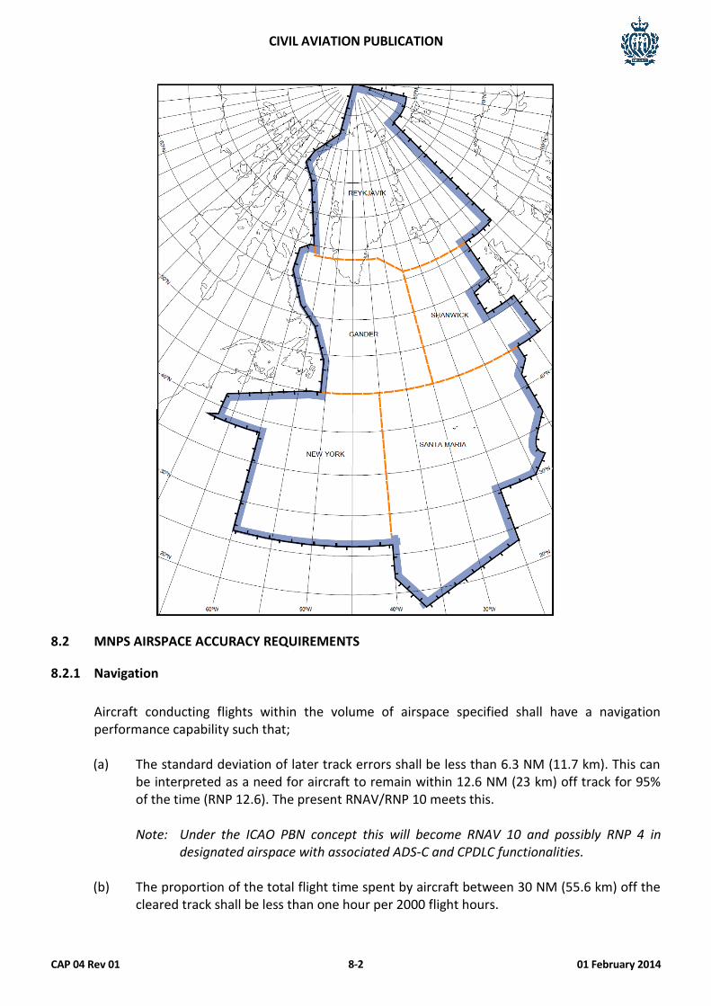
CIVIL AVIATION PUBLICATION
CAP 04 Rev 01 01 February 2014 8-2
8.2 MNPS AIRSPACE ACCURACY REQUIREMENTS
8.2.1 Navigation
Aircraft conducting flights within the volume of airspace specified shall have a navigation performance capability such that;
(a) The standard deviation of later track errors shall be less than 6.3 NM (11.7 km). This can
be interpreted as a need for aircraft to remain within 12.6 NM (23 km) off track for 95% of the time (RNP 12.6). The present RNAV/RNP 10 meets this.
Note: Under the ICAO PBN concept this will become RNAV 10 and possibly RNP 4 in
designated airspace with associated ADS-C and CPDLC functionalities. (b) The proportion of the total flight time spent by aircraft between 30 NM (55.6 km) off the
cleared track shall be less than one hour per 2000 flight hours.
CIVIL AVIATION PUBLICATION
CAP 04 Rev 01 01 February 2014 8-3
(c) The portion of the total flight time spent by aircraft between 50 and 70 NM (92.6 and 129.6 km) off the cleared track shall be less than one hour per 8000 flight hours.
(d) A RNP 10 approval issued by the San Marino CAA as the State of Registry.
8.2.2 Altimetry
The separation requirements are 1000 ft (305 metres) vertical to FL 290 and 2000 ft (610 metres) vertical above FL 290 in opposite directions. Where RVSM airspace is in force, the altimetry and level keeping accuracy requirements apply. Operators must hold a RVSM approval issued by the San Marino CAA as the State of Registry.
8.2.3 Communications
Operators must carry the required communication equipment for MNPS airspace although the requirements vary with different FIRs within MNPS airspace. Generally the requirement is for the carriage of fully serviceable/redundant HF communications equipment although SATCOM voice may also be used with only one HF if relief is available under the MEL. Pilots electing to use SATCOM voice as an alternative to HF voice communications remain responsible for operating SELCAL or maintaining a listening watch on the assigned HF frequency. Datalink communications are gradually being introduced into the MNPS airspace environment for position reporting (via FANS 1/A ADS & CPDLC and through ACARS).
8.3 OPERATIONAL PROCEDURES
8.3.1 Before Flight Phase
During the before flight phase the flight crew should pay particular attention to conditions that may affect operation in MNPS airspace. These include, but may not be limited to:
(a) Verifying that the aircraft equipment is approved for MNPS operations; (b) Reported and forecast weather on the route of flight; (c) Minimum equipment (MEL) requirements pertaining to track keeping systems; (d) If required for the specific aircraft group, accounting for any aircraft operating restriction
related to MNPS airworthiness approval; (e) The use of the letter “X” (for MNPS) and “W” (for RVSM) in item 10.
Note: Any MNPSA Aircraft intending to also fly in the West Atlantic Route System (WATRS
Plus) airspace should ensure that its RNP Approval status is included in the Flight Plan. Specifically such operators should:
(a) Annotate ICAO Flight Plan Item 10 (Equipment) with the letters “R” and “Z”,
and
CIVIL AVIATION PUBLICATION
CAP 04 Rev 01 01 February 2014 8-4
(b) Annotate Item 18 (Other Information) with, as appropriate, “NAV/RNP10” or “NAV/RNP4”
8.3.2 En-route Procedures
Operating procedures contained in the Operations Manual must contain relevant guidance information for in-flight procedures. Contingency procedures for equipment failure and navigation inaccuracies prior to, and after entry, must be addressed. Note: Details of specific contingency procedures for each area or route can be found in the
Route Guide (e.g. Jeppesen Manual).
8.3.3 Post Flight Procedures
Pilots should log the navigation accuracy at the completion of a flight. In making technical entries for a malfunction or inaccuracy in a track keeping system, the pilot should provide sufficient detail to enable an effective and timely repair.
8.4 TRAINING REQUIREMENTS
All operators must receive formal training on MNPS procedures. Recurrent training is required on an annual basis and the items detailed below should be incorporated into training programmes and operating procedures.
(a) Knowledge, understanding and compliance of standard ATC phraseology and track
messages used in each area of operations; (b) MNPS procedures for NAT (and other areas when applicable); (c) Changes to charting and documents to reflect MNPS; (d) Navigation equipment required to be operational for flight in designated MNPS airspace,
limitations associated with the RNAV equipment; (e) Flight planning requirements; (f) Entry, in-flight and exit requirements and procedures; (g) Contingency procedures for system failures or navigation inaccuracies; (h) Position error log and notification requirements; and (i) Operations Manual information and procedures.
CIVIL AVIATION PUBLICATION
CAP 04 Rev 01 01 February 2014 8-5
8.5 APPLICATION FOR MNPS
8.5.1 Process
The application (refer Form SM 04 or Form SM 04A, as applicable) must address all of the sections on equipment, operational requirements, including documentation and training. General Aviation operators shall sign the “Declaration of Compliance” indicating all equipment, operational requirements, documentation and training meet the requirements for MNPS approval. Commercial Air Transport operators shall submit documentary evidence of the required information in the application form.
8.5.2 Airworthiness Issues
An operator is required to hold an RNAV/RNP 10 and RVSM approval from the CAA. Please refer to the applicable Sections of this CAP for the application process, which includes equipment and airworthiness issues.
8.5.3 Operational Requirements
To be eligible for a MNPS approval from the CAA, the following operational issues need to be addressed by the operator:
(a) Operating procedures (SOPs including Contingency Procedures); (b) FCOM & Quick Reference Handbook changes (if applicable); (c) Minimum Equipment List (MEL) as required by the applicable equipment; (d) Training programmes; (e) Provision of flight planning information for designated area (e.g. NOTAMs, AIP etc.); and (f) Data base and software integrity for the PBN.
8.5.4 Approval
The MNPS approval will be issued on a Designated Airspace Approval Certificate for General Aviation operators, a copy of which must be carried in the aircraft for all flights expected to be conducted in that airspace. The MNPS approval will be granted by inclusion in the Operations Specifications of the AOC holder.

CIVIL AVIATION PUBLICATION
CAP 04 Rev 01 01 February 2014 8-6
This Page Intentionally Left Blank
CIVIL AVIATION PUBLICATION
CAP 04 Rev 01 01 February 2014 9-1
CHAPTER 9
RVSM
9. INTRODUCTION
9.1 GENERAL
9.1.1 Purpose
This guidance material is intended for all operators of San Marino registered aircraft planning to operate in Reduced Vertical Separation Minima (RVSM) airspace. This Chapter provides information on the implementation plan, required equipment, the approval process, as well as guidance on operational procedures and training. All San Marino registered aircraft planning to operate in RVSM airspace shall be required to obtain an approval from the CAA before the commencement of operations. Operators must be aware that airspace restrictions and operational penalties may be incurred if the aircraft is not approved for operations in RVSM airspace.
9.1.2 General
Airspace where RVSM is applied should be considered special qualification airspace. The specific aircraft type or types that the operator intends to use will need to be approved by the CAA before the operator conducts flight in RVSM airspace.
9.1.3 References
(a) Federal Aviation Administration (FAA)
(1) AC 91-85 – RVSM –Approval of Operators/Aircraft for RVSM Operations. (b) International Civil Aviation Organisation (ICAO)
(1) ICAO Doc. 9574 – Manual on the Implementation of a 300 m (1000 ft) Vertical Separation Minimum Between FL 290 – FL 410 Inclusive.
(2) ICAO Doc. 7030/4 – Regional Supplementary Procedures (for appropriate region)
contain operational and contingency procedures unique to the regional airspace concerned, specific flight planning requirements, and the approval requirements for aircraft in the designated region.
(c) Joint Aviation Authorities (JAA)
(1) JAA TGL 6 – Guidance Material on the Approval of Aircraft and Operators for flight in Airspace above Flight Level 290 where a 300 m (1000 ft) Vertical Separation Minimum is applied.
CIVIL AVIATION PUBLICATION
CAP 04 Rev 01 01 February 2014 9-2
9.2 AIRCRAFT EQUIPMENT FOR RVSM OPERATIONS
The minimum equipment fit should be:
(a) Two independent altitude measurement systems. Each system should be composed of
the following elements:
(1) Cross-coupled static source/system, provided with ice protection if located in areas subject to ice accretion;
(2) Equipment for measuring static pressure sensed by the static source, converting it
to pressure altitude and displaying the pressure altitude to the flight crew; (3) Equipment for providing a digitally coded signal corresponding to the displayed
pressure altitude, for automatic altitude reporting purposes; (4) Static source error correction (SSEC), if needed to meet performance
requirements; and (5) The equipment fit should provide reference signals for automatic control and
alerting at a selected altitude. These signals should preferably be derived from an altitude measurement system.
(b) One SSR altitude reporting transponder. If only one is fitted, it should have the capability
for switching to operate from either altitude measurement system; (c) An altitude alert system, the threshold being + 90 m (300 ft); (d) An automatic altitude control system, indicating to the flight crew the flight level being
flown and maintenance of a selected flight level.
9.3 OPERATIONAL PROCEDURES
9.3.1 Flight Planning
During flight planning the flight crew and the dispatcher should pay particular attention to conditions that may affect operation in RVSM airspace. These include, but may not be limited to:
(a) Verifying that the airframe is approved for RVSM operations; (b) Reported and forecast weather on the route of flight; (c) Minimum equipment requirements pertaining to height-keeping systems; (d) Any airframe or operating restriction related to RVSM approval; (e) Ensuring that “W” is stated in item 10 of the ATC flight plan to indicate RVSM approval.
CIVIL AVIATION PUBLICATION
CAP 04 Rev 01 01 February 2014 9-3
9.3.2 Pre-flight Procedures
The following actions should be accomplished by flight crew during the pre-flight procedure: (a) Review technical logs and forms to determine the condition of equipment required for
flight in the RVSM airspace. Ensure that maintenance action has been taken to correct defects to required equipment;
(b) During the external inspection of aircraft, particular attention should be paid to the
condition of static sources and the condition of the fuselage skin near each static source and any other component that affects altimetry system accuracy. This check may be accomplished by a qualified and authorised person other than the pilot (e.g., a flight engineer or ground engineer);
(c) Before take-off, the aircraft altimeters should be set to the QNH of the airfield and should
display a known altitude, within the limits specified in the aircraft operating manuals. The two primary altimeters should also agree within limits specified by the aircraft operating manual.
Note: The maximum value for these checks cited in operating manuals should not exceed
75 ft. (d) Before take-off, equipment required for flight in RVSM airspace should be operative, and
any indications of malfunction should be resolved.
9.3.3 Procedures Prior to RVSM Airspace Entry
The following equipment should be operating normally at entry into RVSM airspace:
(a) Two primary altitude measurement systems; (b) One automatic altitude-control system; (c) One altitude-alerting device; (d) Operating Transponder (subject to operational area requirements). Note: Should any of the required equipment fail prior to the aircraft entering RVSM airspace, the
pilot should request a new clearance to avoid entering this airspace.
9.3.4 In-flight Procedures
The following practices should be incorporated into flight crew training and procedures:
(a) Flight crews must comply with any aircraft operating restrictions, if required for the
specific aircraft group, given in the RVSM airworthiness approval; (b) Emphasis should be placed on promptly setting the sub-scale on all primary and standby
altimeters to 1013.2 (hPa) when passing the transition altitude, and rechecking for proper
CIVIL AVIATION PUBLICATION
CAP 04 Rev 01 01 February 2014 9-4
altimeter setting when reaching the initial cleared flight level; (c) In level cruise it is essential that the aircraft is flown at the cleared flight level. This
requires that particular care is taken to ensure that ATC clearances are fully understood and followed. The aircraft should not intentionally depart from the cleared flight level without a positive clearance from ATC unless the crew is conducting contingency or emergency manoeuvres;
(d) When changing levels, the aircraft should not be allowed to overshoot or undershoot the
cleared flight level by more than 150 ft (45 m);
Note: It is recommended that the level off be accomplished using the altitude capture feature of the automatic altitude-control system, if installed.
(e) An automatic altitude-control system should be operative and engaged during level
cruise, except when circumstances such as the need to re-trim the aircraft or turbulence require disengagement. In any event, adherence to cruise altitude should be done by reference to one of the two primary altimeters;
(f) Ensure that the altitude-alerting system is operative; (g) At intervals of approximately one hour, cross-checks between the primary altimeters
should be made. A minimum of two must agree within ±200 ft (±60 m). Failure to meet this condition will require that the altimetry system be reported as defective and notified to ATC:
(1) The usual scan of flight deck instruments should suffice for altimeter cross-
checking on most flights; (2) Before entering oceanic RVSM airspace, the initial altimeter cross-check of primary
and standby altimeters should be recorded. Note: Future systems may make use of automatic altimeter comparators.
(h) In normal operations, the altimetry system being used to control the aircraft should be
selected for the input to the altitude reporting transponder transmitting information to ATC;
(i) If the pilot is advised in real time that the aircraft has been identified by a height-
monitoring system as exhibiting a Total Vertical Error greater than ± 300 ft (± 90 m) and/or an ASE greater than ± 245 ft (± 75 m) then the pilot should follow established regional procedures to protect the safe operation of the aircraft. This assumes that the monitoring system will identify the Total Vertical Error or Altimetry System Error within the set limits for accuracy;
(j) If the pilot is notified by ATC of an Assigned Altitude Deviation error which exceeds ±300
ft (±90 m) then the pilot should take action to return to the cleared flight level as quickly as possible.
CIVIL AVIATION PUBLICATION
CAP 04 Rev 01 01 February 2014 9-5
9.3.5 Contingency procedures after entering RVSM airspace
(a) Notification
The pilot should notify ATC of contingencies, such as equipment failures, system inaccuracies and severe turbulence, which affect the ability to maintain the cleared flight level, and co-ordinate a plan of action. If unable to contact ATC and obtain an ATC clearance prior to deviating from the cleared flight level, the pilot should follow established contingency procedures as defined by the region of operation and obtain ATC clearance as soon as possible.
(b) Notification of Equipment Failures
The types of equipment failures, which should be notified to ATC, are:
(1) Failure of all automatic altitude-keeping devices; (2) Loss of redundancy of all, or part of, altimetry systems; (3) Failure of all altitude reporting transponders; (4) Loss of thrust on an engine necessitating descent; (5) Any other equipment failure affecting the ability to maintain the cleared Flight
Level. (c) Post Flight
In making technical log entries against malfunctions in height-keeping systems, the pilot should provide sufficient detail to enable maintenance to effectively trouble shoot and repair the system. The pilot should detail the actual defect and the crew action taken to try to isolate and rectify the fault. The following information should be noted when appropriate:
(1) Primary and standby altimeter readings; (2) Altitude selector setting; (3) Subscale setting on altimeter; (4) Autopilot used to control the aeroplane and any differences when the alternate
system was selected; (5) Differences in altimeter readings, if alternate static ports selected; (6) Use of air data computer selector for fault diagnosis procedure; (7) The transponder selected to provide altitude information to ATC and any
difference noted when an alternative transponder was manually selected.
CIVIL AVIATION PUBLICATION
CAP 04 Rev 01 01 February 2014 9-6
9.4 TRAINING REQUIREMENTS
The following items should be standardised and incorporated into training programmes and operating practices and procedures. This document is written for all users of RVSM airspace, and as such is designed to present all required actions. All operators should refer to the applicable ICAO Doc 7030/4 to ensure appropriate regional supplementary procedures are addressed in the Operations Manual and training programmes.
In addition to the operating procedures in Section 9.3, the following items should also be included in flight crew training programmes:
(a) Knowledge and understanding of standard ATC phraseology used in each area of
operations; (b) Importance of crew members cross checking to ensure that ATC clearances are promptly
and correctly complied with; (c) Use and limitations in terms of accuracy of standby altimeters in contingencies. Where
applicable, the pilot should review the application of static source error and pressure error correction through the use of correction cards;
(d) Problems of visual perception of other aircraft at 1,000 ft (300 m) planned separation during darkness, when encountering local phenomena such as northern lights, for opposite and same direction traffic, and during turns;
(e) Characteristics of aircraft altitude capture systems, which may lead to flight level
overshoots. (f) Relationship between the aircraft's altimetry, automatic altitude control and transponder
systems in normal and abnormal conditions. (g) Any airframe operating restrictions, if required for the specific aircraft group, related to
RVSM airworthiness approval. (h) Use of TCAS in RVSM airspace. (i) Effect of wake turbulence.
9.5 APPLICATION PROCESS 9.5.1 General
An application may be submitted electronically and allow sufficient lead time to obtain height accuracy confirmation. The approval process involves three separate processes; (a) the CAA determines the airworthiness requirements and if satisfied makes the aircraft
eligible for height monitoring;
CIVIL AVIATION PUBLICATION
CAP 04 Rev 01 01 February 2014 9-7
(b) the CAA then notifies the appropriate Regional Monitoring Agency (RMA) that the aircraft is eligible for height monitoring;
(c) Once the RMA has confirmed the height accuracy, the CAA will issue an approval.
9.5.2 Process
All operators must submit evidence of altimetry performance capability with their application. The application (refer Form SM 04 or Form SM 04A, as applicable) must address all of the sections on equipment, operational requirements, including documentation and training. General Aviation operators shall sign the “Declaration of Compliance” indicating all equipment, operational requirements, documentation and training meet the requirements for RVSM approval. Commercial Air Transport operators shall submit documentary evidence of the required information in the application form.
9.5.3 Airworthiness Issues
The components of a RVSM capable aircraft are usually installed at manufacture of a new generation aircraft and the manufacturer includes statements as to altimetry performance capability in the Aircraft Flight Manual, an AFM Supplement or STC. Unless the approved MEL already addresses the required equipment, an amendment to the MEL should be submitted to the CAA for approval. It is up to the operator to determine that the maintenance organisation used is capable of providing maintenance support for altimetry equipment.
9.5.4 Over flight Assessment
Once the aircraft has successfully conducted an over flight assessment, there is no requirement for further assessments unless there is a change to the required aircraft equipment. A successful over flight assessment conducted by a RMA is acceptable for all RMAs. An over flight assessment may not be a prerequisite for “group aircraft” but it is for “non-group aircraft”. After the CAA has granted airworthiness approval, operators of non-group aircraft should take steps to either overfly the Height Monitoring Unit (HMU) near the following locations;
(a) Strumble, UK (b) Linz, Austria (c) Nattenheim, Germany (d) Geneva, Switzerland
or arrange with a Regional Monitoring Agency for the carriage of a global positioning system (GPS) monitoring unit (GMU). If monitoring occurs before the CAA has informed the appropriate
CIVIL AVIATION PUBLICATION
CAP 04 Rev 01 01 February 2014 9-8
RMA, the accrued data may still be used provided that it is dated after the modification/inspection was completed. In the case of aircraft added to an operator’s fleet of the same type, after initial application for RVSM operating authority, the appropriate RMA will determine whether any further monitoring is required and will inform the CAA, which in turn will inform the operator. The application form can be obtained from the RMA website.
Any monitoring conducted by a RMA is acceptable to the CAA and to other RMAs. Operators can consult the ARINC Bulletin Board, EUROCONTROL or the appropriate RMA to ascertain if its aircraft have been monitored and acceptable performance has been demonstrated. RMAs are;
Eurocontrol User Support Cell (USC) Airspace Management & Navigation Unit 96 Rue de la Fusée B-1130 Brussels, Belgium Phone: +32-2-729-4627 Facsimile: +32-2-729-4629 E-mail: [email protected] Middle East Regional Monitoring Agency P.O Box 50468 Kingdom of Bahrain Phone: +973-17329150 Facsimile: +973-17311060 E-mail: [email protected] NAT CMA Room T805, CAA House 45-59 Kingsway, London WC2B 6TE United Kingdom Facsimile: +44171 832 5562
Eurasia Regional Monitoring Agency 26, Volokolamskoe Highway, 123182, Moscow, Russia Tel: +7 499 190 35 19 Facsimile: +7 495 190 35 79 E-mail: [email protected]
Note 1: “Group aircraft” means aircraft that are of nominally identical design and build with
respect to all details that could influence the accuracy of height keeping performance. (e.g.; Passenger configuration Boeing 737 NG, Airbus A319, G550 etc.)
CIVIL AVIATION PUBLICATION
CAP 04 Rev 01 01 February 2014 9-9
Note 2: “Non-group aircraft”. Operators of these aircraft must apply on an individual aircraft basis and monitoring by an HMU or GMU is a pre-requisite to obtain RVSM (operational) approval unless flight test evidence can be provided to the CAA to show that each airframe is compliant with Altimetry System Error (ASE) targets.
9.5.5 Periodic Monitoring
It is a CAA requirement that those operators who have already obtained Operational approval will have to perform RVSM HMU/GMU height monitoring under a periodic monitoring programme. Every operator is required to ensure that a minimum of two aeroplanes of each aircraft type grouping of the operator have their height keeping performance monitored, at least once every two years or within intervals of 1000 flight hours per aeroplane, whichever period is longer. If an operator aircraft type grouping consists of a single aeroplane, monitoring of that aeroplane shall be accomplished within the specified period.
9.5.6 Approval
The RVSM approval will be issued on a Designated Airspace Approval Certificate for General Aviation operators, a copy of which must be carried in the aircraft for all flights expected to be conducted in that airspace. The RVSM approval will be granted by inclusion in the Operations Specifications of the AOC holder.
9.6 OVERSIGHT 9.6.1 CAA Action
The CAA has a mechanism for receiving the reports of height-keeping performance issued by the monitoring agencies established. Any San Marino operator reported to be operating in RVSM airspace without approval could face administrative penalties. Any aircraft with faulty equipment or operating incorrectly could jeopardise the safety of other users of the airspace. An operator that consistently incurs equipment or operational errors may be required to forfeit authority for RVSM operations. The CAA may consider revoking RVSM operational approval if the operator response to a height-keeping error is not effective or timely. The CAA will also consider the operator's past performance record in determining the action to be taken. If an operator shows a history of operational and/or airworthiness errors, then approval may be revoked until the root causes of these errors are shown to be eliminated and RVSM programmes and procedures effective. Should a RVSM approval be withdrawn, advice shall be sent to the appropriate RMA.
Following any rectification work the operator would again be expected to demonstrate compliance with the RVSM requirements for monitoring by an independent height monitoring system.

CIVIL AVIATION PUBLICATION
CAP 04 Rev 01 01 February 2014 9-10
9.6.2 Operator Responsibility
As part of their Safety Management System, all operators should conduct their own continuing surveillance and reporting action as described in Section 1.6.1.