city oswego local waterfront revitalization program april 28, 1986, the oswego local waterfront...
TRANSCRIPT
City of OswegoLocal Waterfront Revitalization Program
Adopted:City of Oswego Common Council, April 28. 1986
ApPr9rd:'NYsSccrewy of Sl~lteGail S. Shaffer. ~ember:8;~f9"·
~ . I ,
~ur,.td:
U.S. OUietof'Oeean and Coastal Resource Management. December't6'_l~
This Local Waterfront RevitalizationProgram has been adopted and approved inac~~rdance with the provisions of theWaearf'tont Revitalization and Coastal,.~rces Act of 1981 (Executive Law,
Article 42) and its implementing,reg~ations (6 NYCRR 601). Federal
concurrence on the incorporation of thisLocal Waterfront Revitalization Programinto the New York State Coastal ManagementProgram as a Routine ProgramImplementation has been obtained inaccordance with the provisions of the U.S.Coastal Zone Management Act of 1972 (P.L.92-583), as amended, and its implementingregulations (15 CFR 923).
The vr~aration of this program wasfinanc1al1y aided by a federal grant fromthe U.S. Department of Commer~e, National
.. _,; )~c.eanic ._JXLd Atmospheric Administration,.~ ';; -:-_, ' Office '.', of. .()cean and Coastal Resource'~: -;' -. MatlailtJl~t ~-under the Coastal Zone
".Management ~t of 1972, as amended.,~,.: Federal Gr~nt No. NA-82-AA-D-CZ068.
The New York Coastal Management Programand the preparation of Local WaterfrontRevitalization Programs are administeredby the New York State Department of State.162 ,washington Avenue, Albany, New York12231. '.
w ..~~,~'- ......~.. "
STATE OF NEW YORK
DEPARTMENT OF STATE
GAIL 5, SHAFF£RSECRETARY OF STATE
February 19, 1987
Honorable William S. Cahill, Jr.HayorCity of OswegoCity HallOswego, New York 13126
Dear Hayor Cahill:
REPLY TO
o 1'62 WASHINGTON AVENUEALIIANY, NY 1223 115181474·4750
0270 BROADWAYNEwYORKC""NY1OOO712121587·5800
On September 8, 1986 when I approved the Oswego Local Waterfrdnt RevitalizationProgram (LWRP), I did so with the condition that the City correct ,some' minortechnical deficiencies in the local law amendments that the City Counciladopted in April, 1966 in order to implement the City's LWRP. Hr. AnthonyLeotta, Oswego City Engineer, recently sent us a certified copy of City CouncilResolution No. 7 of 1987, making the necessary amendments to the Oswego ZoningOrdinance. We find that the technical deficiencies are corrected; thereforethe condition is hereby removed.
Again, I commend the City of Oswego on its efforts to develop the LWRP and lookfor~~rd to working with you as endeavor to vitalize your waterfront.
Sincerely,
Gail S.
GSS:lc
Mr. George StaffordDirectorDivision of Coastal Resources
and Waterfront RevitalizationDepartment of State162 Washington StreetAlbany, New York 12231
Dear Mr. Stafford:
UNITED STATES DEPARTMENT OF COMMERCENational Oceanic and Atmospheric AdministrationNATIONAL OCEAN SERVICEOFFICE OF OCEAN AND COASTAL RESOURCE MANAGEMENTWashington, D.C. 20235
December 16, 1986
DEPARTMr:~:TCF STl.iT.COASTt.L p~CG.~J\;',~5 .
JAN 0 61987
RECEJVED
The Office of Ocean and Coastal Resource Management has completedits review of your request .to incorporate the City of OswegoLocal Waterfront Revitalization Program (LWRP) into the New Yorkstate Coastal Management program (NYS CMP). We have received theadopted program which has been approved by the New York Secretaryof state. We received comments from 5 Federal agencies, none ofwhich objected to adopting the LWRP as a routine programimplementation change.
You and my staff have discussed the problem of the need to clearlyidentify in the LWRP which of the 44 coastal policies listed inthe NYS CMP apply to the LWRP area. The current use of "notincluded" is very confusing to the users of these programs.Because there is evidence in the documents, however obscure, thatpolicies labeled "not included" do apply, we concur with yourrequest that the Oswego LWRP be considered as a routine programimplementation. However, we expect the State to remedy theproblem of clearly identifying which policies apply by eliminatingthe term "not included" as soon as possible.
In accordance with the Coastal Management Regulations, 15Federal Consistency will apply to the City of Oswego LWRPyou publish notice of our approval.
SinCerelY/
~ Toeedt~rector
CFR 923.84,after

STATE OF NEW YORK
DEPARTMENT OF STATE
ALBANY. N. Y. 12231
GA.I"- S S""A~FER
SEC"ETART OF STATE September 8, 1986
Honorable William S. Cahill, Jr.MayorCity of OswegoCity HallOswego, New York 13126
Dear Mayor Cahill:
It is with great pleasure that I inform you that, pursuant to theWaterfront Revitalization and Coastal Resources Act, I have approvedthe City of Oswego's Local Waterfront Revitalization Program (LWRP).The City is to be commended for its thoughtful and energetic responseto opportunities presented along its waterfront.
I will notify state agencies shortly that I have approved the City'sLWRP and will provide them a list of their activities which must beundertaken in a manner consistent to the maximum extent practicablewith the Oswego LWRP.
During our reading of the local laws which the City Council recentlyadopted to aid in imp.lementing the City's LWRP, our Division of LegalServices observed minor technical deficiencies. These are described onan attachment to this letter. In order to assure there will beadequate authority to implement the LWRP, I am approving this LWRPwith the condition that the City will correct these deficiencies. TheDepartment of State legal staff and coastal management program staffwill provide whatever assistance you request in this matter.
Again, I would like to commend the City of Oswego on its efforts todevelop the LWRP and look forward to working with you in the years tocome as you endeavor to revitalize your waterfront.
GSS:lc
OFFICE OF THE ....YOA
WILLIAM S. CAHILL. JR.
May 29, 1986
Ci-ty of OSWEGOXc,," Yorlc 13126
...)
(315) 342·5600 Ext. 48
Honorable Gail ShafferSecretary of StateNew York State Department162 Washington AvenueAlbany, New York 12231
Dear Secretary Shaffer:
of State
. ;.~--' i~-~
On April 28, 1986, the Oswego Local Waterfront Revitalization Programwas officially adopted by the Oswego Common Council.· Three copiesof the LWRP are hereby submitted for your .consideration and approval,pursuant to Article 42 of the New York .State Executive Law.
r.::;"=~~::":.'.~' ~,~Also enclosed are c~d ccopiel; of the' resolution adopting the Program,the local consistency)aw, .and amendments to'.the zoning ordinance •
.- ..-". . ~.:-::. -.. -~~,:~. .~>:' ~ ... 'I ~;-;'.~.•:.:-~.:•. ' ~~~~: .'. • I
During the preparation :.!=If: .the _Oswego 'LWRP, -. all .~review .,procedureswere completed 'in' . accOrdance' with ':the ,State Environmental Quality
I Review Act, .and~'all . SEQRA-:-_review}·comm.ents :comply with. Article 42,I of the New York~.State Execu"tive:',);aw';-''::::=-:--- "'---.; .... ;:'" ".' \.;~\.':'.:=\.
~£F:':.'.. .>.:~ :--. -.-<: .\ .' ~." ~.-;~-:;:~~~~:-;;i~~~:~:t~_~~.~~:\-'.' Smcerely, .": ,\ 1·,.,.Il?" "-., . 1/., I . /. _.--_::::,......-:.~ .. .-:::-....,;
..~'"~:. ; ~ ~ ~/ ;~~:t '7' -\'_.'; ':~ ~~ j.~. ~ (/,:-:.; r(..-· '-:,; :. i ;, /, i ';:,~.",;:~;~:--:..:-.:-:- CITY OF OSWEGO I~:' . ;i~':..'". -.1 -. <. _.... .." (. :. ;.'.',•... /'
·~:r:...~ J;.; ':~ :~f;: ~~:j";': ::E~i· 'j' V.·'~ :F·:ll:~~~;~~::, ..... ,~'. : I • • . ~ f .... '.1 • !"!';., . ': .-. I" • I ...".•.
~• ., I ~!. , • . .o' I .... f' .
• -_ ,I •••1>. ("~' ...... ;'/, r-':::~i: ~ .._~ ~.:; ~:.:: I.~:o t f~:;I'f;'! :; .. ~
illiam 5 cahill "Jr' . -~-- - ....'---' --'.! _. _, .. ;.[
'~"i .:~..:::o/: _. -- ::.- ,I'~:~;~ --il:r:";~:(.'l' ,.[.::~. ;~;t~~f~~5-~!{~~'~r,'::;j:;j -~~:~r
",~: ,'·,.'I'(t r~ !'.~ ,I'" '," •.•. -. ,". fJ'. ,",. , . '. ,. I .. ,.. . ... _.~, i~":' -,;. r..!.~ ,.-: " {~; i'~; ~rll
.~nclosures","_.l_ -..::::~ _.! :--- ~.~~.'- -- ;~:'i,':.::_... ,-',.:.·.~~.-;.· !!~ ~ ~.' :,i~: ~'.~'.~.!~.'~.:....,.,..-:~..'~/;~~;-:'~.~.~:={'..'.:...:~~.~~'}.;::~-: ~_~,_ ' ...... ...... .J.....:.
' .. ---"--- ...==.:., -_.. --_.'---"--
OSWEGO: Growing with America for over Two Hundred Years
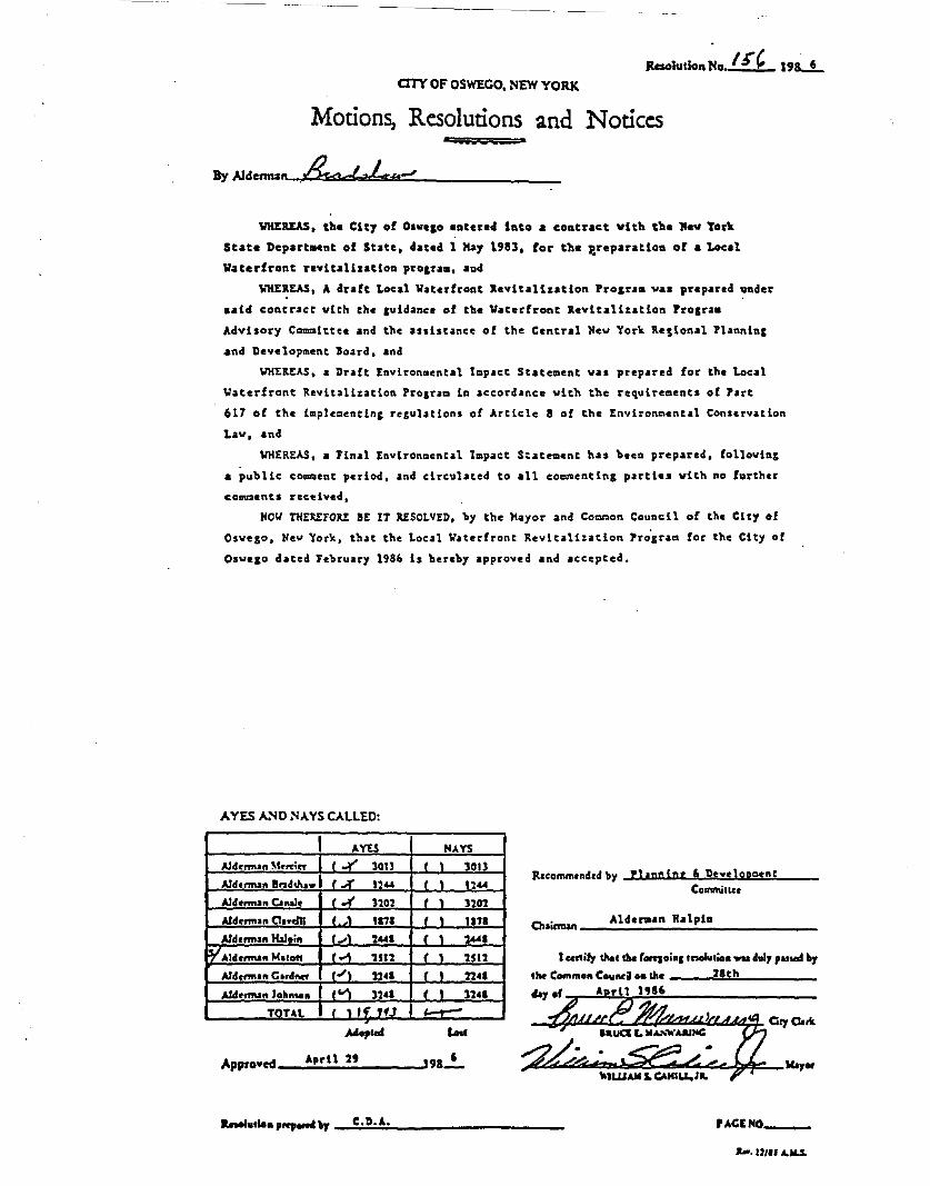
Resolution No I ~CaTY OF' OSWECO, NEW YORK
Motions, Resolutions and Notices...By Ald«muln .& J? L..J
19s.....!...
WHEREAS, the City of Olvelo entered into a contract with the Nev Tork
State Depart..nt of State, dated 1 Hay 1983, for the treparation of a Local
Waterfront revitalization prolra., aDd
WHE~EAS, A draft Local Waterfront .evitali.ation Prolra. va. prepared under
said concracc vich che cuidance of the Wacerfront .evitalizacion Prosra.
Advi.ory Comalttee and the '.Ii.tance of the Cencr.l Nev Yor~ .e,ional Pl.nninl
and Development Jo~rd. and
WHEREAS, • Dr.ft Envlron.ental topact State.ent va. prepared for the Local
Waterfront Revlt.liz.tion Prolr•• io accord.nce vith the requirement. of Part
617 of che i.ple.eocinc recul.tlonl of Article 8 of the Envlron~ent.l Con.erv.tlon
L.a. ..... and
WHEREAS, a Final Eovironoental topact SCate.ent b•• been prepared. f0110vinS
a public co==ent p.rlod, .nd clrculaced to all cOOMentins partie. vich no further
comments rec~ived.
NO~ THEREFORE aE IT AESOLYED, by the Mayor and Co~n Council of the City of
Osvelo. Nev York, Chat the Local Vaterfront Revltali •• tion Prosrao for tb. City of
Osveso d.ted Febru.ry 1986 i. b.reby .pproved and accepted.
AYES A:'oIO NAYS CALLED:
I AYES HAYSAld,mlln M,..i.. I 1,)(' 30n I 1 30nAld,"""n Bnd"'.... 1 ,.;if U41 , , 11"-Ald,nn.n Clnol. 1",( 3101 , I 3101Ald,nn.n CInelli , .•1 1171 , 1 1111Ald,nn.n lbIoift 1...1 2..-1 , 1 144.~Ald..rmaft Mlro" ,"'" 2111 ( 1 2512
Aldonn.n Cord_ 1"1 22.1 , , n.1
Ald,"""n John... 1""1 3211 , I 32••
TnUl , ,,4' fU "-"-.Mop.ed Lose
Approved _..,;.;".:.,r;.;l;.;.I_';.;' ......I9I.!..
Il.ccornrn,nd,d by Phnn!",' llsveloDoentComrnin..
,.ld....n HalpinCh.i....... -'- _
I ....ify \IIa. the (ORIoinC ........io. wulholy ,Ud bythe Common Council H III. 'o.:8tlc....hl- _
A rn 1'16
a...Iutlo. ,..,0n4b)' _.::C.:.;.D:.:.~A::., _ UCENO, _
.... U1U ...JoU.
SECTION I
DEFINITION OF WATERFRONT REVITALIZATION AREA BOUNDARY
SECrION I
DEFDlITION OF WATERFRONT REVITALIZATION AREA BOUNDARY
Contents
CITY OF OSAEGO CORPORAiE LIHITS•••••••• ~............................. 1
Map 1: Corporate Limits ••••••.•••••••••••••.••••••••.••••••••••• 2
DESCRIPTION OF EXISTDlG BOUNDARy•••••••••••••••• ..................... 1
Jo'.ap 2: :B oundary • • • • . • • • • • • . • • • • • • • • • . • • • • • • • • • • • • • • • • • • • • • . • • • •• 3
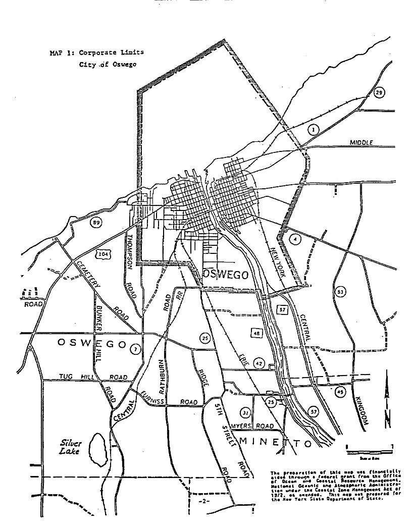
CITY OF OSlol'EGO CORPORA'I'E LIHI'1:S
':the City of Oswego is located at the mouth of the Oswego River on LakeOntario. The corporate limits of the City. includiIlg an area vhich extends~or one mile Ilorth into Lake Ontario as provided by the Ci~ Charter, areshown on }t.ap 1.
DESCRIPTION OF nm EXIsnNG :BOUNDARY
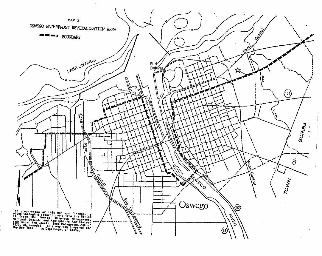
Map 2 sh~s the existing boundary of the Oswego Waterfront Revitali:ationArea.
Beginning at the City line on the West side of OS",Jego. the e.-dsting Waterfront Revitalization Axea bOUo"ldary extends east on George Washington Boulevard to First Avenue; north on First to West Schuyler Street; east on West"Schuyler to Liber~ Street; north on Liberty to West Van Buren Street; easton West Van Buren to West Second Street; south on West Second to theboundary line of the Business Zone at the intersection of Wesr SecondStreet and Erie Street: south along the Business Zone boundary to West~irst Street; south along West First to the hydroelectric dam; east acrossthe river on the dam to East First Street: Ilorth on East First to EastAlbany Street; east On East Albany apprOxU1ately one-half block to theboundary of the Business Zone; along the Business Zone boundary to the PennCentral tracks; north along the railroad tracks to East Seneca Street; andEast on East Seneca to the OS'lo1ego City Line. The ....aterside boundary isfo=ed by extending the City's eastern and vestern boundary lines.respectively. in a northern direction one mile into Lake Ontario andconnecting these ~o lines vith a third line running approxicat~ly parallelto the City's Lake Ontario shoreline. This bounda~j is established in theCity of Oswego's CJl.arter.
Til. 1,••• rllto" .t ''''I "" cl.tlyatd. 'ftr.w~ft. 'a.er.l !rl,., rrD. 'fta OtrtcI., Oc••" ..'4 c.••'I' R•••urea "III',..."' ....,t.,.., OC ••flle .,.. "''''O'''''C A ,.,.tr.·"Oft y"•• r ~ft. c••• ,., Zaft. ~'A.' ft' Ace It'912. •• ,,,.,uSeo. 'iii. I ••••1" " •••,.. r.,ChI H•• rar. ~,.,. O.,.r'••'" It 5,.,•.
MIDDLE:
=
,
tN
........J
'~'Ih..
"~,.~\\
'.'
"",--"'1:------I -2-
r
TUG
Si/~r aLaJee
OSWEGO:x:;:=roo
MAP 1: Corporate Limits
City.of OSYego
MAP 2
OSWEGO WATERFRONT REVITALIZATION AREA
- - -. BOUNDARY
~~~~~(l _
1ho proporotlon 0' this mop "De 'InDnelMly ~ zoldod thrDUgh a rodorol gront 'rom tho OrrIco \\ z.0' Ocoon Dnd Cantot nDBDurco HnnDgement. __•• __••• \\.,')l'?IIotlDnot OCDonlc ond AtmDsphDrle Admlnhtro- \\ ,,'?tlDn undor thD CDO.tot lDno HDnogement Act of ~ \~1912., as Dmondad. This mop "DS propored for ,\ ,the Ife. York - te Depert.ent of Stett. \\ ,
,\""\\,
",
---~- "\
'\IIII
•IIII
fE
SECTION II
INVENTORY AND ANALYSIS
SEcrICN II
INVENToRY AND ANALYSIS
Coutents
INVnrroRY ~ Ali.AI.YSIS................................................ 1o Historic Overview of the Oswego Waterfront...................... 1
o Description of Waterfront Revitalization Area................... 2
o Oswego Waterfront Resources and Opportunities................... 3
o Major Waterfront Development Issues ••••••••••••••••••••••••••••• ·7
~RY OF OPPORtONITY SrrES........................................ 8o FIGURE 1:
o TABLE 1:
o TABLE 2:
Opportuni~ Sites ••••••••••••••••••••••••••••••••••••
opportunity Sites ••••••••••••••••••••••••••••••••••••
Zoning Sucmary•••••••••••••••••••••••••••••••••••••••
9
10
17
NAroRAI. USOURCES INVENTORy......................................... 19o FIGURE 2: Natural Resources I~entory ••••••••••••••••••••••••• 22
EI.ISTmG LAlm .A1'lD ~A1"ER 'DSES. • • • • • • • • • • • • • • • • • • • • • • • • • • • • • • • • • • • • • • • 23
o FIGURE 3: Existing Land acd Water Uses •••••••••••••••••••••••• 27
DEVELOPMENTAL CONSIDERATIONS•••••••••••••••••••••••• :'............... 23
Developmental Considerations -- II ••••••••••••••••••
o FIGURE 4:
o nCURE S:
Developmental Considerations I ••••••••••••••••••• 28
29
COASTAL PUBLIC ACCESS AND RECRBAXIOH................................ 2S
o nCURE 6: Coastal Public Acee•• and Recreation •••••••••••••••• 30
OVERALL INVENTORY AND ANALYSIS-- -----
Approximately 400 years ago. the Iroquois Indians moved from the areaaround Montreal and established a village at the mouth of the Oswego Riverwhere the river flows into Lake Ontario forming a natural harbor. At thispoint. trading activity was established: first. with other Indian tribesand later. with a succession of French. Dutch. British. and American traders. Oswego's advantage as a natural harbor was soon widely recognizedand. by the 18th Century. over 200 Indian canoes loaded with pelts tradedannually at Oswego.
In 1755. the British gained control of Oswego. Fortifications were erectedand the construction of naval vessels dominated the waterfront as Britishmilitary attention shifted to the Americans. Trading activity all butceased during the Revolutionary War as American vessels were allowed onlylimited use of the port.
In 177 9. Oswego was designated by the U. S. Congress as the first "officialport of entry" in the United .States west of the Atlantic Seaboard. A substantial trade in Onondaga salt was soon established as well as large-scalecommercial shipbuilding which reached a peak in 1847 when 26 ships werebuilt and launched at the Port of Oswego.
The opening of the Erie Canal in 1825 had an adverse economic impact onOswego through the diversion of trade to Buffalo and Rochester but thissituation was remedied in 1829 by the opening of the Oswego Canal whichconnected with the Erie Canal. The Oswego Canal greatly stimulijted thesalt trade which reached a value of over $18 million in 1848. Within 25years. however. the salt trade ended in Oswego as a result of new saltdeposit discoveries in Canada. Michigan. and West Virginia.
As trade in salt declined. the importation of lumber from Canada grew inimportance as an economic activity of the Port. Lumber was transhipped tocanal boats for further shipment or was processed at lumber mills in Oswegoprior to shipment. In addition to the lumber trade. a substantial grainmilling industry was established with grain shipped to Europe and the Eastern United States. As a milling center. Oswego ranked in importance withsuch cities as Baltimore and St. Louis.
After 1870. Oswego's importance as a port gradually declined as Onondagasalt shipments were discontinued altogether. Canadian forests were clearcut. and milling activity moved west to be closer to the grain fields.Coal trade provided a sustaining factor in maintaining some activity at theport during this period and. with the opening of the WeIland Canal in 1931.a gradual return to a more active port was made possible. Even though areturn to past high levels of activity was somewhat diminished with theintroduction of extremely large ocean-going ships which require large quantities for shipment in order to justify calling at a port. commercial acti-
. - 1 -
vity at the port has generally grown steadily, subject to national economicfluctuations. Recent trade activity has included such products as petroleum, cement. grain, aluminum, potash. twine. tomato paste. machine parts.salt, and fly ash.
The City of Oswego is divided in half along a north-south axis by theOswego River. with a waterfront along the riverbanks as well as the LakeOntario shoreline. This physical division has created strong EastSide-West Side associations with the banks of the River being main pointsof reference for orientation.
Traveling in an.easterly direction from the City's western boundary. thefollowing alignment of land uses can be found:
o State University of New York Oswego Campus;o Niagara Mohawk Corporation power plant;o Metropolitan Water Board water system intake and plant;o Breitbeck Park and Wright's Landing recreation areas;o Erie-Lackawanna coal dock;o u.s. Coast Guard Station;o Oswego Maritime Foundation Boating Education Center;o Port of Oswego cement silos. oil storage tanks. and bulk storage ware
house; ando White Maritime Museum.
Rounding the mouth of the Oswego River and traveling southeast. the following uses are found:
o mixed use area including commercial properties (some with historicvalue) and a senior citizen's housing complex;
o Bridge Street-West First Street commercial area and parking facilities;
o Utica Street-West First Street commercial area interspersed with vacant/underutilized properties; and
o hydroelectric dam.
Across the river, traveling west from the eastern boundary of the City. thefollowing uses are found:
o large tract of sparsely developed industrial land;o Hammermill Paper Company;o City Sewage Treatment Plant;o abandoned industrial building;o Fort Ontario Park. a State historic site;o a large residential neighborhood south of the abandoned industrial
building and the Fort.
Continuing up river in a southeasterly direction. the following uses are- 2 -
found:
o Port of Oswego piers, warehouses, and administrative offices;o Oswego Marina;o NYS Department of Transportation property bordered by vacant/under
utilized properties;o Bridge Street and East First Street commercial and office building
area as well as the Harbor House Hotel; ando general commercial/industrial mixed-use area with vacant/underutilized
properties extending along the riverbank to the hydroelectric dam.
Also located on the East Bank near the dam are locks for the Barge CanalSystem.
This list of land uses demonstrates the variety of waterfront activitieswi thin the City. It should be noted as well tha t, outside the City'sjurisdiction, many initiatives have been taken to ~~pand coastal activitiesthat enhance the City's waterfront. including the State's fish stockingprogram, several boat launching ramps, and the Seaway Trail. When looking.therefore, at the Oswego waterfront, one is struck by the many resourcesand opportunities that are at hand.
Unfortunately, perhaps. for today's visitor, many of the millS. docks. andother structures which for so long dominated the Oswego waterfront havebeen removed. Foundation walls can still be discovered, however. as areminder of the past and several structures associated with the maritimetrade still exist to provide the flavor of an active commercial port.Ironically, the earlier removal of many old structures new provides Oswegowith resources and opportunities which would otherwise not have been available. These vacant and underutilized sites on or near the waterfront provide the City of Oswego with what may well be its most important singleresource for stimulating development. Through the LWRP. the use of thesesites will maintain and enhance the water resources, including the fishhabitat and drinking water source of Lake Ontario. The lack of uniquevegetative cover and the predominantly urban type of soil avoiddevelopmental limitations that might othe~Jise exist on the use of theresources and opportunites available.
The identification of these resources comes at an opportune time: at apoint in time when there is extensive interest in redeveloping urban waterfronts in New York State and along the Atlantic Seaboard. The desire toprovide greater visual amenities. recreational opportunities and touristattractions in the nation's waterfront areas has struck a responsive chordin Oswego, where attention is being focused on developing a mixed-use waterfront. The term mixed-use occurs frequently in discussing the Oswegowaterfront and perhaps needs some clarification. Mixed-use refers to thevariety of activities located in close proximity to each other. For
- 3 -
example. a given block might be home to a warehouse. professional offices.a parking garage. an hotel. several retail stores. a boat and fishing gearrental shop. houses. and an apartment building. This mixture ishistorically characteristic of the Oswego waterfront and provides vitality.excitement and interest in the downtown section of the City. Mixed-usedevelopment contrasts with areas where uses are separated from each other.resulting in areas characterized by one type of activity. such as housingor retail stores.
As a part of the Oswego Local Waterfront Revitalization Program (LWRP). aninventory of vacant or underutilized sites. or "opportunity sites". hasbeen prepared. These sites are discussed in more detail in Part 2 of thissection of the report. By bringing these opportunity sites into greaterproductive use. it is the City's intention to develop a combination ofwater-dependent or water-enhanced industrial. commercial. and recreationalactivities which will provide employment opportunities and other economicbenefits as well as public access for recreation and tourism. Severalmajor opportunities are being considered for utilizing the land and waterresources available and the Oswego LWRP provides the City with a programmatic vehicle for focusing on its waterfront resources and planning forredevelopment.
A brief description of the Oswego waterfront should start by pointing outthat one of the basic cbaracteristics noticed by the visitor to Oswego isthat the City is divided in half by the Oswego River. The banks on eitherside are channelized. so that the pedestrian is generally two to four feetabove the water at the River's edge. On the Lake Ontario shoreline. thereare areas where ~e4iate contact with the water is possible. This physical division of the City has created strong East Side and West Side associations with the East and West Banks of the River being main points of reference for orientation.
On the far West Side. the campus of the State University at Oswego straddles the City's boundary with the Town of Oswego. The campus is next tothe Niagara Mohawk Power Corporation's electric generating plant. whosechimneys serve as a point of reference for aviators. mariners. and motorists for miles around. Next to the power station is the water plant whichdraws water from Lake Ontario for distribution to a substantial portion ofCentral New York.
Next is Breitbeck Park and Wright's Landing. an extensive land and waterrecreation area which the City is expanding as federal funds are made available. Recent additions include boat launches. docking facilities. and aparking area. Immediately inland from Breitbeck Park and Wright's Landing.the land rises steeply to a residential area which offers interesting viewsof Lake Ontario.
East of Wright's Landing is the former Erie Lackawanna Coal Pier. one oftwo docks which extend into Oswego Harbor. The pier is only partially inuse and is in need of substantial improvement to sustain more intensiveuse. A short. stony beach is east of the cosl pi~r. followed by the Coast
. - 4-
Guard Station and a former sloop dry dock now in use by the Oswego MaritimeFoundation as a Boating Education Center.
The most industrial portion of the waterfront. at least in appearance.constitutes the remainder of the Lake shoreline on the West Side. In thisarea. several large cement silos, oil storage tanks. and bulk storage warehouses are located. Among these industrial structures is the recentlyopened White Maritime Museum which contains exhibits of Oswego maritimehistory and life of seafarers on Lake Ontario.
Rounding the mouth of the Oswego River. the land slopes more gently fromthe river shore inland. Along the shore itself there are some historicallysignificant structures, including Cahill's Fish Market and the MarketHouse. An apartment building for senior citizens is a recent addition: astormwater retention facility will also be built in this area and plans areunderway for development of the West Side Linear Park which would extendapproximately one mile along the West Bank.
The next landcark is the bridge over the Oswego River at Bridge Street, oneof two bridge crossings in the City of Oswego. The Bridge Street areaconstitutes a major retail shopping center, including parking facilities.Extensive work has been undertaken. especially along West First Street, torehabilitate the central business district through refurbishing of storefronts, improvements in vehicle circulation, parking and sidewalks, andstreet furniture and planting improvements. As a result of this work, tneentire area is quite attractive and is enhanced by the restoration of suchbuildings as City Hall and the Pontiac Hotel, the latter new a senior citizen apartment building.
From the area around the Utica Street Bridge to the hydroelectric dam aboutone mile upstream. the mixture of land use activities is such that it isdifficult to characterize the area. Commercial and retail activity isinterspersed with vacant or underutilized sites. The City's plans for theWest Side Linear Park will no doubt serve as a major impetus for change inthis area. expecially given the substantial amount of area available forredevelopment close to the river.
Across the river. starting at the City's eastern boundary with the Town ofScriba and moving along the Lake Ontario shore. there is a substantialamount of land available for development which is zoned for industrial use.Some of the land is already in active use, such as the Hammermill PaperCompany, but there is also an extensive residential area separated from thelake by non-residential uses, principally the Fitzgibbons Building and FortCatario Park.
This northeastern sector of the City is not easily characterized due to thewidely varying mixture of developed sites and vacant areas. One importantexception is the well developed residential area in the vicinity of FortOntario. For the remainder. the City's zoning map classifies thenortheastern section as an Industrial District. Despite this zoning, thereare other non-industrial uses. including residential. commercial, a
- 5 -
ce.a:.e~ery, and vacan~ land. In some respec~s. ~herefore. an ambiguousdevelopmen~ po~en~ial exis~s which probably will be resolved only when ~he
development process begins to establish a clearer pattern of activity.
A prominen~ example of this ambiguous development poteD~ial is theFitzgibbons plant (Oportuntiy Site 113). a vacant industrial building zoned~or industrial use which has been available for reuse for many years. Thesi~e i~self is over 10 acres and con~ains built floor area of 300,000square feet. The enoIl:lous s~ructure is considered by many to have few ifany reuse possibilities, bu~ demolition and clearance of the structure istoo expensive for local au~hori~ies. However, if a way could be found ~o
clear ~he site, a po~entially very desirable residential site, including apanoramic view of Lake On~ario, would become available.
Wi~h respect ~o the na~ural character of the northeastern section of thewaterfron~ area. there are no critical impediments to more intensivedevelopment. However. natural resources that would be adversely affectedby development will receive appropriate protection through the City'swaterfront development process.
Along the coast there are bluff areas and bedrock outcroppings of localgeologic/topographic interest. a SIIlall private "beach" area, and habitatsfor wildlife characteristic of the area, particularly in the cemetery area.The use of the beach has been made undesirable due to drainage from aPollution Abatement Service landfill containing hazardous materials. Thesehave reportedly leached into Wine Creek, which empties at the "beach".Plans for hazardous waste cleanup will hopefully restore the area to fulluse in the future. More details are provided in the section on Natural~!~es Inventory that follows.
Reference to "forest" areas in Figure 3 could perhaps more clea.r1y becharacterized as vacant land whose ground cover, having passed throughvarious vegetative stages, has now reached the tree growth characteristicof areas where other productive uses are no longer persued.
The area sh=n in Figure 3 as "public and semi-public institutional"reflects the previously mentioned cemetery.
Continuing in a westerly direction, the Port of Oswego Authority has itsoffices and some major facilities located at the mourh of the Oswego Riveron the East Side below the heights on which Fort Ontario and thesurrounding residential areas are located.
The piers and warehouses of the Port Authority extend for some distance upthe river and include the Oswego Marina and a popular local restaurant onproperty leased by the Port Authority. Extending along the East Bank areNew York State facilities and land under the adminstration of the Departmen~ of Transportation which are used for the NYS Barge Canal sys~em.
Along the river bank and at various loca~ions inland. there are additionalopportunities for deve10pmen~ on sites now vacan~ or underutilized whichcould be used to provide a mixture of recreational, indus~rial and cammer--
- 6 -
cial activities.
North and south of the Bridge Street Bridge are various commercial andoffice buildings and the Harbor House Hotel. Further sout~ard. from therailroad bridge and the Utica Street Bridge to the Niagara Mohawk hydroelectric dam, is a succession of buildings and sites, some of which arepartially or entirely vacant or underutilized. The character of the areachanges from general industrial/commercial to residential at the edge ofthe East Side neighborhood.' Also located on the East Bank are the locksfor the Barge Canal System.
Major Waterfront Develo~ent Iss~
From this brief description of the Oswego waterfront. it is apparent that anumber of potential sites are available for inclusion in the listing of"opportunity sites" to be discussed in detail in the following section.These sites could be developed for a variety of water-dependent and waterenhanced activities. In doing so. however, there are four maj or development issues to be addressed. as follows:
1. Which sites present the greatest potential in teDnS of attractivenessto private developers by virtue of site size, configuration. and location and hew can these opportunity sites be brought into more activeuse?
2. Which sites offer the most suitable areas for public access, recreation. and tourism and what types of activities would be most appropriate in these areas?
.3. How best can the waterfront area be developed to achieve a compatible
mixture of industrial, commercial. recreational or other uses, allowfor active use of the water by commercial shipping interests and thePort Authority operations, and provide for pleasure boating and shoreline fishing?
4. What private and public funding sources can be utilized in order toimplement development proposals?
- 7 -
INVEN"l'ORY OP OPPORTUNITY SITBS
7he Oswego waterfront area bas a significant resource in the form of asubstantial number of sites which are either vacant or could be redevelopedfor more intensive use. In consultation with the City Engineer. the Community Development Director. and the Executive Assistant to the Hayor. potential sites were identified and submitted to the Waterfront Adviso~ Co~
mittee for review and approval. The list of approved sites which arepresented on the accompanying map (see Figure 1), can accommodate a mixtureof activities including commercial and industrial enterprises. recreationand tourist activities, retail stores and services, and housing. Thedevelopment of these opportunity sites will have a significant impact onthe visual quality of a more fully utilized waterfront and on the economicrevitalization of the waterfront by stimulating new employment opportunities as well as additional sales and real estate tax revenues.
Accompanying the map of opportunity sites is a table which lists site characteristics of particular interest to potential developers (see Table 1).All of the opportunity sites have complete utility service and several haverail access. Three sites are adjacent to water and five sites are"withinapproximately 300 feet of the shore.
Highway access is also good. On the West Side. State Route 48 (West FirstStreet) joins Interstate Route 690. which, in turn. interchanges with theNew York State Thruway (Interstate Route 90) northwest of Syracuse. On theEast Side. East First Street becomes State Route 481 which connects withInterstate 81 and the New York State Thruway (Interstate 90) at Syracuse.
With respect to zoning. the opportunity sites are within one of ,six district categories: Neighborhood Business District (B-1); Central BusinessDistrict (B-2); Redevelopment District (B-3); Industrial District (IN):Residential 3 District; or Residential 4 District. The uses allowed ineach of the six. districts are listed in Table 2.
- 8 -
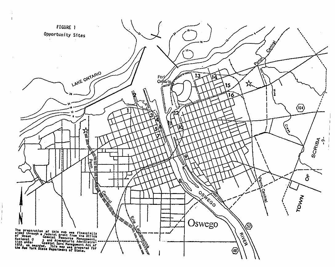
FIGURE 1Opportunity Sites
N ~'i~~---Th. Ir.p.r.tlon or thl•••p II•• rln.nelally ~
.Id. through. r.doro' Bront rro. the Offle. ~ ~or Oe••" eo.u., R',oure. Monogo,.ent, ••• _._••_.~.\\)l?Hatlo"o' 0 e .nd At....ph.rlc Admlnlatro- •••• ••• ~ '\ " .tlon un"'r COllt., Zan. M.".gomont Act or \ ' <$/1972J• •• I.ondld. Thle .Ip ••• ~r.per.d for \\ \the "•• York St.t. O.Plrtllllnt of tit.tl. ~ ~
..,,,..'lIIIIIIII
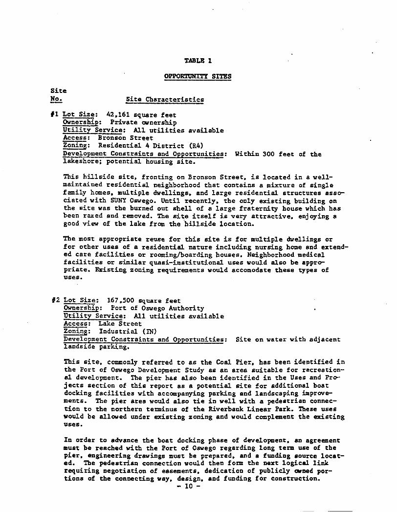
TABLE 1
OPPORTONI'l'Y SI'l'ES
SiteNo. Site Characteristics
'I Lot Size: 42.161 square feetOwnership: Private ownershipUtility Service: All utilities availableAccess: Bronson StreetZoning: Residential 4 District (R4)Development Constraints and Opportunities: Within 300 feet of thelakeshore; potential housing site.
This hillside site. fronting on Bronson Street. is located in a wellmaintained residential neighborhood that contains a mixture of singlefamily homes. multiple dwellings. and large residential structures associated with SUNY Oswego. Until recently. the only existing building onthe site was the burned out shell of a large fraternity house which hasbeen razed and removed. The site itself is very attractive. enjoying agood view of the lake from the "hillside location.
The most appropriate reuse for this site is for multiple dwellings orfor other uses of a residential nature including nursing home and extended care facilities or rooming/boarding houses. Neighborhood medicalfacilities or similar quasi-institutional uses would also be appropriate. Existing zoning requirements would accomodate these types ofuses.
'2 Lot Size: 167.500 square feetOwnership: Port of Oswego AuthorityUtility Service: All utilities availableAccess: Lake StreetZoni~: Industrial (IN)~opment Constraints and Opportunities: Site on water with adjacentlands ide parking.
This site. commonly referred to as the Coal Pier. has been identified inthe Port of Oswego Development Study as an area suitable for recreational development. The pier has also been identified in the Uses and Projects section of this report as a potential site for additional boatdocking facilities with accompanying parking and landscaping improvements. The pier area would also tie in wall with a pedestrian connection to the northern te~inus of the Riverbank Linear Park. These useswould be allowed under existing zoning and would complement the existinguses.
In order to advance the boat docking phase of development. an agreementmust be reached with the Port of Oswego regarding long term use of thepier. engineering drawings must be prepared. and a funding source located. The pedestrian connection would then fo~ the next logical linkrequiring negotiation of easements. dedication of publicly OWned portions of the connecting way. design. and funding for construction.
- 10 -
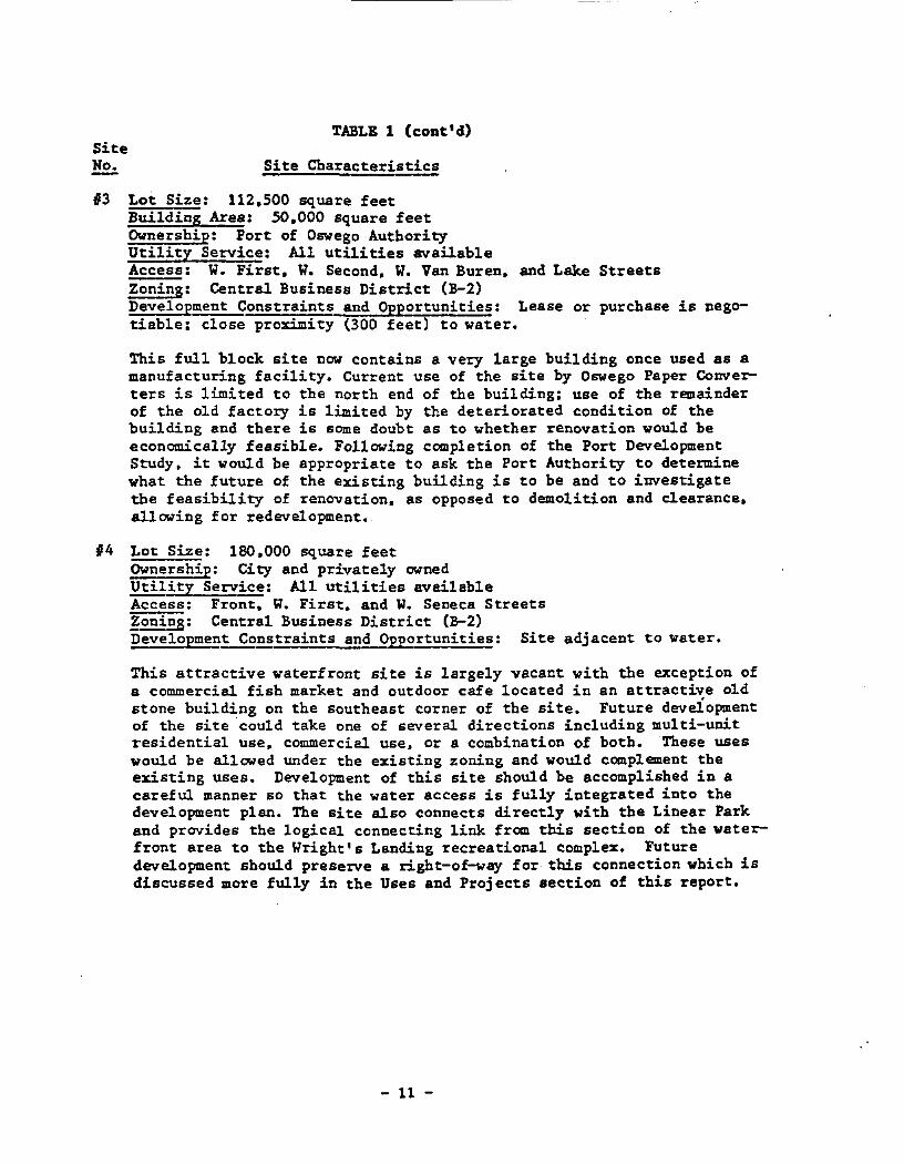
TABLE 1 (cont'd)SiteNo. Site Characteristics
#3 Lot Size: 112.500 square feetBuilding Area: 50,000 square feetOwnership: Port of Oswego AuthorityUtility Service: All utilities availableAccess: W. First. W. Second, W. Van Buren, and Lake StreetsZoning: Central Business District (B-2)Development Constraints and Opportunities: Lease or purchase is negotiable; close proximity (300 feet) to water.
This full block site now contains a very large building once used as amanufacturing facility. Current use of the site by Oswego Paper Converters is limited to the north end of the building: use of the remainderof the old factory is limited by the deteriorated condition of thebuilding and there is some doubt as to whether renovation would beeconomically feasible. Following completion of the Port DevelopmentStudy, it would be appropriate to ask the Port Authority to determinewhat the future of the existing building is to be and to iuvestigatethe feasibility of renovation, as opposed to demolition and clearance,allowing for redevelopment.
14 Lot Size: 180,000 square feetOwnership: City and privately ownedUtility Service: All utilities availableAccess: Front, W. First. and W. Seneca StreetsZoniES: Central Business District (B-2)Development Constraints and Opportunities: Site adjacent to water.
This attractive waterfront site is largely vacant with the exception ofa commercial fish market and outdoor cafe located in an attractive oldstone building on the southeast corner of the site. Future deveiopmentof the site ·could take one of several directions including multi-unitresidential use. commercial use, or a combination of both. These useswould be allowed under the existing zoning and would complement theexisting uses. Development of this site should be accomplished in acareful manner so that the water access is fully integrated into thedevelopment plan. The site also connects directly with the Linear Parkand provides the logical connecting link from this section of the waterfront area to the Wright's Landing recreational complex. Futuredevelopment should preserve a right-of-way for this connection which isdiscussed more fully in the Uses and Projects section of this report.
- 11 -
SiteNo.
~LE 1 (cont'd)
Site Characteristics
j
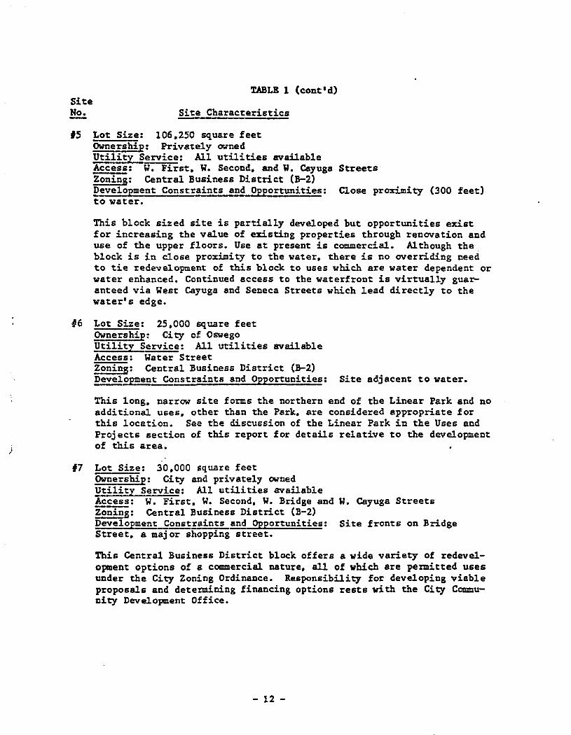
15 Lot Size: 106.250 square feetOwnership: Privately ownedUtility Service: All utilities availableAccess: W. First, W. Second, and W. Cayuga StreetsZoning: Central Business District (B-2)Development Constraints and Opportunities: Close proximity (300 feet)to water.
This block sized site is partially developed but opportunities existfor increasing the value of existing properties through renovation anduse of the upper floors. Use at present is commercial. Although theblock is in close proximity to the water, there is no overriding needto tie redevelopment of this block to uses which are water dependent orwater enhanced. Continued access to the waterfront is virtually guaranteed via West Cayuga and Seneca Streets which lead directly to thewater's edge.
#6 Lot Size: 25.000 square feetOwnership: City of OswegoUtility Service: All utilities availableAccess: Water StreetZoning: Central Business District (B-2)Development Constraints and Opportunities: Site adjacent to water.
This long. narrow site forms the northern end of the Linear Park and noadditional uses. other than the Park, are considered appropriate forthis location. See the discussion of the Linear Park in the Uses andProjects section of this report for details relative to the developmentof this area.
17 Lot Size: 30,000 square feetOwnership: City and privately ownedUtility Service: All utilities availableAccess: W. First, W. Second, W. Bridge and W. Cayuga StreetsZonin!: Central Business District (B-2)Development Constraints and Opportunities: Site fronts on BridgeStreet, a maj or shopping street.
This Central Business District block offers a wide variety of redevelopment options of a commercial nature, all of which are permitted usesunder the City Zoning Ordinance. Responsibility for developing viableproposals and determining financing options rests with the City Community Development Office.
- 12 -
SiteNo.-
TABLE 1 (cont' d)
Site Characteristics
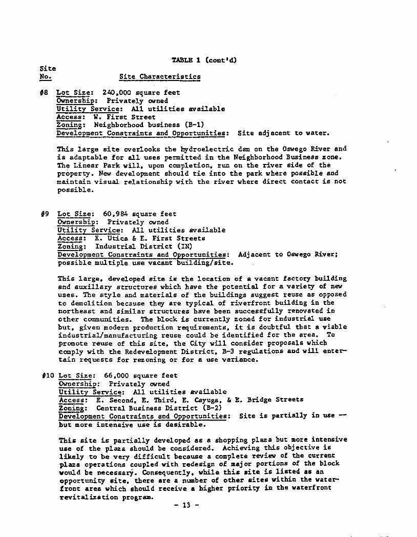
#8 Lot Size: 240,000 square feetOwnership: Privately ownedUtility Service: All utilities availableAccess: W. First Street~s: Neighborhood business (B-1)Development Constraints and Opportunities: Site adjacent to water.
This large site overlooks the hydroelectric dam on the Oswego River andis adaptable for all uses permitted in the Neighborhood Business zone.The Linear Park will, upon completion. run on the river side of theproperty. New development should tie into the park where possible andmaintain visual relationship with the river where direct contact is notpossible.
19 Lot Size: 60,984 square feet9Wnership: Privately ownedUtility Service: All utilities availableAccess: E. Utica &E. First StreetsZonins: Industrial District (IN)Development Constraints and Opportunities: Adjacent to Oswego River;possible multiple use vacant building/site.
This large, developed site is the location of a vacant factory buildingand awdllary structures which have the potential for a variety of newuses. The style and materials of the buildings suggest reuse as opposedto demolition because they are typical of riverfront building in thenortheast and similar structures have been successfully renovated inother communities. The block is currently zoned for industrial usebut. given modern production requirements. it is doubtful that a viableindustrial/manufacturing reuse could be identified for the area. Topromote reuse of this site, the City will consider proposals whichcomply with the Redevelopment District, B-3 regulations and will entertain requests for rezoning or for a use variance.
#10 ~ize: 66.000 square feet~rship: Privately ownedUtility Service: All utilities availableAccess: E. Second, E. Third. E. Cayuga. & E. Bridge StreetsZoning: Central Business District (B-2)Development Constraints and Opportunities: Site is partially in use -but more intensive use is desirable.
This site is partially developed as a shopping plaza but more intensiveuse of the plaza should be considered. Achieving this objective islikely to be very difficult because a complete review of the currentplaza operations coupled with redesign of major portions of the blockwould be necessarY. Consequently, while this site is listed as anopportunity site, there are a number of other sites within the waterfroDt area whicb should receive a higher priority in the waterfrontrevitalization program.
- 13 -
SiteNo.
TABLE 1 (cant 'd)
Site Characteristics
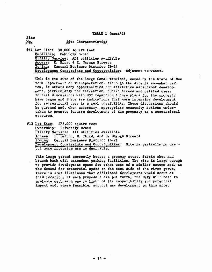
#11 Lot Size: 30.000 square feetOwnership: Publicly ownedUtility Service: All utilities availableAccess: E. Fi~st & E. Cayuga St~eets
Zoning: Central Business District (B-2)~opment Constraints and Opportunities: Adjacent to water.
This is the site of the Barge Canal Terminal. owned by the State of NewYork Department of Transportation. Although the site is somewhat narrow. it offers many opportunities for attractive waterfront development, particularly for recreation, public access and related uses.Initial discussions with DOT regarding future plans for the propertyhave begun and there are indications that more intensive developmentfor recreational uses is a real possibility. These discussions shouldbe pursued and, when necessary, appropriate community actions undertaken to promote fututre development of the property as a recreationalresource.
#12 Lot Size: 275,000 square feetOwnership: Privately ownedUtility Service: All utilities availableAccess: E. Second, E. Third, and E. Cayuga StreetsZoning: Central Business District (B-2)Development Constraints and Opportunities: Site is partially in use but more intensive use is desirable.
This large parcel currently houses a groce~ store. fabric shop andbranch bank with attendant parking facilities. The site is large enoughto provide development space for other uses of a similar nature and, asthe demand for commercial space on the east side of the river grows,there is some likelihood that additional development would occur atthis location. If such proposals are put forth, the City will need toevaluate each each one in light of iu compatibility and potentialimpact and, where feasible, support new development on this site.
- 14 -
SiteNo.
~LE 1 (cont'd)
Site Characteristics
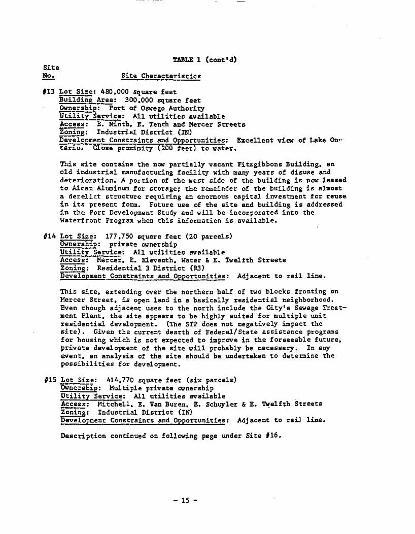
'13 Lot Size: 480,000 square feetBuilding Area: 300,000 square feetOwnership: Port of Oswego AuthorityUtility Service: All utilities availableAccess: E. Ninth, E. Tenth and Mercer StreetsZoning: Industrial District (IN)~ooment Constraints and Opportunities: Excellent view of Lake Ontario. Close proximity (200 feet) to water.
This site contains the now partially vacant Fitzgibbons Building, anold industrial manufacturing facility with many years of disuse anddeterioration. A portion of the west side of the building is now leasedto Alcan Aluminum for storage; the remainder of the building is almosta derelict structure requiring an enormous capital investment for reusein its present form. Future use of the site and building is addressedin the Port Development Study and will be incorporated into theWaterfront Program when this information is available.
'14 Lot Size: 177,750 square feet (20 parcels)Ownership: private ownershipUtility Service: All utilities availableAccess: Mercer, E. Eleventh, Water & E. TWelfth StreetsZoning: Residential 3 District (R3)~opment Constraints and Opportunities: Adjacent to rail line.
This site, extending over the northern half of two blocks fronting onMercer Street, is open land in a basically residential neighborhood.Even though adjacent uses to the north include the City's Sewage Treatment Plant, the site appears to be highly suited for multiple unitresidential development. (The STP does not negatively impact thesite). Given the current dearth of Federal/State assistance programsfor housing which is not expected to improve in the forseeab1e future,private development of the site will probably be necessary. In anyevent, an analysis of the site should be undertaken to determine thepossibilities for development.
'15 Lot Size: 414,770 square feet (six parcels)Ownership: Multiple private ownershipUtility Service: All utilities availableAccess: Mitchell, E. Van Buren, E. Schuyler &E. ~e1fth StreetsZoning: Industrial District (IN)~opment Constraints and Opportunities: Adjacent to ra~ line.
Description continued on following page under Site 116.
- 15 -
SiteNo.
7,ABLE 1 (coat'd)
Site Characteristics
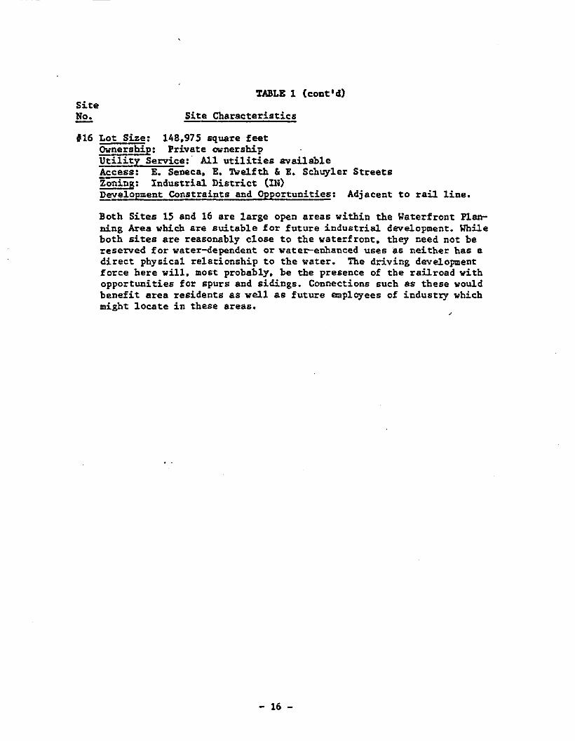
'16 Lot Size: 148,975 square feetOwnership: Private ownershipUtility Service:· AJ.l utilities availableAccess: E. Seneca, E. 'lWelfth & E. Schuyler StreetsZoning: Industrial District (IN)Development Constraints and Opportunities: Adjacent to rail line.
Both Sites 15 and 16 are large open areas within the Waterfront Planning Area which are suitable for future industrial development. Whileboth sites are reasonably close to the waterfront, they need not bereserved for water-dependent or water-enhanced uses as neither has adirect physical relationship to the water. The driving developmentforce here will, most probably, be the presence of the railroad withopportunities for spurs and sidings. Connections such as these wouldbenefit area residents as well as future empl~ees of industry whichmight locate in these areas.
- 16 -
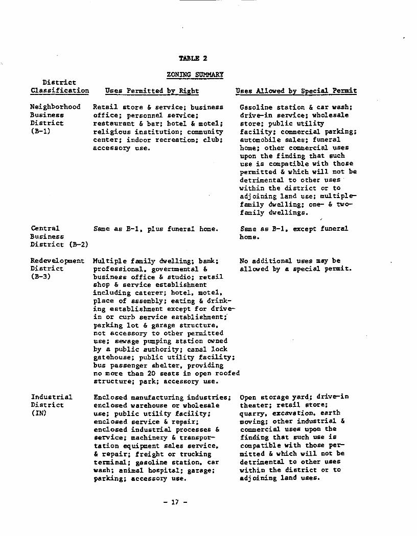
TABLE 2
DistrictClassification
NeighborhoodBusinessDistrict(B-1)
ZONING SUMMARY
Uses Permitted by Right
Retail store & service: businessoffice: personnel service:restaurant & bar: hotel & motel:religious institution: communitycenter; indoor recreation; club;accessory use.
Uses Allowed by Special Permit
Gasoline station & car wash;drive-in service; wholesalestore; public utilityfacility; commercial parking;automobile sales; funeralhome; other commercial usesupon the finding that suchuse is compatible with thosepermitted& which will not bedetrimental to other useswithin the district or toadj oining land use: multipIefamily dwelling; one- & twofamily dwellings.
Central Same as B-1. plus funeral home.BusinessDistrict (B-2)
Same as B-1. except funeralhome.
No additional uses may beallowed by a special permit.
RedevelopmentDistrict(B-3)
HultipI e family dwelling: bank;professional. governmental &business office & studio: retailshop & service establishmentincluding caterer: hotel. motel.place of assembly: eating & drinking establishment except for drivein or curb service establishment:parking lot & garage structure.not accessory to other permitteduse; sewage pumping station ownedby a public authori ty; canal lockgatehouse: public utility facility;bus passenger shelter. providingno more than 20 seats in open roofedstructure; park: accessory use.
IndustrialDistrict(IN)
Enclosed manufacturing industries;enclosed warehouse or wholesaleuse; public utility facility;enclosed service & repair:enclosed industrial processes &service; machinery & transportation equipment sales service.& repair: freight or truckingterminal: gasoline station. carwash; animal hospital; garage;parking; accessory use.
- 17 -
Open storage yard,; drive-intheater; retail store:quarry. excavation. earthmoving: other industrial &commercial uses upon thefinding that such use iscompatible with those permitted & which will not bedetrimental to other useswithin the district or toadjoining land uses.
DistrictClassification
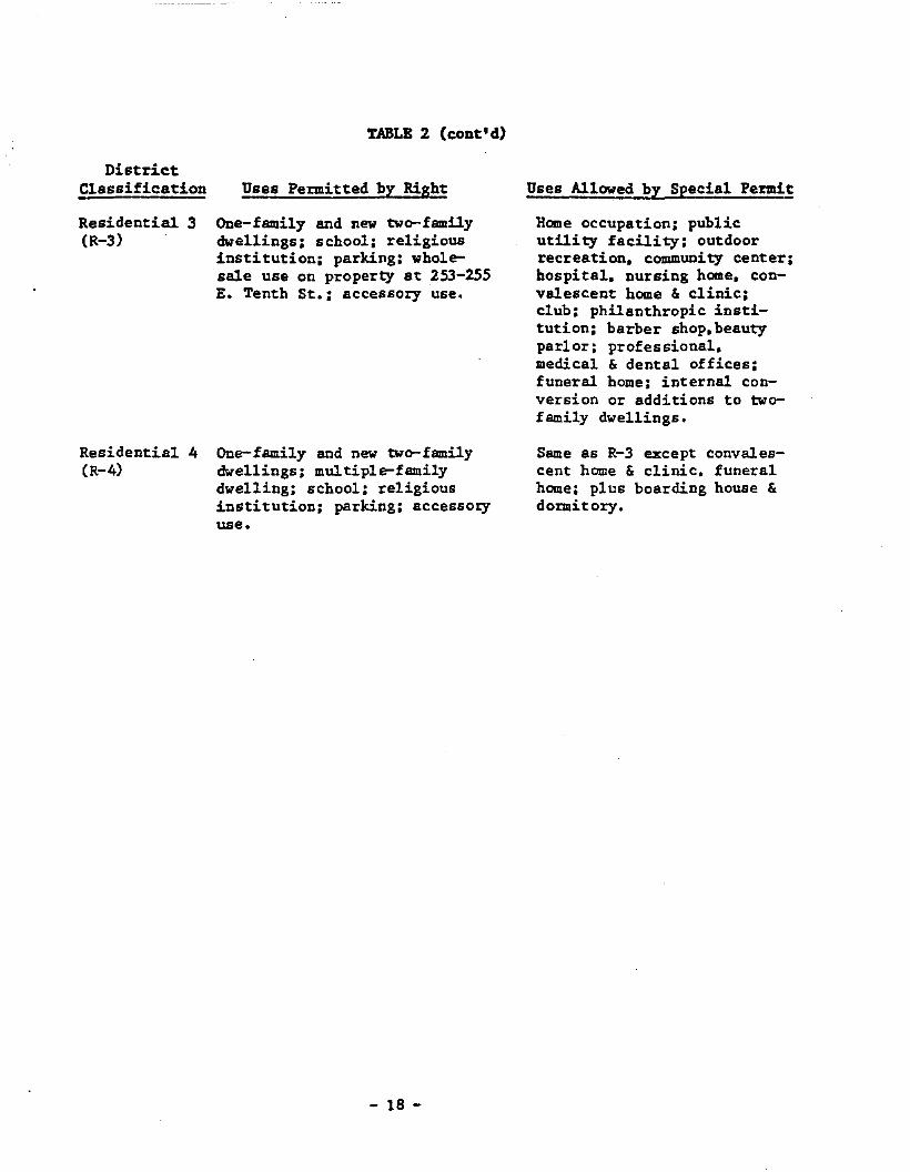
Residential 3(R-3)
Residential 4(R-4)
TABLE 2 (c:ont'd)
Uses Permitted by Right
One-family and new two-familydwellings: school: religiousinstitution: parking: wholesale use on property at 253-255E. Tenth St.: accessory use.
One-family and new two-familydwellings: multiple-familydwelling: school: religiousinstitution: parking: accesso~
use.
- 18 -
Uses Allowed by Special Permit
Home occupation: publicutility facility: outdoorrecreation. community center:hospital. nursing home. convalescent home & clinic:club: philanthropic institution: barber shop. beautyparlor: professional.medical & dental offices:funeral home: internal conversion or additions to twofamily dwellings.
Same as R-3 except convalescent home & clinic. funeralhome: plus boarding house &domitory.
NATURAL RESOURCES INVENTORY- ---Several natural resource factors are important to the Oswego coastal area andhave an important role in the Oswego waterfront revitalization program. Inorder to conserve these natural resources. development proposals submitted tothe City for approval are reviewed to determine potential benefits and adverseimpacts. Wherever possible. project developers will be encouraged to includemeasures to enhance natural resource conservation and minimize unavoidableadverse impacts. The City's planning and zoning review process is viewed as akey measure for maintaining and enhancing coastal area natural resources. Thenatural resources applicable to the Oswego LWRP are shewn on a map of Oswego inFigure 2 and are listed belew:
o scenic vistas;o significant fish and wildlife habitats:o unique topographic/geologic areas:o beaches.
The natural resource element that is considered by far to be most important. andtherefore of statewide significance. is the Oswego Harbor and River area shownin Figure 2. The area is important for fish and waterfowl populations.
Scenic Vistas
Locally important scenic vistas include views of Lake Ontario from Wright'sLanding. Fort Ontario. and the coastal bluffs east of tbe fort and views of theOswego River from vantage points on both the east and west banks.
Fisb and Wildlife Habitata
The substantial areas currently identified as habitats in Figure 2 include theOswego Harbor and River areas as well as land areas near the eastern lakeshoreof the City•.The fish habitats provide excellent sports fisbing opportunities.Cbinooks. cohos. brown and lake trout. and steelheads are the predominantspecies within these fisheries.
Oswego Harbor is a waterfowl wintering area. which results from the open waterthat is created by warm water. particularly that coming from the Niagara Mohawkpower plant discharge. It is for this reason that the area outside thebreakwalls is in the process of being evaluated by DEC for possible designationas a "significant coastal habitat". The waterfowl population includes scaup.common goldeneye. mergansers. black duck. mallard. oldsquaw. canvasback. andbufflehead.
The fish and wildlife habitat on the ONego River extends southward to theNiagara Mohawk Power Dam. as shOlo7n in Figure 2. This area provides good sportsfishing opportunities for SIIIallmouth bass and walleyed pike. DEC indicates thatthe Oswego River also attracts a productive salmonid fishery based on Pacificsalmonids. The potential for a lake trout fishery is also high bere. Thereason for the existing conCentration of sport fish is a high concentration ofgizard shad. DEC also indicates the Oswego River as a probable lake sturgeonhabitat.
- 19 -
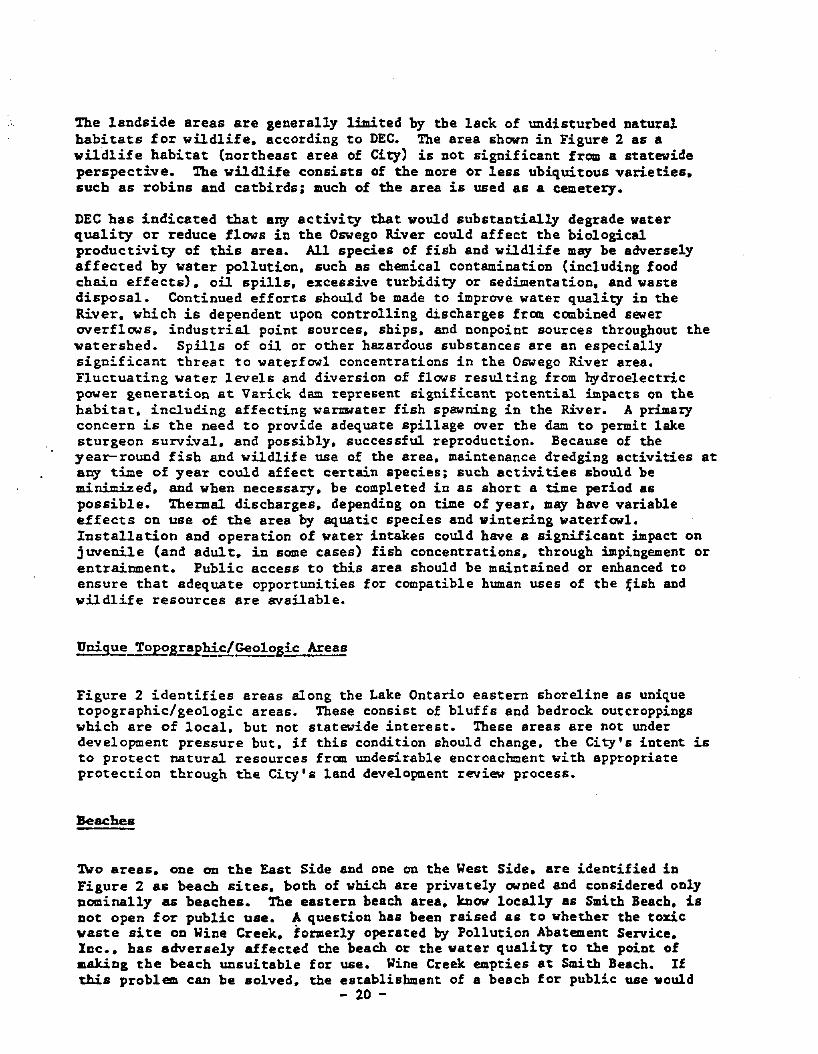
The landside areas are generally limited by the lack of undisturbed naturalhabi~a~s for wildlife. according to DEC. The area shown in Figure 2 as awildlife habitat (northeast area of City) is not significant from a statewideperspective. The wildlife consists of the more or less ubiquitous varieties.sucb as robins and catbirds: much of the area is used as a cemetery.
DEC has indicated that any activity that would substantially degrade waterquality or reduce flows in the Oswego River could affect the biologicalproductivity of this area. All species of fish and wildlife may be adverselyaffected by water pollution. such as chemical contamination (including foodchain effects). oil spills. excessive turbidity or sedimentation, and wastedisposal. Continued efforts should be made to improve water quality in theRiver. which is dependent upon controlling discharges from combined seweroverflows. industrial point sources. ships. and nonpoint sources throughout thewatershed. Spills of oil or other hazardous substances are an especiallysignificant threat to waterfowl concentrations in the Oswego River area.Fluctuating water levels and diversion of flows resulting from ~droe1ectric
power generation a~ Varick dam represen~ significant po~entia1 impacts on thebabitat, including affecting waruwater fish spawning in the River. A primaI}'concern is the need to provide adequate spillage over the dam to permit lakesturgeon survival. and possibly. successful reproduction. Because of theyear-round fish and wildlife use of the area, maintenance dredging activities atany time of year could affect certain species; such activities sbould beminimized. and when necessary. be completed in as short a time period aspossible. Thermal discharges. depending on time of year. may have variableeffects on use of the area by aquatic species and wintering waterfowl.Installation and operation of water intakes could have a significant impact onjuvenile (and adult. in some cases) fisb concentrations. through impingement orentrainment. Public access to this area should be maintained or enhanced toensure that adequate opportunities for compatible human uses of the fish andwildlife resources are available.
Unique Top0s!!p~c/GeologicAreas
Figure 2 identifies areas along the Lake Ontario eastern shoreline as uniquetopographic/geologic areas. These consist of bluffs and bedrock outcroppingswhich are of local, but not statewide interest. These areas are not underdevelopment pressure but. if this condition should change. the City's intent isto protect natural resources from undesirable encroachment with appropriateprotec~ion through the City's land development review process.
Beaches
TWo areas. one on the East Side and one on the West Side. are identified inFigure 2 as beach sites. both of which are privately owned and considered onlynominally as beaches. The eastern beach area. know locally as Smith Beach. isnot open for public use. A question has been raised as to whether the toxicwaste site on Wine Creek. formerly operated ~ Pollution Abatement Service.Inc •• bas adversely affected the beach or the water quality to the point of.aking the beach unsuitable for use. Wine Creek empties at Smith Beach. Ifthis problem can be solved. the establishment of a beach for public use would
- 20 -
enhance the waterfront area by providing additional public access. This assumesthat questions pertaining to the current private ownership of the beach andsurrounding areas can be answered in support of such a public facility. Figure6 shows the Smith Beach area as a potential public access site. reflectingeither public or private development of the site for public use.
With respect to problems associated with the former Pollution Abatement Service.DEC's Division of Solid and Hazardous Waste currently is conducting anenvironmental assessment of Wine Creek and its major tributary. White Creek. inthe area around and downgradient from the abandoned Pollution Abatement Serviceshazardous waste facility. The study is designed to determine primarily if anycurrent or residual impact to the stream systems exists and. if so. what typesof remedial responses would be appropriate. Smith's beach will be considered toa limited extent in this study. which is expected to be completed in the springof 1986. The PAS site is scheduled for remedial action during the summer of1986. which will eliminate any further impact on Wine Creek from the toxicwastes at the site.
The western shore area includes a private beach area adjacent to the residenceof the President of SUNY Oswego which. because of its proximity to theresidence. may not be suitable for public access. However. this site is shownas a nominal beach area in Figure 2.
- 21 -
r RE 2
NATURAL RESOURCES INVENTORY
Scenic Vistas> -
---- Waterfront Boundary'- 3D __-I":
1!fII-
Th" IrepMDtlon of this mnp WDS rtnonclollyaide through 0 fod"rol gront fro. tho Offlcaor Oeaan Dnd COQstol RCGourco Hnnogcment,'._•• •••"otionDI Ocoanlc and Atmospharlc Administra_tion under tho Coastal Zone Monegement Act Of1912. os omondod. Thl8 mop waG "r.porod fortho New York Stote Deportmont Of Stat8.
ISTING LAND AND llATER USES
------------------_.. _----- .,
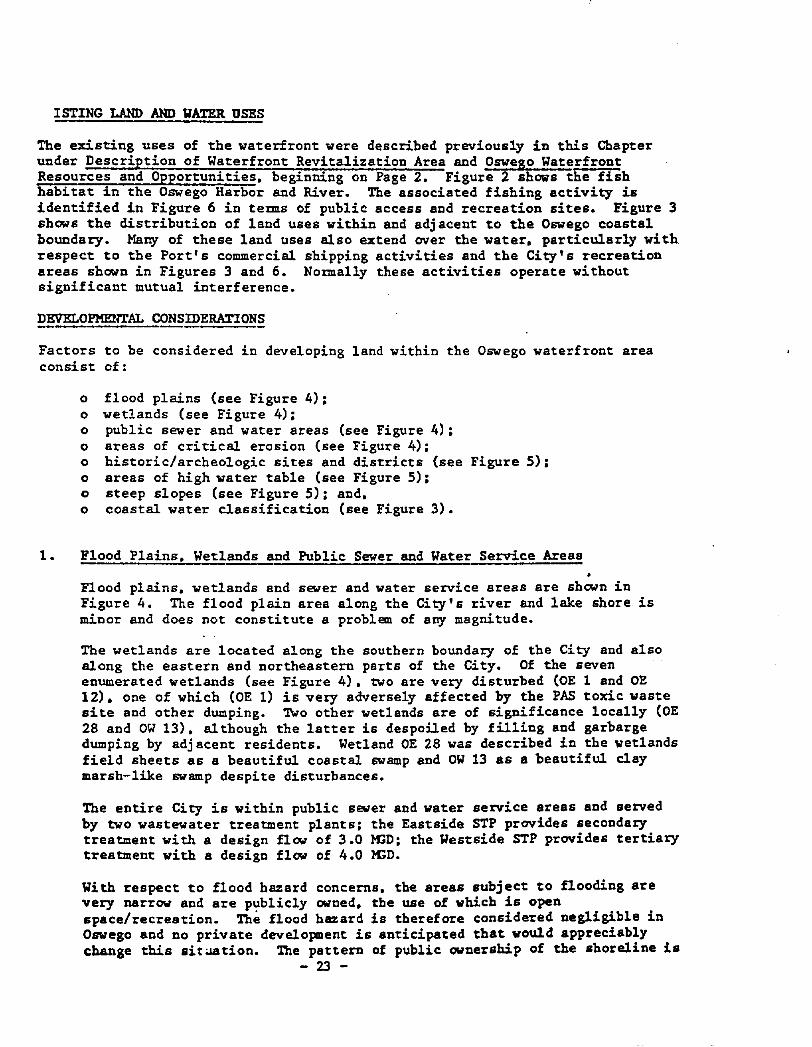
The existing uses of the waterfront were described previously in this Chapterunder Description of Waterfront Revitalization Area and Oswego WaterfrontResources and Opportunities. beginning on Page 2. Figure 2 shows the fishhabitat in the Oswego Harbor and River. The associated fishing activity isidentified in Figure 6 in teDnS of public access and recreation sites. Figure 3shows the distribution of land uses within and adjacent to the Oswego coastalboundary. Y18ny of these land uses also extend over the water. particularly withrespect to the Port's commercial shipping activities and the City's recreationareas shown in Figures 3 and 6. NODnally these activities operate withoutsignificant mutual interference.
DEVELOPMEm'AL CONSIDERATIONS------Factors to be considered in developing land within the Oswego waterfront areaconsist of:
o flood plains (see Figure 4);o wetlands (see Figure 4);o public sewer and water areas (see Figure 4);o areas of critical erosion (see Figure 4);o historic/archeologic sites and districts (see Figure 5);o areas of high water table (see Figure 5);o steep slopes (see Figure 5); and.o coastal water classification (see Figure 3).
1. Flood Plains. Wetlands and Public Sewer and Water Service Areas
Flood plains. wetlands and sewer and water service areas are shown inFigure 4. The flood plain area along the City's river and lake shore isminor and does not constitute a problem of any magnitude.
The wetlands are located along the southern boundary of tbe City and alsoalong the eastern and northeastern parts of the City. Of the sevenenumerated wetlands (see Figure 4). two are very disturbed COE 1 and OE12). one of which (OE 1) is very adversely affected by the PAS toxic wastesite and other dumping. TWo other wetlands are of significance locally COE28 and OW l3}. al though the latter is despoiled by filling and garbargedumping by adjacent residents. Wetland OE 28 was described in the wetlandsfield sheets as a beautiful coastal swamp and OW 13 as a beautiful claymarsh-like swamp despite disturbances.
The entire City is within public sewer and water service areas and servedby two wastewater treatment plants; the Eastside STP provides secondarytreatment wi th a design flow of 3.0 !'CD: the Westside STP provides tertiarytreatment with a design flow of 4.0 !'CD.
llith respect to flood hazard concerns. the areas subject to flooding arevery narrow and are p':lblicly owned. the use of which is openspace/recreation. The flood hazard is therefore considered negligible inOswego and no private development is anticipated that would appreciablychange this sitaation. The pattern of public ownership of the shoreline is
- 23 -
expected to continue. In addition. Oswego County has an extensiveemergency management program. if that should ever be needed.
2. Areas of Critical Erosion
The areas of critical erosion. as determined by the NYS Department ofEuvirocmental Conservation. are shown in Figure 5. The City has adopted acoastal erosion hazard ordinance as part of the LWRP.
3. Historic and Archeologic Sites and District!
The historic and archeologic sites of national and local importance areshown in Figure 5. The historic sites include:
East Side
1 Richard Bates House Museum. 135 E. Third St. (National Registe!)2 Oswego City Library. 120 E. Second St. (National Register)3 Oswego County Courthouse. E. Oneida St.4 Fort Ontario (National Register)
West Side
5 Cahill Fish Market. W. Seneca & W. First SU. (National RegisteE)6 Oswego Market House. W. Bridge & Water Sts. (National Registe!)7 Pontiac Hotel. 225 W. First St. (National Register)8 Oswego City Hall. W. Oneida St. (National Registe!)9 Federal Building. W. Oneida St. (National Register)
10 Sloan Hawley House and Carriage House. 107 W. Van Buren St.11 Sheldon Hall. Washington Blvd. & Sheldon Ave. (National Reg!st~E)
(These sites are shown in Figure 5. as numbered above.)
Archeologic sites. of potential significance have been identified in thewaterfont area. National Registry of Historic Places eligibilitydocumentation has been prepared for the Oswego West Side ArcheologicalDistrict. which is shown in Figure 5. Archeological data has been recoveredfrom a number of sites within the district and a final report is inpreparation.
In addition to the historic sites. the Franklin Square Historic District hasbeen added to the ~~l Registe! (see Figure 5). This district includes.among other sites. a house of historic importance at 49 West Fifth Street.The boundaries of the Franklin Square Historic District are:
West Fifth Street: west side from two houses north of Van Buren tothe Elks on the SW corner of Bridge Street. 30 to 140 (140 has been demolished).
West Fourth Street from Cayuga to Bridge Street: west side 102 to 128:east side 105 to 123.
West Third Street from Seneca to Bridge Street: west side 104 to 116: eastside 77 to 119.
- 24 -
West Seneca from Third to Fifth: north side 35 to 53: south side 60.
West Cayuga: north side from Third to Sixth plus small building attachedto the rear of the Welland (which should be decertified: listing error).31 and 67 to 73: south side from West Third to West Fifth 40-62.
West Bridge Street: from NW corner of Fourth to the west side of WestFifth on the north side 69 to 73; from the SW corner of Fourth to SWcorner of Fifth oc the south side 62 to 74.
Finally. an historic district. to be known as the Westbank HistoricDistrict. is now being identified and documentation prepared forsubmission for inclusion in the National RegisteE (see Figure 5). Theapproximate boundaries of the Westbank Historic District are:
~est First Street: from Oneida to midway between Market Street Alley andCayuga on the east side (stop at empty lot): from Oneida to the MatadorBuilding on the west side.
West Bridge Street: from the Oswego River across First Street and possiblyup to the west side of Second Street.
The Osw~o Theatre on West Second might also be included.
4. Areas of High Water Table and Steep Slopes
Figure 5 shows areas having a high water table and steep slopes.
S. SE~~ta1 Water Classification, .
Pursuant to the Federal Clean Water Act of 1977 (PL95-217). the State hasclassified its coastal and other waters. in accordance with considerations ofbest usage in the interest of tbe public. and has adopted water qualitystandards for each class of water. As part of this State program. LakeOntario in the vicinity of the City of Oswego has been classified "A". forwhich the best use is designated public water supply with filtration anddissinfection. The portion of the Oswego River within the City's boundariesis classified "C". for which the best use is designated as fishing. Thewater classifications "A" and "C" are shown where appropriate in Figure 3.
COASTAL PUBLIC ACCESS AND RECREATION
The public has had a moderate amount of access to the coastal area of Oswego formany years and recent improvements. some not yet completed. will have asubstantial positive impact on public access to the Oswego waterfront. Figure 6shows public access and recreation sites identified by the St. Lawrence-EasternOntario Commission's report. Coastal Public Access and Recreation in the St.LawrenEe-Eastern Ontario Region: An Inventory and Analysis of Sites Under Loca!Government Jurisdiction (Final Report. July 1983). Figure 6 shows areas whichnow exist (Breitbeckhrk•.Wright's Landing. and a portion of the West BankLinear Park): the access area now awaiting funds for implementation (a portionof the West Bank Linear Park): and areas identified as having potential forpublic access and recreational use. Further discussion of these sites isincluded in Section IV. Projects 11. 12. 13 and 14.
- 25 -
One area along the Oswego River has been identified as having a potential forLinear Park development on the East Blink. This extends from the Port Authorityproperty to the power dam. The land in question is owned by the NYS Departmentof Transportation as part of the State's Barge Canal System. DOT is currentlyexamining the possibility of developing the site in question for public access.A second area is on the shore of Lake Ontario east of the Oswego River at a siteknown as Smith Beach which has been discussed in a previous section on theNatural Resources Inventory. Finally. the suggestion has been made that thebreakwalls provide excellent fishing opportunities. With respect to the easternbreakwall. a bridge access of some type could be constructed and the breakwa1litself capped and a railing attached. The breakwall is shown in Figure 6 forpotential public access. Further discussion of these sites is included inSection IV. Projects IS and 16.
With respect to the western breakwall. the City currently has an agreement withNiagara Mohawk Power Corporation permitting public access to the breakwall overNiagara Mohawk property. However. the breakwall appears in need of repair.capping and a railing to provide greater safety. Since the current breakwallcondition is less than suitable for public access. Figure 6 identifies thebreakwall as a potential rather than existing site. in order to avoidencouraging further use of a less than safe facility.
- 26 -
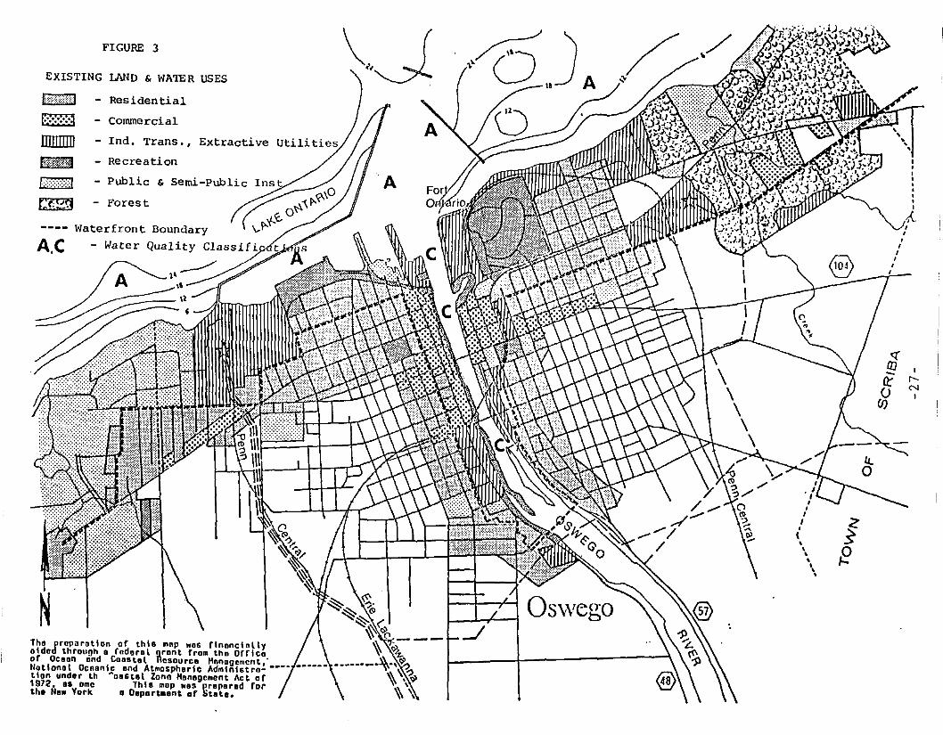
FIGURE 3
EXISTING IJ\ND & WATER USES
Ir-('oJ
I
g-15
(J)
fE
- Public & semi-public
- Forest
lA'"""",}'" - Residential
l=;;':';';'~ - Conunercial
nnnnn - Ind. Trans., Extractive Utilities
trJ¥f,M - Recreation
I;,';:::::::::;:J
~
AC
Tho prep~rDtlan af thlG mnp woo f'nonctollyolded through 0 fodorol i\ront fram tha Orricoor Ocean and Coastal aSDUrCD Mnnagement,'Ilotionol Oceanic ond Atmosphorlc Admlnlstra- _.-tlon undor th ~ooStal Zono Honagement Act of1972, os ame Thlo mop ..0' proporod fortho No.. York 0 Deportment of State.
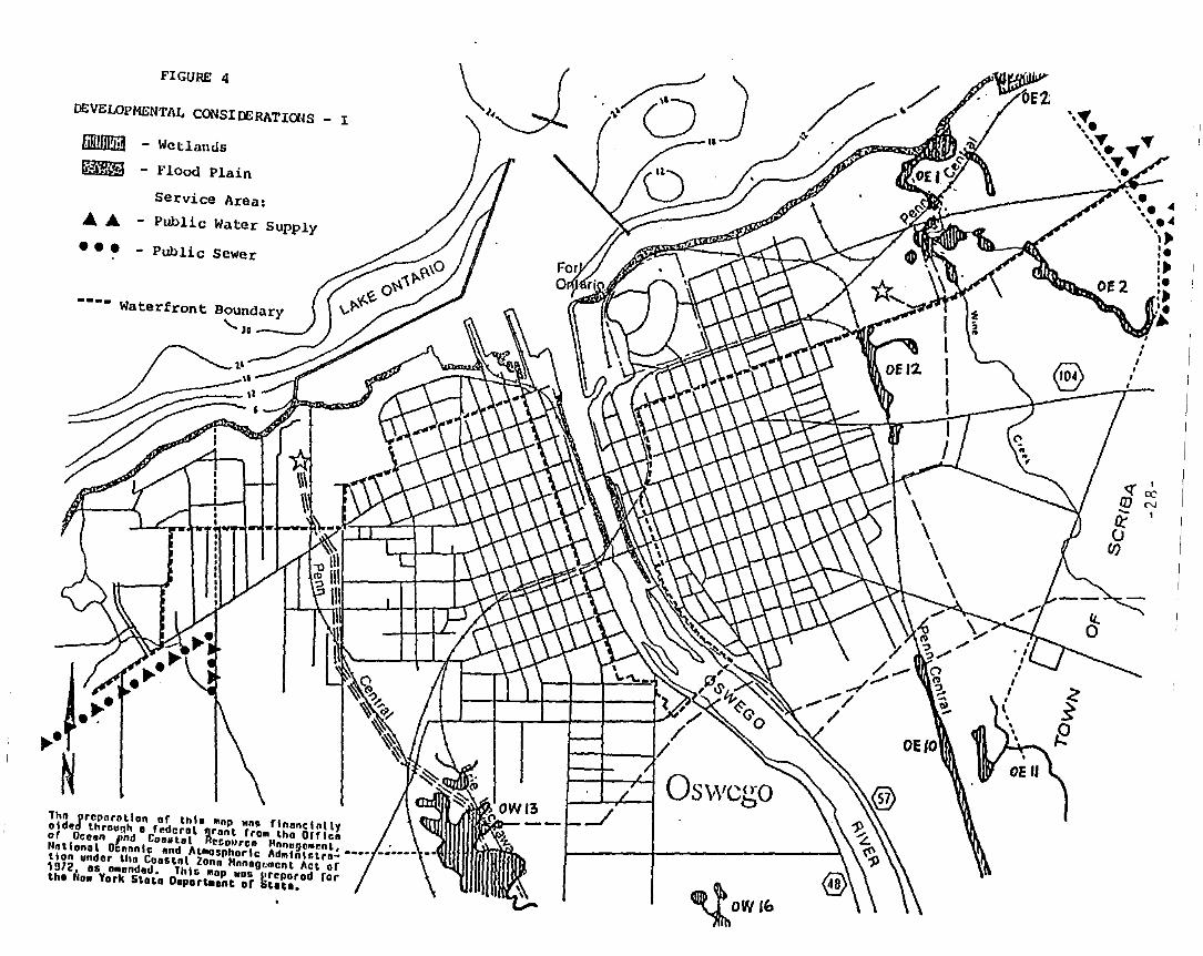
FIGURE 4
DEVELOPMENTAL CONSIDERATIONS _ I
li!i!/ll!i:j - Wetlands
~ Flood Plain
Service Area:
.... - Public Water Supply
• •• - Public Sewer
---- Waterfront Boundary...... JD-__
j.~.~·fN
1hn prep.rotlon or th," IInp "ng flnonclnllyoldad throu"h 0 rodero, grant rroll tho orrlcaor Ocesn ,md CoDa tat Rrcollrco HnnugcMr.nL,IIntlonal Ocnnnic nnd AtllOsphorlc Adlliniotro- ••••tion undor tho CoOStnl Zonn Hnnoooment Act or1912, os omondod. lhls 1I0P wau I.rcporod rortho .Iow York Stoto Dopart.ont or titat••
~OWI&
«'(]]~-- I!J
(J)

E'IGURE 5
DEVELOPMENTAL CONSIDERATIONS _ II
... - Areas of Cri tical Erosion(Limit to "rea Shown)
----- West Side Archeological District~ - Franklin Square District
- - Proposed Westbank Historic Dist.
o - Historic Sites
~ - High Water Table
C~~)::'J - Steep Slopes
---- Waterfront Boundary'-'0-__
lhft prnpnratlon of th\& .. np "ns flnnnclnllyOlded throuoh 0 f.doral orant fro.. tho Drrlcaor OceDn and COO_tel ncsource Hnnogement,"at lonal Dennnic and At"ospharlc Ad"'nhtro- •••_tlon undor tho CODltol Zonn "nnODum.nt Act or1012. oa 0 d. lhla ",op wos preporod fortho IIa. YOI It. 1l0portlOont or Stata.
,,,,," ,,,,,,
" ,
,c-.
<[ ('I
(JJ I
IiufJ)
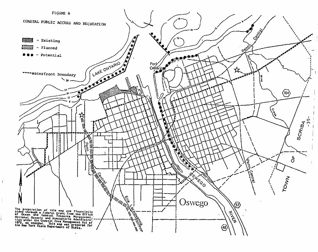
FIGURE 6
COASTAL PUBLIC ACCESS AND RECREATION
.. - Existing
~ - Planned
••• - Potential
----Waterfront Boundary'-30 _
~~~ ~~~~ ('
~~---Tho preporotlon or thls mnp ..ns rtnnncially ~ ~L.olded through 0 rudnrol gront rrom tho Orrico 1\ ,.or Ocoon ond COOstol Resource l1onogement.' __ ._. • __ .,,_, Q).,Notionol Ocnonlc ond AtlllOsphorlc Admlnlotro- __•• ~ ~.,tlon undor tho Coanol Zone Monegement Act or ~ • Ql1972. os omendod. This map ..as props rod ror ~ \the He. York Stote Deportment or StDh. \\ \
\.,•,,
"\
'.,\...
IC"
<:[<"'1en I
if()
(f)
fE
SECTION III
WATERFRONT REVITALIZATION PROGRAM POLICIES
SECTION III
WATERFRONT REVITALIZATION PROGRAM POLICIES
Contents
DEVELOPMENT POLICIES
POLICY 1
POLICY 1A
POLICY 2
POLICY 2A
POLICY 2B
POLICY 2C
POLICY 3
POLICY JI
RESTORE, REVITALIZE, Am> REDEVELOP DETERIORATED Am> UNDERUTILIZED WATERFRONT AREAS FOR COMMERCIAL Am> INDUSTRIAL,CULTURAL, RECREATIONAL AND OTHER COMPATIBLE USES............... 1
RESTORE, REVITALIZE, AND REDEVELOP DETERIORATED AND UNDERUTILIZED WATERFRONT AREAS IN THE CITY OF OSHEGO TO ACHIEVE AMIXTURE OF USES SERVING THE VARIED INTERESTS OF OSWEGO......... 1
FACILITATE THE SITING OF WATER-DEPENDENT USES Am> FACILITIESON OR ADJACENT TO COASTAL WATERS............................... 2
FACILITATE APPROPRIATE INDUSTRIAL AND COMMERCIAL USES IN THEOSWEGO WATERFRONT AREA WHICH REQUIRE OR CAN BENEFITSUBSTANTIALLY FROM A WATERFRONT LOCATION AND WHICH WILLPROVIDE ADDITIONAL EMPLOYMENT OPPORTUNITIES TO STRENGTHENTHE LOCAL OSWEGO ECONOMY....................................... 2
FACILITATE APPROPRIATE ACTIVE AND PASSIVE RECREATIONAL USESAND CULTURAL USES IN THE OSWEGO WATERFRONT AREA WHICH REQUIREOR CAN BENEFIT SUBSTANTIALLY FROM A WATERFRONT LOCATION ANDWHICH WILL INCREASE THE NUMBER OF JOBS AND THE USE OFOSWEGO'S WATERFRONT............................................ 3
AS OPPORTUNITIES ARISE, ENCOURAGE THE POSSIBLE RELOCATION OFEXISTING NON-WATER DEPENDENT USES FROM THE OSWEGO WATERFRONTTO OTHER APPROPRIATE AREAS SUITABLE FOR CONDUCTING THEACTIVITY IN QUESTION, THEREBY MAKING WATERFRONT SITESAVAILABLE FOR WATER-DEPENDENT USES OR ACTIVITIES ENHANCEDBY A WATERFRONT LOCATION....................................... 3
ENCOURAGE THE DEVELOPMENT OF THE STATE'S EIISTIHG MAJORPORTS OF ALBANY, BUFFALO, HEW lORI, OGDENSBURG, Am> OSWEGO ASCENTERS OF COMMERCE AND INDUSTRY, AND ENCOURAGE THE SITING,IN THESE PORT AREAS, INCLUDING THOSE UNDER THE JURISDICTIONOF STATE PUBLIC AUTHORITIES, OF LAND USE Am> DEVELOPMENT WHICHIS ESSENTIAL TO OR IN SUPPORT OF WATERBORNE TRANSPORTATION OFCARGO AND PEOPLE ••• III ••••••• III •••••• III • • • • • • • • • • • • • • • • • • • • • • • • • • • 5
The State Coastal Policy regarding development of smaller harborareas 19 not applicable to Oswego.............................. 6
i
POLICY 5
POLICY SA
POLICY 5B
CONTENTS (Continued)
ENCOURAGE THE LOCATION OF DEVELOPMENT IN AREAS WHERE PUBLICSERVICES AND FACILITIES ESSENTIAL TO SUCH DEVELOPMENT AREADEQUATE, EXCEPT WHEN SUCH DEVELOPMENT HAS SPECIAL FUNCTIONALREQUIREMENTS OR OTHER CHARACTERISTICS WHICH NECESSITATES ITSLOCATION IN OTHER COASTAL AREAS............................... 6
THE CITY OF OSWEGO WILL MAINTAIN AND, WHERE NECESSARY,IMPROVE PUBLIC SERVICES AND FACILITIES TO ASSURE CONTINUEDABILITY TO MEET EXISTING AND FUTURE NEEDS...................... 7
ENCOURAGE DEVELOPMENT TO OCCUR IN SUCH A MANNER AS TOALLOW ADEQUATE WATERFRONT OPEN SPACE AND PUBLIC ACCESSTO THE WATERFRONT.... . . • • . • • • • • • . . . . . . . . • • • . • . . . • • • • • • • • • • • • • • • 7
POLICY 5C FOSTER ENERGY CONSERVATION BY ENCOURAGING PROXIMITYBETWEEN HOME, WORK AND LEISURE ACTIVITIES WITHIN THEMIXED-USE WATERFRONT REVITALIZATION AREA, WHICH HASTRADITIONALLY CHARACTERIZED THE OSWEGO WATERFRONT.............. 7
POLICY 6 EXPEDITE PERMIT PROCEDURES IN ORDER TO FACILITATE THESITING OF DEVELOPMENT ACTIVITIES AT SUITABLE LOCATIONS........ 8
POLICY 61 IN ORDER TO FACILITATE THE SITING OF DEVELOPMENT PROJECTS ATSUITABLE LOCATIONS IN THE OSWEGO WATERFRONT AREA, THE CITYWILL CONTINUE ITS EFFORTS TO SIMPLIFY LOCAL DEVELOPMENTCONTROLS, CONSISTENT WITH OTHER STATE WATERFRONTREVITALIZATION AND COASTAL RESOURCES ACT POLICIES.............. 8
POLICY 6B· WHEN PROPOSING NEW REGULATIONS, IF THIS IS FOUND NECESSARY,THE CITY WILL EXAMINE THE FEASIBILITY OF INCORPORATING THEREGULATIONS WITHIN EXISTING PROCEDURES, IF THIS REDUCES THEBURDEN ON A PARTICULAR TYPE OF DEVELOPMENT AND WILL NOTJEOPARDIZE THE INTEGRITY OF THE REGULATIONS' OBJECTIVES........ 8
POLICY 6c WHEREVER POSSIBLE, WORK WITH COUNTY, STATE, AND FEDERALAGENCIES TO IDENTIFY AND IMPLEMENT WAYS TO EXPEDITE PERMITTINGPROCEDURES TO FACILITATE THE SITI~~ OF DEVELOPMENT ACTIVITIESAT SUITABLE LOCATIONS •..•••..••••.•••.••••••••••••. <II • • • • • • •• • • • a
FISH AND VTJ.DLIFE POLICIES
POLICY 7 SIGNIFICANT COASTAL FISH AND WILDLIFE HABITATS, AS IDENTIFIEDON THE COASTAL AREA HAP, SHALL BE PROTECTED, PRESERVED AND,WHERE PRACTICAL, RESTORED so AS TO MAINTAIN THEIR VIABILITYAS HABITATS.................................................... 9
11
POLICY 7A
POLICY 8
POLICY SA
POLICY SB
POLICY 9
POLICY 9A
POLICY 9B
POLICY 10
CONTENTS (Continued)
AVOID OR PREVENT, INSOFAR AS POSSIBLE, ACTIVITIES ASSOCIATEDWITH LAND USE OR DEVELOPMENT WHICH WOULD DESTROY OR SIGNIFICANTLY IMPAIR THE VIABILITY OF A HABITAT AREA, IN ORDER TOPRESERVE AND PROTECT SIGNIFICANT FISH AND WILDLIFE HABITATSIN THE OSWEGO COASTAL AREA..................................... 10
PROTECT FISH AND WILDLIFE RESOURCES IN THE COASTAL AREAFROM THE INTRODUCTION OF HAZARDOUS WASTES .A1ID OTHERPOLLUTANTS WHICH BIOACCUHULATE IN THE FOOD CHAIN OR WHICHCAUSE SIGNIFICANT LETHAL EFFECT ON THOSE RESOURCES............ 11
PREVENT THE INTRODUCTION OF HAZARDOUS WASTES AND OTHERPOLLUTANTS WHICH CAUSE A DETERIORATION IN FISH AND WILDLIFERESOURCES •••••.••••••••••••••••••.•••.•••••..•••••••••••••••••• 11
MANAGE OR REGULATE WASTES HAVING THE POTENTIAL FOR CONTAMINATING FISH AND WILDLIFE HABITATS AND PROVIDE PROPER ENFORCE-MENT OF EXISTING LOCAL REGULATIONS TO PROTECT HABITATS......... 11
EXPAND RECREATIONAL USE OF FISH AND WILDLIFE RESOURCES INCOASTAL AREAS BY INCREASING ACCESS TO EXISTING RESOURCES,SUPPLEMENTING EXISTING STOCKS AND DEVELOPING NEW RESOURCES.SUCH EFFORTS SHALL BE HADE IN A MANNER WHICH ENSURES THEPROTECTION OF RENEWABLE FISH AND WILDLIFE RESOURCES ANDCONSIDERS OTHER ACTIVITIES DEPENDENT ON THEM.................. 12
EXPAND THE RECREATIONAL USE OF THE OSWEGO FISH AND WILDLIFERESOURCES BY ASSISTING WHERE FEASIBLE IN IMPLEMENTING NEWWATERFRONT FACILITIES OR IMPROVEMENT OF EXISTING FACILITIESFOR FISHING AND BOATING ACTIVITIES............................. 12
ENCOURAGE THE EXPMJSION OF RECREATIONAL FACILITIESTO SUPPORT THE GROWTH OF THE TOURIST INDUSTRy••••.••••••••••••• 12
FURTHER DEVELOP COMMERCIAL FINFISH, SHELLFISH ANDCRUSTACEAN RESOURCES IN THE COASTAL AREA...................... 13
FLOODING AND EROSION HAZARDS POLICIES
POLICY 11 BUILDING AND OTHER STRUCTURES WILL BE SITED IN THE COASTALAREA SO AS TO MINIMIZE DAMAGE TO PROPERTY AND THE ENDANGERINGOF HUMAN LIVES CAUSED BY FLOODING AND EROSION................. 14
iii
CONTENTS (Continued)
POLICY 11A ON COASTAL LANDS IDENTIFIED AS EROSION HAZARD AREAS IN THECITY OF OSWEGO, BUILDINGS AND OTHER STRUCTURES PROPOSED FORCONSTRUCTION SHALL BE SET BACK OR OTHERWISE SITED SUFFICIENTTO MINIMIZE DAMAGE FROM EROSION. STRUCTURES SUCH AS PIERS,DOCKS, AND ACCESS WAYS NECESSARY FOR THE USE OF THE WATERWILL BE PLACED SO AS TO MINIMIZE EROSION PROBLEMS. IN COASTALAREAS OF THE CITY SUBJECT TO STORM WAVE WASH FROM HIGH VELOCITYWATERS, ADEQUATE MEASURES WILL BE UTILIZED TO MINIMIZE DANGERSTO STRUCTURES OR PEOPLE FROM COASTAL STORM HAZARDS ••••••••••••• 14
POLICY 11B IN AREAS IDENTIFIED AS FLOODWAYS, ADEQUATE MEASURES WILL BEUTILIZED TO MINIMIZE DANGERS TO STRUCTURES OR PEOPLE FROMFLOOD WATERS................................................... 15
POLICY 12
POLICY 13
POLICY 14
POLICY 15
POLICY 16
ACTIVITIES OR DEVELOPMENT IN THE COASTAL AREA WILL BEUNDERTAKEN SO AS TO MINIMIZE DAMAGE TO NATURAL RESOURCES ANDPROPERTY FROM FLOODING AND EROSION BY PROTECTING NATURALPROTECTIVE FEATURES INCLUDING BEACHES, DUNES, BARRIER ISLANDS,AND BLUFFS. PRIMARY DUNES YILL BE PROTECTED FROM ALLENCROACHMENTS THAT COULD IMPAIR THEIR NATURAL PROTECTIVECAPACITI. . . • . . . . . . . • • • . • • • • . . . • . . . . . . • • • . . . . . . . . . . • • . . . . . • . . • • , 5
THE CONSTRUCTION OR RECONSTRUCTION OF EROSION PROTECTIONSTRUCTURES SHALL BE UNDERTAKEN ONLY IF THEY HAVE A REASONABLEPROBABILITY OF CONTROLLING EROSION FOR AT LEAST 30 YEARS ASDEMONSTRATED IN DESIGN AND CONSTRUCTION STANDARDS AND/ORASSURED MAINTENANCE OR REPLACEMENT PROGRAMS................... 15
ACTIVITIES AND DEVELOPMENT, IRCLUDING THE CONSTRUCTION ORRECONSTRUCTION OF EROSION PROTECTION STRUCTURES, SHALL BEUNDERTAKEN SO THAT THERE WILL BE NO MEASURABLE INCREASE INEROSION OR FLOODING AT THE SITE OF SUCH ACTIVITIES ORDEVELOPMENT OR AT OTHER LOCATIONS............................. 16
MINING, EXCAVATION, OR DREDGING IN COASTAL WATERS SHALL NOTSIGNIFICANTLY INTERFERE YITH THE NATURAL COASTAL PROCESSESWHICH SUPPLY BEACH MATERIALS TO LAND ADJACENT TO SUCH WATERSAND SHALL BE UNDERTAKEN nl A HANNER WHICH WILL NOT CAUSE ANINCREASE IN EROSION OF SUCH LAND.............................. 16
PUBLIC FUNDS SHALL ONLY BE USED FOR EROSION PROTECTIVESTRUCTURES WHERE NECESSARY TO PROTECT HUMAN LIFE, AND NEWDEVELOPMENT WHICH REQUIRES A LOCATION WITHIN OR ADJACENT TO ANEROSION HAZARD AREA. TO BE ABLE TO FUNCTION. OR EXISTINGDEVELOPMENT; AND ONLY WHERE THE PUBLIC BENEFITS OUTWEIGH THELONG-TERM MONETARY AND OTHER COSTS INCLUDING THE POTENTIAL FORINCREASING EROSION AND ADVERSE EFFECTS ON NATURAL PROTECTIVEFEATURES. • • . . . • . • • • • • • • • • • • . . • • • • • • • • • • • • . . . . . . • • . • . • • • • • • • • • • • 17
1v
POLICY 17
CONTENTS (Continued)
WHENEVER POSSIBLE, USE NONSTRUCTURAL MEASURES TO MINIMIZEDAMAGE TO NATURAL RESOURCES AND PROPERTY FROM FLOODING ANDEROSION. • . . . . . . • • . . • . • • . . . . . . • • • • • • • • • • . • . • . . • . • • • • . . • • • • • • • , 7
GENERAL POLICY
POLICY 18 TO SAFEGUARD THE VITAL ECONOMIC, SOCIAL AND ENVIRONMENTALINTERESTS OF THE STATE AND OF ITS CITIZENS, PROPOSED MAJORACTIONS IN THE COASTAL AREA MUST GIVE FULL CONSIDERATION TOTHOSE INTERESTS, AND TO THE SAFEGUARDS WHICH THE STATE HASESTABLISHED TO PROTECT VALUABLE COASTAL RESOURCE AREAS •••••• 18
PUBLIC ACCESS POLICIES
POLICY 19 PROTECT, MAINTAIN AND INCREASE THE LEVELS AND TYPES OF ACCESSTO PUBLIC WATER-RELATED RECREATION RESOURCES AND FACILITIES SOTHAT THESE RESOURCES AND FACILITIES HAY BE FULLY UTILIZED BYALL THE PUBLIC IN ACCORDANCE WITH REASONABLY ANTICIPATEDPUBLIC RECREATIOn NEEDS AND THE PROTECTION OF HISTORIC ANDNATURAL RESOURCES. IN PROVIDING SUCH ACCESS, PRIORITY SHALLBE GIVEN TO PUBLIC BEACHES, BOATING FACILITIES, FISHING AREASAND WATERFRONT PARKS........................................... 18
POLICY 19A MAINTAIN AND REPAIR, AS NEEDED, THOSE FACILITIES UNDERLOCAL GOVERNMENT CONTROL WHICH AFFECT PUBLIC USE OF THEWATERFRONT AND PROVIDE NECESSARY SAFETY AND SANITATIONSERVICES FOR AREAS UNDER LOCAL JURISDICTION •••••••••••••••••••• 19
POLICY 20 ACCESS TO THE PUBLICLY OWNED FORESHORE AND TO LANDS IMMEDIATELY ADJACENT TO THE FORESHORE OR THE WATER'S EDGE THAT AREPUBLICLY OWNED SHALL BE PROVIDED, AND IT SHOULD BE PROVIDEDIN A HANNER COMPATIBLE WITH ADJOINING USES. SUCH LANDSSHALL BE RETAINED IN PUBLIC OWNERSHIP •••••••••••••••••••••••••• 20
POLICY 20A OBTAIN PUBLIC ACCESS TO THE FORESHORE THROUGH THE USE OFEASEMENTS, L~ID PURCHASE, OR OTHER APPROPRIATE MEASURESWHERE NECESSARY AND FEASIBLE................................... 22
RECREATION POLICIES
POLICY 21 VATER-DEPENDENT AND VATER-ENHANCED RECREATION SHALL BEENCOURAGED AND FACILITATED AND SHALL BE GIVEN PRIORITY OVERHOHWATER-RELlTED USES !LONG THE COAST, PROVIDED IT IS CONSISTENT WITH THE PRESERVATION AND ENHANCEMENT OF OTHER COASTALRESOURCES AND TAXES INTO ACCOUNT DEMAND FOR SUCH FACILITIES.IN FACILITATING SUCH ACTIVITIES, PRIORITY SHALL BE GIVEN TOAREAS WHERE ACCESS TO THE RECREATION Ol"PORTUNITIES OF THECOAST CAN BE PROVIDED BY NEW OR EXISTING PUBLIC TRANSPORTA-
.,
CONTENTS (Continued)
TION SERVICES AND TO THOSE AREAS WHERE THE USE OF THE SHOREIS SEVERELY RESTRICTED BY EXISTING DEVELOPMENT ••••••••••••••••• 23
POLICY 21A PROVIDE OPPORTUNITIES FOR WATER-RELATED RECREATION SUCH ASBOATING AND FISHING AS WELL AS RECREATIONAL ACTIVITIES WHICHARE ENHANCED BY A COASTAL LOCATION SUCH AS PEDESTRIAN ANDJOGGING PATHS, PICNIC AREAS, AND SCENIC VIEWS •••••••••••••••••• 24
POLICY 21B PROVIDE FOR A PROPER INTEGRATION OF RECREATIONAL AND OTHERWATER-DEPENDENT OR WATER-ENHANCED ACTIVITIES IN THE OSWEGOWATERFRONT AREA................................................ 24
POLICY 21C CONTINUE TO MAINTAIN ADEQUATE TRANSPORTATION FACILITIESSERVING WATER-RELATED RECREATIONAL NEEDS •...•..•.••••...•••..•• 24
POLICY 22 DEVELOPMENT, WHEN LOCATED ADJACENT TO THE SHORE, SHALLPROVIDE FOR HATER-RELATED RECREATION. AS A MULTIPLE USE,WHENEVER SUCH RECREATIONAL USE IS APPROPRIATE IN LIGHT OFREASONABLY ANTICIPATED DEMAND FOR SUCH ACTIVITIES AND THEPRIMARY PURPOSE OF THE DEVELOPMENT ••....••••••..••••••...••.••• 25
POLICY 22A ENCOURAGE THE EXPANSION OF WATER-RELATED RECREATIONALFACILITIES TO SUPPORT THE GROWTH OF THE TOURIST INDUSTRy••••••• 25
POLICY 23 PROTECT, ENHANCE AND RESTORE STRUCTURES. DISTRICTS, AREASOR SITES THAT ARE OF SIGNIFICANCE IN THE HISTORY, ARCHITECTURE, ARCHEOLOGY OR CULTURE OF THE STATE, ITS COMMUNITIESOR THE NATION III .. .. .. 26
POLICY 231 MAINTAIN AND RESTORE OSWEGO'S HISTORIC HERITAGE FOUND ATMANY LOCATIONS IN AND AROUND THE WATERFRONT AREA ••••••••••••••• 28
POLICY 23B MAINTAIN AND ENHANCE OSWEGO'S TRADITIONAL LINKS BETWEENHISTORIC AREAS OF DOWNTOWN O~IEGO AND THE WATERFRONT •••••••.••• 28
SCENIC QUALITY POLICIES
POLICY 24
POLICY 25
PREVENT IMPAIRMENT OF SCENIC RESOURCES OF STATEWIDE SIGNIFI-CANCE... .. .. .. .. .. .. .. .. .. .. .. .. .. .. .. .. .. .. .. .. .. .. .. .. .. .. .. .. .. .. .. .. .. .. .. .. .. .. .. .. .. .. .. .. .. .. .. .. .. .. .. .. .. .. .. .. 29
PROTECT, RESTORE AND ENHANCE NATURAL AND HAN-HADE RESOURCESWHICH ARE NOT IDENTIFIED AS BEING OF STA~DE SIGNIFICANCE,BUT WHICH CONTRIBUTE TO THE SCENIC QUALITY OF THE COASTALAREA.. .. .. .. .. .. .. .. .. .. .. .. .. .. .. .. .. .. .. .. .. .. .. .. .. .. .. .. .. .. .. .. .. .. .. .. .. .. .. .. .. .. .. .. .. .. .. .. .. .. .. .. .. .. .. .. .. .. .. 29
POLICY 25A PROTECT AND ENHANCE SCENIC RESOURCES IN OSWEGO, BOTH NATURALAND MAN-MADE, HAVING LOCAL AND STATEWIDE SIGNIFICANCE •••••••••• 29
vi
CONTENTS (Continued)
AGRICULTURAL LANDS POLICY
POLICY 26 The State Coastal Policy regarding agricultural lands is notapplicable to Oswego. 30
ENERGY AND ICE HANAGEHEHT POLLICIES
POLICY 27 HOT INCLUDED IN THE LOCAL PROG~ ••••••••••••••••••••••••••• 30
POLICY 28 ICE HANAGEMENT PRACTICES SHALL NOT DAMAGE SIGNIFICANT FISHAND WILDLIFE AND THEIR HABITATS, INCREASE SHORELINE EROSIONOR FLOODING, OR INTERFERE WITH THE PRODUCTION OF HYDRO-EI.ECTRIC PO'WER................................................. 30
POLICY 29 NOT INCLUDED IN THE LOCAL PROG~ ••••••••••••••••••••••••••• 30
WATER AND AIR RESOURCES POLICIES
POLICY 30
POLICY 31
POLICY 32
POLICY 33
POLICY 34
POLICY 35
MUNICIPAL, INDUSTRIAL, AND COMMERCIAL DISCHARGE OFPOLLUTANTS, INCLUDING BUT NOT LIMITED TO, TOXIC ANDHAZARDOUS SUBSTANCES, INTO COASTAL WATERS WILL CONFORMTO STATE AND NATIONAL WATER QUALITY STANDARDS •••••••••••••••••• 30
STATE COASTAL AREA POLICIES AND PURPOSES OF APPROVED LOCALWATERFRONT REVITALIZATION PROGRAMS WILL BE CONSIDERED WHILEREVIEWING COASTAL WATER CLASSIFICATIONS AND WHILE MODIFYINGWATER QUALITY STANDARDS; HOWEVER, THOSE WATERS ALREADY OVERBURDEllED WITH COllTAMINANTS WILL BE RECOGNIZED AS BEING ADEVaOPliENT CONSTRAINT.......................................... 31
The State Coastal Policy regarding alternative or innovativesanitary waste systems is not applicable to Oswego............ 32
BEST MANAGEMENT PRACTICES WILL BE USED TO ENSURE THECONTROL OF STORHWATER RUNOFF AND COMBINED SEWER OVERFLOWSDRAINING INTO COASTAL WATERS................................... 32
DISCHARGE OF WASTE MATERIALS FROM VESSELS INTO COASTAL WATERSWILL BE LIMITED SO AS TO PROTECT SIGNIFICANT FISH AND WILDLIFEHABITATS, RECREATIONAL AREAS AND WATER SUPPLY AREAS............ 32
DREDGING AND DREDGE SPOIL DISPOSAL IN COASTAL WATERS WILLBE UNDERTAKEN IN A HANHER THAT MEETS EXISTING STATE DREDGIBGPERMIT REQUIREMENTS, AND PROTECTS SIGNIFICANT FISH ANDwnDLIFE HABITATS, SCENIC RESOURCES, NATURAL PROTECTIVEFEATURES, IMPORTANT AGRICULTURAL LANDS,. AiD \lETLANDS........... 32
vii
CONTENTS (Continued)
POLICY 36 ACTIVITIES RELATED TO THE SHIPMENT AND STORAGE OF PETROLEUMAND OTHER HAZARDOUS MATERIALS WILL BE CONDUCTED IN A MANNERTHAT WILL PREVENT OR AT LEAST MINIMIZE SPILLS INTO COASTALWATERS; ALL PRACTICABLE EFFORTS WILL BE UNDERTAKEN TO EXPEDITE THE CLEANUP OF SUCH DISCHARGES; AND RESTITUTION FORDAMAGES WILL BE REQUIRED ~~EN THESE SPILLS OCCUR .••..•.••••••• 33
POLICY 37 BEST MANAGEMENT PRACTICES WILL BE UTILIZED TO MINIMIZE THENONPOINT DISCHARGE OF EXCESS NUTRIENTS. ORGANICS AND ERODEDSOILS INTO COASTAL WATERS ••••••••••••••••••••••••••••••••••••• 33
POLICY 38 THE QUALITY AND QUANTITY OF SURFACE AND GROUNDWATER SUPPLIESWILL BE CONSERVED AND PROTECTED. PARTICULARLY WHERE SUCH WATERSCONSTITUTE THE PRIMARY OR SOLE SOURCE OF WATER SUPPLY••••••••• 33
POLICY 39 THE TRANSPORT. STORAGE. TREAllffiNT AND DISPOSAL OF SOLIDWASTES. PARTICULARLY HAZARDOUS WASTES. WITHIN COASTALAREAS WILL BE CONDUCTED IN SUCH A MANNER SO AS TO PROTECTGROUNDWATER AND SURFACE WATER SUPPLIES. SIGNIFICANT FISHAND WILDLIFE HABITATS. RECREATION AREAS. IMPORTA..'1TAGRICULTURAL LAND AND SCENIC RESOURCES •••••••••••••••••••••••• 34
POLICY 40 EFFLUENT DISCHARGE FROM MAJOR STEAM ELECTRIC GENERATINGAND INDUSTRIAL FACILITIES INTO COASTAL WATERS WILL NOT BEUNDULY INJUROUS TO FISH AND WILDLIFE AND SHALL CONFORM TOSTATE WATER QUALITY STANDARDS .••••••••••••••..•••••••..••••••• 34
POLICY 41 LAND USE OR DEVELOPMENT IN THE COASTAL AREA WILL NOT CAUSENATIONAL OR STATE AIR QUALITY STANDARDS TO BE VIOLATED•••••••• 34
1POLICY 42 NOT INCLUDED IN THE LOCAL PROGRAM •••••••••••••••••••••••••••• 35
1POLICY 43 NOT INCLUDED IN THE LOCAL PROGRAM •••••••••••••••••••••••••••• 35
POLICY 44 PRESERVE AND PROTECT TIDAL AND FRESHWATER WETLANDS ANDPRESERVE THE BENEFITS DERIVED FROM THESE AREAS •••••••••••••••• 35
viii
D1NB:LOl'HEN'r POLICIES
POLIcr 1
FOLICf lA
RESTORE. R!'1ITALIZE. AND REDEVELOP DB'XXRIORAl'ml AND tJNDERD'I'ILIZEDRMEllFRONT AREAS lOR CCHHERCIAL AND nmUSTRIAL. alL'l'URAt.. 1lECREA.noNAI. AND O'IHER. CCHPKrXSLE USES.
Exglanation of Policy
Local, state and federal agencies must ensure that their actionsfurther the revitalization of urban waterfront areas. The transferand purchase of property; the construction of a new officebuilding. highway or park; the provision of tax incentives tobusinesses; establis~ent of enterprise zones. are all examples ofsoverr~ental means for spurring econo~ic growth. ~~en any suchaction. or siQilar actiou is proposed. it must be analyzed todetermine if the action would contribute to or adversely affect awaterfront revitalization effort. Revitalization of once dyna:icwaterfront areas is one of the cost effective ceans of encouragingecono~c gr~~th without cons~ng valuable open space outside ofthe waterfront area. Waterfront redevelopcent is also one of themost effective means of rej~venating or stabilizing residential andcocmerciat districts adjacent to the redevelo~ent area.
In impi~enting this policy. several other policies must be considered: (1)' Uses requiring a location abutting the waterfront must begiven priority in any redevelopcent effort (see Policy 2); (2) asexplained in Policy 5. one reason for revitalizing previously dynamic waterfront areas is that tbe costs for providing basic servicesto such areas is frequently less than providing new services toareas not·· previously d·ev.eloped; (3) the likelihood for successfullysimplifiing pe~it procecures and easing certain requir~ents(Policy 6) will be increased if a discrete area and not the entireurban waterfront is tbe focus for this effort. In turn. ease inobtaining pe~its should increase developers' interest to ir.vest inthese areas. Further. once this concentrated effort has succeeded.stabilization and revitalization of surrounding areas is core likely to occur. Local gover~ent tbrough waterfront revitalizationprogra:s has the pricary responsibility for icpl~enting thispolicy.
RESTORE. RE'lIT,4.LIZE. "lID REDEI/ELO? OPPORTUNITY SITES IN T"riE: OS"olECOIo1AIERfRCNT AREA "liD UTILIZE AVAILABLE PUBLIC AND PRIVATE R.ESCURCESTO ACrlIEVE A MIXTUP~ OE' COMPATI3LE WATEPSRCNT USES.
Exglanation of Policy
The City of O~ego's waterfront area is possibly the single greates~ asset for stimulating econ~ic developcent ~o create neY e=ployment opportunities. By encouraging appropriate use of theopportunity sites discussed in Section II. Inventory and Analysis.the City will maintain a cli.:late which is .ttrac~ive to pcivateiavestors intereated in profitable ventures. The City is cocmittedto a revitalization of the Oswego waterfron~ .a a meaas for
- 1 -
POLICY 2
POLICY 2A
encouraging economic grcweh as well as expaDding the use andenjaymene of the waterfrone for a mixeure of aceivieies. Thecriteria or guidelines for deee:=ining consistency wieh this policy!Delude:
1. Giving priority to uses which are dependene on. or enhanced by.a location adjacent to the water.
2. Encouraging private inieiaeives which lead to a mixture ofdevelopment which is compatible with the desired characeer ofthe area.
3. Promoeing act~v~e~es or actions which serve as a catalyse eoprivaee invesemene and have the poteneial to improve the Ciey'seconocic base.
4. Enco~rasing activities which improve the physical appearance andenhance the unique qualities of the Oswego waterfront as well asenhance scenic vistas and achieve a mixture of canpatible uses.
s. Incorporating public access eo the waeerfront. whereappropriaee. and integraeing cultural and recreationalaceivieies with economic development to achieve a compatiblemixture of waeerfront land uses.
l!'ACJLITA:rE THE SITrnc OJ!' WA:rER-DEPENDENT USES AND P'ACTI.ITIES ON ORADJACENT TO COASTAL WATERS.
Exolanaeion of Pol~£!
There is a finiee &count of waterfront space suitable fordevelopment purposes. Consequently. while the demand for any givenpiece of property will fluctuate in response to varying econanic·an~ social conditions. the only reasonable expectation is thatlong-ter: demand for waterfront space will intensify.
The traditional method of land allocation. i.e •• the real estatemarket. with or without local land use controls. offers littleassurance that uses which require waterfront sites will. in fact.have access to the State's coastal waters. To ensure that suchwater-dependent uses can continue to be accomcodated within theState. State agencies will avoid undereaking. funding. or apptovingnon-water dependent uses when such uses would pree:pt the reasonable foreseeable deve10pcent of water dependent uses. Such water
.'Aependene uses could include induserial and co=ercial activity to. expand the local econoa:y as well as a llIixeure of housing and retailactivity or recreaeiona1 uses. depending on site location and sizeand public funding or privaee inieiaeive.
FACILITATE APPROPRIATE mDUSTRIAL AND COMMERCur. USES m 'IRE OSWa:;OWATERFRONT AREA WIOI REQUIRE OR CAN BENEFIT SUBSTANTIALLY FROM AWATERFRONT LOCATION AND WIOI WILL PROVme ADDITIONAL EHPLO'lMENTOPPORTUNITIES TO STRE:lGTHEN 'IRE LO~ OSWEGO ECONOMY.
- 2 -

POLICY2B
POLICY 2C
--------------
FACILITATE APPROPRIATE ACTIVE AND PASSIVE RECREATIONAL USES ANDCULTURAL USES IN mE OSWEGO WATERFRONT AREA WHICH REQUIRE OR CANBENEFIT SUBSTANTIALLY FROM A WATERFRONT LOCATION AND WHICH,WHENEVER POSSIELE, WILL INCREASE 'mE NUMBER OF JOBS AND 'mE USE OFOSWEGO'S WATERFRONT.
AS OPPOR'IDNITIES ARISE, ENCOURAGE mE POSSIELE RELOCATION OFEXISTING NON-WATER DEPENDENT USES FROM 'mE OSWEGO WATERFRONT TOO'mER APPROPRIATE AREAS SUITABLE FOR CONDUCTING 'mE ACTIVITY INQUESTION, THEREBY MAKING WATERFRONT SITES AVAILABLE FOR WATERDEPENDENT USES OR ACT IV ITIES ENHANCED BY A WATERFRONT LOCATION.
The City of Oswego has a finite amount of waterfront space suitablefor development purposes. While virtually all of the uses currently sited at the Oswego waterfront are either water-dependent or areenhanced by a waterfront location. the City needs to ensure thatthe future use of undeveloped or under-utilized sites enhances theCity's waterfront, by encouraging only those new activities in thewaterfront area which are water-dependent or water-enhanced, asdemand for the use of this area increases. The waterfront areas ofparticular importance are the Opportunity Sites discussed inSection II, Inventory and Analysis.
The following uses and facilities are considered as waterdependent:
o uses which depend on the utilization of resources found in coastal waters (for example: fishing, mining of sand and gravel,mariculture activities):
o recreational activities which depend on access to coastal waters(for example: swimming, fisbing, boating, wildlife, viewing):
o ·uses involved in the sea/land transfer of goods (for example:docks. loading areas, pipelines, short-term storage facilities,especially activities of the Port of Oswego):
o structures needed for navigational purposes (for example: locks,dams. lighthouses):
o flood and erosion protection structures (for example: breakwaters, bulkheads):
o facilities needed to store and service boats and ships (forexample: marinas. boat repair. boat construction yards):
o uses requiring large quantities of water for processing andcooling purposes (for example: hydroelectric power plants, fishprocessing plants, pumped storage power plants):
o uses that rely heavily on the waterborne transportation of rawmaterials or products which are difficult to transport on land,thereby making it critical that a site near to shipping facilities be obtained (for example: coal export facilities. cementplant~. quarries):
- 3 -
o uses which operate under such severe time constraints that proximiry to shipping facilities becomes critical (for example:finns processing perishable foods):
o scientific/educational activities which, by their nature. require access to coastal waters (for example: certain meteorological and oceanographic activities): and
o support facilities which are necessary for the successful functioning of permitted water dependent uses (for example: parkinglots. snack bars, first aid stations, short-tenn storage facilities). Though these uses must be near the given water dependentuse they should, as much as possible, be sited inland from thewater dependent use rather than on the shore.
In addition to water dependent uses, uses which are enhanced by awaterfront location should be encouraged to locate along the shore,though not at the expense of water dependent uses. A waterenhanced use is defined as a use that has no critical dependence onobtaining a waterfront location, but the profitabiliry of the useand/or the enjoyment level of the users would be increased significantly if the use were adjacent to, or had visual access to, thewaterfront. A restaurant which uses good site design to takeadvantage of a waterfront view, and a golf course which incorporates thecoastline into the course design, are two examples of waterenhanced uses.
If there is no immediate demand for a water dependent use in agiven area but a future demand is reasonably foreseeable, temporarynon-water dependent uses should be considered preferable to a nonwater dependent use which involves an irreversible. or nearly irreversible commitment of land. Parking lots, passive recreationalfacilities, outdoor storage areas. and non-permanent structures areuses of facilities which would likely be considered as "temporary"non-water dependent uses.
The criteria or guidelines for detennining consistency with thesepolicies include:
1. Matching water-dependent or water-enhanced uses with suitablelocations to avoid conflicts between competing uses in the waterfront area.
2. Providing adequate sewer. water. power supply, and transportation facilities to development sites.
3. Providing adequate, safe access for those activities to be conducted on the water.
4. Providing protection from degradation to other natural andman-made coastal resources.
4
POLICY 3
5. Giving preference to water-dependent uses at underutilized sitesthrough capital programming. permit expediting. financial incentives and other local actions to promote such sites.
6. Providing adequate space for expansion of successful waterdependent uses in the future.
ENCOURAGE THE DEVELOPMENT OJ!' THE STATE'S EXISTING Hl\JOR PORTS OFALBANY. BUI!'l!'ALO. NEW YORK. OGDENSBURG. AND OSWEGO AS CENTERS OFCOMMERCE AND INDUSTRY. AND ENCOURAGE THE SITING. IN THESE PORTAREAS. lNCLUDING THOSE UNDER THE JURISDICTION OJ!' STATE PUBLICAuTHORITIES, OJ!' LAND USE AND DEVELOPMENT WHICH IS ESSENTIAL TO ORIN SUPPORT OF WAXERBORNE TRANSPORTATION OF CARGO AND PEOPLE.
The aim of this policy is to support port development in New York.Albany. Buffalo. Ogdensburg. and Oswego. Three other developmentpolicies discussed in this Section, have significant implicationsfor port development. namely: water dependency, concentration ofdevelopment. and the expediting of permit reviews. In implementingthis policy. state agencies will recognize the legally establishedjurisdictional boundaries of the port authorities and will abide bythe following guidelines:
1. In assessing proposed projects within or abutting a major port,given that all other applicable policies are adhered to, theoverriding consideration is the maintenance and enhancement ofport activity. i.e., development related to waterborne transportation, which will have precedence over other non-port relatedactivi ties.
2. Dredging to maintain the economic viability of major ports will.be regarded as an action of regional or statewide public benefitif: a clear need is shown for maintaining or improving the established alignment. width, and depth of existing channels or fornew channels essential to port activity; and. it can be demonstrated that environmental impacts would be an acceptable levelaccording to State regulations governing the activity.
3. Landfill projects in the near shore areas will be regarded as anacceptable activity within major port areas, provided adverseenvironmental impacts are acceptable under all applicableenvironmental regulations and a strong economic justification isdemonstra ted.
4. If non-port related activities are proposed to be located in ornear to a major port. these uses shall be sited so as not tointerfere with normal port operations.
- 5 -
Policy 4
Policy 5
5. When not already restricted by existing laws or covenants andwhen there is no overriding regional or statewide public benefitfor doing otherwise, surplus public land or facilities within oradjacent to a major port shall be offered for sale, in the firstinstance, to the appropriate port authority.
6. In the programming of capital projects for port areas, highestpriority will be given to projects that promote the developmentand use of the port. However, in determining such priorities,consideration must also be given to non-port related interestswithin or near the ports that have demonstrated critical capitalprogramming needs.
7. No building, piers, wharves, or vessels shall be abandoned orotherwise left unused by a public agency or sold without makingprovisions for their maintenance in sound condition or for theirdemolition or removal.
8. Port development shall provide opportunities for public accessinsofar as these opportunities do not interfere with theday-to-day operations of the port and the port authority and itstenants do not incur unreasonable costs.
The State Coastal Policy regarding development of smaller harborareas is not applicable to Oswego.
ENCOURAGE THE LOCATION OF DEVELOPMENT IN AREAS WHERE PUBLIC SERVICES AND FACILITIES ESSENTIAL TO SUCH DEVELOPMENT ARE ADEqUATE.EXCEPT WHEN SUCH DEVELOPMENT HAS SPECIAL FUNCTIONAL REQUIREMENTS OROTHER CHARACTERISTICS WHICH NECESSITATES ITS LOCATION IN O'I'HBRCOASTAL AREAS.
Explanation of Policy
By its construction, taxing, funding and regulatory powers, government has become a dominant force in shaping the course of development. Through these government actions, development, particularlylarge-scale development, in the Coastal Area will be encouraged tolocate within, contiguous to, or in close proximity to, existingareas of concentrated development where infrastructure and publicservices are adequate, where topography, geology, and otherenvironmental conditions are suitable for and able to accommodatedevelopment.
The above policy is intended to strengthen existing residential,industrial and commercial centers; foster an orderly pattern ofgrowth where outward expansion is occurring; increase the productivity of existing public services and moderate the need to providenew public services in outlying aress; preserve open space in sufficient amounts and where desirable; foster energy conservation by
- 6 -
POLICY SA
POLICY SB
POLICY 5C
------- -----
encouraging proximity between home. work, and leisure activities.
MAINTAIN AND, WHERE NECESSARY. IMPROVE PUBLIC SERVICES ANDFACILITIES TO ASSURE CONTINUED ABILITY TO MEET EXISTING AND FUTURENEEDS.
ENCOURAGE DEVELOPMENT TO OCOJR IN SUCH A MANNER AS TO ALLOW ADEQUATE WATERFRONT OPEN SPACE AND PUBLIC ACCESS TO THE WATERFRONT.
FOSTER ENERGY CONSERVATION BY ENCOURAGING PROXIMITY BEnJEEN HOME.WORK AND LEISURE ACrIVITIES WITHIN THE MIXED-USE WATERFRONT REVITALIZATION AREA, WHICH HAS TRADITIONALLY CHARACTERIZED THE oswmoWATERFRONT.
Explanation of Pol~EZ
The City of Oswego constitutes an area of concentrated developmentwhere public facilities and services are available and adequate tomeet the existing needs as well as foreseeable demands from futuredevelopment. The criteria or guidelines for determiningconsistency with these policies include:
1. Streets and highways serving proposed development sites canadequately accommodate traffic generated by new activities.
2. Water needs for consumption. processing. cooling. and firefighting can be met by the water supply system.
3. Sewage and solid waste disposal systems can accommodate thewastes generated by new development.
4. Energy requirements of new activities can be accommodated.
5. Stormwater runoff from development sites can be accommodated byonsite and/or off-site facilities.
6. Schools. police and fire protection. and health and social services are adequate to meet the needs of the population expactedto live, work. shop. visit. or conduct business in the City as aresult of new development.
- 7 -

POLICY 6
POLICY 6A
POLICY 6B
POLICY 6C
EXPEDITE PERMIT PROCEDURES IN ORDER TO FACILITATE THE SITING OFDEVELOPMENT ACTIVITIES AT SUITABLE LOCATIONS.
Explanation of Policy
For specific types of development activities and in areas suitablefor such development, State agencies and local governments participating in the Waterfront Revitalization Program will make everyeffort to coordinate and synchronize existing permit procedures andregulatory programs, as long as the integrity of the regulations'objectives is not jeopardized. These procedures and programs willbe coordinated within each agency. Also, efforts will be made toensure that each agency's procedures and programs are synchronizedwith other agencies' procedures at each level of government.Regulatory programs and procedures will be coordinated and synchronized between levels of government. and if necessary, legislativeand/or programmatic changes will be recommended. When proposingnew regulations, an agency will determine the feasibility of incorporating the regulations within existing procedures, if thisreduces the burden on a particular type of development and will notjeopardize the integrity of the regulations' objectives.
m ORDER TO FACILITATE THE SITING OF DEVELOPMENT PROJECTS ATSUITABLE LOCATIONS IN THE OSWEGO WATERFRONT AREA, THE CITY WILLCONTINUE ITS EFFORTS TO SIMPLIFY LOCAL DEVELOPMENT CONTROLS. CONSISTENT WITH OTHER STATE WATERFRONT REVITALIZATION AND COASTALRESOURCES ACT POLICIES.
WHEN PROPOSING NEW REGULATIONS, IF THIS IS FOUND NECESSARY. THECITY WILL EXAMINE THE FEASmILITY OF INCORPORATING THE REGULATIONSWITHIN EXISTING PROCEDURES, IF THIS REDUCES THE BURDEN ON A PARTICULAR TYPE OF DEVELOPMENT AND WILL NOT JEOPARDIZE THE INTEGRITY OFTHE REGULATION S' OBJECTIVES.
WHEREVER pOSSmLE, WORK WITH COUNTY, STATE. AND FEDERAL AGENCIES TOIDENTIFY AND IMPLEHENT WAYS TO EXPEDITE PERMITTING PROCEDURES TOFACILITATE THE SITING OF DEVELOPMENT ACTIVITIES AT SUITABLELOCATIONS.
~planation of PolicX
The City of Oswego's efforts in expediting permit procedures arepart of a much larger system for regulating development. which alsoincludes County, State, and Federal government agencies. The Cityof Oswego wishes to encourage new development by continuing itsefforts to reduce unnecessary regulatory requirements whereverpossible. To be ultimately successful. the City's efforts must bematched by those at other levels of government. over which the Cityhas no control. The State Waterfront Revitalization and CoastalResources Act establishes a basis at the State level to achieve asynchronized and coordinated system of regulatory programs andprocedures between levels of government.
- 8 -
For its part, the City of Oswego Local Waterfront RevitalizationProgram includes the identification of any needed changes to localland development laws and regulations. In addition. as possibleareas for improving County. State. or federal level pemittingprocedures are identified at the local level. these will be broughtto the attention of the Depar~ent of State and/or other apropriateagencies. The criteria or guidelines for determining consistencywith these policies include:
1. Recommendations identified during the course of the Oswego LWRPto improve land development regulations in Oswego. such as, forexample. amending the City's Zoning Ordinance. if needed.
2. Recommendations identified at the local or other governmentallevel for improving land development regulations. if needed.
FISH AND RILDLIFE POLICIES-------- ---POLICY 7 SIGNIFICANT COASTAL FISH AND RILDLIFE HABITATS, AS IDENTIFIED ON
THE COASTAL AREA HAP. SHALL BE PROTECTED. PRESERVED AND. WEREPRACTICAL. RESTORED SO AS TO MAINTAIN mEIR VIABn.ITt AS HABITATS.
Explanation of PolicZ
Habitat protection is recognized as fundamental to assuring thesurvival of fish and wildlife populations. Certain habitats areparticularly critical to the maintenance of a given population andtherefore merit special protection. Such habitats exhibit one ormore of the following characteristics:
o are essential to the survival of a large portion of a particularfish or wildlife population (e.g•• feeding grounds. nurseryareas):
o .support populations of rare and endangered spicies:o are found at a very low frequency within a coastal region:o support fish and wildlife populations having significant commer
cial and/or recreational value: ando would be difficult or impossible to replace.
In order to protect and preserve a significant habitat, land andwater uses or development shall not be undertaken if such actionsdestroy or significantly impair the viability of an area as ahabitat. The range of generic activities most likely to affectsignificant coastal fish and wildlife habitats include but are notlimited to the following:
o draining wetlands, ponds causing changes in vegetation, or changes in groundwater and surface water hydrology:
o filling wetlands. shallow areas of streams. lakes, bays" estuaries which may change the physical character of substrate (e.g.,sandy. to muddy, or smother vegetation. alter surface waterhydrology) :
- 9 -

POLICY 7A
o grading land resulting in vegetation removal, increased surfacerunoff, or increased soil erosion and downstre~ sedimentation:
o clear cutting which may cause loss of vegetative cover, increased fluctuations in ~ount of surface runoff, or increasedstreambed scouring, soil erosion, sediment deposition;
o dredging or excavation which may cause a change in substratecomposition, possible release of contaminants otherwise storedin sediments, removal of aquatic vegetation, or changed circulation patterns and sediment transport mechanisms:
o dredge spoil disposal which may induce shoaling of littoralareas or changed circulation patterns;
o physical alteration of shore areas through channelization orconstruction of shore structure wich may change volume and rateof flow or increase scouring/sedimentation: and
o introduction, storage or disposal of pollutants such as chemical, petrochemical, solid wastes, nuclear wastes, toxic material, pesticide, sewage effluent, urban and rural runoff, leachate of hazardous and toxic substances stores in landfills whichmay cause increased mortality or sublethal effects on organisms,alter their reproductive capabilities, or reduce their value asfood organisms.
AVOID OR PREVENT, INSOFAR AS POSSIBLE, ACrIVITIES ASSOCIATED WITHLAND USE OR DEVELOPMENT WHICH WOULD DESTROY OR SIGNIFICANTI.Y IMPAIRTHE VIABILITY OF A HABITAT AREA, IN ORDER TO PRESERVE AND PROTEcrSIGNIFICANT FISH AND WILDLIFE HABITATS IN THE OSWEGO COASTAL AREA.
Explanation of Policy
Within the City of Oswego coastal area several significant fish andwildlife habitats have been identified which need to be protectedand preserved (see Figure 2, Section II). When a proposed land useor development project is likely to alter the biological, physical,or chemical par~eters of fish and wildlife habitats beyond thetolerance range of organisms occupying the habitat, therebysignificantly imparing or destroying the viability of that habitat,such use or project would be inconsistent with City policy.Indicators of a significantly impared habitat may include: reducedcarrying capacity, changes in food chain relationships or speciesdiversity, reduced productivity and/or increased incidence ofdisease and mortality. The criteria or guidelines for determiningconsistency with these policies include:
1. Protection, preservation, or restoration of significant fish andwildlife habitats.
2. Enforcement of the State Eavironmental Quality Review Act requiring the preparation of an environmental impact statement for anyaction that is likely to have a significant impact upon theenvironment.
10
POLICY 8
POLICY 8A
POLICY 8B
3. Enforcement of local land development regulations forcontrolling activities associated with land use or developmentwhich affect the viability of fish and wildlife habitats.
4. Enforcement of existing regulations to protect coastal areas.
PROTECT FISH AND WILDLIFE RESOURCES IN THE COASTAL AREA FROM THEINTRODUCTION OF HAZARDOUS WASTES AND OTHER POLLUTANTS WICH BlOACaJHlJLATE IN THE FOOD aIAIN OR WHICH CAUSE SIGNIFICANT SUBLKTHAL ORLEniAL EFFECT ON THOSB RESOURCES.
Hazardous wastes are unwanted by-products of manufacturing processes and are generally characterized as being flammable, corrosive,reactive, or toxic. More specifically, hazardous waste is definedin Environmental Conservation Law §S27-0901(3)] as ''waste orcombination of wastes which because of its quantity. concentration.or physical, chemical, or infectious characteristics may: (a)cause. or significantly contribute to an increase in mortality oran increase in serious irreversible. or incapacitating reversibleillness; or (b) pose a substantial present or potential hazard tohuman health or the environment when improperly treated. stored.transported, disposed or otherwise managed."
The handling (storage. transport. treatment and disposal) of hazardous materials is being strictly regulated in New York State toprevent their entry or introduction into the environment. particularly into the State's air. land, and waters. Such controls shouldeffectively minimize possible contamination of and bie-accumulationin the State's coastal fish and wildlife resources at levels thatcause mortality or create physiological and behavioral disorders.
Other pollutants are those conventional wastes, generated frompoint and non-point sources. and not identified as hazardous wastesbut controlled through other State laws.
PREVENT THE INTRODUCTION OF HAZARDOUS WAsTES AND OTHER POLLUTANTSWHICH CAlISE A DETERIORATION IN FISH AND Wll.DLIFE RESOURCES.
MANAGE OR REGULATE WASTES HAVING THE POTENTIAL FOR CONTAMINATINGFISH Jo,l;D Wll.DLIFE HABITATS AND PROVIDE PROPER ENFORCEMENT OFEXISTING LOC'AL REGULATIONS TO PROTECT HABITATS.
The fish and wildlife resources in the Oswego area are included inState monitoring efforts to determine changes in levels of toxicmaterials or pollutants as well as in efforts to alleviate existingproblems associated with the previous introduction of thesematerial~ to the environment. Although much of the responsibility
- 11 -
POLICY 9
POLICY 9A
POLICY 9B
for controlling hazardous wastes and pollutants is at the Stateagency level. the city will exercise its local autbori ty in supportof State efforts. The criteria or guidelines for determiningconsistency with these policies include: .
1. Actions undertaken as needed to manage or regulate wastes entering the environment.
2. Amendment, as necessary, of local regulations pertaining tohazardous wastes and pollutants.
3. Enforcement of existing local regulations to protect coastalareas.
EXPAND RECREATIONAL USE OF FISH AND WILDLIFE RESOURCES DI OOASTALAREAS BY D1CREASING ACCESS TO EXISTING RESOURCES. SUPPLEMENTINGEXISTING STOCKS AND DEVELOPING NEW RESOURCES. SUCH EFFORTS SHALLBE HADE, DI A MANNEJl WICH ENSURES THE PROTECTION OF RENEWABLE FISHAND WILDLIFE RESOURCES AND OONSIDERS OTHER ACTIVITIES DEPENDENT ONTHEM.
~planation of Poli=r
Recreational uses of coastal fish and wildlife resources includeconsumptive uses such as fishing and hunting, and non-consumptiveuses such as wildlife photography, bird watching and nature study.
Any efforts to increase recreational use of these resources will bemade in a manner which ensures the protection of fish and wildliferesources in marine and freshwater coastal areas and which takesinto consideration other activities dependent on these resources.Also, such efforts must be done in accordance with existing Statelaw and in keeping with sound resource management considerations.Such considerations include biology of the species. carrying capacity of the resource. public demand, costs and available technology.existing or future utilization of the State's recreational fish andwildlife resources, and potential for overutilization or impairmentof the habitat.
EXPAND mE RECREATIONAL USE OF mE OSWEGO FISH AND WILDLIFE RESaJRCES, INCLUDIOO THE FISHERY IDENTIFIED ON FIGURE 2. SECTION II. BYASSISTING. WHERE FEASIBLE, IN IMPLEMENTING NEW WATERFRONTFACILITIES OR IMPROVEMENT OF EXISTIOO FACILITIES FOR FISHIOO ANDBOATING AC'rIVITIES.
ENCOURAGE mE EXPANSION OF RECREATION,6L FACILITIES TO SUPPORT THEGROWTH OF THE TOURIST INDUSTRY.
~planation of Policl
The City of Oswego is, through a variety of State-level initiativesand local efforts, becoming established as an area with importantrecreational fish and wildlife resources. These efforts include
- 12 -
POLICY 10
improvements to water quality, improved public access, and stockingof certain species. The facilities which are being planned orconstructed for boating and fishing as well as more passive recreational enjoyment of the water are expected to peDnit substantiallyexpanded use of the waterfront. The criteria or guidelines fordeteDnining consistency with these policies include:
1. Provision of public access to recreational use of fish andwildlife resources, while at the same time supporting adequateopportunities for other water-dependent or water-enhancedactivities.
2. Provision of new facilities, or improvements to existingfacilities, which allow for greater recreational use of fish andwildlife resources.
3. Expansion of the tourist industry.
FURTHER DEVELOP COMMERCIAL FINFISH. SHELLFISH AND CRUSTACEANRESOU1l.CES IN THE COASTAL AREA.
Explanation of Policy
Commercial fishery development activities must occur within thecontext of sound fishery management principals developed and enforced within the State's waters by the New York State Departmentof Environmental Conservation and the management plans developed bythe Regional Fisheries Management Councils (~ad-Atlantic and NewEngland) and enforced by the U.S. National Marine Fisheries Servicewithin the Fishery Conservation Zone. (The Fishery ConservationZone is the area of coastal waters extending from the three-mileState waters boundary to the 200 mile offshore boundary of the u.s.waters. The Conservation Zone is authorized by the U.S. FisheryConservation and Management Act of 1976.) Sound resourcemanagement considerations would include optimum sustained yieldlevels developed for specific commercial fish species, harvestrestrictions imposed by State and Federal governments. and theeconomic. political (uses conflicts) and technological constraintsto utilizing these resources.
The following guidelines should be considered by local, state andfederal agencies as they determine the consistency of theirproposed action with the above policy:
1. A public agency's commercial fishing development initiativeshould not preempt or displace private sector initiative.
2. A public agency's efforts to expand existing or create newon-shore commercial fishing support facilities should be directed towards unmet development needs rather than merely displacingexisting commercial fishing activities from a nearby port. Thismay be accomplished by taking into consideration existing Stateor regional commercial fishing development plans.
- 13 -
3. Consideration should be made by local. state and federalagencies whether an action will impede existing utilization orfuture development of the State's commercial fishing resources.
4. Commercial fishing development efforts should be made in amanner which ensures the maintenance and protection of therenewable fishery resources.
FLOODING AND EROSION HAZARDS POLICIES--- ----
POLICY 11 BUILDINGS AND OTHER STRUCl'DRES WILL BE SITED IN THE COASTAL AREA SOAS TO MINIMIZE DAMAGE TO PROPERTY AND THE ENDANGERING OF HUMANLIVES CADSED BY FLOODING AND EROSION.
~£!anation of Policl
On coastal lands identified as coastal erosion hazard areas.buildings and similar structures shall be set back from theshoreline a distance sufficient to minimize damage from erosionunless no reasonable prudent alternative site is available as inthe case of piers. docks and other structures necessary to gainaccess to coastal waters to be able to function. The extent of thesetback will be calculated, taking into account the rate at whichland is receding due to erosion. and the protection provided byexisting erosion protection structures as well as by naturalprotective features such as beaches, sandbars. nearshore areas,bluffs and wetlands. The only new structure allowed in coastalerosion hazard areas is a moveable structure as defined in Section505.3(u) of the regulations for ECL. Article 34. Prior to itsconstruction, an erosion hazard areas permit must be approved forthe structure. Existing. non-conforming structures located incoastal erosion hazard areas may be only minimally enlarged.
In .coastal lands identified as being subject to high velocitywaters. a coastal high hazard area. walled and roofed buildings orfuel storage tanks shall be sited landward of mean high tide; andno mobile home shall be sited in such area. In coastal landsidentified as floodways. no mobile homes shall be sited other thanin existing mobile home parks.
Where human lives may be endangered by Dlaj or coastal storms. allnecessary emergency preparedness measures should be taken,including disaster preparedness planning.
POLICY llA ON COASTAL LANDS IDENTIFIED AS EROSION HAZARD AREAS IN THE CITY OFOSWEX;O. BUILDINGS AND OTHER STRUCTURES PROPOSED FOR CONSTRUCTIONSHALL BE SET BACX OR OTH~ISE SITED SUFFICIENT TO MINIMIZE DAMAGEFROM EROSION. STRUCTURES SUO! AS PIERS. DOCKS, AND ACCESS WAYSNECESSARY FOR THE USE OF nIE WATER WILL BE PLACED SO AS TO MINIMIZEEROSION PROBLEMS. IN COASTAL AREAS OF THE CITY SUBJECT TO STORMWAVE WASH FROM HIGH VELOCITY WATERS. ADEQUATE MEASURES WILL BEUTILIZED· TO MINIMIZE DANGERS TO STRlJCTURES OR PEOPLE FROM COASTALSTORM HAZARDS.
- 14 -
POLICY ltB IN AREAS IDENTIFIED AS FLOODWAYS. ADEQUATE MEASURES WILL BEUTILIZED TO MINIMIZE DANGERS TO STRUCWRES OR PEOPLE FROM FLOODWATERS.
Explanation of PolicI
The City of Oswego has areas of critical erosion and flood plains.principally along the exposed Ontario Lakeshore. The existingdevelopment is such that there are minimal immediate dangers tolife or property. As development in the waterfront takes place.the City will continue its efforts to avoid coastal area dangersfrom erosion and flooding. In minimizing these dangers. emphasiswill be placed on the use of non-structural measures wherever possible. such as adequate setbacks. vegetative cover and floodproofingor elevation of structures. The criteria or guidelines to be usedfor deteDnining consistency with this policy include:
1. Mitigating measures to avoid erosion or flooding dangers.
2. Mitigating structural or non-structural protective measures. toavoid erosion or flooding dangers.
POLICY 12
POLICY 13
ACTIVITIES OR DEVELOPMENT IN THE COASTAL AREA WILL BE UNDERTAKEN SOAS TO MINIMIZE DAMAGE TO NATURAL RESOURCES AND PROPERTY FROM FLOODING AND EROSION BY PROTECTING NATURAL PROTECTIVE FEATURES INCLUDINGBEACHES. DUNES. BARRIER ISLANDS. AND BLUFE'S. PRIMARY DUNES WILL BEPROTECTED FROM ALL ENCROACHMENTS THAT COULD IMPAIR THEIR NATURALPROTECTIVE CAPACITY.
Explanation of Policl
Beaches. dunes. barrier islands. bluffs. and other naturalprotective features help safeguard coastal lands and property fromdamage. as well as reduce the danger to human life. resulting fromflooding and erosion. Excavation of coastal features, improperlydesigned structures. inadequate site planning, or other similaractions which fail to recognize their fragile nature and highprotective values. lead to the weakening or destruction of thoselandfoDns. Activities or development in, or in proximity to.natural protective features must ensure that all such adverseeffects are minimized. Primary dunes will be protected from allencroachments that could impair their natural protective capacity.
THE CONSTRUCTION OR RECONSTRUCTION OF EROSION PROTECTION STRUC'l'URESSHALL BE mIDERTAKEN ONLY IF THEY HAVE A REASONABLB PROBABILITY OFCONTROLLING EROSION FOR AT LEAST 30 YEARS AS DEHClNSTRATEJ) IN DESIGNAND CONTRUCTION STANDARDS AND/OR ASSURED MAINTENANCE OR REPLACEMENTPROGRAMS.
- 15 -
PaLIC'f 14
PaLIC'f 15
Explanation of PolicI
Erosion protection structures are widely used throughout theState's coastal area. However because of improper design.construction and maintenance standards. many fail to give theprotection which they were presumed to provide. As a result.development is sited in areas where it is subject to damage or lossdue to erosion. This policy will help ensure the reduction of suchdamage or loss.
ACl'IVITIES AND DEVELOPMENT. mCLUDING THE CONSTRUCTION OR RECONSTRUCTION OF EROSION PROTECl'ION STRUC'roRES. SHALL BE UNDERTAKEN SOTHAT l'HERE WILL BE NO HEASlJRABLE mCREASE m EROSION OR FLOODING ATTHE SITE OF SUCH ACTIVITIES OR DEVELOPMENT OR AT 0TIlER LOCATIONS.
Erosion and flooding are processes which occur naturally. However.by his actions. man can increase the severity and adverse effectsof those processes. causing damage to. or loss of property. andendangering human lives. Those actions include: the use of erosionprotection structures such as groins. or the use of impermeabledocks which block the littoral transport of sediment to adjacentshore1ands. thus increasing their rate of recession; the failure toobserve proper drainage or land restoration practices. therebycausing run-off and the erosion and weakening of shorelands; andthe placing of structures in identified f100dways so that the baseflood level is increased causing damage in otherwise hazard-freeareas.
HIHING. EXCAVATION. OR DREDGIBG m roASTAL WATERS SHALL NOT SIGNIFlCAN7LY INTERFERE WITH 1'HE NATURAL COASTAL PROCESSES WHICH SUPPLYBEACH MATERIALS TO LAND ADJACENT TO SUCH WATERS AND SHALL BE UNDERTAKEN m A HANNER WHICH WILL NOT CAUSE AN mCREASE m EROSION OFSUCH LAND.
Explanation of Po1icr
Coastal processes. including the movement of beach materials bywater. and any mining. excavation or dredging in nearshore oroffshore waters which changes the supply and net flow of suchmaterials can deprive shorelands of their natural regenerativepowers. Such mining. excavation and dredging should beaccomplished in a manner so as not to cause a reduction of supply.and thus an increase of erosion. to such shorelands. Offshoremining is a future alternative option to land mining for sand andgravel deposits which are needed to support building and otherindustries.
- 16 -
POLICY 16
POLICY 17
PUBLIC FUNDS SHALL ONLY BE USED FOR EROSION PROTECTIVE STRDC'J.'URESWHERE NECESSARY '1'0 PROTECT HUMAN LIFE. AND NEW DEVELOPHRNT WHICHRmlUIRES A LOCATION WrrHIN OR ADJACENT '1'0 AN EROSION HAZARD AREA TOBE ABLE TO FUNCTION. OR EXISTING DEVELOPMENT; AND ONLY WERE THEPUBLIC BENEFITS OU7WIGH THE LONG-TERM MONETARY AND OTHER COSTSINCLUDING THE POTENTIAL FOR INCREASING EROSION AND ADVERSE EFFECTSON NATURAL PROTECTIVE FEATURES.
Explanation of Poli£rPublic funds are used for a variety of purposes on the State'sshorelines. This policy recognizes the public need for theprotection of human life and existing investment in development ornew development which requires a location in proximity to thecoastal area or in adj acent waters to be able to function. Howeverit also recognizes the adverse impacts of such activities anddevelopment on the rate of erosion and on natural protectivefeatures and requires that careful analysis be made of suchbenefits and long-term costs prior to expending public funds.
WHENEVER POSSmLE. USE NONSTRDCTURAL MEASURES ro MINIMIZE DAMAGE TONATURAL RESOURCES AND PROPERTY FROM FLOODING AND EROSION.
Explanation of Policy
This policy recognizes both the potential adverse impacts offlooding and erosion upon development and upon natural protectivefeatures in the coastal area as well as the costs of protectionagainst those hazards which structural measures entail.
"Non-structural measures" shall include. but not be limited to:(1) within coastal erosion hazard areas identified under Section34-104. Coastal Erosion Hazard Areas Act (Article 34. EnvironmentalConservation Law). and subject to the permit requirements on allregulated activities and development established under that law.(a) the use of minimum setbacks as provided for in Section 34-108:and (b) the strengthening of coastal landforms by the planting ofappropriate vegetation on dunes and bluffs, the installation ofsand fencing on dunes. the reshaping of bluffs to achieve anappropriate angle of repose so as to reduce the potential forslumping and to permit the planting of stabilization vegetation.and the installation of drainage systems on bluffs to reduce runoffand internal seepage of waters which erode or weaken the landforms;and (2) within identified flood hazard areas. (a) the avoidance ofrisk or damage from flooding by the siting of buildings outside thehazard area. and (b) the flood-proofing of buildings or theirelevation about the base flood level.
This policy shall apply to the planning. siting and design ofproposed activities and development. including measures to protectexisting activities and development. To ascertain consistency with
- 17 -
the policy. it must be determined if any one. or a combination of.non-structural measures would afford the degree of protectionappropriate both to the character and purpose of the activity ordevelopment. and to the hazard. If non-structural measures aredetermined to offer sufficient protection. then consistency withthe policy would require the use of such measures. wheneverpossible.
In determining whether or not non-structural measures to protectagainst erosion or flooding will afford the degree of protectionappropriate. an analysis. and if necessary. other materials such asplans or sketches of the activity or development. of the site andof the alternative protection measures should be prepared to allowan assessment to be made.
GENERAL POLICY--------POLICY 18 TO SAFEGUARD THE VITAL ECONOMIC. SOCIAL AND ENVIRONMENTAL INTERESTS
OF THE STATE AND OF ITS CITIZENS. PROPOSED MAJOR ACTIONS IN THECOASTAL AREA mST GIVE FULL CONSIDERATION TO THOSE INTERESTS. ANDTO THE SAFEGUARDS WHICH THE STATE HAS ESTABLISHED TO PROTECT VALUABLE COASTAL RESOURCE AREAS.
~anation of Polic~.
Proposed major actions may be undertaken in the coastal area ifthey will not significantly impair valuable coastal waters andresources. thus frustrating the achievement of the purposes of thesafeguards which the State has established to protect those watersand resources. Proposed actions must take into account the social.economic and environmental interests of the State and its citizensin such matters that would affect natural resources. water levelsand flows. shoreline damage. hydroelectric power generation. andrecreation.
PUBLIC ACCESS POLICIES--- ------POLICY 19 PROTECT. MAINTAIN AND INCREASE THE LEVELS AND TYPES OF ACCESS TO
PUBLIC WATER-RELATED RECREATION RESOURCES AND FACILITIES SO THATTHESE RESOURCES AND FACILITIES HAY BE FULLY UTnIZED BY ALL THEPUBLIC IN ACCORDANCE WITH REASONABLY ANTICIPATED PUBLIC RECREATIONHEEDS AND THE PROTECTION OF HISTORIC AND NATURAL RESOORCES. INPROVIDING SUCH ACCESS. PRIORITY SHALL BE GIVEN TO PUBLIC BEACHES.BOATING FACnITIES. FISHING AREAS AND WATERFRONT PARKS.
Explanation of Polic!
This policy calls for achieving balance among the followingfactors: the level of access to a resource or facility. thecapacity of a resource or facility. and the protection of naturalresources. The imbalance among these factors is the mostsignificant in the State's urban areas. Because this is often dueto access-related problems. priority will be given to improving
- 18 -
POLICY 19A
physical access to existing and potential coastal recreation siteswithin the heavily populated urban coastal areas of the State andto increasing the ability of urban residents to get to coastalrecreation areas by improved public transportation. The particularwater-related recreation resources and facilities which willreceive priority for improved access are public beaches. boatingfacilities. fishing areas and waterfront parks. In addition.because of the greater competition for waterfront locations withinurban areas. the Coastal Management Program will encourage mixeduse areas and multiple use of facilities to improve access.
MAINTAIN AND REPAIR. AS NEEDED, THOSE FACn.ITIES UNDER LOCALGOVERNMENT CONTROL WHICH AFFECT PUBLIC USE OF THE WATERFRONT ANDPROVIDE NECESSARY SAFETY AND SANITATION SERVICES FOR AREAS UNDERLOCAL JURISDICTION.
Explanation of PolicZ
The City of Oswego has as one of its major objectives the increaseduse of the waterfront by the public. The City seeks to improveexisting access, as shown on Figure 6, Section II. and establishnew areas for public recreational use of the waterfront resources.The term "access" is used to mean the public's ability to use thewaterfront area either actively, such as for boating and fishing,or passively, such as for sitting or walking along the water'sedge. The term "public lands or facilities" is used to mean stateor local government property to which the public has. or couldhave, access. Such property m~ be held in fee simple or less thanfee simple. The term "public water-related recreation resources"is used to mean all public lands or facilities that are suitablefor passive or active recreation that requires either water or awaterfront location or is enhanced by a waterfront location. Thecriteria or guidelines to be used for determining consistency withthis policy include:
1. The existing access from adjacent or proximate lands orfacilities to public water-related recreation resources andfacilities shall not be reduced, nor shall the possibility ofincreasing access in the future from adjacent or proximatepublic lands or facilities be eliminated unless. in the lattercase, estimates of future use of these resources and facilitiesare too low to justify maintaining or providing increased publicaccess.
2. Any proposed project to increase public access to publicwater-related recreation resources and facilities shall beanalyzed according to the following factors:
o The level of access to be provided should be in accord withestimated public use. If not, the proposed level of accessto be provided shall be deemed inconsistent with the policy.
- 19 -
POLICY 20
o The level of access to be provided shall not cause a degreeof use which would exceed the physical capability of theresource or facility. If this were determined to be thecase. the proposed level of access to be provided shall bedeemed inconsistent with the policy.
3. The State will not undertake or fund any project which increasesaccess to a water-related resource or facility that is not opento all members of the public.
ACCESS TO THE PUBLICLY OWNED FORESHORE AND TO LANDS IMMEDIATELYADJACENT TO THE FORESHORE OR THE WATER'S EDGE 'l'HAT ARE PUBLICLYOWNED SHALL BE PROVIDED. AND SHALL BE PROVIDED IN A MANNERCOMPATIBLE Wrm. ADJOINING USES. SUCH LANDS SHALL BE RETAINED INPUBLIC OWNERSHIP.
ExElanation of Policy
In coastal areas where there are little or no recreation facilitiesproviding specific water-related recreational activities. access tothe publicly owned lands of the coast at large should be providedfor numerous activities and pursuits which require only minimalfacilities for their enj oyment. Such access would provide forwalking along a beach or a city waterfront or to a vantage pointfrom which to view the seashore. Similar activities requiringaccess would include bicycling. birdwatching, photography, naturestudy. beachcombing. fishing. and hunting.
For those activities. there are several methods of providing accesswhich will receive priority attention of the Coastal ManagementProgram. These include: the development of a coastal trailssystem; the provision of access across transportation facilities tothe coast; the improvement of access to waterfronts in urban areas;and the promotion of mixed and multi-use development.
While such publicly owned lands referenced in the policy shall beretained in public ownership, traditional sales of easements onlands underwater to adjacent onshore property owners are consistentwith this policy. provided such easements do not substantiallyinterfere with continued public use of the public lands on whichthe easeement is granted. Also. public use of such publicly ownedunderwater lands and lands immediately adjacent to the shore shallbe discouraged where such use would be inappropriate for reasons ofpublic safety. military security. or the protection of fragilecoastal resources. The following guidelines will be used indetermining consistency of a proposed action with this policy:
1. Existing access from adjacent or proximate public lands orfacilities to existing public coastal lands and/or waters shallnot be reduced. nor shall the possibility of increasing accessin the future from adjacent or nearby public lands or facilitiesto public coastal lands and/or waters be eliminated. unless suchactions are demonstrated to be of overriding regional or
20 -
statewide public benefit. or in the latter case. estimates offuture uses of these lands and waters are too low to justifymaintaining or providing increased access.The following is an explanation of the terms used in the aboveguidelines:
a. (See definitions under first policy of "access", and "publiclands or facilities").
b. A reduction in the existing level of public access includes.but is not limited to. the following:
(1) Pedestrian access is diminished or eliminated because ofhazardous crossings required at new or altered transportationfacilities, electric power transmission lines, or similarlinear facilities.
(2) Pedestrian access is diminished or blocked completely bypublic or private development.
c. An elimination of the possibility of increasing public accessin the future includes, but is not limited to, the following:
(1) Construction of public facilities which physicallyprevent the provision. except at great expense. of convenientpublic access to public coastal lands and/or waters.
(2) Sale. lease. or other conveyance of public lands thatcould provide public access to public coastal lands and/orwaters
(3) Construction of private facilities which physicallyprevent the provision of convenient public access to publiccoastal lands and/or waters from public lands and facilities.
2. The existing level of public access within public coastal landsor waters shall not be reduced or eliminated.
a. A reduction or elimination in the existing level of publicaccess includes, but is not limited to, the following:
(1) Access is reduced or eliminated because of hazardouscrossings required at new or altered transportationfacilities, electric power transmission lines, or similarlinear facilities.
(2) Access is reduced or blocked completely by any publicdevelopment.
3. Public access from the nearest public roadway to the shorelineand along the coast shall be provided by new land use ordevelopment except where: (a) it is inconsistent with publicsafety, military security. or the protection of identified
- 21
fragile coastal resources: (b) adequate access exists withinone-half mile: or (c) agriculture would be adversely affected.Such access shall not be required to be open to public use untila public agency or private association agrees to acceptresponsibility for maintenance and liability of the accessway.
4. The State will not undertake or fund any proj ect which increasesaccess to a water-related resource or facility that is not opento all members of the public.
5. In their plans and programs for increasing public access, Stateagencies shall give priority in the following order to projectslocated: within the boundaries of the Federal Aid MetropolitanUrban Area and served by public transportation: within the FAMUAbut not served by public transportation: outside the definedUrban Area boundary and served by public transportation: andoutside the defined Urban Area boundary but not served by publictransportation.
6. Proposals for increased public access to coastal lands andwaters shall be analyzed according to the following factors:
a. The level of access to be provided should be in accord withestimated public use. If not, the proposed level of accessto be provided shall be deemed inconsistent with the policy.
b. The level of access to beof use which would exceedcoastal lands or waters.case, the proposed leveldeemed inconsistent with
provided shall not cause a degreethe physical capability of theIf this were determined to be the
of access to be provided shall bethe policy.
POLICY 20A OBTAIN PUBLIC ACCESS TO '!HE FORESHORE THROUGH THE USE OF EASEMENTS,LAND PUROl.ASE, OR OTHER APPROPRIATE MEASURES WHERE NECESSARY ANDFEASIBLE.
Explanation of POlicZ
The City of Oswego is fortunate in having a substantial amount offoreshore accessible to the public, with over 75% of the shore heldin public ownership. The use and accessibility of additional foreshore areas will be increased upon completion of revitalization andimprovement efforts along the West Bank and Wright's Landing.Subsequent revitalization efforts may identify additional need forpublic access points. Wherever feasible, the City will seek toobtain additional public access as needed. The criteria orguidelines for determining consistency with these policies include:
1. Preservation of existing public access to the Oswego foreshore.
22 -
---------~---
POLIC! 21 WAl"ER-DEPENDENT AND WATER-ENHANCED RECREATION SHALL BE EHOOURAGEDAND FACILITATED AND SHALL BE GIVEN PRIORITY OVER NOHWATER-RELATEDUSES ALONG THE COAST. PROVIDED IT IS CONSISTENT WITH THE PRESERVATION AND ENHANCEMENT OF OTHER COASTAL RESOURCES AND TAKES INTOACCOUNT DEMAND FOR SUCH FACILITIES. IN FACILITATING SUCH AC'l'IVI-TIES. PRIORITY SHALL BE GIVEN TO AREAS WHERE ACCESS TO '!'HE RECREATION OPPORTUNITIES OF THE COAST CAN BE PROVIDED BY HEW OR EXISTINGPUBLIC TRANSPORTATION SERVICES AND TO nIOSE AREAS WHERE THE USE OFTHE SHORE IS SEVERELY RESTRICTED BY EXISTING DEVELOPMENT.
Explanation of Po1icr
Water-related recreation includes such obviously water-dependentactivities as boating, swimming, and fishing as well as certainactivities which are enhanced by a coastal location and increasethe general public's access to the coast such as pedestrian andbicycle trails, picnic areas, scenic overlooks and passive recreation areas that take advantage of coastal scenery.
Provided the development of water-related recreation is consistentwith the preservation and enhancement of such important coastalresources as fish and wildlife habitats, aesthetically significantareas, historic and cultural resources, agriculture and significantmineral and fossil deposits, and provided demand exists. waterrelated recreation development is to be increased and such usesshall have a higher priority than any non-coastal dependent uses,including nonwater-related recreation uses. In addition. waterdependent recreation uses shall have a higher priority over waterenhanced recreation uses. Determining a priority among coastaldependent uses will require a case-by-case analysis.
Among priority areas for increasing water-related recreation opportunities are those areas where access to the recreation opportunities of the coast can be provided by new or existing public transportation services and those areas where the use of the shore isseverely restricted by highways, railroads. industry, or otherforms of existing intensive land use or development. The DOS.working with the Office of Parks. Recreation. and Historic Preservation and with local governments. will identify communities whoseuse of the shore has been so restricted and those sites shorewardof such developments which are suitable for recreation and can bemade accessible. Priority shall be given to recreational development of such lands.
The siting or design of new public development in a manner whichwould result in a barrier to the recreational use of a major portion of a community's shore should be avoided as much aspracticable.
- 23 -
Among the types of water-dependent recreation. prov1S4on of adequate boating services to meet future demand is to be encouraged bythis Program. The siting of boating facilities must be consistentwith preservation and enhancement of other coastal resources andwith their capacity to accommodate demand. The provision of newpublic boating facilities is essential in meeting this demand. butsuch public actions should avoid competition with private boatingdevelopment. Boating facilities will. as appropriate. includeparking. park-like surroundings. toilet facilities. and pumpoutfacilities. Harbors of Refuge are particularly needed along LakeErie and Lake Ontario. There is a need for a better locationalpatter of boating facilities to correct problems of overused. insufficient. or improperly sited facilities.
Also to be encouraged is non-motorized recreation in the State'scoastal area. ~ater-related off-road recreational vehicle use isan acceptable activity. provide no adverse environmental impactsoccur. Where adverse environmental impacts will occur. mitigatingmeasures will be implemented. where practicable to minimize suchadverse impacts. If acceptable mitigation is not practicable.prohibition of the use by off-road recreational vehicles will beposted and enforced.
POLICY 21A PROVIDE OPPORTUNITIES FOR WATER-RELATED RECREATION SUCH AS BOATINGAND FISHING AS WELL AS RECREATIONAL ACTIVITIES WHICH ARE ENHANCEDBY A COAST.AL LOCATION SUCH AS PEDESTRIAN AND JOGGING PATHS. PICNICAREAS. AND SCENIC VIEWS.
POLICY 21B PROVIDE FOR THE INTOORATION OF RECREATIONAL AND OTHERWATER-DEPENDENT OR WATER-ENHANCED ACTIVITIES IN THE OSWOOOWATERFRONT AREA.
POLICY 21C CONTINUE TO MAINTAIN ADEQUATE TRANSPORTATION FACILITIES SERVINGWATER-RELATED RECREATIONAL NEEDS.
Explanation of Policy
The City of Oswego has experienced a substantial increase in opportunities for water-related recreation. both publicly and privatelysponsored. Additional facilities for recreational use will be madeavailable upon completion of State-sponsored construction along theWest Bank and Wright's Landing. The criteria or guidelines fordetermining consistency with these policies include:
1. Preservation of existing water-related recreational activity.
2. Provision of adequate transportation facilities serving recreational activities.
3. Provision of additional water-related recreational activities asoppor~unities arise.
- 24 -
POLICY 22
POLICY 22A
-------------
DEVELOPMENT. WEN LOCATED ADJACENT TO THE SHORE. SHALL PROVIDE lORWATER-RELATED RECREATION. AS A MULTIPLE USE. WHENEVER SUCH RECREATIONAL USE IS APPROPRIATE IN LIGR'l' OF REASONABLY ANTICIPATED DEMANDFOR SOCII ACTIVITIES AND THE PRIMARY PURPOSE OF THE DEVELOPMENT.
Explanation of POlicZ
Many developments present practical opportunities for providingrecreation facilities as an additional use of the site or facility.Therefore. whenever developments are located adjacent to the shore.they should to the fullest extent permitted by existing law providefor some form of water-related recreation use unless there arecompelling reasons why any form of such recreation would not becompatible with the development. or a reasonable demand for publicuse cannot be foreseen. The types of development which can generally provide water-related recreation as a multiple use include butare not limited to parks. highways. pewer plants. utility transmission rights of way. sewage treaonent facilities. health facilities.hospitals, prisons. schools, universities. military facilities.nature preserves. large residential subdivisions. shopping centers.and office buildings.
Prior to taking action relative to any development. State agenciesshould consult with the State Office of Parks. Recreation. andHistoric Preservation and with the municipality in which the development is to locate to determine appropriate recreation uses. Theagency should provide OPRHP and the municipality with the opportunity to participate in project planning.
Appropriate recreation uses which do not require any substantialadditional construction shall be provided at the expense of theproject sponsor provided the cost does not exceed 2% of total project cost.
In determining whether compelling reasons exist which would makeinadvisable recreation as a multiple use. safety considerationsshould reflect a recognition that some risk is acceptable in theuse of recreational facilities.
Whenever a proposed development would be consistent with CMP policies and the development could. through the provision of recreationand other mUltiple uses. significantly increase public use of theshore. then such development should be encouraged to locate adjacent to the shore (this situation would generally only apply withinthe more developed portions of urban areas).
ENCOURAGE THE EXPANSION OF WATER-RELATED RECREATIONAL FACILITIES TOSUPPORT THE GRCWTH OF THE TOURIST INDUSTRY.
- 25 -
POLICY 23
~planation of PolicI
The limited size of waterfront area available in Oswego requiresthat a mixture of activities be properly integrated to adequatelyserve a variety of needs. Wherever feasible, a multiple use ofsites is desirable, and Oswego is now demonstrating how this can beachieved in the planning for recreational use of land above a stormwater interceptor along the West Bank. Other multiple uses ofsites will be sought during waterfront revitalization efforts. Thecriteria or guidelines to be used for policy evaluation include:
1. Maintenance of existing multiple use of waterfront sites forrecreational purposes.
2. Provision of additional waterfront multiple use sites for recreational activities as feasible.
3. Support for the recreational facilities needed to expand thetourist industry.
PROTECT. ENHANCE AND RESTORE STRUCTURES, DISTRICTS. AREAS OR SITESTHAT ARE OF SIGNIFICANCE m THE HISTORY. ARCHITECTURE, ARCHEOLOGYOR CtlLTORE OF THE STATE. ITS COHMIJNITIES OR THE NAXION.
Explanation of PolicI
Among the most valuable of the State's man-made resources are thosestructures on areas which are of historic, archeological, or cultural significance. The protection of these structures must involve arecognition of their importance by all agencies and the ability toidentify and describe them. Protection must include concern notjust with specific sites but with areas of significance, and withthe area around specific sites. The policy is not to be construedas a passive mandate but must include active efforts when appropriate to restore or revitalize through adaptive reuse. While theprogram is concerned with the preservation of all such resourceswithin the coastal boundary, it will actively promote the preservation of historic and cultural resources which have a coastalrelationship.
The structures, districts, areas or sites that are of significancein the history, architecture, archeology or culture of the State,its cOlllllluni ties, or the na tion comprise the following resources:
o a resource which is in a Federal or State park established,among other reasons, to protect and preserve the resource:
o a resource on, nominated to be on, or determined eligible to beon the National or State Registers of Historic Places:
o a resource on or nominated to be on the State Nature andHistoric Preserve Trust:
o an archeological resource which is on the State Department ofEducation's inventory of archeological sites:
- 26 -
o a local landmark. park. or locally designated historic districtthat is located within the boundary of an approved local waterfront revitalization program; or
o a resource that is a significant component of an Urban CulturalPark.
All practicable means to protect structures. districts. areas orsites that are of significance in the history. architecture. archeology or culture of the State. its communities or the nation shallbe deemed to include the consideration and adoption of any techniques. measures. or controls to prevent a significant adversechange to such significant structures. districts. areas or sites.A significant adverse change includes but is not limited to:
o Alteration of or addition to one or more of the architectural,structural, ornamental or functional features of a building,structure, or site that is a recognized historic, cultural. orarcheological resource, or component thereof. Such features aredefined as encompassing the style and general arrangement of theexterior of a structure and any original or historically significant interior features including type. color and texture ofbuilding materials; entry ways and doors; fenestration; lightingfixtures; roofing; sculpture and carving; steps, rails; fencing;windows; vents and other openings; grillwork; signs, canopies;and other apurtenant fixtures and, in addition. all buildings.structures outbuildings, walks, fences, steps. topographicalfeatures, earthworks. paving and signs located on the designatedresource property. (To the extent they are relevant. theSecretary of the Interior's "Standards for Rehabilitation andGuidelines for Rehabilitating Historic Buildings" shall beadhered to.)
o Demolition or removal in full or part of a building. structure,or earthworks that is a recognized historic. cultural, or archeological resource or component thereof. to include all thosefeatures described in the above paragraph. plus any otber apurtenant fixtures associated with a building structure or earthwork.
o All proposed actions within 500 feet of the perimeter of theproperty boundary of the historic, architectural. cultural. orarcheological resource and all actions within an historic district that wo~ld be incompatible with the objective of preserving the qUality and integrity of the resource. Primary considerations to be used in making judgement about compatibility shouldfocus on the visual and locational relationship between theproposed action and the special character of the historic. cultural, or archeological resource. Compatibility between theproposed action and the resource means that the general appearance of the resource should be reflected in the architectural
- V -
style. design material. scale. proportion. composition. mass.line. color. texture. detail. setback. landscaping and relateditems of the proposed actions. With historic districts thiswould include infrastructure improvements or changes. such as.streets and sidewalk paving. street furniture and lighting.
This policy shall not be construed to prevent the construction.reconstruction. alteration. or demolition of any building. structure. earthwork. or component thereof of a recognized historic.cultural or archeological resource which has been officially certified as being imminently dangerous to life or public health. Norshall the policy be construed to prevent the ordinary maintenance.repair. or proper restoration according to the U.S. Department ofInterior's Standards for Rehabilitation and Guidelines for Rehabilitating Historic Buildings of any building. structure. site or earthwork. or component thereof of a recognized historic. cultural orarcheological resource which does not involve a significant adversechange to the resource. as defined above.
POLICY 23A MAINTAIN AND RESTORE OSWEGO'S HISTORIC HERITAGE FOUND AT MANYLOCATIONS IN AND AROUND TIlE WATERFRONT AREA. PARTICULARLY THOSESITES SHOWN IN SECTION II. FIGURE 5.
POLICY 23B MAINTAIN AND ENHANCE OSWEGO'S TRADITIONAL LINKS BETWEEN HISTORICAREAs OF DOWNTOWN OSWEGO AND TIlE WATERFRONT.
~planation of Polic~
Much of Oswego's historic and cultural significance is directlyrelated to its waterfront. The protection and enhancement of numerous sites in and around the waterfront noted on Figure 5. SectionII. has a strong influence on waterfront revitalization effortsbeing undertaken. The criteria or guidelines for determiningconsistency with these policies include:
1. Conservation and rehabilitation efforts to maintain physicallinkages with Oswego's past.
2. Integration of areas or sites having historic or cultural significance with a revitalized waterfront.
Given the possibility 'of archeologically significant sites in theOswego waterfront area. government agencies proposing a permittingor development action will contact the New York State Office ofParks. Recreation and Historic Preservation. Division of HistoricPreservation. for procedures to foll~ with respect to a givensite. The Oswego West Side Archeological District is sh~n inFigure 5. Section II.
- 28 -
SCENIC QUALITY POLICIES
POLlCY 24
POLlCY 25
POLlCY 25A
The State Coastal Policy regarding scenic resources ofstatewide significance is not applicable to Oswego.
PROTECT, RESTORE AND ENHANCE NATURAL AND MAN-MADE RESOURCESWICH ARE NOT IDENTIFIED AS BEING OF STATEWIDE SIGNIFICANCE,BUT WHICH CONTRIBUTE TO THE SCENIC QUALITY OF THE COASTAL AREA.
PROTECT AND ENHANCE SCENIC RESOURCES IN OSWEGO, BOTH NATURALAND MAN-MADE HAVING LOCAL SIGNIFICANCE AS IDENTIFIED IN SECTIONII, Figure 2.
Explanation of Policy
When considering a proposed action, which would affect thesescenic resources, agencies shall ensure that the action wouldbe undertaken so as to protect, restore or enhance the overallscenic quality of the coastal area. Activities which couldimpair or further degrade scenic quality are:
o
o
the irreversible modification of geologic forms; thedestruction, or removal of vegetation; the modification,destruction or removal of structures, whenever thegeologic forms, vegetation or structures are significantto the scenic quality of an identified resource; and
the addition of structures which because of siting orscale will reduce identified views or which because ofscale, form, or materials, will diminish the scenicquality of an identified resource.
Important local scenic resources within the Oswego WaterfrontRevitalization Area include scenic vistas, as shown on Figure2, Section II, and historic resources, as shown on Figure 5,Section II.
1.
o
o
o
The following siting and facility related guidelines areto be used to achieve this policy, recognizing that eachdevelopment situation is unique and that the gUidelineswill have to be applied accordingly. The guidelinesinclude:
siting structures and other development such as signs backfrom the shoreline or in other inconspicuous locations tomaintain the attractive quality of the shoreline and toretain views to and from the shore;clustering or orienting structures to retain views, saveopen space, and prOVide visual organization to adevelopment;incorporating sound, existing structures, especiallyhistoric buildings, into the overall development scheme;
- 29 -
o removing deteriorated and/or degrading elements;o maintaining or restoring the original land form, except when
changes screen unattractive elements and/or appropriateinterest;
o maintaining or adding vegetation to provide interest, blendstructures into the site, and obscure unattractive elements,except when selective clearing removes unsightly diseased orhazardous vegetation and when selective clearing creates viewsof coastal waters;
o using appropriate materials, in addition to vegetation, toscreen unattractive elements; and
o using appropriate scales, forms and materials to ensure thatbuildings and other structures are compatible with and addinterest to the landscape.
AGRICULTURAL LANDS POLICY--------POLICY 26 The State Coastal Policy regarding agricultural lands is not
applicable to Oswego.
ENERGY AND ICE MANAGEMENT POLICIES------------------POLICY 27
POLICY 28
POLICY 29
NOT INCLUDED IN THE LOCAL PROGRAM.!.
ICE MANAGEMENT PRACTICES SHALL NOT DAMAGE SIGNIFICANT FISH ANDWILDLIFE AND THEIR HABITATS, INCREASE SHORELINE EROSION OR FLOODING. OR INTERFERE WlnI THE PRODUCTION OF HYDROELECTRIC POWER.
Explanation of Policy
Prior to undertaking actions required for ice management, an assessment must be made of the potential effects of such actions upon theproduction of hydroelectric power, fish and wildlife and theirhabitats as will be identified in the Coastal Area Maps, floodlevels and damage, rates of shoreline erosion damage, and uponnatural protective features.
Following such an examination. adequate methods of avoidance ormitigation of such potential effects must be utilized if theproposed action is to be implemented.
NOT INCLUDED IN THE LOCAL PROGRAM.!.
WA:l'ER AND AIR RESOURCES POLICIES-- ---POLICY 30 HDNICIPAL. INDUSTRIAL. AND COHHERCIAL DrSQlARCE OF POLLUTANTS.
INCLUDING BUT NOT LIHITED TO. TOXIC AND HAZARDOUS SUBSTANCES INTOalASTAL WATERS WD.L roNFORK TO STA:l'E AND NATIONAL WMER QUALITYSTANDARDS.
- 30 -
POLICY 31
Explanation of Polic~
Municipal, industrial and commercial discharges include not only"end-of-the pipe" discharges into surface and groundwater but alsoplant site runoff, leaching. spillages. sludge and other wastedisposal, and drainage from raw material storage sites. Also theregulated industrial discharges are both those which directly emptyinto receiving coastal waters and those which pass through municipal treatment systems before reaching the State's waterways.
STATE COASTAL AREA POLICIES AND FURPOSES OF APPROVED LOCAL WATERFRONT REVITALIZA:rION PROGRAMS WILL BE CONSIDERED WHILE REVIEWINGCOASTAL WATER CLASSIFICATIONS AND Wll.E MODIFYING WATER QUALITYSTANDARDS; BOWVER. THOSE WATERS ALREADY OVERBURDENED WITB CONTAMINANTS WILL BE RECOGNIZED AS BEING A DEVELOPMENT CONSTRAINT.
Exp1~Eation of Pol~El
Pursuant to the Federal Clean Water Act of 1977 (PL 95-217) theState has classified its coastal and other waters in accordancewith considerations of best usage in the interest of the public andhas adopted water quality standards for each class of waters.These classifications and standards are reviewable at least everythree years for possible revision or amendment. Local WaterfrontRevitalization Programs and State coastal management policies shallbe factored into the review process for coastal waters. However.such consideration shall not affect any water pollution controlrequirement established by the State pursuant to the Federal CleanWater Act.
The State has identified certain stream segments as being either"water quality limiting" or "effluent limiting". Waters not meeting State standards and which would not be expected to meet thesestandards even after applying "best practicable treatment" to effluent discharges are classified as "water quality limiting". Thosesegments meeting standards or those expected to meet them afterapplication of "best practicable treatment" are classified as"effluent limiting". and all new waste discharges must receive"best practicable treatment". However, along stream segments classified as "water quality limiting", waste treatment beyond "bestpracticable treatment" would be required, and costs of applyingsuch additional treatment may be prohibitive for new development.
The Oswego River is identified as water quality limiting and LakeOntario is identified as effluent limiting. The surface waterclassification for the Oswego River varies between Class B (bestusage is swimming) and Class C (best usage is fishing). Within theboundaries of the City of Oswego, the river is classified C whichis acceptable to the City because of the extensive recreationalfishing activity which now exists aloog the banks. Hazardous flowconditions preclude swimming.
- 31 -
POLICY 32
POLICY 33
POLICY 34
POLICY 35
The surface water classification for Lake Ontario is Class A (watersupply for drinking or food processing with treatment) which isacceptable to the City because all recreational uses are possible.
The State Coastal Policy regarding alternative or innovativesanitary waste systems is not applicable to Oswego.
BEST MANAGEMENT PRACTICES RILL BE USED '1'0 ENSURE '1'BE CONTROL OFS'1'ORMWATER RUNOFF AND COMBINED SEWER OVERFLOWS DRAINING INTOCOASTAL RATERS.
Explanation of Policr
Best management practices include both structural and nonstructural methods of preventing or mitigating pollution caused bythe discharge of stormwater runoff and combined sewer overflows.At present. structural approaches to controlling stormwater runoff(e.g•• construction of retention basins) and combined sewer overflows (e.g •• replacement of combined system with separate sanitaryand stormwater collection systems) are not economically feasible.Proposed amendments to the Clean Water Act. however. will authorizefunding to address combined sewer overflows in areas where theycreate severe water qUality impacts. Until funding for such projects become available. non-structural approaches (e.g•• improvedstreet cleaning. reduced use of road salt) will be encouraged.
The City of Oswego is in compliance with all state and federalwaste water discharge requirements and there are no waste waterproblems being experienced.
DISCHARGE OF WASTE MATERIALS FROM VESSELS INTO COASTAL WATERS WILLBE LIMITED SO AS '1'0 PROTECT SIGNIFICANT FISH AND RILDLlFE HABITATS.RECREATIONAL AREAS AND WATER SUPPLY AREAS.
The discharge of sewage. garbage. rubbish. and other solid andliquid materials from watercraft and marinas into the State'swaters is regulated. Priority will be given to the enforcement ofthis Law in areas such as shellfish beds and other significanthabitats. beaches. and public water supply intakes. which needprotection from contamination by vessel wastes Also. specificeffluent standards for marine toilets have been promulgated by theDepartment of Environmental Conservation (6 NYCRR. Part 657).
DREDGING AND DREDGE SPOIL DISPOSAL m COASTAL WATERS WILL BE UNDERTAKEN lH A HANNER THAl" MEETS EXISTlNG STATE DREDGlNG PERMIT REQUIREMENTS. AND PROTECTS SIGNIFICANT FISH AND WILDLU'E HABITATS. SCENICRESOURCES. HA:rURAL PROTECTIVE FEAl"IJRES. IMPORTANT AGRIaJL'l'URALLANDS AND WETLANDS.
- 32 -
POLICY 36
POLICY 37
POLICY 38
Explanation of Polic!
Dredgibg often proves to be essential for waterfront revitalizationand development, maintaining navigation channels at sufficientdepths, pollutant removal and meeting other coastal managementneeds. Such dredging projects, however, may adversely affect waterquality, fish and wildlife habitats, wetlands and other importantcoastal resources. Often these adverse effects can be minimizedthrough careful design and timing of the dredging operation andproper siting of the dredge spoil disposal site. Dredging permitswill be granted if it has been satisfactorily demonstrated thatthese anticipated adverse effects have been reduced to levels wichsatisfy State dredging permit standards set forth in regulationsdeveloped pursuant to Environmental Conservation Law (Articles 15,24,25, and 34), and are consistent with policies pertaining to theprotection of coastal resources (State Coastal Management policies7. 15, 24. 26. and 44).
ACTIVITIES RELATED TO THE SHIPMENT AND STORAGE OF PETROLElJK ANDOTHER HAZARDOUS MATERIALS WILL BE CONDUCTED IN A HANNER THAT Wn.LPREVENT OR AT LEAST HIlUHIZE SPILLS INTO roASTAL WATERS; ALLPRACTICABLE EFFORTS WILL BE UNDERTAKEN TO EXPEDITE mE CLEANUP OFSUCH DISCHARGES; AND RESTITUTION FOR DAMAGES WILL BE REQUIRED WENmESE SPn.LS OCCUR.
~=E!anation of Folic!
See Policy 39 for definition of hazardous materials.
BEST MANAGEMENT PRACTICES WILL BE UTn.IZED TO HIlUHIZE THE NONl'OINTDISCHARGE OF EXCESS NUTRIENTS. ORGANICS AND ERODED SOn.S INTOCOASTAL WATERS.
Explanation of Folic!
Best management practices used to reduce these sources of pollutioncould include but are not limited to. encouraging organic farmingand best management principles. soil erosion control practices. andsurface drainage control techniques.
THE QUALITY AND QUANTITY OF SURFACE AND GROUNDWATER SUPPLIES WILLBE roNSERVED AND PROTECTED. PARTICOLARLY WHERE SUCH WATERS CONSTITUTE THE PRIMARY OR SOLE SOURCE OF WATER SUPPLY.
Explanation of Polic!
Surface and groundwater are the principle sources of drinking waterin the State and. therefore. must be protected. As an example,since Long Island's groundwater supply has been designated a "primary source aquifer". all actions must be reviewed relative to theirimpacts on Long Island's groundwater aquifers.
- 33 -
POLICY 39
POLICY 40
POLICY 41
THE TRANSPORT. STORAGE. TREATMENT AND DISPOSAL OF SOLID WASTES.PARTICULARLY HAZARDOUS WASTES. WITHIN COASTAL AREAS WILL BE CONDUCTED IN SUCH A MANNER SO AS TO PROTECT GRCllJNl)WADR AND SURFACEWATER SUPPLms. SIGNIFICANT FISH AND WILDLIFE HABITATS. RECREATIONAREAS. IMPORTANT AGRICULTURAL LAND AND SCENIC RESOURCES.
Explanation of Policy
The definitions of terms "solid wastes" and "solid wastes management facilities" are taken from New York's Solid Waste ManagementAct (Environmental Conservation Law. Article 27). Solid wastesinclude slUdges from air or water pollution control facilities.demolition and construction debris and industrial and commercialwastes.
Hazardous wastes are unwanted by-products of manufacturing processes generally characterized as being flammable. corrosive.reactive. or toxic. More specifically. hazardous waste is definedin Environmental Conservation Law [Section 27-0901 (3)] as "wasteor combination of wastes which because of its quantity.concentration. or physical. chemical or infectious characteristicsmay: (a) cause or significantly contribute to an increase inmortality or an increase in serious irreversible. or incapacitatingillness; or (b) pose a substantial present or potential hazard tohuman health or the environment which improperly treated. stored.transported. disposed. or otherwise managed".
EFFLUENT DISCHARGE FROM KAJOR STEAK ELECTRIC GENERATING AND INDUSTRIAL FACILITmS nrro COASTAL WATERS WILL NOT BE UNDULY INJURIOUSTO FISH AND WILDLIFE AND SHALL CONFORM TO STATE WA:t'ER QUALITYSTANDARDS.
The State Board on Electric Generation Siting and the Environmentmust consider a number of factors when reviewing a proposed sitefor facility construction. One of these factors is that the facility "not discharrge any efflluent that will be unduly injurious tothe propagation and protection of fish and wildlife. the industrialdevelopment of the State. the public health. and public enjoymentof the receiving waters". The effects of thermal discharges onwater quality and aquatic organisms will be considered by theSiting Board when evaluating an applicant's request to construct anew steam generating facility.
LAND USE OR DEVELOPMENT IN THE COASTAL AREA WILL NOT CADSE NATIONALOR STATE AIR QUALITY STANDARDS TO BE VIOLATED.
- 34 -
POLICY lt2
POLICY 43
POLICY ltlt
Exolanation or PQlicy
New York's Coastal Management Program incorporates the air qualitypolicies and programs developed for the State by the Department ofEnvironmental Conservation pursuant to the Clean Air Act and StateLaws on air quality. The requirements of the Clean Air Act are theminimum air quality control requirements applicable within thecoastal area.
To the extent possible, the State Implementation Plan will be consistent with coastal lands and water use policies. Conversely,,coastal management guidelines and program decisions with regard toland and water use and any recommendations with regard to specificsites for major new or expanded industrial, energy, transportation,or commercial facilities will reflect an assessment of their compliance with the air quality requirements of the State ImplementationPlan.
The Department of Environmental Conservation will allocate substantial resources to develop a regulatory and management program toidentify and eliminate toxic discharges into the atmosphere. TheState's Coastal Management Program will assist in coordinatingmajor toxic control programming efforts in the coastal regions andin supporting research on the multi-media nature of toxics andtheir economic and environmental effects on coastal resources.
HOT INCLUDED IN THE LOCAL PROGRAM.l
NOT INCLUDED IN THE LOCAL PROGRAM.l
PRESERVE AND PROTECT TIDAL AND FRESffilATER WETLANDS' AND PRESERVE THEBENEFITS DERIVED FROH THESE AREAS.
Exolanation Qf Policy
Freshwater wetlands include marshes, swamps, bogs, and flats supporting aquatic and semi-aquatic vegetation and other wetlands sodefined in the NYS Freshwater Wetlands Act and the NYS Protectionof Waters Act. Freshwater wetlands in the City of Oswego areidentified in Section II, Figure 4.
The benefits derived from the preservation of tidal and freshwaterwetlands include but are not limited to:
o habitat for wildlife and fish, including a substantial portionof the State's commercial fin and shellfish varieties; andcontribution to associated aquatic food chains;
o erosion, flood and storm control;o natural pollution treatmentjo groundwater protection;o recreational opportunities;o educational and scientific opportunities; and,o aesthetic open space in many otherwise densely developed areas.
-35-
Footnote 1: In determining consistency with the New York State CoastalManagement Program (NYS CMP) , federal agencies should consult theNYS C~~ and Final Environmental Impact Statement (FEIS), or anappendix to the Oswego Waterfront Revitalization Program, for thetext of those policies identified by the phrase "Not Included Inthe Local Program". Otherwise the Oswego Waterfront RevitalizationProgram fully sUbstitutes for the NIS C~~ and FEIS.
-36-
----------------
~ECTION IV
'PROPOSED LAND & WATER USES
AND
PROPOSED PUBLIC & PRIVATE PROJECTS
SECTION IV
PROPOSED LAND AND WATER USES/PUBLIC AND PRIVATE PROJECTS
Contents
PROPOSED L.AJlD AND WATER USES <II <I • • • • • • 1
Table 1: Proposed Land & Water Uses ••••••••·•••••••••••••• 1Figure 1: Proposed Land &Water Use Map................... 3
PROPOSED PUBLIC AND PRIVATE PROJECTS.................................. 2
PROJECT 11: WEST SIDE RIVERFRONT LINEAR PARK.......................... 4Figur"e 2: Location Map.................................... 5Figure 3: Sketch Plan...................................... 6Table 2: Preliminary Estimate................................ 7
PROJECT 12 WRIGHT'S LANDING, PHASE III............................... 8Figure 11: Sketch Plan ••••••••••••••••••••••••••••• ·......... 9
PROJECT 13 WRIGHT'S LANDING, PHASE IVa AND b•.••••••••••••••••••••••• 10Figure 5: Sketch Plan ,................. 11
PROJECT 14: PORT OF OSWEGO IMPROVEMENT PROJECTS .•••.•••••••••••••••••• 12Figure 6: East Terminal Layout .•••••••••••••••••••.••••••• 13Figure 7: Port Property Map •••..•..•.•.•••••••••••••...•••• 14
PROJECT 15: COAL PIER IMPROVEMENTS / CONNECTION •••••••••••••••••••••• 15Figure 8: West Terminal Layout •••••••••••••••••••••••••••• 15
PROJECT 06: EAST SIDE RIVERFRONT LINEAR PARK •••••••••••••••••••••••••• 16Table 3: Preliminary Estimates ••••••••••••••••••••••••••• 17Figure 9: Sketch Plan..................................... 22
----------------------
PROPOSED LAND AND WATER USES
The uses proposed for the Oswego waterfront must achieve a compatible mixture of activities which are water-dependent or water-enhanced. Generally.use of the water itself is intended to be viewed as an extension of theland uses. For example. where landside areas are proposed for recreation.waterside recreation where feasible is also proposed. In addition thedevelopment of the waterfront. due to its high visibility, must produce anaesthetically pleasing result to attract continued private investment innew facilities as well as to encourage increased public use of existing andproposed commercial, recreational, and tourist facilities provided. InTable 1 and Figure 1 which follow, the proposed uses are listed accordingto four sub-areas of the Oswego waterfront.
Several areas of the Oswego waterfront are identified in Figure 1 as "mixeduse". Mixed use is intended to reflect two conditions. First. developmentin Oswego. especially in the waterfront area. has historically tended towards a variety of land uses side by side. and this pattern of land development is expected to continue. Second, some areas of the waterfront. perhaps most significantly is the northeastern portion. are faced with a process of gradual change from vacant to more productive uses. In time thedevelopment process will tend to establish the direction of transition, beit housing. commercial and industrial enterprises. retail commercial tosupport residential uses. or other types of uses in keeping with development trends in Oswego. In any case, the City's development process isintended to protect. or where possible enhance, the natural resources.since it is the existence of these natural resources which. in part, stimulate the growth and development of Oswego.
For those proposed projects and land uses that are not sUfficie~tly addressed within the scope of the LWRP's generic Environmental Impact Statement,a project-specifc or action-specific SEQRA evaluation will have to be madeand, where necessary. an Environmental Impact Statement prepared by theresponsbile lead agency.
TABLE 1
PROPOSED LAND & WATER USES--------------------------WEST LAKESHORE-----------o Land and water-based recreation and tourist activities for boating. fish-
ing, picnics, walking, jogging. hiking and visual enjoyment of the waterfront.
o Land and water-based educational programs in boating use and water safe-ty. small boat handling. and related activities.
o Water-dependent and water-enhanced commercial and scientific activities.o Housing.o Parking facilities.o Institutional uses such as SUNY Oswego: health-related facilities.
1
Table (Continued)
EAST LAKESHOREo-Land-and-;8ter-based recreation and tourist activities for boating. fish
ing. picnics. walking. jogging. hiking and visual enjoyment of the waterfront.
o Water-dependent and water-enhanced commercial and industrial activities.o Housing.o Parking Facilities.
WEST BANKo-Land-and water-based recreation and tourist activities for boating. fish
ing. picnics. walking. jogging. hiking and visual enjoyment of the waterfront.
o Water-dependent and water-enhanced commercial and industrial activities.o Housing above ground floor uses.o Parking facilities.
EAST BANKo-Land-and water-based recreation and tourist activities for boating. fish
ing. picnics. walking. jogging. hiking and visual enjoyment of the waterfront.
o Water-dependent and water-enhanced commercial and industrial activities.o Housing.o Parking facilities.
PROPOSED PUBLIC & PRIVATE PROJECTS
The proposed uses identified in the previous section are refineq in thissection to five specific projects which are on an implementation schedule.These projects. deemed critical to th~ Oswego waterfront revitalizationefforts. include: ,
o West Side Riverfront Linear Park;o Wright's Landing. Phase III;o Wright's Landing. Phase IVa and b:o Port of Oswego Improvement Projects;o Coal Pier Improvements/Connection; ando East Side Riverfront Linear Park.
2
,"
\".
I,IIIIII.I
;..,,
fE
\.J +f5)II
Recreational (Public Lands)
Mixed Use (C/I, R, lIousing, Parking,Institutional)
Predominantely Residentialpredominantly Public & Private
Insti tutional
FIGURE 1. .
PROPOSED LAND AND WATER USES (GENERALIZED)~ Commercial/lndustrial
IICO•o
Tho proparatlon of thlo mop was flnonclnllyolded through 0 fedorat gront from tho Orricoof Deoan Gnd eOesta l Rosource Honogcment,'r1atlonol Ocn ond At....Sphorlc Admlntstro- __• • _tlon undor t ostot Zono Honogcmcnt Act or1912. os omo, • Thlo mop wos preporod rortho Now York Stote Oepert-ent of Stete.
PROJECT #1: WEST SIDE RIVERFRONT LINEI.R PARK
~~~!~PE~~E: The West Side Riverfront Linear Park is a proposed one-milelong recreation area along the west side of the Oswego River to be constructed mainly over an interceptor sewer line. The Park will increaserecreational opportunities for area residents and visitors along the waterfront, including areas for fishing, jogging, bicycling, picnicking, boatlaunching, and scenic viewing areas. The Park will provide improved accessto the River with emphasis on accessibility for the elderly and the handicapped. The installation of safety devices and fencing will address current hazardous conditions. The beautification of the River shoreline inthe main downtown area will complement existing rehabilitation and historicpreservation efforts.
f~~E_~~E~~~~~: $2,261,941. See Table 2 for an estimate of constructioncosts. The State Department of Environmental Conservation will provide12.5% and the U.S. Environmental Protection Agency will provide 7.5% of the$7 million construction of the interceptor sewer line and adjoining pumpingstation to eliminate direct discharges of sewage to the Oswego River, thereby improving the water quality. The interceptor was completed during 1984.The Department of Housing and Urban Development recently awarded $195,000for construction of a section of the Linear Park from West Bridge Streetnorthward: this work is underway.
Time Schedule:---Complete-construction, W.Bridge St. going north •••• During 1985
Begin construction, W.Bridge St. going south••••••• Contingent uponfederal/s~ate funding
Complete construction, W.Bridge St. going south•••• COntingent uponfederal/state funding
When completed, the Linear Park will extend along the west bank of theOswego River from Opportunity Sites 84 through D8 terminating at the substation.
4
Fort Onta· ~-. rIO ~
. .
FIGURE 3
SKETCH PLAN
Riverfront Linear Park
• - - LINEAR PARI( . '_-.-._ ,1NTERCEPTOR SEWER
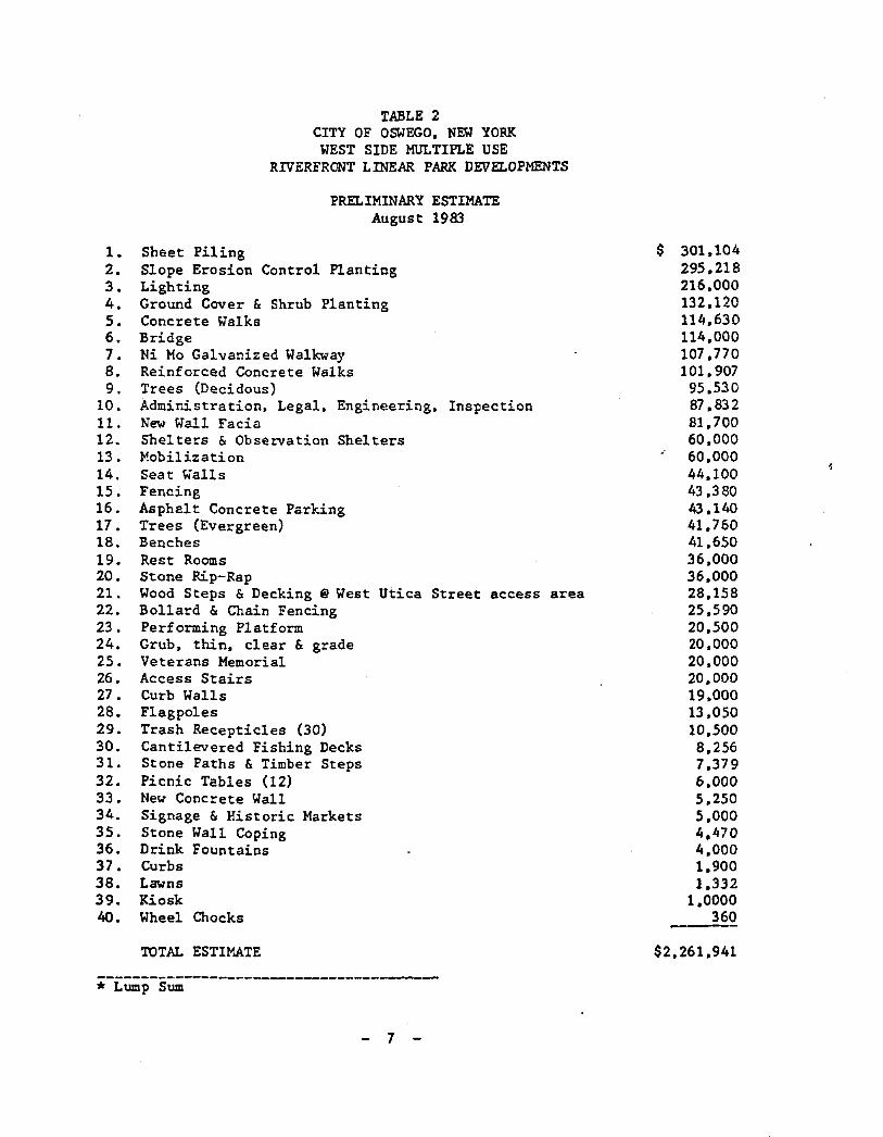
TABLE 2CITY OF OSWEGO. NEW YORK
WEST SIDE MULTIPLE USERIVERFRONT LINEAR PARK DEVELOPMENTS
PRELIMINARY ESTIMATEAugust 1983
1. Sheet Piling2. Slope Erosion Control Planting3. Lighting4. Ground Cover & Shrub Planting5. Concrete Walks6. Bridge7. Ni Mo Galvanized Walkway8. Reinforced Concrete Walks9. Trees (Decidous)
10. Administration. Legal. Engineering. Inspection11. New Wall Facia12. Shelters & Observation Shelters13. Mobilization14. Seat Walls15. Fencing16. Asphalt Concrete Parking17. Trees (Evergreen)18. Benches19. Rest Rooms20. Stone Rip-Rap21. Wood Steps &Decking @ West Utica Street access area22. Bollard & Chain Fencing23. Performing Platform24. Grub. thin. clear & grade25. Veterans Memorial26. Access Stairs27. Curb Walls28. Flagpoles29. Trash Receptic1es (30)30. Cantilevered Fishing Decks31. Stone Paths &Timber Steps32. Picnic Tables (12)33. New Concrete Wall34. Signage & Historic Markets35. Stone Wall Coping36. Drink Fountains37. Curbs38. L8'olns39. Kiosk40. Wheel Chocks
TOTAL ESTIMATE
----------------------------------------* Lump Sum
- 7
$ 301.104295,218216.000132.120114,630114.000107.770101.90795.53087.83281.70060.00060.00044.10043.38043.14041.76041,65036.00036.00028.15825.59020.50020.00020.00020,00019.00013.05010.5008.2567.3796.0005.2505.0004.4704.0001.9001.332
1,0000360--_.
$2.261.941
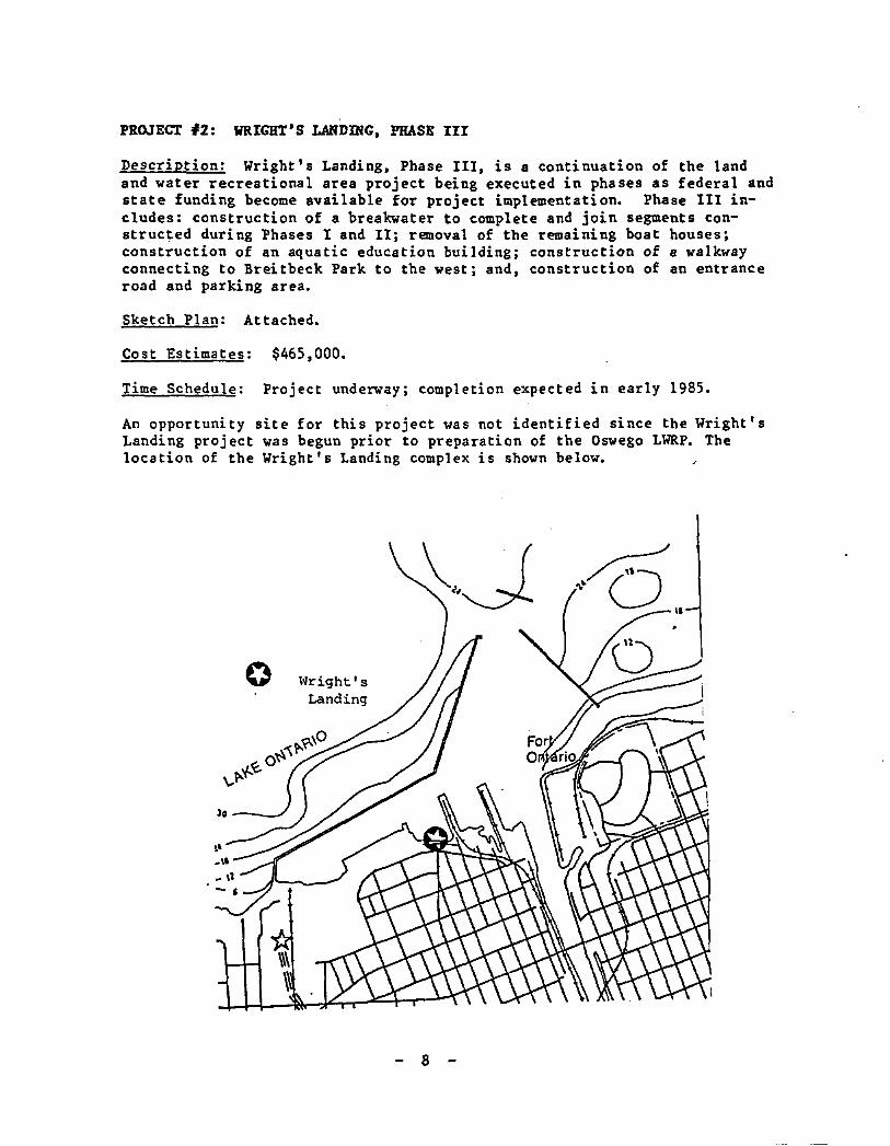
PROJECT #2: WRIGHT'S LANDmC, PHASE III
Description: Wright's Landing, Phase III, is a continuation of the landand water recreational area project being executed in phases as federal andstate funding become available for project implementation. Phase III includes: construction of a breakwater to complete and join segments constructed during Phases I and II; removal of the remaining boat houses;construction of an aquatic education building; construction of a walkwayconnecting to Breitbeck Park to the west; and, construction of an entranceroad and parking area.
Sketch Plan: Attached.
Cost Estimates: $465,000.
Time Schedule: Project underway; completion expected in early 1985.
An opportunity site for this project was not identified since the Wright'sLanding project was begun prior to preparation of the Oswego LWRP. Thelocation of the Wright's Landing complex is shown below.
l~right I 5
Landing
30 -_.-/
8
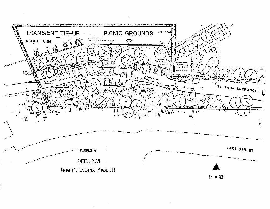
--
LAKE STREET.,.----- -/ --I ------_
f -----_I
PICNIC GROUNDS
'V
SKETCH PlM
_......TRANSIENT TIE-UP
~) '1SHORT TERM
_-- FIGURE 4----.,.---............
,,~ , _ I ~ '*'t""iol , 'l"f "' ,:t••- " -; ':'l' " _. , - ~ .":""~ 4.~.:' .;·~'·"."""'r'~' ....",. ,,," t. _ , ~ .. - ..~ ~-_ ..
---- -------"'",,-----------.-- ---~----- ---~~ ~----
,...-"-- ---.-----/\ .,--,,/ \.,--......
-\\\.
-->./
\-IRIGlH'S lANDINGJ PHASE I III" =LJO'
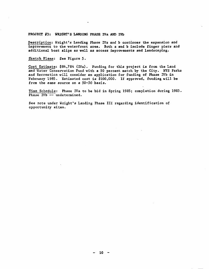
PROJECT 13: WRIGHT'S LANDING PHASE IVa AND IVb
E~~!.fPE.fEE: Hright I S Landing Phase IVa and b continues the expansion aodimprovement to the waterfront area. Both a and b include finger piers andadditional boat slips as well as access improvements and landscaping.
SketcE~!!!!!: See Figure 5.
Cost Estimate: $84,784 (IVa). Funding for this project is from the LandandWater-Conservation Fund with a 50 percent match by the City. NYS Parksand Recreation will consider an application for funding of Phase IVb inFebruary 1985. Estimated cost is $100,000. If approved, funding will befrem the same source on a 50-50 basis.
Time Schedule: Phase IVa to be bid in Spring 1985: completion during 1985.Pha;;-IVb-::-undetermined.
See note under Wright's Landing Phase III regarding identification ofopportunity sites.
10
----------- .._-------
•'oco ',cxo • 1'::100 '
..:~~..sHCINtiY't-MP' 'i:'
"1
Hom ~
I.f'l~/'"'; ~f16C6< .'1 ¢
~PlL.e~ GPaJ~P IN~
~P~~/I~ '3O';Arf"M.f·3.A\~GJe JA~'l'I"~ I.CV"'~
().~t;. e\...%-+'t.!.~~~, J:.J~ "",.....e,. l..O""l". ~S(" CL.1'1(,..4(f~·~"(!~(),u..cn~ Of'" w.ec.e~s ~1'H5 GJ..Ut!~~)
fi(~ ri~~ P1eI'- KlPrr~A~D /'<.t.;C::.C It'"Ir:-"O/t.Mo-n-~ ..FI"A~e.!iZ. ~ ~~~ ~\o.lC:> ",-re;:.;..,;e.G4J J-VI~ \~~~1'~IO.
~e~l~ t.ItU~;Q.,'t'\?;
~W~·~
<::.euST,.. - ,,~
PRoPOSED
, ,,[;XIsr: A liTH. ,,;#
!t~oF~'(~1
8J-~U-1 ~_SIUf~1
~fYa"..1l'e
~ cre (;:(wt:bc:Jkr.'~
~~O,~,"" ~~\Uo
c;~WrTr\~r/~.(I)
E10
,10
30'
G'X./~'t'liJ6- 2?\AL~I-lCAD)~--'::..---r PUT: cr- f:ttt1t~ rr
BI~glo-2~D 7/z,/e2l"t.of'.se-O: :ne HOIST
~ ...~Crr-<~~~Cf'r'(~
~loLt.
~IMo
CF-rn6err'< Cl'"():-~,
!.I'f'( Mu...""~~o,1.'<. I~ 2.:..
c>~lrlV<.l. 1..... /(0'1"
,.!..f?'()CXICH bl' fr-\e Cri'j'';f C~V~-.Q I '4ew -{C~F=- •~ •GLKi'" -n J A 'C4
I
Figure 5. wrightis LandingPhase IVa and IVb
"P~oc.. 1\)0. 810/- '7~I-,
't) W£,. S H To ~ 0 r .e.-11-
PROJECT '4: PORT OF OSWEGO IMPROVEMENT PROJECTS
~esEEi:PEi:£E: The Port of Oswego Development Study is intended to studyport conditions and prepare a comprehensive plan for developing port facilities. The objectives of the plan include the identification of steps formaintaining and/or upgrading existing facilities and operating practicesand the need for expanding facilities or services to meet the growing demands of current users or new regional shippers and consignees who wouldbenefit from using the Port. The State Infrastructure Bond Act resulted infunding appropriations for several improvements at the Port. including:
a) TWo front-end loaders; cost $400.000.b) Roof and window rehabilitation on the grain elevator and electrical
system improvements; cost $420.000.c) Paving and drainage improvements at the Eastside Terminal; cost
$600.000.d) Construction of a covered storage building at the Eastside Terminal;
cost $1.5 million.e) Additional equipment purchases; cost $400.000.f) Dock stabilization. additional bulk storage and improvement of grain
elevator; cost $2.0 million.
The storm runoff from the salt piles at the Port of Oswego will be discharged into the Oswego River under a DEC discharge permit. The recentlycompleted paving project will allow the Port to store more salt in onelocation. thereby lessening the surface area of the salt pile and potentially lessening the salt concentration in the storm runoff from the Portproperties.
Sketch Plan:--------- The preliminary plan is attached for the East TerminalLayout (see Figure 6) with space requirements for locating a proposed roll-on roll-off truck ferry between theUnited States and Canada.
Items (a) through (f). above: $5.320.000
Items (a) through (e). above: completed.Item (f) above: 1986-88.
All improvements for maintaining or upgrading existing facilities are onPort property as identified in Figure 7 and are not shown as opportunitysites.
12
o $ w '£ o I v . £
." .....0010'LAoltO".
(
I
\
Iu~. $TOR.H IHtOPOJASH
'0."."1 CO",.'O"
........LU•• , •••
\.~,..~ £2""l.'••l "'.0,I --- --------;r::.:;;O::p:;E:.~T:.:-:-~"~~-r-----
\P L A U
FIGURE 6
Port of Oswego Improvement Projects
East Terminal Layout
N['" IUKI[OPIPELINE
I....r-l
I
•••,"\
IIIIIIIII
J-fJ(f)
\\,J .~)II
FIGURE 7PORT PROPERTY MAP
Port-Owned Properties Not ShownAs Opportunity Sites
~
~1;"'::~~:{~~---The sroporetton of thle mop "as r1nonehlly ~ ~_
aide thrau!lh a 'edoral grent 'rOm the Ofrlea '\ uof Deaan ond Coastal "osoureo Monage..ent, ._. • __-\.,0;)1.,Ilntlonol Dennnle end At"oSPhorle JId"lnlGtro- -_.- - \\ 'l?tlon under tho Cautol ZaM "aneoement Act or \\ ..~1012., os O..ondad. This ..op "u prepored rar \\ \the "e" '(ark Suu Depart.ant or State. \\ \
PROJECT #5: COAL PIER D1PROVEHENTS I CONNECTION
Description: This project contemplates improvements to the Coal Pierto provide additional public access and boating facilities.with a pedestrian connection between the pier andthe northern terminus of the Linear Park. The diagrambelow indicates how the pier improvements might beaccomplished but should not be interpreted as a sketchplan since no design work has been undertaken.
<'0 'I
oFICURE ~
Port of Oswe&o Improvement ProJectS"West Te...1nal Layout
LtAUD TO cny SHQRT TIt,UI
vI
EAST TERI~ItlAL
_ '1$" • WILDLIfr. SCRVlCt .
None available; see Figure 8
Connectlon between Coal Pier" anaWest Bank Linear park~
wRIGlotT$ LANDING/ .. £.utO 10 City LOwG lUUI
':::::::=::':::::::::::: :===:"<~~.I}~~~ __--.,COAL flER
II' F (;soYest Bank Linear P&~k
Sketch Plan:
--'
Cost E)Ctlcates: None avail abl e
Time Schedule: Undetermined
-15-
I>ROJECI' 16: EAST SIDE RIVERFRONT LINEAR PARK
E!!E!jpti~: The sucess of the West Side Riverfront Linear Park bas beenso great that the City now anticipates a aimUar treatment for the eastbank of the Oswego River. beginning at the Niagara Mohawk Power Dam andproceeding north to East Seneca Street. Also a portion of the Lake Ontarioshoreline is included from Fort Ontario to Bradshaw's Cove. The East SidePark wUl aid in transforming the entire Oswego waterfront into a maj orrecreational resource for local residents and visitors. Additional publicaccess to the water wUl be provided. including an expansion of fishinglocations and boat launching stations.
Cost Estimates: $1.9 million. See Table 3 for an estimate of constructioncosts-fo~each of four project areas.
Time Schedule: Undetermined---------
- 16 -
TABLE 3
CITY OF OSWEX;OEAST SIDE MULTIPLE USE
RIVERFRONT LINEAR PARK DEVELOPMENTS
PRELIMINARY ESTIMATEDecember 1985
Area 1 - Dam area to East Utica Street
Area 2 - East Utica Street to East Bridge Street
Area 3 - East Bridge Street to Port Authority
Area 4 - Fort Ontario to Bradshaw's Cove
TOTAL ESTIMATE
.$446.000
143.000*
272.000
$1.813.000
* Total for Area 2 does not include costs for widening and improvingexisting West Side Breakwell •
•* Total for Area 4 does not include costs for development on the existingabandoned warehouse site.
- 11 -
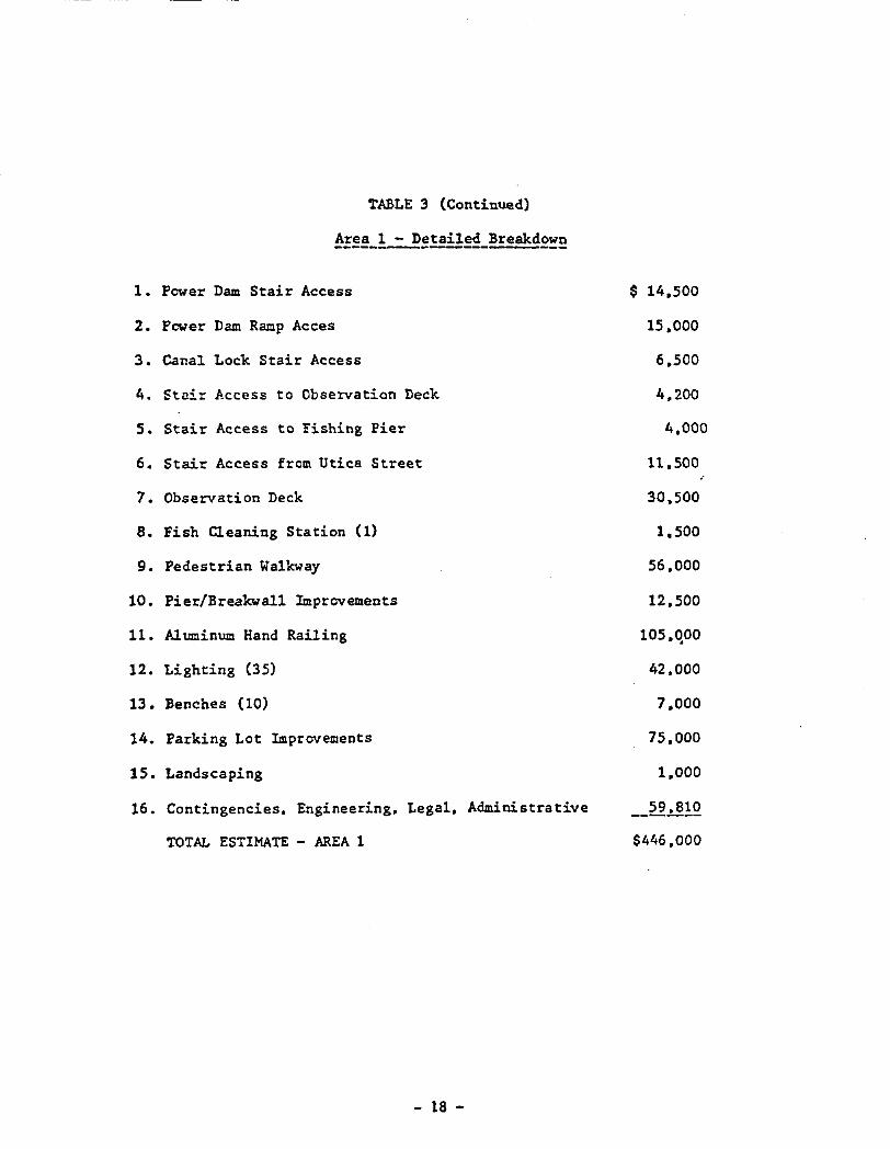
TABLE 3 (Continued)
~!~!_~!!!il~~_Breakd~!!!
1. Power Dam Stair Access
2. Pewer Dam Ramp Acces
3. Canal Lock Stair Access
4. Stair Access to Observation Deck
5. Stair Access to Fishing Pier
6. Stair Access from Utica Street
7. Observation Deck
8. Fish Cleaning Station (1)
9. Pedestrian Walkway
10. Pier/Breakwall Improvements
11- Aluminum Hand Railing
12. Lighting (35)
13. Benches (10)
14. Parking Lot Improvements
15. Landscaping
16. Contingencies. Engineering. Legal. Administrative
TOTAL ESTIMATE - AREA 1
- 18 -
$ 14.500
15.000
6.500
4.200
4.000
11.500
30.500
1.500
56.000
12.500
105.~00
42.000
7.000
75.000
1.000
_59~!Q
$446.000
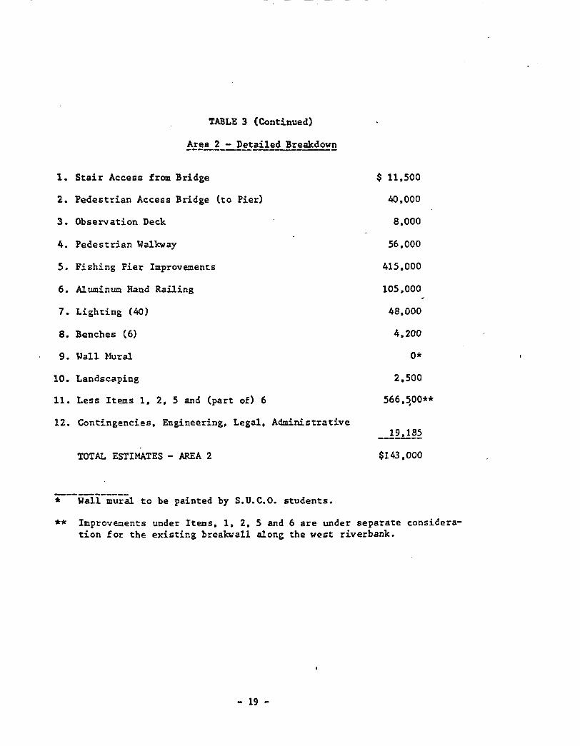
---------------_.- - -
TABLE 3 (Continued)
1. Stair Access frOlll Bridge
2. Pedestrian Access Bridge (to Pier)
3. Observation Deck
4. Pedestrian Walkway
5. Fishing Pier Improvements
6. Aluminum Hand Railing
7. Lighting (40)
8. Benches (6)
9. Wall Nural
10. Landscaping
11. Less Items 1, 2, 5 and (part of) 6
12. Contingencies, Engineering, Legal. Administrative
TOTAL ESTIMATES - MlLA 2
----------• Wall mural to be painted by S.U.C.O. students.
$ 11,500
40,000
8.000
56.000
415,000
105,000
48,000
4.200
0*
2.500
566,~00**
_-!9.1!!~
$143,000
** Improvements under Items. 1, 2. 5 and 6 are under separate consideration for the existing breakwall along the west riverbank.
- 19 -
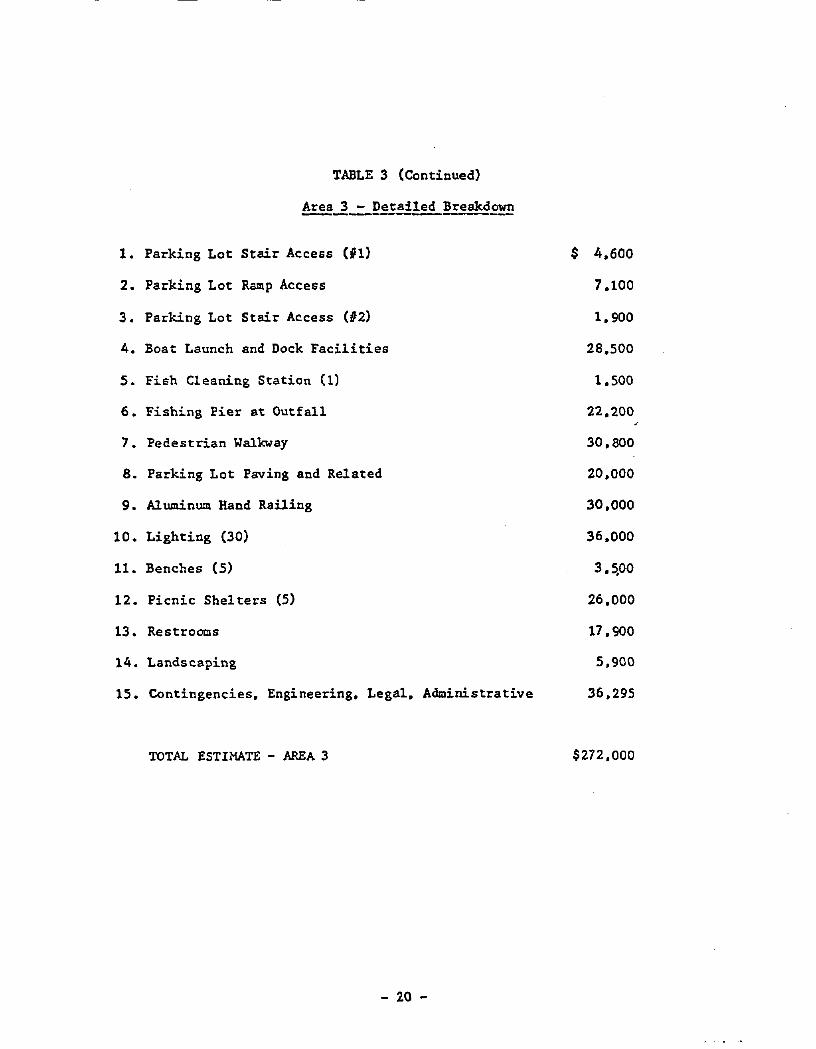
TABLE 3 (Continued)
Area2-=-Det.!.!!!!.!:eakdE~
1. Parking Lot Stair Access (i1)
2. Parking Lot Ramp Access
3. Parking Lot Stair Access (02)
4. Boat Launch and Dock Facilities
5. Fish Cleaning Station (1)
6. Fishing Pier at Outfall
7. Pedestrian Walkway
8. Parking Lot Paving and Related
9. AIuminum Hand Railing
10. Lighting (30)
11. Benches (5)
12. Picnic Shelters (5)
13. Restrooms
14. Landscaping
15. Contingencies. Engineering. Legal. Administrative
TOTAL ESTIMATE - AREA 3
- 20 -
$ 4.600
7.100
1.900
28.500
1.500
22.200
30.800
20.000
30.000
36.000
3.5,00
26.000
17.900
5.900
36.295
$272.000

--- -- -- --- -----~----------
TABLE 3 (Continued)
Area 4 - Detailed Breakdown----------------
1. Fishing Pier/Walkway
2. Stair Access to Pedestrian Walkway
3. Ramp Access to Pedestrian Walkway
4. Ramp Access to Bridge
5. Observation Decks and Accesses (In Lake)
6. Observation Decks and Accesses (Cove) (2)
7. Pedestrian Access Bridge (To Pier)
8. Boat Launch and Docks (Fort Ontario)
9. Boat Launch and Docks (Cove)
10. Fish Cleaning Stations (2)
II. Pedestrian Walkway/Fishing Pier
12. Parking Lot Construction
13. Access Roadway Construction
14. Aluminum Hand Railing
15. Lighting (50)
16. Benches (25)
17. Picnic Shelters (20)
18. Band Shelter and Seatina
19. Restrocms (2)
20. Landscaping
21. Contingencies. Engineering. Legal. Administrative
TO'I'~L ESTIMATE - AREA 4
- 21 -
$ 28.300
4.300
6.500
8.000
48.000
26.000
150.000
29.200
34.000
3.000
57.0.00
120.000
18.000
90.000
60.000
17.500
60.000
11.000
44.000
25.000
127.702
$952.000
. '
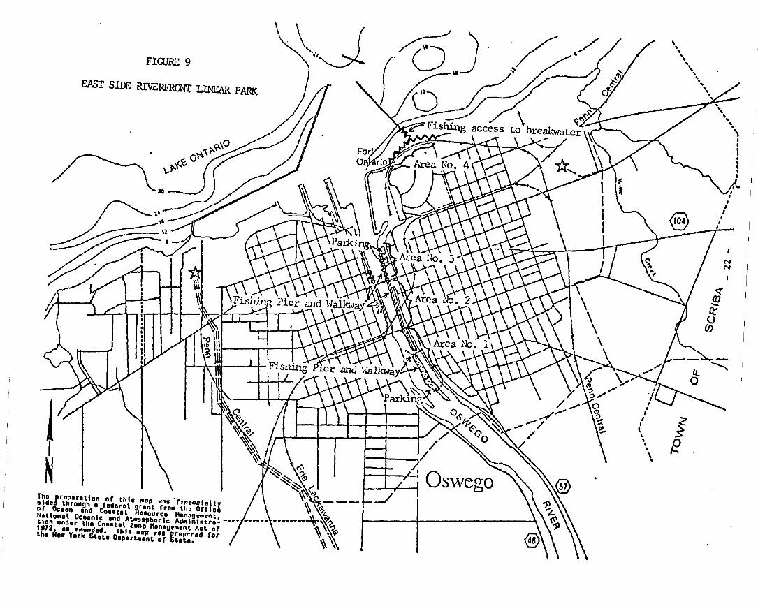
NN
....,"\
II,I
•,,•I
\ ,..,'." '.,
"'.
fE
EAST SIDE RIVERFRrnr LINEAR PARK
FIGURE 9
~ ~.~~ ~~~ <:~~---Tho rropnr.tlon or thll "01' wa•. rlnanclolly ~ "-
.Ide throu~h. rodoro~ ~ront rro. tho orrlc. '\\ C~of Oe••n .nd COUtol RO'ourc. Hnnog.mont, • __••__ • ••_.".,~.,IIltlonol Oc.onlc .nd Atmo,phorlc Ad.. lnhtro- \\ ~.,tlon under tho Cout.l ~ono H.n.g....nt Act or \\ "i,l)1912.......nd.d. This lOOp ... prepar.d for \\ ,the H•• York Stot. Oop.r~.nt or St.t.. " ,
SECTION V
~IQUES FOR LOCAL IHPLEHENTATION OF THE PROG~
SECTION V
TECHNIQUES FOR LOCAL IMPLEMENTATION OF THE PROGRAM
Contents
A. LOCAL LAWS AND REGULATIONS NECESSARY TO IMPLEMENT THE LWRP.............. 1
1. Existing Local Laws and Regulations................................. 1a. City of Oswego Master Plan, 1978................................ 1b. City of Oswego 1973 Zoning Ordinance, amended August 16, 1982... 1c. Coastal Erosion Hazard Area Management Regulations.............. 3.
2. Proposed New Local Laws and Regulations............................. 3a. Local Consistency Law for City of Oswego Agency Actions......... 3
B. OTHER PUBLIC AND PRIVATE ACTIONS NECESSARY TO IMPLEMENT THE LWRP........ 4
1. Local Goverment ~ctions Necessary to Implement the LWRP............. 4a. Housing Site Analysis........................................... 4b. Priority Listing of UDAG Sites.................................. 4c. Increase Public Access.......................................... 5
2. Private Actions Necessary to Implement the LWRP..................... 58. Fitzgibbons Building Site Analysis.............................. 5b. Foreign Trade Zone Feasibility.................................. 6c. Boating Facility Potential...................................... 6
C. MANAGEMENT STRUCTURE NECESSARY TO IMPLEMENT THE LWRP.................... 6
1. Lead Agency and Local Official Designated as Responsiblefor Overall Management and Coordination of the LWRP................. 6
2. Summary of the Assignment of the Specific Responsibilitiesfor Implementation and Management of the LWRP....................... 7
3. Description of Procedures to be used to Ensure that allLocal Actions Comply with the Policies of the LWRP.................. 7
4. Description of Procedures to be used for the Review ofFederal and State Actions for Consistency with the LWRP............. 7
D. FINANCIAL RESOURCES NECESSARY TO IMPLEMENT THE LWRP..................... 9
E. SUMMARY CHART OF ACTIONS IMPLEMENTING LOCAL POLICIES.................... 11
A. LOCAL LAWS AND REGULATIONS NECESSARY TO IHl'LEMENT nm LWRP
1. EXISTING LOCAL LAWS AND REGULATIONS
a. City of Oswego Master Plan,' 1978.
(1) In 1978, the City of Oswego published the Proposed MasterPlan 1978 as part of the City's Community Development Planand Program to update the two previous major planningefforts by the City of Oswego, the Master Plan of 1958 andthe Zoning Ordinance of 1973. "The overall obj ective", asstated in the Introduction to the Master Plan, "is to planfor a vital resident population, encouraging those alreadyliving in the City to continue to do so and seeking toattract new residents necessary to assure a modest growthand a reasonable balance of age groups, economic levels,and life styles."
(2) The City's Proposed Master Plan. although not formallyadopted by the Oswego Common Council, is used routinely asa guide for local development decisions.
b. City of Oswego 1973 Zoning Ordinance, amended August 16, 1982.
(1) The City of Oswego adopted a zoning ordinance on May 29,1940, which has been amended in the intervening years asnecessary, most recently in 1982. The purpose of the zoning ordinance is to provide for orderly growth, lessen congestion, secure safety, provide adequate light and air,prevent overcrowding, provide various public facilities andpromote the health, safety and general welfare of the public.
(2) ,The City of Oswego Zoning Ordinance is an important elementin the implementation of the LWRP since all developmentmust conform with the regulations specified for the district in which the development is proposed. Therefore, noLWRP implementation actions involving new or modified existing physical facilities can be undertaken without meetingthe requirements of the zoning ordinance.
(3) The City's Zoning Ordinance was officially amended duringthe preparation of the LWRP to include several minor modifications presented below.
Page 1. SectioD 103 -- Add to first paragraph: "and topromote the appropriate use of the waterfront and allowadequate public access to the water".
Page 7. Section 160 -- Add the following definitions:
1
Marina. Commercial: A faciliy for the berthing, fueling.repair. and storage of recreational and commercial boatsand the provision of related accessory services; a yardwhere boats are constructed.
Mooring Slip: Any dock. arrangement of piles or methodsused to berth. secure. or fasten a boat.
Yacht Club. Private Marina: A building or use for membersof a group or association for the purpose of engaging inrecreational and competitive boating or other water-relatedsports.
The marine activities added to Section 160 are to be allowed in Neighborhood Business B1. Central Business B2. Redevelopment District B3, and Industrial District IN (Sections461. 471, 481. and 491 respectively).
Page 38. Section 502 -- Add the following statement:
10. With respect to property within the Oswego WaterfrontRevitalization Area Boundary. the owner shall demonstrate how the proposed development will enhance thewaterfront area or otherwise fulfill the City's waterfront revitalization program and, in addition. providewhere possible for visual and physical access to theshore and water in conformance with the City's waterfront revitalization program.
Page 51 •• following Section 564 -- Add the following section:
Section 565 -- Obstruction of Waterways
To prevent encroachment upon, or obstruction of. river orcreek channels. barbor, or other waterways within the jurisdiction of the City of Oswego, there shall not be placed,erected, or located within such waterways any building orstructure, pier. slip, or marina, or retaining or revetmentwall except authorized bridges or dams. In addition, thereshall not be placed within such waterways any filling ofearth. ashes, rubbish, rubble, concrete, masonry, or anyother kind of fill.
However. these provisions may be waived if the structure orfill is approved by the Oswego City Engineer and the OswegoCommon Council. and the U.S. Army Corps of Engineers, andother public bodies. where applicable.
c. Coastal Erosion Hazard Area Manasement Regulation.
(1) A new' Coastal Erosion Hazard Area Management P!gulation hasbeen adopted to help implement the Oswego LWRP. This local
2
law establishes the parameters and guidelines for protection of the City's Lake Ontario shoreline.
(2) The Coastal Erosion Hazard Area Management Regulation implements the LWRP because it accomplishes the following purposes:
o minimizing and preventing damage to structures fromshoreline erosion and protection of natural protectivefeature areas;
o regulating land use and development activities so as tominimize or prevent damage or destruction to manmadeproperty, natural protection features, other naturalresouces, and human life;
o regulating new construction or placement of structuresin order to place them a safe distance from areas ofactive erosion to ensure that these structures are notprematurely destroyed or damaged due to improper siting;
o restricting public investment in services, facilities,or activities which are likely to encourage new permament development in erosion hazard areas; and,
o regulating the construction of erosion protection structures in coastal areas SUbject to serious erosion sothat their construction and operation will minimize orprevent damage or destruction of manmade property, private and public property, natural protective features,and other natural resouces.
•2. ADDITIONAL LOCAL LAWS AND REGULATIONS ADOPTED TO IMPLEMENT THE LWRP- --
a. Local Waterfront Revitalization Program Consistency Law.
(1) A local consistency law has been adopted to assure thatagencies of the City of Oswego will perform municipal functions in a manner consistent with the Oswego LWRP with respect to the waterfront area.
B. OTHER PUBLIC AND PRIVATE ACTIONS NECESSARY TO IMPLEMENT THE LWRP
1. LOCAL GOVERNMENT ACTIONS NECESSARY TO IMPLEMENT THE LWRP
a. Housing Site Analysis - Applicable to Sites 11 and 14; may alsobe applicable to Site 19 since a mixed use planned developmentis under consideration.
(1) Undertake a housing site analysis by a qualified housingdevelopment advisor of opportunity sites where housing is apoten~ial use.
3
(2) Several of the opportunity sites identified in the LWRPappear to have potential as possible housing sites and,therefore, should be evaluated by a qualified housing development advisor. The evaluation should include natural characteristics, neighborhood setting, market level suitability, and financial feasibility. This information can besupplemented by the site data obtained for the inventory ofopportunity sites, in particular the availability of utility services and appropriate zoning.
Several of the sites have locations which are enhanced bytheir adj acency or proximity to the water as well as otherhousing developments where commercial, industrial, or recreational development would not be compatible or appropriate.Since these sites are vacant or underutilized and withinthe Coastal Boundary, their development would help implement the LWRP and enhance the City's efforts to revitalizethe waterfront as well as increase real estate tax revenues. Encouraging people to live in the waterfront areawill help to assure vitality and support a mixture of landuses. This action will help to fulfill State Policies 1.2, 5, 6, 11. 12, 14, 16-25, 30, 31. 33, 37, 38, 41, and 44and related local policies.
b. Priority Listing of UDAG Sites - Applicable to Sites 13. 5, 7,9, 10, and 12.
(1) Develop a priority listing of waterfront area sites to beused as potential UDAG candidates in joint publ~c-private
financing.
(2) The LWRP identifies the City's vacant and underutilized. opportunity sites which are available for reuse in thewaterfront area. The City's next step is to provide incentives to attract private investor interest in these sites,including public and private joint financing strategies.Successful efforts to market the opportunity sites willgreatly depend on making reuse of the sites financiallyattractive to investors. The Urban Develcpment ActionGrant Program is a means of increasing public and privateinvestment in order to aid in economic recovery andstregthen the employment and tax base of communities. Thisaction will help to fulfill State policies 1-3, 5, 6,11-14, 16-25, 31, 33, 41, and 44 and related localpolicies.
4
c. Increase Public Access - Applicable to Sites 12.3.6.8. and 11and to that portion of Site #13 north of the railroad.
(1) Increase opportunities for public access to the waterfrontthrough such means as new recreational areas. walkways andthe use of street ends.
(2) The City's current efforts to provide additional publicaccess to the waterfront, such as at Wright's Landing andthe Linear Parks on the West and East banks, have generatedpublic interest in and support for identifying additionalpublic access opportunities. The City will be examiningother opportunities for implementing the public access portion of the LWRP in conj unction with the development ofdesign guidelines. This action will help fulfill Statepolicies 1. 2. 5. 9. 12, 18-25. 33. and 41 and relatedlocal policies.
2 • PRIVATE AcrIONS NECESSARY TO IMPLEMENT THE LWRP
a. Fitzgibbons Building Site Analysis - Applicable to Site 113.
(1) Prepare an analysis of the Fitzgibbons Building to determine how the site could be made more attractive to developers for redevelopment or reuse. including building demolition and site clearance. and the estimated costs of alternatives.
(2) The site analysis would be carried out under the auspicesof the Port of Oswego Authority and a subcommit~ee of theOswego LWRP Advisory Committee in cooperation with Operation Oswego County, Inc •• a private. nonprofit. local industrial development agency which markets Oswego County to pri-
·vate interests in order to retain existing employment opportunities and attract new employers. The Fitzgibbons Building is a largely vacant. former factory used to manufacturemilitary tanks. The 300.000 square feet of floor area has.to date. not attracted a definitive, permanent reuse. Thesite is well situated for a variety of uses and offers apanoramic view of Lake Ontario. There have been some indications that the existing structure. being largely unusable, may be a deterent to a reuse of the site. A completesite analysis would provide the Port with useful information on how redevelopment of this opportunity site can helpimplement the LWRP. This action will help fulfill Statepolicies 1-3. 5. 18-25, 33,and 41 and related local policies.
b. Foreign Trade Zone Feasibility - Applicable to Port-ownedproperty noted on Figure 7. Section IV and to Sites 13.13.15.and 16.
5
(1) Investigate the feasibility of establishing a foreign tradezone within the City to provide new employment opportunities for area residents.
(2) With the establishment of a foreign trade zone (FTZ) in theCity of Syracuse. interest has been expressed in investigating Oswego's potential for establishing a FTZ. An OswegoF~ could have the effect of stimulating local businessactivity. possibly including operations at the Port ofOswego. thereby offering additional employment opportunities and strengthening local economic revitalizationefforts. The feasibility analysis would be carried outunder the auspices of the Port of Oswego with the assistance of Operation Oswego County. Inc. This action willhelp fulfill State policies 1-3. 5. 6. 14. 18-25. 33.36-38. 41. and 44 and related local policies.
c. Boating Facility Potential - Applicable to Sites 82 and 11.
(1) Investigate the potential for developing additional recreational and tourist boating facilities. particularly withrespect to appropriate siting of such facilities.
(2) Oswego has the opportunity to benefit economically from thegrowing interest in boating activity. This includesprivate pleasure craft. fishing and sightseeing excursionboats. regattas. and boat shows. However. the expansion ofthe recreational and tourist boating activity is limited bythe facilities available. If the City is to maximize thepotential benefits. additional steps will be ne~ded todetermine where additional facilities to meet demands couldbe located. The investigation would be carried out by theCity's Community Development Agency. in cooperation with
. the Port of Oswego Authority and the Oswego MaritimeFoundation. This action will help fulfill State policies1-3. 5. 6. 9-25. 28.33-35.37. 38. 41. and 44 and relatedlocal policies.
C. MANAGEMENT STRUCTURE NECESSARY TO IMPLEMENT THE LWRP
1. LEAD AGENCY AND LOCAL OFFICIAL DESIGNATED AS RESPONSIB!:-E FOR OVE!t:ALL MANAGEMENT AND COORDINATION OF THE LWRP
The Mayor of the City of Oswego is the local official responsiblefor the LWRP. The Mayor delegates specific LWRP responsibilitiesto individual City departments in accordance with specific programrequirements.
6
2. SUMMARY OF THE ASSIGNMENT OF THE SPECIFIC RESPONSIBILITIES FORIMPLEMrihATION AND MANAGEMENT OF THE LWRP
Specific responsibilities for implementation and management of theLWRP are assigned by the Mayor. Matters pertaining to land development and zoning are normally within under the purview of the CityEngineer and the Plantling Board. Given the small size of the Citygovernment, many activities are accomplished usinginter-departmental cooperative efforts, as assigned by the Mayor.TWo departments in particular have been associated with thedevelopment of the LWRP, namely, the Office of the City Engineerand the Community Development Agency. Their continuedparticipation is anticipated in the future, depending onassignments made by the Mayor.
3. DESCRIPTION OF PROCEDURES TO BE USED TO ENSURE THAT ALL LOCALACTIONS COMPLY-W~THE:POLICIES OF THE LWRP -
The Mayor has final responsibility for ensuring that local actionsare in compliance with the LWRP policies. Local actions proposedfor the waterfront area will be reviewed in accordance with SEQRAprocedures and existing land use controls and with the policies andpurposes stated in the Local Waterfront Revitalization Program.
4. DESCRIPTION OF PROCEDURES TO BE USED FOR THE REVIEW OF FEDERAL ANDSTATE ACTIONS FOR CONSISTENCY WITH THE LWRP---------- --Federal and State actions proposed for the waterfront area will bereviewed for consistency in accordance with SEQRA procedures andexisting land use controls and with the policies and pu~poses
stated in the City of Oswego Local Waterfront RevitalizationProgram. The following paragraphs outline the City's reviewprocedure.
A. Upon receipt of notification from a state or federal agency ofa proposed action, including physical development projects,regulatory measures or funding support for projects, the Cityof Oswego will be responsible for evaluating a proposed actionagainst the policies and purposes of its LWRP within thirty(30) days of receipt of complete information for evaluatingeach proposal.
B. If the City of Oswego does not identifY any conflicts betweenthe proposed action and the applicable policies and purposes ofthe LWRP, the subject agency will be notified in writing of theCity's finding of no conflict. Upon receipt of the City'sfinding, the subject agency may proceed with its considerationof the proposed action.
C. If the City of Oswego does not notifY the subject agency inWriting o~ its finding within the estsblished review period,the agency may then assume that the proposed action does notconflict with the policies and purposes of the City's LWRP.
7
I
D. If the City of Oswego notifies the subj ect agency in wri tingthat the proposed action does conflict with the policies and/orpurposes of the LWRP. the-SUbject agency shall not proceed withthe proposed action until efforts are made to resolve theconflict(s) in accordance with the procedure outlined inparagraph E. below. At such time as the subject agency isnotified of the conflict(s). the City will also forward a copyof the identified conflicts to the Secretary of State. Thespecific policies and/or purposes with which the proposedaction is in conflict will be specified in the notification.
E. The following procedure is to be followed for resolution ofidentified conflicts:
1. Upon receipt of notification from the City of Oswego that aproposed action conflicts with the LWRP. the subject agencyshall contact the Mayor of the City of Oswego to discussthe conflict(s) and the means for resolving them. Ameeting between subject agency representatives and the Cityof Oswego may be necessary to discuss and resolve ~onflicts
and. if this step is deemed necessary. both parties shallmake every effort to convene this meeting within thirty(30) days from receipt of the conflict notification fromthe City.
2. If the discussion between the City of Oswego and thesubject agency results in the resolution of the identifiedconflict(s). the subject agency can then proceed with itsconsideration of the proposed action. The Mayo~ of theCity of Oswego will notify the subject agency in writing.with a copy forwarded to the Secretary of State. that allof the identified conflicts have been resolved.
3. If the consultation between the City of Oswego and thesubject agency does not lead to the resolution of theidentified conflicts. either party may request. in writing.the assistance of the Secretary of State to resolve any orall of the identified conflicts. This request must bereceived by the Secretary within 15 days following theformal consultation between the City and the subjectagency. The party requesting the assistance of theSecretary shall forward a copy of their request to theother party.
4. Within thirty (30) days following receipt of a request forassistance. the Secretary or a Department of State officialor employee designated by the Secretary. will discuss theidentified conflicts and circumstances preventing theirresolution with the appropriate representatives of thesubje~t agency and the City of Oswego.
8
5. If agreement among all parties cannot be reached duringthese discussions, the Secretary shall, within 15 days ofcompletion of the discussions, notify both parties of theDepartment's findings and recommendations.
6. The subject agency shall not proceed with consideration ofthe proposed action until the Secretary's findings andrecommendations have been received and have been concurredwith by both the City and the subject agency.
7. If the Secretary cannot obtain the concurrence of bothparties, the conflict resolution process shall beconsidered terminated and the City shall be free to pursueother options available to it under applicable state law.
D. FINANCIAL RESOURCES NECESSARY TO IMPLEMENT THE L~RP
Several financial strategies are being used or are under considerationfor attracting private-investor participation in waterfront revitalization efforts. These include the use of the City's General Fund, theCommunity Development and Urban Development Action Grant Programs,Transportation Bond Act funds administered by NYS Department ofTransportation, the NYS Division of Housing and Community Renewalfunding administered through the Oswego Housing Development Council,Inc•• and the resources of Operation Oswego County, Inc. including thepotential use of direct loans or mortgages under the Small BusinessAdministration's 503(b) Program as well as industrial development bondsand funding through the Job Development Authority. In addition, otherfinancial strategies are available to the City if an appropriateopportunity arises including property tax abatements, publi~ easements.purchase and leaseback agreements, and land swapping.
Listed below are actual or potential public and private financialresources identified for use in implementing the projects identifiedearlier in Section IV and other public and private implementationactions identified in the preceeding paragraphs.
9
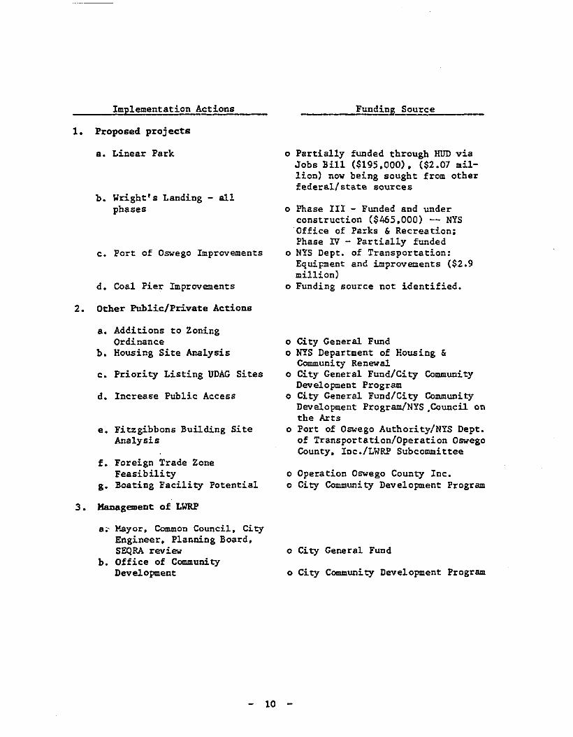
Implementation Actions
1. Proposed proj ects
a. Linear Park
b. Wright's Landing - allphases
c. Port of Oswego Improvements
d. Coal Pier Improvements
2. Other Public/Private Actions
a. Additions to ZoningOrdinance
b. Housing Site Analysis
c. Priority Listing UDAG Sites
d. Increase Public Access
e. Fitzgibbons Building SiteAnalysis
f. Foreign Trade ZoneFeasibility
g. Boating Facility Potential
3 • KaDagement of LWRP
a~ Mayor, Common Council. CityEngineer, Planning Board.SEQRA review
b. Office of CommunityDevelopment
10
_____;::.F-=u=n-=d=i=n~L!!.;:o.;:u=r.;:c.;:e~ _
o Partially funded through HUD viaJobs Bill ($195,000), ($2.07 million) now being sought from otherfederal/state sources
o Phase III - Funded and underconstruction ($465.000) -- NYSOffice of Parks & Recreation:Phase IV - Partially funded
o NYS Dept. of Transportation:Equipment and improvements ($2.9million)
o Funding source not identified.
o City General Fundo NYS Department of Housing &
Community Renewalo City General Fund/City Community
Development Programo City General Fund/City Community
Development Program/NYS ,Council onthe Arts
o Port of Oswego Authority/NYS Dept.of Transportation/Operation OswegoCounty, Inc./LWRP Subcommittee
o Operation Oswego County Inc.o City Community Development Program
o City General Fund
o City Community Development Program
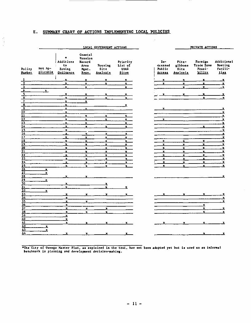
E. SUHHARY CHART OF ACTIONS IHPLEHERTDIG LOCAL POLICIES
LOCAL GOVERNMENT ACTIONS PRIVATE ACTIONS
IAddi:ions
CoutalErosionHazard Priority In- Fitz- Foreign Addit iona1
to Area Housing List of creased gibbons Trade Zone 80atingPolicy Not Ap- Zoning Mglllt. Site UDAG Public Site Feasi- Facili-~ plicable Ordinance !!&L. Analysis Sites !£llll Analvsis lliiu. llu.
I x x x x x x x x2 x x x x x x x x3 x x x x x x4 x5 x x x x -" x x x x6 x x x " x x7 x x8 x x9 x x x x
10 x x11 x x x x x12 x x x x x x13 x x x x14 x x x x x x15 x x16 " " " " "17 x " " x "18 " " x " x x " "19 x x l! x x " x x20 x x x x x " x x21 x x x x " x x x22 " x x x x " x x23 x x x x x x x x24 x x l! x x x x x25 x x x x x x x x26 x27 x28 x x x29 x30 " x3l " x x32 x33 x x x x x x x x34 x x35 " x x36 x x37 x x x x x38 x x x x x39 x40 x41 x x x x x x x x42 x43 x44 x x l! x x x
*The City of Oswego Haster Plan ••• explained in the text. hal not been adopted yet but io uled a. aD informalbenchoark in planning and deY~lopment deci.ion~kinl.
- 11 -
SECTION VI
FEDERAL AND STATE PROGRAMS LIKELY TO AFFECT IMPLEMENTATION
•A.
---------------~~~--~~~~~~-
SECTION VI
FEDERAL AND STATE PROGRAMS LIKELY TO AFFECT IMPLEMENTATION
Contents
FEDERAL AND STATE ACTIONS AND PROGRAMS WHICH SHOULD BEUNDERTAKEN IN A MANNER CONSISTENT WITH THE LWRP •••••••••••••••••••• 1
1.
2.
Federal Actions and Programs •••••••••.••••••••••••••••••••••••
State Actions and Programs •...••.••••.•.•••••••••.••••••••..••
2
9
B. SPECIFIC KEY IMPLEMENTATION ACTIONS ••••••••••••••••••••••••••••••••• 21
C. FEDERAL AND STATE ACTIONS AND PROGRAMS WHICH COULDFURTHER THE LWRP................................................... 22
1.
2.
Federal Actions and Programs ••••••••••••••••••••••••••••••••••
State Actions and Programs .••••••••••••••.•••••••••••••.••••••
22
24
•A. FEDERAL AND STATE ACTIONS AND PROGRAMS WICH SHOULD BE UNDERTAKEN IN A
MANNER CONSISTENT WITH THE LWRP
State and federal actions will affect and be affected by implementationof the LWRP. Under State law and the Federal Coastal Zone Management Act,certain State and Federal actions within or affecting the local waterfrontarea must be "consistent" or "consistent to the maximum extent practicable"with the enforceable policies and purposes of the LWRP. This makes the LWRP aunique, intergovernmental mechanism for setting policy and making decisions.While consistency requirements primarily help prevent detrimental actions fromoccurring and help ensure that future options are not foreclosed needlessly,active participation on the part of state and federal agencies is also likelyto be necessary to implement specific provisions of the LWRP.
The first part of this section identifies the actions and programs ofstate and federal agencies which should be undertaken in a manner consistentwith the LWRP. This is a generic list of actions and programs, as identifiedby the NYS Department of State; therefore, some of the actions and programslisted may not be relevant to this LWRP. Pursuant to the State WaterfrontRevitalization and Coastal Resources Act (Executive Law, Article 42), theSecretary of State individually and separately notifies affected stateagencies of those agency actions and programs which are to be undertaken in amanner consistent with approved LWRPs. Similarly, federal agency actions andprograms subject to consistency requirements are identified in the mannerprescribed by the U.s. Coastal Zone Management Act and its implementingregulations. The lists of state and federal actions and programs includedherein are informational only and do not represent or substitute for therequired identification and notification procedures. The current officiallists of actions subject to state and federal consistency requirements may beobtained from the NYS Department of State.
The second part of this section is a listing of specific key actions andprojects necessary to implement the Oswego LWRP. The third part of thissection is a general list of state and federal agency actions which arenecessary to further the implementation of the LWRP. It is recognized that aState or Federal agency's ability to undertake such actions is subject to avariety of factors and considerations; that the consistency provisions referedto above may not apply; and that the consistency requirements can not be usedto require a state or federal agency to undertake an action it could notundertake pursuant to other.provisions of law. Reference should be made toSections IV and V, which also discuss state and federal assistance needed toimplement the LWRP.
1
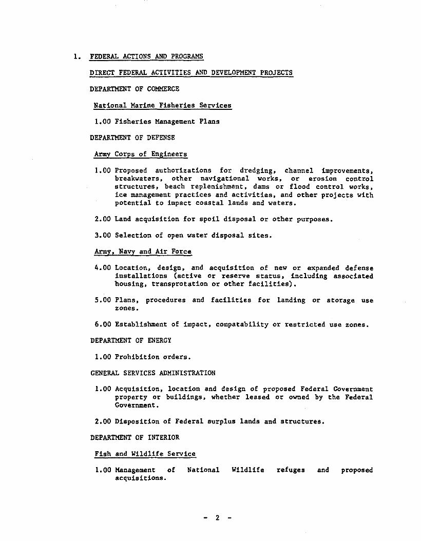
1. FEDERAL ACTIONS AND PROGRAMS
DIRECT FEDERAL ACTIVITIES AND DEVELOPMENT PROJECTS
DEPARTMENT OF COMMERCE
National Marine Fisheries Services
1.00 Fisheries Management Plans
DEPARTMENT OF DEFENSE
Army Corps of Engineers
1.00 Proposed authorizations for dredging, channel improvements,breakwaters, other navigational works, or erosion controlstructures, beach replenishment, dams or flood control works,ice management practices and activities, and other projects withpotential to impact coastal lands and waters.
2.00 Land acquisition for spoil disposal or other purposes.
3.00 Selection of open water disposal sites.
Army, Navy and Air Force
4.00 Location, design, and acquisition of new or expanded defenseinstallations (active or reserve status, including associatedbousing, transprotation or other facilities).
5.00 Plans, procedures and facilities for landing or storage usezones.
6.00 Establishment of impact, compatability or restricted use zones.
DEPARTMENT OF ENERGY
1.00 Prohibition orders.
GENERAL SERVICES ADMINISTRATION
1.00 AcqUisition, location and design of proposed Federal Governmentproperty or buildings, whether leased or owned by the FederalGovernment.
2.00 Disposition of Federal surplus lands and structures.
DEPARTMENT OF INTERIOR
Fish and Wildlife Service
1.00 Management ofacqUisitions.
National
2
Wildlife refuges and proposed
------ ----------- ----
National Park Service
3.00 National Park and Seashore management and proposed acquisitions.
DEPARTMENT OF TRANSPORTATION
Amtrak, Conrail
1.00 Expansions, curtailments, new construction, upgradings orabandonments of railroad facilities or services, in or affectingthe State's coastal area.
Coast Guard
2.00 Location and design, construction or enlargement of Coast Guardstations, bases, and lighthouses.
3.00 Location, placement or removal of navigation devices which arenot part of the routine operations under the Aids to NavigationProgram (ATON).
4.00 Expansion, abandonment, designation or anchorages, lighteringareas or shipping lanes and ice management practices andactivities.
Federal Aviation Administration
5.00 Location and design, construction, maintenance, and demolitionof Federal aids to air navigation.
Federal Highway Administration
6.00 Highway construction.
St. Lawrence Seaway Development Corporation
7.00 Acquisition, location, design, improvement and construction ofnew and existing facilities for the operation of the Seaway,incuding traffic safety, traffic control and length ofnavigation season.
3 -
FEDERAL LICENSES AND PERMITS
DEPARTMENT OF DEFENSE
Army Corps of Engineers
1.00 Construction of dams, dikes or ditches across navigable waters,or obstruction or alteration of navigable waters required underSections 9 and 10 of the Rivers and Harbors Act of 1899 (33U.S.C. 401, 403).
2.00 Establishment of harbor lines pursuant to Section 11 of theRivers and Harbors Act of 1899 (33 U.S.C. 404. 405).
3.00 Occupation of seawall, bulkhead. jetty. dike, levee, wharf,pier, or other work built by the U.S. pursuant to Section 14 ofthe Rivers and Harbors Act of 1899 (33 U.S.C. 408).
4.00 Approval of plans for improvements made at private expense underUSACE supervision pursuant to the Rivers and Harbors Act of ~02
(33 U.S.C. 565).
5.00 Disposal of dredged spoils into the waters of the U.S •• pursuantto the Clean Water Act. Section 404, (33 U.S.C. 1344).
6.00 All actions for which permits are required pursuant to Section103 of the Marine Protection. Research and Sanctuaries Act of1972 (33 U.S.C. 1413).
7.00 Construction of artificial islands and fixed structures in LongIsland Sound pursuant to Section 4(f) of the River and HarborsAct of 1912 (33 U.S.C.).
DEPARTMENT OF ENERGY
Economic Regulatory Commission
1.00 Regulation of gas pipelines. and licensing of import or exportof natural gas pursuant to the Natural Gas Act (15 U.S.C. 717)and the Energy Reorganization Act of 1974.
2.00 Exemptions from prohibition orders.
Federal Energy Regulatory Commission
3.00 Licenses for non-Federal hydroelectric projects and primarytransmission lines under Sections 3(11). 4(e) and 15 of theFederal Power Act (16 U.S.C. 796(11). 797(11) and 808).
4.00 Orders for interconnection of electric transmission facilitiesunder Section 202(b) of the Federal Power Act (15 U.S.C.824a(b» •
4 -
5.00 Certificates for the construction and operation of interstatenatural gas pipeline facilities, including both pipelines andterminal facilities under Section 7(c) of the Natural Gas Act(15 U.S.C. 7l7f(c».
6.00 Permission and approval for the abandonment of natural gaspipeline facilities under Section 7(b) of the Natural Gas Act(15 U.S.C. 7l7f(b».
ENVIRONMENTAL PROTECTION AGENCY
1.00 NPDES permits and other permits for Federal installations,discharges in contiguous zones and ocean waters, sludge runoffand aquaculture permits pursuant to Section 401, 402, 403, 405,and 318 of the Federal Water Pollution Control Act of 1972 (33U.S.C. 1341, 1342, 1343, and 1328).
2.00 Permits pursuant to the Resources Recovery and Conservation Actof .19 76.
3.00 Permits pursuant tounder Section 1424(42 U.S.C. 300h-c).
the underground injection control programof the Safe Water Drinking Water Act
4.00 Permits pursuant to the Clean Air Act of .l9 76 (42 U.S.C. 1857).
DEPARTMENT OF INTERIOR
Fish and Wildlife Services
1.00 Endangered species permits pursuant to the Endangered SpeciesAct (16 U.S.C. l53(a».
Mineral Management Service
2.00 Permits to drill, rights of use and easements for constructionand maintenance of pipelines, gathering and flow lines andassociated structures pursuant to 43 U.S.C. 1334, explorationand development plans, and any other permits or authorizationsgranted for activities described in detail in OCS exploration,development, and production plans.
3.00 Permits required for pipelines crossing federal lands, includingOCS lands, and associated activities pursuant to the OCS LandsAct (43 U.S.C. 1334) and 43U.S.C. 931 (c) and 20 U.S.C. 185.
INTERSTATE COMMERCE COMMISSION
1.00 Authority to abandon railway lines (to the extent that theabandonment involves removal of trackage and disposition ofright-of-way); authority to construct railroads; authority toconstruct coal slurry pipelines.
5 -
NUCLEAR REGULATORY COMMISSION
1.00 Licensing and certification of the siting, construction andoperation of nuclear power plans pursuant to Atomic Energy Actof 19 54, Title II of the Energy Reorganization Act of 19 74 andthe National Environmental Policy Act of 1969.
DEPARTMENT OF TRANSPORTATION
Coast Guard
1.00 Construction or modification of bridges, causeways or pipelinesover navigable waters pursuant to 49 U.S.C. 1455.
2.00 Permits for Deepwater Ports pursuant to the Deepwater Ports Actof 1974 (33 U.S.C. 1501).
Federal Aviation Administration
3.00 Permits and licenses for construction, operation or alterationof airports.
FEDERAL ASSISTANCE*
DEPART}ffiNT OF AGRICULTURE
10.06810.409
10.41010.41110.41310.41410.41510.41610.41810.41910.42210.42310.42410.42610.42910.43010.90110.90210.90410.906
Rural Clean Water ProgramIrrigation, Drainage, and Other Soil and Water ConservationLoansLow to Moderate Income Housing LoansRural Housing Site LoansRecreation Facility LoansResource Conservation and Development LoansRural Rental Housing LoansSoil and Water LoansWater and Waste Disposal Systems for Rural CommunitiesWatershed Protection and Flood Prevention LoansBusiness and Industrial LoansCommunity Facilities LoansIndustrial Development CrantsArea Development Assistance Planning GrantsAbove Moderate Income Housing LoansEnergy Impacted Area Development Assistance ProgramResource Conservation and DevelopmentSoil and Water ConservationWatershed Protection and Flood PreventionRiver Basin Surveys and Investigations
DEPARTMENT OF COMMERCE
11.300
11.30111. 302
Economic Development - Crants and Loans for Public Works andDevelopment FacilitiesEconomic Development - Business Development AssistanceEconomic Development - Support for Planning Organizations
6
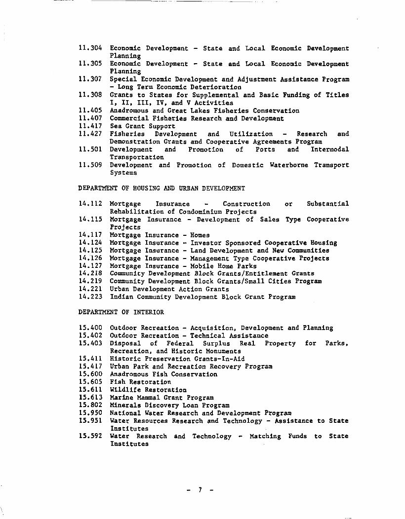
11.304
11.305
11. 307
11. 308
11.40511.40711.41711.427
11.501
11. 509
Economic Development - State and Local Economic DevelopmentPlanningEconomic Development - State and Local Economic DevelopmentPlanningSpecial Economic Development and Adjustment Assistance Program- Long Term Economic DeteriorationGrants to States for Supplemental and Basic Funding of TitlesI, 11. III. IV. and V ActivitiesAnadromous and Great Lakes Fisheries ConservationCommercial Fisheries Research and DevelopmentSea Grant SupportFisheries Development and Utilization Research andDemonstration Grants and Cooperative Agreements ProgramDevelopment and Promotion of Ports and IntermodalTransportationDevelopment and Promotion of Domestic Waterborne TransportSystems
DEPARTMENT OF HOUSING AND URBAN DEVELOPMENT
14.112
14.115
14.11714.12414.12514.12614.12714.21814.21914.22114.223
Mortgage Insurance Construction or SubstantialRehabilitation of Condominium ProjectsMortgage Insurance - Development of Sales Type CooperativeProjectsMortgage Insurance - HomesMortgage Insurance - Investor Sponsored Cooperative HousingMortgage Insurance - Land Development and New CommunitiesMortgage Insurance - Management Type Cooperative ProjectsMortgage Insurance - Mobile Home ParksCommunity Development Block Grants/Entitlement GrantsCommunity Development Block Grants/Small Cities ProgramUrban Development Action GrantsIndian Community Development Block Grant Program
DEPARTMENT OF INTERIOR
15.40015.40215.403
15.41115.41715.60015.60515.61115.61315.80215.95015.951
15.592
Outdoor Recreation - Acquisition. Development and PlanningOutdoor Recreation - Technical AssistanceDisposal of Federal Surplus Real Property for Parks.Recreation. and Historic MonumentsHistoric Preservation Grants-In-AidUrban Park and Recreation Recovery ProgramAnadromous Fish ConservationFish RestorationWildlife RestorationMarine Mammal Grant ProgramMinerals Discovery Loan ProgramNational Water Research and Development ProgramWater Resources Research and Technology - Assistance to StateInstitutesWater Research and Technology - Matching Funds to StateInstitutes
7
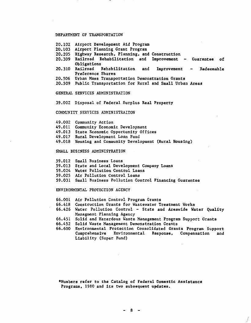
DEPARTMENT OF TRANSPORTATION
20.10220.10320.20520.309
20.310
20.50620.509
Airport Development Aid ProgramAirport Planning Grant ProgramHighway Research. Planning. and ConstructionRailroad Rehabilitation and Improvement Guarantee ofObligationsRailroad Rehabilitation and Improvement RedeemablePreference SharesUrban Mass Transportation Demonstration GrantsPublic Transportation for Rural and Small Urban Areas
GENERAL SERVICES ADMINISTRATION
39.002 Disposal of Federal Surplus Real Property
COMMUNITY SERVICES ADMINISTRAITON
49.00249.01149.01349.01749.018
Community ActionCommunity Economic DevelopmentState Economic Opportunity OfficesRural Development Loan FundHousing and Community Development (Rural Housing)
SMALL BUSINESS ADMINISTRATION
59.01259.01359.02459.02559.031
Small Business LoansState and Local Development Company LoansWater Pollution Control LoansAir Pollution Control LoansSmall Business Pollution Control Financing Guarantee
ENVIRONMENTAL PROTECTION AGENCY
66.00166.41866.426
66.45166.45266.600
Air Pollution Control Program GrantsConstruction Grants for Wastewater Treatment WorksWater Pollution Control - State and Areawide Water QualityManagment Planning AgencySolid and Hazardous Waste Management Program Support GrantsSolid Waste Management Demonstration GrantsEnvironmental Protection Consolidated Grants Program SupportComprehensive Environmental Response. Compensation andLiability (Super Fund)
*Numbers refer to the Catalog of Federal Domestic AssistancePrograms. 1980 and its two subsequent updates.
8
/
2. STATE ACTIONS AND PROGRAMS
OFFICE FOR THE AGING
1.00 Funding and/or approval programs for the establishment of new orexpanded facilities providing various services for the elderly.
DEPARTMENT OF AGRICULTURE AND MARKETS
1.00 Agricultural Districts Program.
2.00 Rural development programs.
3.00 Farm worker services programs.
4.00 Permit and approval programs:
4.01 Custom Slaughters/Processor Permit4.02 Processing Plant License4.03 Refrigerated Warehouse and/or Locker Plant License
DIVISION OF ALCOHOLIC BEVERAGE CONTROL/STATE LIQUOR AUTHORITY
1.00 Permit and approval programs:
1.01 Ball Park - Stadium License1.02 Bottle Club License1.03 Bottling Permits1.04 Brewer's Licenses and Permits1.05 Brewer's Retail Beer License1.06 Catering Establishment Liquor License1.07 Cider Producer's and Wholesaler's Licenses1.08 Club Beer, Liquor, and Wine Licenses1.09 Distiller's Licenses1.10 Drug Store, Eating Place, and Grocery Store Beer Licenses1.11 Farm Winery and Winery Licenses1.12 Hotel Beer, Wine, and Liquor Licenses1.13 Industrial Alcohol Manufacturer's Permits1.14 Liquor Store License1.15 On-Premises Liquor License1.16 Plenary Permit (Miscellaneous-Annual)1.17 Summer Beer and Liquor Licenses1.18 Tavern/Restaurant and Restaurant Wine Licenses1.19 Vessel Beer and Liquor Licenses1.20 Warehouse Permit1.21 Wine Store License1.22 Winter Beer and Liquor Licenses1.23 Wholesale Beer. Wine. and Liquor Licenses
DIVISION OF ALCOHOLISM AND ALCOHOL ABUSE
1.00 Facilities construction, rehabilitation.demolition or the funding of such activities.
9
expansion. or
2.00 Permit and approval programs:
2.01 Letter Approval for Certificate of Need2.02 Operating Certificate (Alcoholism Facility)2.03 Operating Certificate - Community Residence2.04 Operating Certificate (Outpatient Facility)2.05 Operating Certificate (Sobering-Up Station)
COUNCIL ON THE ARTS
1.00 Facilities construction, rehabilitation,demolition or the funding of such activities.
2.00 Architecture and environmental arts program.
DEPARTMENT OF BANKING
expansion, or
1.00 Permit and approval programs:
1.01 Authorization Certificate (Bank Branch)1.02 Authorization Certificate (Bank Change of Location)1.03 Authorization Certificate (Bank Charter)1.04 Authorization Certificate (Credit Union Change of Location)1.05 Authorization Certificate (Credit Union Charter)1.06 Authorization Certificate (Credit Union Station)1.07 Authorization Certificate (Foreign Banking Corporation
Change of Location)1.08 Authorization Certificate (Foreign Banking Corporation
Public Accommodations Office1.09 Authorization Certificate (Investment Company Branch)1.10 Authorization Certificate (Investment Company Change of
Location)1.11 Authorization Certificate (Investment Company Charter)1.12 Authorization Certificate (Licensed Lender Change of
Location)1.13 Authorization Certificate (Mutual Trust Company Charter)1.14 Authorization Certificate (Private Banker Charter)1.15 Authorization Certificate (Public Accommodation Office
Banks)1.16 Authorization Certificate (Safe Deposit Company Branch)1.17 Authorization Certificate (Safe Deposit Company Change of
Location)1.18 Authorization Certificate (Safe Deposit Company Charter)1.19 Authorization Certificate (Savings Bank Charter)1.20 Authorization Certificate (SaVings Bank De Novo Branch
Office)1.21 Authorization Certificate (SaVings Bank Public
Accommodations Office)1.22 Authorization Certificate (Savings and Loan Association
Branch)1.23 Authorization Certificate (Savings and Loan Association
Change of Location)1.24 Authorization Certificate (Savings and Loan Association
Charter)1.25 Authorization Certificate (Subsidiary Trust Company
Charter)
10
1.26 Authorization Certificate (Trust Company Branch)1.27 Authorization Certificate (Trust Company-Change of
Location)1. 28 Authorization Certificate (Trust Company Charter)1.29 Authorization Certificate (Trust Company Public
Accommodations Office)1.30 Authorization to Establish a Life Insurance Agency1. 31 License as a Licensed Lender1.32 License for a Foreign Banking Corporation Branch
CENTRAL NEW YORK REGIONAL TRANSPORTATION AUTHORITY
1. 00 Acquisition, disposition, lease, grant of easementactivities related to the management of landjurisdiction of the Authority.
and otherunder the
2.00 Facilities construction,demolition.
rehabilitation, expansion, or
3.00 Increases in special fares for transportation services to publicwater-related recreation resources.
DEPARTMENT OF COMMERCE
1.00 Preparation or revision of statewide or specific plans toaddress State economic development needs.
2.00 Allocation of the state tax-free bonding reserve.
DEPARTMENT OF CORRECTIONAL SERVICES
1.00 Facilities construction, rehabilitation,demolition or the funding of such activities.
DORMITORY AUTHORITY OF THE STATE OF NEW YORK
expansion, or
1.00 Financing of higher education and health care facilities.
2.00 Planning and design services assistance program.
EDUCATION DEPARTMENT
1.00 Facilities construction, rehabilitation, expansion, demolitionor the funding of such activities.
2.00 Permit and approval programs:
2.01 Certificate of Incorporation (Regents Charter)2.02 Private Business School Registration2.03 Private School License2.04 Registered Manufacturer of Drugs and/or Devices2.05 Registered Pharmacy Certificate2.06 Registered Wholesaler of Drugs and/or Devices2.07 Registered Wholesaler-Repacker of Drugs and/or Devices2.08 Storekeeper's Certificate
11
ENERGY PLANNING BOARD AND ENERGY OFFICE
1.00 Preparation and revision of the State Energy Master Plan.
NEW YORK STATE ENERGY RESEARCH AND DEVELOPMENT AUTHORITY
1.00 Issuance ofmodificationsprojects.
revenue bonds to finance pollution abatementin power-generation facilities and various energy
DEPARTMENT OF ENVIRONMENTAL CONSERVATION
1.00 Acquisition, disposition, lease, grant of easementactivities related to the management of landsjurisdiction of the Department.
and otherunder the
2.00 Classification of Waters Program; classification of land areasunder the Clean Air Act.
3.00 Facilities construction, rehabilitation,demolition or the funding of such activities.
expansion, or
4.00 Financial assistance/grant programs:
4.01 Capital projects for limiting air pollution4.02 Cleanup of toxic waste dumps4.03 Flood control, beach erosion and other water resource
projects4.04 Operating aid to municipal wastewater treatment facilities4.05 Resource recovery and solid waste management capital
projects4.06 Wastewater treatment facilities
5.00 Funding assistance for issuance of permits and other regulatoryactivities (New York City only).
6.00 Implementation of the Environmental Quality Bond Act of 1972,including:
(a) Water Quality Improvement Projects(b) Land Preservation and Improvement Projects including
Wetland Preservation and Restoration Projects, Uniqu~Area
Preservation Projects, Metropolitan Parks Projects, OpenSpace Preservation Projects and Waterways Projects.
7.00 Marine Finfish and Shellfish Programs.
8.00 New York Harbor Drift Removal Project.
9.00 Permit and approval programs:
9.01 Certificate of Approval for Air Pollution Episode ActionPlan
9.02 Certificate of Compliance for Tax Relief - Air PollutionControl Facility
12
9.03 Certificate to Operate: Stationary CombustionInstallation; Incinerator; Process, Exhaust or VentilationSystem
9.04 Permit for Burial of Radioactive Material9.05 Permit for Discharge of Radioactive Material to Sanitary
Sewer9.06 Permit for Restricted Burning9.07 Permit to Construct: a Stationary Combustion Installation;
Incinerator; Indirect Source of Air Contamination; Process,Exhaust or Ventilation System
9.08 Approval of Plans and Specifications for WastewaterTreatment Facilities.
9.09 Certificate to Possess and Sell Hatchery Trout in New YorkState
9.10 Commercial Inland Fisheries Licenses9.11 Fishing Preserve License9.12 Fur Breeder's License9.13 Game Dealer's License9.14 Licenses to Breed Domestic Game Animals9.15 License to Possess and Sell Live Game9.16 Permit to Import, Transport and/or Export under Section
184.1 (l1-0511)9.17 Permit to Raise and Sell Trout9.18 Private Bass Hatchery Permit9.19 Shooting Preserve Licenses9.20 Taxidermy License9.21 Certificate of Environmental Safety (Liquid Natural Gas and
Liquid Petroleum Gas)9.22 Floating Object Permit9.23 Marine Regatta Permit9.24 Mining Permit9.25 Navigation Aid Permit9.26 Permit to Plug and Abandon (a non-commercial oil, gas or
solution mining well)9.27 Permit to Use Chemicals for the Control or Elimination of
Aquatic Insects9.28 Permit to Use Chemicals for the Control or Elimination of
Aquatic Vegetation9.29 Permit to use Chemicals for the Control or Extermination of
Undesirable Fish9.30 Underground Storage Permit (Gas)9.31 Well Drilling Permit (Oil, Gas, and Solution Salt Mining)9.32 Digger's Permit (Shellfish)9.33 License of Menhaden Fishing Vessel9.34 License for Non-Resident Food Fishing Vessel9.35 Non-Resident Lobster Permit9.36 Marine Hatchery and/or Off-Bottom Culture Shellfish Permits9.37 Permits to Take Blue-Claw Crabs9.38 Permit to Use Pond or Trap Net9.39 Resident Commercial Lobster Permit9.40 Shellfish Bed Permit9.41 Shellfish Shipper's Permits9.42 Special Permit to Take Surf Clams from Waters other than
the Atlantic Ocean9.43 Approval - Drainage Improvement District
13
9.44 Approval - Water (Diversions for) Power9.45 Approval of Well System and Permit to Operate9.46 Permit - Article 15, (Protection of Water) - Dam9.47 Permit - Article 15, (Protection of Water) - Dock, Pier or
Wharf9.48 Permit - Article 15, (Protection of Water) - Dredge or
Deposit Material in a Waterway9.49 Permit - Article 15, (Protection of Water) - Stream Bed or
Bank Disturbances9.50 Permit - Article 15, Title 15 (Water Supply)9.51 Permit - Article 24, (Freshwater Wetlands)9.52 Permit - Article 25, (Tidal Wetlands)9.53 River Improvement District approvals9.54 River Regulatory District approvals9.55 Well Drilling Certificate of Registration9.56 Permit to Construct and/or Operate a Solid Waste Management
Facility9.57 Septic Tank Cleaner and Industrial Waste Collector Permit9.58 Approval of Plans for Wastewater Disposal Systems9.59 Certificate of Approval of Realty Subdivision Plans9.60 Certificate of Compliance (Industrial Wastewater Treatment
Facility)9.61 Letters of Certification for Major Onshore Petroleum
Facility Oil Spill Prevention and Control Plan9.62 Permit - Article 36, (Construction in Flood Hazard Areas)9.63 Permit for State Agency Activities for Development in
Coastal Erosion Hazards Areas9.64 Permit Granted (for Use of State Maintained Flood Control
Land)9.65 State Pollutant Discharge Elimination System (SPDES) Permit9.66 401 Water Quality Certification
10.00 Preparation and revision of Air Pollution State ImplementationPlan.
11.00 Preparation and revision of Continuous Executive Program Plan.
12.00 Preparation and revision of Statewide Environmental Plan.
13.00 Protection of Natural and Man-made Beauty Program.
14.00 Urban Fisheries Program.
15.00 Urban Forestry Program.
16.00 Urban Wildlife Program.
ENVIRONMENTAL FACILITIES CORPORATION
1. 00 Financing program for pollution controlindustrial firms and small businesses.
14
facilities for
FACILITIES DEVELOPMENT CORPORATION
1.00 Facilities construction, rehabilitation,demolition or the funding of such activities.
OFFICE OF GENERAL SERVICES
expansion, or
1.00 Administration of the Public Lands Law for acquisition anddisposition of lands, grants of land and grants or easement ofland under water, issuance of licenses for removal of materialsfrom lands under water, and oil and gas leases for explorationand development.
2.00 Administration of Article 4-B, Public Buildings Law, in regardto the protection and management of State historic and culturalproperties and State uses of buildings of historic,architectural or cultural significance.
3.00 Facilities construction,demolition.
DEPARTMENT OF HEALTH
rehabilitation, expansion, or
1.00 Facilities construction, rehabilitation,demolition or the funding of such activities.
expansion, or
2.00 Permit and approval programs:
2.01 Approval of Completed Works for Public Water SupplyImprovements
2.02 Approval of Plans for Public Water Supply Improvements.2.03 Certificate of Need (Health Related Facility - except
Hospitals)2.04 Certificate of Need (Hospitals)2.05 Operating Certificate (Diagnostic and Treatment Center)2.06 Operating Certificate (Health Related Facility)2.07 Operating Certificate (Hospice)2.08 Operating Certificate (Hospital)2.09 Operating Certificate (Nursing Home)2.10 Permit to Operate a Children's Overnight or Day Camp2.11 Permit to Operate a Migrant Labor Camp2.12 Permit to Operate as a Retail Frozen Dessert Manufacturer2.13 Permit to Operate a Service Food Establishment2.14 Permit to Operate a Temporary Residence/Mass Gathering2.15 Permit to Operate or Maintain a Swimming Pool or Public
Bathing Beach2.16 Permit to Operate Sanitary Facilities for Realty
Subdivisions2.17 Shared Health Facility Registration Certificate
DIVISION OF HOUSING AND COMML"NITY RENEWAL and its subsidiaries andaffiliates
1.00 Facilities construction,demolition.
15
rehabilitation, expansion, or
2.00 Financial assistance/grant programs:
2.01 Federal Housing Assistance Payments Programs (Section 8Programs)
2.02 Housing Development Fund Programs2.03 Neighborhood Preservation Companies Program2.04 Public Housing Programs2.05 Rural Initiatives Grant Program2.06 Rural Preservation Companies Program2.07 Rural Rental Assistance Program2.08 Special Needs Demonstration Projects2.09 Urban Initiatives Grant Program2.10 Urban Renewal Programs
3.00 Preparation and implementation of plans to address housing andcommunity renewal needs.
HOUSING FINANCE AGENCY
1.00 Funding programs for the construction, rehabilitation, orexpansion of facilities.
JOB DEVELOPMENT AUTHORITY
1.00 Financing assistance programs for commercial and industrialfacilities.
MEDICAL CARE FACILITIES FINANCING AGENCY
1.00 Financing of medical care facilities.
OFFICE OF MENTAL HEALTH
1.00 Facilities construction, rehabilitation,demolition or the funding of such activities.
2.00 Permit and approval programs:
2.01 Operating Certificate (Community Residence)2.02 Operating Certificate (Family Care Homes)2.03 Operating Certificate (Inpatient Facility)2.04 Operating Certificate (Outpatient Facility)
expansion, or
OFFICE OF MENTAL RETARDATION AND DEVELOPMENT DISABILITIES
1.00 Facilities construction, rehabilitation,demolition or the funding of such activities.
expansion, or
2.00 Permit and approval programs:
2.01 Establishment and Construction Prior Approval2.02 Operating Certificate Community Residence2.03 Outpatient Facility Operating Certificate
16
DIVISION OF MILITARY AND NAVAL AFFAIRS
1.00 Preparation and implementation ofPreparedness Plan.
NATURAL HERITAGE TRUST
the State Disaster
1.00 Funding program for natural heritage institutions.
OFFICE OF PARKS, RECREATION AND HISTORIC PRESERVATION (includingRegional State Park Commissions)
1.00 Acquisition, disposition, lease, grant of easement or otheractivities related to the management of land under thejurisdiction of the Office.
2.00 Facilities construction, rehabilitation,demolition or the funding of such activities.
expansion, or
3.00 Funding program for recreational boating,enforcement.
safety and
4.00 Funding program for State and local historic preservationprojects.
5.00 Land and Water Conservation Fund programs.
6.00 Nomination of properties to the Federal and/or State Register ofHistoric Places.
7.00 Permit and approval programs:
7.01 Floating Objects Permit7.02 Marine Regatta Permit7.03 Navigation Aide Permit7.04 Posting of Signs Outside State Parks
8.00 Preparation and revision of the Statewide Comprehensive OutdoorRecreation Plan and the Statewide Comprehensive HistoricPreservation Plan and other plans for public access, recreation,historic preservation or related purposes.
9.00 Recreation services programs.
10.00 Urban Cultural Parks Program.
PORT OF OSWEGO AUTHORITY
1.00 Acquisition, disposition, lease, grant of easementactivities related to the management of landjurisdiction of the Authority.
and otherunder the
2.00 Facilities construction,demolition.
17
rehabilitation, expansion, or
POWER AUTHORITY OF THE STATE OF NEW YORK
1. 00 Acquisition, disposition, lease, grant of easement and otheractivities related to the management of land under thejurisdiction of the Authority.
2.00 Facilities construction,demolition.
rehabilitation, expansion. or
NEW YORK STATE SCIENCE AND TECHNOLOGY FOUNDATION
1.00 Corporation for Innovation Development Program.
2.00 Center for Advanced Technology Program.
DEPARTMENT OF SOCIAL SERVICES
1.00 Facilities construction. rehabilitation.demolition or the funding of such activities.
2.00 Homeless Housing and Assistance Program.
expansion. or
3.00 Permit and approval programs:
3.01 Certificate of Incorporation (Adult Residential CareFacilities)
3.02 Operating Certificate (Children's Services)3.03 Operating Certificate (Enriched Housing Program)3.04 Operating Certificate (Home for Adults)3.05 Operating Certificate (Proprietary Home)3.06 Operating Certificate (Public Home)3.07 Operating Certificate (Special Care Home)3.08 Permit to Operate a Day Care Center
DEPARTMENT OF STATE
1.00 Appalachian Regional Development Program.
2.00 Coastal Management Program.
3.00 Community Services Block Grant Program.
4.00 Permit and approval programs:
4.01 Billiard Room License4.02 Cemetery Operator4.03 Uniform Fire Prevention and Building Code
STATE UNIVERSITY CONSTRUCTION FUND
1.00 Facilities construction. rehabilitation.demolition or the funding of such activities.
18
expansion, or
STATE UNIVERSITY OF NEW YORK
1.00 Acquisition, disposition, lease, grant of easementactivities related to the management of landjurisdiction of the University.
and otherunder the
2.00 Facilities construction,demolition.
rehabilitation, expansion, or
DIVISION OF SUBSTANCE ABUSE SERVICES
1.00 Facilities construction, rehabilitation,demolition or the funding of such activities.
expansion, or
2.00 Permit and approval programs:
2.01 Certificate of Approval(Substances Abuse Services Program)
DEPARTMENT OF TRANSPORTATION
1. 00 Acquistion, disposition, lease, grant of easement and otheractivities related to the management of land under thejurisdiction of the Department.
2.00 Construction, rehabilitation, expansion, or demolition offacilities, including but not limited to:
(a) Highways and parkways(b) Bridges on the State highways system(c) Highway and parkway maintenance facilities(d) Barge Canal(e) Rail facilities
3.00 Financial assistance/grant programs:
3.01 Funding programs for construction/reconstruction andreconditioning/preservation of municipal streets andhighways (excluding routine maintenance and minorrehabilitation)
3.02 Funding programs for development of the ports of Albany,Buffalo, Oswego, Ogdensburg and New York
3.03 Funding programs for rehabilitation and replacement ofmunicipal bridges
3.04 Subsidies program for marginal branchlines abandoned byConrail
3.05 Subsidies program for passenger rail service
4.00 Permits and approval programs:
4.01 Approval of applications for airport improvements(construction projects)
4.02 Approval of municipal applications for Section 18 Rural andSmall Urban Transit Assistance Grants (constructionprojects)
19
4.03 Approval of municipal or regional transportation authorityapplications for funds for design, construction andrehabilitation of omnibus maintenance and storagefacilities
4.04 Approval of municipal or regional transportation authorityapplications for funds for design and construction of rapidtransit facilities
4.05 Certificate of Convenience and Necessity to Operate aRailroad
4.06 Highway Work Permits4.07 License to Operate Major Petroleum Facilities4.08 Outdoor Advertising Permit (for off-premises advertising
signs adjacent to interstate and primary highway)4.09 Permits for Use and Occupancy of N.Y. State Canal Lands
[except Regional Permits (Snow Dumping»)4.10 Real Property Division Permit for Use of State-Owned
Property
5.00 Preparation or revision ofTransportation and sub-area orto the transportation needs of
the Statewide Master Plan forspecial plans and studies relatedthe State.
6.00 Water Operation and Maintenance Program--Activities related tothe containment of petroleum spills and development of anemergency oil-spill control network.
URBAN DEVELOPMENT CORPORATION and its subsidiaries and affiliates
1.00 Acquisition, disposition, lease, grant of easementactivities related to the management of landjurisdiction of the Corporation.
and otherunder the
2.00 Construction, rehabilitation, expansion, orresidential, commercial, industrial, and civicthe funding of such activities, including butactions under the following programs:
(a) Tax-Exempt Financing Program(b) Lease Collateral Program(c) Lease Financial Program(d) Targeted Investment Program(e) Industrial Buildings Recycling Program
demolition offacilities andnot limited to
DIVISION OF YOUTH
1.00 Facilities construction, rehabilitation, expansion, ordemolition and the funding or approval of such activities.
20
B. SPECIFIC KEY IMPLEMENTATION ACTIONS
The following is a listing of specific actions and projects necessary tofurther specific elements of the Oswego LWRP. The actions and projectsare to be undertaken by local, state or federal agencies and, in somecases, dollar estimates are available on the project cost forimplementing that portion of the program. In subsection C that follows,a general listing is presented of federal and state actions and programswhich could further the LWRP implementation.
Specific Key Implementation Actions and Programs
Proposed Action on Project
Linear Park (connects withopportunity sites 04,6,8)
Wright's Landing, Phase IV
Port of Oswego Improvements
Coal Pier Improvements
Housing Site Analysis
Priority Listing UDAG Sites
Fitzgibbons Building Site Analysis
Foreign Trade Zone Feasibility
21
Agency Program
$2.07 million is being soughtfrom all potential fundingsources.
$95,000 is being sought on a 50%matching basis from the NYSDepartment of Parks, Recreationand Historic Preservation, Landand Water Conservation Funds.
$1.4 million is being sought fromthe U.S. Army Corps of Engineersfor harbor dredging.
Funding source not identified;cost estimates not available.
NYS Department of Housing &Community Renewal.
City general fund/City CommunityDevelopment Program.
Port of Oswego Authority/Operation Oswego County, Inc.
Operation Oswego County, Inc.
C. FEDERAL AND STATE ACTIONS AND PROGRAMS WICH COULD FURTHER THE LWRP
1. FEDERAL ACTIONS AND PROGRAMS
a. DEPARTMENT OF COMMERCE, ECONOMIC DEVELOPMENT ADMINISTRATION
(1) Provides planning grants to develop the capability of state andlocal governments to undertake economic development planning.
(2) Provides grants to locals for construction of public facilitiesto encourage economic growth in designated areas.
(3) Provides loans to sustain industrial and commercial viabilityin designated depressed areas by providing financial assistanceto businesses that create or retain permanent jobs or establishplants in redevelopment areas where financial assistance is notavailable elsewhere.
(4) Provides grants to planning agencies to foster multi-countydistrict and redevelopment area economic development planning.
b. DEPARTMENT OF COMMERCE, OFFICE OF OCEAN AND COASTAL RESOURCESMANAGEMENT
(1) Assists states in administering an approved Coastal ManagementProgram.
(2) Provides grants and loans to states with approved coastalmanagement programs to offset the effects of coastal energyactivity.
c. DEPARTMENT OF DEFENSE, AIR FORCE, ARMY AND NAVY
(1) Donations of surplus property, facilities or equipment.
d. DEPARTMENT OF DEFENSE, ARMY CORPS OF ENGINEERS
(1) Construction projects to assist in repair and restoration offlood or control works damaged by flood, or federallyauthorized hurricane flood and shore protection works damagedby acts of nature.
(2) Construction projects to provide the most practical andeconomic means of meeting general navigation needs.
(3) Construction projects to reduce flood damage.(4) Construction projects to provide bank protection of highways,
highway bridges, and essential public works endangered by floodcaused erosion.
(5) Control of beach and shore erosion to public shores throughsmall construction projects.
(6) Construction projects to reduce flood damage.(7) Construction projects to restore channels for navigation or
flood control.
22
e. DEPARTMENT OF HOUSING AND URBAN DEVELOPMENT, COMMUNITY PLANNING ANDDEVELOPMENT OFFICE
(1) Provides grants to assist distressed cities and other eligibleareas to increase public and private investment thatstrengthens the economy, employment. and tax base.
(2) Provides grants to eligible activities which must (a) benefitlow and moderate-income persons, (b) aid in prevention orelimination of slums or blight, or (c) meet other communitydevelopment needs having urgency.
(3) Provides loans for the revitalization of neighborhoods and forrehabilitation of residential properties with five or moreunits and for homestead properties in designated homesteadareas.
(4) Provides direct payments to aid lower-income families to obtainadequate housing.
(5) Provides project grants to develop viable urban communities byproviding decent housing. a suitable living environment. andexpanded economic opportunities, principally for low andmoderate-income people.
(6) Provides project grants to rehabilitate rental units forlower-income tenants.
(7) Provides for the sale, exchange or donation of property toprovide home-ownership opportunities and to revitalizeneighborhoods.
f. DEPARTMENT OF THE INTERIOR, FISH AND WILDLIFE SERVICE
(1) Provides grants to support proj ects designed to improve andmanage sport fish programs for preservation and improvement ofsport fishing and related activities. Popular name: DingellJohnson Program.
g. DEPARTMENT OF TRANSPORTATION, FEDERAL HIGHWAY ADMINISTRATION
(1) Construction and rehabilitation of interstate and primary,secondary, and urban highways and to replace or rehabilitatebridges.
(2) Provides grants to beautify highways and vicinities includingcontrol of junkyards and billboards.
h. DEPARTMENT OF TRANSPORTATION, COAST GUARD
(1) Improve safe operation and use of boats by providing technicalinformation and training.
1. ENVIRONMENTAL PROTECTION AGENCY, OFFICE OF WATER
(1) Provides grants to assist in construction of municipal sewagetreatment works to meet State and federal water qualitystandards.
j. FEDERAL EMERGENCY MANAGEMENT AGENCY, STATE AND LOCAL PROGRAMS ANDSUPPORT OFFICE
(1) Purchase of property for open space to reduce future floodinsurance and disaster assistance by prOViding an opportunityfor repetitively and substantially damaged structures ofpolicyholders to be permanently removed from flood risk areas.
23
k. NATIONAL ENDOWMENT FOR THE ARTS
(1) Provides grants to promote excellence in design by fundingactivities in architecture, landscape architecture, urbandesign and planning.
1. NATIONAL PARK SERVICE
(1) Provides grants to expand and maintain the National Register ofHistoric Places, to assist in identification, evaluation andprotection of historic properties, for preservation for publicbenefit of National Register properties, and to providematching grants to the National Trust for HistoricPreservation.
(2) Provides grants for rehabilitation of recreation areas andfacilities in economically hard-pressed communities and forrecreation planning.
(3) Provides grants to assist with preparation of outdoorrecreation plans and for acquisition and development of outdoorrecreation areas and facilities.
(4) Donations and sales of surplus federal property for public parkand recreation use and for historic monument use.
(5) Provides technical assistance to states, local governments andprivate interests including non-profit recreationorganizations.
(6) Provides technical assistance in preservation and maintenanceof historic properties.
(7) Provides advice to expand and maintain the National Register ofsites, buildings, districts, structures and objects ofhistorical, architectural, engineering, archeological and/orcultural significance.
(8) Provides advice to identify and mark nationally significanthistoric properties.
2. STATE ACTIONS AND PROGRAMS
a. DEPARTMENT OF ENVIRONMENTAL CONSERVATION
(1) Coastal Erosion Hazard Areas Regulations(2) Freshwater Wetlands Regulations(3) Fish Propagation and Management Program(4) Wildlife Propagation and Management Program(5) Fish and Wildlife Management Act(6) Public Access to Fishing Areas Program(7) Protection of Natural and Man-made Beauty Program(8) Protection of Waters Program(9) State Pollutant Discharge Elimination System(10) Permits for Sources of Air Pollution(11) Indirect Source Control Program(12) Oil Spill Prevention, Control and Compensation Program
b. DEPARTMENT OF STATE
(1) Local Waterfront Revitalization Programs
24
\\
c. STATE ENERCY OFFICE
(1) Energy Law Regulations
d. STATE ENVIRONMENTAL QUALITY REVIEW ACT
(1) Preparation of Environmental Impact Statements
e. ST. LAWRENCE - EASTERN ONTARIO COMMISSION
(1) Project review and technical assistance
25 -
SECTION VII
CONSULTKrICN WI1'H O'lI"ER AFFECTED FEDERAL. STA'l'E.REGIONIL. AND LOCAL AGENCIES
CONSULTATION WITH OTHER AFFECTED FEDERAL, STATE, REGIONAL AND LOCAL AGENCIES
The governmental agencies having an interest with an announcement of theforthcoming publication of the draft LWRP were contacted in May, 1984, (See 31May 1984 Memorandum attached). Those agencies wishing to review the documentwere requested to contact the Regional Planning Board. Responses werereceived from the following:
1. NYS Facilities Development Corporation
2. NYS Department of Parks, Recreation and Historic Preservation
3. U.S. Fish and Wildlife Service
4. NYS Department of Environmental Conservation
5. Dormitory Authority of the State of New York
6. NYS Emergency Management Office
7. NYS Urban Development Corporation
8. State University Construction Fund
9. NYS Energy Research and Development Authority
10. St. Lawrence - Eastern Ontario Commission
The responsibility for further consultation with cognizant agencies has beenassumed by the NYS Department of State. as part of its state agencycoordination activities.
Review comments on the Draft LWRP and Draft Environmental Impact Statementreceived at a public hearing and/or in writing were analyzed by the CityCommon Council, Local Waterfront Revitalization Advisory COllllllittee andRegional Planning Board Staff. The comments received and resulting changesmade in the Draft LWRP document are detailed in the Final Environmental ImpactStatement for the LWRP, which is kept on file for public inspection at theCity Clerk's Office.
.~ f ..~.J I ";..J
'.. 'I ~'''''~I..~-r5~;./J :?}.
Central NewYork Regional Planning &Development Board90 Presidential Plaza, Suite 122 Natalie W. Gustafson, ChairwomanSyracuse, New York 13202· (315) 422-8276 GaryG. Hayes. Executive Director
31 May 1984
M E M 0 RAN DUM
TO:
FROH:
RE:
Federal & State Agencies with Programs Potentially AffectingWaterfront Revitalization
Central Neu York Regional Planning and Development Boarl!Barbara B. Whispell, Director of Planning ·:~c·.~···
,-City of Oswego, Oswego County, New YorkLocal Waterfront Revitalization Program
The City of Oswego, in cooperation with the ~rrs Department ofState and the Central New York Regional Planning and Development Board, isin the process of developing a Local Waterfront Revitalization Program(LWRP) for the area shown on the attached map. The LWRP establishes policies and guidelines for future development/redevelopment within this area.As an agency administering programs which, at some future date, couldaffect the City's waterfront revitalization efforts, you may wish to reviewthe Draft LWRP report. We expect the report to be available for review andcomment on 15 June 1984.
If you would like to receive a copy of the report for review,please let us know by 10 June. Requests should be directed to:
Benjamin D. Manton, Principal PlannerCentral New York Regional Planning and Development Board90 Presidential Plaza, Suite 122Syracuse, New York 13202
(315) 422-8276
BBW:jehEnclosure
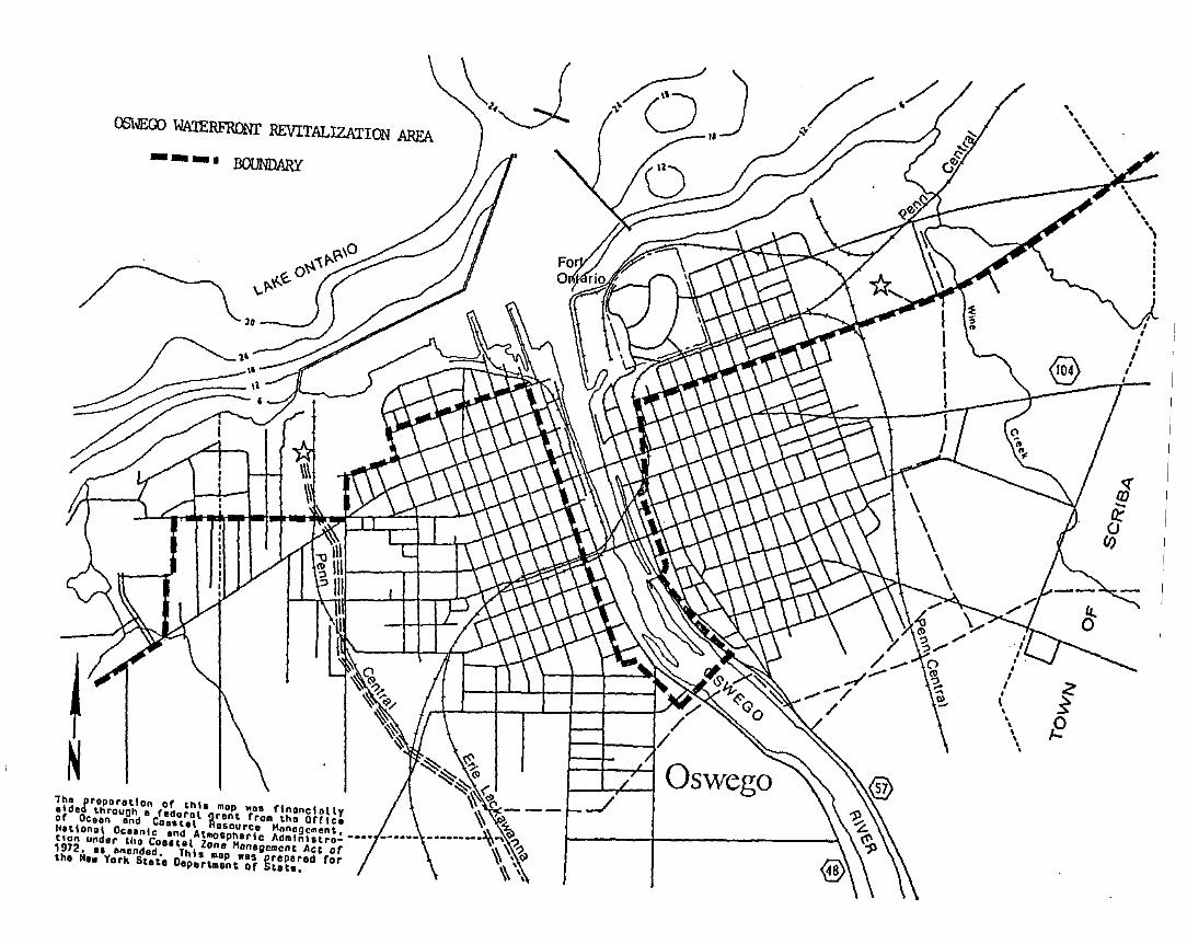
OO\\lEQ) WA1ERFRONr REVITALIZATION AREA--_I BOUNDARY
lho proporotlon or thlo mop .... rlnonclollyetded thraunh • (edoral grant frOA tho arric.or OC ••n and Coastel ROSDurce Mnnogement, _••_ • __•••Notlon.1 OCoonlc and AIBo'phorlc Admlnl.tration undor tho COUUI Zono Honall,,",cnt Act or1912. It amendad. This BOp .as prepared rortho Ho. York Stote Oepart.ant Qr Stata.
fE
\'..."III
II
•II
~._.- --- ----------- ---_._~.. -
Local commitment and support for the Oswego LWRP has been undertaken by theOswego Waterfront Revitalization Program Advisory Committee. The Committeewas the LWRP support group. consisting of elected officials. public agencyand private industry representatives. members of private groups. and individuals interested in the waterfront.
The Advisory Committee was responsible for developing broad-based supportfor. and commitment to. the LWRP and the alternatives selected for resolving the issues concerning how the waterfront area can be developed toachieve a compatible mixture of industrial. commercial. recreational orother uses; allow for active use of the water by commercial shipping interests and the Port Authority operations; and. provide for pleasure boatingand shoreline fishing.
The Committee also ensured public participation in the preparation of theLWRP and provided a vehicle for coordinating the LWRP with the Port ofOswego Development Study. as well as other waterfront activities beingundertaken. such as the City's development of Wright's Landing. the OswegoMaritime Foundation's development of the Boating Education Center. and thedevelopment of the West Bank Linear Park and the design of the East BankPark.
See attached roster for Committee membership.
In this manner.- significant contributions of time. interest and expertisewere drawn from Oswego's businessmen and residents into the preparation ofthe Local Waterfront Revitalization Program. Citizen input improved thedata base. verified program information. evaluated various alternatives andexpressed the values and concerns of the community.
Following the completion of the draft program. the Advisory Committeeformally approved the draft and forwarded it to the City Common Council.Upon approval of the City Common Council. the draft document. including thedraft Environmental Impact Statement (EIS). were submitted to the NYSDepartment of State for distribution to federal and State agencies for a60-day review period. required by NYS Executive Law. Article 42. At thesame time the draft documents were filed and distributed as required by theNYS Environmental Quality Review Act. As a result. there were a number ofcomments received from which further revisions and refinements weredescribed in the final EIS and incorporated into the final LWRP document.The final program document. then. was adopted by the City Cammon Counciland submitted to the ~YS Secretary of State for approval.
Anthon~ A. Leotta, En9~.
Cit, ci 01w&go14 L~"f' Strl'*tO;;wegc NY 13126
Byron LythNl~9or~ Mohawk PGw~r Corp.Lake P""dOsw.. g", NY 1312:>
J:-.C" :-~o!'any, Di rectoryr1C,,"::!4·~ W. Fin.t St.O;~':<i ·;.a t·N 13126
J. F:l chbr.'j Piur.dO~:~~9~ Maritim~ FoundationRC' ;:;3, 8a-~ 219Oi;"';i'';~ NY 13116
93 E~st Moh~wk StrtetOs;..".:o;,:) tlY 13126
To:"JY' SI c':iKOiWi9~ Hi$torian41 G+:-rit St.OSWoi";'o NY 131:26
N;~" V~r.timigl j.io.
lSi Fifth Al)~.
olw",,~,;> tlY 1S 1;2.;
Car! Rich ;.rds '.Stn~to~ 8~rcl~Y'5 O~fjc~
6371 Per t RoocPU1.i.sKi NY 131";2
Andrt1!'I'J J. Fu 11 for-
NYS D.pt. of Tr.n~port.tion
333 E. Wa~hin~tcn St.S)"r·i.Cu'5~ rJY 13202
Oan,.1 J. Palm, Oir.ctorSLEOC317 Washington St.Wat .. rtown NY 13601
Har9ueri to Lincoln, ClerkO~W&90 County L&gislatur&County Offic. BuildingOswego NY 13126
William J. McCarthy, Ex .. c. A.·sist.~I.,")·or's OH i c ..City Ho l1O~we.;o NY 131:::6
Mik:fo t·lir-andioNUi~bau~er ~ Cl~rk~, In~.
14:" W. Fint St.OSl.lJi';" NY 1312::>
Jull.!on J. Pr-u;: rd.. 1 , Jr.
FO 5,,_,: :::03:2O$:_'.J,~·;" fr'" t 3~ :::.~
s.~ 1~~'· S.;..p~~~ ..,Hfrjt~ci Fc~~ditjOn of Osu'i9016: we-it Firs:t St.OS"':~9t;l NY 13126
Mikt Ti+.~+I~, Dir.Cp~r~ticn Oiwe~~ CountyPO Sox ~.) ·:'7Osw+go NY 1312·:'
Srii' 1 t Y WI!' i rlr-"'bHi ;t·:or i c Si t+ r·1~r.';'9+r
F eli t Cr~ t =- r I ,~
Ci:...t~g·' t:y 1.;12~
Fr~r.cis M. e.~n~tt
NYS D~p~~tment yt St~t~
St~t~ O~iic~ elc~.
S),racus+ NY 13202
GrE"tc ..... ~rl P..lphS~r.~t~r O'Amato's Offic~
1259 F~d~r.l etc9.Syratus.. NY 13260
Paul Pasto~ki
tNS DOT.'P"r t Di vis ion1~10 W~ihingto~ ~ve.
Albany tlY 122-;:2
Suo Hi 110rNYS DEC74$1 Honry ClaY Blvd.Liverpool NY 120$8
,Joanne E'o!r-m~.r,
Pall ... diurn Tirnis
OSWi"go NY 13126
Fath~~ '.. Ii' 1 i ~m B..... O'.....nSt. Luk~'! ~p~~t~~~t5
131 LJ. Fir!~ Str""o:o'?tOiwfg.:. th' 13126
Lori SUiK~, Pro!s.I,.}o:tirb.rli M'i'rr..:r" i Si.l Cc·mmi ttll!-~
408 Wiu~c~~~k ~pti.
05Wi-gC' NY 13126
I"ro.:! CrisafulliCcrntor Stvn~ Ri;taur~nt
1330 VaricK Canal0,w090 NY 13126
72 East S~n~~a Str~~t
Osw.e-~v ~.~y 1312·£
Don ,:-.1 d Fr en·:hPo~t of Osw~90 Aytho~ity
PO Box 3:37O:.w~';'O NY 13:2,~
c. J~m~~ Gu~nt~, E~ec. Oir.OSWi£"g.;:, Chamb+r cf Corr,mo!'rc:f'184 W. First StreetOSJ.ol...o IN 13126
SI"I'!'r-\lll:lod H.;.rr,i 1 ~Orl, Ex.c. Dir.Port of O~Wt90 "uthorityPO Box 38,Oswogo NY 13126
Alm~n J. H~wki"'.' 0 r.ctorOsw.9Q Count~ PJ~nn n9 Bo.rdCount/ OffIce BUild ngOsw+90 NY 13126
Raymond T. Ch~£bro
H.wthorn~ Prof ••• ional Bldg.67 S. Se~o~d StrootFu I ton NY 13069
Phil ip Aylward, Diroct""Offico of Community Devolopmont14 Lako StroHOswogo NY 13126
RO~9rt 8~an$h.w, C~~irm.n
DOEP',24 W. Bridgo StrootOswfgO NY 13126
Rc,t·~,. t Suerg'i't'NY';' S~ a Gr ~r, t P"'OQr'" iff,
Sh ~ 1 ,jetrl H.a.l 1-::'1.1,jyO:::VJot-g:':i" rJY t 31:6
Mayor ~i~ li~m S. Cahi r I, Jr.Cit:" of O:·t.l.I':-90Ci ty Hall0;,,0,,1+9° NY 131.26
235 MlJnn S:r-oii'EotO$lI.:i'gc NO.: 1312·$
c.?o. Jo~n Cu!chU.S. Coast Guard St~tion
t1rs. Ant, Fr' .. r.ct"1
409 W. Fifth Stre.tOs..... "" NY 1~12~
Thom~; J. H~Jpjn, Ch~irmon
Co~ncil PloQ/Otv. Corr~i tt~.
242 W. Eighth St.Os......." NY 12126
117 West n,lrd Stre.tOswego NY 131:6
Sheron Holt.t-ooV.Con9r~Sim\ ... Ho~ton'. Offie.Rivorfront Office Bldg.OSI,"Je~Q f·rt 1'31 :.~
Footnote Number 1 for Section III (Local Policies and Applicable StatePolicies) states that in determining consistency with the New York StateCoastal Management Program (NYS CMP). federal agencies should consult the NYSCMP and Final Environmental Impact Statement (FEIS). or an appendix to theOswego Waterfront Revitalization Program. for the text of those policiesidentified by the phrase "Not Included in the Local Program." Those policiesidentified as "Not Included in the Local Program" for Oswego are policies 27.29. 42 and 43. The text of these four policies as extracted from the NYS eMPand FEIS. are as follows:
POLICY 27 Decisions on the siting and construction of major energy facilities Inthe coastal Irea will be based on public energy needs, compallbllityof such facilities with the environment, Ind the facility's n.ed for aahorefrontloeatlon.
A. Explanation of Policy
Demand for energy in New York will increase,althouqh at a rate slower than previously predieted: The State expects to meet these energydemands through a combination of conservationmeasures; traditional and alternative technologies; and use of various fuels including coal ingreat~r proportion.
A c1etermination of public need for energy is thefirst step in the process for siting any newfacilities. The directives for determining thisneed are contained primarily in Article 5 of theNew York State Energy Law. That Article requiresthe preparation of a State Energy Master Plan.With respect to transmission linp.s and steamelectric generating facilities, Articles VII andVIII of the State's Public Service Law requireadditional forecasts and establish the basis fordeternining the compatibility of these facilitieswith the environment and the necessity for ashorefront location. The policies derived fromthe siting regulations under these Articles areentirely consistent with the general coastal zonepolicies derived from other laws, particularly theregulations promulgated pursuant to the WaterfrontRevitalization and Coastal Resources Act. ThatAct is used for the purposf!s of ensuring consistency with the Coastal Managr.ment Program.
The Department of State will comment on the StateEnergy Master Plan; present testimony for therecord during relevant certification proceedingsunder Articles VII and VIII of the PSL; and usethe State SEQR and DOS regulations to ensure thatdecisions on other proposed energy facilities(other than transmission facilities and steamelectric generating plants) which would impact thecoastal area are made consistent with coastalpolicies.
A-l
B. State Beans for InpleI:lenting the Policy
1. Energy Law (Article 5)
Under this law an Energy Planning Board wasestablished. As required, the Board preparedand adopted the first State Energy MasterPlan which is currently in effect. ~he Boardis now considering an updated plan. SeeSection 7 of this docuuent for a noredetailed discussion of this plan.
2. Public Service La~ (Article VIII) - Siting ofllajor Stear.1 Electric Generating Facilities
Defore preparation of a site or theconstruction of a r.lajor stearn electricgeneratinc:; facility can commence, a Certific<.to of invironnental Compatibility alldPublic Need must be issued by the New YorkState Board on Electric Generation Siting andthe Environment. '1'his process is descrilJeclin detail in Section 7. In granting thiscertificate, the Board must aeterl:line thattne faci li ty:
o Represents the mininun adverse environI:lental impact, considering the state ofavailable techllologY1 the nature ancJecononics of the various alternatives;and the interests of the state withrespect to aesthetics, preservation ofhistoric sites, forests and parks, fishand wildlife, and viable agriculturallands 1
lcl\lStbt:and
COI:lplies wi til applicable Stateconcerning, aI:long other natters,environnent and public healthsafety;
o Serves the public interest, convenienceand necessity.
o
The regulations which iuplenent Article VIIIand govern the Board's decision (see Appendi>;A, '7) assure that tllis decislon will becompatible with the policies articulated inthis document, botb those relating toenvironl:lental protection and to economicuevelopl:lent.
~o further ensure com~atibility, the Department of State will review appl ications andnay present testiI:lony during proceedings
A-2
involving facilities proposed to be sited incoastal areas. When reviewing applications,the Department will examine the requireddescription of reasonable alternate locationsas well as the rationale for the preferredsite, particularly with respect to potentialland uses on or near the proposed si te, andthe justification for the amount of shorefront land to be used. Proposed uses whichare likely to be regarded by the Departl'!entas requiring a shorefront location include:
o Uses involved in sea/landgoods (docks, pipelines,storage facilities)~
transfer ofshort term
o Uses requirin9 large quantities(hydroelectric power plants,storage power plants)~ and,
of waterpumped
o Uses that rely heavilytransportation of rawproducts which aretransport on land.
on waterbornematerials or
diff icult to
3. PUblic Service Law (Article VII) - Siting ofMajor Utility Transmission Facilities
Prior to the construction of a major electricor fuel gas transmission facility, a Certificate of Environmental Compatibility and
. Public Need I!\ust be granted by the PublicService Commission. See Rection 7 of thisdocuMent for a detailed description of thisprocess. In issuing a certificate, theCOl!\mission must deterMine that the facility:
o Represents the Minimum adverse environmental impact, considerin~ the state ofavailable technology an~ the nature andeconomics of the various alternatives:
o Conforms with applicable State laws:
o Serves the pUblic interest, convenienceand necessi ty.
As with steam electric generating plants, theDepartment of State will review applicationsand may present testimony duri ng proceedingsinvolving transmission facilities proposed tobe sited in the coastal area. The Departmentwill examine the same matters as underArticle VIII. It will also use the samp.
A-3
cri teria to determine the need for a shorefront location and the consistency of theproposal with coastal policies.
Interstate transmission facilities, such asgas and petroleum pipelines, coal slurrypipelines a~d electric transmission linesassociated with hydroelectric facilities, areregulated by Federal agencies. 'i'hroughFederal consistency provisions, such facilities will be sited in a canner that isconsistent uith the Pro~ram's polici~s.
4. Environncntal Conservation La\l (Article 23,Ti tl<: 17) - Liquefied llatural and PetrolcunCas .
All liquefied natural gas (LUG) and liquefiedpctroleur.l gas (LPG) facilities, r.,ust oLtainan environmental safety perQit beforeconstructiOI\ and operation. For a perrnit tobe granteu, it rnust be shown that suchfacilities uoul~ not endanger residentialareas and contiguous populations and \Iouldothenlise conform to si ting cd teriaestablished by the Department of Environmental Conservation. During the review ofproposed proJects, consideration is given to:the location of the proposed tacility; thedesign and capacity of the facility; expectedsources of the gas; methods of transportinggas to and fron the facility and transportation routes; the public need for thefacility; its environcental irnpacts; an~,
d~scriptions of reasonable alternatelocations for the facility.
5. \;aterfront Revitalization and CoastalResource~ Act, Executive Law (Article 42)
Section 919 of Article 42 requires l) thatState agencies' actions, inclUding directenerg~' development activities such as thoseundertaken by the Po\:er Authority of theState of lIew York, cust be consistent \/i ththe environnental protection and develo~ncnt
policies of this act. 'i'his provision of la\1is irnplemented by acend~ents to SLUR (below)ancJ by DOS regulat'ion~. DOS regulations (19NYCr~ Part 600) provide that, for theirdirect actions which do not have a significant effect on the environcent, Stateagencies certify that the action is consistent with the coastal policies, 2) thatthe Secretary of State shall review actions
A-4
of State agencies that may affect achievementof the policy, and 3) that SEOR regulationsbe amended to reflect consideration ofcoastal resources.
Section 2 of the Act requires that Stateagenci~~ analyze their programs' consistencywith coastal policies and that the Secretaryof State recommend any needed modificationsto the Governor and the Legislature.
6. State Environmental Quality Review Act,Environmental Conservation Law (Article 8)
Under the Statp Environmental Quality ReviewA~t, State agencies and local governments arerequired to prepare an environl'\ental impactstatement for any action that might have asiqnificant impact upon the environment. Thisrequirement applies to larg~ scale energyfacil i ties other than transmission lines anosteam electric generating plants as describedabove. The environment is broadly defined toinclude existing patterns of development andland resources. Actions which have beensubject to an environmental impact statementmust, consistent with social, economic, andother essential considerations, minimize oravoid, to the maximum extent practicable, theadverse environmental effects revealen in theimpact statement (EeL !iB-OI09-B). Inaddition, pursuant to Article 42 of the"Executive Law, SEOR regulations are amendedto require that for actions by a State agencyfor which an EIS has been prepared, suchactions shall be consistent with the coastalpolicies.
7. Water Resources Law, Environmental Conservation Law (Article 15)
Proposals, including those to construct allpipelines, which would excavate or depositfill 1n any navigable waters and anjacentmarshes and estuaries of the State requirepermits issued by the Department ofEnvironmental Conservation.
8. Tidal Wetlands Act, Environmental Conservation Law (Article 25)
The Tidal W~tlands Act requires that a permitbe issuen for uses, including oil piplines,in identified tidal wetlands. It must bedemonstrated that proposed facilities will
A-S
not adversely affect water quality, flood andstorm control, marine food production, wildlife habitats, open space, and aestheticallysignificant areas.
9. Freshwater t<7etlands Act, Environmental Conservation Law (Article 24)
The Freshwater Wetlands Act requires that apermit be issued for uses, including oilpipelines, in identified freshwater wetlands.It must be de~onstrated that proposenfacilities will not adversely affect waterquality, flood and storm control, erosioncontrol, subsurface water resources, wildlifehabitats, fresh'"ater fish sanctuaries, openspace, and aesthetically significant areas.
10. Oil Spill Prevention, Control and Compensation, Navigation Law (Article 12, Section 170et. seq.)
This Article provides for the protection ofthe State' s environment ana econor.lY bypreventinq unreaulated discharge of petroleu~
from major facilities: by authorizing theDepartments of Environmental Conservation andTransportation to respond quickly to removeany discharges: and by establishing liabilityfor any damages sustained within the State asa result of such discharqes.
The Article also creates a fund for clean-up,restoration and compensation for dal'lagescaused by oil spills. Before a license toconstruct a major oil facili ty can be issuenby the Department of Transportation, anapplicant must pay the required fee to helpmaintain the fund and must show that thenecessary equipment to prevent, contain andremove petroleum discharges will be provided.The Department will issue licenses for majoronshore facilities only after the Departmentof Environmental Conservation has certifiedthat the applicant has the necessary equipment to control oil discharges.
11. State Pollutant Discharge Elinination System,Environmental Conservation Law (Article 27)
This Article requires permits for construction of new outlets or new disposal systemsto discharge industrial and other wastes intoState waters, including wastes from nuclearpower plants, other steam electric ~enerating
A-6
plants, and petroleum facilities. Thi~
procedure ensures that establishedquality standards are met.
permitwater
12. Air Pollution Control, Environmental Conservation Law (Article 19, Title 3)
This Article gives the Department of Environmental Conservation the authority to promulgate and enforce regulations controlling airemissions, including those released by energyfacilities. These regulations appear in theState Implementation Plan which details Statestrategies for meeting Federal air qualitystandards under the Clean Air Act.
A-7
POLICY 29 Encourage the development of energy resources on the Outer Con.Iinental Shelf, In Lake Erie and In other water bodies, and .nsure theenvironmental safety of such actlvltl.s.
A. Explanation of Policy
The State recognizes the need to develop newindigenous energy 80urces. It also recognizesthat such development may endanger the env ironment. Among the various energy sources beingexamined are those which may be found on the OuterContinental Shelf (OCS) or in Lake Erie. TheState has been encouraging the wise development ofboth.
Matters pertaining to the OCS are the responsibili ty of the Department of Environmental Conservation. In 1977, the Department, in cooperationwith regional and local agencies, completed astudy which identified potential sites along themarine coast for on-shore OCS facilities. Todate, these sites have not been developed for thispurpose. The Department, also, actively participates in the OCS planning process by reviewing andvoicing the State's concerns about federal OCS oiland gas lease sales and plans. In its review ofthese proposed sales and plans, the DeFartmentconsiders a number of factors such as the effectsupon naviga tional safety in the establishedtraffic lanes leading into and from New YorkHarbor; the impacts upon important finfish, shellfish and wildlife popUlations and their spawningareas; economic and other effects upon commercialand recreational fishing activities: impacts uponpublic recreational resources and opportunitiesalong the marine coast: the potential for geohazards; impacts upon biological communities; andwa ter quali ty.
The Department of Environmental Conservation hasalso examined the potential impacts of Lake Eriegas drilling and is instituting reasonable guidelines 80 that activities can proceed withoutdamage to public water supplies and other valuablecoastal resources. State law prohibits development of wells nearer than one-half mile from theshoreline, two miles from publio water supplyintakes, and one thousand feet from any otherstructure or installation in or on Lake Erie.Further, State law prohibits production of liquidhydrocarbons in Lake Erie, either alone or inassociation with natural ~as. The Department hasnot, however, reached a decision as to whether ornot the lands under Lake Erie will b.a leased forgas exploration purposes.
A-a
B. State Means for Implementing the Policy
1. Env i ronr:le ntal23-1101 )
Conservation Law (Section
The Department of Environmental Conservationmay lease the lands beneath Lake Erie according to specific siting, operation, and liability requirements. Thus the State's environmental agency will retain control over theprocess and ensure appropriate environmentalsafeguards. The production of liquid hydrocarbons is, however, prohibited by thisArticle.
2. Environl'lental23-0305 )
Conservation Law (Section
~his law provides that the Depart~ent ofEnvironmental Conservation will retain jurisdiction over any active or abandoned well.c;and wellheads and may limit production. TheDepartl'lent ~ay act to terminate hazardousdischarges which threaten natural resources.Under this law, producers and handlers mustl:Iaintain accurate records of quantities ofgas handled.
3. Si ting of Major Utili ty TransmissionFacilities, Public Service Law (Article VII)
This law establishes procedures to befollowed ~y developers of natural ~as in theconstruction of any gathering pipelines fromwellheads and any ~ast~r collecting pipelinesin accordance with the environmentalconsiderations of this Article as discussedunder the previous policy.
4. Public Service Law (Article 4, Section 66)
Under this law, the Public S~rvice ComMissionregulates the safe construction an~ operationof natural gas pipelines from the wellhead toany onshore connection.
S. Waterfront Revitalization and CoastalResources Act, Executive Law (Article 42)
See description und~r Policy 27.
.6. State Environmental OualityEnvironnental Conservation8-0113 )
Review Act,Law (Section
See description under Policy 27.
A-9
7. Water Resources Law, Environmental Conservation Law (Article IS)
See description under Policy 27.
8. Freshwater Wetlands Act, Environmental Conservation Act (Article 24)
See description under Policy 27.
9. Freshwater Wetlands Act, Environl:lental Conservation Act (Article 24)
See description under Policy 27.
A-10
POLICY 42 Coastal Management policies will be considered If the State reclass.Ifles land areas pursuant to the prevention of significant deteriorationregula lions of the Federal Clean Air Act.
A. Explanation of Policy
The policies of the State and local coastalmanagement programs concerning proposed land andwater uses and the protection and preservation ofspecial management areas will be taken intoaccount prior to any action to change preventionof significant deterioration land classificationsin coastal regions or adjacent areas. In addition,the Department of State will provide the Department ~f Environmental Conservation with recommendations for proposed prevention of significantdeterioration land classification designationsbased upon State and local coastal managementprograms.
B. State Means for Implementing the Policy
1. Air Pollution Control Act, EnvironmentalConservation Law (Article 19)
This law provides the Department of Environmental Conservation with the authority todesignate areas of the State based upondegree of pollution that may be permitted.It allows the Department to consider thatwhat r.lay be proper for a residential area,for example, may not be proper for a highlydeveloped industrial area.
2. Waterfront Revitalization and CoastalResources Act, Executive Law (Article 42)
Section 919 of Article 42 requires 1) thatState agencies actions, including funding,planning, and land transactions, as well asdirect development activities, must be consistent with the policies of this act, 2)that the Secretary of State shall reviewactions of State agencies that may affectachi~vement of the policy, and 3) that SEQRregulations be amended to reflect consideration and impacts on the use and conservationof coastal resources.
S~ction 2 of the Act requires that !itateagencies analyze their programs' consistencywlth coastal policies and that the Secretaryof State recommend any needed modificationsto the Governor and the Legislature.
A-ll
POLICY 43 Land use or development In the coastal area must not cause thegeneration of significant amounts of the acid rain precursors: nitratesand sulfates.
A. Explanation of Policy
The New York Coastal Management Program incorporates the State's policies on acid rain. As such,the Coastal Management Program will assist in theState's efforts to control acid rain. Theseefforts to control acid rain will enhance thecontinued viability of coastal fisheries,wildlife, agricultural, scenic and waterresources.
s. State .Means for Icplementing the Policy
1. Air Pollution Control Act, EnvironmentalConservation Law (Article 19).
2. ~aterfront Revitalization and CoastalResources Act, Executive Law (Article 42).
Section 919 of Article 42 requires 1) thatState agencies actions, inclUding funding,planning, and land transactions, as well asdirect develop~cnt activities, ~ust beconsistent with the policies of this act, 2)ttlat the Secretary of State shall reviewactions of State agencies that liIay affectachievemer.t of the policy, and 3) that SEQR
. regulations be amended to reflect consideration of impacts on the use and conservationof coastal resources.
Section 2 of the Act requires that Stateagencies analyze their programs' consistencywith coastal policies and that the Secretaryof ·State recolilmend any needed modificationsto the Governor and the Legislature.
A-12