city of san rafaeldocs.cityofsanrafael.org/pubworks/ptsanpedromedians/...within the city limits of...
TRANSCRIPT

CITY OF SAN RAFAEL
ENGINEER’S ANNUAL REPORT
PT. SAN PEDRO ROAD MEDIAN
LANDSCAPING ASSESSMENT DISTRICT
FISCAL YEAR 2012/2013
INTENT MEETING: JULY 2, 2012
PUBLIC HEARING: JULY 16, 2012
FINAL REPORT
Submitted this 3rd Day of July, 2012
CITY OF SAN RAFEL
1400 FIFTH AVENUE
SAN RAFAEL, CA 94901
PREPARED BY
WILLDAN FINANCIAL SERVICES


Engineer’s Annual Report Pt. San Pedro Road Median Landscaping Assessment District
Fiscal Year 2012/2013
i
ENGINEER'S REPORT AFFIDAVIT
Annual Levy of Assessments
City of San Rafael Pt. San Pedro Road Median Landscaping
Assessment District
Fiscal Year 2012/2013
County of Marin, State of California
This Report and the enclosed descriptions, budgets and diagram outline the proposed improvements and assessments associated with the Pt. San Pedro Road Median Landscaping Assessment District for Fiscal Year 2012/2013. Said District includes each lot, parcel, and subdivision of land within the boundaries of the Pt. San Pedro Road Median Landscaping Assessment District, as they existed at the time of the passage of the Resolution of Intention and as defined by the District Diagram, a copy of which is contained herein as Part IV. Reference is hereby made to the Marin County Assessor’s maps for a detailed description of the lines and dimensions of parcels within the Pt. San Pedro Road Median Landscaping Assessment District. The undersigned respectfully submits the enclosed Report as directed by the City of San Rafael City Council. Dated this ____________ day of ______________, 2012. Willdan Financial Services Assessment Engineer On Behalf of the City of San Rafael
By: ________________________________
Jim McGuire Senior Project Manager
By: ________________________________
Richard Kopecky R. C. E. # 16742

Engineer’s Annual Report Pt. San Pedro Road Median Landscaping Assessment District
Fiscal Year 2012/2013
ii
TABLE OF CONTENTS
INTRODUCTION ................................................................................................................... 1
PART I: PLANS AND SPECIFICATIONS ..................................................................... 6
A. DESCRIPTION OF THE DISTRICT .................................................................................... 6
B. IMPROVEMENTS AUTHORIZED BY THE 1972 ACT .......................................................... 6
C. DISTRICT IMPROVEMENTS ............................................................................................. 8
PART II: METHOD OF APPORTIONMENT ................................................................ 10
A. PROPOSITION 218 BENEFIT ANALYSIS ....................................................................... 10
B. METHOD OF ASSESSMENT .......................................................................................... 14
PART III: ESTIMATE OF IMPROVEMENT COSTS (BUDGET) ........................... 22
PART IV: DISTRICT DIAGRAM ..................................................................................... 27
PART V: ASSESSMENT ROLL ..................................................................................... 29
APPENDIX A: BOND INFORMATION ......................................................................... 30
APPENDIX B: IMPROVEMENT AREAS ..................................................................... 33
APPENDIX C: ANNUAL ASSESSMENTS (FY 2012/2013) ................................... 52

Engineer’s Annual Report Pt. San Pedro Road Median Landscaping Assessment District
Fiscal Year 2012/2013
1
INTRODUCTION
Due in part to a severe drought in 1976, and the subsequent deterioration of the irrigation system, the landscape improvements within the median islands along Point San Pedro Road and Third Street east of Union Street significantly declined to a point that very little of the original landscaping remained other than some of the trees and vegetation that were able to survive with little water. Although the original landscaping for the twenty-nine (29) median islands along Point San Pedro Road and Third Street (hereafter, referred to collectively as the “Pt. San Pedro Road Medians” or “Medians”) were installed in connection with and for the benefit of the surrounding developments and properties that are directly adjacent to Point San Pedro Road and Third Street and/or serve as the primary access streets to those developments and properties, no local funding source was established to ensure the ongoing maintenance of those improvements. Ultimately, without a direct source of revenue pledged for repair, reconstruction and maintenance of the landscaping within these Medians (located, both within the City limits of the City of San Rafael and in the immediate contiguous unincorporated area of the County of Marin), it was necessary for both the County and City to limit the servicing of what landscaping remained to occasional trimming to control over-growth.
As a result many properties owners in close proximity to Point San Pedro Road both within the City limits of the City of San Rafael and in the immediate contiguous unincorporated area of the County of Marin, organized an effort to facilitate the formation of an assessment district in the area to fund the capital costs associated with construction and restoration of the landscaping within the Pt. San Pedro Road Medians, as well as the ongoing maintenance and operation of those improvements. Because these Medians and the properties that derive a direct and special benefit from those improvements (properties immediately adjacent to and/or directly access the streets where the medians are located), encompasses an area (territory) that includes properties and improvement areas within both the City of San Rafael and unincorporated portions of the County of Marin, in order to establish such an assessment district the two agencies entered into a Memorandum of Understanding (MOU) concerning the formation of an assessment district for the purpose of funding in whole or in part through annual assessments, the capital costs and ongoing maintenance and operation of the landscaping within the Pt. San Pedro Road Medians. Pursuant to the MOU between the City of San Rafael (hereafter, referred to as the “City”) and the County of Marin (hereafter, referred to as the “County”), adopted by both the County Board of Supervisors and by the City Council, the City was designated as the lead agency with the City Council being the legislative body for the proposed assessment district.

Engineer’s Annual Report Pt. San Pedro Road Median Landscaping Assessment District
Fiscal Year 2012/2013
2
Ultimately in 2011, the City Council initiated proceedings and declared their intention to establish a special benefit assessment district pursuant to the provisions of the Landscape and Lighting Act of 1972, being Part 2 of Division 15 of the California Streets and Highways Code commencing with §22500 (hereafter referred to as the “1972 Act”), and as applicable for the issuance of related bonds, pursuant to the Improvement Bond Act of 1915 Part 1 of Division 10 of the California Streets and Highways Code commencing with §8500 (hereafter referred to as the “1915 Act”), said district to be designated as the:
Pt. San Pedro Road Median Landscaping Assessment District
(hereafter referred to as “District”), for the purpose of providing a revenue source to fund the annual debt service obligation for bonds issued to finance the construction, installation, enhancement, renovation and rehabilitation of the landscaping and related facilities; as well as the annual costs and expenses for the ongoing operation, maintenance, and servicing of those improvements including administration and other incidental expenses.
In accordance with the 1972 Act and the requirements of the California Constitution, Article XIIID (hereafter referred to as the “Constitution”), the City Council called for an Engineer’s Report to be prepared regarding the formation of the District and proposed assessments. As part of this District formation, in accordance with the Constitution Article XIIID Section 4 and the provisions of Government Code, Section 53753, the City conducted a property owner protest ballot proceeding for the proposed District special benefit assessments. In conjunction with this ballot proceeding, a noticed public hearing was held on June 20, 2011 to consider public testimonies, comments and written protests regarding the formation of the District and the levy of assessments. Upon conclusion of the public hearing, protest ballots received were opened and tabulated to determine whether majority protest existed (with ballots weighted based on proportional assessment amounts), and on June 22, 2011 the City Council confirmed the results of that ballot tabulation, with approximately 61.4% of the weighted ballots being in favor of the assessments and 38.61% being opposed. Finding that majority protest did not exist, the City Council approved and adopted the formation of the District and order the levy and collection of assessments for fiscal year 2011/2012 (first year’s annual assessments).
The assessment rate, method of apportionment and assessments including the assessment range formula established in the Engineer’s Report at the time of formation of the District and as described herein, became effective commencing in Fiscal Year 2011/2012 and may be levied annually pursuant to the provisions of the 1972 Act and as applicable the provisions of the 1915 Act. The annual assessments each fiscal year shall be based on the estimated revenues needed to support the annual debt service obligation for bonds or other financing issued to fund the construction, installation, enhancement, renovation and rehabilitation of the landscaping and related facilities; as well as the annual costs and expenses for the ongoing operation, maintenance, and servicing of those improvements including administration and other incidental expenses as authorized pursuant to the 1972 Act and the 1915 Act.

Engineer’s Annual Report Pt. San Pedro Road Median Landscaping Assessment District
Fiscal Year 2012/2013
3
This Engineer’s Annual Report (hereafter referred to as “Report”) has been prepared in connection with the annual levy and collection of assessments of said District to be collected on the County Tax Rolls for fiscal year 2012/2013, pursuant to Chapter 3, beginning with §22620 of the 1972 Act. The District includes all lots and parcels of land within a defined boundary as shown on the District Diagram included in this Report as Part IV and further identified by the Marin County Assessor’s Office Assessor’s Parcel Numbers (parcels), a listing of which along with the 2012/2013 annual assessment amount for each is contained in Appendix C in this Report.
The word “parcel,” for the purposes of this Report, refers to an individual property assigned its own Assessor’s Parcel Number (APN) by the Marin County Assessor’s Office. The Marin County Auditor/Controller uses Assessor’s Parcel Numbers and specific a Fund Number to identify properties to be assessed on the tax roll for the special benefit assessments described herein.
This Report describes the District; identifies the improvements including any proposed substantial changes to such improvements to be provided; the estimated expenditures; and the resulting special benefit assessments to be levied and collected on the County tax rolls for fiscal year 2012/2013. The total District annual assessment presented herein is based on an estimated budget that reflects the revenues required to fund in whole or in part the capital costs associated with construction and restoration of the landscaping within the Pt. San Pedro Road Medians, as well as the ongoing maintenance and operation of those improvements. While the proposed total annual assessment for each property will be comprised of two components, one for debt service on Bonds or other financing issued for the initial capital construction costs, and the second for the annual operation and maintenance of the improvements, all annual assessment revenues including those budgeted for operation and maintenance shall be pledged first to the repayment of the capital improvement costs (debt service on bonds or other financing) with the remaining assessment revenues collected each fiscal year (not applied to debt service and associated administrative expenses) being applied to maintenance and authorized incidental expenses.
Each fiscal year, an Engineer’s Report shall be prepared and presented to the City Council describing the District, any changes to the District or improvements, the proposed budget and assessments for that fiscal year, and the City Council shall hold a noticed public hearing regarding these matters prior to approving and adopting the annual levy of assessments. At the conclusion of the public hearing the City Council may, by resolution, adopt this Report (as submitted or amended) including the assessment diagram; any changes to the improvements to be made, and order the levy and collection of the assessments as described herein. In such case, the assessments (as provided herein or as amended) shall be submitted to the County Auditor/Controller for inclusion on the property tax roll for fiscal year 2012/2013.

Engineer’s Annual Report Pt. San Pedro Road Median Landscaping Assessment District
Fiscal Year 2012/2013
4
This Report consists of five (5) parts:
PART I
Plans and Specifications: This part of the Report contains a general description of the location and extent for the proposed works and improvements within the District boundaries. As of the writing of this Report, detailed plans and specifications for the construction and installation of these improvements and construction costs are being finalized. These plans and specifications (designs and plans) are on file in the office of Public Works of the City of San Rafael and have been utilized to estimate the construction costs and maintenance requirements for fiscal year 2012/2013.
PART II
The Method of Apportionment: A discussion of the general and special benefits associated with the improvements within the Pt. San Pedro Median Landscaping Assessment District (Proposition 218 Benefit Analysis), which includes the original determination of the proportional costs of the special benefits and a separation of costs considered to be of general benefit (and therefore not assessed) established in the Engineer’s Report at the time of formation. This section of the Report also outlines the method of calculating each property’s proportional special benefit and annual assessment utilizing a weighted benefit comparison among the different property types within the District.
PART III
Estimate of Improvement Costs (Budget): An estimate of the average annual cost to fund the improvements and facilities that will be provided by this District resulting in the establishment of an initial maximum assessment rate and annual inflationary adjustment to be approved by the property owners of record. This estimate of the improvement costs (budget) includes an estimate of the average debt service payment for bonds to be issued for the construction and installation of the median landscape improvements based on an estimated par amount of $1,750,000.00 (Principal); funds to be collected for the annual maintenance and servicing of the improvements; and incidental expenses including, but not limited to District administration expenses, county fees and professional services related to the improvement project, annual levy of assessments and bonds issued for the District. The proposed maximum assessment (Rate per Equivalent Benefit Unit) identified in the budget establishes the initial maximum annual assessment rate for the District to be presented to the property owners of record for approval and shall include an annual inflationary adjustments. The proposed assessments each fiscal year shall be based on the estimated net annual cost to fund the District improvements and activities for that fiscal year, but shall not exceed the maximum assessment rate established for the District.

Engineer’s Annual Report Pt. San Pedro Road Median Landscaping Assessment District
Fiscal Year 2012/2013
5
PART IV
Assessment Diagram: A Diagram showing the exterior boundaries of the District is provided in this Report and includes all parcels that will receive special benefits from the improvements. Parcel identification, the lines and dimensions of each lot, parcel and subdivision of land within the boundaries of the District for fiscal year 2012/2013 shall be based on the Marin County Assessor's Parcel Maps as they existed at the time this Report was presented to the City Council for the adoption of the Resolution of Intention, and shall include all subsequent subdivisions, lot-line adjustments or parcel changes therein. Reference is hereby made to the Marin County Assessor’s maps for a detailed description of the lines and dimensions of each lot and parcel of land within the District.
PART V
Assessment Roll: A summary of the assessment amounts to be levied and collected for fiscal year 2012/2013 is provided in this section of the Report and a listing of the assessment amount for each parcel is provided in Appendix C. The assessment amount for each parcel is based on the parcel’s calculated proportional special benefit as outlined in the Method of Apportionment included in this Report as Part II and the annual assessment rates established by the estimated budgets included in this Report as Part III.

Engineer’s Annual Report Pt. San Pedro Road Median Landscaping Assessment District
Fiscal Year 2012/2013
6
PART I: PLANS AND SPECIFICATIONS
A. Description of the District
The territory within the District is outlined in an Assessment Diagram incorporated herein under Part IV of this Report. This diagram incorporates all lots, parcels and subdivisions of land within the District as the same existed at the time this Report was prepared. The District generally includes all or a portion of the parcels identified on the following Marin County Assessor's Parcel Map Books: 008; 009; 014; 015; 016; 017; 184; 185; and, 186.
The parcels within these Assessor's Parcel Map Books that comprise the District are summarized in Part V (Assessment Roll) of this Report, and a detailed listing of the Assessor's Parcel Numbers and corresponding proportional annual assessments for fiscal year 2012/2013 is contained in Appendix C.
The purpose of this District is to provide a stable revenue source to fund the construction, renovation and rehabilitation of the median island landscaping and related facilities on Third Street and Point San Pedro Road as well as the ongoing operation, maintenance of those improvements (collectively referred to as “Improvements”) that provide special benefits to properties within the District, including incidental expenses and debt services for any bond(s), loans or other repayment plans incurred to finance capital improvements. The proposed plan and location of the median islands to be landscaped, upgraded, and renovate through the construction and installation of landscaping improvements and related facilities are generally described in this section. Detailed design plans and specifications for the improvements have been prepared in the detail necessary for the actual construction and installation of the improvements and these plans and specifications are on file in the office of Public Works of the City of San Rafael.
B. Improvements Authorized by the 1972 Act
As applicable or may be applicable to this proposed District, the 1972 Act defines improvements to mean one or any combination of the following:
The installation or planting of landscaping.
The installation or construction of statuary, fountains, and other ornamental structures and facilities.
The installation or construction of public lighting facilities.
The installation or construction of any facilities which are appurtenant to any of the foregoing or which are necessary or convenient for the maintenance or servicing thereof, including, but not limited to, grading, clearing, removal of debris, the installation or construction of curbs, gutters, walls, sidewalks, or paving, or water, irrigation, drainage, or electrical facilities.
The maintenance or servicing, or both, of any of the foregoing.
Engineer’s Annual Report Pt. San Pedro Road Median Landscaping Assessment District
Fiscal Year 2012/2013
7
The acquisition of any existing improvement otherwise authorized pursuant to this section.
Incidental expenses associated with the improvements including, but not limited to:
The cost of preparation of the report, including plans, specifications, estimates, diagram, and assessment;
The costs of printing, advertising, and the publishing, posting and mailing of notices;
Compensation payable to the County for collection of assessments;
Compensation of any engineer or attorney employed to render services;
Any other expenses incidental to the construction, installation, or maintenance and servicing of the improvements;
Any expenses incidental to the issuance of bonds or notes pursuant to Section 22662.5.
Costs associated with any elections held for the approval of a new or increased assessment.
The 1972 Act defines "Maintain" or "maintenance" to mean furnishing of services and materials for the ordinary and usual maintenance, operation, and servicing of any improvement, including:
Repair, removal, or replacement of all or any part of any improvement.
Providing for the life, growth, health, and beauty of landscaping, including cultivation, irrigation, trimming, spraying, fertilizing, or treating for disease or injury.
The removal of trimmings, rubbish, debris, and other solid waste.
The cleaning, sandblasting, and painting of walls and other improvements to remove or cover graffiti.
Furthermore, the 1972 Act specifies that where the cost of improvements (other than maintenance and operations) is greater than can be conveniently raised from a single annual assessment, an assessment to be levied and collected in annual installments. In that event, the governing body may choose to do any of the following:
Provide for the accumulation of the moneys in an improvement fund until there are sufficient moneys to pay all or part of the cost of the improvements.
Provide for a temporary advance to the improvement fund from any available and unencumbered funds of the local agency to pay all or part of the cost of the improvements and collect those advanced moneys from the annual installments collected through the assessments.
Borrow an amount necessary to finance the estimated cost of the proposed improvements. The amount borrowed, including amounts for bonds issued to finance the estimated cost of the proposed improvements.

Engineer’s Annual Report Pt. San Pedro Road Median Landscaping Assessment District
Fiscal Year 2012/2013
8
C. District Improvements
The District improvements may include, but are not limited to the construction, installation, enhancement, renovation and rehabilitation of the landscaping and related facilities of the Point San Pedro Road/Third Street median islands as well as the ongoing operation, maintenance, of those landscape improvements. There are currently twenty-nine (29) existing median islands within the boundaries of the District to be improved and maintained. These median islands are located on Point San Pedro Road and Third Street between Union Street and Biscayne Drive and comprise approximately 156,260 square feet of surface area. The landscape improvements to be constructed and installed are intended to consist of primarily low maintenance, water efficient landscaping which may include, but are not limited to various varieties of trees and drought tolerant vegetation and plantings including ground cover, plants and shrubs; as well as related facilities and amenities including low volume irrigation systems and drainage facilities; as well as hardscape features such as pavers, decorative stone, stamped concrete, masonry or concrete walls, and monuments. The following is a general description of the location of the existing medians on Third Street and Point San Pedro Road proposed to be improved and maintained:
Third Street Medians:
Union Street to San Rafael High School parking lot
San Rafael High School parking lot to middle of parking lot
Middle of San Rafael High School parking lot to Embarcadero Way
Point San Pedro Road Medians:
Embarcadero Way to Mooring Road
Mooring Road to Marina Boulevard
Marina Boulevard to Aqua Vista Drive
Aqua Vista Drive to Royal Court
Royal Court to Porto Bello Drive
Porto Bello Drive to Summit Avenue
Summit Avenue to Margarita Drive
Margarita Drive to Bay Way
Bay Way to Bellevue Avenue
Bellevue Avenue to Manderly Road
Manderly Road to San Pedro Elementary School
San Pedro Elementary School to San Pedro Cove
San Pedro Cove to Lochinvar Drive
Lochinvar Drive to Loch Lomond Shopping Center
Engineer’s Annual Report Pt. San Pedro Road Median Landscaping Assessment District
Fiscal Year 2012/2013
9
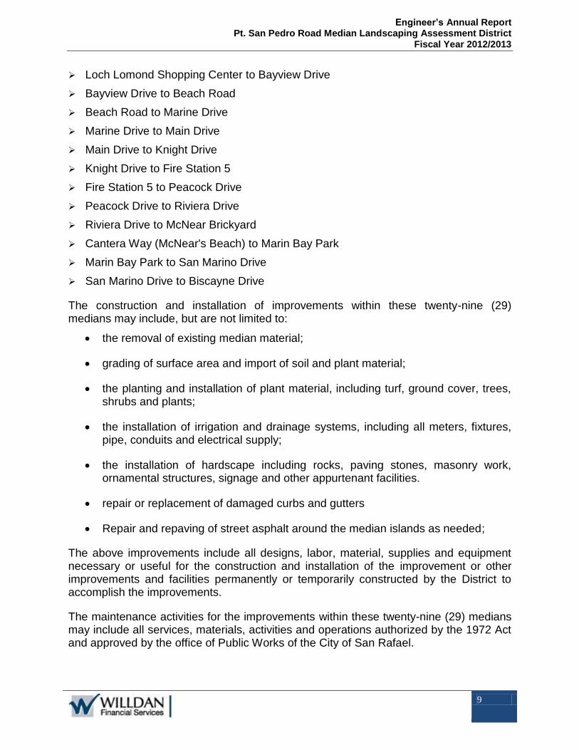
Loch Lomond Shopping Center to Bayview Drive
Bayview Drive to Beach Road
Beach Road to Marine Drive
Marine Drive to Main Drive
Main Drive to Knight Drive
Knight Drive to Fire Station 5
Fire Station 5 to Peacock Drive
Peacock Drive to Riviera Drive
Riviera Drive to McNear Brickyard
Cantera Way (McNear's Beach) to Marin Bay Park
Marin Bay Park to San Marino Drive
San Marino Drive to Biscayne Drive
The construction and installation of improvements within these twenty-nine (29) medians may include, but are not limited to:
the removal of existing median material;
grading of surface area and import of soil and plant material;
the planting and installation of plant material, including turf, ground cover, trees, shrubs and plants;
the installation of irrigation and drainage systems, including all meters, fixtures, pipe, conduits and electrical supply;
the installation of hardscape including rocks, paving stones, masonry work, ornamental structures, signage and other appurtenant facilities.
repair or replacement of damaged curbs and gutters
Repair and repaving of street asphalt around the median islands as needed;
The above improvements include all designs, labor, material, supplies and equipment necessary or useful for the construction and installation of the improvement or other improvements and facilities permanently or temporarily constructed by the District to accomplish the improvements.
The maintenance activities for the improvements within these twenty-nine (29) medians may include all services, materials, activities and operations authorized by the 1972 Act and approved by the office of Public Works of the City of San Rafael.

Engineer’s Annual Report Pt. San Pedro Road Median Landscaping Assessment District
Fiscal Year 2012/2013
10
PART II: METHOD OF APPORTIONMENT
The 1972 Act permits the establishment of assessment districts by agencies for the purpose of providing certain public improvements including, the acquisition, construction, installation, maintenance and servicing of landscaping within public right-of-ways such as medians. The 1972 Act requires that the cost of these improvements be levied according to benefit rather than assessed value:
“The net amount to be assessed upon lands within an assessment district may be apportioned by any formula or method which fairly distributes the net amount among all assessable lots or parcels in proportion to the estimated benefits to be received by each such lot or parcel from the improvements.”
The method of apportionment described in this Report for allocation of special benefit assessments utilizes commonly accepted engineering practices and has been established pursuant to the provisions of the 1972 Act and California Constitution. The formulas used for calculating assessments reflect the composition of parcels within the District and the improvements and activities to be provided, and have been designed to fairly apportion costs based on a determination of the proportional special benefits to each parcel.
A. Proposition 218 Benefit Analysis
The estimated annual cost of the improvements have been identified and allocated to properties within the District based on special benefit. The improvements to be provided by this District and for which properties are assessed, have been identified as local amenities that provide a direct reflection and extension of the properties within the District and are considered by many property owners to be an essential component to the overall development and use of properties within the District.
This District was formed to provide and establish a local landscaping enhancement that affects the presentation of the surrounding properties and therefore directly benefit the parcels to be assessed within the District. The assessments and method of apportionment is based on the premise that the assessments will be used to construct and install landscape improvements within the existing Point San Pedro Road Medians as well as provide for the annual maintenance of those improvements, and the assessment revenues generated through the District will be used solely for such purposes.
In conjunction with the provisions of the 1972 Act, the California Constitution Article XIIID addresses several key criteria for the levy of assessments, notably:
Article XIIID Section 2d defines District as follows:
“District means an area determined by an agency to contain all parcels which will receive a special benefit from a proposed public improvement or property-related service”;

Engineer’s Annual Report Pt. San Pedro Road Median Landscaping Assessment District
Fiscal Year 2012/2013
11
Article XIIID Section 2i defines Special Benefit as follows:
“Special benefit” means a particular and distinct benefit over and above general benefits conferred on real property located in the district or to the public at large. General enhancement of property value does not constitute “special benefit.”
Article XIIID Section 4a defines proportional special benefit assessments as follows:
“An agency which proposes to levy an assessment shall identify all parcels which will have a special benefit conferred upon them and upon which an assessment will be imposed. The proportionate special benefit derived by each identified parcel shall be determined in relationship to the entirety of the capital cost of a public improvement, the maintenance and operation expenses of a public improvement, or the cost of the property related service being provided. No assessment shall be imposed on any parcel which exceeds the reasonable cost of the proportional special benefit conferred on that parcel.”
The method of apportionment (method of assessment) set forth in the Report is based on the premise that each assessed property receives special benefits from the median improvements to be funded by the assessments, and the assessment obligation for each parcel reflects that parcel’s proportional special benefits as compared to other properties that receive special benefits.
To identify and determine the proportional special benefit to each parcel within the District, it is necessary to consider the entire scope of the improvements provided as well as the properties that benefit from those improvements. The improvements and the associated costs described in this Report have been identified and allocated based on a benefit rationale and calculations that proportionally allocate the net cost of only those improvements determined to be of special benefit to properties within the District. The various public improvements and the associated costs have been identified as either “general benefit” (not assessed) or “special benefit”.
General Benefits
Assessments are established on the basis of calculated proportional special benefit to properties within a district. Because general benefits are not assessable, the general benefit costs are excluded from the assessment calculation. With respect to this District, although the various median improvements installed and maintained are located within the street right-of-way that serve as the primary access and entryway to the properties within the District and these improvements are entirely within the proposed boundaries of the District (extending the length of the District), it is also recognized that these medians are certainly visible to the general public and may even be in proximity to and occasionally accessed by properties outside the District boundaries that are not assessed. The fact that these streets are accessible to the general public and maybe in proximity to some properties outside the District boundaries (those properties being the China Camp State Park or other public open space and some residential developments located northwest of the District that could, but would not typically be accessed via Point San Pedro Road) would suggest that at least a portion of the overall cost of these

Engineer’s Annual Report Pt. San Pedro Road Median Landscaping Assessment District
Fiscal Year 2012/2013
12
medians is of “General Benefit”, but not necessarily the proposed landscape improvements.
While Point San Pedro Road and Third Street are certainly accessible and may be used by the general public, various traffic circulation studies/evaluations conducted in conjunction with the developments in the area, collectively suggest that approximately ninety percent (90%) of the daily traffic circulation on these streets comes from the properties within the District, meaning that only about ten percent 10% would be considered traffic associated with the general public or properties outside the District. Per an August 2009 Average Daily Trip (“ADT”) study along Point San Pedro Road, while the average daily trips on Point San Pedro Road varies at different locations between Union Street and Biscayne Drive, the ADT on Point San Pedro Road collectively totaled approximately 44,000 trips. Based on the District’s residential density at the time of formation (single and multi-family residential) of approximately 2,743 units, and utilizing trip generation data as outlined by the Institute of Transportation Engineers Informational Report, Seventh Edition, the expected ADT for these residential properties is estimated to be 26,094 (approximately 60%) of the total ADT along Point San Pedro Road. An additional 13,340 (approximately 30%) of the total ADT is estimated for the various non-residential properties within the District (commercial, church, non-exempt public owned property), which represent approximately 21% of the District’s total acreage. The remaining estimated ADT along Point San Pedro Road (approximately 10%) is reasonably attributed to be generated from external sources. In addition to these studies and analysis, although Point San Pedro Road and Third Street may be considered primary circulation streets for the area, these streets and the associated medians are more isolated than most traditional arterial or collector streets found in the City and County. The north-easterly boundaries of the District abuts the China Camp State Park; the easterly and south-easterly boundaries are adjacent to the San Pablo Bay; and the south-westerly boundary is adjacent to the San Rafael Canal; all of which limits direct access to Point San Rafael Road. Although the western and north-western boundaries of the District are comprised of other developed properties (residential and non-residential), neither Point San Pedro Road or that portion of Third Street within the boundaries of the District would typically be used by these properties as their primary access and certainly not as a direct connection to Highway 101 or the rest of the City.
In review of these facts, it was determined that while the landscape improvements may be visually appealing to the occasional motorist and visitor to the area or the State Park, such benefits are not quantifiable and are considered neither special or general benefit. However, it has also recognized that median islands are constructed for traffic mitigation reasons and as such, there is a measurable general benefit to the public at large and to properties outside the District afforded by the physical existence of these medians, but that benefit is not related to nor extends to the enhancement of those medians by the landscaping within those medians. Therefore, it has been determined that the general benefit to the public at large and properties outside the District is limited to those costs related to and associated with the repair, replacement, rehabilitation and maintenance of the physical median structure and traffic control devices (i.e. curbs, gutters, retaining walls, signage, striping and pavement), but not the actual landscape improvements. Furthermore, it has been determined that only about ten percent 10% of these costs are consider a general benefit to the public at large and properties outside the District.

Engineer’s Annual Report Pt. San Pedro Road Median Landscaping Assessment District
Fiscal Year 2012/2013
13
In addition to the general benefit to properties outside the District and to the public at large noted above, it is reasonable to conclude that the physical medians also provide a general benefit to properties in the District. However, it must also be recognized that these medians were originally constructed and facilitated by the development and planned development of the properties within the District and would otherwise not have been necessary or required for traffic mitigation, and as such these physical medians certainly provide more than just a general benefit to those properties which routinely access Point San Pedro Road and Third Street and these medians, landscaped or not, clearly provide a direct and special benefit to those properties.
Based on the preceding discussion, it has been determined that the general benefit from the medians is limited to those costs related to and associated with the repair, replacement, rehabilitation and maintenance of the physical median structure and traffic control devices within or associated with the medians and not the proposed landscape improvements and amenities themselves. However, it is also recognized that not all costs associated with the renovation and maintenance of these physical medians are considered a general benefit, and although the City and County intend to fund the initial cost of the repair, replacement and rehabilitation of the median islands (curbs, gutters, retaining walls, signage, striping and pavement) in connection with the construction and installation of the landscape improvements, the need for such repairs, replacements, or rehabilitation and the ongoing maintenance of those median islands shall be addressed as part of the ongoing maintenance budgets, which will be addressed as a combination of City, County and assessment funding.
Special Benefits
The proposed Point San Pedro Road Median landscaping will expand and extend the aesthetic presentation of each property within the District by providing enhanced level of landscaping that is directly associated with each property and development along Point San Pedro Road/Third Street. The proposed landscape improvements will provide a physical extension of each private property’s front yard or business frontage and creates an aesthetic continuity and cohesion between the various residential and non-residential properties within the District that could not be accomplished individually. These landscape improvements will create both a visual and physical local beautification and unification of the properties that will directly and proportionately benefit the properties to be assessed. The location and extent of the improvements in relationship to each of the properties in the proposed District clearly makes these improvements a direct and special benefit to these parcels. It has therefore been determined that the proposed improvements and the related cost and expenses to construct and maintain these landscape improvements (excluding those general benefit costs noted above) are entirely special benefits to the properties within the boundaries of the proposed District and the net annual cost to fund such improvements shall be proportionately shared by those properties receiving such special benefits.

Engineer’s Annual Report Pt. San Pedro Road Median Landscaping Assessment District
Fiscal Year 2012/2013
14
B. Method of Assessment
The method of apportionment (method of assessment) developed for this District is based on the premise that each of the property to be assessed receives a direct and special benefit from the improvements to be financed by the District assessments.
The total assessment amount for each parcel in the District shall consist of two parts: Each parcel’s proportional share of the annual bond debt service that will be established each fiscal year, based on the amount of 1915 Act Bonds issued for the District (“Debt Service - Assessment”); and the parcel’s proportional share of additional funding for operation & maintenance and other incidental expenses which have not been financed through the bond issuance (“Non-Bonded-Assessments”) that will be collected in annual installments pursuant to the 1972 Act. The combined Debt Service Assessment and Non-Bonded Assessment for each parcel represent the parcel’s Maximum Annual Assessment and obligation for the District. Once Bonds are issued, the Debt Service Obligation for a parcel will not change even if the land use of the property changes, and their portion of the annual debt service will be calculated based on the established debt service schedule for the bonds (fixed lien amount). The amount that may be collected for the non-bonded projects and incidental expenses shall not exceed the revenues that maybe levied at the approved Maximum Assessment Rate established in this Report (including the allowable annual inflationary adjustment), less the debt service payment. This calculation will establish the Non-Bonded Assessment Rate for that fiscal year.
The proportionate share and benefit for Non-Bonded Projects are calculated annually for each parcel based on current parcel development. The bonded debt service obligation for each parcel is based on the unpaid lien established at the time the bonds are issued. Parcels that have prepaid or paid off their full assessment lien (bonded obligation) are no longer levied for the Debt Service Assessment, but will continue to pay their proportionate share of the Non-Bonded Assessment at the assessment rate established each fiscal year and the method of apportionment described herein.
Equivalent Benefit Units:
The method of apportionment for this District calculates the receipt of special benefit from the respective improvements based on the actual or proposed land use of the parcels within the District. The special benefit received by each lot or parcel is equated to the overall land use of parcels within the District based on the parcel’s actual land use or proposed development. All costs associated with the improvements are distributed among the parcels based upon a calculation of the proportional special benefit received by each parcel. The benefit formula used to determine the assessment obligation is therefore based upon both the improvements that benefit the parcels within the District as well as the use and relative characteristics of each property as compared to other parcels that benefit from those specific improvements.
The Equivalent Benefit Unit (“EBU”) method of assessment apportionment establishes a basic unit (base value) of benefit and then calculates the benefit derived by each assessed parcel as a multiple (or a fraction) of the basic unit.

Engineer’s Annual Report Pt. San Pedro Road Median Landscaping Assessment District
Fiscal Year 2012/2013
15
For the purposes of this Engineer's Report and proportional annual assessment obligation, an EBU is the quantum of benefit derived from the funded improvements, programs and services by a single-family residential parcel (residential unit). Thus, the "benchmark" property (the single-family residential parcel/unit) derives one (1.0) EBU of benefit. All other land uses are proportionately weighted (assigned an EBU) based on an assessment formula that equates the property’s specific development to that of the benchmark property (single-family residential unit). This proportional weighting may be based on several factors that may include, but are not limited to: the various land uses associated with properties in the District; the estimated daily trips generated associated with these land uses; and the relative size (units or acreage) of each parcel. The following provides a discussion and summary of the EBU calculation and determination of proportional special benefit applicable to the various properties and land uses in the District.
Trip Generation Factors:
Utilizing trip generation data outlined by the Institute of Transportation Engineers Informational Report (“ITEIR”), Seventh Edition; an initial (baseline) benefit comparison (trip generation ratio) can be established between the various types of land use classifications that are associated with the parcels in this District. While this data provides an overall comparison of typical traffic flow generated by different types of land uses and is certainly a reflection of the direct exposure the property owners, residents, tenants, and patrons of those properties would typically have to the median landscaping, as noted above, trip generation is only one indicator considered in developing each property’s proportional benefits. The following table summarizes the average daily weekday trip generation data outlined in the ITEIR and provides a trip ratio using the average trips generated by single-family residential as the base unit:
Average Daily Trip
Land Use Trips Ratio
Single-Family Residential 9.57 1.0
Multi-Family Residential 6.72 0.7
Non-Residential (General Commercial Use) 44.32 4.6
Development Density Factors:
Single-family residential properties comprise almost ninety percent (90%) of the parcels within the District (2,688 parcels), with a median development density of approximately three and half (3.5) units per acre, representing approximately forty-nine percent (49%) of the total acreage of the parcels to be assessed. While the specific acreage of an individual residential parcel is not a relevant factor for establishing proportional benefit within this land use (the proportional special benefit to each single-family residential property is considered the same regardless of the size of the parcel), the average number of single-family residential units developed per acre, provides another proportional comparison (nexus) to other land uses including multi-family residential

Engineer’s Annual Report Pt. San Pedro Road Median Landscaping Assessment District
Fiscal Year 2012/2013
16
properties, developed non-residential properties and vacant-undeveloped properties. If such properties were developed as single-family residential developments rather than as multi-family residential or non-residential, their proportional benefit would have been between three and four units per acre.
Equivalent Benefit Units by Land Use:
Utilizing a combination of trip ratio data, development densities and other property specific factors such as acreage; number of residential units; and development status (developed versus vacant) a fair and reasonable representation of each parcel’s proportional special benefit and Equivalent Benefit Unit (EBU) can be established and ultimately each parcel’s proportional share of the net cost to provide the improvements (assessment amount).
The following outlines the EBU calculations to be applied to each of the various land use classifications identified for this District:
Single-family Residential Property:
A single-family residential property is defined as any lot or property identified by the Marin County Assessor's Office with a residential land use or known by the City to have a residential land use that has been developed or may be developed as a single-family dwelling unit. This land use includes all developed single-family residential detached homes, mobile homes, condominiums/townhouses, residential estates, single-family residential attached homes on separate parcels and subdivided single-family residential lots within an approved residential subdivision whether that parcel is developed or vacant. For purposes of establishing equivalent benefit units for all other land uses in this District, the single-family residential land use is designated as the basic unit of assessment and shall be assigned 1.000 EBU per parcel (unit).
Single-family residential properties that are comprised of two or more individual parcels, but are in actuality a single lot (cannot be developed independently) are identified as either Bifurcated lots and/or Contiguous lots and shall collectively be treated and assessed as one single-family residential property.
A Bifurcated lot is defined as one residential lot split into two or more separate parcels by a tax rate area code. For purposes of calculating the assessment obligation, Bifurcated parcels are treated as one residential property, and the entire assessment obligation is apportioned to only one of the parcels (the un-assessed parcel would be identified as exempt).
A Contiguous lot is defined as two or more adjacent residential parcels with the same owner that together may only be developed as one residential lot due to certain development restrictions such as zoning or topography. For purposes of calculating the assessment obligation, parcels identified as Contiguous properties are treated as one residential property, and the entire assessment obligation is apportioned to only one of the parcels (the un-assessed parcel or parcels would be identified as exempt).

Engineer’s Annual Report Pt. San Pedro Road Median Landscaping Assessment District
Fiscal Year 2012/2013
17
Multi-Family Residential Property:
A multi-family residential property is defined as a fully subdivided residential parcel that has more than one residential unit developed on the parcel. (This land use includes apartments, duplexes, triplexes, etc., but does not include condominiums and town-homes which are typically assigned individual Assessor’s Parcel Numbers and designated as single-family residential property). This multi-family residential property land use designation may also include properties identified by the County Assessor’s Office as mixed use property for which there is more than one residential unit (known number of residential units) associated with the property and for which the parcel’s primary use is residential, but may also include a non-residential component or unit.
Although multi-family residential properties receive similar special benefits to that of single-family residential property and an appropriate and comparative calculation of proportional special benefits is reasonably reflected by the parcel’s total number of residential units, it would not be reasonable to conclude that on a per unit basis, the benefits are equal. Studies have consistently shown that multi-family units impact public infrastructure at reduced levels compared to a single-family residence, which is reflective of their reduced structure size, development density and trip generation. Furthermore, as the density (number of units per parcel) increase, the average number of vehicular trips generated, tend to decline because the population density per unit tend to decrease (largely because of reduced unit sizes). Based collectively on these considerations, it has been determined that an appropriate weighting of the proportional special benefit per unit for multi-family residential properties as compared to a single-family residential is best represented by the following sliding scale: 0.750 EBU per unit for the first 5 units; plus 0.625 EBU per unit for units 6 through 25; plus 0.500 EBU per unit for units 26 through 50; plus 0.375 EBU per unit for units 51 through 100; plus 0.250 EBU per unit for units 101 and greater.
Developed Non-Residential Property (Commercial/Industrial):
This land use is defined as a developed property with structures or facilities that are used or may be used for commercial or industrial purposes, whether those structures or facilities are occupied or not. This land use designation includes all developed commercial/industrial properties (such as commercial retail; food services; banks; shopping centers; recreational facilities; office buildings; professional buildings; service centers; warehousing and manufacturing); and properties with specific commercial or recreational use, including but not limited to golf courses, marinas and quarries. Based on the trip generation information, these non-residential properties generate approximately 4.6 times more traffic activity than a single-family residential property; and using the median density of single-family residential properties of 3.5 units per acre as an indicator of the potential residential development per acre, non-residential properties would reasonably be assigned 4.00 EBU per Acre.
Although an apportionment of 4.00 EBU per acre is an appropriate representation of the proportional; special benefit for most non-residential properties, because commercial/industrial parcels typically represent a separate and independent commercial enterprise or business, it has been determined that the proportional special

Engineer’s Annual Report Pt. San Pedro Road Median Landscaping Assessment District
Fiscal Year 2012/2013
18
benefit for any individual non-residential parcel is at least equal to that of a single-family residential property. Therefore, a non-residential parcel that is less than one-quarter of an acre in size shall be assigned 1.00 EBU (minimum EBU). Likewise, it is reasonable to conclude that the special benefit to a non-residential parcel does not proportionately increase as the acreage of that parcel increases. Therefore, non-residential Property is assigned EBU on a decreasing scale, with 4.00 EBU for the first four (4) acres; 3.00 EBU per Acre for the next four (4) acres (acreage between 4 and 8 acres); 2.00 EBU per Acre for the following four (4) acres (acreage between 8 and 12 acres), 1.00 EBU per Acre for the next four (4) acres (acreage between 12 and 16 acres), and 0.00 for acreage above sixteen (16) acres. The tiered EBU assignment reflects the expected decreased benefit derived by the property from the improvements in relation to the property’s increase in size, as well as account for decreased development density (such as parking areas, private landscaped areas, outdoor storage, areas with development restrictions etc.) over larger properties. Therefore, a maximum number of assessable acres (benefiting acres) for any given land use has been limited to sixteen (16) acres. Thus, for any one non-residential Property the maximum EBU assigned would be 40.0 EBU
Lastly, for commercial properties consisting of large private recreational areas, such as golf properties, the acreage of outdoor recreation space (such as the golf course itself) will be excluded from the calculation of assessable acreage and the acreage will be limited to the clubhouse area. For mixed-used property (consisting of both residential and non-residential components), the non-residential EBU assignment discussed in the preceding paragraph will be applied for parcels with less than three (3) residential units, as these properties are assumed to function primarily as non-residential property, and the multi-family property EBU assignment (discussed in multi-family residential property section), will be applied for mixed-use properties with three (3) or more residential units as these property are reasonably assumed to be primarily used for residential purposes.
Private Institutional Property:
Private institutional properties include those properties identified by the Marin County Assessor's Office or known by the City to be developed properties used for private institutional purposes, such as churches, hospitals, etc. Similar to non-residential properties, the special benefits these properties receive from the improvements are equated to the residential based upon parcel size (net-acreage), however, it is reasonable to conclude that private institutional properties receive less proportional special benefit from the improvements than typical non-residential properties. This conclusion is based on the fewer weekly trip generations and general lower average density of development per acre. Similar to non-residential properties, the maximum number of assessable acres (benefiting acres) for any given parcel has been limited to sixteen (16) acres. Private Institutional Property will be assigned 2.00 EBU for the first four (4) acres with a minimum of 1.00 EBU assignment; 1.50 EBU per Acre for the next four (4) acres (acreage between 4 and 8 acres); 1.00 EBU per Acre for the following four (4) acres (acreage between 8 and 12 acres), 0.50 EBU per Acre for the next four (4) acres (acreage between 12 and 16 acres), and 0.00 for acreage above sixteen (16)

Engineer’s Annual Report Pt. San Pedro Road Median Landscaping Assessment District
Fiscal Year 2012/2013
19
acres. Thus, for private institutional properties the maximum EBU assigned to any one parcel is 20.0 EBU.
Developed Public Properties (Public Institutions):
Non-Exempt Public properties are defined as any property identified by the Marin County Assessor's Office which is owned by a public entity and which is not designated as an open space, common area, utility, and/or right-of-way property. Non-exempt public properties include, but are not limited to, schools, fire stations, etc.
While these developed public properties still generate traffic along the improvement roads, they can reasonably be expected to benefit to a lesser extent than other developed properties. Public schools in particular consist of large open space/recreational area, with only a portion of the property actually consisting of structures. To account for the reduced development density and/or reduced direct trip generation associated with these properties as well as the use of such properties by the general public, the proportional special benefit assigned to this property type is 1.00 EBU per Acre (with a maximum of 16.0 acres assessed).
Most parcels identified as non-exempt public properties are also identified by the County Assessor’s Office as non-taxable and the proposed assessments for such properties cannot generally be collected on the tax rolls. Therefore, the proportional capital projects assessment obligation calculate for each of these properties will be prepaid by contributions from the City and County in proportion to the cost sharing agreement identified in the MOU. In addition, the City and County have agreed to contribute funds for some of the costs associated with the annual operation and maintenance the improvements of which a portion is for the calculated annual assessments for these non-exempt public properties.
Vacant-Undeveloped Property:
Vacant-undeveloped properties are defined as any property identified by the Marin County Assessor's Office as vacant property with no structural improvements associated with a parcel or known by the City to be vacant, which may be developed for either residential or non-residential use. All vacant-undeveloped land uses are equated to the residential property based upon parcel size (net-acreage). Since the properties are not developed, their special benefit from the improvements is clearly less than that of developed properties and it has been determined that the proportional special benefit to such properties compared to other property uses is reflected by an assignment of 0.5 EBU per acre or fraction thereof, with a minimum of 1.0 EBU per parcel and a maximum of 8.0 EBU per parcel (utilizing the same 16.0 acreage maximum applied to other land uses).
A parcel that is solely considered a parking lot (no commercial structure) that may be used by the general public at no charge is not considered a developed non-residential property, but shall be classified as vacant property.
Engineer’s Annual Report Pt. San Pedro Road Median Landscaping Assessment District
Fiscal Year 2012/2013
20
Exempt Property:
Pursuant to the California Constitution Article XIIID non-taxable properties (government owned) are not exempt from the assessments unless they derive no special benefit. This land use identifies parcels that for various reasons, it has been determined that the parcel does not and will not receive special benefits from District improvements. This land use classification may include but is not limited to:
Lots or parcels identified as public streets and other roadways (typically not assigned an APN by the County);
Dedicated public easements including open space areas, utility rights-of-way, greenbelts, parkways, or other publicly-owned or utility-owned land that serves the community or general public and are not considered or classified as developed public properties;
Parcels of land that are privately owned, but cannot be developed independently from an adjacent property or is part of a shared interest with other properties, such as common areas, sliver parcels, bifurcated lots or properties with very restrictive development potential or use.
Therefore these parcels shall be exempt from assessment and are assigned 0.00 EBU. However, these properties shall be reviewed annually by the assessment engineer to confirm the parcel’s use and/or development status has not changed.

Engineer’s Annual Report Pt. San Pedro Road Median Landscaping Assessment District
Fiscal Year 2012/2013
21
A summary list of the various land use classifications discussed in the preceding paragraphs and their corresponding EBU calculations are shown in the following table.
Land Use Equivalent Benefit Unit Formula
Single Family Residential 1.000 EBU per Dwelling Unit or Parcel
Multi-Family Residential 0.750 EBU per Unit for first 5 units (units 1 trough 5)
0.625 EBU per Unit for the next 20 units (6 through 25)
0.500 EBU per Unit for the next 25 units (26 through 50)
0.375 EBU per Unit for the next 50 units (51 through 100)
0.250 EBU per Unit for remaining units (unit 101 and greater)
Private Institutional 2.000 EBU per Acre for first 4 Acres (minimum 1.0 EBU per parcel)
1.500 EBU per Acre for next 4 acres (between 4 and 8 acres)
1.000 EBU per Acre for next 4 acres (between 8 and 12 Acres)
0.500 EBU per Acre for next 4 acres(between 12 and 16 Acres)
0.000 EBU for remaining Acres (acreage greater than 16 acres)
Developed Non-Residential 4.000 EBU per Acre for first 4 Acres (minimum 1.0 EBU per parcel)
3.000 EBU per Acre for next 4 acres (between 4 and 8 acres)
2.000 EBU per Acre for next 4 acres (between 8 and 12 Acres)
1.500 EBU per Acre for next 4 acres(between 12 and 16 Acres)
0.000 EBU for remaining Acres (acreage greater than 16 acres)
Vacant/Undeveloped 0.500 EBU per Acre (Minimum 1.0 EBU per parcel, Maximum 16 Assessed Acres)
Public Agency Property 1.000 EBU per Acre (Maximum of 16.0 Assessed Acres)
A summary table of the total proportional EBU and assessment revenue for the various land use classifications represented above, is included in Part V (Assessment Roll).

Engineer’s Annual Report Pt. San Pedro Road Median Landscaping Assessment District
Fiscal Year 2012/2013
22
PART III: ESTIMATE OF IMPROVEMENT COSTS (BUDGET)
The following is a summary of the estimated costs for the construction of the improvements and related facilities.
Construction Expenses Estimated Cost
Demolition and rough grading $61,205
Curb Repair/Replacement 15,500
Refurbishment of Medians (1
‐
3) 12,000
Hardscape 216,595
Trees 38,700
Shrubs 527,205
Mulch 14,200
Paving 13,000
Irrigation, drainage and electrical systems 215,500
Community Identity Signage 60,000
Total Construction Costs $1,173,905
Incidental Construction Expenses
Design engineering $80,000
Plan check 10,000
Construction inspection and administration 7,000
Contingencies 165,220
Total Incidental Costs $262,220
Total Project Expenses $1,436,125
Assessment Financing Costs
Capitalized Interest & Bond Reserve Fund $246,782
Cost of Issuance, Underwriter's Discount 129,200
Other Miscellaneous Expenses 4,730
Total Assessment Financing Costs $380,712
Total Capital Project Expenses $1,816,837
General Benefit Contributions (1)
County General Benefit Contribution (37%) ($16,835)
City General Benefit Contribution (63%) (28,665)
Total General Benefit Contribution ($45,500)
Total Capital Project Special Benefit Obligation $1,771,337
Prepaid Capital Project Obligation for Public Properties (1)
County portion of Prepaid Assessments for Public Properties ($7,895)
City portion of Prepaid Assessments for Public Properties (13,442)
Total Prepaid Assessments ($21,337)
Total Amount To Bond $1,750,000
Estimated Project Costs (Capital Improvements)
(1) Pursuant to the City and County MOU, the County agreed to contribute up to 37% of the non-assessed or otherwise unfunded costs related to the District formation and capital improvements, including general benefit costs and capital assessment obligations for the non-taxable public properties, not to exceed collectively $25,000. The City will contribute the remaining 63% up to $42,500. The Capital Project Assessment Obligation for nine publicly owned parcels within the District (public schools, fire station, etc) shall be prepaid in full by the City/County prior to the issuance of bonds. Collectively these parcels represent 47.58 Equivalent Benefit Units and a prepayment amount of $21,337.

Engineer’s Annual Report Pt. San Pedro Road Median Landscaping Assessment District
Fiscal Year 2012/2013
23
Direct Costs Estimated Cost
Maintenance Costs
Landscape Maintenance (Contract Services) $50,200
Material & Supplies 2,925
Landscape Rehabilition/Repair 4,345
Electricity 1,475
Water 14,770
Direct Subtotal $73,715
Incidental Costs
Personnel & Staffing $9,365
Annual Assessment & Debt Administration 14,175
Other Professional Fees 260
County Collection Fee 5,490
Miscellaneous Administrative Expenses 150
Operating Reserve Collection 1,845
Incidental Subtotal $31,285
Total Annual Operation & Maimtenance (O&M) $105,000
Adjustments & Contributions
County Contribution for Annual Administration (1) ($5,490)
City's Contribution for Annual Administration (1) (9,775)
Total City/County Contribution for Annual Administration ($15,265)
Total O&M Balance to be Collect $89,735
County Contribution — Public Properties O&M Assessments (1) ($509)
City Contribution — Public Properties O&M Assessments (1) (867)
Total City/County Contribution Public Properties (1,377)$
Total O&M to be Assessed on Tax Rolls $88,358
Estimated Annual Operation & Maintenance Costs (Non-Bonded)
(1) Pursuant to the City and County MOU, the County has agreed to pay up to $6,000 each fiscal year, adjusted annually by the change in the Consumer Price Index for the O&M assessments calculated for the non-taxable public properties (37% of that total amount); plus if the assessment revenues are insufficient to fund the entire annual expenses budgeted, the County will fund all or a portion of the administrative expenses identified as the County Collection Fee. The City will contribute the remaining O&M assessments calculated for the non-taxable public properties (63% of that total amount); and a portion of the remaining annual administrative expenses up to a total contribution of $11,000.

Engineer’s Annual Report Pt. San Pedro Road Median Landscaping Assessment District
Fiscal Year 2012/2013
24
Total Estimated Annual Costs:
Annual Debt Service Payment (Collected on Tax Roll) $124,258
Annual Operation & Maintenance Assessment Funding $89,735
City/County O&M Contribution for Public Properties (1,377)
Annual O&M (Collected on Tax Roll) 88,359
Balance to be Collected on the Tax Roll: $212,617
District Statistics:
Total District Parcels 3,006
Total Special Benefit Parcels 2,768
Total Parcels Levied on Tax Roll 2,759
Paid Public Property EBU for O&M 47.57
Total EBU Assessed on Tax Rolls for O&M 3,053.17
Total Equivalent Benefit Units ("EBU") for O&M 3,100.74
Rate per EBU (Operation & Maintenance): 28.94$
Prepaid Public Property EBU for Debt Service 47.57
Prepaid Cash Collection EBU for Debt Service 355.42
Sub-Total Prepaid EBU for Debt Service 402.99
Total EBU Applied to Tax Roll for Debt Service 2,697.75
Total Equivalent Benefit Units ("EBU") for Debt Service 3,100.74
Rate per EBU (Debt Service): 46.06$
Combined Proposed Levy Rate per EBU for Fiscal Year 2012/2013: $75.00
Combined Authorized Maximum Annual Rate per EBU (1): $77.25
Operation & Maintenance and Annual Debt Service
(1) The “Combined Authorized Maximum Annual Rate per EBU” presented above, represents the Adjusted Maximum Assessment Rate allowed for Fiscal Year 2012/2013. This maximum assessment rate is consistent with the approved Assessment Range formula which provides for the maximum assessment rate in the previous fiscal year to be adjusted by the greater of: (a) Three percent (3.0%); or, (b) The percentage increase of the Local Consumer Price Index (CPI). This adjusted maximum assessment rate represents a 3% increase over the maximum assessment rate in the previous fiscal year of $75.00. However, for Fiscal Year 2012/2013 the proposed assessment rate will not be increased from the assessment rate applied in the previous fiscal year.

Engineer’s Annual Report Pt. San Pedro Road Median Landscaping Assessment District
Fiscal Year 2012/2013
25
Assessment Calculations
Applying the method of apportionment outlined in Part II of this Report and the budget estimates above results in the following calculation of assessments:
Debt Service Assessment (Not Prepaid):
$124,258 / 2,697.75 EBU’s = $46.06 per EBU
Non-Bonded Assessment:
$89,735 / 3,100.74 EBU’s = $28.94 per EBU
Therefore, a single benefit unit or the Annual Assessment Rate (Applicable to a typical Single-family Dwelling Unit) would be:
$46.06 + $28.94 = $75.00(1) per EBU
(1) To account for normal inflationary increases in the cost of goods and services related to the operation of the improvements and District, the combined annual assessment rate (debt service rate plus non-bonded rate) includes an annual adjustment that is equal to the percentage increase the Consumer Price Index (San Francisco/Oakland Urban Area) or three (3%), whichever is greater and results in a maximum rate of $77.25 for Fiscal Year 2012/2013.. While this is an adjustment in the maximum allowable assessment rate, the City Council proposes to levy and adopt an assessment rate of $75.00 for fiscal year 2012/2013 which is unchanged from the previous fiscal year.
While the proposed debt service is estimated to be $46.06 per equivalent benefit unit, the actual amount levied for debt service shall be proportional to each parcel’s original lien amount and may fluctuate year-to-year. The total debt service requirement each fiscal year divided by the initial total EBU for all unpaid liens, will establish an average rate per equivalent benefit unit for the bonded portion of the District Assessment. The rate per equivalent benefit unit for maintenance and operation expenses will be based on the estimated maintenance costs for the upcoming fiscal year, but shall not exceed the adjusted maximum assessment rate minus the debt service rate calculated for that fiscal year.
Assessment Range Formula
As part of this District formation and establishment of annual assessments to fund the ongoing operation, maintenance and servicing of those improvements, the proposed assessments submitted to the property owners of record shall include an annual inflationary adjustment referred to as an Assessment Range Formula. The purpose of establishing an Assessment Range Formula is to provide for reasonable increases and inflationary adjustment that are inevitably associated with providing such improvements and activities, thereby reducing the need for additional noticing and balloting procedures simply because of inflationary factors. This Assessment Range Formula for this District is defined by the following:

Engineer’s Annual Report Pt. San Pedro Road Median Landscaping Assessment District
Fiscal Year 2012/2013
26
Commencing in the second fiscal year (Fiscal Year 2012/2013), and each fiscal year thereafter, the maximum assessment rate established for the improvements in the previous fiscal year shall be adjusted by the greater of:
(1) Three percent (3.0%); or,
(2) The percentage increase of the Local Consumer Price Index (CPI).
The Consumer Price Index used for the inflationary adjustment shall be for the San Francisco/Oakland Urban Area, for All Urban Consumers, as developed by U.S. Bureau of Labor Statistics. The CPI used shall be as determined by the Bureau of Labor Statistics for a similar period of time.
Each fiscal year the City shall identify the annual percentage change in the CPI, using the difference over a 12-month period between the current year and of the previous year. This annual percentage change in the CPI is generally established based on the annual percentage change from January to December, but a similar time period may be used if more current data is available. This percentage difference shall then establish the range of increase to the maximum assessment rate allowed based on CPI. If the percentage change in the CPI is less than three percent (3%), the maximum assessment rate shall be increased by three percent (3%). Should the Bureau of Labor Statistics revise such index or discontinue the preparation of such index, the City shall use the revised index or comparable system as approved by the City Council for determining fluctuations in the cost of living.
The adjusted maximum assessment is calculated each fiscal year independent of the annual budget and proposed annual assessment. Although the adjusted maximum assessment will increase each year, the proposed budget and annual assessment rate adopted for a fiscal year may not change from the previous fiscal year. If the budget and the corresponding District assessments for that fiscal year do not require an increase or the increase is less than the allowable adjusted maximum assessment rate, then the proposed assessments required to meet the proposed expenditures shall be applied. If the budget and the corresponding assessments for a given fiscal year require an increase greater than the adjusted maximum assessment rate, then the proposed assessment is considered an increased assessment.
To impose a new or increased assessment other than the annual inflationary adjustment provided by the preceding Assessment Range Formula, the City must comply with the provisions of the California Constitution Article XIIID Section 4c, that requires a public hearing and certain protest procedures including mailed notice of the public hearing and property owner protest balloting. Property owners, through the balloting process, must approve such a new or increased assessment before that new or increased assessment may be imposed.

Engineer’s Annual Report Pt. San Pedro Road Median Landscaping Assessment District
Fiscal Year 2012/2013
27
PART IV: DISTRICT DIAGRAM
The boundary of the proposed Pt. San Pedro Road Median Landscaping Assessment District is described as all lots, parcels and subdivisions of land within the City of San Rafael and the unincorporated areas of Marin County shown on the accompanying map:

Engineer’s Annual Report Pt. San Pedro Road Median Landscaping Assessment District
Fiscal Year 2012/2013
28
Engineer’s Annual Report Pt. San Pedro Road Median Landscaping Assessment District
Fiscal Year 2012/2013
29
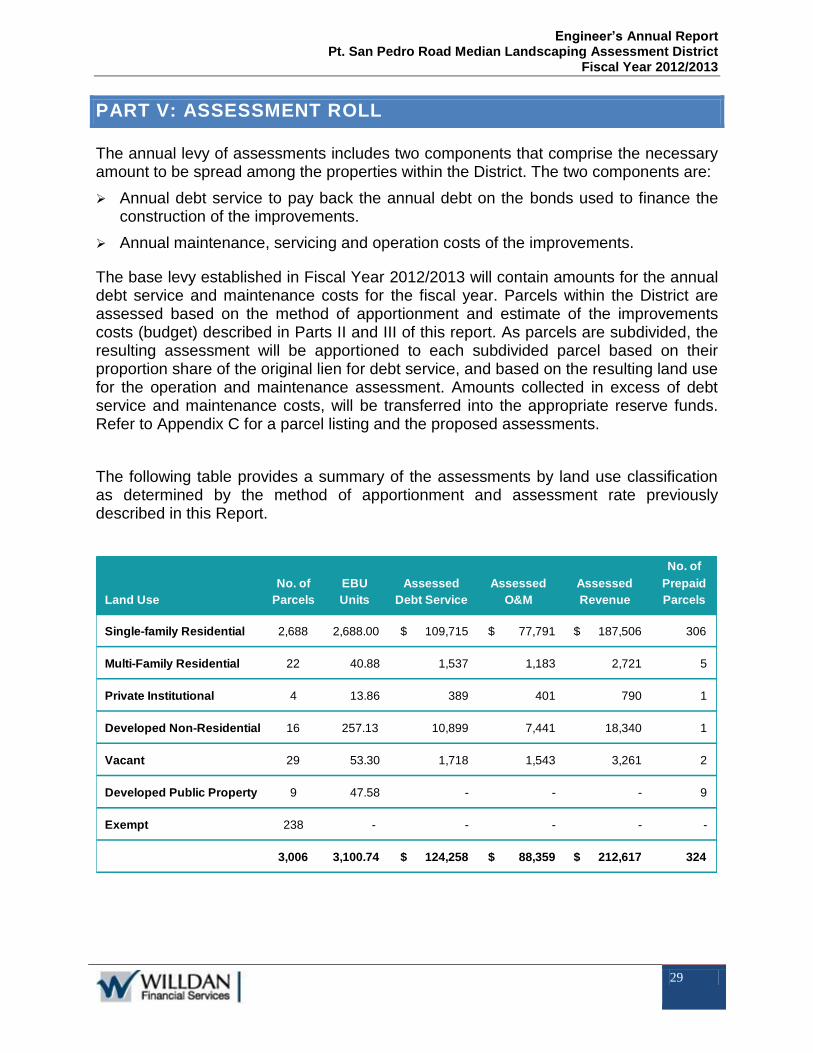
PART V: ASSESSMENT ROLL
The annual levy of assessments includes two components that comprise the necessary amount to be spread among the properties within the District. The two components are:
Annual debt service to pay back the annual debt on the bonds used to finance the construction of the improvements.
Annual maintenance, servicing and operation costs of the improvements.
The base levy established in Fiscal Year 2012/2013 will contain amounts for the annual debt service and maintenance costs for the fiscal year. Parcels within the District are assessed based on the method of apportionment and estimate of the improvements costs (budget) described in Parts II and III of this report. As parcels are subdivided, the resulting assessment will be apportioned to each subdivided parcel based on their proportion share of the original lien for debt service, and based on the resulting land use for the operation and maintenance assessment. Amounts collected in excess of debt service and maintenance costs, will be transferred into the appropriate reserve funds. Refer to Appendix C for a parcel listing and the proposed assessments.
The following table provides a summary of the assessments by land use classification as determined by the method of apportionment and assessment rate previously described in this Report.
No. of EBU Assessed Assessed Assessed
Land Use Parcels Units Debt Service O&M Revenue
Single-family Residential 2,688 2,688.00 $ 109,715 $ 77,791 $ 187,506 306
Multi-Family Residential 22 40.88 1,537 1,183 2,721 5
Private Institutional 4 13.86 389 401 790 1
Developed Non-Residential 16 257.13 10,899 7,441 18,340 1
Vacant 29 53.30 1,718 1,543 3,261 2
Developed Public Property 9 47.58 - - - 9
Exempt 238 - - - - -
3,006 3,100.74 $ 124,258 $ 88,359 $ 212,617 324
No. of
Prepaid
Parcels

Engineer’s Annual Report Pt. San Pedro Road Median Landscaping Assessment District
Fiscal Year 2012/2013
30
APPENDIX A: BOND INFORMATION
Bonds representing unpaid assessments, and bearing interest at a rate not-to-exceed twelve-percent (12-percent) per annum, shall be issued in the manner provided by the Improvement Bond Act of 1915 (Division 10, Streets and Highways Code), and the last installment of the bonds shall mature at a date not-to-exceed thirty-five (35) years from the second day of September next succeeding twelve (12) months from the date of issuance.
For purposes of establishing the assessment calculations shown in Part III of this Report (Estimate of Improvement Costs), an estimate of the annual debt services payments has been developed for the anticipated Issuance of Bonds for the construction and installation of the improvements that would provide an estimated net proceeds of $1,750,000 to be repaid over 30 years. The following two tables, the “Estimated Sources & Uses of Funds” and the “Estimated Debt Service Schedule” provides the basis of the estimated debt service payments used to establish the proposed District assessments.
Sources:
Bond Proceeds:
Par Amount $1,750,000
Other Sources of Funding:
Total General Benefit Contribution $45,500
Prepaid Assessments for Public Properties 21,336.60
Sub-Total Other Sources $66,837
Total Sources 1,816,836.60$
Uses:
Project Fund Deposits:
Estimated Construction Expenses $1,173,905
Incidental Construction Expenses $97,000
Construction Contingency 165,220.00
Sub-Total Construction Expenses $1,436,125
Assessment Financing Costs:
Debt Service Reserve Fund $246,782
Cost of Issuance 100,000.00
Underwriter's Discount 29,200.00
Other Miscellaneous Expenses 4,729.60
Sub-Total Financing Expenses $380,712
Total Uses 1,816,836.60$
San Rafael Landscaping District
Estimated Sources & Uses of Funds

Engineer’s Annual Report Pt. San Pedro Road Median Landscaping Assessment District
Fiscal Year 2012/2013
31
PT. SAN PEDRO ROAD LANDSCAPING MAINTENANCE DISTRICT ESTIMATED DEBT SERVICE FOR CONSTRUCTION OF IMPROVEMENTS
Debt Service Interest Total Annual
Date Rate Principal Interest Debt Service Debt Service
3/1/2013 $0 $61,250 $61,250 $0
9/1/2013 7.00% $20,000 $61,250 $81,250 $142,500
3/1/2014 $0 $60,550 $60,550 $0
9/1/2014 7.00% $20,000 $60,550 $80,550 $141,100
3/1/2015 $0 $59,850 $59,850 $0
9/1/2015 7.00% $20,000 $59,850 $79,850 $139,700
3/1/2016 $0 $59,150 $59,150 $0
9/1/2016 7.00% $25,000 $59,150 $84,150 $143,300
3/1/2017 $0 $58,275 $58,275 $0
9/1/2017 7.00% $25,000 $58,275 $83,275 $141,550
3/1/2018 $0 $57,400 $57,400 $0
9/1/2018 7.00% $25,000 $57,400 $82,400 $139,800
3/1/2019 $0 $56,525 $56,525 $0
9/1/2019 7.00% $30,000 $56,525 $86,525 $143,050
3/1/2020 $0 $55,475 $55,475 $0
9/1/2020 7.00% $30,000 $55,475 $85,475 $140,950
3/1/2021 $0 $54,425 $54,425 $0
9/1/2021 7.00% $35,000 $54,425 $89,425 $143,850
3/1/2022 $0 $53,200 $53,200 $0
9/1/2022 7.00% $35,000 $53,200 $88,200 $141,400
3/1/2023 $0 $51,975 $51,975 $0
9/1/2023 7.00% $40,000 $51,975 $91,975 $143,950
3/1/2024 $0 $50,575 $50,575 $0
9/1/2024 7.00% $40,000 $50,575 $90,575 $141,150
3/1/2025 $0 $49,175 $49,175 $0
9/1/2025 7.00% $45,000 $49,175 $94,175 $143,350
3/1/2026 $0 $47,600 $47,600 $0
9/1/2026 7.00% $45,000 $47,600 $92,600 $140,200
3/1/2027 $0 $46,025 $46,025 $0
9/1/2027 7.00% $50,000 $46,025 $96,025 $142,050
3/1/2028 $0 $44,275 $44,275 $0
9/1/2028 7.00% $50,000 $44,275 $94,275 $138,550
3/1/2029 $0 $42,525 $42,525 $0
9/1/2029 7.00% $50,000 $42,525 $92,525 $135,050
3/1/2030 $0 $40,775 $40,775 $0
9/1/2030 7.00% $55,000 $40,775 $95,775 $136,550
3/1/2031 $0 $38,850 $38,850 $0
9/1/2031 7.00% $60,000 $38,850 $98,850 $137,700
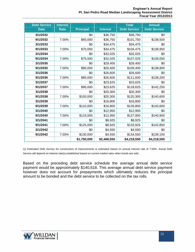
Engineer’s Annual Report Pt. San Pedro Road Median Landscaping Assessment District
Fiscal Year 2012/2013
32
Debt Service Interest Total Annual
Date Rate Principal Interest Debt Service Debt Service
3/1/2032 $0 $36,750 $36,750 $0
9/1/2032 7.00% $65,000 $36,750 $101,750 $138,500
3/1/2033 $0 $34,475 $34,475 $0
9/1/2033 7.00% $70,000 $34,475 $104,475 $138,950
3/1/2034 $0 $32,025 $32,025 $0
9/1/2034 7.00% $75,000 $32,025 $107,025 $139,050
3/1/2035 $0 $29,400 $29,400 $0
9/1/2035 7.00% $80,000 $29,400 $109,400 $138,800
3/1/2036 $0 $26,600 $26,600 $0
9/1/2036 7.00% $85,000 $26,600 $111,600 $138,200
3/1/2037 $0 $23,625 $23,625 $0
9/1/2037 7.00% $95,000 $23,625 $118,625 $142,250
3/1/2038 $0 $20,300 $20,300 $0
9/1/2038 7.00% $100,000 $20,300 $120,300 $140,600
3/1/2039 $0 $16,800 $16,800 $0
9/1/2039 7.00% $110,000 $16,800 $126,800 $143,600
3/1/2040 $0 $12,950 $12,950 $0
9/1/2040 7.00% $115,000 $12,950 $127,950 $140,900
3/1/2041 $0 $8,925 $8,925 $0
9/1/2041 7.00% $125,000 $8,925 $133,925 $142,850
3/1/2042 $0 $4,550 $4,550 $0
9/1/2042 7.00% $130,000 $4,550 $134,550 $139,100
$1,750,000 $2,468,550 $4,218,550 $4,218,550
(1) Estimated Debt Service for construction of improvements is estimated based on annual interest rate of 7.00%. Actual Debt
Service will depend on interest rate(s) established based on current market rates when bonds are sold.
Based on the preceding debt service schedule the average annual debt service payment would be approximately $140,618. This average annual debt service payment however does not account for prepayments which ultimately reduces the principal amount to be bonded and the debt service to be collected on the tax rolls.

Engineer’s Annual Report Pt. San Pedro Road Median Landscaping Assessment District
Fiscal Year 2012/2013
33
APPENDIX B: IMPROVEMENT AREAS
1. Union Street to San Rafael High School parking Lot:
2. San Rafael High School parking lot to middle of parking lot:

Engineer’s Annual Report Pt. San Pedro Road Median Landscaping Assessment District
Fiscal Year 2012/2013
34
3. Middle of San Rafael High School parking lot to Embarcadero Way:
4. Embarcadero Way to Mooring Road:

Engineer’s Annual Report Pt. San Pedro Road Median Landscaping Assessment District
Fiscal Year 2012/2013
35
5. Mooring Road to Marina Boulevard:
6. Marina Boulevard to Aqua Vista Drive:

Engineer’s Annual Report Pt. San Pedro Road Median Landscaping Assessment District
Fiscal Year 2012/2013
36
7. Aqua Vista Drive to Royal Court:
8. Royal Court to Porto Bello Drive:

Engineer’s Annual Report Pt. San Pedro Road Median Landscaping Assessment District
Fiscal Year 2012/2013
37
9. Porto Bello Drive to Summit Avenue:

Engineer’s Annual Report Pt. San Pedro Road Median Landscaping Assessment District
Fiscal Year 2012/2013
38
Porto Bello Drive to Summit Avenue (continued):
10. Summit Avenue to Margarita Drive:

Engineer’s Annual Report Pt. San Pedro Road Median Landscaping Assessment District
Fiscal Year 2012/2013
39
Summit Avenue to Margarita Drive (continued):
11. Margarita Drive to Bay Way:

Engineer’s Annual Report Pt. San Pedro Road Median Landscaping Assessment District
Fiscal Year 2012/2013
40
12. Bay Way to Bellevue Avenue:
13. Bellevue Avenue to Manderly Road:

Engineer’s Annual Report Pt. San Pedro Road Median Landscaping Assessment District
Fiscal Year 2012/2013
41
14. Manderly Road to San Pedro Elementary School:

Engineer’s Annual Report Pt. San Pedro Road Median Landscaping Assessment District
Fiscal Year 2012/2013
42
15. San Pedro Elementary School to San Pedro Cove:
16. San Pedro Cove to Lochinvar Drive:

Engineer’s Annual Report Pt. San Pedro Road Median Landscaping Assessment District
Fiscal Year 2012/2013
43
17. Lochinvar Drive to Loch Lomond Shopping Center:
18. Loch Lomond Shopping Center to Bayview Drive:

Engineer’s Annual Report Pt. San Pedro Road Median Landscaping Assessment District
Fiscal Year 2012/2013
44
19. Bayview Drive to Beach Road:
20. Beach Road to Marine Drive:

Engineer’s Annual Report Pt. San Pedro Road Median Landscaping Assessment District
Fiscal Year 2012/2013
45
Beach Road to Marine Drive (continued):
21. Marine Drive to Main Drive:

Engineer’s Annual Report Pt. San Pedro Road Median Landscaping Assessment District
Fiscal Year 2012/2013
46
Marine Drive to Main Drive (continued):
22. Main Drive to Knight Drive:

Engineer’s Annual Report Pt. San Pedro Road Median Landscaping Assessment District
Fiscal Year 2012/2013
47
Marin Drive to Knight Drive (continued):
23. Knight Drive to Fire Station:

Engineer’s Annual Report Pt. San Pedro Road Median Landscaping Assessment District
Fiscal Year 2012/2013
48
24. Fire Station to Peacock Drive:
25. Peacock Drive to Riviera Drive:

Engineer’s Annual Report Pt. San Pedro Road Median Landscaping Assessment District
Fiscal Year 2012/2013
49
26. Riviera Drive to McNear Brickyard:
27. Cantera Way (McNear's Beach) to Marin Bay Park:

Engineer’s Annual Report Pt. San Pedro Road Median Landscaping Assessment District
Fiscal Year 2012/2013
50
28. Marin Bay Park to San Marino Court:

Engineer’s Annual Report Pt. San Pedro Road Median Landscaping Assessment District
Fiscal Year 2012/2013
51
29. San Marino Drive to Biscayne Drive

Engineer’s Annual Report Pt. San Pedro Road Median Landscaping Assessment District
Fiscal Year 2012/2013
52
APPENDIX C: ANNUAL ASSESSMENTS (FY 2012/2013)