city docks
TRANSCRIPT

www.bristol.gov.uk/conservationareas
Conservation Area 17
City DocksCharacter Appraisal & Management Proposals
December 2011

City Docks Conservation Area

3.i.
CONTENTS
1. INTrODuCTION p. 12. PlANNINg POlICy CONTExT p. 13. lOCATION & SETTINg p. 24. SummAry Of ChArACTEr & SPECIAl INTErEST p. 45. hISTOrIC DEvElOPmENT & ArChAEOlOgy p. 56. SPATIAl ANAlySIS 6.1 routes & Spaces p. 14
6.2 views p. 16 6.3 landmark Buildings p. 21
7. ChArACTEr ANAlySIS 7.1 Overview & Character Areas p. 23
7.1.1 Area 1 - Cumberland Basin p. 25
7.1.2 Area 2 - Pooles Wharf p. 28 7.1.3 Area 3 - The floating harbour p. 30 7.1.4 Area 4 - Cumberland road & The New Cut p. 33
7.1.5 Area 5 - Canons marsh p. 36 7.1.6 Area 6 - Bathurst Basin p. 39
7.2 relative merit of unlisted Buildings p. 41
7.3 Townscape Details p. 43 7.4 materials p. 44 7.5 Wildlife & Trees p. 45
8. TyPICAl lAND uSE & ISSuES 8.1 Overview p. 46 8.2 residential p. 47 8.3 Cultural & leisure p. 48 8.4 Industrial/Office p. 49 8.5 maritime p. 50 8.6 vacant Sites p. 51 8.7 flooding p. 52
9. NEgATIvE fEATurES p. 54
10. mANAgEmENT PrOPOSAlS p. 5611. STATEmENT Of COmmuNITy INvOlvEmENT p. 59
12. lOCAl guIDANCE, PuBlICATIONS & SOurCES Of furThEr INfOrmATION p. 60
13. glOSSAry p. 62

ii.
ClIfTON & mAPS & fIgurES
maps
map 1 City Docks Conservation Area within its local context p. 3map 2 Approximate Building Ages p. 13map 3 landmark Buildings p. 22map 4 Overview of Character Areas p. 24
map 4a: Character Area 1 p. 25map 4b: Character Area 2 p. 28map 4c: Character Area 3 p. 30
map 4d: Character Area 4 p. 33map 4e: Character Area 5 p. 36map 4f: Character Area 6 p. 39
map 5 relative merit of unlisted Buildings p. 42
map 6 Predominant land use in the Conservation Area p. 53
figures
figure: 1 great Western Docks p. 4figure: 2 Jessop’s Plan for the floating harbour, 1802 p. 6figure: 3 Baltic Wharf and the Albion graving Dock, 1828 p. 7figure: 4 Watercolour of the New gaol, Cumberland road by hugh O’Neil, 1821 p. 7figure: 5 Plumley and Ashmead’s Plan, 1828 p. 8figure: 6 first Edition Ordnance Survey, 1885-6 p. 8figure: 7 lavar’s view, 1887 p. 9figure: 8 Corporation granary on Princes Wharf, burnt out after blitz in 1941 p. 10figure: 9 The 1929 Tobacco Bond, Canon’s marsh, prior to demolition in 1987 p. 11figure: 10 hanover Quay p. 14figure: 11 railway tracks running E/W along south side of floating harbour p. 14figure: 12 gaol ferry Bridge crossing Avon New Cut p. 15figure: 13 Panoramic view (P17) from Bathurst Basin towards south Bristol p. 16figure: 14 Panoramic view (P22) from south side of floating harbour to Clifton Wood p. 17figure: 15 long view (l13) from Wapping Quay across floating harbour to the Cathedral p. 19figure: 16 local view (lC7) from millennium Promenade SW to ss great Britain p. 20figure: 17 Planetarium, millennium Square p. 21figure: 18 m Shed and Stothert & Pitt cranes, Princes Wharf p. 21figure: 19 Brunel Swing (Swivel) Bridge p. 26figure: 20 Ashton Swing Bridge (grade II) from south side of Avon New Cut p. 26figure: 21 Pooles Wharf p. 29

5.iii.
figure: 22 Bristol marina p. 31figure: 23 Wapping railway Wharf p. 31figure: 24 Prince’s Wharf p. 31figure: 25 hoardings blighting historic Wapping Wharf boundary wall p. 34figure: 26 Avon New Cut looking northeast p. 34figure: 27 harbourside Development and Cathedral Walk p. 37figure: 28 former gas Works from Capricorn Quay p. 37figure: 29 Anchor Square from Pero’s Bridge p. 37figure: 30 Public art, millennium Square p. 37figure: 31 The louisiana Public house p. 40figure: 32 Bathurst Basin looking southwest p. 40figure: 33 Anchor, Wapping railway Wharf p. 43figure: 34 railway lines, Wapping Wharf p. 43

1.
ClIfTON & hOTWEllSCITy DOCKS
1. IntroductIon
1.1 A Conservation Area is ‘an area of special architectural or historic interest, the character or appearance of which it is desirable to preserve or enhance’ (Planning (listed Buildings & Conservation Areas) Act, 1990).
1.2 SincethedesignationofthefirstConservation Areas in 1970, Bristol City Council has undertaken a comprehensive programme of Conservation Area designation, extension and policy development. There are now 33 Conservation Areas in Bristol, covering approximately 30% of the city.
1.3 The statutory framework places Bristol City Council under a duty of care to recognise thesignificanceofitsbuiltenvironmentandpositively manage change within it. The City Council is continuing a comprehensive programme of producing a Character Appraisal for each Conservation Area.
1.4 The Conservation Area Character Appraisals follow recent national guidance set out in English heritage’s guidance on Conservation Area Appraisals (2006), which require detailed appraisals of each Conservation Area in the form of formally approved and published documents.
1.5 A Character Appraisal provides a point of reference for the planning authority, developers and communities in managing change appropriately. The consultation and adoption process values the specialist knowledge of local groups and is intended to ensure that features that communities value about a place, or feel are under threat, are properly considered.
1.6 Once adopted a Character Appraisal provides a tool for development managementofficers,developers,residentsand others to recognise the special interest of the area in order that it can be preserved or enhanced.
2. PlannIng PolIcy context
2.1 Planning Policy Statement 5 (march 2010) sets out the government’s national policies relating to the historic environment. This document underpins the local planning policy framework and is the foundation upon which the local authority will assess schemes affecting the historic environment.
2.2 In exercising its planning functions in a Conservation Area, the local planning authority is under a duty to pay “special attention to the desirability of preserving or enhancing the character or appearance” of the area (s.72 Planning (listed Buildings and Conservation Areas) Act 1990). Bristol’s Conservation Areas are the subject of policies in the Core Strategy (adopted by full Council on 21 June 2011). Policy BCS22 relatesspecificallytoConservationandthehistoric Environment. Policies B02 - B22, relating to the Built Environment have been saved from the 1997 adopted Bristol local Plan.
2.3 Where sections within the Character Appraisal relate to policies from Core Strategy, or saved from the Bristol local Plan, extracts are highlighted within blue boxes at the end of that section. for full policy wording, please refer to the Core Strategy (2011) or Saved Policies from the Bristol local Plan (1997).
2.4 City Docks was designated as a Conservation Area on 19 September 1979. Each adopted Character Appraisal will replace the relevant Conservation Area Enhancement Statement for that area.
2.5 The City Docks Conservation Area Character Appraisal was adopted by Zoe Willcox, head of Planning Services, under delegated powers from the Strategic Director for Neighbourhoods on 28th November 2011.

2.
CITy DOCKS
3 locatIon & settIng
3.1 The City Docks Conservation Area centres on the low lying land adjacent to the floating harbour and the New Cut, between Cumberland Basin in the west and Bathurst Basin in the east. Broadly it covers the area that once formed the working heart of Bristol’s dock and commercial activities, and has evolved into a hub of prime leisure and cultural attractions.
3.2 The Conservation Area falls across three political wards - Southville, Cabot and Clifton. The boundaries of the area are broadlydefinedbythecentralportionsoftwo of Bristol’s most vital waterways: the floating harbour and the Avon New Cut. (The floating harbour extends beyond the boundaries of the Conservation Area, from Cumberland Basin as far as The feeder, which continues to control the waterway up to Netham lock. The New Cut extends from the back of underfall as far as Totterdown lock).
3.3 The harbour and New Cut separate three long land masses, the buildings and activities of which are focused towards the water. Coronation road to Clift house road is the southern route across the area; Cumberland road follows the water north of the New Cut; and Anchor road / hotwell road runs along the north side of the floating harbour.
3.4 Concentrated in the Conservation Area is a significantclusterofBristol’smostrenowntourist destinations (including ‘m’ Shed, the ssgreat Britain and @Bristol), a Scheduled Ancient monument (underfall yard), andsomenationallysignificantdocksideinstallations (e.g Brunel’s Swivel Bridge). The central area known as Spike Island houses an exciting mix of creative, heritage and leisure destinations.
3.5 Below the Avon New Cut, Clift house road forms the southern boundary, taking in the Tannery and former iron works industrial complex; ‘C’ Bond Warehouse; a pump house; and riverside garden Centre. The landscaped area to the far south west, designed by the late Sylvia Crowe, provides an important setting area and green space south of the Avon.
3.6 Coronation road carries the southern Conservation Area boundary eastwards from Clift house road. This takes in the riverside cycle way; the nature corridor on the water’s southern edge; the three hugelysignificantfootbridgesoverthewater; and the Pennant retaining walls of theCut.Someofthemostsignificantviewsinto the City Docks can be enjoyed from this southern perspective.
map 1: City Docks Conservation Area & local context

3.
map 1: City Docks Conservation Area & local context

4.
ClIfTON & hOTWEllSCITy DOCKS
4. summary of character & sPecIal Interest
4.1 The City Docks Conservation Area covers the largest element of the waterways in the centre of Bristol. The topography of this area is formed by the river valley of two rivers - the frome and the Avon - that have produced a fairly low lying level valley bottom with pronounced hillsides on both the northern and southern sides. The floating harbour and the tidal course of the NewCutisapreciousandsignificantassetto Bristol.
4.2 The floating harbour is remarkable for its intimate relationship to the city. The port was never enclosed or separate; as a result, city streets opened onto wharfs and the working of the docks was carried out next to public highways. The physical proximity of the docks to the public realm has been critical in shaping Bristol’s sense of place as a great maritime city.
4.3 The City Docks ceased to function as a commercial harbour in the mid 1970s and since that time the area has evolved into one of the most exciting districts in the city. Today the area boasts an impressive range of existing attractions, events and cultural facilities which sit adjacent to features of historical, architectural and industrial archaeological interest.
4.4 The City Docks Conservation Area is unique in terms of the special relationship between the water courses that run central to it: the floating harbour and the New Cut. The wide expanse of water and local topography also offer some of the best views in and out of Bristol, and to major city landmarks and features of interest.
figure 1: great Western Dockyard
4.5 The City Docks displays an amazing mix of land uses and building types. It is the retention and balance of domestic, commercial or industrial accommodation adjoining the harbour that has given the Conservation Area its interesting character and placed it ahead in the process of late 20th century urban renewal.
4.6 The character of the City Docks also lies in the quality and diversity of its local details-streetfurniture,dockfittings,surfaces, the remains of railway lines, and the buildings - once seen as dispensable, nowfindinglivelyandsustainableuses.heritage Assets include many listed buildings, a Scheduled monument (underfall yard) and historic vessels. Included in the National historic fleet Core Collection are the ss great Britain (1843 passenger ship);theMayflower(1861tugboat);andthePyronaut(1934fireboat).Theareaalso boasts working heritage assets such as Wapping Wharf, a vital resource for mv Balmoral and other visiting vessels, the harbour railway, and the functions undertaken at Albion Dry Dock and underfall yard.

5.
CITy DOCKS
5. hIstorIc develoPment & archaeology
5.1 gaining an understanding and appreciation for the historic development of an area can becriticalinestablishingitssignificance.marking key periods in a locality’s history, and highlighting the survival of historic buildings, streets, layouts or events, can help determine the form of the Conservation Area and any features that are worthy of protection.
5.2 Earliest Settlement There is as yet little evidence to support the ideaofsignificanthumanactivityinwhatis now central Bristol prior to the roman period. The earliest evidence of Bristol as asignificantsettlementdatesbacktothe10th century. The discovery of an early 11th century coin that was minted within the town suggests that by this time Bristol was an established community and one of some substance.
5.3 medieval Period Bristol had prospered because of the overall advantage of its westerly location, with earliest trade with the viking settlements of southern Ireland contributing to the town’s increasing prosperity. By the 12th century, trade with france, in particular the south western regions such as Bayonne and Bordeaux, had become increasingly important. Commerce with more distant parts of Europe such as Spain and Portugal all contributed to Bristol’s status as a thriving and successful port.
5.4 rising trade increased pressure for ships to gain access to Bristol’s quays, highlighting the inadequacies of the existing port. As well as pressure for space, only small boats were able to navigate through to Bristol’s central wharfs; larger ships were forced to unload further downstream. The tidal range of the river Avon was an additional problem, often grounding ships on rocks.
5.5 In the 13th century, the river frome was re-coursed through marshlands belonging to the Abbey of St Augustine’s and joined the river Avon at Canons marsh. Between 1240 and 1247, the diversionary channel that was 18 feet deep and 40 yards wide was cut, with extensive quays created alongside. Once complete, it provided a new harbour that was accessible for large ships whilst the soft mud of the trench meant it was a place where ships could rest at low tide without fear of damage. This was a major piece of civil engineering for its time and probably the crucial factor in Bristol’s emergence as England’s second port and city.
5.6 16th & 17th Centuries By the 16th century Bristol’s trading links were extensive extending as far as the Baltic and North Africa. In the 1630s Bristol was a major Atlantic port and by the end of the 17th century it was part of the transatlantic slave trade. By the 1730s Bristol was Britain’s leading slave port, exporting goods to Africa, which were exchanged for people to enslave and transport to the Caribbean plantations.
5.7 During this period Bristol’s harbour was
managed by the merchant venturers, a society formed in 1552 to represent the interests of Bristol’s merchants. In return for the income generated by the harbour, for ‘wharfage’, a charge that was levied on imported goods, the merchant venturers undertook to build new quays and improve the facilities of the old. Even with improvements, as the 17th century progressed, the harbour came under increasing strain with its medieval wharves struggling to cope with the ever increasing volume of trade.

6.
5.8 18th Century By the 1690s change had begun, with work being undertaken to lengthen the quay. This workcontinuedintothefirsthalfofthe18th centurywithsignificantchangeshappeningwithin the harbour area. In 1717, work began to further lengthen the quay to the corner of the frome channel, whilst in 1724 The Back was lengthened. Around this time work also commenced on the ‘New Quay’, which later became known as The grove. As well as creating increased accessible space, facilities were also improved. Some of this involved repairing existing parts of the harbour, but new pieces of equipment were also installed.
5.9 With the industrial revolution, came major evolutions in crane technology in the City Docks. John Padmore’s ‘great Crane’, built by the side of the old mud dock was constructed in 1735 and was powered by a treadmill.
5.10 An Act of Parliament in 1776 made it compulsoryforshipstounloadflammablematerials; merchants Dock was established on the north side of the water. The Bonding yard, essentially an open-air storage area surrounded by a wall, was created as a store for timber, pitch and tar, covering an area of 1.8 hectares.
5.11 Early to mid 19th Century Oneofthemostsignificantinterventionsthat shaped Bristol’s history occurred with the creation of the floating harbour. Bristol’stides,whichfluctuateabout9metres (30 ft) between high and low water, meant that the river was easily navigable at high-tide but reduced to a muddy channel at low tide in which ships would often run aground. Increasing competition from other dock cities (e.g liverpool) meant a solution had to be found to ensure the viability of Bristol as a trade city.
5.12 In 1802 the Bristol Docks Company commissioned William Jessop, who engineered a scheme to equalise the levels inside and outside the Dock for the passage of vessels to and from the Avon. Jessop built Cumberland Basin with two entrance locks from the Avon, and a wide junction lock between the Basin and what became known as the floating harbour. This arrangement providedflexibilityofoperationwiththeBasin being used as a lock when there were large numbers of arrivals and sailings. The harbourwasofficiallyopenedon1May1809.The course of the river Avon was diverted along the New Cut.
figure 2: Jessop’s Plan for the floating harbour, 1802 (© Bristol museum & Art gallery)

7.7.
5.13 The construction of the floating harbour had a dramatic effect on the city’s topography, road systems and water transportation potential. The development of the city centre for commercial and residential uses, combined with the increasing size of ships that followed the change to iron construction, lead to a migration of shipbuilding and repair work to the south side of the river on ‘Spike Island’ and towards Cumberland Basin.
5.14 The land on either side of the floating harbour was developed for commercial use; though this was done in an open-plan and flexiblewaytoallowfordifferenttradesandindustries.Atitspeaktherewere17firmsof boat and shipbuilders around the harbour. The land around the present underfall yard was in use for shipbuilding and storage soon after the floating harbour was constructed.
5.15 The area known as Baltic Wharf was once the home of several timber yards where ships from the Baltic, Canada and russia came to off-load cargoes. The quayside was never built up, so dockers had to run on planks laid across barges between ship and shore carrying long lengths of wood. The Cottage Public house at the end of this stretchwasoncetheofficeforoneofthetimberfirms.
5.16 The banks of the New Cut were also developed, with industries such as iron works, foundries and tanneries being established beside the water. The ‘New gaol’ was opened in 1821 facing the New Cut and Cumberland road.
5.17 While the floating harbour improved the efficiencyofBristol’sdocks,itconverselycreated new problems particularly related to sewage and silt. The limited movement of the water combined with the continued dumping of waste into it meant the water soon degenerated into a putrid mess. The lack of tidal movement also led to the formation of areas of shallow water created by the accumulation of silt and mud. These shoals made the negotiation of the enclosed harbourareadifficultandhazardous.
figure 4: Watercolour of The New gaol, Cumberland road, from harford’s [Bedminster] Bridge by hugh O’Neill, 1821 (Braikenridge Collection © Bristol museum & Art gallery)
figure 3: Baltic Wharf and Albion graving dock, 1826 (© Bristol museum & Art gallery)

8.
figure 5: Plumley & Ashmead’s Plan, 1828 (© Bristol museum & Art gallery)
figure 6: first Edition Ordnance Survey, 1885-6 (© Bristol museum & Art gallery)
9.
5.18 The harbour cost more than anticipated and high rates were levied to repay loans, reducinganybenefitthenewharbourhadat drawing companies back from liverpool.In 1848 the city council bought the docks company to force down the rates. They employed Isambard Kingdom Brunel to make improvements, including new lock gates, a dredger and sluice gates designed to reduce siltation.
5.19 Brunel concluded that to remove the silt, dredging was needed from the bottom of the harbour. To do this Brunel utilised a series of existing sluices, three shallow and one deep, which became known as the ‘underfall’. he also designed a boat which would drag the silt away from the harbour walls and guide it towards the sluices. When the deep water sluice opened at low tide the silt was carried away. This system remains in use today.
5.20 Brunel’s work to solve the problems of the
floating harbour was part of a range of alterations and improvements to the docks that were undertaken in the 19th century. Other changes were carried out to enable the harbour to cater for the increasingly large ships that wanted to use Bristol’s facilities.
5.21 The great Western Dockyard, where the ss great Britain was built and now rests, is of greatinterestastheworld’sfirstpurpose-built integrated iron steamship works. The great Western Steamship Company purchased the empty site in 1839, extended the existing dry dock, built the large Steamship Engine Works and probably the survivingDrawingOffice.Itproceededtoconstruct the ss great Britain, the world’s firstironpassengerliner,herebetween1839and 1843.
5.22 In 1843 the ss great Britain was the largest ship in the world and it was found to be too large to pass through the lock of the floating harbour. It was only when parts of the dock were removed that the ship was able to make its departure. After 1852 the dockyard was leased to other shipbuilders and repairers until the ss great Britain returned as a hulk in 1970.
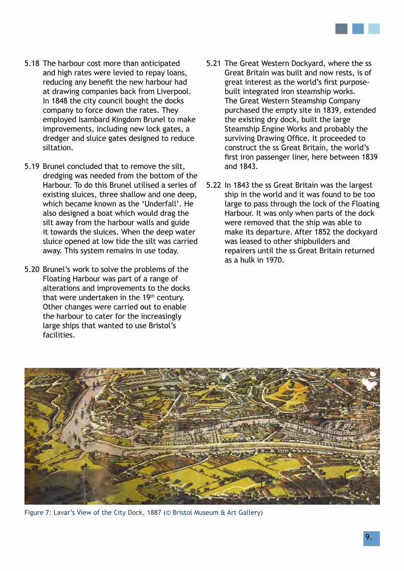
figure 7: lavar’s view of the City Dock, 1887 (© Bristol museum & Art gallery)

10.10.
5.23 late 19th Century The lengths of quayside established in medieval times remained basically the same until the mid 19th century. Only minor works and alterations were carried out from time to time; the floating harbour absorbed the Trin tide-mill (formerly at the mouth of the malago river) for the construction of the harbour entrances at Bathurst Basin. In 1865 a series of Acts empowered the Bristol Corporation and the great Western railway Company to create lengths of quayside furnished with railway tracks and the new style of warehouse, the transit shed. later in the 19th century, a multiplicity of factories, warehouses, and railway installations characterised development in the City Docks.
5.24 The creation in the 1860s of deep water docks at Bathurst Basin and Princes Wharf createdthefirstmajorcargowharfswithrailway connections. The 1870s saw yet another enlargement of the docks entrance lock. In the 1880s, the Docks Committee had purchased Nova Scotia yard and the Avon Crescent houses to enlarge the engineering facility at underfall yard and to be able to repair and operate the slip.
5.25 Extensive works involving a virtual rebuilding of the workshops at underfall yard and construction of a new hydraulic pumping station to the north of the slipway to replace the one at Cumberland Basin were overseen by JW girdlestone after 1884.
5.26 Buildings that appeared in the City Docks around this time were constructed to high victorian engineering standards of design, robustness and simplicity. The 1890s saw the development of Canons marsh quays and construction of E and W Sheds (now Watershed).Prince Street swing bridge opened in 1878. The gaol was closed in 1883 and largely demolished in 1898, only the gate and fragments of outer wall remains.
5.27 The fairbairn steam crane on Wapping Wharf was built by manufacturers Stothert and Pitt in 1878 especially for Bristol’s docks. Another steam crane, on the Canons’ marsh quayside almost opposite, arrived in 1891. unfortunately this crane, on hanover Quay, was scrapped and only its stone tower remains. hydraulic (water powered) cranes arrived in the docks in 1892 and electric ones not long after, in 1906.
5.28 Improving accessibility and navigation up the river Avon to Bristol’s port was considered, but the costs were prohibitive. In 1877 a new dock was opened at Avonmouth, followed two years later by one at Portishead, which could cater for the large modern ships and tankers. The changes in the size of ships, as well as the infrastructure needed to support them, meant that Bristol City Docks became increasingly redundant.
figure 8: Corporation granary on Princes Wharf, burnt out after blitz in 1941 (© Bristol museum & Art gallery)

11.
5.29 20th Century - Today until the 20th century, small coastal vessels
were vital for the movement of bulk goods, livestock and passengers. The City Docks not only catered for large vessels but also boasted a series of slipways and quays that enabled lifting of small ships for routine maintenance and emergency repair. In the mid 20th century, this trade became virtually extinct and with it went much of the need for working slipways and dry docks.
5.30 Trade continued into the mid 20th century, albeit an a smaller scale, and improvements to the City Docks after the late 19th century were modest. Despite this, the construction ofsignificantwarehousestoservetheHarbourcontinuedintothefirsthalfofthe 20th century. The B Bond Warehouse constructed in 1908 was designed by the Docks Committee engineer, and built by WilliamCowlin&Sons.Itwasthefirstmajorbuilding in Britain to use Edmond Coignet’s reinforced concrete system.
5.31 Brunel’s lock was permanently sealed in the 1950’s and the heavy wooden timbers that filledtheunusualstepontheNorthernsidewere removed after World War II. World War IIbombingcausedsignificantdamagetotheCity Docks, with many sites being razed. The dry dock at the great Western Dockyard, which had continued with ship repairs until well into the 20th century, suffered in early 1941 bombing raids that badly damaged the site and left the Steamship Engine Works as a ruined shell.
5.32 In 1969 the City Council decided to close the docksandterminatedcommercialtrafficin 1975. Since that time the City Docks has undergone considerable changes, having to adapt in an environment where little ‘value’ was placed on the remnants of its industrial or commercial past. In 1969 proposals as radicalasinfillingtheFloatingHarbour,thefeeder Canal and Temple Backs were put forward by the City Council causing great controversy. Sir hugh Casson of Casson, Conder and Partners was commissioned to prepare a study of Bristol City Docks that contributed to securing the harbour as the City’s primary asset.
5.33 Since 1974 and the acceptance of retaining all the urban waterways, there has been a great amount of discussion on principles for development that followed the closure of the commercial docks. During the late 1970saflurryofresidentialandcommercialdevelopment plans emerged, designed to revive the redundant City Docks. An Area ActionPlanwasestablished,andthefirstinvestment in a dockside building was the redevelopment of JT’s Bush Warehouse (now Arnolfini).AgrantaidschemeforEshedenabled the opening of the Watershed in 1982.
figure 9: The 1929 Tobacco Bond, Canon’s marsh, prior to demolition in 1987 (© Bristol museum & Art gallery)
12.
5.34 Towards the end of the 20th century, the City Docks has witnessed a re-evaluation of the value placed on the harbour and the city’s industrial heritage. Bristol’s Civic Society and other local groups fought to preserve features and the character integral to the Docks, so that today a number of buildings and quayside structures remain as preserved historic features. The City Docks Conservation Area was designated in September 1979.
5.35 major development appeared in the early 1990s when lloyds Bank relocated to the ‘Amphitheatre’. In 1994 English Partnerships declared Canons marsh a ‘priority area’. Waterfront housing was becoming increasingly popular, Baltic Wharf and merchants Quay became priority sites for development.
5.36 much has changed since the City Docks ConservationAreawasfirstestablished:housing has increased and the area has become an increasingly popular (and expensive) place to live; employment has both changed and increased. The floating harbour is now one of the most well-used stretches of urban water in Britain. Tourism has increased and it is now an exciting cultural and leisure destination, especially celebrated for its maritime heritage.
map 2: City Docks Approximate Building Ages
relevant Policy references
Planning Policy statement 5: Planning for the historic environmentPolicy he9.1 (extract): ‘There should be a presumption in favour of the conservation of designated heritage assets and the more significant the designated heritage asset,the greater the presumption in favour of its conservation should be...’
core strategy (June 2011)Policy BCS22 - Conservation & The historic Environment

13.
map 2: Approximate Building Ages

14.14.
CITy DOCKS
6. SPATIAl ANAlySIS
6.1 routes & Spaces
6.1.1 The historic street layout and the relationship of built form to open space definetheframeworkofanarea.Thetraditional pattern of development and the way an area is interpreted, front and rear building lines, planned open spaces, enclosed open spaces, street layout, and plot sizes should be respected and used to dictate the scale and level of enclosure or openness appropriate to the Conservation Area.
6.1.2 The floating harbour cuts through most of the city centre neighbourhoods, and connects a series of important new and historic urban spaces. These include the Centre Promenade, millennium Square, and the lloyd’s Amphitheatre. Whilst the floating harbour is a well used pedestrian, boat and leisure route, the Avon New Cut is best experienced from the cycle route that follows it just below Cumberland road.
6.1.3 Over the past half century, the water’s edge has evolved from an inaccessible industrial hinterland to a well-used recreation resource for the city. Over 80% of the harbour’s edge is now accessible to the public and much of the floating harbour, and Bathurst Basin, can only be accessed and interpreted on foot, by boat or rail. As a result, its importance as a pedestrian route is increasing, as is its role as a vantage point from which to enjoy the topography of the city. This adds greatly to the special character and charm of the area.
6.1.4 The network of railway lines that once populated the south side of the floating harbour have all but disappeared. however, the Bristol harbour railway regularly run a weekend steam train between the ss great Britain and Princes Wharf; as well as along the Avon New Cut.
6.1.5 East to West communications across the area are excellent, but North to South they are poor; crossing points over the floating harbour are limited to the far east and west ends of the Conservation Area. The Cross-harbour ferry provides a vital service across the water from the great Western Dockyard to Capricorn Place. The harbourside ferry also circulates the water, as far as Temple meads. Crossing the Avon New Cut N/S is far easier, with gaol ferry Bridge, vauxhall Bridge and Ashton Swing Bridge providing a vital link with Coronation road and Southville.
figure 10: hanover Quay, floating harbour
figure 11: railway tracks running E/W along south side of floating harbour
6.1.6 Anchor road, hotwell road, Cumberland road and Coronation road carry the majorityofvehiculartrafficthroughtheConservationArea.Trafficalongtheseroutes is heavy and constant making crossing for bicycles and pedestrians difficult.

15.
6.1.7 Away from these roads, streets are immediately quieter - used mainly for access and parking and intersected by footpaths, which add to the permeability and intimate character of the area.
6.1.8 most of the land surrounding the floating harbour has been built up since the late 20th century, with tight-knit residential developments taking precedence. Successful developments are those that complement the maritime setting, which do not over-dominate the existing buildings. Where large-scale residential blocks have appeared, notably on the north side of the water, there has been some sterilisation of the historic character. Spike Island has experienced less development, and legibility of industrial/maritime character is most tangible.
6.1.9 Of special interest is the surviving legibility of industrial/maritime character that remains throughout the Conservation Area, particularly along the south side of the floating harbour. Preserving or improving physical circulation, whilst maintaining or increasing views to key features within the City Docks and beyond, is a critical aspect to protect the character or appearance of the Conservation Area.
figure 12: gaol ferry Bridge crossing Avon New Cut between Cumberland road and Coronation road
relevant Policy references
Planning Policy statement 5: Planning for the historic environmentPolicy he9.1
core strategy (June 2011)Policy BCS22 - Conservation & The historic Environment
saved adopted local Plan Policies (1997) following adoption of core strategy (2011)Policy B15 (extract): (I) ‘Townscape and landscape features that contribute to the character or appearance of streets and open spaces within Conservation Areas should be preserved or enhanced.’
(II) Development will not be permitted where it would unacceptably harm landscapes, open spaces and gardens that contribute to the character of the area.
(III) The introduction of car parking into areas historically used as gardens and forecourts will not be permitted where it erodes either the character of the street and/or the setting of historic buildings.

16.
CITy DOCKS
6.2 views
6.2.1 Based in a valley at the lowest point of the rivers frome and Avon, Bristol grew to the north up the steep slopes of the escarpments of Kingsdown, Clifton and Brandon hill, and in the south up the slopes of Bedminster and Windmill hill. We have thus inherited a city which is strongly shaped by its topography, and the enjoyment of the varied views and vistas that this affords.
6.2.2Thedocksidelandisrelativelyflat,andina hilly city this provides numerous vantage points from which to view the city and beyond. Cumulatively views enjoyed from the Conservation Area, as well as views into it,makeasignificantcontributiontoitscharacter and distinctiveness and are an essential part of the special interest of the City Docks.
6.2.3 A number of the Conservation Area’s most dramatic views and vistas are most clearly visible from the ‘Cumberland Piazza’, the designed landscape created in 1965 by Dame Sylvia Crowe, former president of the Institute of landscape Architects. Crowe’s ‘Piazza’ was located in the Cumberland Basin and views from within it include a panorama of the Avon gorge that encompasses the Suspension Bridge and the Observatory, as well as views into the city which include elements such as the ss great Britain and Bristol Cathedral. views such as these are an outstanding feature of the City Docks.
6.2.4 The Conservation Area is rich in both long-range panoramic views, long views tospecificfeaturesorlandmarks,aswell as short-range contained views and glimpses. views in the City Docks have been categorised into four types:
figure 13: Panoramic view (P17) from Bathurst Basin towards south Bristol inc. tower of St Paul’s Church
• Panoramic views (P) - are far, wide reaching viewsthatsplayfromaspecificvantagepoint to show the topography of the city and surrounding landscape
• long views (l) - are long-range views across thecitytoanarroworspecificfeatureorprominent city landmark
• local views (lC) - tend to be shorter and confinedwithinaConservationArea.Theymay include views to more local landmarks, groups of buildings, or into squares and open spaces
• glimpsed views (gv) - allow intriguing
glances via gaps or intimate routes that permeate the local area. They make an important contribution to local character and distinctiveness
17.
6.2.5 Panoramic views The topography of the city and the attractive
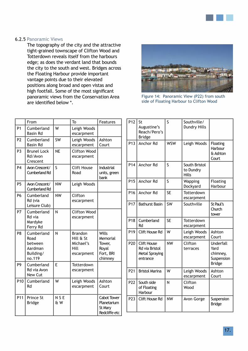
tight-grained townscape of Clifton Wood and Totterdown reveals itself from the harbours edge; as does the verdant land that bounds the city to the south and west. Bridges across the floating harbour provide important vantage points due to their elevated positions along broad and open vistas and highfootfall.Someofthemostsignificantpanoramic views from the Conservation Area areidentifiedbelow*.
figure 14: Panoramic view (P22) from south side of floating harbour to Clifton Wood
from To features
P1 Cumberland Basin rd
W leigh Woodsescarpment
P2 Cumberland Basin rd
SW leigh Woods escarpment
Ashton Court
P3 Brunel lock rd/Avon Crescent
NE Clifton Wood escarpment
P4 Avon Crescent/Cumberland rd
S Clift house road
Industrial units, green bank
P5 Avon Crescent/Cumberland rd
NW leigh Woods
P6 Cumberland rd (via leisure Club)
NW Clifton escarpment
P7 Cumberland rd via mardyke ferry rd
N Clifton Wood escarpment
P8 Cumberland road between Aardman Building/no.119
N Brandon hill & St michael’s hill escarpment
Wills memorial Tower, royal fort, BrI chimney
P9 Cumberland rd via Avon New Cut
E Totterdown escarpment
P10 Cumberland rd
W leigh Woods escarpment
Ashton Court
P11 Prince St Bridge
N S E & W
Cabot Tower Planetarium St mary redcliffe etc
P12 St Augustine’s reach/Pero’s Bridge
S Southville/Dundry hills
P13 Anchor rd WSW leigh Woods floating harbour & Ashton Court
P14 Anchor rd S South Bristol to Dundry hills
P15 Anchor rd S Wapping Dockyard
floating harbour
P16 Anchor rd SE Totterdown escarpment
P17 Bathurst Basin SW Southville St Paul’s Church tower
P18 Cumberland rd
SE Totterdown escarpment
P19 Clift house rd W leigh Woods escarpment
Ashton Court
P20 Clift house rd via Bristol metal Spraying entrance
NW Clifton terraces
underfall yard chimney, Suspension Bridge
P21 Bristol marina W leigh Woods escarpment
Ashton Court
P22 South side of floating harbour
N Clifton Wood
P23 Clift house rd NW Avon gorge Suspension Bridge
18.
P24 hanover Quay W Clifton Wood escarpment
gas Works chimney / leigh Woods / floating harbour
P25 Princes Wharf NW Clifton Wood / Brandon hill / Clifton Terraces / Cumberland Basin
ss great Britain
P26 Junction of Coronation road/Clift house road
W Ashton Court Estate
P27 Junction of Coronation road/Clift house road
SW Dundry hillside
Bristol City football ground
P28 formal viewpoint on Coronation road (upper)
NW to NE via N
Clifton Escarpment- Brandon hill
Include leigh Woods, Clifton Suspension Bridge, & Wills memorial Tower
P29 formal viewpoint on Coronation road (lower)
W to E via N
Clifton Escarpment, Avon gorge & the New Cut
Include Bonds A and B, Baltic Wharf & Bathhurst Basin
P30 Junction of Coronation road/Camden road
N The Point, Cabot Tower & Wills memorial Tower.
P31 Camden road Outfall viewpoint
W to N to E
Includes Clifton, Cabot Tower, & the ss great Britain
P32 Coronation road (outside No 100)
W to E Clifton Suspension Bridge, Cabot Tower & St Pauls Church, Southville
P33 Junction of Coronation road/St John’s road
Bathurst Basin
P34 Asda car park frontage
Bathurst Basin & the general hospital
P35 vauxhall Bridge
W to N to E to S
360 degree view
Include Clifton Suspension Bridge, royal york Crescent & Wills memorial Building
P36 vuaxhall Bridge North Extension
E, S, W Include C Bond, St mary redcliffe & Spike Island Arts
P37 gaol ferry Bridge
E & WNorth vista
Include Ashton Court Estate, rownham hill & Bedminster Bridge.
P38 Ashton Swing Bridge
P39 Pero’s Bridge N, S, E & W
P40 Plimsoll Bridge NW Avon gorge Suspension Bridge, Clifton Terraces
P41 harbour master Car Park
N Clifton / Clifton Wood

19.
6.2.6 long views long views are those that extend from the
Conservation Area to prominent city centre landmark buildings, groups of buildings or features. Often views to these features have been deliberately protected in development schemes, e.g views to the Cathedral or ss great Britain, which helps to characterise the strong sense of place within the Conservation Area. Tall buildings are a notable omission in the built makeup of the City Docks (the bonded warehouses are the only buildings to feature in SPD 1: Tall Buildings). This relative lack of tall buildings contributes to the abundance of long views that are possible from within the Conservation Area. SomeofthemostsignificantlongviewsfromtheConservationAreaareidentifiedbelow*.
from To
l1 Cumberland road/Avon Crescent
NNW Clifton Terraces
l2 Cumberland rd via New Cut
E St mary redcliffe
l3 Cumberland rd via hanover Place
N Clifton Wood terrace
l4 gas ferry road N royal fort
l5 Prince Street Bridge S Bedminster
l6 Prince Street Bridge S St mary redcliffe / Temple Quarter
l7 Anchor road E firehouse Chimney
l8 Anchor road SW ‘A’, ‘B’ Bond Warehouse
l9 Cumberland rd / Wapping rd junction
NW Bristol Cathedral
l10 Brunel Way N Church of holy Trinity, hotwell rd
l11 Wapping Wharf N Brandon hill / Cabot Tower
l12 millennium Square S Stothert & Pitt cranes / m Shed / St Paul’s Church
l13 Wapping Quay via Cathedral Walk
NE Bristol Cathedral
l14 great Western, Wapping Dockyard
N former gas Works / Cabot Tower / roof of St george’s Primary
l15 hotwell road W underfall yard
l16 Junction of Coronation road & greenway Bush lane
N Over vauxhall Bridge to Cumberland road
figure 15: long view (l13) from Wapping Quay across floating harbour to the Cathedral

20.
6.2.7 local viewslocal views are generally to landmarks that add variety and interest to the more local context, or that are enjoyed from a more intimate vantage point. Some of the local viewsofsignificancefromtheConservationAreaareidentifiedbelow*.
from To
lC1 Cumberland Basin rd
S underfall yard Chimney
lC2 Nova Scotia Bridge via floating harbour
E Trees surrounding Caravan site
lC3 Anchor road via Canons Way
S Cumberland rd houses
lC4 Anchor rd E firehouse Chimney
lC5 Bathurst Parade NE redcliffe
lC6 Cumberland rd / Wapping rd junction
Stothert & Pitt cranes, rear of m Shed
lC7 West end of millennium Promenade
W ss great Britain
lC8 Quayside and walkway of great Western Dockyard
N former gas Works buildings and chimney, Capricorn Quay
lC9 hanover Quay SW ss great Britain & linden homes development
6.2.8 glimpsed views glimpsed views are best found walking on foot around the Conservation Area and contribute greatly to a sense of how the locality has developed and the general charm of the area. glimpsed views are easily lost to new development or insensitive planning. Some of the glimpsed views of significancefromtheConservationAreaareidentifiedbelow*.
from Through To
gv1 Nova Scotia / Swing Bridge
S houses & bonded warehouses
South bank of New Cut
gv2 Cumberland rd NE Nos. 80 & 81 Cumberland rd
St mary redcliffe Church spire
gv3 Anchor rd / hotwell rd
S Capricorn Place
ss great Britain
gv4 Anchor rd / hotwell road
SW gas Works great Western Dockyard
gv5 Anchor rd / hotwell road
S gas ferry rd (north)
great Western Dockyard
gv6 Clift house rd N garden Centre
‘A’ Bond warehouse
gv7 hanover Place / Sydney row
NE graving Dock ss great Britain
gv8 Coronation road (outside number 116)
N houses/Trees Wills memorial Building
gv9 Coronation road (outside number 129)
N houses/Trees Clifton Suspension Bridge
*Aviewnotidentifiedabovedoesnotnecessarilyprecludeitssignificance.
figure 16: local view (lC7) from millennium Promenade SW to ss great Britain

21.
relevant Policy reference
Policy B2 (I – Iv) (extract)‘Development should be designed with regard to the local context. Proposals which would cause unacceptable harm to the character and/or appearance of an area, or to the visual impact of historic buildings, views or landmarks, will not be permitted.
6.3 landmark Buildings
6.3.1Bristolhasafineheritageofprominentlandmark buildings, each bearing public, stateorreligioussignificance.Oftenthesebuildings are physically detached from surrounding buildings, occupy prominent positions and are designed to a high quality, utilising quality materials and a richness or distinctiveness of design.
6.3.2Landmarksidentifiedforthepurposeof character appraisals are buildings or structures that due to their height, location or detailed design stand out from their background. They contribute to the character and townscape of the area and provide navigation or focal points or key elements in views.
6.3.3TheLandmarkBuildingsidentifiedwithinthe City Docks Consevation Area are:
• The four Stothert & Pitt cranes, Princes Wharf
• fairbairn steam crane, Wapping Wharf• @ Bristol and the Planetarium• Bristol Aquarium• ss great Britain & Brunel Institute• The Watershed • Spike Island building• Aardman building• ‘A’, ‘B’ & ‘C’ Bonded Warehouses• The Pump house Public house• former gas Works buildings and
chimney, lime Kiln road• underfall yard and chimney• m Shed • lloyds Building• Old gaol gatehouse • firehouse Chimney, Anchor Square• Pero’s Bridge, St Augustine’s reach• Ashton Swing Bridge• vauxhall Bridge• gaol ferry Bridge• Plimsoll Bridge• Byzantine former Warehouse, Bathurst
Parade• Crane base & weather vane, lloyds
Amphitheatre• Brunel’s Swing (Swivel) Bridge, North
Entrance lock• lock Control Buildingsfigure 17: Planetarium, millennium Square
figure 18: m Shed and Stothert & Pitt cranes, Princes Wharf
CITy DOCKS

22.
map 4: landmarks

23.
CITy DOCKS
7. ChArACTEr ANAlySIS
7.1 Overview & Character Areas
7.1.1 Within this broad context, there are pockets of distinct areas, where street layout, architecture or landscape contributes to a certain sense of place.
7.1.2 There is considerable variation between parts of the Conservation Area, the character of which relates very much to its topography, developmental history and land use.
7.1.3 The Conservation Area can be divided into a number of areas of distinct character, eachreflectingaparticularaspectthatgoes beyond planned layout and built form:
• Character Area 1: Cumberland Basin
• Character Area 2: Pooles Wharf
• Character Area 3: The floating harbour
• Character Area 4: Cumberland road & The New Cut
• Character Area 5: Canons marsh
• Character Area 6: Bathurst Basin
map 4: City Docks Character Areas

24.
map 5: City Docks Character Areas

25.
Character Area 1Cumberland Basin
Predominant characteristics
scale & Proportions• large-scale industrial buildings, set in own
substantial plots• many single storey sheds south of Avon New Cut
up to 9 storey Bonded Warehouses• Cluster of 1930s residential cottages, 2 storey,
on Ashton Avenue• Pitched and gabled roofs, or ‘m’ roofs
concealed behind parapets Properties set in substantial grounds
architectural treatment• victorian industrial/utilitarian design• 1930s cottage-style
material Palette• red Cattybrook brick, Brandon hill stone,
Pennant stone• Boundary treatments: Stone quay walls,
Pennant rubble, red sandstone boundaries walls, steel railings, small length of iron railing
• roof coverings: Natural slate, clay tile
7.1.4a Cumberland Basin Character Area occupies the western end of floating harbour and the portion of land south of New Cut, north of Clift house road. To the north and west are Avon gorge and the escarpment and terraces of hotwells and Clifton.
7.1.4b This area is characterised by a predominantly hard industrial dockside landscape and a concrete 20th century highway landscape. The green landscape does much to soften the overall environment.
7.1.4c historically, this area emerged as the entrance to the floating harbour, with early 19th century industrial development. This has been overlaid with the highway intersection in the late 20th century. The early 20th century warehousesareparticularlysignificant.

26.
7.1.4d landscape & Trees. The landscape architect Dame Sylvia Crowe was tasked withlandscapingtheflagshipCumberlandBasin project in 1965. The now mature trees and green spaces provide a soft edge to an otherwise entirely urban environment, which is overlooked from Clifton, the Suspension Bridge, leigh Woods, Ashton Court etc, as well as enjoyed from within. As an entity this area gets a very large amount of adult use daily, albeit transient. This open space is under-appreciated in the wider city context but is a major asset to the Conservation Area.
7.1.4e Key Buildings & features include:• lock gates and harbour walls by Brunel
below 20th century Plimsoll Bridge• Brunel’s Swing (Swivel) Bridge, North
Entrance lock • Bonded warehouses• robert Ware & Sons Tannery complex• riverside garden Centre• Ashton Avenue Swing Bridge• railway lines of former docks railway• Diner Building, mcAdam Way (former
transport cafe)• remains of ferry facilities at rownham
mead
7.1.4f Key views• from Clift house road, northwards
towards Clifton Suspension Bridge and Avon gorge
• Along floating harbour from Ashton Avenue
• from humphry Davy Way westwards to Bower Ashton
• from Clift house road westwards• from Cumberland basin road to south
west• from Brunel lock road towards Poole’s
Wharf
figure 19: Brunel Swing (Swivel) Bridge
figure 20: Ashton Swing Bridge (grade II) from south side of Avon New Cut
Character Area 1Cumberland Basin

27.
strengths opportunitiesrobust harbour buildings and equipment, large-scale but simple buildings
Improved environs around bonded warehouses and links between buildings and spaces
Sylvia Crowe landscape and mature trees along harbour as well as wildlife habitat along railway lines
Improvement of underpass areas to better facilitate cycling/pedestrian movement rather than car parking
high quality views out of area Improved management and maintenance of landscaping, especially around railway
remnants of industrial heritage more interpretation of industrial heritagerestoration and reuse of the Brunel swing bridge
retention of industrial and commercial uses, notably south of Clift house road
restoration and increased use of Ashton Swing Bridge
Weaknesses threats
Over-development of elevated highways with dead areas of car parking beneath, high volume ofvehiculartrafficwithnoiseandpollution
Increased decline of industrial buildings, bridges etc. contributing to a sense of neglect and a threatening environment
Some dereliction in evidence around harbour structures, Brunel Swing Bridge, Ashton Avenue Swing Bridge, boundary walls of Thomas Ware Tannery
Poor quality, utilitarian seating and lighting being installed that do not contribute positively to the local character
Poor pedestrian/cyclist crossing and circulation routes, especially on Spike Island element
Threat to key views and panoramas from within the character area to key landscapes or landmark features
Character Area 1Cumberland Basin

28.
Character Area 2Poole’s Wharf
Predominant characteristics
scale & Proportions• low-rise residential scale up to 4 storeys facing
merchants road and hotwell road, largely two storeys facing water
• Tight-knitflatsandhousesfacingawayfromprimary routes
• TerracesaroundOldfieldRoad
architectural treatment• late victorian terraces, Classical or Italianate
stylearoundOldfiledPlaceandSandfordRoad• late 20th century ‘Classical’ interpretation
waterfront as primary focus
material Palette• Pennant, brick, render, limestone dressings,
some timber cladding and iron balconies• Boundaries: rubble sandstone, iron or metal
railings• Clay tiles, natural slate• Timber joinery
7.1.5a This character area, at the far north west endoftheCityDocksoccupiestheflatgroundtonorthoffloatingharbourandsouthern edge of Clifton slopes. The area is almost entirely residential, in scale and character with late victorian terraces to the west of merchants road and to the east, the late 20th century residential developments of rownham Court and Pooles Wharf facing the floating harbour.
7.1.5b much of the residential development occurred towards the end of the 20th century, when the commercial dockside activity had ceased and the vast merchant’s Quay and Pooles Wharf were redundant spaces. The hotwell road element still retains its original character, some of the area’s oldest buildings still retaining a mix of commercial uses at groundfloorlevel.

29.
strengths opportunitieslow-rise, residential character and quiet, intimate nature of streets and spaces away from main thoroughfares
Encourage retention of existing retail uses and traditional shopfronts along hotwell road
retention of historic buildings and original features, particularly along hotwell road and theOldfieldRoadterraces
further reinstatement and restoration of traditional townscape features including lamp standards and benches
Survivalofcommercialuseatgroundflooralong hotwell road contrasting to the otherwise entirely residential land useQuality of waterfront views
Weaknesses threats
gyratory one-way system with associated heavy throughtraffic,fumesandnoiseandutilitarianroad signs
Increaseindominanceoftrafficunderminingcharacter and appearance of Conservation Area
lack of trees and soft landscaping, particularly in the public realm
reduction in existing trees and landscaping reducing visual amenity and softening of an otherwise entirely urban landscape
Poor maintenance of older buildings, particularly on hotwell road
Continued or increased use of inappropriate materials, especially uPvC windows, doors andsoffits,underminingthecharacterandappearance of the Conservation Area
hard landscaping and poor mix of cycle/pedestrian routes along waterfront
lack of maintenance of walkways and cycle paths or further introduction of utilitarian railings etc.
use of unsympathetic materials especially uPVCinreplacementwindows,doors,soffits,shopfronts & signage, particularly along hotwell road
7.1.5c Key Buildings & features – • The Pump house Public house• GrenvilleChapel,OldfieldPlace• BristolBridgeClub,OldfieldRoad• former Chapel, hotwell road (SPAr shop)• group of buildings adjacent SPAr• 151 hotwell road• Poole’s Wharf gateway, hotwell road• Plume of feathers Public house, hotwell
road• Terrace next to Plume of feathers• Albert Dock
7.1.5d Key views • Northwards towards Clifton Wood• Southwards to Baltic Wharf
figure 21: Pooles Wharf
Character Area 2Poole’s Wharf

30.
Predominant characteristics
scale & Proportions• low rise, tightly planned residential developments
to the west end - introverted away from main routes• One example of an 8 storey building at The Point• Industrial, low-rise warehouses and sheds facing the
waterfront
architectural treatment• high quality, contemporary design in residential
development with waterfront as primary focus• Some ‘pastiche’ late 20th century development• vernacular cottages • Classical terraces facing Avon Crescent• victorian robust industrial architecture of underfall
yard• utilitarian industrial and transit sheds
material Palette• Pennant, brick, render, limestone dressings, some
timber cladding and iron balconies• Boundaries: rubble sandstone, iron or metal railings• Clay tiles, natural slate• Timber joinery
7.1.6a This Character Area takes in the main body of the floating harbour and the low-lying land on the south bank that includes docks and shipyards as well as more recent residential development, known collectively as ‘Spike Island’.
7.1.6b The floating harbour and Spike Island form a distinctive area, with a unique sense of place. It has succeeded in retaining a distinct dockland ambience with working boatyards, warehouses, a working steam railway, together with a fully operational dock infrastructure and many small-scale dockland features. Traditional and creative industries, water based leisure, heritage and cultural attractions all sit within a original docklands landscape.
Character Area 3The floating harbour

31.
7.1.6c This part of the Conservation Area provides the focus for Bristol’s nationally important maritime heritage which includes the ss great Britain and other ships belonging to the historic fleet. The area also provides regionally important shipbuilding and repair facilities for small ships and traditional vessels at the Albion Dockyard and underfall yard.
7.1.6d Key Buildings & features – • Avon Crescent• Old Dock Cottages• Nova Scotia Public house• The Cottage Public house• Nova Scotia Place• hydraulic Engine house• machine Shop• Shipwright’s Shop• former Pattern-makers shop• underfall yard• Albert Dock• great Western Dock and SS great Britain• BrunelOfficebuildingatGreatWestern
Dock• South Junction lock and Swing Bridge• Swing Bridge over North Entrance lock• harbourside walls and associated
structures• fairbairn Steam Crane• m Shed• Pero’s Bridge• Prince’s Wharf and Wapping Wharf quays
and bollards • mcArthur’s Warehouse• merchants row• liberty gardens• Westgate• Stothert & Pitt Cranes
figure 22: Bristol marina
figure 24: Prince’s Wharf
figure 23: Wapping railway Wharf
Character Area 3The floating harbour

32.
strengths opportunitiesDiversity of cultural, leisure and heritage activity such as underfal yard sitting alongside residential developments
Improving public access and directional signage around the floating harbour and Spike Island
Surviving dockside features along the waters edge and surviving railway
Improvements to the cycle path network to allow greater penetration from Ashton gate and Southville and increased use of harbour ferry services to increase north/south circulation
Successful conversion or reuse of former industrial buildings or well-integrated new developments that complement the historic character
Increased small-scale mixed use development utilising existing building stock
limited vehicular access along waterfront allowingleisurelypedestrianandcycleflow
Partnership linking the City Council, leisure, cultural, heritage providers and community interest to provide the best managed development and change in the area
Quality and range of views from the waterfront tospecificfeaturesandthewidercitycontext
Coherent plan for underfall yard to build sustainable business
Weaknesses threats
vacant, undeveloped sites (Wapping railway Wharf) contributing to a sense of decline
Overlaying of traditional surfaces (railway lines) or removal of dockyard features
Poor pedestrian permeability, particularly at the west end of the area and limits to access and circulation of the floating harbour as a whole
unsympathetic developments that result in loss of key views and panoramas or fail to respect the industrial character, scale and material palette of the areaIncrease in high-rise residential developments that unbalance the sensitive mix of commercial/industrial/leisure/cultural/residential usesgradual loss of employment use resulting in physical decline of historic characterreduced permeability and legibility resulting from new developments
Character Area 3The floating harbour

33.
Predominant characteristics
scale & Proportions• Buildings from 2.5 up to 4 storeys, set back
fromroadbehindwelldefinedboundaries• residential scale, most dwellings semi-
detachedpairs,terracesorflatblocks• Occasionallarge,detachedindustrial/office
buildings set in substantial plots• Pitched and gabled roofs, or ‘m’ roofs
concealed behind parapets
architectural treatment• residential building, mix of Classical/regency
and later interpretations• Industrial/Officebuildingscontemporary
material Palette• main facades: rubble stone, render, brick,
metal & timber cladding• Boundary Treatments: coursed lias rubble,
wrought iron gates and cast iron railings, pennant rubble
• roof coverings: Natural slate or clay with brick stacks and clay pots
• Joinery: timber sashes and casements
7.1.7a Character Area 4 runs along the south side of the Conservation Area, taking in the buildings that line Cumberland road and face the New Cut from Bathurst Basin in the east up to and including Spike Island. The New Cut was constructed in 1804-9. The earliest buildings are the group of substantial townhouses and the earliest buildings on its north bank.
7.1.7b Buildings are predominantly residential in scale and character, the majority of which are terraced, with occasional semi-detachedandflatblocks.Withinthiscontextarethefewworkshopandofficebuildings, which contribute to a varied townscape and context.
Character Area 4Cumberland road & The New Cut

34.
7.1.7c There is an interesting mix of land uses that combine traditional and creative industries. Two of Bristol’s leading creative industries are situated in this portion of the Conservation Area: Aardman Animations and the Spike Island Arts Centre.
7.1.7d Key Buildings and features• Terraces along Cumberland road• 129 Cumberland road• The georgian house, gasferry road• Old City gaol gatehouse, and perimeter
wall (remains of)• vauxhall Bridge• gaol ferry Bridge• Spike Island Artspace• railings along north side of Coronation
road• Stone-paved slipways to site of gaol ferry• remains of St raphael’s Church,
Cumberland road• Old gaol Workshop• The ‘Chocolate Block’ Path• victorian railings along railway line
figure 26: Avon New Cut looking NE
figure 25: hoardings blighting historic Wapping Wharf boundary wall and derelict sheds behind
Character Area 4Cumberland road & The New Cut

35.
strengths opportunitiesheritage buildings and structuresWell-designed modern residential development front and rear gardens to houses largely intact
Sensitive redevelopment of Wapping Wharf site and removal of associated hoardings
Spike island Art Centre is focus for innovation and creativity in arts
greater use of New Cut for water transport
views up and down the New Cut and across to Bedminster
restoration and reinstatement of railings along railway
Biodiversity value of New Cut Improved pedestrian crossing points across Cumberland road
Chocolate Block path cycle way and bridges allow appreciation of the Avon New CutWeaknesses threats
long term dereliction of Wapping Wharf site and works building at no. 119 Cumberland road
Threat to species and biodiversity value of New Cut
Wapping Wharf development hoardings at corner of Cumberland road/Wapping road detracting from ‘gateway’ into the conservation area from Commercial road bridge
Continued dereliction of Wapping Wharf site and continuation of hoardings along Cumberland road
lack of street trees and soft planting further loss of traditional features such as railings and boundary walls
SpeedoftrafficalongCumberlandRoadcombined with limited pedestrian crossing points from north and south side of Cumberland road, especially around Spike Island Artspace
Continued dereliction and eventual loss of nos. 119 Cumberland road and gaol gatehouse
Poor condition of railings alongside the railway, which have wire mesh or modern fencing in some sections
IncreasedtrafficalongCumberlandRoadsuchas the proposed Bristol rapid Transit further impeding pedestrian and cycle amenity
Character Area 4Cumberland road & The New Cut

36.
Predominant characteristics
scale & Proportions• Buildings from 2.5 up to 4 storeys, set back
fromroadbehindwelldefinedboundaries,usually rubble stone walls
• residential scale, most dwellings semi-detachedpairs,terracesorflatblocks
• Occasionallarge,detachedindustrial/officebuildings set in own substantial plots
• Pitched and gabled roofs, or ‘m’ roofs concealed behind parapets Properties set in substantial grounds
architectural treatment• In residential building, mix of Classical/regency
and later interpretations• Industrial/Officebuildingscontemporary,
high-quality design
material Palette• main facades: rubble stone, render, brick,
metal & timber cladding• Boundary Treatments: coursed lias rubble,
wrought iron gates and cast iron railings, pennant rubble
7.1.8a North of floating harbour on former marshland belonging to Augustinian Abbey Canons (now cathedral). later used for ship-building and built up with industrial buildings, many of which were gasworks buildings that contaminated the soil. It was redeveloped at the end of 20th century as the ‘harbourside’, a mixed use areaofoffices,residential,entertainmentand shops.
Character Area 5Canons marsh

37.
7.1.8b Key Buildings & features • Canons marsh goods Shed• former leadworks and attached chimney• Crane Base, Canon’s road• millennium Square• City of Bristol College• Capricorn Place• Canons house (lloyds TSB hQ)• Transit Sheds, Bordeaux Quay• @ Bristol and Bristol Aquarium• former gasworks Buildings• Walls to gasferry road• The Three Tuns Public house• 1-15 lower College Street• 1-3 St David’s mews
figure 28: former gas Works from Capricorn Quay
figure 27: harbourside Development and Cathedral Walk
figure 29: Anchor Square from Pero’s Bridge
figure 30: Public art, millennium Square
Character Area 5Canons marsh

38.
strengths opportunitiesSome robust large-scale buildings Increase of trees and soft plantingheritage buildings and structures re-used Improve continuous pedestrian way along
watersideInteresting public squares and spaces with public art
Encourage wider mix of independent leisure facilities
Waterside walks enabling interpretation of the south side of the floating harbour and surrounding landscape
Proposed restoration and re-use of historic gasworks buildings
flexibility of public open spaces to allow for events and festivals throughout the year
Protecting key views and panoramas in future development management negotiations that may have an impact on the area
views south across floating harbour to south Bristol and Dundry hillsvariety of cultural and leisure attractions contributing to Bristol’s wider economyWeaknesses threats
Bland over-scaled facades to modern buildings and sterilisation of character particularly to the west end
Continued economic decline contributing to increase of empty premises
lack of trees and soft landscaping loss of views caused by new developments
Poor connections behind and between buildings and lack of pedestrian permeability
loss of traditional features and townscape details
‘Chain’ bars and restaurants contributing to alate-nightculturethatconflictswithlocalresidents and deters some visitors
Character Area 5Canons marsh

39.
7.1.9a located between the New Cut and the floating harbour, Bathurst Basin is a small triangular basin fronted by small-scale residential developments and bounded by Prince Street, mud Dock and the New Cut.
7.1.9b The basin itself was built on an area of an old mill pond known as Trin mill Pond that received its water supply from the river malago before the creation of the New Cut. At one time Bathurst Basin formed a connection, through two sets of locks, between the floating harbour and the tidal river Avon in the New Cut. The lock to the New Cut was blocked at the beginning of the Second World War to ensure that in case of damage by bombing, the waters of the floating harbour could not drain into the river; it was shut permanently in 1952.
Predominant characteristics
scale & Proportions• Buildings from 2.5 up to 5 storeys (on west
side), directly addressing pavement edge or footway
• residential scale, most dwellings terraces or flatblocks
• Occasionallarge,detachedindustrial/officestill addressing pavement edge and forming a strong grouped building line
• Pitched and gabled roofs, or ‘m’ roofs concealed behind parapets
architectural treatment• In residential building, mix of Classical/regency
and later interpretations• Industrial/Officebuildingscontemporary,or
Byzantine
material Palette• main facades: render, with limestone dressings
brick• Joinery: timber
Character Area 6Bathurst Basin

40.
7.1.9c The area used to be an industrial dock with warehouses, but now has a small marina, with houseboats and residential quayside properties. A manually swung footbridge connects Bathurst Parade with redcliffe and New guinea Street. The basin is the home for Cabot Cruising Club who own the lightship John Sebastian. It was acquired by the Club in 1954 and opened as the Club's headquarters a few years later in 1959.
7.1.9d Key Buildings & features • The louisiana Public house• former robinsons Warehouse• general hospital (within redcliffe
Conservation Area)• views across floating harbour• views towards Bedminster• listed quay walls, bollards and locks
figure 31: The louisiana Public house
figure 32: Bathurst Basin looking southwest
strengths opportunitiesQuality of late georgian buildings with original features
Preservation of key views and panoramas out of the area through future development management negotiations
Intimate character of Bathurst Basin owing to lack of vehicular access
removal of advertising boards and hoardings outside Wapping Wharf site
views across the water to redcliffe and Bedminster
Preservation of traditional architectural features and townscape details
Successful modern residential development that integrates well with the scale and of the traditional fabric
Weaknesses threats
Some views out of area blocked by over-scaled development
Potential unsympathetic redevelopment of sites to the east (Bristol general hospital and vacant site next to Ostrich Public house)
Advertising boards and hoardings outside Wapping Wharf development undermining quality of architecture to east of Wapping road
Proposed Bristol rapid Transit, particularly the proposed new bridge across the New Cut
Character Area 6Bathurst Basin

41.
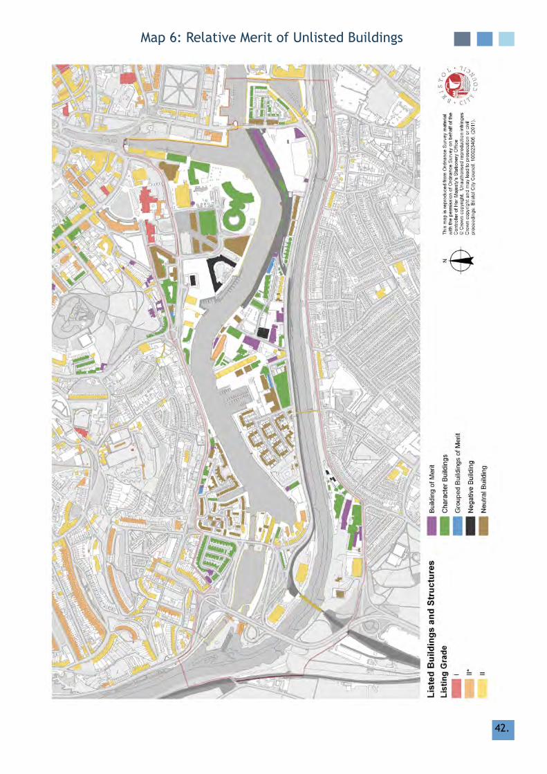
7.2 relative merit of unlisted Buildings
7.2.1 relative to its size, there are relatively few listed buildings within the Conservation Area. In addition to listed buildings, many unlisted buildings in the City Docks Conservation Area make an important contribution to its character. Other buildings clearly detract from the quality of the area and could be replaced.
7.2.2 for the purpose of this character appraisal, buildings within the Conservation Area have been categorised according to their special interest and the degree of contribution they make to the character of the City Docks.
7.2.3 Buildings of merit are unlisted buildings that make a special contribution to the Conservation Area. These are usually of particular architectural or historic interest.Theidentificationofabuildingwithin the Conservation Area as being of particular merit will be of material consideration in future planning decisions.
Buildings of merit within the City Docks Conservatin Area include:
• m Shed• The Planetarium• J.S fry and Sons Warehouse• Old gaol Workshops• landmark Court• 94 -96 Cumberland road • 119 Cumberland road• Aardman Animation• mcArthur’s Warehouse• Old industrial building/warehouse
hanover Place• The Cottage Inn Public house• former Ironworks, Coronation road• Part of the former tannery, Clift house
road
• grenville Chapel• BristolBridgeClub,OldfieldRoad• mission room (now a Spar) 181b hotwells
road.• Poole’s Wharf – No 2• Dockside buildings next to SS great
Britain.• TheformerAlbionDockyardOffice
Building• Two unlisted buildings on the edge of the
underfall yard
7.2.4 grouped Buildings of merit are buildings that form an attractive group and are collectivelyofsignificance.Itmaybetheir method or date of construction, or distinctive architectural treatment, that is of interest. Such groups would be particularly sensitive to change that could undermine their group value. grouped buildings of merit within the City Docks Conseration Area include:
• 181a – 185 hotwells road• 120-126 St georges road• 1-9 merchants row• 1-11 Sydney row
7.2.5 Character Buildings make a positive contribution to the overall character and sense of place of the Conservation Area. Their value is in their overall scale, form, materials or date, which helps form the built backcloth for the area.
7.2.6 Neutral Buildings are buildings that
make neither a positive nor negative
CITy DOCKS
42.
map 6: relative merit of unlisted Buildings

43.
7.3 Townscape Details
7.3.1 Other features and details in the townscape also contribute to a sense of local distinctiveness. These can range from distinctive boundary treatments and street furniture, to trees and hard landscaping. Individually and collectively they contribute to the overall quality of Bristol’s streetscape.
7.3.2 The City Docks Conservation Area is rich in local townscape details that cumulatively give interest and quality to the street scene and make a positive contribution to the character and appearance of the area. To ensure the character and appearance of the Conservation Area is preserved, these details should be protected or replaced with sympathetic, quality, modern equivalents. It is the degradation and disappearance of traditional or locally distinctive details that can threaten to undermine the quality and interest of the area (see Negative features below).
7.3.3 Traditional Street Surfaces Treatments such as stone setts and
paving can be important elements in the townscape of an area. Paving, if well maintained and in high quality materials, contributes greatly to the character of an area, providing the backdrop to surrounding buildings or spaces with an intimate charm and distinctiveness.
7.3.4 Pennant paving slabs are used on the footways and small scale lanes within City Docks. The use of Pennant stone in the pathways, as well as its presence in a number of buildings and the boundary walls, enhances the traditional grain of the Conservation Area and acts as a unifying feature, linking buildings and street surfaces and enclosing green spaces.
7.3.5 A cohesive plan for the future of street surfaces, that reduces the hotchpotch treatments whilst considering maintenance, would greatly enhance the local environment. Where the opportunity arises, a scheme to restore the traditional street surfaces would greatly enhance the routes where it has been lost.
7.3.6 railings and Boundary Treatments railings and boundary walls contribute significantlytothecharacteroftheConservation Area, they add interest and variety of scale in the street scene and provide a sense of enclosure.
figure 33: Anchor, Wapping railway Wharf
figure 34: railway lines, Wapping Wharf
CITy DOCKS

44.
7.4 materials
7.4.1 Building materials give texture and interest to individual buildings, they also characterise an area.The strong material palette seen throughout the City Docks unites the area and gives an indication of building ages and patterns ofdevelopment.Whereinfillornewdevelopments most successfully preserve or enhance the area, they respect their context and the dominant local materials.
7.4.2 Whererecentinfillsandnewdevelopments have failed to respect the dominant palette, these undermine the character of the area as a whole.
relevant Policy references
Planning Policy statement 5: Planning for the historic environmentPolicy he9.1
core strategy (June 2011)Policy BCS22 - Conservation & The historic Environment
saved adopted local Plan Policies (1997) following adoption of core strategy (2011)B18 (i-vi) (extract): ‘Traditional materials should be retained, repaired and where necessary replaced, and not covered with paints or cladding which would be harmful to the appearance of the Conservation Area’.
relevant Policy references
Planning Policy statement 5: Planning for the historic environmentPolicy he9.1
core strategy (June 2011)Policy Bcs22 - conservation & the historic environment
saved adopted local Plan Policies (1997) following adoption of core strategy (2011)
B15(I) (extract): ‘Townscape and landscape features that contribute to the character or appearance of streets and open spaces within the Conservation Area should be preserved or enhanced’
The loss of private planting, the removal of boundary walls and railings, the introduction of car parking into traditional front garden areas, and the loss or replacement of traditional signage, street lighting, paving and street furniture can all adversely affect the character of the historic environment and will generally not be acceptable.
CITy DOCKS
7.3.7 Street furniture The City Docks Conservation Area has a
fascinating collection of historic street furniture, some of which is listed. The appropriate maintenance and protection of this is important, as is the need to prevent modern street clutter detracting from its setting.

45.
7.5 WIlDlIfE & TrEES
7.5.1 Trees and green spaces are vital to the quality and diversity of many parts of the city, particularly where they soften an otherwise built-up landscape. Trees and green spaces, public or private, contributesignificantlytoasenseofplaceand character; adding value to visual, and residential amenity.
7.5.2 Theenvironmentalamenitybenefitsoftrees largely depends on the extent of tree canopy cover. A high proportion of trees and a verdant character contributes positively towards physical and mental health, and mitigates pollution and climate changeeffectsincludingfloodingandtemperature increase. The tidal waterway of the Avon New Cut is a valuable wildlife corridor as it is very fertile and can produce twice the plant growth of the sameareaoffield.Thelandnearthewateralsobenefitsfromthenutrientsproduced in the mud which supports a variety of rare specie of birds and plants.
7.5.3 Over 30 species of birds have been seen along the Cut, including the grey heron, Sandpiper,andCormorant,feedingonfishfrom the Cut which indicates the health of the water.
7.5.4 Over19speciesofbutterflyanddaymothhavebeenspottedat‘ButterflyJunction’, particularly attracted to brambles, grasses and buddleia commonly on redundant sites. The site also provides a safe home for a variety of grasshoppers, crickets, beetles and other insects. The variety of grasses that grow in the summer provide an abundant breeding ground for species including the marbled White,RingletandSkippers.ButterflyJunction is regularly monitored and maintained to encourage the grasses and keep the more invasive plants under control.
7.5.5 Over90speciesoffloweringplantsarepresent between gaol ferry Bridge and Ashton Bridge. The Ivy Broomrape is extremely rare and found in a very few other habitats, and is the emblem of the friends of the Avon New Cut (frANC).
7.5.6 Over 30 species of trees can be seen alongtheCut,includingfigtreeswhichare believed to have grown from seeds deposited in ballast.
7.5.7 Tall braod-leaved london plane trees are common in urban envirounments as their regularly shed their bark and are resilient to pollution. Planes give Coronation road and Commercial road the structure of “the boulevard” intended by Alderman Proctor when planting along the Avon New Cut in 1873.
relevant Policy references
Planning Policy statement 5: Planning for the historic environmentPolicy he9.1
core strategy (June 2011)Policy Bcs22 - conservation & the historic environment
saved adopted local Plan Policies (1997) following adoption of core strategy (2011)
B15 (ii), NE2, NE3, NE9 (extract):‘historic parks and gardens and other designed landscapes of national and local importance... will be protected. Development which would adversely affect the character or appearance of historic landscapes and, in the case of nationally important sites, their setting, will not be permitted.’
CITy DOCKS

46.
8 TyPICAl lAND uSE & ISSuES
8.1 Overview
8.1.1 Bristol is the most competitive large English city outside of london and its central area is the region’s economic hub providing a wide range of employment, cultural, educational and service opportunities. In recent years it has also rediscovered its role as a place where people increasingly want to live. The more vital and vibrant districts tend to be those with the greatest mix of uses, with people living, working and socialising in the same area.
8.1.2 Depending on the predominant land use, aspecificlocalitywillhavedifferingissues that may affect its character or appearance, and most appropriate future management. maintaining the balance between the needs of different users in specificpartsoftheConservationAreais vital in preserving or enhancing its character.
8.1.3 The City Docks originated as the industrial/maritime heartland of Bristol, with some peripheral residential development. Since its inception, the area has transformed into a vibrant mixed-use suburb with a growing population; and as a centre for cultural and leisure attractions. Within this context there remains a small, but vital, number of industrial and maritime facilities that keep the area thriving and contribute to its diversity and special interest.
8.1.4 land use types that broadly characterise the conservation area and issues that undermine it, tend to fall under one of the following categories:
• residential• Cultural & leisure• Industrial/Office• maritime• vacant sites
CITy DOCKS

47.
8.2 residential Dwellinghouses, Residential institutions,
hotels, boarding and guesthouses (C1, C2, C3 Uses)
8.2.1 The residential portions of the Conservation Area tend to be characterised by pockets of victorian terraces, with a high quality townscape and the larger-scale residential complexes built since the late 20th century. With the exception of Cumberland road, residential developments tend to be situated in quieter, some entirely private streets and cul-de-sacs. until the harbourside development, residential schemes were relatively low-rise (between 2 and 4 storeys above ground), unobtrusive in character.
8.2.2 The popularity of the City Docks as a good
place to live has increased the pressure for new residential developments and a drive to maximise land values by building high-density developments. There is a genuine threat to the character and sustainability of the Conservation Area if industrial buildings and land are redeveloped to the highest possible density. The recent change in economic climate has led to a surplus of one bedroomflatsinthenewHarboursideDevelopment.
main Issues Affecting residential Areas
• unsympathetic alterations & loss of traditional architectural details
• loss of trees• loss of boundary treatments and gardens to
infill/off-streetparking• loss or poor maintenance of traditional
street surfaces or hotchpotch of modern replacement materials
• loss or poor maintenance of traditional street furniture
• volume of on-street parking• Wheelie bins/refuse issues• Subdivisionofpropertiesintoflatsadding
pressure to the public realm
CITy DOCKS

48.
8.3 Cultural & leisure (D1 & D2 uses) schools, art galleries,
museums; (A1-A5 uses) retail, restaurants, cafes
8.3.1 The City Docks is part of the region’s fastest growing tourism and leisure development areas, with an impressive range of existing attractions, events and cultural facilities of national renown that include:
• ‘m’ Shed • ss great Britain and Brunel Institute• Spike Island• Explore at-Bristol• Bristol Aquarium & Imax• The Watershed Cinema• underfall yard (see also maritime use)• Arnolfini(outsidetheConservationArea)
8.3.2 Giventhefinancialresourcesandaspirations for major institutions, new developments and extensions tend to be of a highest quality of design, and sensitive to the heritage of the area.
8.3.4 The continued growth and development of important cultural and leisure facilities is vital in securing their ongoing viability and value. The needs of the cultural institutions in maintaining and growing visitor numbers and revenue is vital, and striking the right balance between the institution in an imaginative way that meets the needs of the institutions as well as the historic environment is critical.
8.3.5 Car and coach parking that give adequate facilities for some cultural attractions, particularly on Spike Island, is an issue.
8.3.6 The Conservation Area’s leisure activity is vital to its character and to the wider context of Bristol. The City Docks boasts a diverse range of independent restaurants and bars, which contributes to Bristol’s reputation as a city that supports and thrives on its local distinctiveness.
8.3.7 Conversely, the Canons marsh area has also had a number of national chain bars occupy its sites. Some of which have attracted ‘stag’ and ‘hen’ parties and can create a threatening environment, particularly at the weekend. In order to support the diversity and uniqueness of the City Docks, the volume of national chains would be carefully managed to avoid a sterilisation of the area’s character.
8.3.8 Consequently, they are vulnerable to closure and economic decline. If retail uses are not viable, the shopfronts themselves are under threat to being lost to residential, which would deprive the area of active frontages.
8.3.9 masterplans, establishing long-term aspirations and strategies, may be the best way for institutions and the local authority to establish a planning and environmental framework to provide a framework to best manage development plans in a sensitive way.
main Issues Affecting Culture/leisure Areas
• Parking pressures, managing needs of institutions to provide staff and visitor parking in an area of limited on-street parking
• Unsympatheticinfilldevelopment• unsympathetic extension or alterations as
buildings are adapted for new uses• loss or poor maintenance of traditional
street surfaces or hotchpotch of modern replacement materials
• loss or poor maintenance of traditional street furniture
• lack of parking provisions
CITy DOCKS
49.
8.4 Industrial/Office Business/Office(B1uses)
8.4.1 The Conservation Area once formed the working heart of Bristol’s dock and commercial activities. Today, many of the industrial sheds and warehouses have become cultural/leisure facilities. There does remain a vital number of industrial uses.
8.4.2 Engineering, creativity and manufacture are all part of the heritage of the City Docks, which still exist in pockets - notably in the Centre of Spike Island and north of Clift house road.
8.4.3 Officeuseshavetendedtoappearin
the Conservation Area since the late 1980s, when lloyds Bank moved to the prominent waterfront location at the Amphitheatre. South of Anchor road are a number of substantial contemporary officeblocks.Architecturallythesehavelittle relation to the character of the City Docks and tend to be glass curtain-walled and occupying large plots.
8.4.4 ‘B’ Bond, at the west end of the Conservation Area houses The Create Centre,theBristolRecordOfficeand BCC’s Property and Sustainable City departments. re-use of this vast warehouse has ensured the future viability of the listed asset, and provided vital activity to this part of the Conservation Area during the week.
8.4.5 Officebuildingstendtobeemptyandquiet outside normal working hours. mixed use developments, which also contain residential portions, would better support activity at all times.
MainIssuesAffectingIndustrial/OfficeUses
• Economic pressures impacting on land values and development viability
• loss or poor maintenance of traditional street surfaces or hotchpotch of modern replacement materials
• loss or poor maintenance of traditional street furniture
• lack of parking provisions
CITy DOCKS

50.
8.5 maritime
8.5.1 maritime activities remain an essential partoftheConservationArea,reflectingboth the area’s history and providing functions and services that are necessary and relevant in the 21st century.
8.5.2 The Albion Dockyard and underfall yard provide shipbuilding and repair facilities for small and traditional vessels. They serve as an ongoing reminder of the area’s ship building past and ensure the continued use of specialist craft skills. Perhaps most importantly though is that through their continued use the survival of these historic sites, the latter of which is a scheduled monument, is ensured.
8.5.3 The City Docks provides the location for a variety of water based leisure activities, including sailing, canoeing and wind surfing,aswellasfishingandboattours.unsurprisingly the wide range of activities on offer has played a role in encouraging the growth of bars and restaurants as well as making the area a desirable place to live. As well as the residential developments which have grown up on the harbourside there are also a number of houseboats moored in the docks. These provide centrally based moderately priced accommodation, as well as adding to the character of the City Docks Conservation Area. The use of houseboats has become increasingly important in recent years, with the demand for moorings exceeding the supply of adequately serviced berths.
main Issues Affecting maritime use
• Economic pressures impacting on land values and development viability
• Potential loss of historic character if land use changes
• Preasure on mooring space
CITy DOCKS

51.
8.6 vacant Sites
8.6.1 There are two major vacant sites within the City Docks Conservation Area. The firstoftheseisonGasFerryRoadtothenorth of the docks, where the grade II listed remains of the former gas works have remained derelict for a number of years, whilst the second is at Wapping Wharf to the south of the docks on Cumberland road. As with the site on gas ferry road, Wapping Wharf is home to a number of listed structures at risk, the grade II listed entrance wall and gateway to the Old City gaol and the remains of its eastern wing, which is also grade II listed.
8.6.2 The presence of vacant sites and derelict buildings within the City Docks Conservation Area are both a weakness and an opportunity. The deteriorating buildings give an impression of neglect which impacts on the surrounding area whilst, despite the presence of hoardings, the derelict sites act as a draw forthoseintentongraffiti,vandalismand destruction; factors which are to the detriment of the appearance and character of the conservation area.
8.6.3 however, vacant sites are also an opportunity for further development, as well as the conservation and reuse of the historic structures that that are located on them. At Wapping Wharf development is underway, with the remains of the Old City goal being incorporated into a scheme that will include housing, localservices,officespaceandahotel.Planning consent has also been granted for residential development and shops for the eastern part of the gas ferry road site(theEasternPurifierHouse),whilstplansforofficesinthewesternpartoftheformergasworks(theWesternPurifierhouse and the Engine house and chimney) have also been announced.
main Issues Affecting vacant Sites
• Economic pressures impacting on land values and development viability
• loss of views within, into and out of the Conservation Area as land is redeveloped
• Deterioration and loss of heritage assets
CITy DOCKS

52.
main Issues Associated with flood risk
• Tidalinundationandassociatedflooding• Outofcharacterflooddefencemeasures• Impact to historic fabric of docks, such as
loss of historic lock gates• flood damage to historic structures
8.7 flooding
8.7.1 The Conservation Area is unique in Britain inthatthemostsignificantelementof the designated area, the floating harbour, plays a vital role in protecting thecityfromfloodingbyprovidingstormwaterstorageduringtimesofpeakflow.however, the harbour itself is at risk offloodingfromhightidesintheRiverAvon that in turn could cause widespread floodingtohomesandbusinessesintheharbourarea.Theriskoftidalfloodingis anticipated to grow with expected sea level rise.
8.7.2 Thesefloodriskissuesposesomeuniquethreats to the special character of the conservation area both in terms of potential tidal inundation as well as any measures taken to mitigate these risks such as improvements to harbour installations. A careful balance needs to be struck between safegaurding the city’s residents, property and businesses whilst preserving or enhancing the special character of the City Docks.
CITy DOCKS
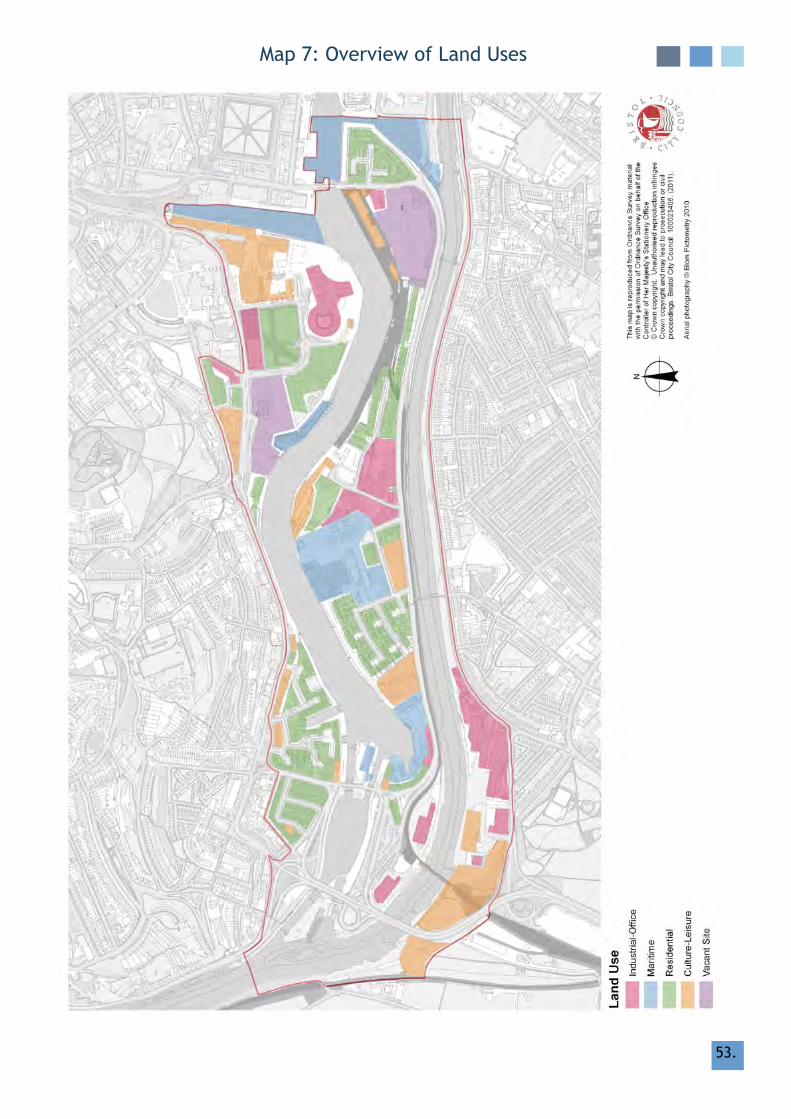
53.
map 7: Overview of land uses

54.
9. negatIve features
9.1 The value or importance of a Conservation Area can be vulnerable to harm as negative elements detract from the local environment, and threaten to undermine its special interest. This can include small-scale alterations, loss of traditional features, or large-scale developments. Negative features and threats present an opportunity for enhancement or restoration, as detailed in Section 10.
9.2 PedestrianandTrafficConflictsThehighvolumeofvehiculartrafficthrough parts of the Conservation Area, notably around the periphery routes, cancauseconflictswithvisualamenityand visitor experience. Cumberland Roadisafast,heavilytraffickedroute;parking spaces are on the south side, and pedestrians have to cross the busy main road to reach Spike Island, ssgreat Britain and south side of the floating harbour. An increase in pedestrian crossing points may improve the situation.
9.3 loss or Poor maintenance of Traditional Street Surfaces, Townscape & Industrial/maritime features
The Conservation Area has a high quality and relatively unique public realm, which includes many traditional townscape features and surviving remnants of the area’s industrial/maritime heritage. Traditional quay walls, original dock furniture, industrial machinery, bridges, street surfaces, railings and boundary walls all add to the quality and diversity of interest of the City Docks. Where traditional features are removed, poorly maintained or replaced with non-traditional materials, this is gradually eroding the character and special interest of the area.
9.4 Derelict Buildings & vacant Sites The lack of care and maintenance of individual properties and sites is seriously undermining the appearance of parts of the Conservation Area and contributing to a sense of a declining character. Some larger sites throughout the Conservation Area have been derelict for some time, which have been impacted on by a depressed development market. The poor condition of certain buildings or sites is currentlyamajorconflictwiththearea’sotherwise thriving and bustling character.
9.5 If the condition of empty buildings declines through lack of maintenance or use then their future viability can be compromised. Where listed, unlisted Buildings of merit and Character Buildings are allowed to deteriorate, this could lead to their eventual loss and an erosion of the character and diversity that makes the Conservation Area so special.
9.6 Advertising Boards & hoardings Any oversized and unsympathetically
locatedhoardingsdetractsignificantlyfrom individual buildings, the street scene, and the quality of the wider Conservation Area. The corner of Wapping road / Cumberland road represents a gateway into the Conservation Area, which is currently compromised by a series of large advertising boards and hoardings associated with the Wapping Wharf site.
CITy DOCKS

55.
9.7 UnsympatheticInfill&NewDevelopment Newdevelopmentorinfillthatfailsto
respect the character of an area, ignores the predominant building lines, scale, proportions, details or materials, or which obstructs important views or cuts of pedestrian routes, can cause serious harm to the special interest of the Conservation Area.
9.8 loss of views The loss of views, either to key landmarks within or outside the conservation area, or to landscapes or sites beyond is impacting negatively on the character of the Conservation Area. Proposed development north of the floating harbour (Building 4) will result in the loss of a key view from the south of the water to the Cathedral.

56.
10. mANAgEmENT PrOPOSAlS
10.1 It is expected that the effective management of the City Docks can, for the most part, be met through an effective policy framework and the positive use of existing development management and enforcement powers. The analysis of the character and appearance of the Conservation Area within this appraisal thereforeidentifiesthoseelementstheCouncil will seek to protect, as well as negative features, which may present opportunities for enhancement.
10.2 The following provides proposals for remedyingthosefeaturesidentifiedas ‘negative’ in Section 9. The implementation of the Potential Actions may depend on the existing and future financialandstaffresourcesthatBristolCity Council departments work within.
10.3 Negative feature Pedestrian&TrafficConflicts
If improvements were made to facilitate pedestrian movement, especially across busytrafficroutes,itwouldgreatlyenhance the visitor experience and overall quality of the Conservation Area. Calming and safety schemes that are designed with sensitivity to the local character and context would greatly enhance streets and improvepedestrian/cycleflowandsafety
10.4 Potential Actions Work with other Bristol City Council departments, especially highways and lighting, on strategies to improve and increase safe crossing points across busy routes, especially Cumberland road
10.5 Work with highways and lighting departments on future schemes that involve the introduction of new street furniture and signage into sensitive areas in order to mitigate impact
10.6 Encourage imaginative design of railings and safety measures on new developments that meet adequate standards but also have a minimal impact on the character or appearance of the local environment
10.7 Negative feature loss or Poor maintenance of Traditional
Street Surfaces, Townscape & Industrial / maritime features
Schemes to restore and regularly maintain the traditional street surfaces and townscape features would greatly enhance and protect the character of the area promote its historic context. An audit and condition survey of industrial/maritime features in the Conservation Area could provide a basis for a cohesive plan for the protection of these features. Where the opportunity arises, schemes to repair or reinstate traditional street surfaces or townscape features would greatly enhance areas where they have been lost
10.8 Potential Actions Encourage retention and regular maintenance of traditional street surfaces and townscape features
10.9 Encourage retention/reinstatement of cobbles, setts, stone kerbing, Pennant paving etc.; where those materials are‘fitforpurpose’.Wherewholesalereplacement is proposed work should be undertaken to ensure consistency and quality of replacement materials
CITy DOCKS

57.
10.10 retain or reinstate, and ensure good maintenance of, traditional street furniture where appropriate.
10.11 Support local conservation groups and amenity societies who may seek to maintain or reinstate traditional street furniture in their local areas or undertake and audit/condition survey of traditional features in the Conservation Area
10.12 Negative feature Advertising Boards and hoardings Potential Actions
Investigate the possibility of implementing regulation 7 controls on estate agents’ boards in areas where there tends to be a proliferation.
10.13 Seek enforcement action against any breach of planning permission or conditions where there is a negative impact on the character or appearance of the Conservation Area
10.14 undertake a city-wide review of existing licensed advertising hoardings and seek to serve a discontinuance notice and removal of any that have a negative impact on the appearance of the Conservation Area
10.15 resist the introduction of any new advertising boards or hoardings that could have a negative impact on the character or appearance of the Conservation Area, especially around sites with a uncertain timescale for development
10.16 Negative feature UnsympatheticInfill&NewDevelopment Potential Actions resist unsympathetic applications which
would harm the character or appearance of the Conservation Area. high quality design and materials will be encouraged through existing development management powers
10.17 Where consent is required, resist unsympathetic alterations or additions through positive use of existing development management powers
10.18 Seek enforcement action against any breach of planning permissions of conditions where there is a negative impact on the character or appearance of the Conservation Area
10.20 Ensure that predominant height, scale, massing, footprint, layout, materials, details, roofscape and front and rear and building lines are respected in line withtheBLP/LDFpoliciesandfindingswithin the Conservation Area Character Appraisal
10.21 Encourage appropriate reinstatement of traditional architectural details in future development management negotiations
10.22 Negative feature loss of views Potential Actions Where applications for new
development arise, ensure these are sensitive to the character or appearance of the Conservation Area through positive use of existing development management powers
10.23 Seek enforcement action, where appropriate, against unauthroised development.

58.
addItIonal PotentIal actIons
10.24 Increase Awareness Increase awareness of conservation issues and understanding of the character of the Conservation Area through the promotion of this Character Appraisal and other means
10.25 Investigate the possibility of producing a leafletforhouseownersadvisingthemonwhat is and is not covered by Permitted Development rights and how best to maintain their property in a way that is consistent with the character of the ConservationAreaasidentifiedinthisAppraisal
10.26 Direction Controlling Permitted Development Investigate the possibility of implementing a Direction to remove certain Permitted Development rights in order to protect features considered important to the character or appearance of the Conservation Area
10.27 unauthorised Works Seek enforcement action against
unauthorised works where a breach of planning control has occurred and there is a negative impact on the character or appearance of the Conservation Area
10.28 Increase awareness of conservation issues and understanding of the character of the Conservation Area through promotion of the Character Appraisal
CITy DOCKS
59.59.
11. statement of communIty Involvement
11.1 The participation of local interest groups in the production of character appraisals is greatly valued by Bristol City Council. The opinions held by the local community on what characterises their locality adds depth and a new perspective to the local authority view.
11.2 Bristol City Council recognises the value in gaining input from local groups at an early stage in the hope that the appraisal canbecompletedasefficientlyandaccurately as possible. In August 2010 letters and an introductory overview to the forthcoming City Docks Conservation Area Character Appraisal was compiled and circulated via the harbourside forum, Conservation Advisory Panel, local amenity societies and on the Bristol City Council website to invite interested parties to come forward with their views and input. Consultation finder was also updated to provide information on this initial stage of public consultation.The consultation lasted until October 8th 2010.
11.3 following this consultation a small steering group was set up with key interested parties (such as the underfall yard and the ss great Britain) and an initial meeting was held at great Western Dockyard on October 21st 2010. At this meeting the general format of a character appraisal was discussed as well as how the subject areas that would be covered in a City Docks Conservation Area Character Appraisalcouldbeadaptedtobestreflectthe special interest of the City Docks. The steering group were asked for their input on a number of areas in particular those related to important views, landmark buildings, unlisted buildings of merit, negative features, character zones, and boundary extensions. feedback from the steering group continued until mid December 2010.
11.4 With the information gained from the initial consultation, feedback from the steering group and research undertaken by Bristol City Council’s urban Design and Conservation team, the formulation ofaninitialdraftbegan.Whilstthisfirstdraft was being written, communication between Bristol City Council and members of the steering group continued. This enabled the urban Design and Conservation team to keep interested parties informed of the progress of the appraisal, for example Bristol City Council officersgaveanupdateontheirprogressto the harbourside forum at a meeting on April 6th 2011; it also generated further input from interested groups.
11.5 The draft document of the City Docks Conservation Area Character Appraisal was published on the Bristol City Council website in July 2011 and a further phase of consultation began. This consultation, which lasted from the 5th July 2011 until the 5th August 2011 was publicised in a number of ways including on the Bristol City Council website and on Consultation finder.
11.6 following this consultation the draft document was updated in light of comments received. It was presented to the Development Control (Central) Committee on 27th July, 2011 and to the housing, Property Services and regeneration Executive member on 12th September, 2011.
11.7 The City Docks Conservation Area Character Appraisal is available to down-load at: www.bristol.gov.uk/conservationareas or hard copies purchased via [email protected]
CITy DOCKS

60.
12. local guidance, Publications & Sources of further Information
Information on the City Docks Conservation Area can be sought from:
• Bristol urban Archaeological Assessment• CBA research report No. 74 Waterfront
Archaeology edited by gl good, rh Jones and mW Ponsford
• A Celebration of the Avon New Cut: A great Engineering Achievement compiled by Katie White Doveton Press
• Bristol Parks forum www.bristolparks.org.uk
for further information on Conservation Area Character Appraisals or conservation issues in general, contact:
urban Design & Conservation City Design group Planning Services Division Bristol City Council Tel: 0117 922 3097 fax: 0117 922 3101 E-mail: [email protected]
Adopted and consultation draft Character Appraisals and details of the programme for reviewing Conservation Areas can be viewed at www.bristol.gov.uk/conservationareas
for advice on alterations to buildings or new development within the City Docks Conservation Area Conservation Area, contact:
Central Area Planning Team Planning Services Division Bristol City Council Tel: 0117 922 3097 fax: 0117 922 3417 [email protected]
The City Docks Conservation Area Character Appraisal & management Proposals will form part of the emerging local Development framework and should be considered within the context of existing Supplementary Planning guidance (SPgs), Supplementary Planning Documents (SPDs), and Planning Advice Notes (PANs) including:
• City Centre Strategy and Action Plan• SPD 1 - Tall Buildings Adopted January
2005• SPD 7 ‘Archaeology and Development’• PAN 6 – Off-street residential parking in
Conservation Areas• PAN 7 – Conservation Policies• PAN 8 – Shopfront Design guides• PAN 15 – responding to local Character –
A Design guide• PAN 17 - Control of food and Drink uses
Bristol’s Environmental Access Standards, 2006 should also be used by those who are planning, designing and implementing schemes in the built environment.
Bristol City Council’s planning policies are set out in the adopted Bristol local Plan (BlP) 1997 and 2003 Proposed Alterations to the local Plan. These documents can viewed at
www.bristol.gov.uk/planning
Bristol’s Strategic flood risk Assessment can be viewed at
www.bristol.gov.uk/page/strategic-flood-risk-assessment-sfra
CITy DOCKS
61.61.
further information on listed buildings, Conservation Areas, and guidance on Character Appraisals can be obtained from:
National Policy guidance:• Planning Policy Statement 5: Planning
for the historic Environment (2010) and accompanying Practice guide (2010)
English heritage Publications:• guidance on Conservation Area appraisals
(2006)• guidance on the management of
Conservation Areas (2006)• The heritage of historic Suburbs (2007)• understanding Place: historic Area
Assessment - Principles and Practice (2010)
EnglishHeritage(HeadOffice) 1 Waterhouse Square 138 – 142 holborn london EC1N 2ST general Enquiries: 020 7973 3000 www.english-heritage.org.uk
English heritage (South West) 29 Queen Square Bristol BS1 4ND Tel: 0117 950 0700
for technical guidance and lists of specialist suppliers relating to historic buildings, contact:
The Society for the Protection of Ancient Buildings (SPAB)
37 Spital Square london E1 6Dy Tel: 020 7377 1644 www.spab.org.uk
The georgian group 6 fitzroy Square london W1T 5Dx Tel: 0871 750 2936
www.georgiangroup.org.uk
The victorian Society 1 Priory gardensBedford Churchyardlondon W4 1TTTel: 020 8994 1019www.victorian-society.org.uk
The Twentieth Century Society70 Cowcross Streetlondon EC1m 6EJTel: 020 7250 3857www.c20society.org.uk
Institute of historic Building Conservation (IhBC)www.ihbc.org.uk

62.
13. glossary
13.1 glossary of architectural terms
Aestheticsrelating to, or sensitive to, visual beauty
AccretionsA gradual build-up of small additions and layers
AshlarFinelyfinishedblocksofstonemasonry,laidinhorizontal courses with vertical joints, creating a smooth, formal effect
Brises-soleil Anarrangementofhorizontalorverticalfinsused to shade window openings
BathstoneEven grained, poorly fossiliferous, cream coloured, oolitic limestone. Plentiful in the Bath and Cotswold area and can be sawn when freshly quarried. huge quarries were opened by ralph Allen in the 18th century and connected to wharves on the river Avon. used for whole buildings, sawn as squared dressings and corners, or carved as window and door surrounds
BayA vertical division of the exterior of a building marked by fenestration, an order, buttresses, roof compartments etc.
Cast IronAn iron-based alloy containing more than 2% carbon. The molten iron is poured into a sand or cast mould rather than being hammered into shape. This allows for regular and uniform patterns and high degrees of detail to be represented.Thefinishedproductischunkier,though more brittle, than wrought iron
Chimney StackMasonryorbrickworkcontainingseveralflues,projecting above the roof and terminating in chimney pots
Classical (neo-Classicism)A revival of the principles of greek or roman architecture and an attempt to return to the rule of artistic laws of nature and reason; emphasizing formal and spatial qualities of order and symmetry. Begun in Britain c. 1616 and continued up to the 1930s, though most popular during the mid 18th -19th centuries
CorniceIn Classical architecture, the top projecting section of an entablature. Also any projecting ornamental moulding along the top of a building, wall,archetc.,finishingorcrowningit
CurtilageThe land around a domestic or commercial property, forming a contiguous unit with it (e.g the garden around a house)
Door SurroundTimber assembly around a door, usually based on the classical motif of column, frieze and cornice
Dormer WindowA window placed vertically in a sloping roof and with a roof of its own. Name comes from french to sleep
DressingsStoneworkedintoafinishedface,whethersmooth or moulded, and used around an angle, window, or any feature
façadeThe frontage of a building
fenestrationThe arrangement of windows in a building’s façade
flashingStrip of metal, usually lead, used to prevent water penetration through a roof or dormer
flueSmoke duct in chimney
CITy DOCKS

63.
gableThe upper portion of a wall at the end of a pitched roof; can have straight sides or be shaped or crowned with a pediment (known as a Dutch gable)
georgianThe period in British history between 1714-1830 and the accession of george I and death of george Iv. Also includes the regency Period, definedbytheRegencyofGeorgeIVasPrinceofWales during the madness of his father george III
glazing BarsBars, usually of timber, which subdivide a casement or sash window
gothicA style of European architecture, particularly associated with cathedrals and churches, that began in 12th century france. The style focused on letting light into buildings and so emphasizes verticality, glass, and pointed arches. A series of gothic revivals began in mid 18th century, mainly for ecclesiastical and university buildings
half-timbered (or timber frame) A building technique using timber framing, infilledwithnon-structuralwallingsuchaslathandplasterwithawattleanddaubfinish.Sometimes the frame is covered with render or timber boarding
hipped roofA roof with sloped instead of vertical ends
mansard roofTakes its name from the french architect francois mansart. Normally comprises a steep pitched roof with a shallower secondary pitch above and partially hidden behind a parapet wall. The design allows extra accommodation at roof level
mortarmixture of lime, cement, sand and water, used for bonding bricks or stones
Pantile (& Double roman)Roofingtile,ofclay,withcurved‘S’-shapedor corrugated section. Double roman tiles are flatinthemiddle,withaconcavecurveatoneend at a convex curve at the other, to allow interlocking.
ParapetA low wall, placed to protect from a sudden drop – often on roofs – and a distinctive feature of Classical architecture
PedimentA Classical architectural element consisting of a triangular section or gable found above the entablature, resting on columns or a framing structure
Pennant StoneHard,fine-grained,blue/greycolouredsandstone. Quarried in South Wales and the Bristol area and commonly used, throughout thecountry,asastoneroofingorstreetsurfacematerial
Pilasterrectangular column projecting slightly from a wall
Pitched roofA roof consisting of two halves that form a peak in the middle where they meet
PlinthThe projecting base of a wall or column generally angled at the top
PointingMortarfillingbetweenstonesandbricksinawall,whichactsasadhesiveandweatherproofing
Portland StoneA light coloured limestone from the Jurassic period, quarried on the Isle of Portland in Dorset
QuoinsCornerstones of buildings, usually running from the foundations up to the eaves

64.
renderCovering material, e.g plaster, over a stone or brick surface
revealThe wall structure exposed by setting-back window or door joinery from the face of the building
Sash WindowA window formed with sliding glazed frames running vertically
victorianPeriodoftendefinedastheyearsofQueenvictoria’s reign (1837-1902), though the reform Act of 1832 is often taken as the start of this new cultural era
Wrought Ironmade by iron being heated and plied by a blacksmith using a hammer and anvil. Pre-dates the existence of cast iron and enjoyed a renaissance during the late 19th century. Wrought iron is not as brittle as cast and seldom breaks
13.2 glossary of Planning Policy terms
Article 4 and Article 4 (2) Directionsrestrict the right of landowners to carry out certain categories of development which would otherwise be automatically permitted; where that type of permitted development would have a particularly unfortunate effect on the appearance of the area. The Secretary of State’s approval is not required in the case of a direction made under Article 4 (2) relating to land in a Conservation Area
Building at risk registerlisted buildings “at risk” are those in danger of being lost due to: lack of use; under-use; disrepair; or dereliction. Alongside a national register, maintained by English heritage, the city council also produces a register of Buildings at risk, which is revised and updated every two years. Buildings are categorised (1-3) according to their state of disrepair
CharacterThe design, materials and pattern of land use of the built environment provide character and definitiontoalocalityandcanenablelocalplanning authorities to better understand the appropriateness of proposed development. (PPS5 Practice guide para. 34.) It is a government objective that the positive contribution of the historic environment and its heritage assets to local character and sense of place is recognised and valued
Conservation Area“An area of special architectural or historic interest, the character or appearance of which it is desirable to preserve or enhance”. Set out in Section 69 of the Planning (listed Buildings and Conservation Areas) Act 1990. The planning authority has extra powers to control works and demolition of buildings to protect or improve the character or appearance of the area
Curtilage listing“Any object or structure within the curtilage ofthebuildingwhich,althoughnotfixedtothe building, forms part of the land and has done so since before 1st July 1948”. This would mean listed building consent is required for its demolition, in whole or in part, and for any works of alteration or extension which would affect its character as a building of special architectural or historic interest
Discontinuance NoticesWhere an advertisement is being displayed with thebenefitofdeemedconsent,anyauthoritymay serve a discontinuance notice on the owner and occupier of the land and on the advertiser, requiring the advertisement to be removed

65.
heritage AssetA building, monument, site, place, area or landscapepositivelyidentifiedashavingadegreeofsignificancemeritingconsiderationin planning decisions. heritage assets are the valued components of the historic environment. They include designated heritage assets and assetsidentifiedbythelocalplanningauthorityduring the process of decision-making or through the plan-making process
historic EnvironmentAll aspects of the environment resulting from the interaction between people and places through time, including all surviving physical remains of past human activity, whether visible, buried or submerged, and landscaped and planted or managedflora.Thoseelementsofthehistoricenvironmentthatholdsignificancearecalledheritage assets
house in multiple Occupation (hmO)A house which is occupied by three of more unrelated persons, who do not form a single household–thisdefinitionissupportedbySections 254, 257 and 258 of the housing Act 2004
listed BuildingA building, object or structure that has been judged to be of national importance in terms of architectural or historic interest and included on a special register, called the list of Buildings of Special Architectural or historic Interest. When a building is listed, it is listed in its entirety, which means that both the exterior and the interior are protected. listed buildings are classifiedintogradesasfollows:grade I - buildings of exceptional interest (approximately 2% of all listed buildings) GradeII*-particularlyimportantandmorethanspecial interest (approximately 4%) grade II - buildings of special interest, warranting every effort being made to preserve them (94%)
landmark BuildingA conspicuous building or structure that, whether duetoitsheight,location,specificuseordetailed design, stands out from its background. may also be a navigation or focal point, or a key element in views, both locally and in the wider context
listed Building Consentlisted building control is a type of planning control, which protects buildings of special architectural or historical interest. The controls apply to any works for the demolition of a listed building, or for its alteration or extension, which is likely to affect its character as a building of special architectural or historical interest
Negative featuresElements within a locality that detract from its special character or appearance, which offer a potentialforbeneficialchange
Permitted DevelopmentThere are a number of categories of minor works for which a planning application is not normally needed for certain works to enlarge, improvement, or other alter a dwelling house as they are automatically permitted by a general or special development order as in The Town and Country Planning (general Permitted Development) (Amendment) (No. 2) (England) Order, 2008’Planning Policy Statement: 5 (PPS5)Sets out planning policies on the conservation of the historic environment. The policies are a material consideration which must be taken into account in development management decisions, where relevant

66.
register of historic Churchyards and gardenshistoric Churchyards and gardens are designed landscapes which, because of their layout, features and architectural ornament, are ofspecialhistoricinterest.ManysignificantChurchyards and gardens, which were originally identifiedinaRegistercompiledbytheAvongardens Trust, are protected by Policy NE9 of the Bristol local Plan. English heritage also maintains a register of historic Churchyards and Gardens.EntriesareGradedI,II*orII
regulation 7 DirectionsA local planning authority may seek a direction under regulation 7 restricting the display ofadvertisingof:variousofficialsignsandadvertisements;miscellaneous small signs;estate agents’ boards; site boards; signs on businesspremises;advertisementsonflags;posters on hoardings etc. If a Direction is in place it means that the particular category of advertisement can be displayed, but only if it has been the subject of a grant of express consent
Section 106 AgreementSection 106 (S106) of the Town and Country Planning Act 1990 allows a local planning authority (lPA) to enter into a legally-binding agreement or planning obligation with a landowner in association with the granting of planning permission. These agreements are a way of delivering or addressing matters that are necessary to make a development acceptable in planning terms. They are used to support the provision of services and infrastructure, such as highways, recreational facilities, education, health and affordable housing
SettingThe surroundings in which a heritage asset is experienced.Itsextentisnotfixedandmaychange as the asset and its surroundings evolve. Elements of a setting may make a positive or negativecontributiontothesignificanceofanasset, may affect the ability to appreciate that significanceormaybeneutral
SignificanceThe value of a heritage asset to this and future generations because of its heritage interest. That interest may be archaeological, architectural, artistic or historic
Tree Preservation Order (TPO)The Town and Country Planning Act 1990 and associated regulations enables the local authority to protect trees in the interests of amenity, by making tree preservation orders (TPOs). The making of an order, in general, makes it an offence to cut down, top, lop, uproot, wilfully damage or wilfully destroy a tree without our permission

Bristol City CouncilBrunel house
St. georges roadBristol
BS1 5uy
[email protected]/conservationareas
© City Design group 2011With special thanks to the harbourside forum for their input and support