city benchmarks
TRANSCRIPT

!
!
!
!
!
! !
!
!
!
!
!
!
!
!
!
!
!
!
!
!
!
!
!
!
!
!
!
!
!
!
!
!
!
!
!
!
!
!
!
!
!
!
!
!
!
!
!
!
!
!
!
!
!
!
!
!
!
!
!
!
!
!
!
!
!
!
!
!
!
!
!
!
!
!
!
!
!
!
!
!
!
!
!
!
!
!
!
!
!
!
!
!
!
!
!
!
!
!
!
!
!
!
!
!
!
!
!
!
!
!
!
!
!
!
!
!
!
!
!
!
!
!
!
!
!
!
!
!
!
!
!
!
!
!
!
!
!
!
!
!
!
!
!
!
!
!
!
!
!
!
!
!
!
!
!
!
!
!
!
!
!
!
!
!
!
!
!
!
!
!
!
!
!
!
!
!
!
!
!
!
!
!
!
!
!
!
!
!
!
!
!
!
!
!
!
!
!
!
!
!
!
!
!
!
!
!
!
!
!
!
!
!
!
!
!
!
!
!
!
!
!
!
!
!
!
!
!
!
!
!
!
!
!
!
!
!
!
!
!
!
!
!
!
!
!
!
!
!
!
!
!
!
!
!
!
!
!
!
!
!
!
!
!
!!
!
!
!
!
!
!
!
!
!
!
!
!
!
!
!
!
!
!
!
!
!
!
!
!
!
!
!
!
!
!
!
!
!
!
!
!
!
!
!
!
!
!
!
!
!
!
!
!
!
!
!
!
!
!
!
!
!
!
!
!
!
!
!
!
!
!
!
!
!
!
!
!
!
!
!
!
!
!
!
!
!
!
!
!
!
!
!
!
!
!
!
!
!
!
!
!
!
!
!
!
!
!
!
!
!
!
!
!
!
!
!
!
! !
!
!
!
!
!
!
!
!
!
!
!
!
!
!
!
!
!
!
!
!
!
!
!!
!
!
! !!
!
!
!
!
!
!
!
!
!
!
!
!
!
!
!
!
!
!
!
!
!
!
!
!
!
!
!
!
!
!
!
!
!
!
!
!
!
!
!
!
!
!
!
!
!
!!
!
!
!
!
!
!
!
!
!
!
!
!
!
!
!
!
!
!
!
!
!
!
!
!
!
!
!
!
!
!
!
!
!!
!
!
!
!
!
!
!
!
!
!
!
!
!
!
!
!
!
!
!
!
!
!
!
!
!
MARY L ANE
CANT
ER
GAMBLE
ARROW
GRAND
BERN
ARDO
CANYO N C R ES
T
7TH
ROCK SP RINGS
S AN PASQUAL
VALLEY
F EL ICITA
CLOV
ERDA
LE
LAURA
HALE
NUTM
EG
4TH
M OUN T ISR AE
L
FIR
DARROW
TAHITI
MARY
ENCINO
EL N OR TE
CITRUS
STANLEY
17TH
KNOB HILL
F OXFIR E
V IA RANCHO
JES MOND DENE
LINCO LN
HAAS
MISSION
O LD VIA RANCHO
TAM ARACK
GAMBL E
SUNN Y SLOPE
QUA RRY
S HE RI DA N
HI CKO RY
SLEEPY HO LLO W
PINE
ALE X
ANDE
R
UNNA
MED 9F
N ORDAHL
COUNT RY CLUB
FIG
C OUN
TRY
CLUB
JEFFERSO N
AVENIDA DEL DIABLO
SUMMI T
IDAHO
RINCO N
VISTA
HAM ILTON
PENNSYLVANIA
CANDLE LIG HT
METCALF
MILLS
PASE O DEL S OL
LA HO NDA
FULTON
GAMB
LE
SUNSET
15TH
RYAN
PEET
PASO DEL NO RTE
ESCONDIDO
LA S ERE NA
RANCHO
CENT
RE CI
TY
ASH
ROSEHILL
SUMMIT
IRIS
ANAHEIM
2ND
ROCK
HOF F
DEODAR
CANYO N
AVEN
IDA C
HAPALA
9TH
CL ARENCE
DIXO
N
VE REDA CALL ADA
3RD
11T HLANC
ER
5TH
DATE
RANC
HO DE
L V E
RDE
HIGHG
ROVE
KE NT
RUBY
MCLEES
GEM
HAYDEN
THORN
ORANGE
C AM INO DEL P OST IGO
6TH
YORK
DEL
D IO S
SUNSET
MEA DOW
FIE S TA
BRO THERTON
7TH
CITRU
S
ELM
KE NOR A
5TH
CIMA
R RON
SHERMAN
MIDW
A Y
HOLL
Y
VALL
EY
GRO V E
TAN
TAM
PUBLICMCKINLEY
NANTUCKET
ENTE
RPRIS
E
BARHAMOASIS
ROSE
HARM
ONY GR
OVE
VERMO NT
WIN
D
OLIVE
HIGH
LAND
VALL
EY
HO LLY
KAL MIA
WYN
DEM
ERE
ZUKO
R GL EN
OLD VIA
R
AN CH O
WOOD
LAND
LAUREL
QUINCE
ELM
UPAS
6TH
SPR UCE
GARY
WE ST CITRACADO
GRAPE
REDWOOD
LEHNER
YUMA
BEL FAST
13TH
DESTREE
BI RCH
DE VON SHIRE
DAL E
PALM
BAHAM A
CAM EO
H ERI TA
GE
BEGONIA
LORETO
CONWAY
G ARDE
NI A
LA HA
BRA
S AN PAS QUAL
HUBBARD
LANC
ER PA
R K
JUNIPER
HICKORY
4TH
ME SA
RO CK
5TH
CR OFTO N
3RD
BIG
PINE
B EL LO HI LLS
VIEW POIN TE
GLEN R ID GE
LEE
SENDERO
IRIS
ANDREASEN
ROS EA NN
CITRACADO
CLAUDAN
PINECREST
CANY
ON
ROSS
BRET T
KINGSTO N
AVEN IDA RE P
OSO
PASA
T IE M
PO
FANTE RO
BE ECHWO OD
S HAD
YWO OD
MO UNTAIN VIE W
HAYWARD
RIVA
LANDAVO RAN CH O
ASH
K AU ANA LOA
WISTERIA
REDWOOD
5TH
JACK RABBIT ACRES
EL MWO OD
P UR DUM
DAN C
ER
MONT IEL
ASH
EL DORADO
11T H
TOYON
HIDDEN TRA IL S
L INSAY
CRESC ENDO
CL EVELAND
HALE
INSP IRAT IO N
3RD
KAIL
E
CHISHOLM
RHEA
CARAWAY
IVY
UPAS
LUN A
V IST
A
PICO
MUIRF IELD
M ARY LANE
V IA SALERNO
S KY C REST
PA RK H ILL
SPRUCE
QUINCE
BO YL E
FIELDBRO OK
VILETTA
MAPLE
EASTRIDGE
ORANGE
WAV ERL Y
BEECH
BRO ADWAY
CONT
INENTAL
L OC H WOOD
B EECH
KAYW
OOD
VIA LO MITA
A STO
R GA
M ORT ON
EAGLE
DIAZ
GREENWAY RI SE
VIA CAS CABEL
BENN
ETT
CEDAR
DATE
CAM ELLIA
UPAS
KALMIA
WIL LOW
V ILL
A DE
L DI
OS
PAMELA
DEXTER
DREW
R IM ROCK
TAYLOR
GRAPE
V IA
LOS
ARCO
S
BIRCH
MOO DY
LAS PALMAS
AL AMO
L OMAS
SER ENAS
M OUNTA IN C RE ST
7TH
L INWOOD
LAKE
WO HL
FORD
LI NDS LEY PA RK
PASEO A LEG RE
PUEB LA
SUNSET
V IA
TERA
MO
F LEE TWO ODCO NDADO
16TH
EUCA
LYPT
US
2ND
JUST
INBO RDEN
WES
TBR I
DGE
ACKE
R
W ILL OW TRE E
CONWAY
LEAH
HILLST ONE
SKYH
ILL
FINE
CHESTNUT
CANYON
CRE E
K
CO DY
TOWELL
2ND
B ROOK
ANDORRE
LIVE OAK
CENTENNIAL
V IA LA RA NC HI TA
EL DO
RADO
GRAPE
PA LOM AR
BUT T
ERWO
OD
MANCHEST ER
CANY
ON
FELICITA
WIL SO N
UTAH
CARRI Z O
L AS BRISAS
WAVE R LY
LIBRE
HARDING
D OGWOO
D
GRA NGE R
REED
FA IR MOUNT
MAYWOOD
PI NEHURST
GEISE
GRAPE
BUCHANANDO NALD
MARK
ET
DERRINGER
CLEO
PALOM INO
ARI A
MICRO
MILLS
PITMAN
KENORA
HO LLY
CONWAY
DO ROTHY
YORK
LINW OOD
9TH
4TH
M ANDEV ILLE
NABAL
PO INTER
STANLEY
MEADOW CREE K
LACROSSE
FO OTHILL
KNOL L PA RK
5TH
LOM A
LINCO LN
CROSS
CRE EK
MOMA R
MACERO
FAR GO
TATAS
BORDEN
SIG GSON
AVOCADO
KATELL A
STO
NEYB
RAE
DOUG
LAS
CRISI E
FAIR O AK
B ELLA GIO
WILD
R OSE
SUNBURY
CENTURY
KISO
COLVER
STIL LWATER
ALD ERG ROVE
HEMI
N GW
AY
PA R AD ISE
BO LERORIDGE
SR-78
14TH
EL SER
PE DREG AL
ORAN
GE
BERN
ARDO
JADE
IVY
KIWI
S AN ROQUE
4TH
HANN
IGAN
S
RO CKY PO IN T
DATE
VIA BEL L EZ A
MONT ICELL O
11T H
VIA SOL ANA
MARJO RIE
TULIP
TANGLEW
OOD
V IA VALLE V ISTA
CONWAY
GALE
BRIDGEPORT
HILCORTE
SHADYRIDG E
PA LMA VIST A
AMAN
DA
AMORO
SA
AVOC ADO
CONW
AY
LE M O N
BAL L
N ANC Y
LESL IE
EAST
VIE
W
BEECH
GAYLAND
AUTOPARK
WANEK
A LTA V ISTA
CAL LE RICARDO
INDUSTRIAL
LANDAVO
MILLS
JACK
S C R
E EK
SKYL
INE
RUE DE LAC
SKYRIDG E
B EAR
VALL
EY
IM PERIAL
RANCHITO
ELM
LISA
OAK VALLE Y
E ME RA U DE
PEARL
HOME
STEA
D
CAM INO BAIL EN
VIO L
ET
SYBIL
M U SIC
DRAG
T
TABBY
PANO
RAM
ACA
MINO TABL ERO
FA RRJE D
HOW
E LL
HEIG
HTS
SAINT
PAUL
S KYHA WK
ELKHORN
TERRACE
RORE
X
O PPE
R
DICHOSO
LA MIRADA
PROG RESS
PEARL
8TH
11T H
NIG HTINGALE
NO RTHVIEW
TOPAZ
FROE BE L
JO NA HMAG NOLIA
O LD OAK T REE
10TH
S UM MIT
ACCESS
HILLS
BORO
RANRIDO
IVY
ACO RN
VIKING
GLAD E
L EJ OSF LYNN
RO NDA
V ER DA
D AR EN
ASPERO
SEPH
GRAND
GOLDE N CRE S T
B LUFF
FLO WER
A ZALEA
C H ARDONNEY
SHAMROCK
CITRUS
RYAN
VERA
M
L ARK
WEDG EW OOD
ULTIMO
CAIN
GING ER
CALLE L ADER
A
MEADOWL ARK
WARD
LAURADAISY
FAW
N CR
EEK
MONT EG O
STANLEY
LEOR
A
BRIDGE
TAYLOR
CRAIGM ORE
EL A
IRE
WINDSTONE
BORRA
DAN
PEET
SECO
THOMAS
ELD ERBUR RY
VAQUERO
PEARL
LYNX
NINACENT ER
HO WE
L EMO RA
A N OCHE
WOO
DLAN
D HE
IGH T
S
O LD O AK
TREE
RON D A
ROSA
HIGHL
ANDS
WEST
14TH
2ND
3RDAUST IN
SINGI
NGW
OOD
BEECH
COAC
H4TH
PORTO LA
MICHAEL
GRACE
RU
E MON TREU
X
ANKA
QUAI
L
VI A SE NDE RO VIS TA
NAVA JO
BRO OK CANYON
KALMIA
OHIO
ESQUIRE
MODE
CHEY ENNE
OAK
QUAI
L
ME D FORD
SIERR A
D ERRI
CK
CHER RY
CO LL INS
AVOCADO
SAYL ES
MILL
ER
DANICA
QUAIL G LEN
R INCON
PAR K
BUCKSKIN
ADAM S
EDEN
8TH
JOSE
LEO
KIN ROSS
7TH
HAZ EL
6TH
4TH
12TH
3RD
REED
LUX
10TH
ROBE
RTS
ALAM
O
ORINDA
CHAR
ISE
BEACON
MONT VIEW
LINVIEW
WALS
ING
IDA H
O
INDIAN
VINTAG E
PAUM
A
L OST O AK
AURO RA
YANKEE
DON LE E
SR-78
M ONIQ UE
CHAT
EAU
MAZ E
GAMBLE
RUE
DE FL
EUR
WOODWARD
ROBIL HILL
BE AR TRA P
SUNDOWN
BERKSHIRE
MIMO SA
EARL
RO SE
TORR
EY
HARDING
JET S
AERO
CHERO K E
E
C AL VIN
BRO OKS
JOSHUA
ZERMATT
MEDFO
RD
SA GE
ENCA NTO
DATE
CARN
ATI O
N
JASPER
IDAHO
VENT
URE
INGL ESIDE
CABRILL O
MADISO N
MICHAEL
L ORRI
TERRACE
S UP E
R IOR
D ORAL
VIEW CR EST
BRAVA
AMAR
IL LO
MON TECIT O
D EL OR O
VIA FL
ORA
WIN
AMAR
OLEANDER
HIGHLAND
ST ERL ING
SUMAC
ELDER
AMIE
TAFT
V IA
SENDE RO
CO UNTRY
AMELIA
PHEASANT
KAL
NUT MEG
HI GH CR E S T
V IA
LINDA
8TH
ATHENS
A NA H
E IM
SYLV
AN
LOUIS
CALL E M ONT E RA
GROV
E HILL
SHAY
AVOCA
DO
ANNA
PEE T
AM PARO
GANNON
BRIA
RWOO
D
ELM
CO LTRANE
KAYW OO D
N ORS E
VIA LA
D ER A
NAVEL
LE CLAIR
SUSAN
SUMMI T
COOL
R ID G
E
HILL
P LAT EAU
MO N
TE RE
AL
STANLEY
FINO
MARTIN
VIEW MONT
JENN
A
VERLA
BO BCAT
TERREL LA
PHEASANT
AL ITA
CITY
VIEW
VORTEX
SOCIN
HUMPHREY
L AWR ENC E
HINRICHS
GREENVIEW
LA TR
IEST
E
ALM AG
RO
ALTA VI STA
LION VAL LE Y
ALHU
DSO
N
MARCYN
LEAF
M AVERICK
MEMORY
ENGE
L
LA LOM ITA
HUB BA RD
BITT ERRO OT
HALL
MARK
JONATHO N
QUI
ET HI
LLS
A LTO
N
L OR RY
S HALIM AR
10T H
A RROY
O
PAR
K V I LLA
WINDEMERE
MELR
U
GROVE
WEDG EM ERE
L A PRADERA
LAMB AR
RANCHO
ORLANDO
ORANGE
BELLINDA
P INE HEIGH T S
CL EV ELAND
ST ONECREST
SUZA
NNE
MARY
GRAPE
SI MPSON
DICHOSO
KAY WO OD
JASM
INE
VIA
LA PA
Z
RAY
GREYSTONE
HILLWARD
ASTER
SURREY
EL KU
11T H
PUBL IC
DOS CA BA ZOS
KONA KAI
BUSHA R D
WIL SO N
WABASH
LAK E VIEW
OLD MILKY
SKYLINE
C AN YON OA K
OLIVI A
GLEN
SCHAF ER
KASH MERE
MARK
MANZANITA
FELICE
UNNAMED 9G
QUAR TZ
H I LL
C AN TERBU RY
SUMMERF IELD
VINE
BRO ADWAY
CARR
OLL
CRANSTO N
C OVE
SOL V ISTA
PALM
TUTELA
ALLE
NWOO
D
N EP
T UNE
ASTERLASLO
PALOM AR
JULI
N DA
CAMB RI A
MONTEMAR
MCCLELL AND
EAS TMONT
DESERT
W YN DEMERE
2ND
ESPUELA
GLENNA
4TH
DONA
LOR
SHE RIDAN
CORP
ORA
TE
3RD
W EISS
DIPPO NS
MARLYNN
MAPLE
H Y PO INT
WOODLAND
GORDON
LOOK
OUT
AUTOPARK
D O S HERMANOS
R IDGEM ONT
WHI TE HAWK
CIT RACADO
RINCON VIL LA
VI STA VERDE
RANCHO DE L SOL
VIA AL E XANDR
A
L AR ED O
WEATHERBY
DE L LA GO
GREENVIEW
GLEN VIEW
ALPIN
E
LARG
O
W ILL OWBROOK
ARBO
LES
RACHEL
MO RNIN G VIEW
RACHEL
DOUGL AST ON G LEN
TURN
BRIDG
E
RO CKHOFF
ROCKH OFF
STONEH UR ST
MADRO NE
CALAVO
SIERRA LINDA
KAYW
OOD
ARM
STRON G
SUM MIT
HIL L
L A TERRA ZA
PLEA
SANT
HILL
TIOG
A LA
KE
S TO N EP OINTE
AUG US
TA
LA C O LI NA
DA R BY
7TH
LA S PALM AS
BELKNA
P
LA TE
RRA Z
A
VA LLEY C EN TE R
SUTTER
QUA
IL GLEN
R IDG
EG ROVE
LOTUS
DIM
AIO
ORANGE WOOD
O RANGEW O OD
FOX LE
Y
Z LA T
IBO
R RAN
C H
PAUL
HARO LD
V ALL
EY CENTE
R
D ON ROLA NDO
OLINDA
CORR
AL
VLADIC
CO NCERTO
BAHIA
OAK VIE W
HIL LCRE S T
TOBA CCO
SCEN
IC
MO
N
TE SAN O
DON AL
OR
LELA
ND
TULIP
CHAPARRAL
ABER
DEE N
E MBERWOOD
WOODLAND H EIGHTS
LA BR
E A
WOO
DS
C HO
YA C A
NYO N
MONTEREY
MELB OU RNE GLEN
JOSHUAPA
R K H I
L L
LEXI NE
COLL
EY
CANT
EGRA
VERM
EL
BLOS
SOM
H IL L
FIRETHORN
R
O C K
FOREST
FOR
EST
B ERNAR
DO M
OUN T
A IN
V IA DO RADO
MATIN
T REL LIS
EAGL
E ROCK
CALM
AR
SUMM ER
VERMO NT
BOUL
DER
L EGE
ND
ALAP
AT
O RO
VER D
E
ORO VERDE
LAR KHAVEN
SAL
NOVA
BANYAN
AURAL IE
WI L
MA
SHADETREE
VIST
A DE
L SEMBRADO
WOOD L AND HEIGHTS
TOYON CANYO N
JEF FERSO N
SLIVKO FF
AUTU
MN W
O ODS
CORTINA
CORT IN A
MONTE REY
OAK
CANYON
T IM BER
LOM ICA
CARROL L
SLIV
KOFF
L AS VI LLAS
PAMPLONA
VIA CO NEJO
COUN
TRY
CLUB
FIRES
TONE
HOWAR
D
IONA
SHADO W HIL LS
TECA
TE
AVE N IDA AM ORO SA
MOC K I N GBIR
D
CIRCLE
CIRCLE
SARNO
TIERRA DE DIOS
RO BYN
PUESTA DEL S OL
LAKE
F OR E
S T
HABERO
PASE O S ALIDA
ANGELES
IVY
CL OVER
CAM INO
CAM I
NO
LUNDY LAKE
LUND
Y L A
KE
FAIRWAY
3RD
3RD
LOS CIELOSG IANE LL I
JESM
OND
DENE HEIG HTS
ROY AL O AK
LENDE E
VENICE
LASL O
SKY
FOY
FOYFOY
MEYE
RS
MEYERS
WI LLO
W
TITAN
GLEN
NAIRE
LE MO N
KINGS
LAUR
ASHA
WN
TIE R
R A
VISTA
ROSS
ER IK
TIBIDABO
ROOSEVELT
GRE E N
M OU N
T AI N
VALL
EY
PAT TERSO NARDATH
CEDAR
D EL
DIOS
MCLA
IN
MCLAIN
MAYWO OD
PIN E VA LL E Y
GLEN
VIST
A RO
COSA
QUINCE
CATHY
S TONER ID GE
STONERIDGE
RUST IC
GUIL DER
APOS
TAL
JEF FREY
M ICHA EL
SUN RI SE
SUN RISE
AVEN
IDA
SIER
RA
OAK
OAK
EL
MWOOD
1ST
1ST
2ND
CEDAR
BE
AUM ONT
EDITH
J ESS ICA
FAIRDALE
5TH
VIE
WRIDGE
EAST BURY
JODY
VERONICA
STATE
RANC
HO DE
L RA
Y
CIRCLE
CIRCLE
EDW ORD S
ACC
ESS
RO BERT SO N
S E V EN OAKES
REES
KE NORA
GRE TNA G REE N
WINSOM E
HIDDEN ESTATES
COUN
TRY
KRYSTA L
CRES CE NT KN O LL S
M OUNT IS RA EL
RIDG
EMONT
VINE WOO D
VI A PRIVADA
GROTO N
CHES TNUT
FLINT
ROHN
VINEW
OOD
GOLDENROD
FERN
ERICADAISY
AVEN IDA MAGORIA
ROBIN HILL
SORIA
TRIJUL LO
NO RTH
TEAL
MEDI
NA
DAV ID
DAVI
D
SKYVIEW
SKYVI EW
MILANE
KERSH AWN
CALLE M ARIA
MINOR
VIDAS
OVERLOOK
HE IGHTS
FLOR
A
DAYBREA K
RIDGELINE
TAM
O SH
ANT E
R
OLD SPANISH
PURE R
PUR E
R
PARK
GLEN
AVON
FOREST
FOREST E SPER AN ZA
G LAS G
OW
SU SI
EMPR
E
PAULA
AVE NID A A DOBE
RANCHO DE ORO
SORR
ENTIN
O
LOS ARBOLES RANCH
COLE BRO OK
SUBURBAN HIL LS
S U MMIT
LEE
WOODL AND HEIGH TS
SPRUCE
C ITR
US H I
L LS
E SP ANAS
DAISY
CAMELLIA
WAH
UPA
R ANC
H
ONTARIO
DINARA
JUDSON
LO MA VI
STA
JORDAN
HAWAI I
GRAPE
CREST
ERICA
LEMO
N
RUA MICHELL E
JAMES
L AKEVI E W
HIGHLA NDKIM BALL
SLEE
PY HI
LL
S EWER
EA S EMENT
TEEP
EE
VALE
NCIA
BUTT
ERFI
ELD
QUA I
L RI D
GE
BUCKSKIN
CONW
AY
HAGE
N O
AKES
PAUL
GRE
EN W
OOD
HO OVER
DAXI
VIST
A LA
GO
OLD GUEJITO
GR AD E
VENTANA
DONE
E DIEGO
RIDG
ECRE
ST
V ERME L
C ROW NPOIN T
CARO
LINE
CLOV ERIDGE
OL D GU EJI TO GR ADE
CASA REAL
STANLEY
PIZARRO
SONR
ISA
KINGS
CANYON
R IDGE
12TH
BEAR VALLEY
ROYA
L C R ES T
LAKE
LAKE
NO RLAK
HIDD EN VIEW
GREEN
CO MM ERCIAL
VERD
E VI A
V IENTO VALLE
VIENTO VA LLE
VA LL E Y
VALLEY
WIL LOW
GINNY
EAGL
E L A
KE
CRYS
TAL
H EA T HE
R W OOD
HOOVER
ROOSEVELT
O RAN GE B LOSSO M
BARB AR A
CO RTEZ
CO RTEZ
VI A
LOMA
V IST
A
VIA LOM A
VIS TA
VI S TA NO R TE
MCDONAL D
REILL
VIE
W
PARK
R ANCH
O
AKWOOD CREEK
BROADW
AY
V IL LAGE
15TH
CHES
TNUT
BORD
EN
CAMINO M
AR ZAGAN
C ENTRE C ITY
VIA PALOM A
MICHAEL
IVY DEL L
BORDEN
FELI CI TA
VIA S IN
SON T
E
CATHE DRAL
SUM
MIT
SUM MIT
WINDSO R
ANTH
ON
Y H EIGHT S
COYOTE HILL
UNNAME D 9N
MUDGE
CIT A
M OUNT WHITNEY
N O B H ILL
SAN PASQ
UAL
QUIET HILL S
TULI P
TULIP
EL R ANCHO
JEFFR EY
ROYA L
V IEW
SA N PASQ UAL
ALEX
ANDE
R
8TH
AUTO PARK
AUTO
PARK
SAWG R ASS
O LD SA N PA
SQUAL
G OLDEN CIRC LE
UNNAMED 9M
PA RK RIDGE
MILPAS
SIERR A
L IN D
A
SIER RA LINDA
PRINCE
PRINCE
GOLD EN CIRCLE
M ELBOU R NE
GLE
N
JOHNST ON
KE
RN
CRAN
STO
N
AMBER
PARK
ECHO VALLEY
ROYA
L CREST
FU ERT E
HIL L VALL EY
DUBL
IN
EDEN VALLEY
MA R
I ON
BEVIN
ESCONDIDO BLVD
VALLE LINDO RD
BEAR VA
LLEY
PKWY
LEWIS LANE
345-B
782
708-A
807
791-A
182
769
675
273-A
435
189 392-A
293-A
401
624
166
650
641
458
70-A
442
391
279-A
25
741
36-A73-B
124-B
193-A
728716
599
672
760
296-A
254-A
212
335
302-A
121-A
8-A
229-A
690
566
715
231-A
416
721
596
425424
419
770
635
762
682-B
573
186
737
266-C
681
460-A576
771
666-A
542
540
317-A
98-A
150
563
113-A
329-A375
509
482
568
281-A
457
112
610
485-A
662
660
430
592
280-B
88-C
479-A
30
21-B
255-A
252-A
303
299-A
397
398
357-A
710
491
622 619
558
393
220-A404
336-A
343-B
452
223-A
701
93-B
232
505-A
504
411-A
527
495
755
414
798
571
652-A
395
636
767
793
488
768
181-B
354
703
583
403
680
687
736
263-B
261-A
498
713
450-A
522
604-A
603-A
192-A
649
484-A
766
502
440
409-A
611
289-A
362-A
361-A
746
647
286
287
108-A
31
506
648
470-A
304-A
169-A
277-A
301
33
665
213-B
215-B
389
618
557
146
743
747
318-A
480
670
405
655-A
753
241
126-B
226
511
199
390
225
549
422
446
386-B
537
487-A
516
673
178-A
676
514-A
714
582
174-A
486
245-A
538
319-B
66-A
449-A
541
626625
629
288
706
110
75-A
661
376-A
752
133-C
725
657
642
643
646
633
630
328
352
749
761
294
669
535-A
147
477-A
227
337-A
387
598
165-A
551
758
493
796
312-A
780
323
528-A
421-B
396
358
772
774
544-A
683
164
586-A
176-A
340-A
700
474
717
501739
359-B
259-A
262-B
627
96-B
269-A433
513-A
282
22
472-A123-B
727
508
601
777
632
443
26-A
466
606
471-B
613-A
664
253
600
144-B
142-A
298
62-A
593
744
115-A
214-B
709
621
381-A
605
556
16
228-A
163-A
731
720
496
547
548
497
800
239-B
444-A
550
324
385
726
773
490
585
729
185
684
374-A
348
589
315-A
366-A
577
188
685
569
461
270-A
330
41-A
612
707
723
545-A
291-A
658
645
476
268-A
28
607
327
63-A300
257
194
216-A617
145-C
297
15-A
130-B
574
222-A
656
350-C
705
494
492-B
221-A
567-B
211-C
406-A
546
445-A
597
383-A
418
638637
763
775
724
183
779
187-A
591
795
679
429-A
499
738
735
347-A
331-A
718
668
628
602
483
651-A
554
360-A608
507
478-A
616 27 467
663
671
748
750
689
351-B
561
580
570
200-A
311-A
224-A
510-A
754
234-B
240-C
407-A
426
420-A
639
408
543-A
515
674
590
349
734
473
581437
173-A
730
688
379
702
436
686
125-A
265-A400-A
346-A
722
764
285-A
524
242-B 162-A
190-B
732
640
503
284-B
355-B
609
659
24
742
745
797
341-A
103
740
334
17-A
719
620
332
711
219-A
196
353-A
704
230
310-A
751
210-B
799
161-B
776
236-A 526
677
756
784
808
786-A
786
785
791
795-A
783
801
804
792
806
803
781
794
802
805
§̈¦15
§̈¦15
§̈¦15
! Bench MarksCity BoundaryParcels
CITY OF ESCONDIDOBENCH MARKS
ESTABLISHED FROM USC AND G.S. MONUMENTS
°S:\GIS\Projects\Engineering\Falconieri0112\Benchmarks 2012.mxd
1,000 0 1,000 2,000500Feet

CITY OF ESCONDIDO
ENGINEERING SERVICES
VERTICAL CONTROL
BENCHMARKS
BASED ON THE NATIONAL GEODETIC
VERTICAL DATUM OF 1929
ESTABLISHED FROM U.S.C. and G.S. MONUMENTS
UPDATED: 1/09/2012

PREFACE
The Elevations of the following described benchmarks are based on the National Geodetic
Vertical Datum of 1929, and were established by conventional leveling methods based on found
United States Coast and Geodetic Survey Monuments located throughout the City of Escondido.
Most of the U.S.C. AND G.S. Monuments used to establish the benchmarks listed herein have
been subsequently destroyed by various development projects. In most cases, each benchmark
listed within this book was tied to a minimum of 2 previously set benchmarks within this
network. Anyone wishing to use a benchmark contained herein as vertical control for any project
should tie into 2 different benchmarks within this network, closest to the project site, prior to
acceptance of the stated elevation data on any single benchmark. All reasonable effort has been
exercised to maintain the accuracy of the data contained herein. If it is discovered by field
observations that a currently listed benchmark has been destroyed or disturbed, or there appears
to be a discrepancy in the location or elevation data of any listed benchmark, please report your
findings to the City of Escondido Field Engineering Division to assist us in maintaining the most
up-to-date data available.

Bench
Mark No. DESCRIPTION ELEVATION
-1- Rev. 1/09/2012
8-A Chiseled on curb, at North end of curb return, on the N.W. corner of
Ash Street and Grand Avenue.
688.45
15-A Chiseled on curb, at the West end of curb return, on the S.W. corner
of Grand Avenue and Date Street.
673.36
16 Chiseled on curb, on the N.W. corner of 2nd Avenue and Date
Street, at curb return.
679.05
17-A Chiseled on top of curb, at the edge of a wheelchair ramp, on the N.E.
corner of Fig Street and Grand Avenue.
668.02
19 Removed 1/2007.
21-B Chiseled on top of curb, at the edge of a pedestrian ramp, on the
S.W. corner of Ivy Street and Pennsylvania Avenue Set 1/2004
653.72
22 A bronze disc. labeled U.S. COAST & GEODETIC SURVEY
BENCHMARK – ESCONDIDO 1934. On Broadway Street, at the back
of sidewalk, in front of Grape Day Park bathroom facility, (±) 2.5 ft.
North of light pole.
652.561
24 Chiseled on curb, on the N.E. corner of 11th Avenue and Maple
Street.
661.36
25 Chiseled on curb, on the N.E. corner of 10th Avenue and Maple
Street.
665.35
26-A Chiseled on top of curb, at the West side of a pedestrian ramp, on
the N.W. corner of Maple Street and 9th
Avenue. Reset 12/2005.
674.58
27 Chiseled on curb, at the N.E. corner of 8th Avenue and Maple
Street.
676.89
28 Chiseled on curb, at the N.E. corner of 6th Avenue and Maple
Street.
654.98
30 Chiseled on curb, at the N.W. corner of 6th Avenue and Kalmia
Street, on the 6th Avenue side.
664.42
31 Chiseled on curb, at the N.W. corner of 6th Avenue and Juniper
Street, on 6th Avenue side.
675.48
32 Removed 1/2007.

Bench
Mark No. DESCRIPTION ELEVATION
-2- Rev. 1/09/2012
33 Chiseled on curb, at the S.W. corner of 5th Avenue and Ivy Street,
on the Ivy Street side.
685.27
34 Removed 11/2008 - Disturbed
35 Removed 1/2007 - Disturbed
36-A Chiseled around brass pin, on top of curb, at the N.E. corner of Ivy
Street and 2nd Avenue, 16 ft East of curb return, in front of house #402
2nd Avenue.
682.29
41-A Chiseled on top of curb, at the North edge of a pedestrian ramp, on
the N.W. corner of Redwood Street and 13th Avenue.
662.75
62-A Chiseled on top of curb at the center of a curb inlet, on the S.E.
corner of Juniper Street and 11th Avenue.
678.23
63-A Chiseled on top of curb, at the center of curb return, on the N.W.
corner of 9th
Avenue and Juniper Street. Reset 12/2005.
692.13
66-A Chiseled on top of curb, at the center of curb return, on the N.E.
corner of Spruce Street and Norlak Avenue.
640.07
70-A Chiseled on curb, at the center of curb return, on the S.W. corner of
13th Avenue and Tulip Street.
662.24
73-B Chiseled on top of curb, at the easterly beginning of curb return, on
the S.E. corner of Pennsylvania Avenue and Kalmia Street. Set 8/1995.
651.15
75-A Brass disk on top of curb stamped "VERTICAL CONTROL MARK –
NATIONAL GEODETIC SURVEY #B-321, RESET 1975" on the S.E.
corner of Escondido Blvd. and 4th Avenue, at the East end of curb
return.
648.12
76-A Destroyed by Construction.
88-C Chiseled on top of curb, at the North edge of a pedestrian ramp, on
the N.E. corner of 13th Avenue and Escondido Boulevard. Set 11/1999.
661.57
93-B Chiseled on curb, at the Westerly beginning of curb return, on the
N.W. corner of Washington Avenue and Midway Drive.
689.81

Bench
Mark No. DESCRIPTION ELEVATION
-3- Rev. 1/09/2012
96-B 1 ½‖ diameter brass disk marked ―C.O.E. BM 96-B‖ on top of curb, on
the West side of a 5’ wide curb inlet, on the N.W. corner of Mission Ave
and Quince Street. Set 12/2006.
651.55
98-A Chiseled on top of curb, at the Westerly beginning of curb return, on
the N.W. corner of 9th Avenue and Upas Street.
699.23
103 Chiseled "+" mark on top of curb, on the N.E. corner of Hickory Street
and 7th Avenue.
717.98
108-A Chiseled on top of curb, on the East side of Pine Street, at the
intersection with 15th Avenue.
659.63
110 Chiseled on top of curb, near pole, on the S.W. corner of 9th Avenue
and Quince Street.
649.99
112 Chiseled on top of curb, near middle of curb return, on the N.W.
corner of 12th Avenue and Quince Street.
657.13
113-A Chiseled on top of curb, at the middle of curb return, at the West side
of a wheelchair ramp, on the S.W. corner of Quince Street and Norlak
Avenue.
642.15
115-A Chiseled on top of curb, at the West edge of a pedestrian ramp, on the
N.W. corner of Mission Avenue and Cedar Street. Set 11/1998.
667.29
120-A Destroyed by Construction.
121-A Chiseled on top of curb, on the S.E. corner of 7th Avenue and
Chestnut Street. Adjusted Elevation 5/01/2004.
729.84
123-B Chiseled on top of curb, at the Easterly beginning of curb return, on
the N.E. corner of Mission Avenue and Broadway Street.
653.45
124-B Chiseled on top of curb, on the N.W. corner of Gamble Street and
Mission Avenue, at the middle of curb return, at bottom of wheelchair
ramp.
656.81
125-A Chiseled on top of curb, at the center of curb return, on the S.W.
corner of Hale Avenue and Industrial Avenue.
630.04
126-B Chiseled on top of curb, at the West edge of a pedestrian ramp, on the
S.W. corner of Mission Avenue and Midway Drive. Set 8/2000.
698.00

Bench
Mark No. DESCRIPTION ELEVATION
-4- Rev. 1/09/2012
130-B Chiseled on top of curb, at the center of curb inlet, on the N.W.
corner of Lincoln Avenue and Rose Street at Westerly beginning of curb
return. Set 8/1995.
714.23
132-A Destroyed by construction.
133-C Chiseled on top of curb, at the East edge of a pedestrian ramp, on the
S.E. corner of Gamble Street and Lincoln Parkway. Set 4/2003.
657.47
138-A Removed from book—2011.
142-A Chiseled on top of curb, on the West side of Cranston Drive, on the
North side of driveway opening, at S.E. corner of Restaurant property,
18 ft. South P.P.# JP612390 (699887H)
548.74
144-B Chiseled on top of curb, at the beginning of curb return, on the N.E.
corner of Escondido Boulevard and Citracado Parkway.
592.92
145-C Chiseled on top of curb, at the middle of curb return, on the S.W.
corner of Juniper Street and Felicita Avenue.
684.76
146 Chiseled on top of curb, on the N.W. corner of Juniper Street and
Vermont Avenue.
691.78
147 Chiseled on top of curb, in front of house #108 Vermont Avenue,
approximately 65 ft. east of Naranja Street.
661.98
149-A Destroyed by Construction.
150 Chiseled on top of head wall, at the Westerly end of headwall, on the
North side of Grand Avenue, North of the intersection of Spruce Street
and Grand Avenue.
642.555
161-B Chiseled on top of curb, at the center of a curb inlet, on the S.W.
corner of Midway Drive and Oak Hill Drive, at the Southerly beginning
of curb return. Set 8/1995.
692.66
162-A Chiseled on top of curb, at the center of curb return, on the N.W.
corner of Broadway Street and El Norte Parkway.
679.20
163-A Chiseled on top of curb, at the middle of curb inlet, on the N.W.
corner of Washington Avenue and Rose Street.
679.44

Bench
Mark No. DESCRIPTION ELEVATION
-5- Rev. 1/09/2012
164 Chiseled on top of median curb, on Country Club Lane, ±80 ft. N.E.
of El Norte Parkway.
702.29
165-A Chiseled on top of curb on East side of Rose Street at South end of
bridge over flood control channel between Washington Street and Valley
Parkway.
680.82
166 Chiseled ―X‖ on concrete base for light pole, on the North side of
Escondido Boulevard, approximately mid-way between Washington
Avenue and Mission Avenue, near Northerly edge of large building.
649.86
167 Destroyed by Construction.
169-A Chiseled on top of curb, at the North edge of a pedestrian ramp, on
the N.W. corner of Escondido Boulevard and Felicita Avenue. Set
11/1999.
657.79
172 Removed 1/2007.
173-A Chiseled on top of curb, on the North side of Mission Road, 1000 ft.
± West of Andreasen Drive, in front of power pole #214914, at 1350
West Mission Road.
643.50
174-A Chiseled on top of curb, on the North side of Mission Road, across
from Enterprise Street, in front of power pole #P10632.
650.67
176-A Chiseled on top of curb, on the North side of Mission Road, across
from entrance to SDG&E yard, in front of power pole #Z618845.
655.75
178-A Chiseled on top of curb, on the North side of Mission Road, in front
of power pole #10629, near 1824 Mission Road.
669.95
179-A Destroyed by Construction 2007.
180-B Destroyed by Construction.
181-B Chiseled on top of curb, at the S.W. corner of Country Club Lane and
Golden Circle Drive, 3.5' from South curb return. Set 5/2000.
718.42
182 Chiseled on top of curb, at the N.E. corner of Country Club Drive and
Lorraine Place.
723.53
183 Chiseled on top of curb, at the N.E. beginning of curb return of
Country Club Drive and Gary Lane.
720.13

Bench
Mark No. DESCRIPTION ELEVATION
-6- Rev. 1/09/2012
185 Chiseled on top of curb, on the West side of Country Club Drive, at
crest of hill , 520 feet +/- East of intersection with Firestone Drive.
741.00
186 Chiseled on top of curb, on the South side of Country Club Drive, at
the East side of Golfcart Driveway, East of crest of hill, 90 feet +/- East
of Center Line of La Brea Street.
732.37
187-A Chiseled on top of curb, on the North side of Country Club Drive,
+75 feet West of Nutmeg Street. Reset Oct. 8, 1980.
750.95
188 C Chiseled on top of curb, on the North side of Country Club Drive,
at crest of first hill West of Centre City Parkway, 50 ft. ± West of I-15
overpass.
789.49
189 Chiseled on top of curb inlet, 125 feet +/- West of Centre City
Parkway, on the South side of Country Club Drive.
778.80
190-B Chiseled on top of curb, on the S. E. corner of Broadway Street and
Sheridan Avenue.
704.38
191-A Destroyed by Construction.
192-A Chiseled on top of curb, on the West side of Broadway Street, 100 ft.
± North of Bahia Lane.
695.63
193-A Chiseled on top of curb, at the middle of a 5-foot-wide curb inlet, on
the S.E. corner of Fig Street and Lincoln Avenue, approximately 45 feet
East of curb return. Set 1994.
663.00
194 Spike in Power pole # 315563, on the North side of Lincoln Avenue,
Easterly of Martin Street, across from address #1031 Lincoln Avenue
668.01
196 Chiseled on the S.E. corner of square S.D.C.W.A. water aqueduct
manhole structure, in the grass median, on the North side of Lincoln
Avenue at Harding Street.
688.62
199 Chiseled on top of curb, on the North side of Oak Hill Dr., at the
center of a drainage structure, on the S.E. corner of church lot, at address
#1816 Oak Hill Drive, East of Highland Pl.
688.89
200-A Chiseled on top of curb, at the S.E. corner of Rose Street and Oak
Hill Drive, in front of fire hydrant.
709.24
203 Destroyed by Construction.

Bench
Mark No. DESCRIPTION ELEVATION
-7- Rev. 1/09/2012
205 Destroyed by Construction.
208-A Destroyed by Construction.
209-A Destroyed by Construction.
210-B Chiseled on top of curb, on the South side of Grand Avenue, across
from the intersection with Foxdale Pl.
684.93
211-C Chiseled on top of curb, at the West edge of a pedestrian ramp, on the
N.W. corner of Midway Drive and Grand Avenue. Set 1/2001.
686.56
212 Chiseled on top of curb, at the center of curb return, on the N.W.
corner of Mission Avenue and Ash Street, at the Northerly edge of a
wheelchair ramp.
670.23
213-B Chiseled on top of curb, at the edge of a wheelchair ramp, on the S. E.
corner of Lincoln Avenue and Ash Street.
673.20
214-B Chiseled on top of curb, on the West side of Ash Street, at the
prolonged centerline of Kent Avenue. Set 5/2000.
676.77
215-B Chiseled on top of curb, at the center of curb return, on the N.W.
corner of El Norte Parkway and Conway Drive. Reset in 10/2004.
708.38
216-A Destroyed by construction – 2000.
219-A Chiseled on top of curb, between two wheelchair ramps, at the center
of curb return, on the S.E. corner of Valley Parkway and Ash Street.
670.37
220-A Chiseled on top of curb, at the Northeast corner of Ash Street and
Washington Avenue, 6 ft. North of driveway to #620 N. Ash Street.
669.05
221-A Chiseled on top of curb, at the edge of a pedestrian ramp, on the S.E.
corner of Lincoln Avenue and Midway Drive. Set 5/1998.
709.63
222-A Chiseled on top of curb, at the East edge of a pedestrian ramp, on the
S.E. corner of Erica Street and Lincoln Avenue. Set 8/2000.
705.92
223-A Chiseled on top of curb, at the East edge of pedestrian ramp, on the
N.E. corner of Lincoln Avenue and Thomas Way. Set 8/2000.
704.48
224-A Chiseled on top of curb, 2 ft. +/- West of the beginning of curb return,
on the N.W. corner of Mission Avenue and Paula Street.
704.57
Bench
Mark No. DESCRIPTION ELEVATION
-8- Rev. 1/09/2012
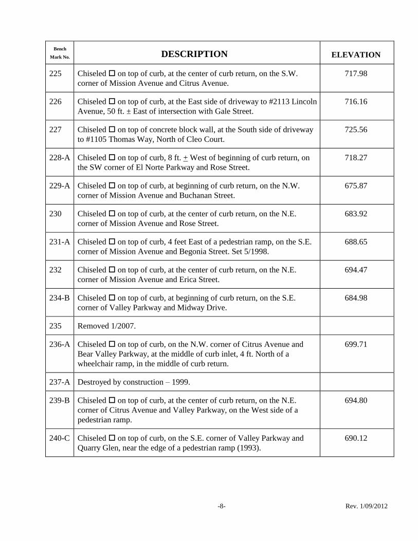
225 Chiseled on top of curb, at the center of curb return, on the S.W.
corner of Mission Avenue and Citrus Avenue.
717.98
226 Chiseled on top of curb, at the East side of driveway to #2113 Lincoln
Avenue, 50 ft. ± East of intersection with Gale Street.
716.16
227 Chiseled on top of concrete block wall, at the South side of driveway
to #1105 Thomas Way, North of Cleo Court.
725.56
228-A Chiseled on top of curb, 8 ft. + West of beginning of curb return, on
the SW corner of El Norte Parkway and Rose Street.
718.27
229-A Chiseled on top of curb, at beginning of curb return, on the N.W.
corner of Mission Avenue and Buchanan Street.
675.87
230 Chiseled on top of curb, at the center of curb return, on the N.E.
corner of Mission Avenue and Rose Street.
683.92
231-A Chiseled on top of curb, 4 feet East of a pedestrian ramp, on the S.E.
corner of Mission Avenue and Begonia Street. Set 5/1998.
688.65
232 Chiseled on top of curb, at the center of curb return, on the N.E.
corner of Mission Avenue and Erica Street.
694.47
234-B Chiseled on top of curb, at beginning of curb return, on the S.E.
corner of Valley Parkway and Midway Drive.
684.98
235 Removed 1/2007.
236-A Chiseled on top of curb, on the N.W. corner of Citrus Avenue and
Bear Valley Parkway, at the middle of curb inlet, 4 ft. North of a
wheelchair ramp, in the middle of curb return.
699.71
237-A Destroyed by construction – 1999.
239-B Chiseled on top of curb, at the center of curb return, on the N.E.
corner of Citrus Avenue and Valley Parkway, on the West side of a
pedestrian ramp.
694.80
240-C Chiseled on top of curb, on the S.E. corner of Valley Parkway and
Quarry Glen, near the edge of a pedestrian ramp (1993).
690.12

Bench
Mark No. DESCRIPTION ELEVATION
-9- Rev. 1/09/2012
241 Chiseled on top of curb, on the North side of Valley Parkway, 60 ft. ±
West of Westerly driveway exit to Post Office, in front of power pole
#1008180H.
680.23
242-B Chiseled on top of curb, at the East edge of a pedestrian ramp, on the
N.E. corner of Escondido Blvd. and El Norte Parkway. Set 8/2000.
678.36
245-A Chiseled on top of curb, on the South side of El Norte Parkway,
approximately 30 ft. West of the Center Line of Iris Lane, and 50 ft.
South of the Center Line of El Norte Parkway.
680.88
246 Destroyed by construction – 1998.
247 Destroyed by construction – 1998.
248 Destroyed by construction – 1997.
249 Destroyed by construction – 6/23/89.
251-B Destroyed by construction – 1998.
252-A Chiseled on top of curb, at the West side of driveway to residence #
670 Cathy Court, just West of Fig Street.
665.97
253 Chiseled on top of curb, at the center of curb return, on the S.E.
corner of Mission Avenue and Fig Street.
663.46
254-A Chiseled on top of curb, at the N.E. corner of Fig Street and
Washington Avenue, 27 ft. + East on Washington Avenue at the West
end of curb inlet.
657.98
255-A Chiseled on top of curb, at the center of an 11 ft. wide curb inlet, on
the N.E. corner of Washington Avenue and Hickory Street, at the
Easterly curb return. Set 9/2000.
655.23
257 Chiseled on top of curb, at the S.E. corner of Fig Street and Ohio
Avenue, approximately 8 ft. South of the Southerly curb return.
662.63
258-A Destroyed by Construction.
259-A Chiseled on top of curb, at the center of a 4ft. wide curb outlet, on the
Northerly side of Nutmeg Street, at the intersection with Turtle Dove
Lane. Set 11/2003.
784.49

Bench
Mark No. DESCRIPTION ELEVATION
-10- Rev. 1/09/2012
261-A Chiseled on top of curb, on the East side of Borden Road,
approximately 200 ft. South of the intersection with Seven Oaks Road,
15 ft. South of fire hydrant.
State Hwy. Rec. El
757.18
757.30
262-B Chiseled on top of curb, at a pedestrian ramp, on the N.E. corner of
Sundown Glen and Borden Road.
718.64
263-B Chiseled on top of curb, 1ft. North of curb return, on the N.E. corner
of Mission Avenue and Metcalf Street.
640.69
264-A Destroyed by construction.
265-A Chiseled on top of curb, at the North side of a pedestrian ramp, on
the N.W. corner of Simpson Way and Hale Avenue.
630.14
266-C Chiseled on top of curb, at the edge of a pedestrian ramp, on the N.E.
corner of Auto Park Way and Hale Avenue.
624.97
268-A Chiseled on top of curb, at the Easterly edge of a pedestrian ramp, on
the N.E. corner of 9th Avenue and Escondido Boulevard. Set 11/1999.
657.39
269-A Chiseled on top of curb, at the S.E. corner of 9th Avenue and Tulip
Street, on the East side of Tulip Street, at the South end of driveway to
Child Care Center, approximately 115 ft. South of the centerline of 9th
Avenue.
665.21
270-A Chiseled on top of curb, at the N.E. corner of 9th Avenue and Vine
Street, 18.5 ft. from end of curb, 19.0 ft. from fire hydrant, and 7.5 ft.
from P.P.# 820723H.
760.21
271 Removed-2007.
272 Destroyed by Construction.
273-A Chiseled on top of curb, on the N.W. corner of Valley Parkway and
9th Avenue, at the Westerly curb return. Set 6/1995.
624.87
274 Destroyed by Construction.
275 Removed 2007.
276 Removed 1/2007.

Bench
Mark No. DESCRIPTION ELEVATION
-11- Rev. 1/09/2012
277-A Chiseled on top of curb, at the Northerly curb return, on the N.W.
corner of 15th Avenue and Escondido Boulevard. Set 11/1999.
660.09
278 Destroyed by construction – 1999.
279-A Chiseled on top of curb, at the North edge of a pedestrian ramp, on
the S.W. corner of Felicita Avenue and Centre City Parkway. Set
11/1999.
657.69
280-B Chiseled on top of curb, at the center of a 6’ wide curb inlet, on the
N.W. corner of Felicita Avenue and Redwood Street. Set 1/2004.
669.87
281-A Chiseled on top of concrete pad for water valves, behind sidewalk, at
the N.W. corner of Felicita Road and Montview Dr.
667.96
282 Chiseled on concrete drainage structure, at the S.W. corner of Rohn
Road and Montview Drive.
676.81
283 Destroyed by construction.
284-B Chiseled on top of curb, at the edge of a pedestrian ramp, on the S.E.
corner of Felicita Road and Citracado Parkway. Set 6/2003.
630.98
285-A Railroad spike in power pole #412682, 1 foot up, on the North side of
Gamble Lane, at the West end of house at #1048 Gamble Lane.
654.24
286 Chiseled on concrete drainage structure, at the N.W. corner of
manhole, 20 ft. South of the centerline of Montview Dr. and 50 ft. East
of Vermont Avenue.
650.36
287 Chiseled on top of curb, at the center of curb return, at the N.W.
corner of 13th Avenue and Pine Street.
655.10
288 Chiseled on top of curb, at the center of curb return, on the S.W.
corner of Calvin Street and 13th Avenue.
701.14
289-A Chiseled on top of curb, at the N.E. corner of 5th Avenue and Quince
Street, at the North edge of a pedestrian ramp. Set 12/1995.
643.00
290 Destroyed by Construction 10/2009.
291-A Chiseled on top of curb, at the center of curb return, on the S.E.
corner of Grand Avenue and Maple Street, 3.5 ft. from edge of
wheelchair ramp.
651.36

Bench
Mark No. DESCRIPTION ELEVATION
-12- Rev. 1/09/2012
292-A Destroyed by Construction—2011.
293-A Chiseled on top of curb, at the edge of a wheelchair ramp, at the
center of curb return, on the N.W. corner of Valley Parkway and Tulip
Street.
656.65
294 Chiseled on top of curb, at the North end of curb return, on the N.W.
corner of 9th Avenue and Omar Drive.
724.54
295 Destroyed by Construction.
296-A Chiseled on top of curb, at the center of curb return, on the N.W.
corner of 9th Avenue and Hickory Street. Reset 12/2005.
718.16
297 Chiseled on top of curb, at the center of curb return, on the N.W.
corner of 9th Avenue and Chestnut Street.
719.84
298 Chiseled on top of curb, at the center of curb return, on the S.E.
corner of 13th Avenue and Broadway Place.
679.00
299-A Chiseled on top of curb, at the center of an 8' wide curb inlet, on the
East side of Juniper Street, at the prolonged centerline of 13th Avenue.
Set 5/2000.
676.41
300 Chiseled on top of curb, at the center of a drainage structure, on the
N.W. corner of 11th Avenue and Chestnut Street.
690.82
301 Chiseled on top of curb, at the center of a drainage structure, on the
N.W. corner of 10th Avenue and Chestnut Street.
702.07
302-A Chiseled on the S.W. corner of a concrete pad, 8 ft. x 14 ft., by flag
pole at Westminster Church, on the S.E. corner of Idaho Avenue and
Juniper Street.
689.68
303 Chiseled on the N.W. corner of a drainage structure, on the S.E.
corner of Escondido Boulevard and Brotherton Road.
615.60
304-A Chiseled on top of curb, on the East side of Escondido Boulevard,
90 ft. + North of the entrance to pump station #2, in front of a fire
hydrant (1993).
550.71
310-A Chiseled on top of curb, at the East end of curb return, on the N.E.
corner of Mary Lane and Bear Valley Parkway.
390.77

Bench
Mark No. DESCRIPTION ELEVATION
-13- Rev. 1/09/2012
311-A Chiseled on top of curb, at the West side of a wheelchair ramp, on
the N.W. corner of Begonia Street and Washington Avenue. Reset
11/16/76.
682.35
312-A Chiseled on top of curb, at the West side of a wheelchair ramp, on
the N.W. corner of Erica Street and Washington Avenue. Reset
11/16/76.
685.45
314 Destroyed by Construction.
315-A Chiseled on top of curb, at the center of a curb inlet, on the N.W.
corner of Nutmeg Street and Gary Lane, at the West end of curb return.
771.62
317-A Chiseled on top of curb, at edge of wheelchair ramp, on the S.W.
corner of Hamilton Lane and Bernardo Avenue.
642.10
318-A Chiseled on top of curb, on the N.E. corner of Cedar Street and
Valley Parkway, 14 ft. + from curb return.
666.16
319-B Chiseled on top of curb, at the edge of the driveway to Pump Station
#9 on Hamilton Lane, near the prolonged centerline of Orange Street.
679.42
320-A Destroyed by Construction-2003.
321 Destroyed by Construction-2003.
322 Destroyed by Construction-2006.
323 Chiseled on top of concrete drainage channel, on the North side, at
intersection of Glen Ridge Road and Mountain View Road,
approximately 50’ North of concrete curb and 20’ East of Street Light
post.
705.66
324 Chiseled on concrete pedestrian bridge over drainage channel, on the
West side of the most Easterly bridge, at center of bridge, on Glen
Ridge Road, Southwest of Citrus Avenue (entrance to Orange Glen
High).
716.06
325 Removed 1/2007.
327 Chiseled on top of curb, at the center of curb return, on the S.E.
corner of Rorex Road and Muriel Lane.
640.98

Bench
Mark No. DESCRIPTION ELEVATION
-14- Rev. 1/09/2012
328 Chiseled at the N.W. corner of a concrete driveway, on the S.E.
corner of Gamble Lane and Alexander Drive.
672.25
329-A Chiseled on top of curb, on the N.W. corner of Washington Avenue
and Escondido Boulevard, West of the curb return on Washington
Avenue.
651.89
330 Chiseled on top of curb, at the West end of curb return, on the N.W.
corner of Washington Avenue and Quince Street. Adjusted Elevation
1/2007.
644.37
331-A Chiseled on top of curb, at the West edge of a pedestrian ramp, on
the S.W. corner of Spruce Street and Washington Avenue. Set 1997.
642.98
332 Chiseled on top of Rock, on the S.W. corner of Idaho Avenue and
Robyn Road.
809.93
334 Chiseled on top of curb, at the center of curb return, on the N.W.
corner of 4th Avenue and Elm Street.
758.54
335 Chiseled on top of curb, at center of curb return, on the N.E. corner
of Sheridan Avenue and Tibidabo Way.
790.86
336-A Chiseled on top of curb, at the East edge of a pedestrian ramp, on the
N.E. corner of Alana Way and Sheridan Avenue. Set 3/2001.
872.70
337-A Chiseled on top of curb, 8 ft. West of edge of wheelchair ramp, on
the S.W. corner of Vista Verde Way and Normandy Glen.
784.91
340-A Chiseled on top of curb, on the S.E. corner of Rees Road and El
Norte Parkway, at the east end of curb return, in front of fire hydrant.
698.88
341-A Chiseled on top of curb, on the Southwest corner of Via Rancho
Parkway and Lomas Serenas Drive, at beginning of curb return.
390.24
343-B Chiseled on top of concrete headwall, at middle of headwall for 36"
R.C.P. at South end of Kit Carson Park, 10 ft. West of 8-ft.-high x
15-ft.-wide underground storm drain box and 40 ft. North of asphalt
pedestrian path on North side of North County Fair Road.
347.68
345-B Chiseled on top of curb, at the N.E. corner of Rock Springs Road and
Lincoln Avenue, in front of power pole #313883.
677.99

Bench
Mark No. DESCRIPTION ELEVATION
-15- Rev. 1/09/2012
346-A Chiseled on top of curb, at the middle of curb return, at the N.E.
corner of Borden Road and Rock Springs Road, in front of power pole
#10810.
669.35
347-A Chiseled on top of curb at the middle of a storm drain inlet, on the
east side of Borden Road, across street from house #1301 Borden Road.
684.23
348 Chiseled on top of curb, at center of curb return, on the N.W. corner
of Avenida Del Diablo and Vermel Avenue.
643.30
349 Chiseled on top of curb, at the center of curb return, on the S.W.
corner of Vermel Avenue and Fleetwood Street.
651.10
350-C Chiseled on top of curb, at the beginning of curb return, on the S.W.
corner of Las Palmas Avenue and Bear Valley Parkway.
426.74
351-B Chiseled on top of concrete inlet, on the S.W. corner of Las Palmas
Avenue and entrance to Kit Carson Park, 50 ft.(+) east of Wooden
Bridge.
428.43
352 Chiseled on top of curb, at center of curb return, on the N.E. corner
of Alexander Drive and Howe Place.
652.52
353-A Chiseled on top of curb, on the S.E. corner of Rose Street and
Granger Avenue, at the Southerly beginning of curb return. (1994)
775.06
354 Chiseled on top of curb inlet, on the east side of Vermel Avenue in
front of house #2038.
663.46
355-B Chiseled on top of curb, at the edge of a pedestrian ramp, on the N.E.
corner of Valley Parkway and Esc. Blvd. Set 6/2005.
646.79
356 Destroyed by construction – 1999.
357-A Chiseled on top of curb, 20 ft (±) West of the Grand Avenue
entrance to hospital parking structure.
682.86
358 Chiseled on top of curb, in front of metal light pole No. 403A, on the
North side Valley Parkway, near the Intersection with Falconer Dr.,
37 ft. West of telephone pole No. 3506.
710.33
359-B Chiseled on top of curb, on the North side of 9th
Avenue, 16.5’ East
of the prolonged centerline of Hale Avenue Set 4/2003.
625.14

Bench
Mark No. DESCRIPTION ELEVATION
-16- Rev. 1/09/2012
360-A Chiseled on top of curb, on the S.E. corner of Orange Street and
Valley Parkway at the Southerly beginning of curb return.
645.12
361-A Chiseled on top of curb, at the S.E. corner of Park Avenue and
Broadway, 5 ft. North of the Southerly beginning of curb return. Set
11/1995.
655.58
362-A Chiseled on top of curb, at the center of an 8 foot long curb inlet, on
the S.E. corner of Orange Street and Fourth Avenue. Revised 8/1996.
646.09
363-A Disturbed.
364 Disturbed.
365 Removed 1/2007.
366-A Chiseled on top of curb, at the end of a block wall, on the Northwest
side of Valley Parkway, across the street from driveway to house #2050
West Valley Parkway.
668.13
370 Removed 1/2007.
371 Destroyed by Construction.
372 Removed 2007.
373 Destroyed by Construction.
374-A Chiseled on top of curb inlet, on the East side of Citracado Parkway,
midway between Avenida Del Diablo and Valley Parkway (1994).
664.98
375 Chiseled on top of curb, at the N.E. corner of Woodward Avenue
and Escondido Boulevard, at the Easterly beginning of curb return.
647.22
376-A Chiseled on top of curb, on the S.W. corner of Woodward Avenue
and Broadway, at the Westerly end of curve.
653.75
377-A Removed 1/2007.
379 Chiseled on top of concrete drainage channel wall, on the West side
of channel, 300 ft.+ North of the junction of the two channels, South of
Autopark Way, at Sta. 3+20 (Flood Control Channel Stationing) at
angle pt. on top of channel wall.
623.29

Bench
Mark No. DESCRIPTION ELEVATION
-17- Rev. 1/09/2012
381-A Chiseled on top of curb, at the beginning of curb return, on the N.E.
corner of Via Rancho Parkway and entrance to Mall shopping center,
across from off-ramp to I-15 freeway.
358.11
382 Removed 1/2007.
383-A Chiseled on top of curb, at the edge of a wheelchair ramp, on the
S.E. corner of Citrus Avenue and Glenridge Road.
727.14
384 Destroyed by Construction.
385 Chiseled on top of curb, at the intersection of Moody Drive and Reed
Road, on the North side of Reed Road, approximately 30 ft. West of the
centerline of Moody Drive, in front of light pole, and 3 ft. West of a fire
hydrant.
735.01
386-B Chiseled on top of curb, at the middle of curb return, on the N.E.
corner of Moody Drive and Glenridge Road. Reset 4/2001.
764.86
387 Chiseled on the West side of a 5' x 5' concrete base for a granite
memorial stone, approximately 120 ft. North of concrete "Snake"
Sculpture and approximately 80 ft. South of a 3 ft. high stone waterfall.
397.60
388 Destroyed by Construction.
389 Chiseled on top of curb, at the middle of curb return, on the N.E.
corner of Stanley Avenue and Hoover Street.
688.17
390 Chiseled on top of curb, at the South end of curb, on the East side of
Midway Drive, at the South side of Flood Control Channel.
691.38
391 Chiseled on top of curb, at the middle of curb return, on the S.E.
corner of Siggson Court and Grape Street.
671.75
392-A Chiseled on top of curb, at the West edge of a pedestrian ramp, on
the S.W. corner of Village Road and Woodglen Place. Set 6/2000.
770.94
393 Chiseled on top of concrete flood control channel wall, at the S.E.
corner of intersection of Ash Street and Flood Control Channel.
672.22
395 Chiseled on top of depressed curb, at the middle of wheelchair ramp,
at middle of curb return, on the N.W. corner of Reed Road and Falconer
Road, 7 ft. S.W. of fire hydrant.
744.50

Bench
Mark No. DESCRIPTION ELEVATION
-18- Rev. 1/09/2012
396 Chiseled on top of curb, 3 ft. East of driveway to house #2517
Heather Place.
712.42
397 Chiseled on top of curb, at the middle of curb return, on the S.E.
corner of 2nd Avenue and Hickory Street.
729.39
398 Chiseled on top of curb, at the middle of return, on the South side of
alley at Grape Street, between 3rd Avenue and 4th Avenue, on the East
side of Grape Street.
721.13
399 Destroyed by construction.
400 Destroyed by construction.
400-A Chiseled on top of curb, at the N.E. corner of Tulip Street and
Railroad Avenue, at the Easterly beginning of curb return. Set 1/1999.
634.68
401 Chiseled on top of concrete flood channel wall, at "V" intersection of
Flood Control Channels for Reidy Creek and Escondido Creek,
approximately 95 ft. West of the center line of Santa Fe Railroad,
Northeasterly of Tulip Street.
639.26
402 Destroyed by Construction--2011.
403 Chiseled on top of concrete flood control channel wall, on South side
of channel, 170 ft. ± West of the prolonged centerline of Windsor Place.
623.07
404 Chiseled on top of curb, at the N.W. corner of Harding Street and
Washington Avenue, at the South side of a wheelchair ramp.
671.51
405 Chiseled on top of curb, at the N.W. corner of Mills Street and
Washington Avenue, at the South side of a wheelchair ramp.
674.65
406-A Chiseled on top of curb, at the West edge of a pedestrian ramp, on
the N.W. corner of Washington Avenue and Maywood Street. Set
5/1998
690.65
407-A Chiseled on top of curb at the South edge of a pedestrian ramp on the
N.W. corner of Washington Avenue and Carlann Lane. Set 5/1998.
694.15
408 Chiseled on top of drainage inlet, on the West side of Falconer Road,
approximately 600 ft. North of Reed Road.
735.12

Bench
Mark No. DESCRIPTION ELEVATION
-19- Rev. 1/09/2012
409-A Chiseled on top of curb, at the edge of a pedestrian ramp, on the
S.W. corner of 9th Avenue and Spruce Street. Set 3/2002.
658.44
410 Destroyed.
411-A Chiseled on top of curb inlet, on the West side of Sierra Linda Drive,
approximately 115 ft. South of the centerline intersection of San
Pasqual Road and Sierra Linda Drive.
442.97
414 Chiseled on the N.W. corner of a concrete base for SDG&E
electrical control box, 3'x3.5'x2' high, #32806-D-75730, on the North
side of Sierra Linda Drive, approximately 135 ft. from a concrete light
pole at the intersection of Sierra Linda Drive and Sierra Linda Drive
(Loop Roadway).
604.32
415 Destroyed by Construction.
416 Chiseled on the N.E. corner of 5'x7' ft. concrete Telephone Co. vault,
on the West side of Sierra Linda Drive, 40 ft. ± North of driveway to
house #3915 Sierra Linda Drive.
570.95
418 Chiseled on top of curb, at the S. W. corner of Falconer Road and
Oak Hill Drive, at the West end of curb return, 3 ft. east of fire hydrant
and 7 ft. east of power pole #314397.
762.12
419 Chiseled on top of curb, at the S.E. corner of Hayden Drive and Oak
Hill Drive , at the middle of curb return, at the East side of wheelchair
ramp.
724.52
420-A Chiseled on top of curb, at the North edge of a pedestrian ramp, on
the N.W. corner of Hayden Drive and Algiers Avenue. Reset 4/2001
719.87
421-B Chiseled on top of curb, on the South side of Oak Hill Dr., 50 ft.
West of centerline of Citrus Avenue Set 11/2004.
743.60
422 Chiseled on top of curb, at the N.W. corner of Reed Road and Citrus
Avenue, at the East end of driveway to house #831 Citrus Avenue.
742.74
423 Removed 1/2007.
424 Chiseled top of curb, at the West side of a wheelchair ramp, on the
S.W. curb return of Sierra Linda Dr. and Valle Grande.
493.63

Bench
Mark No. DESCRIPTION ELEVATION
-20- Rev. 1/09/2012
425 Chiseled on top of curb, at the top of a wheelchair ramp, on the S.E.
corner of Sierra Linda Drive and Vista Bonita.
504.07
426 Chiseled on the S.W. corner of an SDG&E transformer box,
#3278D75792, on the North side of Sierra Linda Drive, (South part of
loop) approximately 10 ft. from edge of pavement.
546.41
428 Destroyed by construction.
429-A Chiseled on top of curb, on the S.E. corner of Rock Springs Road
and Corral Glen, on curb inlet 5 ft. East of beginning of curb return.
669.69
430 Chiseled on top of curb, on the N.W. corner of Citracado Parkway
(Gamble) and Miller Avenue, 38 ft. West of the centerline of Miller
Avenue and 41 ft. North of the centerline of Citracado Parkway, and 1
ft. from the end of curb.
644.00
431 Destroyed by Construction
432 Destroyed by construction.
433 2" iron ring in concrete driveway, at the center of driveway, at house
#540 S. Upas Street, approximately 25 ft. from the centerline of Upas
Street.
772.72
434-A Destroyed by Construction -12/2009
435 Chiseled on top of curb, on the West side of the Westerly driveway
to business #1301 Simpson Way.
631.12
436 Chiseled on top of curb, at the N.E. corner of Andreasen Drive and
Industrial Avenue, at the east end of curb return.
629.58
437 Chiseled on top of curb, at the middle of a wheelchair ramp, on the
N.E. corner of Andreasen Drive and Vineyard Avenue.
662.26
439 Removed 2007.
440 Chiseled top of curb, at middle of curb inlet, on the S.W. corner of
11th Avenue and Tulip Street.
658.54
441 Destroyed by Construction-2006.

Bench
Mark No. DESCRIPTION ELEVATION
-21- Rev. 1/09/2012
442 Chiseled at the N.W. corner of a concrete walk, in front of entrance
to Salvation Army church at the S.E. corner of 11th Avenue and
Redwood Street.
657.25
443 Chiseled on top of curb, on east side of intersection of 11th Avenue
and Pine Street, on the approximate prolonged centerline of 11th
Ave,
2.5 ft. South of a sewer manhole.
652.87
444-A Drive pin in top of curb, at the West end of curb return, on the
Northwest corner of Wanek Road and Pickett Glen.
696.34
445-A Chiseled on top of curb, near the east edge of a pedestrian ramp, on
the N.E. corner of Wanek Road and Myrtlewood Court. Set 5/200.
699.51
446 Chiseled on top of curb, in front of streetlight, approximately 200 ft.
West of an Angel Point in Wanek Road, approximately 1100 ft. North
of Valley Parkway.
706.27
447 Destroyed by Construction.
449-A Chiseled on top of curb, at the North edge of a pedestrian ramp, on
the N.W. corner of Escondido Blvd. and Decatur Way. Set 8/2000.
666.62
450-A Chiseled on top of curb, at the N.E. corner of Lincoln Avenue and
Morning View Drive, at the North end of a pedestrian ramp at the
middle of curb return.
669.34
452 Chiseled on top of curb, on the N.E. corner of Encino Drive and El
Dorado Drive, at the middle of curb return.
654.00
453-A Destroyed by construction – 2010.
454 Destroyed by construction – 1997.
455 Destroyed by Construction – 2008.
457 Chiseled on top of curb, at the east side of a wheelchair ramp, on the
S.E. corner of Russell Place and 15th Avenue.
680.78
458 Chiseled on top of curb, at the center of curb return, on the N.E.
corner of Tulip Street and 15th Avenue.
668.51
459-A Destroyed by Construction.

Bench
Mark No. DESCRIPTION ELEVATION
-22- Rev. 1/09/2012
460-A Chiseled on top of curb, at Easterly beginning of curb return, on the
N.E. corner of El Norte Parkway and Nordahl Road.
768.27
461 Chiseled on top of curb, at North side of driveway to house # 1162
Avocado Avenue.
755.28
462-A Destroyed by Construction.
466 Chiseled on top of curb, at middle of curb return, on the N.W. corner
of Broadway and Alley between 7th and 8th Avenues.
704.45
467 Chiseled on top of Easterly end of curb return, on the N.E. corner of
Broadway and Khayyam Road.
761.93
468-A Removed 1/2007.
469 Destroyed.
470-A Chiseled on top of curb, on the N.E. corner of La Varona Place and
South Escondido Boulevard, near the edge of a pedestrian ramp. Set
1994.
465.01
471-B Chiseled on top of curb, on the N.W. corner of 2nd Avenue and
Kalmia Street, ± 2.3 ft. from the edge of a wheelchair ramp.
652.54
472-A Chiseled on top of curb, at the east edge of a pedestrian ramp, on the
S.W. corner of Broadway and Lincoln Parkway. Set 11/1998.
658.17
473 Chiseled on top of curb, on the N.E. corner of the Flood Control
Channel bridge at Harmony Grove Road.
621.88
474 Chiseled on top curb, on the South side of a driveway to house #
1120 Hale Avenue, approximately 50 ft. North of the centerline of
Harmony Grove Road and 20 ft. east of the centerline of Hale Avenue.
627.52
476 Chiseled on top of curb, at the center of curb return, on the S.W.
corner of Redwood Street and 15th Avenue, at the Northerly side of
wheelchair ramp.
670.51
477-A Chiseled on top of curb, at the South edge of a pedestrian ramp, on
the S.E. corner of 3rd Avenue and Cedar Street. Set 1/2001.
692.93

Bench
Mark No. DESCRIPTION ELEVATION
-23- Rev. 1/09/2012
478-A Chiseled on top of curb, at the Southerly edge of a pedestrian ramp,
on the S.E. corner of 11th Avenue and Escondido Boulevard. Set
11/1999.
658.50
479-A Chiseled on top of curb, at the South edge of a pedestrian ramp, on
the S.E. corner of 11th Avenue & Orange Street. Set 8/2001.
655.32
480 Chiseled on top of curb, at the east end of driveway on Elmwood
Drive, for residence # 689 Ash Street.
671.22
482 Lead and tack inside of a Chiseled on top of curb, at the east end of
curb return, on the S.E. corner of Rincon Avenue and Broadway.
729.08
483 Chiseled on top of curb, at the center of curb inlet, on the East side
of Broadway Street, across from the intersection with Village Road.
712.36
484-A Chiseled on top of curb, at the edge of a pedestrian ramp, on the S.E.
corner of Broadway Street and Merion Glen. Set 5/2002.
750.63
485-A Chiseled on top of curb inlet, on the S.E. corner of Grand Avenue
and Broadway Street, at the easterly beginning of curb return.
653.87
486 Chiseled on top of curb, on the S.W. corner of Palsero Avenue and
Casero Place, at the West end of a pedestrian ramp.
691.07
487-A Chiseled on top of a concrete drainage structure flush with ground, at
the entrance to the Bear Valley power plant, approximately 285 ft. West
of Lake Wohlford Road.
976.00
488 Top of a 1-3/4" diameter iron post, on top of a 2 ft. high concrete block
wall, at the end of wall, on the S.W. corner of Barham Drive and
Meyers Avenue.
687.21
489 Destroyed by Construction-2006.
490 Chiseled on top of curb, at the S.E. corner of Barham Drive and
Opper Street, at the middle of curb return, at the North side of a
wheelchair ramp.
686.73
491 Chiseled on top of curb, at the end of Martin Drive cul-de-sac,
approximately 600 ft., South of Lincoln Avenue, on top of curb inlet.
664.91
492-B Chiseled on top of curb, on North side of Oak Hill Drive, at
prolonged centerline of Boyle Avenue. Set 5/2000.
734.10

Bench
Mark No. DESCRIPTION ELEVATION
-24- Rev. 1/09/2012
493 Chiseled on top curb, on the S.W. curb return, approximately 50 ft.+
east of the intersection of Boyle Avenue and Loma De Paz, across the
street from address #842 Boyle Avenue.
773.72
494 Chiseled on top of curb, in front of fire hydrant at address #1414
Boyle Avenue, approximately 50'-75' east of the intersection of Boyle
Avenue and Destree Road, on the North side of street.
802.44
495 Chiseled on top of curb, in front of streetlight at address #1602 Boyle
Avenue, on North side of street, approximately 200 ft. east of Paul
Way.
776.95
496 Chiseled on top curb, at the beginning of curb return, on the N.W.
corner of Boyle Avenue and Boyle Place, in front of streetlight.
754.20
497 Chiseled on top of curb, at the middle of curb return, on the N.W.
corner of Boyle Avenue and Bear Valley Parkway.
725.83
498 Railroad spike in South side of power pole #119303, at the N.W. corner
of Gamble Lane and Orange Avenue, approximately 50 ft. North of the
centerline Gamble Lane.
703.69
499 Chiseled on the West side of a concrete driveway, 15 ft. Northerly of
the South end of the driveway to residence #1660 Gamble Lane, at top
of hill.
822.94
500 Destroyed by Construction - 2007.
501 Chiseled on top of curb, at middle of curb return, on the S.W. corner
of Avenida Del Diablo and Valley Parkway.
666.82
502 Bolt in Telephone Pole # 662944H, approximately 2 ft. above ground,
at the N.W. corner of Miller Avenue and Hamilton Lane.
627.30
503 Chiseled on the N.W. corner of a concrete headwall, at the S.E.
corner of Hamilton Lane and Felicita Avenue.
616.02
504 Boat spike in the West side of power pole #P316431, on the East side
of La Honda Drive, approximately 20 ft. East of the centerline of La
Honda Drive, and approximately 700 ft. North of El Norte Parkway.
743.86
505-A Chiseled on top of Northerly corner of curb inlet, in front of address
# 1426 La Honda Drive.
752.17

Bench
Mark No. DESCRIPTION ELEVATION
-25- Rev. 1/09/2012
506 Chiseled on the S.E. corner of an SDG&E utility vault, on the N.W.
corner of Ash Street and Sheridan Avenue.
734.71
507 Chiseled on top of curb, 5.0 ft. from the end of curb, in front of a
streetlight pole at address #1741 N. Ash Street, on the West side of
street, approximately 75 ft. South of the intersection of Ash Street and
Hubbard Avenue.
831.35
508 Chiseled on the N.W. corner of a concrete utility pad, on the S.E.
corner of N. Ash Street and Vista Avenue, approximately 50 ft. South
of the centerline of Vista Avenue.
769.10
509 Chiseled on top of curb, at the center of a curb inlet, on the South
side of Vista Avenue, at intersection of Lehner Avenue and Vista
Avenue.
722.18
510-A Chiseled on top of curb, at beginning of curb return, on the S.E.
corner of Dublin Lane and La Honda Drive.
804.47
511 Chiseled on the N.W. corner of a 2.5 ft. square concrete base for a
waterline blow off valve, on the East side of La Honda Drive,
approximately 80 ft. South of the Southerly driveway to a 2-story white
house at address #1633 La Honda Drive.
883.31
513-A Chiseled on top of curb, at the North edge of a pedestrian ramp, on
the N.E. corner of Escondido Boulevard and Lincoln Avenue. Set
8/2000.
658.44
514-A Chiseled on top of curb, at the center of an 8 ft. wide curb inlet, on
the N.W. corner of Gary Lane and David Drive. Set 6/2000.
730.45
515 Chiseled on top of curb, at the Northerly end of a curb inlet, on the
East side of David Drive, in front of residence # 1910 David Drive.
752.79
516 Chiseled on top of curb, at the beginning of curb return, on the S.W.
corner of David Drive and Golden Circle Drive.
789.73
519 Destroyed by construction – 1997.
520 Destroyed by construction.
521 Removed 2007.

Bench
Mark No. DESCRIPTION ELEVATION
-26- Rev. 1/09/2012
522 County Benchmark #ES-355
Bronze disk in 6" diameter concrete Monument, 30 ft. South of the
centerline of Via Rancho Parkway, approximately 100 ft. West of Via
Hermosa, and 20 ft. West of power pole #510376.
578.36
523 Destroyed by construction – 1997.
524 Bolt in West side of power pole #P112342, 2 ft. above ground, at the
S.E. corner of 5th Avenue and Upas Street, at address # 520 South Upas
Street.
756.54
526 Lead and tack in top of curb, on a curb inlet, at the end of the cul-de-sac
opposite residence # 2508 Meadow Lark Lane.
706.55
527 Chiseled on top of a 6 ft. wide concrete headwall, approximately 25
ft. east of the centerline of Bear Valley Parkway, and 50 ft. North of
Maye Place, in front of residence #1541 Bear Valley Parkway.
695.49
528-A Chiseled on top of curb, at the South edge of a pedestrian ramp, on
the S.E. corner of Washington Avenue and Citrus Avenue. Set 5/1998.
698.51
529 Destroyed by Construction.
530 Chiseled on top of curb, at the South end of curb, on the East side of
Valley Center Road, 150 ft. North of the intersection of Lake Wohlford
Road and Valley Center Road.
737.52
531 Destroyed by Construction -2010.
532 Destroyed by Construction -2010.
533 Destroyed by construction – 1998.
535-A Chiseled on top of curb inlet, at middle of curb return, on the S.E.
corner of Fig Street and Valley Parkway.
660.49
536 Destroyed by Construction-2006.
537 Chiseled on top of granite rock, 6'x3'x2' high, on the West side of
Lake Wohlford Road, at the intersection with Lake Wohlford Court,
approximately 15 ft. West of the centerline stripe in road, on the South
side of a rock drainage swale. (Elevation Adjusted 11/2004).
830.49

Bench
Mark No. DESCRIPTION ELEVATION
-27- Rev. 1/09/2012
538 Chiseled on top of a 42" diameter concrete inlet structure, in median
area of Centre City Parkway, approximately 500 ft. South of Country
Club Lane, and 7 ft. West of the edge of pavement of the Northbound
lanes of centre City Parkway.
765.40
540 Chiseled on the S.W. corner of a curb inlet, at the Northwest corner
of Centre City Parkway and Iris Lane, on the east side of the frontage
road, approximately 50 ft. North of the centerline of Iris Lane.
734.20
541 Chiseled on top of the South side of a concrete drainage channel
wall, at the center of wall, in the median area of Centre City Parkway,
approximately 0.5 mile North of the intersection of El Norte Parkway
and Centre City Parkway.
687.05
542 Chiseled on the East side of an 18‖ square concrete base for a
flashing signal warning sign, on the West side of Centre City Parkway,
approximately 0.2 mile North of El Norte Parkway.
681.87
543-A Chiseled on the S.W. corner of a concrete pad for a waterline blow-
off valve, across the street from address # 430 S. Citracado Parkway.
764.86
544-A Chiseled on top of curb, at the beginning of curb return, on the N.W.
corner of Progress Place and Country Club Lane.
714.59
545-A Chiseled on top of curb, on the S.W. corner of Center City Parkway
and 5th Avenue, at the Southerly beginning of curb return. Set 1993.
647.56
546 P.K. nail in top of 1 ft. high retaining wall around SDG&E vault, at the
N.W. corner of vault, in front of residence #1832 S. Citrus Avenue.
644.99
547 Chiseled on top of curb, at middle of curb return, on the N.E. corner
of Idaho Avenue and Citrus Hills.
679.76
548 Chiseled on top of curb, at middle of curb return, on the N.E. corner
of Birch Avenue and Via De La Cuesta.
710.67
549 Chiseled on the S.W. corner of a 3.5'x4.0' concrete base for fire
hydrant, in front of residence #1518 S. Citrus Avenue.
713.44
550 Chiseled on the S.W. corner of a 3.5'x4.0' concrete base for fire
hydrant, on the S.W. corner of Citrus Avenue and Mountain View
Drive.
730.74

Bench
Mark No. DESCRIPTION ELEVATION
-28- Rev. 1/09/2012
551 Chiseled on top of a concrete headwall at the S.W. corner of El
Dorado Drive and Bear Valley Parkway.
630.49
552 Deleted 1/2007.
554 Chiseled on top of curb, on the N.E. corner of Centre City Parkway
and 2nd Avenue (1984).
646.37
556 Chiseled on top of curb, at middle of curb return, on the S.W. corner
of Juniper Street and Helen Way.
685.55
557 Chiseled at the east end of a 4 ft. wide concrete sidewalk, in front of
residence # 2171 Juniper Street, at the N.W. corner of Juniper Street
and Sunset Drive, approximately 35 ft. West of the center line of
Juniper Street.
641.99
558 Chiseled on top of curb, at the West end of curb return, on the N.W.
corner of Sunset drive and Ginny Lane.
671.19
561 Chiseled on top of North end of headwall, at the S.W. corner of
Sunset Drive and Bear Valley Parkway.
514.23
562 Removed 1/2007.
563 Chiseled on top of curb, on the S.W. corner of Quince Street and
Valley Parkway, at the east side of a pedestrian ramp.
642.48
564 Destroyed by Construction.
566 Chiseled on the N.W. corner of a curb inlet, on the North side of Via
Rancho Parkway, approximately 300 ft. South of Beethoven Drive, on
parking lot level.
340.79
567-B Chiseled on top of curb, West of a pedestrian ramp, on the
Southwest corner of Bear Valley Parkway and San Pasqual Valley Road
(Rte.78).
625.96
568 Chiseled on the N.W. corner of a 2' x 2' concrete base for concrete
streetlight, at the Southeast corner of Brotherton Road and Felicita
Avenue.
645.86
569 Chiseled on top of curb, at the S.W. corner of Valley Parkway and
Auto Park Way, at the east end of a pedestrian ramp.
627.58

Bench
Mark No. DESCRIPTION ELEVATION
-29- Rev. 1/09/2012
570 Chiseled on top of curb, at the S.E. corner of Alamo Lane and Bear
Valley Parkway, at the South end of a curb return.
397.60
571 Chiseled on top of curb, 4.5 ft. from the North end of curb return, at
the N.E. corner of Idaho Avenue and Citrus Glen.
716.21
572 Destroyed by construction.
573 Chiseled on top of curb, at middle of an 11 ft. wide curb inlet, on the
North side of Mission Road, at the East side of a driveway to bisiness at
#2010 West Mission Road.
680.88
574 Chiseled on top of curb, at middle of curb return, on the N.W. corner
of Rimrock Drive and El Norte Parkway.
737.05
575 Destroyed.
576 Chiseled on top of curb, at beginning of curb return, on the S.E.
corner of Nutmeg Street and Nutmeg Circle.
739.56
577 Chiseled on top of curb, at the Southeast end of Borden Road, in cul-
de-sac, 10 ft. Northeast of driveway opening.
775.25
578 Destroyed by construction.
579 Destroyed by construction – 1998.
580 Chiseled on top of curb, at middle of curb return, on the North side
of a pedestrian ramp, at the N.E. corner of Harding Street and Valley
Parkway.
671.33
581 Chiseled at the beginning of curb return, on top of curb, at the N.E.
corner of Vineyard Avenue and Vinewood Street.
670.53
582 Chiseled at the beginning of curb return, on top of curb, at the N.E.
corner of Market Place and Vineyard. Avenue.
677.00
583 Chiseled at the beginning of curb return, on top of curb, at the N.E.
corner of State Place and Vineyard Avenue.
660.58
585 Chiseled on top of curb, at the Easterly beginning of curb return, at
the Northeast corner of Enterprise Street and Vineyard Avenue.
684.37

Bench
Mark No. DESCRIPTION ELEVATION
-30- Rev. 1/09/2012
586-A Chiseled on top of curb, at the East edge of a driveway,
approximately 80 ft. east of the center of the driveway entrance to
SDG&E facility, on the North side of Vineyard Avenue.
710.90
587 Destroyed by Construction 2007.
588 Destroyed by Construction 2007.
589 Chiseled on top of curb, at the beginning of curb return, on the S.E.
corner of State Place and Simpson Way, in front of street light pole.
640.35
590 Chiseled on top of curb, at the beginning of curb return, on the S.W.
corner of Citracado Parkway and Mesa Grande Drive.
699.60
591 Chiseled on top of curb, approximately 50 ft. West of a light pole, on
the South side of Citracado Parkway, approximately 0.25 miles East of
Valley Parkway.
742.90
592 Chiseled on top of a 25 X 2
5 ft. square concrete pad for a fire
hydrant, at the back of sidewalk at middle of curb return, on the N.W.
corner of Miller Avenue and Brotherton Road.
646.81
593 Chiseled on top of curb, at the middle of curb return, on the N.E.
corner of 4th Avenue and Hickory Street.
749.93
596 Chiseled on top of curb, at the West end of curb return, on the
Southwest corner of Veronica Place and Washington Avenue.
713.47
597 Chiseled on top of curb, at the West end of a pedestrian ramp, on the
Southwest corner of Washington Avenue and Justin Way.
714.26
598 Chiseled on top of curb, at the South end of curb return, on the
Southeast corner of Oak Hill Drive and San Pasqual Valley Road (Rte.
78).
702.95
599 Chiseled at the bottom of concrete steps to S.D.C.W.A. Aqueduct
Pump Station, at the N.E. corner of bottom slab, on the South side of
Vista Avenue, approximately 1400 ft. East of Ash Street, across from
the S.E. corner of Rincon Elementary School.
781.01
600 Chiseled "+" on the N.E. corner of a concrete drainage inlet, at the N.E.
corner of Lehner Avenue and Conway Drive, approximately 20 ft. East
of Conway Drive and 25 ft. North of Lehner Avenue.
766.80

Bench
Mark No. DESCRIPTION ELEVATION
-31- Rev. 1/09/2012
601 Chiseled on the North edge of the concrete collar of a manhole, at
the N.W. corner of Lehner Avenue and Ash Street, 23 ft. North of
Lehner Avenue and 45 ft. West of Ash Street.
729.73
602 Chiseled on top of curb, at the North end of the Lincoln School
property, on the West side of Broadway Street, approximately 400 ft.
North of Lincoln Avenue.
665.46
603-A Chiseled on top of curb, at the South curb return, on the Southwest
corner of Mission Avenue and Escondido Boulevard.
651.39
604-A Chiseled on top of curb, at the center of an 11 ft. wide curb inlet, on
the N.E. corner of Escondido Blvd. and Crest Street. Set 8/2000.
650.76
605 Railroad spike in power pole #319213, on the East side of pole, 2 ft.
above ground, located on Ross Lane, approximately 60 ft. South of the
centerline of Las Palmas Avenue.
612.50
606 Chiseled on top of curb, at the East end of curb return, on the
Northeast corner of 3rd Avenue and Broadway.
651.75
607 Chiseled on top of curb, at the West end of curb return, on the
Southwest corner of 2nd Avenue and Broadway.
650.76
608 Chiseled on top of curb, at the South side of a pedestrian ramp, on
the Southwest corner of 2nd Avenue and Maple Street.
651.40
609 Chiseled on top of curb, at the North side of a pedestrian ramp, on
the Southeast corner of 2nd Avenue and Escondido Boulevard.
645.97
610 Chiseled on top of curb, at the middle of curb return, on N.W. corner
of 7th Avenue and Pine Street.
647.78
611 Chiseled on top of curb, at the middle of a curb inlet, approximately
50 ft. East of the S.E. curb return, at the intersection of 9th Ave and
Centre City Parkway.
651.53
612 Chiseled on top of curb, at the Southerly beginning of curb return, on
the S.E. corner of Quince Street and 11th Avenue.
653.05
613-A Chiseled on top of curb, at the Westerly beginning of curb return, on
the S.W. corner of Valley Parkway and Juniper Street.
652.20
614 Destroyed by construction.

Bench
Mark No. DESCRIPTION ELEVATION
-32- Rev. 1/09/2012
616 Destroyed by construction – 1999.
617 Chiseled on top of curb, at the N.E. corner of Esperanza Way and
Conway Drive.
727.57
618 Chiseled on top of curb, at the beginning of curb return, on the
Westerly corner of Esperanza Way and Dolores Place.
741.75
619 Chiseled on top of curb, near wheelchair ramp, at the Southeasterly
corner of Esperanza Way and Creencia Place.
768.08
620 Chiseled on top curb, near the center of curb return, on the N.W.
corner of Conway Drive and Sheridan Avenue.
765.34
621 Chiseled on top curb, at the beginning of curb return, on the N.W.
corner of Aliso Place and Conway Drive.
790.59
622 Chiseled on top of curb, at the N.W. corner of Sheridan Ave and
Fallsview Place.
755.52
624 Chiseled on top of curb, at middle of curb return, on the S.W. corner
of Country Club Lane and N. Iris Lane.
726.44
625 Chiseled on top of curb, in front of a fire hydrant, on the S.W. corner
of Country Club Lane and Ranchwood Glen.
748.10
626 Chiseled on top of curb, at middle of curb return, on the Northwest
corner of Eastridge Lane and Blueridge Place.
771.67
627 Chiseled on top of curb, at beginning of curb return, on the
Northwest corner of Country Club and Village Road.
775.67
628 Chiseled on top of curb, at beginning of curb return, on the Southeast
corner of Village Road and Terraceview Place.
768.54
629 Chiseled on top of curb, 2 ft. from edge of a pedestrian ramp, on the
Southeast corner of Village Road and Country Place.
718.83
630 Chiseled on top of curb, at the East edge of a curb inlet, on the S.E.
corner of Via Rancho Parkway and Avenida Hacienda.
439.99
631 Destroyed by Construction.

Bench
Mark No. DESCRIPTION ELEVATION
-33- Rev. 1/09/2012
632 Chiseled on a concrete base of a storm drain grate, on Avenida
Sierra, across from Avenida Adobe, in front of address #3322 Avenida
Sierra.
437.06
633 Chiseled on a concrete apron, near gutter, at middle of curve, at the
Southwesterly corner of Avenida Hacienda and Calle De La Paz.
515.87
634 Destroyed by construction – 2001.
635 Chiseled on top of curb, 10 ft. from the Easterly beginning of curb
return, on the N.E. corner of Roseann Avenue and James Street.
734.92
636 Chiseled on top of curb, at the Easterly beginning of curb return, on
the S.E. corner of Roseann Avenue and Hypoint.
757.44
637 Chiseled on top of curb, in front of a water meter in sidewalk, at
address # 2936 Hypoint Avenue.
767.92
638 Chiseled on top of curb, at Northerly beginning of curb return, on the
N.W. corner of Roseann Avenue and Hypoint Avenue.
733.30
639 Chiseled on top of curb, at Easterly beginning of curb return, on the
N.E. corner of Hypoint Avenue and Falconer Road.
724.65
640 Chiseled on top of curb, 5 ft from the center of a pedestrian ramp, on
the S.E. corner of Rincon Avenue and Parktree Lane.
724.04
641 Chiseled on top of curb, at the Easterly beginning of curb return, on
the S.E. corner of Ash Street and Rincon Avenue.
727.34
642 Chiseled on top of curb, at the beginning of curb return, on the N.W.
corner of Conway Drive and Rincon Avenue.
742.17
643 Chiseled on top of curb, 5 ft. Southerly of the center of a pedestrian
ramp, on the S.E. corner of Conway Drive and Glenwood Way.
760.46
644 Chiseled on top of curb, 5 ft. Southerly of the center of a pedestrian
ramp, on the S.W. corner of Conway Drive and Cleveland Avenue.
760.64
645 Chiseled on top of curb inlet, at the Westerly end of Cleveland
Avenue, West of Conway Street.
751.23
646 Chiseled on top of curb, approximately 25 ft. from end of curb, at the
Easterly end of Cleveland Avenue, on the South side of street.
774.06

Bench
Mark No. DESCRIPTION ELEVATION
-34- Rev. 1/09/2012
647 Chiseled on top of curb, 5 ft. from the center of a pedestrian ramp,
on the S.W. corner of Rincon Avenue and Stone Valley Place.
747.10
648 Chiseled on top of curb, 5 ft. from the center of a pedestrian ramp,
on the S.E. corner of Rincon Avenue and Creek Hollow Place.
752.74
649 Chiseled on top of curb, at the Northerly beginning of curb return, on
the N.W. corner of Ash Street and Pleasantwood Lane.
724.37
650 Chiseled on top of curb, in front of street litepole, on the West side
of Ash Street, approximately 200 ft. North of Collins Terrace.
742.80
651-A Chiseled on top of curb, at Southerly beginning of curb return, at the
S.E. corner of Broadway and North Avenue. Set 7/2002.
760.23
652-A Chiseled on top of curb, at the Easterly beginning of curb return, on
the S.E. corner of Oaktree Place and Washington Avenue. Set 3/1996.
712.24
653 Destroyed by Construction.
654 Destroyed by Construction.
655-A Chiseled on top of curb, near the Westerly beginning of curb return,
on the N.W. corner of Greenway Rise and El Norte Parkway. Reset
10/2004.
737.18
656 Chiseled on top of curb, at the Westerly beginning of curb return, on
the N.W. corner of Vista Verde Way and El Norte Parkway.
744.23
657 Chiseled on top of curb, ± 21 ft. from end of curb, on the East side of
Ash Street, approximately 150 ft. North of the intersection of Ash Street
and Madison Street.
787.06
658 Chiseled on top of curb inlet, at Angle point in curb, on the N.W.
corner of Elm Street and Sheridan Avenue.
734.83
659 Chiseled on top of curb, near the edge of a pedestrian ramp, on the
S.W. corner of Sheridan Avenue and Fig Street.
741.22
660 Chiseled on top of curb, at the beginning of curb return, on the S.W.
corner of Sheridan Avenue and Archwood Place.
799.70
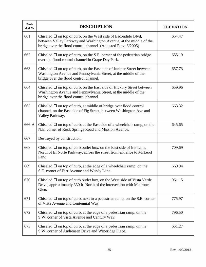
Bench
Mark No. DESCRIPTION ELEVATION
-35- Rev. 1/09/2012
661 Chiseled on top of curb, on the West side of Escondido Blvd,
between Valley Parkway and Washington Avenue, at the middle of the
bridge over the flood control channel. (Adjusted Elev. 6/2005).
654.47
662 Chiseled on top of curb, on the S.E. corner of the pedestrian bridge
over the flood control channel in Grape Day Park.
655.19
663 Chiseled on top of curb, on the East side of Juniper Street between
Washington Avenue and Pennsylvania Street, at the middle of the
bridge over the flood control channel.
657.73
664 Chiseled on top of curb, on the East side of Hickory Street between
Washington Avenue and Pennsylvania Street, at the middle of the
bridge over the flood control channel.
659.96
665 Chiseled on top of curb, at middle of bridge over flood control
channel, on the East side of Fig Street, between Washington Ave and
Valley Parkway.
663.32
666-A Chiseled on top of curb, at the East side of a wheelchair ramp, on the
N.E. corner of Rock Springs Road and Mission Avenue.
645.65
667 Destroyed by construction.
668 Chiseled on top of curb outlet box, on the East side of Iris Lane,
North of El Norte Parkway, across the street from entrance to McLeod
Park.
709.69
669 Chiseled on top of curb, at the edge of a wheelchair ramp, on the
S.E. corner of Farr Avenue and Wendy Lane.
669.94
670 Chiseled on top of curb outlet box, on the West side of Vista Verde
Drive, approximately 330 ft. North of the intersection with Madrone
Glen.
961.15
671 Chiseled on top of curb, next to a pedestrian ramp, on the S.E. corner
of Vista Avenue and Centennial Way.
775.97
672 Chiseled on top of curb, at the edge of a pedestrian ramp, on the
S.W. corner of Vista Avenue and Century Way.
796.50
673 Chiseled on top of curb, at the edge of a pedestrian ramp, on the
S.W. corner of Andreasen Drive and Wineridge Place.
651.27

Bench
Mark No. DESCRIPTION ELEVATION
-36- Rev. 1/09/2012
674 Chiseled on top of curb, at the Northerly curb return, on the N.E.
corner of Andreasen Drive and Enterprise Street.
636.42
675 Chiseled on top of curb, at the crest of hill on the North side of El
Norte Parkway, across from Wisteria Glen entrance to mobilehome
park, 25 ft. ± East of an alley at the subdivision boundary.
741.20
676 Chiseled on top of curb, on the N.E. corner of El Norte Parkway and
Las Palmas Lane, 2 feet from the edge of a wheelchair ramp.
719.37
677 Chiseled on top of curb, at the Westerly beginning of curb return, on
the N.W. corner of Mountain View Road and Mountain Park Place.
784.21
678 Destroyed by construction.
679 Chiseled on top of curb outlet box, on the East side of Seven Oaks
Road, approximately 250 feet South of the intersection of Seven Oaks
Road and Homestead Place.
717.48
680 Chiseled on top of curb outlet box, on the East side of Seven Oaks
Road, approximately 200 feet North of the intersection of Seven Oaks
Road and Sugarloaf Drive.
718.85
681 Chiseled on top of curb, at the edge of a pedestrian ramp, on the N.E.
corner of Seven Oaks Road and Borden Road.
756.12
682-B Chiseled on top of curb, 3 ft. East of a wheelchair ramp, on the N.E.
corner of El Norte Parkway and Woodland Parkway. Reset 6/2002.
717.75
683 Chiseled on top of curb, in front of a street light pole, on the West
side of Woodland Parkway, across from the guard house entrance to the
Escondido Highlands housing development.
837.03
684 Chiseled on top of curb, near the edge of a wheelchair ramp, on the
S.E. corner of Valley Parkway and Citracado Parkway.
699.95
685 Chiseled on top of curb, at the edge of a wheelchair ramp, on the
S.E. corner of Hamilton Lane and Eucalyptus Avenue. (1991)
744.57
686 Chiseled on top of curb, at the edge of a wheelchair ramp, on the
N.E. corner of Eucalyptus Avenue and Stoneridge Circle. (1991)
776.66
687 Chiseled on top of curb, at the edge of a wheelchair ramp, on the
S.E. corner of Eucalyptus Avenue and Winsome Drive. (1991)
751.09

Bench
Mark No. DESCRIPTION ELEVATION
-37- Rev. 1/09/2012
688 Chiseled on top of curb, at the beginning of curb return, on the N.E.
corner of Eucalyptus Avenue and Via Rancho Parkway. (1991)
653.00
689 Chiseled on top of curb, at the edge of a wheelchair ramp, on the
N.E. corner of Mission Avenue and Harding Street.
673.13
690 Chiseled on top of curb, at the beginning of curb return, on the N.W.
corner of Mission Avenue and Mills Street.
678.79
700 Chiseled on top of curb, on the South side of Avenida Del Diablo,
approximately 20 ft. East of the center line produced of Hale Avenue, in
front of power pole #16108. (1993)
639.45
701 Chiseled on top of curb, at the edge of a wheelchair ramp, on the
N.E. corner of Ranchito Drive and Bear Valley Parkway. (1993)
515.51
702 Chiseled on top of curb, at the Southerly beginning of curb return, on
the S.E. corner of Auto Park Way North and Howard Avenue. (1994)
636.41
703 Chiseled on top of curb, at the edge of a wheelchair ramp, on the
S.E. corner of Howard Avenue and Auto Park Way South. (1994)
647.40
704 Chiseled on top of curb, at the Southerly beginning of curb return, on
the S.E. corner of 17th Avenue and Encino Drive. (1994)
693.61
705 Chiseled on top of concrete drainage structure, at the N.E. corner of
San Pasqual Valley Road and Viletta Drive. (1994)
678.70
706 Chiseled on top of curb, in front of power pole #JP11409, on the
S.W. corner of Quince Street and 3rd Avenue. Set 12/1995.
641.99
707 Chiseled on top of curb, at the center of an 8-1/2 ft. wide curb inlet,
at the Southerly beginning of curb return, on the S.W. corner of 7th
Avenue and Quince Street. Set 12/1995.
648.22
708-A 1 ½‖ Diameter Brass Disk marked ―COE BM 708-A‖ in top of curb, at
the center of a 22’ wide curb inlet, on the N.E. corner of Rock Springs
Road and Deodar Road. Set 6/2008.
699.90
709 Chiseled on top of curb, on the nose of a street median, 2 ft. East of a
streetlight, Westerly of the intersection of Kent Street and Harding
Street North. Set 8/1996.
690.76
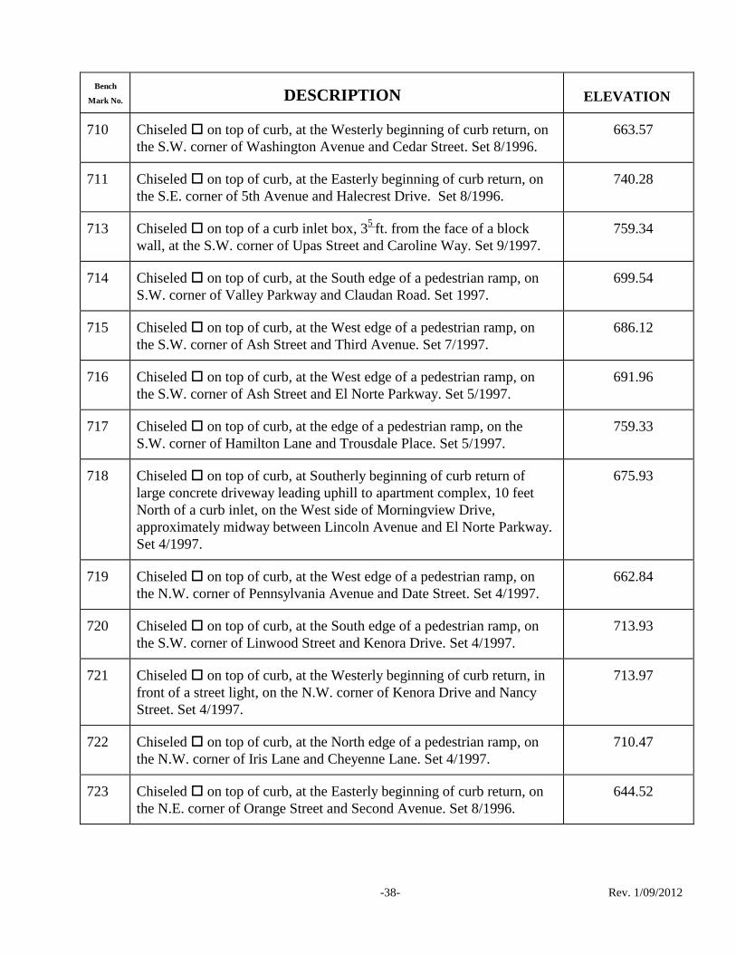
Bench
Mark No. DESCRIPTION ELEVATION
-38- Rev. 1/09/2012
710 Chiseled on top of curb, at the Westerly beginning of curb return, on
the S.W. corner of Washington Avenue and Cedar Street. Set 8/1996.
663.57
711 Chiseled on top of curb, at the Easterly beginning of curb return, on
the S.E. corner of 5th Avenue and Halecrest Drive. Set 8/1996.
740.28
713 Chiseled on top of a curb inlet box, 35
ft. from the face of a block
wall, at the S.W. corner of Upas Street and Caroline Way. Set 9/1997.
759.34
714 Chiseled on top of curb, at the South edge of a pedestrian ramp, on
S.W. corner of Valley Parkway and Claudan Road. Set 1997.
699.54
715 Chiseled on top of curb, at the West edge of a pedestrian ramp, on
the S.W. corner of Ash Street and Third Avenue. Set 7/1997.
686.12
716 Chiseled on top of curb, at the West edge of a pedestrian ramp, on
the S.W. corner of Ash Street and El Norte Parkway. Set 5/1997.
691.96
717 Chiseled on top of curb, at the edge of a pedestrian ramp, on the
S.W. corner of Hamilton Lane and Trousdale Place. Set 5/1997.
759.33
718 Chiseled on top of curb, at Southerly beginning of curb return of
large concrete driveway leading uphill to apartment complex, 10 feet
North of a curb inlet, on the West side of Morningview Drive,
approximately midway between Lincoln Avenue and El Norte Parkway.
Set 4/1997.
675.93
719 Chiseled on top of curb, at the West edge of a pedestrian ramp, on
the N.W. corner of Pennsylvania Avenue and Date Street. Set 4/1997.
662.84
720 Chiseled on top of curb, at the South edge of a pedestrian ramp, on
the S.W. corner of Linwood Street and Kenora Drive. Set 4/1997.
713.93
721 Chiseled on top of curb, at the Westerly beginning of curb return, in
front of a street light, on the N.W. corner of Kenora Drive and Nancy
Street. Set 4/1997.
713.97
722 Chiseled on top of curb, at the North edge of a pedestrian ramp, on
the N.W. corner of Iris Lane and Cheyenne Lane. Set 4/1997.
710.47
723 Chiseled on top of curb, at the Easterly beginning of curb return, on
the N.E. corner of Orange Street and Second Avenue. Set 8/1996.
644.52

Bench
Mark No. DESCRIPTION ELEVATION
-39- Rev. 1/09/2012
724 Chiseled on top of curb, at the center of a curb inlet, on the S.E.
corner of Johnston Road and Badger Glen. Set 2/1997.
699.71
725 Chiseled on top of curb, at the Southerly beginning of curb return, on
the S.W. corner of Ivy Street and Aspen Way. Set 11/1998.
662.77
726 Chiseled on top of curb, at the East edge of a pedestrian ramp, on the
S.W. corner of Washington Avenue and Valley Parkway. Set 11/1998.
723.96
727 Chiseled on top of curb, at the Westerly beginning of curb return, on
the S.W. corner of El Norte Parkway and Ivy Street. Set 11/1998.
691.23
728 Chiseled on top of curb, at the North edge of a pedestrian ramp, on
the S.E. corner of El Norte Parkway and Fig Street. Set 11/1998.
686.87
729 Chiseled on top of curb, at the Easterly beginning of curb return, near
a street light pole, on the S.E. corner of Gary Lane and Calle Redonda
Lane. Set 10/1998.
749.61
730 Chiseled on top of curb, at the Easterly beginning of curb return, near
a street light pole, on the S.E. corner of Gary Lane and Lark Glen. Set
10/1997.
814.12
731 Chiseled on top of curb, at the edge of a pedestrian ramp, on the S.E.
corner of Paddy Place and Midway Drive. Set 5/1998.
714.42
732 Chiseled on top of curb, two feet Easterly of the beginning of curb
return, on the N.E. corner of Stanley Avenue and Teal Glen. Set
12/1998.
722.09
733 Destroyed by Construction, 4/2007.
734 Chiseled on top of curb, at the Northerly beginning of curb return, on
the N.E. corner of Hale Avenue and Gabrielle Glen. Set 12/1998.
634.24
735 Chiseled on top of curb, at the North edge of a pedestrian ramp, on
the N.W. corner of Metcalf Street and Washington Avenue. Set 1/1999.
635.08
736 Chiseled on top of curb, at the West edge of a pedestrian ramp, on
the S.W. corner of Ninth Avenue and Del Dios Road. Set 1/1999.
645.04
737 Chiseled on top of curb, at the edge of a pedestrian ramp, on the
S.W. corner of Valley Parkway and 11th Avenue. Set 2/1999.
678.04

Bench
Mark No. DESCRIPTION ELEVATION
-40- Rev. 1/09/2012
738 Chiseled on top of curb, at the North edge of a pedestrian ramp, on
the N.W. corner of 11th Avenue and Del Dios Road. Set 2/1999.
674.83
739 Chiseled on top of curb, at the edge of a pedestrian ramp, on the
S.W. corner of Del Dios Road and Avenida del Diablo. Set 3/1999
681.31
740 Chiseled on top of curb, at the Southerly beginning of curb return, on
the S.W. corner of Fifth Avenue and Grape Street. Set 3/1999.
742.98
741 Chiseled on top of curb, at center of five foot wide curb inlet, nine
feet South of beginning of curb return, on the S.W. corner of Fourth
Avenue and Juniper Street. Set 3/1999.
666.88
742 Chiseled on top of curb, at the Westerly beginning of curb return, on
the N.W. corner of Juniper Street and Second Avenue. Set 4/1999.
657.78
743 Chiseled on top of curb, at the center of a five foot wide curb inlet in
middle of curb return, at the S.E. corner of Beech Street and Ohio
Avenue. Set 4/1999.
673.16
744 Chiseled on top of curb, at the North edge of a pedestrian ramp, on
the N.W. corner of Ohio and Date Street. Set 4/1999.
667.59
745 Chiseled on top of curb, at the edge of a pedestrian ramp, on the
N.W. corner of Ash Street and Terrace Avenue. Set 4/1999.
711.28
746 Chiseled on top of curb, at the edge of a pedestrian ramp, on the S.E.
corner of Elm Street and Terrace Avenue. Set 4/1999.
706.29
747 Chiseled on top of curb, at the East edge of a pedestrian ramp, on the
N.E. corner of Beech Street and Second Avenue. Set 5/1999.
675.40
748 Chiseled on top of curb, at North edge of a pedestrian ramp, on the
S.W. corner of Felicita Avenue and Tamarme Terrace. Set 11/1999.
670.67
749 Chiseled on top of curb, at the Southerly beginning of curb return, on
the S.W. corner of 6th Avenue and Escondido Boulevard. Set 1/2000.
652.19
750 Chiseled on the S.E. corner of a concrete pad for a storm drain
manhole, in Kit Carson Park arboretum area, 30 feet ± East of
arboretum graded road with 1' high rock wall on West side of road. Set
12/1999.
398.17

Bench
Mark No. DESCRIPTION ELEVATION
-41- Rev. 1/09/2012
751 Chiseled on top of curb, at the center of an 11 foot wide curb inlet,
on the S.W. corner of Linwood Street and Kingston Drive. Set 5/2000.
693.61
752 Chiseled on top of curb, at the Southerly beginning of curb return, on
the S.W. corner of Gamble Street and Peartree Place. Set 7/2000
663.11
753 Chiseled on top of curb, at the Easterly beginning of curb return, on
the N.E. corner of Beethoven Dr. and Calle Montera. Set 12/2000.
368.60
754 Chiseled on top of curb, at the end of curb, gutter and sidewalk
improvements on the East side of La Honda Drive, 0.3 mile +/- North
of Dublin Lane. Set 12/2000.
948.89
755 Chiseled on top of curb, on the West side of a concrete driveway to
house #2001, on South side of La Honda Drive, approximately 500 feet
South of entrance to Dixon Lake. Set 12/2000.
1149.22
756 Chiseled on top of curb, at the East edge of a pedestrian ramp, on the
N.E. corner of Glenridge Road and Jessica Lane. Set 4/2001.
740.28
757 Chiseled on top of curb, at the South edge of a pedestrian ramp, on
the S.W. corner of Moody Drive and Wedgewood Avenue. Set 4/2001.
755.40
758 Chiseled on top of curb, at the center of curb return, on the S.E.
corner of Idaho Avenue and San Pasqual Valley Road. Set 10/2001.
706.77
759 Destroyed 9/2008.
760 Chiseled on top of curb, 6' North of a pedestrian ramp, on the N.E.
corner of Conway Drive and Honeysuckle Way. Set 9/2001.
795.45
761 Chiseled on top of curb, at the center of an 8' wide curb inlet, on the
S.E. corner of 5th Avenue and Broadway. Set 3/2002.
656.02
762 Chiseled on top of curb, at the edge of a pedestrian ramp, on the N.E.
corner of Hidden Trails Road and Meadowside Place. Set 7/2002.
800.33
763 Chiseled on top of curb, at the edge of a pedestrian ramp, on the N.E.
corner of Mountain View Road and Canyon Crest Drive. Set 7/2002.
842.98
764 Chiseled on top of curb, at the edge of a pedestrian ramp, on the
N.W. corner of Bernardo Avenue and Dexter Place. Set 10/2002.
634.35
765 Destroyed by Construction.

Bench
Mark No. DESCRIPTION ELEVATION
-42- Rev. 1/09/2012
766 Chiseled on top of curb, at the middle of curb return, on the S.E.
corner of North Broadway and Legend Way. Set 1/2003.
818.37
767 Chiseled on top of curb, at the edge of a pedestrian ramp, on the S.E.
corner of Hidden Trails Road and Meadow Creek Lane. Set 7/2003.
894.58
768 Chiseled on top of curb, at the edge of a pedestrian ramp, on the
N.W. corner of Anna Lane and Woodland Parkway. Set 5/2003.
756.47
769 Chiseled on top of curb, at the center of an 8’ wide curb inlet, at the
90 bend in road on Harmony Grove Road, 400’ South of Enterprise
Street. Set 3/2003.
622.46
770 Chiseled on top of curb, at the edge of a pedestrian ramp, on the
N.W. corner of Wanek Road and Valley Parkway. Set 9/2004.
715.81
771 Chiseled on top of curb, on the East side of Hidden Trails Road, just
South of driveway to Address #318. Set 9/2004.
926.98
772 Chiseled on top of curb, at the edge of a pedestrian ramp, on the N.E.
corner of Hidden Trails Road and Oakwood Ln. Set 9/2004.
895.93
773 Chiseled on top of curb, at the edge of a pedestrian ramp, on the NW
corner of Reed Road and Hidden Estates Ln. Set 9/2004
797.11
774 Chiseled on top of curb, on the S.E. corner of a concrete bridge, at
the intersection of Lake Wohlford Road and Oakvale Road. Set
11/2004.
1411.29
775 Brass disk set in boulder marked ―W 300-1935‖, located on Lake
Wohlford Road, 140ft. +/- South of the centerline of Lake Wohlford
Ct., on the East side of Road, Approximately 22ft. East of the centerline
stripe.
826.82
776 Chiseled on top of curb, at the edge of a pedestrian ramp, on the
S.W. corner of Citrus Avenue and Citron Pl. Set 11/2004.
745.11
777 Chiseled on top of curb, at the edge of a pedestrian ramp, on the
S.W. corner of North Avenue and Conway Dr. Set 6/2005.
766.95
778 Destroyed by Construction – 2010.
779 Chiseled on top of curb, at the edge of a pedestrian ramp, on N.E.
corner of Princess Kyra Pl. and Harmony Grove Road. Set 6/2005.
620.44

Bench
Mark No. DESCRIPTION ELEVATION
-43- Rev. 1/09/2012
780 Chiseled on top of curb, on the East edge of a 10ft. wide curb inlet,
on the South side of Birch Avenue, Approximately 750ft. West of Bear
Valley Parkway. Set 12/2005.
703.76
781 1 ½‖ Brass disk marked ― COE BM 781‖ set in top of curb at the
westerly end of the curb return, on the S.W. corner of Mission Rd. and
Auto Pkwy. Set 9/2009.
692.58
782 1 ½‖ Brass disk marked ― COE BM 782‖ set in top of curb at the
Northerly curb return, on the N.E. corner of Bear Valley Pkwy and
Orleans Ave. Set 8/210.
700.10
783 1 ½‖ Brass disk marked ― COE BM 783‖ set in top of curb, at the
Southwesterly curb return, on the S.E. corner of Valley Pkwy and Bear
Valley Pkwy. Set 8/2010.
703.39
784 1 ½” Brass disk marked “ COE BM 784” set in top of curb, at the NE
corner of Auto Pkwy and Aero Way, 15 feet Easterly of the beginning
of the curb return. Set 9/2010.
717.43
785 1 ½” Brass disk marked “ COE BM 785” set in concrete base of traffic
signal pole, at the NE corner of Auto Pkwy and Country Club Drive.
Set 9/2010.
725.67
786 1 ½‖ Brass disk marked ― COE BM 786‖ set in top of curb, on the
South side of El Norte Pkwy, across from the intersection with La
Honda Drive. Set 9/2010.
730.10
786-A 1 ½‖ Brass disk marked ― COE BM 786-A‖ set in top of curb, at the
middle of the curb return, on the SW corner of Alexander Dr. and
Feeney Pl. Set 9/2010.
655.31
791 1 ½‖ Diameter Brass Disk marked ―COE BM 791‖ set in top of curb, at
the center of a storm drain inlet, on the S.E. corner of El Norte Parkway
and Bennett Avenue Set 3/2008.
709.46
791-A
1 ½‖ Diameter Brass Disk marked ―COE BM 791-A‖ set in top of curb,
at Southerly beginning of curb return, on the S.W. corner of Felicita
Avenue and Rockwell Springs Ct. Set 4/2008.
642.91
792 1 ½‖ Diameter Brass Disk marked ―COE BM 792‖ set in top of curb, at
the Westerly edge of a pedestrian ramp, on the S.E. corner of Valley
Center Road and Lake Wohlford Road. Set 12/2007.
733.66

Bench
Mark No. DESCRIPTION ELEVATION
-44- Rev. 1/09/2012
793 1 ½‖ Diameter Brass Disk marked ―COE BM 793‖ set in top of curb, at
the South end of the curb return, on the S.W. corner of Valley Parkway
and Beven drive. Set 12/2007.
723.54
794 1 ½‖ Diameter Brass Disk marked ― COE BM 794‖ set in top of curb,
on a 5 ft. wide curb inlet, at the N.E. corner of Citracado Parkway and
Andreasen Drive. Set 7/2007.
666.39
795 1 ½‖ Diameter Brass Disk marked ―C.O.E. BM 795‖ set in top of curb,
at the West edge of a pedestrian ramp, on the S.W. corner of Mission
Road and Andreasen Dr. Set 7/2006. Reset 9/2010.
639.28
795-A 1 ½‖ Diameter Brass Disk marked ―C.O.E. BM 795-A ‖ set in top of
curb, on the North corner of a 20 foot long curb inlet, at the S.W. corner
of Citracado Parkway and Vineyard Avenue Set 7/2007.
722.93
796 1 ½‖ Diameter Brass Disk marked ―C.O.E. BM 796‖ set in top of curb,
at the center of curb inlet structure, on the N.E. corner of Rose Street
and Grand Avenue Set 7/2006.
679.25
797 1 ½‖ Diameter Brass Disk marked ―C.O.E. BM 797‖ set in top of curb,
on the South side of Hubbard Avenue, at the East side of Driveway to
House #1147, Approximately 0.35 miles East of Ash Street. Set 2/2006.
969.53
798 1 ½‖ Diameter Brass Disk marked ―C.O.E. BM 798‖ set in top of curb,
at the middle of curb return, on the S.E. corner of Oakhill Dr. and Bear
Valley Parkway. Set 2/2006.
704.19
799 1 ½‖ Diameter Brass Disk marked ―C.O.E. BM 799‖ set in top of curb,
at the middle of curb return, on the S.W. corner of Midway Dr. and
Bear Valley Parkway. Set 2/2006.
699.82
800 1 ½‖ Diameter Brass Disk marked ―C.O.E. BM 800‖ set in top of curb,
at the middle of curb return, on the N.E. corner of Glenridge Road and
Bear Valley Parkway. Set 2/2006.
714.40
801 1 ½” Diameter Brass disk marked “C.O.E. BM 801” set in top of curb,
on the West side of Bear Valley Parkway , at the intersection with San
Pasqual Road. Set 2-2009.
363.62
802 1 ½” Diameter Brass disk marked “C.O.E. BM 802” set in top of curb,
at the East edge of a pedestrian ramp, on the Southeast corner of El
Norte Pkwy and Washington Ave.Set 3/2009.
717.46

Bench
Mark No. DESCRIPTION ELEVATION
-45- Rev. 1/09/2012
803 1 ½” Diameter Brass disk marked “C.O.E. BM 803” set in top of curb,
on the Southwest corner of El Norte Pkwy and Citrus Ave. Set 3/2009.
725.09
804 1 ½” Diameter Brass disk marked “C.O.E. BM 804” set in top of curb,
at the East side of a pedestrian ramp, on the Northeast corner of El
Norte Pkwy and Sungold Way. Set 3/2009.
720.08
805 1 ½” Diameter Brass disk marked “C.O.E. BM 805” set in top of curb,
at the center of a 7’ wide curb inlet, on the Northwest corner of
Escondido Blvd. and Vermont Ave. Set 4/2009.
643.37
806 1 ½” Diameter Brass disk marked “C.O.E. BM 806” set in top of curb,
near the Easterly end of curb return, on the NE corner of Tulip St. and
5th
Ave. Set 11/2009.
685.00
807 1 ½” Diameter Brass disk marked “C.O.E. BM 807” set in top of curb,
on the SW corner of Spruce St. and 3rd
Ave. Set 1/2012.
646.99
808 1 ½” Diameter Brass disk marked “C.O.E. BM 808” set in top of curb,
at the Northerly end of the curb return, on the NW corner of Tulip St.
and Brenna Hills Place. Set 1/2012.
671.53