chemehuevi valley special recreation management area … · chemehuevi valley special recreation...
TRANSCRIPT
Chemehuevi Valley Special Recreation Management Area (SRMA)
The Chemehuevi Valley Viewshed with the Turtle Mountains National Natural Landmark is directly west of the communities of Havasu Landing, California and Lake Havasu City, Arizona. The Turtle Mountains Natural Landmark is an excellent illustration of volcanic phenomena with superimposed sculpturing of mountain landforms. In combination, the eastern and western sections present some of the finest geological formations in the Mohave Desert. The site is of scenic value and interest; it also contains excellent examples of Mohave Desert flora and fauna. From October to April each year hundreds of travelers “snowbirds” from the northeastern United States, Canada and Europe journey to the area to enjoy the mild winter climate seeking new experiences, enjoying vast landscape which have not existed in European Nations for hundreds of years. Visitors participate in backcountry touring adventure and the discovery of new hiking trails, rock hounding sites and camping opportunities. The Chemehuevi Reservation Havasu Landing Resort depends on the naturalness of the Chemehuevi Valley to support the recreation pursuits of their visitors. The Needles Field Office has developed a system of designated trails entitled the Mojave Adventure Routes in regards to the 2002 Northern and Eastern Colorado Desert Coordinated Management Plan item 3.8.7. These routes are an outstanding network of 4x4 vehicle backcountry touring routes for motorized recreation. These routes were developed for the purpose of traveling to areas not often seen by many people. This network is a shared-use trail system providing recreation opportunities for all persons, including those who use street-legal and non-street legal (Green Sticker) vehicles, hikers, bicyclists, and equestrians. It also provides a backcountry opportunity for non-traditional trail users such as persons with disabilities, senior citizens, and families with small children.
RMA/RECREATION MANAGEMENT ZONE (RMZ) OBJECTIVE(S) DECISIONS RMZ 2a: Chemehuevi Valley Viewshed Area Objective Statement: Designate this area as a Special Recreation Management Area. To manage and protect the outstanding aesthetic value of the Chemehuevi Area to ensure enjoyment of the “Mojave Adventure Routes” Backcountry Trail System, and the experiences offered by RMZ 2b – 2g. The Turtles Mountain National Natural Area centers around two twin volcanic peaks located in the middle of the Turtles Mountain Wilderness. These two peaks are a dominant landmark within the viewshed of both Lake Havasu City, Arizona and Havasu Landing, California. They are also highly valued by the local Native American Tribes. The Mojave Adventure Routes are a system of trails which lead to a variety of recreational activities within the Needles Field Office. These routes were designated open in the Northern and Eastern Colorado Desert Plan where they are referred to as the Discovery Trails.

Activities: Back Country Touring, Discovery of Historic Locations, Camping, Stargazing, Hiking, and Walking for Pleasure Experiences: Travel the same routes that Early Explorers and Native Americans did and learn about their experiences. Benefits: Personal: Learn about the unique volcanic landscape and its wildlife local species through interpretation and education kiosk. Increased health and fitness with an overall sense of relaxation and reduced stress. Community/Social: Increased tourism and revenue for the local economy. Environmental: Protect the cultural, natural and visual resource while providing recreation opportunities. ------------------------------------------------------------------------------------------------------------------------------- RMZ 2b: Blue Cloud Self Contained Camping Area Objective Statement: To provide and maintain a formal campground setting to accommodate a broad range of recreational camping, provide necessary facilities to manage this use, and develop a business plan to provide funding for operations and maintenance. This area would provide seasonal camping conveniently located to the community of Parker, Arizona. This area is located in the southeast corner of the field office. Dispersed 14-day use gathers within this area and tends to heavily impact the landscape for approximately 5 miles east and west along State Highway 62. An individual SRP program with use restriction would assist in the management of this area. Activities: Back Country Travel, Camping, Hiking, and Relaxing Experiences: Time spent with family and friends Benefits: Personal: Enjoyment of warm weather climates. Community/Social: Increased tourism and revenue for the local economy. Environmental: By focusing use into one area we prevent the continuous sprawl of vehicles over a 10 mile wide section of land, thereby reducing the overall impact to the landscape. ------------------------------------------------------------------------------------------------------------------------------- RMZ 2c: Lost Arch Historic Mining Camp Objective Statement: Lost Arch Historic Mining Camp will be managed for its outstanding opportunities; backcountry travel, exploration of historic sites, and primitive dispersed camping. The Lost Arch Historic Mining Camp has a history of recreational and economic use for over 100 years. The area contains the remnants of Native American trails, Prospector trails, mine and mill sites, cabins, and an old vehicle graveyard. The area has always had high interest however visitation has increased

since 2009 when a project was implemented creating a visitor friendly area by the placement of wildlife cupolas and gates on the dominant mines and backfilling of smaller mines. The material associated with the mines was left in place to preserve the history of the mining era as dictated within the California Desert Protection Act. Activities: Camping, Hiking, Photography, Stargazing, Walking for Pleasure, Picnicking, Nature Studies, Night Vision Wildlife Viewing Area Experiences: Historical and Geological Discovery and time spent with family and friends. Benefits: Personal: An increased knowledge of early community life in the desert. Community/Social: Increased tourism and revenue for the local economy. Provide ownership in the history of the area. Environmental: Protect the visual resource by designing facilities which blend naturally into the harsh landscape. ------------------------------------------------------------------------------------------------------------------------------- RMZ 2d: Chemehuevi Trails Objective Statement: To actively manage and provide for OHV opportunities by families who rent seasonally from the Havasu Landing Recreation Resorts on the Chemehuevi Tribal lands, in a way that minimizes the impacts to natural and cultural resources. Activities: Camping, OHV Riding Experiences: Opportunities to share in similar motorized sports with family and friends. Benefits: Personal: Enjoy family time in a low-stress activity area and build a better appreciation for the resources utilized. Community/Social: Increased tourism and revenue for the local economy. Environmental: Better direction to the public assists in reducing the impacts from inappropriate use. ------------------------------------------------------------------------------------------------------------------------------- RMZ 2e: Savahia Peak Rock Collection Area Objective Statement: To provide the rockhounder with easily accessible routes and primitive Day Use/Camping Sites within rock collection areas. Rockhound as it is identified in the California Desert Conservation Area Plan are people who casually pick up something that catches their eye and serious collectors who travel around the country to display their discoveries at rock and gem shows. Areas where certain rocks and minerals have historically been collected in the California desert were identified by a consortium of rockhound clubs about 20 years ago.

Numerous rockhounding sites exist within the Chemehuevi Valley with the largest number situated around Savahia Peak which is located adjacent to the western boundary of the Whipples Wilderness unit. This area is heavily dependent on the use of motorized-vehicles to access the area due to its remoteness, while the recreation action is hiking areas seeking out that one perfect specimen to add to one’s own collection. Routes utilized to reach this area were designated open within the Northern and Eastern Colorado Desert Coordinated Management Plan 2002. Activities: Back Country Touring, Rock Collecting, Hiking, and Picnicking Experiences: The discovery of new rock collecting opportunities and backcountry areas. Benefits: Personal: Learn about the local geology, increased health and fitness. Community/Social: Increased tourism and revenue for the local economy. Environmental: Personal interest in the area helps to maintain and monitor the area. ------------------------------------------------------------------------------------------------------------------------------- RMZ 2f: Monument Peak Objective Statement: To manage and monitor this highly scenic Mojave Adventure route which provides access to one of California’s only Giant Saguaro Cactus Viewing Areas Activities: Educational Field Trips, Photography, Hiking/Walking for Pleasure, Back Country Travel Experiences: Learning about the unique plant species which grown in the California Desert Monsoon Areas Benefits: Personal: Enjoying the stress-free environment and breathtaking panoramic vistas. Community/Social: Increased tourism and revenue for the local economy Environmental: Preserve the natural resources of the area with its unique plants and animals through interpretation and education projects. ------------------------------------------------------------------------------------------------------------------------------- RMZ 2f: Snaggletooth Primitive Camp Objective Statement: To provide and maintain a formal campground setting to accommodate a broad range of recreational camping, provide necessary facilities to manage this use, and develop a business plan to provide funding for operations and maintenance. This area would provide seasonal camping conveniently located to the community of Needles, California. Snaggletooth Primitive Camp is a series of four large group primitive camping sites used by the public and permitted events. The camp is located along the northeast edge of the Snaggletooth Mountain Range, west of US 95 and the Chemehuevi Mountains Wilderness. The site is named for the old basaltic ridge with several sharp spires along the crest.

This highly utilized primitive campground adjacent to US Highway 95 provides access to the Chemehuevi Wilderness and will be managed as an interpretive introduction site to the Chemehuevi SRMA area. Easy access from US 95, large hardened surfaces and within an easy commute to local community facilities makes this an ideal primitive group camping site for large vehicles. Visitation and use over the last five years has increased and is spreading. Activities: Camping, Hiking, Photography and Back Country Travel Experiences: Increased health and fitness Benefits: Personal: Enjoying the stress-free environment and breathtaking panoramic vistas. Community/Social: Increased tourism and revenue for the local economy. Environmental: Preserve the natural resources of the area with its unique plants and animals through interpretation and education projects.
RECREATION SETTING CHARACTERISTICS (RSC) DESCRIPTIONS
ERMA: Chemehuevi Valley Viewshed Area Physical: Primitive to Rural Social: Primitive to Rural Operational: Primitive to Rural RMZ: Blue Cloud Self Contained Camping Area Physical: Middle Country to Rural Social: Middle to Front Country Operational: Middle to Rural RMZ: Lost Arch Historic Mining Camp Physical: Middle Country Social: Back to Middle Country Operational: Back to Middle Country RMZ: Chemehuevi Trails Physical: Middle to Rural Social: Middle to Rural Operational: Middle to Rural RMZ: Savahia Peak Rock Collection Area Physical: Back to Middle Country Social: Back Country Operational: Back to Middle Country RMZ: Monument Peak
Physical: Back to Front Country Social: Primitive to Middle Operational: Back to Middle Country RMZ: Snaggletooth Primitive Camp Physical: Front to Rural Social: Middle to Rural Operational: Middle to Rural
Management Actions and Allowable Uses
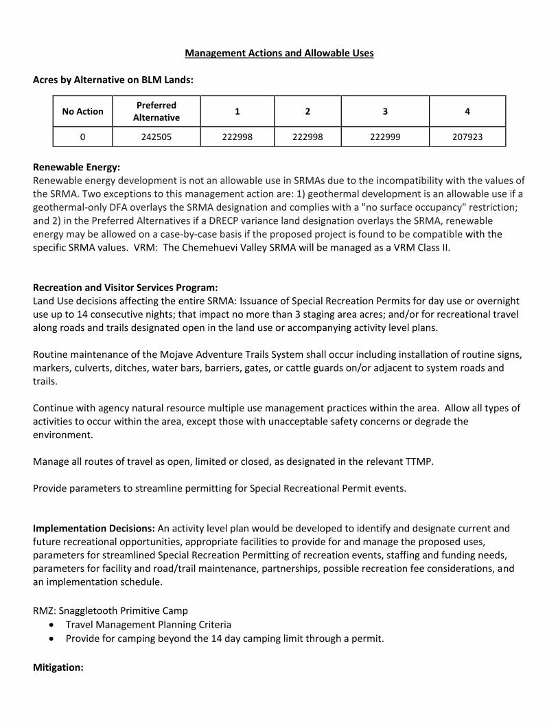
Acres by Alternative on BLM Lands:
No Action Preferred
Alternative 1 2 3 4
0 242505 222998 222998 222999 207923
Renewable Energy: Renewable energy development is not an allowable use in SRMAs due to the incompatibility with the values of the SRMA. Two exceptions to this management action are: 1) geothermal development is an allowable use if a geothermal-only DFA overlays the SRMA designation and complies with a "no surface occupancy" restriction; and 2) in the Preferred Alternatives if a DRECP variance land designation overlays the SRMA, renewable energy may be allowed on a case-by-case basis if the proposed project is found to be compatible with the specific SRMA values. VRM: The Chemehuevi Valley SRMA will be managed as a VRM Class II. Recreation and Visitor Services Program: Land Use decisions affecting the entire SRMA: Issuance of Special Recreation Permits for day use or overnight use up to 14 consecutive nights; that impact no more than 3 staging area acres; and/or for recreational travel along roads and trails designated open in the land use or accompanying activity level plans. Routine maintenance of the Mojave Adventure Trails System shall occur including installation of routine signs, markers, culverts, ditches, water bars, barriers, gates, or cattle guards on/or adjacent to system roads and trails.
Continue with agency natural resource multiple use management practices within the area. Allow all types of activities to occur within the area, except those with unacceptable safety concerns or degrade the environment. Manage all routes of travel as open, limited or closed, as designated in the relevant TTMP.
Provide parameters to streamline permitting for Special Recreational Permit events.
Implementation Decisions: An activity level plan would be developed to identify and designate current and future recreational opportunities, appropriate facilities to provide for and manage the proposed uses, parameters for streamlined Special Recreation Permitting of recreation events, staffing and funding needs, parameters for facility and road/trail maintenance, partnerships, possible recreation fee considerations, and an implementation schedule.
RMZ: Snaggletooth Primitive Camp
Travel Management Planning Criteria
Provide for camping beyond the 14 day camping limit through a permit.
Mitigation:

1. Maintain through traffic motorized route network connectivity with roads and trails leading into and
through the Chemehuevi Valley SRMA.
2. Manage renewable energy development on adjacent and nearby lands to avoid traffic conflicts with
visitors & permitted uses.

The information and maps shown on this system should be used for planning purposes only. It should not be the sole source for determining map boundary locations.


