chapter 5 state(s): oregon recovery unit name: willamette ... willamette.pdf · recovery unit name:...
TRANSCRIPT

Chapter 5
State(s): Oregon
Recovery Unit Name: Willamette River Recovery Unit
Region 1U.S. Fish and Wildlife Service
Portland, Oregon

ii
DISCLAIMER
Recovery plans delineate reasonable actions that are believed necessary torecover and protect listed species. Plans are prepared by the U.S. Fish andWildlife Service and, in this case, with the assistance of recovery unit teams,contractors, State and Tribal agencies, and others. Objectives will be attained andany necessary funds made available subject to budgetary and other constraintsaffecting the parties involved, as well as the need to address other priorities. Recovery plans do not necessarily represent the views or the official positions orindicate the approval of any individuals or agencies involved in the planformulation, other than the U.S. Fish and Wildlife Service. Recovery plansrepresent the official position of the U.S. Fish and Wildlife Service only after theyhave been signed by the Director or Regional Director as approved. Approvedrecovery plans are subject to modification as dictated by new findings, changes inspecies status, and the completion of recovery tasks.
Literature Cited: U.S. Fish and Wildlife Service. 2002. Chapter 5, WillametteRiver Recovery Unit, Oregon. 96 p. In: U.S. Fish and Wildlife Service. BullTrout (Salvelinus confluentus) Draft Recovery Plan. Portland, Oregon.

iii
ACKNOWLEDGMENTS
Two working groups are active in the Willamette River Recovery Unit: the Upper Willamette (since 1989) and Clackamas Bull Trout Working Groups. In 1999, these groups were combined, and, along with representation from theSantiam subbasin, comprise the Willamette River Recovery Unit Team.
The following individuals contributed to developing the Willamette RiverRecovery Unit chapter.
Willamette River Recovery Unit Team:
Neil Armantrout, Bureau of Land ManagementChris Brun, Confederated Tribes of Warm Springs ReservationDave Bickford, U.S. Forest ServiceTim Cummings, U.S. Fish and Wildlife ServiceDoug Cramer, Portland General Electric CompanyTim Downey, Eugene Water and Electric BoardMary Hanson, Oregon Department of Fish and WildlifeTom Horning, U.S. Forest ServiceWayne Hunt, Oregon Department of Fish and WildlifeDoug Larson, U.S. Forest ServiceDave Liscia, Oregon Department of Fish and WildlifeBob Magne, U.S. Army Corps of EngineersJim Muck, Oregon Department of Fish and WildlifeGreg Pitts, Oregon Council Federation of Fly FishersRamon Rivera, U.S. Forest ServiceTim Shibahara, Portland General Electric CompanyDan Shively, U.S. Forest ServiceWade Sims, U.S. Forest ServiceDel Skeesick, Private citizenWayne Somes, U.S. Forest ServiceJim Stark, Weyerhaeuser CompanyGreg Taylor, Oregon Department of Fish and WildlifeAmy Unthank, U.S. Forest Service

iv
Mark Wade, Oregon Department of Fish and WildlifeDave Ward, Oregon Department of Fish and WildlifeChuck Willis, U.S. Army Corps of EngineersJeff Ziller, Oregon Department of Fish and Wildlife
Additional Contributors:
Chris Allen, U.S. Fish and Wildlife ServiceTony Nigro, Oregon Department of Fish and WildlifeRobert Danehy, Ph.D., Boise CorporationTim Whitesel, U.S. Fish and Wildlife ServiceSteve Liebhardt, U.S. Fish and Wildlife ServiceWilla Nehlsen, U.S. Fish and Wildlife Service

v
WILLAMETTE RIVER RECOVERY UNIT CHAPTER OF THEBULL TROUT RECOVERY PLAN
EXECUTIVE SUMMARY
CURRENT SPECIES STATUS
The Fish and Wildlife Service issued a final rule listing the Columbia Riverpopulation of bull trout as a threatened species on June 10, 1998 (63 FR 31647). TheWillamette River Recovery Unit (often called the Willamette Recovery Unit in thischapter) forms part of the range of the Columbia River population. The WillametteRecovery Unit encompasses the Willamette River basin, a major tributary to theColumbia River. The Willamette River flows through Portland, Oregon, beforeentering the Columbia River at about river kilometer 140. The Willamette Riverdrains part or all of 10 counties—an area of approximately 31,080 square kilometers,almost one-eighth of Oregon’s total area.
The Willamette Recovery Unit Team identified one core area, the UpperWillamette River core area, and the Clackamas River core habitat. The ClackamasRiver core habitat does not currently support bull trout populations, but it didhistorically, and the Recovery Unit Team believes that it has the necessary elementsto support reintroduction of bull trout. The Santiam River basin also had historic bulltrout populations, but this basin is not considered core habitat at this time because ofuncertainties regarding its potential to support bull trout. Identifying adequateamounts and locations of suitable habitat in the Santiam River basin is a researchneed.
HABITAT REQUIREMENTS AND LIMITING FACTORS
A detailed discussion of bull trout biology and habitat requirements isprovided in Chapter 1 of this recovery plan. The limiting factors discussed here arespecific to the Willamette Recovery Unit chapter. At the time of listing, the U.S. Fishand Wildlife Service considered dams, forest management, roads, and water qualityas threats to bull trout in the Willamette River basin. The construction of impassabledams and culverts is considered a major factor in the decline of the species, blocking

vi
migratory corridors and altering temperature and flow regimes. Habitat degradation,passage barriers, overharvest, chemical treatment projects, and hybridization andcompetition with nonnative brook trout are possible suppressing factors for bull troutpopulations in the Willamette River basin. Alteration and degradation of instreamhabitat resulting in loss of instream structure, pools, and side-channel habitats areidentified as limiting bull trout populations in the McKenzie and Middle ForkWillamette River basins. Causal mechanisms can be both manmade and natural andare difficult to quantify due to a lack of data on historic population abundance andhabitat conditions.
Although much of the damage is historical and although current policies andpractices are more protective of aquatic resources, the legacy effects of past eventsare still evident. What can be restored naturally—for example, riparian cover andrecruitment of large woody debris—will require many years. In other instanceswhere change may not be reversible—for example, impassable dams—other solutionswill be required to address the threats to bull trout survival and persistence.
RECOVERY GOALS AND OBJECTIVES
The goal of the bull trout recovery plan is to ensure the long-termpersistence of self-sustaining, complex, interacting groups of bull troutdistributed throughout the species’ native range so that the species can bedelisted. To achieve this goal, the following objectives have been identified for bulltrout in the Willamette Recovery Uni:
< Maintain current distribution of bull trout and restore distribution inpreviously occupied areas within the Willamette Recovery Unit.
< Maintain stable or increasing trends in abundance of adult bull trout.
< Restore and maintain suitable habitat conditions for all bull trout life historystages and forms.
< Conserve genetic diversity and provide opportunity for genetic exchange.

vii
RECOVERY CRITERIA
Recovery criteria for the Willamette Recovery Unit reflect the stated objectives,evaluation of population status, and recovery actions necessary to achieve the overallgoal.
1. Distribution criteria will be met when bull trout are distributed among fiveor more local populations in the recovery unit: four in the UpperWillamette River core area and one in the Clackamas River core habitat. In a recovered condition, the Upper Willamette River core area would includelocal populations in the mainstem McKenzie River (connectivity with the TrailBridge local population would need to be established), South Fork McKenzieRiver, upper Middle Fork Willamette River, and Salt Creek/SalmonCreek/North Fork Middle Fork Willamette River complex. Core habitat in theClackamas River basin would also contain one or more local populations in alocation that has yet to be identified. Feasibility analyses are needed to assessthe potential for reintroducing bull trout into historic habitat in the Middle ForkWillamette River basin (Salt Creek, Salmon Creek, and North Fork Middle ForkWillamette River watersheds) and into the Clackamas River core habitat. Additional population studies and a better understanding of bull trout fidelity totheir natal streams are needed to further define local populations in the recoveryunit.
2. Abundance criteria will be met when estimated abundance of adult bulltrout is from 900 to 1,500 or more individuals in the recovery unit,distributed in each core area as follows: 600 to 1,000 in the UpperWillamette River core area and 300 to 500 in the Clackamas River corehabitat.
3. Trend criteria will be met when adult bull trout exhibit stable or increasingtrends in abundance in the recovery unit, based on a minimum of 10 yearsof monitoring data.
4. Connectivity criteria will be met when migratory forms are present in alllocal populations and when intact migratory corridors among all local
viii
populations in core areas provide opportunity for genetic exchange anddiversity. For the Upper Willamette River core area, meeting connectivitycriteria would require establishing fish passage at Cougar, Trail Bridge, Dexter,Lookout Point, and Hills Creek Dams. In the future, establishing fish passage atdams in the Clackamas and Santiam River basins may be necessary, butcurrently, there is insufficient information to make that determination.
ACTIONS NEEDED
Recovery for bull trout will entail reducing threats to the long-term persistenceof local populations and their habitats, ensuring the security of multiple interactinggroups of bull trout, and providing habitat conditions and access to conditions thatallow for the expression of various life history forms. Seven categories of actionsneeded are discussed in Chapter 1; tasks specific to this recovery unit are provided inthis chapter.
ESTIMATED COST OF RECOVERY
Total cost for bull trout recovery in the Willamette River Recovery Unit isestimated at $26 million, spread over a 25-year recovery period. Total costs includeestimates of expenditures by local, Tribal, State, and Federal governments and byprivate business and individuals. These costs are attributed to bull trout conservationbut other aquatic species will also benefit. Cost estimates are not provided for taskswhich are normal agency responsibilities under existing authorities.
ESTIMATED DATE OF RECOVERY
Time required to achieve recovery depends on bull trout status, factors affectingbull trout, implementation and effectiveness of recovery tasks, and responses torecovery tasks. A tremendous amount of work will be required to restore impairedhabitat, reconnect habitat, and eliminate threats from nonnative species. Three to fivebull trout generations (15 to 25 years), or possibly longer, may be necessary beforeidentified threats to the species can be significantly reduced and bull trout can beconsidered eligible for delisting.
ix
TABLE OF CONTENTS
DISCLAIMER . . . . . . . . . . . . . . . . . . . . . . . . . . . . . . . . . . . . . . . . . . . . . . . . . . . . . . . . ii
ACKNOWLEDGMENTS . . . . . . . . . . . . . . . . . . . . . . . . . . . . . . . . . . . . . . . . . . . . . . iii
EXECUTIVE SUMMARY . . . . . . . . . . . . . . . . . . . . . . . . . . . . . . . . . . . . . . . . . . . . . . v
TABLE OF CONTENTS . . . . . . . . . . . . . . . . . . . . . . . . . . . . . . . . . . . . . . . . . . . . . . . ix
INTRODUCTION . . . . . . . . . . . . . . . . . . . . . . . . . . . . . . . . . . . . . . . . . . . . . . . . . . . . . 1Recovery Unit Designation . . . . . . . . . . . . . . . . . . . . . . . . . . . . . . . . . . . . . . . . 1Geographic Description . . . . . . . . . . . . . . . . . . . . . . . . . . . . . . . . . . . . . . . . . . . 1
DISTRIBUTION AND ABUNDANCE . . . . . . . . . . . . . . . . . . . . . . . . . . . . . . . . . . . . 9Status of Bull Trout at the Time of Listing . . . . . . . . . . . . . . . . . . . . . . . . . . . . 9Current Distribution and Abundance . . . . . . . . . . . . . . . . . . . . . . . . . . . . . . . . . 9
REASONS FOR DECLINE . . . . . . . . . . . . . . . . . . . . . . . . . . . . . . . . . . . . . . . . . . . . 22Water Quality . . . . . . . . . . . . . . . . . . . . . . . . . . . . . . . . . . . . . . . . . . . . . . . . . . 22Dams . . . . . . . . . . . . . . . . . . . . . . . . . . . . . . . . . . . . . . . . . . . . . . . . . . . . . . . . 23Forest Management Practices . . . . . . . . . . . . . . . . . . . . . . . . . . . . . . . . . . . . . 28Agricultural Practices . . . . . . . . . . . . . . . . . . . . . . . . . . . . . . . . . . . . . . . . . . . 31Transportation Network . . . . . . . . . . . . . . . . . . . . . . . . . . . . . . . . . . . . . . . . . . 32Mining . . . . . . . . . . . . . . . . . . . . . . . . . . . . . . . . . . . . . . . . . . . . . . . . . . . . . . . 32Residential Development . . . . . . . . . . . . . . . . . . . . . . . . . . . . . . . . . . . . . . . . . 33Fisheries Management . . . . . . . . . . . . . . . . . . . . . . . . . . . . . . . . . . . . . . . . . . . 34Isolation and Habitat Fragmentation . . . . . . . . . . . . . . . . . . . . . . . . . . . . . . . . 37
ONGOING RECOVERY UNIT CONSERVATION MEASURES . . . . . . . . . . . . . . 39State of Oregon . . . . . . . . . . . . . . . . . . . . . . . . . . . . . . . . . . . . . . . . . . . . . . . . 39Federal Activities . . . . . . . . . . . . . . . . . . . . . . . . . . . . . . . . . . . . . . . . . . . . . . . 43Eugene Water and Electric Board . . . . . . . . . . . . . . . . . . . . . . . . . . . . . . . . . . 45

x
RELATIONSHIP TO OTHER CONSERVATION/PLANNING/RECOVERY EFFORTS . . . . . . . . . . . . . . . . . . . . . . . . . . . . . . . . . . . . . . . 46
State of Oregon . . . . . . . . . . . . . . . . . . . . . . . . . . . . . . . . . . . . . . . . . . . . . . . . . . . . 46Federal Activities . . . . . . . . . . . . . . . . . . . . . . . . . . . . . . . . . . . . . . . . . . . . . . . . . . . 49
STRATEGY FOR RECOVERY . . . . . . . . . . . . . . . . . . . . . . . . . . . . . . . . . . . . . . . . . . . . . 50The Role of Artificial Propagation and Transplantation . . . . . . . . . . . . . . . . . . . . . 50Recovery Goals and Objectives . . . . . . . . . . . . . . . . . . . . . . . . . . . . . . . . . . . . . . . . 53Recovery Criteria . . . . . . . . . . . . . . . . . . . . . . . . . . . . . . . . . . . . . . . . . . . . . . . . . . . 57Research Needs . . . . . . . . . . . . . . . . . . . . . . . . . . . . . . . . . . . . . . . . . . . . . . . . . . . . 60
ACTIONS NEEDED . . . . . . . . . . . . . . . . . . . . . . . . . . . . . . . . . . . . . . . . . . . . . . . . . . . . . . 62Recovery Measures Narrative . . . . . . . . . . . . . . . . . . . . . . . . . . . . . . . . . . . . . . . . . 62
IMPLEMENTATION SCHEDULE . . . . . . . . . . . . . . . . . . . . . . . . . . . . . . . . . . . . . . . . . . 71
REFERENCES CITED . . . . . . . . . . . . . . . . . . . . . . . . . . . . . . . . . . . . . . . . . . . . . . . . . . . . 81
APPENDIX A. Fish Species . . . . . . . . . . . . . . . . . . . . . . . . . . . . . . . . . . . . . . . . . . . . . . . . 91
APPENDIX B. List of Chapters . . . . . . . . . . . . . . . . . . . . . . . . . . . . . . . . . . . . . . . . . . . . . 96
LIST OF TABLES
Table 1. Average monthly discharge for the months August and January for bull troutbasins in the Willamette Recovery Unit. . . . . . . . . . . . . . . . . . . . . . . . . . . . . . . . . . . 5
Table 2. Releases of adult spring chinook salmon from the McKenzie and WillametteHatcheries, 1993 to 1999 (ODFW data). . . . . . . . . . . . . . . . . . . . . . . . . . . . . . . . . . . 7
Table 3. Number of bull trout fry and juveniles captured in the downstream migrant trap inAnderson Creek, 1994 through 2001 (Ziller and Taylor 2000; D. Bickford, U. S.Forest Service, pers. comm., 2001a). . . . . . . . . . . . . . . . . . . . . . . . . . . . . . . . . . . . . 15
xi
Table 4. Bull trout fry transferred from Anderson Creek, a McKenzie River tributary, to theMiddle Fork Willamette River basin above Hills Creek Reservoir. Adapted fromTaylor and Reasoner (2000). . . . . . . . . . . . . . . . . . . . . . . . . . . . . . . . . . . . . . . . . . . 19
Table 5. Changes in Oregon Department of Fish and Wildlife angling regulations to protectbull trout (Ziller and Taylor 2000). . . . . . . . . . . . . . . . . . . . . . . . . . . . . . . . . . . . . . 39
Table 6. Changes in management of hatchery-reared rainbow trout implemented by theOregon Department of Fish and Wildlife to reduce take of bull trout in the upperWillamette River basin (Ziller and Taylor 1999). . . . . . . . . . . . . . . . . . . . . . . . . . . 40
LIST OF FIGURES
Figure 1. Bull trout recovery units in the United States. The Willamette River RecoveryUnit is highlighted. . . . . . . . . . . . . . . . . . . . . . . . . . . . . . . . . . . . . . . . . . . . . . . . . . . 2
Figure 2. Map of the Upper Willamette River core area, with local populations delineated.10
Figure 3. Number of bull trout counted at Leaburg Dam on the McKenzie River, 1995through September 2001 (partial count). . . . . . . . . . . . . . . . . . . . . . . . . . . . . . . . . . 12
Figure 4. Redd counts in Anderson Creek, a tributary to the McKenzie River, 1989 through2001. . . . . . . . . . . . . . . . . . . . . . . . . . . . . . . . . . . . . . . . . . . . . . . . . . . . . . . . . . . . . . 14
Figure 5. Redd counts in Olallie Creek, a tributary to the McKenzie River, 1995 through2001. . . . . . . . . . . . . . . . . . . . . . . . . . . . . . . . . . . . . . . . . . . . . . . . . . . . . . . . . . . . . . 14
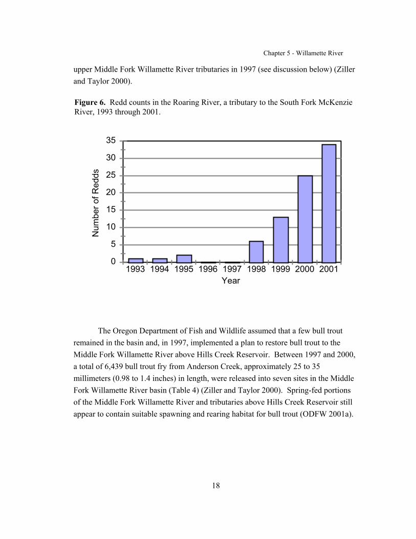
Figure 6. Redd counts in the Roaring River, a tributary to the South Fork McKenzie River,1993 through 2001. . . . . . . . . . . . . . . . . . . . . . . . . . . . . . . . . . . . . . . . . . . . . . . . . . 18
Figure 7. Location of core habitat in the Clackamas River basin and of potential corehabitat in the Santiam River basin. . . . . . . . . . . . . . . . . . . . . . . . . . . . . . . . . . . . . . 21
Chapter 5 - Willamette River
1
INTRODUCTION
Recovery Unit Designation
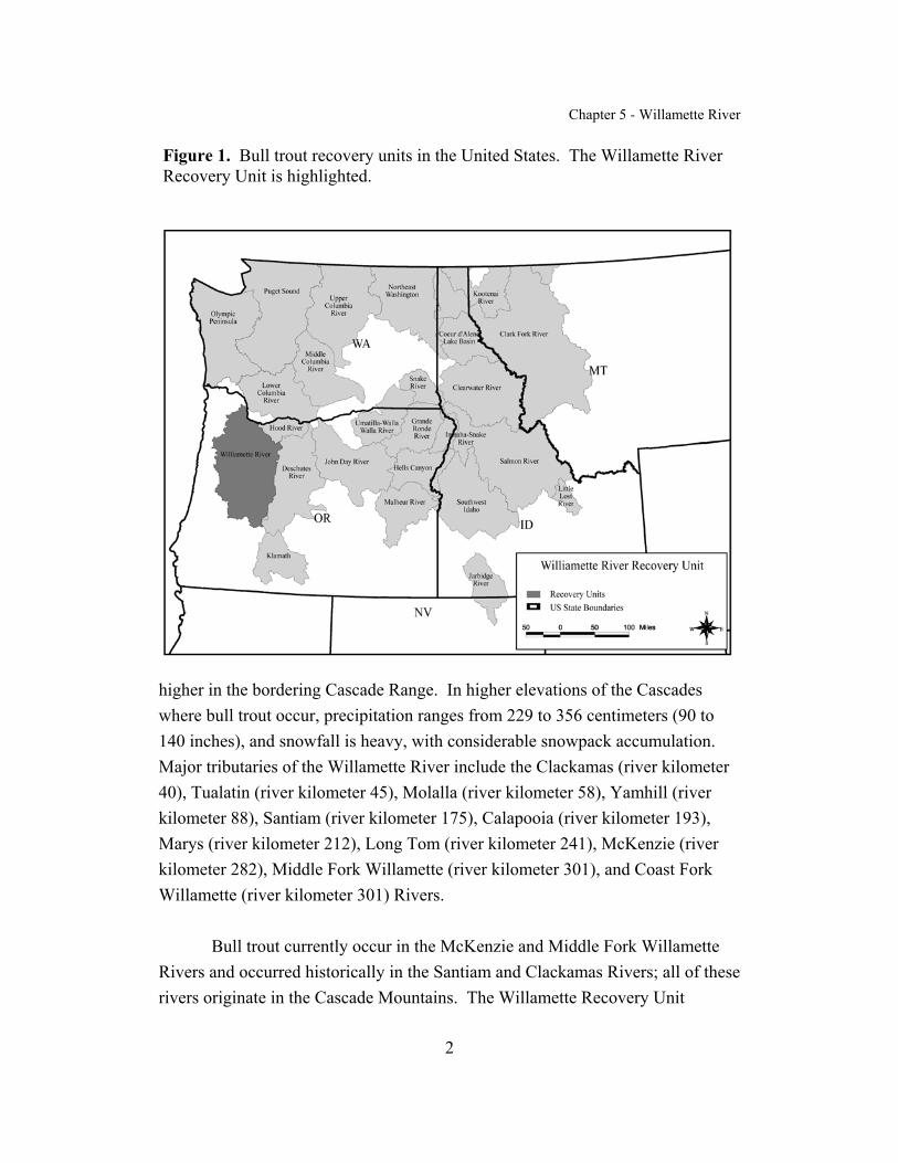
The Willamette River Recovery Unit (often called the WillametteRecovery Unit in this chapter) is one of 22 recovery units designated for bull troutin the Columbia River basin (Figure 1). Designation of the Willamette RecoveryUnit is based on the Oregon Department of Fish and Wildlife (Kostow 1995)designation of bull trout populations in the Willamette River as a geneconservation group. This delineation is supported by the genetic analysisconducted by Spruell and Allendorf (1997). Willamette River bull trout areincluded in the “coastal” group of bull trout populations that includes bull trout ofthe Lewis River (Washington) (Spruell et al. 1998), Hood River (Oregon), andDeschutes River (Oregon) (Spruell and Allendorf 1997). The Willamette Riverbasin also contains many important areas for anadromous salmon and steelhead.
Although bull trout are currently found only in a portion of the upperbasin (McKenzie and Middle Fork Willamette River basins), the recovery unitencompasses the entire Willamette River basin, including historic bull trouthabitat in the Santiam and Clackamas River basins.
Geographic Description
The Willamette River basin, situated in northwestern Oregon, is a majortributary of the Columbia River, entering at about river kilometer 140. TheWillamette River drains part or all of ten counties—approximately 31,080 squarekilometers (12,000 square miles), or almost one-eighth of Oregon’s total area. Itis bounded on the north by the Columbia River, and on the east, south, and westby the summits of the Cascade Range, the Calapooia Mountains, and the CoastRange, respectively. The north–south length of the basin is about 240 kilometers(149 miles), and its average east–west width is about 120 kilometers (75.6 miles). Principal streams of the basin head at elevations of 1,830 meters (6,004 feet) and
Chapter 5 - Willamette River
2
Figure 1. Bull trout recovery units in the United States. The Willamette RiverRecovery Unit is highlighted.
higher in the bordering Cascade Range. In higher elevations of the Cascadeswhere bull trout occur, precipitation ranges from 229 to 356 centimeters (90 to140 inches), and snowfall is heavy, with considerable snowpack accumulation. Major tributaries of the Willamette River include the Clackamas (river kilometer40), Tualatin (river kilometer 45), Molalla (river kilometer 58), Yamhill (riverkilometer 88), Santiam (river kilometer 175), Calapooia (river kilometer 193),Marys (river kilometer 212), Long Tom (river kilometer 241), McKenzie (riverkilometer 282), Middle Fork Willamette (river kilometer 301), and Coast ForkWillamette (river kilometer 301) Rivers.
Bull trout currently occur in the McKenzie and Middle Fork WillametteRivers and occurred historically in the Santiam and Clackamas Rivers; all of theserivers originate in the Cascade Mountains. The Willamette Recovery Unit

Chapter 5 - Willamette River
3
focuses on these four river basins. The McKenzie River basin drains an area ofabout 3,367 square kilometers (1,300 square miles), comprising about 11 percentof the Willamette River basin; more than 80 percent of the subbasin is in LaneCounty, with the remainder in Linn County. The Middle Fork Willamette Riverbasin covers 3,496 square kilometers (1,350 square miles), or about 11 percent ofthe total Willamette River basin; 94 percent of the basin is in Lane County and 6percent is in Douglas County. The Clackamas River basin drains an area of about2,419 square kilometers (934 square miles), or about 8 percent of the WillametteRiver basin, in Clackamas County. The Santiam River basin drains an area ofabout 4,732 square kilometers (1,827 miles), or about 15 percent of theWillamette River basin, primarily in Marion and Linn Counties.
Willamette River basin tributaries of the Cascade Mountains flow throughthree physiographic provinces: the High Cascades, Western Cascades, andWillamette Valley Provinces. The High Cascades Province consists of volcaniclandforms with varying degrees of glaciation. Lava flows formed relatively stableplateaus, which are capped by the recent Cascade Range volcanoes. Drainagesare generally not yet well developed, and precipitation and snowmelt disperse intohighly permeable volcanic deposits. Geologically recent volcanic deposits aresubject to large debris flows when saturated by snowmelt (USFS and BLM 1993).
The Western Cascades Province is distinguished from the High CascadesProvince by older volcanic activity and longer glacial history. Ridge crests atgenerally similar elevations are separated by steep, deeply dissected valleys. Complex eruption materials juxtapose relatively stable lava flows and volcanicdeposits that weather to thick soils and are subject to large, slow-movinglandslides. Unconsolidated alluvial and glacial deposits are subject to streambankerosion, and landslides and are susceptible to increased peak flows. Tributarychannels flow at large angles into wide, glaciated valleys (USFS and BLM 1993).
The Willamette Valley Province is a broad structural depression orientedin a north–south direction and rimmed on the west by the Coast Range and on theeast by the Cascade Mountains. Elevation on the valley floor increasesapproximately 80 meters from north to south (from Salem to Eugene). During the
Chapter 5 - Willamette River
4
Pleistocene epoch, glacial meltwater filled the valley on at least two occasions. Soils of the valley are derived from these lacustrine (lake) deposits as well asfrom more recent alluvial deposits (Franklin and Dyrness 1973).
The McKenzie, Middle Fork Willamette, Clackamas, and Santiam Riversall originate in the High Cascades Province, traverse through the WesternCascades Province, and join the mainstem Willamette River in the WillametteValley Province. They tend to have relatively steep gradients in the middle tohigher elevations and are gently sloped in lower reaches.
The Willamette River basin is characterized by cool, wet winters and bywarm, dry summers. Mean monthly air temperatures in the valley range fromabout 3 to 5 degrees Celsius (37.4 to 41 degrees Fahrenheit) during January to 17to 20 degrees Celsius (63.6 to 68 degrees Fahrenheit) during August (Wentz et al.1998). Mean annual precipitation in the Willamette River basin ranges from 500to 1,000 millimeters (20 to 40 inches) in the valley to more than 2,500 millimeters(100 inches) in the Coast Range. About 70 to 80 percent of the annualprecipitation falls from October through March, but less than 5 percent falls inJuly and August (Wentz et al. 1998). Most precipitation in the CascadeMountains falls as snow above 1,524 meters (5,000 feet); however, the CoastRange and Willamette Valley receive relatively little snow. The uplands (CoastRange and Cascade Mountains) receive about 80 percent of the precipitation thatfalls on the Willamette River basin, and they store much of this water as snow. Snowfall accumulation exceeds 228.6 centimeters (90 inches) in the centralCascades. From late winter to early summer, much of this snow melts, feedingcold, fast-flowing streams.
Stream flow in the Willamette River basin reflects the seasonaldistribution of precipitation, with 60 to 85 percent of runoff occurring fromOctober through March, but less than 10 percent occurring in July and August(Wentz et al. 1998). Releases from 13 tributary reservoirs are managed for waterquality enhancement by maintaining a flow of 170 cubic meters per second (6,000cubic feet per second) in the Willamette River at Salem during summer months(USACE 1989). Mean annual discharge of the Willamette River near its mouth at

Chapter 5 - Willamette River
5
Portland, Oregon, was 917.5 cubic meters per second (32,400 cubic feet persecond) during water years 1972 to 1990. Typical monthly flows at Portlandranged from about 226.5 cubic meters per second (8,000 cubic feet per second) inAugust to about 1,982 cubic meters per second (70,000 cubic feet per second) inDecember. Recorded extreme flows were 119 cubic meters per second (4,200cubic feet per second) in July 1978 and 8,013.7 cubic meters per second (283,000cubic feet per second) in January 1974, although the river reached an estimatedpeak flow of 13,025 cubic meters per second (460,000 cubic feet per second)during the flood of February 1996 (Wentz et al. 1998). Average monthlydischarge for the bull trout basins is shown in Table 1.
Table 1. Average monthly discharge for the months August and January for bulltrout basins in the Willamette Recovery Unit. Data are from the U.S. GeologicalSurvey (http://water.usgs.gov/or/nwis/monthly).
Basin
Gage Location (river
kilometer)
Average MonthlyDischarge (cubic feet persecond) Drainage
Area (squaremiles)
Period ofRecordAugust January
McKenzie River Coburg (6) 2,263 9,908 1,337 1945 to 1972
Middle ForkWillamette River
Dexter (27) 1,845 5,004 1,001 1947 to 2000
Clackamas River Estacada (37) 914 4,200 671 1909 to 2000
Santiam River Jefferson (16) 1,246 14,420 1,790 1908 to 2000
Uplands (land above 152 meters [500 feet] elevation) are dominated atlow- to mid-elevations by Douglas-fir/western hemlock forest and at higherelevations in the Cascade Mountains by subalpine forests and alpineenvironments. Natural fire was the dominant disturbance on the landscape untilthe early 1900's, when fire was suppressed. After World War II, the dominantmanagement regimes were clear-cutting, prescribed burning, and planting croptrees on a 50-year rotation. About 60 percent of the upland is Federally owned
Chapter 5 - Willamette River
6
and is managed under the Northwest Forest Plan. Forest harvesting has beengreatly reduced from former levels under this plan, and more emphasis has beenplaced on habitat for fish and wildlife. About 40 percent of upland land isprivately owned, where forest lands are managed according to the Oregon StateForest Practices Act.
The Willamette Valley is characterized by broad, almost level, alluvialterrain (Franklin and Dyrness 1973). Nearly all land (96 percent) in theWillamette Valley (roughly, lands below 152 meters [500 feet] elevation) isprivately owned and has been converted to agriculture or to urban land use. TheWillamette Valley had an oak–grass–pine vegetation type following the last iceage, and Native Americans maintained this type by burning. The cessation offires has led to an increase in conifer intrusion.
Habitats in the valley can be grouped into six main types, all of whichhave been reduced over the past century. Significant remnants of bottomlandforests, bottomland prairies, emergent wetlands, and open-water habitats can stillbe found because, historically, they were difficult to farm or develop. Parts ofthese habitats are protected to varying degrees by various State and Federal laws. Upland forests and foothill savannas/prairies have been eliminated, except for afew small parcels, because they occupied land that could be easily converted tohigh-value crops.
Fish Resources. Many other fish species besides bull trout inhabit theWillamette Recovery Unit. A partial list is shown in Appendix A.
The species most commonly associated with bull trout in the McKenzieRiver basin include cutthroat trout, rainbow trout, spring chinook salmon, sculpin,and mountain whitefish. Naturally reproducing, nonnative brook trout arewidespread in the basin above Trail Bridge Dam, the result of releases by theOregon Department of Fish and Wildlife in Heart Lake and Clear Lake. Brooktrout are also found in the mainstem McKenzie River just downstream of TrailBridge Dam, and they are abundant in the headwaters of Horse Creek and the
Chapter 5 - Willamette River
7
South Fork McKenzie River. In 1998, a bull trout x brook trout hybrid wascollected from the mainstem McKenzie River above Trail Bridge Reservoir.
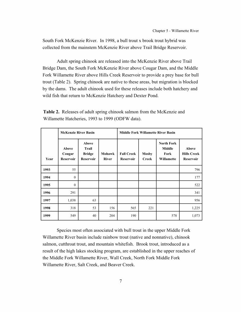
Adult spring chinook are released into the McKenzie River above TrailBridge Dam, the South Fork McKenzie River above Cougar Dam, and the MiddleFork Willamette River above Hills Creek Reservoir to provide a prey base for bulltrout (Table 2). Spring chinook are native to these areas, but migration is blockedby the dams. The adult chinook used for these releases include both hatchery andwild fish that return to McKenzie Hatchery and Dexter Pond.
Table 2. Releases of adult spring chinook salmon from the McKenzie andWillamette Hatcheries, 1993 to 1999 (ODFW data).
Year
McKenzie River Basin Middle Fork Willamette River Basin
AboveCougar
Reservoir
AboveTrail
BridgeReservoir
MohawkRiver
Fall CreekReservoir
MosbyCreek
North ForkMiddleFork
Willamette
AboveHills CreekReservoir
1993 55 796
1994 0 177
1995 0 522
1996 291 341
1997 1,038 63 956
1998 318 53 156 565 221 1,225
1999 549 40 204 190 578 1,073
Species most often associated with bull trout in the upper Middle ForkWillamette River basin include rainbow trout (native and nonnative), chinooksalmon, cutthroat trout, and mountain whitefish. Brook trout, introduced as aresult of the high lakes stocking program, are established in the upper reaches ofthe Middle Fork Willamette River, Wall Creek, North Fork Middle ForkWillamette River, Salt Creek, and Beaver Creek.

Chapter 5 - Willamette River
8
Current steelhead runs in the Middle Fork Willamette River are the resultof stocking programs begun in the 1950's. Distribution of winter and summer runsteelhead occurs downstream of Dexter Dam and in Fall Creek. Fall chinooksalmon were introduced after Dexter and Lookout Point Dams were constructed,but a self-sustaining run has not become established. Introduced warmwaterspecies, such as largemouth bass, bluegill, crappie, bullhead catfish, and walleye,and the native cyprinid, Oregon chub, occur primarily downstream of Dexter Dam(Connolly et al. 1992).
Chapter 5 - Willamette River
9
DISTRIBUTION AND ABUNDANCE
Status of Bull Trout at the Time of Listing
In 1996, the Oregon Department of Fish and Wildlife evaluated the status (riskof extirpation) of the Willamette River bull trout populations and rated them asfollows: Middle Fork Willamette River as high risk, South Fork McKenzie River asmoderate risk, Anderson Creek/mainstem McKenzie River as moderate risk, TrailBridge Reservoir as high risk, and the Santiam and Clackamas Rivers as probablyextinct (Buchanan et al. 1997). In the final listing rule (63 FR 31647), three bull troutsubpopulations in the Willamette River basin were identified: (1) McKenzie Riverand tributaries above Trail Bridge Dam, (2) McKenzie River and tributariesdownstream of Trail Bridge Dam, and (3) South Fork McKenzie River and tributariesabove Cougar Dam. All three extant populations exhibit a fluvial or adfluvial lifehistory form. Bull trout were thought to be extirpated from the Middle ForkWillamette River, the North and South Forks of the Santiam River, and the ClackamasRiver.
Current Distribution and Abundance
The Willamette Recovery Unit Team identified one core area, the UpperWillamette River core area, and the Clackamas River core habitat. The ClackamasRiver core habitat does not currently support bull trout populations, but it historicallysupported bull trout, and the recovery unit team believes that it has the necessaryelements to support reintroduction of bull trout. The Santiam River basin also hadhistoric bull trout populations, but is not considered core habitat at this time because ofuncertainties regarding its potential to support bull trout.
Upper Willamette River Core Area. The core area encompasses theMcKenzie and Middle Fork Willamette River basins and the portion of the WillametteRiver that connects the two stream systems (Figure 2). Local populations include themainstem McKenzie River, Trail Bridge, and South Fork McKenzie River. Pendingdocumentation of successful reproduction, a fourth local population may exist on theMiddle Fork Willamette River above Hills Creek Dam.

Chapter 5 - Willamette River
1 There are two Deer Creeks; both enter the McKenzie River upstream of Leaburg Dam. The DeerCreek referred to in this instance is the farthest upstream, entering the McKenzie River at riverkilometer 127 (river mile 79).
10
Figure 2. Map of the Upper Willamette River core area, with local populationsdelineated.
The mainstem McKenzie River local population occurs from the mouth to TrailBridge Dam and extends into portions of the South Fork McKenzie River, Gate Creek,Blue River, Horse Creek, Separation Creek, Deer Creek,1 Olallie Creek, and AndersonCreek. A total of 170 kilometers (105.6 miles) of stream habitat has been identified asbeing used by bull trout in the McKenzie River basin downstream of Trail Bridge Dam(Ziller and Taylor 2000). Most of the population occurs upstream of Leaburg Dam. However, since 1995 when color video equipment was added to the dam, greatlyfacilitating identification of bull trout, from 4 to 28 bull trout (25.4 centimeters [10inches] and larger) annually have been observed passing through the fish ladder at this
dam (Figure 3) (EWEB et al. 2001; ODFW 2001a). In March 1999, a 74-centimeter
Chapter 5 - Willamette River
11
(29-inch) bull trout was captured by Oregon Department of Fish and Wildlife crewswhile seining near the mouth of the McKenzie River (WRUT, in litt., 1997b). Damson the Blue River and the South Fork McKenzie River limit upstream movement ofthe mainstem McKenzie River local population in these tributaries.
Adult bull trout overwinter in the mainstem McKenzie River, distributedthroughout the river as far downstream as Hendricks Bridge (river kilometer 38)(WRUT, in litt., 1997a). They occupy large pools, using available large wood andundercut banks for cover (USFS 1995a). Upstream migration begins in April andcontinues through the summer until September when the fish are found staging inlarge pools near spawning tributaries (ODFW 2001a). Radio-tagged bull trout enteredAnderson Creek in late August or early September. They remained in Anderson Creekfor approximately one month and then quickly returned to overwintering sites lower inthe river.
Several bull trout returned to the same overwinter sites each year during theperiod in which they were monitored (Ziller and Taylor 2000). In 1999 in AndersonCreek, data from a passive electronic counter (called a Vaki River Watcher) showedthat bull trout migrated upstream and downstream at a higher rate during daylighthours (69 percent and 61 percent, respectively). Peak migration of bull trout throughthe fish counter in 1999 occurred during the middle of September. Bull trout ranged insize from 18 to 81 centimeters (7 to 31.9 inches) (Ziller and Taylor 2000).
Bull trout habitat in McKenzie River spawning streams is characterized byabundant large wood (instream), high channel complexity, and a mature conifercanopy. Mainstem habitats used by bull trout, in addition to large pools, include sidechannels, river margins, and tributaries (USFS 1995a).

Chapter 5 - Willamette River
12
0
5
10
15
20
25
30
Num
ber o
f Fis
h O
bser
ved
1995 1996 1997 1998 1999 2000 2001Year
Figure 3. Number of bull trout counted at Leaburg Dam on the McKenzie River,1995 through September 2001 (partial count).
Known juvenile bull trout distribution in the mainstem McKenzie River, asdetermined from night snorkeling, extends at least 8 river miles downstream ofAnderson and Olallie Creeks to just downstream of Lost Creek (ODFW 2001a), atapproximately river kilometer 118. Data from a screw trap that has been operatedseasonally since 1993 and located immediately downstream of the culvert passingunder Highway 126 and approximately 0.4 kilometer (0.25 mile) upstream of themouth of Anderson Creek (Ziller and Taylor 2000) indicate that the majority of bulltrout fry (age less than 1 year) and juveniles (age greater than 1 year) migrate fromAnderson Creek between February and June (ODFW 2001a). Peak migration occursfrom the middle to the end of March (ODFW 2001a). A similar trap was installed inOlallie Creek in 1999 about 50 meters (164 feet) upstream of Highway 126 (Ziller andTaylor 2000).
During snorkel surveys in 1993, juvenile (7.6 to 12.7 centimeters [3 to 5inches] in length) bull trout were observed in the lower 1.45 kilometers (0.9 miles) ofSeparation Creek, a tributary to Horse Creek. However, subsequent surveys in 1995
Chapter 5 - Willamette River
13
(using electrofishing techniques) and in 1997 (using snorkel and angling techniques)failed to identify spawning areas in Separation Creek (ODFW 1993b; USFS 1997).
The bulk of spawning takes place in Anderson Creek (in approximately 3.8kilometers [2.4 miles]) and to a lesser extent in Olallie Creek. Access toapproximately 3.2 kilometers (2.0 miles) of spawning and rearing habitat in OlallieCreek upstream of Highway 126 was restored in 1995 when a culvert blockingpassage was replaced. Spawning has not been documented in other tributaries; forexample, Blue River is thought to be used primarily for foraging (EWEB et al. 2001). Spawning timing, based on redd counts from 1995 through 1999, showed thatspawning peaked in the third week of September (Taylor and Reasoner 2000). In1999, peak migration of bull trout (upstream and downstream) through the fish counteroccurred from September 10 to 17 (Taylor and Reasoner 2000).
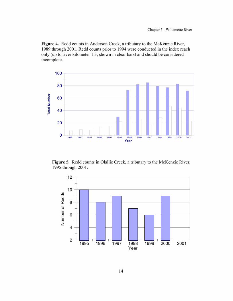
Total adult abundance of bull trout is difficult to estimate because of a lack ofinformation, including the following: (1) proportion of adult population spawning in agiven year, (2) number of redds per female bull trout (ratio of 2 redds to 1 female bulltrout), and (3) sex ratio (ratio during spawning of 1.3 males to 1 female up to 1 male to2 females) (ODFW 2001a). Using professional judgment and the monitoring datacollected to date, local biologists estimate that the total adult bull trout population inthe Willamette Recovery Unit is no more than 300 fish. The mainstem McKenzieRiver local population makes up the bulk of that total abundance. Since 1995,spawning surveys in Anderson and Olallie Creeks show an average of 80 redds peryear in Anderson Creek (Figure 4) and redd counts ranging from 6 to 10 in OlallieCreek (Figure 5). In 1999, an electric counter in Anderson Creek indicated that 249bull trout adults passed upstream and 214 passed downstream (Ziller and Taylor2000).
An estimate of abundance of juvenile bull trout migrating from AndersonCreek was made using data from the downstream migrant trap on Anderson Creek. Traps are operated four days a week, from early February until the first week in June(Ziller and Taylor 2000). Results are shown in Table 3.
Chapter 5 - Willamette River
14
0
20
40
60
80
100
Tota
l Num
ber
1989 1990 1991 1992 1993 1994 1995 1996 1997 1998 1999 2000 2001Year
Figure 4. Redd counts in Anderson Creek, a tributary to the McKenzie River,1989 through 2001. Redd counts prior to 1994 were conducted in the index reachonly (up to river kilometer 1.3, shown in clear bars) and should be consideredincomplete.
2
4
6
8
10
12
Num
ber o
f Red
ds
1995 1996 1997 1998 1999 2000 2001Year
Figure 5. Redd counts in Olallie Creek, a tributary to the McKenzie River,1995 through 2001.

Chapter 5 - Willamette River
15
Table 3. Number of bull trout fry and juveniles captured in the downstream migrant trap in Anderson Creek,1994 through 2001 (Ziller and Taylor 2000; D. Bickford, U. S. Forest Service, pers. comm., 2001a).
Number of fry age 1 or less Number equal to or greater thanage 1
Date Captured Estimated Capture Captured Estimated Capture
1994 1,808 5,308 129 403
1995 1,877 5,995 261 785
1996 1,995 5,700 179 550
1997 6,540 21,592 64 215
1998 7,902 23,153 151 453
1999 7,406 21,693 100 263
2000 6,097 17,713 190 553
2001 5,840 9,733 141 235
a Estimated number of bull trout captured if the trap ran continuously and captured fish at a 60 percent rateof efficiency.
In 1999, densities of juvenile bull trout were estimated in 2.6 kilometers (1.62miles) of Anderson Creek by using the modified Hankin and Reeves (1988) protocol. An average of 1.8 juvenile (age 1 to 2 years or more) bull trout per unit were observedin 60 habitat units. Pocket units had the highest observed densities (9.7 per 100 squaremeters), while the lowest densities were observed in fast-water units (0.8 per 100 square meters) (Taylor and Reasoner 2000).
The Trail Bridge local population occurs in Trail Bridge Reservoir upstream toTamolitch Falls, a natural barrier. The Trail Bridge pool, the mainstem McKenzieRiver to Tamolitch Falls, and the lower Smith River provide foraging and rearinghabitat. Spawning and rearing habitat consists of Sweetwater Creek and the mainstemMcKenzie River above the Trail Bridge pool (USFS 1997).
Spawning occurs in the mainstem McKenzie River upstream of Trail BridgeReservoir in about 1.1 kilometers (6.8 miles) of available habitat. In 1992, passagerestoration in Sweetwater Creek (tributary to Trail Bridge Reservoir) through a

Chapter 5 - Willamette River
16
blocked culvert under Highway 126 was completed, making 2.4 kilometers (1.49miles) of additional spawning and juvenile rearing habitat accessible (Ziller andTaylor 2000). Fry transfers from Anderson Creek into Sweetwater Creek between1993 and 1999, ranging from 308 to 1,889 fry annually, were designed to helpreestablish spawning in this tributary. In 1999, five adults were video-recordedascending into Sweetwater Creek from Trail Bridge Reservoir, and in 2001, 11 adultswere recorded (Bickford, pers. comm. 2001b). Redds were first observed in 2000when 2 were counted. In December 2001, 4 bull trout juveniles measuring 60 to 70millimeters (2.36 to 2.76 inches) in length were observed during snorkel surveys(USFS 2001).
Counting bull trout redds in the McKenzie River upstream of Trail Bridge iscomplicated by the presence of chinook salmon redds. However, biologists estimatedzero to 12 bull trout redds in this reach since they began spawning surveys in 1994(Ziller and Taylor 2000). The population probably has fewer than 20 adults spawningeach year (ODFW 2001a).
Bull trout redds (two) were first observed in Sweetwater Creek in 2000, andone redd has been counted so far during surveys in 2001 (D. Bickford, pers. comm.,2001b). However, no bull trout fry have been positively identified during two surveyefforts (ODFW 2001a).
The third bull trout local population occurs in the mainstem South ForkMcKenzie River upstream of Cougar Dam to approximately the wilderness boundaryand also the lower portions of French Pete Creek and Roaring River—a total of 29.3kilometers (18.2 miles) of habitat. Spawning and juvenile rearing are known to occuronly in Roaring River, a large spring-fed tributary of the South Fork McKenzie River,or 5 kilometers (3 miles) of the total habitat of the local population (Ziller and Taylor2000).
Radio-tagging four fish from 1997 through 1999 determined that bull troutreside in Cougar Reservoir until the end of April and move into the South ForkMcKenzie River in early May. Two tagged fish entered Roaring River in late Augustand early September, presumably to spawn, and had reentered the reservoir by the

Chapter 5 - Willamette River
17
middle of October (Ziller and Taylor 2000). A passive electronic counter installed inRoaring River in 1999 counted 41 fish passing upstream (66 percent) at night, whilemost downstream passage (71 percent) occurred during daylight hours. Most bulltrout (83 percent) passing the counter migrated into Roaring River during the first twoweeks in September. Migration peaked in late September and early October and wascomplete by early October. The average length of fish passing upstream was 42centimeters (16.5 inches) and ranged from 21 to 58 centimeters (8.3 to 23 inches)(Ziller and Taylor 2000). In 2000, 81 bull trout were counted migrating up RoaringRiver (ODFW 2001a).
Redd counts in Roaring River showed a sharp increase over the past four years(Figure 6). The use of the radio tags and the Vaki counter has improved the ability topinpoint timing and location of spawning in this very turbulent stream. The OregonDepartment of Fish and Wildlife estimates the adult population of the South ForkMcKenzie River at 80 to 100 adults (ODFW 2001a). In 1999, the estimated number ofbull trout per redd was 3.2 in Roaring River.
Historic distribution in the Middle Fork Willamette River local populationincluded the mainstem Middle Fork Willamette River, the North Fork Middle ForkWillamette River, Salt Creek, Swift Creek, Staley Creek, and Hills Creek Reservoir(ODFW 2001a).
In spite of extensive electrofishing and snorkeling survey efforts between 1993and 1997 in approximately 400 kilometers (248.5 miles) of streams in the Middle ForkWillamette River and contiguous springs, bull trout were not located (ODFW andUSFS 1998). Personnel with the Oregon Department of Fish and Wildlife and theU.S. Forest Service snorkeled most of the pools in the Middle Fork Willamette Riverfrom Paddy’s Valley to Staley Creek, as well as much of Swift Creek, but no bull troutwere found (ODFW 2001a). Nevertheless, persistent reports from anglers suggest thata few bull trout may remain in the basin. As late as 1990, a bull trout was documentedin a photograph taken at the head of the middle fork arm of Hills Creek Reservoir. The most recent reliablereport was by an angler who caught a subadult in early June2000 in the Middle Fork Willamette below Hills Creek Dam (river kilometer 66). Theorigin of the fish is unknown, although it was possibly one of the 178 fry released in
Chapter 5 - Willamette River
18
0
5
10
15
20
25
30
35
Num
ber o
f Red
ds
1993 1994 1995 1996 1997 1998 1999 2000 2001Year
Figure 6. Redd counts in the Roaring River, a tributary to the South Fork McKenzieRiver, 1993 through 2001.
upper Middle Fork Willamette River tributaries in 1997 (see discussion below) (Zillerand Taylor 2000).
The Oregon Department of Fish and Wildlife assumed that a few bull troutremained in the basin and, in 1997, implemented a plan to restore bull trout to theMiddle Fork Willamette River above Hills Creek Reservoir. Between 1997 and 2000,a total of 6,439 bull trout fry from Anderson Creek, approximately 25 to 35millimeters (0.98 to 1.4 inches) in length, were released into seven sites in the MiddleFork Willamette River basin (Table 4) (Ziller and Taylor 2000). Spring-fed portionsof the Middle Fork Willamette River and tributaries above Hills Creek Reservoir stillappear to contain suitable spawning and rearing habitat for bull trout (ODFW 2001a).
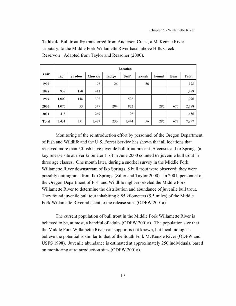
Chapter 5 - Willamette River
19
Table 4. Bull trout fry transferred from Anderson Creek, a McKenzie Rivertributary, to the Middle Fork Willamette River basin above Hills CreekReservoir. Adapted from Taylor and Reasoner (2000).
YearLocation
Iko Shadow Chuckle Indigo Swift Skunk Found Bear Total
1997 96 26 56 178
1998 938 150 411 1,499
1999 1,000 148 302 526 1,976
2000 1,075 53 349 204 822 285 673 2,788
2001 418 269 96 1,456
Total 3,431 351 1,427 230 1,444 56 285 673 7,897
Monitoring of the reintroduction effort by personnel of the Oregon Departmentof Fish and Wildlife and the U.S. Forest Service has shown that all locations thatreceived more than 50 fish have juvenile bull trout present. A census at Iko Springs (akey release site at river kilometer 116) in June 2000 counted 67 juvenile bull trout inthree age classes. One month later, during a snorkel survey in the Middle ForkWillamette River downstream of Iko Springs, 8 bull trout were observed; they werepossibly outmigrants from Iko Springs (Ziller and Taylor 2000). In 2001, personnel ofthe Oregon Department of Fish and Wildlife night-snorkeled the Middle ForkWillamette River to determine the distribution and abundance of juvenile bull trout. They found juvenile bull tout inhabiting 8.85 kilometers (5.5 miles) of the MiddleFork Willamette River adjacent to the release sites (ODFW 2001a).
The current population of bull trout in the Middle Fork Willamette River isbelieved to be, at most, a handful of adults (ODFW 2001a). The population size thatthe Middle Fork Willamette River can support is not known, but local biologistsbelieve the potential is similar to that of the South Fork McKenzie River (ODFW andUSFS 1998). Juvenile abundance is estimated at approximately 250 individuals, basedon monitoring at reintroduction sites (ODFW 2001a).

Chapter 5 - Willamette River
20
Clackamas River Core Habitat. The Clackamas River core habitatencompasses the Clackamas River basin (Figure 7). Currently, no bull trout are in thiscore area, but it did support a historic population in both the Santiam and ClackamasRivers. The last documented bull trout observations in these systems were in 1945(North Santiam), 1953 (South Santiam), and 1960 (Clackamas) (Goetz 1989). Masseyand Keeley (1996) reported two instances of bull trout being caught in the 1970's. A1992 survey of the upper mainstem Clackamas River (river kilometer 79 to 85), theCollawash River (river kilometer 6.45 to 13), and the East Fork Collawash River (riverkilometer 0 to 3.9) by U.S. Forest Service and Oregon Department of Fish andWildlife personnel failed to find bull trout (Eberl and Kamikawa 1992). Additionalsurveys in 1998 and 1999 failed to find bull trout in the upper mainstem ClackamasRiver (river kilometer 123.8 to 124.6) and tributaries (Cub, Berry, Farm, Dickey,Lemiti, and Squirrel Creeks), two tributaries of the Oak Grove Fork (Shellrock andCrater Creeks), and two tributaries (East Fork Collawash River and Elk Lake Creek) inthe mainstem

Chapter 5 - Willamette River
21
Figure 7. Location of core habitat in the Clackamas River basin and of potential corehabitat in the Santiam River basin.
Collawash River (river kilometer 9.7 to 10.7) (Zimmerman 1999). Based on the sizeof bull trout recorded in creel records dating from the 1940's and 1960's and on thelocations where the fish were caught, these populations probably had a fluvial lifehistory. No estimates of historic abundance for the Clackamas and Santiam basins areavailable.
Goetz (1989) also reported that a bull trout in the Long Tom River appeared increel records in 1962. However, the Long Tom River probably never supported a bulltrout population because of the low elevation of its headwaters and subsequent lack ofvery cold water required by bull trout for spawning and rearing. This finding suggeststhat bull trout may have used the mainstem Willamette River as a foraging area.

Chapter 5 - Willamette River
22
REASONS FOR DECLINE
At the time of listing, the U.S. Fish and Wildlife Service considered dams,forest management (harvest), roads, and water quality as threats to bull trout in theWillamette River basin (USFWS 1998a). The construction of impassable dams andculverts is considered a major factor in the decline of bull trout (Wevers et al. 1992;Goetz 1994) because migratory corridors were blocked and temperature and flowregimes were altered. Ratliff and Howell (1992) list habitat degradation, passagebarriers, overharvest, chemical treatment projects, and hybridization and competitionwith nonnative brook trout as possible suppressing factors for bull trout populations inthe Willamette River basin. Alteration and degradation of instream habitat, resultingin loss of instream structure, pools, and side-channel habitats are identified as limitingbull trout populations in the McKenzie and Middle Fork Willamette River basins(ODFW 1993a; Unthank and Sheehan 1994). Causal mechanisms can be bothmanmade and natural and are difficult to quantify because data on historic populationabundance and habitat conditions are lacking.
Although much of the damage is historical and although current policies andpractices are more protective of aquatic resources, the legacy effects of past events arestill evident. What can be restored naturally—for example, riparian cover andrecruitment of large woody debris—will require many years. In other instances wherechange may not be reversible—for example, impassable dams—other solutions will berequired to address the threats to bull trout survival and persistence.
Water Quality
Impacts resulting from cumulative effects of land use activities are reflected ina river’s water quality and aquatic fauna. Although water quality in the McKenzie andMiddle Fork Willamette Rivers is considered excellent and ranks high compared withthe water quality of other rivers in Oregon (Cude 2001; EWEB et al. 2001), segmentsof both rivers are listed as water quality limited for temperature according to the CleanWater Act 303 (d) list(http://waterquality.deq.state.or.us/wq/303dlist/Download303d.htm). Both themainstem McKenzie River, from the confluence of the South Fork McKenzie River
Chapter 5 - Willamette River
23
upstream to Trail Bridge Reservoir, and Horse Creek, from the mouth to EugeneCreek, exceed the Oregon bull trout standard (10 degrees Celsius [50 degreesFahrenheit]) in the summer. The bull trout standard is conservative to protectspawning and juvenile rearing habitat and was established based on the best availableinformation at the time. Neither of the river segments currently support bull troutspawning, although Horse Creek may be used by juveniles. Whether temperature islimiting bull trout rearing in these segments is not known. Segments of the mainstemMcKenzie River and its tributaries do not meet criteria for salmonid spawning (12.8degrees Celsius [55 degrees Fahrenheit]) and rearing (17.8 degrees Celsius [64 degreesFahrenheit]), especially during the summer. A section of the Middle Fork WillametteRiver that is potentially important to bull trout (from Hills Creek Lake to StaleyCreek) is also listed because of exceeding temperature criteria for rearing salmonids insummer.
At this time, the McKenzie River is not considered limited because ofsediment, although sedimentation is raised as a major issue during interagencyconsultation discussions. The lengthy incubation time and sensitivity of bull trouteggs while in the gravel make them highly susceptible to suffocation from sedimentinputs. The McKenzie River’s ability to rapidly flush out sediments may mask subtlechanges that could affect bull trout but that may not be detectable with currentmethodologies.
Dams
Major barriers to bull trout moving upstream in the McKenzie River basininclude Cougar Dam on the South Fork McKenzie River and Trail Bridge Dam on themainstem McKenzie River. Built without effective fish passage, these structuresprevent genetic interchange among the McKenzie River bull trout populations andmay, therefore, affect their long-term persistence. Smith Dam is also a passage barrierto the Trail Bridge bull trout population, reducing habitat available to bull trout in thiswatershed above the dam. Hills Creek, Lookout Point, and Dexter Dams, all builtwithout fish passage, have limited bull trout migration in the Middle Fork WillametteRiver basin.

Chapter 5 - Willamette River
24
Juvenile spring chinook are believed to be an important prey for bull trout. Cougar Dam and Trail Bridge Dam eliminated spring chinook from spawning andrearing in the upper South Fork McKenzie River and the upper McKenzie River,respectively, for many years. The absence of spring chinook may have limited theproduction potential of the bull trout populations. Dexter Dam blocked spring chinookfrom migrating to the upper Middle Fork Willamette River. Prior to construction ofDexter and Lookout Point Dams, the Hines Lumber Company mill at river kilometer 2on the North Fork of the Middle Fork Willamette River blocked upstream migration ofspring chinook. It had a fishway, but the structure was inadequate (Hutchison et al.1966). This mill was removed in 1995 (J. Ziller, pers. comm., 2001).
Hydroelectric facilities in the upper Willamette River subbasin are potentialsources of mortalities to downstream-migrating bull trout and, in some cases, pose riskfor fish migrating upstream. The Leaburg-Walterville project, Cougar Dam and itswater temperature-control project, the Bigelow Project, Trail Bridge Dam, and HillsCreek Dam are discussed below.
Leaburg-Walterville project. Chinook fry and smolts currently experience alow level of mortality when they pass through the Leaburg roll gates, althoughalternative passage routes are available to them, for example, the left-bank fish ladderand the power canal intake screen bypass facility (EWEB et al. 2001). Bull trout useof the roll gates and any subsequent mortality are unknown. Walterville intake iscurrently unscreened, and entrainment into the turbines is a potential threat to bulltrout, although there is no data indicating that bull trout are using the power canal(EWEB et al. 2001).
Cougar Project. Downstream passage may occur through the turbines orregulating outlets. Of three radio-tagged bull trout recovered after passing through thefacility, two showed signs of injury. According to one study, mortality rates estimatedfor juvenile chinook salmon were about 7 percent for the turbine route and 32 percentfor the regulating outlet route (ODFW 2000). This study also determined thatmortality increased with fish size. Bull trout mortalities can be expected at CougarDam for downstream migrants. Bull trout exiting the dam via the spill gates wouldprobably encounter elevated total dissolved gas levels, from 97.8 to 124.1 percent of
Chapter 5 - Willamette River
25
saturation, near the base of the dam. The State of Oregon water quality criterion fortotal dissolved gas downstream of dams is a maximum not to exceed 110 percent ofsaturation relative to atmospheric pressure (OAR 340-41-445 [2][n][A]). Effects onbull trout have not been evaluated.
Bigelow Hydroelectric Project. This run-of-the-river (a dam that does nothold water longer than a 24-hour period) project is not equipped with fish passagefacilities of any kind. Although there are no data that indicate bull trout are beingimpacted by the project, there is risk of mortality to migrating bull trout. No bypasssystem prevents downstream migrants from entering the power plant, and no tailracebarrier prevents upstream migrants from swimming into the tailrace and subsequentlyinto the draft tube (NMFS and USFWS 1999).
Trail Bridge Powerhouse. The turbine intake is unscreened, and bull troutmay be entrained and killed in the turbines. If fish survive passage through theturbines, they could be lost to the Trail Bridge local population. In 1998, EugeneWater and Electric Board staff sampled nine fish from a screw trap; one was a deadjuvenile chinook salmon, and none were bull trout (EWEB et al. 2001).
Hills Creek Powerhouse. Biologists observed mortalities in juvenile springchinook in the turbine (59 percent) and regulating outlets (32 percent) at Hills CreekDam on the Middle Fork Willamette River (D. Larson, U.S. Forest Service, pers.comm., 2000). Bull trout attempting to migrate through Hills Creek Dam wouldprobably experience some mortality either going through the turbines or out theregulating outlets. The drop from the regulating outlets to the river is 53 meters (175feet).
Aquatic habitat has been degraded by dam construction and operation in theMcKenzie and Middle Fork Willamette River basins through altering flow andtemperature regimes and interrupting natural movement patterns of sediment and largewoody material. Impacts to bull trout are from loss of pool habitat for overwinteringadults and loss of side-channel habitat important to juveniles. Loss of these habitatelements in the lower mainstem McKenzie and Middle Fork Willamette Rivers has

Chapter 5 - Willamette River
26
also impaired anadromous species production, with consequences to bull trout throughloss of their historic prey base.
Temperature regimes downstream of Cougar, Blue River, and Hills CreekDams are now cooler in spring and early summer and warmer in late summer and fallthan they were prior to dam construction (Minear 1994; USACE 2000). The reducedproduction of spring chinook that resulted from the altered temperature regime affectsbull trout through loss of available prey species (USACE 2000). Temperature data arenot available for Smith River downstream of Smith Dam to assess changes resultingfrom dam operation (EWEB et al. 2001).
Flood control is a major purpose of the dams of the U.S. Army Corps ofEngineers in the Willamette River basin. The resulting reduction in peak flows in theMcKenzie River from about 1,132.7 cubic meters per second (40,000 cubic feet persecond) to about 934.46 cubic meters per second (33,000 cubic feet per second)(USACE 2000) has reduced the rivers’ ability to move bedload. Dams also reduceinputs of sediment and large wood and, therefore, deprive the rivers of buildingmaterials that, coupled with peak flow events, create and rework habitat elementsimportant to fish, for example, side channels and scour pools. Runyon (2000)estimated a 59 percent reduction in annual suspended sediment load compared withthe load before reservoirs were constructed. Logs trapped behind dams arepurposefully removed and generally lost to the river system. Minear (1994) attributedthe loss of pools in the McKenzie River above Leaburg Dam to reduced peak flows,channel straightening, and removal of large woody debris. Loss of habitat complexityin the less confined reaches of the lower McKenzie River was also attributed toreduced peak flows resulting from construction of Cougar and Blue River Dams and tobank riprapping (EA 1991). Reduced length and width of side-channel habitats in themainstem South Fork McKenzie River downstream of Cougar Dam were attributed, inpart, to reduced peak flows and loss of large wood contributions as a result of the dam(USFS 1994). The McKenzie River downstream of Dearhorn Park, between theLeaburg and Walterville projects, had many islands and shifting channels prior toflood control and the extensive riprapping (EA 1991) that was installed to protectbanks from flooding (USACE 2000). Impacts to downstream populations of bulltrout—for example, in the Blue and South Fork McKenzie Rivers—resulting from

Chapter 5 - Willamette River
27
reservoir operations during drawdown (e.g,, water level fluctuations, increasedturbidity) are not well understood and should be investigated.
The Santiam River basin contains numerous dams that would act as passagebarriers to bull trout and would need to be addressed if bull trout were reintroducedinto this basin. U.S. Army Corps of Engineers flood control facilities on the NorthSantiam River include Detroit and Big Cliff Dams, both constructed without fishpassage. Diversions at the Stayton and Minto Dams may not be passage barriers, butcould delay migration. Foster and Green Peter Dams on the South Santiam River havesimilar effects. However, the South Santiam River may have historically been used bybull trout more for foraging than for spawning and early rearing (W. Somes, U.S.Forest Serivce, pers. comm., 1999). Anadromous runs of chinook and steelhead aremaintained through hatchery programs in the North Santiam River downstream of BigCliff Dam, the Little North Santiam River, and the South Santiam River downstreamof Foster Dam.
Dams on the mainstem Clackamas River and its tributaries would presentmigration challenges to bull trout if they were reintroduced into this basin. River MillDam has a fish ladder, but it needs improvement to pass anadromous species. Farraday Dam (formerly Cazadero Dam) has a 2.74-kilometer-long (1.7 miles) ladder(North Fork fishway) that provides passage past both Farraday and North Fork Dams. North Fork Dam has a collection facility that collects downstream migrants, which arethen passed into a pipeline that takes them below River Mill Dam. Downstreammigrants may also leave North Fork Reservoir via the spillway during high flows, butsuch migrants may experience high mortality rates as they pass Farraday and RiverMill powerhouses, which are not equipped with juvenile bypass facilities (Murtagh etal. 1992).
These dams were not originally equipped with fish passage when built. Anadromous species, and probably bull trout, were cut off from upper portions of thewatershed for approximately 20 years. River Mill Dam had a ladder installed in 1939,and downstream passage was provided in the late 1950's. Whether facilities designedfor anadromous species will be sufficient to safely pass bull trout is not known (T.Horning, U.S. Forest Service, pers. comm., 1999).

Chapter 5 - Willamette River
28
Forest Management Practices
Forest management practices include timber harvest and associated roadconstruction. Recreation development and management on public lands are alsoincluded in this section as most of the Federal land is in the forested habitat.
Timber harvest, the dominant land use in the upper Willamette Riversubbasin, dates from the late 1800's and began along the lower reaches of theMcKenzie River (Weyerhaeuser 1994, 1995). Log drives on both mainstems (fromLeaburg downstream on the McKenzie River and from the North Fork Middle Forkdownstream on the Middle Fork Willamette River) were used to convey logs to millslocated at the cities of Coburg and Eugene, Oregon, until about 1912 (DSL 1983). Loggers took advantage of the high spring flows to move large log rafts downstreamunassisted by splash dams (DSL 1983). Log drives in the Middle Fork WillametteRiver upstream of Oakridge have been documented, and there is some evidence thatsplash dams were created to float the logs prior to releasing them to the stream byblowing up the dams (Unthank and Sheehan 1994). Truck logging dates from the1940's (Weyerhaeuser 1995), and by 1950, harvest had extended into portions of theupper McKenzie River subbasin (USFS 1995a). By the 1960's (based on roadconstruction built to access timber), harvest extended into the upper Middle ForkWillamette River subbasin (USFS 1996). Harvest activities peaked in the 1980's, andby the 1990's had decreased significantly on public lands due to more stringentpolicies governing management of public lands, such as the Willamette NationalForest Plan and the Northwest Forest Plan (USFS 1995a). Removing large woodfrom streams and harvesting by clear-cutting were accepted forest practices from themid-1970's until the 1980's on the National Forest (USFS 1995b). Similar actionswere recommended on private timberlands prior to revision of the Oregon ForestPractices Act in 1994 (Weyerhaeuser 1995).
Impacts to bull trout habitat that are due in part to historic harvest in riparianareas include loss of large wood and its contributions to habitat complexity, instreamstructure, and pool formation; increases in water temperature from loss of ripariancanopy; and mobilization of sediments during high flows (Chamberlain et al. 1991). Loss of pools and instream structure were identified as possible limiting factors to
Chapter 5 - Willamette River
29
bull trout in the mainstem McKenzie River, the South Fork McKenzie River belowCougar Reservoir, Deer Creek, and Horse Creek (ODFW 1993a). Water temperatureimpacts were identified in Deer Creek and in the South Fork McKenzie Riverupstream of Cougar Reservoir (ODFW 1993a). Loss of pool habitat and availablecover and the alteration of temperature regimes are possible limiting factors in theupper Middle Fork Willamette subbasin (Unthank and Sheehan 1994). Increasedtemperature in the mainstem and tributaries to the Middle Fork Willamette River areattributed to riparian harvest (ODFW 1993a; Unthank and Sheehan 1994). Streamsurveys in 1992 revealed decreases in primary pool habitat in the Middle ForkWillamette River since surveys of those habitats were conducted in 1937 (Unthankand Sheehan 1994).
Data on fine sediment in substrates and in nutrient and food web systems werenot collected during the 1992 survey, so impacts from sedimentation on bull trouthave not been evaluated. Increases in sediment can result from slope failureassociated with harvest and road building (Lyons and Beschta 1983) and from debristorrents that introduce large volumes of sediment into the stream system during highflow events. Landslides occurred more frequently in clear-cut and roaded areas thanin forested areas without roads (Lyons and Beschta 1983), thereby increasing theamount of sediment available for transport to streams in those areas. Significantincreases in channel width and aggradation at the junctions of several streams in theMiddle Fork Willamette River above Hills Creek Reservoir were noted after a floodin 1964 (Lyons and Beschta 1983). Increases in channel width and areas of exposedcobble and gravel bars were evident from aerial photographs taken of the South ForkMcKenzie River between 1939 and 1990; the number of side channels also decreasedduring the same period (USFS 1994). The 1964 flood had a major impact on theSouth Fork McKenzie River above the dam, changes were similar to those observedin the Middle Fork Willamette River.
In addition to the direct loss of large wood from harvest, logs transported andredeposited downstream during high flow events, such as the 1964 flood, aretraditionally removed for firewood, to reduce navigation hazards in the McKenzieRiver (in this instance), and to protect hydroelectric facilities (Minear 1994;Weyerhaeuser 1995; Runyon 2000). Except where logs have been salvaged for use in

Chapter 5 - Willamette River
30
aquatic restoration projects (Runyon 2000), they are lost to the stream system. Aggressive salvage of large wood from the main channel and side channels of theSouth Fork McKenzie River above the reservoir from 1964 through the early 1980'smay have caused the river to abandon side channels (USFS 1994).
Some road culverts in the Middle Fork Willamette River have been identifiedas barriers to bull trout (USFS 1996). Road culverts on Olallie and SweetwaterCreeks in the McKenzie River basin prevented access to upstream spawning andrearing habitat until they were replaced.
Some uncertainty exists regarding the long-term security of bull trout habitatbecause critical spawning and rearing habitat in the McKenzie and Middle ForkWillamette River basins in the Willamette National Forest is designated as landwhere timber harvest will continue. Provisions of the Northwest Forest Plan shouldbe adequate to prevent future habitat degradation, and past damage will heal as theforest regenerates and as projects to improve instream habitat, fish passage, andoverall watershed health are completed.
The Santiam River system has been affected in various ways by forestmanagement practices. The removal of streamside vegetation has increased theamount of sunlight hitting streams, thereby increasing temperatures in some areasabove what is suitable for good bull trout spawning and early rearing habitat. Vegetation removal has also reduced the potential amount of large wood that couldenter streams and renew habitat complexity. Soil-disturbing land managementactivities has created conditions such that disturbed soil can be mobilized by stormevents and enter streams as suspended sediment, thereby reducing habitat quality andstream biotic production. Stream channels have been cleared of trees to reduce therisk of flood damage to bridges and culverts. Road building in conjunction withharvest activities produced sediment, impacted streams because of their proximity,and created migration barriers at improperly constructed stream crossings (Somes,pers. comm., 1999). Assessments of potential bull trout habitat need to includepassage considerations at culverts and other stream crossings.

Chapter 5 - Willamette River
31
As within the rest of the bull trout subbasins, aquatic habitat has beendegraded in the Clackamas River basin by timber harvest in the riparian zone, harvestby clear-cutting, removal of large wood from stream channels, and road building(Murtaugh et al. 1992). Increased sediment loading throughout much of the lowersubbasin has decreased stream habitat quality, as well as increased streamtemperatures and decreased stream channel stability. Road building and recentregeneration harvesting of forest stands affects hydrologic function and alters peakflows; in some areas of the watershed, the road network exceeds the road densitythresholds (road miles per square mile) that the Forest Plan standards currently allow(Horning, pers. comm., 1999). Prior to the Northwest Forest Plan, many ripariancorridors were harvested of old-growth timber, and salvage logging after the 1964flood further reduced large wood available to streams. Many years will need to passbefore these areas produce trees of suitable size to contribute to large woodrecruitment in streams (Horning, pers. comm., 1999). In addition, legacy effectsremain where stream crossings do not provide adequate passage at stream culverts,although all anadromous streams have fish passage today (Horning, pers. comm.,1999). Assessments of potential bull trout habitat need to include passageconsiderations at culverts and other stream crossings.
Agricultural Practices
Most of the land used for agriculture occurs in the lower reaches of all fourbull trout subbasins. However, only the McKenzie River supports bull troutmigration and overwintering in areas that are likely to be impacted by agriculturalactivities. According to Runyon (2000), higher densities of farmland (cultivatedfields and orchards) near the river occur between Hendricks Bridge (river kilometer39) and Hayden bridge (river kilometer 24), and such farmland is less abundant todaythan in 1944. High levels of fecal coliform, total phosphorus, ammonia and nitratenitrogen, biological oxygen demand (measure of oxygen required to decomposewaste), and total solids impact water quality recorded at Coburg Road (riverkilometer 11.45) and the Mohawk River during periods of extended precipitation andhigh flows (Cude 2000). Some of these materials are attributable to agricultural run-off, but some are also from urban areas. Impacts to bull trout are unknown.

Chapter 5 - Willamette River
32
Transportation Network
Major State highways follow the mainstem rivers in all four bull troutsubbasins in the Willamette Recovery Unit: Highway 58 along the Middle ForkWillamette River and its tributary Salt Creek, Highway 242 along the McKenzieRiver, Highway 20 along the South Santiam River, Highway 22 along the NorthSantiam River, and Highway 224 along the Clackamas River from Estacada to theconfluence of Oak Grove Fork. Access over the crest of the Cascade Mountains isprovided by Highways 58 and 22.
Risks to bull trout in the McKenzie River subbasin, and potentially to theother subbasins as bull trout are successfully reintroduced, include the potential forspills of hazardous or toxic materials resulting from highway accidents. Roadmaintenance operations along Highway 126 (e.g., brush and “hazard tree” removal)remove large wood and shade elements and may cause short-term turbidity. Applying cinders to road surfaces adjacent to streams for winter driving traction mayinundate redds and could affect habitat through minor aggradation, pool filling, andchannel widening (R. Rivera, U.S. Forest Service, pers. comm., 2001).
Historic effects from development of the transportation network in theMcKenzie River subbasin remain and may limit habitat in the lower mainstem. Lossof riparian conifers to road construction and other development in the flood plainreduced potential contributions of large wood to the channel (Minear 1994). Leveesand riprap have been constructed along more than 17 kilometers (11 miles) of riverbank in the lower McKenzie River for flood control (USACE 1989). These structuresdisconnect the river from its floodplain and, over time, could gradually isolate side-channel habitats, thereby reducing off-channel habitats that are important foranadromous salmonids (Minear 1994). Bull trout may be affected by loss ofanadromous prey species that would use these habitats.
Mining
Mining for gold, silver, and copper occurred from the late 1800's to the early1900's in four mining districts on the Willamette National Forest: Blue River, Fall

Chapter 5 - Willamette River
33
Creek, North Santiam, and Quartzville. Although these areas are small isolatedpockets with questionable ore potential, some recreational mining now takes place inthe Little North Santiam and Quartzville areas (USFS 1990). Mining projects alongBlue River, most of which were tapped out by 1912 (USFS 1994), affected the riverand probably the McKenzie River downstream (N. Armantrout, Bureau of LandManagement, pers. comm., 2001). Although commercial gravel mining occurs in thelower McKenzie River, it is not considered a threat to bull trout at this time.
Residential Development
This section includes urbanization in general since the lower mainstems of theClackamas, McKenzie, and Middle Fork Willamette Rivers have been affected bysubstantial development, both industrial and residential. Summer home communitiesand individual dwellings built near streams in the Santiam River basin occur in theNorth Santiam River watershed. Impacts to bull trout are from alterations to aquatichabitat and potential impacts from periodic inputs of pollutants during storms (seeprevious discussions in the sections on Transportation Networks and AgriculturalPractices).
Runyon (2000) identified old, failing septic systems as a potential waterquality problem in the lower McKenzie River because on-site alternatives are limiteddue to thin soils, small lot sizes, a high water table, and porous soils. A total of 474river-front houses were counted between the Interstate 5 bridge and Quartz Creekbridge (Runyon 2000), a distance of approximately 48 kilometers (29.8 miles). Elevated levels of fecal coliform detected at monitoring stations at Coburg Road andMohawk River during storm events may have resulted from failing septic systemsand livestock operations (Runyon 2000). Additional testing is necessary to assessimpacts from residential septic systems.
The only major, permitted, industrial point-source discharges into theMcKenzie River are from the Weyerhaeuser Company facilities in Springfield. Several outfalls discharge treated wastewater or cooling water into the river betweenriver kilometer 22 and river kilometer 24. Temperature limits on discharged waterare either 38 degrees Celsius (100.4 degrees Fahrenheit) or 44 degrees Celsius (111.2
Chapter 5 - Willamette River
34
degrees Fahrenheit), depending on the location. A brief review of monitoring reportsfor February and May 2001 showed that temperature maximums did not exceed 24degrees Celsius (75.2 degrees Fahrenheit) or 30 degrees Celsius (86 degreesFahrenheit), respectively. The closest downstream ambient monitoring site is atCoburg Road, approximately 11.3 kilometers (seven miles) downstream from theoutfalls and the Mohawk River confluence. The temperature standard through thisreach from September 1 through May 31 is 12.8 degrees Celsius (55 degreesFahrenheit). The temperature standard was violated 21 percent of the time during the1999 water year; the area would not be considered water quality limited fortemperature unless the standard were violated 25 percent of the time. In comparison,the temperature standard was violated 4 percent of the time at the closest upstreammonitoring site at Hendricks Bridge, at approximately river kilometer 39 (Cude2000). The effects of plant effluent discharges on bull trout that may be foraging oroverwintering in the lower river is unknown.
Fisheries Management
At this time, there are no significant fish diseases in the recovery unit thatthreaten existing bull trout populations. However, whirling disease has been reportedrecently at a private trout farm in the Clackamas River basin (ODFW, in litt., 2001). Whirling disease has been present since the 1980's in the Grande Ronde basin, whichalso has several populations of bull trout. But bull trout have not shown signs of thedisease.
Bull trout may be inherently resistant to some diseases that are moredevastating to other salmonids. In challenge cost-share studies conducted by OregonState University researchers, Metolius River (Deschutes Recovery Unit) bull troutexposed to high and low doses of the infectious stages of Myxobolus cerebralis(causative agent in whirling disease) showed no signs of infection as measured by thepresence of spores (clinical disease signs). Rainbow trout exposed simultaneouslyshowed high infection prevalence and disease severity. Metolius River bull troutexposed to Ceratomyxa shasta, a myxosporean parasite that attacks the digestivesystem, did not show signs of infection (Bartholomew 2001). Disease studiesconducted on bull trout from the Deschutes River basin showed them to be relatively
Chapter 5 - Willamette River
35
resistant to all strains of infectious hematopeietic necrosis virus. Bull trout haddetectable levels of antigen to Renibacterium salmoninarum (bacterial kidneydisease) but no evidence of the disease.
Overharvest and stocking programs may have limited bull trout production inthe Willamette River basin. Prior to 1990, anglers fishing in the McKenzie andMiddle Fork Willamette Rivers and their tributaries could legally catch and keep fivetrout per day (native rainbow trout, native bull trout, stocked catchable rainbow trout,or nonnative brook trout were all listed as trout in this system). Bull trout harvest isnow prohibited, and additional gear restrictions for other species have beenimplemented, but have not been fully evaluated for their effectiveness in protectingbull trout. In the mainstem McKenzie River from Hayden Bridge upstream to BlueRiver, bait is allowed between April 17 and October 31 (ODFW 2001b). Bait isallowed in lakes and reservoirs, except for Trail Bridge, which was restricted toartificial flies and lures in 2001. Use of bait may pose some risk to bull trout, butlittle or no angling activity occurs during the time bull trout are present in these areas.
Bull trout in the upper Willamette River basin are vulnerable to overharvestand poaching because of the small number of spawning fish, the limited areas wherethey spawn, and misidentification by anglers (ODFW 1993a). Areas with easy accessand numerous dispersed campsites, such as the South Fork McKenzie River aboveCougar Reservoir, Horse Creek, the mainstem McKenzie River, and the Middle ForkWillamette River, receive greater angling pressure, which increases the potential forillegal take of bull trout. Ongoing education of anglers and the public about bull troutis needed to protect bull trout and their habitat.
Since before the 1960's, brook trout have been released into high lakes in theCascade Mountains and have become self-sustaining in some of these lakes. There isa large population of brook trout in Trail Bridge Reservoir, and hybridization is aclear concern. Brook trout are well established in the watershed above this TrailBridge Reservoir bull trout population, and abundant brook trout in the reservoir arestrong competition for bull trout, although predator–prey relationships in the reservoirhave not been studied. There is potential for hybridization and/or competition withbrook trout in the mainstem McKenzie River just downstream of Trail Bridge
Chapter 5 - Willamette River
36
Reservoir and in the Horse Creek watershed, and hybridization may already beoccurring. U.S. Forest Service surveyors reported a bull trout x brook trout hybrid inHorse Creek during snorkeling operations in 1992 and in the mainstem McKenzieRiver above Trail Bridge Reservoir in 1998. Brook trout have been present in theheadwaters of the South Fork McKenzie River for many years but have not expandedtheir range to overlap with bull trout. Brook trout distribution in the Middle ForkWillamette River extends downstream as far as the mouth of Tumblebug Creek as aresult of lake stocking (WRUT, in litt., 1997a). Brook trout are also found in lakes inthe Swift Creek and Bear Creek drainages and in Beaver Creek (ODFW and USFS1998), Wall Creek, North Fork Middle Fork Willamette River, and Salt Creek(Connolly et al. 1992). Brook trout do not inhabit the bull trout release areas, andbull trout are prevented from expanding upstream by several natural barriers (ODFWand USFS 1998).
Chemical treatment of the Middle Fork Willamette River above and belowHills Creek Dam and tributaries above the dam was carried out in 1960 to removenongame fish before closing the dam. Most bull trout were probably eliminated inthe treatment area, and the remaining population level is probably small enough tohave resulted in a serious genetic bottleneck (ODFW 1993a).
Risks to bull trout reintroduced into the Santiam River basin include 1)overharvest from misidentification and deliberate poaching and 2) hybridization andcompetition with brook trout. Brook trout have been introduced into dozens of lakesin the North Santiam River basin. In various places, they have strayed from the lakesand are residing in outlet streams. Surveys have generally not found them very farfrom the lakes where they were stocked, though in some instances decades havepassed since the original stocking. Any proposal for reintroducing bull trout into theNorth Santiam River should consider the present distribution of brook trout in thebasin (Somes, pers. comm., 1999).
Harvest appears to have been a major factor in eliminating bull trout from theClackamas River basin before the existing protective regulations were implemented. The Clackamas River receives heavy angling pressure and is close to the Portland

Chapter 5 - Willamette River
37
metropolitan area, factors that could be important in the future if bull trout arereintroduced (Horning, pers. comm., 1999).
Brook trout are generally restricted to small headwater streams, often abovefalls that are barriers to anadromous fish migration; they would have little opportunityto impact bull trout (Horning, pers. comm., 1999). Brook trout are also found inTimothy Lake and the Oak Grove Fork of the Clackamas River, although they are nolonger stocked in these waters. They reproduce naturally in tributaries flowing intoTimothy Lake (Murtagh et al. 1992). Brown trout found in the Oak Grove Fork ofthe Clackamas River are descendants of fish planted there under past hatcheryprograms (Murtagh et al. 1992).
Isolation and Habitat Fragmentation
Bull trout populations in the Willamette Recovery Unit are exposed to agreater risk of extinction because of their small population size and physical isolationby dams. Dams act as barriers preventing gene flow from the mainstem McKenzieRiver local population to the local populations above the dams and inhibit gene flowfrom the local populations above the dams to the mainstem McKenzie River localpopulation. Bull trout that survive passing downstream at the dams are lost to thelocal populations above the dams. Bull trout in the Willamette Recovery Unit arebelow the numbers that, in current population theory, are thought to represent a viablepopulation (minimum of 1,000 adult spawning individuals) to minimize inbreedingeffects and maintain an ability to adapt to changing environmental conditions(Rieman and Allendorf 2001). Maximizing adult bull trout abundance in the localpopulations is essential for their long-term genetic health. However, even ifpopulations were in a recovered state, restricted amounts of suitable habitat becauseof not restoring opportunities for passage may limit attainment of what would beconsidered viable numbers in each bull trout local population. Restoringopportunities for passage increases the overall fitness by allowing for geneticinterchange among the local populations and by renewing adult numbers in localpopulations behind dams.
Chapter 5 - Willamette River
38
The spawning area of the McKenzie River bull trout local populationdownstream of Trail Bridge Dam is currently limited to approximately 5 streamkilometers (3 miles) in two streams, both located within a 1.6-kilometer (1-mile)radius. This condition increases the risk of extirpation for this population from ahuman or natural disturbance, such as a wildfire or chemical spill at the Highway 126crossings (USFS 1995a). Establishing viable populations in historic habitat in theClackamas, Santiam, and Middle Fork Willamette Rivers spreads the risk ofextinction due to a catastrophe and provides a donor source for recolonization. Reintroduction into the Middle Fork Willamette River basin has begun (seediscussion in the section on Distribution and Abundance), while assessments forsuitability to support viable bull trout populations need to be completed for theClackamas River basin and initiated for the Santiam River basin.

Chapter 5 - Willamette River
39
ONGOING RECOVERY UNIT CONSERVATION MEASURES
Efforts to recover bull trout and other native species are ongoing in theWillamette Recovery Unit, with a high level of cooperation occurring betweenfishery entities on various projects. Spawning surveys have been a cooperative effortfor many years. The McKenzie River basin has an active local watershed groupdedicated to finding workable solutions to restoring native fish runs. The followinglist of activities is by no means complete, but is representative of ongoing effortswithin the Willamette Recovery Unit.
State of Oregon
Angling regulations have been changed to protect bull trout (Table 5),including closure to angling for bull trout and catch and release of trout in all streamsin the Willamette Zone (which is comparable to the Willamette River basin).
Table 5. Changes in Oregon Department of Fish and Wildlife angling regulationsto protect bull trout (Ziller and Taylor 2000).
Year Location Regulation Change
1991 Willamette River basin Taking bull trout prohibited
1992 McKenzie River (mainstem and South Fork) All wild trout must be released
1994 McKenzie River (river kilometer 105 to 133) Artificial flies and lures only
1997 South Fork McKenzie River Artificial flies and lures only
Trail Bridge Reservoir All wild trout must be released
Middle Fork Willamette River (above Hills CreekReservoir)
All wild trout must be released; artificialflies and lures only
2001 Most of McKenzie River tributaries and Trail BridgeReservoir
All wild trout must be released;Artificial flies and lures only
The Oregon Department of Fish and Wildlife has reduced or eliminated troutstocking programs (Table 6). Brook trout are no longer stocked in high lakes in theMcKenzie and Middle Fork Willamette River basins. No hatchery trout are released
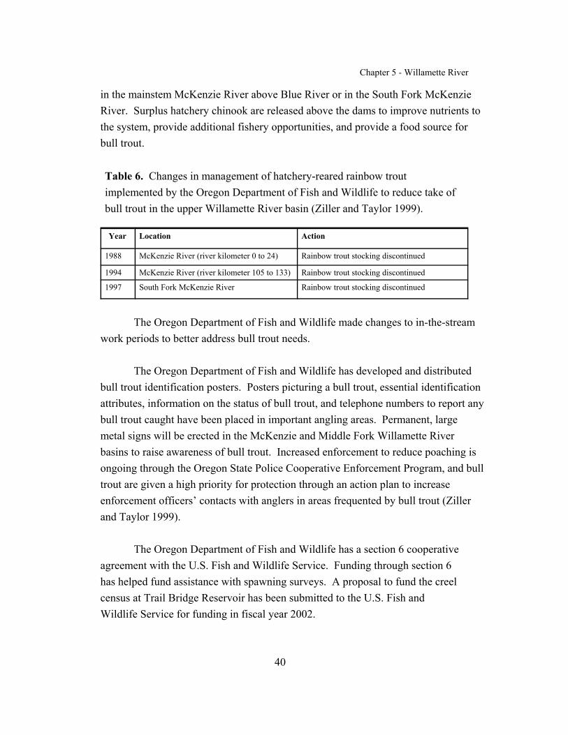
Chapter 5 - Willamette River
40
in the mainstem McKenzie River above Blue River or in the South Fork McKenzieRiver. Surplus hatchery chinook are released above the dams to improve nutrients tothe system, provide additional fishery opportunities, and provide a food source forbull trout.
Table 6. Changes in management of hatchery-reared rainbow troutimplemented by the Oregon Department of Fish and Wildlife to reduce take ofbull trout in the upper Willamette River basin (Ziller and Taylor 1999).
Year Location Action
1988 McKenzie River (river kilometer 0 to 24) Rainbow trout stocking discontinued
1994 McKenzie River (river kilometer 105 to 133) Rainbow trout stocking discontinued
1997 South Fork McKenzie River Rainbow trout stocking discontinued
The Oregon Department of Fish and Wildlife made changes to in-the-streamwork periods to better address bull trout needs.
The Oregon Department of Fish and Wildlife has developed and distributedbull trout identification posters. Posters picturing a bull trout, essential identificationattributes, information on the status of bull trout, and telephone numbers to report anybull trout caught have been placed in important angling areas. Permanent, largemetal signs will be erected in the McKenzie and Middle Fork Willamette Riverbasins to raise awareness of bull trout. Increased enforcement to reduce poaching isongoing through the Oregon State Police Cooperative Enforcement Program, and bulltrout are given a high priority for protection through an action plan to increaseenforcement officers’ contacts with anglers in areas frequented by bull trout (Zillerand Taylor 1999).
The Oregon Department of Fish and Wildlife has a section 6 cooperativeagreement with the U.S. Fish and Wildlife Service. Funding through section 6has helped fund assistance with spawning surveys. A proposal to fund the creelcensus at Trail Bridge Reservoir has been submitted to the U.S. Fish andWildlife Service for funding in fiscal year 2002.
Chapter 5 - Willamette River
41
An Oregon Department of Fish and Wildlife project to monitordistribution, population trends, and habitat use of bull trout populations in theMcKenzie and Middle Fork Willamette River basins and to implementrehabilitation of bull trout in the Middle Fork Willamette River basin has beenoccurring since 1994. The project is funded by the Bonneville PowerAdministration through the Northwest Power Planning Council’s Fish andWildlife Program (Project No. 9405300). This project has resulted in thecollection of most of the current information we have on bull trout distributionand abundance in the McKenzie and Middle Fork Willamette River basins. Through this project, and along with the participation of the WillametteRecovery Unit Team members, several restoration projects have beencompleted, including culvert replacements in Sweetwater Creek in 1992 and inOlallie Creek in 1995.
Sweetwater Creek is a designated key watershed, where habitat isprotected from land use effects by the Northwest Forest Plan. Bull trout fryfrom Anderson Creek were, over a period of a few years, transplanted intoSweetwater and Olallie Creeks to reestablish bull trout in those streams. In1998, the Oregon Department of Fish and Wildlife began transplanting fry fromAnderson Creek into the upper Middle Fork Willamette River subbasin aboveHills Creek Reservoir to restore extirpated or depleted bull trout populations inthe Middle Fork Willamette River basin (Taylor and Reasoner 2000).
Another Oregon Department of Fish and Wildlife project funded byBonneville Power Administration (Project No. 9405400) has resulted in thegenetic analysis of Oregon bull trout, including samples from the McKenzieRiver populations. This research established the genetic baseline for Oregonbull trout and confirmed the Oregon Department of Fish and Wildlife’sdesignation of Willamette River bull trout as a separate gene conservation group(Spruell and Allendorf 1997).
In 1995, the Oregon Department of Fish and Wildlife hired a bull troutcoordinator to complete a statewide bull trout status assessment, map bull trout

Chapter 5 - Willamette River
42
distribution, and develop conservation strategies for bull trout. When bull troutwere listed, the effort shifted to recovery planning.
In 1993, the Oregon Department of Fish and Wildlife began releasingexcess hatchery adult and juvenile spring chinook into the South ForkMcKenzie River above Cougar Dam and into the upper Middle Fork WillametteRiver above Hills Creek Dam to provide nutrients to the system and food forbull trout. Releases are made periodically when excess hatchery fish areavailable. In 1997, adult fish were released into the mainstem McKenzie Riverabove Trail Bridge Reservoir.
Beginning in 2001, the U.S. Army Corps of Engineers is helping to fundOregon Department of Fish and Wildlife research investigations to betterunderstand movement and habitat use patterns of bull trout in the South ForkMcKenzie River above Cougar Dam and to develop a plan to minimize impactsof construction of the Cougar Reservoir Temperature Control Project. Drafting(removal of water) of the reservoir, as required for construction of the facility,may adversely affect bull trout. The goal of the research project is to ensurethat the bull trout population is protected during construction of thetemperature-control project (ODFW 2000). Work completed in 2001 includedthe following: trapping and fitting adult bull trout with radio tags (15 total with13 still accounted for as of October 2001); tagging juveniles and adult bull trout(total of 72 fish) with passive integrated transponders (commonly known as“PIT tags”); setting a trap net in Cougar Reservoir; setting minnow traps in theSouth Fork McKenzie River system to trap juveniles; tagging juveniles (9juvenile bull trout were captured; 2 had been PIT-tagged previously); installingand operating a rotary screw trap in Roaring River to monitor juvenilemovement and an 8-foot rotary screw trap in the tailrace of Cougar Reservoir tomonitor movement of fish through the turbines; conducting redd surveys onSeptember 6 and 27 and in early October; and installing and operating a Vakifish counter in Roaring River from August through October to enumerate adultbull trout migrating to and from spawning areas (Wade 2001).
Chapter 5 - Willamette River
43
Federal Activities
The Willamette National Forest has completed a variety of habitatprojects that will benefit bull trout: construction of buck side channels toimprove rearing habitat in the upper mainstem McKenzie River; culvert projectsin Ollallie and Sweetwater Creeks; placement of large wood in Anderson Creek;buck side channel construction in South Fork McKenzie River above CougarReservoir and in Roaring River to provide additional cover, nutrient capture,and prey items and to improve bull trout production; and a habitat enhancementproject at Gate Creek to improve bull trout foraging habitat (USFWS 1998b;Ziller and Taylor 2000). In addition, Willamette National Forest staff hasassisted Oregon Department of Wildlife staff with producing and distributing“Please Release Me” posters at campgrounds and other high-use areas and inreintroducing bull trout in the Middle Fork Willamette River. The GiustinaLand Exchange will contribute to cumulative improvements in bull trout habitatby increasing the acreage of riparian habitat that is managed by the WillametteNational Forest and that has protections under the Northwest Forest Plan(USFWS 1998c). Harvest in riparian zones has been severely restricted underthe amended Northwest Forest Plan, a restriction that should increase thedominance of conifer communities (USFS 1994) and their future contribution toinstream large woody material. Habitat improvement projects in the MiddleFork Willamette River include placing logs, root wads, and boulder structures inthe mainstem river from the mouth of Echo Creek to the mouth of Found Creekto increase pool habitat and add habitat complexity. Structural elements wereadded in the mainstem and side channels at Secret Campground and SacandagaCampground to increase complexity and provide rearing habitat, and largewood was added to the lower reaches of Youngs Creek, Estep Creek, and PineCreek to improve fish passage (ODFW and USFS 1998). The U.S. ForestService plans to place additional spawning gravel in four of the release sites toimprove spawning habitat (ODFW 2001a).
During section 7 consultation on continuing operation of their 13 damsand reservoirs in the Willamette River basin, the U.S. Army Corps of Engineersdiscussed the need for restoration of riparian areas and floodplains. This work

Chapter 5 - Willamette River
44
would most likely take place primarily in the upper mainstem Willamette Riverand attempt, among other activities, to recapture side channel areas. Other areaswithin the Willamette River basin affected by U.S. Army Corps of Engineersactivities, for example, below Cougar Dam, could also be potential project sites. While the exact nature and scope of the restorative work are yet to bedetermined, such work will include restoring elements of natural ecosystemprocesses, such as channel complexity and large wood components, andconsidering ecosystem processes, such as sediment and flow dynamics, as theyrelate to habitat abundance and diversity. The Willamette Action Team forEcosystem Restoration, which will be established as a requirement under theWillamette River basin Biological Opinion, will determine the overall goals andobjectives, the priority actions and areas, and the individual project scopes anddetails for the Willamette River riparian area and floodplain restoration program(C. Willis, U.S. Army Corps of Engineers, pers. comm., 2001).
The U.S. Army Corps of Engineers is in the process of constructing atemperature-control project at Cougar Reservoir to regulate water temperaturesof water leaving the reservoir, primarily for the benefit of spring chinook. Benefits to bull trout would be in improved spawning and rearing of springchinook, a prey species, as temperatures are regulated to mimic pre-reservoirconditions. A similar project is also being proposed for Blue River Reservoir.
The U.S. Army Corps of Engineers is studying 10 alternatives for fishpassage (for chinook and bull trout) at Cougar Reservoir. Seven alternativesshowed promise, although more must be known about the behavior of the targetfish species and about the specific biological goals for the South ForkMcKenzie River (CH2M HILL 1999).
Relicensing for Portland General Electric hydroelectric projects in theClackamas River basin is in progress, with the application to the Federal EnergyRegulatory Commission due in 2001. Bull trout needs have been discussed, anda new ladder at River Mill Dam is scheduled for construction in 2005.

Chapter 5 - Willamette River
45
Eugene Water and Electric Board
The Eugene Water and Electric Board has proposed modifications to theLeaburg-Walterville Project that are expected to improve passage conditions forchinook and bull trout. A feasibility study will be conducted to study fishpassage under the roll gates. Raising the Leaburg Lake level may provide abenefit to bull trout by increasing overwintering habitat. Other conservationmeasures proposed as part of their relicensing application to the Federal EnergyRegulatory Commission include establishing a land trust program to include a$500,000 grant to the McKenzie River Trust for purchase of land and/orconservation easements and increasing interim instream flows downstream ofLeaburg Dam (until construction of the Walterville intake screen and bypassfacility are completed). Proposed studies include (1) evaluating opportunities toenhance habitat condition downstream of the Carmen-Smith Project and TrailBridge Dam; (2) investigating stranding potential at Trail Bridge Reservoirassociated with project operating regimes; (3) analyzing and evaluatingopportunities and constraints to joining the two bull trout subpopulations aboveand below Trail Bridge Dam; (4) evaluating entrainment and mortality andpossible deterrent devices at turbine intakes; (5) studying bull trout habitatenhancement for Trail Bridge bull trout, focusing on the potential to improvehabitat conditions in Sweetwater Creek, the Smith River upstream of TrailBridge Reservoir, and the mainstem McKenzie River; and (6) studying bulltrout abundance above Trail Bridge Dam (EWEB et al. 2001).

Chapter 5 - Willamette River
46
RELATIONSHIP TO OTHER CONSERVATION EFFORTS
State of Oregon
On January 14, 1999, Governor Kitzhaber expanded the Oregon Plan forSalmon and Watersheds (Oregon 1997) to include all at-risk wild salmonidsthroughout the State through Executive Order 99-01. The goal of the OregonPlan is to “restore populations and fisheries to productive and sustainable levelsthat will provide substantial environmental, cultural, and economic benefits.” Components of this plan include 1) coordinating of efforts by all parties, 2)developing action plans with relevance and ownership at the local level, 3)monitoring progress, and 4) making appropriate corrective changes in thefuture. The plan is a cooperative effort of State, local, Federal, Tribal, andprivate organizations and individuals.
The Oregon Department of Fish and Wildlife and the Oregon WaterResources Department have established priorities for restoring streamflow aspart of the Oregon Plan for Salmon and Watersheds (Measure IV.A.8). TheOregon Department of Fish and Wildlife has prioritized streamflow restorationneeds by ranking biophysical factors, water use patterns, and the extent thatwater limits fish production in a particular area. The watermasters of theOregon Water Resources Department will incorporate these priorities into theirfield work activities as a way to implement flow restoration measures. Thepriorities for streamflow restoration needs will also be used by the OregonWatershed Enhancement Board as one criterion in determining fundingpriorities for enhancement and restoration projects. Watershed councils andother entities may also use the needs priorities as one piece of information todetermine high-priority restoration projects. Streams occupied by bull trout inthe recovery unit are included in the highest priority designation for streamflowrestoration (NWPPC 2001).
The McKenzie Watershed Council has been in existence since 1993 andis one of many local watershed councils operating in the Willamette Riverbasin. Watershed councils generally identify baseline conditions in their

Chapter 5 - Willamette River
47
watersheds, including assessing watershed conditions, identifying problems,and making recommendations or identifying solutions to problems. TheMcKenzie River watershed assessment has been completed for the McKenzieWatershed Council and includes recommendations for high-priority actions ineducation, conservation, restoration, institutional change, and monitoring(Runyon 2000).
Opportunities to convert existing out-of-stream flows to instream flowsin Oregon are available through a variety of legislatively mandated programsadministered by the Oregon Water Resources Department, including transfers oftype and place of use (ORS 536.050[4]), voluntary written agreement amongwater users to rotate their use of the supply to which they are collectivelyentitled (ORS 540.150 and OAR 690-250-0080), allocation of “conservedwater” to instream use (ORS 537.455 to 537.500), lease of all or a portion ofconsumptive water rights to instream purposes (ORS 537.348, OAR 690-77-070to 690-77-077), exchange of a water right for an instream purpose to use waterfrom a different source (stored water, surface or groundwater) (ORS 540.533 to540.543), and substitution of a groundwater right for a primary surface waterright (ORS 540.524). The Oregon Water Trust provides purchase of waterrights from willing landowners for conversion to instream water rights.
The Oregon Department of Environmental Quality oversees theWillamette River total maximum daily load process. This process will lead todevelopment of a Water Quality Management Plan to address forest,agricultural, urban, and transportation sources of water quality impairment (http://waterquality.deq.state.or.us/wq/TMDLs/TMDLs.htm).
The Agricultural Water Quality Management Program, establishedthrough Senate Bill 1010 (ORS 568.900 through 568.933), addresses waterpollution associated with agricultural lands and activities and will beincorporated into plans that are drafted as part of the total maximum daily loadprocess.

Chapter 5 - Willamette River
48
Total maximum daily loads and water quality management plans for theWillamette River basin (including the McKenzie, Middle Fork Willamette,Santiam, and Clackamas Rivers) are expected to be completed in 2003. Available data have been analyzed, and additional field monitoring is ongoingat this time. The Willamette National Forest has completed the Water QualityRestoration Plan for the upper McKenzie River watershed, which has been sentto the Oregon Department of Environmental Quality as part of the process(Rivera, pers. comm., 2001)(http://www.deq.state.or.us/wq/Willamet/WillMonthlyRpt0801.pdf).
In mid-1996, the Oregon Department of Transportation and the OregonDepartment of Fish and Wildlife entered into a contract that committed theOregon Department of Fish and Wildlife to inventory, assess, and prioritize forrepair all culverts associated with State- and County-owned roadways in thecoastal river basins. These surveys did not include private (i.e., on forestlands,residential property, and other private lands), Federal, or city roads. Thecontract was subsequently amended several times to include all river basins inthe State (Mirati 1999).
Chapter 5 - Willamette River
49
Federal Activities
As part of the Pacific Northwest Electric Power Planning andConservation Act of 1980, the Bonneville Power Administration has theresponsibility to protect, mitigate, and enhance fish and wildlife resourcesaffected by operation of Federal hydroelectric projects in the Columbia Riverand its tributaries. The Northwest Power Planning Council develops andimplements the Columbia River Basin Fish and Wildlife Program that isimplemented by the Bonneville Power Administration, U.S. Army Corps ofEngineers, U.S. Bureau of Reclamation, and Federal Energy RegulatoryCommission. Coordination of Bonneville Power Administration’sresponsibilities for protecting, mitigating, and enhancing fish and wildliferesources and incorporation of recommendations by the Northwest PowerPlanning Council occur in part through the development of subbasin summaries.These summaries identify status of fish and wildlife resources, limiting factors,and recommended actions at the subbasin level.
The draft Willamette subbasin summary (NWPPC 2001) encompassesthe Willamette Recovery Unit and is consistent with bull trout recoveryplanning efforts to identify limiting factors. The draft Willamette subbasinsummary identifies impassable dams and culverts, introduction of nonnativespecies, water diversions, chemical treatment (Middle Fork Willamette River),and loss of prey species contributing to the decline of bull trout. The overallfisheries goal of the draft Willamette subbasin summary, as expressed in thenumerous existing planning efforts in the basin, is “to protect and restorespecies and habitat through an integrated, ecosystem-based approach thatrespects local, tribal, and regional needs and targets strategic investment forenvironmental results.” Recovery goals and objectives for bull trout that weredeveloped by the Willamette Recovery Unit Team were incorporated into thesubbasin summary. The Willamette Recovery Unit Team will continue to usethis planning process to identify and seek funding for projects to aid bull troutrecovery.

Chapter 5 - Willamette River
50
STRATEGY FOR RECOVERY
A core area represents the closest approximation of a biologicallyfunctioning unit for bull trout. The combination of core habitat (i.e., habitat thatcould supply all the necessary elements for the long-term security of bull trout,including for both spawning and rearing, as well as for foraging, migrating, andoverwintering) and a core population (i.e., bull trout inhabiting a core habitat)constitutes the basic core area upon which to gauge recovery within a recoveryunit. Within a core area, many local populations may exist. One core area wasdefined for the Willamette Recovery Unit: the Upper Willamette River corearea. The Clackamas River is considered to represent core habitat because itcurrently does not contain any known local populations. The Santiam Riverbasin may represent core habitat, but further analysis is needed to assess currenthabitat conditions.
To recover bull trout in the Willamette River Recovery Unit, securingthe existing local populations in the McKenzie River and augmentingpopulations in the Middle Fork Willamette River will be necessary. As thesepopulations become more secure, they are expected to expand their seasonaldistribution farther into the mainstem Willamette River for foraging, migrating,and overwintering. As passage issues are resolved, migratory access maybecome possible between the Middle Fork Willamette and McKenzie Rivers.
Clackamas River Core Habitat. The Clackamas River basin has beenidentified as a potential area for reintroducing bull trout. Reestablishing bulltrout in the Clackamas River core habitat will improve the long-term outlook forbull trout recovery in the Willamette Recovery Unit. As noted earlier, the twoknown spawning streams in the mainstem McKenzie River are very near oneanother, so another core area in the Clackamas River basin—one that is fartherfrom the other two—would help safeguard bull trout persistence in theWillamette Recovery Unit by spreading potential extinction risks.
Chapter 5 - Willamette River
51
The Role of Artificial Propagation and Transplantation
As described in Chapter 1, section 3(3) of the Endangered Species Actlists artificial propagation and transplantation (or reintroduction) as methodsthat may be used for the conservation of listed species. While transplantationhas played an important role in the recovery of other listed fish species, theoverall recovery strategy for bull trout in the Willamette Recovery Unit, wherepossible, will emphasize identifying and correcting threats affecting bull troutand bull trout habitats. If transplantation is determined to be necessary for bulltrout recovery within the Willamette Recovery Unit and if a feasibility studyidentifies streams capable of supporting bull trout, the joint policy of the U.S.Fish and Wildlife Service and the National Marine Fisheries Service regardingcontrolled propagation of listed species will be followed (65 FR 56916). Also,an appropriate plan would need to be approved to consider the effects oftransplantation on other species, as well as on the donor bull trout populations. Transplanting listed species must be authorized by the U.S. Fish and WildlifeService through a 10(a)(1)(A) recovery permit, and methods must meetapplicable State fish-handling and disease policies.
In streams within the Clackamas River core habitat and the SantiamRiver basin, bull trout may or may not be present in habitat that historicallycontained reproducing populations. These streams are considered candidatelocations for transplantation activities.
Though every effort should be made to recover a species in the wildbefore implementing transplantation, in the Clackamas River core habitat andthe Santiam River basin, natural recolonization may not be a viable solution toenhance the existing abundance and distribution of bull trout. While bull troutmay respond to habitat improvements in occupied and unoccupied streams,successful recovery will probably require a transplantation program.
Recent behavioral and genetic studies of bull trout support artificialpropagation programs. These studies report that bull trout exhibit a high degreeof fidelity to natal streams (James et al., in litt., 1998; Spruell et al. 2000;

Chapter 5 - Willamette River
52
Hvenegaard and Thera 2001). Strong fidelity for natal streams does not meanthat fish movement between adjacent populations or adjacent basins does notoccur, but such fidelity may mean that gene flow and colonization orrecolonization of unoccupied habitat may take more than several generations. Therefore, to achieve recovery in the time frame that is specified in Chapter 1and in this Willamette Recovery Unit chapter, some form of reintroduction maybe necessary. If the current Willamette River bull trout populations have beenisolated and functioning at low abundance for a long period of time, such aprogram may be necessary to immediately increase the number of individualfish in the core area and to infuse new genetic material into existing populationsto avoid loss of alleles and heterozygosity (Spruell et al. 1999). Beforeimplementation of any reintroduction program, a feasibility study would becompleted to identify streams with the greatest potential to support localpopulations of bull trout and to identify the best available source of geneticmaterial.
The Willamette Recovery Unit Team recommends the following: (1)identify and correct threats in the upper Middle Fork Willamette River, theClackamas River core habitat, and the Santiam River basin, if these areas aredetermined to contain adequate bull trout habitat, to increase bull trout densitiesand to allow natural population expansion to occur within streams that haveevidence of recruitment; (2) consider a reintroduction program within the UpperWillamette River core area and the Clackamas River core habitat if a feasibilitystudy indicates that this option is the best option for recovery; and (3) recognizethat, even if threats are identified and corrected in the Upper Willamette Rivercore area and the Clackamas River core habitat, natural recolonization of bulltrout in streams that once supported a local population may take an extendedamount of time. In this case, supplementation or transplantation may be thebest option. For this option, a feasibility study would need to be completed toidentify streams with the greatest potential to support local populations. Supplementation or transplantation would then occur concurrently with otherrestoration and recovery activities

Chapter 5 - Willamette River
53
Recovery Goals and Objectives
The goal of the bull trout recovery plan is to ensure the long-termpersistence of self-sustaining, complex, interacting groups of bull troutdistributed throughout the species’ native range so that the species can bedelisted. To achieve this goal, the following objectives have been identified forthe Willamette Recovery Unit:
< Maintain current distribution of bull trout within the WillametteRecovery Unit and reestablish bull trout in previously occupied habitats.
< Maintain stable or increasing trends in abundance of bull trout in theWillamette Recovery Unit.
< Restore and maintain suitable habitat conditions for all bull trout lifehistory stages and strategies.
< Conserve genetically diverse populations of bull trout populationswithin the Willamette Recovery Unit.
Rieman and McIntyre (1993) and Rieman and Allendorf (2001)evaluated the bull trout population numbers and habitat thresholds necessary forlong-term viability of the species. They identified four elements, and thecharacteristics of those elements, to consider when evaluating the viability ofbull trout populations. These four elements are (1) number of local populations;(2) adult abundance (defined as the number of spawning fish present in a corearea in a given year); (3) productivity, or the reproductive rate of the population(as measured by population trend and variability); and (4) connectivity (asrepresented by the migratory life history form and functional habitat). For eachelement, the Willamette Recovery Unit Team classified bull trout into relativerisk categories based on the best available data and the professional judgment ofthe team.

Chapter 5 - Willamette River
54
The Willamette Recovery Unit Team also evaluated each element undera potential recovered condition to produce recovery criteria. Evaluation ofthese elements under a recovered condition assumed that actions identifiedwithin this chapter had been implemented. Recovery criteria for the WillametteRecovery Unit reflect 1) the stated objectives for the recovery unit, 2)evaluation of each population element in both current and recovered conditions,and 3) consideration of current and recovered habitat characteristics within therecovery unit. Recovery criteria will probably be revised in the future as moredetailed information on bull trout population dynamics becomes available.Given the limited information on bull trout, both the level of adult abundanceand the number of local populations needed to lessen the risk of extinctionshould be viewed as a best estimate.
This approach to developing recovery criteria acknowledges that thestatus of populations in some core areas may remain short of ideals described byconservation biology theory. Some core areas may be limited by naturalattributes or by patch size and may always remain at a relatively high risk ofextinction. Because of limited data within the Willamette Recovery Unit, therecovery unit team relied heavily on the professional judgment of its members.
Local Populations. Metapopulation theory is important to consider inbull trout recovery. A metapopulation is an interacting network of localpopulations with varying frequencies of migration and gene flow among them(Meffe and Carroll 1994) (see Chapter 1). Multiple local populationsdistributed and interconnected throughout a watershed provide a mechanism forspreading risk from stochastic events. In part, distribution of local populationsin such a manner is an indicator of a functioning core area. Based in part onguidance from Rieman and McIntyre (1993), bull trout core areas with fewerthan 5 local populations are at increased risk, core areas with between 5 and 10local populations are at intermediate risk, and core areas with more than 10interconnected local populations are at diminished risk. For the upperWillamette River core area, there are currently 3 known local populations. Based on the above guidance, bull trout in the Upper Willamette River core areais at an increasing risk category.

Chapter 5 - Willamette River
55
Adult Abundance. The recovered abundance levels in the WillametteRecovery Unit were determined by considering theoretical estimates ofeffective population size, historical census information, and the professionaljudgment of recovery team members. In general, effective population size is atheoretical concept that allows us to predict potential future losses of geneticvariation within a population due to small population sizes and genetic drift (seeChapter 1). For the purpose of recovery planning, effective population size isthe number of adult bull trout that successfully spawn annually. Based onstandardized theoretical equations (Crow and Kimura 1970), guidelines havebeen established for maintaining minimum effective population sizes forconservation purposes. Effective population sizes of greater than 50 adults arenecessary to prevent inbreeding depression and a potential decrease in viabilityor reproductive fitness of a population (Franklin 1980). To minimize the loss ofgenetic variation due to genetic drift and to maintain constant genetic variancewithin a population, an effective population size of at least 500 is recommended(Franklin 1980; Soule 1980; Lande 1988). Effective population sizes requiredto maintain long-term genetic variation that can serve as a reservoir for futureadaptations in response to natural selection and changing environmentalconditions are discussed in Chapter 1 of the recovery plan.
For bull trout, Rieman and Allendorf (2001) estimated that a minimumnumber of 50 to 100 spawners per year is needed to minimize potentialinbreeding effects within local populations. In addition, a population size ofbetween 500 and 1,000 adults in a core area is needed to minimize thedeleterious effects of genetic variation from drift.
For the purposes of bull trout recovery planning, abundance levels wereconservatively evaluated at the local population and core area levels. Localpopulations containing fewer than 100 spawning adults per year were classifiedas at risk from inbreeding depression. Bull trout core areas containing fewerthan 1,000 spawning adults per year were classified as at risk from genetic drift.
Adult abundance in the upper Willamette River core area was estimated at 300 adult spawners per year in the three known local populations. Based on

Chapter 5 - Willamette River
56
the aforementioned abundance guidance, bull trout in the upper WillametteRiver core area were considered at increasing risk of inbreeding depression.
Productivity. A stable or increasing population is a key criterion forrecovery under the requirements of the Endangered Species Act. Measures ofthe trend of a population (the tendency to increase, decrease, or remain stable)include population growth rate or productivity. Estimates of population growthrate (i.e., productivity over the entire life cycle) that indicate a population isconsistently failing to replace itself also indicate an increased risk of extinction. Therefore, the reproductive rate should indicate that the population is replacingitself, or growing.
Since estimates of the total population size are rarely available, theproductivity or population growth rate is usually estimated from temporal trendsin indices of abundance at a particular life stage. For example, redd counts areoften used as an index of a spawning adult population. The direction andmagnitude of a trend in the index can be used as a surrogate for the growth rateof the entire population. For instance, a downward trend in an abundanceindicator may signal the need for increased protection, regardless of the actualsize of the population. A population that is below recovered abundance levels,but that is moving toward recovery, would be expected to exhibit an increasingtrend in the indicator.
The population growth rate is an indicator of probability of extinction. This probability cannot be measured directly, but it can be estimated as theconsequence of the population growth rate and the variability in that rate. For apopulation to be considered viable, its natural productivity should be sufficientfor the population to replace itself from generation to generation. Evaluationsof population status will also have to take into account uncertainty in estimatesof population growth rate or productivity. For a population to contribute torecovery, its growth rate must indicate that the population is stable or increasingfor a period of time.

Chapter 5 - Willamette River
57
Based on the depressed and probably declining population trend and theloss of range within the Willamette River basin, bull trout in the UpperWillamette River core area are considered to be at intermediate risk due to anapparent population trend that is not declining and that has low to moderateannual variability (based on five years of data).
Connectivity. The presence of the migratory life history form withinthe Willamette Recovery Unit was used as an indicator of the functionalconnectivity of the recovery unit. If the migratory life form was absent, or if themigratory form was present but local populations lacked connectivity, the corearea was considered to be at increased risk. If the migratory life form persistedin at least some local populations, with partial ability to connect with other localpopulations, the core area was judged to be at intermediate risk. Or, if themigratory life form was present in all, or nearly all, local populations and hadthe ability to connect with other local populations, the core area was consideredto be at diminished risk.
Migratory bull trout may persist in some local populations in the UpperWillamette River core area and are, therefore, considered to be at anintermediate risk.
Recovery Criteria
Recovery criteria for bull trout in the Willamette Recovery Unit are thefollowing:
1. Distribution criteria will be met when bull trout are distributedamong five or more local populations in the recovery unit: four inthe Upper Willamette River core area and one in the ClackamasRiver core habitat area. In a recovered condition, the UpperWillamette River core area would include local populations in themainstem McKenzie River (connectivity with Trail Bridge populationwould be reestablished), South Fork McKenzie River, upper MiddleFork Willamette River, and the Salt Creek/Salmon Creek/North Fork
Chapter 5 - Willamette River
58
Middle Fork Willamette River complex. The Clackamas River corehabitat area would also contain one or more local populations as yet tobe identified. Feasibility analyses are needed to assess the potential forreintroducing bull trout into historic habitat in the Middle ForkWillamette River subbasin (Salt Creek, Salmon Creek, and North ForkMiddle Fork Willamette River watersheds) and into the ClackamasRiver core habitat area. Additional population studies and a betterunderstanding of bull trout fidelity to natal streams are needed to furtherdefine local populations in the recovery unit.
2. Abundance criteria will be met when the Willamette Recovery Unitsupports an estimated 900 to 1,500 adult bull trout, distributed ineach core area or core habitat as follows: 600 to 1,000 in the UpperWillamette River core area and 300 to 500 in the Clackamas Rivercore habitat. The recovered abundance range was derived from theprofessional judgment of the recovery unit team in estimating theproductive capacity of identified local populations and potential habitat. These abundance goals may be refined as more information becomesavailable through monitoring and research.
Increased population abundance in the Upper Willamette River core areais expected to occur through expanding of seasonal distribution in theUpper Willamette River core area and through expanding of populationsto additional basins, for example, the Clackamas and Santiam Riverbasins.
Opportunities to protect spawning and rearing habitat on private landsthrough purchase, conservation easement, land exchange, or other meansshould be pursued. Habitat restoration efforts to improve anadromoussalmonid production in the recovery unit can be expected to benefitexisting and potential migration corridors and overwintering habitat forbull trout, as well as improve the prey base for bull trout.

Chapter 5 - Willamette River
59
3. Trend criteria will be met when adult bull trout exhibit stable orincreasing trends in abundance in the recovery unit. Achievement ofthis recovery criterion will be based on a minimum of 10 years ofmonitoring data.
4. Connectivity criteria will be met when migratory forms are presentin all local populations and when intact migratory corridors amongall local populations in the Willamette Recovery Unit provide anopportunity for genetic exchange and diversity. Addressing passagebarriers within the Willamette Recovery Unit would ensureopportunities for connectivity among local populations within each corearea. In the Upper Willamette River core area, addressing fish passageat Cougar, Trail Bridge, Dexter, Lookout Point, and Hills Creek Damswould ensure opportunities for exchange of genetic material among bulltrout populations in the core area. In the future, addressing fish passageat dams in the Clackamas and Santiam River basins may be necessary,but there is insufficient information at this time to make thatdetermination.
Connectivity between core areas via the Willamette River may become afactor in achieving recovery. However, additional monitoring andresearch is needed to assess this connectivity.
Identifying barriers does not imply that other actions associated withpassage and habitat degradation are not crucial for recovery to occur. To achieve recovery in the Willamette Recovery Unit, all four recoverycriteria (distribution of local populations, abundance, population trends,and connectivity) must be achieved. Meeting all four recovery criteriawill probably not be accomplished by only removing barriers.
Recovery criteria for the Willamette Recovery Unit were established toassess whether recovery actions are resulting in the recovery of bull trout. The Willamette Recovery Unit Team expects that the recovery process will bedynamic and will be refined as more information becomes available. While
Chapter 5 - Willamette River
60
removal of bull trout as a listed species under the Endangered Species Act (i.e.,delisting) can only occur for the entity that was listed (Columbia River distinctpopulation segment), the criteria listed above will be used to determine whenthe Willamette Recovery Unit is fully contributing to recovery of the populationsegment.
Research Needs
Using the best scientific information available, the Willamette RecoveryUnit Team has identified recovery criteria and actions necessary for recovery ofbull trout. However, the Willamette Recovery Unit Team recognizes that manyuncertainties exist regarding bull trout population abundance and distributionand about actions needed to recover bull trout in the Willamette Recovery Unit. The Willamette Recovery Unit Team believes that if effective management andrecovery are to occur, the recovery plan for the Willamette Recovery Unitshould be viewed as a “living” document, to be updated as new informationbecomes available. As part of this adaptive management approach, theWillamette Recovery Unit Team has identified essential research needs withinthe recovery unit.
Primary research needs throughout the recovery unit include evaluatingfood web interactions, especially where introduced nonnative fish are present;evaluating the response of different bull trout life stages and populationproductivity to environmental variables such as stream temperature, introducedfine sediments, and changing habitat conditions; documenting and describinghabitat use, especially of the reservoir environments, by different bull trout lifestages and rearing use of the mainstem McKenzie River; evaluatingpredator–prey relationships, and potential disease and pathogen relationships,between bull trout and other fish species present in the recovery unit; andattempting to document or quantify the relative response or effectiveness of thefull range of management, recovery, and conservation actions within therecovery unit.
Chapter 5 - Willamette River
61
Santiam River Basin. The North Santiam River has the most potentialin the Santiam River basin for supporting the reintroduction of bull trout. Historically, bull trout were probably present throughout the North Santiam andBreitenbush River systems. Spawning and early rearing probably took placeprimarily in the upper parts of the Breitenbush and North Santiam Rivers,including suitable tributaries such as the North and South Forks of theBreitenbush River and the larger, colder tributaries of the upper North SantiamRiver that flow in from the Mount Jefferson Wilderness Area. The Little NorthSantiam River probably did not support a population of bull trout becauseSalmon Falls would have been impassable and would not have allowed accessto potential spawning habitat upstream. Salmon Falls has since been laddered,and bull trout could potentially make it almost up to Opal Creek (Somes, pers.comm., 1999). An assessment of the potential of the Santiam River subbasin tosupport bull trout is needed.

Chapter 5 - Willamette River
62
ACTIONS NEEDED
Recovery Measures Narrative
In this chapter and all other chapters of the bull trout recovery plan, therecovery measures narrative consists of a hierarchical listing of actions thatfollows a standard template. The first-tier entries are identical in all chaptersand represent general recovery tasks under which specific (e.g., third-tier) tasksappear when appropriate. Second-tier entries also represent general recoverytasks under which specific tasks appear. Second-tier tasks that do not includespecific third-tier actions are either programmatic activities that are applicableacross the species’ range and appear in italic type. These tasks may or may nothave third-tier tasks associated with them; see Chapter 1 for more explanation. Some second-tier tasks may not be sufficiently developed to apply to therecovery unit at this time and appear in a shaded italic type (as seen here). These tasks are included to preserve consistency in numbering tasks amongrecovery unit chapters and are intended to assist in generating informationduring the comment period for the draft recovery plan, a period during whichadditional tasks may be developed. Third-tier entries are tasks specific to theWillamette Recovery Unit. They appear in the Implementation Schedule thatfollows this section and are identified by three numerals separated by periods.
The Willamette Recovery Unit chapter should be updated or revisedwhen recovery tasks are accomplished, environmental conditions change, ormonitoring results or other new information becomes available. Revisions tothe Willamette Recovery Unit chapter will probably focus on priority streams orstream segments within core areas where restoration activities occurred andwhere habitat or bull trout populations have shown a positive response. TheWillamette Recovery Unit Team should meet annually to review annualmonitoring reports and summaries and to make recommendations to the U.S.Fish and Wildlife Service.
1 Protect, restore, and maintain suitable habitat conditions for bull trout.
Chapter 5 - Willamette River
63
1.1 Maintain or improve water quality in bull trout core areas orpotential core habitat.
1.1.1 Complete an access and travel management plan forFederal lands in the upper Middle Fork Willamette River. U.S. Forest Service roads that have been identified incurrent watershed analyses as needing decommissioninginclude 2100392, 2100390, 2100391, 2100401,21004023, and 2100273 along the upper Middle ForkWillamette River.
1.1.2 Assess turbidity from operation of Blue River project forimpacts on bull trout. Take corrective action if turbidityis a problem.
1.1.3 Identify and eliminate industrial, agricultural, residentialand sewage effluent runoff (nutrients and chemicals) thatimpact bull trout habitat in the mainstem Middle ForkWillamette River and the lower mainstem McKenzieRiver.
1.1.4 Investigate the effects on bull trout of thermal effluentdischarged into the McKenzie River.
1.2 Identify barriers or sites of entrainment for bull trout andimplement tasks to provide passage and eliminate entrainment.
1.2.1 Assess feasibility of restoring fish passage at dams toreconnect fragmented bull trout populations in the UpperWillamette River core area. Dams include Cougar, TrailBridge, Hills Creek, Lookout Point, and Dexter Dams. Analysis should include cost/benefits, potential qualityand quantity, and relative importance of habitat that couldbe newly accessed.
Chapter 5 - Willamette River
64
1.2.2 Prioritize and then implement fish passage at dams toreconnect fragmented bull trout populations in the UpperWillamette River core area. Base prioritization onanalyses of feasibility and potential benefit.
1.2.3 Document, enumerate, and evaluate entrainment atCougar Dam as a factor influencing bull trout status inthe South Fork McKenzie River.
1.2.4 Provide fish protection at water diversions and associatedstructures. Examples include the Walterville Canalpowerhouse, Leaburg Dam roll gates, and Bigelowpowerhouse.
1.2.5 Correct manmade barriers that impede bull trout access tosuitable habitat. Examples include road culverts on EchoCreek Road 325, Swift Creek Road 2300422, and Road2300 and barriers in the upper Middle Fork WillametteRiver at Coal Creek Road 2133 and Road 2133228.
1.2.6 Identify and evaluate opportunities for improving passagethrough dams to increase survival rates. Dams includeTrail Bridge, Leaburg-Walterville, and U.S. Army Corpsof Engineers Projects at turbine intakes, regulatingoutlets, and spillways.
1.2.7 Improve survival below the regulating outlet at HillsCreek Dam by addressing inadequate plunge pool at lowor moderate flows.
1.3 Identify impaired stream channel and riparian areas andimplement tasks to restore their appropriate functions.

Chapter 5 - Willamette River
65
1.4 Operate dams to minimize negative effects on bull trout inreservoirs and downstream.
1.4.1 Review and evaluate reservoir operations and providerecommendations through Federal Energy RegulatoryCommission relicensing process and/or Federalconsultation. Reservoir operations include water levelmanipulation, flows downstream from reservoirs, andothers.
1.5 Identify upland conditions that negatively affect bull trouthabitats and implement tasks to restore appropriate functions.
1.5.1 Identify existing road systems that have a high risk ofadversely affecting bull trout streams. Negative changesinclude sediment delivery and natural drainage networks,interception of groundwater, and interruption of deliveryof woody material. Road management plans should bedeveloped to modify, reduce, or eliminate such roads.
1.5.2 Update the watershed analysis for the upper Middle ForkWillamette River. This task is necessary to determineappropriate U.S. Forest Service management activitiesand to help establish short- and long-term goals andactions compatible with bull trout recovery.
2 Prevent and reduce negative effects of nonnative fishes and othernonnative taxa on bull trout.
2.1 Develop, implement, and enforce public and private fish-stockingpolicies to reduce stocking of nonnative fishes that affect bulltrout.

Chapter 5 - Willamette River
66
2.2 Evaluate enforcement of policies for preventing illegal transportand introduction of nonnative fishes.
2.3 Provide information to the public about ecosystem concerns ofillegal introductions of nonnative fishes.
2.4 Evaluate biological, economic, and social effects of control ofnonnative fishes.
2.5 Implement control of nonnative fishes where feasible andappropriate.
2.6 Develop tasks to reduce negative effects of nonnative taxa onbull trout.
3 Establish fisheries management goals and objectives that are compatiblewith bull trout recovery and implement practices to achieve goals.
3.1 Develop and implement State and Tribal native fish managementplans integrating adaptive research.
3.1.1 Continue reestablishment of bull trout into the upperMiddle Fork Willamette River. Identify conflicts withthe reestablishment program such as road management,cumulative impacts from timber harvest, and impacts ofand access to recreation sites.
3.1.2 Incorporate bull trout recovery actions into the OregonDepartment of Fish and Wildlife’s Willamette Riverbasin fish management plans.
3.1.3 Coordinate bull trout recovery with management plansand with recovery and other efforts for other species,such as chinook salmon and steelhead trout.

Chapter 5 - Willamette River
67
3.1.4 Coordinate bull trout recovery monitoring in theWillamette River basin with the monitoring program forthe Oregon Plan for Salmon and Watersheds.
3.1.5 Restore historic prey base by reestablishing springchinook salmon into habitats occupied by bull trout. Priority areas remaining in the Willamette River basininclude Salt Creek and Salmon Creek.
3.2 Evaluate and prevent overharvest and incidental anglingmortality of bull trout.
3.2.1 Conduct a creel census at Trail Bridge Reservoir todocument angling pressure and mortality.
3.3 Evaluate potential effects of introduced fishes and associatedsport fisheries on bull trout recovery and implement tasks tominimize negative effects on bull trout.
3.4 Evaluate effects of existing and proposed sport fishingregulations on bull trout.
4 Characterize, conserve, and monitor genetic diversity and gene flowamong local populations of bull trout.
4.1 Incorporate conservation of genetic and phenotypic attributes ofbull trout into recovery and management plans.
4.2 Maintain existing opportunities for gene flow among bull troutpopulations.
4.3 Develop genetic management plans and guidelines forappropriate use of transplantation and artificial propagation.
Chapter 5 - Willamette River
68
5 Conduct research and monitoring to implement and evaluate bull troutrecovery activities, consistent with an adaptive management approachusing feedback from implemented, site-specific recovery tasks.
5.1 Design and implement a standardized monitoring program toassess the effectiveness of recovery efforts affecting bull troutand their habitats.
5.2 Conduct research evaluating relationships among bull troutdistribution and abundance, bull trout habitat, and recovery tasks.
5.2.1 Assess habitat conditions and capacity in tributaries withhistoric or potential habitat in the Upper WillametteRiver core area. For example, assess conditions inSalmon Creek, Salt Creek, and the North Fork MiddleFork Willamette River.
5.2.2 Assess capacity of habitat in the Santiam and ClackamasRiver basins to support self-sustaining populations of bulltrout.
5.3 Conduct evaluations of the adequacy and effectiveness of currentand past best management practices in maintaining or achievinghabitat conditions conducive to bull trout recovery.
5.4 Evaluate effects of diseases and parasites on bull trout anddevelop and implement strategies to minimize negative effects.
5.5 Develop and conduct research and monitoring studies to improveinformation concerning the distribution and status of bull trout.
5.5.1 Assess feasibility of reestablishing bull trout in theClackamas and Santiam River basins. Include tasknumbers 5.2.2 and 5.5.2 as part of the analysis.

Chapter 5 - Willamette River
69
5.5.2 Conduct additional field sampling to determinepresence/absence of bull trout in the Clackamas andSantiam River basins.
5.5.3 Conduct physical and biological surveys in the UpperWillamette River core area to determine currentabundance of populations and factors preventing orlimiting productivity. Eugene Water and Electric Boardis proposing in the draft biological assessment to assesspopulation status of bull trout and brook trout in TrailBridge Reservoir.
5.6 Identify actions needed to improve understanding ofrelationships among genetic characteristics, phenotypic traits,and local populations of bull trout.
6 Use all available conservation programs and regulations to protect andconserve bull trout and bull trout habitats.
6.1 Use partnerships and collaborative processes to protect,maintain, and restore functioning core areas for bull trout.
6.1.1 Participate in efforts by local and regional (basinwide)watershed groups and others to accomplish site-specificprotection and restoration activities. Examples of groupsand others include watershed councils (McKenzie Trust)and the Willamette Restoration Initiative.
6.1.2 Coordinate with other agencies, research scientists, andconservation organizations. Efforts include 1) identifyingand facilitating activities necessary to accomplish tasks atbasin and subbasin levels, 2) implementing prioritizationand scheduling of projects (such as surveys, habitatrestoration, reintroductions), and 3) soliciting

Chapter 5 - Willamette River
70
participation of organizations. Coordinate recoveryactions with recommendations for watershedimprovements developed by the McKenzie WatershedCouncil.
6.2 Use existing Federal authorities to conserve and restore bulltrout.
6.2.1 Identify opportunities to incorporate bull trout recoveryactions into the relicensing process for hydroelectricprojects in the Willamette Recovery Unit. Examples ofprojects include the Carmen-Smith Project in theMcKenzie River basin and Portland General Electricprojects in the Clackamas River basin.
6.2.2 Identify and develop opportunities for collaborationbetween total maximum daily load planning (Clean WaterAct) and bull trout recovery unit planning andimplementation in the Willamette Recovery Unit.
6.3 Evaluate enforcement of existing Federal, State, and Tribalhabitat protection standards and regulations and evaluate theireffectiveness for bull trout conservation.
7 Assess the implementation of bull trout recovery by recovery units andrevise recovery unit plans based on evaluations.
7.1 Convene annual meetings of each recovery unit team to reviewprogress on recovery plan implementation.
7.2 Assess effectiveness of recovery efforts.
7.3 Revise scope of recovery as suggested by new information.

Chapter 5 - Willamette River
71
IMPLEMENTATION SCHEDULE
The Implementation Schedule that follows lists recovery task priorities;task numbers; task descriptions; duration of tasks; potential or participatingresponsible parties; total cost estimate and estimates for the next four or fiveyears, if available; and comments. These tasks, when accomplished, will lead torecovery of bull trout in the coterminous United States as discussed in Chapter 1of this recovery plan.
Parties with authority, responsibility, or expressed interest to implementa specific recovery task are identified in the Implementation Schedule. Listinga responsible party does not imply that prior approval has been given or requirethat party to participate or expend any funds. However, willing participants willbenefit by demonstrating that their budget submission or funding request is for arecovery task identified in an approved recovery plan and, therefore, part of acoordinated effort to recover bull trout. In addition, section 7 (a)(1) of theEndangered Species Act directs all Federal agencies to use their authorities tofurther the purposes of the Act by implementing programs for the conservationof threatened or endangered species.
The following are definitions to column headings used in theImplementation Schedule:
Priority Number: All priority 1 tasks are listed first, followed by priority 2 andpriority 3 tasks.
Priority 1: All actions that must be taken to prevent extinction or to prevent thespecies from declining irreversibly in the foreseeable future.
Priority 2: All actions that must be taken to prevent a significant decline inspecies population or habitat quality or to prevent some other significantnegative impact short of extinction.

Chapter 5 - Willamette River
72
Priority 3: All other actions necessary to provide for full recovery (orreclassification) of the species.
Task Number and Task Description: Recovery tasks as numbered in therecovery outline. Refer to the action narrative for task descriptions.
Task Duration: Expected number of years to complete the corresponding task. Study designs can incorporate multiple tasks, which, when combined, canreduce the time needed for task completion.
Responsible or Participating Party: The following organizations are those withresponsibility or capability to fund, authorize, or carry out the correspondingrecovery task.
Federal Agencies:
BLM Bureau of Land ManagementFERC Federal Energy Regulatory CommissionNMFS National Marine Fisheries ServiceUSACE U.S. Army Corps of EngineersUSFS U.S. Forest ServiceUSFWS U.S. Fish and Wildlife Service
State Agencies:
ODEQ Oregon Department of Environmental QualityODFW Oregon Department of Fish and WildlifeODOT Oregon Department of TransportationOSP Oregon State PoliceOWRD Oregon Water Resources Department
Chapter 5 - Willamette River
73
Others:
EWEB Eugene Water and Electric BoardPGE Portland General Electric CompanyRUT Recovery Unit TeamWC Watershed CouncilsWeyCo Weyerhaeuser Corporation, Inc.WRI Willamette Restoration Initiative
Bolded type indicates the agency or agencies that have the lead role for taskimplementation and coordination, though not necessarily sole responsibility.
Cost Estimates: Cost estimates are rough approximations and are provided onlyfor general guidance. Total costs are estimated for the duration of the task andalso itemized annually for the next five years. Total costs include estimates ofexpenditures by local, Tribal, State, and Federal governments and by privatebusiness and individuals. These costs are attributed to bull trout conservationbut other aquatic species will also benefit. Cost estimates are not provided fortasks which are normal agency responsibilities under existing authorities.
An asterisk (*) in the total cost column indicates ongoing tasks that arecurrently being implemented as part of normal agency responsibilities underexisting authorities. Because these tasks are not being done specifically orsolely for bull trout conservation, they are not included in the cost estimates. Some of these efforts may be occurring at reduced funding levels and/or in onlya small portion of the watershed.
Double asterisk (**) in the total cost column indicates that estimated costs forthese tasks are not determinable at this time. Input is requested to help developreasonable cost estimates for these tasks.
Triple asterisk (***) indicates costs are combined with or embedded withinother related tasks.

Chapter 5 - Willamette
74
Implementation Schedule for the bull trout recovery plan: Willamette River Recovery Unit
TaskPriority
TaskNumber
Task DescriptionTask
Duration(years)
ResponsibleParties
Cost Estimates (in $1,000 units)Comments
Total Costs Year1
Year2
Year3
Year4
1 1.2.1 Assess feasibility of restoring fish passageat dams to reconnect fragmented bull troutpopulations Upper Willamette River corearea
5 EWEB, USACE,USFWS, ODFW,NMFS
50 20 20 10 Proposed biologicalassessment/biological opinionstudy of passagefeasibility forCarmen-Smith
1 1.2.2 Prioritize and then implement fish passageat dams to reconnect fragmented bull troutpopulations in the Upper Willamette Rivercore area
10 EWEB, USACE,USFWS, ODFW,NMFS
1,000 to 5,000 Cost depends ondetails of proposal;any major structuralwork probably doneas part of post-2008project relicensing
1 1.2.3 Document, enumerate, and evaluateentrainment at Cougar Dam as a factorinfluencing bull trout status in the SouthFork McKenzie River
3 USACE, USFWS,ODFW
90 30 30 30
1 1.2.4 Provide fish protection at water diversionsand associated structures
3-4 EWEB, FERC,ODFW, Privateindividual
17,000
13 M 4 M Fish screen, tailracebarriers, ladders

Chapter 5 - Willamette River Chapter 5 - Willamette
Implementation Schedule for the bull trout recovery plan: Willamette River Recovery Unit
TaskPriority
TaskNumber
Task DescriptionTask
Duration(years)
ResponsibleParties
Cost Estimates (in $1,000 units)Comments
Total Costs Year1
Year2
Year3
Year4
75
1 1.2.5 Correct manmade barriers that impede bulltrout access to suitable habitat
3 USFS, ODOT 725 5 180 360 180
1 1.2.6 Identify and evaluate opportunities forimproving passage through dams toincrease survival rates
2-5 EWEB, USACE 50 20 20 10 EWEB proposedstudy of entrainment/mortality for TrailBridge
1 1.4.1 Review and evaluate reservoir operationsand provide recommendations throughFederal Energy Regulatory Commissionrelicensing process and/or Federalconsultation
8 EWEB, USACE,ODFW, FERC,NMFS, USFWS,USFS
400 50 50 50 50 Figures are forCarmen-Smithrelicensing;EWEB proposedstudy; relicensingprocess to 2008
1 3.1.1 Continue reestablishment of bull trout intothe Upper Middle Fork Willamette River
10 ODFW, USFS,EWEB, USFWS
400 40 40 40 40 Fry reintroductionslimited to 5–6 years;some sites begunlater
1 5.5.1 Assess feasibility of reestablishing bulltrout in the Clackamas and Santiam Riverbasins
3 ODFW, USFWS,USFS, PGE
150 50 50 50

Chapter 5 - Willamette River Chapter 5 - Willamette
Implementation Schedule for the bull trout recovery plan: Willamette River Recovery Unit
TaskPriority
TaskNumber
Task DescriptionTask
Duration(years)
ResponsibleParties
Cost Estimates (in $1,000 units)Comments
Total Costs Year1
Year2
Year3
Year4
76
1 5.5.3 Conduct physical and biological surveys inthe Upper Willamette River core area todetermine current abundance of populationsand factors preventing or limitingproductivity
5 ODFW, USFS,EWEB, USACE
500 100 100 100 100 Proposed biologicalassessment/biological opinionstudy of habitat andother possiblelimiting factors (e.g.,brook trout) abovedams as part ofpassage study, task1.2.1
2 1.2.7 Improve survival below the regulatingoutlet at Hills Creek Dam by addressinginadequate plunge pool at low or moderateflows
USACE ** The cost will dependon whetheroperational orstructural solution isimplemented
2 3.1.2 Incorporate bull trout recovery actions intothe ODFW’s Willamette River basin fishmanagement plans
Ongoing ODFW, USFWS * May require actionby Fish and WildlifeCommission

Chapter 5 - Willamette River Chapter 5 - Willamette
Implementation Schedule for the bull trout recovery plan: Willamette River Recovery Unit
TaskPriority
TaskNumber
Task DescriptionTask
Duration(years)
ResponsibleParties
Cost Estimates (in $1,000 units)Comments
Total Costs Year1
Year2
Year3
Year4
77
2 3.1.3 Coordinate bull trout recovery withmanagement plans and with recovery andother efforts for other species, such aschinook salmon and steelhead trout
3 ODFW, USFS,USFWS, NMFS
60 20 20 20
2 3.1.5 Restore historic prey base by reestablishingspring chinook salmon into habitatsoccupied by bull trout
Ongoing ODFW, USFS * Covered underexisting programs
2 3.2.1 Conduct a creel census at Trail BridgeReservoir to document angling pressureand mortality
1 ODFW, EWEB 15 15 Proposal submittedto USFWS forsection 6 funding
2 5.2.1 Assess habitat conditions and capacity intributaries with historic or potential habitatin the Upper Willamette core area
4 ODFW, USFS,USFWS
40 10 10 10 10
2 5.2.2 Assess capacity of habitat in the Santiamand Clackamas River basins to support self-sustaining populations of bull trout
4 ODFW, USFS,USFWS
40 10 10 10 10
2 5.5.2 Conduct additional field sampling todetermine presence/absence of bull trout inthe Clackamas and Santiam River basins
3 USFS, ODFW,USFWS
150 50 50 50

Chapter 5 - Willamette River Chapter 5 - Willamette
Implementation Schedule for the bull trout recovery plan: Willamette River Recovery Unit
TaskPriority
TaskNumber
Task DescriptionTask
Duration(years)
ResponsibleParties
Cost Estimates (in $1,000 units)Comments
Total Costs Year1
Year2
Year3
Year4
78
2 6.2.1 Identify opportunities to incorporate bulltrout recovery actions into the relicensingprocess for hydroelectric projects in theWillamette Recovery Unit
8 USFWS, FERC,USACE, EWEB,USFS, ODFW, PGE
*** Carmen-Smith; seealso task 1.4.1
3 1.1.1 Complete access and travel managementplan for Federal lands in the upper MiddleFork Willamette River
3 USFS 75 35 20 20 Through Access andTravel ManagementPlanning
3 1.1.2 Assess turbidity from operation of BlueRiver project for impacts on bull trout
3 USACE 150 50 50 50
3 1.1.3 Identify and eliminate industrial,agricultural, residential, and sewageeffluent runoff (nutrients and chemicals)that impact bull trout in the mainstemMiddle Fork Willamette River and thelower mainstem McKenzie River
Ongoing ODEQ *** Much of this taskwill be covered inthe total maximumdaily load (TMDL)process
3 1.1.4 Investigate effects on bull trout of thermaleffluent discharged into the McKenzieRiver
3 WeyCo 300 100 100 100

Chapter 5 - Willamette River Chapter 5 - Willamette
Implementation Schedule for the bull trout recovery plan: Willamette River Recovery Unit
TaskPriority
TaskNumber
Task DescriptionTask
Duration(years)
ResponsibleParties
Cost Estimates (in $1,000 units)Comments
Total Costs Year1
Year2
Year3
Year4
79
3 1.5.1 Identify existing road systems that have ahigh risk of adversely affecting bull troutstreams
Ongoing USFS 120 30 30 30 30
3 1.5.2 Update the watershed analysis for theUpper Middle Fork Willamette River
1 USFS *** Upper Middle ForkWillamette Riverwatershed analysisrevision; costcovered under task1.3.1
3 3.1.4 Coordinate bull trout recovery monitoringin the Willamette River basin with themonitoring program for the Oregon Planfor Salmon and Watersheds
4Ongoing
USFS, BLM,ODFW, USFWS,NMFS, WRI
50 5 15 15 15
3 6.1.1 Participate in efforts by local and regional(basinwide) watershed groups and others toaccomplish site-specific protection andrestoration activities
25 All agencies, WC 475 15 15 15 15 McKenzie Riverwatershed councilhas set of recommendations
3 6.1.2 Coordinate with other agencies, researchscientists, and conservation organizations
Ongoing RUT, WC *
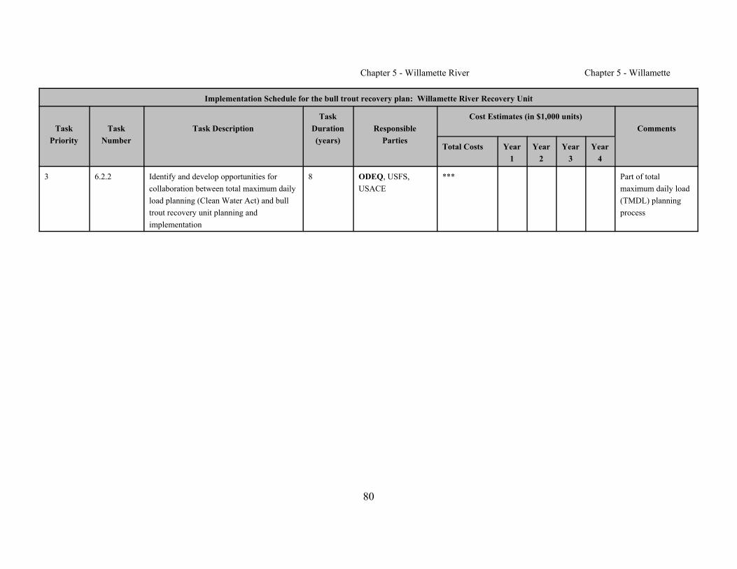
Chapter 5 - Willamette River Chapter 5 - Willamette
Implementation Schedule for the bull trout recovery plan: Willamette River Recovery Unit
TaskPriority
TaskNumber
Task DescriptionTask
Duration(years)
ResponsibleParties
Cost Estimates (in $1,000 units)Comments
Total Costs Year1
Year2
Year3
Year4
80
3 6.2.2 Identify and develop opportunities forcollaboration between total maximum dailyload planning (Clean Water Act) and bulltrout recovery unit planning andimplementation
8 ODEQ, USFS,USACE
*** Part of totalmaximum daily load(TMDL) planningprocess
Chapter 5 - Willamette River
81
REFERENCES CITED
Allen, J., Salamack, A., and P. Schoonmaker. 1999. Restoring the WillametteBasin: issues and challenges. Willamette Restoration Initiative.
Bartholomew, J. 2001. Fish health risk assessment. Oregon State University 2000progress report. In: Portland General Electric Pelton Round Butte fisheriesworkshop, spring 2001. Portland General Electric Company, Portland,Oregon.
Buchanan, D.V., M.L. Hanson, and R.M. Hooton. 1997. Status of Oregon's bulltrout, distribution, life history, limiting factors, managementconsiderations, and status. Report to Bonneville Power Administration.Contract No. 1994BI34342, Project No. 199505400 (BPA ReportDOE/BP-34342-5). Oregon Department of Fish and Wildlife, Portland.185 p.
Chamberlain, T.W., R.D. Harr, and F.H. Everest. 1991. Timber harvesting,silviculture and watershed processes. In W. R. Meehan, editor. Influencesof forest and rangeland management on salmonid fishes and their habitats.American Fisheries Society Special Publication 19:181-205. Bethesda,Maryland.
(CH2M HILL) CH2M HILL/Montgomery Watson Joint Venture. 1999. CougarLake WTC project alternatives report for fish passage. Task Order No. 15.30% submittal. Bellevue, Washington.
Connolly, P.J., M.G. Wade, J M. Hutchinson, and J.S. Ziller. 1992. Middle ForkWillamette Subbasin fish management plan. Oregon Department of Fishand Wildlife, Portland.
Chapter 5 - Willamette River
82
Cude, C. 2000. McKenzie watershed water quality report: water years1990–1999. Oregon Department of Environmental Quality, LaboratoryDivision, Portland.
Cude, C. 2001. Oregon water quality index report for upper Willamette Basin.(http://www.deq.state.or.us/lab/wqm/wqi/upwill/upwill3.htm). OregonDepartment of Environmental Quality Laboratory, Portland.
(DSL) Division of State Lands. 1983. Report and recommendation on thenavigable waters of Oregon. DSL, Salem, Oregon.
(EA) EA Engineering, Science, and Technology. 1991. The fluvialgeomorphology of the lower McKenzie River. Report prepared for theEugene Water and Electric Board, 500 East Fourth Avenue, Eugene,Oregon 97440.
Eberl, J., and D. Kamikawa. 1992. Upper Clackamas River bull trout survey. Mt.Hood National Forest, Oregon.
EWEB, EA Engineering, Science, and Technology, Inc, and Parametrix, Inc.(EWEB et al.). 2001. Draft biological assessment for the Eugene Waterand Electric Board McKenzie River hydroelectric projects. Eugene,Oregon.
Franklin, J.F., and C.T. Dyrness. 1973. Natural vegetation of Oregon andWashington. Oregon State University Press.
Goetz, F.A. 1989. Biology of bull trout, Salvelinus confluentus, a literaturereview. U.S. Department of Agriculture, Forest Service, WillametteNational Forest, Eugene, Oregon.
Goetz, F.A. 1994. Distribution and juvenile ecology of bull trout (Salvelinusconfluentus) in the Cascade Mountains. M.S. thesis. Oregon StateUniversity, Corvallis.
Chapter 5 - Willamette River
83
Hankin, D.G., and G.H. Reeves. 1988. Estimating total fish abundance and totalhabitat area in small streams based on visual estimation methods.Canadian Journal of Fisheries and Aquatic Sciences 45:834-844.
Hutchison, J.M., K.E. Thompson, and J.D. Fortune, Jr. 1966. The fish andwildlife resources of the upper Willamette Basin, Oregon, and their waterrequirements: report with recommendations to the Oregon State WaterResources Board. Oregon State Game Commission, Portland.
Kostow, K. 1995. Biennial report of the status of wild fish in Oregon. OregonDepartment of Fish and Wildlife, Portland.
Lyons, J.K., and R.L. Beschta. 1983. Land use, floods, and channel changes:upper Middle Fork Willamette River, Oregon (1936–1980). WaterResources Research 19(2):463-471.
Massey, J., and P. Keeley. 1996. Fish management review. Columbia Region,Lower Willamette Fish District. Oregon Department of Fish and Wildlife,Portland.
Minear, P.J. 1994. Historical change in channel form and riparian vegetation ofthe McKenzie River, Oregon. M.S. thesis. Oregon State University,Corvallis.
Mirati, A.H., Jr. 1999. Assessment of road culverts for fish passage problems onState- and County-owned roads. Statewide summary report. OregonDepartment of Fish and Wildlife, Portland.
Murtagh, T., R. Rohrer, M. Gray, E. Olsen, T. Rien, and J. Massey. 1992.Clackamas Subbasin fish management plan. Oregon Department of Fishand Wildlife, Portland.
(NMFS and USFWS) National Marine Fisheries Service and U.S. Fish andWildlife Service. 1999. Biological opinion on effects of issuance of
Chapter 5 - Willamette River
84
license for McKenzie (Bigelow) Hydropower Project on upper WillametteRiver chinook salmon, its proposed critical habitat, and bull trout.Consultation conducted jointly by National Marine Fisheries Service,Northwest Region, and U.S. Fish and Wildlife Service, Pacific Region.November 15, 1999.
(NMFS and USFWS) National Marine Fisheries Service and U. S. Fish andWildlife Service. 2000. Biological opinion on effects of Cougar Reservoirwater temperature control project on upper Willamette River chinooksalmon, its critical habitat, bull trout, northern spotted owl, and its criticalhabitat. National Marine Fisheries Service, Northwest Region, and U.S.Fish and Wildlife Service, Pacific Region, Portland, Oregon.
(NWPPC) Northwest Power Planning Council. 2001. Draft Willamette subbasinsummary.
Oregon, State of. 1997. Coastal salmon restoration initiative.
(ODFW) Oregon Department of Fish and Wildlife. 1993a. Summary ofinformation on bull trout populations. Willamette District, Springfield,Oregon. Unpublished report.
(ODFW) Oregon Department of Fish and Wildlife. 1993b. 1993 bull troutsurveys. Upper Willamette District. South Willamette Watershed District,Springfield, Oregon. Unpublished report.
(ODFW) Oregon Department of Fish and Wildlife. 2000. Minimizing risks andmitigation of impacts to bull trout Salvelinus confluentus fromconstruction of temperature control facilities at Cougar Reservoir, Oregon.Project proposal to U.S. Army Corps of Engineers. ODFW, SouthWillamette District, Springfield.

Chapter 5 - Willamette River
85
(ODFW) Oregon Department of Fish and Wildlife. 2001a. Review of T & E,sensitive and stocks of concern. Unpublished report. South WillametteWatershed District, Springfield, Oregon.
(ODFW) Oregon Department of Fish and Wildlife. 2001b. 2002 Oregon SportFishing Regulations. ODFW, Portland.
(ODFW and USFS) Oregon Department of Fish and Wildlife and U.S. ForestService/Rigdon Ranger District. 1998. Rehabilitation of the Middle ForkWillamette bull trout population. Risk analysis and monitoring plan.Unpublished report. Springfield, Oregon.
Ratliff, D.E., and P.J. Howell. 1992. The status of bull trout populations inOregon. In: P.J. Howell and D.V. Buchanan, editors. Proceedings of theGearhart Mountain bull trout workshop. Oregon Chapter of the AmericanFisheries Society, Corvallis. p. 10-17.
Rieman, B.E., and F.W. Allendorf. 2001. Effective population size and geneticconservation criteria for bull trout. North American Journal of FisheriesManagement 21:756-764. American Fisheries Society, Bethesda,Maryland.
Rieman, B.E., and J.D. McIntyre. 1993. Demographic and habitat requirementsfor conservation of bull trout. General Technical Report INT_302. U.S.Department of Agriculture, Forest Service, Intermountain ResearchStation, Ogden, Utah.
Runyon, J. 2000. McKenzie River Subbasin assessment—Technical ReportFebruary 2000. Report to Bonneville Power Administration. Contract No.2000AC23129, Project No. 200003000 (BPA Report DOE/BP-23129-1).206 p.

Chapter 5 - Willamette River
86
Spruell, P., and F.W. Allendorf. 1997. Nuclear DNA analysis of Oregon bulltrout. Final report to Oregon Department of Fish and Wildlife. Division ofBiological Sciences, University of Montana, Missoula.
Spruell, P., Z. Wilson, and F.W. Allendorf. 1998. Genetic analysis of Lewis Riverbull trout. Final report WTSGL-102 to PacifiCorp. Division of BiologicalSciences, University of Montana, Missoula.
Taylor, G.A. 2000. Monitoring of downstream fish passage at Cougar Dam in theSouth Fork McKenzie River, Oregon 1998–00. South WillametteWatershed District, Oregon Department of Fish and Wildlife, Springfield,Oregon. Unpublished.
Taylor, G.A., and A. Reasoner. 2000. Bull trout Salvelinus confluentus populationand habitat surveys in the McKenzie and Middle Fork Willamette basins.Oregon Department of Fish and Wildlife annual report 1999. Report to theBonneville Power Administration. Contract No. 00000226, Project No.199505300 (BPA Report DOE/BP-00000226-1). 28 p.
Unthank, A., and M. Sheehan. 1994. Upper Middle Fork Willamette River.Stream survey and basin report. Willamette National Forest, Eugene,Oregon.
(USACE) U.S. Army Corps of Engineers. 1989. Willamette River basin reservoirsystem operation: Portland District. U.S. Army Corps of Engineers report.43 p. plus appendices.
(USACE) U.S. Army Corps of Engineers. 1999. Cougar Reservoir watertemperature control project supplemental biological assessment. PortlandDistrict, Portland, Oregon.
(USACE) U.S. Army Corps of Engineers. 2000. Biological assessment of theeffects of the Willamette River basin flood control project on listed

Chapter 5 - Willamette River
87
species under the Endangered Species Act. Final. Portland District,Portland, Oregon.
(USFS) U.S. Forest Service. 1990. Willamette National Forest land and resourcemanagement plan. Pacific Northwest Region, Portland Oregon.
(USFS) U.S. Forest Service. 1994. South Fork McKenzie watershed analysis.Blue River Ranger District, Willamette National Forest, Blue River,Oregon.
(USFS) U.S. Forest Service. 1995a. Upper McKenzie watershed analysis.McKenzie Ranger District, Willamette National Forest, McKenzie Bridge,Oregon.
(USFS) U.S. Forest Service. 1995b. Watershed analysis report. Middle ForkWillamette River downstream tributaries watershed. Rigdon RangerDistrict, Willamette National Forest, Oakridge, Oregon.
(USFS) U.S. Forest Service. 1996. Upper Middle Fork Willamette Riverwatershed analysis. Rigdon Ranger District, Willamette National Forest,Oakridge, Oregon.
(USFS) U.S. Forest Service. 1997. Horse Creek watershed analysis. McKenzieRanger District, Willamette National Forest, McKenzie Bridge, Oregon.
(USFS) U.S. Forest Service. 2001. Sweetwater Creek snorkel, projecteffectiveness monitoring, 12 December 2001. Blue River Ranger District,Blue River, Oregon.
(USFS and BLM) U.S. Forest Service and Bureau of Land Management. 1993.Draft supplemental environmental impact statement on management ofhabitat for late-successional and old-growth forest related species withinthe range of the northern spotted owl. Portland, Oregon.

Chapter 5 - Willamette River
88
(USFWS) U.S. Fish and Wildlife Service. 1998a. Klamath River and ColumbiaRiver bull trout population segments: status summary and supportingdocument lists. Prepared by the Bull Trout Listing Team.
(USFWS) U.S. Fish and Wildlife Service. 1998b. Conferencing memorandum toDistrict Manager, Bureau of Land Management, Eugene District, Eugene,Oregon, on effects of Gate Creek habitat enhancement project on bulltrout. March 20. Portland, Oregon.
(USFWS) U.S. Fish and Wildlife Service. 1998c. Letter of concurrence to DarrelL. Kenops, Forest Supervisor, Willamette National Forest, on the GuistanaLand Exchange, McKenzie Ranger District, Lane County, Oregon (Logno. 1-7-98-I-422). Portland, Oregon.
Wade, M. 2001. Bull trout monitoring quarterly report July 1 through September30, 2001. Oregon Department of Fish and Wildlife, Springfield.
Wentz, D.A., B.A. Bonn, K.D. Carpenter, S.R. Hinkle, M.L. Janet, F.A. Rinella,M.A. Uhrich, I.R. Waite, A. Laenen, A., and K.E. Bencala. 1998. Waterquality in the Willamette Basin, Oregon, 1991–95. U.S. GeologicalSurvey Circular 1161. (http://water.usgs.gov/pubs/circ1161). UpdatedJune 25.
Wevers, M.J., J. Wetherbee, and W. Hunt. 1992. Santiam and Calapooia Subbasinfish management plan. Oregon Department of Fish and Wildlife, Portland.
Weyerhaeuser Company. 1994. Lower McKenzie, South Side watershed analysis.Springfield, Oregon.
Weyerhaeuser Company. 1995. Lower McKenzie, North Side watershed analysis.Springfield, Oregon.
(WRI) Willamette Restoration Initiative. 2001. Restoring a river of life: theWillamette restoration strategy.

Chapter 5 - Willamette River
89
Ziller, J.S., and G.A. Taylor. 2000. Using partnerships for attaining long termsustainability of bull trout Salvelinus confluentus populations in the upperWillamette basin, Oregon. In: Wild trout VII management in the newmillennium: are we ready? Yellowstone National Park, October 1–4,2000.
Zimmerman, M.P. 1999. Upper Clackamas River basin bull trout surveys,1998–1999. Information Reports Number 99-5. Oregon Department ofFish and Wildlife, Clackamas.
In Literature
James, P., S. Craig, J. Shannon, T. Eichler, and E. Anderson. 1998. Evidence oftwo distinct stocks of bull trout in a central Washington reservoir. Abstractpresented at the North Pacific International Chapter of the AmericanFisheries Society. Nelson, British Columbia, November 16–17, 1998.
(ODFW) Oregon Department of Fish and Wildlife. 2001. Press release: Parasitethat causes whirling disease found in private hatchery on Clackamas Rivertributary.(http://www.dfw.state.or.us/public/NewsArc/2001News/December/121401newsb.htm). December 14. Portland, OR.
(WRUT) Willamette Recovery Unit Team. 1997a. Minutes of meeting ofNovember 20.
(WRUT) Willamette Recovery Unit Team.1997b. Minutes of meeting of April 8.
Personal Communications
Armantrout, N., Bureau of Land Management. 2001. Communication with M.Hanson about mining in Blue River mining district. December 20.

Chapter 5 - Willamette River
90
Bickford, D., U.S. Forest Service. 2001a. Communication with M. Hanson on2001 data. November 13.
Bickford, D., U.S. Forest Service. 2001b. Communication with M. Hanson onSweetwater Creek update. September 4.
Horning, T., U.S. Forest Service. 1999. Fax communication with M. Hansonabout Clackamas limiting factors. July 2.
Larson, D., U.S. Forest Service. 2000. Presentation about Middle Fork Willamettefield season results. November 29.
Rivera, R., U.S. Forest Service. 2001. Communication with M. Hanson aboutwater quality planning efforts. November 11.
Somes, W., U.S. Forest Service. 1999. Fax communication with M. Hanson aboutSantiam limiting factors. July 13.
Willis, C., U.S. Army Corps of Engineers. 2001. Communication with M. Hansonabout conservation action. November 16.
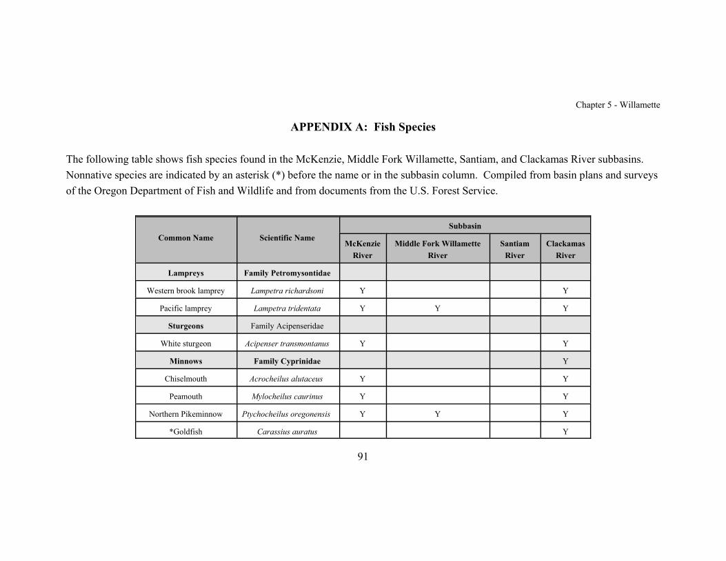
Chapter 5 - Willamette
91
APPENDIX A: Fish Species
The following table shows fish species found in the McKenzie, Middle Fork Willamette, Santiam, and Clackamas River subbasins. Nonnative species are indicated by an asterisk (*) before the name or in the subbasin column. Compiled from basin plans and surveysof the Oregon Department of Fish and Wildlife and from documents from the U.S. Forest Service.
Common Name Scientific NameSubbasin
McKenzieRiver
Middle Fork WillametteRiver
SantiamRiver
ClackamasRiver
Lampreys Family Petromysontidae
Western brook lamprey Lampetra richardsoni Y Y
Pacific lamprey Lampetra tridentata Y Y Y
Sturgeons Family Acipenseridae
White sturgeon Acipenser transmontanus Y Y
Minnows Family Cyprinidae Y
Chiselmouth Acrocheilus alutaceus Y Y
Peamouth Mylocheilus caurinus Y Y
Northern Pikeminnow Ptychocheilus oregonensis Y Y Y
*Goldfish Carassius auratus Y

Chapter 5 - Willamette River Chapter 5 - Willamette
Common Name Scientific NameSubbasin
McKenzieRiver
Middle Fork WillametteRiver
SantiamRiver
ClackamasRiver
92
*Common carp Cyprinus carpio Y Y
Oregon chub Oregonichthys crameri Y Y
Longnose dace Rhinichthys cataracta Y Y
Speckled dace Rhinichthys osculus Y Y
Leopard dace Rhinichthys falcatus Y
Redside shiner Richardsonius balteatus Y Y Y
Suckers Family Castosomidae
Largescale sucker Catostomus macrocheilus Y Y Y
Mountain sucker Catostomus platyrhynchus Y Y
Bullhead catfishes Family Ictaluridae
*Yellow bullhead Ameiurus natalis Y Y? Y Y
*Brown bullhead Ameiurus nebulosus Y Y? Y Y
*Channel catfish Ictalurus punctatus Y Y
Trouts Family Salmonidae

Chapter 5 - Willamette River Chapter 5 - Willamette
Common Name Scientific NameSubbasin
McKenzieRiver
Middle Fork WillametteRiver
SantiamRiver
ClackamasRiver
93
Cutthroat trout Oncorhynchus clarki Y Y Y Y (wild andhatchery)
Rainbow trout/steelhead Oncorhynchus mykiss Y Y (wild and hatchery) Y (wild andhatchery)
Y (wild andhatchery)
Coho salmon Oncorhynchus kisutch Y* Y* Y (wild andhatchery)
Sockeye salmon(Kokanee)
Oncorhynchus nerka Y* Y*
Chinook salmon Oncorhynchus tshawytscha Y Y (wild? and hatchery) Y (wild andhatchery)
Y (wild andhatchery)
Mountain whitefish Prosopium williamsoni Y Y Y Y
*Brown trout Salmo trutta Y
Bull trout Salvelinus confluentus Y Y H H
*Brook trout Salvelinus fontinalis Y Y Y Y
Trout Perch Family Percopsidae
Sand Roller Percopsis transmontana Y Y
Killifishes Family Cyprinodontidae

Chapter 5 - Willamette River Chapter 5 - Willamette
Common Name Scientific NameSubbasin
McKenzieRiver
Middle Fork WillametteRiver
SantiamRiver
ClackamasRiver
94
*Banded killifish Fundulus diaphanus Y
Livebearers Family Poeciliidae
*Western mosquitofish Gambusia affinis Y
Stickleback Family Gasterosteidae
Three-spine stickleback Gasterosteus aculeatus Y Y
Sculpins Family Cottidae
Prickly sculpin Cottus asper Y (not identified to species) Y
Paiute sculpin Cottus beldingi Y
Shorthead sculpin Cottus confusus Y
Reticulate sculpin Cottus perplexus Y Y
Torrent sculpin Cottus rhotheus Y
Sunfishes Family Centrarchidae
*Pumpkinseed Lepomis gibbosus Y Y
*Warmouth Lepomis gulosus Y Y
*Bluegill Lepomis macrochirus Y Y Y Y
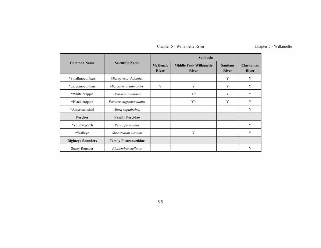
Chapter 5 - Willamette River Chapter 5 - Willamette
Common Name Scientific NameSubbasin
McKenzieRiver
Middle Fork WillametteRiver
SantiamRiver
ClackamasRiver
95
*Smallmouth bass Micropterus dolomieu Y Y
*Largemouth bass Micropterus salmoides Y Y Y Y
*White crappie Pomoxis annularis Y? Y Y
*Black crappie Pomoxis nigromaculatus Y? Y Y
*American shad Alosa sapidissima Y
Perches Family Percidae
*Yellow perch Perca flavescens Y
*Walleye Stizostedion vitreum Y Y
Righteye flounders Family Pleuronectidae
Starry flounder Platichthys stellatus Y
Chapter 5 - Willamette River
96
APPENDIX B: List of Chapters
Chapter 1 IntroductoryChapter 2 Klamath River Recovery Unit, OregonChapter 3 Clark Fork River Recovery Unit, Montana and IdahoChapter 4 Kootenai River Recovery Unit, Montana and IdahoChapter 5 Willamette River Recovery Unit, OregonChapter 6 Hood River Recovery Unit, OregonChapter 7 Deschutes River Recovery Unit, OregonChapter 8 Odell Lake Recovery Unit, OregonChapter 9 John Day River Recovery Unit, OregonChapter 10 Umatilla–Walla Walla Rivers Recovery Unit, Oregon and WashingtonChapter 11 Grande Ronde River Recovery Unit, OregonChapter 12 Imnaha–Snake Rivers Recovery Unit, OregonChapter 13 Hells Canyon Complex Recovery Unit, Oregon and IdahoChapter 14 Malheur River Recovery Unit, OregonChapter 15 Coeur d’Alene Lake Basin Recovery Unit, IdahoChapter 16 Clearwater River Recovery Unit, IdahoChapter 17 Salmon River Recovery Unit, IdahoChapter 18 Southwest Idaho Recovery Unit, IdahoChapter 19 Little Lost River Recovery Unit, IdahoChapter 20 Lower Columbia River Recovery Unit, WashingtonChapter 21 Middle Columbia River Recovery Unit, WashingtonChapter 22 Upper Columbia River Recovery Unit, WashingtonChapter 23 Northeast Washington Recovery Unit, WashingtonChapter 24 Snake River Washington Recovery Unit, Washington