chapter 3 · will also help the contractor avoid costly mistakes. ... in order to avoid costly ......
TRANSCRIPT

3-1
Chapter 3 InterpretIng Stormwater FeatureS In the SIte Development plan Before beginning preparation of the Stormwater Pollution Prevention Plan, the preparer needs to carefully review the site development plan, or SDP, opportunities to prevent and control stormwater pollution. The scope of stormwater controls outlined in the plan may range from minimal representation to full scale environmental site design. See Diagram 3.1 Regardless of the scope of features presented, the site development plan should be carefully examined by the preparer for ways to optimize stormwater control. The preparer’s approach to selecting and installing stormwater control measures can significantly impact benefits from their use and can lead to cost savings.
Site Development plan
Contemporary SDP with Environmental Site Design showing elevations and
multiple stormwater practices.
Conventional SDP Showing Minimal Representation.
Elevations.•
Rain gardens, bioswales.•
Vegetated street edges/parking lots.•
Stream setback buffered with vegetation.•
Elevations.•
Stormwater basin.•
Diagram 3.1
Site development plans that contain a well constructed environmental site design should be easy to interpret. For example, Figure 3.1 demonstrates opportunities available to the Stormwater Pollution Prevention Plan preparer and contractor for enhancing stormwater control. In this example, there is no basin for permanent stormwater runoff control. Therefore, it would be less practical to build a large costly sediment basin, because it would need to be back-filled upon project completion, instead of being converted to a permanent stormwater pond. In this project, the prairie provides for sheet flow of larger storms that ultimately flow into woods along the perimeter. The woods along the southwest part of the property provide further protection of the

3-2
natural drainage areas and the stream below Also, rain gardens and bioswales are designed into the plan to capture runoff at its source, because these practices will slow runoff and filter pollutants after the development is complete. The Stormwater Pollution Prevention Plan should explain how these permanent stormwater control features will be protected during the property development. The Stormwater Pollution Prevention Plan, is discussed in more detail in Chapter 4.
The depressions for rain gardens and bioswales can be made ahead of time to catch sediment during construction, or they can be fenced off for protection during construction. If used to catch sediment, they will need to be cleaned out and converted to permanent use when the development is finished and the site is stabilized. In either case, these sites and any connecting flow paths should be protected from traffic compaction, material storage and contaminated runoff, and such protection measures should be identified in the Stormwater Pollution Prevention Plan. Fencing these protection zones will provide added protection.
Figure 3.1 Proposed Bear Creek Prairie Project, Columbia, MO. Source: Andy Guti
Conventional Site Development Plans showing a minimum of stormwater controls can still provide opportunities for SWPPP preparers and contractors to incorporate environmental features that will enhance the protection of water resources, as well as improve the project’s overall success. For example, in a conventional Site Development Plan, a choice can be made to use more than one small sediment pond or a series of other small depressions to catch sediment. Additionally phase land disturbance in order to minimize sediment-laden runoff. Better success in reducing sediment laden runoff will be achieved by focusing more effort on erosion control than on sediment capture. Regarding redevelopment projects, Environmental Site Design features may include planter boxes and street edge bioswales. Steps for incorporating these elements into the Stormwater Pollution Prevention Plan and ensuring their protection during development are described in more detail in Chapter 4.

3-3
Earlier chapters explain when stormwater control practices are installed in accordance with good environmental principles, they will not only benefit the environment, but they will improve overall use and enjoyment of the development site and increase property values. Well-designed practices can also reduce project costs by reducing site maintenance requirements. Preparers and contractors can maximize these benefits when writing and executing the project’s Stormwater Pollution Prevention Plan.
Increased use of environmental Site Designs The number of development designs incorporating environmental features is growing. It is a trend that contractors will notice, if they are not already aware of it. The trend has led to the creation of the Environmental Site Design, used by developers to serve the growing public demand for environmental features. Environmental features are designed into the initial site development plan (concept) and carried through to the final site improvement plan. Stormwater Pollution Prevention Plan preparers and contractors familiar with these special design features are better prepared to properly select and install them. The Environmental Site Design approach is rapidly being adopted across the nation, because conventional stormwater management has been shown to significantly increase the volume and velocity of stormwater runoff, resulting in flooding, eroded properties and diminished fishing, swimming and drinking water resources.
Stormwater Pollution Prevention Plan preparers and contractors who understand the purpose and function of environmental features will be able to assist communities and developers in maximizing their benefits. For example, capital project costs can be reduced through the Environmental Site Design that employs less asphalt, fewer curbs and fewer pipes. The resulting landscape features will add value of interest to the buyer. Those benefits extend to construction contractors as well.
Contractors well versed in environmental site design goals and protection measures have an employable advantage over those who do not. And, their success in implementing Environmental Site Design features depends on an understanding of their benefits and contributions to the overall development goals. The following sections are devoted to explaining the important site development principles essential to achieving an effective Environmental Site Design. While these ideas are directed more toward a community leader or developer with environmental site design goals, the same principles apply throughout project implementation. The contractor’s awareness of them will improve his or her ability to offer feasible adjustments to improve a site design at any stage of project development. An understanding of these goals will also help the contractor avoid costly mistakes. For more information about environmental site design, see references including Missouri Guide to Green Infrastructure: Integrating Water Quality into Municipal Stormwater Management 2011.
environmental Site Design principles and Features When projects are conceived, the business interest is usually clearly understood. Therefore, it is important to recognize the financial benefits of environmental site design such as reduced capital expenditures, lower escrow requirements and increased property values. In order to avoid costly repairs or risk environmental fines, general contractors may require written agreements that hold subcontractors and field personnel responsible for protecting environmental design components and practices.
A greater challenge in integrating environmental features may be in understanding the benefit and function of the site’s natural attributes (geology, soils, vegetation, drainage patterns, etc.) toward the project’s design. Through careful research and planning, natural systems, such as streams, undisturbed green space, wetlands and riparian areas, can be maintained, restored or enhanced to function as efficient stormwater management features. They are nature’s stormwater management system and should be preserved and used as cost-effective measures.
3-4
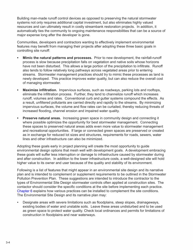
Building man-made runoff control devices as opposed to preserving the natural stormwater systems not only requires additional capital investment, but also eliminates highly valued resources and can ultimately result in costly streambank restoration projects. In addition, it automatically ties the community to ongoing maintenance responsibilities that can be a source of major expense long after the developer is gone.
Communities, developers and contractors wanting to effectively implement environmental features may benefit from managing their projects after adopting these three basic goals in controlling site runoff:
Mimic the natural patterns and processes.• Prior to new development, the rainfall-runoff process is slow because precipitation falls on vegetation and native soils whose horizons have not been disturbed. This allows a large portion of the precipitation to infiltrate. Runoff also tends to follow relatively long pathways across vegetated areas prior to entering streams. Stormwater management practices should try to mimic these processes as land is newly developed. This practice improves water quality, but can also reduce the overall cost of managing stormwater.
Maximize infiltration.• Impervious surfaces, such as roadways, parking lots and rooftops, eliminate the infiltration process. Further, they tend to channelize runoff which increases runoff, volumes and rates. Conventional curb and gutter systems compound the effects. As a result, unfiltered pollutants are carried directly and rapidly to the streams. By minimizing impervious surfaces, the volume and flow rates can be curtailed, thereby reducing threats of increased flooding, channel erosion and impaired water quality.
Preserve natural areas. • Increasing green space in community design and connecting it where possible optimizes the opportunity for best stormwater management. Connecting these spaces to preserved natural areas adds even more value to stormwater management and recreational opportunities. If large or connected green spaces are preserved or created as in exchange for reduced lot sizes and structures, requirements for roads, sewers, water lines and other infrastructure can also be minimized.
Adopting these goals early in project planning will create the most opportunity to guide environmental design options that mesh well with development goals. A development embracing these goals will suffer less interruption or damage to infrastructure caused by stormwater during and after construction. In addition to the lower infrastructure costs, a well-designed site will hold higher value to its owner and user because of the quality and stability of its environment.
Following is a list of features that might appear in an environmental site design and its narrative plan and is intended to complement or supplement requirements to be outlined in the Stormwater Pollution Prevention Plan. These suggestions are intended to introduce the contractor to the types of Environmental Site Design stormwater controls often applied at construction sites. The contactor should consider the specific conditions at the site before implementing each practice. Chapter 6 explains how various practices can be installed to complement the site conditions. The Environmental Site Design and its narrative plan may:
Designate areas with severe limitations such as floodplains, steep slopes, drainageways, •existing bodies of water and unstable soils. Leave these areas undisturbed and to be used as green space to protect water quality. Check local ordinances and permits for limitations of construction in floodplains and near waterways.
3-5
Identify natural vegetation and trees to be left undisturbed during construction or during •certain phases of construction. Existing areas of grass, shrubs and trees will provide natural erosion and sediment control while enhancing the attractiveness of the project. Check local ordinances for stream corridor setbacks. In some cases, these areas can also be enhanced to help meet water quality protection requirements for both construction and post-construction runoff control.
Sequence earth grading and other site preparation so these activities are minimized. The narrative Environmental Site Design plan may also refer to the numerous resources on contemporary green infrastructure and low impact development designs. Such designs may make it easier to comply with federal, state and local requirements to protect water quality. More information is available about how these contemporary practices may even minimize project costs. See references, including Missouri Guide to Green Infrastructure: Integrating Water Quality into Municipal Stormwater Management 2011.
Specify rough grading in phases to keep disturbed areas small and to minimize the amount •of time soil will be bare of vegetation. The discharge permit required for land disturbance states: “Where soil disturbing activities cease in any area for 14 days or more, the permittee shall construct and install best management practices to establish interim stabilization. If the slope of the area is greater than 3:1 or if the slope is greater than 3 percent and greater than 150 feet in length, then the permittee shall establish interim stabilization within seven days of ceasing operations on that part of the site.”
Plan for the installation of best management practices (see Chapter 6) to control overland sheet flow, limit erosion and keep sediment and other pollutants on the site.
When planning for best management practices near streets, ensure practices are designed •and installed in a manner that prevents major flooding, sediment accumulation, traffic interruptions, road damage or other off-site impacts during significant storm (design) events.
Require topsoil to be stockpiled and protected from erosion so it may be available for •spreading over the areas to be permanently vegetated during final grading. Protecting topsoil helps maintain its organic matter, microorganisms and nutrients for successful vegetation establishment.
Schedule the installation of control measures, such as best management practices prior to •land disturbance. It is very important to understand the ultimate plan for post-construction runoff to effectively plan, prepare, schedule and coordinate conversion from construction site best management practices to permanent practices. Schedule the installation of post-construction stormwater control measures after the site is stabilized. There should be no potential for erosion on the site or sediment discharge into the post-construction stormwater control measures, unless they are intentionally designated to serve as temporary practices.
Provide for operation and maintenance of the permanent, post-construction stormwater •control measures after the site is stabilized. If selected, designed, installed and operating properly, these structures will provide storm water quantity and quality protection after the construction phase of the project is complete.
3-6
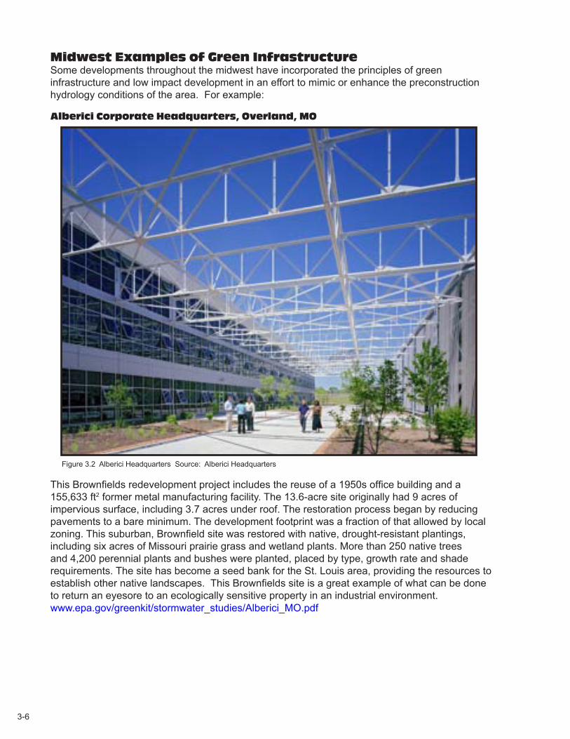
midwest examples of green Infrastructure Some developments throughout the midwest have incorporated the principles of green infrastructure and low impact development in an effort to mimic or enhance the preconstruction hydrology conditions of the area. For example:
alberici Corporate headquarters, overland, mo
Figure 3.2 Alberici Headquarters Source: Alberici Headquarters
This Brownfields redevelopment project includes the reuse of a 1950s office building and a 155,633 ft2 former metal manufacturing facility. The 13.6-acre site originally had 9 acres of impervious surface, including 3.7 acres under roof. The restoration process began by reducing pavements to a bare minimum. The development footprint was a fraction of that allowed by local zoning. This suburban, Brownfield site was restored with native, drought-resistant plantings, including six acres of Missouri prairie grass and wetland plants. More than 250 native trees and 4,200 perennial plants and bushes were planted, placed by type, growth rate and shade requirements. The site has become a seed bank for the St. Louis area, providing the resources to establish other native landscapes. This Brownfields site is a great example of what can be done to return an eyesore to an ecologically sensitive property in an industrial environment. www.epa.gov/greenkit/stormwater_studies/Alberici_MO.pdf
3-7
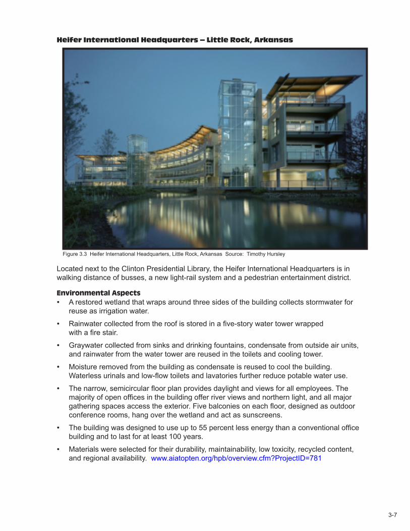
heifer International headquarters – little rock, arkansas
Figure 3.3 Heifer International Headquarters, Little Rock, Arkansas Source: Timothy Hursley
Located next to the Clinton Presidential Library, the Heifer International Headquarters is in walking distance of busses, a new light-rail system and a pedestrian entertainment district.
Environmental AspectsA restored wetland that wraps around three sides of the building collects stormwater for •reuse as irrigation water.
Rainwater collected from the roof is stored in a five-story water tower wrapped •with a fire stair.
Graywater collected from sinks and drinking fountains, condensate from outside air units, •and rainwater from the water tower are reused in the toilets and cooling tower.
Moisture removed from the building as condensate is reused to cool the building. •Waterless urinals and low-flow toilets and lavatories further reduce potable water use.
The narrow, semicircular floor plan provides daylight and views for all employees. The •majority of open offices in the building offer river views and northern light, and all major gathering spaces access the exterior. Five balconies on each floor, designed as outdoor conference rooms, hang over the wetland and act as sunscreens.
The building was designed to use up to 55 percent less energy than a conventional office •building and to last for at least 100 years.
Materials were selected for their durability, maintainability, low toxicity, recycled content, •and regional availability. www.aiatopten.org/hpb/overview.cfm?ProjectID=781

3-8
the wilderness - overland park, Kansas This multi-phase development located in southern Overland Park- Johnson County, Kansas offers various housing types among trees and natural areas. A 12-acre city park is located nearby that offers a 5-acre stocked fishing lake. Paved trails lead to 400-acre deed restricted Nature Preserve with lakes, trails, land and wildlife.
oakbrook - Clay County, missouri The Oakbrook development is the first low impact development in Clay County, Missouri. The development places emphasis on conserving the area’s natural resources. The development is currently 156 acres that consist of one to two acre lots, 54 acres of dedicated open space. Walking trails and rain gardens are located throughout the development. Bear Creek prairie - Columbia, missouri Bear Creek Prairie is a proposed 17-acre conservation development. The development is designed to follow the principles of the conservation community concept, where homes are generally clustered around common green spaces that everyone can use and enjoy. This encourages interaction among residents while retaining use of wooded and open areas for trails, gardens, gathering areas and other amenities.
The City of Columbia permits Planned Unit Developments, or PUD districts, which provided the vehicle for the project if it is built as planned. This zoning will allow the developers to accomplish the conservation community concept. Figure 3.4 shows the development’s proposed site plan. www.bearcreekprairie.com
Figure 3..4: Bear Creek Prairie Proposed Development Site Plan. Source: Andy Guti www.bearcreekprairie.com

3-9
Fields neighborhood - east troy, wisconsin This development in southern Wisconsin is a new nature-based community that combines sustainable living with a strong community atmosphere and respect for the natural environment. The development offers a range of clustered condominiums integrating the latest green building technologies with designs minimizing the impact on the natural surroundings. After completion, the development will feature 74 units of clustered condominiums on 17-acres. Figure 3.5 shows a rain garden on a property in Fields Neighborhood. www.fieldsneighborhood.org
Figure 3.5: Fields Neighborhood Rain Garden Source: www.fieldsneighborhood.org
legacy trails, habitat for humanity- Springfield, missouri The goal of this 18-acre development is to provide homes for 56 families and to enhance the quality of life for residents as well as protect the quality of the environment, featuring:
Native plants and grasses. •Innovative, energy-efficient home design. •Natural walking paths. •A savannah-like community park. •Curbless streets to limit stormwater runoff. •Limited on-street parking to increase safety and reduce crime.•
In December 2008 the Missouri Conservation Heritage Foundation awarded Habitat Springfield a $5,000 grant helping fund a native plant, rain garden project at Legacy Trails. The bio-retention areas have proven successful in helping manage stormwater runoff quality. http://www.habitatspringfieldmo.org/where-habitat-for-humanity-springfield-builds-homes/habitat-springfield-legacy-trails/

3-10
Figure 3.6: Prairie Crossing Homes Source: www.planningwithpower.org
prairie Crossing- grayslake, Illinois This development is one of the most popular conservation design communities in the nation, and is considered a national example of how to plan our communities to enhance the environment and support a better way of life. The development is located in Grayslake, Illinois, a suburb of Chicago. The community was designed to combine the preservation of open land, easy commuting by rail and responsible development practices.
More than 60 percent of the 677-acre site is protected open land actively used by people and wildlife. Ten miles of trails wind through a landscape of farm fields, pastures, lakes and ponds, native prairies and wetlands.
The development is well known for its beautiful native prairie landscaping. With more than 165 acres of restored prairies, 20 acres of restored wetlands and 16 acres of historic hedgerows, the Prairie Crossing landscape is contributing to the restoration of the native ecology of the region. Many Prairie Crossing residents integrate these native plant communities into their own landscaping. Figure 3.6 shows some of the homes located in the development. www.prairiecrossing.com
3-11
Combining Stormwater treatment practices Each stormwater control measure has unique characteristics and can be used to target specific pollutants. For example, some practices will collect sediment, whereas other practices are preferred for treating phosphorus. (See Appendix C and Appendix D for resources that provide specific pollution control information, such as the International BMP Database and the SUSTAIN model.)
The preferred approach for maximizing water quality improvement is a combination of stormwater control measures that collectively address the source of pollutants, the conveyance of stormwater and the infiltration and treatment of runoff. This series of measures, sometimes referred to as a “treatment train” or “string of pearls”, typically includes an integrated set of biological and physical treatment steps that successively remove pollutants from stormwater runoff. The components of a combination approach are designed to treat stormwater runoff for water quality benefits and to reduce stormwater runoff peaks and volumes. Source controls, upstream of the initial structural components are an important component to maximize benefit.
The combination approach typically follows a hierarchy of practices in a sequenced approach. The stages of a combination approach incorporate the following components:
Preservation or restoration of open space and natural drainage areas and their native or •adapative vegetation.
Dispersion of small-scale, on-site source controls such as rain gardens and other practices •that provide infiltration and evapotranspiration (see Appendix B).
Conveyances such as swales and filter strips that connect on-site controls, dissipate energy •and filter larger particles.
Filtration stormwater control measures such as bioretention and wetland swales.•Provisions for overflowing or rerouting large storm events.•
receiving waters A designer should understand the site conditions and hydrologic characteristics of the drainage area and the requirements for water quality treatment before choosing a sequence of treatment practices. The developer and site design team should select a combination of practices to meet water quality goals, while meeting local requirements and objectives. Preserving native areas or establishing vegetated open space is commonly the first step of a combination approach. Undisturbed land and areas landscaped with native plants increase stormwater infiltration and can help minimize runoff, erosion and potential for downstream pollution.
Developments may have design or site constraints limiting the amount of open space available for stormwater management. These sites may require some engineered stormwater infiltration practices and treatment.
Stormwater control measures, such as pervious vegetated areas, infiltration trenches and rain gardens, provide treatment and control of runoff near its source. Site characteristics, such as area, soil type or topography, may limit the effectiveness of open space and infiltration practices.
Engineering filtration systems are the next step of the combination approach. Filtration systems, such as bioretention and vegetated swales, have the capacity to detain smaller rain events and are designed to treat the water quality volume.

3-12
Larger scale stormwater detention practices should be the last stage of the combination approach. Detention generally applies to dense developments and provides a solution for damaging storms larger than the water quality event. Detention basins manage the rate of stormwater discharge from larger rainfall events. Some also include a treatment component sized for the water quality event. If detention basins are needed, their size may be minimized based on the combination of on-site practices that also provide for volume control.
The following examples demonstrate how a combination approach may be incorporated at three different sites:
Scenario 1: new residential Subdivision
Preserve a native prairie remnant or other unique landscape feature as common open space.•Landscape with native or adaptive vegetation and incorporate rain gardens on each lot (or a •group of lots) to disconnect downspouts.
Design vegetated swales to convey and treat runoff from landscaped yards and streets.•Limit impervious area for the development by limiting street width and the use of cul-de-sacs •(provide narrower through-streets to accommodate emergency vehicles), using pervious pavement, limit on-street parking to one side, etc.
Scenario 2: Commercial Development
Establish native or adaptive landscaping in and around buildings and parking areas.•Use best parking lot designs to minimize impervious surface, including intra-lot bioswales or •dispersed rain gardens below.
Use bioretention cells and porous pavement to treat and infiltrate parking lot runoff.•Use green roofs to reduce runoff from “flat” rooftops.•
Scenario 3: office parkIdentify source controls and maintenance practices that decrease roadway salts and •fertilizer use.
Place filter strips around building downspouts and parking lots, leading to infiltration basins.•Use dry swales to treat runoff from streets and convey to a wet pond or detention.•Install a cistern to use for irrigation, lawn watering or other purposes.•
Proper maintenance and pollution prevention practices can further limit stormwater runoff pollution. Maintenance of stormwater control measures to remove pollutants and sediment is critical to continued success. Pollution prevention strategies are specific to the site management practices and may include containment barriers around chemical storage areas, vehicle maintenance to prevent leakage or maintenance practices that reduce salt or fertilizer application.
The next chapter presents information to assist in preparing a SWPPP. Preparers should occasionally revisit this chapter while preparing the SWPPP. For more information about environmental site design, see references including Missouri’s Guide to Green Infrastructure: Integrating Water Quality into Municipal Stormwater Management 2011.