chapter 10: aspects of the bronze age timber … of woodworking technology. ... based on form is the...
TRANSCRIPT
Chronology and function (Figs 10.1-10.4)The evidence retrieved from the A13 fits within thegeneral regional pattern of an increase in theconstruction of timber structures along the flood-plain wetland margins during the 2nd millenniumBC. Aside from the ‘bridge’ structure at Free -masons Road, three trackways and a possibleplatform were recorded at Woolwich Manor Way,and a further two trackways at Movers Lane. Inaddition a number of smaller stake built structureswere recorded at all three sites. The dating of theA13 structures is largely based on radiocarbondating of the worked wood, supported by theanalysis of woodworking tech nology. Unfortunately all attempts to date larger oak wood samples(both natural and humanly worked) by dendro -chron ology failed. In the case of the ‘bridge’ struc-ture this was due to the fact that the timbers usedfor the piles were from rather fast grown oaks withtoo few annual rings. The earliest structureappears to have been built at Woolwich ManorWay where radiocarbon dates on roundwood fromTrackway 50 date construction to the second half ofthe 3rd / earlier part of the 2nd millennium BC(see Fig. 10.1 and Appendix 1.2), the bridge struc-ture at Freemasons Road, Trackway 29 at Wool -wich Manor Way, and both trackways at MoversLane date to the early to mid 2nd millennium BC.The overlap in the radiocarbon dating suggestssome of these structures may have been contempo-rary, although when all the dates are combinedtogether they are not statistically consistent. Track -way 29 and platform structure 61 at WoolwichManor Way are a little later, dating to the latterpart of the 2nd millennium BC.
The pile alignment at Freemasons Road can becompared with a number of other similar structuresexcavated in the Thames Valley. The closest parallelbased on form is the middle Bronze Age pile groupexcavated in the Ebbsfleet Valley (Wenban-Smith etal. forthcoming). Obvious comparisons can also bedrawn with the middle and late Bronze Age pilegroups excavated at Vauxhall (Haughey 1999; Sidellet al. 2002, 29) and further upstream at Eton (Allen etal. forthcoming, Lambrick 2009, 232). The radio-carbon dates suggest that the structure at Free -masons Road is one of the earliest and may wellhave been contemporary with the larger Vauxhallstructure (Fig. 10.2). At T=0.1 at 1df, the dates on thetwo structures are statistically consistent (chi-squared test using Beta-152738 and Beta-122970).Reconstruction of the contemporary topography at
Freemasons Road tends to support the interpreta-tion that this structure was a footbridge bridge orjetty running from the higher ground out into awetland zone during a period of increasing wetness.Recent topographic modelling work in the LeaValley suggests that during the early Bronze Age alarge floodplain island existed immediately to theeast of Freemasons Road and it is possible the struc-ture linked the drier ground of the terrace to thisisland (Fig. 4.8b; Corcoran et al. 2011, 56 and fig 108).
The dates for the A13 trackways tend to beslightly earlier than a number of Bronze Age struc-tures recorded in the immediate vicinity whichappear to post-date 1500 cal BC (Figs 10.3 and 10.4).Further afield there are a number of other BronzeAge trackways and some, such as Bramcote Green inBermondsey have produced pre-1500 cal BC dates(Thomas and Rackham 1996). There are also possible
131
Chapter 10: Aspects of the Bronze Age Timber Structures
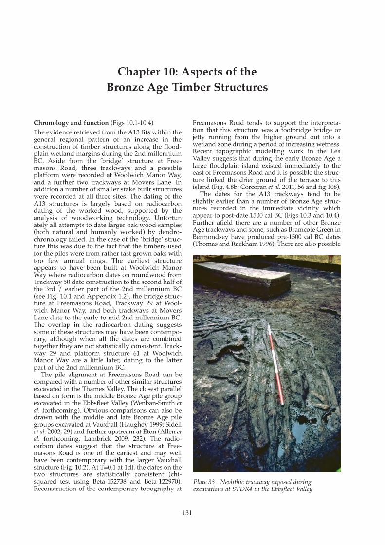
Plate 33 Neolithic trackway exposed during excavations at STDR4 in the Ebbsfleet Valley

Landscape and Prehistory of the East London Wetlands
132
Fig. 10.1 Radiocarbon chronology of the A13 timber structures
Fig. 10.2 Radiocarbon chronology of Bronze Age piled structures from the Middle and Lower Thames Valley
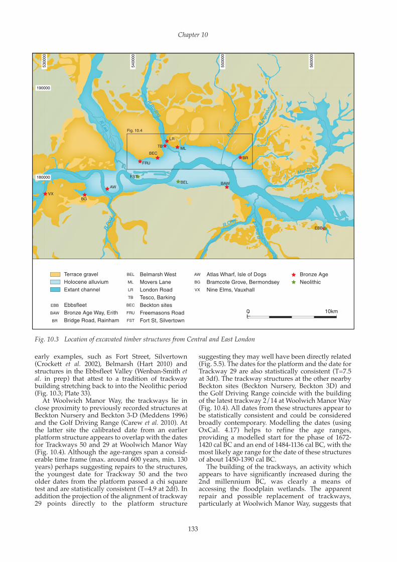
early examples, such as Fort Street, Silvertown(Crockett et al. 2002), Belmarsh (Hart 2010) andstructures in the Ebbsfleet Valley (Wenban-Smith etal. in prep) that attest to a tradition of trackwaybuilding stretching back to into the Neolithic period(Fig. 10.3; Plate 33).
At Woolwich Manor Way, the trackways lie inclose proximity to previously recorded structures atBeckton Nursery and Beckton 3-D (Meddens 1996)and the Golf Driving Range (Carew et al. 2010). Atthe latter site the calibrated date from an earlierplatform structure appears to overlap with the datesfor Trackways 50 and 29 at Woolwich Manor Way(Fig. 10.4). Although the age-ranges span a consid-erable time frame (max. around 600 years, min. 130years) perhaps suggesting repairs to the structures,the youngest date for Trackway 50 and the twoolder dates from the platform passed a chi squaretest and are statistically consistent (T=4.9 at 2df). Inaddition the projection of the alignment of trackway29 points directly to the platform structure
suggesting they may well have been directly related(Fig. 5.5). The dates for the platform and the date forTrackway 29 are also statistically consistent (T=7.5at 3df). The trackway structures at the other nearbyBeckton sites (Beckton Nursery, Beckton 3D) andthe Golf Driving Range coincide with the buildingof the latest trackway 2/14 at Woolwich Manor Way(Fig. 10.4). All dates from these structures appear tobe statistically consistent and could be consideredbroadly contemporary. Modelling the dates (usingOxCal. 4.17) helps to refine the age ranges,providing a modelled start for the phase of 1672-1420 cal BC and an end of 1484-1136 cal BC, with themost likely age range for the date of these structuresof about 1450-1390 cal BC.
The building of the trackways, an activity whichappears to have significantly increased during the2nd millennium BC, was clearly a means ofaccessing the floodplain wetlands. The apparentrepair and possible replacement of trackways,particularly at Woolwich Manor Way, suggests that
Chapter 10
133
Fig. 10.3 Location of excavated timber structures from Central and East London

the construction and maintenance of these structuresretained some relevance with the changinghydrology of the area and suggests that defined andestablished access routes into the marshland wererespected and maintained. However as their pointsof origin and destinations are unknown it is difficultto speculate further. The palaeoenvironmentalevidence from the A13 sites indicates that construc-tion broadly coincides with rising water levels and achange from predominantly alder carr to a moreopen environment of sedge fen, reedswamp andmarsh. Further into the marsh, closer to the Thamesforeshore it is likely that saltmarsh environmentsexisted. Access to the floodplain may have beenrequired to exploit the range of natural resources
that must have been abundant in such environ-ments: plants for medicinal purposes or reeds forbasketry and thatching, as well as activities such ashunting, fishing and waterfowling. However, aspreviously stated there is little evidence of suchactivities from sites along the A13 or the ThamesEstuary in general during this period. Alternativelythe trackways may have been used for herding ofanimals to seasonal pasture on the marshes. Giventhe light construction, the trackways themselveswere probably only used for human foot traffic withthe herd wading alongside through the wetter areas.The role of animal husbandry, particularly of cattle,in the local subsistence economies of the region iswell attested.
Landscape and Prehistory of the East London Wetlands
134
Fig. 10.4 Radiocarbon chronology of Bronze Age timber trackways in East London

Construction methods
Freemasons Road ‘bridge’ (Fig. 10.5)
Form The Freemasons Road ‘bridge’, a double pile align-ment, was the most substantial wooden structurefound during the A13 project. No elements of theupper works of the structure were found, althoughthe oak sliver chips from the organic silt thataccumulated around the base of the piles (layer 49)do suggest that the trimming of large oak planks ofthe sort likely to have been used in a walkway hadoccurred close-by. The reconstruction presented inFigure 10.5 is tentative and has been based on theuse of a range of joints and materials documented in
Bronze Age timber structures from south-eastEngland. Other possible assemblies can not be ruledout, but axe hewn tusk tenons on the tops of piles forcarrying cross planks with socket joints are knownin the Bronze Age and later simple trestle type struc-tures. At Swalecliffe in Kent, for example, a substan-tial cleft plank was supported by two piles withelongated tusk tenons at the base of a waterhole orwell (Masefield et al. 2003, 66) and another largerexample of a tusk tenoned pile comes from Flag Fen(Pryor 1991, fig. 79). Having established a moder-ately rigid trestle it would have been relatively easyto lay down cleft planks or half logs to form thelongitudinals and walkway. There is no evidence ofthe use of lashings or wooden pegs in such situa-tions so they have not been used in the illustration.
Chapter 10
135
Fig. 10.5 Reconstruction of the Freemasons Road ‘bridge’
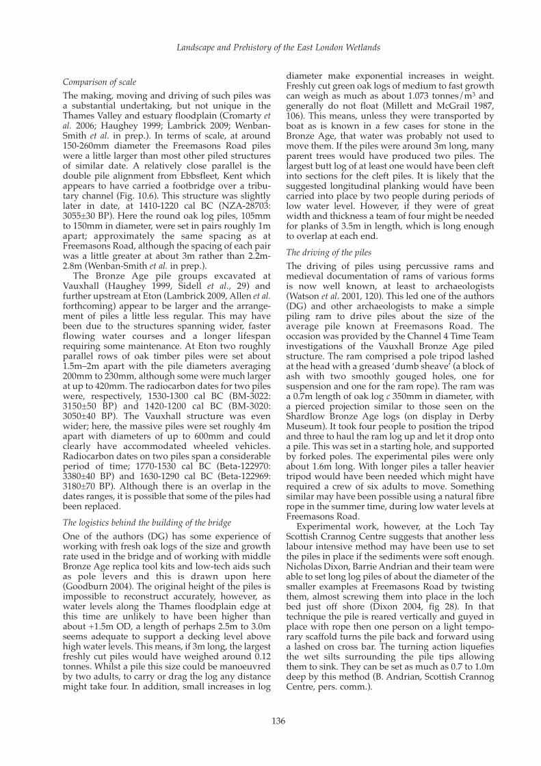
Comparison of scaleThe making, moving and driving of such piles wasa substantial undertaking, but not unique in theThames Valley and estuary floodplain (Cromarty etal. 2006; Haughey 1999; Lambrick 2009; Wenban-Smith et al. in prep.). In terms of scale, at around150-260mm diameter the Freemasons Road pileswere a little larger than most other piled structuresof similar date. A relatively close parallel is thedouble pile alignment from Ebbsfleet, Kent whichappears to have carried a footbridge over a tribu-tary channel (Fig. 10.6). This structure was slightlylater in date, at 1410-1220 cal BC (NZA-28703:3055±30 BP). Here the round oak log piles, 105mmto 150mm in diameter, were set in pairs roughly 1mapart; approximately the same spacing as atFreemasons Road, although the spacing of each pairwas a little greater at about 3m rather than 2.2m-2.8m (Wenban-Smith et al. in prep.).
The Bronze Age pile groups excavated atVauxhall (Haughey 1999, Sidell et al., 29) andfurther upstream at Eton (Lambrick 2009, Allen et al.forthcoming) appear to be larger and the arrange-ment of piles a little less regular. This may havebeen due to the structures spanning wider, fasterflowing water courses and a longer lifespanrequiring some maintenance. At Eton two roughlyparallel rows of oak timber piles were set about1.5m–2m apart with the pile diameters averaging200mm to 230mm, although some were much largerat up to 420mm. The radiocarbon dates for two pileswere, respectively, 1530-1300 cal BC (BM-3022:3150±50 BP) and 1420-1200 cal BC (BM-3020:3050±40 BP). The Vauxhall structure was evenwider; here, the massive piles were set roughly 4mapart with diameters of up to 600mm and couldclearly have accommodated wheeled vehicles.Radiocarbon dates on two piles span a considerableperiod of time; 1770-1530 cal BC (Beta-122970:3380±40 BP) and 1630-1290 cal BC (Beta-122969:3180±70 BP). Although there is an overlap in thedates ranges, it is possible that some of the piles hadbeen replaced. The logistics behind the building of the bridgeOne of the authors (DG) has some experience ofworking with fresh oak logs of the size and growthrate used in the bridge and of working with middleBronze Age replica tool kits and low-tech aids suchas pole levers and this is drawn upon here(Goodburn 2004). The original height of the piles isimpossible to reconstruct accurately, however, aswater levels along the Thames floodplain edge atthis time are unlikely to have been higher thanabout +1.5m OD, a length of perhaps 2.5m to 3.0mseems adequate to support a decking level abovehigh water levels. This means, if 3m long, the largestfreshly cut piles would have weighed around 0.12tonnes. Whilst a pile this size could be manoeuvredby two adults, to carry or drag the log any distancemight take four. In addition, small increases in log
diameter make exponential increases in weight.Freshly cut green oak logs of medium to fast growthcan weigh as much as about 1.073 tonnes/m3 andgenerally do not float (Millett and McGrail 1987,106). This means, unless they were transported byboat as is known in a few cases for stone in theBronze Age, that water was probably not used tomove them. If the piles were around 3m long, manyparent trees would have produced two piles. Thelargest butt log of at least one would have been cleftinto sections for the cleft piles. It is likely that thesuggested longitudinal planking would have beencarried into place by two people during periods oflow water level. However, if they were of greatwidth and thickness a team of four might be neededfor planks of 3.5m in length, which is long enoughto overlap at each end.The driving of the pilesThe driving of piles using percussive rams andmedieval documentation of rams of various formsis now well known, at least to archaeologists(Watson et al. 2001, 120). This led one of the authors(DG) and other archaeologists to make a simplepiling ram to drive piles about the size of theaverage pile known at Freemasons Road. Theoccasion was provided by the Channel 4 Time Teaminvestigations of the Vauxhall Bronze Age piledstructure. The ram comprised a pole tripod lashedat the head with a greased ‘dumb sheave’ (a block ofash with two smoothly gouged holes, one forsuspension and one for the ram rope). The ram wasa 0.7m length of oak log c 350mm in diameter, witha pierced projection similar to those seen on theShardlow Bronze Age logs (on display in DerbyMuseum). It took four people to position the tripodand three to haul the ram log up and let it drop ontoa pile. This was set in a starting hole, and supportedby forked poles. The experimental piles were onlyabout 1.6m long. With longer piles a taller heaviertripod would have been needed which might haverequired a crew of six adults to move. Somethingsimilar may have been possible using a natural fibrerope in the summer time, during low water levels atFreemasons Road.
Experimental work, however, at the Loch TayScottish Crannog Centre suggests that another lesslabour intensive method may have been use to setthe piles in place if the sediments were soft enough.Nicholas Dixon, Barrie Andrian and their team wereable to set long log piles of about the diameter of thesmaller examples at Freemasons Road by twistingthem, almost screwing them into place in the lochbed just off shore (Dixon 2004, fig 28). In thattechnique the pile is reared vertically and guyed inplace with rope then one person on a light tempo-rary scaffold turns the pile back and forward usinga lashed on cross bar. The turning action liquefiesthe wet silts surrounding the pile tips allowingthem to sink. They can be set as much as 0.7 to 1.0mdeep by this method (B. Andrian, Scottish CrannogCentre, pers. comm.).
Landscape and Prehistory of the East London Wetlands
136

Chapter 10
137
Fig. 10.6 Plans of Bronze Age piled structures from the Middle and Lower Thames Valley
The work force requiredAs a result of this, all that can be tentativelysuggested is the minimum size of the work forcerequired to build the Freemasons Road footbridge.Clearly a larger team could have built the structuremuch faster. The limited experiments in possibleBronze Age piling methods indicate that the workforce could have been at the scale of the extendedhousehold rather than a huge communal effort.However, if the structure was built by one extendedhousehold rather than a village sized community itwould have taken many weeks to build allowing forall the stages in the work required from felling toerection on site. Although some of the wood workingdebris found on site might have been the debris leftfrom the finishing of planking for the super-struc-ture of the bridge, no chips from trimming andpointing the piles were found and this most likelytook place elsewhere. Hewing the tips a few days orweeks ahead of setting them would have made thepiles lighter to move and allowed the tips to dry,thus hardening the surfaces prior to setting. Tool kitsThe implied tool kit used for the woodworkingneeded to build this bridge is a simple onecomprising one or more axes to fell and buck theparent trees and make the pile points; logs wouldalso have been required for skidding the timber andas poles for moving and temporary shoring. Otheritems that must have been included are ropes, amaul and some wooden wedges for cleaving someof the piles and the super-structure elements. Thesocket joint holes in the implied cross planks wouldhave been cut using narrow bladed axes and oradzes as the tool mark studies of such joints in othertimbers shows (Orme and Coles 1983, 41; Goodburn2003a, 66).
The stake alignments The mainly roundwood stake alignments foundduring the A13 project were simple structures.Once the roundwood material was felled, loppedand bucked a variety of point types were hewn,with small Bronze Age axes of varied form, but allfar smaller and lighter than most used since theIron Age. Roundwood to be woven (‘weavers’)would have been handled in a similar way,although it may have been cut to longer lengths.The stakes were used to support horizontalelements mainly woven round them as in ‘wattlework’. When the wattle work was laid flat in water-logged deposits it is often preserved and here weare able to move beyond the examination ofpointed stake ends and examine weave patterns.The wattle hurdles used as a trackway surface atMovers Lane were a distinctive, quickly woven butrather weak, version of the ‘slew’ weave. The slewweave involved weaving three or four weaverstogether in and out behind the originally upright
stakes. Where paired stake lines have been found,for example at Freemasons Road, these may repre-sent either a phase of repair or possibly the use of aform of ‘dead hedging’ where wood branch andstem debris was held between pairs of stakes.Finally, it is also possible that stake lines may havebeen used to support nets or sheet materials such asbark or natural fibre matting. Evidence for more specialised older work partiesThe level of skill and strength needed to carry outthese types of work is modest and well within theabilities of all adults and many children from theage of perhaps five or six years upward. It seemsvery likely that the building of such simple round-wood structures would have been a whole familyaffair in Bronze Age Greater London. This is nottrue, however, of the weaving of complicatedweaves or with the use of large diameter weaverswhere adult strength in arms and shoulders isrequired. Where stake alignments included clefttimber stakes and large timbers, for example atMovers Lane Area 3, Woolwich Manor WayPlatform 61 and elements of Structure 32 (the‘bridge’) at Freemasons Road, they imply the logis-tics and complexity of the work would havereached a different level. The work requiredphysical strength as well as knowledge of largertrees and wood working skills. This would mostlikely have been carried out at a greater distancefrom home and hearth. It may even have been inareas of wildwood where predatory animals mightalso be found. We might reasonably suggest that itis probably the case that the work parties involvedin this included mainly adult men and some olderchildren.Tool kitsFor most of the stake alignments found on the A13project the tool kit required was meagre; an axe anda large mallet or ‘maul’ would be all that wasneeded apart from a chopping block or log end totrim the stake points on. If cleft material wasinvolved a set of wooden wedges and possibly achisel would also be required. The chisel would beused to cut fibrous slivers in the narrow clefts madeduring log cleaving. Evidence of repairs Clearly the prolonged use of a site in a similar wayis indicated by archaeological evidence of repairs towooden structures or even rebuilds. Such evidenceis typically found in wooden property boundarieson waterlogged urban sites, where wattle fencelines are often found superimposed in virtually thesame place on the same alignment. In relation tostake alignments from the A13 project, only therather mysterious stake groups at Movers Lane (Str.5168 and possibly Str. 5144) probably show signs ofthe repair or rebuilding of a stake built structure onthe same alignment. This is particularly true ofStructure 5168 which had a great density of varied
Landscape and Prehistory of the East London Wetlands
138
stakes, including larger and smaller roundwoodand even some cleft timber examples (see Fig. 7.11and 7.12c).
The trackways
The restricted range of trackway forms found on theA13Of the five wooden trackways recorded, four werewhat has been loosely termed brushwood tracksmade of roundwood dumped lengthwise (Track -ways 50, 29 and 2/14 at Woolwich Manor Way andTrackway 3031 at Movers Lane). Structure 5268 atMovers Lane was a hurdle trackway (Fig. 7.11; Plate17). In national terms the brushwood tracks werethe simplest requiring only the felling, lopping andbucking of poles, coppice stems and some branch-wood. The key issue for the builders was movingthe material and laying it end to end to form amoderately level walkway. Such trackways repre-sent a modest investment of labour and materials ifshort in length. However, when extending overhundreds of metres many tons of material wouldhave been required. This trackway type can beparalleled widely in Britain and Ireland from theNeolithic onwards (Coles and Orme 1980a and b;Coles and Orme 1985; Raftery 1990). The fact thatTrackway 3031 at Movers Lane (Fig 7.9; Plate 15)and Trackway 2/14 at Woolwich Manor Way (Fig.
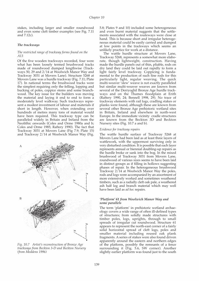
5.8; Plates 9 and 10) included some heterogeneousand even burnt material suggests that the settle-ments associated with the routeways were close athand. This is because short and irregular heteroge-neous material could be easily carried and dumpedat low points in the trackways which seems anunlikely practice for work at a distance.
The wattle hurdle structure at Movers Lane,Trackway 5268, represents a somewhat more elabo-rate, though lightweight, construction. Havingmade the hurdle panels out of thin, pliable, rods ondry land they could be laid out rapidly to form alight fairly level trackway. Coppicing is funda-mental to the production of such fine rods for thisparticularly light, regular weaving. The quickmulti-weaver ‘slew’ weave is not exactly paralleledbut similar multi-weaver weaves are known fromseveral of the Derryoghil Bronze Age hurdle track-ways and on the Thames floodplain at Erith(Raftery 1990, 24; Bennell 1998, 29). No trace oftrackway elements with rail logs, cradling stakes orplanks were found, although these are known fromseveral other Bronze Age prehistoric wetland sitesin Britain, Ireland and elsewhere in north-westEurope. In the immediate vicinity cradle structuresare known from the Beckton 3D and BecktonNursery sites (Fig. 10.7 a and b).Evidence for trackway repairs The wattle hurdle surface of Trackway 5268 atMovers Lane had been laid as at least three layers ofwattlework, with the uppermost surviving only invery disturbed condition. It is possible that each layerrepresents annual or biennial doubling-up repairs asthe hurdle broke or sank into the bog. In the mixedbrushwood of Trackway 3031 from Movers Lane,roundwood of various sizes seems to have been laidin distinct groups as if filling in hollows suggestingphases of repair. In the heterogeneous brushwoodTrackway 2/14 at Woolwich Manor Way the poles,rods and logs were accompanied by an assortment ofmore extensively worked and sometimes weatheredtimbers, such as a radially cleft oak pale, a weatheredash half log and branch material which may wellhave been laid as ad hoc repairs.
‘Platform’ 61 from Woolwich Manor Way andsome parallelsThe term ‘platform’ in prehistoric wetland archae-ology covers a wide range of often ill-defined typesof structures; from solidly made structures withtimber poles, logs, uprights, through to smallspreads of irregular cut roundwood. Structure 61appears to represent the north-east corner of a fairlysolid horizontal spread of cleft logs, poles andsmaller material including reused oak plankfragments. A series of stakes were also found drivenapparently around the eastern and northern edgesof the platform, possibly the remnants of a fencesurrounding it (Fig. 5.6, SW corner). Anotherslightly earlier platform was found just to the south
Chapter 10
139
A
B
Fig. 10.7 Artist’s reconstruction of Bronze Age track ways from Beckton 3-D and Beckton Nursery(from Meddens 1996)
of this structure on the Beckton Golf Driving Range.However, this was more lightly built comprising alayer of possible cut yew stems and branchescovered with a layer of close set alder logs (Carew etal. 2010; Goodburn 2003b). Platform 61 was mainlymade of much larger section material set closetogether, a little like the log and branch floors oflater prehistoric buildings excavated from theeroding edges of the Lower Severn Estuary (Belland Caseldine 2000, 88). It also broadly resemblesthe more heavily constructed parts of the AtlasWharf ‘platform’ found on the Isle of Dogs, whichwas of similar date (Goodburn 1998). Unfortunatelythe trench at Woolwich Manor Way could not beextended southwards to expose more of the struc-ture to ascertain whether it might have supported adwelling for example. Although the evidence islimited such a function is possible.
Woodworking debitage as an indicator of activity For a great many years archaeologists haveexcavated and studied stone tool making debris asstandard practice. Sometimes stone tool specialistsare able to refit stone flakes showing roughly whathad been made where the debris spread lay, in otherwords the ‘debitage’ is diagnostic of particularknapping activities and in broad terms the produc-tion of certain types of stone artefact. It is less wellknown that the targeted sampling and study ofdifferent types of wood chips and other workingdebris can provide similar information (Meddensand Beasley 1990, 243; Goodburn 1996, 241). Severalfinds of woodworking debris, or what might beloosely called wood chips, were made during theA13 investigations which have provided extrainsights into the behaviour of those that occupiedthe area. They have also shed some light on thetechnological aspects of the woodworking carriedout at certain locations, and the range of speciesbeing worked. Probably the most important, from aforensic point of view, were the distinctive elon -gated slivers from smoothing large cleft oak timbersfound in layer 49 at Freemasons Road. Apart fromsome broken fragments in the platform (Str. 61) atWoolwich Manor Way no wide cleft planks werefound in situ. Using experimental parallels it hasbeen suggested that the debris may have derivedfrom trimming parts of the Freemasons Road bridgesuperstructure, particularly walkway planking. Asmaller scatter of yew wood chips at Movers Lane(Area 3) again suggested the working of timber notused on the site itself, although several items ofworked yew wood were found at Woolwich ManorWay and the nearby Beckton Golf Driving Rangesite (Carew et al. 2010).
Bronze Age double pointed sticks; note on arecurring class of wooden artefact The A13 project produced two mysterious objects ofradially cleft wood that resemble each other, and a
larger example from beside a Bronze Age trackwaywas found at Erith on the southern edge of theestuarine flood plain. It should be noted that allthese objects were found lying horizontally, notused as some form of stake. At Freemasons Roadobject 32 was made from an axe trimmed cleftsection of yew, 0.44m long by about 25mm squareand carved to a point at both ends (Fig. 4.14). Nextto trackway 2/14 at Woolwich Manor Way anothersimilar object was found, radially cleft and 0.56mlong, 37mm wide and about10mm thick andpointed at both ends (Fig. 5.9, f). The possibleparallel from Erith was around twice as large; aradially cleft and double pointed stick of alder,about 1.11m long, 60mm wide and 30mm thick.These objects have similar form and were found insimilar contexts but there is little other evidence topoint to their function. A role in the drying,smoking and/or cooking fish is possible, althoughevidence for the exploitation of fish resources isotherwise lacking (see above, Chapter 9) this couldextend to other cuts of meat (Fig. 10.8). In the damptemperate climate of the Pacific north-western coastof America Native Americans used to cook openedup cleaned fish held flat by flat pointed stick(s)threaded through slits in the body. The assemblywas then set, near up right, leaning slightly over asmall fire (Stewart 1984, 84). The fish would becooked or even smoked and dried using thismethod, which relies mainly on radiant heat. Todaya modernised version of the method, with the fishnailed to a board, is still practiced in the Pacificnorth-western region.
Raw materials, treescapes and Bronze Agewoodmanship (Fig 10.9)In any situation past or present, the materialsselected for different types of structural work aredictated by a combination of factors such as: localavailability, itself a result of natural conditions andoften human management of the land, the structuralcharacteristics of the species, and often seeminglyirrational cultural prejudices. Clearly for these sitesthe most important natural factor influencing theavailability of certain species is the degree of water-logging and distance to drier land. These factorsvaried through time and across locations on the A13project. Environmental archaeologists have beenidentifying waterlogged wood samples and treepollen to species or group for over half a century(Godwin 1956; Coles and Orme 1985). Ever since thebeginnings of work by Rackham and others in theearly 1970s on ancient systems of woodlandmanagement or ‘woodmanship’, seeking evidencefor tree management practices such as coppicing,pollarding and other systems has been a key aim ofwetland archaeology. In coppicing, young trees arerepeatedly harvested as regrowth from an estab-lished root system or ‘stool’; in pollarding theregrowth springs from higher up a stem out of reachof browsing animals. Each system produces many
Landscape and Prehistory of the East London Wetlands
140

young pliable rods (Rackham 1976, 20). Rackhamclearly defined a series of terms to describe ancientforms of woodmanship that shaped the landscapeor ‘treeland’. Prior to the early 13th century ADearly treescapes in England were often a distinctivemosaic of managed tree-land forms ranging fromorchard and hedgerow trees to areas of more or lessunmanaged wildwood. Regarding the A13 project,the concern is therefore not just with the range ofspecies used but also whether the parent trees weresubject to a woodmanship practice or not. Due tothe cultural and practical selection criterion used byearly woodworkers other strands of evidence havealso to be considered. For example, the pollen studyshows that linden (lime: Tilia sp.) was common onthe dry land bordering the wetlands but virtuallyno trace of it was found in the examined workedroundwood or timber
Based on field identifications of the larger stemscross checked with the microscopic identifications,species used as larger structural timber in the roundor cleft included one of the two native oaks (or both)with a little ash, alder and elm. A much wider rangeof species were used as poles, cut branches, andsmaller rods, including in order of magnitude:alder, ash, willow/poplar, and less commonly yew,hazel, oak, elm and a single pole of holly.
Only a small proportion of the materialexcavated was of likely to have been of wildwood
origin, in other words being derived from large oldtrees and typically narrow ringed (that is 2mmwide annual rings or narrower) and straight-grained (Goodburn 1991). It seems that any standsof trees growing in wildwood type conditions wereprobably a little distance away from the wetlandedge zone where various forms of managedtreeland and farmland dominated (Fig. 10.9). Oaktimber having wildwood characteristics was foundas occasional radially cleft stakes at Movers Lane(for example stake 5244, sample 1125) and in theelongated trimming slivers found at FreemasonsRoad derived from timbers that were not found onsite (layer 49). However, the vast bulk of materialclearly derived from more open forms of treelandwhere trees could put on moderately or very widerings. The process that opened up the woodlandwas probably frequent fellings although theopening of the wildwood through hurricanes andflash flooding might also have been a factor. Theoak piles of the bridge or jetty found at FreemasonsRoad varied between about 150mm and 200mm indiameter with around 50-70 rings but also includea few cleft timbers from larger diameter fast grownlogs up to about 450mm in diameter (for examplepile 79). As some of the piles were a little knotty itis likely that they were cut from a log taken wellabove the base of the tree. It is possible that some orall the above grew in managed woodland with
Chapter 10
141
Fig. 10.8 Artist’s reconstruction of a cooking scene using double pointed sticks (by M Gridley)

Landscape and Prehistory of the East London Wetlands
142
Fig. 10.9 Parent trees for selected
timb
ers of Bronze A
ge date

small timber trees and coppice (‘coppice withstandards’ still common in parts of the south-easttoday) (Plate 34).
The fine, regular young roundwood weavers, c25mm max diameter, in wattle trackway 5268 atMovers Lane were clearly derived from coppicedwoodland, in this case mainly of alder. Similar,slightly larger material, also of alder, was used atMovers Lane for stake structure 5247, while abundle of regular small rods dumped by trackway3031 was mainly of a mix of alder and willow orpoplar. The presence of a small beaver dam on thesite shows that we should not assume that all thecoppiced material was necessarily evidence ofhuman woodmanship; some areas may well havebeen cut and maintained by beavers. The coppicederived from species more typical of slightly drierland such as ash, elm and hazel was presumablygrowing on the drier edges of the wetland or even a little distance up on the gravel terraces. Theyew wood elements found probably came from thenow extinct wetland yews that were once commonin the floodplain wildwood around 2000 BC(Goodburn 1998). The almost total lack of the useof easily worked linden (lime) wood, evidenced inthe pollen sequences, is difficult to explain, butperhaps there were cultural prejudices against itsuse.
From the woodworkers point of view thewoodmanship practices employed and the ecotonal
natural environment produced woody materials ofmany sizes, shapes and species to suit differentfunctions. In a real sense the woodmanship waspart of their traditions of woodworking and it isalmost certain that the same people were bothwoodsmen (possibly including children andwomen in the lighter work) and woodworkers. Thiscontrasts with today, in most cases, when awoodworker buys a timber of a certain size madeby someone else from logs supplied at a distance byothers, so that the connection between end user andlandscape is broken.
Technical details on the recording and analysis ofwaterlogged wood assemblages
Tool marks, tool kits and dating in relation tosome other key Bronze Age assemblagesThe level of the preservation of tool marks wasdisappointing for most of the woodwork foundduring the A13 project, bearing in mind the veryfine preservation of some prehistoric wetlandwoodwork excavated in the region, such as atBeckton Golf Driving Range (Carew et al. 2010;Goodburn 2003b). The general lack of very well-preserved marks was due to various factors such ascompression by overburden, ancient weathering,localised drying before full excavation and in somecases hurried excavation and poor wrapping priorto recording. However, some information on theform, size and method of use of Bronze Age axetype tools was recorded which enables somecomparisons to be made with toolmarks recorded inother assemblages spanning the Bronze Age. Herewe are concerned only with marks on the largerroundwood and timber used where fairly completetool marks might be expected. Also, for the vastmajority of the A13 material, the preservation wasnot good enough to identify the signatures left bythe unique pattern of nicks on individual axeblades.
Although it was soon recognised during work inthe Somerset Levels in the 1980s that axes ofdifferent periods, from the Neolithic to Iron Ages,left different marks (Orme and Coles 1983, 32), therealisation that the key difference was in the size ofthe facets and width of the stop marks (or ‘jamcurves’) came later (O’Sullivan 1997). Although thesmoothness of the facets and angle of the cut arealso factors worth consideration and there aremarked differences in these features between stoneand metal worked material from the early BronzeAge, these are of much less importance. O’Sullivan,working systematically on prehistoric wetlandwoodwork from central Ireland, was able to showthat there were distinctive changes in the size of thebest preserved marks found in assemblages overtime from the Neolithic to Iron Ages. Working onmaterial from Oak Bank Crannog in Loch Tay,Sands (1997) was able to take tool mark recordingfurther and distinguish late Bronze Age from early
Chapter 10
143
Plate 34 Coppiced hazel woodland (photo by Michael JSpiller)

Iron Age axe marks as well as carry out innovativework on comparing individual axe signature marks.It is now clear that there are predictable trends inthe sizes of the largest axes or adzes that groups ofwoodworkers used through time (Goodburn 2003a,104; 2004, 129; Webley and Hiller 2009). This is, ofcourse, entirely unremarkable as it has long beenknown that there were substantial changes inBronze Age axe forms and that blade width was a
key factor. Clearly in any one period there aresmaller and larger tools but the working assump-tion here is that in the vast majority of cases thewoodworkers would use the largest heaviest toolfor the heaviest jobs such as felling trees over polesize and heavy duty hewing. Thus, near or fullycomplete axe facets and stop marks can be corre-lated with broad date ranges in the Bronze Age ofearly, middle and late, so far the correlations have
Landscape and Prehistory of the East London Wetlands
144
Fig. 10.10 Axe stop marks

proved reliable with assemblages dated by radio-carbon and tree-ring matching. One notable excep-tion is the partially excavated pile from the middleBronze Age Vauxhall Bridge now at the Museum ofLondon, where the widths of the facets of the upperparts are narrow and more typical of the late BronzeAge. However, hitherto very little detailedrecording of elements of that structure has beenpossible.
In the case of the Freemasons Road assemblagethe pile tips were fairly well preserved and once allof them had been cleaned and recorded the largestnearly complete facets and stop marks could beseen. They were moderately rounded and 65mmwide, implying the use of an axe blade about70mm wide, which is typical of the middle BronzeAge but at the smaller end of the early Bronze Agespectrum. Similar marks were documented on theDover Boat (Goodburn 2004, 129, Fig. 10.10). Someof the larger wood chips from the site also impliedthe use of blades about 70mm wide. However, one of the piles (pile 80), had facets only about35mm wide indicating the use of a second, muchsmaller, implement Initially smaller marks werefound on the two least well preserved piles and alate Bronze Age date was suggested demonstratingthe need to examine as much of the material aspossible.
From Woolwich Manor Way there were nonearly complete facets that could be compared,although a fine partial signature survived on onepiece of worked yew. Most of the worked materialwas small roundwood, or had been weathered inantiquity. Similar problems prevented the survivalof a range of crisp and clear facets and stop marksfrom Movers Lane; most of the worked materialwas small roundwood and the larger material wasgenerally weathered with eroded facets. However,in a few cases fairly well-preserved axe marks didsurvive such as on the end of a pole from Trackway3010 (sample 208) which bore a very rounded axestop mark, 50mm wide, which was from a deepblow and seemed fairly complete. Such a markwould be typical of the larger end of the late BronzeAge spectrum fitting the narrow rounded cuttingedges/blades of nearly all socketed axes (Good -burn 2003a, 104). However, radiocarbon dating ofthe trackway produced a date in the early tomiddle Bronze Age and this may be anotherexample of a lack of fit of the tool mark to radio-carbon date. An intrusive stake tip 5108 (sample1000) was found driven through the upper part ofthe wattle hurdle trackway (Str. 5268) clearly fromsome way above. The axe facets were small,rounded and only up to 35mm wide which wouldbe best matched in the late Bronze Age (Goodburn2003a, 104).
The limits of previously existing terminology fordescribing cut roundwood ends By the beginning of the A13 project a commonlyadopted terminology had gradually evolved todescribe the forms of the cut ends of worked round-wood so common in Bronze Age wetland assem-blages. The terms described three main categoriesthat all cut roundwood was supposed fall into(O’Sullivan 1997, 307):1. The chisel form, with one oblique face forming
the point or end2. The wedge form, with two oblique cut faces
forming the point or end 3. The pencil form, with multiple oblique cut faces
forming the point or endHowever, recording work during the A13 project
and for other smaller assemblages of Bronze Agewoodwork from London shows that the tripartitecategories are inadequate with many examplesfalling outside. The most common exception waspointed or cut roundwood ends formed by cuttingtwo adjacent oblique faces, as exemplified in stake67 from TP9 at Woolwich Manor Way (Fig. 5.9g).This feature was also noticed by the pioneeringprehistoric wetland investigators in the mid 1980s(Coles and Orme 1985, 26), but a simplified schemathen gradually evolved. The reason for shapingpoints or cut ends leaving two adjacent facetsbecomes apparent when coppice rods are cut formaking replicas of early roundwood structures.This was clearly demonstrated by D. Goodburnduring the reconstruction of section of the ErithBronze Age wattle hurdle trackway for BexleyMuseum with middle Bronze Age tools. Similarly itwas experimental works that led Coles and Orme tothe same conclusion.
Many coppice shoots curve tightly in at their baseto form a curved butt to the stem (Rackham 1976,21). If the stem is cut low the simplest way ofmaking a point is to form it with two adjacentoblique faces. If the stem is cut higher then chisel,wedge and pencil forms are more likely to be conve-nient. A variation on the point of two adjacent facesis one where a third face is also slightly cut so as totaper in, similarly dealing with the curving ends ofmany coppice stems. Thus, these two categories canbe added to the checklists used during therecording of early roundwood found on archaeo-logical sites. None of these issues apply to straightstems grown from seed known as ‘maidens’.Ultimately the experience of the A13 woodworkrecording has refined recording terminology forsmaller roundwood and aided a more subtle under-standing of woodworking processes and woodman-ship in the Bronze Age of south-east England.
Chapter 10
145