chapter 1: introduction - home - montgomery … · 2016-06-24 · chapter 1: introduction ... with...
TRANSCRIPT
1
Bethesda Downtown Sector Plan Planning Board Edits to the Public Hearing Draft dated May 2015 Draft Revisions June 24, 2016
Chapter 1: Introduction Bethesda is a thriving urban center located in southern Montgomery County. What began as a crossroads
village in 1871 now boasts more than 10,000 residents and is home to the two largest employers in the
County. With numerous restaurants, shops, art galleries and entertainment choices, including performing
arts, live music and movies, Bethesda is a County arts and entertainment destination and a center of the
nightlife economy.
The development of Bethesda has been guided by a series of County Master and Sector Plans. These plans,
each created through a public process, identify general goals, intentions and priorities for development
throughout the defined Plan Area (about 450 acres for Downtown Bethesda). They include specific
recommendations for individual properties within the Plan Area, for land use and zoning, urban design,
transportation, open space, environmental conditions and historic preservation.
Prepared by the Planning Department and Planning Board, and approved by the County Council, these
Plans inform the community, Planning Department staff and Board members in their review of proposed
projects to ensure that development is consistent with the Plan goals, intentions and recommendations.
This Sector Plan fine‐tunes earlier Sector Plans by reevaluating their original goals and resulting
environments, rather than radically changing direction. Consistency of County policy helps create a
community that is confident in its future and whose citizens are committed to improving that community.
This Sector Plan defines the context, purpose, Plan Area and recommendations for the Downtown
Bethesda, and highlights the direction for the next 20 years.
2
1.1 Bethesda Today
1.1.1 Brief History of Downtown Bethesda
The area now known as the Bethesda Central Business District, originally called Darcy’s Store, was a small
crossroads community surrounded by farms into the post‐Civil War era. Most of the early buildings from
this period were demolished as Bethesda grew, following the extension of the Tennallytown and Rockville
Railroad Company streetcar line along Wisconsin Avenue to Alta Vista in 1890.
In the 1890s, the Chevy Chase Land Company began buying farmland for residential development and by
1912, very little land in the area remained in agricultural production. The B&O Railroad’s Georgetown
Branch, opened in 1910, further stimulated Bethesda’s commercial growth and led to the development of
related industries, such as coal yards, lumber yards, a planing mill and an ice plant, in Bethesda.
Bethesda’s first real estate boom, from 1922 to 1926, was prompted in part by the increased popularity
of automobiles as a means of commuting and led to the subdivision of more farmland and escalating land
values. By the late 1920s, Bethesda had three filling stations, a drug store, a hardware store, a variety
store, a grocery store, two feed stores, two barber shops and three small lunchrooms, and at the close of
the 1930s, 23 auto‐related businesses were located in Bethesda. About a dozen early 20th‐century
buildings remain to reflect Bethesda’s transition in the 1920s and 1930s from a rural crossroads to an
automobile‐oriented, suburban community.
The development of the National Institutes of Health complex in 1938 and Bethesda Naval Hospital in
1940 spurred additional commercial activity in Bethesda during World War II. Following the war, a second
wave of homebuilding took place. As Bethesda’s residential areas matured, the downtown continued to
grow and prosper, with a significant number of commercial buildings being constructed using various
mid‐century modern architectural expressions. Bethesda experienced another wave of growth in the
1980s, following the arrival of Metrorail, with many new buildings replacing post‐World War II and earlier
commercial structures. The emphasis of much of this development shifted from smaller commercial
activities along Wisconsin Avenue, designed to serve nearby residential areas, to offices, shops and
restaurants that have made Bethesda a significant downtown for the southern part of the County, as well
as a regional destination.
1.1.2 Strengths and Challenges
A. Strengths
Rich with unique history, community character and established residential neighborhoods.
Home to more than 10,000 residents within the Plan boundary and adjacent to two major
federal employers.
A County arts, entertainment and nightlife destination.
3
Regional destination for shopping and entertainment.
Pedestrian‐oriented with good access to public transit.
B. Challenges
Highest average rents in the County and a need to preserve and enhance existing affordable
housing options.
Lack of urban parks and green space.
Competition from other jurisdictions to remain a center of employment, entrepreneurship
and innovation.
High in impervious cover within watersheds exhibiting poor‐to‐fair water quality.
High energy demand and carbon generator.
4
1.2 Bethesda Tomorrow
1.2.1 Vision
In 2035, Bethesda residents will have a downtown that is a model for sustainability, accessibility,
equity and innovation. They will have more affordable choices of housing in close proximity to
jobs, shopping and recreation. Residents will safely walk and bike to stores and offices, past new
energy‐efficient buildings and familiar landmarks. New parks and open spaces will provide green,
tranquil places for the residents, their families and friends to gather, socialize and relax. Nearby
Metrorail and new Purple Line stations will be quickly reached from tree‐lined streets and
sidewalks to meet the needs of both the residents and visitors to Downtown Bethesda.
This vision stems from the goals and recommendations within this Sector Plan to enhance
Downtown Bethesda over the next 20 years. The aim of the Plan is not to radically transform the
community but to achieve a truly sustainable downtown through incremental measures
addressing its economic, social and environmental future.
1.2.2 Plan Framework
A. Overarching Goals
Specifically, the Bethesda Downtown Sector Plan builds on the past successes of Downtown Bethesda to
create a truly sustainable downtown by focusing on components that will bolster the elements most in
need of enhancement to make Bethesda a true leader in sustainability. The
recommendationsrecommendations to increase:
1. Parks and open spaces, including new civic greens at Veteran’s Park, Bethesda Farm Women’s
Cooperative Market, Capital Crescent Trail, and new urban parks, pathways and gateways.
1.2. Affordable housing, including the preservation of existing market‐rate affordable housing,
providing a mix of housing options and the provision of Moderately Priced Dwelling Units in
exchange for development incentives.
2. Parks and open spaces, including new civic greens at Veteran’s Park, Bethesda Farm Women’s
Cooperative Market, Capital Crescent Trail, and new urban parks, pathways and gateways.
3. Environmental innovation, including more energy‐efficient buildings, better stormwater
management, improved sidewalks and bicycle routes, and other measures to enhance
community health and quality of life.
5
4. Economic competitiveness based on new development, public amenities and proximity to
public transit to attract businesses and visitors from throughout the region, and foster
entrepreneurship and innovation.
B. Strengthened Centers of Activity
Bethesda is distinguished by multiple downtowns within its greater Downtown. Identified in Chapter
Three are nine districts, including the established centers of the Wisconsin Avenue Corridor, Bethesda
Row and Woodmont Triangle; emerging centers of the Pearl and Arlington South Districts; and residential
and edge districts of Battery Lane, Eastern Greenway, South Bethesda and Arlington North. The Plan
explores ways to strengthen these centers of activity through the economic, social and environmental
aspects of sustainability.
C. New Approaches
Montgomery County’s new Zoning Ordinance, enacted in October 2014, provides valuable tools for
developing a mix of residential and non‐residential uses within the Commercial Residential (CR) or
Commercial Residential Town (CRT) zones, such as those of Downtown Bethesda. At the same time, these
zones allow for public amenities and benefits, including affordable housing, energy conservation, public
open space and high quality designs of streetscapes and buildings. The methods of achieving these
benefits include:
1. Bethesda Overlay Zone: This Plan recommends a new overlay zone to provide a planning and
zoning strategy that preserves the recommendations outlined in the Plan while providing a
comprehensive zoning scheme that does not exceed the densities recommended in the land
use vision. The Bethesda Overlay Zone is intended to establish a funding mechanism for parks
and open space, expand the County’s affordable housing inventory, ensure high quality design
through the use of a Design Review Advisory Panel and for the purpose of modifying the density
averaging rules for certain priority sites in the Plan area.
1. Density averaging: The Sector Plan designates Open Space Priority Sending Sites,
Landmark Priority Sending Sites and Affordable Housing Sending Sites. Density transfers from
these sites are encouraged to facilitate, respectively, the creation or enlargement of urban parks,
protection of significant landmarks and retention of affordable housing.
2. Optional Method Public Benefits in the CR zone: Public benefits must be provided that enhance
or contribute to the objectives of the zone and the goals of this Sector Plan. With the increase in
density proposed by this Sector Plan, enhanced public benefits are expected with any new
development.
3. High Performance Area: This designation aims to raise the level of sustainability by incentivizing
the construction of high performing, energy‐efficient buildings tothat save resources, and
decrease operating and maintenance costs, and incentivize development that will help achieve
6
the County’s greenhouse gas objectivesclimate objective. The High Performance Area will be
implemented through the public benefits in the Commercial Residential (CR) zone.
4. Design Excellence: As one of the country’s wealthiest and most educated communities,
Bethesda deserves to have Bbuildings, public spaces and neighborhoods should be designed toof
the highest quality design reflecting its prosperity and knowledgeBethesda’s community identity,
and improve economic competitiveness, livability and environmental quality. Fostering design
excellence is becoming increasingly important as the amount of available land for development
in the County is shrinking and building density is increasing in communities like Bethesda. These
challenges present a greater need than in the past to create and enhance neighborhoods that
are active, walkable and focused around a high quality public realm of pedestrian‐oriented
streets and lively public and privately owned spaces, all framed by distinguished buildings and
landscapes. To raise the quality of design throughout the County, the Planning Department
launched a comprehensive Design Excellence initiative that will affect future Master Plans and
their design guidelines.
1.2.3 Planning Objectives
Bethesda’s diverse, mixed‐use and residential districts have each formed a distinct character and an
identity that is valued by residents and attractive to visitors and newcomers. Over the past 20 years,
Downtown Bethesda has been a center of economic vitality. Building on this success, the Bethesda
Downtown Plan aims to continue to promote all the elements that are fundamental to keeping Bethesda
unique and competitive in the years to come.
A. Economic Growth
The Sector Plan endorses the following economic growth objectives in support of the Plan goals:
Promote flexibility to allow future development to better adapt to market conditions.
Incentivize expanded affordability for housing.
Foster community enrichment by encouraging public and private gathering places.
Re‐imagine under‐performing public spaces to revitalize them as community assets.
Identify new partners and projects (e.g., in the fields of art, entertainment, education,
science) that will catalyze economic development in the Downtown.
Enhance specific aspects of the public realm that support retail and office development
where applicable.
Take best advantage of existing and planned transit, including Metrorail, Purple Line light rail,
Bus Rapid Transit (BRT) and bus.
Incentivize development that adopts new green technologies to save energy and natural
resources while creating an innovative and desirable community for decades to come.

7
B. Housing
The Sector Plan endorses the following housing objectives in support of the Plan goals:
Incentivize expanded affordability for housing.
Preserve existing, market‐rate affordable housing where possible.
Promote a diversified mix of housing options in the Downtown through mixed‐use and multi‐
family residential zoned development.
Preserve and protect existing single‐family neighborhoods in and around the Sector Plan
area.
Provide a sufficient supply of housing to serve Bethesda’s existing and future job growth.
Maintain and enhance the quality of housing through County Design Excellence programs.
C. Retail
The Sector Plan endorses the following retail objectives in support of the Plan goals:
Support a consolidated, long‐term retail solution for districts with unmet retail demand,
including Arlington South, Bethesda Row, Wisconsin Avenue North and Pearl District.
Encourage redevelopment of underperforming retail spaces in the Wisconsin Avenue Metro
Core, Woodmont Triangle and Wisconsin Avenue South Districts, and conversion of less
appropriate retail locations to non‐retail purposes, such as professional offices, studio spaces
and educational uses.
D. Public Facilities
The Sector Plan endorses the following public facilities objectives in support of the Plan goals:
Schools – Ensure options for providing adequate student enrollment capacity.
Mobility – Promote alternative modes of transportation through and around the Sector Plan
area, such as pedestrian, bikewalkingpedestrian, bicyclingke, BRT, etc.
Community Services – Provide support for public facilities to meet the human service,
recreation, security, educational and other needs of the community.
E. Sustainability
The central theme of this Sector Plan is sustainability. The tenets of sustainable urbanism include a walkable and transit‐served community integrated with high‐performance buildings and infrastructure. As the economic heart of Montgomery County, Bethesda is already characterized by excellent walkability, access to transit, mix of uses, community‐serving retail and restaurants, and a cultural and economic hub with a significant urban identity. These characteristics are strong foundations towards building a lasting and dynamic 21st Century urban center. By expanding upon these elements Bethesda will be well positioned to become a regional and national leader as a sustainable downtown.
8
A sustainable community includes three overlapping principals for present and future generations: a strong and prosperous economy; social and cultural equity; and environmental responsibility. To pursue sustainability is to create and maintain the conditions under which each principal works in tandem with each other. The objectives and recommendations throughout this Plan intend to improve sustainability by focusing on the most underachieving performance areas or elements of sustainability to ensure long‐term economic, equitable, and environmental success.
F. Performance Areas The Sector Plan establishes six interrelated targeted performance areas of sustainability with associated objectives and recommendations for each performance area. Performance areas are the building blocks to which the three principals of sustainability can be defined and measured. They are indicators for how a community is performing economically, socially, and environmentally. The performance areas are holistic interlinking categories for sustainable planning and when each performance area is addressed the Plan becomes truly sustainable for decades to come. The six performance areas of focus are: Sustainability Performance Areas
Community Identity: Improve neighborhood identity and character; support innovation and design excellence; beautify the city through area wide greening and improved parkland; improve streetscapes.
Equity: Increase affordable housing options; retain mix of economies and age diversity; ensure environmental justice; provide growth and development opportunities; encourage flexibility in space and programming to adapt to future needs.
Access and Mobility: Increase and improve alternative modes of public transportation; reduce vehicle miles travelled; improve pedestrian mobility; improve circulation system.
Habitat and Health: Improve public health; increase public green and habitat connectivity; improve air quality; increase access and quality of parks and open space;
Water: Improve stormwater treatment, water conservation, and stream quality.
Energy: Incentivize energy efficiencies and conservation to address climate change and improve quality of life.
The central theme of this Sector Plan is sustainability, not just environmental sustainability but also
economic and social sustainability. Integrating the latest planning principles for each of these three
elements can increase urban livability for Bethesda’s residents, support a prosperous economy and
provide a healthy place to live work and recreate.
The Sector Plan establishes goals for each of these elements and then sets forth a system for
measuring success toward reaching the goals. Each idea proposed in this Sector Plan can be evaluated
in terms of six key performance areas that are important measures of overall sustainability. The
targeted performance areas for Downtown Bethesda are:
9
Community Identity
Equity
Habitat and Health
Access and Mobility
Water
Energy and Materials
Many of these performance areas are already well integrated into the fabric of Bethesda’s existing
urban landscape. Bethesda has a thriving identity, mixed use development, diverse transit options, a
walkable street grid, and many other features of a well‐planned downtown. On the other hand,
improvements can be made to all performance areas. Habitat and Health can be improved by
providing additional parks, tree plantings, and green cover. Water quality can be improved through
the installation of stormwater management features, and reduced impervious cover. Equity can
improve by increasing affordable housing, access to transit options, age in place potential, and
additional parks and resources. The Plan has identified and made recommendations where
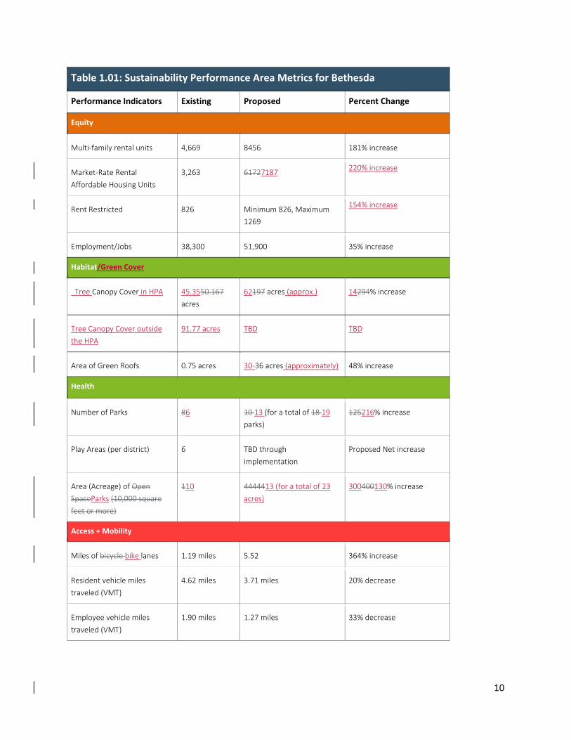
performance areas can be improved. The metrics chart on the previous page The metrics chart on the
previous page quantifies the measurable performance areas, indicating where Downtown Bethesda is
today and could be in the next 20 years.
LEED for Neighborhood Development
Recognizing that buildings are just one component of sustainability, the United States Green Building
Council (USGBC) developed a rigorous audit and rating system to measure the overall sustainability of
a community called LEED for Neighborhood Development (LEED ND). The rating system holistically
quantifies all the elements that make a neighborhood sustainable. The most sustainable
neighborhoods exhibit high levels of walkability, a sense of place, social cohesion and stability amid
changing economic and sociopolitical conditions, and address climate change, energy efficiencies,
public health, affordable housing, and transportation.
To support incorporating holistic sustainability into the land use planning process and to remove
barriers to future sustainable development, the US Green Building Council is beta testing the LEED for
Neighborhood Development (LEED ND) Assessment service for local government plans. This service
supports local governments by assessing a neighborhood‐scale land use plan against the best practices
identified in LEED ND. The goal of this new offering is to set a strong foundation for future
development to more readily incorporate the principles of smart growth, new urbanism and green
building embodied in the rating system. The Bethesda Downtown Plan was the first to participate in
the LEED ND Assessment beta test. The findings from which will enable refinements to the plan. The
LEED ND Assessment paves the way for future development projects in Downtown Bethesda to more
readily achieve LEED ND certification.
10
Table 1.01: Sustainability Performance Area Metrics for Bethesda
Performance Indicators Existing Proposed Percent Change
Equity
Multi‐family rental units 4,669 8456 181% increase
Market‐Rate Rental
Affordable Housing Units
3,263 61727187 220% increase
Rent Restricted 826 Minimum 826, Maximum
1269
154% increase
Employment/Jobs 38,300 51,900 35% increase
Habitat/Green Cover
Tree Canopy Cover in HPA 45.3550.167
acres
62197 acres (approx.) 14294% increase
Tree Canopy Cover outside
the HPA
91.77 acres TBD TBD
Area of Green Roofs 0.75 acres 30‐36 acres (approximately) 48% increase
Health
Number of Parks 86 10 13 (for a total of 18 19
parks)
125216% increase
Play Areas (per district) 6 TBD through
implementation
Proposed Net increase
Area (Acreage) of Open
SpaceParks (10,000 square
feet or more)
110 4444413 (for a total of 23
acres)
300400130% increase
Access + Mobility
Miles of bicycle bike lanes 1.19 miles 5.52 364% increase
Resident vehicle miles
traveled (VMT)
4.62 miles 3.71 miles 20% decrease
Employee vehicle miles
traveled (VMT)
1.90 miles 1.27 miles 33% decrease
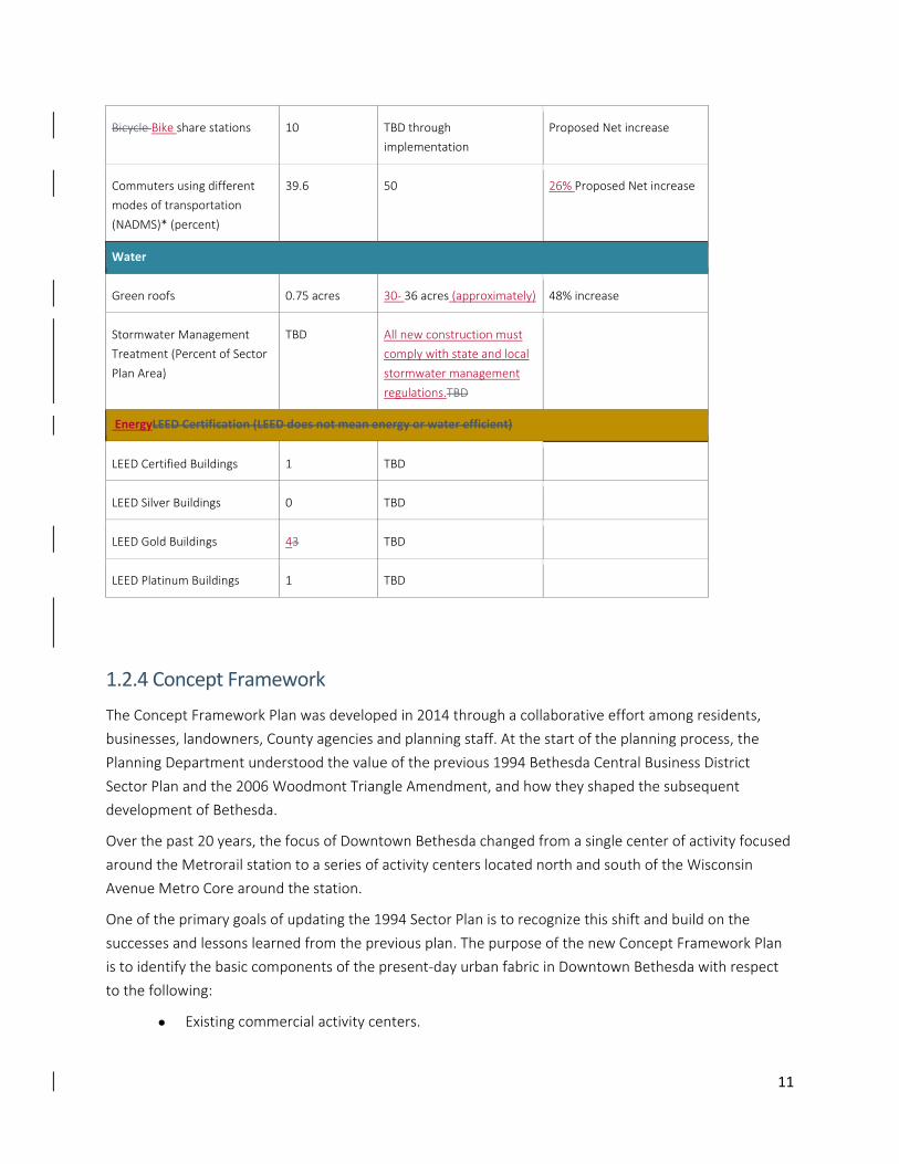
11
Bicycle Bike share stations 10 TBD through
implementation
Proposed Net increase
Commuters using different
modes of transportation
(NADMS)* (percent)
39.6 50 26% Proposed Net increase
Water
Green roofs 0.75 acres 30‐ 36 acres (approximately) 48% increase
Stormwater Management
Treatment (Percent of Sector
Plan Area)
TBD All new construction must
comply with state and local
stormwater management
regulations.TBD
EnergyLEED Certification (LEED does not mean energy or water efficient)
LEED Certified Buildings 1 TBD
LEED Silver Buildings 0 TBD
LEED Gold Buildings 43 TBD
LEED Platinum Buildings 1 TBD
1.2.4 Concept Framework
The Concept Framework Plan was developed in 2014 through a collaborative effort among residents,
businesses, landowners, County agencies and planning staff. At the start of the planning process, the
Planning Department understood the value of the previous 1994 Bethesda Central Business District
Sector Plan and the 2006 Woodmont Triangle Amendment, and how they shaped the subsequent
development of Bethesda.
Over the past 20 years, the focus of Downtown Bethesda changed from a single center of activity focused
around the Metrorail station to a series of activity centers located north and south of the Wisconsin
Avenue Metro Core around the station.
One of the primary goals of updating the 1994 Sector Plan is to recognize this shift and build on the
successes and lessons learned from the previous plan. The purpose of the new Concept Framework Plan
is to identify the basic components of the present‐day urban fabric in Downtown Bethesda with respect
to the following:
Existing commercial activity centers.
12
Emerging commercial activity centers over the next 20 years.
Residential neighborhoods.
Primary pedestrian corridors connecting activity centers and residential neighborhoods.
Parks and open space network that complements the pedestrian corridors and anchors the
community.
All other Sector Plan details are built upon this structure to form a cohesive urban fabric that will evolve
over the next 20 years.
13
1.3 Summary of Recommendations
1.3.1 Land Use and Zoning
A. Land Use Recommendations:
Coordinate and align the Central Business District (CBD), Urban District (UD) and Parking Lot
District (PLD) and the Transportation Management District (TMD).
Preserve and enhance the community’s existing affordable housing throughout the Sector
Plan area by leveraging proximity to transit stations and supporting flexible zoning, density
incentives and expanded economic programs.
Increase the requirement for moderately priced dwelling units (MPDUs) from 12.5 percent to
15 percent.
Consolidate retail in appropriate places within the Sector Plan area through designated retail
centers or nodes.
Strengthen the centers of activity through economic, social and environmental aspects of
sustainability.
Encourage mixed‐use development to allow development to adapt to market conditions.
B. Zoning Recommendations:
Increase density for many of the properties with Commercial Residential (CR) zones to
accommodate future growth, as projected in the Council of Governments Cooperative
Forecast Round 8.3, and incentivize redevelopment in appropriate areas of the Downtown.
The increase in density equates to approximately a 20 percent increase from the 1994
Plan.Zone individual properties Commercial Residential (CR) with the currently mapped
density limit and recommended heights as documented in this Plan.
Properties rezoned to a CR or CRT from an R‐10, R‐60, EOF and PD zone will be translated to
an equivalent density.
Cover all properties within the Sector Plan boundary with the Bethesda Overlay Zone (BOZ).
Identify and prioritize key density averaging sending sites to achieve desired parks and open
space, facilitate landmark preservation and preservation of existing market‐rate affordable
housing. Implement through the use of an Overlay Zone.
Rezone current Planned Development (PD) zones to a comparable Commercial Residential
(CR) zone, as described in the new County Zoning Ordinance effective October 30, 2014.
14
Rezone current Employment Office zones to a comparable Commercial Residential (CR) zone,
as described in the new County Zoning Ordinance effective October 30, 2014.
For development sites less than 20,000 square feet, encourage a fee‐in‐lieu of the required
public open space as part of the property’s public benefits.
Update the existing streetscape guidelines and allow for improvements and flexibility within
the pavement and public right‐of‐way.
Introduce a floating zone designation for the Bethesda Fire Station (Tax Map HN341) at the
corner of Bradley Boulevard and Wisconsin Avenue.
1.3.2 Transportation
A. Roadway Recommendations:
Expand the Urban Road Code boundary to be contiguous with the Sector Plan boundary.
Recommend right‐of‐way improvements, as discussed in the Appendix.
Propose new streets, as discussed in Chapter Two.
Evaluate reconfiguration of the East‐West Highway (MD 410)/ Montgomery Lane/ Old
Georgetown Road (MD 187)/ Woodmont Avenue one‐way pair into a two‐way street system.
B. Transit Recommendations:
Implement Purple Line light rail and construct the Bethesda South Station.
Reconfigure the Bethesda Metrorail Station in connection with redevelopment of the
Metrorail Station plaza.
Extend BRT Corridor 4: MD 355 South from the Bethesda North Station to the Bethesda
South Station, and connect to the Purple Line.
Improve Bethesda South Station bus circulation with additional space for bus bays along Elm
Street.
Expand Bethesda Circulator Bus route.
C. Bicycle and Pedestrian Recommendations:
Confirm Bicycle Pedestrian Priority Area (BPPA), as identified in the 2013 Countywide Transit
Corridors Functional Master Plan.
Design all roads within the Sector Plan area for shared use by motor vehicles and bicycles.
Recommend specific bikeways, as described in Chapter Two.
Confirm the recommendation in the 2014 Bethesda Purple Line Station Minor Master Plan
Amendment for a full‐service bicycle storage facility at the Bethesda Purple Line station.
15
D. Transportation Demand Management Recommendations:
Expand the existing Non‐Auto Driver Mode Share (NADMS) to include residents and increase
both goals to 50 percent.
E. Parking Recommendations:
Continue the Constrained Long‐Term Parking Policy.
Expand the Parking Lot District.
Consider co‐location of public facilities and parking lot district facilities.
Promote incentives to reduce parking.
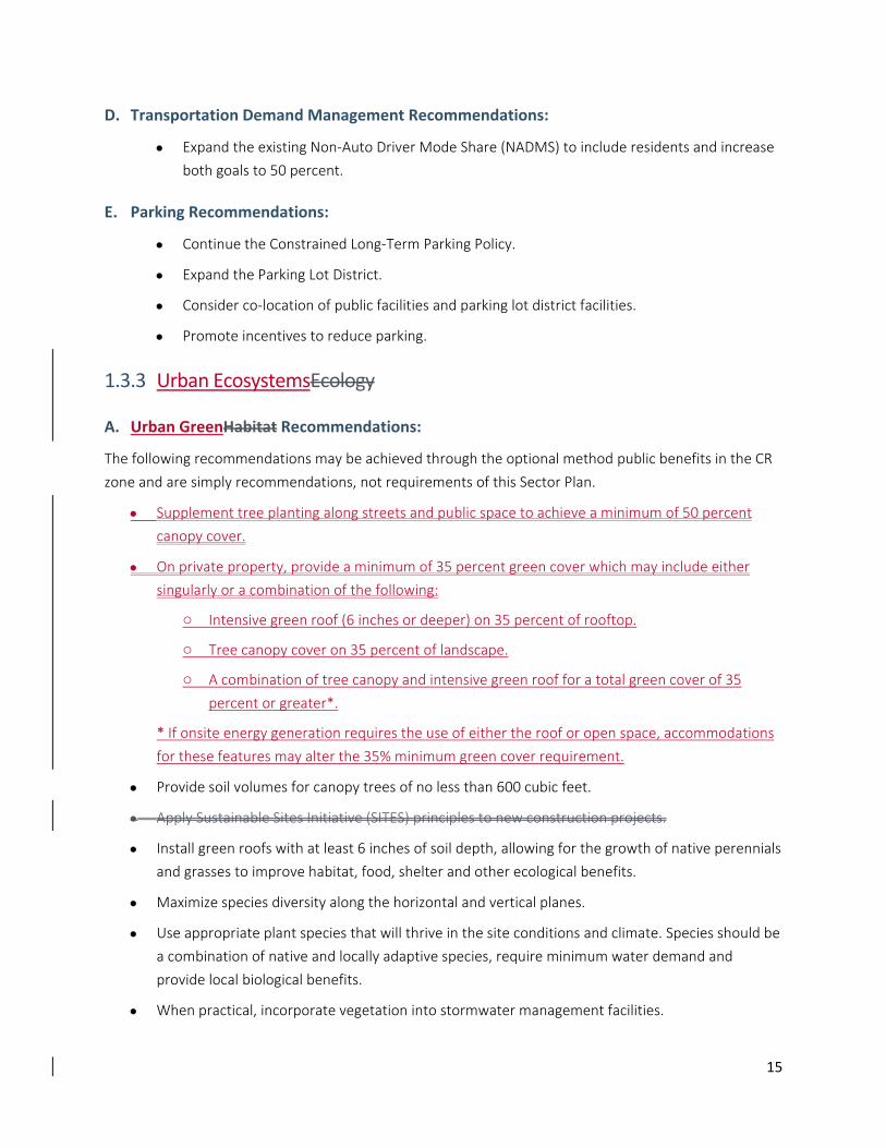
1.3.3 Urban EcosystemsEcology
A. Urban GreenHabitat Recommendations:
The following recommendations may be achieved through the optional method public benefits in the CR
zone and are simply recommendations, not requirements of this Sector Plan.
Supplement tree planting along streets and public space to achieve a minimum of 50 percent
canopy cover.
On private property, provide a minimum of 35 percent green cover which may include either
singularly or a combination of the following:
o Intensive green roof (6 inches or deeper) on 35 percent of rooftop.
o Tree canopy cover on 35 percent of landscape.
o A combination of tree canopy and intensive green roof for a total green cover of 35
percent or greater*.
* If onsite energy generation requires the use of either the roof or open space, accommodations
for these features may alter the 35% minimum green cover requirement.
Provide soil volumes for canopy trees of no less than 600 cubic feet.
Apply Sustainable Sites Initiative (SITES) principles to new construction projects.
Install green roofs with at least 6 inches of soil depth, allowing for the growth of native perennials
and grasses to improve habitat, food, shelter and other ecological benefits.
Maximize species diversity along the horizontal and vertical planes.
Use appropriate plant species that will thrive in the site conditions and climate. Species should be
a combination of native and locally adaptive species, require minimum water demand and
provide local biological benefits.
When practical, incorporate vegetation into stormwater management facilities.

16
Prioritize street tree planting along existing and proposed bicycle networks, creating green
corridors.
Supplement tree planting along streets and public space to achieve a minimum of 50 percent
canopy cover. On private property, provide a minimum of 35 percent green cover which may
include either singularly or a combination of the following:
Intensive green roof (6 inches or deeper).
Tree canopy cover.
For sites with an open space requirement, the 35 percent green cover must include both tree
canopy cover and an intensive green roof.
Bury overhead wires to avoid conflicts with street trees.
Achieve an overall canopy cover with species diversity where no single genus comprises more
than 20 percent of the total population.
Increase overall tree canopy cover and subcanopy cover by encouraging the planting of trees on
public and private land, along rights‐of‐way, within open space and existing neighborhoods.
Daylight Bethesda Mainstem Tributary.
Apply Sustainable Sites Initiative (SITES) principles to new construction projects.
B. Water Quality Recommendations:
Integrate stormwater management within the right‐of‐way.
Integrate visible environmental site design strategies that provide multiple performance area
benefits for water quality, habitat, health and aesthetic improvement. Strategies include:
o Intensive green roofs (6 inches or greater to maximize water treatment).
o Stormwater planters.
o Pervious pavement.
o Bioswales, biofiltration, bioretention, bioinfiltration.
o Rainwater harvesting for retention, irrigation and gray water.
Incorporate multiple stormwater management facilities or treatment train to maximize
benefits.
Reduce impervious cover to maximize infiltration and/or green space.
Where feasible, use permeable paving for roads, road shoulders, parking lots and parking
lanes.
Utilize environmental site design for parks and open space where it can be interpreted for
community education.
17
Use street trees for stormwater interception, temperature mitigation and air quality
improvement.
C. Energy:
Reduce heating, cooling and lighting loads through climate‐responsive design and
conservation practices including:
o Building massing that maximizes natural ventilation, air flow and access to natural
lighting.
o High‐performance building envelopes; select walls, roofs and other assemblies based
on long‐term insulation, air barrier performance and durability requirements.
o Light‐emitting diodes (LED) lighting throughout buildings.
o Energy Star‐approved and/or Federal Energy Management Program (FEMP)‐
designated energy‐efficient products that meet or exceed U.S. Department of Energy
standards.
Maximize use of alternative energy systems to supply a portion or all of a building’s energy
demand. Alternative energy systems may include:
o Solar power.
o Geothermal.
o Co‐generation.
o Biomass and biogas strategies.
o Purchase electricity generated from renewable sources or low polluting sources.
Maximize solar orientation and design techniques that take advantage of passive solar
heating, cooling and lighting.
Design buildings with operable windows for cross‐ventilation.
Install green roofs to reduce heating and cooling demand.
Utilize low albedo surfaces to diffuse reflectivity, reducing heat island effect.
Consider net zero energy concepts.
Exceed County requirements for minimum LEED certification or equivalent standards.
Utilize district energy (central heating/cooling) if two or more buildings are being constructed
adjacent to each other.
1.3.4 High Performance Area
The High Performance Area is a designation that aims to raise the level of sustainability through
exceeding minimum requirements for high performing, energy‐efficient buildings.
18
In the High Performance Area, buildings must meet the public benefits category for CR
Energy Conservation and Generation 59‐C‐15.856 (b). An optional method building over 4
stories must exceed the current ASHRAE 90.1 requirement‐2010 by at least 15 percent.
Should the County approve the International Green Construction Code (IgCC), building energy
performance must rank two points lower (more efficient) than the Zero Energy Performance
Index (zEPI) score listed or the current applicable ASHRAE standard in the most recent
International Green Building Code (IGCC) as locally amended. order to achieve the maximum
allowable density for the zoned property.
1.3.5 Community Identity and Urban Design
Over the past two decades, Downtown Bethesda has changed from a single center of activity focused
around the Metrorail Station to multiple downtowns each with its own unique character. This Sector Plan
explores ways to strengthen these centers of activity through the following urban design
recommendations.
A. Public Space Network:
Provide each center with a gathering space appropriate to the character of the area.
Link streets, midblock connections, greenways and trails to create a well‐connected network.
Organize streets, midblock connections, greenways and trails to contribute to a well‐
connected network.
Transition to surrounding neighborhoods with green open space amenities and civic buffers.
Enhance the pedestrian and bike experience connecting from the Metro core to Woodmont
Triangle and Bethesda Row along Wisconsin and Woodmont Avenues.
Activate Norfolk Avenue as a main street linking the proposed Veteran’s Park Civic Green
through Battery Lane Park to the North Bethesda Trail.
Connect the proposed Capital Crescent Central Civic Green along Bethesda Avenue to the
reimagined Farm Women’s Cooperative Market.
B. Urban Form:
Design signature tall buildings that integrate design and sustainability innovation to occupy
the symbolic center and surround civic gathering spaces.
Allow signature tall buildings to occupy the symbolic center and civic gathering spaces that
integrate design and sustainability innovation.
Encourage economic vitality in the emerging centers of activity through mixed‐use
development at increased building heights appropriate to surrounding context.
19
Increase building heights to enhance community facilities, prioritize affordable housing
opportunities with redevelopment, enhance connectivity to Norwood Local Park and North
Bethesda Trail.
Establish a green connector along the eastern edge of the Plan area to provide open space,
pathways, environmental benefits and a transition to adjacent neighborhoods. Allow a range
of building heights dependent on the amount of green space dedicated.
Create a green connector along the eastern edge of the Sector Plan area to provide open
space, pathways and environmental benefits. Allow a range of heights dependent on the
amount of green space dedicated.
Balance development with transitions to single‐family neighborhoods surrounding the Sector
Plan area in residential and edge districts, such as Battery Lane, Arlington North, South
Bethesda and Eastern Greenway.
Encourage preservation of low‐rise buildings with fine‐grain building articulation along
Norfolk Avenue.
Increase all previously “T” designated heights by 20 percent rounded to the nearest 5‐foot
increment to accommodate the density increase throughout the Sector Plan area.
C. Placemaking:
Design streets not just for mobility but also as great public spaces for gathering, events and
play.
Activate streets and open spaces with temporary and phased uses that can catalyze future
investment and growth.
Create gateways at the transit and street entrances to the Downtown that integrate elements
such as wayfinding, landscape and building form unique to Bethesda.
Integrate public art throughout the Downtown area and continue to support Bethesda as an
art and culture destination.
1.3.6 Parks and Open Space
Support each of the three centers (Woodmont Triangle, Bethesda Row and the Wisconsin
Avenue corridor) with civic gathering spaces by providing civic greens in each center.
Provide linkages and signature gateways to the major trail systems.
Create livable communities and appropriate transitions by greening and buffering the edges.
Create green neighborhood parks.

20
While all of the above listed recommendations are highly encouraged to achieve the goals of this Sector
Plan, the Plan recognizes that certain projects may not be able to achieve all of them.

21
Chapter 2: Areawide Approach Sustainable development is the central theme of the Downtown Bethesda Sector Plan, providing a lasting
foundation for a thriving community. This development must support innovation and economic well‐
being, community equity and environmental health to be truly sustainable.
Regionally, the projected population growth of Montgomery County over the next 20‐30 years is
expected to increase by more than 20 percent. With the County having only approximately 19 percent
unconstrained land available for development, urban centers such as Bethesda, where infrastructure
already supports schools, roads and mass transit, are expected to flourish to accommodate new residents
and resulting residential and non‐residential uses.
Focusing additional density and new infill development in such compact, transit‐oriented areas can
reduce suburban sprawl and protect farmland and rural areas within the County’s Agricultural Reserve.
This Chapter highlights the advantages of Downtown Bethesda in its well‐established street grid, walkable
and mixed‐use districts, Metrorail station and connected system of parks and open space.
All of the six performance areas described in Chapter One reflect the sustainable approaches that guide
this Sector Plan. The goals and recommendations for the six performance areas were determined by
analysis in the areas of land use and zoning, transportation, ecology, community identity and urban
design, parks and open space, and community facilities. The performance areas will be addressed
throughout Chapter Two and subsequent portions of the Sector Plan.
22
2.1 Sector Plan Area
Bethesda is located along Wisconsin Avenue between Friendship Heights and the Capital Beltway,
centered on the intersection of Wisconsin Avenue, Old Georgetown Road and East‐West Highway. These
major thoroughfares connect Bethesda to Silver Spring, Rockville, Potomac and Washington, DC.
The Bethesda Downtown Plan retains the Plan Area boundary of the 1994 Bethesda Central Business
District (CBD) Sector Plan, including the areas covered by both the 2006 Woodmont Triangle Amendment
and the 2014 Planning Board Draft Bethesda Purple Line Station Minor Master Plan Amendment. The
area covers approximately 451 acres and is bounded by the National Institutes of Health campus on the
north; Tilbury Street, Sleaford Road, Cheltenham Road, Capital Crescent Trail, 46th Street and West
Avenue on the east; Norwood Park and Nottingham Drive on the south; and Arlington Road and Old
Georgetown Road on the west.
The Sector Plan boundaries are shown in Figure 2.01: Sector Plan Area.
23
2.2 Land Use The 1994 Bethesda Central Business District Sector Plan focused on providing additional
office/employment land uses to establish Downtown Bethesda as a center for employment growth in
Montgomery County. In 2006, the Woodmont Triangle Amendment to the Sector Plan refined this
strategy by recommending more housing close to the Bethesda Metrorail Station.
This Sector Plan envisions the continuation of Downtown Bethesda as a thriving urban center with a
regional draw for employment, shopping and entertainment. The Plan estimates an additional 14,155
jobs by 2040, a 38 percent increase above existing levels.
This Plan also envisions a continued focus on housing by proposing a diverse mix of residential choices
throughout Downtown Bethesda in order to accommodate more workers and reduce commuter traffic
congestion. The Plan estimates an ultimate build‐out over the next 20 years of approximately 8,355
additional units, a 46 percent increase above current levels. Figure 2.02 shows the existing land use in the
1994 Plan and Figure 2.04 the existing zoning. The Plan recommends confirming all zoning within the
Sector Plan boundary, except where zoning changes are proposed and illustrated on recommended
zoning plans. Figure 2.05 shows recommended zoning.
2.2.1 Goals:
A. General
Coordinate and align the Central Business District (CBD), Urban District (UD) and Parking Lot
District (PLD) and the Transportation Management District (TMD) boundaries.
Support the priorities of The Bethesda Urban Partnership and the Arts and Entertainment
District.
B. Land Use
Preserve and enhance the community’s affordable housing throughout the Sector Plan area
by leveraging proximity to transit stations and supporting flexible zoning, density incentives
and expanded economic development programs.
Increase the requirement for moderately priced dwelling units (MPDUs) from 12.5 percent to
15 percent.
Encourage mixed‐use development where appropriate.
Consolidate retail in appropriate places within the Sector Plan area through designated retail
nodes.
Create new civic gathering spaces in the expanded centers of activity.
24
C. Zoning
Provide flexible development opportunities to allow future development to better adapt to
market conditions.
Promote infill development with higher densities and building heights nearest the central
core of Downtown Bethesda to accommodate future growth, as projected in the
Metropolitan Washington Council of Governments Cooperative Forecast Round 8.3.
Provide zoning incentives for facilitating arts improvements.
2.2.2 Recommendations:
A. Zoning
Zone individual properties Commercial Residential (CR) with the currently mapped density
limit and recommended heights as documented in this Plan.Increase density for many of the
Commercial Residential (CR) zones to accommodate future growth, as projected in the
Council of Governments Cooperative Forecast Round 8.3, and to incentivize redevelopment
in appropriate areas of the Downtown. The increase in density equa tes to an approximate 20
percent increase from the 1994 Plan.
Properties rezoned to a CR or CRT from an R‐10, R‐60, EOF and PD zone will be translated to
an equivalent density.
Cover all CR zoned properties within the Sector Plan boundary with the Bethesda Overlay
Zone (BOZ).
Identify and prioritize key density averaging sending sites to achieve desired parks and open
space, and to facilitate landmark preservation and implement through the use of an Overlay
Zone (see figure 4.01).
For development sites less than 20,000 square feet, encourage a fee‐in‐lieu of the required
public open space as part of the property’s public benefits.
Rezone current Planned Development (PD) zones to a comparable Commercial Residential
(CR) zone as described in the new County Zoning Ordinance effective October 30, 2014.
Rezone current Employment Office zones to a comparable Commercial Residential (CR) zone
as described in the new County Zoning Ordinance effective October 30, 2014.
2.2.3 Housing
The Sector Plan envisions Downtown Bethesda as a place consisting of a well‐rounded community of
residents and workers who contribute to the health and vitality of the downtown. However, its
attractiveness as a place to live, the ambience of street life, shops, and restaurants, and the
25
proximity to employment and Metro – has resulted in housing costs increasingly out of reach for
most residents across Montgomery County.
Over the next 25 years, Downtown Bethesda is anticipated to grow at a faster rate than
Montgomery County as a whole, with households projected to increase by 28 percent, population
by 24 percent, and employment by 40 percent. As housing demand continues to increase as a result
of this growth, Bethesda’s high housing costs will become even more cost‐prohibitive for most
Montgomery County residents to reside there. Monthly homeowner costs in the Bethesda
Downtown Plan Area Study area currently average around $4,660, which is two‐thirds higher than
the County. The average rent in this area is $1,9161, which is about 20 percent more than the
average rent for the County. Furthermore, newly built residential apartments typically rent for
$2,7502, which is 30 percent more than the Study area and over 40 percent more than the County.
Along with high housing costs, Downtown Bethesda also continues to have a shortage of committed
affordable housing. Of the 4,669 multifamily rental apartments in the Bethesda Downtown Study
Area, only 826 (17.69 percent) are rent‐restricted as defined by MPDU requirements, Low‐Income
Housing Tax Credits, or public subsidies3. There also exists about 1,992 “market‐affordable”4 rental
apartments in Bethesda– apartments whose market rents fall within affordable income levels due to
their age or limited amenities – but given Bethesda’s high land values and overall desirability, these
rents have the potential to increase considerably. Figure 2.07 illustrates the distribution of
affordable market‐rate and rent‐restricted rental units in Downtown Bethesda. Thus, absent special
efforts, there will be a continuing shortfall of new units to meet the needs of moderate‐to‐lower
income households that require the services or are employed by retail establishments in Bethesda.
A. Goal: Preserve existing market‐rate affordable housing, provide a diverse
mix of housing options, reach deeper levels of affordability below 65
percent AMIIM and produce new units by increasing the requirement of
Moderately Priced Dwelling Units.
Recommendations:
Add more units to the marketplace by requiring a minimum 15% MPDUs for residential
development within Downtown Bethesda.
Provide 15 percent MPDUs on‐site as a first priority.
Preserve existing market‐rate affordable housing by identifying some sites as Priority
Sending Sites for density averaging. Affordable Housing sending sites that choose to
transfer their density must enter into a rental agreement to retain 30% of their existing
1 2012 Rental Housing Survey, Montgomery County Department of Housing and Community Affairs 2 Based on rents at comparable new apartments in Bethesda 3 Such units are typically required to be affordable to households with an income below 65 percent of AMI (Area Median
Income), or about $70,000 for a household size of 4. 4 Market‐Rate rentals are defined as affordable if their rent price plus expected tenant‐paid utility costs are no more than 30
percent of household income (not rent restricted).

26
affordable housing units, defined as 65 percent of Area Median Income (AMI) or below,
for 20 years.
Prioritize two and three bedroom units through increased CR public benefit points and
through DHCA evaluation of area needs through negotiations with developer.
Reach deeper levels of affordability by providing 10 percent of MPDU units below 65
percent AMI through DHCA negotiations with developer.
Off‐site MPDUs are on a case‐by‐case basis through negotiations with DHCA, but must
remain within the Bethesda Downtown Sector Plan Boundary.
27
2.3 Transportation Downtown Bethesda is well connected to the surrounding region by a vibrant transportation network
connected to three major highways: Old Georgetown Road (MD 187), Wisconsin Avenue (MD 355) and
East‐West Highway (MD 410). The community is near the Capital Beltway (I‐495) and Metrorail Red Line.
In addition to these roadways and commuter rail system, the proposed Purple Line light rail and proposed
MD 355 South Bus Rapid Transit Corridor are anticipated to be implemented during the horizon year
(2040) of this planning document. A grid of local streets completes the transportation network by
promoting safe and efficient travel throughout the community for pedestrians, bicyclists and motorists.
In order to enhance the existing transportation network, this Plan recommends “Complete Streets”
improvements to the roadway network that increase the connectivity, safety and quality for all modes of
transportation. Complete Streets design principles refer to roadway treatments intended to
accommodate multiple modes of transportation, including pedestrian, bicycle, vehicular and transit,
within the same right‐of‐way. It is important to note that due to the operational focus of Complete
Streets design strategies, this approach does not include “Green Streets” enhancements, such as storm
water management, as part of its primary objective. Due to the transit‐oriented nature of Downtown
Bethesda, future transportation improvements within the Sector Plan area should consider Complete
Streets strategies as critical elements of the transportation network.
A high‐quality pedestrian network is essential to the success of transit‐oriented communities because,
unlike most other modes of transportation, pedestrian activity is about experiencing the community
between points of origin and destination. Nearly all modes of transportation require that at least a
portion of each trip be completed as a pedestrian; therefore, the quality of the pedestrian network is an
important issue for most residents and commuters in Downtown Bethesda.
In addition to physical elements of the transportation network, such as the roadway, transit, bicycle and
pedestrian strategies described above, this Sector Plan recommends two transportation programs to
improve mobility and manage congestion within the Bethesda Downtown Sector Plan area. These
programs are Transportation Demand Management and constrained parking.
Transportation Demand Management (TDM) programs increase efficiency within the transportation
network by reducing reliance on single‐occupancy vehicles during the most congested periods. TDM
strategies will become increasingly important through the horizon year of this Plan and will both manage
traffic congestion and reinforce the Sector Plan area as a transit‐oriented area. All optional method
projects should participate in the Bethesda Transportation Management Organization.
This Plan recommends continuing the 1994 Bethesda CBD Sector Plan’s recommendation of maintaining a
constrained long‐term parking supply strategy, which has been in effect since the1994 Bethesda CBD
Sector Plan. A constrained parking strategy helps to mitigate traffic congestion by encouraging other
modes of transportation and discouraging single‐occupancy vehicle trips. All optional method projects
should participate in the constrained parking policy.
28
In addition, this Plan recommends that public‐private partnerships and co‐location of public facilities be
considered as part of future parking facility development. These strategies have been implemented with
success in recent years within the Bethesda, Silver Spring and Wheaton Parking Lot Districts.
2.3.1 Goals
Enhance roadway accommodation of all users.
Increase the use of non‐auto driver travel.
Implement new transit alternatives.
Improve bicycle and pedestrian infrastructure.
Expand the constrained parking policy.
2.3.2 Roadways
A. Battery Lane Connector Street (B‐1)
(50‐foot right‐of‐way; Rugby Avenue to Battery Lane):
This proposed street would improve connectivity between the residential area along Battery Lane and the
Woodmont Triangle commercial district by extending the existing Woodmont Triangle street grid to the northern
portion of the Sector Plan area. Additionally, this street would improve pedestrian and bicycle circulation within
the Downtown Bethesda area and may help to activate the western edge of Battery Lane Urban Park. This
connection may be implemented as a shared street and should accommodate two‐way vehicular travel. It would
provide an opportunity for a mix of future retail and residential uses to have frontage on Battery Lane Urban Park.
Public/private ownership and specific horizontal alignment should be determined at the time adjacent properties
are reviewed for regulatory approval. This proposed street is contingent on the acquisition of additional parkland
for Battery Land Urban Park with the goal of no net loss of parkland with construction of this road.
BA. Pearl District Connector (B‐21)
(60‐foot right‐of‐way; intersection of Bethesda‐Chevy Chase High School Driveway/ East‐West
Highway to south of Montgomery Avenue):
This street would improve local connectivity and would contribute to extending the street grid within
the Pearl District. The intent of this recommendation is to guide the development pattern within the
Pearl District toward short blocks and pedestrian‐friendly street crossings. Any street improvements
associated with this recommendation should align opposite intersections and consolidate adjacent
driveways to the extent practicable at the time of implementation. This street should be considered
within the context of the following site:
1. 4350 East‐West Highway:
29
This property is directly south of the Bethesda‐ Chevy Chase High School driveway/ East‐West
Highway signalized intersection. Implementation of the Pearl Street Connector should only be
considered if 4350 East‐West Highway is redeveloped.
CB. Strathmore Street Extended (B‐2)
(60‐foot right‐of‐way; Bradley Boulevard to Chevy Chase Drive):
This street would improve connectivity between the residential area north of Bradley Boulevard and
Norwood Park by extending the existing Strathmore Street. This improvement could improve access
from Downtown Bethesda and activate Norwood Local Park. Public/Private ownership and specific
horizontal alignment should be determined at the time adjacent properties are reviewed for regulatory
approval.
DCD. Woodmont Avenue/ Bethesda Avenue Intersection Improvements
Reconfigure the intersection of Woodmont Avenue/ Bethesda Avenue to shorten the pedestrian
crossing distance and expand the plaza located on the northwest side of the intersection. This
intersection is an important crossing for pedestrians on Woodmont Avenue, Bethesda Avenue and
Capital Crescent Trail. Additional demand is anticipated in the future with the implementation of the
Bethesda South Station and future park on the east side of Woodmont Avenue. Further analysis is
necessary to determine the extent to which this reconfiguration can occur, given the angle of
intersection between Woodmont Avenue and Bethesda Avenue.
D. Arlington Road Realignment
This Plan carries forward an element of the 1994 Plan that recommends improving safety on
Arlington Road, south of Bethesda Avenue. This segment of Arlington Road combines poor sight
distance, caused by a sharp curve, with a number of driveways accessing the road from adjacent
development and increasing numbers of pedestrians. The Plan recommends realigning Arlington
Road to reduce the curve and provide better sight distance. This improvement may require more
right‐of‐way than the minimum recommended in Table 2.01 of this Plan.
E. Further Evaluation
Consider reconfiguration of the East‐West Highway (MD 410)/ Montgomery Lane/ Old Georgetown
Road (MD 187)/ Woodmont Avenue one‐way pair into a two‐way street system. Conversion of these
one‐way streets to two‐way operation would slow vehicular traffic, improve bicycle accommodation
(by virtue of slower vehicular traffic) and enliven the street for pedestrians. This operational change
would also increase visibility to commercial establishments along the one‐way segment and provide
new opportunities for placemaking. From a traffic operation perspective, this change would also
make car travel less confusing and more easily navigable.

30
Alternatively: Reconfigure the East‐West Highway (MD 410)/ Montgomery Lane/ Old Georgetown
Road (MD 187)/ Woodmont Avenue one‐way pair using a “road diet” approach. A road diet is a
technique by which an existing roadway is reconfigured to accommodate bicycle facilities, wider
sidewalks, etc. by repurposing a travel lane. The future configuration should include two travel lanes,
an on‐street parking lane and a bicycle bike lane. Consideration should be given to the provision of a
two‐way bicycle bike lane.
F. Capacity
Policy Area Roadway Network Adequacy Test
In support of the 2012 Subdivision Staging Policy (SSP), a Transportation Policy Area Review (TPAR)
analysis was performed for each policy area in the county to test the roadway network’s adequacy in
2040. The year 2040 TPAR analysis took into account build‐out of all the adopted County Master
Plans by the year 2040 in combination with the implementation of all the unbuilt master planned
projects anticipated to be constructed by 2040. It should be noted that this study differs from TPAR
analysis for year 2024 that is currently used in the context of the regulatory review process.
In the 2012 SSP year 2040 TPAR analysis, the Bethesda Chevy Chase Policy Area is shown to be
adequate for the roadway test. Given that the Bethesda Downtown Sector Plan area is a small subset
of a much larger policy area, the transportation network is considered to be in balance with the land
use and densities proposed by the Sector Plan.
Plan Vision with Existing Street Network: Traffic analysis of the Plan Vision 2040 land use determined
that all intersections within the Bethesda Downtown Sector Plan area are projected to operate within
the current 1,800 Critical Lane Volume (CLV) threshold. That analysis assumed maintenance of the
existing street network, including funded improvementsimprovments, and traffic flow pattern
(without reconfiguration of any one‐way streets). The most congested intersection within the limits
of the sector plan is at Bradley Boulevard and Wisconsin Avenue, which is projected to operate at
1,533 CLV in the evening peak hour – an eight percent increase over the existing CLV at this location.
Plan Vision with Two‐Way Street Conversion: When considering the proposed two‐way street
conversion scenario, the traffic analysis indicates that the intersection of Montgomery Lane and
Wisconsin Avenue would exceed the congestion standard with a forecast CLV of 1,830 in the evening
peak hour. Under the same scenario, the analysis indicates that the intersection of Wisconsin Avenue
and Old Georgetown Road/ East‐West Highway would remain within the congestion standard with a
forecast CLV of 1,427 in the evening peak hour. This analysis suggests that the conversion of one‐way
streets in Bethesda may not significantly impact traffic circulation within the Sector Plan area;
however, the introduction of a two‐way street pattern should be subject to a more detailed
examination following this Sector Plan.
Immediately outside the Sector Plan area, four intersections are forecast to exceed the Bethesda/
Chevy Chase Policy Area congestion standard of 1,600 CLV. Those intersections are listed below:
East‐West Highway and Connecticut Avenue
31
Rockville Pike and Cedar Lane
Bradley Boulevard and Huntington Parkway
Connecticut Avenue and Bradley Lane
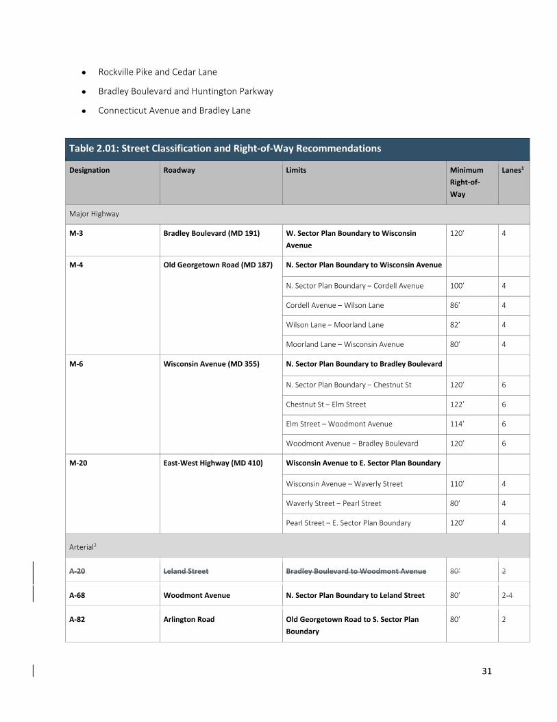
Table 2.01: Street Classification and Right‐of‐Way Recommendations
Designation Roadway Limits Minimum
Right‐of‐
Way
Lanes1
Major Highway
M‐3 Bradley Boulevard (MD 191) W. Sector Plan Boundary to Wisconsin
Avenue 120’ 4
M‐4 Old Georgetown Road (MD 187) N. Sector Plan Boundary to Wisconsin Avenue
N. Sector Plan Boundary – Cordell Avenue 100’ 4
Cordell Avenue – Wilson Lane 86’ 4
Wilson Lane – Moorland Lane 82’ 4
Moorland Lane – Wisconsin Avenue 80’ 4
M‐6 Wisconsin Avenue (MD 355) N. Sector Plan Boundary to Bradley Boulevard
N. Sector Plan Boundary – Chestnut St 120’ 6
Chestnut St – Elm Street 122’ 6
Elm Street – Woodmont Avenue 114’ 6
Woodmont Avenue – Bradley Boulevard 120’ 6
M‐20 East‐West Highway (MD 410) Wisconsin Avenue to E. Sector Plan Boundary
Wisconsin Avenue – Waverly Street 110’ 4
Waverly Street – Pearl Street 80’ 4
Pearl Street – E. Sector Plan Boundary 120’ 4
Arterial2
A‐20 Leland Street Bradley Boulevard to Woodmont Avenue 80’ 2
A‐68 Woodmont Avenue N. Sector Plan Boundary to Leland Street 80’ 2‐4
A‐82 Arlington Road Old Georgetown Road to S. Sector Plan
Boundary
80’ 2
32
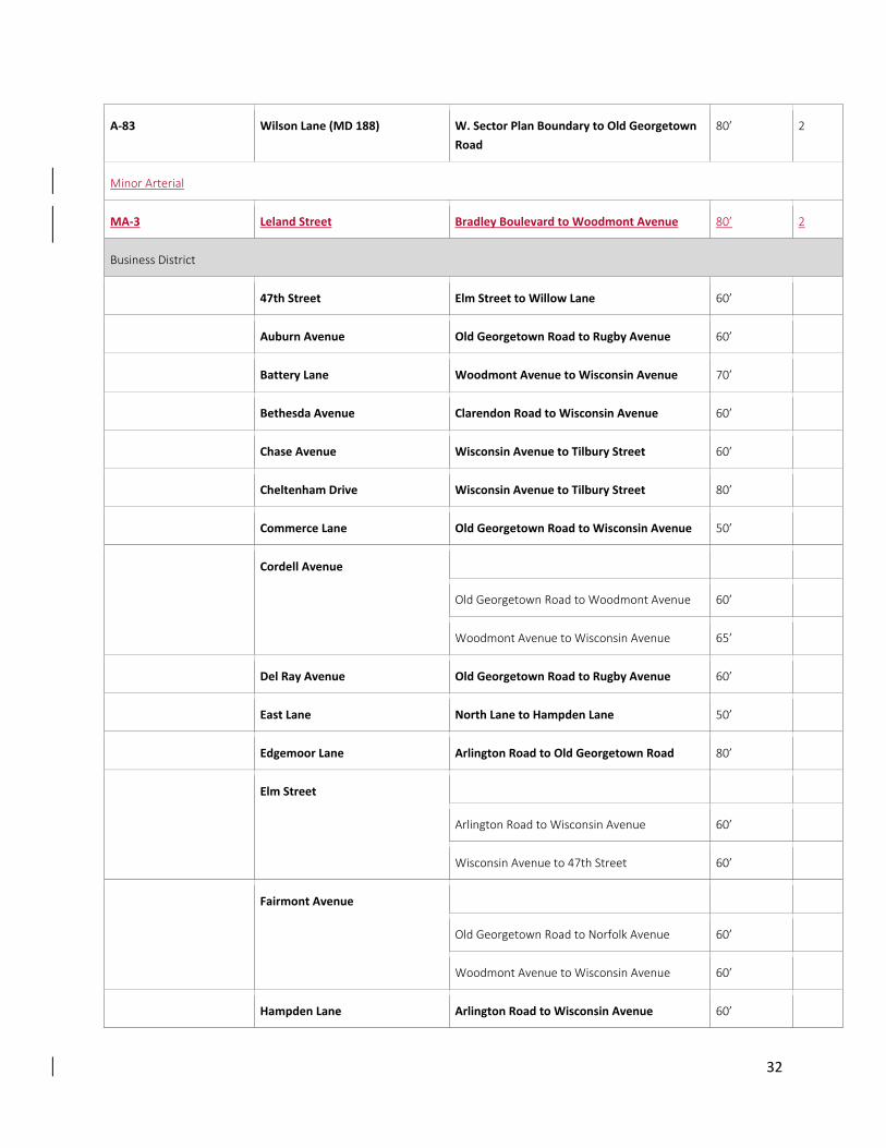
A‐83 Wilson Lane (MD 188) W. Sector Plan Boundary to Old Georgetown
Road
80’ 2
Minor Arterial
MA‐3 Leland Street Bradley Boulevard to Woodmont Avenue 80’ 2
Business District
47th Street Elm Street to Willow Lane 60’
Auburn Avenue Old Georgetown Road to Rugby Avenue 60’
Battery Lane Woodmont Avenue to Wisconsin Avenue 70’
Bethesda Avenue Clarendon Road to Wisconsin Avenue 60’
Chase Avenue Wisconsin Avenue to Tilbury Street 60’
Cheltenham Drive Wisconsin Avenue to Tilbury Street 80’
Commerce Lane Old Georgetown Road to Wisconsin Avenue 50’
Cordell Avenue
Old Georgetown Road to Woodmont Avenue 60’
Woodmont Avenue to Wisconsin Avenue 65’
Del Ray Avenue Old Georgetown Road to Rugby Avenue 60’
East Lane North Lane to Hampden Lane 50’
Edgemoor Lane Arlington Road to Old Georgetown Road 80’
Elm Street
Arlington Road to Wisconsin Avenue 60’
Wisconsin Avenue to 47th Street 60’
Fairmont Avenue
Old Georgetown Road to Norfolk Avenue 60’
Woodmont Avenue to Wisconsin Avenue 60’
Hampden Lane Arlington Road to Wisconsin Avenue 60’
33
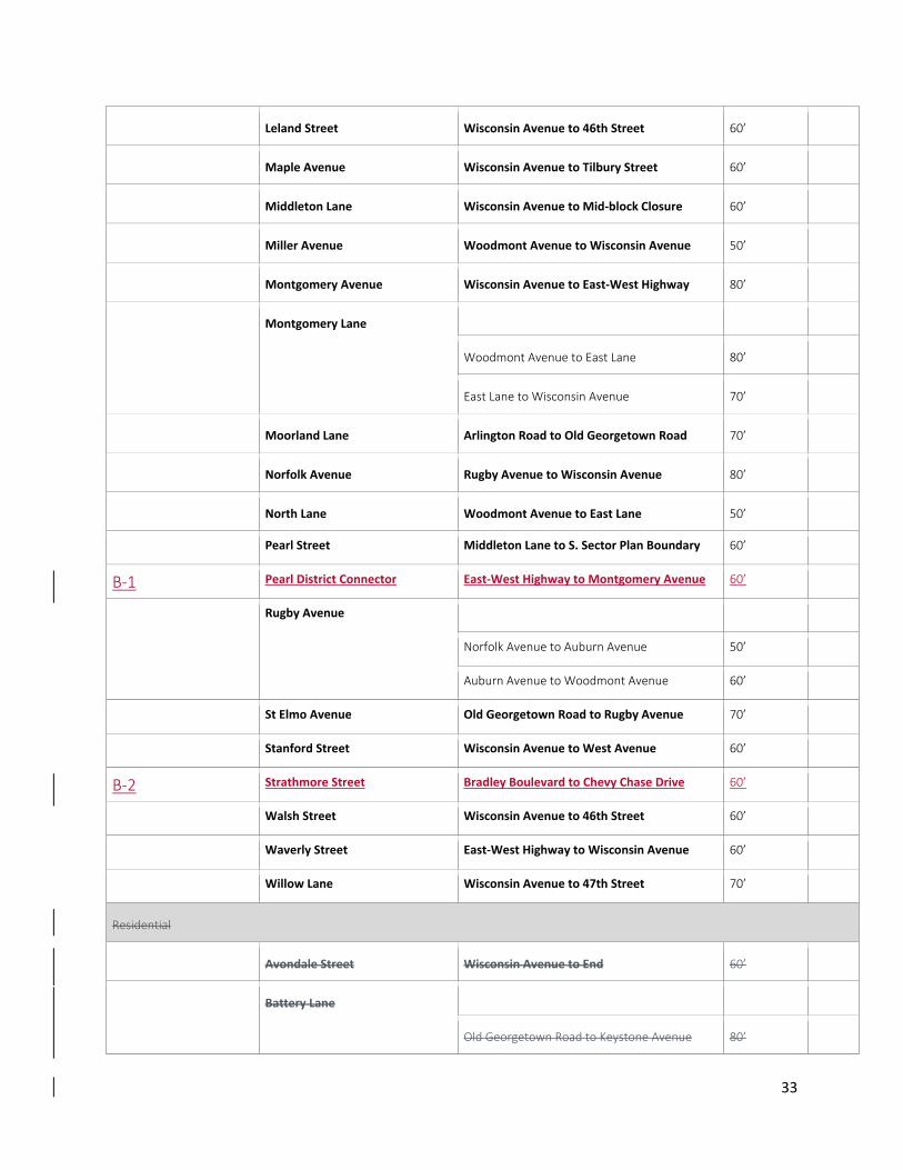
Leland Street Wisconsin Avenue to 46th Street 60’
Maple Avenue Wisconsin Avenue to Tilbury Street 60’
Middleton Lane Wisconsin Avenue to Mid‐block Closure 60’
Miller Avenue Woodmont Avenue to Wisconsin Avenue 50’
Montgomery Avenue Wisconsin Avenue to East‐West Highway 80’
Montgomery Lane
Woodmont Avenue to East Lane 80’
East Lane to Wisconsin Avenue 70’
Moorland Lane Arlington Road to Old Georgetown Road 70’
Norfolk Avenue Rugby Avenue to Wisconsin Avenue 80’
North Lane Woodmont Avenue to East Lane 50’
Pearl Street Middleton Lane to S. Sector Plan Boundary 60’
B‐1 Pearl District Connector East‐West Highway to Montgomery Avenue 60’
Rugby Avenue
Norfolk Avenue to Auburn Avenue 50’
Auburn Avenue to Woodmont Avenue 60’
St Elmo Avenue Old Georgetown Road to Rugby Avenue 70’
Stanford Street Wisconsin Avenue to West Avenue 60’
B‐2 Strathmore Street Bradley Boulevard to Chevy Chase Drive 60’
Walsh Street Wisconsin Avenue to 46th Street 60’
Waverly Street East‐West Highway to Wisconsin Avenue 60’
Willow Lane Wisconsin Avenue to 47th Street 70’
Residential
Avondale Street Wisconsin Avenue to End 60’
Battery Lane
Old Georgetown Road to Keystone Avenue 80’
34
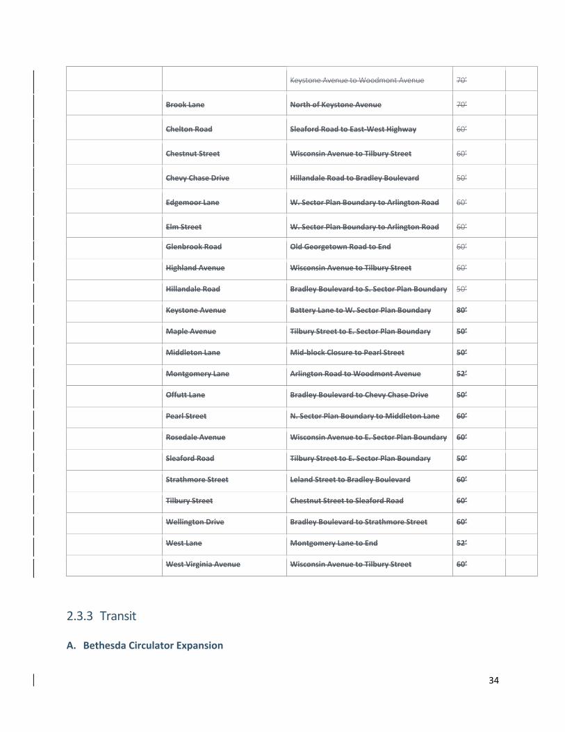
Keystone Avenue to Woodmont Avenue 70’
Brook Lane North of Keystone Avenue 70’
Chelton Road Sleaford Road to East‐West Highway 60’
Chestnut Street Wisconsin Avenue to Tilbury Street 60’
Chevy Chase Drive Hillandale Road to Bradley Boulevard 50’
Edgemoor Lane W. Sector Plan Boundary to Arlington Road 60’
Elm Street W. Sector Plan Boundary to Arlington Road 60’
Glenbrook Road Old Georgetown Road to End 60’
Highland Avenue Wisconsin Avenue to Tilbury Street 60’
Hillandale Road Bradley Boulevard to S. Sector Plan Boundary 50’
Keystone Avenue Battery Lane to W. Sector Plan Boundary 80’
Maple Avenue Tilbury Street to E. Sector Plan Boundary 50’
Middleton Lane Mid‐block Closure to Pearl Street 50’
Montgomery Lane Arlington Road to Woodmont Avenue 52’
Offutt Lane Bradley Boulevard to Chevy Chase Drive 50’
Pearl Street N. Sector Plan Boundary to Middleton Lane 60’
Rosedale Avenue Wisconsin Avenue to E. Sector Plan Boundary 60’
Sleaford Road Tilbury Street to E. Sector Plan Boundary 50’
Strathmore Street Leland Street to Bradley Boulevard 60’
Tilbury Street Chestnut Street to Sleaford Road 60’
Wellington Drive Bradley Boulevard to Strathmore Street 60’
West Lane Montgomery Lane to End 52’
West Virginia Avenue Wisconsin Avenue to Tilbury Street 60’
2.3.3 Transit
A. Bethesda Circulator Expansion
35
A more robust Circulator Bus route should be considered to serve an expanded Downtown Bethesda.
That route should include service to the Battery Lane and Pearl Districts. Potential new stops should
include the following locations (see Figure 2.10: Proposed Circulator Route Revisions):
1. Battery Lane:
Battery Lane Urban Park
Old Georgetown Road
Woodmont Avenue
2. Pearl District:
Waverly Street Parking Garage
3. Bethesda South
Woodmont Avenue at Wisconsin Avenue
Bradley Boulevard at Wisconsin Avenue
Bradley Boulevard at Leland Street
Arlington Road between Bradley Boulevard and Bethesda Avenue
The proposed expansion would require elimination of service to the following existing stations:
Arlington Road north of Elm Street
Arlington Road/ Montgomery Lane
Edgemoor Lane near Woodmont Avenue (two stops)
4. Auburn Avenue at:
Old Georgetown Road
Norfolk Avenue
Rugby Avenue
Phasing of the proposed Circulator Bus expansion should be considered at the time of
implementation to account for anticipated ridership and impacts on overall service. At the time this
Sector Plan was drafted, expansion into the Bethesda South and Battery Lane districts seems to be
the first logical expansion areas. Expansion into the Pearl District should be timed to coincide with
that district’s development in the future.
B. Further Evaluation Consider extending the proposed MD 355 South BRT Corridor to the intersection of Elm Street and
Wisconsin Avenue to provide a direct connection to the future Purple Line light rail station. This extension
would directly link three major transportation systems and would enhance the transportation oriented
36
downtown. Further evaluation is necessary due to the limited right‐of‐way on Elm Street and on‐going
design of both the BRT and Purple Line.
2.3.4 Bicycle and Pedestrian Facilities
Table 2.02: Bicycle Network Recommendations
Designation Roadway/ Route Limits Status
Separated Bike Lane
CT‐4 Woodmont Avenue1 Battery Lane to Bethesda Avenue New Proposal
CT‐5 Bradley Boulevard W. Sector Plan Boundary to E. Sector Plan
Boundary
New Proposal
CT‐3 Capital Crescent Trail (Surface
Route: Bethesda Ave/ Willow Ln)
47th Street to Woodmont Avenue Proposed
Bicycle Bike Lane
BL‐3 Wilson Lane (MD 188) Aberdeen Road to Old Georgetown Road Proposed
BL‐7 Elm Street Exeter Road to Wisconsin Avenue Proposed
LB‐111 Battery Lane Old Georgetown Road to Woodmont Avenue Existing
BL ‐44 Norfolk Avenue2 Battery Lane Urban Park to Wisconsin Avenue New Proposal
LB ‐2 Arlington Road Old Georgetown Road to Bradley Boulevard New Proposal
LB ‐3 Pearl Street East‐West Highway to Montgomery Avenue New Proposal
Shared Roadway3Roadway2
LB‐4 Cheltenham Drive Wisconsin Avenue to Tilbury Street New Proposal
SR‐8 Edgemoor Ln/ Commerce Ln/
Avondale St
Exeter Road to Avondale Street New Proposal
37
SR‐9 Bethesda Avenue Exeter Clarendon Road toRoadto Woodmont
Avenue
Proposed
LB ‐131 Rosedale Avenue Wisconsin Avenue to Tilbury Street New Proposal
LB ‐5 Tilbury Street/ Sleaford Road Rosedale Avenue to Sleaford Road to CCT New Proposal
LB ‐6 Strathmore Street Woodmont Avenue to Bradley Boulevard Proposed
LB ‐7 Pearl Street Sleaford Road to Montgomery Avenue New Proposal
Shared Use Path
SP‐3 North Bethesda Trail4 N. Sector Plan Boundary to Rugby Avenue Existing
SP‐6 Capital Crescent Trail W. Sector Plan Boundary to E. Sector Plan
Boundary
Existing
SP‐44 Capital Crescent Trail (Surface
Route)
Elm Street to Willow Lane via 47th Street Proposed
SP‐62 Wisconsin‐Woodmont Trail N. Sector Plan Boundary to Battery Lane Existing
DB‐4 Bradley Boulevard (MD 191)5 W. Sector Plan Boundary to Wisconsin Avenue Proposed
1 Woodmont Avenue may be improved with either bicycle bike lanes or a separated bike lanes, depending on the
future one‐way/ two‐way operation of the street. If the street remains one‐way southbound in its ultimate condition,
two‐way separated bike lanes are is necessary to facilitate safe, adequate and efficient bicycle circulation. Design
and operation to be determined by MCDOT at the time of facility planning.
2 If Norfolk Avenue is extended to Battery Lane, the new section of roadway should have bicycle lanes.
3 2 All roads in the Sector Plan area should be designed for shared use by motor vehicles and bicycles and are designated as shared roadways unless another higher quality bicycle facility is provided (e.g. bike lanes). These shared roadways are called out for wayfinding purposes. This sector plan recommends amending the practice of implementing shared roadways on wide travel lanes; Bicycles should operate on‐road as vehicles where the prevailing roadway operation is characterized by low vehicular speed and volume. 3The ‘LB’ designation is a ‘Local Bikeway’ that is not included in the Countywide Bikeway Master Plan due to its limited importance to the County as a whole. LB bikeways can be implemented as any facility designation.
4 If Norfolk Avenue is extended to Battery Lane, the new section of roadway should have a shared use path along the
west side of the street (Battery Lane Urban Park). If the alternative “Auburn Avenue Road Extension” is pursued
instead of the Norfolk Avenue extension, the North Bethesda Trail/ Battery Lane Urban Park shared use path should
be realigned to meet at the new intersection of Auburn Avenue and Battery Lane. 5 Bradley Boulevard may be improved with either separated bike lanes or a dual bikeway (bicycle lanes and shared
use path). Specific design and location to be determined by MCDOT at the time of facility planning. If a shared use
path or a two‐way separated bike lanes are constructed, they would be on the north side of the road.
38
A. New Bikeway Proposals
1. Woodmont Avenue (CT‐4)
Separated Bike Lanes (ultimate); Bike Lanes (interim); Battery Lane to Bethesda Avenue
This bikeway would improve north‐south connectivity within the Sector Plan area and would serve as
the primary alternative to Wisconsin Avenue for bicyclists. Due to potential parking and operational
impacts resulting from lane reallocation required as part of this recommendation, the following
alternatives have been identified for further analysis and the implemented bikeway may contain a
combination of configurations (see also Table 2.02: Bicycle Network Recommendations):
a. Separated Bike Lanes (One‐way): Due to Woodmont Avenue’s importance to the bicycling
network in Bethesda, this is the preferred bicycle facility for Woodmont Avenue. However,
given the space required for one‐way separated bike lanes, implementation of this option
would require elimination of both the two‐way‐left‐turn lane and on‐street parking lanes, and
must be considered in combination with the impact on the business community. With the
implementation of a network of low‐stress bicycling and bicycle bike parking in and around
Downtown Bethesda, this facility type will generate substantial bicycle volumes and has the
potential to offset the loss of on‐street parking over time.
b. Conventional Bike Lanes: Recommended in the 2005 Countywide Bikeways Functional Master
Plan (CBFMP), this option would require elimination of the two‐way‐left‐turn lane. This
configuration may be the only viable option south of Hampden Lane due to the anticipated
need for on‐street parking in that area.
c. Separated Bike Lanes (Two‐way): Many jurisdictions are implementing two‐way separated
bike lanes because they require the same amount of space as conventional bike lanes. A
drawback of this option is that the bike lane closest to traffic lanes travels in the opposite
direction of traffic, creating conflicts that motorists may not expect. But there are ways to
manage these conflicts, including traffic signals and access restrictions. Given the space
required for two‐way separated bike lanes, implementation of this option would require
elimination of the two‐way‐left‐turn lane.
2. Bradley Boulevard (CT‐5)
Separated Bike Lanes; West Sector Plan Boundary to East Sector Plan Boundary
This bikeway would improve east‐west connectivity within the Sector Plan area and would bridge an
area that is currently inaccessible to most bicyclists. It was previously recommended for as a dual
bikeway with both a shared use path and a signed shared roadway in the 2005 Countywide Bikeways
Functional Master Plan. However, from Wilson Lane to Glenbrook Road, the bikeway is being
designed by the Department of Transportation as a shared use path and bike lanes.
39
3. Norfolk Avenue (BL‐44)
Bike Lanes/ Shared Street; Battery Lane Urban Park to Wisconsin Avenue
This bikeway would improve north‐south connectivity within the Sector Plan area and would serve as
the primary alternative to Old Georgetown Road for bicyclists. Due to the recommendation that a
portion of Norfolk Avenue be reconfigured as a shared street, the following alternatives have been
identified for further analysis:
a. Bike Lanes Alternative: This alternative is recommended for the near‐term, prior to any
implementation of the shared street concept. The primary advantage to this alternative is the
relative ease with which it can be implemented. Norfolk Avenue is currently 48 feet wide with
two travel (16 feet wide) lanes and two on‐street parking lanes. As a result, two 56‐foot wide
bicycle bike lanes and two 10‐foot wide travel lanes can be implemented without any
additional reallocation of the existing roadway or loss of parking.
b. Shared Street Alternative: This alternative reflects the Sector Plan recommendation that a
portion of Norfolk Avenue be improved as a shared street with alternative paving materials
and flush curbs. Once implemented, the shared street concept is anticipated to have a traffic
calming effect and will support relatively low‐speed mixed traffic. Under such a scenario,
separated bicycle bike lanes are unnecessary for bicyclists’ comfort.
4. Arlington Road (LB‐2)
Buffered or Separated Bicycle Bike Lanes; Old Georgetown Road to Bradley Boulevard
This bikeway would improve north‐south connectivity on the west side of the Sector Plan area and
would provide a direct connection between the Woodmont Triangle and proposed Bradley Boulevard
bikeway via Bethesda Row. The following alternatives have been identified for further analysis (see
also Table 2.02: Bicycle Network Recommendations):
a. Buffered Bike Lanes: Implementation of this option would require converting Arlington Road
from a four‐lane road to a three‐lane road, including a center‐turn lane.
b. Separated Bike Lanes: As with buffered bike lanes, this option would require converting
Arlington Road from a four‐lane road to a three‐lane road, including a center‐turn lane. The
main difference between buffered bike lanes and separated bike lanes is the presence of
vertical separation between traffic lanes and bike lanes.
5. Cheltenham Drive (LB‐4)
Shared Roadway; Wisconsin Avenue to Tilbury Street
This bikeway would improve east‐west connectivity across Wisconsin Avenue, between the proposed
Norfolk Avenue bicycle bike lanes in the Woodmont Triangle, and single‐family residential
neighborhoods east of Wisconsin Avenue. Additionally, this connection would provide an alternative
connection to the Capital Crescent Trail via the existing Sleaford Road connection. This bikeway
40
should have clear way‐finding signs and markings to encourage its use as an important connection
within Downtown Bethesda.
6. Edgemoor Lane/ Commerce Lane/ Avondale Street (SR‐8)
Shared Roadway; Exeter Road to Avondale Street
This bikeway would improve east‐west connectivity across both Old Georgetown Road and Wisconsin
Avenue, by directing bicyclists to cross at an existing traffic signal on Old Georgetown Road and a
marked crosswalk on Wisconsin Avenue. Ultimately, this bikeway should be extended to Pearl Street
if Avondale Street is extended through redevelopment. This bikeway should have clear wayfinding
signs and markings to encourage its use as an important connection within Downtown Bethesda.
7. Rosedale Avenue (LB‐1)
Shared Roadway; Wisconsin Avenue to Tilbury Street
This bikeway would improve east‐west connectivity across Wisconsin Avenue, between the single‐
family residential neighborhoods located to the west and east of the Sector Plan area. This bikeway
should have clear wayfinding signs and markings to encourage its use as an important connection
within Downtown Bethesda.
8. Tilbury Street (LB‐5)
Shared Roadway; Rosedale Avenue to Sleaford Road
This bikeway would improve north‐south connectivity on the east side of the Sector Plan area and
would provide an alternative to Wisconsin Avenue for bicyclists. This bikeway corresponds to the
Sector Plan’s recommendation that Tilbury Street serve as the “eastern greenway,” or an area of
transition between the high land‐use density of Downtown Bethesda and its surrounding
neighborhoods. Since this bikeway is proposed as a shared roadway, it is not anticipated to conflict
with any of the open space or storm water management recommendations associated with the
greenway. This bikeway should have clear wayfinding signs and markings to encourage its use as an
important connection within Downtown Bethesda.
9. Pearl Street (LB‐7)
Bicycle Bike Lane; Montgomery Avenue and Avondale Street.
Shared Roadway; North of East‐West HighwayAvondale Street to Sector Plan Boundary
This bikeway would improve north‐south connectivity on the east side of the Sector Plan and would
provide a direct connection between the emerging Pearl District and single‐family residential
neighborhood to the north and east of the Sector Plan area. This Plan recommends bicycle bike lanes
on the block between East‐West Highway and Montgomery Avenue, given the anticipated level of
activity in that area of the Pearl District. North of East‐West Highway, this bikeway should be
implemented as a shared roadway. This bikeway should have clear wayfinding signs and markings to
encourage its use as an important connection within Downtown Bethesda.
41
B. New Trail Connections
1. Bradley Boulevard/ Capital Crescent Trail Connector
Bicycle Ramp; Northwest side of the Bradley Boulevard/ Capital Crescent Trail Bridge
A staircase currently exists in this location and this Plan recommends that a new bicycle ramp be
considered in this location to better facilitate the connection between an existing regional bikeway
(the Capital Crescent Trail) and a proposed regional bikeway (the Bradley Boulevard Separated
Bikeway). Based on preliminary analysis, this ramp would extend approximately 400 linear feet, from
Bradley Boulevard to the Capital Crescent Trail, to achieve an ADA‐compliant longitudinal grade. This
improvement should be considered at the time the adjacent property is redeveloped.
2. Pearl Street/ Capital Crescent Trail Connector
Bicycle Ramp; South side of the Pearl Street terminus
The current connection at this location is sub‐standard. Therefore, this Sector Plan recommends a
new shared use path be considered in this location to better facilitate the connection between a
proposed local bikeway (the Pearl Street Shared Roadway) and an existing regional bikeway (the
Capital Crescent Trail). This trail connector improvement is identified as part of the proposed Purple
Line light rail project and is funded through Montgomery County’s Capital Improvements Program in
the event the Purple Line project is delayed. Given this Plan’s recommendation that the segment of
Pearl Street south of Montgomery Avenue be improved as a shared street, the enhanced connection
to the trail should be considered an opportunity for a high‐quality open space/ plaza that connects
the Pearl District with the Capital Crescent Trail.
3. North Bethesda Trail
The North Bethesda Trail provides a critical regional trail connection between Downtown Bethesda
and Rockville via White Flint. This trail currently features a substandard width for a shared use path,
resulting in a lower quality experience for those who use the trail. This Sector Plan recommends that
the trail be widened to a width of 12 feet with 1‐foot‐ wide shoulders on either side between Rugby
Avenue and the National Institutes of Health (NIH) campus. Additionally, the trail should be improved
with pedestrian‐scaled lighting to reflect its importance as a regional connection.
4. Intersection Improvements
When compared to linear bikeway projects, intersection improvements for bicycle accommodation
have a disproportionate impact on the quality, enjoyment and safety of each bicycle trip. At the same
time, however, many improvements are highly technical in nature and beyond the Sector Plan scope.
This Plan recommends that all bikeway improvements be completed to the nearest intersection with
appropriate transitions across major barriers.
A specific example of this approach can be illustrated with regard to the existing Battery Lane
Bike Lane. This Plan recommends that the Battery Lane bike lanes be extended to terminate
42
at the intersections of Woodmont Avenue and Old Georgetown Road, rather than the current
mid‐block terminus.
At the time of implementation, intersection improvements should be based on the best
practices available from the transportation planning field nationwide, including The National
Association of City Transportation Officials (NACTO), Congress for New Urbanism (CNU) and
American Association of State Highway Officials (AASHTO).
Much like Wisconsin Avenue, Old Georgetown Road is a major barrier to bicyclists due to the speed
and volume of its vehicular traffic. The constrained right‐of‐way cannot accommodate the level of
lane allocation necessary to support a separated bikeway. As a result, staff has identified Norfolk
Avenue as a “low‐stress” alternative to Old Georgetown Road. It is worth noting that this Plan
supports Old Georgetown Road as a shared roadway for more experienced bicyclists.
5. Bike Parking Station
This Sector Plan confirms the recommendation in the 2014 Bethesda Purple Line Station Minor
Master Plan Amendment for a bicycle storage facility at the Bethesda South Station.
6. Bike Share
Since bike share expanded into Montgomery County in 2013, it has grown in popularity within
Downtown Bethesda. One way to build on this popularity and increase access to the system is to
provide additional bike share stations within close proximity to existing stations. Such an expansion
should be directly tied to new development; however, stations outside the Sector Plan area could
also be considered for implementation as part of the County’s Capital Improvements Program, as
funding permits. Bike share stations should also be timed to open with bikeway recommendations
identified in this Sector Plan.
New bike share stations should be sited in proximity to existing bike share stations, high density
development and transit to optimize use of the system. To the extent possible, bike share station
sites should be located near existing and master planned bicycle infrastructure. Specific bike share
station sites for development projects will be selected in concert with M‐NCPPC and the Montgomery
County Department of Transportation (MCDOT) to ensure consistency with bike share system
objectives and siting requirements.
2.3.5 Transportation Demand Management
Transportation Demand Management (TDM) represents programmatic elements designed to encourage
the use of travel modes other than single occupancy vehicles, including walking, bicycling, transit, and
telework. TDM programs are context‐sensitive and are designed based on the transportation
infrastructure available to those living and working within a defined area. In Bethesda, that area is
referred to as a Transportation Management District (TMD) and is managed by a Transportation
Management Organization. Transportation Demand Management is an important strategy in managing
43
intersection congestion within the Downtown area and should be continued through the horizon year of
this Sector Plan.
Success in implementing TDM strategies is determined by establishing and monitoring Non‐Auto Driver
Mode Share (NADMS). The current NADMS in Bethesda indicates that approximately 42 percent of
commuters arrive at work by means other than single occupancy vehicles. This Sector Plan recommends
that the NADMS goal be expanded to apply to both commuters and residents and increased to 50 percent
for both groups.
The Transportation Management District and Urban District responsibilities should be expanded to include parking management efforts. Parking management offers many benefits to downtown areas, not least of which is a positive impact on the public realm and streetscape appearance.
2.3.6 Parking
This Plan recommends a continuation of the 1994 Bethesda CBD Sector Plan’s recommendation of
maintaining a constrained long‐term parking supply, an approach that supports Transportation Demand
Management (TDM) strategies within the Downtown area. This Plan adds a recommendation that
opportunities for public‐private partnerships and co‐location of public facilities should be considered for
future parking facility development. It should be noted that public‐private partnerships and co‐location
are not new concepts for the Montgomery County Parking Lot District, as that entity has implemented
those strategies with success in recent years within the Bethesda, Silver Spring and Wheaton Parking Lot
Districts. This Sector Plan recommends a continuation of that practice.
Since the Parking Lot District (PLD) boundary is inconsistent with the Sector Plan boundary, the Plan area
was evaluated to determine the potential catchment area of existing public parking facilities. That
evaluation identified properties within a quarter mile (5‐minute walk) of existing parking garages and lots,
and determined that nearly all of Bethesda is within a 5‐minute walk of public parking (see Figure 2.15:
Parking Lot District (PLD) Expansion).
Staff refined this initial evaluation by limiting the area of recommended expansion to coincide with the
proposed Commercial Residential zoning, centers of emerging activity and the neighborhood adjacent to
the Bethesda Metrorail Station. Expanding the Parking Lot District (PLD) boundary in this manner is
consistent with its original intent, which focused on the Central Business District (CBD) zones.
In the future, MCDOT should evaluate the potential benefits of integrating parking management witch existing transportation demand management and urban district activities. Parking management has a direct positive effect on both aesthetic and operational elements of the transportation network.
A. Parking Recommendations
Promote a constrained parking policy that supports a transit‐oriented downtown.
44
Expand the Parking Lot District to include newly proposed Commercial Residential zoning,
centers of emerging activity and the neighborhood adjacent to the Metrorail station.
Explore opportunities for co‐location of public facilities on Parking Lot District properties and
facilities. Co‐location should be considered as existing facilities are evaluated for replacement
and as the market allows for new mixed‐use development.

45
2.4 Urban Ecosystem
The overall vision for Downtown Bethesda aims to improve all three interconnecting principals of sustainability: Economic, environmental, and equity (social) stability. This section focuses on the principal of the environment, one‐third of the sustainability puzzle.
Environmental sustainability means maintaining clean air, fresh and clean water, protecting natural resources, reducing consumption of nonrenewable resources, and maintaining or enhancing biodiversity (plants and animals) thereby supporting future generations to meet their own needs.
Bethesda, the county’s most populated urban core is a compact, walkable, mixed use, downtown and the economic heart of Montgomery County. It’s a place where people can live, work, shop, and play without the need for getting into an automobile. When transportation is needed, there are a variety of safe and accessible transportation options such as public transit (metro, bus, the circulator), a well‐connected bicycle network, and extensive sidewalks and trails. This profoundly saves fossil fuels by reducing vehicle miles travelled (VMT) resulting in decreased carbon emissions, air pollution, improved health, reduced obesity, and improves air quality. Data has shown that on average there is a 39 percent reduction of single occupancy trips made on weekdays in urban areas.
Bethesda’s centralized growth also helps reduce sprawl protecting sensitive land and natural resources while reducing the costs and demand for infrastructure over a wide geographic area. In addition, mixed‐use development generally reduces per‐unit energy consumption by approximately 40‐50 percent due to smaller dwelling units, centralized heating and cooling systems, shared walls, and fewer windows.
Presently, the majority of downtown Bethesda has no stormwater management, consequently receiving waterways are impaired and water quality is degraded. All redevelopment will be subject to the County’s strict stormwater management regulations designed to mitigate the effects of development and improve water quality. Innovative stormwater management called Environmental Site Design (ESD) such as green roofs, underground storage, bioretention, and tree planting will have numerous benefits. Not only will ESD’s improve water quality and reduces impacts on the streambanks, but they can provide simultaneously provide much needed greenspace in the urban landscape. This increases biodiversity and improves the quality of place and health of those who live in Bethesda.
Estimate Reduction in Pollutants with Stormwater Management per Acre
Nitrogen Phosphorus Total Suspended Solids
Stormwater lbs/ac/yr lbs/ac/yr lbs/ac/yr
Proportion 45 ‐ 65% 52 ‐ 76% 56 ‐ 82% land use loading rate
46
Quantity 6.8 ‐ 9.8 lbs/yr
0.85 ‐ 1.24 lbs/yr
975 – 1418 total sediment reduction (based on site and stream bank reduction)
These environmental benefits are significant and make Bethesda a sought after community to live and work. These benefits enhance the Urban Ecosystem which is described as the relationship between humans, the built environment and the natural environment. They are dynamic and interdependent systems that affect the health and wellbeing of a community.
Further improvements to the urban ecosystem beyond the successes of those mentioned above include greener open space, high performance buildings to lower energy demand and operational costs; stormwater management that mimics nature to improve groundwater recharge and stream quality; and stratified vegetative plantings to improve habitat, purify air and water, and cool the urban landscape. When implemented comprehensively and on a site‐by‐site basis, these performance‐based recommendations can be quantified and measured to improve and sustain a healthier, greener and more prosperous community.
2.4 Ecology The degraded environmental conditions within Bethesda are common to most urban landscapes.
Impervious surfaces cover nearly 67 percent of the Sector Plan area, with few stormwater management
facilities contributing to the poor water quality in receiving streams. Natural springs and streams have
been piped underground, tree canopy cover continues to decline and, in the summer, heat island effect
can often be oppressive with an ever increasing number of poor air quality days. Buildings are older with
poor insulation, resulting in energy inefficiencies and higher demand from non‐renewable resources.
These consequences resulted from traditional planning and policies that contributed to energy and resource depletion rather than preservation. This Sector Plan recommends strategies that compensate, mitigate and minimize lost resources to grow a healthier and greener city. These approaches include transit‐oriented development to lessen carbon outputs; high performance buildings to lower energy demand and operational costs; stormwater management that mimics nature to improve groundwater recharge and stream quality; and stratified vegetative plantings to improve habitat, purify air and water, and cool the urban landscape. When implemented comprehensively and on a site‐by‐site basis, these performance‐based recommendations can be quantified and measured to improve and sustain a healthier, greener and more prosperous community.
2.4.1 Urban Green Urban green space, such as parks, street trees, tree clusters, green roofs, planted areas including
stormwater management systems, streams, and community gardens, provides critical ecosystem services
and biophilic elements of a city. Green space also promotes physical activity, psychological well‐being,
improved public health, and draws businesses and residents. Urban green creates great cities where the
built and natural environments are interwoven making them more livable for humans and all living biota.
47
The following recommendations below, aimmay be achieved through the optional method public benefits
in the CR zone and are simply recommendations, not requirements, of this Sector Plan.
2.4.1 Habitat
An urban habitat contains an ecosystem of plants, living organisms and their physical surroundings.
Bethesda’s habitat includes large patches of development, small fragmented green spaces and an
inconsistent street tree canopy. Through the recommendations identified below, this Sector Plan aims to
reestablish and link green spaces to create green corridors that connect new and existing green elements
to parks, trails, stream buffers, and the denser forest networks beyond the Bethesda boundaries. Through
through streetscape and private property green improvements, tree canopy corridors, stratified
vegetative plantings, park acquisition,vegetation and the construction of green roofs Bethesda’s green
corridors and infrastructure will significantly to improve human health and biological diversity; provide
food and shelter for local species; increase improve human health; provide ecological resilience; reduce
water and energy demand; provide greaterimprove carbon sequestration capacity; and significantly
enhance quality of place and desirability.
A. Goals:
Improve ecological biodiversity.
Increase overall tree canopy cover.
Expand green corridors by linking green streets, greenspace, and green roofs.
Reduce heat island effect.
Improve air quality and carbon sequestration capacityand air quality.
Improve ecological biodiversity
Increase green roofs.
B. Recommendations:
The following recommendations are importantcritical to achieving the urban greenhabitat goals of this
Sector Plan:
Provide soil volumes for canopy trees of no less than 600 cubic feet.
Supplement tree planting along streets and public space to achieve a minimum of 50 percent
overall canopy cover.
On private property, provide a minimum of 35 percent green cover which may include either
singularly or a combination of the following:
o Intensive green roof (6 inches or deeper) on 35 percent of rooftop.
o Tree canopy cover on 35 percent of landscape.
48
o A combination of tree canopy and intensive green roof for a total green cover of 35
percent or greater*.
* If onsite energy generation requires the use of either the roof or open space, accommodations
for these features may alter the 35% minimum green cover requirement.
Install green roofs with at least 6 inches of soil depth on at least 35 percent of the roof, allowing
for greater stormwater treatment, possible urban agriculture, and the growth of native
perennials and grasses to improve habitat, food, shelter and other ecological benefits.
Use appropriate plant species that will thrive in the site conditions and climate. Species should be
a combination of native and locally adaptive species lessoning, require minimum water demand
while, providingand provide local biological benefits.
Supplement tree planting along streets and public space to achieve a minimum of 50 percent
canopy cover. On private property, provide a minimum of 35 percent green cover, which may
include either singularly or a combination of the following:
o Intensive green roof (6 inches or deeper).
o Tree canopy cover.
o For sites with an open space requirement, the 35 percent green cover must include both
tree canopy cover and an intensive green roof.
Provide soil volumes for canopy trees of no less than 600 cubic feet.
The following recommendations should be incorporated into development projects wherever possible:
Apply Sustainable Sites Initiative (SITES) principles on new construction projects.
Maximize species diversity along the horizontal and vertical planting planes.
Prioritize street tree planting along existing and proposed bicycle networks, to expand
linearcreating green corridors.
Achieve an overall canopy cover with species diversity where no single genus comprises more
than 20 percent of the total population of trees.
Increase overall tree canopy cover and subcanopy cover by encouraging the planting of trees
on public and private land, along right‐of‐ways, within open space and existing
neighborhoods.
Consider daylighting Bethesda Mainstem Tributary if purchased as public green space.
When practical, incorporate vegetation into stormwater management facilities.
Bury overhead wires underground to avoid conflict with street trees.
49
Achieve an overall canopy cover with species diversity where no single genus comprises more
than 20 percent of the total population of trees.
Apply Sustainable Sites Initiative (SITES) principles on new construction projects.
Maximize species diversity along the horizontal and vertical planting planes.
2.4.2 Water Quality
Located in Bethesda are the Rock Creek and Little Falls watersheds and three receiving tributaries:
Coquelin Run, Bethesda Mainstem and Willett Branch. Water quality is poor due to a high impervious
cover of over 65 percent, and lack of stormwater treatments. Impervious surfaces curtail groundwater
recharge eliminating the capacity for , soil saturation, pollution reduction via soil saturation and filtration
which prohibits, and prohibit the release of filtered water from saturated soils into water bodies. When
stormwater flows across impervious surfaces, pollutants are carried into drain inlets and discharge
directly into the receiving tributaries, causing water surges, stream bank erosion, algae blooms, reduced
aquatic life and poor water quality.
Improving water quality in the three receiving tributaries is an important goal that will take many years to
achieve. With each new development and streetscape design, the construction of integrated stormwater
management treatments will begin to reduce the quantity and improve the quality of stormwater runoff
and water in the receiving streams.
A. Goals:
Reduce untreated stormwater runoff to improve stream quality.
Reduce water consumption through conservation measures.
B. Recommendations:
Integrate stormwater management within the right‐of‐way where feasible. Stormwater
management should not displace the proposed bicycle networks.
Integrate visible environmental site design strategies that provide multiple performance area
benefits for water quality, habitat, health and aesthetic improvement. Strategies include:
o Intensive green roofs (6 inches or greaterdeeper to maximize water treatment).
o Stormwater planters.
o Pervious pavement.
o Bioswales/biofiltration/bioretention/bioinfiltration.
o Rainwater harvesting for retention, irrigation and gray water.
Incorporate multiple stormwater management facilities or treatment train where feasible to
maximize benefits.
Reduce impervious cover to maximize stormwater infiltration and/or green space.
50
Where feasible, use permeable paving for roads, road shoulders, parking lots and parking
lanes.
When building new or retrofitting roadways, incorporate stormwater management treatment
in the right‐of‐way to create green streets.
Utilize environmental site design for parks and open spaces where it can be interpreted for
community education.
When feasible, exceed the County’s minimum stormwater treatment requirement.
Use street trees for stormwater interception, temperature mitigation and air quality
improvement.
2.4.3 Energy
In Montgomery County, three sectors contribute to greenhouse gas emissions: transportation (34
percent), buildings (65 percent) and solid waste management (1 percent). Sixty percent of the energy
used in Montgomery County’s buildings is heated and cooled from coal and other fossil fuels where the
combustion byproduct is carbon dioxide (CO2), the leading source of climate change.
In an effort to reduce carbon dioxide (CO2) and other harmful emissions (nitrogen oxide, particulate
matter, heavy metals, etc.), long‐range planning must include strategies to combat climate change and
reduce greenhouse gas emissions in the two leading energy consumer categories: transportation and
buildings.
A holistic sustainable Sector Plan must include strategies for reducing energy demand and carbon output.
In the County Bill 34‐07, Planning Procedures‐Greenhouse Gas Emissions, enacted in 2008, the County
states that it is incumbent upon the Montgomery County Planning Board to recommend ways to reduce
carbon emissions through transportation and buildings...
The transportation recommendations can be found in Chapter Two of this document (Section 2.3).
Recommendations pertaining to buildings are identified below and in Section 2.5 High Performance Area
of this Sector Plan.
A. Goals
Improve building energy efficiency and reduce energy demand.
Reduce vehicle miles traveled.
B. Recommendations:
In the High Performance Area, buildings must meet the public benefits category for CR
Energy Conservation and Generation 59‐C‐15.856 (b). An optional method building over 4
stories must exceed the current ASHRAE 90.1 requirement‐2010 by at least 15 percent or the
current applicable ASHRAE standard. Should the County approve the International Green
Construction Code (IgCC), building energy performance must rank two points lower (more
51
efficient) than the Zero Energy Performance Index (zEPI) score listed in the most recent2015
International Green BuildingConstruction Code (IGCCIgCC) as locally amended. , or the latest
adopted IgCC, whichever is more recent.
Utilize “whole building design” approach to new construction, considering the interactions of
all building components, building envelope and systems to create a more comfortable
building that saves energy and reduces environmental impacts.
Reduce heating, cooling and lighting loads through climate‐responsive design and
conservation practices.
o Design building massing that maximizes natural ventilation, air flow and access to
natural lighting.
o Use high‐performance building envelopes; select walls, roofs and other assemblies
based on long‐term insulation, air barrier performance and durability requirements.
o Install light‐emitting diodes (LED) lighting throughout buildings.
o Use Energy Star‐approved and/or Federal Energy Management Program (FEMP)
designated energy‐efficient products that meet or exceed U.S. Department of Energy
Standards.
Maximize use of alternative energy systems to supply a portion or all of a building’s energy
demand. Some alternative energy systems may include:
o Solar power.
o Geothermal.
o Co‐generation.
o Biomass and biogas strategies.
o Purchase electricity generated from renewable sources or low polluting sources.
Maximize solar orientation and design techniques that take advantage of passive solar
heating, cooling and lighting.
Design buildings with operable windows for cross‐ventilation.
Utilize green roofs to reduce heating and cooling demand.
Utilize low albedo surfaces to diffuse reflectivity, reducing heat island effect.
Consider zero energy concepts.
Exceed County requirements for minimum LEED certification or its equivalent standards.
Utilize district energy (central heating/cooling) if two or more buildings are being constructed
adjacent to each other.

52
53
2.5 High Performance Area The High Performance Area (HPA) is an instrument to create a sustainable neighborhood and city by
including buildings as major landscape elements on the path to planning for long‐term sustainability. This
method aims to incentivize development that will help meet the County’s climate objectives for reducing
carbon emission, greenhouse gases, and energy demand.emissions. It will make transit‐oriented
development even smarter, by providing greater density with the lowest ecological impact.
The High Performance Area will be a model to accelerate sustainability in one of the most underachieving
performance area ofareas in Bethesda: Energy. By addressing, with energy specifically being addressed in
this chapter. Addressing this performance area during the Sector Plan advancesdevelopment process will
further advance comprehensive and holistic sustainable planningsustainability in the urban landscape.
The High Performance Area will be implemented through the public benefits in the CR zone for optional
method development (see 4.1.4 Public Benefits in the CR Zone).
The development of the High Performance Area is a response to community feedback, the County’s
greenhouse gas reduction initiative, national and international planning initiatives, and growing market
demand for sustainable living that includes healthy places to live, work and play. In addition to providing
community benefits and reducing carbon, building sustainably has proven to be economically profitable
by decreasing operation and maintenance costs; improving building longevity and occupancy rates;
reducing tax rates and increasing subsidies; improving public relations; saving energy and utility costs;
promoting resource conservation; and creating healthier and more productive living and working
environments.
Today, Montgomery County requires all buildings exceeding 10,000 square feet to achieve a LEED‐Silver
certified rating or equivalent. However, this standard does not ensure the construction of high
performing,highly energy‐ efficient buildings. Consequently, many new buildings consume significant
amounts of energy, contributing to greenhouse gas emissions, infrastructure taxes, and consumptionloss
of non‐renewable resources. As a result, the County is considering changes to achieve higher efficiencies
by passing the International Green Construction Code (IgCC). The IgCC requires stricter building codes for
energy efficiency and sustainability. If approved, this progressive County effort is notable, but existing
technology, economic returns, and regional competition allow for even greater building efficiencies. The
High Performance Area (HPA) incentivizes the construction of buildings that slightly exceed existing
American Society of Heating, Refrigerating, and Air‐Conditioning Engineers (ASHRAE) or the proposed
IgCC (International Green Construction Code) energy standards to levels that are already being achieved
throughout the Washington, DC region at unprecedented rates in an ongoing effort to increase long‐term
sustainability.
2.5.1 Goal:
Incentivize development that exceeds County minimum requirements for energy‐efficient buildings.
54
2.5.2 Recommendations:
a. Energy
Today’s technologies maximize the use of renewable resources. Greater energyEnergy‐efficient buildings
will be accomplished through the optional method of development that allows higher density as an
incentive to providing significant public benefits. This prioritizes the benefit points for energy
conservation and generation.
An optional method project in the High Performance Area should be approved only if it achieves the
maximum amount of public benefit points allowed for constructing buildings that exceed energy‐
efficiency standards for the building type. In order to qualify for the maximum available points, any
building that is located in whole or in part within the boundary of the High Performance Area
would beis required to exceed the current ASHRAE 90.1 standard by 15 percent.
If the County adopts a building code with a different efficiency standard, a building in the High
Performance Area should similarly exceed the minimum standard. For exampleIn the alternative, if
the County approves the International Green Construction Code (IgCC), building energy
performance shouldmust rank two points lower (more efficient) than the Zero Energy
Performance Index (zEPI) score listed in the most recent International Green BuildingConstruction
Code (IgCC) as locally amended. or the latest adopted IgCC, whichever is more recent.
55
2.6 Urban Design The Concept Framework outlined in Chapter One identifies the centers of activity, primary gathering
spaces and network of streets and open spaces that help achieve the community vision for Downtown
Bethesda. This framework serves as an overarching guide for the following areawide urban design
approach as well as the district‐specific concepts and recommendations in the next chapter. These urban
design recommendations are further detailed in the Urban Design Guidelines and Streetscape Standards
for the Bethesda Downtown Sector Plan area.
2.6.1 Public Space Network
Great public spaces serve to define a downtown by enhancing quality of life, improving social interaction
and bolstering economic opportunities. A well‐connected public space network with a range of inviting
streets, parks and plazas is crucial to fostering a walkable, bikeable and livable downtown environment.
Downtown Bethesda has many opportunities to fill in the gaps in areas lacking specific types of public
spaces and quality connections.
A. Goal: Improve access to a variety of quality public spaces throughout Downtown
Bethesda and links to adjacent areas.
Recommendations:
Gathering Spaces: Provide each center with a gathering space appropriate to the character
of the area.
Connections: OrganizeLink streets, midblock connections, greenways and trails to contribute
create to a well‐connected network.
Edges: Transition to surrounding neighborhoods with green open space amenities and civic
buffers.
B. Goal: Enhance the primary links between Bethesda’s established centers of activity and
major transit nodes. Anchor these links with great urban green spaces.
Recommendations:
Enhance the pedestrian and bike experience connecting Metro Center to Woodmont Triangle
and Bethesda Row along Wisconsin and Woodmont Avenues.
Activate Norfolk Avenue as a main street linking the proposed Veteran’s Park Civic Green
through to Battery Lane Park andto the North Bethesda Trail.
56
Connect the proposed Capital Crescent Central Civic Green along Bethesda Avenue to the
reimagined Farm Women’s Cooperative Market.
C. Goal: Activate privately‐owned public use spaces that are often underutilized.
Recommendations:
Improve visibility and connections to the street.
Consider integrating new buildings with active ground‐floor uses.
Use creative wayfinding and public art as beacons.
Unclutter plaza spaces by smoothing grade and limiting large permanent furniture.
Integrate stormwater management practices into flexible lawn spaces and plantings.
Encourage more temporary programming, such as events kiosks and educational
opportunities.
2.6.2 Urban Form
As an established downtown, much of Bethesda’s urban fabric has been set and the majority of changes
will be infill development. In this context, increased building heights should be supported in targeted
areas, while the remaining heights should be maintained as currently allowed, as they have been sculpted
through the public process in previous planning efforts. also ensuring new development relates to the
character of existing streets, districts and neighborhoods.
A. Goal: Accommodate future growth in Downtown Bethesda by targeting building height
increases in specific areas that support the Plan Vision and Concept Framework.
Recommendations:
Symbolic Center and Civic Gathering Spaces: Design signature tall buildings that integrate
design and sustainability innovation to occupy the symbolic center and surround civic
gathering spaces.
Expanded/Emerging Centers of Activity: Encourage economic vitality in the Emerging
Centers of Activity through mixed‐use development and increased building heights
appropriate to surrounding context.
Affordable Housing, Park Connectivity and Community Facilities: Increase height to
enhance community facilities, prioritize affordable housing opportunities with
redevelopment, and enhance connectivity to Norwood Local Park and North Bethesda Trail.
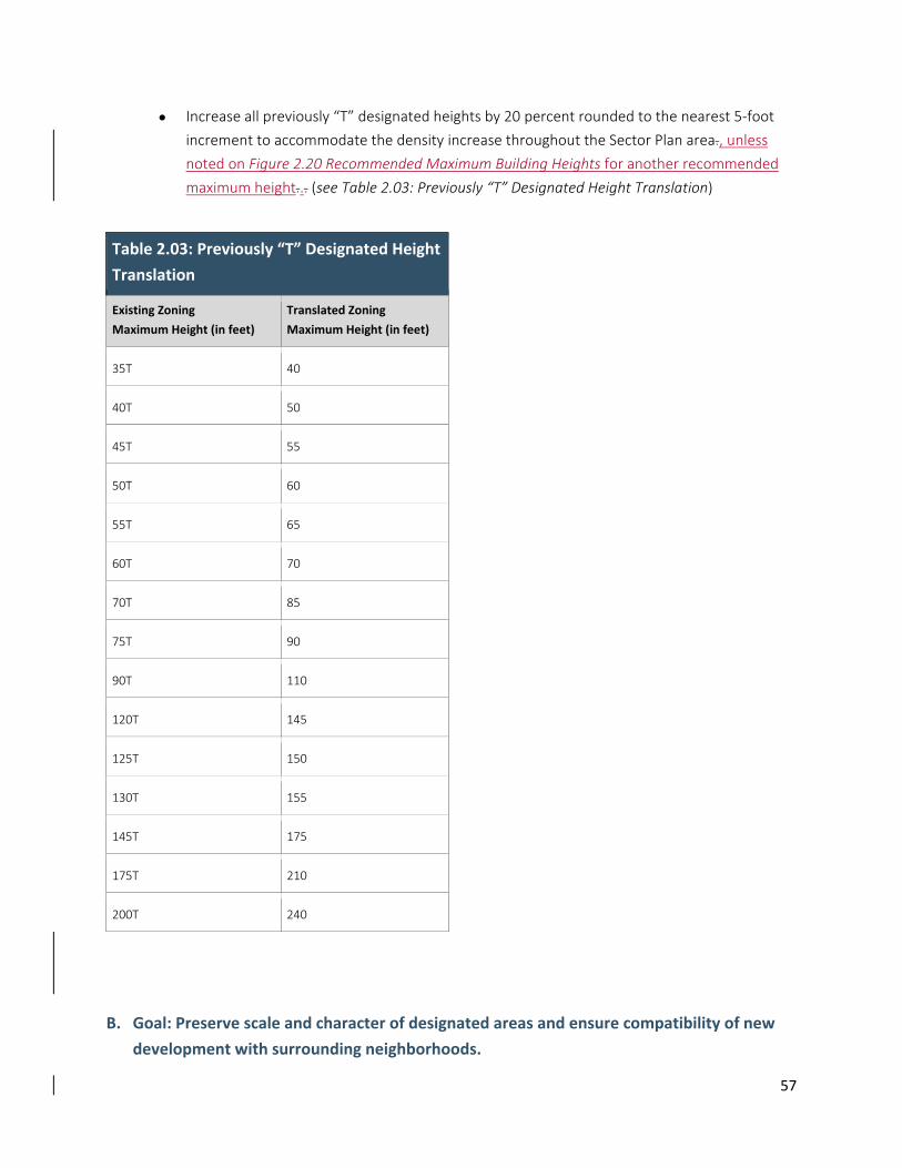
57
Increase all previously “T” designated heights by 20 percent rounded to the nearest 5‐foot
increment to accommodate the density increase throughout the Sector Plan area., unless
noted on Figure 2.20 Recommended Maximum Building Heights for another recommended
maximum height... (see Table 2.03: Previously “T” Designated Height Translation)
Table 2.03: Previously “T” Designated Height
Translation
Existing Zoning
Maximum Height (in feet) Translated Zoning
Maximum Height (in feet)
35T 40
40T 50
45T 55
50T 60
55T 65
60T 70
70T 85
75T 90
90T 110
120T 145
125T 150
130T 155
145T 175
175T 210
200T 240
B. Goal: Preserve scale and character of designated areas and ensure compatibility of new
development with surrounding neighborhoods.
58
Recommendations:
Balance development with transitions to single‐family neighborhoods surrounding the Plan
area in residential and edge districts, such as Battery Lane, Arlington North, South Bethesda
and Eastern Greenway.
Establish a green connector along the eastern edge of the Plan area to provide open space,
pathways, environmental benefits and a transition to adjacent neighborhoods. Allow a range
of building heights dependent on the amount of green space dedicated.
Encourage preservation of low‐rise buildings with fine‐grain building articulation along
Norfolk Avenue.
C. Goal: Create a walkable environment where buildings frame a vibrant public realm and relate to
the human scale. Limit the impacts of imposing building massing and bulk particularly in the
design of tall buildings by designing with sensitivity for their effect on access to sunlight and air,
shadows and how they contribute to the character and visual identity of Downtown Bethesda.
Intent:
With the increases to allowable building heights recommended for Downtown Bethesda and the flexibility to
transfer and allocate additional density in the overlay zone, building form recommendations are critical to
create clear expectations to guide the development review process.
Tall Buildings should not be designed to appear as massive walls extruded directly from the property lines with
subtle variation. Instead they should have a clearly differentiated base that relates to the pedestrian scale,
with substantial variation in the building massing, façade and materials to achieve the urban design goals of
the Sector Plan.
Recommendations:
Setback: Allow sufficient setback from the curb for a clear pedestrian walkway lined by plantings and
furnishings per the Bethesda Streetscape Standards.
Public Mid‐block Connection: Provide connections for people to walk and bike through
large blocks.
Base: Provide a low‐ to mid‐rise building base that frames the street with fine‐grain facade
articulation.
Tower Step‐back: Step back upper floors along streets, open spaces and midblock connections in a
way that distinctly differentiates the tower from the building base.
Bulk: Limit tower floor plates, vary geometry and articulate facades to reduce building bulk.
59
Separation: Separate towers to allow access to light and air, and reduce impact of shadows on the
public realm.
Top: For buildings in prominent locations and with significant height, consider creating a special top
that contributes to the quality of the skyline.
Innovation: Encourage innovative building form and allow flexibility for design that meets the
intent of the recommendations.
Variation: Vary tower heights, setbacks, orientation, and building materials.
2.6.3 Placemaking
Fostering a sense of place is central to enhancing Bethesda’s community character and identity.
Placemaking involves creating great streets, open spaces and buildings that represent Downtown
Bethesda, making it recognizable and special to both residents and visitors alike.
A. Goal: Encourage and accommodate opportunities for creative placemaking to activate
Bethesda’s streets and open spaces.
Recommendations:
Design streets not just for mobility, but also as great public spaces for gathering, events and
play.
Activate streets and open spaces with temporary and phased uses that can catalyze future
investment and growth.
Create gateways at the transit and street entrances to the Downtown that integrate elements
such as wayfinding, landscape and building form unique to Bethesda.
Integrate public art throughout the Downtown area and continue to support Bethesda as an
art and cultural destination.
60
2.7 Parks and Open Space
2.7.1 Why Parks aAre Needed iIn Bethesda
In Bethesda, as in all of Montgomery County’s urban areas, residents, employees and visitors need an
attractive and convenient system of parks, trails and open spaces accessible by walking and transit.
Bethesda is already one of the highest density areas of the County. Adding more density to an already
densely built environment requires more parks, trails and open space located in the right places to make
sure Bethesda remains a place where people want to live, work, and play.
The positive effects of parks on people cannot be overstated, particularly in urban areas. Urban living can
result in a disengagement of people from their natural environment and be detrimental to health and
well‐being. Parks can be the vital link to nature that people need to be healthy. They offer space for
leisure and sport, and their natural green settings help reduce stress. Parks help create community
cohesion and identity by providing spaces for gatherings and events, with opportunities for people to
meet each other, socialize and bond with neighbors.
2.7.2 Parks, Trails, and Open Space Goals
Policy Guidance from previous plans and the 2012 Park, Recreation and Open Space (PROS) Plan, along
with community input during the planning process, led to the development of opportunities for areawide
and neighborhood focal spaces, gateways, connections and green transitions with the following goals:
Support the centers with civic gathering spaces.
Provide linkages and signature gateways to the major trail systems.
Create livable communities and appropriate transitions by greening and buffering the edges.
Create green neighborhood parks.
Add to the existing Park, Trail and Open Space System
2.7.3 Recommendations
A. Support centers of activity with civic gathering spaces by providing civic greens.
The Concept Framework Plan identifies multiple centers of activity in areas of highest density, mixed‐
use development, with central gathering spaces at each. The 2012 PROS Plan identifies new urban
park types, including one called “civic green,” which is described as follows:
Formally planned, flexible, programmable open space that serves as a place for informal gathering,
quiet contemplation or large special event gatherings. Depending on its size, a civic green may
support open air markets, concerts, festivals and special events, but is not often used for
programmed recreational purposes. A central lawn is often the main focus with adjacent spaces
61
providing complementary uses. The green may include gardens, water features and shade structures.
The minimum size is 0.5 acre.
During the planning process, public input during meetings with surrounding communities indicated
that there is a desire for more green spaces overall, with particular mention of green open space for a
variety of functions and amenities in central locations.
Civic greens should have the following characteristics:
Located on or within direct view of main streets and adjacent to the highest concentration of
commercial and civic land uses.
Green lawn area for flexible use (events, ceremonies, celebrations, informal seating).
Shaded areas with seating; shade provided by trees and shade structures.
Designed to welcome public use; integrated into the public realm.
Inclusive design serving all age groups.
Attractive landscaping.
Located near restaurants for takeaway outdoor dining opportunities.
Flexible space for multiple types of activities.
Flexible seating to accommodate multiple sized groups or individuals.
The following amenities are appropriate for civic greens to maximize usage by all ages:
Event lawns to host various sizes of community events and festivals.
Multiple seating options, from benches to seating walls to lounging chairs, to accommodate
all styles of relaxation.
Places for picnicking with tables as one option.
A variety of food and drink options that can be enjoyed in the park.
Comfort amenities, such as restrooms and drinking fountains.
Interesting lighting for nighttime use.
Multiple ways for children to play, such as in water features, traditional playgrounds, nature
play areas.
Amenities that allow for physical fitness to be improved.
Multi‐seasonal amenities, such as ice‐rinks, community gardens, water play features, holiday
lighting, lawn games and volleyball courts.
Tents and movable shade structures.
Trails and walkways that connect to public gathering spots or attractions.
Places where dogs can play and their owners can socialize.
62
Gardens and attractive, multi‐seasonal landscaping.
The following new civic greens are recommended in Bethesda:
1. Veteran’s Park Civic Green
Vision: Veteran’s Park Civic Green is envisioned as a green extension of the existing successful public
open space in front of called Veteran’s Park at the intersections of Woodmont Avenue, Wisconsin
Avenue and Cheltenham Drive. This new park would expand the existing public space across the
street and serve as a linkage between the established center of the Woodmont Triangle District and
Wisconsin Avenue Corridor District.
Recommended size: 0.5 acres
Purpose: This new civic green would complement the hardscape of Veteran’s Park with flexible,
green, community open space. This green open space would allow for more formal community
events and programming, but also casual informal lunchtime or dinnertime picnicking, reading and
sunbathing.
2. The Farm Women’s Market Civic Green
Vision: This Civic Green is envisioned as a green open space next to the Farm Women’s Cooperative
Market, which is a longstanding community institution in the historic heart of Bethesda. This space
would act as both a destination and a local gathering spot, providing a space for market customers to
eat and relax. It serves as an extension of Elm Street Park and the proposed Eastern Greenway. The
open space at the famous Weaver Street Market in Carrboro, North Carolina serves as an example of
the type of space envisioned here.
Recommended size: 0.6 acres (includes market). We think this is closer to .7 acres – need to check
GIS map)
Purpose: This civic green will maintain the historic building as a functioning market and a central
activating feature for a green civic space that connects to the proposed Eastern Greenway and Elm
Street Park.
3. The Capital Crescent Civic Green
Vision: This space is envisioned as the civic green for the Bethesda Row District and the western
gateway of the Capital Crescent Trail. It will build on the success of the existing small plaza at the
Barnes and Noble store and act as an outdoor civic center for the Bethesda Row District.
Recommended size: 0.57 acres
Purpose: The Capital Crescent Trail Civic Green would provide an open space with a large lawn. This
green would accommodate community events and programming, a meeting spot for moviegoers,
cyclists and restaurant patrons, and space for casual picnicking, reading and sunbathing.
Implementation: The Capital Crescent Civic Green meets the criteria to be designated as an Urban
Open Space of countywide importance within the Legacy Open Space Functional Master Plan (2001).
63
This critical civic green will create one of the primary green spaces in the center of Bethesda. It will
provide key community open space for recreation and casual use by the large population center in
this community, as well as support trail usage and special events to serve the entire County.
Designating this site in the Legacy Open Space Functional Master Plan here provides for the use of
Legacy Open Space tools and funding to implement this park recommendation.
B. Provide linkages and signature gateways to the major trail systems.
The North Bethesda Trail and the Capital Crescent Trail are two major corridors that run directly into
the heart of the Bethesda Downtown Sector Plan. These heavily used trails for walking and biking lack
sufficient space for the volume of pedestrian and cyclist traffic at trailheads and linkages. Use of hard
and natural surface trails is the County’s most popular recreation activity, according to the Vision
2030 statistically valid survey. Sixty‐eight percent of the respondents surveyed in Vision 2030
reported using both types of trails and nearly 75 percent considered them very important to their
households. In addition, trails ranked as the highest outdoor facility on the survey as to the overall
importance of adding, expanding or improving.
The 2012 PROS Plan and community input from public outreach identified the need for additional
community open space, which is defined in the PROS Plan as “an open, level, grassy area for a variety
of informal recreational activities” and is a minimum of 10,000 square feet, with 60‐foot width (PROS
Plan, page 53).
The following park spaces are recommended to provide linkages and signature gateways to the major
trail system through the development of additional community open spaces:
1. North Bethesda Trail Urban Greenway
Vision: The North Bethesda Trail is a major bicycle and pedestrian link between Bethesda and White
Flint. The North Bethesda Trail Gateway Park is envisioned as a green and active linear park
connection between the National Institutes of Health and Woodmont Triangle.
Recommended size: 0.9 acres
Purpose: The North Bethesda Trail Gateway Park would provide a bicycle and pedestrian trail through
the enhanced Battery Lane Park. This trail would be wide enough for stream improvements,
environmental interpretation and play elements.
2. Gateway into Norwood Local Park
Vision: This gateway is envisioned as a welcoming, green entrance into Norwood Local Park from the
north that improves connectivity to the area north of the park.
Recommended size: A 15‐foot width minimum from Chevy Chase Drive to the park property line.
Purpose: Norwood Local Park is a 17‐acre local park and among the most popular and highly utilized
of all local parks in Montgomery County. It sits on the edge of the Bethesda Central Business District
and is surrounded on all sides by residential neighborhoods. The park is the largest local park in the
Bethesda‐ Chevy Chase area and contains the only rectangular and diamond fields available for
64
permitting in the immediate downtown area. Currently, the official entrance is off Norwood Drive.
Woodmont Avenue and Strathmore Avenue are identified as bicycle priority routes in the Bethesda
Downtown Sector Plan and this proposed north entrance to Norwood Local Park will improve
connections to those routes.
3. Eastern Capital Crescent Urban Greenway
Vision: The Eastern Capital Crescent Urban Greenway Gateway Park is envisioned as an active
gateway park along the Capital Crescent Trail.
Recommended size: 1.89 acres This park proposal is growing in acreage because of the latest
information about the MTA traction power substation. Need the real acreage.
Purpose: The Eastern Capital Crescent Gateway Park would provide active recreational areas along
the trail and serve as a green gateway into the Bethesda Central Business District. Facilities here could
include adult fitness equipment, a dog park, skate boarding, courts and a playground.
Implementation: The Eastern Capital Crescent Urban Greenway meets the criteria to be designated
as an Urban Open Space within the Legacy Open Space Functional Master Plan (2001). This new
Urban Greenway will increase access between one of the most important trail corridors in the County
and the center of Bethesda and will provide key additional recreational open space to a community
with high population density. Designating this site in the Legacy Open Space Functional Master Plan
here provides for the use of Legacy Open Space tools and funding to implement this park
recommendation.
4. Arlington South Gateway Park Plaza
Vision: This park will be an urban greenway gateway linking the Arlington South District to the Capital
Crescent Trail. The PROS Plan defines an urban greenway as a “linear park that provides trails or wide
landscaped walkways and bikeways and may include other recreational and natural amenities.”
Recommended size: The size of this space is to be determined at the time of regulatory plan review.
Staff recommends a minimum width of 12 feet in between the existing buildings that are adjacent to
the Capital Crescent Trail and a larger width of 20 feet in the area leading to Arlington Boulevard.
Purpose: This linear park will connect the Capital Crescent Trail to the proposed mid‐block crossing of
Arlington Boulevard at Bradley Shopping Center. This space would include a wide walkway, shade
trees or shade structures, and a focal feature that visually draws people to the park and
communicates that it is a linkage to the trail. This space should accommodate people on foot and on
bikes.
C. Create livable communities and appropriate transitions by greening and buffering the
edges.
The Bethesda Downtown Sector Plan area is an already dense Central Business District and continues
to develop and urbanize. Additional green buffer parks are needed on the edges of the Sector Plan
65
area to provide physical transitions between the residential neighborhoods and the urban core, and
ensure that these neighborhoods remain desirable places to live.
1. Battery Lane Urban Park Expansion
Vision: An expanded Battery Lane Urban Park will build on the success of the existing Battery Lane
Urban Park as a buffer park that provides needed recreational amenities for visitors and residents.
Recommended size: 3.75 acres reduce acreage to eliminate the triangle on the Sherwin Williams site.
Purpose: Battery Lane Urban Park is an existing urban buffer park that provides open space and
recreational amenities to the Battery Lane and Woodmont Triangle Districts, and surrounding
neighborhoods. Additional land at Battery Lane Urban Park will allow for needed walk‐to facilities,
such as community open space, dog parks, skate parks or community gardens.
2. Fire Station 6 Urban Buffer Park
Vision: A walk to green space for the residents of the South Bethesda and Wisconsin Avenue Districts,
this space will also provide a needed trail connection into the Norwood Local Park.
Recommended size: 0.85 acres.
Purpose: Fire Station 6 Urban Buffer Park will allow for needed walk‐to facilities, such as community
open space, dog parks, skate parks or community gardens.
D. Create green neighborhood parks
Neighborhoods need centrally located parks for meeting neighbors and friends, exercising in a
convenient location and being in touch with open green space.
The PROS Plan describes Neighborhood Green Urban Parks as parks that serve residents and workers
from the surrounding neighborhood or district, but may be designed for more activity than an urban
buffer park. These formally planned, flexible open spaces serve as places for informal gathering,
lunchtime relaxation or small special event gatherings.
1. Old Georgetown Road Neighborhood Green Urban Park
Vision: This park is envisioned as a heavily landscaped, shady, green living room. This park will be a
signature moment in the Bethesda landscape and act a wayfinding and placemaking space.
Recommended size: 0.3 acres. The proposed site consists of the current Shell gas station at
Woodmont Avenue and Old Georgetown Road, and the adjacent single‐family homes to the
southwest.
Purpose: This site, one of the most visible intersections in Bethesda, is a transition between the
Woodmont Triangle District and the Metro Core. This park will provide a green respite for residents, a
66
lunch space for employees and a destination for visitors. This park would act as a formal, passive
green space featuring trees, bushes and elegant fencing and paving. Straus Park in New York City is an
example of the type of park envisioned here.
2.3. Wellington Drive Neighborhood Green Urban Park
Vision: Wellington Drive Neighborhood Green Urban Park is a neighborhood park that will provide in‐
demand, walk‐to amenities, such as community open space, trees and an art or nature‐based play
area for the residents immediately surrounding this park.
Recommended size: 0.5 acres
Purpose: This park will act as a buffer between the Sacks subdivision and proposed redevelopment of
the multi‐family housing located along Bradley Boulevard and Strathmore Street.
3.4. South Bethesda Public Plaza
Vision: South Bethesda Public Plaza will be a small public open space at the corner of Bradley
Boulevard and Strathmore Street.
Recommended size: 0.15 acre
Purpose: This space will provide shaded open space for the area of denser residential development
proposed along Bradley Boulevard just west of Wisconsin Avenue.
4.5. Bethesda‐Chevy Chase East Neighborhood Green Urban Park
Vision: A neighborhood green urban park that serves new development in the area between
Bethesda‐Chevy Chase High School and the Pearl Street and East‐West Highway intersection.
Recommended size: 0.3 acres
Purpose: This park will provide community open space, seating areas, trees and an art or nature‐
based play area.
Move this section to another chapter. Implementation: This park space would be acquired through
the Montgomery County Department of Parks’ Capital Improvements Program, developed through
private sector contributions and coordinated with Montgomery County Public Schools.
5.6. Eastern Greenway Neighborhood GreensGreen Urban Parks
North End:
Vision: The Eastern Greenway Neighborhood Green Urban Parks at the north end will be pockets of
parkland along the Eastern Greenway and allow for additional recreational amenities and green
buffers for the community.
Recommended size: 0.5 acres each, including the greenway, to accommodate walk‐to facilities.
Purpose: These two buffer parks will provide spaces for in‐demand, walk‐to facilities and continue
the pattern of the Chase Avenue / and/ Cheltenham Drive Urban Bbuffer Pparks (formerly classified
67
as Urban Parks). A new park nearbuffer parks. Highland AvenueNorth North could provide a dog park
at a minimum of 10,000 square feet.
South End:
Vision: These parks are envisioned as destinations and pockets of larger green space along the
eastern edge of the Bethesda Downtown Sector Plan boundary and provide buffers to the Town of
Chevy Chase.
Recommended size: In addition to the historic building and green space at the Farm Women’s
Cooperative Market, there will be three additional acres of green space.
Purpose: These parks will provide small‐scale neighborhood recreational opportunities and act as
green buffers for the community on the eastern side of the Bethesda Downtown Sector Plan
boundary. They will decrease existing impervious surfaces, while increasing tree canopy cover.
6.7. Western Edge Neighborhood Greens Parks
The Western Greenway Neighborhood Green Urban Parks would consist of two additions to existing
public property: one at the southwest corner of Bethesda Elementary School and the other at
Caroline Freeland Urban Park.
Vision: These parks are envisioned as pockets of larger green space along the western edge of the
Bethesda Downtown Sector Plan boundary.
Recommended size: The addition to Caroline Freeland Urban Park is 0.15 acres and the addition to
Bethesda Elementary School is 1.0 acres.
Purpose: These parks will provide small‐scale neighborhood recreational opportunities and act as
green buffers for the community on the western side of the Bethesda Downtown Sector Plan
boundary.
ED. Add to existing Parks, Open Spaces and Trails
Existing parks in the Bethesda Downtown Plan currently serve as critical open spaces for
residents and visitors alike, and can serve those needs even better with additional space
and facility improvements. Three such parks with opportunities for additional land
and/or improved facilities are identified here.
1. Battery Lane Urban Park Neighborhood Green Expansion
Vision: An expanded Battery Lane Neighborhood Green (formerly categorized as Urban Park) Urban
Park will build on the success of the existing site Battery Lane Urban Park as a buffer park that
provides needed recreational amenities for visitors and residents.
Recommended size: 3.75 acres (reduce acreage to eliminate the triangle on the Sherwin Williams)
site.
68
2. Chase Avenue Neighborhood Green Urban Park Expansion
Vision: This extension is envisioned as an additions to the existing small Neighborhood Green
(formerly classified as an urban park) urban park and to the proposed Eastern greenway along the
eastern edge of the Bethesda Downtown Sector Plan boundary.
Recommended size: The addition to Chase Avenue Urban Park may include up to four lots totaling is
0.8 ??? acres.
Purpose: These parcels will add to the small‐scale neighborhood recreational opportunities and act as
green buffers for the community on the eastern side of the Bethesda Downtown Sector Plan
boundary.
3. Elm Street Urban Buffer Park Improvements
Vision: Elm Street Urban Buffer Park (formerly classified as an Urban Park) currently serves as a key
green open space very near the center of Bethesda. The southern portion of the park was upgraded
about 10 years ago, and the northern portion is currently in design for facility improvements. Current
funding will support the design phase, but the construction phase is not fully funded.
Recommended size: No additional land recommended for this park. Current park size: 2.08 acres
Purpose: Redevelopment of this key park will add new and improved recreational opportunities and
provide better access to the Capital Crescent Trail from the BDP and the surrounding residential
communities.
2.8 Community Facilities Public facilities and services are the building blocks of community. Fire and rescue services ensure safety
and public schools, day care and elderly services address the needs of all generations. Libraries, post
offices and recreation centers help build a community among people with shared needs, interests and
values.
Downtown Bethesda provides its residents with a variety of services. As a growth center and a
commercial focus for Bethesda‐Chevy Chase and southern Montgomery County, Downtown Bethesda
reaches a population beyond the Sector Plan boundary through its services and facilities. This chapter
describes existing services and makes recommendations for additions to facilities that can respond to
future commercial and residential growth.
2.8.1 Plan Objectives
69
Provide public facilities to meet the human service, recreation, security, educational and
other needs of the community.
Encourage flexibility in space and programming to adapt to future needs.
2.8.2 Human Services
A. Child Care Services
Downtown Bethesda’s role as an urban and transportation center makes it an appropriate location for
child care services for both employees and nearby residents. Downtown Bethesda currently has a number
of privately‐run child care facilities, located in churches, community centers and office buildings that
serve the large existing and proposed residential areas of Downtown Bethesda.
The Bethesda Downtown Sector Plan will have an effect on the life of young children in Downtown
Bethesda in other ways. One influence centers on child‐friendly environments with parks, wide sidewalks
and safe street crossings. These issues are addressed elsewhere in the Plan.
Another positive effect of the Sector Plan is encouraging private developers to provide subsidized child
care facilities in appropriate locations. Proximity to parks and open space, and location of play spaces
away from busy roads are important criteria when reviewing sites. The high land value of property in
Downtown Bethesda often prices child care services out of the market and limits the provision of outdoor
play space for children.
Recommendation
Encourage child care facilities in key locations throughout the Downtown Bethesda area.
B. Facilities for the Elderly
While Downtown Bethesda generally attracts younger residents, its nature as an established and compact
community with concentrated services and Metrorail access also makes it attractive to elderly residents
who are uncomfortable driving.
Most of Bethesda’s seniors have relatively high incomes and home equity, enabling them to turn to the
private sector for the services they need. As the population ages, the market has responded with housing,
entertainment and services geared to an affluent elderly population. However, elderly people between
the ages of 75 and 80 often begin to lose the ability to care for themselves and their homes. The in‐home
care they need is not always readily available because of an inadequate supply of housing in the
Downtown Bethesda for such service workers.
The growing elderly population in Downtown Bethesda and the surrounding area also includes less
affluent residents who need the option to “age in place” or in a familiar environment near their former
homes. The County Housing Opportunities Commission (HOC) currently operates Waverly House, a senior
citizen development of 158 apartments on East‐West Highway that partially addresses this need.
Recommendation

70
Although policies beyond the scope of this Plan have a primary impact on the lives of the elderly, some
local measures can add to their quality of life. The land use recommendations are designed to create an
environment that is concentrated and walkable, affording elderly people increased mobility and
independence.
Private and public housing options should meet the needs of a range of people, including hired caregivers
who cannot afford market‐rate housing in Downtown Bethesda, family caregivers who need the space
and special design features to take care of older relatives at home, and the elderly residents themselves.
Improved transportation can provide better access to groceries and services. The proposed loop bus or a
special bus service that could possibly extend to the Friendship Heights elderly community would provide
increased mobility and independence. The financing of such a service must be explored further.
Other services, like nutrition and recreation programs, and adult day care, are currently available in
Downtown Bethesda, including those provided at Waverly House and the Leland Community Recreation
Center.
C. Facilities for the Homeless
Despite its status as an employment center and the high education and income levels of its residents,
Downtown Bethesda has a homeless population. The amount of homelessness varies with the strength of
the economy and with community responses to the problem. Among the homeless population are
veterans, families and the mentally ill, all with different needs requiring different responses.
The Bethesda community has responded with Bethesda Cares, a community outreach program for the
homeless, founded in 1988 by a group of local religious congregations. Greater urbanization and other
factors may increase the homeless population. The Department of Housing and Community Affairs
(DHCA) estimates that there are at least 400 homeless people on the streets of Montgomery County on
any given night. The current day and night shelter capacity in the County is approximately 200 beds.
Recommendation
Although the increase in jobs and housing in Downtown Bethesda may offer opportunities to some
segments of the homeless community, many more will probably not be served by the market. Since many
of the service jobs that will be created will likely not pay enough to meet current housing costs, new
housing options should be considered, such as personal living quarters (PLQs), perhaps reusing small
hotels within the Central Business District. Consideration should be given to a Zoning Text Amendment
that would allow greater number of allowing PLQs inunits in some CR zones (in appropriate locations) in
some Commercial Residential (CR) zoneswithout requiring condition of approval.
2.8.3 Public Security
A. Police Station
The 2nd District Police Station located at 7359 Wisconsin Avenue is currently planning the design and
construction of a replacement district station.
71
The existing, 21,707‐square‐foot Bethesda Police Station was constructed in 1961. The station site is
constrained with limited staff parking and no public parking. The station has experienced considerable
deferred maintenance and requires major building repairs.
The new project provides for design and construction of a replacement district station to serve the
Bethesda‐Chevy Chase area and portions of Potomac and Silver Spring included in the 2nd Police District.
A District Police Station like this one serves as the center for police services for each district. It provides
the base of support facilities for all District beat teams and serves as the parent facility for all satellite
facilities. District Police Stations operate 24 hours a day, 7‐days a week, on a continuous basis with three
shifts.
The new 2nd District Police Station will be built at 4823 Rugby Avenue on a vacant lot that backs up to
Public Parking Garage #35. The new facility will be a four‐story, above grade, 28,480 square‐foot structure
that utilizes part of the public garage for police parking. The facility will be designed to conform to
Montgomery County standards for public buildings.
Recommendations
Should the police station relocate, leaving the existing 21,707‐square‐foot building vacant, this Plan
recommends the following criteria for reuse of the site and/or building:
The use should advance the goals of the Bethesda Downtown Sector Plan.
The use should not exceed the density or height limits set by the Sector Plan.
The use should be compatible with adjacent land uses.
B. Fire and Rescue Stations
Downtown Bethesda has two fire and rescue facilities. Fire Station 6 is located at 6600 Wisconsin Avenue
at the southwest corner of Wisconsin Avenue and Bradley Boulevard. The property consists of two lots
totaling 79,765 square feet.
The property is owned by Bethesda Fire Department, Inc. (BFD), a 501c3 non‐profit organization that is
managed by a volunteer community‐based board of directors. Most board members represent residential
constituent communities of Bethesda and Chevy Chase, and the business community through the active
participation of representatives from the Greater Bethesda Chevy Chase Chamber of Commerce.
The Bethesda Fire Department believes that the current strategic location of Fire Station 6 is essential to
the continued well‐being of the community and is considering how best to provide operational and
technological improvements to the physical asset.
Fire Station 6 was built in 1969 and has aged considerably. The fire department is determining the best
way to provide a modernized fire station that will meet the constantly increasing community needs for
the next 40‐50 years by considering the following options:
Maintain Fire Station 6.
Renovate the existing Fire Station 6.
72
Build a new stand‐alone Fire Station 6.
Work with an outside developer to redevelop the property as a residential building, including
a new Fire Station 6.
Determine the possibility of obtaining density rights that could be sold to other properties in
Bethesda to fund a renovation or a new Fire Station 6.
The rescue squad is located at the northern end of the Sector Plan area at 5020 Battery Lane. The 90,569
square‐foot parcel is located minutes from Downtown Bethesda. The land use is currently for a rescue
station and parking lot.
The rescue squad is looking into redevelopment options to provide a new, more modern facility on the
site as well as possibly adding additional uses on the parcel, such as a multi‐story residential and
commercial building complex. Any new redevelopment would be phased construction that will allow the
rescue squad facility to remain operational during construction.
Currently, the property is zoned for single‐family residential or Residential‐60. Any future redevelopment
of the site, including commercial and multi‐story residential, would require a change to the current
zoning of the property.
Recommendations
This Plan recommends that the rescue squad site located at the intersection of Battery Lane and Old
Georgetown Road,both sites change from their current R‐60its current R‐60 zone to a Commercial
Residential (CR) zone and the Fire Station 6 site at the corner of Bradley Boulevard and Wisconsin
Avenue, retain its R‐10 base zone and a floating zone be recommended with a Commercial Residential
(CR) designation and R‐10 zones to a Commercial Residential (CR) zone to permit some additional uses
consistent with the surrounding neighborhood and renovation of the facilities to improve safety and
services. (see Figure 2.05: Recommended Zoning)
2.8.4 Educational Facilities
A. Library
The Bethesda Regional Library, located at 7400 Arlington Road, serves Downtown Bethesda. Along with
its regular collection, it features an extensive reference collection and meeting rooms, all of which are
well used. The Bethesda Library is an active community gathering place. It is one of the busiest libraries in
the County, attracting both business and residential users.
The County has no immediate plans to expand or renovate the Bethesda Library at this time.
Recommendations
Rather than investing in large capital expenditures, like a building addition, the library prefers to expand
into the community with small facilities and through electronic connections to homes and businesses.
Staffed “mini‐libraries” or unstaffed information kiosks at Metrorail stations can provide services such as
73
electronic access to community and collection information, reserve book pickup and a small selection of
lending paperbacks.
The Bethesda Downtown Sector Plan recommends creating and encouraging opportunities for the library
to provide expanded services to the community at appropriate locations within the Central Business
District. The Plan supports locating a kiosk or other mobile information system at the Bethesda Metrorail
Station.
B. Public Schools
The Downtown Bethesda Sector Plan is within the service areas of Bethesda Elementary School, Westland
Middle School and Bethesda‐Chevy Chase High School. Enrollment increases have been occurring at all
these schools and a variety of strategies will be considered to accommodate additional students resulting
from the Sector Plan. The Plan includes designation of the former Lynnbrook Elementary School as a
future operating elementary school.
In addition, the Sector Plan provides for up to 8,456 new multi‐family high‐rise housing units. Based on
student generation for this area of the county, Montgomery County Public Schools (MCPS) estimates at
full build‐out, the new housing would result in approximately 355 elementary school students, 145
middle school students and 195 high school students. Build‐out of the Sector Plan requires
redevelopment of many properties and is estimated to take 20 to 30 years. Some properties identified for
more housing units may not redevelop at all during the life of the Plan.
Because the full impact of the Sector Plan on school enrollments will not be realized for many years, it is
impossible to precisely gauge the impact on public schools. School enrollments in the area will change
over the 20 to 30 year time‐frame of the Plan. In addition, MCPS enrollment forecasts and associated
facility plans and capital projects focus on a six‐year time‐frame—not a 20 to 30 year period. Therefore,
the following options to accommodate additional students from the Plan describe current enrollment
projections and capital projects. Following these comments, typical approaches that MCPS employs to
address enrollment increases are provided. All approaches require County Board of Education approval.
At the elementary school level, Bethesda Elementary School has a building addition scheduled for
completion in August 2015 to address increased enrollment. The new addition will increase the school’s
capacity from the current 384 students to 568 students. Site constraints indicate that no additional
capacity can be built at the school. Current projections indicate that for the next six years there will be
little space available at the school, even with the addition. If there continues to be no surplus capacity at
Bethesda Elementary School by the time new housing occupancies occur in the Plan area, then MCPS
would explore the following range of options to serve additional elementary school students:
Determine if space is available at nearby elementary schools in the area and reassign
students to a school(s) with space available.
Build an addition, or additions, at nearby school(s) and reassign students to the school(s) with
increased capacity.
74
If the capacity of existing elementary schools, even with additions built, is insufficient to
address increased enrollment, then the opening of a new elementary school would be
considered. A new elementary school could be provided in one of two ways:
o Reopen a former elementary school in the Bethesda‐Chevy Chase (B‐CC) cluster.
There are two former operating elementary schools in the cluster that could be
considered, including the former Rollingwood and Lynnbrook Elementary Schools.
Lynnbrook Elementary School is located adjacent to the Sector Plan area and is
identified in the Plan as the location for an elementary school.
o Construct a new elementary school. There are currently no future elementary school
sites identified in the B‐CC cluster. A site selection process would be conducted for a
new elementary school and co‐location and/or purchase may be required.
At the middle school level, Westland Middle School is projected to be over capacity by more than 800
students in the coming years. A second middle school for the B‐CC cluster is scheduled to open in August
2017. The temporary name for this school is Bethesda‐Chevy Chase Middle School #2. The boundaries for
the new middle school, and changes to the Westland Middle School service area, are not yet determined.
However, it is anticipated that there will be some space available at both middle schools once the new
middle school opens. If there is insufficient capacity available at the two B‐CC cluster middle schools by
the time new housing occupancies occur in the Plan area, then MCPS would explore a range of options to
serve additional middle school students as follows:
Determine if space is available in an adjacent middle school and reassign students to a school
with space available.
Build an addition at Bethesda‐Chevy Chase Middle School #2 or Westland Middle School.
Build an addition at an adjacent middle school and reassign students to the school.
Construct a new middle school. There are currently no future middle school sites identified in
the B‐CC cluster or adjacent clusters. A site selection process would be conducted for a new
middle school in the region and collocation and/or purchase may be required.
At the high school level, Bethesda‐Chevy Chase High School serves the Sector Plan area. This school is
projected to be over capacity by more than 700 students and to enroll up to 2,500 students in the coming
years. An addition to the school that will increase the capacity to 2,400 is scheduled for completion in
August 2017.
Current projections indicate that for the next six years there will be little space available at the school,
even with construction of the addition. Also, the school will be at the high end of the desired enrollment
size for high schools. If there continues to be no surplus capacity at Bethesda‐Chevy Chase High School by
the time new housing occupancies occur in the Plan area, then MCPS would explore the following range
of options to serve additional high school students:
Determine if space is available in an adjacent high school and reassign students to a school
with space available.
75
Build an addition at an adjacent high school and reassign students to the school.
Reopen a former high school in the vicinity. A former high school, known as Woodward High
School, is located on Old Georgetown Road in Bethesda. This is the only former high school in
the MCPS inventory. The facility currently houses Tilden Middle School. However, Tilden
Middle School will be relocated to its original Tilden Lane location when its
revitalization/expansion is completed in August 2019. The Woodward facility will then
become a holding center for middle schools undergoing revitalization and/or expansion. Long
term, another holding center for middle schools undergoing revitalization and/or expansion is
planned at the former Broome Jr. High School in Rockville.
Construct a new high school. There are currently no future high school sites identified in this
area of the County. A site selection process would be conducted for a new high school in the
region and collocation and/or purchase may be required.
Recommendations
Ensure options for providing adequate student enrollment capacity, as described above.
2.8.5 Other Public Facilities
A. Bethesda‐Chevy Chase Regional Services Center
Bethesda is not an incorporated municipality, but it provides a local government office to strengthen
communication between the community and various agencies of County government. The Bethesda‐
Chevy Chase Regional Services Center functions as a local town hall, offering problem‐solving and
information, and referral services to residents. The Center offers many ways to get involved in local
government, including committees, volunteer opportunities, educational opportunities, public meetings,
open houses and more. The Director of the Regional Services Center is a member of the County’s senior
management team with direct access to the County Executive and department heads. Along with this
liaison function, the Center also:
Identifies regional priorities and future service needs.
Coordinates local initiatives and community problem‐solving.
Maintains a library of County literature, including the Recreation Guide, Master Plans and
Guide to Senior Resources.
Maintains meeting rooms for public use.
Distributes welcome packets to new residents.
Oversees County promotional and maintenance services in Downtown Bethesda performed
under contract by the Bethesda Urban Partnership.
Manages the site selection process for County facilities.
76
The Center has been located in Bethesda since 1979. When the Center first opened its doors, it was
housed in the Reference Room at the Bethesda Regional Library on Arlington Road. In the early 1980s,
both the Library and the Center needed additional space and the Center moved to Woodmont Avenue. In
December 1996, the Center moved to a brand new County office building located in the heart of
Downtown Bethesda, near the Bethesda Metrorail Station and above the County’s Bethesda Center
parking garage. The Center is located on the plaza level of the Metropolitan apartment complex on
Edgemoor Lane that includes a 308‐unit, mixed‐income project owned by the Housing Opportunities
Commission of Montgomery County.
Recommendation
Support the priorities of the Bethesda‐Chevy Chase Regional Services Center.
B. Writers Center
The Writers Center is a County‐owned building formerly operated as a community center. This publicly
owned property presents a valuable opportunity in an urban area with high land costs to accommodate a
variety of uses over the next 20 years.
The County has decided to retain ownership and has leased the building on a long‐term basis to the
Writers Center. By retaining title, the County will have the flexibility to change tenants, depending on
local demand and interests.
Recommendation
The Plan recommends continued County ownership of the building to further the goals of establishing the
cultural district in Downtown Bethesda or other community objectives.
C. Arts and Entertainment District
This Sector Plan supports public and private sector arts and entertainment forms and venues within the
Arts and Enetrtainment District to appeal to diverse audiences and help stimulate economic
development.
The Plan recommends the following priorities for the Arts and Entertainment District:
Provide flexible community theater/stage space (known as a “black box”) of approximately
5,000 square feet with potential seating capacity of 200‐250 seats. Identify this space as a
major public facility resource for a CR zone if it is a nonprofit and/or public owned/managed
facility.
For CR Optional Method project amendments to existing developments, encourage and
support revitalization, replacement and/or relocation of existing public art and/or support a
payment accepted by the Arts and Entertainment District for a public arts and entertainment
initiative that is recommended in a master plan or by the Arts and Entertainment Board as a
priority project.

77
Exclude any on‐site public arts facility or space in the Arts and Entertainment District from
the calculation of development impact taxes, transportation management district fees or
similar taxes and fees.
78
Chapter 3: Districts Based on community feedback and the Concept Framework Plan, this Sector Plan divides Downtown
Bethesda into nine districts for the development of specific goals and recommendations. These areas
comprise Wisconsin Avenue and the established centers of Bethesda Row and Woodmont Triangle; the
emerging centers of the Pearl and Arlington South Districts; and the residential and edge districts of Battery
Lane, Eastern Greenway, South Bethesda and Arlington North.
79
3.1 Wisconsin Avenue and Established
Centers
3.1.1 Wisconsin Avenue Corridor
The Wisconsin Avenue Corridor is the main artery through the center of Downtown Bethesda. It extends
from the Sector Plan Boundary/National Institutes of Health (NIH) on the north to Bradley Boulevard on
the south, and from Woodmont Avenue on the west to Waverly Street on the east. With the existing
Bethesda Metrorail Station, future Purple Line and Bus Rapid Transit (BRT) options, Wisconsin Avenue is a
critical focus area for improved access, mobility and pedestrian safety. The corridor is envisioned as a
symbolic downtown center that reflects the character of adjacent neighborhoods and overall identity of
Bethesda through innovative building designs and active public spaces.
The Wisconsin Avenue Corridor is primarily a commercial area, containing both retail and office uses.
Among its numerous large office buildings are older ones predating the 1976 Bethesda Central Business
District Sector Plan, such as the Air Rights Building; 1980s structures; and buildings at the Bethesda
Metrorail Station. The northern part of Wisconsin Avenue comprises several hotels, stores, restaurants
and offices, but currently has no clear identity. The area’s retail potential is compromised by its location
on either side of Wisconsin Avenue. As a major commuter arterial, this street has heavy traffic volumes
that eliminate the potential for “cross‐shopping” and a lack of visibility for retail establishments.
However, Wisconsin North anticipates increased development activity with five planned projects,
including the Harris Teeter site at 8300 Wisconsin Avenue. These projects will increase the employee,
visitor and residential customer base within the district.
The Metro Core of Wisconsin Avenue struggles with the same condition caused by the barrier of
Wisconsin Avenue’s width as well as its vehicular traffic volume and speed. Similar to northern Wisconsin
Avenue, the area includes hotels, but is most noted for the density of office buildings that surround its
Metrorail station and accessible roadways. Consequently, most of the existing retail offerings in the
Metro Core are oriented to the Monday through Friday, 9‐to‐5 customer. As Bethesda Row and
Woodmont Triangle have become increasingly more attractive as locations for new and/or expanding
retailers, these areas draw more and more customers away from the Metro Core’s shops, restaurants and
services.
The southern portion of Wisconsin Avenue is located at the second most visible retail intersection in
Downtown Bethesda – Wisconsin Avenue and Bradley Boulevard. Like its companion area to the north,
south Wisconsin Avenue is bifurcated. This condition is reinforced by existing retail locations in the area,
including the Shops of Wisconsin to the east and the CVS, Staples and PetSmart stores. One of this area’s
most significant obstacles to future growth and change is its rigid building designs and layouts that are
difficult to adapt to more retail‐appropriate spaces and, therefore, more flexible tenanting.
80
The Wisconsin Avenue Corridor, consistent with adopted planning principles, has the tallest buildings in
Downtown Bethesda. Building heights step down from the 200‐foot Clark Building to the surrounding
143‐foot heights allowed in the Commercial Residential zone (former Central Business District‐2 zone in
the 1994 Bethesda Central Business District Sector Plan). Buildings at Bethesda and Wisconsin Avenues
provide a gateway open space at the corner of this intersection. A number of potentially high‐density
sites remain to be developed in the area.
A. Land Use and Zoning
1. Goals:
Encourage infill and reinvestment on underutilized commercial sites and surface parking
lots.
Encourage mixed‐income/affordable housing near transit stations.
Provide zoning recommendations that allow signature tall buildings at major civic spaces
in the established centers.
Develop compact nodes that place the highest intensity in those centers, provide
distinctive infill buildings and step down to lower densities and heights near the edges.
Improve and enhance underutilized privately owned public use spaces.
Provide new civic gathering spaces.
Encourage high‐performance buildings and sites nearest the established centers.
Improve the pedestrian environment with upgraded streetscapes.
2. Recommendations:
a. Land Use:
Create two new civic gathering spaces in the form of civic green space/parks at the Farm
Women’s Cooperative Market site and Veteran’s Park Civic Green.
Emphasize mixed land uses focused on employment and high density residential.
b. Zoning
Increase maximum building height to 290 feet around the Bethesda Metrorail Station (see
Figure 2.20: Recommended Building Heights for proposed building heights in the
Wisconsin Avenue District).
Increase maximum building height to 250 feet for the area surrounding Veteran’s Park and
properties surrounding the proposed Metrorail and Purple Line Stations (see Figure 2.20:
Recommended Building Heights).
81
Increase maximum building height to 200 feet around the Farm Women’s Cooperative
Market and along Bethesda Avenue near the intersection with Wisconsin Avenue (see
Figure 2.20: Recommended Building Heights).
Establish fivesix priority sending sites for density averaging (Farm Women’s Cooperative
Market, Union Hardware site, the old post office, Wilson Store at 7250 Wisconsin Avenue,
Brooks Photographer’s Building at 7349 Wisconsin Avenue, St. John’s Episcopal Church) to
create, enhance and/or preserve key parks and historic and community resources (see
figure 3.01 Recommended Zoning and 4.01 Proposed Priority Sending Sites).
Increase the density for the Farm Women’s Cooperative Market site to CR‐6.0 (see figure
3.01 Recommended Zoning).
Increase density for properties within the 290 foot height area to CR‐8.0. Retain CR‐8.0
where it already exists (see figure 3.01 Recommended Zoning).
Increase density for properties within the 250 foot height area to CR‐6.0 (see figure 3.01
Recommended Zoning).
Increase density for properties within the 200 feet height area to CR‐5.0 (see figure 3.01
Recommended Zoning).
B. Urban Design
1. Public Realm
a. Goal: Create green, active and walkable sidewalks that are designed to balance pedestrian
and retail activity with vehicular and BRT traffic along this major corridor.corridor.
Recommendations:
Provide a planting and furnishing buffer against street traffic.
Ensure a clear pedestrian pathway.
Allow space for various activities, such as outdoor dining in retail focus areas, and provide
planting and seating along remaining sections of the street.
b. Goal: Create major civic gathering spaces as the hinge between Wisconsin Avenue, Norfolk
Avenue and Bethesda Avenue.
Recommendations:
Expand Veteran’s Park through a new civic green bordered by a shared street that
connects Wisconsin Avenue to Norfolk Avenue and Woodmont Triangle.
Enhance the Farm Women’s Cooperative Market as both a market and a public space
connected to Bethesda Avenue and the Bethesda Row district.
82
c.a. Goal: Activate privately‐owned public use spaces that are often underutilized.
Recommendations:
Improve visibility and connections to the street.
Consider integrating new buildings with active ground‐floor uses.
Use creative wayfinding and public art as beacons.
Unclutter plaza spaces by smoothing grade and limiting large permanent furniture.
Integrate stormwater management practices into flexible lawn spaces and plantings.
Encourage more temporary programming, such as events kiosks and educational
opportunities.
2. Building Form
a. Goal: Design tall buildings along Wisconsin Avenue to have a human‐scaled presence on the
street, and reduced uniformity, and compatibility with edge neighborhoods..
Recommendations:
Provide building articulation such as step back, glazing and material changes.
Provide building separation to ensure the design allows for light and air, and reduces
shadows cast onto public spaces.
Step down development at the southeast corner of Wisconsin Avenue and Cheltenham
Drive on Block 2 lots 2, 7 and 8 from 250 feet along Wisconsin Avenue to 110 feet at the
rear of the lots.
b. Goal: Provide visual interest along the corridor by highlighting significant points with
increased height.
Recommendations:
Provide increased height at the gateways at the north and south boundaries of the Sector
Plan area, as well as at the transit gateways to the Metrorail and Purple Line stations.
Mark the Veteran’s Park Civic Green as a major civic gathering space through taller
buildings at this location.
c. Goal: Incentivize the provision of green space along the northern segment of the Eastern
Greenway through increased building height along Wisconsin Avenue.
and affordable housing through increased height along Wisconsin Avenue.
Recommendations:
Allow a maximum height of up to 200120 feet along Wisconsin Avenue on the properties
at the northeast corner of Wisconsin Avenue and Chase Avenue on Block 9 including lot
83
27, PT 4 and PT 5 if lots 21 and 22 are dedicated as an extension of Chase Avenue Urban
Park. If the park land is not provided, limit building height to 145 feet.
Allow a maximum height of up to 290 feet at the northwest corner of Wisconsin Avenue
and Norfolk Avenue on lots 613 and 621 if a park is dedicated as an extension of Veterans
Park and the block is assembled. If a park is not provided, limit building height to 250 feet.
Allow a maximum height of up to 290 feet at the southwest corner of Wisconsin Avenue
and Fairmont Avenue on lot 655 if 15% MPDUs and 10% workforce housing are provided
and the block is assembled. If the affordable housing is not provided, limit building height
to 250 feet.
between Maple Avenue and Cheltenham Drive, if the property redevelops with the
Eastern Greenway District parcels and provides a Tier 2 Greenway or Tier 3 Neighborhood
Green (See Eastern Greenway recommendations for a description of Tier designations). If
greenway is not provided, limit building height to 90 feet.
3.1.2 Bethesda Row District
The Bethesda Row District is bounded by lots on the north side of Hampden Lane, Woodmont Avenue on
the east, the southern edge of Lot #31 and Capital Crescent Trail on the south and southeast, and Giant
supermarket and Euro Motor Cars to the west.
This district serves as the heart of Downtown Bethesda and is a regional destination and model for
placemaking with thriving retail, human‐scaled design and an active streetscape environment. The
proposed land use and urban design recommendations aim to build on this success and better connect
this established center of activity with the Capital Crescent Trail, proposed Purple Line Station and new
Bethesda Metrorail Station entrance, as well as other Downtown Bethesda districts.
A. Land Use and Zoning
1. Goals:
Preserve human‐scale and mixed‐use character of the neighborhood.
Continue the main street shopping character along Bethesda Avenue consistent with
recent development.
Provide a civic gathering space as an extension of the Barnes and Noble store plaza.
Improve bike facilities and connectivity throughout the district.
Improve the street intersection at Bethesda Avenue and Woodmont Avenue.
2. Recommendations:
a. Land Use
84
Create a new civic gathering space in the form of a civic green across from the Barnes and
Noble store plaza.
b. Zoning
Designate the empty lot owned by Federal Realty Investment Trust across from the Barnes
and Noble plaza as a priority sending site for density averaging to create a new central
gathering space for the Bethesda Row district (see Figure 3.03 for Recommended Zoning
and Figure 4.01 for Proposed Priority Sending Sites)..
B. Urban Design
1. Public Realm
a. Goal: Create a major central gathering space that can be the hub of activity and connect
Bethesda Row to regional transit, trails and surrounding districts.
Recommendations:
Create the Capital Crescent Central Civic Green at the entrance to the Capital Crescent
Trail and future Purple Line station.
Reduce the size of the intersection of Woodmont Avenue and Bethesda Avenue to
enhance the pedestrian experience by extending the Barnes and Noble plaza.
Enhance the streetscape design of the segment of Woodmont Avenue from Elm Street to
Bethesda Avenue with elements such as special paving to indicate this area as the heart of
the district.
2. Building Form
a. Goal: Maintain the district’s human‐scaled design and character in new developments.
Recommendations:
Design new buildings to reflect the successful approaches to building articulation, material
and street frontage seen throughout Bethesda Row.
Design buildings fronting the Capital Crescent Central Civic Green so theyto relate to the
public open space through elements such as transparent, ground‐floor storefronts and
outdoor plazas.
3.1.3 Woodmont Triangle District
The Woodmont Triangle District is located roughly between Old Georgetown Road and Wisconsin
Avenue, south of the Battery Lane District.
85
Woodmont Triangle is an eclectic, mixed‐use district that balances high‐rise residential development with
small‐scale retail and arts amenities. This district serves as an office and retail center during the day, and
as a restaurant district during the evenings and weekends.
Woodmont Triangle is primarily a commercial area, containing both retail and office uses. Offices occupy
low‐scale buildings and second‐floor space, as well as a few high‐rise buildings. Residential uses were
once limited, but since the 2006 Woodmont Triangle Amendment, additional apartments and
condominiums have been developed in the district. These newer structures include Lionsgate on the
corner of Woodmont Avenue and Old Georgetown Road; Gallery Bethesda Apartments on Auburn
Avenue; Palisades Apartments on Cordell Avenue; as well as the Bainbridge Bethesda on St. Elmo Avenue.
A community of single‐family homes remains on Rugby Avenue and Glenbrook Parkway.
The predominance of low buildings on small parcels in Woodmont Triangle creates a strong contrast with
the higher density residential blocks that have recently developed in the district as well as in the Metro
Core. Parking lots and decks, both public and private, occupy the limited number of otherwise vacant
properties. The area has little open space and few visually distinctive buildings. Lack of distinguishing
characteristics among the streets creates orientation problems for visitors.
Despite its lack of visual quality, the district’s diverse business activity, low‐scale buildings and low‐speed
street pattern contribute to the area’s appeal. Woodmont Triangle has established a wide customer base,
although not as well‐established or regionally attractive as Bethesda Row’s. Due in part to its angled
roadway system that creates triangles within the Triangle, this district features oddly configured and
dispersed retail spaces, and difficult accessibility and visibility from major roadways. However, these
conditions have allowed a more diverse and local boutique retail environment to flourish. In general,
start‐up retailers are more likely to set up shop in Woodmont Triangle than in Bethesda Row.
This Sector Plan reaffirms the urban design approach outlined in the 2006 Woodmont Triangle
Amendment and suggests further enhancements to Norfolk Avenue and a connection to Battery Lane
Urban Park to activate Woodmont’s urban spine.
A Land Use and Zoning
1. Goals:
Preserve low density, pedestrian scale character along Norfolk Avenue.
Enhance existing commercial/retail businesses with improved accessibility, visibility and
upgraded streetscapes guidelines.
Promote opportunities for more diverse, mixed‐income residential development.
Improve connectivity throughout the neighborhood by providing public mid‐block pedestrian
connections enhancing walkability.
Balance all modes of transportation and allow for more flexible public space.
Enhance bike connectivity.
86
Improve intersections and environment for pedestrians and bikes through lighting and safety
measures.
Enhance Norfolk Avenue as a main street connecting the Wisconsin Avenue Corridor with
Battery Lane area.
2. Recommendations:
a. Zoning
Recommend small‐scale standard method infill development along Norfolk Avenue and
the southern portion of the Triangle through step back regulations.
Make existing buildings more useful and attractive with very small additions.
Designate properties that front Norfolk Avenue as priority sending sites in order to
preserve the pedestrian‐scale main street atmosphere. (see Figure 3.05 for
Recommended Zoning and Figure 4.01 for Proposed Priority Sending Sites).
Eliminate the Woodmont Triangle Density Transfer Area to facilitate the CR zone density
averaging initiatives.
B. Urban Design
1. Public Realm
a. Goal: Enhance Norfolk Avenue as the Main Street for the district, building on what works well and
creates the unique character in Woodmont Triangle.
Recommendations:
Enhance Norfolk Avenue as an active street for retail, arts and community events.
Short Term: Provide opportunity for parklets in a few parking spaces to expand public
space and activate the street. Parklets are temporary or permanent extensions of the
sidewalk installed in the parking lane that can accommodate programming such as with
outdoor dining, public and performance art, children’s play areas and seating areas.
Long Term: Create a shared street as a connection between Battery Lane Urban Park and
Veteran’s Park along all or a portion of Norfolk Avenue. Shared streets balance all modes
of transportation and allow for more flexible public space.
b. Goal: Provide improved connectivity within the district and to an expanded Battery Lane Urban
Park.
Recommendations:
Connect Norfolk Avenue along Battery Lane Urban Park to Battery Lane with a new park
street.
87
Reconfigure the Norfolk Avenue/Rugby Avenue intersection and adjacent properties to
expand the park and improve the street connection to Norfolk Avenue.
Enhance and widen the pedestrian and bicycle only trail connection through Battery Lane Urban Park to make the park more visible from Woodmont Triangle and improve connectivity between the districts.
Provide public midblock connections throughout the district to enhance walkability and
bikeability between long blocks. Install bumpouts to facilitate pedestrian crossings at all
proposed public midblock connections – subject to verification of adequate sight
distances.
c. Goal: Create opportunities for public spaces to balance high intensity new development.
Recommendations:
Consider creating a new pocket park or a plaza at the intersection of Old Georgetown
Road, Moreland Lane and Woodmont Avenue as a small gathering space between districts
and a stop along the proposed Woodmont Avenue bikeway.
Encourage design of midblock connections to include seating, public art, tree canopy and
landscaping as places for respite.
2. Building Form
a. Goal: Maintain scale and character of Norfolk Avenue and provide a transition to Wisconsin
Avenue Corridor.
Recommendations:
Consider the effects of sunlight and shadow on Norfolk Avenue and its small retail
character by designing new development to step back from Norfolk Avenue.
Allow increased heights to punctuate the presence of Veteran’s Park and a new civic green.
88
3.2 Emerging Centers
3.2.1 Pearl District
As the eastern gateway to the Sector Plan area, the Pearl District is an emerging center of activity with
potential for concentrated retail growth along Pearl Street between East‐West Highway and Montgomery
Avenue. Current buildings range from small‐scale commercial uses in single‐family homes to high‐rise
commercial and residential buildings with poor street presence.
The Pearl District contains a mix of office and residential uses, many constructed prior to the 1976
Bethesda Central Business District Sector Plan. High‐rise buildings facing East‐West Highway include two
apartment buildings and an office complex. Other uses in the area include Our Lady of Lourdes Church,
the front section of Bethesda‐Chevy Chase High School and a sports club. Numerous single‐family houses
and small office buildings are scattered throughout the area.
The character of each street in the district varies. East‐West Highway is primarily high‐rise and urban on
the south, but its character on the north is less clearly defined. Montgomery Avenue contains the rear
service entrances to high‐rises on the north and a variety of offices in single‐family houses on the south.
The small offices were viewed in the 1976 Bethesda Central Business District Sector Plan as a transition to
the community of single‐family houses located south of the Capital Crescent Trail. The attractiveness of
this district would be improved by additional streetscaping and redevelopment of lower density parcels.
The proposed concept for this district is to promote open space and street activity through a mixed‐use
environment with improved pedestrian connectivity and new public space opportunities.
A. Land Use and Zoning
1. Goals:
Create a gateway to Bethesda along East‐West Highway and a gateway to the Metro Core
District at Pearl Street through public art, landscaping and architecture.
Improve the visual quality of buildings and streetscapes along Montgomery Lane to enhance
the public realm for pedestrians and incentivize economic investment.
Promote more mixed‐use land uses to enhance 24‐hour activity in the district.
Encourage attractive, compatible redevelopment and infill development on properties with
low densities.
Protect the adjacent single‐family neighborhoods from the negative effects of redevelopment
by establishing design guidelines for the district.
Enhance pedestrian connectivity throughout the district.
Expand the network of public open spaces.

89
Promote Pearl Street as a new main street with local neighborhood serving retail.
2. Recommendations:
a. Land Use
The Pearl District will become an asset to the office tenants and residents of the
immediate area. The amount and mix of its retail should be focused to meet the area’s
unmet demand for local, neighborhood serving retail uses.
b. Zoning
Encourage infill development on the remaining sites in this district. In some locations,
existing structures in scale with adjacent residential neighborhoods would be retained. In
locations closer to the Metrorail station, opportunities are created for somewhat higher
density development. Future land use and recommended zoning are shown in Figure 3.07:
Pearl District Recommended Zoning
Rezone all Employment Office (EOF) properties in the triangle of land created by East‐
West Highway, Montgomery Avenue and Pearl Street Pearl District to a comparable
Commercial Residential (CR) zone to with allowable building heights of a maximum 120
feet to promote infill redevelopment with a mix of uses. (see Figure 3.07 Pearl District
Recommended Zoning and Figure 2.20 Recommended Building heights for maximum
building heights).
Redevelop office uses to mixed uses with activating ground floor retail at properties along
Pearl Street based on the Retail Planning Strategy guidelines and recommendations.
Redevelop office uses to mixed uses at properties in the triangle of land created by East‐
West Highway, Montgomery Avenue and Pearl Street currently zoned EOF‐3.0. The CR‐
3.5, C‐0.5, R‐3.5, H‐120 would be an appropriate zone to allow mixed‐use redevelopment
of the site to include high density residential with some ground‐floor retail.
Redevelop the properties in the triangle of land created by East‐West Highway,
Montgomery Avenue, and Pearl Street currently zoned EOF‐1.5. The CR‐2.0, C‐1.75, R‐2.0,
H‐120 would be an appropriate zone to allow mixed‐use redevelopment of the site to
include high density residential with some ground‐floor retail.
Redevelop the properties on the south side of Montgomery Avenue currently zoned EOF‐
3.0, H‐100. The CR‐3.5, C‐3.5, R‐3.5, H‐120 would be an appropriate zone to allow
redevelopment of the sites to include high density residential.
Redevelop the property on the south side of Montgomery Avenue next to the sports club
currently zoned EOF‐1.5, H‐100. The CR‐2.0, C‐1.75, R‐2.0, H‐120 would be an appropriate
zone to allow redevelopment of the site to include high density residential.
90
Redevelop 4300 Montgomery Avenue currently zoned EOF‐1.5, H‐60. The CR‐2.0, C‐0.5, R‐
2.0, H‐120 would be an appropriate zone to allow redevelopment of the site to include
high density residential.
Retain current zones and allowable heights between Waverly Street and Pearl Street, with
the exception of the property 4500 East West Hwy, which is currently zoned for a
maximum allowable height of 100T. Provide this property with a maximum allowable
height of 145 feet, a similar height zoned for the remainder of the block.
The Plan supports low‐density apartments or townhouses on the Our Lady of Lourdes
Church parking lot east of Pearl Street, currently zoned R‐60. Sshould it redevelop in the
future, this Plan recommends rezoning the property to a comparable Commercial
Residential (CR) zone (See Figure 3.07 Recommended Zoning and Figure 2.20
Recommended Building Heights).and identifies the site as suitable for CR1.5, C‐0.5, R‐1.5,
H‐120 zoning.
Redevelop the office uses at East‐West Highway and Pearl Street (northeast), currently
EOF‐1.5. The CR‐2.0, C‐0.5, R‐2.0, H‐120 would be an appropriate zone to allow mixed‐use
redevelopment.
Confirm the existing R‐60 zoning on the properties along East‐West Highway at Chelton
Road. The Sector Plan endorses efforts to protect and enhance residential uses.
Since the 1976 Bethesda Central Business District Sector Plan, the houses along the south
side of Montgomery Avenue have been converted to commercial uses. This Sector Plan
recommends redevelopment of the single‐familyCRN lotszoned lots to allow for a new
recreational park in the future that connects to the Capital Crescent Trail and expands the
network of public open spaces in this district. The Plan recommends designating the
single‐familyCRN zoned lots as priority sending sites for density averaging to create a new
recreational park. (see figure 3.07: Pearl District Recommended Zoning and Figure 4.01
Proposed Priority Sending Sites).
Designate the Waverly House apartments as a priority sending site for density averaging
to preserve existing affordable housing (see figure 3.07: Pearl District Recommended
Zoning and Figure 4.01 Proposed Priority Sending Sites.
B. Urban Design
1. Public Realm
a. Goal: Enhance street activity on the emerging retail block along Pearl Street.
Recommendations:
Short Term: Consider interim street activation through uses such as food trucks before
retail development is complete.
91
Long Term: Create a shared street along Pearl Street with integrated stormwater
management.
b. Goal: Improve connectivity throughout the district.
Recommendations:
Create new streets and public midblock connections to reconnect the street grid.
Provide a prominent connection to the Capital Crescent Trail at Pearl Street and provide
connections to the trail at several points between Pearl Street and East‐West Highway.
c. Goal: Provide new public open space opportunities to fill gaps in the public space network.
Recommendations:
Create a new recreational park that connects to the Capital Crescent Trail, provides
opportunities for stormwater management and brings activity to this segment of
Montgomery Avenue.
Consider providing a new informal public open space with the redevelopment of
properties on the northeast block of Pearl Street and East‐West Highway that serves the
BCC High School and Our Lady of Lourdes Church and Catholic School, and also connects
to Pearl Street.
2. Building Form
a. Goal: Encourage growth in this emerging district and gateway. while also ensuring compatibility
with surrounding areas..
Recommendation:
Increase building heights to provide opportunities for new mixed‐use development.
Step down development to the west of BCC High School on parcel P224 from 120 feet
along East‐West Highway to 50 feet at the rear of the lots.
3.2.2 Arlington South District
The district is bounded by the old post office and Euro Motor Cars sites on the north, Capital Crescent
Trail on the east, multi‐family apartments west of Arlington Road and Bradley Shopping Center and
Safeway grocery store on the south along Arlington Road. Arlington South is an outlier among the
downtown districts and one of the gateways into the area.
This district provides neighborhood‐serving retail for the district and adjacent neighborhoods. It is
characterized by a strip shopping center along Arlington Road. The predominant land use is retail
characterized by low‐rise structures. Along Arlington Road, the shopping center and auto sales on the
92
west side are one story, with a five‐story office‐ retail complex on the east side. The old post office site is
currently being redeveloped as a mixed‐use residential project with ground‐floor retail.
Arlington South is an emerging center of activity with potential for commercial and residential
redevelopment. As an automobile‐oriented retail district, convenience and abundance of parking will be
critical for this district as redevelopment occurs. By urbanizing the development pattern, building to the
sidewalk with parking in the rear or underneath the buildings, the site can support the depth required for
junior anchors while balancing the Sector Plan goals for creating a pedestrian‐friendly streetscape
environment.
A. Land Use and Zoning
1. Goals:
Enhance opportunities for local serving retail and junior anchor‐scale retail.
Improve pedestrian and bike connectivity, and intersection safety along Bradley Boulevard
and Arlington Road.
Provide enhanced pedestrian connections through the district.
Promote mixed‐use redevelopment along Arlington Road through increased building
heights and density.
Create enhanced gateway, access and connections for pedestrians and cyclists to Capital
Crescent Trail.
2. Recommendations:
a. Zoning
The Sector Plan recommends rezoning the old post office site, which is currently a Planned
Unit Development (PD)‐44 zone. The site is currently beinghas been recently redeveloped
as a mixed‐use residential project. Rezoning the property as Commercial Residential Town
(CRT) ‐2.0, C‐0.5, R‐2.0, H‐70 zone would allow for redevelopment that is compatible with
the surrounding properties and their current zoning. It would promote mixed‐use
redevelopment compatible with the land uses in the area and character of Bethesda Row.
The addition of the residential use will provide a transition from commercial uses to the
Sacks subdivision of single‐family houses to the east, helping to maintain the vitality of the
neighborhood. (See Figure 3.09 Recommended Zoning and Figure 2.20 Recommended
Building Heights).
Eliminate the Chevy Chase Neighborhood Retail (CCNR) Overlay Zone.
B. Urban Design
1. Public Realm
93
a. Goal: Improve connectivity to the Capital Crescent Trail and provide a central open space for the
district.
Recommendations:
Create a public midblock connection to the Capital Crescent Trail, allowing for improved
walkability through large blocks.
Create new public open spaces for the district that align with the Capital Crescent Trail
connection and provide places for gathering, dining and rest for area shoppers and
residents.
2. Building Form
a. Goal: Define the southern entrance to Downtown Bethesda. and ensure compatibility with
adjacent neighborhoods..
Recommendations:
Improve the intersection of Arlington Road and Bradley Boulevard, and provide an
architectural gateway at the southern entrance to the Downtown area through elements
such as building corner treatments and material changes.
Allow increased heights in the district to encourage retail and mixed‐use redevelopment.
Transition heights beyond the Arlington South district down to current allowable zoning to
provide compatibility with single‐family neighborhoods to the east of the Sector Plan area.
Step down heights on the property at the northwest corner of Bradley Boulevard and the
Capital Crescent Trail (parcel P881) from 120 feet to 70 feet toward the Capital Crescent
Trail.
94
3.3 Residential and Edge Districts
3.3.1 Battery Lane District
The Battery Lane District consists primarily of garden and mid‐rise apartments on either side of Battery
Lane between Woodmont Avenue and Old Georgetown Road, directly south of the National Institutes of
Health (NIH)campus. The Battery Lane district has the well‐used Battery Lane Urban Park and North
Bethesda Trail at its center, and a range of housing types, including single‐family homes and low‐ to high‐
rise buildings. Planted setbacks provide an inviting green streetscape along Battery Lane. However, wider
buffered sidewalks and connections through long blocks are needed to make this neighborhood a truly
walkable area.
The Bethesda Rescue Squad occupies a site on the corner of Old Georgetown Road and Battery Lane on
the southwestern edge of the district.
Within the Battery Lane District, 1,044 dwelling units in 16 building complexes provide one of the major
sources of market‐ rate affordable housing in Bethesda. Most of these apartment houses were built in the
1950s and 1960s. Many lack air conditioning, but they are well maintained, rents are reasonable and
vacancy rates are relatively low. Tenants are mostly employed in the Bethesda‐Chevy Chase area,
including at NIH, or in the District of Columbia. They are predominantly young and single, although there
are some families and older people, and a high‐rise apartment building, built in 1988, is designed for the
elderly.
A. Land Use and Zoning
1. Goals:
Preserve existing market‐rate affordable housing.
Promote enhanced redevelopment opportunities to foster a quality mix of housing options.
Expand neighborhood green at Battery Lane Park.
Improve pedestrian and bike connectivity through the district and along the park.
2. Recommendations:
a. Zoning
Rezone all PD zoned properties in the Battery Lane District to a comparable Commercial
Residential (CR) zone to promote infill redevelopment with high density residential (see
95
Figure 3.11 Recommended Zoning and Figure 2.20 Recommended Building heights for
proposed building heights).
Allow redevelopment of a site on the north side of Battery Lane on the corner of
Woodmont Avenue currently zoned PD‐75. The CR‐2.5, C‐0.5, R‐2.5, H 120 zone would be
appropriate for this site by allowing for redevelopment at a higher intensity and increased
lot coverage.
Allow redevelopment of a site on the north side of Battery Lane just west of Woodmont
Avenue currently zoned PD‐100 and the Glen Aldon Apartments property south of Battery
Lane just west of Woodmont Avenue currently zoned PD‐100. The CR‐3.5, C‐0.5, R‐3.5, H‐
120 zone would be appropriate for these three sites, allowing for redevelopment at a
higher intensity and increased lot coverage, as well as possibilities for assembling the two
sites on south of Battery Lane.
Allow redevelopment of Lot 23, Block 2 and Lot 26, Block 2 Battery Lane Apartments and
Springhouse of Bethesda sites on the north side of Battery Lane currently zoned R‐10. The
CR‐1.5, C‐0.5, R‐1.5, H‐120 zone would be appropriateRezone these properties to be a
comparable CR zoneppropriate for these sites, allowing for redevelopment of residential
apartments at a higher intensity and increased lot coverage.
Most of the existing housing in the district should be preserved to ensure a variety of
housing types and allow retention of lower‐cost housing. The Sector Plan endorses
application of County programs to ensure that housing remains affordable.
Facilitate several possible scenarios for Lot 633, which is identified as a potential
expansion area for Battery Lane Urban Park in Chapter 2.7 of this Plan, including park
acquisition, partial redevelopment combined with park dedication, or redevelopment. Any
redevelopment should be accessed from Rugby Avenue in order to facilitate park
expansion with land from both the lot and the Glenbrook Road right of way and maximize
visibility of the park from Woodmont Triangle. Additionally, dDesignate Lot 633 as a
priority sending site for density averaging to facilitate park expansionexpand Battery Lane
Park.
Rezone the townhouse development on North Brook Lane from its current RT‐12.5 zone
to the Townhouse High Density (THD) zone. With the adoption of the new County Zoning
Ordinance in October 2014, RT zones are being phased out and the new townhouse zones
implemented through the master planning process.
Redevelop Rezone the Lot 56, the Chevy Chase Rescue Squad site located at Old
Georgetown Road and Battery Lane currently zoned R‐60 to. The CR‐2.5, C‐0.5, R‐2.5, H‐
120 zone would be appropriatea comparable CR zoneppropriate to redevelop the Rescue
Squad facility so the new construction includes high density residential uses.
Allow redevelopment of the Christ Evangelical Lutheran Church site located on Old
Georgetown Road currently zoned PD‐44. The CR‐2.5, C‐0.5, R‐2.5, H‐120 zone would be
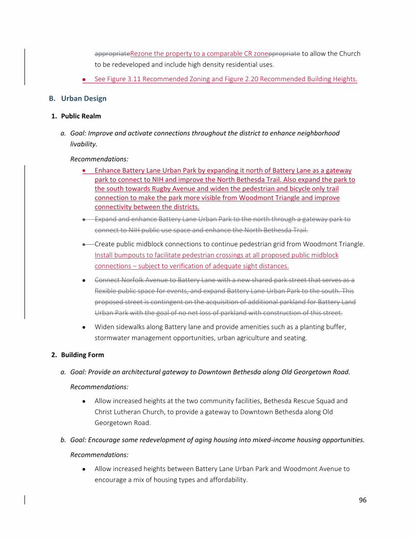
96
appropriateRezone the property to a comparable CR zoneppropriate to allow the Church
to be redeveloped and include high density residential uses.
See Figure 3.11 Recommended Zoning and Figure 2.20 Recommended Building Heights.
B. Urban Design
1. Public Realm
a. Goal: Improve and activate connections throughout the district to enhance neighborhood
livability.
Recommendations:
Enhance Battery Lane Urban Park by expanding it north of Battery Lane as a gateway park to connect to NIH and improve the North Bethesda Trail. Also expand the park to the south towards Rugby Avenue and widen the pedestrian and bicycle only trail connection to make the park more visible from Woodmont Triangle and improve connectivity between the districts.
Expand and enhance Battery Lane Urban Park to the north through a gateway park to
connect to NIH public use space and enhance the North Bethesda Trail.
Create public midblock connections to continue pedestrian grid from Woodmont Triangle.
Install bumpouts to facilitate pedestrian crossings at all proposed public midblock
connections – subject to verification of adequate sight distances.
Connect Norfolk Avenue to Battery Lane with a new shared park street that serves as a
flexible public space for events, and expand Battery Lane Urban Park to the south. This
proposed street is contingent on the acquisition of additional parkland for Battery Land
Urban Park with the goal of no net loss of parkland with construction of this street.
Widen sidewalks along Battery lane and provide amenities such as a planting buffer,
stormwater management opportunities, urban agriculture and seating.
2. Building Form
a. Goal: Provide an architectural gateway to Downtown Bethesda along Old Georgetown Road.
Recommendations:
Allow increased heights at the two community facilities, Bethesda Rescue Squad and
Christ Lutheran Church, to provide a gateway to Downtown Bethesda along Old
Georgetown Road.
b. Goal: Encourage some redevelopment of aging housing into mixed‐income housing opportunities.
Recommendations:
Allow increased heights between Battery Lane Urban Park and Woodmont Avenue to
encourage a mix of housing types and affordability.
97
3.3.2 Eastern Greenway Districts
North of East West Highway: This area forms a transitional area between the single‐family houses of East
Bethesda and commercial structures of the Central Business District. It is characterized by low‐density,
primarily residential development, green open spaces and paved parking lots screened with landscaping.
The western edge of the transition area is the CBD line. The existing Sector Plan boundary currently
defines the district on the north and east. Along the southern edge, the area includes the playing fields
and most of the Bethesda‐Chevy Chase High School buildings.
From Chestnut Street to Middleton Lane, the transitional area comprises single‐family houses as well as
multi‐family residential in the form of 30 garden apartments, two small public parks, Public Parking Lot 25
and a privately owned vacant lot used for commercial parking. The garden apartments on Tilbury Street
predated the 1976 Bethesda Central Business District Sector Plan and the two parks, recommended by
the 1976 Plan, are stable, transitional land uses.
The area is located only half a block from the commercial uses within the Downtown Bethesda area on
Wisconsin Avenue, and redevelopment of Wisconsin Avenue North sites will have an impact on the
transitional area and the East Bethesda neighborhood.
South of East West Highway: This area functions as a transitional area between the single‐family
residential Town of Chevy Chase and commercial Downtown. It is characterized by green public open
spaces, several parking lots and a single block of residential and commercial uses, including a County‐
owned structure. The boundary of the area is the CBD line on the west and 46th Street and West Avenue
on the east.
Primary land uses include the two‐acre Elm Street Park at the northern end, between Elm Street and
Willow Lane, and Public Parking Lots 24 and 10. Elm Street Park serves as a stable, transitional use,
enjoyed by both Town of Chevy Chase residents and CBD employees.
The Eastern Greenway Districts are intended as both transitional areas and amenities between the
Wisconsin Avenue Corridor and adjacent single‐family neighborhoods. The aim is to make the best use of
land near the Bethesda Metrorail Station and reduce the impervious surfaces of existing parking lots with
a balance of new development and a connected network of parks and open spaces.
A. Land Use and Zoning
1. Goals:
Ensure the stability of the land uses in the transitional area to preserve East Bethesda and
the Town of Chevy Chase as single‐family residential neighborhoods.
Prevent overflow parking and cut‐through traffic from having an undesirable impact on
the East Bethesda neighborhood and Town of Chevy Chase.
98
Make the best use of land near the Bethesda Metrorail Station and future Purple Line
station by promoting redevelopment of under‐utilized properties and County surface
parking lots.
Provide a compatible transition between higher density development along Wisconsin
Avenue and the East Bethesda and Town of Chevy Chase neighborhoods.
Provide a green connector and a buffer along the eastern edge of the Sector Plan area.
2. Recommendations:
a. Zoning
Rezone some of the R‐60 properties to a mixed‐use zone to facilitate redevelopment of
underutilized properties and County surface parking lots. The CRT zoning would be an
appropriate zone as a transitional zone area from the higher density commercial along
Wisconsin Avenue to the single‐family residential neighborhoods of East Bethesda and
Town of Chevy Chase. (See Figure 3.14 Recommended Zoning and Figure 2.20 Proposed
Building Heights).
Rezone the current townhouse development between Chestnut Street and Rosedale
Avenue zoned RT‐12.5 to a THD zone. With the adoption of the new County Zoning
Ordinance in October 2014, RT zones are being phased out and the new townhouse zones
implemented through the master planning process.
PLD lots #24 and #10: Language will be added to this section at a later date once the
details have been worked out by staff and the Planning Board.
Rezone and redevelop the properties along Maple Avenue and Highland Avenue, and
bounded by Tilbury Street that are currently zoned R‐60. The CRT 0.5, C‐0.25, R‐0.5 H‐70
zone would allow redevelopment at an appropriate scale and provide a transition from the
taller development along Wisconsin Avenue to the East Bethesda neighborhood.
Rezone and redevelop the properties along Highland Avenue and West Virginia Avenue,
and bounded by Tilbury Street that are currently zoned R‐60 and CRT‐0.5. The CRT 0.5, C‐
0.25, R‐0.5 H‐70 zone would encourage redevelopment at an appropriate scale and
provide a transition from the taller development along Wisconsin Avenue to the East
Bethesda neighborhood.
Provide redevelopment opportunities for the properties along West Virginia and Chase
Avenue, and bounded by Tilbury Street that are currently zoned R‐60. The CRT 0.5, C‐0.25,
R‐0.5 H‐70 zone would allow redevelopment at an appropriate scale and provide a
transition from the taller development along Wisconsin Avenue to the East Bethesda
neighborhood.
Provide redevelopment opportunities for the properties along Chase Avenue and
Cheltenham Drive, and bounded by Tilbury Street that are currently zoned R‐10. The CRT
99
0.5, C‐0.25, R‐0.5 H‐70 zone would allow for redevelopment at an appropriate scale and
provide a transition from the taller development along Wisconsin Avenue to the East
Bethesda neighborhood.
Redevelop Public Parking Lots 24 and 10 currently zoned R‐60. The CRT 0.5, C‐0.25, R‐0.5
H‐70 zone would allow redevelopment at an appropriate scale and provide a transition
from the taller development along Wisconsin Avenue to the Town of Chevy Chase along
46th Street.
Provide redevelopment opportunities for the properties located between Walsh Street
and Stanford Street that front West Avenue and are currently zoned R‐60 (6 properties).
The CRT – 0.5, C‐0.25, R‐0.5, H‐70 zone would allow redevelopment at an appropriate
scale and provide a transition from the taller development along Wisconsin Avenue to the
Town of Chevy Chase along West Street.
Provide redevelopment opportunities for the properties located between Stanford Street
and Bradley Boulevard that front West Avenue and are currently zoned R‐60 (8
properties), including the St. John’s property. The CRT – 0.5, C‐0.5, R‐0.5, H‐70 zone would
allow redevelopment at an appropriate scale and provide a transition from the taller
development along Wisconsin Avenue to the Town of Chevy Chase along West Street.
Eliminate the Transferable Development Rights (TDR) designation.
B. Urban Design
1. Public Realm and Building Form
a. Goal: Height limits and greenway setbacks will ensure compatibility with adjacent neighborhoods,
provide public open space, improve connections and enhance environmental benefits.
Recommendations:
Tier building heights based on the amount and type of green space provided (see Section
4.4 Implementation).
o Tier 1 Green Street: The green street should be designed todesigned to
accommodate elements such as tree canopy, wide sidewalks and stormwater
management.
o Tier 2 Greenway: The greenway should be designed to accommodate elements
such as tree canopy and vegetation; wide pathways; seating; stormwater
management; and activity space, such as small play areas, exercise stations and
community gardens.
o Tier 3 Neighborhood Green: The neighborhood green should be designed
todesigned to accommodate space for informal recreation and activities, tree
canopy and vegetation, wide pathways, seating and stormwater management.
100
Activate ground floors facing onto the greenway, provide entries, articulate/step back
upper floors and encourage balconies to ensure that the greenway‐facing façade is
compatible with adjacent neighborhoods and is not designed as the back of the building.
Encourage provision of a Tier 3 Neighborhood Green or a larger destination park adjacent
to the Farm Women’s Cooperative Market to provide green space and programming
within a short walk of the future Metrorail station entrance and Purple Line station.
Allow structured parking to be built underneath the greenway or neighborhood green
with sufficient soil depth for tree planting.
On blocks with existing single‐family homes, the greenway only occurs if the entire block is
redeveloped.
3.3.3 South Bethesda District
South Bethesda is an established residential neighborhood situated north of Norwood Local Park, a major
area amenity. The district has a garden character with tree‐lined streetscapes and planted setbacks, and
offers several opportunities to create better connections for pedestrians and bikes within the district and
to surrounding destinations.
The residential community on either side of Bradley Boulevard is composed predominately of garden
apartments and townhouses, except for a neighborhood of single‐family houses in the north‐west
section. There are 650 rental garden apartments built primarily in the 1950s along Strathmore Street,
Bradley Boulevard and Chevy Chase Drive. Within the existing Sector Plan area, about 170 townhouses
are situated along Bradley Boulevard, Offutt Lane, Hillandale Road and Chevy Chase Drive, many
substantially renovated in the 1970s.
In the Sacks subdivision on Leland Street and Wellington Drive, zoned R‐60, there are 60 single‐family
houses occupied by both long‐time residents and more recent homeowners. Plan preparation included
numerous discussions with the residents of the Sacks neighborhood about the viability of this subdivision
as a single‐family neighborhood so close to Downtown Bethesda and the recent development of Lot 31.
Approximately half of the homeowners in the Sacks Neighborhood would like their properties to be
rezoned to a higher density to allow for more redevelopment opportunities, according to letters received
by the Planning staff. The other 50 percent of the homeowners believe that the neighborhood is desirable
for close‐in urban living and seek County support to deter cut‐through traffic.
A. Land Use and Zoning
1. Goals:
Preserve the existing market‐rate affordable multi‐family housing.
Promote enhanced redevelopment opportunities to foster a quality mix of housing options.
Confirm R‐60 zoning for the Sacks neighborhood.

101
Enhance pedestrian connectivity to Norwood Local Park.
Improve pedestrian and bike safety along Bradley Boulevard.
Extend Strathmore Street to Chevy Chase Drive.
2. Recommendations:
a. Land Use
Extend Strathmore Street south across Bradley Boulevard to Chevy Chase Drive to provide
additional access and mobility from Downtown Bethesda to south of Bradley and
Norwood Local Park. (see Transportation Section in Chapter Two).
Provide urban design and streetscape guidelines to improve pedestrian safety along
Bradley Boulevard.
Continue the application of County programs to ensure that existing market‐rate housing
remains affordable.
Preserve existing apartments and townhouses in South Bethesda to ensure a variety of
housing types and retain a major source of moderately priced housing.
b. Zoning
Confirm the existing R‐60 zoning in the Sacks subdivision to retain the single‐family
detached houses along Leland Street and Wellington Drive. The Plan supports efforts to
preserve the viability and residential integrity of the neighborhood as an alternative to
multi‐family living in the Sector Plan area.
Rezone all Employment Office (EOF) properties in the South Bethesda District to a
comparable Commercial Residential (CR) zone to promote infill redevelopment (See Figure
3.17 Recommended Zoning and Figure 2.20 Proposed Building Heights).
Provide redevelopment opportunities for the Cokinos family property located along Chevy
Chase Drive that is currently zoned EOF 3.0 H‐35. Rezoning this property to CR‐3.5, C‐1.0,
R‐3.5, H‐70 feet would allow the redevelopment of the site to include office and low
density residential.
Extend a pedestrian pathway along the east edge of the Cokinos family property
toproperty, Lot 6, Block 1, to allow for a more formalized public access to Norwood Local
Park from Downtown Bethesda.
Rezone some of the R‐10 properties bound by Offutt Lane, Wellington Drive, east‐side of
Strathmore Street, to the south of Chevy Chase Drive at the Sector Plan Boundary, to a
comparable CR zone to promote infill redevelopment compatible with the South Bethesda
neighborhood (See Figure 3.17 Recommended Zoning and Figure 2.20 Proposed Building
Heights).
102
Provide redevelopment opportunities for the Aldon Management Properties located at
the corner of Strathmore Street and Bradley Boulevard that are currently zoned R‐10.
Zoning the properties to CR‐1.5 (C‐0.5, R‐1.5, H‐70) would allow the property to be
designated as a priority sending site for density transfer to preserve existing market‐rate
affordable housing and to provide opportunities for some redevelopment.
Provide redevelopment opportunities for the Bradley View Apartments properties along
Bradley Boulevard that are currently zoned R‐10. The CR‐1.5 (C‐0.25, R‐1.5, H‐70) zone
would allow the property to be designated as a priority sending site for density transfer to
preserve existing market‐rate affordable housing and provide opportunities for some
redevelopment.
Allow redevelopment of the Strathmore Street Apartments on Strathmore Street that are
currently zoned R‐10. The CR‐1.5, C‐0.25, R‐1.5, H‐70 zone would be appropriate to allow
the redevelopment of the site to include medium density residential.
Provide redevelopment opportunities for the Aldon Management Properties located south
of Bradley Boulevard, between Bradley Boulevard and Chevy Chase Drive that are
currently zoned R‐10. The CR‐1.5 (C‐0.25, R‐1.5, H‐70) zone would allow the property to
be designated as a priority sending site for density transfer to preserve existing market‐
rate affordable housing and to provide opportunities for some redevelopment.
Provide redevelopment opportunities for the Barclay Apartments (HOC/Chevy Chase
Development Corporation) properties located on Bradley Boulevard and Chevy Chase
Drive that is currently zoned R‐10., by rezoning the property to a CR . The CR‐3.0 (C‐0.25,
R‐3.0, H‐70) zone would allow the property to be designatedzone. Designate the property
as a priority sending site for density transfer to preserve existing market‐rate affordable
housing and to provide opportunities for some redevelopment.redevelopment (See Figure
3.17 Recommended Zoning, Figure 2.20 Proposed Building Heights and Figure 4.01
Proposed Priority Sending Sites)...
Allow redevelopment potential of the Bethesda Fire Department site located at the corner
of Bradley Boulevard and Wisconsin Avenue that is currently zoned R‐10. The CR‐1.5, C‐
1.5, R‐1.5, H‐70 zone would be The CR‐1.5, C‐1.5, R‐1.5, H‐70 zone would be The CR‐1.5,
C‐1.5, R‐1.5, H‐70 zone would be The CR‐1.5, C‐1.5, R‐1.5, H‐70 zone would be by
recommending a CR Floating . The CR‐1.5, C‐1.5, R‐1.5, H‐70 zone would be Zone that
would allow for replacement of the fire station in order to maintain service to the
community and to allow additional uses on the property. The Bethesda Fire Department
property would retain the base zone of R‐10 with a maximum height of 35 feet until the
floating zone of CR 1.5, C‐1.5, R‐1.5, H‐70 is applied for and approved by the County
Council through the process outlined in the Montgomery County Zoning Ordinance (See
Figure 2.20 Proposed Building Heights). For the undeveloped portion of the property to
the west of the Fire Station facility, facilitate several possible scenarios, which is identified
103
as a potential open space in Chapter 2.7 and on Figure 2.19 Public Open Space, including
park acquisition and partial redevelopment combined with park dedication.appropriate to
replace the fire station and redevelop the site to include medium density residential
housing.
Allow redevelopment of the Aldon Management Property located south of Chevy Chase
Drive currently zoned R‐10. The CR‐1.5 (C‐0.25, R‐1.5, H‐70) zone would allow the
property to be designated as a priority sending site for density transfer to preserve
existing market‐rate affordable housing and to provide opportunities for some
redevelopment.
Provide redevelopment opportunities for 4720 Chevy Chase Drive Condominium property
located south of Chevy Chase Drive currently zoned R‐10. The CR‐1.5, C‐0.25, R‐1.5, H‐70
zone would be appropriate to allow the redevelopment of the site to include medium
density residential.
Provide redevelopment opportunities for 4702 Chevy Chase Drive property located south
of Chevy Chase Drive currently zoned R‐10. The property is currently a large single‐family
house being used as a dental office. The CR‐1.5, C‐0.25, R‐1.5, H‐70 zone would be
appropriate to allow the redevelopment of the site to include medium density residential.
B. Urban Design
1. Public Realm
a. Goal: Improve connectivity throughout the district and between Downtown Bethesda and
Norwood Local Park.
Recommendations:
Create midblock connections through long blocks to improve walkability and connections
to other districts. Install bumpouts to facilitate pedestrian crossings at all proposed public
midblock connections – subject to verification of adequate sight distances.
Improve visibility and connectivity to Norwood Local Park especially in locations where
people’s choice trails currently connect Chevy Chase Drive to the north side of the park.
b. Goal: Provide opportunities for small neighborhood‐oriented open spaces within this residential
area.
Recommendations:
Consider creating a plaza at Bradley Boulevard and Strathmore Street as a central
gathering place for the district.
Consider creating a neighborhood green near the Sacks neighborhood to serve as a
gathering and play area.
104
2. Building Form
a. Goal: Encourage some redevelopment of aging housing into mixed‐income housing opportunities.
Recommendation:
Allow increased heights on properties along Bradley Boulevard and Chevy Chase Drive east
of Offutt Lane, including the Bethesda Fire Department. Redevelopment would allow for
low to mid‐rise buildings compatible with existing housing types in the immediate area.
3.3.4 Arlington North District
The Arlington North District is a transitional zone between the urban core and single‐family
neighborhoods to the west of the Sector Plan area. Houses used as offices are located along both
Montgomery Lane and Arlington Road. The district is located between Woodmont Avenue and Arlington
Road, and extends from Hampden Lane to Moorland Lane. The form of new development has been mid‐
to high‐rise apartments.
Most houses along Arlington Road have been converted to offices, with their use limited to a few
professional office categories. Some properties along Montgomery Lane are also in office use.
There are opportunities for both open space and connectivity improvements to enhance this area for
residents. West of Arlington Road, the institutional buildings and park spaces provide a buffer to the
single‐family homes. East of Arlington Road, heights should continue to step up as the buildings approach
Woodmont Avenue.
A. Land Use and Zoning
1. Goals:
Retain residential scale along Arlington Road as a transition between the urban core and
suburban neighborhoods.
Improve access, mobility and pedestrian safety along Arlington Road.
Promote redevelopment opportunities for under‐utilized sites such as single‐family
homes.
Limit commercial and retail uses to preserve residential urban village character.
Create a new neighborhood park adjacent to Bethesda Elementary School.
2. Recommendations:
a. Land Use
Limit commercial and retail uses to Woodmont Avenue on the ground floor.
Create a neighborhood park adjacent to the Bethesda Elementary School. The site is
currently includes play courts and a playground (See Section 2.6, Parks and Open Space).
105
b. Zoning
Rezone the five R‐60 properties in this District to a compatible CR zone.comparable CR
zone reflective of the surrounding density (See Figure 3.19 Recommended Zoning and
Figure 2.20 Proposed Building Heights).
Provide redevelopment opportunities for the Mooreland LLC site along Moorland Lane
next to the Shell gas station that is currently zoned CRN‐0.5. The site is currently a single‐
family home being used as office space. The CR‐2.25, C‐0.5, R‐2.0, H‐120 zone would be
appropriate to allow compatible redevelopment options in this district.
Redevelop 7505 Arlington Road, a single‐family house in the Edgemoor community that is
currently zoned R‐60. The property is situated within a block of office uses and high
density apartments. The CR‐2.0, C‐0.25, R‐2.0, H‐50 zone would be appropriate to allow
compatible redevelopment options in this location.
Redevelop the 4885 Edgemoor Lane site at the corner of Edgemoor Lane and Woodmont
Avenue that is currently zoned R‐60. The site is currently a single‐family home. The CR‐2.5,
C‐0.5, R‐2.5, H‐120 zone would be appropriate to allow compatible redevelopment
options in this area and its proximity to the Bethesda Metrorail Station.
Provide redevelopment opportunities for 4824 Edgemoor Lane site at the corner of
Edgemoor Lane and Woodmont Avenue that is currently zoned R‐60. The site is currently
a single‐family home being used as office space. The CR‐2.5, C‐0.5, R‐2.5, H‐120 zone
would be appropriate to allow compatible redevelopment options in this area and its
proximity to the Bethesda Metrorail Station.
Provide redevelopment opportunities for two properties on West Lane that are currently
zoned R‐60. The properties are interior to the block and are currently single‐family
detached homes on a block of office uses and high density apartment buildings. Rezoning
to CR‐2.5, C‐0.25, R‐2.5, H‐70 would be appropriate to allow compatible redevelopment
options in a block of high density residential and low‐rise office uses.
Limit height of new development along Arlington Road to a maximum of 60 feet.
B. Urban Design
1. Public Realm
a. Goal: Provide additional open space to serve the Arlington North District and surrounding
neighborhoods and enhance bike connectivity.
Recommendations:
Provide a public open space and a recreation space connected to the Bethesda
Elementary School north of Edgemoor Lane to serve both the school and surrounding
residents.
106
Improve bike connectivity along Arlington Road and Edgemoor Lane.
Improve the green buffer at Caroline Freeland Urban Park by adding an additional parcel
of property.
2. Building Form
a. Goal: Transition Heights from Woodmont Avenue west to single‐family residential neighborhoods.
Recommendation:
Maintain the majority of heights as currently allowed, except the intermittent R‐60
properties with a 35‐foot maximum height. These R‐60 properties should align with
surrounding allowable heights and transition from high‐rise buildings along Woodmont
Avenue to low‐ to mid‐rise along Arlington Road.
107
Chapter 4: Implementation The Downtown Bethesda Plan will be implemented through incremental redevelopment over time
consistent with the County’s current subdivision staging policies. Recognizing that Bethesda is a mixed‐use
area, most of the Downtown is recommended for continued Commercial Residential (CR) or Commercial
Residential Town (CRT) zoning, with significant flexibility to develop a mix of residential and non‐residential
uses. At the same time, there are certain public amenities and benefits that are critical to the economic,
sustainability and quality‐of‐life goals of this Sector Plan.
108
4.1 Zoning
4.1.1 Commercial Residential (CR) and Commercial Residential Town (CRT)
Zoning
The CR and CRT zones in Downtown Bethesda allow higher density under the County’s optional method
of development, but require public amenities to support the additional density. Ensuring the right mix of
public benefits in connection with future development in Bethesda is crucial for realizing this Sector Plan’s
vision for a vibrant, pedestrian‐oriented urban center. Therefore, one of the key implementation
strategies of this Plan is to clearly identify those public benefits. This Plan identifies certain public
benefits as a top priority, meaning that an optional method development should be approved only if it
provides the recommended benefit.
4.1.2 Bethesda Overlay Zone (BOZ) In general, an overlay zone is a mapped district placed over the standard, underlying zone that modifies
the uses or development requirements of the zone. An overlay zone imposes requirements or restrictions
in addition to, or in place of, those of the underlying zoning classification. In theory, an overlay zone can
be either more restrictive or less restrictive than the standards and requirements of the underlying zoning
classification. Overlay zones are appropriate where there is a special public policy interest that cannot be
met by either the standards of the underlying zone or by rezoning to a different zone. The intent of an
overlay zone is to provide requirements and standards that are necessary to achieve the planning goals
and objectives for development or redevelopment of an area. Overlay zones are created in areas of
critical public interest and provide uniform, comprehensive development regulations for an area. An
overlay zone can only be applied when it has been recommended by a Master Plan and must be
implemented by a Sectional Map Amendment.
The CR family of zones provides significant flexibility to tailor zoning to specific planning goals. This Sector
Plan relies as much as possible on this flexibility and other related existing tools to implement its
vision. However, certain of the planning goals for Downtown Bethesda require modifications to the
existing zoning. This Plan recommends the adoption of a Bethesda Overlay Zone as an important part of
a comprehensive zoning scheme that allows development consistent with the land use vision of this
Sector Plan without exceeding the amount of density that the planning area can support. The Bethesda
Overlay Zone is also intended to establish a funding mechanism for parks and open space critical to
support additional development, expand the County’s affordable housing inventory, ensure high quality
design through the use of a Design Review Advisory Panel and for the purpose of modifying the density
averaging rules for certain sites in the Plan area. In order to accomplish these objectives, this Plan
recommends zoning individual properties CR with the currently mapped density limit and the building
heights recommended in this Sector Plan along with the Overlay Zone.
More specifically, the Bethesda Overlay Zone will:
109
Cover all properties within the Sector Plan boundary.
Set a cap on development to ensure that total density in the Plan Area does, including mapped CR density, does not exceed approximately 32.4 million square feet.
Allow development to exceed the mapped CR density limit on a property if Overlay Zone density is available and the proposed development meets certain requirements.
Establish the requirements for additional density received through the Bethesda Overlay Zone, including a requirement to provide a Park Impact Payment, provide 15 percent MPDUs and participate in a Design Review Advisory Panel at the Concept Plan and/or Sketch Plan application phase.
Establish the process for obtaining approval of a development with Overlay Zone density and using it in a timely manner so that unused density is not hoarded.
Modify the density averaging rules to encourage transfers of density from the Priority Sending Sites identified in this Sector Plan
The CR family of zones provides significant flexibility to tailor zoning to specific planning goals. This Sector
Plan relies as much as possible on this flexibility and other related existing tools to implement its vision.
However, certain of the planning goals for Downtown Bethesda require minor modifications to the
existing zoning. This Plan recommends the adoption of a Bethesda Overlay Zone for the purpose of
modifying the density averaging rules for certain sites in the Plan area.
4.1.3 Public Amenities and Benefits
In the Bethesda Downtown, the following projects qualify for a fee in lieu payment under Section
6.3.6.C.2 of the County Zoning Ordinance:
A. Woodmont Triangle:
Streetscape improvements, especially on Norfolk Avenue.
Battery Lane Urban Park improvements.
B. Wisconsin Avenue Corridor:
Streetscape improvements.
Gateways from the north and south.
C. Pearl District:
Streetscape improvements.
Connection to Capital Crescent Trail.
Pedestrian and bicycle improvements.
D. Eastern Greenway:
Park improvements.
110
Streetscape improvements for pedestrians.
E. Battery Lane:
Streetscape improvements.
Gateway Park connection to North Bethesda Trail.
F. South Bethesda:
Connections to Norwood Local Park.
4.1.4 Public Benefits in the CR Zone
A. Top Priority Benefits
The following public benefits are of highest priority in all optional method projects:
1. Affordable Housing
This Plan recommends that optional method development in a High Performance Area should be
allowed only if it delivers certain affordable housing benefits. An optional method project that
includes residential dwellings should provide a minimum of 15 percent Moderately Priced Dwelling
Units (MPDUs).
2. Public benefits in High Performance AreaOpen Space
Optional method development within this Sector Plan should be allowed only if public open space is
provided, or making a payment for, open space in excess of the minimum open space requirement
of the zone as outlined in the criteria in the Commercial/Residential and Employment Zone Incentive
Density Implementation Guidelines.
3. Public benefits in High Performance Area and Enhanced Vegetated Roofs to Increase Green Cover
This Plan delineates a High Performance Area, which is targeted for properties within the Commercial
Residential (CR) zone in the Central Business District, where the greatest densities of development
and the tallest building heights are anticipated. This Plan recommends that optional method
development in a High Performance Area should be allowed only if the development delivers certain
energy efficiency benefits.
An optional method project in a High Performance Area should be approved only if it achieves the
maximum amount of public benefit points allowed for constructing buildings that exceed energy‐
efficiency standards for the building type. In order to qualify for the maximum available points, any
building over 4 stories that is located in whole or in part within the boundary of high High
performance Performance area Area would be required to exceed theexceed the current existing
ASHRAE standard 90.1 by 15 percent. Should the County approve the latest International Green
111
Construction Code (IgCC), building energy performance must rank two points lower (more efficient)
than the adopted standard.
If the County adopts a building code with a different efficiency standard, a building in the High
Performance Area should similarly exceed the ordinary efficiency standard. For example, if the
County approves the International Green Building Code (IgCC), building energy performance should
rank two points lower (more efficient) than the Zero Energy Performance Index (zEPI) score listed in
the International Green Building Code (IgCC) as locally amended or the latest adopted IgCC,
whichever is more recent.
2. Enhanced Vegetated Roofs to Increase Green Cover
In order to achieve ecological and energy efficiency goals for Downtown Bethesda, this Sector Plan
recommends the wide use of vegetated roofs. Given Bethesda’s density, the objectives for linking
greens spaces to create corridors, and the desire to reduce the heat island effect, this Plan
recommends increased soil depth for vegetated roofs that to will allow for the growth of more
substantial locally adapted plants, and greater stormwater treatment... Public benefit points for a
vegetated roof should be approved only if the soil depth is at least six inches.
4. Exceptional Design
As an overarching goal of this Plan as described on page 6, optional method development within this
Sector Plan should only be allowed if it achieves the maximum amount of public benefit points for
Exceptional Design as outlined in the criteria in the Commercial/Residential and Employment Zone
Incentive Density Implementation Guidelines.
5. Minimum Parking
This Plan makes certain parking recommendations to achieve the Plan goal of promoting a
constrained parking policy that supports a transit‐oriented downtown and to encourage the use of
travel models other than single occupancy vehicles. As a result, this Plan recommends that optional
method development should only be allowed if it achieves the maximum amount of public benefit
points for providing fewer than the maximum allowed number of parking spaces, where a maximum
is applicable as outlined in the criteris in the Commercial/Residential and Employment Zone
Incentive Density Guidelines.
B. Other Priority Benefits
The following public benefits should be considered priorities during project development and review
of optional method projects in the CR zone:
1. Public open space

112
2. Exceptional design
3. Minimum parking
4. Tree canopy
5. Provision of community facilities
113
4.2 Priority Sending Sites The CR and CRT zoning recommended by this Sector Plan allow density averaging – effectively, density
transfers from one site to another – within certain limits and provided that certain findings can be made.
Density averaging allows density to be combined and shifted around two or more contiguous or non‐
contiguous properties, subject to necessary regulatory approvals. The density averaging provisions of the
CR and CRT zones allow density transfers generally and replace the Woodmont Triangle‐specific density
transfer program of the former Sector Plan.
The Sector Plan also designates Open Space Priority Sending Sites, Landmark Priority Sending Sites and
Affordable Housing Sending Sites. Density transfers from these sites are encouraged to facilitate,
respectively, the creation or enlargement of urban parks, protection of significant landmarks and
retention of affordable housing. The Priority Sending Sites have been carefully chosen and the rules in
this Sector Plan are intended to apply only to the specifically delineated areas.
In order to achieve the specific densitydensity, transfer objectives of this Plan, the Downtown Bethesda
Overlay Zone must modify the default density averaging rules for a Priority Density Sending Site.
Specifically, on a designated Priority Density Sending Site, the following rules would apply:
Density from a Priority Sending Site may be included in a development application for any CR
or CRT‐zoned site within Downtown Bethesda. The purpose of this rule is to expand the
market for density from a Priority Density Transfer Site to beyond the normally applicable ¼‐
mile limit.
Density may be averaged with – or, in effect, transferred to – another site without being
included in a common sketch or a site plan. This practice removes uncertainty about whether
the transfer of density from a sending site would be approved in connection with a sketch or
site plan, and is appropriate because Priority Density Transfer Sites have been predetermined
to be appropriate for sending density. The resulting building mass and density on a receiving
site must still be approved through the usual approval process and subject to the usual
findings, but the purchaser of density from a Priority Sending Site knows upfront that the
density is available to use.
Exempt transferred density from a priority sending site on the receiving site from the
mandatory BLT purchase provisions of the CR zone.
Density from a priority sending site would be exempt from providing the 15 percent MPDUs
and would only be required to provide the 12.5 percent MPDUs under current law.
Density purchased from a Priority Sending Site would be exempt from providing the Park
Impact Payment required in the Bethesda Overlay Zone.
On a site identified in this Plan as an Open Space Priority Sending Site, all development rights
must be extinguished before the approval of any plan that uses such density in a density
114
averaging scheme. This rule will discourage a property owner from transferring partial
density, which might prolong the status quo at a site where the goal of this Plan is to
extinguish development density altogether. The owner of a Priority Density Transfer Site who
wishes to sell density from their site would place a covenant on the property, to be approved
by the M‐NCPPC, that would extinguish the right to have any density on the site and the
entire square footage attributable to the site would be available for use on another site or
sites. Under this approach, it will be necessary to document the creation of the transferrable
density and carefully track the use of the density at a receiving site.
On a site identified in the Plan as an Affordable Housing Priority Sending Site, all development
rights not associated with an existing structure must be extinguished before the approval of
any plan that uses such density in a density averaging scheme. As with an Open Space
Priority Density Sending Site, documentation of the extinguishment and tracking of the
associated density are essential. In addition, in order for the density from an Affordable
Housing Priority Sending Site to be transferred, the owner of such a development must enter
into a rental agreement to retain 30% of their existing affordable housing units, defined as 65
percent of Area Median Income (AMI) or below, for 20 years.a rental agreement to retain the
existing number of affordable housing units, defined as 65 ‐ 100 percent of area median
income (AMI), for 20 years.
On a Landmark Priority Sending Site, all development rights not associated with an existing
structure must be extinguished before the approval of any plan that uses such density in a
density averaging scheme.
Density from a Priority Sending Site may be used at more than one receiving site. This rule
addresses the likelihood that all of the density from a Priority Sending Site cannot be used at
one receiving site.
If an Open Space or Landmark Priority Sending Site is dedicated to the M‐NCPPC
Montgomery County Department of Parks, it may qualify for public benefit points as a major
public facility. However, if density is transferred off of a Priority Sending Site, the dedication
of that site to the M‐NCPPC Montgomery County Department of Parks does not qualify for
public benefit points as a major public facility.
Surface parking is not allowed on a Priority Sending Site.
Recommending an overlay zone is not the only way in which this Plan seeks to facilitate the transfer of
density from Priority Sending Sites. This Plan also recommends that Open Space and Affordable Housing
Priority Sending Sites be zoned to allow for development completely as residential or commercial
development. These zones maximize the flexibility with which the density from such sites can be used at a
receiving site.
115
4.3 Legacy Open Space Designations The Legacy Open Space program has evaluated all the propsed parks in the Bethesda Downtown Sector Plan to determine if
any sites merit designation as LOS Urban Open Spaces. After analysis and review with the LOS Advisory Group, Park Planning
and other Planning Department staff, staff has identified additional sites of countywide significance that should be designated
as LOS Urban Open Spaces: The Capital Crescent Civic Green and the Eastern Capital Crescent Urban Greenway. These
recommended sites in Bethesda complement two sites already designated in the Planning Board Draft of the Westbard Sector
Plan.
The unifying theme for these four Urban Open Spaces is that they provide for a variety of types of green
and recreational spaces along the County’s most heavily used trail, the Capital Crescent Trail. The four
sites include two Urban Greenways, one Countywide Urban Recreational Park, and one Central Civic
Green. These sites all meet the LOS criteria to increase access to open space and recreation in dense
urban communities, to promote interconnectivity of the urban green infrastructure, and to provide
community open space for casual use and large community gatherings. These park spaces adjacent to
the Capital Crescent Trail clearly rise to the level of being “best of the best” open spaces in the entire
County that deserve designation in LOS and active efforts to implement as public parkland.
Designation of these sites in the LOS Functional Master Plan via the Bethesda Downtown Plan provides
additional tools, including access to LOS funding, to make the implementation of these two parks a reality
as Bethesda moves forward as an urban destination to live, work and play.
Implementation: The Capital Crescent Civic Green meets the criteria to be designated as an Urban Open
Space of countywide importance within the Legacy Open Space Functional Master Plan (2001). This
critical civic green will create one of the primary green spaces in the center of Bethesda.4.3 It will
provide key community open space for recreation and casual use by the large population center in this
community, as well as support trail usage and special events to serve the entire County. Designating this
site in the Legacy Open Space Functional Master Plan here provides for the use of Legacy Open Space
tools and funding to implement this park recommendation.
Implementation: The Eastern Capital Crescent Urban Greenway meets the criteria to be designated as an Urban Open Space
within the Legacy Open Space Functional Master Plan (2001). This new Urban Greenway will increase access between one of
the most important trail corridors in the County and the center of Bethesda and will provide key additional recreational open
space to a community with high population density. Designating this site in the Legacy Open Space Functional Master Plan
here provides for the use of Legacy Open Space tools and funding to implement this park recommendation.

116
4.4 On-Site Public Open Space Adequate public open space is critical to meeting this Sector Plan’s goal of making Downtown Bethesda a
better place to live, work and play. Downtown Bethesda has a considerable amount of open space, but
more important to its future is the right quality of space that serves the goal of enhancing the public
realm. Too often in the past, the goal of obtaining public open space has resulted in site layouts that
provide the required amount of space, but in a way that fails to enhance the public realm. In some
instances, buildings are set back from the street to make room for a public open space and, in the
process; the activating benefit of positioning the building closer to the street is lost. In other instances, a
public use space may be located on the interior of a block, so that it cannot be experienced from any
public thoroughfare. In other instances, public use space is simply too small to perform a meaningful
function.
In order to ensure the right amount and quality of public open space, this Sector Plan recommends offsite
improvements or contributions, instead of public open space that is too small, fails to enhance the public
realm and prevents a building from activating the street. This Plan further recommends that any project
whose public open space requirement under the County Zoning Ordinance is less than 10 percent be
required to make an improvement or contribution to offsite public open space under Section 6.3.6.C of
the County Zoning Ordinance and that the Bethesda Overlay Zone reflect this requirement.
117
4.5 Greenway In order to provide a buffer between the Wisconsin Avenue corridor and existing residential
neighborhoods, and enhance connectivity, the Sector Plan calls for greenways in certain areas. The
maximum heights will be established through the County’s Sectional Map Amendment (SMA). On a site
identified as a greenway, this Plan recommends that building heights be reduced below the maximum
height allowed in the applicable zone based on the setback from the street and the land be dedicated for
the greenway. This reduction in height applies to the entire parcel. In order to enhance compatibility with
the abutting residential neighborhood, the greater the setback, the lesser the reduction in the allowed
building height, as follows:
Tier 1 Green Street: For a building set back 20 feet‐35 feet from the curb, the maximum
building height is 35 feet.
Tier 2 Greenway: For a building set back 36 feet‐75 feet from the curb, the maximum
building height is 50 feet.
Tier 3 Neighborhood Green: For a building set back at a distance greater than 75 feet from
the curb, the maximum building height is 70 feet.
Similar to compatibility requirements in the zoning code, the maximum building height measurement for
each tier is taken from the average grade along the building facing the greenway.
This Plan further recommends that buildings with land dedicated to the greenway should be allowed to
build below‐grade parking under the dedicated area. Undergrounding of parking would be
developer/private responsibility only. The County would not take on the undergrounding of parking as
part of any recommended improvement projects for open space, greenway or private development.
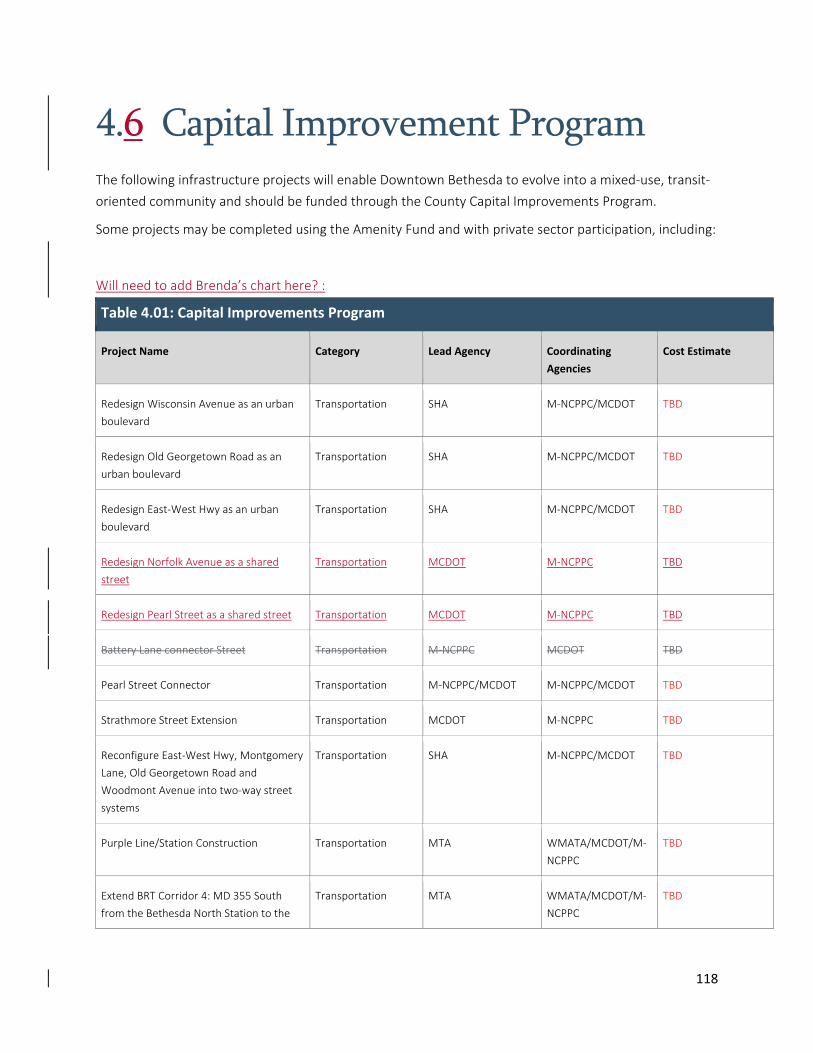
118
4.6 Capital Improvement Program The following infrastructure projects will enable Downtown Bethesda to evolve into a mixed‐use, transit‐
oriented community and should be funded through the County Capital Improvements Program.
Some projects may be completed using the Amenity Fund and with private sector participation, including:
Will need to add Brenda’s chart here? :
Table 4.01: Capital Improvements Program
Project Name Category Lead Agency Coordinating
Agencies
Cost Estimate
Redesign Wisconsin Avenue as an urban
boulevard
Transportation SHA M‐NCPPC/MCDOT TBD
Redesign Old Georgetown Road as an
urban boulevard
Transportation SHA M‐NCPPC/MCDOT TBD
Redesign East‐West Hwy as an urban
boulevard
Transportation SHA M‐NCPPC/MCDOT TBD
Redesign Norfolk Avenue as a shared
street
Transportation MCDOT M‐NCPPC TBD
Redesign Pearl Street as a shared street Transportation MCDOT M‐NCPPC TBD
Battery Lane connector Street Transportation M‐NCPPC MCDOT TBD
Pearl Street Connector Transportation M‐NCPPC/MCDOT M‐NCPPC/MCDOT TBD
Strathmore Street Extension Transportation MCDOT M‐NCPPC TBD
Reconfigure East‐West Hwy, Montgomery
Lane, Old Georgetown Road and
Woodmont Avenue into two‐way street
systems
Transportation SHA M‐NCPPC/MCDOT TBD
Purple Line/Station Construction Transportation MTA WMATA/MCDOT/M‐
NCPPC
TBD
Extend BRT Corridor 4: MD 355 South
from the Bethesda North Station to the
Transportation MTA WMATA/MCDOT/M‐
NCPPC
TBD
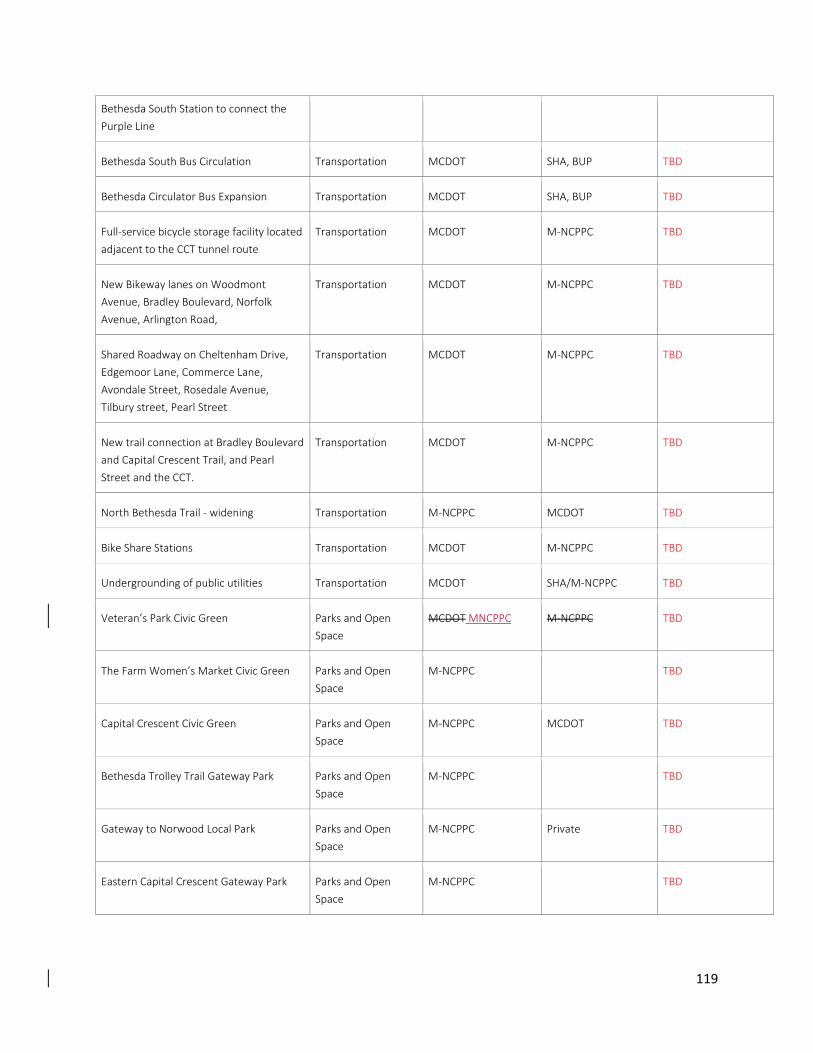
119
Bethesda South Station to connect the
Purple Line
Bethesda South Bus Circulation Transportation MCDOT SHA, BUP TBD
Bethesda Circulator Bus Expansion Transportation MCDOT SHA, BUP TBD
Full‐service bicycle storage facility located
adjacent to the CCT tunnel route
Transportation MCDOT M‐NCPPC TBD
New Bikeway lanes on Woodmont
Avenue, Bradley Boulevard, Norfolk
Avenue, Arlington Road,
Transportation MCDOT M‐NCPPC TBD
Shared Roadway on Cheltenham Drive,
Edgemoor Lane, Commerce Lane,
Avondale Street, Rosedale Avenue,
Tilbury street, Pearl Street
Transportation MCDOT M‐NCPPC TBD
New trail connection at Bradley Boulevard
and Capital Crescent Trail, and Pearl
Street and the CCT.
Transportation MCDOT M‐NCPPC TBD
North Bethesda Trail ‐ widening Transportation M‐NCPPC MCDOT TBD
Bike Share Stations Transportation MCDOT M‐NCPPC TBD
Undergrounding of public utilities Transportation MCDOT SHA/M‐NCPPC TBD
Veteran’s Park Civic Green Parks and Open
Space
MCDOT MNCPPC M‐NCPPC TBD
The Farm Women’s Market Civic Green Parks and Open
Space
M‐NCPPC TBD
Capital Crescent Civic Green Parks and Open
Space
M‐NCPPC MCDOT TBD
Bethesda Trolley Trail Gateway Park Parks and Open
Space
M‐NCPPC TBD
Gateway to Norwood Local Park Parks and Open
Space
M‐NCPPC Private TBD
Eastern Capital Crescent Gateway Park Parks and Open
Space
M‐NCPPC TBD
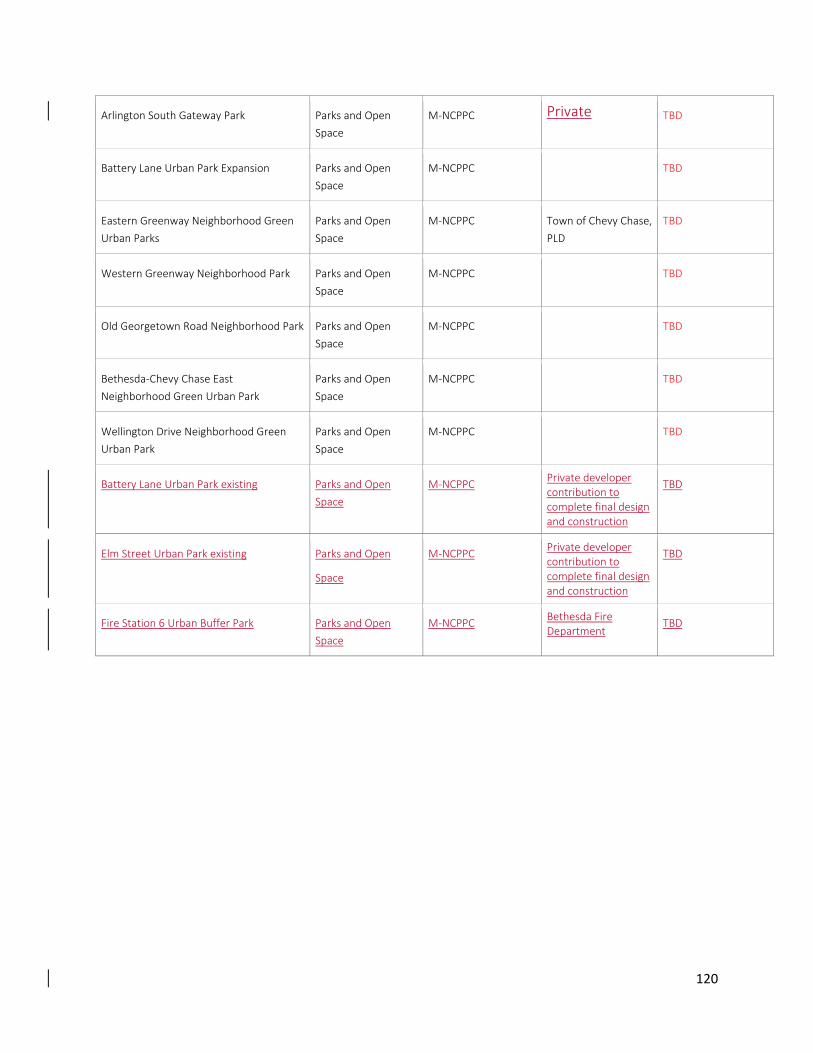
120
Arlington South Gateway Park Parks and Open
Space
M‐NCPPC Private TBD
Battery Lane Urban Park Expansion Parks and Open
Space
M‐NCPPC TBD
Eastern Greenway Neighborhood Green
Urban Parks
Parks and Open
Space
M‐NCPPC Town of Chevy Chase,
PLD
TBD
Western Greenway Neighborhood Park Parks and Open
Space
M‐NCPPC TBD
Old Georgetown Road Neighborhood Park Parks and Open
Space
M‐NCPPC TBD
Bethesda‐Chevy Chase East
Neighborhood Green Urban Park
Parks and Open
Space
M‐NCPPC TBD
Wellington Drive Neighborhood Green
Urban Park
Parks and Open
Space
M‐NCPPC TBD
Battery Lane Urban Park existing
Parks and Open
Space
M‐NCPPC Private developer contribution to complete final design and construction
TBD
Elm Street Urban Park existing
Parks and Open
Space
M‐NCPPC Private developer contribution to complete final design and construction
TBD
Fire Station 6 Urban Buffer Park Parks and Open
Space
M‐NCPPC Bethesda Fire Department
TBD
121
4.7 Partnerships The Sector Plan supports continued cooperation between the public and private sectors to administer
and coordinate enhanced public services and private initiatives in Downtown Bethesda.
Montgomery County passed legislation in 1987 to create the Bethesda Urban District, a special
assessment district covering much of the Sector Plan area. Legislation passed in 1993 authorized the
creation of urban district corporations to provide certain services in each urban district. These functions
include maintaining and enhancing the streetscape; streetscape amenities; promotion, organization and
support of cultural and business activities; specialized transportation and similar activities.
This Plan supports the priorities of the Bethesda Urban Partnership, Arts and Entertainment District,
Regional Services Center, Parking Lot District, Woodmont Triangle Action Group, and Bethesda Green in
their common mission to provide enhanced public services to the residents and business community of
Downtown Bethesda.
4.6.1 Bethesda Urban Partnership (BUP)
Bethesda is home to numerous retailers, arts organizations, a thriving restaurant community and an
expansive downtown workforce. Established by Montgomery County in 1994, Bethesda Urban
Partnership (BUP) fulfills the landscaping and maintenance needs, and manages cultural events and
exciting festivals for the community. Over its 19 years of operation, BUP created Bethesda Transportation
Solutions (BTS) in 2000, established the Bethesda Arts and Entertainment District in 2002 and has grown
from two full‐time staff members to more than 35 employees working in maintenance, marketing,
transportation and administration.
The organization is an important instrument for implementing key objectives of the Sector Plan, including
retail enhancement, cultural district and streetscape objectives.
4.6.2 Arts and Entertainment District
The State of Maryland designated Downtown Bethesda as an Arts and Entertainment District effective
July 1, 2002. The 501(c)(3) non‐profit organization comprises a 12‐member board of directors as well as
an advisory committee of local artists and arts businesses representatives. The mission of the Bethesda
Arts and Entertainment District is to create and implement arts and entertainment projects that
contribute to the artistic, cultural and economic growth of Downtown Bethesda. Special tax incentives are
in place that benefit artists, arts enterprises and developers of projects located within the Bethesda Arts
and Entertainment District. The District produces the Bethesda Fine Arts Festival, The Trawick Prize:
Bethesda Contemporary Art Awards, Bethesda Painting Awards, Bethesda Art Walk, Dance Bethesda and
Play in a Day, and manages Gallery B and Studio B.
122
This Sector Plan supports the priorities of the Arts and Entertainment District as evidenced by
recommendations identified throughout this document.
4.6.3 Parking Lot District (PLD)
Montgomery County Department of Transportation administers, operates and maintains and enforces
the Downtown Bethesda Parking Lot District (PLD). The PLD is an independent taxing district with
obligations to bond holders who finance PLD facilities. Downtown Bethesda has 16 public parking garages
and surface lots that put residents and visitors within short walking distance of Downtown Bethesda
destinations.
This Sector Plan supports the redevelopment of County parking facilities along with replacement of
parking, and supports the priorities of the PLD and the recommendations as outlined in Section 2.2
Transportation.
4.6.4 Woodmont Triangle Action Group (WTAG)
Creation of the Woodmont Triangle Action Group (WTAG) was a recommendation of the 2006
Woodmont Triangle Amendment to the 1994 Sector Plan for the Bethesda CBD. The purpose of this
group is to coordinate and monitor the progress of development and retail revitalization, and the
provision of amenities and facilities in the Woodmont Triangle district of Downtown Bethesda.
Membership includes representatives from the M‐NCPPC, Bethesda Urban Partnership, Civic
Associations, Bethesda Transportation Solutions, Greater Bethesda‐Chevy Chase Chamber of Commerce,
Bethesda‐Chevy Chase Regional Services Center, Western Montgomery County Citizens Advisory Board
and other appropriate groups.
Unlike the 2006 Woodmont Triangle Amendment to the 1994 Bethesda CBD Sector Plan, the Bethesda
Downtown Sector Plan’s focus is Bethesda‐wide. The Woodmont Triangle Action Group in its current form
would not be worth retaining; however, some type of advisory group should be created to support the
implementation of the Sector Plan.
This Sector Plan supports the creation of a standing committee or an advisory group to address
implementation of this Sector Plan. The formation of any new standing committee or advisory group
should be initiated by the Board of the Bethesda Urban Partnership. This advisory group would work in
coordination with the Bethesda Urban Partnership and Bethesda Chevy‐Chase Regional Services Center
by providing specific community and redevelopment expertise that would also serve as an interface
between developers and County agencies in implementing the Bethesda Downtown Sector Plan
recommendations. This new group should reflect the current makeup of the WTAG in that it will be
structured to include representatives from the various constituencies interested in successful
implementation of the plan.
4.6.5 Bethesda Green
123
Bethesda Green is a public‐private partnership that promotes sustainable growth and sustainable living
practices in Downtown Bethesda. Bethesda Green brings together businesses, government agencies and
community residents to create a dynamic model of sustainable living. Bethesda Green created the first
green business incubator in Montgomery County and assists individuals in leading greener lives.
Bethesda Green achieves its mission by focusing on three strategic areas:
1. Incubate green businesses – Stimulate the next generation of sustainable businesses.
2. Educate the community about sustainability – Raise awareness and inspire action through
programs, online communications and education center.
3. Facilitate the implementation of green solutions – Advocate for physical infrastructure and
programs that make Bethesda a more sustainable community.
This Sector Plan supports the mission and priorities of Bethesda Green, as economic, social and
environmental sustainability is the hallmark of the Downtown Bethesda Sector Plan, as defined in Section
1.2 of this document. Bethesda Green’s mission and priorities are critical to achieving the goals of this
Plan.
4.6.6 Public Sector Partnerships within the Bethesda Community
The Sector Plan supports continued cooperation between the public sectors to administer and coordinate
enhanced public services and private initiatives in Downtown Bethesda.
This Sector Plan supports the priorities of enhancing the park and open space realm as evidenced by
recommendations identified throughout this document.
To this end, the Sector Plan continues to support and encourage the following partnerships:
Public Sector Partnerships
Example: Partnering with MNCPPC to provide Friends of Parks groups, to donate amenities to the parks,
to help community members earn student service hours, and to earn volunteer hours.
There are several community organizations that have made a significant commitment to parks over many
years. Each started by organizing an initial project and continuing the effort. While the department of
Parks does not have a formal Adopt‐A‐Park program, the plan encourages the development of long term
partners that are committed to helping meet the Park and Open Space needs.