central africa’s rainforests worldpdf.wri.org/gfw_centralafrica_full.pdf · central africa’s...
TRANSCRIPT
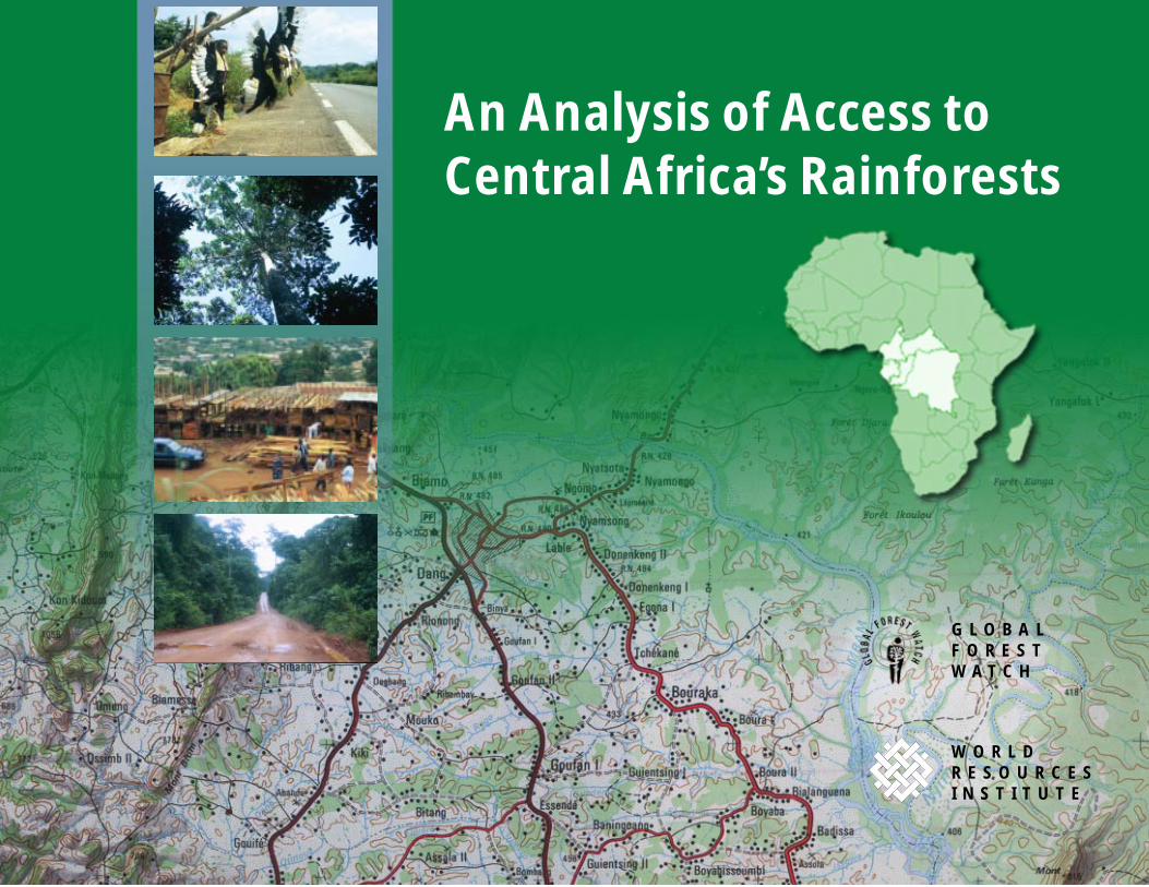
An Analysis of Access toCentral Africa’s Rainforests
W O R L DR E S O U R C E SI N S T I T U T E
G L O B A LF O R E S TW A T C H
iAN ANALYSIS OF ACCESS INTO CENTRAL AFRICA’S RAINFORESTS
An Analysis of Accessinto Central Africa’s Rainforests
by Susan Minnemeyer
with contributions fromTyson Walker
Jean-Gaël CollombLinda CottonDirk Bryant
an initiative of
World Resources InstituteWashington, DC
www.wri.org
ii AN ANALYSIS OF ACCESS INTO CENTRAL AFRICA’S RAINFORESTS
Karen HolmesEditor
Hyacinth BillingsProduction Manager
Maggie PowellLayout
Cover photographs1. © Jean Gaël Collomb2. © Jean Gaël Collomb3. © Jean Gaël Collomb4. © Jean Gaël Collomb
Each World Resources Institute report represents a timely, scholarlytreatment of a subject of public concern. WRI takes responsibility
for choosing the study topics and guaranteeing its authors and researchersfreedom of inquiry. It also solicits and responds to the guidance of
advisory panels and expert reviewers. Unless otherwise stated, however,all the interpreation and findings set forth in WRI publications are those
of the authors.
Copyright © 2002 World Resources Institute. All rights reserved.ISBN 1-56973-518-2
iiiAN ANALYSIS OF ACCESS INTO CENTRAL AFRICA’S RAINFORESTS
Acknowledgments
International, Global Witness, and the WorldResources Institute. David Kramer (WWF-US)helped us to update national roads datasets forcentral Africa.
In addition, we would like to thank the followingpeople who reviewed a draft version of the report:Phillippe Auzel, Dirk Bryant, Jennifer D’Amico,Tony Janetos, Jean-Jacques Landrot, NadineLaPorte, Emily Matthews, Ralph Ridder, MarcSteininger, Holly Strand, Dan Tunstall, CarolineTutin, Jacqueline van de Pol, Jean-Pierre VandeWeghe, and David Wilkie.
Ralph Ridder (GFW) and Dirk Bryant (GFW)oversaw the development of datasets for this studyand provided guidance on the preparation of thisreport. Geographic information systems (GIS)analysis for the study was performed by TysonWalker, Susan Minnemeyer, and Debra Fischman.
Global Forest Watch would like to thank Jacquelinevan de Pol (Tropenbos) for her contributions to theCameroon logging roads dataset, a pilot datasetprepared in the context of the project “État desLieux du Secteur Forestier au Cameroun” incollaboration with Nature+, Programme Tropenbos
GFW’s work in central Africa is supported by theU.S. State Department, the U.S. Agency for Inter-national Development, the Central African RegionalProgram for the Environment (CARPE), andAVINA. Our GIS and remote sensing work is madepossible by donations of software and training bythe Environmental Systems Research Institute, Inc.(ESRI) and ERDAS, Inc. Satellite images wereobtained from the University of Maryland throughNASA’s Land Use Land Cover Change (LULCC)program.
iv AN ANALYSIS OF ACCESS INTO CENTRAL AFRICA’S RAINFORESTS
Table of Contents
Key Findings ....................................................................................................................................................................... v
Introduction ....................................................................................................................................................................... 1
Why Identify Low-Access Forests in Central Africa? .................................................................................... 1
How This Analysis Was Conducted ........................................................................................................................ 3
How Much of Central Africa’s Forests Have Been Accessed? .................................................................. 7
Conclusion and Next Steps ..................................................................................................................................... 10
Appendix: Technical Notes ...................................................................................................................................... 13
References ........................................................................................................................................................................ 16
List of BoxesThe Importance of Central Africa’s Rainforest Ecosystems ...................................................................... 4
How Much Low-Access Forest is Required to Sustain Forest Species? .............................................. 6
Logging in Central Africa ......................................................................................................................................... 11
vAN ANALYSIS OF ACCESS INTO CENTRAL AFRICA’S RAINFORESTS
Key Findings
• Over two-thirds of central Africa’s forests stillqualify as large tracts of low-access forest i.e.,contiguous forest areas of at least 1,000 squarekilometers (km2), unbroken by public roads.Only South America’s Amazon basin has largerareas of undisturbed tropical forest.
• About a third of forests remain within very large(over 10,000 km2) tracts of low-access forest,primarily in the interior Congo Basin. Much ofthis is inhospitable swamp forest and/or islocated in very sparsely populated areas.
• However, our regional analysis did not factor inlogging roads, for lack of data. Pilot work forCameroon using satellite images suggests thatmuch of the forest mapped as low-access andfalling within concessions has, in fact, been
opened up by logging roads. New data show thatlogging roads provide logging access to 16% oflarge low-access forest tracts in Cameroon andhunting access to almost two-thirds of theseforests.
• At most, 35% of central Africa’s forests remainwithin large tracts of low-access forest that haveyet to be allocated for logging.
• Most large, low-access forest tracts in centralAfrican countries (except the DemocraticRepublic of Congo) are within active or allo-cated logging concessions.
• Only 8% of central Africa’s large tracts of low-access forest are in parks ands reserves, but eventhese protected areas are poorly managed.
�AN ANALYSIS OF ACCESS INTO CENTRAL AFRICA’S RAINFORESTS
�����������
In the absence of detailed information about centralAfrica’s rainforests, Global Forest Watch hasundertaken to provide a coarse-scale picture of theregion’s large tracts of low-access forest—i.e.,forests at least 2 kilometers (km) from public roadsand in contiguous blocks of at least 1,000 km2. Toidentify blocks of forest relatively undisturbed bycommercial-scale activities, we assessed the degreeto which these forest tracts were located in pro-tected areas or in areas allocated for logging. Thiscoarse-scale approach offers an indication of whichforests are more or less impacted by development,but overall it underestimates human access intoforests. Detailed data for Cameroon, unavailable forthe rest of central Africa, allowed us to examine theextent to which logging roads and other newlyconstructed transport routes are opening access intopreviously remote forest tracts (i.e., those identifiedin the coarser-scale regional analysis). This two-tiered approach offers insight into the potentialcondition of forests in logging concessions region-wide and reveals the need for improved roads data.
�� ������� ���������� ������� � ������� ������
population density is very low and, to date, defores-tation has been limited. The primary adverse impactof forest access in these regions is widespreaddefaunation (i.e, removal of animals from the forestfaster than their populations can recover) caused bycommercial-scale bushmeat hunting.
Improved road networks benefit people, but mayharm ecosystems. Improved road networks areessential to economic development and growth.They often indirectly harm the environment,however, as roads provide access to previouslyundisturbed forest. Road improvement increasesopportunities for trade by reducing the time andcosts required to transport goods to market. Roadscan enable previously isolated communities to gainaccess to education and medical services as well as
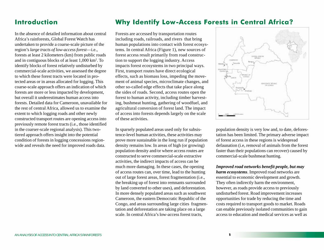
Forests are accessed by transportation routesincluding roads, railroads, and rivers that bringhuman populations into contact with forest ecosys-tems. In central Africa (Figure 1), new sources offorest access result primarily from road construc-tion to support the logging industry. Accessimpacts forest ecosystems in two principal ways.First, transport routes have direct ecologicaleffects, such as biomass loss, impeding the move-ment of animal species, microclimate changes, andother so-called edge effects that take place alongthe sides of roads. Second, access routes open theforest to human activity, including timber harvest-ing, bushmeat hunting, gathering of woodfuel, andagricultural conversion of forest land. The impactof access into forests depends largely on the scaleof these activities.
In sparsely populated areas used only for subsis-tence-level human activities, these activities mayprove more sustainable in the long run if populationdensity remains low. In areas of high (or growing)population density and/or where access routes areconstructed to serve commercial-scale extractiveactivities, the indirect impacts of access can bemuch more damaging. In these cases, the openingof access routes can, over time, lead to the huntingout of large forest areas, forest fragmentation (i.e.,the breaking up of forest into remnants surroundedby land converted to other uses), and deforestation.In more densely populated areas such as southwestCameroon, the eastern Democratic Republic of theCongo, and areas surrounding large cities fragmen-tation and deforestation are taking place on a largescale. In central Africa’s low-access forest tracts,

� AN ANALYSIS OF ACCESS INTO CENTRAL AFRICA’S RAINFORESTS
markets (FAO and ATIBT 1999). While roadnetworks are expanding rapidly in many areas ofcentral Africa especially eastern Cameroon, thenorthern Republic of the Congo, and the southerntip of the Central African Republic in much of theDemocratic Republic of the Congo, road infrastruc-ture has declined as a result of years of civil war.Future expansion of road networks in central Africais unavoidable and road improvements are a neces-sity for economic development, but, withoutappropriate interventions, environmental degrada-tion will accompany roads wherever they areconstructed.
A broad range of political, economic and culturalfactors drive the damaging effects of increasing forestaccess. These include political and economic instabil-ity, foreign debt, corruption, poverty, poor lawenforcement, and cultural traditions that place lowpriority on environmental protection. Such factorslead in turn to poor forest management, unsustainablelogging practices, semi-open access to forests, anduncontrolled commercial-scale bushmeat hunting—all of which contribute to the indirect environmentaldamage observed in central Africa in association withthe opening of new transport routes through the forest(Geist and Lambin 2001). The adverse impact ofroads likely cannot be reduced without also address-ing the broad underlying factors that contribute toenvironmental harm.
Access adversely impacts wildlife populations.Forest animals vary greatly in their ability totolerate roads, clearings, and agricultural areas thatmay separate forest areas. A landscape that servesas continuous habitat for one species may offer onlya limited usable habitat area for more sensitive
species. Species living in the tropical rainforest tendto be intolerant of conditions outside intact forest,making them sensitive to the barriers that roadscreate. Roads, especially heavily traveled ones witha corridor of cleared vegetation on either side, maybe a permanent barrier to the movement of someanimals, such as understory birds or small mammals(Bierregaard et al.1992, Forman and Alexander1998, Turner 1996). Infrequently used roads may,however, attract predator species that travel or huntalong roads as well as foraging herbivores that grazeon roadside vegetation (Forman and Alexander1998).
For other species, the presence of human popula-tions may be a more significant factor than theimpact of roads per se. Forest elephants, for ex-ample, are attracted to areas of secondary growth,such as abandoned logging concessions, fields orvillages, but hunted populations avoid comingwithin several kilometers of areas of current humanactivity (Barnes et al. 1991, Barnes et al. 1995,Wilkie and Morelli 1998). As road density in-creases, forests may become fragmented and forestspecies confined to smaller, isolated patches. Inareas of increasingly dense human populations,forests begin to be converted to agricultural andother uses.
Forest access facilitates commercial bushmeathunting. Perhaps the most severe impact of roadconstruction on wildlife populations in centralAfrica is the expanded movement of bushmeathunters into remote forest. In this region, wild gamecontributes nearly all of the animal protein con-sumed by forest-dwelling people. It is also a favoredfood of city dwellers, who are willing to pay
premium prices for bushmeat relative to meat fromdomesticated animals. Bushmeat has become asubstantial market commodity in cities throughoutcentral Africa and trade in this commodity isbecoming increasingly commercialized (Wilkie andCarpenter 1999, Wilkie et al. 2000). Increasedaccess to forests by hunters may lead to the localextirpation or extinction of animals through directdefaunation (Redford 1992, Rudel and Roper 1997).Because of the significant threat to wildlife fromover-hunting, many areas likely suffer from the“empty forest” syndrome (Redford 1992); i.e.,though forest cover remains, much of the nativefauna and flora may be locally extinct or in dangerof extinction (Terborgh 1992, Rudel and Roper1997, Saunders et al. 1991).
Logging facilitates bushmeat hunting by increasingaccess to formerly remote forest areas on newly builtroad networks. Improved access to such remote areasmeans that bushmeat can be transported to market bymotor vehicle in a fraction of the time required totake out game on foot. Logging vehicles oftenprovide transportation for bushmeat and hunters, andin many cases the concession employees themselvesearn a significant portion of their income by hunting(Wilkie and Carpenter 1999). The present level ofbushmeat hunting is unsustainable; unless theremoval of animals in and around many loggingconcessions is scaled back, many species face localextirpation and potential extinction.
Forest access is linked to degradation and defores-tation. Road construction, coupled with selectivelogging, is often the first step in a process leading toforest degradation, fragmentation, and eventualdeforestation. Commercial logging causes direct
�AN ANALYSIS OF ACCESS INTO CENTRAL AFRICA’S RAINFORESTS
environmental damage; it also creates the firstopening in the forest, facilitating further access vialogging roads and exacerbating the initial damage.These roads draw in hunters and poachers as well aslandless immigrants, who convert forest outside theconcessions and along the sides of main roads toagricultural uses. Commercial logging operationsemploy many workers and pay relatively highwages, attracting large numbers of people intosparsely populated areas (Wilkie and Carpenter1999, Wilkie et al. 2000). Logging thus often leadsindirectly to further degradation and deforestation.
Poor management of forests, including thosemanaged for timber supply as well as protectedareas, threatens remaining low-access tracts. Whilecentral Africa retains a substantial share of theworld’s largest tracts of intact rainforest, these forestsare becoming increasingly open to human access.Currently, unsustainable forestry practices threatenthe ecological integrity of these forests and areincompatible with the conservation of biologicaldiversity. (See Box 1.) Most logging operations lackbasic safeguards, such as management plans andcontrols on wildlife hunting, to minimize forestdegradation. In addition, illegal logging and forestrycode violations are widespread in many parts of theregion (Greenpeace 2000). Poor managementplagues the region’s protected areas system: manyprotected areas are no more than “paper parks,”established in legislation, but with few or no re-sources or staff to protect forests from commercialbushmeat hunting, poaching of endangered species,illegal logging, and other damaging exploitation.
��� ��� ������� �� ���������
This study was carried out using ArcView 3.2 andArcGIS 8 geographic information systems (GIS)software and ERDAS Imagine 8.4 remote sensingsoftware. Steps in the analysis are outlined below.
Regional analysis of forest access incentral Africa1. Roads datasets were prepared and, where
possible, updated. Public roads data for theregion-wide analysis depicted public accessroutes and did not include logging roads or otherprivate roads, as these data are generally notavailable region-wide. Datasets were collectedfrom various sources, including digital datasets,scanned topographic maps, and paper maps. (SeeAppendix: Technical Notes for more details.)
2. Forest cover data were prepared to identifyrainforest areas and to exclude from the analysisareas of secondary or degraded forest. TheTREES 2001 (EU Joint Research Centre, Ispra,Italy) forest cover dataset was used to identifyareas of forest and nonforest. The 1-km-resolutionTREES map was derived from 2000 NOAAAVHRR and SPOT VEGETATION satelliteimagery, as well as ERS and JERS radar imagery.
Three classes of TREES data lowlandrainforest, mangrove, and swamp forest weredesignated “forest” for the purposes of thisanalysis. To ensure that “forest” included onlyrelatively intact areas, the “secondary forest andrural complex” class was removed. This classrepresents primarily degraded forest around
cities, along roadsides, and within small frag-ments of forest remaining in agricultural orsavanna regions.
3. A forest buffer was established. Public roadsdatasets were buffered by 2 km and overlaidwith the TREES map to exclude from theanalysis forest within this buffering distance.The buffer size was selected based on the resultsof a study in eastern Cameroon, which foundthat 80% of all deforestation takes place within 2km of a road (Mertens and Lambin 1997).
While a buffer of this size will segregate fromthe analysis most degraded and deforested areas,in some cases it will also remove forest classi-fied by the TREES map as closed-canopy forest.Forests such as these, located on the boundariesof deforested areas, suffer from so-called edgeeffects, which may include microclimatechanges, biomass loss, decline in speciesrichness, increased susceptibility to fire, andinvasion by exotic species, among other damag-ing impacts (Rudel and Roper 1997, Terborgh1992, Lambin and Ehrlich 1997, Barnes et al.1995). Excluding these edge forests from theanalysis helps ensure that the large, low-accessforest tracts described by this study betterrepresent truly intact rainforest habitats.
This regional analysis does not consider thepotential impacts of hunting, because the lack ofregion-wide data on logging roads provides aninsufficient basis for a reasonable estimate. Wehave produced a national-level estimate of the
� AN ANALYSIS OF ACCESS INTO CENTRAL AFRICA’S RAINFORESTS
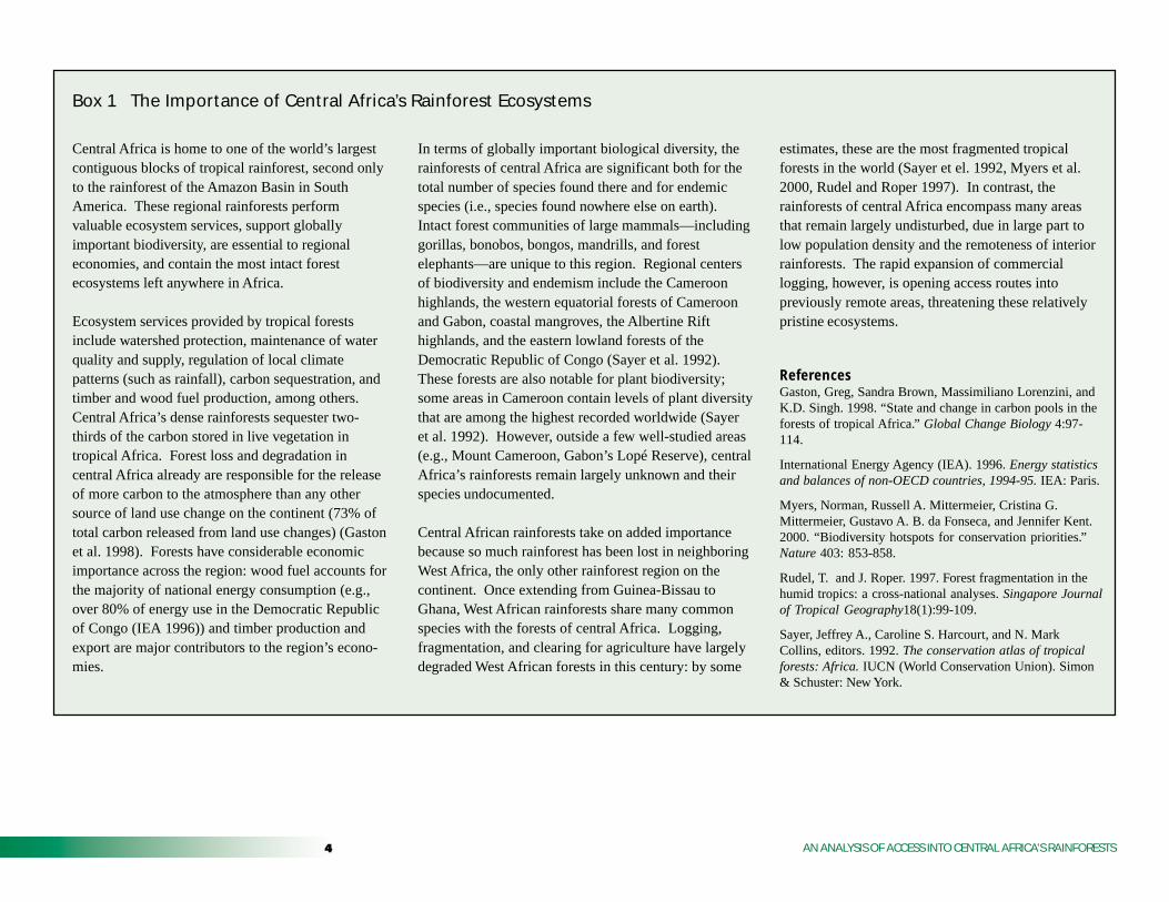
Box 1 The Importance of Central Africa’s Rainforest Ecosystems
Central Africa is home to one of the world’s largestcontiguous blocks of tropical rainforest, second onlyto the rainforest of the Amazon Basin in SouthAmerica. These regional rainforests performvaluable ecosystem services, support globallyimportant biodiversity, are essential to regionaleconomies, and contain the most intact forestecosystems left anywhere in Africa.
Ecosystem services provided by tropical forestsinclude watershed protection, maintenance of waterquality and supply, regulation of local climatepatterns (such as rainfall), carbon sequestration, andtimber and wood fuel production, among others.Central Africa’s dense rainforests sequester two-thirds of the carbon stored in live vegetation intropical Africa. Forest loss and degradation incentral Africa already are responsible for the releaseof more carbon to the atmosphere than any othersource of land use change on the continent (73% oftotal carbon released from land use changes) (Gastonet al. 1998). Forests have considerable economicimportance across the region: wood fuel accounts forthe majority of national energy consumption (e.g.,over 80% of energy use in the Democratic Republicof Congo (IEA 1996)) and timber production andexport are major contributors to the region’s econo-mies.
In terms of globally important biological diversity, therainforests of central Africa are significant both for thetotal number of species found there and for endemicspecies (i.e., species found nowhere else on earth).Intact forest communities of large mammals—includinggorillas, bonobos, bongos, mandrills, and forestelephants—are unique to this region. Regional centersof biodiversity and endemism include the Cameroonhighlands, the western equatorial forests of Cameroonand Gabon, coastal mangroves, the Albertine Rifthighlands, and the eastern lowland forests of theDemocratic Republic of Congo (Sayer et al. 1992).These forests are also notable for plant biodiversity;some areas in Cameroon contain levels of plant diversitythat are among the highest recorded worldwide (Sayeret al. 1992). However, outside a few well-studied areas(e.g., Mount Cameroon, Gabon’s Lopé Reserve), centralAfrica’s rainforests remain largely unknown and theirspecies undocumented.
Central African rainforests take on added importancebecause so much rainforest has been lost in neighboringWest Africa, the only other rainforest region on thecontinent. Once extending from Guinea-Bissau toGhana, West African rainforests share many commonspecies with the forests of central Africa. Logging,fragmentation, and clearing for agriculture have largelydegraded West African forests in this century: by some
estimates, these are the most fragmented tropicalforests in the world (Sayer et el. 1992, Myers et al.2000, Rudel and Roper 1997). In contrast, therainforests of central Africa encompass many areasthat remain largely undisturbed, due in large part tolow population density and the remoteness of interiorrainforests. The rapid expansion of commerciallogging, however, is opening access routes intopreviously remote areas, threatening these relativelypristine ecosystems.
ReferencesGaston, Greg, Sandra Brown, Massimiliano Lorenzini, andK.D. Singh. 1998. “State and change in carbon pools in theforests of tropical Africa.” Global Change Biology 4:97-114.
International Energy Agency (IEA). 1996. Energy statisticsand balances of non-OECD countries, 1994-95. IEA: Paris.
Myers, Norman, Russell A. Mittermeier, Cristina G.Mittermeier, Gustavo A. B. da Fonseca, and Jennifer Kent.2000. “Biodiversity hotspots for conservation priorities.”Nature 403: 853-858.
Rudel, T. and J. Roper. 1997. Forest fragmentation in thehumid tropics: a cross-national analyses. Singapore Journalof Tropical Geography18(1):99-109.
Sayer, Jeffrey A., Caroline S. Harcourt, and N. MarkCollins, editors. 1992. The conservation atlas of tropicalforests: Africa. IUCN (World Conservation Union). Simon& Schuster: New York.
�AN ANALYSIS OF ACCESS INTO CENTRAL AFRICA’S RAINFORESTS
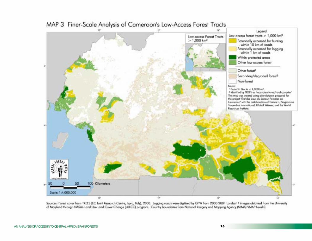
area potentially accessible to hunters inCameroon (Map 3), the only country for whichlogging roads data are available. The Cameroonanalysis offers insight into potential patterns ofaccess in logging concessions across centralAfrica.
4. Tracts of low-access forest were identified andgrouped. Only forests at least 2 km from aroadside and in blocks of at least 1,000 km2
were designated as large tracts of low-accessforest. These thresholds were chosen in anattempt to identify those tracts of forest largeenough to sustain native flora and fauna (seeBox 2). The two size classes for large tracts oflow-access forest (1,000-10,000 km2 and largerthan 10,000 km2) were established to permitcomparison with relevant studies, includingother Global Forest Watch mapping projects andthe World Resources Institute’s Pilot Analysis ofGlobal Ecosystems (Matthews et al. 2000). Theywere also selected for compatibility withproposed indicator criteria under the Conventionon Biological Diversity (UNEP 1997).
Finer-Scale Analysis of Cameroon’sLow-Access Forest Tracts
1. Logging roads and other previously unmappedroads were digitized from satellite imagery. Weused 1999-2001 high-resolution Landsat 7satellite imagery to digitize logging roads andother roads within Cameroon’s forests notincluded in the dataset used for the regional-level analysis described above. Images wereobtained from the University of Maryland
through NASA’s Land Use Land Cover Change(LULCC) program.
Recently constructed logging roads are clearlyvisible on Landsat images, as are some of theopenings in the forest created by selectivelogging. For some areas known to have beenpreviously logged (e.g., expired concessionareas), no logging roads were visible, indicatingthat over time the forest canopy closes overroads and obscures them from view. Also, someminor logging roads may not be visible if onlysmall breaks in the forest canopy were createdduring construction. While most of the roadsthat we digitized are within concessions andappear to be logging roads, other roads throughthe forest, including new major transportationroutes, were digitized if they did not appear inthe Cameroon national roads dataset.
The logging roads dataset was created as a pilotdataset for the study, “État des Lieux du SecteurForestier au Cameroun,” in collaboration withNature+, Programme Tropenbos International,Global Witness, and the World ResourcesInstitute. Planned ground-truthing of this datasetusing global positioning system (GPS) pointshas not yet been carried out, so the accuracy andcompleteness of this dataset are unknown.
2. Logging roads were buffered to estimate accessfor logging and hunting. Logging roads werebuffered by two distances: first by 1 km, toestimate the maximum reach of logging equip-ment into the forest, and second by 10 km, toestimate the minimum area accessed forbushmeat hunting. The 1-km buffer represents thepenetration into remote forest of large vehicles,
which are commonly used to transport bushmeatfrom the forest to markets. The 10-km buffer is aconservative estimate of the distance that huntersare willing to travel on foot from roads. Thisdistance is likely to vary greatly depending onlocation, terrain, size of animals hunted, andabundance of wildlife in a particular area (Peresand Terborgh 1995). Estimating the area accessedby hunters is further complicated by the fact thathunters use footpaths and forest tracks that are forthe most part unmapped and not visible insatellite imagery. Therefore, it is likely that ourestimate of the area accessed by hunters isconsiderably less than the actual figure.
3. Buffered areas were overlaid with low-accessforest tracts to determine the proportion of theseareas accessed for logging or hunting. Roadbuffers were overlaid with low-access foresttracts identified during the coarse-scale regionalanalysis to estimate how much of these tracts isactually accessed for logging (1-km buffer) orfor hunting (10-km buffer). The results of thisnational-level analysis for Cameroon are indica-tive of potential levels of access across centralAfrica where active logging concessions arepresent.

� AN ANALYSIS OF ACCESS INTO CENTRAL AFRICA’S RAINFORESTS
Box 2 How Much Low-Access Forest is Required to Sustain Forest Species?
Considerable uncertainty surrounds the issue ofminimum habitat area required to ensure the long-termsurvival of forest species. Much evidence supports thenotion that small forest fragments will tend to losespecies over time, especially large mammals and toppredators. On average, larger areas are more likely tosustain a full range of forest species (Turner 1996).There is less experimental evidence to indicatespecifically the minimum habitat area required tomaintain viable populations for resident species—afigure that will vary greatly by ecosystem type(Bierregaard et al. 1992, Saunders et al. 1991). Largemammals native to central Africa—including forestelephants, gorillas, mandrills, and leopards—mayrequire very extensive areas of undisturbed forest,either because they have inherently large habitatrequirements or because they are sought after byhunters and poachers (Armbruster and Lande 1993,Wilkie et al. 2000).
Area required to support large mammals. A foresttract sufficiently extensive to sustain species needinglarge habitat areas is likely to meet habitat require-ments for most other species. In central Africa,elephants are generally thought to have the largesthabitat requirements. Estimates of the area requiredfor African elephant populations or family groupsrange from 2,500 to 5,800 km2 and up (Armbrusterand Lande 1993, Lindeque and Lindeque 1991).Studies in other tropical forest regions indicate that,while tracts of at least 1,000 km2 are capable ofsustaining most forest species, some animals mayrequire areas in excess of 10,000 km2 to sustain their
populations (Chiarello 2000, Thiollay 1989, Redford andRobinson 1991, Soulé et al. 1979).
Area required to support hunted animals. Huntedspecies will require a greater area to sustain viablepopulations. Estimates of the minimum viable habitatsize for large hunted mammals of the Amazon rainforestwere four times as large as those needed to sustain non-hunted populations (Peres 2001, Redford and Robinson1991). Moreover, levels of hunting in central Africa farexceed those of the Amazon. A comparative study ofextraction rates of hunted animals in the Amazon andCongo river basins found that in the latter, speciesexploitation rates were 30 times higher. It concludedthat 60% of mammal taxa in central Africa were huntedunsustainably (Fa et al. 2002).
This study uses a conservative threshold of 1,000 km2
for designating large, low-access forest tracts. This isthe minimum area needed to sustain many, if not all,tropical forest species. Our analysis identifies verylarge, low-access forest tracts (in excess of 10,000 km2)in an effort to depict areas likely to be the most able tosupport the full range of native central African species,including large mammals and species under huntingpressure.
ReferencesArmbruster, P. and R. Lande. 1993. “A population viabilityanalysis for African elephant (Loxodonta africana)—how bigshould reserves be?” Conservation Biology 7(3):602-610.
Bierregaard, Jr., Richard O., Thomas E. Lovejoy, ValerieKapos, Angelo Augusto dos Santos, and Roger W. Hutchings.
1992. “The biological dynamics of tropical rainforestfragments.” BioScience 42(11):859-866.
Chiarello, A.G. 2000. “Density and population size ofmammals in remnants of Brazilian Atlantic Forest.”Conservation Biology 14:1649-1657.
Fa, John E., Carlos A. Peres, and Jessica Meeuwig. 2002.“Bushmeat exploitation in tropical forests: an intercontinen-tal comparison.” Conservation Biology, 16(1):232-237.
Lindeque, M. and P.M. Lindeque. 1991. “Satellite trackingof elephants in northwestern Namibia.” African Journal ofEcology 29:196-206.
Peres, Carlos A. 2001. “Synergistic effects of subsistencehunting and habitat fragmentation on Amazonian forestvertebrates.” Conservation Biology 15(6): 1490-1505.
Redford, K.H. and J.G. Robinson. 1991. “Park size and theconservation of forest mammals in Latin America.” pp.227-234. In: M.A. Mares and D.J. Schmidly, editors. In:Latin American mammology, history, biodiversity, andconservation. University of Olkahoma Press: Norman, OK.
Saunders, D.A. R.J. Hobbs, and C.R. Margules. 1991.“Biological consequences of ecosystem fragmentation: areview.” Conservation Biology 5:18-32.
Soulé, M. W., B.A. Wilcox and C. Holtby. 1979. “Benignneglect: A model of faunal collapse in the game reserves ofEast Africa.” Biological Conservation 15: 259-272.
Thiollay, J.M. 1989. “Area requirements for the conserva-tion of rain forest raptors and game birds in FrenchGuiana.” Conservation Biology 3(2):128-137.
Turner, I.M. 1996. “Species loss in fragments of tropicalrain forest: a review of the evidence.” Journal of AppliedEcology 33(2):200-209.
Wilkie, David, Ellen Shaw, Fiona Rotberg, Gilda Morelli,and Philippe Auzel. 2000. “Roads, development, andconservation in the Congo Basin.” Conservation Biology14(6):1614-1622.
�AN ANALYSIS OF ACCESS INTO CENTRAL AFRICA’S RAINFORESTS
��� ���� �� ������� ������� ������� ���� ���� ���������
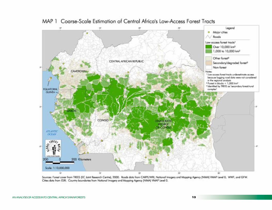
National and local patterns of access. New in-stances of deforestation tend to take place near areasof recent forest fragmentation or deforestation, asroads and clearings in the forest attract furtherdevelopment, human settlement, and additionalclearing (Mertens and Lambin 1997, 2000; Mertenset al. 2001; Skole and Tucker 1993). This patternholds true in central Africa: very densely populatedareas, such as western Cameroon and easternDemocratic Republic of the Congo, contain fewlarge tracts of low-access forest (Table 1). Incontrast, the largest tracts of low-access forest—inexcess of 100,000 km2—are found in the remote,very sparsely populated interior of the Congo Riverbasin. Among central African countries, Gabon, theRepublic of Congo, and the Democratic Republic ofCongo have the greatest share of their forests in
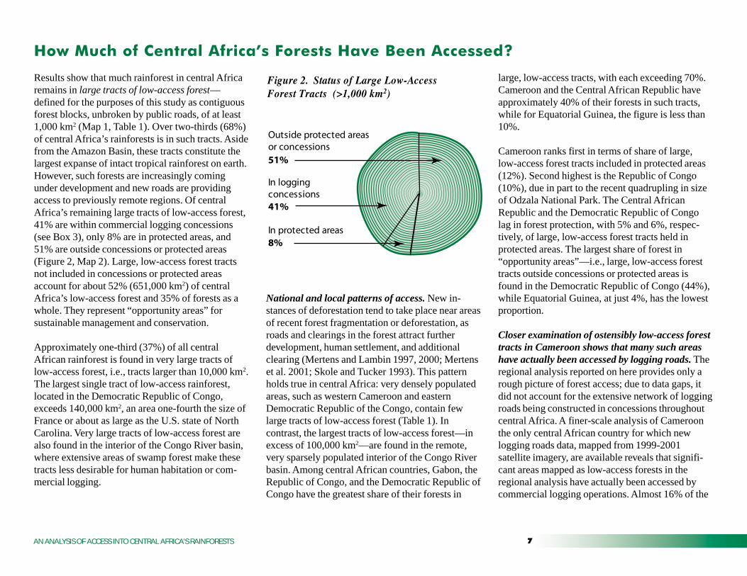
large, low-access tracts, with each exceeding 70%.Cameroon and the Central African Republic haveapproximately 40% of their forests in such tracts,while for Equatorial Guinea, the figure is less than10%.
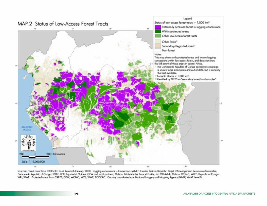
Cameroon ranks first in terms of share of large,low-access forest tracts included in protected areas(12%). Second highest is the Republic of Congo(10%), due in part to the recent quadrupling in sizeof Odzala National Park. The Central AfricanRepublic and the Democratic Republic of Congolag in forest protection, with 5% and 6%, respec-tively, of large, low-access forest tracts held inprotected areas. The largest share of forest in“opportunity areas”—i.e., large, low-access foresttracts outside concessions or protected areas isfound in the Democratic Republic of Congo (44%),while Equatorial Guinea, at just 4%, has the lowestproportion.
Closer examination of ostensibly low-access foresttracts in Cameroon shows that many such areashave actually been accessed by logging roads. Theregional analysis reported on here provides only arough picture of forest access; due to data gaps, itdid not account for the extensive network of loggingroads being constructed in concessions throughoutcentral Africa. A finer-scale analysis of Cameroonthe only central African country for which newlogging roads data, mapped from 1999-2001satellite imagery, are available reveals that signifi-cant areas mapped as low-access forests in theregional analysis have actually been accessed bycommercial logging operations. Almost 16% of the
Results show that much rainforest in central Africaremains in large tracts of low-access forest—defined for the purposes of this study as contiguousforest blocks, unbroken by public roads, of at least1,000 km2 (Map 1, Table 1). Over two-thirds (68%)of central Africa’s rainforests is in such tracts. Asidefrom the Amazon Basin, these tracts constitute thelargest expanse of intact tropical rainforest on earth.However, such forests are increasingly comingunder development and new roads are providingaccess to previously remote regions. Of centralAfrica’s remaining large tracts of low-access forest,41% are within commercial logging concessions(see Box 3), only 8% are in protected areas, and51% are outside concessions or protected areas(Figure 2, Map 2). Large, low-access forest tractsnot included in concessions or protected areasaccount for about 52% (651,000 km2) of centralAfrica’s low-access forest and 35% of forests as awhole. They represent “opportunity areas” forsustainable management and conservation.
Approximately one-third (37%) of all centralAfrican rainforest is found in very large tracts oflow-access forest, i.e., tracts larger than 10,000 km2.The largest single tract of low-access rainforest,located in the Democratic Republic of Congo,exceeds 140,000 km2, an area one-fourth the size ofFrance or about as large as the U.S. state of NorthCarolina. Very large tracts of low-access forest arealso found in the interior of the Congo River basin,where extensive areas of swamp forest make thesetracts less desirable for human habitation or com-mercial logging.
Figure 2. Status of Large Low-Access Forest Tracts (>1,000 km2)
8%
41%
Outside protected areas or concessions
In protected areas
In logging concessions
51%

8 AN ANALYSIS OF ACCESS INTO CENTRAL AFRICA’S RAINFORESTS
Table 1 Results of Access Analysis and Status of Low-Access Forest Tracts
Cameroon 194 86 45% 47 54% 17 20% 22 26%
Central African Republic 49 21 43% 13 60% 1 5% 7 33%
Dem. Republic of Congo3 1,125 807 72% 267 33% 49 6% 491 61%
Equatorial Guinea 21 2 9% 1 68% < 1 8% 1 40%
Gabon 219 159 73% 92 58% 11 7% 56 35%
Republic of Congo 216 168 78% 92 55% 17 10% 59 35%
Central Africa 1,863 1,258 68% 512 41% 95 8% 657 52%
Notes:
¹ Forest cover consisted of the lowland rainforest, swamp forest and mangrove TREES land cover classes.
² Low-access forest tracts not included in logging concessions or protected areas are designated "opportunity areas," but other land uses may in fact already be assigned to these areas.
% of low-access
tracts in parks
% of
low-access tracts in
concessions
Opportunity areas2 not in
concessions or parks
(000 km2)
Forest cover1
(000 km2)
Forest area in low-access
tracts >1,000 km2
(000 km2)
% Forest in Low-Access
Tracts
% of low-access
tracts in opportunity
areas
Area in Low-Access Forest Tracts Status of Low-Access Forest Tracts
Within low-access
tracts, concession
area (000 km2)
Within low-access tracts area
in parks (000 km2)
Percentages may not add to 100 due to rounding.
3 Data used for the Democratic Republic of the Congo was the best available but may not represent the current extent and location of logging concessions.
AN ANALYSIS OF ACCESS INTO CENTRAL AFRICA’S RAINFORESTS
Congo, where road infrastructure is decaying. Inaddition to roads data, other data relevant toestimating forest condition are lacking or difficultto obtain. These include census information,accurate settlements datasets, accurate and up-to-date protected area boundaries, and information onthe location and attribution of logging concessions,among others. Information on forest cover orcondition (e.g., whether degraded or intact,biomass estimates, age, etc.) is also limited.Datasets such as TREES, while the best currentlyavailable, due to coarse resolution have limitedapplicability for monitoring forest change overtime or at scales finer than national or regionallevels.
low-access forests within Cameroon (Map 3) areaccessed for logging (i.e., are 1 km or less from alogging road). 59% is within 10 km of a loggingroad, and thus is potentially impacted by bushmeathunting.
Indeed, Map 3 likely underestimates the area ofCameroon accessed for logging, because someroads, including relatively old logging roads ob-scured by canopy regrowth, may not be visible onsatellite imagery. If other central African countriesare experiencing similar levels of access by loggingroads, up to 41% of the region’s low-access foresttracts may be at risk for local extirpation of wildliferesulting from unsustainable hunting. In the Demo-cratic Republic of Congo, where years of conflicthave largely destroyed road networks (Wilkie andMorelli 1998) and prevented extensive commerciallogging, levels of access in concessions is probablysignificantly lower. However, in some places,conflict has led to extensive forest degradation(Geist and Lambin 2001) where displaced popula-tions have become dependent on local forests forwood fuel and hunting.
Data gaps for Central Africa. Poor data qualityand data gaps currently preclude accurate mappingof the status of central Africa rainforests. Mostavailable geographic data for Africa are coarse andinaccurate, and often based on outdated maps.Limited data are available on the extent of loggingroads in central Africa outside of Cameroon,except for localized studies. Most publicly avail-able datasets omit roads constructed in the last 20years, provide no indication of seasonal accessibil-ity, and often fail to record the condition of roadsin areas, such as the Democratic Republic of
Given the lack of quality datasets, this coarse-scaleanalysis likely contains some systematic errors withrespect to estimates of forest fragmentation incentral Africa. Where datasets omit many new orexisting logging roads, the analysis will tend tounderestimate fragmentation. However, in someareas, we likely overestimate fragmentation,because declining road infrastructure, particularly inthe Democratic Republic of Congo, has renderedmany routes impassable to motor vehicles. Theincreasing availability of low-cost satellite imageryprovides an opportunity to update roads datasets, asGlobal Forest Watch has begun to do for Cameroon.In the meantime, estimates of the status of centralAfrica’s remain limited by the lack of accurate data.
Table 2 Area in logging concessions
Cameroon 194 72 37%
Central African Republic 49 35 71%
Dem. Republic of Congo³ 1125 409 36%
Equatorial Guinea 21 15 71%
Gabon 219 120 55%
Republic of Congo 216 171 79%
Central Africa 1824 822 45%
Notes: Concession area does not include expired or abandoned concessions, so is not an estimate of the total area ever logged.
¹ Forest area consist of TREES lowland rainforest, swamp forest, and mangrove classes.
² Calculated from GFW concession data from various sources (See Map 2 Technical notes). Calculations are based on total concession area; Table 1 shows low access forest in concessions.
³ Data used for the Democratic Republic of the Congo was the best available but may not represent the current extent and location of logging concessions.
Forest Area¹(000 km2)
Concession Area²(000 km2)
% of Total Forest Area in Concession
� AN ANALYSIS OF ACCESS INTO CENTRAL AFRICA’S RAINFORESTS
���������� ��� �!� "��#�
This coarse-scale analysis of access into centralAfrica’s tropical rainforest provides evidence thatthe region retains some of the world’s largest tractsof low-access forests. However, commerciallogging is rapidly opening access routes into theseforests, exposing them to harm from unsustainablebushmeat hunting and other damaging humanactivities. Improved management of forest resourcesand protected areas, accompanied by effectiveenforcement of forestry and wildlife codes, isurgently needed to ensure both the viability ofproductive forest uses and to reduce the harmfuleffects associated with forest access. National andregional land-use planning is an important compo-nent of improved forest management, as centralAfrican governments decide which forest areas willbe slated for economic development and which willbe preserved intact to maintain biological diversityas well as ecological integrity.
While this study provides a rough overview offorest access trends in central Africa, it is importantto note that data gaps and uneven data qualitypreclude accurate and comprehensive documenta-tion of forest conditions at the regional scale. In apilot study of Cameroon, recent, finer-scale dataindicate significantly greater forest access than thecoarser-scale regional analysis, suggesting thatactual levels of logging-associated forest accessacross the region may be considerably higher thanthose estimated here.
Governments, donors, and international institutionsshould cooperate in efforts to improve the quality ofgeographical data, which in turn would enabledevelopment of a more accurate picture of forestconditions and pressures on natural resources. Ashuman activities accelerate in previously isolatedforests, such data are crucial for supporting im-proved forest management and conservation. Thefuture of the central African rainforests depends notonly on segregating conservation and productionareas, but also on proper management of theseareas. Sustainable forest planning and managementcannot be implemented without information onhuman activities and their location within forests.Global Forest Watch is committed to working withother interested parties to promote such datacollection, update this analysis accordingly, andmake datasets publicly available to support deci-sion-making by regional and institutionalpolicymakers.
Complicating this analysis are information gaps,including the lack of comprehensive roads data aswell as incomplete understanding of ecologicalissues, such as minimum habitat requirements forcentral African species. Nevertheless, the potentialimpacts of the loss of central Africa’s rainforests areso great that even a rough estimate of forest accessand fragmentation provides important informationon the critical factors affecting this ecosystem.

��AN ANALYSIS OF ACCESS INTO CENTRAL AFRICA’S RAINFORESTS
Box 3 Logging in Central Africa
Logging undoubtedly affects large swaths of forest incentral Africa. Over the past 40 years, commerciallogging has spread from the accessible coastal foreststo remote interior forests. Typically, to meet marketdemand and to recover high operational costs,companies selectively log only the most commer-cially valuable species. The challenge of sustainableforest management is to ensure that forestry contrib-utes to national economic development withoutexcessively damaging forests’ capacity to providelocally and globally important ecosystem services,including those related to global climate andbiodiversity.
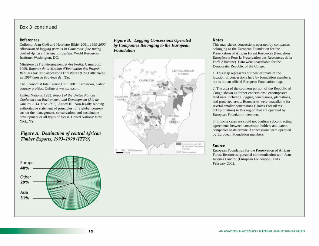
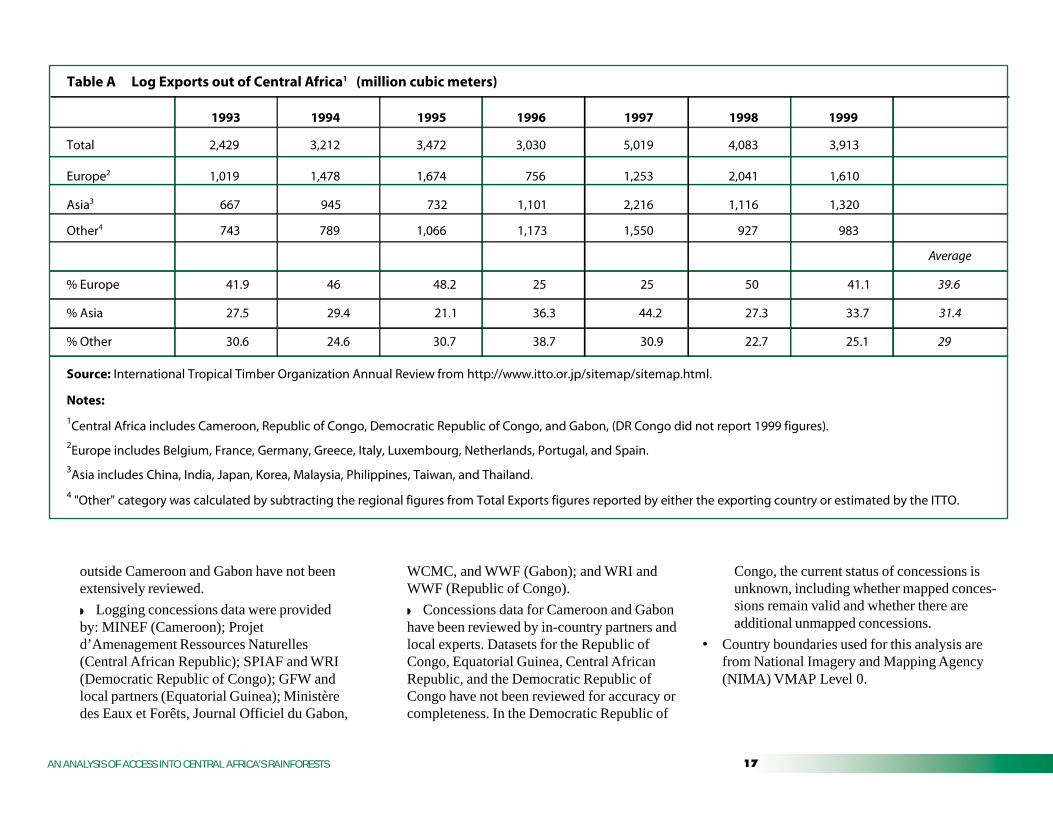
In both Cameroon and Gabon, forest products are thesecond largest export, generating around 20% ofCameroon’s export revenue and 13% of Gabon’sforeign exchange earnings (Economist IntelligenceUnit 2001). Timber exports (logs, sawnwood, veneer,and plywood) from central Africa steadily increasedthroughout the 1990s, except for a brief, sharpdownturn due to the Asian financial crisis (Table B).For the period 1993 to 1999, Europe imported 40%of central African logs (Figure A), making it thelargest importing region. In 1996-97, however, Asiabegan to surpass Europe as an importing region, atrend that will likely continue due to increasedpopulation and economic growth, particularly inChina (Table A). Rising Asian log imports are drivenin part by the exhaustion of commercial timbersupplies within much of that continent’s naturalforests, as well as a partial logging ban established inChina in 1998.
Governments are the principal landowners in centralAfrica and lease logging rights to companies andindividuals through allocation procedures that vary fromcountry to country. Well over a thousand companies andindividuals hold logging concessions in central Africa.Many concessionaires are unable to carry out loggingoperations and subcontract out their concessions, oftento large foreign companies. Of the many existinglogging companies, few have the financial capital,logistical resources, and experience needed to conductlong-term, large-scale operations. Those that do areoften foreign multinational groups with a complex webof subsidiaries, involving local and foreign companies(Collomb and Bikié 2001).
Sustainable management of natural resources began toappear on political and economic agendas in centralAfrica following the Rio UNCED conference (UnitedNations 1992), often at the urging of donors and interna-tional non-governmental organizations (NGOs). Com-pared with international forestry standards, however,logging practices in the region lag considerably in termsof efficiency and sustainability. Only in the past five toseven years have governments and the private sectorbegun to consider sustainable forest management incentral Africa; steps towards implementation remainlimited to a few companies. Progress is limited byconditions that provide disincentives for sustainablemanagement, including political and economic instabilityand widespread illegal logging. These conditions make itmore difficult for companies to make long-term invest-ments and commit to the long rotation cycles required forsustainable forest management.
Recently, a number of European companies an-nounced their willingness to lead efforts to improveforest management in the region. Members of theEuropean Foundation for the Preservation of AfricanForest Resources (Fondation Européenne Pour laPreservation des Ressources de la Forêt Africaine),these companies lease substantial concession areasin Cameroon, Gabon, and the Republic of Congo(Figure B). They have made significant environmen-tal commitments, including creation of a standardpractical forest-management plan, improvement ofreduced-impact logging techniques, a professionalcode of conduct, and establishment of a Pan-AfricanCertification System. Such commitments could playan influential role in spurring improved forestmanagement among the central African loggingindustry as a whole. Because logging concessionscover approximately 41% of low-access foresttracts, much of the future of central Africa’s forestsdepends on how well companies manage theirconcessions. Monitoring the performance of thesecompanies is essential; even companies that havepledged publicly to improving forest managementhave committed documented forestry code viola-tions (Ministère de l’Environnement et des Forêts,Cameroon 1999). This indicates that not all compa-nies will successfully implement their environmentalcommitments and points to the need for strength-ened enforcement of forestry legislation by govern-ments in the region.
continued next page
�� AN ANALYSIS OF ACCESS INTO CENTRAL AFRICA’S RAINFORESTS
ReferencesCollomb, Jean-Gaël and Henriette Bikié. 2001. 1999-2000Allocation of logging permits in Cameroon: fine-tuningcentral Africa’s first auction system. World ResourcesInstitute: Washington, DC.
Ministère de l’Environnement et des Forêts, Cameroun.1999. Rapport de la Mission d’Evaluation des ProgrèsRéalisés sur les Concessions Forestières (UFA) Attribuéesen 1997 dans la Province de l’Est.
The Economist Intelligence Unit. 2001. Cameroon, Gaboncountry profiles. Online at www.eiu.com.
United Nations. 1992. Report of the United NationsConference on Environment and Development (Rio deJaneiro, 3-14 June 1992). Annex III: Non-legally bindingauthoritative statement of principles for a global consen-sus on the management, conservation, and sustainabledevelopment of all types of forest. United Nations: NewYork, NY.
NotesThis map shows concessions operated by companiesbelonging to the European Foundation for thePreservation of African Forest Resources (FondationEuropéenne Pour la Preservation des Ressources de laForêt Africaine). Data were unavailable for theDemocratic Republic of the Congo.
1. This map represents our best estimate of thelocation of concessions held by foundation members,but is not an official European Foundation map.
2. The area of the southern portion of the Republic ofCongo shown as “other concessions” encompassesland uses including logging concessions, plantations,and protected areas. Boundaries were unavailable forseveral smaller concessions (Unités Forestièresd’Exploitation) in this region that are operated byEuropean Foundation members.
3. In some cases we could not confirm subcontractingagreements between concession holders and parentcompanies to determine if concessions were operatedby European Foundation members.
SourceEuropean Foundation for the Preservation of AfricanForest Resources; personal communication with Jean-Jacques Landrot (European Foundation/IFIA),February 2002.
Figure B. Logging Concessions Operatedby Companies Belonging to the EuropeanFoundation
Figure A. Destination of central AfricanTimber Exports, 1993–1990 (ITTO)
31%
29%
Europe
Asia
Other
40%
Box 3 continued
��AN ANALYSIS OF ACCESS INTO CENTRAL AFRICA’S RAINFORESTS
�� AN ANALYSIS OF ACCESS INTO CENTRAL AFRICA’S RAINFORESTS
��AN ANALYSIS OF ACCESS INTO CENTRAL AFRICA’S RAINFORESTS

�� AN ANALYSIS OF ACCESS INTO CENTRAL AFRICA’S RAINFORESTS
�$$% &�'( �������� ����
Map 1: Coarse-Scale Estimation of Central Africa’sLow-Access Forest Tracts and Map 2: Status of Low-Access Forest Tracts
The base vegetation layer used was the latestTREES 2000 land cover map for central Africa(Mayaux and Malingreau 2000), updated from theoriginal, approximately 1-km2 resolution dataset(Mayaux et al.1997).
• A forest/ non-forest map was created to separatenatural closed-canopy forest from other vegeta-tion. The “forest” category included lowlandrainforest, mangroves, and swamp forest (classes1, 6, and 9). “Non-forest” included secondaryforest and rural complex, forest-savanna mosaic,nonforest, water bodies, swamp grasslands, andplantations (classes 2-5, 7-8, and 10).
• Updated roads datasets were prepared:
◗ National-level roads data were updated.
◗ The CARPE roads dataset (Central AfricanRegional Program for the Environment/WorldResources Institute) was used as the baselayer.
◗ Roads data missing from the CARPEdataset were supplemented with available datafrom the National Imagery and MappingAgency (NIMA) Vector Map Level 0 dataset.VMAP (1997) is an update of the DigitalChart of the World, which was used as thebase layer for the CARPE roads datasets.
◗ Additional roads were digitized at WRIusing recent (1993 to 2000) national maps atvarious scales (1:1,000,000 to 1:3,300,000).
These coarse-scale maps were used to digitizenewer roads not depicted by other sources. Nofiner-scale (e.g., 1:200,000) maps createdwithin the last decade were available for anycountries in the region.
◗ The Gabon roads dataset was updated withroads data provided by WWF-Gabon that weredigitized from local topographic maps(1:200,000) and Landsat satellite imagery.
◗ Foot paths, ferry crossings, and other non-pertinent transport routes were removed priorto the forest fragmentation analysis.
◗ No information was available on degradedor impassable roads (especially prevalent inthe Democratic Republic of Congo).
◗◗◗◗◗ These roads datasets were not verified inthe field.
• Roads were buffered to a distance of 2 km, andconverted to a 100-meter (m) grid. The TREESlandcover map was also resampled to 100 m, toprevent the buffers from removing excess forestdue to the coarseness of the forest cover map.
• Rivers are important access routes throughoutcentral Africa. They were not, however, consid-ered access routes for the purposes of this study,due to the difficulty in determining with consis-tent accuracy across the region which rivers areused as access routes. The region’s largest riversare considered indirectly in the analysis; theyappear on the TREES land cover dataset as“non-forest” and therefore divide large forestareas into smaller blocks.
• Railroads were not considered access routes forthe purposes of this analysis, even though theyare important means of transporting timber andbushmeat in many forest areas.
• The buffered roads grid was used to segregateforest within 2 km of roads from the TREESforest cover map.
• Remaining forest areas were grouped intocontiguous blocks, and sorted by size:
◗ Over 10,000 km2
◗ 1,000 to 10,000 km2
◗ Under 1,000 km2
• Contiguous forest areas of at least 1,000 km2
were defined as “large tracts of low-accessforest.”
• Logging concessions and protected areas GISdatasets were overlaid on the low-access foresttracts and the portion of these tracts in conces-sions or protected areas was calculated. Allcalculations were made using datasets in anAlbers equal-area projection.
◗ Protected areas information was obtainedfrom CARPE, based on datasets from theWorld Conservation Monitoring Centre(WCMC). Protected areas datasets forCameroon and Gabon have been reviewed andupdated by Global Forest Watch, with inputfrom WWF and Wildlife Conservation Society(WCS); GFW also updated the boundaries forOdzala National Park in the Republic ofCongo (ECOFAC). Protected areas datasets
��AN ANALYSIS OF ACCESS INTO CENTRAL AFRICA’S RAINFORESTS
WCMC, and WWF (Gabon); and WRI andWWF (Republic of Congo).
◗ Concessions data for Cameroon and Gabonhave been reviewed by in-country partners andlocal experts. Datasets for the Republic ofCongo, Equatorial Guinea, Central AfricanRepublic, and the Democratic Republic ofCongo have not been reviewed for accuracy orcompleteness. In the Democratic Republic of
Congo, the current status of concessions isunknown, including whether mapped conces-sions remain valid and whether there areadditional unmapped concessions.
• Country boundaries used for this analysis arefrom National Imagery and Mapping Agency(NIMA) VMAP Level 0.
outside Cameroon and Gabon have not beenextensively reviewed.
◗ Logging concessions data were providedby: MINEF (Cameroon); Projetd’Amenagement Ressources Naturelles(Central African Republic); SPIAF and WRI(Democratic Republic of Congo); GFW andlocal partners (Equatorial Guinea); Ministèredes Eaux et Forêts, Journal Officiel du Gabon,
Table A Log Exports out of Central Africa1 (million cubic meters)
1993 1994 1995 1996 1997 1998 1999
Total 2,429 3,212 3,472 3,030 5,019 4,083 3,913
Europe2 1,019 1,478 1,674 756 1,253 2,041 1,610
Asia3 667 945 732 1,101 2,216 1,116 1,320
Other4 743 789 1,066 1,173 1,550 927 983
Average
% Europe 41.9 46 48.2 25 25 50 41.1 39.6
% Asia 27.5 29.4 21.1 36.3 44.2 27.3 33.7 31.4
% Other 30.6 24.6 30.7 38.7 30.9 22.7 25.1 29
Source: International Tropical Timber Organization Annual Review from http://www.itto.or.jp/sitemap/sitemap.html.
1Central Africa includes Cameroon, Republic of Congo, Democratic Republic of Congo, and Gabon, (DR Congo did not report 1999 figures). 2Europe includes Belgium, France, Germany, Greece, Italy, Luxembourg, Netherlands, Portugal, and Spain.3Asia includes China, India, Japan, Korea, Malaysia, Philippines, Taiwan, and Thailand.
4 "Other" category was calculated by subtracting the regional figures from Total Exports figures reported by either the exporting country or estimated by the ITTO.
Notes:
�� AN ANALYSIS OF ACCESS INTO CENTRAL AFRICA’S RAINFORESTS
Map 3: Finer-Scale Analysis of Cameroon’s Low-Access Forest Tracts
• Logging roads within Cameroon were digitizedfrom 1999-2001 Landsat 7 ETM+ satelliteimagery. The Landsat scenes provided fullcoverage of Cameroon’s forested areas, thoughin some cases clouds prevented road mapping.The logging roads data layer includes mainlogging roads, secondary logging roads, andsome new primary transportation routes throughforest used to reach logging concessions.
• Logging roads were buffered twice: first by 1km, to estimate the area accessed for loggingand deepest penetration of vehicles into theforest; and second by 10 km, to estimate the areaaccessed for bushmeat hunting. The areasaccessed for logging and hunting were calcu-lated as a percentage of the total area ofCameroon’s large (at least 1,000 km2), low-access forest tracts.
• Buffered road areas for the Cameroon map werenot removed from the low-access forest tractsbecause these are not permanent roads. Also, acalculation of the portion accessed allows anindication of the extent of forest accessed inconcessions across the region.
Table 1. Results of Access Analysis and Status ofLow-Access Forest Tracts
Calculations of forest areas were based on theTREES 2000 central African vegetation map(Mayaux and Malingreau 2000). The 1-km-resolu-tion TREES map was derived from 2000 NOAAAVHRR and SPOT VEGETATION satelliteimagery, as well as ERS and JERS radar imagery.Landcover types included are: lowland rainforest,secondary forest and rural complex, forest-savannahmosaic, nonforest, mangrove, water bodies, swampgrasslands, swamp forest, and plantations. The
coarse-scale TREES vegetation map is suitable forregional analyses where the dataset can be com-pared to data from other sources. TREES data aremuch less accurate locally, as the coarseness of thesensor creates spatial aggregation errors (Mayaux etal. 1998).
The area of forest cover in central Africa has beenreported in several global forest-resource assess-ments, including from TREES 1997 (E.C. JointResearch Centre), FAO (United Nations Food andAgriculture Organization, and IUCN (The WorldConservation Union). Another estimate is availablefrom the Central African Regional Program for theEnvironment (CARPE) (LaPorte et al. 1998). Theextent of forest cover varies according to forestdefinition, date of the analysis, and methods used todevelop land cover classifications, among otherfactors. Our estimate of 1,863,000 km2, derivedfrom the TREES 2000 data, compares with
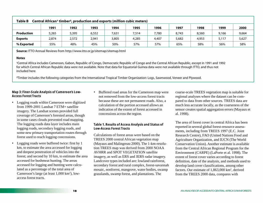
Table B Central African¹ timber², production and exports (million cubic meters)
1991 1992 1993 1994 1995 1996 1997 1998 1999 2000
Production 5,265 5,395 6,552 7,631 7,514 7,780 8,743 8,560 9,166 9,664
Exports 2,874 2,572 2,941 3,805 4,285 4,407 5,682 4,953 5,117 5,627
% Exported 55% 48% 45% 50% 57% 57% 65% 58% 56% 58%
Source: ITTO Annual Reviews from http://www.itto.or.jp/sitemap/sitemap.html
Notes
¹Central Africa includes Cameroon, Gabon, Republic of Congo, Democratic Republic of Congo and the Central African Republic, except in 1991 and 1992 for which Central African Republic data were not available. Note that data for Equatorial Guinea data were not available through ITTO, and thus not included here.
²Timber includes the following categories from the International Tropical Timber Organization: Logs, Sawnwood, Veneer and Plywood.
�AN ANALYSIS OF ACCESS INTO CENTRAL AFRICA’S RAINFORESTS
1,839,670 km2 estimated by TREES 1997 (“ever-green and semi-deciduous forest”); 1,583,000 km2
by FAO-FORIS (“closed broadleaf forest”);1,858,020 km2 by IUCN (“closed forest”); and1,815,753 km2 by CARPE (LaPorte et al. 1998).For a discussion and detailed comparison of theTREES 1997, FAO, and IUCN datasets, seeMayaux et al. 1998.
Box 3, Figure A: Destination of Central AfricanTimber Exports, 1993–1999
Regional totals are based on figures reported byInternational Tropical Timber Organization (ITTO)members, generally those reported by majorimporting countries.
• Estimates of log export underestimate thevolume of timber felled, since logs are a subsetof forest products produced and exported bycentral African countries. In addition, thisestimate does not account for illegal logging.
Cameroon and Gabon are rapidly developing awood processing industry to complement logproduction and exports with value-addedproducts, such as sawnwood, plywood, andveneer sheets.
• Accurate data on the volume and direction oftrade of processed products are difficult to obtaindue to overlapping definitions used by interna-tional reporting agencies (Food and AgricultureOrganization, International Tropical TimberOrganization), and conflicting authority withinthe exporting countries’ forestry and customsservices. Therefore, the direction of trade for alltimber products (logs and processed products)may differ from the direction of log trade.Overall, export figures presented here are to beinterpreted with caution due to discrepanciesboth within a single data source (e.g., ITTO) andbetween data sources (e.g., ITTO and FAO).However, these numbers give an indication oftrends in trade and the associated order ofmagnitude.
)���������
Barnes, R.F.W.; Blom, A.; Alers, M.P.T. 1995. “Areview of the status of forest elephants Loxodontaafricana in central Africa.” Biological Conservation71(2):125-132.
Barnes, R.F.W., Barnes, K.L., Alers, M.P.T. & Blom, A.1991. “Man determines the distribution of elephantsin the rain forests of northeastern Gabon.” AfricanJournal of Ecology 29: 54-63.
Bierregaard, Jr., Richard O., Thomas E. Lovejoy, ValerieKapos, Angelo Augusto dos Santos, and Roger W.Hutchings. 1992. “The biological dynamics oftropical rainforest fragments.” BioScience42(11):859-866.
Food and Agriculture Organization of the UnitedNations (FAO) and the Association TechniqueInternationale des Bois Tropicaux (ATIBT). 1999.Road Infrastructures in Tropical Forests: Road todevelopment or road to destruction? FAO: Rome.
Forman, R.T.T., and L.E. Alexander. 1998. “Roads andtheir major ecological effects.” Annual Review ofEcology and Systematics 29:207-231.
Geist, Helmut J. and Eric F. Lambin. 2001. What drivestropical deforestation? LUCC Report Series No. 4.Land Use and Land Cover Change (LUCC), Interna-tional Geosphere-Biosphere Programme.
Greenpeace. 2000. Spotlight on the Illegal TimberTrade: Cameroon.
� AN ANALYSIS OF ACCESS INTO CENTRAL AFRICA’S RAINFORESTS
Lambin, E.F., and D. Ehrlich. 1997. “The identificationof tropical deforestation fronts at broad spatialscales.” International Journal of Remote Sensing18(17):3551-3568.
Matthews, Emily, Richard Payne, Mark Rohweder, andSiobhan Murray. 2000. Pilot analysis of globalecosystems (PAGE): forest ecosystems. WorldResources Institute: Washington, DC.
Mayaux, Philippe and Jean-Paul Malingreau. 2000. “Lecouvert forestier d’Afrique centrale: un nouvel étatdes lieux.” Mededelingen der Zittingen Bulletin DesSeances 46(4):475-486.
Mayaux, Philippe, Frédéric Achard, and Jean-PaulMalingreau. 1998. “Global tropical forest measure-ments derived from coarse resolution satelliteimagery: a comparison with other approaches.”Environmental Conservation 25(1):37-52.
Mayaux, P., E. Janodet, C. Blair-Myers and P. Legeay-Janvier. 1997. Vegetation Map of Central Africa at1:5,000,000, TREES Series D: Thematic output No1, EUR 17322 EN.
Mertens, B. and E.F. Lambin. 1997. “Spatial modelingof deforestation in southern Cameroon: spatialdisaggregation of diverse deforestation processes.”Applied Geography 17(2):143-162.
Mertens, B. and E.F. Lambin. 2000. “Land-coverchange trajectories in Southern Cameroon.” Annalsof the Association of American Geographers90(3):467-494.
Mertens, B., E. Forni, and E.F. Lambin. 2001. “Predic-tion of the impact of logging activities on forestcover: A case-study in the East province ofCameroon.” Journal of Environmental Management62:21-36.
Peres, C. and J. Terborgh. 1995. “Amazonian naturereserves: an analysis of the defensibility status ofexisting conservatio units and design criteria for thefuture.” Conservation Biology 9:34-45.
Redford, K.H. 1992. “The empty forest.” BioScience42:412-422.
Rudel, T. Roper, J. 1997. “Forest fragmentation in thehumid tropics: a cross-national analysis.” SingaporeJournal of Tropical Geography 18(1):99-109.
Saunders, D.A. R.J. Hobbs, and C.R. Margules. 1991.“Biological consequences of ecosystem fragmenta-tion: a review.” Conservation Biology 5:18-32.
Skole, D.; Tucker, C. 1993. “Tropical deforestation andhabitat fragmentation in the Amazon: satellite datafrom 1978 to 1988.” Science 260(5116):1905-1910.
Terborgh, J. 1992. “Maintenance of biodiversity intropical forests.” Biotropica 24:283-292.
Turner, I.M. 1996. “Species loss in fragments of tropicalrain forest: a review of the evidence.” Journal ofApplied Ecology 33(2):200-209.
United Nations Environment Programme (UNEP).1997. Convention on Biological Diversity, SubsidiaryBody on Scientific, Technical, and TechnologicalAdvice. Recommendations for a core set of indicatorsof biological diversity. Third meeting, Montreal,Canada, 1 to 5 September 1997. Secretariat of theConvention on Biological Diversity: Montreal.
Wilkie, David and Gilda Morelli.1998. “Journal: thepoor roads of the Ituri forest were bad for people, butgreat for wildlife.” Natural History, Aug. 1998:12.
Wilkie, David S. and Julia F. Carpenter. 1999.“Bushmeat hunting in the Congo Basin: an assess-ment of impacts and options for mitigation.”Biodiversity and Conservation 8(7):927-955.
Wilkie, David, Ellen Shaw, Fiona Rotberg, GildaMorelli, and Philippe Auzel. 2000. “Roads, develop-ment, and conservation in the Congo Basin.” Conser-vation Biology 14(6):1614-1622.