cenozoic sediments in the southern tarim basin: implications for the uplift of northern tibet and...
TRANSCRIPT
Geological Society, London, Special Publications
doi: 10.1144/SP342.6p67-78.
2010, v.342;Geological Society, London, Special Publications WangHongbo Zheng, Ryuji Tada, Juntao Jia, Colin Lawrence and Ke evolution of the Taklimakan Desertimplications for the uplift of northern Tibet and Cenozoic sediments in the southern Tarim Basin:
serviceEmail alerting
new articles cite this article to receive free e-mail alerts whenhereclick
requestPermission
part of this article to seek permission to re-use all orhereclick
Subscribe
Collection London, Special Publications or the Lyell
to subscribe to Geological Society,hereclick
Notes
© The Geological Society of London 2014
at Memorial University of Newfoundland on June 10, 2014http://sp.lyellcollection.org/Downloaded from at Memorial University of Newfoundland on June 10, 2014http://sp.lyellcollection.org/Downloaded from
Cenozoic sediments in the southern Tarim Basin: implications
for the uplift of northern Tibet and evolution of the
Taklimakan Desert
HONGBO ZHENG1*, RYUJI TADA2, JUNTAO JIA3,
COLIN LAWRENCE4 & KE WANG1
1School of Earth Science and Engineering, Nanjing University, Nanjing, 210093, China2Department of Earth and Planetary Science, University of Tokyo, Tokyo 113-0033, Japan
3State Key Laboratory of Marine Geology, School of Ocean and Earth Science, Tongji
University, Shanghai, 200092, China4School of Earth and Geographic Sciences, The University of Western Australia,
Crawley, WA 6009, Australia
*Corresponding author (e-mail: [email protected])
Abstract: Cenozoic sedimentary successions along the southern margin of the Tarim Basin,western China, reach up to 10 km in thickness. The two studied sections, the Yecheng and Aertashi,comprise c. 4.5 km and c. 7.0 km of clastic sedimentary rocks respectively. The base of theYecheng section has been dated palaeomagnetically to be about 8 Ma. Age control of the Aertashisection is based on 87Sr/86Sr measurements (for the basal marine bed), together with magnetostra-tigraphy and regional stratigraphic correlation. The lower part of each section is mainly composedof fine-grained mudstone and fine sandstone, which makes up the Wuqian Group (Miocene). Thepalaeoenvironment is low-energy, meandering and braided streams. The middle part is composedof red mudstone, sandstone with thin conglomerate beds, which make up the Artux Formation(Pliocene). The palaeoenvironment is a distal- to mid-fan environment. The uppermost part ofthe section, known as the Xiyu Formation (Plio-Pleistocene), consists of cobble and boulderconglomerate intercalated with massive siltstone lenses, which formed as proximal alluvial fanand aeolian deposits. Neogene red beds passing upward into upward-coarsening conglomerateand debris-flow deposits record the change in palaeoslope related to uplift of the northernmargin of Tibetan Plateau.
The formation of aeolian dunes at c. 8 Ma, and underlying playa lake deposits (as at Aertashi),may indicate an arid, enclosed basin in the southern Tarim after this time. Sedimentological charac-teristics, together with grain size distribution and geochemistry of siltstone bands in the Xiyu andArtux Formations, point to an aeolian origin. This indicates that the Taklimakan Desert and theregional climate regime may have been fully developed by the Early Pliocene. The onset ofaeolian sedimentation in the southern Tarim Basin coincided with uplift of the northern TibetanPlateau, as inferred from the lithofacies change. Tibetan Plateau uplift resulted in the shift ofsedimentary environments northwards into the southern Tarim Basin, and could well havetriggered the onset of full aridity in the Taklimakan region as a whole.
Central Asia has experienced dramatic changes inboth tectonics and climate during the Cenozoic,including the uplift of Tibetan Plateau, which isone of the most important tectonic events inEarth’s recent history. Climatic changes, as rep-resented by the aridification of the Asian interiorat one extreme, and monsoon precipitation atanother, are also most prominent. Numerousstudies have been carried out in the recent past todocument the timing, mode and amplitude of theseevents, the effects of which operate well beyondthe immediate region under consideration. In par-ticular, the causal linkage between Asian tectonics
and climatic changes has long been proposed andexplored through either geological records ornumerical modelling. For example, Ramstein et al.(1997) carried out numerical modelling on theeffects of the retreat of Paratethys to the climateand found that this environmental change alonecould have largely increased the aridity of Asianinterior and strengthened the Asian monsoon.Many others simulated the impact of Tibetanuplift on the evolution of the Asian monsoon andaridity of Asia, even on the northern hemisphereglaciation (e.g. Zhang et al. 2007). In the last fewyears, a significant number of investigations of the
From: Clift, P. D., Tada, R. & Zheng, H. (eds) Monsoon Evolution and Tectonics–Climate Linkage in Asia.Geological Society, London, Special Publications, 342, 67–78.DOI: 10.1144/SP342.6 0305-8719/10/$15.00 # The Geological Society of London 2010.
at Memorial University of Newfoundland on June 10, 2014http://sp.lyellcollection.org/Downloaded from
uplift of the Himalaya and Tibetan Plateau (HTP)have been carried out. These observations indicatethat the HTP uplift proceeded by several steps as anortheastwards progression of the uplift area, andthat the Asian monsoon evolution also evolvedwith several steps as a progressive penetration ofthe area of enhanced precipitation into the Asiancontinent, as well as the desertification of Takli-makan and Gobi (e.g. Harrison et al. 1992; Molnaret al. 1993; Matte et al. 1996; Copeland 1997;Zheng et al. 2000; An et al. 2001; Guo et al.2002; Sun & Wang 2005).
Uplift of the northern margin of the TibetanPlateau resulted in deposition of enormous amountsof sediments into the foreland basins of the southernTarim. Through a series of fluvial and aeolianprocesses these sediments were delivered into thebasin, and eventually made up the TaklimakanDesert. Subsequently, the desert provides dust, notonly for the aeolian deposits along the proximalmargins of the basin, but also for the distal ChineseLoess Plateau and remote northern Pacific, thustaking part in major geochemical cycles (Zhanget al. 2003).
Previously, we had carried out sedimentologicaland palaeoenvironmental studies on the Yechengsection of Late Miocene to Pleistocene age (Zhenget al. 2006). Results have shown that the northernmargin of the Tibetan Plateau experienced
accelerated uplift during the Early Pliocene, andthat widespread aeolian deposition commenced atthe same time, indicating the existence or evenfull development of the Taklimakan Desert. In thisstudy, we expand our record to the latest Eocene/earliest Oligocene by introducing the Aertashisection, located 100 km to the NW of Yecheng.The aim of this study is to conduct a detailedsedimentological and palaeoenvironmental studyon the more complete sedimentary successions inthe southern Tarim Basin, and to explore their impli-cations for the tectonic uplift of the northern marginof the Tibetan Plateau and the evolution of theTaklimakan Desert.
Regional geology and stratigraphy
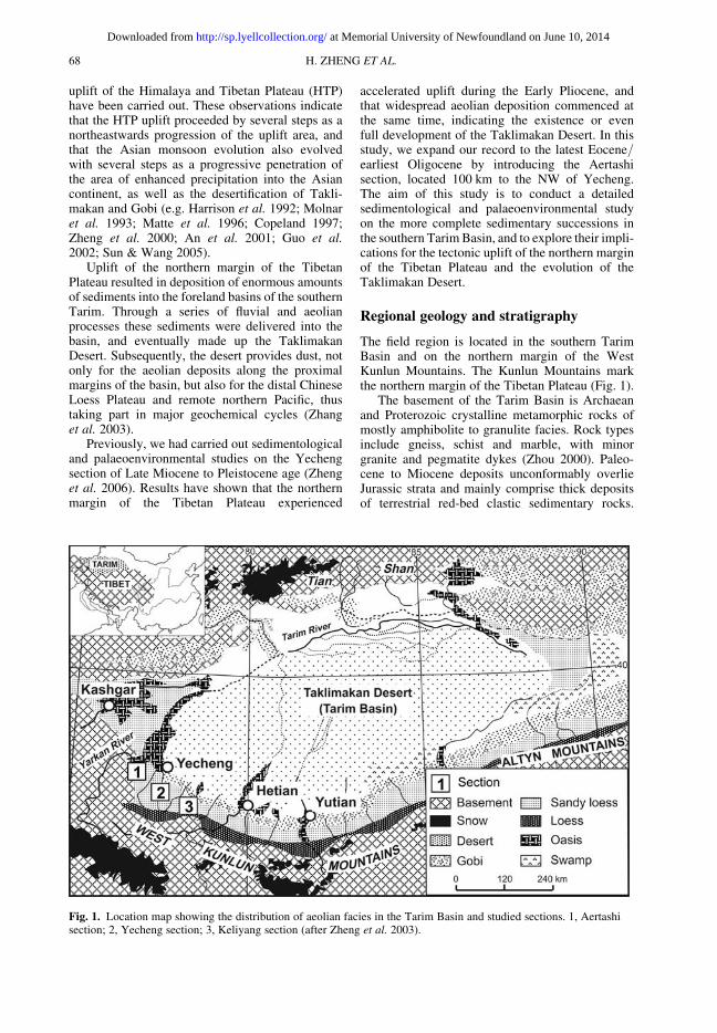
The field region is located in the southern TarimBasin and on the northern margin of the WestKunlun Mountains. The Kunlun Mountains markthe northern margin of the Tibetan Plateau (Fig. 1).
The basement of the Tarim Basin is Archaeanand Proterozoic crystalline metamorphic rocks ofmostly amphibolite to granulite facies. Rock typesinclude gneiss, schist and marble, with minorgranite and pegmatite dykes (Zhou 2000). Paleo-cene to Miocene deposits unconformably overlieJurassic strata and mainly comprise thick depositsof terrestrial red-bed clastic sedimentary rocks.
Fig. 1. Location map showing the distribution of aeolian facies in the Tarim Basin and studied sections. 1, Aertashisection; 2, Yecheng section; 3, Keliyang section (after Zheng et al. 2003).
H. ZHENG ET AL.68
at Memorial University of Newfoundland on June 10, 2014http://sp.lyellcollection.org/Downloaded from

Shallow-marine limestones and calcareous shaleswere deposited periodically until the Oligocene(Zhou 2000). In a more recent study, Ritts et al.(2008) reported a foraminiferal assemblage typicalof an open marine environment in mid-Miocenesediments from the southeastern Tarim Basin, adja-cent to the Altun Shan. This implies a much youngerage for the final retreat of marine environment in thesouthern Tarim than previously believed (Ritts et al.2008). In the Miocene, the whole Tarim Basin sub-sided and a series of terrestrial red sandstones,shales and mudstones were deposited. Uplift andthrusting of the marginal mountains caused depo-sition of thick piedmont conglomerates along thebasin margins (Zhou 2000).
The previously studied Yecheng section is intro-duced here as a reference (Zheng et al. 2000, 2006).The Yecheng section comprises over 4.5 km ofUpper Neogene sedimentary rock (Fig. 2). Thebase of the section is marked by a bed of fineto medium sandstone, with exposed thickness upto 40 m. Observations of the sandstone bed showvery good sorting and cross-bedding. We interpretthis sandstone unit as being aeolian in origin, repre-senting a palaeo-sand dune deposit (Zheng et al.2006). The lower part of the section consists of alter-nating beds of reddish mudstone, siltstone and fineto medium grained sandstone. Based on regionalstratigraphic correlation, the strata are equivalentto the upper part of the Miocene Wuqia Group(Sobel & Dumitru 1997). The middle part of thesection contains fine-grained sandstone, orange silt-stone, yellowish mudstone and thin layers of finegravel, which comprise the Artux Formation. Theuppermost part of the section is named the XiyuFormation, and is dominated by pebble to boulderconglomerate intercalated with lenses of paleyellow siltstone. All three units are conformable atthis location. The Pleistocene Wusu Formationunconformably overlies the Xiyu Formation to thenorth of the section. Aeolian loess deposits of latePleistocene to Holocene age mantle low hillsacross the whole region (Fig. 1).
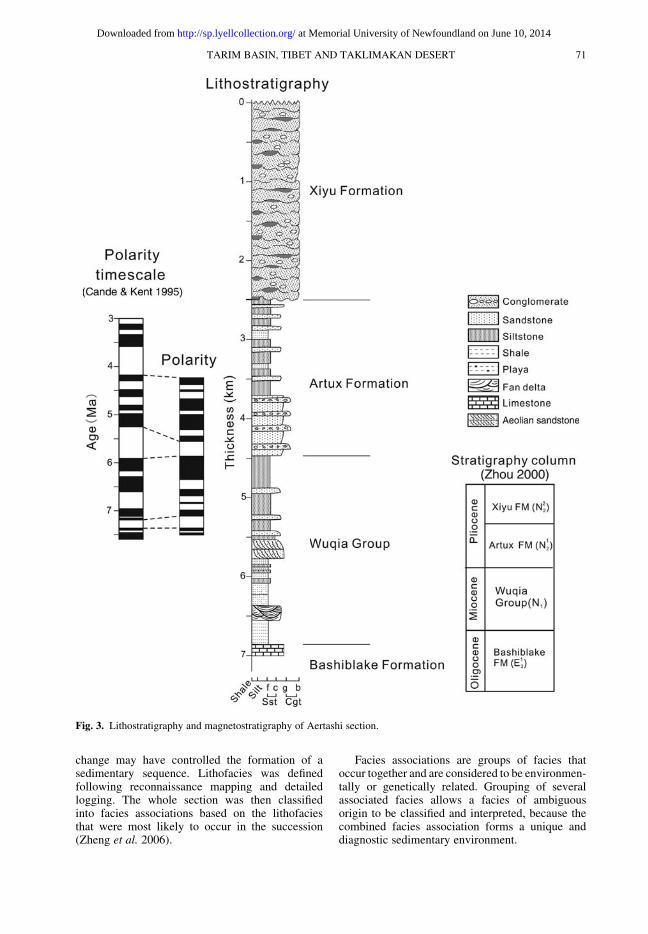
The principal section of the present study is atAertashi, which lies along the Yarkand River,about 100 km NW of the Yecheng section (Fig. 1).The locality comprises a complete successionfrom Upper Cretaceous to Pleistocene. Our studyfocuses on the Cenozoic sediments, with particularfocus on the Neogene sequence (Fig. 3). The totalthickness of the Cenozoic sequence is c. 7 km,but the uppermost part (Xiyu Formation) was notmapped in detail. The upper part of Aertashisection correlates with the three formations atYecheng (namely, the Wuqia Group, the Artux For-mation and the Xiyu Formation). The BashiblakeFormation (Yin et al. 2002) marks the base of thestudied Aertashi section (Fig. 3).
Magnetostratigraphy
About 2500 palaeomagnetic samples were collectedthrough the Yecheng section with a samplinginterval of about 1 m in the Artux Formation andWuqia Group. For the Xiyu Formation, samplingwas only possible from the fine sandstone andsiltstone bands (Fig. 2). All samples were thermallydemagnetized progressively and their magneti-zations were measured using a 2G-cryogenicmagnetometer at the University of WesternAustralia. Previously reported magnetostratigraphyonly included the upper 2800 m of the section(Zheng et al. 2000). This study presents the com-plete palaeomagnetic results, which extend to thevery base of the section. The observed magnetostra-tigraphy can be correlated with Cande & Kent’s(1995) polarity timescale (Fig. 2). The ArtuxFormation ranges from 4.6–3.5 Ma; the XiyuFormation has an age between 3.5–1.8 Ma. Thec. 1.7 km of red beds exposed in the Wuqia Groupis dated palaeomagnetically as being betweenc. 8.0 and 4.6 Ma. Therefore, the sandstone bed atthe base of the section is dated to be slightly olderthan c. 8 Ma.
In the Aertashi section, a total of 1107 sampleswere collected for magnetic polarity determinationfrom the Wuqia Group, through the Artux Forma-tion, up to the base of the Xiyu Formation. Wherepossible, sample sites were spaced at 4 m intervals,dependent on the availability of suitable lithologies.The uppermost part of the section (Xiyu Formation)contains substantially fewer beds suitable forpalaeomagnetic work. This study only presentsthe results of the section between 3500–5500 m,which covers the stratigraphic interval from theupper Wuqia Group and the lower part of theArtux Formation (Fig. 3).
The polarity stratigraphy of the Aertashi sectionis constructed based on its correlation with Cande &Kent’s (1995) polarity timescale (Fig. 3), and withthe Yecheng section (refer to Fig. 2). The base ofthe Artux Formation at Aertashi, defined as thefirst appearance of gravel beds, is dated to beabout 5.8 Ma, which is older than the 4.6 Maassigned to the same formation at Yecheng. Theaeolian sand dunes are slightly older than c. 8 Ma,comparable to the Yecheng section.
Lithofacies and palaeogeographic analysis
Facies analysis was carried out on both Yecheng andAertashi sections to define the sedimentary environ-ments. The objectives of facies analysis are to betterdefine a body of rocks with specific characteristics,based on classification of the sedimentary environ-ments in which the rocks formed. This will furthergive insight into how tectonics and/or climate
TARIM BASIN, TIBET AND TAKLIMAKAN DESERT 69
at Memorial University of Newfoundland on June 10, 2014http://sp.lyellcollection.org/Downloaded from
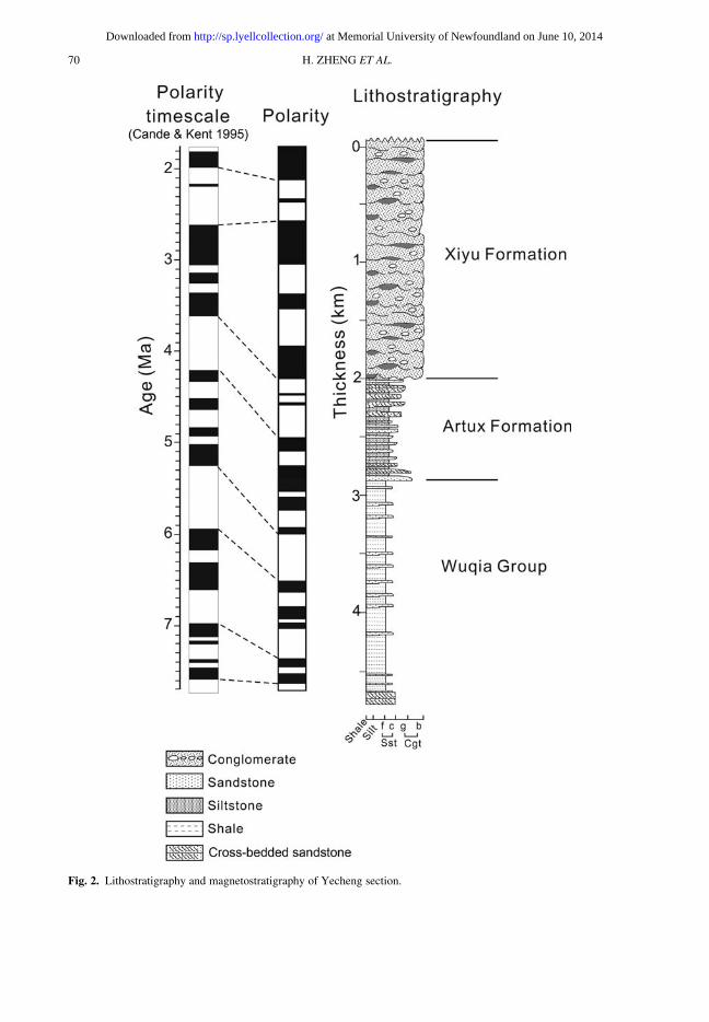
Fig. 2. Lithostratigraphy and magnetostratigraphy of Yecheng section.
H. ZHENG ET AL.70
at Memorial University of Newfoundland on June 10, 2014http://sp.lyellcollection.org/Downloaded from
change may have controlled the formation of asedimentary sequence. Lithofacies was definedfollowing reconnaissance mapping and detailedlogging. The whole section was then classifiedinto facies associations based on the lithofaciesthat were most likely to occur in the succession(Zheng et al. 2006).
Facies associations are groups of facies thatoccur together and are considered to be environmen-tally or genetically related. Grouping of severalassociated facies allows a facies of ambiguousorigin to be classified and interpreted, because thecombined facies association forms a unique anddiagnostic sedimentary environment.
Fig. 3. Lithostratigraphy and magnetostratigraphy of Aertashi section.
TARIM BASIN, TIBET AND TAKLIMAKAN DESERT 71
at Memorial University of Newfoundland on June 10, 2014http://sp.lyellcollection.org/Downloaded from

Yecheng section
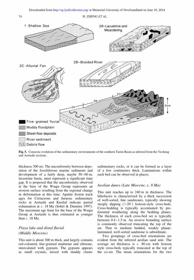
Six broad facies associations were recognizedwithin the Yecheng section. Detailed logs weremade of each sub-facies at a type locality, whichwere subsequently applied to the more generalfacies associations. At Yecheng, five facies asso-ciations were introduced by Zheng et al. (2006);these include: meandering-stream association,braided-stream association, floodplain association,distal- to mid-fan association, and proximalalluvial-fan association.
In this study, we introduce a new facies associ-ation for the Yecheng section, which is the aeoliandune association (Figs 2 & 4). This unit marks thebase of the profile, with an exposed thickness upto 40 m. The lithofacies is characterized by a thicksuccession of well-sorted fine sandstones, typicallyshowing steeply dipping (.208) festoon-stylecross-beds. The thickness of each cross-bed setis typically between 0.421.5 m. An erosive bound-ing surface is commonly observed truncating the topof the set. Thin to medium bedded, weakly planar-laminated, well-sorted sandstone is subordinate.
The lower part of the Yecheng section (theexposed Wuqia Group) is dominated by the depo-sition of thick successions of fine-grained terrestrial,fluvial clastics. Sedimentation occurred in meander-ing and braided streams, and on their flood plainsor distal alluvial fan. Floodplains typically slope at0.138–1.08 (Schumm & Khan 1972) and palaeocur-rent indicators show that the palaeoslope gradedgently to the north and northwest (Fig. 4). Overall,the depositional environment is one of low energy,with abundant deposition of silt, clay and fine sand.
The Artux Formation was deposited in a distal-to mid-fan environment. Most of the Artux For-mation consists of massive siltstone, fine sand,minor clay and granule beds. The depositionalenvironment is interpreted as having been arid,relative to the underlying Wuqia Group, with littlewater transport in the area, and significant depo-sition of silt and fine sand by aeolian processes.The section was close to the uplifted areas, butbecause of relatively minor uplift and the lack ofsignificant running water to transport much sedi-ment, aeolian and flood events dominated thedepositional processes.
The uppermost part of the Yecheng section isdominated by pebble to boulder conglomeratetypical of alluvial-fan debris-flow deposits. Theconglomerate is very poorly sorted, with clastsranging from granules to boulders .2 m in dia-meter. There is no evidence of fluvial sorting orreworking of the debris flow conglomerates. Somechannelling occurs at the base of individual layers,and reverse grading is common. The Xiyu Conglo-merate overlies the Artux Formation conformably
in the studied section, but unconformably in otherplaces (Zhou & Chen 1990).
Aertashi section
As mentioned above, the upper part of the AertashiSection correlates with the Yecheng Section(Fig. 3). The following description therefore focuseson the lithofacies of the lower part of AertashiSection, which includes three facies associations.These are a shallow marine association, a basinplain (lacustrine) association and a playa lakeassociation. The palaeogeographic evolution of thesouth margin of the Tarim Basin through time,has been reconstructed based on the lithofaciesassociations of the two combined sections.
Shallow marine (Early–Late Oligocene)
The measured Aertashi section starts from the top ofthe Bashiblake Formation (Figs 3 & 4). Field exam-ination reveals that the formation is about 200 mthick at this site, and consists of limestone andcalcareous shale, with fossil shells up to 20 cmacross. Deposition of the Bashiblake Formationalong the southern margin of Tarim Basin waswidespread. The easternmost exposure occurs atKeliyang, about 100 km to the SE of Yecheng(Fig. 1). Palaeomagnetic measurement of the Aerta-shi section does not yet go down to the BashiblakeFormation. Instead, 87Sr/86Sr isotope analysisof the shells was carried out to provide an approxi-mate age reference. Three shells yield 87Sr/86Srvalues between 0.707744 and 0.707942. Whenplotted against the Cenozoic global 87Sr/86Srcurve (Palmer & Edmond 1992), these values corre-spond to ages ranging from 35–33 Ma. This is inbroad agreement with previous estimates, whichclaimed that the Bashiblake Formation was formedat around 30 Ma (Sobel & Dumitru 1997).
Unambiguous evidence for uplift is provided bymarine fossils originally deposited at or below sealevel, but now lying at elevations of 1700 m. Themarine environment formed in a shallow embay-ment known as the Tadjik Sea, part of the largeTuran Sea further to the west (Fig. 5). During theEarly Oligocene, the marine basin retreated west-ward and was replaced by continental environments(Burtman 2000).
Basin plain and fan delta (Early Miocene)
The Bashiblake Formation is unconformably over-lain by c. 7 km of Neogene sedimentary rocks,although the age of the sediment was relativelypoorly constrained (Sobel & Dumitru 1997). Fieldobservation suggests that a lacustrine successionpasses up into a fan delta environment (total
H. ZHENG ET AL.72
at Memorial University of Newfoundland on June 10, 2014http://sp.lyellcollection.org/Downloaded from

Fig. 4. A schematic diagram showing the composite stratigraphy, palaeocurrents and sedimentary environments of theCenozoic sediments in the foreland basins of the southern Tarim.
TARIM BASIN, TIBET AND TAKLIMAKAN DESERT 73
at Memorial University of Newfoundland on June 10, 2014http://sp.lyellcollection.org/Downloaded from
thickness 300 m). The unconformity between depo-sition of the fossiliferous marine sediments anddevelopment of a fairly deep, maybe 50–60 m,lacustrine basin, must represent a significant timegap. It is proposed that the unconformity observedat the base of the Wuqia Group represents anerosion surface resulting from the regional changein deformation at this time. Apatite fission trackages for Cretaceous and Jurassic sedimentaryrocks at Aertashi and Kusilaf indicate partialexhumation at c. 18 Ma (Sobel & Dumitru 1997).The maximum age limit for the base of the WuqiaGroup at Aertashi is thus estimated as youngerthan c. 18 Ma.
Playa lake and distal fluvial
(Middle Miocene)
This unit is about 300 m thick, and largely containsred-coloured, fine-grained mudstone and siltstone,intercalated with gypsum. The gypsum appearsas small crystals, mixed with muddy clastic
sedimentary rocks, or it can be formed as a layerof a few centimetres thick. Laminations withineach bed can be observed in places.
Aeolian dunes (Late Miocene, c. 8 Ma)
This unit reaches up to 240 m in thickness. Thelithofacies is characterized by a thick successionof well-sorted, fine sandstones, typically showingsteeply dipping (.208) festoon-style cross-beds.Cross-bedding is typically accentuated by pre-ferential weathering along the bedding planes.The thickness of each cross-bed set is typicallybetween 0.4–1.5 m. An erosive bounding surfaceis commonly observed truncating the top of theset. Thin to medium bedded, weakly planar-laminated, well-sorted sandstone is subordinate.
Two groupings of cross-bed orientations areevident from the inferred aeolian sand unit. Theaverage set thickness is c. 80 cm with festoonstyle cross-beds typically truncated at the top ofthe co-set. The mean orientations for the two
Fig. 5. Cenozoic evolution of the sedimentary environments of the southern Tarim Basin as inferred from the Yechengand Aertashi sections.
H. ZHENG ET AL.74
at Memorial University of Newfoundland on June 10, 2014http://sp.lyellcollection.org/Downloaded from
groups are 22/298 (12 measurements) and 30/197(23 measurements) (Fig. 4). It is assumed thatthese orientations represent the wings of3-dimensional aeolian dunes and the bisectingangle c. 2408 represents the unidirectional winddirection forming Barchan style dune.
The aeolian strata lie below the magnetostrati-graphy analysis performed in this study but corre-lation indicates that they are older than 7.5 Ma. Atthe top of the aeolian section, fluvial mudstonesinterfinger with the aeolian dune sandstones.
Fluvial and distal alluvial (mid- to Late
Miocene)
The upper Wuqia Group records a change froman aeolian to a flood plain environment. Some ofthe sandstones have a yellow-green colour result-ing from reducing conditions. The colour changeslocally along the bed suggesting that it is set afterdeposition. Sandstone point-counting data indicatea shift towards a higher feldspar content and lowerlithic content, so that these rocks are classified aslithic feldspar-rich arenites. Palaeocurrents deter-mined from cross-bed foreset orientations andtrough axes suggest that palaeoflow was towardthe east to southeast. An upward-coarsening trendis observed, with more active channel depositionat the top of the Wuqia Group.
Fluvial, distal alluvial and aeolian
(Early Pliocene)
At Aertashi, the Artux Formation is defined by theearliest influx of coarse conglomerate, which sig-nifies the change to a new sedimentary environment.Facies analysis of the Artux Formation indicates adistinct change in the fluvial style from preservationof abundant fine-grained sediment, to rare fines pre-served only in overbank or crevasse splay settings.Field mapping also revealed the great variety of sub-facies in the Artux Formation. For example, somemeasured units are characterized by confined sedi-ment gravity flows and shallow braided channels.Conglomerate units typically have a scoured baseand may be either clast or matrix-supported. Someare characterized by couplets of conglomerate andsandstone indicating surging debris flow depositionin unconfined areas. The sheet flood deposits andsediment gravity flows indicate an outer alluvialfan environment. The conglomerate is more resis-tive to erosion and forms prominent dark bandsvisible in the field. The modal compositions indicatea slightly higher quartz content compared to sand-stones in the Wuqia Group. Pebble counts of theconglomerate indicate that most of the clasts arelimestone (55%) and 90% of the clasts are
sedimentary in origin. Limestone clasts in a terres-trial environment tend to break down rapidlyand their preservation suggests a proximal source(Mack 1984). Imbrication of clasts indicates palaeo-flow was northeasterly. The age limit suggests thebase of the Artux Formation is c. 5.8 Ma. The sedi-mentation rate shows increasingly rapid depositionand averages c. 1200 m Ma21.
The upper part of the Artux Formation is charac-terized by thick mudstones, channelized ephemeralstream and crevasse splay deposition. Conglomerateunits gradually fade out as finer grain-size equiva-lents appear. Mud cracks and ripples are observedand gypsum is common. Mud drapes indicate sedi-mentation in an ephemeral stream and crevassesplay or overbank deposition. The foredeep basinis probably over-filled at this stage and is perhapssimilar to the present day attitude of the YarkandRiver (see Fig. 1 for location), where flow is trans-verse to the range front. The modal compositiondetermined for this part of the section is similar tosamples from the lower Artux Formation and isclassified as a feldspathic litharenite. Measurablepalaeocurrent indicators were rare althoughasymmetric ripples in some places indicate a flowdirection toward the east. Palaeogeographic recon-struction illustrates a return to a flood plain environ-ment as the alluvial fan has retreated to the west,perhaps as sediment supply decreased. Erosion ofthe fault scarp would have continued, causing anoverall reduction in the slope angle.
The thickness of the Artux Formation at Aertashiis c. 2000 m compared to just 800 m recorded atYecheng. The stratigraphic log of Zheng et al.(2000) at Yecheng indicates that the conglomeratewithin the Artux Formation continues up to thebase of the Xiyu Formation. The 1000 m thickflood plain palaeoenvironment seen at the topof the Artux Formation at Aertashi is apparentlyabsent. Pebble counts on conglomerate clasts atYecheng indicate 50% of clasts are sedimentary inorigin, including up to 25% limestone in the ArtuxFormation. This compares to 90% sedimentaryclasts, including 55% limestone in the Artux For-mation at Aertashi. Intercalated, pale yellowishgrey, very fine grained sandstone and siltstonelenses, within the Xiyu Formation at Yecheng, inter-preted to be aeolian in origin, are absent from thesection at Aertashi. Bedding dips observed atYecheng are similar, although the strike is east–west compared to north–south at Aertashi. Allthese lines of evidence suggest that the depositionalenvironments at the two places were differentduring the deposition of the Artux Formation. Wespeculate that the Artux Formation at Aertashimay have been associated with the palaeo-YarkanRiver, as the fluvial facies are restricted to thisparticular site.
TARIM BASIN, TIBET AND TAKLIMAKAN DESERT 75
at Memorial University of Newfoundland on June 10, 2014http://sp.lyellcollection.org/Downloaded from
At Yecheng, the Artux Formation was depositedin a distal- to mid-fan environment. A number ofthin granule- to cobble-conglomerate beds weredeposited by sheet and debris flows, indicatingminor, proximal uplift to the south. Most of theArtux Formation consists of massive siltstone, finesandstone, minor claystone and granule beds.The palaeoenvironment is interpreted as arid rela-tive to that reconstructed for the Miocene WuqiaGroup, with little water action in the area, and sig-nificant deposition of silt and fine sand by aeolianprocesses (Zheng et al. 2003). The section wasclose to the uplifted areas, but because of relativelyminor uplift and lack of significant running water totransport much sediment, aeolian and flood eventsdominated the depositional processes.
Proximal alluvial and aeolian (Late
Pliocene–Holocene)
During this interval an abrupt change in the pala-eoenvironment is recorded in the Xiyu Formation.Over the period since 1.8 Ma, 2.5 km of boulder tocobble conglomerate of the Xiyu Formation wasdeposited at the Yecheng section. A similar thick-ness and composition of sediments were laid downat Aertashi. The sediments were derived from theWest Kunlun mountains and transported as debrisand sheet flows, with only minor stream-channeltransport. Deposition occurred on a proximal allu-vial fan with slopes of 1–58 to the north (Summer-field 1991), similar to the slopes observed onmodern active alluvial fans in the region (Fig. 5).Deposition was episodic, as debris and sheetfloods tend to be infrequent but highly energetic,depositing large thicknesses of sediments in ashort period of time. The lack of significant streamaction on the alluvial fan allowed silt-sized sedi-ments (in the form of silt bands) to accumulate onthe uneven fan-floor during times of low sedimentinput. The silt is interpreted as loess and similar towhat is currently being deposited on the top of theGobi gravels that rim the Tarim Basin (Zhenget al. 2003).
Aeolian deposition and formation of
Taklimakan Desert
The formation and evolution of the TaklimakanDesert is a regional response to widespread aridifi-cation caused by global climatic changes duringthe Late Cenozoic. Among other factors (such asglobal cooling), the uplift of the Tibetan Plateauand induced changes in atmospheric circulationmay have provided the major driving forces to thisAsian aridification (Zhang et al. 2007). The evol-utionary history of the Taklimakan Desert and the
loess deposits in the surrounding regions havegreat potential for improved understanding ofpalaeoclimatic changes both on regional andglobal scales, as well as having implications forthe uplift history of the Tibetan Plateau.
Zhu (1981) claimed that the aeolian landformsof the Taklimakan Desert were formed during themid- to late Quaternary. Dong et al. (1991) observeda series of buried aeolian sand units in the Neogenesediments in the Taklimakan Desert and surround-ing regions and suggested that the desert mayhave been in existence since the Pliocene or latestMiocene, that is, much earlier than previouslythought. There is little doubt that buried aeoliansand provides direct evidence for the existence ofarid landscapes. However, because buried aeoliansand units have been found only in a few scatteredsites so far, it is far from conclusive as to whetherthey represent relics of an aeolian landscape of rela-tively small scale, or a Late Miocene–Pliocenedesert as vast as the Taklimakan is today.
Aeolian facies are presently very well developedwithin and surrounding the Tarim Basin, and threedistinct aeolian facies can be recognized from thebasin centre to the mountain front (Zheng et al.2003; Fig. 1). These include: the desert facieswhich dominates the present day TaklimakanDesert; the Gobi facies which rims the desert; andthe sandy loess facies, which is distributed in thehilly piedmont regions of the surrounding moun-tains. Presently the three facies undergo constantreworking through fluvial and aeolian processes.Sediments shed off the uplifted region are firstdelivered to the basin by episodic alluvial systems.Fine-grained material is then deflated, resulting inthe formation of the Gobi (land surface concentratedwith gravels) and desert (sediments concentratedwith fine to coarse sand). The deflated fine materialis transported, sorted and then re-deposited alongthe basin margins at relative higher elevations.The loess deposits thus preserve information aboutthe evolution of the desert from which they orig-inally came. Previously we have reported that thesilt beds in the Artux and Xiyu Formations atYecheng were aeolian loess deposits, whichsuggests that the Taklimakan Desert may havebeen in existence since the Early Pliocene (Zhenget al. 2003). Sun & Liu (2006) later provided moreage constraints on the formation of the desert,which suggest that the desert has been in existencesince 5.3 Ma.
Our new stratigraphic data at both Yecheng andAertashi indicate that aeolian dunes first developedat about 8 Ma. The aeolian dune unit at Aertashioccurred after a thick succession of playa lakedeposits (thick accumulation of gypsum), represent-ing hypersaline conditions. We believe that thecombination of playa lake deposition and aeolian
H. ZHENG ET AL.76
at Memorial University of Newfoundland on June 10, 2014http://sp.lyellcollection.org/Downloaded from
dunes indicate that the area was very arid at thattime, although this line of evidence is insufficientto conclude whether or not this represents a land-scape like the Taklimakan today. Strong evidenceof severe deflation and aeolian deposition duringPlio-Pleistocene lies in the Artux and Xiyu Forma-tions, which contain abundant silt bands of aeolianorigin. As discussed above, the Artux Formation atYecheng is dominated by pale yellow medium- tofine-grained sandstone units and orange siltstonebeds, with minor layers of fine gravel. The XiyuFormation at both sections is composed of pebbleto boulder conglomerate intercalated with bands orlenses of pale yellow siltstone. Sedimentologicalexamination, together with grain size analysis andgeochemical investigations all prove that thesesiltstone bands are aeolian in origin, just like thePleistocene–Holocene loess that is widely distri-buted in the region (Zheng et al. 2003). The Plio-Pleistocene loess was deposited episodically onthe uneven fan-floor before being buried by thenext debris or sheet flow. Widespread loessdeposition along the margins of the Tarim Basinindicates that the Taklimakan Desert must havecovered a large area during deposition of the XiyuFormation, and that the climatic regime may havealso been similar to that seen today.
The onset of aeolian sedimentation in thesouthern Tarim Basin at c. 8 Ma coincided withthe lithofacies change from fine-grained mudstoneand sandstone to coarse clasts. We interpret theonset of fully arid conditions in the Tarim regionto be the result of the re-organization of thegeneral atmospheric circulation induced by upliftof the northern part of Tibetan Plateau. Theforcing of the Late Cenozoic climate by plateauuplift is yet to be fully explored. General CirculationModel (GCM) sensitivity tests run by Ruddiman &Kutzbach (1989) have suggested that the TibetanPlateau indeed played an important role in inducingthe ‘late Cenozoic climatic deterioration’ in theNorthern Hemisphere that culminated in the Plio-Pleistocene ice age.
Conclusions
The studied sections at Yecheng and Aertashi, aresituated at the northern foot of the West KunlunMountains, and comprise 4.5 km and 7.0 km ofCenozoic sedimentary strata, typical of the southernTarim Basin. The Cenozoic successions preservenearly continuous records of the sedimentaryresponse to uplift of the northern margin ofTibetan Plateau and palaeoenvironmental evolutionin the Tarim Basin.
The Aertashi section comprises c. 7 km ofnon-marine Palaeogene–Neogene strata uncon-formably overlying Oligocene marine strata of the
Bashiblake Formation. The c. 2200 m thick WuqiaGroup and c. 2000 m thick Artux Formation are con-formably overlain by .2500 m of grey, cobble toboulder, polymictic conglomerate of the Xiyu For-mation. Facies analysis of the section reveals apalaeogeographic evolution starting from shallowmarine conditions in the Early Oligocene, passingto basin plain and fan delta during the EarlyMiocene. A playa lake environment was developingduring the Middle Miocene, and may have culmi-nated in an aeolian dune landscape around 8 Ma,as observed at both Aertashi and Yecheng.
The Yecheng Section correlates with the upperpart of the Aertashi Section, except that the ArtuxFormation at Aertashi was formed in an environ-ment with significant channels and running water,which may indicate the presence of a palaeo-YarkanRiver, whereas the Artux Formation at Yecheng wasdeposited in a distal- to mid-fan environment. Depo-sition of the thick, pebble to boulder conglomerateof the Xiyu Formation marked a phase of strongmountain uplift, although climate change may alsohave contributed to the environmental change.
Development of aeolian dunes at c. 8 Ma, andthe hypersaline deposition below, indicates thatthe regional climate regime was then significantlyarid. Deposition of aeolian silt in the Artux andXifu Formations indicates that the TaklimakanDesert may have been fully developed by thattime. The climate regime had evolved so that thedesert was able to provide aeolian dust that wasdeposited episodically on the uneven surface ofthe alluvial fan before being buried by the nextdebris or sheet flow.
This work was financially supported by a NSFC grant(40830107) and Mitsubishi Foundation awarded to RT.
References
An, Z. S., Kutzbach, J. E., Prell, W. L. & Porter, S. C.2001. Evolution of Asian monsoons and phased upliftof the Himalaya-Tibetan plateau since late Miocenetimes. Nature, 411, 62–66.
Burtman, V. S. 2000. Cenozoic crustal shorteningbetween the Pamir and Tien Shan and a reconstruc-tion of the Pamir–Tien Shan transition zone for theCretaceous and Palaeogene. Tectonophysics, 319,69–92.
Cande, S. C. & Kent, D. V. 1995. Revised calibrationof the geomagnetic polarity timescale for the LateCretaceous and Cenozoic. Journal of GeophysicalResearch, 100, 6093–6095.
Copeland, P. 1997. The when and where of the growth ofthe Himalaya and the Tibetan Plateau. In: Ruddiman,W. F. (ed.) Tectonic Uplift and Climate Change.Plenum Press, New York, 19–40.
Dong, G., Chen, H., Jing, J. & Wang, Y. 1991. Cenozoicpaleo-eolian sands in the south marginal area of theTaklimakan Desert. In: Dong, G., Chen, H., Jing, J. &
TARIM BASIN, TIBET AND TAKLIMAKAN DESERT 77
at Memorial University of Newfoundland on June 10, 2014http://sp.lyellcollection.org/Downloaded from
Wang, Y. (eds) Glaciers and Environments of WestChina. China Association of Quaternary Research,Science Press, Beijing, 42–48.
Guo, Z. T., Ruddiman, W. et al. 2002. Onset of Asiandesertification by 22 Myr ago inferred from loessdeposits in China. Nature, 416, 159–163.
Harrison, T. M., Copeland, P., Kidd, W. S. F. & Yin, A.1992. Rising Tibet. Science, 255, 1663–1670.
Matte, P., Tapponnier, P. et al. 1996. Tectonics ofWestern Tibet, between the Tarim and Indus. Earthand Planetary Science Letters, 142, 311–330.
Molnar, P., England, P. & Martinod, J. 1993. Mantledynamics, uplift of the Tibetan Plateau, and the Indianmonsoon. Reviews of Geophysics, 31, 3570–396.
Palmer, M. R. & Edmond, J. M. 1992. Controls overthe strontium isotope composition of river water.Geochimica et Cosmochimica Acta, 56, 2099–2111.
Ramstein, G., Fluteau, F., Besse, J. & Joussaume, S.1997. Effect of orogeny, plate motion and land-seadistribution on Eurasian climate change over the past30 million years. Nature, 386, 788–795.
Ritts, B. D., Yue, Y., Graham, S. A., Sobel, E. R.,Abbink, O. A. & Stockli, D. 2008. From sea levelto high elevation in 15 million years: uplift history ofthe northern Tibetan Plateau margin in the AltunShan. American Journal of Science, 308, 657–678.
Ruddiman, W. F. & Kutzbach, J. E. 1989. Forcing of lateCenozoic Northern Hemisphere climate by plateauuplift in Southern Asia and the American West.Journal of Geophysical Research, 94, 18 409–18 427.
Schumm, S. A. & Khan, H. R. 1972. Experimental studyof channel patterns. Geological Society of AmericaBulletin, 83, 1755–1770.
Sobel, E. R. & Dumitru, T. A. 1997. Thrusting andexhumation around the margins of the westernTarim basin during the India-Asia collision. Journalof Geophysical Research, 102, 5043–5063.
Summerfield, M. A. 1991. Global Geomorphology: AnIntroduction to the Study of Landforms. New York,Wiley.
Sun, J. M. & Liu, T. S. 2006. The age of the TaklimakanDesert. Science, 312, 1621.
Sun, X. J. & Wang, P. X. 2005. How old is the Asianmonsoon system? Palaeobotanical records from China.Palaeogeography, Palaeoclimatology, Palaeoecology,222, 181–222.
Yin, A., Rumelhart, P. E. et al. 2002. Tectonic historyof the Altyn Tagh fault in northern Tibet inferredfrom Cenozoic sedimentation. Geological Society ofAmerica Bulletin, 114, 1257–1295.
Zhang, X. Y., Gong, S. L., Zhao, T. L., Arimoto, R.,Wang, Y. Q. & Zhou, Z. J. 2003. Sources ofAsian dust and role of climate change versus deser-tification in Asian dust emission. GeophysicalResearch Letters, 30, 2272, doi: 10.1029/2003GL018206.
Zhang, Z., Wang, H., Guo, Z. & Jiang, D. 2007. Whattriggers the transition of palaeoenvironmental patternsin China, the Tibetan Plateau uplift or the ParatethysSea retreat? Palaeogeography, Palaeoclimatology,Palaeoecology, 245, 317–331.
Zheng, H., Powell, C., An, Z., Zhou, J. & Dong, G.2000. Pliocene uplift of the northern Tibetan Plateau.Geology, 28, 715–718.
Zheng, H., Powell, C., Butcher, K. & Cao, J. 2003.Late Neogene aeolian loess deposition in southernTarim Basin and its palaeoenvironmental significance.Tectonophysics, 375, 49–59.
Zheng, H., Huang, X. & Butcher, K. 2006. Lithostrati-graphy, petrography and facies analysis of the LateCenozoic sediments in the foreland basin of the WestKunlun. Paleogeography, Paleoclimatology, Paleo-ecology, 241, 61–78.
Zhou, Z. Y. (ed.) 2000. Stratigraphy of the Tarim Basin.Science Press, Beijing.
Zhou, Z. Y. & Chen, P. J. (eds) 1990. Biostratigraphy andGeological Evolution of Tarim Basin. Science Press,Beijing.
Zhu, Z. 1981. The Aeolian Landforms of the TaklimakanDesert. Science Press, Beijing.
H. ZHENG ET AL.78
at Memorial University of Newfoundland on June 10, 2014http://sp.lyellcollection.org/Downloaded from