cameron county
TRANSCRIPT
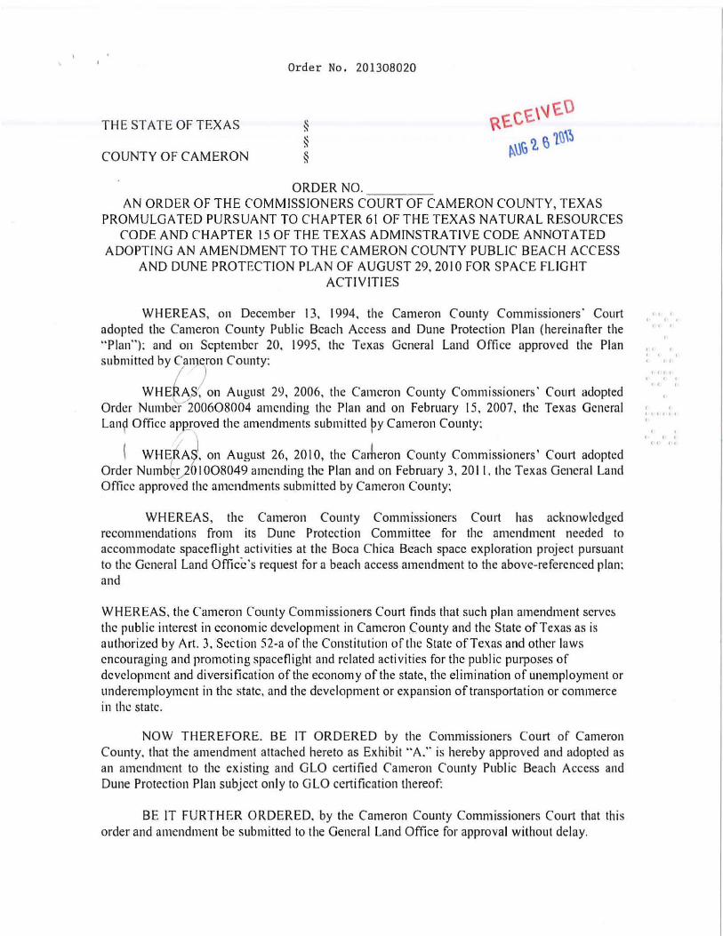
Order No. 201308020
THE STATE OF TEXAS
COUNTY OF CAMERON
ORDER NO. AN ORDER OF THE COMMISSIONERS C-=-O-:-CU=-R=T--=OC::FC-::CAMERON COUNTY, TEXAS
PROMULGATED PURSUANT TO CHAPTER 61 OF THE TEXAS NATURAL RESOURCES CODE AND CHAPTER 15 OF THE TEXAS ADMINSTRATIVE CODE ANNOTATED
ADOPTING AN AMENDMENT TO THE CAMERON COUNTY PUBLIC BEACH ACCESS AND DUNE PROTECTION PLAN OF AUGUST 29. 2010 FOR SPACE FLIGHT
ACTIVITIES
WHEREAS, on December 13, 1994. the Cameron County Commissioners' Court adopted the Cameron County Publ ic Beach Access and Dune Protection Plan (hereinafter the "Plan"): and on September 20. 1995. thc Texas Gcneral Land Office approved the Plan submitted by Can)eron County:
WHEt AI. on August 29. 2006. the Cameron County Commissioners' Court adopted Order Number200608004 amending the Plan and on February 15 . 2007. the Texas General Lan? Office apRroved the amendments submitted Py Cameron County:
\ WHEtJ. on August 26. 2010, the Carheron County Commissioners' Court adopted Order Numbk,2{)1008049 amending the Plan and on February 3.2011. the Texas General Land Office approved the amendments submitted by Cameron County:
WHEREAS. the Cameron County Commissioners Court has acknowledged recommendations from its Dune Protection Committee for the amendment needed to accommodate spaceflight activities at the Boca Chiea Beach space exploration project pursuant to the Geneml Land Office's request for a beach access amendment to the above-referenced plan: and
WHEREAS. the Cameron Counly Commissioners Court finds that such plan amendment serves the public interest in economic development in Cameron .County and the State of Texas as is authorized by Art. 3. Section 52-a of the Constitution of the State of Texas and other laws cncouraging and promoting spaceflight and rclated activities for thc public purposes of dcvelopmcnt and diversification of the economy of the state. the elimination of unemployment or underemploymcnt in thc statc. and the development or expansion of transportation or commerce in the state.
NOW THEREFORE. BE IT ORDERED by the Commissioners Court of Cameron County. that the amendment attached hereto as Exhibit "A." is hereby approved and adopted as an amendment to the existing and GlO certified Cameron County Public Beach Access and Dune Protection Plan subjcct only to GlO certification thereof:
BE IT FURTHER ORDERED. by the Cameron County Commissioners Court that thi s order and amendmcnt bc submitted to the Gencral Land Office for approval without delay.
... • •
.. · · . ({ {t · . .. . · . "," , · .
• • " "
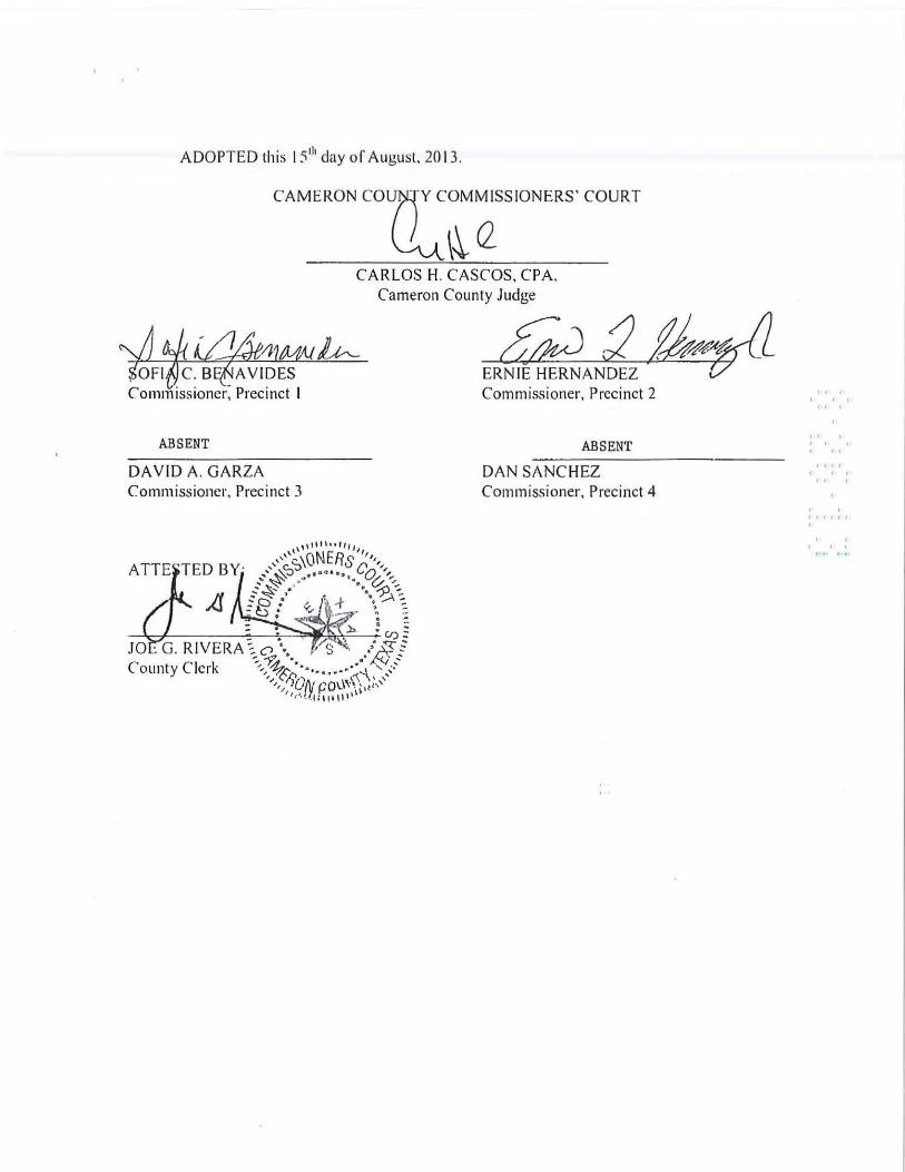
ADOPTED this 15 'h day or August, 2013 .
CAMERON CO'[~~SSIONERS' COURT
CARLOS H. CASCOS. CPA.
~~~~lM{)~ SOFI c. B _ A VIDES Commissioner, Precinct I
ABSENT
DA VID A. GARZA Commissioner, Precinct 3
Cameron County Judge
tkJ 2 ~fAff~ ERNIE HERNANDEZ t5f LL Commissioner. Precinct 2
ABSENT
DAN SANCHEZ Commissioner, Precinct 4
" , , . " ,
" , , , , "
• I" , " " ,
, . "'" , • , , , " ...... ,.,
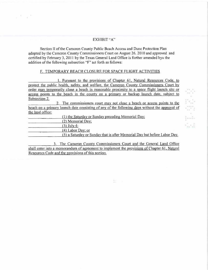
EXHIBIT "A"
Section II of the Cameron County Public Beach Access and Dune Protection Plan adopted by the Cameron County Commissioners Court on August 26. 20 I 0 and approved and certified by February 3, 2011 by the Texas General Land Office is further amended byu the addition of the following subsection "F" set forth as follows:
F. TEMPORARY BEACH CLOSURE FOR SPACE FLIGHT ACTlVlTlES
I. Pursuant to the provisions of Chapter 61 , Natural Resources Code. to protect the public health. safety. and welfare. the Camcron County Commissioners Court by order may temporarily close a bcach in reasonablc proximity to a space flight launch site or access points to the beach in the county on a primary or backup launch date, subject to Subsection 2.
2. The commissioners court may not close a beach or access points to the beach on a primary launch date consisting of any of the following days without the approval of the land office:
( I) the Saturday or Sunday preceding Mcmorial Day; (2) Memorial Day; (3)July4; (4) Labor Day; or (5) a Saturday or Sunday that is after Memorial Day but before Labor Day.
3. The Cameron County Commissioners Court and the General Land Office shall enter into a memorandum of agreement to implement the provisions of Chapter 61, Natural Resources Code and the provisions ofthis section.
, , " ,
, , , , , ." 'f' , , , " ,
, , "'" .
, , , l..l.. l..l..
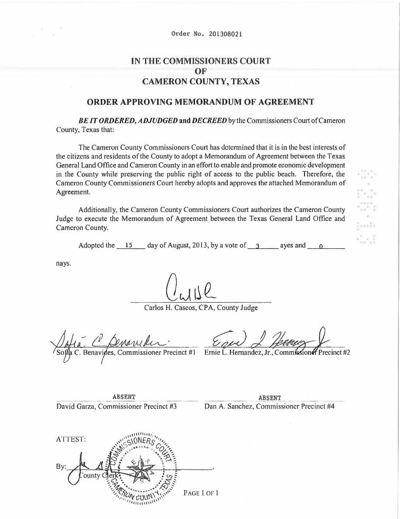
Order No. 201308021
IN THE COMMISSIONERS COURT OF
CAMERON COUNTY, TEXAS
ORDER APPROVING MEMORANDUM OF AGREEMENT
BE IT ORDERED, ADJUDGED and DECREED by the Commissioners Court of Cameron County, Texas that:
The Cameron County Commissioners Court has determined that it is in the best interests of the citizens and residents ofthe County to adopt a Memorandum of Agreement between the Texas General Land Office and Cameron County in an effort to enable and promote economic development in the County while preserving the public right of access to the public beach. Therefore, the Cameron County Commissioners Court hereby adopts and approves the attached Memorandum of A!,'feement.
Additionall y, the Cameron County Commissioners Court authorizes the Cameron County Judge to execute the Memorandum of Agreement between the Texas General Land Office and Cameron County.
Adopted the 15 day of August, 2013, by a vote Of_3",-__ ayes and _""'0'-__
nays.
Carlos H. Cascos, CPA, County Judge
ABSENT _AJlJ!ENL _ -- ----- --David Garza, Commissioner Precinct #3 Dan A. Sanchez, Commissioner Precinct #4
ATTEST:
" , , , " ,
, , , , , " '" ( , , " ,
, , ,,' (,' ,
, , , ,( 'c
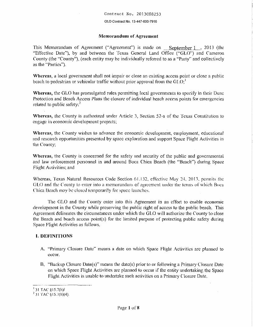
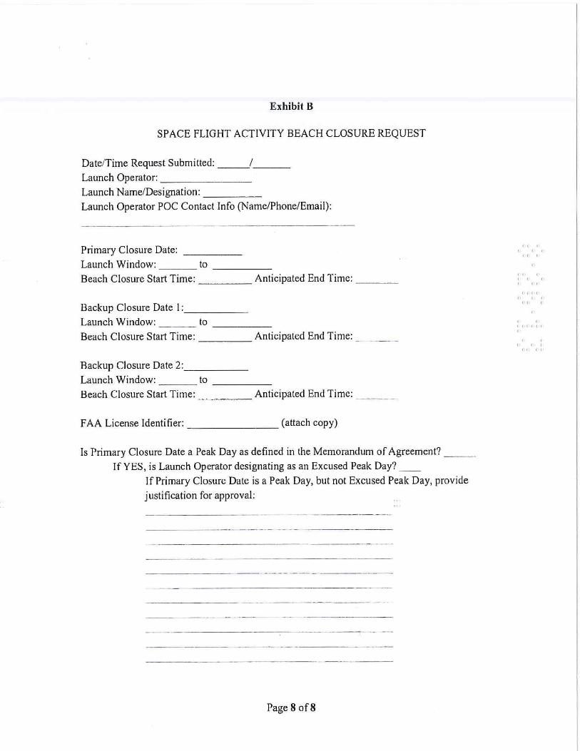
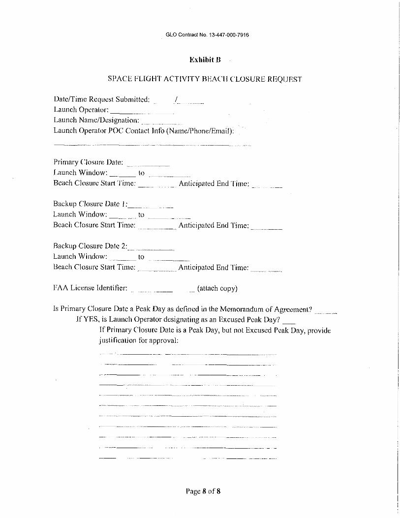
Exhibit B
SPACE FLIGHT ACTIVITY BEACH CLOSURE REQUEST
DatelTime Request Submitted: / __ _ Launch Operator: _______ _
Launch NamelDesignation: ____ _
Launch Operator POC Contact Info (Name/Phone/Email):
Primary Closure Date: Launch Window: _ __ to ____ _
Beach Closure Start Time: ____ Anticipated End Time: ___ _
Backup Closure Date 1: ____ _
Launch Window: to ____ _
Beach Closure Start Time: Anticipated End Time: _ _ _ _
Backup Closure Date 2: ____ _
Launch Window: to ____ _
Beach Closure Start Time: Anticipated End Time: _ __ _
FAA License Identifier: (attach copy)
Is Primary Closure Date a Peak Day as defined in the Memorandum of Agreement? __ _
If YES, is Launch Operator designating as an Excused Peak Day? _ _
IfPrimary Closure Date is a Peak Day, but not Excused Peak Day, provide
justification for approval:
-------- -- ----------- -
--- ------ ---- - -
-- ---- -- --- --- - -
Page8of8
" . . . " .
" · . · " '" , .. " .
· . ,( «( (' , , , ,
(. "
CAMERON COUNTY DUNE PROTECTION AND
BEACH ACCESS PLAN
Adopted on September 20, 1994
Amended on August 29, 2006 August 26, 2010 August 23, 2013
2
I. BACKGROUND A. LEGISLATIVE INTENT
With passage of the 71st Legislature’s SB 1571 in 1989, the Texas General Land Office was charged with assembling a Coastal Management Advisory Committee and initiating consideration of various issues affecting the Texas coast. A number of Cameron County residents were involved with the various hearings and workshops conducted by the Texas General Land Office in development of the Coastal Management Plan. In general, the Plan developed by this committee and the Land Office constituted a broad-based, issue-oriented discussion. It was recognized by the committee that due to the size and diversity of the Texas coast, specific local level planning was necessary to address unique situations in local environments. As a result, the 72nd Legislature in 1991, passed Senate Bill 1053 which charged Texas with counties along the Gulf of Mexico with development of local level coastal planning and management documents. Counties, as coordinating authorities, could delegate planning or incorporated areas to appropriate cities or towns. Although this Legislation mandated and authorized a variety of state and local government actions, the fundamental objective outlined in SB 1053 was:
1. the development of local public beach access plans that would afford and
guarantee the public’s right to beach access and use including a certification process for beachfront construction to prevent impairment of beach access, and
2. establishment of a dune protection line and a permitting process to protect
coastal dune systems, and
3. strengthening flood protection measures to protect the community from the perils of flood damage.
B. CAMERON COUNTY’S RESPONSE TO SB 1053
It was the intent of Cameron County Commissioners to move aggressively forward with development of a plan for Cameron County, even prior to the Texas General Land Office’s development of rules for SB 1053 accordingly, the Commissioners Court, in July of 1991, appointed a Coastal Management Committee composed of seven citizens. The seven committee members were selected to represent a broad array of diverging interests, and different geographic regions of the County. Technical advisor, as well, were selected to represent a diversity of backgrounds and expertise with an emphasis on those familiar with the Cameron County coastline. Also, appointed without voting status were four adjunct committee members, and eight technical advisors. The Commissioners charged the Committee with “fast track” action that would assure production of a plan that took into account all major relevant factors affecting lands and environments of the Cameron County Coastal area, without complicating this planning process by burdensome and extensive delays.
3
The 1992 Cameron County Public Beach Access and Dune Protection Plan was developed over a five (5) month period, commencing in early July and completed in November of 1991. A county approved plan was forwarded from Cameron County to the Texas General Land Office for review and comment in accordance with the requirements of SB 1053. After revisions to address comments by the Texas General Land Office, the 1992 Cameron County Public Beach Access and Dune Protection Plan received approval on an interim basis by the Texas General Land Office in March 1993, and became the operative planning document for land development projects in the county’s unincorporated coastal areas. Subsequent to interim approval of the plan, the Texas General Land Office developed rules which necessitated with requirements and conditions stipulated in the rules. Accordingly Cameron County staff, the Parks prepared and presented a revised plan in the summer of 1994. Cameron County Commissioners in compliance with public hearing requirements reviewed and approved the revised plan on October 20, 1994.
The court’s purpose of this plan is to embrace the intent of SB 1053 so that public beach access and use along all Cameron County beaches are guaranteed in perpetuity by provision of adequate access points, to ensure that Cameron County will be protected from flood losses, and additionally to assure that the integrity of the beach/dune system is maintained and enhanced while recognizing landowner’s private property rights, and affording mitigating options to the landowner that would protect dunes, while not unreasonably restricting private land use.
C. LEGAL AUTHORITY FOR PLAN ADOPTION
Cameron County Commissioners Court, under authority granted by Senate Bill No. 1053, herby establishes the Cameron County Public Beach Access and Dune Protection Plan in accordance with State statutes and requirements, and adopts all beach management practices relative to: protecting the beach /dune system seaward of the defined dune protection line, flood protection and public beach access requirements as represented in the plan. Additionally, Cameron County establishes, by order of Cameron County Commissioners Court (Court Order 1994-02), the Cameron County Public Beach Access interim 1992 CAMERON COUNTY PUBLIC BEACH ACCESS AND DUNE PROTECTION PLAN (COURT ORDER 1992-1), upon certification of said plan by Texas General Land office and Attorney General.
II. PUBLIC BEACH ACCESS IN UNICORPORATED AREAS A. BEACHFRONT CONSTRUCTION CERTIFICATES
Beachfront construction certificates are required under Natural Resources Code §61.015 (c) - (h) for any construction within 1000 feet of mean high tide or up to the first public road, whichever distance is greater. The Cameron County Park System, operating through Cameron County Commissioners Court and advised by the County Parks Advisory Board, is hereby charged with responsibility for administering the beach access component of this plan. Applications for beachfront construction
4
certificates shall be reviewed by the County Parks Advisory Board not sooner than ten (10) days after written notification to the Texas General Land Office of the application for a beachfront construction certificate. The Cameron County Building Official shall be responsible for sending Beachfront Construction Applications to the state. Cameron County Commissioners' Court will review and take action on beachfront construction certificates as advised by parks system staff and the county Park Advisory Board, whose recommendations will be considered but are not binding on court action. Neither the County nor State shall unreasonably delay review or action on an application, and shall make a final determination on an application not later than 6 weeks from application receipt.
Findings necessary by the Court to issue a beachfront construction certificate are:
1. the proposed project does not (directly or indirectly) reduce the size or encroach on the public beach in any manner, or impair or adversely effect public use of or access to and from a public beach, or
2. the proposed project does not functionally support or depend on or is
otherwise related to proposed or existing structures that encroach on the public beach, regardless of whether the encroaching structure is on land that was previously landward of the public beach.
B. REVISION OF BEACH ACCESS COMPONENT OF PLAN
Revision or update of the public beach access component of this plan shall be initiated b the Cameron County Parks Advisory Board. Prior to taking any action on an advisory board recommendation, the Cameron County Commissioners' Court shall conduct a public hearing. Approved plan changes shall be forwarded to the Texas General Land Office and Texas Attorney General for review and comment.
C. PUBLIC SAFETY FINDINGS
Cameron County recognizes that drive-on vehicular operations on beaches currently afford most public beach access in unincorporated county areas. The Commissioners’ Court hereby establishes a beach access plan that provides for a continuance of vehicle access to some County beaches, but that institutes better management controls of vehicular beach use. Further, Cameron County hereby establishes that County’s intent to incrementally redesignate selected vehicular beaches to pedestrian’s beaches by provision of public off beach parking lots and beach access parks. Cameron County will when ever practical and in addition to legal requirements of A.D.A. laws, maintain and enhance free (no fee) beach access areas. Where practical, Cameron County will use walkovers to preserve and enhance beach access. Upon Cameron County planning for adequate parking or public access to the beaches where vehicular access is restricted, it was determined that it was impractical to provide public access while protecting the existing dune system. It was also determined that it was impossible to provide parking every ½ mile from one
5
another along Park Road 100 because of the existing geographic characteristics making it unfeasible by weakening and destroying significantly critical dunes. Therefore, Cameron County has attempted to overcompensate by providing more parking spaces than required and along with parking on the beach at beach access Number 5.
A number of issues and problems associated with vehicular traffic on county beaches led to the recognition that vehicles should be restricted from specific sections of Cameron County beaches, similar to current restrictions in county parks and the beaches of the Town of South Padre Island. These issues include:
1. Pedestrian safety - the operation of motor vehicles on beach areas containing
heavy pedestrian usage, even when in compliance with all rules and regulations, is inherently unsafe.
2. Stranding of motorists - Often motorists become stranded while operating
vehicles on public beaches, thus creating a traffic hazard and impeding traffic flow, as well as creating hazards to nearby pedestrians.
3. Litter - the volume and frequency of littering activity associated with
pedestrian beach areas is notably lower in comparison to areas where beach users gain beach access by vehicle and picnic in the vicinity of vehicles on the public beach.
4. Unauthorized vehicle operation - Inadvertent as well as intentional operation
of two-wheel drive and four-wheel drive motor vehicles in the fore dune areas or loose sand areas causes beach erosion, dune erosion decreases flood protection and disturbs or destroys vegetation.
5. Recreationist’s security - the presence of motor vehicles and activities
sometimes associated with motor vehicle operation has generally left an insecure feeling to other beach users particularly families with young children, on beach areas experiencing high-density use. It is generally recognized by families and persons seeking a crime free environment that the vehicular beaches are the place of last resort.
D. BEACH ACCESS COMPONENT
Use of Beach User Fee Revenues
Revenue from beach user fees may be used only for beach-related services. “Beach-related services” means reasonable and necessary services and facilities directly related to the public beach which are provided to the public to ensure safe use of and access to and from, and the standard maintenance and operation expenses such as but not limited to vehicular controls, management, and parking (including acquisition and maintenance of off-beach parking and access ways); sanitation and litter control; the cleaning or removal of debris from the beach by handpicking and raking by mechanical means, providing law enforcement; beach nourishment projects;
6
beach/dune system education; beach/dune protection and restoration projects providing public facilities such as restrooms, showers, and picnic areas; liability insurance; and personnel necessary to provide beach-related services. Beach-related services and facilities shall serve only those areas on or immediately adjacent to the public beaches. All funds including surplus funds derived by Cameron County from the Beach User Fee program shall be used at a minimum for the following purpose: 1. all costs associated with administering the requirements of TAC §15.8 Beach
User Fees 2. the provision, construction, maintenance, replacement and repair of:
a) sanitary facilities on the beach provided for the use and convenience of the public,
b) on and off beach parking facilities, c) traffic control or road signs, devices or structures on the beach, and sand
dunes and dune vegetation, d) the cleaning and maintenance of the public beach, e) public safety on the beach, and f) all costs directly related to the management of the beach.
Administrative Cost and Accounting
The following methods shall be used for administering beach user fee accounting: 1. No more than 10% of beach user fee revenues shall be expended in one fiscal
year on reasonable administrative costs related to beach-related services. 2. Revenue/Expenditure Accounting. Cameron County will establish a separate
“fund” in the Cameron County Park System budget for all expense of revenue activities occurring on county beaches outside of county parks (i.e., at conservation check stations, beach patrol areas, etc.) Revenues will be maintained and accounted for separately and not commingled with any other funds so that fee collections may be directly traced to expenditures on beach related services.
3. Beach user fee revenues shall be maintained and documented individually for each beach user fee and account balances and expenditures shall be documented according to general accepted accounting principles.
4. Annual operating and capital budgets will be established based on anticipated revenues and any excess revenues at year-end will be credited to the following year’s operating and capital budgets. Along with Park System audits, an independent audit of this fund will be conducted annually; the results of any audit relevant to conservation fee revenues shall be submitted to the Texas General Land Office. Cameron County will send quarterly reports to the Texas General Land Office on the amount of beach conservation fee revenues collected and itemizing how beach user fee revenues are expended.
Conservation Fee / Beach Access In order to establish and a maintain quality beach-related services and facilities for the preservations and enhancement of access, to and from and safe and healthy use
7
of beaches by the public, the following fee schedule is be recommended: a maximum day use fee of $12.00 per vehicle including motorcycles, a day use fee of $6.00 per vehicle for Military Veterans, a $25.00 fee for a 30-day pass, a $100.00 fee for an annual pass, and a $25.00 daily entry fee for Busses. These provisions are consistent with the Beach and Dune Rules of 31 TAC § 15.8(1). Supplemental revenue sources may be considered in addition to the beach user fee to fund the expanded services and management of public beaches. These may include, but are not limited to, parking meter revenues, “bed tax” revenues, State Beach Maintenance Reimbursement funds and potential beach commodity concessionaires. In Cameron County, Public Beach related amenities are maintained for the enjoyment of the visitors, which in the unincorporated areas of the County, there are 7 public county maintained beach access points along the Gulf of Mexico. Three of the existing beach access points to Cameron County beaches will allow public vehicular access and are identified as Access Point Number 7-Boca Chica Beach; Access Point Number 5-E. K. Atwood Park; and Access Point Number 6. Furthermore, four other access points restrict vehicular access on public beaches, but provide pedestrian access and public parking and are identified Access Point Number 1-Isla Blanca Park; Access Point Number 2-Andy Bowie Park; Access Point Number 3-0.3 miles north of Andy Bowie Park; and Access Point Number 4 (Free Access-Beach Pocket Park), one mile north of Andy Bowie Park.
“Free Access-Beach Pocket Parks” Drive on access will be afforded and controlled, as financially feasible, at three designated access points. Vehicular or pedestrian beach access at other points across private lands, particularly that which may result in public trespassing, dune destruction, decreased flood protection and unregulated vehicular activities will be discouraged in accordance with State Statutes while encouraging beach access at official beach access points. Cameron County shall maintain some free public beach access, providing access areas where no fee is charged for parking. These areas are currently identified as: access point number seven (7), Boca Chica Beach; beach access point number four (4) and seasonal free beach access at access point number six (6) on South Padre Island. Beach Conservation Check Stations may be established at each of the beach access points as fiscal resources allow. Such check stations may consist of a building that affords facilities for staffing. At the county’s first vehicular beach access point being the most southern drive-on access point on South Padre Island presently known as E.K. Atwood Park, staffing will be maintained on a year-round basis. Seasonal staffing will be afforded at the beach conservation check station at Cameron County’s Beach Access number 6 located approximately 3 miles north of E. K. Atwood Park (Beach Access 5).
8
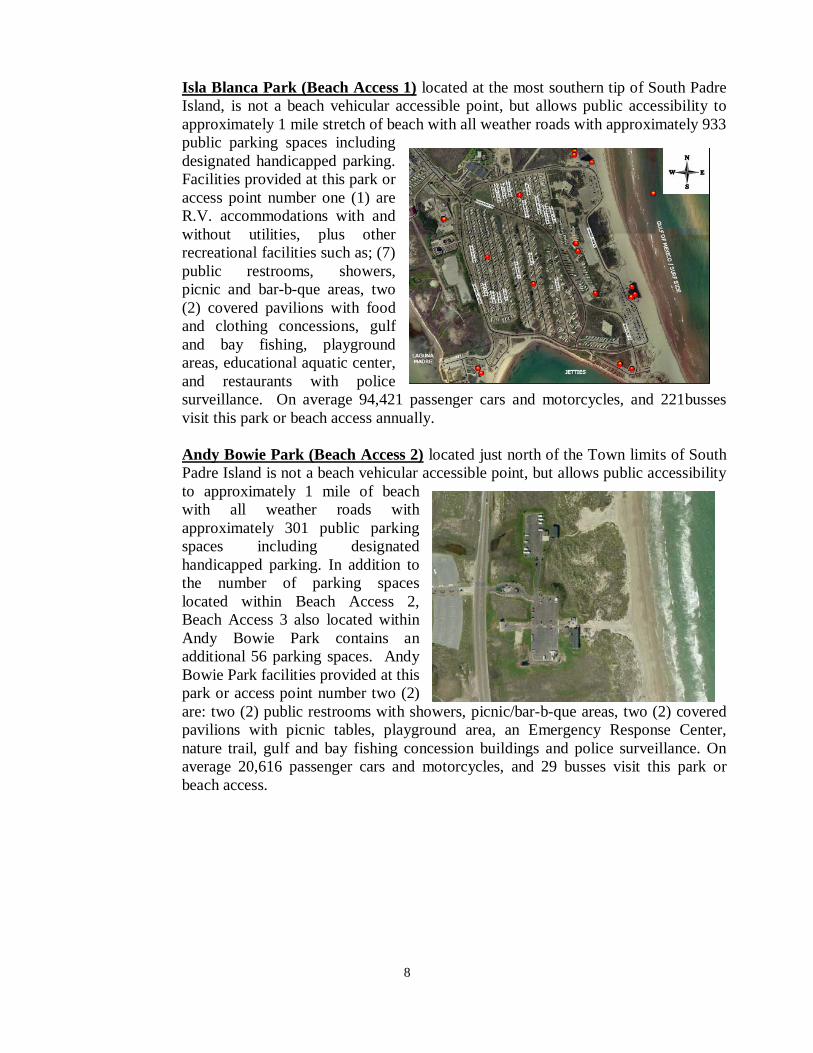
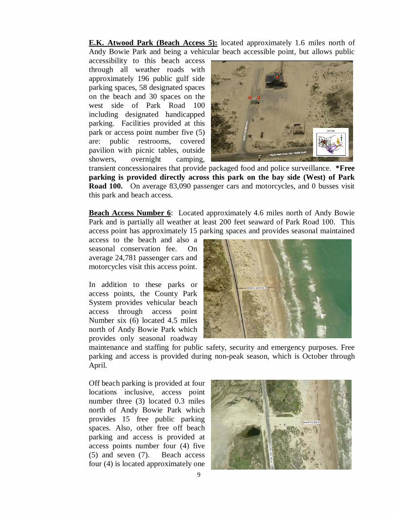
Isla Blanca Park (Beach Access 1) located at the most southern tip of South Padre Island, is not a beach vehicular accessible point, but allows public accessibility to approximately 1 mile stretch of beach with all weather roads with approximately 933 public parking spaces including designated handicapped parking. Facilities provided at this park or access point number one (1) are R.V. accommodations with and without utilities, plus other recreational facilities such as; (7) public restrooms, showers, picnic and bar-b-que areas, two (2) covered pavilions with food and clothing concessions, gulf and bay fishing, playground areas, educational aquatic center, and restaurants with police surveillance. On average 94,421 passenger cars and motorcycles, and 221busses visit this park or beach access annually. Andy Bowie Park (Beach Access 2) located just north of the Town limits of South Padre Island is not a beach vehicular accessible point, but allows public accessibility to approximately 1 mile of beach with all weather roads with approximately 301 public parking spaces including designated handicapped parking. In addition to the number of parking spaces located within Beach Access 2, Beach Access 3 also located within Andy Bowie Park contains an additional 56 parking spaces. Andy Bowie Park facilities provided at this park or access point number two (2) are: two (2) public restrooms with showers, picnic/bar-b-que areas, two (2) covered pavilions with picnic tables, playground area, an Emergency Response Center, nature trail, gulf and bay fishing concession buildings and police surveillance. On average 20,616 passenger cars and motorcycles, and 29 busses visit this park or beach access.
9
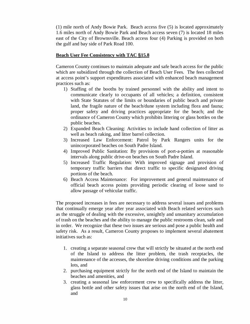
E.K. Atwood Park (Beach Access 5): located approximately 1.6 miles north of Andy Bowie Park and being a vehicular beach accessible point, but allows public accessibility to this beach access through all weather roads with approximately 196 public gulf side parking spaces, 58 designated spaces on the beach and 30 spaces on the west side of Park Road 100 including designated handicapped parking. Facilities provided at this park or access point number five (5) are: public restrooms, covered pavilion with picnic tables, outside showers, overnight camping, transient concessionaires that provide packaged food and police surveillance. *Free parking is provided directly across this park on the bay side (West) of Park Road 100. On average 83,090 passenger cars and motorcycles, and 0 busses visit this park and beach access.
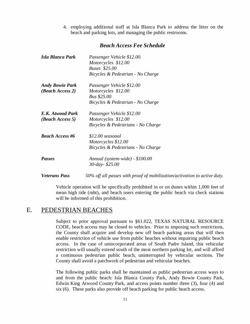
Beach Access Number 6: Located approximately 4.6 miles north of Andy Bowie Park and is partially all weather at least 200 feet seaward of Park Road 100. This access point has approximately 15 parking spaces and provides seasonal maintained access to the beach and also a seasonal conservation fee. On average 24,781 passenger cars and motorcycles visit this access point. In addition to these parks or access points, the County Park System provides vehicular beach access through access point Number six (6) located 4.5 miles north of Andy Bowie Park which provides only seasonal roadway maintenance and staffing for public safety, security and emergency purposes. Free parking and access is provided during non-peak season, which is October through April. Off beach parking is provided at four locations inclusive, access point number three (3) located 0.3 miles north of Andy Bowie Park which provides 15 free public parking spaces. Also, other free off beach parking and access is provided at access points number four (4) five (5) and seven (7). Beach access four (4) is located approximately one
10
(1) mile north of Andy Bowie Park. Beach access five (5) is located approximately 1.6 miles north of Andy Bowie Park and Beach access seven (7) is located 18 miles east of the City of Brownsville. Beach access four (4) Parking is provided on both the gulf and bay side of Park Road 100.
Beach User Fee Consistency with TAC §15.8 Cameron County continues to maintain adequate and safe beach access for the public which are subsidized through the collection of Beach User Fees. The fees collected at access point’s support expenditures associated with enhanced beach management practices such as: 1) Staffing of the booths by trained personnel with the ability and intent to
communicate clearly to occupants of all vehicles; a definition, consistent with State Statutes of the limits or boundaries of public beach and private land, the fragile nature of the beach/dune system including flora and fauna; proper safety and driving practices appropriate for the beach; and the ordinance of Cameron County which prohibits littering or glass bottles on the public beaches.
2) Expanded Beach Cleaning: Activities to include hand collection of litter as well as beach raking, and litter barrel collection.
3) Increased Law Enforcement: Patrol by Park Rangers units for the unincorporated beaches on South Padre Island.
4) Improved Public Sanitation: By provisions of port-a-potties at reasonable intervals along public drive-on beaches on South Padre Island.
5) Increased Traffic Regulation: With improved signage and provision of temporary traffic barriers that direct traffic to specific designated driving portions of the beach.
6) Beach Access Maintenance: For improvement and general maintenance of official beach access points providing periodic clearing of loose sand to allow passage of vehicular traffic.
The proposed increases in fees are necessary to address several issues and problems that continually emerge year after year associated with Beach related services such as the struggle of dealing with the excessive, unsightly and unsanitary accumulation of trash on the beaches and the ability to manage the public restrooms clean, safe and in order. We recognize that these two issues are serious and pose a public health and safety risk. As a result, Cameron County proposes to implement several abatement initiatives such as:
1. creating a separate seasonal crew that will strictly be situated at the north end
of the Island to address the litter problem, the trash receptacles, the maintenance of the accesses, the shoreline driving conditions and the parking lots, and
2. purchasing equipment strictly for the north end of the Island to maintain the beaches and amenities, and
3. creating a seasonal law enforcement crew to specifically address the litter, glass bottle and other safety issues that arise on the north end of the Island, and
11
4. employing additional staff at Isla Blanca Park to address the litter on the beach and parking lots, and managing the public restrooms.
Beach Access Fee Schedule
Isla Blanca Park Passenger Vehicle $12.00.
Motorcycles $12.00 Buses $25.00 Bicycles & Pedestrian - No Charge
Andy Bowie Park Passenger Vehicle $12.00 (Beach Access 2) Motorcycles $12.00
Bus $25.00 Bicycles & Pedestrian - No Charge
E.K. Atwood Park Passenger Vehicle $12.00 (Beach Access 5) Motorcycles $12.00
Bicycles & Pedestrians - No Charge
Beach Access #6 $12.00 seasonal Motorcycles $12.00
Bicycles & Pedestrians - No Charge
Passes Annual (system-wide) - $100.00 30-day- $25.00
Veterans Pass 50% off all passes with proof of mobilization/activation to active duty.
Vehicle operation will be specifically prohibited in or on dunes within 1,000 feet of mean high tide (mht), and beach users entering the public beach via check stations will be informed of this prohibition.
E. PEDESTRIAN BEACHES
Subject to prior approval pursuant to §61.022, TEXAS NATURAL RESOURCE CODE, beach access may be closed to vehicles. Prior to imposing such restrictions, the County shall acquire and develop new off beach parking areas that will then enable restriction of vehicle use from public beaches without impairing public beach access. In the case of unincorporated areas of South Padre Island, this vehicular restriction will usually extend south of the most northern parking lot, and will afford a continuous pedestrian public beach, uninterrupted by vehicular sections. The County shall avoid a patchwork of pedestrian and vehicular beaches.
The following public parks shall be maintained as public pedestrian access ways to and from the public beach: Isla Blanca County Park, Andy Bowie County Park, Edwin King Atwood County Park, and access points number three (3), four (4) and six (6). These parks also provide off beach parking for public beach access.
12
1. Off - Beach Parking: The County shall endeavor to acquire and operate a
series of off beach parking that afford direct pedestrian access to Gulf Coast beaches in the unincorporated areas of Cameron County. Provisions of adequately compliant sized parking lots, located at appropriate intervals, shall be required prior to the restriction of vehicular use of beaches east of the parking lot and on adjacent lands, generally lying to the south of the parking lot. Parking lots shall be located in wash-over areas, at a frequency not greater than three quarters (¾) of a mile from the next nearest designated off beach parking lot, and averaging a parking lot every one-half mile.
Public off-beach parking shall be provided in each parking lot at a quantity sufficient to achieve the standard guideline of one parking space for every fifteen (15) linear feet of beach that will be closed to vehicular traffic. Additional factors may be considered to adjust upward or downward the minimum number of public parking spaces required for planned density of development or privately provided and maintained public parking lots. However, in no case shall less than fifty (50) public parking spaces be provided per one half-mile of beach. Signs shall be posted which conspicuously explain the nature and extent of vehicular controls, parking, and access points. Due to the lack of Zoning Authority within Cameron County s’ all parking lot requirements would be deferred to the local municipalities that have extraterritorial jurisdiction in the area in question. Cameron County although will design and use standardized requirements for specific parking space and the proper ratio of Handicapped vehicle spaces for the amount of regular spaces. Standarized Parking Dimensions 90° angle space: 9’ x 19’ with a 22’ backup (driveway) space 0° (parallel) space: 9’ x 23’ with a 12’ backup (driveway) space Cameron County will make ever effort to assure that logical sites are designated for parking or for vehicular access points without impacting existing dunes. Cameron County will identify locations such as wash out areas or areas that have already been dedicated through subdivision platting. Vehicle operation will be specifically prohibited in or on dunes and beach users entering the public beach via check stations will be informed of this prohibition. Therefore, Cameron County will when feasible create public access areas and constructed of all weather material.
2. Pocket Parks: In some instances, a sufficient quantity of land may be
acquired to accommodate construction of a public park, with off beach parking in accordance with standard guidelines. Exhibit “C” details a suggested site layout and recreation facility components for an approximately two-acre park, providing ninety six (96) parking spaces. This site plan in general, and its quantitative component for public parking is adopted as that
13
minimally acceptable for a public beach park, recognizing that other land tracts will likely require alternate site designs.
3. Land Acquisition of Public Parking Lots:
a) Donation: A private landowner may petition Cameron County to restrict vehicular operation on a particular section of beach, provided that the landowner donates a sufficient quantity of land to meet the objectives of the “standard guidelines”. After proper notice to appropriate state agencies and after conducting the required public hearing and receiving comment from interested agencies or citizens, Cameron County may elect to accept land donation for public beach access purposes. It is the intent of Cameron County, except in unusual cases, to acquire land for public parking and recreational applications by voluntary donation, rather than by fee simple purchase. b) Purchase: Alternately, Cameron County may initiate closure of a beach portion to vehicular traffic by acquisition through negotiation and purchase, or condemnation, and Cameron County will adhere to the same standard guideline discussed above.
c) Public Use Preserved in Perpetuity: The County shall not abandon, relinquish, or convey any right, title, easement, right-of-way, street, path, or other interest that provides existing or potential beach access or parking area, unless an equivalent or better beach access or parking area is first provided consistent with this ordinance.
d) Interfering with Access Prohibited: No person shall create, erect, construct or maintain any obstruction, barrier, signs, or restraint on or within a public beach, which will interfere with the free and unrestricted right of the public to use any public beach, or imply private ownership.
4. Emergency Beach Closures: Any peace officer, through the authority of the
Chief Park Ranger or his designee, in any extraordinary emergency may close areas of the public beach to protect public safety and/or property. The Commissioners’ Court shall limit the closure to the smallest possible area and the shortest possible time necessary.
E. TEMPORARY BEACH CLOSURE FOR SPACE FLIGHT ACTIVITIES
1. Pursuant to the provisions of Chapter 61, Natural Resources Code, to protect
the public health, safety, and welfare, the Cameron County Commissioners Court by order may temporarily close a beach in reasonable proximity to a space flight launch site or access points to the beach in the county on a primary or backup launch date, subject to Subsection 2
14
2. The Commissioner’s Court may not close a beach or access points to the beach on a primary launch date consisting of any of the following days without the approval of the land office:
(1) the Saturday or Sunday preceding Memorial Day; (2) Memorial Day; (3) July 4; (4) Labor Day; or (5) a Saturday or Sunday that is after Memorial Day but before Labor Day.
3. The Cameron County Commissioners Court and the General Land Office shall enter into a memorandum of agreement to implement the provisions of Chapter 61, Natural Resources Code and the provisions of this section.
III. DUNE PROTECTION IN UNINCORPORATED AREAS
A. Cameron County Dune Protection Committee: The Cameron County Commissioners’ Court shall appoint five (5) county residents to serve a term established by Commissioners’ Court of not less than two (2) years, and not more than four (4) years. In selecting members, the Commissioners Court shall attempt to balance the following interests: environmental conservation, technical or legal expertise, land owners or developers, the public recreationist, and other local, governmental jurisdictions affected by proximity to public beaches. The committee’s function is to review and make recommendations to Cameron County Commissioners’ Court on all dune protection permit requests presented to the committee. The committee shall meet on an as needed basis. All committee meetings shall be called and conducted in compliance with the Texas Open Meetings Act.
It shall be the responsibility of the committee to review permit applications, physically inspect proposed project sites by at least three (3) committee members, and recommend approval (with conditions, if appropriate), or denial of a permit or certificate.
B. Dune Protection Line Established: In accordance with Natural Resource Code
§ 63.012, Cameron County hereby establishes a Dune Protection Line in all unincorporated coastal areas parallel to the seaward shoreline of the Gulf of Mexico, shown on the map in Exhibit “A”. That line is based on the mean high tide line of the Gulf of Mexico, and; is a line lying parallel to and not further landward than one thousand (1,000) feet west of the mean high tide line and generally runs in a North-South direction. Cameron County or permit applicant (at the County’s discretion) shall provide the Texas State plane coordinates for locating the Dune Protection line as funds and/or resources allow. The Dune Protection line is a ‘moving’ line changing with shoreline changes and subject to modification that may be necessitated by future State or Federal regulatory and statutory changes. The Commissioners’ Court shall review the location of the Dune Protection line and beachfront construction line at least once every five years to determine
15
whether the lines are adequately located to achieve their stated purposes. In addition, the Commissioners’ Court shall review the adequacy of the location of the lines within 90-days after a tropical storm or hurricane affects the portion of the coast lying within the County’s jurisdiction. The Commissioners’ Court shall amend this Order to adjust the lines whenever necessary to achieve their stated purposes.
Any construction activity proposed east of the Dune Protection line, or any activity covered by Chapter 63, Natural Resources Code that could directly or indirectly cause destruction or damage to sand dune vegetation, is subject to permit and certificate requirements by Cameron County. A party must obtain permit prior to commencing any such activity. Failure to acquire a permit prior to any construction activity east of the Dune Protection Line constitutes separate violations of State Statutes and Cameron County Commissioners’ Court Order 1994. Cumulative penalties may be assessed against a party in violation of the Open Beaches Act, the Dune Protection Act, Order 1994, or Texas General Land Office rules (31 TAC 15.1 - 15.10).
C. Dune Protection permits are hereby required for any activity which may
result in the damage or destruction of dunes and dune vegetation seaward of the Dune Protection line or written in the critical dune area (NRC 363.051). The review process for dune protection permits shall be coordinated with the Texas General Land Office to allow sufficient time for the Texas General Land Office to conduct a field inspection, if necessary of not more than ten (10) days. A copy of the permit application and the applicant’s hearing notice shall be sent to the Texas General Land Office and the Texas Attorney General’s Office at least ten working days prior to the public hearing on the application. The County Engineer will be responsible for sending all correspondence related to permit applications to the State. The Cameron County Dune Protection Committee and Commissioners’ Court shall review, consider, and include in the record a description of the proposed construction and the comments received from the Texas General Land Office and the Texas Attorney General’s Office. Unless impractical, Cameron County shall issue the dune protection permit and the beachfront construction certificate concurrently. The requirements of this plan apply to applications for subdivision plat approval, applications for a building permit, a site plan approval, and zoning approval. The application form and required information to obtain a permit or certificate are established as shown in Exhibits D-1, D-2, and D-3. The application fee for a dune protection permit or beachfront construction certificate is $25.00, and shall be tendered at time of filing an application to the Cameron County Engineering Department. The Cameron County Dune Protection Committee shall make a recommendation to Commissioners’ Court within six (6) weeks of the date that the Committee receives the application. Based on the record established by the Dune Protection Committee and any new relevant information the Court adds to the record, the Court shall either grant or deny a permit or Certificate within four (4) weeks of receiving a Committee recommendation.
16
A permit or certificate may include any conditions necessary to assure adequate public beach access and use rights, the preservation and enhancement of dunes and dune vegetation and protection from potential flood damage. The County shall issue Dune Protection Permits or Beachfront Construction Certificates only under circumstances and conditions consistent with this plan, Texas General Land Office rules, applicable Texas Attorney General enforcement policies and FEMA’s regulations. The Court shall consider the different laws which affect the decision making process and shall take these laws into account when deciding to issue Dune Protection Permits and Beachfront Construction Certificates. A Dune Protection Permit shall be granted to an applicant if Commissioners’ Court finds that:
1. the proposed activity is not a prohibited activity as defined in
Subsection G.2. of this section (Prohibited Activities); 2. The proposed activity will not materially weaken dune complexes or
materially damage dune vegetation within dune complexes seaward of the dune protection line based on substantive findings under Subsection III d of this section (Material Weakening);
3. There are no practicable alternatives to the proposed activity and adverse effects cannot be avoided as provided in Section III D of this section (Mitigation of Adverse Effects);
4. The applicant’s mitigation plan will adequately minimize, mitigate, and/or compensate for any unavoidable adverse effects, as provided in Section III D of this section (Mitigation of Adverse Effects); and
5. The proposed activity complies with any applicable requirements (beach front construction certificates, dune protection permits and management of the public beach) of this order.
Compliance with local, state, and federal laws is necessary for consistent management within Cameron County. The Commissioners’ Court shall not issue a permit or certificate that is inconsistent with this order, the Texas General Land Office rules for management of the beach/dune system 31 TAC §§15.1-15.10, TEXAS OPEN BEACHES ACT, TEXAS DUNE PROTECTION ACT, or FEDERAL EMERGENCY MANAGEMENT AGENCY REGULATIONS, the requirements of which are incorporated into this order by reference.
D. The Mitigation Sequence
Cameron County will maintain a dune protection line which, at a minimum, protects the fore dune ridge and all dunes seaward of the fore dune ridge. Although fore dunes and the fore dune ridge are the primary focus of protection, they depend on the backdunes for support and preservation. Damage and destruction to fore dunes, or to back dunes which would materially weaken fore dunes and the fore dune ridge shall be avoided using the best available technology. Dune damage includes any manmade alteration of a dune or dune vegetation that individually or cumulatively with other actions is likely to materially weaken the beach/dune system by reducing its effectiveness as habitat for flora and fauna, protection from potential flood
17
damage, and protection form erosion.
It is specifically provided that the Commissioners' Court shall balance the objective of protecting the beach/dune system with recognizing landowners' rights to reasonable use of private property. Accordingly, the court shall require the use of the mitigation sequence to redress any injury to dunes and dune vegetation if landowners, after exhausting appropriate efforts to avoid damaging dunes and dune vegetation, demonstrate to the court that disturbance to dunes or dune vegetation is unavoidable.
The mitigation sequence required by the Court consists of the following four (4) steps.
1. Avoidance. Avoidance means avoiding adverse effects altogether by not
taking a certain action or parts of an action. The Commissioners' Court shall not issue a permit allowing any adverse effects on dunes or dune vegetation seaward of the dune protection line unless the applicant proves there is not practicable alternative to the proposed activity, proposed site, or proposed methods for conducting the activity (specifically roads parallel to the beach, non-exempt pipelines, artificial channels, or cause any such adverse effects for which the Commissioners' Court determines there is a practicable alternative that would avoid adverse effects).
2. Minimize. Minimize damage to dunes and dune vegetation. If an applicant for a dune protection permit or beachfront construction certificate proves to the county that damage to dunes and/or dune vegetation is unavoidable, the Court may issue a permit or certificate allowing the unavoidable damage provided that there is a permit or certificate condition requiring that the damage shall be minimized to the greatest extent practicable.
3. Mitigation.
a) Mitigation means repairing, rehabilitating, restoring affected dunes and dune vegetation. Where adverse effects on dunes and dune vegetation cannot be avoided or minimized, the county shall set appropriate permit conditions requiring that permittees repair, rehabilitate, or restore affected dunes to the same volume as the pre-existing dunes and dune vegetation so that they will be superior or equal to the pre-existing dunes in their ability to protect adjacent public and private property from potential flood damage, nuisance, and erosion and to protect natural resources.
b) Permittees may mitigate adverse effects on dunes using vegetative or mechanical means. Permittees shall: 1) Restore dunes to approximate the naturally formed dune
position or location, contour, volume, elevation, vegetative cover, and sediment content in the area;
2) Allow for the natural dynamics and migration of dunes; 3) Use temporary sand fences or a county approved method of
dune restoration, where appropriate, considering the characteristics of the site; and
4) Restore or repair dunes using indigenous vegetation that will
18
achieve the same protective capability as or greater capability than the surrounding natural dunes.
c) In authorizing or requiring restoration of dunes, the county shall give priority to stabilization of blowouts and breaches. Before permitting stabilization of wash over areas, the Commissioners' Court shall: 1) Asses the overall impact of the project on the beach/dune
system; 2) consider any adverse effects on hydrology and drainage which
will result from the project; and 3) require that equal or better public beach access be provided to
compensate for impairment of any public beach access previously provided by the wash over area.
4. Compensate means the replacement of any dune or dune vegetation lost to
construction activities. Landowners shall compensate for unavoidable damage to dunes and dune vegetation by the creation of new dunes, the enhancement of existing dunes, and/or the repair of the damaged dunes as well as the planting of indigenous vegetation. The new, enhanced, and/or repaired dunes shall be superior or equal to the damaged dunes in their ability to protect the community from potential flood damage, to provide habitat for indigenous flora and fauna, and to protect the adjacent beach from erosion.
The permittee shall begin compensation for damage to dunes or dune vegetation which shall begin no later than 30 days after construction is complete. Compensation efforts shall be continuous until the new, enhanced and/or repaired dunes and dune vegetation are superior or equal to the damaged dunes and dune vegetation. However, in no event shall the compensation process take more than three years. After three years, if compensation is incomplete the permittee shall be liable for penalties under the Dune Protection Act and the Open Beaches Act.
The Court will not issue a dune protection permit which allows any construction on artificial dunes created on the public beach, except for dune walkovers or other walkways that serve only as access ways and encroach on the public beach to the minimum extent possible.
On-site compensation consists of replacing or restoring the affected dunes or dune vegetation on the site where the dunes and dune vegetation were originally located, Permittees shall locate compensation work on the construction site, where practicable. A permittee may locate compensation efforts off the construction site if the permittee demonstrates that: on-site compensation is not practicable; the off-site compensation will be located as close to the construction site as practicable; the off-site compensation has achieved a 1:1 ratio of proposed adverse effects on successful, completed and stabilized restoration prior to beginning construction; and the permittee has notified FEMA, Region 6, of the proposed off-site compensation.
a) Permittees shall provide the following information when proposing off-site
compensation: 1) the name, address, phone number, and fax number, if applicable, of
19
the owner of the property where the off-site compensation will be located;
2) a legal description of property intended to be used for the proposed off-site compensation;
3) the source of the sand and dune vegetation to be used; 4) all information regarding permits and certificates issued for the
restoration of dunes on the compensation site; 5) all relevant information regarding the success, current status, and
stabilization of the dune restoration efforts on the compensation site; 6) any increase in potential flood damage to the site where the adverse
effects on dunes and dune vegetation will occur and to the public and private property adjacent to that site; and
7) the proposed date of initiation of the compensation. b) Permittees shall compensate for adverse effects on dune vegetation by
planting indigenous vegetation on the affected dunes. Permittees may not remove existing vegetation from property not owned by the permittee unless the permittee includes in the permit application written permission from the property owner. The permit application must identify the source of any sand and vegetation which will be used in compensation.
c) Permittees shall begin compensation prior to or concurrently with the commencement of construction. If compensation is not to be completed prior to commencement of construction, the permittee shall provide proof of financial responsibility in an amount necessary to complete the compensation, in the form of an irrevocable letter of credit, performance bond, or any other instrument acceptable to the county.
d) Permittees shall notify the Cameron County Engineer or his designee in writing of the actual date of initiation within ten (10) working days after compensation is initiated. If the permittee fails to begin compensation on the date proposed in the application, the permittee shall state the reason for the delay. The county shall take this reason into account when determining whether a permittee has violated the compensation deadline.
e) Permittees shall conduct compensation efforts continuously until the repaired, rehabilitated, and restored dunes and dune vegetation are equal or superior to the pre-existing dunes and dune vegetation. These efforts shall include preservation and maintenance pending completion of compensation.
f) A compensation project is deemed complete when the position, contour, volume, elevation, and vegetative cover of the restored dunes have reached a level that matches or exceeds the pre-existing dunes.
g) The County Engineer shall provide written notification to the General Land Office upon determining that the compensation is complete. If the county engineer does not receive an objection from the General Land Office regarding the completion of compensation within thirty (30) working days after the General Land Office is notified in writing, the County Engineer or his designee may certify to the permittee that the compensation is complete.
h) The permittee shall be deemed to have failed to achieve compensation if a 1:1
ratio has not been achieved within three years after the beginning of compensation efforts.
20
E. PERMIT ADMINISTRATION
1. Terms and renewal of permits/ certificates.
a) Permits or certificates shall be valid for three years from the date of issuance.
b) The Commissioners' Court may renew a permit or certificate for a period not exceeding ninety (90) days if the activity as proposed in the application for renewal complies with this order and the permittee supplements the original application materials with additional information indicating any changes to the activity or information. The Commissioners' Court shall issue only two renewals for each permit or certificate. Thereafter, the permittee must apply for a new permit or certificate.
2. Termination of permits/certificates.
a) The Commissioners' Court may void a permit or certificate if: 1) a material change occurs after the permit or certificate is
issued; or 2) a permittee fails to disclose any material fact in the
application. 3) the permit or certificate is inconsistent with this order or with
the General Land Office rules for management of the beach/dune system at the time of issuance.
b) "Material change" includes human or natural conditions which have adversely affected dunes, dune vegetation, or beach access and use that either did not exist at the time of the original application, or were not considered by the County in making the permitting decision because the permittee did not provide information regarding the site condition in the original application.
c) A permit or certificate automatically terminates if construction comes to lie within the boundaries of the public beach by artificial means or by natural causes.
3. Administrative record.
The administrative record of official Commissioners' Court actions relative to permit and certificate applications shall be maintained within the minutes of the Commissioners' Court by the County Clerk as consistent with state law. The County Engineer shall keep the files relevant to applications and permitting for dune protection permits.
Cameron County delegates the authority to the Town of South Padre Island and the City of Port Isabel to develop and implement a dune protection program for implementation within the Town's and City’s corporate municipal limits only.
4. Issuance or denials of dune protection permit.
a) To determine whether to issue or deny a permit, the Commissioners'
21
Court or its designee should at least review and consider the following factors:
1) the information in the permit application 2) the proposed activity's consistency with this order and the
General Land Office rules for management of the beach/dune system;
3) any other law relevant to dune protection which affects the activity under review;
4) the comments of the dune protection committee, the General Land Office, the Attorney General's Office, and the general public; and particularly: i) cumulative and indirect effects of the proposed
construction on all dunes and dune vegetation seaward of a dune protection line;
ii) cumulative and indirect effects of other activities on dunes and dune vegetation located on the proposed construction site;
iii) the pre-construction type, height, width, slope, volume, and continuity of the dunes, the pre-construction condition of the dunes, the type of dune vegetation, and percent of vegetative cover on the site;
iv) the local historical erosion rate as determined by the University of Texas at Austin, Bureau of Economic Geology, and whether the proposed construction may alter dunes and dune vegetation in a manner that may aggravate erosion;
v) all practicable alternatives to the proposed activity, proposed site, or proposed methods of construction;
vi) the applicant's mitigation plan for any unavoidable adverse effects on dunes and dune vegetation and the effectiveness, feasibility, and desirability of any proposed dune reconstruction and revegetation;
vii) the impacts on the natural drainage patterns of the site and adjacent property;
viii) any significant environmental features of the potentially affected dunes and dune vegetation such as their value and function as floral and faunal habitat or any other benefits the dunes and dune vegetation provide to other natural resources;
ix) wind and storm patterns including a history of wash over patterns;
x) location of the site on the flood insurance rate map; xi) success rates of dune stabilization projects in the area;
and 6) Any other information the Commissioners' Court considers useful, including
resource information made available to them by federal and state natural resource entities. The Commissioners' Court may issue a permit only if it
22
finds as a fact, after a full investigation, that the particular conduct proposed will not have a net effect to materially weaken any dune or materially damage dune vegetation or reduce the effectiveness of any dune as a means of protection against erosion and high wind and water (with or without mitigation). To find that there will be no such material weakening or damage, the Commissioners' Court must find that:
5) Commissioners' Court will evaluate proposed projects to ensure that the
following consequences will not result from the proposed activities: a) The activity will not result in the potential for increased flood damage
to the proposed construction site or adjacent property; b) The activity will not result in runoff or drainage patterns that
aggravate erosion on or off the site; c) The activity will not result in significant changes to the natural
permeability of a dune or its ability to transmit rainwater to the water table;
d) The activity will not disturb unique flora or fauna or result in adverse effects on dune complexes or dune vegetation; and
e) The activity will not significantly increase the potential for washovers or blowouts to occur.
F. GENERAL CONSIDERATIONS FOR PROTECTED DUNE AREAS
To minimize unavoidable adverse effects as required by Subdivision 3.D. of this section, permittees shall:
1. locate non-exempt pipelines across previously disturbed areas, such as
blowout areas, and minimize disturbance of dune surfaces where use of previously disturbed areas is not practicable;
2. minimize construction and pedestrian traffic on or across dune areas to the greatest extent practicable, accounting for trends of dune movement and beach erosion in that area; a) route all pedestrian access to and from beaches through wash
over areas or over elevated walkways, and conspicuously mark all such access that is public with permanent signs so indicating;
b) consider consolidated private access ways from any proposed subdivision, multiple dwelling, or commercial facility. In some cases, the minimum beach access may be only one access way. In determining the appropriate grouping of access ways, the county shall consider the size and scope of the development;
c) the county may consider that the developer post and maintain signs in areas where pedestrians traffic is high explaining the functions of dunes and the importance of vegetation in preserving dunes;
d) where practicable, provide vehicular access to and from beaches by sing existing roads, unless public beach access is
23
restricted, and where possible, improve existing access roads possible, improve existing access roads with elevated beams near the beach that prevent channelization of floodwaters;
e) where practicable, locate new beach access roads in wash over areas, blowout areas or other areas where dune vegetation has already been disturbed, construct such roads along the natural land contours, and minimize their width;
f) where practicable, locate new beach access roads at an oblique angle to the prevailing wind direction;
g) prohibit persons from using or parking any motor vehicle on, through, or across dunes outside designated access ways;
h) maximize use of natural or existing drainage patterns when providing for storm water runoff and retention;
i) locate and construct new artificial storm water runoff channels and retention basins so as to avoid erosion and unnecessary construction of additional channels and to direct all runoff inland and not to the Gulf of Mexico through dune areas; and
j) not cause any adverse effects that the Commissioners' Court finds can be minimized.
G. SPECIAL PROVISION REGARDING DUNES
1. Alteration of Dunes Prohibited without Permit: The following activities are exempt from the requirement for a permit, but may nevertheless require a beachfront construction certificate or a permit pursuant to other county court orders: a) exploration for and production of oil and gas and reasonable and
necessary activities directly related to such exploration and production, including construction and maintenance of production and gathering facilities seaward of the dune protection line which serve wells located outside the dune protection line, provided that such facilities are located no farther than two miles from the well being served;
b) grazing livestock and reasonable and necessary activities directly related to grazing; and
c) recreational activities other than operation of a recreational vehicle. 2. Prohibited Activities: The Commissioners' Court shall not issue a permit
authorizing the following actions seaward of the dune protection line (excepting public recreation facilities built within accreting beach areas): a) activities that are likely to result in the temporary or permanent
removal of sand from the portion of the beach/dune system located on or adjacent to the construction site, including: moving sand to a location landward of the dune protection line; and temporarily or permanently moving sand off the site, except for purposes of permitted mitigation, compensation, or an approved dune restoration or beach nourishment project and then only from areas where the historical accretion rate is greater than two feet per year, and the project does not cause any adverse effects on the sediment budget;
24
b) depositing sand, soil, sediment, or dredged spoil which contains any of the toxic materials listed in Volume 40 of the Code of Federal Regulations, Part 302.4, in concentrations which are harmful to people, flora, and fauna as determined by applicable, relevant, and appropriate requirements for toxicity standards established by the local, state, and federal governments;
c) depositing sand, soil, sediment or dredged spoil which is of an unacceptable mineralogy or grain size when compared to the sediments found on the site (this prohibition does not apply to materials related to the installation of maintenance of public beach access roads running generally perpendicular to the public beach);
d) creating dredged spoil disposal sites, such as levees and weirs, unless an appropriate local, state, and federal permit is obtained;
e) constructing or operating industrial facilities not in full compliance with all relevant laws and permitting requirements prior to the effective date of this order;
f) Prohibition of Vehicular Operation in Dunes: Operation of motor vehicles on or in dunes within 1,000 feet of mean high tide is hereby prohibited pursuant to §63.093 of the Natural Resources Code. Vehicle operation on roadways, parking lots, or the roadway portion of the public beach is exempt from this prohibition.
g) mining dunes; h) constructing concrete slabs or other impervious surfaces within 200
feet landward of the natural line of vegetation, except for such a surface that (1)does not extend beyond the perimeter of a habitable structure elevated on pilings, provided that no walls are erected that prohibit the natural transfer of sands, or (2) does not exceed an area equal to the footprint plus 5% of the permitted habitable structure it serves; the use of permeable materials such as brick pavers, limestone, or gravel is recommended when feasible for drives or parking areas;
i) the placement of a concrete slab may not be structurally attached to the buildings piling foundation in the area within 200 feet of the line of vegetation.
j) depositing trash, waste, or debris including inert materials such as concrete, stone, and bricks that are not part of the permitted on-site construction;
k) constructing cisterns, septic tanks, and septic fields seaward of any structure serviced by the cisterns, septic tanks, and septic fields; and
l) detonating bombs or explosives with the exception of fireworks associated with a holiday or a public event.
H. REVISION OF DUNE PROTECTION COMPONENT OF PLAN
Revision of the dune protection component of the plan shall be initiated by the Cameron County Dune Protection Committee. Such revision is subject to approval by the Cameron County Commissioners' Court after conducting a public hearing on the proposed revisions, and after review and comment of the proposed revisions by
25
the Texas General Land Office.
I. CONCURRENT REQUIREMENTS FOR BOTH DUNE PROTECTION PERMITS AND
BEACHFRONT CONSTRUCTION CERTIFICATES Permittees shall:
1. Consider beach erosion rates at proposed development sites, the possibility of the westward movement of the public easement, and potential storm vulnerability when selecting building sites located landward of the building line;
2. Not engage in any construction, which may aggravate erosion; 3. Not construct any new erosion response structure, except a retaining wall
located greater than 200 feet landward of the line of vegetation; 4. Not maintain or repair an existing erosion response structure located on the
public beach; 5. Not enlarge or improve an existing erosion response structure located less
than 200 feet landward of the vegetation line; 6. Not maintain or repair an existing erosion response structure located less than
200 feet landward of the vegetation line that is more than 50% damaged, except: when failure to repair the damaged structure will cause unreasonable hazard to a public building, public road, public water supply, public sewer system, or other public facility immediately landward of the structure; or when failure to repair the damaged structure will cause unreasonable flood hazard to habitable structures because adjacent erosion response structures will channel floodwaters to the habitable structure;
7. Not engage in construction that does not comply with FEMA'S regulations governing construction in flood hazard areas; and
8. Design construction so as to minimize impacts on natural hydrology. Construction shall to cause erosion to adjacent properties, critical dune areas, or the public beach.
9. Consider variances from federal requirements. The Cameron County Engineer shall inform the General Land Office and FEMA Region 6 before it issues any variance from FEMA'S regulations found in Volume 44 of the Code of Federal Regulations, Parts 59-77.
J. FLOOD PROTECTION IN COUNTY AREAS
In issuing dune protection permits and beachfront construction certifications, Cameron County shall comply with FEMA'S regulations governing construction in flood hazard areas. FEMA prohibits man-made alteration of sand dunes within Zones V1-30, V, and VE on Cameron County's Flood Insurance Rate Map which would increase the potential for flood damage. FEMA also prohibits the use of fill for structural support of buildings within Zones VI-30, V, and VE. Cameron County shall expeditiously inform the General Land Office and the FEMA regional representative in Texas of the issuance of any activity done in variance of FEMA'S regulations. Variances may affect participation in the Federal Flood Insurance
26
Program. IV. SPECIAL PROVISIONS FOR DEVELOPMENT IN COASTAL AREAS A. DEVELOPMENT IN ERODING COASTAL AREAS
"Eroding areas" are portions of the shoreline experiencing a historical erosion rate of greater than two feet per year based on published data of the University of Texas at Austin, Bureau of Economic Geology. In addition to the other requirements of this ordinance, in eroding areas, permittees shall: 1. Elevate all structures on pilings in accordance with FEMA minimum
standards or above the natural elevation (whichever is greater); 2. Design structures located on property adjacent to the public beach so
that they may be relocated; 3. Be allowed to pave or alter only the ground within the footprint for
the habitable structure, however brick pavers, gravel or crushed limestone may be used to stabilize driveways only if the alteration or paving will be entirely undertaken, constructed, and located landward of 200 feet from the line of vegetation; and
4. Demonstrate and assure financial ability to fund eventual relocation or demolition of the proposed structure.
B. If there is any conflict between the requirements of this subsection and the requirements of any other provision of this ordinance, this subsection controls.
V. MASTER PLANNED DEVELOPMENTS
A. "Master planned development" means proposed development for which approval is requested by submission of a comprehensive plan containing maps, drawings, narrative, tables, and other information about the proposed use of specific land and/or water including descriptions of uses and use intensities, building and/or site improvement locations and sizes, relationships between buildings and improvements, vehicular and pedestrian access and circulation systems, parking, utility systems, storm water management and treatment systems, geography, geology, impact assessments, regulatory-approved checklist, and phasing. Information in the master plan may be conceptual or detailed depending on the status of its regulatory approval.
B. At least 60 days prior to acting on a request for approval of a master planned development within the area subject to this order the County shall send the plan to the General Land Office and the Attorney General's Office for review.
C. When acting on a request for approval of a master planned development, the Commissioners' Court shall consider:
27
1. The development's potential effects on dunes, dune vegetation, public beach use and access, and the applicant's proposal to mitigate for such effects throughout the construction;
2. The contents of plan; and 3. Whether any component of the development, such as installation of
roads or utilities, or construction of structures seaward of a dune protection line, will subsequently require a permit or a certificate.
D. If the Commissioners' Court determines that all development contemplated by the plan complies with all requirements of this order, a permit and/or certificate for the development may be issued.
E. If the Commissioners' Court determines that any development contemplated by the plan does not comply with the requirements of this order and therefore can not be approved without an amendment to this order, the Commissioners' Court shall not issue a permit and/or certificate, but shall submit the plan to the General Land Office and the Attorney General's Office for approval as an amendment to this order.
VI. STANDARDS FOR BEACH MAINTENANCE AND
OTHER ACTIVITIES
1. Beach Maintenance
A. The Commissioners' Court shall not authorize or undertake any beach maintenance or management activities that materially weaken dunes or dune vegetation, reduce the protective functions of dunes, result in significant redistribution of sand, or significantly alter the beach profile. All sand moved or redistributed due to beach maintenance activities of the county shall be returned to a location seaward of the dune protection line. "Beach maintenance" means the cleaning or removal of debris from the beach by handpicking, raking, or mechanical means.
B. The Commissioners' Court authorizes the following beach maintenance and management measures; removal of sand deposits in parking areas, roads, or other public facilities or buildings as necessary to allow continued use and for the construction of government-sponsored artificial dune programs using recycled Christmas trees and or other material that is environmentally safe and may easily decompose.
C. Monitoring: The county may, or at the request of the General Land Office shall, require a permittee to conduct or pay for a monitoring program to study the effects on the public beach of the permittee's coastal and shore protection project, and shall require the permittee to notify the General Land Office and the County of any discernible change in the erosion rate caused by the project.
D. Beach nourishment standards: The County shall not authorize beach nourishment project unless it finds and the project sponsor demonstrates that:
28
1. The project is consistent with all applicable requirements of this order;
2. The sediment to be used is of effective grain size, mineralogy, and quality or is the same as the existing beach material;
3. The proposed nourishment material does not contain any toxic materials listed in Volume 40 of the Code of Federal Regulations, Part 302.4, in concentrations which are harmful to people, flora, and fauna as determined by applicable, relevant, and appropriate requirements for toxicity standards established by the local, state, and federal governments;
4. There will be no adverse environmental effects on the property surrounding the area from which the sediment will be taken or on the site of the proposed nourishment;
5. The removal of the sediment will not have any adverse impacts on flora and fauna; and
6. There will be no adverse effects from transporting the nourishment material.
2. DUNE RESTORATION AND CONSTRUCTION OF ARTIFICIAL DUNES
The Commissioners' Court may issue a general permit to a government entity, or other public service organization for the construction of artificial dunes. Except as otherwise expressly provided in this order, the Commissioners' Court shall not authorize restoration of dunes on a public beach unless it finds and the project sponsor demonstrates that the following requirements are met.
A. The proposed projects:
1. Shall extend no more than twenty feet seaward of the vegetation line and shall follow the natural migration of the vegetation line;
2. Shall not restrict or interfere with public use of the beach at normal high tide.
B. All restored dunes shall be continuous with any surrounding naturally formed dunes; shall approximate the natural position, contour, volume, elevation, vegetative cover, and sediment content of any naturally formed dunes in the proposed dune restoration area; and shall be planted with indigenous vegetation that will achieve the same protective capability as the surrounding natural dunes.
C. The following methods or materials may be used to restore dunes: 1. Piles of sand having similar grain size and mineralogy as the
surrounding beach; 2. Temporary sand fences conforming to General Land Office
guidelines; 3. Organic brushy materials such as used Christmas trees; and
4. Sand or other naturally-occurring organic material obtained by scraping accreting beaches only if the scraping is approved by the local government and the project is monitored to determine
29
any changes that may increase erosion of the public beach. D. The following methods or materials shall not be used to restore dunes: 1. Hard or engineered structures;
2. Materials such as bulkheads, riprap, concrete, or asphalt rubble, building construction materials, and any non-biodegradable items;
3. Fine, clayey, or silt sediments; 4. Sediments containing the toxic materials listed in Volume 40
of the Code of Federal Regulations, Part 302.4 In concentrations which are harmful to people, flora, and fauna as determined by applicable, relevant, and appropriate requirements for toxicity standards established by the local, state, and federal governments; and
5. Sand obtained by scraping or grading dunes or the beach, except as part of an approved mitigation plan.
E. Activities affecting restored dunes shall be subject to the requirements of this order. Permittees shall not construct or maintain private structures on restored dunes, except for dune walkovers or similar access ways meeting the requirements of this order.
F. All applications or proposals for reconstructing dunes on the public beach shall be forwarded to both the General Land Office and the Attorney General's Office at least ten (10) working days prior to the decision on the application.
3. DUNE WALKOVERS.
The County shall not authorize construction of dune walkovers or other beach access mechanisms unless it finds and the project sponsor demonstrates that the following requirements are met.
A. The walkover is restricted; to the greatest extend possible, to the most
landward point to the public beach. B. The walker is constructed and located in a manner that will not
interfere with or otherwise restrict public use of the beach at normal high tides.
C. Permittees shall relocate walkovers to follow any landward migration of the public beach or seaward migration of dunes using the following procedures and standards. 1. After a major storm or any other event causing significant
landward migration of the landward boundary of the public beach, permittees shall shorten any dune walkovers encroaching on the public beach to the appropriate length for removal of the encroachment.
2. In cases where the migration of the landward boundary of the public beach occurs slowly over a period of time or where a dune walkover needs to be lengthened because of the seaward migration of dunes, the permittees shall apply for a permit or certificate authorizing the modification of the structure.
30
VII. GENERAL PROVISIONS
1. PENALTIES.
Any person who violates either the Dune Protection Act, the Open Beaches Act, this order, or traffic regulation orders or ordinances established by Cameron County Commissioners' Court, a permit or certificate condition is liable for a Civil or criminal penalties (in the case of state statutes, not less than $50 nor more than $1,000 per violation per day). Each day the violation occurs or continues constitutes a separate violation. Violation of the Dune Protection Act, the Open Beaches Act, and the rules adopted pursuant to those statutes are separate violations. The assessment of penalties under one act does not preclude another assessment of penalties under the other act for the same act or omission. Conversely, compliance with one statue and the rules adopted there under does not preclude penalties under the other statue and the rules adopted pursuant to that statue. The Commissioners' Court shall consider the following mitigating circumstances when referring violations for assessment of penalties: acts of god, war, public riot, or strike; unforeseeable, sudden, and natural occurrences of a violent nature; and willful misconduct by a third party not related to the permittee by employment or contract.
2. CONSTRUCTION.
A. This order and all orders, resolutions, or other enactments related or
pursuant to this order shall be read in harmony with county orders of general applicability. If there is any conflict between them, which cannot be reconciled by ordinary rules or legal interpretation, this order controls.
B. This order and all orders, resolutions, or other enactments related or pursuant to this order shall be read in harmony with the Open Beaches Act, the Dune Protection Act, and General Land Office rules implementing them. If there is any conflict between them, which cannot be reconciled by ordinary rules of legal interpretation, state law provisions control.
3. BOUNDARY DETERMINATIONS.
The Attorney General shall make determinations on issues related to the location of the boundary of the public beach and encroachments on the public beach pursuant to the requirements of the Open Beaches Act, Sec. 61.016 and Sec. 61.017. The County shall consult with the Attorney General whoever questions of encroachment and boundaries arise with respect to the public beach.
31
4. BEACHES PRESUMED TO BE PUBLIC.
The Commissioners' Court shall presume that any beach fronting the Gulf of Mexico is subject to a public easement unless the owner of the adjacent land obtains a declaratory judgment otherwise under the Open Beaches Act, Sec. 61.019. That section provides that any person owning property fronting the Gulf of Mexico whose rights are determined or affected by this order may bring suit for a declaratory judgment against the state to try the issue or issues.
5. GENERAL PROHIBITION.
No person shall violate any provision of this order or any permit or certificate or the conditions contained therein.
6. APPEALS.
The Dune Protections Act, Sec. 63.151, and the Open Beaches Act Sec. 61.019, contain the provisions for appeals related to this order.
VIII. SUPPLEMENTAL RECOMMENDATIONS
A wide variety of issues were brought to the attention of the Cameron County Coastal Management Committee during the plan development process. Four (4) issues in particular merit mention, and the committee recommends that beyond adopting a dune protection and public beach access, and flood protection plan, Cameron County Commissioners' Court take separate action relative to these issues:
A. Beach Nourishment
The Committee recommends that Cameron County in association with the Town of South Padre Island initiate an aggressive beach nourishment program. It is recognized that beaches on the northern portion of South Padre Island are eroding at an alarming rate and posing subsequent threats to properties in the northern portion of the Town of South Padre Island as well as unincorporated areas. The committee recommends that the county and the town work in concert to at least insure that beach-quality (in both grain size and toxicity) dredge materials removed by the U.S. Army Corps of Engineers from the Brazos Santiago Ship Channel are placed directly onto the beaches of South Padre Island.
The County and the Town of South Padre Island should examine additional options to increase the sand budget accruing to beaches of South Padre Island. It is recognized that the dredge materials from the Brazos Santiago Ship Channel alone will not be sufficient to resolve beach erosion problems
32
on South Padre Island.
B. Rezoning of Unincorporated South Padre Island Cameron County should undertake an effort in cooperation with the town of South Padre Island to update zoning and subdivision ordinances. Both town and county zoning and rules should be complementary and consistent to allow for planned growth of the island, while taking advantage of "lessons learned” in the town to avoid undesirable trends in as yet undeveloped county areas.
C. Underground Utilities
Cameron County should utilize all legal powers and best efforts to prevent further expansion of overhead Utility lines on South Padre Island.
D. Park Road 100 Relocation
Park Road 100, commencing in Andy Bowie Park and extending approximately seven (7) miles to its present northern terminus, should be moved in whole or in parts to a more western location. Storm vulnerability and maintenance costs for sand removal would be greatly reduced, while creating new, valuable beachfront lands.
IX. SOUTH PADRE ISLAND DUNE PROTECTION &
BEACH ACCESS PLAN
The Cameron County Commissioners' Court has delegated the town of South Padre Island and City of Port Isabel the authority to establish and implement a dune protection, beach access and flood protection plan within its corporate municipal limits. The town recognizes the importance of SB 1053 in furthering the preservation and protection of sand dunes, and the protection and enhancement of the public's rights of access to and use of the public beaches.
X. DEFINITIONS Affect - as used in this subchapter regarding dunes, dune vegetation, and the public beach, "affect" means to produce an effect upon dunes, dune vegetation, or public beach use and access. Amenities - any uninhabitable major structures including swimming pools, bathhouses, detached garages, cabanas, pipelines, piers, canals, lakes, ditches, artificial runoff channels and other water retention structured, roads, streets, highways, parking areas and other paved areas (exceeding 144 square feet in area), underground storage tanks, and similar structures. Back dunes - the dunes located landward of the fore dune ridge which are usually well vegetated but may also be unvegetated and migratory. These dunes supply sediment to the beach after the fore dunes and the foredune ridge have been destroyed by natural or human activities. Beach access - the right to use and enjoy the public beach, including the rights of free and
33
unrestricted ingress and egress to and from the public beach. Artificial dunes - a mound, hill, or ridge of sand created by the deliberate placement of sand or sand trapping devices including sand fences, trees, or brush, and planted with dune vegetation. Beach/dune system - the land from the line of mean low tide to the critical dune line (1000 feet landward of mean high tide) including wash over areas and areas adjacent to tidal inlets. Beachfront construction certificate or certificates – a certificate issued by a local government that proposed beachfront construction adjacent to and landward of a public beach will preserve and enhance public access to the public beaches as required by §61.015 (c) - (h) of the Natural Resources Code. Beach profile - the intersection of the ground surface with a vertical plane; it may extend from the top of the fore dune ridge to the seaward limit of sand movement. Beach-related services - reasonable and necessary services and facilities directly related to the public beach which are provided to the public to ensure safe use of and access to and from the public beach, such as vehicular controls, management, and parking (including acquisition and maintenance of off-beach parking and access ways); sanitation and litter control; the cleaning or removal of debris from the beach by handpicking, raking, or mechanical means; law enforcement; beach nourishment projects; beach/dune system education; beach/dune protection and restoration projects; providing public facilities such as restrooms, showers, lockers, equipment rentals, and picnic areas; recreational and refreshment facilities; liability insurance; and staff and personnel necessary to provide beach-related services. Beach-related services and facilities shall serve only those areas on or immediately adjacent to the public beach. Beach Conservation fee - any fee collected by Cameron County as defined in §61.001 of the Natural Resources Code, to fund beach-related services. Beach raking - mechanically drawn raking or sand sifting devices designed to remove debris, generally not wider than 16 feet, and that generally do not remove sand material. Blowout - a breach in the dunes cause by wind erosion. Breach - a break or gap in the continuity of a dune caused by wind or water. Bulkhead - a structure or partition built to retain or prevent the sliding of land. A secondary purpose is to protect the upland against damage from wave action. Coastal and shore protection project - a project designed to slow shoreline erosion or enhance shoreline stabilization, including, but not limited to, erosion response structures, beach nourishment, sediment, bypassing, construction of man-made vegetated mounds, and dune revegetation. Commercial facility - any structure used for providing, distributing, an selling goods or services in commerce including, but not limited to, hotels, restaurants, bars, rental operations, and rental properties.
34
Construction - any building, bulk heading, filling, clearing, excavation (removal or alteration of dunes and dune vegetation and scraping, grading, or dredging a site), or any substantial improvement to land or the size of any structure, including any activity which is likely to result in the alteration of a dune or dune vegetation. Construction includes the removal of or damage to vegetation, clearing or grading the site, and the placing of construction materials on the site, as well as continuation of site work beyond the limits of the foundation including landscape work. Coppice mounds - the initial stages of dune growth formed as sand accumulates on the downwind side of plants and other obstructions on or immediately adjacent to the beach seaward of the fore dunes. Coppice mounds may be unvegetated. Critical dune area - an area of dunes affected by the commissioner of the Texas General Land Office, within 1,000 feet of mean high tide, that are judged essential to the protection of state-owned land, public beaches, and submerged land. Cumulative impact - the effect on beach use and access, on a critical dune area, or an area seaward of the dune protection line which results from the incremental effect of an action when added to other past, present, and reasonably foreseeable future actions regardless of what agency or person undertakes such other actions. Cumulative effects can result from individually minor but collectively significant actions taking place over a period of time. Dune - a natural or man-made emergent mound, hill, or other ridge of sand either bare or vegetated, located on land, which is adjacent to the waters of the open Gulf of Mexico. Dune complex - any emergent area adjacent to the waters of the Gulf of Mexico in which several types of dunes are found or in which dunes have been established by proper management of the area. In some portions of the Texas coast, dune complexes contain depressions known as swales. Dune vegetation - flora indigenous to natural dune complexes on the Texas coast and can include coastal grasses and herbaceous and woody plants. Effect or effects - "effects" include: direct effects – those impacts on public beach use and access, on critical dune areas, or on dunes and dune vegetation seaward of a dune protection line which are caused by the action and occur at the same time and place; and indirect effects - those impacts on beach use and access, on critical dune areas, or on dunes and dune vegetation seaward of a dune protection line which are caused by an action and are later in time or farther removed in distance than a direct effect, but are still reasonably foreseeable. Indirect effects may include growth inducing effects and other effects related to induced changes in the pattern of land use, population density, or growth rate, and related effects on air and water and other natural systems, including ecosystems. "Effects" and "impacts" as used in this ordinance are synonymous. "Effects “may be ecological (such as the effects on natural resources and on the components, structures, and functioning of affected ecosystems), aesthetic, historic, cultural, economic, social, or health, whether direct, indirect, or cumulative. Dune protection permit or permit - the authorization by local governments to allow construction in a specified location seaward of a dune protection line or within the critical dune area as required by §63.051 of the Natural Resources Code. Dune protection permits shall be valid only for a six-month period.
35
Eroding area - a portion of the shoreline, which is experiencing a historical erosion rate of greater than two feet per year based on published data of the University of Texas at Austin, Bureau of Economic Geology. Erosion - natural processes and human activities affecting barrier island vegetation and dunes, usually caused by wind or water motion over or around barrier islands, which may displace, damage, or otherwise completely remove natural or artificially constructed structures on barrier islands. The wearing away of land or the removal of beach and/or dune material by wave action, tidal currents, littoral currents or deflation. Erosion includes but is not limited to horizontal recession and scour. Erosion response structure - a hard or rigid structure built for shoreline stabilization which includes, but is not limited to, a jetty, retaining wall, groin, breakwater, bulkhead, seawall, riprap, rubble mound, revetment, or the foundation of a structure which is the functional equivalent of these specified structures. Extraordinary emergency - emergencies judged by the chief park ranger of the Cameron County park system, or his designee, to constitute a substantial threat to public health or safety, or that present a hazard to natural resources, including but not limited to, civil disturbance, recurrent life threatening criminal activity, hurricanes, oil spills, fish kills, or extreme beach overcrowding. FEMA - the Federal Emergency Management Agency of the United States government. This agency administers the National Flood Insurance Program and produces the Flood Insurance Rate Maps. Fore dunes - those dunes which offer the first significant means of dissipation storm-generated wave and current energy issuing form the open Gulf of Mexico. Because various heights and configurations of dunes may perform this function, no standardized physical description can be offered. However, where they occur, fore dunes are distinguishable from surrounding dune types by their relative location and physical appearance. For dunes are the first clearly distinguishable, usually grass-covered, stabilized large dunes encountered landward of the open Gulf of Mexico. Although they may be large and continuous, fore dunes are typically hummocky and discontinuous and are often interrupted by breaks and wash over channels. Fore dune ridge - the high continuous line of dunes which are usually well vegetated and rise sharply landward of the fore dune area but may rise directly from a flat, wave-cut beach immediately after a storm. Habitable structures - structures suitable for human habitation including, but not limited to, single or multi-family residences, hotels, condominium buildings, and buildings for commercial purposes. Each building of a condominium regime is considered a separate habitable structure, but if a building is divided into apartments, then the entire building, not the individual apartments are considered a single habitable structure. Additionally, a habitable structure includes porches, gazebos, and other attached improvements. Industrial facilities - include, but are not limited to, those establishments listed in Part 1, Division D, Major Groups 20-39 and Part 1, Division E, Major Group 49 of the Standard Industrial
36
Classification Manual as adopted b the Executive Office of the President, Office of Management and Budget (1987 ed.). However, for the purposes of this order, the establishments listed in Part1, Division D, Major Group 20, Industry Group number 209, Industry numbers 2091 and 2092 are not considered “industrial facilities.” These establishments are listed in Appendix attached to this order. Large-scale construction - construction activity greater than 5,000 square feet area and habitable structures greater than two stories is height. Multiple-family habitable structures are typical of this type of construction. Line of vegetation - the extreme seaward boundary of natural vegetation, which spreads continuously inland generally defining the landward extent of the public beach as defined by the Open Beaches Act. Mitigation sequence - the hierarchy of preferred impacts used by permitting authorities in issuing dune protection and beach access permits. National Flood Insurance Act - 42 United States Code §§4001, etseq. Natural resources - land, fish, wildlife, insects, biota, air, surface water, groundwater, plants, trees, habitat of flora and fauna, and other such resources. Non-exempt pipeline - any pipeline other than those identified in the General Land Office rules for management of the beach/dune system, §15.3 (S) (2) (a) . Permit condition or certificate condition - a statement or stipulation that is part of a permit or certification, performance or which is necessary for compliance with the permit or certification. Person - an individual, firm, corporation, association, partnership, consortium, joint venture, commercial entity, the United States government, a state, a municipality, commission, political subdivision , or any international or interstate body or any other governmental entity. Pipeline – a tube or system of tubes used for the transportation of oil, gas, chemicals, fuels, water, sewage, or other liquid, semi-liquid, or gaseous substances. Practicable – in determining what is practicable, the Commissioners’ Court shall consider the effectiveness, scientific feasibility, and commercial availability of the technology or technique. The court shall also consider the cost of the technology or technique. Production and Gathering Facilities – the equipment used to recover and move oil or gas from a well to a main pipeline, or other point of delivery such as a tank battery, and to place such oil or gas into marketable condition. Included are pipelines used as gathering lines, pumps, tanks, separators, compressors, and associated equipment and roads. Public Beach – any beach that extends inland from the line of mean low tide to the natural line of vegetation bordering on the seaward shore of the Gulf of Mexico, or such larger contiguous area, to which the public has acquired a right of use or easement to or over by prescription, dedication, or estoppels, or has retained a right by virtue of continuous right in the public since time immemorial as recognized by law or custom. This definition does not include a beach that is not accessible by a
37
public road or ferry as provided in § 61.021 of the Natural Resources Code. Recreational Activity – includes, but is not limited to, hiking, sunbathing, and camping for less than 14 days. Recreation Vehicles - means a dune buggy, marsh buggy, minibike, trail bike, jeep, or any other mechanized vehicle that is being used for recreational purposes, but does not include any vehicle not being used for recreational purposes. Restoration – the process of constructing man-made vegetated mounds, repairing damaged dunes, or vegetating existing dunes. Retaining Wall – a structure designed primarily to contain material and to prevent the sliding of land. Sand Budget – the amount of all sources of sediment, sediment traps, and transport of sediment within a defined area. From the sand budget, it is possible to determine whether sediment gains and losses are in balance. Seawall – an erosion response structure that is specifically designed to withstand wave forces. Small Scale Construction – construction activity less than or equal to 5,000 square feet and habitable structure less than or equal to two stories in height. Single-family habitable structures are typical of this type of construction. Standard Guideline – quantitative planning guideline established for public beaches in Cameron County to assure that land sufficient for one standard passenger car sized parking space is provided for off-beach parking for each 17.5 feet of beachfront property restricted from vehicle operation. Structure – includes, without limitation, any building or combination of related components constructed in an ordered scheme that constitutes a work or improvement constructed on or affixed to land. Variance – any provision not in conformance with General Land Office rules, FEMA rules or Cameron County’s plan which is incorporated into a permit or a certification. Wash Over Areas – low areas that channel hurricane flood tides across barrier islands and peninsulas into bay areas. Many washovers occupy sites of abandoned tidal channels; others are caused by storm tides where fore dunes are poorly developed or weakened by blowouts. During major storms these are areas of intense current activity where large volumes of sand are displaced from the seaward side of the island and deposited in the channels and/or on the back side of the island.

38