by adam watson, stuart rae & alexander d. walker may...
TRANSCRIPT
A provisional scientific assessment of the boundaries of proposed nature conservation sites at Cairn Gorm and Glen More
by Adam Watson, Stuart Rae & Alexander D. Walker
May 1997
A report commissioned by the Worldwide Fund for Nature, available from WWF-UK,
Panda House, Weyside Park, Catteshall Lane, Godalming, Surrey GU7 1XR
CONTENTS Page
Summary 3 Preface 5 Introduction 7 Background to designations in the UK 9 History of designations on the study area 11 Study area 14 Methods 16 Results, with site analyses of areas a)-f) 17 Main findings 27 Appendix 1. Annex I habitats and non-Annex I plant communities of note 28 Appendix 2. Main plant communities (National Vegetation Classification) 34 Appendix 3. Annex I bird species and other birds of conservation importance 37 Appendix 4. Visitor numbers and ground disturbed by human impact 44 Appendix 5. Landforms, hydrology, and soils 46 Appendix 6. The main management issues 54 Appendix 7. Other issues of high scientific importance 59 Acknowledgements 60 References 61 Legends to maps 68 Addendum, August 1997 69 Taxonomic status of snow buntings breeding in Scotland 70 SNH reasons for adding area c) to the proposed Cairn Gorm European nature conservation site, November 1997 71 Latin names of higher plants are in parentheses after first mention of a species’ English name. Latin names are not given after English names of birds and mammals as the English names are well standardised.
2
SUMMARY 1. This report provides a provisional technical appraisal of the scientific validity of boundaries for i) a possible Special Area of Conservation (SAC, EEC Habitats Directive), ii) a proposed Special Protection Area (SPA, Birds Directive), and iii) a new Glenmore Forest Site of Special Scientific Interest (SSSI), in the Cairn Gorm and Glen More area of Speyside in the north-east Scottish Highlands. 2. Rothiemurchus and Glen More are unique in the UK for their continuum of climate, landforms, soils, vegetation, and animals in near-natural habitats from strath woodland (200m) to arctic-alpine 1300m summit within a short distance up to 10km. They offer a potential for continued natural evolution of habitats and enhanced quality in an internationally outstanding site. This was the writers’ guiding general principle when appraising specific boundary issues. It is the standard principle used internationally for impartial site investigation and assessment in outstanding natural areas. 3. It is the Scottish Office’s (SO) responsibility, guided by Scottish Natural Heritage (SNH), to designate nature conservation areas and determine their number and size, but their validity is open to anyone to question. The authors’ rationale was to explore whether excluded land has habitat qualities as high as or higher than those of the included land, and adverse human impacts on site quality as low as or lower than those of the included land. This was done on a technical, scientific impartial basis. 4. Bedrock, landforms, hydrology, and soils (the physical basis that supports wildlife) were studied on maps and aerial photographs and during site visits, along with plant communities, vegetation damage, anthropogenic bared ground, and soil erosion. Data on birds came mainly from unpublished work by Drs A. Watson and R.D. Smith. 5. Appraisals were requested of excluded land in Glen More Forest Park:-a) north of, and b) south of Cairn Gorm, c) west of Coire Cas, and d) south-west of Creagan Gorm (time permitting). The authors covered these, and also adjacent excluded land owned by the Royal Society for the Protection of Birds (RSPB) on its Abernethy reserve east of a), regarded here as part of an enlarged area a), and other exclusions on area e) west of Loch Morlich, and on area f), the most heavily used part of the leased ski area. 6. No scientific justification was found for excluding areas a), b), and c). High land on areas a) and b) supports alpine heath and siliceous alpine grassland, and on areas a) and c) subalpine heath also (all Annex I). It has breeding dotterel, foraging peregrine, merlin, golden eagle, golden plover and rarely snowy owl (all Annex I), rarely Lapland bunting, and regularly ptarmigan and snow bunting. It shows far less disturbed ground than on much of the plateau within the proposed sites. Skiers seldom use area c) as snow lie is poor, despite the snow fences. It is mostly subalpine heath (Annex I), and Annex I raptor species use it for hunting. Moorland on areas a) and c) has subalpine heath, wet heath, and dry heath (all Annex I), where golden plovers used to nest, and colonising pine with the potential to become Caledonian forest (priority Annex I). Scottish crossbills and capercaillie (both Annex I) and crested tits use some Caledonian forest (Annex I) at the foot of area a). Alpine land on area a) includes the best site known for rare snow-bed lichens in the UK, and
3
exposed spurs that are nationally important for rare boreal-arctic lichens. Documents involving SNH show that areas b) and c) were excluded for non-scientific reasons. 7. The notified Glen More SSSI excludes areas d) and e). Most of area d) is dry heath, with much wet heath and subalpine heath (all Annex I), and some Caledonian forest (priority Annex I), and many colonising young pines. Merlins hunt in summer and have bred, and peregrines and golden eagles hunt, with hen harriers and short-eared owls in passing (all Annex I). Area e) has bog woodland and Caledonian forest (both priority Annex I), the only lichen-rich pinefloor sites known in Rothiemurchus and Glen More (a rare habitat in the EU outside Fennoscandia), and Loch Morlich’s outstanding west shore. Formerly, golden plover nested and an occasional wood sandpiper was seen. It has capercaillie, Scottish crossbills, osprey, black-throated divers, red-throated divers (all Annex I), and goldeneyes and crested tits. 8. Some of area f) shows serious ground disturbance due to past works and impact by walkers, but most of it is pristine. It has alpine and subalpine heath, siliceous alpine grassland, dry heath, and wet heath (all Annex I), Deschampsia flexuosa snow-bed grassland, and alpine sawwort (Saussurea alpina). Dotterel (Annex I), ptarmigan, twites and snow buntings breed. 9. When the Birds Directive was issued in 1979, the snow bunting was a far rarer breeder in the EEC than many other species in the UK and other EEC countries that were listed in Annex I. Its omission from Annex I is therefore surprising, as is the omission from the Habitats Directive Annex I of Deschampsia flexuosa snow-bed grassland, a rare UK community that is not in current Annex I lists for other EU countries. Both omissions indicate shortcomings by the Nature Conservancy Council (NCC), Joint Nature Conservation Committee (JNCC) and SNH. This is highly relevant to the exclusion of areas a), b) and f) from the pSPA, and of area f) from the pSAC. The omissions of boreal subalpine scrub, lichen-rich pinewood floor, and boreal-arctic lichen communities indicate further shortcomings, important in the exclusion of areas a), c), d), e), and f) from the pSAC. 10. The landforms and soils, which form the fundamental physical and chemical basis for the habitats that support the plant communities as well as the bird species and their population densities, have boundaries which do not correspond with the artificial boundaries of the proposed sites. 11. In short, the boundaries of proposed nature conservation sites in the Cairn Gorm/Glen More area are inconsistent, incompatible, and lacking in scientific objectivity. A more detailed, rigorous impartial review is required.
4
PREFACE Several areas in the northern Cairngorms meet the necessary criteria for nature conservation designation, but are excluded from the Cairngorms pSPA and pSAC and the Glenmore Forest SSSI. The boundary lines of all three sites appear to have been drawn arbitrarily and based loosely upon historical boundaries which had themselves been drawn for partly political rather than wholly scientific reasons. It can therefore be questioned why some adjacent areas have been excluded from these sites. The official criteria for site selection state the need to assess a habitat’s representativeness, ecological quality and restoration potential. However, a recurring shortcoming in the application of these criteria is the minimal consideration and interpretation of the importance of a site’s full set of features. Unlike remnant fragmented lowland conservation sites, many of which have been designated mainly to conserve single species, the designation of northern upland sites ought to be forward-thinking and large enough to protect whole ecological systems. As well as the common failure of assessments to include the full range of abiotic features such as geology, slope, climate, soils etc, little attempt is usually made to relate such features to the biological diversity under review. In turn, this limits the degree of extrapolation and the prediction of similar habitats in other comparable land facets. However, the Glen More/ Cairn Gorm axis provides a unique opportunity in the UK to demonstrate such inter-relationships across a complete soil catena. Associated with the geographic “Northern Coniferous Zone”, it lies within the epicentre of the podzol soil zone in the UK, and displays the complete altitudinal range of podzol development from Iron Podzols in the strath woodlands to Alpine Podzols on the high plateau. In addition, the role of soil in the ecosystem is more readily elucidated because of the ubiquitous acidic coarse-textured soil parent materials which are all derived from acid schists and granites. The widespread presence of an iron pan and/or indurated layer helps create perched water tables in otherwise freely-drained soil columns, which are reflected by the ground vegetation. Finally, the relationship between the climax Scots pine continuum and the inter-connected ericaceous moorland over a very wide altitudinal distribution is better displayed here than anywhere else in the UK. Of particular note is the undisturbed soil column under the Scots pine canopy in the unploughed parts of the Rothiemurchus and Abernethy woodlands, the adverse impacts of afforestation cultivation frequently being ignored by conservation biologists. If a habitat or species in the Annex I lists of the Habitats or Birds Directive (e.g. alpine heath or a dotterel pair) is present on a site, it does not follow that the site should necessarily be designated. Many places have Annex I “habitats” or bird species, but it would be unrealistic to propose that all of them should be designated for such an exclusive reason alone. The minimum that should be considered is that qualifying habitats and species adjacent to a possible site should be fully appraised for potential inclusion. At Cairn Gorm and Glen More, the minimum recommendation is that areas b) and c), and parts of areas a), d), e), and f) should be considered for inclusion in the Cairngorms SPA and SAC, and the Glenmore SSSI. The optimum recommendation is that all of these areas should be included.
5
In the present case, SNH and the SO appear to have been short-sighted and leaned towards a minimal and fragmented representation of the diversity of characteristic features. It is suggested that it would be more fulfilling for nature conservation if the opportunity were seized to redefine the site and create a link between the plateau and the pinewoods by including all the intervening ground in one large contiguous site. This would lead to the designation of one large area containing the full range of strath, moorland and alpine habitats. It is generally recognised that both the woodland and alpine zones have outstanding value. However, the moorland features are basically similar to those on other areas such as the lower Monadh Liath and the Nairnshire “1000 ft peneplain”, and are also not wholly natural because of past muirburn and heavy grazing. Nevertheless the moorland zone in the study area is now outstanding because of five decades without burning or heavy grazing, and the resultant expansion of natural tree regeneration and scrub on low moorland and the lower sections of subalpine moorland. Therefore the Glen More basin and adjacent high ground now have unique value as the foremost nature conservation site in Britain and Ireland. Its site integrity has a whole that greatly exceeds the sum of its parts.
6
INTRODUCTION This report provides a provisional technical assessment of the scientific validity of boundaries proposed by SNH for nature conservation sites in the Glen More and Cairn Gorm area of Speyside, in the north-east Scottish Highlands about 100km west of Aberdeen. The Worldwide Fund for Nature (WWF) set out the following background and objectives:- Background to the study The Cairngorms massif is the pre-eminent mountain area in Scotland, with one of the finest areas of subarctic habitat in the European Union countries. The Glen More/Cairn Gorm corridor, while a part of the ecological whole, is under threat from development, and the Habitats Directive provides the best mechanism for securing its future conservation. Objectives of the study 1. To identify those areas adjoining the current pSAC boundary in and around Glen More Forest Park that contain habitat types listed in the pSAC citation in sufficient coverage and of a quality (either actual or potential) to warrant inclusion within the pSAC. 2. To consider whether those sites also warrant inclusion within the pSPA. WWF-Scotland commissioned Dr A. Watson to do the study. He enlisted Dr S. Rae (expertise in the National Vegetation Classification (NVC)). Although the WWF remit concerned a proposed SAC and SPA, i.e. Annex I “habitats” (mostly plant communities) and Annex I bird species only, Dr Watson requested the help of Mr A.D. Walker (former senior officer of the Grantown office of the Macaulay Institute for Soil Research). This was because bedrock, landforms, hydrology, and soils form the fundamental chemical and physical basis that supports the Annex I “habitats” and bird species and their abundance. Soils are more than simply a result of interactions among local bedrock, landforms, climate, water and organisms. Physical abiotic components of the environment, such as boulders, ridges, and other high points, have crucial effects on the presence and abundance of many plant, invertebrate, bird and mammal species and communities. Two of the four main theoretical models for understanding biological communities are that i) the terrestrial environment is primarily structured by “large-scale geomorphologic processes which generate gradients and patchy structures separated by discontinuities” (hierarchy theory, Allen & Starr 1982), and ii) variations in the abundance of organisms and the structure of communities are caused by these environmental variables (environmental control model, May 1984). Biological factors that influence these variations are emphasised in the other two main models produced since then, but it is now generally accepted that all four models are not mutually exclusive and are interactive. Considering whether this basis of geomorphology and soils was broadly similar on excluded and included land added to the present study’s rigour. The designations are a “proposed” SPA (“Birds Directive”, full title Directive 79/409/EEC on the Conservation of Wild Birds) in the Cairngorms, a “possible” SAC
7
(“Habitats Directive”, full title Directive 92/43/EEC on the Conservation of Natural Habitats and of Wild Flora and Fauna) with the same boundaries plus the Inchrory and Abernethy Sites of Special Scientific Interest (SSSIs), and a Glen More SSSI that was under SNH consideration when the present study was commissioned, has now been designated, and is soon to be added to the possible SAC. The “possible” SACs have to be agreed with the EC before they become “proposed”. Hence, pSPA below refers to proposed, and pSAC to possible. The Habitats Directive uses “habitats”, when in nearly all cases plant communities are meant. The term’s well established ecological use includes all other relevant aspects such as geomorphological features, climate, soils, and the physical structure of abiotic features and vegetation, as well as plant and animal communities. To conform with the Directive, we sometimes use “habitat” in the Directive sense, but it is with the above clear proviso. The Kincraig/Glen More basin, mostly in Strath Spey with a smaller part in Badenoch, is unique in the UK for its continuum of a wide succession of climate, landscape, landforms, soils, vegetation and animals in near-natural habitats from strath woodland at 200m to alpine 1300m summit, within a short distance of 10km or less. Rothiemurchus and Glen More (the main part of that basin) offer a potential for the continued natural evolution of habitats which already form an internationally outstanding site of high importance, though not officially designated as such. There is potential for great enhancement of site quality and public value by sound management with priority on conservation objectives. This was the writers’ guiding general principle when appraising specific boundary issues raised in WWF’s remit. It is the standard principle used internationally for impartial site investigation and assessment of outstanding natural areas. Site investigations revealed not only technical scientific information on site quality, but instances where management objectives had adverse effects on site quality. Appendix 6 lists some examples. Much more information on this was collated, and could be made available, but is omitted here as it is outwith the study’s remit. As the study was short and the report gives only a brief provisional assessment, it had to emphasise excluded areas. SNH’s data and descriptions for included areas are large in volume. A full study would require an assessment of this material, and a more detailed inventory and appraisal of habitats on excluded land in the study area. This would involve new field work on both excluded and included areas, resting on a thorough prior analysis of all survey information that is available to SNH for both types of area. Some of this work is under preparation by SNH. Every organisation circulated by WWF-Scotland in autumn 1996 with the first draft of the present report responded with useful comments, with two exceptions. These were SNH, whose response was that comments would be sent to the SO, and the SO itself, whose response was that they would be unable to comment within the timescale. The comments by SNH to the SO, and by the SO, have still not been received.
8
BACKGROUND TO DESIGNATIONS IN THE UK One of the main criticisms of conservation designations, by the public in general and landowners in particular, is their confusing variety and implications. Here we review the different designations briefly. The SSSI is the main current designation in the UK, and current European ones are the SAC which refers to habitats and species (mainly plant communities) and the SPA which refers to bird species. In the UK, both SACs and SPAs must first be SSSIs to comply with the Wildlife & Countryside Act (1981). The key publication describing selection methods for biological SSSIs has been produced by the Nature Conservancy Council (1989). The guiding principles for extensive habitats include (Part B, 5.7) that “the diversity which is characteristic of the particular ecosystem in the particular district must be fully represented in the selected site”, and that ornithological “requirements usually reinforce the need to select the whole of major systems”. Paragraph 5.8.2 stresses that “The full range of abiotic features should also be included, over as complete as possible a range of the variation present in each (e.g. in underlying geology, soil type, slope, aspect, elevation, macro- and micro-topography and hydrological regime)”....... There is usually a correspondence between biotic and abiotic diversity, but this is not always fully understood”. In 5.9 it is specified that “Boundaries should be drawn which are appropriate to these requirements.......fences and ownership limits often have to be used as boundaries-of-convenience. They must, however, always be compatible with the selection guidelines under 5.8 above and must not take precedence over them”. In 5.13, it is stated that “the boundaries of a site should be fixed.......to defend its integrity or ‘wholeness’ ”. The main relevant point in the Upland section is that the definition of boundaries is crucial in the more open upland situations. The designated area should represent the range of recorded features and their dynamic and spatial relationships, and the full complement of abiotic features should be included. It is recommended that high watersheds should not be used as boundaries. The report stresses that the aim with physical features should be to select a topographic unit as complete as possible in regard to them, so that it runs from the highest to the lowest relevant elevation. Ordinary SACs may be over-ridden on social or economic grounds, but priority habitats in SACs only on grounds of public health and safety. SPAs may not be over-ridden on economic grounds except in the rare exception of public health. Therefore, the SAC system will continue to rely on voluntary agreement and compensation, i.e. there is no real effective difference from the SSSI system. An opportunity to make the mechanisms for implementing nature conservation more effective is being missed. The Birds Directive requires member countries to designate SPAs for Annex I species. The Habitats Directive “provides for the creation of a network of special areas of conservation, called Natura 2000”. Annex I of the Habitats Directive lists European natural habitat types, including priority ones “in danger of disappearance.......Annex I is based on the hierarchical classification of European habitats developed by the CORINE biotopes project” in 1991 (CORINE = Co-ordination of information on the environment).
9
The CORINE classification covers botanical, geomorphological and zoological aspects and a biotope is defined as “an area of land or a water body which forms an ecological unit of Community significance for nature conservation, regardless of whether this area is formally protected by legislation”. Selection criteria for a biotope of Community significance are (i) the presence of threatened species of plants and animals, (ii) the presence of sensitive habitat types, (iii) the richness of a site for a taxonomic group of species, such as birds, mammals, dragonflies or orchids, and (iv) the richness of a site for a collection of habitat types. Conditions for (i) and (ii) above are defined by proportional representation of species or habitat types. In conditions for (iii) and (iv), “the criteria for richness should generally be applied by individual contributors using their expert judgement”. The two Directives with their lists of Annex I bird species and Annex I habitat types (including “priority” habitats) were published by the European Commission (EC 1991, 1995), and re-published in the SO Environment Department’s Circular 6 (1995). Publications describing selection methods for designated sites are by the European Commission (EC 1991, 1995) for EU sites, including the definition of habitats relevant to the UK (JNCC 1994), and a statement on how the Habitats Directive will apply in the UK (JNCC 1995). The criteria for selecting pSPAs and pSACs in the UK are still under preparation and in draft form respectively, and hence not yet publicly available. As summarised in DGX1 Natura 2000 Newsletter 1, pSAC selection must assess a habitat’s representativeness, ecological quality and restoration potential. The classification of rarity changed when extra countries joined the EU, and is likely to change in future if further countries join. Another shortcoming is that the national and regional importance of the habitat or species may be relegated, if the European interest is already being satisfied by better representation in another EU country. On the other hand, one advantage is that an area of general high conservation value may be listed, if in the opinion of local experts the area should qualify, e.g. excluded parts of the Cairn Gorm/Glen More area as described below. Footnote. Appendix 1 lists all “habitats” relevant locally to the Habitats Directive, and Appendix 3 all bird species relevant locally to the Birds Directive.
10
HISTORY OF DESIGNATIONS ON THE STUDY AREA The history of designations in the Glen More/Cairn Gorm area provides a useful background to the present report (see Watson 1990 and especially R.D. Watson 1993 for more details). Traditionally, Rothiemurchus, Glen More, and Abernethy were adjacent deer forests which mainly comprised alpine land and moorland, but included Scotland’s largest blocks of native pinewood. In the 1800s, all farmers in Glen More and the south part of Abernethy including Ryvoan were cleared to make way for deer. In 1916 the Duke of Richmond and Gordon sold the Glen More woods to the Home-Growing Timber Committee on behalf of the Government, for the war effort. He “made it a condition of sale that a certain proportion of trees per acre be left standing so as to secure the natural re-seeding and re-growth of this picturesque forest” (Cairngorm Club Journal 1917, 8, 273). The Canadian lumbermen did this, and photographs by Mr Robert M. Adam of Kingussie (e.g. in Gordon (1951, opposite p. 144)) show many scattered trees left uncut throughout the felled areas. The newly formed FC purchased Glen More from the Duke in 1923, but did not use the opportunity to re-create the natural pinewood. Instead, for more than 60 years the FC followed a policy of planting conifers, including much use of alien species. The Scottish Wild Life Conservation Special Committee (1947, Cmd 7235, Part II) recommended the value of the ecological approach to many activities of Government, reserves for nature conservation, and the formation of a Biological Survey. Already in 1946 the Committee suggested (report published in 1949) that land above 2500 ft in the central Cairngorms might be formed as a National Nature Reserve (NNR). This minimalist view was criticised publicly, as it would exclude important habitats on Carn Ban Mor, Moine Mhor and the old forest, and it was later dropped. In March 1949 the Nature Conservancy (NC) was constituted. On the instruction of the NC’s Scottish Council in August 1951, senior NC officer Mr J. Grant Roger discussed possible boundaries for a Cairngorms NNR with Mr Desmond Nethersole-Thompson, RSPB ornithologist in Speyside and local elected member of Inverness-shire County Council. In September 1951, Badenoch District Council requested the County Council’s Planning Committee to press for the establishment of both a National Park (NP) and NNR in the Cairngorms. At its meeting in October 1951, the Planning Committee learned that the Government was not prepared at present to establish a NP in the Cairngorms (despite legislation under way to set up NPs in England and Wales), but suggested that the NC might be approached over a possible NNR. The Planning Committee unanimously agreed to call a meeting of relevant proprietors and the NC, with a view to establishing a NNR. In a detailed report commissioned by the RSPB and the NC, Nethersole-Thompson (1952) stated that the most outstanding parts of the Cairngorms for hill birds lay on the Cairn Gorm/Ben Macdui plateau (including parts of Cairn Gorm and Cairn Lochan in the Glen More National Forest Park), Cairn Toul, and the Glen Feshie hills,
11
with Braeriach of far lesser value. The mainly pinewood area bounded by Loch Morlich, the River Luineag, Coylumbridge, the road to Gleann Einich, and the upper woodland line to Loch Morlich was “a habitat of the greatest importance”. The pine/birch wood south of the Coylumbridge-Inverdruie road should be in the NNR, but the woods around Loch an Eilein were of less interest. He stated that “Loch Morlich is by far the most important bird loch in our area. I strongly recommend that it should be included in the future Nature Reserve” (typescript underlined), and this should include land along all sides of the loch,. and north to the public road. The NNR should incorporate all of the above areas and part of Seafield Estate next to Abernethy. In a supplementary report he recommended that the NNR should extend north into the southern part of the Abernethy woodland, linking Abernethy via Glen More to Rothiemurchus in what was Britain’s richest block of Caledonian pinewood. When the NC declared the Cairngorms National Nature Reserve (NNR) in 1954, the Reserve excluded the plateau’s north parts in the Glen More National Forest Park, and likewise Abernethy, the east part of Rothiemurchus, and Loch Morlich. These decisions by the NC were not wholly based on scientific grounds. It was perceived by NC staff and others locally that the decisions fitted the wishes of Rothiemurchus owner the late Col J.P. Grant, who wanted the NNR to include west Rothiemurchus and not east, and who became a member of NC’s Scottish Committee in September 1955. The NC justified exclusion of the Park on the grounds that it was in public ownership and that the FC’s Park designation would afford protection (e.g. NCC at the Lurcher’s Gully Public Inquiry in 1981). There was some evidence on paper to back this justification. Prof John Walton, editor of the FC’s 1956 Guide, stated on p. 3, “This large area now comprising both National Forest Park and the Cairngorms Nature Reserve, on which plant and animal life is protected, will undoubtedly help to keep in a vigorous state the wild life in this important and representative part of the Cairngorms and provide scope for the study of our native plants and animals living in natural conditions”. The fifth edition (1975) repeated this quotation, except for omitting “National” before “Forest Park” and adding it before “Nature Reserve”. However, these words have frequently been disregarded by those taking decisions on policy and actions on the ground. For example, in 1971 the Secretary of State for Scotland transferred ownership of the high, mostly unwooded land on the Cairn Gorm side of the Forest Park from the FC to the Highlands & Islands Development Board (HIDB), who named it Cairngorm Estate. He did so because, referring to the Cairngorm Winter Sports Development Board (later called Cairngorm Chairlift Company (CCC)),“The Board is already working closely and successfully with the Cairngorm Winter Sports Development Board on the development of sports facilities in the area and, with the ownership in its hands, it will be better able to continue this work in co-operation with the Sports Development Board to the benefit of the public” (Hansard, 13 May 1970, p. 281). Later in the 1970s, the NCC did not designate the Northern Corries, which were still in public ownership (though held by a Development Board), and which confusingly still formed part of the Glen More Forest Park. Lack of protection at the outset by the NC had four important consequences. One was that Cairn Gorm was more likely to be developed for downhill skiing than Braeriach,
12
although Braeriach was less outstanding for hill birds and arctic-like features than the Cairn Gorm plateau. It was perceived by NC staff and other people that Col Grant of Rothiemurchus did not wish a ski development and access road to Braeriach on his estate. Development on Cairn Gorm came to pass. A second consequence was insufficient control of the Cairn Gorm ski developments. Inappropriate methods caused much ground damage, and substantial areas have not yet been reinstated. Conflict followed over proposed ski developments in the Northern Corries, leading to the Lurcher’s Gully Public Inquiry in 1981, then conflict over a revised Lurcher’s plan in the late 1980s, and recent plans for a funicular railway. At the 1981 Inquiry, NCC had to claim that the Northern Corries were of SSSI quality, even though not notified for reasons given above. Eventually, NCC notified the Northern Corries SSSI in 1984, which provoked strong reaction by the HIDB, including the commissioning of a report that argued on mostly incorrect grounds that notification was unjustified except in uppermost Coire an Lochain and Coire an t-Sneachda (ASH 1984). A third consequence was that the FC continued to plant alien conifers on much low ground, developed Loch Morlich’s north shore by felling trees and building gravel roads and lay-bys, and encouraged ploughing and planting of alien conifers on area e), as described by Nethersole-Thompson & Watson (1981). A fourth consequence was that some parts of Abernethy were ploughed and densely planted with alien conifers by new corporate owners. Since 1975 the RSPB has been buying parts of Abernethy, and now owns most of it. In recent years the RSPB has been removing the alien conifers and reinstating the area. NCC notified the Abernethy SSSI in 1972, and re-notified it in 1984 and 1986 with extensions. NCC excluded the native woodland on the Glen More side of Ryvoan, as the FC had made a Reserve agreement with the Scottish Wildlife Trust to manage it as an SWT Wildlife Reserve. This agreement was terminated by FE in 1996, illustrating the short-term nature of NCC’s earlier decision on Ryvoan. During consideration of the new Glenmore Forest SSSI, RSPB land outwith the Abernethy SSSI (i.e. on the north side of the Kincardine Hills) was excluded on the grounds that the RSPB was already protecting it. Nethersole-Thompson’s 1952 vision of a Cairngorms Reserve including all these Caledonian woods and Loch Morlich, and the Forest Park south to Cairn Gorm, Cairn Lochan and the plateau to Ben Macdui, is fundamentally that suggested in the present report as an internationally significant land unit of invaluable public importance. In 1991 the SO’s Cairngorms Working Party described the general area as there being “no landscape or ecosystem quite like it anywhere else in the world”. According to the Habitats Directive, only Caledonian forest is listed as a priority habitat and thus fully protected. Yet the whole range of adjacent habitats was in the 1952 vision. Now, in 1997, it can be seen that human impact has damaged parts of it in ways that would have been unlikely had it been properly designated in 1954. The total site integrity of this area has been fragmented and reduced. Nevertheless the 1952 vision
13

of what would have been the most outstanding nature conservation site in Britain and Ireland is now widely viewed as the right, appropriate, and achievable. The potential for restoration is still there, even in parts where site qualities have been most reduced. The objective of the Habitats Directive in the UK is to conserve and enhance the range of naturally occurring wildlife there, for Europe as well as the UK. This integrates the conservation of habitats and species throughout the EU, but inevitably leads to the isolation of the small pockets and samples of such features. Undoubtedly the small-patchwork approach is applicable and necessary for conserving well defined small remnant patches, such as in south-eastern England where nearly all wild land has been destroyed. However, this concept is needlessly restrictive and misses the full superb potential of the Cairn Gorm/Glen More area, where there is a strong case for conserving an area containing several adjacent habitats in their natural sequence. This is particularly the case, given that the UK government applied in 1991 for provisional listing of the Cairngorms area as a World Heritage Site, and that in 1997 the Cairngorms Partnership (CP) will begin to prepare the case for full consideration by the World Conservation Union.
14
STUDY AREA Fig. 1 is a general map of the Cairn Gorm/ Glen More area and surrounding land. Other maps show areas b) and c) that are excluded from the pSPA and pSAC (Fig. 2), the Rothiemurchus Pinewood SSSI (Fig. 3); the Glen More pSSSI with excluded area e) marked by the writers on the section west of Loch Morlich (Fig. 4); Fig. 5 the excluded areas a) on Cairn Gorm, d) on the Kincardine Hills, and f) on the main heavily used ski area; Fig. 6 the pSAC and SSSI boundaries in the Cairngorms massif and nearby low ground; and Fig.7 the leased ski area, HIE’s Cairngorm Estate, FE’s Queen’s Forest, and the northern parts of the Cairngorms National Nature Reserve and Cairngorms National Scenic Area. Some eastern boundaries of Cairngorm Estate and land owned by FE do not follow the watershed, and on Cnap Coire na Spreidhe and Mam Suim exclude areas which are in the Glen More catchment but are part of the RSPB’s Abernethy reserve. Area a) covers a large area of alpine land, mostly owned by HIE but with a big eastern part lying within the RSPB reserve. The southern margin begins at the county boundary south-east of Cairn Gorm (Fig. 5), includes Ciste Mhearad, Cnap Coire na Spreidhe, Sron a’ Cha-no, Coire Laogh Mor, the extensive plateau east of the Ptarmigan Bowl, the upper part of Coire na Spreidhe, and the top of the escarpment between Sron a’ Cha-no and the county boundary south-east of Cairn Gorm summit. The subalpine section and the large moorland section include land east of the Coire na Ciste car park. This land extends past Lochan na Beinne and the experimental high-altitude plantation, up to the top of Carn Lochan na Beinne and Mam Suim, where it meets the Glenmore Forest SSSI (Fig. 5). It includes the moorland at An t-Aonach and Clach Bharraig, between the two car parks at Coire Cas and Coire na Ciste. Also within area a) is the moorland slope between the west road to Coire Cas and the east boundary of the Northern Corries SSSI on the ridge west of the lower reaches of Allt a’ Choire Chais (Fig. 5). The HIE’s Cairngorm Estate covers all of the southern side of the Glen More catchment on the northern slopes of Cairn Gorm and Cairn Lochan, as far down as the upper edge of FE’s plantations, as shown in a recent map and description of the Estate (Highlands & Islands Enterprise 1995). The Northern Corries SSSI lies within Cairngorm Estate, except for a band on the east slopes of the Lairig Ghru owned by Rothiemurchus Estate. The HIE map shows also that part of the Estate which is leased by CCC for skiing. A useful map in the Company’s Development Plan (1993) shows this leased area, Cairngorm Estate, the Northern Corries SSSI, land owned by FE, and the Glen More Forest Park (which includes FE’s Glen More Forest and Cairngorm Estate). It is reproduced here as Fig. 7. The leased ski area includes much land in Coire an t-Sneachda in the Northern Corries SSSI. Part of this (area c)) has snow fences and is excluded from the pSPA and pSAC, but downhill skiers seldom use it because snow lie is poor. The leased ski area includes much other land that skiers seldom use, as follows:- i) on An t-Aonach between the Coire Cas and Coire na Ciste car parks, within area a), and ii) on the furthest east catchment of middle Coire na Ciste where there are some snow fences, also within area a). Hence, area f) is not the total leased ski area, but includes the
15

most heavily used sections. These cover i) the Coire Cas catchment from the car park southwards to Fiacaill a’ Choire Chais and Cairn Gorm summit, and east to the ridge of Sron an Aonaich, and ii) the adjacent Coire na Ciste catchment from the car park southwards to the top of the Marquis’ Well slope, and east to the ridge which forms the immediate skyline east of Allt na Ciste and bounds the Ptarmigan Bowl (Fig. 5).
16
METHODS The first step was to contact relevant bodies to inform them of the study and its rationale, request permission for access, request maps and other information on designations, and borrow aerial photographs and associated maps of vegetation surveys from SNH. At the outset of the study, Dr A. Watson asked several local and national SNH officers for SNH’s written rationale for selecting the boundaries, as this was a fundamental basis for any review. SNH has given no such written rationale to us or WWF-Scotland. As a partial substitute for detailed field work on excluded land, the writers relied greatly on their combined long scientific experience of the area. However, limited reconnaissances were made to inspect landforms, soils, hydrology, vegetation, birds, and human impacts on ground, on areas a)-f). Photocopies of aerial photographs and of SNH’s plant community maps were used in the field. Most plant communities were assigned to the NVC, as in Rodwell (1991a & b, 1992, 1995). These are described in the results, together with the NVC codes (e.g. H12, M16) which are listed for each area (Appendix 2). A community that is in area e) but not in the NVC or the Habitats Directive is lichen-rich pinewood-floor (Watson & Birse 1991). Another community absent from the NVC and the Habitats Directive is Deschampsia flexuosa snow-bed grassland, which occurs on area f). Although there is no species-rich Nardus grassland as defined by SNH for the Habitats Directive (so far known in the pSAC only at Inchrory and Glen Feshie), several stands of Nardus-Carex grassland (U7) on area a) were richer in herbs than the common type of alpine Nardus-Carex grassland in the Cairngorms massif, and these stands are noted. When comparing the excluded areas a)-f) with the included land, the writers mainly used their detailed experience of the included land, but inspected some of it afresh. In summer 1996, Beinn Bhrotain, the Cairn Gorm/Ben Macdui plateau, the Northern Corries, the Loch Avon basin, An Garbh Choire, and Braeriach were visited in the course of other work, and some observations were made there with the current study in mind. Also, aerial photographs of the included areas, and SNH’s associated plant community maps, were inspected. Aerial photographs of excluded areas were examined by stereoscope to identify landform-hydrology-soil-vegetation relationships. The team re-read the relevant scientific and management literature, but it was outwith this report’s remit even to review that literature briefly. Nevertheless, it is an important background context for the present study, and therefore some of it is touched upon where highly relevant. Appendices give more information on landform-hydrology-soil-vegetation relationships, and on plant communities (prepared specifically for the study), and on birds and human impact (mostly based on past published work, but partly on notes during site inspections for this study, and partly on unpublished data held by Drs A. Watson and R.D. Smith).
17
RESULTS, WITH SITE ANALYSES OF AREAS a)-f) Layout of text on different topics Although bedrock, landforms, hydrology, and soils are of fundamental importance as the physical basis for all life on the excluded and included areas, they were not explicitly within the study’s main remit, which was concerned with a pSAC. Even the question of pSPAs arose only secondarily, as a result of Dr A. Watson informing WWF that areas a), b), and f) were important for snow buntings and dotterel. Because of this, the main text below emphasises Annex I habitats, with far less text on birds. Below, each of the excluded areas a)-f) has a section, with sub-sections on plant communities, birds, and human impact. Appendix 3 gives more information on birds, Appendix 4 on visitor numbers and ground disturbed by human impact, and Appendix 5 on landforms, hydrology and soils, with passing reference to bedrock. Analysis of area a) from Ciste Mhearad north to Carn Lochan na Beinne and west on moorland to Clach Bharraig Plant communities Habitats Directive Annex I types on area a) are Caledonian forest and bog woodland (both priority Annex I), wet heath, dry heath, blanket bog, subalpine and alpine heath, and siliceous alpine grassland. The Glenmore Forest SSSI omits a stand of mature and regenerating Scots pine beside Allt Ban, which encompasses small examples of Caledonian forest (W18) and some bog woodland. Many young Scots pines and junipers, and some downy birches, rowans, and occasional scrub willows are regenerating throughout the area up to, and occasionally into the lowest parts of the prostrate heath (H13). Although most trees show some browsing, the numbers of red deer in the area are too low to prevent regeneration. Despite roe deer being seen inside the experimental plantation above Lochan na Beinne, several birches and rowans are growing amongst the planted conifers. Below the Coire na Ciste car park, many Scots pines and some birches, rowans, and willows were regenerating naturally before the recent fencing and planting, especially on freely drained ground. East of Coire na Ciste car park and north of Coire Cas car park, the lower moor is dominated by wet heath (M16) which is rich in cross-leaved heath (Erica tetralix) and Sphagnum compactum, and contains some bog cranberry (Vaccinium oxycoccus) and dwarf cornel (Cornus suecica). Patches of blanket mire (M19) on thick peat are characterised by cloudberry (Rubus chamaemorus), and dry heath on freely drained hillocks by bearberry (Arctostaphylos uva-ursi). Calluna-Arctostaphlyos heath (H16) with conspicuously abundant bearberry is dominant also on the rock-dominated spur above Clach Bharraig and on the large exposed terraces fringing the Allt Mor. The considerable amount of broom (Sarothamnus scoparius) in such locations signifies low browsing by red deer. Calluna-Vaccinium heath (H12) covers most of the sub-montane slopes, merging into prostrate heath (H13) on ridges and small plateaux. The prostrate heaths are generally rich in Cladonia lichens, and locally in bearberry and creeping azalea (Loiseleuria procumbens). Steep slopes in the southern and western parts of Coire Laogh Mor
18
hold large patches of Vaccinium-Deschampsia heath (H18) and Nardus-Carex grassland (U7) in association with fairly long snow-lie. The high plateau of area a) supports large stands of Racomitrium-rich moss heath (U10) and rush-heath (U9). The former is rich in stiff sedge (Carex bigelowii) and crowberry (Empetrum nigrum ssp. hermaphroditum) and the latter in three-leaved rush (Juncus trifidus). There are patches of Vaccinium-Cladonia heath (H19) and large patches of Nardus grassland. Within the stands of grassland on the northern aspect, Anthelia julacea-Sphagnum auriculatum springs (M31) flush and enrich the adjacent downhill grassland. These flushes and grasslands are more herb-rich in the northern shallow corrie south of Coire Laogh Mor, where the abundance of alpine lady’s mantle (Alchemilla alpina), northern blaeberry (Vaccinium uliginosum), thrift (Armeria maritima), moss campion (Silene acaulis), least willow (Salix herbacea), and starry saxifrage (Saxifraga stellaris) is noteworthy. The extensive carpets of Racomitrium moss heaths on the plateau of area a) are in very good condition. Bare ground mostly shows a surface wave pattern caused by wind and freeze/thaw action. East of the watershed, the same plant communities continue on RSPB land, as far as the edge of the steeper slope and crags above Strath Nethy. On the east side, Coire na Spreidhe has extensive grasslands and flushes, with some boulder fields. Species are similar to those south of Coire Laogh Mor. Ciste Mhearad has the second most permanent snowbed location in the Cairngorms massif, and one of the most permanent in Scotland (Dr A. Watson, unpublished data from 1972-96). It has become important as a site for studies of the role of snow in anthropogenic pollution (e.g. Davies et al. 1984). Beneath the long-lying snowbed is a Pohlietum glacialis spring (M33) with vigorous growth of rare high-montane mosses, especially Pohlia wahlenbergii, and some carpets of Polytrichum-Kiaeria snowbed community (U11). Most of the rest of the ground under the longest-lying snow comprises bare grit and boulders. The lack of lichens on rocks is a nationally uncommon feature which occurs only where very long snow-lie inhibits growth. To the south of Ciste Mhearad, a large, shallower hollow with a fairly long-lying snowbed is important for rare bryophytes (Rothero 1990). Recent studies of rock and ground lichens show that the Ciste Mhearad snowbed is nationally outstanding for rare chionophilous species, and that Sron a’ Cha-no, Creagan Dubh and An t-Aonach are nationally important for rare boreal-arctic species on exposed sites (Appendix 1). Hence area a) is of far more scientific and conservation significance for plants than the surveys of vascular plant communities or “habitats” for the SAC designations would indicate. Birds Annex I species on this area are peregrine falcon, merlin, golden eagle, capercaillie, dotterel, golden plover, snowy owl and Scottish crossbill. Alpine parts of area a) support a few breeding dotterel, many breeding ptarmigan, and foraging snow buntings (especially in early summer, autumn, and winter), and there are occasional sightings of golden plover and rarely of snowy owl and Lapland bunting. Dotterel in small groups of up to six birds in a group use alpine parts of area a) after arrival in May, and up to 10 in a group when most of the plateau towards Ben
19
Macdui is under deep snow. Peregrine falcons frequently hunt there, and merlins and golden eagles occasionally. Golden plover used to nest on the low moor near Allt Ban and Allt na Ciste. Crested tits and Scottish crossbills frequently use old pines at the foot of area a), and capercaillie occasionally. Human impact Very few people use the area in summer, as compared with area f), but more than in less accessible areas such as Braeriach’s northern corries. None of the few paths is in very poor condition. There has been virtually no human-induced vegetation damage, bare ground, and soil erosion. An exception on alpine land is Ciste Mhearad. A portable ski tow was operated there for a few years, and a piste machine occasionally. Downhill skiers walk there to ski in some years, and snow-boarders have used the snow in summer and autumn in recent years, causing some damage to soils and vegetation en route. Summer walkers occasionally visit the snow. Survival-training parties made snow holes in the 1970s and 1980s, and left much litter. Research personnel have used the site, and contributed to trampling. Photographs show more bare ground now, in association with the increase in human use, than in earlier decades, but the affected area is small. Area a) is used more in winter than in summer, for instance by outdoor centres for training in winter skills. The CCC erected an interrupted line of snow fences from upper Coire na Ciste downhill to the east of the main run down Allt na Ciste, towards the west side of Coire Laogh Mor, and an interrupted line down from there past the north side of Creagan Dubh, so that skiers can return to Coire na Ciste car park after a descent away from the main runs. On some days many skiers use this east run and the steep subsidiary run down the eastern stream running into Allt na Ciste. A fenced plot 1.5km north-east of Coire na Ciste car park holds an experimental tree plantation. An area below Coire na Ciste car park was fenced in 1989 after some ground cultivation, and introduced lodgepole pine and mountain pine were planted in 1990 as “nurses” for planted Scots pine, birch, rowan, goat willow and juniper. The intention is to remove the fence and nurses when the native trees are well established. In 1991, staff from the Royal Botanic Garden in Edinburgh erected a small fenced plot below Creagan Dubh for trials with alpine plants. A few farm sheep and introduced domestic reindeer summered on area a) in past years (Appendix 6). Since 1992, the reindeer have wintered especially around Coire na Ciste, where Reindeer Company staff give them supplementary food. Their impact is likely to be low, as the herd is small. The most likely community to be affected is lichen-rich prostrate heath, as the reindeer selectively eat terricolous lichens. Analysis of area b) south of Cairn Gorm summit Plant communities In terms of the Habitats Directive, this 15-ha area supports alpine heath and siliceous alpine grassland (both Annex I). The main plant communities are Juncus-Racomitrium heath (U9), Nardus Carex grassland (U7) and Vaccinium Cladonia heath (H19). Most of the grassland is species-poor, but moss campion and thrift on one patch indicate some enrichment by seepage. Such flushing occurs annually in early summer during the main thaw, and at all seasons after heavy rainstorms.
20
Birds Annex I species are foraging peregrine, merlin, dotterel, and occasionally golden plover and snowy owl. There are also foraging snow buntings, breeding ptarmigan, and rarely Lapland bunting. A singing snow bunting has been seen in a few years, and a pair in May in one year. The area is much used by several species of birds after snowfalls in late April, May, and early June, as it clears of snow earlier than other slopes. Up to nine dotterel in a flock have been seen there in such conditions in May. Dotterel foraging there in spring have been seen moving freely between the top of area b) and the top of the nearby adjoining area a). Human impact The top strip up to 100m wide is much visited and shows considerable scuffing of woolly fringe moss (Racomitrium lanuginosum). Few people visit the part further south, where there are hardly any signs of anthropogenic vegetation damage and soil erosion. There was more damaged ground during a survey in 1981 (Watson 1985), but nearly all of it now shows no sign of damage. Hence this area as a whole has shown substantial recovery in condition since 1981, as have some other damaged slopes that are not on steep gradients. Even the top strip shows less bare ground, damaged vegetation, and grit lying on vegetation than in 1981. The area has always been, and still is, in far better condition than the severely damaged slope further west, between Cairn Gorm summit and Fiacaill a’ Choire Chais, yet the latter is included in the pSAC. The potential for restoration of the latter, which is on a steep slope, is clearly low in comparison with that on the flat strip at the top of area b), far less the main, now virtually pristine, part of area b) further south. Analysis of area c) west of the ridge below Fiacaill a’ Choire Chais Plant communities This 50-ha area has alpine and subalpine heath, dry heath, and wet heath, all listed in Annex I of the Habitats Directive. The lowest part supports wet heath (M16), with much cross-leaved heath and deergrass (Scirpus cespitosus), many heath-spotted orchids (Dactylorhiza maculata) and some dwarf cornel. The low northern part of the ridge is dominated by tall dry heath (H12) mostly of heather (Calluna vulgaris), with some boulders. Prostrate heath (H13) grows on the higher spine of the ridge, and crowberry is particularly abundant with some creeping azalea, especially where the ground is exposed and has numerous patches of grit. The higher flanks of the ridge, where snow lies longer, support patches of Vaccinium-Cladonia heath (H19). Many Scots pines (from 1 to at least 15 years old) are regenerating in both wet (M16) and dry heath (H12, H13). Although they show browsing by deer and mountain hares, it is unlikely that those on the upper slopes could be much taller, as they are so exposed to stunting by wind. The boundary of the pSAC and pSPA curves away from the natural line of the ridge and excludes an area with snow fences, but vegetation near the fences is mostly intact.
21
Birds Annex I species are occasionally a dotterel, and frequently hunting merlin and peregrine falcon. There are also breeding ptarmigan and foraging snow buntings, and once a redwing in summer. The area was used for hunting by golden eagles (Annex I) before the ski development, but the writers are aware of no records of eagles since then. Inclusion of area c) in the pSPA is justified on the grounds of its value as a foraging habitat for Annex I raptors, supplying them with important prey species (mainly meadow pipits, wheatears, ptarmigan, and red grouse). Human impact In 1986, 13 snow fences were erected in three corridors, and some boulders between the fences were excavated by machine and moved. The few paths are eroding in several places where the fences have concentrated the movements of walkers. The longer snow-lie induced by the snow fences has led to death of some heather foliage as a result of increases in snow moulds. Rocks and vegetation show very few scrapes by skis or piste machines, and skiers have seldom used the runs because the snow lie is poor. For the same reason, piste machines have rarely been used. Analysis of area d) on the south of the Kincardine Hills Plant communities Annex I habitats are wet heath, dry heath, subalpine heath, very small patches of blanket bog, and some Caledonian forest (priority Annex I). Wet heath (M16) dominates the lower parts of the corries, dry heath (H12) the ridges between the corries and the upper parts of the corries, and prostrate heath (H13) the high ridges. The wet heath contains cross-leaved heath and Sphagnum compactum throughout, and in very wet places also bog asphodel (Narthecium ossifragum), Sphagnum palustre and S. recurvum. The dry heath is rich in blaeberry, and west of Creagan Gorm it contains some common wintergreen (Pyrola minor), indicating slightly richer soil, as shown also by fairly numerous petty whin (Genista anglica). Small patches of herb-rich Festuca-Agrostis-Galium grassland (U4) occur at the top of green flushes, with Juncus-Galium rush-pasture (M23) lower down the flushes. Mole hills were seen at 590m high in Coire Beag-ghleann, on small patches of Festuca-Agrostis-Galium grassland. The prostrate heath has many patches of bearberry on exposed sites, and much lichen, including vigorous growth of Cladonia rangiformis in some places, a sign of relatively richer soil. Small banks of thick peat are characterised by cloudberry. Above the top gate in the fence at the foot of Coire Bogha Choinnich lies an old field, once ploughed for arable cultivation, marking the site of the former farm of Bogha Choinnich. The site’s relative richness is indicated by mole hills, and by big juniper bushes which have been heavily browsed by roe deer. Stands of mature Scots pine, juniper, birch and willow occur above the plantation fence and in Coire Chondlaich. There has been considerable recent regeneration of
22
Scots pine, juniper, rowan and birch, the best of it on dry heath south-west of Creagan Gorm and Craiggowrie, although one area of dense juniper cover lies next to the plantation fence south of Creagan Dubh. The highest limit attained by the regenerating pines is c750m. Many vigorous seedlings of Sitka spruce are growing throughout the area up to this limit. At the end of the highest forest road inside the plantation south of Meall a’ Bhuachaille and witin the Glenmore Forest SSSI is a slope clear-felled except for old Scots pines, reflecting part of FE’s restoration work for the Caledonian woodland. A few Scots pine seedlings and many Sitka spruce seedlings are growing. The boundary of the Glenmore Forest SSSI runs in a straight line south from Meall a’ Bhuachaille through the middle of a stand of regenerating Scots pines. It excludes the extensive slope to the west, with a continuous tract of old and regenerating Caledonian forest (Annex I priority habitat). The boundary of the Glenmore Forest SSSI here is based on that of FE’s Caledonian Forest Reserve, as this is a discrete management unit for FE’s woodland management. However, this raises the validity of both the initial CFR boundary drawn by FE, and that of the Glenmore Forest SSSI which follows suit. The aims and procedures in FE’s management unit may not necessarily always be identical to the broader, more holistic management aims of SNH. Birds Annex I species are breeding capercaillie and Scottish crossbill; merlins occur frequently in summer and have bred, peregrines hunt frequently and golden eagle occasionally, and hen harrier and short-eared owl are seen occasionally in passing. Crested tits nest at the old pines, and black grouse breed on the moor and have been seen foraging on the taller trees in winter. Red grouse breed at higher density than on the moorland on the lower parts of Cairn Gorm and the Northern Corries. Human impact A few paths have developed in recent decades up to and between the summits of the Kincardine Hills. The main routes have been and still are promoted in FC leaflets and map display boards, as well as in guide books. They are much used. Many cairns have been erected as markers. Most paths have widened, with considerable braiding in places and serious erosion on some steep sections. There are narrow paths in a few other places. On the path up Meall a’ Bhuachaille from the south, turves have been dug from the path surface, and laid at the side. Many people use the area but seldom stray from paths, except at summits. Away from the paths there is hardly any sign of man-induced damage. On the writers’ site visit, 36 sheep were in two groups in the two corries west of Creagan Gorm, and 40 on the north-west side of Craiggowrie outside area d). Two counts in late August and September showed 32 and 39 respectively, and 24 and 48. Pityoulish farm has a lease for grazing on the moorland part of Pityoulish Estate, on the north-west slope of Craiggowrie. In Coire Beag-ghleann and Coire Bogha Choinnich, many sheep trails were seen, and much other evidence of sheep in the form of faeces, wool adhering to heather, heath rush browned by sheep urine, and
23
scrapes in peat and mineral soil. A few old pats of cattle dung were noticed on the moor. Analysis of area e) west and south-west of Loch Morlich Plant communities The main Annex I habitat types on area e) are Caledonian forest and bog woodland (both priority Annex I). Most of the area is now a coniferous plantation. In 1970-71, most ground was ploughed, and planted mainly using lodgepole pine and Scots pine, with some larch and Sitka spruce. The former main plant community was moorland with scattered pines. There were also patches of Caledonian forest (W18), as still shown by the scattering of mature Scots pines (with clumps in places), the current understorey, and the fringe vegetation. Two areas of bog on thick peat were neither cultivated nor planted, and parts of them have bog woodland. Small patches of open unplanted ground support Calluna-Vaccinium heath (H12) on freely drained soils, and wet heath (M16) in hollows. Scots pine, birch, and rowan are colonising the dry heath, and willow and alder the wet heath. The fringe of native woodland along Loch Morlich’s west shore is a fine example of how each tree species in the Caledonian forest occupies its appropriate niche. Inside the Cairngorms SSSI/NNR to the south and south-west of area e), and south of the Rothiemurchus Pinewood SSSI, fairly numerous deer have prevented vigorous tree regeneration, as most seedlings have been browsed and kept short. Inside the plantations on area e), tall saplings (1-3m) have regenerated naturally, the only browsers there being roe deer. There are several lochans and pools within area e), an important feature of bog woodland which is lacking on some Speyside forest bogs. The lochans contain vigorous stands of water lobelia (Lobelia dortmanna), described as common in shallow acid water on loch margins in Moray, Nairn and East Inverness-shire by Webster (1978), but in the writers’ experience locally common but less widespread within the main parts of the Cairngorms massif and nearby low ground. The stony shores of these lochans and pools, formerly used much by foraging greenshank and other rare wading birds, have become colonised by grasses. Although the scattered old stunted pines on the bogs are characteristic of this habitat, some saplings are growing at a more vigorous rate (c1-15 years old and up to 2.5m tall). This suggests that the upper layers of peat are drier than formerly. The only lichen-rich pine-floor community (Watson & Birse 1991) known in Rothiemurchus and Glen More occurs at small sites on e), described in Appendix 1. They have arisen by being in fairly open situations, with no tree planting nearby. The community occurs in greater abundance in native pinewood at Loch Mallachie and elsewhere in Abernethy, and in old planted pinewood at some other sites in Strath Spey and Badenoch, as well as in Deeside and other areas described by Watson & Birse.
24
Birds Annex I species at Loch Morlich include a pair of black-throated divers occasionally summering (a pair in 1996), red-throated divers foraging frequently, occasional sightings of a Slavonian grebe, whooper swans frequently in late autumn and winter, and ospreys foraging there and at Lochan nan Geadas. Capercaillie and Scottish crossbills breed in the woodland. Goldeneyes nest at the lochs and crested tits in the pinewood. Formerly, greenshanks and twites nested annually and Temminck’s stints occasionally, and there were at least two black grouse leks. A few pairs of golden plover bred until 1937, and other rare waders were seen including wood sandpiper and spotted redshank (golden plover and wood sandpiper Annex I). The waders have not been seen since the mid 1970s. By then, ploughing had drained the ground and the planted trees had become established. Appendix 3 gives more details. Loch Morlich was formerly the most outstanding lake in Britain for rare boreal waders, along with the adjacent lochans, pools and bogs in area e), as noted by Nethersole-Thompson & Watson (1974). At first sight it might seem odd to suggest designating an area on the basis of a biological interest that it had two decades ago and before. It was excluded from consideration for the Glenmore Forest SSSI because i) it involved a long-term lease to a private individual to grow planted trees for timber, ii) it is therefore unlikely to change from its present state of being mostly a plantation, at least in the near future, and iii) most of it was affected by cultivation and drains, which reduced the wildlife interest. However, the site has potential to become outstanding again and could be restored. Moreover, justifications ii) and iii) would have applied to the FC as recently as 1984, when it planted alien conifers under Caledonian pines. The fact that the FC (and successor FE) has since changed its policy totally, and has taken radical steps aimed at re-creating a large native pinewood, illustrates the unreliability of justifications such as ii) and iii). Human impact A wide road runs up to Rothiemurchus Lodge, and a narrow one skirts near the shore of Loch Morlich and then runs to the south. Most ground was ploughed in 1970-71 for tree planting (Nethersole-Thompson & Watson 1974). Ploughing followed by flash flooding has led to sedimentation in some lochans and pools. From short site visits and knowledge of the literature, it appears likely that there have been reduced stream flows since canopy closure. Trees were planted right up to the edge of the lochans and pools, and up to the fringes of the bogs. This leads to shading of the water edge, and to drying of the ground. Loch Morlich’s west shore, the loch’s most outstanding area for trees, ground vegetation, and birds, and the part showing the least adverse human impacts, is not in the Glenmore Forest SSSI. Yet, other shores which have been more severely affected by human impact were included in the Glenmore Forest pSSSI map, such as the north shore with its road and picnic areas. Ground between this shore and the public road was later excluded as “Land no longer of Special Interest” in a map preparatory to the final map for the notified SSSI. The main impact on the north shore arose from the FC’s felling of many trees and some scrub, combined with bulldozing and use of imported gravel to construct a jetty,
25

car park, and narrow road with lay-bys (Nethersole-Thompson & Watson 1981). However, the intervening woodland and understorey are still in good condition, though the shore vegetation shows evidence of human trampling. If the road, lay-bys and jetty were removed and the ground reinstated, the whole area has the potential to become natural within a few years. Analysis of area f), the most heavily used parts of the ski area Plant communities Annex I habitats are subalpine and alpine heath, siliceous alpine grassland, and very small patches of blanket bog. Heather dominates the lower and middle parts. It occurs in wet heath (M16) in basins and below seepage lines, and Calluna-Vaccinium heath on freely drained sites, forming a tall sward at unusually high altitude on the slope north of the White Lady Tow. The wet heath in lower Coire Cas is notable for the abundance of dwarf cornel and northern blaeberry, and there are patches of blanket bog (M19). Heather dominates the prostrate heath up to 900m on the ridge of Sron an Aonaich between Coire Cas and Coire na Ciste, whereas above 900m the heath has more crowberry along with heather. Many Scots pines and smaller numbers of juniper, birch, rowan, and at least three species of willow are regenerating on the lower slopes, along with occasional bushes of broom. Eared willows (Salix aurita) grow in Coire Cas as far up as 1000m, well above Meikle’s (1984) recorded upper limit of 800m in Atholl. In 1996, S. repens and S. cinerea were noted. The numbers and wide distribution of the willows, in both freely and poorly drained soils on low moorland, subalpine moorland, and alpine land, signify low browsing by red deer. The willows include species which are native to Scotland but have not hitherto been recorded on Cairn Gorm. It is possible that these may be non-Scottish in origin, particularly in view of the alpine garden at the Bottom Station (below). However, it is more likely that they were previously overlooked on Cairn Gorm because of their scarcity, but are now spreading because of very low browsing pressures since the mid 1950s (Appendix 6). Further study would be useful to elucidate this issue. A stand of Nardus-Carex grassland (U7) lies on the middle-altitude section of the White Lady piste. Within part of it is a vigorous stand of herb-rich Deschampsia cespitosa-Galium saxatile grassland (U13). Species include several clumps of alpine sawwort, a fairly uncommon plant on the main granitic parts of the Cairngorms massif, and also alpine lady’s mantle, harebell (Campanula rotundifolia), bog violet (Viola palustris), dwarf cudweed (Omalotheca supina), and eyebright (Euphrasia spp.). On the steep headwall of Coire Cas lies the snowbed of Cuidhe Crom. Beneath it are stands of Polytrichum-Kiaeria (U11) community mosses. On the west side of it, where snow lies less long, a fairly big stand of Deschampsia flexuosa snow-bed grassland stretches up to 230m long and up to 75m wide. A smaller patch of it is on the east side of the Cuidhe Crom. A more mixed grassland with much stiff sedge, moss and some starry saxifrage lies beside the small crags in the western corner.
26
Exposed broad ridges in the upper parts of Coire Cas and Coire na Ciste, and on upper Sron an Aonaich between the corries, are dominated by alpine heath rich in Racomitrium -- especially Juncus Racomitrium heath (U9) -- and by siliceous alpine grassland. Heather dominates the lower parts of Coire na Ciste, with both dry heath and wet heath, including small patches of thick hagged peat at the foot of the Aonach Tow which show signs of disintegration due to trampling by skiers. There are continuous areas of blaeberry and mat grass in the steep middle section along Allt na Ciste and on the West Wall. Stands of both these species are indicative of relatively long snow-lie, particularly the mat grass. Higher up, mat grass dominates a wide band on either side of Allt na Ciste in the Ptarmigan Bowl. Birds The only Annex I species recorded is the dotterel. Foraging dotterel have been seen occasionally, and in two years a dotterel with young. Snow buntings forage often, and nest in some years (up to 1-2 pairs). Ptarmigan breed annually and occur at all seasons, and likewise red grouse on the moorland sections. Ring ouzels and twites have bred in lower Coire Cas and lower Coire na Ciste in recent years. Human impact In the 1960s, some pistes and towlines were bulldozed, many boulders and drains excavated, and roads for ski-company vehicles bulldozed in Coire Cas. Currently there are still many serious problems of bared ground, vegetation damage, and soil erosion, mainly resulting from the use of tracked vehicles decades ago on land at high altitude, which has not been fully reinstated since. Such areas show some new damage annually due to trampling and inadequate management of roads and drains (Watson 1994). However, there is now far less fresh damage from each winter’s operations. In the 1980s, much peat was bared in lower Coire Cas, due to skiers when snow cover was broken or thin, but the amount has greatly declined since 1990, following reseeding and subsequent colonisation by native hill plants. Damage on slopes at higher altitudes, such as on the upper dome of Cairn Gorm above the Ptarmigan Restaurant, on the Cuidhe Crom, and on Fiacaill a’ Choire Chais, was caused mainly by walkers. The amount of vegetation damage and soil erosion from all causes reached a peak in 1981 (Watson 1994). Since 1981, these affected slopes at low gradients have mostly recovered, whereas steep slopes are still in a serious unstable condition, a state that is maintained by current walker traffic. Nevertheless, large areas, including some parts of Coire Cas and almost all of Coire na Ciste, received very little damage and are now in a near-natural condition. In some sectors, especially on steep slopes and boulder-dominated ground, there has been virtually no human impact. The treatment of bared ground with fertilisers, agricultural grass seed, lowland turves, and agricultural topsoil has led to localised anthropogenic grass swards from Coire
27
Cas car park to 1150m beside the main path to Cairn Gorm summit. At lower altitudes these contain agricultural weed species and other colonists typical of lowland. Native hill plants have colonised these swards, replacing the lowland species almost entirely at higher altitudes (Bayfield 1996), and leading to some unusual features, such as unnaturally high abundance of alpine lady’s mantle on ground below the Ptarmigan Restaurant. In some places at low altitude, bulldozing of pistes, towlines, and drains in the 1960s has resulted in abundant snow-patch plants and typical early-succession plants such as mosses and lichens, and in starry saxifrage on bared grit beside drains. Some introduced pines were planted beside the Coire Cas Bottom Station and Mid Station, including alien species at both sites. Introduced alpine garden plants were cultivated in a garden at the Bottom Station, and are still there along with colonising native species from the hill nearby. Patches of Mimulus gluttatus in the garden have spread near the Day Lodge, especially in drains and streams. Birches, rowans and willows were planted at the top of Coire na Ciste car park, and lodgepole and Scots pines on the car-park bank.. Some peat has been removed from a hollow beside Coire na Ciste car park. Appendix 6 describes introduced domestic reindeer and farm sheep on area f), and the very low numbers of red deer there since the mid 1950s. It may seem untenable to propose that parts of an area used for downhill skiing should be considered for inclusion in a designated conservation site. The status of SSSI/SAC might appear to have little meaning unless the ski facilities were removed. However, we do not suggest this, and Appendix 6 (using examples from Glenshee Ski Centre) rejects such a suggestion. Comment on biological conservation (Land Use Consultants 1994) In the Environmental Statement for the planning application for a funicular railway on Cairn Gorm, LUC stated (p. 26, 3.6.15, “Coire Cas and Coire na Ciste are outwith the SSSIs, and this reflects the fact that both areas have been significantly altered in nature conservation terms as a result of many years of skiing development. Nevertheless, both areas contain flora and fauna that are typical of the Cairngorms. They also adjoin the Cairngorms and Northern Corries SSSIs, forming a valuable extension to the semi-natural habitats in these areas. We therefore suggest that these areas should be considered as being of policy importance at Scottish level in biological nature conservation terms (although they have no non-statutory nature conservation designation that recognises this).” Later (p. 158), referring to issues in Coire Cas alone, LUC mention “our assessment that Coire Cas is of Scottish importance for biological nature conservation”.
28
MAIN FINDINGS • There is a remarkable continuum and variety of semi-natural and natural habitats
in the area, from strath native woodland to arctic-alpine summit, within a short distance. The area has potential for continued natural evolution of habitats in an internationally outstanding site, and for greatly enhanced site quality and public value, if management with conservation aims becomes the priority for all agencies cooperating in fully integrated management. Such cooperation has already increased and does not necessarily depend on designations, but designations raise an area’s status and the likelihood of integrated management and extra funding.
• The boundaries of all the proposed nature conservation sites (pSPA, pSAC, and Glenmore Forest SSSI) are confusing, in particular omitting excluded areas evidently for no sound scientific reasons, and in many cases following straight lines rather than natural physiographic/vegetation boundaries. Some vegetation boundaries below the potential woodland limit could change due to management, e.g. burning and heavy browsing, but natural physiographic boundaries would be easier to delimit on the ground and to justify for scientific reasons.
• The soils, which form the fundamental physical and chemical basis for the study area’s habitats and their plant communities and birds, have boundaries which do not correspond with the artificial boundaries of the proposed nature conservation sites. This further rejects the scientific validity of the proposed boundaries.
• SNH and the SO are following SSSI and EU guidelines at Cairn Gorm/Glen More, but interpreting them minimally, such that the area’s superb potential public value will not be realised. As sustainable development is permitted in areas that include non-priority Annex I habitats, the pSAC need not exclude the heavily used parts of the downhill ski area. Indeed, most of that area is improving in condition, and some features are of higher quality than on some of the included areas.
• Excluded areas contain natural features of no lower quality and in some cases of higher quality than those in the included areas, and show less effects of human impact. Although some included parts of the Cairn Gorm/Ben Macdui plateau support higher densities of dotterel than excluded alpine areas, other parts of that plateau are of lesser value for dotterel and habitats, and some show greater adverse effects of human impact than the excluded areas. As areas b) and c) were included earlier, the question arises why they were later removed. Some notable Caledonian forest, bog woodland, and regenerating trees and subalpine scrub are excluded, yet included areas contain plantations of introduced trees. The most valuable part of the Loch Morlich shore, which suffered less human impact and was formerly the most outstanding part of any British lake for rare boreal waders, is excluded.
• Omissions of the snow bunting from the Birds Directive Annex I, and of boreal subalpine scrub, lichen-rich pinewood floor, Deschampsia flexuosa snow-bed grassland, and rare boreal-arctic lichen communities from the Habitats Directive Annex I indicate shortcomings by NCC, JNCC and SNH. These omissions are relevant to areas excluded by SNH from the pSPA, pSAC, and SSSI.
• Documents involving SNH show that areas b) and c) were excluded for non-scientific reasons.
• A more detailed, rigorous impartial review is required.
29
APPENDIX 1. Annex I habitats and non-Annex I plant communities of note List of Annex I habitats on the study area, with * showing priority ones, and the CORINE 91 code and NATURA 2000 code Dry heaths, CORINE 31.2, NATURA 4030 Alpine and subalpine heaths, CORINE 31.4, NATURA 4060 Northern Atlantic wet heaths with Erica tetralix, CORINE 31.11, NATURA 4020 Siliceous alpine and boreal grasslands, CORINE 36.32, NATURA 6150 * Caledonian forest, CORINE 42.51, NATURA 91C0 * Bog woodland, CORINE 44.A1 to 44.A4, NATURA 91D0 Blanket bog, CORINE 52.1 and 52.2, NATURA 7130 Boreal subalpine scrub The development of a subalpine scrub zone on Cairn Gorm and on the south side of the Kincardine Hills is of high scientific and general public interest. Although common in many northern countries, this scrub has been almost eliminated in the Cairngorms area (and in the UK and Ireland generally) by historical browsing by high numbers of sheep and red deer in combination with frequent burning. The Cairn Gorm/Glen More area is the only one in the UK where a large area of former open-hill deer forest and grouse moor not only lies adjacent to a big tract of old pinewood, but also has had very few or no red deer for over 40 years, very few sheep (all of which on areas a), b), c), and f) were removed in 1990), and very low browsing impacts by roe deer, introduced reindeer, and mountain hares. As a result of this unusual combination, since the mid 1950s many thousands of Scots pines, some junipers, and smaller numbers of downy birch, rowan, willow species, and broom have been colonising the low moorland up to the potential timber line, and in some places the subalpine moorland above and even the lower alpine land (Pears 1968; Watson 1981; Miller 1986). The sharp natural upper woodland line on Creag Fhiaclach in the west Cairngorms is well-known, and such sharp timber lines are frequent on steep slopes abroad. On gentle slopes abroad, however, a mosaic frequently occurs at and above the timber line, where scattered groups of small trees along with scrub bushes of dwarf birch, willow, and in some countries juniper, are separated by open patches of heath. The beginnings of such a mosaic are starting to develop on areas a), c), d), and f), and in the Northern Corries SSSI. The full establishment of such a scrub zone is likely to increase the area’s potential for attracting scrub-zone bird species and other scrub-zone wildlife (Watson 1977). This boreal subalpine scrub is not an NVC category and does not feature in the list of Annex I habitats, although its future inclusion in Annex I is likely now that Sweden and Finland are EU countries. SNH has included it under “Dry heath” and “Northern Atlantic wet heaths with Erica tetralix” (CORINE biotopes/Annex I habitats). If it subsequently develops into a more woodland-like community, it is possible that SNH might regard it as part of “Caledonian forest”.
30
However, it would be useful if its inclusion could be considered as a separate type. Boreal subalpine scrub is an abundant and widespread natural community above timber line in many northern and subarctic countries which lack the unusually high browsing and burning impacts of Britain and Ireland, and occurs as a permanent community without changing to woodland. Scrub below the potential upper woodland line in the Cairngorms area could well be classified as a step on a dynamic change towards the climax of “Caledonian forest”. However, scrub on subalpine land above timber line is in a totally different category, similar to permanent subalpine or subarctic scrub beyond timber line in most northern countries. Lichen-rich pinewood floor Lichen-rich pinewood, Cladonia ciliata-Pinus sylvestris Community Birse (Watson & Birse 1991) occurs at three sites in area e), and Dr A. Watson found no others during searches of Glen More and Rothiemurchus in 1985-91. All the sites in area e) have a high proportion of the type species Cladonia ciliata, including its two chemophytic colour forms, and several other species. Although a rare community in the UK, and in the EU outside Sweden and Finland, it is not in the SAC lists. It does not feature in Rodwell’s NVC (1991a), doubtless because the paper by Watson & Birse was published afterwards, but Rodwell & Cooper (1995) later classified it as “Pinus-Hylocomium woodland, western types”, in addition to three other main woodland categories based on Rodwell (1991a). This community is far rarer in the UK than some (e.g. blanket bog, and bog woodland) in the Annex I habitats list. It is suggested that it should be considered for inclusion and for possible priority status. SNH and JNCC have interpreted “Caledonian forest” to include various NVC communities, and also types not included by the NVC, such as the lichen-rich pinewoods. In this sense, they are already regarded as part of a priority habitat, and the Cairngorms pSAC includes the fine stand of this vegetation at Loch Mallachie in Abernethy, described by Watson & Birse. However, this carries risks, as Watson & Birse showed that many of the stands are highly localised and hence vulnerable to deterioration or destruction by natural events or human-induced impacts, even though the woodland as a whole remains. It is likely that this habitat type will feature separately on the Annex I list for the Boreal biogeographical region (i.e. Sweden and Finland, since their relatively recent entry to the EU). Given this, it would be useful to consider including the Scottish lichen-rich pinewoods as a similarly distinct type that requires protection, rather than simply including them within the broad-brush grouping of Caledonian forest, nearly all of which lacks lichen-rich pinewood floor vegetation. Deschampsia flexuosa snow-bed grassland McVean & Ratcliffe. McVean & Ratcliffe (1962, p.100) stated “Deschampsia flexuosa may be the dominant vascular plant locally in some of the large Cairngorm snow-fields but the stands are too fragmentary for analysis. This appears to be the only Scottish representation of a series of D. flexuosa....... of Norwegian late snow-beds on acid soils”. The comment about stands being too fragmentary for analysis indicates that McVean & Ratcliffe could not have seen the few large stands that are now known.
31
Pitkin. In the first quantitative survey of plant communities on the plateau, Northern Corries, and other north slopes of Cairn Gorm, Pitkin (1979) used the McVean & Ratcliffe plant community categories, but stated (p.8) “In addition to this list we found it necessary to use six extra categories as follows:- (1) Deschampsia flexuosa heath. Over the whole of the plateau where Juncus trifidus is dominant there is hardly anywehere that it is not accompanied by Deschampsia flexuosa. On the NE slopes of Ben MacDui adjacent to extensive snow-bed heaths however, Deschampsia flexuosa, accompanied by almost nothing else, grows on gravel and among boulders in the same way Juncus trifidus does over the rest of the plateau”. His Table 2 for uncomplicated sites without mixtures of communities shows Df (i.e. Deschampsia flexuosa) as occupying 2% of his sample sites on the plateau, 1% in Coire Cas, and 0.4% in Coire an t-Sneachda. His Table 3 for sites with mixtures of communities shows Df /SB (Deschampsia flexuosa snow-bed or snowy flush) as occupying 0.4% of his sample sites in Coire an Lochain and 0.2% on the plateau. On the plateau, category Df /Jt (with Juncus trifidus) was in 0.3% of his sites, Df /DC (with Dicraneto-Caricetum bigelowii) 0.2%, and Df /NM (with Nardetum medio-alpinum) also in 0.2%. In Coire an Lochain and Coire an t-Sneachda, Pitkin’s map shows D. flexuosa immediately below the cliffs, whereas he mapped it further down in Coire Cas as well as on the east side of Cuidhe Crom (he mapped the western, rocky side of Cuidhe Crom as “cliff community” with a “combination of Juncus trifidus, Deschampsia flexuosa, D. caespitosa and Nardus stricta predominating”). His map shows one sampling site with Df to the west of Cairn Lochan on the slope towards Miadan Creag an Leth-choin and to the west of the upper western crags of Coire an Lochain, where the NCC Upland Vegetation Survey later noted it. Pitkin’s map shows it on three contiguous sampling sites in Aberdeenshire to the east of Ben Macdui summit, four separate ones north-east of the summit, one behind the highest part of the Coire Sputan Dearg cliffs, and one about 350m south of Loch Etchachan. The most extensive pure Df in his systematic survey on a 100m grid was a run of nine contiguous sampling sites (i.e. up to 900m) on Ben Macdui’s North Top and Garbh Uisge Beag, with a total of 23 in the upper Garbh Uisge Beag catchment. All the sites mentioned in this paragraph are included in the quantitative data in the last paragraph. Pitkin’s records in Coire Cas (1979) were confirmed during fieldwork for the present report, when a substantial area of D. flexuosa was recorded at the western end of the Cuidhe Crom snowbed in area f) and a smaller patch at the east end. Moreover, although the central part of the steep Cuidhe Crom headwall slope is the most severely damaged location on Cairngorm Estate as a result of trampling by walkers (Watson 1994), the western part is in pristine condition. Upland Vegetation Survey Maps. Since the first draft of the present report was issued for consultation, inspection of NCC’s maps of plant communities in the late 1980s (Upland Vegetation Survey 12.87 “Black files” at SNH Aberdeen and Aviemore), based on aerial photographs, shows that NCC staff recorded vegetation dominated by Deschampsia flexuosa on Garbh Uisge Beag, Coire an Lochain, and west of Cairn Lochan, in all cases along with Juncus trifidus or boulders or detritus. They mapped it also at the top of Coire Cas in area f), where they recorded a fairly large area of it as Df (i.e. pure Df rather than in mixtures).
32
Holt & Whitfield. In an SNH report issued at the end of 1996, Holt & Whitfield mapped as “Deschampsia flexuosa snow-bed” a large patch in the Garbh Uisge Beag catchment north of the North Top. They stated (p. 4) “On the Cairn Gorm - Ben Macdui plateau Deschampsia flexuosa (Wavy hair-grass) forms, with mosses, an unusual community that grows in areas of moderately late snow-lie”. Their Table 1 gives it as “none” under NVC codes, adding “no NVC code for this community”. Their analysis of the Upland Vegetation Survey map gave Deschampsia flexuosa snow-bed as one of seven plant communities on the plateau. The Table showed it occupying 2.4 ha out of a study area of 457.4 ha, and 18.3 ha or 4% from random point sampling (which they stated was on a less coarse and hence more precise scale than the mapping). This is correct; the writers have long been aware of substantial patches on the plateau that are not on the Upland Vegetation Survey map. Conclusion. This community is so rare in the UK that its omission from the Habitats Directive is surprising, particularly as several other habitats that are listed, including priority ones (Caledonian forest and bog woodland) are far more extensive. Its omission indicates shortcomings by NCC/ JNCC/ SNH. It would be useful if this community were now assessed for possible listing in Annex I and possible priority status. Rare boreal-arctic lichen communities and species Gilbert & Fox (1985) emphasised the national importance of the arctic-alpine zone in the Cairngorms massif for rare lichen communities and species on rock and bare soil, including sites on area a). So far the NVC has not dealt with lichens growing on rocks, and includes lichens growing on bare soil only insofar as they form part of communities named after vascular plants. The list of Annex I habitats for the UK omits lichen communities. Yet the official guidelines for the selection of biological SSSIs (NCC 1989, p. 229) states of “Distinctive communities dominated by lichens” that “Some of these are incidentally represented in the selection of plant communities dominated by vascular species, but others need to be chosen in their own right”. On area a) and elsewhere in the Highlands, recent detailed lichenological research by Fryday (in press) has revealed the inadequacy of standard phytosociological methods based on vascular plants, when lichen communities are being studied. For micro-lichen communities on bedrock, boulders, and pebbles embedded in the soil, the problems in sampling and describing their phytosociology, particularly their small scale, are so different from those for vascular plant communities that a separate classification will be necessary (Fryday, in press). A. Fryday (in litt., in press, in preparation) has found that the Ciste Mhearad snowbed on area a) has a better developed chionophilous lichen vegetation on “bare soil” (terricolous) than any other site known in the UK and Ireland, and has an important lichen vegetation on rocks (saxicolous). Two terricolous species, Cladonia stricta and C. maxima, are of particular note (Schedule 8 of the Wildlife & Countryside Act, Red Data Book - Vulnerable), and the snowbed is the only British locality known for the saxicolous Bellamenea alpina (Red Data Book - Critically Endangered). Fryday has found that the Caloplaca nivalis mentioned by Gilbert & Fox (1985) was mis-identified and is actually an undescribed species, now provisionally named Amelia andeaeaicola. It is so unlike any described taxon that it has required a new genus to be named for it and may require a new family.
33
The exposed northern spurs of Sron a’ Cha-no, Creagan Dubh, and An t-Aonach (all on area a)) are important for rare boreal-arctic terricolous and saxicolous lichens (Fryday in litt.). They are the only sites in Britain and Ireland where the terricolous Alectoria ochroleuca (Red Data Book - Vulnerable) can be found reliably. Although it occurs as isolated thalli on the plateau towards Ben Macdui and elsewhere, it has substantial numbers on Creagan Dubh, where Fryday notes that the population constitutes in excess of 95% of the known British total. In 1995 he found the saxicolous Pseudephebe minuscula on granite boulders on Sron a’ Cha-no and Creagan Dubh, the first British record of the species. He found neither species on the northern spur of Fiacaill a’ Choire Chais, which is partly on area f) and partly on the east end of the Northern Corries SSSI, and where the ground has been heavily disturbed. That part of Fiacaill a’ Choire Chais within the SSSI is also in the pSAC, whereas the far more important sites of Sron a’ Cha-no, Creagan Dubh and An t-Aonach are excluded from any SSSI, the new Glenmore Forest SSSI, and the Cairngorms pSAC. Fryday (in litt.) stated that “The general importance of the Cairngorms lichen vegetation lies in its position as a southern outlier of much more extensive and well-developed lichen-rich terricolous communities further north, and as such will be particularly susceptible to climatic change and useful for monitoring its effects”. Clearly, area a) is of far greater scientific and conservation importance for vegetation than NCC’s and SNH’s NVC surveys for pSAC designation indicate. Indeed it is nationally outstanding for its snowbed lichens and boreal-arctic lichens on soil and rock. Because of the point made about a southern outlier (previous paragraph), the question of international importance arises also. The reason for this major shortcoming of the NVC surveys is that they were incomplete, being wholly biased towards vascular plants and hence omitting communities dominated by lichens, bryophytes and other non-vascular plants. This was despite the clear warning against such bias, made explicit in the official guidelines for the selection of biological SSSIs (Nature Conservancy Council 1989); see above, first paragraph. It cannot be upheld that this unpublished information by Fryday was totally unavailable to the SNH staff who considered the pSAC boundary. Fryday’s paper (now in press and intended to be published in the Botanical Journal of Scotland in 1997) was originally presented as a talk at the Botanical Society of Scotland’s September symposium at Stirling. The information was made freely available when Dr A. Watson wrote to Mr Fryday’s supervisor Dr Oliver Gilbert, asking if there were any new publications on lichens at Ciste Mhearad since the earlier paper by Gilbert & Fox (1985) in one of the main international lichenological journals. It would be useful if SNH were to use the available information on lichens to review the scientific and conservation status of area a). Other surveys of plant communities Pitkin’s (1979) survey, using the classification of McVean & Ratcliffe (1962), covered the Cairn Gorm/Ben Macdui plateau, the Northern Corries, and all of areas a), b), c), and f), except some far northern parts of a). It was based on systematic sampling at each 10m point on the OS km grid. His data show a general pattern of
34
plant communities which is broadly in line with NCC’s and SNH’s later surveys and the writers’ field inspections for the current study. A survey by Bayfield & McGowan (1994) of plant communities on the line of the proposed funicular railway near the Coire Cas chairlift also shows a similar general pattern, though confined to a highly localised linear strip. NCC and SNH have surveyed plant communities on areas a), b), c), and f). The surveys were based on aerial photographs, and used the NVC. The maps are held at SNH offices at Aviemore and Aberdeen. Although they are a useful basis for analysis and further detailed work on habitats, the writers found a considerable number of errors. In this context, the term “errors” does not refer to omissions which are merely a result of mapping at a scale too small to show small areas readily (e.g. very narrow flushes). It means mistakes due to inadequate checking on the ground, such as the flush mapped south of Lochan Buidhe on an area that is freely drained. NCC surveyed some parts of area d) at 1:10 000 (NVC), and other parts at a scale of c.1:24 000 using the Birks & Ratcliffe (1980) classification, but these surveys were not made available to the writers at the time of fieldwork for the present report. Dr James Fenton made a survey (held at FE Inverness and SNH Aviemore) of the former native pinewood relicts in Glen More Forest, which FE used when planning to restore the native pinewood. The stock map of FE’s woodland (1:10 000 scale) is a very useful detailed baseline for any further surveys and management decisions, although at least one mislabelled compartment was noticed. SNH commissioned a survey of native woodland in Strath Spey by Mr Basil Dunlop (1994), which includes 1:50 000 maps of established woodland and non-established regenerating young woodland in Glen More and on Cairn Gorm. Although it is a useful survey for the large area of Strath Spey as a whole, the maps are at too small a scale for precise study of the smaller areas involved in the current study. During site inspections, the writers noted some inconsistency in the mapping of non-established Scots pine regeneration and established self-sown Scots pine woodland. High-altitude silviculture research The Forestry Commission established the fenced plantation above Lochan na Beinne on area a), to study tree growth beyond the normally accepted limit for tree planting at the time. Conifers of several species, mostly introduced, were planted in a series of trials from 1955 to 1980, on ground cultivated by ploughing. Results have been summarised (Nixon & Taylor 1993, in Forest Development in Cold Climates, Plenum Press, New York). The project leader is Mr W. Mason of the FC’s Northern Research Station, Roslin, Midlothian. In 1981, many birches and rowans up to 3m tall had colonised, but were removed a few years later. A few birches and rowans have colonised in recent years. This work now includes comparisons with self-sown, similar-altitude stands in area d). Other surveys A survey commissioned by FE has been carried out by Dr Augustus Jones, the Scottish Wildlife Trust’s ranger at Glen More. A general ecological survey, it includes birds and ants such as the rare (proposed Red Data Book 1) species Formica exsecta, as well as trees and other vegetation.
35

36
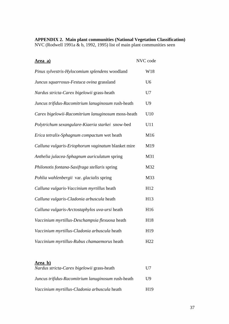
APPENDIX 2. Main plant communities (National Vegetation Classification) NVC (Rodwell 1991a & b, 1992, 1995) list of main plant communities seen
Area a) NVC code
Pinus sylvestris-Hylocomium splendens woodland W18
Juncus squarrosus-Festuca ovina grassland U6
Nardus stricta-Carex bigelowii grass-heath U7
Juncus trifidus-Racomitrium lanuginosum rush-heath U9
Carex bigelowii-Racomitrium lanuginosum moss-heath U10
Polytrichum sexangulare-Kiaeria starkei snow-bed U11
Erica tetralix-Sphagnum compactum wet heath M16
Calluna vulgaris-Eriophorum vaginatum blanket mire M19
Anthelia julacea-Sphagnum auriculatum spring M31
Philonotis fontana-Saxifraga stellaris spring M32
Pohlia wahlenbergii var. glacialis spring M33
Calluna vulgaris-Vaccinium myrtillus heath H12
Calluna vulgaris-Cladonia arbuscula heath H13
Calluna vulgaris-Arctostaphylos uva-ursi heath H16
Vaccinium myrtillus-Deschampsia flexuosa heath H18
Vaccinium myrtillus-Cladonia arbuscula heath H19
Vaccinium myrtillus-Rubus chamaemorus heath H22
Area b) Nardus stricta-Carex bigelowii grass-heath U7
Juncus trifidus-Racomitrium lanuginosum rush-heath U9
Vaccinium myrtillus-Cladonia arbuscula heath H19
37
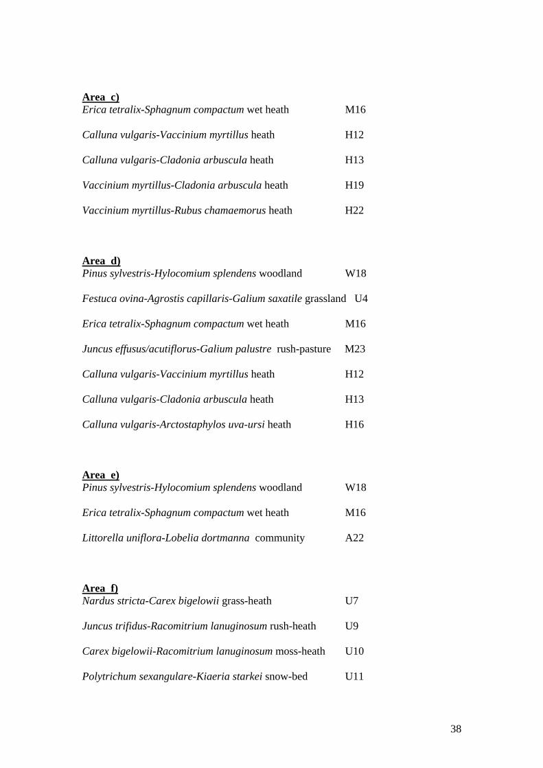
Area c) Erica tetralix-Sphagnum compactum wet heath M16
Calluna vulgaris-Vaccinium myrtillus heath H12
Calluna vulgaris-Cladonia arbuscula heath H13
Vaccinium myrtillus-Cladonia arbuscula heath H19
Vaccinium myrtillus-Rubus chamaemorus heath H22
Area d) Pinus sylvestris-Hylocomium splendens woodland W18
Festuca ovina-Agrostis capillaris-Galium saxatile grassland U4
Erica tetralix-Sphagnum compactum wet heath M16
Juncus effusus/acutiflorus-Galium palustre rush-pasture M23
Calluna vulgaris-Vaccinium myrtillus heath H12
Calluna vulgaris-Cladonia arbuscula heath H13
Calluna vulgaris-Arctostaphylos uva-ursi heath H16
Area e) Pinus sylvestris-Hylocomium splendens woodland W18
Erica tetralix-Sphagnum compactum wet heath M16
Littorella uniflora-Lobelia dortmanna community A22
Area f) Nardus stricta-Carex bigelowii grass-heath U7
Juncus trifidus-Racomitrium lanuginosum rush-heath U9
Carex bigelowii-Racomitrium lanuginosum moss-heath U10
Polytrichum sexangulare-Kiaeria starkei snow-bed U11
38
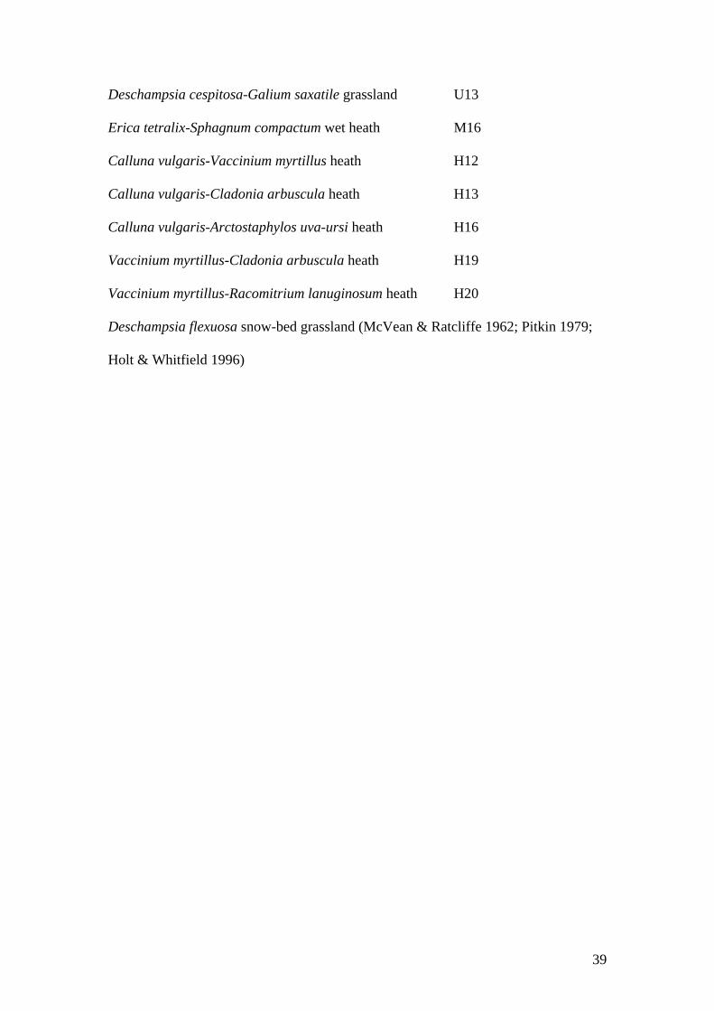
Deschampsia cespitosa-Galium saxatile grassland U13
Erica tetralix-Sphagnum compactum wet heath M16
Calluna vulgaris-Vaccinium myrtillus heath H12
Calluna vulgaris-Cladonia arbuscula heath H13
Calluna vulgaris-Arctostaphylos uva-ursi heath H16
Vaccinium myrtillus-Cladonia arbuscula heath H19
Vaccinium myrtillus-Racomitrium lanuginosum heath H20
Deschampsia flexuosa snow-bed grassland (McVean & Ratcliffe 1962; Pitkin 1979;
Holt & Whitfield 1996)
39
APPENDIX 3. Annex I bird species and other birds of conservation importance The European Council Directive of 2 April 1979 on the Conservation of Wild Birds (79/409/EEC) stated that “The species mentioned in Annex I shall be the subject of special conservation measures concerning their habitat in order to ensure their survival and reproduction in their area of distribution....In this connection, account shall be taken of (a) species in danger of extinction; (b) species vulnerable to specific changes in their habitat; (c) species considered rare because of small populations or restricted local distribution; (d) other species requiring particular attention for reasons of the specific nature of their habitat”. Amendments have been added in years since. It is a widespread view in many countries that the most satisfactory approach to species conservation involves a holistic assessment aimed at the conservation of entire ecosystems. Although some species appear on national or international lists and other species not, in this rationale all are regarded as important parts of a whole. Despite this, many ornithologists concentrate attention on certain species. If this brings general conservation gains it is of some value. However, it cannot put the conservation of these species on such a sound long-term footing as when entire ecosystems are conserved. The introduction of the Habitats Directive is therefore likely to prove valuable for the conservation of species listed in the Birds Directive, provided that it is used effectively and not in a minimalist fashion. The approach below is to discuss Annex I species first. Secondly, some notable species that are not at present listed as Annex I species are mentioned. The chief publications relevant to this second group are Batten et al. (1990), Pritchard et al. (1992), Gibbons, Reid & Chapman (1993), and RSPB (1996). It is suggested that some of these cases, such as the snow bunting, should be assessed for possible Annex I status. The snow bunting is by far the most important omission. In addition, several of the species in both the first and second groups below, especially in the alpine and subalpine zones, are likely to be vulnerable to habitat change, especially if there is marked global warming. They may be of importance as potential indicators of climate change and might be of high significance for monitoring. Examples on alpine land are the ptarmigan, dotterel and snow bunting. a) Annex I species Red-throated and black-throated divers On Loch Morlich there have been occasional records of a pair of black-throated divers, and of red-throated divers foraging, the latter coming from lochs in upper Abernethy where they breed. A pair of red-throated divers has been seen with full-grown young on Loch Morlich, after nesting in upper Abernethy. A floating platform as a diver nest site has been built near the south side of Loch Morlich (R.H. Dennis, pers. comm.). The divers are of interest but not in sufficiently regular occurrence or numbers to justify selection of Loch Morlich as part of an SPA for this reason alone.
40
Raptors and owls Peregrine falcons hunt frequently on areas a), b) and d), merlins occasionally on these, and golden eagles on the northern parts of area a) and occasionally on area d). Golden eagles formerly nested in old pines near Loch Morlich and later in the Slugan and near Ryvoan Pass, but have not used these sites for several decades. Merlins occur in summer on area d), and have been known to breed there. Hen harriers and short-eared owls are seen occasionally on the moorland on areas a) and d) in passing. Desmond Nethersole-Thompson (pers. comm.) observed a cock short-eared owl displaying in open ground south-east of Loch Morlich in May 1960. Ospreys fish at Loch Morlich and Lochan nan Geadas, and often fly over area e) and occasionally over low parts of a) and d). There have been occasional sightings of a snowy owl on alpine parts of areas a) and on b), in the same summers as one was seen on the plateau towards Ben Macdui. In 1876-78, E.T. Booth robbed nests of red kites at Glen More and Abernethy (Nethersole-Thompson & Watson 1974). Single red kites were seen in 1933, 1952, and 1972 over different Strath Spey woods. Now that introduced red kites are spreading in northern Scotland, it is likely that they may re-colonise Glen More. Capercaillie The habitat notes below for capercaillie, crested tit and Scottish crossbill (which are all species characteristic of native pinewood) are brief summaries. Fuller information is given in a recent review (Summers, Moss & Halliwell 1995). The capercaillie’s main habitat is Scots pinewood with old trees which are favoured by feeding birds in winter, and a floor with much blaeberry which provides the main feeding habitat for chicks. As far as is known, no counts have been carried out in areas a), d), and e), but adults have been seen in trees and on the ground in areas d) and e), and broods in areas a), d), and e). Dotterel The main breeding habitat in the Cairngorms massif is flat or gently sloping land dominated by Juncus trifidus. Densities are highest there, but birds breed at low density on several other plant communities (Watson 1989). Up to three pairs in a year have been found nesting on alpine parts of area a), and in most years at least 1-2 pairs. Small groups forage on areas a) and b) in spring, a bird has been seen on area c), birds often fly over areas c) and f) en route between the Cairn Gorm/Ben Macdui plateau and area a), and a brood has been seen in a few years on area f). During 1967-86, Watson (1988, 1989) studied dotterel numbers and breeding success, and possible human impact on them, in an area comprising alpine parts of areas a) and f), along with the plateau south of Cairn Gorm. After 1987 a similar area has been used for a more intensive study by the Nature Conservancy Council and subsequently SNH, known as the Mountain Plateau Ecology Project. The few pairs that breed on area a) form a very small proportion (approximately 1%) of the total number of dotterel pairs known to breed on the Cairngorms pSPA. However, they are an integral continuous part of the main large group breeding on the Cairn Gorm/Ben Macdui plateau. Areas a), b) and f) are all used occasionally by larger numbers than breed there, in May shortly after the birds arrive from Africa, especially when the main breeding grounds on the plateau towards Ben Macdui are
41
under deep snow. The Cairn Gorm/Ben Macdui site is of some additional scientific value as the location of the most long-term studies of dotterel anywhere in the world.. Golden plover This is seen occasionally on alpine land in area a), including small flocks in autumn and occasional pairs and singletons in summer. There is no known breeding record, but the area is very seldom searched carefully. One or two pairs used to nest on the low moor near Allt Ban and Allt na Ciste in area a), and on bogs in area e) in 1934-37. Wood sandpiper There were occasional sightings on area e) before the tree-planting scheme began in 1970. Scottish crossbill The main habitat used by this species is native Scots pinewood. The Glen More-Rothiemurchus area is regarded by specialist ornithologists as a core area of international importance, and has been the site of a well-known pioneering study (Nethersole-Thompson 1975). Detailed studies have been pursued in recent years in Deeside by M. Marquiss & R. Rae, and later in Abernethy (Summers 1996), but relatively little is known about the birds’ population ecology and habitat requirements. It appears that native Scots pinewood might be a necessary habitat. Numbers fluctuate greatly between years. Scottish crossbills have been found nesting in old pines in area e) in most years and in area d) in some years, and feeding in old pines in areas a), d), and e). Recent work shows that some crossbills breeding at Abernethy have large bills matching those of the parrot crossbill (Summers 1996), a widespread bird of the Fennoscandian and north-west Russian coniferous forest. Hitherto it has been regarded as a rare vagrant in the UK, with only a very few records of breeding in eastern England in the past decade. The findings from Abernethy suggest that the native pinewoods are likely to prove of greater ornithological and conservation importance than has been realised so far. b) Notable species that are not listed in Annex I These include some species that feature in other publications, such as the books on Red Data Birds (Batten et al. 1990) and Important Bird Areas in the UK (Pritchard et al. 1992). Criteria for the category of “conservation importance” in the Red Data list for the UK are:-international significance of British populations, scarcity as British breeders, declining breeding numbers, restricted distribution in vulnerable sites or habitats, and species of special concern. Relevant Red Data species for the current report are the goldeneye, goshawk, red and black grouse, greenshank, Temminck’s stint, redwing, crested tit, twite, and Lapland bunting, with black grouse, merlin and greenshank as of special concern. The snow bunting, ptarmigan, goldeneye and crested tit are listed in Important Bird Areas in the UK. Based on the above two publications and on Gibbons et al. (1993) and others, the most up to date review (RSPB 1996) provides a “red list” of species of high
42
conservation concern, and an “amber list” of species of medium conservation concern. Among species relevant in the Glen More/Cairn Gorm area, the red list includes the black grouse and twite, and the amber list includes the Slavonian grebe, whooper swan, goldeneye, kestrel, oystercatcher, ringed plover, lapwing, Temminck’s stint, dunlin, snipe, woodcock, curlew, redshank, greenshank, redstart, ring ouzel, redwing, crested tit, parrot crossbill (see under Scottish crossbill in section a) above, last paragraph), and snow bunting. Goldeneye The numbers of nesting goldeneyes in area e) have been noted by Mr R.H. Dennis and others in the RSPB, but are not given here, for the sake of the birds’ security. Birds have bred at Loch Morlich and nearby lochs since 1980 in nest boxes (R.H. Dennis, pers. comm.). Goshawk and other raptors In 1878, E.T. Booth was shown the pine in Glen More where the last native goshawk nested in the 1850s (Nethersole-Thompson & Watson 1974). A hen goshawk was seen carrying food near Ryvoan in 1969 by T.P. Milsom. If the population were to expand materially in northern Scotland, the woods of Glen More along with nearby Rothiemurchus and Abernethy would be a potential area for breeding birds at low density in native boreal woodland and adjacent moorland. Kestrels are occasionally seen hunting over the moorland on areas a) and d), and nest at low density in Glen More. Ptarmigan It is surprising that the Red Data list for the UK omits the ptarmigan, given that the list includes the far more abundant and widespread golden plover (SPA Annex I species), red grouse, and twite. The ptarmigan should be assessed for possible inclusion. The ptarmigan is a gamebird in the UK. However, its distribution is discontinuous because many areas of suitable habitat are widely separated on isolated hilltops, and mean densities are low or very low on most of the range. The bird’s distribution in the UK has not altered materially between 1968-72 and 1988-91 (Watson & Rae 1993). The stronghold in Britain is generally recognised to be the Cairngorms massif, the Mounth, and neighbouring ranges in the north-east/central Highlands. During periodic natural troughs in numbers, densities even in the more favourable habitats can be extremely low. Moss (1996) regarded the Cairngorms ptarmigan as of major national significance, and of internationally significant scientific value because of the exceptionally long run of data on wild populations over many decades. The main breeding and wintering habitat of ptarmigan in the Cairngorms massif is land with a high proportion of heath associated with numerous boulders, especially heath dominated by blaeberry and crowberry, which are the main food plants (Nethersole-Thompson & Watson 1974). All alpine parts of areas a) and c), and all of area b) hold ptarmigan breeding habitat, and all subalpine and upper moorland parts of a) and c) hold winter habitat on days
43
when higher land is stormbound and has much snow. Ptarmigan abounded on Cairn Gorm in years before the ski developments, when they bred as well as birds studied in more detail on Derry Cairngorm, an area of relatively high-quality habitat for the Cairngorms massif (Watson 1981). Some counts have been published on adult densities and breeding success in years after the ski developments started (Watson 1979). Numbers were still high in the late 1960s, with flocks of >100 at a time in winter (Dr A. Watson, unpublished data). Following an increase of crows on alpine land at Cairn Gorm (Watson 1996b), associated with more food scraps and more visitors, the breeding success of ptarmigan on Cairn Gorm became very low (Watson 1982). More ptarmigan were killed flying into the increased number of ski cables, and in 1979-95 none bred on the most heavily developed parts of the ski area in Coire Cas. Counts have been continued over several decades on Cairn Gorm outside these heavily developed areas, and on the Cairn Gorm/Ben Macdui plateau, and are currently being analysed in relation to long-term counts on Derry Cairngorm and other less visited hills on the Dee side of the Cairngorms massif (Dr A. Watson, unpublished data from 1947 to 1996). Ptarmigan numbers on the Cairn Gorm/Ben Macdui plateau and other parts of the massif show cyclic fluctuations (meaning, in statistical analysis, significantly more regular than random). Red grouse Red grouse breed at low density on the moorland parts of areas a), c), d), and f), forming an altitudinal overlap (though not a habitat overlap) with breeding ptarmigan on areas a), c), and f). In addition, single red grouse have been seen occasionally during autumn on alpine land on areas a) and c). Black grouse Black grouse have declined greatly in woodland and low moorland in the study area, but still occur at low density. They are likely to increase in response to the greater natural regeneration of young pines and broad-leaved trees, following FE’s change of policy in Glen More Forest. Black grouse have already increased on the RSPB’s Abernethy reserve in the last few years, following greater natural regeneration of trees and scrub, removal of fences, and experimental killing of unnaturally high numbers of foxes and crows. Waders in the Loch Morlich area In past decades, several rare species have been seen on area e), particularly on and near the west shore of Loch Morlich, including nesting greenshanks and Temminck’s stints, a singing green sandpiper, and a spotted redshank in summer 1956 (Nethersole-Thompson & Watson 1974). The loch shores also held breeding oystercatchers, ringed plovers, lapwings, dunlins, snipe, curlews, and redshanks. Loch Morlich was formerly the most outstanding loch in the UK for rare boreal waders. Developments and other human-induced changes on and beside the loch have led to a great paucity of waders in recent years (Watson et al. 1988), but there is potential for restoration, given the will and the necessary associated management by FE and other relevant agencies and individuals. Greenshanks used to breed in area e) before the mid 1970s (Nethersole-Thompson 1951; Dennis 1975), but have not been seen there since the planted trees became well established. Woodcock still breed in open parts of the
44
woodland on areas a), d), and e), as well as in the main Glen More and Rothiemurchus woods generally. Crested tit The main habitat is Scots pinewood (including both plantations and native woods) with a varied canopy structure including tall heather, scrub, pines with low side branches, and dead trees. Crested tits commonly forage in established trees and adjacent tall heather in areas a), d), and e), breed annually in area e), and breed at trees in area d) in at least some years. Snow bunting This is one of the rarer of the bird species that breed regularly (i.e. every year on the same areas) in the UK. It did not breed in any other EU country in 1979 when the Birds Directive was issued, and still does not do so except in Sweden and Finland. Yet it was not, and is not, listed in Annex I of the Birds Directive. As breeding birds in the UK, the red throated diver, hen harrier, golden eagle, merlin, peregrine falcon, capercaillie, dotterel, golden plover, Arctic tern, short-eared owl, and Scottish crossbill, all of which are listed in Annex I, are much more abundant and widespread than the snow bunting (as documented in Batten et al. 1990 and RSPB 1996). Furthermore, the UK held most or all of the EEC breeding populations of these other species in 1979 when the Birds Directive was issued. Several other species listed in Annex I, such as the Sandwich tern, roseate tern and little tern, have far larger UK breeding populations than the snow bunting, though in these cases the UK may not have held most of the EEC breeding population in these years. It would be useful if the snow bunting were to be assessed for potential Annex I status. Its omission is surprising and indicates shortcomings by NCC/ JNCC/ SNH. When the Birds Directive was issued, the only snow buntings breeding in the EEC countries were in Scotland. Most of them were in the Cairngorms, and a high proportion on the Ben Macdui/Cairn Gorm plateau and nearby corries. The bird’s main breeding habitat in the Cairngorms massif is vegetated land near boulder fields in association with flushes and snowbeds (Nethersole-Thompson & Watson 1974). The late D. Nethersole-Thompson (pers. comm.) knew area f) as a breeding haunt in the 1930s-1950s, and saw cocks on areas a) and b). In 1969-86, Dr A. Watson (unpublished data) found birds breeding on areas a) and f) in some years, and singing and foraging on area b). During intensive study in 1987-93, breeding by a pair was recorded on area f) in four years (Dr R.D. Smith, unpublished data). In 1996, Dr A. Watson found two pairs breeding on area f). Birds nesting on area f), on the Cairn Gorm/Ben Macdui plateau, and in the Northern Corries often forage on areas a) and b), occasionally with fledged young (Dr A. Watson, unpublished data from 1966-96). A ringed cock sang on area a) in 1989, before moving to Braeriach where he paired with a hen (Dr R.D, Smith, unpublished data). Snow buntings frequently use alpine parts of areas a), b) and c) before nesting (on days when deep snow covers the main breeding grounds), after the young are
45
independent, during the annual post-breeding moult, and in autumn after moulting (Watson 1997a). Dr Smith (unpublished data) has recorded much usage of the alpine parts of areas a) and f) by flocks in winter. Winter flocks have long frequented lower parts of area f) by the car park and nearby (Watson 1979), including many ringed birds known to breed in the Cairngorms (Dr R.D. Smith). The main area for breeding snow buntings on Cairn Gorm and Ben Macdui (map in Smith 1994) covers 16 km2. Of this, 2 km2 are outside the pSPA (1.3 km2 inside Glen More Forest Park and 0.7 km2 outside). The area used in spring, early-summer snowfalls before nesting, and autumn extends to 3 km2 outside Smith’s study area, of which 1.2 km2 is outside the Park. Consideration should be given to expand the SPA so as to include this 1.2 km2 area, all of which is on RSPB land, thus forming a coherent whole. All of it is also a ptarmigan habitat, and much of it a dotterel habitat. Publications on numbers of snow buntings in the Cairn Gorm area have been based mostly on a study area that combines the alpine parts of areas a), b), and f) with the plateau south of Cairn Gorm (Nethersole-Thompson 1966; Milsom & Watson 1984; Watson & Smith 1991; Smith 1994). This is the case also for recent papers on breeding success (Smith & Marquiss 1994, 1995; Watson 1996a). The snow bunting is of particular importance for consideration of pSPA boundaries, with special reference to the exclusion of areas a), b), and f) by SNH and the SO. Other species Ring ouzel, twite and Lapland bunting were noted in the area sections. The shore lark, one of the rarest sporadic breeders in the UK, occurred during summer in several years in the 1970s on the Cairn Gorm/Ben Macdui plateau, and bred in at least two years on ground dominated by Juncus trifidus. High alpine land on area a) has much of this habitat, although the shore lark is not known to have been seen there. A few redstarts breed among old pines at the foot of areas a) and d), and in woodland glades in area e). Wintering waxwings are often seen feeding on berries on bushes and trees on low ground in Strath Spey, including villages, but occasionally in juniper-rich areas in and near native woodland, for instance on area d) in November 1996 (Dr A. Jones, pers. comm.). It is possible that waxwings might nest in Scotland in such a place, which resembles their breeding habitat in Scandinavia. The redwing once seen on area c) in summer was within the zone where scrub is developing, and is an Annex I species if it is breeding. Redwings do nest in low scrub in Fennoscandia and Iceland, and so the scrub on Cairn Gorm has potential as a breeding site for them. A large expansion of scrub, especially dwarf willow and birch, would probably attract other boreal scrub-zone birds to occur and breed (Watson 1977), such as the bluethroat, which is an SPA Annex I species. It is so rare that its colonisation by nesting pairs or groups on a regular annual basis would result in an immediate obligation upon SNH to designate any breeding locations as SPAs. In northern Scotland, heavy browsing and burning have almost eliminated their habitat, but a major expansion of scrub on areas a), c), d), and f) would create it. This is only one example where the drawing of boundaries on the basis of current
46

biological status precludes foresight as to the future potential of the site, and so prevents that potential from being realised.
47
APPENDIX 4. Visitor numbers and ground disturbed by human impact Surveys of visitor numbers have been concentrated on the Cairn Gorm/ Ben Macdui plateau and the ski area, and there is relatively little recorded information from other parts. The most comprehensive visitor survey so far was done by Morris, Hammond & Kessler (1974), involving mapping of the numbers of people using each km square over the Cairngorms NNR and the main approaches in late summer. The number per km2 during eight days in July was 1-49 on most of area a) and some relatively unvisited parts of the Ben Macdui plateau, 50-99 on an upper part of area a) north-east of Cairn Gorm summit, and larger numbers >200 in Coire Cas, the main routes to Cairn Gorm summit, west of Cairn Gorm, on Cairn Lochan, and on the main route towards Ben Macdui. Every summer survey before and since has shown the same broad differences between areas. The most recent total counts in summer were carried out by Amphlett (1996) on a large central part of the Cairn Gorm/Ben Macdui plateau.. Counts documented in Watson (1991) involved numbers seen on summer days on the entire Cairn Gorm/Ben Macdui plateau and nearby slopes, including areas a) and b). A breakdown into different parts (not in Watson 1991) shows that most of the upper parts of area a), involving Coire Laogh Beag, Coire Laogh Mor, the West Wall and the eastern slopes of Coire na Ciste, the lower part of the Ptarmigan Bowl, Coire na Spreidhe, the low plateau below Ciste Mhearad, and the edge of the steep slope further down, had 0 people/ 100ha in the 19 summers 1971-88, as had a few remote corries on Ben Macdui off the main routes. Alpine parts of area a) nearer the chairlift had more people, for example, 230 in Ciste Mhearad, and 790 on the slope that includes area b). Numbers on the main routes to and from the Cairn Gorm/Ben Macdui plateau greatly surpassed them (e.g. 5500 on Cairn Gorm’s west side). Such differences between areas in summer are not all paralleled exactly in winter. For example, Coire Laogh Mor and lower Coire na Ciste in area a), and the routes through area c) on the way to Coire an t-Sneachda, are more used in winter than in summer, especially for climbing and winter training. Human-induced disturbed ground (vegetation damage, increased bare ground, and soil erosion) was mapped in summer 1981 on the upper parts of area a), and on area b) and other parts of the Cairn Gorm/Ben Macdui plateau (Watson 1985). The proportion of disturbed ground on alpine parts of area a) was 0% on Coire na Ciste’s far eastern slopes and land above Coire Laogh Mor and Coire Laogh Beag, and 4-5% on Sron a’ Cha-no and Cnap Coire na Spreidhe. On an area that included area b) it was 27%. Some much-visited parts of the Cairn Gorm/Ben Macdui plateau inside the pSPA and pSAC had 27% (Coire Domhain), the north side of the North Top (54%), Ben Macdui summit area (58%), and the west side of Cairn Gorm (100%). Since 1981, some land on areas a), b), f) and on the Cairn Gorm/Ben Macdui plateau has improved in condition, associated with the end of successive annual increases in visitors using the chairlift and going on the plateau (Watson 1994). Parts that have improved in ground condition include most of area b) and virtually all of area a), whereas some steep slopes and heavily used walks have remained in poor condition
48
and in some cases have deteriorated. These include areas far out on the Cairn Gorm/Ben Macdui plateau and in the Northern Corries (e.g. steep slopes on the North Top of Ben Macdui and on Cairn Lochan inside the NNR, and the path down Miadan Creag an Leth-choin in the Northern Corries SSSI). The most severely damaged area is on the Cuidhe Crom of Coire Cas (excluded), followed by the slope west of Cairn Gorm (included), north-west of Cairn Gorm (excluded), west of Fiacaill a’ Choire Chais ridge (included), west of the North Top (included), and north-west of Cairn Lochan (included). Walkers caused much of the vegetation damage and soil erosion, but this was reduced on the ski area by channelling people and vehicles on to prepared gravel tracks. Much reseeding of damaged ground has been carried out annually on the ski area, especially on and near the main pistes and vehicle tracks. Certain entire slopes at higher altitudes on the ski area were not treated, and were in a serious condition in 1981 (Watson 1981, 1985). Since then, most of the affected slopes at low gradients have recovered naturally, though those on steep slopes remain in a serious unstable condition. Nevertheless, large parts of the ski area were little affected in earlier years, and some were virtually unaffected. These included the slope between the White Lady tow and the car park, the boulder field west of the top of the Coire Cas tow, and almost all of Coire na Ciste including the Ptarmigan Bowl. Other parts that are now in a near-natural condition are the upper parts of the slope south of Coire Cas car park, and the area to the east of the top of the Fiacaill tow. The numbers and widths of footpaths have increased greatly in the Cairn Gorm and Glen More area, due to more visitors using certain popular routes, and the length of footpaths per km square is a useful measure of their density (Watson 1984). Cursory inspection of the data shows no footpaths or very low values on area a) and e), zero on area b), and low values on areas c) and d), yet fairly high values in the Northern Corries and on much of the Cairn Gorm/Ben Macdui plateau. A fuller, quantitative analysis should prove revealing. On area d), FE carries out path maintenance and repair, and work is currently required in some places. Many wide eroding footpaths on area f) and in the nearby Northern Corries are now in better condition following a major programme of repairs since the late 1980s by HIDB and later HIE, which is still continuing each summer. On area f) there is a considerable amount of debris from construction works and operation of the ski facilities, though markedly less than during surveys in 1981 (Watson 1981). The amount of tourists’ litter has also declined on area f) since 1981. During site inspections for the present study, some litter was found on alpine land on area a), but only on the shallow corrie north-east of the Ptarmigan Bowl, next to area f). Nearly all of it had been blown from the ski area, e.g. a T-bar, a cafe tray, roofing material, and a cardboard cup. Some tourists’ litter was seen in Ciste Mhearad. Hardly any litter was noted on the lower parts of area a), or on areas b), c), and e), and none on area d) except occasionally along paths. Hence, amounts of litter were associated with amounts of human use, and accessible but seldom visited parts of the study area had very little litter. The same point is noticeable more generally, e.g. very
49

few litter items on the relatively accessible but little visited Cromdale Hills and eastern Monadh Liath. On each site visit for the present report, people were seen walking on the main paths on area d), with up to 27 at a time on the path from Ryvoan to Meall a’ Bhuachaille, and also along the road on area e), with up to eight at a time on the first 500m from the River Luineag, but only up to four at a time on other parts of this road and other roads. The writers are unaware of any study giving survey information for these routes.
50
APPENDIX 5. Landforms, hydrology, and soils This section comprises a general account of landforms, hydrology, and soils in the Rothiemurchus/Cairn Gorm/Glen More region, followed by detailed area-specific accounts. Landforms Rising from c200m on the Upper Speyside lowlands to the highest plateau at c 1200m, Glen More and the adjacent Cairngorms massif have been long recognised as the best area in the UK for the study of pre-glacial, glacial, and periglacial geomorphology, and indeed are of global importance. The present-day landscapes reflect the influences of major glaciations on the pre-glacial topography, the last culminating around 18 000 years ago, though severe climatic conditions returned for another c1000 years about 11 000 years ago. This was followed by the rapid onset of a warmer climate accompanied by the melting of the ice and the deposition of enormous spreads of morainic and fluvioglacial sands and gravels. Major contemporary geomorphological agencies are dominated by scree activity, flash flooding, debris flows, and continued periglacial activity on the high tops. The lowlands of Glen More are characterised by a pitted outwash plain with classical examples of kames, eskers and terraces etc. Their distribution has been extensively mapped and studied (Young 1974). The paleobotany of the common basin peats, which in many places exceed 4m in thickness, has been studied in detail, e.g. Birks (1995). Steep slopes rapidly rise from the outwash plain, delineating the perimeter of the Cairngorms massif and ending in a series of planation surfaces which starts at c760m. Of particular note are the well-developed tors and both the massive and incipient corries. Several distinguished scientists, including Hinxman, Linton, Sissons and Sugden have carried out research on these aspects. Periglacial phenomena have likewise been studied in depth by Clapperton, Galloway, and King, amongst others. Comprehensive bibliographies including the above authors are listed in the papers by Gordon (1993) and Brazier et al. (1996), which are in the References list at the end of the present report. Hydrology Although the hydrology of the Cairngorms, especially the assessment of stream flows, snowmelt and catchment drainage etc. has been the subject of various studies (e.g. Ferguson 1985; Brazier et al. 1996), little work has been undertaken on soil-water movement. Exceptions include the recent installation of dip-wells in Coire Cas below the Ptarmigan Restaurant, and in a kettle-hole adjacent to the Coire na Ciste car park (Walker & Watson 1996). They formed part of the site investigations for the proposed funicular railway on Cairn Gorm (however, no records from either installation have been made available by the CCC). The only detailed soil-water study in the Cairngorms is currently being pursued in the upper catchment of Allt a’ Mharcaidh west of Gleann Einich, a joint UK-Scandinavian Acid Rain Project (Nolan 1985).
51
Outwith minor springs and burns, particularly those associated with the corries and incipient corries, and rock-controlled seepages which are particularly common in the northern sector of Coire Cas, the major hydrological factor affecting the soils in the study area is a perched water-table. Caused by an iron pan or indurated horizon within the soil profile, the resultant effects range from very transient water to complete and permanent water-logging. Both horizons truncate the available rooting volume and thus exaggerate the potential effects of saturation. The formation of many of the peat deposits has been induced by the presence of an iron pan in peaty gleyed podzols in depressed sites. Soils Little systematic research has been undertaken into the soils of the Cairngorms, let alone the specific area under review. A brief general appraisal was made by Heslop (1974), and a similar assessment relates to the soils of the Spey catchment (Walker 1988). However, two detailed soil surveys (1: 10 000) were produced by the Soil Survey of Scotland for Coire Cas and the area initially leased by the Tilhill Forestry Company south-west of Loch Morlich. The maps were accompanied by the physical and chemical analyses of eight profiles in each area (Walker & Gauld 1971, 1972). An unpublished report has been prepared by Walker & Watson (1996), commissioned by Cairngorm Chairlift Company concerning the proposed funicular railway, and A.D. Walker wrote the section on soils for the Environmental Statement on the proposed railway (Land Use Consultants 1994). In addition, Walker and Watson were co-authors of the report on the ecological implications of skiing development in Lurcher’s Gully (Bayfield et al. 1988), which included sections on soils and hydrology. Also, the Soil Survey for Scotland produced a 1:250 000 reconnaissance soil map for Eastern Scotland, including the Cairngorms. It is based on 1:50 000 field maps and the interpretation of 1:25 000 aerial photographs, and the soil map units are described in an accompanying memoir (Walker et al. 1982). Podzolisation is the main soil-forming process in northern Scotland, which lies within the geographic zone of the “Northern Coniferous Forests” (Tamm 1950). Derived from acid, free-draining soil parent materials, podzols are characteristic of coarse-texture drifts such as found in river terraces, fluvioglacial deposits, and mountain areas. Uncultivated series are associated especially with ericaceous heaths, and below the subalpine zone with pinewoods. Review of these formative factors indicates that the epicentre of podzolisation in the UK lies in the Speyside-Deeside axis. Indeed, according to Birks et al. (1975) “Contrary to popular belief, Caledonian pine woodland was not the widespread ‘primeval’ woodland type of Scotland. Pine woods were centred on the acid, well-drained soils of the Cairngorms, Upper Deeside and Upper Speyside”. Similarly, Birks (1988) stated that “the relative importance of Pinus increased eastwards, reaching a maximum in Upper Deeside and Upper Speyside”. Podzols may be classified in an altitudinal sequence or catena, which begins with the iron podzol, the most excessively drained of all podzols. The uncultivated series is rare, and largely restricted to sands and gravels of the Moray lowlands and the woodlands of Abernethy and Rothiemurchus in Strath Spey. An investigation into the physical and chemical properties of the iron podzol by one of the authors (ADW) and
52
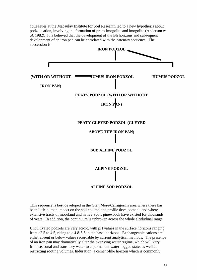
colleagues at the Macaulay Institute for Soil Research led to a new hypothesis about podzolisation, involving the formation of proto-imogolite and imogolite (Anderson et al. 1982). It is believed that the development of the Bh horizons and subsequent development of an iron pan can be correlated with the catenary sequence. The succession is:
IRON PODZOL
(WITH OR WITHOUT
IRON PAN)
HUMUS-IRON PODZOL
HUMUS PODZOL
PEATY PODZOL (WITH OR WITHOUT
IRON PAN)
PEATY GLEYED PODZOL (GLEYED
ABOVE THE IRON PAN)
SUB ALPINE PODZOL
ALPINE PODZOL
ALPINE SOD PODZOL
This sequence is best developed in the Glen More/Cairngorms area where there has been little human impact on the soil column and profile development, and where extensive tracts of moorland and native Scots pinewoods have existed for thousands of years. In addition, the continuum is unbroken across the whole altidudinal range. Uncultivated podzols are very acidic, with pH values in the surface horizons ranging from c2.5 to 4.5, rising to c 4.8-5.5 in the basal horizons. Exchangeable cations are either absent or below values recordable by current analytical methods. The presence of an iron pan may dramatically alter the overlying water regime, which will vary from seasonal and transitory water to a permanent water-logged state, as well as restricting rooting volumes. Induration, a cement-like horizon which is commonly
53
found in soils derived from tills and moraines, is similarly restricting. Obviously, the availability of water has a profound effect upon the composition of the associated plant community. From the above resume, particularly the ubiquitous nature of the podzol sequence across the whole area under review, it is obvious that the soil boundaries cannot be correlated with, and so reject the scientific validity of, the artificial boundaries which have been indicated for the designation of proposed nature conservation sites. Area a) The area comprises three main topographic elements: 1) a fluvioglacial and morainic complex which forms the floor of Glen More and trends northwards through the Ryvoan Pass. Rising from the original forestry perimeter fence at c460m, the distinctive moundy and kamiform landform and associated kettle-holes tends to fade abruptly around 600m. 2) the main north-western flanks of the northernmost sector of the Cairngorms massif. Often beginning with a slightly concave skirt, the slopes steepen rapidly before flattening out as a convex shoulder to the main plateau. 3). the northernmost section of the Cairn Gorm/Ben Macdui plateau along with its associated incipient corries and escarpments. Coire Laogh Mor has small remains of broken cliff. There are steep cliffs at the south end of Coire na Spreidhe and east of Cnap Coire na Spreidhe, and at Mudachan Cha-no on the east flank of Sron a’ Cha-no. These cliffs form parts of a remarkable 4.5km-long escarpment above Strath Nethy. On a slight break in this escarpment within the alpine zone, expanses of ice-smoothed bedrock with an associated waterfall occur on the Cairn Gorm side of the Saddle. In the subalpine zone, ice-smoothed granite bedrock outcrops east of Clach Bharraig, on the lowest spur of An t-Aonach between Coire Cas and Coire na Ciste. Clach Bharraig itself is a prominent large erratic granite boulder. Glacial meltwater channels are conspicuous east of Lochan na Beinne, and form an unusually varied set within a small area. Snow avalanches occasionally tear up vegetation and soils in Coire Laogh Mor, contributing to current landform processes. The plateau and slopes of area a) contain numerous tors, which form one of the most varied and largest sets in the Cairngorms massif. Those on the slope south-east of Cnap Coire na Spreidhe are particularly notable for their total number, density, variety, and state; they include many collapsed tors. The soil parent materials of the morainic and fluvioglacial complex in topographic element 1) comprise freely or excessively drained sands and gravels, mainly derived from schists but with a variable granite content. Peaty podzols dominate the tops of the mounds, whereas peaty gleyed podzols are characteristic of the slopes, which often lead to peat-infilled basins. Both soils have a thin iron pan at the base of the Bh horizon which, in the peaty gleyed podzols induces a seasonal perched water-table. The peat in the basins often exceeds 2.0m in thickness. On the main slopes above the complex in 1), peaty gleyed podzols merge in many locations with shallow blanket peat 0.5-1.0m thick, and characterise the lower concave slopes. Peaty podzols are found on slightly more prominent areas. Isolated small patches of shallow peat occur also on flat summits and gentle uppermost slopes
54
in the subalpine zone, particularly on Mam Suim, Carn Lochan na Beinne, and the unnamed top to the south-east of the latter. Below the Coire Cas car park and flowing round the toe of An t-Aonach towards the Coire na Ciste car park is a belt of morainic mounds and peat hollows below c550m. The parent material is mainly a partially stratified loamy sand and gravel with thin seams of bedded silts. Well-bedded and sorted sands and gravels are also found, particularly around the confluence of Allt a’ Choire Chais and Allt Mor, where there are large conspicuous terraces containing fluvioglacial sands and gravels, and the occasional esker and mound. Peaty podzols and peaty gleyed podzols are the primary soil profiles. With increasing altitude, the thick peaty surface horizons rapidly thin and the dominating soil-forming process of podzolisation lessens as climatic influences increasingly prevail. Concomitant with these processes is the gradual replacement of the peaty and peaty gleyed podzols by sub-alpine podzols, characterised by a less strongly coloured Bs horizon and very much thinner organic surface horizons. The soil parent material is a freely drained and coarse-textured stony granite drift, which often displays the effects of colluviation. Poorly drained soils such as peaty gleys, humic gleys, and sub-alpine gleys are limited in area. They are mainly confined to ribbon strands alongside burns and below seepage planes. On the plateau, the prevailing soil-forming processes are physical and climatically induced, with chemical influences virtually non-existent. The main major soil sub-groups are the alpine podzols up to c1000m with alpine sod podzols increasingly dominant above that altitude. Much of the soil solum, however, is too thin to permit horizon development apart from lithosols and rankers. Poorly drained soils are entirely restricted to the floors of corries and incipient corries. They include alpine gleys, humic gleys, and more rarely peaty gleys and shallow peat around the backwalls. The soil parent material of the plateau is granite and entirely locally derived. It is subject to current periglacial processes, resulting in the formation of wind-eroded surfaces, active small gelifluction lobes, ripple patterning of grit, terracettes, stone circles, stone stripes, occasional flows of grit, erosion of linear channels by mud flows, “ploughing” boulders, etc. Area b) This area consists of the upper part of the southern face of the dome-shaped summit of Cairn Gorm, descending to approximately the 1150m contour. A prominent roche moutonnee stands at the foot of the shallow corrie below. All the soils, viz: alpine podzols, alpine sod podzols, lithosols, and rankers are found also in area a) described above. Much of the surface is wind-eroded and boulder strewn. The soil parent material is a very locally derived, very stony, gritty loamy sand of granite derivation. Drainage, apart from the odd minor seepage, is free or excessive. Because of this freely draining status associated with the highly porous coarse granular structure, translocation of silt particles has been a constant feature in the soil column in both this area and area a).
55
Area c) Mainly comprising the western flanks of the ridge Fiacaill a’ Choire Chais and the associated lower western slopes leading to the stream of Allt Coire an t-Sneachda, the area spans an altitude from 650m to 1000m. One of the largest tor complexes at medium altitude on Cairn Gorm stands on the western side of the ridge. Much of the upper spine and slopes are severely exposed and either rock or boulder dominated, and the soils are freely drained or excessively drained. Where the solum is sufficiently thick to permit a standard profile development, sub-alpine podzols dominate the area from 650m to 800m, otherwise lithosols and rankers are characteristic. Above 800m, alpine podzols are occasionally found. The lower slopes are mainly peaty gleys and peaty gleyed podzols, with peat 1-2m thick occupying much of the flattish area beyond the toe of the ridge. A stony, coarse-textured granite drift forms the parent material of the soils on the ridge and upper slopes. On the lower gentle northern slopes, the soil parent materials range from a stony sandy loam till to moraine sands and gravels. The drift is entirely granitic in origin, whereas the till has a variable schist component which increases in the morainic and fluvioglacial deposits. Area d) This area is essentially the south-western flanks of the Kincardine Hills, which comprise a line of broad summits rising in alignment from Craiggowrie (686m) in the north-west to Meall a’ Bhuachaille (810m) in the south-east. Creagan Gorm (732m) occupies a central position. Apart from slightly concave embayments projecting upslope from the forestry perimeter fence (c450m) along the line of three major burns draining the flanks, the main slopes are planar or slightly convex. They become increasingly convex towards the summits. Outwith the rock-dominated area on the extreme north-western summit of Craiggowrie and minor outcrops on Creagan Gorm, the smooth rounded nature of the summits is characteristic of most hills in the Eastern Highlands, though rock is seldom far below the surface. A large glacial erratic was observed along the main line of the ridge west of Creagan Gorm, at a level above that of the nearby col. Peaty podzols dominate the slopes up to approximately 600-650m. An iron pan may be present but is not characteristic of such soils. Above that level, increasing exposure and severity of climate reduce the production of organic matter and increasingly inhibit soil chemical reactions. This results in the replacement of the peaty podzols by subalpine podzols. Where rock is close to the surface, rankers are dominant. Humus-iron podzols characterise the lowest slopes of the extreme south-western flanks, within the remnants of the Caledonian Scots pinewood. Poorly drained soils are limited in extent and generally restricted to the lower concave slopes, where peaty gleys and peaty fragogleys are characteristic. Wet soils are found also along the narrow floodplains and adjoining banks of the burns draining the hillslope. Often in these situations the dynamic drainage system results in the combination of erosion and deposition of sediments, and leads to the formation of humic gleys. The better and more mineralised rooting conditions and increased pH values generally lead to a more diverse vegetation. Peat is restricted mainly to
56
shallow cols along the crest-line, where it is usually hagged and up to 2m thick. Minor areas of peat occur on flat sites near the summit of Meall a’ Bhuachaille where it is seldom more than 0.5m thick, and also in conjunction with the peaty gleys in the lower concave slopes. The primary soil parent material consists of a compact stony sandy loan till derived from schist rocks with a minor granite component. This till reaches a height of at least 600m, as evidenced by the 2m eroding headwall at the source of the Milton Burn. Above that level, the summits are cloaked by a very stony, locally derived schist drift. Wreaths of stabilised gelifluction boulder lobes are a noticeable feature on the upper slopes below the summits, and occasionally at lower altitude as on Creagan Dubh. A minor parent material comprises mainly schist-derived, stratified gravelly loamy sands found on the lower extreme south-western slopes. Area e) The bulk of the area consists of fluvioglacial sands and gravels rising gently southwards from 310m near the River Luineag below the western end of Loch Morlich to 410m below Rothiemurchus Lodge. Emphasising the flattish nature of the northern sector are two large basin bogs, on either side of the access road near the bridge over the River Luineag. A series of very steep-sided gravel mounds known as Na Sidhean dominates the central area, rising from an overall level of 340m and culminating in sharp crests up to 375m. They are the largest such mounds in the Cairngorms. Thereafter, moundy terrain gradually sweeps southwards. Apart from minor areas of peaty gleys associated with flushed areas, especially below Rothiemurchus Lodge, the majority of the soils are excessively drained humus-iron podzols. These merge into peaty podzols with increasing altitude. An iron pan is commonly found. Because of the relatively low rainfall and the moundy nature of the terrain, there is no trace of gleying above the pan. Some of the kettle holes have developed lochans, which are either fed from small burns or from the regional ground-water table. The peat bogs near Loch Morlich have been partially exploited for fuel, though the intact sections still attain a thickness of c4m. The soil parent materials are mainly acidic sands and gravels, with virtually no silt or clay present. They are stone-dominated and mainly derived from schist with a variable granite admixture. Excepting the Bs horizon which is frequently strongly cemented, the structure is single-grained or stone-dominated. Towards the south, boulders become more common within the profile, possibly reflecting a morainic rather than fluvioglacial origin. Fringing the shoreline of Loch Morlich is a narrow ribbon of water-logged soils, mostly peaty gleys. A distinctive area of humic gleys is associated with the continually reworked delta of a minor burn. The resultant continual mineralisation has produced a relatively more fertile soil which is reflected by the more diverse vegetation. Area f) This section relates to the main, heavily used parts of the ski area. It rises from 650m at the Coire Cas car park to 1130m at Cuidhe Crom on the Coire Cas headwall and 1245m at the summit of Cairn Gorm, and from 550m at Coire na Ciste car park to the
57
top of the Ptarmigan Bowl and the Marquis’ Well slope rising to Cairn Gorm summit. The Coire Cas amphitheatre is bounded to the north by the broad, exposed ridge of Sron an Aonaich, which separates Coire Cas from Coire na Ciste. Area f) contains a small tor at the top of Sron an Aonaich, and a large collapsed tor at 750m near the top of the bouldery slope east of the Coire Cas car park. Small broken cliffs outcrop on Creagan Dubh south-east of the Coire na Ciste car park, and at the west end of Cuidhe Crom. Frost-shattered cliff relics stand on the slope west of Cairn Gorm summit. The remains of an ancient debris flow are conspicuous on the same slope. Snow avalanches at Cuidhe Crom occasionally tear off vegetation and upper soil horizons. Most of the soils are sub-alpine podzols at the lower levels but rapidly merge into alpine podzols with increasing altitude. Many areas are boulder-dominated and bedrock is often close to the surface, especially at the higher altitudes. Elsewhere at these heights, especially on Sron an Aonaich and the adjacent slopes around the Ptarmigan Bowl and higher on the dome of Cairn Gorm, periglacial action is pronounced, with wind-eroded grit traps and micro-terracette formation being common. Most of these soils are freely drained. However, in the central depression of the White Lady piste north of the upper chairlift, a series of seepage planes erupts in echelon, accompanied by a series of small burns. Previous drainage works with one catchment adversely affected the natural flow of these minor burns and led to braiding. During rapid snow-melt and heavy rain, the commonly associated flash flooding substantially increases the sediment load, which often overspills onto the adjacent soils. This cycle of erosion and deposition has led to the mineralisation of the surface organic horizons and the formation of humic gleys amidst the peaty gleys which usually dominate these flushed sites. This constantly rejuvenated mineralisation has produced a relatively more fertile and somewhat unique soil which is reflected by the more diverse vegetation. Poorly drained soils are located around the shallow rim of the Ptarmigan Bowl at the head of Coire na Ciste, where minor springs and seepages are associated with alpine gleys and peaty gleys. Shallow peat occurs in small patches at the foot of the Ptarmigan Bowl and on the eastern slopes below it. Larger areas of peat, however, dominate the valley below the Mid Station in Coire Cas, where it is occasionally up to 2m thick. Much of this peat is dissected and eroded. Projecting mounds of moraine are dominated by peaty podzols and peaty gleyed podzols. These soils are common also on the lower surrounding slopes as far up as the Mid Station, where they merge upwards into subalpine podzols. On the north-western flank of Sron an Aonaich east of the Coire Cas car park, at an altitude below c800m, rockhead is frequently close to the surface, and minor rock outcrops, boulder lobes, lithosols, and peaty rankers are widespread, whereas stabilised scree and colluviated soils characterise the lower slopes. Stone-dominated soils and boulder pavements are typical also of the slopes north-west of Cairn Gorm summit. Although excessive pedestrian traffic has caused considerable soil erosion there and triggered colluviation of the surface horizons, intact alpine sod podzols are found in small patches between the boulders and below the boulder pavement.
58

APPENDIX 6. The main management issues As the scientific and management literature on the area is voluminous and mostly well known, this Appendix cites only the most important recent additions. Cairngorm Estate and downhill ski facilities For Cairngorm Estate, Miller (1985) gave useful suggestions, some of which were later implemented (e.g. Watson 1994). HIE recently issued the first review of their Management Plan for the Estate (1995). CCC applied for planning permission for a funicular railway on Cairn Gorm, accompanied by an Environmental Statement (Land Use Consultants 1994), and Highland Council gave planning approval in March 1997. A report by R.D. Watson (1993) for the “Save the Cairngorms Campaign” gave some historical information about the Estate and about the land formerly owned by the FC and now owned by FE. The issue of development in sites designated for conservation is important. With the technical knowledge now available on impact mitigation and reinstatement, it is possible to construct and operate new ski tows or chairlifts with virtually no ground impacts. Hence, such developments on a designated site are not necessarily incompatible with conserving Annex I “habitats” (i.e. in this case predominantly plant communities) and birds, which are the sole features in the European designations. At Glenshee Ski Centre there has been development and continuing operation of the two Coire Fionn tows and the Glas Maol tow within the Caenlochan and Coire Fionn SSSIs, and of associated snow fencing and use of piste machines. Since 1985 this has been to the satisfaction of senior NCC (later SNH) officers from the Aberdeen office, who have attended the annual early-summer inspections and occasional autumn inspections of the ski area along with Glenshee Chairlift Company’s Manager and the independent monitor. SNH has now proposed a pSAC that includes these ski facilities. Exclusion of areas b) and c), in relation to downhill skiing SNH letter to the CP. In a letter of 26 October 1995 to Mr David Robb, Secretary to the CP, Jane Clark (Head of Advisory Services, SNH North East Region) wrote, “Ian Jardine has asked me to reply to your letter of 16 October requesting clarification about the prospective designations of parts of the Cairngorm plateau as a Special Protection Area (SPA) and Special Area of Conservation (SAC) under the European Birds and Habitats and Species Directives..... Cairngorms pSAC is still in phase 1 of the consultation process since it has not yet been forwarded to the European Community (EC). Objections received through the Natura 2000 consultation process have resulted in the Cairngorms possible SAC not being forwarded to Brussels for consideration as a candidate SAC until the issues raised at consultation are addressed...... Cairngorms is both a proposed SPA (pSPA) and a possible SAC (pSAC). There have been detailed discussions between Scottish Office and SNH regarding the boundary, with the result that the summit area of Cairngorm and an area along the Fiacaill a’ Choire Chas (sic) have been excluded. (These are our areas b) and c).)
59
The pSPA departmental brief is awaiting approval from the Scottish Office. Both designations have been held up by the requirement to assess the impact of skiing developments fully and the Scottish Office will not issue any official statement until the National Planning Policy Guidelines on downhill skiing is issued (hopefully later this year).” Clearly, areas b) and c) were excluded for reasons associated with downhill skiing interests, and not scientific reasons. Cairngorms Partnership Board Meeting 1 December 1995, Notes on presentation by Ian Jardine, Director North East Region, SNH (Annex 4 to CPB 19/1/96: Paper 5, page 2). “A single SAC is proposed for the Cairngorms comprising a number of existing SSSIs. At the top of Cairn Gorm the SPA boundary differs from the existing SSSI boundary to exclude the summit. The reasons for this are the lack of qualifying bird interest in the immediate summit area and potential conflicts with skiing. The boundary also goes to the west of the Fiacaill Ridge (sic) because of the existing snowfencing. The SAC boundary is likely to follow the same boundary as the proposed SPA boundary”. As the present report shows clearly, there is qualifying bird interest in the immediate summit area because of its use for dotterel. On the reference to “potential conflicts with skiing” on area b), it is important to note that this area is not used for downhill skiing or piste-grooming, has no ski tow or snow fencing, and is very seldom used for cross-country skiing. The only anticipated ski facilities in the summit area are a proposed Marquis Well Tow and associated fencing down the hollow north-east of the summit. This would be entirely on area a) and completely outwith area b). Hence, the exclusion of area b) because of possible future conflict with downhill skiing is not relevant. Moreover, the existence of a ski tow, snow fencing and piste grooming on Glas Choire of Glas Maol has not prevented SNH from proposing a Caenlochan pSAC that includes them. Deer After decades with hardly any red deer on Cairngorm Estate and the Cairn Gorm/ Ben Macdui plateau since the mid 1950s, red deer have increased in recent years and an annual cull has been taken since 1988 (HIE 1995, Watson 1997b, c). Many tree seedlings have become established during these decades, especially Scots pine scrub (French, Miller & Cummins 1997), and HIE intend that the trees should not be threatened by browsing from high deer numbers. Although no red deer were seen during site visits for the present study, faeces and tracks were obvious, especially on the north-eastern parts of area a), where they were most frequent around the wet flushes, and some damage to small trees from browsing was noticed. Red deer occur at low density on the Kincardine Hills. A count by the Red Deer Commission in late February-mid March 1967 showed none on area d) and on unwooded land that later became Cairngorm Estate, but small numbers in Strath Nethy, and 91 (mostly hinds and calves) on the north side of the Kincardine Hills. Red deer on the FE estate are mainly in the woods, but some are on the moorland at times, such as about 50-70 on area d). Beasts on the northern side of the Kincardine Hills occasionally come on to the south side, and deer on the two sides are not discrete populations. In the last two years, about 40 have been shot on the FE estate
60
each year, from a population currently estimated at 72 stags, 72 hinds and 32 calves on the basis of dung counts (David Jardine, in litt.). During the calendar year January-December 1996, the cull was 55 stags, 16 hinds and 5 calves. This exceeded the planned cull of stags, but it is intended that a few more hinds will be taken in January-February 1997. Most roe deer are in the woods, but a few are on the moor. During 1995/96, 24 were shot on FE’s land, and FE expects to cull about 50 in 1996/97. The cull during the calendar year 1996 involved 15 bucks, 9 does, and no fawns. The current population estimates for the FE estate, based on dung counts, are 63 bucks, 63 does, and 30 fawns. FE’s policy on deer management within the Forest Park is to maintain population densities of both species at a level low enough to allow natural tree regeneration. Following the introduction of domestic woodland reindeer from Swedish Lapland to Glen More in 1952, fenced enclosures were erected on Airgiod-meall west of the Allt Mor, but the reindeer often foraged on areas a) and f), and on land that later was designated the Northern Corries SSSI, and on the Cairn Gorm/ Ben Macdui plateau and beyond (Watson 1979, 1997d). In 1992 the herd was divided, with a large offshoot to Strath Avon, and about 60 are now on Cairn Gorm. They are inside the enclosure from May to September, for extra care during and after calving, but for the rest of the year are mostly on the lower slopes of Cairn Gorm, especially on the lower parts of area a). Curry-Lindahl (1989) questioned why “the introduction of an apparently unsuitable stock of reindeer” (a domesticated forest form, not the domesticated mountain or wild form) was allowed beside the Cairngorms NNR, which he regarded as Britain’s foremost area of international importance for nature conservation. He actually recommended the elimination of reindeer on the NNR. Sheep and mountain hares A small sheep flock has summered on Cairn Gorm and the Cairn Gorm/Ben Macdui plateau for many decades. After the ski developments the sheep increased on area f), favouring reseeded patches (Watson 1979), and numbers rose also on the plateau (Watson 1997d). In 1990 the grazing lease was terminated and the sheep were sold. Sheep on area d) are described above in the analysis for that area. Mountain hares browse on young trees occasionally, but their densities are too low to cause much damage, so they have not been an important management issue so far. Watson (1979) found that grazing hares favoured the fertilized reseeded patches on area f). They occur on alpine and moorland parts of areas a), c), d), and f), and on area b), and used to be on area e) before the tree planting. The generally low population density and lack of groups are interesting ecological features, compared with the high densities and frequent groups seen on some burned grouse moorland. Tree planting, natural tree regeneration and fencing Some recent tree plantings are described in HIE’s Management Plan. Scots pines and lodgepole pines were planted on the bank immediately below the Coire na Ciste car park in 1989. In late 1989, 55-ha of moorland at Bathaich Fionndag below the Coire na Ciste car park and extending down to the upper edge of FE’s woodland were enclosed by a deer fence, and some ground cultivation was carried out, including
61
“dolloping” and drain excavation. This was followed in 1990 by planting of 9ha in 15 patches, using Scots pines, introduced lodgepole and mountain pines, and birch, rowan, and goat willow. The intention is to use the introduced pines as “nurse” species, which would eventually be removed. Other native trees were planted in 1990 without cultivation, fencing, and nurse species, on the slope west of the junction of the roads to Coire Cas and Coire na Ciste. Some voluntary organisations and individuals opposed these plantings and the methods used (including cultivation, drains, planting locations, and species), and had the area been an SSSI it seems likely that the schemes would have been regarded as damaging operations. In the study area, all standing plantations and areas for tree planting until recently were enclosed by deer fences. FE has removed some of this fencing, but FE and HIE have erected new fencing since 1989. On FE land there has been a net reduction. In recent years it has been recognised increasingly that fencing for tree planting and natural regeneration leads to mortality of birds flying into the wires. Studies elsewhere in Speyside and Deeside pinewoods have shown heavy mortality of capercaillie and black grouse in particular (Catt et al. 1994; Petty 1995). Moreover, fencing is increasingly perceived as having adverse effects on landscape, wildlife, and recreation. There is a growing realisation that natural processes of tree regeneration should be paramount in such an outstanding part of the country as Glen More. FE estate and policy The Pass of Ryvoan Wildlife Reserve, formerly managed by the SWT, has ended. The management agreement with FE was terminated in early summer 1996, and not renewed. A major change on FE land followed the production of the key document, the Forest Design Plan (Forest Enterprise 1995). It stated that “In 1991 plans were formulated to create a pinewood reserve in Glenmore in order to forge the link between Abernethy and Rothiemurchus, with the vision of creating continuous semi natural pine woodland along the foothills of the Northern Cairngorms. The Glenmore Caledonian Forest Reserve was designated in 1992”. The 1995 Plan envisages the southern and eastern quarters of the wooded part of the Forest Park being cleared of introduced species by the year 2000 and restored to native pinewood. The intention is that a smaller area of bog pine to the north of Loch Morlich will receive similar treatment. Outside these areas of the Caledonian Forest Reserve (CFR), there would be staged removal of introduced conifers over the next 20-30 years and their replacement by Scots pine of local origin, to be managed for timber production whilst respecting the guidelines on native woodland. The plan also involves the introduction of more native broadleaved trees to the woodland. The woodland would extend on to the moor on the Glenmore Forest SSSI north-west of Lochan na Beinne by natural regeneration, and to this end a new fence has been erected there, enclosing the lower moorland slopes of Mam Suim. If confirmed, SNH’s Glenmore Forest SSSI would contain all of FE’s CFR, where it is intended that all alien plantation trees would be removed by the year 2000 (but may well be completed earlier). The additional areas within the Glenmore Forest SSSI which are not in the CFR currently support Scots pine plantations which are to be managed by variable thinning to provide structural diversity and to encourage
62
dwarf shrubs. Designation of the Glenmore Forest SSSI could entail some changes from typical timber-production procedures such as ground cultivation, large-scale clear-felling, and planting of alien species. The changes at Glen More Forest have developed over some years, and further changes in approach may be considered in future. It is becoming increasingly likely that more of the alien trees will be removed, and that the whole of the FE’s woodland at Glen More will eventually become native woodland. Rothiemurchus and area e) On Rothiemurchus, all of the eastern parts next to Glen More are within the Rothiemurchus Pinewood SSSI, except for a fenced 700-acre (c283ha) area south-west of Loch Morlich, and the loch’s west shore and land between it and the fence. After fencing in 1970, most of the area was ploughed and planted mainly with introduced tree species, although there was much planting of Scots pine, especially in a wide belt in the northern part. Two areas of blanket bog close to the loch were neither ploughed nor planted. Rothiemurchus Estate retained the feu superiorship (which includes the sporting rights), but leased the land on a long-term tenancy for the purpose of growing trees. The lease was initially to Tilhill Forestry Ltd, and a private individual later became the tenant. Practical management issues discovered during site investigations In the course of site investigations, the authors became aware of some practical issues of potential importance for management, such as errors in the mapping of plant communities and trees, fire risks, footpath management and promotion, formation and management of car parks and lay-bys, development of outdoor centres and lodges, reinstatement of quarries, quality of signs, drying of bogs, lochans, pools, and streams, damage to trees, lack of zoning of development and recreation, and disturbance of birds. Such issues were not directly within the remit of this study, but in some cases have had adverse effects on site quality. Information on them could be made available, as well as recommendations for improved site management. The need for a scientific review body It would be useful if there were a scientific review body, perhaps initiated by the CP and including independent scientists with the relevant expertise, which could oversee new research and development projects . Such a body might well have helped in avoiding the damage done by some past schemes which used heavily interventionist methods that were inappropriate for such an outstanding semi-natural site. Natural evolution of habitats is the well-established general principle for such areas internationally. This incurs less cost to taxpayers, and above all leads to higher standards for landscape and wildlife. There is a general lack of independent rigorous assessment of new schemes. A recent example was that suggested in August 1996 (by bodies other than HIE the landowner) for fairly large-scale planting to extend scrub of native species on the low moorland and subalpine land east of the Coire na Ciste car park on area a). The proposal to plant was later dropped, following critical comments by a number of individuals and by SNH.
63

The need for different bodies to integrate management In many cases, development and management by FE, HIE (formerly HIDB, and CCC (and to some extent the armed services, Reindeer Company, and Rothiemurchus Estate) have been pursued by each organisation without close integration and close correlation. This has sometimes resulted in declines in site quality. There is great potential in the Cairn Gorm/Glen More area for closer co-operation between organisations, aimed at maximising site quality and visitor experience. The CP, established in 1995 at Grantown on Spey, is the obvious body to help achieve this co-ordination. One of its main objectives is to integrate the work of others, with the ultimate goal of conservation-oriented integrated management aimed at enhanced landscapes and wildlife habitats, which would also be of long-term benefit for local people (Cairngorms Partnership 1996).
64
APPENDIX 7. Other issues of high scientific importance Outstanding excluded areas outwith the study area Another exclusion, in this case outwith the study area, is on A’ Choinneach, Bynack More, and the blanket bog plateau to the north, in the RSPB’s Abernethy reserve. The pSAC and pSPA include the eastern (Banffshire) slopes down to the Lairig an Laoigh path, inside the Cairngorms NNR. However, they exclude the western (Inverness-shire) slopes into Strath Nethy. Yet the excluded land is important for breeding dotterel, dunlin, and ptarmigan, and is a foraging area for golden eagles and peregrine falcons. It has extensive alpine heath, subalpine heath, siliceous acid grassland, and blanket bog. In addition it forms a topographic and biological unit with Cairn Gorm on the other side of Strath Nethy, and with the south-eastern corner of the Abernethy pSAC and pSPA on the top of Carn Bheadhair. Perhaps a more conspicuous exclusion is the area on the RSPB’s land that lies between the Abernethy SSSI and the north boundary of area d) along the watershed of the Kincardine Hills. This has the same habitats as in area d) on the south side, including small remnants of Caledonian forest (priority Annex I), spreading regeneration of young pines, junipers, birch, and rowan, and a large expansion of willow scrub on flushes, especially on the lower slopes between Ryvoan Bothy and the southern end of the main Abernethy pinewood to the north. This willow scrub has spread greatly in the last few decades. A small rock outcrop at GR 001 118 has a relatively rich flora with several species of tall herbs. The problem of excluded areas arises in other parts of the Cairngorms, notably on Mar Lodge Estate in Aberdeenshire, now managed by the National Trust for Scotland with conservation objectives as its priority. The pSAC and pSPA exclude the outstanding slopes south of Beinn Bhrotain and south of the Feith nan Sgor ridge between Sgor Mor and Sgor Dubh. Both locations hold dry heath, wet heath, subalpine heath, and blanket bog (Annex I habitats), and notable terricolous lichen communities. Both contain localised but widespread dwarf birch (Betula nana), the stands in the Geldie bogs being the most extensive in Deeside. Both are important also for peregrine falcon, golden eagle, dotterel, golden plover, dunlin, and greenshank, and a wood sandpiper has been seen in the bog in Glen Dee south of Feith nan Sgor. In addition the Beinn Bhrotain area has long-lying snowbeds, alpine heath, siliceous acid grassland, and many ptarmigan, and the south-east end of the Sgor Dubh slopes supports Caledonian forest (priority Annex I) near the Linn of Dee.
65
ACKNOWLEDGEMENTS We thank Dr D.B.A. Thompson for sending copies of SNH’s survey maps of plant communities, and lists and descriptions from the Habitats and Birds Directives. Dr D. Evans, J. Stacey, D. Duncan and others at SNH’s Aviemore office helped with finding and loaning aerial photographs, and sent photocopies of maps of proposed designated areas and descriptions of them. Mr A. Macleod of FE, Inverness, sent FE’s useful stock map of Glen More Forest, and made arrangements for access by car. We gratefully acknowledge co-operation from SNH for use of their official maps as a basis for several; Figures; from the FC for use of their map of Glen More Forest Park from Woodburn (1975), which appears in adapted form as our Fig. 5, and CCC for use of their map (in Cairngorm Chairlift Company 1993) for our Fig. 7. The writers are very grateful for valuable comments made on the consultation draft, especially by Alan W. Stevenson (FE Regional Forest Management & Environment Officer), David C. Jardine (FE Forest District Director), Keith S. Bryers (HIE Property Development Manager), and Dr Tim J. Stowe of the RSPB. Dr Oliver Gilbert and Alan Fryday gave valuable help with largely unpublished information on rare lichens.
66
REFERENCES Allen, T.F.H. & Starr, T.B. (1982). Hierarchy - Perspectives for Ecological Complexity. University of Chicago Press, Chiacago. Amphlett, A. (1996). Cairn Gorm-Ben Macdui Plateau Visitor Survey, May-August 1992-94. Royal Society for the Protection of Birds, Nethy Bridge. Anderson, H.A., Berrow, M.L., Farmer, V.C., Hepburn, A., Russell, J.D. & Walker, A.D. (1982). A reassessment of podzol formation process. Journal of Soil Science 33, 125-136. ASH (1984). A Review of the Case for SSSI Designation of the Northern Corries Area of Cairn Gorm. Anderson Semens Houston Environmental Design Partnership, Glasgow. Batten, L.A., Bibby, C.J., Clement, P., Elliott, G.D. & Porter, R.F. (1990). Red Data Birds in Britain. Poyser, London. Bayfield, N.G. (1996). Long term changes in colonisation of bulldozed ski pistes at Cairn Gorm, Scotland. Journal of Applied Ecology 33, 1359-1365. Bayfield, N.G. & McGowan, G.M. (1994). Funicular Route: Vegetation Survey. Institute of Terrestrial Ecology, Banchory. Bayfield, N.G., Watson, A., Miller, G.R., Walker, A.D. & Smith, I.R. (1988). Lurcher’s Gully: Ecological Implications of Development for Skiing. Institute of Terrestrial Ecology, Banchory. Birks, H.J.B. & Ratcliffe, D.A. (1980). Classification of Upland Vegetation Types in Great Britain. Unpublished document, Nature Conservancy Council, Peterborough. Birks, H.J.B. (1988). Long-term change in the British uplands. Ecological Change in the Uplands (Ed. by M.B. Usher & D.B.A. Thompson), pp. 37-56. Blackwell, Oxford. Birks, H.J.B., Deacon, J. & Peglar, S. (1975). Pollen maps for the British Isles 5000 years ago. Proceedings of the Royal Society of London B, 189, 87-105. Brazier, V., Gordon, J.E., Hubbard, A. & Sugden, D.E. (1996). The geomorphological evaluation of a dynamic landscape: the Cairngorm mountains, Scotland. Botanical Journal of Scotland 48, 13-30. Cairngorm Chairlift Company (1993). Cairngorm Ski Area Development Plan. CCC, Aviemore. Cairngorms Partnership (1996). Managing the Cairngorms -- a Consultation Paper. CP, Grantown on Spey.
67

Catt, D.C., Dugan, D., Green, R.E., Moncrieff, R., Moss, R., Picozzi, N., Summers, R.W. & Tyler, G. (1994). Collisions against fences by woodland grouse in Scotland. Forestry 67, 105-118. Curry-Lindahl, K. (1989). The Cairngorms National Nature Reserve (NNR), the foremost British conservation area of international significance. Caring for the High Mountains: Conservation of the Cairngorms (ed. by J.W.H. Conroy, A. Watson & A.R. Gunson), pp. 108-119. Centre for Scottish Studies, University of Aberdeen, & Natural Environment Research Council. Davies, T.D., Abrahams, P.W., Tranter, M., Blackwood, I., Brimblecombe, P. & Vincent, C.E. (1984). Black acidic snow in the remote Scottish Highlands. Nature (London) 312, 58-61. Dennis, R.H. (1975). The wild life of Glen More. Glen More Forest Park Cairngorms (Ed. by D.A.Woodburn), pp. 31-41. Her Majesty’s Stationery Office, Edinburgh. Dunlop, B.M.S. (1994). The Native Woodlands of Strathspey. Scottish Natural Heritage, Battleby, Perth. European Commission (1991). CORINE Biotopes Manual, Habitats of the European Community. EUR 12587/3. Office for Official Publications of the European Communities. European Commission (1995). Interpretation Manual of European Union Habitats - Annex I of Council Directive 92/43/EEC on the Conservation of Natural Habitats and of Wild Fauna and Flora. Version EUR12. EC Directorate-General XI. Ferguson, R.I. (1985). High densities, water equivalents, and melt rates of snow in the Cairngorm mountains, Scotland. Weather 40, 272-277. Forest Enterprise (1995). Forest Design Plan Application: Approval sought for Felling, Restocking and Regeneration of Native Woodlands at Glenmore Forest Park, Strathspey. FE, North Scotland Region, Inverness. French, D.D., Miller, G.R. & Cummins, R.P. (1997). Recent developments of high-altitude Pinus sylvestris scrub in the northern Cairngorm mountains. Biological Conservation 79, 133-144. Fryday, A. (in press). Montane lichens in Scotland. Botanical Journal of Scotland 49, in press (draft paper at Botanical Society of Scotland Symposium at Stirling). Fryday, A.M. (in preparation). Montane Lichen Vegetation in the British Isles. Unpublished PhD thesis, Department of Landscape, University of Sheffield. Gilbert, O.L. & Fox, B.W. (1985). Lichens of high ground in the Cairngorm Mountains, Scotland. Lichenologist 17, 51-66.
68
Gilvray, M. & Bryant, R. (1990). Glenmore Forest Park. Landscape Design, Dec. 1990/Jan. 1991, 37-40. Gordon, J.E. (1993). The Cairngorms. Quaternary of Scotland. Geological Conservation Review (Ed. by J.E. Gordon & D.G. Sutherland), pp. 259-276. Chapman & Hall, London. Heslop, R.E.F. (1974). Soils. In Nethersole-Thompson & Watson (1974), pp. 222-227. Highlands & Islands Enterprise (1995). Cairngorm Estate Management Plan. HIE, Inverness. Holt, S. & Whitfield, D.P. (1996). Montane Ecology Project Site Report Series: Cairn Gorm Study Area. SNH, Edinburgh. Hughes, P. (1994). The Habitats Directive and the UK Conservation Framework and SSSI System. Research Paper 94/90. House of Commons Library, London.. Joint Nature Conservation Committee (draft, 1994). Definition of Habitats on Annex I of the Habitats and Species directive. JNCC, Peterborough. Joint Nature Conservation Committee (1995). The Habitats Directive: how it will apply in Great Britain. Department of the Environment, London. Land Use Consultants (1994). Cairngorm Funicular Project. Environmental Statement. LUC, Glasgow. May, R.M. (1984). An overview: real and apparent patterns in community structure. Ecological Communities: Conceptual Issues and the Evidence (ed. by D.R. Strong, D. Simberloff, L.G. Abele & A.B. Thistle), pp. 3-16. Princeton University Press, Princeton, New Jersey. McVean, D.N. (1963). Snow cover in the Cairngorms 1961-52. Weather 18, 339-342. McVean, D.N. & Ratcliffe, D.A. (1962). Plant Communities of the Scottish Highlands. Monographs of the Nature Conservancy No. 1. Her Majesty’s Stationery Office, London. Meikle, R.D. (1984). Willows and Poplars of Great Britain and Ireland. BSBI Handbook No. 4. Botanical Society of the British Isles, London. Miller, G.R. (1985). Ecological Considerations in the Management of Cairngorm Estate. Institute of Terrestrial Ecology, Banchory. Miller, G.R. (1986). Development of Subalpine Scrub at Northern Corries, Cairngorms SSSI. Institute of Terrestrial Ecology, Banchory.
69
Milsom, T.P. & Watson, A. (1984). Numbers and spacing of summering Snow Buntings and snow cover in the Cairngorms. Scottish Birds 13, 19-23. Morris, D., Hammond, E.C. & Kessler, C.D.J. (1974). Cairngorms National Nature Reserve. A Report on the Characteristics of Visitor Use. Nature Conservancy Council, Aviemore. Moss, R. (1996). Gamebirds. The Cairngorms Assets (Ed. by N.G. Bayfield & J.W.H. Conroy), pp. 256-268. The Cairngorms Partnership, Grantown on Spey. Nature Conservancy Council (1989). Guidelines for Selection of Biological SSSIs. NCC, Peterborough. Nethersole-Thompson, D. (1951). The Greenshank. Collins, London. Nethersole-Thompson, D. (1952). Survey of the Birds of Rothiemurchus Forest and West Cairngorms. Unpublished report to the Royal Society for the Protection of Birds and the Nature Conservancy. Nethersole-Thompson, D. (1966). The Snow Bunting. Oliver & Boyd, Edinburgh. Nethersole-Thompson, D. (1975). Pine Crossbills. Poyser, Berkhamsted. Nethersole-Thompson, D. & Watson, A. (1974). The Cairngorms: their Natural History and Scenery. Collins, London. Nethersole-Thompson, D. & Watson, A. (1981). The Cairngorms. Melven Press, Perth. Nolan, A. & Lilly, A. (1985). Soils of the Allt a’ Mharcaidh Catchment. Macaulay Institute for Soil Research, Aberdeen. Pears, N.V. (1968). Post-glacial tree-lines in the Cairngorm Mountains, Scotland. Transactions of the Botanical Society of Edinburgh 40, 361-394. Petty, S.J. (1995). Assessment of Fence Collisions by Grouse Species in Scotland. Research Information Note 264. Forestry Commission, Edinburgh. Pitkin, P.H. (1979). Some Possible Effects of Further Development of the Skiing Facilities on the Vegetation of the Cairngorms. Nature Conservancy Council, Edinburgh. Pritchard, D.E., Housden, S.D., Mudge, G.P., Galbraith, C.A. & Pienkowski, M.W. (1992). Important Bird Areas in the United Kingdom including the Channnel Islands and the Isle of Man. Royal Society for the Protection of Birds, Sandy, Bedfordshire. Rodwell, J.S. (ed.) (1991a). British Plant Communities. Vol. I. Woodlands and Scrub. Cambridge University Press, Cambridge.
70
Rodwell, J.S. (ed.) (1991b). British Plant Communities. Vol. 2. Mires and Heaths. Cambridge University Press, Cambridge. Rodwell, J.S. (ed.) (1992). British Plant Communities. Vol. 3. Grasslands and Montane Communities. Cambridge University Press, Cambridge. Rodwell, J.S. (ed.) (1995). British Plant Communities. Vol. 4. Aquatic Communities, Swamps and Tall-herb Fens. Cambridge University Press, Cambridge. Rodwell, J.S. & Cooper, E.A. (1995). Scottish pinewoods in a European context. Our Pinewood Heritage (Ed. by J.R. Aldhous), pp. 4-22. Forestry Commission, Edinburgh. Rothero, G.P. (1990). A Survey of Bryophyte Snowbeds: the Cairngorms and Aonach Mor. Scottish Field Unit, Report S 41. Nature Conservancy Council, Edinburgh. Royal Society for the Protection of Birds (1996). Birds of Conservation Concern in the United Kingdom, Channel Islands and Isle of Man. RSPB, Sandy, Bedfordshire. Scottish Office Environment Department (1995). Nature Conservation: Implementation in Scotland of EC Directives on the Conservation of Natural Habitats and of Wild Fauna and Flora, and the Conservation of Wild Birds: The Conservation (Natural Habitats, &c.) Regulations 1994. Circular No. 6/1995. Rural Affairs & Natural Heritage Division, SO, Edinburgh. Scottish Wild Life Conservation Special Committee (1949). Nature Reserves in Scotland. Her Majesty’s Stationery Office, Edinburgh. Smith, R.D (1994). Snow Buntings breeding in the Cairngorms: Population Dynamics and the Influence of Recreation. Review No. 1, Scottish Natural Heritage, Edinburgh. Smith, R.D. & Marquiss, M. (1994). Breeding seasons and nesting success of Snow Buntings in north-east Scotland. Scottish Birds 17, 223-234. Smith, R.D. & Marquiss, M. (1995). Production and costs of nesting attempts by Snow Buntings; why do they attempt second broods? Ibis 117, 469-476. Summers, R. (1996). Scottish crossbill study. Report on RSPB Research during 1995/96, Part II, p. 15. RSPB, Sandy, Bedfordshire. Summers, R.W., Moss, R. & Halliwell, E.C. (1995). Scotland’s native pinewoods -- the requirements of birds and mammals. Our Pinewood Heritage (Ed. by J.R. Aldhous), pp. 222-241. Forestry Commission, Edinburgh. Tamm, O. (1950). Northern Coniferous Forest Soils. Scrivener Press, Oxford.
71
Walker, A.D. (1988). Soils of the River Spey catchment. Land Use in the River Spey Catchment (Ed. by D. Jenkins), pp. 44-47. Aberdeen Centre for Land Use, University of Aberdeen. Walker, A.D., Campbell, C.G.B., Heslop, R.E.F., Gauld, J.H., Laing, D., Shipley, B.M. & Wright, G.G. (1982). Eastern Scotland, 1:250 000. Sheet 5. Macaulay Institute for Soil Research, Aberdeen. Walker, A.D. & Gauld, J.H. (1971). The Soils of Coire Cas. Internal production, Macaulay Institute for Soil Research, Aberdeen. Walker, A.D. & Gauld, J.H. (1973). The Soils of the Loch Morlich Area. Internal production, Macaulay Institute for Soil Research, Aberdeen. Walker, A.D. & Watson, A. (1996). Coire na Ciste Spoil Disposal Site. Report to Cairngorm Chairlift Company, Aviemore. Walton, J. (Ed) (1956). Glen More Cairngorms: National Forest Park Guide. Her Majesty’s Stationery Office, Edinburgh. Watson, A. (1977). Wildlife potential in the Cairngorms region. Scottish Birds 9, 179-203. Watson, A. (1979). Bird and mammal numbers in relation to human impact at ski lifts on Scottish hills. Journal of Applied Ecology 16, 754-764. Watson, A. (1981). Detailed Analysis. Evidence at Lurcher’s Gully Public Inquiry, lodged with Scottish Development Department. Watson, A. (1982). Effects of human impact on ptarmigan and red grouse near ski lifts in Scotland. Annual Report of Institute of Terrestrial Ecology, 1981, p. 51. ITE, Cambridge. Watson, A. (1984). Paths and people in the Cairngorms. Scottish Geographical Magazine 107, 99-105. Watson, A. (1985). Soil erosion and vegetation damage near ski lifts at Cairn Gorm, Scotland. Biological Conservation 33, 363-381. Watson, A. (1988). Dotterel Charadrius morinellus numbers in relation to human impact in Scotland. Biological Conservation 43, 245-256. Watson, A. (1989). Dotterel populations and spacing on three Scottish areas in 1967-86. Ornis Fennica 66, 85-99. Watson, A. (1990). Human impact on the Cairngorms environment above timber line. Caring for the High Mountains: Conservation of the Cairngorms (ed. by J.W.H. Conroy, A. Watson & A.R. Gunson), pp. 61-82. Centre for Scottish Studies, University of Aberdeen, & Natural Environment Research Council.
72
Watson, A. (1991). Increase of people on Cairn Gorm plateau following easier access. Scottish Geographical Magazine 107, 99-105. Watson, A. (1994). Environmental Baseline Study of Damaged Ground at Cairngorm Estate. Highlands & Islands Enterprise, Inverness. Watson, A. (1996a). Scottish Snow Bunting Plectrophenax nivalis breeding and climate. Ornis Fennica 73, 137-140. Watson, A. (1996b). Human-induced increases of Carrion Crows and gulls on Cairngorms plateaux. Scottish Birds 18, 205-213. Watson, A. (1997a). Habitat use by Snow Buntings in Scotland from spring to autumn. Scottish Birds 19, in press. Watson, A. (1997b). Disappearance and later colonisation of red deer on Cairn Gorm, Scotland. Journal of Zoology 242, in press. Watson, A (1997c). Human-induced changes in numbers of red deer in the Cairn Gorm area. Deer 10, in press. Watson, A (1997d). Changes in use of the Cairn Gorm area by sheep and reindeer. Deer 10, in press. Watson, A. & Birse, E. (1991). Lichen-rich pinewood, Cladonia ciliata-Pinus sylvestris Community in north-eastern Scotland. Botanical Journal of Scotland 46, 73-88. Watson, A., Nethersole-Thompson, D., Duncan, K., Galbraith, H., Rae, S., Smith, R. & Thomas, C. (1988). Decline of shore waders at Loch Morlich. Scottish Birds 15, 91-92. Watson, A. & Rae, S. (1993). Ptarmigan. The New Atlas of Breeding Birds in Britain and Ireland: 1988-1991 (Ed. by D.W. Gibbons, J.B. Reid & R.B. Chapman), pp. 128-129. Poyser, London. Watson, A. & Smith, R. (1991). Scottish Snow Bunting numbers in summer 1970-87. Scottish Birds 16, 53-56. Watson, R.D. (1993). The History and Development of the Glenmore National Forest Park. Save the Cairngorms Campaign, Inverness. Webster, M.McCallum (1978). Flora of Moray, Nairn and East Inverness. Aberdeen University Press, Aberdeen. Woodburn, D.A. (Ed.) (1975). Glen More Forest Park Cairngorms. Forestry Commission Guide. Her Majesty’s Stationery Office, Edinburgh. Young, J.A.T. (1974). Ice wastage in Glenmore, upper Spey Valley, Inverness-shire. Scottish Journal of Geology 10, 147-157.
73

Legends to Maps Fig. 1. General map of proposed designated sites in the Cairn Gorm/ Glen More area.
Fig. 2. Excluded areas b) south of Cairn Gorm, and c) west of Coire Cas.
Fig. 3. Rothiemurchus Pinewood SSSI.
Fig. 4. Glenmore Forest pSSSI and excluded area e), and final map for notified SSSI.
Fig. 5. Excluded areas a) on Cairn Gorm, d) on the Kincardine Hills, and f) on the main, heavily used parts of the leased ski area.
Fig. 6. Boundaries of pSAC and SSSIs in Cairngorms massif and nearby low ground.
Fig. 7. Leased ski area and several ownership and designation boundaries in the Cairn Gorm/Glen More area.
74
Addendum, August 1997
Extra information highly relevant to nature conservation sites at Cairn Gorm/Glen More 1. Habitats Directive. The Interpretation Manual of European Union Habitats (EC 1995, Version EUR 12, p. 68) shows that blanket bog is in Annex I ("Code given in Annex I as published in the Official Journal" 52.1 and 52.2, NATURA 2000 code 7130, CORINE 91 code 52.1 and 52.2), though not a priority habitat. However, "active" blanket bog is a priority habitat (Annex I code 51.1, NATURA 2000 code 7110. CORINE 91 code 51.1), and "The term "active" must be taken to mean still supporting a significant area of vegetation that is naturally peat forming". Areas d) and f) have small patches of active blanket bog (< l ha each), and area a) much bigger tracts in addition to small patches. Area e) has two active peat bogs larger than l ha each, both of the distinct type known as active raised bogs (Annex I code 51.1, NATURA 2000 code 7110, CORINE 91 code 51.1), which is a priority habitat. The Manual states (page 67) "There are very few intact or near-intact raised bogs in Europe". Those on area e) show minor disturbance from peat-cutting at one edge and from a few drains excavated near the perimeter when the drier parts were drained for tree planting, but most of the surface of both bogs is completely intact and there are small pools, which held no water on site visits in September 1996 after a long dry period, but were full to the brim on a visit on 13 June 1997.
2. Birds Directive. Dr A. Watson found two cock snow buntings singing in area f) during summer 1997, paired with three hens. They reared three first broods and three second broods. Adults, fledglings, and independent juveniles foraged on areas a) and b), in addition to area f). After sunset on 3 June, a snow bunting called as it flew past Dr Watson high on area c), coming from lower on area f).
3. Scrub willow on area f). On 10 June, Drs A. Watson and S. Rae visited the gardens beside the Day Lodge to check whether willow species in the gardens were the same as those seen on the hill during site inspections in 1996. Several bushes of Salix lanata and S. lapponum were in the gardens. Neither was among the species seen on the hill. Former ski managers R. Clyde and T. Paul knew of no planted willow. On 5 July, Dr Watson noted that all of many willow bushes inspected on the hill had been fairly heavily browsed. Most bushes were in disturbed sites. In August he saw Salix capraea, so scrub willows known on area f) now number four species (excluding least willow).
4. Deschampsia flexuosa snow-bed grassland. In August 1997, Dr A. Watson noted this at many sites on Ben Macdui plateau, including some not mentioned in previous accounts. On area a), he found a long patch on the south side of lower Ciste Mhearad, and smaller ones south of Ciste Mhearad and in the Ptarmigan Bowl. On area f), he saw large patches above and below the Cuidhe Crom, as well as on the west and east ends as already reported.
75
Taxonomic status of snow buntings breeding in Scotland
When the EEC Bird Directive was announced in 1979, the only snow buntings breeding in the EEC countries were those in Scotland, with a high proportion on the Cairngorms. After the entry of Sweden and Finland in recent years, the bulk of the snow buntings breeding in the EU countries were in Sweden and Finland, and it might be suggested that the Scottish ones were thereby of lesser importance. Such a suggestion ignores the fact (Smith 1996) that snow buntings in Scandinavia are of the nominate race Plectrophenax nivalis nivalis, which breeds throughout much of northern Eurasia, North America and Greenland, whereas most of those breeding in Scotland are of the dark race Plectrophenax nivalis insulae from Iceland and Faeroe.
Smith's comprehensive review shows that most snow buntings wintering in Scotland are of the dark insulae race, including almost all females. He concluded (p. 134) that "Breeding populations of insulae outside Iceland are small, so the likely origin of most Cairngorms-wintering Snow Buntings is Iceland". The predominance of insulae is even greater among birds breeding in the Cairngorms. Smith stated (p. 135) that "about 90% of Cairngorms-breeding males and almost all females in 1988-93 were considered to be insulae”.
Nethersole-Thompson (1968), who made exploratory observations on breeding snow buntings in the Cairngorms, mainly in the 1930s and 1940s, suggested that breeding birds in the Cairngorms were merely those few that stayed behind out of the very large migratory numbers that came from breeding grounds in the arctic to winter in Scotland. The implication was that there was no self-sustaining Scottish population. However, more recent full-time intensive research using colour-ringed birds provides evidence that the Scottish breeding population is self-sustaining (Smith et al. 1993).
Smith (1996) showed a trend towards a higher proportion of insulae breeding males in the Cairngorms, between the early observations of Nethersole-Thompson (1968), the 1969-86 observations of A. Watson & T. Milsom (given to Smith 1996), and the recent data from 1988 to 1993 (in Smith 1996). Smith suggested the possibility that dark birds may be better adapted to southerly breeding locations or maritime climates, and that there is a possibility that Scottish breeding snow buntings will become even darker than Icelandic birds. Scottish breeding females were the darkest of all of the many hundreds of birds studied by him from different parts of the world range.
To sum up, Scottish breeding birds overwhelmingly comprise a different, darker race from those in Scandinavia, like the dark birds that breed in Iceland, and it is possible that they may be evolving into an even darker race than the Icelandic one.
Nethersole-Thompson, D. (1968). The Snow Bunting. Oliver & Boyd, Edinburgh.
Smith, R.D. (1996). Racial composition of breeding and wintering Snow Buntings Plectrophenax nivalis in the north-east Scottish uplands. Ringing & Migration 17,123-136.
Smith, R.D., Marquiss, M., Whitfield, D.P. & Thompson, D.B.A. (1993). Snow buntings in Scotland: an update 1993. In: The Snow Bunting, 2nd edn (by D. Nethersole-Thompson), pp. 310-318. Peregrine Books, Leeds.
76
SNH reasons for adding Area C to the proposed Cairn Gorm European nature conservation site
It was reported on 7 November 1997 (Press & Journal) that SNH had added this area, which had previously been in the proposed designated area but was later excluded. The reasons given were "because hares and ptarmigan recently moved into it". The Scotsman of 7 November reported that “Ian Jardine, an SNH director, said, "We believe we were justified in the decision we took earlier, but, in light of the latest evidence, it appears this particular area is recovering from the damage done by ski piste machines and should now be included in the list of proposed SACs".
As stated in the report to WWF by Watson, Rae & Walker (1997), this area showed no human impact in 1996, other than a) some boulders were excavated and moved in 1986 to make way for snow fences, b) a few paths showed erosion in places because the snow fences had concentrated the movements of walkers, c) some heather had died due to snow moulds induced by longer snow-lie beside the fences, and d) rocks and vegetation showed very few scrapes by skis or piste machines. Our report made clear that "skiers have seldom used the runs because the snow lie is poor", and "For the same reason, piste machines have rarely been used". In 1997 there was no change, and there has been no noticeable change in human impact in this area since the late 1980s. Inspection of aerial photographs held by SNH confirms this, as does SNH's own ("black files") maps of plant communities, which show no ground on Area C as "disturbed", although this category appears on patches at major ski runs in Coire Cas. In short, human impact has always been insignificant on Area C, mainly involving walkers' paths, and with negligible effects from piste machines.
No damaged ground on a scale large enough to map was found in this area in A. Watson's survey of damaged ground in 1981 (Watson 1981, Detailed Analysis, scientific evidence at Lurcher's Gully Public Inquiry, held at NCC Aviemore; and 1985, scientific paper on “Soil erosion and vegetation damage near ski lifts at Caim Gorm, Scotland" in the journal Biological Conservation 33, 363-381). This pre-dated the installation of snow fences on Area C in 1986, but no problem sites for damaged ground featured there in the Environmental Baseline Study of Damaged Ground at Cairngorm Estate (Watson 1994, for HIE), field work for which was done annually in 1989-94.
Since the 1960s I have studied ptarmigan and red grouse on Area C along with Coire Cas and nearby land. I did the work in early summer to measure the size and distribution of breeding stocks, and in late summer to measure breeding success, but with some observations at all other seasons. I made notes annually on numbers of mountain hares there. Some of the data were published in 1979 in the Journal of Applied Ecology, but the entire run of quantitative evidence will be published, and a major paper on ptarmigan was submitted to the American scientific journal Ecology in July 1997. It can be stated that both ptarmigan and mountain hares have occurred on Area C in every year since these long-term studies began in 1967. Ptarmigan numbers in early summer have been steady and showing no material change throughout the period 1981-97. Red grouse have occurred on the lower parts of Area C in every year since 1968, when the first counts of them were started.
77

The statements to the press were by Dr Ian Jardine, former Director of SNH North-East Region, who has no track record with scientific work on hares, ptarmigan, or human impact on hill ground.
Conclusion. SNH's reasons for adding Area C are totally spurious. Dr Adam Watson, 17 Nov. 97.
78