built environment journal - ir.uitm.edu.myir.uitm.edu.my/id/eprint/14658/1/aj_siti aebal salleh bej...
TRANSCRIPT

Built Environment
Journal Faculty of Architecture, Planning and Surveying Volume 12 No. 1 January 2015 ISSN 1675-5022
Assessment of Craftsmen Turnover in the Construction Industry Calistus Ayegba Adakole Edwin Agbo Singgora Tiles: Perception of the Community in Kota Bharu, Kelantan Nor Hidayah Abdullah Rodiah Zawawi Zuraini Md Ali Comparative Studies of Remotely Sensed Coastline Mapping Techniques Siti Aekbal Salleh Nurhanis Syazlia Hasshim Nor Aizam Adnan A Comparative Analysis of the Cost of Cash Retention and Retention Bond Bashir O. Ganiyu Wasiu A. Ola-awo Kabir Adetoro Moh’d Kabir Umar Designers Approach in Managing Legal Design Risks in Malaysia Zul Zakiyuddin Ahmad Rashid Hamimah Adnan Norazian Mohd Yusuwan

BUILT ENVIRONMENT JOURNAL (BEJ)
Chief Editor Professor Dr Abdul Hadi Hj Nawawi, Universiti Teknologi MARA, Malaysia
Managing Editor Assoc. Prof. Datin Dr Hamimah Adnan, Universiti Teknologi MARA, Malaysia
Editorial Advisory and Review Board
Professor Dr Yusoff Abbas, Universiti
Teknologi MARA, Malaysia Professor Dr Zainal Mat Saat, Universiti
Teknologi MARA, Malaysia Assoc. Prof. Dr Norhati Ibrahim, Universiti
Teknologi MARA, Malaysia Professor Dr Dasimah Omar, Universiti
Teknologi MARA, Malaysia Professor Albert PC Chan, The Hong Kong
Polytechnic University Professor Dr Ismail Rahmat, Universiti
Teknologi MARA, Malaysia
Assoc. Prof. Dr Jamalunlaili Abdullah,
Universiti Teknologi MARA, Malaysia Assoc. Prof. Dr Faridah Mohd Yusof,
Universiti Teknologi MARA, Malaysia Professor Dr Ir Siti Hawa Hamzah,
Universiti Teknologi MARA, Malaysia Assoc. Prof. Dr Faisal Arain, Northen
Alberta Institute of Technology (NAIT)
Dr Asrul Nasid Masrom, Universiti Tun
Hussein Onn, Malaysia Dr Zaharah Yahya, Universiti Teknologi
MARA Professor Dr Charles Egbu, Salford
University, United Kingdom Sr Dr Siti Aekbal Salleh, Universiti
Teknologi MARA, Malaysia Professor Dr Azmi Ibrahim, Universiti
Teknologi MARA, Malaysia Professor Christopher Andrew Gorse, Leeds
Sustainability Institute Professor Low Sui Pheng, National University
of Singapore Professor Dr George Ofori, National University
of Singapore, Singapore
Dr Salina Mohamed Ali, Universiti
Teknologi MARA, Malaysia Zarina Alias, Universiti Teknologi MARA,
Malaysia
Copyright © February 2015 by Faculty of Architecture, Planning and Surveying, Universiti Teknologi
MARA, 40450 Shah Alam, Selangor, Malaysia.
All rights reserved. No part of this publication may be reproduced, stored in a retrieval system, or
transmitted in any form or any means, electronic, mechanical, photocopying, recording or otherwise,
without prior permission, in writing, from the publisher.
Built Environment Journal is jointly published by Faculty of Architecture, Planning and Surveying
and UiTM Press, Universiti Teknologi MARA, 40450 Shah Alam, Selangor, Malaysia.
The views and opinion expressed therein and those of the individual authors and the publication of
these statements in the Built Environment Journal do not imply endorsement by the publisher or the
editorial staff. Copyright vested in Universiti Teknologi MARA. Written permission is required to
reproduce any part of this publication.

Built Environment
Journal Faculty of Architecture, Planning and Surveying Volume 12 No. 1 Jan 2015 ISSN 1675-5022
1. Assessment of Craftsmen Turnover in the Construction Industry Calistus Ayegba Adakole Edwin Agbo
2. Singgora Tiles: Perception of the Community in Kota Bharu,
Kelantan Nor Hidayah Abdullah Rodiah Zawawi Zuraini Md Ali
3. Comparative Studies of Remotely Sensed Coastline Mapping
Techniques Siti Aekbal Salleh Nurhanis Syazlia Hasshim Nor Aizam Adnan
4. A Comparative Analysis of the Cost of Cash Retention and
Retention Bond Bashir O. Ganiyu Wasiu A. Ola-awo Kabir Adetoro Moh’d Kabir Umar
5. Designers Approach in Managing Legal Design Risks in Malaysia Zul Zakiyuddin Ahmad Rashid Hamimah Adnan Norazian Mohd Yusuwan

Built Environment Journal Vol. 12, No.1, 18-25, 2015
COMPARATIVE STUDIES OF REMOTELY SENSED COASTLINE MAPPING TECHNIQUES
Siti Aekbal Salleh, Nurhanis Syazlia Hasshim and Nor Aizam Adnan
Applied Remote Sensing and Geospatial Research Group
Faculty of Architecture, Planning and Surveying
Universiti Teknologi MARA
40450 Shah Alam, Selangor, Malaysia
ABSTRACT
The shoreline is always changing its shape and position dynamically. There are many remote
sensing techniques can be used to depict coastline. Band Ratio, Tasselled Cap
Transformation, ISODATA and NDWI are amongst the established technique use to map
coastline. A comparison is needed to identify which of these techniques is offer better
accuracy. Thus, the aim of this study is to identify the optimum method for mapping coastline.
In order to achieve this aim, the objectives of this project are: i) to study technique of
coastline extraction using remote sensing image, ii) to map coastline using the selected
remote sensing technique for comparison and iii) to determine accuracy these techniques by
using local authority data as the baseline. The study area for this research is at Pantai Puteri,
Tanjung Keling, Melaka. The techniques explored in this study are Band ratio, Tasseled Cap
Transformation, Unsupervised Classification (ISODATA) and Normalized Difference Water
Index (NDWI). For processing, the main data use is Landsat 8 OLI imagery which is
downloaded from USGS website. The result shows that Band Ratio offer highest accuracy as
compared to the other tested techniques.
Keywords: coastline, remote sensing, band ratio, tasseled cap, isodata, ndwi
INTRODUCTION
The coastal management is a crucial and important issue for government and community as it’s
provides economic, social and environmental benefits and services (Nayak, 2002). Monitoring
coastline changes is important to environmental protection and sustainable development. Major issue
in coastal management is the impacts of coastal erosion to the dynamics changes of coastline.
Coastline erosion happens because of two major elements; the human activity (anthropogenics) and
the environmental factors (wave, tides, tsunami etc.).
In the past, aerial photo, photogrammetry techniques and ground survey were used to detect
changes in coastal area. Aerial photo is used together with ground survey to determine the changes
(Kauth and Christ, 1986). The progress of the surveying works is time consuming, with the drastic
and dynamics changes of coastline getting the results in time would be difficult. In some cases, the
processes take months or even years to achieve a complete result especially when the sites involved
multiple coastal boundaries. Besides, conventional method also demands for professional surveyor and
hydrographer and thus it is costly. It is also involved a few sophisticated instruments to add up to the
expensive professional fees. In this study, remote sensing technique is explored and investigates to
detect the coastline. The availability of various techniques to depict coastline has become a major
challenge. Thus, it is at urge to identify which one of these techniques offer better accuracy. Recently,
remote sensing and Geographical Information System (GIS) have been widely used as another option
than conventional method for monitoring shoreline position (Raju et al., 2010). Early research in the

A Comparative Analysis of Remotely Sensed Coastline Mapping Techniques
application of satellite sensor images for shoreline mapping relied on coarse spatial resolution satellite
sensor images (Lipakis, 2006).
METHODOLOGY
Study Area and Research flow
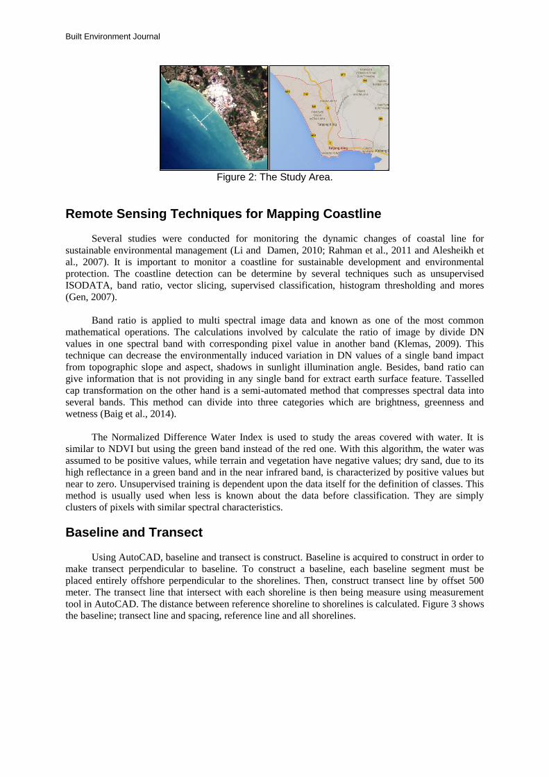
Pantai Puteri, Tanjung Keling, Melaka has been chosen as a study area. Pantai Puteri is
previously known as Pantai Kundur. This area is chosen because the place is well-known and situated
at a strategic point in west coast. Melaka is located at western of east coast Semenanjung Malaysia.
The coordinate of Pantai Puteri is at Latitude 2’13’36’’, Longitude 102’09’27’’. Figure 1 show the
processes adopted in this study while the location of the study area, is illustrated in Figure 2.
Figure 1: Methodological Flowchart
Processing
Tasseled Cap Transformation
Unsupervised
Classification (ISODATA)
Pre-Processing
Measurement in
AutoCAD
Analysis
Map Production
Band Ratio
Radiometric Correction
Layer Stack
Reprojection
Subset
NDWI
Vectorization in
ArcGIS
PHASE 1
PHASE 2
PHASE 4
PHASE
3
Download image LANDSAT 8 OLI
Built Environment Journal
Figure 2: The Study Area.
Remote Sensing Techniques for Mapping Coastline
Several studies were conducted for monitoring the dynamic changes of coastal line for
sustainable environmental management (Li and Damen, 2010; Rahman et al., 2011 and Alesheikh et
al., 2007). It is important to monitor a coastline for sustainable development and environmental
protection. The coastline detection can be determine by several techniques such as unsupervised
ISODATA, band ratio, vector slicing, supervised classification, histogram thresholding and mores
(Gen, 2007).
Band ratio is applied to multi spectral image data and known as one of the most common
mathematical operations. The calculations involved by calculate the ratio of image by divide DN
values in one spectral band with corresponding pixel value in another band (Klemas, 2009). This
technique can decrease the environmentally induced variation in DN values of a single band impact
from topographic slope and aspect, shadows in sunlight illumination angle. Besides, band ratio can
give information that is not providing in any single band for extract earth surface feature. Tasselled
cap transformation on the other hand is a semi-automated method that compresses spectral data into
several bands. This method can divide into three categories which are brightness, greenness and
wetness (Baig et al., 2014).
The Normalized Difference Water Index is used to study the areas covered with water. It is
similar to NDVI but using the green band instead of the red one. With this algorithm, the water was
assumed to be positive values, while terrain and vegetation have negative values; dry sand, due to its
high reflectance in a green band and in the near infrared band, is characterized by positive values but
near to zero. Unsupervised training is dependent upon the data itself for the definition of classes. This
method is usually used when less is known about the data before classification. They are simply
clusters of pixels with similar spectral characteristics.
Baseline and Transect
Using AutoCAD, baseline and transect is construct. Baseline is acquired to construct in order to
make transect perpendicular to baseline. To construct a baseline, each baseline segment must be
placed entirely offshore perpendicular to the shorelines. Then, construct transect line by offset 500
meter. The transect line that intersect with each shoreline is then being measure using measurement
tool in AutoCAD. The distance between reference shoreline to shorelines is calculated. Figure 3 shows
the baseline; transect line and spacing, reference line and all shorelines.

A Comparative Analysis of Remotely Sensed Coastline Mapping Techniques
Figure 3: Baseline and transect line
The baseline approach or also called transect method is implied for determining the degree of
shoreline recession. The comparison between reference line which is reference coastline acquired from
JUPEM with test coastline which is the four techniques used is calculated. Figure 4 shows that the
illustration of baseline approach or transect method to compare the true coastline and the test line. The
true coastline represents the reference line acquired from JUPEM while the test line represents the 4
techniques used. Then transect is constructed perpendicular to the baseline and transect will intersect
with true coastline and the test line
Figure 4: Illustration of baseline approach (Source: USGS, 2014).
RESULTS AND DISCUSSIONS
There are four (4) implied automated and semi-automated remotely sensed coastline detection
techniques involved in this study. These techniques are band ratio, tasselled cap transformation,
NDWI and unsupervised classification (ISODATA). In this study, the Landsat 8 (21 June 2014) image
is used. Thus, on 21 June the mean tide recorded by Malaysia Surveying and Mapping Department
(JUPEM) is 289.6 which are near to total mean of one month. Overall the mean tide recorded on 21
June is normal. Figure 5 shows the result of coastline detection by using ISODATA, Tasselled cap,
NDWI and Band Ratio techniques.

Built Environment Journal
ISODATA
The accuracy recorded for this technique is
83.33% while overall Kappa Statistics recorded is
0.7458.
TASSELLED CAP
The average maximum and minimum value is
between -42736.5 and 3961.03. The highest value
represents blue colour while the lowest value
represents red colour.
NDWI
The positive values are assumed to be water while
vegetation or terrain has the negative values. The
coastline is classified as sandy coast (<0), while
other coastline types such as bed rock coast (>
0.26) is not coastline.

A Comparative Analysis of Remotely Sensed Coastline Mapping Techniques
BAND RATIO
The highest value which is represents the water
area while the lowest value which is represents
soil / vegetation. The water is represented in blue
colour.
Figure 5: The Coastline Maps
The lowest mean and standard deviation of the calculation obtain is considered as the most
accurate when referred to reference line. From the Table 1, the lowest mean and lowest standard
deviation is band ratio technique. Band ratio technique recorded the lowest mean distance with
169.68m and standard deviation 29.15.
Figure 6: The Construction of Transect and Baseline of the Case Study
Table 1: Transect Summary

Built Environment Journal
Figure 7: Coastline Extraction Method
Figure 7 shows graph of coastline extraction method. From this graph, the purple line is
indicates the reference line which is recorded zero value. The x axis is indicates the transect point
while the y axis is indicates the distance of four techniques from reference line. This graph shows that
the band ratio method which represents red colour line is the closest to the reference line. The second
close from reference line is Unsupervised Classification method which represents green colour line.
This method also is nearest to the band ratio method. The blue line which is tasselled cap
transformation method is quite far from reference line while the farthest method from reference line is
NDWI method represents pink colour line.
Figure 8: Accuracy Assessment of Coastline Extraction Method
Figure 8 shows the graph of accuracy assessment of coastline extraction method. This graph
shows mean and standard deviation which represent line of blue colour and black colour. The x –axis
shows the 4 technique involves which is method 1 is Band Ratio technique, method 2 represents
Unsupervised Classification method, method 3 represents NDWI and method 4 represents Tasselled
Cap transformation technique. Hence, it shows that the lower the mean values, the lower the standard
deviation values as Band Ratio technique has the lowest mean and standard deviation value.
CONCLUSIONS
Based on the comparison of four (4) remotely sensed techniques to separate the water and land
with refer to the baseline data acquired from JUPEM. Four remote sensing techniques (Tasselled cap
transformation, Band Ratio, ISODATA and NDWI) were successfully used to extract the same
coastline area. The results from this study exhibited that Band Ratio method for coastline extraction
offers more accuracy. The fundamental principle in extraction of coastline is the accuracy. Thus, the
spatial resolution of the source of data is important. Data that was used in this study is Landsat 8 OLI
with 30 meter resolution for visible, NIR and SWIR while 15 meters for panchromatic. Using semi-
automated techniques extraction of coastline, the processes can be conducted smoother and faster,
hence, saving time, cost and maintenance as compared to the traditional method of coastline mapping
techniques.

A Comparative Analysis of Remotely Sensed Coastline Mapping Techniques
ACKNOWLEDGEMENT
The authors would like to thanks the Center of Studies Surveying Science & Geomatics, Faculty
of Architecture, Planning and Surveying, UiTM Shah Alam for the support, motivation, and
encouragement throughout this entire studyPlease submit papers online through the conference
website.
REFERENCES Alesheikh, A. A., Ghorbanali, A., & Nouri, N. (2007). Coastline change detection using remote
sensing. International Journal of Environmental Science & Technology, 4(1), 61-66. Baig, M. H. A., Zhang, L., Shuai, T., & Tong, Q. (2014). Derivation of a tasselled cap transformation
based on Landsat 8 at-satellite reflectance.Remote Sensing Letters, 5(5), 423-431. Gens, R. (2010). Remote sensing of coastlines: detection, extraction and monitoring. International
Journal of Remote Sensing, 31(7), 1819-1836. Kauth R.J, and Crist E.P. (1986). The Tasseled Cap DeMystified, Photogrammetric Engineering and
Remote Sensing, vol. 52, pp. 81-86. Klemas, V. V. (2009). Sensors and techniques for observing coastal ecosystems. In Remote Sensing
and Geospatial Technologies for Coastal Ecosystem Assessment and Management (pp. 17-44). Springer Berlin Heidelberg.
Li, X., & Damen, M. C. (2010). Coastline change detection with satellite remote sensing for environmental management of the Pearl River Estuary, China.Journal of Marine Systems, 82, S54-S61.
Lipakis, M., Chrysoulakis, N., & Kamarianakis, Y. (2008). Shoreline extraction using satellite imagery. Beach Erosion Monitoring, 81-95.
Nayak, S. (2000). Critical issues in coastal zone management and role of remote sensing.Subtle Issues in Coastal Management, 77-98.
Rahman, A. F., Dragoni, D., & El-Masri, B. (2011). Response of the Sundarbans coastline to sea level rise and decreased sediment flow: A remote sensing assessment .Remote Sensing of Environment, 115(12), 3121-3128.
Raju, D. K., Santosh, K., Chandrasekar, J., & Tiong-Sa, T. (2010). Coastline change measurement and generating risk map for the coast using geographic information system. In Joint International Conference on Theory, Data Handling and Modelling in GeoSpatial Information Science, Hong Kong.
Built Environment Journal
NOTES FOR CONTRIBUTORS
SUBMISSION
All materials submitted for publication must be
original, unpublished work and are not under
consideration for publication elsewhere.
Papers may be submitted by e-mail to
[email protected]. Alternatively, 2 copies of the
manuscript together with a full version on CD may
be submitted to the Editorial Board.
Address:
Assoc. Prof. Datin Dr. Hamimah Adnan
Managing Editor
Built Environment Journal (BEJ)
Faculty of Architecture, Planning and Surveying
Universiti Teknologi MARA
40450 Shah Alam
Selangor, Malaysia.
Editors reserve the right to edit/comment on the
content of the manuscript. If major or substantial
amendments are recommended by the editors the
authors will be given the option to accept or reject
the recommendations (and withdraw participation).
MANUSCRIPT PREPARATION
Language
The manuscript must be submitted in British
English.
Length
The manuscript should be within the range of 5000
– 7500 words in Times New Roman font, 12 point
type. Authors are requested to state how many
words their paper contains. The manuscripts should
be typed and single spaced on one side of A4 paper
only, with 4 cm margins on the sides, the top and
the bottom. All text should be set aligned justified
throughout. The pages should be numbered in
order.
Title Page
The first page of the manuscripts must contain the
full title, name of author(s), designation(s) of
affiliation(s), highest academic qualification and the
present address(es) with the telephone/fax/e-mail
contact information listed.
Abstract and Keywords
The abstract must not exceed 250 words and should
summarise the paper including the main
conclusions. There shall be not more than 5
keywords.
Text
The order when typing manuscripts: Title,
author(s), highest academic qualification,
Affiliations, Abstract, Keywords, Main Text (Aim,
Problem Statement/Issues, Methodology and
Analysis),Conclusion and Recommendations,
References, Acknowledgment and Appendix (if
any). Simple language, short sentences and a good
use of headings are encouraged. Headings should
be numbered and the use of more than three levels
of heading should be avoided. Headings and
paragraphs should be separated by two carriage
returns. Text following a heading should not be
indented.
Illustration
Photographs, diagrams and charts should be
referred to as “Figure(s)” and numbered in the order
in which they are referred to in the text. Maps and
diagrams should be submitted in a form ready for
reproduction, all in legible digital format. Please
note that illustrations in the journal shall be printed
in black-and-white or grey-scale.
Units
All measurements and data should be given in
metric units or, if other units are used, then the
metric equivalent should be given in parentheses.
Reference
The Harvard system is used. The reference is
referred to in the text by the following manner:
Onojaefe D, Ukpere WI (2009). Partnership and
the e-commerce initiative of small businesses.
African Journal Business Management, 3(12):
855-861.
Shahimi, N. (2006). A Study on The Achievement of
Class F Contractors. Shah Alam: Department
of Quantity Surveying, Faculty of Architecture,
Planning and Surveying, Universiti Teknologi
MARA Malaysia.
Swan W, Khalfan MMA (2007). Mutual Objective
Setting For Partnering Projects in the Public
Sector. Engineering, Construction and
Architectural Management, 14(2): 119-130.
Stevens, R. (2004). “Partnering, Environmental &
Risk Management”,. International
Construction Conference 2004. CIOB
Malaysia.
CIDB (2011), Construction Industry Development
Board, Malaysia, www.cidb.gov.my.
COPYRIGHT
Once published in the Built Environment Journal,
the copyright including electronic copyrights of the
article is automatically invested with UiTM. The
copyright covers the exclusive use of rights to
reproduce and distribute the article, including
reprints, photography reproductions, microfilm,
electronic publication or any reproduction of a
similar nature and translations. Permission to
publish illustrations must be obtained by the author
before submission. Any acknowledgements should
be included in the figure captions.