building politics through policies: guiding trends ... politics through policies: guiding trends...
TRANSCRIPT
Building Politics through Policies:
Guiding Trends (Legitimately?) from E.U. Level
JOAQUÍN FARINÓS DASÍ & TERESA PAREJO NAVAJAS Department of Geography Department of Public Law
University of Valencia University Carlos III, Madrid [email protected] [email protected]
Paper for the ECPR Workshop on “European Spatial Politics or Spatial Policy for Europe?”
13-18 April 2004, Uppsala, Sweden
Introductory thoughts
The territory is not only one of the most precious mankind assets, as it is where all human activities take place, but the natural resource on which life grows. But it is scarce and easily destructible, and because of that, its planification has turned into a strategic activity for the development of the regions in Europe.
Thereby, one of the principal problems in our society is the continuous environmental damage caused by human activity in a constant territory transformation. And although there has been an important improvement since the first step taken in protecting our environment, there is still a long way to go.
In this process, the Torremolinos Charter has been a key element for the development of a spatial planning concerning the whole European territory1, not only because it defines, for the first time, the major Europe wide objectives that should underline policies for spatial planning, improvement of the quality of life, and the organisation of human activities in the physical space of Europe, but because it also gives the only definition for “spatial planning” accepted by all the State Members.
The objectives of the Charter for spatial planning refer to achieving (1) balanced socio-economic development of the regions; (2) improvement of the quality of life; (3) responsible management of natural resources and protection of the environment, and (4) rational use of land.
1 “The 6th conference of European Ministers responsible for Regional Planning held at Torremolinos in May 1983, constitutes a landmark in he history of regional/spatial planning at European level…This Charter forms an addition to the council of Europe texts of general scope. It seeks to set the guidelines for national and European policies which contribute to balanced regional development and afford Europeans a healthy environment of high quality. There can be no doubt that the Charter will have a long-term impact on European society by importing fresh impetus to European co-operation, enhancing awareness of a common identity and so lending greater force to our efforts towards European unification”. CONFERENCE EUROPÉENNE DES MINISTRES RESPONSABLES DE L´AMÉNAGEMENT DU TERRITOIRE. CONSEIL DE L´EUROPE. “Charte Européenne de l´aménagement du territoire”. Charte de Torremolinos. Adopté le 20 de mai de 1983 á Torremolinos, Espagne.
1

This fundamental goals are the same as the ones pointed out in the Treaty establishing the European Community2 (henceforth, TEC) and later on, in the main document titled European Spatial Development Perspective3 (henceforth, ESDP), in which the Member States reached an agreement on common objectives and concepts for the future development of the European territory. Therefore, the Community activity, by implementing common policies or activities –the ones referred in article 3 TEC-, co-ordinated with the national planning policies, shapes the development of a European spatial planning policy.
1. Degrees to understand spatial planning task
As the Charter shows, the “Spatial planning gives geographical expression to the economic, social, cultural and ecological policies of society. It is at the same time a scientific discipline, an administrative technique and a policy developed as an interdisciplinary and comprehensive approach directed towards a balanced regional development and the physical organisation of space according to an overall strategy”. At the same time, there are also three ways to understand the spatial planning activity, according to different implications and technical and political requirements. From below to above, these are:
a) The Diagnostic: spatial planning as a territorial analysis or spatial diagnostic, estimation variables as space, structure, landscape or territorial model.
b) The Method: spatial planning as: 1) an application of territorial techniques and instruments in order to achieve the desired objectives –economical, cultural, ecological, etc.- which are previously established in a Plan; and 2) as a co-ordination in the use of land and sectoral polices.
c) The Political mainstream: spatial planning as a background and a guide in a political decision-making process. It should be possible to harmonise all the Charter objectives in order to achieve the “territorial sustainable development”.
2 ARTICLE 2: “The Community shall have as its task, by establishing a common market and an economic and monetary union and by implementing common policies or activities referred to in Articles 3 and 4, to promote throughout the Community a harmonious, balanced and sustainable development of economic activities, a high level of employment and of social protection, equality between men and women, sustainable and non-inflationary growth, a high degree of competitiveness and convergence of economic performance, a high level of protection and improvement of the quality of the environment, the raising of the standard of living and quality of life, and economic and social cohesion and solidarity among Member States”. EUROPEAN COMMUNITIES. ”Consolidation version of the Treaty establishing the European Community”. Official Journal of the European Communities (C 325) 24/12/2002. http://europa.eu.int/eur-lex/en/treaties/dat/EC_consol.pdf (March 2004). 3 “The aim of spatial development policies is to work towards a balanced and sustainable development of the territory of the European Union. In the Ministers' view, what is important is to ensure that the three fundamental goals of European policy are achieved equally in all the regions of the EU: 1) economic and social cohesion; 3) conservation and management of natural resources and the cultural heritage; and 3) more balanced competitiveness of the European territory. The ESDP is a suitable policy framework for the sectoral policies of the Community and the Member States that have spatial impacts, as well as for regional and local authorities, aimed as it is at achieving a balanced and sustainable development of the European territory”. Final Conclusions issued by the German Presidency at the close of the Informal Council of EU Ministers responsible for Spatial Planning held in Potsdam on 10-11 May 1999. http://europa.eu.int/comm/regional_policy/sources/docoffic/official/reports/pdf/concl_en.pdf (March 2004).
2

The two first requirements (a & b1) are much more developed than the last two (b2 & c), which is related to the process of “new European governance”4. Anyhow, the “political mainstream” is the requirement that will be analysed more deeply in this paper.
The “sustainable development” objective –if it was not called “sustainable”, it could only be named as “growth”- which guaranties the European Community quality of life is one of the most important goals in a democratic power exercise. In this new paradigm, called by some authors as “territorialité” (RAFFESTIN, 1999), it seems that the idea of the territorial planning –as a way to construct the space- needs to be followed by the “development” concept, creating, this way, a new one: the “Territorial Development Planning” (FARINÓS, 2004c).
The European Community “Territorial Development Panning” fits perfectly in the new interpretation of the planning concept. Planning equals, then, to “govern the transformation” –provoked by other actors and political actions- and with a future vision. However, this interpretation raises some interrogations:
• Given this interpretation, would it be possible to consider spatial planning as a future territorial “design” (even with an imperative character)? The EU is neither interested in provoking big territorial transformations nor in determining the future European territorial model (except the general matters as the ones referred to the polycentrism). The EU rather cares for the general principles and objectives (territorial cohesion), but not the concrete way to obtain them. This unusual position makes stagger the whole reasoning as the transformation of the European territory focused to the territorial cohesion needs the State Members voluntary agreement, with a common coherence an logic in their approach.
• At this moment, though, this way of understanding the European spatial planning is neither agreed by all the State Members with the same intensity nor equally valued by all the European institutions in their activity. It seams to stand at a second level in which the spatial planning is considered as a co-ordinated exercise of the different territorial policies. Hence, instead of being refer to territorial development planning, it should be called as “territory government”. This new concept refers to a specific territorial policy aimed at the rationalisation of the public policies in its entirety which affect the territory (PAREJO, JIMÉNEZ-BLANCO y ORTEGA, 1998), opposed to the sectoral policy planning. Some of this sectoral policies, anyhow, are now incorporating territorial criteria.
The need of a holistic focus, a territorial policy co-ordination method as a territorial development planning condition can be easily justified. The space, the territory, as its being already set ahead, is a scarce resource, and because of that, its planning has become an strategic activity in which an integral –or holistic- vision is needed. Nevertheless, it is much more complicated to put this idea into actions. The scientific method agrees on the idea that for achieving the whole, it is necessary to divide it in
4 COMMISSION OF THE EUROPEAN COMMUNITIES. “European Governance. A White Paper”. Brussels, 25/7/2001. COM (428) Final. http://europa.eu.int/eur-lex/en/com/cnc/2001/com2001_0428en01.pdf (march, 2004).
3

parts. This way to approach a reasoning might be valid for politics and administrative fields –government tasks divisions, following the Napoleonic method-, but it has an unquestionable risk: the interrelations –and it effects- between politics are missed.
In view of this, a couple of questions arises: is it possible to use the holistic or integral concept for a territorial development policy?, from where should we start to build it?, how can we legally carry out this new way of planning?. It seams logic to start this process with the design of the territorial policies. To do that, it is needed adequate indicators (actualised, trustworthy and measurable) and also new instruments and methodologies (Study Programmes on European Spatial Planning. Strategic Impact Assessment, Assessment of the Environmental Impact of Projects, Assessment of the Effects of Plans and Programmes on the Environment), which is already being developed by the ESPON (European Spatial Planning Observation Network)5. Besides that, one of the most important tasks is the addition of new routines, new relational and governance patterns among the decision making actors.
Which are the decision making levels? those that make it easier –subsidiarity principle art. 5 TEC-, that have a willingness to do so, and also that force multiplying the effects towards the European level, mostly the Commission. This European institution was not capable to work freely on spatial planning matters as it had to cope with the Member State´s competences, desires, implementation speeds and the use of enhanced co-operations, yielding to the State Member’s pressures. Now, the Commission has decided to face the intergovernmental method with the establishment of a new ESDP document -or ESDP II-. In that respect, the Commission has elaborated a four-part agenda to foster the effective sectoral policy co-ordination (Working Group 4c, 2001: 42-45)6
In view of this, the Commission is working on a periodical document of strategic nature to promote the Community policy co-ordination and their impact on the territory: the European Scheme of Reference for Sustainable Development and Economic, Social and Territorial Cohesion (SERDEC). The idea is to insert this new document in the annual proposal on financial forecast. This, then, will be followed by the Strategic Impact
5 The main objetive of the ESPON is to research and studies on spatial development and planning seen from the national, regional and local points of view, is partly already existing and available, although only covering smaller parts of the European territory. With the ESPON 2006 Programme and by addressing an enlarged EU territory and larger territorial entities the Commission and the Member States expect to have at their disposal: a) a diagnosis of the principal territorial trends at EU scale as well as the difficulties and potentialities within the European territory as a whole; b) a cartographic picture of the major territorial disparities and of their respective intensity; c) a number of territorial indicators and typologies assisting a setting of European priorities for a balanced and polycentric enlarged European territory; and d) some integrated tools and appropriate instruments (databases, indicators, methodologies for territorial impact analysis and systematic spatial analyses) to improve the spatial co-ordination of sector policies. http://www.espon.lu/ Official Website of the ESPON 2006 supported by the EU-Community Initiative INTERREG III6 The proof of the good will to abandon the intergubernamental method can be seen at the DG REGIO Work Programme 2000 which will end up changing the old Committee on Spatial Development (CSD), responsible of the Postdam document, in a Urban and Territorial Development Subcommittee (SUD), belonging to the Development and Region Conversion Committee, which is in charge of the Structural Funds at the DG REGIO.
4

Assessment (SIA)7. As a result of this, the Commission will have to present –as in a third step of this process- some proposals, actions or guidelines to be chosen within horizontal and vertical relations. Finally, at an institutional level, it will be necessary to put in practice new procedures within the European Parliament and Council to be able to reach coherent decisions among the sectoral councils. This means an important goal that needs to be addressed in the midst of the Councils pretension to gain power in the co-decision process, on the Commission’s expense (SERENA, 2003). This is understood as a violation of the initiative right (joined-up thinking) that corresponds to the Commission.
The absence of a spatial planning competence in the Treaty is seen as an additional obstacle in this task, mostly as it is a subject which is capable to produce such an important impact in the way the policies are applied and in the policy decision making, at a State or European level. Consistently, the Member State are suspicious of an European formal competence8. However, the possibility of this new competence at a European level has more and more supporters. In fact, since its signing in Potsdam in 1999, the ESDP is having a great and evident effectiveness9. It is easier, though, to find out if there should exist or not this competence rather than how or what type should it be. Every possible answer to this questions is difficult to justify and understand, at least today.
At this moment, it should be helpful to recall that the possibility of a formal European spatial planning competence is only one of the four “pillars” among which is based this subject. The other tree, besides the competence task, are:
• The cross-border co-operation. The INTERREG initiative provides for the co-operation of its participants and co-ordinators as advisers in European spatial planning, following “petites Europe” format.
• The sectoral competences of the EU that transform the territory. There is a spatial planning reality do to the activity of the EU through its sectoral policies. This policies follow –with variable intensity, depending on each State Member- the guidelines of the ESDP (POLVERARI, ROONEY, et al., 2002).
• The different spatial planning documents and programs of the EU. The ESDP has been the most important and followed document, but there are others that should be taken into consideration, as the ”Guiding Principles for Sustainable Spatial Development of the European Continent”10.
7 The SIA integrates all evaluations. There are already some methodological proposals, such as the multicriteria analysis techniques or the more recent ‘Choice modelling’ that helps the decision making process as it permits to know the value of each option. 8 Probably, the German case is the most illustrative to that effect. Vid. JOERGES, C., LADEUR, K-H & ZILLER, J. “Gobernance in European Union an the Commission White Paper”. European University Institute, Florence. Department of Law. Working Paper, LAW nº 2002/8. pp. 22 and on. 9 For further information, vid. PAREJO NAVAJAS, T. Das Europäische Raumentwicklunskonzet: EinInstrument zur offenen Koordinierung der Raumordnung in Europa. EurUP. Zeitschrift für Europäisches Umwelt- und Planungsrecht. Dezember 2003. Seiten 49-96 . Der Juristische Verlag. Lexxion. Berlin. Pp. 64-70. 10 EUROPEAN CONFERENCE OF MINISTER RESPONSIBLE FOR REGIONAL PLANNING (CEMAT). ”Guiding Principles for Sustainable Spatial Development of the European Continent”.
5
But is it really necessary to find a European spatial planning competence to protect the transformations of the territory do to the EU actions? This question is the one we will try to answer below.
2. How policies influence politics?
In this new scenery, “territorialité” is no longer interpreted as a simple result of social territorial behaviour, but as a resultant of the “setting up” process of this behaviour (RAFFESTIN, 1999). Since the first half of the eighties, the territory and the space as strategic elements or resources are being recovered to guarantee an adequate development and quality levels for the citizenship. Economical crisis, obsolete locational models, “deconstructive” new relationships among the agency and the structure (GIDDENS, 1984), economical globalization, “demos” decrease, and as a reaction to all these, a higher participation request and an increase of the respect to the identities. Many and connected processes which put the territory in a first place, either with an identity or cultural belonging sense, or as an asset or a resource from which generate an added value from a long-lasting and sustainable point of view. This means that the development process should be transformed into an increase of the territorial capital available.
This new approach leads to a two level changes: the first one, related to the territorial management field (policies), and the second one, to the public management field (politics). Before both acted separately, but now these two fields are suffering a necessary approach to improve the fulfilling of their objectives. This is what has been called as the raising of the “governmental intelligence”, as the instrument for the information management to foster an efficient territorial governance. In view of this, the most important goal will be to adjust the public policies to the territory and not the opposite way around, searching synergy among the policies developed in the different levels vertically related.
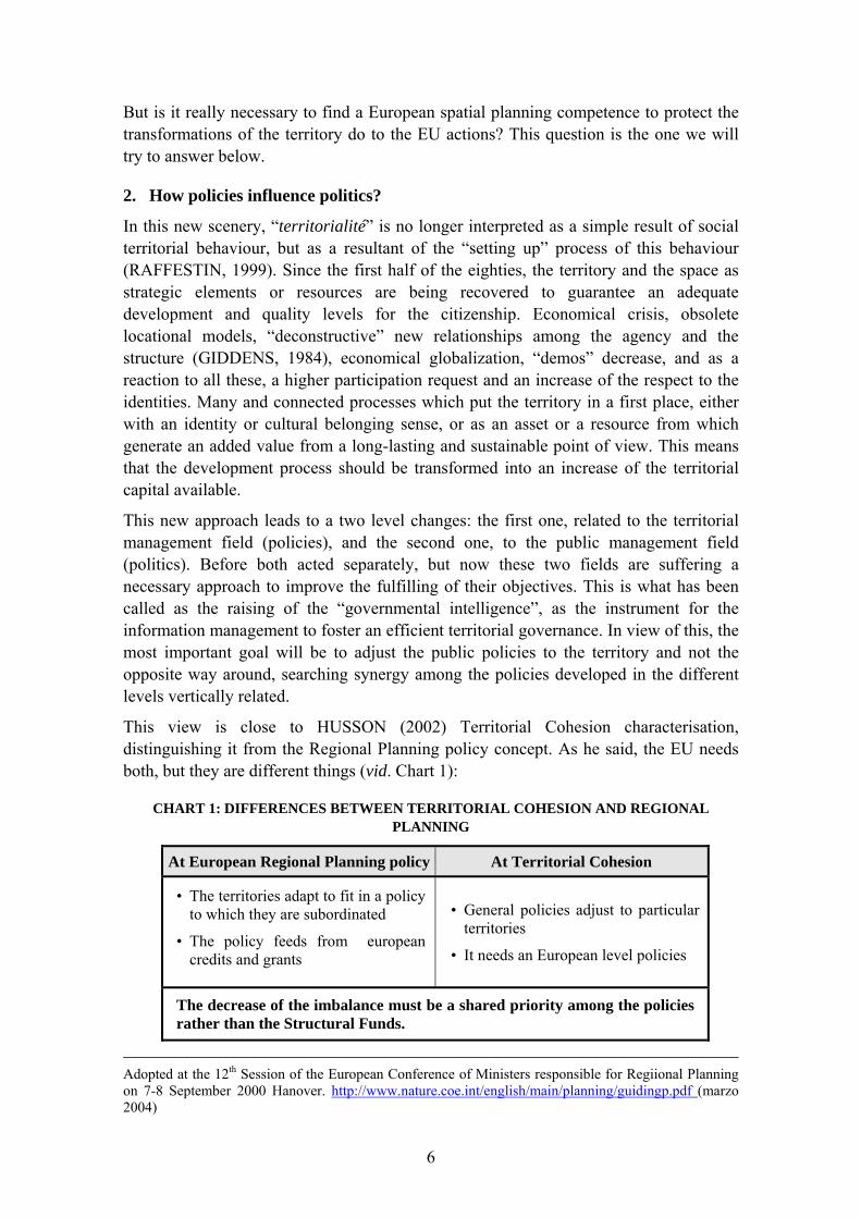
This view is close to HUSSON (2002) Territorial Cohesion characterisation, distinguishing it from the Regional Planning policy concept. As he said, the EU needs both, but they are different things (vid. Chart 1):
CHART 1: DIFFERENCES BETWEEN TERRITORIAL COHESION AND REGIONAL PLANNING
At European Regional Planning policy At Territorial Cohesion
• The territories adapt to fit in a policy to which they are subordinated
• The policy feeds from european credits and grants
• General policies adjust to particular territories
• It needs an European level policies
The decrease of the imbalance must be a shared priority among the policies rather than the Structural Funds.
Adopted at the 12th Session of the European Conference of Ministers responsible for Regiional Planning on 7-8 September 2000 Hanover. http://www.nature.coe.int/english/main/planning/guidingp.pdf (marzo 2004)
6

It is also very close to the Open Method of Coordination that was ratified in the Lisbon Summit in 2000 (FALUDI, 2004,b). This method aims at putting in relation all the governmental actors from the different levels with the non governmental ones, both public and private, in order to perform under the definition of common goals, the exchange of good practices ant the joint evaluation of the implementation of the respective actions.
FIGURE 2: POLITICAL IMPLICATIONS OF NEW EU SPATIAL PLANNING
REVITALIZATION OF FROM COMPETENCES (POLITICAL POWERS)
POINT OF VIEW
PHASES WITH EMPHASIS: CONFLICT:
PREPARATION: STATES, REGIONS, LOCAL Participative Method
AUTHORITIES, COMISSION, C.S.D. (Co-operation and partnership), Implication of the Local Scales SELECTION OF ALTERNATIVES
SOLUTION: - Subsidiarity principle implementation
REINFORCED INSTRUMENT:
EVALUATION (ex-ante)
- European Constitution PROMOTED CONTENTS: SUSTAINABLE DEVELOPMENT:
* Good Indicators * New Methodologies:
NEW MODEL Environmental Impact Assessment, Territorial Impact Assessment, Strategic Environmental Assessment, Studies of Sustainability and Strategic Impact Assessment
OF STATE
PUBLIC POLICY ANALYSIS
From a less rhetoric perspective, the application of territorial policies has caused some changes in the politics but also in the polity not just at State level but also at EU level as it is depicted in figures 2, 3 and 4. It has been the way under which a greater development and application of the subsidiary principle has manifested. Although in the beginning it was limited to the relationship between the EU and the Member States, it has spread into them. The result has been a progressive emergence of the sub-state scales participating in the design and implementation of the different EU policies. It does not seem to be excessive to state that it has been the regional policy along with the economic and social cohesion objective which have played a decisive role in such change, much more than any other. This is, a policy that has introduced to the current programming period a heavy territorial load (POLVERARI y BACHTLER, 2004), that will be increased in the next one according to what the Third report on Cohesion (CEC, 2004) reflected.
In his turn, the institutional structure and the nature of mechanisms for decision-making in each country can significantly influence the successful implementation of policy
7

FIGURE 3: EUROPEAN POLITY FORMATION
Source: Sonja Puntscher Riekmann, www.iwe.oeaw.ac.at/staatlichkeit/es_e.htm .
FIGURE 4: PROPOSITIONS FOR THE REALLOCATION OF COMPETENCES AMONG DIFFERENT LEVELS OF GOVERNMENT LEVELS
Source: Eser, 1991, p. 10 (from Eser & Konstadakopulos, 2000).
options and, under a spatial planning point of view, the greater or smaller chance to achieve the different territorial goals, fundamentally the balanced European territory
8

one. Indeed, we can classify the different States according to the government level where the greater deal of competence lies (Chart 5) although the competence (political power) in spatial planning is not a well known question because particularities of each country that are also in continuous change.
CHART 5: ALLOCATION BY LEVELS OF COMPETENCES IN SPATIAL PLANNING
● At central level: Most countries except for Belgium, though limited in Austria and Spain and stronger than usual in the UK, Ireland and Luxembourg.
● At regional-statal level: Belgium, Austria, Spain, Germany and Italia
● At supra-local level: The Netherlands, France, Denmark and Finland. Much less important until know, in UK, Ireland and Luxembourg
● At Local Level: have the primary responsibility for regulating land use control and detailed planning in most of EU countries, theoretically within a framework set and supervised in national or regional government. The role of local authorities is stronger in unitary but decentralised states, such as Denmark, Finland and Sweden.
We say, “theoretically” because, in some cases, as in the Spanish one, things at local level go separately from a supposed legal framework that is competence of Autonomous Communities, even translated in legal conflicts that justice has to solve. So, we can say, reality shows regulation is not enough.
This is a powerful reason to foster an updating of both the territorial planning systems and the development degree of new governance ways. It will be possible to count on that from September 2006 when the results of projects 2.3.1 and 2.3.2 from the EPSON program will be presented. Multilevel politic relations and new governance styles represent an interesting alternative to solve the question of emerging conflicts in a regulatory system with a well defined list of competencies: soft law, agreements and contracts, territorial cohesion in front of regulation and formal competencies.
3. Spatial planning: a new competence for European level?
3.1. An European Spatial Policy?
The formalization of the European spatial policy after the concept formulated by the Torremolinos Charter has some juridical problems, as the Treaty does not contain a Community competence on spatial planning -it remains in each State Member’s sovereignty-. But the fact is that the European territory is been transformed, and not only by the State actions, but also, by the Community sectoral policy actions, mostly those that search to achieving a balanced and sustainable development of the European territory (henceforth, “territorial policies”). However, the competencies Treaty system is complex enough not to conclude clearly in just one sense. Its dynamics and peculiarity permits, through article 308 TEC, to extent the Communitarian action to foster one of the objectives shown in the Treaty11, the cohesion among the Member States, or “territorial cohesion”.
11 ARTICLE 308 ECT: “If action by the Community should prove necessary to attain,in the course of the operation of the common market, one of the objectives of the Community, and this Treaty has not
9

Nevertheless, the truth is that neither article 308 ECT nor by means of the subsumption of the Community territorial action, either in the Environmental policy (Title XIX TEC) or in the Cohesion policy (Title XVII TEC), it is possible to regularize a European spatial planning policy12.
- Even though article 175.2 TEC points out the Council’s competence in adopting “measures affecting town and country planning”, this only justifies spatial planning actions for the only purpose of achieving environmental objectives. Therefore, the lack of planning objectives and principles does not allow building a spatial planning policy trough the interpretation of the article 308.
- In the same way as in the previous analysis, the Cohesion policy regulation -articles 158 to 162 TEC- does not give the guidelines to deduce a spatial planning policy from the Cohesion analysis.
In view of this situation, new and informal products start to enter the scene, pushing aside the traditional tools that have become to rigid to manage the imbalance between the desires to adjust all the activities into binding rules –pretending to favour a lawful method- and the reality, that is always much more complex.
The spatial development planning can be considered as part of an emergent multilevel governmental system at a European scale (FALUDI, 2000). Such planning requires of not only inter-institutional, vertical (multilevel) and horizontal (multisectoral) relations, but also one between public and private agents. It is precisely at this point where co-ordination between the different government levels and the different policies affecting territory, becomes necessary. It presents also important challenges and conflicts, coming from the deep changes it arouses in each Member State’s methods, that turn into a power reallocation. This sparks off the reticence of those who hold the power, both in the Member States and in the European Union operations. Some authors (HUSSON, 2002) refer to “the needed and the impossible” as the conflict between the communitarian and the intergovernmental methods. The (im)possibility of a European level Spatial Planning, the search for alternative paths to achieve its goals through communitarian policies with territorial impact and the new concept of “territorial cohesion”, appear in the background.
The alternative of a larger deregulation along with enhanced participation of the civil society is an option that presents risks. The implication of citizens in public affairs is neither developed nor well rooted uniformly in all countries. Hence, the pretended “new participated governance” could disguise a new form of political economics favouring just the powerful groups. Therefore, a “neo-institutionalist” planning, as cited in the preceding paragraph, with enhanced public power presence, not just at state level but also on multiple sovereignty bases (FALUDI, 2003b) shared upwards with the UE and downwards with the sub-national levels, seems more appropriate. The reason for this is the how the governance of territory is understood, how it is defined. In order to guaranty
provided the necessary powers, the Council shall, acting unanimously on a proposal from the Commission andafter consulting the European Parliament,take the appropriate measures”. 12 For more information, PAREJO NAVAJAS, T. “La Estrategia Territorial Europea: la percepción comunitaria del uso del territorio”. Tesis doctoral. Universidad Carlos III de Madrid. Colmenarejo, 2003.
10

a coherent approach within a complex system, this is, for the implemented policies to be coherent and understandable, political leadership and an institutional engagement is required.
The next question that arises is how to achieve this goal, with what competencies base or if having one is really indispensable. Is it really necessary to create a new European competence in Spatial Planning? (vid. Figure 6).
FIGURE 6: FORMAL COMPETENCES FOR SPATIAL PLANNING AT EU LEVEL?
As GONZÁLEZ-VARAS (2004) points out, it is quite difficult to voice the “need” for a EU competence on Spatial Planning but there are several reasons supporting its convenience.
a) Given that there are some sectoral policies where it is competent (agriculture, transportation, cohesion, transeuropean networks, environment…), it should be able to correctly address their territorial dimension, which would have positive effects on a better fulfilment and implementation of such policies.
b) The latest reforms on the Treaties show a horizontal extension of competences for the EU but limit their vertical implementation because of the “subsidiary principle”.
c) One of the principles of the current European institutional reform is the simplification and clarification of competences between the EU and the Member States.
d) The different European documents on Spatial Planning, which can be understood as a first pre-normative phase, insist in the need for a European dimension and greater action of the EU on territory matters. The issue is whether they can by themselves, as the ESDP, substitute the existence of a real competence or not. The ESDP is not of normative nature but does have juridical value. This document is a reference for the set of programs and interventions co-financed by the Community. The Treaty confers to the Community some objectives with clear territorial vocation should the ESPD exist or not (for example article 158 on cohesion policy). Since it does exist,
11

it becomes a necessary point of reference, provided that its ratification by not just the Member States but also the Commission represents an engagement on the formalised goals. This way, such territorial goals must be introduced into the sectoral policies with territorial impact. If not, a justification of its non-consideration as a guidance for intervention will be needed.
e) This will allow the Member States to implement some actions they could not do on their own because of their cost or complexity. The EU, as a superior instance, would be responsible for such actions. However, the effect that this Community “responsibility” could have should be carefully considered. It would be good to know if there is or not a conscience on how some European guidelines can foster the emergence of new checks and balances at different scales along with new governance methods that may overcome past policy failures (i.e. sprawl) or support new promising alternatives (local co-operation and new supra-local entities). Such way to make the Community “responsible” could be well perceived and used by the sub-state instances but not at State level or vice versa depending on their competencies level on the matter (Spain and Germany would be examples of this). It can also have different interpretations on a local scale: as a potential advantage in some cases, as a threat in others.
The issue is to which extent the EU can be recognised as the guidance for the emergence of a new territorial development planning culture that will give way to a new territorial policy culture, even inside the Member States themselves. For instance, in Spain there is a refined territorial State model, there are good laws, they are well written but their implementation fails (FARINÓS, ROMERO y SÁNCHEZ, 2004; Plaza, ROMERO y FARINÓS, 2003). How could a goal like this be achieved? to which extend has the ESDP succeeded in this?
3.2. Conflicts arising from a possible formal competence
We can think of two different types of conflicts. Firstly, the assumption of the Spatial Planning competence by the EU can generate a legal paradox, although it may just be apparent, consisting of the central State Government not having competence on the matter while the EU does. We say “apparent” because actually central governments (besides Belgium perhaps) end up affecting the territory’s evolution by means of other policies on which they do have a competence. In this same direction, their position is not substantially different a European level. Secondly, territorial planning might become the most favourite battlefield on which visualise the conflict between the Council and the Commission.
In the opposed direction to that of the community competence, Germany wanted the Amsterdam Treaty to establish State formulated intergovernmental planning as the framework supporting all the community policies on territory. Nevertheless, there has been a reaction from the Commission in the Nice Treaty while deciding to oppose to the intergovernmental method in the upcoming ESDP II. Among the reasons for this, the will to prevent mistrust among the States and the length of the process, specially in the new more complex and diverse situation (more Member States), that could take for another 10 years. The guaranty for the Member States lies in the fact that Brussels cannot elaborate on its own a document of such nature without counting on national
12

experts. It is just; let us remind it, a question of leading the process (joined-up thinking). Commitology committees – the Commission establishes and manages the agenda- or outside them? In Leipzig meeting (1994) the German delegation document included a proposal in order to institutionalise a network of advisors. Currently, given the progress in the EPSON program, a greater deal of independence from the particular interest of each State among this advisors and an impartial vocation, seem easier to achieve.
Although the Nice Intergovernmental Conference in 2000 postponed the issue, it has gained momentum in the face of the 25 Member State ministerial summit to be held in fall 2004 during the Dutch presidency that will concentrate on the extension of the so called ESDP process. This will have to link to the future European Constitution because it seems that a formalisation of the guidance role to be played by the Commission could require some amendment to the Treaty. The Dutch presidency can favour the Commission to gain visibility, as it happened during the Madrid Minister Council in 1995, because it is a country that has been supportive to this competence as, for example, during the discussion from 1988 of its Fourth National Spatial Planning Report (FALUDI, 2004a).
With respect to the lack of communitarian competence on Spatial Planning, this does not entail “incapacity”. The lack of direct prescriptive value of the ESDP document is for some, the result of the lack of communitarian competence and a means to prevent it from having it. Nevertheless it can also be interpreted as a “sui generis” way to solve the lack of competence. PAREJO (2003) develops an interesting thesis explaining how the non-imperative and regulative nature of the ESDP document has been precisely its guaranty for progress. This would be giving way to a new form of “soft law”, combined with the need to follow its principles in any Community’s action. Consequently, its application can be foreseen for the European territory, at least because of that.
Nevertheless, as some reports have shown, this has not happened in the same way everywhere, as it has varied in accordance with to the different practices of the States, which are a consequence, among others, of their own territorial policy culture and their political-administrative organisation. The efficiency of the ESDP is weaker in those States in charge of its practical implementation. This could be the reason for more guidance at the Community level, though under the principles of autonomy and respect to diversity, preventing different local implementation speeds and excess resource to enhanced co-operation. However, being its fulfilment something optional, the issue is if it can be implemented at the discretion of the States. The answer is negative for many reasons with different weight. Firstly because of the “reference value” of the agreements, as it happened with the Commission. Secondly, because its guidelines should be considered in the implementation of communitarian policies co-financed by the States in their territories. Finally, because of the need for agreement and co-ordination among different levels.
4. Alternatives for a formal competence
4.1. Principle of Territorial Cohesion
In face of the impossibility to count on a free-hand competence, the Commission’s strategy has been focused, on the one hand, in moving the Spatial Planning “Tower of
13

Babel” preventing the different local implementation speeds and excess resource to enhanced co-operation mechanisms, yielding to intergovernmental pressures and taking advantage of the “engines” provided by France on one side, Germany on the other and Holland in the middle (FALUDI, 2004a). In addition, it has also tried to achieve its goals through the Sustainable Development objective, the Regional Policy and the Territorial Cohesion principle.
Territorial Cohesion, a concept mentioned for the first time in the Second Report on Economic and Social Cohesion, in 2001, seems to be meant to become the keystone for territorial planning at European level based upon an improved ESDP, renamed European Strategy for Territorial Cohesion (FALUDI, 2003c). Its inclusion in the draft text of the European Constitution allows for this guess.
Anyhow, what is territorial cohesion? It is probably easier to define it by its resistance to social and territorial fracture than by what it proposes (FARINÓS & ROMERO, 2003). It does not refer to a geographical unity but to the will to be part of a community, a shared feeling of belonging among citizens who do not feel discriminated by the application the different politic-administrative levels public policies. It entails a decentralised and multilevel understanding of European policies by means of the association between the sub-State levels of democracy and public action. It does not assume any social construction on the territory (notion of nation) but before anything it evokes an agreement between the different actors (both public and private in all the spheres of the economy, the public endowments, or infrastructures) trying to achieve some spatial coherence in its actions. The State is founded upon the territory while the territory cohesion brings sense to the Community. Hence it should be confused neither with spatial planning nor with regional policy. Its goal is not just to reduce the imbalances but to harmonise the joint policies developed on a territory (HUSSON, 2002).
The territorial cohesion reinforces the communitarian nature as it assumes a global vision of the EU along with a social project that is complementary to the goal of global competitiveness. For this reason it is linked to the common interest services but also with the local territory development initiatives (vid. Figure 7). Its importance derives from the impact it has on the people’s life quality and competitive opportunities in the territories they live in. Both help to retain population and to mesh the territory.
FIGURE 7: THE TWO FACES FOR TERRITORIAL COHESION AT LOCAL LEVEL
1. Render of ServicesPoint of view
SpatialLocal
Development
2. Territorial Competitiveness
Point of view
(Economic)Services
of GeneralInterest
• “Territoriality” (Active /Passive)• “Glocalisation”• Territorial Capital• Territorial Gross Added Value• Territorial Sustainability
1. Render of ServicesPoint of view
SpatialLocal
Development
2. Territorial Competitiveness
Point of view
(Economic)Services
of GeneralInterest
• “Territoriality” (Active /Passive)• “Glocalisation”• Territorial Capital• Territorial Gross Added Value• Territorial Sustainability
14

It is possible to find at least two definitions of the concept Territorial Cohesion from the French term “Aménagement du Territoire” (Chart 8)
CHART 8: TWO INTERPRETATIONS FOR TERRITORIAL COHESIÓN
RISING: COMPREHENSIVE AND INTEGRATIVE STYLE
DOWNING: INTERVENTIONIST AND REGULATORY STYLE
• Related to the concept “spatial development”.
• It does not assume social construction (nation) on the territory.
• Evokes the agreement of different actors (community) in all the spheres (economy, public endowments and infrastructures)
• Pursues the spatial coherence of actions (coordination of policies)
• Northern and Baltic countries.
• Related to the principle of solidarity and to the idea of balanced development.
• Aims at redistribution (spatial justice). • Substitutes the centre-periphery model
for a polycentric one. • Modernises the “pole” concept: in
network as service providers. • Priority for economic development at
the expense of territory. • Countries benefiting from cohesion
funds.
Source: Farinós, 2004a.
Once again it should be remarked the fact that Territorial Cohesion is not equivalent to an evolved European Regional Policy with which it has a tendency to be confused (vid. Chart 1). In fact, even just as an hypothesis, one of the main problems the EU will have to face again in the future is the different interpretation given by the different States to territorial cohesion. Along with this, there is the underlying danger of an involution towards this type of planning at the expense of the territorial one in those countries enjoying cohesion funds or with well-built experience in economic regional planning.
4.2. ESDP: the only instrument capable, until now, to gather the State Members Interest in connection with the European Spatial Planning.
Whatever the future of the ESDP might be the truth is that upon its adoption, all the participants gathered around this process were agreed that the document does not provide for any new responsibilities at Community level. It only serves as a policy framework for the Member States, their regions and local authorities and the European Commission in their own respective spheres of responsibility
The ESDP has turned into a perfect example to show the pertinence, at least until now, of a soft law document to foster certain goals referred to an strategic element –the territory-, as it is very difficult to join all Member States´s interest in a global decision making at European level.
As FALUDI (2004a) says, the German position became that European spatial planning was necessary, but should be an intergovernmental responsibility; so “closed the window of opportunities for European Community planning. Why did the process proceed, neverthless?… The German initiative to bring the process into an inter-governmental arena, although stopping the French-Dutch initiative in its tracks, at the
15

same time made sure that everybody was kept on board. There is an important lesson to be learned here about the benefits of slow, cumbersome multi-lateral learning…One would be hard put to discern clearly defined national interests at work in this process. Governments do not engage each other over planning. It was planning agencies (often pleading with ministers to take up their cause) that had a primary interest in the matter. They saw involvement in European spatial planning as enhancing their positions. So ‘bureaucratic politics’ was one of the forces propelling the ESDP process along… The question mark is the Commission role”.
It is precisely this soft character of ESDP and its non-binding co-ordination system, which have made a referential value for all territorial actions, either at a national or at European level. Despite the already mentioned unwillingness of some Member States, (due more to a loss of control fear on this important resource, hence on the territorial decision making process, than to the appearance of this new transversal value which most important outcome is the overcoming of the negative effects provoked by the sectoral isolated actions), the ESDP document is undoubtedly efficient and contributes to the sustainable development of the territories of the different European regions, this is to the territorial cohesion as it is addressed in the ESPD II.
5. Conclusions. How should be elaboration of futur ESDP(?) II?
Until now, it seems that the possibilities to advance from a European spatial policy to a spatial politics and policy are still far away. For this reason an alternative to maintain the ESDP process open is the new concept of Territorial Cohesion. At the same time, there is a big need at European level to close this first semestre of EU Irish Presidency, as the agreement on European Constitution makes even more difficult to introduce any changes.
The question whether a formal European competence in spatial planning is necessary or not has already being answered above (see Fig. 6). Results of INTERREG and ESDP document, guidelines of whichever all Community actions must be taken in account, are an efficient instrument in order to foster a spatial planning at European level. ESDP has involved both, Member States and the Commission, and its main reference for all players, at any level and place in the Polity. States also are interested to go on with this process which will have to be adapted for the EU enlargement process. This review, wich is also a part of the Strategic Territorial Planning process, should consider either the advances and the changes in European territorial reality. The ESPON Programme will be a helpful instrument to understand this process.
For this task the Commission should maintain its power of initiative (joined-up thinking). This can be understood as a resistance to loss its role in front of Council’s progressive expansionism in Community Method of Co-decision, turn European spatial planning into an strategic battlefield. In this view, the European Commission has understood the Territorial Cohesion concept -new and still not very clearly defined- as a way to deal with situations defending its position in order to make easier the process leading to a new ESDP II and avoiding the problems that delayed the ESDP I for 10 years.
16

Professor FALUDI presents in some forthcoming papers13 a suggestive proposal concerning the future European Territorial Cohesion Strategy (ETCS) as the ESDP II, and the way to reach to it: through a Co-ordination Open Method -a ‘Third Way” in EU governance- complementary of Community Method that can be used when “harmonization is unworkable but mutual recognition and the resulting regulatory competition may have unworkable consequences” (MOSHER & TRUBECK, 2003: 83). First, only used for European Employment Strategy and for social services, later on also used for sustainability (see www.eurocities.org/pacts/), the author (FALUDI, 2004c) reflects on the possibilities to apply this method to design the territorial cohesion policy as formula to achieve a new ETCS:
“As always, the Commission would seek to build on previous experiences, and there is no more relevant example than the ESDP process. After all, as indicated, in this process elements of OMC have already been present. Thus, as with the ESDP, the aim of the European Territorial Cohesion Strategy would be to provide an agreed framework, nothing more. To draw benefit from their expertise, the Commission would invite Member States to each formulate a Territorial Cohesion Plan for Action (TCPAs). The Territorial Cohesion Plans of Action would have a dual purpose: to form the basis of mutual reviews (being an important element of OMC) by panels of experts from other Member States, and to provide inputs into formulating the European Territorial Cohesion Strategy. Naturally, in formulating their Territorial Cohesion Plans of Action, where available Member States would draw on existing national policy. Perhaps, for the sake of comparability, a minimum of standardisation as regards topics and data would be needed, drawing amongst others on ongoing work in the framework of the European Spatial Planning Observation Network ESPON. The Commission would hold the ring as regards the mutual reviews, help develop the methodology and procedures of the peer reviews. It would organise occasions for presenting the Territorial Cohesion Plans of Action. These occasions might be called European Territorial Cohesion Forums. A stout dream would be for these forums to take the form of European Council meetings. Be that as it may, at such forums, not only Member States, but the Commission, too, would present the current version of the European Territorial Cohesion Strategy. Obviously, in the spirit of OMC, in formulating it, the Commission would take as much as possible account of what the documents of the Member States say. In this sense, just as in the ESDP, the polycentric process which OMC represents would be a safeguard for polycentric policies to be pursued. Thereafter, if need should be, the Commission might make recommendations to Member States. However, recommendations would be just that. As in the field of employment, social security and so forth, they would not be binding. European territorial cohesion policy would know no hegemonic”.
13 “Territorial Cohesión: A Polycentric Process for a Polycentric Europe”, paper for the Congress of the Association of European Schools of Planning, Metropolitan Planning and Environmental Issues, July 1-4, 2004, Grenoble. Earlier versions of this paper has been given under the title “A Polycentric Process” at the International Conference A New Geography for Europe –Polycentric Territorial Cohesion and Development, held at Calouste Gulbenkian Foundation, January 23th, 2004, Lisbon, and under the title “The Future of the ESDP Process” at the International Conference Present and future of the European Spatial Development Perspective, will held at Turin on March 5, 2004, organised by the Ministero dello Infrastrutturo e dai Transporti.
17

The only possible remark that could be made to this seminal proposal is referred to the use of the unclear Territorial Cohesion concept as method to advance in European Spatial planning. Besides that, the method used in Faludi´s tesis is very interesting and has a lot of potential in order to develop Territorial Cohesion as a shared power between the Commission and the Member States. This remark, though, could have such as negative consequences than the non-existence of the European competence in Spatial Planning. Why? Because the non-existence of a unique and agreed Territorial Cohesion concept for all the Member States could lead them to the same situation created by the spatial planning concept before the agreement reached with the Torremolinos Charter (see the “introductory thoughts” above). All of them could arrange a proposal of territorial cohesion strategy for its own territory, very different in each country, and uncapable to fit in the new governance and planning methods. In this view, Figure 9 represents Territorial Cohesion as a rhomb surface wich will be covered, at least partly, for each country according to its own Territorial and Spatial Planning culture.
FIGURE 9: DIFFERENT WAYS TO UNDERSTAND TERRITORIAL COHESION
Spatial Competitiveness
It could be understood that the Commission’s interest in leading a new ETCS process regards to the main leaders of the ESDP process (Germany, France and The Netherlands), which have already gone through an approach (confluence?) of its own style on spatial planning (FALUDI 2003a, 2004a). These countries could be situated in the quadrant I -or at least in the right part-. On the other hand, the rest of the State Members, which have a lower speed capability to incorporate the new Spatial Planning
Objectives
Focu
sses
IV I
Social (Services of General
Interest)
IIIII
Spatial Justice (Balanced
Development) Spatial
Development
18

patherns promoted by ESDP and, for this reason, less interested in it, could be localized in quadrant III.
A short-term thought about the need of a more intensive director role in this process would be very appropriate at this moment in order to get ready a ESDP II first draft before 2007. But not only that: it would also be necessary, this time though, probably in a longer-term period of time, to think about the positive effects provoqued by the ESDP in each Member State´s Spatial planning systems. For this reason, reinforcing the idea of an alive ESDP will be much easier to maintain the new Territorial Cohesion policy process. However, it is not easy to decide how this should be managed.
Let´s use the Spanish case to illustrate this commentary. Spain has an institutional architecture (Polity) similar to Germany and Austria, but with some peculiarities typical of Belgium, (because Spain also has different nationalities within the same State). The spanish Spatial planning concept refers to an economic regional planning, whose competence corresponds to the Central government. Hence, new european proposals for spatial planning development has been seen, at this national level, not only with indifference, but even with mistrust. Nevertheless, the regional governments have shown a greater interest for this european proposals. These regions have -according to the Spanish Constitution, signed in 1978- the spatial planning competence –sharing, though, the urban planning competences with the local authorities depending on its own planning tradition and territorial culture-. Some experts on this matter have also shown a great interest, supporting the new territorial paradigm.
In Spain, all competence subjects related to the Central government run easy (for instance, the economic planning). In this view, a Territorial Cohesion programm situated on the left part of the rhomb would perpetuate the old planning styles for economic and social cohesion –now enlarged and banalized with the new Territorial Cohesion concept-. Spatial Development, instead, is an excellent argument to advance in the sense of a new style among the multilevel-power relationships.
Want to have one’s cake and eat it. This seems to be the decision for the next programming period, after 2006, for new objectives 2 (old 2+3) and 3 (an extended INTERREG) in an enlarged EU situation, with a lot of new objective 1-Regions, and without a correspondence of a contained public expenditure at the same percentage of EU-25 GDP14. The selection of national objective 2 areas by each State, tried to avoid a re-nationalisation of European Regional Policy that looked for net contributors. But there are also other states -that could have areas in the same country- with higher GDP/capita and spatial visions documents, that could receive European founds lefting aside others less developed without these strategies. That seems a more complicated problem than the comparative inequalities between areas situated in different countries, but not a new situation for geographical areas under objective 2 since 1988 reform. Those countries with either a poor tradition in the new governance modes or in a more integrated spatial planning style, are those that need a reinforced paper of European Commission. But if cohesion objective falls, legitimacy for European policies will be
14 According with Communication about new financial perspectives for 2007-2013 and Third Report on Economic and Social Cohesion, former published by the CEC on 10th February and presented 18th February 2004 the latter.
19

lost, and national powers (specially neo-liberals) follow a different path. If this moment arrives, we will be facing one of the worst moments in the European Union process.
Only the new objective 3, that has less financial support, seems to support the option for an spatial planning (Territorial Cohesion) at European level through the idea of the “petites Europe” and in a long-term horizon. The solution to this problem is not expected in the short-term as the opinion of the main countries have a tremendous weight, while rest Member States stand aside as simple spectators. That could be understood as the ESDP is a question of Political Economy policy and not of Governance. In this sense, the best way for the Commission to achieve a decisive role for the inter-governmental method needs to be related to the decision of the State Members to be able to get them involved in this process, as well as the national experts in planning matters at the various administrations. Hence, it is necessary to take care of all this incipient and accumulated intellectual capital (spatial planners, geographers, lawyers, politicians, scientists...) that are waiting to best moment to start a change, to do things in other way and with other style. They need more time to change the political and administration workers way of thinking.
In order to involve the governmental levels, the Territorial Cohesion concept can be very useful because the Co-ordination Open Method in this case should include not only the Member States and the Commission, but also the “non-central” governments through trans-national projects of co-operation. Hence, this way it would be possible to get different spatial visions for all EU, for the “petites Europe” and for each State. However, the non-central levels implication in each State still remains unsettled. This matter is out of the Commission commitments, but not out of its thoughts.
Which of these visions is the one that dominates the rest?, the one of the Commission? the one referred to the Member States?, which States, which planning styles?, the “no-central” governments? Maybe none or maybe all of them, if there is a consensus. But someone should find a solution for them; should it be the European Commission at European level?, should this solution be founded in a flexible way in order to find co-ordination mechanisms between different levels, independently of the polity model of each State (the case of ETCS), or is it possible to advance in a more directive guideline?. If it is so, in which of them and which indicators have to be used to decide?, the Evaluation of its respective documents of territorial cohesion strategies?, according to the level of the development of the new governance on urban and territorial polices?, both?, others?… Many questions that can not be answered, but that can be discuss in this moment.
BIBLIOGRAPHIC REFERENCES
CEC - Commission of the European Communities (2004): A New Partnership for Cohesion: Convergence, Competitiveness, Cooperation - Third Report on Economic and Social Cohesion (Communication from the Commission COM/2004/107), Office for Official Publications of the European Communities, Luxembourg. http://europa.eu.int/comm/regional_policy/ sources/cohesion3_en.htm.
20

COMMISSION OF THE EUROPEAN COMMUNITIES –CEC- (2004): European Governance. A White Paper. Brussels, 25/7/2001. COM (428) Final. http://europa.eu.int/eur-lex/en/com/cnc/2001/com2001_0428en01.pdf (march, 2004).
CONFERENCE EUROPÉENNE DES MINISTRES RESPONSABLES DE L´AMÉNAGEMENT DU TERRITOIRE. CONSEIL DE L´EUROPE. “Charte Européenne de l´aménagement du territoire”. Charte de Torremolinos. Adopté le 20 de mai de 1983 á Torremolinos, Espagne.
ESER, T. W. (1996) Oekonomische Theorie der Subsidiaritaet und Evaluation der Regionalpolitik, Baden-Baden, Nomos, Wirtschaft, Universitaetstschriften 29.
ESER, T.W. & Konstadakopulos, D. (2000): “Power Shifts in the European Union? The Case of Spatial Planning”, European Planning Studies, Vol. 8, nº 6, pp. 783-798.
EUROPEAN CONFERENCE OF MINISTER RESPONSIBLE FOR REGIONAL PLANNING (CEMAT). ”Guiding Principles for Sustainable Spatial Development of the European Continent”. Adopted at the 12th Session of the European Conference of Ministers responsible for Regiional Planning on 7-8 September 2000 Hanover. http://www.nature.coe.int/english/main/planning/guidingp.pdf
FALUDI, A. (2002): “Positioning European Spatial Planning”, European Planning Studies, 10 (7), pp. 897-909.
FALUDI, A. (2003a): “Territorial cohesión: Old (French) Wine in New Bottles?”. Ponencia para el 3er Congreso conjunto Association o Collegiate Schools of Planning - Association of European Schools of Planning, Lovaina, Bélgica, 9-12 de julio.
FALUDI, A. (2003b): “Unfinished business: European spatial planning in the 2000s”, en: A. Faludi (ed) ‘The Application of the European Spatial Development Perspective’, Town Planning Review, 78(1).
FALUDI, A. (2004a): “Las tradiciones de Planificación Territorial en Europa: su papel en el proceso de la Estrategia Territorial Europea”, en ROMERO, J. y FARINÓS, J. (Eds.), Ordenación del Territorio y Desarrollo Territorial. El gobierno del territorio en Europa: tradiciones, contextos, culturas y nuevas visiones, Gijón, TREA. (in press).
FALUDI, A. (2004b): “A polycentric process”, intervención en la Conferencia Internacional A New Geography for Europe: Polycentrism, Territorial Cohesion, and Development, Lisboa, 23 de enero.
FARINÓS, J. (2004a): “La Estrategia Territorial Europea para el futuro”, en ROMERO, J. y FARINÓS, J. (Eds.), Ordenación del Territorio y Desarrollo Territorial. El gobierno del territorio en Europa: tradiciones, contextos, culturas y nuevas visiones, Gijón, TREA. (in press).
FARINÓS, J. (2004b): ”La Ordenación del Territorio en Europa y su repercusión en el Arco Mediterráneo”, en González-Varas, S. (Dr.) La Ordenación del Territorio en las Administraciones Públicas, Valencia, Diputación Provincial de Valencia. (En prensa en el momento de esta redacción).
FARINÓS, J. (2004c): “La Estrategia Territorial Europea en el nuevo paradigma de la territorialidad”, en Camagni, R. and Tarroja, A. (Eds.) Estrategias Territoriales: una nueva cultura de la ordenación y desarrollo del territorio en Europa y Cataluña,
21

Barcelona, Diputación de Barcelona, Colección ‘Territorio y Gobierno: Visiones’, nº 4 (in press).
FARINÓS, J. y ROMERO, J. (2003): “Cohesión Territorial desde el ámbito local”, Banco de Buenas Prácticas en Geografía II: Desarrollo Local, Colegio de Geógrafos, pp. 5-7. Disponible en: www.geografos.org/BOLETIN/banco/banco.htm
FARINÓS, J., ROMERO, J., SÁNCHEZ, I. (2004): “Structural problems for the renewal of planning styles: The case of Spain”, en: U. Janin Rivolin y A. Faludi (Eds.) ‘Southern Perspectives on European Planning’, Special Issue, European Planning Studies, 12 (7) (in press).
GIDDENS, A. (1984): The constitution of society. Outline of the theory of structuration, Berkeley, University of California Press.
GONZÁLEZ-VARAS, S. (2004): “El conflicto competencial de la Ordenación del Territorio en Europa”, en ROMERO, J. y FARINÓS, J. (Eds.), Ordenación del Territorio y Desarrollo Territorial. El gobierno del territorio en Europa: tradiciones, contextos, culturas y nuevas visiones, Gijón, TREA. (in press).
HUSSON, C. (2002) L’Europe sans territoire. Essai sur le concept de cohésion territoriale, París, Éditions de l’Aube, DATAR.
JOERGES, C., LADEUR, K-H & ZILLER, J. (2002): Governance in European Union an the Commission White Paper, European University Institute, Florence. Department of Law. Working Paper, LAW nº 2002/8.
PAREJO ALFONSO, L.; JIMÉNEZ-BLANCO, A. & ORTEGA ALBA, F. (1998): Manual de derecho administrativo, Barcelona, Ariel, 2 vols.
PAREJO NAVAJAS, T. (2003): Das Europäische Raumentwicklunskonzet: EinInstrument zur offenen Koordinierung der Raumordnung in Europa. EurUP. Zeitschrift für Europäisches Umwelt- und Planungsrecht. Dezember. Seiten 49-96 . Der Juristische Verlag. Lexxion. Berlin. Pp. 64-70.
PAREJO NAVAJAS, T. (2003): “La Estrategia Territorial Europea: La percepción comunitaria del uso del territorio”, tesis doctoral, Departamento de Derecho Público del Estado, Universidad Carlos III de Madrid.
PLAZA, J.I.; ROMERO, J. y FARINÓS, J. (2003): “Nueva cultura y gobierno del territorio en Europa”, ‘Ería’, nº 61, pp. 227-249.
POLVERARI, L. y BACHTLER, J. (2004): “La dimensión territorial de la cohesión económica y social: política regional y planificación territorial en Europa”, en ROMERO, J. y FARINÓS, J. (Eds.), Ordenación del Territorio y Desarrollo Territorial. El gobierno del territorio en Europa: tradiciones, contextos, culturas y nuevas visiones, Gijón, TREA. (in press).
POLVERARI, L. & ROONEY, M.L. ET AL. (2002): The Spatial and Urban dimensions in the 2000-06. Objetive 1 Overview, and The Spatial and Urban Dimensions in the 2000-06. Objetive 2 Programmes, European Policies Research Centre, University of Strathclyde.
RAFFESTIN, C. (1999): “Paysages construits et territorialités”, Convegno Internazionale Disegnare paesaggi construiti, DIPRA, Politecnico di Torino.
22