bring new orleans back - nolaplans.comnolaplans.com/plans/bnob/infrastructure committee...
TRANSCRIPT
Bring New Orleans Back
Infrastructure Committee
Levees and Flood Protection Sub-Committee
John E. Koerner III, Chairman
January 18, 2006
Executive Committee
Bruce Thompson
Billy Marchal
Ralph Lehmann
For More Information or
Additional Copies Contact:
John E. Koerner, III
(504) 524-9600
Bring New Orleans Back Infrastructure Committee
Levees and Flood Protection Sub-Committee
John E. Koerner III, Chairman January 18, 2006
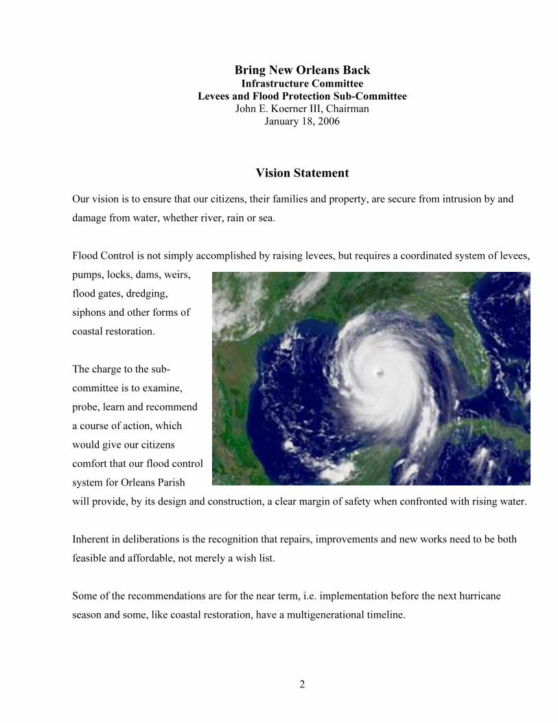
Vision Statement
Our vision is to ensure that our citizens, their families and property, are secure from intrusion by and
damage from water, whether river, rain or sea.
Flood Control is not simply accomplished by raising levees, but requires a coordinated system of levees,
pumps, locks, dams, weirs,
flood gates, dredging,
siphons and other forms of
coastal restoration.
2
ontrol
Inherent in deliberations is the recognition that repairs, improvements and new works need to be both
Some of the recommendations are for the near term, i.e. implementation before the next hurricane
The charge to the sub-
committee is to examine,
probe, learn and recommend
a course of action, which
would give our citizens
comfort that our flood c
system for Orleans Parish
will provide, by its design and construction, a clear margin of safety when confronted with rising water.
feasible and affordable, not merely a wish list.
season and some, like coastal restoration, have a multigenerational timeline.
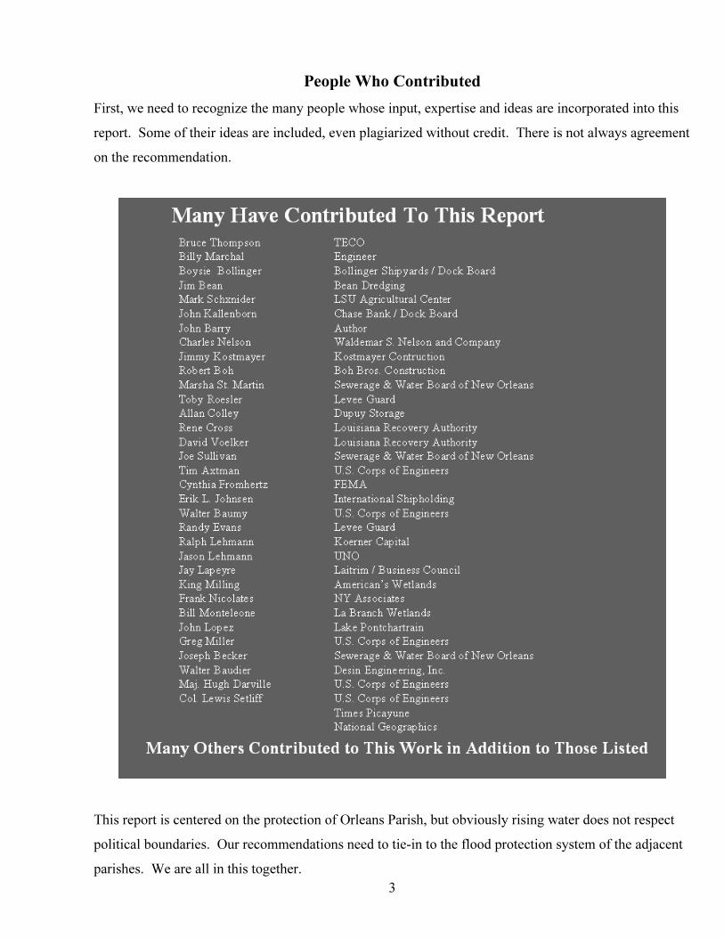
People Who Contributed
First, we need to recognize the many people whose input, expertise and ideas are incorporated into this
report. Some of their ideas are included, even plagiarized without credit. There is not always agreement
on the recommendation.
This report is centered on the protection of Orleans Parish, but obviously rising water does not respect
political boundaries. Our recommendations need to tie-in to the flood protection system of the adjacent
parishes. We are all in this together.
3
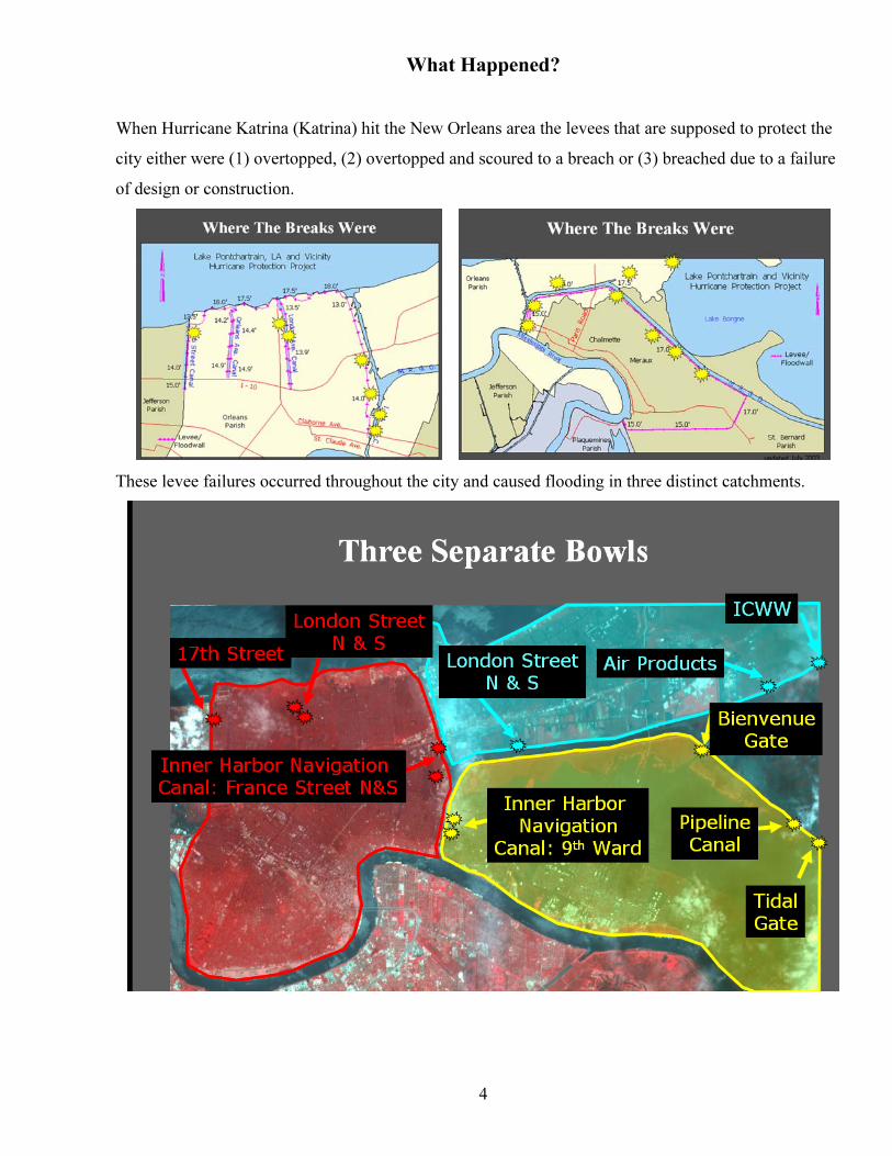
What Happened?
When Hurricane Katrina (Katrina) hit the New Orleans area the levees that are supposed to protect the
city either were (1) overtopped, (2) overtopped and scoured to a breach or (3) breached due to a failure
of design or construction.
These levee failures occurred throughout the city and caused flooding in three distinct catchments.
4
5
uilt
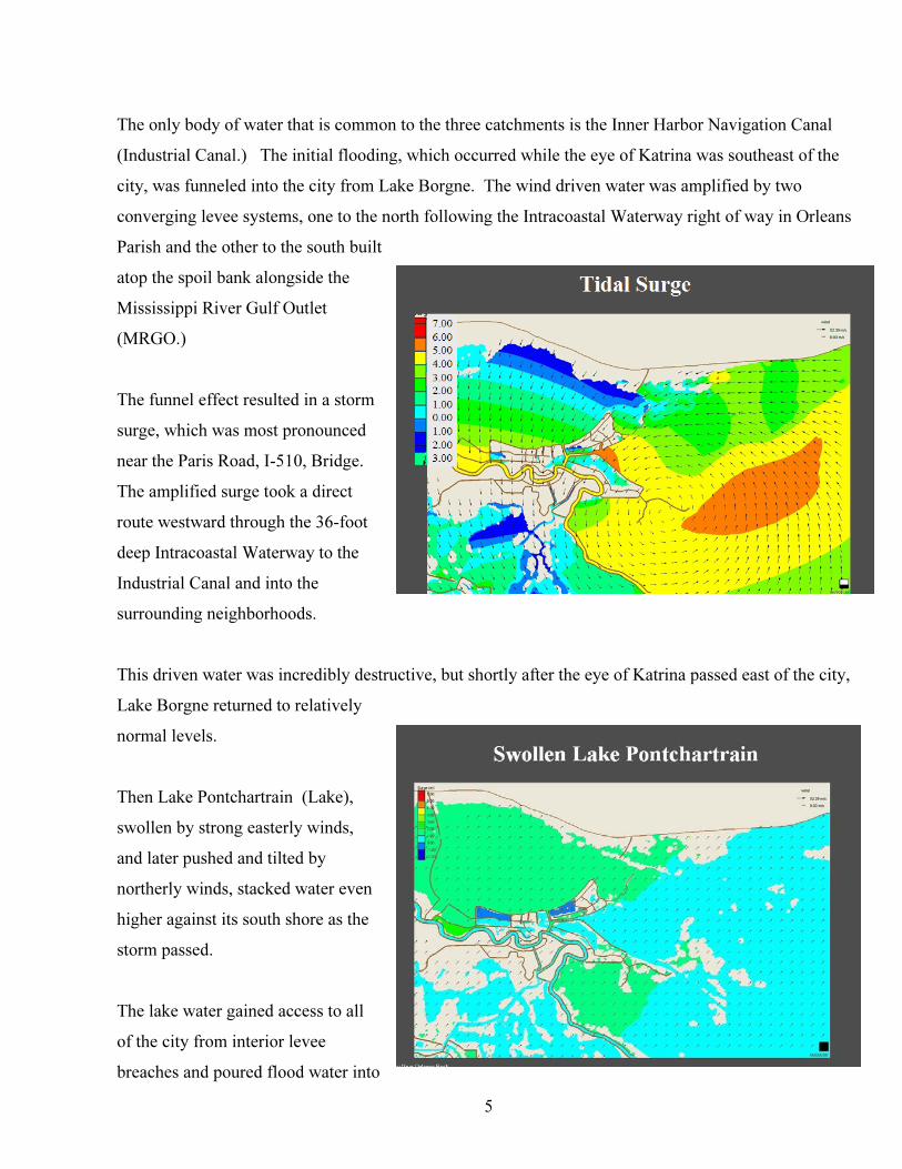
The only body of water that is common to the three catchments is the Inner Harbor Navigation Canal
(Industrial Canal.) The initial flooding, which occurred while the eye of Katrina was southeast of the
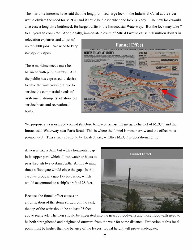
city, was funneled into the city from Lake Borgne. The wind driven water was amplified by two
converging levee systems, one to the north following the Intracoastal Waterway right of way in Orleans
Parish and the other to the south b
atop the spoil bank alongside the
Mississippi River Gulf Outlet
(MRGO.)
The funnel effect resulted in a storm
surge, which was most pronounced
near the Paris Road, I-510, Bridge.
The amplified surge took a direct
route westward through the 36-foot
deep Intracoastal Waterway to the
Industrial Canal and into the
surrounding neighborhoods.
This driven water was incredibly destructive, but shortly after the eye of Katrina passed east of the city,
Lake Borgne returned to relatively
normal levels.
Then Lake Pontchartrain (Lake),
swollen by strong easterly winds,
and later pushed and tilted by
northerly winds, stacked water even
higher against its south shore as the
storm passed.
The lake water gained access to all
of the city from interior levee
breaches and poured flood water into
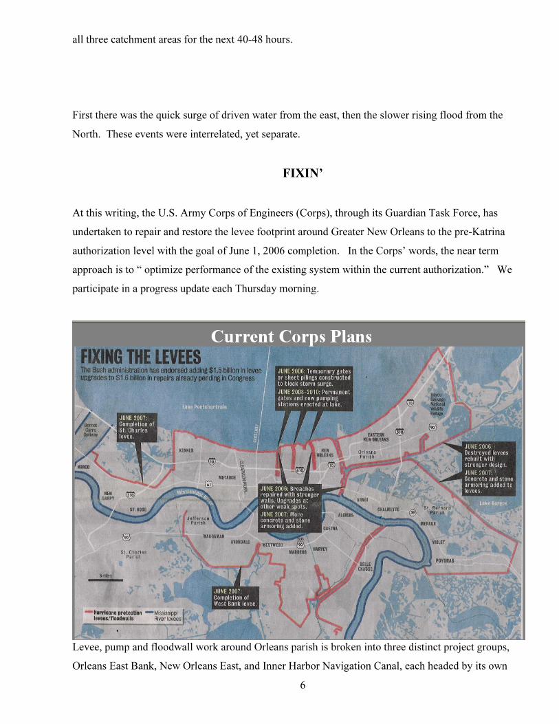
all three catchment areas for the next 40-48 hours.
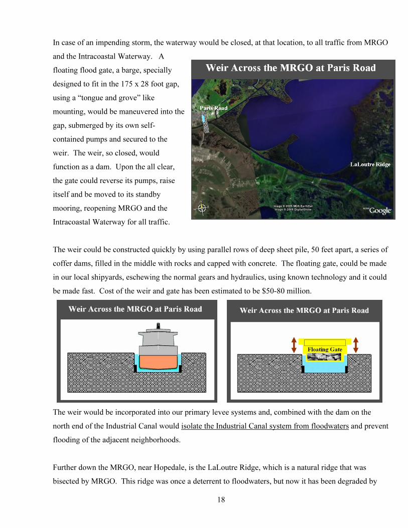
First there was the quick surge of driven water from the east, then the slower rising flood from the
North. These events were interrelated, yet separate.
FIXIN’
At this writing, the U.S. Army Corps of Engineers (Corps), through its Guardian Task Force, has
undertaken to repair and restore the levee footprint around Greater New Orleans to the pre-Katrina
authorization level with the goal of June 1, 2006 completion. In the Corps’ words, the near term
approach is to “ optimize performance of the existing system within the current authorization.” We
participate in a progress update each Thursday morning.
6
Levee, pump and floodwall work around Orleans parish is broken into three distinct project groups,
Orleans East Bank, New Orleans East, and Inner Harbor Navigation Canal, each headed by its own
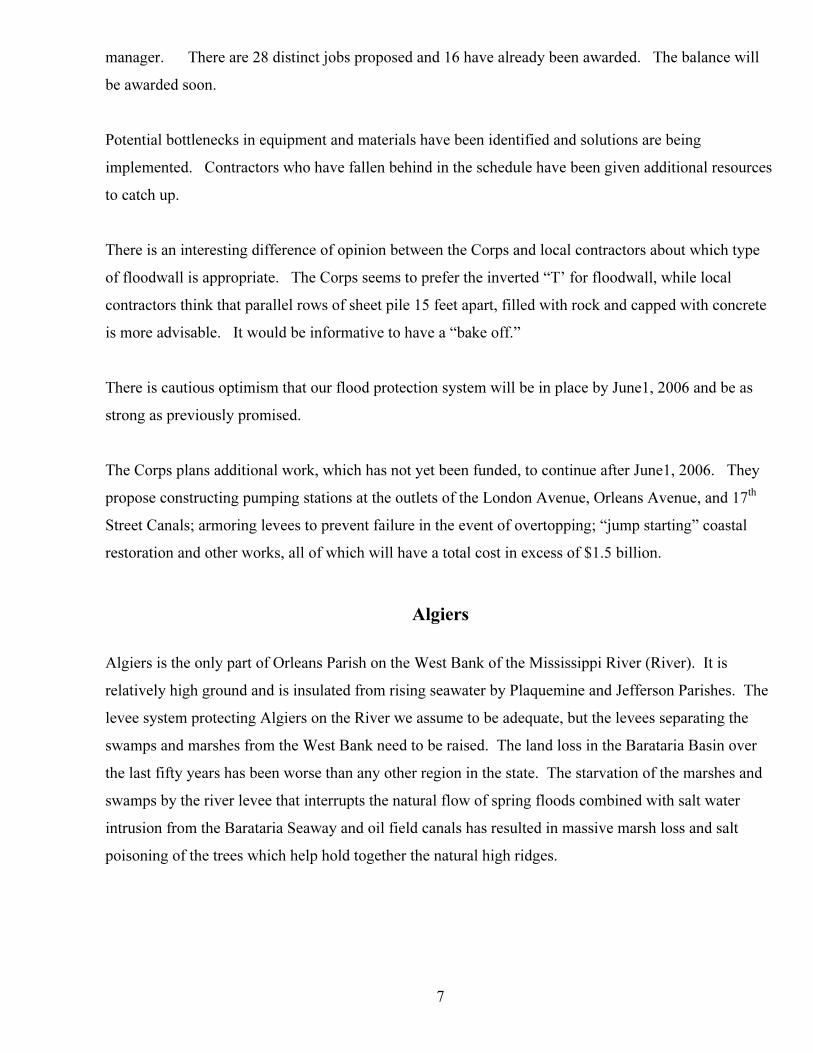
7
ll
ks in equipment and materials have been identified and solutions are being
plemented. Contractors who have fallen behind in the schedule have been given additional resources
teresting difference of opinion between the Corps and local contractors about which type
f floodwall is appropriate. The Corps seems to prefer the inverted “T’ for floodwall, while local
in place by June1, 2006 and be as
rong as previously promised.
, which has not yet been funded, to continue after June1, 2006. They
ropose constructing pumping stations at the outlets of the London Avenue, Orleans Avenue, and 17 P
thP
Algiers is the only part of Orleans Parish on the West Bank of the Mississippi River (River). It is
gh ground and is insulated from rising seawater by Plaquemine and Jefferson Parishes. The
he
d
manager. There are 28 distinct jobs proposed and 16 have already been awarded. The balance wi
be awarded soon.
Potential bottlenec
im
to catch up.
There is an in
o
contractors think that parallel rows of sheet pile 15 feet apart, filled with rock and capped with concrete
is more advisable. It would be informative to have a “bake off.”
There is cautious optimism that our flood protection system will be
st
The Corps plans additional work
p
Street Canals; armoring levees to prevent failure in the event of overtopping; “jump starting” coastal
restoration and other works, all of which will have a total cost in excess of $1.5 billion.
Algiers
relatively hi
levee system protecting Algiers on the River we assume to be adequate, but the levees separating t
swamps and marshes from the West Bank need to be raised. The land loss in the Barataria Basin over
the last fifty years has been worse than any other region in the state. The starvation of the marshes an
swamps by the river levee that interrupts the natural flow of spring floods combined with salt water
intrusion from the Barataria Seaway and oil field canals has resulted in massive marsh loss and salt
poisoning of the trees which help hold together the natural high ridges.
8
nterrelated with surrounding parishes and in fact are virtually all located in
ould
or
lgiers, as well as the
be
re
East Bank of Orleans
ooding and loss of life. It is here where the
lood protection systems are built in layers which surround us. At the center of that protection is an
he best flood protection is common sense and self-actuation. That is what makes us move our cars to
Personal initiative is the best insurance against floods. God helps those who help themselves.
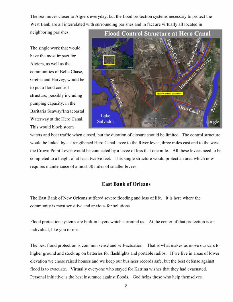
The sea moves closer to Algiers everyday, but the flood protection systems necessary to protect the
West Bank are all i
neighboring parishes.
The single work that w
have the most impact f
A
communities of Belle Chase,
Gretna and Harvey, would
to put a flood control
structure, possibly including
pumping capacity, in the
Baritaria Seaway/Intracoastal
Waterway at the Hero Canal.
This would block storm
waters and boat traffic when closed, but the duration of closure should be limited. The control structu
would be linked by a strengthened Hero Canal levee to the River levee, three miles east and to the west
the Crown Point Levee would be connected by a levee of less that one mile. All these levees need to be
completed to a height of at least twelve feet. This single structure would protect an area which now
requires maintenance of almost 30 miles of smaller levees.
The East Bank of New Orleans suffered severe fl
community is most sensitive and anxious for solutions.
F
individual, like you or me.
T
higher ground and stock up on batteries for flashlights and portable radios. If we live in areas of lower
elevation we chose raised houses and we keep our business records safe, but the best defense against
flood is to evacuate. Virtually everyone who stayed for Katrina wishes that they had evacuated.
9
pending danger, to have a plan, to maintain clear evacuation routes and to declare the evacuation.
operators,
nd of course levees, to protect people and property that might be left behind.
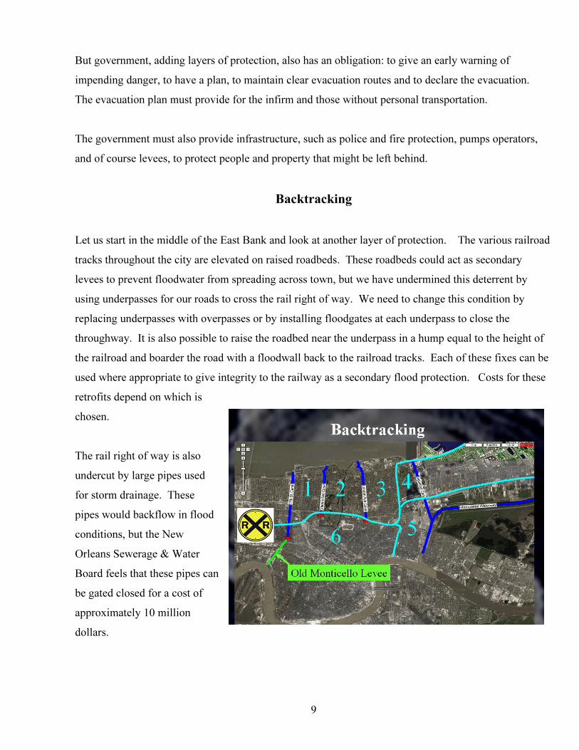
Let us start in the middle of the East Bank a layer of protection. The various railroad
acks throughout the city are elevated on raised roadbeds. These roadbeds could act as secondary
of
can be
ight of way is also
undercut by large pipes used
es can
But government, adding layers of protection, also has an obligation: to give an early warning of
im
The evacuation plan must provide for the infirm and those without personal transportation.
The government must also provide infrastructure, such as police and fire protection, pumps
a
Backtracking
nd look at another
tr
levees to prevent floodwater from spreading across town, but we have undermined this deterrent by
using underpasses for our roads to cross the rail right of way. We need to change this condition by
replacing underpasses with overpasses or by installing floodgates at each underpass to close the
throughway. It is also possible to raise the roadbed near the underpass in a hump equal to the height
the railroad and boarder the road with a floodwall back to the railroad tracks. Each of these fixes
used where appropriate to give integrity to the railway as a secondary flood protection. Costs for these
retrofits depend on which is
chosen.
The rail r
for storm drainage. These
pipes would backflow in flood
conditions, but the New
Orleans Sewerage & Water
Board feels that these pip
be gated closed for a cost of
approximately 10 million
dollars.
10
The railroad tracks can be raised, if overhead clearances allow, an additional two feet for a cost of one
million dollars per mile and flood walls can be added alongside the railway to give a level barrier where
necessary.
This secondary flood protection is termed containment and is used extensively by the Dutch. The
improved railroad “levee” could be joined with the outfall canal levees and other internal floodwalls to
create containment areas, which isolate floodwaters and prevent them from migrating unimpeded all
over the city.
In addition, the old protection levee along Monticello Street at the Orleans/Jefferson Parish line could be
renewed by either closing or raising the streets, which now penetrate it. This program would involve
raising River Road and Jefferson Highway, placing a floodgate at the Public Belt Railroad, and raising
Airline Highway, as well as dealing with other neglect and abuse of an originally solid flood protection
system, which extended from Pumping Station #6 to the River.
Combined, these secondary systems would help isolate future possible floods east of the Industrial Canal
into six separate containment areas.
In New Orleans East, the Maxent levee along Paris Road, starts at Little Woods and meanders until it
intersects with the floodwall at the Intracoastal Canal. This levee, which is owned by the U. S. Wildlife
and Fisheries, needs to be strengthened and raised, and combined with the railroad right of way which
runs near Highway 90, could provide a number of containment areas in new Orleans East.
Secure the Perimeter
. Our perimeter levees at this time are our most important line of defense against floodwaters. The Southern border of the East Bank is the Mississippi River levee and for this discussion we assume it to be adequate.
To the west lies Jefferson Parish. Their levee and pump system along Lake Pontchartrain held up well
in hurricane Katrina. The floodwall at the Jefferson/St. Charles Parish line is being inspected, because
of its similarity to the failed floodwalls in Orleans Parish. Renewal of the aforementioned systems at the
Orleans/Jefferson Parish line can add some comfort. For purposes of this discussion we will assume
that we are protected from the West.
Looking North
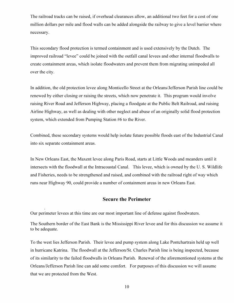
Now we look to the North toward Lake Pontchartrain. The protection levee along the South shore of the
Lake, our city’s North side has four big holes in it, not counting Bayou St. John. Three holes are at the
mouths of the outfall drainage canals: 17P
thP Street, Orleans and London Avenue. The fourth opening is
the north end of the Industrial Canal.
All these canals are open, without restriction, to the Lake and carry sea level water into the interior of
the city; well behind our robust levee at the Lake.
We need to do something about that!
11
Ready Jetty
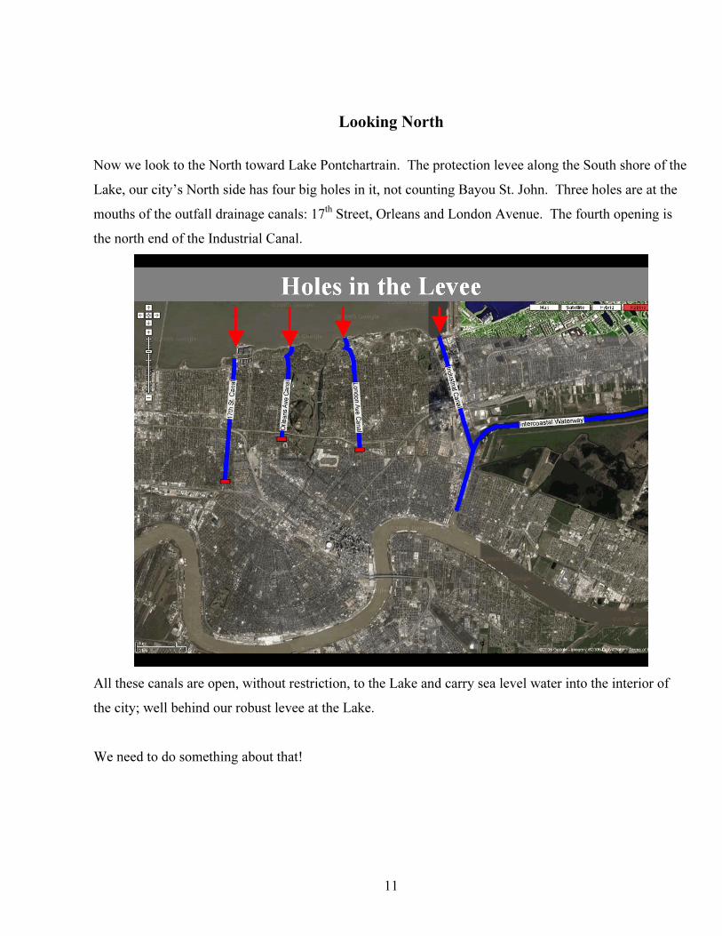
The three drainage canals open, unprotected into the Lake. Any mechanism placed near the mouth of
these canals, be it sheet pile dam, flood gate
or pump needs protection from 24 miles of
open water and the waves that can develop
in that fetch.
Jefferson Parish has wisely installed jetties
across the mouths of its canals thus
protecting the pumping stations from a
direct hit.
Orleans Parish should do the same,
immediately.
The Corps theorizes that the canal walls may have failed because waves driven into the canals by the
north wind in Katrina slopped side to side
throughout the canals thus causing increased
stress and flexing of the canal walls.
Jetties at each canal would stop these waves
and keep them from entering the canal or
damaging any mechanical structure placed
near the mouth. The jetties will be needed
when the new pumping stations are built at
the lake, so the sooner they are built, the
better.
We recommend immediate construction of jetties at the mouth of each canal. Cost for both the jetties
recently built in Jefferson Parish, $11 million or $5 ½ million apiece.
“Sinking in the Rain”
12
No other flood protection system is built like ours. Everywhere else pumps are put at the mouth of
drainage canals and integrated into and made part of the perimeter or outer levee system. We need to
move the pumps or construct new pumping capacity at the Lake end of these canals, thus cutting off the
free flow of water from the Lake to the interior of our neighborhoods. The cost to move or build anew
for three pumping stations has been estimated to be in excess of $450 million, and take up to five years.
During the interim we remain exposed.
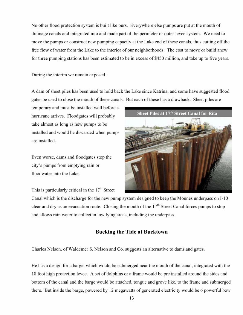
A dam of sheet piles has been used to hold back the Lake since Katrina, and some have suggested flood
gates be used to close the mouth of these canals. But each of these has a drawback. Sheet piles are
temporary and must be installed well before a
hurricane arrives. Floodgates will probably
take almost as long as new pumps to be
installed and would be discarded when pumps
are installed.
13
Even worse, dams and floodgates stop the
city’s pumps from emptying rain or
floodwater into the Lake.
This is particularly critical in the 17P
thP Street
Canal which is the discharge for the new pump system designed to keep the Mounes underpass on I-10
clear and dry as an evacuation route. Closing the mouth of the 17 P
thP Street Canal forces pumps to stop
and allows rain water to collect in low lying areas, including the underpass.
Bucking the Tide at Bucktown
Charles Nelson, of Waldemer S. Nelson and Co. suggests an alternative to dams and gates.
He has a design for a barge, which would be submerged near the mouth of the canal, integrated with the
18 foot high protection levee. A set of dolphins or a frame would be pre installed around the sides and
bottom of the canal and the barge would be attached, tongue and grove like, to the frame and submerged
there. But inside the barge, powered by 12 megawatts of generated electricity would be 6 powerful bow
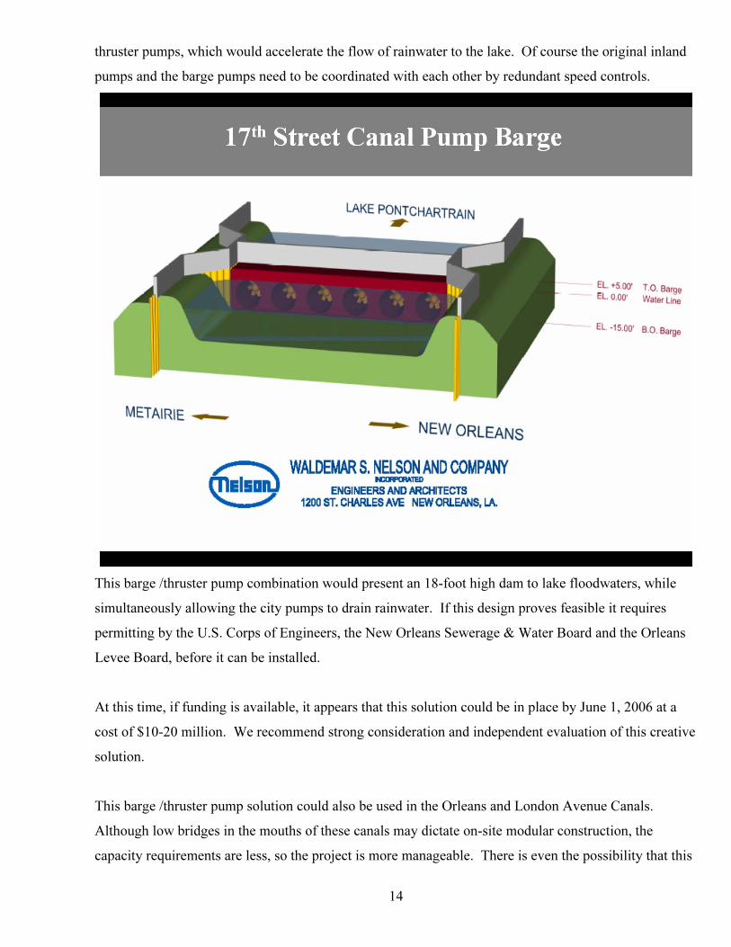
thruster pumps, which would accelerate the flow of rainwater to the lake. Of course the original inland
pumps and the barge pumps need to be coordinated with each other by redundant speed controls.
This barge /thruster pump combination would present an 18-foot high dam to lake floodwaters, while
simultaneously allowing the city pumps to drain rainwater. If this design proves feasible it requires
permitting by the U.S. Corps of Engineers, the New Orleans Sewerage & Water Board and the Orleans
Levee Board, before it can be installed.
At this time, if funding is available, it appears that this solution could be in place by June 1, 2006 at a
cost of $10-20 million. We recommend strong consideration and independent evaluation of this creative
solution.
This barge /thruster pump solution could also be used in the Orleans and London Avenue Canals.
Although low bridges in the mouths of these canals may dictate on-site modular construction, the
capacity requirements are less, so the project is more manageable. There is even the possibility that this
14
could be a permanent solution and the barges would remain fixed on location at a considerable cost
saving to building three new pumping stations. Cost estimate for all three canals is $25-50 million, with
a hurry up installation time of six months.
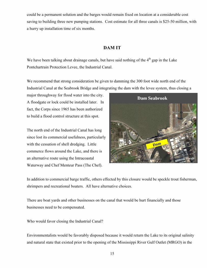
DAM IT
We have been talking about drainage canals, but have said nothing of the 4P
thP gap in the Lake
Pontchartrain Protection Levee, the Industrial Canal.
We recommend that strong consideration be given to damming the 300 foot wide north end of the
Industrial Canal at the Seabrook Bridge and integrating the dam with the levee system, thus closing a
major throughway for flood water into the city.
A floodgate or lock could be installed later. In
fact, the Corps since 1965 has been authorized
to build a flood control structure at this spot.
15
articularly
tal
In addi o commercial barge traffic, others effected by this closure would be speckle trout fisherman,
There are boat yards and other businesses on the canal that would be hurt financially and those
Who would favor closing the Industrial Canal?
Environmentalists would be favorably disposed because it would return the Lake to its original salinity
and natural state that existed prior to the opening of the Mississippi River Gulf Outlet (MRGO) in the
The north end of the Industrial Canal has long
since lost its commercial usefulness, p
with the cessation of shell dredging. Little
commerce flows around the Lake, and there is
an alternative route using the Intracoas
Waterway and Chef Menteur Pass (The Chef).
tion t
shrimpers and recreational boaters. All have alternative choices.
businesses need to be compensated.
16
strial Canal could even be reauthorized to function as fresh water
diversion structures, when not locking vessels through, thus nourishing the Lake Borgne estuary.
protected from flood waters from an overflowing Lake Pontchartrain.
y estimates from contractors are 6
months to construct at a cost of $10-15 million.
jetties, specialized barge/thruster pumps, a dam, and in
few years, new pumping stations, we can close the weak points in our defenses against an angry Lake.
mid ‘60s. The daily tide which scours the marsh from the ever widening banks of the MRGO would be
greatly reduced, almost eliminated.
The locks on the south end of the Indu
The neighborhoods that border the canal would be much more secure knowing that they would be
Again we suggest damming the north end of the Industrial Canal. Earl
By implementing these proposed solutions using
a
We would present a Ucontinuous barrier on our northern frontU that would stretch from Highway 11 on the
east to the St. Charles Parish line on the west.
To the East
o the East is Chef Menteur Pass, Rigolets Pass, Lake Borgne and MRGO. All need to be dealt with in
any flood control plan.
ght to contribute greatly to the storm surge effect by channeling water into both
Orleans and St. Bernard. It is also malign t for destroying marshland, nature’s
eton Island to a depth of 22 feet, far short of its authorized
epth of 36 feet. The U.S. congress has not funded the Corps to dredge the waterway in 2006, so that
e
T
Seeking Closure
MRGO is generally thou
ed by environmentalis
barrier to storm surge. It also provides a navigable waterway for boats of all types, including ocean-
going ships that need access to various docks on the Industrial Canal.
How do we accommodate all these needs?
MRGO, since Katrina, has silted up near Br
d
the future status of MRGO is uncertain. The perverse outcome of this situation is that most of maritim
commerce is denied, yet the silting is so far out as to provide no public safety benefit. Everyone loses.
17
he maritime interests have said that the long promised large lock in the Industrial Canal at the river
ld
p
hese maritime needs must be
nd
l
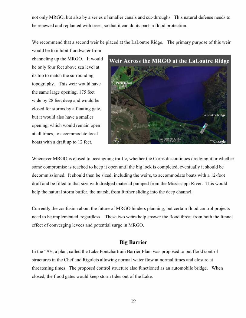
e propose a weir or flood control structure be placed across the merged channel of MRGO and the
weir is like a dam, but with a horizontal gap
ecause the funnel effect causes an
the east,
d int
m the weir for some distance. Protection at this focal
T
would obviate the need for MRGO and it could be closed when the lock is ready. The new lock wou
also ease a long time bottleneck for barge traffic in the Intracoastal Waterway. But the lock may take 7
to 10 years to complete. Additionally, immediate closure of MRGO would cause 350 million dollars in
relocation expenses and a loss of
up to 9,000 jobs. We need to kee
our options open.
T
balanced with public safety. A
the public has expressed its desire
to have the waterway continue to
service the commercial needs of
oystermen, shrimpers, offshore oi
service boats and recreational
boats.
W
Intracoastal Waterway near Paris Road. This is where the funnel is most narrow and the effect most
pronounced. This structure should be located here, whether MRGO is operational or not.
A
in its upper part, which allows water or boats to
pass through to a certain depth. At threatening
times a floodgate would close the gap. In this
case we propose a gap 175 feet wide, which
would accommodate a ship’s draft of 28 feet.
B
amplification of the storm surge from
the top of the weir should be at least 25 feet
above sea level. The weir should be integrate
be both strengthened and heightened outward fro
point must be higher than the balance of the levees. Equal height will prove inadequate.
o the nearby floodwalls and those floodwalls need to
18
would be closed, at that location, to all traffic from MRGO
nd the Intracoastal Waterway. A
ap,
,
aise
c.
by using parallel rows of deep sheet pile, 50 feet apart, a series of
e middle with rocks and capped with concrete. The floating gate, could be made
In case of an impending storm, the waterway
a
floating flood gate, a barge, specially
designed to fit in the 175 x 28 foot g
using a “tongue and grove” like
mounting, would be maneuvered into the
gap, submerged by its own self-
contained pumps and secured to the
weir. The weir, so closed, would
function as a dam. Upon the all clear
the gate could reverse its pumps, r
itself and be moved to its standby
mooring, reopening MRGO and the
Intracoastal Waterway for all traffi
The weir could be constructed quickly
coffer dams, filled in th
in our local shipyards, eschewing the normal gears and hydraulics, using known technology and it could
be made fast. Cost of the weir and gate has been estimated to be $50-80 million.
The weir would be incorporated into our primary levee systems and, combined with the dam on the
rth end of the Industrial Canal would Uisolate the Industrial Canal system from floodwatersno U and prevent
, is the LaLoutre Ridge, which is a natural ridge that was
bisected by MRGO. This ridge was once a deterrent o floodwaters, but now it has been degraded by
flooding of the adjacent neighborhoods.
Further down the MRGO, near Hopedale
t
19
s to
purpose of this weir
ould be to inhibit floodwater from
e,
l
eango
me compromise is reached to keep it open until the big lock is completed, eventually it should be
d control projects
eed to be implemented, regardless. These two weirs help answer the flood threat from both the funnel
the ‘70s, a plan, called the Lake Pontchartrain Barrier Plan, was proposed to put flood control
structures in the Chef and Rigolets allowing normal water flow at normal times and closure at
n
not only MRGO, but also by a series of smaller canals and cut-throughs. This natural defense need
be renewed and replanted with trees, so that it can do its part in flood protection.
We recommend that a second weir be placed at the LaLoutre Ridge. The primary
w
channeling up the MRGO. It would
be only four feet above sea level at
its top to match the surrounding
topography. This weir would have
the same large opening, 175 feet
wide by 28 feet deep and would be
closed for storms by a floating gat
but it would also have a smaller
opening, which would remain open
at all times, to accommodate loca
boats with a draft up to 12 feet.
Whenever MRGO is closed to oc ing traffic, whether the Corps discontinues dredging it or whether
so
decommissioned. It should then be sized, including the weirs, to accommodate boats with a 12-foot
draft and be filled to that size with dredged material pumped from the Mississippi River. This would
help the natural storm buffer, the marsh, from further sliding into the deep channel.
Currently the confusion about the future of MRGO hinders planning, but certain floo
n
effect of converging levees and potential surge in MRGO.
Big Barrier
In
threatening times. The proposed control structure also functioned as an automobile bridge. Whe
closed, the flood gates would keep storm tides out of the Lake.
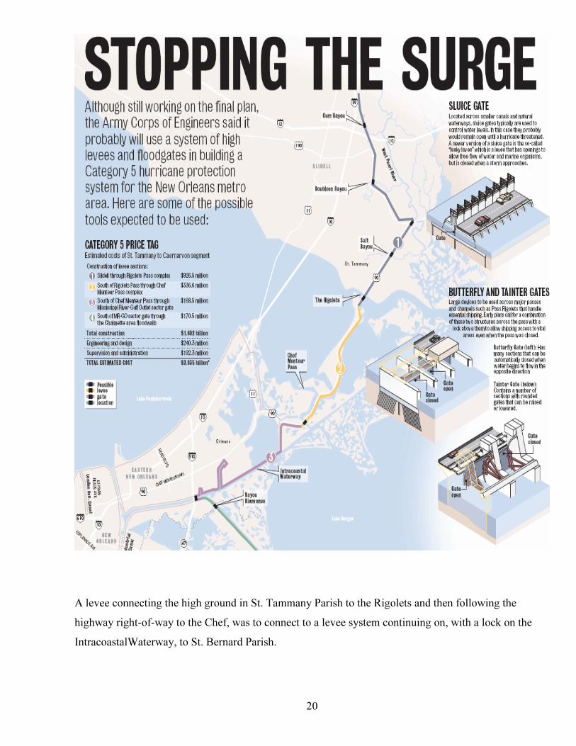
A levee connecting the high ground in St. Tammany Parish to the Rigolets and then following the
highway right-of-way to the Chef, was to connect to a levee system continuing on, with a lock on the
IntracoastalWaterway, to St. Bernard Parish.
20
Environmental interests at the time discouraged the plan, but in light of the future threats of another
Katrina, these plans need to be reconsidered.
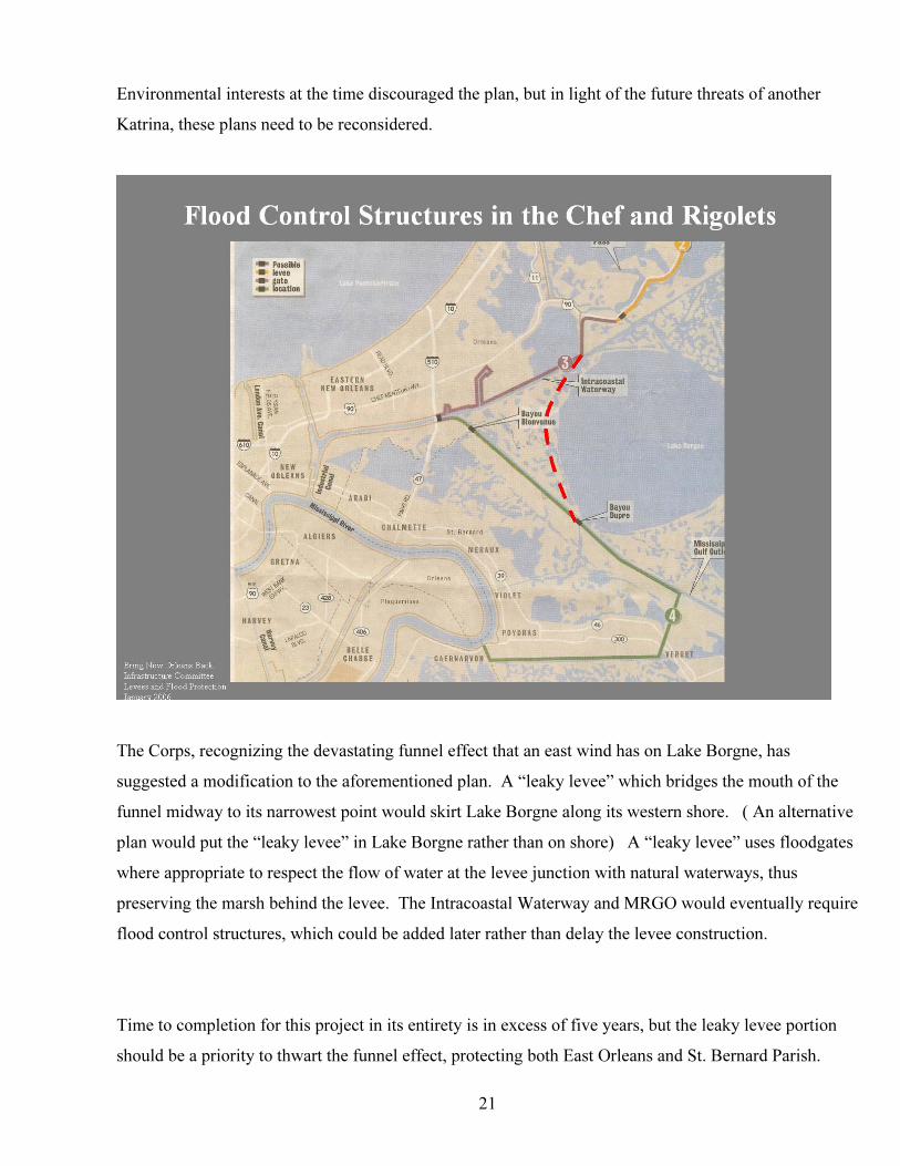
The Corps, recognizing the devastating funnel effect that an east wind has on Lake Borgne, has
suggested a modification to the aforementioned plan. A “leaky levee” which bridges the mouth of the
funnel midway to its narrowest point would skirt Lake Borgne along its western shore. ( An alternative
plan would put the “leaky levee” in Lake Borgne rather than on shore) A “leaky levee” uses floodgates
where appropriate to respect the flow of water at the levee junction with natural waterways, thus
preserving the marsh behind the levee. The Intracoastal Waterway and MRGO would eventually require
flood control structures, which could be added later rather than delay the levee construction.
Time to completion for this project in its entirety is in excess of five years, but the leaky levee portion
should be a priority to thwart the funnel effect, protecting both East Orleans and St. Bernard Parish.
21
22
mportant
s,
us those
wo billion dollars
um,
ver
is
his barrier would
ary
e
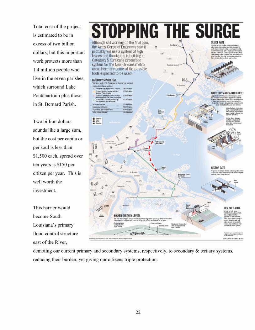
Total cost of the project
is estimated to be in
excess of two billion
dollars, but this i
work protects more than
1.4 million people who
live in the seven parishe
which surround Lake
Pontchartrain pl
in St. Bernard Parish.
T
sounds like a large s
but the cost per capita or
per soul is less than
$1,500 each, spread o
ten years is $150 per
citizen per year. This
well worth the
investment.
T
become South
Louisiana’s prim
flood control structur
east of the River,
demoting our current primary and secondary systems, respectively, to secondary & tertiary systems,
reducing their burden, yet giving our citizens triple protection.
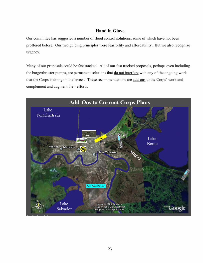
Hand in Glove
Our committee has suggested a number of flood control solutions, some of which have not been
proffered before. Our two guiding principles were feasibility and affordability. But we also recognize
urgency.
Many of our proposals could be fast tracked. All of our fast tracked proposals, perhaps even including
the barge/thruster pumps, are permanent solutions that Udo not interfereU with any of the ongoing work
that the Corps is doing on the levees. These recommendations are Uadd-onsU to the Corps’ work and
complement and augment their efforts.
23
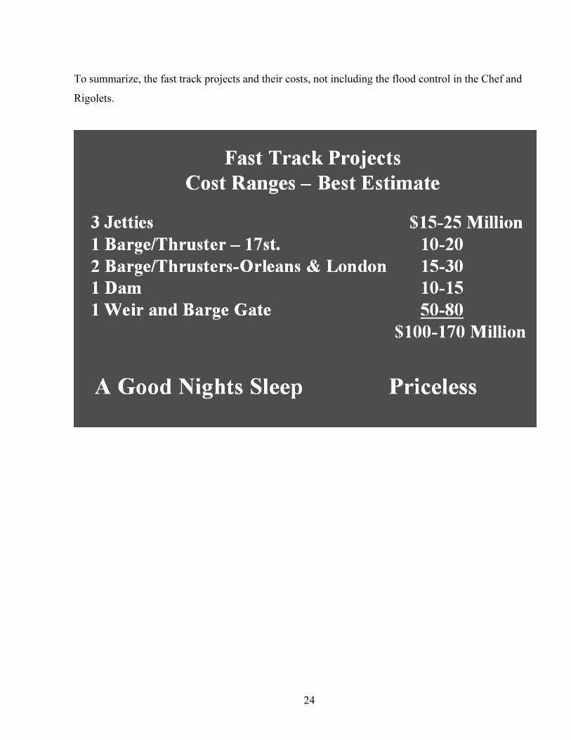
To summarize, the fast track projects and their costs, not including the flood control in the Chef and
Rigolets.
24

25
References
John A. Lopez, Ph.D., 2005. “The Multiple Lines of Defense Strategy to Sustain Louisiana’s Coast,” Lake Pontchartarin Basin Foundation Severn T. Darned, General Counsel, “A Codification of Laws Relative to the Creation and Operation of the Board of Levee Commissioners of the Orleans Levee District.” Design Engineering, Inc. 2006, “The Board of Commissioners of the Orleans Levee District.” J.N. Tate, A.R. Carillo, R.C. Berger, B.J. Thibodeaux, 2002, “Salinity Changes in Pontchartrain Basin Estuary, Louisiana, Resulting From Mississippi River-Gulf Outlet Partial Closure Plans with Width Reduction,” US Army Corps of Engineers 2005, “New Orleans After the Storm: Lessons from the Past,” The Brookings Institution: Special Analysis in Metropolitan Policy R. H. Caffey, B. Leblanc, 2002, “Closing the Mississippi River Gulf Outlet: Environmental and Economic Considerations,” Interpretive Topic Series on Coastal Wetland Restoration in Louisiana, Coastal Wetland Planning, Projection and Restoration Act. Toby A. Roesler, 2005, “How to Protect New Orleans (West of the Industrial Canal) from Hurricane Strom Surge and Associated Flooding.” Mark Schielfstein, Bob Marshall, John McQuaid, 2005, “Fixing the Levees,” The Times-Picayune, 12/16/05, Page 1. John McQuaid, Mark Schielfstein, Bob Marshall, 2005, “100 Days After Katrina, the Evidence is Clear That the Great Flood Was a Man-Made Disater,” The Times-Picayune, 12/8/05, Page 1. Mark Schielfstein, Bob Marshall, 2005, “Corps May Put Gates at Key Canals,” The Times-Picayune, 11/12/05, Page 1. John McQuaid, 2005, “Beating Back the Sea: How the Dutch Fight to Save Their Low-Lying Land,” The Times-Picayune, 11/13/05, Page 1. Eric A. Stene, 1996, “The Teton Basin Project,” Bureau of Reclamation History Program, Denver, Colorado Research on Historic Reclamation Projects. “Economic Impact Assessment Louisiana Coastal Area Comprehensive Coast/Wide Ecosystem Restoration Study,” State of Louisiana, Department of Natural Resources. 2005, “Protecting New Orleans From Future Flooding,” White house Office of Communications, 12/15/05 1971, “Lake Pontchartrain, Louisiana and Vicinity, Lake Pontchartrain Barrier Plan, Rigolets Control Structure, Closure Dam and Adjoining Levees,” US Army Corps of Engineers, 1971
26
2004, “Louisiana Coastal Area, Louisiana, Ecosystem Restoration Study,” US Army Corps of Engineers, July 2004 Peter Nicholson, Ph.D., P.E., Associate Professor of Civil and Environmental Engineering and Graduate Engineers Chair, 2005, “Hurricane Katrina: Why Did the Levees Fail?,” Testimony on Behalf of the American Society of Civil Engineers before Committee on Homeland Security and Governmental Affairs, U.S. Senate, 11/2/2005 Rene Zijlstra, 2005, Consulting Engineer, Royal Haskoning, “Flood Management From a Dutch Perspective,” Louisiana Recovery & Rebuilding Conference, 11/11/05 2005, “Comprehensive Habitat Management Plan Lake Pontchartrain Basin,” Lake Ponchartrain Basin Foundation Draft Report, 11/7/05 Nicole T. Carter, Analyst in Environmental Policy, Resources, Science, and Industry Division, 2005, “New Orleans Levees and Floodwalls: Hurricane Damage Protection,” CRS Report for Congress, 09/06/05 2004, “Grand Isle Barrier Shoreline Stabilization Study No. 2512-04-05,” Coastal Restoration Division, Louisiana Department of Natural Resources, 01/07/04 2003, “Saving America’s Wetland, A National Treasure,” Governor’s Advisory Commission on Coastal Restoration and Conservation, March 2003 2004, “Saving America’s Wetland, 2004 Report on Progress Made and Future Challenges,” Governor’s Advisory Commission on Coastal Restoration and Conservation, March 2004 2005, “Saving America’s Wetland,” Governor’s Advisory Commission on Coastal Restoration and Conservation, May 2005 James R. Hanchey, Steven R. Abt, Gordon P. Boutwell, Jr., Charles C. Calhoun, Henry J. Hatch, Donald F. Hayes, Ehab A. Meselhe, Dominic Izzo, John F. Durrant, Gerald E. Galloway, Jr., Jerome Delli Priscoli, 2003, “Restoring Coastal Louisiana, Enhancing the Role of Engineering and Science in the Restoration Program,” American Society of Civil Engineers, Task Committee on America’s Wetland, 2003 Herbert R. Haar, Jr., Colonel, DM No. 1 – General, Seabrook Lock, February 6, 1969, The Flood Control Act (Public Law 89-298), “Lake Pontchartrain, Louisiana and Vicinity and Mississippi River-Gulf Outlet, Louisiana,” October 27, 1969, US Army, New Orleans District, Corps of Engineers, Carl A Strock, Lt General, US Army, Chief of Engineers, “Report to the Secretary of the Army, Louisiana Coastal Area, Louisiana, Ecosystem Restoration,” January 31, 2005 Gerald M Duszynski, Louisiana Department of Natural Resources, Office of Coastal Restoration and Management, 2005, “Costal Restoration in Louisiana,” Remarks to Senate Committee Staff on Transportation, New Orleans, LA, January 5, 2005 2004, Physical Oceanographic Real Time System Ports For The State of Louisiana, National Oceanic and Atmospheric Administration, National Ocean Service, Center for Operational Oceanographic Products and Services
27
Louisiana Coastal Wetlands Conservation, Restoration and Management Act/ ACT 6 1986 CWPPRA (Coastal Wetlands Planning, Protection and Restoration Act) 1990 Coast 2050 Plan, “ Coast 2050 – Toward a Sustainable Coastal Louisiana” 1998 Section 905(b) (WRDA 1986) Analysis Louisiana Coastal Area, Louisiana – Ecosystem Restoration - 1999