bridgewater canal - faelixmedia.urbed.coop.ccc.cdn.faelix.net/sites/default/files/100817... ·...
TRANSCRIPT

Bridgewater Canal: Vision and masterplan for a regional tourist attraction
Final Report August 2010

partly openenclosed to one side by trees
stone bridge
wide towpath
N
to Astley Green
steel bridge
stone bridge
nodelandmarkconfinementedge
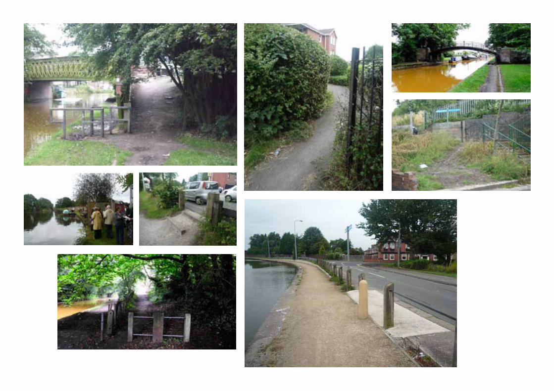
As part of the baseline Landscape Projects produced a series of character studies of the canal. These are reproduced sequentially through this report running from the Ship Canal running westwards to the edge of Salford
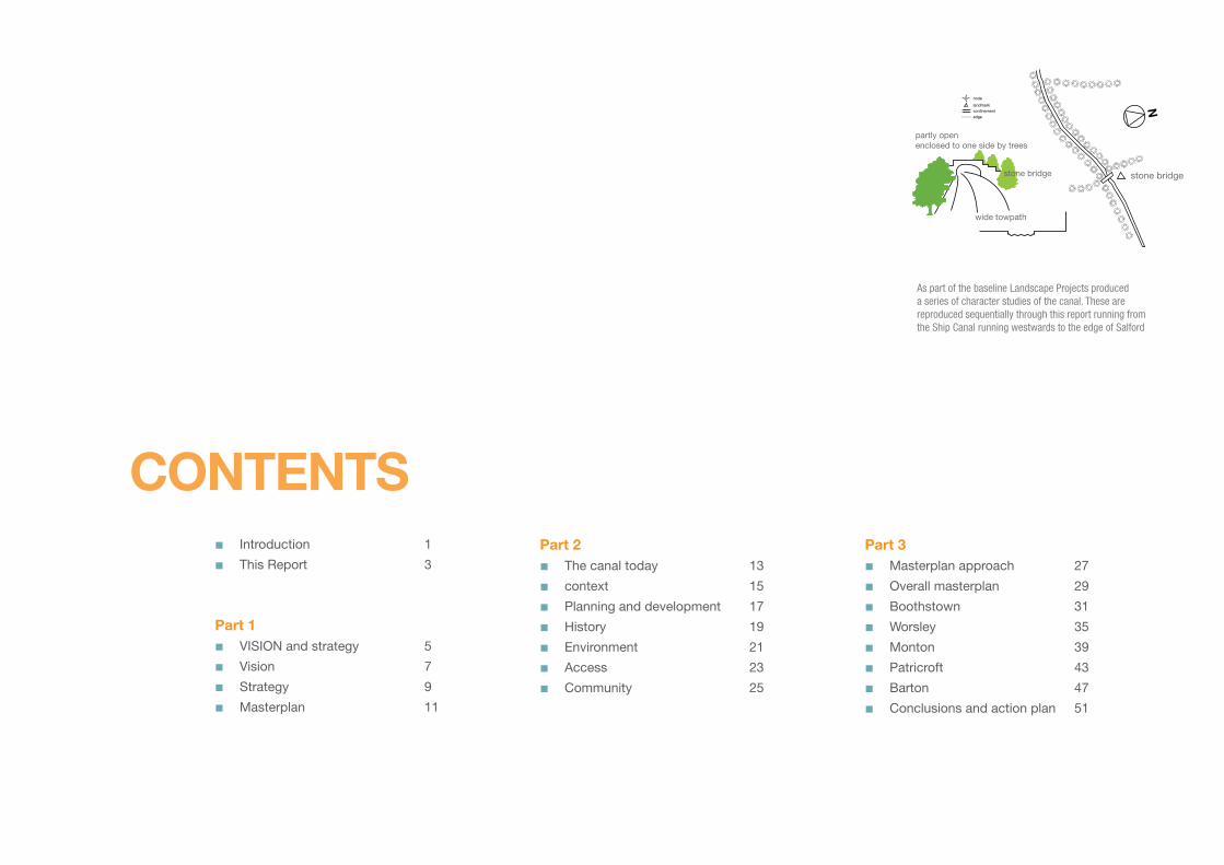
Contents Introduction 1
This Report 3
Part 1 VISION and strategy 5
Vision 7
Strategy 9
Masterplan 11
■■
■■■■
Part 2 The canal today 13
context 15
Planning and development 17
History 19
Environment 21
Access 23
Community 25
■■■■■■■
Part 3 Masterplan approach 27
Overall masterplan 29
Boothstown 31
Worsley 35
Monton 39
Patricroft 43
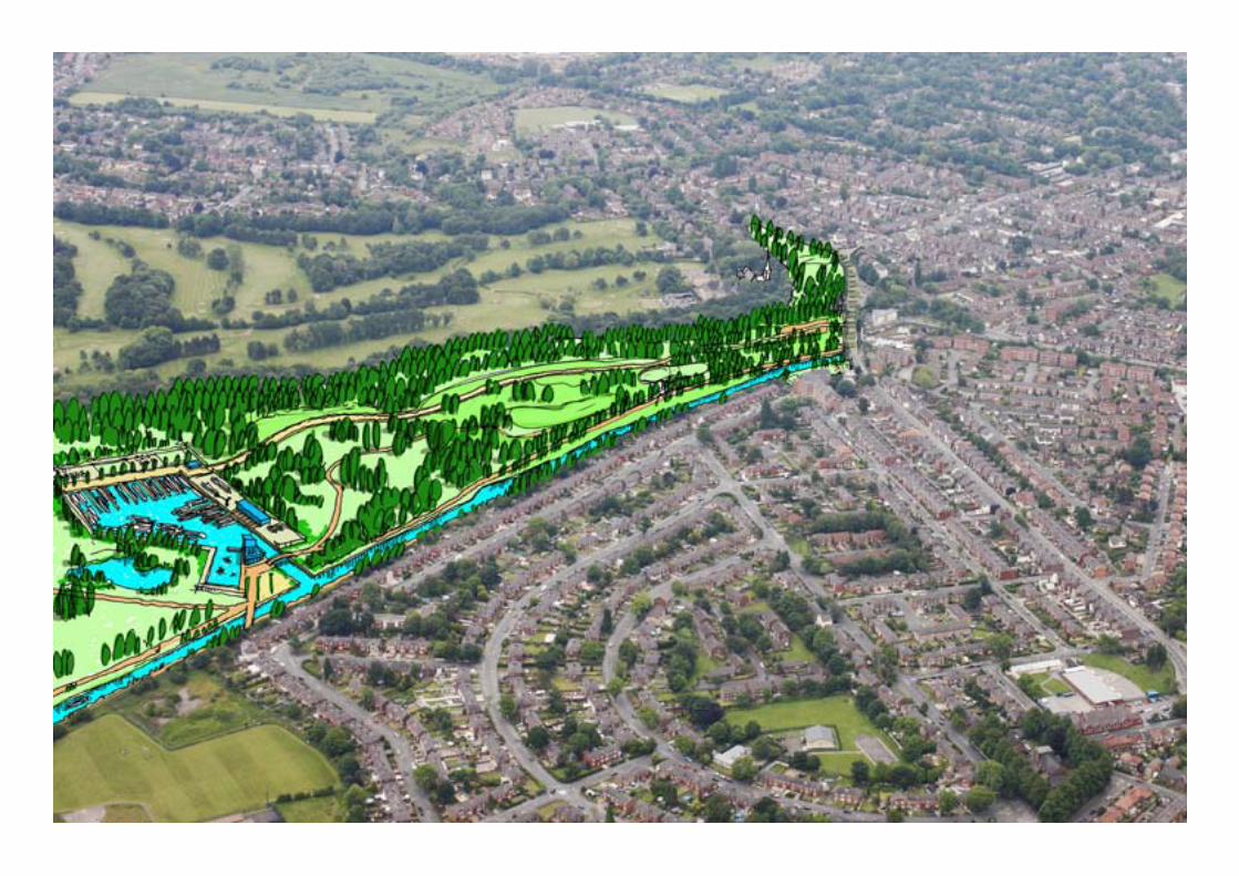
Barton 47
Conclusions and action plan 51
■■■■■■■■


Bridgewater Canal Masterplan - Report by URBeD and Landscape Projects
1
Yet for most of its journey through Salford you
wouldn’t know this. The canal, as a contour canal,
has no locks and little of the historic architecture and
infrastructure that you find on later canals. Much of
the towpath is muddy and the canal edge is steel
sheet piling rather than stone. The eastern part of the
canal feels run down and, while the western part is
much more rural, with the exception of the centre of
Worsley, it is not particularly picturesque.
This is an aspirational document that aims to
transform this situation and to turn the canal into an
attraction used by a broad range of people from local
dog Walkers to international visitors exploiting its
history and fame. If the canal is to become Salford
West’s main visitor attraction as identified in the
Salford West Framework there is a need to:
Improve the environment of the canal
Make more of its star attractions – Worsley Delph
and Barton Aqueduct
Make more of its history and industrial
archaeology through interpretation
Provide visitor infrastructure such as cafes,
toilets and visitor information and orientation
Provide gateways to the canal linked to parking
and public transport
Improve links to the surrounding communities
and particularly the five villages along the canal
Identify development opportunities along the
canal that can improve the environment and
increase activity
Increase use of the water for boating and leisure
Package all of this up into a recognisable
attraction that can be marketed regionally.
These are the issues that we address in this
masterplan. In doing so we draw upon a detailed
baseline report published in September 2009. The
baseline should be read in conjunction with this
report, we will draw from it, but most of the detailed
analysis will not be repeated.
■■
■
■
■
■
■
■■
IntRoDUCtIon This masterplan has been produced as part of a series of
studies commissioned by Salford City Council to transform the 4.9 miles of the Bridgewater Canal that run through the city. The canal, indeed the section of the canal in Salford, is arguably the most historically important canal in Britain. It is taught to every child as part of the National Curriculum and could be said to have kick started the Industrial Revolution. It is identified in as key driver in the Salford West Strategic
Regeneration Framework as the area’s main potential tourist attraction because of its history and brand recognition.
The Bridgewater Canal is owned by The Bridgewater
Canal Company which is a subsidiary of Peel
Holdings and we have consulted closely with them
as well as other land owners along the canal as part
of this study. We have sought where possible to
accommodate the aspirations of land owners where
they are in line with the above objectives.
This is one of a series of reports commissioned by
Salford City Council on the Bridgewater Canal:
Conservation Management Plan –Donald Insall
Associates – March 2009
Audience Development Plan – Alex Saint
Associates and Palmer Squared – March 2009
Access Plan – Countryside Equality Marketing
– March 2009
Interpretation Plan – Image Makers
Economic Impact – Atkins and Pan Leisure
These reports together with this masterplan set out
a vision for the canal in order to inform planning
decisions along the canal as well as future funding
bids.
■
■
■
■■
Barton
Aquaduct
nodelandmarkconfinementedge
N
enclosed
boat yard building
noisy
narrow towpath blocked
A
A


Bridgewater Canal Masterplan - Report by URBeD and Landscape Projects
3
Work on this masterplan has taken place through
the second part of 2009 and early 2010. The
baseline report describes the context and history of
the canal and explores its landscape, public realm,
connectivity and economy. This background work
informed a series of draft masterplans for each part
of the canal which were the subject of consultation
from November 2009 to March 2010. This included
presentations to both Eccles Community Committee
and Worsley & Boothstown Community Committee
along with 14 public exhibitions. The results of this
consultation can be found in Appendix 1.
The findings of the consultation have fed into this
report which describes the masterplan for the canal
corridor from Barton to the boundary with Wigan.
The report is in three sections:
Part 1: Vision and strategy
Unlike most masterplanning reports we start with
the vision and strategy. This has been done because
the vision and visitor strategy for the development
of the canal as a major tourist destination is part
of our brief. The first part of this report therefore
elaborates this vision drawing on the audience
development and access reports that have already
been completed. This is in three parts:
The vision for the canal as a major tourist
attraction that can be developed gradually over
time.
The strategy of developing the audience based
initially on local people and expanding the draw
of the canal to bring in regional and eventually
national and international visitors.
The implications of this for the masterplan and
the concept of focusing on the five villages
along the canal and the different roles that they
can play.
■
■
■
thIs RePoRtThis report outlines a masterplan for the Bridgewater
Canal designed to turn it, over time, into a major visitor destination. The report is the result of six months of
work and is supported by a baseline report published in September 2009 and a consultation exercise undertaken
from November 2009 to March 2010. This report is in three parts, starting with the vision for the canal before describing the current position and then developing a
series of masterplans for each part of the canal.
Part 2: the canal today
The second part of the report summarises the key
findings of the baseline and therefore describes the
raw material that we have to work with in realising
the vision. This is in 6 parts:
The regional context
Development proposals and policy
The history of the canal
The quality of the environment of the canal
Access to the canal
The views of the community along the canal.
Part 3: the Masterplan
The final part of the report then describes five
masterplans covering each of the villages along the
canal. These develop the role proposed for each
of these villages into a masterplan and a series of
recommendations.
These proposals have been developed working
closely with AGDR who have undertaken an
economic viability assessment of these proposals.
■■■■■■
enclosed
urban
noisy
narrow towpath with road along side
nodelandmarkconfinementedge
N
Bridgewater Mill


Bridgewater Canal Masterplan - Report by URBeD and Landscape Projects
�
PaRt 1
VIsIon anD stRategy

Below: Iron Bridge in Shropshire Centre: Castlefield ManchesterRight: The East Lancs Railway in Bury
Bridgewater Canal Masterplan - Report by URBeD and Landscape Projects
�
There is great interest in industrial archaeology in
the northwest. The Industrial Powerhouse campaign
promotes 60 attractions in the region, 30-40 heritage
trails and 150 events a year. The Bridgewater Canal
has the potential to play a major part in this offer.
However as the Audience Development plan points
out, the canal is not a destination at present when
compared to places like Ironbridge, the
Anderton Boat Lift or Castlefield. It has
destination potential in Worsley Delph and
the Barton Aqueduct but these attractions
are not currently in a position to provide
a visitor experience capable of attracting
visitors from anything other than the local
area.
One of the problems in doing this is the fact that
the canal is a linear attraction. The Audience
Development plan compares this to Hadrian’s
Wall and there are more local examples like the
VIsIon
‘To create a living canal connecting communities with a unique industrial and
natural heritage enjoyed by all’(Salford City Council’s Vision for the Canal)
East Lanc’s Railway in Bury. The trick is to link the
attractions along the canal with a common identity
and to package the canal’s assets to create the
ingredients of a fulfilling visit. This might include
combining heritage sites with countryside walks,
creating circular routes for walking and cycling and
making water activities part of the attraction.
There is a need for major capital investment to
realise the canal’s full potential as a destination. If
part of the 46 miles of underground canals on four
levels under the Delph could be opened up, or the
Barton Swing Bridge could be combined with a
museum charting the history of the Bridgewater and
Ship Canals then the canal could become one of the
region’s biggest attractions.
This however does not need to happen in one
big bang. Indeed the lesson of many of the
millennial Lottery projects is that this is risky, visitor
numbers often fail to live up to expectations and
business plans prove unrealistic. The vision for
the Bridgewater Canal is therefore to develop the
attraction and the number of visitors gradually
over time, appealing first to local visitors, before
widening this to the city, then the region and only
then nationally and internationally. This will prepare
the way for major investment by putting the canal on
the map and dealing with its many failings before it
is asked to step up to being a major attraction.
The detail and viability of the major capital
investments in the Delph and Barton are beyond the
scope of this report. The masterplan does however
focus on this process of gradual improvement and
audience development to pave the way for these
projects in the future.
enclosed by buildings
urban
noisy
Bridgewater Mill
nodelandmarkconfinementedge
N
Bridgewater Mill

1Packaged guided and self-
guided walks linked to the
interpretation strategy being
developed by Imagemakers.
2A series of visitor
information points/cafes
that people can use as
the starting and ending point for
their walks and incorporating
interpretation and refreshments.
This would be similar to
the Mersey Valley in South
Manchester.
3The development of Monton
Marina and the Duke Drive
Country Park as a regional
attraction together with widely
marketed paying attractions such
as canal tours. There is scope for
something like the East Lanc’s
Railway that uses themed train
rides to link together different
attractions.
4A significant attraction at
Barton Bridge linked to a
museum about the Ship
Canal and Bridgewater Canal
and with marketing linked to
the Trafford Centre. This would
become the staring point for the
boat trips although it may be that
the attraction is on the Trafford
bank.
5The opening of the Delph
as a finale to the boat tours
in which they would enter
the tunnels and experience the
underground system of canals,
mines shafts and the inclined plane
for winching boats between levels.
Top: Sunbury Embroidery Centre a high-quality visitor centre and cafe Bottom: National Wildflower Centre, Liverpool
Top: The Strata project is working to open a network of underground canals and quarries below DudleyBottom: Antwerp’s underground canals have recently opened to visitors
Top: Anderton Boat Lift in CheshireBottom: The Falkirk Wheel Boat Lift in Scotland
Top: The Manchester Ship Canal

Bridgewater Canal Masterplan - Report by URBeD and Landscape Projects
�
Research for Visit Manchester suggests that
there are 9.7 Million visitor nights spent in Greater
Manchester, 854,000 who are overseas visitors. This
generates £2.56 Billion of spending and supports
just under 44,000 jobs. Almost half of these people
visit attractions during their visit, the biggest being
the Lowry (850,000) and the Museum of Science
and Industry (292,000). A survey by Blue Sail in 2008
suggested that of the 10 Million people
within a two hour drive of the Bridgewater
Canal, 85% of local residents, 73% of NW
residents and 54% of people from outside
the region found the idea of a visit to the
Bridgewater Canal appealing.
At present the canal is tapping very few
of these potential visitors. The strategy as
set out on the previous page is to target local visitors
first and, as the canal establishes itself, to widen
this to regional day trippers and beyond. Audience
Development Plan identifies the following groups that
the masterplan should cater for:
Boaters: There are currently 45 moorings at the
Boothstown marina and around 30 in Patricroft
Bridge. Boothstown includes a boat hire facility
but generally canal holidays are not a major market
because the canal is not particularly interesting and
Manchester has a bad reputation. There is however
surplus demand for leisure and residential mooring
and scope to increase marina space on the canal.
anglers: The angling club with rights to use the
canal has 6,000 members and they are probably the
longest established leisure users. There are areas
where the anglers virtually block the towpath at
present something which the masterplan should seek
to overcome.
Walkers: There are a number of leisure walks in the
area, the most popular is the Monton Roe Green
Loop Line heritage trail which includes the canal. The
report on the Economic Case for the Bridgewater
Way projects almost half a million Walkers a year
along its full length representing 66% of users. The
masterplan should increase the range of walks
available, focussing particularly on circular routes
from the main gateways.
Cyclists: It is now legal to cycle on the improved
sections of the towpath which are included in the NW
cycle network. The Bridgewater Way is projected to
have 167,000 cyclists a year, 17% of users. As with
walking the plan should seek to create circular routes
from the canal gateways.
Visitors: As the canal improves and becomes more
lively it can widen its ambition in attracting day
trippers. In a sense this will simply be broadening
the above activities to a wider range of people.
However the masterplan strategy should be to
develop this over time through the steps described
on the opposite page. The advantage of this gradual
audience development strategy is that it is viable
at each stage. The reopening of the Delph tunnels,
in particular, is a long term plan and may prove to
be technically impossible because of subsidence,
methane etc.. This would be a shame but it doesn’t
undermine the strategy which works even if only
Stages 1 and 2 are possible.
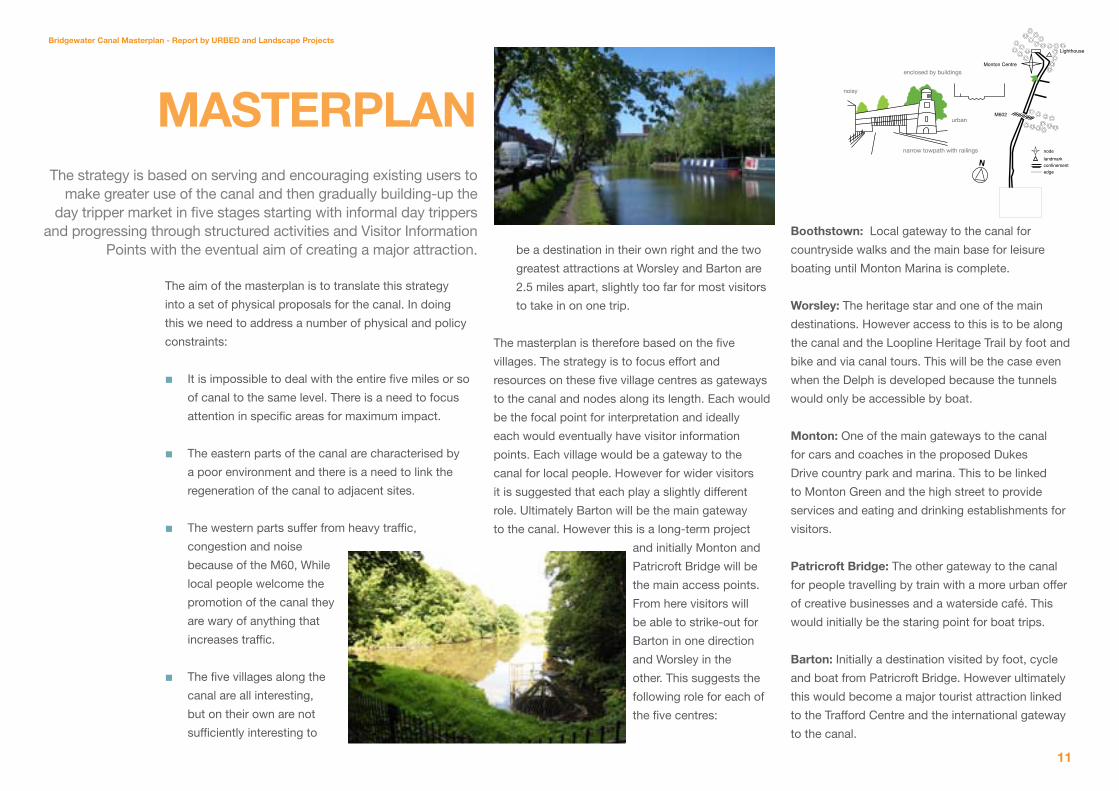
stRategy The strategy is based on serving and encouraging existing users to make greater use of the canal and then gradually
to build up the day tripper market in five stages starting with informal day trippers and progressing through
structured activities and visitor information points with the eventual aim of creating a major attraction.
Monton Centre
Lighthouse
M602
enclosed by trees and housing
concrete M602 bridge
noisy
narrow towpath
N
nodelandmarkconfinementedge
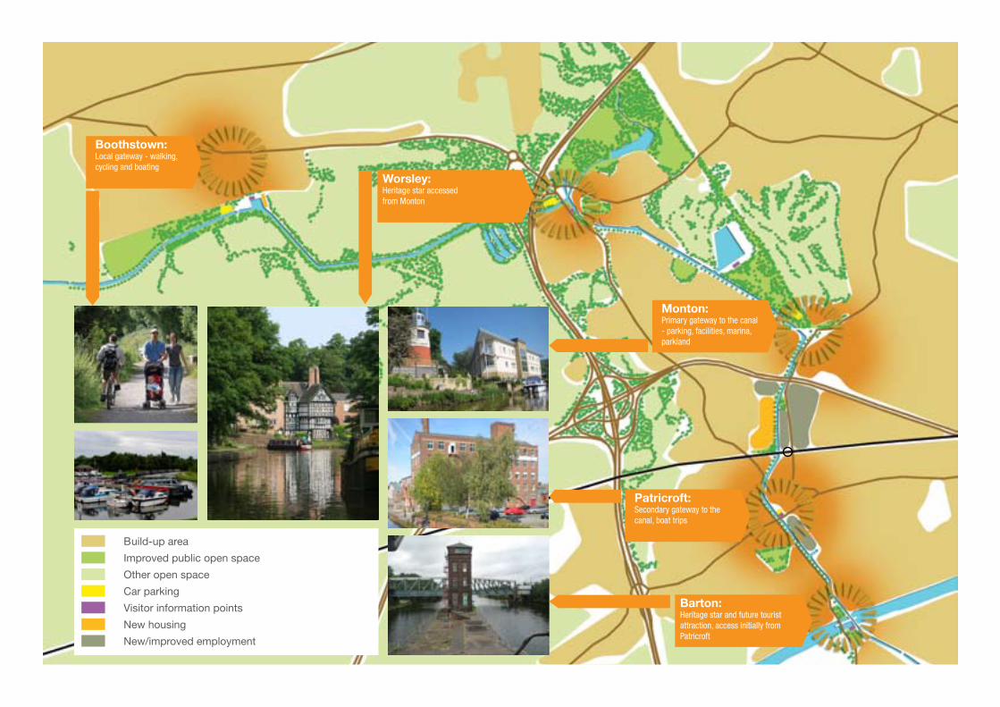
Boothstown:Local gateway - walking, cycling and boating
Worsley:Heritage star accessed from Monton
Monton:Primary gateway to the canal - parking, facilities, marina, parkland
Patricroft:Secondary gateway to the canal, boat trips
Barton:Heritage star and future tourist attraction, access initially from Patricroft
Build-up area
Improved public open space
Other open space
Car parking
Visitor information points
New housing
New/improved employment
Bridgewater Canal Masterplan - Report by URBeD and Landscape Projects
11
The aim of the masterplan is to translate this strategy
into a set of physical proposals for the canal. In doing
this we need to address a number of physical and policy
constraints:
It is impossible to deal with the entire five miles or so
of canal to the same level. There is a need to focus
attention in specific areas for maximum impact.
The eastern parts of the canal are characterised by
a poor environment and there is a need to link the
regeneration of the canal to adjacent sites.
The western parts suffer from heavy traffic,
congestion and noise
because of the M60, While
local people welcome the
promotion of the canal they
are wary of anything that
increases traffic.
The five villages along the
canal are all interesting,
but on their own are not
sufficiently interesting to
■
■
■
■
be a destination in their own right and the two
greatest attractions at Worsley and Barton are
2.5 miles apart, slightly too far for most visitors
to take in on one trip.
The masterplan is therefore based on the five
villages. The strategy is to focus effort and
resources on these five village centres as gateways
to the canal and nodes along its length. Each would
be the focal point for interpretation and ideally
each would eventually have visitor information
points. Each village would be a gateway to the
canal for local people. However for wider visitors
it is suggested that each play a slightly different
role. Ultimately Barton will be the main gateway
to the canal. However this is a long-term project
and initially Monton and
Patricroft Bridge will be
the main access points.
From here visitors will
be able to strike-out for
Barton in one direction
and Worsley in the
other. This suggests the
following role for each of
the five centres:
Boothstown: Local gateway to the canal for
countryside walks and the main base for leisure
boating until Monton Marina is complete.
Worsley: The heritage star and one of the main
destinations. However access to this is to be along
the canal and the Loopline Heritage Trail by foot and
bike and via canal tours. This will be the case even
when the Delph is developed because the tunnels
would only be accessible by boat.
Monton: One of the main gateways to the canal
for cars and coaches in the proposed Dukes
Drive country park and marina. This to be linked
to Monton Green and the high street to provide
services and eating and drinking establishments for
visitors.
Patricroft Bridge: The other gateway to the canal
for people travelling by train with a more urban offer
of creative businesses and a waterside café. This
would initially be the staring point for boat trips.
Barton: Initially a destination visited by foot, cycle
and boat from Patricroft Bridge. However ultimately
this would become a major tourist attraction linked
to the Trafford Centre and the international gateway
to the canal.
MasteRPLan The strategy is based on serving and encouraging existing users to
make greater use of the canal and then gradually building-up the day tripper market in five stages starting with informal day trippers
and progressing through structured activities and Visitor Information Points with the eventual aim of creating a major attraction.
Monton Centre
Lighthouse
M602
enclosed by buildings
urban
noisy
narrow towpath with railings
Nnodelandmarkconfinementedge


Bridgewater Canal Masterplan - Report by URBeD and Landscape Projects
13
PaRt 2
the CanaL toDay

Wigan Greenheart Project
Manchester Ship Canal Trafford
Centre Museum of museums
MediaCity
Lowry Centre and Imperial War Museum
TraffordPark
Chat MossMosslands Project
Leigh
Boothstown
Worsley
Monton
Patricroft
Eccles
ManchesterCity Centre
Port Salford
Strategic Context Built-up area
Industry
Commercial space
Major developments
Salford West Boundary
Chat Moss
Wigan Greenheart project
Bridgewater Canal Masterplan - Report by URBeD and Landscape Projects
1�
Waterways
The canal forms part of an
extensive waterways network
in the North West. To the south
it links to Manchester and the
Cheshire branch of the canal
which is part of the Cheshire
Ring and to the Trent and Mersey
Canal. To the north it links to the Leeds Liverpool
Canal which now runs into the Pierhead in Liverpool
as well as connecting over the Pennines. The
other part of the canal system is the Manchester
Ship Canal which together with the Bridgewater is
being promoted by Peel as the Ocean Gateway.
This combines a series of projects that Peel is
promoting on their land holdings associated with
the Bridgewater and Ship Canals. As part of this
the Bridgewater Canal towpath is being refurbished
and promoted through the Bridgewater Way, a
partnership between Peel and the eight local
authorities through which the canal runs.
Regeneration initiatives
salford: There are two regeneration strategies
covering the Salford City Council area – the Central
Salford Urban Regeneration Framework and the
Salford West Strategic Regeneration Framework.
The most important project in Salford Central is
MediaCityUK which will house the BBC’s northern
headquarters and create 5,000 jobs. This is
predicted to have a halo effect on locations like
Monton and Worsley as places where people
working in MediaCityUK could be attracted to live.
The Salford West Regeneration Framework is based
on three themes – business and the economy,
high quality neighbourhoods and leisure and
environment. The Bridgewater canal is seen as
crucial to the last of these and is the main potential
visitor attraction in the area. Two of the 12 key
projects in the strategy relate directly to the canal;
the Bridgewater Way, which supports the initiative
described above and a proposal for an Industrial
Heritage Hub focused on Worsley.
trafford: The Trafford Council
boundary is the Ship Canal and
the area just south of this is
crucial to this strategy. There are
huge numbers of potential visitors
in this area at the Trafford Centre
and attractions such as the Chill
Factor. Trafford have long aspired
to create a visitor centre and
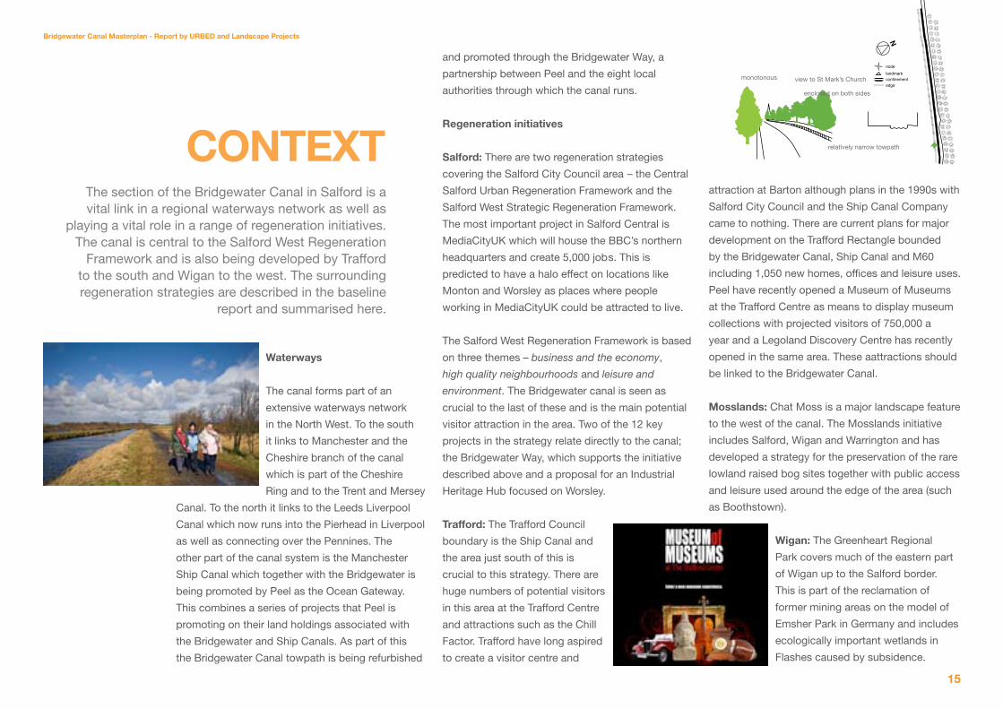
Context The section of the Bridgewater Canal in Salford is a vital link in a regional waterways network as well as
playing a vital role in a range of regeneration initiatives. The canal is central to the Salford West Regeneration
Framework and is also being developed by Trafford to the south and Wigan to the west. The surrounding regeneration strategies are described in the baseline
report and summarised here.
N
nodelandmarkconfinementedge
monotonous
enclosed on both sides
relatively narrow towpath
view to St Mark’s Church
attraction at Barton although plans in the 1990s with
Salford City Council and the Ship Canal Company
came to nothing. There are current plans for major
development on the Trafford Rectangle bounded
by the Bridgewater Canal, Ship Canal and M60
including 1,050 new homes, offices and leisure uses.
Peel have recently opened a Museum of Museums
at the Trafford Centre as means to display museum
collections with projected visitors of 750,000 a
year and a Legoland Discovery Centre has recently
opened in the same area. These aattractions should
be linked to the Bridgewater Canal.
Mosslands: Chat Moss is a major landscape feature
to the west of the canal. The Mosslands initiative
includes Salford, Wigan and Warrington and has
developed a strategy for the preservation of the rare
lowland raised bog sites together with public access
and leisure used around the edge of the area (such
as Boothstown).
Wigan: The Greenheart Regional
Park covers much of the eastern part
of Wigan up to the Salford border.
This is part of the reclamation of
former mining areas on the model of
Emsher Park in Germany and includes
ecologically important wetlands in
Flashes caused by subsidence.

Ownership, policy and projects Greenbelt
Worsley Greenway (Policy EN2)
New and improved open space (Policy R6/19)
Conservation Areas
Potential development sites
Peel land ownership
Salford City Council land ownership
BoothstownMarina
Salford Forest Park Site
Trafford Rectangle
GUS Site
Green Lane sites
BridgewaterMill
Americhem

Worsley Green
Worsley Woods
Worsley Centre
Worsley Centre
hump backed bridge
stone bridge
Bridgewater Canal Masterplan - Report by URBeD and Landscape Projects
1�
Planning Policy
The Development Plan for Salford currently consists
of the North West of England Plan and saved policies
of the Unitary Development Plan. Policy ST4 of the
Unitary Development Plan identifies Worsley Village,
Barton Swing Aqueduct and the Bridgewater Canal
Corridor as a key tourism area, to be protected
and enhanced as tourism destinations. Policy R7
supports development of the recreation and leisure
potential of the city’s waterways. Policy DES 6
requires all development adjacent to the Bridgewater
Canal to facilitate pedestrian access along and
across the waterway and sets out criteria by which
development proposals will be judged.
Along its length, the canal passes through areas
subject to various site-specific plan allocations.
The land west of Worsley and south of
Boothstown is within the Green Belt, subject to
policy EN 1.
Policy EN 2 protects Worsley Greenway, as a
strategically important green wedge between
Worsley and Monton.
Policy R 6 identifies land north of the canal
at Boothstown and Ellenbrook as a site for
improved recreation use.
The canal passes through Conservation Areas at
Monton, Worsley and Barton upon Irwell.
In the Patricroft area, many of the adjacent sites
are established employment areas, protected by
policy E 5. However, the City Council’s Employment
Land Review identifies several of the key canal-side
sites as “swing sites” that will perform either poorly
or very poorly in the future market, where future
change of use may be considered appropriate. The
review recommends that further work is undertaken
to ascertain which sites should be released for
alternative uses, including an analysis of the
regeneration priorities of the surrounding area.
The current adopted Unitary Development Plan is
due to be replaced by the Core Strategy and other
Local Development Framework Documents from
September 2011. The conclusions of this masterplan
will inform the emerging policy documents.
Current Development Proposals
Boothstown Marina: Peel have proposed a scheme
to develop housing around the Marina. The planning
application has been withdrawn but new proposals
are expected in the future.
■
■
■
■
PLannIng anD DeVeLoPMent
The current planning policy for the area is set by the UDP which supports the development and improvement of
the canal as a visitor attraction. The output of this plan will feed into the Local Development Framework which
will replace the UDP. There are a number of potential development sites along the canal which have been
explored and tested as part of this study.
relatively narrow towpath
buildings on towpath edge
enclosed
green Lane: There are a series of sites in this area
including the former GUS site, the former Nasmyths
Foundry site which is now the Salford Business
& Technology Centre. The GUS site has recently
been refused planning consent for industrial and
storage use. The is a current application for a Waste
Recycling plant to the east of Green Lane. This is a
private proposal designed to process the waste of
authorities outside Greater Manchester and it is not
yet clear whether it will be supported. This will clearly
impact on surrounding sites on Green Lane. There
is however scope for part of the land to the west of
the canal (the former GUS site) to be redeveloped for
employment or housing provided a substantive case
can be made.
Patricroft Bridge: There are proposals by the owners
of the Bridgewater Mill to invest in their premises. To
the south of Liverpool Road Americhem are planning
to expand their plant along the eastern bank of the
canal.
salford Forest Park: Planning permission for a major
leisure scheme, which included a race course, golf
course and a five star hotel, south of Boothstown and
Worsley has been refused planning consent.
Nnodelandmarkconfinementedge
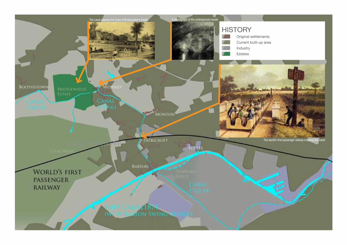
HISTORY Original settlements
Current built-up area
Industry
Estates
The canal passing the Duke of Bridgewater’s Estate A photograph of the underground canals
The world’s first passenger railway crossing the canal
hump backed bridge
noisy
N
nodelandmarkconfinementedge
Worsley Green
Worsley Woods
Worsley Centre
Worsley Centre
hump backed bridge
stone bridge
N
nodelandmarkconfinementedge
Bridgewater Canal Masterplan - Report by URBeD and Landscape Projects
1�
The history of the Bridgewater Canal is known to
every school child in the UK and neatly encapsulates
many of the themes of the Industrial Revolution.
The story starts with the exploitation of the Duke
of Bridgewater’s coal deposits on his estate in
the countryside west of Manchester. The catalyst
however was not the presence of coal but the
transport technology to get to market. The first
section of the Bridgewater Canal opened on the 17th
July 1761. The initial idea had been to run the canal
to the River Irwell but that arm (shown south of the
Bridgewater Estate on the plan) was abandoned and
the canal was directed towards Manchester.
The section of canal between Worsley and the Irwell
is therefore the first cut canal in the UK. There were
canalised watercourses before this, and canals
existed elsewhere in the world, such as the Canal
du Midi in France and the Grand Canal in China. The
Bridgewater’s significance was its role at the start of
the Industrial Revolution. It had the same impact as
the railways would have 80 years later, and indeed
the Internet has had in our time. At one time there
were fast packet services on the Bridgewater, pulled
by teams of horses that took passengers between
Manchester and Liverpool, and indeed onwards to
New York. The packet boats managed 9 miles an
hour and included outriders sent ahead to clear the
towpath. Later the railway also became part of the
Bridgewater’s history, since in Patricroft it is crossed
by the world’s first passenger line opened on 15th
September 1830.
In 1762 the second section of the Bridgewater
Canal was carried across the River Irwell on a
bridge designed by Brindley. This was the wonder
of the age, carrying boats at the level of the treetop
and giving Brindley a sleepless night as he worried
whether it would survive being filled with water. A
century later the Bridgewater Canal Company would
move an act of Parliament to canalise the Irwell
to create the Manchester Ship Canal. Brindley’s
aqueduct was replaced with a swing bridge,
carrying the canal in a rotating tank, another wonder
of its age. The close relationship between the two
canals lives on in the ownership of Peel Holdings.
At Worsley the canals ran directly into the mines
and the system was eventually extended to include
46 miles of underground canal on four levels one of
which was 20m below the current canal. Inclined
Planes were created to winch canal boats between
the different levels and the whole system became
the most efficient mining operation of its time. This
allowed coal production costs to be cut dramatically
triggering the economic explosion of the Industrial
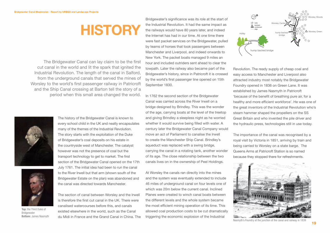
hIstoRy
The Bridgewater Canal can lay claim to be the first cut canal in the world and lit the spark that ignited the
Industrial Revolution. The length of the canal in Salford, from the underground canals that served the mines of
Worsley to the world’s first passenger railway in Patricroft and the Ship Canal crossing at Barton tell the story of a
period when this small area changed the world.
Revolution. The ready supply of cheap coal and
easy access to Manchester and Liverpool also
attracted industry most notably the Bridgewater
Foundry opened in 1836 on Green Lane. It was
established by James Nasmyth in Patricroft
‘because of the benefit of breathing pure air, for a
healthy and more efficient workforce’. He was one of
the great inventors of the Industrial Revolution who’s
steam hammer shaped the propellers on the SS
Great Britain and who invented the pile driver and
the hydraulic press, technologies still in use today.
The importance of the canal was recognised by a
royal visit by Victoria in 1851, arriving by train and
being carried to Worsley on a state barge. The
Queens Arms at Patricroft Station is so named
because they stopped there for refreshments.
Top: the Third Duke of BridgewaterBottom: James Nasmyth
Nasmyth’s Foundry at the junction of the canal and railway in 1839

1.
3.
5.
2b.
2a.
6.
4.
ECOLOGICAL DESIGNATIONS1. Botany Bay Wood: SBI Grade A, pSSSI
2a. Worsley Woods and Old Warke Dam: LNR, SBI Grade B
2b. Wardley Wood : SBI Grade B
3. Middlewood : SBI Grade B
4. Bridgewater Canal, Monton to Barton Bridge: SBI Grade B
5. Bittern Pits Wood: SBI Grade C
6. Alder Forest Marsh: SBI Grade C

Bridgewater Canal Masterplan - Report by URBeD and Landscape Projects
21
N
nodelandmarkconfinementedge
Worsley Green
Worsley Woods
Worsley Centre
Worsley Centre
hump backed bridge
stone bridge
historic buildings
relatively narrow towpath
enclosed
The Bridgewater Canal in Salford has two quite
distinctive characters. To the south and east it is
industrial / urban in character while to the north and
west it is more rural / residential.
the Urban Canal: The southern section of the canal
through Barton and Patricroft Bridge is urban in
character. The canal is
hemmed in by buildings
and sections are directly
adjacent to busy roads.
This is the area that
was once dominated by
industry attracted by the
intersection of the canal
and railway. This was
once characterised by
historic mills and canal
arms. However all but one
of the mills has been lost, particularly sad being the
demolition of Nasmyth’s Foundry and the mill on the
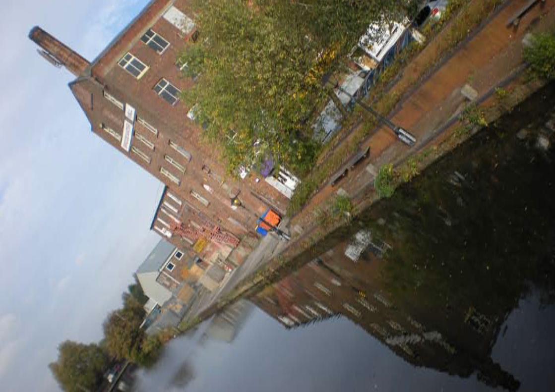
GUS site. Bridgewater Mill is the last of its kind and
is not in fact listed although we suspect that it dates
from the end of the eighteenth century. In place of the
former mills stand modern industrial premises and
vacant sites and the overall feeling is of neglect. The
centres of Barton and Patricroft do however retain
their historic character. Barton is a conservation area
and has the historic infrastructure of the aqueducts
and ship canal. Patricroft is more low key but has
some fine civic buildings such as Christ Church and
the former Police Station on Green Lane, plus the
historically important house of the aviator A.V Roe.
the Rural Canal: The village centre of Monton
represents the edge of the urban area, as far as
users of the canal are concerned. Monton retains the
structure of the rural village it once was with a large
village green and lively high street. Monton Church is
the main listed building and local landmark. However
from the canal the most memorable structure is the
lighthouse, built as a folly by a local resident.
North of Monton the character of the canal is largely
rural with long straight sections and little variety
or character. This is enlivened by the villages of
Worsley and Boothstown. The former in particular
is the jewel on the canal with many listed buildings
and a conservation area. The black and white half
timbered character of Worsley gives it an old village
feel, although, of course this is a conceit since the
village was largely created by the Duke and at one
time would have been very industrial in character. The
enVIRonMentThe environment of the canal changes dramatically
from the urban, rather run down character of the canal environment in the east to the open rural feel of the west. Between the two stand the villages of
Worsley and Monton, that retain much of their rural character despite now being absorbed into the
conurbation.
character that exists in Boothstown is not visible from
the canal and the impression is of suburban housing
and the marina.
open space structure The western part of the canal is more rural in
character. West of Worsley the canal runs through
the Bridgewater Estate, former home of the Duke
however this is not really apparent from the canal.
To the south the canal is elevated above the low
lying Chat Moss but mature tree cover limits views.
The whole of this area is rich in ecology. The
canal passes three designated sites of biological
importance; Botany Bay Woods to the south, Bittern
Pits Woods and Middlewood to the north around the
Worsley Old Hall.
The urban section of the canal also has important
landscape features. The most significant is the
Worsley Greenway, a wedge of natural space
reaching into the heart of Monton. The northern
section is natural pasture while the southern part
was once a mini golf course. There is less open
space in the southern part of the canal. In Patricroft
the main provision is the Recreation Ground west of
the canal and the small pocket park in Barton which
is now very overgrown.
ECOLOGICAL DESIGNATIONS1. Botany Bay Wood: SBI Grade A, pSSSI
2a. Worsley Woods and Old Warke Dam: LNR, SBI Grade B
2b. Wardley Wood : SBI Grade B
3. Middlewood : SBI Grade B
4. Bridgewater Canal, Monton to Barton Bridge: SBI Grade B
5. Bittern Pits Wood: SBI Grade C
6. Alder Forest Marsh: SBI Grade C

enclosed by trees
concrete M60 bridge
noisy
wide towpath
M60
bridge
nodelandmarkconfinementedge
N
Bridgewater Canal Masterplan - Report by URBeD and Landscape Projects
23
The baseline assessed access to the canal by road
and public transport as well as cycling and walking
routes.
Roads The canal has excellent road access. It is served
by both the M60 and the M602 putting it within
an hours drive of Manchester, Liverpool and
Leeds. The primary roads are the East Lancs Road
through Worsley and the A57 Liverpool Road
through Patricroft. However the main problems of
congestion are on the other main roads, particularly
Worsley Road and Parrin Lane. These are very busy
in peak hours largely due to the motorway junctions.
They are less busy at weekends when visitors are
likely to arrive. However there are local concerns in
Worsley about traffic and the capacity of the area to
accommodate more visitors.
Public transport There is a web of bus routes in the eastern part of
the area that allow access to the canal from much
of Greater Manchester. The services in Boothstown
are limited, infrequent and not well linked to the
canal. The main public transport asset is the railway
station at Patricroft. This however has limitations,
the tram service stops at Eccles and the frequent
Manchester, Liverpool services don’t stop here.
The station therefore only has an hourly service and
limited patronage (around 50 passenger movements
a day). However it could be marketed as part of the
attraction with train times linked to boat trips. There
is however a need for a facelift for the station if this
is to happen.
Walking and cyclingAs part of the baseline we have plotted all of
the pedestrian points of access to the canal, the
quality of the towpath and the surrounding footpath
network. The key message is that the canal itself
is the most important footpath route in the area,
providing a traffic free route between the villages
and potential walk to work routes. There are plans
for a footpath route along the ship canal providing a
traffic-free route to Media City and Salford Quays/
Trafford Park.
aCCess
Access to the canal by car is excellent giving it access to a huge market but there are concerns about congestion and traffic locally. Public transport, walking routes and cycling
are all stronger to the east where there are networks of routes and much weaker in the rural west.
The same is true of cycles. The unimproved sections
of towpath are generally too narrow for cycling and
walking and there remain many no cycling signs
on the bridges. However the section that has been
improved to Bridgewater Way standards makes an
excellent cycle route and has become part of the
national cycle network. To the east of the area this
links into a strong cycle route network linking into
Eccles and central Salford. There is however very
little provision to the west.
The quality of the canal as a pedestrian and cycling
environment is excellent where the Bridgewater Way
works have taken place. Elsewhere however the
environment is poor and the towpath narrow and
muddy, particularly south of Patricroft Bridge. There
are conflicts with fishermen and the points of access
are poor. There is also a major problem at Barton
where there is no towpath on the canal bridge and
very limited pedestrian access on the road bridge
where there is conflict with traffic and heavy goods
vehicles.
WORSLEY
IRLAM
WINTON
BOOTHSTOWN & ELLENBROOK
BARTON
ECCLES
SWINTON SOUTH
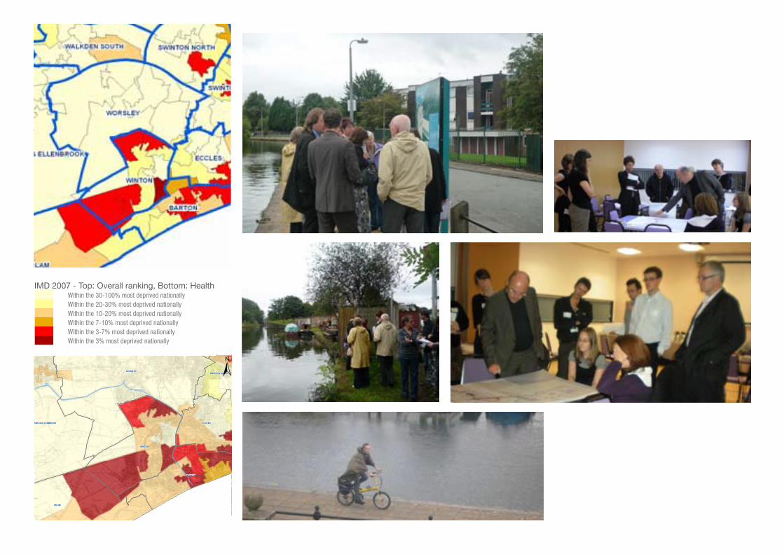
SWINTON NORTHIndex of Deprivation 2007
LegendWard Boundaries
Bridgewater Canal
IMD 2007 SalfordHealth
Within the 30% most deprived nationally
Within the 20-30% most deprived nationally
Within the 10-20% most deprived nationally
Within the 7-10% most deprived nationally
Within the 3-7% most deprived nationally
Within the 3% most deprived nationally
Health
Salford City Council. Licence No. 100019737. 2009
IMD 2007 - Top: Overall ranking, Bottom: Health Within the 30-100% most deprived nationally Within the 20-30% most deprived nationally Within the 10-20% most deprived nationally Within the 7-10% most deprived nationally Within the 3-7% most deprived nationally Within the 3% most deprived nationally
Salford Ward Profiles: Barton ward Page 1
Demographics
Figure 1 - Multiple Deprivation in Salford, Index of Deprivation 2007
Source: Index of Deprivation 2007, Communities and local government
The index of multiple deprivation is a weighted combination of the seven individual deprivation domains (excluding the two additional indexes). The weightings are as follows;
Income = 22.5% Employment = 22.5% Health & Disability = 13.5% Education Skills & Training = 13.5% Barriers to Housing & Services = 9.3% Crime = 9.3% Living Environment = 9.3%

Stream
Boothstown Marina
Bittern PitsWood
nodelandmarkconfinementedge
Nenclosed by trees
wide towpath
steel bridge
Bridgewater Canal Masterplan - Report by URBeD and Landscape Projects
2�
The Bridgewater Canal runs through a series of
diverse communities. To the south of the M60 the
socio-demographic data shows concentrations
of deprivation in Patricroft and Barton. There are
particular problems with health and the canal
corridor can create recreational opportunities for
these communities. To the north the canal flows
through the more suburban areas of Boothstown,
Worsley and Monton with higher levels of prosperity.
The exception is the Westwood Park estate just
south of Monton which shows significant levels of
disadvantage in areas such as health and education.
As part of the preparation of this masterplan
we have sought to engage with these diverse
communities. This consultation took place in two
stages. The first stage consultations from July to
September 2009 included stakeholder workshops,
community walkabouts and stakeholder one-to-
ones. Altogether 70 people responded to these
consultations and the results fed into the draft
masterplan. A second round of consultations took
place between December 2009 and March 2010.
To assist with this consultation a 16 page summary
booklet was prepared together with an exhibition
and these were used at 14 drop in sessions together
with presentations at the Eccles, Worsley and
Boothstown Community Committees as well as a
series of specialist consultations such as the local
high school and the Salford Disability Forum. In total
478 people were engaged and 394 commented.
ResponsesThe detailed responses to the consultation are
detailed in Appendix 1 of this report. The response
to the consultations was overwhelmingly positive.
90% of respondents supported the vision and
similarly high numbers supported improvements to
the towpath and interpretation. There was a general
feeling that the canal was a neglected asset and the
main concerns were that the vision would not be
realised.
Boothstown: There was support for enhancing
Boothstown and concern that the marina is
currently a focus for anti social behaviour. This
included support for development in keeping with
the character of the canal to provide surveillance
although there was some concern about loss of
views over the canal and land to the south.
Worsley: The responses were very positive about
making more of Worsley’s heritage including
opening up the mines. There was however concern
that Worsley lacked visitor infrastructure including
parking and that it was already very congested. As a
CoMMUnIty
The development of this masterplan has included extensive consultation with local people and stakeholders
in the diverse communities along the canal. This has included walkarounds, workshops drop in sessions and presentations. More than 500 people have taken part in
these consultations and the overwhelming response has been support for this strategy.
result the road access to the marina was changed to
come from Monton.
Monton: There was strong support in Monton for
the creation of Dukes Drive Country Park. A majority
was also in favour of the marina although this
was less than other issues and a minority strongly
opposed it. This was mostly due to the potential
impact on Worsley and has been addressed by
changing the access, although this needs to be
subject to further consultation.
Patricroft: The proposals in Patricroft were strongly
supported including the refurbishment of the mill
and the proposed square and visitor information
point. Generally people were happy to see
residential development on underused industrial
sites such as GUS.
Barton: There were concerns that the landscaped
areas around Barton had become a focus for
anti-social behaviour and strong support for the
improvement of this area including the visitor
information points and public realm works. There
was concern with the severance of the towpath
and a desire to see pedestrian links across the Ship
Canal improved.


Bridgewater Canal Masterplan - Report by URBeD and Landscape Projects
2�
PaRt 3
MasteRPLan

Masterplan Cafe and visitor information point
Bridgewater Way towpath works
Interpretation locations
Interpretation signage

Bridgewater Canal Masterplan - Report by URBeD and Landscape Projects
2�
The masterplanning proposals in this report don’t
go into detail on the two major long term projects
at Barton and Worsley. Instead we concentrate on
actions that can be taken over the next ten years to
develop the canal as an attraction. This is focussed
on the five villages and on the following pages we set
out detailed proposals for each of these areas. This
work, and all other schemes along the canal need to
be guided by the following principles:
All development should face onto the canal to
increase surveillance
Development should be sympathetic to the
character and heritage of the canal
Development should improve access from
surrounding residential areas to the canal
Development in the villages should include active
uses such as cafes facing the canal
Development on the non-towpath side should
allow for public access along the canal
Schemes should seek to encourage water
activities including moorings and where possible
new basins.
■
■
■
■
■
■
Canal wide projectsThere are however three strands that encompass the
whole of the canal:
towpath Improvements: There is a scheme to
upgrade all 40 miles of the Bridgewater towpath
through 8 council areas called the Bridgewater
Way. This is investing in bonded gravel paths,
signposting and stone seating. To date 13 miles
have been improved, including the 2.2 mile section
from Monton through to Patricroft. The masterplan
assumes that the remainder of the towpath will be
improved to the same standard under this scheme.
Interpretation: Work has been undertaken by
Imagemakers to develop an interpretation strategy
for the canal corridor. This includes interpretation
hubs in each of the village centres together with
public art, wayfinding, benches and themed play
areas. The centrepiece is a new viewing platform at
Worsley Delph with ‘starvationer’ benches (based
on the boats used in the mines, augmented reality
boards and a light and projection show. This will
make the Delph into an attraction even before the
mines are opened.
Canal tours: The aim is to make the canal work as
a local, regional and national/international attraction.
To achieve the latter it will be necessary to package
all of the attractions along the canal to allow it to
compete with other major attractions. The East
oVeRaLL MasteRPLanThe masterplan strategy as described on page 11 is to build up the visitor potential
of the canal gradually. This includes a series of projects for each of the gateways
described on the following pages as well as canal wide initiatives and guidelines
described on this page.
Lancs Railway in Bury is the 12th most visited attraction in the
North West yet as a linear attraction faces similar problems.
Just as the steam trains link the attractions along the East
Lancs Railway so there is scope to use canal boats to make the
Bridgewater a unified attraction linking Worsley Mines to Barton
Bridge and indeed on to Castlefield in the city centre.
The council have already started subsidising boat tours and
are seeking to build these up to the point where they no longer
require subsidy. In the future the highlight of the trip may be the
barges entering the Worsley Mines however trips can develop a
strong offer in advance of this.
Canal wide projects
Description Phasing Cost Potential funding sources
1a: towpath improvements:
Completion of the Bridge-water Way improvements to the canal towpath through Boothstown and Worsley and south of Patricroft
Years 1-5 £1M Bridgewater Canal Trust, Salford City Council, HLF
1b: Interpretation strategy
Interpretation, signposting, public art, play areas and seating as recommended by Imagemakers
Years 1-5 Included in each village on following pages
SCC, HLF, Arts Council
1c: Boat trips
Continuation of subsidy for pleasure trips from Patri-croft to Barton and then to Worsley.
Years 1-5 £2K/year for 3 years
Continuation of SCC current subsidy agreement with a view to the trips be-ing self funding within 3 years

BOOTHSTOWN Mixed-use development
Improved open space
Path improvements
Bridgewater Way towpath works
New car parking
Bird information panels
Picnic areas
Interpretation
Gateways
Improved bridges
Improvements to Bridgewater Park
New car parkMixed use development scheme
relatively open
wide towpath
marina
Stream
Boothstown Marina
nodelandmarkconfinementedge
N
Bridgewater Canal Masterplan - Report by URBeD and Landscape Projects
31
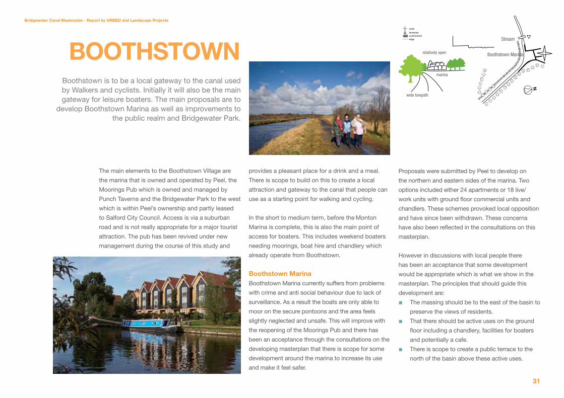
The main elements to the Boothstown Village are
the marina that is owned and operated by Peel, the
Moorings Pub which is owned and managed by
Punch Taverns and the Bridgewater Park to the west
which is within Peel’s ownership and partly leased
to Salford City Council. Access is via a suburban
road and is not really appropriate for a major tourist
attraction. The pub has been revived under new
management during the course of this study and
provides a pleasant place for a drink and a meal.
There is scope to build on this to create a local
attraction and gateway to the canal that people can
use as a starting point for walking and cycling.
In the short to medium term, before the Monton
Marina is complete, this is also the main point of
access for boaters. This includes weekend boaters
needing moorings, boat hire and chandlery which
already operate from Boothstown.
Boothstown Marina Boothstown Marina currently suffers from problems
with crime and anti social behaviour due to lack of
surveillance. As a result the boats are only able to
moor on the secure pontoons and the area feels
slightly neglected and unsafe. This will improve with
the reopening of the Moorings Pub and there has
been an acceptance through the consultations on the
developing masterplan that there is scope for some
development around the marina to increase its use
and make it feel safer.
BoothstoWnBoothstown is to be a local gateway to the canal used by Walkers and cyclists. Initially it will also be the main gateway for leisure boaters. The main proposals are to
develop Boothstown Marina as well as improvements to the public realm and Bridgewater Park.
Proposals were submitted by Peel to develop on
the northern and eastern sides of the marina. Two
options included either 24 apartments or 18 live/
work units with ground floor commercial units and
chandlers. These schemes provoked local opposition
and have since been withdrawn. These concerns
have also been reflected in the consultations on this
masterplan.
However in discussions with local people there
has been an acceptance that some development
would be appropriate which is what we show in the
masterplan. The principles that should guide this
development are:
The massing should be to the east of the basin to
preserve the views of residents.
That there should be active uses on the ground
floor including a chandlery, facilities for boaters
and potentially a cafe.
There is scope to create a public terrace to the
north of the basin above these active uses.
■
■
■


Bridgewater Canal Masterplan - Report by URBeD and Landscape Projects
33
This would allow the quayside to be secured at
night to allow for secure moorings.
During the day full public access should be
maintained.
Bridgewater ParkThe area to the west of the marina is already used as
an informal park covering around 15ha. This is owned
by Peel although the western part is leased by the
Council. It is proposed to develop and improve this
space for informal recreation with improved paths,
seating and picnic areas, improved planting and
habitat creation, interpretation boards and a car park.
other ImprovementsThe other improvements to the Boothstown area
include:
Signposting to traffic from the road junction on
Leigh Road.
Improvements to the Bridgewater Way along the
towpath.
Improvements to other footpaths in the area
notably the path to Worsley on the northern side
of the canal.
Improvements to the two bridges over the canal
Interpretation boards next to the pub.
and car park in line with Image Makers
recommendations.
Bird information panels in locations near
footpaths.
■
■
■
■
■
■■
■
Boothstown Projects
Description Phasing Cost Potential funding sources
2a: Boothstown Marina:
Mixed use development to the east of the basin plus a single storey block including a chandlery and cafe with a public viewing platform on the roof and re-configuration and improve-ment of the marina
Years 1-5 £3.7M Private funding
2b: Bridgewater Park:
Improvements to the park including footpaths, fencing, picnic areas and interpretation
Years 1-5 £344K Arts Council and SCC
2c: other Improvements:
Miscellaneous works around Boothstown
Years 1-5 £227K To form part of the Lottery application.
Top and middle: Hough End Clough in Manchester, recently refurbished to a similar standard proposed for the Bridgewater ParkBelow: Earth sculptures used to create a special sense of place.

WORSLEY Cafe and visitor information point
Improved open space
Path improvements
Bridgewater Way towpath works
Bird information panels
Picnic areas
Interpretation
Gateways
Create footpath and interpretation to the mouths of the canal tunnels in the Delph
Existing car park
Cafe and visitor information point
New footpath under Worsley Road to give access to the Delph
Extend open water and open up views
Open up Worsley Delph and if possible tunnels as premier visitor attraction, improve landscape setting and access
Area to be left as wet woodland

enclosed by trees
stone bridge
N
nodelandmarkconfinementedge
Worsley Green
Worsley Woods
Worsley Centre
Worsley Centre
hump backed bridge
Bridgewater Canal Masterplan - Report by URBeD and Landscape Projects
3�
Worsley has the potential to be a major tourist
attraction. It played a central role in the history of
the canal, it is adjacent to the Duke of Bridgewater’s
former estate, there are miles of underground canal
accessed from the Delph, and Old Warke Dam was
built to provide water to the canal. None of this
is very evident to the visitor today and the town is
dominated by traffic with few local facilities. This is
one of the main attractions on the canal but it needs
to be managed carefully. It is not going to be possible
to make Worsley a major gateway to the canal.
The idea is rather to direct visitors to Monton and
Boothstown and have them arrive in Worsley on foot,
bike and in the future by boat.
the DelphThe underground canals beneath Worsley represent a
potential significant tourist attraction. There are many
examples of underground attractions from natural
cave systems to slate and coal mines that have
become successful visitor attractions. The Worsley
mines would be a fitting culmination to boat trips on
the canal and would be a fascinating insight into the
history of the area. The feasibility of this is beyond
the scope of this study. However we have spoken
to people who have entered the mines in the past
(with the help of a professional caving team) and they
were sceptical about whether the tunnels could ever
be opened. Subsidence and water levels mean that
many of the canals are impassable and there are also
serious problems with marsh gas. This needs to be
subject to a separate full feasibility study.
WoRsLey
Worsley is the heritage star on the canal but in exploiting its assets it will be important to limit pressure on local roads which are already very congested. Worsley will therefore be accessed
from Boothstown and Monton. The long-term aim to open up the mines is beyond the scope of this study. The current proposals
are to open the Delph basin to navigation and pedestrian access, improve the woods and provide interpretation and a visitor
information point in the heart of the village.
There is however much that could be done to create
a tourist attraction without opening up the mines.
There is scope to create public access to the mine
entrances with a new footbridge under Worsley Road
and a walkway around the Delph at water level. This
would be part of a public realm and landscaping
scheme for the whole of the Delph and would be
linked to interpretation to explain the extent of the
system which could include visualisations or even
virtual or physical models.
The Strata project in Dudley
is working to open a network of underground
canals and quarriesto the
public.

Bridgewater Canal Masterplan - Report by URBeD and Landscape Projects
3�
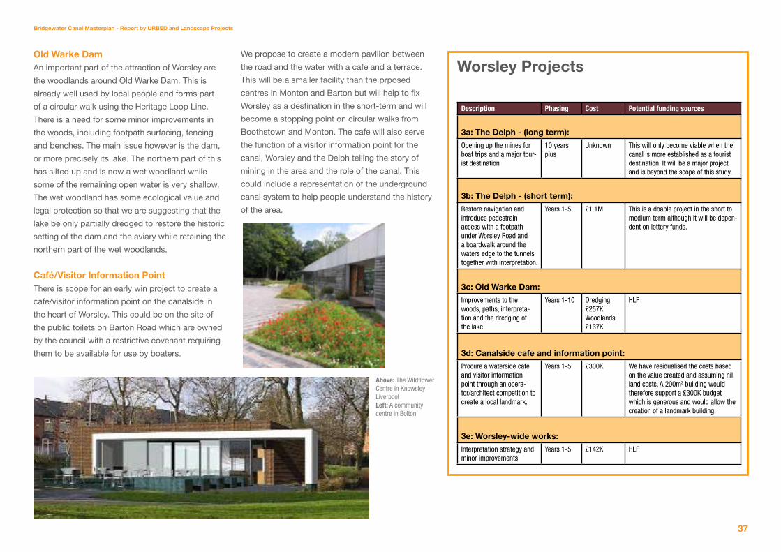
Worsley Projects
Description Phasing Cost Potential funding sources
3a: the Delph - (long term):
Opening up the mines for boat trips and a major tour-ist destination
10 years plus
Unknown This will only become viable when the canal is more established as a tourist destination. It will be a major project and is beyond the scope of this study.
3b: the Delph - (short term):
Restore navigation and introduce pedestrain access with a footpath under Worsley Road and a boardwalk around the waters edge to the tunnels together with interpretation.
Years 1-5 £1.1M This is a doable project in the short to medium term although it will be depen-dent on lottery funds.
3c: old Warke Dam:
Improvements to the woods, paths, interpreta-tion and the dredging of the lake
Years 1-10 Dredging£257KWoodlands£137K
HLF
3d: Canalside cafe and information point:
Procure a waterside cafe and visitor information point through an opera-tor/architect competition to create a local landmark.
Years 1-5 £300K We have residualised the costs based on the value created and assuming nil land costs. A 200m2 building would therefore support a £300K budget which is generous and would allow the creation of a landmark building.
3e: Worsley-wide works:
Interpretation strategy and minor improvements
Years 1-5 £142K HLF
old Warke Dam An important part of the attraction of Worsley are
the woodlands around Old Warke Dam. This is
already well used by local people and forms part
of a circular walk using the Heritage Loop Line.
There is a need for some minor improvements in
the woods, including footpath surfacing, fencing
and benches. The main issue however is the dam,
or more precisely its lake. The northern part of this
has silted up and is now a wet woodland while
some of the remaining open water is very shallow.
The wet woodland has some ecological value and
legal protection so that we are suggesting that the
lake be only partially dredged to restore the historic
setting of the dam and the aviary while retaining the
northern part of the wet woodlands.
Café/Visitor Information Point There is scope for an early win project to create a
cafe/visitor information point on the canalside in
the heart of Worsley. This could be on the site of
the public toilets on Barton Road which are owned
by the council with a restrictive covenant requiring
them to be available for use by boaters.
We propose to create a modern pavilion between
the road and the water with a cafe and a terrace.
This will be a smaller facility than the prposed
centres in Monton and Barton but will help to fix
Worsley as a destination in the short-term and will
become a stopping point on circular walks from
Boothstown and Monton. The cafe will also serve
the function of a visitor information point for the
canal, Worsley and the Delph telling the story of
mining in the area and the role of the canal. This
could include a representation of the underground
canal system to help people understand the history
of the area.
Above: The Wildflower Centre in Knowsley Liverpool Left: A community centre in Bolton

MONTON Cafe and visitor information point
Improved open space
New public car park
Path improvements
Bridgewater Way towpath works
Picnic areas
Interpretation
Gateways
New bridge
New Vehicle access to marina
Secure car park for Marina
Cafe
250 berth marina
Boat maintenance and chandlery
Improved road crossings to create links to Monton Village centre
Dukes Drive Country Park
New footbridges
New public car and coach park

Monton Centre
Lighthouse
M602
enclosed by buildings
urban
noisy
narrow towpath with railings
Nnodelandmarkconfinementedge
Bridgewater Canal Masterplan - Report by URBeD and Landscape Projects
3�
Dukes Drive Country ParkTo the north west of Monton is a wedge of open
space that is protected in the local plan as the
Worsley Greenway (Policy EN2). This provides a
continuous stretch of open space from Old Warke
Dam to the centre of Monton. The former railway
line has been developed as the Loop Line Heritage
Trail and beyond this is a historic golf course. The
land between the former
railway and the canal is
underused scrub land
that was once a miniature
golf course. There is an
old route along the canal
known as Duke’s Drive.
This is now unpassable
but is marked with a gate
lodge at either end and
was the route that the
Monton
Monton is one of the liveliest villages along the canal and has the capacity to play a more important
role as a gateway with parking for cars and coaches. The main opportunity for change is the
proposed Dukes Drive Country Park and marina. It is however important to link this to Monton Green and the high street to provide services and eating
and drinking establishments for visitors.
Monton Marina British Waterways indicate that demand for moorings
is rising at 2.4% per year and leisure spending
associated with waterways by 6-8%. This demand
is not being matched by the development of new
moorings and the BW report* on the investment case
for marina estimates demand for 47 new marinas of
250 berths over the next 10 years.
We therefore believe that there would be value in
creating a large marina on the Bridgewater Canal to
tap this growing market and in doing so transform
the level of activity and the amount of spending
power on the canal. A combination of complex
land ownerships, existing uses, ground conditions
Duke of Bridgewater took back to his estate. The
northern part of Worsley Greenway is pasture land in
Peel’s ownership.
There is an existing policy commitment to create a
neighbourhood park in this area on the former mini
golf course. This is supported by this strategy and
we have developed a proposal for the Duke’s Drive
Country Park as the main gateway to the canal in the
short to medium term (before the development of the
Barton gateway). The park will include paths, seating,
play areas, picnic areas and outdoor activities
such as mountain biking tracks. The southern part
of the park will include a car park which will be
signposted as the main visitor car and coach park
for people visiting the canal and will therefore include
interpretation. This will be the starting point for
circular walks to Worsley.
Whitlingham water centre in Norwich
* Inland Marina Investment Guide - British Waterways 2006

Bridgewater Canal Masterplan - Report by URBeD and Landscape Projects
41
and Green Belt designation mean that the only
opportunity for such a marina is the pasture land
owned by Peel north of the proposed county park.
This proposal would be supported by Peel who are
indeed interested in developing the marina.
This proposal is potentially compatible with Planning
Policy EN2 relating to the Worsley Greenway which
would permit leisure uses provided. However the
scheme would need to maintain the open character
of the area and its value for amenity, recreation and
wildlife.
The masterplan show a marina with berths for 250
boats that would be predominantly for leisure boaters
however there may be scope for some residential
moorings to provide surveillance and security. We
have explored vehicle access to the marina from
both Worsley and Monton. Highways advice is that
this will be easier to achieve from Monton although
there will be a need for further consultation and more
detail work to ensure that there is road and junction
capacity for the extra traffic. The new vehicle access
would be integrated into the design of the country
park to reduce its visual impact. The marina will
have a range of ancillary facilities. It is anticipated
that there would be sufficient activity to support a
cafe/bar/restaurant which would be combined with a
chandlers to supply boaters. As in Worsley, this could
play the twin roles of cafe and visitor information
point. There would also be secure parking for boaters
and a yard where boats can be taken out of the water
for maintenance.
The marina will require the construction of a new
bridge so that Duke’s Drive is not severed. It is also
proposed to create a bridge over the canal at this
point to allow the housing area to the south to access
the Country Park and the new facilities. The marina
needs to be subject to a detailed design proposal
before its acceptability in planning terms can be
confirmed. This will need to include a environmental
impact assessment and careful design to reduce the
impact of the scheme and preserve the openness
of the green wedge as well as a crime prevention
plan. However we believe that this is one of the most
significant projects capable of transforming the canal
in the short to medium term.
Monton ImprovementsThere is a need for some small improvements to
the centre of Monton to better link it to the country
park. This will include improved road crossings on
the Green and along the canal. The high street is in
a reasonably good condition and it is anticipated
that the increased visitor numbers will allow further
investment to take place in the shops and cafes in
the village centre.
Monton Projects
Description Phasing Cost Potential funding sources
4a: Dukes Drive Park:
Improvements to the former mini golf course to create a country park covering 11.5ha
To be linked to the de-velopment of the Ma-rina - years 5-10
£1.5M Contribution from the Marina as part of creating the vehicle access. SCC, S106, Landfill Tax Credits scheme
4b: Monton Marina:
The creation of a 250 berth marina on a 5ha site with 3ha of water. The scheme would include road access, a chandlery, cafe and visi-tor information point
Dependent upon Peel likely to be years 5-10
£4.8M Private investment
4c: Improvements to Monton Centre:
Small scale works, traffic crossings, environmental improvements
Years 1-5 £258K+Parrins bridge75K
Funding as part of the HLF Applica-tion.
Left: A large new marina developed by British WaterwaysAbove right: Moseley Village in Birmingham - a potential model for Monton

Patricroft Cafe and visitor information point
New mixed development
Improved / new employment space
Improved open space
Path improvements
Bridgewater Way towpath works
Interpretation
New bridge
Gateways
Refurbished Bridgewater Mill
Cafe/visitor information point
Improved public square/car park
New development
Improved / development site
Upgrade railway station
Improved pedestrian bridge
Landscape improvements along
the canal
Greenspace improvements
Relocated Motorworld unit
NORTH

Bridgewater Canal Masterplan - Report by URBeD and Landscape Projects
43
This impacts on the principle that should guide
development along the canal. It is important that
on the towpath side development should face onto
the canal animating and overlooking the space.
This would be true also for residential development
to the east of the canal. However for employment
the traditional format has been for public access to
PatRICRoFt
At Patricroft Bridge the canal passes into a more urban / industrial environment where the main issues relate to the use of vacant and underused industrial sites. While there
remains some uncertainty about these sites, there is an opportunity to create a gateway to the canal accessible
from both the railway and the A57.
enclosed by buildings
urban
noisy
Bridgewater Mill
nodelandmarkconfinementedge
N
Bridgewater Mill
where a planning application for industrial use has
recently been refused. This was on the grounds of
access and an unacceptable impact on the amenity
of the adjacent residents.
A review of site conditions and market viability
suggests that re-use of some sites in this area for
employment use is unlikely to be viable whereas
housing is likely to be more commercially viable. We
have concluded that the Weymouth Road Industrial
Estate is well occupied and viable but the GUS site
is more questionable given the planning restrictions.
There is similarly a lack of demand for the sites along
Green Lane. However the impact of the likely future
use of the land to the east is likely to undermine
residential use.
the canal to be restricted and indeed for buildings
to come right up to the bank. However where this
happens it is important for canal facing elevation
to be designed with care including windows and
opportunities for landscaping and moorings.
gUs and nasmyth’s site South of the M602 the canal takes on a more
industrial character in Paricroft Bridge. Between the
motorway and the railway are a series of industrial
sites. These include the GUS site and the Weymouth
Road Industrial Estate to the west of the canal the
former Nasmyths site, now the Salford Business
and Technology Centre and to the east, beyond the
boundary of the study area, the former Mitchell and
Shackleton site, now vacant. The GUS and Nasmyths
sites were once dominated by impressive mills, now
demolished and since then the sites have turned their
back on the canal and create a poor environment on
the towpath as well as restricting access to the canal
for surrounding communities.
The sites have all been assessed in the Employment
Land Review undertaken by Salford and have been
categorised as ‘swing sites’. The presumption is that
these will remain in employment use, however where
there is demonstrated to be no demand where a case
can be made, they can be reallocated for alternative
uses. This is particularly relevant to the GUS site
Below: Quality family housing addressing a canal Right: The reuse of industrial buildings for offices and cafe space at the Round Foundry in Leeds


Bridgewater Canal Masterplan - Report by URBeD and Landscape Projects
4�
The masterplan therefore proposes that the land
to the east of the canal - the non-towpath side, be
retained in employment use and activity be focussed
here. The GUS site by contrast co uld either remain
an employment site or be developed for alternative
uses provided that a case can be made.
Improvements to the railway stationThe station is currently an underused asset but
potentially provides access to the canal and is also
historically significant. It is proposed that the station
be improved including better lighting and a link to
the canal. This should include interpretation and
signposting.
Bridgewater Mill, square and visitor information point The owners of the mill are considering a modest
refurbishment for creative workspace. This will
include work to the fabric of the building and new
lift access. In addition to this it is proposed that the
council-owned car park to the south of the mill be
landscaped to create as public square that also
serves as a car park. This would include cobbles,
trees and terraces along the water. In order to create
a frontage onto Liverpool Road we are suggesting
that the car parts store be relocated to the site west
of the canal. This would create a site for a café/visitor
information point similar to that proposed in Worsley.
This would become one of the gateways to the canal
and initially the embarkation point for boat trips.
Patricroft Projects
Description Phasing Cost Potential funding sources
�a: gUs and naysmiths sites
The redevelopment of the 4.5ha GUS site for a mix of potential uses. If it was housing this would ac-commodate around 200 units. The refurbishment and development of the former Nasmyths site.
Years 5-10 Housing £22MNew footbridge£187KRailway footbridge30K
Private
�b: Railway station
Refurbishment of the station facili-ties with seating, lighting, interpre-tation and a general lick of paint
Years 5-10 £236K Network Rail, S106
�c: Bridgewater Mill and square
Refurbishment of Bridgewater Mill, landscaping of the car park to create a square, relocation of the car parts unit to create a site for the development of a new visitor information point/cafe and invest-ment in the Mill
Years 1-10 £300K (Mill)£336K (Square)£265K Cafe visitor centre£205 (Inter-pretation)
The mill is viable and liklely to proceed with private finding. The relocation of the car parts unit and development of the cafe is just about viable with the council contributing their land. The square and interpreta-tion require HLF support.
south of PatricroftThe study has also explored the industrial sites along
the canal to the south of Liverpool Road. There
are a number of sites along Cawdor Road that are
likely to become available including the Bridgewater
Industrial Estate. These sites are currently the subject
of proposals being developed by Americhem who
occupy a site on the canal to expand their site. This is
a welcome expansion of a high quality manufacturing
facility. As with the Nasmyths site this should respect
the canal frontage and should provide a landscape
strip and a quality elevation to the canal rather
than it being just the back of the factory, as well as
preserving the moorings. To the west the quality
of the towpath along Barton Road is currently very
poor and dominated by traffic. This will be improved
significantly by the Bridgewater Way works.
Top: Canalside development in Speichergracht, Germany Below: A new waterside square in Hebden Bridge
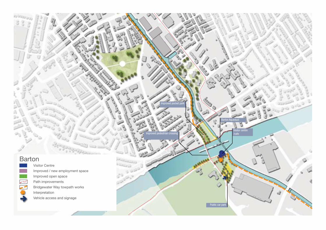
Public car park
Barton Aqueduct
Improved pedestrian crossing
Improved pocket park
Barton Visitor Centre
Improved / new employment space
Improved open space
Path improvements
Bridgewater Way towpath works
Interpretation
Vehicle access and signage
Visitor centre /cafe
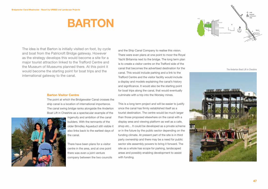
Bridgewater Canal Masterplan - Report by URBeD and Landscape Projects
4�
Barton Visitor CentreThe point at which the Bridgewater Canal crosses the
ship canal is a location of international importance.
The canal swing bridge ranks alongside the Anderton
Boat Lift in Cheshire as a spectacular example of the
ingenuity and ambition of the canal
builders. With the remnants of the
older Brindley Aqueduct still visible it
also links back to the earliest days of
the canal.
There have been plans for a visitor
centre in the area, and at one point
there was even a joint venture
company between the two councils
BaRton
The idea is that Barton is initially visited on foot, by cycle and boat from the Patricroft Bridge gateway. However as the strategy develops this would become a site for a major tourist attraction linked to the Trafford Centre and the Museum of Museums planned there. At this point it would become the starting point for boat trips and the international gateway to the canal.
Barton
Aquaduct
nodelandmarkconfinementedge
N
enclosed
boat yard building
noisy
narrow towpath blocked
A
A
and the Ship Canal Company to realise this vision.
There were even plans at one point to moor the Royal
Yacht Britannia next to the bridge. The long term plan
is to create a visitor centre on the Trafford side of the
canal that becomes the advertised destination for the
canal. This would include parking and a link to the
Trafford Centre and the visitor facility would include
a display and models explaining the canal’s history
and significance. It would also be the starting point
for boat trips along the canal, that would eventually
culminate with a trip into the Worsley mines.
This is a long term project and will be easier to justify
once the canal has firmly established itself as a
tourist destination. The centre would be much larger
than those proposed elsewhere on the canal with a
display area and viewing platform as well as a cafe,
shop etc... It could be developed as a private scheme
or in the future by the public sector depending on the
funding climate. At present part of the site is in third
party ownership and there may be a need for public
sector site assembly powers to bring it forward. The
site as a whole has scope for parking, landscaped
areas and possibly enabling development to assist
with funding.
The Anderton Boat Lift in Cheshire

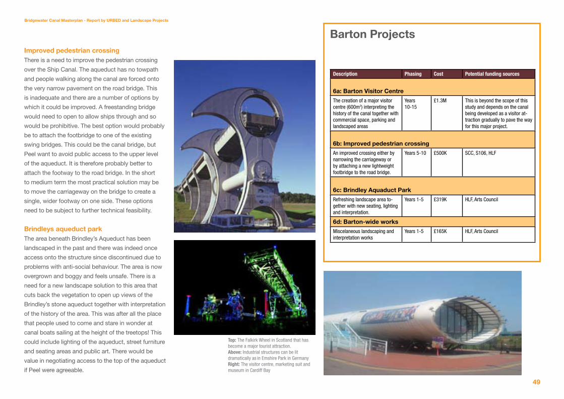
Bridgewater Canal Masterplan - Report by URBeD and Landscape Projects
4�
Improved pedestrian crossingThere is a need to improve the pedestrian crossing
over the Ship Canal. The aqueduct has no towpath
and people walking along the canal are forced onto
the very narrow pavement on the road bridge. This
is inadequate and there are a number of options by
which it could be improved. A freestanding bridge
would need to open to allow ships through and so
would be prohibitive. The best option would probably
be to attach the footbridge to one of the existing
swing bridges. This could be the canal bridge, but
Peel want to avoid public access to the upper level
of the aqueduct. It is therefore probably better to
attach the footway to the road bridge. In the short
to medium term the most practical solution may be
to move the carriageway on the bridge to create a
single, wider footway on one side. These options
need to be subject to further technical feasibility.
Brindleys aqueduct parkThe area beneath Brindley’s Aqueduct has been
landscaped in the past and there was indeed once
access onto the structure since discontinued due to
problems with anti-social behaviour. The area is now
overgrown and boggy and feels unsafe. There is a
need for a new landscape solution to this area that
cuts back the vegetation to open up views of the
Brindley’s stone aqueduct together with interpretation
of the history of the area. This was after all the place
that people used to come and stare in wonder at
canal boats sailing at the height of the treetops! This
could include lighting of the aqueduct, street furniture
and seating areas and public art. There would be
value in negotiating access to the top of the aqueduct
if Peel were agreeable.
Barton Projects
Description Phasing Cost Potential funding sources
6a: Barton Visitor Centre
The creation of a major visitor centre (600m2) interpreting the history of the canal together with commercial space, parking and landscaped areas
Years 10-15
£1.3M This is beyond the scope of this study and depends on the canal being developed as a visitor at-traction gradually to pave the way for this major project.
6b: Improved pedestrian crossing
An improved crossing either by narrowing the carriageway or by attaching a new lightweight footbridge to the road bridge.
Years 5-10 £500K SCC, S106, HLF
6c: Brindley aquaduct Park
Refreshing landscape area to-gether with new seating, lighting and interpretation.
Years 1-5 £319K HLF, Arts Council
6d: Barton-wide works
Miscelaneous landscaping and interpretation works
Years 1-5 £165K HLF, Arts Council
Top: The Falkirk Wheel in Scotland that has become a major tourist attraction. Above: Industrial structures can be lit dramatically as in Emshire Park in GermanyRight: The visitor centre, marketing suit and museum in Cardiff Bay


Bridgewater Canal Masterplan - Report by URBeD and Landscape Projects
�1
ConCLUsIon anD aCtIon PLan
This report has set out a step by step strategy to
turn the Bridgewater Canal in Salford into a major
visitor attraction. This will not be achieved over night
and some of the big opportunities such as the Delph
mines and the Barton Visitor centre will take years
to achieve. However they will be far easier once the
canal is firmly established on the north west visitor
map with demonstrable visitor potential. This report
sets out a strategy to build towards this point.
This is based on the five stages of development set
out on page 8;
1. The development of the canal for local visitors
including a series of walks linked to the
interpretation strategy. The main access points
are to be at Boothstown, the existing Worsley
car park and Patricroft Bridge.
2. A series of visitor information points/cafes that
people can use as the starting and ending point
for their walks and incorporating interpretation
and refreshments. The key facilities initially
would be at Worsley and Patricroft.
3. The development of a regional attraction
at Monton including the Marina and Dukes
Drive Country Park. This would package the
attractions of the canal to a wider audience and
be linked to widely publicised paying attractions
such as canal tours.
4. A significant attraction at Barton Bridge
linked to a museum about the Ship Canal and
Bridgewater Canal and with marketing linked
to the Trafford Centre. This would become the
starting point for the boat trips although it may
be that the attraction is on the Trafford bank of
the ship canal.
5. The opening of the Delph as a finale to the boat
tours in which they would enter the tunnels and
experience the underground system of canals,
mines shafts and inclined planes.
To this end the projects set out on the previous
pages have been organised into an action plan on
the following page. This divides the projects into
three phases, the first five years, five to ten years
and then long term projects. The projects in the first
phases are those necessary to achieve stages 1 and
2 of the strategy. The Monton Marina and Dukes
Drive Country Park have been put into the second
phase, largely because the Marina will take time to
develop. However if this can be brought forward
there is no reason it couldn’t happen in less than five
years. The long term projects then relate to Barton
and the Delph, these are beyond the scope of this
study and need to be reassessed once the earlier
stages of the strategy have been achieved.
The aim is to develop the first stage projects into an
application to the Heritage Lottery Fund. The table
on the following page suggests that the total cost
of the first phase projects will be just over £9M of
which just under £5M will be private investment. The
largest element of the remaining costs is the £1.1M
for dredging the dam which may not form part of
the HLF bid. This leaves just over £3M to be funded
through a combination of SCC funds, S106, grant
applications and HLF.
This report sets out a strategy for the development of the Bridgewater Canal in Salford into a major visitor attraction over the next decade. Once established in the visitor map of the North West it will be possible to move on to the next stage of the plan involving a significant visitor centre at Barton and the opening up of the Delph mines.
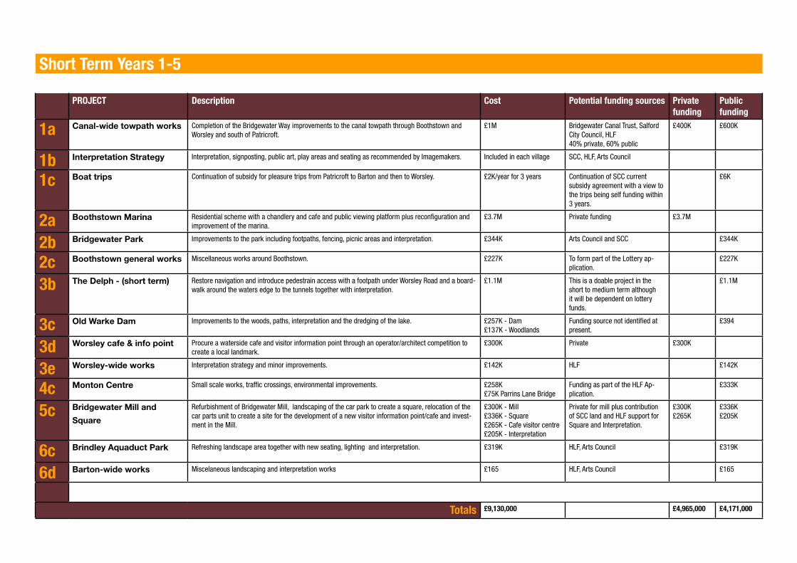
Short Term Years 1-5
PROJECT Description Cost Potential funding sources Private funding
Public funding
1a Canal-wide towpath works Completion of the Bridgewater Way improvements to the canal towpath through Boothstown and Worsley and south of Patricroft.
£1M Bridgewater Canal Trust, Salford City Council, HLF40% private, 60% public
£400K £600K
1b Interpretation strategy Interpretation, signposting, public art, play areas and seating as recommended by Imagemakers. Included in each village SCC, HLF, Arts Council
1c Boat trips Continuation of subsidy for pleasure trips from Patricroft to Barton and then to Worsley. £2K/year for 3 years Continuation of SCC current subsidy agreement with a view to the trips being self funding within 3 years.
£6K
2a Boothstown Marina Residential scheme with a chandlery and cafe and public viewing platform plus reconfiguration and improvement of the marina.
£3.7M Private funding £3.7M
2b Bridgewater Park Improvements to the park including footpaths, fencing, picnic areas and interpretation. £344K Arts Council and SCC £344K
2c Boothstown general works Miscellaneous works around Boothstown. £227K To form part of the Lottery ap-plication.
£227K
3b the Delph - (short term) Restore navigation and introduce pedestrain access with a footpath under Worsley Road and a board-walk around the waters edge to the tunnels together with interpretation.
£1.1M This is a doable project in the short to medium term although it will be dependent on lottery funds.
£1.1M
3c old Warke Dam Improvements to the woods, paths, interpretation and the dredging of the lake. £257K - Dam£137K - Woodlands
Funding source not identified at present.
£394
3d Worsley cafe & info point Procure a waterside cafe and visitor information point through an operator/architect competition to create a local landmark.
£300K Private £300K
3e Worsley-wide works Interpretation strategy and minor improvements. £142K HLF £142K
4c Monton Centre Small scale works, traffic crossings, environmental improvements. £258K£75K Parrins Lane Bridge
Funding as part of the HLF Ap-plication.
£333K
5c Bridgewater Mill and
square
Refurbishment of Bridgewater Mill, landscaping of the car park to create a square, relocation of the car parts unit to create a site for the development of a new visitor information point/cafe and invest-ment in the Mill.
£300K - Mill£336K - Square£265K - Cafe visitor centre£205K - Interpretation
Private for mill plus contribution of SCC land and HLF support for Square and Interpretation.
£300K£265K
£336K£205K
6c Brindley aquaduct Park Refreshing landscape area together with new seating, lighting and interpretation. £319K HLF, Arts Council £319K
6d Barton-wide works Miscelaneous landscaping and interpretation works £165 HLF, Arts Council £165
Totals £9,130,000 £4,965,000 £4,171,000

Bridgewater Canal Masterplan - Report by URBeD and Landscape Projects
�3
Medium Term Years 5-10
4a Dukes Drive Park Improvements to the former mini golf course to create a country park covering 11.5ha. £1.5M Contribution from the Marina as part of creating the vehicle access. SCC, S106, Landfill Tax Credits scheme.
£1.5M
4b Monton Marina The creation of a 250 berth marina on a 5ha site with 3ha of water. The scheme would include road access, a chandlery, cafe and visitor information point.
£4.8M Private investment £4.8M
5a gUs & naysmiths The redevelopment of the 4.5ha GUS site for a mix of potential uses. If it was housing this would ac-commodate around 200 units. The refurbishment and development of the former Nasmyths site.
£22M - Housing£187K - Footbridge£30K - Railway footbridge
Private £22,217,000
5b Railway station Refurbishment of the station facilities with seating, lighting, interpretation and a general lick of paint. £236K Network Rail, S106 £236K
6b Barton Bridge crossing An improved pedestrian crossing over the Ship Canal. £500K SCC, S106, HLF £500K
Totals £29M £27,017,000 £1,736,500
Long-Term Years 10-15 years
6a Barton Visitor Centre The creation of a major visitor centre (600m2) interpreting the history of the canal together with com-mercial space, parking and landscaped areas.
Unknown This is beyond the scope of this study and depends on the canal being developed as a visitor at-traction gradually to pave the way for this major project.
3a the Delph - (long term) Opening up the mines for boat trips and a major tourist destination. Unknown This will only become viable when the canal is more established as a tourist destination. It will be a major project and is beyond the scope of this study.


Bridgewater Canal Masterplan - Report by URBeD and Landscape Projects
��
APPENDIX 1ConsULtatIon
RePoRt
Contents
1. Executive summary
2. Introduction
3. Methodology
4. Stage one consultation results
5. Stage two consultation result
annexes
1. List of organisations notified of consultation
2. List of respondents
3. Bridgewater Canal Corridor Draft Masterplan
consultation document
4. Questionnaire
5. Updated masterplan
6. Table of formal comments and council responses
This report detailing the results of the consultations undertaken during the course of the study has been prepared by Salford City Council on the basis of the
drawings provided by the URBED Team.
1.1 BackgroundSalford City Council commissioned URBED and
Landscape Projects in June 2009 to produce a
masterplan for the Bridgewater Canal Corridor. The
key objectives of the masterplan are to:
Improve the environment of the canal
Make more of its star attractions
Make more of its history and industrial
archaeology through
Interpretation
Provide visitor infrastructure such as cafes and
visitor centres
Provide gateways to the canal linked to parking
and public transport
Improve links to the surrounding communities
and five villages along the canal
Identify development opportunities along the
canal to improve the environment and activity
Increase waterside and waterborne activity.
Consultation on the draft masterplan was undertaken
in two stages. Stage one (July –September 2009)
fed into and informed the development of the draft
masterplan and was aimed at key landowners,
statutory partners and local residents. Methods
included community walkabouts, stakeholder
meetings and a stakeholder round table workshop.
In total 70 people or organisations took part in stage
one of the consultation.
Stage two consulted on the draft masterplan
proposals and was again aimed at key landowners,
■■■
■■
■
■
■
■
statutory partners and local residents. To assist with
the stage two consultations a 16 page summary
booklet was produced and mailed out to key
stakeholders. 14 drop in sessions were also held
at key venues along the canal alongside specialist
consultations with Community Committees, a local
high school and Salford Disability Forum. In total
478 people or organisations were engaged as part of
stage two consultations, with 394 either commenting
verbally at consultation sessions or formally
submitting comments via questionnaire / email.
1.2 summary of consultation responsesThe masterplan was extremely well received by
local residents, stakeholders and key landowners
with strong overall support for the proposals. The
following section sets out a summary of the key
overall comments and issues raised during the
consultation sessions.
Comments were recorded on the draft vision, the
overall masterplan proposals and by each of the 5
‘canalside villages’ identified in the masterplan. This
section then highlights what changes will be made
to the substance of the masterplan as a result of
comments made.
1.3 Vision‘Love the vision. It’s about time we improved these
beautiful areas’
‘These proposals will make the Bridgewater Canal a
destination and something to be proud of’
‘The masterplan is a strong regenerative tool which
seems to offer both improvements and safeguards to
the general local environment’
‘This will put the whole area firmly on the tourist map,
improve facilities for local residents and give a much
needed lift to local businesses’.
support
90.3% of respondents supported the vision for the
canal corridor.
Changes
Natural heritage to be mentioned in the vision,
More focus on the importance of the industrial
heritage.
1.4 Draft masterplan‘The draft masterplan will breathe life into neglected…
historical areas’
‘The canal heritage is well worth preserving - keep up
the good work!’
‘I think it’s a fabulous idea!’
support
92.2% expressed support for access and
towpath improvements across the canal,
80.6% expressed support for a new marina
along the canal.
84.4% of people agreed that multi-media
interpretation should be used to tell the story of
the canal.
Key issues
Need coherent implementation plan detailing
■■
■
■
■
■
1. exeCUtIVe sUMMaRy

Bridgewater Canal Masterplan - Report by URBeD and Landscape Projects
��
timescales and funding,
Proposals need a regular and confirmed
maintenance regime,
Need for short term ‘quick win’ projects.
Changes
Bridges at Dukes Drive Country Park and GUS
site to be prioritised. Other bridges only to come
forward where development led.
1.� Boothstown ‘recreational hub’‘Boothstown Marina is a pleasant open space at the
moment’
‘Make the most of the wildlife…more access to green’
‘Boat and cycle hire in Boothstown… the proposals
provide good recreational access into the
environment’
support
87% expressed overwhelming support for
enhancing the quality of the public realm and the
towpath,
84.7% of respondents want to see Boothstown
enhanced as a recreational hub.
81.2% of respondents support increasing use of
the marina and surrounding area.
Key issues
Poor quality of the public realm around
Boothstown Marina,
Poor quality of towpath and links to surrounding
greenspace was highlighted,
Concern about anti-social behaviour at the
■
■
■
■
■
■
■
■
■
Marina,
Development should be in keeping with
character of area.
Changes
Include mixed-use development at Boothstown
Marina,
Include mixed-use development at Boothstown
Marina to improve surveillance and enhance
security. Development should be sensitive to the
character, surroundings and public amenity.
1.6 Worsley ‘heritage star’‘Opening the underground canals is great… this has
long been desired by residents’
‘Opening Worsley Delph - brilliant!’
‘This provides recognition of the national importance
of Worsley Village in terms of industrial heritage’
support
90.2% support for showcasing the international
heritage of Worsley Delph,
84.5% support for opening up the tunnels to
create a major national and regional tourist
attraction. 3.2% disapproved of opening the
tunnels,
90.2% agreed with proposals to improve the
pedestrian environment and access in Worsley,
Key issues
Lack of visitor infrastructure, particularly parking,
Potential impact of development and increased
visitor numbers on traffic congestion.
■
■
■
■
■
■
■■
Changes
Marina to be moved south towards Monton to
enhance its proximity to amenities in Monton
Village,
Access road to marina moved from Worsley
Road to Parrin Lane following further discussions
with highways engineers.
1.� Monton ‘country in the city’‘It will encourage exercise for locals and visitors and
provide a sense of well being with the green spaces’
‘Using Monton as a ‘green lung’ is perfect to enhance
its gorgeous village and lovely walks’
‘I would change the land usage opposite the canal in
Monton / Patricroft from industrial to mixed use’
support
88.2% of respondents support the creation of a
country park at Dukes Drive,
79.2% of people approved of a new pedestrian
bridge to improve accessibility to the new
marina and country park,
77.3% support for a new marina at Dukes Drive.
5.2% of respondents strongly disapproved of
this development in its current location, mainly
due to potential for increased traffic congestion
and lack of visitor infrastructure in Worsley.
Key issues
Concerns over the scale of new marina and
potential loss of greenspace,
Signage and wayfinding needs improving,
Split in opinion about the proposal for a new
■
■
■
■
■
■
■■

pedestrian bridge,
Concerns about anti-social behaviour.
Changes
Car parking moved to east of the marina to
reflect new access from Parrin Lane following
further discussions with highways engineers,
Pedestrian bridge moved south to reflect re-
siting of marina,
Leisure / play area incorporated at Dukes Drive,
Improved car park included at Dukes Drive
Country Park following concerns raised
regarding parking,
Pedestrian crossing incorporated across Parrin
Lane to improve safe access to facilities.
1.8 Patricroft ‘waterside regeneration’‘Redeveloping run down areas in Patricroft is
excellent’
‘The social history aspect e.g. industrial history is
very important’
‘The improvements will make the canal towpath
more accessible for all and encourage use by a
wider audience’
support
87% support proposals to improve access to
Patricroft Station,
84.4% of respondents agreed with proposals
to enhance the Bridgewater Mill as a centre for
creative industries,
83.7% support the creation of new waterside
development.
■
■
■
■■
■
■
■
■
Key issues
Interpretation of the area’s industrial and social
history needs to be improved,
New developments need to face and interact
with the canal,
Strong concerns were raised regarding the
proposed new waste management facility.
Changes
Residential development to be incorporated on
the GUS site.
1.� Barton ‘international gateway’‘I like the fact the area around Barton Bridge is to be
improved’
‘The aqueduct was one of the 7 wonders of the
industrial age… and should be a focal point for
education groups of all ages’
‘I like the idea of providing a visitor centre which
would provide a base for boat trips, the exposure of
the stone aqueduct would also fit in well’
support
83.1% of respondents support a new visitor
centre and parking on the Trafford side of the
aqueduct,
81.2% support the remodelling of the pocket
park and viewing platform.
Key issues
Condition and width of towpath,
Concerns over anti-social behaviour,
Poor quality of the environment,
■
■
■
■
■
■
■■■
Maximise the links to Trafford Centre to increase
the visitor offer of the area,
Potential increase in traffic congestion.
Changes
Masterplan boundary amended to reflect the
Barton-upon-Irwell Conservation Area,
Aspiration added to improve the pedestrian
access across the Manchester Ship Canal.
■
■
■
■

2. IntRoDUCtIon
��
The Bridgewater Canal was the first industrial canal
system in the country, indeed the world. It has
national / international brand recognition and is
on UNESCO’s tentative list for World Heritage Site
status. The canal in Salford contains a number of
international heritage ‘stars’ including Worsley Delph
and Barton Swing Aqueduct.
The Bridgewater Canal currently attracts both
national and international visitors. Industrial
heritage enthusiasts from across the world come
to see Barton Swing Aqueduct, one of the ‘seven
wonders of the waterways world’ and the only swing
aqueduct in the world. However, the product offer
on the ground does not match expectations and
fails to inspire repeat visits.
In June 2009 Salford City Council commissioned
URBED and Landscape Projects to produce a
masterplan for the Bridgewater Canal Corridor.
The masterplan aims to breath new life back into
the canal by improving the existing heritage and
infrastructure whilst enhancing the visitor offer to
create a ‘destination’ which Salford and the North
West can be proud of. The key objectives of the
masterplan are to:
• Improve the environment of the canal
• Make more of its star attractions
• Make more of its history and industrial
archaeology through
Interpretation
• Provide visitor infrastructure such as cafes
and visitor centres
• Provide gateways to the canal linked to
parking and public transport
• Improve links to the surrounding
communities and five villages along
the canal
• Identify development opportunities along
the canal to improve the
environment and increase activity
• Increase waterside and waterborne activity.
The canal in Salford was originally built to transport
coal from the mines in Worsley to the industrial
heartlands of Manchester, linking the villages of
Monton, Patricroft and Barton along the route. The
masterplan builds on the concept of ‘canalside
villages’ with the addition of Boothstown to the
above to reflect the 5 ‘canalside villages’ that the
masterplan is based around.
To underpin the development of the draft masterplan
an extensive baseline analysis was undertaken
including a socio-economic analysis, land use,
urban design and landscape analysis, public realm
audit, ecological review, movement and connectivity
and planning and development analysis.
Consultation on the draft masterplan was
undertaken in two stages. Stage one (July
–September 2009) fed into and informed the
development of the draft masterplan and was
aimed at key landowners, statutory partners and
local residents. Methods included community
walkabouts, stakeholder meetings and a
stakeholder round table workshop. In total 70
people or organisations took part in stage one of the
consultation.
Stage two consulted on the draft masterplan
proposals and was again aimed at key landowners,
statutory partners and local residents. To assist with
the stage two consultations a 16 page summary
booklet was produced and mailed out to key
stakeholders. 14 drop in sessions were also held
at key venues along the canal alongside specialist
consultations with Community Committees, a
local high school and Salford Disability Forum. In
total 478 people or organisations were engaged
as part of stage two consultations, with 394 either
commenting verbally at consultation sessions or
formally submitting comments via questionnaire /
email.
3. MethoDoLogy3.1 summaryConsultation on the masterplan took part in
two stages. Stage one was undertaken in the
development phase of the masterplan and took
place over a 12 week period between July and
September 2009. These were aimed at key
landowners, statutory partners and local residents
and involved approximately 60 consultees through
a combination of one-to-one meetings, community
walkabouts and a stakeholder roundtable workshop.
The purpose of these consultations was to highlight
the key issues and areas of opportunity along the
canal corridor to help inform the draft masterplan.
The stage two consultation took place over a 13 week
period (not including Christmas) between 24 November
2009 and 9 March 2010. This targeted local residents,
statutory partners, local businesses, community
and voluntary sector groups and the aim was to get
feedback on the draft masterplan proposals.
The stage two consultation was widely publicised
to ensure that residents and stakeholders had every
opportunity to contribute. Publicity included:
2 page article in the Salford Advertiser on 24
December
Advert in December ‘Life in Salford’ magazine
Articles in Community Committee newsletters
Advert in ‘essentially yours’ December issue
Details of exhibitions on the council’s webpages
Details of the exhibitions on URBED’s
webpages
■
■■■■■
Postcard detailing the exhibition dates sent to
over 6000 households along the canal corridor
w/c 30 November and w/c 4 January
To assist with the stage two consultation a 16 page
summary booklet was produced setting out the draft
masterplan (Annex C) alongside a questionnaire
which sought people’s views on the draft masterplan
(Annex D). These were distributed to libraries and
community centres in Boothstown, Eccles, Winton
and Worsley. The documents were also available on
the council’s web pages and URBED’s web pages.
In addition the summary booklet and questionnaire
was sent out to 114 stakeholders. 14 exhibition
and drop in sessions were held across the
area and presentations were undertaken at the
Community Committees for Eccles and Worsley
and Boothstown. Specific consultations were also
undertaken with St. George’s Roman Catholic
School and Salford Disability Forum.
During stage two a total of 364 people attended
consultation events, with 154 questionnaires
received. In addition to this 30 letters were received
from statutory, voluntary and national organisations.
stage one consultation3.2 Community walkaboutsCommunity walkabouts were undertaken during
stage one of the consultation.
The walkabouts were targeted at local councillors
and members of the community who had expressed
■ an interest in getting involved in the Bridgewater
Canal Corridor project.
The walkabouts were facilitated by URBED and
the aim of the walkabouts was to understand local
Councillors and residents concerns and aspirations
to inform the development of the draft masterplan.
Participants were asked to lead the discussions
through pointing out features of interest, areas of
concern and sites of potential development.
The walkabouts were held in Boothstown, Worsley,
Monton, Patricroft and Barton on the following
dates:
Wednesday 5 August 2009, Worsley &
Boothstown
Wednesday 12 August 2009, Eccles (Monton
and Patricroft)
Thursday 1 October 2009, Barton
30 people attended the walkabouts in total, 12
in Worsley and Boothstown, 10 in Monton and
Patricroft and 8 in Barton.
3.3 stakeholder workshopA stakeholder workshop was held on 23 September
2009 at Eccles Gateway Centre. The workshop
was targeted at key stakeholders including
representatives from Salford City Council Planning
and Environment, Wigan Council, Trafford Council,
Peel Holdings and Sustrans. Approximately 30
people were in attendance.
■
■
■

Bridgewater Canal Masterplan - Report by URBeD and Landscape Projects
61
The workshop was facilitated by URBED and
Landscape Projects and the aim of the workshop
was to identify the key issues and aspirations of
stakeholders and to discuss ideas for developing
the canal corridor. A baseline analysis and initial
thoughts on development of the canal corridor was
presented by the consultants.
Attendees were then split into 4 groups with
conversations focused around a number of key
themes:
Environmental improvements
Tourism development
Placemaking opportunities
Opportunities for development
3.4 stakeholder one-to-one meetingsA series of one-to-one meetings were also held
with key landowners and stakeholders. The aim of
these consultations was to introduce the masterplan
and to identify the key issues, aspirations and
development opportunities along the canal corridor.
Meetings were held with the following organisations:
Bridgewater Canal User Group
City West Housing Trust
Destination Worsley
Peel Holdings
Salford City Council Environment
Salford City Council Planning
Salford Primary Care Trust
■■■■
■■■■■■■
Trafford Council
Visit Manchester
Wigan Council
stage two consultation3.� stakeholder mailoutA mailout to 114 stakeholders was sent out on
17 November 2009. This included a copy of the
masterplan summary consultation booklet and
questionnaire. The purpose of the mailout was to
inform key stakeholders about the draft masterplan
and to ask their opinion on the draft proposals.
Recipients invited to comment on the draft
masterplan proposals included statutory partners
such as English Heritage, the Environment Agency,
Visit Manchester, local businesses and other
statutory, special interest and community groups. A
full list of organisations notified of the consultation
can be found at Annex 1. In total 30 responses were
received to the mailout, including 13 from statutory
partners and landowners, 6 from local businesses
and 11 from local interest groups.
3.6 Community Committee consultationsThere are eight Community Committees in Salford,
one for each neighbourhood area. Community
Committees are open meetings that have been set
up to ensure local residents can influence decisions
about their neighbourhoods. Priorities for each area
is agreed and enshrined in an annual community
action plan.
■■■
Council officers and URBED attended Eccles
Community Committee on 26 January 2010 at
the Monton House Hotel. A special meeting of the
Worsley & Boothstown Community Committee was
held on 16 February 2010 at Worsley Court House.
A 20 minute presentation was given by David Rudlin
of URBED outlining the draft masterplan. This was
then followed by a question and answer session,
with attendees invited to comment on the draft
masterplan proposals. Approximately 50 people
attended the two meetings.
3.� Drop in sessionsFourteen exhibitions were held for residents along
the canal corridor between December 2009 and
February 2010. The purpose of the drop in sessions
was to obtain feedback on the draft masterplan
proposals from local residents. To maximise
attendance exhibitions were held in visible locations
in buildings with high local footfall. Each session
was staffed and included information boards giving
a summary of the baseline study, a map of the
overall area and a summary of the proposals for the
5 villages. They were held on:
Saturday 5 December 2009, at Worsley Court
House
Friday 18 December 2009, at Eccles Precinct
Community Shop
Saturday 19 December 2009, at Eccles Precinct
Community Shop
Monday 11 January 2010, at Worsley Library
■
■
■
■

Tuesday 12 January, at Worsley Library
Thursday 14 January 2010, at the Rainbow
Rooms, Liverpool Road
Friday 15 January 2010, at Monton Unitarian
Church Hall
Saturday 16 January 2010, at the Waterside
Pub, Monton
Saturday 16 January 2010, at the Standfield
Centre, Boothstown
Friday 22 January 2010, at Worsley Library
Saturday 30 January 2010, at the Standfield
Centre, Boothstown
Saturday 30 January 2010, at the Rainbow
Rooms, Liverpool Road
Tuesday 16 February 2010, at Eccles Gateway
Centre
Friday 19 February 2010, at Walkden Gateway
Centre
The drop in sessions attracted a significant amount
of interest from local residents and interested
enthusiasts with 268 people attending across the 14
drop in sessions.
3.8 schools consultationA separate youth consultation session was held
at St George’s Roman Catholic High School on
Monday 1 February 2010 involving 32 pupils. The
aim of the session was to inform pupils living near
to the canal about the proposals and get their
feedback on the draft plans. The consultation took
place as part of a GCSE geography lesson with a
presentation outlining the proposals for each area,
■■
■
■
■
■■
■
■
■
followed by a discussion and question and answer
session. Pupils were then split into groups and
asked to do a ‘destiny board’ exercise. This involved
designing a mural using pictures from magazines
which they felt represented their aspirations for the
area.
3.� salford Disability ForumIn addition to this a special consultation session
was held with Salford Disability Forum on Tuesday
9 March, with 14 people in attendance. Salford
Disability Forum coordinates local disability groups
and aims to raise awareness and understanding
of the barriers to inclusion and integration to
professional and statutory organisations. The aim of
this consultation was to outline the draft masterplan
and obtain feedback from an accessibility
perspective. A presentation outlined the proposals
for each village and this was followed by a facilitated
group discussion.

Bridgewater Canal Masterplan - Report by URBeD and Landscape Projects
63
Method Date Audience AttendanceStage oneCommunity walkabouts 5 August 2009, Worsley & Boothstown
12 August 2009, Monton, Patricroft, Barton
1 October 2009, Barton
Local residents
Elected Members
12
10
8
Stakeholder workshop 23 September 2009 Salford City Council officers
Neighbouring local authority officers
Landowners
Statutory stakeholders
30
Stakeholder one-to-ones July – September 2009 Elected Members
Local residents
Statutory stakeholders
Landowners
Local tourism forums
10 Organisations/groups
Stage twoStakeholder mailout 17 November 2009 – 9 March 2010 Statutory stakeholders
Local businesses
Landowners
Community / voluntary sector groups
114 packs sent
Community Committees Eccles – 26 January 2010
Worsley & Boothstown – 16 February 2010
Local residents
Elected Members
25
25
Drop in sessions 5 December 2009 – Worsley Court House
16 December 2009 – Eccles Precinct
19 December 2009 – Eccles Precinct
11 January 2010 – Worsley Library
Local residents 268

4. stage one ConsULtatIon ResULtsThis section discusses the consultation results from
stage one and stage two of the process. It highlights
the key issues and aspirations that were raised during
the consultations. The results are set out according to
the 5 villages contained within the masterplan and by
theme.
4.1 Community walkaboutsCommunity walkabout sessions were held on
5 August, 12 August and 1 October 2009. The
responses to these are set out below.
4.1.1 BoothstownThe key issues/aspirations raised were:
Poor state of the public realm around Boothstown
Marina,
Poor surveillance of the marina due to surrounding
properties being set back,
Poor quality of the towpath and links to
surrounding greenspace,
Concerns that development on the marina would
block neighbouring properties views and enclose
the public space.
4.1.2 WorsleyThe key issues/aspirations raised were:
Dredging, environmental improvements and
interpretation of the Delph is the priority,
The toilet block should be converted to a café,
visitor reception point and community space,
The canal side green is currently neglected and in
need of landscaping, play facilities, seating and
picnic areas,
■
■
■
■
■
■
■
Environment and interpretation of Lime Kiln needs
to be improved.
4.1.3 MontonKey issues/aspirations raised were:
Signage and wayfinding needed to direct
people to the canal and inform them about other
interesting features such as Monton Village and
the Roe Green loopline,
Maintenance along the canal towpath needs to be
improved,
Access points and paths to the canal are often
narrow, poorly maintained, unwelcoming and
close to speeding traffic,
Pedestrian crossings needed near to the canal
bridge to help walkers / cyclists cross,
Monton village has some high quality and
welcoming shops and cafes and would increase
the visitor offer of the Bridgewater Canal,
Issue of quad bikes on old pitch and putt course
(Duke’s Drive) – the area needs to be improved.
4.1.4 PatricroftThe key issues/aspirations raised were:
More needs to made of the setting of the Nasmyth
Steam Hammer with environmental improvements
and interpretation needed,
Nothing in place to tell the story where the world’s
first passenger railway crosses the world’s first
commercial canal – needs interpreting,
Links are poor to Patricroft station, which itself
has limited access, no parking and a poor
environment,
■
■
■
■
■
■
■
■
■
■
Towpath needs maintaining and widening to
accommodate cyclists, walkers, joggers and
anglers.
4.1.5 BartonThe key issues/aspirations raised were:
Need to clear, light and interpret the original
aqueduct structure to become a feature of the
area,
Access to the upper level of the aqueduct should
be reinstated to open up views of swing aqueduct
from Salford side,
Need to reinstate towpath along full length of
canal,
Barton Aqueduct pocket park is currently a dead-
end and lack of maintenance has led to problems
of anti-social behaviour,
Interpretation to tell the story of the canal and
aqueduct,
Need to improve links to the Trafford Centre -
thousands of visitors per day unaware of proximity
to the canal.
4.2 stakeholder workshop and one-to-onesThis section describes the key themes and issues
arising from the stakeholder one-to-ones and the
stakeholder workshop in September 2009. Consultees
/ participants were asked to discuss the visitor,
environmental, placemaking and development
opportunities alongside highlighting their aspirations
for each area.
■
■
■
■
■
■
■

Bridgewater Canal Masterplan - Report by URBeD and Landscape Projects
6�
4.2.1 Environmental improvementsAccess to surrounding greenspace and keeping
the land in public use is important,
Ongoing maintenance is a key issue which needs
to in place if improvements are to be sustained,
‘Reinventing the existing environment’ – small
interventions using the existing environment may
make a huge impact.
4.2.2 Tourism developmentStory telling and capturing the visitors imagination
is very important,
The creation of marinas, basins, arms and
moorings could help to animate the waterside
through leisure boating and residential moorings,
Create opportunities for people to get on the
canal- boat trips, gondolas, pedalos etc,
Sporting activities along the canal.
4.2.3 Place making opportunitiesCurrently the canal is under performing but canal
can contribute to community life through its
multifunctional role (cultural, educational, health
and transport),
New waterside development schemes are often
the primary generators of growth. The canal could
therefore be a catalyst for regeneration.
4.2.4 Development opportunitiesExisting employment land may not be suitable for
employment uses in future. This could open up
development opportunities,
Re-use and re-interpret the space of derelict
■
■
■
■
■
■
■
■
■
■
■
buildings e.g Liverpool Biennial using an empty
school in Bootle as a focal point for an arts based
canal festival,
A new marina couldn’t be justified in greenbelt
(Boothstown). Closer to urban areas would have a
stronger economic multiplier effect.
4.2.5 BoothstownOpportunity to link the canal to the Wigan
Greenheart proposals and the Astley Green
Colliery Museum,
Threatening / unwelcoming environment around
the marina due to lack of natural surveillance,
Working with the established boat community is
important,
Quality of the public realm is an important issue.
4.2.6 WorsleyCareful attention will need to be paid to managing
the tension of visitor numbers and existing
character and population,
Worsley will work well as a hub linked by boats, on
foot and bicycle,
Current linkages to the Delph are weak and
undermined by roads,
There is an acute lack of visitor infrastructure,
Label as a ‘water based’ destination.
4.2.7 MontonPotential for realising more radical aspirations,
The openspace of council land at Duke’s Drive is a
priority for attention,
Monton has the infrastructure and facilities to
■
■
■
■
■
■
■
■
■■
■■
■
support a new marina,
Good connections to other recreational routes.
4.2.8 PatricroftA large number of properties have their backs to
the canal,
Linking into the heritage assets of AV Roe house
and Bridgewater Mill is important,
Connections for walkers and cyclists with the
station are poor,
Changes from Patricroft to Barton should focus
on improving the towpath, re-inventing the use of
buildings and sustainable landscape and public
realm treatments,
There are some derelict and empty properties that
blight the canal,
Shared surfacing on Liverpool road and Worsley/
Barton Road to force traffic to slow down.
4.2.9 BartonSpaces next to the canal are of poor
environmental quality,
The bridges currently have very little presence in
the area,
Re-cladding of the tower blocks at Cawdor Street
would improve their appearance,
The area is able to take large amounts of visitors
through the extensive road infrastructure serving
the Trafford Centre and retail parks,
The area is home to one of the heritage stars of
the canal, but is also one of the most deprived
areas and needs concentrated investment.
■
■
■
■
■
■
■
■
■
■
■
■

�. stage tWo ConsULtatIon ResULtsThis section sets out the quantative results of
the questionnaire that was produced to support
the draft masterplan consultation. In total 154
questionnaires were returned and 30 stakeholders
and residents chose to write letters rather than
specifically respond to the questionnaire. For a
breakdown of respondents please refer to Annex ….
�.1 VisionThe first question asked respondents to state
whether they agreed or disagreed with the draft
vision and suggest amendments. 94% of people
agreed with the draft vision whilst only 0.6%
disagreed. Suggestions included referencing
access, educational opportunities, interpretation and
the natural heritage of the area.
Vision Agree Disagree No opinion
No. 139 5 10
% 90.3% 3.2% 6.5%
�.2 Draft masterplanRespondents were then asked to state whether they
agreed or disagreed with some key overall principles
and development opportunities.
92% of respondents either strongly approved
or approved that access to the canal and the
surface of the towpath should be improved,
Four-fifths of respondents agreed that the canal
would benefit from a new marina, with 9.7%
either disapproving or strongly disapproving and
9.7% expressing no opinion,
■
■
84.4% of people approved or strongly approved
that multi-media interpretation should be used
along the canal, with 3.9% disapproving.
Comments and suggestions included:
All proposals need a confirmed and regular
maintenance regime,
Concerns about the potential increase in traffic
congestion across the canal corridor,
Support for the incremental approach to project
delivery,
Developments should support local businesses,
Enquiries about how much will the masterplan
cost to implement and how will it be funded,
The need for some short-term ‘quick win’
projects,
Improvements to wayfinding are essential.
■
■
■
■
■■
■
■
Strongly
Approve
Approve Disapprove Strongly
Disapprove
No opinion
Increase access to
the canal
111 (72.1%) 31
(20.1%)
0
(0.0%)
2
(1.3%)
10
(6.5%)
Improve surface of
towpath
113
(73.4%)
29
(18.8%)
2
(1.3%)
0
(0.0%)
10
(6.5%)
Have a new marina
along canal
64
(41.6%)
60
(39.0%)
9
(5.8%)
6
(3.9%)
15
(9.7%)
Tell the story of the
canal through multi-
media interpretation
80
(51.9%)
50
(32.5%)
6
(3.9%)
0
(0.0%)
18
(11.7%)
�.3 Boothstown ‘Recreational hub’ 64.9% strongly agree with the focus on wildlife
and the landscape in Boothstown, with only 2%
either strongly disagreeing or disagreeing,
53.9% strongly agreed that the area should be
enhanced as a recreational hub, 31.8% agreed
whilst 3.3% disagreed or strongly disagreed,
81.2% strongly agreed or agreed with increased
use of the marina. 3.9% of respondents disagreed
and 0.7% strongly disagreed,
87% strongly approved or approved of proposals
to enhance the quality of the public areas in
Boothstown, only 1.3% of people disapproving,
81.8% of people agreed with proposals to
enhance traffic calming, with 5.9% either
disapproving or strongly disapproving,
77.3% of respondents supported the expansion
of the chandlery and boat facilities at Boothstown
Marina, with only 4.5% disapproving.
■
■
■
■
■
■

Bridgewater Canal Masterplan - Report by URBeD and Landscape Projects
6�
90.2% agreed with proposals to improve the pedestrian environment and
access in Worsley, with only 1.3% disapproving,
82.4% of respondents approved or strongly approved with proposals
to extend and maintain the open water at Old Warke Dam. 5.9% of
respondents disapproved.
It was felt that opening up the tunnels at Worsley Delph would create a major
regional and national tourist attraction which would be the lynchpin of the whole
strategy. Concerns were raised however regarding the capacity of Worsley to
accommodate additional visitors and in particular the lack of car parking.
�.� Monton ‘country in the city’88.2% approved of proposals to create a vibrant outdoor park and 89.8%
supported the creation of new walking and cycling routes through the park.
Only 1.3% of respondents disapproved of creating a vibrant outdoor park,
42.2% of respondents strongly approved and 35.1% approved of a new
marina at Dukes Drive. 5.2% strongly disapproved of this development,
■
■
■
■
Strong objections were registered against residential
development at Boothstown Marina where it was
felt this would detract from the existing views over
the marina and enclose the public space. Strong
objections were also registered against installation
of bird hides in this area as it was felt they would
become a magnet for anti-social behaviour.
�.4 Worsley ‘heritage star’90.2% of respondents approved of showcasing
the international heritage of Worsley Delph and
84.5% support the opening up of the tunnels if
feasible. 3.2% disapproved of opening up the
tunnels, mainly due to concerns over health and
safety,
78.6% of people approved of having a visitor
reception point on Barton Road, with 9.1%
disagreeing,
■
■
Strongly
Approve
Approve Disapprove Strongly
Disapprove
No opinion
Focus on wildlife
and landscape
100
(64.9%)
32
(20.1%)
2
(1.3%)
1
(0.7%)
19
(12.3%)
Enhance as
recreational hub
83
(53.9%)
49
(31.8%)
3
(2.0%)
2
(1.3%)
17
(11.0%)
Increase use of
the marina and
surrounding area
75
(48.7%)
50
(32.5%)
6
(3.9%)
1
(0.7%)
22
(14.3%)
Enhance the quality
of the public areas
91
(59.1%)
43
(27.9%)
2
(1.3%)
0
(0.0%)
18
(11.7%)
Enhance traffic
calming where
needed
69
(44.8%)
57
(37.0%)
6
(3.9%)
3
(2.0%)
19
(12.3%)
Expand chandlers
and boat facilities
61
(39.6%)
58
(37.7%)
5
(3.2%)
2
(1.3%)
28
(18.2%)
Strongly
Approve
Approve Disapprove Strongly
Disapprove
No opinion
Showcase the
international heritage
of Worsley Delph
104
(67.5%)
35
(22.7%)
0
(0.0%)
2
(1.3%)
13
(8.5%)
Open up the tunnels
at Worsley Delph if
possible
95
(61.8%)
35
(22.7%)
5
(3.2%)
0
(0.0%)
19
(12.3%)
Visitor reception
point on Barton
Road
81
(52.6%)
40
(26.0%)
13
(8.4%)
1
(0.7%)
19
(12.3%)
Improve predestrian
environment and
access
99
(64.3%)
40
(25.9%)
2
(1.3%)
0
(0.0%)
13
(8.5%)
Extend and maintain
open water at Old
Warke Dam
95
(61.6%)
32
(20.8%)
8
(5.2%)
1
(0.7%)
18
(11.7%)
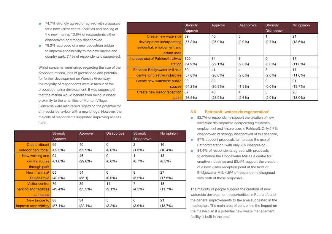
74.7% strongly agreed or agreed with proposals
for a new visitor centre, facilities and parking at
the new marina. 13.6% of respondents either
disapproved or strongly disapproved,
79.2% approved of a new pedestrian bridge
to improve accessibility to the new marina and
country park. 7.1% of respondents disapproved.
Whilst concerns were raised regarding the size of the
proposed marina, loss of greenspace and potential
for further development on Worsley Greenway,
the majority of respondents were in favour of the
proposed marina development. It was suggested
that the marina would benefit from being in closer
proximity to the amenities of Monton Village.
Concerns were also raised regarding the potential for
anti-social behaviour with a new bridge. However, the
majority of respondents supported improving access
here.
■
■
Strongly
Approve
Approve Disapprove Strongly
Disapprove
No opinion
Create vibrant
outdoor park for all
96
(62.3%)
40
(25.9%)
0
(0.0%)
2
(1.3%)
16
(10.4%)
New walking and
cycling routes
through park
94
(61.0%)
46
(29.8%)
0
(0.0%)
1
(0.7%)
13
(8.5%)
New marina at
Dukes Drive
65
(42.2%)
54
(35.1)
0
(0.0%)
8
(5.2%)
27
(17.5%)
Visitor centre,
parking and facilities
at marina
76
(49.4%)
39
(25.3%)
14
(9.1%)
7
(4.5%)
18
(11.7%)
New bridge to
improve accessibility
88
(57.1%)
34
(22.1%)
5
(3.2%)
6
(3.9%)
21
(13.7%)
�.6 Patricroft ‘waterside regeneration’83.7% of respondents support the creation of new
waterside development incorporating residential,
employment and leisure uses in Patricroft. Only 2.7%
disapproved or strongly disapproved of this scenario,
87% support proposals to increase the use of
Patricroft station, with only 2% disagreeing,
84.4% of respondents agreed with proposals
to enhance the Bridgewater Mill as a centre for
creative industries and 82.4% support the creation
of a new visitor reception point at the front of
Bridgewater Mill. 4.6% of respondents disagreed
with both of these proposals.
The majority of people support the creation of new
waterside development opportunities in Patricroft and
the general improvements to the area suggested in the
masterplan. The main area of concern is the impact on
the masterplan if a potential new waste management
facility is built in the area.
■
■
■
Strongly
Approve
Approve Disapprove Strongly
Disapprove
No opinion
Create new waterside
development incorporating
residential, employment and
leisure uses
89
(57.8%)
40
(25.9%)
3
(2.0%)
1
(0.7%)
21
(13.6%)
Increase use of Patricroft railway
station
100
(64.9%)
34
(22.1%)
3
(2.0%)
0
(0.0%)
17
(11.0%)
Enhance Bridgewater Mill as a
centre for creative industries
89
(57.8%)
41
(26.6%)
4
(2.6%)
3
(2.0%)
17
(11.0%)
Create new waterside public
spaces
99
(64.2%)
32
(20.8%)
2
(1.3%)
0
(0.0%)
21
(13.7%)
Create new visitor reception
point
87
(56.5%)
40
(25.9%)
4
(2.6%)
3
(2.0%)
20
(13.0%)
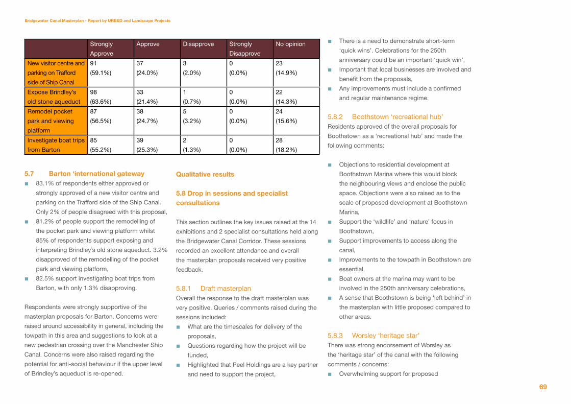
Bridgewater Canal Masterplan - Report by URBeD and Landscape Projects
6�
�.� Barton ‘international gateway83.1% of respondents either approved or
strongly approved of a new visitor centre and
parking on the Trafford side of the Ship Canal.
Only 2% of people disagreed with this proposal,
81.2% of people support the remodelling of
the pocket park and viewing platform whilst
85% of respondents support exposing and
interpreting Brindley’s old stone aqueduct. 3.2%
disapproved of the remodelling of the pocket
park and viewing platform,
82.5% support investigating boat trips from
Barton, with only 1.3% disapproving.
Respondents were strongly supportive of the
masterplan proposals for Barton. Concerns were
raised around accessibility in general, including the
towpath in this area and suggestions to look at a
new pedestrian crossing over the Manchester Ship
Canal. Concerns were also raised regarding the
potential for anti-social behaviour if the upper level
of Brindley’s aqueduct is re-opened.
■
■
■
Strongly
Approve
Approve Disapprove Strongly
Disapprove
No opinion
New visitor centre and
parking on Trafford
side of Ship Canal
91
(59.1%)
37
(24.0%)
3
(2.0%)
0
(0.0%)
23
(14.9%)
Expose Brindley’s
old stone aqueduct
98
(63.6%)
33
(21.4%)
1
(0.7%)
0
(0.0%)
22
(14.3%)
Remodel pocket
park and viewing
platform
87
(56.5%)
38
(24.7%)
5
(3.2%)
0
(0.0%)
24
(15.6%)
Investigate boat trips
from Barton
85
(55.2%)
39
(25.3%)
2
(1.3%)
0
(0.0%)
28
(18.2%)
Qualitative results
�.8 Drop in sessions and specialist consultations
This section outlines the key issues raised at the 14
exhibitions and 2 specialist consultations held along
the Bridgewater Canal Corridor. These sessions
recorded an excellent attendance and overall
the masterplan proposals received very positive
feedback.
5.8.1 Draft masterplanOverall the response to the draft masterplan was
very positive. Queries / comments raised during the
sessions included:
What are the timescales for delivery of the
proposals,
Questions regarding how the project will be
funded,
Highlighted that Peel Holdings are a key partner
and need to support the project,
■
■
■
There is a need to demonstrate short-term
‘quick wins’. Celebrations for the 250th
anniversary could be an important ‘quick win’,
Important that local businesses are involved and
benefit from the proposals,
Any improvements must include a confirmed
and regular maintenance regime.
5.8.2 Boothstown ‘recreational hub’Residents approved of the overall proposals for
Boothstown as a ‘recreational hub’ and made the
following comments:
Objections to residential development at
Boothstown Marina where this would block
the neighbouring views and enclose the public
space. Objections were also raised as to the
scale of proposed development at Boothstown
Marina,
Support the ‘wildlife’ and ‘nature’ focus in
Boothstown,
Support improvements to access along the
canal,
Improvements to the towpath in Boothstown are
essential,
Boat owners at the marina may want to be
involved in the 250th anniversary celebrations,
A sense that Boothstown is being ‘left behind’ in
the masterplan with little proposed compared to
other areas.
5.8.3 Worsley ‘heritage star’There was strong endorsement of Worsley as
the ‘heritage star’ of the canal with the following
comments / concerns:
Overwhelming support for proposed
■
■
■
■
■
■
■
■
■
■

improvements to Worsley Delph, particularly the
long term aim to open the underground tunnels,
Major concerns regarding the impact of the
masterplan on traffic congestion in the area,
Currently very few parking spaces in Worsley
and development constraints in the area mean
there is little space to create new parking,
Visitor infrastructure in Worsley needs to be
improved through additional car parking, a
visitor centre/ reception point, toilet facilities
and improving the hospitality offer.
5.9.4 Monton ‘country in the city’On the whole residents supported the plans for
Monton as the ‘country in the city’ with the following
comments:
Marina would provide a much needed focus for
the area and a valuable resource for boaters,
Marina may exacerbate traffic congestion in the
area,
Supportive of idea to make Monton a ‘green
lung’ as it supports work that local community
groups have been doing in the area for years,
Concern that improvements to accessibility of
the canal may lead to increase in anti-social
behaviour,
Lighting and fencing should be installed to
combat any potential anti-social behaviour.
5.8.5 Patricroft ‘waterside regeneration’Overall residents supported plans for ‘waterside
regeneration’ in the patricroft area but raised the
following issues:
Proposed waste management facility would
undo improvements contained within the
masterplan,
■
■
■
■
■
■
■
■
■
New development needs to incorporate
affordable housing,
The masterplan highlights several visitor
reception points, residents were unsure if
another one was needed in Patricroft due to its
proximity to Barton and Monton,
Improvements to Patricroft Station are much
needed.
5.8.6 Barton ‘international gateway’On the whole participants supported the plans
for Barton as the international gateway with the
following comments:
Support for the remodelling of Barton Pocket
Park and improvements to the viewing platform
at Barton Aqueduct,
Towpath from Patricroft to Barton very narrow
and in poor condition,
Support for the area to be redeveloped on
the Trafford side of the canal, but concerns
were raised regarding pedestrian safety of
encouraging visitors over to the Salford side,
Concerns about the potential increase in traffic
and congestion in an already busy area,
Queries about how the plans fit in with the
plans for ‘Port Salford’ and the new City Reds
Stadium.
�.� Community Committee consultationThis section discusses the key issues to arise from
the forums held at Eccles Community Committee
on 26 January 2010 and Worsley & Boothstown
Community Committee on 16 February 2010. A
presentation of the draft masterplan was undertaken
and this was followed by a question and answer
session.
■
■
■
■
■
■
■
■
5.9.1 Eccles Community CommitteeKey issues/aspirations raised were:
Support the findings and recommendations of
the masterplan,
Need a coherent implementation plan to provide
assurances regarding implementation,
Safety and security, particularly at Barton
Aqueduct,
Reinstate and resurface the towpath in Barton,
Need to demonstrate some ‘quick wins.
5.9.2 Worsley & Boothstown Community CommitteeKey issues/aspirations raised were:
Overall support expressed for recommendations
contained within the masterplan,
Concerns regarding demands for housing
development,
Worsley does not currently have the capacity to
accommodate an increase in visitor numbers,
Concerns over additional traffic generated by
the masterplan,
Proposed new marina should be nearer to
Monton to improve links to existing cafes /
restaurants,
Introduction of bird hides will attract anti-social
behaviour,
Need to introduce measures to prevent horse
riding and off-road vehicles,
Need to maintain public rights of way,
Signage and paths within Worsley Woods needs
to be improved,
Need to look at shared surfaces to deal with
problem of traffic speed.
■
■
■
■■
■
■
■
■
■
■
■
■■
■
Bridgewater Canal Masterplan - Report by URBeD and Landscape Projects
�1
�.10 st georges Roman Catholic high school consultationThe GCSE pupils were very supportive and excited
about the proposals for the canal corridor. The key
issues/aspirations raised during the consultation
were:
To create wildlife reserves along the canal
in Boothstown and Monton to protect the
important species such as bird hides and
butterfly sanctuaries,
Put on events and tours for people to learn
about the nature and heritage,
The canal is in need of more tourist facilities
such as cafes, restaurants and toilets,
It can be brought to life by increasing activities
on and around the canal, such as boating,
biking, sporting events and guided tours;
Create viewing platforms along the canal,
New housing built along the canal should be of
good quality houses and face the canal.
Put in place alternative transport types to
access the new developments and tourist
attractions such as boat and bikes,
A good improvement would be the
improvements of existing bridges across the
canal and the installation of more places to
cross the canal.
�.11 salford Disability Forum consultationAgain, the attendees were largely supportive of
the proposals for development along the canal,
but raised a few queries mostly around access
requirements.
■
■
■
■
■■
■
■
5.11.1 General Parking adjacent to the canal is essential,
Public transport links to all the main attractions
is essential,
Interpretation should be accessible and include
tactile maps and objects to feel for the deaf/
blind,
Important that Peel Holdings are engaged in the
project.
5.11.2 Boothstown ‘recreational hub’Important that embarkation points along the
canal and at key venues have disabled access.
Boats need to be wheelchair accessible too,
Ensure seating along the canal is accessible.
5.11.3 Worsley ‘heritage star’ Supportive of plans for Worsley,
Attention should be paid to ensuring
interpretation is accessible and there are
accessible parking spaces available.
5.11.4 Monton ‘country in the city’ Queries about feasibility of proposed marina,
Ensure play areas at Dukes Drive Country Park
are accessible to wheelchair users and those
with mobility impairments,
Monton suffers from traffic congestion. This
needs to be taken into consideration when
developing plans for the new marina and the
country park.
5.11.5 Patricroft ‘waterside regeneration’ Supportive of the plans to work with Network
Rail to improve accessibility of Patricroft
Station,
■■
■
■
■
■
■■
■■
■
■
Support for opening up the Bridgewater Mill to
the canal side and it becoming an embarkation
point for boat trips.
5.11.6 Barton ‘international gateway’ Important to make the most of the fantastic
history of this area and undertake environmental
improvements,
Salford side of the canal very constrained
and concerns raised regarding addressing
accessible parking,
Concerns that proposals will add to congestion
in the area.
■
■
■
■
Breakdown of Questionnaire Respondents
128 respondents out of 154 completed the ‘further details question. The
breakdown is as follows:
of the female respondents:5.1% were under 181.7% were 18-258.5% were 25-3411.9% were 35-4413.5% were 45-5430.5% were 55-64
28.8% were 65+ of the male respondents:
4.3% were under 18There were no respondents aged 18-255.8% were 25-3411.6% were 35-4411.6 were 45-5430.4% were 55-6436.2% were 65+
■■■■■■■
■■
■■■■■
46.1% of respondents were female53.9% were male4.7% of all respondents were aged under 180.8% were aged 18-247% were aged 25-3411.7% were aged 35-4412.5% were aged 45-5430.5% were aged 55-64
32.8% were aged 65 +
■
■■
■■■■■■