brewery district development concept studycms.cityoftacoma.org/planning/dome-brewery subarea/brewery...
TRANSCRIPT
FINA
L DR
AFT
DRAFT
BREWERY DISTRICT DEVELOPMENT CONCEPT STUDY CITY OF TACOMADEPARTMENT OF COMMUNITY AND ECONOMIC DEVELOPMENTAPRIL 2010
FINA
L DR
AFT
2 — FINAL DRAFT Brewery District Develoment Concept
1.0 INTRODUCTION + PURPOSE 41.1 Planning Context 4
1.1.2 Policy Framework 51.2 Public Outreach Summary 6
2.0 THE DISTRICT TODAY 82.1 Demographic Profile 102.2 Historic Preserva�on + Public Benefit 12
2.2.1 Preserva�on Challenges 132.2.3 Exis�ng Programs 14
2.3 Land Use and Development/Market Condi�ons 152.3.1 Land Use And Development Challenges 16WR Zone Analysis 192.3.4 Public Safety + Service Provision 21
2.4 University and Workforce 232.4.1 UWT Rela�onship to the Brewery District 232.4.2 Students on Campus and in the Community 242.4.3 Other Downtown Colleges and Educa�on Uses 24
2.5 Site Analysis, Connec�ons and Access 262.5.1 Exis�ng Condi�ons 262.5.2 Site Analysis Issues 27
3.0 DEVELOPMENT OBJECTIVES + VISION 30O1 Catalyst Sites 31O2 Leverage Transit Proximity 34O3 Incubate Crea�vity 40O4 Sustainability 44O5 Public Realm and Circula�on 46O6 Suppor�ng Land Use Strategies 58
BREWERY DISTRICT DEVELOPMENT CONCEPT STUDY CITY OF TACOMADEPARTMENT OF COMMUNITY AND ECONOMIC DEVELOPMENT
FINA
L DR
AFT
FINAL DRAFT Brewery District Development Concept 3
ACKNOWLEDGEMENTS
CITY OF TACOMACOMMUNITY AND ECONOMIC DEVELOPMENT DEPARTMENTHILLSIDE DEVELOPMENT COUNCIL UNIVERSITY OF WASHINGTON, TACOMANEW TACOMA NEIGHBORHOOD COUNCIL
CONSULTANT TEAM
VIA ARCHITECTUREBCRABECKWITH CONSULTING
4.0 DEVLOPMENT CONCEPTS -- MEETING OBJECTIVES 624.1 Catalyst Site A New Brewery Center 62
4.1.2 Building Assessments and Uses 634.1.3 New Brewery Center Overall Concept 664.1.4 New Brewery Center Core Design Elements 674.1.5 New Brewery Center Strengths and Weaknesses 69
4.2 Catalyst Project B: Design Concepts 704.2.1 Concept Vision 704.2.2 Core Design Elements 71concept framework baseline: Op�on 1 73concept framework amenity: Op�on 2 744.2.3 Other Considera�ons from Stakeholders 75 4.2.4 Next Steps 75
CONCLUSION 76
FINA
L DR
AFT
4 — FINAL DRAFT Brewery District Develoment Concept
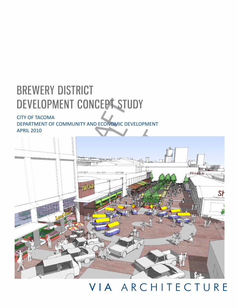
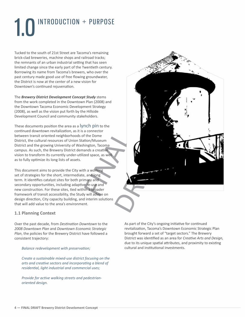
Tucked to the south of 21st Street are Tacoma’s remaining brick-clad breweries, machine shops and railroad tracks; the remnants of an urban industrial se�ng that has seen limited change since the early part of the Twen�eth century. Borrowing its name from Tacoma’s brewers, who over the past century made good use of free flowing groundwater, the District is now at the center of a new vision for Downtown’s con�nued rejuvena�on.
The Brewery District Development Concept Study stems from the work completed in the Downtown Plan (2008) and the Downtown Tacoma Economic Development Strategy (2008), as well as the vision put forth by the Hillside Development Council and community stakeholders.
These documents posi�on the area as a lynch pin to the con�nued downtown revitaliza�on, as it is a connector between transit oriented neighborhoods of the Dome District, the cultural resources of Union Sta�on/Museum District and the growing University of Washington, Tacoma campus. As such, the Brewery District demands a crea�ve vision to transform its currently under-u�lized space, as well as to fully op�mize its long lists of assets.
This document aims to provide the City with a working set of strategies for the short, intermediate, and long term. It iden�fies catalyst sites for both primary and secondary opportuni�es, including adap�ve re-use and new construc�on. For these sites, �ed within a broader framework of transit accessibility, the Study will advise on design direc�on, City capacity building, and interim solu�ons that will add value to the area’s environment.
1.0
INTRODUCT ION + PURPOSE
1.1 Planning Context
Over the past decade, from Des�na�on Downtown to the 2008 Downtown Plan and Downtown Economic Strategic Plan, the policies for the Brewery District have followed a consistent trajectory:
Balance redevelopment with preserva�on;
Create a sustainable mixed-use district focusing on the arts and crea�ve sectors and incorpora�ng a blend of residen�al, light industrial and commercial uses; Provide for ac�ve walking streets and pedestrian-oriented design.
As part of the City’s ongoing ini�a�ve for con�nued revitaliza�on, Tacoma’s Downtown Economic Strategic Plan brought forward a set of “target sectors.” The Brewery District was iden�fied as an area for Crea�ve Arts and Design, due to its unique spa�al a�ributes, and proximity to exis�ng cultural and ins�tu�onal investments.
FINA
L DR
AFT
FINAL DRAFT Brewery District Development Concept 5
From the public sector perspec�ve, policy goals for an engaged crea�ve community in the Brewery District might include:
A�rac�ng crea�ve industry and cultural enterprises Encouraging business and job development for the
exis�ng business sector Suppor�ng adjacent des�na�ons such as the Tacoma
Arts Museum, the Washington State History Museum and the Museum of Glass, and encouraging similar uses to locate in the Brewery District
Preserving and reusing historically significant buildings Enhancing property values Engaging transi�onal uses that can transform under
u�lized space and encourage long-term, sustainable uses
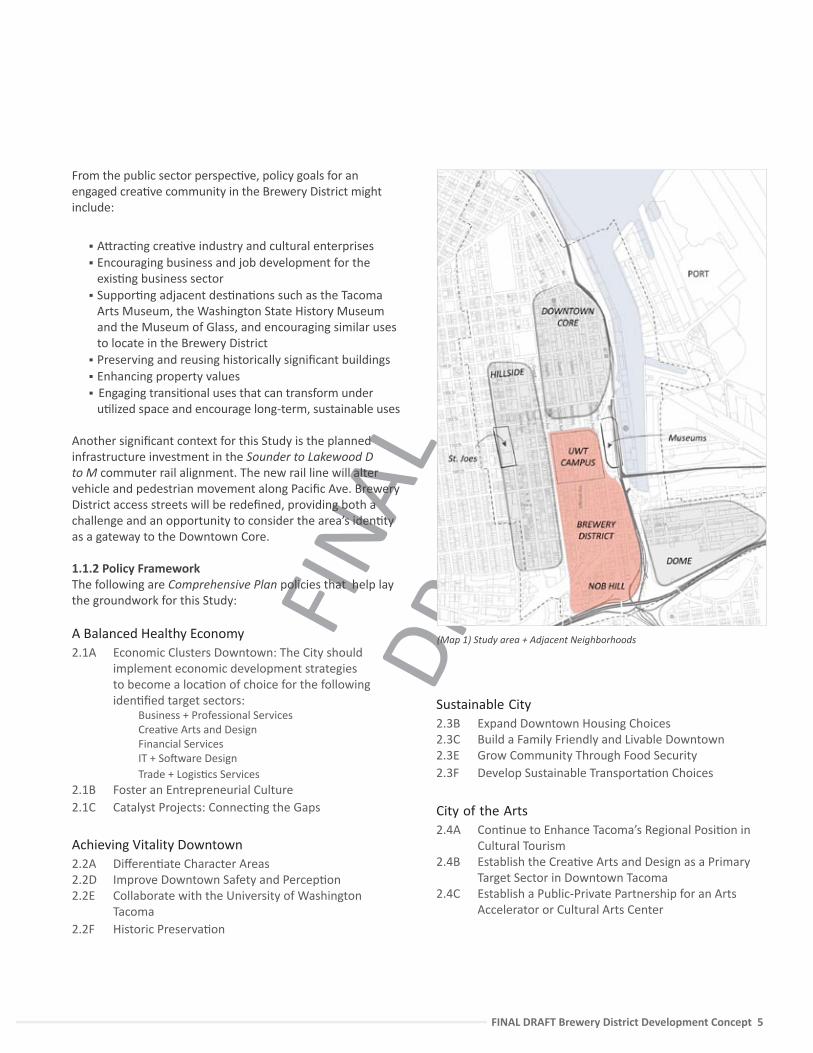
Another significant context for this Study is the planned infrastructure investment in the Sounder to Lakewood D to M commuter rail alignment. The new rail line will alter vehicle and pedestrian movement along Pacific Ave. Brewery District access streets will be redefined, providing both a challenge and an opportunity to consider the area’s iden�ty as a gateway to the Downtown Core.
1.1.2 Policy FrameworkThe following are Comprehensive Plan policies that help lay the groundwork for this Study:
A Balanced Healthy Economy 2.1A Economic Clusters Downtown: The City should
implement economic development strategies to become a loca�on of choice for the following iden�fied target sectors:
Business + Professional Services Crea�ve Arts and Design Financial Services IT + So�ware Design Trade + Logis�cs Services
2.1B Foster an Entrepreneurial Culture2.1C Catalyst Projects: Connec�ng the Gaps
Achieving Vitality Downtown 2.2A Differen�ate Character Areas2.2D Improve Downtown Safety and Percep�on2.2E Collaborate with the University of Washington
Tacoma2.2F Historic Preserva�on
(Map 1) Study area + Adjacent Neighborhoods
Sustainable City2.3B Expand Downtown Housing Choices2.3C Build a Family Friendly and Livable Downtown2.3E Grow Community Through Food Security2.3F Develop Sustainable Transporta�on Choices
City of the Arts2.4A Con�nue to Enhance Tacoma’s Regional Posi�on in
Cultural Tourism2.4B Establish the Crea�ve Arts and Design as a Primary
Target Sector in Downtown Tacoma2.4C Establish a Public-Private Partnership for an Arts
Accelerator or Cultural Arts Center
FINA
L DR
AFT
6 — FINAL DRAFT Brewery District Develoment Concept
1.2 Public Outreach Summary
Public outreach conducted by the project team provided insight into community aspira�ons and goals related to development concepts and recommenda�ons. During the six months of the project the consul�ng team conducted the following:
3. On-line survey posted to the Tacoma List Server and distributed to stakeholder mailing lists, and other social networking sources (Survey can be found in Appendix 1).Survey was held open for one month with over 200 respondents.
4. Public Open House Mee�ng and Presenta�on was held at the University of Washington, Tacoma on December, 9 2009 with a�endance from both project stakeholders, City staff, and the public.
5. Publica�on of DRAFT Development Concept Study for public review and comment on December 9, 2009.
1. Stakeholder interviews with the following individuals and groups:
Downtown Developers School of the Arts Washington State History Museum Brewery District Residents and Business Owners Department of Community and Economic
Development Metro Parks Museum and Cultural Representa�ves Small Business Owners Pierce Transit Sound Transit University of Washington Tacoma GTEC, Tacoma Mobility Coordinator Dome District Stakeholders Department of Public Works Tacoma Housing Authority Tacoma Arts Commission Historic Tacoma Social Service Providers
2. Presenta�ons and summary by the Consultant team to the Hillside Neighborhood Council for technical advice on the following dates:
July 23, 2009 September 24, 2009 October 20, 2009
FINA
L DR
AFT
FINAL DRAFT Brewery District Development Concept 7
(Map 2) Study Area aerial photo and key areas
21st
Puyallup
25th Street
19th Street
17th Street
Jeffe
rson
Sounder/Amtra
k extension
Taco
ma
Ave
LIN
K
Sout
h C
Stre
etH
olga
te
Com
mer
ce
Hoo
d St
reet
/Pra
irie
Line
Paci
fic A
ve
23rd Street
To the Dome District Transit
Center
University of Washington
Campus
Core Brewery District Area
Nob Hill Residen�al
Neighborhood area
Pacific Ave mixed
commercial area
Museum District
I-705
I-5
Hillside Residen�al
Neighborhood
STUDY AREA BOUNDARY
FINA
L DR
AFT
8 — FINAL DRAFT Brewery District Develoment Concept
2.0
THE D ISTR ICT TODAY
Museums and Cultural Representa�ves Are excited about the City’s focus on crea�vity, and
would like to par�cipate and help make this a reality.UW Tacoma
Interested in knowing what the best opportuni�es for partnerships are between the campus and the Brewery District, and how to strengthen the links between the two study areas.
Concerned about safety along Commerce, Jefferson, and the Prairie Line as residen�al student popula�on grows.
Concerned about pedestrian crossings on 21st where vehicle/pedestrian conflicts are high.
Tacoma Arts Commission Would like to advance the working arts - through
both long term and temporary strategies to get more people into the district and make connec�ons to the exis�ng museums.
Social Service Providers Development on the 6-acre parcel (at 21st and
Jefferson) should be though�ul about workforce housing need; in par�cular as the neighborhood redevelops; se�ng up for long-term care for working class and lower income residents.
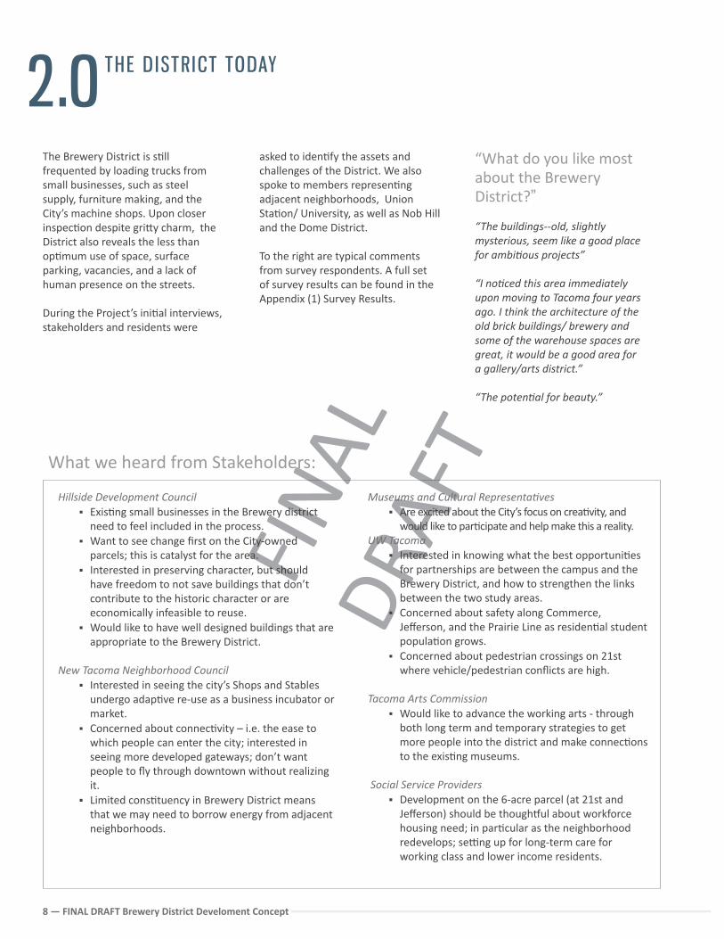
The Brewery District is s�ll frequented by loading trucks from small businesses, such as steel supply, furniture making, and the City’s machine shops. Upon closer inspec�on despite gri�y charm, the District also reveals the less than op�mum use of space, surface parking, vacancies, and a lack of human presence on the streets.
During the Project’s ini�al interviews, stakeholders and residents were
Hillside Development Council Exis�ng small businesses in the Brewery district
need to feel included in the process. Want to see change first on the City-owned
parcels; this is catalyst for the area. Interested in preserving character, but should
have freedom to not save buildings that don’t contribute to the historic character or are economically infeasible to reuse.
Would like to have well designed buildings that are appropriate to the Brewery District.
New Tacoma Neighborhood Council Interested in seeing the city’s Shops and Stables
undergo adap�ve re-use as a business incubator or market.
Concerned about connec�vity – i.e. the ease to which people can enter the city; interested in seeing more developed gateways; don’t want people to fly through downtown without realizing it.
Limited cons�tuency in Brewery District means that we may need to borrow energy from adjacent neighborhoods.
What we heard from Stakeholders:
asked to iden�fy the assets and challenges of the District. We also spoke to members represen�ng adjacent neighborhoods, Union Sta�on/ University, as well as Nob Hill and the Dome District.
To the right are typical comments from survey respondents. A full set of survey results can be found in the Appendix (1) Survey Results.
“What do you like most about the Brewery District?”
“The buildings--old, slightly mysterious, seem like a good place for ambi�ous projects”
“I no�ced this area immediately upon moving to Tacoma four years ago. I think the architecture of the old brick buildings/ brewery and some of the warehouse spaces are great, it would be a good area for a gallery/arts district.”
“The poten�al for beauty.”
FINA
L DR
AFT
FINAL DRAFT Brewery District Development Concept 9
Walkable, narrow streets Views of the Foss Waterway and proximity to the
waterfront Poten�al for gateway access to downtown core at
Pacific Avenue Clear neighborhood boundaries and iden�ty Historic character of buildings, both contribu�ng and
pivotal in the core, along the Prairie Line Corridor and Pacific Avenue
Available space for industry and produc�on Proximity to extensive mass transit (LINK, Sounder,
AMTRAK, local and regional bus service) and other transporta�on modes including I-705 and I-5
Proximity to exis�ng cultural district and museums Centrally located within a growing downtown Neighborhood and ins�tu�onal investment through
the UWT Topography and views are interes�ng and dynamic Significant assembled land in public ownership
Limited street level ac�vity Public safety and social costs related to blighted or
under-u�lized space Buildings in disrepair Aging infrastructure High number of vacancies Dispropor�onately high concentra�on of social
services A percep�on of crime that discourages visitors Lack of des�na�ons Percep�on of risk by financiers and developers Barriers to pedestrian crossing between the University
Campus and the Brewery District Conflict between vehicle movement and pedestrians Great character on Commerce Street, but no public or
pedestrian uses
District ChallengesDistrict Assets
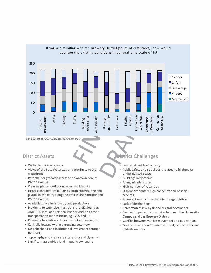
If you a re fa milia r w ith the B re w e ry District (south of 21st stre e t), how w ould you ra te the e x isting conditions in ge ne ra l on a sca le of 1-5
0
50
100
150
200
250
His
tori
cpr
eser
vatio
n
Safe
ty
Park
ing
Traf
fic
Build
ing
appe
aran
ce
Acc
essi
bilit
y
Hou
sing
oppo
rtun
ity
Park
spa
ce
Exis
ting
serv
ices
Conn
ectio
nto
the
Foss
Conn
ectio
nto
Dow
ntow
n
Conn
ectio
nto
the
UW
1- poor
2- fair
3- average
4- good
5- excellent
For a full set of survey responses see Appendix (1)
FINA
L DR
AFT
10 — FINAL DRAFT Brewery District Develoment Concept
2.1 Demographic Profile
Much of the study area popula�on is concentrated at the edges or just outside of the core historic area of the Brewery District in either Nob Hill, Hillside or on the University footprint. This popula�on lives in both older homes and in new mul�family construc�on, such as Court 17. Addi�onal popula�ons include lower income households in subsidized housing, such as the Jefferson Apartments operated by the Metropolitan Development Council (MDC).
Racially diverse, with a 33% minority popula�on, the study area residents have compara�vely less income than city-wide and a median age of 24-35. However, over the past ten years, median income has risen by nearly $10,000 from $32,865 to $42,903 .1
In order to be�er gauge the market for new and resale mul�family developments,the City of Tacoma commissioned the 2007 Tacoma Housing Trends Study.2 This study provided a demographic profile for the South Downtown. Its findings for the most part, follow the broader na�onal trends. The most significant are listed below;
1. Smaller household sizes. For the first �me in the history of the U.S. Census, the majority of households are singles and couples with no children. Urban areas such as South Downtown offer housing prospects for these shrinking families.
2. An aging popula�on. As baby boomers age, this popula�on will con�nue to grow, peaking in 2015. Older popula�ons are choosing to live where they can easily walk or take public transit to ameni�es and ac�vi�es.
3. Young couples. Those born between 1979 and 1994 are just now entering the housing market, and many of these new buyers have small budgets and different interests than their parents.
4. Overall, the Study sees the area as growing and highlighted issues of safety and access as primary drivers for a choice to live in the South Downtown.
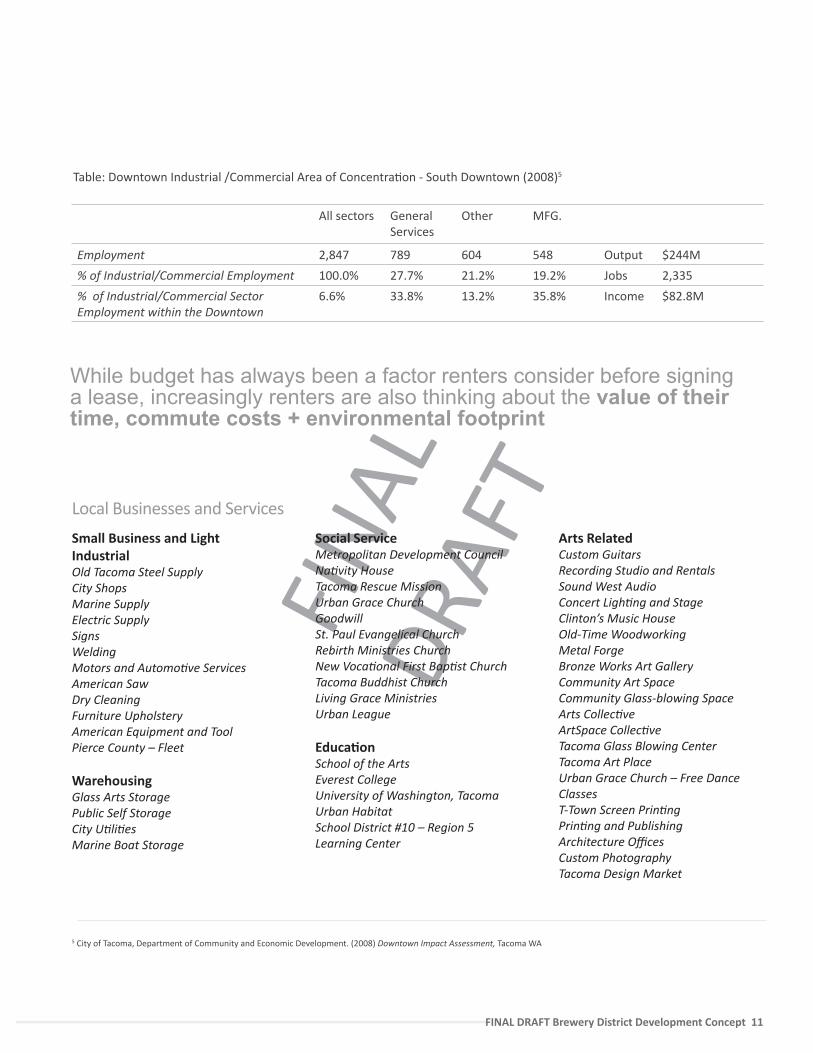
Study Area EmploymentThe 2008 Downtown Impact Assessment’s analysis of the southern quarter of Downtown Tacoma provides a snap shot of current business within the Brewery District4. Characterized primarily as a Industrial/Commercial concentra�on, the report found that there is a lack of employment density rela�ve to other areas in Downtown. However, while the quarter contains just 6.7% of Downtown Tacoma’s total employment, it does represent 35% of the total manufacturing in Downtown. Furthermore, the study noted a low jobs-to-space u�liza�on within the District.
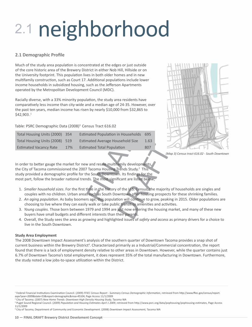
(Map 3) Census tract 616.02 - South Downtown
Total Housing Units (2000) 354 Es�mated Popula�on in Households 695
Total Housing Units (2008) 519 Es�mated Average Household Size 1.63
Es�mated Vacancy Rate 17% Es�mated Total Popula�on 807
Table: PSRC Demographic Data (2008)3 Census Tract 616.02
1 Federal Financial Ins�tu�ons Examina�on Council. (2009) FFIEC Census Report - Summary Census Demographic Informa�on, retrieved from h�p://www.ffiec.gov/census/report.aspx?year=2009&state=53&report=demographic&msa=45104, Page Access 11/1/20092 City of Tacoma. (2007) New Home Trends: Downtown High Density Housing Study, Tacoma WA3 Puget Sound Regional Council. (2009) Popula�on and Housing Es�mates April 1 2009, retrieved from h�p://www.psrc.org/data/pophousing/pophousing-es�mates, Page Access 11/1/20094 City of Tacoma, Department of Community and Economic Development. (2008) Downtown Impact Assessment, Tacoma WA
2.1 neighborhood
FINA
L DR
AFT
FINAL DRAFT Brewery District Development Concept 11
While budget has always been a factor renters consider before signing a lease, increasingly renters are also thinking about the value of their time, commute costs + environmental footprint
All sectors General Services
Other MFG.
Employment 2,847 789 604 548 Output $244M
% of Industrial/Commercial Employment 100.0% 27.7% 21.2% 19.2% Jobs 2,335
% of Industrial/Commercial Sector Employment within the Downtown
6.6% 33.8% 13.2% 35.8% Income $82.8M
Table: Downtown Industrial /Commercial Area of Concentra�on - South Downtown (2008)5
Small Business and Light IndustrialOld Tacoma Steel SupplyCity Shops Marine SupplyElectric SupplySignsWeldingMotors and Automo�ve ServicesAmerican SawDry CleaningFurniture UpholsteryAmerican Equipment and ToolPierce County – Fleet
WarehousingGlass Arts Storage Public Self StorageCity U�li�esMarine Boat Storage
Social ServiceMetropolitan Development Council Na�vity HouseTacoma Rescue MissionUrban Grace ChurchGoodwillSt. Paul Evangelical ChurchRebirth Ministries ChurchNew Voca�onal First Bap�st ChurchTacoma Buddhist ChurchLiving Grace MinistriesUrban League
Educa�onSchool of the ArtsEverest CollegeUniversity of Washington, TacomaUrban HabitatSchool District #10 – Region 5 Learning Center
Arts RelatedCustom GuitarsRecording Studio and RentalsSound West AudioConcert Ligh�ng and Stage Clinton’s Music HouseOld-Time WoodworkingMetal ForgeBronze Works Art GalleryCommunity Art SpaceCommunity Glass-blowing SpaceArts Collec�veArtSpace Collec�veTacoma Glass Blowing CenterTacoma Art PlaceUrban Grace Church – Free Dance ClassesT-Town Screen Prin�ngPrin�ng and PublishingArchitecture OfficesCustom Photography Tacoma Design Market
Local Businesses and Services
5 City of Tacoma, Department of Community and Economic Development. (2008) Downtown Impact Assessment, Tacoma WA
FINA
L DR
AFT
12 — FINAL DRAFT Brewery District Develoment Concept
authen�city2.2 Historic Preserva�on + Public Benefit
The historic buildings in the core of the Brewery District inform how ci�zens percieve the District and are significant to downtown Tacoma’s overall imageability. However, these buildings have also been both catalyst and obstacle in the neighborhood’s pursuit of redevelopment. Within the Puget Sound’s earthquake prone region, buildings renovated for more intensive uses must undergo a seismic retrofit to meet life safety requirements, o�en resul�ng in extra costs. In addi�on, some of the proper�es have issues related to absenteeism, specula�on, or disassembled ownership, resul�ng in a por�olio of structures that are underu�lized or vacant.
However, despite difficul�es, successful historic preserva�on and adap�ve re-use invoke a mul�plier effect of public benefits including:
Increased property values Stabilized neighborhoods Heritage tourism Civic pride Sustainability
As such, preserva�on/adap�ve reuse has become one of Tacoma’s economic development priori�es. With many in Downtown concerned about the fate of historic icons, including the Elks Building and Old City Hall, the City is undergoing an update to the Historic Preserva�on Element in the Comprehensive Plan and asasociated Landmarks Code in 2010-2011.
Historic Preserva�on has also been key to the University of Washington’s
evolving urban campus, bestowing on it a tangible rela�onship with the area’s past and making it one of the most well-received new development areas in the City
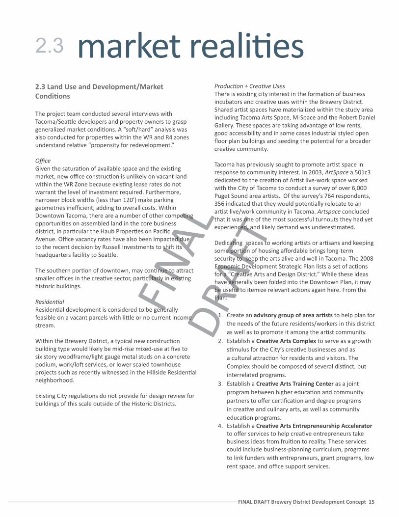
Historic Structures in the Brewery DistrictThe northern blocks of the Brewery District contain a por�on of the Union Sta�on Conserva�on District as a buffer around the more formal Historic District. In the Brewery District, older warehousing and industrial buildings along Commerce, Pacific, and ‘A’ Street share similar height, construc�on type, and original func�on. Many of these buildings are especially well suited to adap�ve re-use due to their large, open floor plates, high ceilings, and plen�ful windows. Buildings located between South C Street, Commerce, and Pacific Ave are designed with dual entrances and loading docks.
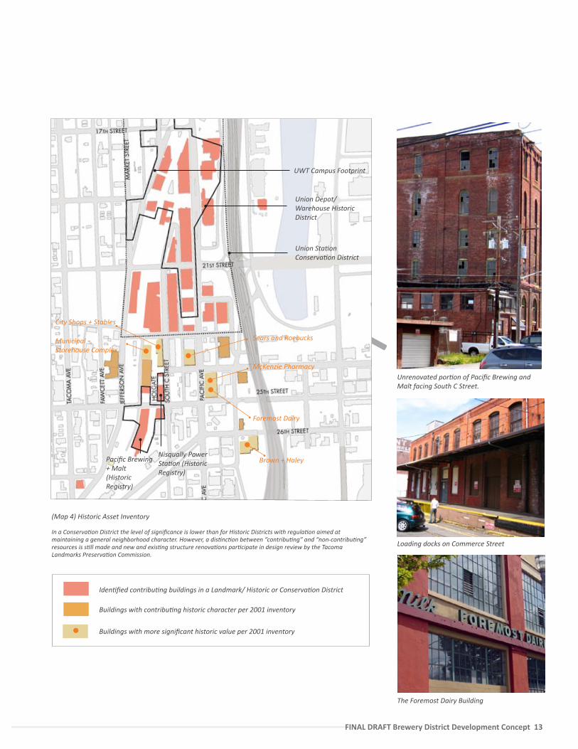
A survey was conducted in 2001 by the City of Tacoma as part of an applica�on for a Historic District nomina�on throughout the Brewery District. The survey recommended a number of buildings as “pivotal,” “primary,” or “contribu�ng.” This inventory is now in the process of being updated and can help to iden�fy the most important buildings to preserve. A summary of these findings is located on the map on page 13.
2.2.1 Preserva�on ChallengesHistoric buildings within the District are in various states of repair. Some buildings are derelict and/or under-u�lized, and many have deferred maintenance making it very costly to bring these buidlings in complaince with code, par�cularly seismic. In stakeholder mee�ngs we heard that public concern, in par�cular, revolves around the following:
1. The set of public works u�lity buildings including the shops, water, and power buildings that line Holgate Ave. With the excep�on of the Nisqually Power Sta�on these buildings are not currently in a Conserva�on District or otherwise protected.
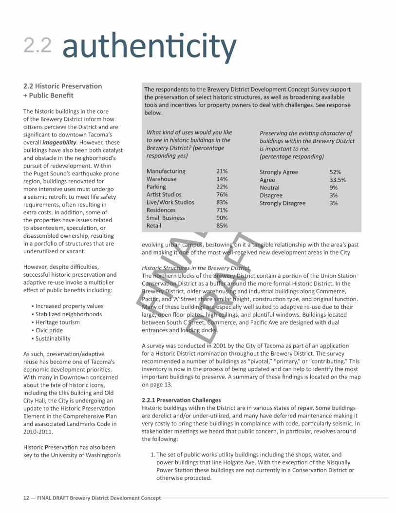
What kind of uses would you like to see in historic buildings in the Brewery District? (percentage responding yes)
Manufacturing 21%Warehouse 14%Parking 22%Ar�st Studios 76%Live/Work Studios 83%Residences 71%Small Business 90%Retail 85%
Preserving the exis�ng character of buildings within the Brewery District is important to me.(percentage responding)
Strongly Agree 52%Agree 33.5%Neutral 9%Disagree 3%Strongly Disagree 3%
The respondents to the Brewery District Development Concept Survey support the preserva�on of select historic structures, as well as broadening available tools and incen�ves for property owners to deal with challenges. See response below.
2.2
FINA
L DR
AFT
FINAL DRAFT Brewery District Development Concept 13
Iden�fied contribu�ng buildings in a Landmark/ Historic or Conserva�on District
Buildings with contribu�ng historic character per 2001 inventory
Buildings with more significant historic value per 2001 inventory
(Map 4) Historic Asset Inventory
In a Conserva�on District the level of significance is lower than for Historic Districts with regula�on aimed at maintaining a general neighborhood character. However, a dis�nc�on between “contribu�ng” and “non-contribu�ng” resources is s�ll made and new and exis�ng structure renova�ons par�cipate in design review by the Tacoma Landmarks Preserva�on Commission.
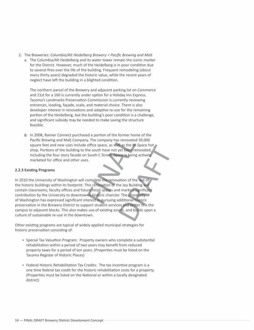
Unrenovated por�on of Pacific Brewing and Malt facing South C Street.
Union Depot/ Warehouse Historic District
Union Sta�on Conserva�on District
Nisqually Power Sta�on (Historic Registry)
Pacific Brewing + Malt (Historic Registry)
UWT Campus Footprint
Loading docks on Commerce Street
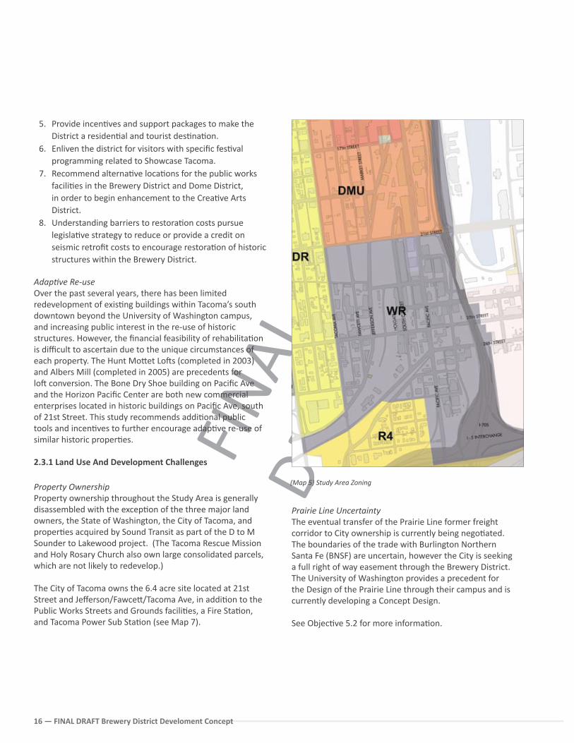
The Foremost Dairy Building
Municipal Storehouse Complex
City Shops + Stables
Sears and Roebucks
McKenzie Pharmacy
Foremost Dairy
Brown + Haley
FINA
L DR
AFT
14 — FINAL DRAFT Brewery District Develoment Concept
2. The Breweries: Columbia/Alt Heidelberg Brewery + Pacific Brewing and Malta. The Columbia/Alt Heidelberg and its water tower remain the iconic marker
for the District. However, much of the Heidelberg is in poor condi�on due to several fires over the life of the building. Frequent remodeling (about every thirty years) degraded the historic value, while the recent years of neglect have le� the building in a blighted condi�on.
The northern parcel of the Brewery and adjacent parking lot on Commerce and 21st for a 160 is currently under op�on for a Holiday Inn Express. Tacoma’s Landmarks Preserva�on Commission is currently reviewing entrances, loading, façade, scale, and material choice. There is also developer interest in renova�ons and adap�ve re-use for the remaining por�on of the Heidelberg, but the building’s poor condi�on is a challenge, and significant subsidy may be needed to make saving the structure feasible.
b. In 2008, Rainier Connect purchased a por�on of the former home of the Pacific Brewing and Malt Company. The company has renovated 30,000 square feet and new uses include office space, as well as the M-Space hot shop. Por�ons of the building to the south have not yet been renovated, including the four story facade on South C Street. Space is being ac�vely marketed for office and other uses.
2.2.3 Exis�ng Programs
In 2010 the University of Washington will complete the renova�on of the last of the historic buildings within its footprint. This renova�on of the Joy Building will contain classrooms, faculty offices and future retail spaces and marks a significant contribu�on by the University to downtown’s historic charcter. The University of Washington has expressed significant interest in pursuing addi�onal historic preserva�on in the Brewery District to support student services and be�er link the campus to adjacent blocks. This also makes use of exis�ng assets, and builds upon a culture of sustainable re-use in the downtown.
Other exis�ng programs are typical of widely applied municipal strategies for historic preserva�on consis�ng of:
Special Tax Valua�on Program: Property owners who complete a substan�al rehabilita�on within a period of two years may benefit from reduced property taxes for a period of ten years. (Proper�es must be listed on the Tacoma Registar of Historic Places)
Federal Historic Rehabilita�on Tax Credits: The tax incen�ve program is a one �me federal tax credit for the historic rehabilita�on costs for a property. (Proper�es must be listed on the Na�onal or within a locally designated district)
FINA
L DR
AFT
FINAL DRAFT Brewery District Development Concept 15
2.3 Land Use and Development/Market Condi�ons
The project team conducted several interviews with Tacoma/Sea�le developers and property owners to grasp generalized market condi�ons. A “so�/hard” analysis was also conducted for proper�es within the WR and R4 zones understand rela�ve “propensity for redevelopment.”
OfficeGiven the satura�on of available space and the exis�ng market, new office construc�on is unlikely on vacant land within the WR Zone because exis�ng lease rates do not warrant the level of investment required. Furthermore, narrower block widths (less than 120’) make parking geometries inefficient, adding to overall costs. Within Downtown Tacoma, there are a number of other compe�ng opportuni�es on assembled land in the core business district, in par�cular the Haub Proper�es on Pacific Avenue. Office vacancy rates have also been impacted due to the recent decision by Russell Investments to shi� its headquarters facility to Sea�le.
The southern por�on of downtown, may con�nue to a�ract smaller offices in the crea�ve sector, par�cularly in exis�ng historic buildings.
Residen�al Residen�al development is considered to be generally feasible on a vacant parcels with li�le or no current income stream.
Within the Brewery District, a typical new construc�on building type would likely be mid-rise mixed-use at five to six story woodframe/light gauge metal studs on a concrete podium, work/lo� services, or lower scaled townhouse projects such as recently witnessed in the Hillside Residen�al neighborhood.
Exis�ng City regula�ons do not provide for design review for buildings of this scale outside of the Historic Districts.
Produc�on + Crea�ve Uses There is exis�ng city interest in the forma�on of business incubators and crea�ve uses within the Brewery District. Shared ar�st spaces have materialized within the study area including Tacoma Arts Space, M-Space and the Robert Daniel Gallery. These spaces are taking advantage of low rents, good accessibility and in some cases industrial styled open floor plan buildings and seeding the poten�al for a broader crea�ve community.
Tacoma has previously sought to promote ar�st space in response to community interest. In 2003, ArtSpace a 501c3 dedicated to the crea�on of Ar�st live-work space worked with the City of Tacoma to conduct a survey of over 6,000 Puget Sound area ar�sts. Of the survey’s 764 respondents, 356 indicated that they would poten�ally relocate to an ar�st live/work community in Tacoma. Artspace concluded that it was one of the most successful turnouts they had yet experienced, and likely demand was underes�mated.
Dedica�ng spaces to working ar�sts or ar�sans and keeping some por�on of housing affordable brings long-term security to keep the arts alive and well in Tacoma. The 2008 Economic Development Strategic Plan lists a set of ac�ons for a “Crea�ve Arts and Design District.” While these ideas have generally been folded into the Downtown Plan, it may be useful to itemize relevant ac�ons again here. From the Plan:
1. Create an advisory group of area ar�sts to help plan for the needs of the future residents/workers in this district as well as to promote it among the ar�st community.
2. Establish a Crea�ve Arts Complex to serve as a growth s�mulus for the City’s crea�ve businesses and as a cultural a�rac�on for residents and visitors. The Complex should be composed of several dis�nct, but interrelated programs.
3. Establish a Crea�ve Arts Training Center as a joint program between higher educa�on and community partners to offer cer�fica�on and degree programs in crea�ve and culinary arts, as well as community educa�on programs.
4. Establish a Crea�ve Arts Entrepreneurship Accelerator to offer services to help crea�ve entrepreneurs take business ideas from frui�on to reality. These services could include business-planning curriculum, programs to link funders with entrepreneurs, grant programs, low rent space, and office support services.
market reali�es2.3
FINA
L DR
AFT
16 — FINAL DRAFT Brewery District Develoment Concept
5. Provide incen�ves and support packages to make the District a residen�al and tourist des�na�on.
6. Enliven the district for visitors with specific fes�val programming related to Showcase Tacoma.
7. Recommend alterna�ve loca�ons for the public works facili�es in the Brewery District and Dome District, in order to begin enhancement to the Crea�ve Arts District.
8. Understanding barriers to restora�on costs pursue legisla�ve strategy to reduce or provide a credit on seismic retrofit costs to encourage restora�on of historic structures within the Brewery District.
Adap�ve Re-useOver the past several years, there has been limited redevelopment of exis�ng buildings within Tacoma’s south downtown beyond the University of Washington campus, and increasing public interest in the re-use of historic structures. However, the financial feasibility of rehabilita�on is difficult to ascertain due to the unique circumstances of each property. The Hunt Mo�et Lo�s (completed in 2003) and Albers Mill (completed in 2005) are precedents for lo� conversion. The Bone Dry Shoe building on Pacific Ave and the Horizon Pacific Center are both new commercial enterprises located in historic buildings on Pacific Ave, south of 21st Street. This study recommends addi�onal public tools and incen�ves to further encourage adap�ve re-use of similar historic proper�es.
2.3.1 Land Use And Development Challenges
Property OwnershipProperty ownership throughout the Study Area is generally disassembled with the excep�on of the three major land owners, the State of Washington, the City of Tacoma, and proper�es acquired by Sound Transit as part of the D to M Sounder to Lakewood project. (The Tacoma Rescue Mission and Holy Rosary Church also own large consolidated parcels, which are not likely to redevelop.)
The City of Tacoma owns the 6.4 acre site located at 21st Street and Jefferson/Fawce�/Tacoma Ave, in addi�on to the Public Works Streets and Grounds facili�es, a Fire Sta�on, and Tacoma Power Sub Sta�on (see Map 7).
Prairie Line UncertaintyThe eventual transfer of the Prairie Line former freight corridor to City ownership is currently being nego�ated. The boundaries of the trade with Burlington Northern Santa Fe (BNSF) are uncertain, however the City is seeking a full right of way easement through the Brewery District. The University of Washington provides a precedent for the Design of the Prairie Line through their campus and is currently developing a Concept Design.
See Objec�ve 5.2 for more informa�on.
(Map 5) Study Area Zoning
FINA
L DR
AFT
FINAL DRAFT Brewery District Development Concept 17
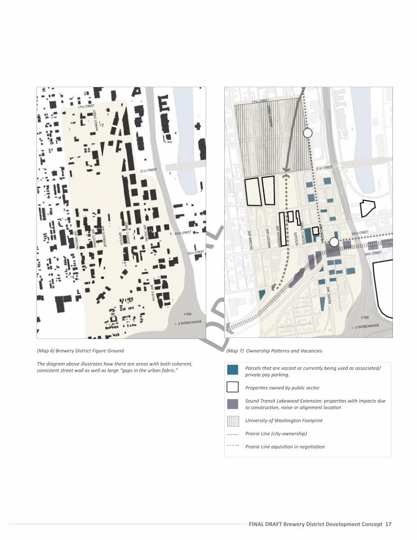
(Map 7) Ownership Pa�erns and Vacancies(Map 6) Brewery District Figure Ground
The diagram above illustrates how there are areas with both coherent, consistent street wall as well as large “gaps in the urban fabric.” Parcels that are vacant or currently being used as associated/
private pay parking.
Proper�es owned by public sector
Sound Transit Lakewood Extension: proper�es with impacts due to construc�on, noise or alignment loca�on
University of Washington Footprint
Prairie Line (city-ownership)
Prairie Line aquisi�on in nego�a�on
FINA
L DR
AFT
18 — FINAL DRAFT Brewery District Develoment Concept
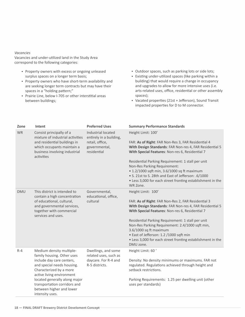
Zone Intent Preferred Uses Summary Performance Standards
WR Consist principally of a mixture of industrial ac�vi�es and residen�al buildings in which occupants maintain a business involving industrial ac�vi�es
Industrial located en�rely in a building, retail, office, governmental, residen�al
Height Limit: 100’
FAR: As of Right: FAR Non-Res 3, FAR Residen�al 4 With Design Standards: FAR Non-res 4, FAR Residen�al 5 With Special Features: Non-res 6, Residen�al 7
Residen�al Parking Requirement: 1 stall per unit Non-Res Parking Requirement: • 1.2/1000 sq� min, 3.6/1000 sq � maximum• S. 21st to S. 28th and East of Jefferson: .6/1000• Less 3,000 for each street fron�ng establishment in the WR Zone.
DMU This district is intended to contain a high concentra�on of educa�onal, cultural, and governmental services, together with commercial services and uses.
Governmental, educa�onal, office, cultural
Height Limit: 100’
FAR: As of Right: FAR Non-Res 2, FAR Residen�al 3 With Design Standards: FAR Non-res 4, FAR Residen�al 5 With Special Features: Non-res 6, Residen�al 7
Residen�al Parking Requirement: 1 stall per unitNon-Res Parking Requirement: 2.4/1000 sq� min, 3.6/1000 sq � maximum• East of Jefferson: 1.2 /1000 sq� min • Less 3,000 for each street fron�ng establishment in the DMU zone.
R-4 Medium density mul�ple-family housing. Other uses include day care centers, and special needs housing. Characterized by a more ac�ve living environment located generally along major transporta�on corridors and between higher and lower intensity uses.
Dwellings, and some related uses, such as daycare. For R-4 and R-5 districts.
Height Limit: 60 ‘
Density: No density minimums or maximums. FAR not regulated. Regula�ons achieved through height and setback restric�ons.
Parking Requirements: 1.25 per dwelling unit (other uses per standards)
VacanciesVacancies and under-u�lized land in the Study Area correspond to the following categories:
Outdoor spaces, such as parking lots or side lots; Exis�ng under-u�lized spaces (like parking within a
building) that would require a change in occupancy and upgrades to allow for more intensive uses (i.e. arts-related uses, office, residen�al or other assembly spaces);
Vacated proper�es (21st + Jefferson), Sound Transit impacted proper�es for D to M connector.
Property owners with excess or ongoing unleased surplus spaces on a longer term basis;
Property owners who have short-term availability and are seeking longer term contracts but may have their spaces in a “holding pa�ern;”
Prairie Line, below I-705 or other inters��al areas between buildings;
FINA
L DR
AFT
FINAL DRAFT Brewery District Development Concept 19
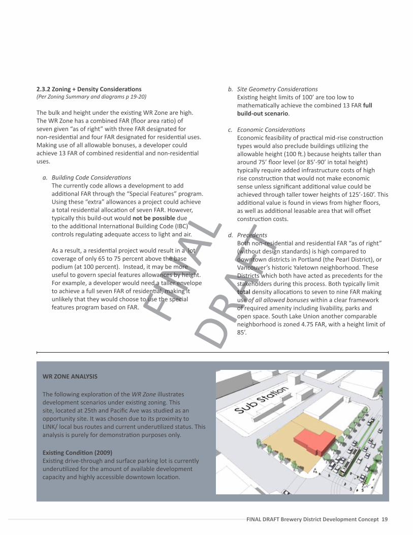
WR ZONE ANALYSIS
The following explora�on of the WR Zone illustrates development scenarios under exis�ng zoning. This site, located at 25th and Pacific Ave was studied as an opportunity site. It was chosen due to its proximity to LINK/ local bus routes and current underu�lized status. This analysis is purely for demonstra�on purposes only.
Exis�ng Condi�on (2009)Exis�ng drive-through and surface parking lot is currently underu�lized for the amount of available development capacity and highly accessible downtown loca�on.
2.3.2 Zoning + Density Considera�ons(Per Zoning Summary and diagrams p 19-20)
The bulk and height under the exis�ng WR Zone are high. The WR Zone has a combined FAR (floor area ra�o) of seven given “as of right” with three FAR designated for non-residen�al and four FAR designated for residen�al uses. Making use of all allowable bonuses, a developer could achieve 13 FAR of combined residen�al and non-residen�al uses.
a. Building Code Considera�ons The currently code allows a development to add
addi�onal FAR through the “Special Features” program. Using these “extra” allowances a project could achieve a total residen�al alloca�on of seven FAR. However, typically this build-out would not be possible due to the addi�onal Interna�onal Building Code (IBC) controls regula�ng adequate access to light and air.
As a result, a residen�al project would result in a lot coverage of only 65 to 75 percent above the base podium (at 100 percent). Instead, it may be more useful to govern special features allowances by height. For example, a developer would need a taller envelope to achieve a full seven FAR of residen�al, making it unlikely that they would choose to use the special features program based on FAR.
b. Site Geometry Considera�ons Exis�ng height limits of 100’ are too low to
mathema�cally achieve the combined 13 FAR full build-out scenario.
c. Economic Considera�ons Economic feasibility of prac�cal mid-rise construc�on
types would also preclude buildings u�lizing the allowable height (100 �.) because heights taller than around 75’ floor level (or 85’-90’ in total height) typically require added infrastructure costs of high rise construc�on that would not make economic sense unless significant addi�onal value could be achieved through taller tower heights of 125’-160’. This addi�onal value is found in views from higher floors, as well as addi�onal leasable area that will offset construc�on costs.
d. Precedents Both non-residen�al and residen�al FAR “as of right”
(without design standards) is high compared to downtown districts in Portland (the Pearl District), or Vancouver’s historic Yaletown neighborhood. These Districts which both have acted as precedents for the stakeholders during this process. Both typically limit total density alloca�ons to seven to nine FAR making use of all allowed bonuses within a clear framework of required amenity including livability, parks and open space. South Lake Union another comparable neighborhood is zoned 4.75 FAR, with a height limit of 85’.
FINA
L DR
AFT
20 — FINAL DRAFT Brewery District Develoment Concept
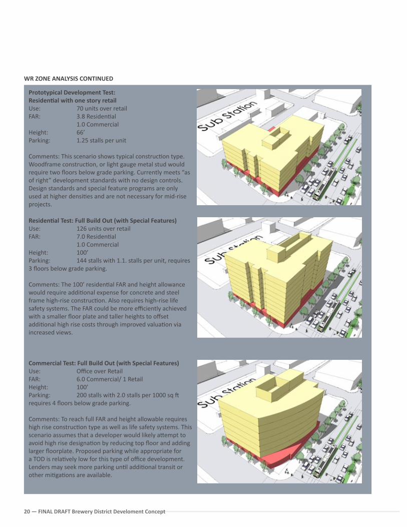
Prototypical Development Test:Residen�al with one story retail Use: 70 units over retailFAR: 3.8 Residen�al 1.0 Commercial Height: 66’Parking: 1.25 stalls per unit
Comments: This scenario shows typical construc�on type. Woodframe construc�on, or light gauge metal stud would require two floors below grade parking. Currently meets “as of right” development standards with no design controls. Design standards and special feature programs are only used at higher densi�es and are not necessary for mid-rise projects.
Residen�al Test: Full Build Out (with Special Features) Use: 126 units over retailFAR: 7.0 Residen�al 1.0 Commercial Height: 100’Parking: 144 stalls with 1.1. stalls per unit, requires 3 floors below grade parking.
Comments: The 100’ residen�al FAR and height allowance would require addi�onal expense for concrete and steel frame high-rise construc�on. Also requires high-rise life safety systems. The FAR could be more efficiently achieved with a smaller floor plate and taller heights to offset addi�onal high rise costs through improved valua�on via increased views.
Commercial Test: Full Build Out (with Special Features)Use: Office over RetailFAR: 6.0 Commercial/ 1 RetailHeight: 100’Parking: 200 stalls with 2.0 stalls per 1000 sq � requires 4 floors below grade parking.
Comments: To reach full FAR and height allowable requires high rise construc�on type as well as life safety systems. This scenario assumes that a developer would likely a�empt to avoid high rise designa�on by reducing top floor and adding larger floorplate. Proposed parking while appropriate for a TOD is rela�vely low for this type of office development. Lenders may seek more parking un�l addi�onal transit or other mi�ga�ons are available.
WR ZONE ANALYSIS CONTINUED
FINA
L DR
AFT
FINAL DRAFT Brewery District Development Concept 21
In sum, the already significant “as of right” FARs (four FAR residen�al and three FAR Non-Residen�al), provide li�le incen�ve for developers to use either the Design Standards, or Special Features programs to add value to their proper�es beyond typical mid rise wood frame construc�on (shown on the preceding page) with a combined FAR of 3.8. Unfortunately, the City’s code therefore currently has limited impact on either architectural design or catalyzing higher and be�er uses.
Reforming the Special Features Incen�vesThe Bonus features is a key way that the City may encourage private developers to achieve more public benefits and add value that is both fair to the developer and to the City. Deriving the poten�al added revenue or “li�” from the significant added density, along with funding for new infrastructure and benefits for all, depends first upon a realis�c financial model. To this end, we believe that the City of Tacoma may wish to reconsider the current format of the amenity system.
Currently the City has chosen to apply a “flat rate” approach to its Special Features. However, the City should ensure that the densi�es provided for through incen�ve bonusing are achievable and contribute the quality of life in the district with appropriate development economics. The City should consider the following:
Iden�fy a priority list (with costs) for “bonusable ameni�es” through a repor�ng mechanism. Ameni�es should be priori�zed with a “first �er” category by zone. From the input received during this study, the Brewery District should include in its first �er those needs most cri�cal to redevelopment; i.e. public realm investments in the Prairie Line, a cultural amenity, water features or low impact development drainage features, and Historic Preserva�on.
An economist should review the requirements related in the “special features” program to ensure that within a typical project pro-forma, high density projects are incen�vized to contribute to neighborhood livability. These reviews should occur on a periodic basis to reflect market changes, par�cularly as the market for residen�al development increases within downtown Tacoma. Alterna�vely it may be possible to convene a ULI panel or technical advisory group.
Since varia�on of land value is not accounted for in the current flat rate system for amenity bonusing, providing an amenity may cost more propor�onally to project values in one loca�on versus another. As such, other methods of bonusing should be considered that reflect the values associated with specific ameni�es desired by the community. The CIty may wish to conduct a study on the u�liza�on of land li� ra�os. (Es�mated assessed value at exis�ng FAR: Es�mated value at Bonused FAR). This will allow the City and a private developer to understand the rela�ve ra�o that can be responsibly applied towards community amenity crea�on. Required amenity must account for risk and preclude placing the developer at a compe��ve disadvantage. This process would be par�cularly useful for a City led redevelopment or public/private venture (i.e. Catalyst Sites).
Recognize conveyance of land to public use. Base FAR should not be lost in the event a land owner conveys land for right-of-way, or any other public use. There should be a clear incen�ve to land owners and developers to give up por�ons of property for improvements related to open space, sidewalk alloca�ons or midblock crossings.
Use limita�ons within the WR Zone“Use limita�ons” within the WR zoning have been designed to be flexible. The inten�on of the zone is to encourage a variety of different uses within the district with an emphasis on produc�on and light industrial uses.
This flexibility has one excep�on; there is a prohibi�on on greater than six screen entertainment centers. With good access to transit, and proximity to student popula�ons, this restric�on should be reconsidered.
In addi�on, the City should consider limi�ng drive-through uses beyond the current 100’ distance from a light rail street to support walking and pedestrian priority within the full 400’ catchment of the Light Rail sta�on areas.
FINA
L DR
AFT
22 — FINAL DRAFT Brewery District Develoment Concept
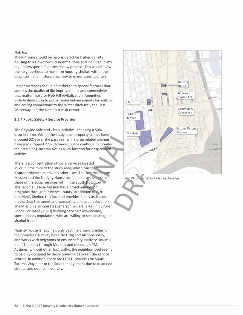
(Map 8) Loca�on of Social Service Providers
Nob HillThe R-4 zone should be reconsidered for higher density housing to a Downtown Residen�al zone and included in any regulatory/special features review process. This would allow the neighborhood to maximize housing choices within the downtown and in close proximity to major transit centers.
Height increases should be tethered to special features that address the quality of life improvements and connec�vity that ma�er most for Nob Hill revitaliza�on. Ameni�es include dedica�on to public realm enhancements for walking and cycling connec�ons to the Water ditch trail, the Foss Waterway and the Dome’s transit center.
2.3.4 Public Safety + Service Provision
The Citywide Safe and Clean Ini�a�ve is seeking a 50% drop in crime. Within the study area, property crimes have dropped 32% over the past year while drug related charges have also dropped 22%. However, police con�nue to monitor the area along Tacoma Ave as a key loca�on for drug related ac�vity.
There is a concentra�on of social services located in, or in proximity to the study area, which can seem dispropor�onate rela�ve to other uses. The Tacoma Rescue Mission and the Na�vity House combined provide a lion’s share of the social services within the South Downtown.The Tacoma Rescue Mission has a broad number of programs throughout Pierce County. In addi�on to a 70 bed Men’s Shelter, this loca�on provides family assistance, meals, drug treatment and counseling and adult educa�on. The Mission also operates Jefferson Square, a 42 unit Single Room Occupancy (SRO) building serving a low-income, special needs popula�on, who are willing to remain drug and alcohol free.
Na�vity House is Tacoma’s only day�me drop-in shelter for the homeless. Na�vity has a No Drug and Alcohol policy, and works with neighbors to ensure safety. Na�vity House is open Thursday through Monday and closes at 4 PM. At �mes, without other foot traffic, the neighborhood seems to be only occupied by those traveling between the service centers. In addi�on, there are CPTED concerns on South Tacoma Way near to the Sounder alignment due to dead end streets, and poor connec�vity.
Goodwill
Hillside Terrace
MDC
Na�vity House
Jefferson Square Apts.
Community Counseling
Tacoma Rescue Mission
SOUTH TACOMA WAY
FINA
L DR
AFT
FINAL DRAFT Brewery District Development Concept 23
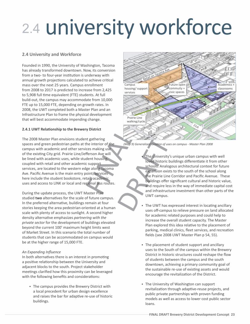
2.4 University and Workforce
Founded in 1990, the University of Washington, Tacoma has already transformed downtown. Now, its conversion from a two- to four-year ins�tu�on is underway with annual growth projec�ons calculated to achieve cri�cal mass over the next 25 years. Campus enrollment from 2008 to 2017 is predicted to increase from 2,425 to 5,908 full �me equivalent (FTE) students. At full build-out, the campus may accommodate from 10,000 FTE up to 15,000 FTE, depending on growth rates. In 2008, the UWT completed both a Master Plan and an Infrastructure Plan to frame the physical development that will best accommodate impending change.
2.4.1 UWT Rela�onship to the Brewery District
The 2008 Master Plan envisions student gathering spaces and green pedestrian paths at the interior of the campus with academic and other services making use of the exis�ng City grid. Prairie Line/Jefferson Ave will be lined with academic uses, while student housing, coupled with retail and other academic support services, are located to the western edge along Tacoma Ave. Pacific Avenue is the main entry point, services here include the student bookstore, retail, academic uses and access to LINK or local and regional bus routes.
During the update process, the UWT Master Plan studied two alterna�ves for the scale of future campus. In the preferred alterna�ve, buildings remain at four stories keeping the area pedestrian-oriented at a human scale with plenty of access to sunlight. A second higher density alterna�ve emphasizes partnering with the private sector for the development of buildings elevated beyond the current 100’ maximum height limits west of Market Street. In this scenario the total number of students that can be accommodated on campus would be at the higher range of 15,000 FTE.
An Expanding Influence In both alterna�ves there is an interest in promo�ng a posi�ve rela�onship between the University and adjacent blocks to the south. Project stakeholder mee�ngs clarified how this proximity can be leveraged with the following benefits and considera�ons:
The campus provides the Brewery District with a local precedent for urban design excellence and raises the bar for adap�ve re-use of historic buildings.
The University’s unique urban campus with well loved historic buildings differen�ate it from other schools. Analogous architectural context for future expansion exists to the south of the school along the Prairie Line Corridor and Pacific Avenue. These buildings offer significant cultural and historic value, and require less in the way of immediate capital cost and infrastructure investment than other parts of the UWT campus.
The UWT has expressed interest in loca�ng ancillary uses off-campus to relieve pressure on land allocated for academic related purposes and could help to increase the overall student capacity. The Master Plan explored this idea rela�ve to the placement of parking, medical clinics, fleet services, and recrea�on fields (see 2008 UWT Master Plan p 54, 55).
The placement of student support and ancillary uses to the South of the campus within the Brewery District in historic structures could reshape the flow of students between the campus and the south downtown, achieving a primary community goal of the sustainable re-use of exis�ng assets and would encourage the revitaliza�on of the District.
The University of Washington can support revitaliza�on through adap�ve-reuse projects, and public private partnerships with proven funding models as well as access to lower cost public sector loans.
university workforce2.4
21st
Retail on Pacific Ave
Retail on Tacoma Ave
Prairie Line walking/cycle
Campus housing/ supportservices
Future open commuity +civic spaces
(Map 9) Generalized loca�on of uses on campus - Master Plan 2008
Academics +classrooms
FINA
L DR
AFT
24 — FINAL DRAFT Brewery District Develoment Concept
Keen private sector interest and support from Brewery District stakeholders would encourage the University’s well integrated presence into the exis�ng urban environment.
2.4.2 Students on Campus and in the Community
In the fall of 2009, the University offered a limited amount of on-campus accommoda�ons for the first �me (contracted within Court 17). Other related considera�ons are summarized following:
The University considers much of its student popula�on to be “place bound,” i.e. commuter students from the South Sound. Conserva�ve es�mates expect about 12% of the students to live downtown by 2017.
Only a small por�on of students will ul�mately be accommodated on the campus footprint, primarily freshman and sophomores.
By 2012 to 2013 the University plans to build residence halls to house about 350 students, increasing to around 650 students by 2017.
With an expansion in commuter students, maintaining a balance of both vehicular and pedestrian/transit access will be a challenge. The University has chosen to pursue an intensive Transporta�on Demand Management model, following the example of the Sea�le campus, which does not give preference for student parking, but rather for transit passes and alterna�ve transporta�on modes. There may be a strong a�rac�on for students to reduce travel costs if appropriate housing is located near campus.
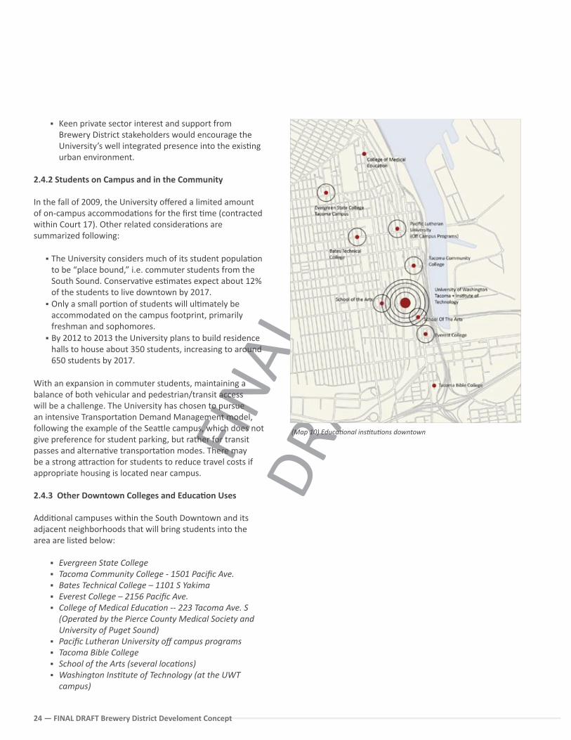
2.4.3 Other Downtown Colleges and Educa�on Uses
Addi�onal campuses within the South Downtown and its adjacent neighborhoods that will bring students into the area are listed below:
Evergreen State College Tacoma Community College - 1501 Pacific Ave. Bates Technical College – 1101 S Yakima Everest College – 2156 Pacific Ave. College of Medical Educa�on -- 223 Tacoma Ave. S
(Operated by the Pierce County Medical Society and University of Puget Sound)
Pacific Lutheran University off campus programs Tacoma Bible College School of the Arts (several loca�ons) Washington Ins�tute of Technology (at the UWT
campus)
(Map 10) Educa�onal ins�tu�ons downtown
FINA
L DR
AFT
FINAL DRAFT Brewery District Development Concept 25
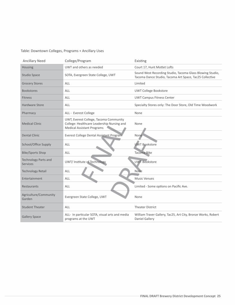
Table: Downtown Colleges, Programs + Ancillary Uses
Ancillary Need College/Program Exis�ng
Housing UWT and others as needed Court 17, Hunt Mo�et Lo�s
Studio Space SOTA, Evergreen State College, UWTSound West Recording Studio, Tacoma Glass Blowing Studio, Tacoma Dance Studio, Tacoma Art Space, Tac25 Collec�ve
Grocery Stores ALL Limited
Bookstores ALL UWT College Bookstore
Fitness ALL UWT Campus Fitness Center
Hardware Store ALL Specialty Stores only: The Door Store, Old Time Woodwork
Pharmacy ALL - Everest College None
Medical ClinicUWT, Everest College, Tacoma Community College: Healthcare Leadership Nursing and Medical Assistant Programs
None
Dental Clinic Everest College Dental Assistant Program None
School/Office Supply ALL UWT Bookstore
Bike/Sports Shop ALL Tacoma Bike
Technology Parts and Services
UWT/ Ins�tute of Technology UWT Bookstore
Technology Retail ALL None
Entertainment ALL Music Venues
Restaurants ALL Limited - Some op�ons on Pacific Ave.
Agriculture/Community Garden
Evergreen State College, UWT None
Student Theater ALL Theater District
Gallery SpaceALL- In par�cular SOTA, visual arts and media programs at the UWT
William Traver Gallery, Tac25, Art City, Bronze Works, Robert Daniel Gallery
FINA
L DR
AFT
26 — FINAL DRAFT Brewery District Develoment Concept
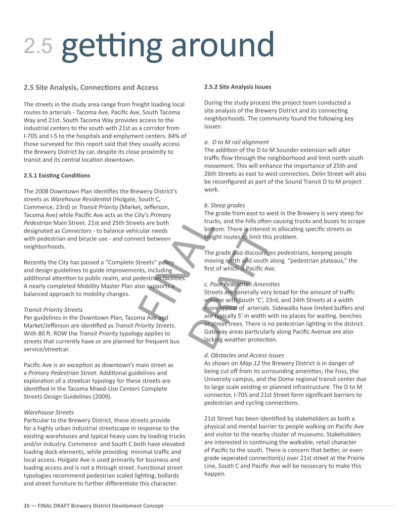
2.5 Site Analysis, Connec�ons and Access
The streets in the study area range from freight loading local routes to arterials - Tacoma Ave, Pacific Ave, South Tacoma Way and 21st. South Tacoma Way provides access to the industrial centers to the south with 21st as a corridor from I-705 and I-5 to the hospitals and emplyment centers. 84% of those surveyed for this report said that they usually access the Brewery District by car, despite its close proximity to transit and its central loca�on downtown. 2.5.1 Exis�ng Condi�ons
The 2008 Downtown Plan iden�fies the Brewery District’s streets as Warehouse Residen�al (Holgate, South C, Commerce, 23rd) or Transit Priority (Market, Jefferson, Tacoma Ave) while Pacific Ave acts as the City’s Primary Pedestrian Main Street. 21st and 25th Streets are both designated as Connectors - to balance vehicular needs with pedestrian and bicycle use - and connect between neighborhoods.
Recently the City has passed a “Complete Streets” policy and design guidelines to guide improvements, including addi�onal a�en�on to public realm, and pedestrian facili�es. A nearly completed Mobility Master Plan also supports a balanced approach to mobility changes.
Transit Priority StreetsPer guidelines in the Downtown Plan, Tacoma Ave and Market/Jefferson are iden�fied as Transit Priority Streets. With 80 �. ROW the Transit Priority typology applies to streets that currently have or are planned for frequent bus service/streetcar.
Pacific Ave is an excep�on as downtown’s main street as a Primary Pedestrian Street. Addi�onal guidelines and explora�on of a streetcar typology for these streets are iden�fied in the Tacoma Mixed-Use Centers Complete Streets Design Guidelines (2009).
Warehouse StreetsPar�cular to the Brewery District, these streets provide for a highly urban industrial streetscape in response to the exis�ng warehouses and typical heavy uses by loading trucks and/or industry. Commerce and South C both have elevated loading dock elements, while providing minimal traffic and local access. Holgate Ave is used primarily for business and loading access and is not a through street. Func�onal street typologies recommend pedestrian scaled ligh�ng, bollards and street furniture to further differen�ate this character.
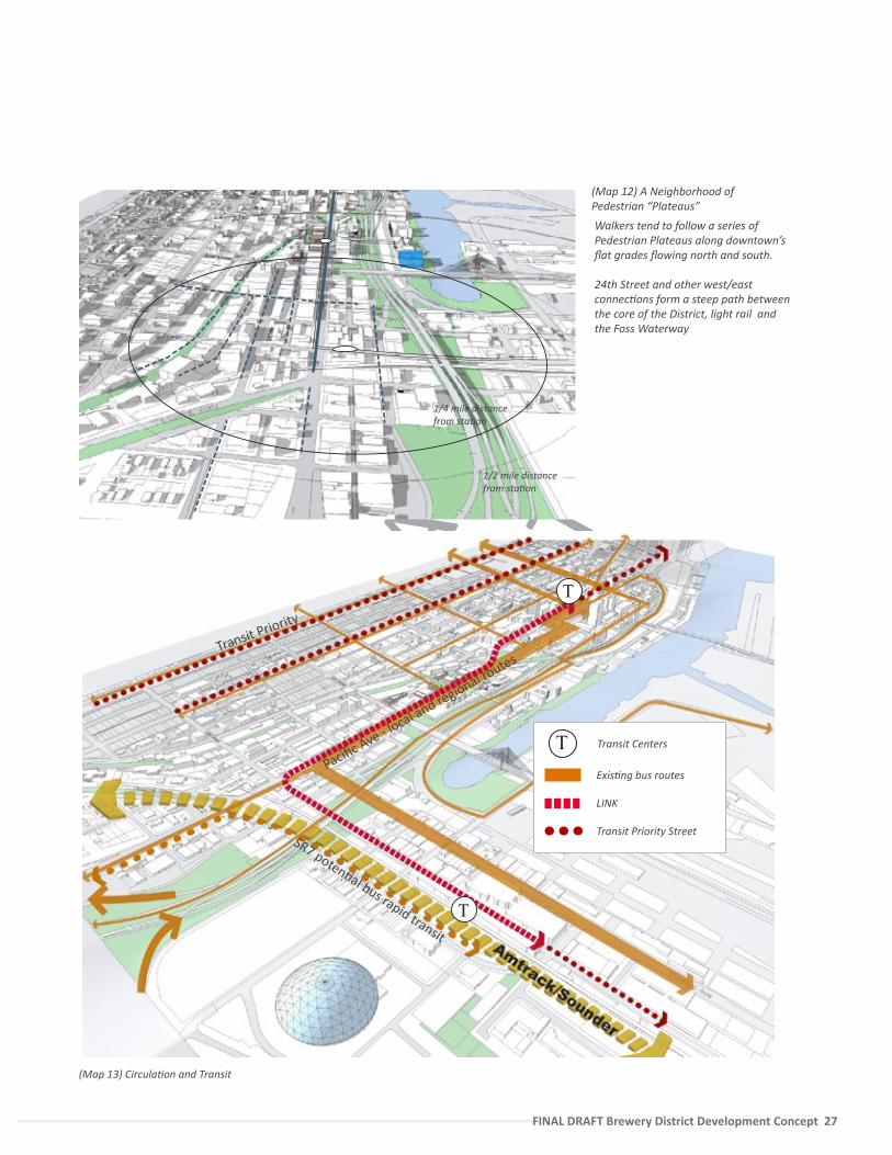
2.5.2 Site Analysis Issues
During the study process the project team conducted a site analysis of the Brewery District and its connec�ng neighborhoods. The community found the following key issues:
a. D to M rail alignment The addi�on of the D to M Sounder extension will alter traffic flow through the neighborhood and limit north south movement. This will enhance the importance of 25th and 26th Streets as east to west connectors. Delin Street will also be reconfigured as part of the Sound Transit D to M project work.
b. Steep gradesThe grade from east to west in the Brewery is very steep for trucks, and the hills o�en causing trucks and buses to scrape bo�om. There is interest in alloca�ng specific streets as freight routes to limit this problem.
The grade also discourages pedestrians, keeping people moving north and south along “pedestrian plateaus,” the first of which is Pacific Ave.
c. Poor Pedestrian Ameni�esStreets are generally very broad for the amount of traffic volume with South ‘C’, 23rd, and 24th Streets at a width more typical of arterials. Sidewalks have limited buffers and are typically 5’ in width with no places for wai�ng, benches or street trees. There is no pedestrian ligh�ng in the district. Gateway areas par�cularly along Pacific Avenue are also lacking weather protec�on.
d. Obstacles and Access issuesAs shown on Map 12 the Brewery District is in danger of being cut off from its surrounding ameni�es; the Foss, the University campus, and the Dome regional transit center due to large scale exis�ng or planned infrastructure. The D to M connector, I-705 and 21st Street form significant barriers to pedestrian and cycling connec�ons.
21st Street has been iden�fied by stakeholders as both a physical and mental barrier to people walking on Pacific Ave and visitor to the nearby cluster of museums. Stakeholders are interested in con�nuing the walkable, retail character of Pacific to the south. There is concern that be�er, or even grade seperated connec�on(s) over 21st street at the Prairie Line, South C and Pacific Ave will be nessecary to make this happen.
ge�ng around2.5
FINA
L DR
AFT
FINAL DRAFT Brewery District Development Concept 27
(Map 12) A Neighborhood of Pedestrian “Plateaus”
Walkers tend to follow a series of Pedestrian Plateaus along downtown’s flat grades flowing north and south.
24th Street and other west/east connec�ons form a steep path between the core of the District, light rail and the Foss Waterway
1/4 mile distance from sta�on
1/2 mile distance from sta�on
SR7 poten�al bus rapid transit
Transit Priority
T
T
Pacific Ave - local and regional ro
utes
Exis�ng bus routes
LINK
Transit Priority Street
T Transit Centers
(Map 13) Circula�on and Transit
FINA
L DR
AFT
28 — FINAL DRAFT Brewery District Develoment Concept
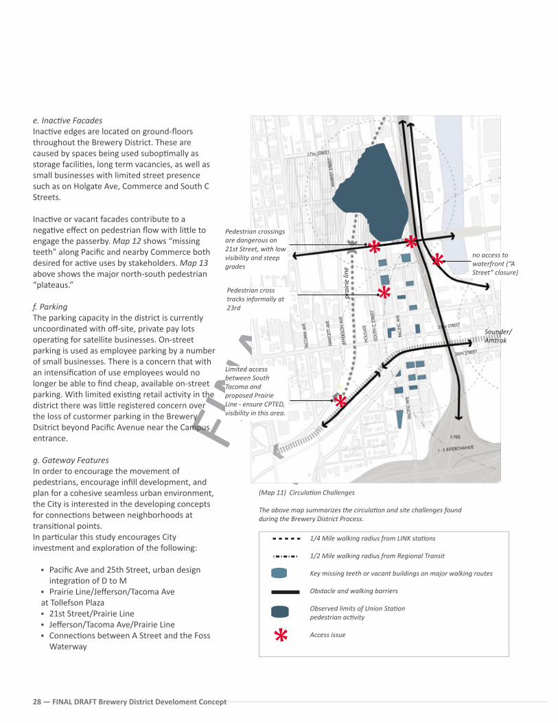
e. Inac�ve FacadesInac�ve edges are located on ground-floors throughout the Brewery District. These are caused by spaces being used subop�mally as storage facili�es, long term vacancies, as well as small businesses with limited street presence such as on Holgate Ave, Commerce and South C Streets.
Inac�ve or vacant facades contribute to a nega�ve effect on pedestrian flow with li�le to engage the passerby. Map 12 shows “missing teeth” along Pacific and nearby Commerce both desired for ac�ve uses by stakeholders. Map 13 above shows the major north-south pedestrian “plateaus.”
f. ParkingThe parking capacity in the district is currently uncoordinated with off-site, private pay lots opera�ng for satellite businesses. On-street parking is used as employee parking by a number of small businesses. There is a concern that with an intensifica�on of use employees would no longer be able to find cheap, available on-street parking. With limited exis�ng retail ac�vity in the district there was li�le registered concern over the loss of custormer parking in the Brewery Dsitrict beyond Pacific Avenue near the Campus entrance.
g. Gateway FeaturesIn order to encourage the movement of pedestrians, encourage infill development, and plan for a cohesive seamless urban environment, the City is interested in the developing concepts for connec�ons between neighborhoods at transi�onal points. In par�cular this study encourages City investment and explora�on of the following:
Pacific Ave and 25th Street, urban design integra�on of D to M
Prairie Line/Jefferson/Tacoma Aveat Tollefson Plaza 21st Street/Prairie Line Jefferson/Tacoma Ave/Prairie Line Connec�ons between A Street and the Foss
Waterway
(Map 11) Circula�on Challenges
The above map summarizes the circula�on and site challenges found during the Brewery District Process.
1/4 Mile walking radius from LINK sta�ons
1/2 Mile walking radius from Regional Transit
Key missing teeth or vacant buildings on major walking routes
Obstacle and walking barriers
Observed limits of Union Sta�onpedestrian ac�vity
Access issue
Sounder/ Amtrak
LIN
K
prai
rie li
ne
no access to waterfront (“A Street” closure)
Limited access between South Tacoma and proposed Prairie Line - ensure CPTED, visibility in this area.
Pedestrian crossings are dangerous on 21st Street, with low visibility and steep grades
Pedestrian cross tracks informally at 23rd

FINA
L DR
AFT
FINAL DRAFT Brewery District Development Concept 29
FINA
L DR
AFT
30 — FINAL DRAFT Brewery District Develoment Concept
3.0 DEVELOPMENT OBJECT IVES AND V IS ION
FINA
L DR
AFT
FINAL DRAFT Brewery District Development Concept 31
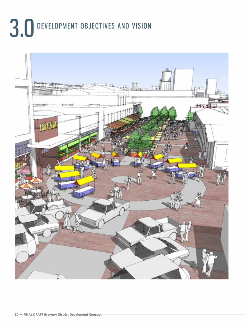
The Brewery District will be a sustainable neighborhood based on the adap�ve re-use of historic buildings, local crea�ve produc�on, and a popula�on mix of students, ar�sts, and local workforce. This will be achieved via a series of progressive interven�ons, from the temporary and small scale designed to help change the percep�on of the area, to larger scaled public-private redevelopment. From the preceding analysis it is clear that zoned capacity is not the problem, nor is loca�on – but the challenge lies in crea�ng methods that encourage desirable placemaking + ac�vated uses. A mul�-layer approach will help respond to the shi�ing market, as well as lay out a long term strategy for the con�nued health of the District.
A variety of uses will transform this under-u�lized district into a vibrant neighborhood with an emphasis on crea�ve business, educa�on, produc�on, arts and culture. The District represents an important opportunity for developing local iden�ty, housing, employment and transporta�on op�ons.
The following objec�ves provide a general framework for public redevelopment projects within the Study Area and are intended to help best achieve the neighborhood Vision. Most importantly, the objec�ves will help the City and the neighborhood stakeholders to consider the neighborhood as an integrated place, from economics to urban design, rather than a set of disassociated projects.
o1 Conduct proac�ve outreach to the private sector to foster public-private partnerships for redevelopment sites in accordance with the community vision.
o2 Advocate for and leverage an integrated approach between transporta�on access and land use development to spur the crea�on of a livable, walkable neighborhood and capitalize on the substan�al transporta�on investments in the area.
o3 Use community-based partnerships to diversify risk and incubate local businesses within both renovated and new structures in the District. Encourage the loca�on of companies that produce goods, ar�s�c cra� and green technology.
o4 Apply a range of sustainability strategies for the long term health of the neighborhood.
o5 Invest in pedestrian and bicycle system improvements that will con�nue to realize connec�ons between the Brewery District and surrounding residen�al and commercial areas par�cularly the University of Washington Campus.
o6 Build city capacity to op�mize exis�ng resources through crea�ve, interim and long term land use strategies.
Development Objec�ves
32 — FINAL DRAFT Brewery District Develoment Concept32 — FINAL DRAFT Brewery District Develoment Concept
There was a �me when development was le� to developers. The public sector, including local and state government, established the parameters within which development could take place through zoning ordinances, building codes, and comprehensive plans and then stepped out of the way in the hope that development would occur. However, many ci�es discovered that this passive role in the real estate development process did not always result in the amount and kind of investment the community had hoped for – par�cularly in complex infill sites or revitalizing neighborhoods.
Development incen�ves ranging from grants to loans to tax abatements were created to encourage the investment of private capital into projects broadly defined as being in the public good. In addi�on, there are also certain projects that require ac�ve par�cipa�on from the public and nonprofit sectors. These projects are defined as Community Ini�ated Development (CID) and are coordinated by a co-development team.
While there are an infinite variety of ac�vi�es that might cons�tute a CID project, each one is dis�nguished by four characteris�cs:
The idea originates from the public or nonprofit sectors, not from a private-sector developer.
A co-development team is part of the process un�l the development is completed, whether or not a private-sector developer ul�mately is involved.
There is substan�al commitment of public or nonprofit resources to the development. These resources would certainly include money, but may also include nonfinancial resources as well.
The project itself is deemed to have substan�al public benefit in addi�on to the financial returns the building generates.
The City of Tacoma has had an assortment of experience with Community Ini�ated Developments. Some of the most recent include the Thea Foss Esplanade, the Centre for Urban Waters in partnership with the UWT, Greater Tacoma Conven�on and Trade Center, and the South Park Parking Garage/Pacific PLaza.
A CID in the Brewery District?Understanding that an alterna�ve development approach may be necessary to achieve the community vision, the project team focused on two opportunity sites (Catalyst Site A and Catalyst Site B) already in public ownership. Each was studied for its poten�al to provide the neighborhood with public benefit.
Conduct proac�ve outreach to the private sector to foster public-private partnerships for redevelopment sites in accordance with the community vision.
Chartering a new organiza�on to undertake these proposed opportuni�es may be one implementa�on strategy. For example, a Public Development Authority is a public en�ty modeled on a private organiza�on. They func�on as municipal corpora�ons that operate independently from other branches of government. Further considera�on should be conducted by the City to understand the pros and cons of using this development approach in the Brewery District.
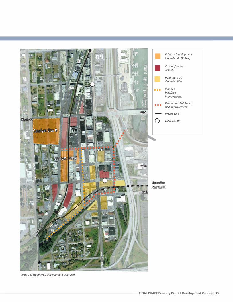
Catalyst Site AThe group of municipal buildings along Holgate between 24th and 23rd is an area with cohesive street character envisioned as the loca�on for a new public des�na�on. Catalyst Site A would encompass not only the structures within the City ownership, but also public right-of-way, and adjacent planned infrastructure improvement; the Prairie Line.
In the current economic climate, a phased incremental redevelopment of Site A will have the greatest immediate impact on the overall Brewery District. The City should suggest that the City move forward with public realm and lower cost improvements to reshape percep�on of the area. Furthermore construc�ng an adap�ve re-use project, adding new public or ac�ve uses into the City Shops and Stables and other associated structures will alter area percep�on. By taking on this challenge first, the City may see profound changes to the value of its larger property at Catalyst Site B.
Catalyst Site B Located at 21st and Jefferson, the site consists of two vacant blocks under scru�ny by both City and the UWT. This site is not without interest from the private market, however there is a desire by the community that it be designed with the greatest benefit to the neighborhood and as a complement to the University’s exis�ng investments.
During the Brwery District process, stakeholders revealed ambi�ous plans for the site including large scale mixed use development, civic uses and dense housing. These aspira�ons must be considered by the City in light of the fact that much of downtown land is not taxable, and the parcel’s redevelopment must ensure revenue—business and occupa�on tax, sales tax and property tax—to the extent feasible. A preliminary capacity study and site evalua�on was completed with feedback from stakeholders and the UWT to test ideas. These studies may be used for broader discussion to secure a proof of concept as well as a project proforma which includes a desired level of amenity. Development Concepts are explored in Chapter 4.0, Development Vision-Mee�ng Objec�ves.
o1
FINA
L DR
AFT
FINAL DRAFT Brewery District Development Concept 33
Primary Development Opportunity (Public)
Poten�al TOD Opportuni�es
Current/recent ac�vity
Plannedbike/pedimprovement
Prairie Line
(Map 14) Study Area Development Overview
21st
Taco
ma
Ave
Paci
fic A
ve
25th
Catalyst Site B
LINK sta�on
SounderAMTRAK
Catayst Site A
21rst Ave
24th
Jeffe
rson
Recommended bike/ped improvement
34 — FINAL DRAFT Brewery District Develoment Concept34 — FINAL DRAFT Brewery District Develoment Concept
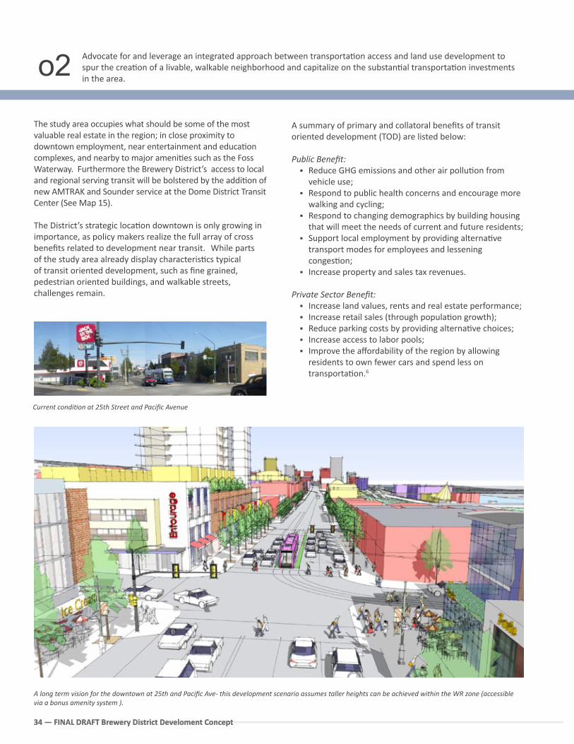
A long term vision for the downtown at 25th and Pacific Ave- this development scenario assumes taller heights can be achieved within the WR zone (accessible via a bonus amenity system ).
Current condi�on at 25th Street and Pacific Avenue
The study area occupies what should be some of the most valuable real estate in the region; in close proximity to downtown employment, near entertainment and educa�on complexes, and nearby to major ameni�es such as the Foss Waterway. Furthermore the Brewery District’s access to local and regional serving transit will be bolstered by the addi�on of new AMTRAK and Sounder service at the Dome District Transit Center (See Map 15).
The District’s strategic loca�on downtown is only growing in importance, as policy makers realize the full array of cross benefits related to development near transit. While parts of the study area already display characteris�cs typical of transit oriented development, such as fine grained, pedestrian oriented buildings, and walkable streets, challenges remain.
Advocate for and leverage an integrated approach between transporta�on access and land use development to spur the crea�on of a livable, walkable neighborhood and capitalize on the substan�al transporta�on investments in the area.
A summary of primary and collatoral benefits of transit oriented development (TOD) are listed below:
Public Benefit: Reduce GHG emissions and other air pollu�on from
vehicle use; Respond to public health concerns and encourage more
walking and cycling; Respond to changing demographics by building housing
that will meet the needs of current and future residents; Support local employment by providing alterna�ve
transport modes for employees and lessening conges�on;
Increase property and sales tax revenues.
Private Sector Benefit: Increase land values, rents and real estate performance; Increase retail sales (through popula�on growth); Reduce parking costs by providing alterna�ve choices; Increase access to labor pools; Improve the affordability of the region by allowing
residents to own fewer cars and spend less on transporta�on.6
o2
FINA
L DR
AFT
FINAL DRAFT Brewery District Development Concept 35
6. Benefits shown are adapted from the study: Na�onal Coopera�ve Highway Research Program, TRB, (2005). Transit-Oriented Development: Developing a Strategy to Measure Success, Research Results Digest No. 294, p 57. See Sound Transit website at h�p://www.soundtransit.org/documents/html/board/mo�ons/html/Mo�onM2000-90.html8. The City of Tacoma conducted a “Sta�on Area Analysis and Development Strategies” Study in 1999 as a complement to the then new LINK light rail line. A number of these strategies are s�ll applicable and should be pursued with renewed focus and energy.
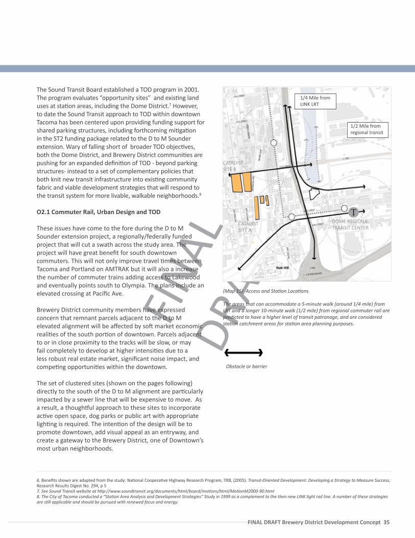
(Map 15) Access and Sta�on Loca�ons
The areas that can accommodate a 5-minute walk (around 1/4 mile) from LRT and a longer 10-minute walk (1/2 mile) from regional commuter rail are predicted to have a higher level of transit patronage, and are considered sta�on catchment areas for sta�on area planning purposes.
Obstacle or barrier
1/4 Mile from LINK LRT
CATALYST SITE A
CATALYST SITE B
DOME REGIONAL TRANSIT CENTER
The Sound Transit Board established a TOD program in 2001. The program evaluates “opportunity sites” and exis�ng land uses at sta�on areas, including the Dome District.7 However, to date the Sound Transit approach to TOD within downtown Tacoma has been centered upon providing funding support for shared parking structures, including forthcoming mi�ga�on in the ST2 funding package related to the D to M Sounder extension. Wary of falling short of broader TOD objec�ves, both the Dome District, and Brewery District communi�es are pushing for an expanded defini�on of TOD - beyond parking structures- instead to a set of complementary policies that both knit new transit infrastructure into exis�ng community fabric and viable development strategies that will respond to the transit system for more livable, walkable neighborhoods.8
O2.1 Commuter Rail, Urban Design and TOD
These issues have come to the fore during the D to M Sounder extension project, a regionally/federally funded project that will cut a swath across the study area. The project will have great benefit for south downtown commuters. This will not only improve travel �mes between Tacoma and Portland on AMTRAK but it will also a increase the number of commuter trains adding access to Lakewood and eventually points south to Olympia. The plans include an elevated crossing at Pacific Ave.
Brewery District community members have expressed concern that remnant parcels adjacent to the D to M elevated alignment will be affected by so� market economic reali�es of the south por�on of downtown. Parcels adjacent to or in close proximity to the tracks will be slow, or may fail completely to develop at higher intensi�es due to a less robust real estate market, significant noise impact, and compe�ng opportuni�es within the downtown.
The set of clustered sites (shown on the pages following) directly to the south of the D to M alignment are par�cularly impacted by a sewer line that will be expensive to move. As a result, a though�ul approach to these sites to incorporate ac�ve open space, dog parks or public art with appropriate ligh�ng is required. The inten�on of the design will be to promote downtown, add visual appeal as an entryway, and create a gateway to the Brewery District, one of Downtown’s most urban neighborhoods.
1/2 Mile from regional transit
T
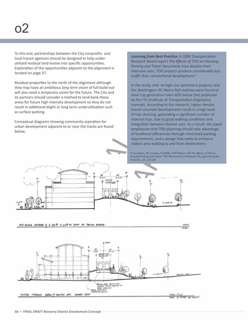
FINA
L DR
AFT
36 — FINAL DRAFT Brewery District Develoment Concept
To this end, partnerships between the City nonprofits and local transit agencies should be designed to help under-u�lized residual land evolve into specific opportuni�es.Explora�on of the opportuni�es adjacent to the alignment is located on page 37.
Residual proper�es to the north of the alignment although they may have an ambi�ous long term vision of full build-out will also need a temporary vision for the future. The City and its partners should consider a method to land-bank these areas for future high intensity development so they do not result in addi�onal blight or long term underu�liza�on such as surface parking.
Conceptual diagrams showing community aspira�on for urban development adjacent to or near the tracks are found below.
Learning from Best Prac�ce: A 2008 Transporta�on Research Board report The Effects of TOD on Housing, Parking and Travel documents how despite their intensive uses, TOD projects produce considerably less traffic than conven�onal development.9
In the study, mid- to high-rise apartment projects near the Washington DC Metro Rail sta�ons were found to have trip genera�on rates 60% below that predicted by the ITE (Ins�tute of Transporta�on Engineers) manuals. According to the research, higher density transit-oriented developments result in a high level of trip chaining, genera�ng a significant number of internal trips, due to good walking condi�ons and integra�on between diverse uses. As a result, the paper emphasizes that TOD planning should take advantage of loca�onal efficiencies through minimized parking requirements, and a design that seeks to enhance sta�on area walking to and from des�na�ons.
9. Arrington, GB, Cervero, R (2008). TCRP Report 128 The Effects of TOD on Housing Parking and Travel, TRB, Retrieved at onlinepubs.trb.org/onlinepubs/tcrp/tcrp_rpt_128.pdf
o2
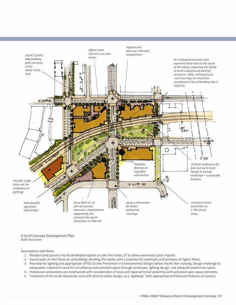
FINA
L DR
AFT
FINAL DRAFT Brewery District Development Concept 37
D to M Concept Development Plan
A Street underpass for bike and cycle route. Design to include landscape + sustainable features
South C Street: bike/walking path connects to the Water Ditch trail.
Office/ noise tolerant uses near tracks
Gateway features at regraded intersec�on
Highest and best-use: intensive employment
Close Delin St. as part of Sounder extension. Development opportunity site connects the South Downtown to Nob Hill
New possible signalized intersec�on
Square intersec�on for be�er pedestrian crossings
Exis�ng A Street connec�on to 1-705 access ramp.
Assump�ons and Notes 1. Residual land parcels may be developed against or over the tracks; ST to allow easements upon request. 2. Sound walls on first floors on all buildings abu�ng the tracks; with a poten�al for overlooks and windows at higher floors.3. Poten�al for ligh�ng and appropriate CPTED (Crime Preven�on in Environmental Design) below Pacific Ave crossing. Design challenge to
adequately respond to need for surveillance and ac�vated space through landscape, ligh�ng design, and adequate pedestrian space.4. Pedestrian connec�ons are emphasized with considera�on of local and regional transit proximity with ac�vated open space elements.5. Treatment of the south downtown area with priority urban design, as a “gateway” with appropriate architectural features at corners.
BCRA Illustra�on
Possible single story use (no underground parking)
An underground sewer main traverses these sites to the south of the tracks, impac�ng the ability to build underground parking structures. Other ac�vated uses -such as a dog run should be considered in lieu of building sites if required.
FINA
L DR
AFT
38 — FINAL DRAFT Brewery District Develoment Concept
REGULATORY CHANGES
Require new development within the WR zone to meet best prac�ce TOD principles for pedestrian-oriented design via an overlay, or altering exis�ng zoning. ‘Intent’ of the WR zone should encompass diversity of uses sought in the district beyond industrial, encouraging ground level work-live and/or walk-in trade along Commerce, Holgate and the Prairie Line. The City should also consider placing limits on stand-alone parking garages within thise district, and/or ensure that parking garages have adequate ac�va�on and high quality urban design.
$
Consider alterna�ve methods to incen�vize development within sta�on catchment areas, this process should conduct a gap analysis of the exis�ng bonus amenity system and work with legal and economic experts to redesign the process.
$$
Consider rezoning the Nob Hill R-4 to Downtown Residen�al to complement its walking loca�on to major transit centers. A related Bonus Amenity incen�ve program should contain a specific op�on for enhanced connec�vity in exchange for height.
$$
Ensure that models/standards related to mixed-use i.e. a) trip es�mates, and b) parking requirements within walking distance (1/2 mile of the commuter rail and 1/4 mile of LRT sta�ons) capture best prac�ce thinking related to TOD. Adjusted figures should be circulated, and made available to key par�es.
$$
WORK WITH PARTNERS
Con�nue to meet with local financiers + developers to educate local lenders on the benefits of Transit Oriented Development and encourage inclusion of loca�on efficient mortgage programs.
$
Collect/share data related to transit use, se�ng ambi�ous mode share targets for sta�ons and priori�ze investments in these areas to achieve vibrancy and be�er placemaking.
$$
Consider methods to support infrastructure upgrades within the TOD sta�on areas that may be too significant for an individual project to finance.
$$$
D TO M USER BENEFIT + ALIGNMENT INTEGRATION
Public realm improvements associated with the D to M alignment including, landscaping, public art, bike/ped paths should fit the alignment into exis�ng urban context. These include CPTED and safety considera�ons, as well as crea�ve, green and efficient use of urban space.
$$$
City Panel may work with Sound Transit to clarify future use and develop an interim or temporary use land policy. For example, Sound Transit should consider a flexible management structure that adds temporary uses to contribute to visible place-making, open space ameni�es, and discourage the under-u�liza�on of parcels.
$$
On-going, cross-sec�onal partnerships between the City, Pierce Transit, and Sound Transit are needed to realize efficiencies and effort to provide a framework for future public input to address the urban design quality, placemaking and ridership intensifica�on.
$
Priority Ac�on Steps
o2
FINA
L DR
AFT
FINAL DRAFT Brewery District Development Concept 39
FINA
L DR
AFT
40 — FINAL DRAFT Brewery District Develoment Concept
Use community-based partnerships to diversify risk and incubate local businesses within both renovated and new structures in the District. Encourage the loca�on of companies that produce goods, crea�ve or ar�s�c cra� and green technology.
The Brewery District’s long term development opportunity lies in building upon already exis�ng downtown clusters. The south downtown, in par�cular holds a concentra�on of crea�ve arts and design, exis�ng ins�tu�onal investment (museums and cultural ac�vi�es) as well as the human resource power of the University.
Suppor�ng a synergy of crea�ve use is increasingly considered a feasible economic development strategy, both directly in the arts and cultural produc�on, as well as related companies such digital media, design or culinary arts.
Markusen and Schrock write in their ar�cle, The Ar�s�c Dividend;
Ar�sts create import-subs�tu�ng entertainment op�ons for regional consumers and spend large shares of their own incomes on local arts output. We take a labor-centered view of the arts economy, hypothesizing that many ar�sts choose a locale in which to work, o�en without regard to par�cular employers but in response to a nurturing ar�s�c and patron community, ameni�es, and affordable cost of living.11
Targe�ng new crea�ve uses and their prospec�ve workforce helps to feed a downtown quality of life. In fact, a broad consensus among project stakeholders believe the District is ripe for a more a public, accessible, and crea�ve set of uses located within its core (see full suvey responses). This use would take full advantage of loca�onal efficiencies summarized in Objec�ve 2, as well as provide a new relevance for the historic neighborhood, bookending downtown with quality des�na�ons.
Their ideas (and the party generally responsible for that idea) are listed following:
High technology arts performance hall, with modular, flexible programmable spaces - SOTA
Film Center- SOTA Ar�sans and Public Market - New Tacoma
Neighborhood Council Live-Work and Ar�sans - HDC and others Arts School or Glass Workshop– Glass Museum
Culinary related uses, Food Tourism, MicroBrewery- Historic Tacoma and Others
Ar�st Lo�s/Arts School - Chihuly Workshop and Real Estate representa�ves
Crea�ve Design Companies- Economic Development Shared Arts Studio Spaces - Tacoma Arts Commission Community Gardening or Food related program -
Na�vity House, Bates College
These ideas find addi�onal support in the 2005 Public Market Feasibility Study jointly commissioned by the Community and Economic Development Department and the New Tacoma Neighborhood Council. The Study selected the Brewery District Municipal Storehouse Annex (Streets and Grounds Facility) as its first choice loca�on for a moderately-sized public market hall of 19,000 gross SF (9,500 net SF of leasable vendor area) which would contain approximately 25 vendors. According to the study, this proposed market is less than half of the 21,000 net SF size of three comparable public markets in the Vancouver BC area, and is roughly 60% the size of the na�onal average (from Urban Land Ins�tute/Project for Public Spaces). The study notes that in lieu of na�onal retailers, the City should work towards crea�ng its own unique draw, building upon exis�ng partnerships for other ac�vated uses. A table on the following page explores the range of poten�al ac�ve uses and a set of community based partners for Catayst Site A that should be further explored.
This idea is also supported by consultant Paula Rees’ work in the Downtown Tacoma Retail Strategy developed in 2003.
o3
11. Markeusen, A Schrock, G (2006). The Ar�s�c Dividend; Urban Ar�s�c Specialisa�on and Economic Development Implica�ons, Urban Studies, Vol 43, No 10, p 1661-1668
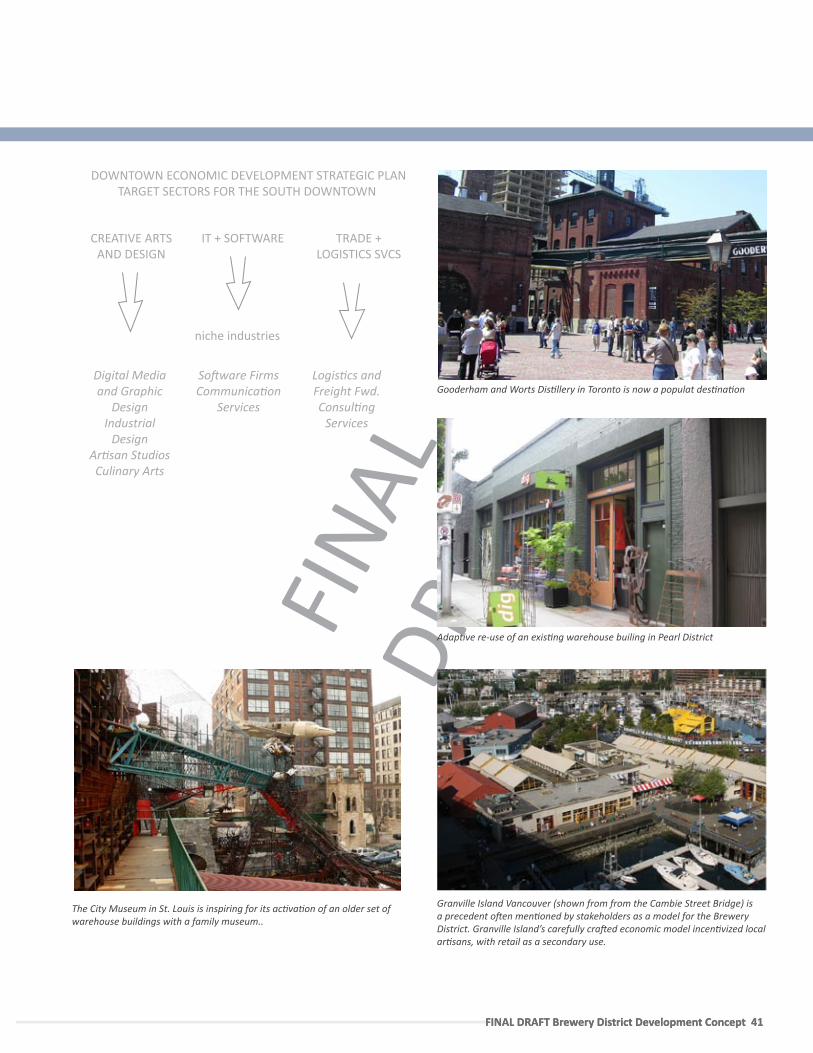
FINA
L DR
AFT
FINAL DRAFT Brewery District Development Concept 41 FINAL DRAFT Brewery District Development Concept 41
Granville Island Vancouver (shown from from the Cambie Street Bridge) is a precedent o�en men�oned by stakeholders as a model for the Brewery District. Granville Island’s carefully cra�ed economic model incen�vized local ar�sans, with retail as a secondary use.
Gooderham and Worts Dis�llery in Toronto is now a populat des�na�on
TRADE + LOGISTICS SVCS
Logis�cs and Freight Fwd.Consul�ng
Services
niche industries
IT + SOFTWARE
So�ware FirmsCommunica�on
Services
CREATIVE ARTS AND DESIGN
Digital Media and Graphic
DesignIndustrial
DesignAr�san StudiosCulinary Arts
DOWNTOWN ECONOMIC DEVELOPMENT STRATEGIC PLAN TARGET SECTORS FOR THE SOUTH DOWNTOWN
The City Museum in St. Louis is inspiring for its ac�va�on of an older set of warehouse buildings with a family museum..
Adap�ve re-use of an exis�ng warehouse builing in Pearl District
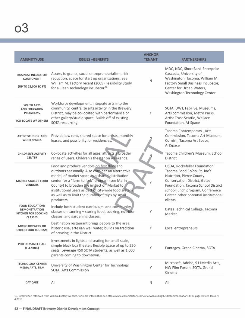
FINA
L DR
AFT
42 — FINAL DRAFT Brewery District Develoment Concept42 — FINAL DRAFT Brewery District Develoment Concept
AMENITY/USE ISSUES +BENEFITS ANCHOR TENANT PARTNERSHIPS
BUSINESS INCUBATOR COMPONENT
(UP TO 25,000 SQ FT)
Access to grants, social entrepreneurialism, risk reduc�on, space for start up organiza�ons. See William M. Factory recent (2009) Feasibility Study for a Clean Technology incubator.10
N
MDC, NDC, ShoreBank Enterprise Cascadia, University of Washington, Tacoma, William M. Factory Small Business Incubator, Center for Urban Waters, Washington Technology Center
YOUTH ARTS AND EDUCATION
PROGRAMS
(CO-LOCATE W/ OTHER)
Workforce development, integrate arts into the community, centralize arts ac�vity in the Brewery District, may be co-located with performance or other gallery/studio space. Builds off of exis�ng SOTA resourcing
YSOTA, UWT, FabFive, Museums, Arts commission, Metro Parks, Ar�st Trust-Sea�le, Wallace Founda�on, M-Space
ARTIST STUDIOS AND WORK SPACES
Provide low rent, shared space for ar�sts, monthly leases, and possibility for residencies.
N
Tacoma Contemporary , Arts Commission, Tacoma Art Museum, Cornish, Tacoma Art Space, ArtSpace
CHILDREN’S ACTIVITY CENTER
Co-locate ac�vi�es for all ages, a�racts a broader range of users. Children’s theater on weekends.
NTacoma Children’s Museum, School District
MARKET STALLS + FOOD VENDORS
Food and produce vendors on first floor and outdoors seasonally. Also consider an alterna�ve model, of market space as a shared distribu�on center for a “farm to fork” program (see Marin County) to broaden the impact of Market to ins�tu�onal users as part of city-wide food system, as well as to limit the number of trips by small producers.
Y
USDA, Rockefeller Founda�on, Tacoma Food Co’op, St. Joe’s Nutri�on, Pierce County Conserva�on District, Gates Founda�on, Tacoma School District school lunch program, Conference Center, other poten�al ins�tu�onal clients.
FOOD-EDUCATION; DEMONSTRATION
KITCHEN FOR COOKING CLASSES
Include both student curriculum and community classes on canning + storing food, cooking, nutri�on classes, and gardening classes.
YBates Technical College, Tacoma Market
MICRO BREWERY OR OTHER FOOD TOURISM
Des�na�on restaurant brings people to the area, historic use, artesian well water, builds on tradi�on of brewing in the District.
Y Local entrepreneurs
PERFORMANCE HALL (FLEXIBLE)
Investments in lights and sea�ng for small scale, simple black box theater; flexible space of up to 250 seats. Leverage 450 SOTA students, as well as 1,000 parents coming to downtown.
Y Pantages, Grand Cinema, SOTA
TECHNOLOGY CENTER MEDIA ARTS, FILM
University of Washington Center for Technology, SOTA, Arts Commission
YMicroso�, Adobe, 911Media Arts, NW Film Forum, SOTA, Grand Cinema
DAY CARE All N All
10. Informa�on retrieved from William Factory website, for more informa�on see h�p://www.williamfactory.com/review/Building%20Recommenda�ons.htm, page viewed January 4,2010
o3
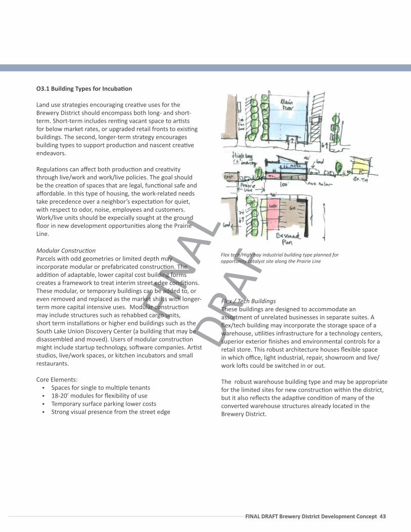
FINA
L DR
AFT
FINAL DRAFT Brewery District Development Concept 43 FINAL DRAFT Brewery District Development Concept 43
O3.1 Building Types for Incuba�on
Land use strategies encouraging crea�ve uses for the Brewery District should encompass both long- and short-term. Short-term includes ren�ng vacant space to ar�sts for below market rates, or upgraded retail fronts to exis�ng buildings. The second, longer-term strategy encourages building types to support produc�on and nascent crea�ve endeavors.
Regula�ons can affect both produc�on and crea�vity through live/work and work/live policies. The goal should be the crea�on of spaces that are legal, func�onal safe and affordable. In this type of housing, the work-related needs take precedence over a neighbor’s expecta�on for quiet, with respect to odor, noise, employees and customers. Work/live units should be expecially sought at the ground floor in new development opportuni�es along the Prairie Line.
Modular Construc�on Parcels with odd geometries or limited depth may incorporate modular or prefabricated construc�on. The addi�on of adaptable, lower capital cost building forms creates a framework to treat interim street edge condi�ons. These modular, or temporary buildings can be added to, or even removed and replaced as the market shi�s with longer-term more capital intensive uses. Modular construc�on may include structures such as rehabbed cargo units, short term installa�ons or higher end buildings such as the South Lake Union Discovery Center (a building that may be disassembled and moved). Users of modular construc�on might include startup technology, so�ware companies. Ar�st studios, live/work spaces, or kitchen incubators and small restaurants.
Core Elements: Spaces for single to mul�ple tenants 18-20’ modules for flexibility of use Temporary surface parking lower costs Strong visual presence from the street edge
Time Based + Arts Related
Flex tech/High bay industrial building type planned for opportunity catalyst site along the Prairie Line
Flex / Tech BuildingsThese buildings are designed to accommodate an assortment of unrelated businesses in separate suites. A flex/tech building may incorporate the storage space of a warehouse, u�li�es infrastructure for a technology centers, superior exterior finishes and environmental controls for a retail store. This robust architecture houses flexible space in which office, light industrial, repair, showroom and live/ work lo�s could be switched in or out.
The robust warehouse building type and may be appropriate for the limited sites for new construc�on within the district, but it also reflects the adap�ve condi�on of many of the converted warehouse structures already located in the Brewery District.
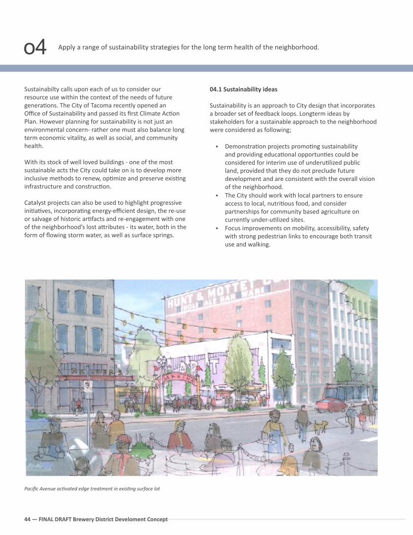
44 — FINAL DRAFT Brewery District Develoment Concept44 — FINAL DRAFT Brewery District Develoment Concept
Apply a range of sustainability strategies for the long term health of the neighborhood.
Sustainabilty calls upon each of us to consider our resource use within the context of the needs of future genera�ons. The City of Tacoma recently opened an Office of Sustainability and passed its first Climate Ac�on Plan. However planning for sustainability is not just an environmental concern- rather one must also balance long term economic vitality, as well as social, and community health.
With its stock of well loved buildings - one of the most sustainable acts the City could take on is to develop more inclusive methods to renew, op�mize and preserve exis�ng infrastructure and construc�on.
Catalyst projects can also be used to highlight progressive ini�a�ves, incorpora�ng energy-efficient design, the re-use or salvage of historic ar�facts and re-engagement with one of the neighborhood’s lost a�ributes - its water, both in the form of flowing storm water, as well as surface springs.
04.1 Sustainability ideas
Sustainability is an approach to City design that incorporates a broader set of feedback loops. Longterm ideas by stakeholders for a sustainable approach to the neighborhood were considered as following;
Demonstra�on projects promo�ng sustainability and providing educa�onal opportun�es could be considered for interim use of underu�lized public land, provided that they do not preclude future development and are consistent with the overall vision of the neighborhood.
The City should work with local partners to ensure access to local, nutri�ous food, and consider partnerships for community based agriculture on currently under-u�lized sites.
Focus improvements on mobility, accessibility, safety with strong pedestrian links to encourage both transit use and walking.
Pacific Avenue ac�vated edge treatment in exis�ng surface lot
o4
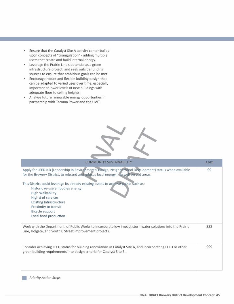
FINA
L DR
AFT
FINAL DRAFT Brewery District Development Concept 45 FINAL DRAFT Brewery District Development Concept 45
COMMUNITY SUSTAINABILITY Cost
Apply for LEED ND (Leadership in Environmental Design, Neighborhood Development) status when available for the Brewery District, to rebrand and refocus local energy into well served areas.
This District could leverage its already exis�ng assets to achieve points such as:Historic re-use embodies energyHigh WalkabilityHigh # of services Exis�ng InfrastructureProximity to transitBicycle supportLocal food produc�on
$$
Work with the Department of Public Works to incorporate low impact stormwater solu�ons into the Prairie Line, Holgate, and South C Street improvement projects.
$$$
Consider achieving LEED status for building renova�ons in Catalyst Site A, and incorpora�ng LEED or other green building requirements into design criteria for Catalyst Site B.
$$$
Priority Ac�on Steps
Ensure that the Catalyst Site A ac�vity center builds upon concepts of “triangula�on” - adding mul�ple users that create and build internal energy.
Leverage the Prairie Line’s poten�al as a green infrastructure project, and seek outside funding sources to ensure that ambi�ous goals can be met.
Encourage robust and flexible building design that can be adapted to varied uses over �me, especially important at lower levels of new buildings with adequate floor to ceiling heights.
Analyze future renewable energy opportun�es in partnership with Tacoma Power and the UWT.
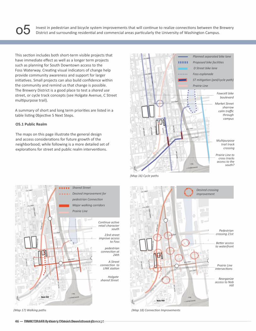
46 — FINAL DRAFT Brewery District Develoment Concept46 — FINAL DRAFT Brewery District Develoment Concept
This sec�on includes both short-term visible projects that have immediate effect as well as a longer term projects such as planning for South Downtown access to the Foss Waterway. Crea�ng visual indicators of change help provide community awareness and support for larger ini�a�ves. Small projects can also build confidence within the community and remind us that change is possible. The Brewery District is a good place to test a shared use street, or cycle track concepts (see Holgate Avenue, C Street mul�purpose trail).
A summary of short and long term priori�es are listed in a table lis�ng 0bjec�ve 5 Next Steps.
Invest in pedestrian and bicycle system improvements that will con�nue to realize connec�ons between the Brewery District and surrounding residen�al and commercial areas par�cularly the University of Washington Campus.
O5.1 Public Realm
The maps on this page illustrate the general design and access considera�ons for future growth of the neighborbood; while following is a more detailed set of explora�ons for street and public realm interven�ons.
46 — DRAFT Brewery District Develoment Concept
(Map 16) Cycle paths
Fawce� bike boulevard
Market Street sharrow
calm traffic through campus
Prairie Line to cross tracks
access to the south?
Planned separated bike lane
Proposed bike facili�es
D Street bike lane
Foss esplanade
ST mi�ga�on (ped/cycle path)
Prairie Line
Be�er access to waterfront
Desired crossing improvement
Reorganize access to Nob
Hill
Pedestrian crossing 21st
Prairie Line intersec�ons
Shared Street
Desired improvement for
pedestrian Connec�on
Major walking corridors
Prairie Line
Con�nue ac�ve retail character
south
Holgate shared Street
23rd street improve access
to Foss
A Street connec�on to
LINK sta�on
(Map 18) Connec�on Improvements(Map 17) Walking paths
o5
Mul�purpose trail track
crossing
pedestrian connec�on at
24th
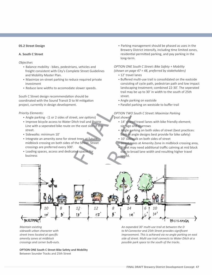
FINA
L DR
AFT
FINAL DRAFT Brewery District Development Concept 47
OPTION ONE South C Street Bike Safety and Mobility Between Sounder Tracks and 25th Street
05.2 Street Design
A. South C Street
Objec�ve: Balance mobility - bikes, pedestrians, vehicles and
freight consistent with City’s Complete Street Guidelines and Mobility Master Plan.
Maximize on-street parking to reduce required private investment
Reduce lane widths to accomodate slower speeds.
South C Street design recommenda�on should be coordinated with the Sound Transit D to M mi�ga�on project, currently in design development.
Priority Elements: Angle parking - (1 or 2 sides of street; see op�ons) Improve bicycle access to Water Ditch trail and Prairie
Line with a seperated bike route on the east side of the street.
Sidewalks: minimum 10’ Integrate an amenity zone for street trees at future
midblock crossing on both sides of the Street. Street crossings are preferred every 300’.
Loading spaces, access and dedicated spaces for business
Parking management should be phased as uses in the Brewery District intensify, including �me limited zones, residen�al permi�ed parking, and pay parking in the long-term.
OPTION ONE South C Street: Bike Safety + Mobility (shown on page 47 + 48, preferred by stakeholders)
12’ travel lanes Buffered mul�-use trail is consolidated on the eastside
consis�ng of cycle path, pedestrian path and low impact landscaping treatment; combined 22-30’. The seperated trail may be up to 30’ in width to the south of 25th street.
Angle parking on eastside Parallel parking on westside to buffer trail
OPTION TWO South C Street: Maximize Parking (not shown)
14’ shared travel lanes with bike friendly element; signage and sharrows
Angle parking on both sides of street (best prac�ces: back-in angle designs best provide for bike safety)
10’ sidewalk on both sides of street Street-trees at Amenity Zone in midblock crossing area, Street may need addi�onal traffic calming at mid block
due to broad lane width and resul�ng higher travel speed.
An expanded 30’ mul�-use trail at between the D to M Connector and 25th Street provides significant improvement. This is achieved via no angle parking on east side of street. Mul� use trail connects to Water Ditch at a possible park space to the south of the tracks.
1212810 8 10614
Maintain exis�ng sidewalk urban character with street trees located at specific amenity zones at midblock crossings and corner bulb-outs.
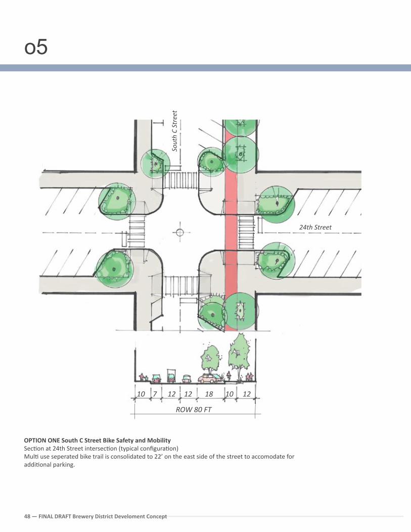
FINA
L DR
AFT
48 — FINAL DRAFT Brewery District Develoment Concept
24th Street
1212710 18 10 12
ROW 80 FT
Sout
h C
Stre
et
OPTION ONE South C Street Bike Safety and Mobility Sec�on at 24th Street intersec�on (typical configura�on) Mul� use seperated bike trail is consolidated to 22’ on the east side of the street to accomodate for addi�onal parking.
24th Street
o5
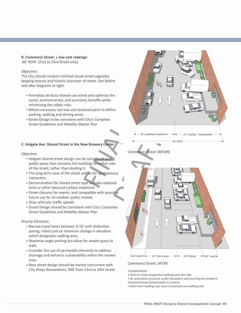
FINA
L DR
AFT
FINAL DRAFT Brewery District Development Concept 49
B. Commerce Street: a low-cost redesign 60’ ROW (21st to 23rd Street only)
Objec�ve:The City should conduct minimal visual street upgrades keeping texture and historic character of street. See before and a�er diagrams at right.
Formalize de-facto shared-use street and op�mize the social, environmental, and economic benefits while minimizing the safety risks.
Where necessary use low-cost textured paint to define parking, walking and driving areas.
Street Design to be consistent with City’s Complete Street Guidelines and Mobility Master Plan
C. Holgate Ave: Shared Street in the New Brewery Center
Objec�ve: Holgate shared street design can be considered as a
public space that connects the buildings on either side of the street, rather than dividing it.
The long term view of the street will be for spontaneous interac�on.
Demonstra�on for shared street type includes exposed brick or other textured surface treatment
Street closures for events; and compa�ble with possible future use for an outdoor public market.
Slow vehicular traffic speeds Street Design should be consistent with City’s Complete
Street Guidelines and Mobility Master Plan
Priority Elements: Narrow travel lanes between 9-10’ with dis�nc�ve
paving, rolled curb or minimum change in eleva�on which designates walking area.
Maximize angle parking but allow for ample space to walk.
Consider the use of permeable elements to address drainage and enhance sustainability within the market area.
New street design should be started concurrent with City Shops Renova�ons; 300’ from 23rd to 24th Street.
Commerce Street: BEFORE
Commerce Street: AFTER
Considera�ons:• Paint or stripe designated walking path this side.• As renova�ons proceed, prefer dumpsters and recycling be located in recessed alcoves behind gates or screens.• Short term loading may occur if necessary on walking side.
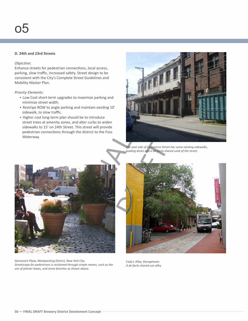
FINA
L DR
AFT
50 — FINAL DRAFT Brewery District Develoment Concept
The east side of Commerce Street has some exis�ng sidewalks, loading docks and a de-facto shared used of the street.
Gansvoort Plaza, Meatpacking District, New York City.Streetscape for pedestrians is reclaimed through simple means, such as the use of planter boxes, and stone benches as shown above.
Cady’s Alley, Georgetown. A de facto shared-use alley
D. 24th and 23rd Streets Objec�ve:Enhance streets for pedestrian connec�ons, local access, parking, slow traffic, increased safety. Street design to be consistent with the City’s Complete Street Guidelines and Mobility Master Plan.
Priority Elements: Low Cost short-term upgrades to maximize parking and
minimize street width. Restripe ROW to angle parking and maintain exis�ng 10’
sidewalk, to slow traffic. Higher cost long-term plan should be to introduce
street trees at amenity zones, and alter curbs to widen sidewalks to 15’ on 24th Street. This street will provide pedestrian connec�ons through the district to the Foss Waterway.
o5
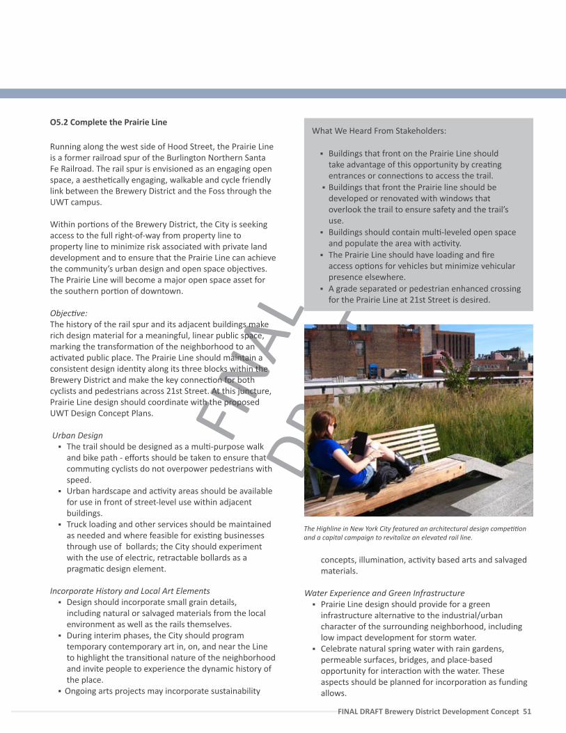
FINA
L DR
AFT
FINAL DRAFT Brewery District Development Concept 51
O5.2 Complete the Prairie Line
Running along the west side of Hood Street, the Prairie Line is a former railroad spur of the Burlington Northern Santa Fe Railroad. The rail spur is envisioned as an engaging open space, a aesthe�cally engaging, walkable and cycle friendly link between the Brewery District and the Foss through the UWT campus.
Within por�ons of the Brewery District, the City is seeking access to the full right-of-way from property line to property line to minimize risk associated with private land development and to ensure that the Prairie Line can achieve the community’s urban design and open space objec�ves. The Prairie Line will become a major open space asset for the southern por�on of downtown.
Objec�ve:The history of the rail spur and its adjacent buildings make rich design material for a meaningful, linear public space, marking the transforma�on of the neighborhood to an ac�vated public place. The Prairie Line should maintain a consistent design iden�ty along its three blocks within the Brewery District and make the key connec�on for both cyclists and pedestrians across 21st Street. At this juncture, Prairie Line design should coordinate with the proposed UWT Design Concept Plans.
Urban Design The trail should be designed as a mul�-purpose walk
and bike path - efforts should be taken to ensure that commu�ng cyclists do not overpower pedestrians with speed.
Urban hardscape and ac�vity areas should be available for use in front of street-level use within adjacent buildings.
Truck loading and other services should be maintained as needed and where feasible for exis�ng businesses through use of bollards; the City should experiment with the use of electric, retractable bollards as a pragma�c design element.
Incorporate History and Local Art Elements Design should incorporate small grain details,
including natural or salvaged materials from the local environment as well as the rails themselves.
During interim phases, the City should program temporary contemporary art in, on, and near the Line to highlight the transi�onal nature of the neighborhood and invite people to experience the dynamic history of the place.
Ongoing arts projects may incorporate sustainability
What We Heard From Stakeholders:
Buildings that front on the Prairie Line should take advantage of this opportunity by crea�ng entrances or connec�ons to access the trail.
Buildings that front the Prairie line should be developed or renovated with windows that overlook the trail to ensure safety and the trail’s use.
Buildings should contain mul�-leveled open space and populate the area with ac�vity.
The Prairie Line should have loading and fire access op�ons for vehicles but minimize vehicular presence elsewhere.
A grade separated or pedestrian enhanced crossing for the Prairie Line at 21st Street is desired.
The Highline in New York City featured an architectural design compe��on and a capital campaign to revitalize an elevated rail line.
concepts, illumina�on, ac�vity based arts and salvaged materials.
Water Experience and Green Infrastructure
Prairie Line design should provide for a green infrastructure alterna�ve to the industrial/urban character of the surrounding neighborhood, including low impact development for storm water.
Celebrate natural spring water with rain gardens, permeable surfaces, bridges, and place-based opportunity for interac�on with the water. These aspects should be planned for incorpora�on as funding allows.

FINA
L DR
AFT
52 — FINAL DRAFT Brewery District Develoment Concept
Possible new hotel in development site/at Heidelberg Brewery. Loading should not nega�vely impact proposed public space.
Student housing or ar�st housing and crea�ve industrial uses desired on this block to link to Campus uses.
Make linkage east on 23rd to mul�-use trail on South C Street.
New 24th Street pedestrian access desired between Hogate and Prairie Line.
Development site for mixed-use/ flex tech high bay industrial development on Jefferson Ave.
Work lo�s in new development west side ac�vate the Prairie Line at ground floor.
Pacific Brewing and Malt Complex is par�ally renovated. Parking for offices located on west side of street.
Development site on Jefferson; poten�al to con�nue character of Prairie Line with mixed use, work lo�s and ac�ve uses.
Temporary or interim ac�va�on of development site
Poten�al plaza or gathering space at D to M connector terminus-
Exis�ng storage parking lot street vaca�on
Planned academic buildings offer opportunity for connec�ons over or under 21st Street
Preliminary design concept has been completed by the UWT.
Coordinate possible bridge/underground connec�on at 21st Street.
Connec�ng a�ribute:ramp, plaza, mid-block, or access issue
Exis�ng Building
Future development site
SOUNDER
o5
Connect to the waterfront at Tollefson Plaza
Design concepts coordinated with the Tacoma Art Museum.
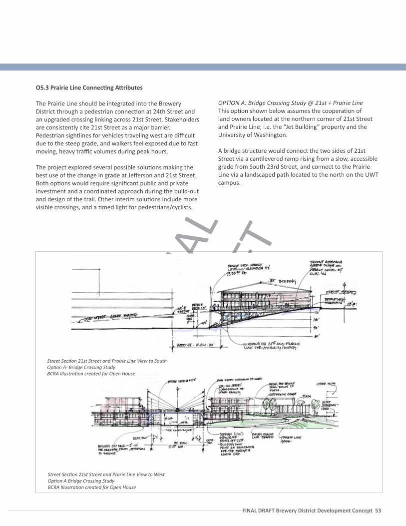
FINA
L DR
AFT
FINAL DRAFT Brewery District Development Concept 53
Connec�ng a�ribute:ramp, plaza, mid-block, or access issue
Exis�ng Building
Future development site
O5.3 Prairie Line Connec�ng A�ributes
The Prairie Line should be integrated into the Brewery District through a pedestrian connec�on at 24th Street and an upgraded crossing linking across 21st Street. Stakeholders are consistently cite 21st Street as a major barrier. Pedestrian sightlines for vehicles traveling west are difficult due to the steep grade, and walkers feel exposed due to fast moving, heavy traffic volumes during peak hours.
The project explored several possible solu�ons making the best use of the change in grade at Jefferson and 21st Street. Both op�ons would require significant public and private investment and a coordinated approach during the build-out and design of the trail. Other interim solu�ons include more visible crossings, and a �med light for pedestrians/cyclists.
OPTION A: Bridge Crossing Study @ 21st + Prairie Line This op�on shown below assumes the coopera�on of land owners located at the northern corner of 21st Street and Prairie Line; i.e. the “Jet Building” property and the University of Washington.
A bridge structure would connect the two sides of 21st Street via a can�levered ramp rising from a slow, accessible grade from South 23rd Street, and connect to the Prairie Line via a landscaped path located to the north on the UWT campus.
Street Sec�on 21st Street and Prarie Line View to WestOp�on A Bridge Crossing StudyBCRA Illustra�on created for Open House
Street Sec�on 21st Street and Prairie Line View to SouthOp�on A- Bridge Crossing StudyBCRA Illustra�on created for Open House
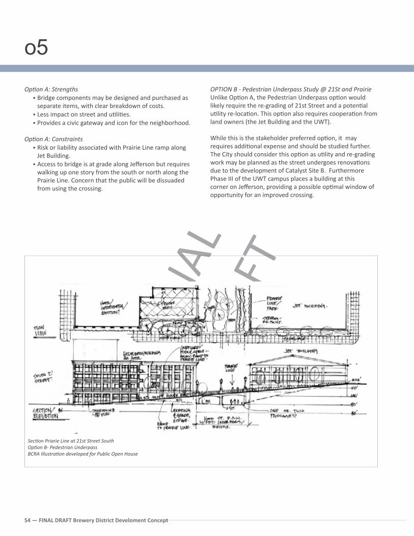
FINA
L DR
AFT
54 — FINAL DRAFT Brewery District Develoment Concept
OPTION B - Pedestrian Underpass Study @ 21St and PrairieUnlike Op�on A, the Pedestrian Underpass op�on would likely require the re-grading of 21st Street and a poten�al u�lity re-loca�on. This op�on also requires coopera�on from land owners (the Jet Building and the UWT).
While this is the stakeholder preferred op�on, it may requires addi�onal expense and should be studied further. The City should consider this op�on as u�lity and re-grading work may be planned as the street undergoes renova�ons due to the development of Catalyst Site B. Furthermore Phase III of the UWT campus places a building at this corner on Jefferson, providing a possible op�mal window of opportunity for an improved crossing.
Op�on A: Strengths Bridge components may be designed and purchased as
separate items, with clear breakdown of costs. Less impact on street and u�li�es. Provides a civic gateway and icon for the neighborhood.
Op�on A: Constraints Risk or liability associated with Prairie Line ramp along
Jet Building. Access to bridge is at grade along Jefferson but requires
walking up one story from the south or north along the Prairie Line. Concern that the public will be dissuaded from using the crossing.
Sec�on Priarie Line at 21st Street South Op�on B- Pedestrian Underpass BCRA Illustra�on developed for Public Open House
o5
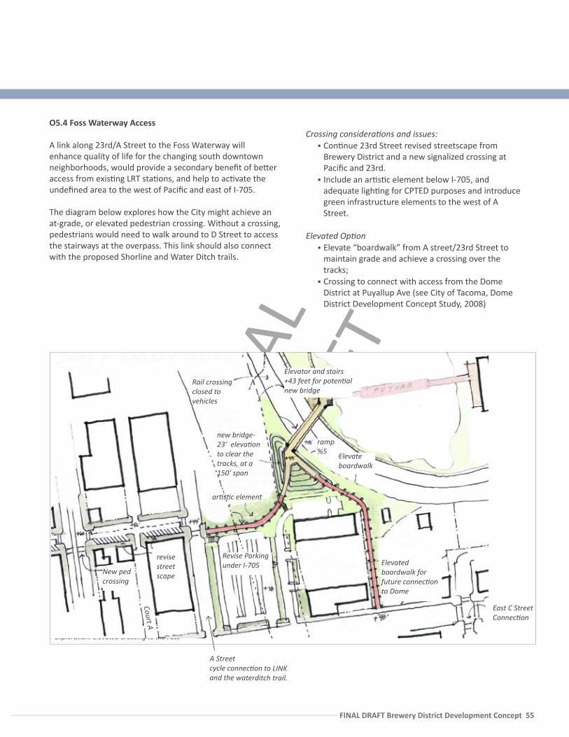
FINA
L DR
AFT
FINAL DRAFT Brewery District Development Concept 55
O5.4 Foss Waterway Access
A link along 23rd/A Street to the Foss Waterway will enhance quality of life for the changing south downtown neighborhoods, would provide a secondary benefit of be�er access from exis�ng LRT sta�ons, and help to ac�vate the undefined area to the west of Pacific and east of I-705.
The diagram below explores how the City might achieve an at-grade, or elevated pedestrian crossing. Without a crossing, pedestrians would need to walk around to D Street to access the stairways at the overpass. This link should also connect with the proposed Shorline and Water Ditch trails.
Crossing considera�ons and issues: Con�nue 23rd Street revised streetscape from
Brewery District and a new signalized crossing at Pacific and 23rd.
Include an ar�s�c element below I-705, and adequate ligh�ng for CPTED purposes and introduce green infrastructure elements to the west of A Street.
Elevated Op�on Elevate “boardwalk” from A street/23rd Street to
maintain grade and achieve a crossing over the tracks;
Crossing to connect with access from the Dome District at Puyallup Ave (see City of Tacoma, Dome District Development Concept Study, 2008)
Explora�on: Elevated Crossing to the Foss
Court A
A Street cycle connec�on to LINK and the waterditch trail.
revise street scape
Rail crossing closed to vehicles
new bridge- 23’ eleva�on to clear the tracks, at a 150’ span
East C StreetConnec�on
ar�s�c element
Elevated boardwalk for future connec�on to Dome
Revise Parking under I-705
Elevate boardwalk
Elevator and stairs +43 feet for poten�al new bridge
ramp %5
New ped crossing
FINA
L DR
AFT
56 — FINAL DRAFT Brewery District Develoment Concept
CROSSINGS
CROSSING AT 21st and PRAIRIE Work with owners of the Jet Building and the UWT as renova�on proceeds to complete a grade separated bike/pedestrian crossing under or over 21st Street as funding allows.
$$$
25th + SOUTH TACOMA WAYConsider a pedestrian controlled traffic light for 25th Street and Holgate Ave as well as South Tacoma Way and South ‘C’ Street to facilitate movement as uses intensify upon comple�on of the D to M connector.
$$$
STREET IMPROVEMENTS
SOUTH C STREET - CYCLE IMPROVEMENT Work with ST during D to M mi�ga�on project to configure cycle lane on east side of street. Consider connec�ng cycle lane to the Prairie Line on 23rd Street due to minimal grade and plan for future 21st Street crossing.
$$$
SOUTH C STREET - PEDESTRIAN + PARKINGSidewalk improvements for a mul�-use trail on the east side of the street per street design concepts should be considered as funding allows. By consolida�ng green space to the east side, design requirements for street trees needs to be coordinated in the zoning code.
$$$
COMMERCE STREET REDESIGNConduct low cost experiment with textured paint to formalize already de-facto street space, and reduce travel lane width to enhance safety, as well as provide for building buffer and loading. Change design standards to ensure that dumpsters are adequately screened.
$
23RD and 24TH STREETConduct low-cost improvements by narrowing traffic lanes and restriping angle parking to buffer pedestrians. Designate signage to limit both streets’ use as a truck through route.
$$
HOLGATE AVE SHARED STREETWork with the Public Works Department and Catalyst Site redevelopment team for a shared street design in Phase one of Catalyst Site A project.
$$$
NEW CONNECTIONS
COMPLETE THE PRAIRIE LINEComplete a landscape and drainage design for the Prairie Line according to the design principles listed in sec�on 4.1, and coordinate with exis�ng University of Washington Design Concepts. Include adjacent land owners to op�mize future access and uses lining the Prairie Line.
$$$
CONTINUE 24th WITH A PEDESTRIAN CONNECTION TO JEFFERSON AVE Connect 24th Street to the Prairie Line and Jefferson Ave during project redevelopment. (Must be nego�ated with private land owner.)
$$$
PLAN FOR FOSS WATERWAY ACCESSConsider a long-term project to connect the downtown to the Foss Waterway via 23rd Street to mi�gate the closure of the ‘A’ Street rail crossing (see diagram 5.4). Con�nue Watersitch trail to connect to the boardwalk at “A street.”
$$$
Priority Ac�on Steps
o5
FINA
L DR
AFT
FINAL DRAFT Brewery District Development Concept 57 FINAL DRAFT Brewery District Development Concept 57
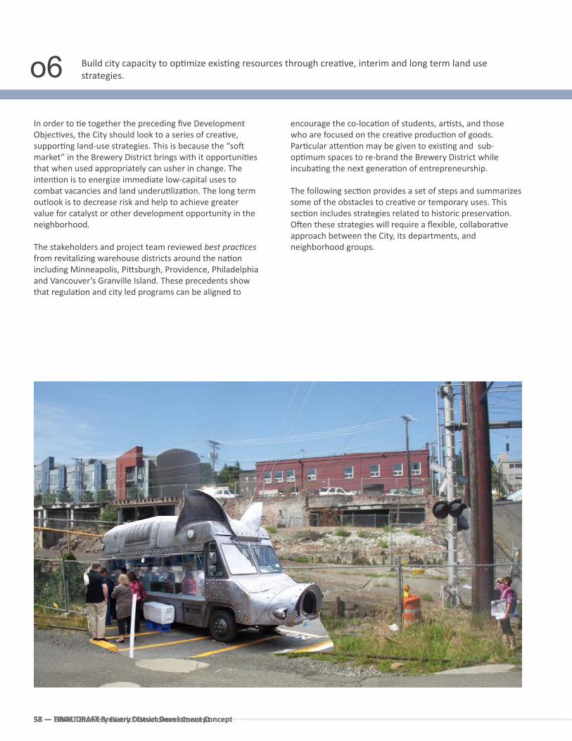
58 — FINAL DRAFT Brewery District Develoment Concept58 — FINAL DRAFT Brewery District Develoment Concept
In order to �e together the preceding five Development Objec�ves, the City should look to a series of crea�ve, suppor�ng land-use strategies. This is because the “so� market” in the Brewery District brings with it opportuni�es that when used appropriately can usher in change. The inten�on is to energize immediate low-capital uses to combat vacancies and land underu�liza�on. The long term outlook is to decrease risk and help to achieve greater value for catalyst or other development opportunity in the neighborhood.
The stakeholders and project team reviewed best prac�ces from revitalizing warehouse districts around the na�on including Minneapolis, Pi�sburgh, Providence, Philadelphia and Vancouver’s Granville Island. These precedents show that regula�on and city led programs can be aligned to
encourage the co-loca�on of students, ar�sts, and those who are focused on the crea�ve produc�on of goods. Par�cular a�en�on may be given to exis�ng and sub-op�mum spaces to re-brand the Brewery District while incuba�ng the next genera�on of entrepreneurship.
The following sec�on provides a set of steps and summarizes some of the obstacles to crea�ve or temporary uses. This sec�on includes strategies related to historic preserva�on. O�en these strategies will require a flexible, collabora�ve approach between the City, its departments, and neighborhood groups.
Build city capacity to op�mize exis�ng resources through crea�ve, interim and long term land use strategies.
58 — DRAFT Brewery District Develoment Concept
o6
FINA
L DR
AFT
FINAL DRAFT Brewery District Development Concept 59
Time Based Use Ideas
Conduct a survey to understand the rela�ve need and types of available temporary spaces within downtown
Create a City led Task Force to iden�fy barriers to temporary use; such as access to short-term liability insurance and regula�ons (such as seismic) that govern change in occupancy to higher or more intensive uses.
Develop a Commi�ee made up of City regulatory agencies including building permi�ng, health department, and fire department to brainstorm together, as well as earn departmental buy in to reduce barriers and provide code flexibility.
Develop a streamlined and user friendly process that brings property owners with excess or under-u�lized space (within buildings or land) together with ar�sts or others who would like to make use of the space, such as an online form or checklist. Provide a standardized contract which also solces the liabiblity obstacle to legi�mize process, consider the development of a website to market the ini�a�ve.
Focus early efforts on one “temporary use” demonstra�on project mee�ng the following criteria:a. property owner interestb. within walking distance of Pacific Ave c. low costd. crea�vely engages the community
City should work with local partners to ini�ate a Design Compe��on for temporary use on exis�ng City/University under-u�lized or vacant land.
Encourage the University of Washington as well as other agencies (Sound Transit) to work towards policies that will look a�er the interim use of under-u�lized land to discourage blight, and to empower the local community.
O6.1 Welcome Time Based Uses
In order to promote long-term sustainability, Tacoma must first ensure the neighborhood’s short term viability. In this way, it will be necessary to develop a private land nuisance abatement strategy that proac�vely supports the community vision and reduces under-u�lized land.
Food vending, art and performance installa�ons, sustainability or educa�on projects are desirable temporary uses now emerging in empty spaces in ci�es throughout the country. To encourage (allow) these uses Tacoma should explore the crea�on of a standardized contract that would take on all or a por�on of the liability related to public use of private land, in par�cular for specific iden�fied uses such as local food produc�on, cycle repair, public art, or community gathering space. Liability issues are o�en cited as a major obstacle to the temporary, low cost re-use of land by not only smaller private land owners but also major public agencies such as Sound Transit.
DRAFT Brewery District Development Concept 59
Strategies may also focus on stages of construc�on or deconstruc�on, and phased or temporary occupancy permits to offset the �me and expense it takes to complete costly seismic upgrades.
To achieve this goal will require a city-led look at exis�ng regula�ons, with the goal of finding more flexible methods to encourage growth.
During this process the City should apply best prac�ces from leaders in the field including
- Storefront for Ar�sts in Philadelphia,- Pennsylvania Arts Ini�a�ve, Pi�sburgh,- Chasama, New York City - Street vending policies, Portland Oregon
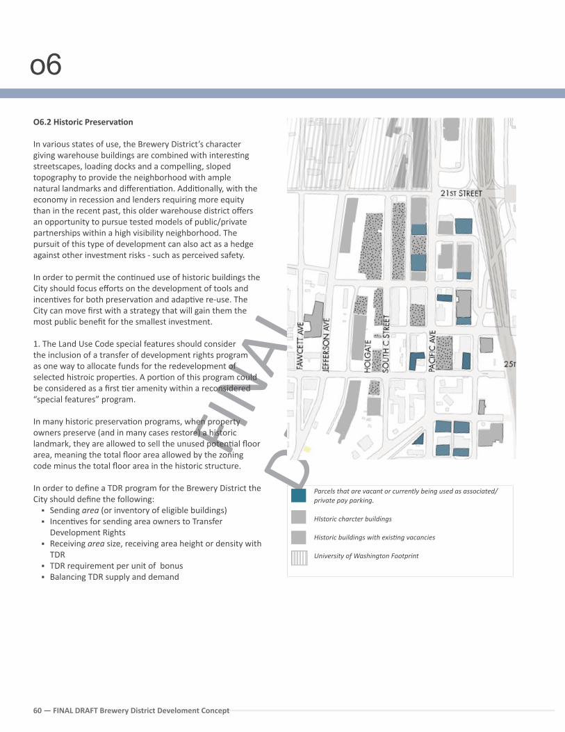
FINA
L DR
AFT
60 — FINAL DRAFT Brewery District Develoment Concept
O6.2 Historic Preserva�on
In various states of use, the Brewery District’s character giving warehouse buildings are combined with interes�ng streetscapes, loading docks and a compelling, sloped topography to provide the neighborhood with ample natural landmarks and differen�a�on. Addi�onally, with the economy in recession and lenders requiring more equity than in the recent past, this older warehouse district offers an opportunity to pursue tested models of public/private partnerships within a high visibility neighborhood. The pursuit of this type of development can also act as a hedge against other investment risks - such as perceived safety.
In order to permit the con�nued use of historic buildings the City should focus efforts on the development of tools and incen�ves for both preserva�on and adap�ve re-use. The City can move first with a strategy that will gain them the most public benefit for the smallest investment.
1. The Land Use Code special features should consider the inclusion of a transfer of development rights program as one way to allocate funds for the redevelopment of selected histroic proper�es. A por�on of this program could be considered as a first �er amenity within a reconsidered “special features” program.
In many historic preserva�on programs, when property owners preserve (and in many cases restore) a historic landmark, they are allowed to sell the unused poten�al floor area, meaning the total floor area allowed by the zoning code minus the total floor area in the historic structure.
In order to define a TDR program for the Brewery District the City should define the following:
Sending area (or inventory of eligible buildings) Incen�ves for sending area owners to Transfer
Development Rights Receiving area size, receiving area height or density with
TDR TDR requirement per unit of bonus Balancing TDR supply and demand
Parcels that are vacant or currently being used as associated/private pay parking.
HIstoric charcter buildings
Historic buildings with exis�ng vacancies
University of Washington Footprint
o6
FINA
L DR
AFT
FINAL DRAFT Brewery District Development Concept 61
In Portland, density may be transferred within the neighborhood where the Historic landmark is located or to any site within two miles of the landmark. By allowing unused development poten�al to be transferred, redevelopment pressure on the landmark is lessened and a poten�al source of income is provided, as the owner may sell these rights to the owner or developer of the receiving site. Portland recently adopted zoning changes that extend this capability to “contribu�ng” buildings in the Pearl District or those that are ranked on the City’s Historic Resource Inventory.
2. Complying with building code standards is probably one of the most challenging aspects of adap�ve reuse. Intended primarily for new construc�on, they typically have few excep�ons for exis�ng buildings and can act as a disincen�ve for rehabilita�on. Furthermore, within our earthquake prone environment the cost of seismic upgrades have become one of the largest prohibi�ons to the adap�ve re-use of historic structures.
Recently the Building Officials and Code Administrators (BOCA) and the Interna�onal Conference of Building Officials (ICBO) included amendments to their model codes, the basis
for many states’ building codes, to allow for alterna�ve code solu�ons on historic preserva�on projects. For example, Portland now allows phased compliance and developer-municipality compliance agreements as another alterna�ve to put safety improvements within the financial grasp of owners reliant on revenue that doesn’t come in all at once. Portland’s strategy has been to help provide flexibility towards building code standards with several ini�a�ves that provide a good precedent for Tacoma’s explora�on including a Seismic Loan Program, Historic TDR, and a Life Safety Guide for Exis�ng Buildings FLEX Guide (available online on the City of Portland Website).
3. Many ci�es rely upon small grant programs dedicated to the restora�on of qualifying historic buildings. The City of Tacoma should consider the development of a facade grant program which reimburses a property owner a percent of the total cost of a façade renova�on and construc�on up to a dollar amount (such as $10,000.) Addi�onally a Design Services Grant reimburses related facade design services up to dollar amount (such as $10,000).
Historic Preserva�on Ideas
Priori�ze the comple�on of the Historic Buildings Inventory for the Brewery District
Explore a provision to incorporate a transfer of development rights program related to historic preserva�on in the Bonus Amenity System for the WR and DMU zones.
Develop alterna�ve structural solu�ons for exis�ng historic buildings. The City of Tacoma should commit to the following tasks:- Proceed with internal task force to iden�fy obstacles and problems with current code administra�on for Historic Buildings. - Work with local developers to understand the major obstacles to historic renova�on and provide an avenue for technical
assistance. - Collaborate with other local municipali�es, par�cularly Portland, to learn from recent best prac�ces.
Consider the development of a Seismic Loan Program to target unreinforced masonry buildings (URMs) and proper�es designated in the Tacoma Historic Inventory.
Promote Heritage tourism; walking tour collabora�on with the WA State History Museum, Historic Tacoma
Consider the crea�on of dedicated grant programs - such as facade improvement - for qualifying historic buildings.
Open landmark nomina�on process for City Shops and Stables, and Municipal Complex/Annex on Holgate Ave.
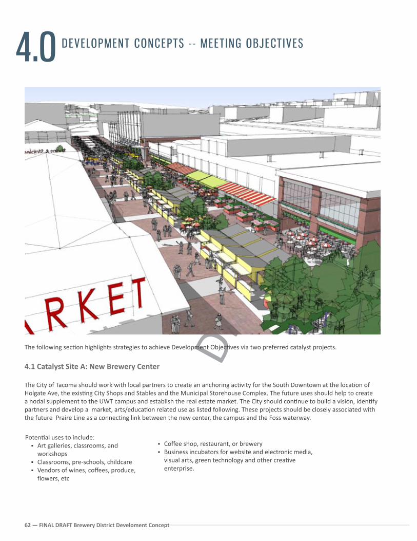
FINA
L DR
AFT
62 — FINAL DRAFT Brewery District Develoment Concept
4.0 DEVELOPMENT CONCEPTS - - MEET ING OBJECT IVES
The following sec�on highlights strategies to achieve Development Objec�ves via two preferred catalyst projects.
4.1 Catalyst Site A: New Brewery Center
The City of Tacoma should work with local partners to create an anchoring ac�vity for the South Downtown at the loca�on of Holgate Ave, the exis�ng City Shops and Stables and the Municipal Storehouse Complex. The future uses should help to create a nodal supplement to the UWT campus and establish the real estate market. The City should con�nue to build a vision, iden�fy partners and develop a market, arts/educa�on related use as listed following. These projects should be closely associated with the future Praire Line as a connec�ng link between the new center, the campus and the Foss waterway.
Poten�al uses to include: Art galleries, classrooms, and
workshops Classrooms, pre-schools, childcare Vendors of wines, coffees, produce,
flowers, etc
Coffee shop, restaurant, or brewery Business incubators for website and electronic media,
visual arts, green technology and other crea�ve enterprise.
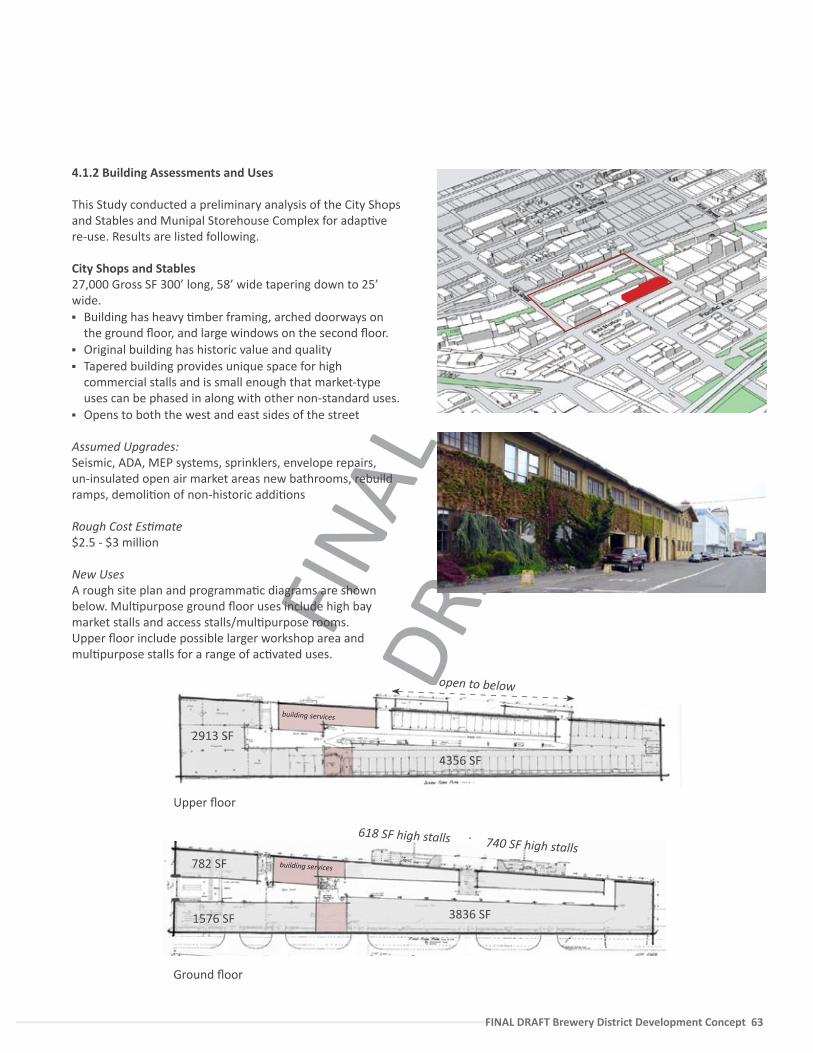
FINA
L DR
AFT
FINAL DRAFT Brewery District Development Concept 63
4.1.2 Building Assessments and Uses
This Study conducted a preliminary analysis of the City Shops and Stables and Munipal Storehouse Complex for adap�ve re-use. Results are listed following.
City Shops and Stables27,000 Gross SF 300’ long, 58’ wide tapering down to 25’ wide. Building has heavy �mber framing, arched doorways on
the ground floor, and large windows on the second floor. Original building has historic value and quality Tapered building provides unique space for high
commercial stalls and is small enough that market-type uses can be phased in along with other non-standard uses.
Opens to both the west and east sides of the street
Assumed Upgrades:Seismic, ADA, MEP systems, sprinklers, envelope repairs, un-insulated open air market areas new bathrooms, rebuild ramps, demoli�on of non-historic addi�ons
Rough Cost Es�mate$2.5 - $3 million
New UsesA rough site plan and programma�c diagrams are shown below. Mul�purpose ground floor uses include high bay market stalls and access stalls/mul�purpose rooms. Upper floor include possible larger workshop area and mul�purpose stalls for a range of ac�vated uses.
4356 SF
building services
2913 SF
740 SF high stallsbuilding services
618 SF high stalls
782 SF
1576 SF 3836 SF
open to below
Upper floor
Ground floor
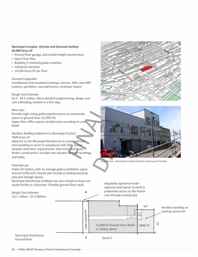
FINA
L DR
AFT
64 — FINAL DRAFT Brewery District Develoment Concept
Municipal Complex (Streets and Grounds Facility) 28,400 Gross SF Ground floor garage, and double height second story Open Floor Plan Building in rela�vely good condi�on Industrial character 14,200 Gross SF per floor
Assumed Upgrades Condi�oned and insulated envelope, seismic, ADA, new MEP systems, sprinklers, new bathrooms, envelope repairs
Rough Cost Es�mate$3.5 - $4.2 million. More detailed programming, design and cost es�ma�ng needed as a first step.
New UsesPossible high ceiling gallery/performance or community space on ground floor (12,990 SF)Upper floor office spaces variable sizes according to usesRetail
Ancillary Building (Adjacent to Municipal Facility) 7600 Gross SFAdjacent to the Municipal Storehouse is a proposed two story building to assist in compliance with ADA access elevator and other requirements. New brick and heavy �mber construc�on, includes one elevator for both buildings and lobby.
Poten�al use Public Art Gallery with an average gallery exhibi�on space around 3,500 sq �. Should also include a loading and prep area and storage spaces. Municipal Warehouse building may also contain at least one studio facility or classroom. Possible ground floor retail.
Rough Cost Es�mate $1.1 million - $1.4 Million
Holgate Ave - Municipal Complex (Streets and Grounds Facility)
16’
Municipal Storehouse Ground floor
12,990 SF Ground Floor Retail or Gallery Space
Ancillary building on exis�ng vacant lot
Nego�ate agreement with adjacent land owner to build in pedestrian access to the Prairie Line through exis�ng bay.
2848 SF
50’
72’
South C
24th
con
nect
or
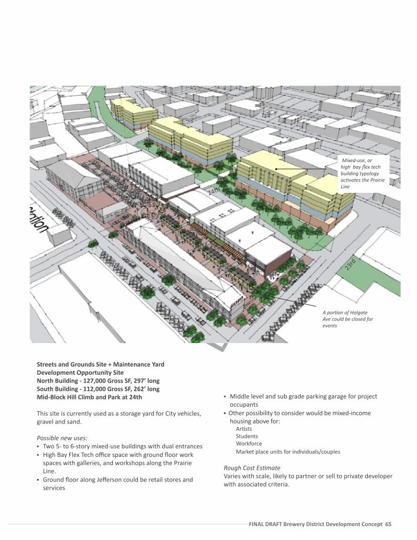
FINA
L DR
AFT
FINAL DRAFT Brewery District Development Concept 65
Middle level and sub grade parking garage for project occupants
Other possibility to consider would be mixed-income housing above for:
Ar�stsStudentsWorkforceMarket place units for individuals/couples
Rough Cost Es�mateVaries with scale, likely to partner or sell to private developer with associated criteria.
24th
23rd
Streets and Grounds Site + Maintenance YardDevelopment Opportunity SiteNorth Building - 127,000 Gross SF, 297’ long South Building - 112,000 Gross SF, 262’ longMid-Block Hill Climb and Park at 24th
This site is currently used as a storage yard for City vehicles, gravel and sand.
Possible new uses: Two 5- to 6-story mixed-use buildings with dual entrances High Bay Flex Tech office space with ground floor work
spaces with galleries, and workshops along the Prairie Line.
Ground floor along Jefferson could be retail stores and services
A por�on of Holgate Ave could be closed for events
Mixed-use, or high bay flex tech building typology ac�vates the Prairie Line
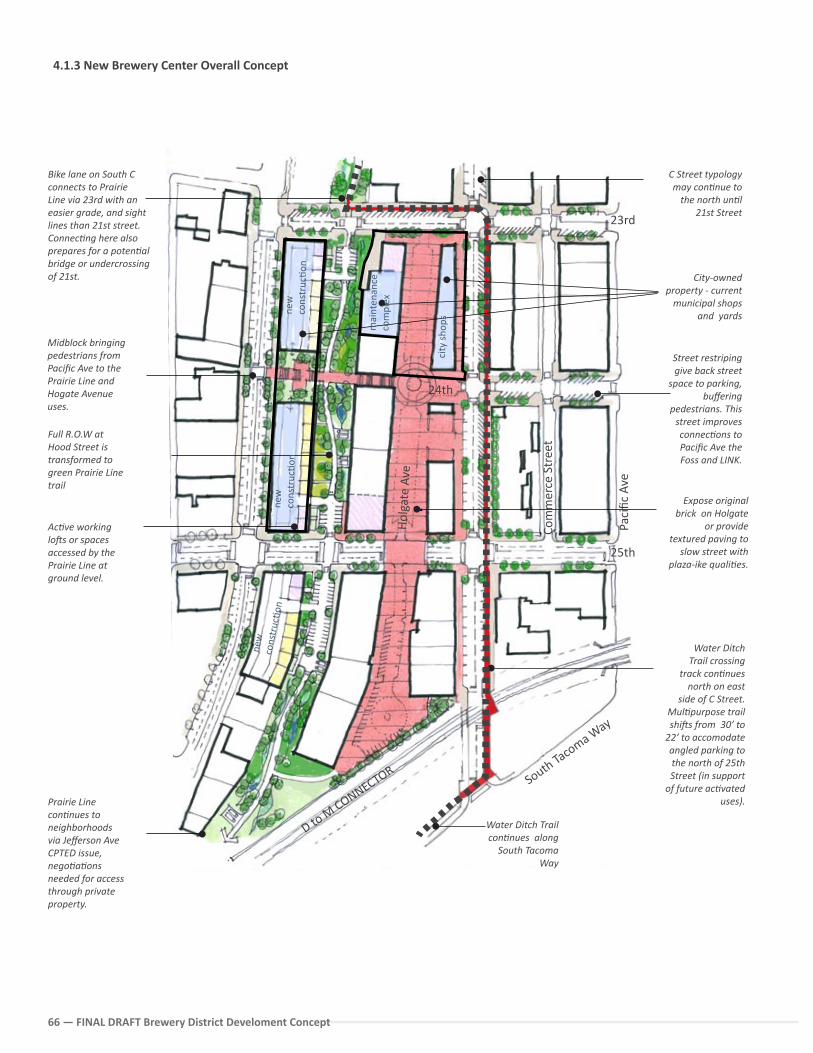
FINA
L DR
AFT
66 — FINAL DRAFT Brewery District Develoment Concept
Water Ditch Trail crossing
track con�nues north on east
side of C Street. Mul�purpose trail shi�s from 30’ to
22’ to accomodate angled parking to the north of 25th Street (in support
of future ac�vated uses).
Bike lane on South C connects to Prairie Line via 23rd with an easier grade, and sight lines than 21st street. Connec�ng here also prepares for a poten�al bridge or undercrossing of 21st.
Prairie Line con�nues to neighborhoods via Jefferson Ave CPTED issue, nego�a�ons needed for access through private property.
Midblock bringing pedestrians from Pacific Ave to the Prairie Line and Hogate Avenue uses.
Full R.O.W at Hood Street is transformed to green Prairie Line trail
C Street typology may con�nue to
the north un�l 21st Street
Street restriping give back street
space to parking, buffering
pedestrians. This street improves connec�ons to Pacific Ave the Foss and LINK.
Ac�ve working lo�s or spaces accessed by the Prairie Line at ground level.
City-owned property - current
municipal shops and yards
Water Ditch Trail con�nues along
South Tacoma Way
4.1.3 New Brewery Center Overall Concept
23rd
South Tacoma W
ay
D to M
CONNECTOR
Paci
fic A
ve
Hol
gate
Ave
25th
Expose original brick on Holgate
or provide textured paving to
slow street with plaza-ike quali�es.
city
sho
psmai
nten
ance
co
mpl
ex
new
co
nstr
uc�o
n
new
co
nstr
uc�o
n
new
co
nstr
uc�o
n
Com
mer
ce S
tree
t
24th
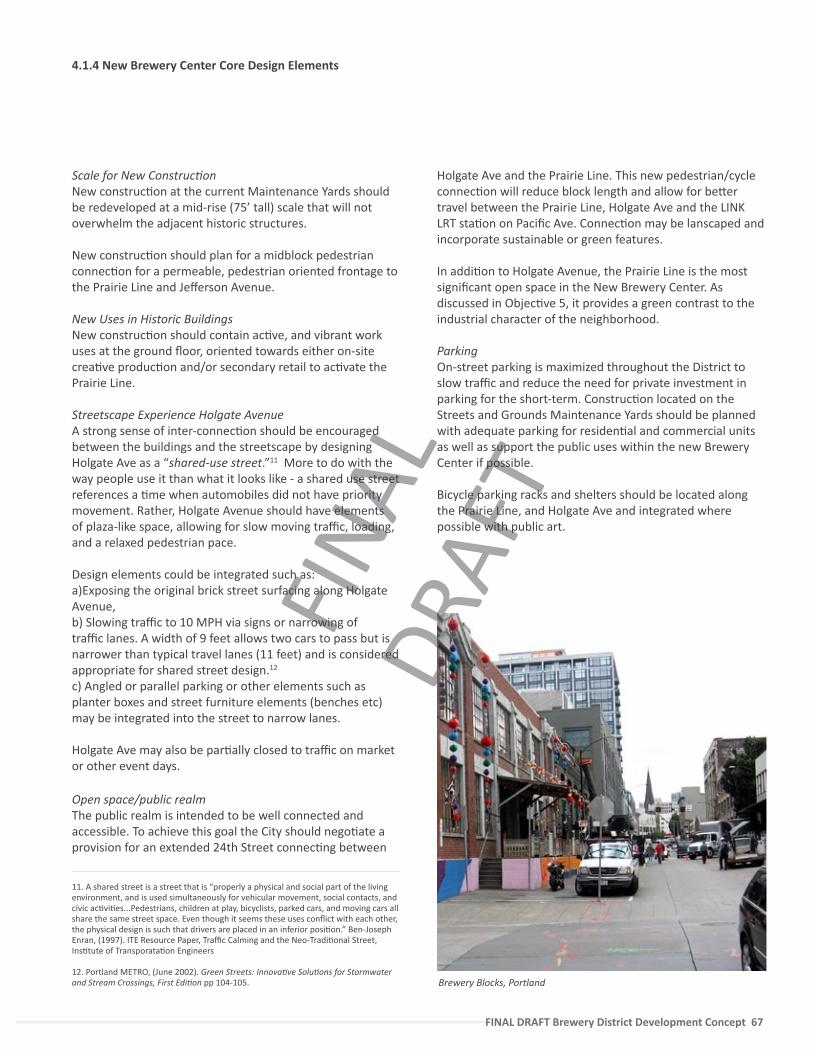
FINA
L DR
AFT
FINAL DRAFT Brewery District Development Concept 67
Scale for New Construc�onNew construc�on at the current Maintenance Yards should be redeveloped at a mid-rise (75’ tall) scale that will not overwhelm the adjacent historic structures.
New construc�on should plan for a midblock pedestrian connec�on for a permeable, pedestrian oriented frontage to the Prairie Line and Jefferson Avenue.
New Uses in Historic BuildingsNew construc�on should contain ac�ve, and vibrant work uses at the ground floor, oriented towards either on-site crea�ve produc�on and/or secondary retail to ac�vate the Prairie Line.
Streetscape Experience Holgate AvenueA strong sense of inter-connec�on should be encouraged between the buildings and the streetscape by designing Holgate Ave as a “shared-use street.”11 More to do with the way people use it than what it looks like - a shared use street references a �me when automobiles did not have priority movement. Rather, Holgate Avenue should have elements of plaza-like space, allowing for slow moving traffic, loading, and a relaxed pedestrian pace.
Design elements could be integrated such as:a)Exposing the original brick street surfacing along Holgate Avenue, b) Slowing traffic to 10 MPH via signs or narrowing of traffic lanes. A width of 9 feet allows two cars to pass but is narrower than typical travel lanes (11 feet) and is considered appropriate for shared street design.12 c) Angled or parallel parking or other elements such as planter boxes and street furniture elements (benches etc) may be integrated into the street to narrow lanes.
Holgate Ave may also be par�ally closed to traffic on market or other event days.
Open space/public realmThe public realm is intended to be well connected and accessible. To achieve this goal the City should nego�ate a provision for an extended 24th Street connec�ng between
Holgate Ave and the Prairie Line. This new pedestrian/cycle connec�on will reduce block length and allow for be�er travel between the Prairie Line, Holgate Ave and the LINK LRT sta�on on Pacific Ave. Connec�on may be lanscaped and incorporate sustainable or green features.
In addi�on to Holgate Avenue, the Prairie Line is the most significant open space in the New Brewery Center. As discussed in Objec�ve 5, it provides a green contrast to the industrial character of the neighborhood.
ParkingOn-street parking is maximized throughout the District to slow traffic and reduce the need for private investment in parking for the short-term. Construc�on located on the Streets and Grounds Maintenance Yards should be planned with adequate parking for residen�al and commercial units as well as support the public uses within the new Brewery Center if possible.
Bicycle parking racks and shelters should be located along the Prairie Line, and Holgate Ave and integrated where possible with public art.
4.1.4 New Brewery Center Core Design Elements
Brewery Blocks, Portland
11. A shared street is a street that is “properly a physical and social part of the living environment, and is used simultaneously for vehicular movement, social contacts, and civic ac�vi�es...Pedestrians, children at play, bicyclists, parked cars, and moving cars all share the same street space. Even though it seems these uses conflict with each other, the physical design is such that drivers are placed in an inferior posi�on.” Ben-Joseph Enran, (1997). ITE Resource Paper, Traffic Calming and the Neo-Tradi�onal Street, Ins�tute of Transporata�on Engineers
12. Portland METRO, (June 2002). Green Streets: Innova�ve Solu�ons for Stormwater and Stream Crossings, First Edi�on pp 104-105.
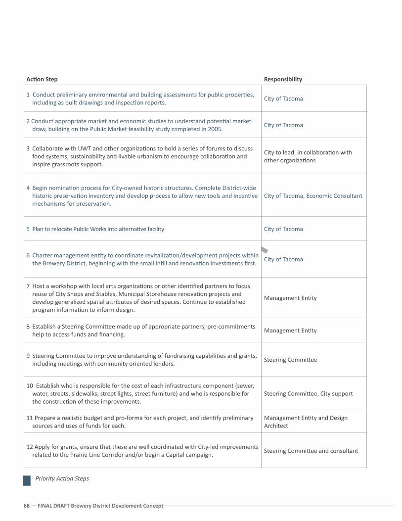
FINA
L DR
AFT
68 — FINAL DRAFT Brewery District Develoment Concept
Ac�on Step Responsibility
1 Conduct preliminary environmental and building assessments for public proper�es, including as built drawings and inspec�on reports.
City of Tacoma
2 Conduct appropriate market and economic studies to understand poten�al market draw, building on the Public Market feasibility study completed in 2005.
City of Tacoma
3 Collaborate with UWT and other organiza�ons to hold a series of forums to discuss food systems, sustainability and livable urbanism to encourage collabora�on and inspire grassroots support.
City to lead, in collabora�on with other organiza�ons
4 Begin nomina�on process for City-owned historic structures. Complete District-wide historic preserva�on inventory and develop process to allow new tools and incen�ve mechanisms for preserva�on.
City of Tacoma, Economic Consultant
5 Plan to relocate Public Works into alterna�ve facility City of Tacoma
6 Charter management en�ty to coordinate revitaliza�on/development projects within the Brewery District, beginning with the small infill and renova�on investments first.
City of Tacoma
7 Host a workshop with local arts organiza�ons or other iden�fied partners to focus reuse of City Shops and Stables, Municipal Storehouse renova�on projects and develop generalized spa�al a�ributes of desired spaces. Con�nue to established program informa�on to inform design.
Management En�ty
8 Establish a Steering Commi�ee made up of appropriate partners; pre-commitments help to access funds and financing.
Management En�ty
9 Steering Commi�ee to improve understanding of fundraising capabili�es and grants, including mee�ngs with community oriented lenders.
Steering Commi�ee
10 Establish who is responsible for the cost of each infrastructure component (sewer, water, streets, sidewalks, street lights, street furniture) and who is responsible for the construc�on of these improvements.
Steering Commi�ee, City support
11 Prepare a realis�c budget and pro-forma for each project, and iden�fy preliminary sources and uses of funds for each.
Management En�ty and Design Architect
12 Apply for grants, ensure that these are well coordinated with City-led improvements related to the Prairie Line Corridor and/or begin a Capital campaign.
Steering Commi�ee and consultant
Priority Ac�on Steps
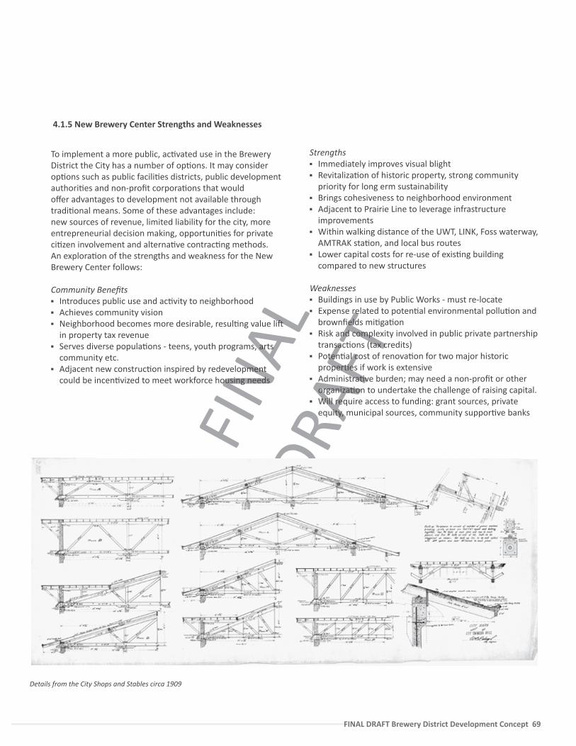
FINA
L DR
AFT
FINAL DRAFT Brewery District Development Concept 69
To implement a more public, ac�vated use in the Brewery District the City has a number of op�ons. It may consider op�ons such as public facili�es districts, public development authori�es and non-profit corpora�ons that would offer advantages to development not available through tradi�onal means. Some of these advantages include: new sources of revenue, limited liability for the city, more entrepreneurial decision making, opportuni�es for private ci�zen involvement and alterna�ve contrac�ng methods. An explora�on of the strengths and weakness for the New Brewery Center follows:
Community Benefits Introduces public use and ac�vity to neighborhood Achieves community vision Neighborhood becomes more desirable, resul�ng value li�
in property tax revenue Serves diverse popula�ons - teens, youth programs, arts
community etc. Adjacent new construc�on inspired by redevelopment
could be incen�vized to meet workforce housing needs
Strengths Immediately improves visual blight Revitaliza�on of historic property, strong community
priority for long erm sustainability Brings cohesiveness to neighborhood environment Adjacent to Prairie Line to leverage infrastructure
improvements Within walking distance of the UWT, LINK, Foss waterway,
AMTRAK sta�on, and local bus routes Lower capital costs for re-use of exis�ng building
compared to new structures
Weaknesses Buildings in use by Public Works - must re-locate Expense related to poten�al environmental pollu�on and
brownfields mi�ga�on Risk and complexity involved in public private partnership
transac�ons (tax credits) Poten�al cost of renova�on for two major historic
proper�es if work is extensive Administra�ve burden; may need a non-profit or other
organiza�on to undertake the challenge of raising capital. Will require access to funding: grant sources, private
equity, municipal sources, community suppor�ve banks
Details from the City Shops and Stables circa 1909
4.1.5 New Brewery Center Strengths and Weaknesses
FINA
L DR
AFT
70 — FINAL DRAFT Brewery District Develoment Concept
4.2.1 Concept Vision
A�ract a high quality mixed-use development that will capitalize on the site’s proximity to the University and local and regional transit connec�ons, and will compliment the area’s rela�onship with an ac�vated Brewery District.
Create an ac�ve center that provides partnering opportuni�es for local community groups with an arts, sustainability or a medical/wellness focus.
Provide a project with a diverse mix of uses, including strong employment and commercial ac�vi�es that will add to City revenue streams.
Work with the University of Washington, Tacoma to encourage an interchange between the student life on and off campus and include where possible the loca�on of non-academic uses on the site, such as a clinic or other student uses such as housing.
Use the triple accounts framework of sustainability (environment, economy, and social equity) as a project benchmark during the development process and include sustainability into project proposal with such items as green building technique, life cycle cost analysis, renewable or alterna�ve energies, and low impact stormwater solu�ons.
The BaselineThe project team conducted several development concept studies of Catalyst Site B. A prototypical build out of mid-rise apartment buildings achieves a 4.3 FAR, with woodframe six story construc�on between 70-75’ in height. Total baseline residen�al capacity is 528 residen�al units and 100,000 SF of retail space.
The ini�al baseline study shows “what the market would deliver.” This is also modeled on recent project precedents within Downtown Tacoma such as “The Mercado” project which clarify what the current market will deliver as a product type.
This allowed the team to set a star�ng point for a set of more ambi�ous alterna�ve concepts that incorporate desired community elements, as well as preferred uses iden�fied during the stakeholder and district analysis process.
4.2 Catalyst Project B: Design ConceptsIt is recommended that the City work with a consultant team to understand the likely development scenarios and create a ledger of costs associated with desired community benefits, including addi�onal circula�ons and streets (while promo�ng walking this also reduces efficient parking geometries due to smaller block size), smaller scale local uses such as retail (these may need subsidy), community centers, and civic open space. It is par�cularly important to recognize that high quality buildings, civic uses, and green strategies may require addi�onal capital costs offset within a project pro-forma.
Specific public amenity opportuni�es that were considered during this preliminary alterna�ve development include;
Gym / community center / a restaurant kitchen incubator / training program
Clinic and wellness preventa�ve care center Student and workforce housing Shared parking and arrangements with structured
garages Hotel Small scale playfield Internal park/plaza Daycare Pocket park, children’s outdoor play space Subsidized small ‘mom+pop’ local/displaced retail +
services
Furthermore while dense housing is desirable because of environmental and social advantages, it is riskier to investors; including greater up-front capital costs, overall cost, type of construc�on, longer �me frames for en�tlements, construc�on, absorp�on, higher exposure to lawsuits, and larger carrying costs.
A public-private partnershipBy clarifying the scope of development supported by the community, the City may reduce associated risk and add value to the site by including access to land, streamlined permi�ng, and advanced environmental review to help offset costs.
As a Community Ini�ated Development, upon comple�on of this report, the City (or chartered management structure) should con�nue to fully define the terms for a public/private partnership so that development can move forward as the market recovers. A “development ready” package would include:
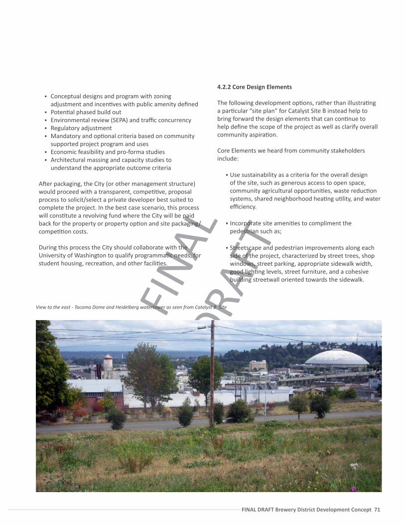
FINA
L DR
AFT
FINAL DRAFT Brewery District Development Concept 71
Conceptual designs and program with zoning adjustment and incen�ves with public amenity defined
Poten�al phased build out Environmental review (SEPA) and traffic concurrency Regulatory adjustment Mandatory and op�onal criteria based on community
supported project program and uses Economic feasibility and pro-forma studies Architectural massing and capacity studies to
understand the appropriate outcome criteria
A�er packaging, the City (or other management structure) would proceed with a transparent, compe��ve, proposal process to solicit/select a private developer best suited to complete the project. In the best case scenario, this process will cons�tute a revolving fund where the City will be paid back for the property or property op�on and site packaging/compe��on costs.
During this process the City should collaborate with the University of Washington to qualify programma�c needs, for student housing, recrea�on, and other facili�es.
View to the east - Tacoma Dome and Heidelberg watertower as seen from Catalyst B SIte
4.2.2 Core Design Elements
The following development op�ons, rather than illustra�ng a par�cular “site plan” for Catalyst Site B instead help to bring forward the design elements that can con�nue to help define the scope of the project as well as clarify overall community aspira�on.
Core Elements we heard from community stakeholders include:
Use sustainability as a criteria for the overall design of the site, such as generous access to open space, community agricultural opportuni�es, waste reduc�on systems, shared neighborhood hea�ng u�lity, and water efficiency.
Incorporate site ameni�es to compliment the pedestrian such as;
Streetscape and pedestrian improvements along each side of the project, characterized by street trees, shop windows, street parking, appropriate sidewalk width, good ligh�ng levels, street furniture, and a cohesive building streetwall oriented towards the sidewalk.
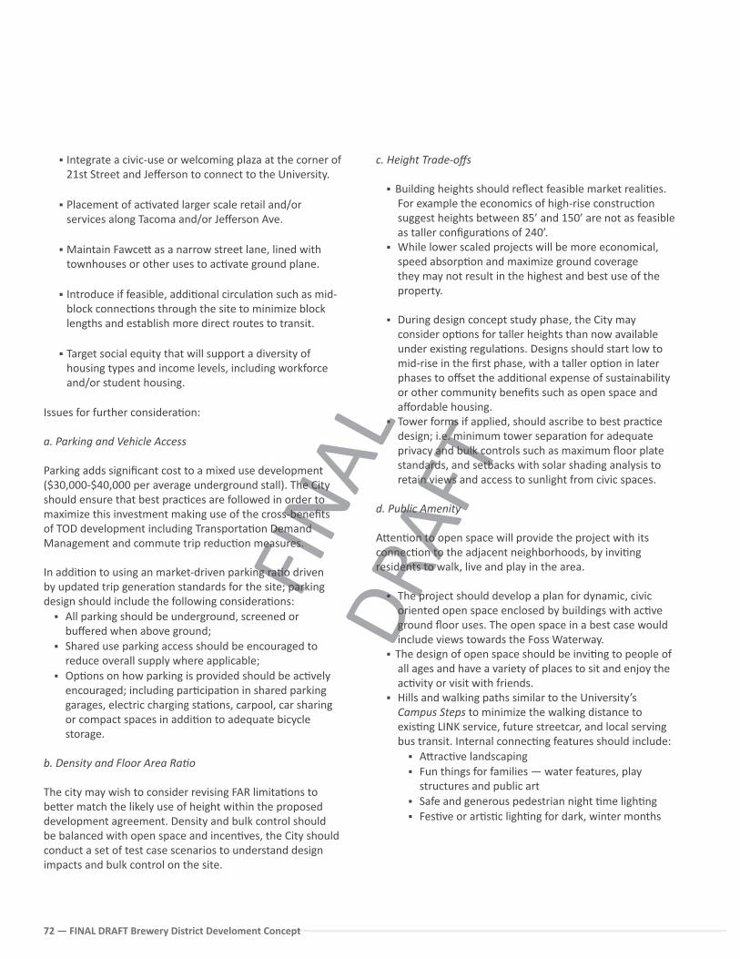
FINA
L DR
AFT
72 — FINAL DRAFT Brewery District Develoment Concept
Integrate a civic-use or welcoming plaza at the corner of 21st Street and Jefferson to connect to the University.
Placement of ac�vated larger scale retail and/or services along Tacoma and/or Jefferson Ave.
Maintain Fawce� as a narrow street lane, lined with townhouses or other uses to ac�vate ground plane.
Introduce if feasible, addi�onal circula�on such as mid-block connec�ons through the site to minimize block lengths and establish more direct routes to transit.
Target social equity that will support a diversity of housing types and income levels, including workforce and/or student housing.
Issues for further considera�on:
a. Parking and Vehicle Access
Parking adds significant cost to a mixed use development ($30,000-$40,000 per average underground stall). The City should ensure that best prac�ces are followed in order to maximize this investment making use of the cross-benefits of TOD development including Transporta�on Demand Management and commute trip reduc�on measures.
In addi�on to using an market-driven parking ra�o driven by updated trip genera�on standards for the site; parking design should include the following considera�ons:
All parking should be underground, screened or buffered when above ground;
Shared use parking access should be encouraged to reduce overall supply where applicable;
Op�ons on how parking is provided should be ac�vely encouraged; including par�cipa�on in shared parking garages, electric charging sta�ons, carpool, car sharing or compact spaces in addi�on to adequate bicycle storage.
b. Density and Floor Area Ra�o
The city may wish to consider revising FAR limita�ons to be�er match the likely use of height within the proposed development agreement. Density and bulk control should be balanced with open space and incen�ves, the City should conduct a set of test case scenarios to understand design impacts and bulk control on the site.
c. Height Trade-offs
Building heights should reflect feasible market reali�es. For example the economics of high-rise construc�on suggest heights between 85’ and 150’ are not as feasible as taller configura�ons of 240’.
While lower scaled projects will be more economical, speed absorp�on and maximize ground coverage they may not result in the highest and best use of the property.
During design concept study phase, the City may consider op�ons for taller heights than now available under exis�ng regula�ons. Designs should start low to mid-rise in the first phase, with a taller op�on in later phases to offset the addi�onal expense of sustainability or other community benefits such as open space and affordable housing.
Tower forms if applied, should ascribe to best prac�ce design; i.e. minimum tower separa�on for adequate privacy and bulk controls such as maximum floor plate standards, and setbacks with solar shading analysis to retain views and access to sunlight from civic spaces.
d. Public Amenity
A�en�on to open space will provide the project with its connec�on to the adjacent neighborhoods, by invi�ng residents to walk, live and play in the area.
The project should develop a plan for dynamic, civic oriented open space enclosed by buildings with ac�ve ground floor uses. The open space in a best case would include views towards the Foss Waterway.
The design of open space should be invi�ng to people of all ages and have a variety of places to sit and enjoy the ac�vity or visit with friends.
Hills and walking paths similar to the University’s Campus Steps to minimize the walking distance to exis�ng LINK service, future streetcar, and local serving bus transit. Internal connec�ng features should include:
A�rac�ve landscaping Fun things for families — water features, play
structures and public art Safe and generous pedestrian night �me ligh�ng Fes�ve or ar�s�c ligh�ng for dark, winter months
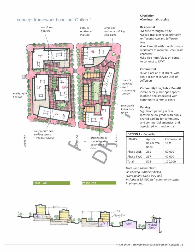
FINA
L DR
AFT
FINAL DRAFT Brewery District Development Concept 73
Circula�on One internal crossing
Residen�alMidrise throughout siteMixed-use over retail primarily on Tacoma Ave and Jefferson Ave.Line Fawce� with townhouses or work lo�s to maintain small scale characterMid-rise hotel/plaza on corner to connect to UWT
CommercialCivic plaza at 21st street, with clinic or other service uses on Jefferson
Community Use/Public BenefitSmall semi-public open space in phase one associated with community center or clinic.
ParkingSignificant parking access located below grade with public shared parking for community and commercial amen�es, and associated with residen�al.
Taco
ma
Ave
Faw
ce�
Ave
Jeffe
rson
Ave
Alley for fire and parking access - woonerf paving
workforce housing
hotel or residen�al mid-rise
market rate or special needs housing over clinic
semi-public family play space
retail and restaurants lining civic plaza
student housing/ over community center
75”
75’
65’
65’
75’
75’65’
concept framework baseline: Option 1
Phase OnePhase Two
market rate housing
OPTION 1 - Capacity
TOTALS Approx Residen�al units
Commercialsq �
Phase ONE 261 60,000
Phase TWO 267 40,000
Total 528 100,000
Notes and Assump�onsAll parking is market-based Average unit size is 900 sq �Includes a 35, 000 sq � community center in phase one.
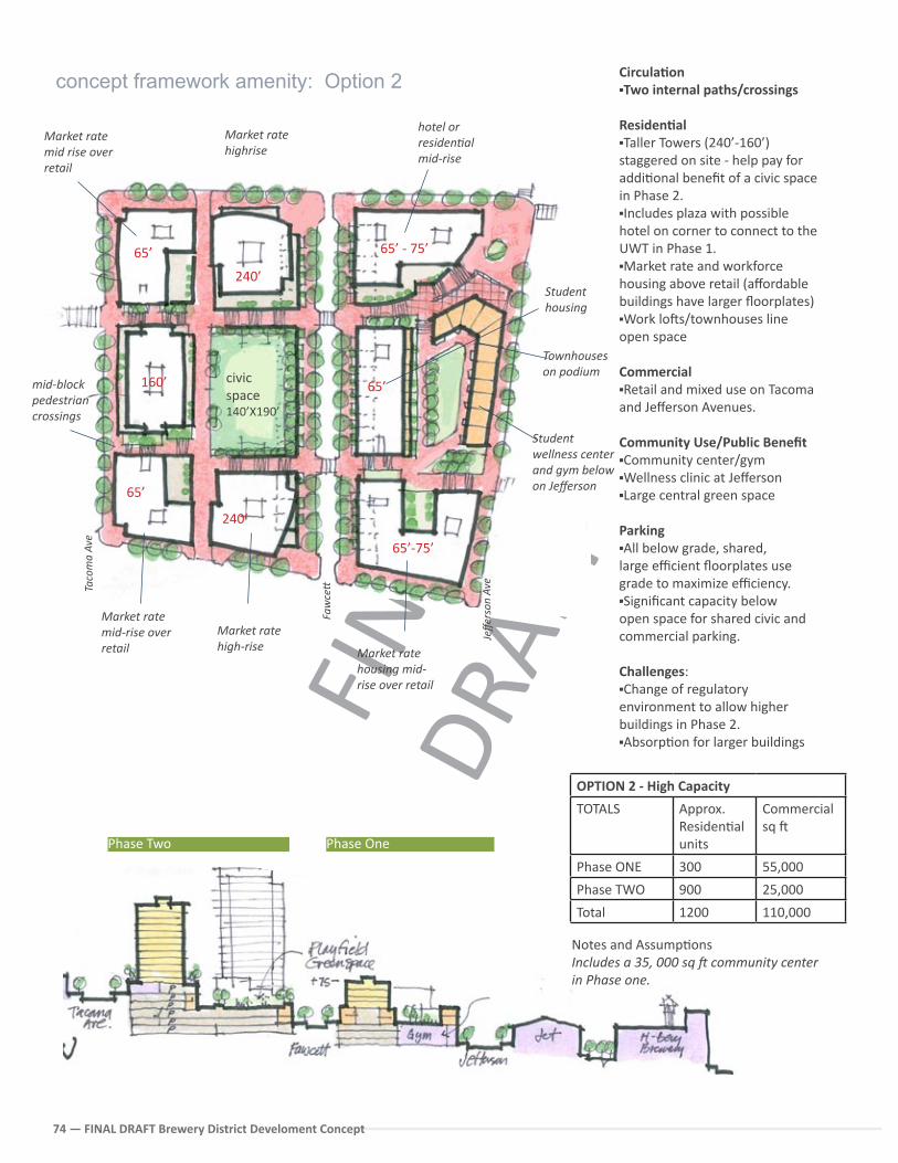
FINA
L DR
AFT
74 — FINAL DRAFT Brewery District Develoment Concept
65’
160’
65’-75’
65’ - 75’
65’
240’
240’
Taco
ma
Ave
Faw
ce�
Jeffe
rson
Ave
65’
hotel or residen�al mid-rise
civic space 140’X190’
Student wellness center and gym below on Jefferson
Townhouses on podium
mid-block pedestrian crossings
Circula�onTwo internal paths/crossings
Residen�alTaller Towers (240’-160’) staggered on site - help pay for addi�onal benefit of a civic space in Phase 2.Includes plaza with possible hotel on corner to connect to the UWT in Phase 1.Market rate and workforce housing above retail (affordable buildings have larger floorplates)Work lo�s/townhouses line open space
Commercial Retail and mixed use on Tacoma and Jefferson Avenues.
Community Use/Public Benefit Community center/gymWellness clinic at JeffersonLarge central green space
ParkingAll below grade, shared,large efficient floorplates use grade to maximize efficiency. Significant capacity below open space for shared civic and commercial parking.
Challenges:Change of regulatory environment to allow higher buildings in Phase 2. Absorp�on for larger buildings
concept framework amenity: Option 2
Phase OnePhase Two
Market rate mid rise over retail
OPTION 2 - High Capacity
TOTALS Approx. Residen�al units
Commercialsq �
Phase ONE 300 55,000
Phase TWO 900 25,000
Total 1200 110,000
Notes and Assump�onsIncludes a 35, 000 sq � community center in Phase one.
Market rate housing mid-rise over retail
Market rate high-rise
Market rate mid-rise over retail
Market rate highrise
Student housing
FINA
L DR
AFT
FINAL DRAFT Brewery District Development Concept 75
OPTION 2 - High Capacity
TOTALS Approx. Residen�al units
Commercialsq �
Phase ONE 300 55,000
Phase TWO 900 25,000
Total 1200 110,000
4.2.3 Other Considera�ons from Stakeholders
An interes�ng Stakeholder comment received during the project was that developing the 6-Acre parcel to its highest and best use including mixed- high intensity housing may limit development opportunity for the private sector in the surrounding area. An alterna�ve design idea was therefore proposed that the Catalyst site instead of being developed, should contain a large scale civic use, such as a park that would help raise property value for the adjacent private sector property.
While there are precedents for this type of development the pursuit of this concept would require further study of the following elements to understand associated costs:
Poten�al re-zone around the park site and include an arrangement such as an LID (Local Improvement District) that would contribute funds to civic use;
Understanding of exis�ng funding sources and op�ons for future maintainance of park;
A proforma itemizing this alterna�ve as related to overall City budget.
Furthermore, economic development promotes the general idea that ac�vity generates other types of ac�vity, and significant private/public investment in the site would likely help to catalyze rather than detract from future investment.
We therefore believe that it is in the best interest of the City to develop the site according to its high loca�on efficiency and its proximity to the growing UWT campus with a diverse mix of uses and related housing. Furthermore any major civic investment should not compete with the previously iden�fied priority project, the Prairie Line.
4.2.4 Next Steps
Con�nue to develop site “proof of concept,” including pro-formas and schema�c design to meet where possible, the core design elements of the site. Appendix contains the prelimiary square footage and parking per Op�ons 1 and 2.
Work concurrently with the City’s Capital Division to develop a ledger of public benefits, including costs for addi�onal circula�on, low impact development, community centers. The project should develop an understanding of public and priavte sector responsibili�es and highlight the rela�ve costs of providing sustainbility premiums via the overall feasibilty of the development project.
The costs of civic oriented uses, and donated space should tested to be adequately offset by revenue sources such as addi�onal housing units in order to ensure the project’s overall feasibility.
Conduct interviews with poten�al developers and encourage rela�onships with developers that have completed similar projects.
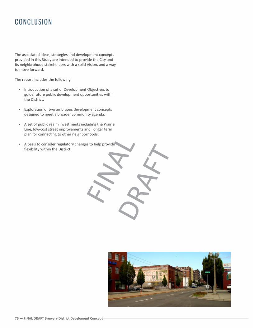
FINA
L DR
AFT
76 — FINAL DRAFT Brewery District Develoment Concept
CONCLUS ION
The associated ideas, strategies and development concepts provided in this Study are intended to provide the City and its neighbrohood stakeholders with a solid Vision, and a way to move forward.
The report includes the following;
Introduc�on of a set of Development Objec�ves to guide future public development opportuni�es within the DIstrict;
Explora�on of two ambi�ous development concepts designed to meet a broader community agenda;
A set of public realm investments including the Prairie Line, low-cost street improvements and longer term plan for connec�ng to other neighborhoods;
A basis to consider regulatory changes to help provide flexibility within the District.
FINA
L DR
AFT
FINAL DRAFT Brewery District Development Concept 77
o1 Conduct proac�ve outreach to the private sector to foster public-private partnerships for redevelopment sites in accordance with the community vision.
o2 Advocate for and leverage an integrated approach between transporta�on access and land use development to spur the crea�on of a livable, walkable neighborhood and capitalize on the substan�al transporta�on investments in the area.
o3 Use community-based partnerships to diversify risk and incubate local businesses within both renovated and new structures in the District. Encourage the loca�on of companies that produce goods, ar�s�c cra� and green technology.
o4 Apply a range of sustainability strategies for the long term health of the neighborhood.
Invest in pedestrian and bicycle system improvements that will con�nue to realize connec�ons between the Brewery District and surrounding residen�al and commercial areas par�cularly the University of Washington Campus.
o6 Build city capacity to op�mize exis�ng resources through crea�ve, interim and long term land use strategies.
OBJECT IVES SUMMARY
o5