boulder creek project -...
TRANSCRIPT
Idaho Panhandle National Forests 1
About the Boulder Creek Restoration Project The Boulder Creek Restoration Project (BCRP) is part of a broader collaborative forest landscape restoration program proposal occurring in the lower Kootenai River Watershed.
In 2011, a collaborative group called the Kootenai Valley Resource Initiative (KVRI)1 and staff from the Idaho Panhandle National Forests (IPNF) developed the Lower Kootenai Valley River Watershed Collaborative Forest Landscape Restoration Proposal. That document identified the need for holistic ecological restoration across all land ownerships in the watershed. The desired conditions for the lower Kootenai River Watershed is a landscape that maintains natural processes, patterns and functions, and is more resilient to unforeseen disturbances. After numerous project development meetings and field trips to the Boulder Creek area, we collectively developed the BCRP proposal. This proposal incorporates the collaborative forest landscape restoration program goals that are relevant to the National Forest System lands in the Boulder Creek area.
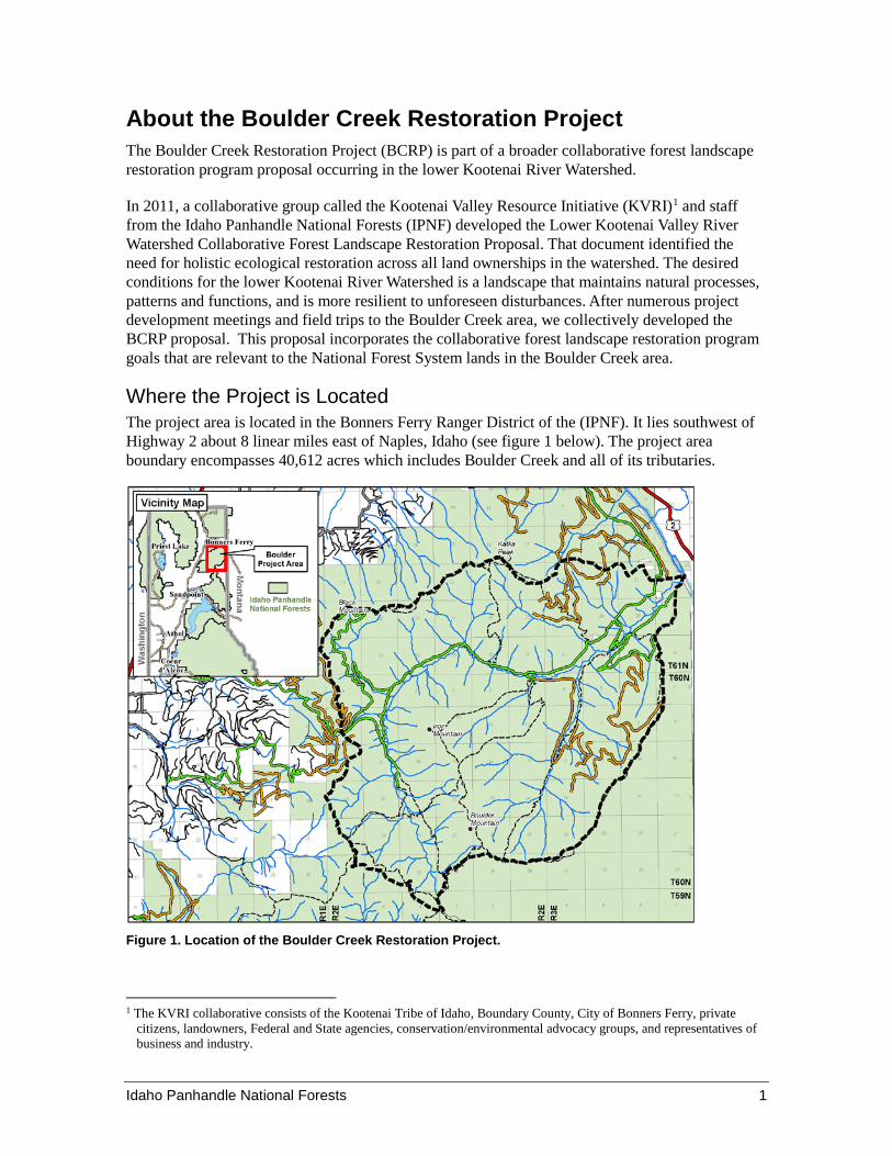
Where the Project is Located The project area is located in the Bonners Ferry Ranger District of the (IPNF). It lies southwest of Highway 2 about 8 linear miles east of Naples, Idaho (see figure 1 below). The project area boundary encompasses 40,612 acres which includes Boulder Creek and all of its tributaries.
Figure 1. Location of the Boulder Creek Restoration Project.
1 The KVRI collaborative consists of the Kootenai Tribe of Idaho, Boundary County, City of Bonners Ferry, private
citizens, landowners, Federal and State agencies, conservation/environmental advocacy groups, and representatives of business and industry.

2 Idaho Panhandle National Forests
Why are we proposing this project? Our primary focus of the BCRP is to manage the forest stands in the project area to maintain or improve their resilience to disturbances such as drought, insect and disease outbreaks, and wildfires. We are also concerned about areas where forest fuel accumulations are high and continuous across the landscape, conditions which often contribute to large severe wildfires. The steep and inaccessible topography makes fire suppression difficult over most of the project area. The northern section of the BCRP is in or adjacent to the wildland-urban interface (WUI). This area has continuous stands of trees with high fuel loadings (dead trees, branches, and forest litter). When wildfire(s) occur in these fuel types, these conditions could cause a severe fire that is difficult to control or could spread onto private lands to the north. If such a fire were to kill expansive areas of trees across multiple drainages, heavy rains could cause large flash floods and debris flows, negatively affecting private landowners and community water systems to the north of the project area.
Values at risk in the project area include the communication equipment and the lookout tower located at the top of Black Mountain. Other assets that could be negatively impacted by fire include the historic resources in the vicinity of the Boulder City Ghost Town and the small community water systems north of the project area.
Another main focus of our proposal is specific to grizzly bear habitat. The 2015 Revised Land Management Plan for the IPNF retained direction from several amendments of the (1987) Forest Plan, including design elements of the selected alternative for the Kootenai, Idaho Panhandle, and Lolo National Forests Land and Resource Management Plans Amendment for Motorized Access Management within the Selkirk and Cabinet-Yaak Grizzly Bear Recovery Zones. This direction requires all Grizzly Bear Management Units (BMUs) within the affected Forests to meet access management standards by 2019. The Boulder BMU (where the BCRP is located) currently does not meet these standards. This project will serve as the mechanism to achieve access management standards for the BMU by increasing grizzly bear core habitat and reducing the Total Motorized Route Density (TMRD) for this BMU by 2019”.
We have other resource objectives we would like to accomplish while working in this area. These objectives include: maintaining and improving recreational sites and experiences, maintaining aquatic ecosystems, treating noxious weeds, and promoting the persistence and stability of wildlife habitat.
We have designed the BCRP proposal to achieve direction described in the 2015 IPNF forest plan. The BCRP boundary totals 40,612 acres and overlaps the following different Management Areas (MA’s), specifically MA 2b (Eligible Wild and Scenic River – 35 acres), MA 4a (Hunt Girl Research Natural Area – 1,425 acres), MA 5 (Backcountry Restoration – 23,384 acres), MA 6 (General Forest – 15,717 acres) and also 51 acres of private land.
Idaho Panhandle National Forests 3
The following sections highlight our purpose and need for the Boulder Creek Restoration Project, listing specific goals and objectives and explaining why they are necessary.
Changing Forest Vegetation to Improve Landscape Resiliency Forest vegetation in the BCRP area has changed over time due to a combination of fire suppression, introduction of white pine blister rust and past forest management practices. Before the accidental introduction of blister rust, white pine was a more significant component of the landscape. Historically, larch and white pine stands regenerated in the sunny openings created by wildfires.
For thousands of years, both large and small fires were once common across all of north Idaho, including the Boulder Creek landscape. During recorded history, the biggest fire years included 1889 and 1910 when more than 27,000 acres burned across the Boulder Creek area in 1910 alone. Smaller fires also occurred in the early 1920s (burning just a few hundred acres each), suggesting that up until the era of successful fire suppression (early 1930s) fire disturbance was frequent across this and neighboring landscapes. These variable-intensity fires likely maintained lower fuel loadings than we see today, helped create a mosaic of stand conditions, and provided for a range of wildlife habitats. Unfortunately, natural fires have now been absent for over 106 years in this area, resulting in a relatively homogenous landscape with increased fuels and dense stands of similar age, structure, and composition.
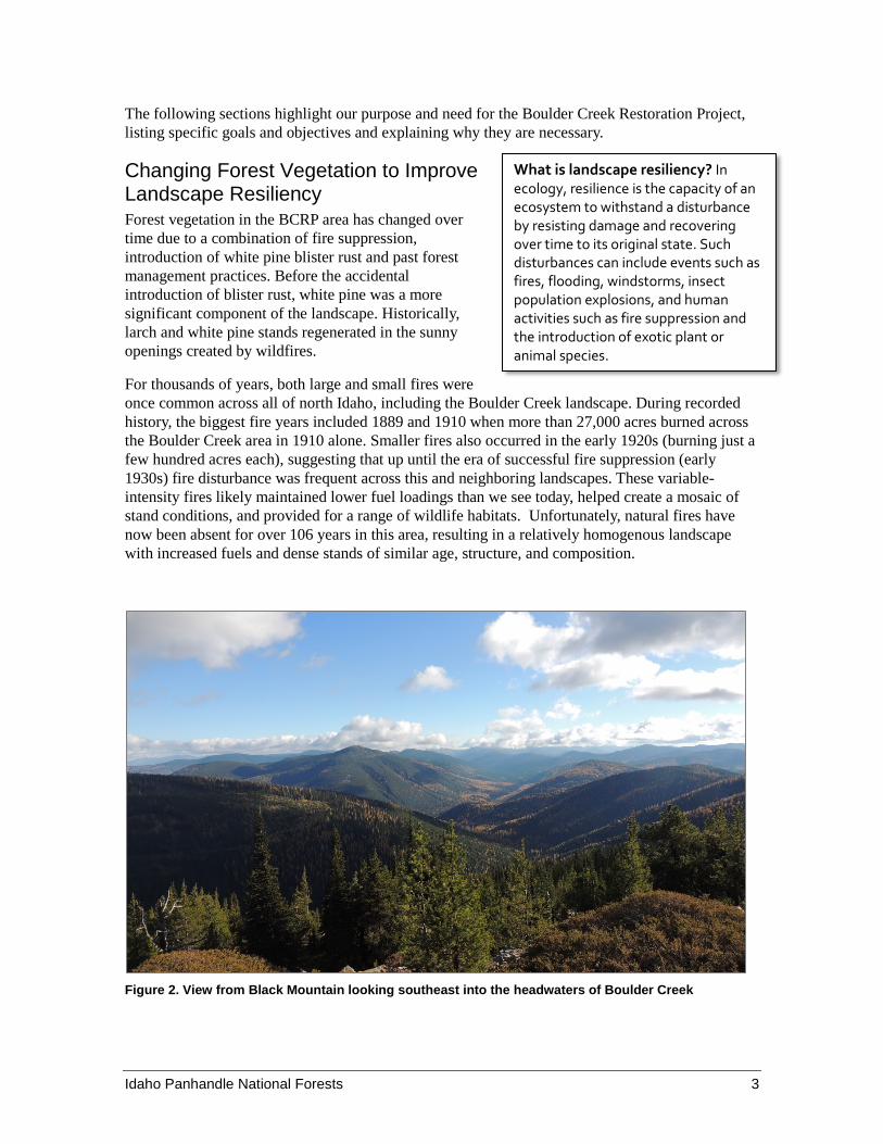
Figure 2. View from Black Mountain looking southeast into the headwaters of Boulder Creek
What is landscape resiliency? In ecology, resilience is the capacity of an ecosystem to withstand a disturbance by resisting damage and recovering over time to its original state. Such disturbances can include events such as fires, flooding, windstorms, insect population explosions, and human activities such as fire suppression and the introduction of exotic plant or animal species.

4 Idaho Panhandle National Forests
Forest ecosystems may be ecologically stable, unstable or somewhere in between given their respective composition and structure and resilience to changes. In the case of the BCRP and the inherent fire risk across the landscape, we know that we cannot change the topography nor the weather; but we can adjust the stand structures, fuel loadings and continuity of the forested areas. The vegetation management part of this proposal is exploring what, where and how can we manage the forest stands and fuel types in the project area. Your comments will help develop the environmental analysis which will highlight the projected effects of active management as compared to allowing nature to take its course.
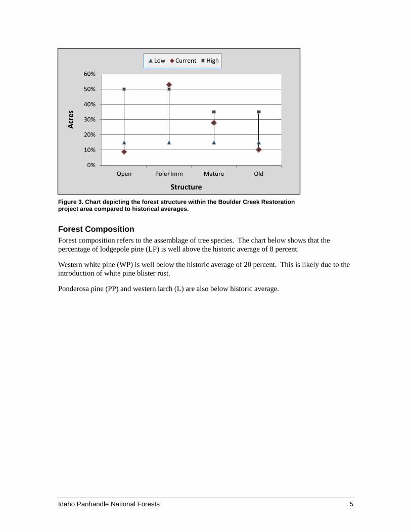
One way to evaluate risks pertaining to overall ecosystem stability is to compare the current and historic values2 of the vegetation structure and composition at the landscape level. The graphs below indicate which components of the landscape are within the historical range or outside of the historical range. With these graphs we can see how the Boulder Creek Restoration Project area landscape rates from a historical perspective and evaluate which components may need to be addressed with this project proposal.
Forest Structure Forest structure is the horizontal and vertical distribution of layers in a forest. Structure looks at the proportion of young, mature, and old trees across the landscape.
The chart shows that openings in the forest canopy currently occupy only 9 percent of the project area. This is below the sub-basin range of 15 to 50 percent of the landscape.
Young forests (Pole and Immature) are currently 53 percent of project area. This number is slightly above historic sub-basin upper range of 50 percent.
Mature forests are currently within the historic range at 28 percent.
Old growth currently comprises 10 percent of the landscape which is outside and below the historic range of 15 to 35 percent.
2 Historic ranges and averages for structure and composition are compared to the Kootenai River Sub-Basin and derived
from the North Zone Geographic Assessment (NZGA)
Idaho Panhandle National Forests 5
Figure 3. Chart depicting the forest structure within the Boulder Creek Restoration project area compared to historical averages.
Forest Composition Forest composition refers to the assemblage of tree species. The chart below shows that the percentage of lodgepole pine (LP) is well above the historic average of 8 percent.
Western white pine (WP) is well below the historic average of 20 percent. This is likely due to the introduction of white pine blister rust.
Ponderosa pine (PP) and western larch (L) are also below historic average.
0%
10%
20%
30%
40%
50%
60%
Open Pole+Imm Mature Old
Acre
s
Structure
Low Current High

6 Idaho Panhandle National Forests
Figure 4. Chart depicting the forest composition within the Boulder Creek Restoration project area.
Species Key
C – Western red cedar
DF – Douglas-fir
GF – Grand fir
WH – Western hemlock
L – Larch
LP – Lodgepole pine
PP – Ponderosa pine
SAF – Sub alpine fir
WP – White pine
WBP - Whitebark pine
HDW – Hardwoods such as Aspen, Birch and Cottonwood.
Today, nearly 30 percent of the project area landscape is composed of mature forests dominated by Douglas-fir, grand fir, western hemlock, and lodgepole pine; species that have replaced white pine, ponderosa pine and larch. These stands, which historically would have had fewer of these species due to wildfires, have very little structural diversity and are at higher risk of succumbing to insect and disease infestations because of congested stand conditions and competition for light, water and nutrients.
Many of the lodgepole pine stands are considered a high hazard for bark beetle attacks because they are mature, growing in crowded condition and therefore often stressed due to inter-tree competition for nutrients, water and sunlight, a trend that is expected to continue in the near future without active management.
Aspen stands within the BCRP area typically regenerated after wildfires, now with successful fire suppression they are often competing with conifer trees for light, water and nutrients, which limits their ability to regenerate.
Because the BCRP landscape is in the lower ranges for old growth coverage, many of the mature forest stands would be actively or passively managed so they can develop into old growth stands where needed for various resource benefits on the landscape.
0%
10%
20%
30%
40%
Acre
s
Species
Current Historic

Idaho Panhandle National Forests 7
For these reasons and risks to the vegetation, we want to maintain and improve forest landscape resiliency by providing for tree species, stocking levels, and landscape patterns that better resist insects, disease, and stand-replacing wildfire(s). Needs that are specific to the BCRP include:
Restoration of white pine on habitat types that historically supported the species. Reduction in acres of moderate and high hazard lodgepole pine stands. Maintenance and restoration of ponderosa pine and western larch on habitat types that
historically supported these species. Maintenance and restoration of dry-site old growth stands that may need management in
the form of fuels reduction, prescribed fire, or both. Increased patch size of forest openings (seedling/sapling) and decreased patch size of
immature forests (small and medium) in order to emulate mixed-severity fire regimes and landscape burn patterns.
Conserve existing whitebark pine populations and enhance opportunities for restoration. Retention or restoration of ecological conditions and processes that sustain the habitats
currently or potentially occupied by sensitive plant species.
Our proposal prescribes several different methods to manage the vegetation in the Boulder project area to address the concerns discussed above. Maps and a detailed unit-by-unit prescription table is available on the Idaho Panhandle National Forest webpage at: http://www.fs.usda.gov/projects/ipnf/landmanagement/projects (see “Idaho Panhandle National Forest Current and Recent Projects”).
Other Resource Objectives We Want to Accomplish
Aquatic Resource Currently, many of the road systems in the BCRP are in need of maintenance and need surface work and drainage improvements to prevent sediment from roads entering into the stream systems and becoming detrimental to aquatic species. We want to reduce the risk of sediment entering the stream systems from sources such as roads, trails and recreation sites.
Improving Fish Passage in the Middle Fork of Boulder Creek Fish and aquatic habitat surveys indicate that streams in the project area are functioning properly and require very little restoration. However, one culvert passing Middle Fork Boulder Creek under Forest Service Road #628 is deemed a barrier to upstream fish passage. Replacing this culvert with a structure that will allow fish access to beneficial aquatic habitat upstream of this location would benefit all life stages of fish species in the project area. Effects of replacing this culvert would be analyzed with this project as an opportunity and replacement may occur as priorities and funding allow.
Wildlife Habitat As depicted in Figures 2-4, and in the landscape resiliency discussion; the project area contains a landscape of stands that are relatively similar in size and age, and therefore, not providing a wide range of wildlife habitats. Therefore, this project proposes to:
Contribute to meeting the standards of the Grizzly Bear Access Amendment for the Bear Management Units by increasing core habitat.
8 Idaho Panhandle National Forests
Promote the long-term persistence and stability of wildlife habitat and biodiversity by trending toward an ecosystem composed of vegetation that more closely resembles the historic range of variability.
Improve the diversity of forest and riparian structures. Emulate historic disturbance patterns.
Recreation There is a need to maintain and improve recreational sites and experiences in the Boulder Creek area because of the increasing demand for outdoor experiences including hiking, hunting, berry picking, dispersed camping and fishing. By improving recreational sites we can also provide opportunities for visitors to learn about the local history, protect off road areas and connecting trail systems from illegal ATV use.
The Boulder City Ghost Town, established over 100 years ago, is a well-known and much loved day-hike destination for local history buffs. Nestled in the timber above Boulder Creek near it’s confluence with the Kootenai River, Boulder City boasts a dynamic history suitable for an adventure novel: a business man of questionable business ethics, but a heart for the poor man; years of backwoods and pioneer mining and living; and a lifespan extending from the expansion of the population into the west through the devastation of the depression.
With the popularity of Daniel James Brown’s Award winning book Boys in the Boat – one in which Boulder City plays a part, the national and international tourist communities have become aware of this northern Idaho gem.
With the rise in popularity of the area, the age of the wooden and metal remnants of a historic town site not occupied for 60 years, and the increase in public visits, the limited remaining fragile historic remains of the town are in serious jeopardy. Lack of directed public use of this high interest area has led to many activities that have degraded the town site remains: graffiti on historic structural remains, wooden house remains being scavenged for camp fires, illegal digging through the housing areas by metal collectors, scavengers seeking and removing historic artifacts, and other activities are visible throughout the historic town site.
In addition, trailhead parking areas within the project boundary are brushy, not well defined and are merely a wide spot on the road shoulder. Most of these trailheads are too small to turn around in safely with a vehicle and trailer. We propose to widen trailheads to allow for safer parking and travel.
Controlling Invasive Plants Boundary County and other jurisdictions have partnered to manage and control noxious weeds across boundaries. In the BCRP area, we propose to contain or control existing noxious weed populations along road and trail systems, and minimize potential for new weed infestations, because they could spread into riparian areas such as Boulder Meadows.
Managing the Road System There are two primary reasons we need to manage the road systems within the BCRP area. The first need is to be in compliance with the forest plan and the standards of the Grizzly Bear Access Amendment. The second need is to manage the road systems for long-term transportation and resource needs.
Idaho Panhandle National Forests 9
The interdisciplinary team reviewed all of the road systems affiliated with the BCRP area. The team also went through an assessment of the transportation system using the Travel Analysis Process (TAP) to identify a future road system that would meet the purpose and need of the this project as well as provide access for a variety of uses and minimize unwanted impacts to natural resources. Please refer to Table 5 for the specifics on proposed road management.
Enhancing the Scenic Integrity of the Area A portion of the project area was harvested in the 1970s through 80s, back when stands were cut with little consideration for how the result would appear when viewed at a distance. Natural vegetation patterns, which historically were shaped by events such as wildfire, are not obvious and geometric; their shapes, sizes and burn patterns resulted in irregular shaped openings and patches across the landscape. As we complete our restoration work, we want areas viewed from routes and sites of high scenic concern such as U.S. Highway 2, Trail 182 (between Katka Pass and Clifty Mountain) and the Black Mountain Lookout to mimic natural vegetation patterns and reflect healthy, resilient vegetation conditions.
Contributing to the Local Economy In addition to other landscape restoration work happening in the Lower Kootenai River Watershed, the BCRP can help contribute to local economic growth. This project is not expected to create new permanent jobs in the long term, however it is expected to bolster the local economy because of improvements to the recreation resource, an increase in visitor days into the community of Bonners Ferry and the project would generate activities and funds from forest products that would be produced as a result of the restoration activities.
Details of Our Proposal Vegetation Management Prescriptions In order to address the resource issues discussed above in the purpose and need for this project, we are prescribing several different methods to manage the vegetation in the Boulder project area. Please refer to the maps and detailed unit-by-unit prescription table located on the Idaho Panhandle National Forest webpage at: http://www.fs.usda.gov/projects/ipnf/landmanagement/projects (see “Idaho Panhandle National Forest Current and Recent Projects”).
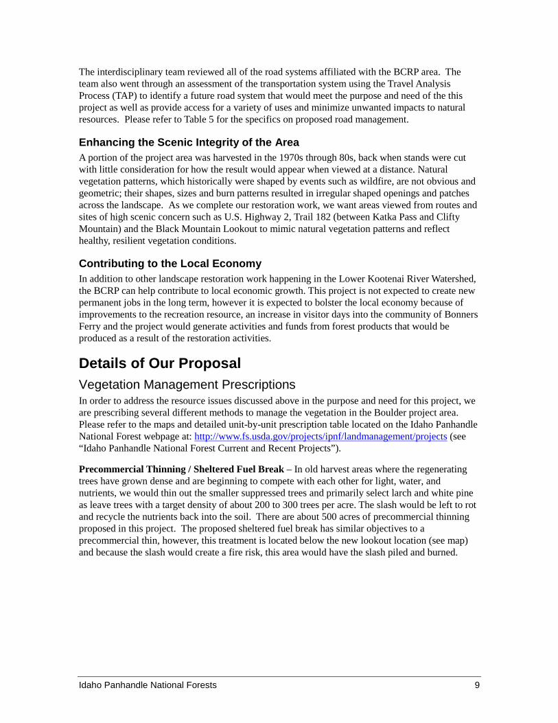
Precommercial Thinning / Sheltered Fuel Break – In old harvest areas where the regenerating trees have grown dense and are beginning to compete with each other for light, water, and nutrients, we would thin out the smaller suppressed trees and primarily select larch and white pine as leave trees with a target density of about 200 to 300 trees per acre. The slash would be left to rot and recycle the nutrients back into the soil. There are about 500 acres of precommercial thinning proposed in this project. The proposed sheltered fuel break has similar objectives to a precommercial thin, however, this treatment is located below the new lookout location (see map) and because the slash would create a fire risk, this area would have the slash piled and burned.
10 Idaho Panhandle National Forests
Figure 5. Example of a precommercial thinning. This management technique helps reduce competition among young trees so they get more light, water and nutrients. The term “precommercial” indicates that the cut material is not yet merchantable for sawlog products.
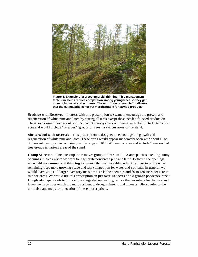
Seedtree with Reserves – In areas with this prescription we want to encourage the growth and regeneration of white pine and larch by cutting all trees except those needed for seed production. These areas would have about 5 to 15 percent canopy cover remaining with about 5 to 10 trees per acre and would include “reserves” (groups of trees) in various areas of the stand.
Shelterwood with Reserves – This prescription is designed to encourage the growth and regeneration of white pine and larch. These areas would appear moderately open with about 15 to 35 percent canopy cover remaining and a range of 10 to 20 trees per acre and include “reserves” of tree groups in various areas of the stand.
Group Selection – This prescription removes groups of trees in 1 to 3-acre patches, creating sunny openings in areas where we want to regenerate ponderosa pine and larch. Between the openings, we would use commercial thinning to remove the less desirable understory trees to provide the remaining trees more growing space and less competition for water and nutrients. In general, we would leave about 10 larger overstory trees per acre in the openings and 70 to 130 trees per acre in thinned areas. We would use this prescription on just over 100 acres of old growth ponderosa pine / Douglas-fir type stands to thin out the congested understory, reduce the hazardous fuel ladders and leave the large trees which are more resilient to drought, insects and diseases. Please refer to the unit table and maps for a location of these prescriptions.
Idaho Panhandle National Forests 11
Figure 6. Existing condition in an overstocked ponderosa pine and Douglas-fir old growth stand.
Seedtree Shelterwood
Group selection Commercial thinning
Figure 7. Graphic simulations showing how different vegetation prescriptions would look

12 Idaho Panhandle National Forests
Table 1. Vegetation treatment prescriptions
Vegetation Prescriptions Acres
Group Selection 757 Shelterwood with Reserves 214 Seedtree with Reserves 4,516 Precommercial Thinning 500 Sheltered Fuel Break 25 Total 6,007
Openings Exceeding 40 Acres Forest Service policy FSM 2470.1 directs land managers to normally limit the size of openings created by even-aged silvicultural methods to 40 acres or less. With the BCRP, the Shelterwood and Seedtree with Reserve treatments are considered even-aged silvicultural prescriptions.
With some exceptions, creation of larger openings is allowable with Regional Forester authorization. The proposed action includes units that would exceed the 40-acre opening size (either by themselves or when considered with adjacent openings) as displayed in the proposed action map. Regional Forester authorization to exceed 40-acre regeneration openings will occur after public input and prior to issuing a decision on this project.
How Trees would be Removed (Yarding) Where trees to be removed have commercial value, we would use various types of equipment based on the terrain and access constraints. Helicopter yarding would be used in areas not easily accessible by roads. Skyline yarding would be used on steep terrain. Tractor yarding would be used on flat to gentle slopes, and a combination of skyline and tractor yarding would be used where slopes vary. In areas of precommercial thinning, small trees and large shrubs would be cut by hand with a chainsaw.
Table 2. Tree removal systems (acres)
Tree Removal System Acres
Helicopter 1,887 Tractor 2,302 Skyline 650 Combination Tractor and Skyline 648 Total 5510
Fuel Reduction Activities Large fires were once common across all of north Idaho, including the Boulder Creek landscape. Big fire years included 1889 and 1910; more than 27,000 acres burned through the Boulder area in 1910 alone. Smaller fires also occurred in the early 1920s (burning just a few hundred acres each), suggesting that up until the era of successful fire suppression (early 1930s) fire disturbance was frequent across this and neighboring landscapes. These variable-intensity fires likely maintained low fuel loads, helped create a mosaic of stand conditions, and provided for a range of wildlife habitat. Unfortunately, natural fires have now been absent for over 106 years, resulting in increased fuels and dense stands of similar age, structure, and composition.
Idaho Panhandle National Forests 13
Proposed Action for Burn Only Units The Boulder project area is over 40,000 acres in size and prescribed burning without timber harvest is being proposed on approximately 20 percent of that to help meet the project purpose and need. Fifteen ‘burn only’ units have been identified ranging in size from 120 acres to just over 2,000 acres. The burn units were designed to improve the historical integrity of the area because they would create openings, rejuvenate aspen clones, improve wildlife habitat, reduce fuels, return fire to a fire-dependent landscape, and allow for safe and effective fire management into the future, as described in the IPNF Forest Plan.
Specifically, prescribed burns would:
Maintain and improve forage and quality and quantity of browse by: ♦ Top-killing at least 50 percent of the brush on-site to stimulate basal crown
resprout and aid brush seedling establishment ♦ Stimulating forage plants to regenerate from seeds stored in the soil
Consume surface fuels (such as grass, small shrubs, and jackpots of down woody fuel) and ladder fuels (tall shrubs, small conifers, and lower branches of larger conifers)
♦ Percent blackened within the burn areas should be at least 50 percent
Apply low-intensity surface fire to just over 100 acres of dry forest (dominated by ponderosa pine and Douglas-fir) old growth to moderate fuels while minimizing any damage to the overstory.
♦ Return fire to stands that historically burned on average of every 40-years. ♦ Maintain the old-growth now and over the long-term by reducing the risk of losing
it to competition factors or high-intensity and severe wildfires.
Maintain or enlarge existing openings by killing encroaching conifers ♦ Revitalize decadent brush, reduce shrub height, and stimulate new growth in the
existing openings.
Create new openings, specifically in the mid-elevation cool/moist forests and upper-elevation cold/dry forests. This would be accomplished utilizing high-intensity surface fire and passive crown fire (torching of individual trees or groups of trees) to kill up to about one-third of the dominant overstory in patches up to approximately 10 acres. These openings would:
♦ Disrupt the continuity of large patches of similar sized and aged forests, creating variability in forest structures
♦ Allow increased sunlight to the forest floor to stimulate new growth ♦ Help reduce spread potential, intensity, and severity of future wildfires
Table 3. Fuel treatment prescriptions
Fuels Treatments Acres
Prescribed burning only 7,800 Harvest followed up with underburning and / or grapple piling 5512
Sheltered Fuel Break 25 Total 13, 360
14 Idaho Panhandle National Forests
Other Resource Management Activities Producing Forage for wildlife The project area contains a landscape of stands that are relatively similar in size and age, and therefore, not providing a wide range of wildlife habitats. Part of the purpose and need specific to wildlife habitat is to emulate historic disturbance patterns and promote the long-term persistence and stability of wildlife habitat and biodiversity by trending toward an ecosystem composed of vegetation that more closely resembles the historic range of variability. Vegetation treated through harvesting and underburning or using prescribed fire alone is expected to improved forage and habitat for various types of wildlife.
Controlling and Managing Spread of Invasive Plants Although some areas within the Boulder project area are currently under weed management direction as prescribed in the Bonners Ferry Ranger District Weed Management Record of Decision (USDA Forest Service 1995) many of the roads are not currently covered under any management direction. However, substantial weed populations occur in the project area, particularly adjacent to roadways.
Therefore, as part of the BCRP, we propose to treat weed populations along trailheads and roads within the project planning area using USFS approved herbicides and weed management practices. Methods of weed containment or control may include biological, cultural, mechanical, and chemical management practices (our analysis will cover use of accepted herbicides and weed management practices in the project area, as well as all National Forest System roads leading into or going out of the project area). We would also provide follow-up weed treatments (by contractor or Forest Service) in the area to keep existing weed populations and potential new weed invaders in check.
Improving Fish Passage in the Middle Fork of Boulder Creek The culvert on the Middle Fork of Boulder Creek under National Forest System Road 628 is likely a velocity barrier that is preventing or impeding fish and other aquatic organisms from accessing upstream habitat. We would like to replace this culvert with a crossing structure that will improve upstream passage for all life stages of fish species in the Boulder Creek drainage. The existing culvert would be removed and replaced with a structure large enough to accommodate natural stream substrate materials (gravel and cobble) throughout the length of the crossing. This design would better mimic the existing stream channel, improve upstream fish passage, and more efficiently pass higher stream flows and debris.
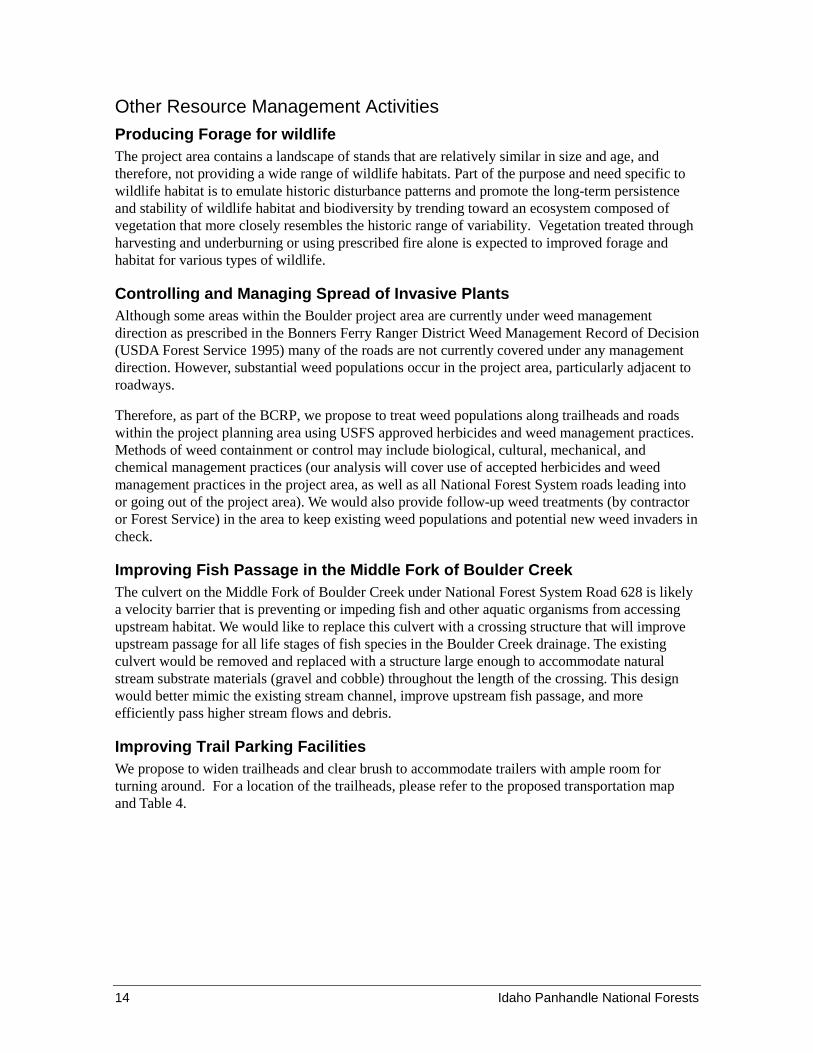
Improving Trail Parking Facilities We propose to widen trailheads and clear brush to accommodate trailers with ample room for turning around. For a location of the trailheads, please refer to the proposed transportation map and Table 4.
Idaho Panhandle National Forests 15
Table 4. Proposed trail work.
Trail Trailhead Location
Trail # 184 – Kootenai River Walk Trail Access from Road # 2209
Trail # 51 – Timber Mountain Trail Access from Road # 4402 at Boulder City
Provide for mountain bike single track tread on Road 1304G after road is stored.
Trail # 136 – EF Boulder Creek Trail
Relocate current Trailhead from Boulder Creek bridge about ½ mile SE to Road # 1304. Current Trailhead is too
congested and the trail is washed out just up from the trailhead. Reroute trail around washout to connect to the
new trailhead.
Trail # 143 – Dobson Creek Trail Access from Road # 408.
Trail # 180 – Iron Mountain Trail Access from Road # 628.
Trail # 182 – Clifty Mountain Trail Access from Road # 274.
Recreation and Heritage Resources To help preserve what remains of the historic town, to give the public the best experience, and to manage more proactively how the public interacts with the history and the historic remains, we propose to do the following:
1. Create a self-directed “discovery” of what remains of the structures of this once vibrant enclave.
2. Establish an official ¼ mile walking trail in the location of an unofficial walking trail created by the public that covers the mid-housing area and leads to vistas of the main mine hydro-diggings.
3. Re-establish the trail head for Trail 51 which leads to the Timber Mountain trail (also the boundary between the Kootenai National Forest and the IPNF), stabilization and protection of the historic remains along the base of the path.
4. Install a toilet facility, more clearly define dispersed camping spots, build and install two housings for interpretive panels.
5. At the historic cemetery site, more clearly define dispersed camping spots and protect the cemetery area.
6. Create and publish a “History of the Boulder City Ghost Town” with a self-guided self-discovery tour of the town from the gauging station and tying in all of the work from 1-5, above.
Managing the Road System Existing Road System– The base transportation network of arterials, collectors, and major local roads is well established. Roads discussed in this section refer to roads that lie within the project area or are haul routes out of the project area, with the exception of Forest Service Road 2209. This road lies just NE of the project area, and is discussed further below.
Access for existing roads varies from open yearlong to open seasonally (gated for wildlife security), to roads that are stored in non-drivable status until needed in the future.
16 Idaho Panhandle National Forests
Proposed Road Plan– We will be using many of the roads in the project area to accomplish our proposed activities.
Based on a combination of factors, including a lack of funding to maintain all roads following their use for the project, we are proposing to place some roads into storage3 for future use and to decommission one road. Additional changes to road status are discussed in the next sub-sections.
When a road is placed into storage it would not be regularly maintained and would be left in an inert condition. Roads put into storage would have the entrance blocked, drainage structures (culverts) may be removed, waterbars and other drainage would be installed, and unstable slopes would be treated. These activities would reduce risk of failure and possible sediment delivery to project area streams. However, the majority of the road prism would be preserved for future use.
A road proposed for decommissioning has no foreseen need in the future and would be made hydrologically inert and inaccessible by vehicles. Decommissioning activities would be similar to storage except all drainage structures would be removed and the road bed may be decompacted or recontoured.
Table 5 below shows miles of roads by management designation, and how we propose to manage them after the Boulder Project is complete.
Converting Road 1304G to Non-Motorized Use Trail– Once our proposed activities are complete on Road 1304G, we propose to store this road and convert its surface to a non-motorized biking trail, which will serve as an additional single track access to Trail 51.
Reopening Road 2209 to Kootenai River Walk Trailhead– Road 2209 is currently a 3 mile long seasonally open road (gated from March 31 through December 1st). We propose to open this road to the public to allow motorized access down to the trailhead from June 16 –through March 31.
Temporary Road Construction– We are proposing to construct four temporary road segments totaling approximately 3.50 miles for the purpose of accessing harvest units for our proposed activities. These roads will be closed and returned to an environmentally stable condition once project activities are complete.
Placing Roads in Storage – To meet the purpose and need of this project specific to grizzly bear security in this BMU, and to meet the access amendment and IPNF forest plan standards by 2019, some of the roads in the BCRP will need to be stored in non-drivable condition.
We will be using many of the roads in the project area to accomplish our proposed activities. Due to a lack of funding to keep these roads maintained following their use for the project and to meet the bear security portion of the purpose and need for this project, we are proposing to put them into storage so they could still be used in the future. We are not proposing to construct any new permanent system roads or decommission any existing drivable roads. Table 5 shows miles of roads by management designation, and how we propose to manage them after the Boulder Project is complete.
3 Road storage entails keeping a road on the transportation system for potential future use, but closing it to public and
administrative use. It means removing features that require regular maintenance, such as culverts, and stabilizing portions of the roadbed that could erode over time.

Idaho Panhandle National Forests 17
Table 5. Existing and proposed road management in the project area (miles).
System Roads Existing Mileage
Proposed Mileage Change4
Final Proposed Mileage Notes
Open Yearlong 52.3 2.3 54.6 Open Road: 2209
Open Yearlong (Restricted)
0 1.6 1.6
Add Road 427UH5 (for special use permit),
restricted access to last segment of #2209.
Open Seasonally 41.9 -12.8 29.1
Store Roads: 628A, 628C, 1304G, 1304H, 2113A, and the end
segments of 628 and 2662
(all are currently open seasonally).
Open Road: 2209
(currently open seasonally).
Storage 15.4 9.2 24.6
Store Roads: 628A, 628C, 1304G, 1304H, 2113A, and the end
segments of 628 and 2662
(all are currently open seasonally)
Decommission Road:
4801 (currently stored) Decommission N/A 0.7 0.70 Road 4801
Total Miles of Road: 110 1.0 111
Road Reconstruction and Maintenance Needed to Support Proposed Activities To support large trucks and equipment, we would need to improve the road surface and conduct maintenance work on about 76 miles of existing roads. These activities would include clearing brush from the road shoulders to improve sight distance, blading and shaping the road, cleaning ditches, improving drainage structures, and adding gravel to the road surface.
Development of Gravel Pit The existing gravel pit located on Road 628 is roughly in the center of the project area and would be used as a gravel source for this project. Crushing and hauling activities would occur for a few months while the project roads are being improved.
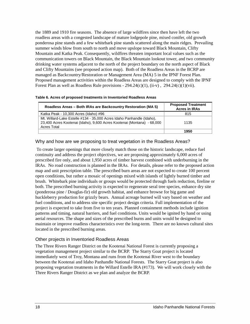
Inventoried Roadless Areas (IRA) The current project proposal includes approximately 1,950 acres of timber harvest and potentially 6,000 acres of prescribed burning spread across the Katka Peak and Mt. Willard-Lake Estelle Roadless Areas. The majority of the 40,500 acre Boulder Creek watershed was last burned during 4 Total combined mileage change for each category; (-) indicates mileage subtracted from the category. 5 Change road from Non-System status to System status, with restricted access, for special use permit.
18 Idaho Panhandle National Forests
the 1889 and 1910 fire seasons. The absence of large wildfires since then have left the two roadless areas with a congested landscape of mature lodgepole pine, mixed conifer, old growth ponderosa pine stands and a few whitebark pine stands scattered along the main ridges. Prevailing summer winds blow from south to north and move upslope toward Black Mountain, Clifty Mountain and Katka Peak. Consequently, wildfires threaten important local values such as the communication towers on Black Mountain, the Black Mountain lookout tower, and two community drinking water systems adjacent to the north of the project boundary on the north aspect of Black and Clifty Mountains (see proposed action map). Both of the Roadless Areas in the BCRP are managed as Backcountry/Restoration or Management Area (MA) 5 in the IPNF Forest Plan. Proposed management activities within the Roadless Areas are designed to comply with the IPNF Forest Plan as well as Roadless Rule provisions - 294.24(c)(1), (ii-v) , 294.24(c)(1)(vii).
Table 6. Acres of proposed treatments in Inventoried Roadless Areas
Roadless Areas – Both IRAs are Backcountry Restoration (MA 5) Proposed Treatment Acres in IRAs
Katka Peak - 10,300 Acres (Idaho) #96 815 Mt. Willard-Lake Estelle #134 - 35,000 Acres Idaho Panhandle (Idaho), 23,400 Acres Kootenai (Idaho), 9,600 Acres Kootenai (Montana) - 68,000 Acres Total
1135
1950
Why and how are we proposing to treat vegetation in the Roadless Areas? To create larger openings that more closely match those on the historic landscape, reduce fuel continuity and address the project objectives, we are proposing approximately 6,000 acres of prescribed fire only, and about 1,950 acres of timber harvest combined with underburning in the IRAs. No road construction is planned in the IRAs. For details, please refer to the proposed action map and unit prescription table. The prescribed burn areas are not expected to create 100 percent open conditions, but rather a mosaic of openings mixed with islands of lightly burned timber and brush. Whitebark pine individuals or groups would be protected through fuels reduction, fireline or both. The prescribed burning activity is expected to regenerate seral tree species, enhance dry site (ponderosa pine / Douglas-fir) old growth habitat, and enhance browse for big game and huckleberry production for grizzly bears. Annual acreage burned will vary based on weather and fuel conditions, and to address site specific project design criteria. Full implementation of the project is expected to take from five to ten years. Planned containment methods include ignition patterns and timing, natural barriers, and fuel conditions. Units would be ignited by hand or using aerial resources. The shape and sizes of the prescribed burns and units would be designed to maintain or improve roadless characteristics over the long-term. There are no known cultural sites located in the prescribed burning areas.
Other projects in Inventoried Roadless Areas The Three Rivers Ranger District on the Kootenai National Forest is currently proposing a vegetation management project similar to the BCRP. The Starry Goat project is located immediately west of Troy, Montana and runs from the Kootenai River west to the boundary between the Kootenai and Idaho Panhandle National Forests. The Starry Goat project is also proposing vegetation treatments in the Willard Estelle IRA (#173). We will work closely with the Three Rivers Ranger District as we plan and analyze the BCRP.
Idaho Panhandle National Forests 19
Fuels Treatment Projects and the Wildland Urban Interface (WUI) The prescribed burning areas are located on both sides of the WUI boundary (see proposed action map). The WUI boundary was developed as a result of the Boundary Community Wildfire Protection Plan (CWPP) which encourages fuel treatments in the WUI and adjacent to the WUI boundary.
Measures Designed to Avoid, Minimize or Mitigate Adverse Effects As part of the environmental analysis the interdisciplinary team will identify standard design features to minimize or avoid adverse effects which could occur as a result of implementing proposed activities in the project area. The design features are based on Forest Plan direction and policy, best available science, best management practices, and site-specific evaluations. Design features would be applied during project implementation (except where specifically stated otherwise). Design features are an integral part of the proposed action and would be applied on the ground during project implementation.