book3 june'05 gen deck questions
TRANSCRIPT
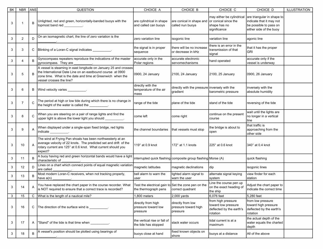
BK NBR ANS QUESTION CHOICE A CHOICE B CHOICE C CHOICE D ILLUSTRATION
3 1 B Unlighted, red and green, horizontally-banded buoys with the topmost band red __________.
are cylindrical in shape and called can buoys
are conical in shape and called nun buoys
may either be cylindrical or conical since the shape has no significance
are triangular in shape to indicate that it may not be possible to pass on either side of the buoy
3 2 D On an isomagnetic chart, the line of zero variation is the __________. zero variation line isogonic line variation line agonic line
3 3 C Blinking of a Loran-C signal indicates __________. the signal is in proper sequence
there will be no increase or decrease in kHz
there is an error in the transmission of that signal
that it has the proper GRI
3 4 B Gyrocompass repeaters reproduce the indications of the master gyrocompass. They are __________.
accurate only in the Polar regions
accurate electronic servomechanisms hand operated accurate only if the
vessel is underway
3 5 B
A vessel is steaming in east longitude on January 25 and crosses the International Date Line on an eastbound course at 0900 zone time. What is the date and time at Greenwich when the vessel crosses the line?
0900, 24 January 2100, 24 January 2100, 25 January 0900, 26 January
3 6 B Wind velocity varies __________.directly with the temperature of the air mass
directly with the pressure gradient
inversely with the barometric pressure
inversely with the absolute humidity
3 7 C The period at high or low tide during which there is no change in the height of the water is called the __________. range of the tide plane of the tide stand of the tide reversing of the tide
3 8 C When you are steering on a pair of range lights and find the upper light is above the lower light you should __________. come left come right continue on the present
course
wait until the lights are no longer in a vertical line
3 9 A When displayed under a single-span fixed bridge, red lights indicate __________. the channel boundaries that vessels must stop the bridge is about to
open
that traffic is approaching from the other side
3 10 A
The wind at Frying Pan shoals has been northwesterly at an average velocity of 22 knots. The predicted set and drift of the rotary current are 125° at 0.6 knot. What current should you expect?
119° at 0.9 knot 172° at 1.1 knots 225° at 0.6 knot 340° at 0.4 knot
3 11 B A buoy having red and green horizontal bands would have a light characteristic of __________. interrupted quick flashing composite group flashing Morse (A) quick flashing
3 12 D Lines on a chart which connect points of equal magnetic variation are called __________. magnetic latitudes magnetic declinations dip isogonic lines
3 13 B Most modern Loran-C receivers, when not tracking properly, have a(n) __________.
bell alarm to warn the user
lighted alarm signal to warn the user
alternate signal keying system
view finder for each station
3 14 A You have replaced the chart paper in the course recorder. What is NOT required to ensure that a correct trace is recorded?
Test the electrical gain to the thermograph pens
Set the zone pen on the correct quadrant
Line the course pen up on the exact heading of the ship
Adjust the chart paper to indicate the correct time
3 15 C What is the length of a nautical mile? 1,800 meters 2,000 yards 6,076 feet 5,280 feet
3 16 C The direction of the surface wind is __________.directly from high pressure toward low pressure
directly from low pressure toward high pressure
from high pressure toward low pressure deflected by the earth's rotation
from low pressure toward high pressure deflected by the earth's rotation
3 17 A "Stand" of the tide is that time when __________. the vertical rise or fall of the tide has stopped slack water occurs tidal current is at a
maximum
the actual depth of the water equals the charted depth
3 18 B A vessel's position should be plotted using bearings of __________. buoys close at hand fixed known objects on
shore buoys at a distance All of the above
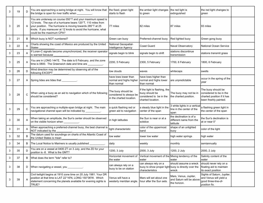
3 19 D You are approaching a swing bridge at night. You will know that the bridge is open for river traffic when __________.
the fixed, green light starts to flash
the amber light changes to green
the red light is extinguished
the red light changes to green
3 20 A
You are underway on course 050°T and your maximum speed is 12 knots. The eye of a hurricane bears 120°T, 110 miles from your position. The hurricane is moving towards 285°T at 25 knots. If you maneuver at 12 knots to avoid the hurricane, what could be the maximum CPA?
77 miles 82 miles 87 miles 93 miles
3 21 B Which buoy is NOT numbered? Green can buoy Preferred-channel buoy Red lighted buoy Green gong buoy
3 22 A Charts showing the coast of Mexico are produced by the United States __________.
National Geospatial-Intelligence Agency Coast Guard Naval Observatory National Ocean Service
3 23 A If Loran-C signals become unsynchronized, the receiver operator is warned because __________. signals begin to blink signals begin to shift stations discontinue
transmission stations transmit grass
3 25 A You are in LONG 144°E. The date is 6 February, and the zone time is 0800. The Greenwich date and time are __________. 2200, 5 February 2300, 5 February 1700, 6 February 1800, 6 February
3 26 D Wind direction may be determined by observing all of the following EXCEPT __________. low clouds waves whitecaps swells
3 27 A Spring tides are tides that __________.have lows lower than normal and highs higher than normal
have lows higher than normal and highs lower than normal
are unpredictable occur in the spring of the year
3 28 C When using a buoy as an aid to navigation which of the following should be considered?
The buoy should be considered to always be in the charted location.
If the light is flashing, the buoy should be considered to be in the charted location.
The buoy may not be in the charted position.
The buoy should be considered to be in the charted position if it has been freshly painted.
3 29 C You are approaching a multiple-span bridge at night. The main navigational channel span will be indicated by __________.
a quick flashing red or green aid to navigation
a steady blue light in the center of the span
3 white lights in a vertical line in the center of the span
a flashing green light in the center of the span
3 30 A When taking an amplitude, the Sun's center should be observed on the visible horizon when __________. in high latitudes the Sun is near or at a
solstice
the declination is of a different name from the latitude
the Sun's declination is at or near 0°
3 31 A When approaching a preferred-channel buoy, the best channel is NOT indicated by the __________. light characteristic color of the uppermost
bandshape of an unlighted buoy color of the light
3 32 B The datum used for soundings on charts of the Atlantic Coast of the United States is mean __________. low water lower low water high water springs high water
3 34 B The Local Notice to Mariners is usually published __________. daily weekly monthly semiannually
3 35 D You are on a vessel at 0400 ZT on 3 July, and the ZD for your position is -8. What is the GMT? 1200, 3 July 2000, 3 July 1200, 2 July 2000, 2 July
3 37 B What does the term "tide" refer to? Horizontal movement of the water
Vertical movement of the water
Mixing tendency of the water
Salinity content of the water
3 38 D When navigating a vessel, you __________. can always rely on a buoy to be on station
can always rely on a buoy to show proper light characteristics
should assume a wreck buoy is directly over the wreck
should never rely on a floating aid to maintain its exact position
3 39 A
Civil twilight begins at 1910 zone time on 20 July 1981. Your DR position at that time is LAT 22°16'N, LONG 150°06'W. Which statement concerning the planets available for evening sights is TRUE?
Venus will have a westerly meridian angle.
Mars will set about one hour after the Sun sets.
Mars, Venus, Jupiter, and Saturn will be above the horizon.
Sights of Saturn, Jupiter, and Venus will yield a good three-line-of-position fix.
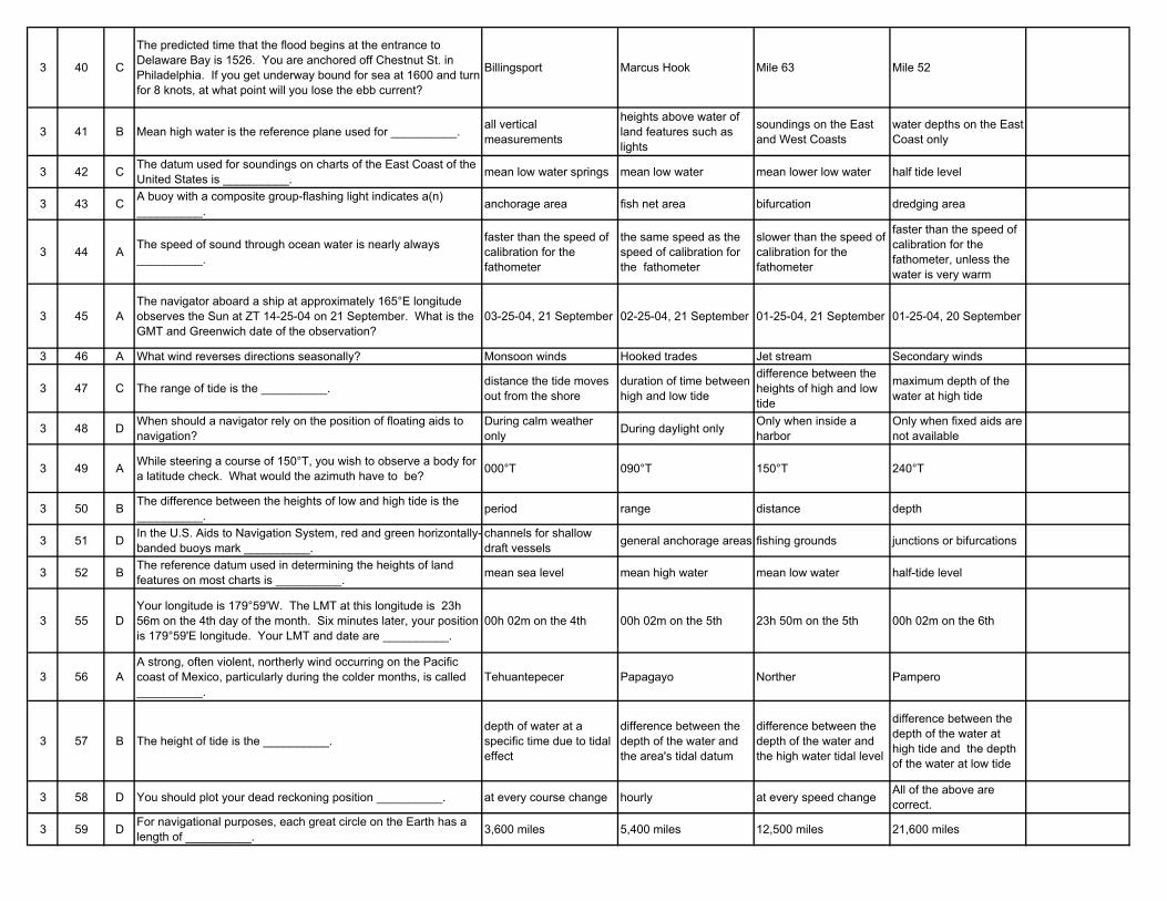
3 40 C
The predicted time that the flood begins at the entrance to Delaware Bay is 1526. You are anchored off Chestnut St. in Philadelphia. If you get underway bound for sea at 1600 and turn for 8 knots, at what point will you lose the ebb current?
Billingsport Marcus Hook Mile 63 Mile 52
3 41 B Mean high water is the reference plane used for __________. all vertical measurements
heights above water of land features such as lights
soundings on the East and West Coasts
water depths on the East Coast only
3 42 C The datum used for soundings on charts of the East Coast of the United States is __________. mean low water springs mean low water mean lower low water half tide level
3 43 C A buoy with a composite group-flashing light indicates a(n) __________. anchorage area fish net area bifurcation dredging area
3 44 A The speed of sound through ocean water is nearly always __________.
faster than the speed of calibration for the fathometer
the same speed as the speed of calibration for the fathometer
slower than the speed of calibration for the fathometer
faster than the speed of calibration for the fathometer, unless the water is very warm
3 45 AThe navigator aboard a ship at approximately 165°E longitude observes the Sun at ZT 14-25-04 on 21 September. What is the GMT and Greenwich date of the observation?
03-25-04, 21 September 02-25-04, 21 September 01-25-04, 21 September 01-25-04, 20 September
3 46 A What wind reverses directions seasonally? Monsoon winds Hooked trades Jet stream Secondary winds
3 47 C The range of tide is the __________. distance the tide moves out from the shore
duration of time between high and low tide
difference between the heights of high and low tide
maximum depth of the water at high tide
3 48 D When should a navigator rely on the position of floating aids to navigation?
During calm weather only During daylight only Only when inside a
harborOnly when fixed aids are not available
3 49 A While steering a course of 150°T, you wish to observe a body for a latitude check. What would the azimuth have to be? 000°T 090°T 150°T 240°T
3 50 B The difference between the heights of low and high tide is the __________. period range distance depth
3 51 D In the U.S. Aids to Navigation System, red and green horizontally-banded buoys mark __________.
channels for shallow draft vessels general anchorage areas fishing grounds junctions or bifurcations
3 52 B The reference datum used in determining the heights of land features on most charts is __________. mean sea level mean high water mean low water half-tide level
3 55 DYour longitude is 179°59'W. The LMT at this longitude is 23h 56m on the 4th day of the month. Six minutes later, your position is 179°59'E longitude. Your LMT and date are __________.
00h 02m on the 4th 00h 02m on the 5th 23h 50m on the 5th 00h 02m on the 6th
3 56 AA strong, often violent, northerly wind occurring on the Pacific coast of Mexico, particularly during the colder months, is called __________.
Tehuantepecer Papagayo Norther Pampero
3 57 B The height of tide is the __________.depth of water at a specific time due to tidal effect
difference between the depth of the water and the area's tidal datum
difference between the depth of the water and the high water tidal level
difference between the depth of the water at high tide and the depth of the water at low tide
3 58 D You should plot your dead reckoning position __________. at every course change hourly at every speed change All of the above are correct.
3 59 D For navigational purposes, each great circle on the Earth has a length of __________. 3,600 miles 5,400 miles 12,500 miles 21,600 miles
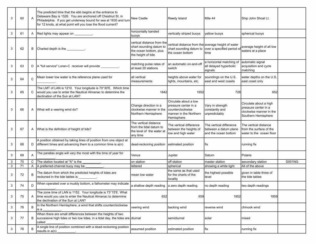
3 60 A
The predicted time that the ebb begins at the entrance to Delaware Bay is 1526. You are anchored off Chestnut St. in Philadelphia. If you get underway bound for sea at 1630 and turn for 12 knots, at what point will you lose the flood current?
New Castle Reedy Island Mile 44 Ship John Shoal Lt.
3 61 A Red lights may appear on __________. horizontally banded buoys vertically striped buoys yellow buoys spherical buoys
3 62 B Charted depth is the __________.
vertical distance from the chart sounding datum to the ocean bottom, plus the height of tide
vertical distance from the chart sounding datum to the ocean bottom
average height of water over a specified period of time
average height of all low waters at a place
3 63 D A "full service" Loran-C receiver will provide __________. matching pulse rates of at least 20 stations
an automatic on-and-off switch
a horizontal matching of all delayed hyperbolic signals
automatic signal acquisition and cycle matching
3 64 C Mean lower low water is the reference plane used for __________.
all vertical measurements
heights above water for lights, mountains, etc.
soundings on the U.S. east and west coasts
water depths on the U.S. east coast only
3 65 CThe LMT of LAN is 1210. Your longitude is 70°30'E. Which time would you use to enter the Nautical Almanac to determine the declination of the Sun at LAN?
1842 1652 728 652
3 66 A What will a veering wind do?Change direction in a clockwise manner in the Northern Hemisphere
Circulate about a low pressure center in a counterclockwise manner in the Northern Hemisphere
Vary in strength constantly and unpredictably
Circulate about a high pressure center in a clockwise manner in the Southern Hemisphere
3 67 A What is the definition of height of tide?
The vertical distance from the tidal datum to the level of the water at any time
The vertical difference between the heights of low and high water
The vertical difference between a datum plane and the ocean bottom
The vertical distance from the surface of the water to the ocean floor
3 68 DA position obtained by taking lines of position from one object at different times and advancing them to a common time is a(n) __________.
dead-reckoning position estimated position fix running fix
3 69 A The parallax angle will vary the most with the time of year for __________. Venus Jupiter Saturn Polaris
3 70 C The station located at "A" is the __________. on station off station master station secondary station D001NG3 71 A A preferred-channel buoy may be __________. lettered spherical showing a white light All of the above
3 72 B The datum from which the predicted heights of tides are reckoned in the tide tables is __________. mean low water
the same as that used for the charts of the locality
the highest possible level
given in table three of the tide tables
3 74 D When operated over a muddy bottom, a fathometer may indicate __________. a shallow depth reading a zero depth reading no depth reading two depth readings
3 75 AThe zone time of LAN is 1152. Your longitude is 73°15'E. What time would you use to enter the Nautical Almanac to determine the declination of the Sun at LAN?
652 659 1852 1859
3 76 B In the Northern Hemisphere, a wind that shifts counterclockwise is a __________. veering wind backing wind reverse wind chinook wind
3 77 BWhen there are small differences between the heights of two successive high tides or two low tides, in a tidal day, the tides are called __________.
diurnal semidiurnal solar mixed
3 78 B A single line of position combined with a dead-reckoning position results in a(n) __________. assumed position estimated position fix running fix
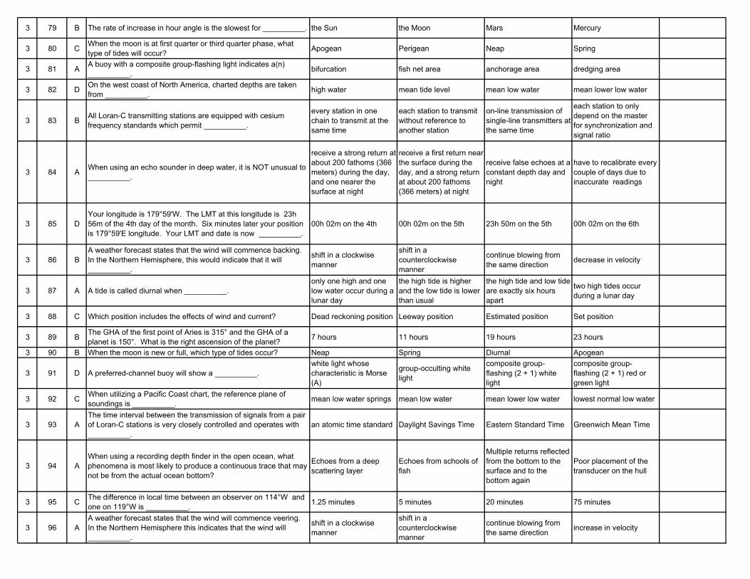
3 79 B The rate of increase in hour angle is the slowest for __________. the Sun the Moon Mars Mercury
3 80 C When the moon is at first quarter or third quarter phase, what type of tides will occur? Apogean Perigean Neap Spring
3 81 A A buoy with a composite group-flashing light indicates a(n) __________. bifurcation fish net area anchorage area dredging area
3 82 D On the west coast of North America, charted depths are taken from __________. high water mean tide level mean low water mean lower low water
3 83 B All Loran-C transmitting stations are equipped with cesium frequency standards which permit __________.
every station in one chain to transmit at the same time
each station to transmit without reference to another station
on-line transmission of single-line transmitters at the same time
each station to only depend on the master for synchronization and signal ratio
3 84 A When using an echo sounder in deep water, it is NOT unusual to __________.
receive a strong return at about 200 fathoms (366 meters) during the day, and one nearer the surface at night
receive a first return near the surface during the day, and a strong return at about 200 fathoms (366 meters) at night
receive false echoes at a constant depth day and night
have to recalibrate every couple of days due to inaccurate readings
3 85 DYour longitude is 179°59'W. The LMT at this longitude is 23h 56m of the 4th day of the month. Six minutes later your position is 179°59'E longitude. Your LMT and date is now __________.
00h 02m on the 4th 00h 02m on the 5th 23h 50m on the 5th 00h 02m on the 6th
3 86 BA weather forecast states that the wind will commence backing. In the Northern Hemisphere, this would indicate that it will __________.
shift in a clockwise manner
shift in a counterclockwise manner
continue blowing from the same direction decrease in velocity
3 87 A A tide is called diurnal when __________.only one high and one low water occur during a lunar day
the high tide is higher and the low tide is lower than usual
the high tide and low tide are exactly six hours apart
two high tides occur during a lunar day
3 88 C Which position includes the effects of wind and current? Dead reckoning position Leeway position Estimated position Set position
3 89 B The GHA of the first point of Aries is 315° and the GHA of a planet is 150°. What is the right ascension of the planet? 7 hours 11 hours 19 hours 23 hours
3 90 B When the moon is new or full, which type of tides occur? Neap Spring Diurnal Apogean
3 91 D A preferred-channel buoy will show a __________.white light whose characteristic is Morse (A)
group-occulting white light
composite group-flashing (2 + 1) white light
composite group-flashing (2 + 1) red or green light
3 92 C When utilizing a Pacific Coast chart, the reference plane of soundings is __________. mean low water springs mean low water mean lower low water lowest normal low water
3 93 AThe time interval between the transmission of signals from a pair of Loran-C stations is very closely controlled and operates with __________.
an atomic time standard Daylight Savings Time Eastern Standard Time Greenwich Mean Time
3 94 AWhen using a recording depth finder in the open ocean, what phenomena is most likely to produce a continuous trace that may not be from the actual ocean bottom?
Echoes from a deep scattering layer
Echoes from schools of fish
Multiple returns reflected from the bottom to the surface and to the bottom again
Poor placement of the transducer on the hull
3 95 C The difference in local time between an observer on 114°W and one on 119°W is __________. 1.25 minutes 5 minutes 20 minutes 75 minutes
3 96 AA weather forecast states that the wind will commence veering. In the Northern Hemisphere this indicates that the wind will __________.
shift in a clockwise manner
shift in a counterclockwise manner
continue blowing from the same direction increase in velocity
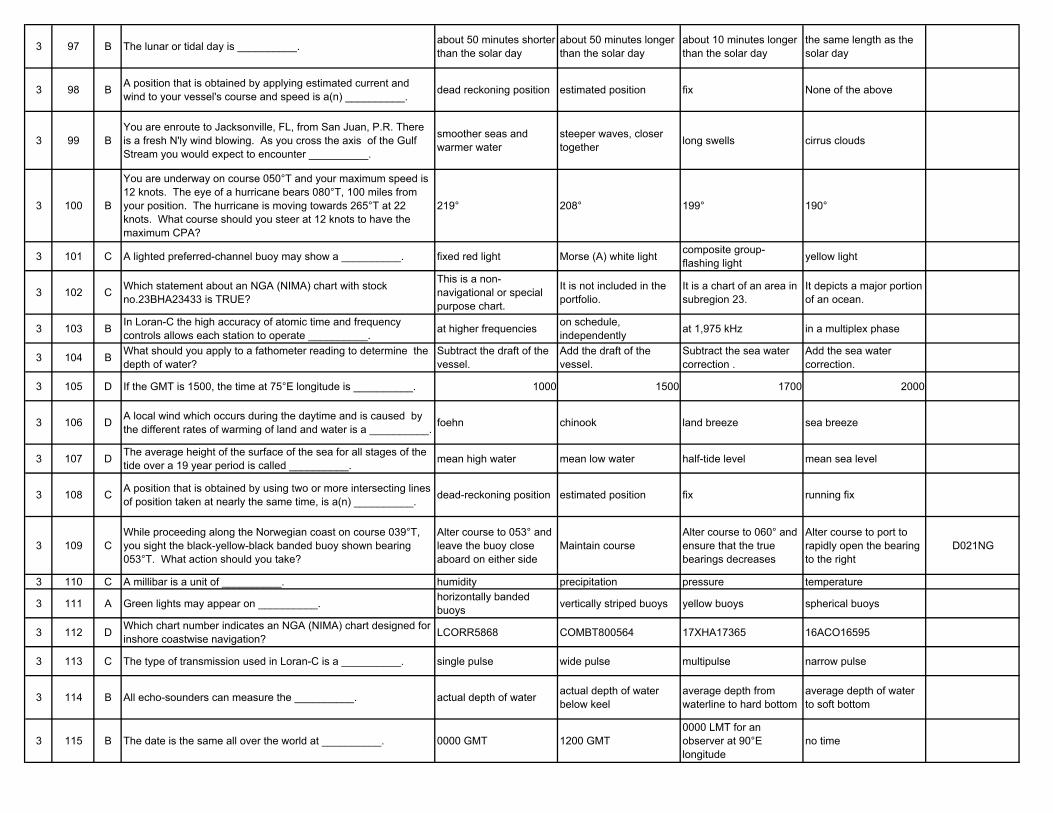
3 97 B The lunar or tidal day is __________. about 50 minutes shorter than the solar day
about 50 minutes longer than the solar day
about 10 minutes longer than the solar day
the same length as the solar day
3 98 B A position that is obtained by applying estimated current and wind to your vessel's course and speed is a(n) __________. dead reckoning position estimated position fix None of the above
3 99 BYou are enroute to Jacksonville, FL, from San Juan, P.R. There is a fresh N'ly wind blowing. As you cross the axis of the Gulf Stream you would expect to encounter __________.
smoother seas and warmer water
steeper waves, closer together long swells cirrus clouds
3 100 B
You are underway on course 050°T and your maximum speed is 12 knots. The eye of a hurricane bears 080°T, 100 miles from your position. The hurricane is moving towards 265°T at 22 knots. What course should you steer at 12 knots to have the maximum CPA?
219° 208° 199° 190°
3 101 C A lighted preferred-channel buoy may show a __________. fixed red light Morse (A) white light composite group-flashing light yellow light
3 102 C Which statement about an NGA (NIMA) chart with stock no.23BHA23433 is TRUE?
This is a non-navigational or special purpose chart.
It is not included in the portfolio.
It is a chart of an area in subregion 23.
It depicts a major portion of an ocean.
3 103 B In Loran-C the high accuracy of atomic time and frequency controls allows each station to operate __________. at higher frequencies on schedule,
independently at 1,975 kHz in a multiplex phase
3 104 B What should you apply to a fathometer reading to determine the depth of water?
Subtract the draft of the vessel.
Add the draft of the vessel.
Subtract the sea water correction .
Add the sea water correction.
3 105 D If the GMT is 1500, the time at 75°E longitude is __________. 1000 1500 1700 2000
3 106 D A local wind which occurs during the daytime and is caused by the different rates of warming of land and water is a __________. foehn chinook land breeze sea breeze
3 107 D The average height of the surface of the sea for all stages of the tide over a 19 year period is called __________. mean high water mean low water half-tide level mean sea level
3 108 C A position that is obtained by using two or more intersecting lines of position taken at nearly the same time, is a(n) __________. dead-reckoning position estimated position fix running fix
3 109 CWhile proceeding along the Norwegian coast on course 039°T, you sight the black-yellow-black banded buoy shown bearing 053°T. What action should you take?
Alter course to 053° and leave the buoy close aboard on either side
Maintain courseAlter course to 060° and ensure that the true bearings decreases
Alter course to port to rapidly open the bearing to the right
D021NG
3 110 C A millibar is a unit of __________. humidity precipitation pressure temperature
3 111 A Green lights may appear on __________. horizontally banded buoys vertically striped buoys yellow buoys spherical buoys
3 112 D Which chart number indicates an NGA (NIMA) chart designed for inshore coastwise navigation? LCORR5868 COMBT800564 17XHA17365 16ACO16595
3 113 C The type of transmission used in Loran-C is a __________. single pulse wide pulse multipulse narrow pulse
3 114 B All echo-sounders can measure the __________. actual depth of water actual depth of water below keel
average depth from waterline to hard bottom
average depth of water to soft bottom
3 115 B The date is the same all over the world at __________. 0000 GMT 1200 GMT0000 LMT for an observer at 90°E longitude
no time
3 116 C Which wind results from a land mass cooling more quickly at night than an adjacent water area? Coastal breeze Sea breeze Land breeze Mistral
3 117 D Mean high water is the average height of __________. the higher high waters the lower high waters the lower of the two daily tides all high waters
3 118 C What describes an accurate position that is NOT based on any prior position? Dead-reckoning position Estimated position Fix Running fix
3 119 CWhile proceeding along the Mediterranean coast of Spain, you sight the black and yellow buoy shown. Your course is 039°T, and the buoy bears 053°T. What action should you take?
Alter course to 053°T and pass the buoy close aboard on either side
Alter course to 060° and ensure that the bearings decrease
Maintain course and ensure that the bearings increase
Alter course towards the buoy and leave the buoy well clear on either side
D020NG
3 120 A
You are underway on course 050°T and your maximum speed is 13 knots. The eye of a hurricane bears 100°T, 120 miles from your position. The hurricane is moving towards 275°T at 25 knots. If you maneuver at 13 knots to avoid the hurricane, what could be the maximum CPA?
72 miles 78 miles 83 miles 89 miles
3 121 D A safe water mark may be __________. vertically striped spherical showing a white light All of the above
3 122 A
The subregions of the United States Gulf and East Coasts are numbered 11, 12 and 13 within the chart numbering system. Which chart number indicates a chart for either the Gulf or East Coast?
11250 18411 21228 17136
3 123 AIf the radio signal ground wave extends out for less distance than the minimum skywave distance, there is an area in which no signal is received. This is called the __________.
skip zone blackout zone diffraction zone shadow zone
3 124 B An electronic depth finder operates on the principle that __________.
radio signals reflect from a solid surface
sound waves travel at a constant speed through water
radar signals travel at a constant speed through water
pressure increases with depth
3 125 B The GMT is 0445 and your zone description is +1. Your zone time is __________. 445 345 545 1545
3 126 C A katabatic wind blows __________. up an incline due to surface heating in a circular pattern down an incline due to
cooling of the air
horizontally between a high and a low pressure area
3 127 C Mean low water is the average height of __________. the surface of the sea high waters and low waters all low waters the lower of the two daily
low tides
3 128 A A position obtained by applying only your vessel's course and speed to a known position is a __________. dead-reckoning position fix probable position running fix
3 129 BIn working out a local apparent noon sight for your latitude, you subtract the Ho from 90°. The 90° represents the angular distance from __________.
the equator to the elevated pole
your horizon to your zenith
your zenith to the elevated pole
the geographical position of the Sun to the elevated pole
3 130 B The distance between the surface of the water and the tidal datum is the __________. range of tide height of tide charted depth actual water depth
3 131 D A vertically-striped buoy may be __________. striped black and green striped black and yellow lighted with a red light lighted with a white light
3 132 B The value of sixty nautical miles per degree of geodetic latitude is most correct at __________. the equator latitude 45° the poles all latitudes
3 133 B The line connecting the Loran-C master station with a secondary station is called the __________. focus line base line side line center line
3 134 B The recording fathometer produces a graphic record of the __________.
bottom contour only up to depths of 100 fathoms
depth underneath the keel against a time base
contour of the bottom against a distance base
depth of water against a distance base
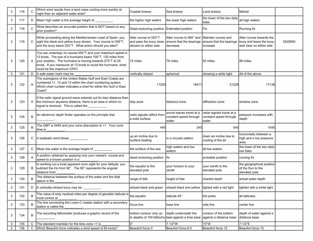
3 135 C The standard meridian for the time zone +1 is __________. 0° 7 1/2°W 15°W 7 1/2°E3 136 C Which Beaufort force indicates a wind speed of 65 knots? Beaufort force 0 Beaufort force 6.5 Beaufort force 12 Beaufort force 15
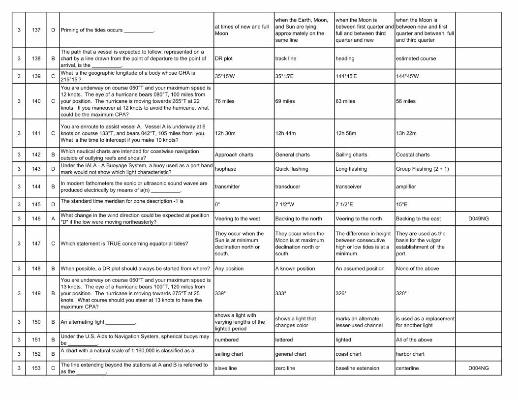
3 137 D Priming of the tides occurs __________. at times of new and full Moon
when the Earth, Moon, and Sun are lying approximately on the same line
when the Moon is between first quarter and full and between third quarter and new
when the Moon is between new and first quarter and between full and third quarter
3 138 BThe path that a vessel is expected to follow, represented on a chart by a line drawn from the point of departure to the point of arrival, is the __________.
DR plot track line heading estimated course
3 139 C What is the geographic longitude of a body whose GHA is 215°15'? 35°15'W 35°15'E 144°45'E 144°45'W
3 140 C
You are underway on course 050°T and your maximum speed is 12 knots. The eye of a hurricane bears 080°T, 100 miles from your position. The hurricane is moving towards 265°T at 22 knots. If you maneuver at 12 knots to avoid the hurricane, what could be the maximum CPA?
76 miles 69 miles 63 miles 56 miles
3 141 CYou are enroute to assist vessel A. Vessel A is underway at 6 knots on course 133°T, and bears 042°T, 105 miles from you. What is the time to intercept if you make 10 knots?
12h 30m 12h 44m 12h 58m 13h 22m
3 142 B Which nautical charts are intended for coastwise navigation outside of outlying reefs and shoals? Approach charts General charts Sailing charts Coastal charts
3 143 D Under the IALA - A Buoyage System, a buoy used as a port hand mark would not show which light characteristic? Isophase Quick flashing Long flashing Group Flashing (2 + 1)
3 144 B In modern fathometers the sonic or ultrasonic sound waves are produced electrically by means of a(n) __________. transmitter transducer transceiver amplifier
3 145 D The standard time meridian for zone description -1 is __________. 0° 7 1/2°W 7 1/2°E 15°E
3 146 A What change in the wind direction could be expected at position "D" if the low were moving northeasterly? Veering to the west Backing to the north Veering to the north Backing to the east D049NG
3 147 C Which statement is TRUE concerning equatorial tides?
They occur when the Sun is at minimum declination north or south.
They occur when the Moon is at maximum declination north or south.
The difference in height between consecutive high or low tides is at a minimum.
They are used as the basis for the vulgar establishment of the port.
3 148 B When possible, a DR plot should always be started from where? Any position A known position An assumed position None of the above
3 149 B
You are underway on course 050°T and your maximum speed is 13 knots. The eye of a hurricane bears 100°T, 120 miles from your position. The hurricane is moving towards 275°T at 25 knots. What course should you steer at 13 knots to have the maximum CPA?
339° 333° 326° 320°
3 150 B An alternating light __________.shows a light with varying lengths of the lighted period
shows a light that changes color
marks an alternate lesser-used channel
is used as a replacement for another light
3 151 B Under the U.S. Aids to Navigation System, spherical buoys may be __________. numbered lettered lighted All of the above
3 152 B A chart with a natural scale of 1:160,000 is classified as a __________. sailing chart general chart coast chart harbor chart
3 153 C The line extending beyond the stations at A and B is referred to as the __________. slave line zero line baseline extension centerline D004NG
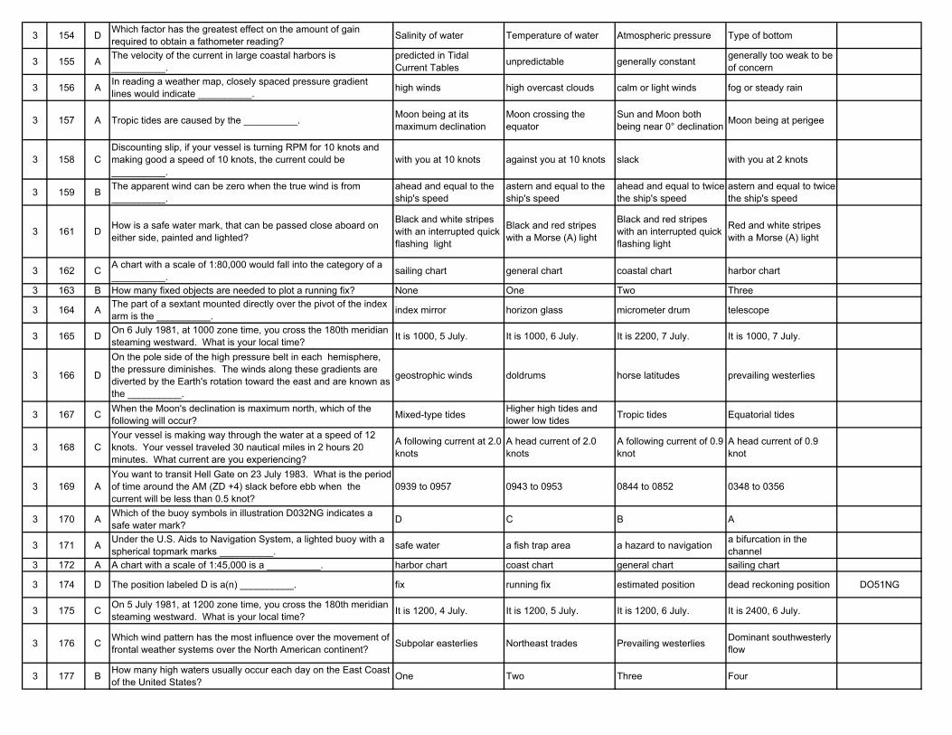
3 154 D Which factor has the greatest effect on the amount of gain required to obtain a fathometer reading? Salinity of water Temperature of water Atmospheric pressure Type of bottom
3 155 A The velocity of the current in large coastal harbors is __________.
predicted in Tidal Current Tables unpredictable generally constant generally too weak to be
of concern
3 156 A In reading a weather map, closely spaced pressure gradient lines would indicate __________. high winds high overcast clouds calm or light winds fog or steady rain
3 157 A Tropic tides are caused by the __________. Moon being at its maximum declination
Moon crossing the equator
Sun and Moon both being near 0° declination Moon being at perigee
3 158 CDiscounting slip, if your vessel is turning RPM for 10 knots and making good a speed of 10 knots, the current could be __________.
with you at 10 knots against you at 10 knots slack with you at 2 knots
3 159 B The apparent wind can be zero when the true wind is from __________.
ahead and equal to the ship's speed
astern and equal to the ship's speed
ahead and equal to twice the ship's speed
astern and equal to twice the ship's speed
3 161 D How is a safe water mark, that can be passed close aboard on either side, painted and lighted?
Black and white stripes with an interrupted quick flashing light
Black and red stripes with a Morse (A) light
Black and red stripes with an interrupted quick flashing light
Red and white stripes with a Morse (A) light
3 162 C A chart with a scale of 1:80,000 would fall into the category of a __________. sailing chart general chart coastal chart harbor chart
3 163 B How many fixed objects are needed to plot a running fix? None One Two Three
3 164 A The part of a sextant mounted directly over the pivot of the index arm is the __________. index mirror horizon glass micrometer drum telescope
3 165 D On 6 July 1981, at 1000 zone time, you cross the 180th meridian steaming westward. What is your local time? It is 1000, 5 July. It is 1000, 6 July. It is 2200, 7 July. It is 1000, 7 July.
3 166 D
On the pole side of the high pressure belt in each hemisphere, the pressure diminishes. The winds along these gradients are diverted by the Earth's rotation toward the east and are known as the __________.
geostrophic winds doldrums horse latitudes prevailing westerlies
3 167 C When the Moon's declination is maximum north, which of the following will occur? Mixed-type tides Higher high tides and
lower low tides Tropic tides Equatorial tides
3 168 CYour vessel is making way through the water at a speed of 12 knots. Your vessel traveled 30 nautical miles in 2 hours 20 minutes. What current are you experiencing?
A following current at 2.0 knots
A head current of 2.0 knots
A following current of 0.9 knot
A head current of 0.9 knot
3 169 AYou want to transit Hell Gate on 23 July 1983. What is the period of time around the AM (ZD +4) slack before ebb when the current will be less than 0.5 knot?
0939 to 0957 0943 to 0953 0844 to 0852 0348 to 0356
3 170 A Which of the buoy symbols in illustration D032NG indicates a safe water mark? D C B A
3 171 A Under the U.S. Aids to Navigation System, a lighted buoy with a spherical topmark marks __________. safe water a fish trap area a hazard to navigation a bifurcation in the
channel3 172 A A chart with a scale of 1:45,000 is a __________. harbor chart coast chart general chart sailing chart
3 174 D The position labeled D is a(n) __________. fix running fix estimated position dead reckoning position DO51NG
3 175 C On 5 July 1981, at 1200 zone time, you cross the 180th meridian steaming westward. What is your local time? It is 1200, 4 July. It is 1200, 5 July. It is 1200, 6 July. It is 2400, 6 July.
3 176 C Which wind pattern has the most influence over the movement of frontal weather systems over the North American continent? Subpolar easterlies Northeast trades Prevailing westerlies Dominant southwesterly
flow
3 177 B How many high waters usually occur each day on the East Coast of the United States? One Two Three Four
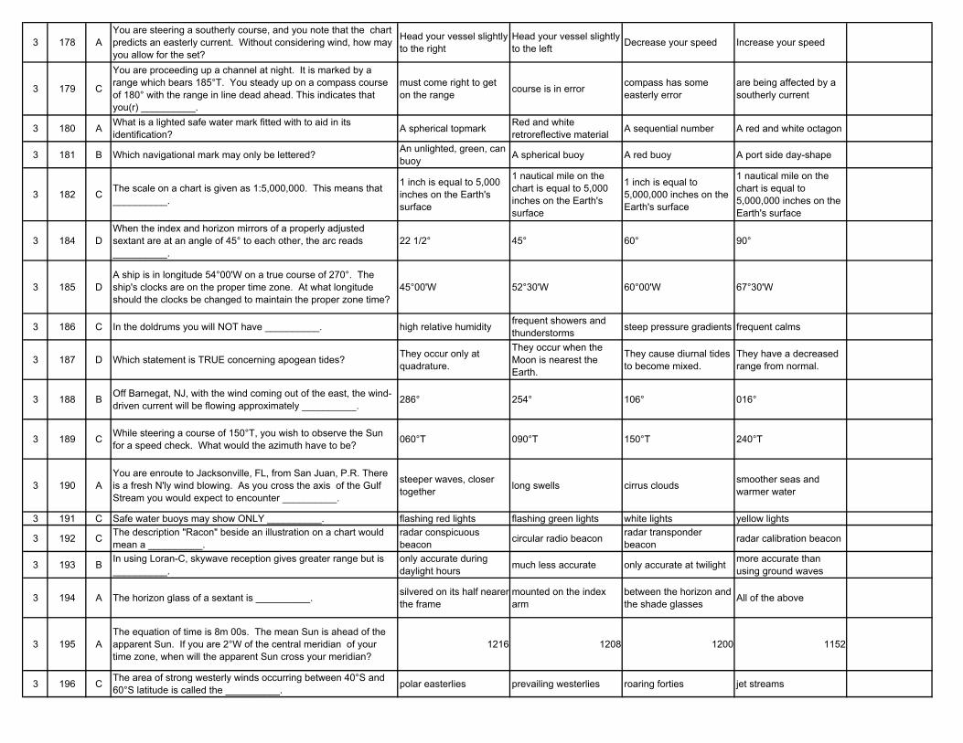
3 178 AYou are steering a southerly course, and you note that the chart predicts an easterly current. Without considering wind, how may you allow for the set?
Head your vessel slightly to the right
Head your vessel slightly to the left Decrease your speed Increase your speed
3 179 C
You are proceeding up a channel at night. It is marked by a range which bears 185°T. You steady up on a compass course of 180° with the range in line dead ahead. This indicates that you(r) __________.
must come right to get on the range course is in error compass has some
easterly errorare being affected by a southerly current
3 180 A What is a lighted safe water mark fitted with to aid in its identification? A spherical topmark Red and white
retroreflective material A sequential number A red and white octagon
3 181 B Which navigational mark may only be lettered? An unlighted, green, can buoy A spherical buoy A red buoy A port side day-shape
3 182 C The scale on a chart is given as 1:5,000,000. This means that __________.
1 inch is equal to 5,000 inches on the Earth's surface
1 nautical mile on the chart is equal to 5,000 inches on the Earth's surface
1 inch is equal to 5,000,000 inches on the Earth's surface
1 nautical mile on the chart is equal to 5,000,000 inches on the Earth's surface
3 184 DWhen the index and horizon mirrors of a properly adjusted sextant are at an angle of 45° to each other, the arc reads __________.
22 1/2° 45° 60° 90°
3 185 DA ship is in longitude 54°00'W on a true course of 270°. The ship's clocks are on the proper time zone. At what longitude should the clocks be changed to maintain the proper zone time?
45°00'W 52°30'W 60°00'W 67°30'W
3 186 C In the doldrums you will NOT have __________. high relative humidity frequent showers and thunderstorms steep pressure gradients frequent calms
3 187 D Which statement is TRUE concerning apogean tides? They occur only at quadrature.
They occur when the Moon is nearest the Earth.
They cause diurnal tides to become mixed.
They have a decreased range from normal.
3 188 B Off Barnegat, NJ, with the wind coming out of the east, the wind-driven current will be flowing approximately __________. 286° 254° 106° 016°
3 189 C While steering a course of 150°T, you wish to observe the Sun for a speed check. What would the azimuth have to be? 060°T 090°T 150°T 240°T
3 190 AYou are enroute to Jacksonville, FL, from San Juan, P.R. There is a fresh N'ly wind blowing. As you cross the axis of the Gulf Stream you would expect to encounter __________.
steeper waves, closer together long swells cirrus clouds smoother seas and
warmer water
3 191 C Safe water buoys may show ONLY __________. flashing red lights flashing green lights white lights yellow lights
3 192 C The description "Racon" beside an illustration on a chart would mean a __________.
radar conspicuous beacon circular radio beacon radar transponder
beacon radar calibration beacon
3 193 B In using Loran-C, skywave reception gives greater range but is __________.
only accurate during daylight hours much less accurate only accurate at twilight more accurate than
using ground waves
3 194 A The horizon glass of a sextant is __________. silvered on its half nearer the frame
mounted on the index arm
between the horizon and the shade glasses All of the above
3 195 AThe equation of time is 8m 00s. The mean Sun is ahead of the apparent Sun. If you are 2°W of the central meridian of your time zone, when will the apparent Sun cross your meridian?
1216 1208 1200 1152
3 196 C The area of strong westerly winds occurring between 40°S and 60°S latitude is called the __________. polar easterlies prevailing westerlies roaring forties jet streams
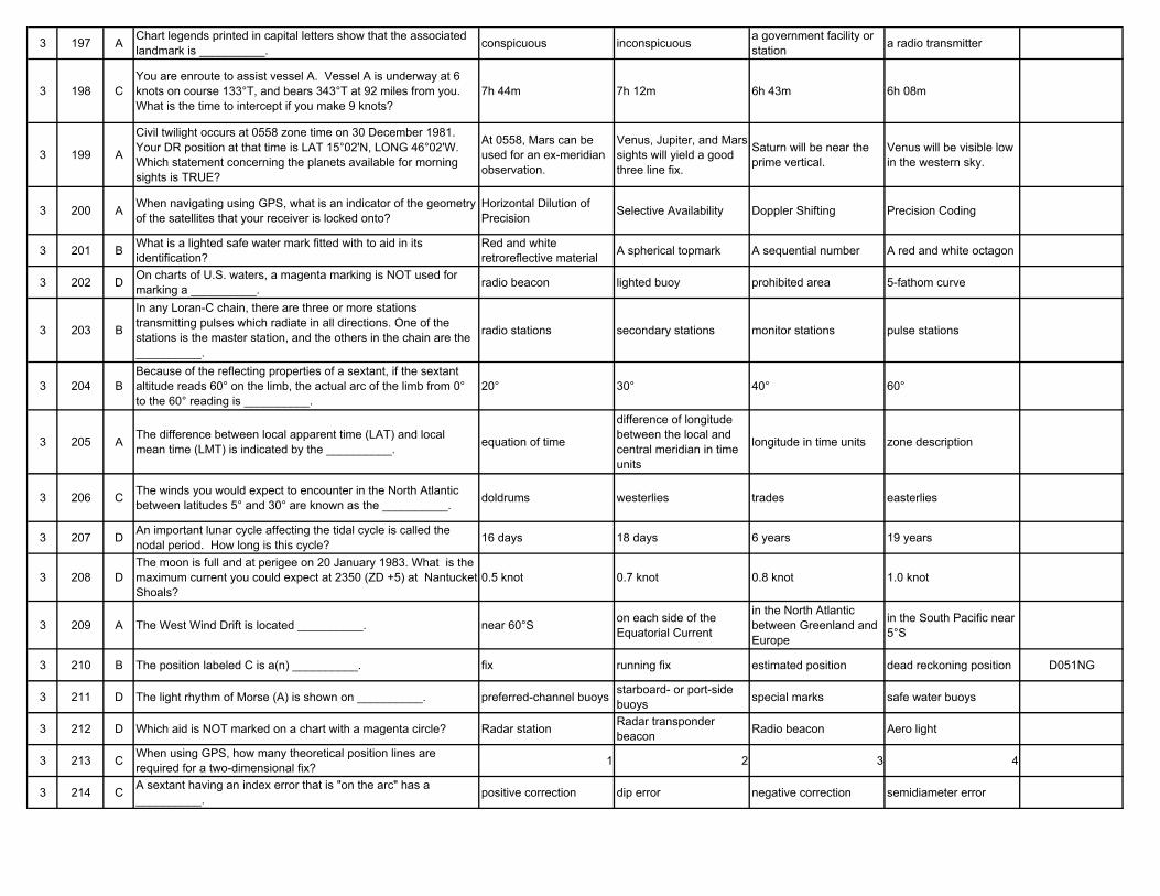
3 197 A Chart legends printed in capital letters show that the associated landmark is __________. conspicuous inconspicuous a government facility or
station a radio transmitter
3 198 CYou are enroute to assist vessel A. Vessel A is underway at 6 knots on course 133°T, and bears 343°T at 92 miles from you. What is the time to intercept if you make 9 knots?
7h 44m 7h 12m 6h 43m 6h 08m
3 199 A
Civil twilight occurs at 0558 zone time on 30 December 1981. Your DR position at that time is LAT 15°02'N, LONG 46°02'W. Which statement concerning the planets available for morning sights is TRUE?
At 0558, Mars can be used for an ex-meridian observation.
Venus, Jupiter, and Mars sights will yield a good three line fix.
Saturn will be near the prime vertical.
Venus will be visible low in the western sky.
3 200 A When navigating using GPS, what is an indicator of the geometry of the satellites that your receiver is locked onto?
Horizontal Dilution of Precision Selective Availability Doppler Shifting Precision Coding
3 201 B What is a lighted safe water mark fitted with to aid in its identification?
Red and white retroreflective material A spherical topmark A sequential number A red and white octagon
3 202 D On charts of U.S. waters, a magenta marking is NOT used for marking a __________. radio beacon lighted buoy prohibited area 5-fathom curve
3 203 B
In any Loran-C chain, there are three or more stations transmitting pulses which radiate in all directions. One of the stations is the master station, and the others in the chain are the __________.
radio stations secondary stations monitor stations pulse stations
3 204 BBecause of the reflecting properties of a sextant, if the sextant altitude reads 60° on the limb, the actual arc of the limb from 0° to the 60° reading is __________.
20° 30° 40° 60°
3 205 A The difference between local apparent time (LAT) and local mean time (LMT) is indicated by the __________. equation of time
difference of longitude between the local and central meridian in time units
longitude in time units zone description
3 206 C The winds you would expect to encounter in the North Atlantic between latitudes 5° and 30° are known as the __________. doldrums westerlies trades easterlies
3 207 D An important lunar cycle affecting the tidal cycle is called the nodal period. How long is this cycle? 16 days 18 days 6 years 19 years
3 208 DThe moon is full and at perigee on 20 January 1983. What is the maximum current you could expect at 2350 (ZD +5) at Nantucket Shoals?
0.5 knot 0.7 knot 0.8 knot 1.0 knot
3 209 A The West Wind Drift is located __________. near 60°S on each side of the Equatorial Current
in the North Atlantic between Greenland and Europe
in the South Pacific near 5°S
3 210 B The position labeled C is a(n) __________. fix running fix estimated position dead reckoning position D051NG
3 211 D The light rhythm of Morse (A) is shown on __________. preferred-channel buoys starboard- or port-side buoys special marks safe water buoys
3 212 D Which aid is NOT marked on a chart with a magenta circle? Radar station Radar transponder beacon Radio beacon Aero light
3 213 C When using GPS, how many theoretical position lines are required for a two-dimensional fix? 1 2 3 4
3 214 C A sextant having an index error that is "on the arc" has a __________. positive correction dip error negative correction semidiameter error
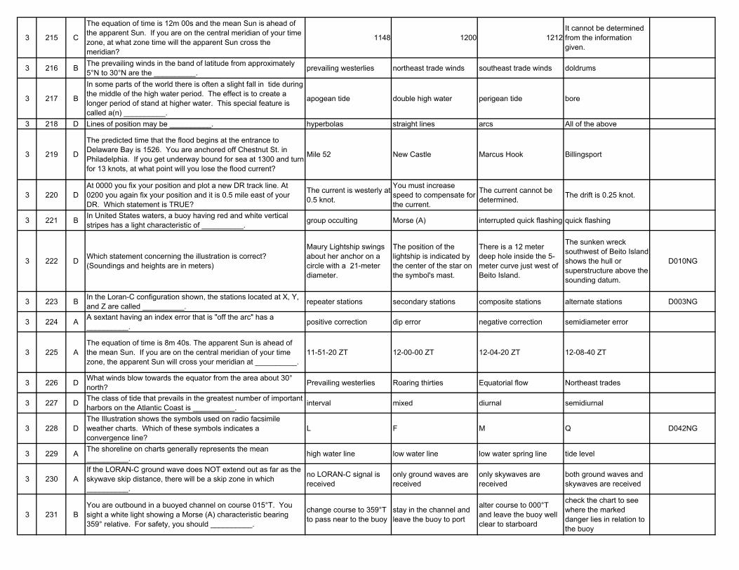
3 215 C
The equation of time is 12m 00s and the mean Sun is ahead of the apparent Sun. If you are on the central meridian of your time zone, at what zone time will the apparent Sun cross the meridian?
1148 1200 1212It cannot be determined from the information given.
3 216 B The prevailing winds in the band of latitude from approximately 5°N to 30°N are the __________. prevailing westerlies northeast trade winds southeast trade winds doldrums
3 217 B
In some parts of the world there is often a slight fall in tide during the middle of the high water period. The effect is to create a longer period of stand at higher water. This special feature is called a(n) __________.
apogean tide double high water perigean tide bore
3 218 D Lines of position may be __________. hyperbolas straight lines arcs All of the above
3 219 D
The predicted time that the flood begins at the entrance to Delaware Bay is 1526. You are anchored off Chestnut St. in Philadelphia. If you get underway bound for sea at 1300 and turn for 13 knots, at what point will you lose the flood current?
Mile 52 New Castle Marcus Hook Billingsport
3 220 DAt 0000 you fix your position and plot a new DR track line. At 0200 you again fix your position and it is 0.5 mile east of your DR. Which statement is TRUE?
The current is westerly at 0.5 knot.
You must increase speed to compensate for the current.
The current cannot be determined. The drift is 0.25 knot.
3 221 B In United States waters, a buoy having red and white vertical stripes has a light characteristic of __________. group occulting Morse (A) interrupted quick flashing quick flashing
3 222 D Which statement concerning the illustration is correct? (Soundings and heights are in meters)
Maury Lightship swings about her anchor on a circle with a 21-meter diameter.
The position of the lightship is indicated by the center of the star on the symbol's mast.
There is a 12 meter deep hole inside the 5-meter curve just west of Beito Island.
The sunken wreck southwest of Beito Island shows the hull or superstructure above the sounding datum.
D010NG
3 223 B In the Loran-C configuration shown, the stations located at X, Y, and Z are called __________. repeater stations secondary stations composite stations alternate stations D003NG
3 224 A A sextant having an index error that is "off the arc" has a __________. positive correction dip error negative correction semidiameter error
3 225 AThe equation of time is 8m 40s. The apparent Sun is ahead of the mean Sun. If you are on the central meridian of your time zone, the apparent Sun will cross your meridian at __________.
11-51-20 ZT 12-00-00 ZT 12-04-20 ZT 12-08-40 ZT
3 226 D What winds blow towards the equator from the area about 30° north? Prevailing westerlies Roaring thirties Equatorial flow Northeast trades
3 227 D The class of tide that prevails in the greatest number of important harbors on the Atlantic Coast is __________. interval mixed diurnal semidiurnal
3 228 DThe Illustration shows the symbols used on radio facsimile weather charts. Which of these symbols indicates a convergence line?
L F M Q D042NG
3 229 A The shoreline on charts generally represents the mean __________. high water line low water line low water spring line tide level
3 230 AIf the LORAN-C ground wave does NOT extend out as far as the skywave skip distance, there will be a skip zone in which __________.
no LORAN-C signal is received
only ground waves are received
only skywaves are received
both ground waves and skywaves are received
3 231 BYou are outbound in a buoyed channel on course 015°T. You sight a white light showing a Morse (A) characteristic bearing 359° relative. For safety, you should __________.
change course to 359°T to pass near to the buoy
stay in the channel and leave the buoy to port
alter course to 000°T and leave the buoy well clear to starboard
check the chart to see where the marked danger lies in relation to the buoy
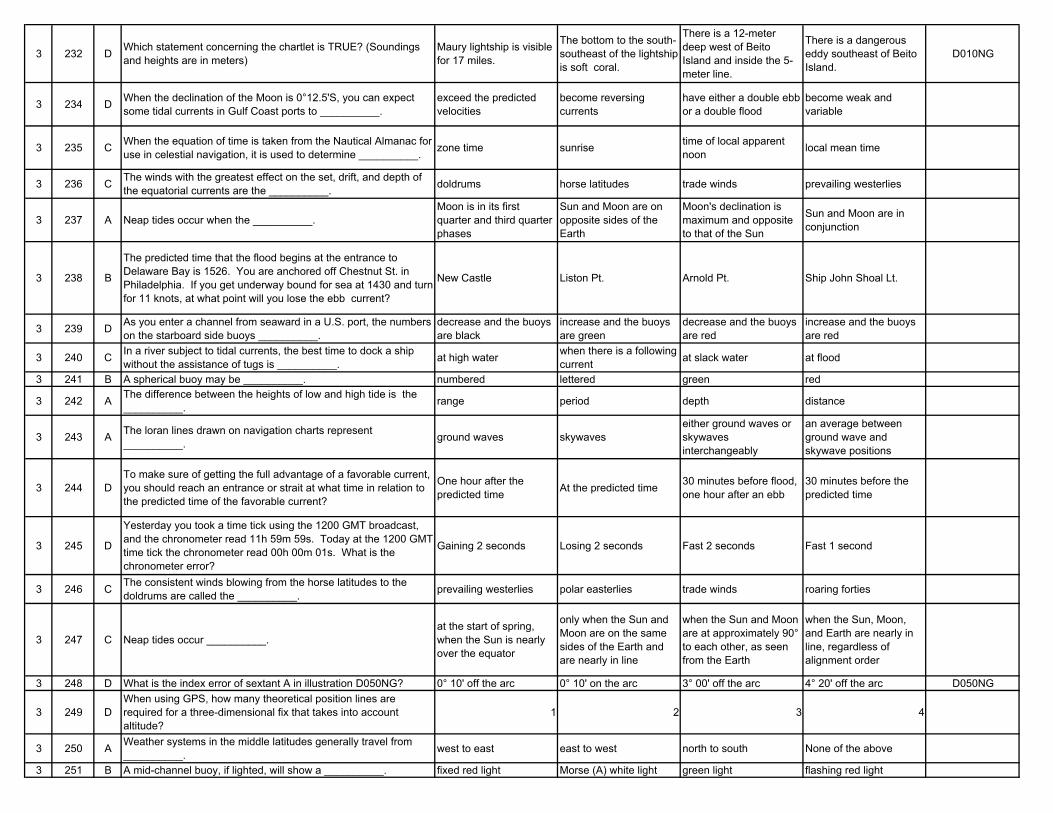
3 232 D Which statement concerning the chartlet is TRUE? (Soundings and heights are in meters)
Maury lightship is visible for 17 miles.
The bottom to the south-southeast of the lightship is soft coral.
There is a 12-meter deep west of Beito Island and inside the 5-meter line.
There is a dangerous eddy southeast of Beito Island.
D010NG
3 234 D When the declination of the Moon is 0°12.5'S, you can expect some tidal currents in Gulf Coast ports to __________.
exceed the predicted velocities
become reversing currents
have either a double ebb or a double flood
become weak and variable
3 235 C When the equation of time is taken from the Nautical Almanac for use in celestial navigation, it is used to determine __________. zone time sunrise time of local apparent
noon local mean time
3 236 C The winds with the greatest effect on the set, drift, and depth of the equatorial currents are the __________. doldrums horse latitudes trade winds prevailing westerlies
3 237 A Neap tides occur when the __________.Moon is in its first quarter and third quarter phases
Sun and Moon are on opposite sides of the Earth
Moon's declination is maximum and opposite to that of the Sun
Sun and Moon are in conjunction
3 238 B
The predicted time that the flood begins at the entrance to Delaware Bay is 1526. You are anchored off Chestnut St. in Philadelphia. If you get underway bound for sea at 1430 and turn for 11 knots, at what point will you lose the ebb current?
New Castle Liston Pt. Arnold Pt. Ship John Shoal Lt.
3 239 D As you enter a channel from seaward in a U.S. port, the numbers on the starboard side buoys __________.
decrease and the buoys are black
increase and the buoys are green
decrease and the buoys are red
increase and the buoys are red
3 240 C In a river subject to tidal currents, the best time to dock a ship without the assistance of tugs is __________. at high water when there is a following
current at slack water at flood
3 241 B A spherical buoy may be __________. numbered lettered green red
3 242 A The difference between the heights of low and high tide is the __________. range period depth distance
3 243 A The loran lines drawn on navigation charts represent __________. ground waves skywaves
either ground waves or skywaves interchangeably
an average between ground wave and skywave positions
3 244 DTo make sure of getting the full advantage of a favorable current, you should reach an entrance or strait at what time in relation to the predicted time of the favorable current?
One hour after the predicted time At the predicted time 30 minutes before flood,
one hour after an ebb30 minutes before the predicted time
3 245 D
Yesterday you took a time tick using the 1200 GMT broadcast, and the chronometer read 11h 59m 59s. Today at the 1200 GMT time tick the chronometer read 00h 00m 01s. What is the chronometer error?
Gaining 2 seconds Losing 2 seconds Fast 2 seconds Fast 1 second
3 246 C The consistent winds blowing from the horse latitudes to the doldrums are called the __________. prevailing westerlies polar easterlies trade winds roaring forties
3 247 C Neap tides occur __________.at the start of spring, when the Sun is nearly over the equator
only when the Sun and Moon are on the same sides of the Earth and are nearly in line
when the Sun and Moon are at approximately 90° to each other, as seen from the Earth
when the Sun, Moon, and Earth are nearly in line, regardless of alignment order
3 248 D What is the index error of sextant A in illustration D050NG? 0° 10' off the arc 0° 10' on the arc 3° 00' off the arc 4° 20' off the arc D050NG
3 249 DWhen using GPS, how many theoretical position lines are required for a three-dimensional fix that takes into account altitude?
1 2 3 4
3 250 A Weather systems in the middle latitudes generally travel from __________. west to east east to west north to south None of the above
3 251 B A mid-channel buoy, if lighted, will show a __________. fixed red light Morse (A) white light green light flashing red light
3 252 BA large automated navigational buoy, such as those that have replaced some lightships, would be shown on a chart by which symbol?
A B C D D015NG
3 253 D Loran-C is which type of system? Reflected electron Electrical radiation Quarterpoint electrical navigation
Hyperbolic radio navigation
3 254 A The range of tide is the __________.difference between the heights of high and low tide
distance the tide moves out from the shore
duration of time between high and low tide
maximum depth of the water at high tide
3 255 C On March 17, at 0500 zone time, you cross the 180th meridian steaming eastward to west longitude. What is your local time?
You are in -12 time zone. It is 1700, March 18. It is 0500, March 16. It is 0500, March 18.
3 256 A The belt of light and variable winds between the westerly wind belt and the northeast trade winds is called the __________.
subtropical high pressure belt
intertropical convergence zone doldrum belt polar frontal zone
3 257 D Spring tides occur __________.at the start of spring, when the Sun is nearly over the equator
only when the Sun and Moon are on the same side of the Earth and nearly in line
when the Sun and Moon are at approximately 90° to each other as seen from the Earth
when the Sun, Moon, and Earth are nearly in line, in any order
3 258 DYou are enroute to Savannah, GA, from Recife, Brazil. There is a strong N'ly wind blowing. As you cross the axis of the Gulf Stream you would expect to encounter __________.
cirrus clouds long swells smoother seas and warmer water
steeper waves, closer together
3 259 CThe Illustration shows the symbols used on radio facsimile weather charts. The symbol indicated at letter "Q" represents a __________.
convergence zone squall line convergence line weather boundary D042NG
3 260 B The National Ocean Service publishes the __________. Light Lists Coast Pilots pilot charts Sailing Directions
3 261 DYou are heading out to sea in a buoyed channel and see a quick-flashing green light on a buoy ahead of you. In U.S. waters, you should leave the buoy __________.
well clear on either side about 50 yards off on either side to port to starboard
3 262 D Which of the buoy symbols shown indicates a safe water mark? A B C D D032NG
3 263 B Loran-C uses the multiple pulse system because __________.less signal energy is necessary for receiver operation
more signal energy is available at the receiver
it significantly increases the peak power
it increases the signal capacity
3 264 B Which of the four adjustable errors in the sextant is the principle cause of index error?
Telescope not being parallel to the frame
Index mirror and horizon glass not being parallel
Index mirror not being perpendicular to the frame
Horizon glass not being perpendicular to the frame
3 265 C It is 1200 local time for an observer at 54°E longitude. Which statement is TRUE?
It is afternoon at Greenwich.
It is midnight at 126°E longitude.
The observer is in time zone -4. All of the above are true.
3 266 A The horse latitudes are characterized by __________. weak pressure gradients and light, variable winds
the formation of typhoons or hurricanes in certain seasons
steady winds in one direction for six months followed by wind reversal for the next six months
steady winds generally from the southeast in the Southern Hemisphere
3 267 B
You are inbound in a channel marked by a range. The range line is 309°T. You are steering 306°T and have the range in sight as shown. The range continues to open. What action should you take?
Alter course to the right to 309°T or more to bring the range in line.
Alter course to the left until the range closes, then steer to the left of 306°T.
Alter course to the left to close the range, then alter course to 309°T.
Maintain course as it is normal for the range to open as you get close.
D047NG
3 268 DThe illustration shows the symbols used on radio facsimile weather charts. The symbol indicated at letter "L" represents a __________.
convergence line maritime air mass warm front convergence zone D042NG
3 269 D
The wind at Frying Pan shoals has been south-southwesterly at an average velocity of 30 knots. The predicted set and drift of the rotary current are 232° at 0.8 knot. What current should you expect?
065° at 1.2 knots 092° at 1.3 knots 139° at 0.6 knot 224° at 0.4 knot
3 270 C
You are entering port and have been instructed to anchor, as your berth is not yet available. You are on a SW'ly heading, preparing to drop anchor, when you observe the range lights as shown on your starboard beam. You should __________.
drop the anchor immediately as the range lights mark an area free of obstructions
drop the anchor immediately as a change in the position of the range lights will be an indication of dragging anchor
ensure your ship will NOT block the channel or obstruct the range while at anchor
NOT drop the anchor until the lights are in line D047NG
3 271 DYour vessel is leaving New York harbor in dense fog. As the vessel slowly proceeds toward sea, you sight a green can buoy on the starboard bow. Which action should you take?
Turn hard right to get back into the channel.
Pass the buoy close to, leaving it to your port.
Stop and fix your position.
Stand on, leaving the buoy to your starboard.
3 272 B What does the symbol shown indicate on a chart? A sunken vessel marked by a buoy A safe water beacon A red and white can
buoyA can buoy with a rotating white light D033NG
3 273 A Loran-C is which type of navigation system? Hyperbolic, long-range navigation system Short-range electronic
Long-range, high frequency navigation system
Long-range, with a frequency of 1950 kHz
3 274 A Which of the four adjustable errors in the sextant causes side error?
Horizon glass not being perpendicular to the frame
Index mirror not being perpendicular to the frame
Telescope not being parallel to the frame Elliptical centering error
3 275 A Which statement concerning illustration is correct? (Soundings and heights are in meters)
The sunken wreck southwest of Beito Island shows the hull or superstructure above the sounding datum.
There is a 12-meter deep hole inside the 5-meter curve just west of Beito Island.
The position of the lightship is indicated by the center of the star on the symbol's mast.
Maury Lightship swings about her anchor on a circle with a 21-meter diameter.
D010NG
3 276 B The region of high pressure extending around the Earth at about 35°N latitude is called the __________. prevailing westerlies horse latitudes troposphere doldrums
3 277 BYour vessel goes aground in soft mud. You would have the best chance of refloating it on the next tide if it grounded at __________.
low water neap low water spring high water neap high water spring
3 278 D
You are underway on course 050°T and your maximum speed is 11 knots. The eye of a hurricane bears 070°T, 80 miles from your position. The hurricane is moving towards 270°T at 19 knots. If you maneuver at 11 knots to avoid the hurricane, what could be the maximum CPA?
84 miles 79 miles 74 miles 66 miles
3 279 A As a vessel changes course to starboard, the compass card in a magnetic compass __________.
remains aligned with compass north also turns to starboard
first turns to starboard then counterclockwise to port
turns counterclockwise to port
3 280 B Under the U.S. Aids to Navigation System, a lighted buoy with a spherical topmark marks __________.
the port side of the channel safe water a hazard to navigation the position of
underwater cables
3 281 B A lighted buoy to be left to starboard, when entering a U.S. port from seaward, shall have a __________. white light red light green light light characteristic of
Morse (A)
3 282 DThe symbol which appears beside a light on a chart reads "Gp Fl R (2) 10 sec 160 ft 19M". Which characteristic describes the light?
It is visible 10 miles. Its distinguishing number is "19M". It has a radar reflector. None of the above
3 283 A Loran-C operates on a single frequency centered on __________. 100 kHz 500 kHz 1,850 kHz 1,950 kHz
3 284 BThe marine sextant is subject to seven different types of errors, four of which may be corrected by the navigator. An error NOT correctable by the navigator is __________.
index error prismatic error perpendicularity of the horizon glass
perpendicularity of the index mirror
3 285 C The apparent wind is zero when the true wind is __________. zero from ahead and equal to the ship's speed
from astern and equal to the ship's speed
from astern and is twice the ship's speed
3 286 DOn the pole side of the trade wind belt, there is an area of high pressure with weak pressure gradients and light, variable winds. This area is called the __________.
prevailing westerlies geostrophic winds doldrums horse latitudes
3 287 D
The datum from which the predicted heights of tides are reckoned in the tide tables is the same as that used for the charts of the locality. The depression of the datum below mean sea level for Hampton Roads, Virginia is __________.
between -.7 and +.5 feet between 1.9 and 3.2 feet 4.1 feet 1.2 feet
3 288 C When using a radar in a unstabilized mode, fixes are determined most easily from __________. center bearings tangent bearings ranges objects that are close
aboard
3 289 AA position obtained by crossing lines of position taken at different times and advanced to a common time is a(n) __________.
running fix dead-reckoning position fix estimated position
3 290 DThe true wind is from 330°T, speed 6 knots. You want the apparent wind to be 30 knots from 10° on your port bow. To what course and speed must you change?
Cn 240°, 28.0 knots Cn 270°, 28.0 knots Cn 180°, 30.0 knots Cn 090°, 32.5 knots
3 291 A A buoy marking a wreck will show a(n) __________.white light FL (2) and a topmark of 2 black spheres
occulting green light and may be lettered
yellow light and will be numbered
continuous quick white light and may be numbered
3 292 CThe symbol which appears beside a light on a chart reads "Gp Fl R (2) 10 sec 160 ft 19M". Which characteristic does the light possess?
It is visible two nautical miles.
Its distinguishing number is "19M". It has a red light. It flashes once every ten
seconds.
3 293 C The use of pulse groups and extremely precise timing at each Loran-C station makes possible the use of __________. high frequency pulses combinations of high and
low frequency pulsesthe same frequency for all stations in a chain
varied long and short pulses
3 294 A What is a nonadjustable error of the sextant? Prismatic error Index error Side error Error of collimation
3 295 B The difference (measured in degrees) between the GHA of the body and the longitude of the observer is the __________. right ascension meridian angle SHA of the observer zenith distance
3 296 A The wind flow from the horse latitudes to the doldrums is deflected due to __________. Coriolis force the mid-latitude, semi-
permanent highdiffering atmospheric pressures the prevailing westerlies
3 297 C The tides in Boston Harbor generally __________. are diurnal in naturehave their variations caused by the changing declination of the Moon
have a greater range than the tides in Gulf Coast ports
All of the above
3 298 A A great circle crosses the equator at 173°E. It will also cross the equator at what other longitude? 7°W 73°E 73°W 173°W
3 299 B Steady precipitation is typical of __________. coming cold weather conditions
a warm front weather condition high pressure conditions scattered cumulus
clouds3 300 C Which of the symbols shown represents a warm front? A B C D D018NG
3 301 DIn the U.S. Aids to Navigation System, lateral aids as seen entering from seaward will display lights with which characteristic?
Flashing Occulting Quick Flashing All of the above
3 302 A Which symbol represents a 20-fathom curve? -..-..-..-..- - - - - - - - - - - . - - . - - . - - . - - - - - - - -
3 304 B In order to remove index error from a sextant, you should adjust the __________.
index mirror to make it parallel to the horizon glass with the index set at zero
horizon glass to make it parallel to the index mirror with the index set at zero
horizon glass to make it parallel to the sextant frame
telescope to make it perpendicular to the sextant frame
3 305 AIN REGION A of the IALA Buoyage System, when entering from seaward, the port side of a channel would be marked by a __________.
red can buoy black can buoy red conical buoy black conical buoy
3 306 A Weather conditions in the middle latitudes generally move __________. eastward westward northward southward
3 307 C The time meridian that is used when computing the currents for Pensacola Bay, Florida, is __________. 60°W 75°W 90°W 105°W
3 308 B
The wind at Frying Pan shoals has been west-northwesterly at an average velocity of 40 knots. The predicted set and drift of the rotary current are 323° at 0.6 knot. What current should you expect?
001° at 0.7 knot 018° at 0.4 knot 052° at 0.6 knot 089° at 0.9 knot
3 309 C
You are underway on course 050°T and your maximum speed is 12 knots. The eye of a hurricane bears 120°T, 110 miles from your position. The hurricane is moving towards 285°T at 25 knots. What course should you steer at 12 knots to have the maximum CPA?
332° 339° 346° 357°
3 310 B Which sextant shown has an index error of 3'30" off the arc? A B C D D050NG
3 311 BYou are steaming southward along the west coast of the United States when you encounter a buoy showing a flashing red light. The buoy should be left on __________.
the vessel's starboard side the vessel's port side either side close aboard either side well clear
3 312 B The depth of water on a chart is indicated as 23 meters. This is equal to __________. 11.5 fathoms 12.6 fathoms 69.0 feet 78.6 feet
3 313 C The Loran-C receiver __________. is not affected by interference
can be used at any distance with accuracy
can be affected by interference
is reliable only from sunrise to sunset
3 314 D Which of these sextant errors is nonadjustable? Prismatic error Graduation error Centering error All of the above
3 315 C Which statement about the time diagram shown DO08NG is TRUE?
You are in west longitude.
Your date is ahead of Greenwich.
The meridian angle of the Sun is east.
The GHA of the Sun is less than 180°.
3 316 AAccording to Buys Ballot's law, when an observer in the Northern Hemisphere experiences a northwest wind, the center of low pressure is located to the __________.
northeast west-southwest northwest south-southeast
3 317 C The time meridian used for tide computations in New York Harbor is __________. 52°30'W 60°00'W 75°00'W 82°30'W
3 318 B Vessels required to have an Automatic Radar Plotting Aid must have a device to indicate the __________. distance to the next port
speed of the vessel over the ground or through the water
time of the next navigational satellite pass
None of the above
3 319 BThe Illustration shows the symbols used by radio facsimile weather charts. The symbol indicated at letter "F" represents a __________.
maritime air mass weather boundary convergence zone squall line D042NG
3 320 CSometimes foreign charts are reproduced by NGA (NIMA). On such a chart, a wire-dragged, swept area may be shown in green or __________.
red black purple yellow
3 321 B Which buoy may be even numbered? Mid-channel buoy Unlighted nun buoy Lighted green buoy All of the above
3 323 B The position accuracy of Loran-C degrades with increasing distance from the transmitting stations as __________.
gains are made over the signal path
a result of variation in propagation conditions
the frequency of the pulses increases the stations shift pulses
3 324 C Index error of a sextant is primarily caused by __________. improperly correcting the other errors in a sextant
the horizon glass not being parallel to the horizon mirror
the horizon glass not being parallel to the index mirror
human error in taking a celestial observation
3 325 D What is the longitude of the geographical position of a body whose Greenwich hour angle is 210°30'? 30°30'E 59°30'W 120°30'W 149°30'E
3 326 AYou are steaming west in the North Atlantic in an extratropical cyclonic storm, and the wind is dead ahead. According to the law of Buys Ballot, the center of low pressure lies to the __________.
north south east west
3 327 BWhen daylight savings time is kept the times of tide and current calculations must be adjusted. One way of doing this is to __________.
subtract one hour from the times listed under the reference stations
add one hour to the times listed under the reference stations
apply no correction, as the times in the reference stations are adjusted for daylight savings time
add 15° to the standard meridian when calculating the time difference
3 328 C The direction of prevailing winds in the Northern hemisphere is caused by the __________.
magnetic field at the North Pole Gulf Stream Earth's rotation Arctic cold fronts
3 329 D The symbols shown are used on radio facsimile weather charts. Which symbol indicates a weather boundary? I H G F D042NG
3 330 AYou are taking bearings on two known objects ashore. The BEST fix is obtained when the angle between the lines of position is __________.
90° 30° 45° 60°
3 331 D What indicates a buoy that should be left to port when entering from seaward? (U.S. Aids to Navigation System) White light Group flashing
characteristic Nun shape Odd number
3 333 BLoran-C stations transmit groups of pulses at specific times. The time interval between transmissions from the master station is the __________.
coding delay group repetition interval pulse interval phase code
3 334 D The index error is determined by adjusting the __________. sextant frame horizon glass index mirror micrometer drum
3 335 A What is the geographic longitude of a body whose GHA is 232°27'? 127°33'E 52°27'E 61°52'W 61°52'E
3 336 D
You are steaming eastward in the North Atlantic in an extratropical cyclonic storm and the wind is dead ahead. According to the law of Buys Ballot, the center of the low pressure lies __________.
ahead of you astern of you to the north to the south
3 337 B To predict the actual depth of water using the Tide Tables, the number obtained from the Tide Tables is __________. the actual depth added to or subtracted
from the charted depthmultiplied by the charted depth
divided by the charted depth
3 338 CThe illustration shows the symbols used on radio facsimile weather charts. The symbol indicated at letter "N" represents __________.
hail freezing rain rain snow D042NG
3 339 C
The wind at Frying Pan shoals has been north-northeasterly at an average velocity of 30 knots. The predicted set and drift of the rotary current are 355° at 0.8 knot. What current should you expect?
010° at 1.1 knots 047° at 0.3 knot 325° at 0.7 knot 279° at 1.0 knot
3 340 D Information about the direction and velocity of rotary tidal currents is found in the __________. Mariner's Guide Nautical Almanac Tide Tables Tidal Current Tables
3 341 C Buoys which only mark the left or right side of the channel will never exhibit a light with which characteristic? Flashing Quick flashing Composite group
flashing Equal interval (isophase)
3 342 D A polyconic projection is based on a __________. plane tangent at one point
cylinder tangent at one parallel
cone tangent at one parallel
series of cones tangent at selected parallels
3 344 B
A marine sextant has the index arm set at zero and the reflected image of the horizon forms a continuous line with the actual image. When the sextant is rotated about the line of sight the images separate. The sextant has __________.
error of perpendicularity side error prismatic error centering error
3 345 C A navigator fixing a vessel's position by radar __________. should never use radar bearings
should only use radar bearings when the range exceeds the distance to the horizon
can use radar information from one object to fix the position
must use information from targets forward of the beam
3 346 CIf your weather bulletin shows the center of a low pressure area to be 100 miles due east of your position, what winds can you expect in the Northern Hemisphere?
East to northeast East to southeast North to northwest South to southeast
3 347 A The illustration shows the symbols used on radio facsimile weather charts. Which of these symbols indicates rain? N M I G D042NG
3 348 D When using a radar in an unstabilized mode, fixes are determined most easily from __________. center bearings tangent bearings objects that are close
aboard ranges
3 349 C The direction of the southeast trade winds is a result of the __________. equatorial current humidity rotation of the earth change of seasons
3 350 CWhen making landfall at night, the light from a powerful lighthouse may sometimes be seen before the lantern breaks the horizon. This light is called the __________.
diffusion backscatter loom elevation
3 351 B Which buoy may be odd numbered? A spherical buoy An unlighted can buoy A red buoy A yellow buoy
3 352 D Which chart projection would be most suitable for marine surveying? Gnomonic Lambert conformal Mercator Polyconic
3 354 C In order to remove side error from a sextant, you should adjust the __________.
horizon glass to make it parallel to the horizon mirror with the index set at zero
horizon glass to make it perpendicular to the index mirror with the index set at zero
horizon glass to make it perpendicular to the sextant frame
telescope to make it parallel to the sextant frame
3 355 C During the month of October the Sun's declination is __________. north and increasing north and decreasing south and increasing south and decreasing
3 356 D When facing into the wind in the Northern Hemisphere the center of low pressure lies __________. directly in front of you directly behind you to your left and behind
youto your right and behind you
3 357 B
On 10 August 1983 you will dock near Days Point, Weehawken, on the Hudson River, at 1800 DST (ZD +4). The charted depth alongside the pier is 24 feet (7.3 meters). What will be the depth of water when you dock?
23.5 feet (7.1 m) 23.9 feet (7.2 m) 24.9 feet (7.5 m) 26.3 feet (8.0 m)
3 358 B What will be the set of the rotary current at Nantucket Shoals at 1245 (ZD +5) 14 January 1983? 015° 125° 162° 225°
3 359 DYou are enroute to assist vessel A. Vessel A is underway at 4.5 knots on course 233°T, and bears 264°T, 68 miles from you. What is the time to intercept if you make 13 Knots?
6h 31m 6h 47m 7h 03m 7h 34m
3 360 BThe Illustration shows the symbols used on radio facsimile weather charts. The symbol indicated at letter "M" represents __________.
rain snow hail ice D042NG
3 361 BAs your vessel is heading southward along the east coast of the United States, you encounter a buoy showing a red flashing light. How should you pass this buoy?
Pass it about 50 yards off on either side.
Leave it to your starboard. Leave it to your port. Pass it well clear on
either side.
3 362 D Which statement about a simple conic chart projection is TRUE? It is an equal-area projection.
It is a conformal projection.
Meridians appear as curved lines.
The scale is correct along any meridian.
3 363 D Your dead reckoning position should be plotted __________. whenever an estimated position is plotted
when it agrees with your loran position
when coming on or going off soundings
at least every hour on the hour in the open waters of the sea
3 364 A What causes the error of collimation with regards to the four adjustments to a sextant?
Telescope not parallel to the frame Personal error The frame and index
mirror not perpendicularThe frame and horizon glass not perpendicular
3 365 A The Sun at a maximum declination north would be approximately at __________. aphelion perihelion autumnal equinox first point of Aries
3 366 B If an observer in the Northern Hemisphere faces the surface wind, the center of low pressure is to his______________. left, slightly behind him right, slightly behind him left, slightly in front of
himright, slightly in front of him
3 367 CWhat will be the time after 0800 EST (ZD +5) that the height of the tide at South Freeport, ME, will be 6.0 feet (1.8 meters) on 7 November 1983?
936 942 951 1001
3 368 A A great circle crosses the equator at 134°E. It will also cross the equator at what other longitude? 46°W 124°W 134°W 34°E
3 369 D
You are underway on course 050°T and your maximum speed is 11 knots. The eye of a hurricane bears 070°T, 80 miles from your position. The hurricane is moving towards 270°T at 19 knots. What course should you steer at 11 knots to have the maximum CPA?
250° 234° 227° 215 °
3 370 D Prevailing winds between 30°N and 60°N latitude are from the __________. north south east west
3 371 C Which buoy may be odd numbered? Mid-channel buoy Unlighted nun buoy Lighted green buoy All of the above
3 372 A You would find the variation on a polyconic projection chart __________. on the compass rose on the mileage scale written on the chart title at each line of longitude
3 373 B How is a navigation light on the Mississippi River identified on an Army Corps of Engineers navigation map?
Name and light characteristic
Name and miles from a reference point
Light characteristic and miles A.H.P. None of the above
3 374 A There are seven sources of error in the marine sextant. Of the four errors listed, which one is adjustable? Error of collimation Prismatic error Graduation error Centering error
3 375 A If the Sun's observed altitude is 47°50', the zenith distance is __________. 42°10' 42°50' 47°50' 132°10'
3 376 DAccording to Buys Ballot's law, when an observer in the Northern Hemisphere experiences a northeast wind the center of low pressure is located to the __________.
northeast west-southwest northwest south-southeast
3 377 B Determine the height of the tide at 2045 EST (ZD +5) at Augusta, ME, on 8 March 1983. 1.4 feet (0.5 meter) 1.9 feet (0.6 meter) 2.3 feet (0.7 meter) 2.6 feet (0.8 meter)
3 378 B A navigator fixing a vessel's position by radar __________. should never use radar bearings
can use radar information from one object to fix the position
should only use radar bearings when the range exceeds the distance to the horizon
must use information from targets forward of the beam
3 379 C The steady current circling the globe at about 60°S is the __________. Prevailing Westerly Sub-Polar Flow West Wind Drift Humboldt Current
3 380 B Prevailing winds between 30°N and 60°N latitude are from the __________. east west north south
3 381 B A nun buoy will __________. be green in color have an even number be left to port when entering from seaward be cylindrical in shape
3 382 A Which would you consult for information about the general current circulation in the North Atlantic Ocean? Pilot chart Coast Pilot Current Table Climatological Atlas
3 384 D Which is a nonadjustable error of the sextant? Error of perpendicularity Side error Error of collimation Centering error
3 385 CThe difference of latitude (l) between the geographic position (GP) of a celestial body and your position, at the time of upper transit, is represented by __________.
colatitude codistance zenith distance altitude
3 386 BYour vessel is on course 180°T speed 22 knots. The apparent wind is from 70° off the port bow, speed 20 knots. The true direction and speed of the wind are __________.
45°T, 21.0 knots 51°T, 24.0 knots 58°T, 21.2 knots 64°T, 26.0 knots
3 388 D
You are underway on course 120°T and your maximum speed is 12 knots. The eye of a hurricane bears 150°T, 120 miles from your position. The hurricane is moving towards 295°T at 20 knots. If you maneuver at 12 knots to avoid the hurricane, what could be the maximum CPA?
89 miles 96 miles 105 miles 117 miles
3 389 A
The edge of a hurricane has overtaken your vessel in the Gulf of Mexico, and the northwest wind of a few hours ago has shifted to the west. This is an indication that you are located in the __________.
navigable semicircle dangerous semicircle low pressure area eye of the storm
3 390 A During the winter months, the southeast trade winds are __________.
stronger than during the summer months
weaker than during the summer months
drier than during the summer months
wetter than during the summer months
3 391 C When outbound from a U.S. port, a buoy displaying a flashing red light indicates __________.
a junction with the preferred channel to the left
a sharp turn in the channel to the right
the port side of the channel
a wreck to be left on the vessel's starboard side
3 392 B A pilot chart does NOT contain information about __________. average wind conditions tidal currents magnetic variation average limits of field ice
3 394 C An instrument designed to maintain a continuous record of atmospheric pressure is a(n) __________. mercurial barometer aneroid barometer barograph thermograph
3 395 A If the Sun's observed altitude is 27°12', the zenith distance is __________. 62°48' 27°12' 152°48' 43°12'
3 396 CYour vessel is on course 150°T, speed 17 knots. The apparent wind is from 40° off the starboard bow, speed 15 knots. What is the speed of the true wind?
9.0 knots 10.2 knots 11.0 knots 12.0 knots
3 397 D The mean tide level at Peaks Island, ME, is __________. 1.8 feet (0.5 meters) 2.5 feet (0.8 meters) 3.2 feet (1.0 meters) 4.5 feet (1.4 meters)
3 398 BThe velocity of the apparent wind can be less than the true wind and from the same direction, if certain conditions are present. One condition is that the __________.
ship's speed is more than the true wind velocity
true wind is from dead astern true wind is on the beam true wind is from dead
ahead
3 399 D Where will you find information about the duration of slack water? American Practical Navigator Sailing Directions Tide Tables Tidal Current Tables
3 400 D Information about the currents for the Pacific Coast of the U. S. are found in the __________. Ocean Current Tables Nautical Almanac Tide Tables Tidal Current Tables
3 401 AYou are steaming in a westerly direction along the Gulf Coast. You see ahead of you a lighted buoy showing a red isophase light. Which action should you take?
Alter course to port and leave the buoy to starboard.
Alter course to starboard and leave the buoy to port.
Alter course and leave the buoy near by on either side.
Alter course and pass the buoy well-off on either side.
3 402 D All of the following can be found on a Pilot Chart EXCEPT information concerning the __________.
percentage of frequency of wave heights
percentage of poor visibility conditions
sea surface temperatures amounts of precipitation
3 404 B An aneroid barometer is an instrument __________. used to measure the speed of wind
in which the pressure of the air is measured
that tells which direction a storm is coming from
used to measure the height of waves
3 405 C At upper transit, if the zenith distance is 34°, the geographical distance from the observer to a body's GP is __________. 510 miles 1220 miles 2040 miles 2260 miles
3 406 D
Your vessel is on course 135°T, speed 18 knots. From the appearance of the sea you estimate the speed of the true wind as 24.5 knots. The apparent wind is 40° on the starboard bow. Determine the speed of the apparent wind.
24.2 knots 28.4 knots 32.2 knots 36.0 knots
3 407 B What would be the height of the tide at Crisfield, MD, at 0310 DST (ZD +4) on 6 May 1983? 0.1 foot 0.5 foot 1.1 feet 1.6 feet
3 408 C A buoy bears 176°T at 3000 yards. What is the course to make good to leave the buoy 100 yards to port? 174°T 176°T 178°T 180°T
3 409 AOn November 1st the zone time is 1700 EST (ZD +5) in LONG 75°W. What is the corresponding zone time and date in LONG 135°E?
0700, November 2nd 0700, November 1st 2200, November 1st 2200, October 31st
3 410 BThe height of the tide at low water is 0.0 feet. The range is 9.0 feet. The duration is 06h 00m. The height of the tide 02h 12m before high water will be __________.
8.3 feet 6.3 feet 4.7 feet 2.7 feet
3 411 C When entering from seaward, a buoy displaying a single-flashing red light would indicate __________.
a junction with the preferred channel to the left
a sharp turn in the channel to the right
the starboard side of the channel
a wreck to be left on the vessel's port side
3 412 AIf you were sailing in the North Pacific and were interested in the ice and iceberg limits, you could find this information in the __________.
Pilot Chart Coast Pilot Notice to Mariners None of the above
3 414 D The barometer is an instrument for measuring the __________. temperature relative humidity dew point atmospheric pressure
3 415 A If the Sun's observed altitude is 54°30', what is the zenith distance? 35°30' 45°30' 12°30' 14°30'
3 416 BA ship is on course 195° at a speed of 15 knots. The apparent wind is from 40° on the port bow, speed 30 knots. The direction and speed of the true wind are __________.
068°T, 30 knots 127°T, 21 knots 263°T, 42 knots 292°T, 42 knots
3 417 D On 6 July 1983, at 1830 DST (ZD +4), what will be the predicted height of tide at Newburgh, NY? 3.3 feet 2.6 feet 2.4 feet 2.0 feet
3 418 A In most cases, the direction of the apparent wind lies between the bow and __________.
the direction of the true wind true north the beam on the
windward side the beam on the lee side
3 419 BThe ocean bottom that extends from the shoreline out to an area where there is a marked change in slope to a greater depth is the __________.
abyssal plain continental shelf borderland offshore terrace
3 420 A
You are inbound in a channel marked by a range. The range line is 309°T. You are steering 306°T and have the range in sight as shown. The range continues to open. What action should you take?
Alter course to the left until the range closes then steer to the left of 306°T.
Maintain course as it is normal for the range to open as you get close.
Alter course to the left to close the range, then alter course to 309°T.
Alter course to the right to 309°T or more to bring the range in line.
D047NG
3 421 B Daylight savings time is a form of zone time that adopts the time __________. one zone to the west one zone to the east two zones to the west two zones to the east
3 422 BIf you are sailing from the East Coast of the United States to the Caribbean Sea, which publication would contain information on weather, currents, and storms?
Sailing Charts of the Caribbean Sea
Pilot Charts of the North Atlantic
Light Lists, Atlantic and Gulf Coast Tidal Current Tables
3 424 D For an accurate barometer check, you would __________. check it with a barometer on another vessel
take readings from several barometers and average them
check it with the barometer at the ship chandlery
check it against radio or National Weather Service reports of the immediate vicinity
3 425 D 90° - Ho = __________. sextant altitude co-latitude LHA zenith distance
3 426 C The wind speed and direction observed from a moving vessel is known as __________. coordinate wind true wind apparent wind anemometer wind
3 427 COn 23 March 1983, at Kingston Point, NY, what is the earliest time after 1700 EST (ZD +5) that the predicted tide will be +2.0 feet?
1730 1800 1854 2030
3 428 BA buoy bears 178°T at 3000 yards (2700 meters). What is the course to make good to leave the buoy 100 yards (90 meters) to starboard?
174°T 176°T 178°T 180°T
3 429 B A great circle crosses the equator at 127°W. It will also cross the equator at what other longitude? 127°E 53°E 27°E 27°W
3 430 D The southeast trade winds actually blow toward the __________. southeast south east northwest
3 431 D When a buoy marks a channel bifurcation, the preferred channel is NOT indicated by __________.
the shape of an unlighted buoy
the light color of a lighted buoy
the color of the topmost band
whether the number is odd or even
3 432 B When using a Lambert conformal chart in high latitudes, angles such as bearings are measured in reference to __________.
the meridian through the object of the bearing
the meridian through the ship's position
the meridian midway between the ship and the object
any meridian
3 434 B The purpose of the "set" hand on an aneroid barometer is to __________. adjust the barometer
indicate any change in the reading of the barometer
provide a correction for height above sea level
provide a correction for temperature changes
3 435 C If an observer is at 35°N latitude, his zenith is __________. 55°S of the celestial equator at the north celestial pole 35°N of the celestial
equator55°N of the celestial equator
3 436 C A wind vane on a moving vessel shows __________. dead reckoning wind direction true wind direction apparent wind direction estimated wind direction
3 437 B
Your vessel will be docking at Chester, PA, during the evening of 22 April 1983. The chart shows a depth of 20 feet (6.1 meters) at the pier. What will be the depth of water available at 1856 EST (ZD +5)?
22.4 feet (6.8 meters) 23.4 feet (7.2 meters) 24.9 feet (7.6 meters) 25.7 feet (7.8 meters)
3 438 CYour longitude is 124°E, and your local mean time is 0520 on the 5th of the month. The mean time and date at Greenwich is __________.
1336 on the 4th 1336 on the 5th 2104 on the 4th 2104 on the 5th
3 439 AIf a weather bulletin shows the center of a low pressure system to be 100 miles due east of you, what winds can you expect in the Southern Hemisphere?
South-southwesterly North-northwesterly South-southeasterly North-northeasterly
3 440 DYou are inbound in a channel marked by a range. The range line is 309°T. You are steering 306°T. The range appears as shown and is closing. Which action should you take?
Continue on the present heading until the range is in line, then alter course to the left.
Immediately alter course to the right to bring the range in line.
Immediately alter course to 309°T.
Continue on course until the range is closed, then alter course to the right.
D047NG
3 441 B A yellow buoy may exhibit a(n) __________. fixed red light flashing light white light occulting light
3 442 D In very high latitudes, the most practical chart projection is the __________. Mercator gnomonic azimuthal Lambert conformal
3 444 B A sylphon cell is a part of a __________. maximum thermometer barograph thermograph hygrometer
3 445 C The values of the Greenwich hour angle and declination, tabulated in all almanacs, are for the __________.
upper limb of a celestial body
lower limb of a celestial body
centers of the various celestial bodies
lower limb of the Sun and Moon; center of the stars and planets
3 446 B The usual sequence of directions in which a tropical cyclone moves in the Southern Hemisphere is __________.
northwest, west, and south
southwest, south, and southeast
north, northwest, and east
west, northwest, and north
3 447 A On 27 April 1983, at 1105 DST (ZD +4), what will be the predicted height of tide at Falkner Island, CT? 5.3 feet (1.6 m) 5.6 feet (1.7 m) 6.2 feet (1.9 m) 6.8 feet (2.7 m)
3 448 C Mean high water is the reference datum used to measure __________.
soundings on the east coast of the United States
soundings in European waters
heights of topographical features in the United States
both heights and soundings worldwide
3 449 DYou are enroute to assist vessel A. Vessel A is underway at 5 knots on course 063°T, and bears 136°T at 78 miles from you. What is the course to steer at 13 knots to intercept vessel A?
340° 295° 158° 114°
3 450 CYou are enroute to Jacksonville, FL, from San Juan, P.R. There is a fresh N'ly wind blowing. As you cross the axis of the Gulf Stream you would expect to encounter __________.
cirrus clouds smoother seas and warmer water
steeper waves, closer together long swells
3 451 A Which light characteristic may be used on a special purpose mark? Fixed Occulting Equal interval Quick flashing
3 452 A When navigating in high latitudes and using a chart based on a Lambert conformal projection, __________.
a straight line drawn on the chart approximates a great circle
the chart should not be used outside of the standard parallels
the course angle is measured at the mid-longitude of the track line
distance cannot be measured directly from the chart
3 454 A On what does the operation of an aneroid barometer depend? Thin, metal, air tight cell Curved tube containing alcohol
Column of mercury supported by atmospheric pressure
Expansion of mercury in a closed tube
3 455 D The height of eye correction is smaller than geometrical dip because of __________.
the angle between the horizontal and the line of sight to the visible horizon
index error parallax terrestrial refraction
3 456 D Which condition exists in the eye of a hurricane? Wind rapidly changing direction
A temperature much lower than that outside the eye
Towering cumulonimbus clouds
An extremely low barometric pressure
3 457 D Find the height of the tide at Port Wentworth, GA, on 5 October 1983, at 1840 DST (ZD +4). 3.0 feet 3.5 feet 4.0 feet 4.4 feet
3 458 A The prevailing westerlies of the Southern Hemisphere blow 18-30 knots __________. all year long during the summer
months only during the winter only during spring only
3 459 DA buoy bears 178°T at 3000 yards (2700 meters). What is the course to make good to leave the buoy 100 yards (90 meters) to port?
174°T 176°T 178°T 180°T
3 460 D When using horizontal sextant angles of three objects to fix your position, an indeterminate position will result in which situation?
The objects lie in a straight line.
The vessel is inside of a triangle formed by the objects.
The vessel is outside of a triangle formed by the objects.
A circle will pass through your position and the three objects.
3 461 A Under the U.S. Aids to Navigation System, a yellow buoy may __________. mark a fish net area be lighted with a white
light show a fixed red light All of the above
3 462 A For what purpose would using a Lambert conformal chart be more convenient than using a Mercator?
Plotting radio bearings over a long distance
Determining latitude and longitude of a fix
Measuring rhumb line distances
Measuring rhumb line directions
3 464 C Prior to reading an aneroid barometer, you should tap the face lightly with your finger to __________.
expose any loose connections
demagnetize the metal elements
bring the pointer to its true position
contract and expand the glass face
3 465 BWhen applying a dip correction to the sighted sextant angle (hs), you always subtract the dip because you are correcting __________.
hs to the visible horizon hs to the sensible horizon
hs to the celestial horizon
Ho to the celestial horizon
3 466 C In the relatively calm area near the hurricane center, the seas are __________.
moderate but easily navigated calm mountainous and
confused
mountainous but fairly regular as far as direction is concerned
3 467 C At what time after 1400 EST (ZD +5), on 4 January 1983, will the height of the tide at Port Wentworth, GA, be 3.0 feet? 1612 1630 1653 1718
3 468 B Which of the symbols shown represents a cold front? A B C D DO18NG
3 469 C Where are the prevailing westerlies of the Southern Hemisphere located?
Between the Equator and 10° latitude
Between 10° and 20° latitude
Between 30° and 60° latitude
Between 60° and 90° latitude
3 470 C
You are underway on course 120°T and can make 12 knots. The eye of a hurricane bears 150°T at 120 miles. The hurricane is on course 295° at 20 knots. What course should you steer at 12 knots to have the maximum CPA?
312° 330° 348° 001°
3 471 A Yellow lights may appear on __________. special purpose buoys vertically-striped buoys horizontally-banded buoys spherical buoys
3 472 B Which conic projection chart features straight lines which closely approximate a great circle? Polyconic Lambert conformal Orthographic Stereographic
3 474 B Which indication on the barometer is most meaningful in forecasting weather?
The words "Fair -- Change -- Rain"
The direction and rate of change of barometric pressure
The actual barometric pressure The relative humidity
3 475 B A correction for augmentation is included in the Nautical Almanac corrections for __________. the Sun the Moon Venus None of the above
3 476 A Tropical cyclones normally form within which of the following belts of latitude? 5° to 15° 15° to 30° 30° to 45° 45° to 60°
3 477 C Determine the height of the tide at 1430 EST (ZD +5) at New Bedford, MA, on 10 April 1983. 1.1 feet 1.2 feet 1.4 feet 1.7 feet
3 478 DThe velocity of the apparent wind can be more than the true wind, and come from the same direction, if certain conditions are present. One condition is that the __________.
ship's speed must be less than the true wind velocity
true wind must be from dead astern
true wind velocity must be faster than the ship's speed
true wind must be from dead ahead
3 479 AYou are enroute to assist vessel A. Vessel A is underway at 5 knots on course 063°T, and bears 136°T at 78 miles from you. What is the course to steer at 13 knots to intercept vessel A?
114° 158° 295° 340°
3 480 B What kind of pressure systems travel in easterly waves? High pressure Low pressure Subsurface pressure Terrastatic pressure
3 481 A A special mark (yellow buoy), if lighted, may exhibit which light rhythm? Flashing Morse "A" Equal interval Occulting
3 482 D Which statement about a gnomonic chart is correct? A rhumb line appears as a straight line.
Distance is measured at the mid-latitude of the track line.
Meridians appear as curved lines converging toward the nearer pole.
Parallels, except the equator, appear as curved lines.
3 483 ACoral atolls, or a chain of islands at right angles to the radar beam, may show as a long line rather than as individual targets due to __________.
the effects of beam width limitations on range resolution
the pulse length of the radar
the multiple-target resolution factor
3 484 A The needle of an aneroid barometer points to 30.05 on the dial. This indicates that the barometric pressure is __________. 30.05 inches of mercury 30.05 millimeters of
mercury 30.05 millibars falling
3 485 C A phase correction is applied to observations of __________. the Sun stars planets All of the above
3 486 D Tropical cyclones do not form within 5° of the Equator because __________.
there are no fronts in that area it is too hot it is too humid of negligible Coriolis
force
3 487 DWhat will be the time after 0600 (ZD +3), on 6 March 1983, that the height of the tide at Puerto Rosales, Argentina, will be 9.0 feet (2.7 meters)?
740 754 840 922
3 488 B A great circle crosses the equator at 93°W. It will also cross the equator at what other longitude? 13°E 87°E 177°E 177°W
3 489 AYou are anchored in the Aleutian Island chain and receive word that a tsunami is expected to strike the islands in six hours. What is the safest action?
Get underway and be in deep, open-ocean water when the tsunami arrives.
Increase the scope of the anchor cable and drop the second anchor underfoot at short stay.
Get underway and be close inshore on the side of the island away from the tsunami.
Plant both anchors with about a 60° angle between them, and let out a long scope to each anchor.
3 490 B
You are underway on course 050°T and your maximum speed is 10 knots. The eye of a hurricane bears 100°T, 90 miles from your position. The hurricane is moving towards 285°T at 19 knots. Which course should you steer at 10 knots to have the maximum CPA?
221° 226° 233° 238°
3 491 D A special purpose buoy shall be __________. lighted with a white light striped black and red lighted with a red light yellow
3 492 BWhich type of projection is formed if a plane is tangent to the Earth, and points are projected geometrically from the center of the Earth?
Lambert conformal Oblique gnomonic Mercator Transverse conic
3 493 CThe picture shown represents the geographic location of a vessel and the radar presentation at the same time. Which statement is TRUE?
Ship No. 1 is not detected due to the shadow effect of the headland.
The small island is not detected due to the effect of beam width.
A tangent bearing of the headland to the south-southeast should be corrected by adding one-half of the beam width.
Ship No. 2 is not detected due to the reflective mass of the background mountain overpowering the ship's reflective signals.
D011NG
3 494 D Aneroid barometers are usually calibrated to indicate atmospheric pressure in __________.
inches of mercury and centimeters
feet of mercury and millibars
inches of mercury and millimeters
inches of mercury and millibars
3 495 B A semidiameter correction is applied to observations of __________. Mars the Moon Jupiter All of the above
3 496 D Severe tropical cyclones (hurricanes, typhoons) occur in all warm-water oceans except the __________. Indian Ocean North Pacific Ocean South Pacific Ocean South Atlantic Ocean
3 497 BWhat will be the time after 0300 (ZD +4), on 5 March 1983, when the height of the tide at Port of Spain, Trinidad, will be 2.5 feet (.76 meters) ?
548 602 618 634
3 498 C What is an advantage of the magnetic compass aboard vessels?Compass error is negligible at or near the earth's magnetic poles.
It does not have to be checked as often.
It is reliable due to it's essential simplicity.
All points on the compass rose are readily visible.
3 499 D Which of the symbols shown represents an occluded front? A B C D D018NG
3 500 BThe National Geospatial-Intelligence Agency (formerly the National Imagery and Mapping Agency) would produce a chart of the coast of __________.
Alaska Canada Puerto Rico Hawaii
3 501 D Which of the buoys listed below could be used to mark an anchorage?
White buoy numbered "3"
White buoy with a green top
White buoy with orange bands Yellow buoy lettered "N"
3 502 A A gnomonic projection is based on a(n) __________. plane tangent at one point
cylinder tangent at the equator
cone tangent at one parallel
infinite series of cones tangent at selected parallels
3 503 D You are approaching a light fitted with a RACON. The light may be identified on the radar by __________.
a dashed line running from the center of the scope to the light
an audible signal when the sweep crosses the light
a circle appearing on the scope surrounding the light
a coded signal appearing on the same bearing at a greater range than the light
3 504 A Barometer readings in weather reports are given in terms of pressure at __________. sea level Washington, D.C. the weather station the broadcasting station
3 505 D The error in the measurement of the altitude of a celestial body, caused by refraction, increases as the __________.
horizontal parallax decreases
observer's height above sea level increases
humidity of the atmosphere decreases
altitude of the body decreases
3 506 D
You are to sail from Elizabethport, N.J., on 22 May 1983, with a maximum draft of 28 feet. You will pass over an obstruction in the channel near Sandy Hook that has a depth of 26.5 feet. The steaming time from Elizabethport to the obstruction is 1h 40m. What is the earliest time (ZD + 4) you can sail on the afternoon of 22 May and pass over the obstruction with 2 feet of clearance?
1454 1424 1405 1342
3 507 A What will be the time after 1000 EST (ZD +5), on 4 March 1983, that the height of the tide at City Island, NY, will be 2.4 feet? 1228 1240 1244 1248
3 508 A Which statement about the chartlet is TRUE? (Soundings and heights are in meters)
There is a dangerous eddy southeast of Beito Island.
Maury lightship is visible for 17 miles.
The bottom to the south-southeast of the lightship is soft coral.
There is a 12-meter deep west of Beito Island and inside the 5-meter line.
D010NG
3 509 B A line of position derived by radar range from an identified point on a coast will be a(n) __________. straight line arc parabola line parallel to the coast
3 510 A Which aid is NOT marked on a chart with a magenta circle? Aero light Radar station Radar transponder beacon Radio beacon
3 511 D A survey (special purpose mark) buoy __________. must be lighted may have a flashing red light
may have a fixed white light None of the above
3 512 C On a gnomonic chart, a great circle track between Los Angeles and Brisbane will appear as a __________. loxodromic curve curved line concave to
the equator straight line spiral approaching the poles as a limit
3 513 BYou are radar scanning for a buoy fitted with a racon. Which radar screen represents the presentation you should expect on the PPI?
A B C D D017NG
3 514 D What instrument measures wind velocity? Hydrometer Barometer Psychrometer Anemometer
3 515 BThe small circle of the celestial sphere parallel to the celestial equator, and transcribed by the daily motion of the body, is called the __________.
hour circle of the body parallel of declination vertical circle of the body parallel of altitude
3 516 DA hurricane moving northeast out of the Gulf passes west of your position. You could expect all of the following EXCEPT __________.
higher than normal swells high winds
winds veering from south, through west, to northwest
light showers
3 517 A On 5 March 1983, at 0630 EST (ZD +5), what will be the predicted height of tide at Ocracoke, Ocracoke Inlet, NC? 0.1 foot 1.2 feet 1.9 feet 2.3 feet
3 518 AWith regard to GPS, a civilian receiver may be capable of achieving the same accuracy as a military receiver if __________.
selective availability is set to zero
the satellites are all below 15° in elevation
your vessel is equipped with a Doppler receiver
the horizontal dilution of precision is high
3 519 BThe chart of a beach area shows a very flat slope to the underwater beach bottom. What type of breakers can be expected when trying to land a boat on this beach?
Surging Spilling Plunging Converging
3 520 A On charts of U.S. waters, a magenta marking is NOT used for marking a __________. 5-fathom curve prohibited area lighted buoy radio beacon
3 521 D Which sextant has an index error of 2'10" on the arc? A B C D D050NG
3 522 D All straight lines represent great circle tracks on a chart based on a(n) __________. Mercator projection polyconic projection orthographic projection gnomonic projection
3 523 B A radar display in which North is always at the top of the screen is a(n) __________. unstabilized display stabilized display composition display relative display
3 524 A An anemometer on a moving vessel measures __________. apparent wind speed only
true wind speed and true wind direction true wind speed only apparent wind speed
and true wind direction
3 525 D In the celestial equator system of coordinates, what is comparable to latitude on the terrestrial sphere? Altitude Right ascension Celestial meridians Declination
3 526 B When a hurricane passes over colder water or land and loses its tropical characteristics, the storm becomes a(n) __________. high pressure area extratropical low-
pressure system tropical storm easterly wave
3 527 B On 6 June 1983, at 1719 EST (ZD +5), what will be the predicted height of tide at Chester, PA? 0.8 feet( 0.2 meters) 1.1 feet (0.3 meters) 3.5 feet (1.1 meters) 4.7 feet (1.4 meters)
3 528 B What should you expect when you encounter a tsunami in the open ocean?
Violent seas from mixed directions
No noticeable change from the existing sea state
Winds increasing to gale force from the northwest in the Northern Hemisphere
A major wave of extreme height and length
3 529 BIn some river mouths and estuaries the incoming high-tide wave crest overtakes the preceding low-tide trough. This results in a wall of water proceeding upstream, and is called a __________.
seiche bore boundary wave surge
3 530 C Under the U.S. Aids to Navigation System, a lighted buoy with a spherical topmark marks __________.
the port side of the channel
the position of underwater cables safe water a hazard to navigation
3 531 CYou have been informed that dredging operations may be underway in your vicinity. Which buoy indicates the dredging area?
White buoy with a green top
White and international orange buoy Yellow buoy Yellow and black
vertically-striped buoy
3 532 B In a river subject to tidal currents, the best time to dock a ship without the assistance of tugs is __________. at high water at slack water at flood tide when there is a following
current
3 533 A
You are using a radar in which your own ship is shown at the center, and the heading flash always points to 0°. If bearings are measured in relation to the flash, what type of bearings are produced?
Relative TRUE Compass Magnetic
3 534 C What is TRUE concerning an anemometer on a moving vessel? It measures true wind speed.
It measures true wind speed and true wind direction.
It measures apparent wind speed.
It measures apparent wind speed and true wind direction.
3 535 D The tropical year differs from which year by 20 minutes? Astronomical year Natural year Equinoctial year Sidereal year
3 536 AYou are enroute from Puerto Rico to New York. A hurricane makes up and is approaching. If the wind veers steadily, this indicates that your vessel is __________.
in the dangerous semicircle
in the navigable semicircle
directly in the path of the storm in the storm center
3 537 B What will be the height of tide at Gargathy Neck, VA, at 1800 DST (ZD +4), on 16 August 1983? 2.3 feet 2.9 feet 3.3 feet 3.6 feet
3 538 A Which symbol shown represents a stationary front? A B C D DO18NG
3 539 A
You are underway on course 050°T and your maximum speed is 13 knots. The eye of a hurricane bears 120°T, 100 miles from your position. The hurricane is moving towards 265°T at 25 knots. What course should you steer at 13 knots to have the maximum CPA?
324°T 306°T 299°T 276°T
3 540 D A white buoy with an orange rectangle on it is used to indicate __________. danger a controlled area an exclusion area general information
3 541 C A yellow buoy may mark a(n) __________. wreck shoal area anchorage area middle ground
3 542 B The only cylindrical chart projection widely used for navigation is the __________. Lambert conformal Mercator azimuthal gnomonic
3 543 C A radar display which is oriented, so that north is always at the top of the screen, is called a(n) __________. relative display composite display stabilized display unstabilized display
3 544 B The instrument most commonly used to gather the data for determining the relative humidity is the __________. hydrometer psychrometer barometer anemometer
3 545 A The arc of a great circle which passes through the body and celestial poles is part of the __________. hour circle diurnal circle observer's meridian altitude circle D007NG
3 546 DIf it is impossible to avoid a hurricane in the Northern Hemisphere, the most favorable place to be when the storm passes is in __________.
the dangerous semicircle the eye (center) of the storm
that half of the storm lying to the right of the storm's path
that half of the storm lying to the left of the storm's path
3 547 A On 2 November 1983, at 1630 EST (ZD +5), what will be the predicted height of tide at Fulton, FL? 2.8 feet (0.8 meters) 3.4 feet (1.0 meters) 4.2 feet (1.3 meters) 5.6 feet (1.7 meters)
3 548 C When the declination of the Moon is 0°12.5'S, you can expect some tidal currents in Gulf Coast ports to __________.
have either a double ebb or a double flood
become reversing currents
become weak and variable
exceed the predicted velocities
3 549 D On a working copy of a weather map, an occluded front is represented by which color line? Red Blue Alternating red and blue Purple
3 550 A The description "Racon" beside an illustration on a chart would mean a __________.
radar transponder beacon
radar conspicuous beacon radar calibration beacon circular radio beacon
3 551 CSpoil grounds, anchorage areas, cable areas, and military exercise areas are all marked by yellow buoys. Which special mark on the buoy will indicate the specific area you are in?
A topmark triangular in shape
A topmark spherical in shape Lettering on the buoy
A topmark consisting of two cones with the points up
3 552 A A Mercator chart is a __________. cylindrical projection simple conic projection polyconic projection rectangular projection
3 553 CThe beam width of your radar is 2°. The left tangent bearing of a small island, as observed on the PPI scope, is 056°pgc. If the gyro error is 2°E, what bearing would you plot on the chart?
052° 056° 059° 060°
3 554 C A sling psychrometer is a(n) __________. type of cargo gear instrument used in celestial navigation
instrument used to measure relative humidity
instrument used to measure specific gravity
3 555 D The letter D shown represents the __________. geoidal horizon celestial horizon visible horizon geometrical horizon D006NG
3 556 A In a tropical cyclone in the Northern Hemisphere, a vessel hove to with the wind shifting counterclockwise would be __________.
in the navigable semicircle
in the dangerous semicircle
directly in the path of the center ahead of the storm
3 557 A
Your vessel has a draft of 23 feet. On 23 June 1983 you wish to pass over a temporary obstruction near Beaufort, SC, that has a charted depth of 22 feet. Allowing for a safety margin of 3 feet, what is the earliest time after 1600 DST (ZD +4) that this passage can be made?
1751 1815 1855 1944
3 558 A A buoy bears 176°T at 3000 yards. What is the course to make good to leave the buoy 100 yards to starboard? 174°T 176°T 178°T 180°T
3 559 D A great circle crosses the equator at 162°E. It will also cross the equator at what other longitude? 62°E 126°W 162°W 18°W
3 560 D
On 14 April 1981, a back sight is taken of the upper limb of the Sun as seen in the telescope. The height of eye is 45 feet. The index error is 2.5' on the arc. The sextant altitude (hs) is 117°14.6'. What is the observed altitude (Ho)?
63°01.9' 63°03.4' 63°07.4' 63°09.9'
3 561 B Buoys which mark dredging areas are painted __________. black yellow green red
3 562 A
You wish to measure the distance on a Mercator chart between a point in latitude 42°30'N and a point in latitude 40°30'N. To measure 30 miles at a time you should set the points of the dividers at __________.
41°15' and 41°45' 41°45' and 42°15' 42°15' and 42°45' 42°00' and 42°30'
3 563 CYour radar has a beam width of 2°. The radar gyro bearing of the right tangent of an island is 316°. The gyro error is 1°E. Which true bearing should be plotted on the chart?
313° 314° 316° 317°
3 564 D A hygrometer is a device used for determining __________. the absolute temperature atmospheric pressure wind velocity relative humidity
3 565 A The letter B as shown represents the __________. geoidal horizon celestial horizon visible horizon sensible horizon D006NG
3 566 D
You are attempting to locate your position relative to a hurricane in the Northern Hemisphere. If the wind direction remains steady, but with diminishing velocity, you are most likely __________.
in the right semicircle in the left semicircle on the storm track ahead of the center
on the storm track behind the center
3 568 AThe chart of a beach area shows a very steep slope to the underwater beach bottom. Which type of breakers can be expected when trying to land a boat on this beach?
Surging Converging Spilling Plunging
3 569 B A line of position formed by sighting two charted objects in line is called a(n) __________. relative bearing range line track line estimated position
3 570 B Chart legends printed in capital letters show that the associated landmark is __________. inconspicuous conspicuous a government facility or
station a radio transmitter
3 571 CThe Coast Guard Captain of the Port has excluded all traffic from a section of a port, while a regatta is taking place. The buoys marking this exclusion area will be __________.
nun- or can-shaped to conform to the overall direction of navigation
yellow orange and white marked with a spherical topmark
3 572 B
You wish to measure the distance on a Mercator chart between a point in latitude 43°30'N and a point in latitude 40°30'N. To measure 30 miles at a time, you should set the points of the dividers at __________.
41°30' and 42°00' 41°45' and 42°15' 42°00' and 42°30' 42°15' and 42°45'
3 573 B What is the name of the movable, radial guide line used to measure direction on a radar? Compass rose Cursor Plan position indicator Variable range marker
3 574 BIf your mercurial barometer reads 30.50 inches (1033 millibars) and the temperature is 56°F (13°C), what is the correct reading at 55°N, 150°W?
30.42 inches (1030 millibars)
30.45 inches (1031 millibars)
30.50 inches (1032 millibars)
30.53 inches (1033 millibars)
3 575 DThe horizontal plane, perpendicular to the zenith-nadir axis, that intersects with the celestial sphere and is tangent to the earth is called the __________.
celestial horizon sensible horizon visible horizon geoidal horizon
3 576 D In a tropical cyclone in the Southern Hemisphere, a vessel hove to with the wind shifting clockwise would be __________.
ahead of the storm center
in the dangerous semicircle
directly behind the storm center
in the navigable semicircle
3 577 C
Your vessel has a draft of 24 feet. On 7 April 1983 you wish to pass over a temporary obstruction near Lovell, MA, that has a charted depth of 22 feet. Allowing for a safety margin of 3.1 feet under your keel, what is the earliest time after 0100 EST (ZD +5) that this passage can be made?
248 304 334 356
3 578 B
At about GMT 1436, on 3 December 1981, the lower limb of the Moon is observed with a sextant having an index error of 2.5' on the arc. The height of eye is 32 feet. The sextant altitude (hs) is 3°38.8'. What is the observed altitude?
Ho 4°18.6' Ho 4°29.1' Ho 4°36.3' Ho 4°42.2'
3 579 C Low pressure disturbances, which travel along the intertropical convergence zone, are called __________. permanent waves tidal waves tropical waves tropical storms
3 580 B
On 21 January 1981, you take a back sight of the Sun's upper limb as it appears in the scope. The sextant altitude (hs) is 121°31.5'. The index error is 2.5' on the arc. The height of eye is 31 feet (9.3 meters). What is the observed altitude (Ho)?
31°06.2' 58°53.1' 58°12.2' 58°03.2'
3 581 D The Captain of the Port has closed to navigation, and buoyed, a section of a harbor. These buoys would be painted __________.
red or green to conform with the other lateral aids
red and green horizontally-striped solid yellow white with orange
markings
3 582 A Distance along a track line is measured on a Mercator chart by using the __________.
latitude scale near the middle of the track line
longitude scale near the middle of the track line
latitude scale at the mid-latitude of the chart
latitude or longitude scale at the middle of the scale
3 583 B The radar control used to reduce sea return at close ranges is the __________. gain control sensitivity time control fast time constant pulse length control
3 584 A The correction(s) which must be applied to an aneroid barometer reading include(s) __________. height error gravity error temperature error All of the above
3 585 C What great circle is always needed to form the astronomical triangle? Celestial Equator Prime Meridian Celestial Meridian Prime Vertical Circle
3 586 B
The approximate distance to a storm center can be determined by noting the hourly rate of fall of the barometer. If the rate of fall is 0.08 - 0.12 inches, what is the approximate distance to the storm center?
50 to 80 miles 80 to 100 miles 100 to 150 miles 150 to 250 miles
3 587 B
Your vessel has a draft of 34 feet. On 8 October 1983 you wish to pass over an obstruction near Jaffrey Point, NH, that has a charted depth of 31 feet. Allowing for a safety margin of 3 feet, what is the earliest time after 0900 DST (ZD +4) that this passage can be made?
920 1029 1120 1159
3 588 C
You are underway on course 050°T and your maximum speed is 10 knots. The eye of a hurricane bears 100°T, 90 miles from your position. The hurricane is moving towards 285°T at 19 knots. If you maneuver at 10 knots to avoid the hurricane, what could be the maximum CPA?
39 miles 45 miles 53 miles 59 miles
3 589 D What is the index error of sextant D? 7'10" on the arc 6'50" on the arc 3'00" on the arc 2'10" on the arc D050NG
3 590 C
On 16 January 1981, you take a sight of a star. The sextant altitude (hs) is 4°33.0'. The temperature is -10°C, and the barometer reads 992 millibars. The height of eye is 42 feet. The index error is 1.9' off the arc. What is the observed altitude (Ho)?
4°10.2' 4°14.3' 4°17.0' 4°24.1'
3 591 C White lights may be found on __________. special purpose buoys preferred channel buoys information and regulatory buoys numbered buoys
3 592 CTo measure distance on a Mercator chart between the parallels of LAT 34°30'N and LAT 31°30'N, which 30 mile scale should be used?
33°00'N to 33°30'N 32°30'N to 33°00'N 32°45'N to 33°15'N 32°15'N to 32°45'N
3 593 B Radar makes the most accurate determination of the __________. direction of a target distance to a target size of a target shape of a target
3 594 B Barometers are calibrated at a standard temperature of __________. 0°F 32°F 60°F 70°F
3 595 A In the navigational triangle, the angle at the elevated pole is the __________. meridian angle altitude right ascension azimuth angle
3 596 D Which condition would NOT indicate the approach of a tropical storm? Long, high swells Cirrus clouds Halos about the Sun or
MoonDecrease in wind velocity
3 597 B
You will be loading in Boston Harbor to a maximum draft of 32'06". The charted depth of an obstruction in the channel near Boston Light is 30 feet and you wish to have 3 feet of keel clearance. The steaming time from the pier to the obstruction is 01h 05m. What is the latest time (ZD +4) you can sail on 17 May 1983 and meet these requirements?
1610 1726 1821 2350
3 598 D A great circle crosses the equator at 141°E. It will also cross the equator at what other longitude? 180°E 41°E 141°W 39°W
3 599 B Magnetic compass deviation __________. varies depending upon the bearing used
is the angular difference between magnetic north and compass north
is published on the compass rose on most nautical charts
is the angular difference between geographic and magnetic meridians
3 600 C The dangerous semicircle of a typhoon in the Southern Hemisphere is that area __________.
measured from due south clockwise 180°
measured from due south counterclockwise 180°
to the left of the storm's track
ahead of the typhoon measured from the storm's track to 90° on each side
3 601 A White and orange buoys, if lighted, show which color light? White Orange Red Alternating yellow and white
3 602 BBetween the equator and the 46th parallel of latitude, there are 3099 meridional parts. How many degrees of equatorial longitude does 3099 meridional parts represent?
35°52'45" 51°39'00" 74°21'11" 82°36'12"
3 603 A What is the approximate wave length of an X Band Radar operating on a frequency of approximately 9500 MHz? 3 cm 10 cm 30 cm 100 cm
3 604 D Chronometer error may be found by __________. radio time signal comparison with a timepiece of known error
applying the prevailing chronometer rate to previous readings
All of the above
3 605 C Which is NOT a side of the celestial navigational triangle? Co-latitude Zenith distance Altitude Co-declination
3 606 A Early indications of the approach of a hurricane may be all of the following EXCEPT __________. short confused swells
gradually increasing white clouds (mare's tails)
pumping barometer continuous fine mist-like rain
3 607 D
The charted depth alongside the south face of Mystic Pier, Charlestown, MA, is 35 feet. Your maximum draft is 38 feet. You wish to have 2 feet under the bottom, on a rising tide, when you go alongside to discharge a heavy lift. What is the earliest time after 0900 EST (ZD +5), on 2 February 1983, that you can dock?
1020 1050 1120 1150
3 608 B In which voyage, between two points, is the rhumb line distance NOT approximately the same as the great circle distance?
The two points are in low latitudes in the same hemisphere.
The two points are in high latitudes in the same hemisphere.
The two points are near the equator, but in different hemispheres.
One point is near the equator, one point is in a high latitude, and both are near the 180th meridian.
3 609 AA tropical wave is located 200 miles due west of your position, which is north of the equator. Where will the wave be in 24 hours?
Farther away to the west Farther away to the east In the same place Closer and to the west
3 610 CThe apparent wind's speed can be zero, but only when two conditions are present. One condition is that the true wind __________.
must be from dead ahead speed must be zero must be from dead
astern must be on the beam
3 611 C Information markers, when lighted, will display __________. yellow lights green lights white lights red lights
3 612 B Which statement is TRUE concerning a Mercator projection?Degrees of longitude decrease in length as latitude increases.
The length of the meridians is increased to provide for equal expansion in all directions.
The mileage between the meridians is increased as the latitude increases.
All of the above
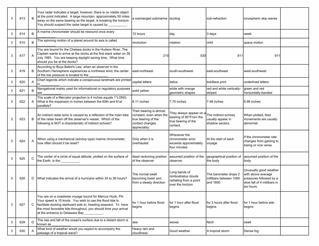
3 613 B
Your radar indicates a target; however, there is no visible object at the point indicated. A large mountain, approximately 50 miles away on the same bearing as the target, is breaking the horizon. You should suspect the radar target is caused by __________.
a submerged submarine ducting sub-refraction ionospheric skip waves
3 614 B A marine chronometer should be rewound once every __________. 12 hours day 3 days week
3 615 B The spinning motion of a planet around its axis is called __________. revolution rotation orbit space motion
3 617 A
You are bound for the Chelsea docks in the Hudson River. The Captain wants to arrive at the docks at the first slack water on 28 July 1983. You are keeping daylight saving time. What time should you be at the docks?
215 530 811 911
3 619 BAccording to Buys Ballot's Law, when an observer in the Southern Hemisphere experiences a northwest wind, the center of the low pressure is located to the __________.
east-northeast south-southwest east-southeast west-southwest
3 620 A Chart legends which indicate a conspicuous landmark are printed in __________. capital letters italics boldface print underlined letters
3 621 B Navigational marks used for informational or regulatory purposes are __________. solid yellow white with orange
geometric shapesred and white vertically-striped
green and red horizontally-banded
3 622 AThe scale of a Mercator projection is 4 inches equals 1°LONG. What is the expansion in inches between the 60th and 61st parallels?
8.11 inches 7.70 inches 7.48 inches 6.98 inches
3 623 BAn indirect radar echo is caused by a reflection of the main lobe of the radar beam off the observer's vessel. Which of the following is NOT a characteristic of indirect echoes?
Their bearing is almost constant, even when the true bearing of the contact changes appreciably.
They always appear on a bearing of 90°From the true bearing of the contact.
The indirect echoes usually appear in shadow sectors.
When plotted, their movements are usually abnormal.
3 624 A When using a mechanical (windup type) marine chronometer, how often should it be reset?
Only when it is overhauled
Whenever the chronometer error exceeds approximately four minutes
At the start of each voyage
If the chronometer rate changes from gaining to losing or vice versa
3 625 C The center of a circle of equal altitude, plotted on the surface of the Earth, is the __________.
dead reckoning position of the observer
assumed position of the observer
geographical position of the body
assumed position of the body
3 626 D What indicates the arrival of a hurricane within 24 to 36 hours?The normal swell becoming lower and from a steady direction
Long bands of nimbostratus clouds radiating from a point over the horizon
The barometer drops 2 millibars between 1000 and 1600
Unusually good weather with above average pressures followed by a slow fall of 4 millibars in six hours
3 627 C
You are on a coastwise voyage bound for Marcus Hook, PA. Your speed is 15 knots. You wish to use the flood tide to facilitate docking starboard side to, heading seaward. To have the most favorable tide throughout, you should time your arrival at the entrance to Delaware Bay __________.
for 1 hour before flood begins
for 1 hour after flood begins
for 3 hours after flood begins
for 1 hour before ebb begins
3 629 D The rise and fall of the ocean's surface due to a distant storm is known as __________. sea waves fetch swell
3 630 A What kind of weather would you expect to accompany the passage of a tropical wave?
Heavy rain and cloudiness Good weather A tropical storm Dense fog
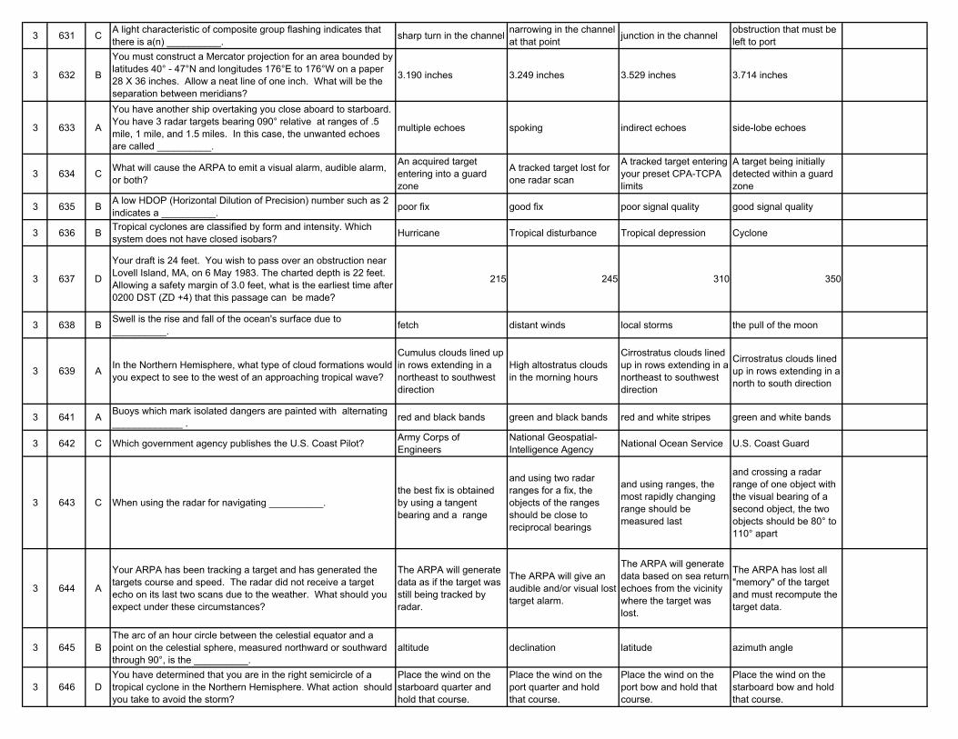
3 631 C A light characteristic of composite group flashing indicates that there is a(n) __________. sharp turn in the channel narrowing in the channel
at that point junction in the channel obstruction that must be left to port
3 632 B
You must construct a Mercator projection for an area bounded by latitudes 40° - 47°N and longitudes 176°E to 176°W on a paper 28 X 36 inches. Allow a neat line of one inch. What will be the separation between meridians?
3.190 inches 3.249 inches 3.529 inches 3.714 inches
3 633 A
You have another ship overtaking you close aboard to starboard. You have 3 radar targets bearing 090° relative at ranges of .5 mile, 1 mile, and 1.5 miles. In this case, the unwanted echoes are called __________.
multiple echoes spoking indirect echoes side-lobe echoes
3 634 C What will cause the ARPA to emit a visual alarm, audible alarm, or both?
An acquired target entering into a guard zone
A tracked target lost for one radar scan
A tracked target entering your preset CPA-TCPA limits
A target being initially detected within a guard zone
3 635 B A low HDOP (Horizontal Dilution of Precision) number such as 2 indicates a __________. poor fix good fix poor signal quality good signal quality
3 636 B Tropical cyclones are classified by form and intensity. Which system does not have closed isobars? Hurricane Tropical disturbance Tropical depression Cyclone
3 637 D
Your draft is 24 feet. You wish to pass over an obstruction near Lovell Island, MA, on 6 May 1983. The charted depth is 22 feet. Allowing a safety margin of 3.0 feet, what is the earliest time after 0200 DST (ZD +4) that this passage can be made?
215 245 310 350
3 638 B Swell is the rise and fall of the ocean's surface due to __________. fetch distant winds local storms the pull of the moon
3 639 A In the Northern Hemisphere, what type of cloud formations would you expect to see to the west of an approaching tropical wave?
Cumulus clouds lined up in rows extending in a northeast to southwest direction
High altostratus clouds in the morning hours
Cirrostratus clouds lined up in rows extending in a northeast to southwest direction
Cirrostratus clouds lined up in rows extending in a north to south direction
3 641 A Buoys which mark isolated dangers are painted with alternating _____________ . red and black bands green and black bands red and white stripes green and white bands
3 642 C Which government agency publishes the U.S. Coast Pilot? Army Corps of Engineers
National Geospatial-Intelligence Agency National Ocean Service U.S. Coast Guard
3 643 C When using the radar for navigating __________.the best fix is obtained by using a tangent bearing and a range
and using two radar ranges for a fix, the objects of the ranges should be close to reciprocal bearings
and using ranges, the most rapidly changing range should be measured last
and crossing a radar range of one object with the visual bearing of a second object, the two objects should be 80° to 110° apart
3 644 A
Your ARPA has been tracking a target and has generated the targets course and speed. The radar did not receive a target echo on its last two scans due to the weather. What should you expect under these circumstances?
The ARPA will generate data as if the target was still being tracked by radar.
The ARPA will give an audible and/or visual lost target alarm.
The ARPA will generate data based on sea return echoes from the vicinity where the target was lost.
The ARPA has lost all "memory" of the target and must recompute the target data.
3 645 BThe arc of an hour circle between the celestial equator and a point on the celestial sphere, measured northward or southward through 90°, is the __________.
altitude declination latitude azimuth angle
3 646 DYou have determined that you are in the right semicircle of a tropical cyclone in the Northern Hemisphere. What action should you take to avoid the storm?
Place the wind on the starboard quarter and hold that course.
Place the wind on the port quarter and hold that course.
Place the wind on the port bow and hold that course.
Place the wind on the starboard bow and hold that course.
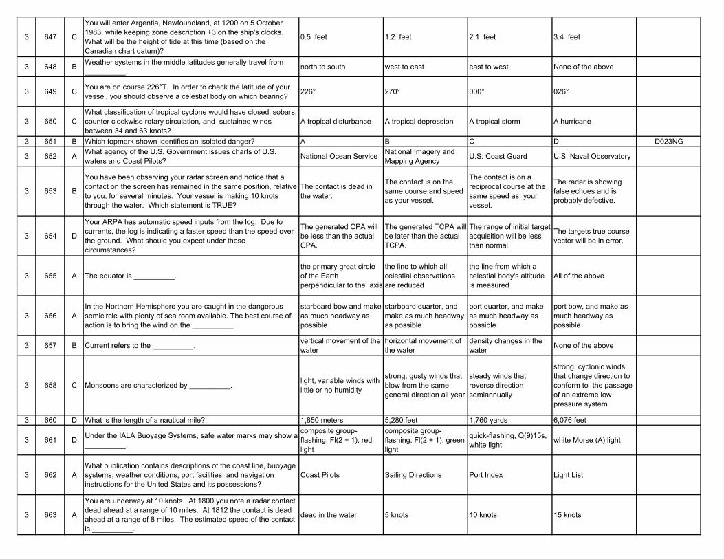
3 647 C
You will enter Argentia, Newfoundland, at 1200 on 5 October 1983, while keeping zone description +3 on the ship's clocks. What will be the height of tide at this time (based on the Canadian chart datum)?
0.5 feet 1.2 feet 2.1 feet 3.4 feet
3 648 B Weather systems in the middle latitudes generally travel from __________. north to south west to east east to west None of the above
3 649 C You are on course 226°T. In order to check the latitude of your vessel, you should observe a celestial body on which bearing? 226° 270° 000° 026°
3 650 CWhat classification of tropical cyclone would have closed isobars, counter clockwise rotary circulation, and sustained winds between 34 and 63 knots?
A tropical disturbance A tropical depression A tropical storm A hurricane
3 651 B Which topmark shown identifies an isolated danger? A B C D D023NG
3 652 A What agency of the U.S. Government issues charts of U.S. waters and Coast Pilots? National Ocean Service National Imagery and
Mapping Agency U.S. Coast Guard U.S. Naval Observatory
3 653 B
You have been observing your radar screen and notice that a contact on the screen has remained in the same position, relative to you, for several minutes. Your vessel is making 10 knots through the water. Which statement is TRUE?
The contact is dead in the water.
The contact is on the same course and speed as your vessel.
The contact is on a reciprocal course at the same speed as your vessel.
The radar is showing false echoes and is probably defective.
3 654 D
Your ARPA has automatic speed inputs from the log. Due to currents, the log is indicating a faster speed than the speed over the ground. What should you expect under these circumstances?
The generated CPA will be less than the actual CPA.
The generated TCPA will be later than the actual TCPA.
The range of initial target acquisition will be less than normal.
The targets true course vector will be in error.
3 655 A The equator is __________.the primary great circle of the Earth perpendicular to the axis
the line to which all celestial observations are reduced
the line from which a celestial body's altitude is measured
All of the above
3 656 AIn the Northern Hemisphere you are caught in the dangerous semicircle with plenty of sea room available. The best course of action is to bring the wind on the __________.
starboard bow and make as much headway as possible
starboard quarter, and make as much headway as possible
port quarter, and make as much headway as possible
port bow, and make as much headway as possible
3 657 B Current refers to the __________. vertical movement of the water
horizontal movement of the water
density changes in the water None of the above
3 658 C Monsoons are characterized by __________. light, variable winds with little or no humidity
strong, gusty winds that blow from the same general direction all year
steady winds that reverse direction semiannually
strong, cyclonic winds that change direction to conform to the passage of an extreme low pressure system
3 660 D What is the length of a nautical mile? 1,850 meters 5,280 feet 1,760 yards 6,076 feet
3 661 D Under the IALA Buoyage Systems, safe water marks may show a __________.
composite group-flashing, Fl(2 + 1), red light
composite group-flashing, Fl(2 + 1), green light
quick-flashing, Q(9)15s, white light white Morse (A) light
3 662 AWhat publication contains descriptions of the coast line, buoyage systems, weather conditions, port facilities, and navigation instructions for the United States and its possessions?
Coast Pilots Sailing Directions Port Index Light List
3 663 A
You are underway at 10 knots. At 1800 you note a radar contact dead ahead at a range of 10 miles. At 1812 the contact is dead ahead at a range of 8 miles. The estimated speed of the contact is __________.
dead in the water 5 knots 10 knots 15 knots
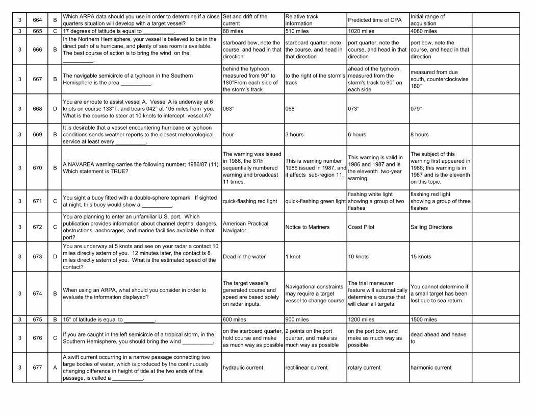
3 664 B Which ARPA data should you use in order to determine if a close quarters situation will develop with a target vessel?
Set and drift of the current
Relative track information Predicted time of CPA Initial range of
acquisition3 665 C 17 degrees of latitude is equal to __________. 68 miles 510 miles 1020 miles 4080 miles
3 666 B
In the Northern Hemisphere, your vessel is believed to be in the direct path of a hurricane, and plenty of sea room is available. The best course of action is to bring the wind on the __________.
starboard bow, note the course, and head in that direction
starboard quarter, note the course, and head in that direction
port quarter, note the course, and head in that direction
port bow, note the course, and head in that direction
3 667 B The navigable semicircle of a typhoon in the Southern Hemisphere is the area __________.
behind the typhoon, measured from 90° to 180°From each side of the storm's track
to the right of the storm's track
ahead of the typhoon, measured from the storm's track to 90° on each side
measured from due south, counterclockwise 180°
3 668 DYou are enroute to assist vessel A. Vessel A is underway at 6 knots on course 133°T, and bears 042° at 105 miles from you. What is the course to steer at 10 knots to intercept vessel A?
063° 068° 073° 079°
3 669 BIt is desirable that a vessel encountering hurricane or typhoon conditions sends weather reports to the closest meteorological service at least every __________.
hour 3 hours 6 hours 8 hours
3 670 B A NAVAREA warning carries the following number; 1986/87 (11). Which statement is TRUE?
The warning was issued in 1986, the 87th sequentially numbered warning and broadcast 11 times.
This is warning number 1986 issued in 1987, and it affects sub-region 11.
This warning is valid in 1986 and 1987 and is the eleventh two-year warning.
The subject of this warning first appeared in 1986; this warning is in 1987 and is the eleventh on this topic.
3 671 C You sight a buoy fitted with a double-sphere topmark. If sighted at night, this buoy would show a __________. quick-flashing red light quick-flashing green light
flashing white light showing a group of two flashes
flashing red light showing a group of three flashes
3 672 C
You are planning to enter an unfamiliar U.S. port. Which publication provides information about channel depths, dangers, obstructions, anchorages, and marine facilities available in that port?
American Practical Navigator Notice to Mariners Coast Pilot Sailing Directions
3 673 D
You are underway at 5 knots and see on your radar a contact 10 miles directly astern of you. 12 minutes later, the contact is 8 miles directly astern of you. What is the estimated speed of the contact?
Dead in the water 1 knot 10 knots 15 knots
3 674 B When using an ARPA, what should you consider in order to evaluate the information displayed?
The target vessel's generated course and speed are based solely on radar inputs.
Navigational constraints may require a target vessel to change course.
The trial maneuver feature will automatically determine a course that will clear all targets.
You cannot determine if a small target has been lost due to sea return.
3 675 B 15° of latitude is equal to __________. 600 miles 900 miles 1200 miles 1500 miles
3 676 C If you are caught in the left semicircle of a tropical storm, in the Southern Hemisphere, you should bring the wind __________.
on the starboard quarter, hold course and make as much way as possible
2 points on the port quarter, and make as much way as possible
on the port bow, and make as much way as possible
dead ahead and heave to
3 677 A
A swift current occurring in a narrow passage connecting two large bodies of water, which is produced by the continuously changing difference in height of tide at the two ends of the passage, is called a __________.
hydraulic current rectilinear current rotary current harmonic current
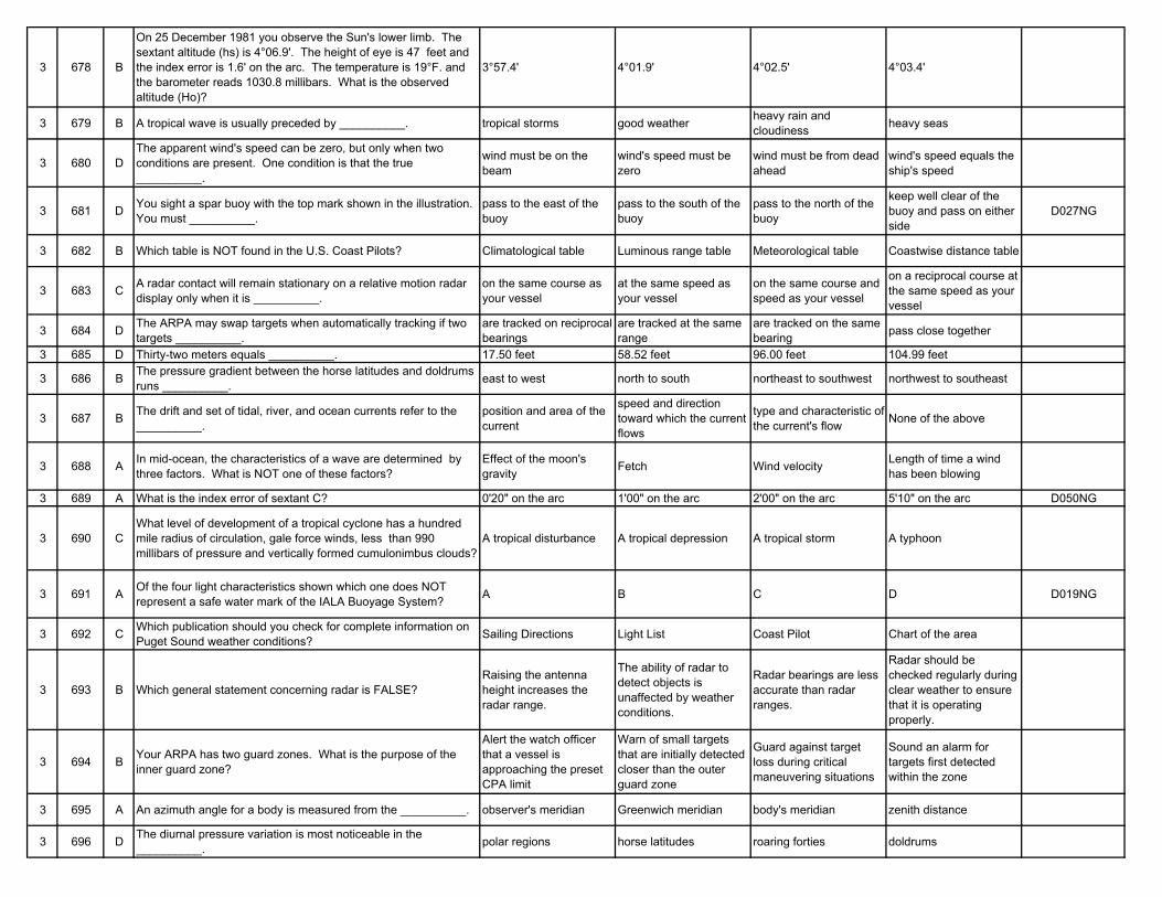
3 678 B
On 25 December 1981 you observe the Sun's lower limb. The sextant altitude (hs) is 4°06.9'. The height of eye is 47 feet and the index error is 1.6' on the arc. The temperature is 19°F. and the barometer reads 1030.8 millibars. What is the observed altitude (Ho)?
3°57.4' 4°01.9' 4°02.5' 4°03.4'
3 679 B A tropical wave is usually preceded by __________. tropical storms good weather heavy rain and cloudiness heavy seas
3 680 DThe apparent wind's speed can be zero, but only when two conditions are present. One condition is that the true __________.
wind must be on the beam
wind's speed must be zero
wind must be from dead ahead
wind's speed equals the ship's speed
3 681 D You sight a spar buoy with the top mark shown in the illustration. You must __________.
pass to the east of the buoy
pass to the south of the buoy
pass to the north of the buoy
keep well clear of the buoy and pass on either side
D027NG
3 682 B Which table is NOT found in the U.S. Coast Pilots? Climatological table Luminous range table Meteorological table Coastwise distance table
3 683 C A radar contact will remain stationary on a relative motion radar display only when it is __________.
on the same course as your vessel
at the same speed as your vessel
on the same course and speed as your vessel
on a reciprocal course at the same speed as your vessel
3 684 D The ARPA may swap targets when automatically tracking if two targets __________.
are tracked on reciprocal bearings
are tracked at the same range
are tracked on the same bearing pass close together
3 685 D Thirty-two meters equals __________. 17.50 feet 58.52 feet 96.00 feet 104.99 feet
3 686 B The pressure gradient between the horse latitudes and doldrums runs __________. east to west north to south northeast to southwest northwest to southeast
3 687 B The drift and set of tidal, river, and ocean currents refer to the __________.
position and area of the current
speed and direction toward which the current flows
type and characteristic of the current's flow None of the above
3 688 A In mid-ocean, the characteristics of a wave are determined by three factors. What is NOT one of these factors?
Effect of the moon's gravity Fetch Wind velocity Length of time a wind
has been blowing
3 689 A What is the index error of sextant C? 0'20" on the arc 1'00" on the arc 2'00" on the arc 5'10" on the arc D050NG
3 690 CWhat level of development of a tropical cyclone has a hundred mile radius of circulation, gale force winds, less than 990 millibars of pressure and vertically formed cumulonimbus clouds?
A tropical disturbance A tropical depression A tropical storm A typhoon
3 691 A Of the four light characteristics shown which one does NOT represent a safe water mark of the IALA Buoyage System? A B C D D019NG
3 692 C Which publication should you check for complete information on Puget Sound weather conditions? Sailing Directions Light List Coast Pilot Chart of the area
3 693 B Which general statement concerning radar is FALSE?Raising the antenna height increases the radar range.
The ability of radar to detect objects is unaffected by weather conditions.
Radar bearings are less accurate than radar ranges.
Radar should be checked regularly during clear weather to ensure that it is operating properly.
3 694 B Your ARPA has two guard zones. What is the purpose of the inner guard zone?
Alert the watch officer that a vessel is approaching the preset CPA limit
Warn of small targets that are initially detected closer than the outer guard zone
Guard against target loss during critical maneuvering situations
Sound an alarm for targets first detected within the zone
3 695 A An azimuth angle for a body is measured from the __________. observer's meridian Greenwich meridian body's meridian zenith distance
3 696 D The diurnal pressure variation is most noticeable in the __________. polar regions horse latitudes roaring forties doldrums
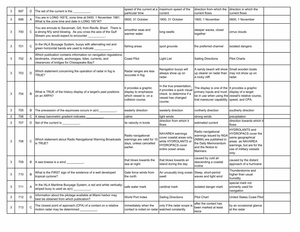
3 697 D The set of the current is the __________. speed of the current at a particular time
maximum speed of the current
direction from which the current flows
direction in which the current flows
3 698 A You are in LONG 165°E, zone time at 0400, 1 November 1981. What is the zone time and date in LONG 165°W? 0600, 31 October 1800, 31 October 1800, 1 November 0600, 1 November
3 700 CYou are enroute to Savannah, GA, from Recife, Brazil. There is a strong N'ly wind blowing. As you cross the axis of the Gulf Stream you would expect to encounter __________.
smoother seas and warmer water long swells steeper waves, closer
together cirrus clouds
3 701 C In the IALA Buoyage System, buoys with alternating red and green horizontal bands are used to indicate __________. fishing areas spoil grounds the preferred channel isolated dangers
3 702 AWhich publication contains information on navigation regulations, landmarks, channels, anchorages, tides, currents, and clearances of bridges for Chesapeake Bay?
Coast Pilot Light List Sailing Directions Pilot Charts
3 703 D Which statement concerning the operation of radar in fog is TRUE?
Radar ranges are less accurate in fog.
Navigation buoys will always show up on radar.
A sandy beach will show up clearer on radar than a rocky cliff.
Small wooden boats may not show up on radar.
3 704 B What is TRUE of the history display of a target's past positions on an ARPA?
It provides a graphic display to emphasize which vessel is on a collision course.
In the true presentation, it provides a quick visual check to determine if a vessel has changed course.
The display is one of the primary inputs and must be in use when using the trial maneuver capability.
It provides a graphic display of a target vessel's relative course, speed, and CPA.
3 705 B The precession of the equinoxes occurs in a(n) __________. easterly direction westerly direction northerly direction southerly direction
3 706 C A steep barometric gradient indicates __________. calms light winds strong winds precipitation
3 707 D Set of the current is __________. its velocity in knots direction from which it flows estimated current direction towards which it
flows
3 708 C Which statement about Radio Navigational Warning Broadcasts is TRUE?
Radio navigational warnings are valid for 10 days, unless cancelled earlier.
NAVAREA warnings cover coastal areas only, while HYDROLANTS or HYDROPACS cover entire ocean areas.
Radio navigational warnings issued by NGA (NIMA) are published in the Daily Memorandum and the Notice to Mariners.
HYDROLANTS and HYDROPACS cover the same geographical areas as NAVAREA warnings, but are for the use of military vessels only.
3 709 B A sea breeze is a wind __________. that blows towards the sea at night
that blows towards an island during the day
caused by cold air descending a coastal incline
caused by the distant approach of a hurricane
3 710 B What is the FIRST sign of the existence of a well developed tropical cyclone?
Gale force winds from the north
An unusually long ocean swell
Steep, short-period waves and light wind
Thunderstorms and higher than usual humidity
3 711 A In the IALA Maritime Buoyage System, a red and white vertically-striped buoy is used as a(n) __________. safe water mark cardinal mark isolated danger mark
special mark not primarily used for navigation
3 712 D Information about the pilotage available at Miami harbor may best be obtained from which publication? World Port Index Sailing Directions Pilot Chart United States Coast Pilot
3 713 C The closest point of approach (CPA) of a contact on a relative motion radar may be determined __________.
immediately when the contact is noted on radar
only if the radar scope is watched constantly
after the contact has been marked at least twice
by an occasional glance at the radar
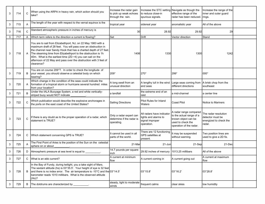
3 714 C When using the ARPA in heavy rain, which action should you take?
Increase the radar gain to pick up weak echoes through the rain.
Increase the STC setting to reduce close-in spurious signals.
Navigate as though the effective range of the radar has been reduced.
Increase the range of the inner and outer guard rings.
3 715 A The length of the year with respect to the vernal equinox is the __________. tropical year sidereal year anomalistic year All of the above
3 716 C Standard atmospheric pressure in inches of mercury is __________. 30 28.92 29.92 29
3 717 A Which term refers to the direction a current is flowing? Set Drift Vector direction Stand
3 718 A
You are to sail from Elizabethport, NJ, on 22 May 1983 with a maximum draft of 28 feet. You will pass over an obstruction in the channel near Sandy Hook that has a charted depth of 27 feet. The steaming time from Elizabethport to the obstruction is 1h 40m. What is the earliest time (ZD +4) you can sail on the afternoon of 22 May and pass over the obstruction with 3 feet of clearance?
1406 1330 1300 1242
3 719 BYou are on course 209°T. In order to check the longitude of your vessel, you should observe a celestial body on which bearing?
209° 270° 299° 000°
3 720 AWhich change in the condition of the seas could indicate the formation of a tropical storm or hurricane several hundred miles from your location?
A long swell from an unusual direction
A lengthy lull in the wind and seas
Large seas coming from different directions
A brisk chop from the southeast
3 721 B Under the IALA Buoyage System, a red and white vertically-striped buoy would NOT indicate __________. a landfall the extreme end of an
islet a mid-channel a center line
3 722 C Which publication would describe the explosive anchorages in the ports on the east coast of the United States? Sailing Directions Pilot Rules for Inland
Waters Coast Pilot Notice to Mariners
3 723 C If there is any doubt as to the proper operation of a radar, which statement is TRUE?
Only a radar expert can determine if the radar is operating.
All radars have indicator lights and alarms to signal improper operation.
A radar range compared to the actual range of a known object can be used to check the operation of the radar.
The radar resolution detector must be energized to check the radar.
3 724 C Which statement concerning GPS is TRUE? It cannot be used in all parts of the world.
There are 12 functioning GPS satellites at present.
It may be suspended without warning.
Two position lines are used to give a 2D fix.
3 725 A The First Point of Aries is the position of the Sun on the celestial sphere on or about __________. 21-Mar 21-Jun 21-Sep 21-Dec
3 726 D Atmospheric pressure at sea level is equal to __________. 14.7 pounds per square inch 29.92 inches of mercury 1013.25 millibars All of the above
3 727 C What is an ebb current? A current at minimum flow A current coming in A current going out A current at maximum
flow
3 728 B
In the Bay of Fundy, during twilight, you a take sight of Mars. The sextant altitude (hs) is 03°35.5'. Your height of eye is 32 feet and there is no index error. The air temperature is -10°C and the barometer reads 1010 millibars. What is the observed altitude (Ho)?
03°14.5' 03°15.8' 03°16.2' 03°28.8'
3 729 B The doldrums are characterized by __________. steady, light to moderate winds frequent calms clear skies low humidity
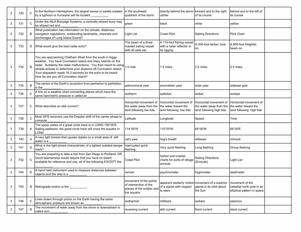
3 730 C In the Northern Hemisphere, the largest waves or swells created by a typhoon or hurricane will be located __________.
in the southeast quadrant of the storm
directly behind the storm center
forward and to the right of its course
behind and to the left of its course
3 731 C Under the IALA Buoyage Systems, a vertically-striped buoy may be striped red and __________. green black white yellow
3 732 BWhat publication has information on the climate, distances, navigation regulations, outstanding landmarks, channels and anchorages of Long Island Sound?
Light List Coast Pilot Sailing Directions Pilot Chart
3 733 D What would give the best radar echo?The beam of a three masted sailing vessel with all sails set.
A 110-foot fishing vessel with a radar reflector in its rigging.
A 300-foot tanker, bow on.
A 600-foot freighter, beam on.
3 734 B
You are approaching Chatham Strait from the south in foggy weather. You have Coronation Island and Hazy Islands on the radar. Suddenly the radar malfunctions. You then resort to using whistle echoes to determine your distance off Coronation Island. Your stopwatch reads 16.3 seconds for the echo to be heard. How far are you off Coronation Island?
1.0 mile 1.5 miles 2.0 miles 2.5 miles
3 735 B The period of the Earth's revolution from perihelion to perihelion is the __________. astronomical year anomalistic year solar year sidereal year
3 736 C A line on a weather chart connecting places which have the same barometric pressure is called an __________. isotherm isallobar isobar isotope
3 737 C What describes an ebb current?Horizontal movement of the water away from the land following low tide
Horizontal movement of the water toward the land following low tide
Horizontal movement of the water away from the land following high tide
Horizontal movement of the water toward the land following high tide
3 738 C Most GPS receivers use the Doppler shift of the carrier phase to compute __________. Latitude Longitude Speed Time
3 739 AThe upper vertex of a great circle track is in LONG 156°00'E. Sailing eastward, the great circle track will cross the equator in LONG __________.
114°00'W 110°00'W 66°00'W 66°00'E
3 740 A A very light breeze that causes ripples on a small area of still water is a __________. cat's paw hog's breath williwaw chinook
3 741 D What is the light phase characteristic of a lighted isolated-danger mark?
Interrupted quick flashing Very quick flashing Long flashing Group flashing
3 742 C
You are preparing to take a tow from San Diego to Portland, OR. Good seamanship would require that you have on board, available for reference and use, all of the following EXCEPT the __________.
Coast Pilotharbor and coastal charts for ports of refuge enroute
Sailing Directions (Enroute) Light List
3 744 D A hand held instrument used to measure distances between objects and the ship is a __________. vernier psychrometer hygrometer stadimeter
3 745 B Retrograde motion is the __________.
movement of the points of intersection of the planes of the ecliptic and the equator
apparent westerly motion of a planet with respect to stars
movement of a superior planet in its orbit about the Sun
movement of the celestial north pole in an elliptical pattern in space
3 746 C Lines drawn through points on the Earth having the same atmospheric pressure are known as __________. isothermal millibars isobars seismics
3 747 B The movement of water away from the shore or downstream is called a(n) __________. reversing current ebb current flood current slack current
3 748 BYou are steaming west in the South Atlantic in an extratropical cyclonic storm, and the wind is dead ahead. According to the law of Buys Ballot, the center of low pressure lies __________.
to the north of you to the south of you dead ahead of you dead astern of you
3 749 BYou are enroute to assist vessel A. Vessel A is underway at 4.5 knots on course 233°T, and bears 264°T at 68 miles from you. What is the course to steer at 13 knots to intercept vessel A?
249° 256° 262° 268°
3 750 B On a working copy of a weather map, a cold front is represented by what color line? Red Blue Alternating red and blue Purple
3 751 D Under the IALA Buoyage Systems, a yellow buoy may mark __________. fish net areas spoil areas military exercise zones All of the above
3 752 D Which publication would NOT be used on a voyage from Houston to New York? Coast Pilot Light List Radio Navigational Aids Sailing Directions
(Enroute)
3 754 D Deviation in a compass is caused by the __________. vessel's geographic position vessel's heading earth's magnetic field influence of the magnetic
materials of the vessel
3 755 D The sidereal day begins when the __________.Sun is over the lower branch of the reference meridian
Sun is over the upper branch of the reference meridian
first point of Aries is over the lower branch of the reference meridian
first point of Aries is over the upper branch of the reference meridian
3 756 B What is a common unit of measure for atmospheric pressure? centimeters Inches Degrees Feet
3 757 A The term "flood current" refers to that time when the water __________.
is flowing towards the land
is moving towards the ocean level is not changing level is rising because of
heavy rains
3 759 BAt 0000 you fix your position and plot a new DR track line. At 0200 you again fix your position and it is 0.5 mile west of your DR. Which statement is TRUE?
The set is 090°, drift 0.5 knot.
The set is 270°, drift 0.25 knot.
The set is 270°, drift 0.5 knot.
The set is 270°, drift 1.0 knot.
3 760 C As a vessel changes course to starboard, the compass card in a magnetic compass __________.
first turns to starboard then counterclockwise to port
also turns to starboard remains aligned with compass north
turns counterclockwise to port
3 761 D Under the IALA Buoyage Systems, a safe water mark may NOT __________. be spherical display a white light be lettered show a quick flashing
light
3 762 D Chart correction information is NOT disseminated through the __________. Summary of Corrections Local Notice to Mariners Daily Memorandum Chart Correction Card
3 763 D Time signals broadcast by WWV and WWVH are transmitted __________. every 15 minutes every 30 minutes every hour continuously throughout
day3 764 D Magnetic variation changes with a change in __________. the vessel's heading sea conditions seasons the vessel's position
3 765 B Diurnal aberration is due to __________. motion of the Earth in its orbit
rotation of the Earth on its axis
the body's orbital motion during the time required for its light to reach the Earth
a false horizon
3 766 D Which position includes the effects of wind and current? Dead reckoning position Leeway position Set position Estimated position
3 767 B What describes a flood current?Horizontal movement of the water toward the land after high tide
Horizontal movement of the water toward the land after low tide
Horizontal movement of the water away from the land following high tide
Horizontal movement of the water away from the land following low tide
3 768 A The wind velocity is higher in the dangerous semicircle of a tropical cyclone because of the __________.
wind circulation and forward motion of the storm
extension of the low pressure ridge recurvature effect direction of circulation
and pressure gradient
3 769 B What does not contribute to the commercial GPS receiver position error? Satellite clock Ship's speed Atmospheric/Ionospheric
propagation Satellites' orbits
3 770 AYou are plotting a running fix in an area where there is a determinable current. How should this current be treated in determining the position?
The course and speed made good should be determined and used to advance the LOP.
The drift should be added to the ship's speed.
The current should be ignored.
The set should be applied to the second bearing.
3 771 A Under the IALA Buoyage Systems, a spherical buoy will mark the __________. safe water port side of the channel a hazard to navigation the position of an
underwater cable
3 772 DYou are hove to in a hurricane on a heading of 328°T. The wind is from 030° true at 119 knots. How should this be encoded on the weather report form under Nddff.
80312 83011 83099 80399 D041NG
3 773 A What is the basic principle of the magnetic compass?
Magnetic materials of the same polarity repel each other and those of opposite polarity attract.
The Earth's magnetic lines of force are parallel to the surface of the Earth.
Magnetic meridians connect points of equal magnetic variation.
The compass needle(s) will, when properly compensated, lie parallel to the isogonic lines of the Earth.
3 774 C Variation is not constant; it is different with every change in __________. speed vessel heading geographical location cargo
3 775 D A sidereal day is shorter than a solar day. This difference is due to __________.
irregularities in the daily rotational rate of the Sun
the space motion of the solar system
the precession of the equinoxes
the use of different reference points
3 776 C You are navigating in pilotage waters using running fixes. The maximum time between fixes should be about __________. 4 hours 1 hour 30 minutes 5 minutes
3 777 A With respect to a reversing current, slack water occurs when there is __________.
little or no horizontal motion of the water
little or no vertical motion of the water
a weak ebb or flood current
when winds cause water to back up in a river mouth
3 778 D The navigable semicircle of a hurricane in the Northern Hemisphere is that area of the storm measured __________.
from true north clockwise to 180°T
from true north counterclockwise to 180°T
from the bow counterclockwise to 180° relative
from the direction of the storm's movement counterclockwise 180°
3 779 C Which sextant shown has an index error of 0'20" on the arc? A B C D D050NG
3 780 C Apparent wind speed blowing across your vessel while underway can be measured by a(n) __________. barometer wind vane anemometer thermometer
3 781 C The IALA Buoyage Systems do NOT apply to __________. the sides and centerlines of navigable channels
natural dangers and other obstructions, such as wrecks
lighthouses and lightships
areas in which navigation may be subject to regulation
3 782 A Mariners are FIRST warned of serious defects or important changes to aids to navigation by means of __________.
marine broadcast Notice to Mariners
Weekly Notices to Mariners
corrected editions of charts Light Lists
3 783 B Magnetism which is present only when the material is under the influence of an external field is called __________. permanent magnetism induced magnetism residual magnetism terrestrial magnetism
3 784 C Variation is the angular measurement between __________. compass north and magnetic north
compass north and true north
magnetic meridian and the geographic meridian
your vessel's heading and the magnetic meridian
3 785 D An amplitude of the Sun in high latitudes __________. is most accurate before sunrise
is most accurate after sunset
should only be observed when the Sun's lower limb is above the horizon
is most accurate when the Sun's center is observed on the visible horizon
3 786 C The greater the pressure difference between a high and a low pressure center, the __________. dryer the air mass will be cooler the temperature
will begreater the force of the wind will be
warmer the temperature will be
3 787 AYou are on a voyage from New Orleans to Boston. When navigating off the Florida coast, you will get the greatest benefit from the Gulf Stream if you navigate __________.
about 45 miles east of Cape Canaveral
about 25 miles east of Daytona Beach
along the 50-fathom curve
close inshore between Fowey Rocks and Jupiter Inlet
3 789 A The dangerous semicircle of a hurricane in the Northern Hemisphere is that area of the storm __________.
to the right of the storm's track
measured from true north clockwise to 180°T
measured from true north counterclockwise to 180°T
between the ship's heading and the bearing to the eye
3 791 C Under the IALA Buoyage Systems, the topmark of a red and white vertically-striped buoy shall be __________. X-shaped two black spheres a single red sphere a single red cone
3 792 CInformation about temporary, short term changes affecting the safety of navigation in U.S. waters is distributed to navigational interests by the __________.
Daily Memorandum HYDROLANT or HYDROPAC broadcasts Local Notice to Mariners Summary of Corrections
3 793 D The permanent magnetism of a vessel may change in strength due to __________.
a collision with another vessel
being moored on a constant heading for a long period of time
being struck by lightning All of the above
3 795 B The path of a celestial body during its daily apparent revolution around the Earth is called its __________. ecliptic diurnal circle altitude circle circle of position
3 796 B Cyclones tend to move __________.perpendicular to the isobars in their warm sectors
parallel to the isobars in their warm sectors
parallel to the line of the cold front
perpendicular to the line of the cold front
3 797 D Which statement is TRUE concerning the current of the Gulf Stream?
It reaches its daily maximum speed a few hours before the transit of the Moon.
It is slower at the time of neap tides than at spring tides.
When the Moon is at its maximum declination the stream is narrower than when the Moon is on the equator.
Variations in the trade winds affect the current.
3 798 A A HYDROLANT warning would normally be sent for all of the following EXCEPT __________.
extinguishment of Robbins Reef Light in New York City's Upper Bay
unexploded ordinance in ocean waters at a depth of 78 fathoms (143 meters)
the presence of a large unwieldy tow in congested offshore water
a report of an overdue ship
3 799 CIn Region A of the IALA Buoyage System, when entering from seaward, the starboard side of a channel would be marked by a __________.
green can buoy red can buoy green conical buoy red conical buoy
3 800 A
You are to sail from Elizabethport, NJ, on 17 November 1983 with a maximum draft of 27 feet. You will pass over an obstruction in the channel near Sandy Hook that has a charted depth of 26 feet. The steaming time from Elizabethport to the obstruction is 1h 50m. What is the earliest time (ZD +5) you can sail on 17 November and pass over the obstruction with 2 feet of clearance?
100 124 154 218
3 801 A You are entering an African port and see ahead of you a red can-shaped buoy. What action should you take?
Alter course to leave the buoy to port
Alter course to leave the buoy to starboard
Pass the buoy close aboard on either side
Pass the buoy well clear on either side
3 802 B Which is a weekly publication advising mariners of important matters affecting navigational safety? Light List Notice to Mariners Coast Pilot Sailing Directions
3 803 C Which buoy will NOT display white retroreflective material? Safe water mark Isolated danger mark Preferred channel mark Daymark of no lateral significance
3 804 D A relative bearing is always measured from __________. true north magnetic north the vessel's beam the vessel's head
3 805 A If the right ascension of a body is 9 hours, it also __________. is 135° corresponds to an SHA for the body of 45°
means that the GP of the body is in the western hemisphere
All of the above
3 806 B Temperature and moisture characteristics are modified in a warm or cold air mass due to __________.
pressure changes in the air mass
movement of the air mass
the heterogeneous nature of the air mass
upper level atmospheric changes
3 807 C The approximate mean position of the axis of the Gulf Stream east of Palm Beach, FL, is __________. 35 nautical miles 25 nautical miles 15 nautical miles 5 nautical miles
3 808 C On a working copy of a weather map, a stationary front is represented by which color line? Red Blue Alternating red and blue Purple
3 809 B The compass rose on a nautical chart indicates both variation and __________. deviation annual rate of variation
change precession compass error
3 810 C The position labeled B is a(n) __________. fix running fix estimated position dead reckoning position DO51NG
3 811 A Under the IALA-A Buoyage System, a green spar buoy with a triangular topmark would indicate that the buoy __________.
should be left to port when heading out to sea
may be left close aboard on either side
is on the north side of a point of interest
is marking the preferred channel
3 812 D You are informed of defects or changes in aids to navigation by __________. Local Notice to Mariners Weekly Notice to
Mariners marine broadcasts All of the above
3 813 C At the magnetic equator there is no induced magnetism in the vertical soft iron because __________.
the lines of force cross the equator on a 0°-180° alignment
the quadrantal error is 0°there is no vertical component of the Earth's magnetic field
the intercardinal headings have less than 1° error
3 814 A Steam smoke will occur when __________.extremely cold air from shore passes over warmer water
warm dry air from shore passes over cooler water
cold ocean water evaporates into warm air
cool rain passes through a warm air mass
3 815 A When entering from seaward, a buoy displaying a composite group (2+1) flashing red light indicates __________.
a junction with the preferred channel to the left
a sharp turn in the preferred channel to the right
the starboard side of the secondary channel
a wreck to be left on the vessel's port side
3 816 B Cyclones that have warm sectors usually move __________. westerly parallel to the isobars in the warm sector
toward the nearest high pressure area
faster than the accompanying cold front
3 817 D Which current would you encounter on a direct passage from London, England, to Cape Town, South Africa? Falkland Current Brazil Current Norway Current Benguela Current
3 818 D Ocean swells originating from a typhoon can move ahead of it at speeds near __________. 10 knots 20 knots 30 knots 50 knots
3 819 A Which sextant has an index error of 4'20" off the arc? A B C D D050NG
3 820 BA position obtained by crossing lines of position taken at different times and advanced to a common time is a(n) __________.
dead-reckoning position running fix estimated position fix
3 821 C In addition to monitoring channel 16, all Corps of Engineer locks may use as working channels __________. 06, 12 and 22A 01A, 05A and 07A 12, 13 and 14 14, 24 and 28
3 822 C Charts should be corrected by using information published in the __________. Light List American Practical
Navigator Notice to Mariners Coast Pilot
3 823 D The greatest directive force is exerted on the magnetic compass when the __________.
needles are nearly in line with the meridian
vessel is near the magnetic poles variation is near zero vessel is near the
magnetic equator
3 824 B An "atoll cloud" forming over an island due to heating of the land during the daytime would be which type? Cirrus Cumulus Stratus Nimbus
3 825 C While steering a course of 150°T, you wish to observe the Sun for a speed check. What would the azimuth have to be? 000°T 090°T 150°T 240°T
3 826 A In the U.S., in which direction do air masses usually move? Easterly Southerly Northerly Southwesterly
3 827 C The Benguela Current flows in a __________. SW'ly direction along the NW coast of Africa
S'ly direction off the East Coast of Australia
NW'ly direction along the SW coast of Africa
SW'ly direction along the SE coast of Greenland
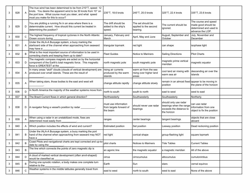
3 828 A
The true wind has been determined to be from 210°T, speed 12 knots. You desire the apparent wind to be 30 knots from 10° on the port bow. What course must you steer, and what speed must you make for this to occur?
235°T, 18.6 knots 245°T, 20.0 knots 325°T, 22.4 knots 335°T, 23.6 knots
3 829 DYou are plotting a running fix in an area where there is a determinable current. How should this current be treated in determining the position?
The drift should be added to the ship's speed.
The set should be applied to the second bearing.
The current should be ignored.
The course and speed made good should be determined and used to advance the LOP.
3 830 C The highest frequency of tropical cyclones in the North Atlantic Ocean occurs during __________.
January, February and March April, May and June August, September and
OctoberJuly, November and December
3 831 AUnder the IALA-A Buoyage system, a buoy marking the starboard side of the channel when approaching from seaward may have a __________.
triangular topmark red light can shape isophase light
3 832 B What is the most important source of information to be used in correcting charts and keeping them up to date? Fleet Guides Notice to Mariners Sailing Directions Pilot Charts
3 833 DThe magnetic compass magnets are acted on by the horizontal component of the Earth's total magnetic force. This magnetic force is GREATEST at the __________.
north magnetic pole south magnetic pole magnetic prime vertical meridian magnetic equator
3 834 AIn many areas "atoll" clouds (clouds of vertical development) are produced over small islands. These are the result of __________.
rising air currents produced by the warm islands
warm air from the sea rising over higher land areas
cool land air mixing with warm sea air
descending air over the islands
3 835 A When taking stars, those bodies to the east and west will __________. change altitude rapidly change altitude slowly remain in an almost fixed
positionappear to be moving in the plane of the horizon
3 836 D In North America the majority of the weather systems move from __________. north to south south to north east to west west to east
3 837 B The Brazil Current flows in which general direction? Northwesterly Southwesterly Southeasterly Northerly
3 838 D A navigator fixing a vessel's position by radar __________.must use information from targets forward of the beam
should never use radar bearings
should only use radar bearings when the range exceeds the distance to the horizon
can use radar information from one object to fix the position
3 839 A When using a radar in an unstabilized mode, fixes are determined most easily from __________. ranges center bearings tangent bearings objects that are close
aboard
3 840 A Which position includes the effects of wind and current? Estimated position Set position Leeway position Dead reckoning position
3 841 BUnder the IALA-A Buoyage system, a buoy marking the port hand of the channel when approaching from seaward may NOT have a __________.
red light conical shape group-flashing light square topmark
3 842 B Coast Pilots and navigational charts are kept corrected and up-to-date by using the __________. pilot charts Notices to Mariners Tide Tables Current Tables
3 843 B The line which connects the points of zero magnetic dip is __________. an agonic line the magnetic equator a magnetic meridian All of the above
3 844 D A cloud of marked vertical development (often anvil-shaped) would be classified as __________. cirrus cirrocumulus altocumulus cumulonimbus
3 845 B During one synodic rotation, a body makes one complete turn relative to the __________. Earth Sun stars vernal equinox
3 846 C Weather systems in the middle latitudes generally travel from __________. east to west north to south west to east None of the above
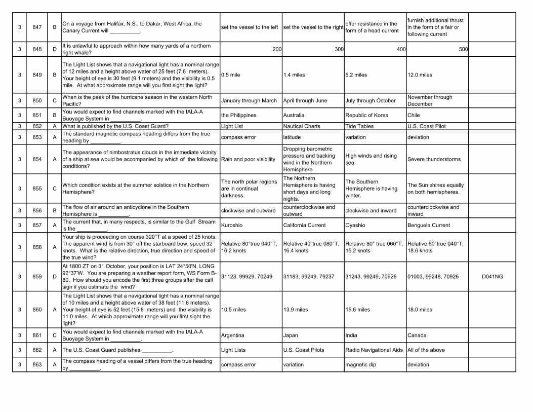
3 847 B On a voyage from Halifax, N.S., to Dakar, West Africa, the Canary Current will __________. set the vessel to the left set the vessel to the right offer resistance in the
form of a head current
furnish additional thrust in the form of a fair or following current
3 848 D It is unlawful to approach within how many yards of a northern right whale? 200 300 400 500
3 849 B
The Light List shows that a navigational light has a nominal range of 12 miles and a height above water of 25 feet (7.6 meters). Your height of eye is 30 feet (9.1 meters) and the visibility is 0.5 mile. At what approximate range will you first sight the light?
0.5 mile 1.4 miles 5.2 miles 12.0 miles
3 850 C When is the peak of the hurricane season in the western North Pacific? January through March April through June July through October November through
December
3 851 B You would expect to find channels marked with the IALA-A Buoyage System in __________. the Philippines Australia Republic of Korea Chile
3 852 A What is published by the U.S. Coast Guard? Light List Nautical Charts Tide Tables U.S. Coast Pilot
3 853 A The standard magnetic compass heading differs from the true heading by __________. compass error latitude variation deviation
3 854 AThe appearance of nimbostratus clouds in the immediate vicinity of a ship at sea would be accompanied by which of the following conditions?
Rain and poor visibility
Dropping barometric pressure and backing wind in the Northern Hemisphere
High winds and rising sea Severe thunderstorms
3 855 C Which condition exists at the summer solstice in the Northern Hemisphere?
The north polar regions are in continual darkness.
The Northern Hemisphere is having short days and long nights.
The Southern Hemisphere is having winter.
The Sun shines equally on both hemispheres.
3 856 B The flow of air around an anticyclone in the Southern Hemisphere is __________. clockwise and outward counterclockwise and
outward clockwise and inward counterclockwise and inward
3 857 A The current that, in many respects, is similar to the Gulf Stream is the __________. Kuroshio California Current Oyashio Benguela Current
3 858 A
Your ship is proceeding on course 320°T at a speed of 25 knots. The apparent wind is from 30° off the starboard bow, speed 32 knots. What is the relative direction, true direction and speed of the true wind?
Relative 80°true 040°T, 16.2 knots
Relative 40°true 080°T, 16.4 knots
Relative 80° true 060°T, 15.2 knots
Relative 60°true 040°T, 18.6 knots
3 859 D
At 1800 ZT on 31 October, your position is LAT 24°50'N, LONG 92°37'W. You are preparing a weather report form, WS Form B-80. How should you encode the first three groups after the call sign if you estimate the wind?
31123, 99929, 70249 31183, 99249, 79237 31243, 99249, 70926 01003, 99248, 70926 D041NG
3 860 A
The Light List shows that a navigational light has a nominal range of 10 miles and a height above water of 38 feet (11.6 meters). Your height of eye is 52 feet (15.8 ,meters) and the visibility is 11.0 miles. At which approximate range will you first sight the light?
10.5 miles 13.9 miles 15.6 miles 18.0 miles
3 861 C You would expect to find channels marked with the IALA-A Buoyage System in __________. Argentina Japan India Canada
3 862 A The U.S. Coast Guard publishes __________. Light Lists U.S. Coast Pilots Radio Navigational Aids All of the above
3 863 A The compass heading of a vessel differs from the true heading by __________. compass error variation magnetic dip deviation
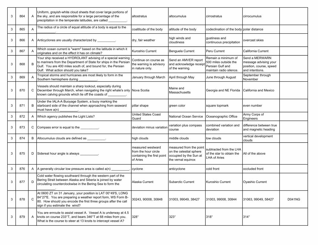
3 864 AUniform, grayish-white cloud sheets that cover large portions of the sky, and are responsible for a large percentage of the precipitation in the temperate latitudes, are called __________.
altostratus altocumulus cirrostratus cirrocumulus
3 865 A The radius of a circle of equal altitude of a body is equal to the __________. coaltitude of the body altitude of the body codeclination of the body polar distance
3 866 A Anticyclones are usually characterized by __________. dry, fair weather high winds and cloudiness
gustiness and continuous precipitation overcast skies
3 867 A Which ocean current is "warm" based on the latitude in which it originates and on the effect it has on climate? Kuroshio Current Benguela Current Peru Current California Current
3 868 B
Your ship received a HYDROLANT advising of a special warning to mariners from the Department of State for ships in the Persian Gulf. You are 400 miles south of, and bound for, the Persian Gulf. What action should you take?
Continue on course as the warning is advisory in nature only.
Send an AMVER report and acknowledge receipt of the warning.
Remain a minimum of 500 miles outside the Persian Gulf and maintain radio silence.
Send a MERWARN message advising your position, course, speed and intentions.
3 869 A Tropical storms and hurricanes are most likely to form in the Southern hemisphere during __________. January through March April through May June through August September through
November
3 870 CVessels should maintain a sharp lookout, especially during December through March, when navigating the right whale's only known calving grounds which lie off the coasts of __________.
Nova Scotia Maine and Massachusetts Georgia and NE Florida California and Mexico
3 871 BUnder the IALA-A Buoyage System, a buoy marking the starboard side of the channel when approaching from seaward must have a(n) __________.
pillar shape green color square topmark even number
3 872 A Which agency publishes the Light Lists? United States Coast Guard National Ocean Service Oceanographic Office Army Corps of
Engineers
3 873 C Compass error is equal to the __________. deviation minus variation variation plus compass course
combined variation and deviation
difference between true and magnetic heading
3 874 B Altocumulus clouds are defined as __________. high clouds middle clouds low clouds vertical development clouds
3 875 D Sidereal hour angle is always __________.
measured westward from the hour circle containing the first point of Aries
measured from the point on the celestial sphere occupied by the Sun at the vernal equinox
subtracted from the LHA of the star to obtain the LHA of Aries
All of the above
3 876 A A generally circular low pressure area is called a(n) __________. cyclone anticyclone cold front occluded front
3 877 D
Cold water flowing southward through the western part of the Bering Strait between Alaska and Siberia is joined by water circulating counterclockwise in the Bering Sea to form the __________.
Alaska Current Subarctic Current Kuroshio Current Oyashio Current
3 878 C
At 0600 ZT on 31 January, your position is LAT 00°49'S, LONG 84°27'E. You are preparing a weather report form, WS Form B-80. How should you encode the first three groups after the call sign if you estimate the wind?
30243, 90008, 30848 31003, 99049, 38427 31003, 99008, 30844 31063, 99049, 58427 D041NG
3 879 AYou are enroute to assist vessel A. Vessel A is underway at 4.5 knots on course 233°T, and bears 346°T at 68 miles from you. What is the course to steer at 13 knots to intercept vessel A?
328° 323° 318° 314°
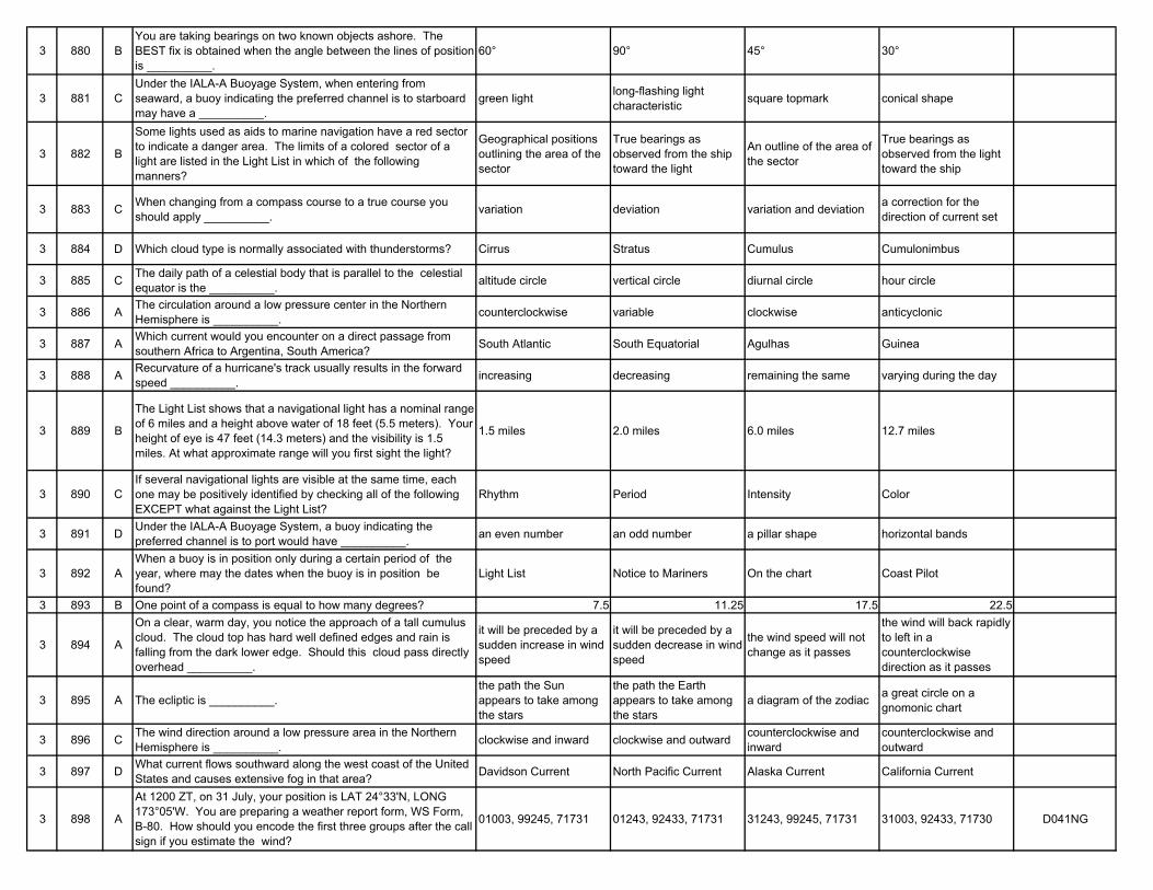
3 880 BYou are taking bearings on two known objects ashore. The BEST fix is obtained when the angle between the lines of position is __________.
60° 90° 45° 30°
3 881 CUnder the IALA-A Buoyage System, when entering from seaward, a buoy indicating the preferred channel is to starboard may have a __________.
green light long-flashing light characteristic square topmark conical shape
3 882 B
Some lights used as aids to marine navigation have a red sector to indicate a danger area. The limits of a colored sector of a light are listed in the Light List in which of the following manners?
Geographical positions outlining the area of the sector
True bearings as observed from the ship toward the light
An outline of the area of the sector
True bearings as observed from the light toward the ship
3 883 C When changing from a compass course to a true course you should apply __________. variation deviation variation and deviation a correction for the
direction of current set
3 884 D Which cloud type is normally associated with thunderstorms? Cirrus Stratus Cumulus Cumulonimbus
3 885 C The daily path of a celestial body that is parallel to the celestial equator is the __________. altitude circle vertical circle diurnal circle hour circle
3 886 A The circulation around a low pressure center in the Northern Hemisphere is __________. counterclockwise variable clockwise anticyclonic
3 887 A Which current would you encounter on a direct passage from southern Africa to Argentina, South America? South Atlantic South Equatorial Agulhas Guinea
3 888 A Recurvature of a hurricane's track usually results in the forward speed __________. increasing decreasing remaining the same varying during the day
3 889 B
The Light List shows that a navigational light has a nominal range of 6 miles and a height above water of 18 feet (5.5 meters). Your height of eye is 47 feet (14.3 meters) and the visibility is 1.5 miles. At what approximate range will you first sight the light?
1.5 miles 2.0 miles 6.0 miles 12.7 miles
3 890 CIf several navigational lights are visible at the same time, each one may be positively identified by checking all of the following EXCEPT what against the Light List?
Rhythm Period Intensity Color
3 891 D Under the IALA-A Buoyage System, a buoy indicating the preferred channel is to port would have __________. an even number an odd number a pillar shape horizontal bands
3 892 AWhen a buoy is in position only during a certain period of the year, where may the dates when the buoy is in position be found?
Light List Notice to Mariners On the chart Coast Pilot
3 893 B One point of a compass is equal to how many degrees? 7.5 11.25 17.5 22.5
3 894 A
On a clear, warm day, you notice the approach of a tall cumulus cloud. The cloud top has hard well defined edges and rain is falling from the dark lower edge. Should this cloud pass directly overhead __________.
it will be preceded by a sudden increase in wind speed
it will be preceded by a sudden decrease in wind speed
the wind speed will not change as it passes
the wind will back rapidly to left in a counterclockwise direction as it passes
3 895 A The ecliptic is __________.the path the Sun appears to take among the stars
the path the Earth appears to take among the stars
a diagram of the zodiac a great circle on a gnomonic chart
3 896 C The wind direction around a low pressure area in the Northern Hemisphere is __________. clockwise and inward clockwise and outward counterclockwise and
inwardcounterclockwise and outward
3 897 D What current flows southward along the west coast of the United States and causes extensive fog in that area? Davidson Current North Pacific Current Alaska Current California Current
3 898 A
At 1200 ZT, on 31 July, your position is LAT 24°33'N, LONG 173°05'W. You are preparing a weather report form, WS Form, B-80. How should you encode the first three groups after the call sign if you estimate the wind?
01003, 99245, 71731 01243, 92433, 71731 31243, 99245, 71731 31003, 92433, 71730 D041NG
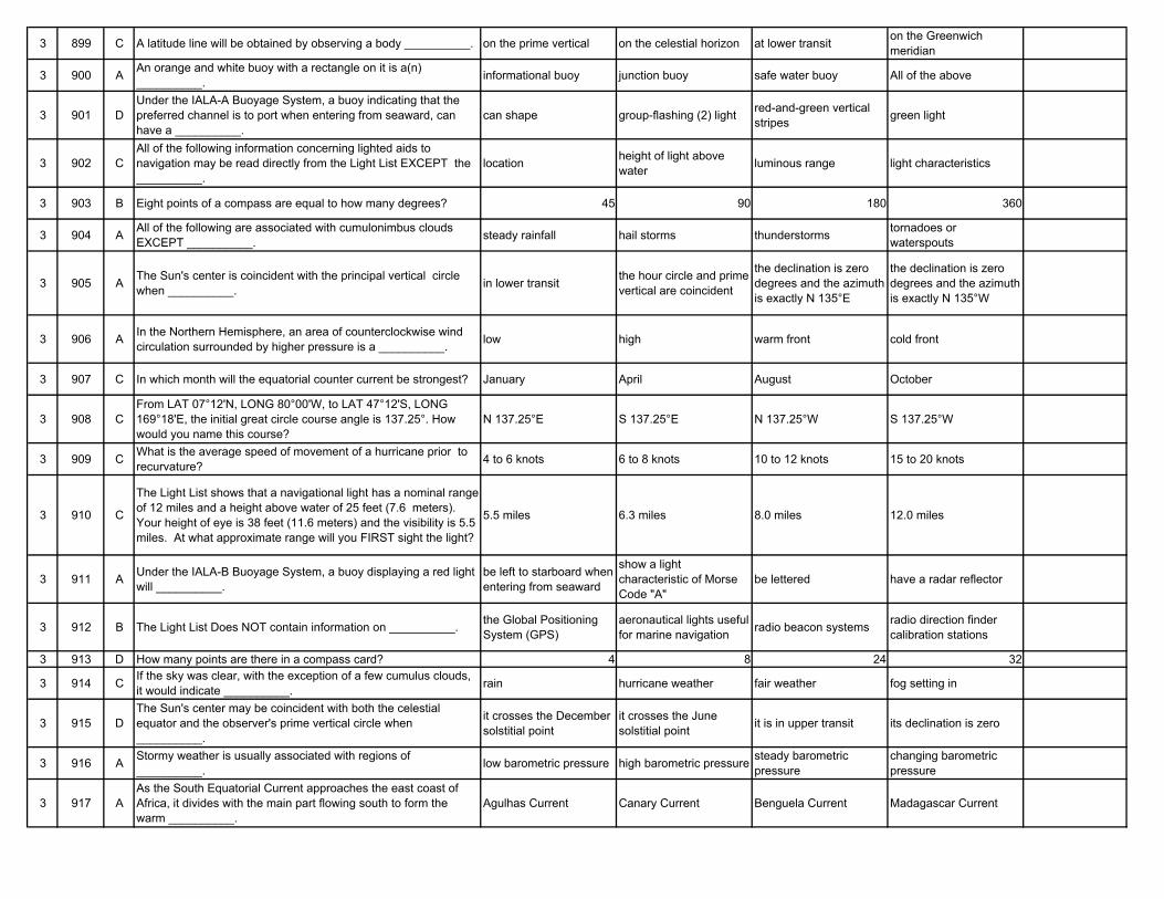
3 899 C A latitude line will be obtained by observing a body __________. on the prime vertical on the celestial horizon at lower transit on the Greenwich meridian
3 900 A An orange and white buoy with a rectangle on it is a(n) __________. informational buoy junction buoy safe water buoy All of the above
3 901 DUnder the IALA-A Buoyage System, a buoy indicating that the preferred channel is to port when entering from seaward, can have a __________.
can shape group-flashing (2) light red-and-green vertical stripes green light
3 902 CAll of the following information concerning lighted aids to navigation may be read directly from the Light List EXCEPT the __________.
location height of light above water luminous range light characteristics
3 903 B Eight points of a compass are equal to how many degrees? 45 90 180 360
3 904 A All of the following are associated with cumulonimbus clouds EXCEPT __________. steady rainfall hail storms thunderstorms tornadoes or
waterspouts
3 905 A The Sun's center is coincident with the principal vertical circle when __________. in lower transit the hour circle and prime
vertical are coincident
the declination is zero degrees and the azimuth is exactly N 135°E
the declination is zero degrees and the azimuth is exactly N 135°W
3 906 A In the Northern Hemisphere, an area of counterclockwise wind circulation surrounded by higher pressure is a __________. low high warm front cold front
3 907 C In which month will the equatorial counter current be strongest? January April August October
3 908 CFrom LAT 07°12'N, LONG 80°00'W, to LAT 47°12'S, LONG 169°18'E, the initial great circle course angle is 137.25°. How would you name this course?
N 137.25°E S 137.25°E N 137.25°W S 137.25°W
3 909 C What is the average speed of movement of a hurricane prior to recurvature? 4 to 6 knots 6 to 8 knots 10 to 12 knots 15 to 20 knots
3 910 C
The Light List shows that a navigational light has a nominal range of 12 miles and a height above water of 25 feet (7.6 meters). Your height of eye is 38 feet (11.6 meters) and the visibility is 5.5 miles. At what approximate range will you FIRST sight the light?
5.5 miles 6.3 miles 8.0 miles 12.0 miles
3 911 A Under the IALA-B Buoyage System, a buoy displaying a red light will __________.
be left to starboard when entering from seaward
show a light characteristic of Morse Code "A"
be lettered have a radar reflector
3 912 B The Light List Does NOT contain information on __________. the Global Positioning System (GPS)
aeronautical lights useful for marine navigation radio beacon systems radio direction finder
calibration stations
3 913 D How many points are there in a compass card? 4 8 24 32
3 914 C If the sky was clear, with the exception of a few cumulus clouds, it would indicate __________. rain hurricane weather fair weather fog setting in
3 915 DThe Sun's center may be coincident with both the celestial equator and the observer's prime vertical circle when __________.
it crosses the December solstitial point
it crosses the June solstitial point it is in upper transit its declination is zero
3 916 A Stormy weather is usually associated with regions of __________. low barometric pressure high barometric pressure steady barometric
pressurechanging barometric pressure
3 917 AAs the South Equatorial Current approaches the east coast of Africa, it divides with the main part flowing south to form the warm __________.
Agulhas Current Canary Current Benguela Current Madagascar Current
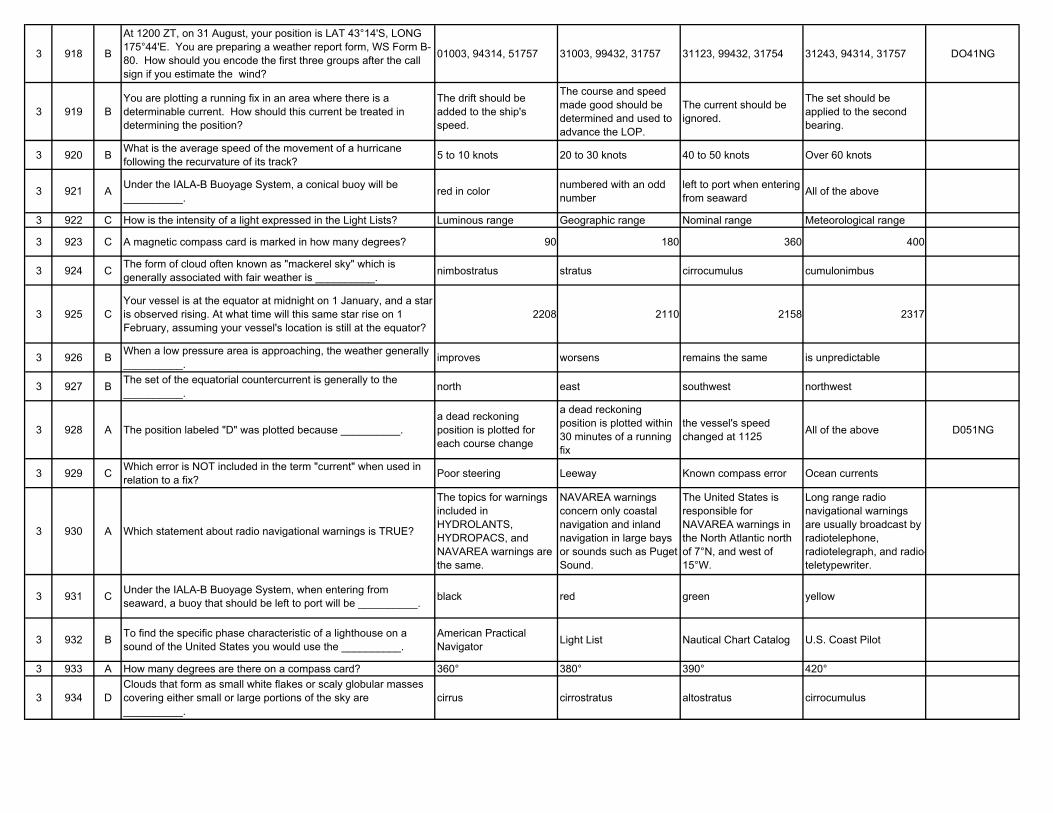
3 918 B
At 1200 ZT, on 31 August, your position is LAT 43°14'S, LONG 175°44'E. You are preparing a weather report form, WS Form B-80. How should you encode the first three groups after the call sign if you estimate the wind?
01003, 94314, 51757 31003, 99432, 31757 31123, 99432, 31754 31243, 94314, 31757 DO41NG
3 919 BYou are plotting a running fix in an area where there is a determinable current. How should this current be treated in determining the position?
The drift should be added to the ship's speed.
The course and speed made good should be determined and used to advance the LOP.
The current should be ignored.
The set should be applied to the second bearing.
3 920 B What is the average speed of the movement of a hurricane following the recurvature of its track? 5 to 10 knots 20 to 30 knots 40 to 50 knots Over 60 knots
3 921 A Under the IALA-B Buoyage System, a conical buoy will be __________. red in color numbered with an odd
numberleft to port when entering from seaward All of the above
3 922 C How is the intensity of a light expressed in the Light Lists? Luminous range Geographic range Nominal range Meteorological range
3 923 C A magnetic compass card is marked in how many degrees? 90 180 360 400
3 924 C The form of cloud often known as "mackerel sky" which is generally associated with fair weather is __________. nimbostratus stratus cirrocumulus cumulonimbus
3 925 CYour vessel is at the equator at midnight on 1 January, and a star is observed rising. At what time will this same star rise on 1 February, assuming your vessel's location is still at the equator?
2208 2110 2158 2317
3 926 B When a low pressure area is approaching, the weather generally __________. improves worsens remains the same is unpredictable
3 927 B The set of the equatorial countercurrent is generally to the __________. north east southwest northwest
3 928 A The position labeled "D" was plotted because __________.a dead reckoning position is plotted for each course change
a dead reckoning position is plotted within 30 minutes of a running fix
the vessel's speed changed at 1125 All of the above D051NG
3 929 C Which error is NOT included in the term "current" when used in relation to a fix? Poor steering Leeway Known compass error Ocean currents
3 930 A Which statement about radio navigational warnings is TRUE?
The topics for warnings included in HYDROLANTS, HYDROPACS, and NAVAREA warnings are the same.
NAVAREA warnings concern only coastal navigation and inland navigation in large bays or sounds such as Puget Sound.
The United States is responsible for NAVAREA warnings in the North Atlantic north of 7°N, and west of 15°W.
Long range radio navigational warnings are usually broadcast by radiotelephone, radiotelegraph, and radio-teletypewriter.
3 931 C Under the IALA-B Buoyage System, when entering from seaward, a buoy that should be left to port will be __________. black red green yellow
3 932 B To find the specific phase characteristic of a lighthouse on a sound of the United States you would use the __________.
American Practical Navigator Light List Nautical Chart Catalog U.S. Coast Pilot
3 933 A How many degrees are there on a compass card? 360° 380° 390° 420°
3 934 DClouds that form as small white flakes or scaly globular masses covering either small or large portions of the sky are __________.
cirrus cirrostratus altostratus cirrocumulus
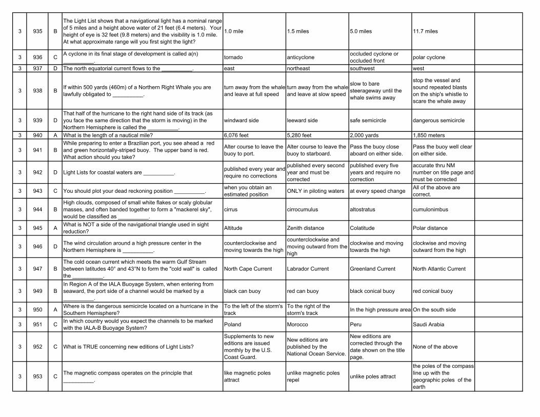
3 935 B
The Light List shows that a navigational light has a nominal range of 5 miles and a height above water of 21 feet (6.4 meters). Your height of eye is 32 feet (9.8 meters) and the visibility is 1.0 mile. At what approximate range will you first sight the light?
1.0 mile 1.5 miles 5.0 miles 11.7 miles
3 936 C A cyclone in its final stage of development is called a(n) __________. tornado anticyclone occluded cyclone or
occluded front polar cyclone
3 937 D The north equatorial current flows to the __________. east northeast southwest west
3 938 B If within 500 yards (460m) of a Northern Right Whale you are lawfully obligated to __________.
turn away from the whale and leave at full speed
turn away from the whale and leave at slow speed
slow to bare steerageway until the whale swims away
stop the vessel and sound repeated blasts on the ship's whistle to scare the whale away
3 939 DThat half of the hurricane to the right hand side of its track (as you face the same direction that the storm is moving) in the Northern Hemisphere is called the __________.
windward side leeward side safe semicircle dangerous semicircle
3 940 A What is the length of a nautical mile? 6,076 feet 5,280 feet 2,000 yards 1,850 meters
3 941 BWhile preparing to enter a Brazilian port, you see ahead a red and green horizontally-striped buoy. The upper band is red. What action should you take?
Alter course to leave the buoy to port.
Alter course to leave the buoy to starboard.
Pass the buoy close aboard on either side.
Pass the buoy well clear on either side.
3 942 D Light Lists for coastal waters are __________. published every year and require no corrections
published every second year and must be corrected
published every five years and require no correction
accurate thru NM number on title page and must be corrected
3 943 C You should plot your dead reckoning position __________. when you obtain an estimated position ONLY in piloting waters at every speed change All of the above are
correct.
3 944 BHigh clouds, composed of small white flakes or scaly globular masses, and often banded together to form a "mackerel sky", would be classified as __________.
cirrus cirrocumulus altostratus cumulonimbus
3 945 A What is NOT a side of the navigational triangle used in sight reduction? Altitude Zenith distance Colatitude Polar distance
3 946 D The wind circulation around a high pressure center in the Northern Hemisphere is __________.
counterclockwise and moving towards the high
counterclockwise and moving outward from the high
clockwise and moving towards the high
clockwise and moving outward from the high
3 947 BThe cold ocean current which meets the warm Gulf Stream between latitudes 40° and 43°N to form the "cold wall" is called the __________.
North Cape Current Labrador Current Greenland Current North Atlantic Current
3 949 BIn Region A of the IALA Buoyage System, when entering from seaward, the port side of a channel would be marked by a __________.
black can buoy red can buoy black conical buoy red conical buoy
3 950 A Where is the dangerous semicircle located on a hurricane in the Southern Hemisphere?
To the left of the storm's track
To the right of the storm's track In the high pressure area On the south side
3 951 C In which country would you expect the channels to be marked with the IALA-B Buoyage System? Poland Morocco Peru Saudi Arabia
3 952 C What is TRUE concerning new editions of Light Lists?
Supplements to new editions are issued monthly by the U.S. Coast Guard.
New editions are published by the National Ocean Service.
New editions are corrected through the date shown on the title page.
None of the above
3 953 C The magnetic compass operates on the principle that __________.
like magnetic poles attract
unlike magnetic poles repel unlike poles attract
the poles of the compass line up with the geographic poles of the earth
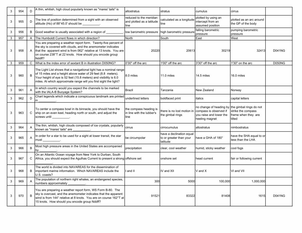
3 954 D A thin, whitish, high cloud popularly known as "mares' tails" is __________. altostratus stratus cumulus cirrus
3 955 D The line of position determined from a sight with an observed altitude (Ho) of 88°45.0' should be __________.
reduced to the meridian and plotted as a latitude line
calculated as a longitude line
plotted by using an intercept from an assumed position
plotted as an arc around the GP of the body
3 956 B Good weather is usually associated with a region of __________. low barometric pressure high barometric pressure falling barometric pressure
pumping barometric pressure
3 957 A The Humboldt Current flows in which direction? North South East West
3 958 A
You are preparing a weather report form. Twenty-five percent of the sky is covered with clouds, and the anemometer indicates that the apparent wind is from 062° relative at 13 knots. You are on course 238°T at 22 knots. How should you encode group Nddff?
20220 20613 30219 32413 D041NG
3 959 C What is the index error of sextant B in illustration D050NG? 0'30" off the arc 1'00" off the arc 3'30" off the arc 1'30" on the arc D050NG
3 960 B
The Light List shows that a navigational light has a nominal range of 15 miles and a height above water of 29 feet (8.8 meters). Your height of eye is 52 feet (15.8 meters) and visibility is 6.0 miles. At which approximate range will you first sight the light?
8.0 miles 11.0 miles 14.5 miles 16.0 miles
3 961 A In which country would you expect the channels to be marked with the IALA-B Buoyage System? Brazil Tanzania New Zealand Norway
3 962 D Chart legends which indicate a conspicuous landmark are printed in __________. underlined letters boldfaced print italics capital letters
3 963 CTo center a compass bowl in its binnacle, you should have the ship on an even keel, heading north or south, and adjust the screws until __________.
the compass heading is in line with the lubber's line
there is no lost motion in the gimbal rings
no change of heading by compass is observed if you raise and lower the heeling magnet
the gimbal rings do not strike the compass frame when they are tilted
3 964 A The thin, whitish, high clouds composed of ice crystals, popularly known as "mares' tails" are __________. cirrus cirrocumulus altostratus nimbostratus
3 965 A In order for a star to be used for a sight at lower transit, the star must __________. be circumpolar
have a declination equal to or greater than your latitude
have a GHA of 180° have the SHA equal to or less than the LHA
3 966 B Most high pressure areas in the United States are accompanied by __________. precipitation clear, cool weather humid, sticky weather cool fogs
3 967 COn an Atlantic Ocean voyage from New York to Durban, South Africa, you should expect the Agulhas Current to present a strong __________.
offshore set onshore set head current fair or following current
3 968 BThe world is divided into NAVAREAS for the dissemination of important marine information. Which NAVAREAS include the U.S. coasts?
I and II IV and XII V and X VI and VII
3 969 A The population of northern right whales, an endangered species, numbers approximately __________. 300 5000 100,000 1,000,000
3 970 B
You are preparing a weather report form, WS Form B-80. The sky is overcast, and the anemometer indicates that the apparent wind is from 144° relative at 8 knots. You are on course 162°T at 15 knots. How should you encode group Nddff?
91521 83322 81408 1615 D041NG
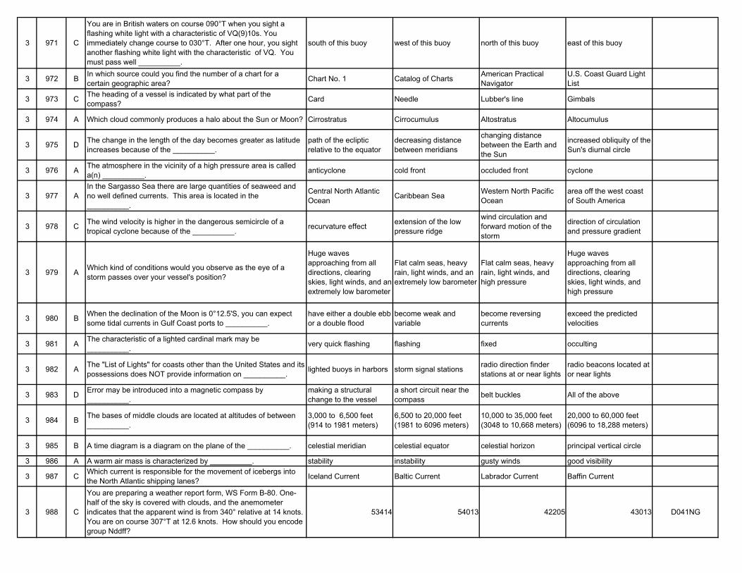
3 971 C
You are in British waters on course 090°T when you sight a flashing white light with a characteristic of VQ(9)10s. You immediately change course to 030°T. After one hour, you sight another flashing white light with the characteristic of VQ. You must pass well __________.
south of this buoy west of this buoy north of this buoy east of this buoy
3 972 B In which source could you find the number of a chart for a certain geographic area? Chart No. 1 Catalog of Charts American Practical
NavigatorU.S. Coast Guard Light List
3 973 C The heading of a vessel is indicated by what part of the compass? Card Needle Lubber's line Gimbals
3 974 A Which cloud commonly produces a halo about the Sun or Moon? Cirrostratus Cirrocumulus Altostratus Altocumulus
3 975 D The change in the length of the day becomes greater as latitude increases because of the __________.
path of the ecliptic relative to the equator
decreasing distance between meridians
changing distance between the Earth and the Sun
increased obliquity of the Sun's diurnal circle
3 976 A The atmosphere in the vicinity of a high pressure area is called a(n) __________. anticyclone cold front occluded front cyclone
3 977 AIn the Sargasso Sea there are large quantities of seaweed and no well defined currents. This area is located in the __________.
Central North Atlantic Ocean Caribbean Sea Western North Pacific
Oceanarea off the west coast of South America
3 978 C The wind velocity is higher in the dangerous semicircle of a tropical cyclone because of the __________. recurvature effect extension of the low
pressure ridge
wind circulation and forward motion of the storm
direction of circulation and pressure gradient
3 979 A Which kind of conditions would you observe as the eye of a storm passes over your vessel's position?
Huge waves approaching from all directions, clearing skies, light winds, and an extremely low barometer
Flat calm seas, heavy rain, light winds, and an extremely low barometer
Flat calm seas, heavy rain, light winds, and high pressure
Huge waves approaching from all directions, clearing skies, light winds, and high pressure
3 980 B When the declination of the Moon is 0°12.5'S, you can expect some tidal currents in Gulf Coast ports to __________.
have either a double ebb or a double flood
become weak and variable
become reversing currents
exceed the predicted velocities
3 981 A The characteristic of a lighted cardinal mark may be __________. very quick flashing flashing fixed occulting
3 982 A The "List of Lights" for coasts other than the United States and its possessions does NOT provide information on __________. lighted buoys in harbors storm signal stations radio direction finder
stations at or near lightsradio beacons located at or near lights
3 983 D Error may be introduced into a magnetic compass by __________.
making a structural change to the vessel
a short circuit near the compass belt buckles All of the above
3 984 B The bases of middle clouds are located at altitudes of between __________.
3,000 to 6,500 feet (914 to 1981 meters)
6,500 to 20,000 feet (1981 to 6096 meters)
10,000 to 35,000 feet (3048 to 10,668 meters)
20,000 to 60,000 feet (6096 to 18,288 meters)
3 985 B A time diagram is a diagram on the plane of the __________. celestial meridian celestial equator celestial horizon principal vertical circle
3 986 A A warm air mass is characterized by __________. stability instability gusty winds good visibility
3 987 C Which current is responsible for the movement of icebergs into the North Atlantic shipping lanes? Iceland Current Baltic Current Labrador Current Baffin Current
3 988 C
You are preparing a weather report form, WS Form B-80. One-half of the sky is covered with clouds, and the anemometer indicates that the apparent wind is from 340° relative at 14 knots. You are on course 307°T at 12.6 knots. How should you encode group Nddff?
53414 54013 42205 43013 D041NG
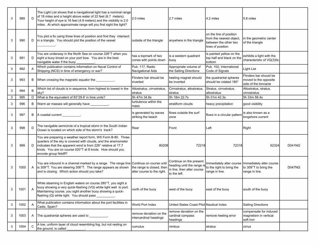
3 989 D
The Light List shows that a navigational light has a nominal range of 18 miles and a height above water of 22 feet (6.7 meters). Your height of eye is 16 feet (4.9 meters) and the visibility is 2.0 miles. At which approximate range will you first sight the light?
2.0 miles 2.7 miles 4.2 miles 5.8 miles
3 990 DYou plot a fix using three lines of position and find they intersect in a triangle. You should plot the position of the vessel __________.
outside of the triangle anywhere in the triangle
on the line of position from the nearest object, between the other two lines of position
in the geometric center of the triangle
3 991 DYou are underway in the North Sea on course 328°T when you sight a buoy broad on your port bow. You are in the best navigable water if the buoy __________.
has a topmark of two cones with points down
is a western quadrant buoy
is painted yellow on the top half and black on the bottom
exhibits a light with the characteristic of VQ(3)5s
3 992 A Which publication contains information on Naval Control of Shipping (NCS) in time of emergency or war?
Pub. 117, Radio Navigational Aids
Appropriate volume of the Sailing Directions
Pub. 102, International Code of Signals Light List
3 993 B When crossing the magnetic equator the __________. Flinders bar should be inverted
heeling magnet should be inverted
the quadrantal spheres should be rotated 180°
Flinders bar should be moved to the opposite side of the binnacle
3 994 B Which list of clouds is in sequence, from highest to lowest in the sky?
Altostratus, cirrostratus, stratus
Cirrostratus, altostratus, stratus
Stratus, cirrostratus, altostratus
Altostratus, stratus, cirrostratus
3 995 D What is the equivalent of 83°29.6' in time units? 5h 47m 34.8s 5h 18m 22.7s 5h 01m 42.3s 5h 33m 58.4s
3 996 B Warm air masses will generally have __________. turbulence within the mass stratiform clouds heavy precipitation good visibility
3 997 B A coastal current __________. is generated by waves striking the beach
flows outside the surf zone flows in a circular pattern is also known as a
longshore current
3 998 D The navigable semicircle of a tropical storm in the South Indian Ocean is located on which side of the storm's track? Rear Front Left Right
3 999 D
You are preparing a weather report form, WS Form B-80. Three-quarters of the sky is covered with clouds, and the anemometer indicates that the apparent wind is from 226° relative at 17.7 knots. You are on course 020°T at 8 knots. How should you encode group Nddff?
80208 72218 72318 62324 D041NG
3 1000 AYou are inbound in a channel marked by a range. The range line is 309°T. You are steering 306°T. The range appears as shown and is closing. Which action should you take?
Continue on course until the range is closed, then alter course to the right.
Continue on the present heading until the range is in line, then alter course to the left.
Immediately alter course to the right to bring the range in line.
Immediately alter course to 309°T to bring the range in line.
D047NG
3 1001 A
While steaming in English waters on course 280°T, you sight a buoy showing a very quick-flashing (VQ) white light well to port. Maintaining course, you sight another buoy showing a quick-flashing (Q) white light. You should pass __________.
north of the buoy west of the buoy east of the buoy south of the buoy
3 1002 A What publication contains information about the port facilities in Cadiz, Spain? World Port Index United States Coast Pilot Nautical Index Sailing Directions
3 1003 A The quadrantal spheres are used to __________. remove deviation on the intercardinal headings
remove deviation on the cardinal compass headings
remove heeling errorcompensate for induced magnetism in vertical soft iron
3 1004 C A low, uniform layer of cloud resembling fog, but not resting on the ground, is called __________. cumulus nimbus stratus cirrus
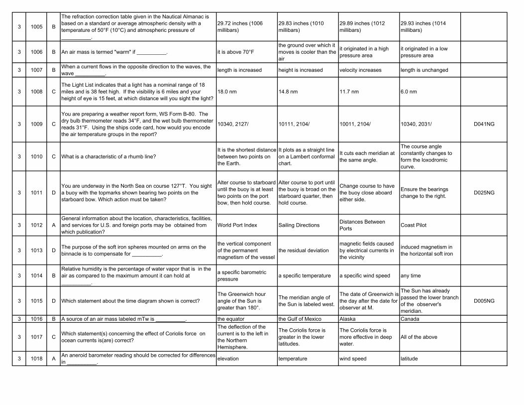
3 1005 B
The refraction correction table given in the Nautical Almanac is based on a standard or average atmospheric density with a temperature of 50°F (10°C) and atmospheric pressure of __________.
29.72 inches (1006 millibars)
29.83 inches (1010 millibars)
29.89 inches (1012 millibars)
29.93 inches (1014 millibars)
3 1006 B An air mass is termed "warm" if __________. it is above 70°Fthe ground over which it moves is cooler than the air
it originated in a high pressure area
it originated in a low pressure area
3 1007 B When a current flows in the opposite direction to the waves, the wave __________. length is increased height is increased velocity increases length is unchanged
3 1008 CThe Light List indicates that a light has a nominal range of 18 miles and is 38 feet high. If the visibility is 6 miles and your height of eye is 15 feet, at which distance will you sight the light?
18.0 nm 14.8 nm 11.7 nm 6.0 nm
3 1009 C
You are preparing a weather report form, WS Form B-80. The dry bulb thermometer reads 34°F, and the wet bulb thermometer reads 31°F. Using the ships code card, how would you encode the air temperature groups in the report?
10340, 2127/ 10111, 2104/ 10011, 2104/ 10340, 2031/ D041NG
3 1010 C What is a characteristic of a rhumb line?It is the shortest distance between two points on the Earth.
It plots as a straight line on a Lambert conformal chart.
It cuts each meridian at the same angle.
The course angle constantly changes to form the loxodromic curve.
3 1011 DYou are underway in the North Sea on course 127°T. You sight a buoy with the topmarks shown bearing two points on the starboard bow. Which action must be taken?
Alter course to starboard until the buoy is at least two points on the port bow, then hold course.
Alter course to port until the buoy is broad on the starboard quarter, then hold course.
Change course to have the buoy close aboard either side.
Ensure the bearings change to the right. D025NG
3 1012 AGeneral information about the location, characteristics, facilities, and services for U.S. and foreign ports may be obtained from which publication?
World Port Index Sailing Directions Distances Between Ports Coast Pilot
3 1013 D The purpose of the soft iron spheres mounted on arms on the binnacle is to compensate for __________.
the vertical component of the permanent magnetism of the vessel
the residual deviationmagnetic fields caused by electrical currents in the vicinity
induced magnetism in the horizontal soft iron
3 1014 BRelative humidity is the percentage of water vapor that is in the air as compared to the maximum amount it can hold at __________.
a specific barometric pressure a specific temperature a specific wind speed any time
3 1015 D Which statement about the time diagram shown is correct?The Greenwich hour angle of the Sun is greater than 180°.
The meridian angle of the Sun is labeled west.
The date of Greenwich is the day after the date for observer at M.
The Sun has already passed the lower branch of the observer's meridian.
D005NG
3 1016 B A source of an air mass labeled mTw is __________. the equator the Gulf of Mexico Alaska Canada
3 1017 C Which statement(s) concerning the effect of Coriolis force on ocean currents is(are) correct?
The deflection of the current is to the left in the Northern Hemisphere.
The Coriolis force is greater in the lower latitudes.
The Coriolis force is more effective in deep water.
All of the above
3 1018 A An aneroid barometer reading should be corrected for differences in __________. elevation temperature wind speed latitude
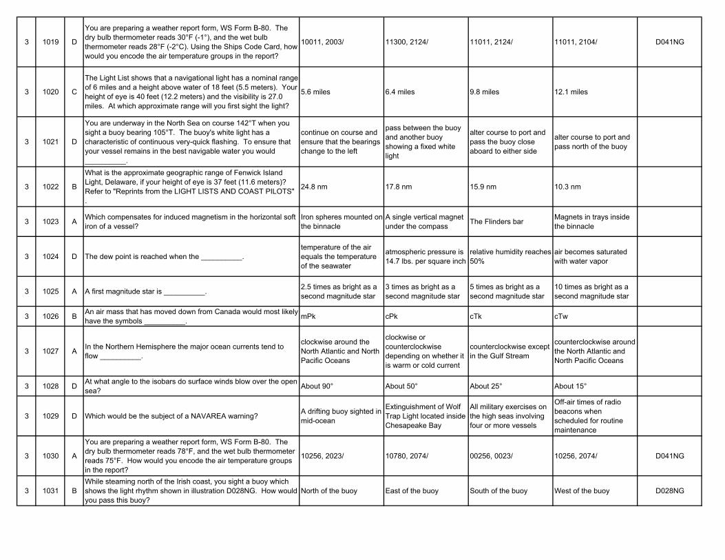
3 1019 D
You are preparing a weather report form, WS Form B-80. The dry bulb thermometer reads 30°F (-1°), and the wet bulb thermometer reads 28°F (-2°C). Using the Ships Code Card, how would you encode the air temperature groups in the report?
10011, 2003/ 11300, 2124/ 11011, 2124/ 11011, 2104/ D041NG
3 1020 C
The Light List shows that a navigational light has a nominal range of 6 miles and a height above water of 18 feet (5.5 meters). Your height of eye is 40 feet (12.2 meters) and the visibility is 27.0 miles. At which approximate range will you first sight the light?
5.6 miles 6.4 miles 9.8 miles 12.1 miles
3 1021 D
You are underway in the North Sea on course 142°T when you sight a buoy bearing 105°T. The buoy's white light has a characteristic of continuous very-quick flashing. To ensure that your vessel remains in the best navigable water you would __________.
continue on course and ensure that the bearings change to the left
pass between the buoy and another buoy showing a fixed white light
alter course to port and pass the buoy close aboard to either side
alter course to port and pass north of the buoy
3 1022 B
What is the approximate geographic range of Fenwick Island Light, Delaware, if your height of eye is 37 feet (11.6 meters)? Refer to "Reprints from the LIGHT LISTS AND COAST PILOTS" .
24.8 nm 17.8 nm 15.9 nm 10.3 nm
3 1023 A Which compensates for induced magnetism in the horizontal soft iron of a vessel?
Iron spheres mounted on the binnacle
A single vertical magnet under the compass The Flinders bar Magnets in trays inside
the binnacle
3 1024 D The dew point is reached when the __________.temperature of the air equals the temperature of the seawater
atmospheric pressure is 14.7 lbs. per square inch
relative humidity reaches 50%
air becomes saturated with water vapor
3 1025 A A first magnitude star is __________. 2.5 times as bright as a second magnitude star
3 times as bright as a second magnitude star
5 times as bright as a second magnitude star
10 times as bright as a second magnitude star
3 1026 B An air mass that has moved down from Canada would most likely have the symbols __________. mPk cPk cTk cTw
3 1027 A In the Northern Hemisphere the major ocean currents tend to flow __________.
clockwise around the North Atlantic and North Pacific Oceans
clockwise or counterclockwise depending on whether it is warm or cold current
counterclockwise except in the Gulf Stream
counterclockwise around the North Atlantic and North Pacific Oceans
3 1028 D At what angle to the isobars do surface winds blow over the open sea? About 90° About 50° About 25° About 15°
3 1029 D Which would be the subject of a NAVAREA warning? A drifting buoy sighted in mid-ocean
Extinguishment of Wolf Trap Light located inside Chesapeake Bay
All military exercises on the high seas involving four or more vessels
Off-air times of radio beacons when scheduled for routine maintenance
3 1030 A
You are preparing a weather report form, WS Form B-80. The dry bulb thermometer reads 78°F, and the wet bulb thermometer reads 75°F. How would you encode the air temperature groups in the report?
10256, 2023/ 10780, 2074/ 00256, 0023/ 10256, 2074/ D041NG
3 1031 BWhile steaming north of the Irish coast, you sight a buoy which shows the light rhythm shown in illustration D028NG. How would you pass this buoy?
North of the buoy East of the buoy South of the buoy West of the buoy D028NG
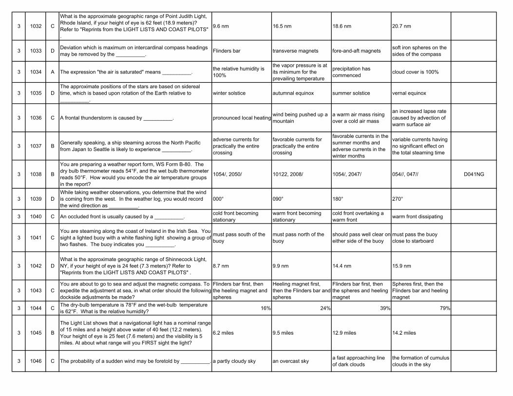
3 1032 C
What is the approximate geographic range of Point Judith Light, Rhode Island, if your height of eye is 62 feet (18.9 meters)? Refer to "Reprints from the LIGHT LISTS AND COAST PILOTS" .
9.6 nm 16.5 nm 18.6 nm 20.7 nm
3 1033 D Deviation which is maximum on intercardinal compass headings may be removed by the __________. Flinders bar transverse magnets fore-and-aft magnets soft iron spheres on the
sides of the compass
3 1034 A The expression "the air is saturated" means __________. the relative humidity is 100%
the vapor pressure is at its minimum for the prevailing temperature
precipitation has commenced cloud cover is 100%
3 1035 DThe approximate positions of the stars are based on sidereal time, which is based upon rotation of the Earth relative to __________.
winter solstice autumnal equinox summer solstice vernal equinox
3 1036 C A frontal thunderstorm is caused by __________. pronounced local heating wind being pushed up a mountain
a warm air mass rising over a cold air mass
an increased lapse rate caused by advection of warm surface air
3 1037 B Generally speaking, a ship steaming across the North Pacific from Japan to Seattle is likely to experience __________.
adverse currents for practically the entire crossing
favorable currents for practically the entire crossing
favorable currents in the summer months and adverse currents in the winter months
variable currents having no significant effect on the total steaming time
3 1038 B
You are preparing a weather report form, WS Form B-80. The dry bulb thermometer reads 54°F, and the wet bulb thermometer reads 50°F. How would you encode the air temperature groups in the report?
1054/, 2050/ 10122, 2008/ 1054/, 2047/ 054//, 047// D041NG
3 1039 DWhile taking weather observations, you determine that the wind is coming from the west. In the weather log, you would record the wind direction as __________.
000° 090° 180° 270°
3 1040 C An occluded front is usually caused by a __________. cold front becoming stationary
warm front becoming stationary
cold front overtaking a warm front warm front dissipating
3 1041 CYou are steaming along the coast of Ireland in the Irish Sea. You sight a lighted buoy with a white flashing light showing a group of two flashes. The buoy indicates you __________.
must pass south of the buoy
must pass north of the buoy
should pass well clear on either side of the buoy
must pass the buoy close to starboard
3 1042 DWhat is the approximate geographic range of Shinnecock Light, NY, if your height of eye is 24 feet (7.3 meters)? Refer to "Reprints from the LIGHT LISTS AND COAST PILOTS" .
8.7 nm 9.9 nm 14.4 nm 15.9 nm
3 1043 CYou are about to go to sea and adjust the magnetic compass. To expedite the adjustment at sea, in what order should the following dockside adjustments be made?
Flinders bar first, then the heeling magnet and spheres
Heeling magnet first, then the Flinders bar and spheres
Flinders bar first, then the spheres and heeling magnet
Spheres first, then the Flinders bar and heeling magnet
3 1044 C The dry-bulb temperature is 78°F and the wet-bulb temperature is 62°F. What is the relative humidity? 16% 24% 39% 79%
3 1045 B
The Light List shows that a navigational light has a nominal range of 15 miles and a height above water of 40 feet (12.2 meters). Your height of eye is 25 feet (7.6 meters) and the visibility is 5 miles. At about what range will you FIRST sight the light?
6.2 miles 9.5 miles 12.9 miles 14.2 miles
3 1046 C The probability of a sudden wind may be foretold by __________. a partly cloudy sky an overcast sky a fast approaching line of dark clouds
the formation of cumulus clouds in the sky
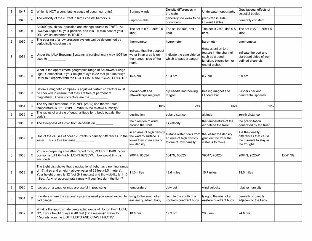
3 1047 D Which is NOT a contributing cause of ocean currents? Surface winds Density differences in the water Underwater topography Gravitational effects of
celestial bodies
3 1048 C The velocity of the current in large coastal harbors is __________. unpredictable generally too weak to be
of concernpredicted in Tidal Current Tables generally constant
3 1049 BAt 0000 you fix your position and change course to 270°T. At 0030 you again fix your position, and it is 0.5 mile east of your DR. Which statement is TRUE?
The set is 090°, drift 0.5 knot.
The set is 090°, drift 1.0 knot.
The set is 270°, drift 0.5 knot.
The set is 270°, drift 1.0 knot.
3 1050 C The passing of a low pressure system can be determined by periodically checking the __________. thermometer hygrometer barometer anemometer
3 1051 D Under the IALA Buoyage Systems, a cardinal mark may NOT be used to __________.
indicate that the deepest water in an area is on the named side of the mark
indicate the safe side on which to pass a danger
draw attention to a feature in the channel such as a bend, junction, bifurcation, or end of a shoal
indicate the port and starboard sides of well-defined channels
3 1052 A
What is the approximate geographic range of Southwest Ledge Light, Connecticut, if your height of eye is 32 feet (9.8 meters)? Refer to "Reprints from the LIGHT LISTS AND COAST PILOTS" .
15.5 nm 13.4 nm 8.7 nm 6.9 nm
3 1053 DBefore a magnetic compass is adjusted certain correctors must be checked to ensure that they are free of permanent magnetism. These correctors are the __________.
fore-and-aft and athwartships magnets
dip needle and heeling magnet
heeling magnet and Flinders bar
Flinders bar and quadrantal spheres
3 1054 D The dry-bulb temperature is 78°F (26°C) and the wet-bulb temperature is 68°F (20°C). What is the relative humidity? 10% 24% 56% 60%
3 1055 D The radius of a circle of equal altitude for a body equals the body's __________. declination polar distance altitude zenith distance
3 1056 B The steepness of a cold front depends on __________. the direction of wind around the front its velocity the temperature of the
air behind the frontthe precipitation generated by the front
3 1057 B One of the causes of ocean currents is density differences in the water. This is true because __________.
in an area of high density the water's surface is lower than in an area of low density
surface water flows from an area of high density to one of low density
the lesser the density gradient the freer the water is to move
it is the density differences that cause the currents to stay in the troughs
3 1058 CYou are preparing a weather report form, WS Form B-80. Your position is LAT 64°42'N, LONG 02°28'W. How would this be encoded?
90647, 90024 0647N, 00025 99647, 70025 9064N, 9025W D041NG
3 1059 B
The Light List shows that a navigational light has a nominal range of 17 miles and a height above water of 28 feet (8.5 meters). Your height of eye is 32 feet (9.8 meters) and the visibility is 11.0 miles. At what approximate range will you first sight the light?
11.0 miles 12.6 miles 15.7 miles 18.0 miles
3 1060 C Isobars on a weather map are useful in predicting __________. temperature dew point wind velocity relative humidity
3 1061 B In waters where the cardinal system is used you would expect to find danger __________.
lying to the south of an eastern quadrant buoy
lying to the south of a northern quadrant buoy
lying to the east of an eastern quadrant buoy
beneath or directly adjacent to the buoy
3 1062 BWhat is the approximate geographic range of Horton Point Light, NY, if your height of eye is 40 feet (12.2 meters)? Refer to "Reprints from the LIGHT LISTS AND COAST PILOTS" .
18.8 nm 19.3 nm 20.3 nm 24.8 nm
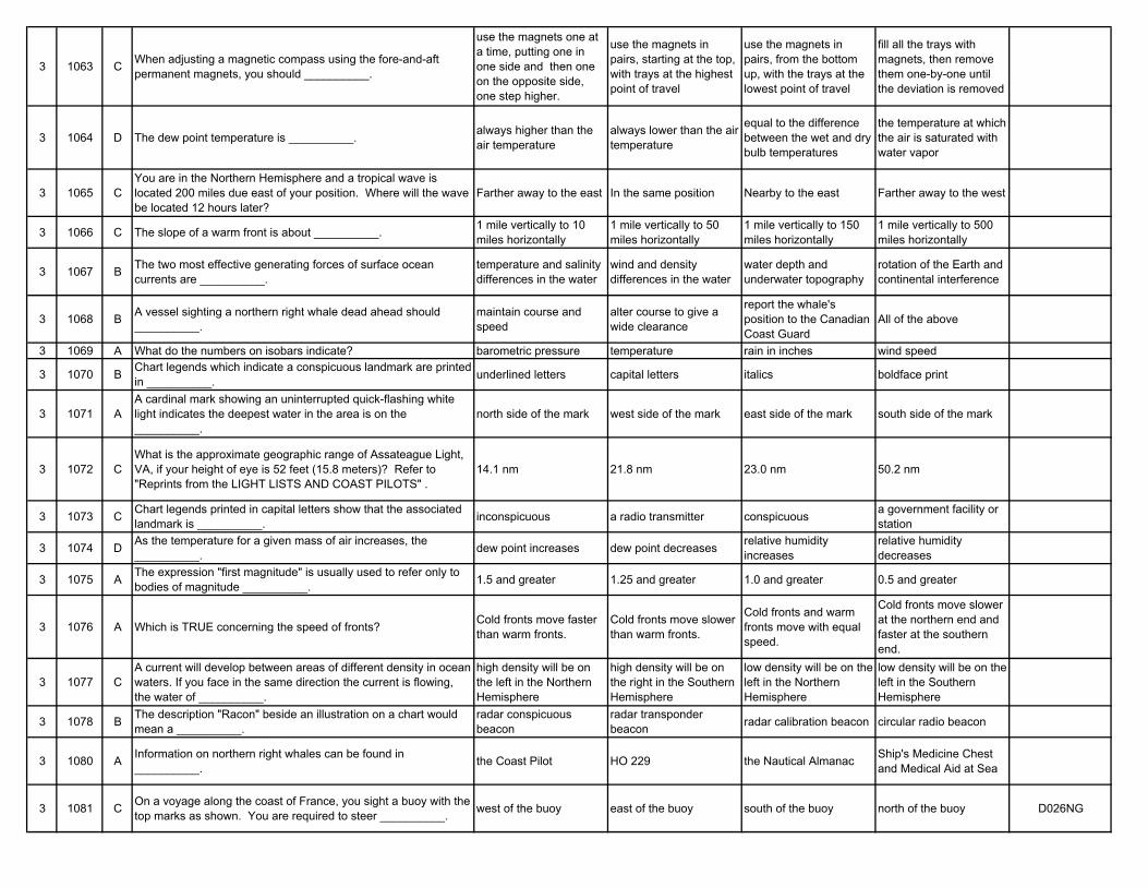
3 1063 C When adjusting a magnetic compass using the fore-and-aft permanent magnets, you should __________.
use the magnets one at a time, putting one in one side and then one on the opposite side, one step higher.
use the magnets in pairs, starting at the top, with trays at the highest point of travel
use the magnets in pairs, from the bottom up, with the trays at the lowest point of travel
fill all the trays with magnets, then remove them one-by-one until the deviation is removed
3 1064 D The dew point temperature is __________. always higher than the air temperature
always lower than the air temperature
equal to the difference between the wet and dry bulb temperatures
the temperature at which the air is saturated with water vapor
3 1065 CYou are in the Northern Hemisphere and a tropical wave is located 200 miles due east of your position. Where will the wave be located 12 hours later?
Farther away to the east In the same position Nearby to the east Farther away to the west
3 1066 C The slope of a warm front is about __________. 1 mile vertically to 10 miles horizontally
1 mile vertically to 50 miles horizontally
1 mile vertically to 150 miles horizontally
1 mile vertically to 500 miles horizontally
3 1067 B The two most effective generating forces of surface ocean currents are __________.
temperature and salinity differences in the water
wind and density differences in the water
water depth and underwater topography
rotation of the Earth and continental interference
3 1068 B A vessel sighting a northern right whale dead ahead should __________.
maintain course and speed
alter course to give a wide clearance
report the whale's position to the Canadian Coast Guard
All of the above
3 1069 A What do the numbers on isobars indicate? barometric pressure temperature rain in inches wind speed
3 1070 B Chart legends which indicate a conspicuous landmark are printed in __________. underlined letters capital letters italics boldface print
3 1071 AA cardinal mark showing an uninterrupted quick-flashing white light indicates the deepest water in the area is on the __________.
north side of the mark west side of the mark east side of the mark south side of the mark
3 1072 CWhat is the approximate geographic range of Assateague Light, VA, if your height of eye is 52 feet (15.8 meters)? Refer to "Reprints from the LIGHT LISTS AND COAST PILOTS" .
14.1 nm 21.8 nm 23.0 nm 50.2 nm
3 1073 C Chart legends printed in capital letters show that the associated landmark is __________. inconspicuous a radio transmitter conspicuous a government facility or
station
3 1074 D As the temperature for a given mass of air increases, the __________. dew point increases dew point decreases relative humidity
increasesrelative humidity decreases
3 1075 A The expression "first magnitude" is usually used to refer only to bodies of magnitude __________. 1.5 and greater 1.25 and greater 1.0 and greater 0.5 and greater
3 1076 A Which is TRUE concerning the speed of fronts? Cold fronts move faster than warm fronts.
Cold fronts move slower than warm fronts.
Cold fronts and warm fronts move with equal speed.
Cold fronts move slower at the northern end and faster at the southern end.
3 1077 CA current will develop between areas of different density in ocean waters. If you face in the same direction the current is flowing, the water of __________.
high density will be on the left in the Northern Hemisphere
high density will be on the right in the Southern Hemisphere
low density will be on the left in the Northern Hemisphere
low density will be on the left in the Southern Hemisphere
3 1078 B The description "Racon" beside an illustration on a chart would mean a __________.
radar conspicuous beacon
radar transponder beacon radar calibration beacon circular radio beacon
3 1080 A Information on northern right whales can be found in __________. the Coast Pilot HO 229 the Nautical Almanac Ship's Medicine Chest
and Medical Aid at Sea
3 1081 C On a voyage along the coast of France, you sight a buoy with the top marks as shown. You are required to steer __________. west of the buoy east of the buoy south of the buoy north of the buoy D026NG
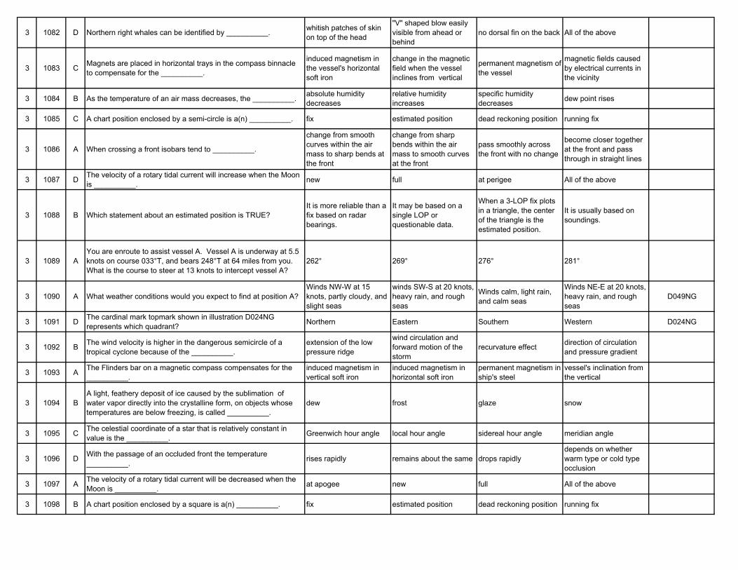
3 1082 D Northern right whales can be identified by __________. whitish patches of skin on top of the head
"V" shaped blow easily visible from ahead or behind
no dorsal fin on the back All of the above
3 1083 C Magnets are placed in horizontal trays in the compass binnacle to compensate for the __________.
induced magnetism in the vessel's horizontal soft iron
change in the magnetic field when the vessel inclines from vertical
permanent magnetism of the vessel
magnetic fields caused by electrical currents in the vicinity
3 1084 B As the temperature of an air mass decreases, the __________. absolute humidity decreases
relative humidity increases
specific humidity decreases dew point rises
3 1085 C A chart position enclosed by a semi-circle is a(n) __________. fix estimated position dead reckoning position running fix
3 1086 A When crossing a front isobars tend to __________.
change from smooth curves within the air mass to sharp bends at the front
change from sharp bends within the air mass to smooth curves at the front
pass smoothly across the front with no change
become closer together at the front and pass through in straight lines
3 1087 D The velocity of a rotary tidal current will increase when the Moon is __________. new full at perigee All of the above
3 1088 B Which statement about an estimated position is TRUE?It is more reliable than a fix based on radar bearings.
It may be based on a single LOP or questionable data.
When a 3-LOP fix plots in a triangle, the center of the triangle is the estimated position.
It is usually based on soundings.
3 1089 AYou are enroute to assist vessel A. Vessel A is underway at 5.5 knots on course 033°T, and bears 248°T at 64 miles from you. What is the course to steer at 13 knots to intercept vessel A?
262° 269° 276° 281°
3 1090 A What weather conditions would you expect to find at position A?Winds NW-W at 15 knots, partly cloudy, and slight seas
winds SW-S at 20 knots, heavy rain, and rough seas
Winds calm, light rain, and calm seas
Winds NE-E at 20 knots, heavy rain, and rough seas
D049NG
3 1091 D The cardinal mark topmark shown in illustration D024NG represents which quadrant? Northern Eastern Southern Western D024NG
3 1092 B The wind velocity is higher in the dangerous semicircle of a tropical cyclone because of the __________.
extension of the low pressure ridge
wind circulation and forward motion of the storm
recurvature effect direction of circulation and pressure gradient
3 1093 A The Flinders bar on a magnetic compass compensates for the __________.
induced magnetism in vertical soft iron
induced magnetism in horizontal soft iron
permanent magnetism in ship's steel
vessel's inclination from the vertical
3 1094 BA light, feathery deposit of ice caused by the sublimation of water vapor directly into the crystalline form, on objects whose temperatures are below freezing, is called __________.
dew frost glaze snow
3 1095 C The celestial coordinate of a star that is relatively constant in value is the __________. Greenwich hour angle local hour angle sidereal hour angle meridian angle
3 1096 D With the passage of an occluded front the temperature __________. rises rapidly remains about the same drops rapidly
depends on whether warm type or cold type occlusion
3 1097 A The velocity of a rotary tidal current will be decreased when the Moon is __________. at apogee new full All of the above
3 1098 B A chart position enclosed by a square is a(n) __________. fix estimated position dead reckoning position running fix
3 1099 BYou are enroute to assist vessel A. Vessel A is underway at 6 knots on course 133°T, and bears 343°T at 92 miles from you. What is the course to steer at 9 knots to intercept vessel A?
356° 003° 022° 038°
3 1101 B
In the North Sea area, you sight a buoy showing an uninterrupted quick-flashing white light. Which of the four topmarks shown will this buoy be fitted with under the IALA Buoyage system?
A B C D D031NG
3 1102 CWhat is the approximate geographic range of Race Rock Light, NY, if your height of eye is 27 feet (8.2 meters)? Refer to "Reprints from the LIGHT LISTS AND COAST PILOTS" .
9.9 nm 14.3 nm 15.7 nm 17.4 nm
3 1103 AThe vertical component of the Earth's magnetic field causes induced magnetism in vertical soft iron. This changes with latitude. What corrects for this coefficient of the deviation?
The Flinders bar The heeling magnet Quadrantal soft iron spheres
Bar magnets in the binnacle
3 1104 D Which condition(s) is(are) necessary for the formation of dew? Clear skies Calm airEarth's surface cooler than the dew point of the air
All of the above
3 1105 C
The Light List shows that a navigational light has a nominal range of 22 miles and a height above water of 48 feet (14.6 meters). Your height of eye is 35 feet (10.7 meters) and the visibility is 20.0 miles. At what approximate range will you first sight the light?
10.5 nm 13.2 nm 14.7 nm 32.0 nm
3 1106 B The legend/symbol which designates an occluded front is represented by a __________. red line purple line blue line dashed blue line
3 1108 B Preferred channel buoys indicate the preferred channel to transit by __________. odd or even numbers the color of their top
bandthe location of the buoy in the channel junction the buoy's light rhythms
3 1109 D You are on course 146°T. To check the speed of your vessel you should observe a celestial body on which bearing? 000° 056° 090° 146°
3 1110 BTo make sure of getting the full advantage of a favorable current, you should reach an entrance or strait at what time in relation to the predicted time of the favorable current?
At the predicted time 30 minutes before the predicted time
One hour after the predicted time
30 minutes before flood, one hour after an ebb
3 1111 CBlack double-cone topmarks are the most important feature, by day, of cardinal marks. Which of the four topmarks shown indicates the best navigable water lies to the west of the buoy?
A B C D D030NG
3 1112 AConsidering the general circulation of the atmosphere, the wind system between latitudes 30°N and 60°N is commonly called the __________.
prevailing westerlies horse latitudes trade winds subpolar low pressure belts
3 1113 B A single vertical magnet placed underneath the compass in the binnacle is used to compensate for __________.
the horizontal component of the permanent magnetism
deviation caused by the vessel's inclination from the vertical
induced magnetism in the horizontal soft iron
induced magnetism in the vertical soft iron
3 1114 D Mechanical lifting of air by the upslope slant of the terrain is called __________. vertical lifting convective lifting advective lifting topographic lifting
3 1115 A Which light characteristic may be used on a special purpose mark? Flashing Occulting Equal interval Quick flashing
3 1116 C When a cold air mass and a warm air mass meet, and there is no horizontal motion of either air mass, it is called a(n) __________. cold front occluded front stationary front warm front
3 1118 B When entering from seaward, a buoy displaying a single-flashing red light indicates __________.
a junction with the preferred channel to the left
the starboard side of the channel
a sharp turn in the channel to the right
a wreck to be left on the vessel's port side
3 1119 C The position labeled "D" was plotted because __________. the vessel's speed changed at 1125
a dead reckoning position is plotted within 30 minutes of a running fix
a dead reckoning position is plotted for each course change
All of the above D051NG
3 1120 B You are on course 042°T. To check the course of your vessel you should observe a celestial body on which bearing? 090° 132° 180° 222°
3 1121 D The articulated light is superior to other types of buoys because __________.
the radar reflectors reflect better signals
fog horn signals travel farther to sea
it is equipped with strobe lights
it has a reduced watch circle
3 1122 B A barometer showing falling pressure indicates the approach of a __________. high pressure system low pressure system high dew point low dew point
3 1123 B What are the only magnetic compass correctors that correct for both permanent and induced effects of magnetism? Quadrantal spheres Heeling magnets Athwartships magnets Fore-and-aft magnets
3 1124 B
The region containing 3/4 of the mass of the atmosphere and the region to which are confined such phenomena as clouds, storms, precipitation and changing weather conditions is called __________.
stratosphere troposphere stratopause tropopause
3 1125 B
The Light List shows that a navigational light has a nominal range of 19 miles and a height above water of 52 feet (15.8 meters). Your height of eye is 42 feet (12.8 meters) and the visibility is 10.0 miles. At what approximate range will you first sight the light?
10.0 miles 16.0 miles 17.3 miles 19.0 miles
3 1126 A When a warm air mass is adjacent to a cold air mass, the separation line between the two is called a(n) __________. front isobar isotherm equipotential line
3 1127 A In a river subject to tidal currents, the best time to dock a ship without the assistance of tugs is __________. at slack water at flood tide when there is a following
current at high water
3 1128 B In 1981, when would Jupiter and Saturn be visible in temperate latitudes for both evening and morning stars? 10-Jan 27-Mar 22-Jun 8-Oct
3 1129 A The motion of celestial bodies relative to other celestial bodies is known as __________. space motion apparent motion diurnal motion actual motion
3 1130 D During daylight savings time the meridian used for determining the time is located farther __________.
west in west longitude and east in east longitude
east in west longitude and west in east longitude
west east
3 1131 B On navigational aids, what does the light characteristic "Fl(2+1)" mean?
A flashing light combined with a fixed light of greater brightness
Light flashes combined in groups, with a different number of flashes in each group
A light showing groups of two or more flashes at regular intervals
A fixed light varied at regular intervals by groups of two or more flashes of greater brightness
3 1132 B On charts of U.S. waters, a magenta marking is NOT used for marking a __________. radio beacon 5-fathom curve prohibited area lighted buoy
3 1133 C Which compensates for errors introduced when the vessel heels over?
The soft iron spheres on the arms of the binnacle
Magnets placed in trays inside the binnacle
A single vertical magnet beneath the compass The Flinders bar
3 1134 D The Earth's irregular heating is caused by __________. the time of day the seasons geography All of the above
3 1135 A A position on the Earth has a longitude of 74°10'E. Its celestial counterpart would have a __________. GHA of 285°50' SHA of 74°10' SHA of 285°50' LHA of 74°10'E
3 1136 A When a warm air mass overtakes and replaces a cold air mass, the contact surface is called a(n) __________. warm front cold front line squall occluded front
3 1137 A When the declination of the Moon is 0°12.5'S, you can expect some tidal currents in Gulf Coast ports to __________.
become weak and variable
exceed the predicted velocities
become reversing currents
have either a double ebb or a double flood
3 1138 DOn approaching the English Channel on course 080°T, you note the symbol YBY near a charted buoy. You must pass __________.
northward of the buoy southward of the buoy eastward of the buoy westward of the buoy
3 1139 B A star is observed at lower transit. The line of position derived from this sight is __________. on the prime vertical a latitude line a longitude line of no special significance
3 1140 B What is the light characteristic of a lighted, preferred-channel buoy? Group flashing Composite group
flashingInterrupted quick flashing Fixed and flashing
3 1141 C What is characteristic of an isophase light?4 sec. flash, 2 sec. eclipse, 3 sec. flash, 2 sec. eclipse
2 sec. flash, 5 sec. eclipse
1 sec. flash, 1 sec. eclipse
6 sec. flash, 3 sec. eclipse
3 1142 C Which weather conditions would you expect to find 100 miles East of position "B"?
Winds NW at 20.5 knots, steady warm temperature, high seas
Winds calm, falling temperature, clear skies, high seas
Winds WSW, steady temperature, scattered clouds, moderate seas
None of the above D049NG
3 1143 DWhat is used to correct for both induced and permanent magnetism, and must be readjusted with radical changes in latitude?
Flinders bar Soft iron spheres Fore-and-aft permanent magnets in their trays Heeling magnet
3 1144 B Freezing salt water spray should be anticipated when the air temperature drops below what temperature? 32°F (0.0°C) 28°F (-2.2°C) 0°F (-17.8°C) -40°F (-28.9°C)
3 1145 A The GHA of a star __________.increases at a rate of approximately 15° per hour
increases at a rate of approximately 4° per hour
decreases at a rate of approximately 15° per hour
decreases at a rate of approximately 4° per hour
3 1146 D What is true about a front? A front is a boundary between two air masses.
There are abrupt temperature differences on opposite sides of a front.
The pressure tendencies are different on opposite sides of a front.
All of the above
3 1147 CTo make sure of getting the full advantage of a favorable current, you should reach an entrance or strait at which time in relation to the predicted time of the favorable current?
One hour after At the predicted time 30 minutes before 30 minutes before flood, one hour after an ebb
3 1148 D The numeral in the center of a wind rose circle on a pilot chart indicates the __________.
total number of observations
average wind force on the Beaufort scale
average wind force in knots percentage of calms
3 1149 A
You are entering port and have been instructed to anchor, as your berth is not yet available. You are on a SW'ly heading, preparing to drop anchor, when you observe the range lights, as shown, on your starboard beam. You should __________.
ensure your ship will NOT block the channel or obstruct the range while at anchor
drop the anchor immediately as the range lights mark an area free of obstructions
drop the anchor immediately as a change in the position of the range lights will be an indication of dragging anchor
NOT drop the anchor until the lights are in line D047NG
3 1150 A You are on course 312°T. To check the speed of your vessel you should observe a celestial body on which bearing? 312° 000° 090° 222°
3 1151 D Buoys are marked with reflective material to assist in their detection by searchlight. Which statement is TRUE?
A safe-water buoy will display red and white vertical stripes of reflective material.
All reflective material is white because it is the most visible at night.
A special-purpose mark will display either red or green reflective material to agree with its shape.
A preferred-channel buoy displays either red or green reflective material to agree with the top band of color.
3 1152 B When using GPS without Selective Availability, you may expect your horizontal accuracy to be better than __________. 3 meters 20 meters 100 meters 200 meters
3 1153 B Heeling error is defined as the change of deviation for a heel of __________.
2°While the vessel is on an intercardinal heading
1°While the vessel is on a compass heading of 000°
2° and is constant on all headings
1° while the vessel is on a compass heading of 180°
3 1154 C The speed at which an ocean wave system advances is called __________. wave length ripple length group velocity wave velocity
3 1155 B Which aid is NOT marked on a chart with a magenta circle? Radar station Aero light Radio beacon Radar transponder beacon
3 1156 A When cold air displaces warm air you have a(n) __________. cold front occluded front stationary front warm front
3 1157 D How many slack tidal currents usually occur each day on the east coast of the United States? One Two Three Four
3 1158 C What type of cloud is indicated by the number 5 in illustration D039NG? Cirrostratus Cirrocumulus Altocumulus Nimbostratus D039NG
3 1159 D
Two navigational hazards are located near to each other, but each is marked by an individual cardinal buoyage system. The buoys of one cardinal system may be identified from the other system by __________.
the differing light colors
one system having odd numbers while the other system has even numbers
one system using horizontal bands while the other system uses vertical stripes
the difference in the periods of the light
3 1160 C What will be the velocity of the tidal current at 0.2 mile SSW of Clason Point, NY, at 1125 on 17 April 1983? 0.5 knot 0.8 knot 1.1 knots 1.9 knots
3 1161 C What is characteristic of an occulting light?1 sec. flash, 2 sec. eclipse, 1 sec. flash, 5 sec. eclipse
5 sec. flash, 5 sec. eclipse
4 sec. flash, 2 sec. eclipse, 3 sec. flash, 2 sec. eclipse
6 sec. flash, 6 sec. eclipse
3 1162 C A line connecting all possible positions of your vessel at any given time is a __________. longitude line latitude line line of position fix
3 1163 BThe total magnetic effects which cause deviation of a vessel's compass can be broken down into a series of components which are referred to as __________.
divisional parts coefficients fractional parts equations
3 1164 B The largest waves (heaviest chop) will usually develop where the wind blows __________.
at right angles to the flow of the current
against the flow of the current
in the same direction as the flow of the current over slack water
3 1165 B Which statement concerning the chartlet is TRUE? (Soundings and heights are in meters)
Maury lightship is visible for 17 miles.
There is a dangerous eddy southeast of Beito Island.
There is a 12-meter deep west of Beito Island and inside the 5-meter line.
The bottom to the south-southeast of the lightship is soft coral.
D010NG
3 1166 D A series of brief showers accompanied by strong, shifting winds may occur along or some distance ahead of a(n) __________. upper front aloft cyclone occluded front cold front
3 1167 B The velocity of the current in large coastal harbors is __________. unpredictable predicted in Tidal
Current Tables generally constant generally too weak to be of concern
3 1168 D Which type of cloud is indicated by the number 4? Altocumulus Cirrostratus Cumulus Altostratus DO39NG
3 1169 A The symbols shown are used on radio facsimile weather charts. The symbol indicated at letter "O" represents __________. sandstorms thunderstorms snow rain showers D042NG
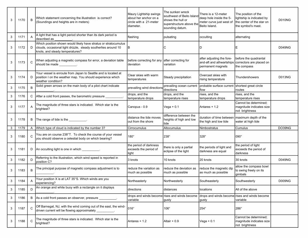
3 1170 B Which statement concerning the illustration is correct? (Soundings and heights are in meters)
Maury Lightship swings about her anchor on a circle with a 21-meter diameter.
The sunken wreck southwest of Beito Island shows the hull or superstructure above the sounding datum.
There is a 12-meter deep hole inside the 5-meter curve just west of Beito Island.
The position of the lightship is indicated by the center of the star on the symbol's mast.
D010NG
3 1171 A A light that has a light period shorter than its dark period is described as __________. flashing pulsating occulting alternating
3 1172 DWhich position shown would likely have stratus or stratocumulus clouds, occasional light drizzle, steady southerlies around 10 knots, and steady temperatures?
B C D E D049NG
3 1173 C When adjusting a magnetic compass for error, a deviation table should be made __________.
before correcting for any deviation
after correcting for variation
after adjusting the fore-and-aft and athwartships permanent magnets
before the quadrantal correctors are placed on the compass
3 1174 DYour vessel is enroute from Japan to Seattle and is located at position I on the weather map. You should experience which weather condition?
Clear skies with warm temperatures Steady precipitation Overcast skies with
rising temperature Thundershowers D013NG
3 1175 B Solid green arrows on the main body of a pilot chart indicate __________. prevailing wind directions prevailing ocean current
directionsprobable surface current flow
shortest great circle routes
3 1176 C After a cold front passes, the barometric pressure __________. drops, and the temperature drops
drops, and the temperature rises
rises, and the temperature drops
rises, and the temperature rises
3 1177 A The magnitude of three stars is indicated. Which star is the brightest? Canopus - 0.9 Vega + 0.1 Antares + 1.2
Cannot be determined; magnitude indicates size not brightness
3 1178 B The range of tide is the __________. distance the tide moves out from the shore
difference between the heights of high and low tide
duration of time between the high and low tide
maximum depth of the water at high tide
3 1179 A Which type of cloud is indicated by the number 3? Cirrocumulus Altocumulus Nimbostratus Cumulus DO39NG
3 1180 C You are on course 238°T. To check the course of your vessel you should observe a celestial body on which bearing? 180° 238° 328° 090°
3 1181 D An occulting light is one in which __________.the period of darkness exceeds the period of light
there is only a partial eclipse of the light
the periods of light and darkness are equal
the period of light exceeds the period of darkness
3 1182 D Referring to the illustration, which wind speed is reported in position C? 3 knots 10 knots 20 knots 30 knots D049NG
3 1183 B The principal purpose of magnetic compass adjustment is to __________.
reduce the variation as much as possible
reduce the deviation as much as possible
reduce the magnetic dip as much as possible
allow the compass bowl to swing freely on its gimbals
3 1184 A Your position X is at LAT 35°S. Which winds are you experiencing? Northeasterly Northwesterly Southeasterly Southwesterly D009NG
3 1185 D An orange and white buoy with a rectangle on it displays __________. directions distances locations All of the above
3 1186 B As a cold front passes an observer, pressure __________. drops and winds become variable
rises and winds become gusty
drops and winds become gusty
rises and winds become variable
3 1187 C Off Barnegat, NJ, with the wind coming out of the east, the wind-driven current will be flowing approximately __________. 016° 106° 254° 286°
3 1188 C The magnitude of three stars is indicated. Which star is the brightest? Antares + 1.2 Altair + 0.9 Vega + 0.1
Cannot be determined; magnitude indicates size not brightness
3 1189 D Concerning a celestial observation, the azimuth angle is measured from the principal vertical circle to the ____________ .
Greenwich celestial meridian hour circle of the body local celestial meridian vertical circle of the body
3 1190 B Which type of cloud is indicated by the number 2? Cumulus Cirrostratus Stratocumulus Altostratus DO39NG
3 1191 C You plot a fix using three lines of position and find they intersect in a triangle. The actual position of the vessel __________. is outside of the triangle may be anywhere in the
trianglemay be inside or outside of the triangle
is the geometric center of the triangle
3 1192 BYou are enroute to assist vessel A. Vessel A is underway at 5.5 knots on course 033°T, and bears 284°T at 43 miles from you. What is the course to steer at 16 knots to intercept vessel A?
284° 303° 329° 342°
3 1193 C If a ship is proceeding towards the magnetic equator, the uncorrected deviation due to permanent magnetism __________. increases remains the same decreases is unimportant and may
be neglected
3 1194 AIn the Northern Hemisphere, an observer at point II in the weather system should experience a wind shift from the __________.
southwest, clockwise to northwest
northeast, clockwise to west-southwest
northeast, counterclockwise to northwest
east, counterclockwise to south-southwest D014NG
3 1195 C A position that is obtained by applying estimated current and wind to your vessel's course and speed is a(n) __________. dead reckoning position fix estimated position None of the above
3 1196 D
In the Northern Hemisphere, gusty winds shifting clockwise, a rapid drop in temperature, thunderstorms or rain squalls in summer (frequent rain/snow squalls in winter) then a rise in pressure followed by clearing skies, indicate the passage of a(n) __________.
warm front tropical cyclone anticyclone cold front
3 1197 B Off Fire Island, NY with winds from the southwest, the average wind-driven current flows in a direction of __________. 014° 076° 170° 256°
3 1198 C The Illustration shows the symbols used on radio facsimile weather charts. Which of these symbols indicates a dust storm? I H O P D042NG
3 1199 C The Sailing Directions (Enroute) contain information on __________.
well-charted inner dangers port facilities coastal anchorages offshore traffic
separation schemes
3 1200 DYou want to transit Pollock Rip Channel, MA, on 6 April 1983. What is the period of time around the 0955 (ZD +5) slack in which the current does not exceed 0.3 knot?
0911 to 0955 0940 to 1010 0955 to 1044 0935 to 1017
3 1201 A What is NOT true concerning color sectors of lights?
Color sectors are expressed in degrees from the light toward the vessel.
Color sectors may indicate dangerous waters.
Color sectors may indicate the best water across a shoal.
Color sectors may indicate a turning point in a channel.
3 1202 B As shown in the illustration, which wind speeds are reported at position A? 10 knots 15 knots 20 knots 25 knots D049NG
3 1203 D If the compass heading and the magnetic heading are the same then __________.
the deviation has been offset by the variation
there is something wrong with the compass
the compass is being influenced by nearby metals
there is no deviation on that heading
3 1204 A Which of the symbols in illustration DO18NG designates a stationary front? A B C D DO18NG
3 1205 A How is the annual rate of change for magnetic variation shown on a pilot chart?
Gray lines on the uppermost inset chart
Red lines on the main body of the chart
In parenthesis on the lines of equal magnetic variation
Annual rate of change is not shown.
3 1206 B Brief, violent showers frequently accompanied by thunder and lightning are usually associated with __________. passage of a warm front passage of a cold front
winds shifting counterclockwise in the Northern Hemisphere
stationary high pressure systems
3 1207 AWhat will be the velocity of the tidal current at New London Harbor Entrance, CT, at 1615 EST (ZD +5) on 26 December 1983?
0.2 knot 0.4 knot 0.7 knot 0.9 knot
3 1208 A Which type of cloud is indicated by the number 1? Cirrus Altostratus Altocumulus Nimbostratus D039NG
3 1209 D You are on course 201°T. To check the speed of your vessel you should observe a celestial body on which bearing? 090° 111° 180° 201°
3 1210 C
You are inbound in a channel marked by a range. The range line is 309°T. You are steering 306°T and have the range in sight as shown. The range continues to open. What action should you take?
Alter course to the right to 309°T or more to bring the range in line.
Maintain course as it is normal for the range to open as you get close.
Alter course to the left until the range closes, then steer to the left of 306°T.
Alter course to the left to close the range, then alter course to 309°T.
D047NG
3 1211 D Red sectors of navigation lights warn mariners of __________. floating debris heavily trafficked areas recently sunken vessels shoals or nearby land
3 1213 A If the magnetic heading is greater than the compass heading, the deviation is __________. east west north south
3 1214 D The letter B in the diagram represents the __________. sensible horizon visible horizon celestial horizon geoidal horizon D006NG
3 1215 C Daylight savings time is a form of zone time that adopts the time __________. two zones to the east two zones to the west one zone to the east one zone to the west
3 1216 AIn the Northern Hemisphere, winds veering sharply to the west or northwest with increasing speed are indications that a __________.
cold front has passed low pressure center is approaching stationary front exists high pressure center has
passed
3 1217 D What will be the velocity and direction of the tidal current at Old Ferry Point, NY, at 1340 EST (ZD +5) on 5 February 1983? 0.8 knot at 060°T 0.8 knot at 240°T 1.0 knot at 076°T 1.4 knots at 076°T
3 1219 D Which sextant in illustration D043NG reads 29°42.5'? A B C D D043NG
3 1220 D Under the U.S. Aids to Navigation System, a lighted buoy with a spherical topmark marks __________.
the position of underwater cables a hazard to navigation the port side of the
channel safe water
3 1221 B On a chart, the characteristic of the light on a lighthouse is shown as flashing white with a red sector. The red sector __________.
indicates the limits of the navigable channel indicates a danger area
is used to identify the characteristics of the light
serves no significant purpose
3 1222 D On entering from seaward, a starboard side daymark will __________.
show a fixed red light if lighted
show a Morse (A) white light be square in shape have an even number if
numbered
3 1223 B The difference between magnetic heading and compass heading is called __________. variation deviation compass error drift
3 1224 DNGA (NIMA) charts are adopting the metric system. In order to change a charted depth in meters to feet you may use the conversion table found __________.
in the Light List in Bowditch Vol. II on the chart All of the above
3 1225 DThe term "Western Rivers," when it refers to regulations requiring towing vessels to carry navigational-safety equipment, charts or maps, and publications, includes the _____________ .
Mississippi River and its tributaries
Port Allen - Morgan City Alternate Route
Red River and the Old River All of the above
3 1226 B Cumulonimbus clouds are most likely to accompany a(n) __________. high pressure system cold front warm front occluded front
3 1227 C What will be the direction and velocity of the tidal current at Provincetown Harbor, MA, at 1405 DST (ZD +4) on 5 May 1983? 0.0 knot at 135°T 0.2 knot at 135°T 0.4 knot at 315°T 0.6 knot at 315°T
3 1228 C "An electronic or electric device that indicates the rate of turn of a vessel," defines a/an _____________ . magnetic compass gyro-compass swing meter odometer
3 1229 BThe initial great circle course angle between LAT 23°00'S, LONG 42°00'W and LAT 34°00'S, LONG 18°00'E is 063.8°. What is the true course?
063.8°T 116.2°T 243.8°T 296.2°T
3 1230 C Weather forecast messages are usually __________. given only to TV stationstransmitted only by commercial broadcast stations
broadcast in plain language
broadcast immediately on VHF Channel 16 and 2182 kHz
3 1231 CSome lights used as aids to marine navigation have a red sector to indicate a danger area. How are the limits of a colored sector of light listed in the Light List?
Geographical positions outlining the area of the sector
True bearings as observed from the light toward a vessel
True bearings as observed from a vessel toward the light
Bearings given in the Light List are always magnetic
3 1232 A Entering from seaward, triangular-shaped daymarks are used to mark __________.
the starboard side of the channel
the centerline of the channel
an obstruction where the preferred channel is to starboard
special purpose areas
3 1233 C Deviation is the angle between the __________. true meridian and the axis of the compass card
true meridian and the magnetic meridian
magnetic meridian and the axis of the compass card
axis of the compass card and the degaussing meridian
3 1234 B Which information does the outer ring of a compass rose on a nautical chart provide? Variation True directions Magnetic directions Annual rate of variation
change
3 1235 C Weather information provided by the National Weather Service (NWS) advisories should be used along with __________.
the Tide Tables and Tidal Current Tables
the local Notice to Mariners
weather maps and local knowledge any U.S. Coast Pilot
3 1236 B After the passage of a cold front the visibility_______. _ does not change improves rapidly improves only slightly becomes poor
3 1237 C What will be the velocity of the tidal current at Port Royal, VA, at 1505 DST (ZD +4) on 4 June 1983? 0.0 knot 0.1 knot 0.4 knot 0.7 knot
3 1238 B What will be the height of tide at Three Mile Harbor Entrance, Gardiners Bay, NY, at 0700 (ZD +5) on 14 Nov 1983? 1.1 feet (0.3 meters) 1.7 feet (0.5 meters) 1.9 feet (0.6 meters) 2.2 feet (0.7 meters)
3 1239 AWhile taking weather observations, you determine that the wind is blowing from the northeast. You would record the wind direction in the weather log as __________.
045° 090° 135° 225°
3 1240 D Weather information is available from __________. commercial radio broadcasts
the Coast Guard on scheduled marine information broadcasts
VHF-FM continuous marine weather broadcasts provided by the National Weather Service
All of the above
3 1241 A Which picture shows a fixed and flashing light? A B C D D034NG
3 1242 A Daymarks marking the starboard side of the channel when going towards the sea are __________. green squares green triangles red squares red triangles
3 1243 D Magnetic heading differs from compass heading by __________. compass error true heading variation deviation
3 1245 A You can follow the approach of a dangerous cyclonic storm by inspecting __________.
a newspaper, a weather map, a weather fax, or a weather forecast
the National Weather Service Observing Handbook No.1, Marine Surface Observations
the Coast Pilot or Sailing Directions the sky overhead
3 1246 D What weather change accompanies the passage of a cold front in the Northern Hemisphere?
Wind shift from northeast clockwise to southwest
Steady dropping of barometric pressure
Steady precipitation, gradually increasing in intensity
A line of cumulonimbus clouds
3 1247 A What is the predicted velocity of the tidal current 2 miles west of Southwest Ledge for 2330 DST (ZD +4) on 7 September 1983? 1.3 knots 1.6 knots 1.9 knots 2.2 knots

3 1248 D On 6 July 1983, at 1520 DST (ZD +4) what will be the predicted height of tide at Newburgh, NY? 2.1 feet 1.7 feet 1.2 feet 0.6 foot
3 1249 D What is the light characteristic of a lighted, preferred-channel buoy? Fixed and flashing Continuous quick Isophase Composite group-
flashing
3 1250 A Daylight savings time is a form of zone time that adopts the time __________. one zone to the east one zone to the west two zones to the east two zones to the west
3 1251 C A List of Lights entry (L Fl) is a single flashing light which shows a long flash of not less than __________. 1.0 second duration 1.5 seconds duration 2.0 seconds duration 3.0 seconds duration
3 1252 A Port side daymarks may be __________. numbered octagonal black and white of any shape
3 1253 A The horizontal angle between the magnetic meridian and the north-south line of the magnetic compass is __________. deviation variation compass error dip
3 1254 B Lighted white and orange buoys must show which color light? Orange White Red Alternating yellow and white
3 1255 D The wind velocity is higher in the dangerous semicircle of a tropical cyclone because of the __________.
extension of the low pressure ridge
direction of circulation and pressure gradient recurvature effect
the wind circulation and forward motion of the storm
3 1256 A A cold front moving in from the northwest can produce __________.
thunderstorms, hail, and then rapid clearing
increasing cloud cover lasting for several days lengthy wet weather low ceilings with thick
cirrus clouds
3 1257 A What will be the velocity of the tidal current 1.0 mile southwest of Lewis Pt., RI, at 1501 EST (ZD +5) on 4 April 1983? 0.7 knot 1.4 knots 1.6 knots 1.9 knots
3 1258 D You should log all barometer readings taken at sea __________. regularly at least once during each watch
more often under changeable weather conditions
All of the above
3 1259 A General information on enroute weather and climate is found in __________.
the Sailing Directions and the Coast Pilot a weather fax the Local Notice to
Mariners the Light List
3 1260 B On 26 February 1983, at 1750 EST (ZD +5) what will be the predicted height of tide at New Haven (city dock), CT? -.3 foot (-0.1 meter) -.6 foot (-0.2 meter) 1.3 feet (0.4 meter) 1.6 feet (0.5 meter)
3 1261 B A light having characteristics which include color variations is defined as __________. switching alternating oscillating fluctuating
3 1262 D A safe water daymark has what shape? Triangular Diamond Circular Octagonal
3 1263 C The compass deviation changes as the vessel changes __________. geographical position speed heading longitude
3 1265 A When reporting wind direction, you should give the direction in __________. true degrees magnetic compass
degrees relative degrees isobaric degrees
3 1266 C A line of clouds, sharp changes in wind direction, and squalls are most frequently associated with a(n) __________. occluded front warm front cold front warm sector
3 1267 B What will be the velocity of the tidal current at Coxsackie, NY, at 0945 EST (ZD +5) on 11 March 1983? 0.3 knot 0.7 knot 1.2 knots 1.9 knots
3 1268 D On a nautical chart, the inner ring of a compass rose indicates __________. true directions compass error deviation magnetic directions
3 1269 C
The Light List indicates that a light has a nominal range of 14 miles and is 42 feet (12.7 m) high. If the visibility is 16 miles and your height of eye is 20 feet (6.1 m), at which approximate distance will you sight the light?
20.1 miles 16.0 miles 12.8 miles 7.6 miles
3 1271 D Which word indicates color variation in the characteristics of a light? Opposing Changing Reversing Alternating
3 1272 B What are the colors of a mid-channel daymark? Black and red Red and white Green and red Green and white3 1273 B Deviation changes with a change in __________. latitude heading longitude sea conditions
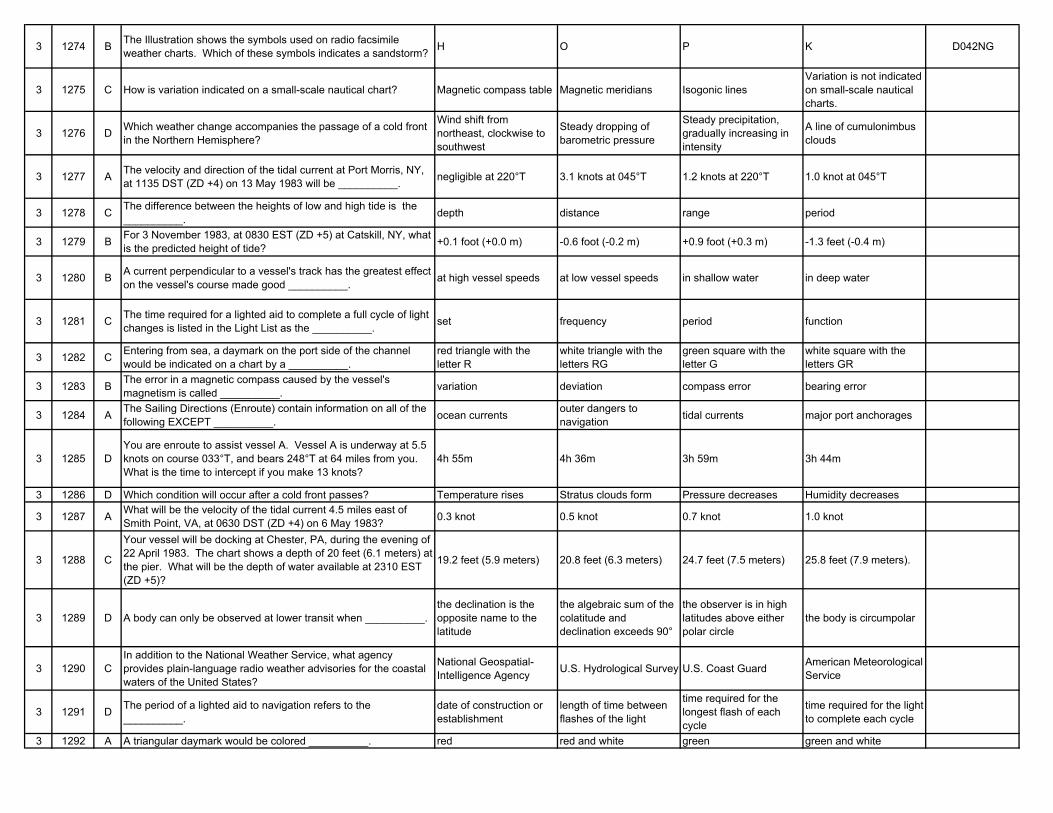
3 1274 B The Illustration shows the symbols used on radio facsimile weather charts. Which of these symbols indicates a sandstorm? H O P K D042NG
3 1275 C How is variation indicated on a small-scale nautical chart? Magnetic compass table Magnetic meridians Isogonic linesVariation is not indicated on small-scale nautical charts.
3 1276 D Which weather change accompanies the passage of a cold front in the Northern Hemisphere?
Wind shift from northeast, clockwise to southwest
Steady dropping of barometric pressure
Steady precipitation, gradually increasing in intensity
A line of cumulonimbus clouds
3 1277 A The velocity and direction of the tidal current at Port Morris, NY, at 1135 DST (ZD +4) on 13 May 1983 will be __________. negligible at 220°T 3.1 knots at 045°T 1.2 knots at 220°T 1.0 knot at 045°T
3 1278 C The difference between the heights of low and high tide is the __________. depth distance range period
3 1279 B For 3 November 1983, at 0830 EST (ZD +5) at Catskill, NY, what is the predicted height of tide? +0.1 foot (+0.0 m) -0.6 foot (-0.2 m) +0.9 foot (+0.3 m) -1.3 feet (-0.4 m)
3 1280 B A current perpendicular to a vessel's track has the greatest effect on the vessel's course made good __________. at high vessel speeds at low vessel speeds in shallow water in deep water
3 1281 C The time required for a lighted aid to complete a full cycle of light changes is listed in the Light List as the __________. set frequency period function
3 1282 C Entering from sea, a daymark on the port side of the channel would be indicated on a chart by a __________.
red triangle with the letter R
white triangle with the letters RG
green square with the letter G
white square with the letters GR
3 1283 B The error in a magnetic compass caused by the vessel's magnetism is called __________. variation deviation compass error bearing error
3 1284 A The Sailing Directions (Enroute) contain information on all of the following EXCEPT __________. ocean currents outer dangers to
navigation tidal currents major port anchorages
3 1285 DYou are enroute to assist vessel A. Vessel A is underway at 5.5 knots on course 033°T, and bears 248°T at 64 miles from you. What is the time to intercept if you make 13 knots?
4h 55m 4h 36m 3h 59m 3h 44m
3 1286 D Which condition will occur after a cold front passes? Temperature rises Stratus clouds form Pressure decreases Humidity decreases
3 1287 A What will be the velocity of the tidal current 4.5 miles east of Smith Point, VA, at 0630 DST (ZD +4) on 6 May 1983? 0.3 knot 0.5 knot 0.7 knot 1.0 knot
3 1288 C
Your vessel will be docking at Chester, PA, during the evening of 22 April 1983. The chart shows a depth of 20 feet (6.1 meters) at the pier. What will be the depth of water available at 2310 EST (ZD +5)?
19.2 feet (5.9 meters) 20.8 feet (6.3 meters) 24.7 feet (7.5 meters) 25.8 feet (7.9 meters).
3 1289 D A body can only be observed at lower transit when __________.the declination is the opposite name to the latitude
the algebraic sum of the colatitude and declination exceeds 90°
the observer is in high latitudes above either polar circle
the body is circumpolar
3 1290 CIn addition to the National Weather Service, what agency provides plain-language radio weather advisories for the coastal waters of the United States?
National Geospatial-Intelligence Agency U.S. Hydrological Survey U.S. Coast Guard American Meteorological
Service
3 1291 D The period of a lighted aid to navigation refers to the __________.
date of construction or establishment
length of time between flashes of the light
time required for the longest flash of each cycle
time required for the light to complete each cycle
3 1292 A A triangular daymark would be colored __________. red red and white green green and white
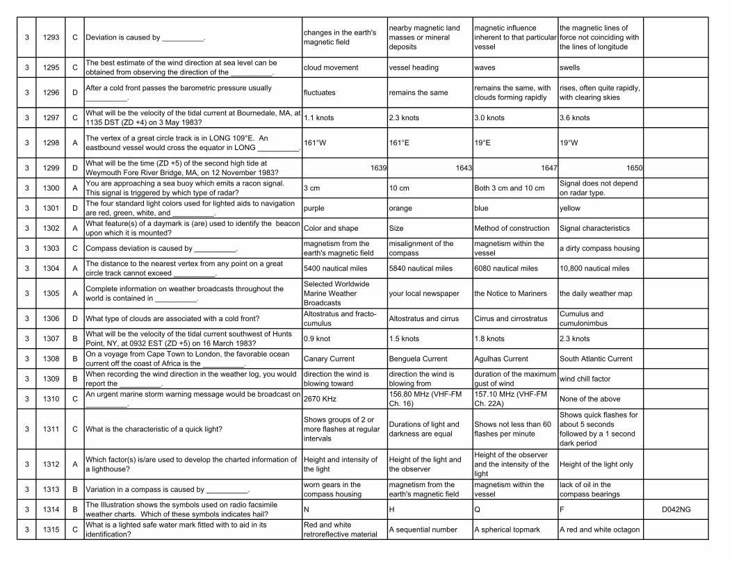
3 1293 C Deviation is caused by __________. changes in the earth's magnetic field
nearby magnetic land masses or mineral deposits
magnetic influence inherent to that particular vessel
the magnetic lines of force not coinciding with the lines of longitude
3 1295 C The best estimate of the wind direction at sea level can be obtained from observing the direction of the __________. cloud movement vessel heading waves swells
3 1296 D After a cold front passes the barometric pressure usually __________. fluctuates remains the same remains the same, with
clouds forming rapidlyrises, often quite rapidly, with clearing skies
3 1297 C What will be the velocity of the tidal current at Bournedale, MA, at 1135 DST (ZD +4) on 3 May 1983? 1.1 knots 2.3 knots 3.0 knots 3.6 knots
3 1298 A The vertex of a great circle track is in LONG 109°E. An eastbound vessel would cross the equator in LONG __________. 161°W 161°E 19°E 19°W
3 1299 D What will be the time (ZD +5) of the second high tide at Weymouth Fore River Bridge, MA, on 12 November 1983? 1639 1643 1647 1650
3 1300 A You are approaching a sea buoy which emits a racon signal. This signal is triggered by which type of radar? 3 cm 10 cm Both 3 cm and 10 cm Signal does not depend
on radar type.
3 1301 D The four standard light colors used for lighted aids to navigation are red, green, white, and __________. purple orange blue yellow
3 1302 A What feature(s) of a daymark is (are) used to identify the beacon upon which it is mounted? Color and shape Size Method of construction Signal characteristics
3 1303 C Compass deviation is caused by __________. magnetism from the earth's magnetic field
misalignment of the compass
magnetism within the vessel a dirty compass housing
3 1304 A The distance to the nearest vertex from any point on a great circle track cannot exceed __________. 5400 nautical miles 5840 nautical miles 6080 nautical miles 10,800 nautical miles
3 1305 A Complete information on weather broadcasts throughout the world is contained in __________.
Selected Worldwide Marine Weather Broadcasts
your local newspaper the Notice to Mariners the daily weather map
3 1306 D What type of clouds are associated with a cold front? Altostratus and fracto-cumulus Altostratus and cirrus Cirrus and cirrostratus Cumulus and
cumulonimbus
3 1307 B What will be the velocity of the tidal current southwest of Hunts Point, NY, at 0932 EST (ZD +5) on 16 March 1983? 0.9 knot 1.5 knots 1.8 knots 2.3 knots
3 1308 B On a voyage from Cape Town to London, the favorable ocean current off the coast of Africa is the __________. Canary Current Benguela Current Agulhas Current South Atlantic Current
3 1309 B When recording the wind direction in the weather log, you would report the __________.
direction the wind is blowing toward
direction the wind is blowing from
duration of the maximum gust of wind wind chill factor
3 1310 C An urgent marine storm warning message would be broadcast on __________. 2670 KHz 156.80 MHz (VHF-FM
Ch. 16)157.10 MHz (VHF-FM Ch. 22A) None of the above
3 1311 C What is the characteristic of a quick light?Shows groups of 2 or more flashes at regular intervals
Durations of light and darkness are equal
Shows not less than 60 flashes per minute
Shows quick flashes for about 5 seconds followed by a 1 second dark period
3 1312 A Which factor(s) is/are used to develop the charted information of a lighthouse?
Height and intensity of the light
Height of the light and the observer
Height of the observer and the intensity of the light
Height of the light only
3 1313 B Variation in a compass is caused by __________. worn gears in the compass housing
magnetism from the earth's magnetic field
magnetism within the vessel
lack of oil in the compass bearings
3 1314 B The Illustration shows the symbols used on radio facsimile weather charts. Which of these symbols indicates hail? N H Q F D042NG
3 1315 C What is a lighted safe water mark fitted with to aid in its identification?
Red and white retroreflective material A sequential number A spherical topmark A red and white octagon
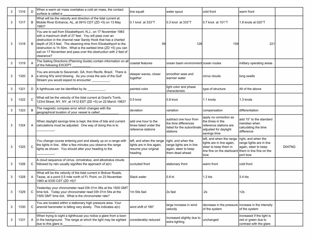
3 1316 D When a warm air mass overtakes a cold air mass, the contact surface is called a __________. line squall water spout cold front warm front
3 1317 BWhat will be the velocity and direction of the tidal current at Mobile River Entrance, AL, at 0915 CDT (ZD +5) on 13 May 1983?
0.1 knot at 333°T 0.3 knot at 333°T 0.7 knot at 151°T 1.8 knots at 025°T
3 1318 B
You are to sail from Elizabethport, N.J., on 17 November 1983 with a maximum draft of 27 feet. You will pass over an obstruction in the channel near Sandy Hook that has a charted depth of 25.5 feet. The steaming time from Elizabethport to the obstruction is 1h 50m. What is the earliest time (ZD +5) you can sail on 17 November and pass over the obstruction with 2 feet of clearance?
59 128 159 221
3 1319 A The Sailing Directions (Planning Guide) contain information on all of the following EXCEPT __________. coastal features ocean basin environment ocean routes military operating areas
3 1320 AYou are enroute to Savannah, GA, from Recife, Brazil. There is a strong N'ly wind blowing. As you cross the axis of the Gulf Stream you would expect to encounter __________.
steeper waves, closer together
smoother seas and warmer water cirrus clouds long swells
3 1321 D A lighthouse can be identified by its __________. painted color light color and phase characteristic type of structure All of the above
3 1322 C What will be the velocity of the tidal current at Grant's Tomb, 123rd Street, NY, NY, at 1412 EST (ZD +5) on 22 March 1983? 0.5 knot 0.8 knot 1.1 knots 1.3 knots
3 1323 B The magnetic compass error which changes with the geographical location of your vessel is called __________. deviation variation compensation differentiation
3 1324 AWhen daylight savings time is kept, the time of tide and current calculations must be adjusted. One way of doing this is to __________.
add one hour to the times listed under the reference stations
subtract one hour from the time differences listed for the subordinate stations
apply no correction as the times in the reference stations are adjusted for daylight savings time
add 15° to the standard meridian when calculating the time difference
3 1325 C
You change course entering port and steady up on a range with the lights in line. After a few minutes you observe the range lights as shown. You should alter your heading to the __________.
left, and when the range lights are in line again, resume your original heading
right, and when the range lights are in line again, steer to keep them dead ahead
left, and when the range lights are in line again, steer to keep them in line fine on the starboard bow
right, and when the range lights are in line again, steer to keep them in line fine on the port bow
D047NG
3 1326 CA cloud sequence of cirrus, cirrostratus, and altostratus clouds followed by rain usually signifies the approach of a(n) __________.
occluded front stationary front warm front cold front
3 1328 AWhat will be the velocity of the tidal current in Bolivar Roads, Texas, at a point 0.5 mile north of Ft. Point, on 23 November 1983 at 0330 CST (ZD +6)?
Slack water 0.8 kt 1.2 kts 3.4 kts
3 1329 CYesterday your chronometer read 03h 01m 56s at the 1500 GMT time tick. Today your chronometer read 03h 01m 54s at the 1500 GMT time tick. What is the chronometer rate?
1m 54s fast 2s fast -2s +2s
3 1330 CYou are located within a stationary high pressure area. Your aneroid barometer is falling very slowly. This indicates a(n) __________.
wind shift of 180° large increase in wind velocity
decrease in the pressure of the system
increase in the intensity of the system
3 1331 AWhen trying to sight a lighthouse you notice a glare from a town in the background. The range at which the light may be sighted due to this glare is __________.
considerably reduced increased slightly due to extra lighting unchanged
increased if the light is red or green due to contrast with the glare
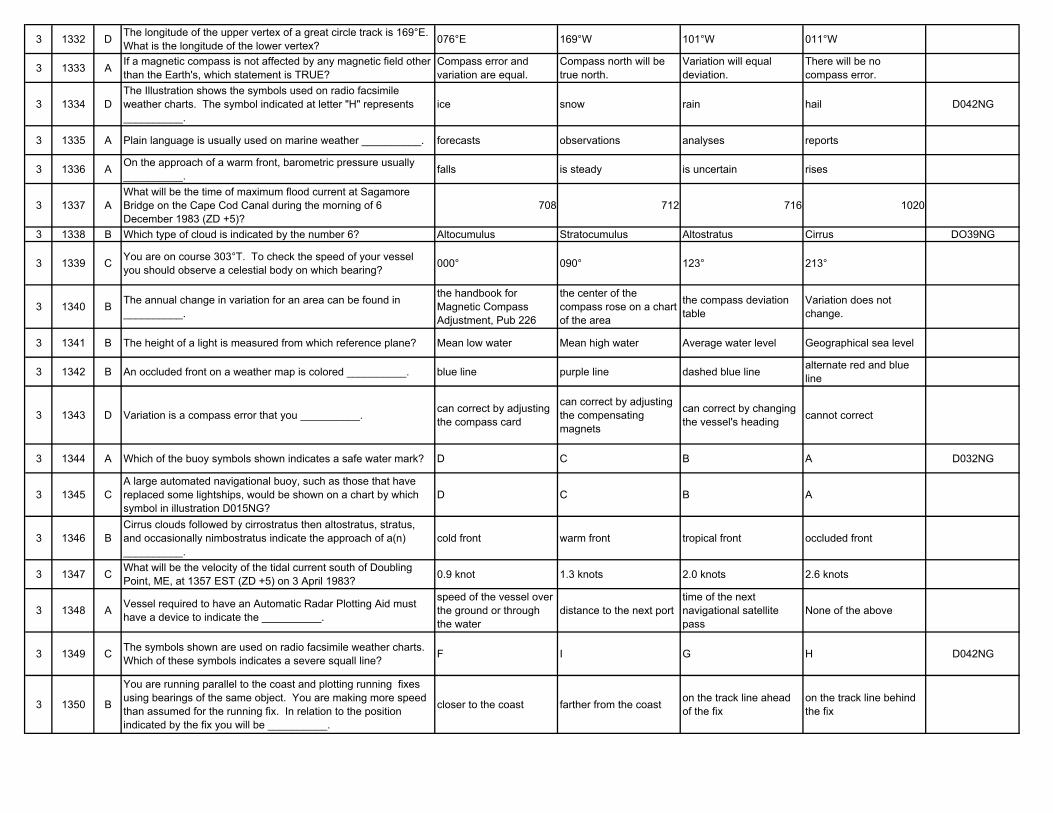
3 1332 D The longitude of the upper vertex of a great circle track is 169°E. What is the longitude of the lower vertex? 076°E 169°W 101°W 011°W
3 1333 A If a magnetic compass is not affected by any magnetic field other than the Earth's, which statement is TRUE?
Compass error and variation are equal.
Compass north will be true north.
Variation will equal deviation.
There will be no compass error.
3 1334 DThe Illustration shows the symbols used on radio facsimile weather charts. The symbol indicated at letter "H" represents __________.
ice snow rain hail D042NG
3 1335 A Plain language is usually used on marine weather __________. forecasts observations analyses reports
3 1336 A On the approach of a warm front, barometric pressure usually __________. falls is steady is uncertain rises
3 1337 AWhat will be the time of maximum flood current at Sagamore Bridge on the Cape Cod Canal during the morning of 6 December 1983 (ZD +5)?
708 712 716 1020
3 1338 B Which type of cloud is indicated by the number 6? Altocumulus Stratocumulus Altostratus Cirrus DO39NG
3 1339 C You are on course 303°T. To check the speed of your vessel you should observe a celestial body on which bearing? 000° 090° 123° 213°
3 1340 B The annual change in variation for an area can be found in __________.
the handbook for Magnetic Compass Adjustment, Pub 226
the center of the compass rose on a chart of the area
the compass deviation table
Variation does not change.
3 1341 B The height of a light is measured from which reference plane? Mean low water Mean high water Average water level Geographical sea level
3 1342 B An occluded front on a weather map is colored __________. blue line purple line dashed blue line alternate red and blue line
3 1343 D Variation is a compass error that you __________. can correct by adjusting the compass card
can correct by adjusting the compensating magnets
can correct by changing the vessel's heading cannot correct
3 1344 A Which of the buoy symbols shown indicates a safe water mark? D C B A D032NG
3 1345 CA large automated navigational buoy, such as those that have replaced some lightships, would be shown on a chart by which symbol in illustration D015NG?
D C B A
3 1346 BCirrus clouds followed by cirrostratus then altostratus, stratus, and occasionally nimbostratus indicate the approach of a(n) __________.
cold front warm front tropical front occluded front
3 1347 C What will be the velocity of the tidal current south of Doubling Point, ME, at 1357 EST (ZD +5) on 3 April 1983? 0.9 knot 1.3 knots 2.0 knots 2.6 knots
3 1348 A Vessel required to have an Automatic Radar Plotting Aid must have a device to indicate the __________.
speed of the vessel over the ground or through the water
distance to the next porttime of the next navigational satellite pass
None of the above
3 1349 C The symbols shown are used on radio facsimile weather charts. Which of these symbols indicates a severe squall line? F I G H D042NG
3 1350 B
You are running parallel to the coast and plotting running fixes using bearings of the same object. You are making more speed than assumed for the running fix. In relation to the position indicated by the fix you will be __________.
closer to the coast farther from the coast on the track line ahead of the fix
on the track line behind the fix
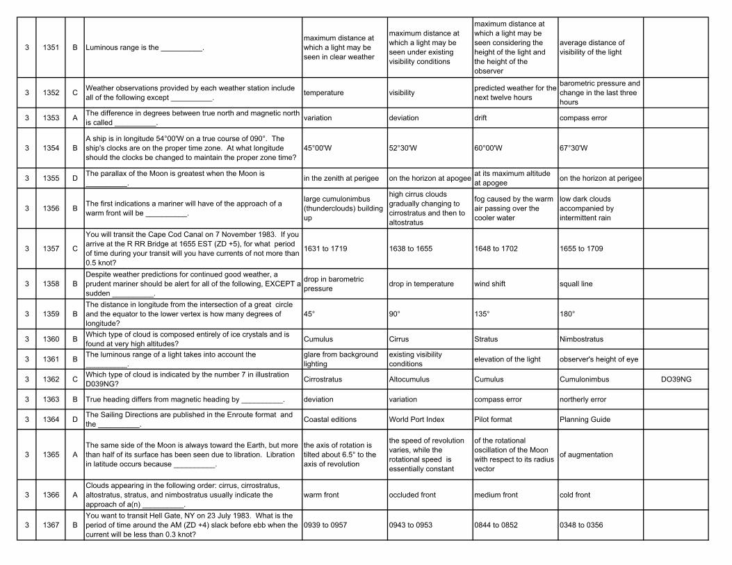
3 1351 B Luminous range is the __________.maximum distance at which a light may be seen in clear weather
maximum distance at which a light may be seen under existing visibility conditions
maximum distance at which a light may be seen considering the height of the light and the height of the observer
average distance of visibility of the light
3 1352 C Weather observations provided by each weather station include all of the following except __________. temperature visibility predicted weather for the
next twelve hours
barometric pressure and change in the last three hours
3 1353 A The difference in degrees between true north and magnetic north is called __________. variation deviation drift compass error
3 1354 BA ship is in longitude 54°00'W on a true course of 090°. The ship's clocks are on the proper time zone. At what longitude should the clocks be changed to maintain the proper zone time?
45°00'W 52°30'W 60°00'W 67°30'W
3 1355 D The parallax of the Moon is greatest when the Moon is __________. in the zenith at perigee on the horizon at apogee at its maximum altitude
at apogee on the horizon at perigee
3 1356 B The first indications a mariner will have of the approach of a warm front will be __________.
large cumulonimbus (thunderclouds) building up
high cirrus clouds gradually changing to cirrostratus and then to altostratus
fog caused by the warm air passing over the cooler water
low dark clouds accompanied by intermittent rain
3 1357 C
You will transit the Cape Cod Canal on 7 November 1983. If you arrive at the R RR Bridge at 1655 EST (ZD +5), for what period of time during your transit will you have currents of not more than 0.5 knot?
1631 to 1719 1638 to 1655 1648 to 1702 1655 to 1709
3 1358 BDespite weather predictions for continued good weather, a prudent mariner should be alert for all of the following, EXCEPT a sudden __________.
drop in barometric pressure drop in temperature wind shift squall line
3 1359 BThe distance in longitude from the intersection of a great circle and the equator to the lower vertex is how many degrees of longitude?
45° 90° 135° 180°
3 1360 B Which type of cloud is composed entirely of ice crystals and is found at very high altitudes? Cumulus Cirrus Stratus Nimbostratus
3 1361 B The luminous range of a light takes into account the __________.
glare from background lighting
existing visibility conditions elevation of the light observer's height of eye
3 1362 C Which type of cloud is indicated by the number 7 in illustration D039NG? Cirrostratus Altocumulus Cumulus Cumulonimbus DO39NG
3 1363 B True heading differs from magnetic heading by __________. deviation variation compass error northerly error
3 1364 D The Sailing Directions are published in the Enroute format and the __________. Coastal editions World Port Index Pilot format Planning Guide
3 1365 AThe same side of the Moon is always toward the Earth, but more than half of its surface has been seen due to libration. Libration in latitude occurs because __________.
the axis of rotation is tilted about 6.5° to the axis of revolution
the speed of revolution varies, while the rotational speed is essentially constant
of the rotational oscillation of the Moon with respect to its radius vector
of augmentation
3 1366 AClouds appearing in the following order: cirrus, cirrostratus, altostratus, stratus, and nimbostratus usually indicate the approach of a(n) __________.
warm front occluded front medium front cold front
3 1367 BYou want to transit Hell Gate, NY on 23 July 1983. What is the period of time around the AM (ZD +4) slack before ebb when the current will be less than 0.3 knot?
0939 to 0957 0943 to 0953 0844 to 0852 0348 to 0356
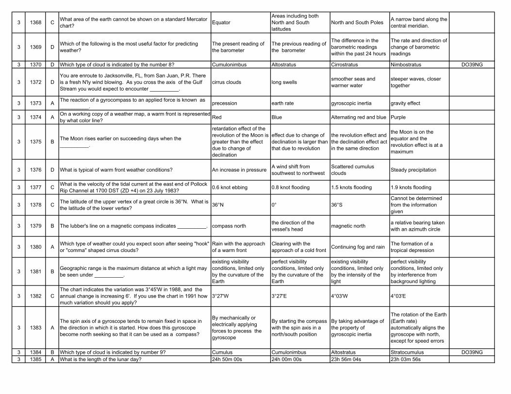
3 1368 C What area of the earth cannot be shown on a standard Mercator chart? Equator
Areas including both North and South latitudes
North and South Poles A narrow band along the central meridian.
3 1369 D Which of the following is the most useful factor for predicting weather?
The present reading of the barometer
The previous reading of the barometer
The difference in the barometric readings within the past 24 hours
The rate and direction of change of barometric readings
3 1370 D Which type of cloud is indicated by the number 8? Cumulonimbus Altostratus Cirrostratus Nimbostratus DO39NG
3 1372 DYou are enroute to Jacksonville, FL, from San Juan, P.R. There is a fresh N'ly wind blowing. As you cross the axis of the Gulf Stream you would expect to encounter __________.
cirrus clouds long swells smoother seas and warmer water
steeper waves, closer together
3 1373 A The reaction of a gyrocompass to an applied force is known as __________. precession earth rate gyroscopic inertia gravity effect
3 1374 A On a working copy of a weather map, a warm front is represented by what color line? Red Blue Alternating red and blue Purple
3 1375 B The Moon rises earlier on succeeding days when the __________.
retardation effect of the revolution of the Moon is greater than the effect due to change of declination
effect due to change of declination is larger than that due to revolution
the revolution effect and the declination effect act in the same direction
the Moon is on the equator and the revolution effect is at a maximum
3 1376 D What is typical of warm front weather conditions? An increase in pressure A wind shift from southwest to northwest
Scattered cumulus clouds Steady precipitation
3 1377 C What is the velocity of the tidal current at the east end of Pollock Rip Channel at 1700 DST (ZD +4) on 23 July 1983? 0.6 knot ebbing 0.8 knot flooding 1.5 knots flooding 1.9 knots flooding
3 1378 C The latitude of the upper vertex of a great circle is 36°N. What is the latitude of the lower vertex? 36°N 0° 36°S
Cannot be determined from the information given
3 1379 B The lubber's line on a magnetic compass indicates __________. compass north the direction of the vessel's head magnetic north a relative bearing taken
with an azimuth circle
3 1380 A Which type of weather could you expect soon after seeing "hook" or "comma" shaped cirrus clouds?
Rain with the approach of a warm front
Clearing with the approach of a cold front Continuing fog and rain The formation of a
tropical depression
3 1381 B Geographic range is the maximum distance at which a light may be seen under __________.
existing visibility conditions, limited only by the curvature of the Earth
perfect visibility conditions, limited only by the curvature of the Earth
existing visibility conditions, limited only by the intensity of the light
perfect visibility conditions, limited only by interference from background lighting
3 1382 CThe chart indicates the variation was 3°45'W in 1988, and the annual change is increasing 6'. If you use the chart in 1991 how much variation should you apply?
3°27'W 3°27'E 4°03'W 4°03'E
3 1383 AThe spin axis of a gyroscope tends to remain fixed in space in the direction in which it is started. How does this gyroscope become north seeking so that it can be used as a compass?
By mechanically or electrically applying forces to precess the gyroscope
By starting the compass with the spin axis in a north/south position
By taking advantage of the property of gyroscopic inertia
The rotation of the Earth (Earth rate) automatically aligns the gyroscope with north, except for speed errors
3 1384 B Which type of cloud is indicated by number 9? Cumulus Cumulonimbus Altostratus Stratocumulus DO39NG3 1385 A What is the length of the lunar day? 24h 50m 00s 24h 00m 00s 23h 56m 04s 23h 03m 56s
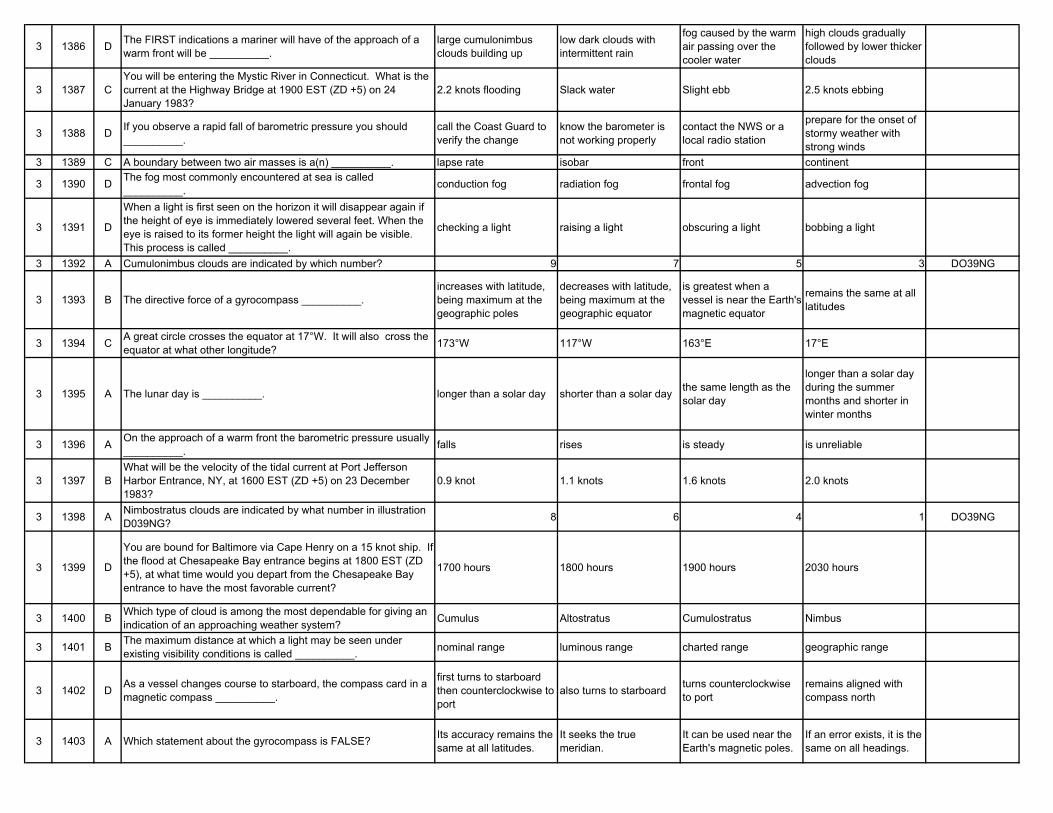
3 1386 D The FIRST indications a mariner will have of the approach of a warm front will be __________.
large cumulonimbus clouds building up
low dark clouds with intermittent rain
fog caused by the warm air passing over the cooler water
high clouds gradually followed by lower thicker clouds
3 1387 CYou will be entering the Mystic River in Connecticut. What is the current at the Highway Bridge at 1900 EST (ZD +5) on 24 January 1983?
2.2 knots flooding Slack water Slight ebb 2.5 knots ebbing
3 1388 D If you observe a rapid fall of barometric pressure you should __________.
call the Coast Guard to verify the change
know the barometer is not working properly
contact the NWS or a local radio station
prepare for the onset of stormy weather with strong winds
3 1389 C A boundary between two air masses is a(n) __________. lapse rate isobar front continent
3 1390 D The fog most commonly encountered at sea is called __________. conduction fog radiation fog frontal fog advection fog
3 1391 D
When a light is first seen on the horizon it will disappear again if the height of eye is immediately lowered several feet. When the eye is raised to its former height the light will again be visible. This process is called __________.
checking a light raising a light obscuring a light bobbing a light
3 1392 A Cumulonimbus clouds are indicated by which number? 9 7 5 3 DO39NG
3 1393 B The directive force of a gyrocompass __________.increases with latitude, being maximum at the geographic poles
decreases with latitude, being maximum at the geographic equator
is greatest when a vessel is near the Earth's magnetic equator
remains the same at all latitudes
3 1394 C A great circle crosses the equator at 17°W. It will also cross the equator at what other longitude? 173°W 117°W 163°E 17°E
3 1395 A The lunar day is __________. longer than a solar day shorter than a solar day the same length as the solar day
longer than a solar day during the summer months and shorter in winter months
3 1396 A On the approach of a warm front the barometric pressure usually __________. falls rises is steady is unreliable
3 1397 BWhat will be the velocity of the tidal current at Port Jefferson Harbor Entrance, NY, at 1600 EST (ZD +5) on 23 December 1983?
0.9 knot 1.1 knots 1.6 knots 2.0 knots
3 1398 A Nimbostratus clouds are indicated by what number in illustration D039NG? 8 6 4 1 DO39NG
3 1399 D
You are bound for Baltimore via Cape Henry on a 15 knot ship. If the flood at Chesapeake Bay entrance begins at 1800 EST (ZD +5), at what time would you depart from the Chesapeake Bay entrance to have the most favorable current?
1700 hours 1800 hours 1900 hours 2030 hours
3 1400 B Which type of cloud is among the most dependable for giving an indication of an approaching weather system? Cumulus Altostratus Cumulostratus Nimbus
3 1401 B The maximum distance at which a light may be seen under existing visibility conditions is called __________. nominal range luminous range charted range geographic range
3 1402 D As a vessel changes course to starboard, the compass card in a magnetic compass __________.
first turns to starboard then counterclockwise to port
also turns to starboard turns counterclockwise to port
remains aligned with compass north
3 1403 A Which statement about the gyrocompass is FALSE? Its accuracy remains the same at all latitudes.
It seeks the true meridian.
It can be used near the Earth's magnetic poles.
If an error exists, it is the same on all headings.
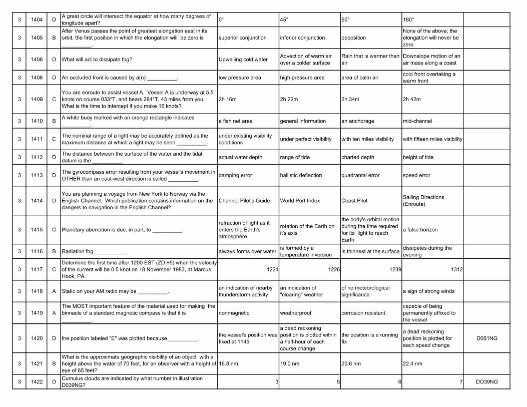
3 1404 D A great circle will intersect the equator at how many degrees of longitude apart? 0° 45° 90° 180°
3 1405 BAfter Venus passes the point of greatest elongation east in its orbit, the first position in which the elongation will be zero is __________.
superior conjunction inferior conjunction oppositionNone of the above; the elongation will never be zero
3 1406 D What will act to dissipate fog? Upwelling cold water Advection of warm air over a colder surface
Rain that is warmer than air
Downslope motion of an air mass along a coast
3 1408 D An occluded front is caused by a(n) __________. low pressure area high pressure area area of calm air cold front overtaking a warm front
3 1409 CYou are enroute to assist vessel A. Vessel A is underway at 5.5 knots on course 033°T, and bears 284°T, 43 miles from you. What is the time to intercept if you make 16 knots?
2h 16m 2h 22m 2h 34m 2h 42m
3 1410 B A white buoy marked with an orange rectangle indicates __________. a fish net area general information an anchorage mid-channel
3 1411 C The nominal range of a light may be accurately defined as the maximum distance at which a light may be seen __________.
under existing visibility conditions under perfect visibility with ten miles visibility with fifteen miles visibility
3 1412 D The distance between the surface of the water and the tidal datum is the __________. actual water depth range of tide charted depth height of tide
3 1413 D The gyrocompass error resulting from your vessel's movement in OTHER than an east-west direction is called __________. damping error ballistic deflection quadrantal error speed error
3 1414 DYou are planning a voyage from New York to Norway via the English Channel. Which publication contains information on the dangers to navigation in the English Channel?
Channel Pilot's Guide World Port Index Coast Pilot Sailing Directions (Enroute)
3 1415 C Planetary aberration is due, in part, to __________.refraction of light as it enters the Earth's atmosphere
rotation of the Earth on it's axis
the body's orbital motion during the time required for its light to reach Earth
a false horizon
3 1416 B Radiation fog __________. always forms over water is formed by a temperature inversion is thinnest at the surface dissipates during the
evening
3 1417 CDetermine the first time after 1200 EST (ZD +5) when the velocity of the current will be 0.5 knot on 18 November 1983, at Marcus Hook, PA.
1221 1226 1239 1312
3 1418 A Static on your AM radio may be __________. an indication of nearby thunderstorm activity
an indication of "clearing" weather
of no meteorological significance a sign of strong winds
3 1419 AThe MOST important feature of the material used for making the binnacle of a standard magnetic compass is that it is __________.
nonmagnetic weatherproof corrosion resistantcapable of being permanently affixed to the vessel
3 1420 D the position labeled "E" was plotted because __________. the vessel's position was fixed at 1145
a dead reckoning position is plotted within a half-hour of each course change
the position is a running fix
a dead reckoning position is plotted for each speed change
D051NG
3 1421 BWhat is the approximate geographic visibility of an object with a height above the water of 70 feet, for an observer with a height of eye of 65 feet?
16.8 nm 19.0 nm 20.6 nm 22.4 nm
3 1422 D Cumulus clouds are indicated by what number in illustration D039NG? 3 5 6 7 DO39NG
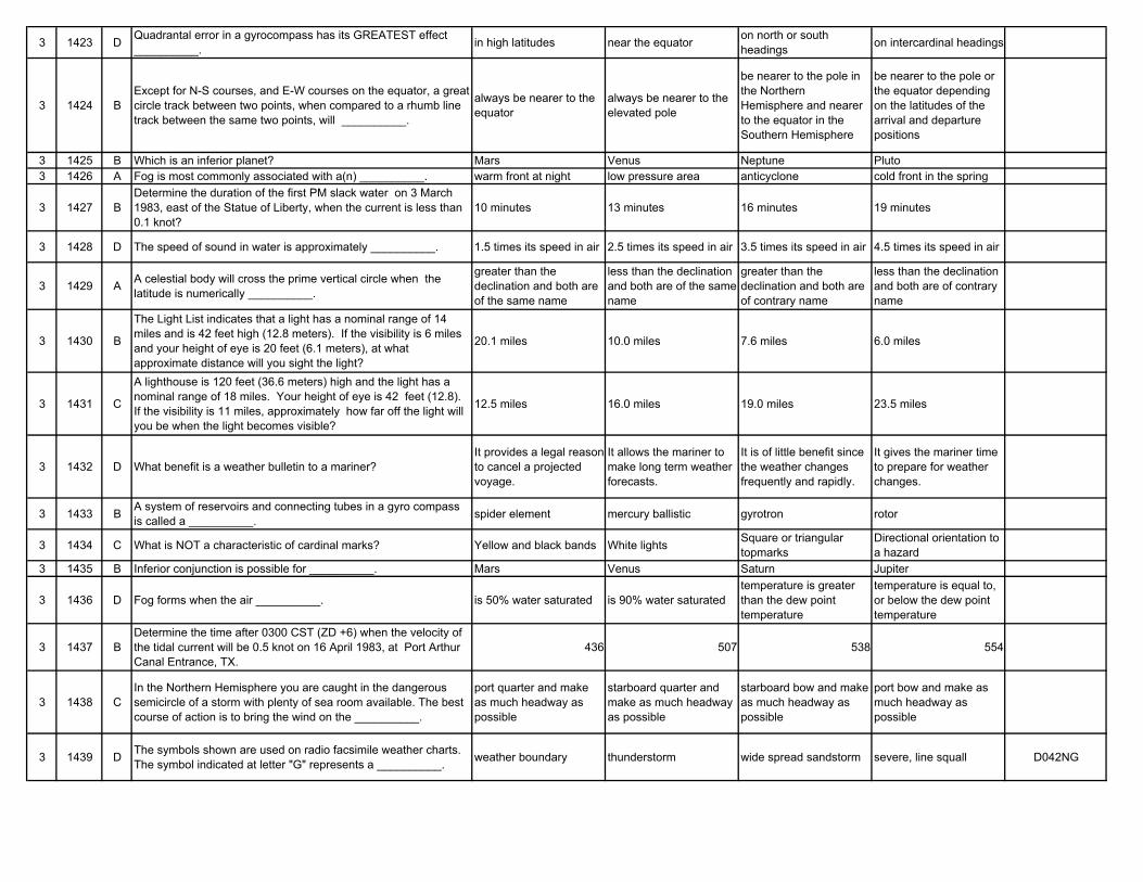
3 1423 D Quadrantal error in a gyrocompass has its GREATEST effect __________. in high latitudes near the equator on north or south
headings on intercardinal headings
3 1424 BExcept for N-S courses, and E-W courses on the equator, a great circle track between two points, when compared to a rhumb line track between the same two points, will __________.
always be nearer to the equator
always be nearer to the elevated pole
be nearer to the pole in the Northern Hemisphere and nearer to the equator in the Southern Hemisphere
be nearer to the pole or the equator depending on the latitudes of the arrival and departure positions
3 1425 B Which is an inferior planet? Mars Venus Neptune Pluto3 1426 A Fog is most commonly associated with a(n) __________. warm front at night low pressure area anticyclone cold front in the spring
3 1427 BDetermine the duration of the first PM slack water on 3 March 1983, east of the Statue of Liberty, when the current is less than 0.1 knot?
10 minutes 13 minutes 16 minutes 19 minutes
3 1428 D The speed of sound in water is approximately __________. 1.5 times its speed in air 2.5 times its speed in air 3.5 times its speed in air 4.5 times its speed in air
3 1429 A A celestial body will cross the prime vertical circle when the latitude is numerically __________.
greater than the declination and both are of the same name
less than the declination and both are of the same name
greater than the declination and both are of contrary name
less than the declination and both are of contrary name
3 1430 B
The Light List indicates that a light has a nominal range of 14 miles and is 42 feet high (12.8 meters). If the visibility is 6 miles and your height of eye is 20 feet (6.1 meters), at what approximate distance will you sight the light?
20.1 miles 10.0 miles 7.6 miles 6.0 miles
3 1431 C
A lighthouse is 120 feet (36.6 meters) high and the light has a nominal range of 18 miles. Your height of eye is 42 feet (12.8). If the visibility is 11 miles, approximately how far off the light will you be when the light becomes visible?
12.5 miles 16.0 miles 19.0 miles 23.5 miles
3 1432 D What benefit is a weather bulletin to a mariner?It provides a legal reason to cancel a projected voyage.
It allows the mariner to make long term weather forecasts.
It is of little benefit since the weather changes frequently and rapidly.
It gives the mariner time to prepare for weather changes.
3 1433 B A system of reservoirs and connecting tubes in a gyro compass is called a __________. spider element mercury ballistic gyrotron rotor
3 1434 C What is NOT a characteristic of cardinal marks? Yellow and black bands White lights Square or triangular topmarks
Directional orientation to a hazard
3 1435 B Inferior conjunction is possible for __________. Mars Venus Saturn Jupiter
3 1436 D Fog forms when the air __________. is 50% water saturated is 90% water saturatedtemperature is greater than the dew point temperature
temperature is equal to, or below the dew point temperature
3 1437 BDetermine the time after 0300 CST (ZD +6) when the velocity of the tidal current will be 0.5 knot on 16 April 1983, at Port Arthur Canal Entrance, TX.
436 507 538 554
3 1438 CIn the Northern Hemisphere you are caught in the dangerous semicircle of a storm with plenty of sea room available. The best course of action is to bring the wind on the __________.
port quarter and make as much headway as possible
starboard quarter and make as much headway as possible
starboard bow and make as much headway as possible
port bow and make as much headway as possible
3 1439 D The symbols shown are used on radio facsimile weather charts. The symbol indicated at letter "G" represents a __________. weather boundary thunderstorm wide spread sandstorm severe, line squall D042NG
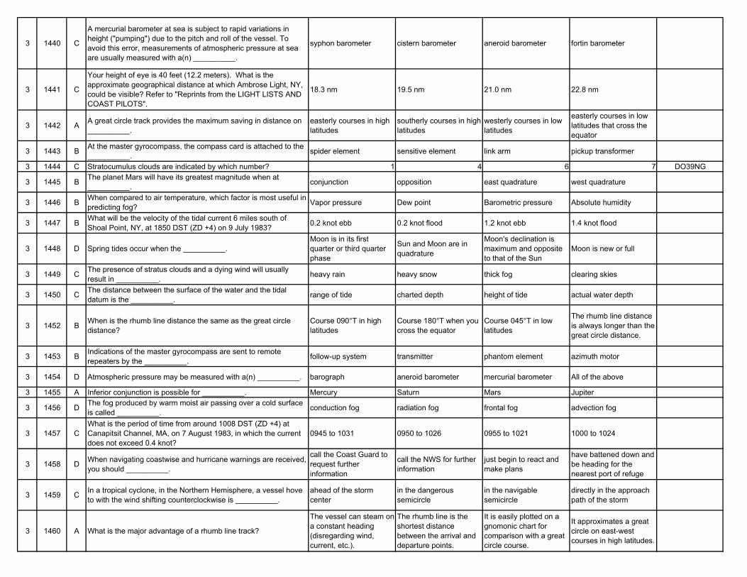
3 1440 C
A mercurial barometer at sea is subject to rapid variations in height ("pumping") due to the pitch and roll of the vessel. To avoid this error, measurements of atmospheric pressure at sea are usually measured with a(n) __________.
syphon barometer cistern barometer aneroid barometer fortin barometer
3 1441 C
Your height of eye is 40 feet (12.2 meters). What is the approximate geographical distance at which Ambrose Light, NY, could be visible? Refer to "Reprints from the LIGHT LISTS AND COAST PILOTS".
18.3 nm 19.5 nm 21.0 nm 22.8 nm
3 1442 A A great circle track provides the maximum saving in distance on __________.
easterly courses in high latitudes
southerly courses in high latitudes
westerly courses in low latitudes
easterly courses in low latitudes that cross the equator
3 1443 B At the master gyrocompass, the compass card is attached to the __________. spider element sensitive element link arm pickup transformer
3 1444 C Stratocumulus clouds are indicated by which number? 1 4 6 7 DO39NG
3 1445 B The planet Mars will have its greatest magnitude when at __________. conjunction opposition east quadrature west quadrature
3 1446 B When compared to air temperature, which factor is most useful in predicting fog? Vapor pressure Dew point Barometric pressure Absolute humidity
3 1447 B What will be the velocity of the tidal current 6 miles south of Shoal Point, NY, at 1850 DST (ZD +4) on 9 July 1983? 0.2 knot ebb 0.2 knot flood 1.2 knot ebb 1.4 knot flood
3 1448 D Spring tides occur when the __________.Moon is in its first quarter or third quarter phase
Sun and Moon are in quadrature
Moon's declination is maximum and opposite to that of the Sun
Moon is new or full
3 1449 C The presence of stratus clouds and a dying wind will usually result in __________. heavy rain heavy snow thick fog clearing skies
3 1450 C The distance between the surface of the water and the tidal datum is the __________. range of tide charted depth height of tide actual water depth
3 1452 B When is the rhumb line distance the same as the great circle distance?
Course 090°T in high latitudes
Course 180°T when you cross the equator
Course 045°T in low latitudes
The rhumb line distance is always longer than the great circle distance.
3 1453 B Indications of the master gyrocompass are sent to remote repeaters by the __________. follow-up system transmitter phantom element azimuth motor
3 1454 D Atmospheric pressure may be measured with a(n) __________. barograph aneroid barometer mercurial barometer All of the above
3 1455 A Inferior conjunction is possible for __________. Mercury Saturn Mars Jupiter
3 1456 D The fog produced by warm moist air passing over a cold surface is called __________. conduction fog radiation fog frontal fog advection fog
3 1457 CWhat is the period of time from around 1008 DST (ZD +4) at Canapitsit Channel, MA, on 7 August 1983, in which the current does not exceed 0.4 knot?
0945 to 1031 0950 to 1026 0955 to 1021 1000 to 1024
3 1458 D When navigating coastwise and hurricane warnings are received, you should __________.
call the Coast Guard to request further information
call the NWS for further information
just begin to react and make plans
have battened down and be heading for the nearest port of refuge
3 1459 C In a tropical cyclone, in the Northern Hemisphere, a vessel hove to with the wind shifting counterclockwise is __________.
ahead of the storm center
in the dangerous semicircle
in the navigable semicircle
directly in the approach path of the storm
3 1460 A What is the major advantage of a rhumb line track?
The vessel can steam on a constant heading (disregarding wind, current, etc.).
The rhumb line is the shortest distance between the arrival and departure points.
It is easily plotted on a gnomonic chart for comparison with a great circle course.
It approximates a great circle on east-west courses in high latitudes.
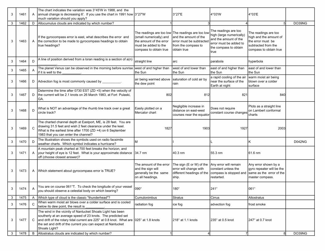
3 1461 AThe chart indicates the variation was 3°45'W in 1988, and the annual change is decreasing 6'. If you use the chart in 1991 how much variation should you apply?
3°27'W 3°27'E 4°03'W 4°03'E
3 1462 D Altocumulus clouds are indicated by which number? 1 3 4 5 DO39NG
3 1463 AIf the gyrocompass error is east, what describes the error and the correction to be made to gyrocompass headings to obtain true headings?
The readings are too low (small numerically) and the amount of the error must be added to the compass to obtain true
The readings are too low and the amount of the error must be subtracted from the compass to obtain true
The readings are too high (large numerically) and the amount of the error must be added to the compass to obtain true
The readings are too high and the amount of the error must be subtracted from the compass to obtain true
3 1464 D A line of position derived from a loran reading is a section of a(n) __________. straight line arc parabola hyperbola
3 1465 A The planet Venus can be observed in the morning before sunrise if it is well to the __________.
west of and higher than the Sun
west of and lower than the Sun
east of and higher than the Sun
east of and lower than the Sun
3 1466 D Advection fog is most commonly caused by __________. air being warmed above the dew point
saturation of cold air by rain
a rapid cooling of the air near the surface of the Earth at night
warm moist air being blown over a colder surface
3 1467 DDetermine the time after 0730 EST (ZD +5) when the velocity of the current will be 2.1 knots on 26 March 1983, at Fort Pulaski, GA.
802 812 821 840
3 1468 D What is NOT an advantage of the rhumb line track over a great circle track?
Easily plotted on a Mercator chart
Negligible increase in distance on east-west courses near the equator
Does not require constant course changes
Plots as a straight line on Lambert conformal charts
3 1469 C
The charted channel depth at Eastport, ME, is 28 feet. You are drawing 31.5 feet and wish 2 feet clearance under the keel. What is the earliest time after 1700 (ZD +4) on 6 September 1983 that you can enter the channel?
1827 1903 1927 2003
3 1470 D The Illustration shows the symbols used on radio facsimile weather charts. Which symbol indicates a hurricane? M I L K D042NG
3 1471 AA mountain peak charted at 700 feet breaks the horizon, and your height of eye is 12 feet. What is your approximate distance off (choose closest answer)?
34.7 nm 40.3 nm 55.3 nm 61.6 nm
3 1473 A Which statement about gyrocompass error is TRUE?
The amount of the error and the sign will generally be the same on all headings.
The sign (E or W) of the error will change with different headings of the ship.
Any error will remain constant unless the compass is stopped and restarted.
Any error shown by a gyro repeater will be the same as the error of the master compass.
3 1474 A You are on course 061°T. To check the longitude of your vessel you should observe a celestial body on which bearing? 090° 180° 241° 061°
3 1475 A Which type of cloud is the classic "thunderhead"? Cumulonimbus Stratus Cirrus Altostratus
3 1476 C When warm moist air blows over a colder surface and is cooled below its dew point, the result is __________. radiation fog ice fog advection fog frost smoke
3 1477 C
The wind in the vicinity of Nantucket Shoals Light has been southerly at an average speed of 23 knots. The predicted set and drift of the rotary tidal current are 225° at 0.8 knot. What are the set and drift of the current you can expect at Nantucket Shoals Light?
025° at 1.8 knots 218° at 1.1 knots 235° at 0.5 knot 247° at 0.7 knot
3 1478 B Altostratus clouds are indicated by which number? 1 4 7 8 DO39NG
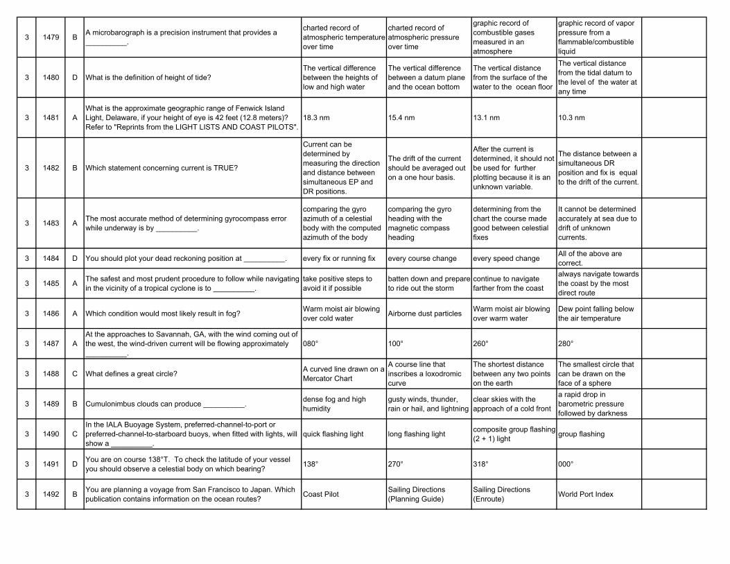
3 1479 B A microbarograph is a precision instrument that provides a __________.
charted record of atmospheric temperature over time
charted record of atmospheric pressure over time
graphic record of combustible gases measured in an atmosphere
graphic record of vapor pressure from a flammable/combustible liquid
3 1480 D What is the definition of height of tide?The vertical difference between the heights of low and high water
The vertical difference between a datum plane and the ocean bottom
The vertical distance from the surface of the water to the ocean floor
The vertical distance from the tidal datum to the level of the water at any time
3 1481 AWhat is the approximate geographic range of Fenwick Island Light, Delaware, if your height of eye is 42 feet (12.8 meters)? Refer to "Reprints from the LIGHT LISTS AND COAST PILOTS".
18.3 nm 15.4 nm 13.1 nm 10.3 nm
3 1482 B Which statement concerning current is TRUE?
Current can be determined by measuring the direction and distance between simultaneous EP and DR positions.
The drift of the current should be averaged out on a one hour basis.
After the current is determined, it should not be used for further plotting because it is an unknown variable.
The distance between a simultaneous DR position and fix is equal to the drift of the current.
3 1483 A The most accurate method of determining gyrocompass error while underway is by __________.
comparing the gyro azimuth of a celestial body with the computed azimuth of the body
comparing the gyro heading with the magnetic compass heading
determining from the chart the course made good between celestial fixes
It cannot be determined accurately at sea due to drift of unknown currents.
3 1484 D You should plot your dead reckoning position at __________. every fix or running fix every course change every speed change All of the above are correct.
3 1485 A The safest and most prudent procedure to follow while navigating in the vicinity of a tropical cyclone is to __________.
take positive steps to avoid it if possible
batten down and prepare to ride out the storm
continue to navigate farther from the coast
always navigate towards the coast by the most direct route
3 1486 A Which condition would most likely result in fog? Warm moist air blowing over cold water Airborne dust particles Warm moist air blowing
over warm waterDew point falling below the air temperature
3 1487 AAt the approaches to Savannah, GA, with the wind coming out of the west, the wind-driven current will be flowing approximately __________.
080° 100° 260° 280°
3 1488 C What defines a great circle? A curved line drawn on a Mercator Chart
A course line that inscribes a loxodromic curve
The shortest distance between any two points on the earth
The smallest circle that can be drawn on the face of a sphere
3 1489 B Cumulonimbus clouds can produce __________. dense fog and high humidity
gusty winds, thunder, rain or hail, and lightning
clear skies with the approach of a cold front
a rapid drop in barometric pressure followed by darkness
3 1490 CIn the IALA Buoyage System, preferred-channel-to-port or preferred-channel-to-starboard buoys, when fitted with lights, will show a __________.
quick flashing light long flashing light composite group flashing (2 + 1) light group flashing
3 1491 D You are on course 138°T. To check the latitude of your vessel you should observe a celestial body on which bearing? 138° 270° 318° 000°
3 1492 B You are planning a voyage from San Francisco to Japan. Which publication contains information on the ocean routes? Coast Pilot Sailing Directions
(Planning Guide)Sailing Directions (Enroute) World Port Index
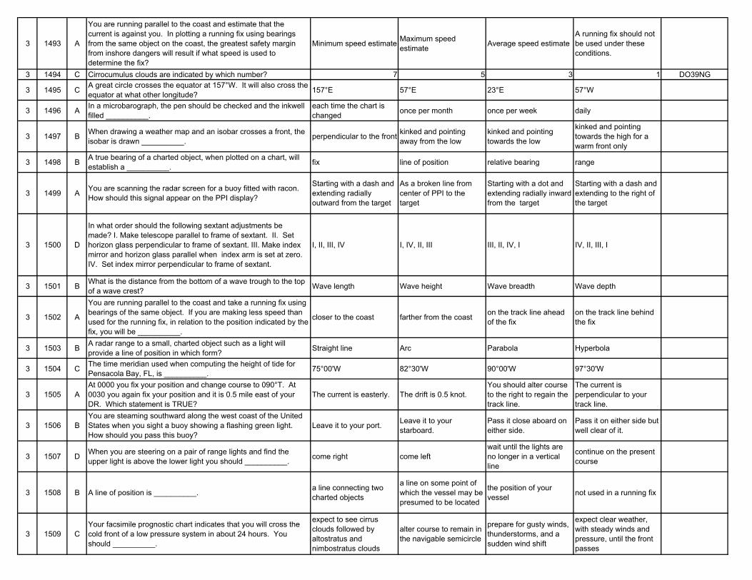
3 1493 A
You are running parallel to the coast and estimate that the current is against you. In plotting a running fix using bearings from the same object on the coast, the greatest safety margin from inshore dangers will result if what speed is used to determine the fix?
Minimum speed estimate Maximum speed estimate Average speed estimate
A running fix should not be used under these conditions.
3 1494 C Cirrocumulus clouds are indicated by which number? 7 5 3 1 DO39NG
3 1495 C A great circle crosses the equator at 157°W. It will also cross the equator at what other longitude? 157°E 57°E 23°E 57°W
3 1496 A In a microbarograph, the pen should be checked and the inkwell filled __________.
each time the chart is changed once per month once per week daily
3 1497 B When drawing a weather map and an isobar crosses a front, the isobar is drawn __________. perpendicular to the front kinked and pointing
away from the lowkinked and pointing towards the low
kinked and pointing towards the high for a warm front only
3 1498 B A true bearing of a charted object, when plotted on a chart, will establish a __________. fix line of position relative bearing range
3 1499 A You are scanning the radar screen for a buoy fitted with racon. How should this signal appear on the PPI display?
Starting with a dash and extending radially outward from the target
As a broken line from center of PPI to the target
Starting with a dot and extending radially inward from the target
Starting with a dash and extending to the right of the target
3 1500 D
In what order should the following sextant adjustments be made? I. Make telescope parallel to frame of sextant. II. Set horizon glass perpendicular to frame of sextant. III. Make index mirror and horizon glass parallel when index arm is set at zero. IV. Set index mirror perpendicular to frame of sextant.
I, II, III, IV I, IV, II, III III, II, IV, I IV, II, III, I
3 1501 B What is the distance from the bottom of a wave trough to the top of a wave crest? Wave length Wave height Wave breadth Wave depth
3 1502 A
You are running parallel to the coast and take a running fix using bearings of the same object. If you are making less speed than used for the running fix, in relation to the position indicated by the fix, you will be __________.
closer to the coast farther from the coast on the track line ahead of the fix
on the track line behind the fix
3 1503 B A radar range to a small, charted object such as a light will provide a line of position in which form? Straight line Arc Parabola Hyperbola
3 1504 C The time meridian used when computing the height of tide for Pensacola Bay, FL, is __________. 75°00'W 82°30'W 90°00'W 97°30'W
3 1505 AAt 0000 you fix your position and change course to 090°T. At 0030 you again fix your position and it is 0.5 mile east of your DR. Which statement is TRUE?
The current is easterly. The drift is 0.5 knot.You should alter course to the right to regain the track line.
The current is perpendicular to your track line.
3 1506 BYou are steaming southward along the west coast of the United States when you sight a buoy showing a flashing green light. How should you pass this buoy?
Leave it to your port. Leave it to your starboard.
Pass it close aboard on either side.
Pass it on either side but well clear of it.
3 1507 D When you are steering on a pair of range lights and find the upper light is above the lower light you should __________. come right come left
wait until the lights are no longer in a vertical line
continue on the present course
3 1508 B A line of position is __________. a line connecting two charted objects
a line on some point of which the vessel may be presumed to be located
the position of your vessel not used in a running fix
3 1509 CYour facsimile prognostic chart indicates that you will cross the cold front of a low pressure system in about 24 hours. You should __________.
expect to see cirrus clouds followed by altostratus and nimbostratus clouds
alter course to remain in the navigable semicircle
prepare for gusty winds, thunderstorms, and a sudden wind shift
expect clear weather, with steady winds and pressure, until the front passes
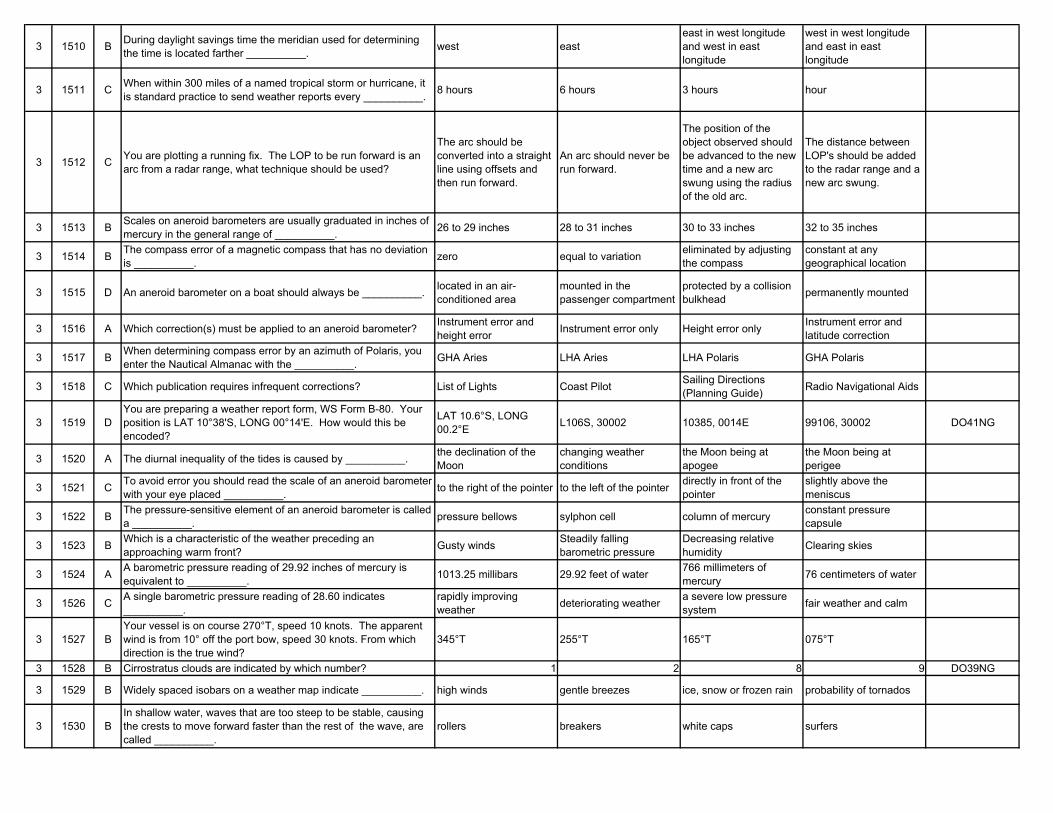
3 1510 B During daylight savings time the meridian used for determining the time is located farther __________. west east
east in west longitude and west in east longitude
west in west longitude and east in east longitude
3 1511 C When within 300 miles of a named tropical storm or hurricane, it is standard practice to send weather reports every __________. 8 hours 6 hours 3 hours hour
3 1512 C You are plotting a running fix. The LOP to be run forward is an arc from a radar range, what technique should be used?
The arc should be converted into a straight line using offsets and then run forward.
An arc should never be run forward.
The position of the object observed should be advanced to the new time and a new arc swung using the radius of the old arc.
The distance between LOP's should be added to the radar range and a new arc swung.
3 1513 B Scales on aneroid barometers are usually graduated in inches of mercury in the general range of __________. 26 to 29 inches 28 to 31 inches 30 to 33 inches 32 to 35 inches
3 1514 B The compass error of a magnetic compass that has no deviation is __________. zero equal to variation eliminated by adjusting
the compassconstant at any geographical location
3 1515 D An aneroid barometer on a boat should always be __________. located in an air-conditioned area
mounted in the passenger compartment
protected by a collision bulkhead permanently mounted
3 1516 A Which correction(s) must be applied to an aneroid barometer? Instrument error and height error Instrument error only Height error only Instrument error and
latitude correction
3 1517 B When determining compass error by an azimuth of Polaris, you enter the Nautical Almanac with the __________. GHA Aries LHA Aries LHA Polaris GHA Polaris
3 1518 C Which publication requires infrequent corrections? List of Lights Coast Pilot Sailing Directions (Planning Guide) Radio Navigational Aids
3 1519 DYou are preparing a weather report form, WS Form B-80. Your position is LAT 10°38'S, LONG 00°14'E. How would this be encoded?
LAT 10.6°S, LONG 00.2°E L106S, 30002 10385, 0014E 99106, 30002 DO41NG
3 1520 A The diurnal inequality of the tides is caused by __________. the declination of the Moon
changing weather conditions
the Moon being at apogee
the Moon being at perigee
3 1521 C To avoid error you should read the scale of an aneroid barometer with your eye placed __________. to the right of the pointer to the left of the pointer directly in front of the
pointerslightly above the meniscus
3 1522 B The pressure-sensitive element of an aneroid barometer is called a __________. pressure bellows sylphon cell column of mercury constant pressure
capsule
3 1523 B Which is a characteristic of the weather preceding an approaching warm front? Gusty winds Steadily falling
barometric pressureDecreasing relative humidity Clearing skies
3 1524 A A barometric pressure reading of 29.92 inches of mercury is equivalent to __________. 1013.25 millibars 29.92 feet of water 766 millimeters of
mercury 76 centimeters of water
3 1526 C A single barometric pressure reading of 28.60 indicates __________.
rapidly improving weather deteriorating weather a severe low pressure
system fair weather and calm
3 1527 BYour vessel is on course 270°T, speed 10 knots. The apparent wind is from 10° off the port bow, speed 30 knots. From which direction is the true wind?
345°T 255°T 165°T 075°T
3 1528 B Cirrostratus clouds are indicated by which number? 1 2 8 9 DO39NG
3 1529 B Widely spaced isobars on a weather map indicate __________. high winds gentle breezes ice, snow or frozen rain probability of tornados
3 1530 BIn shallow water, waves that are too steep to be stable, causing the crests to move forward faster than the rest of the wave, are called __________.
rollers breakers white caps surfers
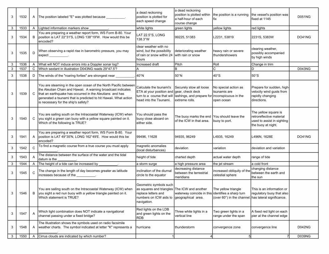
3 1532 A The position labeled "E" was plotted because __________.a dead reckoning position is plotted for each speed change
a dead reckoning position is plotted within a half-hour of each course change
the position is a running fix
the vessel's position was fixed at 1145 D051NG
3 1533 A Lighted information markers show __________. white lights green lights yellow lights red lights
3 1534 BYou are preparing a weather report form, WS Form B-80. Your position is LAT 22°31'S, LONG 138°19'W. How would this be encoded?
LAT 22.5°S, LONG 138.3°W 99225, 51383 L2231, 53819 2231S, 5383W DO41NG
3 1535 D When observing a rapid rise in barometric pressure, you may expect __________.
clear weather with no wind, but the possibility of rain or snow within 24 hours
deteriorating weather with rain or snow
heavy rain or severe thundershowers
clearing weather, possibly accompanied by high winds
3 1536 A What will NOT induce errors into a Doppler sonar log? Increased draft Pitch Roll Change in trim3 1537 C Which sextant in illustration D043NG reads 29°47.5'? A B C D D043NG
3 1538 D The winds of the "roaring forties" are strongest near __________. 40°N 50°N 40°S 50°S
3 1539 C
You are steaming in the open ocean of the North Pacific between the Aleutian Chain and Hawaii. A warning broadcast indicates that an earthquake has occurred in the Aleutians and has generated a tsunami that is predicted to hit Hawaii. What action is necessary for the ship's safety?
Calculate the tsunami's ETA at your position and turn to a course that will head into the Tsunami.
Securely stow all loose gear, check deck lashings, and prepare for extreme rolls.
No special action as tsunamis are inconspicuous in the open ocean
Prepare for sudden, high-velocity wind gusts from rapidly changing directions.
3 1540 CYou are sailing south on the Intracoastal Waterway (ICW) when you sight a green can buoy with a yellow square painted on it. Which of the following is TRUE?
You should pass the buoy close aboard on either side.
The buoy marks the end of the ICW in that area.
You should leave the buoy to port.
The yellow square is retroreflective material used to assist in sighting the buoy at night.
3 1541 AYou are preparing a weather report form, WS Form B-80. Your position is LAT 49°35'N, LONG 162°49'E. How would this be encoded?
99496, 11628 94935, 96249 L4935, 16249 L496N, 1628E DO41NG
3 1542 C To find a magnetic course from a true course you must apply __________.
magnetic anomalies (local disturbances) deviation variation deviation and variation
3 1543 A The distance between the surface of the water and the tidal datum is the __________. height of tide charted depth actual water depth range of tide
3 1544 A The height of a tide can be increased by __________. a storm surge a high pressure area the jet stream a cold front
3 1545 C The change in the length of day becomes greater as latitude increases because of the __________.
inclination of the diurnal circle to the equator
decreasing distance between the terrestrial meridians
increased obliquity of the celestial sphere
changing distance between the earth and the sun
3 1546 BYou are sailing south on the Intracoastal Waterway (ICW) when you sight a red nun buoy with a yellow triangle painted on it. Which statement is TRUE?
Geometric symbols such as squares and triangles replace letters and numbers on ICW aids to navigation.
The ICW and another waterway coincide in this geographical area.
The yellow triangle identifies a sharp turn (over 60°) in the channel.
This is an information or regulatory buoy that also has lateral significance.
3 1547 A Which light combination does NOT indicate a navigational channel passing under a fixed bridge?
Red lights on the LDB and green lights on the RDB
Three white lights in a vertical line
Two green lights in a range under the span
A fixed red light on each pier at the channel edge
3 1548 AThe Illustration shows the symbols used on radio facsimile weather charts. The symbol indicated at letter "K" represents a __________.
hurricane thunderstorm convergence zone convergence line D042NG
3 1550 A Cirrus clouds are indicated by which number? 1 4 5 7 D039NG
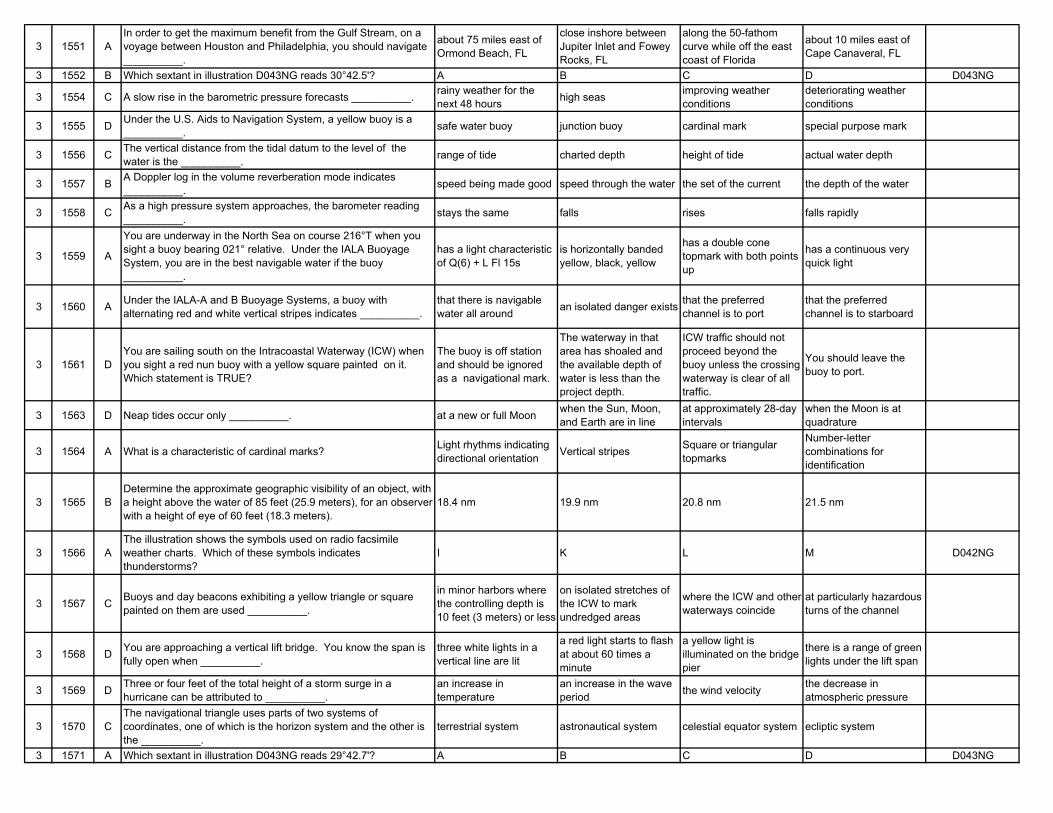
3 1551 AIn order to get the maximum benefit from the Gulf Stream, on a voyage between Houston and Philadelphia, you should navigate __________.
about 75 miles east of Ormond Beach, FL
close inshore between Jupiter Inlet and Fowey Rocks, FL
along the 50-fathom curve while off the east coast of Florida
about 10 miles east of Cape Canaveral, FL
3 1552 B Which sextant in illustration D043NG reads 30°42.5'? A B C D D043NG
3 1554 C A slow rise in the barometric pressure forecasts __________. rainy weather for the next 48 hours high seas improving weather
conditionsdeteriorating weather conditions
3 1555 D Under the U.S. Aids to Navigation System, a yellow buoy is a __________. safe water buoy junction buoy cardinal mark special purpose mark
3 1556 C The vertical distance from the tidal datum to the level of the water is the __________. range of tide charted depth height of tide actual water depth
3 1557 B A Doppler log in the volume reverberation mode indicates __________. speed being made good speed through the water the set of the current the depth of the water
3 1558 C As a high pressure system approaches, the barometer reading __________. stays the same falls rises falls rapidly
3 1559 A
You are underway in the North Sea on course 216°T when you sight a buoy bearing 021° relative. Under the IALA Buoyage System, you are in the best navigable water if the buoy __________.
has a light characteristic of Q(6) + L Fl 15s
is horizontally banded yellow, black, yellow
has a double cone topmark with both points up
has a continuous very quick light
3 1560 A Under the IALA-A and B Buoyage Systems, a buoy with alternating red and white vertical stripes indicates __________.
that there is navigable water all around an isolated danger exists that the preferred
channel is to portthat the preferred channel is to starboard
3 1561 DYou are sailing south on the Intracoastal Waterway (ICW) when you sight a red nun buoy with a yellow square painted on it. Which statement is TRUE?
The buoy is off station and should be ignored as a navigational mark.
The waterway in that area has shoaled and the available depth of water is less than the project depth.
ICW traffic should not proceed beyond the buoy unless the crossing waterway is clear of all traffic.
You should leave the buoy to port.
3 1563 D Neap tides occur only __________. at a new or full Moon when the Sun, Moon, and Earth are in line
at approximately 28-day intervals
when the Moon is at quadrature
3 1564 A What is a characteristic of cardinal marks? Light rhythms indicating directional orientation Vertical stripes Square or triangular
topmarks
Number-letter combinations for identification
3 1565 BDetermine the approximate geographic visibility of an object, with a height above the water of 85 feet (25.9 meters), for an observer with a height of eye of 60 feet (18.3 meters).
18.4 nm 19.9 nm 20.8 nm 21.5 nm
3 1566 AThe illustration shows the symbols used on radio facsimile weather charts. Which of these symbols indicates thunderstorms?
I K L M D042NG
3 1567 C Buoys and day beacons exhibiting a yellow triangle or square painted on them are used __________.
in minor harbors where the controlling depth is 10 feet (3 meters) or less
on isolated stretches of the ICW to mark undredged areas
where the ICW and other waterways coincide
at particularly hazardous turns of the channel
3 1568 D You are approaching a vertical lift bridge. You know the span is fully open when __________.
three white lights in a vertical line are lit
a red light starts to flash at about 60 times a minute
a yellow light is illuminated on the bridge pier
there is a range of green lights under the lift span
3 1569 D Three or four feet of the total height of a storm surge in a hurricane can be attributed to __________.
an increase in temperature
an increase in the wave period the wind velocity the decrease in
atmospheric pressure
3 1570 CThe navigational triangle uses parts of two systems of coordinates, one of which is the horizon system and the other is the __________.
terrestrial system astronautical system celestial equator system ecliptic system
3 1571 A Which sextant in illustration D043NG reads 29°42.7'? A B C D D043NG
3 1572 BGenerally speaking, in the Northern Hemisphere, when winds are blowing from between SE and SW the barometric reading __________.
makes no change at allis somewhat lower than it would be for winds from a northern quadrant
is uncertain and may fluctuate by increasing and decreasing
is somewhat higher than it would be for winds from the northern quadrant
3 1574 C Information about currents around Pacific Coast ports of the U.S. is found in the __________. Nautical Almanac Tide Tables Tidal Current Tables Ocean Current Tables
3 1576 A You are entering an east coast port and see a buoy with a yellow triangle painted on it. This indicates __________.
you are in the vicinity of the ICW
the buoy is a special mark the buoy is off station the buoy designates a
sharp turn in the channel
3 1577 DYesterday your chronometer read 11h 59m 59s at 1200 GMT time tick. Today the chronometer reads 12h 00m 01s at the 1200 GMT tick. What is the chronometer rate?
-1s +1s -2s +2s
3 1578 D The LMT of sunrise on the standard meridian is 0552. Your longitude is 99°15'E. What is your ZT of sunrise? 512 529 552 615
3 1579 B
You get underway from the oil terminal at Marcus Hook, PA, at 0815 ZT (ZD +5) on 20 February 1983, enroute to sea. You will be turning for 11 knots. What is the approximate current when you are abreast Reedy Island?
Slack 2.0 knots ebbing 1.5 knots flooding 0.5 knot flooding
3 1581 B Shown are the symbols used on radio facsimile weather charts. The symbol indicated at letter "I" represents __________. rain showers thunderstorms snow storms sand storms D042NG
3 1582 D Sextant C in illustration D043NG reads __________. 30°45.9' 29°56.0' 29°52.0' 29°47.5' D043NG
3 1583 BThe angle measured from the observer's meridian, clockwise or counterclockwise up to 180°, to the vertical circle of the body is the __________.
local hour angle azimuth angle meridian angle observer's longitude
3 1584 D A decrease in barometric pressure is associated with all of the following except __________. rising warm air proximity to a low
pressure areainward spiraling circulation clear dry weather
3 1585 A The sidereal day begins when the __________.first point of Aries is over the upper branch of the reference meridian
Sun is over the lower branch of the reference meridian
Sun is over the upper branch of the reference meridian
first point of Aries is over the lower branch of the reference meridian
3 1586 C A green buoy has a yellow triangle on it. This is a(n) __________.
information or regulatory buoy that has lateral significance
buoy that is off-station and is marked to warn mariners of its wrong position
dual purpose marking used where the ICW and other waterways coincide
buoy that was set in error and will be replaced with a red nun buoy
3 1587 B In general, the most effective period for observing stars and planets occurs during the darker limit of __________. sunset civil twilight nautical twilight astronomical twilight
3 1588 A The letter D in illustration D006NG represents the __________. geometrical horizon geoidal horizon celestial horizon visible horizon
3 1589 BYou are enroute to Savannah, GA, from Recife, Brazil. There is a strong N'ly wind blowing. As you cross the axis of the Gulf Stream you would expect to encounter __________.
smoother seas and warmer water
steeper waves, closer together long swells cirrus clouds
3 1590 B
Civil twilight starts at 1812 zone time on 26 August 1981, Your DR position at that time is LAT 21°06'S, LONG 14°56' W. Which statement concerning the planets available for evening sights is TRUE?
Mars will be near the prime vertical in the eastern sky.
Venus may be identified from Saturn and Jupiter because it is the brightest.
Sights of Venus, Jupiter, and Saturn will yield a good three line fix.
A sight of either Jupiter, Saturn, or Venus will give a latitude line.
3 1592 D A white buoy marked with an orange rectangle indicates __________. an anchorage a fish net area mid-channel general information
3 1593 B Apparent altitude is sextant altitude corrected for __________. parallax and personal error
inaccuracies in the reading and reference level
visibility and magnitude All of the above are correct
3 1594 CThe Illustration shows the symbols used on radio facsimile weather charts. The symbol indicated at letter "P" represents __________.
snow hail freezing rain sleet D042NG
3 1595 D
The Light List indicates that a light has a nominal range of 8 miles and is 48 feet(14.6 meters) high. If the visibility is 6 miles and your height of eye is 35 feet(10.7 meters), at what approximate distance will you sight the light?
15.0 nm 12.4 nm 8.0 nm 5.9 nm
3 1596 AYou are sailing south on the Intracoastal Waterway (ICW) when you sight a red nun buoy with a yellow square painted on it. Which of the following is TRUE?
You should leave the buoy on your port hand.
This buoy marks the end of the ICW in that geographic area.
The yellow is retroreflective material used to assist in sighting the buoy at night.
The yellow square is in error and it should be a yellow triangle.
3 1597 B The dense black cumulonimbus clouds surrounding the eye of a hurricane are called __________. spiral rainbands cloud walls funnel clouds cyclonic spirals
3 1598 C A slow, gradual fall of the barometer indicates approaching __________.
gale force winds within 12 hours blizzard conditions deteriorating or unsettled
weather heavy, wind driven rain
3 1599 B The time interval between successive wave crests is called the __________. trough period frequency epoch
3 1600 A Zenith distance is equal to __________. 90° - Ho 90° - d Ho° + d 90° - z3 1601 B Sextant B in illustration D043NG reads __________. 30°51.0' 30°42.5' 30°47.5' 31°00.0' D043NG
3 1602 C Most modern Loran-C receivers automatically detect secondary station blink which __________.
indicates the station is transmitting normally
automatically shuts down the receiver
triggers alarm indicators to warn the operator
causes the receiver to shift automatically to another Loran chain
3 1603 B A position that is obtained by using two or more intersecting lines of position, taken at nearly the same time, is a(n) __________. estimated position fix running fix dead-reckoning position
3 1604 D The Illustration shows the symbols used on radio facsimile weather charts. Which of these symbols indicates freezing rain? M N O P D042NG
3 1606 B Aids to navigation marking the intracoastal waterway can be identified by __________.
the letters ICW after the aid's number or letter
yellow stripes, squares, or triangles marked on them
white retroreflective material
the light characteristic and color for lighted aids
3 1607 D When your barometer reading changes from 30.25 to 30.05 in a 12-hour period it indicates __________. rapidly changing weather improving weather high winds within the
next six hourslittle or no immediate change
3 1608 B When using a buoy as an aid to navigation which of the following should be considered?
If the light is flashing the buoy should be considered to be in the charted location.
The buoy may not be in the charted position.
The buoy should be considered to be in the charted position if it has been freshly painted.
The buoy should be considered to always be in the charted position.
3 1609 C A rapid rise or fall of the barometer indicates __________. heavy rain within six hours
a decrease in wind velocity
a change in the present weather conditions that fog will soon set in
3 1610 A When the navigational channel passes under a fixed bridge, the edges of the channel are marked on the bridge with what lights? Red lights Three white lights in a
vertical line
Red lights on the LDB and green lights on the RDB
Yellow lights
3 1611 D What indicates a dual purpose buoy? Red buoy with a horizontal yellow band
Red and white vertically-striped buoy with a vertical yellow stripe
Red and white vertically-striped buoy with a red spherical topmark
Green buoy with a yellow square
3 1612 C The strongest winds and heaviest rains in a hurricane are found in the __________. outer bands eye cloud walls spiral rainbands
3 1613 B Where would you find information concerning the duration of slack water? Tide Tables Tidal Current Tables American Practical
Navigator Sailing Directions
3 1614 B Hot air can hold __________. less moisture than cold air
more moisture than cold air
the same amount of moisture as cold air
moisture independent of air temperature
3 1615 C The Illustration shows the symbols used on radio facsimile weather charts. Which symbol indicates snow? G H M N D042NG
3 1616 D Which picture in illustration D034NG shows a Morse (A) light? A B C D D034NG
3 1617 AThe inner cloud bands of a hurricane, when viewed from a distance, form a mass of dense, black cumulonimbus clouds called the __________.
bar of the storm eye of the storm funnel front
3 1618 A
The Light List indicates that a light has a nominal range of 14 miles and is 26 feet high. If the visibility is 4 miles and your height of eye is 20 feet, at what approximate distance will you sight the light?
7.5 miles 9.6 miles 11.2 miles 14.0 miles
3 1619 A Sextant A reads __________. 29°42.7' 29°45.7' 29°51.8' 30°47.2' DO43NG
3 1620 D
You are at anchor in the anchorage at the entrance to Delaware Bay. If you weigh anchor at 1445 DST (ZD +4) on 24 July 1983 and proceed northbound enroute to Philadelphia at a speed of 10 knots, you will have __________.
a flood current the entire trip
a flood current from Ship John Shoal Lt. to Philadelphia
an ebb current north of New Castle, DE
a weak flood between Reedy Island and Edgemoor
3 1623 D Which of the following statements is FALSE? An anemometer measures wind speed.
A barometer measures atmospheric pressure.
A thermometer measures temperature.
A psychrometer measures wind pressure.
3 1624 CA psychrometer has two thermometers that provide dry bulb and wet bulb temperatures. By comparing these two temperature readings with a set of tables you can determine the __________.
atmospheric pressure wind speed relative humidity and dew point wind chill factor
3 1625 C A sling psychrometer is used to measure __________. seawater temperature engine temperature dry bulb and wet bulb temperatures barometric pressure
3 1626 B Which instrument is used to measure the relative humidity of the air? A hydrometer A hygrometer A spectrometer A barograph
3 1627 C An instrument that maintains a continuous record of humidity changes is called a __________. thermometer barometer hygrograph thermograph
3 1628 B As the temperature of the air reaches the dew point, __________. rain must develop fog may form it begins to snow water freezes
3 1629 D Air temperature varies with __________. the altitude above sea level the season of the year the latitude or distance
from the equator All of the above
3 1631 B Which picture shows an occulting light? A B C D D034NG
3 1632 C Lighted white and orange buoys must show which color light? Orange Red White Alternating yellow and white
3 1633 A To find a magnetic compass course from a true course you must apply __________. deviation and variation deviation variation magnetic anomalies
(local disturbances)
3 1634 A A lighted buoy to be left to starboard, when entering a U.S. port from seaward, shall have a __________. red light white light green light light characteristic of
Morse (A)
3 1635 D An isotherm is __________.
a line on a weather map connecting equal points of both temperature and pressure
an instrument that measures the climatological effects of temperature
a line connecting points of equal barometric pressure on a weather map
a line connecting points of equal temperature on a weather map
3 1636 BA type of precipitation that occurs only in thunderstorms with strong convection currents that convey raindrops above and below the freezing level is known as __________.
sleet hail freezing rain rime
3 1637 B Which of the following is NOT a form of precipitation? rain frost sleet snow
3 1638 A Clouds form __________.
as a mass of warm, humid air rises into the atmosphere and cools, condensing moisture into small droplets
as winds blow across bodies of water, the sun causes the moisture to be absorbed and move upward forming clouds
dry air compresses moisture from the atmosphere into clouds
when the relative humidity of the atmosphere is low
3 1639 C Sextant D reads __________. 30°47.5' 29°47.5' 29°42.5' 29°41.6' D043NG
3 1640 D Clouds with the prefix "nimbo" in their name __________. are sheet or layer clouds have undergone great vertical development
are middle or high altitude clouds are rain clouds
3 1641 D The low, dark, sheet-like cloud which is associated with continuous precipitation for many hours is a __________. cirrus cloud cumulus cloud cumulonimbus cloud nimbostratus cloud
3 1642 D Which type of cloud formation should be of immediate concern to small craft operators? cirrus altostratus nimbostratus cumulonimbus
3 1643 C Cumulus clouds that have undergone vertical development and have become cumulonimbus in form, indicate __________. clearing weather that a warm front has
passedprobable thunderstorm activity
an approaching hurricane or typhoon
3 1644 D Which scale is used to estimate wind speed by observing sea conditions __________. Metric scale Wind scale Coriolis scale Beaufort scale
3 1646 C Which picture in illustration D034NG shows a flashing light? A B C D D034NG
3 1647 A Cumulonimbus clouds are formed by __________. vertical air movements heavy rainstorms horizontal air movements
any movement of moist air
3 1648 D A sign of thunderstorm development is a cumulus cloud __________.
darkening, growing in size and forming an anvil top
that shows extensive vertical development
creating cold downdrafts that are felt on the ground
All of the above
3 1649 B If you count 20 seconds between seeing lightning and hearing the thunder, how far is the storm away from you? 2 miles 4 miles 6 miles 8 miles
3 1651 C From which type of cloud can a tornado or waterspout develop? Nimbostratus Altostratus Cumulonimbus Cirrus
3 1652 BSmall, visible mound-like protuberances on the bottom of cumulonimbus clouds, that are potential breeding grounds for waterspouts and tornadoes, are called __________.
thunderheads mamma rime ice prisms
3 1653 D In a weather report, the term "visibility" expresses __________. how far you can see with the "naked eye"
how far you can see with a telescope or binoculars
how well you can identify an object at night
the distance in miles at which prominent objects are identifiable
3 1654 A Which weather element cannot be measured accurately while on board a moving vessel? Visibility Temperature Wind direction Atmospheric pressure
3 1655 BYesterday your chronometer read 11h 59m 59s at the 1200 GMT time tick. Today the chronometer reads 11h 59m 57s at the 1200 time tick. What is the chronometer rate?
+2s -2s -3s +3s
3 1656 C Which instrument is most useful in forecasting fog? A barometer An anemometer A sling psychrometer A pyrometer
3 1657 D Fog is formed when __________.the moisture in the air is condensed into small droplets
air is cooled to its dew point
the base of a cloud is on the ground All of the above
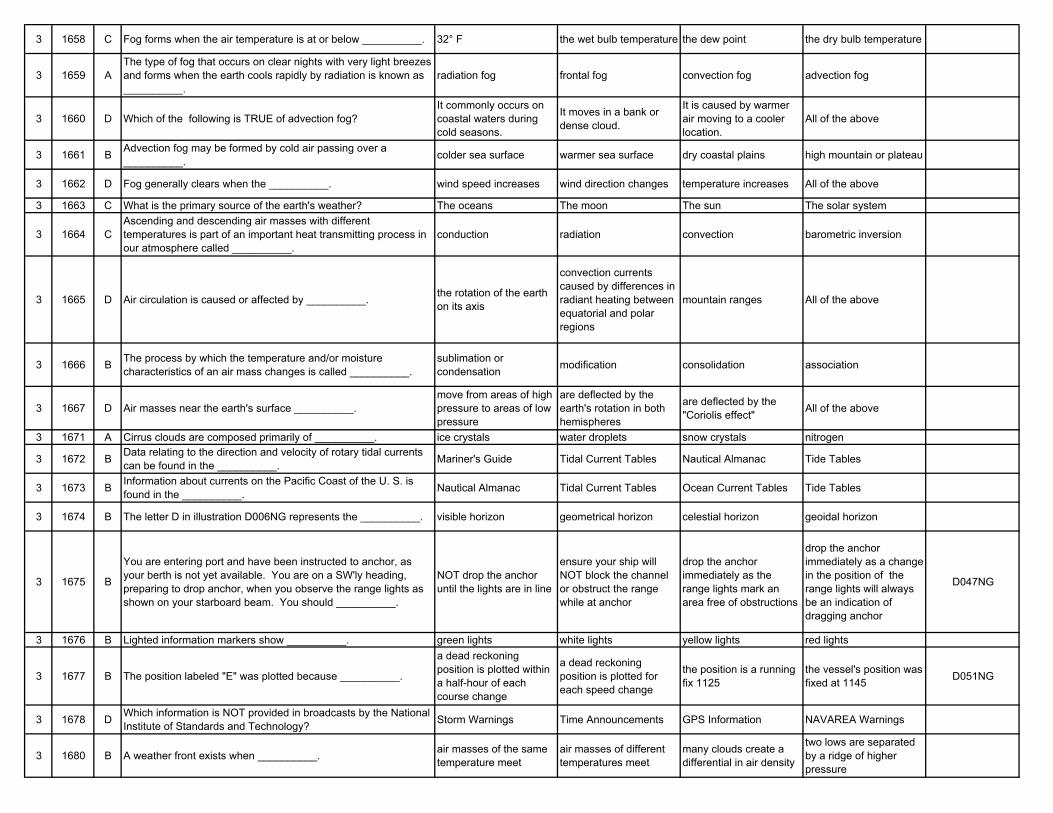
3 1658 C Fog forms when the air temperature is at or below __________. 32° F the wet bulb temperature the dew point the dry bulb temperature
3 1659 AThe type of fog that occurs on clear nights with very light breezes and forms when the earth cools rapidly by radiation is known as __________.
radiation fog frontal fog convection fog advection fog
3 1660 D Which of the following is TRUE of advection fog?It commonly occurs on coastal waters during cold seasons.
It moves in a bank or dense cloud.
It is caused by warmer air moving to a cooler location.
All of the above
3 1661 B Advection fog may be formed by cold air passing over a __________. colder sea surface warmer sea surface dry coastal plains high mountain or plateau
3 1662 D Fog generally clears when the __________. wind speed increases wind direction changes temperature increases All of the above
3 1663 C What is the primary source of the earth's weather? The oceans The moon The sun The solar system
3 1664 CAscending and descending air masses with different temperatures is part of an important heat transmitting process in our atmosphere called __________.
conduction radiation convection barometric inversion
3 1665 D Air circulation is caused or affected by __________. the rotation of the earth on its axis
convection currents caused by differences in radiant heating between equatorial and polar regions
mountain ranges All of the above
3 1666 B The process by which the temperature and/or moisture characteristics of an air mass changes is called __________.
sublimation or condensation modification consolidation association
3 1667 D Air masses near the earth's surface __________.move from areas of high pressure to areas of low pressure
are deflected by the earth's rotation in both hemispheres
are deflected by the "Coriolis effect" All of the above
3 1671 A Cirrus clouds are composed primarily of __________. ice crystals water droplets snow crystals nitrogen
3 1672 B Data relating to the direction and velocity of rotary tidal currents can be found in the __________. Mariner's Guide Tidal Current Tables Nautical Almanac Tide Tables
3 1673 B Information about currents on the Pacific Coast of the U. S. is found in the __________. Nautical Almanac Tidal Current Tables Ocean Current Tables Tide Tables
3 1674 B The letter D in illustration D006NG represents the __________. visible horizon geometrical horizon celestial horizon geoidal horizon
3 1675 B
You are entering port and have been instructed to anchor, as your berth is not yet available. You are on a SW'ly heading, preparing to drop anchor, when you observe the range lights as shown on your starboard beam. You should __________.
NOT drop the anchor until the lights are in line
ensure your ship will NOT block the channel or obstruct the range while at anchor
drop the anchor immediately as the range lights mark an area free of obstructions
drop the anchor immediately as a change in the position of the range lights will always be an indication of dragging anchor
D047NG
3 1676 B Lighted information markers show __________. green lights white lights yellow lights red lights
3 1677 B The position labeled "E" was plotted because __________.
a dead reckoning position is plotted within a half-hour of each course change
a dead reckoning position is plotted for each speed change
the position is a running fix 1125
the vessel's position was fixed at 1145 D051NG
3 1678 D Which information is NOT provided in broadcasts by the National Institute of Standards and Technology? Storm Warnings Time Announcements GPS Information NAVAREA Warnings
3 1680 B A weather front exists when __________. air masses of the same temperature meet
air masses of different temperatures meet
many clouds create a differential in air density
two lows are separated by a ridge of higher pressure
3 1681 D You can expect frontal activity when two air masses collide and __________.
their barometric pressures and temperatures are the same
there are differences in how they track along the jet stream
there are no significant differences between their temperatures and moisture content
there are significant differences between the temperature of each air mass
3 1682 D Which of the listed properties does warm air possess? It rises above cooler air and cools as it rises.
Atmospheric pressure drops as warm air rises.
Moisture in warm air condenses as the air is cooled.
All of the above
3 1683 A As it approaches, a typical warm front will bring __________.rising temperatures and falling barometric pressure
falling temperature and pressure
falling temperatures and rising pressure
rising barometric pressure and temperatures
3 1684 A Which type of frontal passage is associated with a relatively narrow band of precipitation? A cold front A warm front A stationary front None of the above
3 1685 BSquall lines with an almost unbroken line of threatening dark clouds and sharp changes in wind direction, generally precede a(n) __________.
slow-moving warm front fast-moving cold front stationary front occluded front
3 1686 C Which of the following statements concerning frontal movements is TRUE?
The temperature rises after a cold front passes.
The barometric pressure rises when a warm front passes.
A cold front generally passes faster than a warm front.
A warm front usually has more violent weather associated with it than a cold front.
3 1687 A Which statement is TRUE when comparing cold and warm fronts?
Cold fronts are more violent and of shorter duration.
Cold fronts are milder and last longer.
They are very similar with the exception of wind direction.
Warm fronts are more violent and of longer duration.
3 1688 B Which type of front forms when a cold front overtakes and forces a warm front upwards? A cold front An occluded front A warm front A stationary front
3 1689 B The "horse latitudes" are regions of __________. brisk prevailing winds light airs and calms abundant blue sea grass vegetation None of the above
3 1690 B In regions near the poles, the winds are generally described as __________. westerlies easterlies northerlies southerlies
3 1691 A Which of the following is associated with consistently high barometric pressure? The horse latitudes The doldrums The prevailing westerlies The trade winds
3 1692 BThe force resulting from the earth's rotation that causes winds to deflect to the right in the Northern Hemisphere and to the left in the Southern Hemisphere is called __________.
pressure gradient Coriolis effect aurora borealis ballistic deflection
3 1693 C A phenomenon where the atmospheric pressure is higher than that of other surrounding regions is called __________. the "trade winds" a low front or an
occluded fronta high pressure area; an anticyclone; or a "high" the "doldrums"
3 1694 C In the Southern Hemisphere the wind circulation in a high pressure system rotates __________. clockwise and inward clockwise and outward counterclockwise and
outwardcounterclockwise and inward
3 1695 B Compared to a low pressure system, generally the air in a high is __________.
warmer, less dense, and less stable
cool, more dense, and drier muggy and cloudy extremely moist with
high relative humidity
3 1696 B Two well-developed high pressure areas may be separated by a __________. hill of low pressure trough of low pressure valley of low pressure ridge of low pressure
3 1697 C In the Northern Hemisphere, if the center of a high pressure area is due west of you, what wind direction would you expect? South to west South to east North to west North to east
3 1698 B When a high pressure system is centered north of your vessel in the Northern Hemisphere __________.
you should experience hot, moist, clear weather
the wind direction is generally easterly
the winds should be from the southwest at your location
the winds should be brisk
3 1699 BIn the Northern Hemisphere, when the center of a high pressure system is due east of your position, you can expect winds from the __________.
south to west south to east north to west north to east
3 1700 A Generally speaking, you should expect to find low atmospheric pressure prevailing in the earth's __________. equatorial area polar regions mid-latitudes All of the above
3 1701 B Which general weather conditions should you expect to find in a low pressure system? Fair weather Precipitation and
cloudinessScattered clouds at high elevations
Gradual clearing and cooler temperatures
3 1702 A In a cyclone the lowest pressure is found in the __________. center outer edge warm front cold front
3 1703 CIn the Northern Hemisphere, when the wind at your location is northerly, the low pressure center causing the wind is located to your __________.
NNW WSW ESE SSW
3 1704 B If the center of low pressure is due west of you in the Northern Hemisphere, which wind direction should you expect? South to west South to east West to north North to east
3 1705 C Two well-developed low pressure areas may be separated by a __________. trough of higher pressure hill of higher pressure ridge of higher pressure valley of higher pressure
3 1706 A In the Northern Hemisphere a wind is said to veer when the wind __________.
changes direction clockwise, as from north to east, etc.
changes direction violently and erratically
remains constant in direction and speed
changes direction counterclockwise, as from south to east, etc.
3 1707 C "Surface circulation" is another term for __________. cyclones air in motion at all levels of the atmosphere
wind in the lower troposphere ocean currents
3 1708 A What generally occurs when the land is cooler than the nearby water? A land breeze A sea breeze A norther A prevailing westerly
3 1709 C The Beaufort scale is used to estimate the __________. wind direction percentage of cloud cover wind speed barometric pressure
3 1710 B A gale is characterized by a wind speed of __________. 10 to 20 knots 34 to 47 knots 48 to 63 knots 64 to 83 knots
3 1711 A An instrument that indicates wind direction is known as a(n) __________.
weather vane, wind vane or wind sock hydrometer hygrometer sling psychrometer
3 1712 D Tornados are often associated with __________.
winds in the warm sector ahead of a cold front and travel from southwest towards the east or northeast
squall lines and very heavy thunderstorm activity
winds that may be in excess of 200 knots and destructive funnel clouds
All of the above
3 1713 B When a tornado moves over the water from land it is called a __________. tornado waterspout hurricane cyclone
3 1714 A Which statement concerning storm surges on the Great Lakes is FALSE?
They are common along the deeper areas of the lakes.
They cause rapid differences in levels between one end of the lake and the other.
The greatest water level difference occurs when the wind is blowing along the longitudinal axis of the lake.
If the wind subsides rapidly, a seiche effect will most likely occur.
3 1715 C The hurricane season generally occurs from __________. August to January July to December June to November January to June
3 1716 B The hurricane season in the North Atlantic Ocean reaches its peak during the month of __________. June September November July
3 1717 B A tropical storm is a tropical cyclone that generates winds of __________. between 20 and 33 knots between 34 and 63 knots over 63 knots None of the above
3 1718 D A hurricane is characterized by winds of __________. up to 33 knots 34 to 47 knots 48 to 63 knots 64 knots or greater
3 1719 B What is the direction of rotation of tropical cyclones, tropical storms and hurricanes in the Northern Hemisphere? Clockwise and outward Counterclockwise and
inwardCounterclockwise and outward Clockwise and inward
3 1720 A In the Southern Hemisphere winds in a low pressure system rotate in a __________. clockwise direction northeasterly direction northerly direction counterclockwise
direction
3 1721 C A storm's track is characterized by all of the following except __________.
the direction the storm has come from
the direction in which the storm is moving
the speed at which the storm is moving
the path taken by the storm
3 1722 CHurricanes may move in any direction. However, it is rare and generally of short duration when a hurricane in the Northern Hemisphere moves toward the __________.
west or northwest northeast southeast north
3 1723 C The intensity of a hurricane as it reaches higher latitudes and cooler waters __________. Increases remains the same decreases None of the above
3 1724 C What is the first visible indication of the presence of a tropical cyclone or hurricane?
Stratocumulus clouds or strange birds
Rain and increasing winds
An exceptionally long swell
Dark clouds and the "bar" of the storm
3 1725 B
Your present weather is sunny with a steady barometer. A low swell approaches your vessel from the south with crests passing at relatively long periods of about four per minute. This usually indicates __________.
a warm front from the south
a tropical cyclone south of your vessel
a hurricane about 100 miles south of your vessel and heading in your direction
an extra-tropical cyclone
3 1726 D How can you estimate the position of a tropical storm's center? With a radio weather bulletin or weather fax using shipboard radar
observe the wind direction and apply Buys Ballot's law
All of the above
3 1727 A What enables you to estimate the bearing of a storm's center? Buys Ballot's Law An educated guess Pascal's Law The left-hand rule
3 1728 B If a hurricane several hundred miles away is moving in your general direction your barometer would __________. start to rise rapidly start to fall gradually
rise slowly, begin "pumping" and then start a slow, steady fall
remain steady
3 1729 A The first cloud formations you can use to indicate the bearing of the center of a hurricane or tropical storm are __________.
the point of convergence of the cirrus clouds
the direction of movement of thunderstorms on radar
the darkest point of the clouds in the "bar" of the storm
the point of origin of the altostratus clouds
3 1730 AIf you observe the point of cloud convergence shifting to the right and the "bar" of the storm appears to move along the horizon __________.
the center of the storm will by-pass you
the storm will strike you on the starboard side
you are in the direct path of the storm and should take immediate steps to batten down loose gear
the storm is starting to break up
3 1731 D When your vessel is on or near the path of an approaching tropical storm the __________.
wind direction remains steady wind speed increases barometer falls All of the above
3 1732 A The eye of a hurricane is surrounded by dense black cumulonimbus clouds which are called the __________. wall cloud nimbostratus cloud bar funnel
3 1733 C An instrument which maintains a continuous record of temperature changes is called a __________. thermometer barometer thermograph hygrograph
3 1734 C The eye of the hurricane has __________. very high barometric pressure
average barometric pressure
the lowest barometric pressure
no change in barometric pressure
3 1735 D A vessel entering the eye of a hurricane should expect __________.
moderating winds and heavy confused seas to strike his vessel from all directions
the winds to increase to hurricane force and strike from a different direction as the eye passes
the barometer to reach the lowest point All of the above
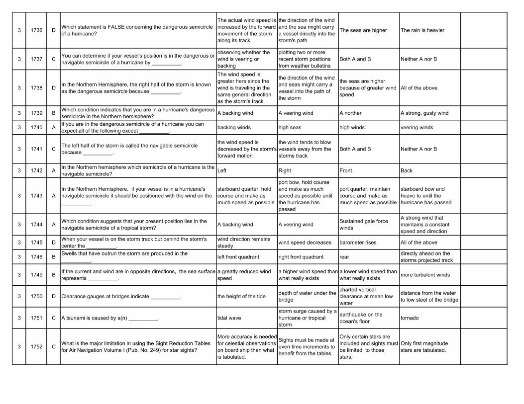
3 1736 D Which statement is FALSE concerning the dangerous semicircle of a hurricane?
The actual wind speed is increased by the forward movement of the storm along its track
the direction of the wind and the sea might carry a vessel directly into the storm's path
The seas are higher The rain is heavier
3 1737 C You can determine if your vessel's position is in the dangerous or navigable semicircle of a hurricane by __________.
observing whether the wind is veering or backing
plotting two or more recent storm positions from weather bulletins
Both A and B Neither A nor B
3 1738 D In the Northern Hemisphere, the right half of the storm is known as the dangerous semicircle because __________.
The wind speed is greater here since the wind is traveling in the same general direction as the storm's track
the direction of the wind and seas might carry a vessel into the path of the storm
the seas are higher because of greater wind speed
All of the above
3 1739 B Which condition indicates that you are in a hurricane's dangerous semicircle in the Northern hemisphere? A backing wind A veering wind A norther A strong, gusty wind
3 1740 A If you are in the dangerous semicircle of a hurricane you can expect all of the following except __________. backing winds high seas high winds veering winds
3 1741 C The left half of the storm is called the navigable semicircle because __________.
the wind speed is decreased by the storm's forward motion
the wind tends to blow vessels away from the storms track
Both A and B Neither A nor B
3 1742 A In the Northern hemisphere which semicircle of a hurricane is the navigable semicircle? Left Right Front Back
3 1743 AIn the Northern Hemisphere, if your vessel is in a hurricane's navigable semicircle it should be positioned with the wind on the __________.
starboard quarter, hold course and make as much speed as possible
port bow, hold course and make as much speed as possible until the hurricane has passed
port quarter, maintain course and make as much speed as possible
starboard bow and heave to until the hurricane has passed
3 1744 A Which condition suggests that your present position lies in the navigable semicircle of a tropical storm? A backing wind A veering wind Sustained gale force
winds
A strong wind that maintains a constant speed and direction
3 1745 D When your vessel is on the storm track but behind the storm's center the __________.
wind direction remains steady wind speed decreases barometer rises All of the above
3 1746 B Swells that have outrun the storm are produced in the __________. left front quadrant right front quadrant rear directly ahead on the
storms projected track
3 1749 B If the current and wind are in opposite directions, the sea surface represents __________.
a greatly reduced wind speed
a higher wind speed than what really exists
a lower wind speed than what really exists more turbulent winds
3 1750 D Clearance gauges at bridges indicate __________. the height of the tide depth of water under the bridge
charted vertical clearance at mean low water
distance from the water to low steel of the bridge
3 1751 C A tsunami is caused by a(n) __________. tidal wavestorm surge caused by a hurricane or tropical storm
earthquake on the ocean's floor tornado
3 1752 C What is the major limitation in using the Sight Reduction Tables for Air Navigation Volume I (Pub. No. 249) for star sights?
More accuracy is needed for celestial observations on board ship than what is tabulated.
Sights must be made at even time increments to benefit from the tables.
Only certain stars are included and sights must be limited to those stars.
Only first magnitude stars are tabulated.
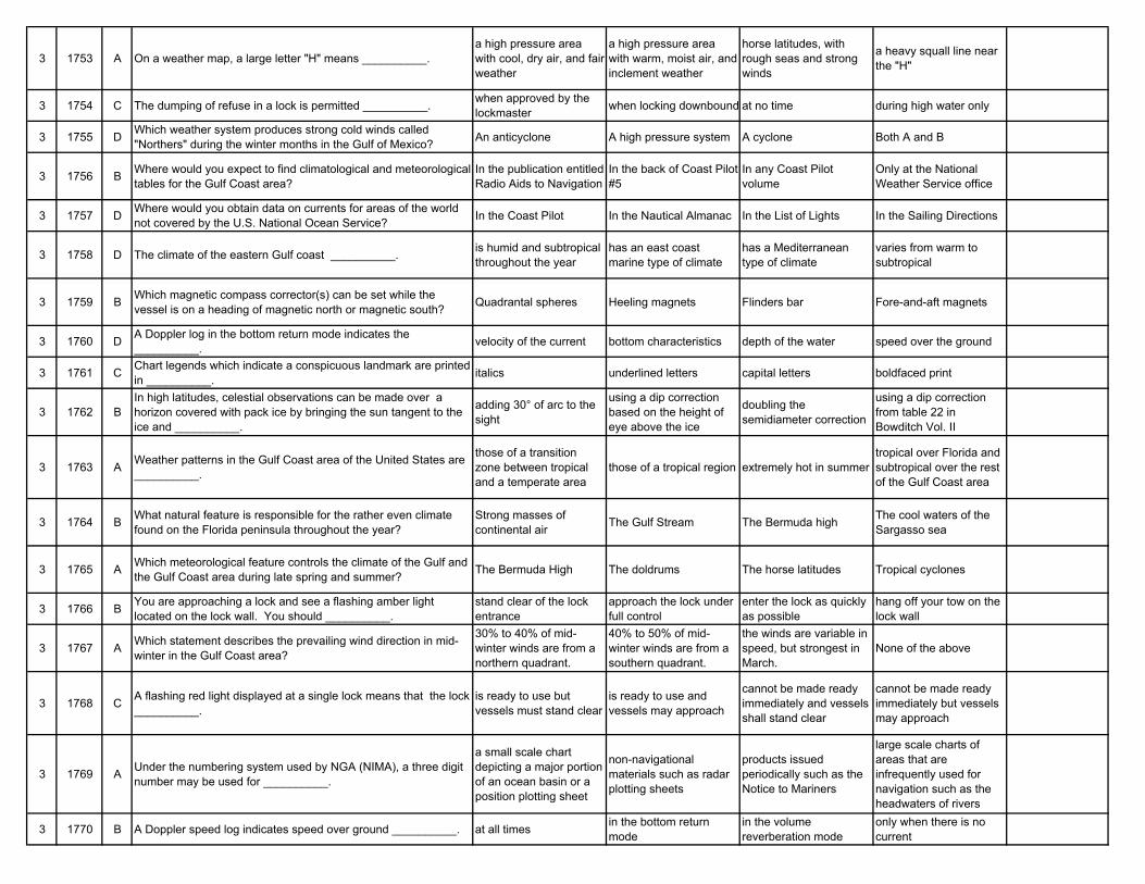
3 1753 A On a weather map, a large letter "H" means __________.a high pressure area with cool, dry air, and fair weather
a high pressure area with warm, moist air, and inclement weather
horse latitudes, with rough seas and strong winds
a heavy squall line near the "H"
3 1754 C The dumping of refuse in a lock is permitted __________. when approved by the lockmaster when locking downbound at no time during high water only
3 1755 D Which weather system produces strong cold winds called "Northers" during the winter months in the Gulf of Mexico? An anticyclone A high pressure system A cyclone Both A and B
3 1756 B Where would you expect to find climatological and meteorological tables for the Gulf Coast area?
In the publication entitled Radio Aids to Navigation
In the back of Coast Pilot #5
In any Coast Pilot volume
Only at the National Weather Service office
3 1757 D Where would you obtain data on currents for areas of the world not covered by the U.S. National Ocean Service? In the Coast Pilot In the Nautical Almanac In the List of Lights In the Sailing Directions
3 1758 D The climate of the eastern Gulf coast __________. is humid and subtropical throughout the year
has an east coast marine type of climate
has a Mediterranean type of climate
varies from warm to subtropical
3 1759 B Which magnetic compass corrector(s) can be set while the vessel is on a heading of magnetic north or magnetic south? Quadrantal spheres Heeling magnets Flinders bar Fore-and-aft magnets
3 1760 D A Doppler log in the bottom return mode indicates the __________. velocity of the current bottom characteristics depth of the water speed over the ground
3 1761 C Chart legends which indicate a conspicuous landmark are printed in __________. italics underlined letters capital letters boldfaced print
3 1762 BIn high latitudes, celestial observations can be made over a horizon covered with pack ice by bringing the sun tangent to the ice and __________.
adding 30° of arc to the sight
using a dip correction based on the height of eye above the ice
doubling the semidiameter correction
using a dip correction from table 22 in Bowditch Vol. II
3 1763 A Weather patterns in the Gulf Coast area of the United States are __________.
those of a transition zone between tropical and a temperate area
those of a tropical region extremely hot in summertropical over Florida and subtropical over the rest of the Gulf Coast area
3 1764 B What natural feature is responsible for the rather even climate found on the Florida peninsula throughout the year?
Strong masses of continental air The Gulf Stream The Bermuda high The cool waters of the
Sargasso sea
3 1765 A Which meteorological feature controls the climate of the Gulf and the Gulf Coast area during late spring and summer? The Bermuda High The doldrums The horse latitudes Tropical cyclones
3 1766 B You are approaching a lock and see a flashing amber light located on the lock wall. You should __________.
stand clear of the lock entrance
approach the lock under full control
enter the lock as quickly as possible
hang off your tow on the lock wall
3 1767 A Which statement describes the prevailing wind direction in mid-winter in the Gulf Coast area?
30% to 40% of mid-winter winds are from a northern quadrant.
40% to 50% of mid-winter winds are from a southern quadrant.
the winds are variable in speed, but strongest in March.
None of the above
3 1768 C A flashing red light displayed at a single lock means that the lock __________.
is ready to use but vessels must stand clear
is ready to use and vessels may approach
cannot be made ready immediately and vessels shall stand clear
cannot be made ready immediately but vessels may approach
3 1769 A Under the numbering system used by NGA (NIMA), a three digit number may be used for __________.
a small scale chart depicting a major portion of an ocean basin or a position plotting sheet
non-navigational materials such as radar plotting sheets
products issued periodically such as the Notice to Mariners
large scale charts of areas that are infrequently used for navigation such as the headwaters of rivers
3 1770 B A Doppler speed log indicates speed over ground __________. at all times in the bottom return mode
in the volume reverberation mode
only when there is no current
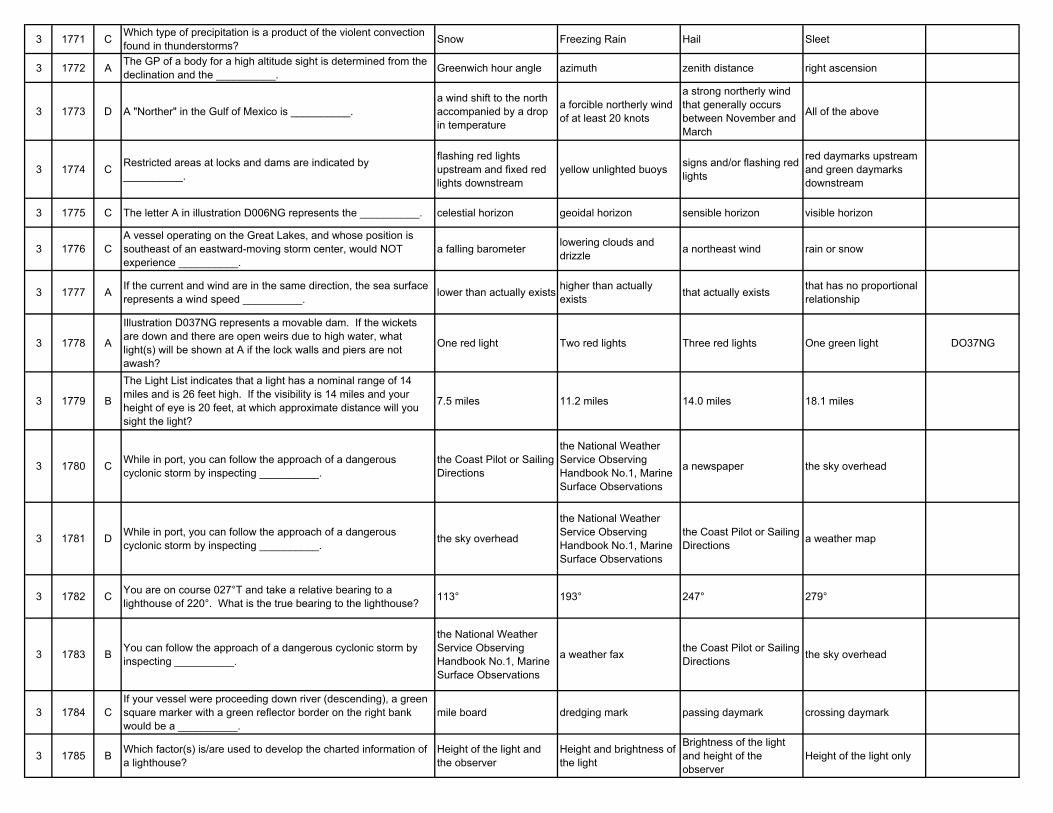
3 1771 C Which type of precipitation is a product of the violent convection found in thunderstorms? Snow Freezing Rain Hail Sleet
3 1772 A The GP of a body for a high altitude sight is determined from the declination and the __________. Greenwich hour angle azimuth zenith distance right ascension
3 1773 D A "Norther" in the Gulf of Mexico is __________.a wind shift to the north accompanied by a drop in temperature
a forcible northerly wind of at least 20 knots
a strong northerly wind that generally occurs between November and March
All of the above
3 1774 C Restricted areas at locks and dams are indicated by __________.
flashing red lights upstream and fixed red lights downstream
yellow unlighted buoys signs and/or flashing red lights
red daymarks upstream and green daymarks downstream
3 1775 C The letter A in illustration D006NG represents the __________. celestial horizon geoidal horizon sensible horizon visible horizon
3 1776 CA vessel operating on the Great Lakes, and whose position is southeast of an eastward-moving storm center, would NOT experience __________.
a falling barometer lowering clouds and drizzle a northeast wind rain or snow
3 1777 A If the current and wind are in the same direction, the sea surface represents a wind speed __________. lower than actually exists higher than actually
exists that actually exists that has no proportional relationship
3 1778 A
Illustration D037NG represents a movable dam. If the wickets are down and there are open weirs due to high water, what light(s) will be shown at A if the lock walls and piers are not awash?
One red light Two red lights Three red lights One green light DO37NG
3 1779 B
The Light List indicates that a light has a nominal range of 14 miles and is 26 feet high. If the visibility is 14 miles and your height of eye is 20 feet, at which approximate distance will you sight the light?
7.5 miles 11.2 miles 14.0 miles 18.1 miles
3 1780 C While in port, you can follow the approach of a dangerous cyclonic storm by inspecting __________.
the Coast Pilot or Sailing Directions
the National Weather Service Observing Handbook No.1, Marine Surface Observations
a newspaper the sky overhead
3 1781 D While in port, you can follow the approach of a dangerous cyclonic storm by inspecting __________. the sky overhead
the National Weather Service Observing Handbook No.1, Marine Surface Observations
the Coast Pilot or Sailing Directions a weather map
3 1782 C You are on course 027°T and take a relative bearing to a lighthouse of 220°. What is the true bearing to the lighthouse? 113° 193° 247° 279°
3 1783 B You can follow the approach of a dangerous cyclonic storm by inspecting __________.
the National Weather Service Observing Handbook No.1, Marine Surface Observations
a weather fax the Coast Pilot or Sailing Directions the sky overhead
3 1784 CIf your vessel were proceeding down river (descending), a green square marker with a green reflector border on the right bank would be a __________.
mile board dredging mark passing daymark crossing daymark
3 1785 B Which factor(s) is/are used to develop the charted information of a lighthouse?
Height of the light and the observer
Height and brightness of the light
Brightness of the light and height of the observer
Height of the light only
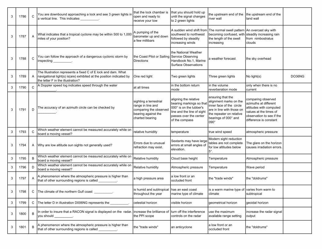
3 1786 C You are downbound approaching a lock and see 3 green lights in a vertical line. This indicates __________.
that the lock chamber is open and ready to receive your tow
that you should hold up until the signal changes to 2 green lights
the upstream end of the river wall
the upstream end of the land wall
3 1787 A What indicates that a tropical cyclone may be within 500 to 1,000 miles of your position?
A pumping of the barometer up and down a few millibars
A sudden wind shift from southwest to northwest followed by steadily increasing winds
The normal swell pattern becoming confused, with the length of the swell increasing
An overcast sky with steadily increasing rain from nimbostratus clouds
3 1788 C You can follow the approach of a dangerous cyclonic storm by inspecting __________.
the Coast Pilot or Sailing Directions
the National Weather Service Observing Handbook No.1, Marine Surface Observations
a weather forecast the sky overhead
3 1789 AThe Illustration represents a fixed C of E lock and dam. What navigational light(s) is(are) exhibited at the position indicated by the letter F in the illustration?
One red light Two green lights Three green lights No light(s) DO36NG
3 1790 C A Doppler speed log indicates speed through the water __________. at all times in the bottom return
modein the volume reverberation mode
only when there is no current
3 1791 D The accuracy of an azimuth circle can be checked by __________.
sighting a terrestrial range in line and comparing the observed bearing against the charted bearing
aligning the relative bearing markings so that 000° is on the lubber's line and the line of sight passes over the center of the compass
ensuring that the alignment marks on the inner face of the circle are in line with those on the repeater on relative bearings of 000° and 090°
comparing observed azimuths at different altitudes with computed values at the times of observation to see if the difference is constant
3 1793 C Which weather element cannot be measured accurately while on board a moving vessel? relative humidity temperature true wind speed atmospheric pressure
3 1794 A Why are low altitude sun sights not generally used? Errors due to unusual refraction may exist.
Sextants may have large errors at small angles of elevation.
Modern sight reduction tables are not complete for low altitudes below 5°.
The glare on the horizon causes irradiation errors.
3 1795 B Which weather element cannot be measured accurately while on board a moving vessel? Relative humidity Cloud base height Temperature Atmospheric pressure
3 1796 D Which weather element cannot be measured accurately while on board a moving vessel? Relative humidity Atmospheric pressure Temperature Wave period
3 1797 A A phenomenon where the atmospheric pressure is higher than that of other surrounding regions is called __________. a high pressure area a low front or an
occluded front the "trade winds" the "doldrums"
3 1798 C The climate of the northern Gulf coast __________. is humid and subtropical throughout the year
has an east coast marine type of climate
is a warm marine type of climate
varies from warm to subtropical
3 1799 C The letter D in illustration D006NG represents the __________. celestial horizon visible horizon geometrical horizon geoidal horizon
3 1800 B In order to insure that a RACON signal is displayed on the radar, you should __________.
increase the brilliance of the PPI scope
turn off the interference controls on the radar
use the maximum available range setting
increase the radar signal output
3 1801 B A phenomenon where the atmospheric pressure is higher than that of other surrounding regions is called __________. the "trade winds" an anticyclone a low front or an
occluded front the "doldrums"
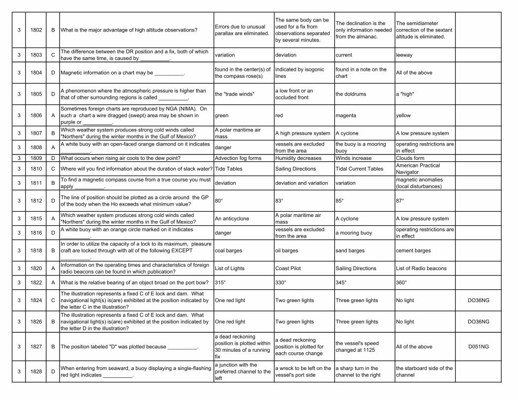
3 1802 B What is the major advantage of high altitude observations? Errors due to unusual parallax are eliminated.
The same body can be used for a fix from observations separated by several minutes.
The declination is the only information needed from the almanac.
The semidiameter correction of the sextant altitude is eliminated.
3 1803 C The difference between the DR position and a fix, both of which have the same time, is caused by __________. variation deviation current leeway
3 1804 D Magnetic information on a chart may be __________. found in the center(s) of the compass rose(s)
indicated by isogonic lines
found in a note on the chart All of the above
3 1805 D A phenomenon where the atmospheric pressure is higher than that of other surrounding regions is called __________. the "trade winds" a low front or an
occluded front the doldrums a "high"
3 1806 ASometimes foreign charts are reproduced by NGA (NIMA). On such a chart a wire dragged (swept) area may be shown in purple or __________.
green red magenta yellow
3 1807 B Which weather system produces strong cold winds called "Northers" during the winter months in the Gulf of Mexico?
A polar maritime air mass A high pressure system A cyclone A low pressure system
3 1808 A A white buoy with an open-faced orange diamond on it indicates __________. danger vessels are excluded
from the areathe buoy is a mooring buoy
operating restrictions are in effect
3 1809 D What occurs when rising air cools to the dew point? Advection fog forms Humidity decreases Winds increase Clouds form
3 1810 C Where will you find information about the duration of slack water? Tide Tables Sailing Directions Tidal Current Tables American Practical Navigator
3 1811 B To find a magnetic compass course from a true course you must apply __________. deviation deviation and variation variation magnetic anomalies
(local disturbances)
3 1812 D The line of position should be plotted as a circle around the GP of the body when the Ho exceeds what minimum value? 80° 83° 85° 87°
3 1815 A Which weather system produces strong cold winds called "Northers" during the winter months in the Gulf of Mexico? An anticyclone A polar maritime air
mass A cyclone A low pressure system
3 1816 D A white buoy with an orange circle marked on it indicates __________. danger vessels are excluded
from the area a mooring buoy operating restrictions are in effect
3 1818 BIn order to utilize the capacity of a lock to its maximum, pleasure craft are locked through with all of the following EXCEPT __________.
coal barges oil barges sand barges cement barges
3 1820 A Information on the operating times and characteristics of foreign radio beacons can be found in which publication? List of Lights Coast Pilot Sailing Directions List of Radio beacons
3 1822 A What is the relative bearing of an object broad on the port bow? 315° 330° 345° 360°
3 1824 CThe illustration represents a fixed C of E lock and dam. What navigational light(s) is(are) exhibited at the position indicated by the letter C in the illustration?
One red light Two green lights Three green lights No light DO36NG
3 1826 BThe illustration represents a fixed C of E lock and dam. What navigational light(s) is(are) exhibited at the position indicated by the letter D in the illustration?
One red light Two green lights Three green lights No light DO36NG
3 1827 B The position labeled "D" was plotted because __________.
a dead reckoning position is plotted within 30 minutes of a running fix
a dead reckoning position is plotted for each course change
the vessel's speed changed at 1125 All of the above D051NG
3 1828 D When entering from seaward, a buoy displaying a single-flashing red light indicates __________.
a junction with the preferred channel to the left
a wreck to be left on the vessel's port side
a sharp turn in the channel to the right
the starboard side of the channel
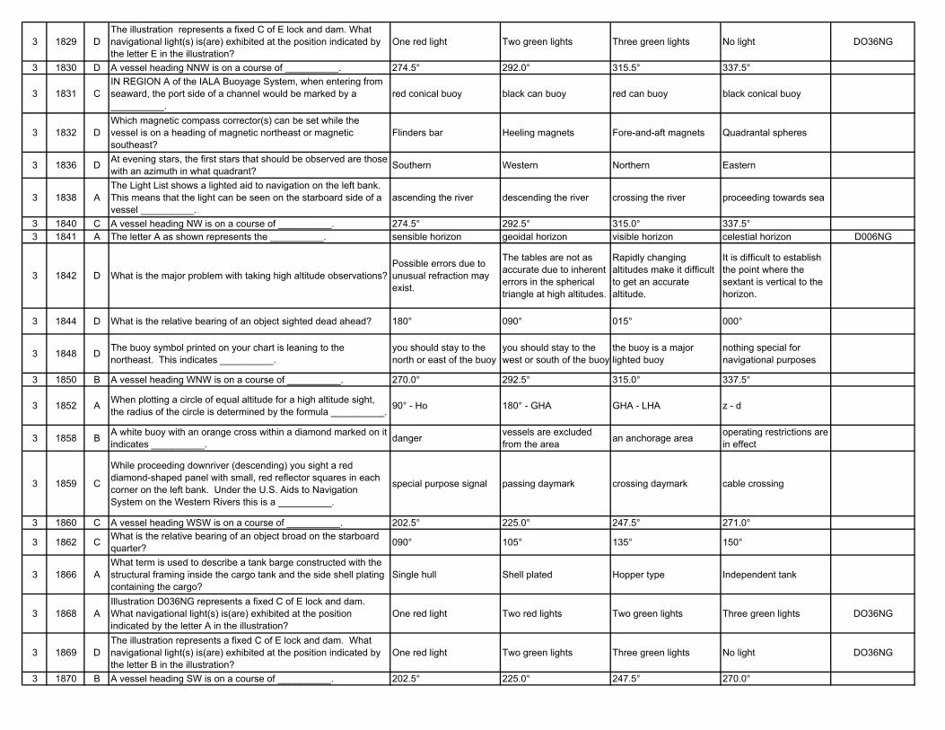
3 1829 DThe illustration represents a fixed C of E lock and dam. What navigational light(s) is(are) exhibited at the position indicated by the letter E in the illustration?
One red light Two green lights Three green lights No light DO36NG
3 1830 D A vessel heading NNW is on a course of __________. 274.5° 292.0° 315.5° 337.5°
3 1831 CIN REGION A of the IALA Buoyage System, when entering from seaward, the port side of a channel would be marked by a __________.
red conical buoy black can buoy red can buoy black conical buoy
3 1832 DWhich magnetic compass corrector(s) can be set while the vessel is on a heading of magnetic northeast or magnetic southeast?
Flinders bar Heeling magnets Fore-and-aft magnets Quadrantal spheres
3 1836 D At evening stars, the first stars that should be observed are those with an azimuth in what quadrant? Southern Western Northern Eastern
3 1838 AThe Light List shows a lighted aid to navigation on the left bank. This means that the light can be seen on the starboard side of a vessel __________.
ascending the river descending the river crossing the river proceeding towards sea
3 1840 C A vessel heading NW is on a course of __________. 274.5° 292.5° 315.0° 337.5°3 1841 A The letter A as shown represents the __________. sensible horizon geoidal horizon visible horizon celestial horizon D006NG
3 1842 D What is the major problem with taking high altitude observations?Possible errors due to unusual refraction may exist.
The tables are not as accurate due to inherent errors in the spherical triangle at high altitudes.
Rapidly changing altitudes make it difficult to get an accurate altitude.
It is difficult to establish the point where the sextant is vertical to the horizon.
3 1844 D What is the relative bearing of an object sighted dead ahead? 180° 090° 015° 000°
3 1848 D The buoy symbol printed on your chart is leaning to the northeast. This indicates __________.
you should stay to the north or east of the buoy
you should stay to the west or south of the buoy
the buoy is a major lighted buoy
nothing special for navigational purposes
3 1850 B A vessel heading WNW is on a course of __________. 270.0° 292.5° 315.0° 337.5°
3 1852 A When plotting a circle of equal altitude for a high altitude sight, the radius of the circle is determined by the formula __________. 90° - Ho 180° - GHA GHA - LHA z - d
3 1858 B A white buoy with an orange cross within a diamond marked on it indicates __________. danger vessels are excluded
from the area an anchorage area operating restrictions are in effect
3 1859 C
While proceeding downriver (descending) you sight a red diamond-shaped panel with small, red reflector squares in each corner on the left bank. Under the U.S. Aids to Navigation System on the Western Rivers this is a __________.
special purpose signal passing daymark crossing daymark cable crossing
3 1860 C A vessel heading WSW is on a course of __________. 202.5° 225.0° 247.5° 271.0°
3 1862 C What is the relative bearing of an object broad on the starboard quarter? 090° 105° 135° 150°
3 1866 AWhat term is used to describe a tank barge constructed with the structural framing inside the cargo tank and the side shell plating containing the cargo?
Single hull Shell plated Hopper type Independent tank
3 1868 AIllustration D036NG represents a fixed C of E lock and dam. What navigational light(s) is(are) exhibited at the position indicated by the letter A in the illustration?
One red light Two red lights Two green lights Three green lights DO36NG
3 1869 DThe illustration represents a fixed C of E lock and dam. What navigational light(s) is(are) exhibited at the position indicated by the letter B in the illustration?
One red light Two green lights Three green lights No light DO36NG
3 1870 B A vessel heading SW is on a course of __________. 202.5° 225.0° 247.5° 270.0°
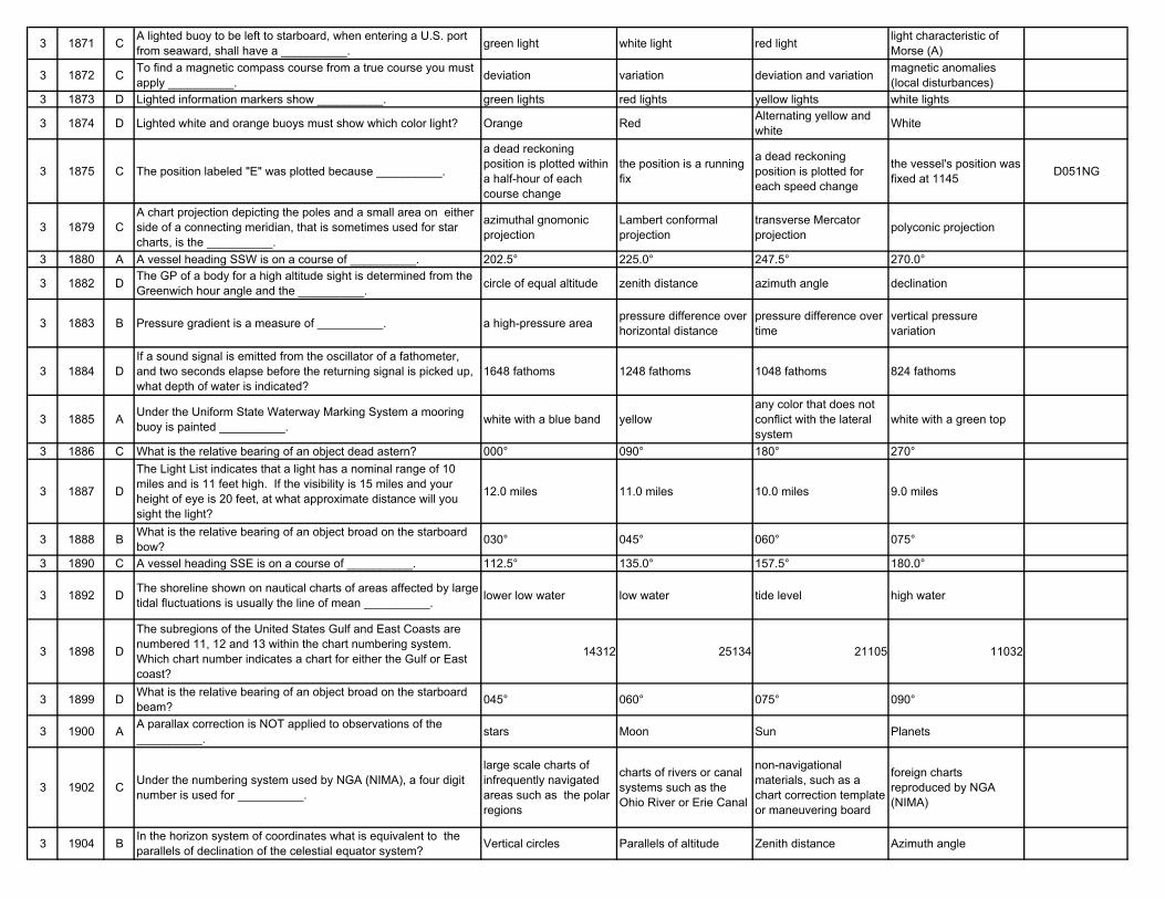
3 1871 C A lighted buoy to be left to starboard, when entering a U.S. port from seaward, shall have a __________. green light white light red light light characteristic of
Morse (A)
3 1872 C To find a magnetic compass course from a true course you must apply __________. deviation variation deviation and variation magnetic anomalies
(local disturbances)3 1873 D Lighted information markers show __________. green lights red lights yellow lights white lights
3 1874 D Lighted white and orange buoys must show which color light? Orange Red Alternating yellow and white White
3 1875 C The position labeled "E" was plotted because __________.
a dead reckoning position is plotted within a half-hour of each course change
the position is a running fix
a dead reckoning position is plotted for each speed change
the vessel's position was fixed at 1145 D051NG
3 1879 CA chart projection depicting the poles and a small area on either side of a connecting meridian, that is sometimes used for star charts, is the __________.
azimuthal gnomonic projection
Lambert conformal projection
transverse Mercator projection polyconic projection
3 1880 A A vessel heading SSW is on a course of __________. 202.5° 225.0° 247.5° 270.0°
3 1882 D The GP of a body for a high altitude sight is determined from the Greenwich hour angle and the __________. circle of equal altitude zenith distance azimuth angle declination
3 1883 B Pressure gradient is a measure of __________. a high-pressure area pressure difference over horizontal distance
pressure difference over time
vertical pressure variation
3 1884 DIf a sound signal is emitted from the oscillator of a fathometer, and two seconds elapse before the returning signal is picked up, what depth of water is indicated?
1648 fathoms 1248 fathoms 1048 fathoms 824 fathoms
3 1885 A Under the Uniform State Waterway Marking System a mooring buoy is painted __________. white with a blue band yellow
any color that does not conflict with the lateral system
white with a green top
3 1886 C What is the relative bearing of an object dead astern? 000° 090° 180° 270°
3 1887 D
The Light List indicates that a light has a nominal range of 10 miles and is 11 feet high. If the visibility is 15 miles and your height of eye is 20 feet, at what approximate distance will you sight the light?
12.0 miles 11.0 miles 10.0 miles 9.0 miles
3 1888 B What is the relative bearing of an object broad on the starboard bow? 030° 045° 060° 075°
3 1890 C A vessel heading SSE is on a course of __________. 112.5° 135.0° 157.5° 180.0°
3 1892 D The shoreline shown on nautical charts of areas affected by large tidal fluctuations is usually the line of mean __________. lower low water low water tide level high water
3 1898 D
The subregions of the United States Gulf and East Coasts are numbered 11, 12 and 13 within the chart numbering system. Which chart number indicates a chart for either the Gulf or East coast?
14312 25134 21105 11032
3 1899 D What is the relative bearing of an object broad on the starboard beam? 045° 060° 075° 090°
3 1900 A A parallax correction is NOT applied to observations of the __________. stars Moon Sun Planets
3 1902 C Under the numbering system used by NGA (NIMA), a four digit number is used for __________.
large scale charts of infrequently navigated areas such as the polar regions
charts of rivers or canal systems such as the Ohio River or Erie Canal
non-navigational materials, such as a chart correction template or maneuvering board
foreign charts reproduced by NGA (NIMA)
3 1904 B In the horizon system of coordinates what is equivalent to the parallels of declination of the celestial equator system? Vertical circles Parallels of altitude Zenith distance Azimuth angle
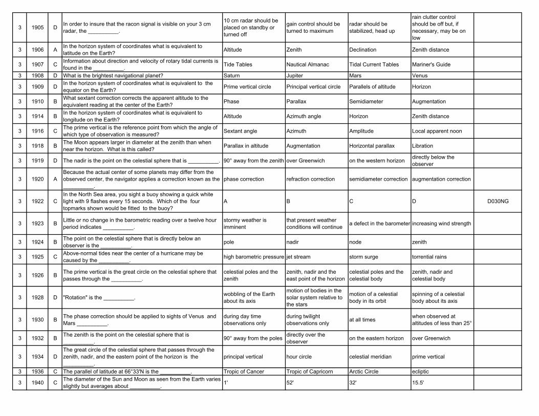
3 1905 D In order to insure that the racon signal is visible on your 3 cm radar, the __________.
10 cm radar should be placed on standby or turned off
gain control should be turned to maximum
radar should be stabilized, head up
rain clutter control should be off but, if necessary, may be on low
3 1906 A In the horizon system of coordinates what is equivalent to latitude on the Earth? Altitude Zenith Declination Zenith distance
3 1907 C Information about direction and velocity of rotary tidal currents is found in the __________. Tide Tables Nautical Almanac Tidal Current Tables Mariner's Guide
3 1908 D What is the brightest navigational planet? Saturn Jupiter Mars Venus
3 1909 D In the horizon system of coordinates what is equivalent to the equator on the Earth? Prime vertical circle Principal vertical circle Parallels of altitude Horizon
3 1910 B What sextant correction corrects the apparent altitude to the equivalent reading at the center of the Earth? Phase Parallax Semidiameter Augmentation
3 1914 B In the horizon system of coordinates what is equivalent to longitude on the Earth? Altitude Azimuth angle Horizon Zenith distance
3 1916 C The prime vertical is the reference point from which the angle of which type of observation is measured? Sextant angle Azimuth Amplitude Local apparent noon
3 1918 B The Moon appears larger in diameter at the zenith than when near the horizon. What is this called? Parallax in altitude Augmentation Horizontal parallax Libration
3 1919 D The nadir is the point on the celestial sphere that is __________. 90° away from the zenith over Greenwich on the western horizon directly below the observer
3 1920 ABecause the actual center of some planets may differ from the observed center, the navigator applies a correction known as the __________.
phase correction refraction correction semidiameter correction augmentation correction
3 1922 CIn the North Sea area, you sight a buoy showing a quick white light with 9 flashes every 15 seconds. Which of the four topmarks shown would be fitted to the buoy?
A B C D D030NG
3 1923 B Little or no change in the barometric reading over a twelve hour period indicates __________.
stormy weather is imminent
that present weather conditions will continue a defect in the barometer increasing wind strength
3 1924 B The point on the celestial sphere that is directly below an observer is the __________. pole nadir node zenith
3 1925 C Above-normal tides near the center of a hurricane may be caused by the __________. high barometric pressure jet stream storm surge torrential rains
3 1926 B The prime vertical is the great circle on the celestial sphere that passes through the __________.
celestial poles and the zenith
zenith, nadir and the east point of the horizon
celestial poles and the celestial body
zenith, nadir and celestial body
3 1928 D "Rotation" is the __________. wobbling of the Earth about its axis
motion of bodies in the solar system relative to the stars
motion of a celestial body in its orbit
spinning of a celestial body about its axis
3 1930 B The phase correction should be applied to sights of Venus and Mars __________.
during day time observations only
during twilight observations only at all times when observed at
altitudes of less than 25°
3 1932 B The zenith is the point on the celestial sphere that is __________. 90° away from the poles directly over the
observer on the eastern horizon over Greenwich
3 1934 DThe great circle of the celestial sphere that passes through the zenith, nadir, and the eastern point of the horizon is the __________.
principal vertical hour circle celestial meridian prime vertical
3 1936 C The parallel of latitude at 66°33'N is the __________. Tropic of Cancer Tropic of Capricorn Arctic Circle ecliptic
3 1940 C The diameter of the Sun and Moon as seen from the Earth varies slightly but averages about __________. 1' 52' 32' 15.5'
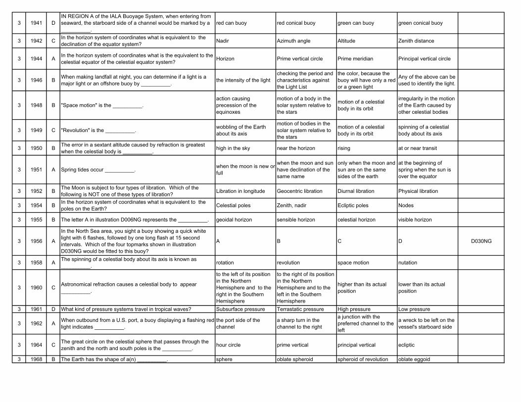
3 1941 DIN REGION A of the IALA Buoyage System, when entering from seaward, the starboard side of a channel would be marked by a __________.
red can buoy red conical buoy green can buoy green conical buoy
3 1942 C In the horizon system of coordinates what is equivalent to the declination of the equator system? Nadir Azimuth angle Altitude Zenith distance
3 1944 A In the horizon system of coordinates what is the equivalent to the celestial equator of the celestial equator system? Horizon Prime vertical circle Prime meridian Principal vertical circle
3 1946 B When making landfall at night, you can determine if a light is a major light or an offshore buoy by __________. the intensity of the light
checking the period and characteristics against the Light List
the color, because the buoy will have only a red or a green light
Any of the above can be used to identify the light.
3 1948 B "Space motion" is the __________.action causing precession of the equinoxes
motion of a body in the solar system relative to the stars
motion of a celestial body in its orbit
irregularity in the motion of the Earth caused by other celestial bodies
3 1949 C "Revolution" is the __________. wobbling of the Earth about its axis
motion of bodies in the solar system relative to the stars
motion of a celestial body in its orbit
spinning of a celestial body about its axis
3 1950 B The error in a sextant altitude caused by refraction is greatest when the celestial body is __________. high in the sky near the horizon rising at or near transit
3 1951 A Spring tides occur __________. when the moon is new or full
when the moon and sun have declination of the same name
only when the moon and sun are on the same sides of the earth
at the beginning of spring when the sun is over the equator
3 1952 B The Moon is subject to four types of libration. Which of the following is NOT one of these types of libration? Libration in longitude Geocentric libration Diurnal libration Physical libration
3 1954 B In the horizon system of coordinates what is equivalent to the poles on the Earth? Celestial poles Zenith, nadir Ecliptic poles Nodes
3 1955 B The letter A in illustration D006NG represents the __________. geoidal horizon sensible horizon celestial horizon visible horizon
3 1956 A
In the North Sea area, you sight a buoy showing a quick white light with 6 flashes, followed by one long flash at 15 second intervals. Which of the four topmarks shown in illustration D030NG would be fitted to this buoy?
A B C D D030NG
3 1958 A The spinning of a celestial body about its axis is known as __________. rotation revolution space motion nutation
3 1960 C Astronomical refraction causes a celestial body to appear __________.
to the left of its position in the Northern Hemisphere and to the right in the Southern Hemisphere
to the right of its position in the Northern Hemisphere and to the left in the Southern Hemisphere
higher than its actual position
lower than its actual position
3 1961 D What kind of pressure systems travel in tropical waves? Subsurface pressure Terrastatic pressure High pressure Low pressure
3 1962 A When outbound from a U.S. port, a buoy displaying a flashing red light indicates __________.
the port side of the channel
a sharp turn in the channel to the right
a junction with the preferred channel to the left
a wreck to be left on the vessel's starboard side
3 1964 C The great circle on the celestial sphere that passes through the zenith and the north and south poles is the __________. hour circle prime vertical principal vertical ecliptic
3 1968 B The Earth has the shape of a(n) __________. sphere oblate spheroid spheroid of revolution oblate eggoid
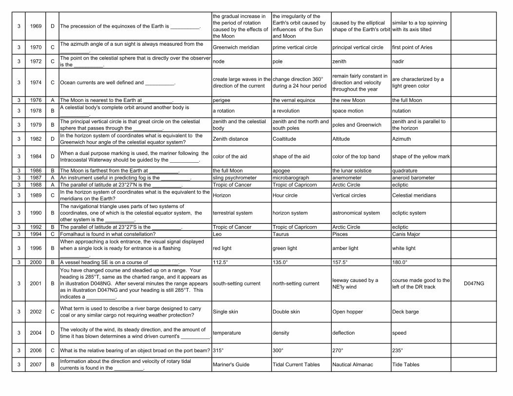
3 1969 D The precession of the equinoxes of the Earth is __________.
the gradual increase in the period of rotation caused by the effects of the Moon
the irregularity of the Earth's orbit caused by influences of the Sun and Moon
caused by the elliptical shape of the Earth's orbit
similar to a top spinning with its axis tilted
3 1970 C The azimuth angle of a sun sight is always measured from the __________. Greenwich meridian prime vertical circle principal vertical circle first point of Aries
3 1972 C The point on the celestial sphere that is directly over the observer is the __________. node pole zenith nadir
3 1974 C Ocean currents are well defined and __________. create large waves in the direction of the current
change direction 360° during a 24 hour period
remain fairly constant in direction and velocity throughout the year
are characterized by a light green color
3 1976 A The Moon is nearest to the Earth at __________. perigee the vernal equinox the new Moon the full Moon
3 1978 B A celestial body's complete orbit around another body is __________. a rotation a revolution space motion nutation
3 1979 B The principal vertical circle is that great circle on the celestial sphere that passes through the __________.
zenith and the celestial body
zenith and the north and south poles poles and Greenwich zenith and is parallel to
the horizon
3 1982 D In the horizon system of coordinates what is equivalent to the Greenwich hour angle of the celestial equator system? Zenith distance Coaltitude Altitude Azimuth
3 1984 D When a dual purpose marking is used, the mariner following the Intracoastal Waterway should be guided by the __________. color of the aid shape of the aid color of the top band shape of the yellow mark
3 1986 B The Moon is farthest from the Earth at __________. the full Moon apogee the lunar solstice quadrature3 1987 A An instrument useful in predicting fog is the __________. sling psychrometer microbarograph anemometer aneroid barometer3 1988 A The parallel of latitude at 23°27'N is the __________. Tropic of Cancer Tropic of Capricorn Arctic Circle ecliptic
3 1989 C In the horizon system of coordinates what is the equivalent to the meridians on the Earth? Horizon Hour circle Vertical circles Celestial meridians
3 1990 BThe navigational triangle uses parts of two systems of coordinates, one of which is the celestial equator system, the other system is the __________.
terrestrial system horizon system astronomical system ecliptic system
3 1992 B The parallel of latitude at 23°27'S is the __________. Tropic of Cancer Tropic of Capricorn Arctic Circle ecliptic3 1994 C Fomalhaut is found in what constellation? Leo Taurus Pisces Canis Major
3 1996 BWhen approaching a lock entrance, the visual signal displayed when a single lock is ready for entrance is a flashing __________.
red light green light amber light white light
3 2000 B A vessel heading SE is on a course of __________. 112.5° 135.0° 157.5° 180.0°
3 2001 B
You have changed course and steadied up on a range. Your heading is 285°T, same as the charted range, and it appears as in illustration D048NG. After several minutes the range appears as in illustration D047NG and your heading is still 285°T. This indicates a __________.
south-setting current north-setting current leeway caused by a NE'ly wind
course made good to the left of the DR track D047NG
3 2002 C What term is used to describe a river barge designed to carry coal or any similar cargo not requiring weather protection? Single skin Double skin Open hopper Deck barge
3 2004 D The velocity of the wind, its steady direction, and the amount of time it has blown determines a wind driven current's __________. temperature density deflection speed
3 2006 C What is the relative bearing of an object broad on the port beam? 315° 300° 270° 235°
3 2007 B Information about the direction and velocity of rotary tidal currents is found in the __________. Mariner's Guide Tidal Current Tables Nautical Almanac Tide Tables
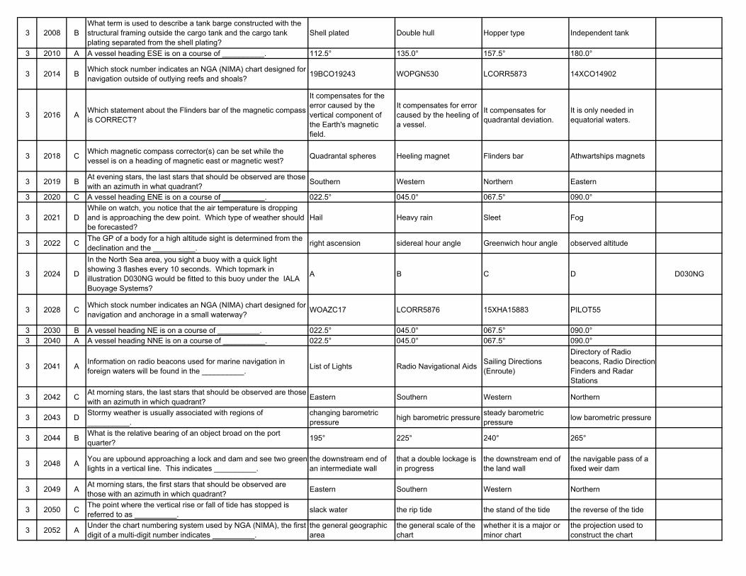
3 2008 BWhat term is used to describe a tank barge constructed with the structural framing outside the cargo tank and the cargo tank plating separated from the shell plating?
Shell plated Double hull Hopper type Independent tank
3 2010 A A vessel heading ESE is on a course of __________. 112.5° 135.0° 157.5° 180.0°
3 2014 B Which stock number indicates an NGA (NIMA) chart designed for navigation outside of outlying reefs and shoals? 19BCO19243 WOPGN530 LCORR5873 14XCO14902
3 2016 A Which statement about the Flinders bar of the magnetic compass is CORRECT?
It compensates for the error caused by the vertical component of the Earth's magnetic field.
It compensates for error caused by the heeling of a vessel.
It compensates for quadrantal deviation.
It is only needed in equatorial waters.
3 2018 C Which magnetic compass corrector(s) can be set while the vessel is on a heading of magnetic east or magnetic west? Quadrantal spheres Heeling magnet Flinders bar Athwartships magnets
3 2019 B At evening stars, the last stars that should be observed are those with an azimuth in what quadrant? Southern Western Northern Eastern
3 2020 C A vessel heading ENE is on a course of __________. 022.5° 045.0° 067.5° 090.0°
3 2021 DWhile on watch, you notice that the air temperature is dropping and is approaching the dew point. Which type of weather should be forecasted?
Hail Heavy rain Sleet Fog
3 2022 C The GP of a body for a high altitude sight is determined from the declination and the __________. right ascension sidereal hour angle Greenwich hour angle observed altitude
3 2024 D
In the North Sea area, you sight a buoy with a quick light showing 3 flashes every 10 seconds. Which topmark in illustration D030NG would be fitted to this buoy under the IALA Buoyage Systems?
A B C D D030NG
3 2028 C Which stock number indicates an NGA (NIMA) chart designed for navigation and anchorage in a small waterway? WOAZC17 LCORR5876 15XHA15883 PILOT55
3 2030 B A vessel heading NE is on a course of __________. 022.5° 045.0° 067.5° 090.0°3 2040 A A vessel heading NNE is on a course of __________. 022.5° 045.0° 067.5° 090.0°
3 2041 A Information on radio beacons used for marine navigation in foreign waters will be found in the __________. List of Lights Radio Navigational Aids Sailing Directions
(Enroute)
Directory of Radio beacons, Radio Direction Finders and Radar Stations
3 2042 C At morning stars, the last stars that should be observed are those with an azimuth in which quadrant? Eastern Southern Western Northern
3 2043 D Stormy weather is usually associated with regions of __________.
changing barometric pressure high barometric pressure steady barometric
pressure low barometric pressure
3 2044 B What is the relative bearing of an object broad on the port quarter? 195° 225° 240° 265°
3 2048 A You are upbound approaching a lock and dam and see two green lights in a vertical line. This indicates __________.
the downstream end of an intermediate wall
that a double lockage is in progress
the downstream end of the land wall
the navigable pass of a fixed weir dam
3 2049 A At morning stars, the first stars that should be observed are those with an azimuth in which quadrant? Eastern Southern Western Northern
3 2050 C The point where the vertical rise or fall of tide has stopped is referred to as __________. slack water the rip tide the stand of the tide the reverse of the tide
3 2052 A Under the chart numbering system used by NGA (NIMA), the first digit of a multi-digit number indicates __________.
the general geographic area
the general scale of the chart
whether it is a major or minor chart
the projection used to construct the chart
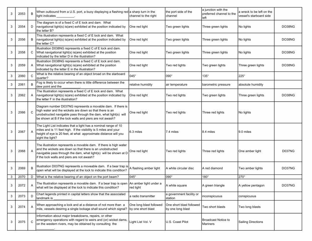
3 2053 B When outbound from a U.S. port, a buoy displaying a flashing red light indicates __________.
a sharp turn in the channel to the right
the port side of the channel
a junction with the preferred channel to the left
a wreck to be left on the vessel's starboard side
3 2054 DThe diagram is of a fixed C of E lock and dam. What navigational light(s) is(are) exhibited at the position indicated by the letter B?
One red light Two green lights Three green lights No lights DO38NG
3 2056 BThis illustration represents a fixed C of E lock and dam. What navigational light(s) is(are) exhibited at the position indicated by the letter C?
One red light Two green lights Three green lights No lights DO38NG
3 2058 CIllustration D038NG represents a fixed C of E lock and dam. What navigational light(s) is(are) exhibited at the position indicated by the letter D in the illustration?
One red light Two green lights Three green lights No lights DO38NG
3 2059 AIllustration D038NG represents a fixed C of E lock and dam. What navigational light(s) is(are) exhibited at the position indicated by the letter E in the illustration?
One red light Two red lights Two green lights Three green lights DO38NG
3 2060 C What is the relative bearing of an object broad on the starboard quarter? 045° 090° 135° 225°
3 2061 B Fog is likely to occur when there is little difference between the dew point and the __________. relative humidity air temperature barometric pressure absolute humidity
3 2062 AThe Illustration represents a fixed C of E lock and dam. What navigational light(s) is(are) exhibited at the position indicated by the letter F in the illustration?
One red light Two red lights Two green lights Three green lights DO38NG
3 2066 C
Diagram number D037NG represents a movable dam. If there is high water and the wickets are down so that there is an unobstructed navigable pass through the dam, what light(s) will be shown at B if the lock walls and piers are not awash?
One red light Two red lights Three red lights No lights
3 2067 A
The Light List indicates that a light has a nominal range of 10 miles and is 11 feet high. If the visibility is 5 miles and your height of eye is 20 feet, at what approximate distance will you sight the light?
6.3 miles 7.4 miles 8.4 miles 9.0 miles
3 2068 A
The illustration represents a movable dam. If there is high water and the wickets are down so that there is an unobstructed navigable pass through the dam, what light(s) will be shown at D if the lock walls and piers are not awash?
One red light Two red lights Three red lights One amber light D037NG
3 2069 B Illustration D037NG represents a moveable dam. If a bear trap is open what will be displayed at the lock to indicate this condition? A flashing amber light A white circular disc A red diamond Two amber lights DO37NG
3 2070 D What is the relative bearing of an object on the port beam? 045° 090° 180° 270°
3 2072 A The Illustration represents a movable dam. If a bear trap is open what will be displayed at the lock to indicate this condition?
An amber light under a red light A white square A green triangle A yellow pentagon DO37NG
3 2073 D Chart legends printed in capital letters show that the associated landmark is __________. a radio transmitter a government facility or
station inconspicuous conspicuous
3 2074 A When approaching a lock and at a distance of not more than a mile, vessels desiring a single lockage shall sound which signal?
One long blast followed by one short blast
One short blast followed by one long blast Two short blasts Two long blasts
3 2075 C
Information about major breakdowns, repairs, or other emergency operations with regard to weirs and (or) wicket dams, on the western rivers, may be obtained by consulting the __________.
Light List Vol. V U.S. Coast Pilot Broadcast Notice to Mariners Sailing Directions
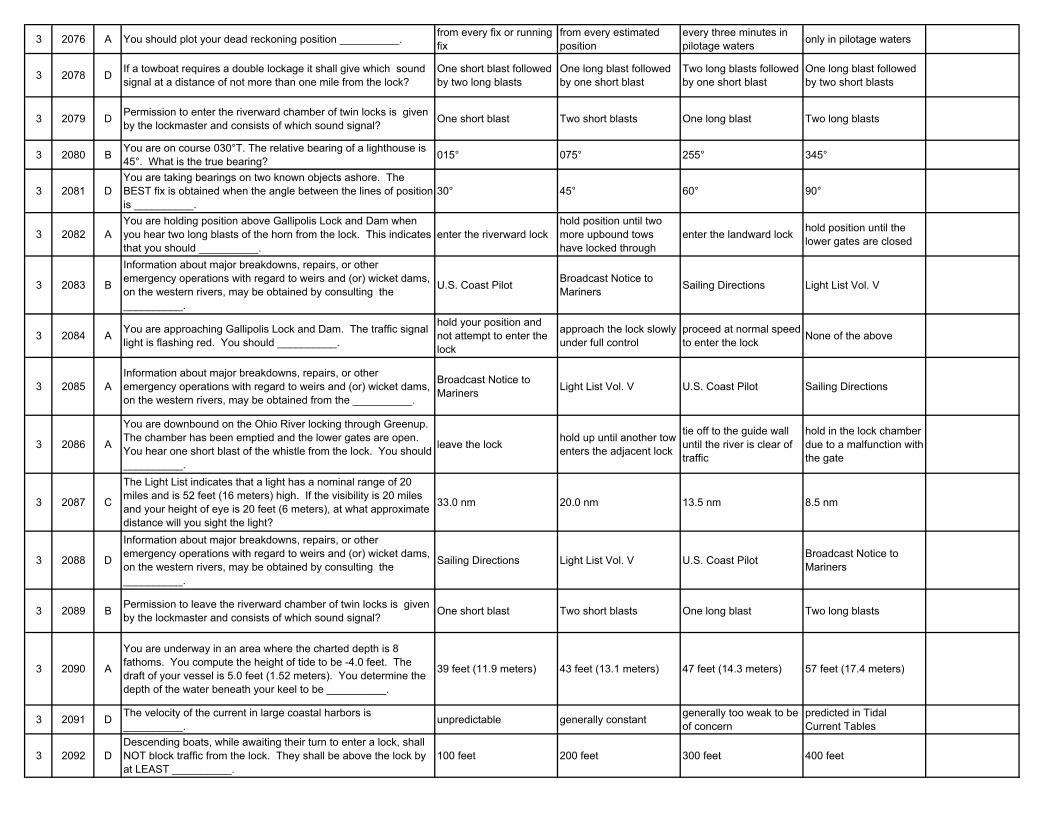
3 2076 A You should plot your dead reckoning position __________. from every fix or running fix
from every estimated position
every three minutes in pilotage waters only in pilotage waters
3 2078 D If a towboat requires a double lockage it shall give which sound signal at a distance of not more than one mile from the lock?
One short blast followed by two long blasts
One long blast followed by one short blast
Two long blasts followed by one short blast
One long blast followed by two short blasts
3 2079 D Permission to enter the riverward chamber of twin locks is given by the lockmaster and consists of which sound signal? One short blast Two short blasts One long blast Two long blasts
3 2080 B You are on course 030°T. The relative bearing of a lighthouse is 45°. What is the true bearing? 015° 075° 255° 345°
3 2081 DYou are taking bearings on two known objects ashore. The BEST fix is obtained when the angle between the lines of position is __________.
30° 45° 60° 90°
3 2082 AYou are holding position above Gallipolis Lock and Dam when you hear two long blasts of the horn from the lock. This indicates that you should __________.
enter the riverward lockhold position until two more upbound tows have locked through
enter the landward lock hold position until the lower gates are closed
3 2083 B
Information about major breakdowns, repairs, or other emergency operations with regard to weirs and (or) wicket dams, on the western rivers, may be obtained by consulting the __________.
U.S. Coast Pilot Broadcast Notice to Mariners Sailing Directions Light List Vol. V
3 2084 A You are approaching Gallipolis Lock and Dam. The traffic signal light is flashing red. You should __________.
hold your position and not attempt to enter the lock
approach the lock slowly under full control
proceed at normal speed to enter the lock None of the above
3 2085 AInformation about major breakdowns, repairs, or other emergency operations with regard to weirs and (or) wicket dams, on the western rivers, may be obtained from the __________.
Broadcast Notice to Mariners Light List Vol. V U.S. Coast Pilot Sailing Directions
3 2086 A
You are downbound on the Ohio River locking through Greenup. The chamber has been emptied and the lower gates are open. You hear one short blast of the whistle from the lock. You should __________.
leave the lock hold up until another tow enters the adjacent lock
tie off to the guide wall until the river is clear of traffic
hold in the lock chamber due to a malfunction with the gate
3 2087 C
The Light List indicates that a light has a nominal range of 20 miles and is 52 feet (16 meters) high. If the visibility is 20 miles and your height of eye is 20 feet (6 meters), at what approximate distance will you sight the light?
33.0 nm 20.0 nm 13.5 nm 8.5 nm
3 2088 D
Information about major breakdowns, repairs, or other emergency operations with regard to weirs and (or) wicket dams, on the western rivers, may be obtained by consulting the __________.
Sailing Directions Light List Vol. V U.S. Coast Pilot Broadcast Notice to Mariners
3 2089 B Permission to leave the riverward chamber of twin locks is given by the lockmaster and consists of which sound signal? One short blast Two short blasts One long blast Two long blasts
3 2090 A
You are underway in an area where the charted depth is 8 fathoms. You compute the height of tide to be -4.0 feet. The draft of your vessel is 5.0 feet (1.52 meters). You determine the depth of the water beneath your keel to be __________.
39 feet (11.9 meters) 43 feet (13.1 meters) 47 feet (14.3 meters) 57 feet (17.4 meters)
3 2091 D The velocity of the current in large coastal harbors is __________. unpredictable generally constant generally too weak to be
of concernpredicted in Tidal Current Tables
3 2092 DDescending boats, while awaiting their turn to enter a lock, shall NOT block traffic from the lock. They shall be above the lock by at LEAST __________.
100 feet 200 feet 300 feet 400 feet
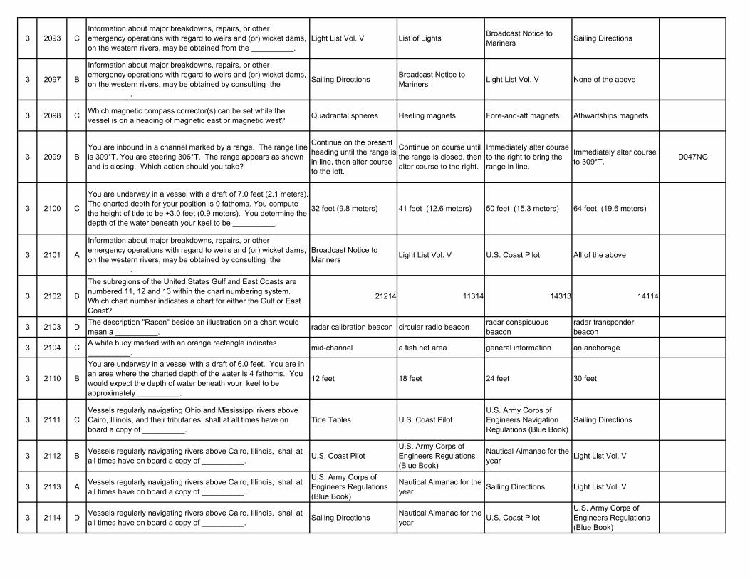
3 2093 CInformation about major breakdowns, repairs, or other emergency operations with regard to weirs and (or) wicket dams, on the western rivers, may be obtained from the __________.
Light List Vol. V List of Lights Broadcast Notice to Mariners Sailing Directions
3 2097 B
Information about major breakdowns, repairs, or other emergency operations with regard to weirs and (or) wicket dams, on the western rivers, may be obtained by consulting the __________.
Sailing Directions Broadcast Notice to Mariners Light List Vol. V None of the above
3 2098 C Which magnetic compass corrector(s) can be set while the vessel is on a heading of magnetic east or magnetic west? Quadrantal spheres Heeling magnets Fore-and-aft magnets Athwartships magnets
3 2099 BYou are inbound in a channel marked by a range. The range line is 309°T. You are steering 306°T. The range appears as shown and is closing. Which action should you take?
Continue on the present heading until the range is in line, then alter course to the left.
Continue on course until the range is closed, then alter course to the right.
Immediately alter course to the right to bring the range in line.
Immediately alter course to 309°T. D047NG
3 2100 C
You are underway in a vessel with a draft of 7.0 feet (2.1 meters). The charted depth for your position is 9 fathoms. You compute the height of tide to be +3.0 feet (0.9 meters). You determine the depth of the water beneath your keel to be __________.
32 feet (9.8 meters) 41 feet (12.6 meters) 50 feet (15.3 meters) 64 feet (19.6 meters)
3 2101 A
Information about major breakdowns, repairs, or other emergency operations with regard to weirs and (or) wicket dams, on the western rivers, may be obtained by consulting the __________.
Broadcast Notice to Mariners Light List Vol. V U.S. Coast Pilot All of the above
3 2102 B
The subregions of the United States Gulf and East Coasts are numbered 11, 12 and 13 within the chart numbering system. Which chart number indicates a chart for either the Gulf or East Coast?
21214 11314 14313 14114
3 2103 D The description "Racon" beside an illustration on a chart would mean a __________. radar calibration beacon circular radio beacon radar conspicuous
beaconradar transponder beacon
3 2104 C A white buoy marked with an orange rectangle indicates __________. mid-channel a fish net area general information an anchorage
3 2110 B
You are underway in a vessel with a draft of 6.0 feet. You are in an area where the charted depth of the water is 4 fathoms. You would expect the depth of water beneath your keel to be approximately __________.
12 feet 18 feet 24 feet 30 feet
3 2111 CVessels regularly navigating Ohio and Mississippi rivers above Cairo, Illinois, and their tributaries, shall at all times have on board a copy of __________.
Tide Tables U.S. Coast PilotU.S. Army Corps of Engineers Navigation Regulations (Blue Book)
Sailing Directions
3 2112 B Vessels regularly navigating rivers above Cairo, Illinois, shall at all times have on board a copy of __________. U.S. Coast Pilot
U.S. Army Corps of Engineers Regulations (Blue Book)
Nautical Almanac for the year Light List Vol. V
3 2113 A Vessels regularly navigating rivers above Cairo, Illinois, shall at all times have on board a copy of __________.
U.S. Army Corps of Engineers Regulations (Blue Book)
Nautical Almanac for the year Sailing Directions Light List Vol. V
3 2114 D Vessels regularly navigating rivers above Cairo, Illinois, shall at all times have on board a copy of __________. Sailing Directions Nautical Almanac for the
year U.S. Coast PilotU.S. Army Corps of Engineers Regulations (Blue Book)
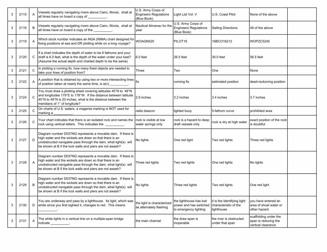
3 2115 A Vessels regularly navigating rivers above Cairo, Illinois, shall at all times have on board a copy of __________.
U.S. Army Corps of Engineers Regulations (Blue Book)
Light List Vol. V U.S. Coast Pilot None of the above
3 2116 B Vessels regularly navigating rivers above Cairo, Illinois, shall at all times have on board a copy of the __________.
Nautical Almanac for the year
U.S. Army Corps of Engineers Regulations (Blue Book)
Sailing Directions All of the above
3 2119 A Which stock number indicates an NGA (NIMA) chart designed for fixing positions at sea and DR plotting while on a long voyage? WOAGN520 PILOT16 16BCO16212 WOPZC5245
3 2120 CIf a chart indicates the depth of water to be 6 fathoms and your draft is 6.0 feet, what is the depth of the water under your keel? (Assume the actual depth and charted depth to be the same)
6.0 feet 26.5 feet 30.0 feet 56.5 feet
3 2121 C In plotting a running fix, how many fixed objects are needed to take your lines of position from? Three Two One None
3 2122 A A position that is obtained by using two or more intersecting lines of position taken at nearly the same time, is a(n) __________. fix running fix estimated position dead-reckoning position
3 2124 C
You must draw a plotting sheet covering latitudes 45°N to 49°N and longitudes 179°E to 178°W. If the distance between latitude 45°N to 49°N is 20 inches, what is the distance between the meridians of 1° of longitude?
2.9 inches 3.2 inches 3.4 inches 3.7 inches
3 2125 C On charts of U.S. waters, a magenta marking is NOT used for marking a __________. radio beacon lighted buoy 5-fathom curve prohibited area
3 2126 C Your chart indicates that there is an isolated rock and names the rock using vertical letters. This indicates the __________.
rock is visible at low water springs only
rock is a hazard to deep draft vessels only rock is dry at high water exact position of the rock
is doubtful
3 2127 D
Diagram number D037NG represents a movable dam. If there is high water and the wickets are down so that there is an unobstructed navigable pass through the dam, what light(s) will be shown at B if the lock walls and piers are not awash?
No lights One red light Two red lights Three red lights
3 2128 A
Diagram number D037NG represents a movable dam. If there is high water and the wickets are down so that there is an unobstructed navigable pass through the dam, what light(s) will be shown at B if the lock walls and piers are not awash?
Three red lights Two red lights One red lights No lights
3 2129 B
Diagram number D037NG represents a movable dam. If there is high water and the wickets are down so that there is an unobstructed navigable pass through the dam, what light(s) will be shown at B if the lock walls and piers are not awash?
No lights Three red lights Two red lights One red light
3 2130 DYou are underway and pass by a lighthouse. Its light, which was white since you first sighted it, changes to red. This means __________.
the light is characterized as alternately flashing
the lighthouse has lost power and has switched to emergency lighting
it is the identifying light characteristic of the lighthouse
you have entered an area of shoal water or other hazard
3 2131 A The white lights in a vertical line on a multiple-span bridge indicate __________. the main channel the draw span is
inoperablethe river is obstructed under that span
scaffolding under the span is reducing the vertical clearance
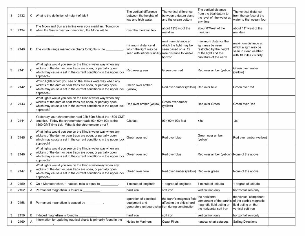
3 2132 C What is the definition of height of tide?The vertical difference between the heights of low and high water
The vertical difference between a datum plane and the ocean bottom
The vertical distance from the tidal datum to the level of the water at any time
The vertical distance from the surface of the water to the ocean floor
3 2134 BThe Moon and Sun are in line over your meridian. Tomorrow when the Sun is over your meridian, the Moon will be __________.
over the meridian too about 12°East of the meridian
about 6°West of the meridian
about 11° west of the meridian
3 2140 D The visible range marked on charts for lights is the __________.minimum distance at which the light may be seen with infinite visibility
minimum distance at which the light may be seen based on a 12 mile distance to visible horizon
maximum distance the light may be seen restricted by the height of the light and the curvature of the earth
maximum distance at which a light may be seen in clear weather with 10 miles visibility
3 2141 C
What lights would you see on the Illinois water way when any wickets of the dam or bear traps are open, or partially open, which may cause a set in the current conditions in the upper lock approach?
Red over green Green over red Red over amber (yellow) Green over amber (yellow)
3 2142 B
Which lights would you see on the Illinois waterway when any wickets of the dam or bear traps are open, or partially open, which may cause a set in the current conditions in the upper lock approach?
Green over amber (yellow) Red over amber (yellow) Red over blue Green over red
3 2143 A
What lights would you see on the Illinois water way when any wickets of the dam or bear traps are open, or partially open, which may cause a set in the current conditions in the upper lock approach?
Red over amber (yellow) Green over amber (yellow) Red over Green Green over Red
3 2144 AYesterday your chronometer read 02h 59m 58s at the 1500 GMT time tick. Today the chronometer reads 03h 00m 02s at the 1500 GMT time tick. What is the chronometer error?
02s fast 03h 00m 02s fast +3s -3s
3 2145 D
What lights would you see on the Illinois water way when any wickets of the dam or bear traps are open, or partially open, which may cause a set in the current conditions in the upper lock approach?
Green over red Red over blue Green over amber (yellow) Red over amber (yellow)
3 2146 C
What lights would you see on the Illinois water way when any wickets of the dam or bear traps are open, or partially open, which may cause a set in the current conditions in the upper lock approach?
Green over red Red over blue Red over amber (yellow) None of the above
3 2147 B
What lights would you see on the Illinois waterway when any wickets of the dam or bear traps are open, or partially open, which may cause a set in the current conditions in the upper lock approach?
Green over blue Red over amber (yellow) Red over green None of the above
3 2150 C On a Mercator chart, 1 nautical mile is equal to __________. 1 minute of longitude 1 degree of longitude 1 minute of latitude 1 degree of latitude
3 2152 A Permanent magnetism is found in __________. hard iron soft iron vertical iron only horizontal iron only
3 2158 B Permanent magnetism is caused by __________.operation of electrical equipment and generators on board ship
the earth's magnetic field affecting the ship's hard iron during construction
the horizontal component of the earth's magnetic field acting on the horizontal soft iron
the vertical component of the earth's magnetic field acting on the vertical soft iron
3 2159 B Induced magnetism is found in __________. hard iron soft iron vertical iron only horizontal iron only
3 2160 A Information for updating nautical charts is primarily found in the __________. Notice to Mariners Coast Pilots nautical chart catalogs Sailing Directions
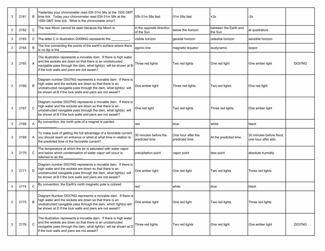
3 2161 BYesterday your chronometer read 03h 01m 56s at the 1500 GMT time tick. Today your chronometer read 03h 01m 58s at the 1500 GMT time tick. What is the chronometer error?
03h 01m 58s fast 01m 58s fast +2s -2s
3 2162 C The new Moon cannot be seen because the Moon is __________.
in the opposite direction of the Sun below the horizon between the Earth and
the Sun at quadrature
3 2163 C The letter C in illustration D006NG represents the __________. visible horizon geoidal horizon celestial horizon sensible horizon
3 2164 B The line connecting the points of the earth's surface where there is no dip is the __________. agonic line magnetic equator isodynamic isopor
3 2165 A
The illustration represents a movable dam. If there is high water and the wickets are down so that there is an unobstructed navigable pass through the dam, what light(s) will be shown at B if the lock walls and piers are not awash?
Three red lights Two red lights One red light One amber light D037NG
3 2166 B
Diagram number D037NG represents a movable dam. If there is high water and the wickets are down so that there is an unobstructed navigable pass through the dam, what light(s) will be shown at B if the lock walls and piers are not awash?
One amber light Three red lights Two red lights One red light
3 2167 C
Diagram number D037NG represents a movable dam. If there is high water and the wickets are down so that there is an unobstructed navigable pass through the dam, what light(s) will be shown at B if the lock walls and piers are not awash?
One red light Two red lights Three red lights One amber light
3 2168 A By convention, the north pole of a magnet is painted __________. red blue white black
3 2169 ATo make sure of getting the full advantage of a favorable current, you should reach an entrance or strait at what time in relation to the predicted time of the favorable current?
30 minutes before the predicted time
One hour after the predicted time At the predicted time 30 minutes before flood,
one hour after ebb
3 2170 CThe temperature at which the air is saturated with water vapor and below which condensation of water vapor will occur is referred to as the __________.
precipitation point vapor point dew point absolute humidity
3 2171 D
Diagram number D037NG represents a movable dam. If there is high water and the wickets are down so that there is an unobstructed navigable pass through the dam, what light(s) will be shown at B if the lock walls and piers are not awash?
One amber light One red light Two red lights Three red lights
3 2174 C By convention, the Earth's north magnetic pole is colored __________. red white blue black
3 2175 B
Diagram Number D037NG represents a movable dam. If there is high water and the wickets are down so that there is an unobstructed navigable pass through the dam, which light(s) will be shown at D if the lock walls and piers are not awash?
One amber light One red light Two red lights Three red lights
3 2176 C
The illustration represents a movable dam. If there is high water and the wickets are down so that there is an unobstructed navigable pass through the dam, what light(s) will be shown at D if the lock walls and piers are not awash?
Three red lights Two red lights One red light One amber light D037NG
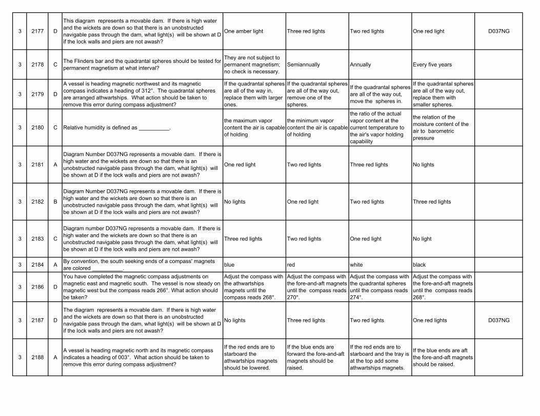
3 2177 D
This diagram represents a movable dam. If there is high water and the wickets are down so that there is an unobstructed navigable pass through the dam, what light(s) will be shown at D if the lock walls and piers are not awash?
One amber light Three red lights Two red lights One red light D037NG
3 2178 C The Flinders bar and the quadrantal spheres should be tested for permanent magnetism at what interval?
They are not subject to permanent magnetism; no check is necessary.
Semiannually Annually Every five years
3 2179 D
A vessel is heading magnetic northwest and its magnetic compass indicates a heading of 312°. The quadrantal spheres are arranged athwartships. What action should be taken to remove this error during compass adjustment?
If the quadrantal spheres are all of the way in, replace them with larger ones.
If the quadrantal spheres are all of the way out, remove one of the spheres.
If the quadrantal spheres are all of the way out, move the spheres in.
If the quadrantal spheres are all of the way out, replace them with smaller spheres.
3 2180 C Relative humidity is defined as __________.the maximum vapor content the air is capable of holding
the minimum vapor content the air is capable of holding
the ratio of the actual vapor content at the current temperature to the air's vapor holding capability
the relation of the moisture content of the air to barometric pressure
3 2181 A
Diagram Number D037NG represents a movable dam. If there is high water and the wickets are down so that there is an unobstructed navigable pass through the dam, what light(s) will be shown at D if the lock walls and piers are not awash?
One red light Two red lights Three red lights No lights
3 2182 B
Diagram Number D037NG represents a movable dam. If there is high water and the wickets are down so that there is an unobstructed navigable pass through the dam, what light(s) will be shown at D if the lock walls and piers are not awash?
No lights One red light Two red lights Three red lights
3 2183 C
Diagram number D037NG represents a movable dam. If there is high water and the wickets are down so that there is an unobstructed navigable pass through the dam, what light(s) will be shown at D if the lock walls and piers are not awash?
Three red lights Two red lights One red light No light
3 2184 A By convention, the south seeking ends of a compass' magnets are colored __________. blue red white black
3 2186 D
You have completed the magnetic compass adjustments on magnetic east and magnetic south. The vessel is now steady on magnetic west but the compass reads 266°. What action should be taken?
Adjust the compass with the athwartships magnets until the compass reads 268°.
Adjust the compass with the fore-and-aft magnets until the compass reads 270°.
Adjust the compass with the quadrantal spheres until the compass reads 274°.
Adjust the compass with the fore-and-aft magnets until the compass reads 268°.
3 2187 D
The diagram represents a movable dam. If there is high water and the wickets are down so that there is an unobstructed navigable pass through the dam, what light(s) will be shown at D if the lock walls and piers are not awash?
No lights Three red lights Two red lights One red lights D037NG
3 2188 AA vessel is heading magnetic north and its magnetic compass indicates a heading of 003°. What action should be taken to remove this error during compass adjustment?
If the red ends are to starboard the athwartships magnets should be lowered.
If the blue ends are forward the fore-and-aft magnets should be raised.
If the red ends are to starboard and the tray is at the top add some athwartships magnets.
If the blue ends are aft the fore-and-aft magnets should be raised.
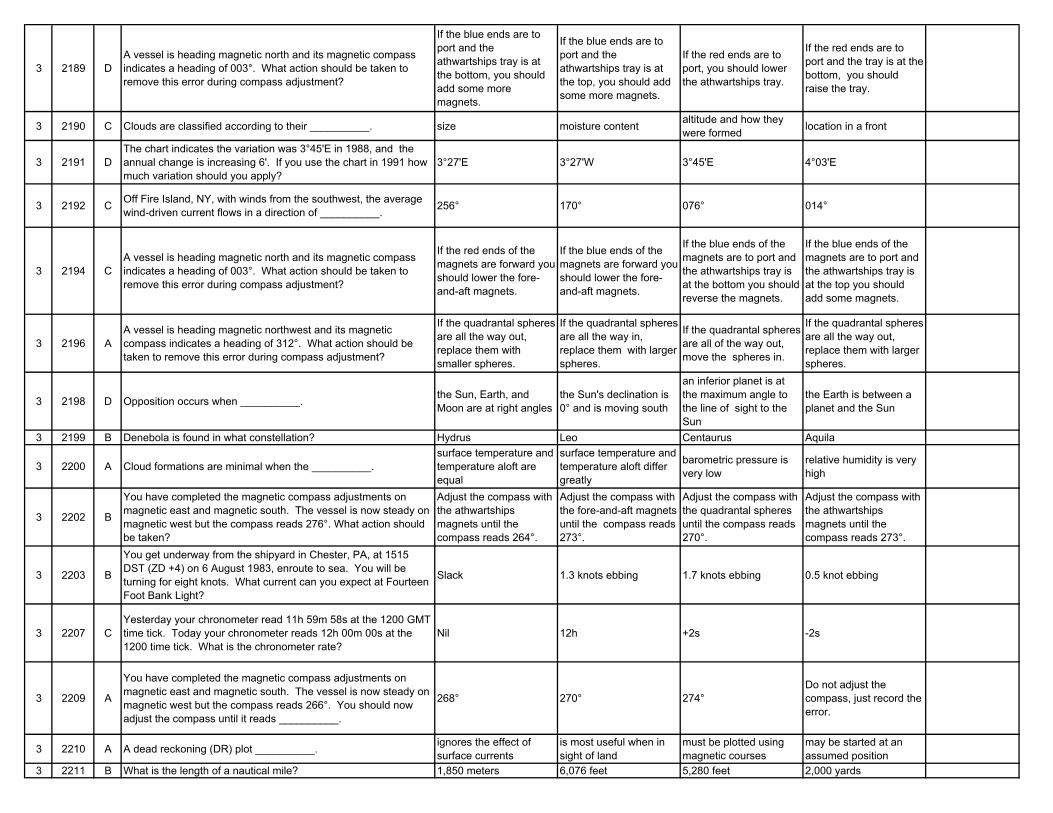
3 2189 DA vessel is heading magnetic north and its magnetic compass indicates a heading of 003°. What action should be taken to remove this error during compass adjustment?
If the blue ends are to port and the athwartships tray is at the bottom, you should add some more magnets.
If the blue ends are to port and the athwartships tray is at the top, you should add some more magnets.
If the red ends are to port, you should lower the athwartships tray.
If the red ends are to port and the tray is at the bottom, you should raise the tray.
3 2190 C Clouds are classified according to their __________. size moisture content altitude and how they were formed location in a front
3 2191 DThe chart indicates the variation was 3°45'E in 1988, and the annual change is increasing 6'. If you use the chart in 1991 how much variation should you apply?
3°27'E 3°27'W 3°45'E 4°03'E
3 2192 C Off Fire Island, NY, with winds from the southwest, the average wind-driven current flows in a direction of __________. 256° 170° 076° 014°
3 2194 CA vessel is heading magnetic north and its magnetic compass indicates a heading of 003°. What action should be taken to remove this error during compass adjustment?
If the red ends of the magnets are forward you should lower the fore-and-aft magnets.
If the blue ends of the magnets are forward you should lower the fore-and-aft magnets.
If the blue ends of the magnets are to port and the athwartships tray is at the bottom you should reverse the magnets.
If the blue ends of the magnets are to port and the athwartships tray is at the top you should add some magnets.
3 2196 AA vessel is heading magnetic northwest and its magnetic compass indicates a heading of 312°. What action should be taken to remove this error during compass adjustment?
If the quadrantal spheres are all the way out, replace them with smaller spheres.
If the quadrantal spheres are all the way in, replace them with larger spheres.
If the quadrantal spheres are all of the way out, move the spheres in.
If the quadrantal spheres are all the way out, replace them with larger spheres.
3 2198 D Opposition occurs when __________. the Sun, Earth, and Moon are at right angles
the Sun's declination is 0° and is moving south
an inferior planet is at the maximum angle to the line of sight to the Sun
the Earth is between a planet and the Sun
3 2199 B Denebola is found in what constellation? Hydrus Leo Centaurus Aquila
3 2200 A Cloud formations are minimal when the __________.surface temperature and temperature aloft are equal
surface temperature and temperature aloft differ greatly
barometric pressure is very low
relative humidity is very high
3 2202 B
You have completed the magnetic compass adjustments on magnetic east and magnetic south. The vessel is now steady on magnetic west but the compass reads 276°. What action should be taken?
Adjust the compass with the athwartships magnets until the compass reads 264°.
Adjust the compass with the fore-and-aft magnets until the compass reads 273°.
Adjust the compass with the quadrantal spheres until the compass reads 270°.
Adjust the compass with the athwartships magnets until the compass reads 273°.
3 2203 B
You get underway from the shipyard in Chester, PA, at 1515 DST (ZD +4) on 6 August 1983, enroute to sea. You will be turning for eight knots. What current can you expect at Fourteen Foot Bank Light?
Slack 1.3 knots ebbing 1.7 knots ebbing 0.5 knot ebbing
3 2207 CYesterday your chronometer read 11h 59m 58s at the 1200 GMT time tick. Today your chronometer reads 12h 00m 00s at the 1200 time tick. What is the chronometer rate?
Nil 12h +2s -2s
3 2209 A
You have completed the magnetic compass adjustments on magnetic east and magnetic south. The vessel is now steady on magnetic west but the compass reads 266°. You should now adjust the compass until it reads __________.
268° 270° 274°Do not adjust the compass, just record the error.
3 2210 A A dead reckoning (DR) plot __________. ignores the effect of surface currents
is most useful when in sight of land
must be plotted using magnetic courses
may be started at an assumed position
3 2211 B What is the length of a nautical mile? 1,850 meters 6,076 feet 5,280 feet 2,000 yards
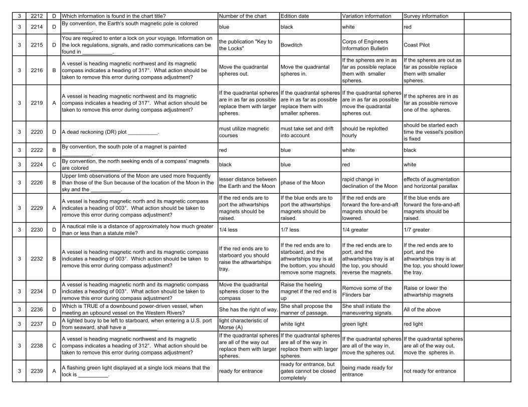
3 2212 D Which information is found in the chart title? Number of the chart Edition date Variation information Survey information
3 2214 D By convention, the Earth's south magnetic pole is colored __________. blue black white red
3 2215 DYou are required to enter a lock on your voyage. Information on the lock regulations, signals, and radio communications can be found in __________.
the publication "Key to the Locks" Bowditch Corps of Engineers
Information Bulletin Coast Pilot
3 2216 BA vessel is heading magnetic northwest and its magnetic compass indicates a heading of 317°. What action should be taken to remove this error during compass adjustment?
Move the quadrantal spheres out.
Move the quadrantal spheres in.
If the spheres are in as far as possible replace them with smaller spheres.
If the spheres are out as far as possible replace them with smaller spheres.
3 2219 AA vessel is heading magnetic northwest and its magnetic compass indicates a heading of 317°. What action should be taken to remove this error during compass adjustment?
If the quadrantal spheres are in as far as possible replace them with larger spheres.
If the quadrantal spheres are in as far as possible replace them with smaller spheres.
If the quadrantal spheres are in as far as possible move the quadrantal spheres out.
If the spheres are in as far as possible remove one of the spheres.
3 2220 D A dead reckoning (DR) plot __________. must utilize magnetic courses
must take set and drift into account
should be replotted hourly
should be started each time the vessel's position is fixed
3 2222 B By convention, the south pole of a magnet is painted __________. red blue white black
3 2224 C By convention, the north seeking ends of a compass' magnets are colored __________. black blue red white
3 2226 BUpper limb observations of the Moon are used more frequently than those of the Sun because of the location of the Moon in the sky and the __________.
lesser distance between the Earth and the Moon phase of the Moon rapid change in
declination of the Mooneffects of augmentation and horizontal parallax
3 2229 AA vessel is heading magnetic north and its magnetic compass indicates a heading of 003°. What action should be taken to remove this error during compass adjustment?
If the red ends are to port the athwartships magnets should be raised.
If the blue ends are to port the athwartships magnets should be raised.
If the red ends are forward the fore-and-aft magnets should be lowered.
If the blue ends are forward the fore-and-aft magnets should be raised.
3 2230 D A nautical mile is a distance of approximately how much greater than or less than a statute mile? 1/4 less 1/7 less 1/4 greater 1/7 greater
3 2232 BA vessel is heading magnetic north and its magnetic compass indicates a heading of 003°. Which action should be taken to remove this error during compass adjustment?
If the red ends are to starboard you should raise the athwartships tray.
If the red ends are to starboard, and the athwartships tray is at the bottom, you should remove some magnets.
If the red ends are to port, and the athwartships tray is at the top, you should reverse the magnets.
If the red ends are to port, and the athwartships tray is at the top, you should lower the tray.
3 2234 DA vessel is heading magnetic north and its magnetic compass indicates a heading of 003°. What action should be taken to remove this error during compass adjustment?
Move the quadrantal spheres closer to the compass
Raise the heeling magnet if the red end is up
Remove some of the Flinders bar
Raise or lower the athwartship magnets
3 2236 D Which is TRUE of a downbound power-driven vessel, when meeting an upbound vessel on the Western Rivers? She has the right of way. She shall propose the
manner of passage.She shall initiate the maneuvering signals. All of the above
3 2237 D A lighted buoy to be left to starboard, when entering a U.S. port from seaward, shall have a __________.
light characteristic of Morse (A) white light green light red light
3 2238 CA vessel is heading magnetic northwest and its magnetic compass indicates a heading of 312°. What action should be taken to remove this error during compass adjustment?
If the quadrantal spheres are all of the way out replace them with larger spheres.
If the quadrantal spheres are all of the way in replace them with larger spheres.
If the quadrantal spheres are all of the way in, move the spheres out.
If the quadrantal spheres are all of the way out, move the spheres in.
3 2239 A A flashing green light displayed at a single lock means that the lock is __________. ready for entrance
ready for entrance, but gates cannot be closed completely
being made ready for entrance not ready for entrance
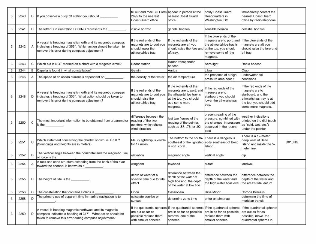
3 2240 D If you observe a buoy off station you should __________.fill out and mail CG Form 2692 to the nearest Coast Guard office
appear in person at the nearest Coast Guard office
notify Coast Guard Headquarters in Washington, DC
immediately contact the nearest Coast Guard office by radiotelephone
3 2241 D The letter C in illustration D006NG represents the __________. visible horizon geoidal horizon sensible horizon celestial horizon
3 2242 AA vessel is heading magnetic north and its magnetic compass indicates a heading of 356°. Which action should be taken to remove this error during compass adjustment?
If the red ends of the magnets are to port you should lower the athwartships tray.
If the red ends of the magnets are aft you should raise the fore-and-aft tray.
If the blue ends of the magnets are to port, and the athwartships tray is at the top, you should remove some of the magnets.
If the blue ends of the magnets are aft you should raise the fore-and-aft tray.
3 2243 C Which aid is NOT marked on a chart with a magenta circle? Radar station Radar transponder beacon Aero light Radio beacon
3 2244 B Capella is found in what constellation? Gemini Auriga Libra Crab
3 2246 A The speed of an ocean current is dependent on __________. the density of the water the air temperature the presence of a high pressure area near it
underwater soil conditions
3 2248 DA vessel is heading magnetic north and its magnetic compass indicates a heading of 356°. What action should be taken to remove this error during compass adjustment?
If the red ends of the magnets are to port you should raise the athwartships tray.
If the red ends of the magnets are to port, and the athwartships tray is at the top, you should add some more magnets.
If the red ends of the magnets are to starboard you should lower the athwartships tray.
If the red ends of the magnets are to starboard, and the athwartships tray is at the top, you should add some more magnets.
3 2250 C The most important information to be obtained from a barometer is the __________.
difference between the reading of the two pointers, which shows wind direction
last two figures of the reading of the pointer, such as .87, .76, or .92
present reading of the pressure, combined with the changes in pressure observed in the recent past
weather indications printed on the dial (such as "cold, wet, etc.") under the pointer
3 2251 C Which statement concerning the chartlet shown is TRUE? (Soundings and heights are in meters)
Maury lightship is visible for 17 miles.
The bottom to the south-southeast of the lightship is soft coral.
There is a dangerous eddy southeast of Beito Island.
There is a 12-meter deep west of Beito Island and inside the 5-meter line.
D010NG
3 2252 D The vertical angle between the horizontal and the magnetic line of force is the __________. elevation magnetic angle vertical angle dip
3 2254 A A rock and sand structure extending from the bank of the river toward the channel is known as a __________. wingdam towhead cutoff landwall
3 2255 D The height of tide is the __________.depth of water at a specific time due to tidal effect
difference between the depth of the water at high tide and the depth of the water at low tide
difference between the depth of the water and the high water tidal level
difference between the depth of the water and the area's tidal datum
3 2256 C The constellation that contains Polaris is __________. Orion Cassiopeia Ursa Minor Corona Borealis
3 2258 D The primary use of apparent time in marine navigation is to __________.
calculate sunrise or sunset determine zone time enter an almanac determine the time of
meridian transit
3 2259 DA vessel is heading magnetic northwest and its magnetic compass indicates a heading of 317°. What action should be taken to remove this error during compass adjustment?
If the quadrantal spheres are out as far as possible replace them with smaller spheres.
If the quadrantal spheres are in as far as possible remove one of the spheres.
If the quadrantal spheres are in as far as possible replace them with smaller spheres.
If the quadrantal spheres are out as far as possible, move the quadrantal spheres in.
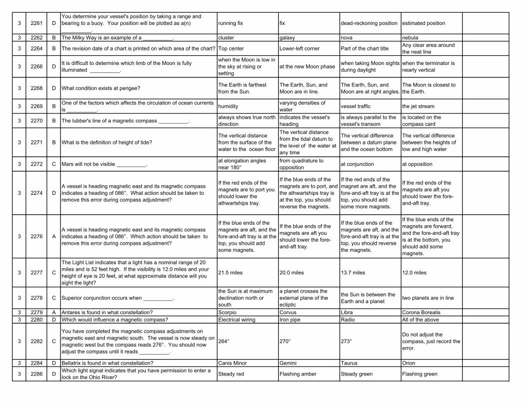
3 2261 DYou determine your vessel's position by taking a range and bearing to a buoy. Your position will be plotted as a(n) __________.
running fix fix dead-reckoning position estimated position
3 2262 B The Milky Way is an example of a __________. cluster galaxy nova nebula
3 2264 B The revision date of a chart is printed on which area of the chart? Top center Lower-left corner Part of the chart title Any clear area around the neat line
3 2266 D It is difficult to determine which limb of the Moon is fully illuminated __________.
when the Moon is low in the sky at rising or setting
at the new Moon phase when taking Moon sights during daylight
when the terminator is nearly vertical
3 2268 D What condition exists at perigee? The Earth is farthest from the Sun.
The Earth, Sun, and Moon are in line.
The Earth, Sun, and Moon are at right angles.
The Moon is closest to the Earth.
3 2269 B One of the factors which affects the circulation of ocean currents is __________. humidity varying densities of
water vessel traffic the jet stream
3 2270 B The lubber's line of a magnetic compass __________. always shows true north direction
indicates the vessel's heading
is always parallel to the vessel's transom
is located on the compass card
3 2271 B What is the definition of height of tide?The vertical distance from the surface of the water to the ocean floor
The vertical distance from the tidal datum to the level of the water at any time
The vertical difference between a datum plane and the ocean bottom
The vertical difference between the heights of low and high water
3 2272 C Mars will not be visible __________. at elongation angles near 180°
from quadrature to opposition at conjunction at opposition
3 2274 DA vessel is heading magnetic east and its magnetic compass indicates a heading of 086°. What action should be taken to remove this error during compass adjustment?
If the red ends of the magnets are to port you should lower the athwartships tray.
If the blue ends of the magnets are to port, and the athwartships tray is at the top, you should reverse the magnets.
If the red ends of the magnet are aft, and the fore-and-aft tray is at the top, you should add some more magnets.
If the red ends of the magnets are aft you should lower the fore-and-aft tray.
3 2276 AA vessel is heading magnetic east and its magnetic compass indicates a heading of 086°. Which action should be taken to remove this error during compass adjustment?
If the blue ends of the magnets are aft, and the fore-and-aft tray is at the top, you should add some magnets.
If the blue ends of the magnets are aft you should lower the fore-and-aft tray.
If the blue ends of the magnets are aft, and the fore-and-aft tray is at the top, you should reverse the magnets.
If the blue ends of the magnets are forward, and the fore-and-aft tray is at the bottom, you should add some magnets.
3 2277 C
The Light List indicates that a light has a nominal range of 20 miles and is 52 feet high. If the visibility is 12.0 miles and your height of eye is 20 feet, at what approximate distance will you sight the light?
21.5 miles 20.0 miles 13.7 miles 12.0 miles
3 2278 C Superior conjunction occurs when __________.the Sun is at maximum declination north or south
a planet crosses the external plane of the ecliptic
the Sun is between the Earth and a planet two planets are in line
3 2279 A Antares is found in what constellation? Scorpio Corvus Libra Corona Borealis3 2280 D Which would influence a magnetic compass? Electrical wiring Iron pipe Radio All of the above
3 2282 C
You have completed the magnetic compass adjustments on magnetic east and magnetic south. The vessel is now steady on magnetic west but the compass reads 276°. You should now adjust the compass until it reads __________.
264° 270° 273°Do not adjust the compass, just record the error.
3 2284 D Bellatrix is found in what constellation? Canis Minor Gemini Taurus Orion
3 2286 D Which light signal indicates that you have permission to enter a lock on the Ohio River? Steady red Flashing amber Steady green Flashing green
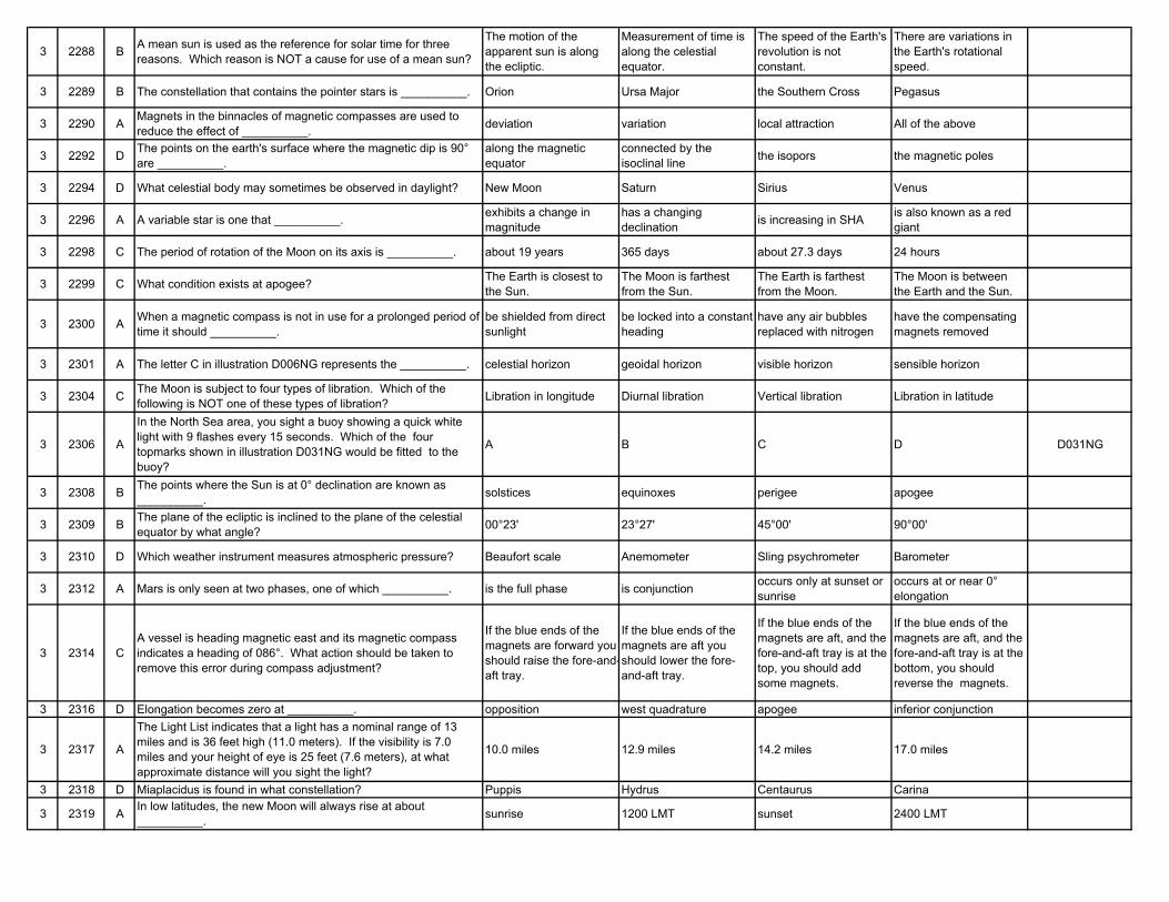
3 2288 B A mean sun is used as the reference for solar time for three reasons. Which reason is NOT a cause for use of a mean sun?
The motion of the apparent sun is along the ecliptic.
Measurement of time is along the celestial equator.
The speed of the Earth's revolution is not constant.
There are variations in the Earth's rotational speed.
3 2289 B The constellation that contains the pointer stars is __________. Orion Ursa Major the Southern Cross Pegasus
3 2290 A Magnets in the binnacles of magnetic compasses are used to reduce the effect of __________. deviation variation local attraction All of the above
3 2292 D The points on the earth's surface where the magnetic dip is 90° are __________.
along the magnetic equator
connected by the isoclinal line the isopors the magnetic poles
3 2294 D What celestial body may sometimes be observed in daylight? New Moon Saturn Sirius Venus
3 2296 A A variable star is one that __________. exhibits a change in magnitude
has a changing declination is increasing in SHA is also known as a red
giant
3 2298 C The period of rotation of the Moon on its axis is __________. about 19 years 365 days about 27.3 days 24 hours
3 2299 C What condition exists at apogee? The Earth is closest to the Sun.
The Moon is farthest from the Sun.
The Earth is farthest from the Moon.
The Moon is between the Earth and the Sun.
3 2300 A When a magnetic compass is not in use for a prolonged period of time it should __________.
be shielded from direct sunlight
be locked into a constant heading
have any air bubbles replaced with nitrogen
have the compensating magnets removed
3 2301 A The letter C in illustration D006NG represents the __________. celestial horizon geoidal horizon visible horizon sensible horizon
3 2304 C The Moon is subject to four types of libration. Which of the following is NOT one of these types of libration? Libration in longitude Diurnal libration Vertical libration Libration in latitude
3 2306 A
In the North Sea area, you sight a buoy showing a quick white light with 9 flashes every 15 seconds. Which of the four topmarks shown in illustration D031NG would be fitted to the buoy?
A B C D D031NG
3 2308 B The points where the Sun is at 0° declination are known as __________. solstices equinoxes perigee apogee
3 2309 B The plane of the ecliptic is inclined to the plane of the celestial equator by what angle? 00°23' 23°27' 45°00' 90°00'
3 2310 D Which weather instrument measures atmospheric pressure? Beaufort scale Anemometer Sling psychrometer Barometer
3 2312 A Mars is only seen at two phases, one of which __________. is the full phase is conjunction occurs only at sunset or sunrise
occurs at or near 0° elongation
3 2314 CA vessel is heading magnetic east and its magnetic compass indicates a heading of 086°. What action should be taken to remove this error during compass adjustment?
If the blue ends of the magnets are forward you should raise the fore-and-aft tray.
If the blue ends of the magnets are aft you should lower the fore-and-aft tray.
If the blue ends of the magnets are aft, and the fore-and-aft tray is at the top, you should add some magnets.
If the blue ends of the magnets are aft, and the fore-and-aft tray is at the bottom, you should reverse the magnets.
3 2316 D Elongation becomes zero at __________. opposition west quadrature apogee inferior conjunction
3 2317 A
The Light List indicates that a light has a nominal range of 13 miles and is 36 feet high (11.0 meters). If the visibility is 7.0 miles and your height of eye is 25 feet (7.6 meters), at what approximate distance will you sight the light?
10.0 miles 12.9 miles 14.2 miles 17.0 miles
3 2318 D Miaplacidus is found in what constellation? Puppis Hydrus Centaurus Carina
3 2319 A In low latitudes, the new Moon will always rise at about __________. sunrise 1200 LMT sunset 2400 LMT
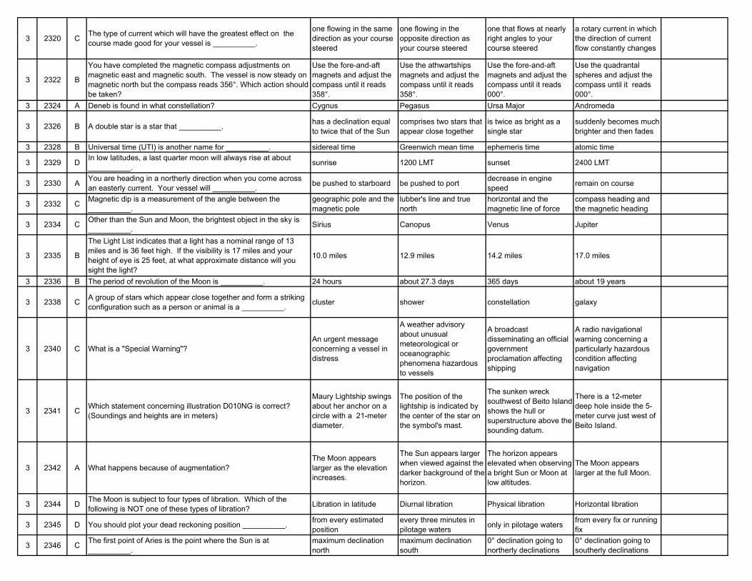
3 2320 C The type of current which will have the greatest effect on the course made good for your vessel is __________.
one flowing in the same direction as your course steered
one flowing in the opposite direction as your course steered
one that flows at nearly right angles to your course steered
a rotary current in which the direction of current flow constantly changes
3 2322 B
You have completed the magnetic compass adjustments on magnetic east and magnetic south. The vessel is now steady on magnetic north but the compass reads 356°. Which action should be taken?
Use the fore-and-aft magnets and adjust the compass until it reads 358°.
Use the athwartships magnets and adjust the compass until it reads 358°.
Use the fore-and-aft magnets and adjust the compass until it reads 000°.
Use the quadrantal spheres and adjust the compass until it reads 000°.
3 2324 A Deneb is found in what constellation? Cygnus Pegasus Ursa Major Andromeda
3 2326 B A double star is a star that __________. has a declination equal to twice that of the Sun
comprises two stars that appear close together
is twice as bright as a single star
suddenly becomes much brighter and then fades
3 2328 B Universal time (UTI) is another name for __________. sidereal time Greenwich mean time ephemeris time atomic time
3 2329 D In low latitudes, a last quarter moon will always rise at about __________. sunrise 1200 LMT sunset 2400 LMT
3 2330 A You are heading in a northerly direction when you come across an easterly current. Your vessel will __________. be pushed to starboard be pushed to port decrease in engine
speed remain on course
3 2332 C Magnetic dip is a measurement of the angle between the __________.
geographic pole and the magnetic pole
lubber's line and true north
horizontal and the magnetic line of force
compass heading and the magnetic heading
3 2334 C Other than the Sun and Moon, the brightest object in the sky is __________. Sirius Canopus Venus Jupiter
3 2335 B
The Light List indicates that a light has a nominal range of 13 miles and is 36 feet high. If the visibility is 17 miles and your height of eye is 25 feet, at what approximate distance will you sight the light?
10.0 miles 12.9 miles 14.2 miles 17.0 miles
3 2336 B The period of revolution of the Moon is __________. 24 hours about 27.3 days 365 days about 19 years
3 2338 C A group of stars which appear close together and form a striking configuration such as a person or animal is a __________. cluster shower constellation galaxy
3 2340 C What is a "Special Warning"?An urgent message concerning a vessel in distress
A weather advisory about unusual meteorological or oceanographic phenomena hazardous to vessels
A broadcast disseminating an official government proclamation affecting shipping
A radio navigational warning concerning a particularly hazardous condition affecting navigation
3 2341 C Which statement concerning illustration D010NG is correct? (Soundings and heights are in meters)
Maury Lightship swings about her anchor on a circle with a 21-meter diameter.
The position of the lightship is indicated by the center of the star on the symbol's mast.
The sunken wreck southwest of Beito Island shows the hull or superstructure above the sounding datum.
There is a 12-meter deep hole inside the 5-meter curve just west of Beito Island.
3 2342 A What happens because of augmentation?The Moon appears larger as the elevation increases.
The Sun appears larger when viewed against the darker background of the horizon.
The horizon appears elevated when observing a bright Sun or Moon at low altitudes.
The Moon appears larger at the full Moon.
3 2344 D The Moon is subject to four types of libration. Which of the following is NOT one of these types of libration? Libration in latitude Diurnal libration Physical libration Horizontal libration
3 2345 D You should plot your dead reckoning position __________. from every estimated position
every three minutes in pilotage waters only in pilotage waters from every fix or running
fix
3 2346 C The first point of Aries is the point where the Sun is at __________.
maximum declination north
maximum declination south
0° declination going to northerly declinations
0° declination going to southerly declinations
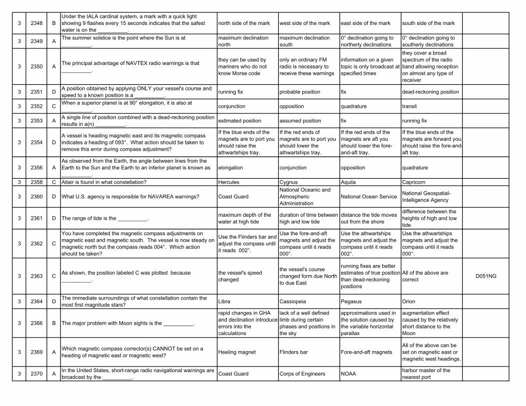
3 2348 BUnder the IALA cardinal system, a mark with a quick light showing 9 flashes every 15 seconds indicates that the safest water is on the __________.
north side of the mark west side of the mark east side of the mark south side of the mark
3 2349 A The summer solstice is the point where the Sun is at __________.
maximum declination north
maximum declination south
0° declination going to northerly declinations
0° declination going to southerly declinations
3 2350 A The principal advantage of NAVTEX radio warnings is that __________.
they can be used by mariners who do not know Morse code
only an ordinary FM radio is necessary to receive these warnings
information on a given topic is only broadcast at specified times
they cover a broad spectrum of the radio band allowing reception on almost any type of receiver
3 2351 D A position obtained by applying ONLY your vessel's course and speed to a known position is a __________. running fix probable position fix dead-reckoning position
3 2352 C When a superior planet is at 90° elongation, it is also at __________. conjunction opposition quadrature transit
3 2353 A A single line of position combined with a dead-reckoning position results in a(n) __________. estimated position assumed position fix running fix
3 2354 DA vessel is heading magnetic east and its magnetic compass indicates a heading of 093°. What action should be taken to remove this error during compass adjustment?
If the blue ends of the magnets are to port you should raise the athwartships tray.
If the red ends of magnets are to port you should lower the athwartships tray.
If the red ends of the magnets are aft you should lower the fore-and-aft tray.
If the blue ends of the magnets are forward you should raise the fore-and-aft tray.
3 2356 AAs observed from the Earth, the angle between lines from the Earth to the Sun and the Earth to an inferior planet is known as __________.
elongation conjunction opposition quadrature
3 2358 C Altair is found in what constellation? Hercules Cygnus Aquila Capricorn
3 2360 D What U.S. agency is responsible for NAVAREA warnings? Coast GuardNational Oceanic and Atmospheric Administration
National Ocean Service National Geospatial-Intelligence Agency
3 2361 D The range of tide is the __________. maximum depth of the water at high tide
duration of time between high and low tide
distance the tide moves out from the shore
difference between the heights of high and low tide
3 2362 C
You have completed the magnetic compass adjustments on magnetic east and magnetic south. The vessel is now steady on magnetic north but the compass reads 004°. Which action should be taken?
Use the Flinders bar and adjust the compass until it reads 002°.
Use the fore-and-aft magnets and adjust the compass until it reads 000°.
Use the athwartships magnets and adjust the compass until it reads 002°.
Use the athwartships magnets and adjust the compass until it reads 000°.
3 2363 C As shown, the position labeled C was plotted because __________.
the vessel's speed changed
the vessel's course changed form due North to due East
running fixes are better estimates of true position than dead-reckoning positions
All of the above are correct D051NG
3 2364 D The immediate surroundings of what constellation contain the most first magnitude stars? Libra Cassiopeia Pegasus Orion
3 2366 B The major problem with Moon sights is the __________.
rapid changes in GHA and declination introduce errors into the calculations
lack of a well defined limb during certain phases and positions in the sky
approximations used in the solution caused by the variable horizontal parallax
augmentation effect caused by the relatively short distance to the Moon
3 2369 A Which magnetic compass corrector(s) CANNOT be set on a heading of magnetic east or magnetic west? Heeling magnet Flinders bar Fore-and-aft magnets
All of the above can be set on magnetic east or magnetic west headings.
3 2370 A In the United States, short-range radio navigational warnings are broadcast by the __________. Coast Guard Corps of Engineers NOAA harbor master of the
nearest port
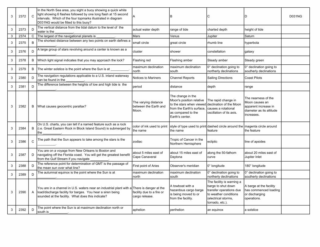
3 2372 C
In the North Sea area, you sight a buoy showing a quick white light showing 6 flashes followed by one long flash at 15 second intervals. Which of the four topmarks illustrated in diagram D031NG would be fitted to this buoy?
A B C D D031NG
3 2373 D The vertical distance from the tidal datum to the level of the water is the __________. actual water depth range of tide charted depth height of tide
3 2374 C The largest of the navigational planets is __________. Mars Venus Jupiter Saturn
3 2375 B The shortest distance between any two points on earth defines a __________. small circle great circle rhumb line hyperbola
3 2376 D A large group of stars revolving around a center is known as a __________. cluster shower constellation galaxy
3 2378 B Which light signal indicates that you may approach the lock? Flashing red Flashing amber Steady amber Steady green
3 2379 B The winter solstice is the point where the Sun is at __________. maximum declination north
maximum declination south
0° declination going to northerly declinations
0° declination going to southerly declinations
3 2380 D The navigation regulations applicable to a U.S. inland waterway can be found in the __________. Notices to Mariners Channel Reports Sailing Directions Coast Pilots
3 2381 D The difference between the heights of low and high tide is the __________. period distance depth range
3 2382 B What causes geocentric parallax?The varying distance between the Earth and Moon.
The change in the Moon's position relative to the stars when viewed from the Earth's surface, as compared to the Earth's center.
The rapid change in declination of the Moon causes a rotational oscillation of its axis.
The nearness of the Moon causes an apparent increase in diameter as its altitude increases.
3 2384 BOn U.S. charts, you can tell if a named feature such as a rock (i.e. Great Eastern Rock in Block Island Sound) is submerged by the __________.
color of ink used to print the name
style of type used to print the name
dashed circle around the feature
magenta circle around the feature
3 2386 C The path that the Sun appears to take among the stars is the __________. zodiac Tropic of Cancer in the
Northern Hemisphere ecliptic line of apsides
3 2387 DYou are on a voyage from New Orleans to Boston and navigating off the Florida coast. You will get the greatest benefit from the Gulf Stream if you navigate __________.
about 5 miles east of Cape Canaveral
about 15 miles east of Daytona
along the 50-fathom curve
about 20 miles east of Jupiter Inlet
3 2388 D The reference point for determination of GMT is the passage of the mean sun over what line? First point of Aries Observer's meridian 0° longitude 180° longitude
3 2389 D The autumnal equinox is the point where the Sun is at __________.
maximum declination north
maximum declination south
0° declination going to northerly declinations
0° declination going to southerly declinations
3 2390 AYou are in a channel in U.S. waters near an industrial plant with a load/discharge facility for barges. You hear a siren being sounded at the facility. What does this indicate?
There is danger at the facility due to a fire or cargo release.
A towboat with a hazardous cargo barge is being moved to or from the facility.
The facility is warning a barge to shut down transfer operations due to weather conditions (electrical storms, tornado, etc.).
A barge at the facility has commenced loading or discharging operations.
3 2392 D The point where the Sun is at maximum declination north or south is __________. aphelion perihelion an equinox a solstice
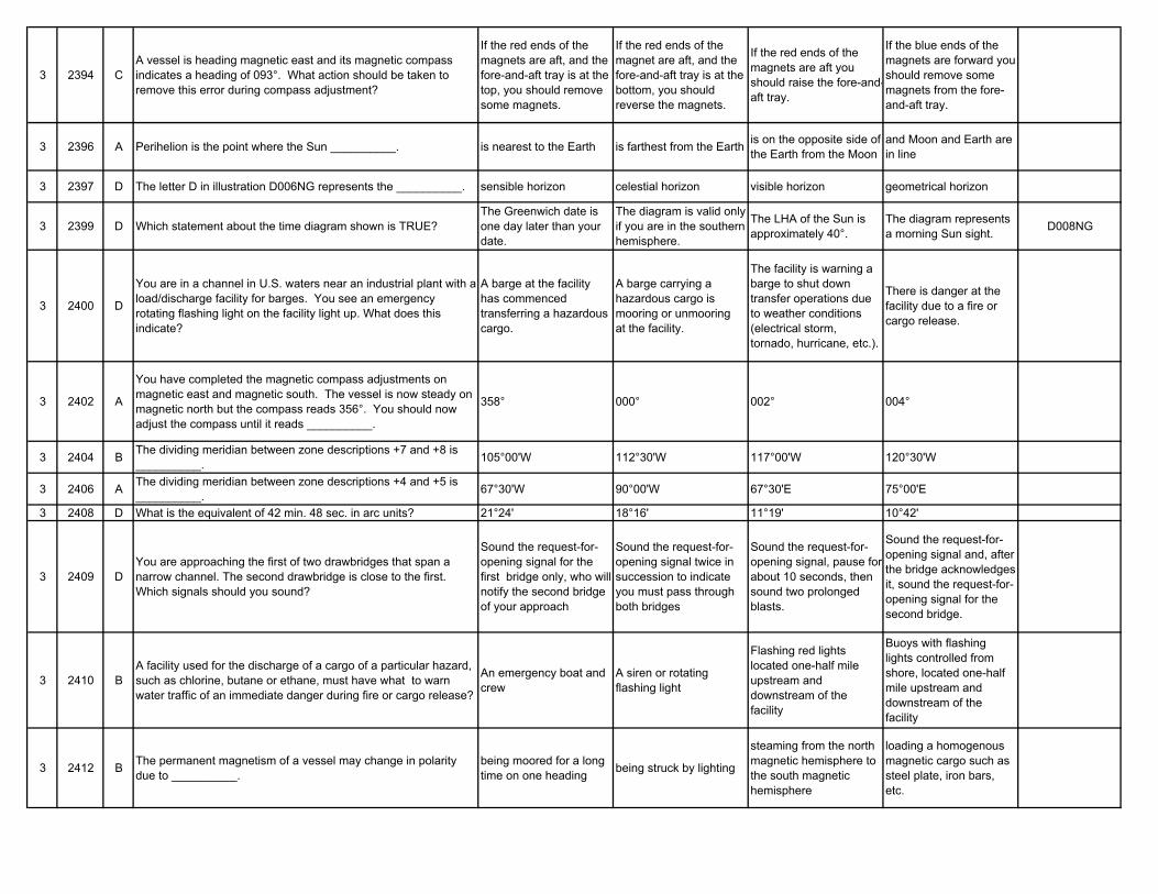
3 2394 CA vessel is heading magnetic east and its magnetic compass indicates a heading of 093°. What action should be taken to remove this error during compass adjustment?
If the red ends of the magnets are aft, and the fore-and-aft tray is at the top, you should remove some magnets.
If the red ends of the magnet are aft, and the fore-and-aft tray is at the bottom, you should reverse the magnets.
If the red ends of the magnets are aft you should raise the fore-and-aft tray.
If the blue ends of the magnets are forward you should remove some magnets from the fore-and-aft tray.
3 2396 A Perihelion is the point where the Sun __________. is nearest to the Earth is farthest from the Earth is on the opposite side of the Earth from the Moon
and Moon and Earth are in line
3 2397 D The letter D in illustration D006NG represents the __________. sensible horizon celestial horizon visible horizon geometrical horizon
3 2399 D Which statement about the time diagram shown is TRUE?The Greenwich date is one day later than your date.
The diagram is valid only if you are in the southern hemisphere.
The LHA of the Sun is approximately 40°.
The diagram represents a morning Sun sight. D008NG
3 2400 D
You are in a channel in U.S. waters near an industrial plant with a load/discharge facility for barges. You see an emergency rotating flashing light on the facility light up. What does this indicate?
A barge at the facility has commenced transferring a hazardous cargo.
A barge carrying a hazardous cargo is mooring or unmooring at the facility.
The facility is warning a barge to shut down transfer operations due to weather conditions (electrical storm, tornado, hurricane, etc.).
There is danger at the facility due to a fire or cargo release.
3 2402 A
You have completed the magnetic compass adjustments on magnetic east and magnetic south. The vessel is now steady on magnetic north but the compass reads 356°. You should now adjust the compass until it reads __________.
358° 000° 002° 004°
3 2404 B The dividing meridian between zone descriptions +7 and +8 is __________. 105°00'W 112°30'W 117°00'W 120°30'W
3 2406 A The dividing meridian between zone descriptions +4 and +5 is __________. 67°30'W 90°00'W 67°30'E 75°00'E
3 2408 D What is the equivalent of 42 min. 48 sec. in arc units? 21°24' 18°16' 11°19' 10°42'
3 2409 DYou are approaching the first of two drawbridges that span a narrow channel. The second drawbridge is close to the first. Which signals should you sound?
Sound the request-for-opening signal for the first bridge only, who will notify the second bridge of your approach
Sound the request-for-opening signal twice in succession to indicate you must pass through both bridges
Sound the request-for-opening signal, pause for about 10 seconds, then sound two prolonged blasts.
Sound the request-for-opening signal and, after the bridge acknowledges it, sound the request-for-opening signal for the second bridge.
3 2410 BA facility used for the discharge of a cargo of a particular hazard, such as chlorine, butane or ethane, must have what to warn water traffic of an immediate danger during fire or cargo release?
An emergency boat and crew
A siren or rotating flashing light
Flashing red lights located one-half mile upstream and downstream of the facility
Buoys with flashing lights controlled from shore, located one-half mile upstream and downstream of the facility
3 2412 B The permanent magnetism of a vessel may change in polarity due to __________.
being moored for a long time on one heading being struck by lighting
steaming from the north magnetic hemisphere to the south magnetic hemisphere
loading a homogenous magnetic cargo such as steel plate, iron bars, etc.
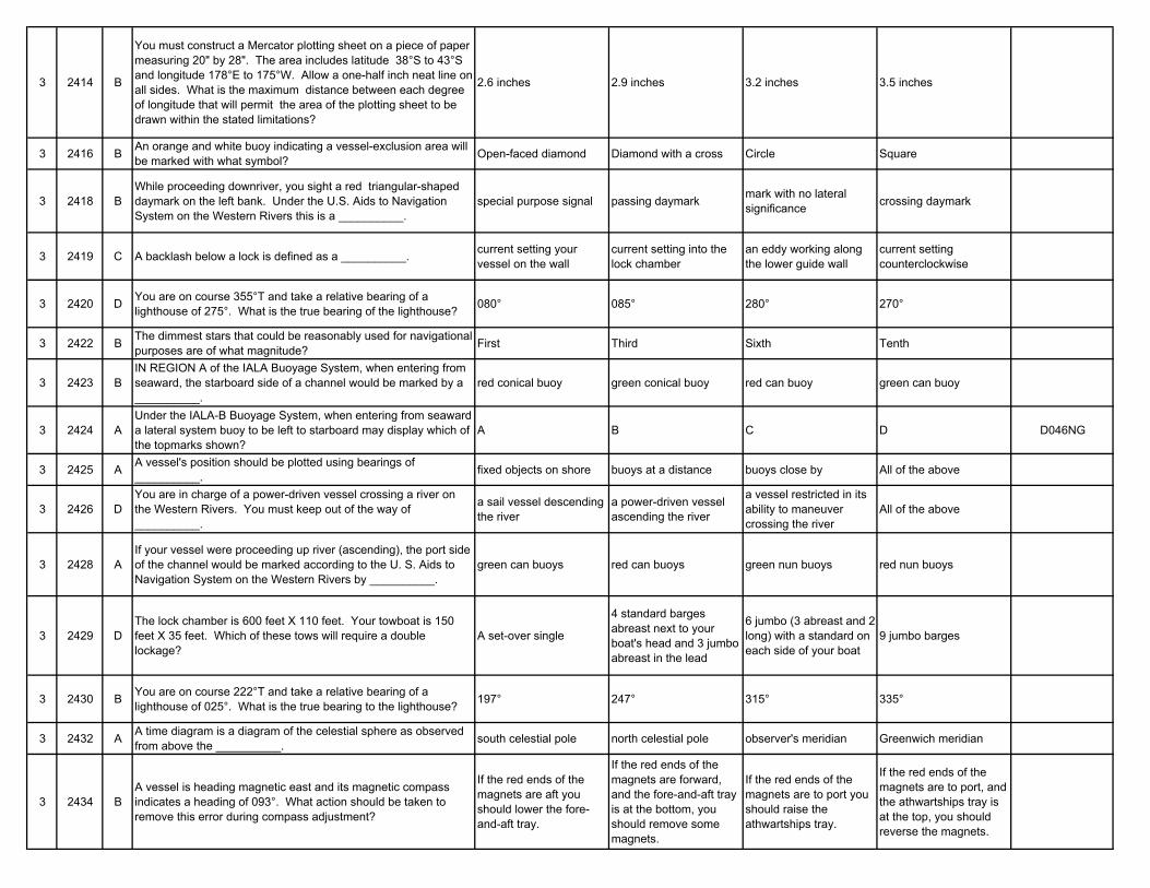
3 2414 B
You must construct a Mercator plotting sheet on a piece of paper measuring 20" by 28". The area includes latitude 38°S to 43°S and longitude 178°E to 175°W. Allow a one-half inch neat line on all sides. What is the maximum distance between each degree of longitude that will permit the area of the plotting sheet to be drawn within the stated limitations?
2.6 inches 2.9 inches 3.2 inches 3.5 inches
3 2416 B An orange and white buoy indicating a vessel-exclusion area will be marked with what symbol? Open-faced diamond Diamond with a cross Circle Square
3 2418 BWhile proceeding downriver, you sight a red triangular-shaped daymark on the left bank. Under the U.S. Aids to Navigation System on the Western Rivers this is a __________.
special purpose signal passing daymark mark with no lateral significance crossing daymark
3 2419 C A backlash below a lock is defined as a __________. current setting your vessel on the wall
current setting into the lock chamber
an eddy working along the lower guide wall
current setting counterclockwise
3 2420 D You are on course 355°T and take a relative bearing of a lighthouse of 275°. What is the true bearing of the lighthouse? 080° 085° 280° 270°
3 2422 B The dimmest stars that could be reasonably used for navigational purposes are of what magnitude? First Third Sixth Tenth
3 2423 BIN REGION A of the IALA Buoyage System, when entering from seaward, the starboard side of a channel would be marked by a __________.
red conical buoy green conical buoy red can buoy green can buoy
3 2424 AUnder the IALA-B Buoyage System, when entering from seaward a lateral system buoy to be left to starboard may display which of the topmarks shown?
A B C D D046NG
3 2425 A A vessel's position should be plotted using bearings of __________. fixed objects on shore buoys at a distance buoys close by All of the above
3 2426 DYou are in charge of a power-driven vessel crossing a river on the Western Rivers. You must keep out of the way of __________.
a sail vessel descending the river
a power-driven vessel ascending the river
a vessel restricted in its ability to maneuver crossing the river
All of the above
3 2428 AIf your vessel were proceeding up river (ascending), the port side of the channel would be marked according to the U. S. Aids to Navigation System on the Western Rivers by __________.
green can buoys red can buoys green nun buoys red nun buoys
3 2429 DThe lock chamber is 600 feet X 110 feet. Your towboat is 150 feet X 35 feet. Which of these tows will require a double lockage?
A set-over single
4 standard barges abreast next to your boat's head and 3 jumbo abreast in the lead
6 jumbo (3 abreast and 2 long) with a standard on each side of your boat
9 jumbo barges
3 2430 B You are on course 222°T and take a relative bearing of a lighthouse of 025°. What is the true bearing to the lighthouse? 197° 247° 315° 335°
3 2432 A A time diagram is a diagram of the celestial sphere as observed from above the __________. south celestial pole north celestial pole observer's meridian Greenwich meridian
3 2434 BA vessel is heading magnetic east and its magnetic compass indicates a heading of 093°. What action should be taken to remove this error during compass adjustment?
If the red ends of the magnets are aft you should lower the fore-and-aft tray.
If the red ends of the magnets are forward, and the fore-and-aft tray is at the bottom, you should remove some magnets.
If the red ends of the magnets are to port you should raise the athwartships tray.
If the red ends of the magnets are to port, and the athwartships tray is at the top, you should reverse the magnets.
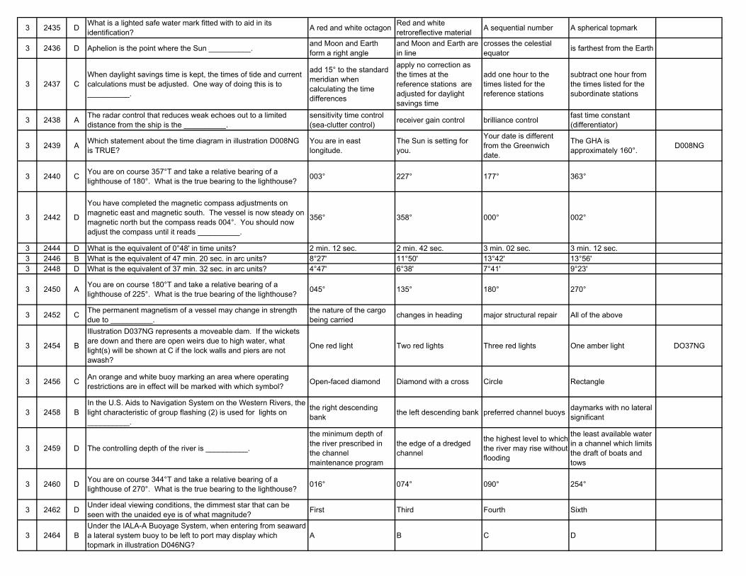
3 2435 D What is a lighted safe water mark fitted with to aid in its identification? A red and white octagon Red and white
retroreflective material A sequential number A spherical topmark
3 2436 D Aphelion is the point where the Sun __________. and Moon and Earth form a right angle
and Moon and Earth are in line
crosses the celestial equator is farthest from the Earth
3 2437 CWhen daylight savings time is kept, the times of tide and current calculations must be adjusted. One way of doing this is to __________.
add 15° to the standard meridian when calculating the time differences
apply no correction as the times at the reference stations are adjusted for daylight savings time
add one hour to the times listed for the reference stations
subtract one hour from the times listed for the subordinate stations
3 2438 A The radar control that reduces weak echoes out to a limited distance from the ship is the __________.
sensitivity time control (sea-clutter control) receiver gain control brilliance control fast time constant
(differentiator)
3 2439 A Which statement about the time diagram in illustration D008NG is TRUE?
You are in east longitude.
The Sun is setting for you.
Your date is different from the Greenwich date.
The GHA is approximately 160°. D008NG
3 2440 C You are on course 357°T and take a relative bearing of a lighthouse of 180°. What is the true bearing to the lighthouse? 003° 227° 177° 363°
3 2442 D
You have completed the magnetic compass adjustments on magnetic east and magnetic south. The vessel is now steady on magnetic north but the compass reads 004°. You should now adjust the compass until it reads __________.
356° 358° 000° 002°
3 2444 D What is the equivalent of 0°48' in time units? 2 min. 12 sec. 2 min. 42 sec. 3 min. 02 sec. 3 min. 12 sec.3 2446 B What is the equivalent of 47 min. 20 sec. in arc units? 8°27' 11°50' 13°42' 13°56'3 2448 D What is the equivalent of 37 min. 32 sec. in arc units? 4°47' 6°38' 7°41' 9°23'
3 2450 A You are on course 180°T and take a relative bearing of a lighthouse of 225°. What is the true bearing of the lighthouse? 045° 135° 180° 270°
3 2452 C The permanent magnetism of a vessel may change in strength due to __________.
the nature of the cargo being carried changes in heading major structural repair All of the above
3 2454 B
Illustration D037NG represents a moveable dam. If the wickets are down and there are open weirs due to high water, what light(s) will be shown at C if the lock walls and piers are not awash?
One red light Two red lights Three red lights One amber light DO37NG
3 2456 C An orange and white buoy marking an area where operating restrictions are in effect will be marked with which symbol? Open-faced diamond Diamond with a cross Circle Rectangle
3 2458 BIn the U.S. Aids to Navigation System on the Western Rivers, the light characteristic of group flashing (2) is used for lights on __________.
the right descending bank the left descending bank preferred channel buoys daymarks with no lateral
significant
3 2459 D The controlling depth of the river is __________.
the minimum depth of the river prescribed in the channel maintenance program
the edge of a dredged channel
the highest level to which the river may rise without flooding
the least available water in a channel which limits the draft of boats and tows
3 2460 D You are on course 344°T and take a relative bearing of a lighthouse of 270°. What is the true bearing to the lighthouse? 016° 074° 090° 254°
3 2462 D Under ideal viewing conditions, the dimmest star that can be seen with the unaided eye is of what magnitude? First Third Fourth Sixth
3 2464 BUnder the IALA-A Buoyage System, when entering from seaward a lateral system buoy to be left to port may display which topmark in illustration D046NG?
A B C D
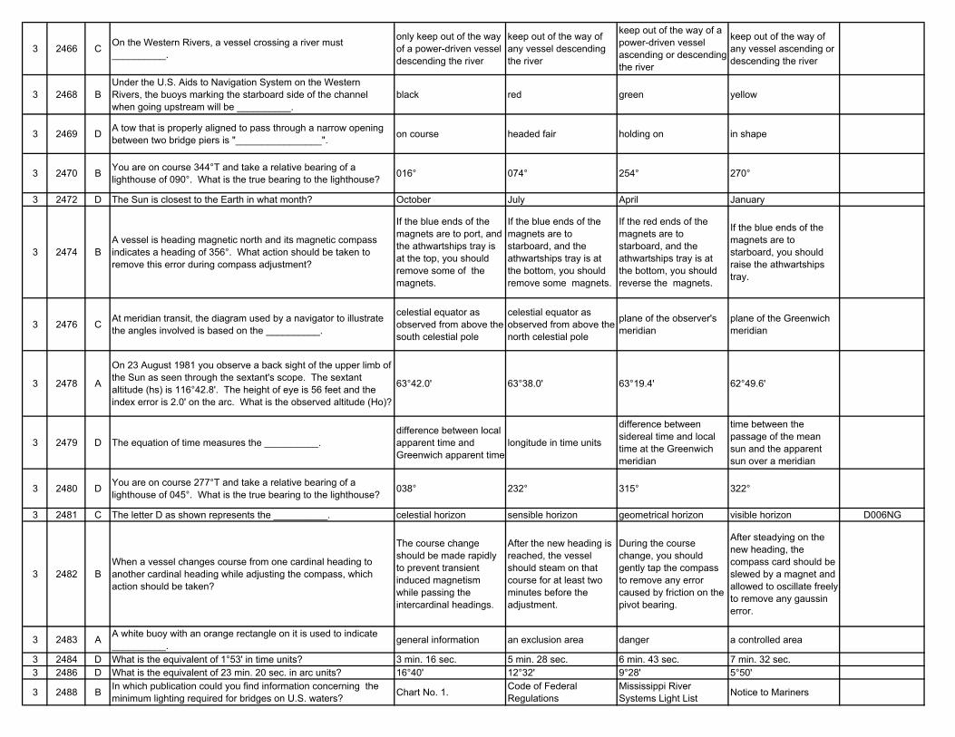
3 2466 C On the Western Rivers, a vessel crossing a river must __________.
only keep out of the way of a power-driven vessel descending the river
keep out of the way of any vessel descending the river
keep out of the way of a power-driven vessel ascending or descending the river
keep out of the way of any vessel ascending or descending the river
3 2468 BUnder the U.S. Aids to Navigation System on the Western Rivers, the buoys marking the starboard side of the channel when going upstream will be __________.
black red green yellow
3 2469 D A tow that is properly aligned to pass through a narrow opening between two bridge piers is "________________". on course headed fair holding on in shape
3 2470 B You are on course 344°T and take a relative bearing of a lighthouse of 090°. What is the true bearing to the lighthouse? 016° 074° 254° 270°
3 2472 D The Sun is closest to the Earth in what month? October July April January
3 2474 BA vessel is heading magnetic north and its magnetic compass indicates a heading of 356°. What action should be taken to remove this error during compass adjustment?
If the blue ends of the magnets are to port, and the athwartships tray is at the top, you should remove some of the magnets.
If the blue ends of the magnets are to starboard, and the athwartships tray is at the bottom, you should remove some magnets.
If the red ends of the magnets are to starboard, and the athwartships tray is at the bottom, you should reverse the magnets.
If the blue ends of the magnets are to starboard, you should raise the athwartships tray.
3 2476 C At meridian transit, the diagram used by a navigator to illustrate the angles involved is based on the __________.
celestial equator as observed from above the south celestial pole
celestial equator as observed from above the north celestial pole
plane of the observer's meridian
plane of the Greenwich meridian
3 2478 A
On 23 August 1981 you observe a back sight of the upper limb of the Sun as seen through the sextant's scope. The sextant altitude (hs) is 116°42.8'. The height of eye is 56 feet and the index error is 2.0' on the arc. What is the observed altitude (Ho)?
63°42.0' 63°38.0' 63°19.4' 62°49.6'
3 2479 D The equation of time measures the __________.difference between local apparent time and Greenwich apparent time
longitude in time units
difference between sidereal time and local time at the Greenwich meridian
time between the passage of the mean sun and the apparent sun over a meridian
3 2480 D You are on course 277°T and take a relative bearing of a lighthouse of 045°. What is the true bearing to the lighthouse? 038° 232° 315° 322°
3 2481 C The letter D as shown represents the __________. celestial horizon sensible horizon geometrical horizon visible horizon D006NG
3 2482 BWhen a vessel changes course from one cardinal heading to another cardinal heading while adjusting the compass, which action should be taken?
The course change should be made rapidly to prevent transient induced magnetism while passing the intercardinal headings.
After the new heading is reached, the vessel should steam on that course for at least two minutes before the adjustment.
During the course change, you should gently tap the compass to remove any error caused by friction on the pivot bearing.
After steadying on the new heading, the compass card should be slewed by a magnet and allowed to oscillate freely to remove any gaussin error.
3 2483 A A white buoy with an orange rectangle on it is used to indicate __________. general information an exclusion area danger a controlled area
3 2484 D What is the equivalent of 1°53' in time units? 3 min. 16 sec. 5 min. 28 sec. 6 min. 43 sec. 7 min. 32 sec.3 2486 D What is the equivalent of 23 min. 20 sec. in arc units? 16°40' 12°32' 9°28' 5°50'
3 2488 B In which publication could you find information concerning the minimum lighting required for bridges on U.S. waters? Chart No. 1. Code of Federal
RegulationsMississippi River Systems Light List Notice to Mariners
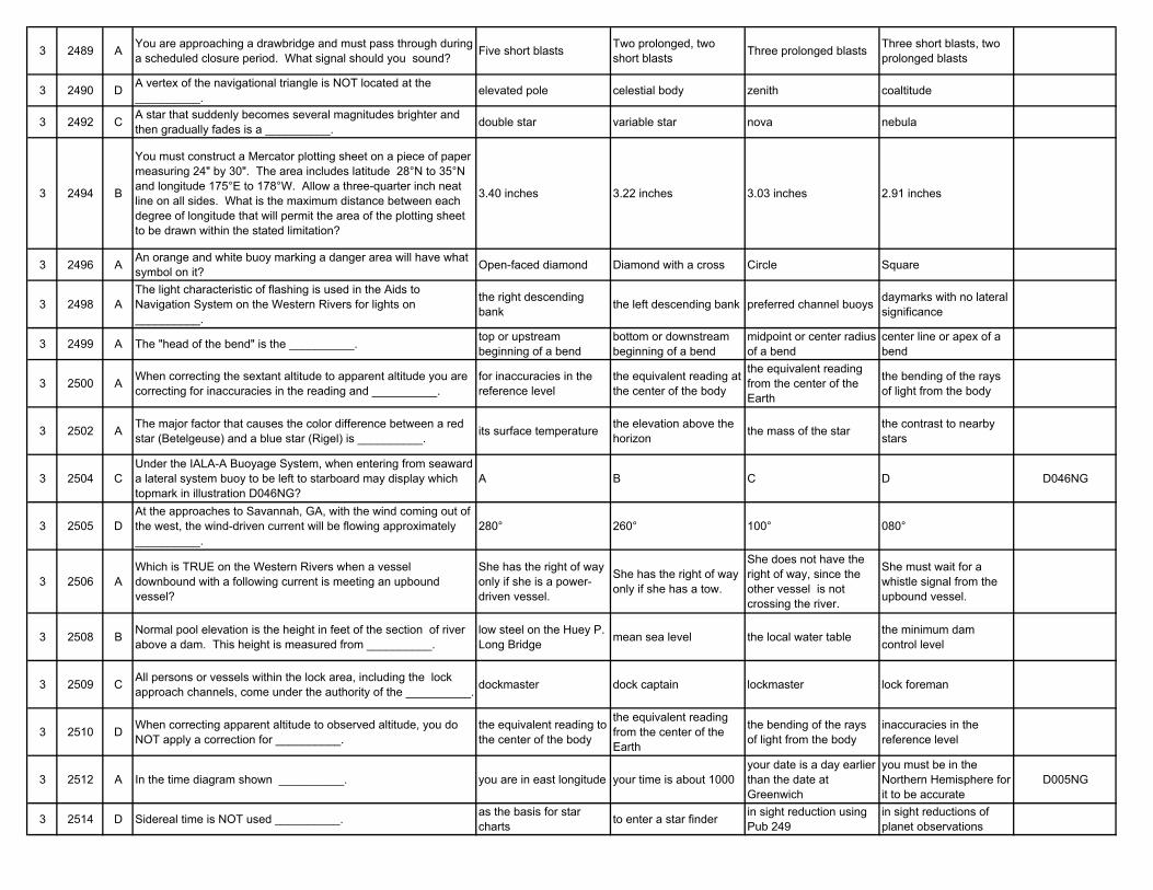
3 2489 A You are approaching a drawbridge and must pass through during a scheduled closure period. What signal should you sound? Five short blasts Two prolonged, two
short blasts Three prolonged blasts Three short blasts, two prolonged blasts
3 2490 D A vertex of the navigational triangle is NOT located at the __________. elevated pole celestial body zenith coaltitude
3 2492 C A star that suddenly becomes several magnitudes brighter and then gradually fades is a __________. double star variable star nova nebula
3 2494 B
You must construct a Mercator plotting sheet on a piece of paper measuring 24" by 30". The area includes latitude 28°N to 35°N and longitude 175°E to 178°W. Allow a three-quarter inch neat line on all sides. What is the maximum distance between each degree of longitude that will permit the area of the plotting sheet to be drawn within the stated limitation?
3.40 inches 3.22 inches 3.03 inches 2.91 inches
3 2496 A An orange and white buoy marking a danger area will have what symbol on it? Open-faced diamond Diamond with a cross Circle Square
3 2498 AThe light characteristic of flashing is used in the Aids to Navigation System on the Western Rivers for lights on __________.
the right descending bank the left descending bank preferred channel buoys daymarks with no lateral
significance
3 2499 A The "head of the bend" is the __________. top or upstream beginning of a bend
bottom or downstream beginning of a bend
midpoint or center radius of a bend
center line or apex of a bend
3 2500 A When correcting the sextant altitude to apparent altitude you are correcting for inaccuracies in the reading and __________.
for inaccuracies in the reference level
the equivalent reading at the center of the body
the equivalent reading from the center of the Earth
the bending of the rays of light from the body
3 2502 A The major factor that causes the color difference between a red star (Betelgeuse) and a blue star (Rigel) is __________. its surface temperature the elevation above the
horizon the mass of the star the contrast to nearby stars
3 2504 CUnder the IALA-A Buoyage System, when entering from seaward a lateral system buoy to be left to starboard may display which topmark in illustration D046NG?
A B C D D046NG
3 2505 DAt the approaches to Savannah, GA, with the wind coming out of the west, the wind-driven current will be flowing approximately __________.
280° 260° 100° 080°
3 2506 AWhich is TRUE on the Western Rivers when a vessel downbound with a following current is meeting an upbound vessel?
She has the right of way only if she is a power-driven vessel.
She has the right of way only if she has a tow.
She does not have the right of way, since the other vessel is not crossing the river.
She must wait for a whistle signal from the upbound vessel.
3 2508 B Normal pool elevation is the height in feet of the section of river above a dam. This height is measured from __________.
low steel on the Huey P. Long Bridge mean sea level the local water table the minimum dam
control level
3 2509 C All persons or vessels within the lock area, including the lock approach channels, come under the authority of the __________. dockmaster dock captain lockmaster lock foreman
3 2510 D When correcting apparent altitude to observed altitude, you do NOT apply a correction for __________.
the equivalent reading to the center of the body
the equivalent reading from the center of the Earth
the bending of the rays of light from the body
inaccuracies in the reference level
3 2512 A In the time diagram shown __________. you are in east longitude your time is about 1000your date is a day earlier than the date at Greenwich
you must be in the Northern Hemisphere for it to be accurate
D005NG
3 2514 D Sidereal time is NOT used __________. as the basis for star charts to enter a star finder in sight reduction using
Pub 249in sight reductions of planet observations

3 2516 B Apparent time is based on __________.a fictitious sun moving along the celestial equator
the visible sun moving along the ecliptic
the Moon's motion in relation to the Sun
the movement of the first point of Aries
3 2518 C In low latitudes, the full Moon will always rise at about __________. sunrise 1200 LMT sunset 2400 LMT
3 2519 C The standard time meridian for zone description -12 is __________. 165.0°E 172.5°E 180.0° 172.5°W
3 2520 CWhen correcting the sextant altitude to apparent altitude you are correcting for inaccuracies in the reference level and __________.
the equivalent reading to the center of the body
the equivalent reading from the center of the Earth
for inaccuracies in the instrument
the bending of the rays of light from the body
3 2522 C The letter H in illustration D006NG represents the __________. celestial horizon geoidal horizon visible horizon refractive horizon D006NG
3 2524 A What is the equivalent of 2° 35' in time units? 10 min. 20 sec. 9 min. 10 sec. 7 min. 06 sec. 6 min. 43 sec.
3 2525 D Daylight savings time is a form of zone time that adopts the time __________. two zones to the west two zones to the east one zone to the west one zone to the east
3 2526 C What is the equivalent of 10 min. 52 sec. in arc units? 0°47' 1°12' 2°43' 3°52'
3 2527 B In the doldrums you can expect __________. steady, constant winds frequent rain showers and thunderstorms steep pressure gradients low relative humidity
3 2528 DIllustration D038NG represents a fixed C of E lock and dam. What navigational light(s) is(are) exhibited at the position indicated by the letter A in the illustration?
One red light Two red lights Two green lights No light DO38NG
3 2529 B
A bridge over a navigable waterway is being repaired. There is a traveler platform under the bridge's deck that significantly reduces the vertical clearance. If required by the CG district commander, how will this be indicated at night?
Illumination by flood lights
A quick flashing red light at each lower corner
A strobe light visible both up and downstream
Fixed amber lights under the extreme outer edges of the traveler
3 2530 D The distance between any two meridians measured along a parallel of latitude __________.
increases in north latitude and decreases in south latitude
decreases as DLO increases
increases with increased latitude
decreases with increased latitude
3 2532 A
You must construct a Mercator plotting sheet on a piece of paper measuring 28" by 32". The area includes latitude 32°S to 39°S and longitude 005°E to 003°W. Allow a one-half inch neat line on all sides. What is the maximum distance between each degree of longitude that will permit the area of the plotting sheet to be drawn within the stated limitations?
3.38 inches 3.62 inches 3.79 inches 3.95 inches
3 2534 C
You must construct a Mercator plotting sheet on a piece of paper measuring 26" by 30". The area includes latitude 28°15'N to 35°45'N and longitude 174°00'E to 178°00'W. Allow a three-quarter inch neat line on all sides. What is the maximum distance between each degree of longitude that will permit the area of the plotting sheet to be drawn within the stated limitation?
2.76 inches 2.92 inches 3.06 inches 3.19 inches
3 2536 C A revised print of a chart is made __________.
after every major hydrographic survey of the area covered by the chart
when there are numerous corrections to be made or the corrections are extensive
when a low-stock situation occurs and minor corrections are made
every two years to update the magnetic variation information
3 2538 CThe light characteristic of composite group flashing (2 + 1) is used in the Aids to Navigation System on the Western Rivers for lights on __________.
the right descending bank the left descending bank preferred-channel buoys daymarks with no lateral
significance
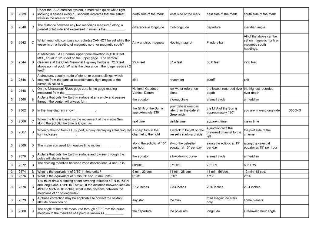
3 2539 CUnder the IALA cardinal system, a mark with quick white light showing 3 flashes every 10 seconds indicates that the safest water in the area is on the __________.
north side of the mark west side of the mark east side of the mark south side of the mark
3 2540 C The distance between any two meridians measured along a parallel of latitude and expressed in miles is the __________. difference in longitude mid-longitude departure meridian angle
3 2542 C Which magnetic compass corrector(s) CANNOT be set while the vessel is on a heading of magnetic north or magnetic south? Athwartships magnets Heeling magnet Flinders bar
All of the above can be set on magnetic north or magnetic south headings.
3 2544 B
At McAlpine L & D, normal upper pool elevation is 420.0 feet MSL, equal to 12.0 feet on the upper gage. The vertical clearance at the Clark Memorial Highway bridge is 72.6 feet above normal pool. What is the clearance if the gage reads 27.2 feet?
25.4 feet 57.4 feet 60.6 feet 72.6 feet
3 2546 AA structure, usually made of stone, or cement pilings, which extends from the bank at approximately right angles to the current is called a __________.
dike revetment cutoff crib
3 2548 A On the Mississippi River, gage zero is the gage reading measured from the __________.
National Geodetic Vertical Datum
low water reference plane
the lowest recorded river depth
the highest recorded river depth
3 2560 B A plane that cuts the Earth's surface at any angle and passes through the center will always form __________. the equator a great circle a small circle a meridian
3 2562 B In the time diagram shown __________. the GHA of the Sun is approximately 330°
your date is one day later than the date at Greenwich
the LHA of the Sun is approximately 120° you are in west longitude D005NG
3 2566 C When the time is based on the movement of the visible Sun along the ecliptic the time is known as __________. real time visible time apparent time mean time
3 2567 D When outbound from a U.S. port, a buoy displaying a flashing red light indicates __________.
a sharp turn in the channel to the right
a wreck to be left on the vessel's starboard side
a junction with the preferred channel to the left
the port side of the channel
3 2569 D The mean sun used to measure time moves __________. along the ecliptic at 15° per hour
along the celestial equator at 15° per day
along the ecliptic at 15° per day
along the celestial equator at 15° per hour
3 2570 D A plane that cuts the Earth's surface and passes through the poles will always form __________. the equator a loxodromic curve a small circle a meridian
3 2572 B The dividing meridian between zone descriptions -4 and -5 is __________. 60°00'E 67°30'E 75°00'E 60°00'W
3 2574 B What is the equivalent of 2°52' in time units? 9 min. 23 sec. 11 min. 28 sec. 11 min. 56 sec. 12 min. 18 sec.3 2576 D What is the equivalent of 8 min. 56 sec. in arc units? 0°28' 0°46' 1°12' 2°14'
3 2578 C
You must draw a plotting sheet covering latitudes 49°N to 53°N and longitudes 179°E to 178°W. If the distance between latitude 49°N to 53°N is 16 inches, what is the distance between the meridians of 1° of longitude?
2.12 inches 2.33 inches 2.56 inches 2.81 inches
3 2579 D A phase correction may be applicable to correct the sextant altitude correction of __________. any star the Sun third magnitude stars
only some planets
3 2580 C The angle at the pole measured through 180°From the prime meridian to the meridian of a point is known as __________. the departure the polar arc longitude Greenwich hour angle
3 2582 D
You must construct a Mercator plotting sheet on a piece of paper measuring 32" by 36". The area includes latitude 31°S to 37°S and longitude 005°W to 002°E. Allow a three-quarter inch neat line on all sides. What is the maximum distance between each degree of longitude that will permit the area of the plotting sheet to be drawn within the stated limitations?
4.00 inches 4.11 inches 4.25 inches 4.36 inches
3 2583 DYou are in the Northern Hemisphere and a tropical wave is located 200 miles due west of your position. Where will the wave be located 24 hours later?
In the same place Closer and to the west Closer and to the east Farther away to the west
3 2584 D
You must construct a Mercator plotting sheet on a piece of paper measuring 30" by 36". The area includes latitude 30°45'S to 37°15'S and longitude 004°00'E to 005°00'W. Allow a one inch neat line on all sides. What is the maximum distance between each degree of longitude that will permit the area of the plotting sheet to be drawn within the stated limitation?
3.09 inches 3.22 inches 3.41 inches 3.58 inches
3 2585 B The letter D as shown represents the __________. visible horizon geometrical horizon sensible horizon celestial horizon D006NG
3 2586 BA chart has extensive corrections to be made to it. When these are made and the chart is again printed, the chart issue is a __________.
first edition new edition revised edition reprint
3 2587 AGiven are the courses and speeds of 4 vessels. The navigator of which vessel would be required to know the actual time of meridian transit in order to take an accurate observation at LAN?
C 166°T, Sp 24 knots C 013°T, Sp 7 knots C 291°T, Sp 25 knots C 112°T, Sp 4 knots
3 2588 AYou are approaching an open drawbridge and sound the proper signal. You receive no acknowledgment from the bridge. Which action should you take?
Approach with caution and proceed through the open draw.
Approach under full control to a position no closer than 400 yards from the bridge and await a signal from the bridge.
Hold in the channel as a vessel is closing the bridge from the other direction.
Resound the opening signal and do not pass through the bridge until signals have been exchanged.
3 2589 DUnder the IALA cardinal system, a mark with a quick white light showing 6 flashes followed by one long flash indicates that the safest water is on the __________.
north side of the mark west side of the mark east side of the mark south side of the mark
3 2590 D A plane perpendicular to the polar axis will never form what line on the Earth's surface? Great circle Equator Small circle Meridian
3 2592 A A deadhead is a(n) __________. tree or log awash in a nearly vertical position
crew member who refuses to work
upstream end of a land wall buoy that is adrift
3 2594 C
At McAlpine L & D, normal upper pool elevation is 420.0 feet (130.8 meters) MSL, equal to 12.0 feet (3.7 meters) on the upper gage. The vertical clearance at the Clark Memorial Highway bridge is 72.6 feet (22.1 meters) above normal pool. What is the clearance if the gage reads 10.6 feet (3.2 meters)?
84.6 feet (25.8 meters) 83.2 feet (25.4 meters) 74.0 feet (22.6 meters) 62.0 feet (18.9 meters)
3 2596 A The abbreviation L.W.R.P. on the navigation maps means __________.
low water reference plane low winter runoff point least water river plane land wall reference point
3 2597 CYou determine your vessel's position by taking a range and bearing to a buoy. Your position will be plotted as a(n) __________.
fix running fix estimated position dead-reckoning position
3 2598 BA vessel is proceeding downstream in a narrow channel on the Western Rivers when another vessel is sighted moving upstream. Which vessel has the right of way?
The vessel moving upstream against the current
The vessel moving downstream with a following current
The vessel located more towards the channel centerline
The vessel with the least amount of maneuverability
3 2600 C A parallel of latitude other than the equator is a __________. great circle loxodromic curve small circle gnomonic curve
3 2602 D The lunar day is also known as the __________. lunitidal interval vulgar establishment of the port nodal day tidal day
3 2604 A A sidereal day is approximately how much shorter than a solar day? 4 minutes 8 minutes 12 minutes 16 minutes
3 2606 B The measurement of local time is based on the passage of the Sun over the __________.
upper branch of the observer's meridian
lower branch of the observer's meridian
upper branch of the Greenwich meridian
lower branch of the Greenwich meridian
3 2608 C You should plot your dead reckoning position __________. from every estimated position
every three minutes in pilotage waters
from every fix or running fix only in pilotage waters
3 2609 D The letter A in illustration D006NG represents the __________. geoidal horizon celestial horizon visible horizon sensible horizon D006NG
3 2610 B A line on the Earth parallel to the equator is a __________. gnomonic curve small circle meridian great circle
3 2612 A The dividing meridian between zone descriptions -7 and -8 is __________. 112°30'E 118°30'E 120°00'E 116°30'W
3 2614 D What is the equivalent of 4°36' in time units? 9 min. 12 sec. 14 min. 36 sec. 15 min. 36 sec. 18 min. 24 sec.3 2616 D What is the equivalent of 4 min. 04 sec. in arc units? 60°16' 8°08' 2°08' 1°01'
3 2618 D
You must draw a plotting sheet covering latitudes 38°N to 43°N and longitudes 179°E to 178°W. If the distance between each degree of longitude is 5 inches, what is the distance between latitude 38°N and latitude 43°N?
29.0 inches 29.6 inches 32.1 inches 32.8 inches
3 2619 B In low latitudes, a first quarter Moon will always rise at about __________. sunrise 1200 LMT sunset 2400 LMT
3 2620 B The navigator is concerned with three systems of coordinates. Which system is not of major concern? Terrestrial Ecliptic Celestial horizon Celestial equator
3 2624 A
You must construct a Mercator plotting sheet on a piece of paper measuring 30" by 32". The area includes latitudes 31°10'S to 37°40'S and longitudes 007°00'W to 001°00'E. Allow a one-half inch neat line on all sides. What is the maximum distance between each degree of longitude that will permit the area of the plotting sheet to be drawn within the stated limitation?
3.69 inches 3.52 inches 3.38 inches 3.26 inches
3 2625 C Stormy weather is usually associated with regions of __________. high barometric pressure changing barometric
pressure low barometric pressure steady barometric pressure
3 2626 C What information is found in the chart title? Date of the first edition Date of the edition and, if applicable, the revision
Information on the sounding datum
Information on which IALA buoyage system applies
3 2627 B Stormy weather is usually associated with regions of __________. high barometric pressure low barometric pressure steady barometric
pressurechanging barometric pressure
3 2628 BA drawbridge may use visual signals to acknowledge a vessel's request to open the draw. Which signal indicates that the draw will NOT be opened immediately?
A flashing amber light A fixed red light A white flag raised and lowered vertically A flashing white light
3 2629 D In both regions of the IALA buoyage system, which topmark is used on a special mark? A B C D D022NG
3 2630 D In the celestial equator system of coordinates what is NOT equivalent to the longitude of the Earth system of coordinates? SHA t LHA Zn
3 2632 A A section of the river that is narrower than usual and is often navigable from bank to bank is a __________. chute stabilized channel slough navigable pass
3 2634 A Under the U.S. Aids to Navigation System on the Western Rivers, a preferred-channel buoy is __________.
horizontally-banded red and green
vertically-striped red and white solid red solid green
3 2636 D
You are ascending a river and exchanging navigational information via radiotelephone with a descending vessel. If the descending vessel advises you to "watch for the set" above point X, what would you expect to encounter above point X?
An increase in current velocity Slack water Shallow water A sideways movement of
your vessel
3 2638 D A vessel crossing a river on the Western Rivers has the right of way over __________.
vessels ascending the river
vessels descending the river
all vessels ascending and descending the river None of the above
3 2639 AUnder the U.S. Aids to Navigation System used on the Western Rivers, aids to navigation lights on the right descending bank show __________.
white or green lights white or red lights green lights only white lights only
3 2640 B In the celestial equator system of coordinates what is the equivalent to the meridians of the Earth system of coordinates? Horizon Hour circles Vertical circles Parallel of declination
3 2642 C Local sidereal time is equal to the __________. GHA of Aries minus 180° SHA of Aries LHA of Aries right ascension of Aries plus 180°
3 2644 C The sidereal day begins __________. when the sun is over the first point of Aries
when the first point of Aries is over 180° longitude
when the first point of Aries is over the upper branch of the reference meridian
at 0000 on 1 January (Sidereal Date)
3 2646 A During daylight savings time the meridian used for determining the time is located farther __________. east west
east in west longitude and west in east longitude
west in west longitude and east in east longitude
3 2648 D The 3-cm radar as compared to a 10-cm radar with similar specifications will __________.
give better range performance in rain, hail, etc.
display small targets in a mass of dense sea clutter at a greater range
have less sea return in choppy rough seas
display a more maplike presentation for inshore navigation
3 2649 B The letter C in illustration D006NG represents the __________. geoidal horizon celestial horizon visible horizon sensible horizon D006NG
3 2650 C In the celestial equator system of coordinates what is equivalent to the colatitude of the Earth system of coordinates? Coaltitude Zenith distance Polar distance Declination
3 2651 A Low pressure disturbances which travel along the intertropical convergence zone are called __________. tropical waves tropical disturbances permanent waves tidal waves
3 2652 D The dividing meridian between zone descriptions -10 and -11 is __________. 135°30'E 145°00'E 150°00'E 157°30'E
3 2654 B What is the equivalent of 5°54' in time units? 20 min. 16 sec. 23 min. 36 sec. 25 min. 54 sec. 30 min. 27 sec.3 2656 C What is the equivalent of 0 min. 16 sec. in arc units? 0°32' 0°16' 0°04' 0°01'
3 2658 C
You must draw a plotting sheet covering latitudes 45°N to 49°N and longitudes 179°E to 178°W. If the distance between each degree of longitude is 5 3/4 inches, what is the distance between latitude 45°N and latitude 49°N?
33.1 inches 33.3 inches 33.6 inches 33.9 inches
3 2659 DIN REGION A of the IALA Buoyage System, when entering from seaward, the port side of a channel would be marked by a __________.
black can buoy red conical buoy black conical buoy red can buoy
3 2660 D In the celestial equator system of coordinates what is equivalent to the longitude of the Earth system of coordinates? Zenith distance Azimuth angle Declination Greenwich hour angle
3 2662 C
You must construct a Mercator plotting sheet on a piece of paper measuring 24" by 28". The area includes latitude 37°S to 42°S and longitude 175°E to 179°W. Allow a one inch neat line on all sides. What is the maximum distance between each degree of longitude that will permit the area of the plotting sheet to be drawn within the stated limitations?
3.33 inches 3.41 inches 3.67 inches 3.82 inches
3 2664 CThe Light List shows a lighted aid to navigation on the right bank. This means that the light can be seen on the port side of a vessel __________.
crossing the river descending the river ascending the river proceeding towards sea
3 2666 B The following boats are approaching a lock. Which has priority for locking? An 85-foot yacht
Corps of Engineer towboat running empty-headed
"Delta Queen" (passenger vessel)
An integrated chemical tow
3 2668 BYou are approaching a drawbridge and have sounded the request-for-opening signal. The bridge has responded with five short blasts. What reply should you sound?
None; No reply is required Five short blasts Two prolonged blasts One prolonged, one
short blast
3 2669 A Under the IALA Buoyage System, which topmark shown will be displayed on a safe water mark? A B C D D023NG
3 2670 CThe angle that is measured westward from the first point of Aries to the hour circle of the body along the celestial equator is the __________.
Greenwich sidereal angle local sidereal time sidereal hour angle azimuth angle
3 2672 AWhen you are steering on a pair of range lights and find the upper light is in line above the lower light, you should __________.
continue on the present course come left come right
wait until the lights are no longer in a vertical line
3 2673 C A bluff bar is a bar __________. extending out from a bluff alongside the river
that tends to give a false indication of its position
that has a sharp drop off into deep water
that is perpendicular to the current
3 2674 DIn the U.S. Aids to Navigation System on the Western Rivers, a preferred channel buoy to be left to port while proceeding downstream will __________.
have the upper band red show a red light if lightedhave a characteristic of composite group flashing if lighted
All of the above
3 2675 BWhen you are steering on a pair of range lights and find the upper light is in line above the lower light, you should __________.
come left continue on the present course come right
wait until the lights are no longer in a vertical line
3 2676 D The place where a channel moves from along one bank of the river over to the other bank of the river is called a __________. draft cutoff draw crossing
3 2678 D A vessel crossing a river on the Western Rivers, must keep out of the way of a power-driven vessel __________.
descending the river with a tow
ascending the river with a tow
ascending the river without a tow All of the above
3 2679 A Under the U.S. Aids to Navigation System on the Western Rivers, a daymark on the right descending bank will __________. be green have an odd number indicate the gage
readinghave yellow retroreflective markings
3 2680 BThe angle measured eastward from the vernal equinox along the celestial equator often expressed in time units is the __________.
Greenwich sidereal time right ascension local sidereal time sidereal hour angle
3 2682 B Sidereal time is used by navigators when __________. used with the equation of time
used in the form of LHA Aries
calculating the time of moonrise
determining local apparent time
3 2683 B A vessel's position should be plotted using bearings of __________. buoys close at hand fixed known objects on
shore fixed objects All of the above
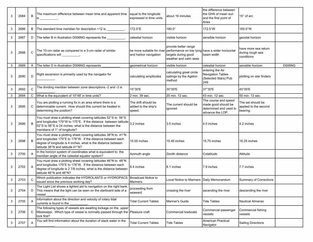
3 2684 B The maximum difference between mean time and apparent time is __________.
equal to the longitude expressed in time units about 16 minutes
the difference between the GHA of mean sun and the first point of Aries
15° of arc
3 2686 B The standard time meridian for description +12 is __________. 172.5°E 180.0° 172.5°W 165.0°W
3 2687 D The letter B in illustration D006NG represents the __________. celestial horizon visible horizon sensible horizon geoidal horizon
3 2688 C The 10-cm radar as compared to a 3-cm radar of similar specifications will __________.
be more suitable for river and harbor navigation
provide better range performance on low lying targets during good weather and calm seas
have a wider horizontal beam width
have more sea return during rough sea conditions
3 2689 A The letter D in illustration D006NG represents __________. geometrical horizon visible horizon celestial horizon sensible horizon D006NG
3 2690 D Right ascension is primarily used by the navigator for __________. calculating amplitudes
calculating great circle sailings by the Ageton method
entering the Air Navigation Tables (Selected Stars) Pub 249
plotting on star finders
3 2692 C The dividing meridian between zone descriptions -2 and -3 is __________. 15°30'E 30°00'E 37°30'E 45°00'E
3 2694 C What is the equivalent of 10°48' in time units? 2 min. 39 sec. 20 min. 12 sec. 43 min. 12 sec. 50 min. 12 sec.
3 2695 CYou are plotting a running fix in an area where there is a determinable current. How should this current be treated in determining the position?
The drift should be added to the ship's speed.
The current should be ignored.
The course and speed made good should be determined and used to advance the LOP.
The set should be applied to the second bearing.
3 2696 B
You must draw a plotting sheet covering latitudes 52°S to 56°S and longitudes 179°W to 175°E. If the distance between latitude 52°S to 56°S is 24 inches, what is the distance between the meridians of 1° of longitude?
3.2 inches 3.5 inches 4.0 inches 4.2 inches
3 2698 B
You must draw a plotting sheet covering latitudes 38°N to 41°N and longitudes 179°E to 178°W. If the distance between each degree of longitude is 4 inches, what is the distance between latitude 38°N and latitude 41°N?
15.00 inches 15.49 inches 15.75 inches 16.25 inches
3 2700 A In the horizon system of coordinates what is equivalent to the meridian angle of the celestial equator system? Azimuth angle Zenith distance Colatitude Altitude
3 2702 A
You must draw a plotting sheet covering latitudes 46°N to 48°N and longitudes 179°E to 178°W. If the distance between each degree of longitude is 2 7/8 inches, what is the distance between latitude 46°N and 48°N?
8.4 inches 8.1 inches 7.9 inches 7.7 inches
3 2703 C Which publication indicates the HYDROLANTS or HYDROPACS issued since the previous working day?
Broadcast Notice to Mariners Local Notice to Mariners Daily Memorandum Summary of Corrections
3 2704 DThe Light List shows a lighted aid to navigation on the right bank. This means that the light can be seen on the starboard side of a vessel __________.
proceeding from seaward crossing the river ascending the river descending the river
3 2705 A Information about the direction and velocity of rotary tidal currents is found in the __________. Tidal Current Tables Mariner's Guide Tide Tables Nautical Almanac
3 2706 CThe following types of vessels are awaiting lockage on the upper Mississippi. Which type of vessel is normally passed through the lock first?
Pleasure craft Commercial towboats Commercial passenger vessels
Commercial fishing vessels
3 2707 A You will find information about the duration of slack water in the __________. Tidal Current Tables Tide Tables American Practical
Navigator Sailing Directions
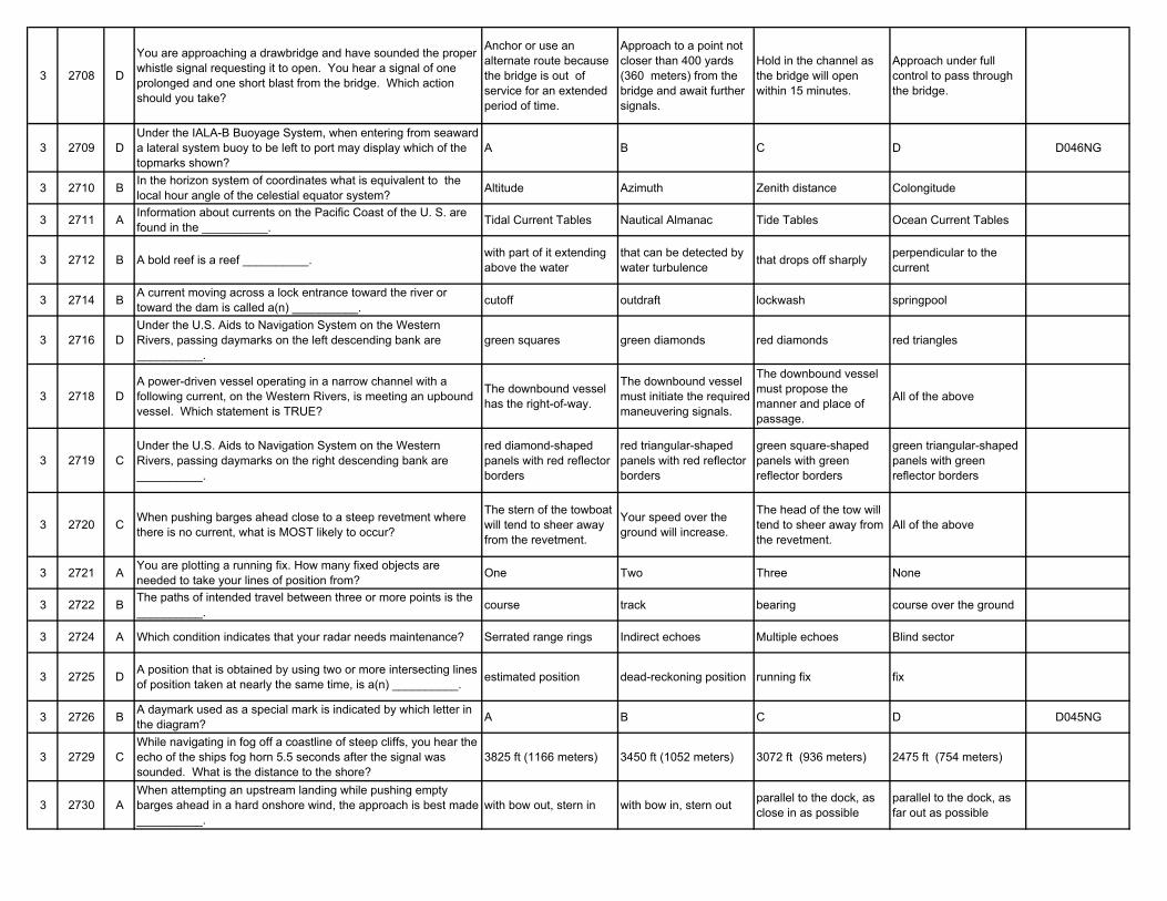
3 2708 D
You are approaching a drawbridge and have sounded the proper whistle signal requesting it to open. You hear a signal of one prolonged and one short blast from the bridge. Which action should you take?
Anchor or use an alternate route because the bridge is out of service for an extended period of time.
Approach to a point not closer than 400 yards (360 meters) from the bridge and await further signals.
Hold in the channel as the bridge will open within 15 minutes.
Approach under full control to pass through the bridge.
3 2709 DUnder the IALA-B Buoyage System, when entering from seaward a lateral system buoy to be left to port may display which of the topmarks shown?
A B C D D046NG
3 2710 B In the horizon system of coordinates what is equivalent to the local hour angle of the celestial equator system? Altitude Azimuth Zenith distance Colongitude
3 2711 A Information about currents on the Pacific Coast of the U. S. are found in the __________. Tidal Current Tables Nautical Almanac Tide Tables Ocean Current Tables
3 2712 B A bold reef is a reef __________. with part of it extending above the water
that can be detected by water turbulence that drops off sharply perpendicular to the
current
3 2714 B A current moving across a lock entrance toward the river or toward the dam is called a(n) __________. cutoff outdraft lockwash springpool
3 2716 DUnder the U.S. Aids to Navigation System on the Western Rivers, passing daymarks on the left descending bank are __________.
green squares green diamonds red diamonds red triangles
3 2718 DA power-driven vessel operating in a narrow channel with a following current, on the Western Rivers, is meeting an upbound vessel. Which statement is TRUE?
The downbound vessel has the right-of-way.
The downbound vessel must initiate the required maneuvering signals.
The downbound vessel must propose the manner and place of passage.
All of the above
3 2719 CUnder the U.S. Aids to Navigation System on the Western Rivers, passing daymarks on the right descending bank are __________.
red diamond-shaped panels with red reflector borders
red triangular-shaped panels with red reflector borders
green square-shaped panels with green reflector borders
green triangular-shaped panels with green reflector borders
3 2720 C When pushing barges ahead close to a steep revetment where there is no current, what is MOST likely to occur?
The stern of the towboat will tend to sheer away from the revetment.
Your speed over the ground will increase.
The head of the tow will tend to sheer away from the revetment.
All of the above
3 2721 A You are plotting a running fix. How many fixed objects are needed to take your lines of position from? One Two Three None
3 2722 B The paths of intended travel between three or more points is the __________. course track bearing course over the ground
3 2724 A Which condition indicates that your radar needs maintenance? Serrated range rings Indirect echoes Multiple echoes Blind sector
3 2725 D A position that is obtained by using two or more intersecting lines of position taken at nearly the same time, is a(n) __________. estimated position dead-reckoning position running fix fix
3 2726 B A daymark used as a special mark is indicated by which letter in the diagram? A B C D D045NG
3 2729 CWhile navigating in fog off a coastline of steep cliffs, you hear the echo of the ships fog horn 5.5 seconds after the signal was sounded. What is the distance to the shore?
3825 ft (1166 meters) 3450 ft (1052 meters) 3072 ft (936 meters) 2475 ft (754 meters)
3 2730 AWhen attempting an upstream landing while pushing empty barges ahead in a hard onshore wind, the approach is best made __________.
with bow out, stern in with bow in, stern out parallel to the dock, as close in as possible
parallel to the dock, as far out as possible
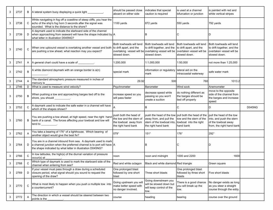
3 2737 B A lateral system buoy displaying a quick light __________. should be passed close aboard on either side
indicates that special caution is required
is used at a channel bifurcation or junction
is painted with red and white vertical stripes
3 2738 CWhile navigating in fog off a coastline of steep cliffs, you hear the echo of the ship's fog horn 3 seconds after the signal was sounded. What is the distance to the shore?
1100 yards 872 yards 550 yards 792 yards
3 2739 DA daymark used to indicate the starboard side of the channel when approaching from seaward will have the shape indicated by what letter in illustration D045NG?
A B C D
3 2740 C When one upbound vessel is overtaking another vessel and both are pushing a tow ahead, what reaction may you expect?
Both towheads will tend to drift apart, and the overtaking vessel will be slowed down.
Both towheads will tend to drift together, and the overtaking vessel will be slowed down.
Both towheads will tend to drift apart, and the overtaken vessel will be slowed down.
Both towheads will tend to drift together, and the overtaken vessel will be slowed down.
3 2741 A A general chart could have a scale of __________. 1:200,000 1:1,000,000 1:50,000 not more than 1:25,000
3 2742 B A white diamond daymark with an orange border is a(n) __________. special mark information or regulatory
marklateral aid on the intracoastal waterway safe water mark
3 2744 A The standard atmospheric pressure measured in inches of mercury is __________. 29.92 500 760 1013.2
3 2746 D What is used to measure wind velocity? Psychrometer Barometer Wind sock Anemometer
3 2750 B When pushing a tow and approaching barges tied off to the shore, you should __________.
increase speed so you will pass faster
decrease speed while passing so you won't create a suction
do nothing different as the barges should be tied off properly
move to the opposite side of the channel from the barges and increase speed
3 2752 C A daymark used to indicate the safe water in a channel will have which of the shapes shown? A B C D D045NG
3 2760 BYou are pushing a tow ahead, at high speed, near the right hand bank of a canal. The forces affecting your towboat and tow will tend to __________.
push both the head of the tow and the stern of the towboat away from the right hand bank
push the head of the tow away from, and pull the stern of the towboat into, the right hand bank
pull both the head of the tow and the stern of the towboat into the right hand bank
pull the head of the tow into, and push the stern of the towboat away from, the right hand bank
3 2762 A You take a bearing of 176° of a lighthouse. Which bearing of another object would give the best fix? 079° 151° 176° 292°
3 2764 DYou are in a channel inbound from sea. A daymark used to mark a channel junction when the preferred channel is to port will have the shape indicated by what letter in illustration D045NG?
A B C D
3 2766 C In low latitudes, the high(s) of the diurnal variation of pressure occur(s) at __________. noon noon and midnight 1000 and 2200 1600
3 2768 C Which type of daymark is used to mark the starboard side of the channel when entering from sea? Red and white octagon Black and white diamond Red triangle Green square
3 2769 DIf your vessel must pass through a draw during a scheduled closure period, what signal should you sound to request the opening of the draw?
One prolonged blast followed by one short blast
Three short blastsOne prolonged blast followed by three short blasts
Five short blasts
3 2770 C What is most likely to happen when you push a multiple tow into a countercurrent?
Going upstream you will make better speed with no danger involved.
Going downstream you will be slowed down but will keep control of the tow.
There is a good chance you will break up the tow.
No danger exists as long as you steer a straight course through the eddy.
3 2772 A The direction in which a vessel should be steered between two points is the __________. course heading bearing course over the ground
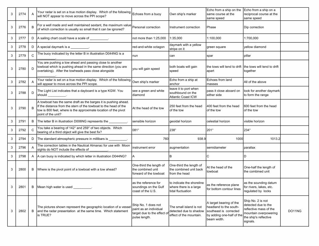
3 2774 A Your radar is set on a true motion display. Which of the following will NOT appear to move across the PPI scope? Echoes from a buoy Own ship's marker
Echo from a ship on the same course at the same speed
Echo from a ship on a reciprocal course at the same speed
3 2776 B For a well made and well maintained sextant, the maximum value of which correction is usually so small that it can be ignored? Personal correction Instrument correction Phase Dip correction
3 2777 D A sailing chart could have a scale of __________. not more than 1:25,000 1:35,000 1:100,000 1:700,000
3 2778 D A special daymark is a __________. red-and-white octagon daymark with a yellow stripe on it green square yellow diamond
3 2779 C The buoy indicated by the letter B in illustration D044NG is a __________. nun can spar pillar
3 2780 D
You are pushing a tow ahead and passing close to another towboat which is pushing ahead in the same direction (you are overtaking). After the towheads pass close alongside __________.
you will gain speed both boats will gain speed
the tows will tend to drift apart
the tows will tend to drift together
3 2782 A Your radar is set on a true motion display. Which of the following will appear to move across the PPI scope. Own ship's marker Echo from a ship at
anchorEchoes from land masses All of the above
3 2788 D The Light List indicates that a dayboard is a type KGW. You should __________.
see a green and white diamond
leave it to port when southbound on the Atlantic Coast ICW
pass it close aboard on either side
look for another daymark to form the range
3 2790 B
A towboat has the same draft as the barges it is pushing ahead. If the distance from the stern of the towboat to the head of the tow is 800 feet, where is the approximate location of the pivot point of the unit?
At the head of the tow 250 feet from the head of the tow
400 feet from the head of the tow
600 feet from the head of the tow
3 2791 B The letter B in illustration D006NG represents the __________. sensible horizon geoidal horizon celestial horizon visible horizon
3 2792 C You take a bearing of 142° and 259° of two objects. Which bearing of a third object will give the best fix? 081° 238° 201° 234°
3 2794 D The standard atmospheric pressure in millibars is __________. 760 938.9 1000 1013.2
3 2796 A The correction tables in the Nautical Almanac for use with Moon sights do NOT include the effects of __________. instrument error augmentation semidiameter parallax
3 2798 A A can buoy is indicated by which letter in illustration D044NG? A B C D
3 2800 B Where is the pivot point of a towboat with a tow ahead?One-third the length of the combined unit forward of the towboat
One-third the length of the combined unit back from the head
At the head of the towboat
One-half the length of the combined unit
3 2801 B Mean high water is used __________.as the reference for soundings on the Gulf coast of the U.S.
to indicate the shoreline where there is a large tidal fluctuation
as the reference plane for bottom contour lines
as the sounding datum for rivers, lakes, etc. regulated by locks
3 2802 BThe pictures shown represent the geographic location of a vessel and the radar presentation at the same time. Which statement is TRUE?
Ship No. 1 does not paint as an individual target due to the effect of pulse length.
The small island is not detected due to shadow effect of the mountain.
A target bearing of the headland to the south-southeast is corrected by adding one-half of the beam width.
Ship No. 2 is not detected due to the reflective mass of the mountain overpowering the ship's reflective signals.
DO11NG
3 2803 ASome locations maintain a zone time of -13. What are the Greenwich time and date if the zone time and date are 0152, 10 January?
1252, 9 January 1452, 9 January 0052, 11 January 1452, 11 January
3 2804 DThe altitude at LAN may be observed by starting several minutes in advance and continuing until a maximum altitude occurs. This procedure should not be used __________.
when the declination and latitude are of different names
when the declination is greater than and the same name as the latitude
if the vessel is stopped or making bare steerageway
on a fast vessel on northerly or southerly headings
3 2805 D
You are entering port and have been instructed to anchor, as your berth is not yet available. You are on a SW'ly heading, preparing to drop anchor, when you observe the range as shown on your starboard beam. You should __________.
drop the anchor immediately as the range lights mark an area free of obstructions
drop the anchor immediately as a change in the position of the range lights will be an indication of dragging anchor
NOT drop the anchor until the lights are in line
ensure your ship will NOT block the channel or obstruct the range while at anchor
D047NG
3 2809 A The diurnal variation of pressure is not visible in the middle latitudes in winter because __________.
it is masked by the pressure changes of moving weather systems
the decreased gravitational effect from the sun causes the variation to fade
the decreased average temperature is less than the critical temperature
the increased Coriolis force disperses the pressure variation
3 2810 AWhen steering a tow downstream around the shape of a sand bar, and staying on the proper side of the buoys, an operator should be cautious of __________.
eddies under the barswift current under the bar causing loss of control
cross-currents pushing the tow away from the bar
cross-currents pushing the tow into the bar
3 2812 A A line of position from a celestial observation is a segment of a __________. circle of equal altitude parallel of declination parallel of altitude vertical circle
3 2814 B In low latitudes the range of the diurnal variation of pressure is up to __________. 0.5 millibar 3.0 millibars 6.0 millibars 10.0 millibars
3 2816 D The length of a wave is the length __________. of the wave's crest of the wave's trough measured from crest to trough
measured from crest to crest
3 2818 D You take bearings of 313°T and 076°T on two objects. Which bearing of a third object will give the best fix? 048°T 101°T 142°T 187°T
3 2819 A The time interval between successive wave crests is called __________. wave period wavelength frequency significant wave height
3 2820 D A towboat is pushing barges ahead at a dangerously fast speed when __________.
the towboat vibrates when backing down
the roostertail exceeds the height of the main deck
a strain is placed on the face wires
water comes over the foredeck of the lead barges
3 2821 C The height of tide is the __________.
difference between the depth of the water at high tide and the depth of the water at low tide
depth of water at a specific time due to tidal effect
difference between the depth of the water and the area's tidal datum
difference between the depth of the water and the high water tidal level
3 2822 AWhile navigating in fog off a coastline of steep cliffs, you hear the echo of the ships fog horn 2 seconds after the signal was sounded. What is the distance to the shore?
360 yards 320 yards 280 yards 140 yards
3 2824 B When you turn on the fast time constant (differentiator) control of a radar it will __________.
enhance weak target echoes and brighten them on the PPI
reduce clutter over the entire PPI by shortening the echoes
only suppress weak targets to a limited distance from the ship (sea clutter)
reduce the beam width to provide a map-like presentation for navigation
3 2826 B You take a bearing of 043° and 169° of two objects. What bearing of a third object will give the best fix? 356° 102° 144° 201°
3 2828 B The daily recurring pattern of pressure changes most noticeable in low latitudes is the __________. daily lapse reading diurnal variation of
pressure pressure tendency synoptic pressure
3 2829 B A spar buoy is indicated by which letter in illustration D044NG? A B C D
3 2830 C The proper way to approach a downstream lock where there is anoutdraft is to be __________.
wide out from the land wall, keeping the stern in at all times
wide out from the land wall, keeping the stern out at all times
close in to the land wall, keeping the stern in at all times
close in to the land wall, keeping the stern out at all times
3 2831 C A coastal chart could have a scale of __________. not more than 1:25,000 1:35,000 1:100,000 1:500,000
3 2832 A The Light List indicates that a dayboard is a type MR. You should __________. leave it on either side
look for the other dayboard forming the range
look for an all red daymark
check to enter the correct channel at this junction daymark
3 2836 D The correction tables in the front of the Nautical Almanac for use with sun sights do NOT include the effects of __________. mean refraction parallax semidiameter irradiation
3 2838 B You take a bearing of 191° and 313° to two objects. Which bearing of a third object will give the best fix? 001° 069° 209° 356°
3 2839 C Privately maintained aids to navigation included in the Light List __________.
are painted white and must use a white light if lighted
must be conspicuously marked by a signboard with the words "PRIVATE AID"
must conform to the standards of the U.S. Aids to Navigation System
are not permitted in or along first-class waterways and may be authorized for second- and third-class waterways
3 2840 CThe lockmaster has given you permission to tie off on the lower guide wall to wait your turn to lock through. What should you be most concerned with?
A downbound vessel An upbound vesselCurrent reaction when the lock chamber is being emptied
Current reaction when the lock chamber is being filled
3 2841 AYou are required to enter a lock on your voyage. Information on the lock regulations, signals, and radio communications can be found in __________.
Coast Pilot Corps of Engineer Information Bulletin Bowditch the publication "Key to
the Locks"
3 2842 B The draw span of a floating drawbridge may be marked with __________. two white lights a yellow diamond flashing blue lights three red lights on each
side of the draw
3 2843 C A position obtained by applying ONLY your vessel's course and speed to a known position is a __________. fix running fix dead-reckoning position probable position
3 2844 C The signal from a ramark will show on the PPI as a __________.
coded signal on the same bearing and at a greater range then the transponder
circle surrounding the transponder
radial line from the transponder to the center of the PPI
dashed circle at the same range as the transponder
3 2846 D Which type of daymark is used to mark the port side of the channel when entering from sea? Red and white octagon Black and white diamond Red triangle Green square
3 2848 BWhile navigating in fog off a coastline of steep cliffs, you hear the echo of the ships fog horn 6 seconds after the signal was sounded. What is the distance to the shore?
1200 yards 1100 yards 1000 yards 900 yards
3 2849 A You take a bearing of 086° of a lighthouse. What bearing of another object would give the best fix? 000° 066° 112° 271°
3 2850 D What is used to help prevent damage to barges, locks, and landings when you are locking or landing a tow? Dock cushions Springers Landing bars Bumpers (fenders)
3 2851 BYou determine your vessel's position by taking a range and bearing to a buoy. Your position will be plotted as a(n) __________.
dead-reckoning position estimated position running fix fix
3 2852 B A daymark warning of a danger will have the shape indicated by which letter? A B C D D045NG
3 2854 CThe distance in miles between the circle of equal altitude for the observed altitude (Ho) and the circle of equal altitude for the computed altitude (Hc) is the __________.
equation of time zenith distance intercept zenith angle
3 2858 BWhile navigating in fog off a coastline of steep cliffs, you hear the echo of the ships fog horn 2 1/2 seconds after the signal was sounded. What is the distance to the shore?
225 yards 460 yards 750 yards 910 yards
3 2859 D The buoy indicated by the letter C in illustration D044NG is a __________. nun can spar pillar
3 2860 B On the Mississippi and Ohio Rivers, there is a special type of fog known as steam fog. It is caused by __________.
warm air passing over much colder water
cold air passing over much warmer water
a rapid cooling of the ground on a clear night
rain coming out of a warm air mass aloft
3 2862 D When slanted letters are used to spell the name of a charted object you know the __________.
object is only a hazard to vessels drawing in excess of 20 feet
position is approximate or doubtful object is always visible object may cover and
uncover with the tide
3 2866 DSome locations maintain a zone time of -13. What are the zone time and date if the Greenwich time and date are 2152, 10 January?
1052, 9 January 0852, 10 January 1052, 10 January 1052, 11 January
3 2868 BYou are inbound in a channel marked by a range. The range line is 309°T. You are steering 306°T and have the range in sight as shown. Which action should you take?
Continue on the present heading until the range is in line then alter course to the right.
Immediately alter course to the right to bring the range in line.
Immediately alter course to the left to bring the range in line.
Immediately alter course to 309°T if the range is closing.
D048NG
3 2869 C A pillar buoy is indicated by which letter shown in the illustration? A B C D D044NG
3 2870 C Steam fog is most likely to occur on the Mississippi and Ohio Rivers in __________.
spring, around late evening
spring, around early evening
fall, around early morning fall, around midday
3 2874 C What daymark has NO lateral significance? Red triangle Red triangle with a green horizontal stripe
Green and white diamond Green square
3 2875 B A harbor chart could have a scale of __________. not more than 1:25,000 1:35,000 1:150,000 not less than 1:500,000
3 2876 B
On 13 November 1981 you observe a back sight of the upper limb of the Sun as seen through the sextant's scope. The sextant altitude (hs) is 109°23.6'. The height of eye is 66 feet, and the index error is 2.0' off the arc. What is the observed altitude (Ho)?
71°01.2' 70°57.2' 70°45.4 70°26.4'
3 2877 B Class I and II private aids to navigation in or along navigable waters of the United States are listed in the __________. Sailing Directions Light List List of Private Aids Aids to Navigation
Manual
3 2878 CGiven are the courses and speeds of 4 vessels. The navigator of which vessel would be required to know the actual time of meridian transit in order to take an accurate observation at LAN?
C 356°T, Sp 5 knots C 099°T, Sp 17 knots C 192°T, Sp 23 knots C 278°T, Sp 6 knots
3 2880 C
While upbound through Memphis, the weather report on the TV news indicates that a cold front will cross western Kentucky and Tennessee the next morning. What weather should accompany this front?
Light, southerly winds; high humidity and possibly fog
Overcast with steady, light rain or drizzle
Gusting winds shifting to the northwest with thunderstorms
Scattered clouds with light to moderate southeasterly winds and possibly fog
3 2882 D
While upbound through Memphis, the weather report on TV news indicates that a warm front is stationary over the Kentucky - Missouri - Tennessee areas. What weather conditions should you expect?
Strong, gusting winds from the NW with thundershowers
Light winds from the northeast with clear skies
A "blue norther"Southerly winds with steady rain; fog or overcast
3 2884 AThe pictures shown represent the geographic location of a vessel and the radar presentation at the same time. Which statement is TRUE?
Ship No. 1 does not appear as an individual target due to the effect of beam width.
Small island is not detected due to the multiple echo effect from the mountain.
A tangent bearing of the headland to the south-southeast is corrected by subtracting one-half of the beam width.
Ship No. 2 is not detected due to the side lobe effect of radar reflecting from the mountain.
D011NG
3 2886 A On mid-ocean waters, the height of a wind-generated wave is not affected by the __________.
water depth exceeding 100 feet fetch wind's velocity duration of the wind
3 2887 C The letter B in illustration D006NG represents the __________. visible horizon sensible horizon geoidal horizon celestial horizon
3 2889 D
On 29 June 1981 you observe a back sight of the lower limb of the Moon as seen through the sextant's scope. The sextant altitude (hs) is 114°16.9'. The height of eye is 36 feet, and the index error is 2.0' off the arc. The horizontal parallax is 60.5'. What is the observed altitude (Ho)?
66°23.8' 66°04.4' 66°00.4' 65°53.8'
3 2890 B
While passing through Memphis, the weather report on the TV news indicates that a cold front is crossing western Kentucky and Tennessee. Tomorrow's weather will be dominated by a high pressure area. What weather should you expect tomorrow?
Light, southerly winds; high humidity and possibly fog
Moderate winds from the northwest, clear visibility and cooler temperatures
Low overcast; mild temperatures with light, steady rain or drizzle
Scattered clouds with light, southeasterly winds; high humidity and possibly fog
3 2891 B Twenty-three meters equals __________. 17.50 feet 75.46 feet 96.00 feet 104.99 feet
3 2892 C The Light List indicates that a dayboard is a type NB. You should __________. see a black triangle look for another daymark
forming a rangeexpect a daymark of no lateral significance
check to enter the correct channel at the junction daymark
3 2894 B Fetch is the __________.distance a wave travels between formation and decay
stretch of water over which a wave-forming wind blows
time in seconds required for two crests to pass a given point
measurement of a wave's steepness
3 2895 C A white buoy with an orange rectangle on it is a(n) __________. junction buoy safe water buoy informational buoy All of the above
3 2896 B You are navigating in pilotage waters. The maximum time between fixes should be about __________. 5 minutes 30 minutes 1 hour 4 hours
3 2899 D You take a bearing of 043° and 169° of two objects. What bearing of a third object will give the best fix? 356° 073° 192° 309°
3 2900 D Who should be consulted for changing conditions of controlling depths in major channels? U.S. Coast Guard National Geospatial-
Intelligence Agency National Ocean Service U.S. Army Corps of Engineers
3 2902 C The direction a vessel is pointed at any given time is the __________. course track heading course over the ground
3 2904 BYour radar displays your ship off center. As you proceed on your course, your ship's marker moves on the PPI scope while echoes from land masses remain stationary. What is this display called?
Off center True motion Stabilized Head up
3 2908 AA daymark used to indicate the port side of the channel when approaching from seaward is indicated by what letter in illustration D045NG?
A B C D
3 2909 D A nun buoy is indicated by which letter in illustration D044NG? A B C D
3 2910 CYou are taking bearings on two known objects ashore. The BEST fix is obtained when the angle between the lines of position is __________.
60° 45° 90° 30°
3 2913 B The Daily Memorandum contains information on __________.
active weather disturbances such as hurricanes or tropical storms
the latest navigational warnings
scheduled vessel arrivals and departures for a 24-hour period
water levels at river ports where run-off affects tidal heights
3 2914 D A daymark with red and green bands, with red uppermost, will have the shape indicated by which letter in illustration D045NG? A B C D
3 2916 D You take a bearing of 191° and 313° to two objects. Which bearing of a third object will give the best fix? 022° 131° 211° 249°
3 2918 B Which agency maintains federal aids to navigation? Corps of Engineers Coast Guard National Ocean Service Maritime Administration
3 2920 C Navigation charts of the Upper Mississippi River are published by __________. National Ocean Service Lake Survey Corps of Engineers, U.S.
Army U.S. Coast Guard
3 2922 B The Light List indicates that a dayboard is a type TR-SY. You should __________.
look for a dayboard of type TR-TY to form a range
leave it to port when southbound on the Atlantic portions of the ICW
pass it close aboard on either side
expect a daymark with no lateral significance
3 2923 B You should plot your dead reckoning position __________. from every estimated position
from every fix or running fix
every three minutes in pilotage waters only in pilotage waters
3 2924 B You take a bearing of 264° of a lighthouse. What bearing of another object would give the best fix? 289° 350v 081° 120°
3 2925 D A single line of position combined with a dead-reckoning position results in a(n) __________. running fix fix assumed position estimated position
3 2926 A
You are inbound in a channel marked by a range. The range line is 309°T. You are steering 306°T and have the range in sight as shown. The range continues to open. Which action should you take?
Come left until the range closes then steer to the left of 306°T.
Alter course to the right to 309°T or more to bring the range in line.
Continue on course but be prepared to come right if the range continues to open.
Alter course to the left to close the range, then alter course to 309°T.
D047NG
3 2927 B The position labeled C, as shown, was plotted because __________.
the vessel's course changed from due North to due East
running fixes are better estimates of true position than dead-reckoning positions
the vessel's speed changed
All of the above are correct D051NG
3 2928 AYou are in a buoyed channel at night and pass a lighted buoy with an irregular characteristic. You should report this to the __________.
Coast Guard harbor master Corps of Engineers National Ocean Service
3 2929 A
On 29 June 1981 you observe a back sight of the upper limb of the Moon as seen through the sextant's scope. The sextant altitude (hs) is 114°16.9'. The height of eye is 36 feet and the index error is 2.0' on the arc. The horizontal parallax is 60.5'. What is the observed altitude (Ho)?
66°31.6' 66°31.0' 66°28.8' 66°26.0'
3 2930 B How is a navigation light identified on an Army Corps of Engineers navigation map?
Name and light characteristic
Name and miles from a reference point
Light characteristic and miles A.H.P. None of the above
3 2931 B The vertical distance from the tidal datum to the level of the water is the __________. range of tide height of tide actual water depth charted depth
3 2932 BIf the main channel under a bridge is marked with lights of the lateral system the adjacent bridge piers should be marked with __________.
occulting white lights fixed yellow lights fixed white lights flashing yellow lights
3 2936 CInformation on search and rescue procedures and special, local communications used in Mexican waters will be found in the __________.
World Port Index International Code of Signals (Pub 102)
Sailing Directions (Planning Guides)
International Aeronautical and Maritime Search and Rescue Manual
3 2937 C The depth of the water is indicated on a chart as 32 meters. This is equal to __________. 11.50 fathoms 12.62 fathoms 17.50 fathoms 104.99 fathoms
3 2938 D You take a bearing of 176° of a lighthouse. What bearing of another object would give the best fix? 000° 021° 189° 272°
3 2939 A The buoy indicated by the letter D in illustration D044NG is a __________. nun can spar pillar
3 2940 C On the Corps of Engineer's Navigation Maps, the channel is __________.
midway between the banks
indicated by depths (in feet)
indicated by a broken line not indicated
3 2941 C During daylight savings time the meridian used for determining the time is located farther __________.
west in west longitude and east in east longitude
east in west longitude and west in east longitude
east west
3 2944 C The height of a wave is the vertical distance __________. from the still water plane to the crest
from the still water plane to the trough from crest to trough
between water levels at one-quarter of the wave's length
3 2945 A A position that is obtained by applying estimated current and wind to your vessel's course and speed is a(n) __________. estimated position dead reckoning position fix None of the above
3 2947 CA position obtained by crossing lines of position taken at different times and advanced to a common time is a(n) __________.
fix dead-reckoning position running fix estimated position
3 2949 C
On 13 November 1981 you observe a back sight of the lower limb of the Sun as seen through the sextant's scope. The sextant altitude (hs) is 109°26.3'. The height of eye is 66 feet, and the index error is 2.0' on the arc. What is the observed altitude (HO)?
70°56.6' 70°38.0' 70°27.2' 70°23.2'
3 2950 DOn an Army Corps of Engineers navigation map, each mile A.H.P. on the Lower Mississippi River is marked by a __________.
dashed red line number showing mileage navigation light red circle
3 2952 AThe channel under a bridge is marked with lights of the lateral system. The centerline of the channel shall be marked on the bridge by __________.
an occulting white light a yellow light three fixed white lights a flashing blue light
3 2954 CYou are inbound in a channel marked by a range. The range line is 309°T. You are steering 306°T. The range appears as shown and is closing. Which action should you take?
Continue on the present heading until the range is in line then alter course to the left.
Immediately alter course to the right to bring the range in line.
Continue on course until the range is closed, then alter course to the right.
Immediately alter course to 309°T. D047NG
3 2956 D
On 23 August 1981 you observe a back sight of the lower limb of the Sun as seen through the sextant's scope. The sextant altitude (hs) is 116°42.8'. The height of eye is 56 feet and the index error is 2.0' off the arc. What is the observed altitude (Ho)?
63°42.0' 63°38.0' 63°19.4' 63°06.2'
3 2958 D Drawbridges equipped with radiotelephones display a __________.
day signal of a yellow diamond marked with the call sign
white sign with the number 16 and the call sign on it
black and white diamond marked with RT 16
blue and white sign showing the radio's channels
3 2959 C Vessels required to have an Automatic Radar Plotting Aid must have a device to indicate the __________.
time of the next navigational satellite distance to the next port
speed of the vessel over the ground or through the water
None of the above
3 2960 A What is NOT found in the Mississippi River System Light List?Distance that a lighted aid to navigation can be seen at night
Distance between major points on the Mississippi River
A color plate showing the details of the aids to navigation used on the Mississippi River
Times of Coast Guard broadcasts concerning river stages
3 2961 B Which position includes the effects of wind and current? Dead reckoning positions Estimated positions Leeway position Set position
3 2962 DWhile navigating in fog off a coastline of steep cliffs, you hear the echo of the ship's fog horn 4 1/2 seconds after the signal was sounded. What is the distance to the shore?
405 yards 628 yards 730 yards 825 yards
3 2964 DThe pictures shown represent the geographic location of a vessel and the radar presentation at the same time. Which statement is TRUE?
Ship No. 1 does not paint as an individual target due to the side lobe affect.
The small island is not detected due to the limitation caused by the pulse length.
A tangent bearing of the headland to the south-southeast is corrected by subtracting one-half of the beam width.
Ship No. 2 is not detected due to the combined affects of beam width and pulse length.
D011NG
3 2965 C Which symbol represents a 10-fathom curve? ____ ____ ____ ... ____ ... ____ ____ . _____ . ____ . ____ ........
3 2966 C You take a bearing of 264° of a lighthouse. Which bearing of another object would give the best fix? 291° 059° 182° 239°
3 2968 CSome locations maintain a zone time of -13. What are the zone time and date if the Greenwich time and date are 0152, 10 January?
0052, 9 January 0258, 9 January 1452, 10 January 0052, 11 January
3 2969 B A red triangular daymark marks __________. the centerline of a navigable channel
the starboard side of a channel
a prominent object of navigational interest that has no lateral significance
an area of a channel where passing another vessel is permitted
3 2970 BThe Light List shows a lighted aid to navigation on the left bank. This means that the light can be seen on the port side of a vessel __________.
ascending the river descending the river crossing the river proceeding from seaward
3 2972 AYou are in a channel inbound from sea. A daymark used to mark a channel junction when the preferred channel is to starboard will have the shape indicated by what letter in illustration D045NG?
A B C D
3 2973 D You should plot a dead reckoning position after every __________. course change speed change fix or running fix All of the above
3 2974 B What daymark shape is used in the lateral system? Semicircle Triangle Pentagon Diamond
3 2975 B The letter H in illustration D006NG represents the __________. geoidal horizon visible horizon celestial horizon refractive horizon
3 2977 D Which symbol represents a 2-fathom curve? -- -- -- .. ____ .. ____ .. ____ ____ . ____ . ____ . .. .. .. .. ..
3 2978 D Where do you find the semidiameter correction to be used to correct sextant observations of the stars?
It is included in the altitude corrections inside the front cover of the Nautical Almanac.
Table 25 in Bowditch contains the correction.
A correction of -0.5' should be applied to all star sights.
No semidiameter correction is used.
3 2979 B You take a bearing of 356° of a lighthouse. What bearing of another object would give the best fix? 013° 082° 176° 201°
3 2980 D What volume of the Coast Guard Light List is used for the Mississippi River system? I II IV V
3 2981 A The maritime radio system consisting of a series of coast stations transmitting coastal warnings is called __________. NAVTEX HYDROLANT/HYDROP
AC NAVAREA SAFESEA
3 2982 A You take a bearing of 142° and 259° of two objects. What bearing of a third object will give the best fix? 019° 084° 166° 281° -
3 2984 D What two shapes shown are used to indicate a preferred channel? A and B B and C C and D A and D D045NG
3 2986 BSome places maintain a zone time of -13. What are the time and date at Greenwich if the zone time and date are 2152, 10 January?
1052, 9 January 0852, 10 January 1052, 10 January 1052, 11 January
3 2988 B The buoy indicated by the letter A is a __________. nun can spar pillar D044NG
3 2989 C
On 13 November 1981 you observe a back sight of the upper limb of the Moon as seen through the sextant's scope. The sextant altitude (hs) is 110°31.2'. The height of eye is 46 feet and the index error is 2.0' off the arc. The horizontal parallax is 61.3'. What is the observed altitude (Ho)?
70°41.4 70°15.4' 70°11.4' 70°02.2
3 2990 B In which source could you find the vertical clearance of a bridge on the Ohio River? Notice to Mariners Light List of the
Mississippi River System Great Lakes Pilot Coast Pilot of the Gulf of Mexico
3 2991 B When using a radar in an unstabilized mode, fixes are determined most easily from __________.
objects that are close aboard ranges tangent bearings center bearings
3 2994 A You take a bearing of 313° and 076° of two objects. Which bearing of a third object will give the best fix? 014° 133° 255° 339°
3 2998 AWhile navigating in fog off a coastline of steep cliffs, you hear the echo of the ships fog horn 3 1/2 seconds after the signal was sounded. What is the distance to the shore?
640 yards 480 yards 315 yards 143 yards
3 2999 C When entering a channel from seaward, the numbers on buoys __________.
are the same as their Light List number
are marked in 6 inch figures with retroreflective material
increase with the even numbers to starboard
decrease with the odd numbers to starboard
3 3000 BAll aids to navigation listed in the Mississippi River System Light List are shown as miles from a reference point and on the __________.
east or west bank left or right descending bank
port or starboard side of the vessel
left or right ascending bank
3 3002 D The diurnal variation of pressure is most noticeable __________. above the polar circles in a low pressure area during periods of low temperatures in the doldrums
3 3003 A The height of tide is the __________.difference between the depth of the water and the area's tidal datum
depth of water at a specific time due to tidal effect
difference between the depth of the water and the high water tidal level
difference between the depth of the water at high tide and the depth of the water at low tide
3 3004 DWhile navigating in fog off a coastline of steep cliffs, you hear the echo of the ship's fog horn 4 seconds after the signal was sounded. What is the distance to the shore?
209 yards 363 yards 480 yards 730 yards
3 3005 C The agonic line on an isomagnetic chart indicates the __________. magnetic equator magnetic longitude
reference linepoints where there is no variation
points where there is no annual change in variation
3 3006 DYou are outbound in a channel marked by a range astern. The range line is 309°T. You are steering 127°T and have the range in sight as shown. What action should you take?
Come right to 129°T.Come left until the range comes in line then alter course to 129°T.
Come left until the range comes in line then alter course to 125°T.
Come right to close the range then when on the range steer 129°T.
D047NG
3 3007 DA rotary current sets through all directions of the compass. The time it takes to complete one of these cycles, in a locale off the East coast of the US, is approximately __________.
2 1/2 hours 3 1/2 hours 6 1/4 hours 12 1/2 hours
3 3008 D You take a bearing of 086° of a lighthouse. Which bearing of another object would give the best fix? 291° 261° 242° 196°
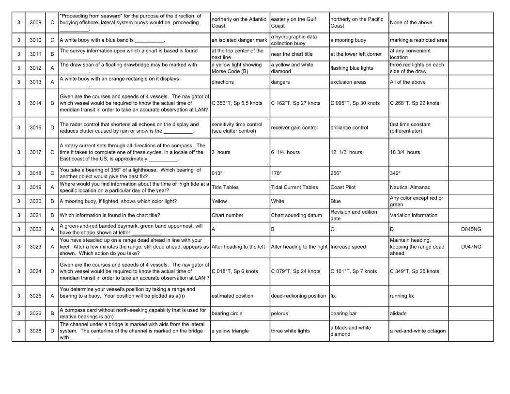
3 3009 C"Proceeding from seaward" for the purpose of the direction of buoying offshore, lateral system buoys would be proceeding __________.
northerly on the Atlantic Coast
easterly on the Gulf Coast
northerly on the Pacific Coast None of the above
3 3010 C A white buoy with a blue band is __________. an isolated danger mark a hydrographic data collection buoy a mooring buoy marking a restricted area
3 3011 B The survey information upon which a chart is based is found __________.
at the top center of the next line near the chart title at the lower left corner at any convenient
location
3 3012 A The draw span of a floating drawbridge may be marked with __________.
a yellow light showing Morse Code (B)
a yellow and white diamond flashing blue lights three red lights on each
side of the draw
3 3013 A A white buoy with an orange rectangle on it displays __________. directions dangers exclusion areas All of the above
3 3014 BGiven are the courses and speeds of 4 vessels. The navigator of which vessel would be required to know the actual time of meridian transit in order to take an accurate observation at LAN?
C 356°T, Sp 5.5 knots C 162°T, Sp 27 knots C 095°T, Sp 30 knots C 268°T, Sp 22 knots
3 3016 D The radar control that shortens all echoes on the display and reduces clutter caused by rain or snow is the __________.
sensitivity time control (sea clutter control) receiver gain control brilliance control fast time constant
(differentiator)
3 3017 CA rotary current sets through all directions of the compass. The time it takes to complete one of these cycles, in a locale off the East coast of the US, is approximately __________.
3 hours 6 1/4 hours 12 1/2 hours 18 3/4 hours
3 3018 C You take a bearing of 356° of a lighthouse. Which bearing of another object would give the best fix? 013° 178° 256° 342°
3 3019 A Where would you find information about the time of high tide at a specific location on a particular day of the year? Tide Tables Tidal Current Tables Coast Pilot Nautical Almanac
3 3020 B A mooring buoy, if lighted, shows which color light? Yellow White Blue Any color except red or green
3 3021 B Which information is found in the chart title? Chart number Chart sounding datum Revision and edition date Variation information
3 3022 A A green-and-red banded daymark, green band uppermost, will have the shape shown at letter __________. A B C D D045NG
3 3023 AYou have steadied up on a range dead ahead in line with your keel. After a few minutes the range, still dead ahead, appears as shown. Which action do you take?
Alter heading to the left Alter heading to the right Increase speedMaintain heading, keeping the range dead ahead
D047NG
3 3024 DGiven are the courses and speeds of 4 vessels. The navigator of which vessel would be required to know the actual time of meridian transit in order to take an accurate observation at LAN ?
C 018°T, Sp 6 knots C 079°T, Sp 24 knots C 101°T, Sp 7 knots C 349°T, Sp 25 knots
3 3025 AYou determine your vessel's position by taking a range and bearing to a buoy. Your position will be plotted as a(n) __________.
estimated position dead-reckoning position fix running fix
3 3026 B A compass card without north-seeking capability that is used for relative bearings is a(n) __________. bearing circle pelorus bearing bar alidade
3 3028 DThe channel under a bridge is marked with aids from the lateral system. The centerline of the channel is marked on the bridge with __________.
a yellow triangle three white lights a black-and-white diamond a red-and-white octagon
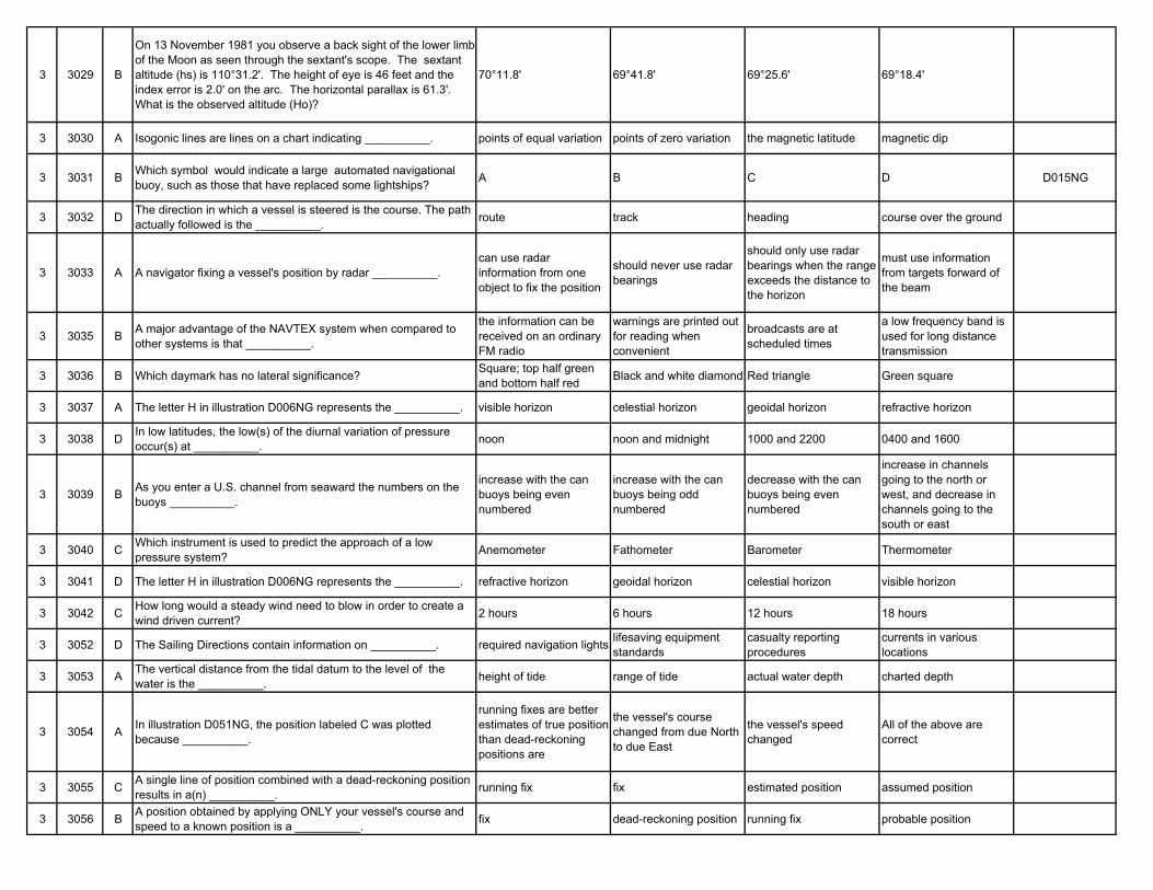
3 3029 B
On 13 November 1981 you observe a back sight of the lower limb of the Moon as seen through the sextant's scope. The sextant altitude (hs) is 110°31.2'. The height of eye is 46 feet and the index error is 2.0' on the arc. The horizontal parallax is 61.3'. What is the observed altitude (Ho)?
70°11.8' 69°41.8' 69°25.6' 69°18.4'
3 3030 A Isogonic lines are lines on a chart indicating __________. points of equal variation points of zero variation the magnetic latitude magnetic dip
3 3031 B Which symbol would indicate a large automated navigational buoy, such as those that have replaced some lightships? A B C D D015NG
3 3032 D The direction in which a vessel is steered is the course. The path actually followed is the __________. route track heading course over the ground
3 3033 A A navigator fixing a vessel's position by radar __________.can use radar information from one object to fix the position
should never use radar bearings
should only use radar bearings when the range exceeds the distance to the horizon
must use information from targets forward of the beam
3 3035 B A major advantage of the NAVTEX system when compared to other systems is that __________.
the information can be received on an ordinary FM radio
warnings are printed out for reading when convenient
broadcasts are at scheduled times
a low frequency band is used for long distance transmission
3 3036 B Which daymark has no lateral significance? Square; top half green and bottom half red Black and white diamond Red triangle Green square
3 3037 A The letter H in illustration D006NG represents the __________. visible horizon celestial horizon geoidal horizon refractive horizon
3 3038 D In low latitudes, the low(s) of the diurnal variation of pressure occur(s) at __________. noon noon and midnight 1000 and 2200 0400 and 1600
3 3039 B As you enter a U.S. channel from seaward the numbers on the buoys __________.
increase with the can buoys being even numbered
increase with the can buoys being odd numbered
decrease with the can buoys being even numbered
increase in channels going to the north or west, and decrease in channels going to the south or east
3 3040 C Which instrument is used to predict the approach of a low pressure system? Anemometer Fathometer Barometer Thermometer
3 3041 D The letter H in illustration D006NG represents the __________. refractive horizon geoidal horizon celestial horizon visible horizon
3 3042 C How long would a steady wind need to blow in order to create a wind driven current? 2 hours 6 hours 12 hours 18 hours
3 3052 D The Sailing Directions contain information on __________. required navigation lights lifesaving equipment standards
casualty reporting procedures
currents in various locations
3 3053 A The vertical distance from the tidal datum to the level of the water is the __________. height of tide range of tide actual water depth charted depth
3 3054 A In illustration D051NG, the position labeled C was plotted because __________.
running fixes are better estimates of true position than dead-reckoning positions are
the vessel's course changed from due North to due East
the vessel's speed changed
All of the above are correct
3 3055 C A single line of position combined with a dead-reckoning position results in a(n) __________. running fix fix estimated position assumed position
3 3056 B A position obtained by applying ONLY your vessel's course and speed to a known position is a __________. fix dead-reckoning position running fix probable position
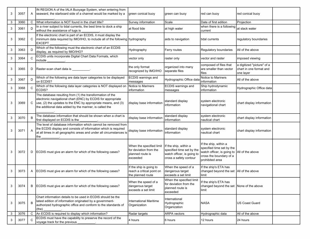
3 3057 AIN REGION A of the IALA Buoyage System, when entering from seaward, the starboard side of a channel would be marked by a __________.
green conical buoy green can buoy red can buoy red conical buoy
3 3060 C What information is NOT found in the chart title? Survey information Scale Date of first edition Projection
3 3061 D In a river subject to tidal currents, the best time to dock a ship without the assistance of tugs is __________. at flood tide at high water when there is a following
current at slack water
3 3062 CIf the electronic chart is part of an ECDIS, it must display the minimum data required by IMO/IHO, to include all of the following EXCEPT __________.
hydrography aids to navigation tidal currents regulatory boundaries
3 3063 D Which of the following must the electronic chart of an ECDIS display, as required by IMO/IHO? Hydrography Ferry routes Regulatory boundaries All of the above
3 3064 C ECDIS units incorporate Digital Chart Data Formats, which include __________. vector only raster only vector and raster imposed viewing
3 3065 D Raster-scan chart data is __________. the only format recognized by IMO/IHO
organized into many separate files
composed of files that are smaller than vector files
a digitized "picture" of a chart in one format and one layer
3 3067 D Which of the following are data layer categories to be displayed on ECDIS?
ECDIS warnings and messages Hydrographic Office data Notice to Mariners
information All of the above
3 3068 C Which of the following data layer categories is NOT displayed on ECDIS?
Notice to Mariners information
ECDIS warnings and messages
Ship hydrodynamic information Hydrographic Office data
3 3069 C
The database resulting from (1) the transformation of the electronic navigational chart (ENC) by ECDIS for appropriate use, (2) the updates to the ENC by appropriate means, and (3) the additional data added by the mariner, is called the __________.
display base information standard display information
system electronic navigational chart chart display information
3 3070 B The database information that should be shown when a chart is first displayed on ECDIS is the __________. display base information standard display
informationsystem electronic nautical chart chart display information
3 3071 A
The level of database information which cannot be removed from the ECDIS display and consists of information which is required at all times in all geographic areas and under all circumstances is the __________.
display base information standard display information
system electronic nautical chart chart display information
3 3072 D ECDIS must give an alarm for which of the following cases?
When the specified limit for deviation from the planned route is exceeded
If the ship, within a specified time set by the watch officer, is going to cross a safety contour
If the ship, within a specified time set by the watch officer, is going to cross the boundary of a prohibited area
All of the above
3 3073 A ECDIS must give an alarm for which of the following cases?If the ship is going to reach a critical point on the planned route
When the speed of a dangerous target exceeds a set limit
If the ship's ETA has changed beyond the set limit
All of the above
3 3074 B ECDIS must give an alarm for which of the following cases?When the speed of a dangerous target exceeds a set limit
When the specified limit for deviation from the planned route is exceeded
If the ship's ETA has changed beyond the set limit
None of the above
3 3075 B
Chart information details to be used in ECDIS should be the latest edition of information originated by a government-authorized hydrographic office and conform to the standards of (the) __________.
International Maritime Organization
International Hydrographic Organization
NASA US Coast Guard
3 3076 C An ECDIS is required to display which information? Radar targets ARPA vectors Hydrographic data All of the above
3 3077 C ECDIS must have the capability to preserve the record of the voyage track for the previous __________. 4 hours 6 hours 12 hours 24 hours
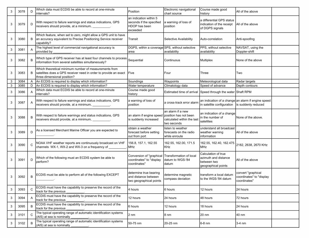
3 3078 D Which data must ECDIS be able to record at one-minute intervals? Position Electronic navigational
chart sourceCourse made good history All of the above
3 3079 D With respect to failure warnings and status indications, GPS receivers should provide, at a minimum, __________.
an indication within 5 seconds if the specified HDOP has been exceeded
a warning of loss of position
a differential GPS status indication of the receipt of DGPS signals
All of the above
3 3080 BWhich feature, when set to zero, might allow a GPS unit to have an accuracy equivalent to Precise Positioning Service receiver capability?
Transit Selective Availability Auto-correlation Anti-spoofing
3 3081 A The highest level of commercial navigational accuracy is provided by __________.
DGPS, within a coverage area
SPS, without selective availability
PPS, without selective availability
NAVSAT, using the Doppler-shift
3 3082 B Which type of GPS receiver has at least four channels to process information from several satellites simultaneously? Sequential Continuous Multiplex None of the above
3 3083 BWhich theoretical minimum number of measurements from satellites does a GPS receiver need in order to provide an exact three-dimensional position?
Five Four Three Two
3 3084 A An ECDIS is required to display which information? Soundings Waypoints Meteorological data Radar targets3 3085 D An ECDIS is required to display which information? Water temperature Climatology data Speed of advance Depth contours
3 3086 A Which data must ECDIS be able to record at one-minute intervals?
Course made good history Estimated time of arrival Speed through the water Shaft RPM
3 3087 A With respect to failure warnings and status indications, GPS receivers should provide, at a minimum, __________.
a warning of loss of position a cross-track error alarm an indication of a change
in satellite configurationan alarm if engine speed is suddenly reduced
3 3088 B With respect to failure warnings and status indications, GPS receivers should provide, at a minimum, __________.
an alarm if engine speed is suddenly increased
an alarm if a new position has not been calculated within the last two seconds
an indication of a change in the number of satellites
None of the above.
3 3089 D As a licensed Merchant Marine Officer you are expected to __________.
obtain a weather forecast before setting out from port
listen to weather forecasts on the radio while enroute
understand all broadcast weather warning information
All of the above
3 3090 C NOAA VHF weather reports are continuously broadcast on VHF channels WX-1, WX-2 and WX-3 on a frequency of __________.
156.8, 157.1, 162.55 MHz
162.55, 162.00, 171.5 KHz
162.55, 162.40, 162.475 MHz 2182, 2638, 2670 KHz
3 3091 D Which of the following must an ECDIS system be able to perform?
Conversion of "graphical coordinates" to "display coordinates"
Transformation of local datum to WGS-'84 datum
Calculation of true azimuth and distance between two geographical points
All of the above
3 3092 B ECDIS must be able to perform all of the following EXCEPT __________.
determine true bearing and distance between two geographical points
determine magnetic compass deviation
transform a local datum to the WGS-'84 datum
convert "graphical coordinates" to "display coordinates"
3 3093 C ECDIS must have the capability to preserve the record of the track for the previous __________. 4 hours 6 hours 12 hours 24 hours
3 3094 A ECDIS must have the capability to preserve the record of the track for the previous __________. 12 hours 24 hours 48 hours 72 hours
3 3095 B ECDIS must have the capability to preserve the record of the track for the previous __________. 6 hours 12 hours 18 hours 24 hours
3 3101 C The typical operating range of automatic identification systems (AIS) at sea is nominally __________. 2 nm 8 nm 20 nm 40 nm
3 3102 B The typical operating range of automatic identification systems (AIS) at sea is nominally __________. 50-75 nm 20-25 nm 6-8 nm 3-4 nm
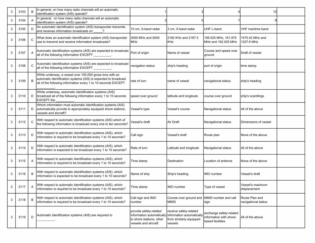
3 3103 B In general, on how many radio channels will an automatic identification system (AIS) operate? 1 3 4 12
3 3104 A In general, on how many radio channels will an automatic identification system (AIS) operate? 3 5 7 9
3 3105 D An automatic identification system (AIS) transponder transmits and receives information broadcasts on _____? 10 cm, S-band radar 3 cm, X-band radar UHF L-band VHF maritime band
3 3106 C What does an automatic identification system (AIS) transponder use to transmit and receive information broadcasts?
3000 MHz and 9200 MHz
2182 KHz and 2187.5 KHz
156.525 MHz, 161.975 MHz and 162.025 MHz
1575.42 MHz and 1227.6 MHz
3 3107 A Automatic identification systems (AIS) are expected to broadcast all of the following information EXCEPT __________. Port of origin Name of vessel Course and speed over
ground Draft of vessel
3 3108 C Automatic identification systems (AIS) are expected to broadcast all of the following information EXCEPT __________. navigation status ship's heading port of origin time stamp
3 3109 B
While underway, a vessel over 100,000 gross tons with an automatic identification systems (AIS) is expected to broadcast all of the following information every 1 to 10 seconds EXCEPT __________.
rate of turn name of vessel navigational status ship's heading
3 3110 DWhile underway, automatic identification systems (AIS) broadcast all of the following information every 1 to 10 seconds EXCEPT the __________.
speed over ground latitude and longitude course over ground ship's scantlings
3 3111 DWhich information must automatic identification systems (AIS) automatically provide to appropriately equipped shore stations, vessels and aircraft?
Vessel's type Vessel's course Navigational status All of the above
3 3112 C With respect to automatic identification systems (AIS) which of the following information is broadcast every one to ten seconds? Vessel's draft Air Draft Navigational status Dimensions of vessel
3 3113 D With respect to automatic identification systems (AIS), which information is required to be broadcast every 1 to 10 seconds? Call sign Vessel's draft Route plan None of the above
3 3114 D With respect to automatic identification systems (AIS), which information is expected to be broadcast every 1 to 10 seconds? Rate of turn Latitude and longitude Navigational status All of the above
3 3115 A With respect to automatic identification systems (AIS), which information is required to be broadcast every 1 to 10 seconds? Time stamp Destination Location of antenna None of the above
3 3116 B With respect to automatic identification systems (AIS), which information is expected to be broadcast every 1 to 10 seconds? Name of ship Ship's heading IMO number Vessel's draft
3 3117 A With respect to automatic identification systems (AIS), which information is required to be broadcast every 1 to 10 seconds? Time stamp IMO number Type of vessel Vessel's maximum
displacement
3 3118 B With respect to automatic identification systems (AIS), which information is required to be broadcast every 1 to 10 seconds?
Call sign and IMO number
Course over ground and MMSI
MMSI number and call sign
Route Plan and navigational status
3 3119 D Automatic identification systems (AIS) are required to __________.
provide safety-related information automatically to shore stations, other vessels and aircraft
receive safety-related information automatically from similarly equipped vessels
exchange safety-related information with shore-based facilities
All of the above
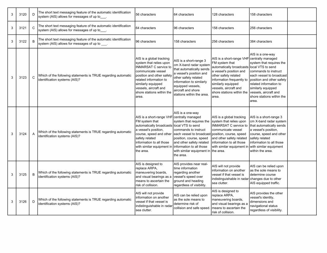
3 3120 D The short text messaging feature of the automatic identification system (AIS) allows for messages of up to___. 56 characters 64 characters 128 characters 158 characters
3 3121 C The short text messaging feature of the automatic identification system (AIS) allows for messages of up to___. 64 characters 96 characters 158 characters 256 characters
3 3122 B The short text messaging feature of the automatic identification system (AIS) allows for messages of up to ___. 96 characters 158 characters 256 characters 384 characters
3 3123 C Which of the following statements is TRUE regarding automatic identification systems (AIS)?
AIS is a global tracking system that relies upon INMARSAT C service to communicate vessel position and other safety related information to similarly equipped vessels, aircraft and shore stations within the area.
AIS is a short-range 3 cm X-band radar system that automatically sends a vessel's position and other safety related information to similarly equipped vessels, aircraft and shore stations within the area.
AIS is a short-range VHF-FM system that automatically broadcasts a vessel's position and other safety related information frequently to similarly equipped vessels, aircraft and shore stations within the area.
AIS is a one-way centrally managed system that requires the local VTS to send commands to instruct each vessel to broadcast position and other safety related information to similarly equipped vessels, aircraft and shore stations within the area.
3 3124 A Which of the following statements is TRUE regarding automatic identification systems (AIS)?
AIS is a short-range VHF-FM system that automatically broadcasts a vessel's position, course, speed and other safety related information to all those with similar equipment in the area.
AIS is a one-way centrally managed system that requires the local VTS to send commands to instruct each vessel to broadcast position, course, speed and other safety related information to all those with similar equipment in the area.
AIS is a global tracking system that relies upon INMARSAT C service to communicate vessel position, course, speed and other safety related information to all those with similar equipment in the area.
AIS is a short-range 3 cm X-band radar system that automatically sends a vessel's position, course, speed and other safety related information to all those with similar equipment within the area.
3 3125 B Which of the following statements is TRUE regarding automatic identification systems (AIS)?
AIS is designed to replace ARPA, maneuvering boards, and visual bearings as a means to ascertain the risk of collision.
AIS provides near real-time information regarding another vessel's speed over ground and heading regardless of visibility.
AIS will not provide information on another vessel if that vessel is indistinguishable in radar sea clutter.
AIS can be relied upon as the sole means to determine course changes due to other AIS equipped traffic.
3 3126 D Which of the following statements is TRUE regarding automatic identification systems (AIS)?
AIS will not provide information on another vessel if that vessel is indistinguishable in radar sea clutter.
AIS can be relied upon as the sole means to determine risk of collision and safe speed.
AIS is designed to replace ARPA, maneuvering boards, and visual bearings as a means to ascertain the risk of collision.
AIS provides the other vessel's identity, dimensions and navigational status regardless of visibility.
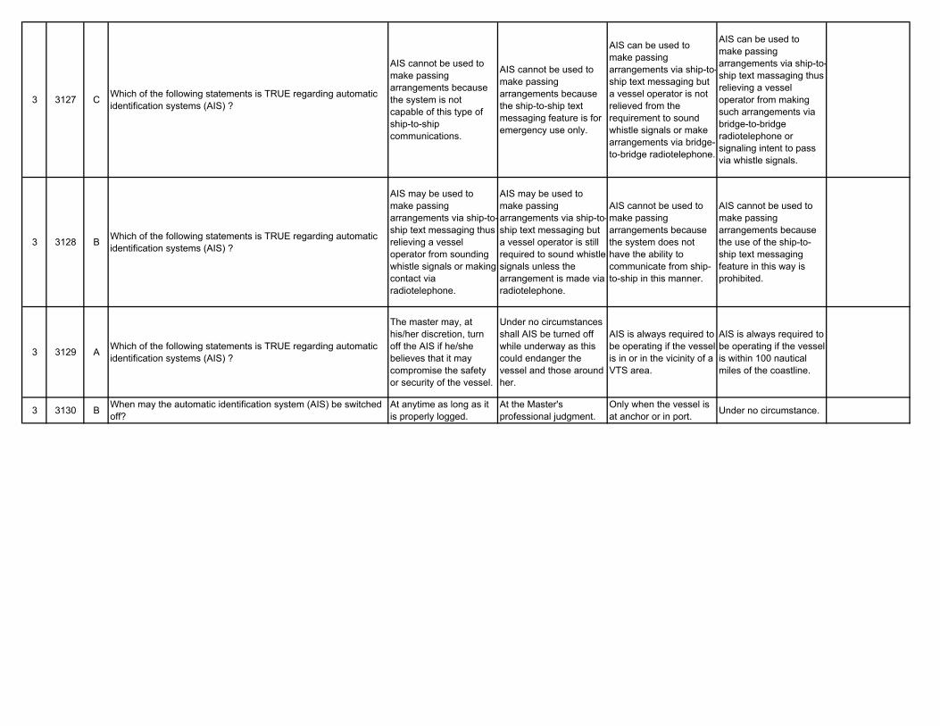
3 3127 C Which of the following statements is TRUE regarding automatic identification systems (AIS) ?
AIS cannot be used to make passing arrangements because the system is not capable of this type of ship-to-ship communications.
AIS cannot be used to make passing arrangements because the ship-to-ship text messaging feature is for emergency use only.
AIS can be used to make passing arrangements via ship-to-ship text messaging but a vessel operator is not relieved from the requirement to sound whistle signals or make arrangements via bridge-to-bridge radiotelephone.
AIS can be used to make passing arrangements via ship-to-ship text massaging thus relieving a vessel operator from making such arrangements via bridge-to-bridge radiotelephone or signaling intent to pass via whistle signals.
3 3128 B Which of the following statements is TRUE regarding automatic identification systems (AIS) ?
AIS may be used to make passing arrangements via ship-to-ship text messaging thus relieving a vessel operator from sounding whistle signals or making contact via radiotelephone.
AIS may be used to make passing arrangements via ship-to-ship text messaging but a vessel operator is still required to sound whistle signals unless the arrangement is made via radiotelephone.
AIS cannot be used to make passing arrangements because the system does not have the ability to communicate from ship-to-ship in this manner.
AIS cannot be used to make passing arrangements because the use of the ship-to-ship text messaging feature in this way is prohibited.
3 3129 A Which of the following statements is TRUE regarding automatic identification systems (AIS) ?
The master may, at his/her discretion, turn off the AIS if he/she believes that it may compromise the safety or security of the vessel.
Under no circumstances shall AIS be turned off while underway as this could endanger the vessel and those around her.
AIS is always required to be operating if the vessel is in or in the vicinity of a VTS area.
AIS is always required to be operating if the vessel is within 100 nautical miles of the coastline.
3 3130 B When may the automatic identification system (AIS) be switched off?
At anytime as long as it is properly logged.
At the Master's professional judgment.
Only when the vessel is at anchor or in port. Under no circumstance.