bloomington industrial acility - official website · bloomington industrial facility page | 1.0-2...
TRANSCRIPT
BLOOMINGTON
INDUSTRIAL FACILITY
FINAL
ENVIRONMENTAL IMPACT REPORT
State Clearinghouse No. 2016031085
Lead Agency:
San Bernardino County Land Use Services Department
385 North Arrowhead Avenue, First Floor
San Bernardino, CA 92415-0187
Contact: Kevin White
Prepared by:
Michael Baker International 3536 Concours, Suite 100
Ontario, CA 91764
Contact: Christine Donoghue
March 2017
Final EIR
County of San Bernardino – Land Use Services Department March 2017 Bloomington Industrial Facility Page | i
Final EIR
County of San Bernardino – Land Use Services Department March 2017 Bloomington Industrial Facility Page | i
Table of Contents
1.1 INTRODUCTION .................................................................................................................. 1.0‐1
1.2 ORGANIZATION OF THE FINAL EIR .......................................................................................... 1.0‐1
1.3 CEQA PROCESS SUMMARY ................................................................................................... 1.0‐1
1.4 CHANGES TO THE DRAFT EIR ................................................................................................. 1.0‐2
2.1 INTRODUCTION TO COMMENTS AND RESPONSES ....................................................................... 2.0‐1
Comment Letter: Colton Joint Unified School District (SCHOOL DIST) ................................. 2.0‐2
Response to Comment Letter: Colton Joint Unified School District (SCHOOL DIST) .......... 2.0‐6
Comment Letter: San Bernardino County Department of Public Works (PUBLIC WORKS) ... 2.0‐13
Response to Comment Letter: San Bernardino County Department of Public Works (PUBLIC WORKS) ................................................................................................................ 2.0‐15
Comment Letter: South Coast Air Quality Management District (AQMD) ......................... 2.0‐17
Response to Comment Letter: South Coast Air Quality Management District (AQMD) .. 2.0‐21
Comment Letter: San Manuel Band of Mission Indians (SAN MANUEL) ............................ 2.0‐28
Response to Comment Letter: San Manuel Band of Mission Indians (SAN MANUEL) ..... 2.0‐30
Comment Letter: Laborers International Union of North America (UNION) ...................... 2.0‐31
Response to Comment Letter: Laborers International Union of North America (UNION) ............................................................................................................................. 2.0‐32
Comment Letter: Golden State Environmental Justice Alliance (JUSTICE ALLIANCE) ......... 2.0‐33
Response to Comment Letter: Golden State Environmental Justice Alliance (JUSTICE ALLIANCE) ........................................................................................................... 2.0‐47
Comment Letter: Cruz Baca Sembelo (SEMBELLO) ............................................................. 2.0‐62
Response to Comment Letter: Cruz Baca Sembelo (SEMBELLO) ..................................... 2.0‐63
Comment Letter: Various (FORM) ....................................................................................... 2.0‐65
Response to Comment Letter: Various (FORM) ............................................................... 2.0‐80
3.1 Introduction to the Errata ............................................................................................... 3.0‐1
3.2 Changes to the Draft EIR ................................................................................................. 3.0‐1
Section 3.0 Project Description .............................................................................................. 3.0‐1
Section 4.5 Land Use ............................................................................................................... 3.0‐6
Attachment A ................................................................................................................................ A‐1
Appendix B .................................................................................................................................... B‐1
List of Tables Table 2.0‐1 Comments from Public Agencies, Organizations and Individuals ................................... 2.0‐1
List of Exhibits Exhibit 3.0‐7, Existing Parcels .................................................................................................................. 3.0‐4 Exhibit 3.0‐8, Tentative Parcel Map ........................................................................................................ 3.0‐5
Final EIR
County of San Bernardino – Land Use Services Department March 2017 Bloomington Industrial Facility Page | i
This page intentionally left blank.
Section 1.0 Introduction
County of San Bernardino – Land Use Services Department March 2017 Bloomington Industrial Facility Page | 1.0-1
1.1 INTRODUCTION
The Final Environmental Impact Report (Final EIR) for the Bloomington Industrial Facility Project (Project)
has been prepared in accordance with the California Environmental Quality Act (CEQA) (California Public
Resources Code § 21000 et seq.), and the CEQA Guidelines (14 California Code of Regulations, Division 6,
Chapter 3). CEQA Guidelines Section 15132 indicates that the contents of a Final EIR shall consist of:
The Draft EIR or a revision of the Draft EIR;
Comments and recommendations received on the Draft EIR either verbatim or in summary;
A list of persons, organizations, and public agencies commenting on the Draft EIR;
The responses of the Lead Agency to significant environmental points raised in the review and
consultation process; and
Any other information added by the Lead Agency.
The Draft EIR, and the Final EIR, along with public comments, will be considered by the County of San
Bernardino Board of Supervisors in determining whether to certify the Final EIR and approve the Project.
1.2 ORGANIZATION OF THE FINAL EIR
This Final EIR provides the requisite information required under CEQA and is organized as follows:
Section 1.0 Introduction. This section provides an introduction to the Final EIR, including the
requirements under CEQA, the organization of the document, as well as brief summary of the
CEQA process activities to date.
Section 2.0 Comments and Responses. This section provides a list of public agencies,
organizations, and individuals commenting on the Draft EIR, provides a copy of each written
comment received, and any response required under CEQA.
Section 3.0 Errata to the Draft EIR. This section details changes to the Draft EIR.
Appendix. This section provides additional content where needed and cross-references from the
body of the Final EIR.
1.3 CEQA PROCESS SUMMARY
Pursuant to CEQA, the discussion of potential effects on the environment is focused on those impacts that
the lead agency determined could be potentially significant. On March 24, 2016, the County issued a
Notice of Preparation (NOP)/Initial Study (IS) (Draft EIR, Appendix A) to inform agencies and the general
public that an IS was being prepared and invite comments on the scope and content of the document and
participation at a public scoping meeting held April 13, 2016. The NOP was distributed to State and Local
agencies, responsible and trustee agencies, interested parties and organizations. The NOP public review
Final EIR
County of San Bernardino – Land Use Services Department March 2017 Bloomington Industrial Facility Page | 1.0-2
period was from March 24, 2016 through April 22, 2016, consistent with the CEQA-required 30 day
comment period.
The Draft EIR includes an in-depth evaluation of seven environmental resource areas and other CEQA-
mandated issues (e.g., cumulative impacts, growth-inducing impacts, alternatives, impacts that are less
than significant, etc.). The seven environmental issue areas upon which the EIR focuses include are Air
Quality; Cultural Resources; Greenhouse Gas Emissions; Hazards and Hazardous Materials; Land Use;
Noise; and Transportation and Circulation.
The County released the Draft EIR to the public on December 23, 2016, for a 45-day review ending on
February 6, 2017. During the public review period, the Project was available for review on the County’s
website at:
http://www.sbcounty.gov/Uploads/lus/Environmental/westernrealco/Draft_EIR.pdf
http://www.sbcounty.gov/Uploads/lus/Environmental/westernrealco/Appendices.pdf
In addition, hard copies were available at the County Land Use Services Department, Planning Division at
385 North Arrowhead Avenue, San Bernardino, CA 92415; and at the Bloomington Branch Library at 18028
Valley Boulevard, Bloomington, CA 92316. See Attachment A for the Notice of Availability.
Comments received on the Draft EIR and the subsequent Errata have been incorporated into the Final EIR
document. The Draft EIR, Final EIR, and public comments will be considered by the Board in determining
whether to certify the Final EIR and approve the Project.
1.4 CHANGES TO THE DRAFT EIR
Section 3.0 Errata to the Draft EIR details the changes to the Draft EIR. The changes to the Draft EIR
represent minor modifications and clarifications to the existing content.
CEQA Guidelines Section 15088.5 describes when an EIR requires recirculation prior to certification,
stating in relevant part:
(a) A lead agency is required to recirculate an EIR when significant new information is added to the
EIR after public notice is given of the availability of the draft EIR for public review under Section
15087 but before certification. As used in this section, the term “information” can include
changes in the project or environmental setting as well as additional data or other information.
New information added to an EIR is not “significant” unless the EIR is changed in a way that
deprives the public of a meaningful opportunity to comment upon a substantial adverse
environmental effect of the project or a feasible way to mitigate or avoid such an effect (including
a feasible project alternative) that the project's proponents have declined to implement…
(b) Recirculation is not required where the new information added to the EIR merely clarifies or
amplifies or makes insignificant modifications in an adequate EIR.
Final EIR
County of San Bernardino – Land Use Services Department March 2017 Bloomington Industrial Facility Page | 1.0-3
The changes to the Draft EIR described herein clarify or make insignificant changes to an adequate EIR,
and are not significant new information as defined by CEQA Guidelines Section 15088.5. Therefore, this
Final EIR is not subject to recirculation prior to certification.
Section 2.0 Comments and Responses
County of San Bernardino – Land Use Services Department March 2017 Bloomington Industrial Facility Page | 2.0-1
2.1 INTRODUCTION TO COMMENTS AND RESPONSES
Table 2.0-1 below provides a list of those parties that provided written comments on the Draft EIR during
the public review period. Each comment document has been assigned a brief description as indicated in
the table.
A copy of each document providing written comments is provided in this section, and each comment has
been annotated with the assigned letter along with a number for each comment. Each comment
document is followed by a written response which corresponds to the comments provided.
Table 2.0-1 Comments from Public Agencies, Organizations and Individuals
Assignment Organization/Name
Agencies
SCHOOL DIST Colton Joint Unified School District January 30, 2017
PUBLIC WORKS San Bernardino County Department of Public Works February 1, 2017
AQMD South Coast Air Quality Management District February 3, 2017
Organizations
SAN MANUEL San Manuel Band of Mission Indians January 26, 2017
UNION Laborers International Union of North America February 2, 2017
JUSTICE ALLIANCE Golden State Environmental Justice Alliance February 5, 2017
Individuals
SEMBELLO Cruz Baca Sembello February 6, 2017
FORM Various Residents (15 Individuals)
Isael Flores;
Alejandro Martinez;
Martine Villasenor;
Michell Vega;
Ricardo Garcia;
Manuel Muro;
Dorthy Cheryl Gardner;
Juan Garcia;
Sal Romero;
Howard Baker;
Jen McNeil;
Cynthia Floriano;
Louetta Gosney;
Salvador Sanchez; and
Leonard J. Harris.
February 1, 2017
Final EIR
County of San Bernardino – Land Use Services Department March 2017 Bloomington Industrial Facility Page | 2.0-2
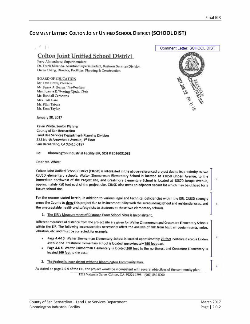
COMMENT LETTER: COLTON JOINT UNIFIED SCHOOL DISTRICT (SCHOOL DIST)
Final EIR
County of San Bernardino – Land Use Services Department March 2017 Bloomington Industrial Facility Page | 2.0-3
Final EIR
County of San Bernardino – Land Use Services Department March 2017 Bloomington Industrial Facility Page | 2.0-4
Final EIR
County of San Bernardino – Land Use Services Department March 2017 Bloomington Industrial Facility Page | 2.0-5
Final EIR
County of San Bernardino – Land Use Services Department March 2017 Bloomington Industrial Facility Page | 2.0-6
RESPONSE TO COMMENT LETTER: COLTON JOINT UNIFIED SCHOOL DISTRICT (SCHOOL DIST)
Response to Comment SCHOOL DIST 1.
The County appreciates and values the comments of the Colton Joint Unified School District (School
District) offered during the EIR participation process. These comments provide general introductory and
background information regarding the proximity and location of two existing schools, Walter Zimmerman
Elementary School (Zimmerman Elementary) and Crestmore Elementary School (Crestmore Elementary),
as well as an adjacent vacant lot which may be utilized for a future school site by the School District.
Responses to specific comments are provided below; no further response is required.
Response to Comment SCHOOL DIST 2.
The commenter notes its opposition to the Project due to the School District’s belief that the Project is
incompatible with the surrounding school and residential uses and health and safety risks. Responses to
specific comments are provided below; no further response is required.
Response to Comment SCHOOL DIST 3.
The commenter states that it believes the Draft EIR is inconsistent with the stated distances between the
locations of both Zimmerman Elementary and Crestmore Elementary to the Project site, as referenced on
pages 4.4-10 and 4.6-6 of the Draft EIR. Distance values will vary depending on whether the measurement
is between features, structures, property lines, or activities. On page 4.4-10, the Draft EIR acknowledges
that Zimmerman Elementary is located approximately 70 feet northwest across Linden Avenue, and
Crestmore Elementary is located approximately 750 feet east of the Project site. These reference
distances between property lines in order to provide a disclosure of the closest possible distances
between the Project and surrounding uses. The references on page 4.6-6 provide the approximate
distance between the nearest classrooms and the Project site for purposes of analyzing noise impacts.
This methodology is appropriate because children are more sensitive to noise disturbances during class
and not while on lunch break. Accordingly, this is why distances vary between the analyses on Draft EIR,
pages 4.4-10 and 4.6-6. Ultimately, all noise and vibrations from Project construction were found to be
less than significant and, would be temporary in nature. County of San Bernardino Municipal Code,
Section 83.01.080, Section (g)(3) states that “Temporary construction, maintenance, repair, or demolition
activities between 7:00 a.m. and 7:00 p.m., except Sundays and Federal holidays” are exempt. Temporary
construction is anticipated to occur over a duration of approximately 10 months, commencing in the first
half of 2017 and the facility would be operational in 2018, such that construction noise and vibration are
not likely to affect the experience of school children playing on the playgrounds because: 1) according to
the Colton Joint Unified School District 2016-2017 School Calendars, all elementary and high schools will
be on summer break from June 6 – August 5, 2017 which would reduce any noise impacts to adjacent
schools by two of the ten months of projected construction duration; 2) the implementation of Mitigation
Measure NOI-2 would help mitigate any potentially significant noise impact to less than significant; and
3) Table 4.6-10 Noise from On-Site Activities shows that noise activities from the Project operations would
not exceed the San Bernardino County Noise Ordinance Standard of 45 dBA for sensitive land uses near
Final EIR
County of San Bernardino – Land Use Services Department March 2017 Bloomington Industrial Facility Page | 2.0-7
the Project site. Specifically, the predicted noise level from onsite noise activities at the nearest school
(Walter Zimmerman Elementary School) would be approximately 38 dBA, which is well below existing
ambient noise levels, as well as the applicable noise ordinance standard. At the more distant Crestmore
Elementary, operational noise levels would be substantially lower. As shown in Table 4.6-11 Project-
Related Traffic Noise, noise from the additional project-related vehicle trips adjacent to Walter
Zimmerman Elementary School would result in an increase of less than 1 decibel. Similarly, project-
related vehicle trips on Jurupa Avenue east of the project (where Crestmore Elementary is located) would
also result in an increase of less than 1 decibel, which is not an audible increase. Vibration from
construction and operation of the project were assessed and determined to be less than significant in
Section 5.5 of the project’s Noise and Vibration Technical Report. Therefore, all noise and vibration
impacts of the Project’s operations were found to be less than significant. Response to Comment SCHOOL
DIST 4.
The comment indicates that the Project is inconsistent with the Bloomington Community Plan for various
reasons, which are stated and fully disclosed on pages 4.5-9 and 4.5-10 of the Draft EIR. Otherwise, this
comment is duly noted. The County of San Bernardino General Plan 2007 Noise Element, Policy N 1.7
states that incompatible land uses shall be prevented, by reason of excessive noise levels, from occurring
in the future. However, all construction and operational noise impacts would be mitigated to a less than
significant impact with implementation of Mitigation Measure NOI-1. No excessive noise levels would
occur. Additionally, NOI-1 applies to construction related noise impacts which tend to be the loudest, but
also only temporary. All operational noise levels are projected to be less than significant; thus,
incompatibility based on noise levels is not applicable. The comment also cites Draft EIR p. 4.5-10
indicating that environmental nuisances would include emissions associated with trucks, which are not
considered compatible with residential uses. The context for this statement is consistency with
Community Plan policy BL/LU 3.3, which focusses on compatibility between residential and industrial use,
and does not address schools. We agree that from a general standpoint truck emissions would be similarly
incompatible with schools. However, with respect to the Project, the results of the project-specific health
risk analysis indicate that impacts would be less than significant at the nearby school, and at residences
which are closer.
Response to Comment SCHOOL DIST 5.
This comment refers to Table 4.6-9 (page 4.6-24 of the Draft EIR noise section), which provides estimates
of construction noise levels by construction phase for the nearest noise-sensitive land uses. The nearest
noise-sensitive land uses are existing residences located as near as 60 feet to the west of the Project site
boundary. The referenced schools are not the nearest noise-sensitive land uses since Zimmerman
Elementary is located 260 feet to the northwest and Crestmore Elementary is located 750-780 feet to the
east1.
Noise levels generated by a “point source” such as construction equipment diminish at a rate of
approximately 6 decibels per doubling of distance from the source (Dudek 2016b). At a distance of 260
1 Approximate distances from Project boundary to school classrooms.
Final EIR
County of San Bernardino – Land Use Services Department March 2017 Bloomington Industrial Facility Page | 2.0-8
feet, construction noise levels at Zimmerman Elementary would be approximately 13 decibels lower than
those shown in Table 4.6-9 at the residences located 60 feet from the Project site. Therefore, the
construction noise levels at Zimmerman Elementary would range from approximately 60 dBA Leq to 71
dBA Leq, even without implementation of the recommended mitigation measures listed in NOI-1.
Assuming a conservative level of exterior-to-interior mitigation, for structures of modern construction,
with doors and windows closed2, the resulting interior noise level in the classrooms would be
approximately 40 to 51 dBA Leq, which would not exceed the County stationary noise standard for
Professional Services3 of 55 dBA Leq. Please note that these estimates are without mitigation measures
provided in NOI-1. Effectiveness of these mitigation measures would vary from several decibels (which in
general is a relatively small change) to ten or more decibels (which subjectively would be perceived as a
substantial change), depending upon the specific equipment and the original condition of that equipment,
the specific locations of the noise sources and the receivers, etc. Relocation of equipment to a more
distant location, for example, could range from 1 decibel or less to over 15 decibels, depending upon the
location of the equipment before and after relocation. Installation of more effective silencers could range
from several decibels to well over 10 decibels. Reduction of idling equipment could reduce overall noise
levels from barely any reduction to several decibels. Cumulatively, however, these measures would result
in substantial decreases in the noise from construction. Furthermore, the commenter does not identify
what noise level it would find acceptable, nor does the commenter provide substantial evidence
identifying why the EIR’s significance conclusion is incorrect.
At the next-nearest school, Crestmore Elementary, located 750-780 feet to the east of the Project site,
noise levels would be approximately 22 decibels lower than those shown in Table 4.6-9 at the residences
located 60 feet from the Project site. Therefore, the construction noise levels at Crestmore Elementary
would range from approximately 51 dBA Leq to 62 dBA Leq, without the recommended mitigation
measures. Assuming a conservative level of exterior-to-interior mitigation, for structures of modern
construction, with doors and windows closed, the resulting interior noise level in the classrooms would
be approximately 31 to 42 dBA Leq, which would not exceed the County stationary noise standard for
Professional Services of 55 dBA Leq. Ultimately, because noise impacts are already less than significant
with the application of existing mitigation, no further measures are required by CEQA. (State CEQA
Guidelines, § 15126.4(a)(3).)
Response to Comment SCHOOL DIST 6.
The comment relates concerns regarding construction air quality impacts. As stated on page 4.1-17 of the
Draft EIR, Localized Significance Thresholds (LSTs) were developed in response to the South Coast Air
Quality Management District (SCAQMD) Governing Boards' Environmental Justice Enhancement Initiative
(I-4). The SCAQMD provided the Final Localized Significance Threshold Methodology (dated June 2003
[revised 2009]) for guidance. The LST methodology assists lead agencies in analyzing localized air quality
2 Federal Highway Administration. 2011. Highway Traffic Noise: Analysis and Abatement Guidance.
FHWA-HEP-10-025. December 2011. 3 Table 83-2, County Code of Ordinances. The County does not provide a specific listing for schools, but professional
service type uses would require a similar level of concentration and comprehension.
Final EIR
County of San Bernardino – Land Use Services Department March 2017 Bloomington Industrial Facility Page | 2.0-9
impacts. The LST methodology acknowledges that construction activities occur throughout a project site
and are concentrated at the point closest to the sensitive receptors. Table 4.1-8 of the Draft EIR identifies
how SCAQMD guidance is used to determine the maximum daily disturbed acreage within 25 meters of a
sensitive receptor for comparison to LSTs. (According to the SCAQMD, projects with boundaries located
closer than 25 meters to the nearest receptor should use the LSTs for receptors located at 25 meters.) The
SCAQMD produced look-up tables for projects that disturb areas less than or equal to 5 acres in size daily.
That is why is it important to note, as shown in Table 4.1-8 of the Draft EIR, that Project construction
would be anticipated to disturb a maximum of 3.5 acres within 25 meters of a sensitive receptor in a single
day, as determined by SCAQMD guidance. Since Project construction would disturb a maximum of 3.5
acres in a single day within 25 meters of a sensitive receptor, the use of the SCAQMD LST methodology,
which includes the use of look-up tables for projects that disturb areas less than or equal to 5 acres in
size daily, is appropriate.
Response to Comment SCHOOL DIST 7.
The commenter is incorrect in suggesting that the Draft EIR fails to acknowledge existing exposure of toxic
air contaminants in the Project vicinity. The Draft EIR does include a disclosure of background
concentrations of diesel particulate matter and potential associated cancer risk. Indeed, the commenter
actually cites to the very Draft EIR appendix that provides that information. As stated in the Health Risk
Assessment (Draft EIR, Appendix B), of the Draft EIR, the SCAQMD has conducted an in‐depth analysis of
the toxic air contaminants and their resulting health risks for all of Southern California, and as a result has
been able to estimate an excess cancer risk of 427 in one million in the Project region. Diesel particulate
matter accounts for 68 percent of the total risk shown in the Multiple Air Toxics Exposure Study in the
South Coast Air Basin, MATES IV (2015). This study, shows that cancer risk has decreased 68 percent
between MATES III (2008) and MATES IV (2015), even though the state’s population has increased 31
percent and the amount of vehicle miles traveled has increased 81 percent over this time. (Draft EIR pp.
4.1-26 through 4.1-27.)
A health risk assessment (HRA) was prepared for the Project in order to analyze potential health risks
resulting from Project-generated diesel particulate matter. The HRA was based on the procedures
developed by the California Office of Environmental Health Hazard Assessment (OEHHA) and the SCAQMD
to meet the mandates of the Air Toxics "Hot Spots" Information and Assessment Act (AB 2588). The
OEHHA procedures describe the toxicity factors associated with various substances, how these toxicity
factors are to be used to determine the acute, chronic, and cancer risks associated with downwind
concentrations of chemicals in the air at various receptors, and dispersion modeling procedures. Due to
the highly technical components of the Project HRA, it is organized in the Draft EIR as an appendix and
cited in Section 4.1 in full.
The Draft EIR applies a threshold of a maximum individual cancer risk of 10 in 1 million for evaluating
whether the Project may cause a significant increase in potential cancer risk consistent with the mandates
of the SCAQMD and the Air Toxics "Hot Spots" Information and Assessment Act. The SCAQMD has
established an incidence rate of 10 persons per 1 million as the maximum acceptable incremental cancer
Final EIR
County of San Bernardino – Land Use Services Department March 2017 Bloomington Industrial Facility Page | 2.0-10
risk due to diesel particulate matter exposure. This threshold serves to determine whether or not a given
project has a potentially significant development-specific and cumulative impact. The 10 in one million
standard is a very health-protective significance threshold. A risk level of 10 in one million implies a
likelihood that up to 10 persons, out of one million equally exposed people would contract cancer if
exposed continuously (24 hours per day) to the levels of toxic air contaminants over a specified duration
of time. This risk would be an excess cancer risk that is in addition to any cancer risk borne by a person
not exposed to these air toxics. To put this risk in perspective, the risk of accidental drowning is 1,000 in
a million, which is 100 times more than the SCAQMD’s threshold of 10 in one million.
Finally, the commenter seem to suggest that any increase in incremental cancer risk equates to a
significant cumulative impact. CEQA case law has rejected that argument finding that “the ‘one
[additional] molecule rule’ is not the law.” (Communities For a Better Environment v. California Resources
Agency (202) 103 Cal. App. 4th 98, 120.)
Response to Comment SCHOOL DIST 8.
The commenter is quoting the total number of trips in Passenger Car Equivalents and assuming they are
all trucks. This is not the case. The bulk of those peak hour trips are employee or other non-truck vehicles.
Based on the Project specific Traffic Impact Analysis (Draft EIR, Appendix F), the Project is anticipated to
add approximately 17 trucks during the morning and evening peak hours.
Of those 17 trucks, approximately 12 would pass by the school complex containing Bloomington Head
Start, Bloomington Junior High School, and Slover Mountain High School at the intersection of Cedar
Avenue and Slover Avenue. The projected 12 new trucks at those intersections will increase the future
projected traffic by 0.40 percent during the morning peak hour and 0.39 percent during the evening peak
hour. This increase in truck traffic is unnoticeable on the roadway network. This amount of increased
traffic is far less than the daily fluctuation of traffic.
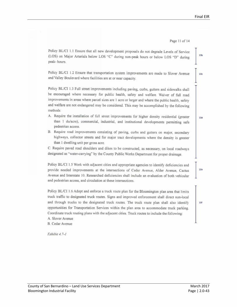
Of those 17 trucks, it is not foreseeable that any trucks would pass by Zimmerman Elementary or
Crestmore Elementary. See Exhibits 4.7-2 Inbound Truck Trip Distribution, and 4.7-3 Outbound Truck
Distribution in the Draft EIR, which illustrate anticipated truck traffic to and from the project site, and
does not show any percentage of truck traffic being distributed on Jurupa Avenue east of Cedar Avenue
where Crestmore Elementary is located.
In response to the comment regarding the traffic impact analysis conducted, according to Kunzman
Associates, Inc., a traffic impact analysis typically evaluates a period for a typical weekday (Tuesday,
Wednesday, or Thursday) during peak hours, in this case from 7:00 a.m. to 9:00 a.m. and from 4:00 p.m.
to 6:00 p.m.; see page 4 of the County of San Bernardino Traffic Impact Analysis Guidelines. Typically, if
there is no impact anticipated during the morning and evening peak periods, there will not be an impact
outside of those peak periods. This traffic impact analysis has analyzed the appropriate day and time
periods based on traffic engineering practices and discussions with the County Public Works Department.
School arrival and departure times may be the peak traffic at a school but it is not the peak traffic on the
Final EIR
County of San Bernardino – Land Use Services Department March 2017 Bloomington Industrial Facility Page | 2.0-11
County roadways. The peak traffic times on the County roadways is directly tied to people driving from
home to work and from work to home. All other peak periods are significantly less intense.
The commenter noted concerns between trucks and pedestrians. Based on the Bloomington Industrial
Facility Traffic Impact Analysis (Draft EIR, Appendix F), the Project is anticipated to add approximately 17
trucks during the morning and evening peak hours, which represents a minor overall increase in truck
traffic. As indicated in the Truck Distribution exhibits (Exhibits 4.7-2 and 4.7-3 of the Draft EIR), truck
traffic would utilize the Cedar Avenue and Jurupa Avenue intersection. This intersection is fully signalized
and supported by crosswalks to serve vehicle use and pedestrian crossing. Project truck traffic would not
be distributed further east on Jurupa Avenue, and would not use Jurupa Avenel east of the project
frontage, and would not use Linden Avenue. As a result, conflicts between trucks and pedestrians are not
anticipated.
The proposed Project is not proposing to modify the County Truck Routes. Based on the Bloomington
Industrial Facility Truck Circulation Analysis, there are no projected truck circulation issues.
Response to Comment SCHOOL DIST 9.
The comment indicates that development under the existing land use designation should be analyzed
under an Existing Zoning Alternative, and that a higher-density residential development should also be
analyzed.
As indicated in the Draft EIR (see page 8.0-1), the No Project Alternative must discuss the existing
conditions and what would reasonably expected to occur in the foreseeable future if the Project would
not occur. (State CEQA Guidelines, § 15126.6(e) (2).) As a result, the No Project Alternative included in
the Draft EIR, evaluates the development of the site consistent with the existing land use
designation/zoning, and thus is equivalent to the suggested Existing Zoning Alternative. This is an
appropriate approach to application of the No Project Alternative under CEQA, regardless of the particular
title attributed to the Alternative.
The suggested higher-density residential development alternative would not meet many of the basic
project objectives, including: Objective 1 in this an alternative would not create revenue-generating uses,
stimulate employment, or respond to current market opportunities; Objective 6 in that such an
alternative would not facilitate goods movement for the benefit of local and regional economic growth;
and Objective 8 in that this alternative would not provide permanent employment opportunities or
improve the local balance of housing and jobs.
CEQA also requires the evaluation of a reasonable range of alternatives that would reduce significant
impact associated with the Project. The Draft EIR evaluated an alternative similar to the proposed Project,
but at a reduced intensity of development, and therefore, with less Project-related traffic, air emissions,
and noise. In addition, the Draft EIR evaluated a use that would remain commercial in nature (similar to
the proposed Project), but would be more compatible with the existing residential uses. Thus, the Draft
EIR evaluates residential use consistent with the General Plan, industrial use at a reduced intensity
Final EIR
County of San Bernardino – Land Use Services Department March 2017 Bloomington Industrial Facility Page | 2.0-12
compared to the Project, and a commercial use project, demonstrating a good faith effort in the
evaluation of a reasonable range of alternatives.
Response to Comment SCHOOL DIST 10.
This comment serves as the conclusion to the letter. This comment provides general information and
reiterates concerns previously stated. Responses to specific comments are provided above; no further
response is required.
Final EIR
County of San Bernardino – Land Use Services Department March 2017 Bloomington Industrial Facility Page | 2.0-13
COMMENT LETTER: SAN BERNARDINO COUNTY DEPARTMENT OF PUBLIC WORKS
(PUBLIC WORKS)
Final EIR
County of San Bernardino – Land Use Services Department March 2017 Bloomington Industrial Facility Page | 2.0-14
Final EIR
County of San Bernardino – Land Use Services Department March 2017 Bloomington Industrial Facility Page | 2.0-15
RESPONSE TO COMMENT LETTER: SAN BERNARDINO COUNTY DEPARTMENT OF PUBLIC WORKS
(PUBLIC WORKS)
Response to Comment PUBLIC WORKS 1.
The comment indicates that the Project is subject to the Comprehensive Storm Drain Plan No. 3-4, dated
September 1997. Similarly, that any revisions to the drainage should be reviewed and approved by the
County Department of Public Works. The County acknowledges that the Project is subject to the
aforementioned review and approval process. This comment does not identify a specific concern with the
adequacy of the Draft EIR or raise an issue or comment specifically related to the Draft EIR’s environmental
analysis. Therefore, no further response is warranted. (State CEQA Guidelines §15088(a) requires that a
lead agency only evaluate and respond to comments raised on environmental issues.)
Response to Comment PUBLIC WORKS 2.
The comment indicates that any work affecting the County Maintained Road System right-of-way would
need a Transportation Permit. The County acknowledges that any Project-related work done to County
roadway system is subject to the aforementioned permit, including modification of the median on Cedar
Avenue, north of Jurupa Avenue to facilitate truck movement across Cedar Avenue at the Project’s
northernmost driveway, and half width street improvements along Project frontage on Cedar, Jurupa, and
Linden Avenues (Draft EIR p. 3.0-14). This comment does not identify a specific concern with the adequacy
of the Draft EIR or raise an issue or comment specifically related to the Draft EIR’s environmental analysis.
Therefore, no further response is warranted. (State CEQA Guidelines §15088(a) requires that a lead
agency only evaluate and respond to comments raised on environmental issues.)
Response to Comment PUBLIC WORKS 3.
The comment indicates that any impacts to water quality or increase in flows can cause sensitive habitats
to grow. In such case, the San Bernardino County Flood Control District (SBCFCD) would be required to
mitigate impacts to these habitats which mitigation measures are often extremely expensive. As such,
any increase in water flow and the effects therein need to be discussed and analyzed in the Final EIR.
Section 6.0 Effects Not Found to be Significant (EFNTBS) of the Draft EIR, Hydrology and Water Quality
section, provides a full discussion on hydrology and water quality related impacts. Additionally, it fully
addresses the stated concern regarding any increase in water flow that could occur due to the
implementation of the Project. As discussed in the EFNTBS, according to the Water Quality Management
Plan, the Project would collect stormwater from impervious areas and direct it to infiltration basins to
both filter and recharge stormwater (Thienes Engineering 2015). Additionally, the Project runoff would
mimic predevelopment conditions in terms of rate/concentration of runoff. In addition, the Project would
not have an increase in water volume or its quality compared to the existing conditions, such that there
will not be any increase in flows as mentioned by the commenter. Thus, the Project would not alter or
exceed the capacity of exiting or planned storm water drainage systems, and would not be expected to
Final EIR
County of San Bernardino – Land Use Services Department March 2017 Bloomington Industrial Facility Page | 2.0-16
contribute to the growing of sensitive habitats. Finally, the commenter will be added to the County’s
notice and distribution list for the Project going forward, as requested by the commenter.
Final EIR
County of San Bernardino – Land Use Services Department March 2017 Bloomington Industrial Facility Page | 2.0-17
COMMENT LETTER: SOUTH COAST AIR QUALITY MANAGEMENT DISTRICT (AQMD)
Final EIR
County of San Bernardino – Land Use Services Department March 2017 Bloomington Industrial Facility Page | 2.0-18
Final EIR
County of San Bernardino – Land Use Services Department March 2017 Bloomington Industrial Facility Page | 2.0-19
Final EIR
County of San Bernardino – Land Use Services Department March 2017 Bloomington Industrial Facility Page | 2.0-20
Final EIR
County of San Bernardino – Land Use Services Department March 2017 Bloomington Industrial Facility Page | 2.0-21
RESPONSE TO COMMENT LETTER: SOUTH COAST AIR QUALITY MANAGEMENT DISTRICT (AQMD)
Response to Comment AQMD 1.
The commenter provides general introductory and background information regarding the Project. The
County appreciates and values these comments during the EIR participation process. Responses to specific
comments are provided below; no further response is required.
Response to Comment AQMD 2.
The commenter briefly voices concerns regarding the assumptions used in the Air Quality Analysis
modeling, asserting that the Project related health risks were likely underestimated. Responses to this
issue are provided below as part of the responses to other specific comments made by the commenter.
Additionally, the commenter indicates that, pursuant to Public Resources Code Section 21092.5, SCAQMD
staff requests that the lead agency provide the SCAQMD with written responses to all comments
contained herein prior to the adoption of the Final EIR. The County will provide written responses to the
SCAQMD’s comments as required by Public Resources Code § 21092.5. Further, the comment indicates
that SCAQMD staff is available to work with the lead agency to address any issues and any other questions
that may arise. The County appreciates and values these comments during the EIR participation process.
This comment provides general introductory and background information. Consistent with Public
Resources Code Section 21092.5, responses to specific comments are provided below; no further
response is required.
Response to Comment AQMD 3.
The commenter is correct that the Project includes demolition, and therefore must comply with SCAQMD
Rule 1403. The purpose of SCAQMD Rule 1403 is to specify work practice requirements to limit asbestos
emissions from building demolition and renovation activities, including the removal and associated
disturbance of asbestos-containing materials (ACM). The requirements for Project demolition activities
under Rule 1403 include asbestos surveying, notification, ACM removal procedures and time schedules,
ACM handling and clean-up procedures, and storage, disposal, and landfilling requirements for asbestos-
containing waste materials (ACWM). Similarly, the existing rules requires that the Project construction
contractor shall be required to maintain records, including waste shipment records, and use appropriate
warning labels, signs, and markings. Therefore, even if asbestos is found within any structures to be
demolished, the processes established under Rule 1403 eliminate the potential for potentially significant
air quality or hazard impacts related to asbestos.
Response to Comment AQMD 4.
A measure that requires daily monitoring of truck numbers and preclusion of trucks from entering the site
is infeasible to impose. For example, it is unclear how a requirement to limit the daily number of trucks
allowed at the facility would be enforced. There are also several potential adverse environmental impacts
from implementing such a measure, including heavy-duty trucks parking along off-site vicinity roadways
Final EIR
County of San Bernardino – Land Use Services Department March 2017 Bloomington Industrial Facility Page | 2.0-22
resulting in congestion, parking conflicts with area residents, traffic safety impacts, and increased truck
movements and idling in residential neighborhoods arising from trucks queuing in the streets or waiting
in adjacent neighborhoods for a new day of truck “counts” to begin.
If and when the County is called upon to issue any subsequent discretionary approval involving the Project,
the County is already subject to the obligation to consider whether changed circumstances, new
information, or other factors requires additional environmental review pursuant to Public Resources Code
§ 21166 and State CEQA Guidelines § 15162. As such, there is no requirement or nexus to support the
imposition of a measure that would duplicate existing requirements under CEQA.
CEQA requires that an EIR analyze only what is reasonably foreseeable – not to speculate about what
potential future activities may (or may not) occur. (State CEQA Guidelines, § 15145.) Here, the EIR and
associated air quality and health risk analyses made a number of conservative assumptions regarding
exposure rates of air toxics. For instance, as stated on pages 4.1-25 through 4.1-26 of the Draft EIR, the
dispersion model employed for the Project analysis was run to obtain the peak 24‐hour and annual
average concentration in micrograms per cubic meter (μg/m3), which is a conservative methodology since
actual 24-hour and annual average and concentrations are dependent on many variables, particularly the
number and type of equipment working at specific distances during time periods of adverse meteorology.
Additionally, the diesel exhaust Unit Risk Factor (URF) employed in the risk estimate is based upon the
upper 95 percentile of estimated risk for each of the epidemiological studies utilized to develop the URF,
and is therefore conservative. The risk estimates assume sensitive receptors will be subject to diesel PM
for 24 hours a day, 350 days a year, which is conservative considering research conducted by CARB that
indicated adults and adolescents in California spent almost 15 hours per day inside their homes, and six
hours in other indoor locations, for a total of 21 hours (87% of the day).4 As an additional conservative
measure, the emissions derived assume that every truck accessing the project site will idle for 15 minutes,
which is an overestimation of actual idling times since California regulations limiting idling to no more
than 5 minutes.
As stated on page 4.1-18 of the Draft EIR, the Project would not violate any air quality standard or
contribute substantially to an existing or projected air quality violation during Project operations as
emissions resulting from Project operations would not exceed any of the SCAQMD regional emissions
thresholds for operational activity. Additionally, as stated on pages 4.1-27 and 4.1-28 of the Draft EIR, the
increased health risk from heavy trucks would also be below the applicable significance threshold.
Nonetheless, while the increased health risk from heavy trucks would be below the applicable significance
threshold, Mitigation Measure AQ-1 is recommended in order to enforce existing regulation and reduce
the generation of diesel particulate matter. Trucks that run at least partially on electricity are projected
by the SCAQMD to become available during the life of the project as discussed in SCAQMD’s 2012 Regional
Transportation Plan. Mitigation Measure AQ-1 requires the project to make this electrical infrastructure
available when the project is built so that it is ready when this technology becomes commercially
available. Additionally, Mitigation Measure AQ-1 enforces existing regulation and provides incentives for
4 Activity Patterns of California Residents, California Air Resources Board, UC Berkeley, 1991.
Final EIR
County of San Bernardino – Land Use Services Department March 2017 Bloomington Industrial Facility Page | 2.0-23
alternative fuel use, both of which will reduce the generation of diesel particulate matter. Mitigation
Measure AQ-1 also requires the Project to promote and support clean truck fleets by providing
information on the CARB Carl Moyer retrofit program and information on idling limits and nearby
alternative fueling stations. The Draft EIR identifies the Project conflicting with the SCAQMD Air Quality
Management Plan to a level that is significant since it will exceed land use assumptions in the Plan. As
stated on page 4.1-21 of the Draft EIR, there is no feasible mitigation available to reduce these emissions
to levels below the threshold.
Response to Comment AQMD 5a.
The commenter is correct that the “Non-Default Regulatory Option – Flat” was employed in AERMOD, the
air pollutant dispersion model used for the Health Risk Assessment completed for the Project. This option
was selected based on the topography of the Project site, which is flat and devoid of any hills or berms.
Based on the flat terrain and no hills or berms on the site, there is no available hill height scale input to
accommodate an “Elevated – Non-Default Regulatory Option.” Additionally, as part of Project
construction, the site is proposed to be graded and further leveled. AERMOD does not make any
distinction between elevated terrain below the inputted pollutant release height, which as discussed
further below, is 8.37 feet. Therefore the “Non-Default Regulatory Option – Flat” was employed, and the
impacts were not underestimated.
Response to Comment AQMD 5b.
The commenter suggests that other meteorological stations closer to the Project should have been
referenced. The SCAQMD provides meteorological data from 27 different locations within the South Coast
Air Basin that is able to be inputted into AERMOD. Meteorological data obtained at the San Bernardino
monitoring station was used for the Health Risk Assessment based on its geographic proximity to the
Project site, coupled with the fact that this data is the most conservative available, thus leading to a
worst-case depiction of potential Project impacts. While the comment suggests obtaining meteorological
data from the Rubidoux station, this station is not one of the 27 different locations that offers data to
input into AERMOD. Therefore, employing data from the Rubidoux station for the purposes of the Health
Risk Assessment is not a reasonable option. The comment also suggests obtaining meteorological data
from the Fontana station, which is nearer to the Project site than the San Bernardino station. However,
while the Fontana station is closer than the San Bernardino station, the meteorological data it provides is
less conservative.
Specifically, the data provided from the San Bernardino station includes calmer wind patterns than that
provided from the Fontana station, thus less pollutant dispersion at the most exposed areas near the
Project site, and more conservative health risk projections. Specifically, the San Bernardino monitoring
station data includes ‘calm days’ or days with no wind, while the Fontana monitoring station does not.
Additionally, the Fontana data includes days experiencing wind speeds within the highest two wind
classes, while the San Bernardino station data does not identify wind patterns reaching such speeds. Since
the data from the San Bernardino station includes days with no wind and does not include wind speeds
Final EIR
County of San Bernardino – Land Use Services Department March 2017 Bloomington Industrial Facility Page | 2.0-24
within the highest two wind classes, it accounts for less pollutant dispersion, higher pollutant
concentrations, and is thus the most conservative data available.
Response to Comment AQMD 5c.
The commenter noted concern regarding the 100 meter spacing of receptors. According to the SCAQMD’s
Supplemental Guidelines for Preparing Risk Assessments for the Air Toxics “Hot Spots” Information and
Assessment Act (AB 2588), air dispersion modeling is required to estimate (a) annual average
concentrations to calculate the Maximum Individual Cancer Risk (MICR), the maximum chronic hazard
index (HI), the zones of impact, and excess cancer burden and (b) peak hourly concentrations to calculate
the health impact from substances with acute non-cancer health effects. To achieve these goals, the
receptor grid should begin at the facility fence line and extend to cover the zone of impact. In addition,
the receptor grid should be fine enough to identify the points of maximum impact. According to the
SCAQMD, in order “to identify the maximum impacted receptors (i.e., peak cancer risk and peak hazard
indices) a grid spacing of 100 meters or less must be used,” (see page 16 of SCAQMD’s Supplemental
Guidelines). The modeling and analysis was prepared in accordance with the SCAQMD Guidelines.
Additionally, the analysis did not miss potential peak concentration levels at any sensitive receptors.
Potential peak concentration levels at sensitive receptors were identified through the examination of
pollutant concentration contour mapping. Where multiple concentration levels are identified within a
single receptor grid, the highest concentration level identified is used for the purpose of determining the
health risk within that receptor grid.
Response to Comment AQMD 5d.
The commenter noted concern regarding the exclusion zones. The Project exclusion zone includes the
Project site. According to SCAQMD protocols, project sites should not be included as a receptor for the
purposes of determining pollutant dispersion from the said project site and the resultant concentration
levels at vicinity sensitive receptors. The pollutant concentration levels within the Project
boundary/volume source exclusion zone were not considered in the analysis of potential health risk to
sensitive land uses.
Response to Comment AQMD 5e.
The California Office of Environment Health Hazard Assessment (OEHHA) 2015 Guidance Manual for the
Preparation of Health Risk Assessments (OEHHA 2015 Health Risk Assessment Guidance) does not provide
AERMOD modeling guidance. The separated line 2W volume source was employed consistent with the
recommendations of the California Air Pollution Control Officers Association (CAPCOA) Health Risk
Assessments for Proposed Land Use Projects (2009) document (page 54 of Attachment 1, Technical
Modeling Guidance), which provides guidance for modeling roads/line sources in AERMOD. This guidance
is necessary since AERMOD does not have a pollutant source option directly specific to mobile sources.
According to CAPCOA, the best method for modeling emissions from travelling truck vehicles in AERMOD
is to use a series of multiple volume sources. Thus, 2W volume sources involves a series of volume sources
Final EIR
County of San Bernardino – Land Use Services Department March 2017 Bloomington Industrial Facility Page | 2.0-25
to approximate a line source. This methodology is consistent with the U.S. EPA AERMOD User’s Guide
(2011). AERMOD can be used to predict the concentrations of pollutants emitted from vehicles on roads.
Response to Comment AQMD 5f.
The line volume source (on-site and off-site diesel truck travel) inputted into the software accounted for
a diesel particulate matter release height of 8.37 feet in order to provide a conservative analysis (i.e.,
using a higher release heights would actually result in a smaller impact by allowing pollutants to disperse
before they affect a receptor). While 8.37 feet is a low release height for some heavy-duty diesel trucks,
a lower release height equates to increased ground-level concentrations, thus less pollutant dispersion at
the most exposed areas near the Project site, and more conservative health risk projections.
Response to Comment AQMD 5g.
AERMOD can be used to predict the concentrations of pollutants emitted from idling vehicles. AERMOD
has 4 basic types of sources (i.e., point, area, volume, and open pit). Area sources are used to model
releases that occur over an area, as differentiated from line volume sources which are used to model
releases from traffic traveling along roadways. The Area Source model option is more appropriate for
depicting a loading dock area where the pollutant source is idling heavy-duty trucks. This is because, as
stated in Chapter 4 of the OEHHA 2015 Health Risk Assessment Guidance, Area Sources are generally
sources of particulate matter and include “parking lots”, which are synonymous with warehouse loading
zones. Additionally, CAPCOA states in its Health Risk Assessments for Proposed Land Use Projects (2009)
document that parking lots are often analyzed as an area source.
Response to Comment AQMD 5h.
As identified by the AERMOD dispersion model, the dominant wind direction is to the northeast of the
Project site. Therefore, modeling accounted for 100 percent of all heavy-duty truck traffic traveling north
on Cedar Avenue to account for a worst-case pollutant concentration at the neighborhoods to the
northeast, the direction of the prevailing winds. As identified in the Health Risk Assessment, health risk
was determined to be less than significant even though the model pollutant concentrations at the
Project’s downwind receptors are based on the conservative calculation that 100 percent of all heavy-
duty truck traffic travels in the same direction. Therefore, health impacts to receptors located south of
the Project (where less than one-third of the Project truck traffic that will occur, and upwind of the Project
site, will necessarily also be less than significant.
Response to Comment AQMD 5i.
The Health Risk Assessment calculates the dispersion of diesel particulate matter based on fine particulate
matter (PM2.5) as this emission-type is most representative of diesel particulate matter than course
particulate matter (PM10), which is more representative of fugitive dust and/or the by-product of a wood-
fire.
Final EIR
County of San Bernardino – Land Use Services Department March 2017 Bloomington Industrial Facility Page | 2.0-26
Response to Comment AQMD 5j.
The Health Risk Assessment derived its diesel particulate matter emission rate by averaging the annual
fleet mix emission rate averages of the years 2018 through 2048, which is 30 years and assumed to span
the life of the Project. This emission rate was used to model pollutant concentrations in the Project
vicinity. The model concentrations at sensitive receptors were then used to quantify the health risk at
sensitive receptors using the 2015 California OEHHA Health Risk Assessment Guidelines. The OEHHA 2015
Health Risk Assessment Guidance provides different exposure periods depending on the applicable
residency period. OEHHA recommends using 30 years as the basis for estimating cancer risk at the
maximally exposed individual receptor in all health risk assessments. As shown in Appendix B, age
sensitivity factors were employed in the Health Risk Assessment in order to accurately estimate potential
health risk resultant of exposure of an individual to pollutant concentrations beginning when that
individual begins the third trimester of their mother’s pregnancy. Accordingly, the Health Risk Assessment
did not underreport potential impacts.
Response to Comment AQMD 6.
The Project would not result in a significant impact to health risk, and therefore, the suggested mitigation
measures are not required. (State CEQA Guidelines § 15126.4(a)(3).) The Draft EIR does identify the
Project conflicting with the SCAQMD Air Quality Management Plan to a level that is significant since it will
exceed land use assumptions in the Plan. As stated on page 4.1-21 of the Draft EIR, there is no feasible
mitigation available to reduce these emissions to levels below the threshold. While the commenter
provides seven mitigation measures as recommendations, these are either infeasible, unnecessary,
ineffective, or redundant.
For instance, the recommendation to require the use of 2010 compliant trucks, alternatively fueled
delivery trucks, or non-diesel powered trucks is infeasible in light of the Project’s objectives to capitalize
on nearby transportation corridors and truck routes and facilitate goods movement for the benefit of local
and regional economic growth. In order to achieve these objectives, the Project must accommodate trucks
from multiple different private fleets and independent trucking contractors and therefore, limiting the
type of trucks that can access the proposed facility based on a narrow set of parameters is infeasible. It is
noted that heavy duty diesel trucks are being developed to operate more and more efficiently, and that
as time progresses, overall heavy-duty diesel truck emissions will diminish. On December 12, 2008, CARB
approved the Truck and Bus Regulation to significantly reduce particulate matter and oxides of nitrogen
emissions from existing diesel vehicles operating in California. The regulation has imposed requirements
for diesel trucks and buses that operate in California to require upgrades to reduce emissions. For
instance, heavier trucks had to be retrofitted with particulate matter filters beginning January 1, 2012,
and older trucks had to be replaced starting January 1, 2015. By January 1, 2023, nearly all trucks and
buses would need to have 2010 model year engines or equivalent.
In terms of implementing mitigation in order to require that the project is limited to the activities analyzed
in the Draft EIR, there is no requirement or nexus to support the imposition of a measure that would
duplicate existing requirements under CEQA. If and when the County is called upon to issue any

Final EIR
County of San Bernardino – Land Use Services Department March 2017 Bloomington Industrial Facility Page | 2.0-27
subsequent discretionary approval involving the Project, the County is already subject to the obligation to
consider whether changed circumstances, new information, or other factors requires additional
environmental review pursuant to Public Resources Code § 21166 and State CEQA Guidelines § 15162.
A similarly unnecessary recommended mitigation measure is the requirement to have truck routes
marked with trailblazer signs so that no trucks will enter residential areas due to the specific location of
the Project site located adjacent to, and with direct access to Cedar Avenue, the primary travel corridor
to be utilized by the proposed Project. The anticipated truck distribution and circulation for the Project is
also the most efficient, and there would be no incentive for trucks to enter residential neighborhoods.
The remaining recommended mitigation measures included in the comment suggest requiring the
promotion of clean truck incentive programs as well as the implementation of electrical infrastructure to
accommodate electric-powered trucks. Such measures are already required under Mitigation Measure
AQ-1 of the Draft EIR which requires the Project to make this electrical infrastructure available when the
Project is built so that it is ready when this technology becomes commercially available. Additionally,
Mitigation Measure AQ-1 enforces existing regulation and provides incentives for alternative fuel use,
both of which will reduce the generation of diesel particulate matter. Mitigation Measure AQ-1 also
requires the Project to promote and support clean truck fleets by providing information on the CARB Carl
Moyer retrofit program and information on idling limits and nearby alternative fueling stations.
Final EIR
County of San Bernardino – Land Use Services Department March 2017 Bloomington Industrial Facility Page | 2.0-28
COMMENT LETTER: SAN MANUEL BAND OF MISSION INDIANS (SAN MANUEL)
Final EIR
County of San Bernardino – Land Use Services Department March 2017 Bloomington Industrial Facility Page | 2.0-29
Final EIR
County of San Bernardino – Land Use Services Department March 2017 Bloomington Industrial Facility Page | 2.0-30
RESPONSE TO COMMENT LETTER: SAN MANUEL BAND OF MISSION INDIANS (SAN MANUEL)
Response to Comment SAN MANUEL 1.
Commenter commends the cultural resources work done on the Project site. However, the commenter
does suggest that a minor correction be made on Section 4.2-14, where Maxine Smith was referenced as
a psychiatrist when in reality Maxine Smith held a Ph.D. in psychology. This information will be forwarded
to the cultural resources consultant to update its information.
This comment does not identify a specific concern with the adequacy of the Draft EIR or raise an issue or
comment specifically related to the Draft EIR’s environmental analysis. Therefore, no further response is
warranted. (State CEQA Guidelines §15088(a) requires that a lead agency only evaluate and respond to
comments raised on environmental issues.)
Final EIR
County of San Bernardino – Land Use Services Department March 2017 Bloomington Industrial Facility Page | 2.0-31
COMMENT LETTER: LABORERS INTERNATIONAL UNION OF NORTH AMERICA (UNION)
Final EIR
County of San Bernardino – Land Use Services Department March 2017 Bloomington Industrial Facility Page | 2.0-32
RESPONSE TO COMMENT LETTER: LABORERS INTERNATIONAL UNION OF NORTH AMERICA
(UNION)
Response to Comment UNION 1.
This comment provides general information and indicates support for the proposed Project. This
comment does not identify a specific concern with the adequacy of the Draft EIR or raise an issue or
comment specifically related to the Draft EIR’s environmental analysis. Responses to specific comments
are provided below; no further response is required. (State CEQA Guidelines §15088(a) requires that a
lead agency only evaluate and respond to comments raised on environmental issues.)
Final EIR
County of San Bernardino – Land Use Services Department March 2017 Bloomington Industrial Facility Page | 2.0-33
COMMENT LETTER: GOLDEN STATE ENVIRONMENTAL JUSTICE ALLIANCE (JUSTICE ALLIANCE)
Final EIR
County of San Bernardino – Land Use Services Department March 2017 Bloomington Industrial Facility Page | 2.0-34
Final EIR
County of San Bernardino – Land Use Services Department March 2017 Bloomington Industrial Facility Page | 2.0-35
Final EIR
County of San Bernardino – Land Use Services Department March 2017 Bloomington Industrial Facility Page | 2.0-36
Final EIR
County of San Bernardino – Land Use Services Department March 2017 Bloomington Industrial Facility Page | 2.0-37
Final EIR
County of San Bernardino – Land Use Services Department March 2017 Bloomington Industrial Facility Page | 2.0-38
Final EIR
County of San Bernardino – Land Use Services Department March 2017 Bloomington Industrial Facility Page | 2.0-39
Final EIR
County of San Bernardino – Land Use Services Department March 2017 Bloomington Industrial Facility Page | 2.0-40
Final EIR
County of San Bernardino – Land Use Services Department March 2017 Bloomington Industrial Facility Page | 2.0-41
Final EIR
County of San Bernardino – Land Use Services Department March 2017 Bloomington Industrial Facility Page | 2.0-42
Final EIR
County of San Bernardino – Land Use Services Department March 2017 Bloomington Industrial Facility Page | 2.0-43
Final EIR
County of San Bernardino – Land Use Services Department March 2017 Bloomington Industrial Facility Page | 2.0-44

Final EIR
County of San Bernardino – Land Use Services Department March 2017 Bloomington Industrial Facility Page | 2.0-45
Final EIR
County of San Bernardino – Land Use Services Department March 2017 Bloomington Industrial Facility Page | 2.0-46
Final EIR
County of San Bernardino – Land Use Services Department March 2017 Bloomington Industrial Facility Page | 2.0-47
RESPONSE TO COMMENT LETTER: GOLDEN STATE ENVIRONMENTAL JUSTICE ALLIANCE
(JUSTICE ALLIANCE)
Response to Comment JUSTICE ALLIANCE 1.
This comment provides general information pertaining to the proposed Project, and requests that the
commenter be added to the distribution and notice list for the Project. The County will add the commenter
to the notice and distribution list for any further Project notices. Beyond this, this comment does not
identify a specific concern with the adequacy of the Draft EIR or raise an issue or comment specifically
related to the Draft EIR’s environmental analysis. Responses to specific comments are provided below;
no further response is required. (State CEQA Guidelines §15088(a) requires that a lead agency only
evaluate and respond to comments raised on environmental issues.)
Response to Comment JUSTICE ALLIANCE 2.
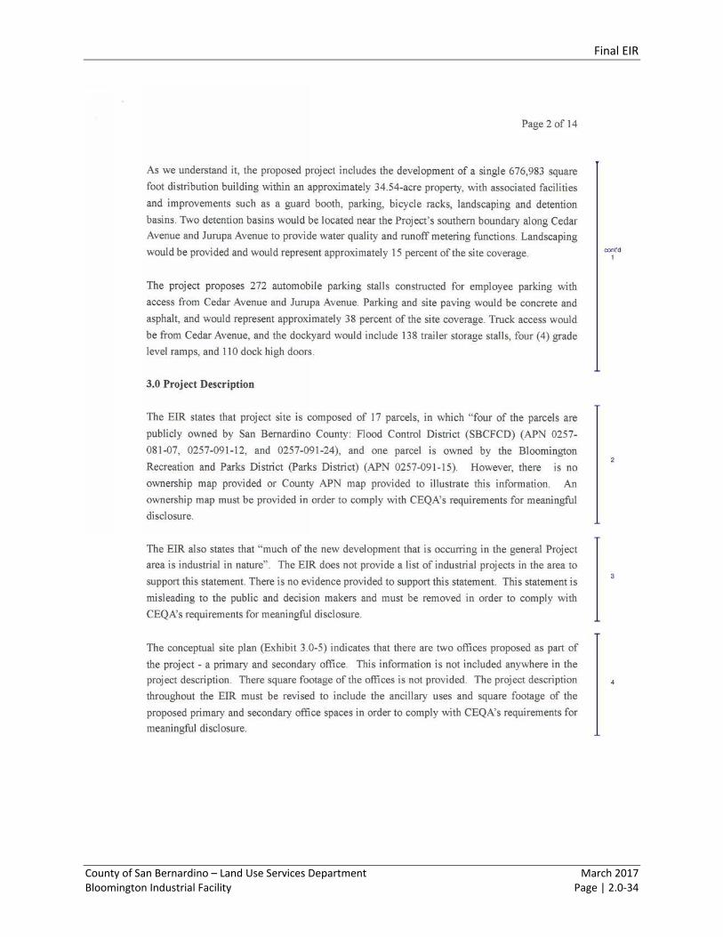
The comment indicates that an ownership map or County assessor parcel number (APN) map should be
provided in order to illustrate how the Project site is divided between the 17 existing parcels. The exiting
parcels are identified in Table 3.0-1 on page 3.0-9 of the Draft EIR, and an aerial view of the project site is
provided on Exhibit 3.0-03 Project Footprint, of the preceding page. In addition, new Exhibit 3.0-7 Existing
Parcels, in Section 3.0 Errata to the Draft EIR 3.0, for the existing parcel layout is provided for your
information. The new parcel layout exhibit merely clarifies the existing information, the map is not
required for disclosure purposes, and does not constitute significant new information under CEQA or
require recirculation under CEQA Guidelines Section 15088.5 (see Section 1.4 herein for additional
discussion).
Among CEQA’s purpose is to disclose to the public the significant environmental effects of a proposed
discretionary project, through the preparation of an appropriate CEQA documents. In this case an
environmental impact report has been prepared, including a project description, and existing conditions
information that provides sufficient context for the meaningful analysis of the Project’s potentially
significant impacts, consistent with CEQA requirements. All of the specific content requirements for an
EIR have been met, and the lack of a particular item from the Draft EIR does not constitute a deficiency
under CEQA.
Response to Comment JUSTICE ALLIANCE 3.
The comment states that the Draft EIR is misleading in that it states that “much of the new development
occurring in the general Project area is industrial in nature”, and the Draft EIR does not provide a list of
industrial Projects in the area to substantiate this.
The Draft EIR acknowledges that, in general, much of the new development occurring in the Project
vicinity is industrial in nature. This sentiment is based on review of aerial photography, recent projects
known to be developed, and recent applications for development. As provided in Section 4.7, a full list of
cumulative impacts in the Project vicinity provides some context as to the type of projects being built in
Final EIR
County of San Bernardino – Land Use Services Department March 2017 Bloomington Industrial Facility Page | 2.0-48
the general area, a list that is dominated by industrial projects. Additionally, the list of projects is provided
as a way of complying with CEQA’s requirements for meaningful disclosure.
Response to Comment JUSTICE ALLIANCE 4.
The commenter notes that the conceptual site plan (Exhibit 3.0-5) indicates that there are two offices
proposed as part of the Project, but these are not mentioned in the Project description. The Project
description in the Draft EIR will be revised to further clarify this issue, as described below. The office
square footage is part of the total building square footage, and accounted for in the environmental
analysis of the Project.
Draft EIR page 3.0-13, under Project Description
The Project involves the development of a single 676,983 ft2 distribution building within an
approximately 34.54-acre property, with associated facilities and improvements such as offices, a
guard booth, parking, bicycle racks, landscaping and detention basins. See Exhibit 3.0-5,
Conceptual Site Plan and Exhibit 3.0-6, Conceptual Elevations.
Approximately 18,000 square feet of the total building area would include primary and secondary
offices fronting Cedar Avenue.
The additional content merely clarifies the existing information provided, is not required for disclosure
purposes, and does not constitute significant new information under CEQA or require recirculation under
CEQA Guidelines Section 15088.5 (see Section 1.4 herein for additional discussion). Also see Response to
Comment JUSTICE ALLIANCE 2.
Response to Comment JUSTICE ALLIANCE 5.
As the commenter stated, the Project site will have passenger vehicle and truck access via both Cedar
Avenue and Jurupa Avenue. This is well illustrated in Exhibit 4.7-2 and 4.7-3. Accordingly, it is unclear why
the commenter believes that access will only be permitted from Cedar Avenue. Passenger vehicle access
points will be 30 feet wide and truck/passenger car access points will be 40 feet wide. This is demonstrated
in the Bloomington Industrial Facility Traffic Impact Analysis (Draft EIR, Appendix F). In addition, minor
text changes will be made in the EIR to clarify that truck access would be via both Cedar Avenue and
Jurupa Avenue; see Section 3.0 Errata to the Draft EIR for changes. Lastly, the impact analysis considers
the use of both Cedar Avenue and Jurupa Avenue for truck access. These changes merely clarifies the
existing information provided, and does not constitute significant new information under CEQA or require
recirculation under CEQA Guidelines Section 15088.5 (see Section 1.4 herein for additional discussion).
Also see Response to Comment JUSTICE ALLIANCE 2.
Final EIR
County of San Bernardino – Land Use Services Department March 2017 Bloomington Industrial Facility Page | 2.0-49
Response to Comment JUSTICE ALLIANCE 6.
The comment states that although Draft EIR states that approval of Tentative Parcel Map (TPM) 19635 is
necessary before the Project is approved, TPM 19635 was not made available in the Draft EIR for the
public to review. The Tentative Parcel Map is available at the County Planning Department for review.
For convenience, new Exhibit 3.0-8, Tentative Parcel Map is added to the Draft EIR; see Section 3.0 Errata
to the Draft EIR. As indicated in the Draft EIR (se p. 3.0-21), approval of Tentative Parcel Map 19635 would
combine the existing parcels into one lot. Also see, Exhibit 3.0-5 which better illustrates the distribution
of features on the proposed parcel, and at an EIR scale.
The additional content merely clarifies the existing information provided, is not required for disclosure
purposes, and does not constitute significant new information under CEQA or require recirculation under
CEQA Guidelines Section 15088.5 (see Section 1.4 herein for additional discussion). Also see Response to
Comment JUSTICE ALLIANCE 2.
Response to Comment JUSTICE ALLIANCE 7.
The comment states that abandoning the existing SBCFCD easement, and dedicating a new easement
would also require to approval from SBCFCD. Additionally, the comment states that a map disclosing the
location of the existing and proposed easements must be included.
The County notes that although SBCFCD is a separate legal entity, it is closely associated with the County,
and shares the same governing board, the County Board of Supervisors. In addition, the EIR has been
updated to include new Exhibit 3.0-7, Existing Parcels, which illustrates the location of the existing north-
south SBCFCD easement; see Section 3.0 Errata to the Draft EIR. The description of the existing and
proposed easement is generally described in the Draft EIR (p. 2.0-2) as follows:
The existing San Bernardino County Flood Control District (SBCFCD) parcels are linear parcels that
bifurcate the middle of the Project site. These parcels are intended to support future flood control
improvements associated with a railroad drainage master plan, to accept/convey drainage from
the rail use to the north. This alignment would be abandoned in favor of one which would direct
future flows east along the northern Project boundary and south along Cedar Avenue. The Project
would dedicate the easement to SBCFCD to facilitate future drainage improvements.
The precise location would be determined in conjunction with SBCFCD.
Response to Comment JUSTICE ALLIANCE 8.
CEQA requires the discussion of cumulative impacts to reflect the severity of the impacts and their
likelihood of occurrence, but the discussion need not provide as great detail as is provided for the project-
specific impacts. Rather, the discussion should be guided by the standards of practicality and
reasonableness, and should focus on the cumulative impact to which the identified other projects
contribute rather than the attributes of other projects which do not contribute to the cumulative. (CEQA
Guidelines Section 15130 (a).
Final EIR
County of San Bernardino – Land Use Services Department March 2017 Bloomington Industrial Facility Page | 2.0-50
The Bloomington Industrial Facility Traffic Impact Analysis (Draft EIR, Appendix F) follows all traffic
engineering practices, and is also consistent with the premise for evaluation of cumulative projects
presented above. The projects suggested by the commenter, are either too far from the Project to
warrant consideration in the traffic impact analysis, or are not likely to contribute measurable traffic to
any of the study area intersections. The Project study area is determined by the trip generation and trip
distribution, and the Traffic Impact Analysis is not required to analyze intersections the project does not
contribute traffic to. Similarly, the Traffic Impact Analysis does not consider other projects that would not
contribute traffic to Project study intersections. For example, for the Ontario Colony Commerce Center,
the closest impacted intersections to the Project is over 10 miles away, so there would not be any basis
to consider such a project in the Traffic Impact Analysis.
At the time of preparation of the traffic impact analysis, cumulative projects and project study area were
selected, in consultation with the County, based on the County guidelines, and the California Department
of Transportation guidelines. Based on this guidance, analysis should be considered where a project is
projected to contribute 50 or more vehicle trips to an arterial to arterial intersection (see page 3 of the
County of San Bernardino Traffic Impact Study Guideline 2014), or where the project is projected to
contribute 100 or more vehicle trips to a State Highway Facility intersection (see page 5 of the California
Department of Transportation Guide for the Preparation of Traffic Impact Studies 2002). This approach,
and facilities to be evaluated, has been verified based on discussions with the County Engineering
Department. The amount of vehicle trips generated by the Project do not require any further analysis
than what is provided in the Bloomington Industrial Facility Traffic Impact Analysis (Draft EIR, Appendix
F). Therefore, the cumulative impacts analysis is appropriate and sufficient under CEQA.
Response to Comment JUSTICE ALLIANCE 9.
From a traffic engineering point of view, the relevant information for these other developments is
provided in Table 4 (other development County identification number, land use, land use quantity, vehicle
type, and trip generation), Figure 19 (other development location map), Figures 20 to 25 (other
development trip distribution by zone) of the Bloomington Industrial Facility Traffic Impact Analysis (Draft
EIR, Appendix F). Although, the other development information provided by jurisdictions often lacks
details, the information obtained is sufficient for analysis purposes. Typically the closest cross streets,
land use, and land use quantities are given. For additional information, each project may be looked up
individually at the County Planning Department. All of the Project’s technical studies are public
information and a copy may be requested at the County Planning Department.
Response to Comment JUSTICE ALLIANCE 10.
The Project site is located in an area characterized by large-lot single family homes. As presented in Table
3.0-2 of Section 3.0, Project Description, in the Draft EIR, the Project site is surrounded on three sides by
development on lands designated Bloomington/Single Residential-1 Acre Minimum-Additional
Agriculture (BL/RS-1-AA). For the purposes of the Draft EIR, a residential land use developed on the
minimum of 1 acre is considered a large-lot. Additionally, the comment is incorrect that such a
characterization of the Project vicinity is intended to mislead readers concerning the amount of sensitive
Final EIR
County of San Bernardino – Land Use Services Department March 2017 Bloomington Industrial Facility Page | 2.0-51
receptors. As a point in clarification, potential air quality-related impacts to sensitive receptors were
analyzed in the Draft EIR in accordance with the SCAQMD’s AB 2588 and Rule 1402 Supplemental
Guidelines (2016). According to the SCAQMD, in order “to identify the maximum impacted receptors (i.e.,
peak cancer risk and peak hazard indices) a grid spacing of 100 meters or less must be used” (see page
19). The evaluation of potential air quality-related impacts to sensitive receptors was prepared consistent
with this SCAQMD recommendation. Therefore, all sensitive receptors potentially impacted by the
Project were appropriately considered.
Response to Comment JUSTICE ALLIANCE 11.
The distances identified between the source of diesel particulate matter emissions and the nearest
sensitive receptors in Table 1 of Section 4.1, Air Quality, Appendix B, Health Risk Assessment, of the Draft
EIR are correct. Nonetheless, the air dispersion modeling for the Health Risk Assessment was performed
using the U.S. EPA AERMOD dispersion model. AERMOD is a steady‐state, multiple‐source, Gaussian
dispersion model designed for use with emission sources situated in terrain where ground elevations can
exceed the stack heights of the emission sources (not a factor in this case). AERMOD requires hourly
meteorological data consisting of wind vector, wind speed, temperature, stability class, and mixing height.
In the case of the Project Health Risk Assessment, AERMOD interfaces with base maps obtained from
Google Earth, which provides the actual distances used to compute potential health risk impacts. See
Appendix B supplement herein for a map of the 24-hour diesel particulate matter concentration5. As
previously stated, the SCAQMD states that in order “to identify the maximum impacted receptors (i.e.,
peak cancer risk and peak hazard indices) a grid spacing of 100 meters or less must be used.” The
dispersion modeling conducted for the Project Health Risk Assessment considered 447 receptors spanning
approximately 100 square meters each. Pollutant concentrations were modeled for the sensitive
receptors located between 10th Street south of the Project site, to West Valley Boulevard north of
Interstate 10; and between Locust Avenue west of the Project site and Spruce Avenue east of the Project
site. The modeling distances used to identify potential health risks at each of the two vicinity elementary
schools is measured at the respective school property line, and impacts related to cancer risk from heavy
trucks would be less than significant at each of the project vicinity school sites.
Response to Comment JUSTICE ALLIANCE 12.
Due to the nature of its use, a church is not considered a sensitive receptor in terms of air quality-related
impacts. Land uses considered sensitive receptors include residences, schools, playgrounds, childcare
centers, long-term health care facilities, rehabilitation centers, convalescent centers, and retirement
homes. While the Upland Indonesian Seventh Day Adventist Church, located approximately 10 feet to
the north, may offer a vacation Bible school program in the summer season, this duration of programming
is not robust enough to result in a potential health risk impact. As stated on page 17 of Appendix B, Health
Risk Assessment, of Section 4.1 of the Draft EIR, current models and methodologies for conducting health
risk assessments are associated with longer-term exposure periods of 9, 40, and 70 years, which do not
correlate well with the temporary and highly variable nature of religious-oriented summer camps. Since
5 See Appendix B herein for the Plot File of 1st High 24—hr. Values for Source Group: All.
Final EIR
County of San Bernardino – Land Use Services Department March 2017 Bloomington Industrial Facility Page | 2.0-52
camp sessions are typically short-term (lasting a few days to a few weeks), the children will not be exposed
over longer-term exposure periods of 9, 40, and 70 years, which is the consideration for a health risk
assessment.
Response to Comment JUSTICE ALLIANCE 13.
As stated on page 4.1-29 of Section 4.1 of the Draft EIR, the SCAQMD states that land uses associated with
odor complaints typically include agricultural uses, wastewater treatment plants, food processing plants,
chemical plants, composting, refineries, landfills, dairies, and fiberglass molding. The SCAQMD does not
identify construction activities as an action that instigates odor complaints. As stated on page 4.1-30,
Construction-related odors would be short-term in nature (anticipated to last 10 months) and cease upon
Project completion.
Response to Comment JUSTICE ALLIANCE 14.
The comment is incorrect that the air quality analysis assumes a maximum of 8 hours daily for
construction. As a point in clarification, Table 4.1-8 of Section 4.1 of the Draft EIR is used to determine
the maximum daily disturbed acreage during Project construction based on the amount of hours each
piece of mobile construction equipment is projected to operate (i.e., emit pollutants) in a single day. For
instance, Table 4.1-8 identifies 4 tractors and 3 dozers as operating for 8 complete hours during the site
preparation phase of construction. This is a conservative assumption since typical operating cycles for
these types of construction equipment may involve 1 or 2 minutes of full power operation, followed by 3
to 4 minutes at lower power settings, and punctuated by consistent intervals of no operation.
Response to Comment JUSTICE ALLIANCE 15.
The Draft EIR acknowledges that, in general, much of the new developments occurring in the Project
vicinity are industrial in nature (Draft EIR, p. 4.5-8). The Draft EIR goes on to characterize the nature of
industrial development near the Project site, as smaller operations comprised of 1 to 5 acres, and
recognizes developments of similar size to the proposed Project more as being located along the I-10 and
Slover corridor to the north and the Riverside Avenue corridor to the east. This trend is based on review
of current and historic aerial photography, recent projects known to be developed, and recent
applications for development. As provided in Section 4.7, a full list of cumulative impacts in the Project
vicinity provide context as to the type of projects being built in the general area, a list that is dominated
by industrial applications. Therefore, the content provided in the Draft EIR is accurate and appropriate.
The Draft EIR also recognizes the residential land uses surrounding the Project site, and the potential
inconsistencies between these uses and the proposed use. It is for that reason that the Project includes a
proposed General Plan Amendment to change the land use designation to Bloomington/Industrial (BL/IC).
The Draft EIR refers to that proposed General Plan Amendment repeatedly throughout the EIR and
analyzes the potential impacts associated with that change. (E.g., Draft EIR pp. 1.0-2, 2.0-1, 3.1-21, 4.5-8
through 4.5-10.) Ultimately, the Draft EIR concludes that there is a significant and unavoidable impact to
land use insofar as “the proposed Project would not be consistent with the surrounding land uses.” (Draft
Final EIR
County of San Bernardino – Land Use Services Department March 2017 Bloomington Industrial Facility Page | 2.0-53
EIR p. 4.5-10.) Thus, contrary to the commenter’s statement, the Draft EIR fully discloses all potential
impacts associated with the Project.
The County notes that the statements indicating both a trend towards industrial and an existing
predominantly residential area reflect that varied mix of land uses in the area characteristic of the
Bloomington area. For instance, the Project site itself is a mixture of residential, agriculture and industrial
uses in close proximity to each other, with multiple uses being characteristic on a single parcel.
Response to Comment JUSTICE ALLIANCE 16.
Setbacks are a common land use or zoning control to create distance between features, or land uses.
Thus, the use of a setback is common and appropriate to provide buffers between uses. Both noise
volumes and emission concentration diminish with distance from the source. The setback from Cedar
Avenue is approximately 90 feet (measured from the property line to the building). In this case, the
combined use of setbacks, fencing, and landscaping would promote some degree of buffer between uses.
The County notes that Cedar Avenue is an arterial road with an existing traffic load. The Project would
appropriately make use of this existing arterial road for Project access.
Response to Comment JUSTICE ALLIANCE 17.
As suggested by the commenter, buffers to the south and west of the Project would be beneficial, and the
Project already provides those buffers. Specifically, the setback to the west is approximately 80 feet, while
the setback to the south is 380 feet from the property line at Jurupa Avenue (measured from the property
line to the building). An 8’ foot tall wall would be installed along the northern boundary of the Project
site, and a portion of the western boundary of the Project site. Most of the property would feature
landscaping around the Project perimeter.
There are approximately 55 loading docks on the north side of the building, and 55 loading docks on the
south side of the building. The setback to the north is approximately 200 feet (measured from the property
line to the building), and no homes would be oriented towards the north side of the building. The south
side of the property has the greatest amount of setback totaling 380 feet, and featuring landscaping,
detention basins, parking and drive aisles.
Response to Comment JUSTICE ALLIANCE 18.
The comment indicates there is a discrepancy on Table 4.5-2 in that both the County General Plan and the
Bloomington Community Plan 2007 are cited as one source for the goals and policies outlined; however,
they are two different documents. While these documents are distinct, the County also acknowledges
that the Bloomington Community Plan is considered and treated by the County as part of the County’s
General Plan. Nonetheless, the EIR will be edited to include this clarification. The goals and policies
included in Table 4.5-2 are from the Bloomington Community Plan 2007. The County General Plan has
been removed from this specific table; see Section 3.0 Errata to the Draft EIR.
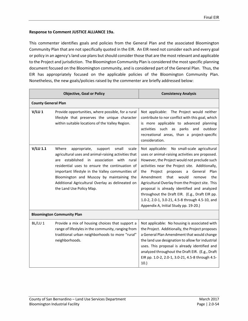
Final EIR
County of San Bernardino – Land Use Services Department March 2017 Bloomington Industrial Facility Page | 2.0-54
Response to Comment JUSTICE ALLIANCE 19a.
This commenter identifies goals and policies from the General Plan and the associated Bloomington
Community Plan that are not specifically quoted in the EIR. An EIR need not consider each and every goal
or policy in an agency’s land use plans but should consider those that are the most relevant and applicable
to the Project and jurisdiction. The Bloomington Community Plan is considered the most specific planning
document focused on the Bloomington community, and is considered part of the General Plan. Thus, the
EIR has appropriately focused on the applicable policies of the Bloomington Community Plan.
Nonetheless, the new goals/policies raised by the commenter are briefly addressed below:
Objective, Goal or Policy Consistency Analysis
County General Plan
V/LU 1 Provide opportunities, where possible, for a rural
lifestyle that preserves the unique character
within suitable locations of the Valley Region.
Not applicable: The Project would neither
contribute to nor conflict with this goal, which
is more applicable to advanced planning
activities such as parks and outdoor
recreational areas, than a project-specific
consideration.
V/LU 1.1 Where appropriate, support small scale
agricultural uses and animal-raising activities that
are established in association with rural
residential uses to ensure the continuation of
important lifestyle in the Valley communities of
Bloomington and Muscoy by maintaining the
Additional Agricultural Overlay as delineated on
the Land Use Policy Map.
Not applicable: No small-scale agricultural
uses or animal-raising activities are proposed.
However, the Project would not preclude such
activities near the Project site. Additionally,
the Project proposes a General Plan
Amendment that would remove the
Agricultural Overlay from the Project site. This
proposal is already identified and analyzed
throughout the Draft EIR. (E.g., Draft EIR pp.
1.0-2, 2.0-1, 3.0-21, 4.5-8 through 4.5-10, and
Appendix A, Initial Study pp. 19-20.)
Bloomington Community Plan
BL/LU 1 Provide a mix of housing choices that support a
range of lifestyles in the community, ranging from
traditional urban neighborhoods to more “rural”
neighborhoods.
Not applicable: No housing is associated with
the Project. Additionally, the Project proposes
a General Plan Amendment that would change
the land use designation to allow for industrial
uses. This proposal is already identified and
analyzed throughout the Draft EIR. (E.g., Draft
EIR pp. 1.0-2, 2.0-1, 3.0-21, 4.5-8 through 4.5-
10.)
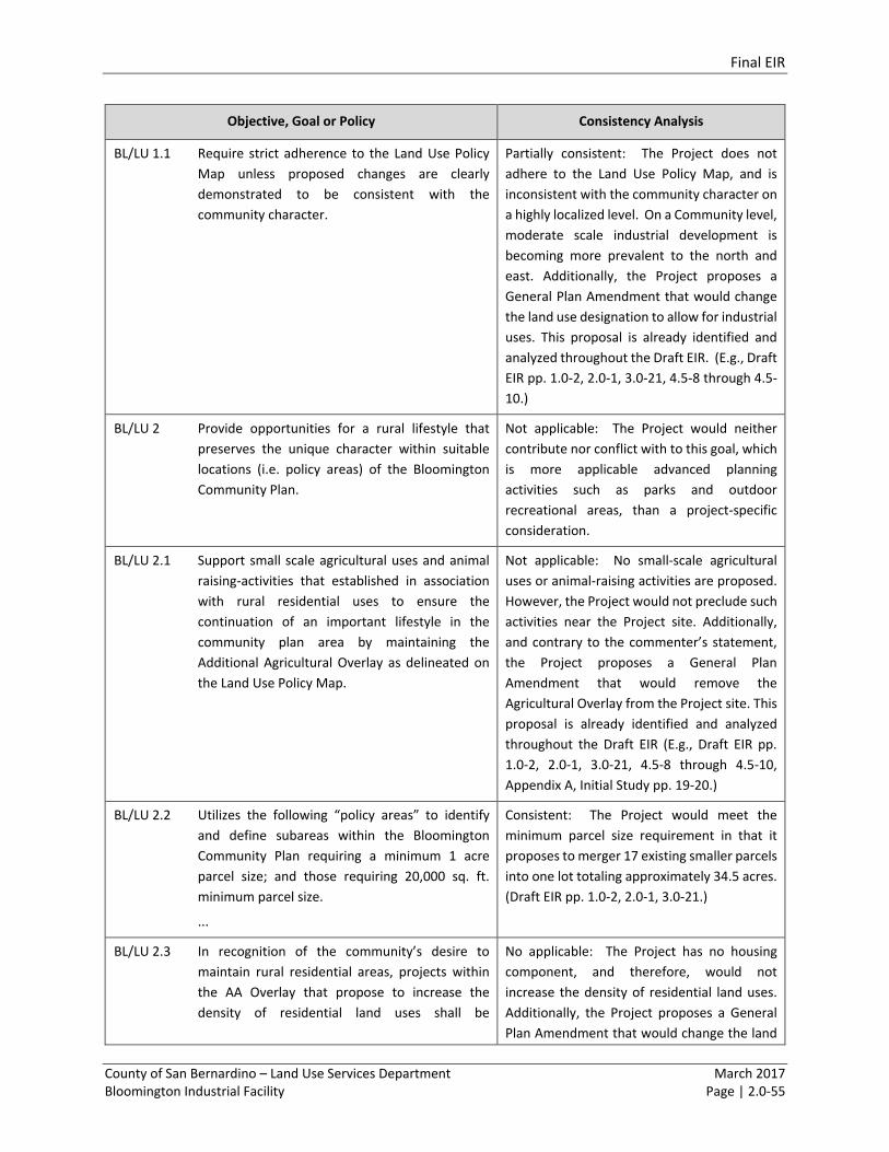
Final EIR
County of San Bernardino – Land Use Services Department March 2017 Bloomington Industrial Facility Page | 2.0-55
Objective, Goal or Policy Consistency Analysis
BL/LU 1.1 Require strict adherence to the Land Use Policy
Map unless proposed changes are clearly
demonstrated to be consistent with the
community character.
Partially consistent: The Project does not
adhere to the Land Use Policy Map, and is
inconsistent with the community character on
a highly localized level. On a Community level,
moderate scale industrial development is
becoming more prevalent to the north and
east. Additionally, the Project proposes a
General Plan Amendment that would change
the land use designation to allow for industrial
uses. This proposal is already identified and
analyzed throughout the Draft EIR. (E.g., Draft
EIR pp. 1.0-2, 2.0-1, 3.0-21, 4.5-8 through 4.5-
10.)
BL/LU 2 Provide opportunities for a rural lifestyle that
preserves the unique character within suitable
locations (i.e. policy areas) of the Bloomington
Community Plan.
Not applicable: The Project would neither
contribute nor conflict with to this goal, which
is more applicable advanced planning
activities such as parks and outdoor
recreational areas, than a project-specific
consideration.
BL/LU 2.1 Support small scale agricultural uses and animal
raising-activities that established in association
with rural residential uses to ensure the
continuation of an important lifestyle in the
community plan area by maintaining the
Additional Agricultural Overlay as delineated on
the Land Use Policy Map.
Not applicable: No small-scale agricultural
uses or animal-raising activities are proposed.
However, the Project would not preclude such
activities near the Project site. Additionally,
and contrary to the commenter’s statement,
the Project proposes a General Plan
Amendment that would remove the
Agricultural Overlay from the Project site. This
proposal is already identified and analyzed
throughout the Draft EIR (E.g., Draft EIR pp.
1.0-2, 2.0-1, 3.0-21, 4.5-8 through 4.5-10,
Appendix A, Initial Study pp. 19-20.)
BL/LU 2.2 Utilizes the following “policy areas” to identify
and define subareas within the Bloomington
Community Plan requiring a minimum 1 acre
parcel size; and those requiring 20,000 sq. ft.
minimum parcel size.
...
Consistent: The Project would meet the
minimum parcel size requirement in that it
proposes to merger 17 existing smaller parcels
into one lot totaling approximately 34.5 acres.
(Draft EIR pp. 1.0-2, 2.0-1, 3.0-21.)
BL/LU 2.3 In recognition of the community’s desire to
maintain rural residential areas, projects within
the AA Overlay that propose to increase the
density of residential land uses shall be
No applicable: The Project has no housing
component, and therefore, would not
increase the density of residential land uses.
Additionally, the Project proposes a General
Plan Amendment that would change the land
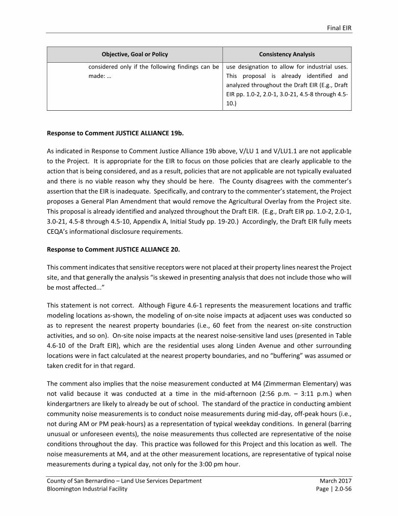
Final EIR
County of San Bernardino – Land Use Services Department March 2017 Bloomington Industrial Facility Page | 2.0-56
Objective, Goal or Policy Consistency Analysis
considered only if the following findings can be
made: …
use designation to allow for industrial uses.
This proposal is already identified and
analyzed throughout the Draft EIR (E.g., Draft
EIR pp. 1.0-2, 2.0-1, 3.0-21, 4.5-8 through 4.5-
10.)
Response to Comment JUSTICE ALLIANCE 19b.
As indicated in Response to Comment Justice Alliance 19b above, V/LU 1 and V/LU1.1 are not applicable
to the Project. It is appropriate for the EIR to focus on those policies that are clearly applicable to the
action that is being considered, and as a result, policies that are not applicable are not typically evaluated
and there is no viable reason why they should be here. The County disagrees with the commenter’s
assertion that the EIR is inadequate. Specifically, and contrary to the commenter’s statement, the Project
proposes a General Plan Amendment that would remove the Agricultural Overlay from the Project site.
This proposal is already identified and analyzed throughout the Draft EIR. (E.g., Draft EIR pp. 1.0-2, 2.0-1,
3.0-21, 4.5-8 through 4.5-10, Appendix A, Initial Study pp. 19-20.) Accordingly, the Draft EIR fully meets
CEQA’s informational disclosure requirements.
Response to Comment JUSTICE ALLIANCE 20.
This comment indicates that sensitive receptors were not placed at their property lines nearest the Project
site, and that generally the analysis “is skewed in presenting analysis that does not include those who will
be most affected...”
This statement is not correct. Although Figure 4.6-1 represents the measurement locations and traffic
modeling locations as-shown, the modeling of on-site noise impacts at adjacent uses was conducted so
as to represent the nearest property boundaries (i.e., 60 feet from the nearest on-site construction
activities, and so on). On-site noise impacts at the nearest noise-sensitive land uses (presented in Table
4.6-10 of the Draft EIR), which are the residential uses along Linden Avenue and other surrounding
locations were in fact calculated at the nearest property boundaries, and no “buffering” was assumed or
taken credit for in that regard.
The comment also implies that the noise measurement conducted at M4 (Zimmerman Elementary) was
not valid because it was conducted at a time in the mid-afternoon (2:56 p.m. – 3:11 p.m.) when
kindergartners are likely to already be out of school. The standard of the practice in conducting ambient
community noise measurements is to conduct noise measurements during mid-day, off-peak hours (i.e.,
not during AM or PM peak-hours) as a representation of typical weekday conditions. In general (barring
unusual or unforeseen events), the noise measurements thus collected are representative of the noise
conditions throughout the day. This practice was followed for this Project and this location as well. The
noise measurements at M4, and at the other measurement locations, are representative of typical noise
measurements during a typical day, not only for the 3:00 pm hour.
Final EIR
County of San Bernardino – Land Use Services Department March 2017 Bloomington Industrial Facility Page | 2.0-57
In addition, the comment points out that no noise measurements or modeling was conducted for
Crestmore Elementary. This statement is correct, but this is because Crestmore Elementary is located
more than 700 feet away from the nearest side of the Project site, and any potential noise effects from
Project-related traffic would be accounted for by the noise measurement and modeling receiver R4,
located immediately to the south of the school, on the south side of Jurupa Avenue. Similarly, noise
measurements or modeling was not specifically conducted at Kessler Park, located to the southwest of
the Project site. However, just as with Crestmore Elementary, any potential effects would have been
accounted for by adjacent receivers (in this case, receivers R1 or R3). Thus, because all noise impacts at
the nearest sensitive receptors (R1, R3, and R4) are already less then significant for both construction and
operation, noise levels at more distant sensitive receptors (including Crestmore Elementary and Kessler
Park) would also be less than significant.
Response to Comment JUSTICE ALLIANCE 21.
The comment states that the noise impact study’s estimated distance from the nearest residences to the
center of the site (approximately 700 feet) and to the nearest side of the proposed structure
(approximately 150 feet) is contradicted throughout the EIR. The comment then states that residents
would be affected 24 hours per day and the analysis should be conservative and conducted at the
residents’ property lines.
Examination of the proposed site plan shows that these distances are accurate. The on-site operational
noise analysis was conducted on a worst-case assumption based upon scaled distances from residential
property lines, and the 24-hour operation of the facility was analyzed using the applicable noise standards.
The noise analysis represents a conservative assessment of potential noise impacts. See also Response to
Comment JUSTICE ALLIANCE 20, above.
Response to Comment JUSTICE ALLIANCE 22a.
The Bloomington Industrial Facility Traffic Impact Analysis (Draft EIR, Appendix F), shows that the Project
is not projected to significantly impact the study area. The Level of Service standards put in place by the
County are there to ensure that the transportation system remains safe and effective, ensuring adequate
traffic movement, while preserving the rural character of the community. Therefore, the Project is
consistent with Policy BL/C11.
Response to Comment JUSTICE ALLIANCE 22b.
The Bloomington Industrial Facility Traffic Impact Analysis (Draft EIR, Appendix F), shows that the study
area intersections are projected to operate within acceptable Levels of Service (Level of Service D or
better) in the future with the proposed Project. This is consistent with Policy BL/CI 1.1 because the Level
of Service during the peak hours does not degrade the Level of Service past Level of Service D.
Final EIR
County of San Bernardino – Land Use Services Department March 2017 Bloomington Industrial Facility Page | 2.0-58
Response to Comment JUSTICE ALLIANCE 22c.
The Bloomington Industrial Facility Traffic Impact Analysis (Draft EIR, Appendix F), shows that the Project
is not projected to significantly impact Slover Avenue or Valley Boulevard. Cedar Avenue (NS) at Slover
Avenue (EW) is projected to operate at an acceptable Level of Service, and Cedar Avenue (NS) at Valley
Boulevard (EW) is outside of the Project’s study area. This is consistent with Policy BL/CI 1.2 because the
project is not projected to significantly impact these intersections and the Level of Service is Level of
Service D or better.
Response to Comment JUSTICE ALLIANCE 22d.
The Project is proposed to fully develop the west side of Cedar Avenue adjacent to the Project and the
north side of Jurupa Avenue adjacent to the Project. Developing the roadways half-section immediately
adjacent to the Project is typically required for new development; this includes the widening of the
roadway and the addition of sidewalk, curb, and gutter. A development is not required to develop the
opposite side of the roadway because that property is not generally a part of the Project site. Under CEQA
a project is required to provide only feasible mitigation that has a nexus to a Project’s potentially
significant impacts and is roughly proportional to the size of the Project’s impacts. (State CEQA Guidelines
§ 15126.4(a)(4).) It is considered unreasonable under CEQA to burden a development with acquiring land
on the County’s behalf and then to improve the opposing side of the street.
Response to Comment JUSTICE ALLIANCE 22e.
The Bloomington Industrial Facility Traffic Impact Analysis (Draft EIR, Appendix F), shows that the study
area intersections are projected to operate within acceptable Levels of Service in the future with the
proposed Project. The only potentially impacted intersections within this list is the Cedar Avenue/I-10
Freeway interchange. The traffic impact analysis specifically provides recommended improvements at
the intersection of Cedar Avenue (NS) at the I-10 Freeway WB Ramps (EW). This improvements are
needed with or without the proposed Bloomington Industrial Project, and are currently contained in the
NEXUS fee program. The proposed Project is contributing to the NEXUS fee program. This is consistent
with Policy BL/CI 1.5 because the Leve of Service, with improvements, at the Cedar Avenue and I-10
Freeway interchange during the peak hours does not degrade the Level of Service past Level of Service D.
Response to Comment JUSTICE ALLIANCE 22f.
The planned Project is not proposing to modify the County Truck Routes. Based on the Bloomington
Industrial Facility Truck Circulation Analysis (Draft EIR, Appendix F), there are no projected truck
circulation issues. Also see Response to Comment JUSTICE ALLIANCE 8. The number of vehicle trips
generated by the Project does not require any further analysis than what is provided in the Traffic Impact
Analysis. This is consistent with Policy BL/CI 1.6 because the project is proposing to use the currently
adopted truck route plan that is currently being enforced.
Final EIR
County of San Bernardino – Land Use Services Department March 2017 Bloomington Industrial Facility Page | 2.0-59
Response to Comment JUSTICE ALLIANCE 23.
The Project study area was selected, in consultation with the County, based on County guidelines and
California Department of Transportation guidelines. Based on this guidance, analysis should be
considered where a project is projected to contribute 50 or more vehicle trips to an arterial-to-arterial
intersection, (see page 3 of the County of San Bernardino Traffic Impact Study Guidelines) or the project
is projected to contribute 100 or more vehicle trips to a State Highway Facility (see page 5 of the California
Department of Transportation Guide for the Preparation of Traffic Impact Studies). This approach and the
facilities to be evaluated have been verified based on discussions with the County Engineering
Department. The number of vehicle trips generated by the Project does not require any further analysis
than what is provided in the Bloomington Industrial Facility Traffic Impact Analysis, and as a result, no
evaluation of CA 60/Rubidoux Boulevard was required (Draft EIR, Appendix F). The project is projected to
contribute approximately 28 vehicles to any one link of the SR 60 Freeway, and therefore, does not
contribute sufficient trips to warrant evaluation of impacts to SR 60. In addition, the Draft EIR was
provided to Caltrans, and Caltrans did not comment on the EIR.
Response to Comment JUSTICE ALLIANCE 24.
The County agrees that CEQA requires the evaluation of a reasonable range of potentially feasible
alternatives that would avoid or reduce significant impact associated with the Project. (State CEQA
Guidelines § 15126.6.) The Draft EIR (see Section 8.0) evaluated an alternative similar to the proposed
Project, but at a reduced intensity of development, and therefore, with less Project-related traffic, air
emissions, and noise. In addition, the Draft EIR evaluated a use that would remain commercial in nature
(similar to the proposed Project), but would be more compatible with the existing residential uses. In
addition, the Draft EIR evaluated the No Project Alternative, in the form of development consistent with
the existing land use designation. Thus, the Draft EIR evaluates residential use consistent with the General
Plan, industrial use at a reduced intensity compared to the Project, and a commercial use project,
demonstrating a good faith effort in the evaluation of a reasonable range of alternatives.
Response to Comment JUSTICE ALLIANCE 25.
The comment asserts that Project objective 2 is unverifiable by the public or decision-makers, indicating
that the new General Plan is not in effect, and the site-specific future designation is unknown.
Objective 2 states: Provide a new land use that is in support of the County’s upcoming General Plan review
to promote the Bloomington area.
The emphasis in this objective is a land use that would promote the Bloomington area and support the
County’s review of its General Plan, not the actual adoption of a General Plan that approves a specific
designation. Accordingly, and contrary to the commenter’s statement, this objective is not premised on
any specific changes that the County may (or may not) make to its Genera Plan as part of a future update.
Final EIR
County of San Bernardino – Land Use Services Department March 2017 Bloomington Industrial Facility Page | 2.0-60
Response to Comment JUSTICE ALLIANCE 26.
Objective 5 states: Reduce existing blight and the opportunity for criminal activity and provide for a range
of potential light industrial, manufacturing, and warehouse uses.
The comment asserts a lack of discussion regarding the elements of existing blight, opportunity for crime,
and a range of potential light industrial, manufacturing, and warehouse uses. Evidence of blight is evident
on a large majority of on-site structures due to aging, and neglect, and is best illustrated in the Cultural
Resources Evaluation (BCR 2016; Draft EIR Appendix C). Large residential or mixed use lots in southern
Bloomington, including properties on the project site, have been associated with illegal storage and
unpermitted trucking activities, and generally considered a source of blight. The opportunity for crime
relates to the easy, and unsecured parcel access that might be facilitated via the existing, graded flood
control easement which bifurcates the Project site. Regarding the last element, the Project would
potentially contribute to light industrial, manufacturing or warehouse uses, depending on the specific
future tenant of the facility. Finally, it should be noted that numerous member of the local community
agree that the Project will assist with the abatement of blight and crime issues. Please see Response to
Comment Letter: Various (Form), below. In contrast, the proposed Project would provide a single cohesive
land use with planned/permitted structures and activities, security fencing and landscaping. As a result,
the project would provide a well-organized development, reduce blight, and also be expected to reduce
potential for on-site criminal activity.
Response to Comment JUSTICE ALLIANCE 27.
Alternative 3 Commercial Use Alternative, if appropriately designed, has the potential to reduce blight,
and the opportunity for criminal activity. It would not contribute to light industrial, manufacturing or
warehouse uses. Thus, as acknowledged by the commenter, Alternative 3 – at best- would only partially
meet this objective.
Response to Comment JUSTICE ALLIANCE 28.
As suggested, the Project includes a No Project Build Alternative that would develop the Project site
consistent with the General Plan. Although, the No Project Alternative is always required under CEQA, in
this instance it is a particularly meaningful alternative that meets a number of the commenters’
suggestions.
As previously discussed, CEQA requires the evaluation of a reasonable range of alternatives; see Response
to Comment JUSTICE ALLIANCE 24. Evaluation of every suggested alternative is not required. Each of the
suggested alternatives offered by the commenter is briefly discussed below:
1. A project that does not require a GPA. This condition is represented in the No Project Alternative.
2. A reduced intensity alternative that reduced the scope of the project enough to avoid significant
impacts to air quality. Any use that is inconsistent with General Plan Land use would by extension
Final EIR
County of San Bernardino – Land Use Services Department March 2017 Bloomington Industrial Facility Page | 2.0-61
be in conflict with the applicable air quality plan, and result in a significant impact to air quality
under CEQA. Thus, only the No Project Alternative would represent this condition.
3. A project that complies with the existing General Plan Land Use designation. This condition is
represented in the No Project Alternative.
4. A project design that eliminates the 40” driveway adjacent to Linden Avenue in order to further
mitigate impacts to sensitive receptors along Linden Avenue. This is not a true project alternative,
but a minor revision to the current project’s internal circulation. We note that there is no site
access via Linden Avenue, and this revision would not eliminate significant impacts associated
with the proposed project. However, it may provide some benefit and reduce land use impacts.
This condition is likely met by Alternative the Reduced Intensity Alternative, which would develop
a smaller building so that alternative on-site circulation scenarios are probably feasible.
5. A project design with 100 foot-wide landscaped buffers along all sides of the building in order to
mitigate urban blight, noise odors, and other impacts associated with the operation of a 24-hour
industrial use. This condition is likely met by Alternative the Reduced Intensity Alternative, which
would develop a smaller building and able to accommodate the suggested buffers.
6. A project that complies with the existing (-AA) additional agricultural overlay designation at the
project site. This condition is represented in the No Project Alternative.
In summary, the above scenarios are sufficiently addressed in the existing alternatives analysis within
Section 8.0 of the Draft EIR.
Response to Comment JUSTICE ALLIANCE 29.
The changes to the Draft EIR do not affect the overall conclusions of the environmental document, and
instead represent changes to the Draft EIR that provide clarification, amplification and/or insignificant
modifications, as needed as a result of public comments on the Draft EIR, or due to additional information
received during the public review period. These clarifications and corrections do not warrant Draft EIR
recirculation pursuant to CEQA Guidelines Section 15088.5. None of the changes or information provided
in the comments or responses reflects a new significant environmental impact, a substantial increase in
the severity of an environmental impact for which mitigation is not proposed, or a new feasible alternative
or mitigation measure that would clearly lessen significant environmental impacts but is not adopted. In
addition, the changes do not reflect a fundamentally flawed or conclusory Draft EIR.
Lastly, this comment serves as the conclusion to the letter and provides contact information. The County
appreciates and values these comments during the Draft EIR participation process, and will add the
commenter to the distribution list for future Project notices. Responses to specific comments are
provided above; no further response is required.
Final EIR
County of San Bernardino – Land Use Services Department March 2017 Bloomington Industrial Facility Page | 2.0-62
COMMENT LETTER: CRUZ BACA SEMBELLO (SEMBELLO)
Final EIR
County of San Bernardino – Land Use Services Department March 2017 Bloomington Industrial Facility Page | 2.0-63
RESPONSE TO COMMENT LETTER: CRUZ BACA SEMBELLO (SEMBELLO)
Response to Comment SEMBELLO 1.
The comment indicates that there was no follow-up to concerns/questions provided during a meeting last
year. Assuming that the commenter is referring to the CEQA scoping meeting, the purpose of the scoping
meeting is to solicit feedback from the public on issues that should be addressed in the Draft EIR. (State
CEQA Guidelines § 15083.) All comments received during the scoping meeting were summarized in the
Draft EIR (see Draft EIR Appendix A, Memo from Michael Baker International dated 4/8/16) and fully
considered and analyzed in the Draft EIR. The commenter indicates support of the Project if the concerns,
summarized below, are met. This comment is duly noted. This comment does not identify a specific
concern with the adequacy of the Draft EIR or raise an issue or comment specifically related to the Draft
EIR’s environmental analysis. Therefore, no further response is warranted. (State CEQA Guidelines
§15088(a) requires that a lead agency only evaluate and respond to comments raised on environmental
issues.) Responses to specific comments are provided below.
Response to Comment SEMBELLO 2.
The commenter indicates that he does not want truck ingress or egress to occur on Linden Street due to
the potential conflict with the adjacent school. The Draft EIR incorporates a discussion of the anticipated
points of access for the proposed Project; refer to Section 4.7, Impact 4.7-4. The proposed Project
originally had an access to Linden Street but based on discussions with the County Traffic Engineer, this
access was removed. The proposed Project is not proposing any vehicular access to Linden Street. Refer
to Exhibit 3.0-5, Conceptual Site Plan showing that ingress and egress points on Linden Avenue have been
eliminated.
Response to Comment SEMBELLO 3.
The comment indicates that building walls should be set back because walls close the street encourage
graffiti. An 8’ foot tall wall would be installed along the northern boundary of the Project site, and a
portion of the western boundary of the Project site. The balance of the site would not have walls. Most
of the property would feature landscaping around the Project perimeter. In addition, the building would
be generally set-back from between 80 to 115 feet from the property line. Therefore, the Project design
is consistent with the suggestion to set-back walls and discourage graffiti.
Response to Comment SEMBELLO 4.
The commenter indicates that he does not want Project-related lighting to be intrusive to residents. The
Draft EIR includes a discussion regarding lighting impacts and fully addresses this issue; see Draft EIR, page
6.0-3 for full discussion on lighting related impacts. As indicated in the Draft EIR, lighting throughout the
site would be implemented in accordance with County design standards. County Ordinance No. 3900
regulates glare, outdoor lighting, and night sky protection. The Ordinance provides that commercial or
industrial lighting shall be fully shielded in such a manner as to preclude light pollution or light trespass
on any of the following: an abutting residential land use district; a residential lot; or public right-of-way.
Final EIR
County of San Bernardino – Land Use Services Department March 2017 Bloomington Industrial Facility Page | 2.0-64
The Project would provide shielded lighting sufficient for security and safety, without nuisance to the
adjacent properties. Any lighting from the site would not interfere with on-coming traffic on adjacent
roadways such as Linden Ave, Cedar Ave, and Jurupa Ave. A professionally prepared outdoor lighting plan
has been submitted to, and is subject to the County’s approval to confirm compliance with County
standards (see Draft EIR Appendix J). Lighting direction and intensity would be developed to minimize
impacts to roadways, adjacent neighbors, and minimize light pollution.
Response to Comment SEMBELLO 5.
This comment serves as the conclusion to the letter. The County appreciates and values the comments
offered during the Draft EIR participation process. Additional meetings regarding the Project will be held
by the County when it considers the Final EIR and Project. Please refer to the County’s website from time
to time at http://cms.sbcounty.gov/lus/Planning/Environmental/Valley.aspx for public notices regarding
those meetings. Responses to specific comments are provided above; no further response is required.
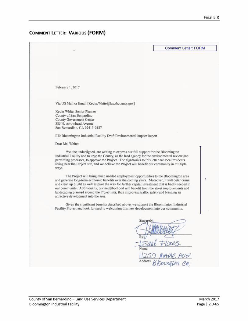
Final EIR
County of San Bernardino – Land Use Services Department March 2017 Bloomington Industrial Facility Page | 2.0-65
COMMENT LETTER: VARIOUS (FORM)
Final EIR
County of San Bernardino – Land Use Services Department March 2017 Bloomington Industrial Facility Page | 2.0-66
Final EIR
County of San Bernardino – Land Use Services Department March 2017 Bloomington Industrial Facility Page | 2.0-67
Final EIR
County of San Bernardino – Land Use Services Department March 2017 Bloomington Industrial Facility Page | 2.0-68
Final EIR
County of San Bernardino – Land Use Services Department March 2017 Bloomington Industrial Facility Page | 2.0-69
Final EIR
County of San Bernardino – Land Use Services Department March 2017 Bloomington Industrial Facility Page | 2.0-70

Final EIR
County of San Bernardino – Land Use Services Department March 2017 Bloomington Industrial Facility Page | 2.0-71
Final EIR
County of San Bernardino – Land Use Services Department March 2017 Bloomington Industrial Facility Page | 2.0-72
Final EIR
County of San Bernardino – Land Use Services Department March 2017 Bloomington Industrial Facility Page | 2.0-73
Final EIR
County of San Bernardino – Land Use Services Department March 2017 Bloomington Industrial Facility Page | 2.0-74
Final EIR
County of San Bernardino – Land Use Services Department March 2017 Bloomington Industrial Facility Page | 2.0-75
Final EIR
County of San Bernardino – Land Use Services Department March 2017 Bloomington Industrial Facility Page | 2.0-76
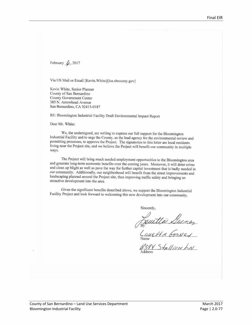
Final EIR
County of San Bernardino – Land Use Services Department March 2017 Bloomington Industrial Facility Page | 2.0-77
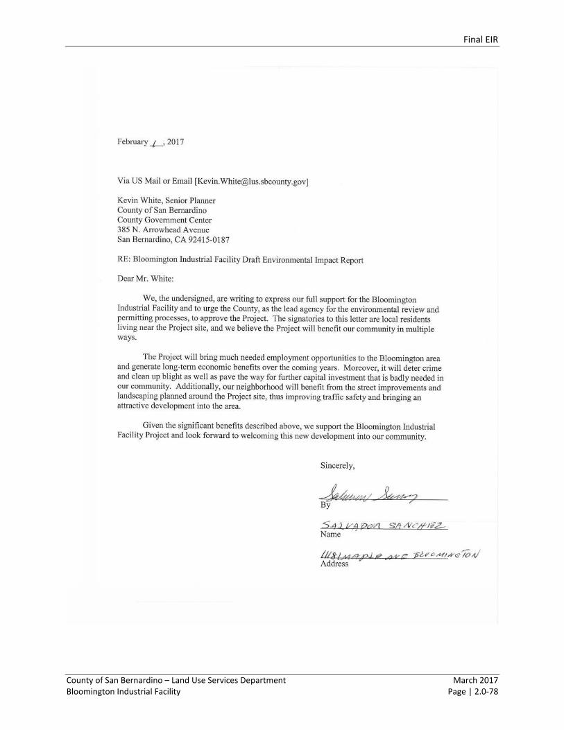
Final EIR
County of San Bernardino – Land Use Services Department March 2017 Bloomington Industrial Facility Page | 2.0-78
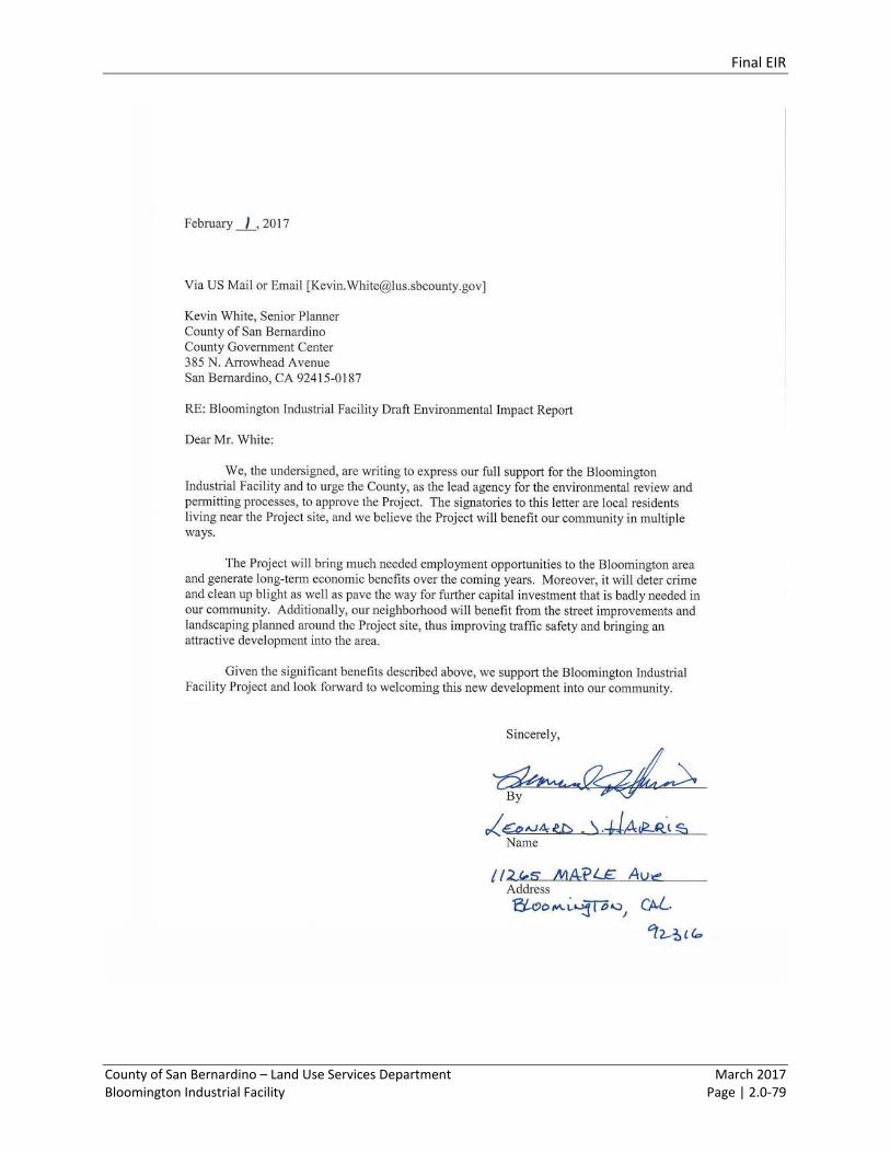
Final EIR
County of San Bernardino – Land Use Services Department March 2017 Bloomington Industrial Facility Page | 2.0-79

Final EIR
County of San Bernardino – Land Use Services Department March 2017 Bloomington Industrial Facility Page | 2.0-80
RESPONSE TO COMMENT LETTER: VARIOUS (FORM)
Preamble
The County received 15 form letter comments generated by community members using pre-written
comments, and adding their contact information. As a result, these comments are substantially similar in
content, and a single response has been provided below. See Table 2.0-1 for a list of commenters. .
All of the comments appear to be from local residents.
Response to Comment FORM 1.
This comment indicates support for the proposed Project. This comment does not identify a specific
concern with the adequacy of the Draft EIR or raise an issue or comment specifically related to the Draft
EIR’s environmental analysis. Responses to specific comments are provided below; no further response
is required. (State CEQA Guidelines §15088(a) requires that a lead agency only evaluate and respond to
comments raised on environmental issues.)

Section 3.0 Errata to the Draft EIR
County of San Bernardino – Land Use Services Department March 2017 Bloomington Industrial Facility Page | 3.0-1
3.1 INTRODUCTION TO THE ERRATA
The Draft EIR for the Project, is hereby incorporated by reference as part of the Final EIR. Changes to the
Draft EIR are further detailed below.
The changes to the Draft EIR do not affect the overall conclusions of the environmental document, and
instead represent changes to the Draft EIR that provide clarification, amplification and/or insignificant
modifications, as needed as a result of public comments on the Draft EIR, or due to additional information
received during the public review period. These clarifications and corrections do not warrant Draft EIR
recirculation pursuant to CEQA Guidelines Section 15088.5. None of the changes or information provided
in the comments reflect a new significant environmental impact, a substantial increase in the severity of
an environmental impact for which mitigation is not proposed, or a new feasible alternative or mitigation
measure that would clearly lessen significant environmental impacts but is not adopted. In addition, the
changes do not reflect a fundamentally flawed or conclusory Draft EIR.
Changes to the Draft EIR are listed by Section, page, paragraph, etc. to best guide the reader to the
revision. Changes are identified as follows:
Deletions are indicated by strikeout text
Additions are indicated by underline text
3.2 CHANGES TO THE DRAFT EIR
SECTION 1.0 EXECUTIVE SUMMARY
Page 1.0-3, first paragraph
Two detention basins would be located near the Project’s southern boundary along Cedar Avenue and
Jurupa Avenue. Landscaping would be provided and would represent approximately 15 percent of the site
coverage. There would be a total of 272 automobile parking stalls constructed for employee parking with
access from Cedar Avenue and Jurupa Avenue. All parking and site paving would be concrete and asphalt,
and would represent approximately 38 percent of the site coverage. Truck access would be from Cedar
Avenue and Jurupa Avenue, and the dockyard would include 138 trailer storage stalls, four (4) grade level
ramps, and 110 dock high doors.
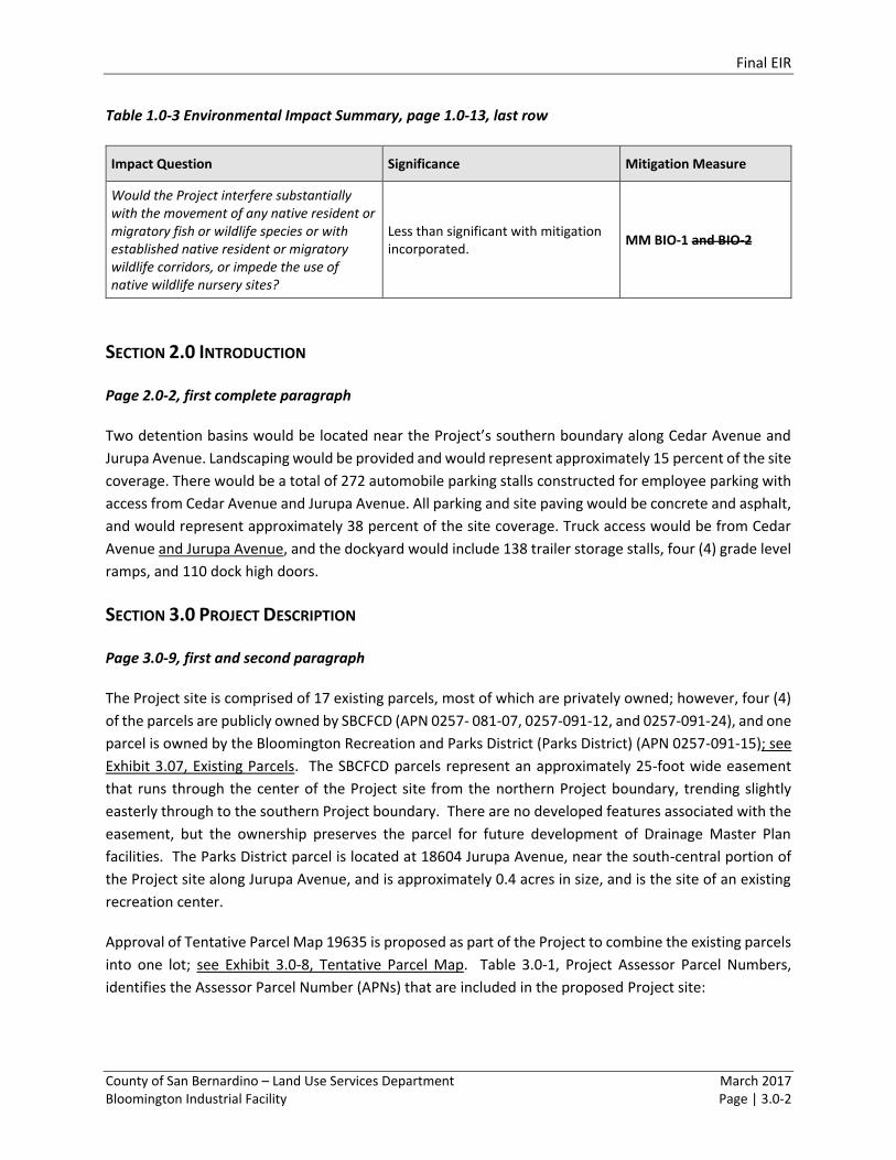
Final EIR
County of San Bernardino – Land Use Services Department March 2017 Bloomington Industrial Facility Page | 3.0-2
Table 1.0-3 Environmental Impact Summary, page 1.0-13, last row
Impact Question Significance Mitigation Measure
Would the Project interfere substantially with the movement of any native resident or migratory fish or wildlife species or with established native resident or migratory wildlife corridors, or impede the use of native wildlife nursery sites?
Less than significant with mitigation incorporated.
MM BIO-1 and BIO-2
SECTION 2.0 INTRODUCTION
Page 2.0-2, first complete paragraph
Two detention basins would be located near the Project’s southern boundary along Cedar Avenue and
Jurupa Avenue. Landscaping would be provided and would represent approximately 15 percent of the site
coverage. There would be a total of 272 automobile parking stalls constructed for employee parking with
access from Cedar Avenue and Jurupa Avenue. All parking and site paving would be concrete and asphalt,
and would represent approximately 38 percent of the site coverage. Truck access would be from Cedar
Avenue and Jurupa Avenue, and the dockyard would include 138 trailer storage stalls, four (4) grade level
ramps, and 110 dock high doors.
SECTION 3.0 PROJECT DESCRIPTION
Page 3.0-9, first and second paragraph
The Project site is comprised of 17 existing parcels, most of which are privately owned; however, four (4)
of the parcels are publicly owned by SBCFCD (APN 0257- 081-07, 0257-091-12, and 0257-091-24), and one
parcel is owned by the Bloomington Recreation and Parks District (Parks District) (APN 0257-091-15); see
Exhibit 3.07, Existing Parcels. The SBCFCD parcels represent an approximately 25-foot wide easement
that runs through the center of the Project site from the northern Project boundary, trending slightly
easterly through to the southern Project boundary. There are no developed features associated with the
easement, but the ownership preserves the parcel for future development of Drainage Master Plan
facilities. The Parks District parcel is located at 18604 Jurupa Avenue, near the south-central portion of
the Project site along Jurupa Avenue, and is approximately 0.4 acres in size, and is the site of an existing
recreation center.
Approval of Tentative Parcel Map 19635 is proposed as part of the Project to combine the existing parcels
into one lot; see Exhibit 3.0-8, Tentative Parcel Map. Table 3.0-1, Project Assessor Parcel Numbers,
identifies the Assessor Parcel Number (APNs) that are included in the proposed Project site:
Final EIR
County of San Bernardino – Land Use Services Department March 2017 Bloomington Industrial Facility Page | 3.0-3
Page 3.0-13, under Project Description
The Project involves the development of a single 676,983 ft2 distribution building within an approximately
34.54-acre property, with associated facilities and improvements such as offices, a guard booth, parking,
bicycle racks, landscaping and detention basins. See Exhibit 3.0-5, Conceptual Site Plan and Exhibit 3.0-6,
Conceptual Elevations.
Approximately 18,000 square feet of the total building area would include primary and secondary offices
fronting Cedar Avenue.
There would be a total of 272 automobile parking stalls constructed for employee parking with access
from Cedar Avenue and Jurupa Avenue. Parking and site paving would be concrete and asphalt, and would
represent approximately 38 percent of the site coverage. Truck access would be from Cedar Avenue and
Jurupa Avenue, and the dockyard would include 138 trailer storage stalls, four (4) grade level ramps, and
110 dock high doors.
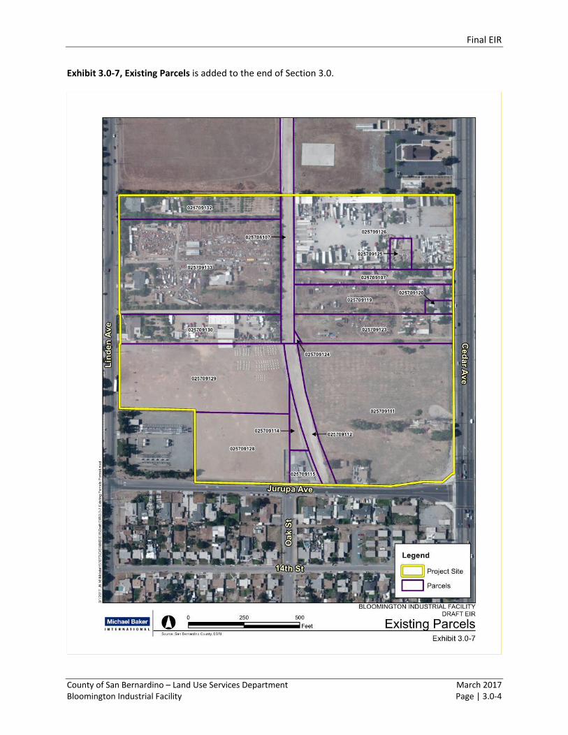
Final EIR
County of San Bernardino – Land Use Services Department March 2017 Bloomington Industrial Facility Page | 3.0-4
Exhibit 3.0-7, Existing Parcels is added to the end of Section 3.0.
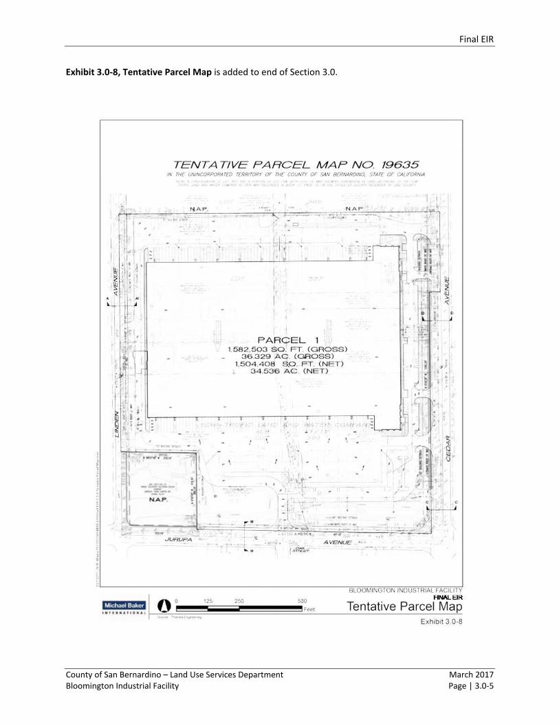
Final EIR
County of San Bernardino – Land Use Services Department March 2017 Bloomington Industrial Facility Page | 3.0-5
Exhibit 3.0-8, Tentative Parcel Map is added to end of Section 3.0.
Final EIR
County of San Bernardino – Land Use Services Department March 2017 Bloomington Industrial Facility Page | 3.0-6
SECTION 4.1 AIR QUALITY
Appendix B has been supplemented to include content that was inadvertently left out of the Draft EIR
Appendix.
SECTION 4.5 LAND USE
Pages 4.5-9 and 4.5-10, Table 4.5-2, Land Use Policy Consistency Analysis
Applicable Land Use Plan Objective, Goal, or Policy Consistency Analysis
County of San Bernardino General Plan Bloomington Community Plan (2007)
Objective Ensure that commercial and industrial
development within the plan area is
compatible with surrounding uses and
meets the needs of local residents.
Inconsistent: The Project site is located in close
proximity to a park, elementary school, and
residences. Industrial development…
SECTION 7.0 GROWTH INDUCTING IMPACTS
Page 7.0-2, third paragraph
Two detention basins would be located near the Project’s southern boundary along Cedar Avenue and
Jurupa Avenue. Landscaping would be provided and would represent approximately 15 percent of the site
coverage. There would be a total of 272 automobile parking stalls constructed for employee parking with
access from Cedar Avenue and Jurupa Avenue. All parking and site paving would be concrete and asphalt,
and would represent approximately 38 percent of the site coverage. Truck access would be from Cedar
Avenue and Jurupa Avenue, and the dockyard would include 138 trailer storage stalls, four (4) grade level
ramps, and 110 dock high doors.
Final EIR
County of San Bernardino – Land Use Services Department March 2017 Bloomington Industrial Facility Page | 3.0-7
The content on the following pages supplements Appendix B to the Draft EIR.

Attachment A Notice of Availability
County of San Bernardino – Land Use Services Department March 2017 Bloomington Industrial Facility Page | A-1
ATTACHMENT A
Notice of Availability of Draft EIR
Final EIR
County of San Bernardino – Land Use Services Department March 2017 Bloomington Industrial Facility Page | A-2
Final EIR
County of San Bernardino – Land Use Services Department March 2017 Bloomington Industrial Facility Page | A-3
Final EIR
County of San Bernardino – Land Use Services Department March 2017 Bloomington Industrial Facility Page | A-4

Final EIR
County of San Bernardino – Land Use Services Department March 2017 Bloomington Industrial Facility Page | A-5
Appendix B Supplement to the Draft EIR
County of San Bernardino – Land Use Services Department March 2017 Bloomington Industrial Facility Page | B-1
APPENDIX B
Supplemental information to Appendix B of the Draft EIR.