biological evaluation idyllwild spring challenge and...
TRANSCRIPT
BIOLOGICAL EVALUATION
IDYLLWILD SPRING CHALLENGE and
24 HOURS of ADRENALINE BIKE EVENTS
SAN JACINTO RANGER DISTRICT
SAN BERNARDINO NATIONAL FOREST
Riverside County, California
T5S, R3E, Sections 17, 18, 19, 20, 28, 29, 30, 31, 32, 33, 34
T6S, R3E, Sections 4, 5; T5S, R2E, Section 24
PREPARED BY:
Anne Poopatanapong
District Wildlife Biologist
02/02/2011
Contact Person: Anne Poopatanapong Phone Number: 909-382-2935 email: [email protected]
Idyllwild Spring Challenge and 24 Hours of Adrenaline Bike Events
2
INTRODUCTION
The purpose of this Biological Evaluation (BE) is to address any potential effects on the annual Idyllwild
Spring Challenge and the annual 24 Hours of Adrenaline events (mountain bike events) habitat. R5
Sensitive and San Bernardino National Forest (SBNF) Watchlist wildlife species and/or their The purpose
of this Management Indicator Species (MIS) report is to evaluate and disclose the effects of the proposed
bike events on the MIS species identified in the SBNF Land Management Plan (LMP) (USDA, 2006).
The proposed project would permit two different bike race events to occur in the May Valley area of the
San Jacinto Ranger District annually.
This Biological Evaluation incorporates by reference the Biological Assessment and Evaluation for
Idyllwild Cycling Race prepared by Kim Boss, dated May 23, 2005 (here after referred to as the 2005
BA/BE), as well as the 2006 and 2008 Supplemental Information Report for 2006 Idyllwild Bike Race
SUP prepared by Heidi Hoggan and Anne Poopatanapong, dated April 15, 2006 (here after referred to as
the 2006 Supplement), and March 11, 2008 (here after referred to as the 2008 Supplement). This
document replaces any previous addendums and the original document. Species accounts are incorporated
by reference from the Land Management Plan (USDA, 2006). Detailed species accounts are available on
disc as part of the project file at the San Jacinto Ranger Station, Idyllwild, CA or on line at:
http://www.fs.fed.us/r5/scfpr/projects/lmp/read.htm.
COMPLIANCE WITH MANAGEMENT DIRECTION
Applicable requirements and direction may be found in the Endangered Species Act, National Forest
Management Act, and Department of Agriculture 9500-4 Regulations, Forest Service Manual, and the
Forest Plan. The 2006 Land Management Plan for SBNF now replaces the 1996 Land and Resource
Management Plan for SBNF. The San Bernardino National Forest is divided into a series of geographical
units called “places”. Each “place” has its own landscape description, desired management condition and
program emphasis. Within the San Jacinto Ranger District, the proposed bike events fall into the
“Idyllwild” place. Detailed descriptions of each place can be found in Part 2 of the San Bernardino Land
Management Plan, Place-Based Program Emphasis (USDA 2006), and are hereby incorporated by
reference. Each description describes the “place” and how management of these areas will meet desired
conditions. There are no Wild and Scenic areas, Research Natural Areas and Special Interest Areas within
the analysis area. The proposed race events are within the Garner Allotment, for which grazing is
currently allowed. Several biological opinions provide guidance for livestock grazing on the SJRD. This
proposed project is currently not in compliance with the LMP as the events are proposed on non-system
trails.
DESCRIPTION OF PROPOSED PROJECT
24 HOURS of ADRENALINE
This proposed event has approximately 350 participants that will ride over approximately 9 miles of non-
system trail (Figure 1). The event is proposed to occur in mid-September of every year. The event
Idyllwild Spring Challenge and 24 Hours of Adrenaline Bike Events
3
would start at 12 PM on Saturday and continue until 12 PM on Sunday. Due to night-time riding, all
participants must have a minimum of a 10 watt lighting system on their bike or person. The event
consists of multiple laps around the same course conducted in a relay fashion. Each team can consist of
up to 10 riders and all riders would stage at the Herkey Creek County campground. In addition, all
camping, event meetings, and ceremonies would be held at Herkey Creek campground. The route is
approximately 9 miles long and utilizes a route that follows the majority of the same non-system trails as
the Spring Challenge’s Beginner Loop. The trail width that riders would be using ranges from 24” to
132” wide, with a median width of 36”. There would be four checkpoints/aide stations set up along the
route at the following locations: (1) Keen Camp Summit; (2) May Valley Road; (3) Apple Canyon Road;
and (4) Coyote Run (Figure 1). The Apple Canyon Road station would be on the paved road, and the rest
of the stations are on dirt roads that are approximately 132” wide. Each station would consist of a 10’ x
10’ canopy with two people providing water and any aide needed.
IDYLLWILD SPRING CHALLENGE
This proposed event has approximately 200 - 300 participants. The event is proposed to occur prior to
May 1st of any given year. On Saturday of the event weekend, the “Cross Country Course” route
includes four loops, the Short Loop (6.5 miles), Beginner Loop (10 miles), Sport Loop (22 miles), and the
Pro/Expert Loop (30.5 miles) (Figure 2). There may be slight route alterations from year to year, but the
routes would total 69 miles and be within the trails represented in Figure 2. There would be three
checkpoints/aide stations set up along the event route at the following locations: (1) South Ridge Road;
(2) Upper May Valley Road; (3) Lower May Valley Road. On the Sunday of the event weekend the
“Super D Course” would be a one-way event starting from the northern end of May Valley Road and
ending in Herkey Creek Campground along a portion of the same routes from Saturday’s events (Figure
3). The “Super D Course” would be approximately 4 miles in length.
DESIGN FEATURES FOR THE PROPOSED PROJECT
No new trails would be created.
A Forest Service biologist would inspect the course after the weekend of each race to ensure
damage to general wildlife habitat has occurred due to the races.
No dogs are allowed on the course or at the checkpoint/aide stations.
Following each race, the proponents would have two days to remove all improvements and clean
up any litter from the course.
A temporary bridge structure would be constructed over Herkey Creek for the junior and beginner
women start. Participants would travel through this perennial creek via the bridge. No “cross-
country” riding would be permitted.
Project proponents shall not widen any trails through the stream course, whether dry or flowing.
Implement Best Management Practices to meet water quality objectives
(http://www.fs.fed.us/r5/publications/water_resources/waterquality/).
EXISTING ENVIRONMENT
Idyllwild Spring Challenge and 24 Hours of Adrenaline Bike Events
4
The “project area” as used in this document, is the area where species or their habitat may be directly
affected by the proposed project. The “analysis area” includes the project area as well as the surrounding
National Forest System Lands, including May Valley. Pre-field reviews were conducted to determine
which wildlife species are known from the analysis area or have suitable habitat present and potentially
occur. The analysis of effects in this document is based on pre-existing data and site visits. There is a
total of 27 miles of non-system bike route in the May Valley/Garner Valley area. These trails/routes have
been created by multiple user groups for various forest activities, including mountain biking.
Vegetation in the analysis areas is dominated by stands of open mixed/redshank chaparral cover type that
contains shrubs such as redshank (Adenostoma sp.), manzanita (Arctostaphylos sp.), mountain mahogany
(Cercocarpus betuloides), buckwheat (Eriogonum sp.), and oak (Quercus sp.). Ponderosa pines (Pinus
ponderosa) and Jeffery pines (Pinus jeffreyii) are scattered through the area. Numerous rocky outcrops
and several creeks (Herkey, Apple Canyon) can be found throughout the project area. Most of the
drainages are intermittently dry. Riparian vegetation is present in areas where wet or moist soil conditions
are maintained throughout the year. Riparian areas are characterized by stands of willow (Salix spp.),
rose (Rosa spp.), and other riparian obligate plants such as sedges. The elevation is between
approximately 4,400 and 6,400 feet elevation. The entire 24 Hours of Adrenaline race is under 5,500 feet
elevation (Figure 1), while various portions of the Spring Challenge are at different elevations.
Topography is highly variable, with large expanses of meadows and rolling hills throughout. Lake Hemet
is the prominent landscape feature in Garner Valley and the largest lake on the district.
The project is within the Garner cattle grazing allotment. The proposed bike races actually occur in the
May Valley/Johnson Meadow subunit of the Garner allotment. These areas have been grazed since the
early 1900s and continue today. As a part of the grazing allotment, areas within the project have been type
converted to pasture lands, and thus have a high proportion of non-native grasses. Other areas are
dominated by dense chaparral or sagebrush encroachment, and are inaccessible as cattle forage.
Fire history maps have indicated that both the Garner Valley area has been burned repeatedly from both
prescribed fire and wildland fire. However as a result of current fire suppression policies,
sagebrush/chaparral encroachment has occurred. Additionally, the short fire return interval of the
overgrown chaparral species has promoted the sagebrush encroachment into existing timberline. The
Bonita Vista hazardous fuels reduction project (on-going since 2004) is immediately adjacent to the
proposed bike events. A part of this project’s objective is to return the area to a regular fire interval and
reduce the encroachment of non-desired species.
The loss of conifer species in the valley floor has resulted in a loss of an important habitat component for
cavity nesting species, such as the Western Bluebird (Sialia mexicana). Areas such as the main tributary
of Herkey Creek are surrounded by dense stands of chaparral and riparian vegetation is out competed by
chaparral species. These areas are currently not productive riparian sites for obligate species. Open slopes
with young vegetation provide habitat for species such as mule deer, mountain lion and badger. However
much of these slopes are overgrown with chamise, and are therefore provide little foraging or breeding
habitat.
Idyllwild Spring Challenge and 24 Hours of Adrenaline Bike Events
5
Recreation has been occurring on lands used by sensitive and watchlist wildlife species since people
inhabited these mountains. There are no baseline studies of fauna diversity prior to use of these lands.
Therefore, it is difficult to evaluate the actual effect of mountain bike events on sensitive and watchlist
species. However, it is assumed that the current diversity and density of wildlife in the May Valley area
represents the existing condition from which to base the effects analysis. It is also important to note that
the current level of recreation is expected to increase. As the population of southern California continues
to increase, it is expected that there will also be a concomitant increase in use of these areas and thus the
pressures on wildlife habitat and/or species.
The project area may have occurrences and/or suitable habitat for the following R5 Sensitive wildlife
species: large-blotched ensatina (Ensatina eschscholtzii klauberi), California legless lizard (Aniella
pulchra), San Diego horned lizard (Phrynosoma coronatum blainvillii), southern rubber boa (Charina
bottae umbratica), coastal rosy boa (Lichanura trivirgata rosafusca), San Bernardino mountain kingsnake
(Lampropeltis zonata parvirubra), San Diego mountain kingsnake (Lampropeltis zonata pulchra),
American peregrine falcon (Falco peregrinus anatus), Willow flycatcher (migrant) (Empidonax traillii),
San Diego cactus wren (Campylorhynchus bruneicapillus sandiegense), California leaf-nosed bat
(Macrotus californicus), Townsend’s big-eared bat (Corynorhinus townsendii), pallid bat (Antrozous
pallidus), western red bat (Lasiurus blossevillii), Los Angeles little pocket mouse (Perognathus
longimembris brevinasus), and San Bernardino flying squirrel (Glaucomys sabrinus californicus).
The following R5 Sensitive wildlife species occur on the San Bernardino National Forest but are not
addressed in the document: Santa Ana speckled dace (Rhinicthys osculus ssp.), arroyo chub (Gila orcutti),
partially armored threespine stickleback (Gasterosteus aculeatus microcephalus), southwestern pond
turtle (Actinemys marmorata pallid), San Diego ringneck snake (Diadophis punctatus similis), California
spotted owl (Strix occidentalis occidentalis), San Diego cactus wren (Campylorhynchus bruneicapillus
sandiegense), and California leaf-nosed bat (Macrotus californicus). These species will not be addressed
further in this document, because there is no suitable habitat and/or occurrences for any of these species
within the proposed project area.
The project area may have occurrences and/or suitable habitat for the following SBNF Watchlist wildlife
species: simple hydroporus diving beetle (Hydroporus simplex), arboreal salamander (Aneides lugubris),
garden slender salamander (Batrachoseps major), western spadefoot toad (Spea hamondii), granite night
lizard (Xantusia henshawi), Coronado skink (Eumeces skiltonianus interparietalis),coast patch-nosed
snake (Salvadora hexalepis virgultea), red diamond rattlesnake (Crotalus ruber ruber), southwestern
speckled rattlesnake (Crotalus mitchellii Pyrrhus), turkey vulture (breeding) (Cathartes aura), osprey
(Pandion haliaetus), white-tailed kite (Elanus leucurus), northern harrier (Circus cyaneus), sharp-shinned
hawk (breeding) (Accipiter striatus),Cooper's hawk (breeding) (Accipiter cooperii), ferruginous hawk
(Buteo regalis), golden eagle (Aquila chrysaetos), merlin (Falco columbarius), prairie falcon (Falco
mexicanus), mountain quail (Oreortyx pictus), band-tailed pigeon (Columba fasciata), flammulated owl
(Otus flammeolus), western screech owl (Otus kennicottii), northern pygmy owl (Glaucidium gnoma),
long-eared owl (Asio otus), northern saw-whet owl (Aegolius acadicus), common nighthawk (Chordeiles
minor), whip-poor-will (Caprimulgus vociferous), black swift (Cypseloides niger), calliope hummingbird
Idyllwild Spring Challenge and 24 Hours of Adrenaline Bike Events
6
(Stellula calliope), Lewis' woodpecker (Melanerpes lewis), Williamson's sapsucker (Sphyrapicus
thyroideus), Nuttall's woodpecker (Picoides nuttallii), southern white-headed woodpecker (Picoides
albolarvatus), gray flycatcher (Empidonax wrightii), California horned lark (breeding) (Eremophila
alpestris actia), purple martin (Progne subis) tree swallow (Tachycineta bicolor) pinyon jay
(Gymnorhinus cyanocephalus), oak titmouse (Parus inornatus), American dipper (Cinclus mexicanus),
Swainson's thrush (Catharus ustulatus), hermit thrush (breeding) (Catharus guttatus), loggerhead shrike
(Lanius ludovicianus), Cassin’s vireo (solitary) (Vireo cassinii), plumbeus vireo (solitary) (Vireo
plumbeus), warbling vireo (Vireo gilvus), yellow warbler (Dendroica petechia brewsteri), MacGillivray's
warbler (Oporornis tolmiei), common yellowthroat (Geothlypis trichas), Wilson's warbler (Wilsonia
pusilla), yellow-breasted chat (Icteria virens), summer tanager (Piranga rubra), southern California
rufous-crowned sparrow (Aimophila ruficeps canescens), black-chinned sparrow (Spizella atrogularis),
Bell's sage sparrow (Amphispiza belli belli), tri-colored blackbird (Agelaius tricolor), Lawrence's
goldfinch (Carduelis lawrencei), long-eared myotis (Myotis evotis), fringed myotis (Myotis thysanodes),
long-legged myotis (Myotis volans), occult little brown bat (Myotis lucifugus), western small-footed
myotis (Myotis ciliolabrum), western mastiff bat (Eumops perotis californicus), San Diego black-tailed
jackrabbit (Lepus californicus bennettii), ringtail (Bassariscus astutus), American badger (Taxidea taxus),
western spotted skunk (Spilogale gracilis),and mountain lion (Felis concolor). All other species on the
SBNF Watchlist either do not have occurrences and/or habitat in the proposed project area.
Executive Order (E.O.) 13186, dated January 10th 2001 directs federal agencies to take certain actions to
further implement the Migratory Bird Treaty Act (MBTA). Requirements of E.O. 13186 that are relevant
to project level planning include developing mitigation criteria that minimize unintentional take of
migratory birds, integrating bird conservation principles, measures and practices into agency activities,
and ensuring that environmental analyses required by NEPA are conducted.
Partners in Flight (PIF) identify priority bird species and habitats for conservation consideration when
planning land management activities. The US Fish and Wildlife Service also list migratory birds of
special concern in the Birds of Conservation Concern 2002. Habitat types utilized by migratory birds
within the allotment boundaries included: coniferous forest, oak woodlands, riparian, and desert shrub.
Bird surveys have been conducted by numerous groups including PSW Riverside Fire lab (J. Rechel,
personal communication 2008), Audubon Christmas Birdcount, San Diego Natural History Museum and
San Bernardino County Museum (Appendix A). Numerous species have been observed. Most of the PIF
priority species and BCC species are also Forest Service Sensitive or Watchlist species. Effects to those
migratory birds are analyzed and disclosed in terms of affected habitats rather than on a species by species
basis.
On December 8th
2008, a Memorandum of Understanding between the USDA Forest Service and the US
Fish and Wildlife Service to Promote the Conservation of Migratory Birds was signed. The intent of the
MOU is to strengthen migratory bird conservation through enhanced collaboration and cooperation
between the Forest Service and the Fish and Wildlife Service as well as other federal, state, tribal and
local governments. Within the National Forests, conservation of migratory birds focuses on providing a
Idyllwild Spring Challenge and 24 Hours of Adrenaline Bike Events
7
diversity of habitat conditions at multiple spatial scales and ensuring that bird conservation is addressed
when planning for land management activities.
A. Effects of Proposed Action and No Action alternatives to R5 Sensitive and Watchlist Species
Due to the number of wildlife species that have the potential to occur in the proposed project area, this BE
and Wildlife Report will address them in similar groups based on behavior and habitat use. No project
specific habitat suitability or occurrence surveys for R5 Sensitive or Watchlist species were conducted as
part of the proposed event. Information regarding occurrence has been from other projects (i.e., livestock
grazing, prescribe burn projects, etc.). Appendix A listed the various bird species that were found in the
May Valley area. Bird data is available as a part of a long term study conducted by the Forest Service-
Pacific Southwest-Riverside Research Fire Lab. Although the data was not collected for this NEPA
analysis specifically, it provides additional occurrence information of the various sensitive and watchlist
bird species. Appendix B provide reptile, amphibian and mammal data which were being collected by the
San Bernardino County Museum and the San Diego Natural History Museum. Data collected was also not
collected for this NEPA analysis specifically, but provides some information regarding occurrences
within May Valley. Information from these efforts was used to determine suitability of the non-system
trails for the proposed bike race events. Therefore, based upon lack of site specific information, areas that
are considered suitable are also considered occupied for the effects analysis of this proposed project.
Species accounts are incorporated by reference from the Land Management Plan (USDA, 2006). Detailed
species accounts are available on disc at the San Jacinto Ranger Station, Idyllwild, CA or on line at:
http://www.fs.fed.us/r5/scfpr/projects/lmp/read.htm.
Direct and Indirect Effects
General: Direct effects of the mountain bike events will be primarily trampling, disturbing, displaying,
crushing and unintentional killing of sensitive and watchlist wildlife species. This effect is the same as the
current existing condition, as the general public already uses these non-system trails for recreation. The
event will also result in increased noise levels that could disturb wildlife behaviors. Most of the riding is
during daylight hours except for the 24Hr event, so most of the disturbance will be to diurnal species.
Indirect effects include changes in habitat as the use of these trails will result in compaction of soil and
surrounding vegetation. Repeated use of routes will cause soil compaction such that vegetation no longer
grows in the immediate area. Riders who cross across Herkey creek while it is flowing could result in
increased sedimentation and reduced water quality of the creek or stream. There is also potential that
mountain bikers may also introduced undesired non-native species such as cheatgrass (Bromus tectorum)
into riparian areas. Other undesired non-native species such as New Zealand mudsnails (Potamopyrgus
antipodarum) could also be introduced into Herkey creek. Such introductions could be devastating to
native aquatic invertebrates.
Amphibians: The proposed bike events could have some effects on aquatic species, such as western
spadefoot toad (Spea hamondii). Since the event is very short term (2-3 days per year), the effect to
Idyllwild Spring Challenge and 24 Hours of Adrenaline Bike Events
8
amphibians is very low. As part of the proposed action, the event will provide a temporary bridge-like
structure to prevent riding through the water. This should prevent any unintentional effects to toads
however there still is a possibility that an event participant could not use the bridge structure. Amphibians
spend time in both upland and aquatic habitats during their lifecycle, and could be affected directly and
indirectly by riders. If Herkey creek is flowing, riders may accidentally dislodge egg masses and/or
displace/disturb tadpoles or newly metamorphed individuals. Riding across Herkey creek use could result
in increased sedimentation and reduced water quality, which affects breeding and survival of amphibians
during their aquatic life-stage. Despite these potential effects, it is expected that the proposed bike events
will not further fragment the habitat or increase movement barriers above and beyond what has already
occurred in the past or is currently occurring.
Herpetofauna, fossorial and small terrestrial species: It is likely that the Herkey Creek area supports
herpteofauna such as San Diego horned lizard (Phrynosoma coronatum blainvillii), California legless
lizards (Aniella pulchra), San Diego ringneck snake (Diadophis punctatus similis), and San Bernardino
mountain kingsnake (Lampropeltis zonata parvirubra). Small mammals such as Los Angeles little pocket
mouse (Perognathus longimembris brevinasus) and San Diego black-tailed jackrabbit (Lepus californicus
bennettii) may also occur within the area. Direct effects could also be in the form of short-term avoidance
of the routes during the events and/or accidental killing (being ran-over). This is expected to minimally
affect the animals’ behavior as the duration of the event is short. Direct effects of the bike event are
confined to mostly narrow paths and a couple of aid stations, thus reducing the effect of the impact on the
species. Herps may use routes to sun themselves and may be slow to react to bikers, especially during
early mornings and late evenings. It is expected that a unspecified number of individuals will be ran-over
or crushed under mountain bikes as a result of this event. Indirect effects include disturbance in the form
of destruction of burrows and travel paths. For example, an individual may be deprived of its hiding or
foraging space when a rock is turned over or a shrub or bunchgrass is ran-over. Most herpetofauna and
fossorial mammals burrow in soft dirt or move into rock crevices or under debris, so it is possible that
riders could turn over these areas during their event. Indirect effects may be in the form of habitat loss,
habitat degradation, and introduced invasive species. Recreation may contribute to this habitat change by
introducing or spreading invasive species especially in areas of concentrated use, such as the routes.
However, cheat grass is already present along the Herkey Creek area and the bike event route, so the
expansion of this species is not due entirely to the proposed event. The proposed event is not expected to
further fragment the habitat for these species or increase movement barriers above and beyond what has
already occurred in the past or already occurring with current use of this area.
Bats: A number of Forest Service sensitive and watch-list bats use trees, rocky outcrops and creeks for
denning, foraging, and breeding sites. Species include: California leaf nosed bat (Macrotus californicus),
Townsend’s big-eared bat (Corynorhinus townsendii), pallid bat (Antrozus pallidus), western red bat
(Lasiurus blossevillii), long-eared myotis (Myotis evotis) and occult little brown bat (Myotis lucifugus). It
is expected that the bike events will have no direct effect on bat individuals. The nighttime riding during
the 24 Hr event could indirectly affect individuals and/or roosting or nesting sites in the form of light
pollution. Headlamps/floodlamps may affect nocturnal insect behavior, and thus alter foraging behaviors
of bats. There will be no reduction in the availability of roosting, breeding or feeding habitats for these
Idyllwild Spring Challenge and 24 Hours of Adrenaline Bike Events
9
species as a result of the event. Since the duration of proposed events is short, any effects to bat
individuals will most likely be non-significant.
Birds: Direct impacts to sensitive/watchlist bird species such as Lawrence’s goldfinch (Carduelis
lawrencei), Willow flycatcher (Empidonax traillii), western screech owl (Otus kennicottii), flammulated
owl (Otus flameolus),common nighthawk (Chordeiles minor), sharp-shinned hawk (Accipiter striatus),
and Cooper's hawk (Accipiter cooperii) are expected to be temporary and short-term in nature. Adult birds
may be temporarily flushed from their territories or nests if bikers are traveling through their habitat.
Areas of dense riparain habitat adjacent to routes (Herkey Creek, Apple Canyon) may receive greater
noise and light disturbance. Large groups of bikers may disrupt birds’ behavior or prevent individuals to
hear songs. Headlamps/flood lights may alter nocturnal birds’ behavior and prevent singing and/or
foraging. However, it is expected that these species will return to their territories and natural behaviors
once the bikers have moved through and/or the event is over. It is also possible that event participants
may accidentally brush against birds’ nest, especially if species nest on the ground or in low growing
shrubs. This may cause a certain number of nest failures due to the destruction of nests and/or the killing
of eggs/chicks. One of the events is in the fall, thus reducing the likelihood that birds will be nesting this
time of year. Indirect impacts to birds in the form of habitat loss is probably low, as the bike routes are
already existing and the events do not propose any vegetation alteration. Events will not further reduce the
amount of available nesting or roosting locations (i.e., shrubs and trees). The potential introduction non-
native plant species may change the availability of native vegetation for birds. Cheatgrass may
outcompete with native herbaceous vegetation. However, since this species is already present in the area,
the events may not be significantly contributing to its expansion in the area. The proposed event is not
expected to further fragment the habitat for these species or increase movement barriers above and
beyond what has already occurred in the past or already occurring with current use of this area.
Mid and large size mammals: Throughout the proposed routes and surrounding areas is suitable habitat
for watchlist species such as ringtail (Bassariscus astutus), western spotted skunk (Spilogale gracilis),
American badger (Taxidea taxus) and mountain lion (Felis concolor). Incidental observations have
sighted these species; however it is unknown exactly where on the district these animals’ territories exist.
It is very unlikely that mid to large size mammals would be directly or indirectly significantly affected by
the mountain bike events. Nocturnal animals such as mountain lions may be temporary displaced during
the nighttime riding of the 24HR event, but this disturbance is expected to be short-term in nature.
Mountain lions have such large home ranges that animals will just avoid the bike event area and use
another part of their home range until the event is over. Crepuscular animals such as ringtail, skunk and
badger may also temporarily alter their behavior as a result of the increased human presence. But because
the event is short term in nature, the effect on these species’ behavior should be non-significant. Indirect
impacts to mid and large size mammals will most likely be in the form of soil compaction around routes,
creek/stream alteration and sedimentation. Indirect impacts will also be in the form of introduced invasive
species. As mentioned above, non-native species such as cheatgrass is already in the proposed project
area.
The No Action alternative (not providing a special use permit to authorize the mountain bike events)
would have no negative direct and/or indirect effects on R5 sensitive and watchlist wildlife species, as
Idyllwild Spring Challenge and 24 Hours of Adrenaline Bike Events
10
there would be no events. Animals would not be unintentionally killed. Habitat for Sensitive and
Watchlist species would not be altered.
Cumulative Effects
This section only addresses the legal definition for cumulative effects/impacts analysis under NEPA.
Under NEPA, “cumulative impacts” are those impacts caused by past, present, and future federal, state,
and private activities within or onto special status animals and their habitats. Future federal activities or
activities permitted by federal agencies are not included under ESA “cumulative effects” because any
proposed future federal activities or federally permitted activities must undergo Section 7 consultation
with the USFWS. There is no State or private mountain biking events that are reasonably certain to occur
within the action area.
The non-system trails cover approximately 27 miles of National Forest System lands. For the purpose of
cumulative effects, the entire May Valley area will be considered the action area, despite the reality that
the event participants ride only on the non-system trails within May Valley. The trails in the May Valley
area on the San Jacinto Ranger District contain known or suitable habitat for numerous R5 sensitive and
watch-list species (Tables 1 and 2). All of the species known to occur have been, are, and will continue
to be affected by the continuation of the recreation, in particular mountain biking. Many other Forest
Service activities occur within the May Valley area. Activities include: recreation (camping, hiking,
equestrian use, target shooting, hunting), OHV use, road maintenance, hazardous fuels treatment, mining,
prospecting, special use events, law enforcement, fuel wood cutting, Native American products gathering
and fire suppression. National Forest System lands are also places were numerous illegal activities
including marijuana plantations, hazardous material dumping, trash dumping, and illicit drug cultivations
occur. State and private activities and/or events may also occur on the National Forest with or without
permits or authorizations.
Cumulative effects from Forest Service projects and activities consist of alteration of occupied, suitable or
potentially suitable habitat for sensitive and watchlist wildlife species. The Bonita Vista fuels project
(started in 2004; in progress) has altered, reduced or increased the amount of available suitable habitat for
wildlife species. Prescribed burning and removal of chaparral may be beneficial for species that prefer
disturbed or more open habitats. This treatment would have a short-term negative effect on the habitat,
over the long term they would prove beneficial in reducing the risk of landscape scale, high intensity
wildfire, and providing a mosaic of habitat types. Mosaic habitat allows provide species a variety of areas
for foraging, roosting, nesting and other cover types. One permitted activity that occurs within the same
area as the proposed bike events is livestock grazing. This area is within the Garner Allotment. Livestock
grazing has been occurring in this area since the early 20th
century and continues today. Although there
has been a decrease in the number of livestock on the landscape, heavily used areas and trails area have
been created by cattle are very present on the landscape. The Forest Service is currently going through the
NEPA process for the Garner Allotment. The result of that NEPA process will be an updated allotment
management plan that will guide the management of these acres toward a desired future condition that is
beneficial for wildlife. There are no other known Forest Service projects to contribute to cumulative
Idyllwild Spring Challenge and 24 Hours of Adrenaline Bike Events
11
effects. For these reasons, no additional negative cumulative effects are expected. Generally, all Forest
Service projects are designed to protect creeks, streams, and streamside management zones through the
implementation of the Forest Plan and Riparian Conservation Measures (RCAs). These measures are
used for all projects to avoid habitat degradation to waterways, and no past, present or future Forest
Service projects are known where these measures were not used.
On-going activities such as forest recreation are expected to increase in the present and near future, as the
population of Southern California continues to increase. The San Bernardino National Forest is one of the
most highly recreated forests in Region 5. The San Jacinto Ranger District also proposes to undergo a
mountain bike designation process for multiple user-created trails that go throughout the Garner
Allotment. The result of this process should be a managed system of trails for hiking, mountain biking
and equestrian use, while minimizing effects on the landscape and wildlife species in the area. Despite
these efforts, the cumulative effect of all of these activities is a reduction in quantity and quality of habitat
for R5 sensitive and watchlist species over the long term. This effect is permanent, as more areas become
developed and fewer areas remain undisturbed. Other uncontrollable factors such as global warming may
also have an unforeseen effect on sensitive and watchlist wildlife species. Broad changes in the
environment such as global warming are probably not affected by small recreational events such as these
events on the San Jacinto Ranger District.
The No Action alternative would have no effect on R5 sensitive and watchlist species and would not
contribute to cumulative effects.
DETERMINATION
It is my determination that the Idyllwild Spring Challenge and 24 Hours of Adrenaline Races may impact
individuals but is not likely to result in a trend toward federal listing or loss of viability of the wildlife
species currently on the Region 5 Sensitive Wildlife Species list (Table 1) or any species currently on the
SBNF Watchlist Species list (Table 2).
Rationale for Determination:
The proposed events are short term in nature (2-3 days/year).
Routes are pre-existing and the project will not be expanding beyond these previously disturbed
areas.
The proposal includes design criteria to minimize effects to wildlife species.
MANAGEMENT INDICATOR SPECIES (MIS) REPORT
Management Indicator Species (MIS) are identified in the LMP. Management indicator species (MIS) are
selected because their population changes are believed to indicate the effects of management activities (36
CFR [Code of Federal Regulations] 219.19(a) (1), 1982) and to serve as a focus for monitoring (36 CFR
219(a) (6), 1982). MIS wildlife species identified in the San Bernardino LMP were developed under the
Idyllwild Spring Challenge and 24 Hours of Adrenaline Bike Events
12
1982 National Forest System Land and Resource Management Planning Rule (1982 Planning Rule) (36
CFR 219). Guidance regarding MIS as set forth in the LMP directs Forest Service resource managers to
(1) at project scale, analyze the effects of proposed projects on the habitats of each MIS affected by such
projects, and 2) at the national forest (Forest) scale, monitor populations and/or habitat trends of forest
MIS, as identified by the LMP. Selection and justification of the MIS species can be found in the SBNF
FEIS Volume II pgs 72-81.
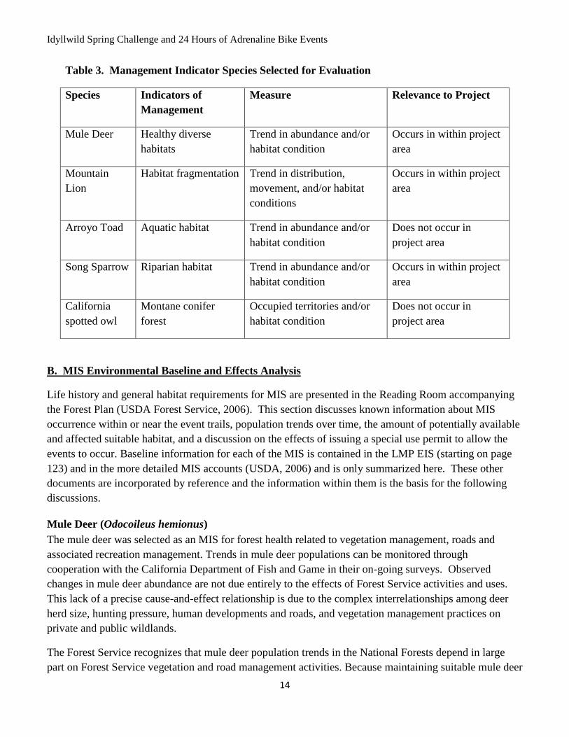
Twelve MIS species were selected to represent habitat types and indicators of management effects will be
monitored for each. Table 3 displays the Management Indicator Species (MIS) that were designated by
the SBNF Forest Plan (USDA, 2006) and whether they are known to occur within the project area.
Species accounts for arroyo toad, California spotted owl, mountain lion, mule deer, and song sparrow, are
incorporated by reference from the Land Management Plan for the SBNF (USDA, 2006). Detailed species
accounts are available on-line at: http://www.fs.fed.us/r5/scfpr/projects/lmp/read.htm. The purpose of
this assessment is to evaluate the potential impacts of the mountian bike events on the Management
Indicator Species (MIS) identified below. The rationale for MIS species selection is presented in the
FEIS, Volume II pages 72-81 and Appendix B of the FEIS. The LMP direction is to maintain or improve
habitat conditions to sustain healthy populations of MIS.
1.a. Direction Regarding the Analysis of Project-Level Effects on MIS
Project level effects on MIS are analyzed and disclosed as part of environmental analysis under the
National Environmental Policy Act (NEPA). This involves examining the impacts of the proposed
project alternatives on MIS habitat by discussing how direct, indirect, and cumulative effects will change
the quantity and/or quality of habitat in the analysis area. These project-level impacts to habitat are then
related to national forest scale population and/or habitat trends. The appropriate approach for relating
project-level impacts to broader scale trends depends on the terms in the LMP.
Where the San Bernardino NF LMP requires population monitoring or population surveys for an MIS, the
project-level effects analysis for that MIS may be informed by available population monitoring data,
which are gathered at the forest scale. For certain MIS, the San Bernardino NF LMP does not require
population monitoring or surveys; for these MIS, project-level MIS effects analysis can be informed by
forest-scale habitat monitoring and analysis alone. Therefore, adequately analyzing project effects to MIS,
including Threatened, Endangered, and Sensitive (TES) species involves the following steps:
Identifying which MIS have habitat that would be either directly or indirectly affected by the
project alternatives; these MIS are potentially affected by the project.
Identifying the LMP forest-level monitoring requirements for this subset of forest MIS.
Discussing forest scale habitat and/or population trends for this subset of forest MIS.
Relating project-level impacts on MIS habitat and/or population trends for the affected MIS at the
forest scale.
These steps are described in detail in the Pacific Southwest Region’s draft document ”MIS Analysis and
Documentation in Project-Level NEPA, R5 Environmental Coordination” (USDA 2006a).
Idyllwild Spring Challenge and 24 Hours of Adrenaline Bike Events
13
1.b. Direction Regarding Monitoring of MIS Population and Habitat Trends at the Forest Scale
Forest scale monitoring requirements for the San Bernardino NF’s MIS are found in the Final
Environmental Impact Statement for the LMP (USDA 2006, Volume 2, Appendix B, pages 77-78).
Habitat Status and Trend
The San Bernardino NF LMP (USDA, 2006) requires forest-scale monitoring of habitat condition and
trend for select MIS on the San Bernardino NF. Habitat condition and trend are not defined in the LMP
or FEIS; however, for this report habitat condition is defined as the current amount of habitat (or habitat
factor) on the San Bernardino NF. Habitat trend is the direction of change in the amount of habitat/habitat
indicator between the time the LMP was approved and the present. To date there has not been concerted
efforts to measure either habitat condition or trend for each MIS. There is no clarification in either the
LMP or the FEIS of what to measure for each habitat factor. There are, however, anecdotal and
professional opinions on habitat trend that are sometimes included in the MIS species accounts.
Population Status and Trend
Population monitoring requirements for the MIS of the San Bernardino NF are identified in the Final
Environmental Impact Statement for the LMP (USDA, 2006). This document requires monitoring of
population status and trend for select MIS on the San Bernardino NF. There are many types of population
data, and this document also identifies the type of population monitoring data required for each MIS.
Population status is the current condition of the MIS related to the type of population monitoring data
(population measure) required in the LMP for that MIS. Population trend is the direction of change in
that population measure over time. Population data for MIS are collected and consolidated by the San
Bernardino NF in cooperation with State and Federal agency partners (including California Department of
Fish and Game, U.S. Geological Survey, and U.S. Fish and Wildlife Service) or conservation partners.
Population data is collected using a number of different methods, including bird point counts, tracking
number of hunter kills, counts of species sign (e.g., deer pellets), etc. The San Bernardino NF’s MIS
monitoring program for mule deer and mountain lion was designed to be implemented in cooperation with
California Department of Fish and Game (CDFG), consistent with direction in the 1982 Planning Rule to
monitor forest-level MIS population trends in cooperation with state fish and wildlife agencies to the
extent practicable (36 CFR 219.19[a][6]). To be biologically meaningful for wide-ranging MIS, presence
data may be collected and tracked not only at the forest scale, but also at larger scales, such as range-wide,
state, province (Southern California), or important species management unit ( e.g., Deer Assessment
Unit). Population data at various scales are important to both assess and provide meaningful context for
population status and trend at the forest scale.
A. MIS Selected for Project Analysis
A review was conducted to determine whether the grazing allotments were within known or potential
habitat for each MIS species displayed below. Table 3 displays the MIS that were selected for analysis
for due to the presence of suitable habitat that may be affected by the project.
Idyllwild Spring Challenge and 24 Hours of Adrenaline Bike Events
14
B. MIS Environmental Baseline and Effects Analysis
Life history and general habitat requirements for MIS are presented in the Reading Room accompanying
the Forest Plan (USDA Forest Service, 2006). This section discusses known information about MIS
occurrence within or near the event trails, population trends over time, the amount of potentially available
and affected suitable habitat, and a discussion on the effects of issuing a special use permit to allow the
events to occur. Baseline information for each of the MIS is contained in the LMP EIS (starting on page
123) and in the more detailed MIS accounts (USDA, 2006) and is only summarized here. These other
documents are incorporated by reference and the information within them is the basis for the following
discussions.
Mule Deer (Odocoileus hemionus)
The mule deer was selected as an MIS for forest health related to vegetation management, roads and
associated recreation management. Trends in mule deer populations can be monitored through
cooperation with the California Department of Fish and Game in their on-going surveys. Observed
changes in mule deer abundance are not due entirely to the effects of Forest Service activities and uses.
This lack of a precise cause-and-effect relationship is due to the complex interrelationships among deer
herd size, hunting pressure, human developments and roads, and vegetation management practices on
private and public wildlands.
The Forest Service recognizes that mule deer population trends in the National Forests depend in large
part on Forest Service vegetation and road management activities. Because maintaining suitable mule deer
Table 3. Management Indicator Species Selected for Evaluation
Species Indicators of
Management
Measure Relevance to Project
Mule Deer Healthy diverse
habitats
Trend in abundance and/or
habitat condition
Occurs in within project
area
Mountain
Lion
Habitat fragmentation Trend in distribution,
movement, and/or habitat
conditions
Occurs in within project
area
Arroyo Toad Aquatic habitat Trend in abundance and/or
habitat condition
Does not occur in
project area
Song Sparrow Riparian habitat Trend in abundance and/or
habitat condition
Occurs in within project
area
California
spotted owl
Montane conifer
forest
Occupied territories and/or
habitat condition
Does not occur in
project area
Idyllwild Spring Challenge and 24 Hours of Adrenaline Bike Events
15
habitat is an important management objective for the National Forests of southern California, it is
important for the Forest Service to engage in inter-agency monitoring efforts of deer population
abundance and habitat condition. In addition, mule deer can be used to evaluate the effects of the
different strategies in the LMP alternatives for vegetation and road management. The LMP desired
condition to maintain or improve habitat conditions to sustain healthy deer populations can be supported
by retaining oak canopy cover in oak/grasslands and managing chaparral areas near water sources to
create irregular shapes to maximize cover and forage opportunities.
Fire and fuel management are the main tools intended to implement these objectives. A continuing mule
deer habitat management goal is to conduct mosaic burning that keeps a continual supply of high-quality
forage in close proximity to cover in mule deer home ranges. Human disturbance near communities
reduces the benefits that mule deer might otherwise gain from community protection prescribed burn
projects. The emphasis on community protection fuel treatments has also deferred some of the chaparral
prescribed burning opportunities for wildlife. Most chaparral is burned in large, high-intensity wildfires
that reduce the amount of cover below desirable levels. These fires result in large amounts of early
successional forage for a few years after the fire. When the vegetation matures, the forage quality
declines until the area burns again, generally in another large, high-intensity fire. The cycle then repeats
itself. Mule deer habitat quality in forest vegetation types has continued to decline because of lack of fire
in most areas. Lack of fire has resulted in stand densification in many cases, which results in decline of
shrub and herbaceous species that deer use as food. Stand densification also has favored white fir and
incense cedar at the expense of black oak, which is an extremely valuable mast crop (acorn) producer
(California Department of Fish and Game, 2002). This has serious long-term consequences for deer and
other mast-dependent species.
Riparian areas (including meadows), which are critical for fawning, are affected by disturbance associated
with high levels of recreation use. These areas are sought out by mule deer as a source of forage, and the
public as a source of recreation. Some locations across the national forests have had vehicle access
reduced by road closure and seasonal campground closures, which has benefited mule deer. Road and
motorized trail densities have continued to increase, primarily because of unauthorized vehicle use in
some areas, since the last forest plans were written. Some unauthorized roads have been closed in critical
areas since the last plans were written, but unauthorized roads are still a major problem in some key
fawning areas and key winter ranges. Urban development within and adjacent to the national forests
continues to adversely affect mule deer numbers, which are generally low adjacent to communities due to
the amount of human and dog use. Feral dogs and domesticated dogs that are allowed to run loose chase
mule deer and kill fawns.
Mule deer are found in a variety of habitat including early to intermediate successional stages of forest,
woodland, and brush habitats. Mule deer prefer a mosaic of vegetation with interspersions of dense shrub
or trees among herbaceous and riparian areas. Edge habitat and vegetation ecotones are important
components for optimal deer habitat. Dense shrub and trees provide hiding cover from disturbance and
predation. Shrub and tree canopies are also utilized for thermal cover during the winter and temperature
regulation during summer months. Mule deer prefer to browse new growth of shrubs, which provides a
more easily digestible nutrient source, in addition to forbs and some grasses. Deer will use mineral and
Idyllwild Spring Challenge and 24 Hours of Adrenaline Bike Events
16
salt licks if available. Acorns (mast) are an important part of the fall diet. Deer are generally crepuscular,
though in many parts of the SBNF (especially close to residential/developed areas); they have altered their
activity patterns to be nocturnal, probably in response to high levels of human disturbance. Other
individuals have become very tolerant of human presence and can be seen during daylight browsing in
yards and eating “hand-outs”. Habitat requirements for deer include hiding cover, thermal cover, foraging
areas and fawning habitat. Openings that are 600 feet or less from cover provide ideal foraging areas.
Optimal fawning habitat consists of low shrubs or small trees (2 to 6 feet) under a tree overstory of about
50% crown closure, and less than 15% slope with succulent vegetation and water within 600 feet. Ranges
of fawn and doe groups are small, varying from 0.4 to 1.9 miles depending upon water availability and
topography. Deer will migrate down slope in winter to areas with less than 18 inches of snow.
Environmental Baseline
Mule deer populations across California and in southern California have declined from high levels in the
early 1960s because of many factors. A sustained low survival rate of fawns is suspected as a major
factor in the deer population decline. Factors thought to be contributing to the low survival rate of fawns
include changes in the amount and distribution of vegetation and age classes, private land development
adjacent to and within the National Forests, recreational use in key areas, lack of frequent small fires, and
an increase in mountain lion predation (Updike pers. comm.). The recent drought, which affected
vegetation and water sources over the past several years in a large part of the planning area, may have
contributed to further decline (Steve Loe pers. observation).
The four southern California National Forests support most of the mule deer in the southern part of the
state. These populations provide important hunting and wildlife viewing opportunities. The National
Forests do not conduct their own individual population surveys but rather cooperate with the California
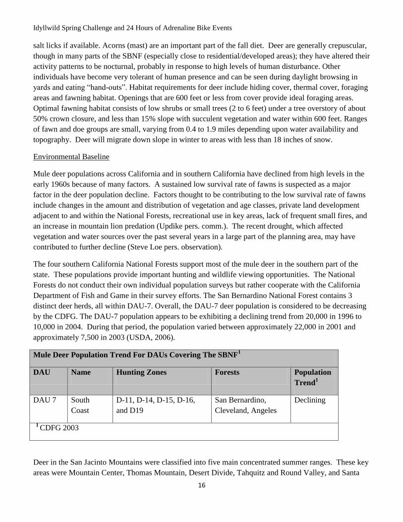
Department of Fish and Game in their survey efforts. The San Bernardino National Forest contains 3
distinct deer herds, all within DAU-7. Overall, the DAU-7 deer population is considered to be decreasing
by the CDFG. The DAU-7 population appears to be exhibiting a declining trend from 20,000 in 1996 to
10,000 in 2004. During that period, the population varied between approximately 22,000 in 2001 and
approximately 7,500 in 2003 (USDA, 2006).
Mule Deer Population Trend For DAUs Covering The SBNF1
DAU Name Hunting Zones Forests Population
Trend1
DAU 7 South
Coast
D-11, D-14, D-15, D-16,
and D19
San Bernardino,
Cleveland, Angeles
Declining
1 CDFG 2003
Deer in the San Jacinto Mountains were classified into five main concentrated summer ranges. These key
areas were Mountain Center, Thomas Mountain, Desert Divide, Tahquitz and Round Valley, and Santa
Idyllwild Spring Challenge and 24 Hours of Adrenaline Bike Events
17
Rosa Mountain. Except for the Tahquitz Valley herd, the deer on the San Jacinto Mountain belong to
resident herds. The Tahquitz Valley herd migrates to a winter range in Murray and Andreas Canyons due
to snow at higher elevations during the winter. Additionally, the San Jacinto/Santa Rosa Mountain herd is
the only herd that moves between Hunt Zone D-19 (on the SBNF) and D-16 of the Cleveland National
Forest.
Deer population estimates are provided by CDFG. Deer kill is an indicator of population numbers when
viewed over the long-term, and is used by the Department of Fish and Game in developing their
population estimates. This estimate can be viewed at: http://www.dfg.ca.gov/hunting/deer/deerhunt.html.
Deer populations are estimated to be stable to slightly declining, with some yearly fluctuations.
There is suitable habitat for mule deer throughout all of the San Jacinto Ranger District, and certainly
along the 21 miles of trail. Habitat for mule deer varies throughout the area from areas of low suitability
(high recreation disturbance, close to highways and developments), to area of high suitability with
perennial water sources. Deer can also use artificially created livestock water developments and salt licks,
that area available in the Garner Allotment.
Potential Impacts to Mule Deer
As a forest MIS species, the indicator of management for mule deer is diverse healthy habitats. Meadows,
intermittent and ephemeral creeks, and riparian areas all provide water and forage for the species. The
proposed mountain bike events are expected to reduce the quantity and quality of habitat available for
mule deer. Disturbance from noise and increased trails and human presence may discourage mule deer
from using this area as fawning habitat. However, since the event is short term, the amount of disturbance
should be minimal. The expected outcome of bike events will result in some reduction of diverse healthy
habitat for mule deer across the May Valley area. These recreation events are unlikely to result in a
noticeable change to deer populations on the SBNF. It is expected that that there will be a no change to a
non-significant movement away from the desired forest condition.
Mountain lion (Felis concolor)
The mountain lion was selected as an MIS to detect the effects of National Forest activities and uses on
landscape-level habitat fragmentation and habitat linkages. The greatest concern for the long-term health
of mountain lion populations on the National Forests of southern California is loss of landscape
connectivity between mountain ranges and large blocks of open space on private land (Dickson et al.,
2005). Factors that adversely affect mule deer also adversely affect mountain lions. Mountain lions prefer
areas with solitude, as do mule deer, so disturbances in riparian areas and key deer summer and winter
ranges also affect mountain lions. Extensive vehicle access increases the potential for disturbance,
poaching, and animal mortality from vehicles. Another threat to the species is the widening of the existing
highway system and new highways, both within and outside the national forests, which can create barriers
to movement. The national forests have been cooperating in the Missing Linkages Projects lead by the
South Coast Wildlands Conservancy. This effort attempts to identify and gain government agency and
public recognition and support for maintaining critical landscape linkages. All four southern California
national forests are participating in this effort.
Idyllwild Spring Challenge and 24 Hours of Adrenaline Bike Events
18
The LMP desired condition to maintain or improve habitat conditions to sustain healthy lion populations
can be supported by activities which support healthy deer populations and provide functional travel routes
for lions to disperse to other suitable habitats. Fire and fuel management are the main tools intended to
implement the objective for providing prey availability.
Environmental Baseline
The mountain lion is the largest carnivore in southern California and requires large core habitat areas,
abundant prey, and habitat connectivity between sub-populations. Recent state population estimates range
from 2,500 to 5,000 individuals, with an increasing population trend. Mountain lions inhabit forest and
shrubland habitats throughout California where deer, their primary prey, are found (CDFG 2005).
Mountain lions are found in nearly all habitat types, but particularly require large areas of riparian
vegetation and brushy habitats. They use natural caves, rocky ledges, and thickets for cover and denning.
Lions feed primarily on deer and bighorn sheep when available, but also eat rabbits, hares, coyotes,
skunks, rodents, and occasionally domestic animals. Males avoid each other, but are not known to defend
a territory. Estrus may occur at any time of year, but in California, most births occur in the spring months.
The young are weaned by about 8 weeks, and become independent in their second year. Females begin to
breed between the ages of 2.5-4 years. Litters are generally produced at 2-year intervals. Implementation
of the project is during the winter and fall months, when mountain lions are not likely to be breeding.
Mountain lion population counts are very difficult and expensive, and do not exist for the SBNF. The
California Department of Fish & Game estimates the mountain lion population statewide to be about
6,000 conservatively (Santa Barbara News-Press 10/27/05). They estimated the population to be 5,100
adults during the 1970s and 1980s (USDA Forest Service 2006). Based on records of depredation, attacks
on people, and predation on prey populations, it is suspected that the population peaked in 1996, and has
been somewhat stable for the past several years (www.dfg.ca.gov/news/issues/lion/lion_faq.html). Human
encounters with mountain lions have increased in the recent past, leading to the belief that mountain lion
populations have increased in the past several decades (Torres et al. 1996). Currently there is no
information that would lead to a cause for concern for mountain lion populations on the SBNF in the
Santa Rosa or San Jacinto Mountains.
The SBNF has some large areas of unfragmented habitat ideal for supporting mountain lion populations.
There is suitable habitat for mountain lion throughout all of the San Jacinto Ranger District, and certainly
along the 21 miles of trail. It is unknown how the relative numbers of mountain lion populations relate to
the trends on the SBNF.
Potential Impacts to Mountain lion
The mountain bike events are not expected to have any significant negative effects on mountain lions.
Animals may avoid the area during the event due to to increased noise, human presence and congestion.
However, lions will most likelt return to the area once the event has passed. Mountaion lions have such
large home ranges which they use nightly, that they may easily not be in the area during the event. The
events are not expected to contribute to habitat fragmentation for the mountain lion. The events will not
directly reduce the amount of available habitat for this species. Indirect effects may be in the form of
Idyllwild Spring Challenge and 24 Hours of Adrenaline Bike Events
19
decreasing habitat if increased recreation is not managed for its effect on large mammals. Non-native
plant species may change habitat and fire regimes. Changes in muke deer availability as a result of
increased recreation would impact mountian lions. It is expected that that there will be a no change from
the desired forest condition.
Song Sparrow (Melospiza melodia)
The song sparrow was selected as a MIS for riparian areas because its abundance is expected to be
responsive to management actions and to indicate trends in the status of the riparian biological
community, particularly birds. The song sparrow is identified by California Partners in Flight as a
riparian focal species, and is considered one of the best indicators of riparian health in the western U.S.,
since over 90% of song sparrow nests are found in riparian vegetation. Its distribution is defined by the
presence of water through the breeding season, becoming scarce where undergrowth is reduced along
ephemeral streams (Roberson and Tenney 1993). As the human population continues to grow and the
demand for water and recreation opportunities increases, the pressures on riparian habitat will also
increase. Song sparrow abundance is negatively correlated with the use of riparian understory habitat for
grazing and recreation (Marshall 1948) and positively correlated with the abundance of herbaceous
vegetation (Ballard and Geupel 1998). Abundance trends for song sparrow and habitat condition
assessments will help indicate whether national forest management is maintaining healthy riparian
ecosystems in the face of increasing demand.
Song Sparrows are found in riparian streams, coastal scrub, chaparral and wetlands. Of the 31 subspecies,
12 breed in California. Some subspecies are year round residents and many over-winter in Southern
California. The most common subspecies in Southern California is the San Diego Song Sparrow (M .m.
cooperi). It is known to breed in streams on the east side of the San Jacinto Mountains. Their main habitat
requirements are a water source, moderately dense vegetation, plenty of light and exposed ground/litter
for foraging. Their diet consists of insects and seeds with the percentage of insects increasing during the
nesting season. They forage on the ground and in shallow water and mud. Breeding occurs between late
March and late June, usually 2 - 3 clutches a year with 3 – 4 young per clutch. Incubation lasts about 2
weeks and the young fledge in about 10 days. Song Sparrows are highly territorial, and may defend
territories year round. On the SBNF, riparian habitat conditions have improved over the past century.
Greater restrictions on grazing, timber management and recreational use has allowed some areas to
recover from conditions 50-100 years ago. However, riparian habitat within the San Bernardino, San
Jacinto, and eastern San Gabriel Mountains on federal and non-federal lands has been affected by water
diversions and extractions over the years, reducing the amount and quality of this habitat type. As such,
impacts to song sparrow populations likely have occurred due to reduction in habitat quality and quantity.
Proposed and planned developments in and adjacent to the SBNF will certainly result in increased
recreational uses in riparian areas on the forest. Demands on water, and thus riparian habitat both on and
off the SBNF, are likely continue to increase.
Sauer et al. (2005) summarize Breeding Bird Survey data, which show a declining trend for the Song
Sparrow in California. An average decrease of 0.3% per year was noted for the period of 1966-2004, with
a decline becoming more evident in the 1980-2004 sampling period (-1%). These results were not
Idyllwild Spring Challenge and 24 Hours of Adrenaline Bike Events
20
statistically significant. However, they are consistent with what appears to be a nationwide decline in the
abundance of this species. Song Sparrows are well represented on all four southern California National
Forests; they were recorded at 197 out of 206 stations during the 1988-1996 riparian bird count surveys.
This species is one of a few that were numerous enough to estimate trends with good confidence.
Negative trends in song sparrow abundance were determined from this monitoring (USDA, 1998). Song
Sparrows are known to adapt to agricultural and landscaped areas. In San Diego County, they have been
documented nesting in gardens, nurseries, and weedy areas, and may occupy territories as small as 0.05
acres (Unitt 2004). The Song Sparrows that occur in urban or suburban areas are not likely to be detected
along Breeding Bird Survey routes, and their colonization of these new habitats may partially compensate
for declines in other areas.
As a Forest MIS species, the indicator of management for song sparrows is ground disturbance, spread of
invasive species, mortality from collision and altered stream flow regimes. There is limited habitat for
song sparrows within the proposed mountain biking event area except for along Herkey creek. However,
there is abundant chaparral landscape that could be used by the birds. Song sparrows have been detected
in May Valley through spring bird counts (J. Rechel pers. comm, 2008). Song sparrows were detected
nearby at Lake Hemet (Garner allotment) by the San Diego Natural History Museum (P. Unitt, pers.
comm.).
Potential Impacts to Song Sparrow
Song Sparrows nest on or near the ground, and prefer habitat that provides fairly dense cover. It is
possible that event participants may accidentally disturb birds and/or nest sites during the events. This
type of disturbance would have negative consequences for breeding success for this species. However,
since the event is limited to only a couple of days per year, and one event is outside of the typical bird
breeding season, the likelihood that song sparrows will be significantly affected is low. Permitting the
mountain bike events on the San Jacinto Ranger District is expected to slightly reduce the amount of
habitat available for song sparrows away from the desired condition.
C. Cumulative Effects for MIS species
For analysis of cumulative effects, the action area is defined as the May Valley area, despite the reality
that the event participants ride only on the non-system trails within May Valley. The non-system trails
cover approximately 27 miles of National Forest System lands on the San Jacinto Ranger District. All of
the MIS species known to occur have been, are, and will continue to be affected by the continuation of the
Forest Service management activities. Effects to MIS species and their habitats were most likely more
significant than currently observed. It is also expected that these effects will continue and potentially
increase as recreation on the SBNF continues to increase. The Biological Evaluation (see above) describes
the various activities that have a cumulative effect on wildlife species. The cumulative effect of all of
these activities is a reduction in the quantity and quality of habitat for MIS species within the proposed
project area. The effect is permanent. However, based on the existing information regarding MIS
populations and the effect of Forest management activities on these species, at this time, the MIS
addressed in this document are not considered to be or going towards a decreasing trend in sustainability.

Idyllwild Spring Challenge and 24 Hours of Adrenaline Bike Events
21
The No Action alternative would have no effect on MIS species and/or their habitats. It would not
contribute to cumulative effects to those species.
Idyllwild Spring Challenge and 24 Hours of Adrenaline Bike Events
22
LITERATURE CITED
Ballard, G. and G. R. Geupel. 1998. Songbird monitoring on the San Luis National Wildlife Refuge
1995-1997. Report to the US Fish and Wildlife Service. PRBO.
California Department of Fish and Game. 2002. California Wildlife Habitat Relationship System
(CWHR). Http://www.dfg.ca.gov/whdab/cwhr
California Department of Fish and Game. 2005. General Deer Hunting Information for ZONE D-14.
Http://www.dfg.ca.gov/hunting/deer/zoneinfo/d14zoneinfo2005.pdf
Dickson, B.G., J.S. Jenness, and P. Beier. 2005. Influence on vegetation, topography, and roads on
cougar movement in southern California. J. Wildlife Management 69:264-276.
Marshall, J.T. 1948. Ecological races of song sparrows in the San Francisco Bay region. Part 1. Habitat
and abundance. Condor 50: 193-215.
Rechel, J. 2008. Wildlife Biologist. Forest Service – PSW – Riverside Fire Lab. Personal
communications with Anne Poopatanapong, District Wildlife Biologist.
Roberson, D., and C. Tenney. Eds. 1993. Atlas of the breeding birds of Monterey County,
California. Monterey, CA: Monterey Peninsula Audubon Society.
Sauer, J.R., J.E. Hines, and J. Fallon. 2005. The North American Breeding Bird Survey, Results and
Analysis 1996 – 2004. Version 2005.2. USGS Patuxent Wildlife Research Center. Laurel, MD.
Http://www.mbr-pwrc.usgs.gov/bbs/bbs.html.
Unitt, P. 2004. San Diego County Bird Atlas. Proceedins of the San Diego Society of Natural History.
No. 39. San Diego Natural History Museum. 645 pgs.
Unitt, P. 2008. Ornithologist and Curator, Department of Birds and Mammals. San Diego Natural History
Museum. Personal communications with Anne Poopatanapong, District Wildlife Biologist.
U.S.D.A. Forest Service. 1998. Trends in riparian bird abundance across four National Forest in southern
California, 1998-1996. Unpublished report.
U.S.D.A. Forest Service (USFS) 2005. Biological Assessment and Evaluation for Idyllwild Cycling
Race. Completed by Kim Boss.
U.S.D.A. Forest Service. 2006. Revised Land Management Plans and Final Environmental Impact
Statement. San Bernardino National Forest. Pacific Southwest Region. R5-MB-086-CD. Final
Environmental Impact Statement for the southern California Forest Plan Revisions. R5-MB-074A
and B.
U.S.D.A. Forest Service. 2006a. MIS Analysis and Documentation in Project-Level NEPA, R5
Environmental Coordination. Internal document.

Idyllwild Spring Challenge and 24 Hours of Adrenaline Bike Events
23
U.S.D.A. Forest Service (USFS). 2006b. Supplemental Information Report for 2006 Idyllwild Bike Race
SUP. Completed by Anne Poopatanapong.
U.S.D.A. Forest Service (USFS). 2008. Supplemental Information Report for 2008 Idyllwild Bike Race
SUP. Completed by Heidi Hoggan.
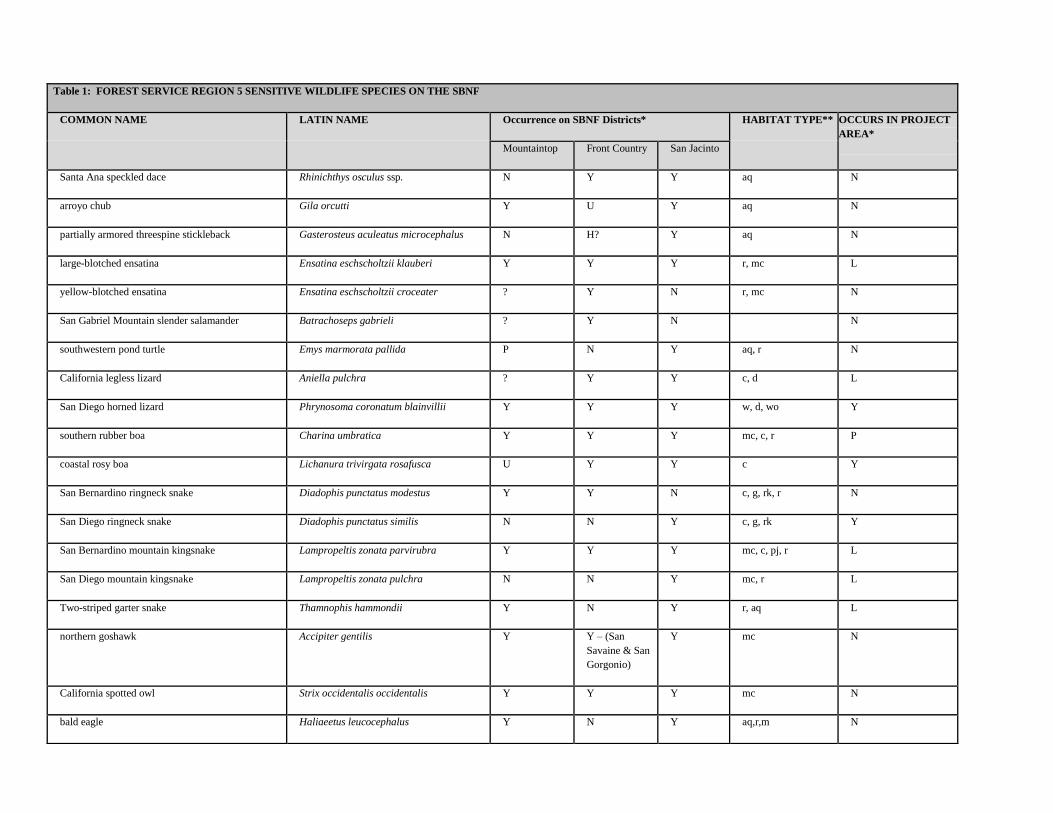
Table 1: FOREST SERVICE REGION 5 SENSITIVE WILDLIFE SPECIES ON THE SBNF
COMMON NAME LATIN NAME Occurrence on SBNF Districts* HABITAT TYPE** OCCURS IN PROJECT
AREA*
Mountaintop Front Country San Jacinto
Santa Ana speckled dace Rhinichthys osculus ssp. N Y Y aq N
arroyo chub Gila orcutti Y U Y aq N
partially armored threespine stickleback Gasterosteus aculeatus microcephalus N H? Y aq N
large-blotched ensatina Ensatina eschscholtzii klauberi Y Y Y r, mc L
yellow-blotched ensatina Ensatina eschscholtzii croceater ? Y N r, mc N
San Gabriel Mountain slender salamander Batrachoseps gabrieli ? Y N N
southwestern pond turtle Emys marmorata pallida P N Y aq, r N
California legless lizard Aniella pulchra ? Y Y c, d L
San Diego horned lizard Phrynosoma coronatum blainvillii Y Y Y w, d, wo Y
southern rubber boa Charina umbratica Y Y Y mc, c, r P
coastal rosy boa Lichanura trivirgata rosafusca U Y Y c Y
San Bernardino ringneck snake Diadophis punctatus modestus Y Y N c, g, rk, r N
San Diego ringneck snake Diadophis punctatus similis N N Y c, g, rk Y
San Bernardino mountain kingsnake Lampropeltis zonata parvirubra Y Y Y mc, c, pj, r L
San Diego mountain kingsnake Lampropeltis zonata pulchra N N Y mc, r L
Two-striped garter snake Thamnophis hammondii Y N Y r, aq L
northern goshawk Accipiter gentilis Y Y – (San
Savaine & San
Gorgonio)
Y mc N
California spotted owl Strix occidentalis occidentalis Y Y Y mc N
bald eagle Haliaeetus leucocephalus Y N Y aq,r,m N
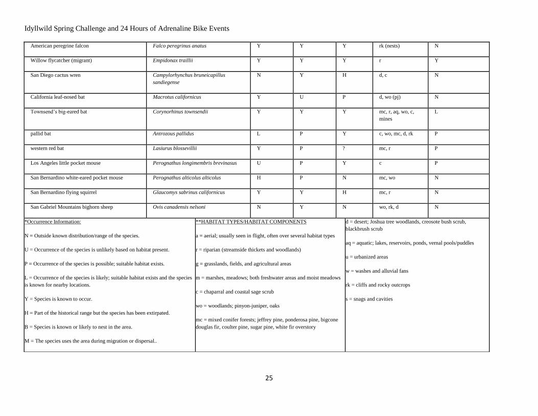
Idyllwild Spring Challenge and 24 Hours of Adrenaline Bike Events
25
American peregrine falcon Falco peregrinus anatus Y Y Y rk (nests) N
Willow flycatcher (migrant) Empidonax traillii Y Y Y r Y
San Diego cactus wren Campylorhynchus bruneicapillus
sandiegense
N Y H d, c N
California leaf-nosed bat Macrotus californicus Y U P d, wo (pj) N
Townsend’s big-eared bat Corynorhinus townsendii Y Y Y mc, r, aq, wo, c,
mines
L
pallid bat Antrozous pallidus L P Y c, wo, mc, d, rk P
western red bat Lasiurus blossevillii Y P ? mc, r P
Los Angeles little pocket mouse Perognathus longimembris brevinasus U P Y c P
San Bernardino white-eared pocket mouse Perognathus alticolus alticolus H P N mc, wo N
San Bernardino flying squirrel Glaucomys sabrinus californicus Y Y H mc, r N
San Gabriel Mountains bighorn sheep Ovis canadensis nelsoni N Y N wo, rk, d N
*Occurrence Information:
N = Outside known distribution/range of the species.
U = Occurrence of the species is unlikely based on habitat present.
P = Occurrence of the species is possible; suitable habitat exists.
L = Occurrence of the species is likely; suitable habitat exists and the species
is known for nearby locations.
Y = Species is known to occur.
H = Part of the historical range but the species has been extirpated.
B = Species is known or likely to nest in the area.
M = The species uses the area during migration or dispersal..
**HABITAT TYPES/HABITAT COMPONENTS
a = aerial; usually seen in flight, often over several habitat types
r = riparian (streamside thickets and woodlands)
g = grasslands, fields, and agricultural areas
m = marshes, meadows; both freshwater areas and moist meadows
c = chaparral and coastal sage scrub
wo = woodlands; pinyon-juniper, oaks
mc = mixed conifer forests; jeffrey pine, ponderosa pine, bigcone
douglas fir, coulter pine, sugar pine, white fir overstory
d = desert; Joshua tree woodlands, creosote bush scrub,
blackbrush scrub
aq = aquatic; lakes, reservoirs, ponds, vernal pools/puddles
u = urbanized areas
w = washes and alluvial fans
rk = cliffs and rocky outcrops
s = snags and cavities
Idyllwild Spring Challenge and 24 Hours of Adrenaline Bike Events
26
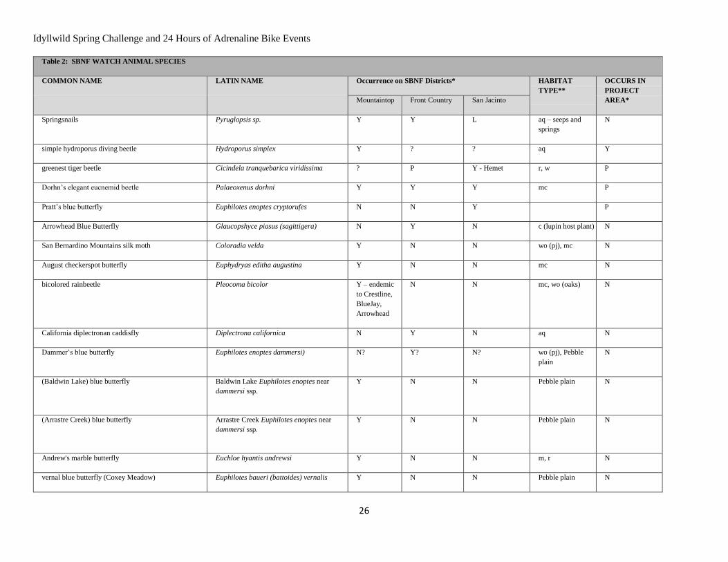
Table 2: SBNF WATCH ANIMAL SPECIES
COMMON NAME LATIN NAME Occurrence on SBNF Districts* HABITAT
TYPE**
OCCURS IN
PROJECT
AREA* Mountaintop Front Country San Jacinto
Springsnails Pyruglopsis sp. Y Y L aq – seeps and
springs
N
simple hydroporus diving beetle Hydroporus simplex Y ? ? aq Y
greenest tiger beetle Cicindela tranquebarica viridissima ? P Y - Hemet r, w P
Dorhn’s elegant eucnemid beetle Palaeoxenus dorhni Y Y Y mc P
Pratt’s blue butterfly Euphilotes enoptes cryptorufes N N Y P
Arrowhead Blue Butterfly Glaucopshyce piasus (sagittigera) N Y N c (lupin host plant) N
San Bernardino Mountains silk moth Coloradia velda Y N N wo (pj), mc N
August checkerspot butterfly Euphydryas editha augustina Y N N mc N
bicolored rainbeetle Pleocoma bicolor Y – endemic
to Crestline,
BlueJay,
Arrowhead
N N mc, wo (oaks) N
California diplectronan caddisfly Diplectrona californica N Y N aq N
Dammer’s blue butterfly Euphilotes enoptes dammersi) N? Y? N? wo (pj), Pebble
plain
N
(Baldwin Lake) blue butterfly
Baldwin Lake Euphilotes enoptes near
dammersi ssp.
Y N N Pebble plain N
(Arrastre Creek) blue butterfly
Arrastre Creek Euphilotes enoptes near
dammersi ssp.
Y N N Pebble plain N
Andrew's marble butterfly Euchloe hyantis andrewsi Y N N m, r N
vernal blue butterfly (Coxey Meadow) Euphilotes baueri (battoides) vernalis Y N N Pebble plain N
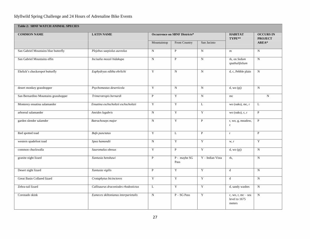
Idyllwild Spring Challenge and 24 Hours of Adrenaline Bike Events
27
Table 2: SBNF WATCH ANIMAL SPECIES
COMMON NAME LATIN NAME Occurrence on SBNF Districts* HABITAT
TYPE**
OCCURS IN
PROJECT
AREA* Mountaintop Front Country San Jacinto
San Gabriel Mountains blue butterfly Plejebus saepiolus aureolus N P N m N
San Gabriel Mountains elfin Incisalia mossii hidakupa N P N rk, on Sedum
spathulifolium
N
Ehrlich’s checkerspot butterfly Euphydryas editha ehrlichi
Y N N d, c, Pebble plain N
desert monkey grasshopper Psychomastax deserticola Y N N d, wo (pj) N
San Bernardino Mountains grasshopper Trimerotropis bernardi P Y N mc N
Monterey ensatina salamander Ensatina eschscholtzii eschscholtzii Y Y L wo (oaks), mc, r L
arboreal salamander Aneides lugubris N Y Y wo (oaks), c, r P
garden slender salamder Batrachoseps major N Y P r, wo, g, meadow,
c
P
Red spotted toad Bufo punctatus Y L P r P
western spadefoot toad Spea hamondii N Y Y w, r Y
common chuckwalla Sauromalus obesus Y P Y d, wo (pj) N
granite night lizard Xantusia henshawi P P - maybe SG
Pass
Y – Indian Vista rk, N
Desert night lizard Xantusia vigilis P Y Y d N
Great Basin Collared lizard Crotaphytus bicinctores Y Y Y d N
Zebra-tail lizard Callisaurus draconiodes rhodostictus L Y Y d, sandy washes N
Coronado skink Eumeces skiltonianus interparietalis N P – SG Pass Y c, wo, r, mc – sea
level to 1675
meters
N
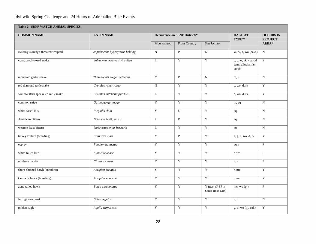
Idyllwild Spring Challenge and 24 Hours of Adrenaline Bike Events
28
Table 2: SBNF WATCH ANIMAL SPECIES
COMMON NAME LATIN NAME Occurrence on SBNF Districts* HABITAT
TYPE**
OCCURS IN
PROJECT
AREA* Mountaintop Front Country San Jacinto
Belding’s orange-throated whiptail Aspidoscelis hyperythrus beldingi N P N w, rk, c, wo (oaks) N
coast patch-nosed snake Salvadora hexalepis virgultea L Y Y c, d, w, rk, coastal
sage, alluvial fan
scrub
P
mountain garter snake Thamnophis elegans elegans Y P N m, r N
red diamond rattlesnake Crotalus ruber ruber N Y Y c, wo, d, rk Y
southwestern speckeled rattlesnake Crotalus mitchellii pyrrhus L Y Y c, wo, d, rk Y
common snipe Gallinago gallinago Y Y Y m, aq N
white-faced ibis Plegadis chihi Y U Y aq N
American bittern Botaurus lentiginosus P P Y aq N
western least bittern Ixobrychus exilis hesperis L Y Y aq N
turkey vulture (breeding) Cathartes aura Y P Y a, g, c, wo, d, rk Y
osprey Pandion haliaetus Y Y Y aq, r P
white-tailed kite Elanus leucurus Y Y Y r, wo P
northern harrier Circus cyaneus Y Y Y g, m P
sharp-shinned hawk (breeding) Accipiter striatus Y Y Y r, mc Y
Cooper's hawk (breeding) Accipiter cooperii Y Y Y r, mc Y
zone-tailed hawk Buteo albonotatus Y Y Y (nest @ SJ in
Santa Rosa Mtn)
mc, wo (pj) P
ferruginous hawk Buteo regalis Y Y Y g, d N
golden eagle Aquila chrysaetos Y Y Y g, d, wo (pj, oak) Y
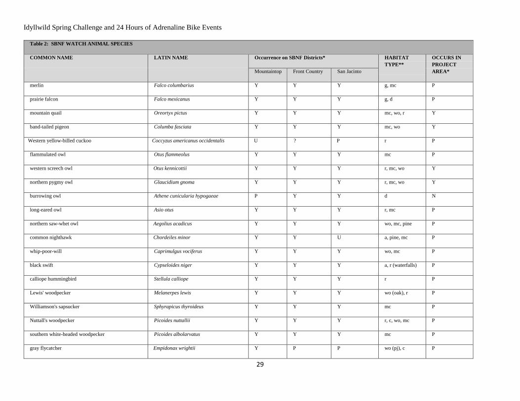
Idyllwild Spring Challenge and 24 Hours of Adrenaline Bike Events
29
Table 2: SBNF WATCH ANIMAL SPECIES
COMMON NAME LATIN NAME Occurrence on SBNF Districts* HABITAT
TYPE**
OCCURS IN
PROJECT
AREA* Mountaintop Front Country San Jacinto
merlin Falco columbarius Y Y Y g, mc P
prairie falcon Falco mexicanus Y Y Y g, d P
mountain quail Oreortyx pictus Y Y Y mc, wo, r Y
band-tailed pigeon Columba fasciata Y Y Y mc, wo Y
Western yellow-billed cuckoo Coccyzus americanus occidentalis U ? P r P
flammulated owl Otus flammeolus Y Y Y mc P
western screech owl Otus kennicottii Y Y Y r, mc, wo Y
northern pygmy owl Glaucidium gnoma Y Y Y r, mc, wo Y
burrowing owl Athene cunicularia hypogaeae P Y Y d N
long-eared owl Asio otus Y Y Y r, mc P
northern saw-whet owl Aegolius acadicus Y Y Y wo, mc, pine P
common nighthawk Chordeiles minor Y Y U a, pine, mc P
whip-poor-will Caprimulgus vociferus Y Y Y wo, mc P
black swift Cypseloides niger Y Y Y a, r (waterfalls) P
calliope hummingbird Stellula calliope Y Y Y r P
Lewis' woodpecker Melanerpes lewis Y Y Y wo (oak), r P
Williamson's sapsucker Sphyrapicus thyroideus Y Y Y mc P
Nuttall's woodpecker Picoides nuttallii Y Y Y r, c, wo, mc P
southern white-headed woodpecker Picoides albolarvatus Y Y Y mc P
gray flycatcher Empidonax wrightii Y P P wo (pj), c P
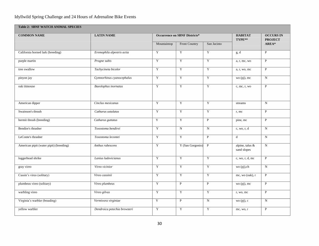
Idyllwild Spring Challenge and 24 Hours of Adrenaline Bike Events
30
Table 2: SBNF WATCH ANIMAL SPECIES
COMMON NAME LATIN NAME Occurrence on SBNF Districts* HABITAT
TYPE**
OCCURS IN
PROJECT
AREA* Mountaintop Front Country San Jacinto
California horned lark (breeding) Eremophila alpestris actia Y Y Y g, d P
purple martin Progne subis Y Y Y a, r, mc, wo P
tree swallow Tachycineta bicolor Y Y Y a, r, wo, mc P
pinyon jay Gymnorhinus cyanocephalus Y Y Y wo (pj), mc N
oak titmouse Baeolophus inornatus
Y Y Y c, mc, r, wo P
American dipper Cinclus mexicanus Y Y Y streams N
Swainson's thrush Catharus ustulatus Y Y Y r, mc P
hermit thrush (breeding) Catharus guttatus Y Y P pine, mc P
Bendire's thrasher Toxostoma bendirei Y N N c, wo, r, d N
LeConte's thrasher Toxostoma lecontei Y Y P d N
American pipit (water pipit) (breeding) Anthus rubescens Y Y (San Gorgonio) P alpine, talus &
sand slopes
N
loggerhead shrike Lanius ludovicianus Y Y Y c, wo, r, d, mc P
gray vireo Vireo vicinior Y Y Y wo (pj),ch N
Cassin’s vireo (solitary) Vireo cassinii Y Y Y mc, wo (oak), r P
plumbeus vireo (solitary) Vireo plumbeus Y P P wo (pj), mc P
warbling vireo Vireo gilvus Y Y Y r, wo, mc P
Virginia’s warbler (breeding) Vermivora virginiae Y P N wo (pj), c N
yellow warbler Dendroica petechia brewsteri Y Y Y mc, wo, r P

Idyllwild Spring Challenge and 24 Hours of Adrenaline Bike Events
31
Table 2: SBNF WATCH ANIMAL SPECIES
COMMON NAME LATIN NAME Occurrence on SBNF Districts* HABITAT
TYPE**
OCCURS IN
PROJECT
AREA* Mountaintop Front Country San Jacinto
MacGillivray's warbler Oporornis tolmiei Y Y Y r. m P
common yellowthroat Geothlypis trichas Y Y Y r P
Wilson's warbler Wilsonia pusilla Y Y Y r P
yellow-breasted chat Icteria virens P Y P r P
hepatic tanager Piranga flava Y Y Y wo P
summer tanager Piranga rubra P Y Y r P
southern California rufous-crowned sparrow Aimophila ruficeps canescens Y Y Y c P
black-chinned sparrow Spizella atrogularis Y Y Y d, c, wo (pj) P
Bell's sage sparrow Amphispiza belli belli Y Y P c P
Lincoln's sparrow Melospiza lincolnii Y Y N r, mc, wo N
tri-colored blackbird Agelaius tricolor Y P Y r, m P
Lawrence's goldfinch Carduelis lawrencei Y Y Y r, c P
Yuma myotis Myotis yumanensis Y Y Y d, wo P
long-eared myotis Myotis evotis Y Y L c, wo, mc P
fringed myotis Myotis thysanodes Y Y Y r, wo, m, g, mc P
long-legged myotis Myotis volans Y Y L wo, mc, c P
occult little brown bat Myotis lucifugus L N Y c, m, g, wo P
western small-footed myotis Myotis ciliolabrum Y Y L wo, r, mc P
spotted bat Euderma maculatum L L L d, rk P
pocketed free-tailed bat Nyctinomops femerosaccus L U (only possible
in Riv. Co.
Y wo (pj), d N
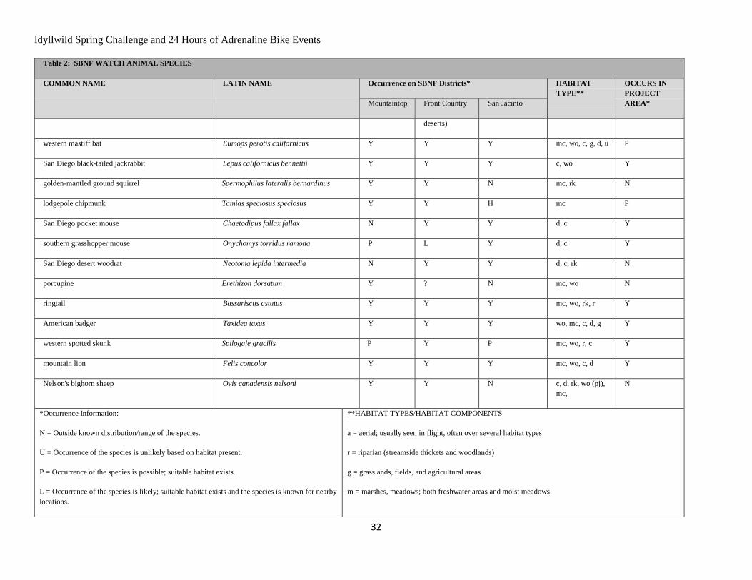
Idyllwild Spring Challenge and 24 Hours of Adrenaline Bike Events
32
Table 2: SBNF WATCH ANIMAL SPECIES
COMMON NAME LATIN NAME Occurrence on SBNF Districts* HABITAT
TYPE**
OCCURS IN
PROJECT
AREA* Mountaintop Front Country San Jacinto
deserts)
western mastiff bat Eumops perotis californicus Y Y Y mc, wo, c, g, d, u P
San Diego black-tailed jackrabbit Lepus californicus bennettii Y Y Y c, wo Y
golden-mantled ground squirrel Spermophilus lateralis bernardinus Y Y N mc, rk N
lodgepole chipmunk Tamias speciosus speciosus Y Y H mc P
San Diego pocket mouse Chaetodipus fallax fallax N Y Y d, c Y
southern grasshopper mouse Onychomys torridus ramona P L Y d, c Y
San Diego desert woodrat Neotoma lepida intermedia N Y Y d, c, rk N
porcupine Erethizon dorsatum Y ? N mc, wo N
ringtail Bassariscus astutus Y Y Y mc, wo, rk, r Y
American badger Taxidea taxus Y Y Y wo, mc, c, d, g Y
western spotted skunk Spilogale gracilis P Y P mc, wo, r, c Y
mountain lion Felis concolor Y Y Y mc, wo, c, d Y
Nelson's bighorn sheep Ovis canadensis nelsoni Y Y N c, d, rk, wo (pj),
mc,
N
*Occurrence Information:
N = Outside known distribution/range of the species.
U = Occurrence of the species is unlikely based on habitat present.
P = Occurrence of the species is possible; suitable habitat exists.
L = Occurrence of the species is likely; suitable habitat exists and the species is known for nearby
locations.
**HABITAT TYPES/HABITAT COMPONENTS
a = aerial; usually seen in flight, often over several habitat types
r = riparian (streamside thickets and woodlands)
g = grasslands, fields, and agricultural areas
m = marshes, meadows; both freshwater areas and moist meadows
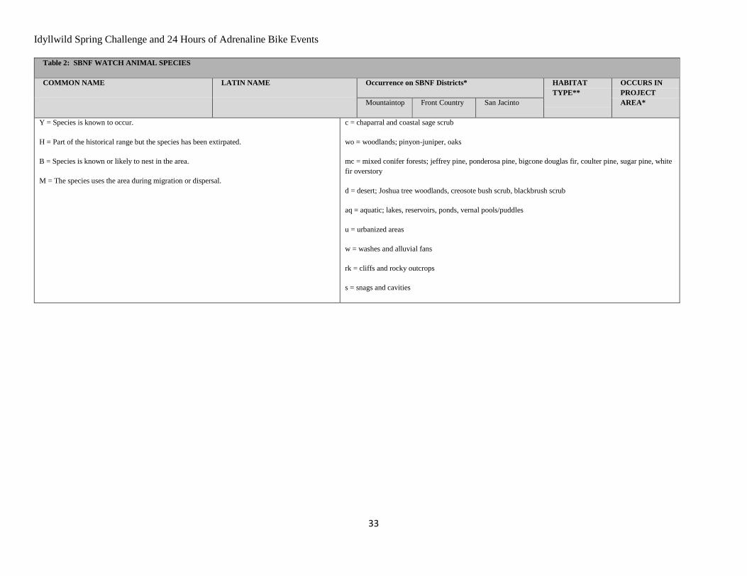
Idyllwild Spring Challenge and 24 Hours of Adrenaline Bike Events
33
Table 2: SBNF WATCH ANIMAL SPECIES
COMMON NAME LATIN NAME Occurrence on SBNF Districts* HABITAT
TYPE**
OCCURS IN
PROJECT
AREA* Mountaintop Front Country San Jacinto
Y = Species is known to occur.
H = Part of the historical range but the species has been extirpated.
B = Species is known or likely to nest in the area.
M = The species uses the area during migration or dispersal.
c = chaparral and coastal sage scrub
wo = woodlands; pinyon-juniper, oaks
mc = mixed conifer forests; jeffrey pine, ponderosa pine, bigcone douglas fir, coulter pine, sugar pine, white
fir overstory
d = desert; Joshua tree woodlands, creosote bush scrub, blackbrush scrub
aq = aquatic; lakes, reservoirs, ponds, vernal pools/puddles
u = urbanized areas
w = washes and alluvial fans
rk = cliffs and rocky outcrops
s = snags and cavities
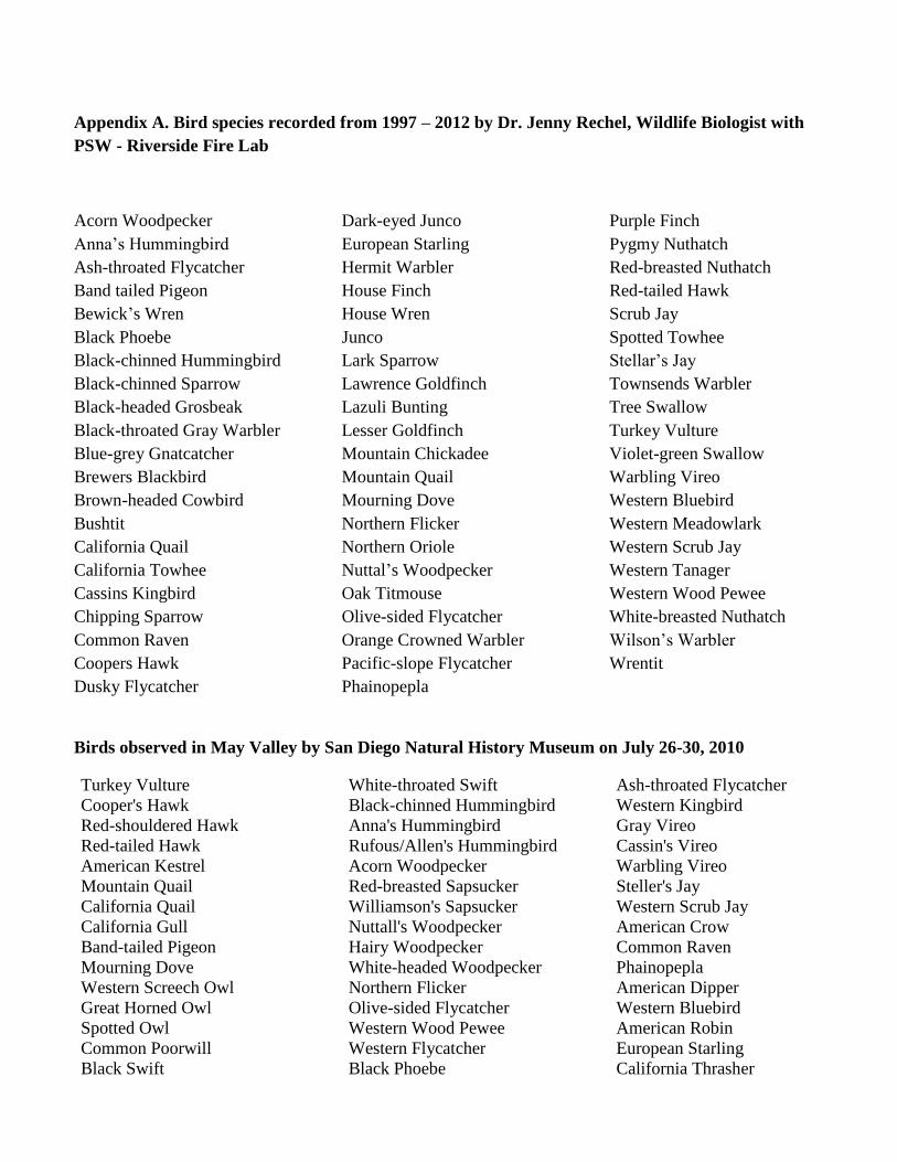
Appendix A. Bird species recorded from 1997 – 2012 by Dr. Jenny Rechel, Wildlife Biologist with
PSW - Riverside Fire Lab
Acorn Woodpecker
Anna’s Hummingbird
Ash-throated Flycatcher
Band tailed Pigeon
Bewick’s Wren
Black Phoebe
Black-chinned Hummingbird
Black-chinned Sparrow
Black-headed Grosbeak
Black-throated Gray Warbler
Blue-grey Gnatcatcher
Brewers Blackbird
Brown-headed Cowbird
Bushtit
California Quail
California Towhee
Cassins Kingbird
Chipping Sparrow
Common Raven
Coopers Hawk
Dusky Flycatcher
Dark-eyed Junco
European Starling
Hermit Warbler
House Finch
House Wren
Junco
Lark Sparrow
Lawrence Goldfinch
Lazuli Bunting
Lesser Goldfinch
Mountain Chickadee
Mountain Quail
Mourning Dove
Northern Flicker
Northern Oriole
Nuttal’s Woodpecker
Oak Titmouse
Olive-sided Flycatcher
Orange Crowned Warbler
Pacific-slope Flycatcher
Phainopepla
Purple Finch
Pygmy Nuthatch
Red-breasted Nuthatch
Red-tailed Hawk
Scrub Jay
Spotted Towhee
Stellar’s Jay
Townsends Warbler
Tree Swallow
Turkey Vulture
Violet-green Swallow
Warbling Vireo
Western Bluebird
Western Meadowlark
Western Scrub Jay
Western Tanager
Western Wood Pewee
White-breasted Nuthatch
Wilson’s Warbler
Wrentit
Birds observed in May Valley by San Diego Natural History Museum on July 26-30, 2010
Turkey Vulture
Cooper's Hawk
Red-shouldered Hawk
Red-tailed Hawk
American Kestrel
Mountain Quail
California Quail
California Gull
Band-tailed Pigeon
Mourning Dove
Western Screech Owl
Great Horned Owl
Spotted Owl
Common Poorwill
Black Swift
White-throated Swift
Black-chinned Hummingbird
Anna's Hummingbird
Rufous/Allen's Hummingbird
Acorn Woodpecker
Red-breasted Sapsucker
Williamson's Sapsucker
Nuttall's Woodpecker
Hairy Woodpecker
White-headed Woodpecker
Northern Flicker
Olive-sided Flycatcher
Western Wood Pewee
Western Flycatcher
Black Phoebe
Ash-throated Flycatcher
Western Kingbird
Gray Vireo
Cassin's Vireo
Warbling Vireo
Steller's Jay
Western Scrub Jay
American Crow
Common Raven
Phainopepla
American Dipper
Western Bluebird
American Robin
European Starling
California Thrasher
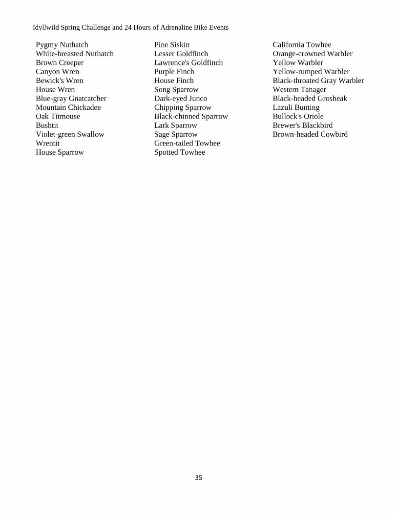
Idyllwild Spring Challenge and 24 Hours of Adrenaline Bike Events
35
Pygmy Nuthatch
White-breasted Nuthatch
Brown Creeper
Canyon Wren
Bewick's Wren
House Wren
Blue-gray Gnatcatcher
Mountain Chickadee
Oak Titmouse
Bushtit
Violet-green Swallow
Wrentit
House Sparrow
Pine Siskin
Lesser Goldfinch
Lawrence's Goldfinch
Purple Finch
House Finch
Song Sparrow
Dark-eyed Junco
Chipping Sparrow
Black-chinned Sparrow
Lark Sparrow
Sage Sparrow
Green-tailed Towhee
Spotted Towhee
California Towhee
Orange-crowned Warbler
Yellow Warbler
Yellow-rumped Warbler
Black-throated Gray Warbler
Western Tanager
Black-headed Grosbeak
Lazuli Bunting
Bullock's Oriole
Brewer's Blackbird
Brown-headed Cowbird
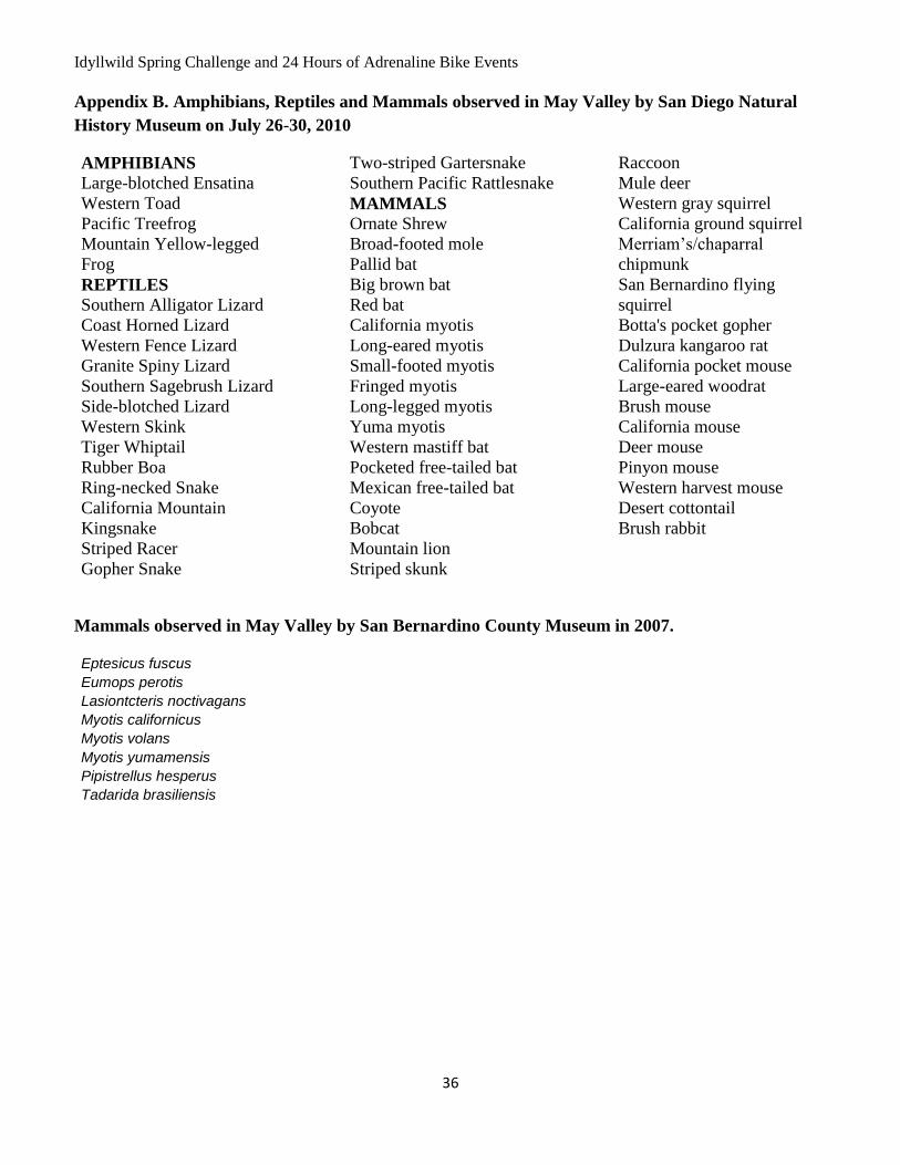
Idyllwild Spring Challenge and 24 Hours of Adrenaline Bike Events
36
Appendix B. Amphibians, Reptiles and Mammals observed in May Valley by San Diego Natural
History Museum on July 26-30, 2010
AMPHIBIANS
Large-blotched Ensatina
Western Toad
Pacific Treefrog
Mountain Yellow-legged
Frog
REPTILES
Southern Alligator Lizard
Coast Horned Lizard
Western Fence Lizard
Granite Spiny Lizard
Southern Sagebrush Lizard
Side-blotched Lizard
Western Skink
Tiger Whiptail
Rubber Boa
Ring-necked Snake
California Mountain
Kingsnake
Striped Racer
Gopher Snake
Two-striped Gartersnake
Southern Pacific Rattlesnake
MAMMALS
Ornate Shrew
Broad-footed mole
Pallid bat
Big brown bat
Red bat
California myotis
Long-eared myotis
Small-footed myotis
Fringed myotis
Long-legged myotis
Yuma myotis
Western mastiff bat
Pocketed free-tailed bat
Mexican free-tailed bat
Coyote
Bobcat
Mountain lion
Striped skunk
Raccoon
Mule deer
Western gray squirrel
California ground squirrel
Merriam’s/chaparral
chipmunk
San Bernardino flying
squirrel
Botta's pocket gopher
Dulzura kangaroo rat
California pocket mouse
Large-eared woodrat
Brush mouse
California mouse
Deer mouse
Pinyon mouse
Western harvest mouse
Desert cottontail
Brush rabbit
Mammals observed in May Valley by San Bernardino County Museum in 2007.
Eptesicus fuscus
Eumops perotis
Lasiontcteris noctivagans
Myotis californicus
Myotis volans
Myotis yumamensis
Pipistrellus hesperus
Tadarida brasiliensis