billabong creek floodplain management plan€¦ · billabong creek floodplain management plan ......
TRANSCRIPT

Billabong Creek Floodplain Management Plan
May 2006 Updated 2012 (Figures 1.1, 4.1, 4.2 resolution improved)

Department of Natural Resources Billabong Creek Floodplain Management Plan
Billabong Ck Plan-May06_Ver1 with figures.doc ii
Preamble The NSW Government’s Flood Prone Land Policy is aimed at providing solutions to existing flooding problems as well as ensuring that new development within flood prone areas is compatible with the prevailing flood risk and does not create additional flooding problems in other areas.
Under this Policy, the Department of Natural Resources (DNR) manage the rural flood risk within NSW for those areas west of the Great Dividing Range. This is through the administration of Part 8 of the Water Act 1912, under which the Billabong Creek Floodplain Management Plan (hereafter the Billabong Creek FMP) is to be adopted and gazetted.
The development of the Billabong Creek FMP has progressed through the following three stages:
Flood Study –technical assessment of the nature and extent of flooding;
Floodplain Management Study – evaluates management options for the floodplain giving consideration to hydraulic, environmental, social and economic issues;
Floodplain Management Plan – outlines strategies to manage flood risk and flood management issues, and support the natural functions of the floodplain environment.
The Billabong Creek Flood Study report (July 2002) and the Billabong Creek Floodplain Management Study (FMS) report (July 2004) document in detail all of the investigations leading to the preparation of the Floodplain Management Plan.
The Billabong Creek FMP will replace the Guidelines for Billabong Creek Floodplain Development, Walbundrie to Urana prepared in 1980 (hereafter the 1980 Guidelines) and extend further downstream to Jerilderie. The 1980 Guidelines have served as the basis for floodplain management for the past 24 years. Current legislative requirements and natural resource management principles meant that the 1980 Guidelines had become outdated and therefore required revision. The revision process has culminated in the preparation of this FMP.

Department of Natural Resources Billabong Creek Floodplain Management Plan
Billabong Ck Plan-May06_Ver1 with figures.doc iii
Billabong Creek
Floodplain Management Plan
Table of Contents
1. INTRODUCTION...................................................................................................... 1 1.1 Vision and Objectives............................................................................................... 1 1.2 Billabong Creek Floodplain ..................................................................................... 1 1.2.1 Overview................................................................................................................................ 1 1.2.2 Flooding History..................................................................................................................... 4 2. LEGISLATIVE POLICY AND PLANNING FRAMEWORK....................................... 4 2.1 The Flood Prone Land Policy................................................................................... 4 2.2 Water Act 1912 and Water Management Act 2000 ................................................. 5 2.3 Additional Floodplain Management Controls ........................................................... 5 2.4 Relevant Management Plans ................................................................................... 6 2.5 Floodplain Management Principles .......................................................................... 6 3. DEVELOPMENT ASSESSMENT CRITERIA........................................................... 7 3.1 Overview................................................................................................................... 7 3.2 Adopted Criteria ....................................................................................................... 7 3.2.1 Historical (for existing flood control works only) ..................................................................... 7 3.2.2 Socio-economic ..................................................................................................................... 8 3.2.3 Ecological .............................................................................................................................. 8 3.2.4 Flooding Behaviour ................................................................................................................ 9 4. THE FMP FLOODWAY NETWORK ...................................................................... 10 4.1 Overview................................................................................................................. 10 4.2 Design Flood .......................................................................................................... 13 4.3 Hydraulic Modelling ................................................................................................ 15 4.4 Critical Flow Distribution Areas .............................................................................. 15 4.5 Environmental Considerations ............................................................................... 16 4.6 Works within Floodways......................................................................................... 16 5. REQUIRED REMEDIAL MEASURES.................................................................... 16 5.1 Overview................................................................................................................. 16 5.2 Summary of Recommended Measures.................................................................. 17 6. ENVIRONMENTAL IMPACTS ............................................................................... 26 6.1 Overview................................................................................................................. 26 6.2 Downstream Floodplains........................................................................................ 28 6.3 State Water Management Outcomes Plan (SWMOP) Assessment ...................... 28 6.4 Related Management Issues ................................................................................. 28 6.4.1 Sapling Regrowth ................................................................................................................ 28 6.4.2 Murray Wetlands Working Group (MWWG) Water .............................................................. 28 7. IMPLEMENTATION ............................................................................................... 30 7.1 Roles and Responsibilities ..................................................................................... 30 7.2 Performance........................................................................................................... 30 7.3 Flood Monitoring..................................................................................................... 31 7.4 Part 8 Approval Process for Flood Control Works ................................................. 31 7.5 Complying and Non Complying Works .................................................................. 34 7.6 Unauthorised Works............................................................................................... 35
Appendix A Flood Monitoring Activities
Appendix B Glossary and Abbreviations

Department of Natural Resources Billabong Creek Floodplain Management Plan
Billabong Ck Plan-May06_Ver1 with figures.doc iv
List of Figures
Figure 1.1 Billabong Creek Floodplain
Figure 4.1 FMP Floodway Network
Fgure 4.2 Recommended Design Flows for Sizing Floodways
List of Tables
Table 2.1 Floodplain Management Principles
Table 3.1 Assessment Criteria: Maximum Permissible Velocities
Table 5.1 Summary of Recommended Measures
Table 6.1 Summary of Billabong Creek FMP Environmental Impacts

Department of Natural Resources Billabong Creek Floodplain Management Plan
Billabong Ck Plan-May06_Ver1 with figures.doc 1
1. INTRODUCTION
1.1 Vision and Objectives
The Billabong Creek FMP has been prepared to replace the 1980 Guidelines and extend the coverage downstream to Jerilderie. The FMP will serve as the future basis for the management of the Billabong Creek floodplain.
The vision for the management of the Billabong Creek floodplain is as follows:
A floodplain managed for the socio-economic interest of the community that provides a healthy and sustainable environment for floodplain ecosystems.
The objectives linked to the above vision statement for the Billabong Creek FMP are as follows:
► Coordinate floodplain development in order to minimise adverse changes to surface flow patterns;
► Develop and adopt floodplain management principles and development assessment criteria;
► Increase the sustainable social, economic and ecological benefits of using the floodplain; and
► Improve and maintain the diversity and well being of native riverine and floodplain ecosystems that depend on regular flood inundation.
The process leading to the preparation of the Billabong Creek FMP commenced in 1999. This process has consisted of a data collection and flood study followed by a floodplain management study. Extensive community consultation activities have taken place including a public display of the recommended floodway network and management options, distribution of information packages to individual landholders including newsletters and questionnaires, and individual landholder interviews to discuss specific issues.
The Billabong Creek FMP has been prepared under the direction of the Billabong Creek Floodplain Management Committee (hereafter the Committee). The Committee consists of 14 members with a mixture of representatives of government agencies, landholder groups and individual landholders.
1.2 Billabong Creek Floodplain
1.2.1 Overview
The Billabong Creek FMP applies to the Billabong Creek floodplain situated between the Murray and Murrumbidgee Rivers in southern New South Wales. The floodplain, shown on Figure 1.1 (Fig 1 in FMS report), extends from Walbundrie in the east to Jerilderie in the west and covers approximately 4,000 square kilometres, of which some 3,000 square kilometres is subject to frequent flooding.

Department of Natural Resources Billabong Creek Floodplain Management Plan
Billabong Ck Plan-May06_Ver1 with figures.doc 2
The floodplain also includes parts of several other creek systems including: Coreen Creek; Wangamong Creek; Nowranie (or South Creek); Wallandoon Creek, Washpool Creek; Sandhill Creek; and Urangeline Creek.
The floodplain is situated primarily within Urana and Jerilderie Shires, with small portions falling within Lockhart, Greater Hume (formerly Culcairn Shire) and Corowa Shires.
Prior to the 1970s, the Billabong Creek floodplain was used extensively for grazing with little alternate agricultural production such as cropping. However, changes in changes to the agricultural activity in the floodplain. Winter cereal and summer irrigated crops (wheat, barley, canola and rice) have now become important agricultural pursuits within the floodplain. Over the last 30 years in particular, crop farmers have been constructing networks of levees and other flood control works, utilising the 1980 Guidelines, in order to reduce the frequency of flooding and consequent impact upon crop loss. However, it was considered that the Guidelines did not extend far enough downstream and were not necessarily consistent with best practice for sustainable natural resources management. It was also considered that the Guidelines needed to be reviewed in light of a number of recent legislative changes and other activities undertaken within the floodplain over subsequent years. The existing Billabong Creek (Walbundrie to Urana) designated floodplain under section 166(1) of Part 8 of the Water Act 1912, will be amended to designate the Billabong Creek (Walbundrie to Jerilderie) floodplain.

Department of Natural Resources Billabong Creek Floodplain Management Plan
Billabong Ck Plan-May06_Ver1 with figures.doc 3

Department of Natural Resources Billabong Creek Floodplain Management Plan
Billabong Ck Plan-May06_Ver1 with figures.doc 4
1.2.2 Flooding History
There is a history of flooding within the Billabong Creek floodplain. Significant floods have been recorded in July 1931; August 1939; July 1956; October 1960; September 1970; October 1974; July 1981; September 1983; and July 1995.
The largest flood recorded within the study area occurred in July 1931. This flood is thought to be the largest flood since at least 1870, and has an estimated average recurrence interval of 100 years.
Floods can be relatively short duration events (like July 1995) which may only last for a few days or weeks, to prolonged floods (like October 1974) that can persist for many months. Depths of inundation are not large throughout the Billabong Creek system, being generally only about 0.5m, except in defined depressions and swamps. On the floodplain, velocity of flow is not high.
Flood flows are generally confined to Billabong Creek at Walbundrie. Further downstream, flood behaviour is more complex:
► Below Walbundrie, flood flows leave the main creek to flow to the south to Nowranie and Wangamong Creeks, and to the north towards Lake Urana.
► There is a general reduction in downstream peak flows due to storage effects on the floodplain, including large storage areas such as Lake Urana.
► Flows from Lake Urana and Nowranie Creek rejoin Billabong Creek upstream of Jerilderie, whilst Wangamong Creek rejoins Billabong Creek further downstream.
► Wangamong Creek can receive significant flood flows from the Twelve Mile Creek catchment to the south of Daysdale. This floodwater can sometimes exceed the peak flows in Wangamong Creek originating from Billabong Creek.
► There are also inflows upstream of Jerilderie from the Murrumbidgee system, mainly via Colombo Creek.
2. LEGISLATIVE POLICY AND PLANNING FRAMEWORK
The management of the Billabong Creek floodplain must be undertaken within the current legislative, policy and planning framework. A brief summary of the primary pieces of relevant legislation and policy is presented below.
2.1 The Flood Prone Land Policy
The primary objective of the Government’s Flood Prone Land Policy is to reduce the impacts of flooding on individual owners and occupiers of flood prone land, and to reduce private and public losses caused by flooding. A central tenet of the policy is that land use proposals for flood prone land be treated within the framework of a strategically generated floodplain risk management plan prepared using a merit approach. The Floodplain Development Manual (NSW Government 2005) supports the policy and outlines a merit - based approach to floodplain management.

Department of Natural Resources Billabong Creek Floodplain Management Plan
Billabong Ck Plan-May06_Ver1 with figures.doc 5
2.2 Water Act 1912 and Water Management Act 2000
DNR takes the lead role for floodplain management in the western rural areas of NSW through its administration of Part 8 of the Water Act 1912. Part 8 was gazetted in 1984 and makes provisions to control rural works that affect, or are likely to affect, flooding and/or floodplain functions. Part 8 was amended in 1999 to allow for more strategic control of rural flood control works through the preparation of FMPs and a more streamlined and resource efficient approval process. The amended Water Act provides for a broader consideration of issues in the approval of existing and proposed flood control works and strengthened DNR’s ability to deal with unauthorised flood control works.
At the time of preparing this FMP the State Government had initiated wide-ranging reform of water legislation, with the outcome being the new Water Management Act 2000. The Act consolidates most of the Acts previously covering water management in NSW and is being phased in gradually as various regulations are developed. It will eventually replace Part 8 of the Water Act and is likely to contain floodplain management provisions that relate closely to existing provisions under the amended Water Act.
Management of the Billabong Creek floodplain needs to be undertaken in accordance with the current legislative and policy framework. An overview of the relevant legislation and policy is provided as follows.
2.3 Additional Floodplain Management Controls
There are several additional legislative acts and policies that are relevant to floodplain management and the approval process for flood control works. The majority of these relate to floodplain environmental matters such as flora and fauna, wetlands, threatened species, and fish habitat.
The Environmental Planning and Assessment Act (EP&A) 1979 is of particular importance. Each of the five Councils in the FMP area (Jerilderie Shire, Urana Shire, Greater Hume Shire, Corowa Shire and Lockhart Shire) have Local Environmental Plans (LEPs) prepared in accordance with the EP&A Act. The LEPs define zones, permissible uses within those zones and specific development standards and other special matters for consideration with regard to the use or development of land. However, in the case of flood control works on the Billabong Creek floodplain development consent is not required from the respective councils and therefore consideration of proposed flood control works under Part 4 of the Act is also not required. Landholders seeking approval for flood control works should approach the local DNR regional office in the first instance. DNR as the determining authority is then required to assess the environmental impact of the works under Part 5 of the EP&A Act.
Other relevant legislation includes:
Native Vegetation Conservation Act 1997 and Native Vegetation Act
Fisheries Management Act 1994
Threatened Species Conservation Act 1995
National Parks and Wildlife Act 1974

Department of Natural Resources Billabong Creek Floodplain Management Plan
Billabong Ck Plan-May06_Ver1 with figures.doc 6
Rivers and Foreshores Improvement Act 1948
In certain circumstances, where a flood control work is likely to impact on a matter of national environmental significance (such as a nationally listed threatened species or a listed migratory species), an approval may also be required under the Commonwealth Environment Protection and Biodiversity Conservation Act 1999. The Commonwealth Department of the Environment and Heritage assesses these approvals.
Natural resource management policy that supported decision-making in the FMP included the State Rivers and Estuaries Policy 1993, which provides a framework for the sustainable use, conservation and management of rivers, the Wetlands Management Policy 1996, the NSW Weirs Policy 1997 and the State Groundwater Dependent Ecosystems Policy 2002.
2.4 Relevant Management Plans
Following recent natural resource reforms in NSW, catchment action plans that consolidate existing natural resource management plans and provide long-term direction for investment in natural resources will be prepared. The Murray Catchment Management Authority will work with local communities to prepare the Murray Catchment Action Plan. The Billabong Creek FMP should be viewed as one component of the integrated planning process, with other components including:
► Murray Catchment Blueprint;
► West Corurgan Land and Water Management Plan;
► Murray Valley Strategic Management Plan;
► Murray Wetlands Working Group Strategic Plan; and
► State Water Management Outcomes Plan (Target 25 of the SWMOP aims to provide floodwater access to 60% of the natural 5 year average recurrence interval (ARI) flooded area.)
2.5 Floodplain Management Principles
A number of overall ‘principles’ is required to guide the development of a plan for Billabong Creek. The Committee considered appropriate principles over a number of meetings. The adopted principles are provided in Table 2.1, divided into six broad categories (social, hydraulic, environmental, economic, legislative and sustainability).

Department of Natural Resources Billabong Creek Floodplain Management Plan
Billabong Ck Plan-May06_Ver1 with figures.doc 7
TABLE 2.1
Floodplain Management Principles
PRINCIPLES
Hydraulic Principles Floodwater should be allowed to follow natural flow paths wherever possible. Floodways, where built or proposed, should have adequate capacity and be maintained free of restrictions. Sufficient floodplain storage should be maintained to avoid increases in downstream flooding.
Environmental Principles Flood-dependent ecosystems need to be identified and strategies developed to maintain a suitable balance of flooding to these areas. Velocities in creeks and floodways should be minimized to reduce erosion wherever possible.
Economic Principles The Plan should be practical, recognize the value of existing flood control works, and permit a reasonable economic use of the land.
Social Principles Floodwater should be fairly distributed. Information on flooding and the Plan should be made available to all landholders.
Legislative Principles The Plan should be consistent with Government policy and legislation.
Sustainability Principles The measures within the Plan should be sustainable environmentally, economically and socially.
3. DEVELOPMENT ASSESSMENT CRITERIA
3.1 Overview
In order to apply the floodplain management principles proposed by the Committee specific hydraulic, environmental and socio-economic criteria have been developed. Such criteria support the decision making process and assist in balancing flood risk, socio-economic and environmental factors.
Assessment criteria can be applied when assessing existing (unapproved) flood control works or proposed new flood control works under Part 8 of the Water Act 1912. In this manner, criteria provide a consistent approach by ensuring all issues are considered and can assist in formulating approval conditions. While the criteria cannot make the final decision when assessing proposals, they can ensure that all issues will be considered. Ultimately an informed decision has to be reached by DNR.
3.2 Adopted Criteria
3.2.1 Historical (for existing flood control works only)
► Flood control works consistent with the ‘original’ guidelines — these works will normally be acceptable, unless additional information and/or flood observations illustrate that the works have a significant adverse hydraulic and/or environmental impact.

Department of Natural Resources Billabong Creek Floodplain Management Plan
Billabong Ck Plan-May06_Ver1 with figures.doc 8
► Concerns and Objections — any on-going concerns and/or objections from neighbouring landholders must be taken into consideration during the assessment process.
3.2.2 Socio-economic
► Disruption to Daily Life — unless previously agreed between all affected landholders, flood control works should not result in significant disruption to the daily life of surrounding landholders (e.g. property access).
► Health Impact — flood control works should not impose potential negative health impacts or stress on surrounding landholders.
► Cost of the Flood Control Works — is the associated cost and benefit of undertaking the work warranted? In some cases it may be necessary to undertake a cost/benefit analysis (preliminary assessment may be adequate) in order to weigh up the hydraulic and/or environmental benefit of undertaking the work against the required expenditure. This must be determined through consultation with the affected stakeholders and DNR.
► Infrastructure Damage — flood control works should not pose detrimental impact on any individual landholder or on community infrastructure including increases in peak flood levels and drainage times.
► Equity — previous agreements between landholders regarding floodways should hold when a new landholder buys in. That is, the onus is on the new landholder (the ‘buyer beware’ principle). This is a legal issue and not one that the Billabong Creek FMP attempts to cover, however it is strongly suggested that written proof regarding these agreements be kept in case a legal issue arises.
3.2.3 Ecological
► Wetland Connectivity – flood control works should not block or restrict natural flowpaths or floodways that feed wetland areas nor alter the flooding regime to these areas.
► Floodplain Flora and Fauna – flood control works should not isolate flood-dependent ecosystems from flood flow. The potential impact on habitat availability and threatened species may need to be assessed.
► Soil Condition and Structure – flood control works should not impose negative impacts on soil structure or condition. For example, works should not increase the potential for scour and erosion and should not block flow to significant areas of floodplain soils.
► Fish Passage — flood control works should not significantly block or restrict the free passage and migration of fish within the floodplain environment.
► Cultural Sites — unless an agreement has been reached with the NPWS and the local Aboriginal lands council, flood control works should not destroy or damage any Aboriginal site or relic and should not block or restrict the delivery of flood flows to scarred and carved trees that rely on flooding regimes.

Department of Natural Resources Billabong Creek Floodplain Management Plan
Billabong Ck Plan-May06_Ver1 with figures.doc 9
► Groundwater Recharge — flood control works should not block or restrict flood flow to identified groundwater recharge areas.
3.2.4 Flooding Behaviour
In applying the following hydraulic assessment criteria the 1974/1983 design flood event (refer Section 4.2) should be considered; however, in some circumstances, a range of flood events up to and including the 1931 flood event (100 year average recurrence interval) may also require consideration.
► Natural Flooding Characteristics — flood control works should not result in a significant departure from the natural flooding pattern of the floodplain (after taking into account existing floodplain development).
► Hydraulic Capacity — flood control works should not reduce the hydraulic capacity and continuity of floodway areas (refer Section 4).
► Pondage and Flow Duration — flood control works should not significantly impact on pondage duration on the developed floodplain or cause flood peak travel time to unduly accelerate to downstream users.
► Redistribution — increases in peak flood levels and percentage peak flow redistribution, as a result of flood control works, should be assessed against the following allowable margins :
Increase in peak levels on a neighbour’s boundary to be a maximum of 0.2 metres above pre-development levels. Note that this is a typical maximum level increase that is unlikely to cause a significant impact on neighbouring rural properties. In some circumstances, smaller maximum levels will be necessary to limit impacts, such as in critical flow distribution areas (refer Section 4.4).
Percentage peak redistribution to be a maximum of 10% of the pre-development distribution. Again, this is a typical limit that is unlikely to cause significant impact in most areas. In some circumstances smaller percentage changes will be necessary to limit impacts, such as in critical flow distribution areas (refer Section 4.4).
► Flow Velocities – flood control works should not significantly increase velocities of flood flow within floodways. Velocities should be of an order that does not significantly increase erosion and siltation under various land uses. As a general rule and using the figures in Table 3.1 as the maximum/limiting flow velocities, velocities should not increase by more than 50% from the pre-development flow velocities.

Department of Natural Resources Billabong Creek Floodplain Management Plan
Billabong Ck Plan-May06_Ver1 with figures.doc 10
TABLE 3.1
Assessment Criteria: Maximum Permissible Velocities
Ground Condition Maximum Permissible Velocity (m/s)*
Bare soil 0.4
Crop 0.6
Native tussocky grass 0.8
* Values based on soil classification of medium to heavy clay, highly pedal with moderate dispersibility
(NSW Soil Conservation Service). Where actual soils differ, analysis of site and erosion risks may be necessary.
Each case should be assessed individually against the above criteria values and a more satisfactory outcome may be achieved by holding discussions with all affected landholders. Applications for flood control works that exceed the above redistribution criteria, or are likely to cause significant impacts, will be considered as non-complying works and must be subject to the Part 8 approval application process. Such works will generally not be approved unless an agreement has been reached between the applicant, DNR and downstream landholders and the relevant environmental criteria met.
4. THE FMP FLOODWAY NETWORK
4.1 Overview
The floodway network defined floodways across the Billabong Creek floodplain that need to be kept clear of obstructions, such as levees or other flood control works to ensure the free flow of floodwater within Billabong Creek and across the floodplain. The floodways have been aligned, as far as possible, with natural flow paths. The process to define these natural flow paths, which is described in detail in Billabong Creek Floodplain Management Study, was based on:
► identifying constraints to flooding (topography, existing banks, rice fields, irrigation channels);
► advice received from landholders;
► interpretation of available aerial photography and satellite photography;
► comparison with flood maps for Billabong Creek produced as part of the Murrumbidgee Basin Floodplain Atlas (Sinclair Knight and Partners, 1987);
► public display in May 2000 of preliminary flood extent maps, with feedback from landholders, Council and DNR officers;
► public display of the proposed floodways.

Department of Natural Resources Billabong Creek Floodplain Management Plan
Billabong Ck Plan-May06_Ver1 with figures.doc 11


Department of Natural Resources Billabong Creek Floodplain Management Plan
Billabong Ck Plan-May06_Ver1 with figures.doc 13
4.2 Design Flood
The design flood is used to assess the hydraulic performance of the floodway network, and therefore influences the minimum floodway widths required without generally exceeding the redistribution criteria listed in Section 3.2.4
The design flood selected is a combination of two historical flood events. The 1983 event (25 year average recurrence interval) was adopted for the upper floodplain and the 1974 flood (32 year average recurrence interval) was chosen for the lower floodplain. This approach provides a relatively uniform flood standard across the Billabong Creek floodplain.
The adopted design flood event should not be confused with the level of protection achieved against flooding. The level of protection achieved is dependant on the height flood protection levees are constructed to. The crest height for a privately funded / constructed levee is selected by the individual landholder. In some instances, the levee crest height chosen may be lower than the resulting flood height if an event equivalent to the design flood event occurred. The level of protection achieved in this instance is less. Alternatively the constructed levee crest height may be higher than the design event flood height. The level of protection achieved in this circumstance is greater.
The adopted design flows are shown in Figure 4.2 (Fig 2 in FMS report).

Department of Natural Resources Billabong Creek Floodplain Management Plan
Billabong Ck Plan-May06_Ver1 with figures.doc 14
Department of Natural Resources Billabong Creek Floodplain Management Plan
Billabong Ck Plan-May06_Ver1 with figures.doc 15
4.3 Hydraulic Modelling
Assessment of the hydraulic performance of the floodway network under design flood conditions requires a detailed understanding and knowledge of flooding behaviour. To supplement available information on historical flood events, computer-based hydraulic models can be used to simulate flooding behaviour and assess the impact on flood behaviour of floodway alignment options and any existing or proposed flood control work.
The hydraulic modelling of the Billabong Creek floodway network was undertaken using a fully dynamic, one-dimensional hydraulic model known as the Danish Hydraulic Institute’s MIKE 11 model. MIKE 11 is a commercially available software package specifically designed for open channel flow computation, particularly river and floodplain systems.
The MIKE 11 modelling involved simulations of the 1974 and 1983 design floods and the 1931 extreme flood under three distinct scenarios:
► ‘Pre-Development’ Conditions Modelling: modelling of the floodplain network prior to the construction of flood control works. The modelling was undertaken in order to obtain information on the natural flooding behaviour within the floodplain.
► ‘Existing’ Conditions Modelling: modelling of the floodplain network after many flood control works had been constructed. The modelling was undertaken in order to quantify any changes to the natural flooding characteristics within the floodplain.
► ‘Ultimate’ Conditions Modelling — modelling of the floodplain network assuming further flood control works are built along the proposed floodway alignments.
The performance of the proposed floodways under extreme flood conditions was tested assuming levees were not overtopped. Nevertheless, it is anticipated that if overtopping occurs flows will continue to follow natural flowpaths and therefore the behaviour should not be dissimilar to the natural flow behaviour in most areas.
Detailed information about the hydraulic modelling of the Billabong Creek floodplain, including impact assessment results, is available in the Billabong Creek Flood Study and Floodplain Management Study reports.
4.4 Critical Flow Distribution Areas
Two critical flow distribution areas have been identified during the simulation of the design flood and an extreme flood (refer Figure 4.1):
► immediately downstream of Mahonga; and
► immediately upstream of Rand.
In these areas, Billabong Creek is particularly perched and large quantities of flow leave the creek channel and are distributed onto the northern and southern floodplains. Small changes to land forms (including levees and roads) which may alter flood levels by only small amounts, can potentially alter flow distributions

Department of Natural Resources Billabong Creek Floodplain Management Plan
Billabong Ck Plan-May06_Ver1 with figures.doc 16
significantly (and as a consequence, change flood patterns on the northern and southern floodplains).
As a result, any proposed flood control works within these two areas may require detailed hydraulic modelling. In this regard, it is likely that any new works (or reviews of existing works) may need to have height controls imposed to ensure overtopping occurs in a controlled and acceptable manner. Furthermore, more stringent hydraulic assessment criteria (Section 3.2.4) will apply in these two areas. Generally, the maximum level increase will be half that shown in Section 3.2.4 and the maximum re-distribution of flows will also be half that shown in Section 3.2.4.
4.5 Environmental Considerations
An important consideration has been to include environmentally sensitive areas, including wetlands and watercourses that depend on flooding, within the floodways where appropriate. In some areas the floodways are wider than would otherwise be required based on hydraulic criteria, in order to include an environmental area. In some instances, where wetlands are located adjacent to a proposed floodway but too distant to be reasonably included within the floodway, environmental measures have been recommended to ensure that the area is not alienated from future floodwater. These are discussed in Section 5.
4.6 Works within Floodways
While flood control works proposed within the floodways are not prohibited, they are only likely to be approved in special circumstances due to the need to maintain natural flooding patterns for hydraulic and/or environmental purposes. Works proposed within the floodways will be identified as non-complying works (refer Section 7.5).
5. REQUIRED REMEDIAL MEASURES
5.1 Overview
As well as delineating the floodway network the Billabong Creek FMP has determined required remedial measures to existing flood control works. These measures are required for hydraulic and environmental purposes.
Hydraulic measures proposed aim to correct restrictions caused by existing flood control works in the floodplain. There are two types of existing flood control works that could be causing such restrictions. The first are existing levee banks that have been built inside the proposed floodways and are significantly obstructing floodway flows. The second are existing infrastructure such as roads and railway lines that have significant control over existing flood patterns.
Environmental measures are proposed to allow wetlands of moderate-high environmental value that are isolated by existing flood control works to be reconnected to flood flows. These measures include:
► modifications to existing flood control works to provided flood access to wetlands;
► further consultation to explore options to reconnect specific wetlands where agreed outcomes are not currently available;

Department of Natural Resources Billabong Creek Floodplain Management Plan
Billabong Ck Plan-May06_Ver1 with figures.doc 17
► use of existing flood control works to provide flood flow access to wetlands.
Some 40 wetlands considered to be potentially isolated from flooding by existing flood control works were identified for the investigation of possible measures to reconnect flood access. Following assessments of wetland hydrology, environmental value and the practicality of modifying flood control works (refer to the Billabong Creek floodplain Management Study for further details), measures have been proposed for 12 of these wetlands.
Whilst the funding of the flood control works would normally be the responsibility of the relevant landholder(s), part or full funding may be available through a range of State and Federal Government programs. DNR staff at the regional office will assist landholders to gain access to this funding, wherever possible.
The issue of removing or modifying weirs and snags within the main channel of Billabong Creek has also been considered. Whilst it is acknowledged that the intent is to manage these issues through other Government programs, willow trees growing in the regulated section of the creek have been identified as an ever increasing impediment to flows, therefore a strategy to eradicate willows and manage other major snags and cumbungi is recommended.
Government Departments, Authorities or other agencies that are developing programs that affect the main channels of the Billabong Creek should take into account the objectives and recommendations of the Billabong Creek Floodplain Management Plan. Where proposed programs are found to have more than a minor impact on the Plan then the proposed program should be referred to the Billabong Creek Floodplain Management Committee for review and comment prior to the development of the program being finalised.
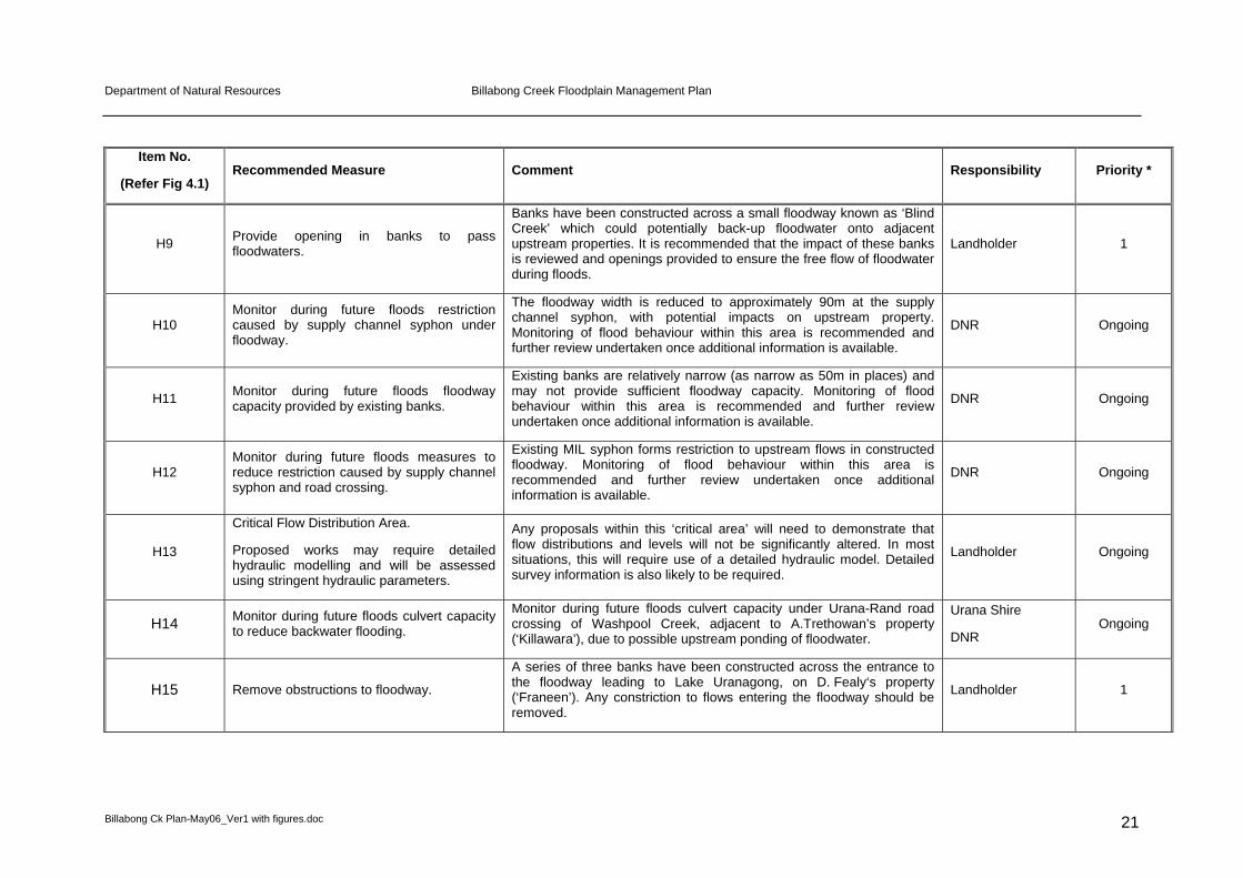
Although generally the floodway network has been designed to convey mainstream flood flows, measures are also required to address local flooding to ensure that future flood control works do not impede the natural drainage of floodwater from local catchments to a floodway. The Billabong Creek FMP has identified approximately 12 locations where it is recommended that local drainage issues be monitored to ensure that these flowpaths are not obstructed from local catchments. Table 5.1 (Table 8.1 in FMS report) and Figure 4.1 refer.
Note on local flooding:
The Billabong Creek floodplain is very large and following short duration rainfall, particularly after extended wet periods, the volume of runoff from the local catchments can be significant and provisions need to be made within levees and roads to ensure local flows can reach the natural flowpaths and floodways. Generally flood control works should be excluded from these areas, or other provisions made (e.g. pipes with flap valves constructed through levees).
5.2 Summary of Recommended Measures
Specific remedial requirements in respect of hydraulic and environmental requirements are provided in Table 5.1 and shown on Figure 4.1.
Implementation priorities for the required changes to flood control works are also assigned in Table 5.1. The priorities are defined as follows:

Department of Natural Resources Billabong Creek Floodplain Management Plan
Billabong Ck Plan-May06_Ver1 with figures.doc 18
Priority 1 - within 12 months of plan’s adoption. These measures are considered very important in relation to the performance of the floodway system and should as a consequence be implemented quickly.
Priority 2 – within 3 years of plan’s adoption. These measures are desirable for hydraulic and / or environmental reasons.
On-going – these issues may require further investigation or have not been fully resolved and therefore may also need to be assessed after monitoring future flood events.
It is important to remember that all proposed and existing flood control works within the Billabong Creek floodplain require approval under Part 8 of the Water Act 1912. Where no approval exists, DNR may take the relevant action(s) under the Act.
With regard to the corrective measures outlined in Table 5.1, please note the following:
Specific structural modifications to existing works will be administered under the relevant sections of Part 8;
Minor modifications to existing approved works identified to be necessary in Table 5.1 will be administered through modifying the Part 8 approval conditions under Section 176A of the Water Act 1912; and
With regard to unapproved works, directions for remedial work(s) may be used as a means of encouraging landholders to bring the subject work(s) within the Water Act 1912 by lodging an application for approval that is complying (refer to Section 7.5) with the FMP.
Please refer to Section 7 for further details regarding approval of flood control works and administration of the Billabong Creek FMP under Part 8 of the Water Act 1912.

Department of Natural Resources Billabong Creek Floodplain Management Plan
Billabong Ck Plan-May06_Ver1 with figures.doc 19
Table 5.1 Summary of Recommended Measures
Item No.
(Refer Fig 4.1) Recommended Measure Comment Responsibility Priority *
Hydraulic Measures
H1
Critical Road Location
Ensure all activities on/near road do not interfere with floodway. Road not to be raised unless compensating measures are provided.
The Rand-Walbundrie Back Road has a significant influence on the quantity of water that flows from Billabong Creek onto the southern floodplains of Coreen Creek and Nowranie (South) Creek. Changes to road levels and/or culvert and causeway capacities have the potential to significantly alter flow distributions throughout the study area.
Greater Hume Shire
RTA
Ongoing
H2
Critical Flow Distribution Area.
Proposed works may require detailed hydraulic modelling and will be assessed using stringent hydraulic parameters.
Any proposals within this ‘critical area’ will need to demonstrate that flow distributions and levels will not be significantly altered. In most situations, this will require use of a detailed hydraulic model. Detailed survey information is also likely to be required.
Landholder Ongoing
H3 Review existing drainage facilities behind levee.
The levee provided on the south bank of Billabong Creek can potentially restrict the drainage of a floodway on the southern floodway from draining back to Billabong Creek. An existing structure in the levee bank allows for drainage back to Billabong Creek. The adequacy and operation of the structure should be reviewed to ensure that undue ponding on the ‘protected’ side of the levee does not occur.
Landholder 2
H4 Remove small deflector levee
Landholders to the north of Billabong Creek have concerns that a small levee on the southern bank of Billabong Creek deflects floodwater back towards the northern floodplain. It appears that this levee may have recently been removed, but this needs to be verified by site inspection.
DNR 1

Department of Natural Resources Billabong Creek Floodplain Management Plan
Billabong Ck Plan-May06_Ver1 with figures.doc 20
Item No.
(Refer Fig 4.1) Recommended Measure Comment Responsibility Priority *
H5
Billabong Creek Restriction.
Monitor during future floods the impact of southern levee on creek conveyance.
A particular concern to many landholders on the northern floodplain is the proximity of levee banks on the southern floodplain to Billabong Creek. The concern is that this provides reduced capacity of the creek and consequently diverts additional floodwater onto the northern floodplain. The floodway width provided for the main creek is as little as 300m wide at its narrowest point (in the vicinity of Roy Hamilton’s house). There is little scope to improve the available width north of the creek due to the presence of high ground and the Hamilton house. Monitor during future floods the impact of southern levee on creek conveyance, and if required assess opportunities to relocate the southern bank to provide additional width (eg when rebuilding becomes necessary or after future bank failure due to flooding or scouring).
DNR Ongoing
H6
Review Billabong Creek geomorphology (mid to upper study area) and develop management strategy to ensure that capacity does not reduce over time. In addition, also develop strategy to manage ‘willow’ and ‘cumbungi’ infestations throughout the study area
Many landholders have claimed that Billabong Creek is aggrading, and its natural capacity reducing, due to siltation and the impacts of snags. The reduced capacity may consequently divert additional overland flow onto the northern floodplain, and to a lesser degree the southern floodplain. As the river aggrades the likelihood of a major breakout and new flow path also increases (particularly in the vicinity of Roy Hamilton’s property). At the same time, a strategy to manage willow and cumbungi infestations is a pressing need identified by the Committee. Community and NSW Fisheries to develop snag, willow and cumbungi management strategy. Committee to write to NSW Fisheries, DNR, CMA in the first instance.
Committee/
Landholders
NSW Fisheries
DNR
CMA
Ongoing
H7 Monitor during future floods capacity provided by Billabong Creek and Anabranch floodways.
Possible hydraulic constriction caused by banks adjacent to Billabong Creek and the Anabranch in the vicinity of the Urana-Corowa Road. Monitoring of flood behaviour within this area is recommended and further review undertaken once additional information is available.
DNR Ongoing
H8 Monitor during future floods position of built bank.
Built bank on property ‘Traleen’ is close (approx 50m) to Billabong Creek. It is likely to restrict the main Billabong Creek floodway and is also likely to be subject to high velocities and potential scouring. Monitoring of flood behaviour within this area is recommended and further review undertaken once additional information is available.
DNR Ongoing
Department of Natural Resources Billabong Creek Floodplain Management Plan
Billabong Ck Plan-May06_Ver1 with figures.doc 21
Item No.
(Refer Fig 4.1) Recommended Measure Comment Responsibility Priority *
H9 Provide opening in banks to pass floodwaters.
Banks have been constructed across a small floodway known as ‘Blind Creek’ which could potentially back-up floodwater onto adjacent upstream properties. It is recommended that the impact of these banks is reviewed and openings provided to ensure the free flow of floodwater during floods.
Landholder 1
H10 Monitor during future floods restriction caused by supply channel syphon under floodway.
The floodway width is reduced to approximately 90m at the supply channel syphon, with potential impacts on upstream property. Monitoring of flood behaviour within this area is recommended and further review undertaken once additional information is available.
DNR Ongoing
H11 Monitor during future floods floodway capacity provided by existing banks.
Existing banks are relatively narrow (as narrow as 50m in places) and may not provide sufficient floodway capacity. Monitoring of flood behaviour within this area is recommended and further review undertaken once additional information is available.
DNR Ongoing
H12 Monitor during future floods measures to reduce restriction caused by supply channel syphon and road crossing.
Existing MIL syphon forms restriction to upstream flows in constructed floodway. Monitoring of flood behaviour within this area is recommended and further review undertaken once additional information is available.
DNR Ongoing
H13
Critical Flow Distribution Area.
Proposed works may require detailed hydraulic modelling and will be assessed using stringent hydraulic parameters.
Any proposals within this ‘critical area’ will need to demonstrate that flow distributions and levels will not be significantly altered. In most situations, this will require use of a detailed hydraulic model. Detailed survey information is also likely to be required.
Landholder Ongoing
H14 Monitor during future floods culvert capacity to reduce backwater flooding.
Monitor during future floods culvert capacity under Urana-Rand road crossing of Washpool Creek, adjacent to A.Trethowan’s property (‘Killawara’), due to possible upstream ponding of floodwater.
Urana Shire
DNR Ongoing
H15 Remove obstructions to floodway.
A series of three banks have been constructed across the entrance to the floodway leading to Lake Uranagong, on D. Fealy‘s property (‘Franeen’). Any constriction to flows entering the floodway should be removed.
Landholder 1

Department of Natural Resources Billabong Creek Floodplain Management Plan
Billabong Ck Plan-May06_Ver1 with figures.doc 22
Item No.
(Refer Fig 4.1) Recommended Measure Comment Responsibility Priority *
H16 Monitor during future floods floodway capacity and modify if required.
The alignment of constructed levee banks at the boundary of D. Fealy’s property (‘Franeen’) and D. Webster’s property should be monitored during future floods to ensure adequate continuity of flow paths and floodway capacity.
DNR Ongoing
H17 Monitor during future floods culvert capacity to reduce backwater flooding.
Monitor during future floods culvert capacity on Bidgeemia Road due to possible upstream backwater flooding.
Lockhart Shire
DNR Ongoing
H18 Monitor during future floods flood flows in Washpool Creek.
A number of landholders identified that Washpool Creek, below its junction with Sandhill Creek, rarely flowed. However, no obvious constriction is apparent. Further site reconnaissance and monitoring of future floods is recommended within this area. Monitor Washpool Creek during floods for constrictions.
DNR Ongoing
H19 Monitor during future floods floodway capacity provided by existing banks.
The capacity of this floodway remains reduced when compared with its upstream capacity. Monitoring of flood behaviour within this area is recommended and further review undertaken once additional information is available.
DNR Ongoing
H20 Monitor condition of outlet from Lake.
Site conditions at the Lake Uranagong outlet will significantly influence the amount of water stored in Lake Uranagong, and the distribution of floodwater leaving the lake. In recent floods, very little water appears to have left the Lake towards the Tombstones and Walsh’s Creek. Site conditions at the outlet should be inspected, and flood behaviour monitored during future flood events. Inspection is priority 1.
DNR 1/Ongoing
H21 Critical road location.
Investigate and increase culvert capacity.
The Urana-Corowa Road crossing of the Eight Mile Floodway is an impediment to flood flows within this floodway. Investigate existing culvert capacity and increase as necessary. DNR and NSW Fisheries to be consulted on waterway design and capacity.
Urana Shire
RTA 1
H22
Critical road location.
Investigate and increase culvert capacity.
The Urana-Corowa Road crossing of the Tombstones Floodway is an impediment to flood flows within this floodway. Investigate existing culvert capacity and increase as necessary. DNR and NSW Fisheries to be consulted on waterway design and capacity.
Urana Shire
RTA 1

Department of Natural Resources Billabong Creek Floodplain Management Plan
Billabong Ck Plan-May06_Ver1 with figures.doc 23
Item No.
(Refer Fig 4.1) Recommended Measure Comment Responsibility Priority *
H23 Inspect existing structures for licence compliance.
Some concern was expressed by upstream landholders that the floodway capacity downstream of the Urana-Corowa Road at the Tombstones crossing was restricted by banks constructed many years ago. Recent license approvals indicate a reasonable floodway width in this vicinity. The presence of former banks, or other restrictions, should be verified by site inspection.
DNR 1
H24 Investigate and increase waterway capacity of disused railway embankment between Coorabin and Urana.
The railway embankment restricted waterways have a significant impact on flood behaviour. Photos from the 1974 flood shows floodwater backed up on the upstream side of the railway over a wide area in the vicinity of the Eight Mile floodway. The adequacy of the existing railway embankment structures should be investigated and increased as required. DNR and NSW Fisheries to be consulted on waterway design and capacity.
Railway owner 1
H25 Monitor during future floods flood behaviour and review floodway provisions
Recent bank approvals (some being limited height) on the north side of Billabong Creek, and in the vicinity of the ‘Gully’ should be monitored in future flood events to ensure that adequate floodway provisions have been provided.
DNR Ongoing
H26 Review floodway capacity provided by existing banks.
Recent banks constructed on C. Dowling’s property (‘Thistle Downs’) are not accordance with recent approvals. The location of these banks should be reviewed and adjusted if necessary.
Landholder 1
H27 Monitor during future floods volume of water reaching Lake Urana
The quantity of water that reaches Lake Urana is a sensitive issue, particularly for landholders occupying land within this area. There have been claims that the network of levee banks constructed on the northern floodplain has diverted additional floodwater towards the Lake. Computer model simulations do show a slight increase in peak flows entering the Lake due to all of the banks constructed to date. However, the majority of floodwater probably originates from Urangeline Creek. As this is a sensitive issue, continued monitoring of flood flows reaching Lake Urana is recommended.
Landholders
DNR Ongoing

Department of Natural Resources Billabong Creek Floodplain Management Plan
Billabong Ck Plan-May06_Ver1 with figures.doc 24
Item No.
(Refer Fig 4.1) Recommended Measure Comment Responsibility Priority *
H28 Monitor during future floods outlet conditions from Lake Urana
Apart from the volume of floodwater that reaches Lake Urana, another important consideration is the condition of the outlet from the Lake. This controls how much water will be impounded within the Lake during flood periods, and how long the Lake will remain wet. As this is another critical issue for landholders that occupy the area, continued monitoring of the outlet and its performance during floods is recommended.
DNR Ongoing
Environmental Measures
E1 Install culvert or causeway under Old Urana Road.
Culvert/causeway across Old Urana Road to allow floodwater to wetland J6. Adequacy of culvert under disused Tocumwal-Narrandera railway to be checked Consultation with DNR, NSW Fisheries and landholder required.
Jerilderie Shire Council, Railway owner
1
E2 Further consultation to explore options to connect Wangamong Creek to J15 & J16 and back to Wangamong Creek
Investigate use of existing drain to connect Wangamong Creek outflows to J16. Connecting flow path downstream of J16 may be modified by existing land use, training works may be required in this area. Landholder alternative of using water provided by the Murray Wetlands Working Group (MWWG) via the Murray Irrigation supply channel system is not a guaranteed option.
Landholder 2
E3 Provide structure in existing banks & connection to J17, outflow drain & back to Wangamong Creek (J14).
Agreed to by landholder. Floodwater flows to wetland J17 are restricted by existing banks.
Landholder 1
E4 Further consultation to explore options to connect Wangamong Creek to J29.
Constructed banks restrict free flow of floodwater to J29. Southern lobe of wetland has higher environmental value and is a priority for reconnection to flooding. Old Corowa Road passes across wetland. Landholder alternative of using water provided by the Murray Wetlands Working Group (MWWG) via the Murray Irrigation supply channel system is not a guaranteed option.
Landholder, Jerilderie Shire Council, DNR
2

Department of Natural Resources Billabong Creek Floodplain Management Plan
Billabong Ck Plan-May06_Ver1 with figures.doc 25
Item No.
(Refer Fig 4.1) Recommended Measure Comment Responsibility Priority *
E5 Further consultation to explore options to connect Wangamong Creek to J35.
Berrigan Extension Channel restricts flow of floodwater to J35. Need to investigate options including a syphon beneath the channel. Landholder alternative of maintaining water provided by the Murray Wetlands Working Group (MWWG) via the Murray Irrigation supply channel system is not a guaranteed option.
Landholder DNR, Murray Irrigation
2
E6 Further consultation to explore options to connect J42 to the floodway via J14.
Landholder alternative of maintaining current water management practice of watering wetland as part of irrigation recycling system may require further environmental assessment.
Landholder, DNR 2
E7 Utilise existing channel to connect wetland U5 to floodway.
Monitor during floods to determine whether existing works lead to premature draining of wetland and amend as required.
Landholder, DNR 2
E8 Install structure in existing bank to allow U29 to fill during floods.
Agreed to by landholder. Landholder 1
E9 Install a structure in existing levee to connect U43 to the floodway via existing drain.
Agreed to by landholder. Landholder 1
E10 Utilise existing pipe structure to fill wetland O30 during floods.
Agreed to by landholder. Landholder 1
E11 Install an opening in existing levee to control flood flows along Nixon’s watercourse.
Agreed to by landholder. Existing levee crossing anabranch ponds water excessively, affecting the condition of riparian trees upstream and impacting on fish passage. Structure required to allow controlled flow through the levee and along the watercourse. Consultation with NSW Fisheries required to ensure adequate fish passage.
Landholder, DNR,
NSW Fisheries 1
* Priority 1 = Next 12 months
Priority 2 = 1 year to 3 years

Department of Natural Resources Billabong Creek Floodplain Management Plan
Billabong Ck Plan-May06_Ver1 with figures.doc 26
6. ENVIRONMENTAL IMPACTS
6.1 Overview
A summary of the environmental impacts arising from the Billabong Creek FMP is provided in Table 6.1. The Billabong Creek FMP will influence the floodplain environment by defining a floodway network that will convey the design flood and by specifying modifications and management measures for existing flood control works. In line with the floodplain management principles adopted by the Committee, the floodway network conforms as closely as possible to the natural drainage pattern on the floodplain. Environmentally sensitive areas dependent on flooding have been identified and strategies developed to maintain flood flow access (through the floodway network) or to restore flood flow access (through works modifications) to these areas.
When assessing the environmental impacts of recommended management options, current floodplain conditions were used as the benchmark. Impacts were assessed at a strategic level by considering the potential impacts on components of the floodplain environment. Further information on the floodplain environment is provided in Bewsher Consulting and Ecosurveys [2000]. Table 6.1 summarises the anticipated impacts of the preferred management options.
TABLE 6.1
Summary Of Billabong Creek FMP Environmental Impacts
Soils
Flood connectivity will benefit soil structure and condition within the floodway network and provide sediment, soil moisture recharge and nutrient release in these areas. Coarse cracking grey and brown clays adapted to more frequent flooding are largely contained within the FMP floodway network.
Vegetation
The FMP floodway network includes all vegetation along the riparian corridors of Billabong Creek and its anabranches and also includes a high proportion of the vegetation types occurring in floodplain wetlands such as Riverine Forest, River Red Gum Woodland, Black Box Woodland and Black Box Woodland/Lignum. The FMP floodway network will allow for ongoing flood connectivity to flood dependent vegetation contained within it and allow this vegetation to be sustained in the long term. Adopted FMP environmental outcomes will also allow for flood flow access to 12 wetlands outside the floodway to be restored, enhancing the condition and regeneration of flood dependent vegetation in these areas. The remaining stands of vegetation that require intermittent flooding but are outside the FMP floodways occur in wetlands that are sustained chiefly by local runoff or in wetlands that have been assessed with a low environmental value.
Wetlands
The 206 wetland ecosystems identified in the Billabong Creek floodplain require access to floodwaters to remain healthy (refer to the Billabong Creek Floodplain Management Study for details). The majority of these wetlands are already connected to flood flows from Billabong Creek and its anabranches and have been incorporated into the FMP floodway network. This will allow for their ongoing flood connectivity and the maintenance of ecological processes associated with intermittent flooding. The Billabong Creek Floodplain Management Study identified 40 wetlands potentially isolated from flooding. Adopted FMP environmental outcomes will allow 12 wetlands with a combined area of about 1400 ha to be reconnected to flood flows. The remaining wetlands were found to be adequately connected to either a water source or filled from local runoff, or had low environmental value. Hydraulic measures recommended in the FMP (Table 5.1) will remove works obstructing inflows to Lake Uranagong, a major wetland located in the floodway network and allow for improved ecological condition. Hydraulic measures also include monitoring of flood inflows to Lake Urana to check (and amend as required) the effects of associated levees on the hydrology of the lake.
Fauna No detailed fauna survey was undertaken; however, a literature survey (refer to the Billabong

Department of Natural Resources Billabong Creek Floodplain Management Plan
Billabong Ck Plan-May06_Ver1 with figures.doc 27
Summary Of Billabong Creek FMP Environmental Impacts Creek Floodplain Management Study for details) identified 164 species (frogs, reptiles, birds and mammals) that have been recorded within the study area. 41 bird species known to occupy wetland habitats have been recorded. Nine threatened bird species, including species that depend directly on flooding for maintenance of their life-cycles (waterbirds) or depend on floodplain vegetation for their food and habitat, have been recorded in the area. Adopted FMP environmental outcomes will benefit floodplain fauna by allowing for the maintenance of flood flows to wetlands and areas of flood dependent vegetation through the FMP floodway network. Adopted FMP environmental outcomes will also reconnect up to about 1400 ha of wetlands that has been excluded from flood flows and this is expected to improve habitat opportunities and may lead to increases in biodiversity.
Fish
No detailed fish survey was undertaken; however, a literature survey (refer to the Billabong Creek Floodplain Management Study for details) identified four fish species that had been recorded in Billabong Creek at Walbundrie as part of a wider survey conducted throughout NSW. This included only one native species, Golden Perch. It is possible, based on surveys of other creeks in the southern Riverina, that a number of other native species occur. Golden Perch is strongly dependent on flooding as it migrates from creeks and rivers during floods to spawn its eggs on the floodplain. Interconnecting flow paths between Billabong Creek, its anabranches and floodplain wetlands are vital for the breeding success of this species locally. The FMP floodway network includes Billabong Creek, the major anabranches and interconnecting flow paths and a high proportion of floodplain wetlands within the floodway network. This will allow for ongoing connectivity and facilitate fish passage over the long term. Adopted FMP environmental outcomes to restore flood connectivity to wetlands in the study area allow for specific consideration of fish passage requirements wherever practical.
Water Quality
Risk of surplus nutrient and pesticide transport through inundation of cropped areas or through excessive scour or erosion will be restricted as the FMP floodway network has been designed to limit flood velocities and minimise the flood risk to agricultural development.
Cultural Significance
No sites of aboriginal importance were found on the Register of the National Estate. However, discussions with the NPWS indicate that It is highly likely for aboriginal relics and sites to be located along the Billabong Creek system as Aboriginal people were known to inhabit the well-watered parts of the landscape in the adjacent central Murray catchment. Sites such as scarred or carved River Red Gum or Black Box trees that are dependent on flooding for their longevity are likely to be maintained as the FMP floodway system incorporates the majority of vegetation types containing these species.

Department of Natural Resources Billabong Creek Floodplain Management Plan
Billabong Ck Plan-May06_Ver1 with figures.doc 28
6.2 Downstream Floodplains
It is anticipated that the Billabong Creek FMP will have a positive influence on downstream floodplain environments for the following reasons:
► the floodway network conforms as closely as possible to the natural flood pattern of the floodplain and allows for the orderly passage of flood flows through the Billabong Creek system and onto downstream floodplain environments;
► connectivity with downstream floodplains will be improved by ensuring that there are no significant barriers to flood flows within the Billabong Ck floodplain; and
► the floodway network will preserve flow paths and allow for the future delivery of the flood regime to sustain flood dependent ecosystems on downstream floodplains.
6.3 State Water Management Outcomes Plan (SWMOP) Assessment
In line with the SWMOP requirements, the Billabong Creek FMP has mapped the major flood paths and flood-dependent ecosystems, identified the significant barriers to flooding and recommended action to deal with the priority barriers. Target 25 of the SWMOP aims to provide floodwater access to at least 60% of the 1 in 5 year flooded area.
The FMP floodway network has been sized to convey a combined 1983/1974 design flood flow with an average recurrence interval of 25 to 32 years. Although natural flooding patterns are difficult to define exactly because of the presence of levees and other works on the floodplain, it is considered highly probable based on knowledge of flooding gained during the preparation of the FMP, that the FMP floodway network exceeds the SWMOP target.
6.4 Related Management Issues
6.4.1 Sapling Regrowth
Sapling regrowth following floods has been identified as a potential issue in parts of the Billabong Creek floodplain. Following a flood event or a particularly wet season, eucalypts (River Red Gum, Black Box and Grey Box) may regenerate in high numbers and subsequently form thickets thus stunting the growth of the individual trees if some do not die. If natural thinning does not occur then some thinning of the regrowth may allow it to develop a woodland structure that is more typical of treed habitats within the Billabong Creek floodplain. By opening up the overstorey this may also allow a native understorey and ground layer to develop or be planted. Any thinning of regrowth would need to be consistent with vegetation clearing controls to be outlined in the forthcoming Murray Catchment Action Plan.
6.4.2 Murray Wetlands Working Group (MWWG) Water
The MWWG water is a parcel of water that has resulted from water savings generated by the improved hydrological management of Moira Lake (1,911 ML) and

Department of Natural Resources Billabong Creek Floodplain Management Plan
Billabong Ck Plan-May06_Ver1 with figures.doc 29
improved practices within the Murray Irrigation Limited (MIL) region (30,000 ML). Since this water has been available it has been used to:
► extend flood events within Barmah-Millewa Forest;
► provide on-farm watering of private property wetlands;
► provide watering of Crown Land wetlands vegetation to complete the life cycle; and
► sell on the temporary transfer market.
Some wetlands within the Billabong Creek floodplain have previously been watered using the MWWG water, however ongoing watering from this source is not guaranteed. For this reason, use of the MWWG water to sustain wetlands isolated from flooding by existing works is not a feasible option in the Billabong Creek FMP.

Department of Natural Resources Billabong Creek Floodplain Management Plan
Billabong Ck Plan-May06_Ver1 with figures.doc 30
7. IMPLEMENTATION
7.1 Roles and Responsibilities
Implementation of the Billabong Creek FMP will be regulated under Part 8 of the Water Act 1912. DNR is responsible for administering floodplain management within rural NSW west of the Great Dividing Range and will therefore be responsible for administering the Billabong Creek FMP.
The successful implementation of the Billabong Creek FMP largely depends on community ownership of the plan. Retention of the designated floodway areas as areas reserved primarily for the discharge and storage of floodwaters needs to be acknowledged and supported by landholders as being in the interests of all, and socially and lawfully responsible.
Implementation of recommended plan measures (refer Table 5.1) aims to have priority 1 measures implemented within 12 months of the plan’s adoption. Priority 2 measures should be implemented within 3 years.
Roles and responsibilities are outlined as follows:
Committee
Oversee the implementation of the Billabong Creek FMP
DNR
Facilitate arrangements for implementation of the required Billabong Creek FMP measures
Provide technical assistance and support to landholders where appropriate
Assess future flood control works applications
Ongoing monitoring of flooding behaviour / Billabong Creek FMP performance indicators
Landholders
Undertake required changes to flood control works
Comply with any conditions placed on future flood control works permits
Ongoing monitoring of flooding behaviour / floodway performance
Local Government
Maintain adequate capacity at roadway waterway structures / ongoing monitoring of flooding behaviour
7.2 Performance
Detailed performance indicators for assessing the success of implementing floodplain management plans are to be developed as part of state floodplain management policy. These indicators are likely to be targeted towards measuring the following objectives:

Department of Natural Resources Billabong Creek Floodplain Management Plan
Billabong Ck Plan-May06_Ver1 with figures.doc 31
Minimising the obstruction to floodwater conveyance and loss of storage within the adopted floodway network.
Restoring / retaining floodwater access to flood dependent ecosystem areas.
Improving the level of protection against future flood damage.
7.3 Flood Monitoring
Monitoring of hydraulic flood behaviour would provide additional information to assess the impact of selected flood control works requiring further review and identify in general any problem areas and whether any modifications or upgrades are required. Depending on the size of flood, monitoring would range from simple observation to measuring of flows and levels followed by additional hydraulic analyses.
For the smaller, more frequent floods, monitoring should be limited to observations of areas requiring further investigation (refer Table 5.1 for list of areas requiring flood monitoring). The larger floods, nearing the 1974 and 1983 design floods, should be monitored in more detail. In particular, as the hydraulic modelling has a significant degree of reliance upon flow estimates, especially peak flows, it will be important to collect data to verify these estimates.
Floods in the Billabong Creek floodplain usually have a relatively long lead - in time. Hence there is time to plan a monitoring program. An effective monitoring program will require input from DNR, Urana and Lockhart Shire Councils, and landholders. The following is recommended:
DNR should undertake aerial photography, collection of satellite imagery, survey, stream gaugings and flow measurements; and,
where safe to do so, Urana and Lockhart Shire Councils and landholders should observe the performance of their part of the floodway network, including marking high flood levels, estimating flow velocities and taking photographs.
Following floods, landholders should estimate flood damage, including crop and fencing losses and damage to private roads. Councils should provide an estimate of flood damage to public roads and infrastructure.
Refer to Appendix A for detailed advisory notes on flood monitoring.
7.4 Part 8 Approval Process for Flood Control Works
General
All activities associated with flood control works are administered under the relevant sections of Part 8 of the Water Act 1912. The Water Administration Ministerial Corporation (hereafter WAMC) is the body who prepares, adopts and administers FMPs, as well as receives and determines Part 8 applications. DNR acts on behalf of WAMC for all matters relating to Part 8 of the Water Act. In short, please note the following:
1. All flood control works require an approval under Part 8 of the Act;

Department of Natural Resources Billabong Creek Floodplain Management Plan
Billabong Ck Plan-May06_Ver1 with figures.doc 32
2. All Part 8 applications for new and existing (unapproved) works within the Billabong Creek floodplain will be determined in accordance with the Billabong Creek FMP and Part 8 of the Act; and
3. Any existing unauthorised works for which a Part 8 application is not lodged, may be served a notice under Section 180D of the Act for removal or DNR may consider prosecution action.
Refer to Section 7.6 for further details regarding unauthorised works and Part 180D of the Water Act 1912.
Works That Require Approval
Works referred to as flood control works are defined under Part 8 of the Water Act 1912 as ‘controlled works’. Controlled works require approval under the Act and are defined as:
An earthwork, embankment or levee that is situated, or proposed to be constructed, on land that:
is, or forms part of, the bank of a river or lake, or is within a floodplain, or
Any work that is situated, or proposed to be constructed, on land that:
is, or forms part of, the bank of a river or lake, or is within a floodplain and that is declared by order of the WAMC published in the Gazette to be a controlled work, or,
An earthwork, embankment or levee, wherever situated or proposed to be constructed, that:
affects or is reasonably likely to affect the flow of water to or from a river or lake, and
is used or is to be used for, or has the effect or likely effect of, preventing land from being flooded by water, or
Any work, wherever situated or proposed to be constructed, that:
affects or is reasonably likely to affect the flow of water to or from a river or lake, and
is used or is to be used for, or has the effect or likely effect of, preventing land from being flooded by water, and
is declared by order of the WAMC published in the Gazette to be a controlled work.
Applying for Approval
The following is an outline of the steps required by an applicant in applying for approval for a flood control work:
Step 1 - Obtain an application form and discuss your proposal with neighbouring landholders.
Step 2 - Contact a DNR Floodplain Licensing Officer to arrange a site inspection, discuss the application and get advice on the information required for the approval process.

Department of Natural Resources Billabong Creek Floodplain Management Plan
Billabong Ck Plan-May06_Ver1 with figures.doc 33
Step 3 - Gather supporting information as your application will require you to supply technical information.
Step 4 - Fill in the application form. Complete additional information requirements on the form including condition of the existing surrounding environment.
Step 5 - Lodge the application with the supporting information and application fee at your local DNR office.
Determination Process
All applications under Part 8 of the Water Act 1912 must proceed through a set process prior to DNR determining the application under Section 171 of the Act. This process includes (but not limited to):
Section 166C of the Water Act 1912 - DNR must have regard to the matters for general consideration outlined in Section 166C including (but not limited to):
The contents of any relevant FMP or any other relevant Government policy;
The need to maintain the natural flood regimes in wetlands and related ecosystems and the preservation of any habitat animals (including fish) or plants that benefit from periodic flooding;
The effect or likely effect on water flows in downstream river sections;
Any geographical features, or other matters of Aboriginal interest that may be affected by a controlled work;
The effect or likely effect of a controlled work on the passage, flow and distribution of flood waters;
The effect or likely effect of a controlled work on existing dominant floodways or exits from floodways, rates of flow, flood water levels and the duration of inundation; and
The protection of the environment.
Part 5 of the Environmental Planning and Assessment Act 1979 – as there are no relevant environmental planning instruments relating to the FMP all proposals must undergo assessment under Part 5. DNR must take into account the following factors concerning the impact of the flood control works on the environment:
Any environmental impact on a community;
Any environmental impact on the ecosystem of a locality;
Any reduction of aesthetic, recreational, scientific or other environmental quality or value of a locality;
Any impact on the habitat of protected fauna;
Any endangering of any species of animal, plant or other form of life, whether living on land, in water or in the air;
Any reduction in the range of beneficial uses of the environment; and

Department of Natural Resources Billabong Creek Floodplain Management Plan
Billabong Ck Plan-May06_Ver1 with figures.doc 34
Any cumulative environmental effect with other existing or likely future activities
Floodplain Management Plan - DNR must consider the Billabong Creek FMP and information contained within the Billabong Creek FMP including principles, assessment criteria, and any recommendations.
Additional Information - DNR must consider any investigation information that has been provided by the applicant.
Possible Determinations
DNR will inform the applicant at the earliest opportunity of the determination of an application for a flood control work. Under the Water Act 1912, there are three (3) possible determinations - approval of the application, approval of the application subject to conditions, or refusal of the application.
There are provisions within the Water Act 1912 for a corporation or individual to object to an application approval if their interest(s) are affected by the approval. There are also provisions for an applicant and / or objector to appeal against the determination to the Land and Environment Court. Refer to the Water Act 1912 for further details regarding these matters.
7.5 Complying and Non Complying Works
Under Section 168B(2) of the Water Act 1912, a flood control work is to be assessed as a complying work if DNR is satisfied that the work complies with the FMP for the area in which the work is situated or proposed to be constructed. Within the Billabong Creek floodplain a work complies with the FMP if:
The work is or is proposed to be located outside the FMP Floodway Network as shown on Figure 4.1 and where described in the recommended measures in Table 5.1.
The work where applicable is to be modified in accordance with the recommended measures in Table 5.1.
When lodging a Part 8 application with DNR, the applicant will be required to provide the necessary technical details to demonstrate that the application is a complying work. Where an existing unapproved or proposed flood control work is determined to be complying and the required environmental assessment is satisfactory, it is envisaged that the approval process will be more expedient.
Under Section 168B(3) of the Water Act 1912, a flood control work is to be assessed as a non-complying work if DNR is not satisfied that the work complies with the FMP for the area in which the work is situated or proposed to be constructed. Within the Billabong Creek floodplain a work is non-complying if:
The work is or is proposed to be located within the FMP Floodway Network as shown on Figure 4.1 and where described in the recommended measures in Table 5.1.
The work where applicable is to be modified not in accordance with the recommended measures in Table 5.1.

Department of Natural Resources Billabong Creek Floodplain Management Plan
Billabong Ck Plan-May06_Ver1 with figures.doc 35
Non-complying works may be approved after a detailed investigation of the hydraulic, environmental, social and economic impacts of the proposal. The cumulative impact of the proposal on flooding characteristics will need to be comprehensively addressed. It is important to understand that it is the applicant’s responsibility to organise a suitably qualified consultant to undertake the investigation and pay for the investigation. DNR will provide direction and guidance for the consultant. Where the requested supporting information is not furnished, DNR can refuse to deal with the application.
Applications for non-complying works must be advertised and third party objections sought prior to the determination of the application. If an objection is received that cannot be resolved, compulsory mediation will be required. DNR may request additional supporting information from the party who lodged the objection, with failure to do so possibly resulting in the objection being rejected.
7.6 Unauthorised Works
Unauthorised controlled works include the following:
Works without approval;
Works which have been constructed in contravention of an approval; or
Works which have not been constructed in accordance with approval conditions.
Where unauthorised works are identified, DNR may direct that one or more of the following types of work be carried out by issuing a notice under Section 180D of the Water Act, 1912:
(a) Work to remove, modify, repair or restore the controlled work or to render the work ineffectual.
(b) Work to repair any damage caused by the controlled work (including any damage caused to any specified land, river, lake, structure or vegetation, or to the environment).
(c) Works to ensure that any specified land, structure, river, lake or vegetation, or the environment, will not be damaged or adversely affected, or further damaged or further adversely affected, by the controlled work.
Without limiting (a) to (c) above, work to correct or restore any alteration caused by the controlled work to the flow of water into or from, or the quantity of water contained in, any specified river or lake.
In the event of the occupier not complying with the served notice, DNR can carry out the work and recover the costs incurred in doing such work. DNR is not required to give any prior notice of its decision to exercise these powers. The occupier can appeal such action to the Land and Environment Court.
Roads and Railways
Roads and railways (and associated bridges, road works and railway works) vested in Local or State Government transport agencies are prescribed works under Part 8 of the Water Act 1912. While these works do not require an approval under these pieces of legislation, agencies are required to assess the impacts of these works under the Environmental Planning and Assessment Act 1979.

Department of Natural Resources Billabong Creek Floodplain Management Plan
Billabong Ck Plan-May06_Ver1 with figures.doc 36
Appendix A
Flood Monitoring Activities In addition to the activities listed below, a number of recommended measures specified in Table 5.1 of the FMP include monitoring of future floods. The following advisory notes specify monitoring activities that should be undertaken by landholders, Urana and Lockhart Shire Councils, and DNR. The collected monitoring data will assist the Billabong Creek FMP performance review process. If found necessary, modifications to the Billabong Creek FMP can be recommended based on the findings of the review process.
1) Landholder Monitoring Guidelines
(a) Hydrologic and Hydraulic Data
Flood event characteristics, including -
Note rainfall depths from private rain gauges throughout the storm event in order to obtain total depth and temporal pattern;
Note the start and finish times of flooding, as well as when the flood peak arrived;
Note the duration of the flood peak (how long the peak lasted prior to receding); and
Compare the flooding with other flood events experienced.
Data near streamflow gauging stations, including -
Note peak water levels from staff gauges (an average of a number of readings should be taken); and
Take photographs illustrating flood extent and flow pattern.
Floodplain data including –
Where possible peg flood peaks across the floodplain (eg. flood marks or debris on strainer posts, trees, farm sheds or dwellings);
Note the extent and width of the flooding;
Estimate surface flow velocities (usually expressed in metres per second) and where possible note flow pattern. Velocities can be estimated by timing the movement of floating debris over an approximated length of travel;
Where possible measure flood water slope by pegging water levels over a length of 1 kilometre;

Department of Natural Resources Billabong Creek Floodplain Management Plan
Billabong Ck Plan-May06_Ver1 with figures.doc 37
Note any obstructions to the passage of flood flow (eg. roads, levees, banks), and where possible obtain estimated difference in water levels upstream and downstream of the obstruction; and
Take photographs illustrating flow paths, flooded areas and dry areas, and flow near obstructions.
Note: Select floodplain monitoring sites that are near hydraulic controls such as roads, levees, major overbank flow breakouts, and at defined floodways.
Data along roads and at causeways/floodways, including –
Where flooded – estimate flow velocities and flow width over the road, as well as the difference in water levels upstream and downstream of the road; and
Where dry – estimate the height out of water.
(b) Flood Damage
After a flood event, information is normally sought to assist in determining the nature and cause of any flood damage. Notes and sketches provided by landholders can aid this process.
Farm loss incurred –
Note the location of any damage and estimate the loss of crops and fencing.
Road damages –
Note the location and extent of pavement damage and silt over roads; and
Where possible estimate the length of road cuts.
Erosion and siltation –
Symptoms of stream bed lowering include vertical headcuts in stream bed, extensive bank erosion on both side of stream, headcuts in tributary streams and gullies, exposed gravel and/or rock beds, exposed pipe capping on bridge piers, and undermining of causeways;
Causes of stream bank erosion include flood flows and abrupt changes in channel alignment, gullying where overland flow enters streams, bed lowering, and obstructions to stream flow such as weirs or low level crossings;
Causes of floodplain erosion include unsustainable landuse practices (eg. clearing), overflows from perched streams, and/or flow concentration due to floodplain development; and
Causes of floodplain siltation include hill-slope erosion and/or reduced capacity of the main channel (bridge crossings, excessive vegetation/regrowth, influx of sediment), which result in instream sediment being deposited onto the floodplain.

Department of Natural Resources Billabong Creek Floodplain Management Plan
Billabong Ck Plan-May06_Ver1 with figures.doc 38
(c) Environmental Data
Wetland data, including –
Monitor the performance of works modifications specified in Table 5.1 to reconnect wetlands to flood flows. Note whether flood flows are reaching the wetland and whether openings in existing works are of adequate size;
Note and photograph any changes to the flooding and drying patterns of the wetland;
Note how long the wetland holds water after a flood event;
Measure and note how deep the water is at different times in the wetland; and
Note and photograph the condition and variety of wetland plant species over time.
Floodplain vegetation (Black Box, River Red Gum, Lignum) data, including –
Note and photograph the extent of floodplain vegetation regeneration over time; and
Note and photograph the extent of flood inundation in the vicinity of floodplain vegetation.
Waterbird and fish observations –
At key sites, such as wetlands, note the abundance and diversity of waterbird species. The easiest method is to group the waterbirds into ducks, grebes, cormorants, etc. and count by 10’s, 50’s or 100’s; and
At key sites, such as wetlands and waterways, note the abundance and diversity of fish species. Dip-netting is the simplest way to monitor small fish in wetlands.
For more information on monitoring wetlands, waterbirds and fish refer to the NSW Murray Wetlands Working Group (2002) document titled Wetlands Watch – A Field Guide for Monitoring Wetlands in the Southern Section of the Murray-Darling Basin.
The following questionnaire could be filled out by landholders as a means of collating information regarding the characteristics of a flood event, as well as flood damage. Additional sheets could be used.

Department of Natural Resources Billabong Creek Floodplain Management Plan
Billabong Ck Plan-May06_Ver1 with figures.doc 39
LANDHOLDER MONITORING QUESTIONNAIRE
Hydrologic and Hydraulic Data
Rainfall depths & duration (private rain gauges)…………………millimetres at 9:00am each day
Inundation limits – sketch on a map areas inundated, flow paths, & areas of backwater
Duration of inundation…………………hours / days
Depth of inundation…………………metres at location…………………
Flow velocity estimates…………………metres per second at location…………………
Flood marks – provide location and description, mark levels upstream and downstream of
structures (channels, roads, culverts etc)
Identify any flow obstructions – banks, channels, roads, etc
Compare with previous floods – larger/smaller, etc
Flood Damage
Crop loss – Yes/No – If yes describe location & extent
Fence loss – Yes/No – If yes describe location & extent
Road damage – Yes/No – If yes describe type, location & extent
Erosion – Yes/No – If yes describe type, location & extent
Siltation – Yes/No – If yes describe location & extent
Environmental Data
Duration of flooding in wetland………………….days
Depth of flooding in wetland…………………….metres at location…………….
Note numbers and types of waterbirds if present
Note presence of native fish in floodwaters
Note extent of regeneration of floodplain vegetation (following floods)
Where works modifications are required to reconnect wetlands:
Is the opening of adequate size?
Did floodwater reach the wetland?
Was floodwater backed up upstream of the opening?
Note level of floodwater through works modifications.
(d) AERIAL AND GROUND PHOTOGRAPHY
Photographs (to be taken between identifiable points on a map)
Areas flooded and areas not flooded;

Department of Natural Resources Billabong Creek Floodplain Management Plan
Billabong Ck Plan-May06_Ver1 with figures.doc 40
Areas of active flow and backwater;
The main flow paths;
Known earthworks such as levees, banks, channels;
Known problem areas;
Roads and railways;
Environmental information, as outlined in (c) above, and;
Time and date each photograph was taken.
2) Council Monitoring Guidelines These activities are similar to those listed for landholders above but in relation to council works. With regard to the road structures, those that are of significant importance (eg Urana-Corowa Road) should be monitored over the duration of the flood. Less crucial structures could be observed at peak levels and at overtopping levels for causeways.
For road structures the following data should be collected:
the head difference across the structure at peak and critical levels;
depth of flow over causeways
estimate the flow velocity through or across the structure;
whether the structure gets affected by debris;
photographs of the structure in flood;
time when flow commences and finishes.
Following floods, Council should assess flood damage to roads and infrastructure by:
Noting the location and extent of pavement damage and silt over roads;
Estimating the length of road cuts where possible; and
Noting damage to other infrastructure such as culverts or bridges.
3) DNR Monitoring Guidelines
DNR’s role in monitoring includes the following activities:
Flood photography, including –
Undertake and obtain on-ground photography of flood event;

Department of Natural Resources Billabong Creek Floodplain Management Plan
Billabong Ck Plan-May06_Ver1 with figures.doc 41
If thought necessary, undertake oblique aerial photography of flood event;
If found necessary, organise vertical aerial photography of flood event; and
Obtain available satellite imagery the study area under flood.
Obtain survey data, including –
Collate existing survey data undertaken or organised by DNR, landholders, or local councils; and,
If found necessary obtain additional survey data, particularly in the vicinity of new flood control works (storages, levees, channels, etc) and structures (bridges, culverts, weirs).
Consultation activities, including –
Undertake consultation activities with stakeholder groups (landholders, government agencies, local councils, and other interest groups) to source their opinion on the flood event and the performance efficiency of the Billabong Creek FMP floodway network;
If thought necessary, reconvene the Committee in order to source their opinion on the flood event, the performance of the Billabong Creek FMP floodway network, and any identified issues; and,
Undertake field investigations after flood events to view identified problem areas.
Obtain flow data, including –
Obtain flood heights and discharge records from gauging stations within the vicinity of the study area (including gauging flows at hydraulic controls such a roads); and,
If necessary, obtain rainfall data from the Bureau of Meteorology and DNR records.

Department of Natural Resources Billabong Creek Floodplain Management Plan
Billabong Ck Plan-May06_Ver1 with figures.doc 42
Appendix B
Glossary and Abbreviations Glossary
Term Definition
Average recurrence interval (ARI)
The long term average number of years between the occurrence of a flood as big or larger than the selected event (eg. floods with a discharge as great or greater than the 100 year ARI event will occur on average once every 100 years).
Catchment The area of land draining to a particular site.
Discharge (or flow) The rate of flow measured in terms of volume per unit time (e.g. megalitres per day – ML/day).
Floodplain Area of land subject to inundation by floods up to the probable maximum flood event.
Floodplain Management Plan The document describing how a particular floodplain is to be used and managed.
Flood risk Potential for damage to property or persons due to flooding.
Floodway Those areas of a floodplain where a significant discharge of floodwater occurs during floods. Floodways are areas, which even if only partially blocked, would cause a significant redistribution of flood flow, or a significant increase in flood level.
Flood control work works such as levees, roads and channels that can affect the distribution of floodwaters on the floodplain. These are known as “controlled works” in the Water Act 1912
Hydraulics Term given to the study of water flow in waterways.
Hydrologic / hydraulic computer models
The mathematical representation of the physical processes involved in runoff generation and streamflow.
Hydrology Term given to the study of the rainfall and runoff process.
Gauged flow Flow rate at a particular location determined

Department of Natural Resources Billabong Creek Floodplain Management Plan
Billabong Ck Plan-May06_Ver1 with figures.doc 43
Term Definition
based on field measurements.
Peak discharge (or peak flow) The maximum flow recorded during a flood event.
Abbreviations
Abbreviation Source name
ARI Average Recurrence Interval
DNR Department of Natural Resources
FMS Floodplain Management Study
FMP Floodplain Management Plan
NPWS National Parks and Wildlife Service
WAMC Water Administration Ministerial Corporation