beidou navigation satellite system open service · the space constellation of beidou navigation...
TRANSCRIPT
BeiDou Navigation Satellite System
Open Service Performance Standard
(Version 1.0)
China Satellite Navigation Office
December 2013
© 2013 China Satellite Navigation Office
BDS-OS-PS-1.0
2013-12
i
Foreword
The space constellation of BeiDou Navigation Satellite System (BDS) will consist of
35 satellites to provide open services to global users. With a space constellation of 14
operational satellites in orbit, BDS has been in full service to provide open services to the
most part of the Asia-Pacific region since December 27, 2012.
This document specifies the BDS open service performance standard at the current
stage.
© 2013 China Satellite Navigation Office
BDS-OS-PS-1.0
2013-12
I
Table of Contents 1 Scope .......................................................................................................................................................... 12 References .................................................................................................................................................. 23 Terms, Definitions and Acronyms .............................................................................................................. 3
3.1 Terms and Definitions .................................................................................................................... 33.2 Acronyms ....................................................................................................................................... 3
4 BDS Overview ........................................................................................................................................... 44.1 Space Segment ............................................................................................................................... 44.2 Ground Control Segment ............................................................................................................... 54.3 User Segment ................................................................................................................................. 54.4 BDS OS Service Volume ............................................................................................................... 5
5 BDS OS SIS Characteristics ....................................................................................................................... 75.1 BDS OS SIS Interface Characteristics ........................................................................................... 7
5.1.1 BDS OS SIS RF Characteristics ........................................................................................ 75.1.2 BDS OS SIS NAV Message Characteristics ...................................................................... 7
5.2 BDS OS SIS Performance Characteristics ..................................................................................... 85.2.1 BDS OS SIS Coverage ...................................................................................................... 85.2.2 BDS OS SIS Accuracy ...................................................................................................... 85.2.3 BDS OS SIS Continuity .................................................................................................... 95.2.4 BDS OS SIS Availability ................................................................................................... 9
6 BDS OS Performance Characteristics ...................................................................................................... 106.1 User Assumptions ........................................................................................................................ 106.2 BDS OS Accuracy ........................................................................................................................ 106.3 BDS OS Availability .................................................................................................................... 10
7 BDS OS SIS Performance Standards ....................................................................................................... 127.1 BDS OS SIS Coverage Standards ................................................................................................ 127.2 BDS OS SIS Accuracy Standards ................................................................................................ 12
7.2.1 BDS OS SIS URE Accuracy Standards ........................................................................... 127.2.2 BDS OS SIS URRE Accuracy Standards ........................................................................ 127.2.3 BDS OS SIS URAE Accuracy Standards ........................................................................ 137.2.4 BDS OS SIS UTCOE Accuracy Standards ...................................................................... 13
7.3 BDS OS SIS Continuity Standards .............................................................................................. 137.4 BDS OS SIS Availability Standards ............................................................................................. 14
8 BDS OS Performance Standards .............................................................................................................. 158.1 BDS OS Service Accuracy ........................................................................................................... 158.2 BDS OS Service Availability Standards ....................................................................................... 15
8.2.1 BDS OS PDOP Availability Standards ............................................................................ 158.2.2 BDS OS Position Service Availability Standards ............................................................ 16
9 Additional Observations ........................................................................................................................... 17

© 2013 China Satellite Navigation Office
BDS-OS-PS-1.0
2013-12
II
List of Figures Figure 1 BDS Space Constellation ............................................................................................................... 4 Figure 2 The BDS Service Area ................................................................................................................... 6 Figure 3 The BDS Service Area(partial enlarged detail) .............................................................................. 6
List of Tables
Table 1 The BDS OS SIS Per-Satellite Coverage Standards .................................................................... 12Table 2 The BDS OS SIS URE Accuracy Standards ................................................................................ 12Table 3 The BDS OS SIS URRE Standards ............................................................................................. 13Table 4 The BDS OS SIS URAE Standards ............................................................................................. 13Table 5 The BDS OS SIS UTCOE Standards ........................................................................................... 13Table 6 The BDS OS SIS Continuity Standards ....................................................................................... 14Table 7 The BDS OS SIS Availability Standards ...................................................................................... 14Table 8 The BDS OS Position/Velocity/Time Accuracy Standards .......................................................... 15Table 9 The BDS OS PDOP Availability Standards ................................................................................. 15Table 10 The BDS OS Position Service Availability Standards ................................................................. 16
© 2013 China Satellite Navigation Office
BDS-OS-PS-1.0
2013-12
1
1 Scope
This document specifies the open service performance standard for BDS B1I signal at the current
stage.
© 2013 China Satellite Navigation Office
BDS-OS-PS-1.0
2013-12
2
2 References
BDS-SIS-ICD-2.0 "BeiDou Navigation Satellite System Signal In Space Interface Control
Document Open Service Signal(Version 2.0) "
© 2013 China Satellite Navigation Office
BDS-OS-PS-1.0
2013-12
3
3 Terms, Definitions and Acronyms
3.1 Terms and Definitions
The BeiDou Navigation Satellite System Open Service is the radio navigation satellite service using
the BDS open service signals to determine a user’s position, velocity and time, etc.
3.2 Acronyms
The following acronym definitions are applicable to this document:
BDS - BeiDou Navigation Satellite System;
BDT - BeiDou Navigation Satellite System Time;
CGCS 2000 - China Geodetic Coordinate System 2000;
GEO - Geostationary Earth Orbit;
ICD - Interface Control Document;
IGSO - Inclined Geosynchronous Orbit;
MEO - Medium Earth Orbit;
NAV- Navigation (as in "NAV data" or "NAV message");
OS - Open Service;
PDOP - Position Dilution Of Precision;
RF- Radio Frequency;
SIS - Signal In Space;
TGD - Group Delay Time correction;
URAE - User Range Acceleration Error;
URE - User Range Error;
URRE - User Range Rate Error;
UTC - Coordinated Universal Time;
UTCOE - UTC Offset Error.
© 2013 China Satellite Navigation Office
BDS-OS-PS-1.0
2013-12
4
4 BDS Overview
BDS consists of the space segment, the ground control segment and the user segment.
4.1 Space Segment
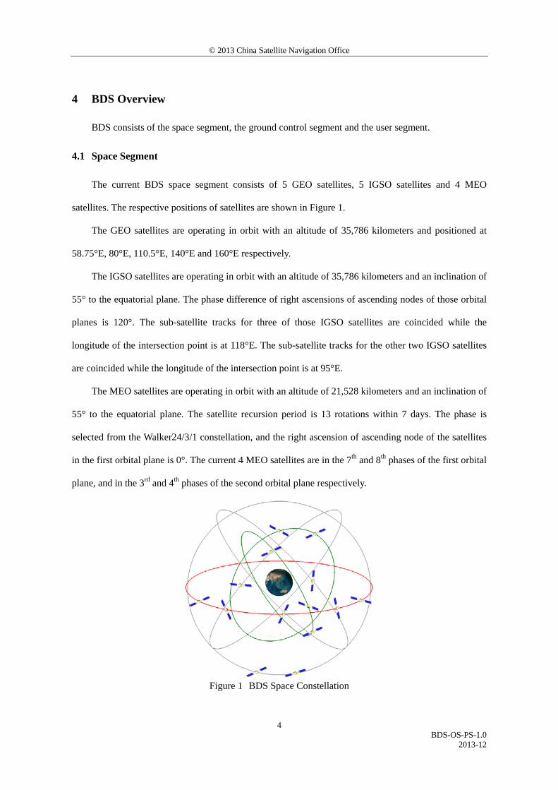
The current BDS space segment consists of 5 GEO satellites, 5 IGSO satellites and 4 MEO
satellites. The respective positions of satellites are shown in Figure 1.
The GEO satellites are operating in orbit with an altitude of 35,786 kilometers and positioned at
58.75°E, 80°E, 110.5°E, 140°E and 160°E respectively.
The IGSO satellites are operating in orbit with an altitude of 35,786 kilometers and an inclination of
55° to the equatorial plane. The phase difference of right ascensions of ascending nodes of those orbital
planes is 120°. The sub-satellite tracks for three of those IGSO satellites are coincided while the
longitude of the intersection point is at 118°E. The sub-satellite tracks for the other two IGSO satellites
are coincided while the longitude of the intersection point is at 95°E.
The MEO satellites are operating in orbit with an altitude of 21,528 kilometers and an inclination of
55° to the equatorial plane. The satellite recursion period is 13 rotations within 7 days. The phase is
selected from the Walker24/3/1 constellation, and the right ascension of ascending node of the satellites
in the first orbital plane is 0°. The current 4 MEO satellites are in the 7th and 8th phases of the first orbital
plane, and in the 3rd and 4th phases of the second orbital plane respectively.
Figure 1 BDS Space Constellation
© 2013 China Satellite Navigation Office
BDS-OS-PS-1.0
2013-12
5
4.2 Ground Control Segment
The ground control segment is responsible for the BDS operation and control. It consists of the
Master Control Station (MCS), Time Synchronization/Upload Stations (TS/US) and Monitor Stations
(MS).
The MCS is the operation and control center of BDS with the main tasks including:
a) to collect observation data of NAV signals from each TS/US and MS, to process data, to
generate satellite NAV messages;
b) to perform mission planning and scheduling, to conduct system operations, management and
control;
c) to observe and calculate the satellite clock bias, to upload satellite NAV messages;
d) to monitor the satellite payload and analyze anomalies, etc.
The main tasks of TS/US are to measure satellite clock biases and to upload satellite NAV
messages.
The main tasks of MS are to continuously observe satellite NAV signals, and to provide real-time
data to the MCS.
4.3 User Segment
The user segment encompasses various types of BDS terminals, including those compatible with
other navigation systems.
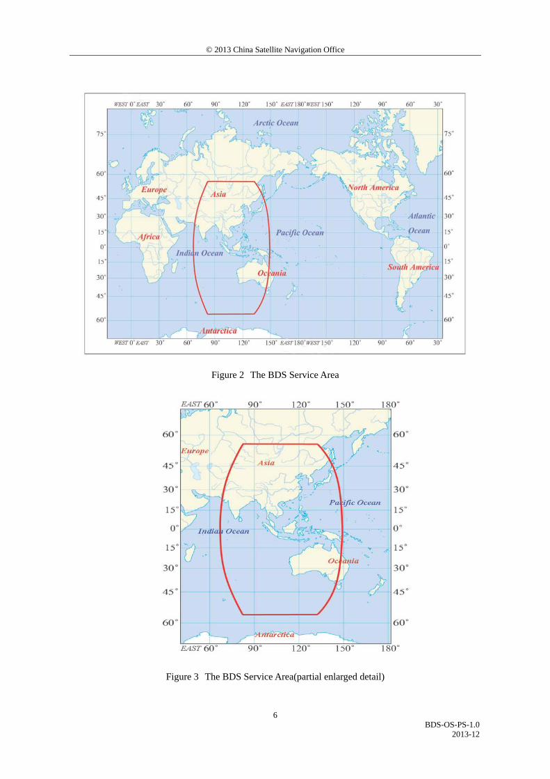
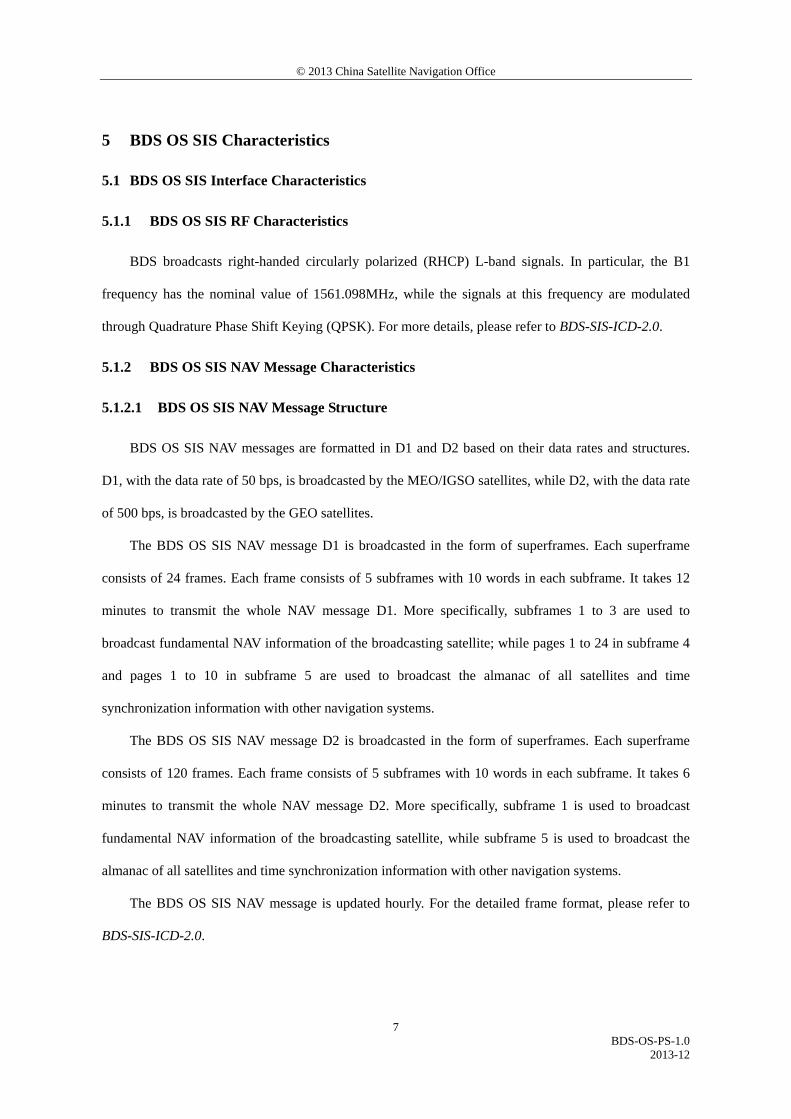
4.4 BDS OS Service Volume
The BDS OS service volume is defined as the OS SIS coverage of the BDS satellites where both the
BDS OS horizontal and vertical position accuracy are better than 10 meters (probability of 95%). At the
current stage, the BDS regional service capability has been achieved, which can provide continuous OS
to the area as shown in Figure 2 & Figure 3, including the most part of the region from 55°S to 55°N,
70°E to150°E.
© 2013 China Satellite Navigation Office
BDS-OS-PS-1.0
2013-12
6
Figure 2 The BDS Service Area
Figure 3 The BDS Service Area(partial enlarged detail)
© 2013 China Satellite Navigation Office
BDS-OS-PS-1.0
2013-12
7
5 BDS OS SIS Characteristics
5.1 BDS OS SIS Interface Characteristics
5.1.1 BDS OS SIS RF Characteristics
BDS broadcasts right-handed circularly polarized (RHCP) L-band signals. In particular, the B1
frequency has the nominal value of 1561.098MHz, while the signals at this frequency are modulated
through Quadrature Phase Shift Keying (QPSK). For more details, please refer to BDS-SIS-ICD-2.0.
5.1.2 BDS OS SIS NAV Message Characteristics
5.1.2.1 BDS OS SIS NAV Message Structure
BDS OS SIS NAV messages are formatted in D1 and D2 based on their data rates and structures.
D1, with the data rate of 50 bps, is broadcasted by the MEO/IGSO satellites, while D2, with the data rate
of 500 bps, is broadcasted by the GEO satellites.
The BDS OS SIS NAV message D1 is broadcasted in the form of superframes. Each superframe
consists of 24 frames. Each frame consists of 5 subframes with 10 words in each subframe. It takes 12
minutes to transmit the whole NAV message D1. More specifically, subframes 1 to 3 are used to
broadcast fundamental NAV information of the broadcasting satellite; while pages 1 to 24 in subframe 4
and pages 1 to 10 in subframe 5 are used to broadcast the almanac of all satellites and time
synchronization information with other navigation systems.
The BDS OS SIS NAV message D2 is broadcasted in the form of superframes. Each superframe
consists of 120 frames. Each frame consists of 5 subframes with 10 words in each subframe. It takes 6
minutes to transmit the whole NAV message D2. More specifically, subframe 1 is used to broadcast
fundamental NAV information of the broadcasting satellite, while subframe 5 is used to broadcast the
almanac of all satellites and time synchronization information with other navigation systems.
The BDS OS SIS NAV message is updated hourly. For the detailed frame format, please refer to
BDS-SIS-ICD-2.0.
© 2013 China Satellite Navigation Office
BDS-OS-PS-1.0
2013-12
8
5.1.2.2 BDS OS NAV Message Data
The BDS OS NAV message data mainly includes:
a) satellite ephemeris parameters;
b) satellite clock offset parameters;
c) ionospheric delay model correction parameters;
d) satellite health status;
e) user range accuracy index;
f) constellation status (almanac information), etc.
For more details, please refer to BDS-SIS-ICD-2.0.
5.2 BDS OS SIS Performance Characteristics
5.2.1 BDS OS SIS Coverage
The BDS OS SIS coverage is described by the per-satellite coverage, which comprises the portion
of the near-Earth region which extends from the surface of the Earth up to an altitude of 1,000
kilometers above the surface of the Earth which is visible from the satellite's orbital position.
5.2.2 BDS OS SIS Accuracy
The BDS OS SIS accuracy is defined as the statistical value of errors (95% probability) for any
healthy satellite in normal operation.
The BDS OS SIS accuracy includes four parameters:
a) User Range Error (URE);
b) User Range Rate Error (URRE);
c) User Range Acceleration Error (URAE);
d) UTC Offset Error (UTCOE).
5.2.2.1 BDS OS SIS URE
The BDS OS SIS URE is described by a statistical measurement of the instantaneous SIS URE
data.
An instantaneous SIS URE is the difference between the pseudorange measured at a given location

© 2013 China Satellite Navigation Office
BDS-OS-PS-1.0
2013-12
9
assuming a receiver clock that is perfectly calibrated to BDT and the expected pseudorange as derived
from the NAV message data for the given location and the assumed receiver clock. The instantaneous
SIS URE includes only those pseudorange data set error budget components assigned to the BDS Space
and Ground Control Segments (i.e., not including the error budget components assigned to the BDS User
Segment such as the troposphere delay compensation error, multipath, and receiver noise).
5.2.2.2 BDS OS SIS URRE
The BDS OS SIS URRE is defined as the time derivative of the BDS OS SIS URE.
5.2.2.3 BDS OS SIS URAE
The BDS OS SIS URAE is defined as the second time derivative of the BDS OS SIS URE.
5.2.2.4 BDS OS SIS UTCOE
The BDS OS SIS UTCOE is defined as the accuracy of the offset between BDT and UTC. The
offset between BDT and UTC is less than 100 nanoseconds.
5.2.3 BDS OS SIS Continuity
The BDS OS SIS continuity is defined as the probability that a healthy BDS OS SIS will continue
working without unscheduled interruptions over a specified time interval. The BDS OS SIS continuity is
closely correlated to unscheduled interruptions.
5.2.4 BDS OS SIS Availability
The BDS OS SIS availability is described by the per-slot availability, which is defined as the
probability that a specific slot in the BDS constellation will be occupied by a BDS satellite transmitting a
healthy OS SIS.
© 2013 China Satellite Navigation Office
BDS-OS-PS-1.0
2013-12
10
6 BDS OS Performance Characteristics
6.1 User Assumptions
The position, velocity and time performance standards in this document are based on the
assumption of using a representative BDS OS receiver that:
a) is designed in accordance with BDS-SIS-ICD-2.0, which can correctly track and process the
BDS OS signals, and conduct position, velocity and time solution;
b) uses a mask angle of 10°;
c) accomplishes satellite position and geometric range computations in CGCS2000;
d) only considers the errors related to the space segment and ground control segment. Those
errors include the satellite orbit error, the satellite clock offset error and TGD error.
6.2 BDS OS Accuracy
The BDS OS accuracy includes those of position, velocity and time.
The BDS OS position accuracy is defined as the statistical difference between the user’s position
derived from BDS OS SIS and its true position, under the BDS user assumptions. The position accuracy
includes horizontal and vertical measurements.
The BDS OS velocity accuracy is defined as the statistical difference between the user’s velocity
derived from the BDS OS SIS and its true velocity, under the BDS user assumptions.
The BDS OS time accuracy is defined as the statistical difference between the user’s time derived
from BDS OS SIS and that value from UTC, under the BDS user assumptions.
6.3 BDS OS Availability
The BDS OS availability is defined as the percentage of the available service time to the expected
service time. The available service time refers to the period when the service accuracy meets the
specified performance standards within a given service volume.
The BDS OS availability in this document includes PDOP availability and positioning service
availability.
The PDOP availability is defined as the percentage of time when PDOP value meets the
© 2013 China Satellite Navigation Office
BDS-OS-PS-1.0
2013-12
11
requirements of PDOP threshold, under specified conditions, within a specified time period and service
volume.
The positioning service availability is defined as the percentage of time when horizontal and
vertical position accuracy meets the specified requirements of accuracy threshold, under specified
conditions, within a specified time period and service volume.

© 2013 China Satellite Navigation Office
BDS-OS-PS-1.0
2013-12
12
7 BDS OS SIS Performance Standards
7.1 BDS OS SIS Coverage Standards
The BDS OS SIS coverage standards are shown in Table 1.
Table 1 The BDS OS SIS Per-Satellite Coverage Standards
Satellite Type Coverage Standard
GEO/IGSO/MEO 100% of the BDS OS SIS coverage; The minimum user-received signal power is greater than -161 dBW.
7.2 BDS OS SIS Accuracy Standards
7.2.1 BDS OS SIS URE Accuracy Standards
The BDS OS SIS URE accuracy standards are shown in Table 2.
Table 2 The BDS OS SIS URE Accuracy Standards
Satellite Type SIS Accuracy Standard
(95% probability) Constraints
GEO/IGSO/MEO URE≤2.5m For any healthy OS SIS; Neglecting single-frequency ionospheric delay model errors.
Note: When a MEO satellite enters the view of the service volume, the SIS accuracy may deteriorate due to the age of data before the new NAV message is uploaded. It is recommended to use the updated NAV message.
7.2.2 BDS OS SIS URRE Accuracy Standards
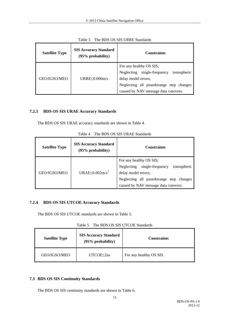
The BDS OS SIS URRE accuracy standards are shown in Table 3.
© 2013 China Satellite Navigation Office
BDS-OS-PS-1.0
2013-12
13
Table 3 The BDS OS SIS URRE Standards
Satellite Type SIS Accuracy Standard
(95% probability) Constraints
GEO/IGSO/MEO URRE≤0.006m/s
For any healthy OS SIS; Neglecting single-frequency ionospheric delay model errors; Neglecting all psuedorange step changes caused by NAV message data cutovers.
7.2.3 BDS OS SIS URAE Accuracy Standards
The BDS OS SIS URAE accuracy standards are shown in Table 4.
Table 4 The BDS OS SIS URAE Standards
Satellite Type SIS Accuracy Standard
(95% probability) Constraints
GEO/IGSO/MEO URAE≤0.002m/s2
For any healthy OS SIS; Neglecting single-frequency ionospheric delay model errors; Neglecting all psuedorange step changes caused by NAV message data cutovers.
7.2.4 BDS OS SIS UTCOE Accuracy Standards
The BDS OS SIS UTCOE standards are shown in Table 5.
Table 5 The BDS OS SIS UTCOE Standards
Satellite Type SIS Accuracy Standard
(95% probability) Constraints
GEO/IGSO/MEO UTCOE≤2ns For any healthy OS SIS.
7.3 BDS OS SIS Continuity Standards
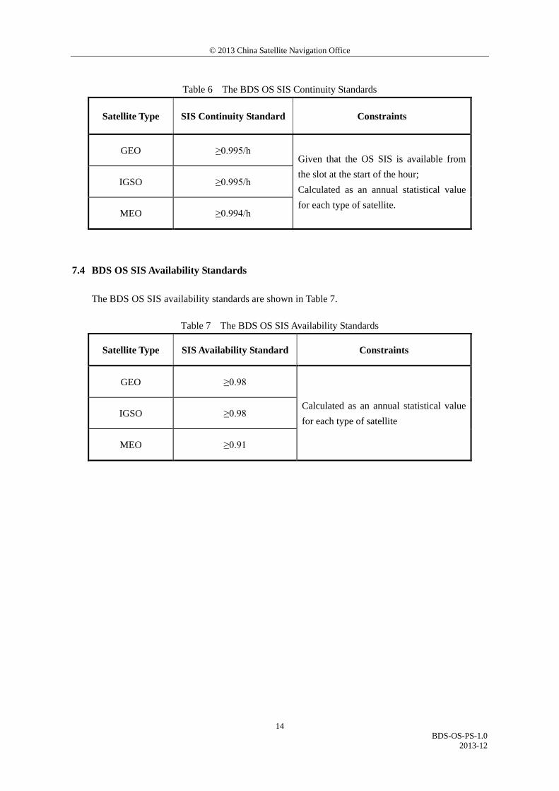
The BDS OS SIS continuity standards are shown in Table 6.
© 2013 China Satellite Navigation Office
BDS-OS-PS-1.0
2013-12
14
Table 6 The BDS OS SIS Continuity Standards
Satellite Type SIS Continuity Standard Constraints
GEO ≥0.995/h Given that the OS SIS is available from the slot at the start of the hour; Calculated as an annual statistical value for each type of satellite.
IGSO ≥0.995/h
MEO ≥0.994/h
7.4 BDS OS SIS Availability Standards
The BDS OS SIS availability standards are shown in Table 7.
Table 7 The BDS OS SIS Availability Standards
Satellite Type SIS Availability Standard Constraints
GEO ≥0.98
Calculated as an annual statistical value for each type of satellite
IGSO ≥0.98
MEO ≥0.91
© 2013 China Satellite Navigation Office
BDS-OS-PS-1.0
2013-12
15
8 BDS OS Performance Standards
8.1 BDS OS Service Accuracy
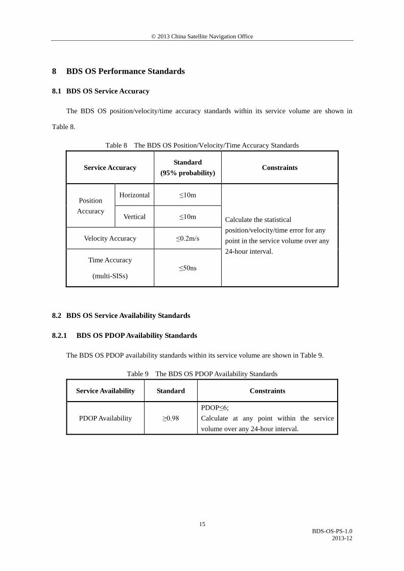
The BDS OS position/velocity/time accuracy standards within its service volume are shown in
Table 8.
Table 8 The BDS OS Position/Velocity/Time Accuracy Standards
Service Accuracy Standard
(95% probability) Constraints
Position Accuracy
Horizontal ≤10m
Calculate the statistical position/velocity/time error for any point in the service volume over any 24-hour interval.
Vertical ≤10m
Velocity Accuracy ≤0.2m/s
Time Accuracy
(multi-SISs) ≤50ns
8.2 BDS OS Service Availability Standards
8.2.1 BDS OS PDOP Availability Standards
The BDS OS PDOP availability standards within its service volume are shown in Table 9.
Table 9 The BDS OS PDOP Availability Standards
Service Availability Standard Constraints
PDOP Availability ≥0.98 PDOP≤6; Calculate at any point within the service volume over any 24-hour interval.
© 2013 China Satellite Navigation Office
BDS-OS-PS-1.0
2013-12
16
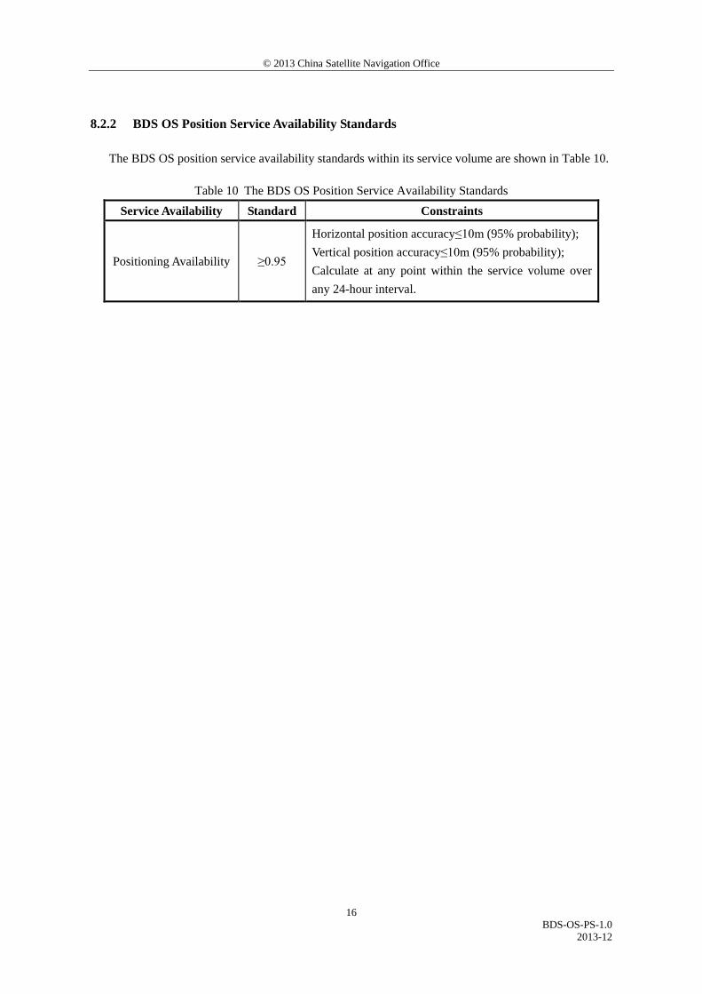
8.2.2 BDS OS Position Service Availability Standards
The BDS OS position service availability standards within its service volume are shown in Table 10.
Table 10 The BDS OS Position Service Availability Standards Service Availability Standard Constraints
Positioning Availability ≥0.95
Horizontal position accuracy≤10m (95% probability); Vertical position accuracy≤10m (95% probability); Calculate at any point within the service volume over any 24-hour interval.
© 2013 China Satellite Navigation Office
BDS-OS-PS-1.0
2013-12
17
9 Additional Observations
At present, in addition to the specified open service volume, in the most part of the area within
55°S~55°N, 55°E~160°E, the BDS could provide open services with the horizontal and vertical position
accuracy better than 20 meters; in the most part of the area within 55°S~55°N, 40°E~180°E, the BDS
could provide open services with the horizontal and vertical position accuracy better than 30 meters. As
a user moves away from the nominal service volume, the service accuracy and availability will decrease
accordingly.