beaver island - michigan water trails
TRANSCRIPT
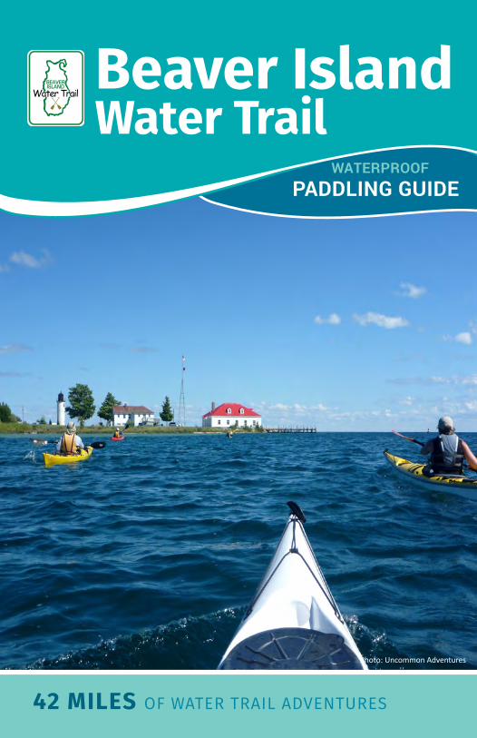
42 MILES OF WATER TRAIL ADVENTURES
Photo: Uncommon Adventures
WATERPROOF PADDLING GUIDE
Beaver IslandWater Trail
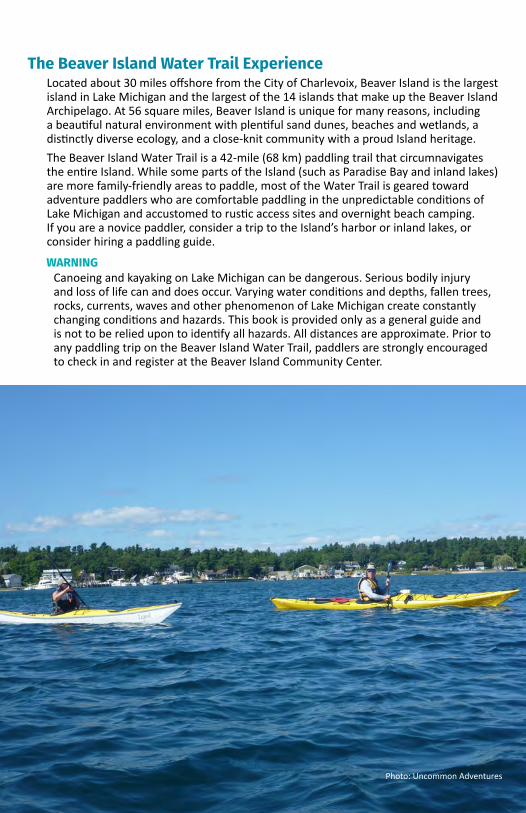
The Beaver Island Water Trail ExperienceLocated about 30 miles offshore from the City of Charlevoix, Beaver Island is the largest island in Lake Michigan and the largest of the 14 islands that make up the Beaver Island Archipelago. At 56 square miles, Beaver Island is unique for many reasons, including a beautiful natural environment with plentiful sand dunes, beaches and wetlands, a distinctly diverse ecology, and a close-knit community with a proud Island heritage. The Beaver Island Water Trail is a 42-mile (68 km) paddling trail that circumnavigates the entire Island. While some parts of the Island (such as Paradise Bay and inland lakes) are more family-friendly areas to paddle, most of the Water Trail is geared toward adventure paddlers who are comfortable paddling in the unpredictable conditions of Lake Michigan and accustomed to rustic access sites and overnight beach camping. If you are a novice paddler, consider a trip to the Island’s harbor or inland lakes, or consider hiring a paddling guide.
Photo: Uncommon Adventures
WARNINGCanoeing and kayaking on Lake Michigan can be dangerous. Serious bodily injury and loss of life can and does occur. Varying water conditions and depths, fallen trees, rocks, currents, waves and other phenomenon of Lake Michigan create constantly changing conditions and hazards. This book is provided only as a general guide and is not to be relied upon to identify all hazards. All distances are approximate. Prior to any paddling trip on the Beaver Island Water Trail, paddlers are strongly encouraged to check in and register at the Beaver Island Community Center.
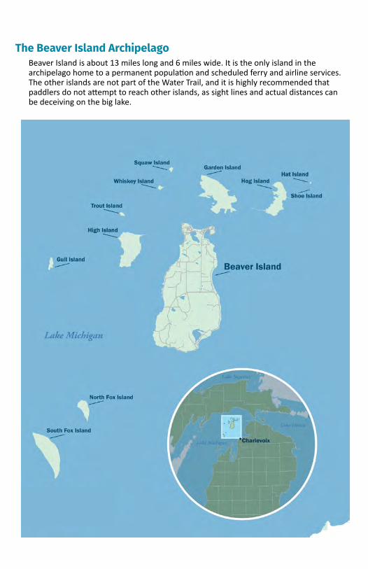
The Beaver Island ArchipelagoBeaver Island is about 13 miles long and 6 miles wide. It is the only island in the archipelago home to a permanent population and scheduled ferry and airline services. The other islands are not part of the Water Trail, and it is highly recommended that paddlers do not attempt to reach other islands, as sight lines and actual distances can be deceiving on the big lake.
Beaver Island Road Map
Safety on Beaver IslandThese basic safety tips will increase your chances of having a safe and enjoyable paddle on Beaver Island:1. REGISTERATTHECOMMUNITYCENTER.
Prior to your paddle, all water trail users should register in the Community Center at 26215 Main Street, right across the street from the ferry dock. Your registration will alert public safety officers to your paddle. There is no cost to register. The Community Center also has useful information about all the amenities and natural features of Beaver Island.
2. ALWAYSPADDLEWITHTHEPROPEREQUIPMENT. Life vests are required by law. A whistle, a first-aid kit and a phone are standard equipment.
3. NEVERPADDLEALONE. Always paddle with at least one other person and do not become separated.
4. BEAWAREOFTHEWATERTEMPERATURE. Cold water is extremely dangerous. Take steps to protect yourself from hypothermia.
5. KEEPTOTHESHORELINE. Paddling far from shore can result in becoming lost. Keep the shoreline in sight at all times.
6. UNDERSTANDTHERIGHT-OF-WAY.The rules give priority first to self-propelled craft, including paddling boats, then to sailboats, and lastly to motorized craft.
7. BEAWAREOFTHEWEATHER. Conditions can change rapidly. Be aware of forecasts and do not go out during thunderstorms or other adverse weather events. Stay alert to changing weather conditions.
8. BEAWAREOFTHEDAYLIGHT. Make sure you leave enough daylight to comfortably finish your trip.
9. BRINGACHANGEOFCLOTHESINADRYBAG.It is very likely you will get wet. Bring a change of clothes in a dry bag to avoid hypothermia.
10. KNOWHOWTOSWIM.Make sure you know how to swim before paddling on Beaver Island.
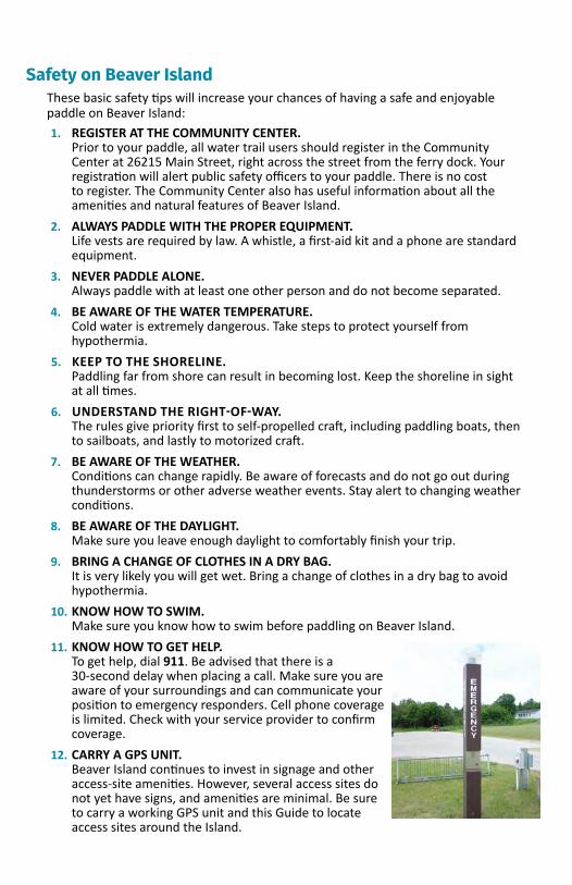
11. KNOWHOWTOGETHELP.To get help, dial 911. Be advised that there is a 30-second delay when placing a call. Make sure you are aware of your surroundings and can communicate your position to emergency responders. Cell phone coverage is limited. Check with your service provider to confirm coverage.
12. CARRYAGPSUNIT. Beaver Island continues to invest in signage and other access-site amenities. However, several access sites do not yet have signs, and amenities are minimal. Be sure to carry a working GPS unit and this Guide to locate access sites around the Island.
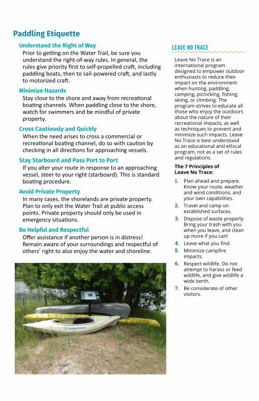
Paddling EtiquetteUnderstand the Right of Way
Prior to getting on the Water Trail, be sure you understand the right-of-way rules. In general, the rules give priority first to self-propelled craft, including paddling boats, then to sail-powered craft, and lastly to motorized craft.
Minimize HazardsStay close to the shore and away from recreational boating channels. When paddling close to the shore, watch for swimmers and be mindful of private property.
Cross Cautiously and QuicklyWhen the need arises to cross a commercial or recreational boating channel, do so with caution by checking in all directions for approaching vessels.
Stay Starboard and Pass Port to PortIf you alter your route in response to an approaching vessel, steer to your right (starboard). This is standard boating procedure.
Avoid Private PropertyIn many cases, the shorelands are private property. Plan to only exit the Water Trail at public access points. Private property should only be used in emergency situations.
Be Helpful and RespectfulOffer assistance if another person is in distress! Remain aware of your surroundings and respectful of others’ right to also enjoy the water and shoreline.
LEAVE NO TRACE
Leave No Trace is an international program designed to empower outdoor enthusiasts to reduce their impact on the environment when hunting, paddling, camping, picnicking, fishing, skiing, or climbing. The program strives to educate all those who enjoy the outdoors about the nature of their recreational impacts, as well as techniques to prevent and minimize such impacts. Leave No Trace is best understood as an educational and ethical program, not as a set of rules and regulations.
The 7 Principles of Leave No Trace:
1. Plan ahead and prepare. Know your route, weather and wind conditions, and your own capabilities.
2. Travel and camp on established surfaces.
3. Dispose of waste properly. Bring your trash with you when you leave, and clean up more if you can!
4. Leave what you find.5. Minimize campfire
impacts.6. Respect wildlife. Do not
attempt to harass or feed wildlife, and give wildlife a wide berth.
7. Be considerate of other visitors.
Transportation to Beaver IslandBeaver Island can be accessed by both boat (private or ferry) and airplane (private or commercial).
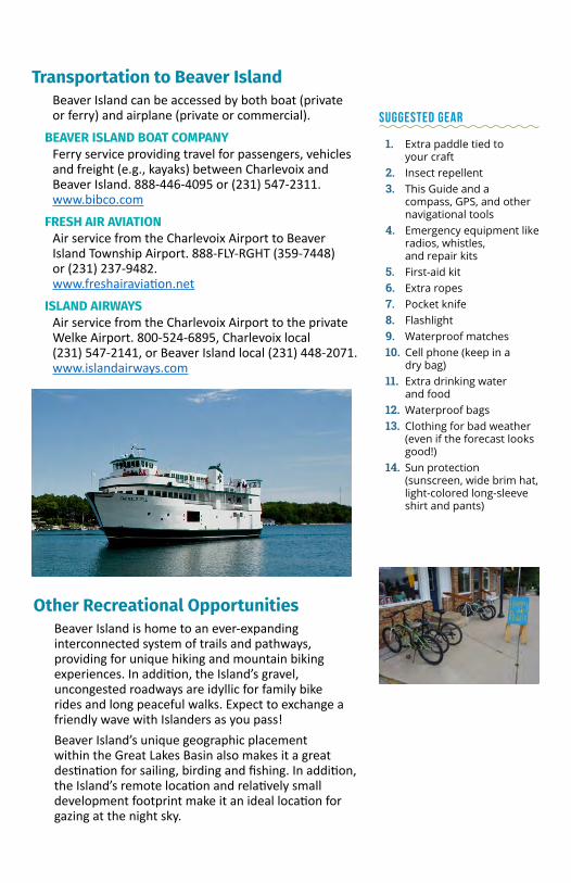
BEAVER ISLAND BOAT COMPANYFerry service providing travel for passengers, vehicles and freight (e.g., kayaks) between Charlevoix and Beaver Island. 888-446-4095 or (231) 547-2311. www.bibco.com
FRESH AIR AVIATIONAir service from the Charlevoix Airport to Beaver Island Township Airport. 888-FLY-RGHT (359-7448) or (231) 237-9482. www.freshairaviation.net
ISLAND AIRWAYSAir service from the Charlevoix Airport to the private Welke Airport. 800-524-6895, Charlevoix local (231) 547-2141, or Beaver Island local (231) 448-2071. www.islandairways.com
SUGGESTED GEAR
1. Extra paddle tied to your craft
2. Insect repellent3. This Guide and a
compass, GPS, and other navigational tools
4. Emergency equipment like radios, whistles, and repair kits
5. First-aid kit6. Extra ropes7. Pocket knife8. Flashlight9. Waterproof matches10. Cell phone (keep in a
dry bag)11. Extra drinking water
and food12. Waterproof bags13. Clothing for bad weather
(even if the forecast looks good!)
14. Sun protection (sunscreen, wide brim hat, light-colored long-sleeve shirt and pants)
Other Recreational OpportunitiesBeaver Island is home to an ever-expanding interconnected system of trails and pathways, providing for unique hiking and mountain biking experiences. In addition, the Island’s gravel, uncongested roadways are idyllic for family bike rides and long peaceful walks. Expect to exchange a friendly wave with Islanders as you pass!Beaver Island’s unique geographic placement within the Great Lakes Basin also makes it a great destination for sailing, birding and fishing. In addition, the Island’s remote location and relatively small development footprint make it an ideal location for gazing at the night sky.

BEAVER ISLAND FUN
Beaver Island has a number of fun and interesting events and festivals throughout the paddling season:
Beaver Island’s St. Patrick Day and Fourth of July holidays both offer festive parades and activities. The Fourth of July weekend is widely regarded as the busiest weekend on the Island.
The Beaver Island Music Festival is held at the Beaver Island Hideaway Campground. The Music Festival draws thousands of people to come hear bands and musicians over three days in July each year.
July’s Museum Week features presentations on nature, oral history and Native American culture, live music, nature walks, a pet show and an art show.
Baroque on Beaver is a musical festival and concert series that draws thousands of visitors and musicians from Michigan and beyond. The event is held in various locations throughout the Island during the last week of July and first week of August.
Homecoming is an Island-wide event held each August with a festival, food, music and a softball tournament.
For all events on the Island, visit the Beaver Island Community Calendar at www.biccenter.org/calendar.
Accommodations on Beaver IslandThere are two formal campsites along the coastline that paddlers can use (see below). Rustic campsites with a small tent platform and fire pit are still under development at other locations around the Island.The Emerald Isle Hotel offers shower facilities to campers for a fee; (231) 448-2376 or www.emeraldislehotel.com.
St. James Township Campground Located on the north end of Beaver Island. Overlooks Lake Michigan and Garden Island, with views of Squaw and Whiskey Islands. Twelve rustic campsites, pit toilets and hand pumps. No showers or electricity.
Bill Wagner Memorial CampgroundLocated on the east side of Beaver Island on the shore of Lake Michigan with a view of the west coast of mainland Michigan. Twenty-two rustic campsites, pit toilets and hand pumps. No showers or electricity.
Other AccommodationsBeaver Island has other lodging accommodations, including motels, B&Bs, rental homes and inland campgrounds. Accommodations fill up quickly during the summer, so be sure to call ahead of time.
Eating on the IslandRestaurants and bars are clustered in and around St. James, offering a range of menu items and drinks. Groceries and other wares can be purchased at McDonough’s Market, a full-service grocery store.
Supplies and Other ProvisionsSupplies (e.g., batteries, tarps, rope, etc.) can be purchased at the hardware store located just south of the ferry dock.
OutfittersHappy Paddle
At Jewell Gillespie Park. (630) 488-2949. www.happypaddle.com
Lakeside Sports26250 Main Street, adjacent to the ferry dock. (231) 448-2166.
Other Points of InterestMarine Museum
The Beaver Island Marine Museum is in an old net shed originally built in 1905 and first used as a museum in 1976. The museum has two floors of exhibits that tell stories of shipwrecks, Coast Guard rescues, ship building, Island vessels, and even diving. The museum is staffed and maintained by volunteers from the Beaver Island Historical Society.
Historical SocietyThe Mormon Print Shop was built in 1850 by the Island’s Mormon settlers. The building is now used as the Beaver Island Historical Society’s main museum, with exhibits on important historical figures as well as diaries and other artifacts. As of this writing, the Beaver Island Historical Society is fundraising for an expansion of this museum, which will be renamed the Museum of Island Life.
The Protar HomeThe Protar Home is one of two sites on Beaver Island registered on the National Register of Historic Places. Maintained by the Beaver Island Historical Society, the historic home and tomb of Feodar Protar draw visitors interested in learning more about this cherished philanthropist and important figure in Beaver Island’s history. Photo credit: News on the ‘Net.
Heritage Park Heritage Park is maintained by the Beaver Island Historical Society and located on Donegal Bay Road. The park features several historical items, including the generator that first provided power to the Island as well as an old tilt-wheel grader. These outdoor exhibits are easily seen from the bike path and the library.

BIRDING ETIQUETTE
Out of respect for Island property owners and to protect migrating and nesting birds, please observe the following rules of birding etiquette:
1. Access private property only with express permission by owner.
2. Do not approach bird nests under any circumstances.
3. Keep all pets on leashes during breeding season.
4. Do not use taped or smartphone bird calls or songs during breeding season (May 1 - July 15).
5. Please stay on trails to protect ground-nesting birds.
Beaver Island Birding TrailAs the largest Island in Lake Michigan, Beaver Island is a critical stopover site for migratory birds. Some of the bird species found on Beaver Island are familiar residents like chickadees, woodpeckers and grouse, while others visit the archipelago as part of their annual cycle. In the winter, northern visitors
such as snowy owls, horned larks, snow buntings and long-tailed ducks can be found. However, the greatest diversity of species can be seen during spring and fall migration, as well as
during the summer breeding season. Large flocks of warblers, vireos, sparrows and thrushes feed along the coastal forests and dunes as they migrate in spring. Many of these birds take advantage of a plentiful food source in May: the large swarms of non-biting midges that emerge from Lake Michigan. The Island’s 35 birding locations can be easily located by the bright Birding Trail signs along the road. www.beaverislandbirdingtrail.org
Invasive SpeciesUnfortunately, invasive species are a common problem in many Great Lakes communities. One benefit of living on an island is that it can be more difficult for invasive species to establish colonies. However, once invasives are established, it is more expensive and sometimes impossible to remove them. Therefore, even a few invasive species can cause significant disruptions to the ecological integrity of an island.
Clean off vegetation and dry all water from boats and gear before transferring between waterways on Beaver Island. Observations of invasive species can be reported at the Beaver Island Community Center in St. James.
RESPECT PLANT AND ANIMAL WILDLIFE
Stay away from nesting sites and birds with their young. Many shorebirds and loons use shorelines and interior lakes to raise their young, and disturbance leads to predation. Photograph flowers but do not remove.
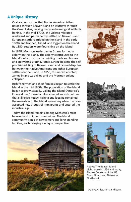
A Unique History Oral accounts show that Native American tribes passed through Beaver Island on journeys through the Great Lakes, leaving many archaeological artifacts behind. In the mid 1700s, the Odawa migrated westward and permanently settled on Beaver Island. European settlers arrived on the Island in the early 1800s and trapped, fished, and logged on the Island. By 1850, settlers were flourishing on the Island.In 1848, Mormon leader James Strang formed a colony on the Island. The colony contributed to the Island’s infrastructure by building roads and homes and cultivating ground. James Strang became the self-proclaimed King of Beaver Island and caused disputes between the Native Americans and other European settlers on the Island. In 1856, this unrest erupted; James Strang was killed and the Mormon colony collapsed.Irish fishermen and their families began to settle the Island in the mid 1800s. The population of the Island began to grow steadily. Calling the Island “America’s Emerald Isle,” these families created an Irish culture that still exists today. Fishing and logging remained the mainstays of the Island’s economy while the Island accepted new groups of immigrants and entered the industrial age.Today, the Island remains among Michigan’s most beloved and unique communities. The Island community is mix of newcomers and long-standing families, each bringing a unique perspective.
Above: The Beaver Island Lighthouse in 1930 and today. Photos Courtesy of the US Coast Guard and Networks Northwest
At left: A historic Island barn.
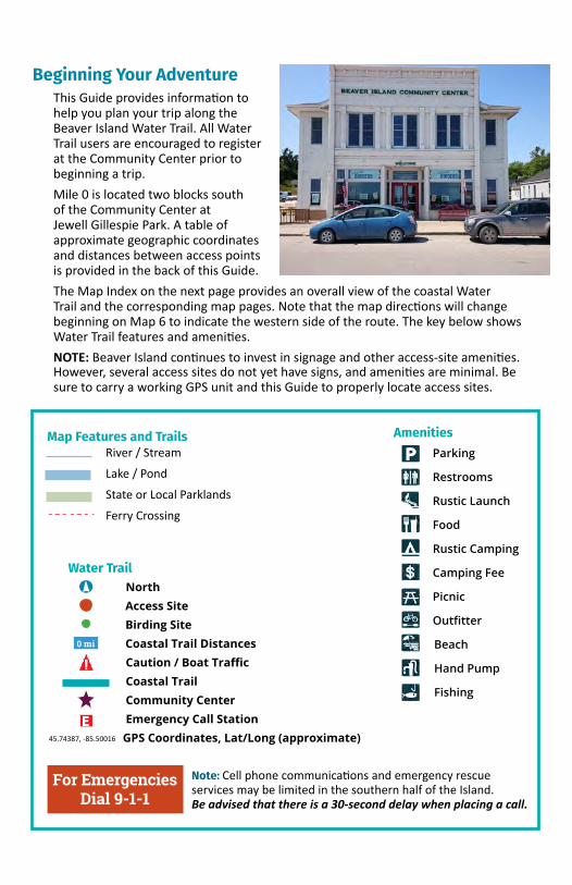
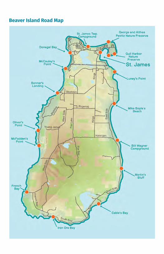
Beginning Your AdventureThis Guide provides information to help you plan your trip along the Beaver Island Water Trail. All Water Trail users are encouraged to register at the Community Center prior to beginning a trip.Mile 0 is located two blocks south of the Community Center at Jewell Gillespie Park. A table of approximate geographic coordinates and distances between access points is provided in the back of this Guide. The Map Index on the next page provides an overall view of the coastal Water Trail and the corresponding map pages. Notethat the map directions will change beginning on Map 6 to indicate the western side of the route. The key below shows Water Trail features and amenities. NOTE: Beaver Island continues to invest in signage and other access-site amenities. However, several access sites do not yet have signs, and amenities are minimal. Be sure to carry a working GPS unit and this Guide to properly locate access sites.
Map Features and TrailsRiver / Stream
Lake / Pond
State or Local Parklands
Ferry Crossing
Water Trail North Access Site Birding Site Coastal Trail Distances Caution / Boat Traffic Coastal Trail Community Center
Emergency Call Station GPS Coordinates, Lat/Long (approximate)
Amenities Parking
Restrooms
Rustic Launch
Food
Rustic Camping
Camping Fee
Picnic
Outfitter
Beach
Hand Pump
Fishing
For EmergenciesDial 9-1-1
.
Note: Cell phone communications and emergency rescue services may be limited in the southern half of the Island. Be advised that there is a 30-second delay when placing a call.
45.74387, -85.50016
0 mi
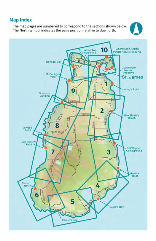
Map IndexThe map pages are numbered to correspond to the sections shown below. The North symbol indicates the page position relative to due north. .
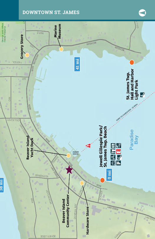
FERRY DOCK
FERRY TO CHARLEVOIX - 32 M
iles
DOWNTOWN ST. JAMES .

Little Sand Bay
1 ST. JAMES TO LUNEY’S POINTMILES 0 TO 3 .
45.72177, -85.50239
45.74387, -85.50016
45.75498, -85.5078545.75078, -85.53821
Little Sand Bay Nature PreserveJust south of Luney’s Point, Little Sand Bay Nature Preserve is a 28-acre mix of conifer forest, cedar swamp and sand dunes with 1,300 feet of Lake Michigan frontage. Michigan monkey-flower, Lake Huron tansy and other threatened or endangered plant species thrive here. A short trail with foot bridges allows visitors to explore without damaging the sensitive habitat. The preserve provides public access to Lake Michigan and to a shallow, marshy beach. Parking is off of East Side Drive southeast of Welke Airport.
Luney’s Point
45.74303, -85.51015
FERRY DOCK
FERRY TO CHARLEVOIX - 32 Miles
1 MIKE BOYLE’S BEACHMILES 4 TO 7 .2
Sand Bay
45.69383, -85.49947
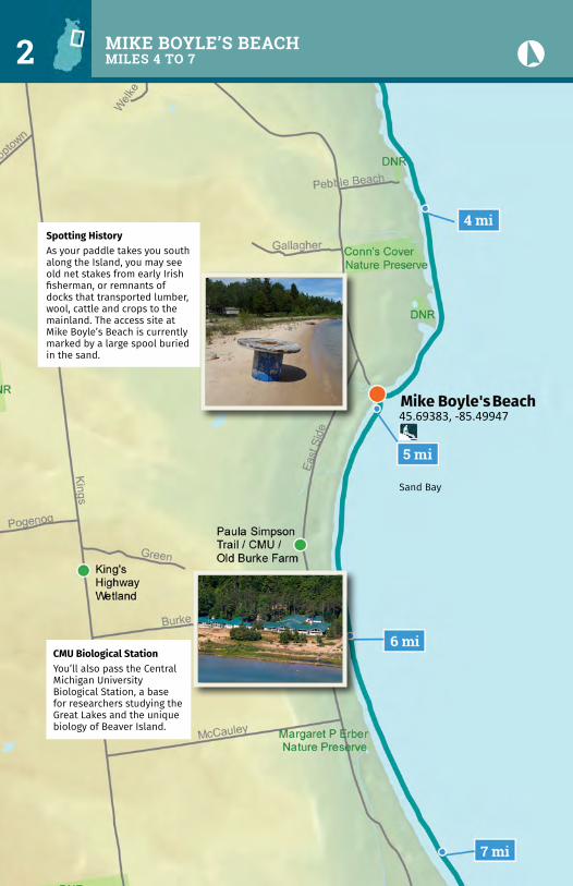
Spotting HistoryAs your paddle takes you south along the Island, you may see old net stakes from early Irish fisherman, or remnants of docks that transported lumber, wool, cattle and crops to the mainland. The access site at Mike Boyle’s Beach is currently marked by a large spool buried in the sand.
CMU Biological StationYou’ll also pass the Central Michigan University Biological Station, a base for researchers studying the Great Lakes and the unique biology of Beaver Island.
.3 WAGNER CAMPGROUND TO MARTIN’S BLUFFMILES 7 TO 10
Point LaPar
Kilty’s Pt.
45.62885, -85.48800
45.65708, -85.49423
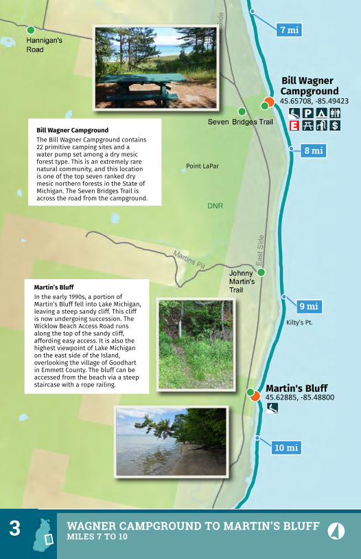
Bill Wagner CampgroundThe Bill Wagner Campground contains 22 primitive camping sites and a water pump set among a dry mesic forest type. This is an extremely rare natural community, and this location is one of the top seven ranked dry mesic northern forests in the State of Michigan. The Seven Bridges Trail is across the road from the campground.
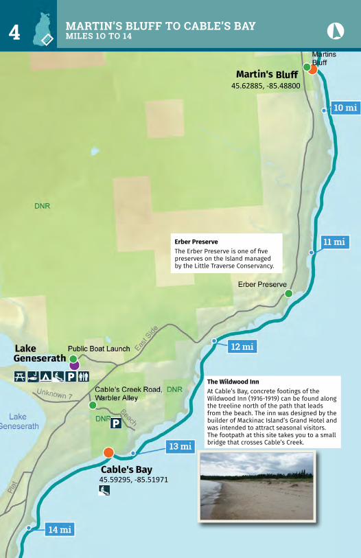
Martin’s BluffIn the early 1990s, a portion of Martin’s Bluff fell into Lake Michigan, leaving a steep sandy cliff. This cliff is now undergoing succession. The Wicklow Beach Access Road runs along the top of the sandy cliff, affording easy access. It is also the highest viewpoint of Lake Michigan on the east side of the Island, overlooking the village of Goodhart in Emmett County. The bluff can be accessed from the beach via a steep staircase with a rope railing.
45.59295, -85.51971
45.62885, -85.48800
The Wildwood InnAt Cable’s Bay, concrete footings of the Wildwood Inn (1916-1919) can be found along the treeline north of the path that leads from the beach. The inn was designed by the builder of Mackinac Island’s Grand Hotel and was intended to attract seasonal visitors. The footpath at this site takes you to a small bridge that crosses Cable’s Creek.
Erber PreserveThe Erber Preserve is one of five preserves on the Island managed by the Little Traverse Conservancy.
MARTIN’S BLUFF TO CABLE’S BAYMILES 1O TO 14 .4
.5 IRON ORE BAY MILES 14 TO 18
Kelly’s Point
45.57922, -85.58446
Iron Ore CreekAn electric cable that supplied the Lighthouse can be viewed near the mouth of Iron Ore Creek. A series of cribs can be viewed to the west of the creek near the point. The cribs are the remains of an old dock that was used to transport virgin timber during the Island’s early logging boom.
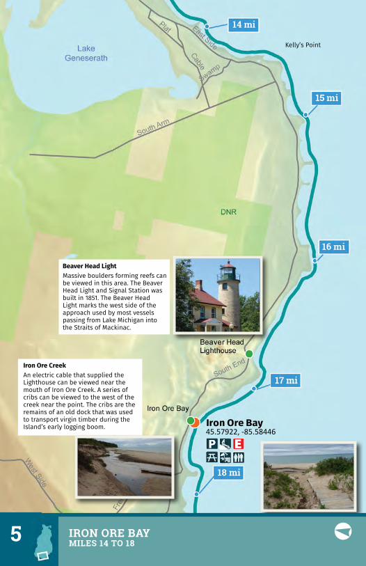
Beaver Head LightMassive boulders forming reefs can be viewed in this area. The Beaver Head Light and Signal Station was built in 1851. The Beaver Head Light marks the west side of the approach used by most vessels passing from Lake Michigan into the Straits of Mackinac.
Cheyenne Point
45.60371, -85.62281
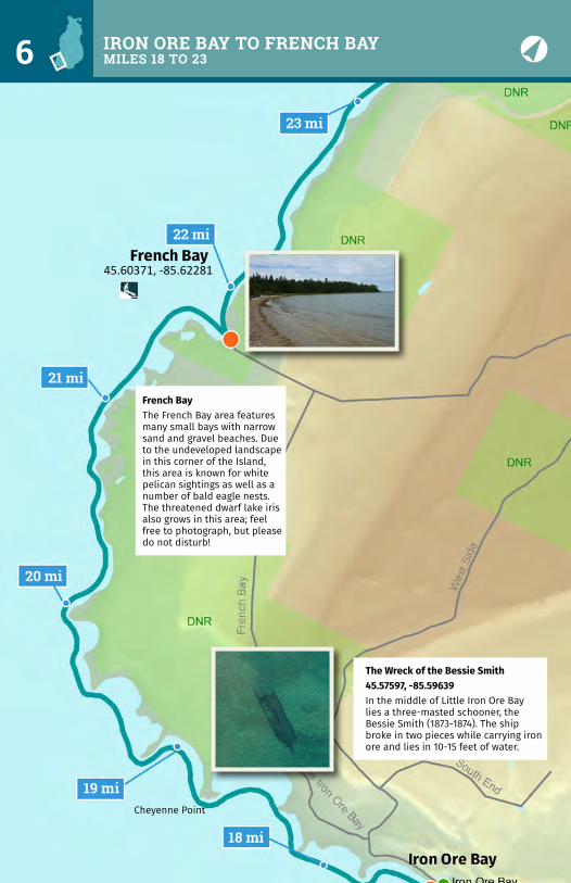
French BayThe French Bay area features many small bays with narrow sand and gravel beaches. Due to the undeveloped landscape in this corner of the Island, this area is known for white pelican sightings as well as a number of bald eagle nests. The threatened dwarf lake iris also grows in this area; feel free to photograph, but please do not disturb!
The Wreck of the Bessie Smith45.57597, -85.59639In the middle of Little Iron Ore Bay lies a three-masted schooner, the Bessie Smith (1873-1874). The ship broke in two pieces while carrying iron ore and lies in 10-15 feet of water.
IRON ORE BAY TO FRENCH BAYMILES 18 TO 23
.6
MCFADDEN’S POINTMILES 23 TO 26 7
Greene’s Bay
45.65075, -85.60630
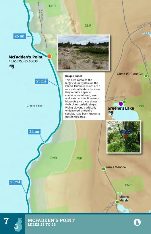
Unique DunesThis area contains the largest dune system on the Island. Parabolic dunes are a rare natural feature because they require a special combination of wind, sand and water action. Numerous blowouts give these dunes their characteristic shape. Piping plovers, a critically endangered shorebird species, have been known to nest in this area.
.
Left’s Point
45.70192, -85.58239
45.66568, -85.60781
Bonner’s Landing Historically, the area contained a settlement of Native Americans.
Oliver’s PointA foot path takes you from Oliver’s Point to Mrs. Redding’s Trail.
OLIVER’S POINT TO BONNER’S LANDINGMILES 27 TO 31 .8
.9 BONNER’S TO DONEGAL BAY BEACHMILES 31 TO 34
Donegal Bay
45.74437, -85.56378
45.72830, -85.56974
45.70192, -85.58239
McCauley’s PointMcCauley’s Point contains a system of dunes subject to continual wind and wave erosion.
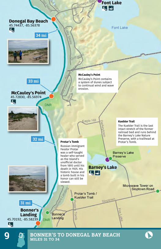
Protar’s TombRussian immigrant Feodor Protar was a self-taught healer who served as the Island’s unofficial doctor from 1893 until his death in 1925. His historic house and a tomb built in his honor can still be viewed.
Kuebler TrailThe Kuebler Trail is the last intact stretch of the former railroad bed and runs behind the Barney’s Lake Nature Preserve, with a trailhead at Protar’s Tomb.
Indian Point
Sucker Point
45.74437, -85.56378
45.75078, -85.53821
45.75498, -85.50785
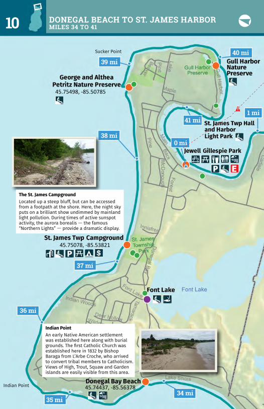
The St. James CampgroundLocated up a steep bluff, but can be accessed from a footpath at the shore. Here, the night sky puts on a brilliant show undimmed by mainland light pollution. During times of active sunspot activity, the aurora borealis — the famous “Northern Lights” — provide a dramatic display.
Indian PointAn early Native American settlement was established here along with burial grounds. The first Catholic Church was established here in 1832 by Bishop Baraga from L’Arbe Croche, who arrived to convert tribal members to Catholicism. Views of High, Trout, Squaw and Garden islands are easily visible from this area.
DONEGAL BEACH TO ST. JAMES HARBORMILES 34 TO 41 .10
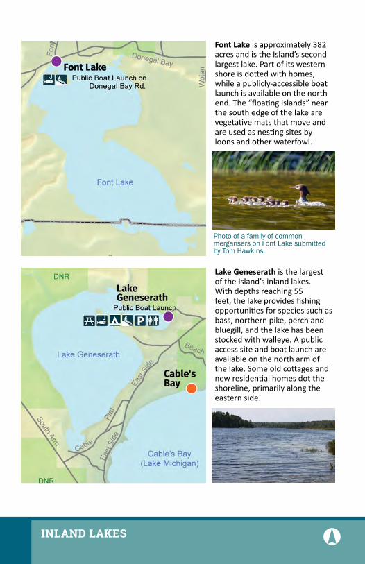
FontLake is approximately 382 acres and is the Island’s second largest lake. Part of its western shore is dotted with homes, while a publicly-accessible boat launch is available on the north end. The “floating islands” near the south edge of the lake are vegetative mats that move and are used as nesting sites by loons and other waterfowl.
LakeGeneserath is the largest of the Island’s inland lakes. With depths reaching 55 feet, the lake provides fishing opportunities for species such as bass, northern pike, perch and bluegill, and the lake has been stocked with walleye. A public access site and boat launch are available on the north arm of the lake. Some old cottages and new residential homes dot the shoreline, primarily along the eastern side.
Photo of a family of common mergansers on Font Lake submitted by Tom Hawkins.
.INLAND LAKES
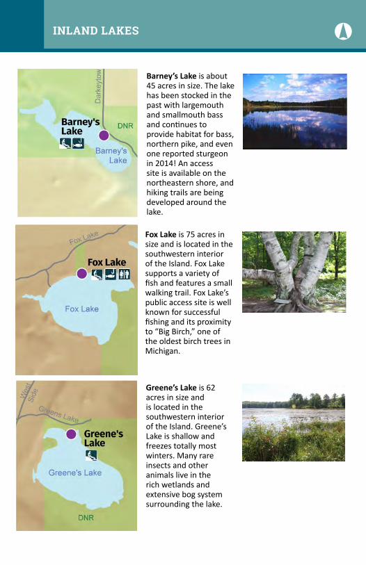
Barney’sLake is about 45 acres in size. The lake has been stocked in the past with largemouth and smallmouth bass and continues to provide habitat for bass, northern pike, and even one reported sturgeon in 2014! An access site is available on the northeastern shore, and hiking trails are being developed around the lake.
Greene’sLake is 62 acres in size and is located in the southwestern interior of the Island. Greene’s Lake is shallow and freezes totally most winters. Many rare insects and other animals live in the rich wetlands and extensive bog system surrounding the lake.
FoxLakeis 75 acres in size and is located in the southwestern interior of the Island. Fox Lake supports a variety of fish and features a small walking trail. Fox Lake’s public access site is well known for successful fishing and its proximity to “Big Birch,” one of the oldest birch trees in Michigan.
INLAND LAKES .

Tabl
e of
Dis
tanc
es B
etw
een
Acce
ss P
oint
s (in
mile
s) a
nd A
ppro
xim
ate
GPS
Coor
dina
tes
(dec
imal
deg
rees
)Al
l Pad
dler
s M
ust R
egis
ter a
t the
Com
mun
ity C
ente
r Prio
r to
Begi
nnin
g Tr
ip
AccessSite
M
ilesfromPreviou
sLatitud
e
Long
itude
Jew
ell G
illes
pie
Park
/St.
Jam
es To
wns
hip
Beac
h 0
.045
.745
11-8
5.52
044
Lune
y’s P
oint
2.4
45.7
2177
-85.
5023
9M
ike
Boyl
e’s B
each
2.3
45.6
9383
-85.
4994
7Bi
ll W
agne
r Cam
pgro
und
2.7
45.6
5708
-85.
4942
3M
artin
’s Bl
uff 2
.145
.628
85-8
5.48
800
Cabl
e’s B
ay 3
.545
.592
95-8
5.51
971
Iron
Ore
Bay
4.3
45.5
7922
-85.
5844
6Fr
ench
Bay
4.3
45.6
0371
-85.
6228
1M
cFad
den’
s Poi
nt 3
.745
.650
75-8
5.60
630
Oliv
er’s
Poin
t 1
.345
.665
68-8
5.60
781
Bonn
er’s
Land
ing
3.9
45.7
0192
-85.
5823
9M
cCau
ley’
s Poi
nt 2
.245
.728
30-8
5.56
974
Done
gal B
ay B
each
1.2
45.7
4437
-85.
5637
8St
. Jam
es To
wns
hip
Cam
pgro
und
3.0
45.7
5078
-85.
5382
1Ge
orge
and
Alth
ea P
etrit
z Nat
ure
Pres
erve
1.5
45.7
5498
-85.
5078
5Gu
ll Ha
rbor
Nat
ure
Pres
erve
1.4
45.7
4387
-85.
5001
6St
. Jam
es To
wns
hip
Hall
and
Harb
or L
ight
Par
k 0
.645
.743
03-8
5.51
015
Jew
ell G
illes
pie
Park
/St.
Jam
es To
wns
hip
Beac
h 1
.045
.745
11-8
5.52
044
Distan
ceAroun
dIsland
41.4
CONTACT: Beaver Island Community Center 26215 Main Street Beaver Island, Michigan 49782
231-448-2022
www.biccenter.org
WWW.MICHIGANWATERTRAILS.ORG
Financial assistance for this project was provided, in part, by the Michigan Coastal Zone Management Program, Office of the Great Lakes, Department of Environmental Quality, under the National Coastal Zone Management Program, through a grant from the National Oceanic and Atmospheric Administration, U.S. Department of Commerce.
Produced in partnership with the Land Information Access Association (LIAA).
Photo: Uncommon Adventures
Beaver IslandWater Trail
WATERPROOF PADDLING GUIDE