australia 2010 petrel sub-basin -...
TRANSCRIPT

AustrAliA 2010
PEtrEl suB-BAsiNBONAPArtE BAsiNrElEAsE ArEAs Nt10-1, W10-1 AND W10-2Offshore Petroleum Exploration Acreage Release
Image: Woodside Energy Ltd.
Geology of Release Areas NT10-1, W10-1 and W10-2 | www.petroleum-acreage.gov.au ii
CONtENtsGEOLOGICAL INFORMATION 1
RELEASE AREA GEOLOGY 2
EXPLORATION HISTORY 3
PETROLEUM SYSTEMS AND HYDROCARBON POTENTIAL 12
FIGURES 15
REFERENCES 27
FigurEsFigurE 1: Location map of Release Areas NT10-1, W10-1 and W10-2 in thePetrel Sub-basin. 15
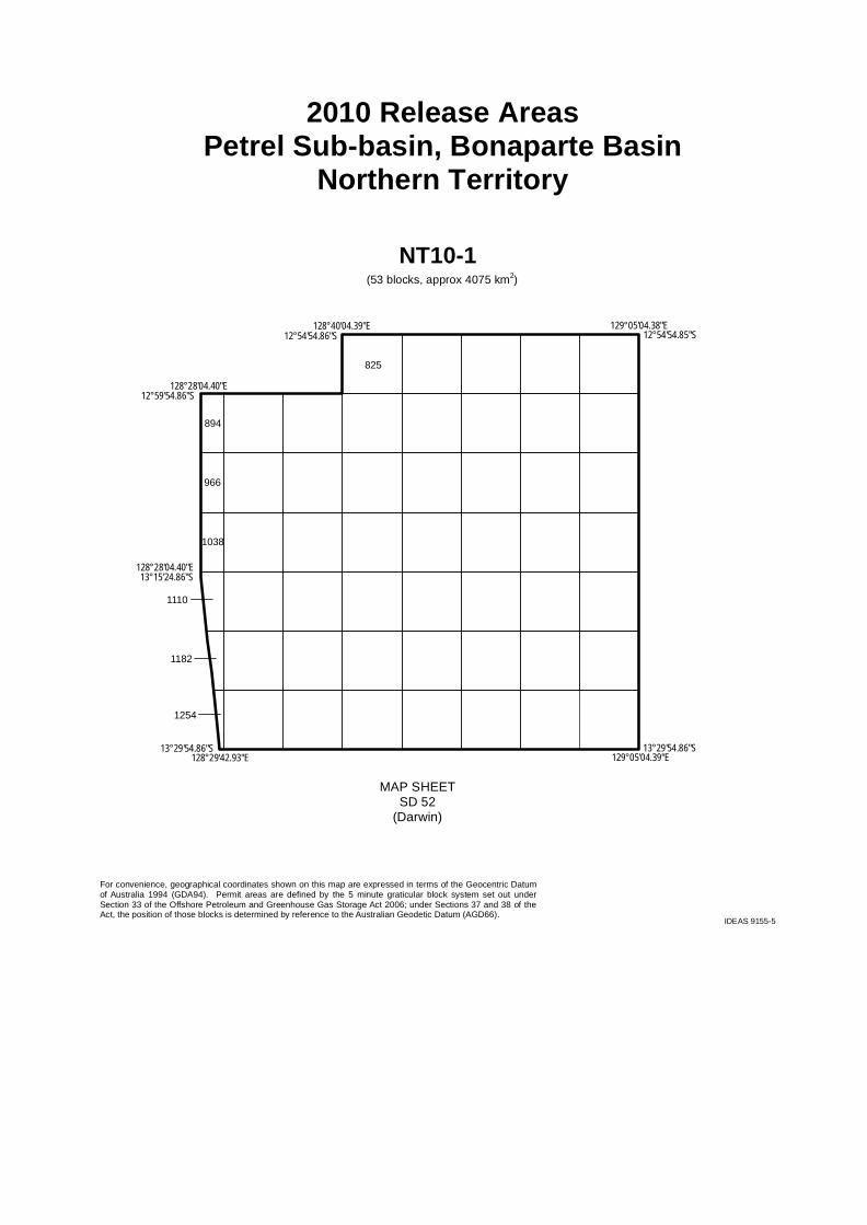
FigurE 2: Graticular block map and graticular block listing for Release AreaNT10-1 in the Petrel Sub-basin. 16
FigurE 3: Graticular block map and graticular block listings for Release Areas W10-1 and W10-2 in the Petrel Sub-basin. 18
FigurE 4: Regional structural elements of the Petrel Sub-basin showing the 2010 Release Areas and locations of the seismic lines reproduced in Figure 7, Figure 8 and Figure 9. 20
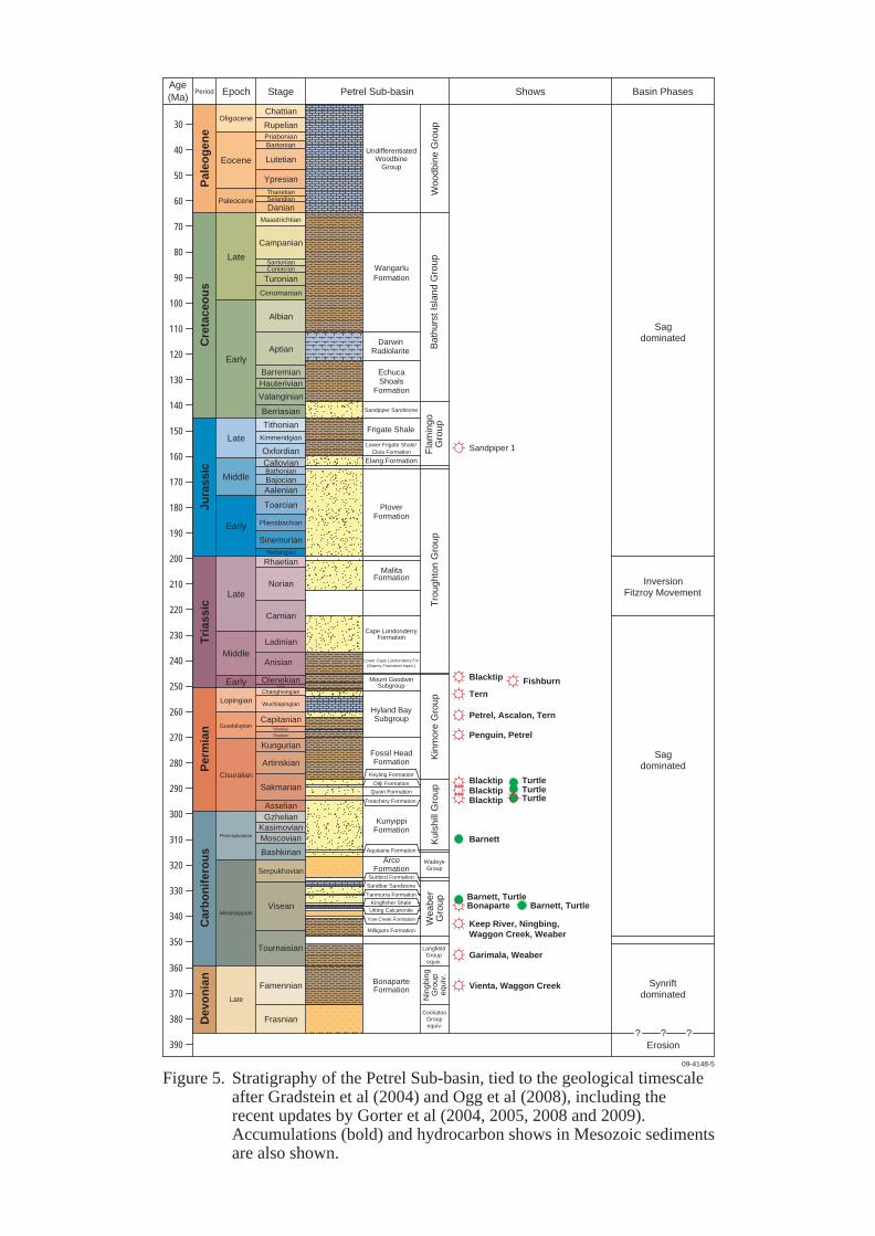
FigurE 5: Stratigraphy of the Petrel Sub-basin, tied to the geological timescale after Gradstein et al (2004) and Ogg et al (2008), including the recent updates by Gorter et al (2004, 2005, 2008 and 2009). Accumulations (bold) and hydrocarbon shows in Mesozoic sediments are also shown. 21
FigurE 6: Detailed Devonian to Triassic stratigraphy of the Petrel Sub-basin, tied to the geological timescale after Gradstein et al (2004) and Ogg et al (2008), and including the recent updates by Gorter et al (2004, 2005, 2008 and 2009). Accumulations (bold) and hydrocarbon shows in Paleozoic sediments are also shown. 22
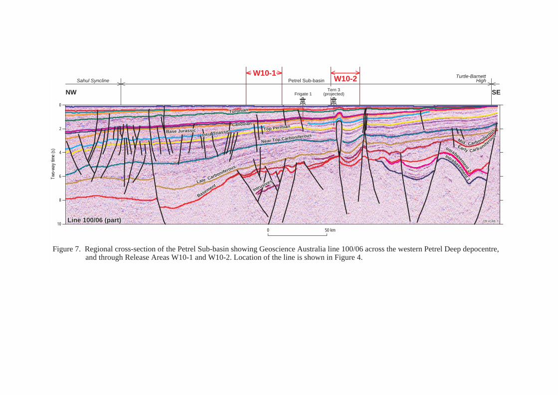
FigurE 7: Regional cross-section of the Petrel Sub-basin showing Geoscience Australia line 100/06 across the western Petrel Deep depocentre, and through Release Areas W10-1 and W10-2. Location of the line is shown in Figure 4. 23
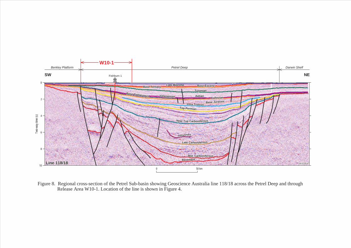
FigurE 8: Regional cross-section of the Petrel Sub-basin showing Geoscience Australia line 118/18 across the Petrel Deep and through Release Area W10-1. Location of the line is shown in Figure 4. 24
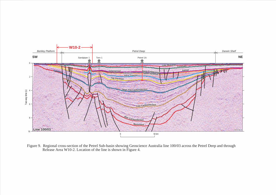
FigurE 9: Regional cross-section of the Petrel Sub-basin showing Geoscience Australia line 100/03 across the Petrel Deep and through Release Area W10-2. Location of the line is shown in Figure 4. 25
FigurE 10: Schematic diagram of the Permian petroleum system. 26
Geology of Release Areas NT10-1, W10-1 and W10-2 | www.petroleum-acreage.gov.au 1
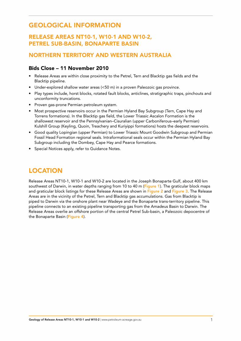
gEOlOgiCAl iNFOrMAtiON
rElEAsE ArEAs Nt10-1, W10-1 AND W10-2,PEtrEl suB-BAsiN, BONAPArtE BAsiN
NOrtHErN tErritOrY AND WEstErN AustrAliA
Bids Close – 11 November 2010• Release Areas are within close proximity to the Petrel, Tern and Blacktip gas fields and the
Blacktip pipeline.
• Under-explored shallow water areas (<50 m) in a proven Paleozoic gas province.
• Play types include, horst blocks, rotated fault blocks, anticlines, stratigraphic traps, pinchouts and unconformity truncations.
• Proven gas-prone Permian petroleum system.
• Most prospective reservoirs occur in the Permian Hyland Bay Subgroup (Tern, Cape Hay and Torrens formations). In the Blacktip gas field, the Lower Triassic Ascalon Formation is the shallowest reservoir and the Pennsylvanian–Cisuralian (upper Carboniferous–early Permian) Kulshill Group (Keyling, Quoin, Treachery and Kuriyippi formations) hosts the deepest reservoirs.
• Good quality Lopingian (upper Permian) to Lower Triassic Mount Goodwin Subgroup and Permian Fossil Head Formation regional seals. Intraformational seals occur within the Permian Hyland Bay Subgroup including the Dombey, Cape Hay and Pearce formations.
• Special Notices apply, refer to Guidance Notes.
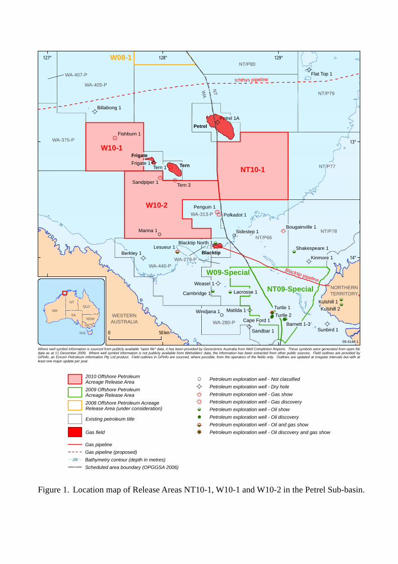
lOCAtiONRelease Areas NT10-1, W10-1 and W10-2 are located in the Joseph Bonaparte Gulf, about 400 km southwest of Darwin, in water depths ranging from 10 to 40 m (Figure 1). The graticular block maps and graticular block listings for these Release Areas are shown in Figure 2 and Figure 3. The Release Areas are in the vicinity of the Petrel, Tern and Blacktip gas accumulations. Gas from Blacktip is piped to Darwin via the onshore plant near Wadeye and the Bonaparte trans-territory pipeline. This pipeline connects to an existing pipeline transporting gas from the Amadeus Basin to Darwin. The Release Areas overlie an offshore portion of the central Petrel Sub-basin, a Paleozoic depocentre of the Bonaparte Basin (Figure 4).
Geology of Release Areas NT10-1, W10-1 and W10-2 | www.petroleum-acreage.gov.au 2
rElEAsE ArEA gEOlOgY
local tectonic settingThe tectonic and stratigraphic development of the Petrel Sub-basin has been discussed in detail by Gunn (1988), Lee and Gunn (1988), Mory (1988, 1991), Gunn and Ly (1989), Petroconsultants Australasia Pty Ltd (1990), BRS (1994), McConachie et al (1996) and Colwell and Kennard (1996). It has been most recently summarised by Kennard et al (2002) and Cadman and Temple (2004). Details of the onshore part of the sub-basin are discussed by Mory and Beere (1988).
The Petrel Sub-basin is an asymmetric, northwest-trending Paleozoic rift (Figure 4) that contains a succession of thick Paleozoic and thinner Mesozoic sediments (Figure 5 and Figure 6). The eastern and western faulted margins of the sub-basin converge onshore to form the southern termination. To the south and east of the Petrel Sub-basin, extensions of the Halls Creek-Fitzmaurice Mobile Zone separate this sub-basin from Precambrian terranes. Extensive basement shelves are overlain by a thin cover of Phanerozoic sediments and are developed on the eastern, western and southern margins of the Petrel Sub-basin. To the east, the Kulshill Terrace and Moyle Platform extend to the north-northeast into the Darwin Shelf. In the southwest, the Berkley Platform extends to the southeast into the Cambridge and Turtle-Barnett highs, where it is flanked by the Lacrosse Terrace (Figure 4).
Structurally, the Petrel Sub-basin consists of a broad northwest-trending syncline that plunges to the northwest, resulting in exposure of Lower Paleozoic sediments in the southern onshore area, and in the progressive subcropping of Upper Paleozoic, Mesozoic and Cenozoic sediments offshore. The Upper Paleozoic–Mesozoic section exceeds 15000 m in thickness in the central and northern Petrel Sub-basin.
Regional seismic lines that cross Release Areas NT10-1, W10-1 and W10-2 in the Petrel Sub-basin are shown in Figure 7, Figure 8 and Figure 9. Figure 7 shows part of a strike line through the western Petrel Deep depocentre. Figure 8 and Figure 9 are regional seismic profiles across the Petrel Deep depocentre.
structural Evolution and Depositional History of the sub-basinLate Givetian/Frasnian to Tournaisian upper-crustal extension produced a series of rift-related structures, particularly in the south and southwest of the basin (Gunn, 1988; O’Brien et al, 1993; Colwell and Kennard, 1996). These structures lie to the southwest of the axis of the main Visean basin ‘sag’ known as the Petrel Deep (Figure 4), indicating a possible partitioning between the mechanisms that controlled upper-crustal extension and the subsequent sag-dominated phase of the basin’s tectonic evolution (Baxter, 1996).
The rift-related structures are bounded by major normal faults (and/or fault systems) and include planated basement platforms (e.g., Berkley Platform and Moyle Platform), horst blocks (e.g., Cambridge High and Barnett-Turtle High), rotated fault-blocks (e.g., Lacrosse Terrace and Kulshill Terrace), and graben (e.g., Cambridge Trough and Keep Inlet Sub-basin).
The basin continued to receive sediment during post-rift subsidence that occurred throughout the Carboniferous, Permian and Triassic. These sediments contain the source rocks, reservoirs and seals for the majority of hydrocarbon accumulations found within the central Petrel Sub-basin. The Fitzroy Movement, a compressional event during the Late Triassic to Early Jurassic, resulted in widespread reactivation, folding and inversion of many earlier extensional faults, and is associated with salt mobilisation. This phase of deformation was responsible for creating many traps within the sub-basin, including the anticlinal structures that host the Petrel and Tern gas fields. During this event, the onshore portion of the sub-basin was uplifted and eroded, resulting in the rapid thickening of the sediments from the south to the north.
The stratigraphy of the Petrel Sub-basin has been compiled from Beere and Mory (1986), Mory and Beere (1988), Mory (1991), Gorter (1998) and Gorter et al (1998). The stratigraphy shown in Figure 5 and Figure 6 has been updated to the geological timescale after Gradstein et al (2004) and Ogg et al (2008), and revised to incorporate the most recent stratigraphic definitions by Gorter et al (2004, 2005, 2008 and 2009). Due to the complexity of the revised Petrel Sub-basin stratigraphy, Figure 6 shows the relationships of the Devonian to Triassic subgroups and formations in greater detail.
Geology of Release Areas NT10-1, W10-1 and W10-2 | www.petroleum-acreage.gov.au 3
EXPlOrAtiON HistOrYIn 1839, the crew of HMS Beagle found bitumen in water wells sunk on the banks of the Victoria River in the southern Petrel Sub-basin. This is one of the earliest oil shows documented in Australia. Initial petroleum exploration began in the early 1950s and resulted in seismic, aeromagnetic and gravity surveys being undertaken by the Bureau of Mineral Resources (BMR) in 1956. The first well to be drilled in the Bonaparte Basin was the onshore stratigraphic well Spirit Hill 1, which was spudded in 1959 by Westralian Oil Limited. It penetrated Carboniferous to Upper Devonian sediments in which oil indications were recorded. This well was followed by the onshore gas discovery at Bonaparte 2 by Alliance Oil Development Australia in 1964 where gas flowed from reservoirs within the Mississippian Kingfisher Shale to Milligans Formation. Keep River 1, drilled by Australian Aquitaine Petroleum Pty Ltd in 1969, also flowed gas from the Milligans Formation. Other wells drilled by Australian Aquitaine Petroleum Pty Ltd in 1966 were Kulshill 1 and 2 which recorded oil shows, and Moyle 1, which was plugged and abandoned without encountering any hydrocarbons.
Some of the earliest offshore geological and geophysical surveys were undertaken by the Scripps Institute of Oceanography and the BMR, and included sea bottom echo profiling and sampling (van Andell and Veevers, 1967). Offshore exploration was conducted by several consortia, including the Arco Australia Ltd (Arco) led joint venture, which drilled the first offshore well, Lacrosse 1, in 1969. Arco then went on to drill Petrel 1, 1A and 2, Gull 1, Tern 1, Sandpiper 1, Pelican Island 1 and Penguin 1 throughout the early 1970s, resulting in the discovery of gas at Petrel, Tern and Penguin. Arco’s later drilling of Curlew 1 (1975) and Frigate 1 (1978) was not able to maintain their earlier successes. Also during the 1970s, Australian Aquitaine Petroleum Pty Ltd (Australian Aquitaine) was actively drilling in the offshore Petrel Sub-basin; however, none of their wells (Newby 1, Flat Top 1, Bougainville 1 and Kinmore 1) resulted in discoveries.
Australian Aquitaine continued to drill exploration wells in both the onshore and offshore Petrel Sub-basin throughout the early 1980s, as well as appraising the Petrel and Tern accumulations. However, it was Western Mining Corporation Limited that discovered the small oil accumulation at Turtle (1984) in the southern, offshore part of the sub-basin. Petroleum-bearing reservoirs were found in numerous Carboniferous and Permian formations. The Barnett oil accumulation was discovered in 1989 with the drilling of Barnett 2 by Elf Aquitaine Exploration Australia Pty Ltd. Onshore, gas was discovered by Santos Ltd in the Garimala 1 well drilled in 1988.
In the early 1990s, appraisal of the offshore Petrel and Tern accumulations continued, as did the appraisal of the onshore Weaber gas accumulation, first discovered in 1982 by Australian Aquitaine. Of the eight offshore exploration wells drilled at this time, only Fishburn 1, drilled by BHP Petroleum Pty Ltd, was successful in making another gas discovery. Of the four wells drilled onshore in the 1990s, Waggon Creek 1 and Vienta 1 were gas discoveries made by Amity Oil NL.
Since the gas discovery at Blacktip 1 in 2001 by Woodside Energy Ltd, further success in this sub-basin has remained elusive, despite the drilling of Sandbar 1 (2001), Shakespeare 1 (2003), Weasel 1 (2003), Blacktip North 1 (2006), Marina 1 (2007) and Sidestep 1 (2008). Frigate Deep 1 was drilled by Santos Ltd in August 2008. The well is reported as a gas discovery (Petroleum News, 4 September; 2008; upstreamonline.com, 25 August 2008) with gas being hosted in the Tern and Mount Goodwin formations (Mount Goodwin Sub-group) (Bauer, 2009). Windjana 1 is the latest exploration well to be drilled in the Petrel Sub-basin, 26.5 km west-southwest of Matilda 1, by Eni Australia B.V. in 2009; however, the results of this well are confidential.
The Eni Australia B.V. owned Blacktip gas-condensate field is, to date, the only accumulation that has been commercialised in the Petrel Sub-basin and is delivering gas to Darwin for the Power and Water Corporation (Petroleum News, 15 September 2009). The 287 km Bonaparte pipeline runs from Eni’s gas processing facility near Wadeye to Ban Ban Springs (about 130 km southeast of Darwin) and transports gas to the existing Amadeus Basin to Darwin pipeline. The Bonaparte gas pipeline is capable of delivering up to 30 petajoules of gas per year to the Northern Territory gas market (http://www.theterritory.com.au/resources/img/pdf/publications/territory_quarterly/TQ-2-2008.pdf). GDF Suez and Santos are continuing to develop the Petrel, Tern and Frigate gas accumulations (that have a gross contingent resource of 2.1 tcf gas (Santos, 2009); as a floating liquefied natural gas venture (Petroleum News, 18 August 2009; 11 September 2009).
Geology of Release Areas NT10-1, W10-1 and W10-2 | www.petroleum-acreage.gov.au 4
In summary, a total of 58 exploration wells have been drilled in the Petrel Sub-basin; of these wells, 17 are hydrocarbon discoveries, giving a technical success of 29% and a 5% historical success rate for accumulations greater than 0.5 Tcf (three discoveries; Blacktip, Petrel and Tern).
Well ControlNo exploration wells have been drilled in Release Area NT10-1. However, the Petrel gas field is located immediately to the northwest and the Penguin (including Polkadot) gas accumulation is located immediately to the southwest. Bougainville 1 (1972) and Sidestep 1 (2008) were drilled to the south, and Flat Top 1 (1970) was drilled to the northeast.
Release Area W10-1 contains the exploration well Fishburn 1 (1992), with the Tern gas field being located immediately to the east. Also east of Release Area W10-1, Santos Limited drilled Frigate Deep 1 in 2008 (0.5 km west of Frigate 1 – drilled in 1978) and encountered gas shows. Billabong 1 (1992) was drilled to the north.
Release Area W10-2 contains the exploration wells Sandpiper 1 (1971), Tern 3 (1982) and Marina 1 (2007). The Tern gas field is located immediately to the north of the Release Area, and the Blacktip gas facility and pipeline is situated immediately to the southeast. Lesueur 1 (1980) and Berkley 1 (1982) were drilled to the south.
Petrel Gas Field
Petrel 1 (1969), Petrel 1A (1970), Petrel 2 (1971), Petrel 3 (1982), Petrel 4 (1988), Petrel 5 (1994) and Petrel 6 (1996).
The Petrel gas field lies 270 km west of Darwin and is situated within Retention Leases NT/RL1 and WA-6-R held by Santos The field is reported to contain initial recoverable resources of 970 Bcf (27.5 Bcm) gas and 5.9 MMbbls (0.94 Mm3) condensate (RDPIFR, 2009) and it is planned to be developed with the Tern and Frigate accumulations as a floating liquefied natural gas (FLNG) facility by Santos and GDF Suez (Petroleum News, 18 August 2009).
Petrel 1, drilled by Arco Australia Limited in 100 m of water, was the second well to be drilled in the Petrel Sub-basin. It was drilled to evaluate the hydrocarbon potential of a large drape anticline (Figure 9) and discovered the Petrel gas accumulation, although the hole was lost due to a blow-out of gas (Arco Ltd – Australian Aquitaine Petroleum Pty Ltd, 1969). The relief well, Petrel 1A, extinguished the blow-out approximately one year later and the Petrel 1 well was sealed off in January 1971. Since then, a total of five additional wells have been drilled on the Petrel Anticline. The accumulation is hosted within the Cape Hay Formation of the Hyland Bay Subgroup between 3500–4000 mKB. Gas is also reservoired within the Pearce and Torrens formations of the Hyland Bay Subgroup in Petrel 2. Porosities of up to 20% or more were recorded in the Cape Hay Formation in Petrel 1; however, permeabilities are low. The gas at Petrel is moderately dry, with a condensate-to-gas-ratio (CGR) of between 0.5–9 bbls/MMscf (2.8–50.5 m3/MMm3).
Flat toP 1 (1970)
Flat Top 1 was drilled by Australian Aquitaine Petroleum Pty Ltd (1970) to test a stratigraphic pinch-out play of Permian sandstones at the basin margin. The well was located in a slightly more basinal setting than that of Newby 1 to test the thickness of the Permo-Triassic sediments before reaching basement. The secondary objective was to test the Upper Jurassic sandstones as encountered at Newby 1. The third objective was to test the age, nature and thickness of a shallow reef-like anomaly known on the bathymetric maps as the Flat Top Bank.
The well reached a TD of 2174 mRT in Proterozoic quartzitic basement after penetrating a thick Cretaceous (Bathurst Island Group), Jurassic (Flamingo Group to Plover Formation) and Triassic to lower Permian section (Malita Formation to Kuriyippi Formation). The well is interpreted to have intersected its primary objectives in the Flamingo Group (Sandpiper Sandstone and Elang Formation), Troughton Group (Plover Formation) and Kinmore Group (Hyland Bay Subgroup).

Geology of Release Areas NT10-1, W10-1 and W10-2 | www.petroleum-acreage.gov.au 5
Gas indications were detected in the Bathurst Island Group, Flamingo Group, Hyland Bay Subgroup and Keyling Formation. However, FIT No. 4 taken at 1473.4 mRT, interpreted as being within the Torrens Formation, only recovered dissolved gas in formation water. The failure of this well is attributed to the absence of an effective stratigraphic trap, poor sealing potential of the Jurassic sediments and lack of an effective charge.
sandPiPer 1 (1971)
Sandpiper 1 was drilled by Arco Australia Ltd (1971a) to test an anticlinal structure, with significant closure in both the Cretaceous and Jurassic sections, which was present above a salt dome or reef (Figure 9).
The well penetrated Tertiary and Mesozoic sediments from the sea floor to 944 mKB (Plover Formation). A diapiric cap rock extending from 944–1753 mKB was penetrated before the first salt was encountered. Massive salt was drilled from 1794 mKB to a TD of 1892 mKB. The cap rock is believed to range from earliest Carboniferous to latest Devonian in age. Middle–Late Devonian palynomorphs were recovered from cuttings, some 150 m within the salt diapir, indicating a minimum age for the salt (Colwell and Kennard, 1996).
Several indications of methane were detected while drilling, but wireline logs indicate that all porous units are either water-bearing or have high water saturation. The drilling confirmed the seismically interpreted presence of diapiric salt features in the southern portion of the Bonaparte Basin.
tern Gas Field
Tern 1 (1971), Tern 2 (1982), Tern 3 (1982), Tern 4 (1994) and Tern 5 (1998).
The Tern gas field is situated 300 km west of Darwin and approximately 50 km to the southwest of the Petrel gas field. It is situated within Retention Lease WA-27-R, which is held by Santos. The field is reported to contain initial recoverable resources of 468 Bcf (13.3 Bcm) gas and 5.7 MMbbls (0.91 Mm3) condensate (DMP, 2007) and it is planned to be developed with the Petrel and Frigate accumulations as a floating liquefied natural gas (FLNG) facility by Santos and GDF Suez (Petroleum News, 18 August 2009).
The Tern gas accumulation was discovered by the Arco Australia Limited (1971b) Tern 1 well in 1971. Four wells have been drilled subsequently to the discovery well to appraise the northwest-trending salt-related, faulted anticline (Figure 7 and Figure 9). Tern 2 was located 9.8 km southeast of Tern 1, in a structurally downdip position to test the deeper Permian objectives and intersect the gas-water contact. Tern 3 tested a separate culmination on the southern extension of the Tern structure above a salt diapir (Figure 7). The main reservoir for the Tern accumulation is the Tern Formation of the Hyland Bay Subgroup. In addition, gas is also reservoired within the Dombey Formation at Tern 2 and 3, and within the Cape Hay Formation at Tern 4. Porosities in excess of 20% have been identified at depths of about 2600 m.
BouGainville 1 (1972)
Bougainville 1 was drilled by Australian Aquitaine Petroleum Pty Ltd (1972) to test the Hyland Bay Formation (Hyland Bay Subgroup) within a domal anticline. Post-drill analysis indicates the structure is a faulted anticline formed by the upward movement of an underlying salt plug on the northwest-plunging Bougainville-Kinmore anticlinal ridge.
After penetrating 304 m of siltstone-dominated Keyling Formation, the well reached a TD of 2676 mKB in the Kulshill Formation (reinterpreted as Keyling Formation). All reservoirs within the Hyland Bay Formation (Hyland Bay Subgroup), Fossil Head Formation and Kulshill Formation (reinterpreted as Keyling Formation) were water saturated. The Bougainville structure probably formed in the Late Jurassic or Cretaceous after the main phase of hydrocarbon migration in the area. Although the well was drilled on a valid structural closure, other closures and deeper targets remain untested at Bougainville 1.
Geology of Release Areas NT10-1, W10-1 and W10-2 | www.petroleum-acreage.gov.au 6
PenGuin 1 (1972)
Penguin 1 was drilled by Arco Australia Ltd (1972) on a turtle-back anticline.
A thick Holocene to Lower Permian sedimentary sequence was penetrated before the well reached a TD at 2756.9 mKB in the Fossil Head Formation. Several gas shows were recorded near the base of the Upper Permian sediments (Hyland Bay Subgroup), and two wireline formation tests taken in the basal member (reinterpreted as Torrens Formation) at 2535 m and 2540 m recovered 127 cf (3.6 m3) and 129 cf (3.6 m3) respectively, of methane.
FriGate 1 (1978)
Frigate 1 was drilled by Arco Australia Ltd (1978) and is located 68 km southwest of Petrel 1 and 14 km west of Tern 1 in the Petrel Deep (Figure 7). The well was drilled on a large, faulted anticlinal structure located on the southern flank of the Petrel Sub-basin. The objective of the well was to test the member ‘A’ and ‘C’ sandstones of the Petrel Formation (reinterpreted as Flamingo Group and Plover Formation, respectively) beneath the thick shale section of the Bathurst Island Formation.
A sedimentary sequence ranging in age from Cenozoic to Middle Triassic was drilled to a TD of 1585.5 mKB (reinterpreted as the Jurassic Plover Formation). Although good reservoir sandstones are present in the Jurassic section, and there is valid structural closure, only minor gas indications were detected in the Petrel Formation (reinterpreted as Flamingo Group and Plover Formation).
lesueur 1 (1980)
Lesueur 1 was drilled in 57.5 m water depth by Australian Aquitaine Petroleum Pty Ltd (1980) on the western margin of the Petrel Sub-basin, at the northernmost extent of the Lacrosse Terrace, 53 km southwest of Penguin 1. The well was positioned near the crest of a large anticlinal closure associated with the main basin-margin fault, ideally located to trap hydrocarbons migrating up-dip from the Petrel Deep. The primary reservoirs targeted were the Kulshill and Tanmurra formations.
The well intersected sediments ranging in age from Triassic to Carboniferous, and terminated within the Bonaparte Beds (reinterpreted as Kingfisher Shale) at 3589 mKB. The quality of the sandstone reservoirs within the Kulshill Formation (reinterpreted as Kuriyippi, Aquitaine and Arco formations) is good, but they are water-bearing. The limestones and calcareous sandstones of the Tanmurra Formation are gas-bearing, but are too tight to flow gas at economical rates. Although the Bonaparte Beds (Kingfisher Shale) have oil shows, they have very low permeabilities. Source rock analyses of sediments from the Tanmurra Formation and Bonaparte Beds (Kingfisher Shale) indicate poor hydrocarbon potential.
BillaBonG 1 (1992)
Billabong 1 was drilled by BHP Petroleum Pty Ltd (1993a) to test the Plover Formation within a faulted, three-way roll-over structure. The main fault strikes northwest with a southward throw. The main objectives were the Sandpiper Sandstone and the Plover Formation, with the third objective, being the Hyland Bay Formation (Hyland Bay Subgroup).
The well intersected both the Sandpiper Sandstone and the Plover Formation objectives in which minor hydrocarbon indications were recorded. The well was terminated at a TD of 2028 mKB in the Plover Formation. The absence of significant hydrocarbons corroborated the pre-drill risk assessment that long distance migration from the Malita Graben source kitchen was a major concern. The Plover Formation sandstones have an average porosity of 18%, but are water-saturated. Seal would have been provided by the overlying Frigate Shale. The Sandpiper Sandstone has 21% average porosity, but is also water-saturated.
Geology of Release Areas NT10-1, W10-1 and W10-2 | www.petroleum-acreage.gov.au 7
FishBurn 1 (1992)
Fishburn 1 was drilled by BHP Petroleum Pty Ltd (1993b) to test a tilted fault block with a three-way dip closure (Figure 8). The Plover Formation was the primary objective and the underlying Hyland Bay Formation (Hyland Bay Subgroup) sandstones provided the secondary objective. The tilted fault block is controlled by the intersection of two fault trends with both target horizons trapped by a faulted three-way roll-over configuration.
The well intersected a 51 m gross gas column in the Hyland Bay Formation (Hyland Bay Subgroup), reaching TD at 2870 mKB. The primary reservoir facies within the Plover Formation and the overlying basal sandstones of the Frigate Shale (Elang Formation) were dry. Average porosity of these sandstones was 20% between the depths 1566.7–1860.8 mKB, but they were water saturated. Pre-drill assessments identified long distance migration and poor fault-seal integrity as the main risks.
As is the case at Tern, the gas column is reservoired in the lower portion of the Tern Formation and the upper section of the Cape Hay Formation. The sandstones have an average porosity of 15% and an average permeability of 10.4 mD. The gas-water contact occurs at 2370 mKB, at a level where the reservoir is not completely sealed by the Mount Goodwin Formation, which was expected to be the main sealing unit.
BlacktiP Gas Field
Blacktip 1 (2001) and Blacktip 2 (2009).
The Blacktip gas accumulation was discovered by the drilling of Blacktip 1 in 2001. The accumulation is situated approximately 300 km southwest of Darwin. The initial recoverable gas resources are 957.2 Bcf (27.1 Bcm) (DMP, 2007). Blacktip 2 is an appraisal well drilled on the Blacktip structure by Eni Australia B.V. in February 2009. Data from this well is still confidential and further information is unavailable at this time. This well was followed up by the development wells Blacktip P1 and P2 in August and June 2009, respectively.
Blacktip 1 was drilled by Woodside Energy Ltd (2002) in 55 m of water on a four-way dip closure on the Lacrosse Terrace. The well was drilled to evaluate the hydrocarbon potential of the Blacktip structure, a Late Triassic compression-induced, fault-independent anticline with amplitude/AVO support at intra-Mount Goodwin Formation and base Keyling Formation (Woodside Australian Energy, 2002; Leonard et al, 2004).
The well reached a TD of 3181 mRT within the Treachery Formation. The deeper Kuriyippi Formation target was not reached. The results of the well proved that the AVO effects were related to gas-bearing units within the Mount Goodwin Formation (Mount Goodwin Subgroup), Keyling Formation and the Treachery Formation. Additional gas-bearing units were not clearly visible on seismic data, possibly due to a combination of reservoir quality and thickness, and depth of burial of the sandstones.
The section penetrated was close to prediction and eight major gas-bearing sandstones were encountered. The primary gas reservoir sandstones occur within the Keyling Formation and are sealed by the Fossil Head Formation, which also contains gas. Additional gas-saturated zones are located within the Mount Goodwin Formation (reinterpreted as Ascalon Formation, Mount Goodwin Subgroup), which contains a 20 m gross gas unit, and two gas columns occur within the Treachery Formation (Leonard et al, 2004; Gorter et al, 2008).
Within the Keyling Formation, a cumulative gross gas column of 339 m was identified, with three reservoir sandstones being tested. The flows were constrained by surface equipment and tubing.
• DST 1: 2767–2785 mRT flowed gas at a rate of 34.4 MMscfd (974090 m3/d) through a 1” choke.
• DST 2: 2570–2588 mRT flowed gas at a rate of 27 MMscfd (764548 m3/d) through a 1” choke.
• DST 3: 2169–2187 mRT flowed gas at a rate of 28 MMscfd (792864 m3/d) through a 1” choke.
Geology of Release Areas NT10-1, W10-1 and W10-2 | www.petroleum-acreage.gov.au 8
The sustained high flow rates (89 MMscfd; 2520176 m3/day; Leonard et al, 2004), recorded on testing the three combined gas-saturated zones in the Keyling Formation, indicate the presence of good quality reservoirs in the Blacktip structure. The porosity of the Keyling Formation is between 15 to 28% and the permeability is up to 800 mD (Leonard et al, 2004). The gas at Blacktip is dry, with a CGR of 5 bbl/MMscf (28 m3/MMm3). The gas is low in carbon dioxide (<1%).
Blacktip 1 has confirmed that the Keyling Formation over this part of the Petrel Sub-basin has excellent reservoir qualities. It has also demonstrated that potential reservoir/seal pairs occur in the underlying Treachery Shale (Treachery Formation) (Woodside Energy Ltd, 2002). The well was plugged and abandoned as a gas discovery.
Polkadot 1 (2004)
Polkadot 1 was drilled by Woodside Energy Ltd in 63.2 m of water to test a prospect down-dip of the Penguin 1 gas discovery. The well was sited to test the presence of hydrocarbons in the Keyling Formation, within a faulted four-way dip closure (Woodside Australian Energy, 2005). The Keyling Formation reservoir was predicted to be sealed by the Fossil Head Formation. The secondary reservoir was the basal Hyland Bay Formation sandstone (‘Penguin Sandstone’) intersected at Penguin 1 (reinterpreted as Torrens Formation). The seal for the ‘Penguin Sandstone’ was predicted to be claystones of the lower Hyland Bay Formation (Hyland Bay Subgroup).
The well reached a TD of 3791 mRT within the Treachery Formation and gas was encountered in three zones, with a gross pay thickness of 50 m. The Hyland Bay Formation (Hyland Bay Subgroup) contained a high porosity 1.7 m gas-bearing sand, which was thinner than that penetrated at Penguin 1. Pressure data suggests that the Hyland Bay sandstone unit (Torrens Formation) within these two wells is not connected.
Two main gas-bearing units are present within the Keyling Formation with a combined net sand interval of about 20 m and an average log porosity of 12% (Woodside Australian Energy, 2005). The uppermost zone comprises 16 m net sand with 12% porosity and 45% gas saturation. The lowermost zone comprises 4 m net sand with 12% porosity and 40% gas saturation. These porosities are similar to those from the reservoir at Tern 1, but lower than those at Blacktip 1. No flow resulted from the DST performed over the perforated depth range of 3133–3152 mRT. Despite re-perforating over a 3133–3153 mRT depth range, the production test failed due to the low permeability (0.4–1.5 mD) of the sandstone reservoir and formation damage.
Within the Keyling Formation, pinpoint to patchy, yellow–brown dull fluorescence is described for cuttings samples over the depth range 3430–3765 mRT. Sidewall cores over the depth range 3122.7–3130.3 mRT also had pinpoint to patchy, dull, yellow–brown trace to 10% fluorescence, with fluorescence increasing from trace to 100% over the depth range 3133.5–3347.8 mRT.
Hydrocarbon charge for the Polkadot prospect was modelled to be sourced from the Keyling and Kuriyippi formations within the northeastern Petrel Sub-basin. TOC contents and Rock-Eval pyrolysis data indicate that the Keyling Formation is a gas-prone source unit. Vitrinite reflectance values of about 0.9% were measured below 2800 mRT, indicating that this section is currently at peak maturity for oil. Palynological analyses suggest that the section is marginally mature to mature for liquid hydrocarbon generation, becoming post-mature below 3675 mRT.
BlacktiP north 1 (2006)
Blacktip North 1 was drilled as an exploration well northwest of Blacktip 1 in November–December 2006 by Eni Australia B.V. (2007). The well reached a TD of 3120 mRT and was plugged and abandoned with oil shows. Interpretive data from this well is still confidential and further information is unavailable at this time.
Geology of Release Areas NT10-1, W10-1 and W10-2 | www.petroleum-acreage.gov.au 9
Marina 1 (2007)
Marina 1 was drilled by Drillsearch Energy Ltd (2008) and reached a TD of 2359 mRT. It was plugged and abandoned as a sub-commercial gas and condensate discovery (DMP, 2009). Hydrocarbons were recovered in at least five zones, but analysis of wireline logs and pressure data indicated that the reservoir was tight (Petroleum News, 25 March 2008). The interpreted results from this well are confidential and further information is unavailable at this time.
FriGate deeP 1 (2008)
Frigate Deep 1 was drilled by Santos Limited in July 2008 and reached a TD of 2520 mRT. It was plugged and abandoned as a successful gas discovery (Santos, 2008). The discovery has a resource estimate of 100 Bcf (2.8 Bcm) gas and could be tied back to a Petrel-Tern development. Two gas-bearing zones with low CO2 gas contents are present within the Mount Goodwin and Tern formations (Bauer, 2009). The interpreted results from this well are confidential and further information is unavailable at this time.
sidesteP 1 (2008)
Sidestep 1 was drilled by Nexus Energy Australia NL in August 2008. The interpreted results from this well are confidential and further information is unavailable at this time.
Geology of Release Areas NT10-1, W10-1 and W10-2 | www.petroleum-acreage.gov.au 10
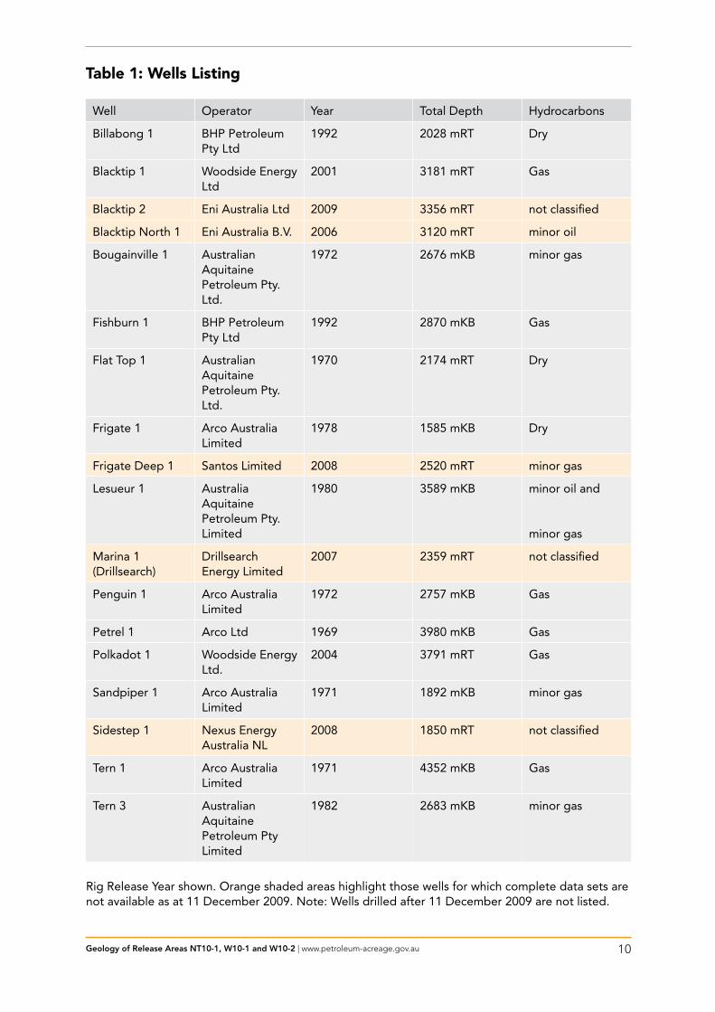
table 1: Wells listing
Well Operator Year Total Depth Hydrocarbons
Billabong 1 BHP Petroleum Pty Ltd
1992 2028 mRT Dry
Blacktip 1 Woodside Energy Ltd
2001 3181 mRT Gas
Blacktip 2 Eni Australia Ltd 2009 3356 mRT not classified
Blacktip North 1 Eni Australia B.V. 2006 3120 mRT minor oil
Bougainville 1 Australian Aquitaine Petroleum Pty. Ltd.
1972 2676 mKB minor gas
Fishburn 1 BHP Petroleum 1992 2870 mKB GasPty Ltd
Flat Top 1 Australian Aquitaine Petroleum Pty. Ltd.
1970 2174 mRT Dry
Frigate 1 Arco Australia Limited
1978 1585 mKB Dry
Frigate Deep 1 Santos Limited 2008 2520 mRT minor gas
Lesueur 1 Australia 1980 3589 mKB minor oil and Aquitaine Petroleum Pty. Limited minor gas
Marina 1 Drillsearch 2007 2359 mRT not classified(Drillsearch) Energy Limited
Penguin 1 Arco Australia Limited
1972 2757 mKB Gas
Petrel 1 Arco Ltd 1969 3980 mKB Gas
Polkadot 1 Woodside Energy Ltd.
2004 3791 mRT Gas
Sandpiper 1 Arco Australia Limited
1971 1892 mKB minor gas
Sidestep 1 Nexus Energy Australia NL
2008 1850 mRT not classified
Tern 1 Arco Australia 1971 4352 mKB GasLimited
Tern 3 Australian Aquitaine Petroleum Pty Limited
1982 2683 mKB minor gas
Rig Release Year shown. Orange shaded areas highlight those wells for which complete data sets are not available as at 11 December 2009. Note: Wells drilled after 11 December 2009 are not listed.
Geology of Release Areas NT10-1, W10-1 and W10-2 | www.petroleum-acreage.gov.au 11
seismic CoverageSeismic coverage is good over most of the Release Areas, with a range of survey vintages from 1964 to 2000, providing a line spacing of about 5–10 km. Geoscience Australia acquired a regional deep seismic grid in the 1990s (surveys 100 and 118), examples of which are shown in Figure 7, Figure 8 and Figure 9, as well as being published by AGSO NW Shelf Study Group (1994).
The Blacktip 3D survey was acquired in September 2000, covering an area of 403 km2 (Woodside Australian Energy, 2002). The Lacrosse 1 and Penguin 1 wells were tied to this survey by reprocessing the 1999 Kings Shoal 2D seismic survey and an additional 92 km of the Blacktip 2D seismic survey. Bright amplitude anomalies were seen at the Blacktip prospect on the 2D lines from the Kings Shoal 2D seismic survey. The Blacktip 3D data were used to study amplitude responses at each anomaly level and to correlate the AVO responses with known rock properties and fluid fill from nearby wells (Leonard et al, 2004).
The Polkadot 2D survey was acquired in June 2002 and consists of 1683 line km, providing a 1 km by 1 km line spacing over the Polkadot prospect (Woodside Australian Energy, 2005).
Geology of Release Areas NT10-1, W10-1 and W10-2 | www.petroleum-acreage.gov.au 12
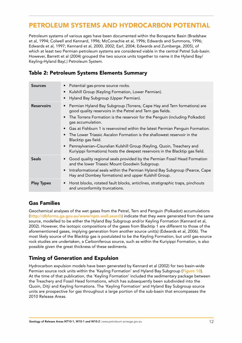
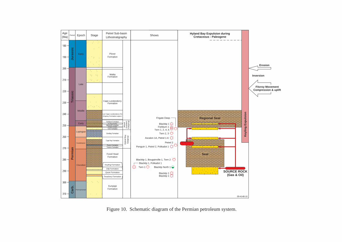
PEtrOlEuM sYstEMs AND HYDrOCArBON POtENtiAlPetroleum systems of various ages have been documented within the Bonaparte Basin (Bradshaw et al, 1994; Colwell and Kennard, 1996; McConachie et al, 1996; Edwards and Summons, 1996; Edwards et al, 1997; Kennard et al, 2000, 2002; Earl, 2004; Edwards and Zumberge, 2005), of which at least two Permian petroleum systems are considered viable in the central Petrel Sub-basin. However, Barrett et al (2004) grouped the two source units together to name it the Hyland Bay/Keyling-Hyland Bay(.) Petroleum System.
table 2: Petroleum systems Elements summary
Sources • Potential gas-prone source rocks.
• Kulshill Group (Keyling Formation, Lower Permian).
• Hyland Bay Subgroup (Upper Permian).
Reservoirs • Permian Hyland Bay Subgroup (Torrens, Cape Hay and Tern formations) are good quality reservoirs in the Petrel and Tern gas fields.
• The Torrens Formation is the reservoir for the Penguin (including Polkadot) gas accumulation.
• Gas at Fishburn 1 is reservoired within the latest Permian Penguin Formation.
• The Lower Triassic Ascalon Formation is the shallowest reservoir in the Blacktip gas field.
• Pennsylvanian–Cisuralian Kulshill Group (Keyling, Quoin, Treachery and Kuriyippi formations) hosts the deepest reservoirs in the Blacktip gas field.
Seals • Good quality regional seals provided by the Permian Fossil Head Formation and the lower Triassic Mount Goodwin Subgroup.
• Intraformational seals within the Permian Hyland Bay Subgroup (Pearce, Cape Hay and Dombey formations) and upper Kulshill Group.
Play Types • Horst blocks, rotated fault blocks, anticlines, stratigraphic traps, pinchouts and unconformity truncations.
gas FamiliesGeochemical analyses of the wet gases from the Petrel, Tern and Penguin (Polkadot) accumulations (http://dbforms.ga.gov.au/www/npm.well.search) indicate that they were generated from the samesource, modelled to be either the Hyland Bay Subgroup and/or Keyling Formation (Kennard et al, 2002). However, the isotopic compositions of the gases from Blacktip 1 are different to those of the aforementioned gases, implying generation from another source unit(s) (Edwards et al, 2006). The most likely source of the Blacktip gas is postulated to be the Keyling Formation, but until gas-source rock studies are undertaken, a Carboniferous source, such as within the Kuriyippi Formation, is also possible given the great thickness of these sediments.
timing of generation and ExpulsionHydrocarbon expulsion models have been generated by Kennard et al (2002) for two basin-wide Permian source rock units within the ‘Keyling Formation’ and Hyland Bay Subgroup (Figure 10). At the time of that publication, the ‘Keyling Formation’ included the sedimentary package between the Treachery and Fossil Head formations, which has subsequently been subdivided into the Quoin, Ditji and Keyling formations. The ‘Keyling Formation’ and Hyland Bay Subgroup source units are prospective for gas throughout a large portion of the sub-basin that encompasses the 2010 Release Areas.
Geology of Release Areas NT10-1, W10-1 and W10-2 | www.petroleum-acreage.gov.au 13
‘keylinG’ source unit
Modelled gas and oil expulsion from shales and coaly shales of the ‘Keyling Formation’ is restricted to the central and outer portions of the Petrel Deep (i.e. to the north and northwest of Penguin 1, beneath Release Area NT10-1 and Release Areas W10-1 and W10-2). Modelled expulsion from the outer Petrel Deep occurred in the latest Permian–Early Triassic. Expulsion from the central Petrel Deep (e.g., below TD of the Petrel wells) commenced and peaked in the Early Triassic and continued to the mid-Cretaceous. Basin modelling studies by Leonard et al (2004) also favoured an oil charge in the immediate vicinity of Blacktip, since gas maturity is only reached to the north of Petrel and Tern. However, these models require revision to explain the occurrence of gas at Blacktip. Compositionally, the Blacktip gas differs significantly from the Petrel and Tern gases and is believed to be sourced from the ‘Keyling Formation’. Explanations for the lack of oil charge in the central Petrel Sub-basin include insufficient source richness of the ‘Keyling Formation’ and underlying Treachery and Kuriyippi formations, and that the structural traps at Petrel, Tern, Penguin and Blacktip, which formed predominantly in the Late Triassic, post-date the main phase of modelled oil expulsion.
hyland Bay source unit
Modelled gas expulsion from the Hyland Bay Subgroup is limited to the outboard portion of the Petrel Sub-basin adjacent to the Malita Graben. It occurred throughout the Jurassic and Cretaceous, with peak expulsion in the mid to late Cretaceous. This source unit is believed to have generated the gas within the Petrel, Tern and Penguin (Polkadot) accumulations. This unit is considered too lean to expel significant quantities of oil.
reservoirsIn the central Petrel Sub-basin, the Upper Permian Cape Hay and Tern formations of the Hyland Bay Subgroup are the main reservoirs for the Petrel and Tern gas fields. Gas is also reservoired within the Torrens Formation (basal Hyland Bay Subgroup) at Penguin 1 and Polkadot 1. Although the Hyland Bay Subgroup was deposited across most of the southern Petrel Sub-basin, post-depositional erosion associated with the Fitzroy Movement has removed these sediments along the margins of the sub-basin, including the Berkley Platform (Lee and Gunn, 1988). Reservoir distribution and characterisation for this subgroup have been mapped in detail by Robinson and McInerney (2004). Gas at Fishburn 1 is reservoired within the Lopingian (upper Permian) Penguin Formation.
Gas at Blacktip 1 is reservoired in sandstones of the Ascalon Formation (Mount Goodwin Subgroup), Fossil Head Formation and the Keyling, Quoin and Treachery formations (Kulshill Group) (Gorter et al, 2008). The Keyling Formation was the primary objective with five gas-bearing zones encountered, equating to a 339 m cumulative gross gas column that is sealed by the Fossil Head Formation (Woodside Australian Energy, 2002; Leonard et al, 2004). The sustained, high flow rates recorded on test from the combined units within the Keyling Formation at Blacktip 1 substantially exceeded the rates achieved by any of the individual wells in the Petrel and Tern gas accumulations.
sealsIn the central Petrel Sub-basin, the transgressive, thick marine shales of the Mount Goodwin Subgroup form the regional seal to the reservoirs of the Hyland Bay Subgroup. Also within the Hyland Bay Subgroup are the intraformational marine shales of the Cape Hay Formation, and the biomicritic limestones of the Dombey and Pearce formations (Colwell and Kennard, 1996; McConachie et al, 1996). The Fossil Head Formation provides the seal to Keyling Formation reservoirs, with intraformational seals occurring within the upper Kulshill Group. The Treachery Formation provides the seal to Kuriyippi Formation reservoirs in more inboard and platform locations within the sub-basin.
Geology of Release Areas NT10-1, W10-1 and W10-2 | www.petroleum-acreage.gov.au 14
Play typesThe Fitzroy Movement was responsible for creating large-scale inversion anticlines (commonly associated with salt mobilisation), such as those drilled by the Petrel wells, and the Bougainville 1, Curlew 1, Gull 1, Penguin 1 and Sandpiper 1 wells. Anticlines associated with faulting include those drilled by the Tern and Blacktip wells, and the Billabong 1, Frigate 1, Lacrosse 1 and Lesueur 1 wells. A tilted fault block was drilled at Fishburn 1.
Salt tectonics (flow, diapirism and withdrawal) has created numerous potential structural and stratigraphic petroleum traps. These features have been identified across most of the sub-basin (Edgerley and Crist, 1974; Durrant et al, 1990). Salt movement may have triggered petroleum migration and influenced migration pathways throughout the development of the Petrel Sub-basin.
Salt-related petroleum plays in the Petrel Sub-basin range from salt-core plays to salt-withdrawal basin plays. The timing of salt movements in the sub-basin varies widely, although many such salt-related traps may have formed too late with respect to hydrocarbon generation and migration. There is abundant evidence on seismic data for the presence of turbidites, basin-floor sandstones, slope-fan sandstones and coastal onlap of sandstone bodies within local depocentres over slowly migrating salt bodies (Lemon and Barnes, 1997; Miyazaki, 1997). These sandstones constitute primary exploration objectives when found in favourable trap geometries.
Stratigraphic pinch-out plays of Permian sandstones within the Hyland Bay Subgroup at the basin margin have been tested by wells such as Flat Top 1 and Newby 1, although success has proven elusive.
Critical risksThe key risks in the 2010 Release Areas appear to be the absence of a proven oil-prone system in the central Petrel Sub-basin, and the small number of suitably sized trap closures for economic gas accumulations. Reservoir quality is also variable and provides an additional exploration risk. This is a particular issue with the Keyling Formation since fluvio-glacial environments are typically silty.
NTWA
W08-1WA-407-P
Windjana 1
Cambridge 1Weasel 1
Lacrosse 1
Matilda 1
Sandbar 1 Sunbird 1
Kulshill 1Kulshill 2
Barnett 1-3
Turtle 1Turtle 2
Cape Ford 1WA-280-PWESTERN
AUSTRALIA
NORTHERNTERRITORY
50
WA-440-P
NT/P77
NT/P78NT/P66
NT/P79WA-405-P
WA-375-P
NT/P80
WA-313-P
WA-279-P
Tern 3
Penguin 1
Lesueur 1Kinmore 1Berkley 1
Sidestep 1
Polkadot 1
Flat Top 1
Fishburn 1
Sandpiper 1
Billabong 1
Shakespeare 1
Bougainville 1
Blacktip North 1
Marina 1
NT09-SpecialW09-Special
Petrel
Tern
Blacktip
Frigate
W10-2
NT10-1
W10-1
Ichthys pipeline
Blacktip pipeline
Tern 1
Petrel 1A
Frigate 1
0 50 km
NTQLD
NSW
TASVIC
WASA
09-4148-1Where well symbol information is sourced from publicly available "open file" data, it has been provided by Geoscience Australia from Well Completion Reports. These symbols were generated from open filedata as at 11 December 2009. Where well symbol information is not publicly available from titleholders' data, the information has been extracted from other public sources. Field outlines are provided byGPinfo, an Encom Petroleum Information Pty Ltd product. Field outlines in GPinfo are sourced, where possible, from the operators of the fields only. Outlines are updated at irregular intervals but with atleast one major update per year.
2010 Offshore PetroleumAcreage Release Area
Existing petroleum title
Gas field
Gas pipeline
Scheduled area boundary (OPGGSA 2006)
Petroleum exploration well - Dry hole
Petroleum exploration well - Oil and gas showPetroleum exploration well - Oil discovery and gas show
Petroleum exploration well - Not classified
Petroleum exploration well - Oil showPetroleum exploration well - Oil discovery
2009 Offshore PetroleumAcreage Release Area
Gas pipeline (proposed)
Petroleum exploration well - Gas showPetroleum exploration well - Gas discovery
Bathymetry contour (depth in metres)200
129°128°127°
13°
14°
2008 Offshore Petroleum AcreageRelease Area (under consideration)
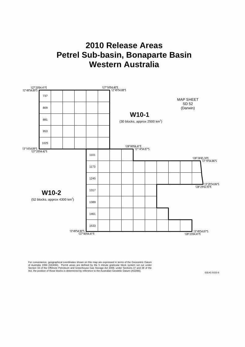
Figure 1. Location map of Release Areas NT10-1, W10-1 and W10-2 in the Petrel Sub-basin.
IDEAS 9155-5
12°54'54.86"S128°40'04.39"E
2010 Release AreasPetrel Sub-basin, Bonaparte Basin
Northern Territory
MAP SHEETSD 52
(Darwin)
NT10-1(53 blocks, approx 4075 km2)
825
13°29'54.86"S129°05'04.39"E13°29'54.86"S128°29'42.93"E
12°54'54.85"S129°05'04.38"E
For convenience, geographical coordinates shown on this map are expressed in terms of the Geocentric Datumof Australia 1994 (GDA94). Permit areas are defined by the 5 minute graticular block system set out underSection 33 of the Offshore Petroleum and Greenhouse Gas Storage Act 2006; under Sections 37 and 38 of theAct, the position of those blocks is determined by reference to the Australian Geodetic Datum (AGD66).
12°59'54.86"S128°28'04.40"E
894
966
1038
1110
1182
1254
13°15'24.86"S128°28'04.40"E
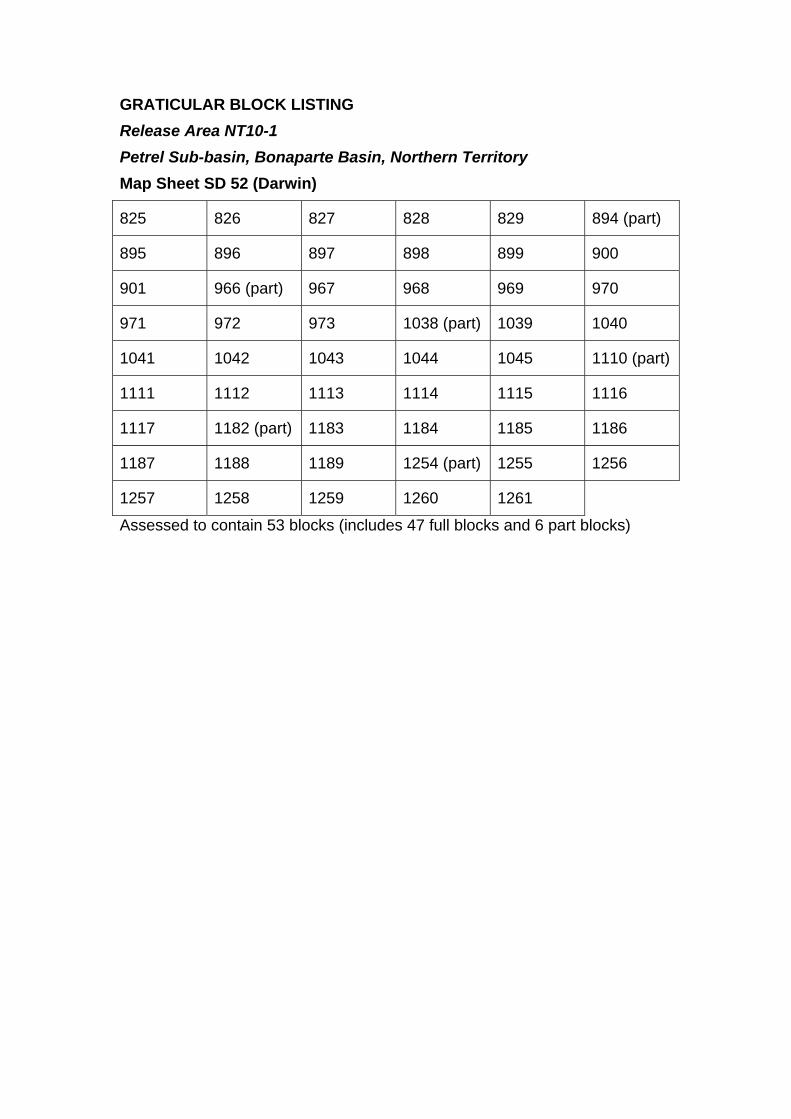
GRATICULAR BLOCK LISTING Release Area NT10-1 Petrel Sub-basin, Bonaparte Basin, Northern Territory Map Sheet SD 52 (Darwin)
825 826 827 828 829 894 (part)895 896 897 898 899 900 901 966 (part) 967 968 969 970 971 972 973 1038 (part) 1039 1040 1041 1042 1043 1044 1045 1110 (part)1111 1112 1113 1114 1115 1116 1117 1182 (part) 1183 1184 1185 1186 1187 1188 1189 1254 (part) 1255 1256 1257 1258 1259 1260 1261 Assessed to contain 53 blocks (includes 47 full blocks and 6 part blocks)
IDEAS 9155-6
2010 Release AreasPetrel Sub-basin, Bonaparte Basin
Western Australia
MAP SHEETSD 52
(Darwin)W10-1
(30 blocks, approx 2500 km2)
737
13°49'54.87"S128°25'04.41"E13°49'54.90"S127°40'04.41"E
12°49'54.88"S127°50'04.40"E
For convenience, geographical coordinates shown on this map are expressed in terms of the Geocentric Datumof Australia 1994 (GDA94). Permit areas are defined by the 5 minute graticular block system set out underSection 33 of the Offshore Petroleum and Greenhouse Gas Storage Act 2006; under Sections 37 and 38 of theAct, the position of those blocks is determined by reference to the Australian Geodetic Datum (AGD66).
12°49'54.89"S127°20'04.41"E
W10-2(52 blocks, approx 4300 km2)
13°14'54.87"S128°00'04.41"E
13°19'54.86"S128°28'45.74"E
13°14'54.89"S127°20'04.42"E
13°29'54.86"S128°29'42.93"E
809
881
953
1025
1101
1173
1245
1317
1389
1461
1533
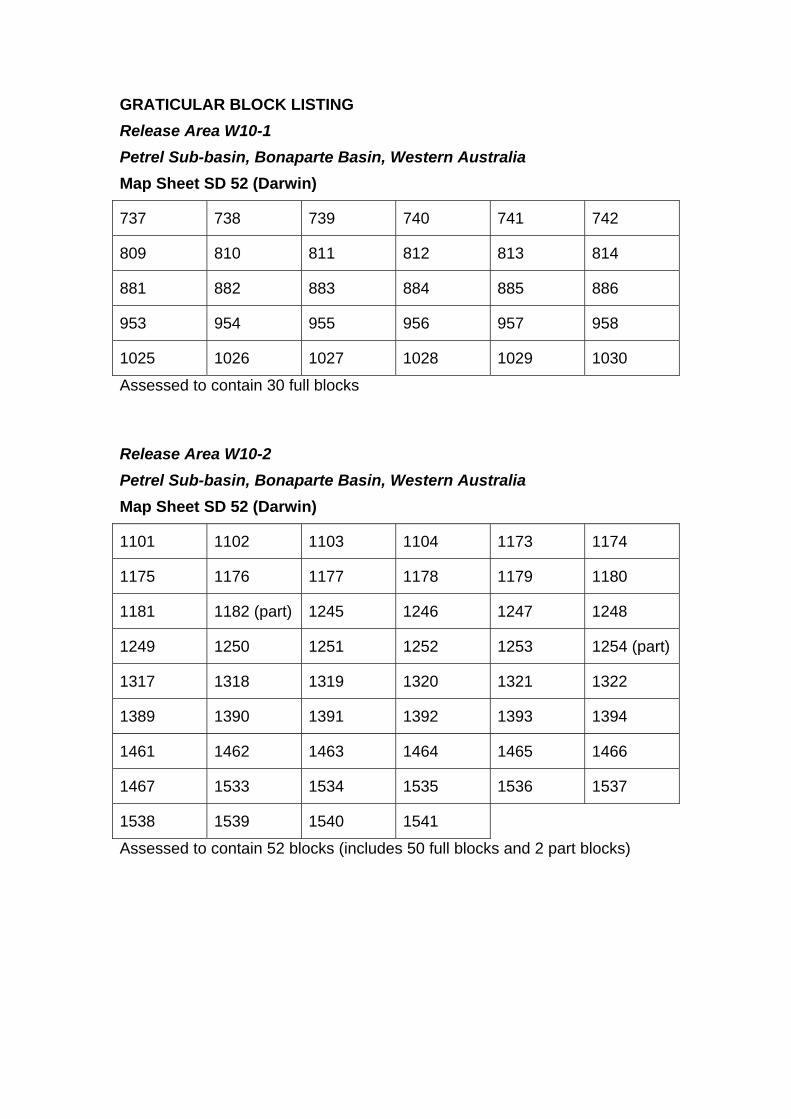
GRATICULAR BLOCK LISTING Release Area W10-1 Petrel Sub-basin, Bonaparte Basin, Western Australia Map Sheet SD 52 (Darwin)
737 738 739 740 741 742 809 810 811 812 813 814 881 882 883 884 885 886 953 954 955 956 957 958 1025 1026 1027 1028 1029 1030 Assessed to contain 30 full blocks Release Area W10-2 Petrel Sub-basin, Bonaparte Basin, Western Australia Map Sheet SD 52 (Darwin)
1101 1102 1103 1104 1173 1174 1175 1176 1177 1178 1179 1180 1181 1182 (part) 1245 1246 1247 1248 1249 1250 1251 1252 1253 1254 (part) 1317 1318 1319 1320 1321 1322 1389 1390 1391 1392 1393 1394 1461 1462 1463 1464 1465 1466 1467 1533 1534 1535 1536 1537 1538 1539 1540 1541 Assessed to contain 52 blocks (includes 50 full blocks and 2 part blocks)

NTWA
WESTERNAUSTRALIA
NORTHERNTERRITORY
Malita Graben
Darwin Shelf
MoylePlatform
BerkleyPlatform
SahulSyncline
Kimberley Block
PetrelSub-basin
Halls Cree
k - Fitz
maurice
Mobile Z
one
Petrel DeepFrigate
LacrosseTerraceCambridge High
CambridgeTrough
CarltonSub-basin
Turtle-Barnett High KulshillTerrace
OrdRiver
Victoria River
100/03
118/18
100/06
Figure 9
Figure 7
Figure 8
Petrel
Tern
Blacktip
Tern 3
Kite 1Gull 1
Skull 1
Newby 1
Moyle 1Weasel 1
WeaberVienta 1
Turtle 2Turtle 1
Oberon 1
Curlew 1
Torrens 1
Sunbird 1Sandbar 1
Rubicon 1
Penguin 1
Matilda 1
Lesueur 1Kinmore 1Berkley 1
Barnett 1-3Windjana 1
Sidestep 1
Shalimar 1
Polkadot 1
Pincombe 1
Ningbing 2Ningbing 1
Lacrosse 1
Kulshill 2Kulshill 1
Garimala 1
Flat Top 1
Fishburn 1
Ascalon 1A
Schilling 1Marsi 1 ST1
Jacaranda 1Darwinia 1A
Cambridge 1
Bonaparte 2Bonaparte 1
Billawock 1
Billabong 1
Kingfisher 1
Keep River 1
Shakespeare 1
Bougainville 1
Pelican Island 1
Bathurst Island 1
Marina 1
Saratoga 1
Blacktip North 1
Harbinger 1 ST1Helvetius 1 ST2
Waggon Creek 1
Cape Ford 1
Sandpiper 1
NT09-SPECIAL
W09-SPECIAL
W10-2
NT10-1
W10-1
Ichthys pipeline
Bayu/Undan pipeline
Blacktip pipeline
NBF-1002
Petrel 1A
Frigate 1 Tern 1
130°128°
12°
14°
WANT
SA
QLD
NSWVIC
TAS
09-4148-4Where well symbol information is sourced from publicly available "open file" data, it has been provided by Geoscience Australia from Well Completion Reports. These symbols were generated from open filedata as at 11 December 2009. Where well symbol information is not publicly available from titleholders' data, the information has been extracted from other public sources. Field outlines are provided byGPinfo, an Encom Petroleum Information Pty Ltd product. Field outlines in GPinfo are sourced, where possible, from the operators of the fields only. Outlines are updated at irregular intervals but with at leastone major update per year.
0 100 km
Salt diapir
Mesozoic Sub-basin
Paleozoic Sub-basin
Platform/Shelf
Precambrian basement2010 Offshore PetroleumAcreage Release Area2009 Offshore PetroleumAcreage Release Area
Gas field
Seismic section figure location
Major "basin forming" fault
Mineral exploration wellPetroleum exploration well - Not classified
Petroleum exploration well - Oil discoveryPetroleum exploration well - Oil showPetroleum exploration well - Gas discovery
Depocentre axisHingeSub-basin outline
Scheduled area boundary(OPGGSA 2006)
Petroleum exploration well - Gas showPetroleum exploration well - Dry well
}
Gas pipelineGas pipeline (proposed)
Petroleum exploration well - Gas discovery and oil showPetroleum exploration well - Oil discovery and gas showPetroleum exploration well - Oil and gas show
Figure 4. Regional structural elements of the Petrel Sub-basin showing the 2010 ReleaseAreas and locations of seismic lines reproduced in Figures 7, 8 and 9.
JPDA
30
40
50
60
70
80
90
100
110
120
130
140
150
160
170
180
190
200
210
220
230
240
250
260
270
280
290
300
310
320
330
340
350
Late
Early
Oligocene
Eocene
PaleoceneDanian
Ypresian
Lutetian
Maastrichtian
Turonian
Cenomanian
Albian
Aptian
BarremianHauterivian
Valanginian
Berriasian
Middle
Late
Early
Sinemurian
Pliensbachian
Toarcian
AalenianBajocian
CallovianOxfordian
Kimmeridgian
Tithonian
Late
Middle
Early
Rhaetian
Norian
Carnian
Ladinian
Anisian
OlenekianChanghsingian
Wuchiapingian
Capitanian
Kungurian
Lopingian
Guadalupian
Cisuralian
Artinskian
Sakmarian
AsselianGzhelian
KasimovianMoscovian
Bashkirian
Serpukhovian
Visean
Tournaisian
Rupelian
Chattian
Campanian
UndifferentiatedWoodbine
Group
Sandpiper Sandstone
Keyling Formation
Ditji Formation
Quoin Formation
Aquitaine Formation
Sunbird Formation
Sandbar Sandstone
Tanmurra Formation
Kingfisher ShaleUtting Calcarenite
Yow Creek Formation
Milligans Formation
Lower Frigate Shale/Cleia Formation
Period Epoch Stage Petrel Sub-basin
360
370
380
390
Late
Famennian
Frasnian
Mount GoodwinSubgroup
Sandpiper 1
Blacktip
Tern
Garimala, Weaber
Shows
Erosion?? ?
Treachery Formation
Elang Formation
Bonaparte
Barnett
Sagdominated
WadeyeGroup
Barnett, TurtleBarnett, Turtle
Turtle
Turtle
Blacktip
BlacktipBlacktip
09-4148-5
CockatooGroupequiv.
Nin
gbin
gG
roup
equi
v.
LangfieldGroupequiv.
Cape LondonderryFormation
Figure 5.
Lower Cape Londonderry Fm(Osprey Formation equiv.)
Basin Phases
Penguin, Petrel
Petrel, Ascalon, Tern
Fishburn
Turtle
Keep River, Ningbing,Waggon Creek, Weaber
Vienta, Waggon Creek
Pennsylvanian
Mississippian
Induan
Age(Ma)
Woo
dbin
e G
roup
Bat
hurs
t Isl
and
Gro
upF
lam
ingo
Gro
upT
roug
hton
Gro
upK
inm
ore
Gro
upK
ulsh
ill G
roup
Wea
ber
Gro
up
Hyland BaySubgroup
Fossil HeadFormation
KuriyippiFormation
ArcoFormation
BonaparteFormation
WangarluFormation
EchucaShoals
Formation
DarwinRadiolarite
PloverFormation
Frigate Shale
MalitaFormation
Synriftdominated
Sagdominated
InversionFitzroy Movement
Dev
on
ian
Car
bo
nif
ero
us
Per
mia
nT
rias
sic
Jura
ssic
Cre
tace
ou
sP
aleo
gen
eSelandianThanetian
ConiacianSantonian
Hettangian
Wordian
Roadian
Bathonian
BartonianPriabonian
Stratigraphy of the Petrel Sub-basin, tied to the geological timescaleafter Gradstein et al (2004) and Ogg et al (2008), including therecent updates by Gorter et al (2004, 2005, 2008 and 2009).Accumulations (bold) and hydrocarbon shows in Mesozoic sedimentsare also shown.

230
240
250
260
270
280
290
300
310
320
330
340
350
Middle
Early
Ladinian
Anisian
Olenekian
Changhsingian
Wuchiapingian
Capitanian
Wordian
Roadian
Kungurian
Lopingian
Guadalupian
Cisuralian
Artinskian
Sakmarian
Asselian
Gzhelian
Kasimovian
Moscovian
Bashkirian
Serpukhovian
Visean
Tournaisian
Fishburn FormationAscalon FormationMairmull FormationPenguin Formation
Tern Formation
Dombey Formation
Cape Hay Formation
Pearce Formation
Torrens Formation
Keyling Formation
Ditji Formation
Quoin Formation
Sunbird Formation
Sandbar Sandstone
Tanmurra Formation
Kingfisher ShaleUtting Calcarenite
Yow Creek Formation
Milligans Formation
Period Epoch Stage Petrel Sub-basin
360
370
380
390
Late
Famennian
Frasnian
Blacktip
Shows
MountGoodwinSubgroup
Tern
TurtleTurtle
BlacktipBarnett 1Blacktip
Barnett
Cape Ford 1
Barnett
Bonaparte 1
Treachery Formation
AquitaineFormation
Turtle 2
Cape Ford 1, Lacrosse 1 Turtle
Lesueur 1
Bonaparte Lesueur 1
Cape Ford 1 Pelican Island 1
Bonaparte 1, Garimala 1, Vienta 1
Events
Erosion
Synriftdominated
Sagdominated
Cape Ford 1
Poi
nt S
prin
gS
ands
tone
Penguin, Petrel, Polkadot
Figure 6.
CockatooGroupequiv.
Nin
gbin
gG
roup
equi
v.
LangfieldGroupequiv.
Garimala, Weaber
Cape LondonderryFormation
09-4148-6
Ascalon 1A
Ascalon 1A, Frigate Deep 1 Torrens 1
Turtle 1
Blacktip 1, Bougainville 1, Tern 2 Cambridge 1, Torrens 1
Barnett 1, Blacktip North 1, Shakespeare 1
Cape Ford 1, Kulshill 1, Lacrosse 1, Turtle 1
Barnett 1, Cape Ford 1, Turtle1, 2
Cape Ford 1
Barnett, TurtleTurtle 1
Ningbing 2
Bonaparte 1
Pincombe 1
Lower Cape Londonderry Fm(Osprey Formation equiv.)
Tern 2, 3
Pennsylvanian
Mississippian
Petrel 2
Blacktip Tern 1 Polkadot
Torrens 1
Barnett 1, Cape Ford 1, Kulshill 2, Pelican Island 1, Turtle 1, 2
Ascalon, Tern, Petrel
Keep River, Ningbing, WeaberWaggon Creek
Vienta, Waggon Creek
Frigate Deep 1Fishburn,
Kin
mor
e G
roup
Hyl
and
Bay
Sub
grou
p
Kul
shill
Gro
up
WadeyeGroup
Wea
ber
Gro
up
BonaparteFormation
Fossil HeadFormation
KuriyippiFormation
ArcoFormation
??
Age(Ma)
Dev
on
ian
Car
bo
nif
ero
us
Per
mia
nT
rias
sic
Induan
Detailed Devonian to Triassic stratigraphy of the Petrel Sub-basin, tied to the geological timescale after Gradstein et al (2004)and Ogg et al (2008), and including the recent updates by Gorter et al (2004, 2005, 2008 and 2009). Accumulations (bold) andhydrocarbon shows in Palaeozoic sediments are also shown.
0
SENW Frigate 1
0
2
4
6
8
10
Two-
way
tim
e (s
)
Basement
Basement
Carboniferous
Carboniferous
LateLate
Near Top CarboniferousNear Top CarboniferousIntra Triassic
Intra TriassicCallovianCallovian
TuronianTuronian
Base JurassicBase Jurassic Top PermianTop Permian
09-4148-709-4148-7
W10-1W10-2
Tern 3(projected)
50 km
Intrusives
Intrusives
EarlyEarly
Mid.Mid.
CarbCarb onifonife
rous
erousero
usero
us
onifonif
CarbCarb
IntraIntrabas
basement 1
ement 1
IntraIntrabas
basement 2
ement 2
and through Release Areas W10-1 and W10-2. Location of the line is shown in Figure 4.Figure 7. Regional cross-section of the Petrel Sub-basin showing Geoscience Australia line 100/06 across the western Petrel Deep depocentre,
Petrel Sub-basinSahul SynclineTurtle-Barnett
High
Line 100/06 (part)Line 100/06 (part)
Two-
way
tim
e (s
)
AptianAptian
0 50 km
TuronianTuronian
NESW
Berkley Platform Petrel Deep Darwin Shelf
Base EoceneBase EoceneLate MioceneLate MioceneBase TertiaryBase Tertiary
Base CretaceousBase Cretaceous ValanginianValanginian
Intra TriassicIntra TriassicBase JurassicBase Jurassic
Top PermianTop Permian
CallovianCallovian
Mid. CarboniferousMid. CarboniferousBasementBasement
09-4148-809-4148-8
0
2
4
6
8
10
Fishburn 1
W10-1
Figure 8. Regional cross-section of the Petrel Sub-basin showing Geoscience Australia line 118/18 across the Petrel Deep and throughRelease Area W10-1. Location of the line is shown in Figure 4.
Line 118/18Line 118/18
ivesivesIntrusIntrus
iferousiferousLate CarbonLate Carbon
NearNear TopTop iferousiferousCarbonCarbon
10
Two-
way
tim
e (s
)
CallovianCallovianAptianAptian
TuronianTuronianLate MioceneLate Miocene
0 50 km
0
2
4
6
8
Intra TriassicIntra TriassicTop PermianTop Permian
ValanginianValanginian
Tern 1Sandpiper 1 Petrel 1A
Darwin ShelfPetrel DeepBerkley PlatformW10-2
SW NE
09-4148-909-4148-9
Figure 9. Regional cross-section of the Petrel Sub-basin showing Geoscience Australia line 100/03 across the Petrel Deep and throughRelease Area W10-2. Location of the line is shown in Figure 4.
Line 100/03Line 100/03
ifeiferousrousLateLate CarbonCarbon
Mid.Mid.
iferousiferousCarCarbonbon
mentmentBaseBase
JurassicJurassicBaseBaseCretaceousCretaceousBaseBase
NearNear TopTop CarboniferousCarboniferous
180
190
200
210
220
230
240
250
260
270
280
290
300
310
Early
Late
Middle
Early
Lopingian
Guadalupian
Cisuralian Keyling Formation
Ditji Formation
Quoin Formation
Treachery Formation
Cape LondonderryFormation
Pennsylvanian
Hyl
and
Bay
Sub
grou
p
Fossil HeadFormation
KuriyippiFormation
PloverFormation
MalitaFormation
Age(Ma)
Period Epoch Stage
Car
b.
Mou
ntG
oodw
inS
ubgr
oup
Petrel Sub-basinLithostratigraphy
Inversion
Erosion
Blacktip 1
09-4148-10
Regional Seal
Seal
Fitzroy MovementCompression & uplift
Key
ling
Exp
uls
ion
Fishburn 1Blacktip 1
Frigate Deep
Ascalon 1A, Petrel 1-6
Petrel 2
Penguin 1, Petrel 2, Polkadot 1
Blacktip 1, Bougainville 1, Tern 2
Blacktip 1, Polkadot 1
Tern 1 Blacktip North 1
Blacktip 1
Shows
Pearce FormationTorrens Formation
Cape Hay Formation
Dombey Formation
Tern FormationPenguin Formation
Ascalon FormationFishburn Formation
Lwr Cape Londonderry Fm(Osprey Formation equiv.)
Mairmull Formation
Tern 1, 2, 4, 5
Tern 2, 3
Figure 10. Schematic diagram of the Permian petroleum system.
SOURCE ROCK(Gas & Oil)
Hyland Bay Expulsion duringCretaceous - Paleogene
Per
mia
nT
rias
sic
Jura
ssic
Geology of Release Areas NT10-1, W10-1 and W10-2 | www.petroleum-acreage.gov.au 27
rEFErENCEsAGSO NW SHELF STUDY GROUP, 1994—Deep reflections on the North West Shelf: changing perceptions of basin formation. In: Purcell, P.G. and Purcell, R.R. (editors), The Sedimentary Basins of Western Australia, Proceedings of the Petroleum Exploration Society of Australia Symposium, Perth, 1994, 63–76.
ARCO AUSTRALIA LIMITED, 1971a—Well Completion Report, Sandpiper No. 1, unpublished.
ARCO AUSTRALIA LIMITED, 1971b—Well Completion Report, Tern No. 1, unpublished.
ARCO AUSTRALIA LIMITED, 1972—Well Completion Report, Penguin No. 1, unpublished.
ARCO AUSTRALIA LIMITED, 1978—Well Completion Report, Frigate No. 1, unpublished.
ARCO LTD – AUSTRALIAN AQUITAINE PETROLEUM PTY LTD, 1969—Well Completion Report, Petrel 1, unpublished.
AUSTRALIAN AQUITAINE PETROLEUM PTY LTD, 1970—Flat Top No. 1, P17 – Northern Territory, Well Completion Report, unpublished.
AUSTRALIAN AQUITAINE PETROLEUM PTY LTD, 1972—Bougainville No. 1, P.17 – Northern Territory, Well Completion Report, unpublished.
AUSTRALIAN AQUITAINE PETROLEUM PTY LTD, 1980—Lesueur No. 1 (LSR 1), WA-18-P, Australia, Well Completion Report, unpublished.
BARRETT, A.G., HINDE, A.L. AND KENNARD, J.M., 2004—Undiscovered resource assessment methodologies and application to the Bonaparte Basin. In: Ellis, G.K., Baillie, P.W. and Munson, T.J. (eds), Timor Sea Petroleum Geoscience, Proceedings of the Timor Sea Symposium, Darwin, 19–20 June 2003. Northern Territory Geological Survey, Special Publication 1, 353–372.
BAUER, J., 2009—Exploration highlights for 2008. PESA News, August/September 2009, Issue No. 101, 28–36.
BAXTER, K., 1996—Flexural isostatic modelling. In: Colwell, J.B. & Kennard, J. M. (compilers), Petrel Sub-basin study 1995-1996: summary report. Australian Geological Survey Organisation Record 1996/40.
BEERE, G.M. AND MORY, A.J., 1986—Revised stratigraphic nomenclature of the onshore Bonaparte and Ord Basins, Western Australia. Western Australia Geological Survey Record 1986/5.
BHP Petroleum Pty Ltd, 1993a—Billabong-1, Well Completion Report, Part 2 Interpretation and Analysis, unpublished.
BHP Petroleum Pty Ltd, 1993b—Fishburn-1, Well Completion Report, Part 2 Interpretation and Analysis, unpublished.
BRADSHAW, M.T., BRADSHAW J., MURRAY A.P., NEEDHAM D.J., SPENCER L., SUMMONS R.E., WILMOT J. AND WINN S., 1994—Petroleum systems in west Australian basins. In: Purcell, P.G. and Purcell, R.R. (eds), The Sedimentary Basins of Western Australia, Proceedings of the Petroleum Exploration Society of Australia Symposium, Perth, 1994, 93–118.
BRS, 1994—Petrel Sub-basin. Bureau of Resource Sciences Petroleum Prospectivity Bulletin and Database, 94/2. An open-file report available from Geoscience Australia.
CADMAN, S.J. AND TEMPLE, P.R., 2004—Bonaparte Basin, NT, WA, AC and JPDA, Australian Petroleum Accumulations Report 5, 2nd Edition, Geoscience Australia, Canberra, GEOCAT # 60865.
COLWELL, J.B. AND KENNARD, J.M. (compilers), 1996—Petrel Sub-basin Study 1995–1996: Summary Report. Australian Geological Survey Organisation Record 1996/40, 122p, unpublished.
Geology of Release Areas NT10-1, W10-1 and W10-2 | www.petroleum-acreage.gov.au 28
Department of Mines and Petroleum, Western Australia (DMP), 2007—[Web page] Petroleum in Western Australia http://www.dmp.wa.gov.au/documents/PWA_Sept_2007.pdf (last accessed 13 January 2010).
Department of Mines and Petroleum, Western Australia (DMP), 2009— [Web page] Petroleum in Western Australia. September 2009 http://www.dmp.wa.gov.au/documents/Petroleum_WA_Sep_2009b.pdf(last accessed 13 January 2010).
DRILLSEARCH ENERGY LTD, 2008—Well Completion Report, Marina-1, Volume 2, Basic Data, Bonaparte Basin, West Australia, unpublished.
DURRANT, J.M., FRANCE, R.E., DAUZACKER, M.V. AND NILSEN, T., 1990—The southern Bonaparte Gulf Basin: new plays. The APEA Journal, 30(1), 52–67.
EARL, K.L., 2004—The Petroleum Systems of the Bonaparte Basin. Geoscience Australia GEOCAT # 61365.
EDGERLEY, D.W. AND CRIST, R.P., 1974—Salt and diapiric anomalies in the southern Bonaparte Basin. The APEA Journal, 14(1), 84–94.
EDWARDS, D.S., BOREHAM, C.J., ZUMBERGE, J.E., HOPE, J.M., KENNARD, J.M., AND SUMMONS, R.E., 2006—Hydrocarbon families of the Australian North West Shelf: a regional synthesis of the bulk, molecular and isotopic composition of oils and gases. 2006 AAPG International Conference and Exhibition, 5–8 November, Perth, Australia, Abstract.
EDWARDS, D.S. AND SUMMONS, R.E., 1996—Petrel Sub-basin Study 1995–1996: Organic Geochemistry of Oils and Source rocks. Australian Geological Survey Organisation Record 1996/42, 77p. An open-file report available from Geoscience Australia.
EDWARDS, D.S., SUMMONS, R.E., KENNARD, J.M., NICOLL, R.S., BRADSHAW, J., BRADSHAW, M., FOSTER, C.B., O’BRIEN, G.W. AND ZUMBERGE, J.E., 1997—Geochemical characterisation of Palaeozoic petroleum systems in north-western Australia. The APPEA Journal, 37(1), 351–379.
EDWARDS, D.S. AND ZUMBERGE, J.E., 2005—The oils of Western Australia II. Regional petroleum geochemistry and correlation of crude oils and condensates from Western Australia and Papua New Guinea. Geoscience Australia, Canberra and GeoMark Research Ltd, Houston.
ENI AUSTRALIA B.V., 2007—WA-279-P: Blacktip North-1 Well Completion Report, Geological and Drilling Basic Data, unpublished.
GORTER, J.D., 1998—Revised Upper Permian stratigraphy of the Bonaparte Basin. In: Purcell, P.G. and Purcell, R.R. (eds), The Sedimentary Basins of Western Australia 2, Proceedings of the Petroleum Exploration Society of Australia Symposium, Perth, 1998, 213–228.
GORTER, J.D., JONES, P.J. NICOLL, R.S. AND GOLDING, C.J., 2005—A reappraisal of the Carboniferous stratigraphy and the petroleum potential of the southeastern Bonaparte Basin (Petrel Sub-basin), northwestern Australia. The APPEA Journal, 45(1), 275–296.
GORTER, J.D., MCKIRDY, D.M., JONES, P.J. AND PLAYFORD, G., 2004—Reappraisal of the Early Carboniferous Milligans Formation source rocks system in the southern Bonaparte Basin, northwestern Australia. In: Ellis, G.K., Baillie, P.W. and Munson, T.J. (eds), Timor Sea Petroleum Geoscience. Proceedings of the Timor Sea Symposium, Darwin, 19–20 June 2003. Northern Territory Geological Survey, Special Publication 1, 231–255.
GORTER, J.D., NICOLL, R.S., METCALFE, I., WILLINK, R.J. AND FERDINANDO, D., 2009—The Permian-Triassic boundary in western Australia: evidence from the Bonaparte and northern Perth basins: exploration implications. The APPEA Journal, 49(1), 311–336.
GORTER, J.D., POYNTER, S.E., BAYFORD, S.W. AND CAUDULLO, A., 2008—Glacially influenced petroleum plays in the Kulshill Group (Late Carboniferous Early Permian) of the southeastern Bonaparte Basin, Western Australia. The APPEA Journal, 48(1), 69–113.

Geology of Release Areas NT10-1, W10-1 and W10-2 | www.petroleum-acreage.gov.au 29
GORTER, J.D., ZIOLKOWSKI, V. AND BAYFORD, S.W., 1998—Evidence of Lower Triassic reservoirs with possible hydrocarbon charge in the southern Bonaparte Basin. In: Purcell, P.G. and Purcell, R.R. (eds), The Sedimentary Basins of Western Australia 2, Proceedings of the Petroleum Exploration Society of Australia Symposium, Perth, 1998, 229–235.
GRADSTEIN, F.M., OGG, J. AND SMITH, A., 2004—A Geologic Time Scale 2004. Cambridge University Press, 589p.
GUNN, P.J., 1988—Bonaparte Basin: evolution and structural framework. In: Purcell, P.G. and Purcell, R.R. (eds), The North West Shelf Australia, Proceedings of Petroleum Exploration Society of Australia Symposium, Perth, 1988, 275–285.
GUNN, P.J. AND LY, K.C., 1989—The petroleum prospectivity of the Joseph Bonaparte Gulf area, northwestern Australia. The APEA Journal, 29(1), 509–526.
KENNARD, J.M., EDWARDS, D.S., BOREHAM, C.J., GORTER, J.D., KING, M.R., RUBLE, T.E. AND LISK, M., 2000—Evidence for a Permian petroleum system in the Timor Sea, Northwestern Australia. AAPG International Conference and Exhibition, Bali, 15–18 October 2000, Abstracts, p. A45.
KENNARD, J.M., DEIGHTON, I., EDWARDS, D.S., BOREHAM, C.J. AND BARRETT, A.G., 2002—Subsidence and thermal history modelling: new insights into hydrocarbon expulsion from multiple petroleum systems in the Petrel Sub-basin, Bonaparte Basin. In: Keep, M. and Moss, S. (eds), The Sedimentary Basins of Western Australia 3, Proceedings of the Petroleum Exploration Society of Australia Symposium, Perth, 2002, 409–437.
LEE, R.J. AND GUNN, P.J., 1988—Bonaparte Basin. In: Petroleum in Australia: The First Century. Australian Petroleum Exploration Association, 252–269.
LEMON, N.M. AND BARNES, C.R., 1997—Salt migration and subtle structures: modelling of the Petrel Sub-basin, northwest Australia. The APPEA Journal, 37(1), 245–258.
LEONARD, A.A., VEAR, A., PANTING, A.L., DE RUIG, M.J., DUNNE, J.C. AND LEWIS, K.A., 2004—Blacktip-1 gas discovery: an AVO success in the southern Bonaparte basin, Western Australia. In: Ellis, G.K., Baillie, P.W. and Munson, T.J. (eds), Timor Sea Petroleum Geoscience, Proceedings of the Timor Sea Symposium, Darwin, 19–20 June 2003. Northern Territory Geological Survey, Special Publication 1, 25–35.
McCONACHIE, B.A., BRADSHAW, M.T. AND BRADSHAW, J., 1996—Petroleum systems of the Petrel Sub-basin – an integrated approach to basin analysis and identification of hydrocarbon exploration opportunities. The APPEA Journal, 36(1), 248–268.
MIYAZAKI, S., 1997—Australia’s southeastern Bonaparte Basin has plenty of potential. Oil and Gas Journal, 95, 78–81.
MORY, A.J., 1988—Regional geology of the offshore Bonaparte Basin. In: Purcell, P.G. and Purcell, R.R. (eds), The North West Shelf Australia, Proceedings of Petroleum Exploration Society of Australia Symposium, Perth, 1988, 287–309.
MORY, A.J., 1991—Geology of the Offshore Bonaparte Basin, Northwestern Australia. Geological Survey of Western Australia Report, 29.
MORY, A.J. AND BEERE, G.M., 1988—Geology of the onshore Bonaparte and Ord Basins. Geological Survey of Western Australia Report, 134.
O’BRIEN, G.W., ETHERIDGE, M.A., WILLCOX, J.B., MORSE, M., SYMONDS, P., NORMAN, C. AND NEEDHAM, D.J., 1993—The structural architecture of the Timor Sea, north-western Australia: implications for basin development and hydrocarbon exploration. The APEA Journal, 33(1), 258–278.
OGG, J.G., OGG, G. AND GRADSTEIN, F.M., 2008—Concise Geologic Time Scale. Cambridge University Press, 177 pp.

Geology of Release Areas NT10-1, W10-1 and W10-2 | www.petroleum-acreage.gov.au 30
PETROCONSULTANTS AUSTRALASIA PTY LTD., 1990—Northern Territory Geological Survey Petroleum Basin Study: Bonaparte Basin. Northern Territory Geological Survey, Darwin.
RDPIFR, 2009—[Web Page] Petroleum Reserves and Resources Summary. Department of Regional Development, Primary Industry, Fisheries and Resources, Northern Territory, http://www.nt.gov.au/d/Minerals_Energy/Content/File/html/Petroleum_Reserves_Resources_Summary.htm(last accessed 13 January 2010).
ROBINSON, P. AND McINERNEY, K., 2004—Permo-Triassic reservoir fairways of the Petrel Sub-basin, Timor Sea. In: Ellis, G.K., Baillie, P.W. and Munson, T.J. (eds), Timor Sea Petroleum Geoscience. Proceedings of the Timor Sea Symposium, Darwin, 19–20 June 2003. Northern Territory Geological Survey, Special Publication 1, 295–312.
SANTOS, 2008—[Web Page] ASX/Media Release http://www.santos.com/library/081023_Third_Quarter_Activities_Report.pdf (last accessed 13 January 2010).
SANTOS, 2009—[Web Page] Investor Presentation, September 2009 http://www.santos.com/library/110909_International_Investor_Presentation.pdf) (last accessed 13 January 2010).
THE TERRITORY, 2009—[Web Page] http://www.theterritory.com.au/resources/img/pdf/publications/territory_quarterly/TQ-2-2008.pdf (last accessed 14 January 2010).
VAN ANDELL, T. H. AND VEEVERS, J.J., 1967—Morphology and sediments of the Timor Sea. Australia, Bureau of Mineral Resources, Geology and Geophysics, Bulletin 83.
WOODSIDE AUSTRALIAN ENERGY, 2002—Well Completion Report, Blacktip-1, Interpretive Data (WA-279-P, Southern Bonaparte Basin), unpublished.
WOODSIDE AUSTRALIAN ENERGY, 2005—Well Completion Report, Polkadot-1, Interpretive Data, WA-313-P, Southern Bonaparte Basin, unpublished.