atlas and travel encyclopedia - ultimate wyomingultimatewyoming.com/wysections/wy2 intro.pdf ·...
TRANSCRIPT
Compiled, edited, and written byMichael Dougherty
and Heidi Pfeil Doughertyand the Staff of Ultimate Press
WyomingAtlas and Travel Encyclopedia
TheUltimate
an Ultimate® Guide Book
Copyright © 2007 Michael Dougherty
Published by Riverbend Publishing, Helena, Montana
ISBN 10: 1-931832-84-6
ISBN 13: 978-1-931832-84-7
All rights reserved. No part of this book may be reproduced, stored, or transmitted in any form or by any means without the prior
permission of the publisher, except for brief excerpts for reviews.
Printed in the U.S.A.
1 2 3 4 5 6 7 8 9 MG 15 14 13 12 11 10 09 08 07
Writing and Compilation:Michael Dougherty and Heidi Pfeil Dougherty
Layout:Rachel C. Jones
Research and Editorial Assistance:Arianna Haines and Lauri Olsen
Written, designed and produced by:
Ultimate Pressan imprint of Champions Publishing, Inc.
301 Evergreen, Suite 201DBozeman, Montana 59715
Phone: 406-585-0237Website: www.ultimatewyoming.com
For advertising inquiries and editorial comments, please contact Ultimate Press at the address above.
For book sales, please contact:
RiverbendPublishing
PO Box 5833Helena, MT 59604
Phone toll-free: 1-866-787-2363Fax: 1-406-449-0330
Email: [email protected]: www.RiverbendPublishing.com
Front Cover Photos: Main Cover photo – Heidi Pfeil Dougherty
Back Cover Photos: Rodeo – Courtesy of Cody Night Rodeo • Rafting – Courtesy of Jackson Hole Whitewater
All others – Michael Dougherty

Introduction • PAGE 1Wyoming: The Cowboy State
Section 1 • PAGE 49Northwest Area • Including Jackson, Dubois, Pinedale and Star Valley
Section 2 • PAGE 91Northcentral Area • Including Cody, Worland, Powell, Lovell and Thermopolis
Section 3 • PAGE 141Northeast Area • Including Sheridan, Buffalo, Gillette and Newcastle
Section 4 • PAGE 205Southwest Area • Including Evanston, Kemmerer, Green River and Rock Springs
Section 5 • PAGE 249Southcentral Area • Including Casper, Riverton, Lander and Rawlins
Section 6 • PAGE 325Southeast Area • Including Cheyenne, Laramie and Douglas
Fort Laramie National Historic Site • PAGE 383
Grand Teton National Park • PAGE 399
Yellowstone National Park • PAGE 433
Index • PAGE 483
CONTENTS

Acknowledgment
We offer a sincere thank you to all of the sponsors who, withouttheir financial support, this book would not have been possible.Throughout the book, you’ll see their names in bold. Stop inand see them when you’re in their area. They would like to hearfrom you.
We especially wish to thank our staff for their excellent help inbringing this first edition to press. A special thanks to PatriciaDeWitt for her tireless efforts in obtaining our sponsors, withoutwhich, we would not exist.
Disclaimer
This guide focuses on recreational activities including travelingto some sites that are off the more frequently traveled roads. Asall such activities contain elements of risk, the publisher, author,affiliated individuals and companies included in this guide dis-claim any responsibility for any injury, harm, or illness that mayoccur to anyone through, or by use of, the information in thisbook. Although the author and publisher have made everyeffort to ensure that the information was correct at the time ofgoing to press, the author and publisher do not assume andhereby disclaim any liability to any party for any loss or damageto person or property caused by errors, omissions, or anypotential travel disruption due to labor or financial difficulty,whether such errors or omissions result from negligence, acci-dent, or any other cause.
Throughout this book, public domain documents of govern-ment agencies (National Park Service, USDA Forest Service,Bureau of Land Management, and Wyoming State Parks andHistoric Sites) were reprinted. Also, brochures published bylocal area chambers of commerce and from the various attrac-tions were reprinted in part or in their entirety. Permissionswere obtained where required.
iv Ultimate Wyoming Atlas and Travel Encyclopedia
1
Introd
uction
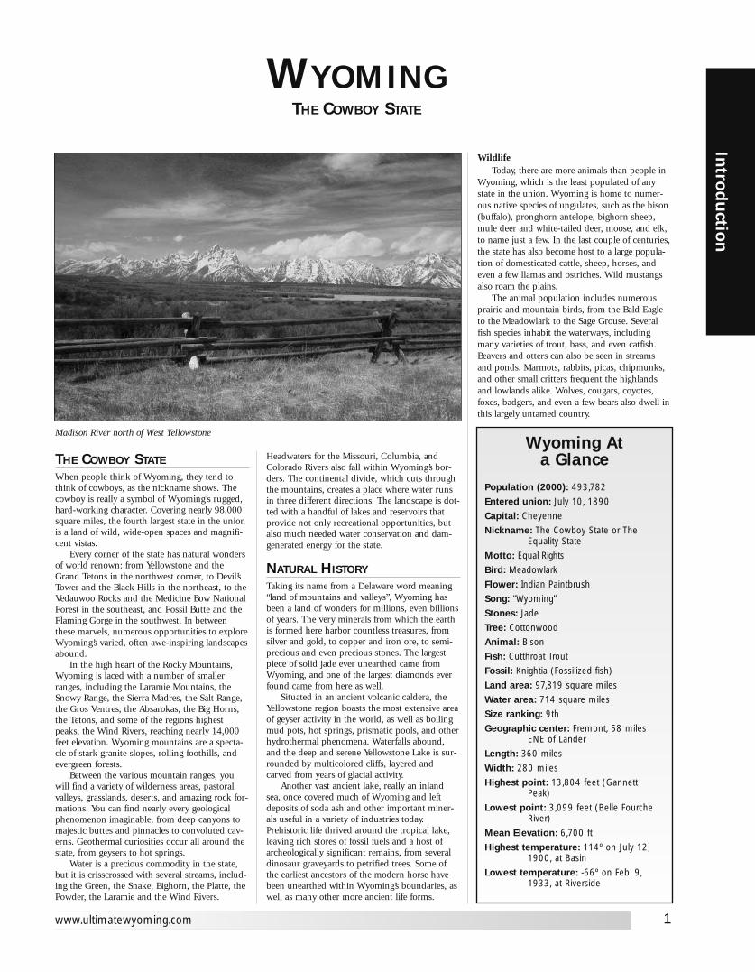
WYOMINGTHE COWBOY STATE
THE COWBOY STATEWhen people think of Wyoming, they tend tothink of cowboys, as the nickname shows. Thecowboy is really a symbol of Wyoming‘s rugged,hard-working character. Covering nearly 98,000square miles, the fourth largest state in the unionis a land of wild, wide-open spaces and magnifi-cent vistas.
Every corner of the state has natural wondersof world renown: from Yellowstone and theGrand Tetons in the northwest corner, to Devil’sTower and the Black Hills in the northeast, to theVedauwoo Rocks and the Medicine Bow NationalForest in the southeast, and Fossil Butte and theFlaming Gorge in the southwest. In betweenthese marvels, numerous opportunities to exploreWyoming’s varied, often awe-inspiring landscapesabound.
In the high heart of the Rocky Mountains,Wyoming is laced with a number of smallerranges, including the Laramie Mountains, theSnowy Range, the Sierra Madres, the Salt Range,the Gros Ventres, the Absarokas, the Big Horns,the Tetons, and some of the regions highestpeaks, the Wind Rivers, reaching nearly 14,000feet elevation. Wyoming mountains are a specta-cle of stark granite slopes, rolling foothills, andevergreen forests.
Between the various mountain ranges, youwill find a variety of wilderness areas, pastoralvalleys, grasslands, deserts, and amazing rock for-mations. You can find nearly every geologicalphenomenon imaginable, from deep canyons tomajestic buttes and pinnacles to convoluted cav-erns. Geothermal curiosities occur all around thestate, from geysers to hot springs.
Water is a precious commodity in the state,but it is crisscrossed with several streams, includ-ing the Green, the Snake, Bighorn, the Platte, thePowder, the Laramie and the Wind Rivers.
Headwaters for the Missouri, Columbia, andColorado Rivers also fall within Wyoming’s bor-ders. The continental divide, which cuts throughthe mountains, creates a place where water runsin three different directions. The landscape is dot-ted with a handful of lakes and reservoirs thatprovide not only recreational opportunities, butalso much needed water conservation and dam-generated energy for the state.
NATURAL HISTORYTaking its name from a Delaware word meaning“land of mountains and valleys”, Wyoming hasbeen a land of wonders for millions, even billionsof years. The very minerals from which the earthis formed here harbor countless treasures, fromsilver and gold, to copper and iron ore, to semi-precious and even precious stones. The largestpiece of solid jade ever unearthed came fromWyoming, and one of the largest diamonds everfound came from here as well.
Situated in an ancient volcanic caldera, theYellowstone region boasts the most extensive areaof geyser activity in the world, as well as boilingmud pots, hot springs, prismatic pools, and otherhydrothermal phenomena. Waterfalls abound,and the deep and serene Yellowstone Lake is sur-rounded by multicolored cliffs, layered andcarved from years of glacial activity.
Another vast ancient lake, really an inlandsea, once covered much of Wyoming and leftdeposits of soda ash and other important miner-als useful in a variety of industries today.Prehistoric life thrived around the tropical lake,leaving rich stores of fossil fuels and a host ofarcheologically significant remains, from severaldinosaur graveyards to petrified trees. Some ofthe earliest ancestors of the modern horse havebeen unearthed within Wyoming’s boundaries, aswell as many other more ancient life forms.
WildlifeToday, there are more animals than people in
Wyoming, which is the least populated of anystate in the union. Wyoming is home to numer-ous native species of ungulates, such as the bison(buffalo), pronghorn antelope, bighorn sheep,mule deer and white-tailed deer, moose, and elk,to name just a few. In the last couple of centuries,the state has also become host to a large popula-tion of domesticated cattle, sheep, horses, andeven a few llamas and ostriches. Wild mustangsalso roam the plains.
The animal population includes numerousprairie and mountain birds, from the Bald Eagleto the Meadowlark to the Sage Grouse. Severalfish species inhabit the waterways, includingmany varieties of trout, bass, and even catfish.Beavers and otters can also be seen in streamsand ponds. Marmots, rabbits, picas, chipmunks,and other small critters frequent the highlandsand lowlands alike. Wolves, cougars, coyotes,foxes, badgers, and even a few bears also dwell inthis largely untamed country.
Madison River north of West Yellowstone
www.ultimatewyoming.com
Wyoming Ata Glance
Population (2000): 493,782
Entered union: July 10, 1890
Capital: Cheyenne
Nickname: The Cowboy State or The Equality State
Motto: Equal Rights
Bird: Meadowlark
Flower: Indian Paintbrush
Song: “Wyoming”
Stones: Jade
Tree: Cottonwood
Animal: Bison
Fish: Cutthroat Trout
Fossil: Knightia (Fossilized fish)
Land area: 97,819 square miles
Water area: 714 square miles
Size ranking: 9th
Geographic center: Fremont, 58 miles ENE of Lander
Length: 360 miles
Width: 280 miles
Highest point: 13,804 feet (Gannett Peak)
Lowest point: 3,099 feet (Belle Fourche River)
Mean Elevation: 6,700 ft
Highest temperature: 114º on July 12, 1900, at Basin
Lowest temperature: -66º on Feb. 9, 1933, at Riverside
2
Intr
odu
ctio
n
Ultimate Wyoming Atlas and Travel Encyclopedia
THE HISTORY OFWYOMING’S PEOPLE
Native AmericansDrawn by the mineral treasures and the
wildlife, humans have been living here for mil-lennia as well. Some of the oldest NativeAmerican campsites in North America havebeen discovered in Wyoming, dating back toover 11, 000 years ago.
Ever since that time, many groups of NativeAmericans have valued Wyoming as prime hunt-ing ground. Early tribes utilized “buffalo jumps,”cliffs where the bison were driven over the ledgeto their deaths. Later on, hunting was done withweapons made from the flint and metals found inthe region. The hunters left behind bones, pot-tery, petroglyphs, fire rings, and sacred stone cir-cles known as Medicine Wheels, the use of whichis still something of a mystery.
In more recent times, numerous plains tribesinhabited the Wyoming wilderness, and contin-ued to vie for hunting rights in the region forcenturies. Among these were the Cheyenne,Sioux, Arapaho, Shoshone, Lakota, Crow,Comanche, Ute, Paiute, Bannock, Blackfeet,Ogalala, Arikara, Gros Ventre, Nez Perce, andMiniconjou. These tribes had rivalries andalliances that sometimes changed and often last-ed for generations.
Many Native Americans of great prominencecalled Wyoming home. The likes of ChiefWashakie, Chief Joseph, Sitting Bull, Red Cloud,Crazy Horse, Dull Knife, White Bull, and BlackHorse inhabited these parts during at least part oftheir lives. Even Sacajawea, the famous guide forLewis and Clark, spent some of her life within thestate’s borders, and is thought by some to havebeen laid to rest near the Wind River Reservation.
Today, relatively few Native Americansremain in the state, many of who live on thesole protected remnant of their ancestral lands,the Wind River Reservation. They are increas-ingly reclaiming their heritage, and are makingthe most of opportunities to share their tribaltraditions at a number of events and venuesthroughout the state.
Explorers And Mountain MenJohn Colter, a member of the Lewis and Clark
expedition, was probably the first white man toset foot in Wyoming, investigating the marvels ofYellowstone country in 1808. Over the nextdecade or so, Jacques LaRamee, a French-Canadian trapper traveled extensively in the east-ern part of the state. Thereafter, Wyoming becamethe place many early European adventurers calledhome. Mountain men, in particular, were largelyresponsible for much of the investigation of thestate. Lured here by the promise of riches frombeaver pelts and other wild game, many mencame to Wyoming with the John Jacob Astorexpedition in the 1820s, and never left. WilliamAshley and Andrew Henry led the original party.
They befriended some Native Americans and
were often rewarded with wives. In time andthrough often harrowing experience, they becamefamiliar with the wonders and dangers of thismagnificent state. They congregated at eventscalled Rendezvous, exchanging goods, informa-tion, stories, a few punches, and a lot of liquor.These are still celebrated today in their honor, butfighting is now frowned upon. Names such as JimBridger, Kit Carson, and Jedediah Smith markedthe paths that would be trod by Easterners for thenext two centuries and beyond.
Pioneers And HomesteadersNot far behind the mountain men came pio-
neers, heading West to make new lives for them-selves in Oregon country and Utah’s Great SaltLake Valley. Crossed by both the Oregon andMormon Trails, innumerable wagons and handcarts traversed Wyoming, leaving ruts in thebedrock still clearly visible over 150 years later.
Immigrants left their marks in other ways,with names etched on cliffs and scattered graves.Winter in the high plains and mountains washarsh and often sudden, sometimes taking travel-ers by surprise. Martin’s Cove was the site of themost extensive casualties. Disease and the occa-sional Indian raid took their toll as well. Makingit across the state alive was no mean feat.
As the Utah Territory welcomed more andmore Mormon immigrants, Prophet BrighamYoung sent settlers north into Wyoming to tamethe wild country there. The Mormon pioneerscultivated significant quantities of wilderness,from Fort Bridger to the Star Valley area to theBighorn Basin, where they built an extensivecanal system. They left behind a legacy of hardwork and industry, and built many historic land-marks that still stand today.
Other settlers came from the East to home-stead in relative peace, including GermanLutherans from Iowa, who farmed land in theBighorn Basin and near the Nebraska border.Their contributions have also stood the test oftime, and made Wyoming part of what it is today.
The Overland Stage And The Pony ExpressAs traffic increased across Wyoming, a stage
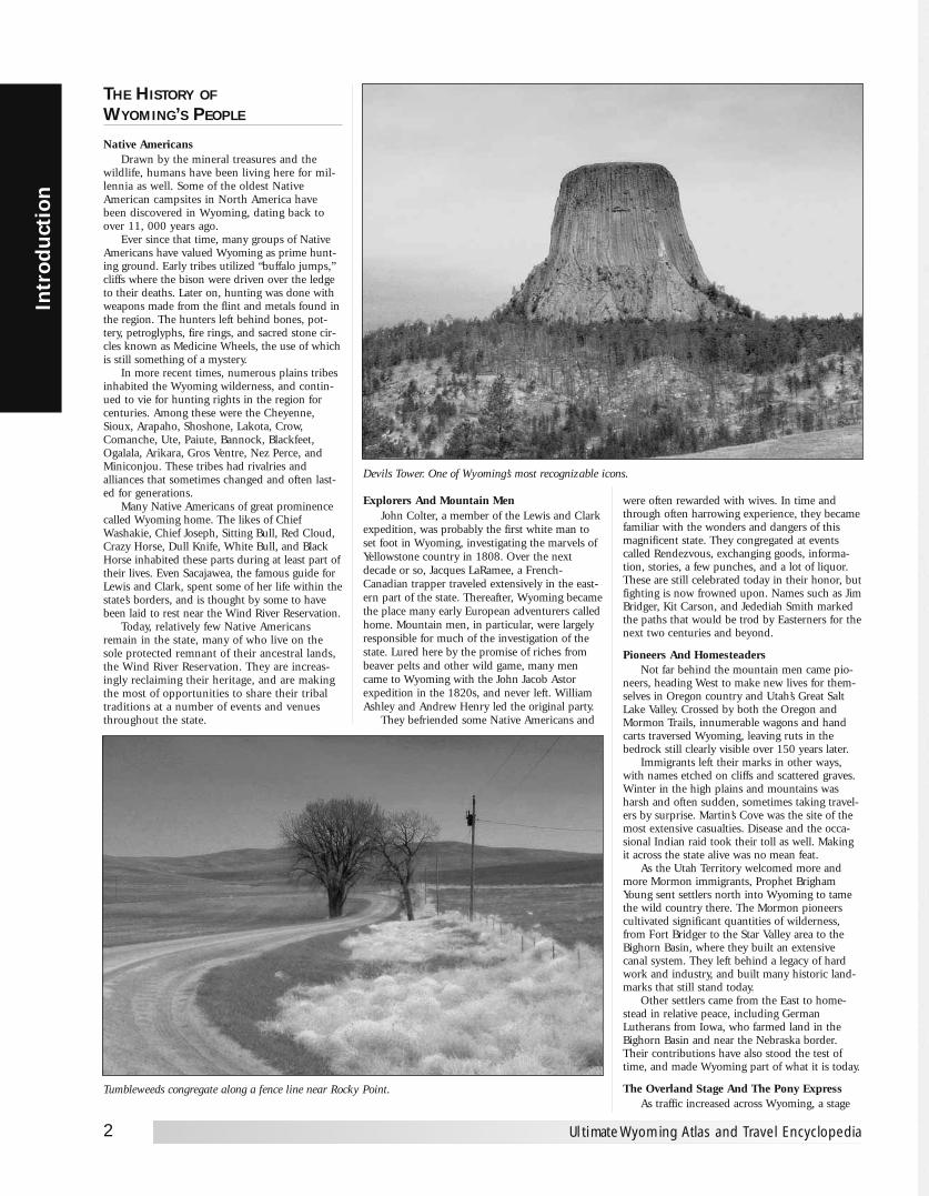
Devils Tower. One of Wyoming’s most recognizable icons.
Tumbleweeds congregate along a fence line near Rocky Point.
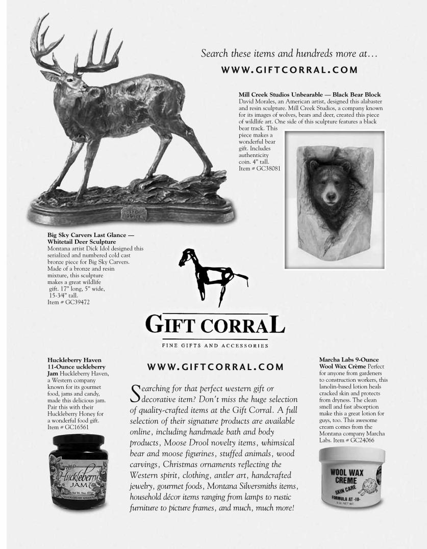
Mill Creek Studios Unbearable — Black Bear BlockDavid Morales, an American artist, designed this alabasterand resin sculpture. Mill Creek Studios, a company knownfor its images of wolves, bears and deer, created this pieceof wildlife art. One side of this sculpture features a blackbear track. Thispiece makes awonderful beargift. Includesauthenticitycoin. 4” tall. Item # GC38081
Big Sky Carvers Last Glance —Whitetail Deer SculptureMontana artist Dick Idol designed thisserialized and numbered cold castbronze piece for Big Sky Carvers. Made of a bronze and resin mixture, this sculpture makes a great wildlifegift. 17” long, 5” wide,15-3⁄4” tall.
Item # GC39472
Marcha Labs 9-OunceWool Wax Crème Perfectfor anyone from gardenersto construction workers, thislanolin-based lotion healscracked skin and protectsfrom dryness. The cleansmell and fast absorptionmake this a great lotion forguys, too. This awesomecream comes from theMontana company MarchaLabs. Item # GC24066
Huckleberry Haven11-Ounce uckleberryJam Huckleberry Haven,a Western companyknown for its gourmetfood, jams and candy,made this delicious jam.Pair this with theirHuckleberry Honey for a wonderful food gift. Item # GC16561
Search these items and hundreds more at...
W W W. G I F T C O R R A L . C O M
Searching for that perfect western gift or decorative item? Don't miss the huge selection
of quality-crafted items at the Gift Corral. A fullselection of their signature products are availableonline, including handmade bath and body products, Moose Drool novelty items, whimsicalbear and moose figurines, stuffed animals, woodcarvings, Christmas ornaments reflecting theWestern spirit, clothing, antler art, handcraftedjewelry, gourmet foods, Montana Silversmiths items,household décor items ranging from lamps to rusticfurniture to picture frames, and much, much more!
W W W. G I F T C O R R A L . C O M

route was developed, with regular stops for wearytravelers. With the Western population growing,many who rode the trail came to do business, notto settle. The Overland Stage Trail provided easiermobility for both eastern and western journeys.Stagecoaches ran freight and provided protectionas well.
Many stage stations also served as stopoversfor Pony Express riders, providing fresh horsesfor both. Sometimes, even the stage didn’t travelfast enough for important information to betransmitted from coast to coast. A letter sent byPony Express could travel from New York toCalifornia in about seven or eight days. Riding forthe Pony Express was a dangerous occupation,mostly because riders were on their own, con-fronting uncertain conditions among the Indians,and unpredictable weather. Nevertheless, duringthe eighteen months it was in operation, only tworiders died.
Treasure Seekers And MinersThe discovery of gold in California sparked a
new wave of immigration in the 1850s and 60s.The pioneer influx was still ongoing, but now thebyways were also filled with wanderers hoping to“strike it rich“, if not in California then inColorado, Montana, or South Dakota.
Wyoming, too, had its share of mineralwealth, and mining towns began to take root. Thecommunities would thrive until the mine ran outof whatever it had provided, then the minerswould move on. This was the start of the boomand bust cycle that would continue throughoutWyoming’s development.
The hunt for gold inspired John Bozeman topioneer a route north through Wyoming to theMontana gold fields. By 1864, the Bozeman Trailwas yet another heavy traffic area across the state.
The Forts And The Indian WarsAs more and more white people began to
come into Wyoming, the Native Americansbecame increasingly distressed about the impactthe strangers were having on tribal lands. Sometribes, like the Shoshone under Chief Washakie,
tried to maintain peaceful relations. Others chafedunder the imposed sanctions, and misunder-standings and conflict became more frequent.
With the increase in Indian confrontations,the US government began to establish a presencein the area. Various forts, such as Fort Bridgerand Fort Laramie, which had once been merelysupply and trading posts, became barricadedcitadels. Some of the most well known Indianbattles were fought in Wyoming, including thebrutal Fetterman Massacre at Fort Phil Kearney.
Both sides sustained many casualties in the
Battle of the Red Buttes at Platte Bridge Station,later called Fort Caspar. The Battle of theRosebud, which happened in the midst of thePowder River Expedition, had Native Americansfighting on both sides. Although the Battle of theLittle Bighorn, or Custer’s Last Stand, took placeacross the Montana border, it was the culminatingcampaign that began with a pioneer’s missing cownear Fort Laramie, and the Grattan Massacre thatfollowed. William F. “Buffalo Bill” Cody made aname for himself the summer after the LittleBighorn disaster by beating Cheyenne ChiefYellow Hand in one-to-one combat.
The Railroad And The Telegraph LineTechnology caught up with the call to head
west, and steam engines became the preferredmethod of travel, telegraph messages the pre-ferred form of communication. Plans were laid fora transcontinental railroad, and the race was onbetween the Eastern and Western builders as theyhurried to meet somewhere in the middle.
The Union Pacific Railroad, and several small-er railroads such as the Burlington, Northern, andSanta Fe Lines, laid tracks all over the state, creat-ing new “hell on wheels” communities, andbringing a variety of colorful people of differentnationalities to the area. The logging industry andthe coal industry rose up to meet the needs of thegrowing railways. The completion of the railroadin 1869 brought ever-greater numbers ofEasterners to the west.
Before the railroad was finished, the state wasfilled with telegraph lines and offices, mostlywhere the stage and Pony Express stops hadbeen. Mail delivered by Pony Express had takenabout a week to arrive. With the telegraph, mes-sages could be sent almost instantaneously. Eastand West were connected like never before.
Cattle And CowboysAs the Eastern states filled with people, range-
land became harder and harder to find. Texas cat-tlemen, in particular, were on the lookout for newterritory where their herds could graze cheaply,
4
Intr
odu
ctio
n
Ultimate Wyoming Atlas and Travel Encyclopedia
North of Rawlins.
Buffalo Bill Scenic Highway west of Cody.
unmolested. Pioneering ranchers like NelsonStory blazed the Texas Trail north, throughOklahoma and Colorado into the open rangecountry of Wyoming, Montana, and the Dakotas.With the stabilizing presence of the army and thefreight options brought by the railroad, Wyomingbecame ideal cattle country. Huge ranching com-panies sprung up, like the Swan Land and CattleCompany, and the Pitchfork and Sun Ranches.
With the cattle came the cowboys, tough andhard living, who made an art of the business oftending the herds. From their broad-brimmedhats, high-heeled boots, chaps and spurs, to theirhorsemanship, skills with ropes, and understand-ing of animals and nature, the cowboy became abreed apart. They lead a harsh and lonely exis-tence, spending endless days on the windswept,open range, living off trail food and sleeping bysolitary campfires. The cowboy becameWyoming’s icon because Wyoming made himwho he was.
Cattle ranching was so profitable during thelate 1800s that it made many men rich. Othermen, who were already rich, such as noblemenand aristocrats from Europe, found it useful toinvest in the cattle industry. For either or perhapsboth reasons, the most successful ranchersbecame known as “cattle barons.”
The cattle barons had a great deal of influencein territorial politics and were able to strong-armmany agricultural settlers into giving up theirland. Accusations of cattle rustling were rampant.Hired guns, known as “range detectives”, intimi-dated homesteaders, and occasionally hung orshot someone. Tom Horn, Cattle Kate, andCalamity Jane became notorious for their roles inthe range wars.
Sheep And SheepherdersThe cattlemen met their match with the
advent of the sheep industry. Sheep were consid-ered by some to be a more profitable investmentbecause they provided two commodities: wooland lambs, and the wool was a renewableresource. Experienced European sheepherders,
including many Basques from the Pyrenees, cameto Wyoming to work for sheep ranchers.
Sheep ranching began to rival cattle ranchingfor power and money, but the real rivalry wasover the rangeland and grazing rights.Eventually, tensions between the two industriesand homesteaders escalated from hired gunsmaking specific “hits” to an all out war inJohnson County. Federal troops had to be sentin to settle the raging dispute.
The Equality StateWyoming made leaps in pioneering women’s
rights while it was still a territory. With such ascattered population, every able-bodied person
had value. Wyoming became the first governmententity in the world to grant women the vote andthe right to hold office, as well as allowing themto own property in their own name.
The first female voter, perhaps in the entireworld, was “Grandma” Louisa A. Swain ofLaramie. The first female jurors in the world,Eliza Stewart, Amelia Hatcher, C.H. Hilton, MaryMackel, Agnes Baker, and Sarah Pease, attended atrial in Laramie also. Wyoming had the firstfemale Justice of the Peace in the world, EstherMorris, in South Pass City, and the first femalegovernor in the US, Nellie Tayloe Ross, ran thestate after her husband died in office. Jacksonbecame to first town in the country to elect agroup of city officials who were all women in1920. Wyoming continues to be a place wherewomen have great value.
OutlawsThis rough country attracted many rough
characters through the years, including:Butch Cassidy (Robert Leroy Parker)The Sundance Kid (Harry Longabaugh)Kid Curry (Harry Logan)“Flat Nose” George CurrieWilliam C. “Teton” Jackson (Harvey Gleason)James Butler “Wild Bill” HickokTom HornJohn Henry “Doc” HollidayCattle Kate (Ellen Watson)Calamity Jane (Martha Jane Canary)Jesse JamesFrank James (Jesse’s brother)“Big Nose George” Parrott (George Manuse)“Dutch Charley” BurrisBill Carlisle, Wyoming’s (and perhaps the
West’s) last great “gentleman” train robber, whopolitely held up passengers several times between1916 and 1919. He later was caught and servedtime in jail as a model prisoner.
WIDE OPEN SPACESWhile traveling on the backroads, you will some-times get a sense that nobody lives here. You cantravel for miles without seeing any sign of civi-
5
Introd
uction
www.ultimatewyoming.com
Somewhere near Split Rock.
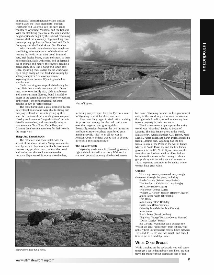
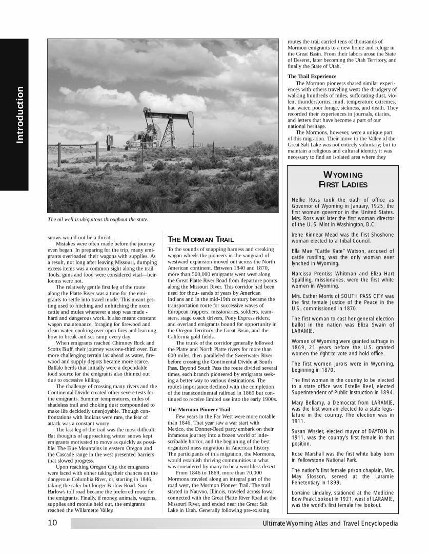
West of Dayton.
lization beyond the occasional small herds of cat-tle. In many parts of the state, oil wells outnum-ber people. Occupied houses are rare andoutnumbered by abandoned homesteaders shacksand log cabins. Fences often disappear entirelyand are replaced by the infrequent “Open Range”signs that warn you cattle may be having theirmid-day siesta in the middle of the road.
None-the-less, most of this land is privatelyowned unless posted otherwise. Before aban-doning your car and heading out across theseopen spaces, it's a good idea and common cour-tesy to find the property owner and get permis-sion. If you see fenceposts or gates with brightorange blazes, then getting permission isn't anoption. They mean “no trespassing” in nouncertain terms.
However, I've never been shot at for stoppingthe car, getting out and smelling the sage, listen-ing to the sound of silence, or to the voice of thewind, or the gurgle of a stream, the howl of acoyote, or the unidentified song of a prairie bird.I've never been asked to move along when I'vestopped to admire a sunset, or simply marvel atthe splendor of the endless sky.
Most of those that have bought and paid fora piece of this marvelous state don't mind shar-ing it with those who come to visit. They simplyask that you respect it and leave no trace youwere there.
THE ROADSGravel roads are the rule rather than the excep-tion in this part of the country. Almost all ofWyoming’s paved roads are well maintained.There are posted speed limits and they are vigor-ously enforced. Be prepared at any time to slow down for riderson horseback. Most horses are accustomed tocars, but can spook if you drive too near. Much ofwyoming is open range. Cattle may be grazing onthe road. A head-on with a steer can be just asdeadly as a head-on with another automobile.
And speaking of cattle, don’t be surprised ifyou come upon a cattle drive. If you do, follow
the instructions of the drovers. They will makeevery effort to clear a path to allow youthrough. Usually the cattle just part ways andmake a path, but don’t go on unless you’regiven instructions to.
Beware of black ice! This is a virtually invisi-ble layer of ice that forms on road surfaces after afog. Be particularly careful of stretches of roadthat parallel rivers and creeks. The early morningfog rising from them can settle on the road freez-ing instantly. If you feel yourself sliding, tap yourbrakes gently. If you slam on the brakes, it’s allbut over. Gently steer into the direction of yourskid (if your back end is going right—steer right).
GumboWe gave this subject its own headline. It is
very important that you read it—and heed it.While Wyoming isn't the only state that has
gumbo, it has its fair share. If you become a resi-dent, it is one of the first things you develop arespect (a healthy respect) for. Grizzlys and rat-tlesnakes might be the hazards you're warned of,but gumbo is the one that will get you.
You'll find it mostly in the eastern half of thestate. It lies in wait on what in dry weatherappears to be an ordinary rock hard dirt road.Your first clue is the occasional sign that readsRoad Impassable When Wet. This is a clear under-statement. When these roads become even mildlywet, they turn into a monster that swallows allsizes of vehicles—and yes, even 4-wheel driveSUVs. Think you'll get a tow? Forget it. No towtruck operator with a higher IQ than dirt willventure onto it until it dries. If you walk on it,you will grow six inches taller and gain 25pounds all on the bottom of your shoes. It cancoat your tires until they won’t turn anymore. Ofcourse, this is if it doesn't swallow you whole firstlike an unsuspecting native in a Tarzan moviewho steps into quicksand.
Bottomline, heed the signs. If it looks likerain, head for the nearest paved road. When itcomes to swallowing things whole, theBermuda Triangle is an amateur compared toWyoming Gumbo.
WYOMING CLIMATE
Topographic FeaturesWyoming’s outstanding features are its majes-
tic mountains and high plains. Its mean elevationis about 6,700 feet above sea level and even whenthe mountains are excluded, the average elevationover the southern part of the State is well over6,000 feet, while much of the northern portion issome 2,500 feet lower. The lowest point, 3,125feet, is near the northeast corner where the BelleFourche River crosses the State line into SouthDakota. The highest point is Gannett Peak at13,785 feet, which is part of the Wind RiverRange in the west-central portion. Since themountain ranges lie in a general north-southdirection, they are perpendicular to the prevailingwesterlies, therefore, the mountain ranges provideeffective barriers which force the air currentsmoving in from the Pacific Ocean to rise anddrop much of their moisture along the westernslopes. The State is considered semiarid east ofthe mountains. There are several mountainranges, but the mountains themselves cover lessarea than the high plains. The topography andvariations in elevation make it difficult to dividethe State into homogeneous, climatological areas.
The Continental Divide splits the State fromnear the northwest corner to the center of thesouthern border. This leaves most of the drainageareas to the east. The run-off drains into threegreat river systems: the Columbia, the Colorado,and the Missouri. The Snake with its tributariesin the northwest flows into the Columbia; theGreen River drains most of the Southwest portion
and joins the Colorado: the Yellowstone, WindRiver, Big Horn, Tongue, and Powder drainageareas cover most of the north portion and flownorthward into the Missouri; the Belle Fourche,Cheyenne, and Niobrara covering the east-centralportion, flow eastward: while the Platte drains thesoutheast and flows eastward into Nebraska.There is a relatively small area along the south-west border that is drained by the Bear whichflows into the Great Salt Lake. In the south-cen-tral portion west of Rawlins, there is an areacalled the Great Divide Basin. Part of this area isoften referred to as the Red Desert. There is nodrainage from this Basin and precipitation, whichaverages only 7 to 10 inches annually, followscreekbeds to ponds or small lakes where it eitherevaporates or percolates into the ground.
Snow accumulates to considerable depths inthe high mountains and many of the streams fedby the melting snow furnish ample quantities of
6
Intr
odu
ctio
n
Ultimate Wyoming Atlas and Travel Encyclopedia
Fall colors near Laramie. Photo courtesy ofLaramie Area Chamber of Commerce.
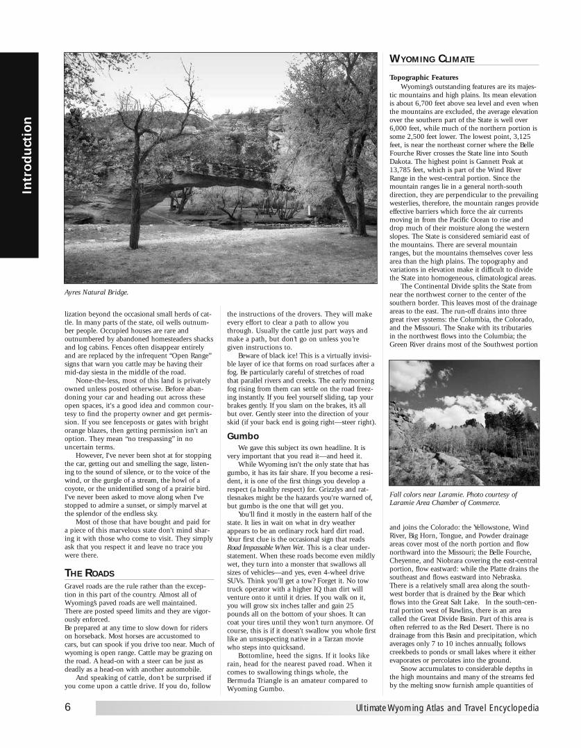
Ayres Natural Bridge.

Growing SeasonEarly freezes in the fall and late in the spring
are characteristic. This results in long winters andshort growing seasons. However, it is a county ofrapid changes through the fall, winter, and springseasons, with frequent variations from cold tomild periods. The average growing season (freeze-free period) for the principal agricultural areas isapproximately 125 days. For hardier plants whichcan stand a temperature of 28° F, or slightly lower,the growing season is the agricultural areas east ofthe Divide is approximately 145 days. In themountains and high valleys freezing temperaturesmay occur any time during the summer. For ten-der plants there is practically no growing seasonin such areas as the upper Green River Valley, theStar Valley and Jackson Hole. At Farson nearSandy Creek, a tributary of the Green River, theaverage is 42 days between the last temperature of32° F in early summer and the first freeze in latesummer. For the places like the Star Valley andJackson Hole, the growing season is even shorter.
SunshineFor most of the State, sunshine ranges from
60 percent of the possible amount during thewinter to about 75 percent during the summer.Mountain areas receive less, and in the wintertimethe estimated amount over the northwesternmountains is about 45 percent. In the summer-time when sunshine is greatest – not only in timebut also intensity – it is characteristic for themornings to be mostly clear. Cumulus cloudsdevelop nearly every day and frequently blot outthe sun for a portion of the afternoons. Becausethe altitude provides less atmosphere for the sun’srays to penetrate and because of the very smallamount of fog, haze, and smoke, the intensity ofsunshine in unusually high.
PrecipitationLike other states in the west, precipitation
varies a great deal from one location to another.The period of maximum precipitation occurs inthe spring and early summer for most of theState. Precipitation is greater over the mountain
ranges and usually at the higher elevations,although elevation alone is not the predominantinfluence. For example, over most of the south-west portion, where the elevation ranges from6,500 to 8,500 feet, annual precipitation variesfrom 7 to 10 inches. At lower elevations over thenortheast portion and along the eastern border,where elevations are mostly in the range from4,000 to 5,500 feet, annual averages are from 12to 16 inches. The relatively dry southwest por-tion is a high plateau nearly surrounded bymountain ranges.
The Big Horn Basin provides a striking exam-ple of the effect of mountain ranges in blockingthe flow of moisture laden air from the east aswell as from the west. The lower portion of theBasin has an annual precipitation of 5 to 8 inch-es, and it is the driest part of the State. The sta-tion showing the least amount is Seaver at 4,105feet with an annual mean of about 5.50 inches.In the southern part of the Basin, Worland at4,061 feet has an annual mean of 7 to 8 inchesas compared with Termopolis at 4,313 feet and11 to 12 inches. There is another good examplein the southeastern part of the State whereLaramie at 7,236 feet has an annual mean of 10inches, while 30 miles to the west, Centennial at8,074 feet receives about 16 inches. Only a fewlocations receive as much as 40 inches a year,based on gauge records.
During the summer, showers are quite fre-quent but often amount to only a few hundredthsof an inch. Occasionally there will be some veryheavy rain associated with thunderstorms cover-ing a few square miles. There are usually severallocal storms each year with from 1 to 2 inches ofrain in a 24-hour period. On rare occasions, 24-hour amounts range from 3 to 5 inches. Thegreatest 24-hour total recorded for any place inWyoming is 5.50 inches at Dull Center, nearNewcastle, on May 31, 1927.
Humidity and EvaporationThe average relative humidity is quite low
and provides delightful summer weather. During
water for irrigation of thousands of acres of land.The snowmelt also furnishes the water to gener-ate electric power, and for domestic use.
Rapid run-off from heavy rain during thun-derstorms causes flash flooding on the headwaterstreams, and when the time of these storms coin-cides with the melting of the snow pack, theflooding is intensified. When overflow occurs inthe vicinity of urban communities situated nearthe streams considerable damage results.
TemperatureBecause of its elevation, Wyoming has a rela-
tively cool climate. Above the 6,000 feet level thetemperature rarely exceeds 100° F. The warmestparts of the State are the lower portions of por-tions of the Big Horn Basin, the lower elevationsof the central and northeast portions, and alongthe east border. The highest recorded temperaturewas 114° F on July 12, 1900, at Basin in the BigHorn Basin. The average maximum temperatureat Basin in July is 92° F. For most of the State,mean maximum temperatures in July rangebetween 85 and 95° F. With increasing elevation,average values drop rapidly. A few places in themountains at about the 9,000 foot level haveaverage maximums in July close to 70° F. Summernights are almost invariably cool, even thoughdaytime readings may be quite high at times. Formost places away from the mountains, the meanminimum temperature in July ranges from 50 to60 ° F. Of course, the mountains and high valleysare much cooler with average lows in the middleof the summer in the 30s and 40s with occasionaldrops below freezing.
In the wintertime it is characteristic to haverapid and frequent changes between mild andcold spells. Usually there are less than 10 coldwaves during a winter, and frequently less thanhalf that number for most of the State. Themajority of cold waves move southward on theeast side of the Divide. Sometimes only the north-east part of the State is affected by the cold air asit slides eastward over the plains. Many of thecold waves are not accompanied by enough snowto cause severe conditions. In January, the coldestmonth generally, man minimum temperaturesrange mostly from 5 to 10° F. In the western val-leys mean values go down to about 5° belowzero. The record low for the State is -66° Fobserved February 9, 1933, at Yellowstone Park.During warm spells in the winter, nighttime tem-peratures frequently remain above freezing.Chinooks, warm downslope winds, are commonalong the eastern slopes.
Numerous valleys provide ideal pockets forthe collection of cold air drainage at night.Protecting mountain ranges prevent the windfrom stirring the air, and the colder heavier airsettles into the valleys often sending readingswell below zero. It is common to have tempera-tures in the valleys considerably lower than onthe nearby mountain side. Big Piney in theGreen River Valley is such a location. MeanJanuary temperatures in the Big Horn Basinshow the variation between readings in thelower part of the valley and those higher up. AtWorland and Basin in the lower portion of theBig Horn Basin, not far from the 4,000 footlevel, the mean minimum temperature forJanuary is zero, while Cody, close to 5,000 feeton the west side of the valley has a meanJanuary minimum of 11° F. January, the coldestmonth, has occasional mild periods when maxi-mum readings will reach the 50s; however, win-ters are usually long and cold.
7
Introd
uction
www.ultimatewyoming.com
Miner’s Delight, the childhood home of Calamity Jane, is now a quiet ghost town.

the warmer part of the summer days, the humidi-ty drops to about 25 to 30 percent, and on a fewoccasions it will be as low as 5 to 10 percent. Lateat night when the temperature is lowest, thehumidity will generally rise to 65 or 75 percent.This results in an average diurnal variation ofabout 40 to 45 percent during the summer, butin the winter the variation is much less. Low rela-tive humidity, high percentage of sunshine, andrather high average winds all contribute to a highrate of evaporation. Because of frequent spells offreezing weather before May 1 and afterSeptember 30, it is difficult to obtain consistentrecords of evaporation for more than the 5-monthperiod from May through September. For thisperiod, the average amount of evaporation isapproximately 41 inches, as determined fromevaporation pans at a few selected locations. Theoverall range is from 30 to about 50 inches.
Severe StormsHailstorms are the most destructive type of
local storm for this State, and every year damageto crops and property from hail amount to manythousands ofdollars. Occasionally a hailstorm willpass over a city and cause severe damage. Most ofthe hailstorms pass over the open rangeland anddamage is slight, although in small areas of cropproducing land, some farmers occasionally losean entire crop by hail.
Tornadoes occur, but records show they aremuch less frequent and destructive than thosethat occur in the Midwest. The relatively smallamount of destruction is partly due to the factthat most of Wyoming is open range country andsparsely populated. However, records show thattornadoes which occur here are somewhat smallerand have a shorter duration. Many of them touchthe ground for only a few minutes before reced-ing into the clouds. The season extends fromApril through September. June has the greatestnumber on the average with May next and mostoccur in the eastern part of the State.
Wyoming is quite windy, and during thewinter there are frequent periods when thewind reaches 30 to 40 miles per hour withgusts to 50 or 60. Prevailing directions in thedifferent localities vary form west-south-westthrough west to northwest. In many localitieswinds are so strong and constant from thosedirections that trees show a definite leantowards the east or southeast.
Snow and BlizzardsSnow falls frequently from November through
May and at lower elevations is light to moderate.About five times a year on the average, stations atthe lower elevations will have snowfall exceeding5 inches. Falls of 10 to 15 inches or more for asingle storm occur but are infrequent outside of
the mountains. Wind will frequently accompanyof follow a snowstorm and pile the snow intodrifts several feet deep. The snow sometimesdrifts so much that it is difficult to obtain anaccurate measurement of snowfall. An unusuallyheavy snow occurred at Sheridan on the 3rd and4th of April 1955. During this period the snow-fall amounted to 39.0 inches, had a water equiva-lent of 4.30 inches and blizzard conditions lastedmore than 43 hours. High winds and low temper-atures with snow cause blizzard or near blizzardconditions. These conditions sometimes last aday or two, but it is uncommon for a severe bliz-zard to last over three days.
Total annual snowfall varies considerably. Atthe lower elevations in the east, the range is from60 to 70 inches. Over the drier southwest por-tion, amounts vary from 45 to 55 inches. Snow isvery light in the Big Horn Basin with annual aver-ages from 15 to 20 inches over the lower portionand 30 to 40 inches on the sides of the Basinwhere elevations range from 5,000 to 6,000 feet.The mountains receive a great deal more and inthe higher ranges annual amounts are well over200 inches. At Beckler River Ranger Station in thesouthwest corner of Yellowstone Park, the snow-fall averages 262 inches for a 20-year period.
The weather pattern most favorable for pre-cipitation is one with a low-pressure center a littleto the south of the State. This will normally pro-vide a condition where relatively cool air at thesurface is overrun by warmer moist air. Studies ofwind flow patterns indicate that Wyoming is cov-ered most of the time by air from the Pacific. Asmaller percentage of time the State is covered bycold air masses that move down from Canada.
AgricultureMost of the State has been subjected to ero-
sion for tens of thousands of years and less than10 percent is covered with a mantle of recent(geologically speaking) water-transported soil.The lack of such soil and adequate moisture lim-its the natural vegetation to hardy plants, such assagebrush, greasewood, and short grass. Low rela-tive humidity and the high rate of evaporationadd to the problem. A number of abandonedhomesteads of onetime enthusiastic settlers bearsilent testimony to the lack of moisture. Even so,dryland farming is carried on successfully insome areas. Approximately 42 percent of theState’s total area is privately-owned land, themajority of which is used for grazing, althoughsome is timberland. The fact that most of theState is still Government-owned attests to thesemiarid climate which has make the land lessattractive to homesteaders. Nearly 4 percent ofthe State is cultivated cropland, including bothirrigated and nonirrigated. Another 13 percent iscovered with forests, while parks and recreationalareas take up about 4 percent.
The majority of the State is used for grazingand has a general appearance of dryness most ofthe time. The more abundant spring moisturebrings a greener landscape often with myriad,varicolored wild flowers. As the season mergesinto summer, grasses and flowers turn brown, butcontinue to serve as food for livestock. Nativegrasses are nutritious, although scant. There aresome very fine grazing areas with luxuriant grass-es, especially in or near the mountains. Grass isgenerally so scarce that large ranches are requiredfor profitable operation. The average for most cat-tle grazing is about 35 to 40 acres per cow. Themountain areas provide timber and a storageplace for the winter snows which in the springand summer feed lakes and reservoirs used in the
8
Intr
odu
ctio
n
Ultimate Wyoming Atlas and Travel Encyclopedia
AMONG THE MOREFAMOUS OF WYOMING’S
NATIVES ARE:Dick Cheney, Vice President under President
George H.W. Bush
Lynne Cheney, author
Dean Conger, photo chief for NationalGeographic Magazine
Roulon Gardner, first man from Wyoming to win an Olympic gold metal in wrestling(Sydney, Australia, 2000 games)
Tom Browning, baseball player
Jim Bridger, frontiersman
Elas Spear Byron, photographer of CusterBattlefield survivors
Buffalo Bill Cody, entertainer and formerPony Express Rider
John Colter, first white man to enter Wyoming
Crazy Horse, Indian leader (Ogalala Sioux)
Peggy Simpson Curry, poet and author
Mike Devereaux, baseball player
Lavina Dobler, author
Thomas Fitzpatrick, mountain man
Harrison Ford, actor
Curt Gowdy, sportscaster
James Herdt, Master Chief Petty Officer ofthe Navy
Tom Horn, purportedly the fastest gun in thewest
Isabel Jewell, actress
Mike Lansing, baseball player
Chris Ledoux, country music artist and rodeocowboy
Thomas Moran, artist from England
Ester Morris, first woman judge
Edgar Wilson, known as Bill Nye, humoristand author
Ted Olson, writer
James Cash Penny, founder of JC PenneyStores
Frances Warren Pershing, wife of General Pershing
Jackson Pollock, abstract artist
Conrad Schwiering, western artist
Jedediah Smith, mountain man
Gerry Spence, lawyer
Nellie Tayloe Ross, first woman electedGovernor of a state
Willis VandeVanter, Supreme Court Justice
Francis E. Warren, first state governor
Chief Washakie, Chief of the EasternShoshone
James G. Watt, former Secretary of theInterior
Ella Watson (aka Cattle Kate), frontier legend
Darrel Winfield “Marlboro Man”, advertising cowboy
Pete Williams, NBC correspondent
Lucille Wright, pilot
Owen Wister, author, The Virginian.
irrigations districts. Most of the irrigated land islocated in the valleys of the following river sys-tems and their tributaries: North Platte, WindRiver, Big Horn, Tongue, and Green. Principalcrops in the irrigation districts are sugar beets,beans, potatoes, and hay. On the nonirrigatedland the principal crops are hay and small grains,such as wheat, barley, and oats.
Tourism is increasingly important toWyoming’s economy and millions of persons,including many sportsmen, visit the State annu-ally to enjoy Yellowstone and Grand TetonNational Parks.Weather article provided by National Climatic Data Center
THE NATIONAL TRAILS SYSTEM“I should compare the (South) pass to the ascent of thecapitol hill from the avenue at Washington.”- John Fremont, 1843, describing the ease ofusing South Pass to cross the Rocky Mountains
In 1800, America’s western border reachedonly as far as the Mississippi River. Following theLouisiana Purchase in 1803 the country nearlydoubled in size, pushing the nation’s westernedge past the Rocky Mountains.
Yet the wilderness known as Oregon Country(which included present-day Oregon, Washingtonand part of Idaho) still belonged to the British, afact that made many Americans eager to settle theregion and claim it for the United States.
American Indians had traversed this countryfor many years, but for whites it was unknownterritory. Lewis and Clark’s secretly funded expe-dition in 1803 was part of a U.S. Governmentplan to open Oregon Country to settlement.However, the hazardous route blazed by thisparty was not feasible for families traveling bywagon. An easier trail was needed.
Robert Stewart of the Astorians (a group offur traders who established Fort Astoria in west-ern Oregon’s Columbia River) became the firstwhite to use what later became known as theOregon Trail. Stewart’s 2,000-mile journey fromFort Astoria to St. Louis in 1910 took 10 months
to complete; still, it was a much less rugged trailthan Lewis and Clark’s route.
It wasn’t until 1836 that the first wagons wereused on the trek from Missouri to Oregon. A mis-sionary party headed by Marcus Whitman and hiswife Narcissa bravely set out to reach theWillamette Valley. Though the Whitmans wereforced to abandon their wagons 200 miles shortof Oregon, they proved that families could gowest by wheeled travel.
In the spring of 1843, a wagon train of nearly1,000 people organized at Independence,Missouri with plans to reach Oregon Country.Amidst an overwhelming chorus of naysayerswho doubted their success, the so-called “GreatMigration” made it safely to Oregon. Crucial totheir success was the use of South Pass, a 12-milewide valley that was virtually the sole placebetween the plains and Oregon where wagonscould cross the formidable Rocky Mountains.
By 1846, thousands of emigrants who weredrawn west by cheap land, patriotism or thepromise of a better life found their way to OregonCountry. With so many Americans settling theregion, it became obvious to the British thatOregon was no longer theirs. They ceded OregonCountry to the United States that year.
“When you start over these wide plains, let no oneleave dependent on his best friend for anything; for ifyou do, you will certainly have a blow-out before youget far.” —John Shivley, 1846
Before railroads or automobiles, people inAmerica had to travel by foot, horse, boat orwagon. Some of these routes from our nation’searly days still remain today as reminders of ourhistoric past. A National Historic Trail (NHT)such as the Oregon NHT is an extended trail thatfollows original routes of travel of national histor-ical significance.
In 1995, the National Park Service establishedthe National Trails System Office in Salt Lake City,Utah. The Salt Lake City Trails Office administersthe Oregon, the California, the Mormon Pioneerand the Pony Express NHTs.
The National Trails System does not manage
trail resources on a day-to-day basis. The respon-sibility for managing trail resources remains in thehands of the current trail managers at the federal,state, local and private levels.
The Office was established to improve inter-state and interregional coordination. Specificresponsibilities of this trails office include coordi-nating and supporting the protection of trailresources, marking and interpreting the trails,designating and marking an auto-tour route andidentifying and certifying high-potential sites.
In 1968, Congress enacted the National TrailsSystem Act and in 1978, National Historic Traildesignations were added. The National HistoricTrails System commemorates these historic routesand promotes their preservation, interpretationand appreciation.
National Historic Trails recognize diversefacets of history such as prominent past routes ofexploration, migration, trade, communication andmilitary action. The historic trails generally con-sist of remnant sites and trail segments, and thusare not necessarily contiguous. Although NationalHistoric Trails are administered by federal agen-cies, land ownership may be in public or privatehands. Of the 11 National Historic Trails, nine areadministered by the National Park Service, one bythe USDA Forest Service and one by the Bureauof Land Management.
If Americans today were to undertake a four-month, 2,000-mile journey on foot without theaid of modern conveniences, many would be infor a harsh jolt. Despite the lingering romancewith which many view the emigrant tide on theOregon Trail, the journey was tough.
Emigrants traveled under the dual yoke offear and withering physical requirements.Rumors of hostile Indians coupled with unfor-giving country, disease and dangerous workmade life difficult.
Yet thousands did make it to Oregon. Whatwas their journey like on a day-to-day basis?
First of all, timing was important to the emi-grants’ success in reaching Oregon. The mostfavorable time to depart from Missouri was inApril or May. This would put them on scheduleto make the high mountain passes when winter
9
Introd
uction
www.ultimatewyoming.com
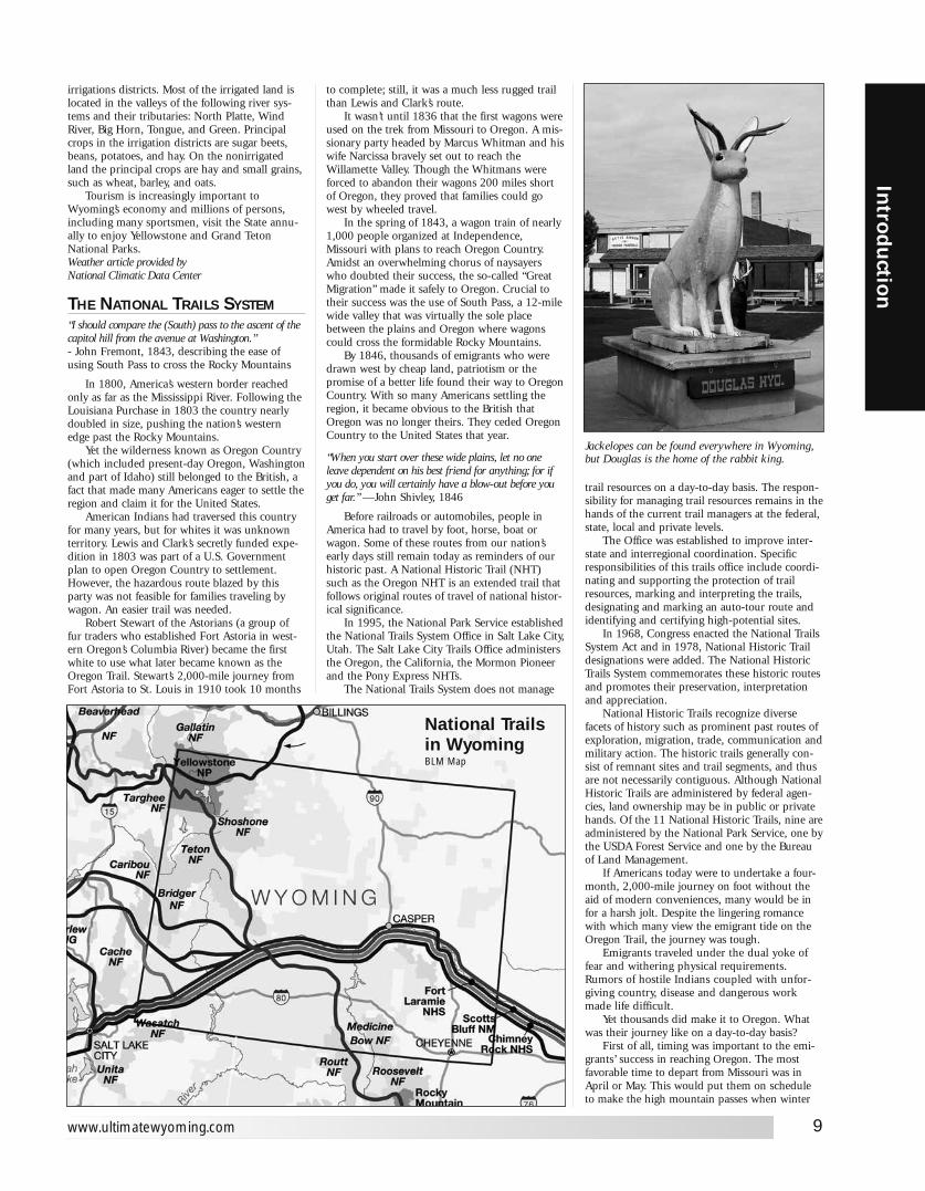
Jackelopes can be found everywhere in Wyoming,but Douglas is the home of the rabbit king.
National Trailsin WyomingBLM Map
snows would not be a threat.Mistakes were often made before the journey
even began. In preparing for the trip, many emi-grants overloaded their wagons with supplies. Asa result, not long after leaving Missouri, dumpingexcess items was a common sight along the trail.Tools, guns and food were considered vital—heir-looms were not.
The relatively gentle first leg of the routealong the Platte River was a time for the emi-grants to settle into travel mode. This meant get-ting used to hitching and unhitching the oxen,cattle and mules whenever a stop was made -hard and dangerous work. It also meant constantwagon maintenance, foraging for firewood andclean water, cooking over open fires and learninghow to break and set camp every day.
When emigrants reached Chimney Rock andScotts Bluff, their journey was one-third over. Butmore challenging terrain lay ahead as water, fire-wood and supply depots became more scarce.Buffalo herds that initially were a dependablefood source for the emigrants also thinned outdue to excessive killing.
The challenge of crossing many rivers and theContinental Divide created other severe tests forthe emigrants. Summer temperatures, miles ofshadeless trail and choking dust compounded tomake life decidedly unenjoyable. Though con-frontations with Indians were rare, the fear ofattack was a constant worry.
The last leg of the trail was the most difficult.But thoughts of approaching winter snows keptemigrants motivated to move as quickly as possi-ble. The Blue Mountains in eastern Oregon andthe Cascade range in the west presented barriersthat slowed progress.
Upon reaching Oregon City, the emigrantswere faced with either taking their chances on thedangerous Columbia River, or, starting in 1846,taking the safer but longer Barlow Road. SamBarlow’s toll road became the preferred route forthe emigrants. Finally, if money, animals, wagons,supplies and morale held out, the emigrantsreached the Willamette Valley.
THE MORMAN TRAILTo the sounds of snapping harness and creakingwagon wheels the pioneers in the vanguard ofwestward expansion moved out across the NorthAmerican continent. Between 1840 and 1870,more than 500,000 emigrants went west alongthe Great Platte River Road from departure pointsalong the Missouri River. This corridor had beenused for thou- sands of years by AmericanIndians and in the mid-19th century became thetransportation route for successive waves ofEuropean trappers, missionaries, soldiers, team-sters, stage coach drivers, Pony Express riders,and overland emigrants bound for opportunity inthe Oregon Territory, the Great Basin, and theCalifornia gold fields.
The trunk of the corridor generally followedthe Platte and North Platte rivers for more than600 miles, then paralleled the Sweetwater Riverbefore crossing the Continental Divide at SouthPass. Beyond South Pass the route divided severaltimes, each branch pioneered by emigrants seek-ing a better way to various destinations. Theroute’s importance declined with the completionof the transcontinental railroad in 1869 but con-tinued to receive limited use into the early 1900s.
The Mormon Pioneer TrailFew years in the Far West were more notable
than 1846. That year saw a war start withMexico, the Donner-Reed party embark on theirinfamous journey into a frozen world of inde-scribable horror, and the beginning of the bestorganized mass migration in American history.The participants of this migration, the Mormons,would establish thriving communities in whatwas considered by many to be a worthless desert.
From 1846 to 1869, more than 70,000Mormons traveled along an integral part of theroad west, the Mormon Pioneer Trail. The trailstarted in Nauvoo, Illinois, traveled across Iowa,connected with the Great Platte River Road at theMissouri River, and ended near the Great SaltLake in Utah. Generally following pre-existing
10
Intr
odu
ctio
n
Ultimate Wyoming Atlas and Travel Encyclopedia
The oil well is ubiquitous throughout the state.
routes the trail carried tens of thousands ofMormon emigrants to a new home and refuge inthe Great Basin. From their labors arose the Stateof Deseret, later becoming the Utah Territory, andfinally the State of Utah.
The Trail ExperienceThe Mormon pioneers shared similar experi-
ences with others traveling west: the drudgery ofwalking hundreds of miles, suffocating dust, vio-lent thunderstorms, mud, temperature extremes,bad water, poor forage, sickness, and death. Theyrecorded their experiences in journals, diaries,and letters that have become a part of ournational heritage.
The Mormons, however, were a unique partof this migration. Their move to the Valley of theGreat Salt Lake was not entirely voluntary; but tomaintain a religious and cultural identity it wasnecessary to find an isolated area where they
WYOMINGFIRST LADIES
Nellie Ross took the oath of office asGovernor of Wyoming in January, 1925, thefirst woman governor in the United States.Mrs. Ross was later the first woman directorof the U. S. Mint in Washington, D.C.
Irene Kinnear Mead was the first Shoshonewoman elected to a Tribal Council.
Ella Mae “Cattle Kate” Watson, accused ofcattle rustling, was the only woman everlynched in Wyoming.
Narcissa Prentiss Whitman and Eliza HartSpalding, missionaries, were the first whitewomen in Wyoming.
Mrs. Esther Morris of SOUTH PASS CITY wasthe first female Justice of the Peace in theU.S., commissioned in 1870.
The first woman to cast her general electionballot in the nation was Eliza Swain ofLARAMIE.
Women of Wyoming were granted suffrage in1869, 21 years before the U.S. grantedwomen the right to vote and hold office.
The first women jurors were in Wyoming,beginning in 1870.
The first woman in the country to be electedto a state office was Estelle Reel, electedSuperintendent of Public Instruction in 1894.
Mary Bellamy, a Democrat from LARAMIE,was the first woman elected to a state legis-lature in the country. The election was in1911.
Susan Wissler, elected mayor of DAYTON in1911, was the country’s first female in thatposition.
Rose Marshall was the first white baby bornin Yellowstone National Park.
The nation’s first female prison chaplain, Mrs.May Slosson, served at the LaramiePenetentiary in 1899.
Lorraine Lindaley, stationed at the MedicineBow Peak Lookout in 1921, west of LARAMIE,was the world’s first female fire lookout.

could permanently settle and practice their reli-gion in peace. This movement of an entire peo-ple, an entire religion, and culture was driven bypersecution, religious fervor, and determination.
The Mormon pioneers learned quickly to bewell-organized. They traveled in semi-militaryfashion, grouped into companies of 100s, 50s,and 1Os. Discipline, hard work, mutual assis-tance, and devotional practices were part of theirdaily routine on the trail. Knowing that otherswould follow, they improved the trail and builtsupport facilities. Businesses, such as ferries,were established to help finance the movement.They did not hire professional guides. Instead,they followed existing trails, used maps andaccounts of early explorers, and gathered infor-mation from travelers and frontiersmen they metalong the way. An early odometer was designedand built to record their mileage while travelingon the trail. In the end, strong group unity andorganization made the Mormon movement moreorderly and efficient than other emigrants travel-ing to Oregon and California.
The Mormon ChurchThe Mormon pioneer experience is closely
tied to the formation, growth, and developmentof the Church of Jesus Christ of Latter Day Saints,which was founded by Joseph Smith, April 6,1830, in Fayette, New York. According to theaccounts of Mormon history, Joseph Smith trans-lated a document from golden plates given to himby an angel. This document, The Book ofMormon, a record of Christ visiting America,became the cornerstone of the new religion. Thename Mormon was applied to those who sub-scribed to these beliefs.
Driven from New York by detractors, thechurch headquarters subsequently moved to Ohio,Missouri, and, in the spring of 1839, to Nauvoo,Illinois. It remained there until 1846, whenincreasing hostility caused the church to movebeyond the Rocky Mountains into then unsettledMexican territory in the Great Basin. There,Mormon leaders hoped to be insulated from fur-ther harassment, antagonism, and persecution.
Membership grew rapidly from 1830 to1845, and the church prospered. Hostility, fear,and controversy, however, surrounded thechurch. The rapid growth of church member-ship, the financial success of the members andthe church, religious beliefs that were outsidemainstream Christian tradition, the practice ofplural marriage (polygamy), a large well-armedmilitia, the blurring of lines between churchand state, and the perception by some non-Mormons that the church was a threat all fueledintolerance. Hostilities escalated, and on June27, 1844, Joseph Smith and his brother Hyrumwere killed by an angry mob while jailed inCarthage, Illinois.
By 1845, the Mormon population in andaround Nauvoo had grown to more than11,000, making it one of the largest cities in thestate. In September of that year, foes burnedmore than 200 Mormon homes and farm build-ings outside Nauvoo in an attempt to force theMormons to leave.
A move to the Far West had been discussedby church leaders as early as 1842, with Oregon,California, and Texas considered as potentialdestinations. In 1844, Joseph Smith obtainedJohn C. Fremont’s map and report, whichdescribed the Great Salt Lake and its surround-ing fertile valleys. Subsequently, the RockyMountains and the Great Basin became theprime candidates for settlement.
Establishing the Trail: The Treks of 1846 and 1847
The initial movement of the Mormons fromNauvoo, Illinois, to the Valley of the Great SaltLake occurred in two segments: one in 1846 andone in 1847. The first segment, across Iowa to theMissouri River, covered around 265 miles. The sec-ond segment, from the Missouri River to the Valleyof the Great Salt Lake, covered about 1,032 miles.
The Trek of 1846The departure from Nauvoo began on
February 4, 1846, under the leadership ofBrigham Young, who succeeded Joseph Smith asleader of the Mormon Church. After crossing the
11
Introd
uction
www.ultimatewyoming.com
Traffic can often be heavy on Wyoming roads. Watch for merging traffic on all open highways.
Mississippi River, the journey across Iowa fol-lowed primitive territorial roads and Indian trails.The initial party reached the Missouri River onJune 14 of that year, having taken more than fourmonths to complete the trip. Some of the emi-grants established a settlement called Kanesvilleon the Iowa side of the river. Others movedacross the river into the area of present-day(north) Omaha, Nebraska, building a camp calledWinter Quarters.
The Mormons left Nauvoo earlier thanplanned because of the revocation of their citycharter, growing rumors of U.S. governmentintervention, and fears that federal troops wouldmarch on the city. This early departure exposedthem to the elements in the worst of winter.Heavy rains later turned the rolling plains ofsouthern Iowa into a quagmire of axle-deep mud.Furthermore, few people carried adequate provi-sions for the trip. The weather, general unpre-paredness, and lack of experience in moving sucha large group of people, all contributed to the dif-ficulties they endured.
Along this first part of the trail, the Mormonsdeveloped skills for moving en masse. Theyestablished several semi-permanent camps,including Garden Grove and Mount Pisgah,
FOLLOW THE TRAIL
To follow The Oregon National Historic Trailwest through Wyoming, from Nebraska toIdaho:
1. Take U.S. Route 26 west to Interstate 25.
2. Turn north onto Interstate 25.
3. Take Interstate 25 west toState Route 220.
4. Turn west onto State Route 220.
5. Take State Route 220 to U.S. Route 287.
6. Turn west onto U.S. Route 287.
7. Take U.S. Route 287 west toState Route 28.
8. Turn West onto State Route 28.
9 Take State Route 28 west toState Route 372.
10. Turn southeast onto State Route 372.
11. Take State Route 372 east toInterstate 80.
12. Turn west onto Interstate 80.
13. Take Interstate 80 west toState Route 412.
14. Turn north onto State Route 412.
15. Take State Route 412 to U.S. Route 189.
16. Turn north onto U.S. Route 189.
17. Take U.S. Route 189 north toU.S. Route 30.
18. Turn west onto U.S. Route 30.
Total original route miles in Wyoming: 491
Source: National Park Service
where they planted crops and built facilities toassist those who followed. It was during this legof the journey that Brigham Young first organizedthem into companies of 1OOs, 50s, and 1Os. Thelessons learned crossing Iowa were used by futurecompanies of Mormons.
The Trek of 1847The longest leg of the journey began at
Winter Quarters on April 5, 1847, and ended onJuly 24, 1847, when Brigham Young entered the
Valley of the Great Salt Lake. The trip wentsmoother than the previous year’s journeybecause the Mormons were better organized, hadbetter provisions, and began the trek when trailconditions were optimal. The lead pioneer partyleft with 148 people (143 men, 3 women, and 2young boys), 72 wagons, 93 horses, 66 oxen, 52mules, 19 cows, 17 dogs, and some chickens.This hand-picked group was organized into twolarge divisions and further split into companies of50 and 10. This organizational structure was
based on Brigham Young’s plan for migratingwest. The plan also included details on campbehavior and devotional practices to be followedduring the journey.
The trail across the Great Plains traversedhundreds of miles along the north side of thePlatte and North Platte rivers. At Fort Laramie theMormons crossed to the south side of the river,where they joined the Oregon Trail. About 100miles later, they left the North Platte River atpresent day Casper, Wyoming. They then fol-lowed the Sweetwater River for almost 100 milesand crossed the Continental Divide at South Pass.At Fort Bridger, they left the Oregon Trail andstruck out on their own following a route firstrecommended by California promoter LansfordHastings and pioneered in 1846 by four compa-nies of emigrants bound for California. Thesefour companies blazed two different routes intothe Salt Lake Valley. The Mormons followed thefaint, year-old track of the ill-fated Donner-Reedparty through the Wasatch Mountains.
The final 116 miles, from Fort Bridger to theValley of the Great Salt Lake, were the most diffi-cult. The people were weary, their wagons worn,and livestock weakened by almost 1,000 miles ofwalking. Travel through the narrow, willow-choked canyons and over tree-covered slopesand rocky ridges of the Wasatch Range was soslow that it took the pioneer party 14 days tocomplete this part of their journey. On July 22,1847, when Thomas Bullock caught his first fullview of the valley he shouted “hurra, hurra,hurra, there’s my home at last.”
The pioneer party began planting late crops assoon as they reached the valley. During the nextfew weeks, they laid out streets, built temporaryshelters, and prepared for winter. Mormon emi-grants continued to arrive during the remainingweeks of summer and fall, and approximately1,650 people spent their first winter in the valley.Shortly after their arrival, Brigham Young and
12
Intr
odu
ctio
n
Ultimate Wyoming Atlas and Travel Encyclopedia
Most trails west passed through the South Pass shown above.
Mormon Pioneer Trail in WyomingNational Park Service Map

many members of the pioneer party made thereturn trip to Winter Quarters to be with theirfamilies and to help organize the next spring’smigration to the valley.
The next 20 years would see about 70,000Mormons traveling by wagons and handcarts tothe Valley of the Great Salt Lake. Overland wagontravel declined after the completion of thetranscontinental railroad in 1869, when emigrantscould travel across the plains by rail.
The Handcarts: 1856 to 1860A unique feature of the Mormon migration
was their use of handcarts. Handcarts, two-wheeled carts that were pulled by emigrants,instead of draft animals, were sometimes used asan alternate means of transportation from 1856 to1860. They were seen as a faster, easier, andcheaper way to bring European converts to SaltLake City. Almost 3,000 Mormons, with 653 cartsand 50 supply wagons, traveling in 10 differentcompanies, made the trip over the trail to SaltLake City. While not the first to use handcarts,they were the only group to use them extensively.
The handcarts were modeled after carts usedby street sweepers and were made almost entirelyof wood. They were generally 6 to 7 feet long,wide enough to span a narrow wagon track, andcould be alternately pushed or pulled. The smallboxes affixed to the carts were 3 to 4 feet longand 8 inches high. They could carry about 500pounds, most of this weight consisting of trailprovisions and a few personal possessions.
All but two of the handcart companies com-pleted the journey with few problems. The fourthand fifth companies, known as the Martin andWillie companies, left Winter Quarters in August1856. This was very late to begin the trip acrossthe plains. They encountered severe winterweather west of present-day Casper, Wyoming,and hundreds died from exposure and faminebefore rescue parties could reach them. Whilethese incidents were a rarity, they illustrate thatthe departure date from the trailhead was crucialto a successful journey.
The Trail TodayCongress established the Mormon Pioneer
National Historic Trail as part of the NationalTrails System on November 10, 1978. This his-toric trail commemorates the 1846-47 journey ofthe Mormon people from Nauvoo, Illinois, to theValley of the Great Salt Lake. The designated cor-ridor is almost 1,300 miles long and is managedas a cooperative effort among private landowners,
trail associations, state and local agencies, theNational Park Service, the Bureau of LandManagement, and the U.S. Forest Service. Landownership along the trail is comprised of 822miles (64 percent) on private land, 264 miles (20percent) under federal management, and 214miles (16 percent) in state and local ownership.Much of the trail is no longer visible, thoughsome trail segments and sites can be visited. Longstretches of the trail can still be seen in Wyoming.Reprinted from National Park Service brochure
THE OREGON TRAIL“When you start over these wide plains, let no oneleave dependent on his best friend for any thing; for ifyou do, you will certainly have a blow-out before youget far.” —John Shively, 1846
Onto Oregon! It all began with a crude net-work of rutted traces across the land from theMissouri River to the Willamette River that wasused by nearly 400,000 people. Today the 2,170-mile Oregon Trail still evokes an instant image, aready recollection of the settlement of this conti-nent, of the differences between American Indiansand white settlers, and of new horizons. In 1840only three states existed west of the MississippiRiver. Maine’s boundary with Canada was unde-fined. The western boundaries of the Nation layroughly along the Continental Divide. Within 10years the United States and Great Britain haddrawn a boundary that stretched from theAtlantic to the Pacific. The western boundarymoved from the Rocky Mountains to the PacificOcean. In another 40 years successive waves ofemigrants completely eliminated any sense offrontier, changed the way of life of the AmericanIndians, and ravaged many wild animal species,especially the herds of buffalo. Plows and barbedwire subdued the prairies. Transcontinental rail-roads knitted the great distances together.
The first Europeans to see the trans-Mississippi West were the mountain men, trap-pers, and the maritime explorers along the westcoast. In Canada, the Hudson’s Bay Company furfrontier was approaching the Columbia Riverbasin. In 1812 John Jacob Astor establishedAstoria at the mouth of the Columbia in a coun-termove and sent Robert Stuart overland to carrydispatches east. Stuart found South Pass by fol-lowing a Crow Indian trail. Only 7,000 feet abovesea level, with easy gradients, South Pass has anattractive geographic proximity to the upperreaches of the Platte River. Both were determiningfactors in the routing of the Oregon Trail. Theearly frontiersmen found the passes, crossed thegreat rivers, and defined the vast reaches of thewestern interior. From the beginning theseexplorers contributed to a growing campaign tomake the Oregon Country a part of either theUnited States or Great Britain, according to theirown sometimes confused loyalties.
Economic depressions in 1837 and 1841 frus-trated farmers and businessmen alike. The col-lapse of the international fur trade in 1839intensified the hard times, and concerns of Britishdomination of the Northwest grew. At the sametime, eastern churches saw the American Indiansof the Oregon Country as ready candidates forEuropean ideas of civilization. Churches formedardent missionary societies to create an activeappetite for Christianity. In 1836 MarcusWhitman and his new wife, Narcissa, along withHenry and Eliza Spalding, headed for Oregon asmissionaries. The letters they sent home publi-cized the opportunities and advantages ofOregon. Many people for many reasons had
13
Introd
uction
www.ultimatewyoming.com
MOVIES MADEIN WYOMING
Wyoming, with its diverse landscape andunspoiled vistas, has been the setting for anumber of films. Close Encounters of the ThirdKind (1977) used the Devil’s Tower area.Butch Cassidy and the Sundance Kid (1969)was filmed near Hole-In-The-Wall. An area justnorth of Casper was the background forStarship Troopers, filmed in 1997, and for TheHellfighters (1968).
The Jackson Hole area was used in RockyIV (1985), The Cowboy and the Lady (1922),The Big Trail (1930), Shane (1951), Jubal,The Big Sky, Spencer’s Mountain (1963).
Clint Eastwood fans saw Wyomingscenery in Any Which Way You Can (1980).
Other movies made in Wyoming include:Bad Bascomb (1946), Bright Angel (1991),The Cowpuncher (1915), End of the Trail(1932), The Far Horizons (1955), GhostsCan’t Do it (1990), Hike (1998), The IndianWars (1914), The Last Resort (1997), TheVanishing (1993), The Wrong Guys (1988).
become interested in Oregon, but it was not until1841 that the first group with serious intent toemigrate left the banks of the Missouri River andheaded west. In 1843, nearly 1,000 completedthe trip-an omen of the multitudes to follow.
The Oregon Trail was never a clearly definedtrack. In places the wagons passed in columns thatmight be hundreds of yards apart; those tracesshifted with the effects of weather and use. In thecourse of time nature obliterated many of thefainter traces. Road builders followed the deeper,more permanent traces because they marked thebest route. The Oregon Trail was quickly being for-gotten. In 1906, 76-yearold Ezra Meeker, Oregonsettler in 1852 and a tireless champion of the trail,
set out in a covered wagon to retrace the routefrom west to east. Among his goals: to create ageneral interest in marking the route, to raise pub-lic awareness of the trail’s history and heritage, andto point out the loss and damage resulting fromcareless disregard. Meeker met with PresidentsTheodore Roosevelt and Calvin Coolidge, testifiedbefore Congress, and made several other publicitytrips over the trail before his death in 1928. Todaythe National Park Service, in concert with theBureau of Land Management, the Forest Service,and the states of Missouri, Kansas, Nebraska,Wyoming, Idaho, Oregon, and Washington striveto protect this legacy.
Across the Plains
GuidebooksIn book or pamphlet form, guidebooks were
soon available for emigrants. Some providedgood, solid, reliable information. Others con-tributed to the Oregon Fever that swept the coun-try in the 1840s describing the land in almostBiblical terms.
Each part of the journey had its difficulties.For the first third of the way, the emigrants gotused to the routine and work of travel. Theylearned to hitch and unhitch their livestock, tokeep the wagons in good running order, and tomake sure that their animals got the water andfood they needed to survive. They learned to getalong with their fellow emigrants, to agree onrules they would all follow on the journey, and toset up and break camp every night and morning.They learned to spread out in several columns sothat they raised less dust and fewer of them had
to breathe the choking air. They rotated positionsin the line in a spirit of fairness. They learned totravel six out of seven days as experienced voicestold them that some of the most difficult sectionsto travel would come at the end, when theywould have to cross mountains before the wintersnows. Fortunately the landscape was relativelygentle as they traveled through the Platte RiverValley heading for the High Plains. Starting in thespring, too, provided them with abundant grassfor the livestock. Water was also plentiful, and ifthey were early enough in the year campsites andwaterholes would not be overgrazed or fouled.Cholera, whose cause was then unknown (but wenow know can be traced to contaminated water),killed more travelers than anything else. Howmany emigrants died along the trail can never beknown. The number of deaths varied from year toyear. Most likely the death rate was little differentfrom that for those who resisted the lure of thetrail with all its potential disasters.
Loading the WagonWagons usually measured 4 feet wide by 12
feet long. Into these 48 square feet were put sup-plies for traveling the trail and the wherewithalfor beginning a new life. The emphasis was ontools and food, but a few family treasures andheirlooms were also carried. A typical load isshown at left. Using the wagon as shelter wasalmost an afterthought.
Over the Continental DivideExcitement abounded when the emigrants
passed the landmarks of Chimney Rock andScotts Bluff, about onethird of the way on the
14
Intr
odu
ctio
n
Ultimate Wyoming Atlas and Travel Encyclopedia
Many travelers left their mark along the way atseveral locations. This man left his at RegisterCliffs near Guernsey
Oregon Trail in WyomingNational Park Service Map
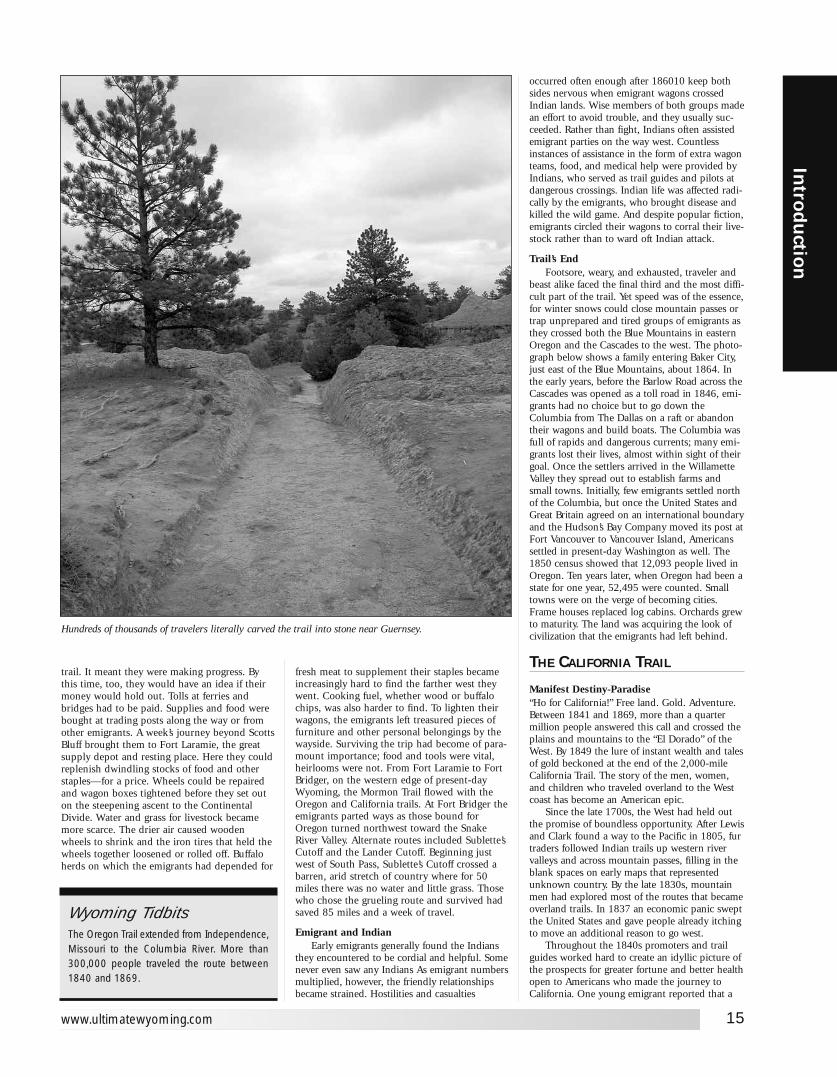
trail. It meant they were making progress. Bythis time, too, they would have an idea if theirmoney would hold out. Tolls at ferries andbridges had to be paid. Supplies and food werebought at trading posts along the way or fromother emigrants. A week’s journey beyond ScottsBluff brought them to Fort Laramie, the greatsupply depot and resting place. Here they couldreplenish dwindling stocks of food and otherstaples—for a price. Wheels could be repairedand wagon boxes tightened before they set outon the steepening ascent to the ContinentalDivide. Water and grass for livestock becamemore scarce. The drier air caused woodenwheels to shrink and the iron tires that held thewheels together loosened or rolled off. Buffaloherds on which the emigrants had depended for
fresh meat to supplement their staples becameincreasingly hard to find the farther west theywent. Cooking fuel, whether wood or buffalochips, was also harder to find. To lighten theirwagons, the emigrants left treasured pieces offurniture and other personal belongings by thewayside. Surviving the trip had become of para-mount importance; food and tools were vital,heirlooms were not. From Fort Laramie to FortBridger, on the western edge of present-dayWyoming, the Mormon Trail flowed with theOregon and California trails. At Fort Bridger theemigrants parted ways as those bound forOregon turned northwest toward the SnakeRiver Valley. Alternate routes included Sublette’sCutoff and the Lander Cutoff. Beginning justwest of South Pass, Sublette’s Cutoff crossed abarren, arid stretch of country where for 50miles there was no water and little grass. Thosewho chose the grueling route and survived hadsaved 85 miles and a week of travel.
Emigrant and IndianEarly emigrants generally found the Indians
they encountered to be cordial and helpful. Somenever even saw any Indians As emigrant numbersmultiplied, however, the friendly relationshipsbecame strained. Hostilities and casualties
occurred often enough after 186010 keep bothsides nervous when emigrant wagons crossedIndian lands. Wise members of both groups madean effort to avoid trouble, and they usually suc-ceeded. Rather than fight, Indians often assistedemigrant parties on the way west. Countlessinstances of assistance in the form of extra wagonteams, food, and medical help were provided byIndians, who served as trail guides and pilots atdangerous crossings. Indian life was affected radi-cally by the emigrants, who brought disease andkilled the wild game. And despite popular fiction,emigrants circled their wagons to corral their live-stock rather than to ward oft Indian attack.
Trail’s EndFootsore, weary, and exhausted, traveler and
beast alike faced the final third and the most diffi-cult part of the trail. Yet speed was of the essence,for winter snows could close mountain passes ortrap unprepared and tired groups of emigrants asthey crossed both the Blue Mountains in easternOregon and the Cascades to the west. The photo-graph below shows a family entering Baker City,just east of the Blue Mountains, about 1864. Inthe early years, before the Barlow Road across theCascades was opened as a toll road in 1846, emi-grants had no choice but to go down theColumbia from The Dallas on a raft or abandontheir wagons and build boats. The Columbia wasfull of rapids and dangerous currents; many emi-grants lost their lives, almost within sight of theirgoal. Once the settlers arrived in the WillametteValley they spread out to establish farms andsmall towns. Initially, few emigrants settled northof the Columbia, but once the United States andGreat Britain agreed on an international boundaryand the Hudson’s Bay Company moved its post atFort Vancouver to Vancouver Island, Americanssettled in present-day Washington as well. The1850 census showed that 12,093 people lived inOregon. Ten years later, when Oregon had been astate for one year, 52,495 were counted. Smalltowns were on the verge of becoming cities.Frame houses replaced log cabins. Orchards grewto maturity. The land was acquiring the look ofcivilization that the emigrants had left behind.
THE CALIFORNIA TRAIL
Manifest Destiny-Paradise“Ho for California!” Free land. Gold. Adventure.Between 1841 and 1869, more than a quartermillion people answered this call and crossed theplains and mountains to the “El Dorado” of theWest. By 1849 the lure of instant wealth and talesof gold beckoned at the end of the 2,000-mileCalifornia Trail. The story of the men, women,and children who traveled overland to the Westcoast has become an American epic.
Since the late 1700s, the West had held outthe promise of boundless opportunity. After Lewisand Clark found a way to the Pacific in 1805, furtraders followed Indian trails up western rivervalleys and across mountain passes, filling in theblank spaces on early maps that representedunknown country. By the late 1830s, mountainmen had explored most of the routes that becameoverland trails. In 1837 an economic panic sweptthe United States and gave people already itchingto move an additional reason to go west.
Throughout the 1840s promoters and trailguides worked hard to create an idyllic picture ofthe prospects for greater fortune and better healthopen to Americans who made the journey toCalifornia. One young emigrant reported that a
15
Introd
uction
www.ultimatewyoming.com
Hundreds of thousands of travelers literally carved the trail into stone near Guernsey.
Wyoming TidbitsThe Oregon Trail extended from Independence,Missouri to the Columbia River. More than300,000 people traveled the route between1840 and 1869.
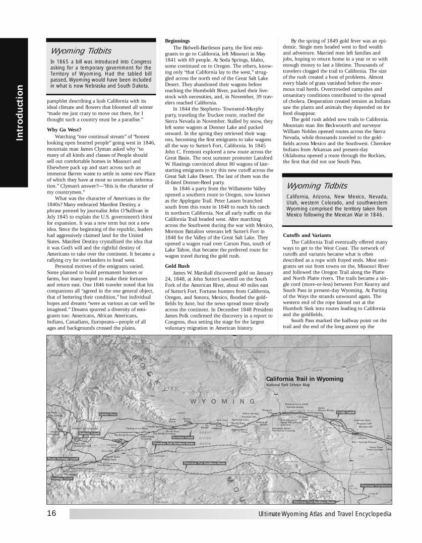
pamphlet describing a lush California with itsideal climate and flowers that bloomed all winter“made me just crazy to move out there, for Ithought such a country must be a paradise.”
Why Go West?Watching “one continual stream” of “honest
looking open hearted people” going west in 1846,mountain man James Clyman asked why “somany of all kinds and classes of People shouldsell out comfortable homes in Missouri andElsewhere pack up and start across such animmense Barren waste to settle in some new Placeof which they have at most so uncertain informa-tion.” Clyman’s answer?—”this is the character ofmy countrymen.”
What was the character of Americans in the1840s? Many embraced Manifest Destiny, aphrase penned by journalist John O’Sullivan inJuly 1845 to explain the U.S. government’s thirstfor expansion. It was a new term but not a newidea. Since the beginning of the republic, leadershad aggressively claimed land for the UnitedStates. Manifest Destiny crystallized the idea thatit was God’s will and the rightful destiny ofAmericans to take over the continent. It became arallying cry for overlanders to head west.
Personal motives of the emigrants varied.Some planned to build permanent homes orfarms, but many hoped to make their fortunesand return east. One 1846 traveler noted that hiscompanions all “agreed in the one general object,that of bettering their condition,” but individualhopes and dreams “were as various as can well beimagined.” Dreams spurred a diversity of emi-grants too: Americans, African Americans,Indians, Canadians, Europeans—people of allages and backgrounds crossed the plains.
BeginningsThe Bidwell-Bartleson party, the first emi-
grants to go to California, left Missouri in May1841 with 69 people. At Soda Springs, Idaho,some continued on to Oregon. The others, know-ing only “that California lay to the west,” strug-gled across the north end of the Great Salt LakeDesert. They abandoned their wagons beforereaching the Humboldt River, packed their live-stock with necessities, and, in November, 39 trav-elers reached California.
In 1844 the Stephens- Townsend-Murphyparty, traveling the Truckee route, reached theSierra Nevada in November. Stalled by snow, theyleft some wagons at Donner Lake and packedonward. In the spring they retrieved their wag-ons, becoming the first emigrants to take wagonsall the way to Sutter’s Fort, California. In 1845John C. Fremont explored a new route across theGreat Basin. The next summer promoter LansfordW. Hastings convinced about 80 wagons of late-starting emigrants to try this new cutoff across theGreat Salt Lake Desert. The last of them was theill-fated Donner-Reed party.
In 1846 a party from the Willamette Valleyopened a southern route to Oregon, now knownas the Applegate Trail. Peter Lassen branchedsouth from this route in 1848 to reach his ranchin northern California. Not all early traffic on theCalifornia Trail headed west. After marchingacross the Southwest during the war with Mexico,Mormon Battalion veterans left Sutter’s Fort in1848 for the Valley of the Great Salt Lake. Theyopened a wagon road over Carson Pass, south ofLake Tahoe, that became the preferred route forwagon travel during the gold rush.
Gold RushJames W. Marshall discovered gold on January
24, 1848, at John Sutter’s sawmill on the SouthFork of the American River, about 40 miles eastof Sutter’s Fort. Fortune hunters from California,Oregon, and Sonora, Mexico, flooded the gold-fields by June, but the news spread more slowlyacross the continent. In December 1848 PresidentJames Polk confirmed the discovery in a report toCongress, thus setting the stage for the largestvoluntary migration in American history.
By the spring of 1849 gold fever was an epi-demic. Single men headed west to find wealthand adventure. Married men left families andjobs, hoping to return home in a year or so withenough money to last a lifetime. Thousands oftravelers clogged the trail to California. The sizeof the rush created a host of problems. Almostevery blade of grass vanished before the enor-mous trail herds. Overcrowded campsites andunsanitary conditions contributed to the spreadof cholera. Desperation created tension as Indianssaw the plants and animals they depended on forfood disappear.
The gold rush added new trails to California.Mountain man Jim Beckwourth and surveyorWilliam Nobles opened routes across the SierraNevada, while thousands traveled to the gold-fields across Mexico and the Southwest. CherokeeIndians from Arkansas and present-dayOklahoma opened a route through the Rockies,the first that did not use South Pass.
Cutoffs and VariantsThe California Trail eventually offered many
ways to get to the West Coast. The network ofcutoffs and variants became what is oftendescribed as a rope with frayed ends. Most emi-grants set out from towns on the, Missouri Riverand followed the Oregon Trail along the Platteand North Platte rivers. The trails became a sin-gle cord (more-or-less) between Fort Kearny andSouth Pass in present-day Wyoming. At Partingof the Ways the strands unwound again. Thewestern end of the rope fanned out at theHumbolt Sink into routes leading to Californiaand the goldfields.
South Pass marked the halfway point on thetrail and the end of the long ascent up the
16
Intr
odu
ctio
n
Ultimate Wyoming Atlas and Travel Encyclopedia
Wyoming TidbitsIn 1865 a bill was introduced into Congressasking for a temporary government for theTerritory of Wyoming. Had the tabled billpassed, Wyoming would have been includedin what is now Nebraska and South Dakota.
Wyoming TidbitsCalifornia, Arizona, New Mexico, Nevada,Utah, western Colorado, and southwesternWyoming comprised the territory taken fromMexico following the Mexican War in 1846.
California Trail in WyomingNational Park Service Map
more reliable and powerful, and harder to steal.Oxen also fared better on prairie grass than didhorses and mules, an important considerationbecause emigrants’ lives could depend on thehealth of their livestock.
Getting started was one thing—getting safelyto California was another. Guidebooks, or “way-bills,” became available almost as soon as the trailopened. Most waybills offered practical adviceabout routes, landmarks, distances, and whatequipment and supplies to take. Some, such as<I>The Emigrants’ Guide, to Oregon andCalifornia,<I> 1845, by promoter and guideLansford W. Hastings, described California inalmost heavenly terms and helped fuel whatbecame “California fever.”
Women and FamiliesAlthough single men made up the majority of
early emigrants and forty-niners, women andfamilies played an important role on the trail.
The first major wagon train, the Bidwell-Bartleson party, set out in 1841 with five womenand about 10 children. At age 19 Nancy Kelsey(carrying her baby over the Sierra Nevada afterthe party abandoned its wagons) became the firstcovered-wagon woman to reach California.Iowans Catherine Haun and her husband caughtgold fever in 1849. The Hauns, and about 25 oftheir neighbors in the wagon party, longed to gowest, pick up gold off the ground, and returnhome to pay off their debts.
Catherine wrote in her journal that womenand children on the trail “exerted a good influ-ence, as the men did not take such risks, weremore alert about the teams and seldom had acci-dents, [and] more attention was paid to cleanli-ness and sanitation.” Even “the meals were moreregular and better cooked thus preventing muchsickness.” Births on the trail were as common asdeaths. As one girl recalled, “Three days after mylittle sister died… we stopped for a few hours,and my sister Olivia was born.”
By 1852 about a third of all those crossing theplains were women. Five years later, it was com-mon to find wagon parties made up largely ofwomen and children. These women, as did allemigrants, left familiar homes and endured hard-ships to find a better life.
Indians and EmigrantsThe quiet land along the California Trail may
have seemed empty but Indian nations had livedthere for more than 10,000 years. UnlikeHollywood stereotypes, Indians were more of ahelp than a danger to emigrants. In the 1840sfatal confrontations were rare. Travelers entrust-ed their wagons and families to Indians whoguided them across swift rivers and throughunfamiliar country.
In 1844 Paiute Chief Truckee guided emi-grants along the route and the river that theynamed after him. Stories of Indian massacres faroutnumbered actual hostile encounters. “We arecontinually hearing of the depredations of theindians,” wrote Caroline Richardson in 1852, “butwe have not seen one yet.” Conflict increased inthe 1850s and 1860s as thousands of emigrantsand their livestock destroyed Indian food sources.Some Indians tried to collect payment for passageacross tribal lands. A few emigrants paid, butmost felt little sympathy for Indian claims to theland. Relations deteriorated: Indians killed travel-ers, and emigrants killed Indians.
The violence attracted attention, but it wasnot the reason most emigrants perished.Thousands died from drownings, accidents, and
disease, especially cholera. Many incidents werethe work of criminals called “white Indians,” whowere notorious for their brutality. One 1850 trav-eler concluded that “the savage Indians” were“afraid to come near the road” and “near all thestealing and killing is done by the Whites follow-ing the Trains.”
An Enduring LegacyTravel to California in days, not months! In
1869 the Union Pacific from the east and theCentral Pacific from the west connected their railtracks at Utah’s Promontory Summit. A goldenspike tapped symbolically to celebrate the unionhailed a new, exciting way to travel the conti-nent, and it signaled the demise of the wagontrails to the West.
Although dust from the wagons settled nearly150 years ago, the California Trail’s heritage liveson with the people who love its history and inthe railroads, interstate highways, and powerlinesthat follow the routes of the old emigrant trails.Today, public lands preserve much of the originallandscape. Surviving ruts offer silent testimony ofthe California Trail, but no one tells this epic bet-ter than the people who traveled it.
Westward travelers shared similar experi-ences: the drudgery of walking more than 2,000miles, the struggle to cross forbidding land-scapes, extremes of temperature and weather,shortages of food and water, fear of Indians, acci-dents, sickness, and death. These emigrants, whosaw the elephant and more, remembered the tripwest as their life’s greatest adventure. Their expe-riences-often recorded eloquently in journals,drawings, and letters-inspired American popularculture and influenced art, literature, and themovies. Their stories are part of the legacy of theAmerican West.Reprint of National Park Service brochure.
THE PONY EXPRESS“Men Wanted” The undersigned wishes to hire ten or adozen men, familiar with the management of horses, ashostlers, or riders on the Overland Express Route viaSalt Lake City. Wages $50 per month and found.”—Ad in Sacramento Union, March 19, 1860.
More than 1,800 miles in 10 days! From St.Joseph, Missouri, to Sacramento, California thePony Express could deliver a letter more quicklythan ever before.
In operation for only 18 months betweenApril 1860 and October 1861, the Pony Expressnevertheless has become synonymous with theOld West. In the era before electronic communi-cation, the Pony Express was the thread that tiedEast to West.
As a result of the 1849 Gold Rush, the 1847Mormon exodus to Utah and the thousands whomoved west on the Oregon Trail starting in the1840s, the need for a fast mail service beyond theRocky Mountains became obvious. This need was
17
Introd
uction
www.ultimatewyoming.com
Wyoming TidbitsThe Pony Express, though in operation only18 months, was a vital form of communica-tion. In those pre-telegraph days of 1860, rid-ers carried mail on 10-day, 2,000 mile routesfrom St. Joseph, Missouri, to Sacramento,California, and back, crossing the mountainsand plains of Wyoming.
Continental Divide. West of South Pass travelerscould go several ways: to Idaho and the Raft Riverarea, where the main branch of the CaliforniaTrail separated from the Oregon Trail; or to Utahand the settlements of the Latter-day Saints,Mormons, which were popular way stations. Aftervisiting Salt Lake City, most emigrants followedthe Salt Lake Cutoff back to the main trail at Cityof Rocks in present-day Idaho. For wagons theHumboldt River Valley provided the best practicalwagon road through the basin-and-range country,but overlanders continually sought easier ways tocross the formidable Sierra Nevada.
By 1860 freight and mail companies, militaryexpeditions, new settlements and trading stations,and thousands of travelers going in both direc-tions transformed the California Trail into a road.
Seeing the ElephantEvery great human migration seems to have
its own catchphrase, and the forty-niners were noexception. “Seeing the elephant” characterizedemigrant encounters with vast plains and barrendeserts and the difficulty of surviving the harrow-ing trek across the western landscape. Theexpression predated the gold rush and was basedon the thrill of seeing these exotic beasts in cir-cuses. For overlanders the elephant symbolized achallenging trip, the adventure of a lifetime.
If you had “seen the elephant” you had seenabout all there was to see! People had neverencountered anything like these prairies, canyons,deserts, and rugged mountains. The deserts of theGreat Basin and the barrier of the Sierra Nevadamade the California Trail the most difficult of alloverland trails. Almost every emigrant recalledseeing the elephant somewhere along this ardu-ous stretch. For many the encounter came on theHumboldt River-the Humbug, as some called it indisgust—a stream that got more sluggish andalkaline as it bent west and south until it finallydisappeared into a shallow lake.
Others met the beast on the Fortymile Deserteast of today’s Reno, Nevada. The travelers luckyenough to escape the deserts of the Great Basinwith animals and outfit intact were almost certainto see the elephant among the steep passes of theSierra Nevada. Those who turned back oftenclaimed to have seen the elephant’s tail. One emi-grant, who turned back after only 700 miles said“he had seen the Elephant and eaten its ears.”
Wagons and WaybillsGoing west was an expensive proposition.
Emigrants needed supplies (food, utensils, stoves,bedding, lanterns, and more), hardware (axes,wagon parts, shovels, rope, other tools), livestock,and money to last for many months. Most travel-ers used light farm wagons that came to be calledprairie schooners because their canvas topsreminded emigrants of sails on a ship. Schoonerscould carry about a ton of food and supplies, andoften travelers packed their belongings into everybit of space. Treasures such as china, heirlooms,and furniture were jettisoned when it becameobvious that the load was too heavy.
Overlanders preferred oxen to pull their wag-ons. They were slower than horses but cheaper,
Wyoming TidbitsTalk about home on the range - there are 2.8cattle for every one person in Wyoming!
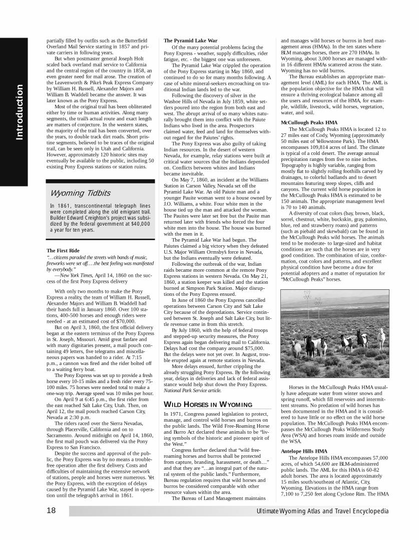
partially filled by outfits such as the ButterfieldOverland Mail Service starting in 1857 and pri-vate carriers in following years.
But when postmaster general Joseph Holtscaled back overland mail service to Californiaand the central region of the country in 1858, aneven greater need for mail arose. The creation ofthe Leavenworth & Pike’s Peak Express Companyby William H. Russell, Alexander Majors andWilliam B. Waddell became the answer. It waslater known as the Pony Express.
Most of the original trail has been obliteratedeither by time or human activities. Along manysegments, the trail’s actual route and exact lengthare matters of conjecture. In the western states,the majority of the trail has been converted, overthe years, to double track dirt roads. Short pris-tine segments, believed to be traces of the originaltrail, can be seen only in Utah and California.However, approximately 120 historic sites mayeventually be available to the public, including 50existing Pony Express stations or station ruins.
The First Ride“…citizens paraded the streets with bands of music,fireworks were set off….the best feeling was manifestedby everybody.”
—New York Times, April 14, 1860 on the suc-cess of the first Pony Express delivery
With only two months to make the PonyExpress a reality, the team of William H. Russell,Alexander Majors and William B. Waddell hadtheir hands full in January 1860. Over 100 sta-tions, 400-500 horses and enough riders wereneeded - at an estimated cost of $70,000.
But on April 3, 1860, the first official deliverybegan at the eastern terminus of the Pony Expressin St. Joseph, Missouri. Amid great fanfare andwith many dignitaries present, a mail pouch con-taining 49 letters, five telegrams and miscella-neous papers was handed to a rider. At 7:15p.m., a cannon was fired and the rider bolted offto a waiting ferry boat.
The Pony Express was set up to provide a freshhorse every 10-15 miles and a fresh rider every 75-100 miles. 75 horses were needed total to make aone-way trip. Average speed was 10 miles per hour.
On April 9 at 6:45 p.m., the first rider fromthe east reached Salt Lake City, Utah. Then, onApril 12, the mail pouch reached Carson City,Nevada at 2:30 p.m.
The riders raced over the Sierra Nevadas,through Placerville, California and on toSacramento. Around midnight on April 14, 1860,the first mail pouch was delivered via the PonyExpress to San Francisco.
Despite the success and approval of the pub-lic, the Pony Express was by no means a trouble-free operation after the first delivery. Costs anddifficulties of maintaining the extensive networkof stations, people and horses were numerous. Yetthe Pony Express, with the exception of delayscaused by the Pyramid Lake War, stayed in opera-tion until the telegraph’s arrival in 1861.
The Pyramid Lake WarOf the many potential problems facing the
Pony Express - weather, supply difficulties, riderfatigue, etc. - the biggest one was unforeseen.
The Pyramid Lake War crippled the operationof the Pony Express starting in May 1860, andcontinued to do so for many months following. Acase of white mineral-seekers encroaching on tra-ditional Indian lands led to the war.
Following the discovery of silver in theWashoe Hills of Nevada in July 1859, white set-tlers poured into the region from both east andwest. The abrupt arrival of so many whites natu-rally brought them into conflict with the PaiuteIndians who lived in the area. Prospectorsclaimed water, feed and land for themselves with-out regard for the Paiutes’ rights.
The Pony Express was also guilty of takingIndian resources. In the desert of westernNevada, for example, relay stations were built atcritical water sources that the Indians dependedon. Conflicts between whites and Indiansbecame inevitable.
On May 7, 1860, an incident at the WilliamsStation in Carson Valley, Nevada set off thePyramid Lake War. An old Paiute man and ayounger Pauite woman went to a house owned byJ.O. Williams, a white. Four white men in thehouse tied up the man and attacked the woman.The Pauites were later set free but the Pauite manreturned later with friends who forced the fourwhite men into the house. The house was burnedwith the men in it.
The Pyramid Lake War had begun. ThePaiutes claimed a big victory when they defeatedU.S. Major William Ormsby’s force in Nevada,but the Indians eventually were defeated.
Following the outbreak of the war, Indianraids became more common at the remote PonyExpress stations in western Nevada. On May 21,1860, a station keeper was killed and the stationburned at Simpson Park Station. Major disrup-tions of the Pony Express ensued.
In June of 1860 the Pony Express cancelledoperations between Carson City and Salt LakeCity because of the depredations. Service contin-ued between St. Joseph and Salt Lake City, but lit-tle revenue came in from this stretch.
By July 1860, with the help of federal troopsand stepped-up security measures, the PonyExpress again began delivering mail to California.Delays had cost the company around $75,000.But the delays were not yet over. In August, trou-ble erupted again at remote stations in Nevada.
More delays ensued, further crippling thealready struggling Pony Express. By the followingyear, delays in deliveries and lack of federal assis-stance would help shut down the Pony Express.National Park Service article.
WILD HORSES IN WYOMINGIn 1971, Congress passed legislation to protect,manage, and control wild horses and burros onthe public lands. The Wild Free-Roaming Horseand Burro Act declared these animals to be “liv-ing symbols of the historic and pioneer spirit ofthe West.”
Congress further declared that “wild free-roaming horses and burros shall be protectedfrom capture, branding, harassment, or death…”and that they are “…an integral part of the natu-ral system of the public lands.” Furthermore,Bureau regulation requires that wild horses andburros be considered comparable with otherresource values within the area.
The Bureau of Land Management maintains
18
Intr
odu
ctio
n
Ultimate Wyoming Atlas and Travel Encyclopedia
Wyoming TidbitsIn 1861, transcontinental telegraph lineswere completed along the old emigrant trail.Builder Edward Creighton’s project was subsi-dized by the federal government at $40,000a year for ten years.
and manages wild horses or burros in herd man-agement areas (HMAs). In the ten states whereBLM manages horses, there are 270 HMAs. InWyoming, about 3,000 horses are managed with-in 16 different HMAs scattered across the state.Wyoming has no wild burros.
The Bureau establishes an appropriate man-agement level (AML) for each HMA. The AML isthe population objective for the HMA that willensure a thriving ecological balance among allthe users and resources of the HMA, for exam-ple, wildlife, livestock, wild horses, vegetation,water, and soil.
McCullough Peaks HMAThe McCullough Peaks HMA is located 12 to
27 miles east of Cody, Wyoming (approximately50 miles east of Yellowstone Park). The HMAencompasses 109,814 acres of land. The climateis typical of a cold desert. The average annualprecipitation ranges from five to nine inches.Topography is highly variable, ranging frommostly flat to slightly rolling foothills carved bydrainages, to colorful badlands and to desertmountains featuring steep slopes, cliffs andcanyons. The current wild horse population inthe McCullough Peaks HMA is estimated to be150 animals. The appropriate management levelis 70 to 140 animals.
A diversity of coat colors (bay, brown, black,sorrel, chestnut, white, buckskin, gray, palomino,blue, red and strawberry roans) and patterns(such as piebald and skewbald) can be found inthe McCullough Peaks wild horses. The animalstend to be moderate- to large-sized and habitatconditions are such that the horses are in verygood condition. The combination of size, confor-mation, coat colors and patterns, and excellentphysical condition have become a draw forpotential adopters and a matter of reputation for“McCullough Peaks” horses.
Horses in the McCullough Peaks HMA usual-ly have adequate water from winter snows andspring runoff, which fill reservoirs and intermit-tent streams. No predation of wild horses hasbeen documented in the HMA and it is consid-ered to have little or no effect on the wild horsepopulation. The McCullough Peaks HMA encom-passes the McCullough Peaks Wilderness StudyArea (WSA) and horses roam inside and outsidethe WSA.
Antelope Hills HMAThe Antelope Hills HMA encompasses 57,000
acres, of which 54,600 are BLM-administeredpublic lands. The AML for this HMA is 60-82adult horses. The area is located approximately15 miles south/southeast of Atlantic, City,Wyoming. Elevations in the HMA range from7,100 to 7,250 feet along Cyclone Rim. The HMA

is bisected by the Continental Divide NationalScenic Trail. The area receives 5-7 inches of pre-cipitation annually. The predominate vegetationtype is sagebrush/grass. Riparian zones are infre-quent but very important to wild horses, wildlife,and livestock. The topography ranges from rollingflatlands south of Cyclone Rim, uplifted ridgesalong Cyclone Rim, and abrupt rocky zones inter-spersed with rolling lands north of the rim to theSweetwater River.
Crooks Mountain HMAThe Crooks Mountain HMA is located directly
southeast of Sweetwater Station, Wyoming, andencompasses about 51,000 acres. The AML for
this HMA is 65-100 adult horses. Elevations inthe HMA range from 6,900 to 8,100 feet. Thelower elevations receive approximately 10-14inches of precipitation annually, and the upperelevations receive 15-20 inches annually. Themajor vegetation types are sagebrush/grass, wood-land, and riparian. Topography within the HMAis generally rolling hills and slopes to the northand south of Crooks Mountain. The CrooksMountain portion of the herd area is quite steepand broken with mountainous terrain. The areasupports significant wildlife populations of elk,deer, and antelope. Livestock graze the area fromMay to December.
Muskrat Basin, Conant Creek, Rock Creek, and Dishpan Butte HMAs
These four HMAs are located in southeastFremont County. They encompass about 375,000acres of land, of which about 90% are BLM-administerd public lands. While the four HMAsare managed with recognized individual popula-tions, there is no geographic separation of theHMAs and the gates between them remain open asignificant part of the year. As a result, the horsesmove regularly among the HMAs, helping toensure the overall genetic health of the horses.Topography of the area includes high ridges andsteep terrain with grand vistas. Beaver Rim, locat-ed on the western edge of the HMAs, is a beauti-ful, high escarpment with amazing views of theWind River Mountains, Copper Mountains, andOwl Creek Mountains. Elevations in the HMAsrange from 5,300 to 7,200 feet. The area receives5 to 12 inches of precipitation a year, dependingon the elevation, most of it in the form of snow.
The AML for these HMAs is 320 horses. A fullrange of colors is present. Most horses are solid incolor. The horses range from 11 to 15 hands and750-1000 pounds mature weight. Health is goodwith few apparent problems. Domestic cattle andsheep utilize the area during spring, summer, andfall. Vegetation is dominated by various sage andgrass species. Elk, deer, and antelope also inhabitthis area.
Green Mountain HMAThe Green Mountain HMA encompasses
88,000 acres, of which 74,000 acres are BLM-administered public lands. Topography within theherd area is generally gently rolling hills andslopes north and south of Green Mountain. GreenMountain itself is quite steep with mountainousterrain and conifer/aspen forests. Elevations rangefrom 6,200 to 9,200 feet with grand vistas of theRed Desert, Sweetwater Rocks, and Oregon Trailfrom the higher elevations. Precipitation rangesfrom 10-14 inches at the lower elevations to 15-20 inches at the upper elevations. Most of theprecipitation is in the form of snow.
The AML for this HMA is 300 horses. A fullrange of colors is present. Most horses are solid incolor, but a noticeable number of tobiano paintsare present. The horses range from 11 to 15hands and 750-1000 pounds mature weight.Health is good with few apparent problems.Domestic cattle and sheep utilize the area in allseasons with summer cattle use predominating.Vegetation around the mountain is dominated byvarious sage, grass, woodland, and riparianspecies. The area supports significant wildlifepopulations of elk, deer, antelope, and moose.
Stewart Creek HMAThe Stewart Creek HMA encompasses
19
Introd
uction
www.ultimatewyoming.com
ROCKHOUNDINGIN WYOMING
Where Is Collection Permissible?Rockhounding is recognized as a legitimaterecreational pursuit on nearly all of the 17.8 mil-lion acres of public land in Wyoming. Thesepublic lands administered by the BLM are opento everyone, to take limited amounts of rockmaterial for noncommercial purposes withoutcharge. Maps showing the location of publiclands in Wyoming can be obtained from thisoffice or the field offices (for addresses seeinformation handout “WYNF-0007, BLM Officesin Wyoming”). You should check with the BLMfield offices to become familiar with local pro-cedures, policies and areas with authorizedrestrictions.
No Historic Artifacts, PleaseThe Archaeological Resources Protection Act of1979 and the Antiquities Act of 1906 aredesigned to protect our Nation’s culturalresources. These laws prohibit the unautho-rized excavation, removal, damage, or alterationof any archaeological and historical site orobject. Petroglyphs, human graves, olddwellings, pottery, stone tools, arrowheads, andother remains of Indians and early inhabitantsare protected by law because they may provideimportant links to our past.
How About Fossils?Fossil collecting has its own set of rules.Vertebrate fossils (which includes all bonesand teeth) are off limits to rockhounders, butinvertebrate and plant fossils that are not ofspecial scientific interest may be collected inreasonable amounts for personal use. No fos-sils collected from public land can be sold,traded, or bartered. Please see the pamphlettitled Fossils on America’s Public Lands avail-able at BLM offices.
May Petrified Wood Be Collected?Hobby collection has special rules. Please seeFossils on America’s Public Lands pamphlet. Amaterial site contract must be obtained from aBLM office for collection of more than 250pounds a year, or for commercial use.
Collected But Not Destroyed . . .Explosives or power equipment must not beused in excavating or removing petrified wood,and may apply to other collecting. Off-roadvehicle use may also be restricted. Also, fossiland/or mineral collecting may be restricted orprohibited in some areas to allow dedication of
the land for another purpose. Such restrictionsfollow official notice in the Federal Register andthe areas are posted.
Permits?The BLM grants permits to qualified individualsand institutions to conduct scientific research atarchaeological, historical, and paleontologicalsites. These permits are issued and adminis-tered by the BLM Wyoming State Office inCheyenne. Permits are given only to individualsholding advanced university degrees in archae-ology, paleontology or a related field and areassociated with an accredited institution.
Reporting Archaeological Or Fossil SitesAll archaeological or paleontological sites suchas prehistoric campsites, buffalo jumps, andfossils of many kinds may be of scientific inter-est. The sites should be reported to the nearestBLM field office for evaluation by archaeologistsor paleontologists.
How About Gemstones?The private collector is welcome to take speci-mens of gemstones as well as common varietyminerals from public lands. However, a permitmust be obtained from the BLM field office ifcommon variety minerals are to be taken inlarge quantities or for resale.
“Locating” GemstonesClaims may be “located” for gemstones underthe general mining laws if location require-ments can be met. Collecting gemstone speci-mens on public land remains an acceptedrecreational use of the public land, however…
Don’t Be A “Claim Jumper”Care must be taken not to violate the rightsof a mining claimant. Patented claims are pri-vate land and permission to collect speci-mens on them must be obtained from theproperty owner. Unpatented claims, howev-er, are still public lands and rockhoundersmay pursue their hobby on such lands aslong as they do not interfere with miningactivities or collect locatable minerals orgemstones for which the claim is “located”. Inother words, if an unpatented claim is locat-ed for jade rockhounders can look for andcollect any mineral except jade (claimantsfrequently locate claims for all locatable min-erals). The claimant is entitled to the rights tothe jade which is, for all practical purposes,his private property. A claim owner may notlegally charge fees for recreational use ofunpatented claims.
Article courtesy of Bureau of Land Management

231,124 acres, of which 215,369 are BLM-administered public lands. The ContinentalDivide (eastern boundary of the Great DivideBasin) traverses the HMA in a north-south direc-tion in its eastern portion along Lost Soldier andBull Springs rims. Adjacent to these rims oneither side are strongly rolling uplands. Theseareas transition to the gently rolling uplandswhich comprise the majority of the HMA.Elevation ranges from 6500 to 7900 feet. Themost abundant plant community issagebrush/grass. The climate in the Great DivideBasin is fairly harsh, with long, severe winters.Annual precipitation ranges from less than seveninches at the lower elevations to more than teninches at some of the higher elevations. Most ofthe precipitation occurs as snow.
The AML for this HMA is 150 horses. Thehorses exhibit a full range of colors but most aresolid in color. A noticeable number of tobianopaints are present, usually as entire bands. Thepresent population has been influenced by theroutine escape of domestic saddle stock from thesurrounding populated areas. The horses rangefrom 14 to 15 hands and 800-1000 poundsmature weight.
Lost Creek HMAThe Lost Creek HMA encompasses 250,000
acres, of which 235,000 acres are BLM-adminis-tered public lands. The HMA lies within the GreatDivide Basin, a closed basin out of which nowater flows. Some desert playa and vegetateddune areas are interspersed throughout the HMA.Several sensitive desert wetland riparian areasoccur throughout the area, including both inter-mittent and perennial lakes and streams.Elevation ranges from 6500 to 6800 feet. Wintersare long and severe. Annual precipitation averagesa little less than six inches. The Lost Creek HMAis joined on the east by the Stewart Creek HMA,on the north by the Antelope Hills HMA, and onthe west by the Divide Basin HMA.
The AML for this HMA is 70 horses. A fullrange of colors is present. The present populationhas been influenced by the routine escape ofdomestic saddle stock from the surrounding pop-ulated areas. The horses range from 14 to 15hands and 800-1000 pounds mature weight.Genetic testing on horses in the Lost Creek HMAshows them to be closely identified with theSpanish Mustang breed.
Genetic testing on the Lost Creek wild horseherd has shown the horses to carry a very highpercentage of genetic markers identified with theSpanish Mustang breed. This means the horsesare genetically more like the Spanish Mustangand other New World Iberian breeds than theyare like other breeds such as American QuarterHorse or Morgan. The characteristic makes theLost Creek herd unique among the wild horseherds of Wyoming tested so far.
According to Chuck Reed, Rawlins FieldOffice, whose work is concentrated in the wildhorse program, “The horses in the Lost Creekherd look a little different than other wild, free-roaming horses in Wyoming. They are just a tinybit smaller, and their coloring is different thanthat of neighboring herds. Paints are less commonin Lost Creek with solid colors predominant.Dorsal stripes and other so-called ‘primitivemarkings’ are more common.”
The BLM has been working with notedequine geneticist Dr. Gus Cothran of theUniversity of Kentucky to better understand thegenetics of the wild horses it manages. This infor-mation will help the BLM develop a management
plan for the horse herd that will ensure itslongterm viability as a rare and unique geneticresource. The plan will identify ways the manage-ment of the Lost Creek herd and its habitat mightneed to be modified in order to protect the rareand unique genetic resource.
The Spanish Mustang breed was introducedto the Americas by the Spanish explorers andconquistadors in the 1500s. Genetic testing onthe Pryor Mountain wild horse herd in southernMontana has shown it to also be closely related tothe Spanish Mustang breed.
Adobe Town HMAThe Adobe Town HMA is located in southcen-
tral Wyoming between Interstate 80 and theColorado/Wyoming border. It encompasses472,812 acres of which 444,744 are BLM-admin-istered public lands. The topography of the areais varied with everything from colorful erodeddesert badlands to wooded buttes and escarp-ments. In between are extensive rolling to roughuplands interspersed with some desert playa andvegetated dune areas. Limited, sensitive desertriparian areas are important features of the land-scape. Winters are long and severe. Annual pre-cipitation ranges from less than seven inches inthe desert basins to more than twelve inches atsome of the higher elevations. Elevation rangesfrom 6600 ft to 7800 ft along Kinney Rim, whichforms the western boundary of the HMA. Someof the HMA is in the Adobe Town WildernessStudy Area. Other features in the area include theCherokee Trail, the Haystacks, and Powder Rim.
The AML for this HMA is 700 horses. Thehorses exhibit a full range of colors, with roansand greys predominating. The present populationhas been influenced by the routine escape ofdomestic saddle stock from the surrounding pop-ulated areas. The horses range from 14 to 15hands and 900-1100 pounds mature weight.Health is good with few apparent problems. Oneof the most famous wild horses of all times,named Desert Dust, came from this area.
Great Divide Basin HMAThe Great Divide Basin HMA encompasses
778,915 acres, of which 562,702 acres are BLM -administered public lands. The management areais located 40 miles east of Rock Springs, to theRawlins/Rock Springs field office boundary, westto the Continental Divide, and north of I-80 tojust south of South Pass City. The northern por-tion of the HMA consists primarily of consolidat-ed public lands with state school sections andsmall parcels of private land making up theremaining lands. The southern portion is in thecheckerboard land ownership area created by theUnion Pacific Railroad grant. Topography withinthe herd area is generally gently rolling hills andslopes with some tall buttes and streams.Elevations range roughly from 6,200 to 8,700feet. Precipitation ranges 6-10 inches, predomi-nately in the form of snow.
The AML for this HMA is 500 horses. Mosthorses are bay, sorrel, black, brown, paint, buck-skin, or gray, but many colors and combinationsare present. The Wyoming horses have a diversebackground of many domestic horse breeds. Theyare most closely related to North American gaitedbreeds such as Rocky Mountain Horse, AmericanSaddlebred, Standardbred, and Morgan. Thehorses range from 14 to 15.5 hands and weighsup to 1,100 pounds mature weight. The health ofthe horses is good with no apparent problems.
Domestic cattle and sheep utilize the arealightly in summer and moderately in winter.
Vegetation in the HMA is dominated by sage-brush and grass intermixed with greasewoodand saltbrush. The area also supports significantwildlife populations including elk, deer, andantelope.
Salt Wells HMAThe Salt Wells HMA encompasses 1,193,283
acres, of which 724,704 acres are BLM- adminis-tered public lands. The majority of the HMA con-sists primarily of checkerboard land ownershiparea created by the Union Pacific Railroad grantin the Northern portion. Consolidated publiclands with state school sections and small parcelsof private land making up the majority of lands inthe southern section of the HMA. Topographywithin the herd area is generally gently rollinghills. There are several small streams passingthrough the area, and some high ridges.Elevations range roughly from 6,300 to 7,900feet. Precipitation ranges 7-10 inches in lowerelevations and 15-17 inches at higher elevations,predominately in the form of snow. The area isunfenced other than portions of boundary fenceand right-of-way boundaries along I-80.
The AML for this HMA is 365 horses. A fullrange of colors is present. This herd has a highnumber of palominos and sorrels with flaxenmanes and tails. Other horses colors are bay,brown, black, paint, buckskin, or gray. TheWyoming horses have a diverse background ofmany domestic horse breeds. They most closelyrelated to North American gaited breeds such asRocky Mountain Horse, American Saddlebred,Standardbred, and Morgan. The horses rangefrom 14 to 15.5 hands and weigh between 750and 1,100 pounds mature weight. The health ofthe horses is good, with no apparent problems.
Domestic cattle and sheep utilize the arealightly in the summer and moderately in the win-ter, cattle use predominating. Vegetation in theHMA is dominated by sagebrush and grass, withjuniper, aspen, and conifers interspersed. Horsestypically use a high amount of grass species, themost favorable being needlegrass, Indian rice-grass, wheatgrass, and sedges. The area supportssignificant wildlife populations including elk,deer, and antelope.
White Mountain HMAThe White Mountain HMA encompasses
392,649 acres, of which 240,416 acres are BLM-administered public lands. The majority of theHMA consists primarily of checkerboard landownership area created by the Union PacificRailroad grant. Consolidated public lands withstate school sections and small parcels of privateland make up the remaining lands in the north-east section of the HMA. The HMA is a highplateau that overlooks Rock Springs. Elevationsrange roughly from 6,300 to 7,900 feet.Precipitation ranges 6-10 inches, predominatelyin the form of snow. The area is unfenced exceptfor portions of boundary fence and right-of-wayboundaries along I-80, and 191 north.
The AML for this HMA is 250 horses. A fullrange of colors is present. This herd has a lot ofcolor in it, many of which are paints. Other col-ors are bay, sorrel, red roan, black, or gray. TheWyoming horses have a diverse background ofmany domestic horse breeds. They are mostclosely related to North American gaited breedssuch as Rocky Mountain Horse, AmericanSaddlebred, Standardbred, and Morgan. Thehorses range from 14 to 15.5 hands and weighbetween 750 and 1,100 pounds mature weight.The health of the horses is good.
20
Intr
odu
ctio
n
Ultimate Wyoming Atlas and Travel Encyclopedia
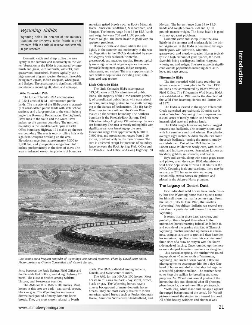
Domestic cattle and sheep utilize the arealightly in the summer and moderately in the win-ter. Vegetation in the HMA is dominated by sage-brush and grass, with saltbrush, winterfat, andgreasewood intermixed. Horses typically use ahigh amount of grass species, the most favorablebeing needlegrass, Indian ricegrass, wheatgrass,and Sedges. The area supports significant wildlifepopulations including elk, deer, and antelope.
Little Colorado HMAThe Little Colorado HMA encompasses
519,541 acres of BLM - administered publiclands. The majority of the HMA consists primari-ly of consolidated public lands with state schoolsections, and a large portion to the south belong-ing to the Bureau of Reclamation. The Big SandyRiver runs to the south and the Green Rivermakes up the western boundary. The northernboundary is the Pinedale/Rock Springs FieldOffice boundary. Highway 191 makes up the east-ern boundary. The area is mostly rolling hills withsignificant canyons breaking up the area.Elevations range from approximately 6,300 to7,900 feet, and precipitation ranges from 6-10inches, predominately in the form of snow. Thearea is unfenced except for portions of boundary
fence between the Rock Springs Field Office andthe Pinedale Field Office, and along Highway 191north. The HMA is divided among Sublette,Lincoln, and Sweetwater counties.
The AML for this HMA is 100 horses. Mosthorses in this area are dark - bay, sorrel, brown,black or gray. The Wyoming horses have adiverse background of many domestic horsebreeds. They are most closely related to North
American gaited breeds such as Rocky MountainHorse, American Saddlebred, Standardbred, andMorgan. The horses range from 14 to 15.5 handsand weigh between 750 and 1,100 poundsmature weight. The horse health is good with noapparent problems.
Domestic cattle and sheep utilize the arealightly in the summer and moderately in the win-ter. Vegetation in the HMA is dominated by sage-brush/grass, with saltbrush, winterfat,greasewood, and meadow species. Horses typical-ly use a high amount of grass species, the mostfavorable being needlegrass, Indian ricegrass,wheatgrass, and sedges. The area supports signifi-cant wildlife populations including deer, ante-lope, and sage grouse.
Little Colorado HMAThe Little Colorado HMA encompasses
519,541 acres of BLM - administered publiclands. The majority of the HMA consists primari-ly of consolidated public lands with state schoolsections, and a large portion to the south belong-ing to the Bureau of Reclamation. The Big SandyRiver runs to the south and the Green Rivermakes up the western boundary. The northernboundary is the Pinedale/Rock Springs FieldOffice boundary. Highway 191 makes up the east-ern boundary. The area is mostly rolling hills withsignificant canyons breaking up the area.Elevations range from approximately 6,300 to7,900 feet, and precipitation ranges from 6-10inches, predominately in the form of snow. Thearea is unfenced except for portions of boundaryfence between the Rock Springs Field Office andthe Pinedale Field Office, and along Highway 191
north. The HMA is divided among Sublette,Lincoln, and Sweetwater counties.
The AML for this HMA is 100 horses. Mosthorses in this area are dark - bay, sorrel, brown,black or gray. The Wyoming horses have adiverse background of many domestic horsebreeds. They are most closely related to NorthAmerican gaited breeds such as Rocky MountainHorse, American Saddlebred, Standardbred, and
Morgan. The horses range from 14 to 15.5hands and weigh between 750 and 1,100pounds mature weight. The horse health is goodwith no apparent problems.
Domestic cattle and sheep utilize the arealightly in the summer and moderately in the win-ter. Vegetation in the HMA is dominated by sage-brush/grass, with saltbrush, winterfat,greasewood, and meadow species. Horses typical-ly use a high amount of grass species, the mostfavorable being needlegrass, Indian ricegrass,wheatgrass, and sedges. The area supports signifi-cant wildlife populations including deer, ante-lope, and sage grouse.
Fifteenmile HMAThe first recorded wild horse roundup on
federal rangeland took place in October 1938on lands now adminstered by BLM's WorlandField Office. The Fifteenmile Wild Horse HMAwas established in 1985 under the direction ofthe Wild Free-Roaming Horses and Burros Actof 1971.
The HMA is located in the upper FifteenmileCreek watershed approximately 30 miles north-west of Worland, Wyoming. It encompasses over83,000 acres of mostly public land with someintermingled state and private lands.
The HMA ranges from rolling hills to ruggedcanyons and badlands. The country is semi-aridwith hot summers and cold winters. Precipitationaverages eight inches. Sudden cloudbursts erodethe area's badlands, turning the streams muddyreddish-brown. Part of the HMA lies in theBobcat Draw Wilderness Study Area, with its col-orful and intricately-carved formations known ashoodoos, goblins, mushrooms, and castles.
Bays and sorrels, along with some grays, roansand pintos, roam the range. BLM administers awild horse population of 70 to 160 adults in theHMA. Counting foals and yearlings, there may beas many as 270 horses to view and enjoy.Periodically, excess horses are gathered andplaced in the Adopt-a-Horse program.
The Legacy of Desert DustFew individual wild horses have made histo-
ry, but one Wyoming horse made quite a namefor himself more than half a century ago. Fromthe fall of 1945 to June 1946, the Rawlins(Wyoming) Republican-Bulletin ran several sto-ries about a particular wild horse from southernWyoming.
It seems that in those days, ranchers, andprobably others, helped themselves to theunbranded horses roaming federal lands both inand outside of the grazing districts. A Glenrock,Wyoming, rancher rounded up horses as a busi-ness, using an airplane to spot and then haze thehorses into a trap. Traps from this era often usedthree sides of a draw or canyon with the fourthside made of fencing. Once rounded up, the hors-es were shipped to eastern markets for slaughter.
This particular spring, the rancher was round-ing up about 40 miles south of Wamsutter,Wyoming, and invited Verne Wood, a Rawlinsphotographer, to accompany him for a day. Oneband of horses rounded up that day belonged toa beautiful palomino stallion. The rancher decid-ed to keep the stallion for breeding and showpurposes. Mr. Wood took several photos of thehorses that day and obtained what all photogra-phers hope for, a one-in-a-million photograph.
“With long, white mane and tail again againstthe rugged background of the corral, Mr. Wood’spicture showed the stallion as it turned his head.All of the beauty, wildness and alertness was
21
Introd
uction
www.ultimatewyoming.com
Coal trains are a frequent reminder of Wyoming’s vast natural resources. Photo by David Scott Smith.Photo courtesy of Gillette Convention and Visitor’s Bureau.
Wyoming TidbitsWyoming holds 30 percent of the nation’suranium ore reserves, ranks fourth in coalreserves, fifth in crude oil reserve and seventhin gas reserves.

caught,.” reported the newspaper. A few weekslater, Wood’s picture was featured in therotogravure section of the Denver Post. Wood hadalready enlarged, tinted, and sold several photosof the stallion, but after the photo appeared in thePost, the inquiries began to roll in. NationalGeographic, Western Natural Life, and EastmanKodak all secured prints of the stallion.
In April of 1946, Wood announced that a40x50 oil color print of the stallion, which bythat time had acquired the name “Desert Dust,”would be hung in the Wyoming Capitol inCheyenne. A second enlargement was given toSen. Joseph C. O’Mahoney for presentation to thenational capitol. According to the Rawlins paper,“Prints of the original photo have gone through-out the world and it has become one of the mostfamous wildlife pictures ever snapped. The May[although it was actually June] issue of WyomingWildlife will feature the picture on its cover andcarry a story of the wild horse chase whichtrapped Desert Dust. The feature article will beillustrated with other pictures of wild horsestaken by Wood.” It was estimated at that timethat about 20 oil paintings of the horse by differ-ent artists had already been completed.
Desert Dust’s fame resulted in the Glenrockrancher being invited to New York to appear on aradio program describing airplane roundups ofwild horses. On his way to New York, the rancherstopped in Cheyenne and told reporters that onlyabout 2,000 horses remained in the Red Desertarea—about one summer’s worth of roundups.The rancher estimated that six to seven thousandhorses once roamed that part of Wyoming. Woodbegan receiving numerous letters favoring a pro-gram of protection for the animals. One statedthat the “horses should be preserved as a symbolof the west and one of the last remnants of tradi-tional western wild life.” Proponents of protectionurged immediate action since an airplaneroundup scheduled for that summer was expect-ed to almost eliminate the herd.
In 1959, passage of the Wild HorseProtection Act prohibited the roundup of wildhorses by aircraft and motor vehicles. The 1971Wild and Free Roaming Horse and Burro Actprovided for protection and management of theseanimals on federal lands. In 1969, the BLM’s firstwild horse range was established in the PryorMountains along the Montana-Wyoming border.The BLM inaugurated its nationwide Adopt-A-Horse program in 1976 in an effort to resolveovercrowding of the public range by wild horsesand burros. Since the program’ inception, over100,000 horses have been adopted across thenation (over 3,000 in Wyoming). Desert Dustmay have started it all.Article courtesy Bureau of Land Management.
WYOMING’S NATURAL RESOURCESYou know that when you drive your car you areusing gasoline, and when you heat your homeyou are using natural gas. But did you know thatwhen you turn on a light, chances are you’reusing coal? And when you drink that ice coldmilk in a tall glass, you are using trona? And cos-
metics and food additives on the market todayuse bentonite? Minerals contribute significantly toour way of life: to the products we use, the itemswe need, the comforts we are accustomed to. AndWyoming minerals managed by the Bureau ofLand Management play a major role in how welive today.
Oil and Gas Production:Oil• Wyoming is the number one producer of feder-al onshore oil producing 46% of the nation’s total.
• Wyoming produced a total of 104 million bar-rels of oil in 1990.
• Federal land in Wyoming produced 67 millionbarrels of oil, or about 60% of the state’s total in1990.
• Oil production is expected to continue todecline as known reserves are depleted, to an esti-mated 88 million barrels total production in 1995.
Gas• Wyoming is the number two producer of feder-al onshore natural gas producing 33% of thenation’s total.
• Wyoming produced 681 billion cubic feet ofnatural gas in 1990.
• Federal land in Wyoming produced 396 billioncubic feet of natural gas in 1990, or about 60% ofthe state’s total.
• Natural gas production is expected to increaseto over 900 billion cubic feet in 1995.
Trends:• New techniques such as horizontal drilling andcarbon dioxide injection are being developed toincrease the recovery rate of oil reserves.
• Coal bed methane is a natural gas which hasreceived increased attention recently. When wateris removed from underground coal seams,methane can be produced. It has been estimatedthat Wyoming coal beds may contain up to 77trillion cubic feet of coal bed methane. So far,costs of development have been high, discourag-ing production.
Economics:• The federal government received about $19million from lease rental and bonuses in 1991,half going to the State of Wyoming.
• The federal government received about $232million from royalties on oil and gas inWyoming during 1991, half of which goes to theState of Wyoming.
• The oil and gas industry employs about 18,000people in Wyoming.
Uses:• Oil is refined into a variety of products, the mostcommon being fuel and lubricants for vehicles.
• Natural gas is used in heating homes and otherstructures.
• Petroleum is used in a wide variety of prod-ucts ranging from plastics, nylon and other syn-thetic fibers.
• Petroleum is also used in a wide variety of cos-metics and toiletries such as petroleum jelly.
Coal Production:• Wyoming is the nation’s largest coal producingstate. The passage of the Clean Air Act willincrease demand for Wyoming’s low sulfur coal.
22
Intr
odu
ctio
n
Ultimate Wyoming Atlas and Travel Encyclopedia
Wyoming TidbitsA one percent severance tax from mineralsand fuels helps Wyoming residents fund edu-cation and water development in the state.
Wyoming TidbitsThe first telephones in Wyoming usedbarbed wire running from fences to houses.When a call was made, the phone in everyhouse on the line rang. Listening in to otherpeople’s calls would earn you the reputationas a “rubbernecker.”
Wyoming has huge reserves of low sulfur coal. The Eagle Butte Mine is one of several large open pit minesin the state.

• 194 million tons of coal was mined inWyoming in 1991, 85-90% of which is producedfrom federal land.
• Total coal from federal leases in the UnitedStates was about 253 million tons in 1991.
• Wyoming produces about 70% of the total fed-eral coal in the United States.
• Wyoming coal production is estimated toincrease to 235 million tons of coal mined in1995.
• Most of Wyoming mines are surface, strip mines.
• On site drying techniques are being developedto increase the heat content of Wyoming’s coalwhich should make it even more marketable inthe future.
Economics:• Approximately $110 million was collected infederal royaIties in 1991, half of which goes tothe State of Wyoming.
• Coal mining employ s over 4,600 people in Wyoming
Uses:• Wyoming coal is primarily used in electricpower generation.
Location:• The largest mines are located in southeastCampbell County (the southern Powder RiverBasin).
• Coal is also mined in central SweetwaterCounty east of Rock Springs, Carbon Countynorth of Hanna, Converse County north ofGlenrock, and Lincoln County near Kemmerer.
• One underground coal mine is in CarbonCounty, and one is in Sweetwater County.
BentoniteProduction:• Bentonite is a clay material which is formedthrough the weathering of volcanic ash or tuff.
• Wyoming bentonite mines are open pit mines.
• Wyoming is the leading producer in the UnitedStates, producing about 2.4 million tons per year.
• Wyoming produces about 68% of the bentonitemined in the United States.
• Only about 23% of Wyoming’s production isfrom federal lands. However, most of the ben-tonite operations were started on mining claimson federal land which were subsequently turnedover to operator ownership.
Economics:• The bentonite industry in Wyoming employsabout 550 people.
Uses:• Bentonite is used in the oil and gas industry asa drilling mud for exploratory drilling.
• Bentonite is also used as a filler in cosmetics,food products and animal feeds.
• Bentonite is used as a sealant in water reservoirsand sanitary landfills.
Location:• Bentonite mining takes place in northernWyoming, primarily in Big Horn, Crook,Johnson, and Weston Counties.
UraniumOnly about 10 years ago, Wyoming was a
major uranium producing state. However, theprice of uranium has fallen drastically and miningin the state has ceased. Several of the mines whichwere operating in Shirley Basin and Gas Hills arepresently being reclaimed. There has been interestby industry in alternate mining methods, howeverthe price of uranium would have to increasebefore more operations would open.
TronaProduction:
Wyoming is the number one producer oftrona in the country. About 16 million tons oftrona are mined annually in Wyoming. 90% ofthe nation’s trona production comes fromWyoming. Wyoming supplies 30% of the world’strona. There are only 6 producers of trona in theUnited States, and five of them are in the GreenRiver Basin in Wyoming. Nearly 50% of the tronain Wyoming is federally owned.
Economics:Federal royalties from trona totaled over $10
million, half of which goes to the State ofWyoming. Trona mining employs approximately3,100 people in Wyoming.
Uses:Trona is refined into a white powder called
soda ash. Soda ash is used to make glass, deter-gent, paper, water softeners, drugs, cleaning com-pounds, and baking soda.
Location:The worlds largest deposit of trona, over 100
billion tons, are located west of Green River inSweetwater County.
Other Mineral CommoditiesOther mineral commodities mined on federal
land in Wyoming include sand and gravel, lime-stone, gypsum, granite, clinker, and jade. Sandand gravel are used in varied construction activi-ties, the largest being our road system.
Approximately 6 million cubic yards of sand andgravel are mined annually in Wyoming.Limestone is used as building and decorativestone as well as being crushed and used as roadaggregate. Gypsum’s primary use is in the manu-facture of wallboard for construction. Wyoming’sjade industry is small, although well known, andjewelry from Wyoming jade is widespread.Collectively these minor mineral commodityindustries employ about 400 people in Wyoming.
The minerals industry in Wyoming has had amajor impact on the state’s economy and thestate’s history. Without ready access to the mineralreserves found in abundance in the state ofWyoming, mostly on federal lands, the state andthe nation would be without valuable productsthat are used in every day living. Since thesereserves are a finite commodity, proper manage-ment of these reserves becomes more importantevery day. The Bureau of Land Managementstrives to ensure that mineral reserves are beingproduced in the most environmentally soundmanner. New and emerging technologies arebeing developed to enhance the recovery of theseminerals, and the Bureau of Land Management isworking cooperatively with industry to ensurethat the growing demands of the nation and theworld are being met.Article courtesy of Bureau of Land Management.
HOW TO USE THIS BOOKWe have divided the state into six sections withseparate chapters for Yellowstone and GrandTeton National Parks and Fort LaramieNational Historic Site. Each section has a com-mon personality and at least one major city ortown (by Wyoming standards). The material ineach section is loosely ordered along the high-way routes through the section and organizedby locator numbers.
Locator NumbersThese are the numbers on the map in white
on a black circle (❶). All information relating tothe area on the map marked by that number ispresented together in the section. The sections ofthe book are ordered from northwest to northeast,then southwest to southeast. The numbers allowyou to follow the routes mile by mile and quicklyfind information along your path relating to yourlocation on the path. In a nutshell, find the num-ber on the map, then find that number heading inthe section and listed under that number is every-thing there is to see or do at that location on themap. If you know where you are on the map, youwill know about everything there is around you.
Category Classification Each item listed is classified under one of nine
categories. The classification key is the shaded let-ter immediately preceding the item listed. Thismakes it very simple to find the type of informa-tion you’re looking for immediately. If you’re hun-gry, look for any items preceded by an F. Lookingfor something to do? Look for a T or V. Want tobuy something to take home with you? Look foran S. Here is a key for the categories:
23
Introd
uction
www.ultimatewyoming.com
Wyoming Tidbits
These friendly folks in Wyoming are known asWyomingites, not Wyomingans.
Wyoming Tidbits
Wyoming’s bucking horse on the car licenseis just one of the state’s symbols. The statefish is the cutthroat trout, the only trout nativeto Wyoming.The state flower is the Indianpaintbrush. The state fossil is the knightia. Thestate dinosaur is Triceratops. The state reptileis the horned toad, which is actually a lizard.When attacked, the horned toad hisses, bites,and ejects blood from the corner of its eyes.The state bird is the meadowlark; the statetree, the cottonwood. The largest cottonwoodtree in the U.S., measuring 29 feet in circum-ference and almost 77 feet high, stood northof Thermopolis. The tree burned in 1955when a grass fire grew out of control.
Wyoming TidbitsThe bucking bronco on the Wyoming licenseplate has a name, "Old Steamboat".

T AttractionThis category includes just about anything worthstopping for. It might be a museum, a ghosttown, a park, or just some quirky thing on theside of the road that makes traveling through thisstate so interesting. Whatever it is, we’ve tried toprovide enough information to let you decidewhether you want to plan a stop or not.
H Historic or Interpretive SignWe have taken the text from over hundreds ofhistorical and interpretive signs throughout thestate and reprinted them here. They’re fun read-ing, and in total provide an excellent backgroundon the history, growth, and features of Wyoming.They wouldn’t have placed them there if theyweren’t of some significance. It would take youweeks, if not months, to travel the state and viewthem all personally, so we have provided the leg-ends from each for you. We have entered themwhere they are located. Sometimes this is a differ-ent location than the actual item they are refer-ring to. Even though, we’ve presented the text ofthese markers here, take the time to stop at every-one you can. They are only a label for the actualsite or event they speak of, and the experience isonly complete if you are able to view the area sur-rounding them.
V AdventureThis would be just about anything you would getout of your car and do. A whitewater raft trip,horseback ride, hike, etc.
A AutoThese are anything automobile related.
F FoodWe didn’t discriminate. If there is prepared foodavailable, we list it. We’ve listed everything rang-ing from the finest restaurants in the state (andthere are a lot of them), to fast food and hot dogstands. Bottom line, if they’ll fix it for you, they’relisted here. While we don’t rate any of the estab-lishments, we highly encourage you to try themom and pop eateries and the locally owned finedining spots. Dayton Duncan, in his excellentbook Out West: American Journey Along the Lewisand Clark Trail (1987, Penguin Books) gave thebest advice we’ve heard;
“Franchises are not for the traveler bent on discov-ery. Forsaking franchises, like forsaking interstates,means that you’re willing to chance the ups and downs,the starts and the stops of gastronomy as well asmotoring. It means sometimes finishing a supper sogood that you order the piece of pie you hadn’t realizedyou wanted and you’re sure you don’t need—andspending the night in town just so you can have break-fast in the same place.”
In Wyoming, you’re pretty safe. Just considerthe logic. Most of these towns are so small thatany place not putting up good grub isn’t going tolast long anyway. Accountability. While much ofAmerica has forgotten that concept, it is still aharsh and unforgiving rule in Wyoming.
As for fine dining, we’d put scores ofWyoming’s best against the best anywhere outsideof Wyoming. Some of the most talented culinaryartists in the world have settled here for thelifestyle and share their talents with residents andvisitors alike.
L LodgingIf they’ll put a roof over your head and a mat-tress under your back, they’re listed here. Again,we don’t discriminate. Truth is, it’s hard to find abad motel in this state. Surviving here is tough,
and if you don’t put up a good product, youdon’t last long.
C CampingThese are private campgrounds that wished to beincluded in the main portion of each section.Otherwise, all private campgrounds are listed inthe camping reference chart later in this section.
S ShoppingDo we need to explain this one? Obviously, wedon’t list every place in the state you can buysomething. Only those who wanted to be in here.And yes, they paid for the opportunity. It wouldbe impractical to list every place in the state youcan buy something. And you probably wouldn’twant to wade through all of them to get to theones that count. So we left it up to the merchantsto decide whether or not they might have some-thing of interest to you, and to choose whether ornot to include themselves in this book.
M Misc. Services This would be just about anything that doesn’tfall into one of the other categories above.
MapsWe’ve included a map for just about anything youwould need a map for. At the beginning of eachsection is a detailed map of the section. We’vealso included a map of any town too big to seeeverything on Main Street standing in one spot—sixty in all. We’ve also included a number ofmaps of special locations. On each of the sectionmaps we’ve marked where campgrounds, fishingsites, and Lewis & Clark points of interest are.
Public CampgroundsCampgrounds are marked on the map with anumber. At the end of each section is a chart list-ing each campground along with pertinent infor-mation about that site. The listings are numberedand the numbers match those on the map. Welisted every maintained campground, public andprivate, we could find. If you find any we missed,please let us know. There are countless primitivecampgrounds in the state that are not maintainedand have no facilities. You’ll find almost all ofWyoming’s campgrounds to be uncrowded mostof the year. It’s not unusual, even at the peak oftourist season, to be the only campers at a site.Most of the public campgrounds charge a smallfee to cover the cost of maintaining them.
Fishing SitesWe’ve listed over hundreds fishing sites in thestate and marked and numbered them on themaps. At the end of this section is a chart listingeach site in the state along with species and facili-ties information. There are thousands of places towet a line in Wyoming. We have listed the majordrainages and and only those fisheries that arerelatively easy to access.
Scenic DrivesWe have tried to offer some scenic or interestingside trips wherever possible. Some take you onbackroads, others just take you a different way.Some are day trips, some are longer. We feel thebook itself offers one long scenic trip, but if youwant to get off the path, these offer some choices.Heed the warnings about gumbo and other back-road hazards mentioned earlier in this book.
HikesWe have offered you a number of hikes at theend of most sections. There are a few sections of
24
Intr
odu
ctio
n
Ultimate Wyoming Atlas and Travel Encyclopedia
the state that don’t offer too many hikingoptions. We didn’t provide a lot of detail aboutthe hikes. We simply pointed them out and tellyou how to get there.
Information PleaseHere we give you phone number for just aboutanything we missed earlier in the section thatmight be of interest to you.
Dining and Lodging Quick Reference GuidesThese charts allow you to take a quick scan of allof the dining and lodging facilities in a mannerthat allows you to find information quickly andmake quick comparisons. The map locator num-bers are listed with each entry to help you findtheir location and possibly additional informationabout them in the front of the section.
NotesWe’ve allowed you ample room at the back ofeach section to make notes about your trip or torecord additional information about your trip.This is a good place to store reservation confirma-tion numbers, or schedule information.
We’ve made every effort to make this book atool for you to get the most from your visit to thestate. If you already live here, we hope it awakensyou to the endless things there to do and see inthe magnificent chunk of America.
And Finally…This is a book that was not as much written as itwas compiled and edited. We used articles andinformation provided by other sources wheneverpossible. To research and know about everyresource and feature of the state intimately wouldtake us years. If it was already researched andwritten, and written well, we used it when wecould do so. We have credited every source asaccurately as possible. It was our goal to provideyou, the reader, the maximum amount of infor-mation possible to make your explorations of thestate enjoyable, while providing all the resourcesyou need in one book. Hopefully we accom-plished that goal. We would certainly like to hearfrom you if there is anything we’ve overlooked.
Happy Trails!
COWBOY WAVE
Wyoming is largely rural, and like largely ruralstates, it is pretty friendly to most who care tobe friendly back. When you're traveling theback roads, particularly the gravel roads, you'llencounter a variety of waves from passingpickups and motorists.
The most common is the one fingerwave, accomplished by simply raising the firstfinger (not the middle finger as is common inurban areas) from the steering wheel. If thedriver is otherwise occupied with his hands orif it is a fairly rough road, you may get a lighthead nod. Occasionally, you may get a twofinger wave which often appears as a modi-fied peace sign if the passerby is having aparticularly good day. On rare occasions, youmay get an all out wave.
The most important things is that whatev-er wave you get, be sure and wave back.
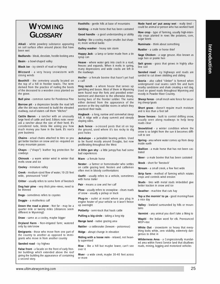
25
Introd
uction
www.ultimatewyoming.com
WYOMINGGLOSSARY
AIkali - white powdery substance appearingon soil surface often around places that havebeen wet
Badlands - bleak, desolate, hostile-looking area
Basin - a bowl-shaped valley
Black ice - icy stretch of road or highway
Blizzard - a very heavy snowstorm withstrong winds
Boothill - the cemetery usually located onthe top of a hill in frontier towns. The termderived from the practice of nailing the bootsof the deceased to a wooden cross planted onthe grave.
Bull pine - common name for Ponderosa Pine
Borrow pit - a depression beside the road leftafter the dirt was removed to build the elevatedroadway, out-of-staters call them “ditches”
Cattle Baron - a rancher with an unusuallylarge herd of cattle and land. Editors note: neverask a rancher about the size of their herd. It’sconsidered rude, kinda like asking you howmuch money you have in the bank. It’s non’ayore business
Chains - actual chains attached to tires so youget better traction on snow and ice -required onmany mountain passes
Chaps - (“shaps”) leather leg protection forcowboys
Chinook - a warm winter wind in winter thatmelts snow and ice
Cooley - miniature valley
Creek - medium-sized flow of water, 10-20 feetwide, pronounced “crick”
Critter - usually refers to some form of livestock
Dog hair pine - very thick pine—trees, need tobe thinned
Dogs - sometimes refers to coyotes
Doggie - a motherless calf
Down the road a piece - Not far - may be aquarter mile or twenty miles (distances seemdifferent in Wyoming!)
Draw - same as a cooley, maybe bigger
Dryland Farm - Non-irrigated farm; wateredonly by rain/snow
Emigrants - those who move from one part ofthe country to another as opposed to immi-grants who move in from another country
Sanded road - icy highwa
False front - a facade on the front of early fron-tier buildings which extended above the roofgiving the building the appearance of containinga second story.
Foothills - gentle hills at base of mountains
Gelding - a male horse that has been castrated
Good handle - a good understanding or ability
Gulley - like a cooley, maybe smaller. but sharp-er, more vertical banks
Gulley washer - heavy rain storm
Happy Jack - a lamp or lanter made from a tinsyrup can
Heave - where water gets into crack in a road,freezes and expands. When it melts in spring,many depressions and wide cracks are left inthe roadways
Heifer - a female bovine that hasn't yet hada calf
Hog ranch - a whore house that serves upgambling and booze. Most of them in Wyomingwere found near the forts and provided enter-tainment and diversion to the otherwise dreary,boring lives of the frontier soldier. The nameeither derived from the appearance of thewomen or the tiny stall-like rooms in which theypracticed their trade.
Hogback - a long, narrow and somewhat steephill. A ridge with a sharp summit and steeplysloping sides.
Jack fence - x-crossed posts that sit on topthe ground, used where it's too rocky to digpost holes
Jackalope - a jackrabbit bearing antlers. Usedto be found mostly around Douglas, but nowproliferating throughout the West
A little gun shy - a little jumpy/has had somebad experiences
Mare - a female horse
Nester - a farmer or homesteader who settleson cattle grazing land. Nesters and catllemenoften met in bloody confrontations
Outfit - usually refers to a vehicle, sometimeswith horse trailer
Pair - means a cow and her calf
Plow - usually refers to snowplow - clears roadsof snow - usually a pickup or truck
Plug-in - outlet at motel where you plug inengine heater of your vehicle so it won't freezeup overnight
Potbelly - semi-truck that hauls cattle
Pulling a big circle - taking a long trip
Range land - native grazing area
Rattler - a rattlesnake (beware - poisonous)
Ridge - abrupt change in elevation
Riding with a loose rein - relaxed, not heavi-ly supervised
Rise - like a hill but maybe lower, can't seeover it
River - a wide creek, maybe 30-40 feet acrossor more
Rode hard an' put away wet - really tired -could be animal or person who has worked hard
Row crop - type of farming, usually high-inten-sity crops planted in rows like potatoes, corn,sugar beets
Ruminate - think about something
Rustler - a cattle or horse thief
Sage Chicken - a sage grouse. Also known assage hen or prairie hen
Salt grass - grass that grows in highly alka-line soil
Sanded road - icy highways and roads aresanded to cut down skidding and sliding
Scoria - also called “clinker” is formed whenunderground coal seams catch fire and burnnearby sandstone and shale creating a red slag.Used on gravel roads throughout Wyoming andmostly in Powder River Country.
Sheep fence - small mesh wire fence for secur-ing sheep/goats
Short grass - doesn't require much moistureand is less than a foot tall
Snow fences - built to control drifting snow,usually seen along roadways to help keeproads clear
Snowblind - a winter condition where thesnow is so bright from the sun it becomes diffi-cult to see
Spring - area where water comes up from deepinside earth
Stallion - a male horse that has not been cas-trated
Steer - a male bovine that has been castrated
Stock - short for 'livestock'
Stream - a small creek, a few feet wide
Strip farm - method of farming which rotatescrops and controls wind erosion
Studs - tires with metal studs imbedded givebetter traction in snow and ice
Swather - machine that cuts hay
Top a the mornin' to ya - good morning/havea nice day
Valley - lowland surrounded by hills or moun-tains
Varmint - any animal you don’t take a liking to
Wapiti - the Indian word for elk. PronouncedWOP-i-tee
White Out - snowstorm so heavy that every-thing looks white, zero visibility, extremely dan-gerous to drive in
Wilderness Area - a Congressionally mandat-ed area within Forest Service land that disallowsroads, mining, logging and motorized vehicles

26
Intr
odu
ctio
n
Ultimate Wyoming Atlas and Travel Encyclopedia
Acme . . . . . . . . . . . . . . .82839Afton . . . . . . . . . . . . . . .83110Aladdin . . . . . . . . . . . . .82710Albin . . . . . . . . . . . . . . .82050Alcova . . . . . . . . . . . . . .82620Alpine . . . . . . . . . . . . . .83128AIta . . . . . . . . . . . . . . . .83422Alva . . . . . . . . . . . . . . . .82711Arapahoe . . . . . . . . . . . .82510Arlington . . . . . . . . . . . .82083Arminto . . . . . . . . . . . . .82630Arvada . . . . . . . . . . . . . .82831Atlantic City . . . . . . . . . .82520Auburn . . . . . . . . . . . . . .83111Baggs . . . . . . . . . . . . . . .82321Bairoil . . . . . . . . . . . . . . .82322Banner . . . . . . . . . . . . . .82832Basin . . . . . . . . . . . . . . .82410Bedford . . . . . . . . . . . . .83112Beulah . . . . . . . . . . . . . .82712Big Horn . . . . . . . . . . . .82833Big Piney . . . . . . . . . . . .83113Bill . . . . . . . . . . . . . . . . .82631Bitter Creek . . . . . . . . . .82901Bondurant . . . . . . . . . . . .82922Bordeaux . . . . . . . . . . . .82201Bosler . . . . . . . . . . . . . . .82051Boulder . . . . . . . . . . . . .82923Buffalo . . . . . . . . . . . . . .82834Buford . . . . . . . . . . . . . .82052Burlington . . . . . . . . . . .82411Burns . . . . . . . . . . . . . . .82053Byron . . . . . . . . . . . . . . .82412Carlile . . . . . . . . . . . . . .82713Carpenter . . . . . . . . . . . .82054CASPER*Centennial . . . . . . . . . . .82055CHEYENNE*Chugwater . . . . . . . . . . .82210Clearmont . . . . . . . . . . .82835Cody . . . . . . . . . . . . . . .82414Cokeville . . . . . . . . . . . .83114Cora . . . . . . . . . . . . . . . .82925Cowley . . . . . . . . . . . . . .82420Creston . . . . . . . . . . . . . .82301Crowheart . . . . . . . . . . .82512Daniel . . . . . . . . . . . . . . .83115Dayton . . . . . . . . . . . . . .82836Deaver . . . . . . . . . . . . . .82421Devils Tower . . . . . . . . . .82714Diamond . . . . . . . . . . . .82210Diamondville . . . . . . . . .83116Dixon . . . . . . . . . . . . . . .82323Douglas . . . . . . . . . . . . .82633Dubois . . . . . . . . . . . . . .82513Eden . . . . . . . . . . . . . . . .82932Edgerton . . . . . . . . . . . .82635Egbert . . . . . . . . . . . . . . .82053Elk Mountain . . . . . . . . .82324Elmo . . . . . . . . . . . . . . .82327
Emblem . . . . . . . . . . . . .82422Encampment . . . . . . . . .82325Ethete . . . . . . . . . . . . . . .82520Etna . . . . . . . . . . . . . . . .83118EVANSTON *Evansville . . . . . . . . . . . .82636Fairview . . . . . . . . . . . . .83119Farson . . . . . . . . . . . . . .82932FE Warren AFB . . . . . . .82005Fontenelle . . . . . . . . . . .83101Fort Bridger . . . . . . . . . .82933Fort Laramie . . . . . . . . . .82212Fort Steele . . . . . . . . . . .82301Fort Washakie . . . . . . . .82514Four Corners . . . . . . . . .82715Frannie . . . . . . . . . . . . . .82423Freedom . . . . . . . . . . . . .83120Frontier . . . . . . . . . . . . .83121Garland . . . . . . . . . . . . .82435Garrett . . . . . . . . . . . . . .82058Gas Hills . . . . . . . . . . . . .82501GILLETTEGlendo . . . . . . . . . . . . . .82213Glenrock . . . . . . . . . . . . .82637Granger . . . . . . . . . . . . . .82934Granite Canon . . . . . . . . .82059Green River . . . . . . . . . . .82935Greybull . . . . . . . . . . . . .82426Grover . . . . . . . . . . . . . .83122Guernsey . . . . . . . . . . . .82214Hamilton Dome . . . . . . . .82427Hamsfork . . . . . . . . . . . .83101Hanna . . . . . . . . . . . . . .82327Harriman . . . . . . . . . . . .82059Hartville . . . . . . . . . . . . .82215Hawk Springs . . . . . . . . .82217Hiland . . . . . . . . . . . . . .82638Hillsdale . . . . . . . . . . . . .82060Hoback Junction . . . . . .83001Horse Creek . . . . . . . . . .82061Hudson . . . . . . . . . . . . .82515Hulett . . . . . . . . . . . . . . .82720Huntley . . . . . . . . . . . . .82218Hyattville . . . . . . . . . . . .82428Iron Mountain, (see Cheyenne)JACKSON *Jay Em . . . . . . . . . . . . . .82219Jeffrey City . . . . . . . . . . .82310JeIm . . . . . . . . . . . . . . . .82063Jenny Lake . . . . . . . . . . .83012Kaycee . . . . . . . . . . . . . .82639Keeline . . . . . . . . . . . . . .82227Kelly . . . . . . . . . . . . . . . .83011Kemmerer . . . . . . . . . . .83101Kinnear . . . . . . . . . . . . .82516Kirby . . . . . . . . . . . . . . .82430Kirtley . . . . . . . . . . . . . .82225Kortes Dam . . . . . . . . . .82327La Barge . . . . . . . . . . . . .83123
Lagrange . . . . . . . . . . . . .82221Lance Creek . . . . . . . . . .82222Lander . . . . . . . . . . . . . .82520LARAMIE *Leiter . . . . . . . . . . . . . . .82837Leo . . . . . . . . . . . . . . . . .82327Linch . . . . . . . . . . . . . . .82640Lingle . . . . . . . . . . . . . . .82223Little America . . . . . . . . .82929Lost Cabin . . . . . . . . . . .82642Lost Springs . . . . . . . . . .82224Lovell . . . . . . . . . . . . . . .82431Lucky Maccamp . . . . . . .82501Lusk . . . . . . . . . . . . . . . .82225Lyman . . . . . . . . . . . . . .82937Park . . . . . . . . . . . . . . . .82190Manderson . . . . . . . . . . .82432Mantua . . . . . . . . . . . . . .82435Manville . . . . . . . . . . . . .82227Marbleton . . . . . . . . . . . .83113Mayoworth . . . . . . . . . . .82639McFadden . . . . . . . . . . .82083McKinnon . . . . . . . . . . . .82938Medicine Bow . . . . . . . . .82329Meeteetse . . . . . . . . . . . .82433Meriden . . . . . . . . . . . . .82081Midval . . . . . . . . . . . . . .82501Midwest . . . . . . . . . . . . .82643Mills . . . . . . . . . . . . . . . .82644Moneta, (see Casper)Moorcroft . . . . . . . . . . . .82721Moose . . . . . . . . . . . . . . .83012Moran . . . . . . . . . . . . . .83013Morton . . . . . . . . . . . . . .82501Mountain Home, (see Laramie)Mountain View . . . . . . . .82939Muddy Gap . . . . . . . . . .82301Natrona . . . . . . . . . . . . .82646Newcastle . . . . . . . . . . . .82701New Haven . . . . . . . . . .82720Node . . . . . . . . . . . . . . .82225Opal . . . . . . . . . . . . . . . .83124Orin . . . . . . . . . . . . . . . .82633Osage . . . . . . . . . . . . . . .82723Oshoto . . . . . . . . . . . . . .82721Otto . . . . . . . . . . . . . . . .82434Parkerton . . . . . . . . . . . .82637Parkman . . . . . . . . . . . . .82838Pavillion . . . . . . . . . . . . .82523Piedmont . . . . . . . . . . . .82933Pine Bluffs . . . . . . . . . . .82082Pinedale . . . . . . . . . . . . . .82941Pine Haven . . . . . . . . . . .82721Point of Rocks . . . . . . . .82942Powder River . . . . . . . . . .82648Powell . . . . . . . . . . . . . .82435Prairie Center . . . . . . . . .82240Quealy . . . . . . . . . . . . . .82901Ralston . . . . . . . . . . . . . .82440Ranchester . . . . . . . . . . . .82839
Rawlins . . . . . . . . . . . . . .82301Raymond . . . . . . . . . . . .83114Recluse . . . . . . . . . . . . . .82725Red Desert . . . . . . . . . . .82336Reliance . . . . . . . . . . . . . .82943Riner . . . . . . . . . . . . . . .82301Riverside . . . . . . . . . . . .82325Riverton . . . . . . . . . . . . .82501Robertson . . . . . . . . . . . .82944Rockeagle . . . . . . . . . . . .82223Rock River . . . . . . . . . . .82083ROCK SPRINGS*Rolling Hills . . . . . . . . . .82637Rozet . . . . . . . . . . . . . . .82727Ryan Park . . . . . . . . . . . .82331Saddlestring . . . . . . . . . .82840Saint Stephens . . . . . . . . .82524Sand Draw . . . . . . . . . . .82501Saratoga . . . . . . . . . . . . .82331Savery . . . . . . . . . . . . . .82332Shawnee . . . . . . . . . . . . .82229Shell . . . . . . . . . . . . . . . .82441Sheridan . . . . . . . . . . . . .82801Shirley Basin . . . . . . . . . .82615Shoshoni . . . . . . . . . . . .82649Sinclair . . . . . . . . . . . . . .82334Slater, . . . . . . . . . . . . . . .82201Smoot . . . . . . . . . . . . . . .83126South Pass City . . . . . . . .82520Story . . . . . . . . . . . . . . . .82842Sundance . . . . . . . . . . . .82729Sunrise . . . . . . . . . . . . . .82215Superior . . . . . . . . . . . . .82945Sussex . . . . . . . . . . . . . .82639Sweetwater Station . . . . .82520Ten Sleep . . . . . . . . . . . .82442Teton Village . . . . . . . . .83025Thayne . . . . . . . . . . . . . .83127Thermopolis . . . . . . . . . .82443Tie Siding . . . . . . . . . . . .82084Tipton . . . . . . . . . . . . . .82336Torrington . . . . . . . . . . .82240Turnerville . . . . . . . . . . .83110Upton . . . . . . . . . . . . . . .82730Veteran . . . . . . . . . . . . . .82243Walcott . . . . . . . . . . . . . .82335Wamsutter . . . . . . . . . . . .82336Wapiti . . . . . . . . . . . . . .82450Weston . . . . . . . . . . . . . ..82731Weston, (see Gillette)Wheatland . . . . . . . . . . .82201Willwood . . . . . . . . . . . . .82435Wilson . . . . . . . . . . . . . .83014Wolf . . . . . . . . . . . . . . . .82844Woriand . . . . . . . . . . . . .82401Wright . . . . . . . . . . . . . .82732Wyarno . . . . . . . . . . . . .82845Yellowstone National Park (alllocations) . . . . . . . . . . . . .82190Yoder . . . . . . . . . . . . . . .82244
WYOMING ZIP CODES*This community has more than one five digit zip code.
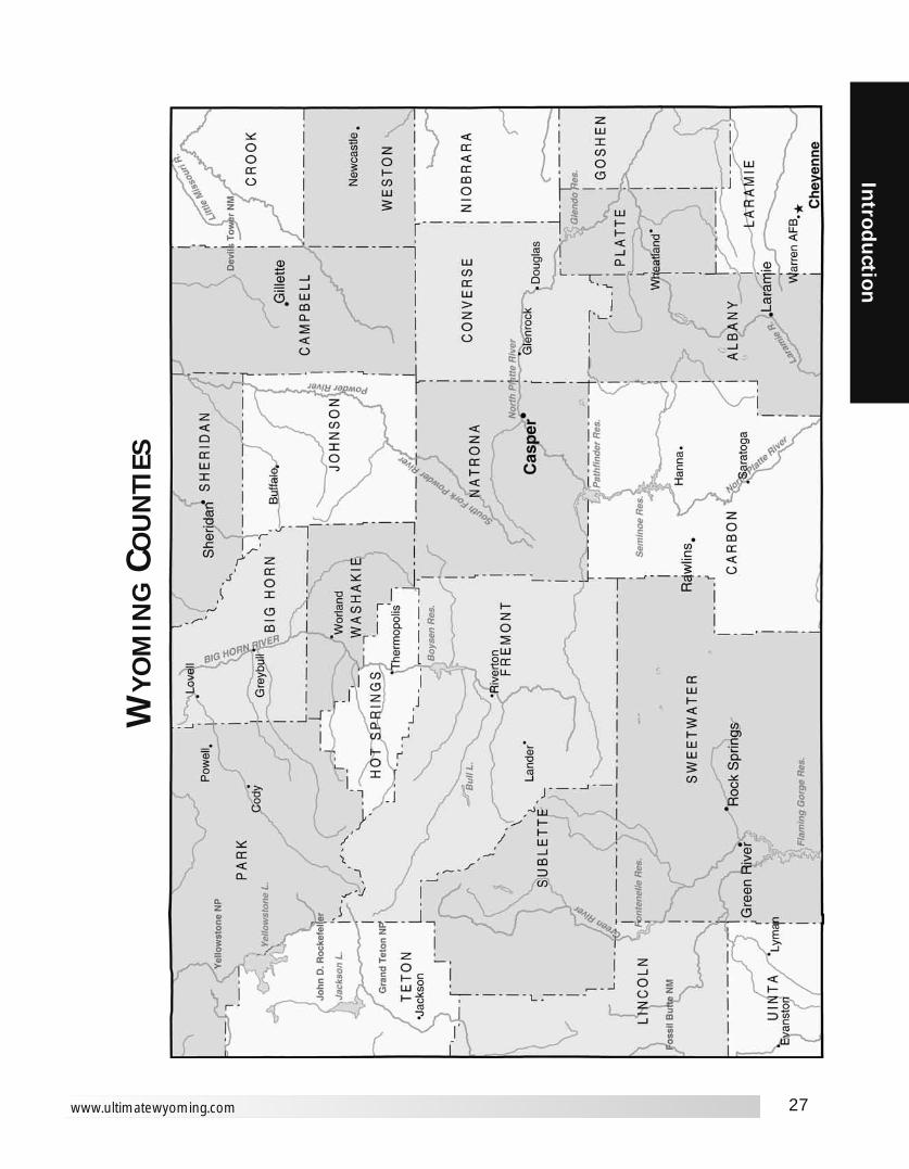
27
Introd
uction
www.ultimatewyoming.com
WY
OM
ING
COU
NTI
ES

28
Intr
odu
ctio
n
Ultimate Wyoming Atlas and Travel Encyclopedia
WY
OM
ING
DIS
TAN
CES

29
Introd
uction
www.ultimatewyoming.com
Afton to Basin . . . . . .308Buffalo . . . . .411Casper . . . . .353Cheyenne . .436Cody . . . . . .247Douglas . . . .403Dubois . . . . .155Evanston . . .120Gillette . . . . .481Glenrock . . .378Green River .165Greybull . . . .300Guernsey . .464Jackson . . . . .69Kemmerer . . .96Lander . . . . .230Laramie . . . .387Lovell . . . . . .294Lusk . . . . . . .457Midwest . . .398Moorcroft . .509Moran Jct. . .100Newcastle . .522Pinedale . . .120Powell . . . . .271Rawlins . . . .288Riverton . . . .233Rock Springs 179Saratoga . . .330Sheridan . . .394Shoshoni . . .255Sundance . .543Thermopolis 288Torrington . .497Wheatland . .445Worland . . . .321Wright . . . . .478Yellowstone .127
Basin toAfton . . . . . .308Buffalo . . . . .120Casper . . . . .194Cheyenne . .372Cody . . . . . . .61Douglas . . . .244Dubois . . . . .196Evanston . . .343Gillette . . . . .190Glenrock . . .218Green River .272Greybull . . . . . .8Guernsey . .305Jackson . . . .238Kemmerer . .293Lander . . . . .143Laramie . . . .339Lovell . . . . . . .40Lusk . . . . . . .298Midwest . . .198Moorcroft . .219Moran Jct. . .208Newcastle . .267Pinedale . . .278Powell . . . . . .62Rawlins . . . .241Riverton . . . .118Rock Springs 259Saratoga . . .282Sheridan . . .103Shoshoni . . . .96Sundance . .252Thermopolis .63Torrington . .338Wheatland . .303Worland . . . . .30Wright . . . . .228Yellowstone .113
Buffalo toAfton . . . . . .411Basin . . . . . .120Casper . . . . .112Cheyenne . .290Cody . . . . . .182
Douglas . . . .162Dubois . . . . .256Evanston . . .403Gillette . . . . . .70Glenrock . . .136Green River .332Greybull . . . .128Guernsey . . .223Jackson . . . .341Kemmerer . .353Lander . . . . .202Laramie . . . .260Lovell . . . . . .135Lusk . . . . . . .216Midwest . . . . .78Moorcroft . . . .98Moran Jct. . .311Newcastle . .146Pinedale . . .338Powell . . . . .157Rawlins . . . .229Riverton . . . .178Rock Springs 319Saratoga . . .259Sheridan . . . .35Shoshoni . . .156Sundance . .132Thermopolis 123Torrington . .256Wheatland . .221Worland . . . . .90Wright . . . . .108Yellowstone .234
Casper toAfton . . . . . .353Basin . . . . . .194Buffalo . . . . .112Cheyenne . .178Cody . . . . . .214Douglas . . . . .50Dubois . . . . .198Evanston . . .326Gillette . . . . .136Glenrock . . . .24Green River .240Greybull . . . .201Guernsey . . .111Jackson . . . .284Kemmerer . .288Lander . . . . .145Laramie . . . .148Lovell . . . . . .233Lusk . . . . . . .104Midwest . . . . .47Moorcroft . .164Moran Jct. . .254Newcastle . .170Pinedale . . .273Powell . . . . .239Rawlins . . . .117Riverton . . . .120Rock Springs 225Saratoga . . .148Sheridan . . .147Shoshoni . . . .98Sundance . .197Thermopolis 130Torrington . .144Wheatland . .109Worland . . . .164Wright . . . . . .98Yellowstone .267
Cheyenne toAfton . . . . . .436Basin . . . . . .372Buffalo . . . . .290Casper . . . . .178Cody . . . . . .393Douglas . . . .129Dubois . . . . .346Evanston . . .357Gillette . . . . .242Glenrock . . .158Green River .271
Greybull . . . .380Guernsey . . . .98Jackson . . . .432Kemmerer . .343Lander . . . . .272Laramie . . . . .49Lovell . . . . . .412Lusk . . . . . . .140Midwest . . .225Moorcroft . .269Moran Jct. . .402Newcastle . .220Pinedale . . .355Powell . . . . .417Rawlins . . . .149Riverton . . . .270Rock Springs 256Saratoga . . .127Sheridan . . .325Shoshoni . . .276Sundance . .265Thermopolis 309Torrington . . .84Wheatland . . .70Worland . . . .342Wright . . . . .204Yellowstone .429
Cody toAfton . . . . . .247Basin . . . . . . .61Buffalo . . . . .182Casper . . . . .214Cheyenne . .393Douglas . . . .264Dubois . . . . .203Evanston . . .364Gillette . . . . .250Glenrock . . .239Green River .293Greybull . . . . .53Guernsey . . .325Jackson . . . .177Kemmerer . .314Lander . . . . .163Laramie . . . .359Lovell . . . . . . .46Lusk . . . . . . .318Midwest . . .259Moorcroft . .276Moran Jct. . .147Newcastle . .326Pinedale . . .254Powell . . . . . .24Rawlins . . . .262Riverton . . . .139Rock Springs 280Saratoga . . .302Sheridan . . .147Shoshoni . . .116Sundance . .311Thermopolis .84Torrington . .358Wheatland . .323Worland . . . . .91Wright . . . . .288Yellowstone . .52
Douglas toAfton . . . . . .403Basin . . . . . .244Buffalo . . . . .162Casper . . . . . .50Cheyenne . .129Cody . . . . . .264Dubois . . . . .248Evanston . . .375Gillette . . . . .113Glenrock . . . .30Green River .290Greybull . . . .251Guernsey . . . .62Jackson . . . .334Kemmerer . .337Lander . . . . .195Laramie . . . .136
Lovell . . . . . .283Lusk . . . . . . . .55Midwest . . . . .97Moorcroft . .140Moran Jct. . .304Newcastle . .135Pinedale . . .323Powell . . . . .288Rawlins . . . .167Riverton . . . .170Rock Springs 275Saratoga . . .198Sheridan . . .196Shoshoni . . .148Sundance . .174Thermopolis 180Torrington . . .94Wheatland . . .60Worland . . . .213Wright . . . . . .75Yellowstone .316
Dubois toAfton . . . . . .155Basin . . . . . .196Buffalo . . . . .256Casper . . . . .198Cheyenne . .346Cody . . . . . .203Douglas . . . .248Evanston . . .276Gillette . . . . .325Glenrock . . .223Green River .205Greybull . . . .204Guernsey . .309Jackson . . . . .86Kemmerer . .225Lander . . . . . .75Laramie . . . .297Lovell . . . . . .236Lusk . . . . . . .302Midwest . . .242Moorcroft . .354Moran Jct. . . .55Newcastle . .366Pinedale . . .163Powell . . . . .227Rawlins . . . .200Riverton . . . . .78Rock Springs 192Saratoga . . .240Sheridan . . .290Shoshoni . . .100Sundance . .387Thermopolis 133Torrington . .342Wheatland . .307Worland . . . .166Wright . . . . .296Yellowstone . .83
Evanston toAfton . . . . . .120Basin . . . . . .343Buffalo . . . . .403Casper . . . . .326Cheyenne . .357Cody . . . . . .364Douglas . . . .375Dubois . . . . .276Gillette . . . . .461Glenrock . . .350Green River . .86Greybull . . . .351Guernsey . .393Jackson . . . .190Kemmerer . . .50Lander . . . . .201Laramie . . . .308Lovell . . . . . .384Lusk . . . . . . .430Midwest . . . .372Moorcroft . .488Moran Jct. . .220Newcastle . .495
Pinedale . . .155Powell . . . . .388Rawlins . . . .208Riverton . . . .226Rock Springs 100Saratoga . . .250Sheridan . . .438Shoshoni . . .248Sundance . .522Thermopolis 280Torrington . .425Wheatland . .365Worland . . . .313Wright . . . . .424Yellowstone .247
Gillette toAfton . . . . . .481Basin . . . . . .190Buffalo . . . . . .70Casper . . . . .136Cheyenne . .242Cody . . . . . .250Douglas . . . .113Dubois . . . . .325Evanston . . .461Glenrock . . .143Green River .376Greybull . . . .198Guernsey . . .175Jackson . . . .411Kemmerer . .423Lander . . . . .272Laramie . . . .249Lovell . . . . . .203Lusk . . . . . . .157Midwest . . . . .89Moorcroft . . . .28Moran Jct. . .381Newcastle . . .76Pinedale . . .408Powell . . . . .226Rawlins . . . .253Riverton . . . .247Rock Springs 361Saratoga . . .283Sheridan . . .103Shoshoni . . .225Sundance . . .61Thermopolis 193Torrington . .208Wheatland . .173Worland . . . .160Wright . . . . . .38Yellowstone .301
Glenrock toAfton . . . . . .378Basin . . . . . .218Buffalo . . . . .136Casper . . . . . .24Cheyenne . .158Cody . . . . . .239Douglas . . . . .30Dubois . . . . .223Evanston . . .350Gillette . . . . .143Green River .265Greybull . . . .226Guernsey . . . .91Jackson . . . .308Kemmerer . .312Lander . . . . .169Laramie . . . .165Lovell . . . . . .258Lusk . . . . . . . .84Midwest . . . . .71Moorcroft . . .170Moran Jct. . .278Newcastle . .163Pinedale . . .297Powell . . . . .263Rawlins . . . .142Riverton . . . .145Rock Springs 250Saratoga . . .173
Sheridan . . .171Shoshoni . . .122Sundance . .203Thermopolis 155Torrington . .124Wheatland . . .89Worland . . . .188Wright . . . . .105Yellowstone .291
Green River toAfton . . . . . .165Basin . . . . . .272Buffalo . . . . .332Casper . . . . .240Cheyenne . .271Cody . . . . . .293Douglas . . . .290Dubois . . . . .205Evanston . . . .86Gillette . . . . .376Glenrock . . .265Greybull . . . .280Guernsey . . .307Jackson . . . .190Kemmerer . . .72Lander . . . . .130Laramie . . . .222Lovell . . . . . .313Lusk . . . . . . .344Midwest . . . .287Moorcroft . .404Moran Jct. . .220Newcastle . .410Pinedale . . .113Powell . . . . .317Rawlins . . . .123Riverton . . . .155Rock Springs .14Saratoga . . .165Sheridan . . .367Shoshoni . . .177Sundance . .437Thermopolis 209Torrington . .340Wheatland . .279Worland . . . .242Wright . . . . .338Yellowstone .247
Greybull toAfton . . . . . .300Basin . . . . . . . .8Buffalo . . . . .128Casper . . . . .201Cheyenne . .380Cody . . . . . . .53Douglas . . . .251Dubois . . . . .204Evanston . . .351Gillette . . . . .198Glenrock . . .226Green River .280Guernsey . . .312Jackson . . . .231Kemmerer . .301Lander . . . . .150Laramie . . . .347Lovell . . . . . . .33Lusk . . . . . . .307Midwest . . .306Moorcroft . .226Moran Jct. . .200Newcastle . .274Pinedale . . .286Powell . . . . . .55Rawlins . . . .248Riverton . . . .126Rock Springs 267Saratoga . . .289Sheridan . . . .95Shoshoni . . .103Sundance . .260Thermopolis .71Torrington . .347Wheatland . .312
Worland . . . . .38Wright . . . . .160Yellowstone .105
Guernsey toAfton . . . . .464Basin . . . . . .305Buffalo . . . . .223Casper . . . . .111Cheyenne . . .98Cody . . . . . .325Douglas . . . . .62Dubois . . . . .309Evanston . . .393Gillette . . . . .175Glenrock . . . .91Green River .307Greybull . . . .312Jackson . . . .395Kemmerer . .378Lander . . . . .256Laramie . . . .104Lovell . . . . . .345Lusk . . . . . . . .49Midwest . . . .158Moorcroft . . .178Moran Jct. . .365Newcastle . .130Pinedale . . .384Powell . . . . .350Rawlins . . . .184Riverton . . . .231Rock Springs 292Saratoga . . .182Sheridan . . .257Shoshoni . . .209Sundance . .174Thermopolis 242Torrington . . .33Wheatland . . .29Worland . . . .275Wright . . . . .137Yellowstone .378
Jackson toAfton . . . . . . .69Basin . . . . . .238Buffalo . . . . .341Casper . . . . .284Cheyenne . .432Cody . . . . . .177Douglas . . . .334Dubois . . . . . .86Evanston . . .190Gillette . . . . .411Glenrock . . .308Green River .190Greybull . . . .231Guernsey . .395Kemmerer . .155Lander . . . . .160Laramie . . . .383Lovell . . . . . .223Lusk . . . . . . .388Midwest . . .328Moorcroft . .440Moran Jct. . . .30Newcastle . .451Pinedale . . . .77Powell . . . . .202Rawlins . . . .284Riverton . . . .164Rock Springs 177Saratoga . . .326Sheridan . . .324Shoshoni . . .186Sundance . .473Thermopolis 218Torrington . .428Wheatland . .393Worland . . . .251Wright . . . . .392Yellowstone . .57
Kemmerer toAfton . . . . . . .96
Basin . . . . . .293Buffalo . . . . .353Casper . . . . .288Cheyenne . .343Cody . . . . . .314Douglas . . . .337Dubois . . . . .225Evanston . . . .50Gillette . . . . .423Glenrock . . .312Green River . .72Greybull . . . .301Guernsey . . .378Jackson . . . .155Lander . . . . .150Laramie . . . .294Lovell . . . . . .360Lusk . . . . . . .392Midwest . . .334Moorcroft . .450Moran Jct. . .190Newcastle . .457Pinedale . . .105Powell . . . . .338Rawlins . . . .194Riverton . . . .175Rock Springs .86Saratoga . . .236Sheridan . . .388Shoshoni . . .197Sundance . .484Thermopolis 230Torrington . .411Wheatland . .351Worland . . . .263Wright . . . . .386Yellowstone .217
Lander toAfton . . . . . .230Basin . . . . . .143Buffalo . . . . .202Casper . . . . .145Cheyenne . .272Cody . . . . . .163Douglas . . . .195Dubois . . . . . .75Evanston . . .201Gillette . . . . .272Glenrock . . .169Green River .130Greybull . . . .150Guernsey . . .256Jackson . . . .160Kemmerer . .150Laramie . . . .222Lovell . . . . . .183Lusk . . . . . . .249Midwest . . .189Moorcroft . .301Moran Jct. . .130Newcastle . .312Pinedale . . .136Powell . . . . .187Rawlins . . . .125Riverton . . . . .25Rock Springs 117Saratoga . . .165Sheridan . . .237Shoshoni . . . .47Sundance . .334Thermopolis .79Torrington . .289Wheatlan . . .254Worland . . . .112Wright . . . . .243Yellowstone .157
Laramie toAfton . . . . . .387Basin . . . . . .339Buffalo . . . . .260Casper . . . . .148Cheyenne . . .49Cody . . . . . .359Douglas . . . .136
Dubois . . . . .297Evanston . . .308Gillette . . . . .249Glenrock . . .165Green River .222Greybull . . . .347Guernsey . . .104Jackson . . . .383Kemmerer . .294Lander . . . . .222Lovell . . . . . .379Lusk . . . . . . .166Midwest . . .195Moorcroft . .276Moran Jct. . .353Newcastle . .246Pinedale . . .307Powell . . . . .384Rawlins . . . .100Riverton . . . .221Rock Springs 207Saratoga . . . . .79Sheridan . . .294Shoshoni . . .243Sundance . .290Thermopolis 276Torrington . .132Wheatland . . .77Worland . . . .309Wright . . . . .212Yellowstone .380
Lovell toAfton . . . . . .294Basin . . . . . . .40Buffalo . . . . .135Casper . . . . .233Cheyenne . .412Cody . . . . . . .46Douglas . . . .283Dubois . . . . .236Evanston . . .384Gillette . . . . .203Glenrock . . .258Green River .313Greybull . . . . .33Guernsey . .345Jackson . . . .223Kemmerer . .360Lander . . . . .183Laramie . . . .379Lusk . . . . . . .338Midwest . . . .213Moorcroft . .232Moran Jct. . .193Newcastle . .280Pinedale . . .300Powell . . . . . .22Rawlins . . . .281Riverton . . . .158Rock Springs 300Saratoga . . .322Sheridan . . .101Shoshoni . . .136Sundance . .266Thermopolis 104Torrington . .378Wheatland . .343Worland . . . . .71Wright . . . . .242Yellowstone . .98
Lusk toAfton . . . . . .457Basin . . . . . .298Buffalo . . . . .216Casper . . . . .104Cheyenne . .140Cody . . . . . .318Douglas . . . . .55Dubois . . . . .302Evanston . . .430Gillette . . . . .157Glenrock . . . .84Green River .344Greybull . . . .307
DRIVING DISTANCE

30
Intr
odu
ctio
n
Ultimate Wyoming Atlas and Travel Encyclopedia
Guernsey . . . .49Jackson . . . .388Kemmerer . .392Lander . . . . .249Laramie . . . .166Lovell . . . . . .338Midwest . . . .151Moorcroft . .129Moran Jct. . .358Newcastle . . .81Pinedale . . .377Powell . . . . .343Rawlins . . . .221Riverton . . . .224Rock Springs 329Saratoga . . .244Sheridan . . .250Shoshoni . . .202Sundance . .125Thermopolis 235Torrington . . .57Wheatland . . .78Worland . . . .268Wright . . . . .130Yellowstone .370
Midwest toAfton . . . . . .398Basin . . . . . .198Buffalo . . . . . .78Casper . . . . . .47Cheyenne . .225Cody . . . . . .259Douglas . . . . .97Dubois . . . . .242Evanston . . .372Gillette . . . . . .89Glenrock . . . .71Green River .287Greybull . . . .206Guernsey . . .158Jackson . . . .328Kemmerer . .334Lander . . . . .189Laramie . . . .195Lovell . . . . . .213Lusk . . . . . . .151Moorcroft . . .117Moran Jct. . .298Newcastle . .123Pinedale . . .320Powell . . . . .235Rawlins . . . .158Riverton . . . .164Rock Springs 272Saratoga . . .195Sheridan . . .113Shoshoni . . .142Sundance . .150Thermopolis 175Torrington . .191Wheatland . .156Worland . . . .168Wright . . . . . .51Yellowstone .312
Moorcroft toAfton . . . . .509Basin . . . . . .219Buffalo . . . . . .98Casper . . . . .164Cheyenne . .269Cody . . . . . .276Douglas . . . .140Dubois . . . . .354Evanston . . .488Gillette . . . . . .28Glenrock . . .170Green River .404Greybull . . . .226Guernsey . . .178Jackson . . . .440Kemmerer . .450Lander . . . . .301Laramie . . . .276Lovell . . . . . .232Lusk . . . . . . .129Midwest . . . .117Moran Jct. . .409Newcastle . . .48Pinedale . . .436
Powell . . . . .254Rawlins . . . .280Riverton . . . .275Rock Springs 388Saratoga . . .311Sheridan . . .131Shoshoni . . .254Sundance . . .34Thermopolis 221Torrington . .185Wheatland . .200Worland . . . .188Wright . . . . . .66Yellowstone .330
Moran Jct. toAfton . . . . .100Basin . . . . . .208Buffalo . . . . .311Casper . . . . .254Cheyenne . .402Cody . . . . . .147Douglas . . . .304Dubois . . . . . .55Evanston . . .220Gillette . . . . .381Glenrock . . .278Green River .220Greybull . . . .200Guernsey . .365Jackson . . . . .30Kemmerer . .190Lander . . . . .130Laramie . . . .353Lovell . . . . . .193Lusk . . . . . . .358Midwest . . .298Moorcroft . .409Newcastle . .421Pinedale . . .107Powell . . . . .171Rawlins . . . .255Riverton . . . .134Rock Springs 207Saratoga . . .296Sheridan . .2941Shoshoni . . .156Sundance . .443Thermopolis 188Torrington . .398Wheatland . .363Worland . . . .221Wright . . . . .351Yellowstone . .27
Newcastle toAfton . . . . .522Basin . . . . . .267Buffalo . . . . .146Casper . . . . .170Cheyenne . .220Cody . . . . . .326Douglas . . . .135Dubois . . . . .366Evanston . . .495Gillette . . . . . .76Glenrock . . .163Green River .410Greybull . . . .274Guernsey . . .130Jackson . . . .451Kemmerer . .457Lander . . . . .312Laramie . . . .246Lovell . . . . . .280Lusk . . . . . . . .81Midwest . . . .123Moorcroft . . . .48Moran Jct. . .421Pinedale . . .442Powell . . . . .302Rawlins . . . .287Riverton . . . .288Rock Springs 395Saratoga . . .317Sheridan . . .180Shoshoni . . .265Sundance . . .47Thermopolis 270Torrington . .137Wheatland . .158
Worland . . . .237Wright . . . . . .72Yellowstone .379
Pinedale toAfton . . . . .120Basin . . . . . .278Buffalo . . . . .338Casper . . . . .273Cheyenne . .355Cody . . . . . .254Douglas . . . .323Dubois . . . . .163Evanston . . .155Gillette . . . . .408Glenrock . . .297Green River .113Greybull . . . .286Guernsey . .384Jackson . . . . .77Kemmerer . .105Lander . . . . .136Laramie . . . .307Lovell . . . . . .300Lusk . . . . . . .377Midwest . . .320Moorcroft . .436Moran Jct. . .107Newcastle . .442Powell . . . . .279Rawlins . . . .207Riverton . . . .160Rock Springs 100Saratoga . . .249Sheridan . . .373Shoshoni . . .183Sundance . .469Thermopolis 215Torrington . .417Wheatland . .364Worland . . . .248Wright . . . . .371Yellowstone .134
Powell toAfton . . . . .271Basin . . . . . . .62Buffalo . . . . .157Casper . . . . .239Cheyenne . .417Cody . . . . . . .24Douglas . . . .288Dubois . . . . .227Evanston . . .388Gillette . . . . .226Glenrock . . .263Green River .317Greybull . . . . .55Guernsey . . .350Jackson . . . .202Kemmerer . .338Lander . . . . .187Laramie . . . .384Lovell . . . . . . .22Lusk . . . . . . .343Midwest . . .235Moorcroft . .254Moran Jct. . .171Newcastle . .302Pinedale . . .279Rawlins . . . .286Riverton . . . .163Rock Springs 304Saratoga . . .326Sheridan . . .123Shoshoni . . .130Sundance . .288Thermopolis 108Torrington . .382Wheatland . .348Worland . . . . .93Wright . . . . .265Yellowstone . .76
Rawlins toAfton . . . . .288Basin . . . . . .241Buffalo . . . . .229Casper . . . . .117Cheyenne . .149Cody . . . . . .262
Douglas . . . .167Dubois . . . . .200Evanston . . .208Gillette . . . . .253Glenrock . . .142Green River .123Greybull . . . .248Guernsey . . .184Jackson . . . .284Kemmerer . .194Lander . . . . .125Laramie . . . .100Lovell . . . . . .281Lusk . . . . . . .221Midwest . . . .158Moorcroft . .280Moran Jct. . .255Newcastle . .287Pinedale . . .207Powell . . . . .286Riverton . . . .123Rock Springs 108Saratoga . . . .42Sheridan . . .263Shoshoni . . .145Sundance . .314Thermopolis 178Torrington . .217Wheatland . .157Worland . . . .211Wright . . . . .215Yellowstone .282
Riverton toAfton . . . . .233Basin . . . . . .118Buffalo . . . . .178Casper . . . . .120Cheyenne . .270Cody . . . . . .139Douglas . . . .170Dubois . . . . . .78Evanston . . .226Gillette . . . . .247Glenrock . . .145Green River .155Greybull . . . .126Guernsey . . .231Jackson . . . .164Kemmerer . .175Lander . . . . . .25Laramie . . . .221Lovell . . . . . .158Lusk . . . . . . .224Midwest . . .164Moorcroft . .275Moran Jct. . .134Newcastle . .288Pinedale . . .160Powell . . . . .163Rawlins . . . .123Rock Springs 142Saratoga . . .164Sheridan . . .212Shoshoni . . . .22Sundance . .309Thermopolis .55Torrington . .264Wheatland . .229Worland . . . . .88Wright . . . . .218Yellowstone .161
Rock Springs toAfton . . . . . .179Basin . . . . . .259Buffalo . . . . .319Casper . . . . .225Cheyenne . .256Cody . . . . . .280Douglas . . . .275Dubois . . . . .192Evanston . . .100Gillette . . . . .361Glenrock . . .250Green River . .14Greybull . . . .267Guernsey . .292Jackson . . . .177Kemmerer . . .86Lander . . . . .117
Laramie . . . .207Lovell . . . . . .300Lusk . . . . . . .329Midwest . . . .272Moorcroft . .388Moran Jct. . .207Newcastle . .395Pinedale . . .100Powell . . . . .304Rawlins . . . .108Riverton . . . .142Saratoga . . .150Sheridan . . .354Shoshoni . . .164Sundance . .422Thermopolis 196Torrington . .325Wheatland . .265Worland . . . .229Wright . . . . .323Yellowstone .234
Saratoga toAfton . . . . .330Basin . . . . . .282Buffalo . . . . .259Casper . . . . .148Cheyenne . .127Cody . . . . . .302Douglas . . . .198Dubois . . . . .240Evanston . . .250Gillette . . . . .283Glenrock . . .173Green River .165Greybull . . . .289Guernsey . . .182Jackson . . . .326Kemmerer . .236Lander . . . . .165Laramie . . . . .79Lovell . . . . . .322Lusk . . . . . . .244Midwest . . .195Moorcroft . .311Moran Jct. . .296Newcastle . .317Pinedale . . .249Powell . . . . .326Rawlins . . . . .42Riverton . . . .164Rock Springs 150Sheridan . . .294Shoshoni . . .186Sundance . .344Thermopolis 218Torrington . .209Wheatland . .155Worland . . . .251Wright . . . . .246Yellowstone .324
Sheridan toAfton . . . . .394Basin . . . . . .103Buffalo . . . . . .35Casper . . . . .147Cheyenne . .325Cody . . . . . .147Douglas . . . .196Dubois . . . . .290Evanston . . .438Gillette . . . . .103Glenrock . . .171Green River .367Greybull . . . . .95Guernsey . . .257Jackson . . . .324Kemmerer . .388Lander . . . . .237Laramie . . . .294Lovell . . . . . .101Lusk . . . . . . .250Midwest . . . .113Moorcroft . .131Moran Jct. . .294Newcastle . .180Pinedale . . .373Powell . . . . .123Rawlins . . . .263Riverton . . . .212
Rock Springs 354Saratoga . . .294Shoshoni . . .190Sundance . .165Thermopolis 158Torrington . .290Wheatland . .255Worland . . . .125Wright . . . . .141Yellowstone .199
Shoshoni toAfton . . . . .255Basin . . . . . . .96Buffalo . . . . .156Casper . . . . . .98Cheyenne . .276Cody . . . . . .116Douglas . . . .148Dubois . . . . .100Evanston . . .248Gillette . . . . .225Glenrock . . .122Green River .177Greybull . . . .103Guernsey . .209Jackson . . . .186Kemmerer . .197Lander . . . . . .47Laramie . . . .243Lovell . . . . . .136Lusk . . . . . . .202Midwest . . .142Moorcroft . .254Moran Jct. . .156Newcastle . .265Pinedale . . .183Powell . . . . .130Rawlins . . . .145Riverton . . . . .22Rock Springs 164Saratoga . . .186Sheridan . . .190Sundance . .287Thermopolis .32Torrington . .242Wheatland . .207Worland . . . . .65Wright . . . . .196Yellowstone .169
Sundance toAfton . . . . .543Basin . . . . . .252Buffalo . . . . .132Casper . . . . .197Cheyenne . .265Cody . . . . . .311Douglas . . . .174Dubois . . . . .387Evanston . . .522Gillette . . . . . .61Glenrock . . .203Green River .437Greybull . . . .260Guernsey . . .174Jackson . . . .473Kemmerer . .484Lander . . . . .334Laramie . . . .290Lovell . . . . . .266Lusk . . . . . . .125Midwest . . . .150Moorcroft . . . .34Moran Jct. . .443Newcastle . . .47Pinedale . . .469Powell . . . . .288Rawlins . . . .314Riverton . . . .309Rock Springs 422Saratoga . . .344Sheridan . . .165Shoshoni . . .287Thermopolis 255Torrington . .181Wheatland . .202Worland . . . .222Wright . . . . .100Yellowstone 364
Thermopolis toAfton . . . . .288Basin . . . . . . .63Buffalo . . . . .123Casper . . . . .130Cheyenne . .309Cody . . . . . . .84Douglas . . . .180Dubois . . . . .133Evanston . . .280Gillette . . . . .193Glenrock . . .155Green River .209Greybull . . . . .71Guernsey . .242Jackson . . . .218Kemmerer . .230Lander . . . . . .79Laramie . . . .276Lovell . . . . . .104Lusk . . . . . . .235Midwest . . . .175Moorcroft . .221Moran Jct. . .188Newcastle . .270Pinedale . . .215Powell . . . . .108Rawlins . . . .178Riverton . . . . .55Rock Springs 196Saratoga . . .218Sheridan . . .158Shoshoni . . . .32Sundance . .255Torrington . .274Wheatland . .240Worland . . . . .33Wright . . . . .228Yellowstone .136
Torrington toAfton . . . . .497Basin . . . . . .338Buffalo . . . . .256Casper . . . . .144Cheyenne . . .84Cody . . . . . .358Douglas . . . . .94Dubois . . . . .342Evanston . . .425Gillette . . . . .208Glenrock . . .124Green River .340Greybull . . . .347Guernsey . . . .33Jackson . . . .428Kemmerer . .411Lander . . . . .289Laramie . . . .132Lovell . . . . . .378Lusk . . . . . . . .57Midwest . . . .191Moorcroft . .185Moran Jct. . .398Newcastle . .137Pinedale . . .417Powell . . . . .382Rawlins . . . .217Riverton . . . .264Rock Springs 325Saratoga . . .209Sheridan . . .290Shoshoni . . .242Sundance . .181Thermopolis 274Wheatland . . .61Worland . . . .307Wright . . . . .169Yellowstone .410
Wheatland toAfton . . . . .445Basin . . . . . .303Buffalo . . . . .221Casper . . . . .109Cheyenne . . .70Cody . . . . . .323Douglas . . . . .60Dubois . . . . .307Evanston . . .365Gillette . . . . .173
Glenrock . . . .89Green River .279Greybull . . . .312Guernsey . . . .29Jackson . . . .393Kemmerer . .351Lander . . . . .254Laramie . . . . .77Lovell . . . . . .343Lusk . . . . . . . .78Midwest . . . .156Moorcroft . .200Moran Jct. . .363Newcastle . .158Pinedale . . .364Powell . . . . .348Rawlins . . . .157Riverton . . . .229Rock Springs 265Saratoga . . .155Sheridan . . .255Shoshoni . . .207Sundance . .202Thermopolis 240Torrington . . .61Worland . . . .273Wright . . . . .135Yellowstone 376
Worland toAfton . . . . .321Basin . . . . . . .30Buffalo . . . . . .90Casper . . . . .164Cheyenne . .342Cody . . . . . . .91Douglas . . . .213Dubois . . . . .166Evanston . . .313Gillette . . . . .160Glenrock . . .188Green River .242Greybull . . . . .38Guernsey . . .275Jackson . . . .251Kemmerer . .263Lander . . . . .112Laramie . . . .309Lovell . . . . . . .71Lusk . . . . . . .268Midwest . . .168Moorcroft . .188Moran Jct. . .221Newcastle . .237Pinedale . . .248Powell . . . . . .93Rawlins . . . .211Riverton . . . . .88Rock Springs 229Saratoga . . .251Sheridan . . .125Shoshoni . . . .65Sundance . .222Thermopolis .33Torrington . .307Wheatland . .273Wright . . . . .198Yellowstone .143
Wright toAfton . . . . . .478Basin . . . . . .228Buffalo . . . . .108Casper . . . . . .98Cheyenne . .204Cody . . . . . .288Douglas . . . . .75Dubois . . . . .296Evanston . . .424Gillette . . . . . .38Glenrock . . .105Green River .338Greybull . . . .160Guernsey . . .137Jackson . . . .392Kemmerer . .386Lander . . . . .243Laramie . . . .212Lovell . . . . . .242Lusk . . . . . . .130Midwest . . . . .51
Moorcroft . . . .66Moran Jct. . .351Newcastle . . .72Pinedale . . .371Powell . . . . .365Rawlins . . . .215Riverton . . . .218Rock Springs 323Saratoga . . .246Sheridan . . .141Shoshoni . . .196Sundance . .100Thermopolis 228Torrington . .169Wheatland . .135Worland . . . .198Yellowstone .340
Yellowstone toAfton . . . . .127Basin . . . . . .113Buffalo . . . . .234Casper . . . . .267Cheyenne . .429Cody . . . . . . .52Douglas . . . .316Dubois . . . . . .83Evanston . . .247Gillette . . . . .301Glenrock . . .291Green River .247Greybull . . . .105Guernsey . . .378Jackson . . . . .57Kemmerer . .217Lander . . . . .157Laramie . . . .380Lovell . . . . . . .98Lusk . . . . . . .370Midwest . . . .312Moorcroft . .330Moran Jct. . . .27Newcastle . .379Pinedale . . .134Powell . . . . . .76Rawlins . . . .282Riverton . . . .161Rock Springs 234Saratoga . . .324Sheridan . . .199Shoshoni . . .169Sundance . .364Thermopolis 136Torrington . .410Wheatland . .376Worland . . . .143Wright . . . . .340

31
Introd
uction
www.ultimatewyoming.com
Section 1Afton
1 Cabin Creek, 16 mi E of Alpine on US 89, USFS 5/27-10/31 10 • • • •2 Swift Creek, 2 mi E of Afton on Cty & FS Rds, USFS 5/27-10/31 13 • • • •
Alpine3 Elbow, 14 mi E of Alpine on US 89, USFS 6/10-9/10 • • • • •4 Forest Park, 37 mi SE of Alpine on US 89, USFS 5/27-10/31 13 • • • •5 Lynx Creek, 13 mi SE of Alpine on US 89, USFS 5/27-10/31 14 • • •6 Moose Flat, 19 mi SE of Alpine on US 89, USFS 5/27-10/31 10 • • • •7 Murphy Creek, 12 mi SE of Alpine on US 89, 5/27-10/31 10 • • • •
FS# 10138 Greys River Rd., USFS8 Station Creek, 11 mi E of Alpine on US 89, USFS 6/10-9/10 15 • • • • •
Big Piney9 Middle Piney Lake, 25 mi W of Big Piney on WY & FS Rd, USFS 7/1-9/30 6 • • • •10 Sacajawea, 22 mi W of Big Piney on WY 35 & FS Rd, USFS 6/15-9/30 26 • • • •
Bondurant11 Granite Creek, 10 mi NW of Bondurant on US 191-189, 9 mi NE of FS Rd, USFS 6/25-9/10 52 • • • • • •12 Hoback, 14 mi NW of Bondurant on US 191-189, USFS 6/5-9/10 8 • • • •13 Kozy, 7 mi W of Bondurant on US 191-189, USFS 6/1-9/5 8 • • •
Boulder14 Boulder Lake, 11 mi NE of Boulder on WY 353, 6/20-10/15 • • • •
6 mi N on Cty Rd, 3 mi E on FS Rd, USFSDubois
15 Brooks Lake, 23 mi W of Dubois on US 26/287, 5 mi N on FS Rd. 515, USFS 6/20-9/30 14 • • • •16 Circle-Up Camper Court, 225 Welty St. Box 1520, All 80 100 • • • • • • • • • •
PH: 307-455-2238, E-mail [email protected] Double Cabin, 28 mi N of Dubois on FS Rd. 508 & 285, USFS 6/1-9/30 15 • • • •18 Falls, 25 mi W of Dubois on US 287, USFS 6/1-10/30 46 • • • •19 Horse Creek, 12 mi N of Dubois on FS Ad, USFS 6/1-10/30 9 • • • •20 Pinnacles, 23 mi NW on US 26/287, 5 mi on FS Rd 515, USFS 6/20-9/3 21 • • • •21 Pinnacle Buttes Lodge & Campground, 3577 Hwy 26, All 12 10 • • • • • • • •
PH: 307-455-2506 or 800-934-3569, FAX: 307-455-387422 Riverside Inn & Campground 5810 Hwy 26. Box 642. PH: 307-455-2337 Seasonal 10 10 • • • • • •
or 877-489-2337. www.dteworld.com/riversideinn
Freedom23 Haderlie's Tincup Mountain Guest Ranch, Hwy 34 #5336, Box 275, 6/1-8/31 2 4 • • • • • •
PH: 208-873-2368, Web: www.silverstar.com/htmlJackson
24 Atherton Creek, 7 mi E of Kelly on FS Rd, USFS 6/5-10/30 20 20 • • •25 Crystal Creek, 13 mi E of Kelly on FS rd, USFS 6/5-10/30 6 • • • •26 Curtis Canyon, 6 mi E of Jackson from Elk Refuge Entrance to Curtis Canyon, 6/5-9/10 12 • • • •
3 mi E, USFS27 Elk Country Inn & RV Park, 480 W Pearl St, Box 1255, All 12 • • • • • •
PH: 307-733-2364, 800-483-8667, Web: www.townsquareinns.com28 Hatchet, 8 mi E of Moran Jct on US 26-287, USFS 6/25-9/10 9 • • • •29 Lazy J Corral RV Park, 10755 S. Hwy 89, PH: 307-733-1554 4/1-11/1 23 • • • • • • • •30 Lone Eagle, 10755 S Hwy 89, Star Rt Box 45-C PH: 307-733-1090 5/15-10/1 23 50 • • • • • •
or 800-321-3800, FAX: 307-733-504231 Signal Mountain, 5 mi NW of Moran via US 89-287, 2 mi SW on Teton Park Road, NPS 5/15-9/30 80 • • • • •32 Snake River Park KOA, 1 mi N Hoback Jct, 9705 S. Hwy 89, 4/7-10/10 41 25 • • • • • • •
PH: 307-733-7078, 800-562-1878, FAX: 733-0412, Web: www.srpkoa.com33 Virginian Lodge RV Park, 750W Broadway, PH: 307-733-7189 5/1-10/5 105 • • • • • • • • • •34 Wagon Wheel Campground, 5 blks N of town square, 5/1-10/31 35 8 • • • • • • • •
525 N Cache, Box 1463, PH: 307-733-4588
Marbleton35 Harper's Park & RV, 16 E 3rd St., Box 4478, PH/ Fax: 307-276-3611 or 276-3611 All 14 5 • • • • • • • • •
Pinedale36 Boulder Lake, 3 mi E of Boulder on 353, then 10 mi N on Boulder Lake Rd, USFS 6/1-10/15 20 • • •37 Fremont Lake, 3 mi NE of Pinedale on Cty Rd, 4 mi NE on FS Rd, USFS 5/25-9/10 53 • • • •38 Green River Lake, 25 mi N of Pinedale on WY 352, 31 mi N on FS Rd, USFS 6/15-9/10 36 • • • •39 Lakeside Lodge Resort & Marina, 4 mi N of town on S shore of Lake, PH: 307-367-2221 5/15-11/1 20 6 • • • • • •40 Narrows, 21 mi N of Pinedale on WY 352, 5 mi E on Cty Rd, 3 mi E on FS Rd, USFS 6/1-9/10 19 • • • •41 New Fork Lake, 21 mi N of Pinedale on WY 352, 6/1-9/10 15 • • •
5 mi E on Cty Rd, 3 mi SE on FS Rd, USFS42 Pinedale Campgrounds, 204 S Jackson, PH: 307-367-4555, FAX: 307-367-2397 5/25-10/15 24 36 • • • • • • •43 Scab Creek, 20 mi SE of Pinedale on Hwy 353, then N 10 mi, BLM 6/1-10/31 10 • • • •
Seas
on
RV s
ites
tent
site
sho
ok-u
pspu
ll-th
rus
dum
p st
atio
nre
stro
oms
hot
show
ers
pool
laun
dry
tabl
es/g
rills
rec-
room
drin
king
wat
er
Map # Description
CAMPGROUNDS
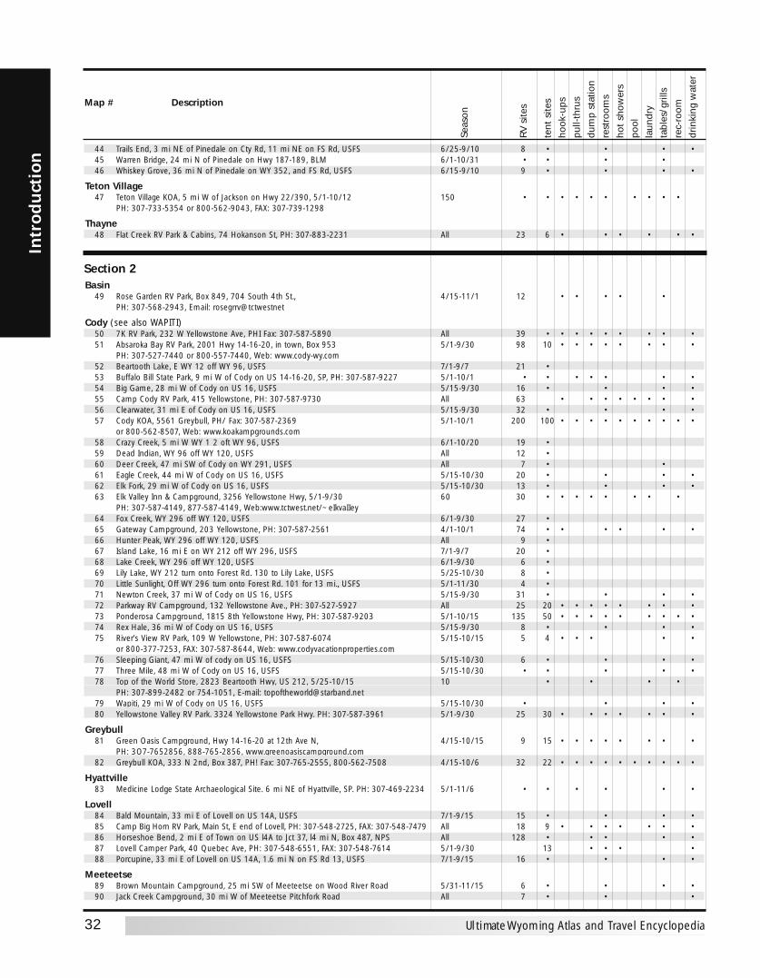
32
Intr
odu
ctio
n
Ultimate Wyoming Atlas and Travel Encyclopedia
44 Trails End, 3 mi NE of Pinedale on Cty Rd, 11 mi NE on FS Rd, USFS 6/25-9/10 8 • • • •45 Warren Bridge, 24 mi N of Pinedale on Hwy 187-189, BLM 6/1-10/31 • • • •46 Whiskey Grove, 36 mi N of Pinedale on WY 352, and FS Rd, USFS 6/15-9/10 9 • • • •
Teton Village47 Teton Village KOA, 5 mi W of Jackson on Hwy 22/390, 5/1-10/12 150 • • • • • • • • • •
PH: 307-733-5354 or 800-562-9043, FAX: 307-739-1298
Thayne48 Flat Creek RV Park & Cabins, 74 Hokanson St, PH: 307-883-2231 All 23 6 • • • • • •
Section 2Basin
49 Rose Garden RV Park, Box 849, 704 South 4th St., 4/15-11/1 12 • • • • •PH: 307-568-2943, Email: rosegrrv@tctwestnet
Cody (see also WAPITI)50 7K RV Park, 232 W Yellowstone Ave, PHI Fax: 307-587-5890 All 39 • • • • • • • • •51 Absaroka Bay RV Park, 2001 Hwy 14-16-20, in town, Box 953 5/1-9/30 98 10 • • • • • • • •
PH: 307-527-7440 or 800-557-7440, Web: www.cody-wy.com52 Beartooth Lake, E WY 12 off WY 96, USFS 7/1-9/7 21 •53 Buffalo Bill State Park, 9 mi W of Cody on US 14-16-20, SP, PH: 307-587-9227 5/1-10/1 • • • • • • •54 Big Game, 28 mi W of Cody on US 16, USFS 5/15-9/30 16 • • • •55 Camp Cody RV Park, 415 Yellowstone, PH: 307-587-9730 All 63 • • • • • • • •56 Clearwater, 31 mi E of Cody on US 16, USFS 5/15-9/30 32 • • • •57 Cody KOA, 5561 Greybull, PH/ Fax: 307-587-2369 5/1-10/1 200 100 • • • • • • • • • •
or 800-562-8507, Web: www.koakampgrounds.com58 Crazy Creek, 5 mi W WY 1 2 oft WY 96, USFS 6/1-10/20 19 •59 Dead Indian, WY 96 off WY 120, USFS All 12 •60 Deer Creek, 47 mi SW of Cody on WY 291, USFS All 7 • •61 Eagle Creek, 44 mi W of Cody on US 16, USFS 5/15-10/30 20 • • • •62 Elk Fork, 29 mi W of Cody on US 16, USFS 5/15-10/30 13 • • • •63 Elk Valley Inn & Campground, 3256 Yellowstone Hwy, 5/1-9/30 60 30 • • • • • • • •
PH: 307-587-4149, 877-587-4149, Web:www.tctwest.net/~eIkvaIIey64 Fox Creek, WY 296 off WY 120, USFS 6/1-9/30 27 •65 Gateway Campground, 203 Yellowstone, PH: 307-587-2561 4/1-10/1 74 • • • • • •66 Hunter Peak, WY 296 off WY 120, USFS All 9 •67 Island Lake, 16 mi E on WY 212 off WY 296, USFS 7/1-9/7 20 •68 Lake Creek, WY 296 off WY 120, USFS 6/1-9/30 6 •69 Lily Lake, WY 212 turn onto Forest Rd. 130 to Lily Lake, USFS 5/25-10/30 8 •70 Little Sunlight, Off WY 296 turn onto Forest Rd. 101 for 13 mi., USFS 5/1-11/30 4 •71 Newton Creek, 37 mi W of Cody on US 16, USFS 5/15-9/30 31 • • • •72 Parkway RV Campground, 132 Yellowstone Ave., PH: 307-527-5927 All 25 20 • • • • • • • •73 Ponderosa Campground, 1815 8th Yellowstone Hwy, PH: 307-587-9203 5/1-10/15 135 50 • • • • • • • • •74 Rex Hale, 36 mi W of Cody on US 16, USFS 5/15-9/30 8 • • • •75 River's View RV Park, 109 W Yellowstone, PH: 307-587-6074 5/15-10/15 5 4 • • • • •
or 800-377-7253, FAX: 307-587-8644, Web: www.codyvacationproperties.com76 Sleeping Giant, 47 mi W of cody on US 16, USFS 5/15-10/30 6 • • • •77 Three Mile, 48 mi W of Cody on US 16, USFS 5/15-10/30 • • • • •78 Top of the World Store, 2823 Beartooth Hwy, US 212, 5/25-10/15 10 • • • •
PH: 307-899-2482 or 754-1051, E-mail: [email protected] Wapiti, 29 mi W of Cody on US 16, USFS 5/15-10/30 • • • •80 Yellowstone Valley RV Park. 3324 Yellowstone Park Hwy. PH: 307-587-3961 5/1-9/30 25 30 • • • • • • •
Greybull81 Green Oasis Campground, Hwy 14-16-20 at 12th Ave N, 4/15-10/15 9 15 • • • • • • • •
PH: 3O7-7652856, 888-765-2856, www.greenoasiscampground.com82 Greybull KOA, 333 N 2nd, Box 387, PH! Fax: 307-765-2555, 800-562-7508 4/15-10/6 32 22 • • • • • • • • • •
Hyattville83 Medicine Lodge State Archaeological Site. 6 mi NE of Hyattville, SP. PH: 307-469-2234 5/1-11/6 • • • • • •
Lovell84 Bald Mountain, 33 mi E of Lovell on US 14A, USFS 7/1-9/15 15 • • • •85 Camp Big Horn RV Park, Main St, E end of Lovell, PH: 307-548-2725, FAX: 307-548-7479 All 18 9 • • • • • • •86 Horseshoe Bend, 2 mi E of Town on US l4A to Jct 37, l4 mi N, Box 487, NPS All 128 • • • • •87 Lovell Camper Park, 40 Quebec Ave, PH: 307-548-6551, FAX: 307-548-7614 5/1-9/30 13 • • • •88 Porcupine, 33 mi E of Lovell on US 14A, 1.6 mi N on FS Rd 13, USFS 7/1-9/15 16 • • • •
Meeteetse89 Brown Mountain Campground, 25 mi SW of Meeteetse on Wood River Road 5/31-11/15 6 • • • •90 Jack Creek Campground, 30 mi W of Meeteetse Pitchfork Road All 7 • • •
Seas
on
RV s
ites
tent
site
sho
ok-u
pspu
ll-th
rus
dum
p st
atio
nre
stro
oms
hot
show
ers
pool
laun
dry
tabl
es/g
rills
rec-
room
drin
king
wat
er
Map # Description
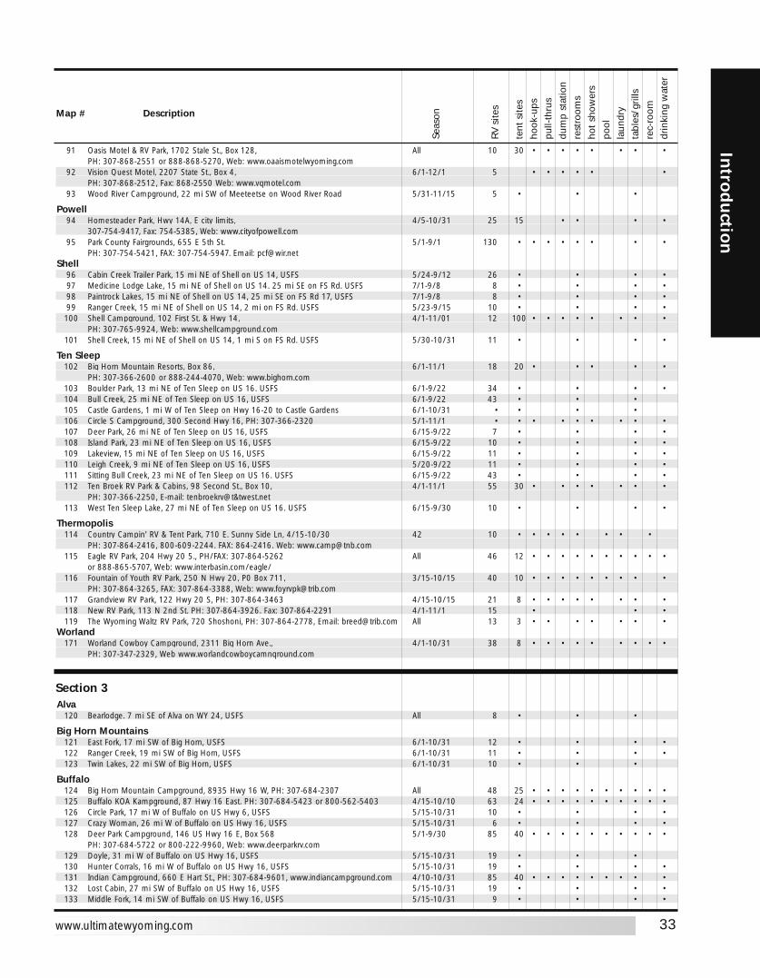
33
Introd
uction
www.ultimatewyoming.com
91 Oasis Motel & RV Park, 1702 Stale St., Box 128, All 10 30 • • • • • • • •PH: 307-868-2551 or 888-868-5270, Web: www.oaaismotelwyoming.com
92 Vision Quest Motel, 2207 State St., Box 4, 6/1-12/1 5 • • • • • •PH: 307-868-2512, Fax: 868-2550 Web: www.vqmotel.com
93 Wood River Campground, 22 mi SW of Meeteetse on Wood River Road 5/31-11/15 5 • • •
Powell94 Homesteader Park, Hwy 14A, E city limits, 4/5-10/31 25 15 • • • •
307-754-9417, Fax: 754-5385, Web: www.cityofpowell.com95 Park County Fairgrounds, 655 E 5th St. 5/1-9/1 130 • • • • • • • •
PH: 307-754-5421, FAX: 307-754-5947. Email: [email protected]
96 Cabin Creek Trailer Park, 15 mi NE of Shell on US 14, USFS 5/24-9/12 26 • • • •97 Medicine Lodge Lake, 15 mi NE of Shell on US 14. 25 mi SE on FS Rd. USFS 7/1-9/8 8 • • • •98 Paintrock Lakes, 15 mi NE of Shell on US 14, 25 mi SE on FS Rd 17, USFS 7/1-9/8 8 • • • •99 Ranger Creek, 15 mi NE of Shell on US 14, 2 mi on FS Rd. USFS 5/23-9/15 10 • • • •100 Shell Campground, 102 First St. & Hwy 14, 4/1-11/01 12 100 • • • • • • • •
PH: 307-765-9924, Web: www.shellcampground.com101 Shell Creek, 15 mi NE of Shell on US 14, 1 mi S on FS Rd. USFS 5/30-10/31 11 • • • •
Ten Sleep102 Big Horn Mountain Resorts, Box 86, 6/1-11/1 18 20 • • • • •
PH: 307-366-2600 or 888-244-4070, Web: www.bighorn.com103 Boulder Park, 13 mi NE of Ten Sleep on US 16. USFS 6/1-9/22 34 • • • •104 Bull Creek, 25 mi NE of Ten Sleep on US 16, USFS 6/1-9/22 43 • • •105 Castle Gardens, 1 mi W of Ten Sleep on Hwy 16-20 to Castle Gardens 6/1-10/31 • • • •106 Circle S Campground, 300 Second Hwy 16, PH: 307-366-2320 5/1-11/1 • • • • • • • • •107 Deer Park, 26 mi NE of Ten Sleep on US 16, USFS 6/15-9/22 7 • • • •108 Island Park, 23 mi NE of Ten Sleep on US 16, USFS 6/15-9/22 10 • • • •109 Lakeview, 15 mi NE of Ten Sleep on US 16, USFS 6/15-9/22 11 • • • •110 Leigh Creek, 9 mi NE of Ten Sleep on US 16, USFS 5/20-9/22 11 • • • •111 Sitting Bull Creek, 23 mi NE of Ten Sleep on US 16. USFS 6/15-9/22 43 • • • •112 Ten Broek RV Park & Cabins, 98 Second St., Box 10, 4/1-11/1 55 30 • • • • • • •
PH: 307-366-2250, E-mail: tenbroekrv@t&twest.net113 West Ten Sleep Lake, 27 mi NE of Ten Sleep on US 16. USFS 6/15-9/30 10 • • • •
Thermopolis114 Country Campin' RV & Tent Park, 710 E. Sunny Side Ln, 4/15-10/30 42 10 • • • • • • • •
PH: 307-864-2416, 800-609-2244. FAX: 864-2416. Web: [email protected] Eagle RV Park, 204 Hwy 20 5., PH/FAX: 307-864-5262 All 46 12 • • • • • • • • • •
or 888-865-5707, Web: www.interbasin.com/eagle/116 Fountain of Youth RV Park, 250 N Hwy 20, P0 Box 711, 3/15-10/15 40 10 • • • • • • • • •
PH: 307-864-3265, FAX: 307-864-3388, Web: [email protected] Grandview RV Park, 122 Hwy 20 S, PH: 307-864-3463 4/15-10/15 21 8 • • • • • • • •118 New RV Park, 113 N 2nd St. PH: 307-864-3926. Fax: 307-864-2291 4/1-11/1 15 • • •119 The Wyoming Waltz RV Park, 720 Shoshoni, PH: 307-864-2778, Email: [email protected] All 13 3 • • • • • • •
Worland171 Worland Cowboy Campground, 2311 Big Horn Ave., 4/1-10/31 38 8 • • • • • • • • •
PH: 307-347-2329, Web www.worlandcowboycamnqround.com
Section 3Alva
120 Bearlodge. 7 mi SE of Alva on WY 24, USFS All 8 • • •
Big Horn Mountains121 East Fork, 17 mi SW of Big Horn, USFS 6/1-10/31 12 • • • •122 Ranger Creek, 19 mi SW of Big Horn, USFS 6/1-10/31 11 • • • •123 Twin Lakes, 22 mi SW of Big Horn, USFS 6/1-10/31 10 • • •
Buffalo124 Big Horn Mountain Campground, 8935 Hwy 16 W, PH: 307-684-2307 All 48 25 • • • • • • • • • •125 Buffalo KOA Kampground, 87 Hwy 16 East. PH: 307-684-5423 or 800-562-5403 4/15-10/10 63 24 • • • • • • • • • •126 Circle Park, 17 mi W of Buffalo on US Hwy 6, USFS 5/15-10/31 10 • • • •127 Crazy Woman, 26 mi W of Buffalo on US Hwy 16, USFS 5/15-10/31 6 • • • •128 Deer Park Campground, 146 US Hwy 16 E, Box 568 5/1-9/30 85 40 • • • • • • • • • •
PH: 307-684-5722 or 800-222-9960, Web: www.deerparkrv.com129 Doyle, 31 mi W of Buffalo on US Hwy 16, USFS 5/15-10/31 19 • • •130 Hunter Corrals, 16 mi W of Buffalo on US Hwy 16, USFS 5/15-10/31 19 • • • •131 Indian Campground, 660 E Hart St., PH: 307-684-9601, www.indiancampground.com 4/10-10/31 85 40 • • • • • • • • •132 Lost Cabin, 27 mi SW of Buffalo on US Hwy 16, USFS 5/15-10/31 19 • • • •133 Middle Fork, 14 mi SW of Buffalo on US Hwy 16, USFS 5/15-10/31 9 • • • •
Seas
on
RV s
ites
tent
site
sho
ok-u
pspu
ll-th
rus
dum
p st
atio
nre
stro
oms
hot
show
ers
pool
laun
dry
tabl
es/g
rills
rec-
room
drin
king
wat
er
Map # Description
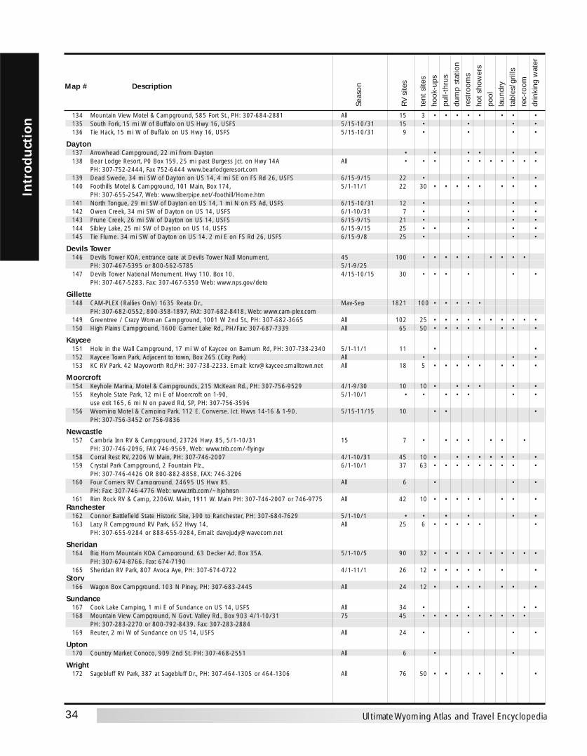
34
Intr
odu
ctio
n
Ultimate Wyoming Atlas and Travel Encyclopedia
134 Mountain View Motel & Campground, 585 Fort St., PH: 307-684-2881 All 15 3 • • • • • • • •135 South Fork, 15 mi W of Buffalo on US Hwy 16, USFS 5/15-10/31 15 • • • •136 Tie Hack, 15 mi W of Buffalo on US Hwy 16, USFS 5/15-10/31 9 • • • •
Dayton137 Arrowhead Campground, 22 mi from Dayton • • • • • •138 Bear Lodge Resort, P0 Box 159, 25 mi past Burgess Jct. on Hwy 14A All • • • • • • • • • •
PH: 307-752-2444, Fax 752-6444 www.bearlodgeresort.com139 Dead Swede, 34 mi SW of Dayton on US 14, 4 mi SE on FS Rd 26, USFS 6/15-9/15 22 • • • •140 Foothills Motel & Campground, 101 Main, Box 174, 5/1-11/1 22 30 • • • • • • • •
PH: 307-655-2547, Web: www.tiberpipe.net/-foothill/Home.htm141 North Tongue, 29 mi SW of Dayton on US 14, 1 mi N on FS Ad, USFS 6/15-10/31 12 • • • •142 Owen Creek, 34 mi SW of Dayton on US 14, USFS 6/1-10/31 7 • • • •143 Prune Creek, 26 mi SW of Dayton on US 14, USFS 6/15-9/15 21 • • • •144 Sibley Lake, 25 mi SW of Dayton on US 14, USFS 6/15-9/15 25 • • • • •145 Tie Flume. 34 mi SW of Dayton on US 14. 2 mi E on FS Rd 26, USFS 6/15-9/8 25 • • • •
Devils Tower146 Devils Tower KOA, entrance gate at Devils Tower NaIl Monument, 45 100 • • • • • • • • •
PH: 307-467-5395 or 800-562-5785 5/1-9/25147 Devils Tower National Monument. Hwy 110. Box 10. 4/15-10/15 30 • • • • • •
PH: 307-467-5283. Fax: 307-467-5350 Web: www.nps.gov/deto
Gillette148 CAM-PLEX (Rallies Only) 1635 Reata Dr., May-Sep 1821 100 • • • • •
PH: 307-682-0552, 800-358-1897, FAX: 307-682-8418, Web: www.cam-plex.com149 Greentree / Crazy Woman Campground, 1001 W 2nd St., PH: 307-682-3665 All 102 25 • • • • • • • • • •150 High Plains Campground, 1600 Garner Lake Rd., PH/Fax: 307-687-7339 All 65 50 • • • • • • • •
Kaycee151 Hole in the Wall Campground, 17 mi W of Kaycee on Barnum Rd, PH: 307-738-2340 5/1-11/1 11 • •152 Kaycee Town Park, Adjacent to town, Box 265 (City Park) All • • • •153 KC RV Park. 42 Mayoworth Rd,PH: 307-738-2233. Email: [email protected] All 18 5 • • • • • • • •
Moorcroft154 Keyhole Marina, Motel & Campgrounds, 215 McKean Rd., PH: 307-756-9529 4/1-9/30 10 10 • • • • • •155 Keyhole State Park, 12 mi E of Moorcroft on 1-90, 5/1-10/1 • • • • • • •
use exit 165, 6 mi N on paved Rd, SP, PH: 307-756-3596156 Wyoming Motel & Camping Park, 112 E. Converse, Jct. Hwys 14-16 & 1-90, 5/15-11/15 10 • • •
PH: 307-756-3452 or 756-9836
Newcastle157 Cambria Inn RV & Campground, 23726 Hwy. 85, 5/1-10/31 15 7 • • • • • • •
PH: 307-746-2096, FAX 746-9569, Web: www.trib.com/-flyingv158 Corral Rest RV, 2206 W Main, PH: 307-746-2007 4/1-10/31 45 10 • • • • • • • •159 Crystal Park Campground, 2 Fountain Plz., 6/1-10/1 37 63 • • • • • • • • •
PH: 307-746-4426 OR 800-882-8858, FAX: 746-3206160 Four Corners RV Campground, 24695 US Hwy 85, All 6 • • •
PH: Fax: 307-746-4776 Web: www.trib.com/~hjohnsn161 Rim Rock RV & Camp, 2206W. Main, 1911 W. Main PH: 307-746-2007 or 746-9775 All 42 10 • • • • • • • •
Ranchester162 Connor Battlefield State Historic Site, I-90 to Ranchester, PH: 307-684-7629 5/1-10/1 • • • • • •163 Lazy R Campground RV Park, 652 Hwy 14, All 25 6 • • • • • •
PH: 307-655-9284 or 888-655-9284, Email: [email protected]
Sheridan164 Big Horn Mountain KOA Campground, 63 Decker Ad, Box 35A. 5/1-10/5 90 32 • • • • • • • • • •
PH: 307-674-8766. Fax: 674-7190165 Sheridan RV Park, 807 Avoca Aye, PH: 307-674-0722 4/1-11/1 26 12 • • • • • • •
Story166 Wagon Box Campground. 103 N Piney, PH: 307-683-2445 All 24 12 • • • • • • •
Sundance167 Cook Lake Camping, 1 mi E of Sundance on US 14, USFS All 34 • • • • 168 Mountain View Campground, N Govt. Valley Rd., Box 903 4/1-10/31 75 45 • • • • • • • • • •
PH: 307-283-2270 or 800-792-8439. Fax: 307-283-2884169 Reuter, 2 mi W of Sundance on US 14, USFS All 24 • • • •
Upton170 Country Market Conoco, 909 2nd St. PH: 307-468-2551 All 6 • •
Wright172 Sagebluff RV Park, 387 at Sagebluff Dr., PH: 307-464-1305 or 464-1306 All 76 50 • • • • • •
Seas
on
RV s
ites
tent
site
sho
ok-u
pspu
ll-th
rus
dum
p st
atio
nre
stro
oms
hot
show
ers
pool
laun
dry
tabl
es/g
rills
rec-
room
drin
king
wat
er
Map # Description
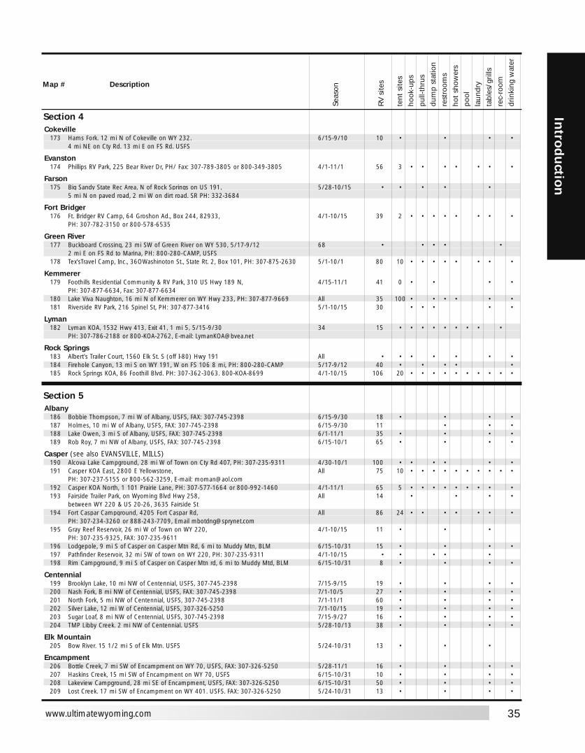
35
Introd
uction
www.ultimatewyoming.com
Section 4Cokeville
173 Hams Fork. 12 mi N of Cokeville on WY 232. 6/15-9/10 10 • • • •4 mi NE on Cty Rd. 13 mi E on FS Rd. USFS
Evanston174 Phillips RV Park, 225 Bear River Dr, PH/ Fax: 307-789-3805 or 800-349-3805 4/1-11/1 56 3 • • • • • • •
Farson175 Big Sandy State Rec Area, N of Rock Springs on US 191, 5/28-10/15 • • • • •
5 mi N on paved road, 2 mi W on dirt road. SR PH: 332-3684
Fort Bridger176 Ft. Bridger RV Camp, 64 Groshon Ad., Box 244, 82933, 4/1-10/15 39 2 • • • • • • • •
PH: 307-782-3150 or 800-578-6535
Green River177 Buckboard Crossing, 23 mi SW of Green River on WY 530, 5/17-9/12 68 • • • • •
2 mi E on FS Rd to Marina, PH: 800-280-CAMP, USFS178 Tex'sTravel Camp, Inc., 36OWashinoton St., State Rt. 2, Box 101, PH: 307-875-2630 5/1-10/1 80 10 • • • • • • • •
Kemmerer179 Foothills Residential Community & RV Park, 310 US Hwy 189 N, 4/15-11/1 41 0 • • • •
PH: 307-877-6634, Fax: 307-877-6634180 Lake Viva Naughton, 16 mi N of Kemmerer on WY Hwy 233, PH: 307-877-9669 All 35 100 • • • • • •181 Riverside RV Park, 216 Spinel St, PH: 307-877-3416 5/1-10/15 30 • • • • •
Lyman182 Lyman KOA, 1532 Hwy 413, Exit 41, 1 mi 5, 5/15-9/30 34 15 • • • • • • • • •
PH: 307-786-2188 or 800-KOA-2762, E-mail: [email protected]
Rock Springs183 Albert's Trailer Court, 1560 Elk St. S (off I-80) Hwy 191 All • • • • • • •184 Firehole Canyon, 13 mi S on WY 191, W on FS 106 8 mi, PH: 800-280-CAMP 5/17-9/12 40 • • • • •185 Rock Springs KOA, 86 Foothill Blvd. PH: 307-362-3063. 800-KOA-8699 4/1-10/15 106 20 • • • • • • • • • •
Section 5Albany
186 Bobbie Thompson, 7 mi W of Albany, USFS, FAX: 307-745-2398 6/15-9/30 18 • • • •187 Holmes, 10 mi W of Albany, USFS, FAX: 307-745-2398 6/15-9/30 11 • • •188 Lake Owen, 3 mi S of Albany, USFS, FAX: 307-745-2398 6/1-11/1 35 • • • •189 Rob Roy, 7 mi NW of Albany, USFS, FAX: 307-745-2398 6/15-10/1 65 • • • •
Casper (see also EVANSVILLE, MILLS)190 Alcova Lake Campground, 28 mi W of Town on Cty Rd 407, PH: 307-235-9311 4/30-10/1 100 • • • • • •191 Casper KOA East, 2800 E Yellowstone, All 75 10 • • • • • • • • • •
PH: 307-237-5155 or 800-562-3259, E-mail: [email protected] Casper KOA North, 1 101 Prairie Lane, PH: 307-577-1664 or 800-992-1460 4/1-11/1 65 5 • • • • • • • • •193 Fairside Trailer Park, on Wyoming Blvd Hwy 258, All 14 • • • •
between WY 220 & US 20-26, 3635 Fairside St194 Fort Caspar Campground, 4205 Fort Caspar Rd, All 86 24 • • • • • • •
PH: 307-234-3260 or 888-243-7709, Email [email protected] Gray Reef Reservoir, 26 mi W of Town on WY 220, 4/1-10/15 11 • • •
PH: 307-235-9325, FAX: 307-235-9611196 Lodgepole, 9 mi S of Casper on Casper Mtn Rd, 6 mi to Muddy Mtn, BLM 6/15-10/31 15 • • • •197 Pathfinder Reservoir, 32 mi SW of town on WY 220, PH: 307-235-9311 4/1-10/15 • • • • •198 Rim Campground, 9 mi S of Casper on Casper Mtn rd, 6 mi to Muddy Mtd, BLM 6/15-10/31 8 • • • •
Centennial199 Brooklyn Lake, 10 mi NW of Centennial, USFS, 307-745-2398 7/15-9/15 19 • • • •200 Nash Fork, B mi NW of Centennial, USFS, FAX: 307-745-2398 7/1-10/5 27 • • • •201 North Fork, 5 mi NW of Centennial, USFS, 307-745-2398 7/1-11/1 60 • • • •202 Silver Lake, 12 mi W of Centennial, USFS, 307-326-5250 7/1-10/15 19 • • • •203 Sugar Loaf, 8 mi NW of Centennial, USFS, 307-745-2398 7/15-9/27 16 • • • •204 TMP Libby Creek. 2 mi NW of Centennial. USFS 5/28-10/13 38 • • • •
Elk Mountain205 Bow River. 15 1/2 mi S of Elk Mtn. USFS 5/24-10/31 13 • • •
Encampment206 Bottle Creek, 7 mi SW of Encampment on WY 70, USFS, FAX: 307-326-5250 5/28-11/1 16 • • • •207 Haskins Creek, 15 mi SW of Encampment on WY 70, USFS 6/15-10/31 10 • • • •208 Lakeview Campground, 28 mi SE of Encampment, USFS, FAX: 307-326-5250 6/15-10/31 50 • • • •209 Lost Creek. 17 mi SW of Encampment on WY 401. USFS. FAX: 307-326-5250 5/24-10/31 13 • • • •
Seas
on
RV s
ites
tent
site
sho
ok-u
pspu
ll-th
rus
dum
p st
atio
nre
stro
oms
hot
show
ers
pool
laun
dry
tabl
es/g
rills
rec-
room
drin
king
wat
er
Map # Description

36
Intr
odu
ctio
n
Ultimate Wyoming Atlas and Travel Encyclopedia
Foxpark210 Boswell Creek, 8 mi SE of Foxpark, USFS 6/1-9/15 • • • •211 Pelton Creek, 10 mi SW of Foxpark, USFS 6/15-10/15 15 • • • •
Hanna212 The Miracle Mile Ranch & RV Park, 48 mi. N. of Hanna on Cty. Rd. 291, All 21 • • • • •
PH: 307-325-6710
Jeffrey City213 Cottonwood, 6 mi E of Jeffrey City on US 287, 8 mi S on Cty & BLM Rds, BLM. 5/22-12/1 18 • • •
PH: 307-322-8420
Lander214 Atlantic City, 25 mi S. of Lander on WY 28, Atlantic City Rd, BLM 5/8-11/15 • • • • •215 Big Atlantic Gulch, 25 mi S. of Lander on WY 28, Miner's Delight, Rd, BLM 6/1-10/31 • • • • •216 Dickinson Creek, 34 mi NW of Lander, USFS 6/20-9/15 6 15 • •217 Fiddlers Lake, 25 mi SW of Lander, USFS 7/1-9/30 13 • • • •218 Hart Ranch Hideout RV Park & Campground, 8 mi SE of Lander at Jct 28 & 789-287, All 55 28 • • • • • • •
PH: 307-332-3836 or 800-914-9226219 Holiday Lodge Campground, 210 McFarlane Dr., 5/1-9/30 2 8 • • • • • •
PH: 307-332-2511 or 800-624-1974, Fax: 307-332-2256220 Lander City Park, 240 Lincoln, PH: 307-332-4647 5/1-9/30 7 • • • •221 Louis Lake, 30 mi SW of Lander, USFS 7/1-9/30 9 9 • • •222 Maverick Mobile Home & RV Park, 1104 N. 2nd St, PH/ Fax: 307-332-3142 4/1-9/30 50 10 • • • • • • • •223 Popo Agie, 28 mi SW of Lander, USFS 7/1-9/30 1 3 • •224 Ray Lake Campground & Cafe, 39 Ray Lake Rd, PH: 307-332-9333, Fax: 307-332-1345 5/1-9/30 10 25 • • • • • • •225 Rocky Acres Campground, 5700 US Hwy 287, PH: 307-332-6953, FAX: 307-322-8505 5/1-9/30 13 28 • • • • • • •226 Sinks Canyon, 11 mi S of Lander, USFS 5/1-10/31 9 • • • •227 Sinks Canyon State Park, 6 mi SW of Lander on WY 131, SP, PH: 307-332-6333 5/1-11/1 • • • • • •228 Sleeping Bear RV Park & Campground, 715 E. Main, All 44 6 • • • • • • • • •
PH: 307-332-5159 or 888-757-2327, Web: www.sleeping-rv-park.com229 Worthen Meadows, 18 mi SW of Lander, USFS 7/1-9/30 20 • • • •
Mcfadden230 Arlington Outpost, at Arlington on I-80, 38 mi W of Laramie at exit 272, 5-1/10-31 50 20 • • • • • • • • •
PH: 307-378-2350231 White's Recreation Reservoirs, 5 mi NE of I-80 (Arlington Exit) on WY 13 5/1-10/1 25 25 • •
Powder River232 Hell's Half Acre, US Hwy 20/26, 45 mi W. of Casper, PH: 307-473-7773 or 473-7772 3/1-11/15 10 10 • • • • •
Rawlins233 American Presidents Campground, 2346 W Spruce St, 6/15-10/30 72 • • • • • •
PH: 307-324-3218 or 800-294-3218, FAX: 307-324-3509234 KOA Kampground, 205 E. Hwy. 71. 4/1-10/31 51 6 • • • • • • • • •
PH: 307-328-2021 or 800-KOA-7559, Email: [email protected] RV World Campground, 3101 Wagon Circle Rd, 3/1-10/1 100 5 • • • • • • • • • •
PH: 307-328-1091 or 800-478-9753, Fax: 307-324-5031236 Western Hills Campground, 2500 Wagon Circle Rd. Box 760, All 171 50 • • • • • • •
PH: 307-324-2592. 888-568-3040. Web' wwwwesternhillscampground.com
Riverside237 Lazy Acres Campground & Motel, on Hwy 230, 5/1-11/1 28 5 • • • • • • • •
PH: 307-327-5968 Web: wwwwyomingcarboncountycom/lazy.htm
Riverton238 Owl Creek Kampground, 11124 US Hwy 26-789, 5/15-9/15 19 21 • • • • • • • • •
PH: 307-856-2869 E-mail: [email protected] Rudy's Camper Court, 622 E Lincoln, PH: 307-856-9764 All 21 3 • • • • • •240 Wind River RV Park, 1618 E Park Ave, All 60 2 • • • • • • • • •
PH: 307-857-3000. 800-528-3913, Fax: 307-856-9559
Saratoga241 Deer Haven RV Park, 706 N 1st St., 307-326-8746 5/15-10/15 45 • • • • •242 French Creek, 39 mi E of Saratoga, USFS, 307-326-5258, FAX: 307-326-5250 5/25-10/31 11 6 • • •243 Jack Creek, 19 mi W of Saratoga. USFS. FAX: 307-326-5250 5/24-10/31 16 • • • •244 Ryan Park, 23 mi. SE of Saratoga, Hwy 130, USFS, FAX: 307-326-5250 5/28-11/15 48 • • •245 Saratoga Lake, 1 mi N of Saratoga. 307-326-8335 or 326-5811 4/15-11/1 25 20 • • • • •246 South Brush Creek, 20 mi SE of Saratoga, USFS, FAX: 307-326-5250 5/28-11/15 20 • • •
Shoshoni247 Boysen State Park, Hwy 20 & Hwy 26, 5/1-10/1 • • • • • • •
south end of Wind River Canyon, SP, PH: 307-876-2796
Sinclair248 Seminoe State Park, 34 mi N of Sinclair on Cty Rd 351, SP, PH: 307-320-3013 5/1-10/15 • • • • • • •
Seas
on
RV s
ites
tent
site
sho
ok-u
pspu
ll-th
rus
dum
p st
atio
nre
stro
oms
hot
show
ers
pool
laun
dry
tabl
es/g
rills
rec-
room
drin
king
wat
er
Map # Description
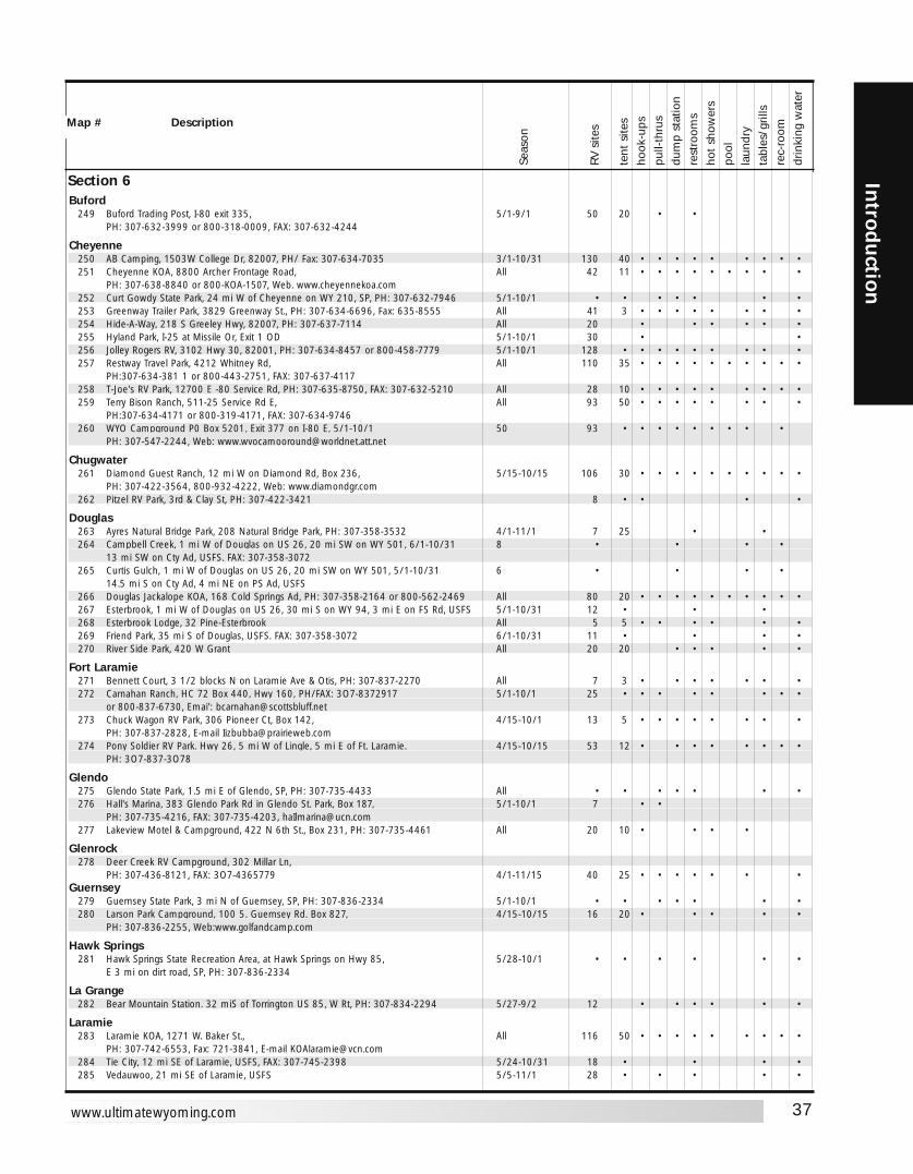
37
Introd
uction
www.ultimatewyoming.com
Section 6Buford
249 Buford Trading Post, I-80 exit 335, 5/1-9/1 50 20 • •PH: 307-632-3999 or 800-318-0009, FAX: 307-632-4244
Cheyenne250 AB Camping, 1503W College Dr, 82007, PH/ Fax: 307-634-7035 3/1-10/31 130 40 • • • • • • • • •251 Cheyenne KOA, 8800 Archer Frontage Road, All 42 11 • • • • • • • • •
PH: 307-638-8840 or 800-KOA-1507, Web. www.cheyennekoa.com252 Curt Gowdy State Park, 24 mi W of Cheyenne on WY 210, SP, PH: 307-632-7946 5/1-10/1 • • • • • • •253 Greenway Trailer Park, 3829 Greenway St., PH: 307-634-6696, Fax: 635-8555 All 41 3 • • • • • • • •254 Hide-A-Way, 218 S Greeley Hwy, 82007, PH: 307-637-7114 All 20 • • • • • •255 Hyland Park, I-25 at Missile Or, Exit 1 OD 5/1-10/1 30 • •256 Jolley Rogers RV, 3102 Hwy 30, 82001, PH: 307-634-8457 or 800-458-7779 5/1-10/1 128 • • • • • • • • •257 Restway Travel Park, 4212 Whitney Rd, All 110 35 • • • • • • • • • •
PH:307-634-381 1 or 800-443-2751, FAX: 307-637-4117258 T-Joe's RV Park, 12700 E -80 Service Rd, PH: 307-635-8750, FAX: 307-632-5210 All 28 10 • • • • • • • • •259 Terry Bison Ranch, 511-25 Service Rd E, All 93 50 • • • • • • • •
PH:307-634-4171 or 800-319-4171, FAX: 307-634-9746260 WYO Campground P0 Box 5201, Exit 377 on I-80 E, 5/1-10/1 50 93 • • • • • • • • •
PH: 307-547-2244, Web: [email protected]
Chugwater261 Diamond Guest Ranch, 12 mi W on Diamond Rd, Box 236, 5/15-10/15 106 30 • • • • • • • • • •
PH: 307-422-3564, 800-932-4222, Web: www.diamondgr.com262 Pitzel RV Park, 3rd & Clay St, PH: 307-422-3421 8 • • • •
Douglas263 Ayres Natural Bridge Park, 208 Natural Bridge Park, PH: 307-358-3532 4/1-11/1 7 25 • •264 Campbell Creek, 1 mi W of Douglas on US 26, 20 mi SW on WY 501, 6/1-10/31 8 • • • •
13 mi SW on Cty Ad, USFS. FAX: 307-358-3072265 Curtis Gulch, 1 mi W of Douglas on US 26, 20 mi SW on WY 501, 5/1-10/31 6 • • • •
14.5 mi S on Cty Ad, 4 mi NE on PS Ad, USFS266 Douglas Jackalope KOA, 168 Cold Springs Ad, PH: 307-358-2164 or 800-562-2469 All 80 20 • • • • • • • • • •267 Esterbrook, 1 mi W of Douglas on US 26, 30 mi S on WY 94, 3 mi E on FS Rd, USFS 5/1-10/31 12 • • •268 Esterbrook Lodge, 32 Pine-Esterbrook All 5 5 • • • • • •269 Friend Park, 35 mi S of Douglas, USFS. FAX: 307-358-3072 6/1-10/31 11 • • • •270 River Side Park, 420 W Grant All 20 20 • • • • •
Fort Laramie271 Bennett Court, 3 1/2 blocks N on Laramie Ave & Otis, PH: 307-837-2270 All 7 3 • • • • • • •272 Carnahan Ranch, HC 72 Box 440, Hwy 160, PH/FAX: 3O7-8372917 5/1-10/1 25 • • • • • • • •
or 800-837-6730, Emai': [email protected] Chuck Wagon RV Park, 306 Pioneer Ct, Box 142, 4/15-10/1 13 5 • • • • • • • •
PH: 307-837-2828, E-mail [email protected] Pony Soldier RV Park. Hwy 26, 5 mi W of Lingle, 5 mi E of Ft. Laramie. 4/15-10/15 53 12 • • • • • • • •
PH: 3O7-837-3O78
Glendo275 Glendo State Park, 1.5 mi E of Glendo, SP, PH: 307-735-4433 All • • • • • • •276 Hall's Marina, 383 Glendo Park Rd in Glendo St. Park, Box 187, 5/1-10/1 7 • •
PH: 307-735-4216, FAX: 307-735-4203, [email protected] Lakeview Motel & Campground, 422 N 6th St., Box 231, PH: 307-735-4461 All 20 10 • • • •
Glenrock278 Deer Creek RV Campground, 302 Millar Ln,
PH: 307-436-8121, FAX: 3O7-4365779 4/1-11/15 40 25 • • • • • • •Guernsey
279 Guernsey State Park, 3 mi N of Guernsey, SP, PH: 307-836-2334 5/1-10/1 • • • • • • •280 Larson Park Campground, 100 5. Guernsey Rd. Box 827, 4/15-10/15 16 20 • • • • •
PH: 307-836-2255, Web:www.golfandcamp.com
Hawk Springs281 Hawk Springs State Recreation Area, at Hawk Springs on Hwy 85, 5/28-10/1 • • • • • •
E 3 mi on dirt road, SP, PH: 307-836-2334
La Grange282 Bear Mountain Station. 32 miS of Torrington US 85, W Rt, PH: 307-834-2294 5/27-9/2 12 • • • • • •
Laramie283 Laramie KOA, 1271 W. Baker St., All 116 50 • • • • • • • • •
PH: 307-742-6553, Fax: 721-3841, E-mail [email protected] Tie City, 12 mi SE of Laramie, USFS, FAX: 307-745-2398 5/24-10/31 18 • • • •285 Vedauwoo, 21 mi SE of Laramie, USFS 5/5-11/1 28 • • • • •
Seas
on
RV s
ites
tent
site
sho
ok-u
pspu
ll-th
rus
dum
p st
atio
nre
stro
oms
hot
show
ers
pool
laun
dry
tabl
es/g
rills
rec-
room
drin
king
wat
er
Map # Description
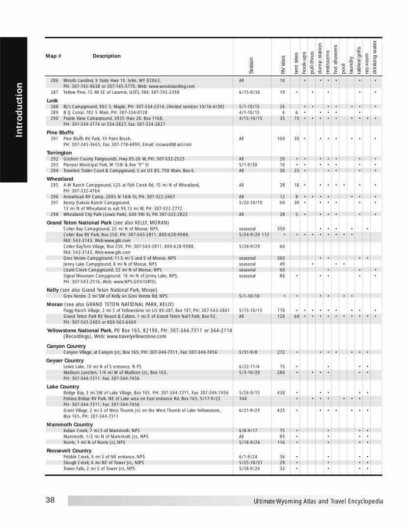
38
Intr
odu
ctio
n
Ultimate Wyoming Atlas and Travel Encyclopedia
286 Woods Landing, 9 State Hwy 10, JeIm, WY 82063, All 10 • • • • • •PH: 307-745-9638 or 307-745-5770, Web: www.woodslanding.com
287 Yellow Pine, 15 Mi SE of Laramie, USFS, FAX: 307-745-2398 6/15-9/30 19 • • • • •
Lusk288 BJ's Campground, 902 S. Maple, PH: 307-334-2314, (limited services 10/16-4/30) 5/1-10/15 26 • • • • • • •289 B Q Corral, 702 5 Main, PH: 307-334-0128 4/1-10/15 6 6 • • • • •290 Prairie View Campground, 3925 Hwy 20, Box 1168, 4/15-10/15 35 15 • • • • • • • • •
PH: 307-334-3174 or 334-2827, Fax: 307-334-2827
Pine Bluffs291 Pine Bluffs RV Park, 10 Paint Brush, All 100 30 • • • • • • •
PH: 307-245-3665, Fax: 307-778-4899, Email: [email protected]
Torrington292 Goshen County Fairgrounds, Hwy 85-26 W, PH: 307-532-2525 All 20 • • • • • • •293 Pioneer Municipal Park, W 15th & Ave "E" St 5/1-9/30 10 • • • • • • •294 Travelers Trailer Court & Campground, S on US 85, 750 Main, Box 6 All 30 25 • • • • •
Wheatland295 4-W Ranch Campground, I-25 at Fish Creek Rd, 15 mi N of Wheatland, All 28 16 • • • • • • •
PH: 307-332-4764296 Arrowhead RV Camp, 2005 N 16th St, PH. 307-322-3467 All 12 8 • • • • • • •297 Kemp Dakota Ranch Campground, 5/20-10/15 60 30 • • • • • •
13 mi N of Wheatland to exit 94,13 mi W, PH: 307-322-2772298 Wheatland City Park (Lewis Park), 600 9th St, PH 307-322-2822 All 28 5 • • • • • •
Grand Teton National Park (see also KELLY, MORAN)Colter Bay Campground, 25 mi N of Moose, NPS, seasonal 350 • • • • •Colter Bay RV Park, Box 250, PH: 307-543-2811, 800-628-9988, 5/24-9/29 112 • • • • • • • • •FAX: 543-3143, Web:www.gtlc.comColter BayTent Village, Box 250, PH: 307-543-2811, 800-628-9988, 5/24-9/29 66FAX: 543-3143, Web:www.gtlc.comGros Ventre Campground, 11.5 mi S and E of Moose, NPS seasonal 360 • • • •Jenny Lake Campground, 8 mi N of Moose, NPS seasonal 49 • • •Lizard Creek Campground, 32 mi N of Moose, NPS seasonal 60 • • •Signal Mountain Campground. 16 mi N of Jenny Lake, NPS, seasonal 86 • • • • •PH: 307-543-2516, Web: www.NPS.GOV/GRTEL
Kelly (see also Grand Teton National Park, Moran)Gros Ventre. 2 mi SW of Kelly on Gros Ventre Rd. NPS 5/1-10/10 • • • • • •
Moran (see also GRAND TETON NATIONAL PARK, KELLY)Flagg Ranch Village, 2 mi S of Yellowstone on US 89-287, Box 187, PH: 307-543-2861 5/15-10/15 170 • • • • • • • • •Grand Teton Park RV Resort & Cabins, 1 mi E of Grand Teton Nat'l Park, Box 92, All 120 60 • • • • • • • • • •PH: 307-543-2483 or 800-563-6469
Yellowstone National Park, P0 Box 165, 82190, PH: 307-344-7311 or 344-2114 (Recordings), Web: www.travelyellowstone.com
Canyon CountryCanyon Village, at Canyon Jct., Box 165, PH: 307-344-7311, Fax: 307-344-7456 5/31-9/8 272 • • • • • • •
Geyser CountryLewis Lake, 10 mi N of S entrance, N PS 6/22-11/4 75 • • • •Madison Junction, 1/4 mi W of Madison Jct., Box 165, 5/3-10/20 280 • • • • • •PH: 307-344-7311. Fax: 307-344-7456
Lake CountryBridge Bay, 3 mi SW of Lake Village, Box 165. PH: 307-344-7311, Fax: 307-344-7456 5/24-9/15 430 • • • • •Fishing Bridge RV Park, NE of Lake area on East entrance Rd, Box 165, 5/17-9/22 344 • • • • • • •PH: 307-344-7311, Fax: 307-344-7456Grant Village, 2 mi S of West Thumb Jct. on the West Thumb of Lake Yellowstone, 6/21-9/29 425 • • • • • • •Box 165, PH: 307-344-7311
Mammoth CountryIndian Creek, 7 mi S of Mammoth. NPS 6/8-9/17 75 • • • •Mammoth, 1/2 mi N of Mammoth Jct., NPS All 85 • • • •Norris, 1 mi N of Norris Jct, NPS 5/18-9/24 116 • • • •
Roosevelt CountryPebble Creek, 9 mi S of NE entrance, NPS 6/1-9/24 36 • • • •Slough Creek, 6 mi NE of Tower Jct., NIPS 5/25-10/31 29 • • • •Tower Falls, 2 mi S of Tower Jct., NPS 5/18-9/24 32 • • • •
Seas
on
RV s
ites
tent
site
sho
ok-u
pspu
ll-th
rus
dum
p st
atio
nre
stro
oms
hot
show
ers
pool
laun
dry
tabl
es/g
rills
rec-
room
drin
king
wat
er
Map # Description

39
Introd
uction
www.ultimatewyoming.com
Rivers & Streams
1 Bechler River • • •2 Firehole River • • •3 Gallatin River • • • •4 Gardner River • • • • •5 Gibbon River • • • • •6 Lamar River • •7 Madison River • • • •8 Slough Creek • •9 Snake River • • •10 Yellowstone River • • •
Lakes
11 Heart Lake • •12 Lewis Lake • • •13 Shoshone Lake • • •14 Yellowstone Lake • •
FISHERIESBy Drainage
YELLOWSTONE PARK
Map Number/Fishery
Broo
k Tr
out
Brow
n Tr
out
Cut
thro
at T
rout
Gra
ylin
g
Lake
Tro
ut
Mou
ntai
n W
hite
fish
Rain
bow
Tro
ut
Rivers & Streams
15 Flat Creek (Above Refuge) • •16 Flat Creek (on Refuge) • • •17 Granite Creek • •18 Greys River • •19 Gros Ventre River • •20 Hoback River • •21 Pacific Creek • •22 Salt River • • •23 Snake River • •
Lakes
24 Grassy Lake • •25 Jackson Lake • • • •26 Jenny Lake • • •27 Lake of the Woods • •28 Leidy Lake •29 Phelps Lake • • •30 Slide Lake, Lower • • •31 Topping Lake •
SNAKE RIVER DRAINAGE
Map Number/Fishery
Broo
k Tr
out
Gra
ylin
g
Lake
Tro
ut
Mou
ntai
n W
hite
fish
Snak
e Rv
r C
utth
roat
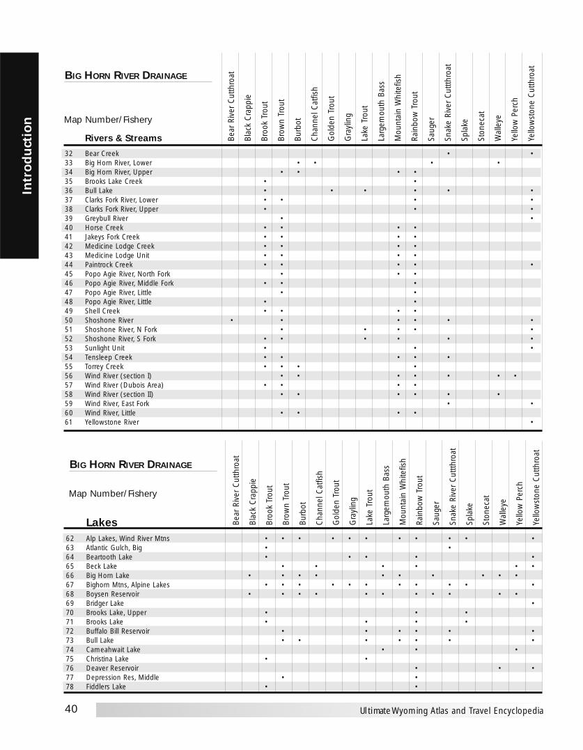
40
Intr
odu
ctio
n
Ultimate Wyoming Atlas and Travel Encyclopedia
Rivers & Streams
32 Bear Creek • •33 Big Horn River, Lower • • • •34 Big Horn River, Upper • • • •35 Brooks Lake Creek • •36 Bull Lake • • • • • •37 Clarks Fork River, Lower • • • •38 Clarks Fork River, Upper • • •39 Greybull River • •40 Horse Creek • • • •41 Jakeys Fork Creek • • • •42 Medicine Lodge Creek • • • •43 Medicine Lodge Unit • • • •44 Paintrock Creek • • • • •45 Popo Agie River, North Fork • • •46 Popo Agie River, Middle Fork • • •47 Popo Agie River, Little • •48 Popo Agie River, Little • •49 Shell Creek • • • •50 Shoshone River • • • • • •51 Shoshone River, N Fork • • • • •52 Shoshone River, S Fork • • • • • •53 Sunlight Unit • • •54 Tensleep Creek • • • • •55 Torrey Creek • • • •56 Wind River (section I) • • • • • • •57 Wind River (Dubois Area) • • • •58 Wind River (section II) • • • • • •59 Wind River, East Fork • •60 Wind River, Little • • • •61 Yellowstone River •
BIG HORN RIVER DRAINAGE
Map Number/Fishery
Bear
Riv
er C
utth
roat
Blac
k C
rapp
ie
Broo
k Tr
out
Brow
n Tr
out
Burb
ot
Cha
nnel
Cat
fish
Gol
den
Trou
t
Gra
ylin
g
Lake
Tro
ut
Larg
emou
th B
ass
Mou
ntai
n W
hite
fish
Rain
bow
Tro
ut
Saug
er
Snak
e Ri
ver
Cut
tthro
at
Spla
ke
Ston
ecat
Wal
leye
Yello
w P
erch
Yello
wst
one
Cut
thro
atLakes
62 Alp Lakes, Wind River Mtns • • • • • • • • • • •63 Atlantic Gulch, Big • •64 Beartooth Lake • • • • •65 Beck Lake • • • • • •66 Big Horn Lake • • • • • • • • • •67 Bighorn Mtns, Alpine Lakes • • • • • • • • • • •68 Boysen Reservoir • • • • • • • • • • •69 Bridger Lake •70 Brooks Lake, Upper • • •71 Brooks Lake • • • •72 Buffalo Bill Reservoir • • • • • •73 Bull Lake • • • • • • •74 Cameahwait Lake • • •75 Christina Lake • •76 Deaver Reservoir • • •77 Depression Res, Middle • •78 Fiddlers Lake • •
BIG HORN RIVER DRAINAGE
Bear
Riv
er C
utth
roat
Blac
k C
rapp
ie
Broo
k Tr
out
Brow
n Tr
out
Burb
ot
Cha
nnel
Cat
fish
Gol
den
Trou
t
Gra
ylin
g
Lake
Tro
ut
Larg
emou
th B
ass
Mou
ntai
n W
hite
fish
Rain
bow
Tro
ut
Saug
er
Snak
e Ri
ver
Cut
tthro
at
Spla
ke
Ston
ecat
Wal
leye
Yello
w P
erch
Yello
wst
one
Cut
thro
at
Map Number/Fishery
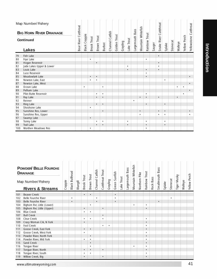
41
Introd
uction
www.ultimatewyoming.com
Lakes79 Fish Lake •80 Frye Lake • •81 Hogan Reservoir • •82 Jade Lakes Upper & Lower • •83 Louis Lake • • •84 Luce Reservoir •85 Meadowlark Lake • • • •86 Newton Lake, East • • •87 Newton Lake, West •88 Ocean Lake • • • •89 Pelham Lake •90 Pilot Butte Reservoir • • • •91 Ray Lake • • • • • •92 Renner •93 Ring Lake • • • •94 Shoshone Lake •95 Sunshine Res, Lower • • • • •96 Sunshine Res, Upper • • • •97 Swamp Lake •98 Torrey Lake • • • • •99 Trail Lake • • • • •100 Worthen Meadows Res • •
BIG HORN RIVER DRAINAGE
Continued
Map Number/Fishery
Bear
Riv
er C
utth
roat
Blac
k C
rapp
ie
Broo
k Tr
out
Brow
n Tr
out
Burb
ot
Cha
nnel
Cat
fish
Gol
den
Trou
t
Gra
ylin
g
Lake
Tro
ut
Larg
emou
th B
ass
Mou
ntai
n W
hite
fish
Rain
bow
Tro
ut
Saug
er
Snak
e Ri
ver
Cut
tthro
at
Spla
ke
Ston
ecat
Wal
leye
Yello
w P
erch
Yello
wst
one
Cut
thro
at
Map Number/Fishery
Rivers & Streams101 Beaver Creek • • •102 Belle Fourche River • • • •103 Belle Fourche River • • • •104 Bighorn Rvr, Little (Lower) • • •105 Bighorn Rvr, Little (Upper) • • •106 Blue Creek • •107 Bull Creek •108 Clear Creek • • • •109 Crazy Woman Crk, N Fork • •110 Fool Creek • • •111 Goose Creek, East Fork • • •112 Goose Creek, West Fork • •113 Powder River, North Fork • •114 Powder River, Mid Fork • • •115 Sand Creek • •116 Tongue River • • •117 Tongue River, North • • • •118 Tongue River, South • • •119 Willow Creek, Big • • •
POWDER/BELLE FOURCHEDRAINAGE
Cra
ppie
Blac
k Bu
llhea
d
Blue
gill
Broo
k Tr
out
Brow
n Tr
out
Cha
nnel
Cat
fish
Cut
tthro
at T
rout
Gra
ylin
g
Gre
en S
unfis
h
Lake
Tro
ut
Larg
emou
th B
ass
Mou
ntai
n W
hite
fish
Nor
ther
n Pi
ke
Rain
bow
Tro
ut
Rock
Bas
s
Smal
lmou
th B
ass
Spla
ke
Ston
ecat
Tige
r M
usky
Wal
leye
Yello
w P
erch
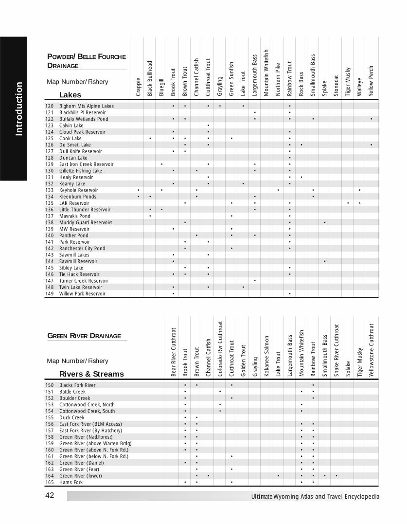
42
Intr
odu
ctio
n
Ultimate Wyoming Atlas and Travel Encyclopedia
Map Number/Fishery
Rivers & Streams150 Blacks Fork River • • • •151 Battle Creek • • • •152 Boulder Creek • • •153 Cottonwood Creek, North • • •154 Cottonwood Creek, South • • •155 Duck Creek • •156 East Fork River (BLM Access) • • • •157 East Fork River (By Hatchery) • • • •158 Green River (Natl.Forest) • • • •159 Green River (above Warren Brdg) • • • •160 Green River (above N. Fork Rd.) • • • •161 Green River (below N. Fork Rd.) • • • •162 Green River (Daniel) • • • •163 Green River (Fear) • • • •164 Green River (lower) • • • • • • •165 Hams Fork • • • • •
GREEN RIVER DRAINAGE
Bear
Riv
er C
utth
roat
Broo
k Tr
out
Brow
n Tr
out
Cha
nnel
Cat
fish
Col
orad
o Rv
r C
utth
roat
Cut
thro
at T
rout
Gol
den
Trou
t
Gra
ylin
g
Koka
nee
Salm
on
Lake
Tro
ut
Larg
emou
th B
ass
Mou
ntai
n W
hite
fish
Rain
bow
Tro
ut
Smal
lmou
th B
ass
Snak
e Ri
ver
Cut
thro
at
Spla
ke
Tige
r M
usky
Yello
wst
one
Cut
thro
at
Map Number/Fishery
Lakes120 Bighorn Mts Alpine Lakes • • • • • •121 Blackhills Pl Reservoir • •122 Buffalo Wetlands Pond • • • • • •123 Calvin Lake •124 Cloud Peak Reservoir • • •125 Cook Lake • • • • • •126 De Smet, Lake • • • • •127 Dull Knife Reservoir • • •128 Duncan Lake •129 East Iron Creek Reservoir • • • •130 Gillette Fishing Lake • • • •131 Healy Reservoir • • •132 Kearny Lake • • • •133 Keyhole Reservoir • • • • • •134 Kleenburn Ponds • • • • •135 LAK Reservoir • • • • • •136 Little Thunder Reservoir • • • •137 Mavrakis Pond • • •138 Muddy Guard Reservoirs • • •139 MW Reservoir • • •140 Panther Pond • • • •141 Park Reservoir • • •142 Ranchester City Pond • • •143 Sawmill Lakes • •144 Sawmill Reservoir • •145 Sibley Lake • • •146 Tie Hack Reservoir • • • •147 Turner Creek Reservoir •148 Twin Lake Reservoir • • •149 Willow Park Reservoir • •
POWDER/BELLE FOURCHEDRAINAGE
Cra
ppie
Blac
k Bu
llhea
d
Blue
gill
Broo
k Tr
out
Brow
n Tr
out
Cha
nnel
Cat
fish
Cut
tthro
at T
rout
Gra
ylin
g
Gre
en S
unfis
h
Lake
Tro
ut
Larg
emou
th B
ass
Mou
ntai
n W
hite
fish
Nor
ther
n Pi
ke
Rain
bow
Tro
ut
Rock
Bas
s
Smal
lmou
th B
ass
Spla
ke
Ston
ecat
Tige
r M
usky
Wal
leye
Yello
w P
erch
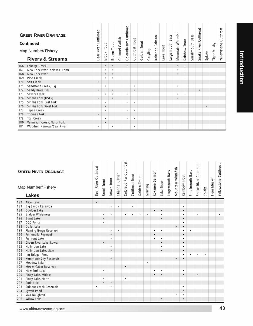
43
Introd
uction
www.ultimatewyoming.com
Map Number/Fishery
Rivers & Streams166 Labarge Creek • • • • •167 New Fork River (below E. Fork) • • • •168 New Fork River • • • •169 Pine Creek • • •170 Salt Creek •171 Sandstone Creek, Big • • •172 Sandy River, Big • • • • •173 Savery Creek • • • • •174 Smiths Fork (USFS) • • •175 Smiths Fork, East Fork • • • •176 Smiths Fork, West Fork • •177 Tepee Creek • • •178 Thomas Fork •179 Tosi Creek • • •180 Vermillion Creek, North Fork •181 Woodruff Narrows/Sear River • • •
GREEN RIVER DRAINAGE
Continued
Bear
Riv
er C
utth
roat
Broo
k Tr
out
Brow
n Tr
out
Cha
nnel
Cat
fish
Col
orad
o Rv
r C
utth
roat
Cut
thro
at T
rout
Gol
den
Trou
t
Gra
ylin
g
Koka
nee
Salm
on
Lake
Tro
ut
Larg
emou
th B
ass
Mou
ntai
n W
hite
fish
Rain
bow
Tro
ut
Smal
lmou
th B
ass
Snak
e Ri
ver
Cut
thro
at
Spla
ke
Tige
r M
usky
Yello
wst
one
Cut
thro
at
Map Number/Fishery
Lakes182 Alice, Lake •183 Big Sandy Reservoir • • • •184 Boulder Lake • • •185 Bridger Wilderness • • • • • • • • • •186 Burnt Lake • • •187 CCC Ponds • •188 Dollar Lake • •189 Flaming Gorge Reservoir • • • • • •190 Fontenelle Reservoir • • •191 Fremont Lake • • • •192 Green River Lake, Lower • • •193 Halfmoon Lake • • •194 Halfmoon Lake, Little • • •195 Jim Bridger Pond • • • •196 Kemmerer City Reservoir • • •197 Meadow Lake •198 Meeks Cabin Reservoir •199 New Fork Lake • • • •200 Piney Lake, Middle • • • •201 Piney Lake, North • •202 Soda Lake • •203 Sulphur Creek Reservoir • • •204 Sylvan Pond •205 Viva Naughton • •206 Willow Lake • •
GREEN RIVER DRAINAGE
Bear
Riv
er C
utth
roat
Broo
k Tr
out
Brow
n Tr
out
Cha
nnel
Cat
fish
Col
orad
o Rv
r C
utth
roat
Cut
thro
at T
rout
Gol
den
Trou
t
Gra
ylin
g
Koka
nee
Salm
on
Lake
Tro
ut
Larg
emou
th B
ass
Mou
ntai
n W
hite
fish
Rain
bow
Tro
ut
Smal
lmou
th B
ass
Snak
e Ri
ver
Cut
thro
at
Spla
ke
Tige
r M
usky
Yello
wst
one
Cut
thro
at
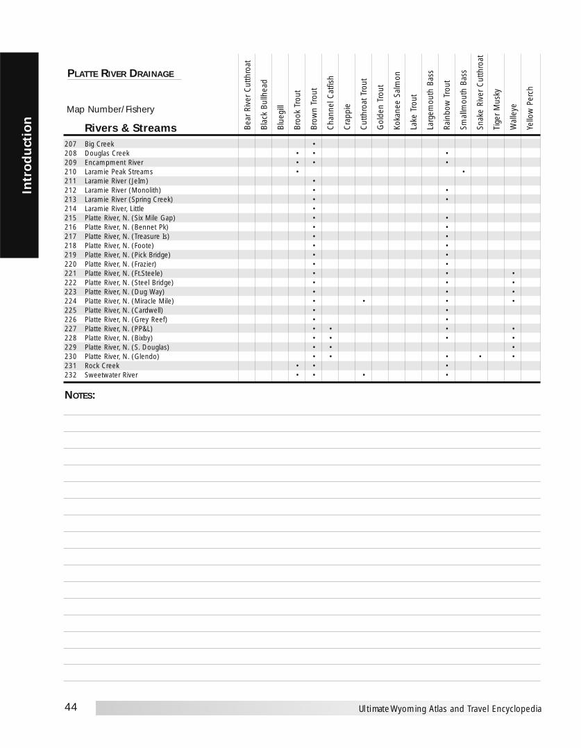
44
Intr
odu
ctio
n
Ultimate Wyoming Atlas and Travel Encyclopedia
Map Number/Fishery
Rivers & Streams207 Big Creek •208 Douglas Creek • • •209 Encampment River • • •210 Laramie Peak Streams • •211 Laramie River (JeIm) •212 Laramie River (Monolith) • •213 Laramie River (Spring Creek) • •214 Laramie River, Little •215 Platte River, N. (Six Mile Gap) • •216 Platte River, N. (Bennet Pk) • •217 Platte River, N. (Treasure Is) • •218 Platte River, N. (Foote) • •219 Platte River, N. (Pick Bridge) • •220 Platte River, N. (Frazier) • •221 Platte River, N. (Ft.Steele) • • •222 Platte River, N. (Steel Bridge) • • •223 Platte River, N. (Dug Way) • • •224 Platte River, N. (Miracle Mile) • • • •225 Platte River, N. (Cardwell) • •226 Platte River, N. (Grey Reef) • •227 Platte River, N. (PP&L) • • • •228 Platte River, N. (Bixby) • • • •229 Platte River, N. (S. Douglas) • • •230 Platte River, N. (Glendo) • • • • •231 Rock Creek • • •232 Sweetwater River • • • •
PLATTE RIVER DRAINAGE
Bear
Riv
er C
utth
roat
Blac
k Bu
llhea
d
Blue
gill
Broo
k Tr
out
Brow
n Tr
out
Cha
nnel
Cat
fish
Cra
ppie
Cut
thro
at T
rout
Gol
den
Trou
t
Koka
nee
Salm
on
Lake
Tro
ut
Larg
emou
th B
ass
Rain
bow
Tro
ut
Smal
lmou
th B
ass
Snak
e Ri
ver
Cut
thro
at
Tige
r M
usky
Wal
leye
Yello
w P
erch
NOTES:

45
Introd
uction
www.ultimatewyoming.com
Map Number/Fishery
Lakes233 33 Mile Ponds • • •234 Alcova Reservoir • • •235 Allen Lake, East • •236 Alsop Lake •237 Country Club Lake • •238 Crow Reservoir, North •239 Crystal Lake •240 Diamond Lake • • •241 Dome Rock Reservoir • • •242 Festo Lake • •243 Gelatt Lake •244 Glendo Reservoir • • • • • •245 Goldeneye Reservoir • • •246 Granite Lake • •247 Grayrocks Reservoir • • • • •248 Hattie, Lake • • • •249 Hawk Springs Reservoir • • • • •250 Hog Park Reservoir • •251 Johnson Creek Reservoir •252 Lake Owen • •253 Meeboer Lake •254 Packers Lake • • • •255 Pathfinder Reservoir • • • •256 Pole Mountain •257 Rim Lake •258 Rob Roy Reservoir • •259 Rock Creek Reservoir •260 Rock Lake • • • • • • •261 Saratoga Lake • •262 Seminoe Reservoir • • • •263 Sloans Lake • • •264 Snowy Range Lakes • • •265 Sodergreen Lake •266 Teton Reservoir • •267 Toltec Reservoir • •268 Turpin Reservoir •269 Twin Buttes Reservoir • •270 Walker Jenkins Lake •271 Wheatland Reservoir #1 • • •272 Wheatland Reservoir #3 • • • •
PLATTE RIVER DRAINAGE
Bear
Riv
er C
utth
roat
Blac
k Bu
llhea
d
Blue
gill
Broo
k Tr
out
Brow
n Tr
out
Cha
nnel
Cat
fish
Cra
ppie
Cut
thro
at T
rout
Gol
den
Trou
t
Koka
nee
Salm
on
Lake
Tro
ut
Larg
emou
th B
ass
Rain
bow
Tro
ut
Smal
lmou
th B
ass
Snak
e Ri
ver
Cut
thro
at
Tige
r M
usky
Wal
leye
Yello
w P
erch
NOTES:
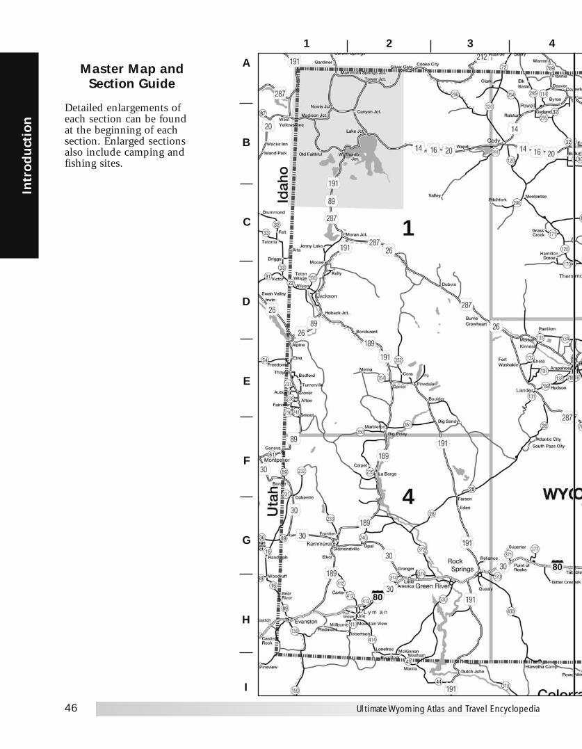
46
Intr
odu
ctio
n
Ultimate Wyoming Atlas and Travel Encyclopedia
1
4
Master Map andSection Guide
21
B
A
C
D
E
F
G
H
I
43
Detailed enlargements ofeach section can be foundat the beginning of eachsection. Enlarged sectionsalso include camping andfishing sites.

47
Introd
uction
www.ultimatewyoming.com
6
3
5
5 6 7 8 9 10
2

48
Intr
odu
ctio
n
Ultimate Wyoming Atlas and Travel Encyclopedia
COUNTIESAlbany (5), 32014 . . . . . . . . . .G-8Big Horn (9), 11461 . . . . . . . .B-5Campbell (17), 33698 . . . . . . .C-8Carbon (6),15639 . . . . . . . . . .G-6Converse (13), 12052 . . . . . . .E-8Crook (18), 5887 . . . . . . . . . . .B-9Fremont (10), 35804 . . . . . . . .E-4Goshen (7),12538 . . . . . . . . .F-10Hot Springs (15), 4882 . . . . . .C-4Johnson (16), 7075 . . . . . . . . .C-7Laramie (2), 81607 . . . . . . . . .H-9Lincoln (12), 14573 . . . . . . . . .F-1Natrona (1), 66533 . . . . . . . . .E-6Niobrara (14), 2407 . . . . . . . .E-10Park (11), 25786 . . . . . . . . . . .B-3Platte (8), 8807 . . . . . . . . . . . .G-9Sheridan (3), 26560 . . . . . . . . .B-6Sublette (23), 5920 . . . . . . . . .F-2Sweetwater (4), 37613 . . . . . .G-4Teton (22), 18251 . . . . . . . . . .C-2Uinta (19), 19742 . . . . . . . . . .H-1Washakie (20), 8289 . . . . . . . .C-5Weston (21), 6644 . . . . . . . . .C-9
CITIES AND TOWNSAcme . . . . . . . . . . . . . . . . . . . .A-6Afton,1818 . . . . . . . . . . . . . . . .E-1Aladdin . . . . . . . . . . . . . . . . .B-1OAlbany . . . . . . . . . . . . . . . . . . .H-7Albin, 120 . . . . . . . . . . . . . .H-1OAlcova . . . . . . . . . . . . . . . . . . .F-7Alpine, 550 . . . . . . . . . . . . . . .E-1Alva . . . . . . . . . . . . . . . . . . . .B-1OArapahoe . . . . . . . . . . . . . . . . .E-4Arlington . . . . . . . . . . . . . . . . .H-7Arminto . . . . . . . . . . . . . . . . . .E-6Arvada . . . . . . . . . . . . . . . . . . .B-7Atlantic City . . . . . . . . . . . . . . .F-4Auburn . . . . . . . . . . . . . . . . . .E-1Baggs, 348 . . . . . . . . . . . . . . . .I-5Bairoil, 97 . . . . . . . . . . . . . . . .F-5Banner . . . . . . . . . . . . . . . . . . .B-6Bar Nunn, 936 . . . . . . . . . . . . .E-7Basin, 1238 . . . . . . . . . . . . . . .B-5Bear River, 441 . . . . . . . . . . . .H-1Beckton . . . . . . . . . . . . . . . . . .B-6Bedford . . . . . . . . . . . . . . . . . .E-1Beulah . . . . . . . . . . . . . . . . . .B-1OBig Horn . . . . . . . . . . . . . . . . .B-6Big Piney, 408 . . . . . . . . . . . . .F-2Big Sandy . . . . . . . . . . . . . . . . .F-3Big Trails . . . . . . . . . . . . . . . . .C-6Bill . . . . . . . . . . . . . . . . . . . . . .D-9Bitter Creek . . . . . . . . . . . . . . .H-4Bondurant . . . . . . . . . . . . . . . .D-2Border . . . . . . . . . . . . . . . . . . .F-1Bosler . . . . . . . . . . . . . . . . . . .G-8Boulder . . . . . . . . . . . . . . . . . .E-3Boxelder . . . . . . . . . . . . . . . . . .F-8Buckhorn . . . . . . . . . . . . . . .C-10Buffalo, 3900 . . . . . . . . . . . . . .B-7Buford . . . . . . . . . . . . . . . . . . .H-9Burgess Jct. . . . . . . . . . . . . . . .A-5Burlington, 250 . . . . . . . . . . . .B-4Burns, 285 . . . . . . . . . . . . . .H-10Burntfork . . . . . . . . . . . . . . . . .I-2Burns . . . . . . . . . . . . . . . . . . . .D-3Byron, 557 . . . . . . . . . . . . . . . .A-4Calpet . . . . . . . . . . . . . . . . . . .F-2Canyon Jct. . . . . . . . . . . . . . . .B-2
Carlile . . . . . . . . . . . . . . . . . . .B-9Carpenter . . . . . . . . . . . . . . . .I-1OCarter . . . . . . . . . . . . . . . . . . .H-1Casper, 49644 . . . . . . . . . . . . .E-7Centennial . . . . . . . . . . . . . . . .H-7Cheyenne, 53011 . . . . . . . . . .H-9Chugwater, 244 . . . . . . . . . . . .G-9Clareton . . . . . . . . . . . . . . . . .D-9Clark . . . . . . . . . . . . . . . . . . . .A-3Clearmont, 115 . . . . . . . . . . . .B-7Cody, 8835 . . . . . . . . . . . . . . .B-3Cokeville, 506 . . . . . . . . . . . . .G-1Colony . . . . . . . . . . . . . . . . .A-1OCora . . . . . . . . . . . . . . . . . . . . .E-2Cowley, 560 . . . . . . . . . . . . . . .A-4Creston Jct. . . . . . . . . . . . . . . .G-5Crowheart . . . . . . . . . . . . . . . .D-3Daniel . . . . . . . . . . . . . . . . . . .E-2Dayton, 678 . . . . . . . . . . . . . . .A-6Deaver, 177 . . . . . . . . . . . . . . .A-4Devils Tower Jct. . . . . . . . . . . .B-9Diamondville, 716 . . . . . . . . . .G-1Dixon, 79 . . . . . . . . . . . . . . . . .I-6Douglas, 5288 . . . . . . . . . . . . .E-9Dubois, 962 . . . . . . . . . . . . . .D-3E. Thermopolis, 274 . . . . . . . .D-5Eden . . . . . . . . . . . . . . . . . . . .G-3Edgerton, 169 . . . . . . . . . . . . .D-7Egbert . . . . . . . . . . . . . . . . . .H-1OElk Basin . . . . . . . . . . . . . . . . .A-4Elk Mountain, 192 . . . . . . . . .G-7Elkol . . . . . . . . . . . . . . . . . . . .G-1Elmo . . . . . . . . . . . . . . . . . . . .G-7Emblem . . . . . . . . . . . . . . . . . .B-4Encampment, 443 . . . . . . . . . .H-7Ervay . . . . . . . . . . . . . . . . . . . .E-6Esterbrook . . . . . . . . . . . . . . . .F-9Ethete . . . . . . . . . . . . . . . . . . .E-4Etna . . . . . . . . . . . . . . . . . . . . .E-1Evanston, 11507 . . . . . . . . . . .H-1Evansville, 2255 . . . . . . . . . . .E-7Fairview . . . . . . . . . . . . . . . . . .E-1Farson . . . . . . . . . . . . . . . . . . .G-3Federal . . . . . . . . . . . . . . . . . .H-9Fort Bridger . . . . . . . . . . . . . . .H-1Fort Laramie, 243 . . . . . . . . .F-10Fort Washakie . . . . . . . . . . . . .E-4Four Corners . . . . . . . . . . . . .C-10Fox Park . . . . . . . . . . . . . . . . .H-7Frannie, 209 . . . . . . . . . . . . . .A-4Freedom . . . . . . . . . . . . . . . . .E-1Frontier . . . . . . . . . . . . . . . . . .G-1Garland . . . . . . . . . . . . . . . . . .B-4Gillette, 19646 . . . . . . . . . . . . .B-8Glendo, 229 . . . . . . . . . . . . . . .F-9Glenrock, 2231 . . . . . . . . . . . .E-8Granger, 146 . . . . . . . . . . . . . .G-2Grass Creek . . . . . . . . . . . . . . .C-4Green River, 11808 H-3Greybull, 1815 . . . . . . . . . . . . .B-5Grover . . . . . . . . . . . . . . . . . . .E-1Guernsey, 1147 . . . . . . . . . . . .F-9Hamilton Dome . . . . . . . . . . . .C-4Hampshire . . . . . . . . . . . . . . . .D-9Hanna, 873 . . . . . . . . . . . . . . .G-7Hartville, 76 . . . . . . . . . . . . . . .F-9Hawk Springs . . . . . . . . . . . .G-10Hiland . . . . . . . . . . . . . . . . . . .E-6HiIlsdale . . . . . . . . . . . . . . . .H-1OHoback Jct. . . . . . . . . . . . . . . .D-1Horse Creek . . . . . . . . . . . . . .H-9Hudson, 407 . . . . . . . . . . . . . .E-4Hulett, 408 . . . . . . . . . . . . . . .B-9
Huntley . . . . . . . . . . . . . . . .G-1OHyattville . . . . . . . . . . . . . . . . .C-5Iron Mountain . . . . . . . . . . . . .H-9Jackson, 8647 . . . . . . . . . . . . .D-1Jay Em . . . . . . . . . . . . . . . . .F-1OJeffrey City . . . . . . . . . . . . . . . .F-5Jenny Lake . . . . . . . . . . . . . . . .C-1Kaycee, 249 . . . . . . . . . . . . . . .C-7Keeline . . . . . . . . . . . . . . . . . . .E-9Kelly . . . . . . . . . . . . . . . . . . . .D-1Kemmerer, 2651 . . . . . . . . . . .G-1Kinnear . . . . . . . . . . . . . . . . . .E-4Kirby, 57 . . . . . . . . . . . . . . . . .C-5La Barge, 431 . . . . . . . . . . . . . .F-2LaGrange, 332 . . . . . . . . . . .G-1OLake Jct. . . . . . . . . . . . . . . . . . .B-2Lamont . . . . . . . . . . . . . . . . . .F-6Lance Creek . . . . . . . . . . . . . . .E-9Lander, 6867 . . . . . . . . . . . . . .E-4Laramie, 27204 . . . . . . . . . . . .H-8Leiter . . . . . . . . . . . . . . . . . . . .B-7Lightning Flat . . . . . . . . . . . . .A-9Linch . . . . . . . . . . . . . . . . . . . .D-7Lingle, 510 . . . . . . . . . . . . . .F-1OLittle America . . . . . . . . . . . . .H-2Lonetree . . . . . . . . . . . . . . . . .H-2Lost Cabin . . . . . . . . . . . . . . . .D-5Lost Springs, 1 . . . . . . . . . . . . .E-9Lovell, 2281 . . . . . . . . . . . . . .A-4Lucerne . . . . . . . . . . . . . . . . . .D-5Lusk, 1447 . . . . . . . . . . . . . .E-1 0Lyman, 1938 . . . . . . . . . . . . . .H-2Lysite . . . . . . . . . . . . . . . . . . . .D-5Madison Jct. . . . . . . . . . . . . . . .B-1Mammoth SpringsJct. . . . . . . . . . . . . . . . . . . . . . .A-1Manderson, 104 . . . . . . . . . . .C-5Manville, 101 . . . . . . . . . . . .E-1OMarbleton, 720 . . . . . . . . . . . .F-2Mayoworth . . . . . . . . . . . . . . .C-6McFadden . . . . . . . . . . . . . . . .G-7McKinnon . . . . . . . . . . . . . . . .1-2Medicine Bow, 274 G-7Meeteetse, 351 . . . . . . . . . . . . .C-4Merna . . . . . . . . . . . . . . . . . . .E-2Midwest, 408 . . . . . . . . . . . . .D-7Millburne . . . . . . . . . . . . . . . .H-1Mills, 2591 . . . . . . . . . . . . . . .E-7Moneta . . . . . . . . . . . . . . . . . . .E-5Moorcroft, 807 . . . . . . . . . . . . .B-9Moose . . . . . . . . . . . . . . . . . . .D-1Moran Jct. . . . . . . . . . . . . . . . .C-2Morrisey . . . . . . . . . . . . . . . .D-10Morton . . . . . . . . . . . . . . . . . .D-4Moskee . . . . . . . . . . . . . . . . .B-10Mountain Home . . . . . . . . . . . .1-7Mountain View, 1153 . . . . . . .H-2Mule Cr. Jct. . . . . . . . . . . . . .D-1ONatrona . . . . . . . . . . . . . . . . . .E-7Newcastle, 3065 . . . . . . . . . .C-1ONew Haven . . . . . . . . . . . . . . .B-9Node . . . . . . . . . . . . . . . . . . .E-1ONorris Jct. . . . . . . . . . . . . . . . .B-1Old Faithful . . . . . . . . . . . . . . .B-1Opal, 102 . . . . . . . . . . . . . . . .G-2Orin . . . . . . . . . . . . . . . . . . . . .F-9Orpha . . . . . . . . . . . . . . . . . . .E-8Osage . . . . . . . . . . . . . . . . . .C-1OOshoto . . . . . . . . . . . . . . . . . . .B-9Otto . . . . . . . . . . . . . . . . . . . . .B-5Parkman . . . . . . . . . . . . . . . . .A-6Pavillion, 165 . . . . . . . . . . . . .D-4Piedmont . . . . . . . . . . . . . . . . .H-1
Pine Bluffs, 1153 . . . . . . . . .H-1OPine Haven, 222 . . . . . . . . . . .B-9Pine Tree Jct. . . . . . . . . . . . . . .D-8Pinedale, 1412 . . . . . . . . . . . . .E-2Pitchfork . . . . . . . . . . . . . . . . .C-3Point of Rocks . . . . . . . . . . . . .G-4Powder River . . . . . . . . . . . . . .E-6Powell, 5373 . . . . . . . . . . . . . .B-4Quealy . . . . . . . . . . . . . . . . . .H-3Ralston . . . . . . . . . . . . . . . . . . .B-4Ranchester, 701 . . . . . . . . . . . .A-6Rawlins, 8538 . . . . . . . . . . . . .G-6Recluse . . . . . . . . . . . . . . . . . . .B-8Red Desert . . . . . . . . . . . . . . . .G-5Redbird . . . . . . . . . . . . . . . .D-1OReliance . . . . . . . . . . . . . . . . . .G-3Reno Jct. . . . . . . . . . . . . . . . . .C-8Riverside, 59 . . . . . . . . . . . . . .H-7Riverton, 9310 . . . . . . . . . . . . .E-4Robertson . . . . . . . . . . . . . . . .H-2Rock River, 235 . . . . . . . . . . . .G-8Rock Springs, 18708 . . . . . . . .G-3Rockypoint . . . . . . . . . . . . . . .A-9Rolling Hills, 449 . . . . . . . . . . .E-8Rozet . . . . . . . . . . . . . . . . . . . .B-9Sage . . . . . . . . . . . . . . . . . . . . .G-1St. Stephens . . . . . . . . . . . . . . .E-4Saratoga, 1726 . . . . . . . . . . . .H-6Savageton . . . . . . . . . . . . . . . .C-8Savery . . . . . . . . . . . . . . . . . . . .I-6Shawnee . . . . . . . . . . . . . . . . .E-9Shell . . . . . . . . . . . . . . . . . . . . .B-5Sheridan, 15804 . . . . . . . . . . .A-6Shoshoni, 635 . . . . . . . . . . . . .D-5Sinclair, 423 . . . . . . . . . . . . . .G-6Slater . . . . . . . . . . . . . . . . . . . .G-9Smoot . . . . . . . . . . . . . . . . . . .E-1South Pass City . . . . . . . . . . . .F-4Spotted Horse . . . . . . . . . . . . .B-8Story . . . . . . . . . . . . . . . . . . . .B-6Sundance, 1161 . . . . . . . . . . .B-10Sunrise . . . . . . . . . . . . . . . . . . .F-9Superior, 244 . . . . . . . . . . . . .G-4Sussex . . . . . . . . . . . . . . . . . . .D-7Sweetwater Station Jct. . . . . . . .F-5Table Rock . . . . . . . . . . . . . . . .G-4Ten Sleep, 304 . . . . . . . . . . . . .C-6Teton Village . . . . . . . . . . . . . .D-1Thayne, 341 . . . . . . . . . . . . . . .E-1Thermopolis, 3172 . . . . . . . . .D-5Tie Siding . . . . . . . . . . . . . . . .H-8Torrington, 5776 . . . . . . . . .G-1OTower Jct. . . . . . . . . . . . . . . . .A-2Turnerville . . . . . . . . . . . . . . . .E-1Ucross . . . . . . . . . . . . . . . . . . .B-7Upton, 872 . . . . . . . . . . . . . . .C-9Urie . . . . . . . . . . . . . . . . . . . . .H-2Valley . . . . . . . . . . . . . . . . . . . .C-3Van Tassell, 18 . . . . . . . . . . .E-1OVeteran . . . . . . . . . . . . . . . . .G-1OWalcott . . . . . . . . . . . . . . . . . .G-7Waltman . . . . . . . . . . . . . . . . .E-6Wamsutter, 261 . . . . . . . . . . . .G-5Wapiti . . . . . . . . . . . . . . . . . . .B-3Washam . . . . . . . . . . . . . . . . .H-2W. Thumb Jct. . . . . . . . . . . . . .B-1Weston . . . . . . . . . . . . . . . . . . .B-8Wheatland, 3548 . . . . . . . . . . .G-9Wilson . . . . . . . . . . . . . . . . . . .D-1Woods Landing . . . . . . . . . . . .H-8Worland, 5250 . . . . . . . . . . . .C-5Wright, 1347 . . . . . . . . . . . . . .C-8Yoder, 169 . . . . . . . . . . . . . .G-1O
CITY/TOWN LOCATOR