assessment of contaminated soil and groundwater
TRANSCRIPT
Assessment of Contaminated Soil and Groundwater
Soil samples were taken at multiple locations and at multiple depths
and investigated for hydrocarbon contamination. Groundwater was
studied where it was possible to reach the groundwater table
© UNEP
UNEP ENVIRONMENTAL ASSESSMENT OF OGONILAND
96
Assessment of Contaminated Soil and Groundwater
4.1 Field observations of the current situation on land
Though oil production in Ogoniland has ceased, the UNEP assessment team visited accessible oilfields and oil-related facilities in the region, including both pipeline and facility rights of way as well as decommissioned and abandoned facilities.
Rights of way consist of land along pipelines and around other oilfield infrastructure which are, by law, owned and managed by oil companies to facilitate easy access for routine maintenance as well as emergency response. SPDC practice is for rights of way around facilities to be fenced, while those along pipelines are kept clear of habitation and vegetation but not fenced. In most cases pipelines are buried. Rights of way act as buffer zones between oil facilities and local communities, so that any incident, such as an oil spill or fire, does not impinge directly upon areas of human
habitation. In any well-functioning oil industry operation, maintaining rights of way is both essential to and indicative of good environmental management.
On the whole, maintenance of rights of way in Ogoniland is minimal, arising in part from the fact that the oilfield has been closed since 1993 and access for the operator is somewhat limited. The entire gamut of oil operations in Ogoniland took place on soil which is very productive. This means that, unless regularly maintained, the land on which oil facilities and rights of way are located can very quickly become overgrown with vegetation. There are several locations within rights of way where lack of maintenance is evident and of serious concern.
Habitation on or close to oilfield facilities
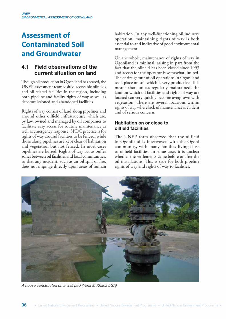
The UNEP team observed that the oilfield in Ogoniland is interwoven with the Ogoni community, with many families living close to oilfield facilities. In some cases it is unclear whether the settlements came before or after the oil installations. This is true for both pipeline rights of way and rights of way to facilities.
A house constructed on a well pad (Yorla 9, Khana LGA)
4 CONTAMINATED SOIL & GROUNDWATER
97
In at least one instance, at Yorla 9, the assessment team came across a family that had built its house within metres of the oil well, on the well pad itself. The family, with very young children, was also using the land around the well pad, within the oil well right of way, for farming. This observation is disturbing in many ways. To begin with, from a safety point of view, especially where children are concerned, it is wholly inappropriate that the family home is located so close to the wellhead. An immediate hazard is that the children may fall and drown in the (currently unprotected) well pit around the wellhead. Moreover, surrounding the well site are a number of other mud and water pits which, even if uncontaminated, are also potential hazards to both children and adults. In addition, the family is unprotected from fire, which is not unusual at disused oil wells in Ogoniland.
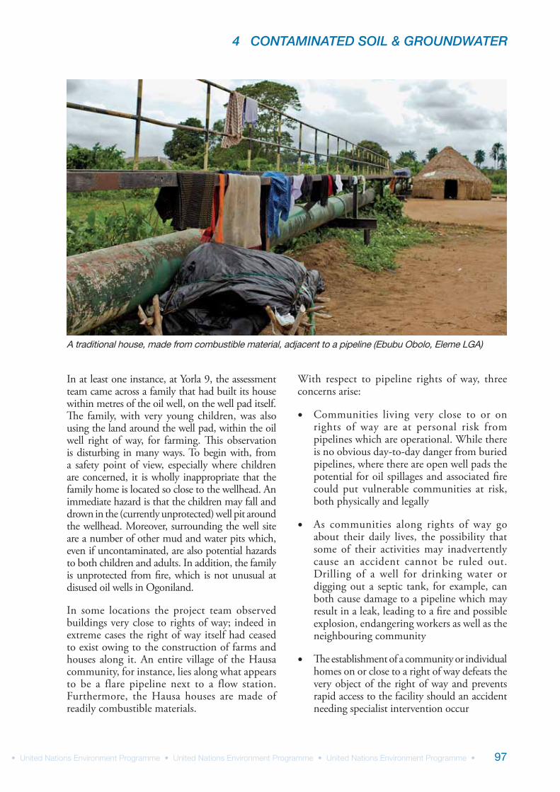
In some locations the project team observed buildings very close to rights of way; indeed in extreme cases the right of way itself had ceased to exist owing to the construction of farms and houses along it. An entire village of the Hausa community, for instance, lies along what appears to be a flare pipeline next to a flow station. Furthermore, the Hausa houses are made of readily combustible materials.
With respect to pipeline rights of way, three concerns arise:
Communities living very close to or on rights of way are at personal risk from pipelines which are operational. While there is no obvious day-to-day danger from buried pipelines, where there are open well pads the potential for oil spillages and associated fire could put vulnerable communities at risk, both physically and legally
As communities along rights of way go about their daily lives, the possibility that some of their activities may inadvertently cause an accident cannot be ruled out. Drilling of a well for drinking water or digging out a septic tank, for example, can both cause damage to a pipeline which may result in a leak, leading to a fire and possible explosion, endangering workers as well as the neighbouring community
The establishment of a community or individual homes on or close to a right of way defeats the very object of the right of way and prevents rapid access to the facility should an accident needing specialist intervention occur
A traditional house, made from combustible material, adjacent to a pipeline (Ebubu Obolo, Eleme LGA)
UNEP ENVIRONMENTAL ASSESSMENT OF OGONILAND
98
That communities have been able to set up houses and farms along pipeline rights of way is a clear indication of the loss of control on the part of both the pipeline operator and the government regulator. This is a serious safety breach. In addition, other poor and marginalized families may follow suit and construct their own houses within rights of way of other oilfield facilities.
Unmanaged vegetation
The project team observed overgrown wellheads and pipeline rights of way at several sites. In some cases, excessive vegetation growth prevented access by the UNEP team.
While overgrown vegetation does not cause an immediate danger to the facilities, there are concerns. Firstly, a small spill around the facility or on the right of way may not be noticed as quickly as it would be in a cleared area. This may, in turn, lead to a fire, causing damage to the facility, the vegetation and the local community.
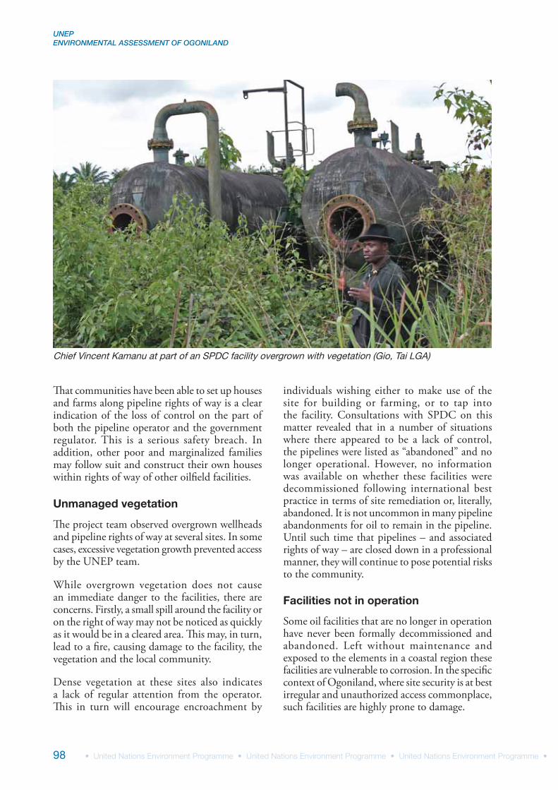
Dense vegetation at these sites also indicates a lack of regular attention from the operator. This in turn will encourage encroachment by
individuals wishing either to make use of the site for building or farming, or to tap into the facility. Consultations with SPDC on this matter revealed that in a number of situations where there appeared to be a lack of control, the pipelines were listed as “abandoned” and no longer operational. However, no information was available on whether these facilities were decommissioned following international best practice in terms of site remediation or, literally, abandoned. It is not uncommon in many pipeline abandonments for oil to remain in the pipeline. Until such time that pipelines – and associated rights of way – are closed down in a professional manner, they will continue to pose potential risks to the community.
Facilities not in operation
Some oil facilities that are no longer in operation have never been formally decommissioned and abandoned. Left without maintenance and exposed to the elements in a coastal region these facilities are vulnerable to corrosion. In the specific context of Ogoniland, where site security is at best irregular and unauthorized access commonplace, such facilities are highly prone to damage.
Chief Vincent Kamanu at part of an SPDC facility overgrown with vegetation (Gio, Tai LGA)
4 CONTAMINATED SOIL & GROUNDWATER
99
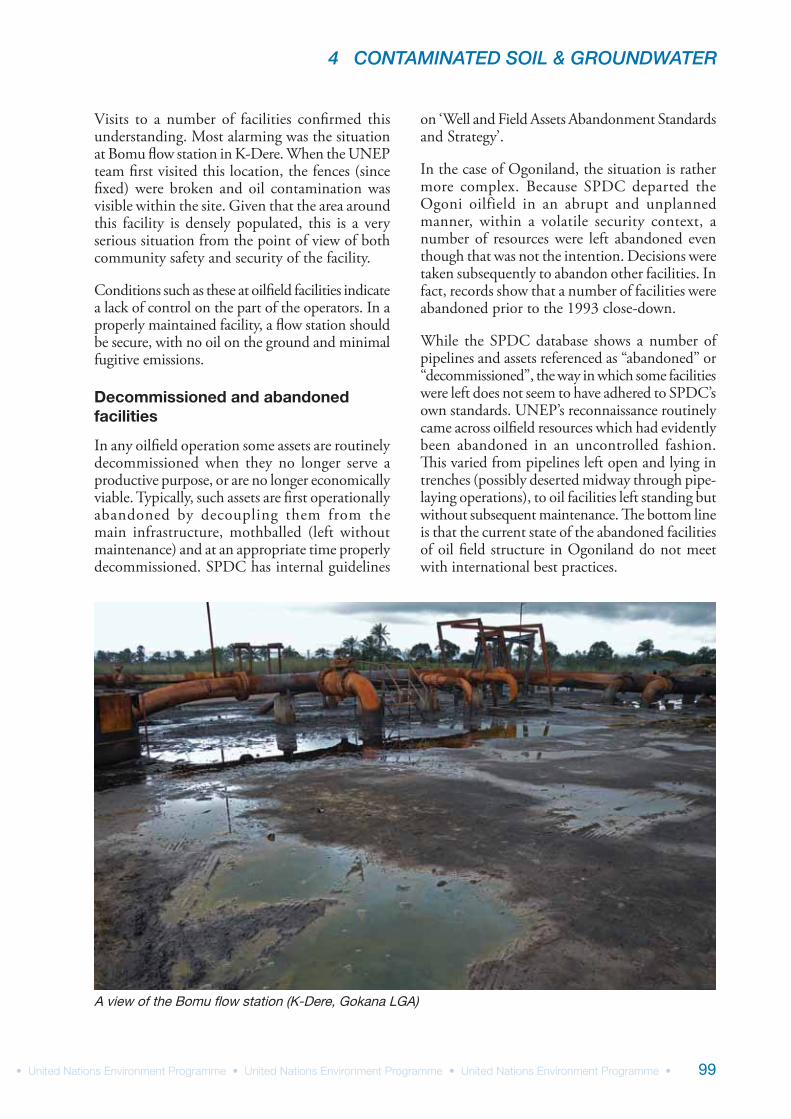
Visits to a number of facilities confirmed this understanding. Most alarming was the situation at Bomu flow station in K-Dere. When the UNEP team first visited this location, the fences (since fixed) were broken and oil contamination was visible within the site. Given that the area around this facility is densely populated, this is a very serious situation from the point of view of both community safety and security of the facility.
Conditions such as these at oilfield facilities indicate a lack of control on the part of the operators. In a properly maintained facility, a flow station should be secure, with no oil on the ground and minimal fugitive emissions.
Decommissioned and abandoned facilities
In any oilfield operation some assets are routinely decommissioned when they no longer serve a productive purpose, or are no longer economically viable. Typically, such assets are first operationally abandoned by decoupling them from the main infrastructure, mothballed (left without maintenance) and at an appropriate time properly decommissioned. SPDC has internal guidelines
on ‘Well and Field Assets Abandonment Standards and Strategy’.
In the case of Ogoniland, the situation is rather more complex. Because SPDC departed the Ogoni oilfield in an abrupt and unplanned manner, within a volatile security context, a number of resources were left abandoned even though that was not the intention. Decisions were taken subsequently to abandon other facilities. In fact, records show that a number of facilities were abandoned prior to the 1993 close-down.
While the SPDC database shows a number of pipelines and assets referenced as “abandoned” or “decommissioned”, the way in which some facilities were left does not seem to have adhered to SPDC’s own standards. UNEP’s reconnaissance routinely came across oilfield resources which had evidently been abandoned in an uncontrolled fashion. This varied from pipelines left open and lying in trenches (possibly deserted midway through pipe-laying operations), to oil facilities left standing but without subsequent maintenance. The bottom line is that the current state of the abandoned facilities of oil field structure in Ogoniland do not meet with international best practices.
A view of the Bomu flow station (K-Dere, Gokana LGA)
UNEP ENVIRONMENTAL ASSESSMENT OF OGONILAND
100
The abandoned facilities in Ogoniland pose both environmental and safety risks. From an environmental point of view, there is no indication as to whether the various containers lying around are full or empty, or what they contain(ed). Corrosion of metallic objects leads to ground contamination by heavy metals. Attempts by criminal elements to recover objects for sale as scrap may lead to safety risks, both on and off oilfield sites, while children playing on these facilities also face health risks.
Well blowouts
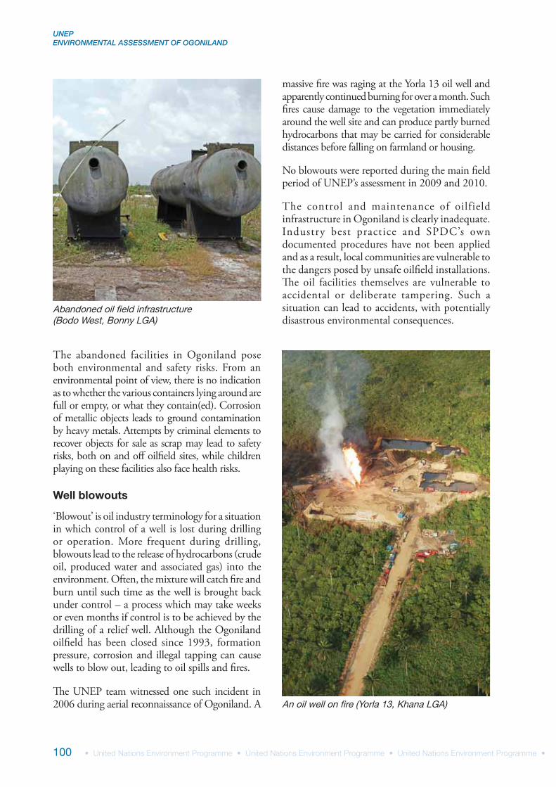
‘Blowout’ is oil industry terminology for a situation in which control of a well is lost during drilling or operation. More frequent during drilling, blowouts lead to the release of hydrocarbons (crude oil, produced water and associated gas) into the environment. Often, the mixture will catch fire and burn until such time as the well is brought back under control – a process which may take weeks or even months if control is to be achieved by the drilling of a relief well. Although the Ogoniland oilfield has been closed since 1993, formation pressure, corrosion and illegal tapping can cause wells to blow out, leading to oil spills and fires.
The UNEP team witnessed one such incident in 2006 during aerial reconnaissance of Ogoniland. A
massive fire was raging at the Yorla 13 oil well and apparently continued burning for over a month. Such fires cause damage to the vegetation immediately around the well site and can produce partly burned hydrocarbons that may be carried for considerable distances before falling on farmland or housing.
No blowouts were reported during the main field period of UNEP’s assessment in 2009 and 2010.
The control and maintenance of oilfield infrastructure in Ogoniland is clearly inadequate. Industry best practice and SPDC’s own documented procedures have not been applied and as a result, local communities are vulnerable to the dangers posed by unsafe oilfield installations. The oil facilities themselves are vulnerable to accidental or deliberate tampering. Such a situation can lead to accidents, with potentially disastrous environmental consequences.
Abandoned oil field infrastructure (Bodo West, Bonny LGA)
An oil well on fire (Yorla 13, Khana LGA)
4 CONTAMINATED SOIL & GROUNDWATER
101
4.2 Field observations concerning illegal oil-related activities
Illegal tapping of oil wells and pipelines
Bunkering is an oil industry term for supplying oil to a ship for its own use. In Ogoniland (and the wider Niger Delta) this term refers to the illegal tapping of oil industry infrastructure with a view to procuring oil illegally.
A number of defunct SPDC oil wells are located in the Ogoniland creeks. However, the wells still contain oil and are self-flowing, such that by operating the well valves, crude oil (along with gas and water) can be produced. During one visit the assessment team observed a group of people tapping into these wells and transferring oil to small boats. This happened in broad daylight, without any apparent hesitation, even in the presence of the UNEP team. The oil collected
was either transferred to larger boats for onward shipment or used locally for illegal artisanal refining (see following section).
SPDC informed UNEP that by November 2010 all the wells had been sealed and capped. No further tapping was observed by the UNEP team during subsequent visits.
Similarly, there are SPDC and NNPC pipelines through Ogoniland that still carry crude oil. There are frequent reports of these pipelines being tapped illegally, in some cases leading to spills and fires. Though UNEP did not directly observe such incidents on the ground, this does not mean that such incidents did not take place during UNEP’s fieldwork period. As there are no externally visible signs while pipelines are being tapped for oil (unlike the highly visible artisanal refining – see next section) and access to sites always had to be negotiated days in advance, only with precise intelligence and community support would it be possible to observe live operations.
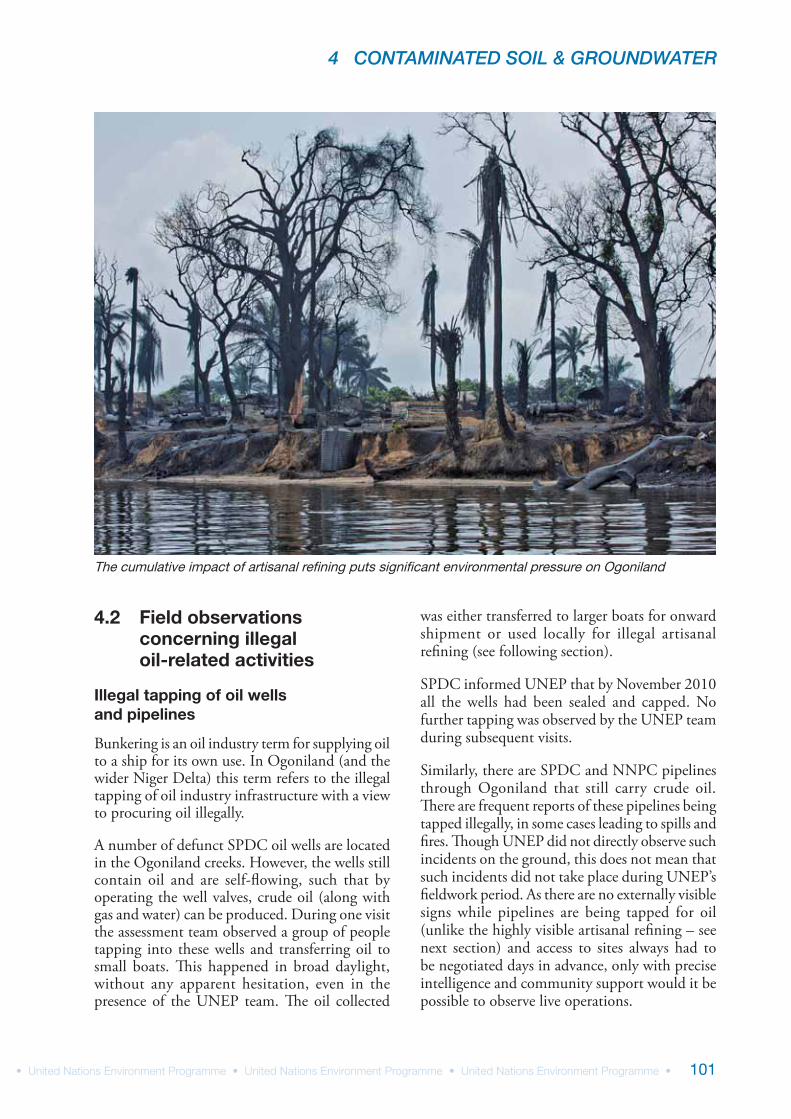
The cumulative impact of artisanal refining puts significant environmental pressure on Ogoniland
UNEP ENVIRONMENTAL ASSESSMENT OF OGONILAND
102
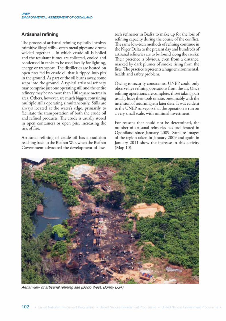
Artisanal refining
The process of artisanal refining typically involves primitive illegal stills – often metal pipes and drums welded together – in which crude oil is boiled and the resultant fumes are collected, cooled and condensed in tanks to be used locally for lighting, energy or transport. The distilleries are heated on open fires fed by crude oil that is tipped into pits in the ground. As part of the oil burns away, some seeps into the ground. A typical artisanal refinery may comprise just one operating still and the entire refinery may be no more than 100 square metres in area. Others, however, are much bigger, containing multiple stills operating simultaneously. Stills are always located at the water’s edge, primarily to facilitate the transportation of both the crude oil and refined products. The crude is usually stored in open containers or open pits, increasing the risk of fire.
Artisanal refining of crude oil has a tradition reaching back to the Biafran War, when the Biafran Government advocated the development of low-
tech refineries in Biafra to make up for the loss of refining capacity during the course of the conflict. The same low-tech methods of refining continue in the Niger Delta to the present day and hundreds of artisanal refineries are to be found along the creeks. Their presence is obvious, even from a distance, marked by dark plumes of smoke rising from the fires. The practice represents a huge environmental, health and safety problem.
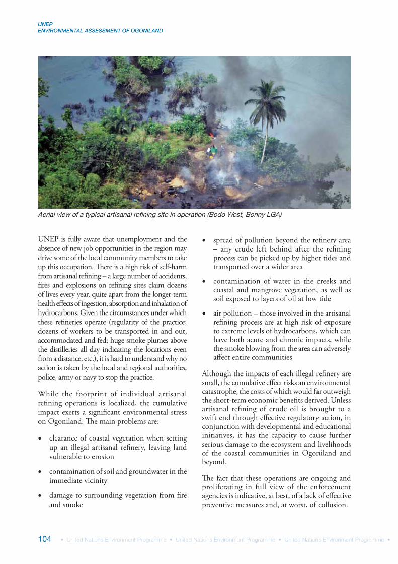
Owing to security constraints, UNEP could only observe live refining operations from the air. Once refining operations are complete, those taking part usually leave their tools on site, presumably with the intention of returning at a later date. It was evident to the UNEP surveyors that the operation is run on a very small scale, with minimal investment.
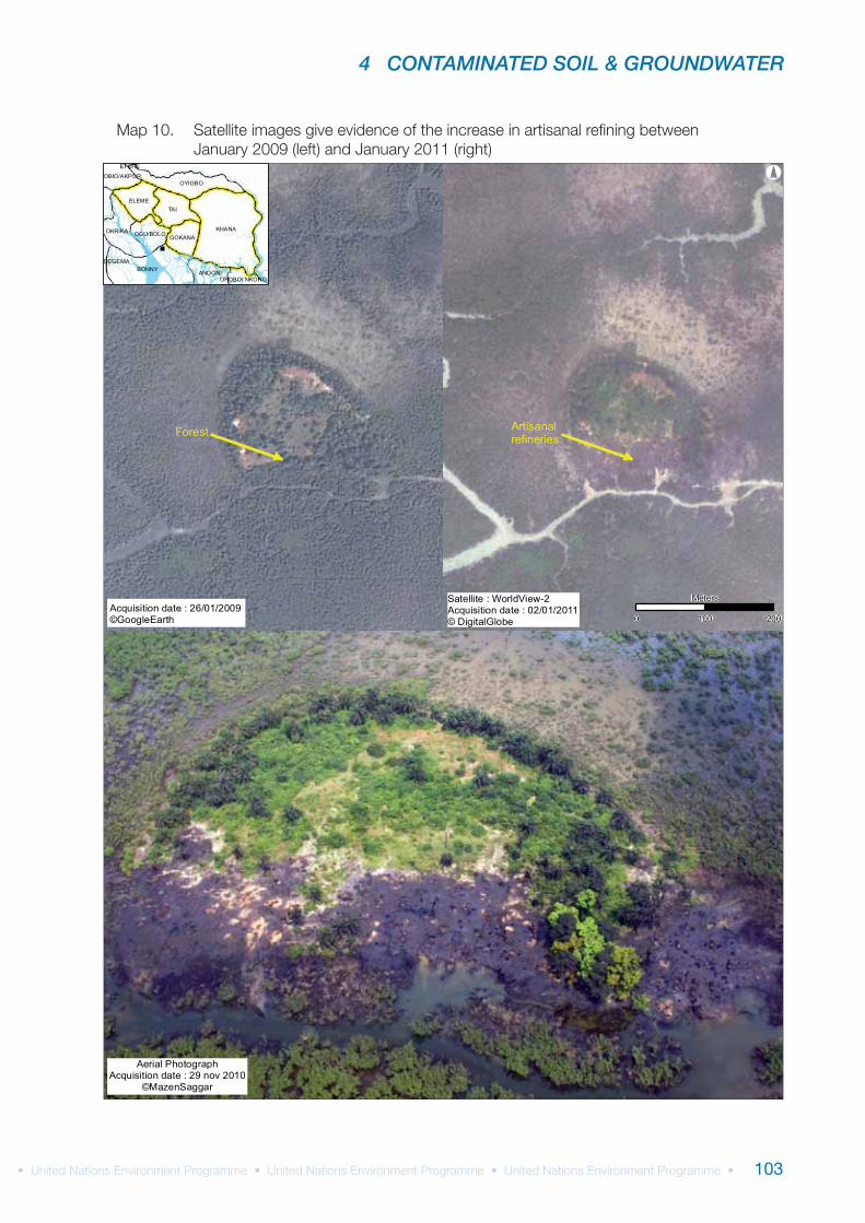
For reasons that could not be determined, the number of artisanal refineries has proliferated in Ogoniland since January 2009. Satellite images of the region taken in January 2009 and again in January 2011 show the increase in this activity (Map 10).
Aerial view of artisanal refining site (Bodo West, Bonny LGA)
4 CONTAMINATED SOIL & GROUNDWATER
103
KHANA
TAI
BONNY
OYIGBO
OKRIKA
ELEME
GOKANA
ANDONI
OGU/BOLO
OBIO/AKPOR
OPOBO/ NKORO
DEGEMA
ETCHE
°
Acquisition date : 26/01/2009©GoogleEarth
Aerial PhotographAcquisition date : 29 nov 2010
©MazenSaggar
Satellite : WorldView-2Acquisition date : 02/01/2011© DigitalGlobe 0 100 200
Meters
Forest Artisanalrefineries
UNEP ENVIRONMENTAL ASSESSMENT OF OGONILAND
104
UNEP is fully aware that unemployment and the absence of new job opportunities in the region may drive some of the local community members to take up this occupation. There is a high risk of self-harm from artisanal refining – a large number of accidents, fires and explosions on refining sites claim dozens of lives every year, quite apart from the longer-term health effects of ingestion, absorption and inhalation of hydrocarbons. Given the circumstances under which these refineries operate (regularity of the practice; dozens of workers to be transported in and out, accommodated and fed; huge smoke plumes above the distilleries all day indicating the locations even from a distance, etc.), it is hard to understand why no action is taken by the local and regional authorities, police, army or navy to stop the practice.
While the footprint of individual artisanal refining operations is localized, the cumulative impact exerts a significant environmental stress on Ogoniland. The main problems are:
clearance of coastal vegetation when setting up an illegal artisanal refinery, leaving land vulnerable to erosion
contamination of soil and groundwater in the immediate vicinity
damage to surrounding vegetation from fire and smoke
spread of pollution beyond the refinery area – any crude left behind after the refining process can be picked up by higher tides and transported over a wider area
contamination of water in the creeks and coastal and mangrove vegetation, as well as soil exposed to layers of oil at low tide
air pollution – those involved in the artisanal refining process are at high risk of exposure to extreme levels of hydrocarbons, which can have both acute and chronic impacts, while the smoke blowing from the area can adversely affect entire communities
Although the impacts of each illegal refinery are small, the cumulative effect risks an environmental catastrophe, the costs of which would far outweigh the short-term economic benefits derived. Unless artisanal refining of crude oil is brought to a swift end through effective regulatory action, in conjunction with developmental and educational initiatives, it has the capacity to cause further serious damage to the ecosystem and livelihoods of the coastal communities in Ogoniland and beyond.
The fact that these operations are ongoing and proliferating in full view of the enforcement agencies is indicative, at best, of a lack of effective preventive measures and, at worst, of collusion.
Aerial view of a typical artisanal refining site in operation (Bodo West, Bonny LGA)
4 CONTAMINATED SOIL & GROUNDWATER
105
4.3 Geological observations
The geological profile of Ogoniland, including the depth and quality of groundwater, is a key factor when assessing contaminated sites. Soil type and grain-size distribution are crucial to the mobility of crude oil in soils and to the groundwater conditions that determine the spread of contamination plumes.
Soil
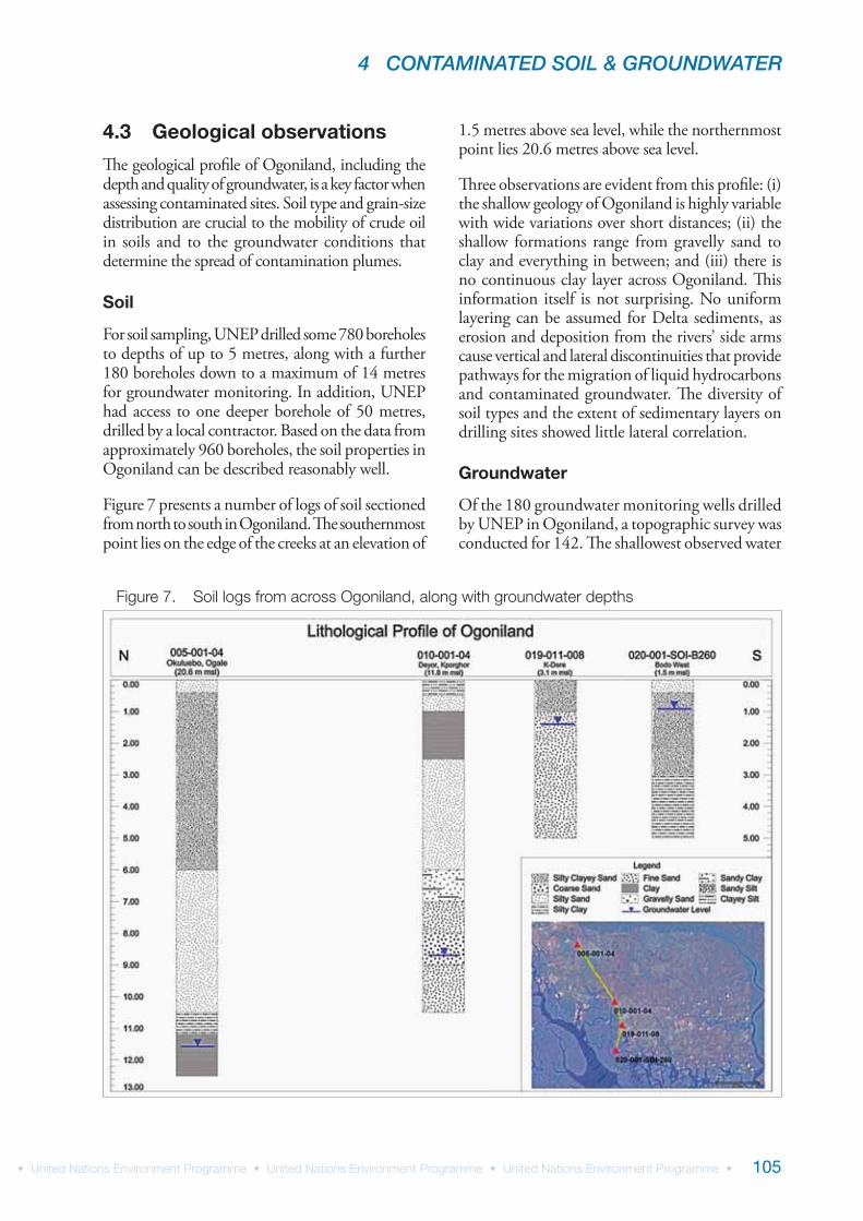
For soil sampling, UNEP drilled some 780 boreholes to depths of up to 5 metres, along with a further 180 boreholes down to a maximum of 14 metres for groundwater monitoring. In addition, UNEP had access to one deeper borehole of 50 metres, drilled by a local contractor. Based on the data from approximately 960 boreholes, the soil properties in Ogoniland can be described reasonably well.
Figure 7 presents a number of logs of soil sectioned from north to south in Ogoniland. The southernmost point lies on the edge of the creeks at an elevation of
1.5 metres above sea level, while the northernmost point lies 20.6 metres above sea level.
Three observations are evident from this profile: (i) the shallow geology of Ogoniland is highly variable with wide variations over short distances; (ii) the shallow formations range from gravelly sand to clay and everything in between; and (iii) there is no continuous clay layer across Ogoniland. This information itself is not surprising. No uniform layering can be assumed for Delta sediments, as erosion and deposition from the rivers’ side arms cause vertical and lateral discontinuities that provide pathways for the migration of liquid hydrocarbons and contaminated groundwater. The diversity of soil types and the extent of sedimentary layers on drilling sites showed little lateral correlation.
Groundwater
Of the 180 groundwater monitoring wells drilled by UNEP in Ogoniland, a topographic survey was conducted for 142. The shallowest observed water
UNEP ENVIRONMENTAL ASSESSMENT OF OGONILAND
106
4 CONTAMINATED SOIL & GROUNDWATER
107
level was 0.7 metres below ground level while the deepest was 14 metres below ground level.
Figure 7 shows the profile of groundwater on a north-south cross section, in which the depth of the water table varies with the prevailing land profile. The groundwater situation in Ogoniland is typical of a delta environment. In areas close
to the creeks, the water table lies close to surface. In intertidal areas in the mangrove zones, the groundwater level rises and falls with the tidal rhythm, while in the interior there are localized swamps into which groundwater drains. The water table fluctuated seasonally in all wells, especially those furthest from the coast.
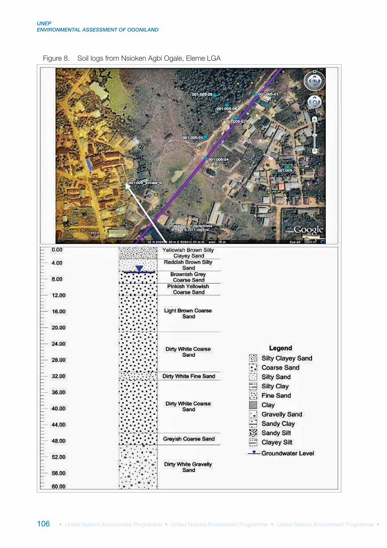
While investigating groundwater contamination at one site, UNEP came across a family drilling deeper boreholes to obtain clean water. Here, the opportunity was taken to obtain a deeper geological profile of the area (Figure 8). The geological profile indicated that there is indeed only one aquifer, which is being tapped by both shallow wells and deeper boreholes. As impermeable layers of clay are highly localized in Ogoniland, interconnectivity with underlying aquifers could not be excluded any of the sites investigated.
While no general flow direction was detected of groundwater in Ogoniland, the flow was typically directed towards the nearest creek or swamp (Figure 9).
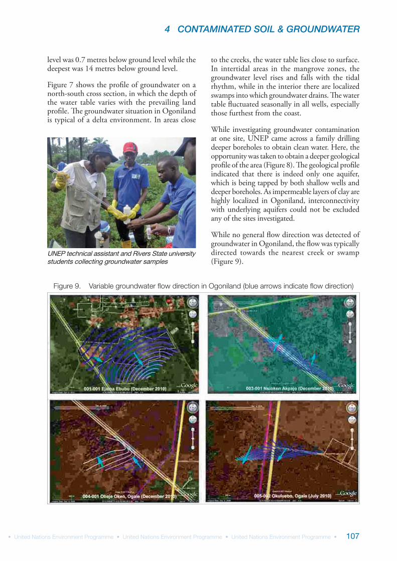
UNEP technical assistant and Rivers State university students collecting groundwater samples
UNEP ENVIRONMENTAL ASSESSMENT OF OGONILAND
108
4.4 Contamination assessments
Soil and groundwater contamination
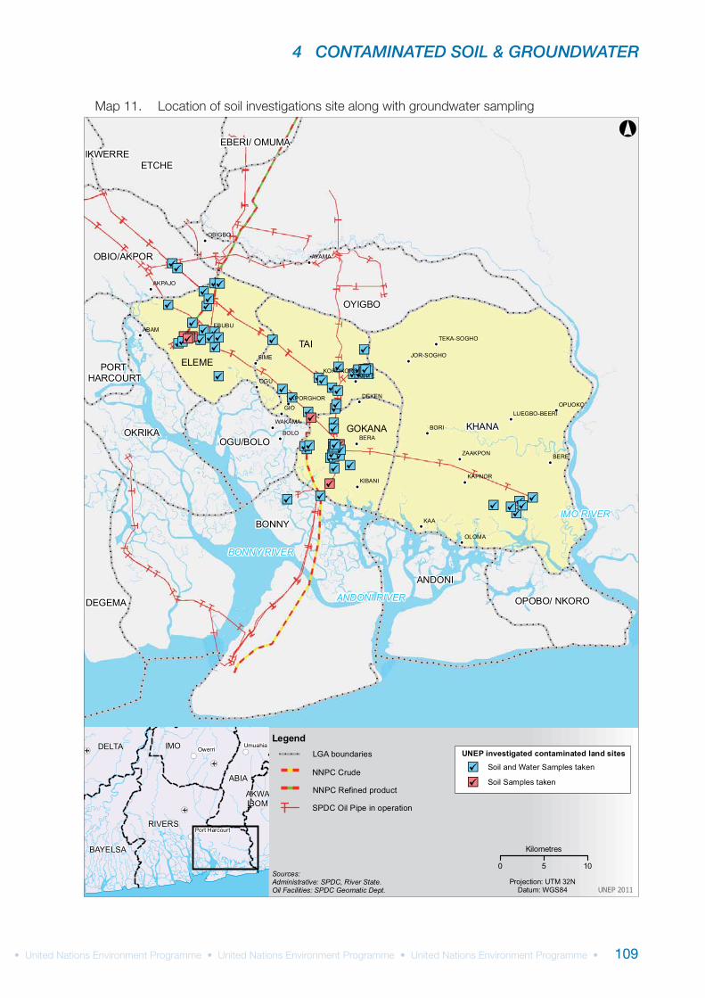
As discussed in Chapter 3, the study investigated 69 different sites for contamination of soil and, where possible, groundwater. Samples of soil were taken at multiple locations within each site, and at each sampling location within a site, samples were taken at multiple depths. Groundwater samples were taken either from dedicated wells drilled for that purpose or from boreholes made to take soil samples.
The sites investigated fall into the following groups:SPDC pipeline rights of waySPDC legacy sites (e.g. abandoned facilities)Suspended SPDC facilities (e.g. wells, flow stations and manifolds never formally abandoned)NNPC crude oil pipelinesNNPC product lines
Table 16 provides a summary of the sites investigated, categorized into the above groupings. At a number of locations within Ogoniland, NNPC pipelines and SPDC pipelines share rights of way. In such instances these were classified as SPDC pipelines, though it was not evident if the spill investigated originated from an SPDC or NNPC crude pipeline.
Two further sites were investigated in detail: an artisanal refinery site and a ‘fly-tipping’ site (i.e. where waste of unknown origin was being disposed of within Ogoniland).
The locations of the sites investigated are presented in Map 11. All sites were investigated for hydro-carbon contamination in soil, while groundwater was investigated where it was possible to reach the groundwater table.
In the following section, findings from representative sites in each of the above categories are presented as case studies. The studies serve to illustrate the prevailing environmental situation in Ogoniland. For each of the sites, site-specific observations, results and conclusions are given, along with site-specific recommendations. Information on all other sites is then presented in tabular form. Taken together, this information provides an overview of the nature and extent of hydrocarbon contamination in Ogoniland.
To accompany this summary report, individual reports for 67 of the sites investigated have been prepared. Each report contains site-specific information on soil profiles, soil and groundwater contamination, proximity to community and depth of penetration of hydrocarbon contamination, concluding with site-specific recommendations. Together, the reports amount to more than 1,000 pages. They will be submitted to both SPDC and the Government of Nigeria and will be available online to interested stakeholders. The supporting database, complete with the analytical data, will also be made publicly available.
The recommendations given in this report are meant to achieve immediate risk reduction. However, prior to initiating comprehensive clean-up, consultation with the regulators, risk assessments and community consultations need to be undertaken during the next phase of the project.
Site classification NumberSPDC pipeline rights of way 34SDPC legacy sites 6Suspended SPDC facilities 22NNPC crude oil pipelines 2NNPC product line 3
4 CONTAMINATED SOIL & GROUNDWATER
109
!
!
!
!
!
!
!
!
!
!
!
!
!
!
!
!
!
!
!
!
!
!
!
!
!
!"h
"h
"h
"h
"h
"h
"h"h
"h "h"h"h
"h
"h
"h
"h"h
"h
"h"h"h"h
"h"h
"h"h"h"h"h
"h
"h "h
"h
"h"h"h
"h"h"h
"h
"h
"h"h "h
"h
"h"h
"h"h
"h
"h
"h"h
"h
"h
"h
"h"h"h "h"h"h
"h
"h"h
"h"h"h "h
BONNY
KHANA
TAI
ANDONI
OYIGBO
OKRIKA
ELEME
ETCHE
DEGEMA
GOKANA
OBIO/AKPOR
OGU/BOLO
OPOBO/ NKORO
PORT HARCOURT
EBERI/ OMUMAIKWERRE
KAA
GIO
OGU
BERE
BERA
ABAM
SIME
BORIBOLO
OLOMA
KPITE
EBUBU
DEKEN
AYAMA
KAPNORKIBANI
OBIGBO
AKPAJO
WAKAMA
OPUOKO
ZAAKPON
KPORGHOR
KOROKORO
JOR-SOGHO
TEKA-SOGHO
LUEGBO-BEERI
BONNY RIVER
IMO RIVER
ANDONI RIVER
0 5 10
Kilometres
UNEP 2011
Sources:Administrative: SPDC, River State.Oil Facilities: SPDC Geomatic Dept.
Projection: UTM 32NDatum: WGS84
¬r
¬r
¬r
!(!(
!(
RIVERS
IMO
ABIA
BAYELSA
DELTA
AKWAIBOM
OwerriUmuahia
Port Harcourt
°
Legend
SPDC Oil Pipe in operationTNNPC Refined product
NNPC Crude
LGA boundaries UNEP investigated contaminated land sites
"h Soil and Water Samples taken
"h Soil Samples taken
UNEP ENVIRONMENTAL ASSESSMENT OF OGONILAND
110
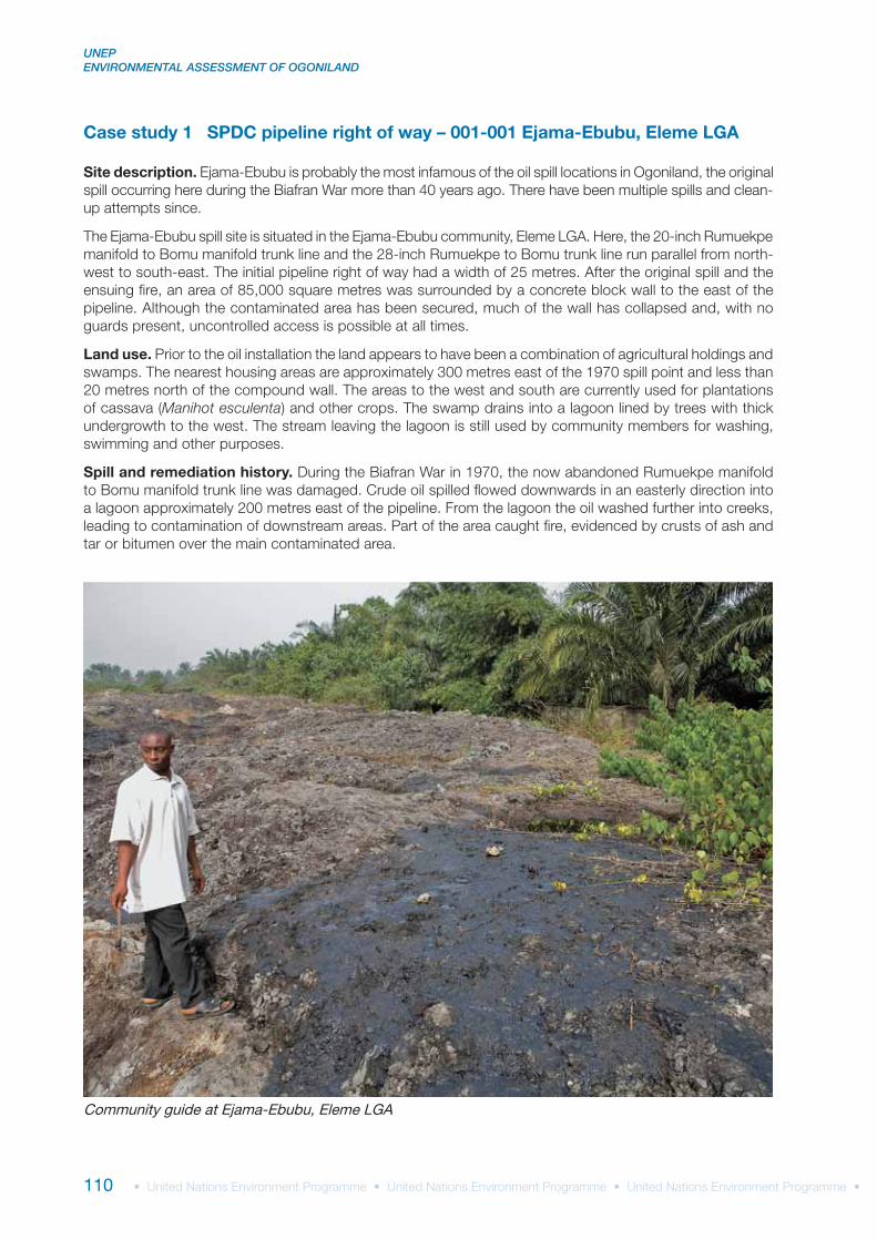
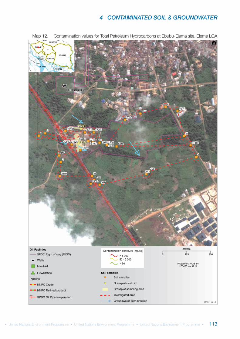
Case study 1 SPDC pipeline right of way – 001-001 Ejama-Ebubu, Eleme LGA
Site description.
Land use.
Manihot esculenta
Spill and remediation history.
Community guide at Ejama-Ebubu, Eleme LGA
4 CONTAMINATED SOIL & GROUNDWATER
111
Visual observations on site.
Sample analysis.
Conclusions.
UNEP site code qc_001-001Site name Ejama-EbubuLGA ElemeSite description SPDC pipeline right of wayTotal Investigated Area (m2) 169,712Number of soil samples 92Number of groundwater samples 15Number of drinking water samples 2Number of surface water samples 1Deepest investigation (m) 6.00Maximum soil TPH (mg/kg) 49,800Number of soil measurements greater than EGASPIN intervention value 36Deepest sample greater than EGASPIN intervention value (m) 6.00Number of wells where free-phase hydrocarbon was observed 1Maximum water TPH (μg/l) 485,000Number of water measurements greater than EGASPIN intervention value 8Presence of hydrocarbons in drinking water NoNumber of soil measurements below 1 metre 62Number of soil measurements below 1 metre greater than EGASPIN intervention value 23Total volume of soil above intervention value (m3) 105,302Total volume of soil above target value (m3) 236,077
UNEP ENVIRONMENTAL ASSESSMENT OF OGONILAND
112
in situ
Site-specific recommendations:
4 CONTAMINATED SOIL & GROUNDWATER
113
")
")
")
")
")
")
")
")
")
")
")")
")
")
")
")
")
")
")
")
")
")
")
")
")
")
")
")")
")")")
2
26
3
6
23
97
387
550
415
128983
155010904590
83051102
5319
2092
8947
28339245
2057
1933337625
25508
13540
14113
20200
10500
17782
1185813800
31900
EBUBU-00328" RUMUEKPE TO BOM
U TRUNKLINE
BONNY
KHANA
TAI
ANDONI
OYIGBO
ELEME
GOKANAOGU/BOLO
°
UNEP 2011
Projection: WGS 84UTM Zone 32 N
Oil Facilities
Pipeline
#* FlowStation
SPDC Oil Pipe in operationT
SPDC Right of way (ROW)
W Wells
") Manifold
NNPC Crude
NNPC Refined product
> 5 00050 - 5 000< 50
Contamination contours (mg/kg)
Investigated area
Soil samples
Grassplot sampling area
") Soil samples
") Grassplot centroid
Groundwater flow direction
0 125 250
Metres
UNEP ENVIRONMENTAL ASSESSMENT OF OGONILAND
114
UNEP site code
LGA Number of soil
samples
Number of groundwater
samples
Deepest soil investigation
(m)
Maximum soil TPH (mg/kg)
Number of soil measurements
>EGASPIN
Deepest soil sample
>EGASPIN (m)
Maximum water TPH (ug/l)
(CL samples)
Hydrocarbons in community
wells
Number of water TPH measurements
>EGASPIN
Number of samples with TPH
>EGASPIN below 1 m
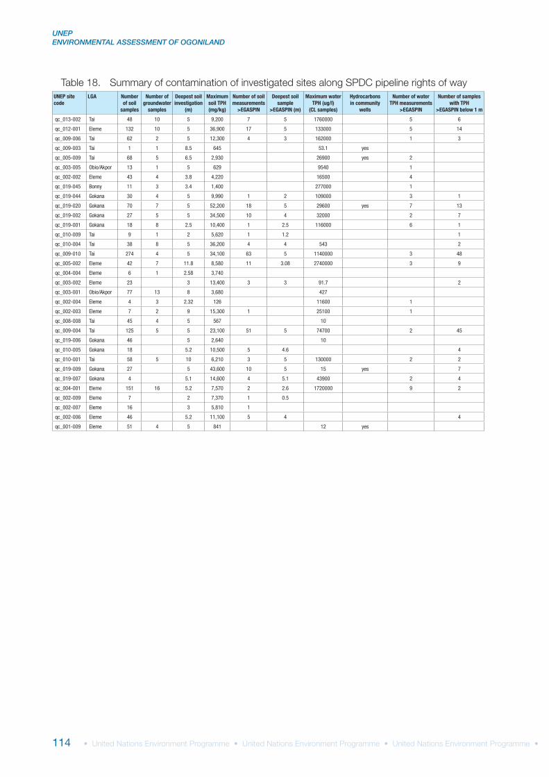
qc_013-002 Tai 48 10 5 9,200 7 5 1760000 5 6
qc_012-001 Eleme 132 10 5 36,900 17 5 133000 5 14
qc_009-006 Tai 62 2 5 12,300 4 3 162000 1 3
qc_009-003 Tai 1 1 8.5 645 53.1 yes
qc_005-009 Tai 68 5 6.5 2,930 26900 yes 2
qc_003-005 Obio/Akpor 13 1 5 629 9540 1
qc_002-002 Eleme 43 4 3.8 4,220 16500 4
qc_019-045 Bonny 11 3 3.4 1,400 277000 1
qc_019-044 Gokana 30 4 5 9,990 1 2 109000 3 1
qc_019-020 Gokana 70 7 5 52,200 18 5 29600 yes 7 13
qc_019-002 Gokana 27 5 5 34,500 10 4 32000 2 7
qc_019-001 Gokana 18 8 2.5 10,400 1 2.5 116000 6 1
qc_010-009 Tai 9 1 2 5,620 1 1.2 1
qc_010-004 Tai 38 8 5 36,200 4 4 543 2
qc_009-010 Tai 274 4 5 34,100 63 5 1140000 3 48
qc_005-002 Eleme 42 7 11.8 8,580 11 3.08 2740000 3 9
qc_004-004 Eleme 6 1 2.58 3,740
qc_003-002 Eleme 23 3 13,400 3 3 91.7 2
qc_003-001 Obio/Akpor 77 13 8 3,680 427
qc_002-004 Eleme 4 3 2.32 126 11600 1
qc_002-003 Eleme 7 2 9 15,300 1 25100 1
qc_008-008 Tai 45 4 5 567 10
qc_009-004 Tai 125 5 5 23,100 51 5 74700 2 45
qc_019-006 Gokana 46 5 2,640 10
qc_010-005 Gokana 18 5.2 10,500 5 4.6 4
qc_010-001 Tai 58 5 10 6,210 3 5 130000 2 2
qc_019-009 Gokana 27 5 43,600 10 5 15 yes 7
qc_019-007 Gokana 4 5.1 14,600 4 5.1 43900 2 4
qc_004-001 Eleme 151 16 5.2 7,570 2 2.6 1720000 9 2
qc_002-009 Eleme 7 2 7,370 1 0.5
qc_002-007 Eleme 16 3 5,810 1
qc_002-006 Eleme 46 5.2 11,100 5 4 4
qc_001-009 Eleme 51 4 5 841 12 yes
4 CONTAMINATED SOIL & GROUNDWATER
115
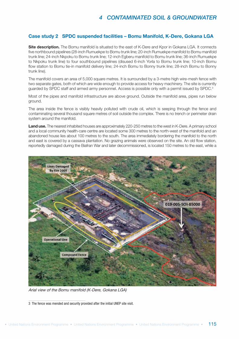
Case study 2 SPDC suspended facilities – Bomu Manifold, K-Dere, Gokana LGA
Site description.
Land use.
3 The fence was mended and security provided after the initial UNEP site visit.
Arial view of the Bomu manifold (K-Dere, Gokana LGA)
UNEP ENVIRONMENTAL ASSESSMENT OF OGONILAND
116
Spill history.
Visual observations on site.
Sample analysis.
Conclusions.
in situ
4 CONTAMINATED SOIL & GROUNDWATER
117
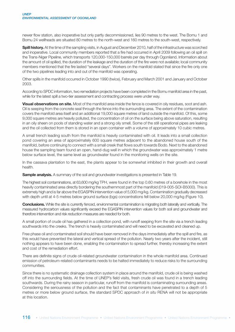
UNEP site code qc_019-005Site name Bomo ManifoldLGA GokanaSite description SPDC operating siteArea Investigated (m2) 37,988Number of soil samples 56Number of groundwater samples 5Deepest investigation (m) 5.00Maximum soil TPH (mg/kg) 63,600Number of soil measurements greater than EGASPIN intervention value 21Deepest sample greater than EGASPIN intervention value (m) 5.00Maximum water TPH (μg/l) 3,410Number of water measurements greater than EGASPIN intervention value 1Presence of hydrocarbons in surface water yesNumber of soil measurements below 1 m 38Number of soil measurements below 1 m greater than EGASPIN intervention value 17Total volume of soil above intervention value (m3) 38,257Total volume of soil above target value (m3) 62,775
Site-specific recommendations:
UNEP ENVIRONMENTAL ASSESSMENT OF OGONILAND
118
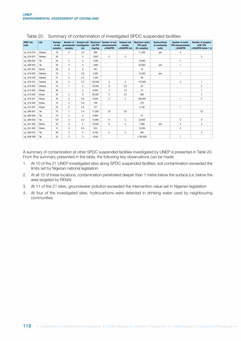
UNEP site code
LGA Number of soil
samples
Number of groundwater
samples
Deepest soil investigation
(m)
Maximum soil TPH (mg/kg)
Number of soil measurements
>EGASPIN
Deepest soil sample
>EGASPIN (m)
Maximum water TPH (ug/l)
(CL samples)
Hydrocarbons in community
wells
Number of water TPH measurements
>EGASPIN
Number of samples with TPH
>EGASPIN below 1 m
qc_019-014 Gokana 16 2 3.2 389 11,500 yes 2
qc_019-021 Gokana 26 5 7,620 2 3 2
qc_009-002 Tai 44 2 5 1,040 10,900 1
qc_008-002 Tai 58 2 5 1,880 42,800 yes 1
qc_007-001 Eleme 58 3 6 442 10
qc_019-035 Gokana 16 1 2.6 3,480 10,300 yes 1
qc_019-032 Gokana 21 2 2.2 1,220 49
qc_019-010 Gokana 32 5 5.2 139,000 5 2 172,000 5 1
qc_019-004 Gokana 18 1 5 23,200 8 2.6 32 4
qc_015-003 Khana 36 3 8,830 1 1.5 10 1
qc_015-002 Khana 45 2 5 20,400 3 3.5 288 3
qc_015-001 Khana 42 2 3.5 8,200 5 3 358,000 1 2
qc_014-004 Khana 18 3 2.6 198 519
qc_014-001 Khana 24 2 2.6 157 2,140 1
qc_008-007 Tai 75 1 7.4 11,200 25 5.6 22
qc_008-004 Tai 72 2 5 4,860 47
qc_008-003 Tai 127 2 5.2 10,800 9 5 22,600 2 9
qc_001-002 Eleme 25 4 3 10,400 6 3 1,980 yes 3 3
qc_001-004 Eleme 8 4 6.5 533 13,200 2
qc_008-010 Tai 60 3 5 6,700 5 5 360 5
qc_008-009 Tai 53 2 5 4,030 1,180,000 1
4 CONTAMINATED SOIL & GROUNDWATER
119
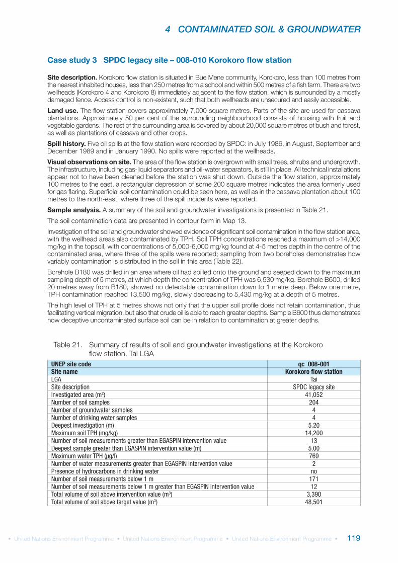
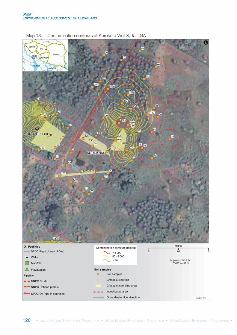
Case study 3 SPDC legacy site – 008-010 Korokoro flow station
Site description.
Land use.
Spill history.
Visual observations on site.
Sample analysis.
UNEP site code qc_008-001Site name Korokoro flow stationLGA TaiSite description SPDC legacy siteInvestigated area (m2) 41,052Number of soil samples 204Number of groundwater samples 4Number of drinking water samples 4Deepest investigation (m) 5.20Maximum soil TPH (mg/kg) 14,200Number of soil measurements greater than EGASPIN intervention value 13Deepest sample greater than EGASPIN intervention value (m) 5.00Maximum water TPH (μg/l) 769Number of water measurements greater than EGASPIN intervention value 2Presence of hydrocarbons in drinking water noNumber of soil measurements below 1 m 171Number of soil measurements below 1 m greater than EGASPIN intervention value 12Total volume of soil above intervention value (m3) 3,390Total volume of soil above target value (m3) 48,501
UNEP ENVIRONMENTAL ASSESSMENT OF OGONILAND
120
")
")
")
")
")
")
")
")
")
")
")
")
")
") ")
")
") ")
")
")
")
")
")
")
")
")
")
")
")
")
")
")
")
")
")
")
")
")")
")
")
")
")
")
")
")
")
")60
60
88
31
68
50
56
50
48
83
29
43
21
41
29 28
64
40
24
39
38
76
14
97
27
111
185
382
429
175
120
316
253120
555
356
664
246
1354
2684
2500
6280
22874281 1132
6825
4770
2960
0
1533440
60,700001
KOROKORO-008
KOROKORO
6" K
orok
oro/
Tai F
S to
Bet
em M
F De
liver
y lin
e(DI
SUSE
D)
BONNY
KHANA
TAI
ANDONI
OYIGBO
ELEME
GOKANAOGU/BOLO
°
UNEP 2011
Projection: WGS 84UTM Zone 32 N
Oil Facilities
Pipeline
#* FlowStation
SPDC Oil Pipe in operationT
SPDC Right of way (ROW)
W Wells
") Manifold
NNPC Crude
NNPC Refined product
> 5 00050 - 5 000< 50
Contamination contours (mg/kg)
Investigated area
Soil samples
Grassplot sampling area
") Soil samples
") Grassplot centroid
Groundwater flow direction
0 60 12
Metres
4 CONTAMINATED SOIL & GROUNDWATER
121
General conclusions.
Site-specific recommendations:
Soil sampling borehole
Depth interval(m)
TPH(mg/kg)
008-010 B180
0.0-0.4 14,200
0.4-1.4 6,810
1.4-2.6 6,020
2.6-4.0 5,630
4.0-5.0 6,530
008-010 B600
0.0-0.7 433
0.7-1.0 285
1.0-2.0 13,500
2.0-3.0 6,460
3.0-4.0 5,620
4.0-5.0 5,430
UNEP site code
LGA Number of soil
samples
Number of groundwater
samples
Deepest soil investigation
(m)
Maximum soil TPH (mg/kg)
Number of soil measurements
>EGASPIN
Deepest soil sample
>EGASPIN (m)
Maximum water TPH (ug/l)
(CL samples)
Hydrocarbons in community
wells
Number of water TPH measurements
>EGASPIN
Number of samples with TPH
>EGASPIN below 1 m
qc_016-001 Khana 85 13 5.2 8,820 2 0.4 77,000 3qc_019-033 Gokana 6 2 331 10qc_009-001 Tai 21 6 3 9,030 2 2 213,000 4 1qc_005-001 Eleme 35 3 9 9,220 6 3 3,590 2 6qc_019-012 Gokana 49 3 5 29,600 11 5 588,000 4 11

UNEP ENVIRONMENTAL ASSESSMENT OF OGONILAND
122
Case study 4 NNPC trunk line spill – 019-013 1990 pipeline leak in K-Dere
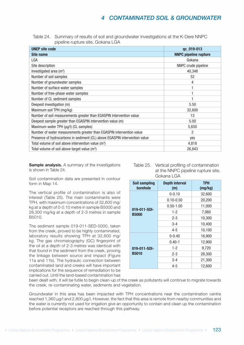
Site description.
Land use.
Spill history.
Visual observations on site.
NNPC trunk line spill (K-Dere, Gokana LGA)
4 CONTAMINATED SOIL & GROUNDWATER
123
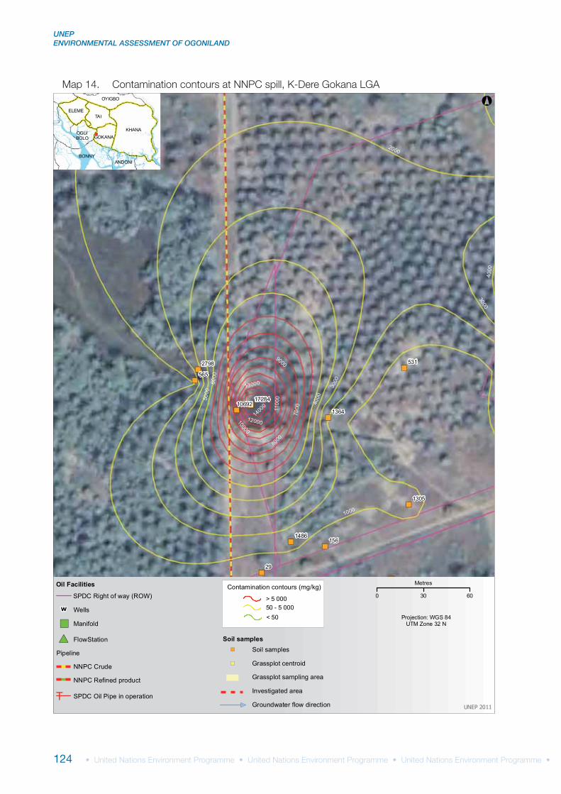
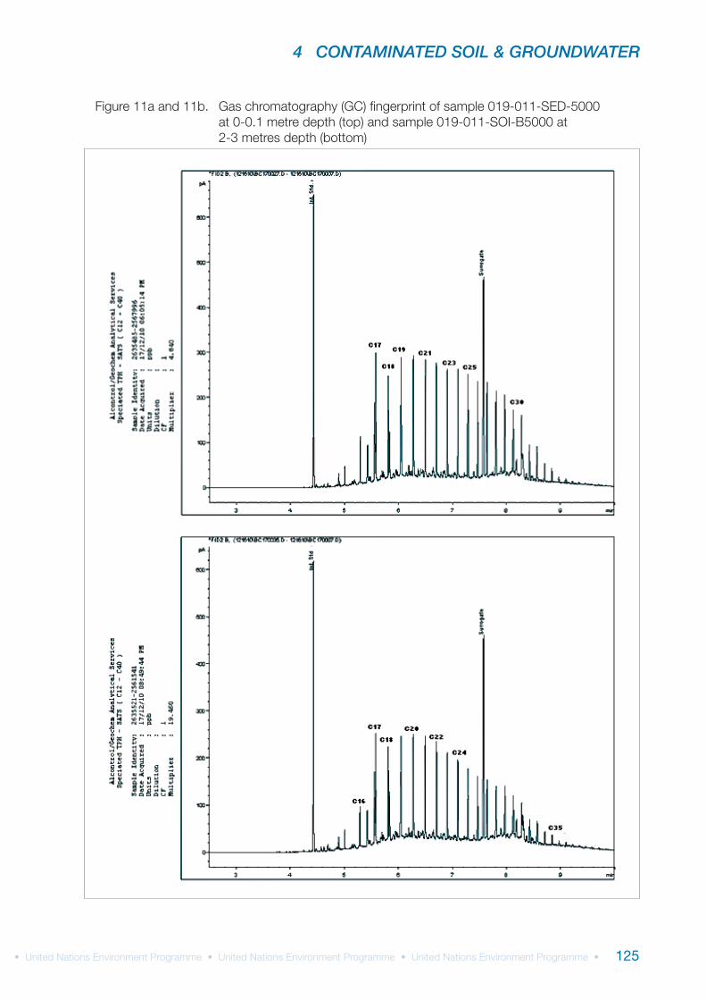
Sample analysis.
UNEP site code qc_019-013Site name NNPC pipeline ruptureLGA GokanaSite description NNPC crude pipelineInvestigated area (m2) 40,348Number of soil samples 52Number of groundwater samples 4Number of surface water samples 1Number of free-phase water samples 1Number of CL sediment samples 1Deepest investigation (m) 5.50Maximum soil TPH (mg/kg) 32,600Number of soil measurements greater than EGASPIN intervention value 13Deepest sample greater than EGASPIN intervention value (m) 5.00Maximum water TPH (μg/l) (CL samples) 5,650Number of water measurements greater than EGASPIN intervention value 2Presence of hydrocarbons in sediment (CL) above EGASPIN intervention value yesTotal volume of soil above intervention value (m3) 4,818Total volume of soil above target value (m3) 26,843
Soil sampling borehole
Depth interval(m)
TPH(mg/kg)
019-011-SOI-B5000
0-0.10 32,600
0.10-0.50 20,200
0.50-1.00 11,000
1-2 7,060
2-3 10,300
3-4 10,400
4-5 10,100
019-011-SOI-B5010
0-0.40 16,900
0.40-1 12,900
1-2 9,720
2-3 28,300
3-4 21,300
4-5 12,600
UNEP ENVIRONMENTAL ASSESSMENT OF OGONILAND
124
")
")
")
")")
")
")
")
")")
")
29
156
531
565
1305
2798
1364
1486
1728410692
1000
2000
3000
400050
0060
00
7000
8000
9000
10000
1100
0
12000
13000
1400
0
3000
4000
BONNY
KHANA
TAI
ANDONI
OYIGBO
ELEME
GOKANAOGU/BOLO
°
UNEP 2011
Projection: WGS 84UTM Zone 32 N
Oil Facilities
Pipeline
#* FlowStation
SPDC Oil Pipe in operationT
SPDC Right of way (ROW)
W Wells
") Manifold
NNPC Crude
NNPC Refined product
> 5 00050 - 5 000< 50
Contamination contours (mg/kg)
Investigated area
Soil samples
Grassplot sampling area
") Soil samples
") Grassplot centroid
Groundwater flow direction
0 30 60
Metres
4 CONTAMINATED SOIL & GROUNDWATER
125
UNEP ENVIRONMENTAL ASSESSMENT OF OGONILAND
126
UNEP site code
LGA Number of soil
samples
Number of groundwater
samples
Deepest soil investigation
(m)
Maximum soil TPH (mg/kg)
Number of soil measurements
>EGASPIN
Deepest soil sample
>EGASPIN (m)
Maximum water TPH (ug/l)
(CL samples)
Hydrocarbons in community
wells
Number of water TPH measurements
>EGASPIN
Number of samples with TPH
>EGASPIN below 1 m
qc_019-046 Gokana 72 3 5 2,900 2,320 2
General conclusions.
Site-specific recommendations:
4 CONTAMINATED SOIL & GROUNDWATER
127
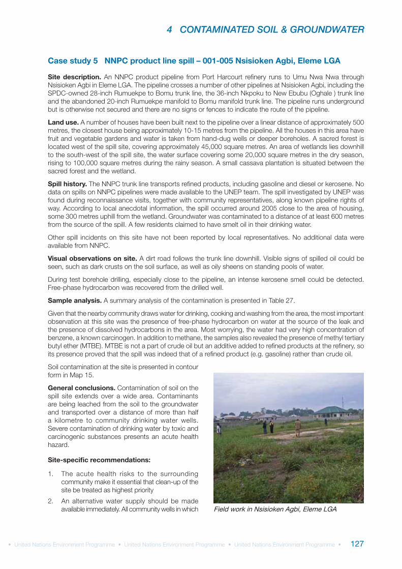
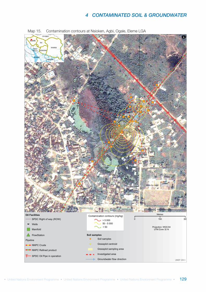
Case study 5 NNPC product line spill – 001-005 Nsisioken Agbi, Eleme LGA
Site description.
Land use.
Spill history.
Visual observations on site.
Sample analysis.
General conclusions.
Site-specific recommendations:
Field work in Nsisioken Agbi, Eleme LGA
UNEP ENVIRONMENTAL ASSESSMENT OF OGONILAND
128
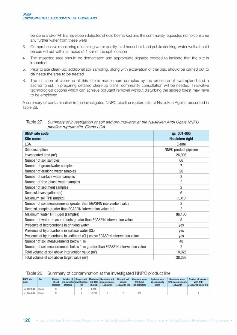
UNEP site code qc_001-005Site name Nsisioken AgbiLGA ElemeSite description NNPC product pipelineInvestigated area (m2) 26,995Number of soil samples 66Number of groundwater samples 7Number of drinking water samples 20Number of surface water samples 2Number of free-phase water samples 2Number of sediment samples 2Deepest investigation (m) 6Maximum soil TPH (mg/kg) 7,310Number of soil measurements greater than EGASPIN intervention value 2Deepest sample greater than EGASPIN intervention value (m) 2Maximum water TPH (μg/l) (samples) 86,100Number of water measurements greater than EGASPIN intervention value 5Presence of hydrocarbons in drinking water yesPresence of hydrocarbons in surface water (CL) yesPresence of hydrocarbons in sediment (CL) above EGASPIN intervention value yesNumber of soil measurements below 1 m 48Number of soil measurements below 1 m greater than EGASPIN intervention value 2Total volume of soil above intervention value (m3) 10,025Total volume of soil above target value (m3) 38,366
Summary of investigation of soil and groundwater at the Nsisioken Agbi Ogale NNPC pipeline rupture site, Eleme LGA
UNEP site code
LGA Number of soil
samples
Number of groundwater
samples
Deepest soil investigation
(m)
Maximum soil TPH (mg/kg)
Number of soil measurements
>EGASPIN
Deepest soil sample
>EGASPIN (m)
Maximum water TPH (ug/l)
(CL samples)
Hydrocarbons in community
wells
Number of water TPH measurements
>EGASPIN
Number of samples with TPH
>EGASPIN below 1 m
qc_002-008 Eleme 13 3 2,950
qc_004-006 Eleme 38 5 13,200 6 2 181 3
4 CONTAMINATED SOIL & GROUNDWATER
129
")
")
")
")
")
")
")
")
")
")
")")
")
")
")
")
")
")
")
")
")
")
1
24
30
50
1450 46 65
1851
403
221
125
731
403
652
1142
1454
6054
1357
2831
2034
28" RUMUEKPE TO BOMU TRUNKLINE
BONNY
KHANA
TAI
ANDONI
OYIGBO
ELEME
GOKANAOGU/BOLO
°
UNEP 2011
Projection: WGS 84UTM Zone 32 N
Oil Facilities
Pipeline
#* FlowStation
SPDC Oil Pipe in operationT
SPDC Right of way (ROW)
W Wells
") Manifold
NNPC Crude
NNPC Refined product
> 5 00050 - 5 000< 50
Contamination contours (mg/kg)
Investigated area
Soil samples
Grassplot sampling area
") Soil samples
") Grassplot centroid
Groundwater flow direction
0 150 300
Metres
UNEP ENVIRONMENTAL ASSESSMENT OF OGONILAND
130
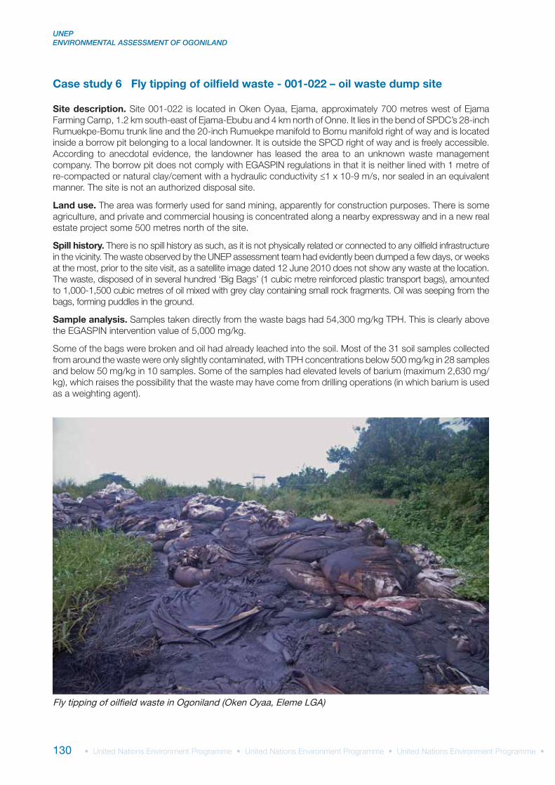
Case study 6 Fly tipping of oilfield waste - 001-022 – oil waste dump site
Site description.
≤
Land use.
Spill history.
Sample analysis.
Fly tipping of oilfield waste in Ogoniland (Oken Oyaa, Eleme LGA)
4 CONTAMINATED SOIL & GROUNDWATER
131
General conclusions.
Site-specific recommendations:
UNEP ENVIRONMENTAL ASSESSMENT OF OGONILAND
132
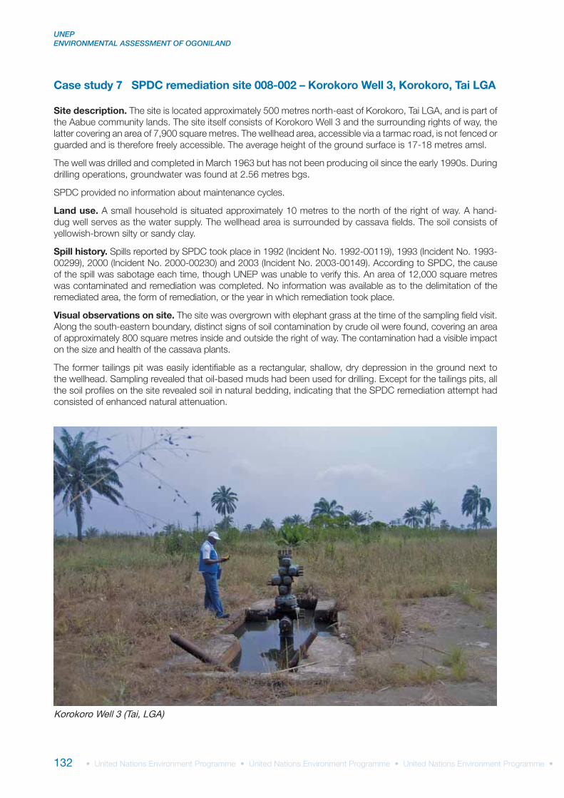
Case study 7 SPDC remediation site 008-002 – Korokoro Well 3, Korokoro, Tai LGA
Site description.
Land use.
Spill history.
Visual observations on site.
Korokoro Well 3 (Tai, LGA)
4 CONTAMINATED SOIL & GROUNDWATER
133
General conclusions.
Site-specific recommendations:
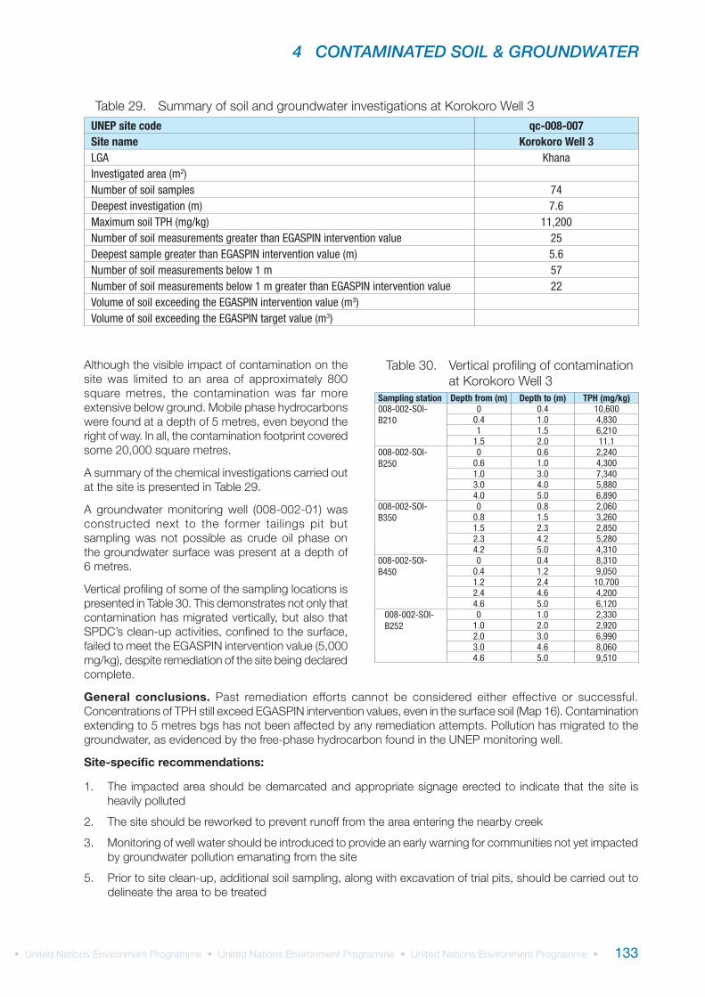
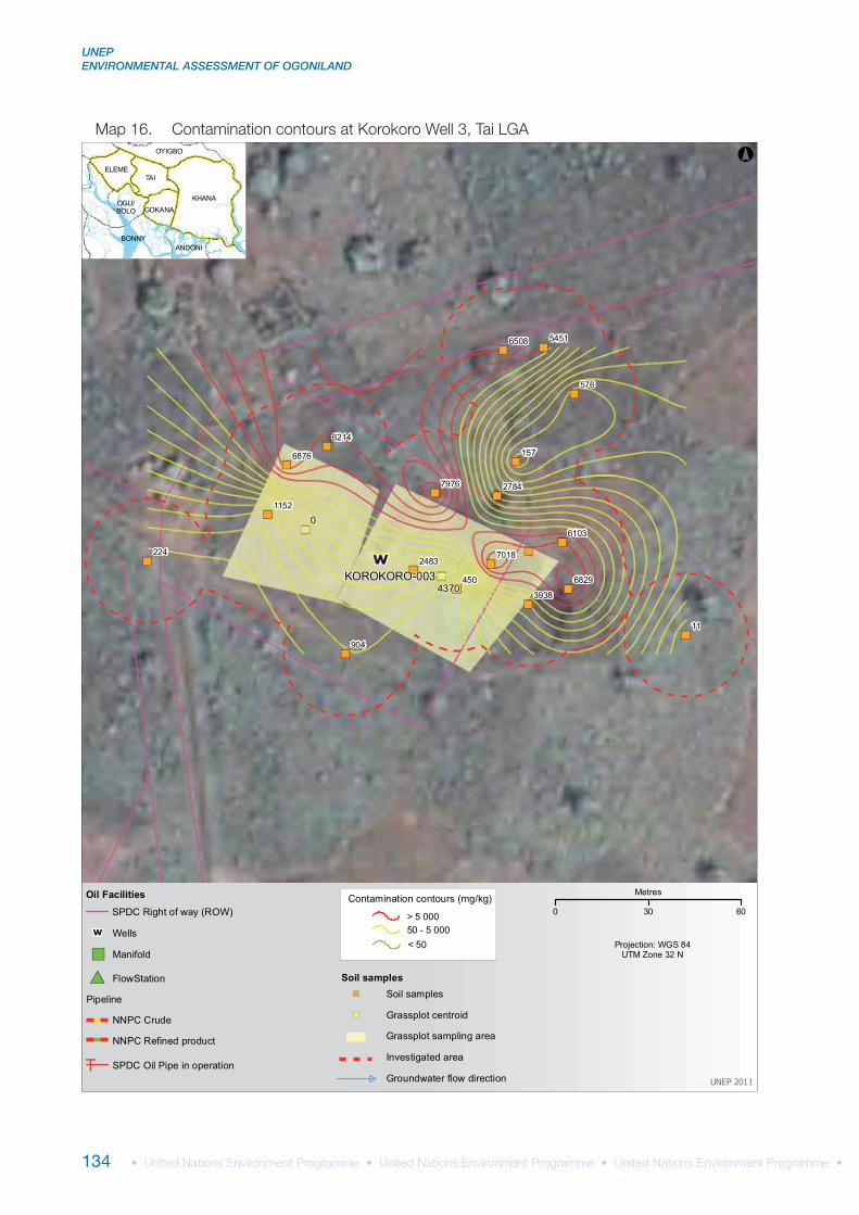
UNEP site code qc-008-007Site name Korokoro Well 3LGA KhanaInvestigated area (m2)Number of soil samples 74Deepest investigation (m) 7.6Maximum soil TPH (mg/kg) 11,200Number of soil measurements greater than EGASPIN intervention value 25Deepest sample greater than EGASPIN intervention value (m) 5.6Number of soil measurements below 1 m 57Number of soil measurements below 1 m greater than EGASPIN intervention value 22Volume of soil exceeding the EGASPIN intervention value (m3)Volume of soil exceeding the EGASPIN target value (m3)
Sampling station Depth from (m) Depth to (m) TPH (mg/kg)008-002-SOI-B210
0 0.4 10,6000.4 1.0 4,8301 1.5 6,210
1.5 2.0 11.1008-002-SOI-B250
0 0.6 2,2400.6 1.0 4,3001.0 3.0 7,3403.0 4.0 5,8804.0 5.0 6,890
008-002-SOI-B350
0 0.8 2,0600.8 1.5 3,2601.5 2.3 2,8502.3 4.2 5,2804.2 5.0 4,310
008-002-SOI-B450
0 0.4 8,3100.4 1.2 9,0501.2 2.4 10,7002.4 4.6 4,2004.6 5.0 6,120
008-002-SOI-B252
0 1.0 2,3301.0 2.0 2,9202.0 3.0 6,9903.0 4.6 8,0604.6 5.0 9,510
UNEP ENVIRONMENTAL ASSESSMENT OF OGONILAND
134
")
")
")")
")
")
")
")
")
")
")
")
")
")
")
")
")
")
")
11
157
904
450
576
224
5451
2784
1152
6214
7018
3938
6508
6103
6829
2483
6876
7976
0
4370KOROKORO-003
BONNY
KHANA
TAI
ANDONI
OYIGBO
ELEME
GOKANAOGU/BOLO
°
UNEP 2011
Projection: WGS 84UTM Zone 32 N
Oil Facilities
Pipeline
#* FlowStation
SPDC Oil Pipe in operationT
SPDC Right of way (ROW)
W Wells
") Manifold
NNPC Crude
NNPC Refined product
> 5 00050 - 5 000< 50
Contamination contours (mg/kg)
Investigated area
Soil samples
Grassplot sampling area
") Soil samples
") Grassplot centroid
Groundwater flow direction
0 30 60
Metres
4 CONTAMINATED SOIL & GROUNDWATER
135
UNEP site code
LGA Site category
Number of soil
samples
Number of groundwater
samples
Deepest soil investigation
(m)
Maximum soil TPH (mg/kg)
Number of soil measurements
>EGASPIN
Deepest soil sample
>EGASPIN (m)
Maximum water TPH (ug/l)
(CL samples)
Number of water samples
>EGASPIN
Number of community
wells with TPH
Number of soil measurements below
1 m >EGASPIN
qc_009-006
Tai SPDC right of way
62 2 5 12,300 4 3 162,000 1 3
qc_019-002
Gokana SPDC right of way
27 5 5 34,500 10 4 32,000 2 7
qc_010-004
Tai SPDC right of way
38 8 5 36,200 4 4 543 2
qc_003-002
Eleme SPDC right of way
23 3 13,400 3 3 91.7 2
qc_019-021
Gokana SPDC suspended facility
26 5 7,620 2 3 2
qc_008-002
Tai SPDC suspended facility
58 2 5 1,880 42,800 1 yes
qc_019-035
Gokana SPDC suspended facility
16 1 2.6 3,480 10,300 1 yes
qc_019-032
Gokana SPDC suspended facility
21 2 2.2 1,220 49
qc_019-010
Gokana SPDC suspended facility
32 5 5.2 139,000 5 2 172,000 5 1
qc_019-004
Gokana SPDC suspended facility
18 1 5 23,200 8 2.6 32 4
qc_015-003
Khana SPDC suspended facility
36 3 8,830 1 1.5 10 1
qc_015-001
Khana SPDC suspended facility
42 2 3.5 8,200 5 3 358,000 1 2
qc_014-004
Khana SPDC suspended facility
18 3 2.6 198 519
qc_014-001
Khana SPDC suspended facility
24 2 2.6 157 2,140 1
qc_016-001
Khana SPDC legacy site
85 13 5.2 8,820 2 0.4 77,000 3
UNEP ENVIRONMENTAL ASSESSMENT OF OGONILAND
136
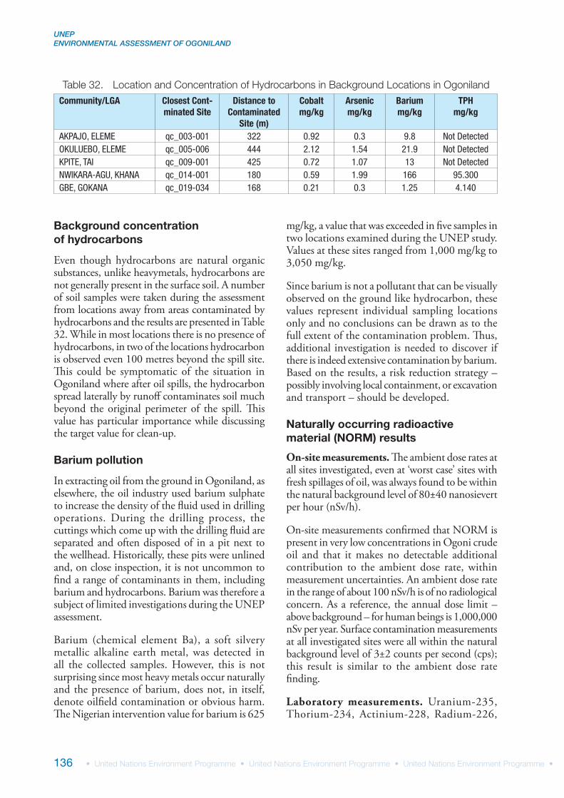
Background concentration of hydrocarbons
Even though hydrocarbons are natural organic substances, unlike heavymetals, hydrocarbons are not generally present in the surface soil. A number of soil samples were taken during the assessment from locations away from areas contaminated by hydrocarbons and the results are presented in Table 32. While in most locations there is no presence of hydrocarbons, in two of the locations hydrocarbon is observed even 100 metres beyond the spill site. This could be symptomatic of the situation in Ogoniland where after oil spills, the hydrocarbon spread laterally by runoff contaminates soil much beyond the original perimeter of the spill. This value has particular importance while discussing the target value for clean-up.
Barium pollution
In extracting oil from the ground in Ogoniland, as elsewhere, the oil industry used barium sulphate to increase the density of the fluid used in drilling operations. During the drilling process, the cuttings which come up with the drilling fluid are separated and often disposed of in a pit next to the wellhead. Historically, these pits were unlined and, on close inspection, it is not uncommon to find a range of contaminants in them, including barium and hydrocarbons. Barium was therefore a subject of limited investigations during the UNEP assessment.
Barium (chemical element Ba), a soft silvery metallic alkaline earth metal, was detected in all the collected samples. However, this is not surprising since most heavy metals occur naturally and the presence of barium, does not, in itself, denote oilfield contamination or obvious harm. The Nigerian intervention value for barium is 625
mg/kg, a value that was exceeded in five samples in two locations examined during the UNEP study. Values at these sites ranged from 1,000 mg/kg to 3,050 mg/kg.
Since barium is not a pollutant that can be visually observed on the ground like hydrocarbon, these values represent individual sampling locations only and no conclusions can be drawn as to the full extent of the contamination problem. Thus, additional investigation is needed to discover if there is indeed extensive contamination by barium. Based on the results, a risk reduction strategy – possibly involving local containment, or excavation and transport – should be developed.
Naturally occurring radioactive material (NORM) results
On-site measurements. The ambient dose rates at all sites investigated, even at ‘worst case’ sites with fresh spillages of oil, was always found to be within the natural background level of 80±40 nanosievert per hour (nSv/h).
On-site measurements confirmed that NORM is present in very low concentrations in Ogoni crude oil and that it makes no detectable additional contribution to the ambient dose rate, within measurement uncertainties. An ambient dose rate in the range of about 100 nSv/h is of no radiological concern. As a reference, the annual dose limit – above background – for human beings is 1,000,000 nSv per year. Surface contamination measurements at all investigated sites were all within the natural background level of 3±2 counts per second (cps); this result is similar to the ambient dose rate finding.
Laboratory measurements. Uranium-235, Thorium-234, Actinium-228, Radium-226,
Community/LGA Closest Cont-minated Site
Distance to Contaminated
Site (m)
Cobaltmg/kg
Arsenicmg/kg
Bariummg/kg
TPHmg/kg
AKPAJO, ELEME qc_003-001 322 0.92 0.3 9.8 Not DetectedOKULUEBO, ELEME qc_005-006 444 2.12 1.54 21.9 Not DetectedKPITE, TAI qc_009-001 425 0.72 1.07 13 Not DetectedNWIKARA-AGU, KHANA qc_014-001 180 0.59 1.99 166 95.300GBE, GOKANA qc_019-034 168 0.21 0.3 1.25 4.140
4 CONTAMINATED SOIL & GROUNDWATER
137
Bismuth-214, Bismuth-212, Lead-212, Lead-214, Lead-210, Thallium-208 and Potassium-40 activity concentrations, measured by gamma spectrometry, were all above detection limits for soil samples but not for liquid samples. Radium-226 and Uranium-235 activities were calculated from the peak at 186 kilo-electron volts (keV) assuming radioactive equilibrium of Radium-226 with its parent Uranium-238 and of natural Uranium-235/Uranium-238 ratio. Liquid samples were measured by ICP-MS expressed in activity concentrations of Uranium-238, Uranium-235, Uranium-234, Thalium-232, Thalium-230 and Radium-226.
These results confirm the on-site findings: NORM is present in the environments assessed by UNEP in concentrations – in the low parts per million range – that would be expected for the geology of the region. Soil samples heavily contaminated with old spilled crude match the zero blank/reference sample and are within analytical or expected natural uncertainties. The conclusion of the laboratory analysis therefore is that NORM is by factors lower in crude oil than it is in the soil. This is confirmed by measurements of the liquids using ICP-MS. Uranium and measured daughter product concentrations in crude oil are lower – by a factor of 1,000 or more – than in local soil.
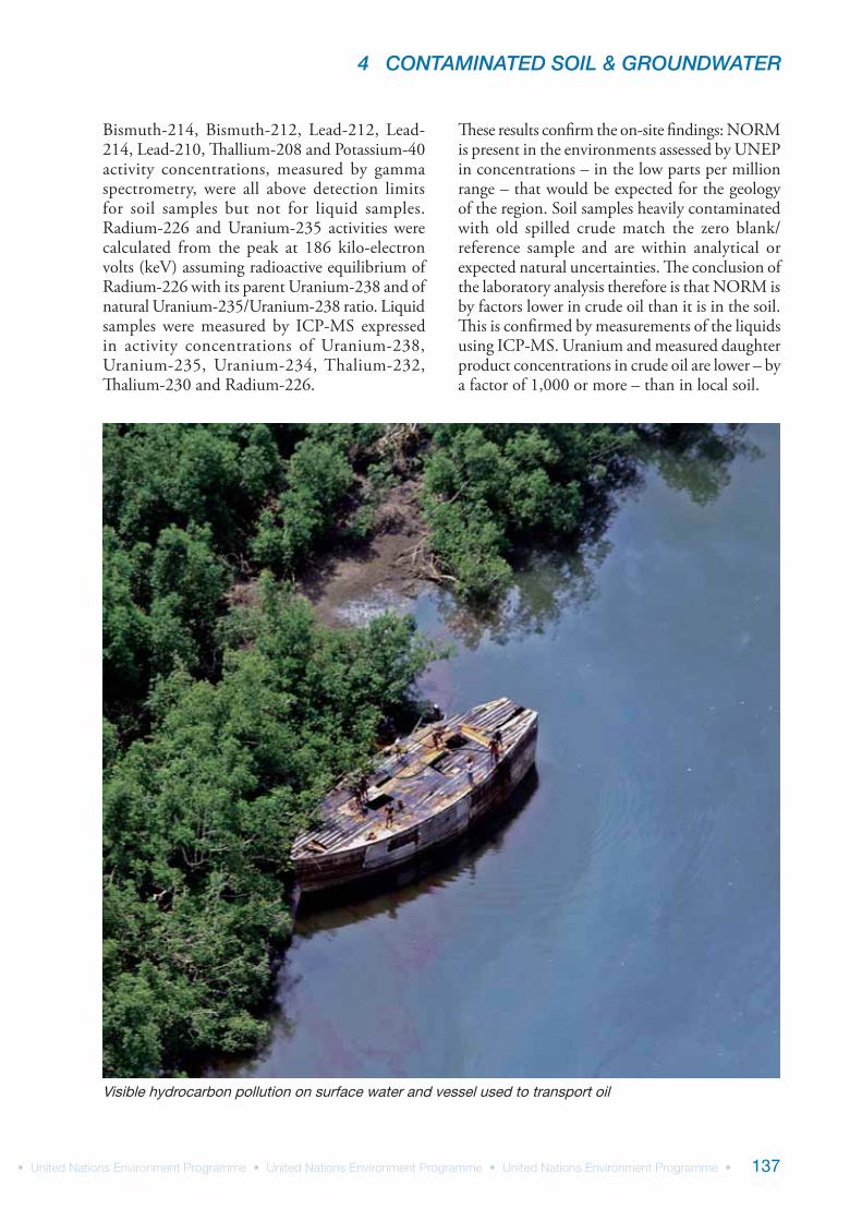
Visible hydrocarbon pollution on surface water and vessel used to transport oil
UNEP ENVIRONMENTAL ASSESSMENT OF OGONILAND
138
4.5 Discussion of institutional issues
UNEP’s review of institutional issues in Nigeria led to a series of observations that have a direct bearing on the current environmental situation in the country. There are also implications for how jurisdictional gaps and overlaps between institutions can be improved so that sustainable environmental improvements can be achieved in Ogoniland. Some of the key observations are detailed below.
Multiple institutions with unclear mandates
Nigeria has a three-tier administration: federal, state and local government. Both the federal and state governments have ministries of environment but the Department of Petroleum Resources (DPR) – the ‘technical arm’ of the Ministry of Petroleum Resources – continues to have a role in regulating environmental issues as well.
The most important piece of legislation on environmental management in Nigeria is the
1992 Environmental Guidelines and Standards for Petroleum Industries in Nigeria (EGASPIN). This confers a statutory role on the DPR to manage all environmental issues arising from oil industry activities, including clean-up of contaminated sites. However, the National Oil Spill Detection and Response Agency (NOSDRA), created in 2006, has since also assumed responsibility for the latter role, though NOSDRA’s mandate does not cover supervision of contaminated site remediation. More importantly, the two agencies have differing interpretations of EGASPIN, which further undermines clean-up operations in Ogoniland.
The overlap of authorities and responsibilities between state ministries and federal ministries is another issue which has an impact on environmental management on-the-ground. In the Nigerian system, central government agencies also have state or regional administrative offices. Separate state government agencies, which sometimes have similar mandates, often end up doing the same work. These overlapping efforts are not always coordinated and can lead to suboptimal environmental management.
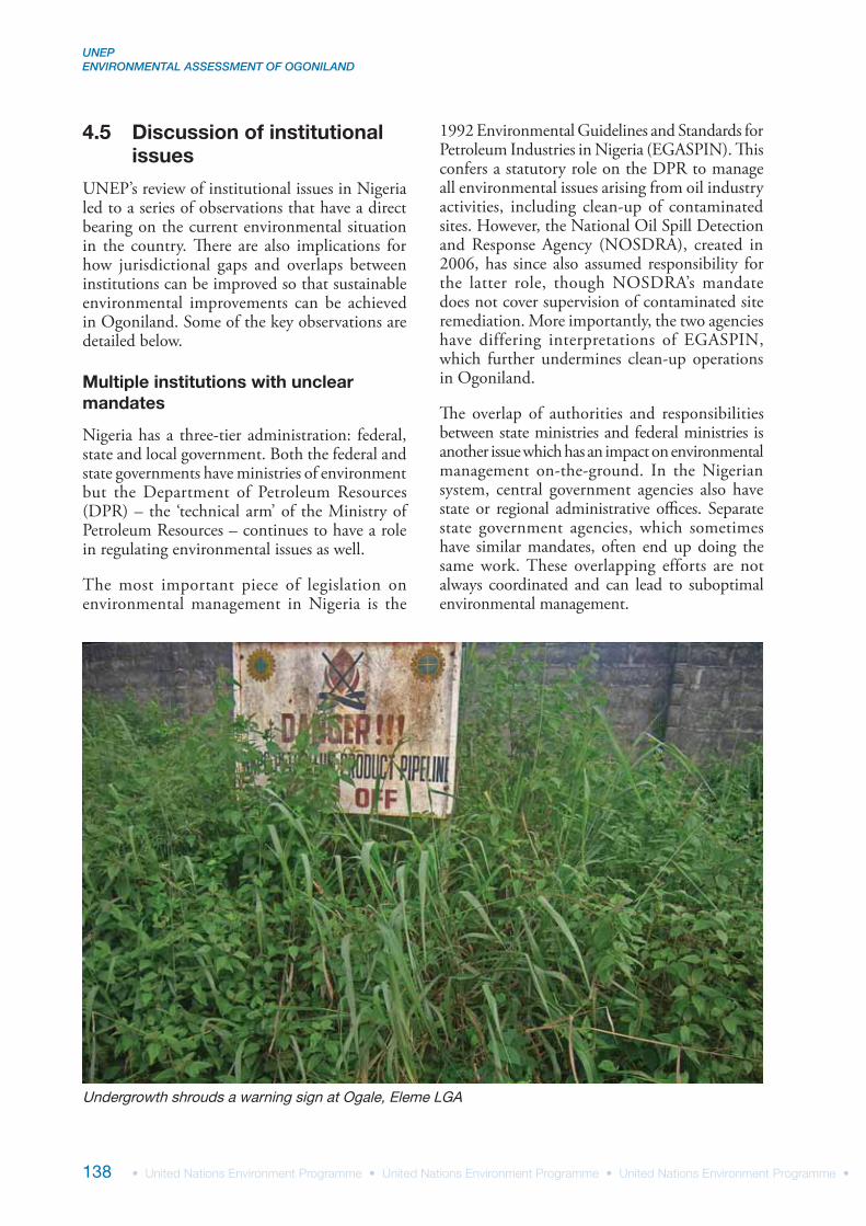
Undergrowth shrouds a warning sign at Ogale, Eleme LGA
4 CONTAMINATED SOIL & GROUNDWATER
139
NOSDRA mandate and resources are not aligned
The National Oil Spill Detection and Response Agency came into being under the National Oil Spill Detection and Response Agency (Establishment) Act, 2006. The Act states that the organization’s mandate “shall be to coordinate and implement the National Oil Spill Contingency Plan for Nigeria” [39]. The main focus of the Contingency Plan is on emergency response in the event of an oil spill. The NOSDRA Act also legislates for emergency response systems and capacity.
However, in the five years since its establishment, very few resources have been allocated to NOSDRA, such that the agency has no proactive capacity for oil-spill detection and has to rely on reports from oil companies or civil society concerning the incidence of a spill. It also has very little reactive capacity – even to send staff to a spill location once an incident is reported. In the Niger Delta, helicopters or boats are needed to reach many of the spill locations and NOSDRA has no access to such forms of transport other than through the oil companies themselves. Consequently, in planning their inspection visits, the regulatory authority is wholly reliant on the oil company. Such an arrangement is inherently inappropriate.
Equally important is the question of mandate when it comes to cleaning up a contaminated site. NOSDRA undertakes supervision of contaminated site assessment based on EGASPIN provisions. However, since the agency did not exist at the time EGASPIN was formulated in 1992 and reissued in 2002, the Act itself does not empower NOSDRA. Consequently, little training and few resources have been provided to enable NOSDRA to carry out this task.
At the time that NOSDRA was created, a clear directive should have been issued delineating the operational boundaries between NOSDRA and the DPR. In the absence of such clarification, both bodies continue to deal with contaminated site clean-up, coordination between the two is poor, and in extreme cases they take differing approaches to interpreting the rules.
Conflict of interest
Petroleum resources account for 80 per cent of national revenue and 95 per cent of export earnings, making the Ministry of Petroleum Resources, which
licenses and regulates oil industry operations, a key ministry in Nigeria. In 1990, when the ministry, through its Department of Petroleum Resources (DPR), developed the EGASPIN, there was no federal Ministry of Environment (environment is currently part of the Federal Ministry of Environment, Housing and Urban Development). Moreover, it seemed logical at that time for the Ministry of Petroleum Resources to oversee the oil industry because of the strategic nature of the country’s oil reserves as well as the technical nature of the industry and the specialized skills therefore needed to regulate it.
However, there is clearly a conflict of interest in a ministry which, on one hand, has to maximize revenue by increasing production and, on the other, ensure environmental compliance. Most countries around the world, including in the Middle East where oil is the mainstay of the regional economy, have placed environmental regulation within the Ministry of Environment or equivalent. It is noteworthy to mention in this context that after the 2010 Deepwater Horizon incident, it came to light that the US Offshore Energy & Minerals Management Office (under the Bureau of Ocean Energy Management, Regulation and Enforcement) responsible for the development of the offshore oilfield was also the body that issued environmental approvals. Even though other federal and local agencies had commented on the industry plans, President Obama called this a “cosy relationship between the oil companies and the federal agency that permits them to drill” [40]. Consequently, a new Bureau of Safety and Environmental Enforcement, under the US Department of the Interior, has been created, which is independent from the Department of Energy Resources.
Lack of resources
Resource limitations, both physical and human, are a feature of all Nigerian ministries. There are also other issues at play, involving various ministries at federal level as well as the contrasts between ministries at federal and state level. For example:
Both DPR and NOSDRA suffer from a shortage of senior and experienced staff who understand the oil industry and can exercise effective technical oversight. The main reason for this is that individuals with technical knowledge in the field of petroleum engineering or science find substantially more rewarding opportunities in the oil industry
UNEP ENVIRONMENTAL ASSESSMENT OF OGONILAND
140
A typical pattern in Nigeria (as in other countries) is that offices in the federal capital of Abuja are better equipped with staff and resources than regional offices. This may not be a financial issue but staff may be reluctant to serve in the regions owing to poorer working conditions and opportunities, ranging from security to schooling for children and career advancement prospects. This is certainly an issue impacting both DPR and NOSDRA
All government departments, both federal and state, lack office equipment and vehicles. Even when such resources are allocated there is often a shortage of funds for maintenance (e.g. maintaining vehicles and buying fuel for generators)
State ministries of environment are even less well provided for in terms of human resources, equipment and infrastructure, and attracting quality staff is especially difficult
Shortage of equipment is particularly troublesome for agencies having to respond to oil spills, which are often in areas inaccessible by road. In the
absence of such resources, government agencies are at the mercy of oil companies when it comes to conducting site inspections.
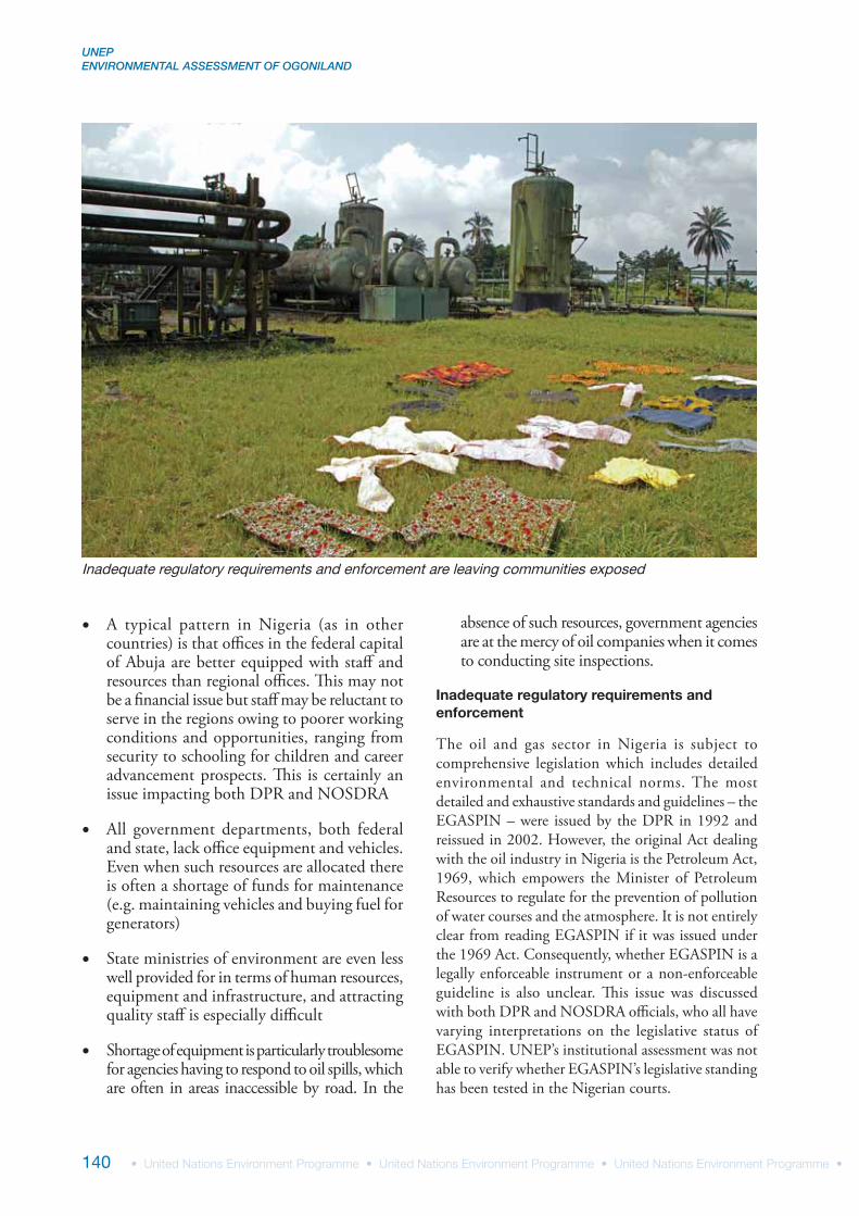
Inadequate regulatory requirements and enforcement
The oil and gas sector in Nigeria is subject to comprehensive legislation which includes detailed environmental and technical norms. The most detailed and exhaustive standards and guidelines – the EGASPIN – were issued by the DPR in 1992 and reissued in 2002. However, the original Act dealing with the oil industry in Nigeria is the Petroleum Act, 1969, which empowers the Minister of Petroleum Resources to regulate for the prevention of pollution of water courses and the atmosphere. It is not entirely clear from reading EGASPIN if it was issued under the 1969 Act. Consequently, whether EGASPIN is a legally enforceable instrument or a non-enforceable guideline is also unclear. This issue was discussed with both DPR and NOSDRA officials, who all have varying interpretations on the legislative status of EGASPIN. UNEP’s institutional assessment was not able to verify whether EGASPIN’s legislative standing has been tested in the Nigerian courts.
Inadequate regulatory requirements and enforcement are leaving communities exposed
4 CONTAMINATED SOIL & GROUNDWATER
141
Regardless of its formal status, for all practical purposes EGASPIN currently forms the basis for environmental management of the oil industry in Nigeria. It is a substantial document running to 361 pages divided into eight sections dealing with all aspects of environmental management of oil activities ranging from exploration to terminal operations.
UNEP’s review examined two specific elements of EGASPIN:
Part VIIIB, contingency planning for the prevention, control and combating of spills of oil and hazardous substances, and
Part VIIIF, management and remediation of contaminated land.
For the purposes of this study, the most important aspect is the approach EGASPIN takes with regard to the criteria for clean-up operations following an oil spill.
EGASPIN recommends the use of the Risk-Based Corrective Action (RBCA) approach pioneered in the United States. However, section 8.1 of Part VIIIF states: “In the interim period whilst suitable parameters are being developed, the guidelines on remediation of contaminated land shall make use of two parameters, i.e. intervention values and target values (Table VIII F1).” Even though EGASPIN was first issued in 1992, the required guidance for a risk-based approach has not yet been developed and the ‘intervention and target values’ approach remains the operating principle in Nigeria today.
EGASPIN defines ‘intervention value’ (8.1.1) as indicating “the quality for which the functionality of soil for human, animal and plant life are, or threatened with being seriously impaired. Concentration in excess of the intervention values correspond to serious contamination”. ‘Target value’ (8.1.2.1) is defined as indicating “the soil quality required for sustainability or expressed in terms of remedial policy, the soil quality required for the full restoration of the soils functionality for human, animal and plant life. The target values therefore indicate the soil quality levels ultimately aimed for”. A list of intervention and target values is provided in Appendix VIII F1 of the EGASPIN.
While in the provisions discussed above EGASPIN is clear and in line with the terminology as applied elsewhere (e.g. in the Dutch Soil Act of 1987 which pioneered the use of intervention and target values), there is internal contradiction elsewhere. The more stringent part of the provision states, in section 2.11.3 of Part VIII:
“Any operator or owner of a facility that is responsible for a spill that results to (sic) impact of the environment shall be required to monitor the impacted environment alongside the restorative activities. The restorative process shall attempt to achieve the minimum oil content and other target values (quality levels ultimately aimed for) for BTEX, metals and polycyclic aromatic hydrocarbons (PAHS) in the impacted environment (also See Part VIII F).
(i) For all waters, there shall be no visible oil sheen after the first 30 days of the occurrence of the spill no matter the extent of the spill
(ii) For swamp areas, there shall not be any sign of oil stain within the first 60 days of occurrence of the incidence
(iii) For land/sediment, the quality levels ultimately aimed for (target value) is 50 mg/kg of oil content (See part VIII F).”
However, section 6.6 of Part VIII of the EGASPIN states:
“Remedial Action Closure. When Remedial Action Treatment has been undertaken and the intervention values (Risk Based Screening Levels (RBSLs) or Site Specific Target Levels (SSTLs) if RBCS (Risk Based Corrective System) is used) have been demonstrated to be achieved at the point of compliance, or containment or institution controls have been installed and monitoring and site maintenance are no longer required to ensure that conditions persist, then no further action shall be necessary, except to ensure that suitable institutional controls (if any) remain in place.”
This latter section is an incorrect interpretation of the ‘intervention value’ and ‘target value’ approach to contaminated site management. Intervention
UNEP ENVIRONMENTAL ASSESSMENT OF OGONILAND
142
value is not expected to be the point of compliance for close out of remedial action. The triviality of the above-quoted interpretation can be explained by taking as an example a site that has been contaminated with 5,001 mg/kg of hydrocarbons. Since it is above the intervention value of 5,000 mg/kg, a treatment plan has to be prepared and implemented. However, remediation work at the site can stop when the value has reached 4,999 mg/kg – in effect, by achieving just a 2 mg/kg reduction of hydrocarbons. In other words, the site can be considered to have moved from a situation where “the functionality of soil for human, animal and plant life are, or threatened with being seriously impaired” to a situation where it is legally acceptable to stop the treatment and even stop monitoring.
Discussions with the DPR clarified that they indeed expect the operator to achieve the target levels at which a remediated spill site can be closed. On the other hand, discussions with NOSDRA confirmed that they use the intervention values as the closure criteria for sign-off. NOSDRA also mentioned that, in their judgement, 5,000 mg/kg is a high target and that in their new legislation, currently in preparation, this will be lowered to 2,500 mg/kg.
Resolving the issue
It is evident from the above that Nigerian legislation is internally inconsistent with regard to one of the most important criteria for oil spill and contaminated site management; specifically the criteria triggering or permitting remediation closure. This is enabling the oil industry to legally close down the remediation process well before contamination has been fully eliminated and soil quality has been restored to achieve full functionality for human, animal and plant life.
This situation needs to be resolved for the whole of Nigeria, and in particular prior to initiation of the clean-up in Ogoniland. It should be mentioned in this context that the Government of The Netherlands, which pioneered the intervention and target value approach, has discontinued setting a target value for soil. Since both DPR and NOSDRA mentioned that they are working on new legislation, it may be opportune to make fundamental changes.
International best practice on contaminated site remediation currently depends on development of site-specific clean-up targets based on a robust source, pathway and receptor model. However, application of this model has to be done in a transparent manner so that the regulators fully comprehend what input data are used to obtain the clean-up targets and the sensitivity of each of these parameters. It has also been accepted internationally that health is just one of the risks to be managed through contaminated site remediation. Situations could arise where non-health risks, such as commercial reputation or community perception, would require the government and oil operator to agree on more stringent targets than would strictly be necessary from a health-risk management point of view.
Making legislation accessible
Another problem with current Nigerian legislation is its inaccessibility. Few texts are available online and many are not easily available even in paper form. In addition, printed copies of legislation, such as the ‘Laws of the Federation of Nigeria’, are extremely expensive and therefore limited to those able to bear the costs. Moreover, many secondary or very recent texts are available only at the issuing agency or from the government printing house in Lagos. Inaccessibility of legislation leads not only to a lack of transparency, but also to a loss of trust in the legal system. Making legislation readily accessible, cheaply and in a variety of forms, will help build confidence at all levels.
Review of SPDC’s practices and performance
As an oil company with decades of experience in Nigeria, and as part of a larger, international organization with global reach, it is not surprising that the Shell Petroleum Development Company has established procedures for the range of environmental issues resulting from its oil exploration and production. SPDC is also backed up technically by Shell which provides a broad policy framework with corporate guidelines and specific technical assistance through Shell Global Solutions.
SPDC procedures
SPDC has documented procedures on all aspects of its business management. It was not the objective
4 CONTAMINATED SOIL & GROUNDWATER
143
of the current study to undertake a systematic audit of all SPDC procedures and their implementation on the ground. However, in matters where there is a direct interface with the environmental contamination of Ogoniland, it was important first to identify the situation on the ground and then to verify whether that situation was a consequence of lack or deficiency of procedures, or laxity in enforcement of those procedures.
Of the three SPDC procedures dealing with environmental issues – oil spill response, oil spill clean-up and abandonment – quantitative assessment was only possible regarding site clean-up. A review of SPDC’s performance in cleaning up contaminated sites is given below.
In undertaking this review, UNEP did not proactively look for SPDC-contaminated sites for assessment. Rather, once the on-the-ground assessment of contaminated sites had been completed, the team checked SPDC records to see how many of the sites were classified as ‘remediation completed’. Where this was the case the site was assessed as to whether (i) it was still contaminated according to Nigerian legislation and (ii) the site met with SPDC’s own internally set standards.
SPDC’s approach to remediation
The SPDC Oil Spill Clean-up and Remediation Procedure (SPDC-2005-005716), the company’s main operating document in guiding clean-up activities, was subjected to examination by UNEP. This procedure is based on a Shell Global Solutions report, ‘Framework for Risk Management of Historically Contaminated Land for SPDC Operations in the Niger Delta (OG.02.47028)’. The report states:
“As the crude ages the lighter end will be lost through natural attenuation processes and as a result the viscosity will increase and vertical migration will further decrease. The high water table in many locations will also prevent deep infiltration of free product. It is expected therefore that any spills within the Niger Delta will migrate predominantly along the ground surface from areas of high topography to areas of low topography. Trial pits have confirmed the shallow extent of soil contamination in many SPDC sites.”
The report was based on a desk study and no field work was undertaken. So the trial pits, underlined in the above statement, refer to those excavated by SPDC as part of its own vertical delineation
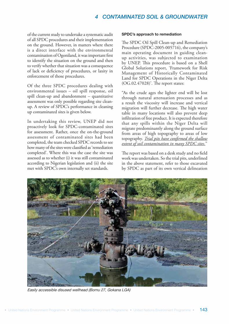
Easily accessible disused wellhead (Bomu 27, Gokana LGA)
UNEP ENVIRONMENTAL ASSESSMENT OF OGONILAND
144
of contamination. It is useful to note that SPDC’s internal procedures for vertical delineation of contamination state:
“…trial pit should be excavated to at least 0.5 metres and no more than 1.5 metres below ground level (bgl)”
“…hand augering should be down to at least 1 metres bgl and preferably to 2 metres bgl”
As already seen from UNEP’s field sampling, contamination of hydrocarbons has migrated to depths of more than 5 metres in some instances. Hence, Shell Global Solutions’ guidance note and the SPDC procedure for vertical delineation need to be revised to incorporate this new information.
Three points of particular interest in the SPDC document are:
1. Remediation by enhanced natural attenuation (RENA) is given as the primary method of remediation of oil-impacted sites
2. Soil remediation criteria are defined and, though the document makes provisions for using risk-based screening levels to indicate satisfactory completion of remedial activities to acceptable risk levels, a TPH value of 5,000 mg/kg (same as the EGASPIN intervention value) was validated as the end point
3. For groundwater the document states that “remediation of impacted potable (usable) groundwater shall be undertaken in conformity to the EGASPIN recommended target level of 10 ppm of dissolved TPH”. However, there is no location in Ogoniland where groundwater remediation has been attempted
A number of criticisms can be made of the above approach:
The RENA approach to remediation. Hydrocarbons, once released to land, can be transferred and degraded through a number of natural processes, including:
evaporation to the atmospherecombustion infiltration, alone or along with rainwater, to soil and eventually to groundwateroverflow into swamps and water bodiesrunoff with rainwater to swamps and water bodiesmicrobial degradation on the ground surface, or in soil, swamps, water or groundwater
The principle of enhanced natural attenuation for clean up of contaminated land is to augment one or more of the above processes so that the concentration of contaminants can be reduced.
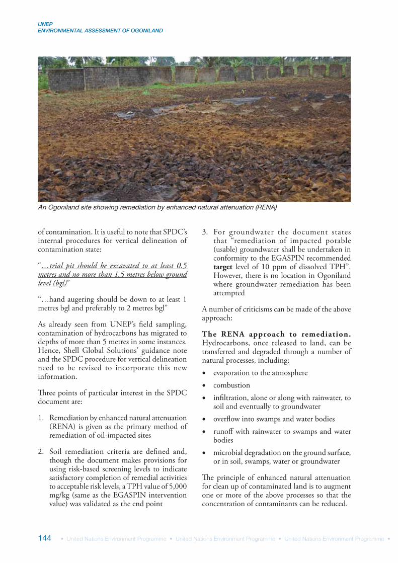
An Ogoniland site showing remediation by enhanced natural attenuation (RENA)

4 CONTAMINATED SOIL & GROUNDWATER
145
After reviewing contaminated land clean-up issues in Nigeria, Shell Global Solutions endorsed the RENA approach. Hence it is SPDC’s preferred procedure and 100 per cent of oil spill remediation in Ogoniland has been undertaken using the RENA approach.
Under RENA, contaminated land (topsoil) is initially ploughed over, either mechanically or manually, to increase aeration. Fertilizer is added to supplement the nutrient requirements of the bacteria as they break down the pollutants. The ploughed soil is then piled into neat windrows to further enhance the aeration process. Samples are taken from the windrows every quarter and once the SPDC specification of 5,000 mg/kg of TPH is reached, the windrows are levelled.
The implicit assumption in the RENA approach applied by SPDC is that the natural process being enhanced is bioremediation. All enhancing actions, whether ploughing, adding nutrients or windrowing, are applied to further natural biodegrading processes. In an ideal situation this approach is scientifically defendable. However, the reality on the ground in Ogoniland speaks otherwise. The RENA process is failing to achieve either environmental clean-up or legislative compliance. As seen in the analyses and case studies presented in this report, it is also failing to achieve compliance with SPDC’s own procedures.
The case against RENA in Ogoniland. The following arguments could be made for discontinuing the use of RENA as an approach to remediation in Ogoniland:
1. The effects of temperature, rainfall and topography hamper the RENA approach at oil-impacted sites because no controls are in place to manage the following processes:
(i) Oil-impacted sites are open and exposed to sun and air, leading to hydrocarbons evaporating and being carried away, risking exposure to on-site workers, neighbouring communities and nearby agricultural workers. No air monitoring, on-site or off-site, is undertaken
(ii) They are continually exposed to rain, which falls on the windrows, leaching
out hydrocarbon, which can then run off into nearby farms, communities, swamps or streams, contaminating a much wider area. Rain falling up-slope can also run off through the windrows. No measures are taken to prevent rainwater from reaching windrows, directly or through runoff, and no systems exist to collect runoff before it escapes from the site. Moreover, no system is in place even to monitor whether this is happening
(iii) Soil remediation occurs in situ with no impermeable layer to prevent infiltration of oil, either by itself or with water, into the subsoil and then into the groundwater. There is no monitoring of this issue
2. Not all hydrocarbons are amenable to bacterial biodegradation, rendering the process unfeasible in situations where:
(i) hydrocarbons are too toxic for the bacteria, and/or too recalcitrant for biodegradation and/or present in too high a concentration
(ii) fire has occurred on the ground and the hydrocarbons have been burnt into a crust, mixing bituminous hydrocarbons with clayey soil
(iii) the soil is very clayey in nature, making oxygen transfer difficult
3. Currently, SPDC undertakes RENA on the land surface layer only, based on the assumption that given the nature of the oil, temperature and an underlying layer of clay, hydrocarbons will not move deeper. However, this basic premise of limiting remediation to the surface soil is not sustainable since observations made by UNEP show that contamination can often penetrate deeper than 5 metres. The RENA approach, if using bioremediation as the primary process to be enhanced, will not work at depths below 1 metre due to difficulties with oxygen transfer
In addition, the UNEP team also noted the following on-site practices which further argue the case against RENA as an appropriate choice for site remediation:
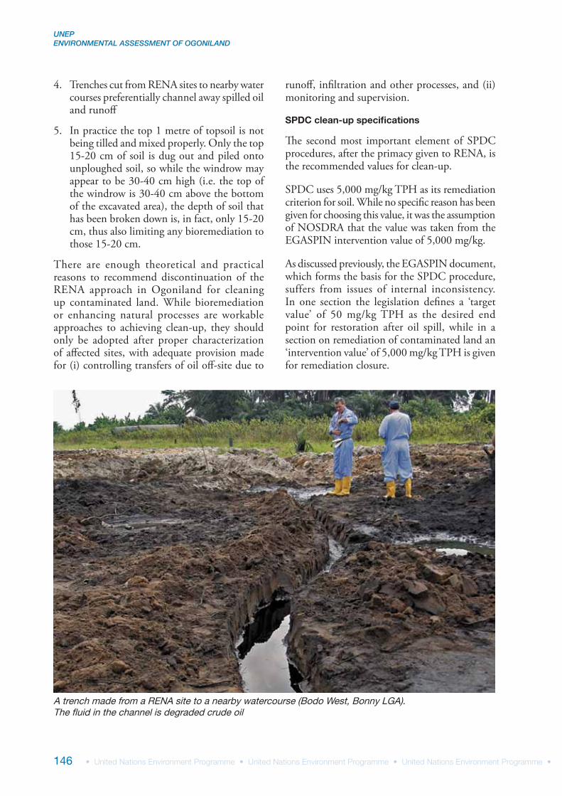
UNEP ENVIRONMENTAL ASSESSMENT OF OGONILAND
146
4. Trenches cut from RENA sites to nearby water courses preferentially channel away spilled oil and runoff
5. In practice the top 1 metre of topsoil is not being tilled and mixed properly. Only the top 15-20 cm of soil is dug out and piled onto unploughed soil, so while the windrow may appear to be 30-40 cm high (i.e. the top of the windrow is 30-40 cm above the bottom of the excavated area), the depth of soil that has been broken down is, in fact, only 15-20 cm, thus also limiting any bioremediation to those 15-20 cm.
There are enough theoretical and practical reasons to recommend discontinuation of the RENA approach in Ogoniland for cleaning up contaminated land. While bioremediation or enhancing natural processes are workable approaches to achieving clean-up, they should only be adopted after proper characterization of affected sites, with adequate provision made for (i) controlling transfers of oil off-site due to
runoff, infiltration and other processes, and (ii) monitoring and supervision.
SPDC clean-up specifications
The second most important element of SPDC procedures, after the primacy given to RENA, is the recommended values for clean-up.
SPDC uses 5,000 mg/kg TPH as its remediation criterion for soil. While no specific reason has been given for choosing this value, it was the assumption of NOSDRA that the value was taken from the EGASPIN intervention value of 5,000 mg/kg.
As discussed previously, the EGASPIN document, which forms the basis for the SPDC procedure, suffers from issues of internal inconsistency. In one section the legislation defines a ‘target value’ of 50 mg/kg TPH as the desired end point for restoration after oil spill, while in a section on remediation of contaminated land an ‘intervention value’ of 5,000 mg/kg TPH is given for remediation closure.
A trench made from a RENA site to a nearby watercourse (Bodo West, Bonny LGA). The fluid in the channel is degraded crude oil
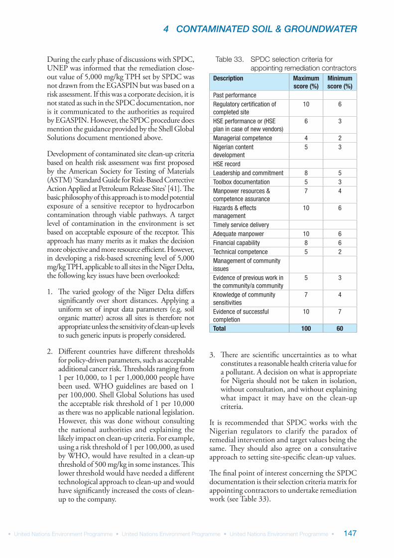
4 CONTAMINATED SOIL & GROUNDWATER
147
During the early phase of discussions with SPDC, UNEP was informed that the remediation close-out value of 5,000 mg/kg TPH set by SPDC was not drawn from the EGASPIN but was based on a risk assessment. If this was a corporate decision, it is not stated as such in the SPDC documentation, nor is it communicated to the authorities as required by EGASPIN. However, the SPDC procedure does mention the guidance provided by the Shell Global Solutions document mentioned above.
Development of contaminated site clean-up criteria based on health risk assessment was first proposed by the American Society for Testing of Materials (ASTM) ‘Standard Guide for Risk-Based Corrective Action Applied at Petroleum Release Sites’ [41]. The basic philosophy of this approach is to model potential exposure of a sensitive receptor to hydrocarbon contamination through viable pathways. A target level of contamination in the environment is set based on acceptable exposure of the receptor. This approach has many merits as it makes the decision more objective and more resource efficient. However, in developing a risk-based screening level of 5,000 mg/kg TPH, applicable to all sites in the Niger Delta, the following key issues have been overlooked:
1. The varied geology of the Niger Delta differs significantly over short distances. Applying a uniform set of input data parameters (e.g. soil organic matter) across all sites is therefore not appropriate unless the sensitivity of clean-up levels to such generic inputs is properly considered.
2. Different countries have different thresholds for policy-driven parameters, such as acceptable additional cancer risk. Thresholds ranging from 1 per 10,000, to 1 per 1,000,000 people have been used. WHO guidelines are based on 1 per 100,000. Shell Global Solutions has used the acceptable risk threshold of 1 per 10,000 as there was no applicable national legislation. However, this was done without consulting the national authorities and explaining the likely impact on clean-up criteria. For example, using a risk threshold of 1 per 100,000, as used by WHO, would have resulted in a clean-up threshold of 500 mg/kg in some instances. This lower threshold would have needed a different technological approach to clean-up and would have significantly increased the costs of clean-up to the company.
3. There are scientific uncertainties as to what constitutes a reasonable health criteria value for a pollutant. A decision on what is appropriate for Nigeria should not be taken in isolation, without consultation, and without explaining what impact it may have on the clean-up criteria.
It is recommended that SPDC works with the Nigerian regulators to clarify the paradox of remedial intervention and target values being the same. They should also agree on a consultative approach to setting site-specific clean-up values.
The final point of interest concerning the SPDC documentation is their selection criteria matrix for appointing contractors to undertake remediation work (see Table 33).
Description Maximum score (%)
Minimum score (%)
Past performanceRegulatory certification of completed site
10 6
HSE performance or (HSE plan in case of new vendors)
6 3
Managerial competence 4 2Nigerian content development
5 3
HSE recordLeadership and commitment 8 5Toolbox documentation 5 3Manpower resources & competence assurance
7 4
Hazards & effects management
10 6
Timely service deliveryAdequate manpower 10 6Financial capability 8 6Technical competence 5 2Management of community issuesEvidence of previous work in the community/a community
5 3
Knowledge of community sensitivities
7 4
Evidence of successful completion
10 7
Total 100 60
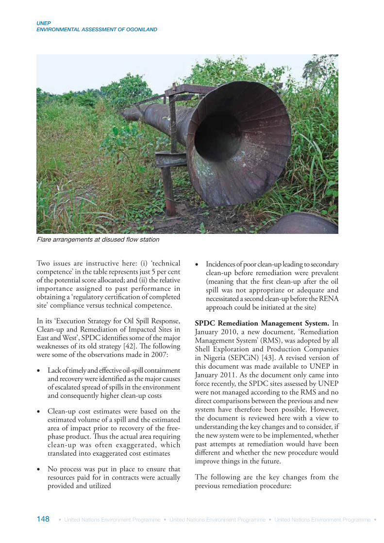
UNEP ENVIRONMENTAL ASSESSMENT OF OGONILAND
148
Two issues are instructive here: (i) ‘technical competence’ in the table represents just 5 per cent of the potential score allocated; and (ii) the relative importance assigned to past performance in obtaining a ‘regulatory certification of completed site’ compliance versus technical competence.
In its ‘Execution Strategy for Oil Spill Response, Clean-up and Remediation of Impacted Sites in East and West’, SPDC identifies some of the major weaknesses of its old strategy [42]. The following were some of the observations made in 2007:
Lack of timely and effective oil-spill containment and recovery were identified as the major causes of escalated spread of spills in the environment and consequently higher clean-up costs
Clean-up cost estimates were based on the estimated volume of a spill and the estimated area of impact prior to recovery of the free-phase product. Thus the actual area requiring clean-up was often exaggerated, which translated into exaggerated cost estimates
No process was put in place to ensure that resources paid for in contracts were actually provided and utilized
Incidences of poor clean-up leading to secondary clean-up before remediation were prevalent (meaning that the first clean-up after the oil spill was not appropriate or adequate and necessitated a second clean-up before the RENA approach could be initiated at the site)
SPDC Remediation Management System. In January 2010, a new document, ‘Remediation Management System’ (RMS), was adopted by all Shell Exploration and Production Companies in Nigeria (SEPCiN) [43]. A revised version of this document was made available to UNEP in January 2011. As the document only came into force recently, the SPDC sites assessed by UNEP were not managed according to the RMS and no direct comparisons between the previous and new system have therefore been possible. However, the document is reviewed here with a view to understanding the key changes and to consider, if the new system were to be implemented, whether past attempts at remediation would have been different and whether the new procedure would improve things in the future.
The following are the key changes from the previous remediation procedure:
Flare arrangements at disused flow station
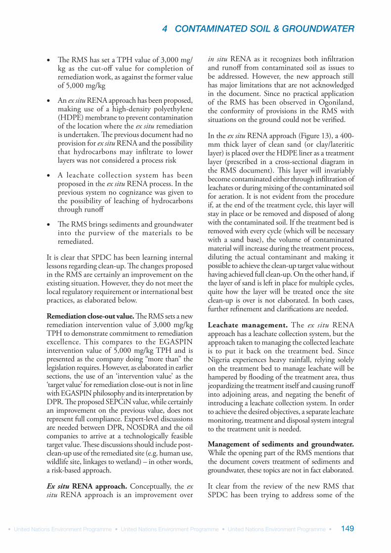
4 CONTAMINATED SOIL & GROUNDWATER
149
The RMS has set a TPH value of 3,000 mg/kg as the cut-off value for completion of remediation work, as against the former value of 5,000 mg/kg
An ex situ RENA approach has been proposed, making use of a high-density polyethylene (HDPE) membrane to prevent contamination of the location where the ex situ remediation is undertaken. The previous document had no provision for ex situ RENA and the possibility that hydrocarbons may infiltrate to lower layers was not considered a process risk
A leachate collection system has been proposed in the ex situ RENA process. In the previous system no cognizance was given to the possibility of leaching of hydrocarbons through runoff
The RMS brings sediments and groundwater into the purview of the materials to be remediated.
It is clear that SPDC has been learning internal lessons regarding clean-up. The changes proposed in the RMS are certainly an improvement on the existing situation. However, they do not meet the local regulatory requirement or international best practices, as elaborated below.
Remediation close-out value. The RMS sets a new remediation intervention value of 3,000 mg/kg TPH to demonstrate commitment to remediation excellence. This compares to the EGASPIN intervention value of 5,000 mg/kg TPH and is presented as the company doing “more than” the legislation requires. However, as elaborated in earlier sections, the use of an ‘intervention value’ as the ‘target value’ for remediation close-out is not in line with EGASPIN philosophy and its interpretation by DPR. The proposed SEPCiN value, while certainly an improvement on the previous value, does not represent full compliance. Expert-level discussions are needed between DPR, NOSDRA and the oil companies to arrive at a technologically feasible target value. These discussions should include post-clean-up use of the remediated site (e.g. human use, wildlife site, linkages to wetland) – in other words, a risk-based approach.
Ex situ RENA approach. Conceptually, the ex situ RENA approach is an improvement over
in situ RENA as it recognizes both infiltration and runoff from contaminated soil as issues to be addressed. However, the new approach still has major limitations that are not acknowledged in the document. Since no practical application of the RMS has been observed in Ogoniland, the conformity of provisions in the RMS with situations on the ground could not be verified.
In the ex situ RENA approach (Figure 13), a 400-mm thick layer of clean sand (or clay/lateritic layer) is placed over the HDPE liner as a treatment layer (prescribed in a cross-sectional diagram in the RMS document). This layer will invariably become contaminated either through infiltration of leachates or during mixing of the contaminated soil for aeration. It is not evident from the procedure if, at the end of the treatment cycle, this layer will stay in place or be removed and disposed of along with the contaminated soil. If the treatment bed is removed with every cycle (which will be necessary with a sand base), the volume of contaminated material will increase during the treatment process, diluting the actual contaminant and making it possible to achieve the clean-up target value without having achieved full clean-up. On the other hand, if the layer of sand is left in place for multiple cycles, quite how the layer will be treated once the site clean-up is over is not elaborated. In both cases, further refinement and clarifications are needed.
Leachate management. The ex situ RENA approach has a leachate collection system, but the approach taken to managing the collected leachate is to put it back on the treatment bed. Since Nigeria experiences heavy rainfall, relying solely on the treatment bed to manage leachate will be hampered by flooding of the treatment area, thus jeopardizing the treatment itself and causing runoff into adjoining areas, and negating the benefit of introducing a leachate collection system. In order to achieve the desired objectives, a separate leachate monitoring, treatment and disposal system integral to the treatment unit is needed.
Management of sediments and groundwater. While the opening part of the RMS mentions that the document covers treatment of sediments and groundwater, these topics are not in fact elaborated.
It clear from the review of the new RMS that SPDC has been trying to address some of the
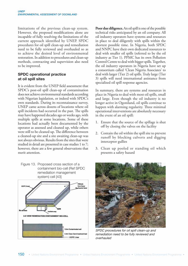
UNEP ENVIRONMENTAL ASSESSMENT OF OGONILAND
150
Poor due diligence. An oil spill is one of the possible technical risks anticipated by an oil company. All oil industry operators have systems and resources in place to deal diligently with spills within the shortest possible time. In Nigeria, both SPDC and NNPC have their own dedicated resources to deal with smaller oil spills (referred to by the oil industry as Tier 1). PPMC has its own Pollution Control Centre to deal with bigger spills. Together, the oil industry operators in Nigeria have set up a consortium called ‘Clean Nigeria Associates’ to deal with larger (Tier 2) oil spills. Truly large (Tier 3) spills will need international assistance from specialized oil spill response agencies.
In summary, there are systems and resources in place in Nigeria to deal with most oil spills, small and large. Even though the oil industry is no longer active in Ogoniland, oil spills continue to happen with alarming regularity. Three minimal operational interventions are absolutely necessary in the event of an oil spill:
1. Ensure that the source of the spillage is shut off by closing the valves on the facility
2. Contain the oil within the spill site to prevent runoff by blocking culverts and digging interceptor gullies
3. Clean up pooled or standing oil which presents a safety hazard
limitations of the previous clean-up system. However, the proposed modifications alone are incapable of fully resolving the limitations of the current approach identified by UNEP. SPDC procedures for oil spill clean-up and remediation need to be fully reviewed and overhauled so as to achieve the desired level of environmental restoration. In addition to procedures and clean-up methods, contracting and supervision also need to be improved.
SPDC operational practice at oil spill sites
It is evident from the UNEP field assessment that SPDC’s post-oil spill clean-up of contamination does not achieve environmental standards according with Nigerian legislation, or indeed with SPDC’s own standards. During its reconnaissance survey, UNEP came across dozens of locations where oil spill incidents had occurred in the past. The spills may have happened decades ago or weeks ago, with multiple spills at some locations. Some of these locations had actually been documented by the operator as assessed and cleaned up, while others were still to be cleaned up. The difference between a cleaned-up site and a site awaiting clean-up was not always obvious. Results from the sites that were studied in detail are presented in case studies 1 to 7; however, there are a few general observations that merit attention.
SPDC procedures for oil spill clean-up and remediation need to be fully reviewed and overhauled
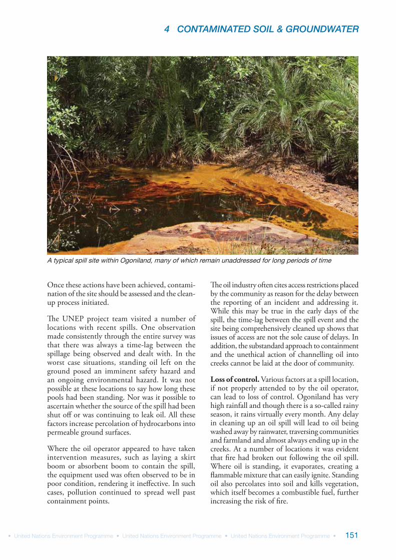
4 CONTAMINATED SOIL & GROUNDWATER
151
Once these actions have been achieved, contami-nation of the site should be assessed and the clean-up process initiated.
The UNEP project team visited a number of locations with recent spills. One observation made consistently through the entire survey was that there was always a time-lag between the spillage being observed and dealt with. In the worst case situations, standing oil left on the ground posed an imminent safety hazard and an ongoing environmental hazard. It was not possible at these locations to say how long these pools had been standing. Nor was it possible to ascertain whether the source of the spill had been shut off or was continuing to leak oil. All these factors increase percolation of hydrocarbons into permeable ground surfaces.
Where the oil operator appeared to have taken intervention measures, such as laying a skirt boom or absorbent boom to contain the spill, the equipment used was often observed to be in poor condition, rendering it ineffective. In such cases, pollution continued to spread well past containment points.
The oil industry often cites access restrictions placed by the community as reason for the delay between the reporting of an incident and addressing it. While this may be true in the early days of the spill, the time-lag between the spill event and the site being comprehensively cleaned up shows that issues of access are not the sole cause of delays. In addition, the substandard approach to containment and the unethical action of channelling oil into creeks cannot be laid at the door of community.
Loss of control. Various factors at a spill location, if not properly attended to by the oil operator, can lead to loss of control. Ogoniland has very high rainfall and though there is a so-called rainy season, it rains virtually every month. Any delay in cleaning up an oil spill will lead to oil being washed away by rainwater, traversing communities and farmland and almost always ending up in the creeks. At a number of locations it was evident that fire had broken out following the oil spill. Where oil is standing, it evaporates, creating a flammable mixture that can easily ignite. Standing oil also percolates into soil and kills vegetation, which itself becomes a combustible fuel, further increasing the risk of fire.
A typical spill site within Ogoniland, many of which remain unaddressed for long periods of time